South Witham Quarry (Eastern Extension) South Witham Lincolnshire Heritage Desk-Based Assessment for Heaton Planning Ltd CA Project: 660574 CA Report: 15763b November 2015

Welcome message from author
This document is posted to help you gain knowledge. Please leave a comment to let me know what you think about it! Share it to your friends and learn new things together.
Transcript
South Witham Quarry (Eastern Extension)
South Witham Lincolnshire
Heritage Desk-Based Assessment
for Heaton Planning Ltd
CA Project: 660574 CA Report: 15763b
November 2015
© Cotswold Archaeology
South Witham Quarry (Eastern Extension), Lincolnshire: Heritage Desk-Based Assessment
South Witham Quarry (Eastern Extension)
South Witham Lincolnshire
Heritage Desk-Based Assessment
CA Project: 660574 CA Report: 15763b
prepared by Elizabeth Pratt, Assistant Heritage Consultant
date November 2015
checked by Nathan Blick, Senior Heritage Consultant
date November 2015
approved by Nathan Blick, Senior Heritage Consultant
signed
date November 2015
issue 02
This report is confidential to the client. Cotswold Archaeology accepts no responsibility or liability to any third party to whom this report, or any part of it, is made known. Any such party relies upon this report entirely at their own risk. No part of this report may be reproduced by any
means without permission.
Cirencester Milton Keynes Andover Exeter Building 11 Kemble Enterprise Park Cirencester Gloucestershire GL7 6BQ
41 Burners Lane South Kiln Farm Milton Keynes Buckinghamshire MK11 3HA
Stanley House Walworth Road Andover Hampshire SP10 5LH
Unit 8 Basepoint Business Centre Yeoford Way Marsh Barton Trading Estate Exeter EX2 8LB
t. 01285 771022 t. 01908 564660 t. 01264 347630 t. 01392 826185 f. 01285 771033
© Cotswold Archaeology
1
South Witham Quarry (Eastern Extension), Lincolnshire: Heritage Desk-Based Assessment
CONTENTS
1. INTRODUCTION ................................................................................................ 5
Location and landscape context ......................................................................... 5
Scope ................................................................................................................. 5
2. METHODOLOGY ............................................................................................... 7
Heritage asset significance ................................................................................. 8
The Setting of Heritage Assets ........................................................................... 9
3. PLANNING POLICY CONTEXT ......................................................................... 11
Legislative framework, national planning policy and relevant sector guidance .... 11
Planning (Listed Buildings and Conservation Areas) Act (1990) ......................... 11
National Planning Policy Framework (the Framework) (2012) ............................ 12
Local planning policy .......................................................................................... 13
4. OVERVIEW OF THE HERITAGE RESOURCE .................................................. 15
Designated heritage assets ................................................................................ 15
Previous Archaeological Work (Fig. 2)................................................................ 16
Geology and the palaeoenvironment .................................................................. 16
Prehistoric (up to AD 43) .................................................................................... 17
Roman period (AD 43 – 410) .............................................................................. 17
Early Medieval (410 – 1066) and Medieval (1066 – 1539) periods ..................... 18
Post-medieval (1540 – 1800) and Modern (1800 – present) periods .................. 19
Undated ............................................................................................................. 20
5. DISCUSSION ..................................................................................................... 21
Significance of Recorded Heritage Assets .......................................................... 21
Potential for archaeological remains ................................................................... 21
Previous Impacts ................................................................................................ 22
6. POTENTIAL DEVELOPMENT EFFECTS .......................................................... 23
Summary of Proposals ....................................................................................... 23
Potential physical development effects ............................................................... 23
Potential non-physical development effects ........................................................ 23
South Witham Conservation Area (Fig. 1) .......................................................... 24
Grade I Listed Church of St. John the Baptist (Fig. 1) ......................................... 27
Grade II Listed Nos. 39 & 41High Street (Fig. 3, 1)............................................. 29
© Cotswold Archaeology
2
South Witham Quarry (Eastern Extension), Lincolnshire: Heritage Desk-Based Assessment
7. CONCLUSIONS ................................................................................................. 32
8. REFERENCES ................................................................................................... 33
APPENDIX A: GAZETTEER OF RECORDED HERITAGE ASSETS AND OTHER
ELEMENTS OF THE HISTORIC ENVIRONMENT .......................................................... 36
APPENDIX B: KEY VIEWS IDENTIFIED BY THE SOUTH WITHAM CONSERVATION
AREA APPRAISAL ......................................................................................................... 37
LIST OF ILLUSTRATIONS
Fig. 1 Site location plan, showing designated heritage assets
Fig. 2 Previous archaeological works
Fig. 3 Recorded heritage assets
Fig. 4 Extract from Ordnance Survey Map (1888)
LIST OF PHOTOGRAPHS
Photo 1 Hedgerow forming the southern boundary of the Site
Photo 2 Key view looking west along the High Street
Photo 3 Key view looking towards the Church of St. John the Baptist and Angel Inn
from Church Lane
© Cotswold Archaeology
3
South Witham Quarry (Eastern Extension), Lincolnshire: Heritage Desk-Based Assessment
SUMMARY
Project Name: South Witham Quarry (Eastern Extension)
Location: South Witham, Lincolnshire
NGR: SK 9235 1875
In October 2015 Cotswold Archaeology was commissioned by Heaton Planning Ltd (on
behalf of Breedon Aggregates) to update an existing Heritage Desk-Based Assessment
(produced by Cotswold Archaeology in 2010) of land proposed for the eastern extension to
South Witham Quarry. The objective of the assessment was to identify the nature and extent
of the heritage resource both within the Site and its immediate environs. This report reviews
current Historic Environment Record data (available since 2010) and also considers the
impact of the proposed development upon the setting of nearby designated heritage assets
– thereby bringing the findings of the previous assessment (Cotswold Archaeology, Report
No. 10233) in line with current planning policy and guidance.
No archaeological or built heritage assets are recorded within the Site. The hedgerow
forming the southern boundary of the Site might be considered to be of historic interest, in
accordance with the criteria defined in the Hedgerows Regulations (1997). This hedgerow is
to be retained within the development proposals. Sources consulted for this assessment
indicate that the Site has long formed part of the outlying agricultural hinterland of South
Witham, a rural settlement of known early medieval origins. There is limited potential for
buried archaeological remains associated with medieval and post-medieval land use; any
scatters of pottery sherds and other material debris derived from historic manuring practices
are considered to be of limited heritage significance.
Previous programmes of archaeological work undertaken in advance of mineral extraction at
South Witham Quarry have uncovered widespread evidence for late Iron Age and Romano-
British occupation and activity. However, evaluation trenching immediately to the west of the
Site – undertaken as a condition of planning consent for an earlier phase of mineral
extraction (AS 2003) – recorded only a single archaeological feature comprising a single
undated pit or post-hole with a fill of human and animal bone. It is conceivable that these
remains relate to the Romano-British cemetery recorded c.250m to the north of the Site.
In conclusion, this desk-based assessment has found no heritage constraints to the
proposed eastern extension to South Witham Quarry. It is possible that archaeological works
may be required to better understand the presence, extent, date, condition and significance
© Cotswold Archaeology
4
South Witham Quarry (Eastern Extension), Lincolnshire: Heritage Desk-Based Assessment
of any surviving remains that may be affected by mineral extraction. Any such further
archaeological investigation (both field evaluation and subsequent mitigation) can be
secured by the imposition of a suitably worded planning condition. The proposed eastern
extension is considered to be consistent with the requirements of the Planning (Listed
Buildings and Conservation Areas) Act 1990, the Framework, and local planning policies
relating to the protection of the historic environment.
.
© Cotswold Archaeology
5
South Witham Quarry (Eastern Extension), Lincolnshire: Heritage Desk-Based Assessment
1. INTRODUCTION
1.1 In October 2015 Cotswold Archaeology was commissioned by Heaton Planning Ltd
(on behalf of Breedon Aggregates) to update an existing Heritage Desk-Based
Assessment (produced by Cotswold Archaeology in 2010) of land proposed for the
eastern extension to South Witham Quarry. The objective of the assessment was to
identify the nature and extent of the heritage resource both within the Site and its
immediate environs. This report reviews current Historic Environment Record data
(available since 2010) and also considers the impact of the proposed eastern
extension upon the setting of nearby designated heritage assets – thereby bringing
the findings of the previous assessment (Cotswold Archaeology, Report No. 10233)
in line with current planning policy and guidance.
Location and landscape context
1.2 The Site comprises a single arable field (measuring approximately 4.1ha in extent)
located c.170m to the south-west of the village of South Witham and c.150m to the
east of the current limits of South Witham Quarry. The Site is bounded by Thistleton
Lane to the east, with sparse hedgerows on all four sides. A footpath traces the
outside of the western boundary of the Site. The southern boundary of the Site
forms the county boundary between Lincolnshire and Rutland; the Site lies wholly
within Lincolnshire.
Scope
1.3 This assessment focuses upon the heritage resource of the Site itself, as well as a
500m ‘buffer’ around its redline boundary (referred to hereafter as the ‘study area’)
(Fig. 3). In addition, several designated heritage assets lying within a 1km radius
have undergone a settings assessment.
1.4 The main objectives of the assessment are:
• to identify and gather information on designated heritage assets within the
Site;
• to identify and gather information on non-designated recorded heritage assets
within the Site and study area;
• where sufficient information allows, to assess the significance of known and
potential buried archaeological remains within the Site;
© Cotswold Archaeology
6
South Witham Quarry (Eastern Extension), Lincolnshire: Heritage Desk-Based Assessment
• where possible, to assess the impact of the proposed development on the
significance of known and potential buried archaeological remains within the
Site; and
• to assess the impact of the proposed development on the significance of
designated heritage assets within the study area, arising from potential
changes to their setting.
© Cotswold Archaeology
7
South Witham Quarry (Eastern Extension), Lincolnshire: Heritage Desk-Based Assessment
2. METHODOLOGY
2.1 The methodology used within this assessment is informed by the guidance provided
in the Chartered Institute for Archaeologists’ Standard and Guidance for Historic
Environment Desk-Based Assessment (2014).
2.2 The defined study area for the assessment of the heritage resource has been
measured from the boundary of the Site, and encompasses a buffer area of a
minimum of 500m around its edge for all known heritage assets. The size of the
study area ensured that data sources provided sufficient information about the Site
and its surrounding landscape from which to assess known and potential impacts
on the heritage resource.
2.3 Known heritage assets within the study area are reported in Section 4. A gazetteer
of known heritage assets in the study area has been compiled (Appendix A). All
assets are referred to in the text by a unique reference number (1), etc... The
locations of these assets can be seen on Fig. 3.
2.4 The desk-based assessment involved consultation of readily available
archaeological and historical information from documentary and cartographic
sources. The major repositories of information consulted comprised:
Historic England National Heritage List
• World Heritage Sites
• Scheduled Monuments
• Listed Buildings
• Registered Parks and Gardens
• Registered Battlefields
Lincolnshire Historic Environment Record
• Database of known archaeological sites, findspots, historic buildings and
previous archaeological works; and
• Published and unpublished documentary sources (including development
control site reports).
Leicestershire and Rutland Historic Environment Record
• Database of known archaeological sites, findspots, historic buildings and
previous archaeological works; and

© Cotswold Archaeology
8
South Witham Quarry (Eastern Extension), Lincolnshire: Heritage Desk-Based Assessment
• Published and unpublished documentary sources (including development
control site reports).
Lincolnshire and Leicestershire Records Offices
• Historic maps and documentary sources to demonstrate previous land use.
Historic England Archives
• AMIE (Archives and Monuments Information, England) data including known
archaeological sites, findspots and previous archaeological works; and
• Aerial photography collections.
Online sources
• Including the British Geological Survey (BGS) Geology of Britain Viewer,
Local Plan information, lidar data (see below) and the Cranfield University
Soilscapes Viewer.
2.5 Existing lidar data of the Site, surveyed by the Environment Agency, was viewed
online from the Geomatics Group.
2.6 A visit to the Site was undertaken on 10th December 2010 to identify any visible
potential archaeological assets, such as earthworks, not recorded by the desk-
based sources and to more fully understand the potential constraints, if any, to the
proposed eastern extension to the quarry. Another visit was made to South Witham
on 15th October 2015, to undertake an assessment of the settings of nearby
designated heritage assets (see below).
Heritage asset significance
2.7 The National Planning Policy Framework defines significance as ‘the value of a
heritage asset to this and future generations because of its heritage interest. That
interest may be archaeological, architectural, artistic or historic.’ (2012, Annex 2).
Conservation Principles, Policies and Guidance (English Heritage 2008) provides a
comprehensive framework for identifying and assessing significance. In this
document, the notion of ‘place’ is favoured over ‘heritage asset’ (2008, 13); and four
categories of ‘value’ are identified:
• Evidential value derives from ‘the potential of a place to yield evidence about
past human activity’ (ibid, 28). It is primarily embodied by physical remains or
historic fabric, but also includes buried archaeology;
© Cotswold Archaeology
9
South Witham Quarry (Eastern Extension), Lincolnshire: Heritage Desk-Based Assessment
• Historical value derives from ‘the ways in which past people, events and
aspects of life can be connected through a place to the present’ (ibid, 28).
Illustrative historical value depends on visibility in a way that evidential value
does not; and ‘has the power to aid interpretation of the past […] through shared
experience of a place’ (ibid, 29). Associative historical value creates resonance
through felt connections with a notable family, person, event or movement;
• Aesthetic value derives from ‘the ways in which people draw sensory and
intellectual stimulation from a place’ (ibid, 30). Aesthetic value might be
generated through conscious design and artistic endeavour, fortuitous and
organic change, and the relationship of structures and materials to their setting;
• Communal value is tied to historical (associative) value and aesthetic value,
deriving from ‘the meanings of a place for the people who relate to it, or for
whom it figures in their collective experience or memory’ (ibid, 31). Communal
value may be commemorative, symbolic or social. The latter is typically
‘associated with places that people perceive as a source of identity,
distinctiveness, social interaction and coherence’ and might only be articulated
when the resource is under threat (ibid, 32).
2.8 Conservation Principles, Policies and Guidance (English Heritage 2008) defines the
significance of a place as the constellation of one or more of these four forms of
value. Approaches towards assessing significance are presented within the Historic
Environment Good Practice Advice in Planning Note 2 – Managing Significance in
Decision-Taking in the Historic Environment (Historic England 2015a). Heritage
assets of archaeological interest may be more sensitive to change, typically
comprising buried remains that ‘may occasionally be harmed by even minor
disturbance, thus damaging the significance of the asset’ (ibid, 6).
2.9 Elements of setting, defined by the national Framework (see Section 3) as the
physical surroundings in which a heritage asset is experienced (DCLG 2012, Annex
2), may make a positive or negative contribution to significance (Historic England
2015b, 2). In Section 6 (below), the contribution that setting makes to the
significance of heritage assets is specifically discussed in terms of how it may foster
and/or assist the appreciation of these value(s) (Historic England 2015b, 4–6).
The Setting of Heritage Assets
2.10 The Historic England document Historic Environment Good Practice Advice in
Planning Note 3: The Setting of Heritage Assets (2015b) provides guidance on
© Cotswold Archaeology
10
South Witham Quarry (Eastern Extension), Lincolnshire: Heritage Desk-Based Assessment
setting and development management. A five-step approach is recommended for
assessing the impact of development proposals; this report implements steps 1, 2
and 3. The first step is to identify the heritage assets affected and their settings. The
second step is to assess whether, how and to what degree these settings make a
positive contribution to the significance of the heritage asset(s), i.e. ‘what matters
and why’. This includes determination of the key attributes of the heritage asset
itself, and then considering:
• the physical surroundings of the asset, including other buildings, structures,
landscapes, areas or archaeological remains;
• the way the asset is experienced, including associative relationships between
heritage assets.
2.11 The third step (where appropriate) is to assess the effect of the proposed
development on the significance of assets through the consideration of the key
attributes of the proposed development in terms of its:
• location and siting;
• form and appearance;
• additional effects; and
• permanence.
2.12 The fourth step is to maximise enhancement and minimise harm, which may be
achieved through:
• removing or re-modelling an intrusive building or features;
• replacement of a detrimental feature by a new and more harmonious one;
• restoring or revealing lost historic features;
• introducing a wholly new feature that adds to the public appreciation of the
asset;
• introducing new views (including glimpses or better framed views) that add to
the public experience of the asset; or
• improving public access to, or interpretation of, the asset including its setting.
2.13 Step five entails making and documenting the decision and monitoring outcomes.
© Cotswold Archaeology
11
South Witham Quarry (Eastern Extension), Lincolnshire: Heritage Desk-Based Assessment
3. PLANNING POLICY CONTEXT
Legislative framework, national planning policy and relevant sector guidance 3.1 The assessment is written within the following legislative, planning policy and
guidance context:
• National Heritage Act 1983 (amended 2002);
• Ancient Monuments and Archaeological Areas Act (1979);
• Planning (Listed Buildings and Conservation Areas) Act (1990);
• Conservation Principles, Policies and Guidance for the Sustainable
Management of the Historic Environment (2008);
• National Planning Policy Framework (2012);
• National Planning Practice Guidance: Conserving and enhancing the historic
environment (accessed October 2015);
• Historic Environment Good Practice Advice in Planning Note 2: Managing
Significance in Decision-Taking in the Historic Environment (2015a);
• Historic Environment Good Practice Advice in Planning Note 3: The Setting of
Heritage Assets (2015b).
Planning (Listed Buildings and Conservation Areas) Act (1990)
3.2 In determining planning applications that might affect the settings of Listed
Buildings, the 1990 Act states that:
‘In considering whether to grant planning permission for development which affects
a listed building or its setting, the local planning authority or, as the case may be,
the Secretary of State shall have special regard to the desirability of preserving the
building or its setting or any features of special architectural or historic interest
which it possesses.’ (Section 66).
3.3 In determining planning applications that might affect the character and appearance
(including their setting) of Conservation Areas, the 1990 Act states that:
‘[W]ith respect to any buildings or other land in a conservation area […], special
attention shall be paid to the desirability of preserving or enhancing the character or
appearance of that area.’ (Section 72).
© Cotswold Archaeology
12
South Witham Quarry (Eastern Extension), Lincolnshire: Heritage Desk-Based Assessment
National Planning Policy Framework (the Framework) (2012) 3.4 The Framework sets out national planning policy relating to the conservation and
enhancement of the historic environment. It defines the historic environment as ‘all
aspects of the environment resulting from the interaction between people and
places through time, including all surviving physical remains of past human activity,
whether visible, buried or submerged, and landscaped and planted or managed
flora.’
3.5 Individual aspects of the historic environment are considered heritage assets:
‘buildings, monuments, sites, places, areas or landscapes identified as having a
degree of significance meriting consideration in planning decisions, because of their
heritage interest.’
3.6 Heritage assets include designated sites and non-designated sites, and policies
within the Framework relate to both the treatment of assets themselves and of their
settings, both of which are a material consideration in development decision
making.
3.7 Key tenets of the Framework are that:
• when considering the impact of a proposed development on the
significance of a designated heritage asset, great weight should be given
to the asset’s conservation. The more important the asset, the greater the
weight should be;
• significance can be harmed or lost through alteration or destruction of the
heritage asset or development within its setting. As heritage assets are
irreplaceable, any harm or loss should require clear and convincing
justification. Substantial harm to or loss of a Grade II listed building, park or
garden should be exceptional. Substantial harm to or loss of designated
heritage assets of the highest significance, notably Scheduled Monuments,
Protected Wreck Sites, Battlefields, Grade I and II* Listed Buildings, Grade
I and II* Registered Parks and Gardens, and World Heritage Sites, should
be wholly exceptional;
• where a proposed development will lead to less than substantial harm to
the significance of a designated heritage asset, this harm should be
weighed against the public benefits of the proposal; and
© Cotswold Archaeology
13
South Witham Quarry (Eastern Extension), Lincolnshire: Heritage Desk-Based Assessment
• with regard to non-designated heritage assets a balanced judgement will
be required having due regard to the scale of any harm or loss and to the
significance of the heritage asset affected.
3.8 Local planning authorities are required to request that applicants describe the
significance of any heritage assets affected by a proposed development, including
any contribution made by their setting. The level of detail required in the
assessment should be ‘proportionate to the assets’ importance and no more than is
sufficient to understand the potential impact of the proposal on their significance.’
Local planning policy
3.9 Local planning policy is provided by South Kesteven Local Development Framework
(Adopted July 2010) and the Core Strategy and Development Management Policies:
Lincolnshire Minerals and Waste Local Plan (Pre-Submission Draft January 2015).
The relevant policy relating to the historic environment in the former is Policy EN1:
Protection and Enhancement of the Character of the District.
3.10 Policy EN1 states that South Kesteven has a rich heritage of buildings,
archaeological remains and countryside. It boasts an attractive and varied
landscape. The historic fabric of the towns, villages and individual buildings,
archaeological features, historic parks and gardens, as well as their settings and the
wider landscape all need to be recognised, understood and conserved. This high
quality natural and built environment could suffer if the needs of the development
are met without taking steps to safeguard these finite resources.
3.11 EN1 states that all development proposals and site allocations will be assessed in
relation to:
• Statutory, national and local designations of landscape features, including
natural and historic assets.
• Local distinctiveness and sense of place.
• Historic character, patterns and attributes of the landscape/
• The layout and scale of buildings and designed spaces.
• The quality and character of the built fabric and their settings.
3.12 The Local Development Framework references Planning Policy Guidance Notes 15
& 16 in relation to planning for the Historic Environment but this has now been
superseded by the National Planning Policy Framework (2012) and Policy DM4:
© Cotswold Archaeology
14
South Witham Quarry (Eastern Extension), Lincolnshire: Heritage Desk-Based Assessment
Historic Environment, of the Lincolnshire Minerals and Waste Local Plan, in relation
to the National Planning Policy Framework.
3.13 Policy DM4: Historic Environment states that proposals that have the potential to
affect heritage assets including features of historic or archaeological importance
(whether known or unknown) should be accompanied by an assessment of the
significance of those assets and the potential impact of the development proposal on
those assets and their settings. Where any impact on heritage assets is identified,
the assessment should provide details of the proposed mitigation measures that
would be implemented. These should include details of any conservation of assets
and also of any further investigation and recording of heritage assets to be lost and
provision for the results to be made publicly available. Planning permission will be
granted for minerals and waste development provided that:
• Heritage assets, and their settings, are conserved, and where possible
enhanced; or
• There are no alternative solutions to mitigate the impact; and
• There are exceptional overriding reasons which outweigh the need to
safeguard the value of sites or features which would be harmed.
© Cotswold Archaeology
15
South Witham Quarry (Eastern Extension), Lincolnshire: Heritage Desk-Based Assessment
4. OVERVIEW OF THE HERITAGE RESOURCE
4.1 This section provides an overview of the historical and archaeological background
of the study area and the region surrounding it, to provide a better understanding of
the context and significance of the heritage resource that may be affected by
development. This assessment also determines the significance of any affected
archaeological sites (Section 5), considers the potential for encountering buried
archaeological remains within the Site, and predicts their likely nature, date, extent
and condition.
Designated heritage assets
4.2 No World Heritage Sites or Tentative Future Nominations for World Heritage Sites
occur within the immediate or wider vicinity of the proposed development.
4.3 There are no Scheduled Monuments within the Site or study area. The nearest
Scheduled Monument comprises the earthwork remains of a Knights Templars
Preceptory with watermill and fishponds (NHLE Ref. 1007688), located c.1.6km to
the north-north-east of the Site (Fig. 1).
4.4 The Grade II Listed Building known as 39 & 41 High Street, South Witham (Fig. 3,
1) is the only designated built heritage asset to occur within the study area. Further
afield, within a 1km radius of the Site, there are six more Grade II Listed Buildings
at South Witham. The Church of St. John the Baptist is Grade I Listed (NHLE Ref.
1062325). The historic core of the village has been designated as a Conservation
Area (Fig. 1).
4.5 At Thistleton, c.1km to the south-west of the Site, there are a further six Grade II
Listed Buildings; whilst the Church of St. Nicholas is Grade II* Listed (NHLE Ref.
1177828; Fig. 1).
4.6 There are no Registered Battlefields or Registered Parks and Gardens within the
Site or wider study area.
4.7 Those designated heritage assets considered to be sensitive to the proposed
development have undergone a settings assessment (see Section 6). Desk-based
research, supported by a Site visit, resulted in many of the Listed Buildings at South
Witham requiring no further assessment beyond Step 1 of the Historic England
guidance (see Section 2.10). It was found that geographical distance, topography,
modern infrastructure and buildings, or vegetation screened views from and
© Cotswold Archaeology
16
South Witham Quarry (Eastern Extension), Lincolnshire: Heritage Desk-Based Assessment
towards the proposed development; and/or no clear historical association between
the asset(s) and the Site could be discerned.
Previous Archaeological Work (Fig. 2)
4.8 No archaeological works have previously been carried out within the Site. However,
a total of 39 evaluation trenches were excavated immediately to the west of the
Site, one of which recorded a single undated pit or post-hole (Fig. 3, 7). This feature
contained 70g of animal bone and 3g of human bone (AS 2003; see Section 4.14).
4.9 Several other programmes of previous archaeological works have taken place in
the vicinity. These comprise:
• An excavation carried out at 8 Church Lane, c.550m to the north-east of the Site,
found evidence of prehistoric and Roman activity; recovered sherds of Saxon
pottery; and identified medieval, post-medieval and modern features (Fig. 3, 2;
ULAS 2003);
• A geophysical survey in advance of the construction of a proposed quarry
access road, which extended to within c.640m to the south-west of the Site (not
illustrated), recorded anomalies indicative of a small Iron Age/Romano-British
enclosure – as well as a trackway and evidence of historic quarrying (PCG
2000); and
• An extensive programme of geophysical survey, trial trench evaluation and
excavation was undertaken in advance of a western extension to South Witham
Quarry, c.650m–2km to the west of the Site (not illustrated), beyond the study
area. These investigations recorded evidence for Neolithic and Bronze Age
activity; as well as a complex of Iron Age features comprising pits and ditches
with a droveway, field system and possible grain storage pits, and a potential
votive offering (HAT 2001; AS 2004).
Geology and the palaeoenvironment Solid geology
4.10 The solid geology of the Site comprises Limestone of the Upper Lincolnshire
Member (BGS viewer online, accessed 14.10.15). No drift deposits, or deposits of
palaeoenvironmental interest, are recorded within the Site.
Superficial deposits and soils
© Cotswold Archaeology
17
South Witham Quarry (Eastern Extension), Lincolnshire: Heritage Desk-Based Assessment
4.11 No superficial deposits are recorded by the British Geological Survey (BGS viewer
online, accessed 14.10.15). The Site is wholly characterised by freely draining lime-
rich loamy soils (Soilscapes viewer online, accessed 14.10.15).
Prehistoric (up to AD 43)
4.12 A small assemblage of Mesolithic worked flints was recorded during excavations at
Church Lane, c.500m to the north-east of the Site (Fig. 3, 2); and surface finds of
Neolithic and Bronze Age worked flints have also been collected through
fieldwalking in and around South Witham village. However, there are no recorded
cropmarks and earthworks that are definitively indicative of contemporaneous
activity within the study area. A circular cropmark, potentially representing the
buried remains of a ring ditch, has been recorded from aerial photographs 500m to
the south-east of the Site (Fig. 3, 8). It is considered that there is no specific
potential for later prehistoric archaeological remains to occur within the Site.
4.13 Further afield, the remains of possible Iron Age or Romano-British enclosures were
recorded during geophysical survey and subsequent trial trenching of land c.650m–
2km to the west of the Site (PCG 2000; HAT 2001; AS 2004; Cotswold Archaeology
2007).
Roman period (AD 43 – 410) 4.14 A Romano-British cemetery of at least 23 inhumations and a single cremation burial
was discovered during gravel extraction at a location c.250m to the north-west of the
Site in the 1920s (Fig. 3, 3). A large well and the wall footings of a building were also
unearthed, raising the potential for a settlement to be located in the vicinity.
However, evaluation trenching undertaken between this area and the Site (AS 2003;
see Fig. 2) recorded only a single undated pit or posthole containing 70g of animal
bone and 3g of human bone. This feature was uncovered in Trench 32, c.85m west
of the Site (see Fig. 2, inset). It is possible that the very small quantity of human
bone is derived from the aforementioned cemetery, but the distance between the
two locations (Fig. 3, 3 and 7) renders the association somewhat tentative. No
additional features of archaeological interest were identified in the other 38 trenches;
although this does not preclude the presence of buried remains of Romano-British
occupation or activity elsewhere in the immediate or wider vicinity.
4.15 A pit and three gullies were recorded during excavations at 8 Church Lane, and
were dated by the discovery of 154 sherds of Roman pottery and a quernstone (Fig.
3, 2). A surface find of a single Roman coin is recorded c.300m to the north-east of
© Cotswold Archaeology
18
South Witham Quarry (Eastern Extension), Lincolnshire: Heritage Desk-Based Assessment
the Site (Fig. 3). Further afield, the site of a Roman villa representing three phases
of settlement between the 2nd and 4th centuries AD was identified and investigated
at Thistleton Dyer Quarry, c.2.7km to the south-west of the Site (not illustrated).
4.16 A number of anomalies indicative of possible Romano-British settlement were
recorded during geophysical survey of land c.650m–2km to the west of the Site
(see Section 4.13).
Early Medieval (410 – 1066) and Medieval (1066 – 1539) periods
4.17 South Witham is recorded by the Domesday Survey as Wime or Wimme; and is
described as a large settlement of 31 households, with land for 5 ploughlands and
41 acres of meadow. Two salthouses are also mentioned. A total of 19 sherds of
Charnwood Ware, a late 5th to early 7th century pottery type, were collected during
the excavation at 8 Church Lane, c.550m to the north-east of the Site (Fig. 3, 2):
demonstrating that this may have been the early medieval core of settlement. A
fragmentary stone structure with a hearth or oven was also uncovered, perhaps
indicative of industrial activity (Fig. 3, 2).The village did not notably expand during
the medieval period, and settlement was likely focussed round Church Street (see
below).
4.18 The Knights Templar had a preceptory at Temple Hill (c.1km north of South Witham
village) from c.1164; and owned half of the parish landholdings until these reverted
to the Crown in 1312. The Scheduled earthwork remains of the preceptory (NHLE
Ref. 1007688) are located beyond the built limits of the village, c.1.6km to the north-
north-east of the Site (Fig. 1). Excavations conducted between 1965 and 1967
found evidence for the 13th–14th century farmstead complex, comprising a chapel,
two great halls, agricultural and industrial buildings, and a gatehouse. The River
Witham was dammed at the north end to form a millpond and a series of fishponds.
The river continued to flow southwards towards and through the village of South
Witham, forming ‘Fishpool Dike’ at Church Lane (SKDC 2013, 7).
4.19 Other archaeological works to the rear of Sycamore House, north of the Church of
St. John the Baptist (ULAS 2002; not illustrated) recorded post-holes, pits and linear
features. Their fills contained pottery sherds that were dated to the 10th–13th
centuries AD; as well as animal bone and iron working slag. These finds attest to a
focus of medieval activity in the vicinity of the Church of St. John the Baptist (Fig.
1). This designated heritage asset, of late 12th or early 13th century origins, is
discussed in further detail in Section 6.
© Cotswold Archaeology
19
South Witham Quarry (Eastern Extension), Lincolnshire: Heritage Desk-Based Assessment
4.20 No evidence for occupation or activity is recorded within the Site or its immediate
environs. The Site is likely to have formed part of the outlying agricultural hinterland
of the parish of South Witham. However, no earthworks indicative of ridge and
furrow cultivation within the former open field system can be discerned on historic
aerial photographs or lidar imagery of the Site. Post-medieval (1540 – 1800) and Modern (1800 – present) periods
4.21 Only 33 households were recorded at South Witham in 1563; and evidence for
ongoing occupation was unearthed during the excavation at 8 Church Lane (Fig. 3,
3). Various upstanding buildings attest to growth and development of South Witham
during the post-medieval period. The Grade II Listed Priory Farmhouse (NHLE Ref.
1360334), Tanyard Farmhouse (NHLE Ref. 1168403) and No. 14 Church Street
(NHLE Ref. 1062324) are all examples of prosperous farmsteads established during
the 17th century. The Grade II Listed Angel Inn dates to c.1700 (NHLE Ref.
1168360); whilst the Grade II Listed Building now known as Nos. 39 & 41 High
Street (Fig. 3, 1) is a private house thought to have been built c.1800 (see Section
6.17).
4.22 Land in the parish of South Witham was subject to parliamentary enclosure in 1793.
However, the original map held at the Lincolnshire Record Office is badly damaged,
and the area detailing the Site is completely destroyed. A hand-drawn, indicative
reconstruction of this map, of unknown provenance, does appear to show the
boundaries of the Site as broadly similar to later cartographic sources.
4.23 By the start of the 19th century, a windmill had been built on high ground to the west
of the village, c.300m to the north of the Site (Fig. 3, 5). Further change is indicated
by the construction, in 1894, of the Midland and Great Northern Junction Railway
(Fig. 3, 6a) to transport iron ore to the Holwell Iron Company at Buckminster (SKDC
2013, 7). A small station (Fig. 3, 6b) was located c.100m to the north of the Site.
4.24 The Ordnance Survey Map of 1888 depicts the Site largely as it exists today (Fig. 4).
A single additional boundary was recorded running east-west through the middle of
the Site. No evidence of this feature was observed during the walkover survey. The
Site is recorded by aerial photographs taken throughout the post-war period, up to
the present. These photographs document the earlier presence and subsequent
removal of the aforementioned field boundary within the Site. They also record the
expansion of the quarry to the west. However, no cropmarks or features of potential
© Cotswold Archaeology
20
South Witham Quarry (Eastern Extension), Lincolnshire: Heritage Desk-Based Assessment
archaeological interest were visible on any of the photographs viewed for this
assessment.
4.25 The hedgerow running along the southern boundary of the Site (Photo 1) traces the
boundary between the parishes of South Witham and Thistleton; and as such, may
be a heritage asset of historic interest. According to the Hedgerows Regulations
(1997) a hedgerow is historically important if it ‘marks the boundary, or part of the
boundary, of at least one historic parish or township; and for this purpose “historic”
means existing before 1850’ (Criteria 1).
Photo 1: Hedgerow forming the southern boundary of the Site Undated
4.26 Archaeological evaluation of land immediately to the west of the Site (AS 2003)
revealed a single pit or a post-hole in Trench 32 (Fig. 2; Fig. 3, 7). This feature
contained 24 fragments of human and animal bone, of uncertain origin and date. As
formerly discussed, an association with the recorded Romano-British cemetery (Fig.
3, 3), c.400m to the north-west, is possible. The proximity of the pit or post-hole to
the Site (the westernmost boundary is located approximately 85m to the east) raises
the potential for buried archaeological remains to occur within the Site.

© Cotswold Archaeology
21
South Witham Quarry (Eastern Extension), Lincolnshire: Heritage Desk-Based Assessment
5. DISCUSSION
Significance of Recorded Heritage Assets 5.1 The hedgerow running along the southern boundary of the Site traces the boundary
between the parishes of South Witham and Thistleton (see Fig. 3); and as such,
may be a heritage asset of historic interest, in accordance with Hedgerows
Regulations criteria (Criteria 1, Hedgerows Regulations 1997). This hedgerow is to
be retained as part of the development.
5.2 No other heritage assets are recorded within the Site.
Potential for archaeological remains
Prehistoric
5.3 Archaeological investigations undertaken prior to a proposed western extension of
South Witham Quarry recorded extensive evidence for Iron Age occupation here,
c.790m to the west of the Site (see Fig. 2). It is possible that buried remains of field
boundaries, trackways and enclosures also occur within the Site; although no
evident potential for such features is indicated by historic aerial photographs and
lidar imagery. Nor did archaeological evaluation of land immediately adjacent to the
Site find any conclusive evidence for occupation (AS 2003). There is thus limited
potential for buried prehistoric archaeological remains to occur within the Site.
Roman
5.4 A Romano-British cemetery is recorded c.250m to the north-west of the Site (Fig. 3, 3). Evaluation trenching undertaken across the area lying between this burial site
and the Site uncovered only a single pit or posthole containing fragmentary animal
and human bone; and this material could not be dated. It is possible that these
remains are associated with the cemetery; and that related evidence is buried
nearby. However, given the paucity of recorded Roman period heritage assets in
the study area and wider landscape, there is limited potential for conclusive
archaeological evidence of Romano-British occupation and activity to occur within
the Site. Only isolated findspots are to be expected, which are considered to be of
limited heritage significance.
Medieval
5.5 The Site lies to the south-west of the village of South Witham. Sources consulted
for this assessment suggest that the settlement never extended beyond its current
limits. It is likely that the Site comprised part of the wider agricultural hinterland of
© Cotswold Archaeology
22
South Witham Quarry (Eastern Extension), Lincolnshire: Heritage Desk-Based Assessment
the parish during the medieval period. Utilised for pasture or cultivation, any buried
archaeological evidence is likely to comprise scatters of pottery sherds and
fragments of tile (as derived from historic manuring practices). There is also some
potential for isolated findspots representing chance losses from individuals utilising
the footpath that runs along the outside of the western boundary of the Site. Any
such material is considered to be of limited heritage significance.
Post-medieval and Modern
5.6 Historic mapping and aerial photographs suggest that the Site remained in
agricultural use throughout the post-medieval and modern periods. There is limited
potential for buried archaeological remains; any scatters of pottery sherds and other
debris are considered to be of limited heritage significance.
Previous Impacts
5.7 Ploughing may have disturbed, truncated or removed potential sub-surface
archaeological remains. The removal of an internal field boundary sometime
between 1958 and 1978 may also have had a localised impact upon any such
potential buried remains.
© Cotswold Archaeology
23
South Witham Quarry (Eastern Extension), Lincolnshire: Heritage Desk-Based Assessment
6. POTENTIAL DEVELOPMENT EFFECTS
Summary of Proposals 6.1 The proposed eastern extension would be integrated into the working and
restoration schemes for the existing quarry. Two stages of works are proposed.
Phase 3A would entail the removal of c.14,500m3 of soil, some of which will be used
to create a screening bund around the external perimeter of the proposed
development area. Extraction of c.535,590 tonnes of saleable limestone (from a
single face) would then commence in an easterly direction through the Site. Phase
3B would entail further extraction of c.406,890 tonnes of saleable limestone; with
restoration progressively following these operations. Soil, overburden material, inert
material and mineral waste will be used to infill the eastern extension area, creating
a limestone escarpment for reasons of geological interest and nature conservation.
Agricultural access will be maintained along the southern margin as part of the
restoration plans.
Potential physical development effects
6.2 The Phase 3A works will involve the wholesale removal of soil horizons that have
some potential to contain material of archaeological interest. Evaluation trenching of
land adjacent to the Site recorded a single, undated pit or post-hole containing
fragments of human and animal bone; and it is possible that similar remains occur
within the Site. Quarrying will have an irreversible, destructive impact upon buried
heritage assets that may be present.
6.3 The Phase 3B works will involve the extraction of limestone bedrock followed by
infilling and remodelling of the eastern extension area. It is considered that these
activities will have no impact on archaeological deposits.
Potential non-physical development effects
6.4 Appraisal was undertaken at an early stage to identify whether the proposed
development would have any impact upon the significance of designated heritage
assets within a 1km study area, through alteration of their setting.
6.5 Step 1 of Historic England guidance (2015b; see Section 3) was conducted through
a map-based search of the National Heritage List for England. After reviewing the
List Entry descriptions for the identified designated heritage assets within the study
area and using Google Earth imagery to ascertain their location relative to the Site,
it was judged that most of the Listed Buildings at South Witham required no further
© Cotswold Archaeology
24
South Witham Quarry (Eastern Extension), Lincolnshire: Heritage Desk-Based Assessment
settings assessment. With the exception of immediate physical surroundings and
associative relationships with other nearby built assets, elements of the wider
setting did not notably contribute to their heritage significance. Additionally,
intervisibility with the Site was obscured by topography, infilled development and/or
vegetative screening.
6.6 The Scheduled Monument of a Knights Templars Preceptory (Fig. 1; NHLE Ref.
1007688) was also considered to require no further assessment beyond the Step 1
exercise. The landscape beyond the southerly extent of the modern village of South
Witham is considered to make no contribution to the significance of this designated
heritage asset. Thus, quarrying within the Site will not result in change to setting
such that heritage significance will be harmed.
6.7 Other designated heritage assets were identified as being potentially sensitive to
the proposed development. Further settings assessment (comprising Steps 2 and 3
of Historic England guidance (2015)) was thus undertaken for:
• South Witham Conservation Area (Fig. 1);
• Grade I Listed Church of St. John the Baptist (Fig. 1); and
• Grade II Listed Nos. 39 & 41 High Street (Fig. 3, 1).
South Witham Conservation Area (Fig. 1) Significance – character and appearance
6.8 The historic core of South Witham was designated as a Conservation Area in 2001,
in recognition of the original settlement pattern having remained relatively unaltered
up until the 20th century. The boundary encloses Church Street, High Street and
Church Lane; revisions in 2013 saw the incorporation of areas of green open space.
The southern part of the Conservation Area falls within the study area, c.350m to
the north-east of the Site. The Appraisal produced by the Local Planning Authority
in 2013 notes that the special interest of this designated heritage asset is derived
from the linear street patterns, groupings of historic buildings (with consistency in
architectural style and harmonious use of materials, namely limestone) that directly
front the street or are delineated by boundary walls, and the contrast in character
between the compact and enclosed historic core to the west and the more open
areas to the east (SKDC 2013, 6–7). The proposed eastern extension to South
Witham Quarry, c.350m to the south-west of the Conservation Area, will have no
© Cotswold Archaeology
25
South Witham Quarry (Eastern Extension), Lincolnshire: Heritage Desk-Based Assessment
impact upon these built elements of the village that lie wholly within the
Conservation Area boundary.
Physical surroundings – ‘what matters and why’
6.9 Linear street patterns with strongly defined building lines make a key contribution to
the identity of South Witham Conservation Area (SKDC 2013, 8). High Street
occupies an elevated position on the south side of the village; its gradual descent
eastwards fostering an interesting streetscape to the south of the highway. Church
Street, in the village core, is more enclosed: branching south into a narrow lane and
public footpath bounded by tall stone walls; and curving around the Church of St.
John the Baptist to the east, before giving way to Church Lane. Development here
is of a lower density, with post-medieval homesteads (such as Tanyard Farmhouse;
see Section 4.21), hedges and mature trees, and outlying fields and green space
providing a strong sense of rural character (SKDC 2013, 11). The wider physical
surroundings are not considered to make a notable contribution to the significance
of the Conservation Area; with the exception of open fields to the east of 14 Church
Street (see below). The proposed eastern extension to South Witham Quarry will
not alter the immediate physical surroundings of the Conservation Area.
© Cotswold Archaeology
26
South Witham Quarry (Eastern Extension), Lincolnshire: Heritage Desk-Based Assessment
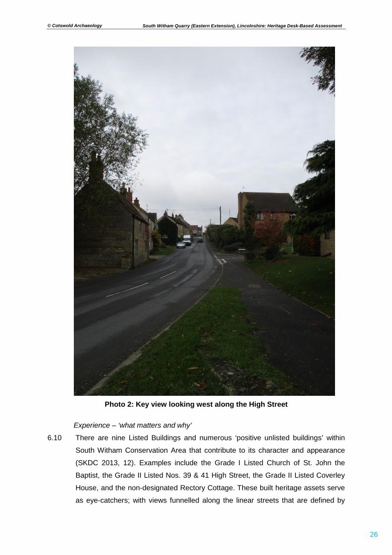
Photo 2: Key view looking west along the High Street
Experience – ‘what matters and why’
6.10 There are nine Listed Buildings and numerous ‘positive unlisted buildings’ within
South Witham Conservation Area that contribute to its character and appearance
(SKDC 2013, 12). Examples include the Grade I Listed Church of St. John the
Baptist, the Grade II Listed Nos. 39 & 41 High Street, the Grade II Listed Coverley
House, and the non-designated Rectory Cottage. These built heritage assets serve
as eye-catchers; with views funnelled along the linear streets that are defined by
© Cotswold Archaeology
27
South Witham Quarry (Eastern Extension), Lincolnshire: Heritage Desk-Based Assessment
boundary or building walls that directly front the highway. The Appraisal includes a
map of key views and vistas within the Conservation Area (see Appendix B). The
falling topography of the High Street ‘contributes to progressive views in both
directions’ (Photo 2) whilst hedgerows along Church Lane ‘delineate constrained
views’ (SKDC 2013, 10). It is noted that: ‘Long-ranging views outside of the
boundary are limited with glimpsed views of the surrounding landscape and distant
tree belts in the eastern views along Water Lane, Church Street, Church Lane and
High Street’ (SKDC 2013, 10). From the southern boundary of the Conservation
Area, the embankment of the dismantled railway line (Fig. 3, 6a) masks views of the
open countryside to the west and east of Thistleton Lane. The proposed eastern
extension to the quarry will not be visible from the village.
Summary of development effect
6.11 The setting of South Witham Conservation Area contributes to its significance as
follows:
• Historic settlement pattern of linear streets – focussing on High Street,
Church Street and Church Lane;
• Sense of enclosure and boundedness – with buildings directly fronting the
street and delineated by boundary walls;
• Harmonious architectural styles and local building materials;
• Secluded, rural character fostered by hedgerows and mature tree planting;
• Glimpsed views of the surrounding landscape to the east of the village.
6.12 The Site is located at some distance from the Conservation Area; and the proposed
development will have no impact upon its built form and layout. Furthermore, there
is no intervisibility between the Site and the Conservation Area. On this basis no
harm to the asset’s heritage significance has been identified.
Grade I Listed Church of St. John the Baptist (Fig. 1) Special architectural and historical interest
6.13 The Church of St. John the Baptist at South Witham is considered to have late 12th
to early 13th century origins; the north arcade may be the oldest surviving built
element. The List Entry description (NHLE Ref. 1062325) observes various features
of architectural and historical interest, including the 12th century 3-bay north
arcade, the early 13th-century western wall of the nave, and 14th and 15th century
windows to the north and south transepts and in the east wall of the chancel. There
is no tower. The heritage significance of this Listed Building is derived primarily from
© Cotswold Archaeology
28
South Witham Quarry (Eastern Extension), Lincolnshire: Heritage Desk-Based Assessment
its historical, evidential and aesthetic value – contained within the physical fabric.
The Church also has some communal value as an historic place of worship for the
residents of South Witham village and parish. The built elements of this designated
heritage asset will be unaffected by the proposed development.
Physical surroundings – ‘what matters and why’
6.14 The Church of St. John the Baptist occupies a slightly elevated position within the
core of South Witham village (see Section 4.19). The main thoroughfare of Church
Street runs directly south before turning east along the northern boundary of the
churchyard. A narrow lane branches off from this corner to extend alongside the
western boundary; with steps leading up to a gate in the south-western corner of
the churchyard – providing pedestrian access to the south door. The churchyard is
compact and completely enclosed by a stone wall; except on the south side, which
is abutted by the Grade II Listed Coverley House (NHLE Ref. 1168394). To the east
side is the Grade II Listed No. 2 Church Street (NHLE Ref. 1062326), with its
garden and orchard utilising the churchyard wall as its western boundary. These
and other nearby historic buildings (including the Grade II Listed Angel Inn; NHLE
Ref. 1168360) arguably have some associative relationships with the Church,
contributing to a sense of the vernacular character of this historic core of the village.
The proposed development will have no impact upon these elements of the physical
surroundings.
Experience – ‘what matters and why’
6.15 The South Witham Conservation Area Appraisal (see above) highlights four key
views in relation to the Grade I Listed Church of St. John the Baptist. These views
correspond to three approaches by which the designated heritage asset is typically
and best appreciated i.e. from the east via Church Lane, from the north via Church
Street, and from the south via the narrow extension of Church Lane and footpath
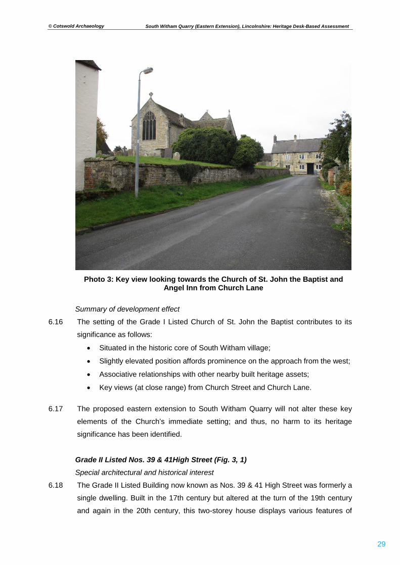
leading from High Street. The topographical prominence of the Church is most
apparent when viewed from the east (Photo 3); but the lack of a tower means that
the building does not function as a landmark throughout the village, and neither can
it be seen from further afield. It is within its immediate physical surroundings that
this designated heritage asset is best experienced. The proposed development
(extraction works and associated infrastructure and traffic) will be distanced away
from the Church and the main thoroughfares towards and past it.
© Cotswold Archaeology
29
South Witham Quarry (Eastern Extension), Lincolnshire: Heritage Desk-Based Assessment
Photo 3: Key view looking towards the Church of St. John the Baptist and
Angel Inn from Church Lane
Summary of development effect
6.16 The setting of the Grade I Listed Church of St. John the Baptist contributes to its
significance as follows:
• Situated in the historic core of South Witham village;
• Slightly elevated position affords prominence on the approach from the west;
• Associative relationships with other nearby built heritage assets;
• Key views (at close range) from Church Street and Church Lane.
6.17 The proposed eastern extension to South Witham Quarry will not alter these key
elements of the Church’s immediate setting; and thus, no harm to its heritage
significance has been identified.
Grade II Listed Nos. 39 & 41High Street (Fig. 3, 1) Special architectural and historical interest
6.18 The Grade II Listed Building now known as Nos. 39 & 41 High Street was formerly a
single dwelling. Built in the 17th century but altered at the turn of the 19th century
and again in the 20th century, this two-storey house displays various features of
© Cotswold Archaeology
30
South Witham Quarry (Eastern Extension), Lincolnshire: Heritage Desk-Based Assessment
architectural and historical interest. The List Entry description (NHLE Ref. 1168419)
notes its coursed limestone rubble construction with large ashlar quoins and
dressings; the pantile roof with one stone coped gable; the two 20th century gables
with single ridge red brick stacks; and single 3-light mullioned windows to each
floor. It appears that the significance of this designated heritage asset is derived
primarily from its historical and evidential value, embodied by the physical fabric.
The proposed development will have no impact upon the built form of Nos. 39 & 41
High Street.
Physical surroundings – ‘what matters and why’
6.19 The Listed Building forms the end of a continuous row of limestone-built houses;
although perhaps only No. 42 (with a mullion window visible at first floor level) is of
contemporaneous construction. No. 39 directly fronts High Street, with three steps
leading up to a front door. No. 41 has a small garden enclosed by a stone wall and
wrought iron fence with gate; a short path leading to its front door, which is tucked
away in the corner between the main east-facing elevation and a rear bay.
Considering the building as a single entity, however, it appears prominent in its
immediate surroundings – facing both High Street and Water Lane. There are
possible associative relationships between Nos. 39 & 41 High Street and nearby
historic buildings such as 4 Water Lane. The proposed eastern extension to South
Witham Quarry will not alter these elements of the immediate physical surroundings
that contribute to the heritage significance of the Listed Building.
Experience – ‘what matters and why’
6.20 The South Witham Conservation Area Appraisal (see above) considers Nos. 39 &
41 High Street as an exemplar of higher-status post-medieval architecture within
the village; and suggests that the Listed Building ‘act[s] as an imposing entrance to
the conservation area from Water Lane’. It is an eye-catcher heritage asset that is
best and typically appreciated when approaching from the east along High Street or
from the north via Water Lane. There is a sense of visual cohesion derived from the
use of limestone as an historic building material. The proposed development
(extraction works and associated infrastructure and traffic) will have no impact upon
the way in which this Listed Building is experienced.
Summary of development effect
6.21 The setting of the Grade II Listed Nos. 39 & 41 High Street contributes to its
significance as follows:
© Cotswold Archaeology
31
South Witham Quarry (Eastern Extension), Lincolnshire: Heritage Desk-Based Assessment
• Located along one of the main streets in South Witham village and
Conservation Area;
• Associative relationships with other nearby built heritage assets;
• Key views from High Street and Water Lane.
6.22 The proposed eastern extension to South Witham Quarry will not affect the built
form or key elements of the immediate setting of Nos. 39 & 41 High Street. On that
basis no harm to heritage significance has been identified.
© Cotswold Archaeology
32
South Witham Quarry (Eastern Extension), Lincolnshire: Heritage Desk-Based Assessment
7. CONCLUSIONS
7.1 No archaeological or built heritage assets are recorded within the Site. The
hedgerow forming the southern boundary of the Site might be considered to be of
historic interest, in accordance with the criteria defined in the Hedgerows
Regulations (1997). This hedgerow is to be retained within the development
proposals. Sources consulted for this assessment indicate that the Site has long
formed part of the outlying agricultural hinterland of South Witham, a rural settlement
of known early medieval origins. There is limited potential for buried archaeological
remains associated with medieval and post-medieval land use; any scatters of
pottery sherds and other material debris derived from historic manuring practices are
considered to be of limited heritage significance.
7.2 Previous programmes of archaeological work undertaken in advance of mineral
extraction at South Witham Quarry have uncovered widespread evidence for late
Iron Age and Romano-British occupation and activity. However, evaluation trenching
immediately to the west of the Site – undertaken as a condition of planning consent
for an earlier phase of mineral extraction (AS 2003) – recorded only a single
archaeological feature comprising a single undated pit or post-hole with a fill of
human and animal bone. It is conceivable that these remains relate to the Romano-
British cemetery recorded c.250m to the north of the Site.
7.3 In conclusion, this desk-based assessment has found no heritage constraints to the
proposed eastern extension to South Witham Quarry. It is possible that
archaeological works may be required to better understand the presence, extent,
date, condition and significance of any surviving remains that may be affected by
mineral extraction. Any such further archaeological investigation (both field
evaluation and subsequent mitigation) can be secured by the imposition of a suitably
worded planning condition. The proposed eastern extension is considered to be
consistent with the requirements of the Planning (Listed Buildings and Conservation
Areas) Act 1990, the Framework, and local planning policies relating to the
protection of the historic environment.
© Cotswold Archaeology
33
South Witham Quarry (Eastern Extension), Lincolnshire: Heritage Desk-Based Assessment
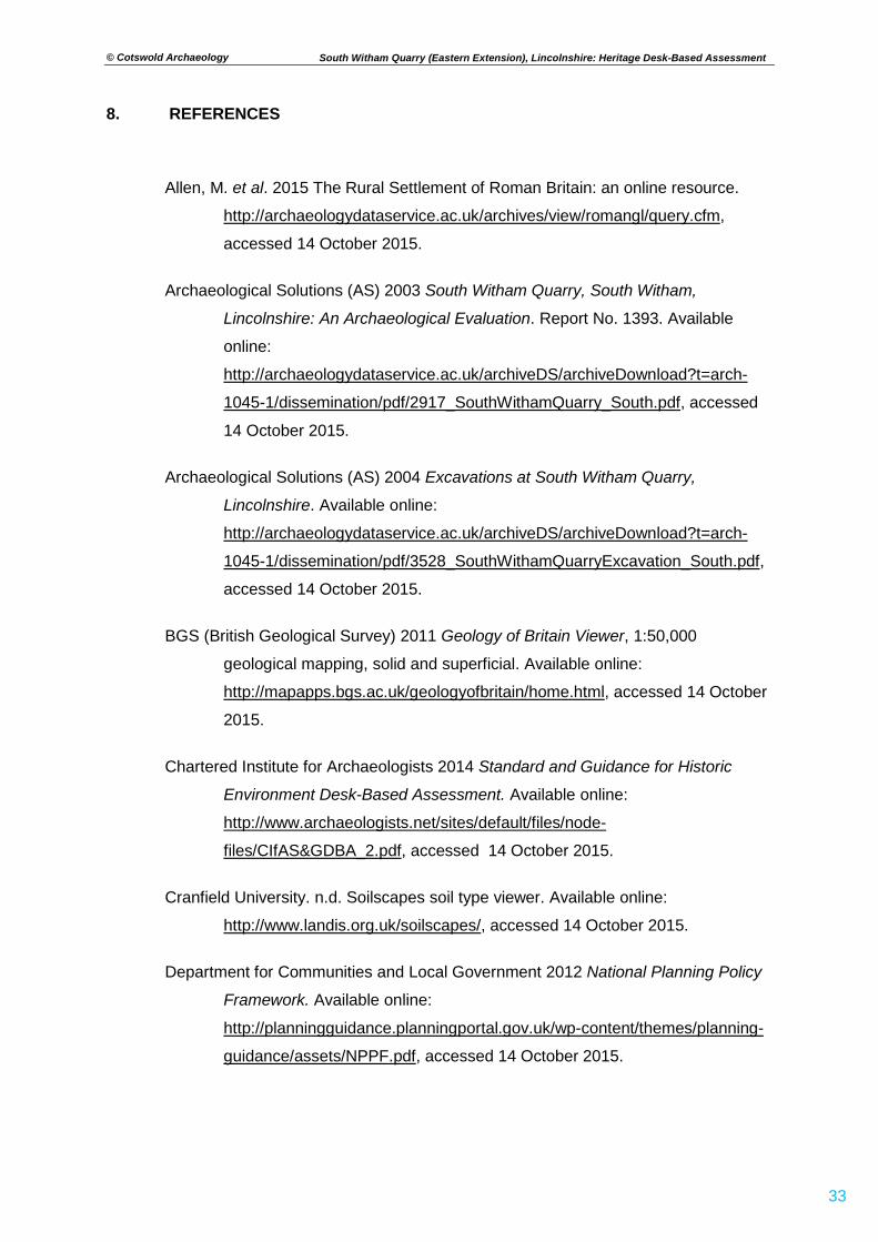
8. REFERENCES
Allen, M. et al. 2015 The Rural Settlement of Roman Britain: an online resource.
http://archaeologydataservice.ac.uk/archives/view/romangl/query.cfm,
accessed 14 October 2015.
Archaeological Solutions (AS) 2003 South Witham Quarry, South Witham,
Lincolnshire: An Archaeological Evaluation. Report No. 1393. Available
online:
http://archaeologydataservice.ac.uk/archiveDS/archiveDownload?t=arch-
1045-1/dissemination/pdf/2917_SouthWithamQuarry_South.pdf, accessed
14 October 2015.
Archaeological Solutions (AS) 2004 Excavations at South Witham Quarry,
Lincolnshire. Available online:
http://archaeologydataservice.ac.uk/archiveDS/archiveDownload?t=arch-
1045-1/dissemination/pdf/3528_SouthWithamQuarryExcavation_South.pdf,
accessed 14 October 2015.
BGS (British Geological Survey) 2011 Geology of Britain Viewer, 1:50,000
geological mapping, solid and superficial. Available online:
http://mapapps.bgs.ac.uk/geologyofbritain/home.html, accessed 14 October
2015.
Chartered Institute for Archaeologists 2014 Standard and Guidance for Historic
Environment Desk-Based Assessment. Available online:
http://www.archaeologists.net/sites/default/files/node-
files/CIfAS&GDBA_2.pdf, accessed 14 October 2015.
Cranfield University. n.d. Soilscapes soil type viewer. Available online:
http://www.landis.org.uk/soilscapes/, accessed 14 October 2015.
Department for Communities and Local Government 2012 National Planning Policy
Framework. Available online:
http://planningguidance.planningportal.gov.uk/wp-content/themes/planning-
guidance/assets/NPPF.pdf, accessed 14 October 2015.
© Cotswold Archaeology
34
South Witham Quarry (Eastern Extension), Lincolnshire: Heritage Desk-Based Assessment
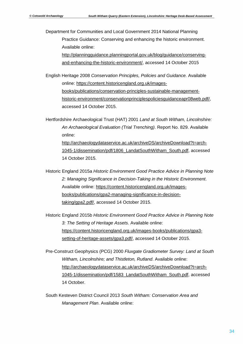
Department for Communities and Local Government 2014 National Planning
Practice Guidance: Conserving and enhancing the historic environment.
Available online:
http://planningguidance.planningportal.gov.uk/blog/guidance/conserving-
and-enhancing-the-historic-environment/, accessed 14 October 2015
English Heritage 2008 Conservation Principles, Policies and Guidance. Available
online: https://content.historicengland.org.uk/images-
books/publications/conservation-principles-sustainable-management-
historic-environment/conservationprinciplespoliciesguidanceapr08web.pdf/,
accessed 14 October 2015.
Hertfordshire Archaeological Trust (HAT) 2001 Land at South Witham, Lincolnshire:
An Archaeological Evaluation (Trial Trenching). Report No. 829. Available
online:
http://archaeologydataservice.ac.uk/archiveDS/archiveDownload?t=arch-
1045-1/dissemination/pdf/1806_LandatSouthWitham_South.pdf, accessed
14 October 2015.
Historic England 2015a Historic Environment Good Practice Advice in Planning Note
2: Managing Significance in Decision-Taking in the Historic Environment.
Available online: https://content.historicengland.org.uk/images-
books/publications/gpa2-managing-significance-in-decision-
taking/gpa2.pdf/, accessed 14 October 2015.
Historic England 2015b Historic Environment Good Practice Advice in Planning Note
3: The Setting of Heritage Assets. Available online:
https://content.historicengland.org.uk/images-books/publications/gpa3-
setting-of-heritage-assets/gpa3.pdf/, accessed 14 October 2015.
Pre-Construct Geophysics (PCG) 2000 Fluxgate Gradiometer Survey: Land at South
Witham, Lincolnshire; and Thistleton, Rutland. Available online:
http://archaeologydataservice.ac.uk/archiveDS/archiveDownload?t=arch-
1045-1/dissemination/pdf/1583_LandatSouthWitham_South.pdf, accessed
14 October.
South Kesteven District Council 2013 South Witham: Conservation Area and
Management Plan. Available online:
© Cotswold Archaeology
35
South Witham Quarry (Eastern Extension), Lincolnshire: Heritage Desk-Based Assessment
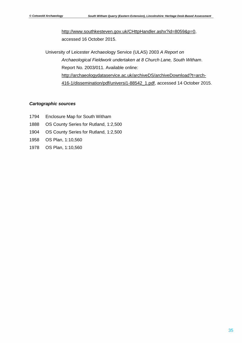
http://www.southkesteven.gov.uk/CHttpHandler.ashx?id=8059&p=0,
accessed 16 October 2015.
University of Leicester Archaeology Service (ULAS) 2003 A Report on
Archaeological Fieldwork undertaken at 8 Church Lane, South Witham.
Report No. 2003/011. Available online:
http://archaeologydataservice.ac.uk/archiveDS/archiveDownload?t=arch-
416-1/dissemination/pdf/universi1-88542_1.pdf, accessed 14 October 2015.
Cartographic sources 1794 Enclosure Map for South Witham
1888 OS County Series for Rutland, 1:2,500
1904 OS County Series for Rutland, 1:2,500
1958 OS Plan, 1:10,560
1978 OS Plan, 1:10,560
© Cotswold Archaeology
36
South Witham Quarry (Eastern Extension), Lincolnshire: Heritage Desk-Based Assessment
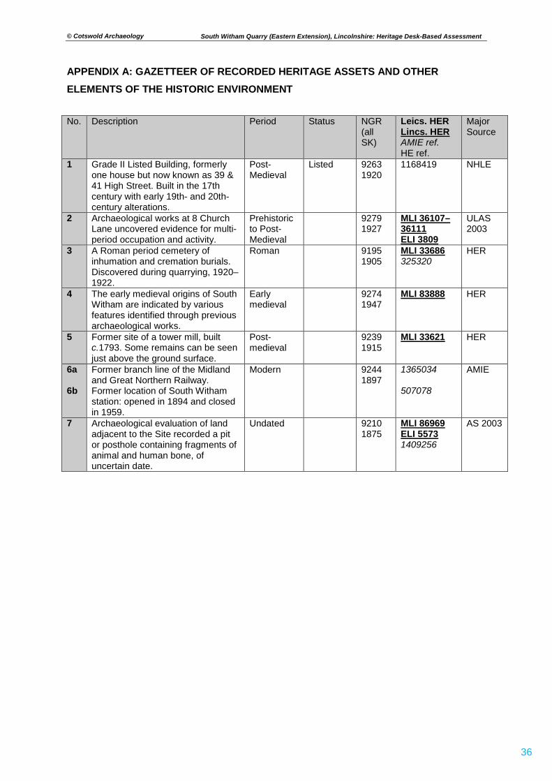
APPENDIX A: GAZETTEER OF RECORDED HERITAGE ASSETS AND OTHER ELEMENTS OF THE HISTORIC ENVIRONMENT
No. Description Period Status NGR (all SK)
Leics. HER Lincs. HER AMIE ref. HE ref.
Major Source
1 Grade II Listed Building, formerly one house but now known as 39 & 41 High Street. Built in the 17th century with early 19th- and 20th-century alterations.
Post-Medieval
Listed 9263 1920
1168419 NHLE
2 Archaeological works at 8 Church Lane uncovered evidence for multi-period occupation and activity.
Prehistoric to Post-Medieval
9279 1927
MLI 36107– 36111 ELI 3809
ULAS 2003
3 A Roman period cemetery of inhumation and cremation burials. Discovered during quarrying, 1920–1922.
Roman 9195 1905
MLI 33686 325320
HER
4 The early medieval origins of South Witham are indicated by various features identified through previous archaeological works.
Early medieval
9274 1947
MLI 83888 HER
5
Former site of a tower mill, built c.1793. Some remains can be seen just above the ground surface.
Post-medieval
9239 1915
MLI 33621
HER
6a 6b
Former branch line of the Midland and Great Northern Railway. Former location of South Witham station: opened in 1894 and closed in 1959.
Modern 9244 1897
1365034 507078
AMIE
7 Archaeological evaluation of land adjacent to the Site recorded a pit or posthole containing fragments of animal and human bone, of uncertain date.
Undated 9210 1875
MLI 86969 ELI 5573 1409256
AS 2003
© Cotswold Archaeology
37
South Witham Quarry (Eastern Extension), Lincolnshire: Heritage Desk-Based Assessment
APPENDIX B: KEY VIEWS IDENTIFIED BY THE SOUTH WITHAM CONSERVATION AREA APPRAISAL
LINCOLNSHIRE
Reproduced from the 2015 Ordnance Survey Explorer map with the permission of Ordnance Survey on behalf of The Controller of Her Majesty's Stationery Office Crown copyright Cotswold Archaeology Ltd 100002109
c
CotswoldArchaeology
N
PROJECT TITLE
FIGURE TITLE
FIGURE NO.
1
South Witham Quarry (Eastern Extension)South Witham, Lincolnshire
Site location plan, showing designated heritage assets
PROJECT NO.DATESCALE@A4
DRAWN BYCHECKED BYAPPROVED BY
66057420/10/20151:20,000
LJHDJBNB
Andover 01264 347630
Cirencester 01285 771022
Exeter 01392 826185
Milton Keynes 01908 564660
w www.cotswoldarchaeology.co.uk
0 500m
site boundary
Scheduled Monument
South WithamConservation Area
Area of previous quarrying
Grade I Listed Building
Grade II* Listed Building
Grade II Listed Building
320000320000
318000318000
490000490000
492000492000
494000494000
CotswoldArchaeology
N
PROJECT TITLE
FIGURE TITLE
FIGURE NO.Reproduced from the 2015 Ordnance Survey Explorer map with the permissionof Ordnance Survey on behalf of The Controller of Her Majesty's Stationery Office Crown copyright Cotswold Archaeology Ltd 100002109 c 2
South Witham Quarry (Eastern Extension)South Witham, Lincolnshire
Previous archaeological works
PROJECT NO.DATESCALE@A4
DRAWN BYCHECKED BYAPPROVED BY
66057426/10/20151:25,000 & 1:15,000
LJHDJBNB
Andover 01264 347630
Cirencester 01285 771022
Exeter 01392 826185
Milton Keynes 01908 564660
w www.cotswoldarchaeology.co.uk
0 1km
site boundary
previous archaeologicalworks
Geophysical Survey(Bartlett-Clark Consultancy 2010)
Geophysical Survey(Bartlett-Clark Consultancy 2010)
Archaeological evaluation(Archaeological Solutions 2003)
Archaeological evaluation(Archaeological Solutions 2003)
Trial trenching at 8 Church Lane(ULAS 2003)
Trial trenching at 8 Church Lane(ULAS 2003)
Geophysical survey(Pre-Construct Geophysics 2000)
Geophysical survey(Pre-Construct Geophysics 2000)
Geophysical survey, trial trenching,excavation & fieldwalking
(Pre-Construct Geophysics 2000; HAT 2001; Archaeological Solutions 2006; Cotswold Archaeology 2007)
Geophysical survey, trial trenching,excavation & fieldwalking
(Pre-Construct Geophysics 2000; HAT 2001; Archaeological Solutions 2006; Cotswold Archaeology 2007)
Geophysical survey, trial trenching & excavation(Pre-Construct Geophysics 2000; HAT 2001;
Archaeological Solutions 2004)
Geophysical survey, trial trenching & excavation(Pre-Construct Geophysics 2000; HAT 2001;
Archaeological Solutions 2004)
0 300m
InsetInset
InsetInset
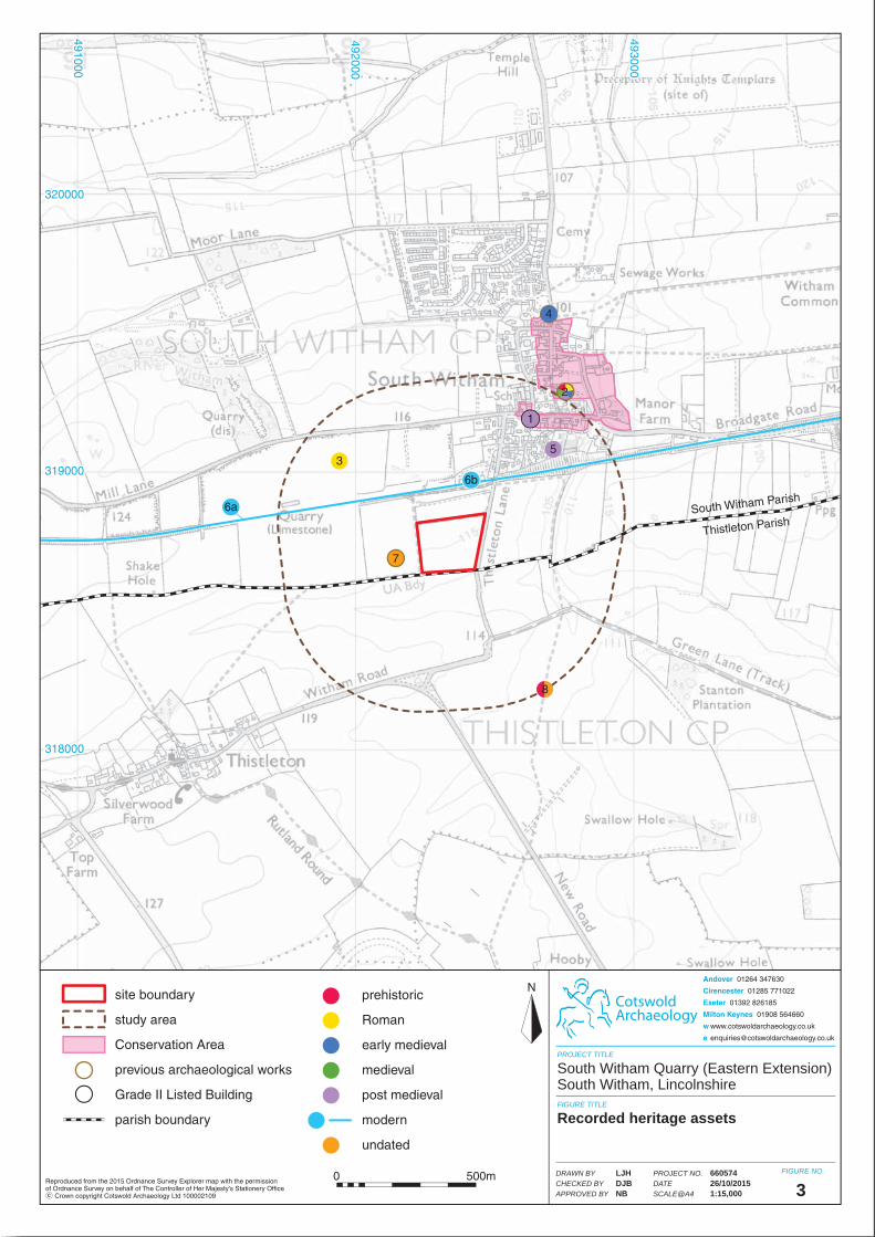
South Witham Parish
Thistleton Parish
2
33
44
55
77
1
491000491000
492000492000
493000493000
320000320000
319000319000
318000318000
CotswoldArchaeology
N
PROJECT TITLE
FIGURE TITLE
FIGURE NO.Reproduced from the 2015 Ordnance Survey Explorer map with the permissionof Ordnance Survey on behalf of The Controller of Her Majesty's Stationery Office Crown copyright Cotswold Archaeology Ltd 100002109 c 3
South Witham Quarry (Eastern Extension) South Witham, Lincolnshire
Recorded heritage assets
PROJECT NO.DATESCALE@A4
DRAWN BYCHECKED BYAPPROVED BY
66057426/10/20151:15,000
LJHDJBNB
Andover 01264 347630
Cirencester 01285 771022
Exeter 01392 826185
Milton Keynes 01908 564660
w www.cotswoldarchaeology.co.uk
0 500m
6b
6a
8
site boundary
study area
Conservation Area
previous archaeological works
Grade II Listed Building
parish boundary
prehistoric
Roman
early medieval
medieval
post medieval
modern
undated
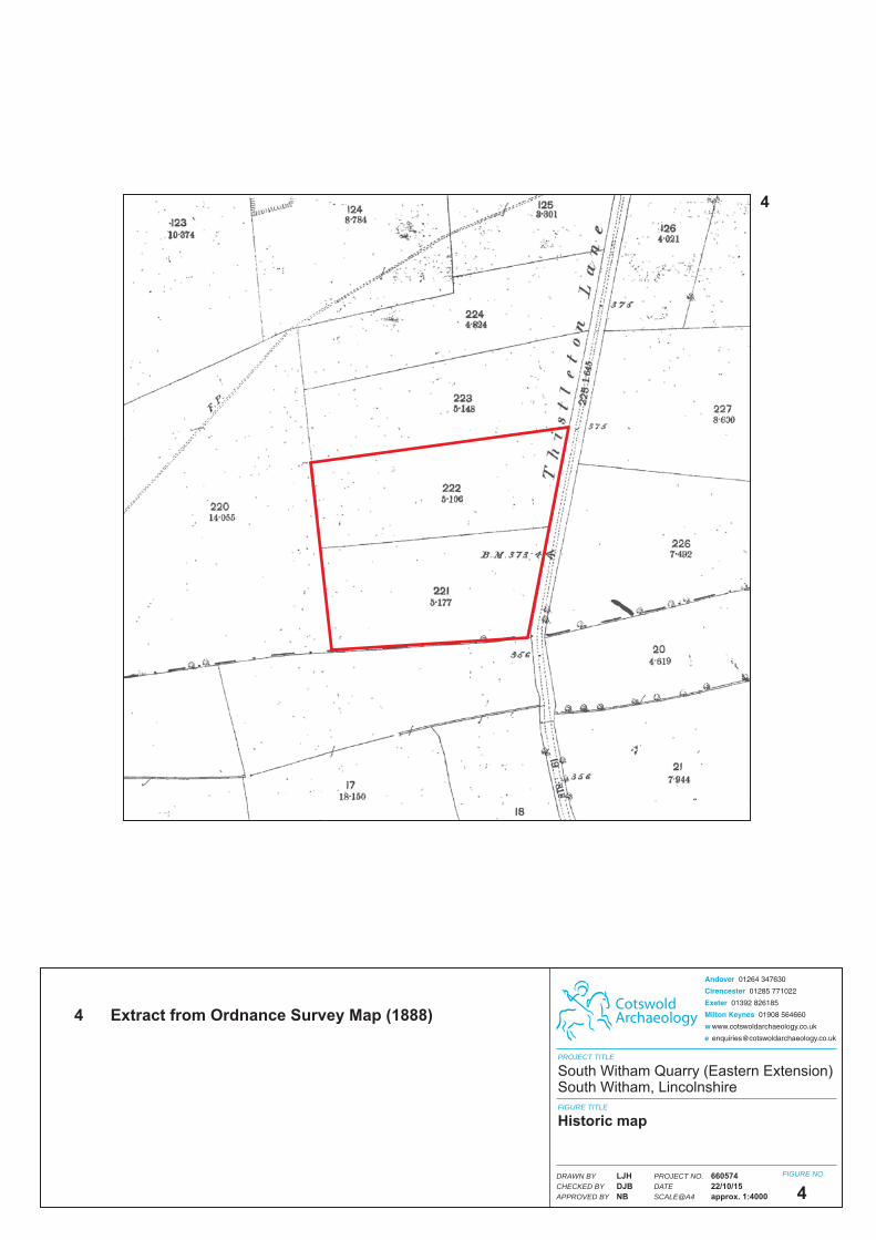
CotswoldArchaeology
PROJECT TITLE
FIGURE TITLE
FIGURE NO.
4
4
South Witham Quarry (Eastern Extension)South Witham, Lincolnshire
4 Extract from Ordnance Survey Map (1888)
Historic map
PROJECT NO.DATESCALE@A4
DRAWN BYCHECKED BYAPPROVED BY
66057422/10/15approx. 1:4000
LJHDJBNB
Andover 01264 347630
Cirencester 01285 771022
Exeter 01392 826185
Milton Keynes 01908 564660
w www.cotswoldarchaeology.co.uk
Related Documents