SOUTH WATERFRONT URBAN RENEWAL PLAN September 2013 City of Salem Adopted: September 4, 2007 Amended: January 22, 2008 – Resolution 08-1 URA Amended: January 22, 2008 – Resolution 08-2 URA Amended: September 9, 2013 – Resolution 13-12 URA

Welcome message from author
This document is posted to help you gain knowledge. Please leave a comment to let me know what you think about it! Share it to your friends and learn new things together.
Transcript

SOUTH WATERFRONT URBAN RENEWAL PLAN
September 2013
City of Salem
Adopted: September 4, 2007
Amended: January 22, 2008 – Resolution 08-1 URA
Amended: January 22, 2008 – Resolution 08-2 URA
Amended: September 9, 2013 – Resolution 13-12 URA

LIST OF PARTICIPANTS
City Council
Janet Taylor, Mayor
Chuck Bennett, Ward 1
Laura Tesler, Ward 2
Brad Nanke, Ward 3
TJ Sullivan, Ward 4
Kate Tartar, Ward 5
Bruce Rogers, Ward 6
Brent DeHart, Ward 7
Dan Clem, Ward 8
Urban Renewal Agency of the City of Salem
Janet Taylor, Chair
Dan Clem
Brent DeHart
Brad Nanke
Bruce Rogers
Laura Tesler
TJ Sullivan
Planning Commission
Chuck Bennett
Dan Dorn
Darr Goss
Nathan Levin
James Lewis
Michael Nelson
Jim Wiles
City of Salem Administration
Bob Wells, City Manager
Rick Scott, Urban Development Director
John Wales, Assistant Urban Development Director
Dan Riordan, Project Manager, Urban Development Department
Courtney Knox, Project Manager, Urban Development Department
David Skilton, Project Coordinator, Urban Development Department
C. Randall Tosh, City Attorney, Legal Department
Michelle Teed, Assistant City Attorney, Legal Department
Vickie Hardin Wood, Director, Community Development Department
Lisa Van de Water, Senior Planner, Community Development Department
Bryce Bishop, Associate Planner, Community Development Department
Julie Warncke, Transportation Planning Manager, Public Works Department
Ralph Lambert, Senior Project Manager, Public Works Department
Consultant Team
Jeffrey Tashman, Tashman Johnson LLC
Elaine Howard Consulting, LLC
SERA Architects
Comprehensive Plan Land Use Findings
Karen Williams, Lane Powell

TABLE OF CONTENTS
I. INTRODUCTION 2
II. GOALS AND OBJECTIVES 5
III. MAP AND LEGAL DESCRIPTION OF URBAN RENEWAL AREA 7
IV. OUTLINE OF MAJOR URBAN RENEWAL PROJECT ACTIVITIES 8
V. URBAN RENEWAL PROJECTS 8
VI. RELATIONSHIP TO LOCAL OBJECTIVES 12
VII. PLANNED LAND USES 32
VIII. PROPERTY ACQUISITION AND DISPOSITION 32
IX. RELOCATION METHODS 33
X. TAX INCREMENT FINANCING OF PLAN 33
XI. FUTURE AMENDMENTS TO PLAN 35

SOUTH WATERFRONT URBAN RENEWAL PLAN
City of Salem 2 January 22, 2008
I. INTRODUCTION
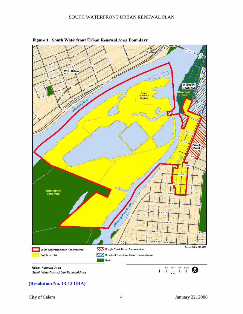
The South Waterfront Urban Renewal Plan (the Plan) contains goals, objectives and projects for
the development of the South Waterfront Urban Renewal Area (the Area). The Area, as shown
in Figure 1, encompasses 411 acres, more or less, and includes: parts of Minto Island and the
Willamette Slough; the area roughly bounded by the Willamette Slough on the west, the
Riverfront Downtown Urban Renewal Area on the north, the easterly line of the Commercial
Street right-of-way on the east, and Mission Street on the south; and an area roughly bounded by
Mission Street on the north, the westerly line of the alley right-of-way between Liberty and
Commercial Streets on the east, the southerly line of the right-of-way of Owens Street on the
south, and the easterly line of the Saginaw Street right-of-way and the easterly line of the alley
right-of-way between Liberty and Saginaw Streets on the west. (Reso. No. 13-12 URA)
In 2006, the City of Salem (City), Boise Cascade Corporation (Boise) and the Strategic
Economic Development Corporation (SEDCOR) invited the Urban Land Institute (ULI) to
convene an Advisory Services Program Panel (the Panel) to evaluate development opportunities
for the Boise site and nearby properties. The Panel was asked to consider possibilities for
profitably redeveloping the properties while providing public benefits.
The Panel was convened the week of June 25, 2006 and issued a report in November 2006 which
included an overall assessment of the downtown and its real estate development environment; an
evaluation of the site’s opportunities and constraints; a suggested concept for redevelopment (the
types and amounts of residential, retail and commercial development, parking, open space and
public areas), and implementation recommendations. The Panel’s report recommended a change
in the zoning and use of the site from industrial to mixed (commercial/residential/public) use and
a strategy of cooperation between Boise and the City to achieve optimal site redevelopment. The
Panel also recommended that the City adopt an urban renewal plan to finance public
improvements.
The City is proceeding with implementation of some of the ULI recommendations. As a part of
that process, the City Council commissioned a Feasibility Study for an urban renewal plan for the
“South Waterfront” area to include the Boise property and its vicinity. The Feasibility Study was
presented to the City Council on March 19, 2007. As part of that discussion, the City Council
directed staff to prepare an Urban Renewal Plan and Report for most but not all of the area
studied and added the area on Minto Island in Boise’s ownership. The boundary was confirmed
by Council on April 23, 2007. On July 9, 2007, the City Council further directed staff to include
the northern portion of Minto Island which is owned by the Salem Audubon Society into the
urban renewal area. This Urban Renewal Plan was developed in response to the Council’s
direction.
The Plan will facilitate and encourage improvements in the Area, including changes to the
transportation and pedestrian systems, extension of riverfront access, daylighting of Pringle
Creek, additions to the pedestrian and bicycle system on Minto Island, and provision of
streetscape improvements and bike lanes. It will also allow for incentives to facilitate the Area’s

SOUTH WATERFRONT URBAN RENEWAL PLAN
City of Salem 3 January 22, 2008
redevelopment in alignment with the goals and objectives in the Plan, and in accordance with the
City’s Comprehensive Plan and land use regulations.
The purpose of the Plan is to use the tools provided by urban renewal (ORS Chapter 457) to
overcome barriers to the development of the Area and create economic opportunities that will
benefit local and regional residents. These tools include tax increment financing (see Section X),
which means that the property taxes resulting from growth in property value within the Area can
be used to finance improvement projects and programs, and the acquisition and sale of land for
redevelopment as part of a public/private development partnership as described in the Plan.
The Plan is administered by Urban Renewal Agency (the Agency) for the City of Salem, Oregon.
The Agency was activated by the City Council of the City Salem by Resolution No. 7986,
adopted on October 23, 1961. Two other urban renewal areas are adjacent to the South
Waterfront Urban Renewal Area -- the Riverfront Downtown Urban Renewal Area and the
Pringle Creek Urban Renewal Area.
As required by ORS 457.085 (3), the Plan is accompanied by the South Waterfront Urban
Renewal Report (the Report), which is intended to provide public information and a basis for the
findings made by the City Council as part of its approval of the Plan.
SOUTH WATERFRONT URBAN RENEWAL PLAN
City of Salem 4 January 22, 2008
(Resolution No. 13-12 URA)
SOUTH WATERFRONT URBAN RENEWAL PLAN
City of Salem 5 January 22, 2008
II. GOALS AND OBJECTIVES
The goals of the Plan establish its basic intent and purpose. Accompanying each goal are
objectives, which generally describe how the Agency intends to achieve the goals. The urban
renewal projects identified in Chapter V of the Plan are the specific means of meeting the
objectives.
Goal 1: LAND USE: EMPLOYMENT, BUSINESS ACTIVITY AND
RESIDENTIAL USES
Promote a mix of retail, commercial, and residential uses to increase employment, attract a
broader range of businesses to the Area, and support existing commercial development in
the Area.
Objectives:
1A: Work with property owners to promote beneficial development of properties within
the Area.
1B: Encourage development of pedestrian and bicycle-oriented uses, public spaces, and
infrastructure improvements. Develop a year-round pedestrian environment that
encourages use and patronage of the Area’s businesses, provides opportunity for new
businesses to locate in the Area, and promotes downtown living.
1C: Increase the total supply of housing adjoining the retail core which will in turn
support restaurants and other businesses that attract residents and visitors to the
downtown area.
1D: Promote development of a variety of housing locations, including locations above
retail and office space, to increase the range of housing opportunities in the Area and to
provide housing which is in walking distance of retail, personal and business services,
and employment opportunities. Orient the housing to take advantage of the views of the
Willamette River and Pringle Creek.
1E: Promote the development of higher density housing and a variety of housing types:
loft, apartment, condominium, and other high density alternatives to serve a variety of
income levels.
1F: Encourage the development of new housing through the use of available measures
including local, state and federal incentives.
1G: Promote mixed-use development including office space above ground floor
commercial service and retail space to attract a broad range of businesses, increase
employment density and support the existing downtown commercial community.
SOUTH WATERFRONT URBAN RENEWAL PLAN
City of Salem 6 January 22, 2008
1H: Promote the rehabilitation and/or conversion of substandard and/or historic buildings
to support mixed-use development.
1I: Support the existing downtown uses and future uses on this site by providing parking
facilities.
1J: Create financial programs offering loans or grants to new or existing businesses that
may be used to improve, upgrade, update, or revitalize the buildings or other structures
associated with their business.
1K: Encourage the development of residential, office, and transit supportive uses such as
dry cleaners, markets, pharmacies, restaurants.
Goal 2: TRAFFIC AND TRANSPORTATION
Implement transportation improvements to increase access to and mitigate traffic impacts
within the Area.
Objectives:
2A: Provide transportation and infrastructure improvements to support the development
of mixed-uses.
2B: Construct street improvements consistent with City standards.
2C: Provide sidewalks and streetscape improvements that promote mixed-use
developments, access and safety.
2D: Support the location of a commuter rail station with pedestrian connections to the
Area with at least partial funding for placement of a future station in the Area.
2E: Extend the transportation network into the Boise Cascade site.
2F: Extend the bike lane network through the Area.
Goal 3: PEDESTRIAN ENVIRONMENT/RIVERFRONT/PUBLIC SPACE
CONNECTIONS
Enhance the pedestrian environment on streets, in public parks and greenspaces, and in
other public gathering spaces. Provide opportunities for public access to the Willamette
River, and connections to the mixed-use development and public spaces adjacent to the
Willamette River. Create an environment that is safe and attractive for pedestrians.
SOUTH WATERFRONT URBAN RENEWAL PLAN
City of Salem 7 January 22, 2008
Objectives:
3A: Participate in the development of the Willamette Riverfront to provide an
opportunity for a mixture of commercial, residential, public and other uses compatible
with the Riverfront, and facilitate safe pedestrian and bicycle movement along the
Riverfront with linkages to all adjoining areas.
3B: Develop a system of streetscape improvements to create a continuous and consistent
pedestrian environment throughout the Area. Improvements could include public art,
landscaping, sidewalk surfacing, signing, street furniture, weather protection and related
improvements.
3C: Construct a recreational path system on Minto Island to allow increased use and
enjoyment of the Island, including creation or improvement of paths that take advantage
of passive recreation opportunities, scenic benefits, and efficient connections to existing
bicycle and pedestrian routes and trails.
3D: Develop a multi-use path along Pringle Creek within the Area which may provide
additional connectivity to existing paths and park areas in or near downtown, and which
may also benefit from the daylighting of Pringle Creek.
3E: Develop pedestrian connections between the Willamette River and Pringle Creek.
3F: Extend the Willamette River pathway into the Area creating additional attractive and
safe trails for recreational use.
3G: Create a public plaza to serve as a gathering place for the community, which may be
adjacent to or otherwise accessible from existing downtown riverfront amenities.
3H: Provide both visual and actual connections from future development to the
Willamette Riverfront.
3I: Provide a view corridor to the Willamette River from the park area north of the Civic
Center, and from Commercial Street.
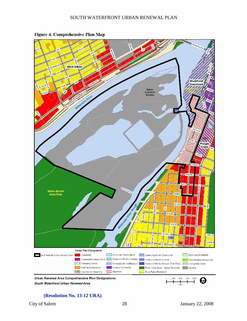
III. MAP AND LEGAL DESCRIPTION OF URBAN RENEWAL AREA
Figure 1 shows the Area boundaries. The legal description of the Area is attached as Appendix
A. Appendix B shows the map from which the legal description was drawn.
SOUTH WATERFRONT URBAN RENEWAL PLAN
City of Salem 8 January 22, 2008
IV. OUTLINE OF MAJOR URBAN RENEWAL PROJECT ACTIVITIES
An outline of major urban renewal project activities is as follows:
Daylighting of Pringle Creek to provide greater public access to the creek and another
connection the Willamette River.
Pedestrian and bicycle improvements, such as paths, bridges, and crossings, to provide
safe access to the Willamette riverfront, Pringle Creek and Minto Island, and Commercial
Street, and connect the Area to the Salem downtown.
Transportation improvements, including but not limited to street realignments, traffic
signals, sidewalks, and bicycle lanes to allow for increased circulation to, from, and
within the Area.
Public Plaza to serve as a community gathering place.
Streetscape improvements to enhance the appearance, safety, and usability of the area.
Transit improvements, including but not limited to a future commuter rail facility.
Loan or grant program for retail, commercial or residential properties.
Environmental remediation matching funds.
LEED certification funds.
V. URBAN RENEWAL PROJECTS
Urban renewal projects authorized by the Plan consist of public improvements and other projects
that are described below and as shown in Figure 2.
A. Capital Projects
Capital projects authorized under the Plan include transportation improvements which
will upgrade and expand existing roadways to increase access into, out of and within the
Area, facilitate the development of vacant and underutilized lands and accommodate
increased levels of traffic as future development occurs. To promote neighborhood
livability and increase multimodal connectivity, transportation projects may also include,
but are not limited to, sidewalks and streetscape improvements.
As shown in the Report, urban renewal funds may be combined with existing and other
future sources of funding to finance project costs.
Capital projects may include the following:
1. Pringle Creek Access Improvements
This project would create a path along Pringle Creek under Commercial Street,
and could include but is not limited to creek bank restoration, property
acquisition, demolition for creek daylighting, habitat restoration and landscaping.
This project would greatly improve multi-modal connections between Bush Park,
Riverfront Park, and Willamette University using the existing path system. This
project will also provide a way for pedestrians to safely cross the existing railroad

SOUTH WATERFRONT URBAN RENEWAL PLAN
City of Salem 9 January 22, 2008
tracks in connection with improved pedestrian access along Pringle Creek. At a
minimum, pedestrian safety crossing treatments will be required but other
improvements may be included.
2. Minto Island Property Acquisition and Multi-Use Path
This project includes acquisition of land for passive and active recreation use
including, but not limited to, construction of a multi-use pathway system
complementary with existing and planned park improvements on the Island.
Anticipated work includes, but is not limited to, grading, paving, surveying,
erosion control, excavation, and other activities generally associated with the
construction of trails and pathways, the improvement of wildlife habitat, and the
provision of scenic views.
3. Multi-Use Path Willamette Riverfront
This project will provide for a pathway along the Willamette Riverfront in this
Area to connect to the existing riverfront pathway. Additional connections to this
pathway may be undertaken through adjacent urban renewal areas or through
other available funding sources.
4. Street Connection to Boise Site and Traffic Signal
This project would create a signalized intersection on Commercial Street to
improve traffic circulation in and around the Area. The likely location would be to
realign Bellevue Street so it enters Commercial Street opposite the Civic Center
driveway. This project may include, but is not limited to, property acquisition,
creation of improvements to multi-modal access or right of way.
5. State Street Extension within the Area
This project would extend State Street south from the boundary of the Riverfront
Downtown Urban Renewal Area into the Area to allow for a transportation
turnaround, parking, enhanced access to the southern portion of Riverfront Park,
and additional commercial development along the newly created corridor as
proposed by the ULI report.
6. Public Plaza, State Street Terminus
This project would provide funding to assist in the development of a public plaza
within the Area, at the proposed terminus of a future State Street extension
project. The gathering place would provide an outdoor social gathering spot for
the Area’s new residents and for the community as a whole.
7. Commercial Street Bicycle Lanes
This project would provide bike lanes along Commercial Street from Mission to
Owens. It would also provide on-street parking improvements to accommodate
the addition of bike lanes in the right of way.

SOUTH WATERFRONT URBAN RENEWAL PLAN
City of Salem 10 January 22, 2008
8. Streetscape Improvements
This project may include, but is not limited to, design and implementation of
accent paving, sidewalk reconstruction, undergrounding of utilities, lighting, street
trees, outdoor furnishings, transit pullouts, and other related activities within the
public right of way or on adjacent private property to promote pedestrian
circulation and public transportation use in the renewal area.
Section V.A.8. Amended: January 22, 2008
Resolution 08-1 URA: “undergrounding of utilities”
9. General Transit Improvements Related to Future Commuter Rail
This project may include, but is not limited to funding for: a feasibility study on a
future commuter rail station; design and predevelopment activities for the station
and related improvements; and/or the construction of the station and related
improvements. The commuter rail station would provide a second passenger
depot for Salem and would help connect the Area and the community to other
places with passenger rail service.

SOUTH WATERFRONT URBAN RENEWAL PLAN
City of Salem 11 January 22, 2008
(Resolution No. 13-12 URA)
SOUTH WATERFRONT URBAN RENEWAL PLAN
City of Salem 12 January 22, 2008
B. Assistance to Property Owners/Lessees for Rehabilitation, Redevelopment or
Development
The Plan authorizes assistance to property and/or business owners, in making capital
improvements, environmental remediation matching funds and LEED certification funds to
property within the Area which support the goals and objectives of the Plan. Specific
program rules and regulations for administration will be developed after the adoption of the
Plan to ensure that urban renewal funds are used properly and for the agreed-upon
purposes.
9. Rehabilitation and Redevelopment Fund
Eligible programs may include:
Loans and/or grants to assist with planning and pre-development
activities as well as property development, rehabilitation or
redevelopment and other improvements. Property to be improved must
be in or planned for retail, commercial, or residential use. Loans may
be at or below market rates, and assistance can include direct loans or
guarantees of loans made by third parties.
Technical assistance, in the form of site studies, market studies,
environmental studies and impact assessments, feasibility analyses,
engineering and design and other activities directly related to
development of property in the Area.
10. Environmental Remediation Matching Fund
This fund would encourage and assist in environmental remediation in the
Area.
11. LEED Certification Fund
This fund would encourage LEED building standards by assisting property
owners with resources to complete the certification process.
VI. RELATIONSHIP TO LOCAL OBJECTIVES
The Plan reflects the regional planning and development objectives contained in the Salem Area
Comprehensive Plan (SACP), City of Salem Revised Code (SRC), and Transportation System
Plan (TSP). Adopted in October 1992 and most recently revised in April 2004, the SACP
identifies goals and policy objectives that support planning activities which will attract private
investment to the area and create new economic opportunities for local residents. The most
specific objectives to which the Plan responds are those contained in the Comprehensive Plan,
Transportation System Plan and Master Plan.
A. Salem Area Comprehensive Plan Goals and Policies
The intent of the Salem Area Comprehensive Plan is to project a goal - the most
desirable pattern of land use - in the Salem area. To ensure that the anticipated
urban land use needs are met, the Salem Area Comprehensive Plan Map demon-
SOUTH WATERFRONT URBAN RENEWAL PLAN
City of Salem 13 January 22, 2008
strates a commitment that land for a wide variety of uses will be available at
appropriate locations as needed. In order to achieve this commitment, the Salem
Area Comprehensive Plan utilizes an approach which provides for the phased
provision of land over time through annexation and rezoning in response to demand
for specific land uses. In using this approach, plans, plan policies, and
implementing mechanisms are developed and administered that are responsive to
changing and evolving land demands yet recognizing existing zoning. The intent
of this approach is to retain flexibility in the plan in order to remain responsive to
changing conditions, and yet recognize the legitimacy of the existing zoning and the
dynamic process of plan implementation.
The land use pattern that is shown on the Comprehensive Plan Map recognizes the
zoning that has developed over time, with general designations of the land uses that
are expected to be developed, as a result of: (1) demand, (2) the plan policies and
intent statements, and (3) implementing regulations and processes. This Plan
recognizes that the land use and zoning are expected to change during the time span
of the Plan as conditions change.
The Urban Renewal Plan is consistent with this policy provision because it provides for a
long-term financial and development plan to address changes in land use. By anticipating
20-year phasing of approximately 86,000 square feet of office space; hotel, restaurant,
retail, and other commercial spaces; and 269 units of housing, the Plan is designed to
provide financing that will allow the Agency to create financial incentives or provide
infrastructure that will encourage private sector development in a way that best addresses
demand, plan policies and intent statements, and processes and procedures prescribed by
the City and the Agency.
As Salem has grown and changed over time, the land use pattern along the downtown
riverfront is transitioning from industrial uses to a vibrant mixture of commercial, retail,
office, residential, and recreation uses. For example, Riverfront Park was a former
industrial site. This transition has also influenced the land use pattern of the south
waterfront area. With the closing of the Boise Cascade facility and the property’s sale,
approximately 323 acres of land within the south waterfront urban renewal area are in a
position to transition to new use.
In recognition of the importance of the redevelopment of Boise Cascade’s riverfront
properties, the Urban Land Institute (ULI) was invited in 2006 to conduct a study to
consider the possibilities for profitably redeveloping the Boise Cascade site. One of the
study’s key recommendations is that redevelopment of the Boise Cascade site will require
a mix of uses.
Because the comprehensive plan and zoning designations that currently apply to the site
do not allow for its redevelopment consistent with the land use pattern called for within
the recommendations of the ULI study, they will need to be changed. The City has begun
a process to change the comprehensive plan and zoning designation of the site to reflect
the findings of the ULI study and recognize the changing character of the downtown and
SOUTH WATERFRONT URBAN RENEWAL PLAN
City of Salem 14 January 22, 2008
its riverfront. Changing the existing comprehensive plan and zoning for the property to
respond to changing conditions and land use demands is consistent with the phased
urbanization and rezoning over time approach utilized by the Salem Area Comprehensive
Plan.
Chapter IV of the SACP identifies Goals and Policies pertaining to the City of Salem’s
long-term planning and development objectives. Of particular relevance to the Plan, and
discussed in detail below, are goals and policy directives contained in the following
sections of SACP Chapter IV: (B) General Development; (C) Urban Growth; (D) Growth
Management; (E) Residential Development; (F) Mixed-use Development; (G)
Commercial Development; (J) Transportation; (K) Open Space, Parks and Recreation;
(N) Natural and Historic Areas; Natural Resources and Hazards; and (O) Willamette
River Greenway.
1. General Development (SACP, Chapter IV, Goal B)
Goal: To insure that future decisions concerning the use of land within the
Salem urban area are consistent with State Land Use Goals.
Policy 3 - Economic Growth
Economic growth which improves and strengthens the economic
base of the Salem urban area should be encouraged.
The Plan is consistent with this policy because it provides for the redevelopment of a large parcel of property that is underutilized, limiting the economic potential of the Plan Area. Effective land use will create employment opportunities, as well as increased property tax revenues and the improved long-term stability of the property tax base.
2. Urban Growth (SACP, Chapter IV, Goal C)
Goal: To ensure that the rate, amount, type, location and cost of development
will preserve or enhance the City’s quality of life and promote the City’s efficient
delivery of services.
Policy 4 - Infill
Development of land with existing urban services shall be encouraged
before the conversion of urbanizable lands to urban uses.
The Plan is consistent with this Policy because the property within the Urban Renewal
Area that will be redeveloped is presently well served with urban services such as
transportation and transit services. Development of this Urban Renewal Area will
encourage development within the Area that has already been converted to urban uses.
3. Growth Management (SACP, Chapter IV, Goal D)
Goal: To manage growth in the Salem urban area through cooperative efforts of
the City of Salem and Marion and Polk Counties, to insure the quality of life of
SOUTH WATERFRONT URBAN RENEWAL PLAN
City of Salem 15 January 22, 2008
present and future residents of the area, and to contain urban development and to
preserve adjacent farm lands.
Policy 6 - Infill Development
New developments shall make maximum use of available land areas with
minimal environmental disturbance and be located and designed to
minimize such public costs as extension of sewer and water services,
schools, parks, and transportation facilities.
Policy 9 - Infill on Facilities
New development shall be encouraged to locate in areas where facilities
are already available and in areas which require the least public costs to
provide needed facilities and services.
The Plan is consistent with this Policy because the property within the Urban Renewal
Area that will be redeveloped is already well provided with urban services such as water,
sewer, power, transportation, and transit services. Development of this Urban Renewal
Area will encourage development within the Area that has already been converted to
urban uses. Also, many of the properties in the Urban Renewal Area have existing access
to needed facilities and services, which will encourage timely redevelopment.
4. Residential Development (SACP, Chapter IV, Goal E)
Goal: To promote a variety of housing opportunities for all income levels
and an adequate supply of developable land to support such housing.
In meeting this goal, residential development shall:
a. Encourage the efficient use of developable residential
land;
b. Provide housing opportunities for Salem’s diverse
population; and
c. Encourage residential development that maximizes
investment in public services.
Policy 3 - Infill Development
City codes and ordinances shall encourage the development of
passed-over or underutilized land to promote the efficient use of
residential land and encourage the stability of neighborhoods.
Policy 6 - Multi-Family Housing
Multi-family housing shall be located in areas proximate to existing
or planned transportation corridors, public facilities and services:
SOUTH WATERFRONT URBAN RENEWAL PLAN
City of Salem 16 January 22, 2008
a. To encourage the efficient use of residential land and
public facilities, development regulations shall require
minimum densities for multiple family development zones;
b. Development regulations shall promote a range of
densities that encourage a variety of housing types;
c. Multiple family developments should be located in areas
that provide walking, auto or transit connections to:
(1) Employment centers;
(2) Shopping areas;
(3) Transit service;
(4) Parks;
(5) Public buildings.
Policy 9 - Alternative Housing Patterns
Residential Development Patterns
Subdivision and zoning regulations shall provide opportunities for
increased housing densities, alternative housing patterns, and
reduced development costs. Development regulations shall promote
residential development patterns that encourage:
a. The use of all modes of transportation;
b. Reduction in vehicle miles traveled and length of auto
trips; and
c. Efficiency in providing public services.
These residential development policies and goals will be facilitated by the Plan because
the Plan will provide the financial resources necessary to allow the Agency to assist in
redevelopment of an underutilized site into a mixed-use neighborhood comprised of
housing, retail, office, commercial, services, parking, and open spaces. This will provide
the density, mix of uses and housing stock, and amenities that are the outcomes described
in these policies.
Policy 11 - Urban Design
Design Standards shall be implemented to improve the quality of life
of Salem’s residents and promote neighborhood stability and
compatibility.
The Plan is consistent with this policy because the Agency’s use of tax increment funding
will allow the Agency to negotiate incentive-based design features that are not likely to be
possible through zoning alone.
5. Mixed-use Development (SACP, Chapter IV, Goal F)
SOUTH WATERFRONT URBAN RENEWAL PLAN
City of Salem 17 January 22, 2008
Goal: To provide a mixture of complementary land uses that may include
housing, retail, offices, services, industrial and civic uses, to create
economic and social vitality.
SOUTH WATERFRONT URBAN RENEWAL PLAN
City of Salem 18 January 22, 2008
Policy 1 - Development
Encourage efficient use of land by facilitating compact, high-density
development and minimizing the amount of land that is needed to
accommodate automobile parking.
Policy 2 - Development (continued)
Encourage development that preserves open space.
Policy 3 - Priorities for Mobility and Access
Facilitate development (land use mix, density, connectivity, design,
and orientation) that reduces the need for, and frequency of, SOV
trips and supports public transit where applicable.
Policy 4 - Priorities for Mobility and Access (continued)
Reinforce streets as public places that encourage pedestrian and
bicycle travel.
Policy 5 - Priorities for Mobility and Access (continued)
Provide roadway and pedestrian connections to residential areas.
Policy 6 - Design
Develop commercial and mixed-use areas that are safe, comfortable
and attractive to pedestrians.
Policy 7 - Design (continued)
Provide flexibility in the siting and design of new developments,
facilities, and redevelopment to respond to changes in the
marketplace and infrastructure systems.
Policy 8 - Design (continued)
Provide appropriate transitions between mixed-use areas and
adjacent single-use neighborhoods.
These mixed-use goals and policies will be facilitated by the Plan because the Plan will
provide the financial resources necessary to allow the Agency to assist in redevelopment
of an underutilized site into a mixed-use neighborhood comprised of housing, retail,
office, commercial, services, parking, and open spaces. This will provide the density,
mix of uses and housing stock, and amenities that are the outcomes described in these
policies. Without the possibility of financial assistance and other urban renewal tools
made available by the Plan, this density of mixed-use development is not economically
feasible for the private sector acting alone. Thus, the Plan implements key policies of the
Salem Area Comprehensive Plan.

SOUTH WATERFRONT URBAN RENEWAL PLAN
City of Salem 19 January 22, 2008
6. Commercial Development (SACP, Chapter IV, Goal G)
Goal: To maintain and promote the Salem urban area as a commercial
center for the Marion-Polk County area.
Policy 1 - Central Business District
The central business district shall be maintained and developed as a
regional retail and employment center for the Salem urban area.
Policy 4 - Community Shopping and Service Facilities
Community shopping and service facilities shall be located adjacent
to major arterials and shall provide adequate parking and service
areas. Land use regulations shall include provisions for siting and
development which discourage major customer traffic from outside
the immediate neighborhoods from filtering through residential
streets.
Policy 5 - Neighborhood and Community Shopping and Service
Facilities
Unless the existing development pattern along arterials and
collectors commits an area to strip development, new commercial
development shall be clustered and located to provide convenience
goods and services for neighborhood residents or a wide variety of
goods and services for a market area of several neighborhoods.
These mixed-use development policies and goals will be facilitated by the Plan because
the Plan will provide the financial resources necessary to allow the Agency to assist in
redevelopment of an underutilized site into a mixed-use neighborhood comprised of
housing, retail, office, commercial, services, parking, and open spaces. This will provide
the density, mix of uses and housing stock, and community shopping and other service
facilities, as well as amenities that are the outcomes described in these policies. Without
the possibility of financial assistance and other urban renewal tools made available by the
Plan, this density of mixed-use development is not economically feasible for the private
sector acting alone. Thus, the Plan implements key policies of the Salem Area
Comprehensive Plan.
7. Transportation (SACP, Chapter IV, Goal J)
Goal: To provide a balanced, multimodal transportation system for the Salem
Urban Area that supports the safe and efficient movement of goods and people.
Policy 4 - Multi-Modal Transportation System
The transportation system for the Salem Urban Area shall consist of an
integrated network of facilities and services for a variety of motorized and
nonmotorized travel modes.
SOUTH WATERFRONT URBAN RENEWAL PLAN
City of Salem 20 January 22, 2008
Policy 5 - Connectivity and Circulation
The vehicle, transit, bicycle, and pedestrian circulation systems shall be
designed to connect major population and employment centers in the
Salem Urban Area, as well as provide access to local neighborhood
residential, shopping, schools, and other activity centers.
Policy 7 - Supportive of land Use Plan Designations and Development
Patterns
Local governments shall encourage the expansion of transit services
throughout and beyond the Salem Urban Area, especially to areas of
increased residential densities, major commercial concentrations, and large
institutional and employment centers.
Policy 12 - System Efficiency
The implementation of transportation system and demand management
measures, enhanced transit service, and provision for bicycle and
pedestrian facilities shall be pursued as a first choice for accommodating
travel demand and relieving congestion in a travel corridor, before
widening projects are constructed.
Policy 14 - Transportation Safety
Local governments within the Salem Urban Area shall make as a high
priority the planning, design, construction, and operation of a safe
transportation system for all modes of travel including minimizing
conflicts between different travel modes.
The Plan is consistent with the Transportation Goals set out above, as it includes several
projects and activities designed to facilitate and expand use of the affected properties by
pedestrians and bicyclists. Further, several transportation-oriented projects and activities
planned for the Area are designed to improve the efficiency and safety of transportation
services within the Area for all types of transportation. The trails, paths, and other open
areas planned for the Area are designed to interconnect within the planned projects but
also to connect transportation users to other transportation systems that exist within the
City of Salem and within the Area, providing increased feasible access to the services,
facilities and activities provided or available in the Area.
8. Open Space, Parks, and Recreation (SACP, Chapter IV, Goal K)
Goal: To provide for the recreation needs of the Salem urban area through the
acquisition and development of adequate parks and recreation facilities.

SOUTH WATERFRONT URBAN RENEWAL PLAN
City of Salem 21 January 22, 2008
Policy 2 - Priority Acquisition
Priority shall be given to acquiring and developing neighborhood,
community, and large urban parks. Exceptions will occur in isolated sub-
neighborhood units where removing access barriers or providing
pedestrian/bicycle linkages to existing parks will be given first priority in
satisfying any given service area’s recreational needs.
Policy 4 - Recreation
Private and public sectors should look for opportunities to meet park
facility needs through cooperative agreements. The City shall provide the
foundation for private programs or facilities, volunteers, and other
appropriate methods to supplement and extend the City’s resources in
developing and maintaining the park system.
Policy 5 - Open Space
The preservation and connection of identified natural open space areas
shall be protected through public acquisition and/or land use regulation.
Policy 7 - Riparian Related
The development of uses relating to the Willamette River and area streams
for recreation and scenic enjoyment should be encouraged.
The Plan is consistent with these Open Space, Parks, and Recreation Policies because it
provides for the development of several areas within the Urban Renewal Area as open
space intended for public use, including passive recreation. The Minto Island property
will provide a very large urban park, and linkages are planned on the island for public
use. Additional linkages will be considered and may be undertaken to connect several
other park and trail systems around the downtown and waterfront area to facilitate use of
these trails and nature areas. Public acquisition and land use regulation will both play a
significant role in the development of these open spaces. Finally, the projects and
activities related to the island and other open spaces planned for the Area will support the
Willamette River Water Trail, and encourage public use of these water resources.
9. Scenic and Historic Resources, Natural Resources, and Hazards (SACP,
Chapter IV, Goal N)

SOUTH WATERFRONT URBAN RENEWAL PLAN
City of Salem 22 January 22, 2008
Goal: To conserve open space, protect natural, historic, cultural and scenic
resources, and to protect life and property from natural disasters and hazards.
Policy 5 - Waterways
Waterways shall be protected, preserved, and maintained as drainage
courses and scenic, recreational, and natural resources. These
characteristics shall be considered during the development review process.
Public access to waterways for maintenance purposes should be provided.
Policy 6 - Wildlife Habitat
Identified significant wildlife habitats shall be protected and managed in
accordance with State wildlife management practices. The importance of
riparian vegetation as wildlife habitat shall be considered during the
development review process.
Policy 7 - Flood Hazards
Development in the floodplain shall be regulated to preserve and maintain
the capability of the floodplain to convey the flood water discharges and to
minimize danger to life and property.
The Plan is consistent with the above policies because it provides for the development of
several areas within the Urban Renewal Area as open space intended for public use,
including passive recreation. Linkages are planned on the island, and additional linkages
may undertaken to connect several other park and trail systems around the downtown and
waterfront area to facilitate use of these trails and nature areas. Public acquisition,
development, or both, of the scenic, historic, and natural resources land use regulation
will encourage public use of these resources in the Area. Additionally, it is expected that
consideration and protection of the wildlife on Minto Island will be a significant
component in advancing the public use of the island property. Some of the property
within the Area is subject to flooding, and management of flood hazards will be
considered in conjunction with the redevelopment, specifically with respect to the island.
As indicated above, the waterway and access to the water resources in the Area have been
a material component in development of the Plan and the Area.
10. Willamette Greenway (SACP, Chapter IV, Goal O)
Goal: To protect, conserve, enhance and maintain the natural, scenic, historical, agricultural, economic and recreational qualities of lands along the Willamette River.
Policy 1 - Use of Land
SOUTH WATERFRONT URBAN RENEWAL PLAN
City of Salem 23 January 22, 2008
Regulations to control the use of land and the intensity of uses within the Willamette River Greenway Boundary shall be maintained.
Policy 2 - Vegetation and Wildlife
Riparian vegetation and wildlife within the Greenway Boundary shall be conserved. Conservation shall include protecting and managing riverbanks, sloughs, wildlife, and vegetation.
Policy 3 - Scenic Easements
Scenic easements shall be used where practical to preserve and
enhance the character of the river within the Greenway Boundary.
Policy 4 - Public Access
Where private property is adjacent to public use areas, measures shall be taken to minimize disturbance to the private property.
Policy 5 - Public Access (continued)
Development and redevelopment within the Greenway Boundary should include provisions for public access to and along the river.
Policy 6 - Park and Recreation Sites
Existing parks within the Greenway Boundary shall be preserved and maintained. Additional sites for recreation and scenic views and access to the Willamette River should be acquired.
Policy 7 - Changes of Land Uses New development and changes of land uses which are compatible with the Greenway concept as defined in the State Land Use Goal may be permitted along the Willamette River.
These goals are facilitated by the Plan because it will allow the Agency to use tax
increment funds to develop public amenities in the greenway area, and to develop
pedestrian access on Minto Island and Minto-Brown Island Park. The amenities allowed
by financing provided through the Plan will further the policies of vegetation
preservation, public access, view preservation, development of parks, and visual access.
In addition, the Plan’s support of high-density, mixed-use development is consistent with
the River-Oriented Use Policies.
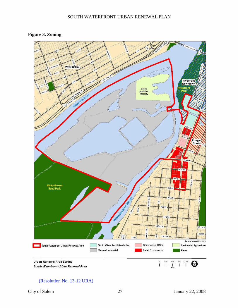
B. City of Salem Zoning and Development Standards
The Salem Revised Code (Title X) establishes zoning districts, which govern the allowed
uses (including outright permitted uses and conditional uses) and contain development
standards. Land within the Area is zoned General Industrial (IG), Retail Commercial
(CR), Commercial Office (CO), and Central Business District (CB). See Figure 3 for
current zoning designations. In addition to the underlying zoning districts, there is a

SOUTH WATERFRONT URBAN RENEWAL PLAN
City of Salem 24 January 22, 2008
Willamette Greenway Overlay, a Mixed-Use Overlay, and an Urban Development
Overlay.
The Salem Revised Code does not have sections which describe the intent and purpose of
the specific land use zones. However, the code implements the Salem Area
Comprehensive Plan which describes each zone.
The Plan will help ensure that the Area develops and redevelops efficiently, with an
emphasis on public infrastructure enhancements and recreation investments to enhance
the Area’s and broader community’s livability. Further, one of the Plan’s stated goals is
to stimulate employment and business activity in the Area by drawing in a diverse mix of
residential, retail and commercial uses, creating jobs and housing for local residents and
strengthening the local economy.
1. Summary of Allowed Uses in the Zones
General Industrial: The uses permitted in this zone are agriculture, forestry,
fishing, construction, manufacturing, transportation, communications, electric, gas
and sanitary services, wholesale trade, retail trade, finance, insurance, and real
estate, services, pubic administration and some other industrial uses.
The Plan does not support continued use of general industrial zoning.
Retail Commercial: The uses permitted in this zone are agriculture, forestry,
construction, printing and publishing, transportation, communications, electric,
gas, sanitary services, retail trade, finance, insurance, real estate, services, public
administration, and other retail commercial uses.
The Plan supports continued retail commercial uses.
Commercial Office: The uses permitted in this zone are residential, agriculture
and forestry, transportation services, retail trade, finance, insurance and real
estate, services, public administration and other commercial office uses.
The Plan supports continued commercial office uses.
Commercial: The uses permitted in this zone are agriculture and forestry,
construction, printing and publishing, transportation, communication, electric,
gas, and sanitary services, wholesale trade, retail trade, finance, insurance, and
real estate, services, public administration and other commercial uses.
The Plan supports continued commercial uses.
Central Business District: The uses permitted in this zone are agriculture and
forestry, construction, manufacturing, transportation, communication, electric and
gas, and sanitary services, wholesale trade, retail trade, finance, insurance and real
SOUTH WATERFRONT URBAN RENEWAL PLAN
City of Salem 25 January 22, 2008
estate, services, public administration, and other CBD uses, dwellings, dwelling
units, and temporary accommodations.
The Plan supports continued central business district uses.
Residential Agriculture District: The uses permitted in this zone are a varied
mixture of residential, agriculture and agriculture related uses as well as public
facilities and infrastructure.
The area zoned residential agriculture is the Salem Audubon Society property. The Plan
anticipates and supports continued uses as directed by the Audubon Society and in
conformance with the underlying zoning.
2. Willamette Greenway Overlay
The intent and purpose of the Willamette Greenway Overlay is set out under
Salem Revised Code 141.010 as follows:
(a) To protect and enhance the natural, scenic, recreational, historical, and
economic resources of the Willamette River corridor;
(b) To implement the goals and policies of the comprehensive plan, the
Greenway Plan and Goal 15 of the Land Conservation and Development
Commission Statewide Planning Goals;
(c) To establish standards and requirements for the use of lands within the
Willamette River Greenway of Salem;
(d) To provide for the review of any intensification of use, change of use,
or development of properties located within the Willamette River
Greenway of Salem;
(e) To allow for use and development consistent with the underlying land
use designation while preserving, protecting, and enhancing the scenic
qualities of the river and the riparian area;
(f) To allow and encourage a variety of water-dependent, water-related and
river oriented uses, recreational developments and public access to and
along the river while preserving, protecting, and enhancing the scenic
qualities of the river and the riparian area;
(g) To insure that land use and activities which make use of the riparian
area are limited to moderate impact on that environment, and do not
endanger it;
(h) To insure that the intensification, development, or change of use on a
site is in keeping with the function of the Greenway Plan, and preserves
and enhances the scenic qualities or economic function of the river, the
site, and adjacent riparian lands;
(i) To insure that the proposed development is in harmony with existing
and proposed adjoining land uses;
(j) To protect and improve water quality in the Willamette River in order
to support designated beneficial water uses, and to protect the functional
SOUTH WATERFRONT URBAN RENEWAL PLAN
City of Salem 26 January 22, 2008
value of the riparian area and provide a riparian buffer to separate the
Willamette River from development. (Ord No. 186-82; Ord No. 16-2004)
The Plan will help ensure that the Area provides enhanced access to the Willamette
Riverfront, Pringle Creek and Minto Island. Through the Minto Island Property
Acquisition and Multi-use Path project, the Plan also encourages water-dependent, water-
related and river oriented uses.
3. Mixed-use Center and Corridor Overlay
The purpose of the Mixed-use Center and Corridor Overlay (Chapter 143F.010) is
to implement the residential and non-residential land use concepts contained in
the Salem Area Comprehensive Plan (SACP) by providing residential uses along
with commercial, office and neighborhood services uses.
The Plan will support the mixed-use center concepts in the SACP.
4. Commercial/Rural Urban Development Overlay
The Commercial/Rural Urban Development Overlay Zone (Ch. 142.010) sets
forth particular development standards to guide development, redevelopment, and
changes in land use so as to minimize impacts on existing residential uses.
The Plan encourages new commercial and residential development and supports the
concepts of minimizing the impacts on existing residential uses.
SOUTH WATERFRONT URBAN RENEWAL PLAN
City of Salem 27 January 22, 2008
Figure 3. Zoning
(Resolution No. 13-12 URA)
SOUTH WATERFRONT URBAN RENEWAL PLAN
City of Salem 28 January 22, 2008
(Resolution No. 13-12 URA)
SOUTH WATERFRONT URBAN RENEWAL PLAN
City of Salem 29 January 22, 2008
C. Transportation System Plan Goals, Objectives and Policies
Adopted in 1998 and most recently amended in 2005, the stated purpose of the
Transportation System Plan (TSP) is to “provide a framework of goals, objectives, and
policies that will guide our community’s efforts at achieving mobility through the
remainder of this century and the first third of the 21st century. In addition, the TSP will
show how our community must invest its resources in future transportation programs and
infrastructure to meet anticipated travel demands.”
The Plan’s goals, objectives, policies and transportation infrastructure projects directly
address or correlate to planning needs identified in the TSP’s Street System Element,
Bicycle System Element and Pedestrian System Element as described below.
1. Street System Element
Goal: To provide a comprehensive system of streets and highways that serves the
mobility and multimodal travel needs of the Salem Urban Area.
Objective Number 1 - To develop a comprehensive, hierarchical system of
streets and highways that provides optimal mobility for all travel modes
throughout the Salem Urban Area. Policies implementing this objective
are:
Policy 1.1 - Multimodal Capacity
The City shall fulfill its system wide travel capacity needs through the
utilization of multiple travel modes within the public rights-of-way.
Policy 1.3 - System of Peripheral Arterial Streets
The City’s street system shall contain a network of peripheral arterial
streets that intercept radial street routes, linking outlying residential,
commercial, and business districts without having to travel through the
central core area.
Objective Number 2 - To design city streets in a manner that maximizes
the utility of public rights-of-way, is appropriate to their functional role,
and provides for multiple travel modes, while minimizing their impact on
the character and livability of surrounding neighborhoods and business
districts. Policies implementing this objective are:
Policy 2.1 - Multimodal Street Design
The City of Salem shall design its streets to safely accommodate
pedestrian, bicycle, and motor vehicle travel.
Policy 2.6 - Streetscape Design and Aesthetics
Wherever possible the City of Salem shall incorporate safely designed,
aesthetic features into the streetscape of its public rights-of-way. These
SOUTH WATERFRONT URBAN RENEWAL PLAN
City of Salem 30 January 22, 2008
features may include: planting of street trees, shrubs, and grasses;
incorporation of planting strips and raised medians; and, in some
instances, the installation of street furniture, planters, special lighting,
public art, and nonstandard paving materials.
Objective Number 4 - To efficiently plan, design, and construct City-
funded street improvement projects to meet the safety and travel demands
of the community. The policy implementing this objective is:
Policy 4.3 - Project Design Life
To maximize the longevity of its capital investments, the City shall design
street improvement projects to meet existing travel demand and, whenever
possible, accommodate the anticipated travel demand of the next 20 years
for that facility.
Insofar as these activities occur within the Area, the Plan supports these Street System
Element goals, objectives and policies by facilitating the improvement of Commercial
Street as a multimodal peripheral arterial. The Plan also proposes extending a
transportation network into the Area at both Bellevue Street and State Street.
2. Bicycle System Element
Goal: To provide a comprehensive system of connecting on-street bicycle
facilities that will encourage increased ridership and safe bicycle travel.
Objective Number 1 - To create a comprehensive system of bicycle
facilities. The Policy implementing this objective is:
Policy 1.1 - Provide Bicycle Facilities on Arterial and Collector Streets
Bicycle lanes shall be provided on all newly constructed Arterial and
Collector streets. Arterial and Collector streets undergoing overlays or
reconstruction will be restriped with bicycle lanes as designated on the
Bicycle Route and Facility System Map. Every effort will be made to
retrofit existing Arterials and Collectors with bicycle lanes, as designated
on the Map.
The Plan supports the Bicycle System Element by providing for bicycle lanes on
Commercial Street. It also provides for multi-use pathways on the riverfront and on
Minto Island. The inclusion of bike lanes and streetscape amenities in proposed
transportation projects will increase multimodal safety and connectivity, create a more
livable, visually pleasing physical environment and encourage alternative modes of
transportation to the single occupancy vehicle.

SOUTH WATERFRONT URBAN RENEWAL PLAN
City of Salem 31 January 22, 2008
3. Pedestrian System Element
Goal: To provide a comprehensive system of connecting sidewalks and walkways
that will encourage and increase safe pedestrian travel.
Objective Number 1 - To create a comprehensive system of pedestrian
facilities. The policy implementing this objective is:
Policy 1.4 - Ensuring Future Sidewalk Connections
All future development shall include sidewalk and walkway construction
as required by the Salem Revised Code and adopted City of Salem Design
Standards. All road construction or renovation projects shall include
sidewalks.
Objective Number 2 - The City of Salem shall seek to double the 1995
percentage of trips made by pedestrians by the year 2015. The policy
implementing this objective is:
Policy 2.2 - Pedestrian Supportive Land Uses
Comprehensive Plan land use designations and zoning shall be developed
to allow for mixed-use land uses which promote pedestrian travel.
The Plan supports this policy by including pedestrian improvements along Pringle Creek,
along the Willamette River, and on Minto Island. The inclusion of bike lanes and
streetscape amenities in proposed transportation projects will increase multimodal safety
and connectivity, create a more livable, visually pleasing physical environment for
pedestrians and bicyclists and encourage alternative modes of transportation to the single
occupancy vehicle.
4. Transit Element
Goal: A public mass transit system that provides convenient and accessible
transit services to the citizens of the Salem Urban area.
Objective Number 1 - Ensure that transit services are accessible to Salem
Urban Area residences and businesses. Policies implementing this
objective are:
Policy 1.2 - Transit-supportive Land Uses
To encourage accessibility and increased ridership, the City shall
encourage future transit supportive land uses, such as mixed-uses, multiple
family, and employment centers, to be located on or near transit corridors.
Likewise, appropriate transit services should be made available to existing
transit-supportive land uses.
Policy 1.3 - Transit-supportive Urban Design
SOUTH WATERFRONT URBAN RENEWAL PLAN
City of Salem 32 January 22, 2008
Through its zoning and development regulations, the City shall facilitate
accessibility to transit services through transit-supportive streetscape,
subdivision, and site design requirements that promote pedestrian
connectivity, convenience, and safety.
The Plan supports the transit element by proposing mixed-use development which is
transit supportive. The Plan also makes provisions for funding to help facilitate a future
Commuter Rail Transit Center.
VII. PLANNED LAND USES
Land uses within the Area are governed by the City of Salem Revised Code. The Zoning
Ordinance establishes zoning districts that implement the Salem Area Comprehensive Plan. The
zoning districts govern the allowed uses (including outright permitted uses and conditional uses)
and contain development standards.
Land in the Area is within a variety of zoning districts, as shown in Figure 3. Properties south of
Mission Street are solely retail commercial zoned properties. The properties north of Mission
Street have a mixture of zoning designations including Retail Commercial with a Mixed-use
Overlay, Commercial Office, Central Business District, Railroad, Residential Agriculture and
General Industrial zoning. The area which is currently zoned General Industrial will be changed
to a mixed-use designation to encourage redevelopment of the Area consistent with the
recommendations of the ULI study.
VIII. PROPERTY ACQUISITION AND DISPOSITION
The Plan authorizes the acquisition and disposition of property as described in this section.
Property includes any and all interests in property, including fee simple ownership, lease,
easements, licenses or other rights to use. The estimated time schedule for the acquisition and
disposition of property under the Plan will be completed by the end of fiscal year 2025.
A. Property Acquisition for Public Improvements
The Agency may acquire any property within the Area for public improvement projects
authorized in the Plan by all legal means, including use of eminent domain. Good faith
negotiations for such acquisition must occur prior to institution of eminent domain
procedures. Acquisition of property authorized under this Plan must follow applicable
policies and procedures adopted by the Urban Renewal Agency, such as Resolution 06-4
URA.
B. Property Acquisition from Willing Sellers
The Plan authorizes the Agency acquisition of any interest in real property within the
Area, including fee simple interest, to support private redevelopment, only in those cases
where the property owner wishes to convey such interests to the Agency. The Plan does
not authorize use of the power of eminent domain to acquire property for private
SOUTH WATERFRONT URBAN RENEWAL PLAN
City of Salem 33 January 22, 2008
redevelopment where such acquisition is not allowed under applicable state, federal, or
local law.
Property acquisition from willing sellers may be required to support development of
projects within the Area.
C. Land Disposition
The Agency may dispose of property acquired under the Plan by conveying any interest in
property acquired pursuant to Subsection VIII A or B, so long as such disposition is
allowed by law. Property shall be conveyed at its fair reuse value. Fair reuse value is the
value, whether expressed in terms of rental or capital price, at which the urban renewal
agency in its discretion determines such land should be made available in order that it
may be developed, redeveloped, cleared, conserved or rehabilitated for the purposes
specified in such plan. Because fair reuse value reflects limitations on use of the property
to those purposes specified in the Plan, the value may be lower than the property’s fair
market value.
Where real property is sold or leased, the purchaser or lessee must agree to use the land
for the purposes designated in the Plan and to begin and complete the building of their
improvements within a period of time that the Agency determines is reasonable.
IX. RELOCATION METHODS
Where property is acquired under the Plan and the acquisition is through or under the threat of
eminent domain, residential or commercial occupants of such property shall be offered relocation
assistance as required under applicable state law. Prior to such acquisition, the Agency may
develop such policies, procedures, rules or regulations as necessary for the administration of
relocation assistance.
X. TAX INCREMENT FINANCING OF PLAN
Tax increment financing consists of using annual tax increment revenues to make debt payments,
usually in the form of payment of tax increment bonds. The proceeds of the bonds are used to
finance the urban renewal projects authorized in the Plan. Bonds may be either long-term or
short-term.
Tax increment revenues equal most of the annual property taxes imposed on the cumulative
increase in assessed value within an urban renewal area over the total assessed value at the time
the urban renewal plan is adopted. Under law effective upon the date of the approval of this
Plan, the property taxes for general obligation (“GO”) bonds and local option levies approved
after October 6, 2001 are not part of the tax increment revenues.
A. General Description of the Proposed Financing Methods
The Plan will be financed using a combination of revenue sources. These include:
SOUTH WATERFRONT URBAN RENEWAL PLAN
City of Salem 34 January 22, 2008
Tax increment revenues;
Advances, loans, grants and any other form of financial assistance from the
Federal, State or local governments or other public body;
Loans, grants, dedications or other contributions from private developers and
property owners, including but not limited to assessment districts; and
Funds from any other public or private source.
Revenue obtained by the Agency will be used to pay or repay the costs, expenses,
advancements and indebtedness incurred in (1) planning or undertaking project activities,
or (2) otherwise exercising any of the powers granted by ORS Chapter 457 in connection
with the implementation of this Plan.
B. Tax Increment Financing and Maximum Indebtedness
The Plan may be financed, in whole or in part, by tax increment revenues as authorized
by Section 1c, Article IX of the Oregon Constitution and allocated to the Agency as
provided in ORS Chapter 457. The ad valorem taxes, if any, levied by a taxing district in
which all or a portion of the Area is located, shall be divided as provided in Section 1c,
Article IX of the Oregon Constitution, and ORS 457.440. Amounts collected pursuant to
ORS 457.440 shall be deposited into the unsegregated tax collections account and
distributed to the Agency based upon the distribution schedule established under ORS
311.390.
The maximum amount of indebtedness that may be issued or incurred under the Plan,
based upon good faith estimates of the scope and costs of projects in the Plan and the
schedule for their completion is $24,000,000. This amount is the principal of such
indebtedness and does not include interest or indebtedness incurred to refund or refinance
existing indebtedness.
C. Prior Indebtedness
Any indebtedness permitted by law and incurred by the Agency or the City of Salem in
connection with the preparation of this Plan or prior planning efforts related to this Plan
may be repaid from tax increment revenues from the Area when and if such funds are
available.

SOUTH WATERFRONT URBAN RENEWAL PLAN
City of Salem 35 January 22, 2008
XI. FUTURE AMENDMENTS TO PLAN
The Plan may be amended as described in this section.
A. Substantial Amendments
Substantial Amendments are solely amendments:
Adding land to the urban renewal area, except for an addition of land that
totals not more than one percent of the existing area of the urban renewal area;
or
Increasing the maximum amount of indebtedness that can be issued or
incurred under the Plan.
Substantial Amendments, in accordance with ORS 457.085(2)(i), shall require the same
notice, hearing and approval procedure required of the original Plan under ORS 457.095,
including public involvement, notice to taxing districts, presentation to the Planning
Commission, and adoption by the City Council by non-emergency ordinance after a
hearing. Notice of such hearing shall be provided to individuals or households within the
City of Salem as required by ORS 457.120. Notice of adoption of a Substantial
Amendment shall be provided in accordance with ORS 457.095 and .115.
B. Major Amendments
Major Amendments consist solely of amendments which result in:
Material changes to the goals and objectives of the Plan; or
Addition or expansion of a project where the expenditure of financing
materially affects the Agency’s ability to complete other projects in the Plan.
Major Amendments require approval by the Agency by resolution and by the City
Council by ordinance or resolution.
C. Minor Amendments
Minor Amendments are amendments that are not Substantial or Major Amendments in
scope. They require approval by the Agency by resolution, and do not require approval
by the City Council.
D. Amendments to the Salem Area Comprehensive Plan and/or Salem Revised
Code
Amendments to the Salem Area Comprehensive Plan or Salem Revised Code that affect
the Plan or the Area shall be incorporated within the Plan without any action required by
the Agency or the City Council.
Legal Description Page 1
APPENDIX A: LEGAL DESCRIPTION
City of Salem
South Waterfront Urban Renewal Area
Outbounds Description
Beginning at the South One-quarter Corner of Section 28, Township 7 South, Range 3 West,
Willamette Meridian;
Thence Northerly along the West line of Lot 7, said Section 28, a distance of 66 feet;
Thence North 45º53’ East, a distance of 1832.70 feet;
Thence South 67º32’ East, a distance of 461.67 feet;
Thence North 22º28’ East, a distance of 315.51 feet;
Thence North 70º25’ West, a distance of 513.00 feet;
Thence North 69º10’ West, a distance of 1485.00 feet;
Thence North 70º19’ West, a distance of 322.20 feet;
Thence North 52º17’ West, a distance of 598.80, 70 feet more or less to the center of the
Willamette River;
Thence along said center line, Northeasterly a distance of 5768 feet more or less to a point at
right angles to the Northern most point of Minto Island;
Thence leaving said center line and turning Southeasterly to said Northern most point of Minto
Island;
Thence Southerly through the Willamette Slough to the intersection with the South 39°57’45”
West course of the Westerly Line of the Riverfront Downtown Urban Renewal Area;
Thence along said Westerly Line, South 39º57’45” West, a distance of 232 feet more or less to a
point on Minto Island, said point being South 84º57’45” West, a distance of 280 feet more or less
from a spike surveyed and monumented by City of Salem, said point being North 05º02’15”
West, a distance of 113.31 feet from a tack in lead in a retaining wall on the North Bank of
Pringle Creek;
Thence North 05º02’15” West, a distance of 25 feet;
Thence South 84º57’45” West, a distance of 150 feet;
Thence South 05º02’15” East, a distance of 150 feet;
Thence North 84º57’45” East, a distance of 150 feet;
Thence North 05º02’15” East, a distance of 25 feet;
Thence North 84º57’45” East, a distance of 280 feet more or less to a point on the low water
mark or the East Bank of said Willamette Slough and/or River;
Thence Southerly along the ordinary low water line of the Willamette Slough, 710 feet more or
less to a point of intersection of the Westerly extension of the north Line of Bellevue Street S.;
Thence Easterly along said Westerly extension of the North Line of said Bellevue Street S., 125
feet more or less to a point on the West Line of the Burlington Northern and Santa Fe Railroad
right-of-way;
Thence Northerly along the West Line of said Railroad right-of-way, 600 feet more or less to a
point on the North Bank of Pringle Creek;
Thence Westerly along said North Bank of Pringle Creek to the point of intersection of a line
established by survey by the City of Salem, in County Survey No. 030067;
Thence North 22º27’50” West, a distance of 75 feet more or less to a 5/8-inch iron rod and cap
marked “City of Salem”;
Legal Description Page 2
Thence North 22º32’10” West, a distance of 195.55 feet;
Thence North 22º27’50” East, a distance of 381.57 feet;
Thence South 69º04’17” East, a distance of 261.17 feet more or less to a point on the West Line
of the now vacated Front Street SE’
Thence South 22º32’00” West, along the said now vacated Front Street, a distance of 400 feet
more or less to a point of intersection of the Westerly extension of the South Line of Trade Street
SE;
Thence South 67º26’ East along the Westerly extension of the South Line of said Trade Street
SE, a distance of 445 feet more or less to a point on the West Line of Commercial Street SE;
Thence Southeasterly along said Westerly extension of the South Line of Trade Street SE to the
East Line of said Commercial Street SE;
Thence Southerly along said East Line of Commercial Street SE to a point being 8.35 feet North
of the South Line of W. H. Wilson D.L.C.;
Thence Easterly parallel with said South Line of W. H. Wilson D.L.C., a distance of 73.20 feet;
Thence Northerly a distance of 40 feet;
Thence Easterly a distance of 60 feet to the West Line of the Alley in Block 40, City of Salem;
Thence along said West Line of the Alley to the North Line of Mission Street;
Thence Southeasterly through Mission Street to the intersection of the South Line of Mission
Street with the East Line of the Alley in Block 1, G H Jones Addition to the City of Salem;
Thence Southerly along said East Line of the Alley through Blocks1, 4 and 5, G H Jones
Addition and to the South Line of Owens Street;
Thence Westerly along said South Line of Owens Street to the intersection with the extension of
the West Line of the Alley in Block 1, Hugh Owens Addition to the City of Salem;
Thence Northerly a distance of 246.45 feet through Owens Street and along said West Line to a
point 120.16 feet from the South Line of Bush Street;
Thence West a distance of 60 feet;
Thence North a distance of 186.16 feet to a point on the North Line of Bush Street;
Thence West along said North Line of Bush Street to the East Line of Saginaw Street;
Thence North along said East Line of Saginaw Street to a point 100 feet South of the South Line
of Mission Street;
Thence East, a distance of 72 feet;
Thence South, a distance of 27.50 feet;
Thence East, a distance of 94 feet;
Thence North, a distance of 127.50 feet;
Thence East, a distance of 9 feet;
Thence North, a distance of 66.50 feet to the South Line of Mission Street;
Thence West along said South Line of Mission Street to the centerline of the Willamette Slough;
Thence Southerly along the centerline of the Willamette Slough to the South Line of said Section
28;
Thence Westerly along said South Line of Section 28 to the Point of Beginning.
Said area contains approximately 410 Acres more or less.
Amended: January 22, 2008 – Resolution 08-2 URA: “Thence North 52º17’ West, a distance of
598.80 feet more or less to the center of the Willamette River;”

Legal Description Page 3
(Resolution No. 13-12 URA)
Related Documents