South Lanarkshire Green Network Opportunities Mapping GCV Green Network Partnership

South lanarkshire green network opportunities mapping final report
Mar 23, 2016
Â
Welcome message from author
This document is posted to help you gain knowledge. Please leave a comment to let me know what you think about it! Share it to your friends and learn new things together.
Transcript

South Lanarkshire Green Network
Opportunities Mapping
GCV Green Network Partnership
www.gcvgreennetwork.gov.uk www.gcvgreennetwork.gov.uk
Contents
1 Summary.............................................2 Introduction.......................................... 2.1 WhatistheGreenNetwork? 2.2 WhatComprisestheGreenNetwork? 2.3 PolicyContextandRationale 2.4 TheRoleofPlanninginDelivery3 Methodology......................................... 3.1 Approach 3.2 AnalysisandOutputs
4 InterpretationofAnalysis............................. 4.1 Overview 4.2 GreenNetworkandLandUseAnalysis
5 AnalysisofIndividualDatasets........................
5.1 StrategicAccessPriorities6 Conclusions..........................................
6.1 SouthLanarkshireStrategicGreenNetworkOpportunities 6.2 SouthLanarkshireGreenNetworkExpansionPriorities 6.3 FutureApplicationsofOutputs 6.3.1 LocalDevelopmentPlan 6.3.2 MasterplanningandDevelopmentProposals 6.3.3 DevelopmentManagement 6.3.4 GreenNetworkStrategyDevelopment 6.3.5 TargetingofResources 6.3.6 SingleOutcomeAgreements
7 Appendices..........................................
Page
1
4
5579
12
1316
18
1919
28
29
32
333435353536363737
40

www.gcvgreennetwork.gov.uk www.gcvgreennetwork.gov.uk
1 Summary
TheCentralScotlandGreenNetworkisaNationalDevelopmentasidentifiedinNationalPlanning Framework2andassuchitsdeliverymustbeconsideredandplannedforatregionalandlocal authoritylevelswhenproducingplanningpolicyandindevelopmentmanagementdecisionmaking.
TheGCVGreenNetworkPartnershipdevelopedaGISbasedapproachtoidentifystrategicregional opportunitiesfordeliveryoftheGreenNetworkintheGlasgowandClydeValley(GCV)Strategic DevelopmentPlan.TheanalysisusesarangeofGreenNetwork,developmentandsocialdatasetsto identifystrategiclocations,or“hotspots”wheretheplanningprocessandthetargetingofresources candelivermultipleGreenNetworkbenefits.
TheapproachwasrecognisedbySouthLanarkshireCouncilashavingthepotentialtoidentifyGreen NetworkOpportunitiesatalocalauthorityscale.Themethodology,andthedatasetsused,wererefined andadaptedtoreflectSouthLanarkshire’sparticularcircumstances.
The“hotspots”identifiedthroughtheanalysisonasettlementbysettlementbasisare: a RutherglenandCambuslang(Appendix2) 1 Shawfield 2 CuningarLoop 3 HooverSite,Cambuslang 4 AreaaroundWestburnCemetery 5 NewtonCGA 6 SouthCairnsArea 7 Springhall,WhitelawburnandBorgieGlenArea 8 Fernhill
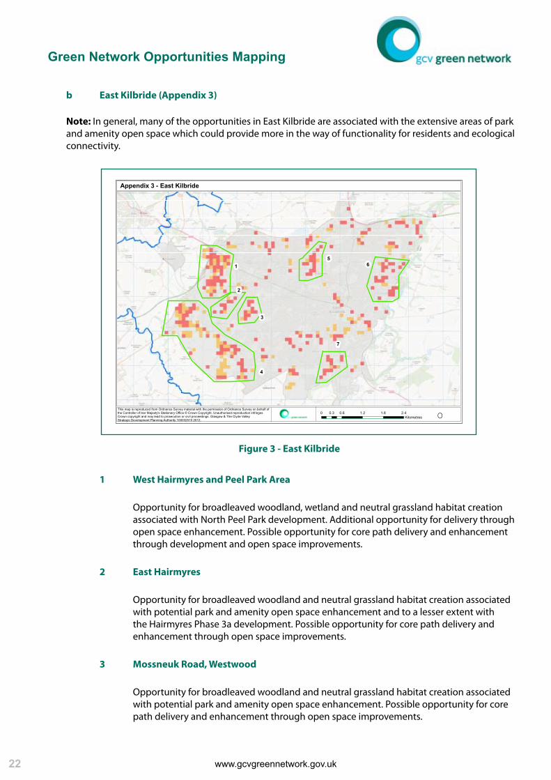
b EastKilbride(Appendix3)
1 WestHairmyresandPeelParkArea 2 EastHairmyres 3 MossneukRoad,Westwood 4 EastKilbrideCGA 5 EastMainsRoadArea 6 StLeonards 7 LanglandsWest
c Hamilton,UddingstonandBlantyre(Appendix4)
1 Gardenside/WestUddingston 2 Bothwell 3 CraigheadRetreat 4 HamiltonInternationalInvestmentPark 5 Ferniegair
d Larkhall,StrathavenandCoalburn(Appendix5)
1 CarlukeCGA 2 SmyllumPark
1

Green Network Opportunities Mapping
www.gcvgreennetwork.gov.uk www.gcvgreennetwork.gov.uk www.gcvgreennetwork.gov.uk www.gcvgreennetwork.gov.uk
Thisreportdescribestheapproachandinterpretstheoutputsgeneratedthroughthe analysis.Italsorecommendsthattheoutputsshouldbeusedto:
• DeveloprobustanddefensibleGreenNetworkpoliciesfortheLocalDevelopmentPlan • Targetlimitedresourcesandplanninggaineffectively • Informmasterplanninganddevelopmentmanagement • DevelopGreenNetworkStrategiesforopportunityareasidentifiedthroughanalysis • InformStrategieswhichsupporttheLocalDevelopmentPlane.g.OpenSpace,Biodiversity andAccessStrategies • SetSingleOutcomeAgreementTargetsandmeasures
2

www.gcvgreennetwork.gov.uk www.gcvgreennetwork.gov.uk
www.gcvgreennetwork.gov.uk www.gcvgreennetwork.gov.uk 3

www.gcvgreennetwork.gov.uk www.gcvgreennetwork.gov.uk 1
introduction

www.gcvgreennetwork.gov.uk www.gcvgreennetwork.gov.uk 5
2 Introduction
2.1 WhatistheGreenNetwork?
TheGreenNetworkisalargescaleandambitiousinitiativethatwill,throughplannedandco-ordinated localactionwhichdeliversastrategicvision,transformCentralScotlandbyimprovinglocalcommunities, promotinghealthierlifestyles,connectingandenhancingnaturalhabitats,transformingperceptionsand byattractingandretaininginvestmentinthearea. TheGreenNetworkwilldeliverarangeofoutcomesincluding:
EnterpriseDevelopment
TheeconomywillbenefitfromtheGreenNetworkbecauseitprovides:
• attractivelocationsinwhichexistingbusinesseswillwishtoremainastheydevelopandgrow • vibrantcommunitiesthatwillattractnewbusinessinvestment,andencouragestaffrecruitment andretention • newopportunitiesforinnovativeenterprisestohelpmanagetheGreenNetwork HealthImprovement
PeoplewillbenefitfromtheGreenNetworkbecauseitwillprovide:
• attractivelocationsinwhichtoexerciseorrelax • safespacesthatencouragewell-beingandcommunityspirit • cleanerlivingenvironmentsofwhichlocalpeoplecanbeproud
StrongerCommunities
CommunitieswillbenefitfromtheGreenNetworkbecauseitwill:
• providewell-designed,sustainableplacesinwhichtolive • empowerlocalcommunitiestotakeownershipandhelpcreatethesafe,attractiveplacesthat theywant • providespacesthatpeoplecanbeproudofandwhichwillhelpdevelopacommunityspirit
BiodiversityandtheEnvironment
People,wildlifeandenvironmentwillbenefitfromtheGreenNetworkbecauseit:
• providesrobustdiversehabitats,linkingacrossthecityregion • reduceshumanimpactontheenvironment • reducestheimpactofclimatechangeontheurbanpopulation
2.2 WhatComprisestheGreenNetwork?
TheGreenNetworkisanetworkofconnectedgreenandopenspacewhichdeliversarangeofmultiple benefitsasdescribedandisdesignedandmaintainedtodeliverthesebenefitsnowandintothefuture.

Green Network Opportunities Mapping
www.gcvgreennetwork.gov.uk www.gcvgreennetwork.gov.uk www.gcvgreennetwork.gov.uk www.gcvgreennetwork.gov.uk 6
Theform,sizeandfunctionofitsindividualelementswillvarysignificantly,however,thecombination oftheseindividualelementsiswhatwillcreatetheNetwork.
InthinkingaboutthedevelopmentoftheGreenNetwork,itishelpfultodistinguishbetween:
GreenNetworkCores/Hubs
–largeareasofexistingornewgreenspacewhichalreadydeliverawiderangeofGreenNetwork benefits.Theaimshouldbetoprotectandexpandtheseareas,tocreatenewcores/hubs, createvisualconnectionsand,critically,todevelopcorridorstolinkthem;
GreenNetworkCorridorsandLinks
–continuouscorridorsofgreenspacealongrivers,disusedrailways,pathsandcyclewaysand existingrailwaysandroadswhichservetoconnectGreenNetworkCores/Hubs.Manyofthesecorridorsareincomplete,orprovidealimitednumberoffunctions,soakeyaimistoincreasethenumber,continuity,visualinteractionandfunctionalityofthesecorridors;
GreenNetworkSteppingStones
–itmaynotalwaysbenecessaryorappropriatetocreateacontinuouscorridorofgreenspace. Manyplantandanimalspecies,forexample,areabletomoveshortdistancesbetweenareas ofhabitat.Historicallysuburbshadregularpublicandprivatesquaressetamongstdensely developedterraces.ThedevelopmentofGreenNetworkSteppingStonescanprovideincomplete corridorslinkinglargerareasofgreenspace.Thiscouldincludetheplantingofstreettrees, improvedroadsidevergesorgardenimprovement. IsolatedGreenspaces
–itislikelythattherewillalwaysbesomeisolatedgreenspaceswhicharedifficulttoconnectto thewiderGreenNetwork.Whilethespacesfunctioninadifferentmanner,theystillprovide considerablebenefitstolocalcommunities.Theroleofthesespacesinmeetingaperceivedneed withinlocalcommunitiesshouldnotbeignored,asperceptionofneedisasstrongadriveras geographicneed.
GreenNetworkCores/Hubs,CorridorsandLinks,andSteppingStonesmaybecomprisedofanynumber oftypesofgreenspaceasdefinedinPAN65‘PlanningandOpenSpace’.

www.gcvgreennetwork.gov.uk www.gcvgreennetwork.gov.uk
www.gcvgreennetwork.gov.uk www.gcvgreennetwork.gov.uk
2.3 PolicyContextandRationale
Thedifficultyoftenforpractitioners,whetherplanners,landmanagersordevelopers,istointerpret nationalpolicyandguidanceintolocalpolicyandguidance,butmoreimportantlyintodeliveryonthe groundintheformofqualityplacesinwhichpeoplewillwanttolive,workandrecreate.
This“goldenthread”ofnationalpolicyintolocaldeliveryiswhatthisdocumentseekstohelpdeliverby assistinglocalauthoritiestosetlocallyderivedandsensitiveGreenNetworkprioritieswhichhelptodeliver theGCVGreenNetwork-aregionalcomponentoftheCentralScotlandGreenNetwork(aNational Development)assetoutinNationalPlanningFramework2.
Thehierarchyofpolicycontextwithinwhichthiswillbeachievedisoutlinedbelow.
2.3.1 ScottishPolicyFramework
ScottishPlanningPolicy(SPP)
ScottishPlanningPolicy(SPP)isthestatementoftheScottishGovernment’spolicyonnationally importantlanduseplanningmattersandsupersedesthepreviousindividualdocuments.
OfparticularrelevancetothedeliveryoftheGreenNetworkarethesectionsrelatingtothe preparationofDevelopmentPlans,DevelopmentManagementandanumberoftheindividual subjectpoliciesincluding:
OpenSpaceandPhysicalActivity
“Greennetworkswhichprovideopportunitiesforphysicalactivityandaccesstotheoutdoors,and increaseaccessibilitywithinsettlementsandtothesurroundingcountryside,shouldbepromoted andsafeguardedthroughthedevelopmentplan”
LandscapeandNaturalHeritage
“Astrategicapproachtonaturalheritage...linkedtogetherinintegratedhabitatnetworkscanmake animportantcontributionto...biodiversity”
“PlanningAuthoritiesshouldseektopreventfurtherfragmentationandisolation...andidentify opportunitiestorestorelinks”
FloodingandDrainage
“Watercoursesshouldnotbeculvertedaspartofanewdevelopment…andexitingculverts shouldbeopenedwherepossible.Inallcasesopportunitiesforhabitatrestorationor enhancementshouldbesought.”
NationalPlanningFramework2(NPF2)
NPF2laysoutthespatialdevelopmentofScotlandto2030.ItrecognisesthatStrategicPlanning forthecityregions:
“providestheopportunitytodevelopextensivegreennetworksconnectingourinnerurban areaswiththeirsurroundingruralenvironments,providingawiderangeofsocial,healthand environmentalbenefits”.
7

Green Network Opportunities Mapping
www.gcvgreennetwork.gov.uk www.gcvgreennetwork.gov.uk www.gcvgreennetwork.gov.uk www.gcvgreennetwork.gov.uk 8
ItidentifiestheCentralScotlandGreenNetworkasoneoffourteen“NationalDevelopments”in recognitionthatitsdelivery“offerstheopportunitytoeffectastepchangeinenvironmental quality,woodlandcoverandrecreationalopportunities.ItwillmakeCentralScotlandamore attractiveplacetoliveanddobusiness,helptoabsorbCO2andpromotehealthier,moreactive lifestyles”.
NPF2recognisesthattheGlasgowandClydeValleyGreenNetworkPartnershipisdeliveringthis NationalDevelopmentinthewestCentralBeltby“takingforwardaprogrammeofgreenspace enhancementdesignedtopromotehealthierlifestyles,betterenvironments,greaterbiodiversity, strongercommunitiesandeconomicopportunity.”
OtherNationalPolicyandStrategyandDocuments
OthernationalpolicyandstrategicdocumentsofparticularrelevancetotheGNProgramme include:
• DesigningPlaces(ScottishGovernment2008) • DesigningStreets(ScottishGovernment2010) • PeopleandPlaces:RegenerationPolicy;(ScottishGovernment2006) • ClosingtheOpportunityGaps;(ScottishGovernment2007) • ScottishForestryStrategy;(ForestryCommissionScotland2006) • ScottishBiodiversityStrategy;(ScottishGovernment2004) • Smart,SuccessfulScotland;(ScottishGovernment2001) • GreenJobsStrategy.(ScottishGovernment2005) • EquallyWell(ScottishGovernment2008) • GoodPlaces,BetterHealth(ScottishGovernment2008)
2.3.2 RegionalPolicyFramework
SupportingtheStrategicCommunityPlan,theGCVStrategicDevelopmentPlan(SDP)provides anoverarchingplanningframeworkforthedevelopmentofinfrastructureacrosstheregion.The SDPsupersedestheJointStructurePlanandisamuchmorefocusseddocumentrepresenting prioritiesandopportunitiesspatially.AswiththeearlierJointStructurePlandeliveryoftheGCV GreenNetworkremainsacornerstoneoftheSDP.
TheSDPproposed,basedonGISanalysis,14geographicalareasacrosstheGCVwherestrategic opportunitiesexisttodelivertheGreenNetwork.These14“hotspots”willinduecourserequire tobereflectedintheeightrespectiveGCVLocalDevelopmentPlans.
ThedevelopmentofthisreportwithSouthLanarkshireCouncilwillapplytheSDPmethodology tothelocalauthorityscaleinordertoidentifylocalGreenNetworkOpportunities.
2.3.3 LocalPolicyFramework
Inlinewithnewplanningpolicy,SouthLanarkshireCouncil(SLC)hastoprepareaLocal DevelopmentPlan(LDP)whichreflectstheprioritiesidentifiedintheSDP.Thestartingpointfor thisprocessisthegatheringofevidence,preparationoftheMonitoringStatementandthe identificationofthekeyissues,prioritiesandopportunitiesinaMainIssuesReport.
ThenewstyleLDPwillthereforerequiretoincorporatepolicieswhichseektoensurearobustand defensibleGreenNetwork.Thisdocumentwillinformthedevelopmentofthosepolicies.

www.gcvgreennetwork.gov.uk www.gcvgreennetwork.gov.uk
www.gcvgreennetwork.gov.uk www.gcvgreennetwork.gov.uk 9
2.4 TheRoleofPlanninginDelivery
TheplanningsystemisoneofthemostimportantmeansofrealisingtheGreenNetworkvision.Itcan ensurethatdevelopmentrespectsandenhancestheGreenNetwork.Itcanprovidethebroaderspatial perspectivetoco-ordinateindividualactionsinordertocreatequalityplacesinwhichtoliveandwork.
ItcanhelpensurethattherightGreenNetworkcomponents,oftherightquality,arecreatedinthe rightplace,andthatthewidestpossiblerangeofbenefitsresult.
ThefollowingprinciplesshouldbeconsideredbyplannerstohelpensurethatdevelopmentoftheGreen Networkisembeddedwithintheplanningsystem.
2.4.1 LocalDevelopmentPlansshould,basedonspatialandqualitativeanalysis,guide localdeliveryoftheGreenNetwork
TheGCVStrategicDevelopmentPlan,basedondetailedspatialanalysis,setsoutGreenNetwork opportunitiesforthecityregion.Theoutputisbasedontheanalysisoffourdatasets:habitat networkopportunities;accessnetworkopportunities;greenspaceandcorepathimprovement opportunitiesandstrategicdevelopmentareas.
UsingSouthLanarkshirespecificdatasets,suchasopenspaceaudits,asimilaranalyticalprocess hasbeenusedtoinformlocalprioritiesandLocalDevelopmentPlanpoliciesandassociated SupplementaryGuidance.
Green Network Opportunities Mapping
www.gcvgreennetwork.gov.uk www.gcvgreennetwork.gov.uk www.gcvgreennetwork.gov.uk www.gcvgreennetwork.gov.uk 10
2.4.2 DevelopmentsshouldcontributetodeliveryoftheGreenNetwork.
ThegreatestGreenNetworkbenefitsarelikelytobeachievedwhenitisconsideredasanintegral partofthedevelopmentprocess,ratherthandealtwithasanafterthoughtonceotherelements oftheschemehavebecome‘fixed’.Additionally,itislikelytobemoreefficientuseofresourcesto ‘buildin’GreenNetworkcomponentsratherthan‘retrofit’themoncethebuiltenvironmenthas beencompleted.
CarefullydesigneddevelopmentwhichconsidersGreenInfrastructure:watermanagement;habitat networks;accessnetworks;greenandopenspaceandstewardshipovertime,attheoutsetandas equalconsiderationstootherdevelopmentrequirementssuchasroadlayouts,haveanimportant roletoplayindeliveryoftheGreenNetwork.
2.4.3 PlanningshouldpromotetheGreenNetworkasakeycontributortoplace-making
Placemakingiscentraltotheenvironmental,socialandeconomictransformationofGlasgow andtheClydeValleywithplanningbeingthekeymechanismthroughwhichtheagendacanbe realised.
TheintegrationoftheGreenNetworkintothefabricofnewdevelopment,andretrospectivelyinto theexistingurbanenvironment,reflectinglocaldistinctivenessandtheneedsandaspirationsof localpeople,willbeakeycontributortothedeliveryoftheplacemakingagenda.
2.4.4 Planningshouldpromotethedevelopmentofmulti-functionalGreenNetworks
TheclusteringofusesandactivitieswithinGreenNetworknodescreatesvibrant,diverseand excitingspaces.TheplanningsystemshouldpromotetheuseoftheGreenNetworkfor: naturalisedwatermanagement(SUDS);habitatcreationandenhancement;safeoff-roadaccess aroundandbetweencommunities;formalandinformalrecreation;environmentaleducation;art andculturalheritage. Creatingmulti-functionalspaceswhichpeoplewanttovisitandusecandelivermultiplehealth andsocialbenefits.
2.4.5 ConsiderlongtermstewardshipoftheGreenNetworkfromtheoutset
“Delivering better places takes time and demands long-term commitment to place quality”
(DeliveringbetterplacesinScotland,ScottishGovernment2011).
ManyoftheproblemsassociatedwithpoorqualityofGreenNetworkcomponentsstemsfromlack ofconsiderationandinvestmentinrevenuefundingleadingtoanunsustainableinvestment/ declinecycle.Theplanningprocesscanencourage,andifneedbeenforce,solutionswhichtake futuremanagementandmaintenancemechanismsandfinancingintoaccountattheoutsetby usingplanningconditions,frameworkagreementsanddesigncodes.

www.gcvgreennetwork.gov.uk www.gcvgreennetwork.gov.uk
www.gcvgreennetwork.gov.uk www.gcvgreennetwork.gov.uk 11

www.gcvgreennetwork.gov.uk www.gcvgreennetwork.gov.uk 7
methodology

www.gcvgreennetwork.gov.uk www.gcvgreennetwork.gov.uk 13
3 Methodology
ThemethodologywhichhasbeenappliedtotheidentificationofGreenNetworkOpportunitiesMapping inSouthLanarkshirewasoriginallydevelopedinresponsetoguidancefromplannersfortheneedto representstrategicGreenNetworkopportunitiesspatiallyandgraphicallywithintheGCVStrategic DevelopmentPlan(SDP)MainIssuesReport(MIR).
AlthoughoriginallyconceivedtoidentifystrategicopportunitiesacrosstheGlasgowcityregionitwas recognisedfromtheoutsetthattheresultantdatacouldalsobeinterrogatedatafinerresolutionfor morelocalisedopportunities.
Additionally,byreplacingregionallybaseddatasetswithSouthLanarkshirespecificdatasets,outputs whichweremorerelevantandusefultothelocalauthoritycontextcouldbeproduced.Theresultant outputswillbeusedbySouthLanarkshireCouncilintwoways:
a Toidentifylocalprioritiesforactionandwhatthatactionmightbetodelivermaximum andmultiplebenefit.
b ToinformthedevelopmentofLDPGreenNetworkpoliciesandsupportingtechnical documentationand,ifrequired,supplementaryplanningguidance.
3.1 Approach
Thedevelopmentofthemethodologybeganbyseekingtoaddressthefollowingquestions:
1 WhatGreenNetworkresourcecurrentlyexistsandwherearetheopportunitiestoimproveit?
2 WherearethepriorityareastoexpandtheGreenNetworkfor?
a Biodiversityhabitatnetworks?
b Publicaccesstogreenspace?
3 Wherearethemajorareasoflandusechangeandsocialneed?
Aseriesofdatasetswereidentifiedwhichcouldprovideanswerstothesequestionsbothattheregional scalefortheSDPandatalocalscaleforSouthLanarkshire.

Green Network Opportunities Mapping
www.gcvgreennetwork.gov.uk www.gcvgreennetwork.gov.uk www.gcvgreennetwork.gov.uk www.gcvgreennetwork.gov.uk
SDP SouthLanarkshire
GCVwideIntegratedHabitatNetworkprioritiesmodelling
SLCwideIntegratedHabitatNetworkprioritiesmodelling
StrategicOutdoorRecreation&ActiveTravelOpportunitiesdatasetproducedbyCentralScotlandGreenNetworkshowingsupplymappedagainstdemandandneed.
SLCwideNetworkforPeopleprioritiesmodelling
14
SDP SouthLanarkshire
GCVwidegreenspacedatasetbasedonPAN65typologiesproducedin2006 SLCPAN65weightedtypologies
CorePathPlansfromeachoftheeightGCVlocalauthorities.Datasetsweightedtoreflectpotentialforimprovement.
SLCCorePathPlan
Layer1ExistingGreenspaceProvision,PathNetworkandPotentialforEnhancement
Layer2StrategicBiodiversityandAccessPriorities
3.1.1 Datasets
TheGISbasedanalysisconsideredfourdatalayerswhichcollectivelyspatiallyrepresenttheGCV GreenNetwork,keystrategiclocationswherefuturelandusechangepresentopportunitiesfor deliveryandwhereopportunitiesexistfortheexpansionofconnectivityforpeopleandwildlife. Thedatalayerswere:
Layer3StrategicDevelopmentOpportunities,LandUseChangeOpportunities andAreasofSocialNeed
SDP SouthLanarkshire
FlagshipRegenerationAreasandCommunityGrowthAreasacrosstheGCV SLCdevelopmentandregenerationsites
SocialIndicesofMultipleDeprivation(SIMD)
TheSLCanalysiswasrunpurelyonlandusedata.SIMDwasnotincluded

www.gcvgreennetwork.gov.uk www.gcvgreennetwork.gov.uk
www.gcvgreennetwork.gov.uk www.gcvgreennetwork.gov.uk 15
3.1.2 WeightingofDatasets
InordertorankandprioritisetheGNopportunitiesidentifiedbyeachofthedatasets,andtoaid theGISanalysis,asystemofweightingwasapplied.Theweightings,andtherationaleforthem, asappliedtotheSouthLanarkshiredatasetsaredetailedbelow: ExistingGreenspaceandCorePaths
TheGreenNetworkisinessencearangeoftypesofgreenandopenspaceandthepathsand linkswhichconnectthem.In2007SouthLanarkshireCouncilundertookacomprehensiveOpen SpaceAuditwhichdetailedthequantityandqualityofitsgreenspaceresourceaccordingtotheir PAN65typology.Whencombinedwiththelocalauthority’sCorePathPlans,thesetwodatasets canbetakenasagoodrepresentationofthecurrentGreenNetwork.
However,notallgreenspacepresentsthesameopportunityforenhancementorincreased functionalityandthereforedeliveryoftheGreenNetwork.Weightingwasthereforeappliedto theOpenSpaceAuditqualitativescorestoreflectthedifferingpotentialsasfollows:
Lowestscoring10%,11-20%and21-30%ofsiteswereweighted3,2and1respectively.
CorepathsweretakenashavinglimitedabilitytodelivermoretotheGNandtherefore weightedas1(althoughitisrecognisedthatsomepathsmayfallshortofadesirablequality).
StrategicBiodiversityOpportunities
TheIntegratedHabitatNetwork(IHN)ModelusesGIStospatiallyrepresentgrassland,wetland andwoodlandhabitatsandtheabilityofspeciestomovebetweenhabitatsandthroughthe adjacentlandscape.
TheIHNModelrepresentsthecurrentstatusofhabitatsandhowtheyare‘functionallyconnected’. However,itdoesn’tshowwherebesteffortandresourcesshouldbetargetedtoincreasethesize andnumberofhabitatnetworks.
Newsoftware,employingaseriesofassessmentcriteria,wasappliedtoa100mgridofcells coveringSouthLanarkshireandusedtoidentifylocationswhereinterventionwouldyieldthe greatestbenefitintermsofimprovinghabitatconnectivity.
Thetopscoring10%,11-20%and21-30%ofassessmentcellswereweightedas3,2and1 respectivelyinthefinalanalysis.
StrategicAccessOpportunities
NewworkwascommissionedbytheGCVGreenNetworkPartnershipwhichwoulduseasimilar approachtohabitatopportunitymodellingbutwouldinsteadanalysetheurbanenvironmentin termsofitspermeabilityforhumanaccessibilityfromhomestogreenspaceandpathnetworks.
Firstly,aNetworksforPeople(N4P)modelwasdevelopedwhichusesGIStoaccuratelymapthe distancespeoplehavetotravelfromtheirhousestoeithergreenspaceoracorepath.Any householdwhichismodelledasbeingfurtherthan250misconsideredtobedisconnectedfrom theGreenNetwork.
Secondly,asforstrategichabitatopportunitiesmodelling,softwareappliedaseriesof assessmentcriteriato100mcellgridofcellscoveringSouthLanarkshireandthosehexagons
Green Network Opportunities Mapping
www.gcvgreennetwork.gov.uk www.gcvgreennetwork.gov.uk www.gcvgreennetwork.gov.uk www.gcvgreennetwork.gov.uk 16
whichconsistentlyscoredlowlyintermsofadjacencyandconnectivitytogreenspaceandpath networkswereidentifiedashighopportunitytoimprovethenetwork.
Thelowestscoring10%,11-20%and21-30%ofassessmentcellswereweightedas3,2and1 respectivelyinthefinalanalysis.
StrategicDevelopmentOpportunities&AreasofNeed
InconsultationwithSouthLanarkshireCouncilOfficers,aseriesofdevelopmentandregeneration siteswereidentifiedashavingthepotentialtodelivertheGreenNetwork.
Thesesiteswereweightedas3inthefinalanalysisi.e.theyofferedahighpotentialfordelivery.
IndiscussionwithSouthLanarkshireCouncilOfficersitwasdecidedtoruntwoversionsofthe analysis.ThefirstwouldbebasedpurelyonthephysicalandspatialaspectsoftheGreenNetwork usingonlytheOpenSpace,NetworksforPeople,HabitatNetworksandDevelopmentSites datasets.Aseconditerationoftheanalysiswouldthenberuntoinformfurtherprioritisationby includingtheSocialIndicesofMultipleDeprivation(SIMD)andwouldactasaproxyforsocialneed. Thelowest15%scoringdatazonesinSouthLanarkshirewereweightedas3indicatingagreater socialneedandthereforeapriority.
3.2 AnalysisandOutputs GISanalysiswasemployedtooverlaytheweighteddatasetsdetailedaboveandtoidentifygeographical locationsacrossSouthLanarkshirewhereastrongcorrelationexistsbetweenthem.Theseareasof correlationweretakenaslocationswhereopportunitiesexisttodelivermultipleGreenNetworkbenefits throughthetargetingofeffortandresources.
Theoutputsfromtheanalysisweremapbasedspatialrepresentationsofthehighestscoringclustersof 100mcellsacrossSouthLanarkshire.TheindividualoutputsfromtheGISanalysisare:
1 GISlayersshowing: a Combinedanalysisofthelanduselayersoutlinedaboveidentifyingareasofgreatest opportunitytoaugmentandenhanceGreenNetwork.
b Thetopprioritiesforaccesstoopenspaceenhancement.

www.gcvgreennetwork.gov.uk www.gcvgreennetwork.gov.uk
www.gcvgreennetwork.gov.uk www.gcvgreennetwork.gov.uk 17
4 InterpretationofAnalysis

www.gcvgreennetwork.gov.uk www.gcvgreennetwork.gov.uk
interpretationof analysis

www.gcvgreennetwork.gov.uk www.gcvgreennetwork.gov.uk
4.1 Overview
Althoughtheimagesbelowandintheappendicesshowtheanalysisoutputsatalocalauthoritywide scaleitshouldbenotedthattheunderlyingdatacanbeviewedatanyresolutionanddifferentthresholds maybesetforviewingthedataifamoredetailedbreakdownisrequiredforaparticulararea. Areaswherethereareclusteringsofcells,particularlythehighscoringcellsshowninred,canbetaken asgeographicallocationswheretheopportunityexiststodelivermultipleGreenNetworkbenefits. Theoutputsareinterpretedinmoredetailbelow.
4.2 GreenNetworkandLandUseAnalysis
Figure1below(alsoincludedasAppendix1)showsthestrategicGreenNetworkOpportunitiesoutput identifyingthoseareasacrossSouthLanarkshirewhichhavethepotentialtodelivermultiplebenefitsin returnforinvestmentofeffortandresources.
Note:Forthe100mx100mcellsuponwhichtheanalysisisbasedtoscoreintheveryhighopportunity band(showninred),theymusthaveatleastmaximumscoringcorrelationbetweentwoofthedatasets plussomecorrelationwithathirddataset.Thesewillbereferredtoasveryhighopportunities.Forthe cellstoscoreinthehighopportunityband(showninorange)theymusthaveamaximumscoringinat leasttwodatasets.
671cellsscoreintheveryhighopportunitybandand556cellsscoreinthehighopportunityband. Theanalysisisbrokendowninmoredetailbelowforeachsettlementorclustersofadjacentsettlements andhighlightstheparticularopportunitiesassociatedwitheach.
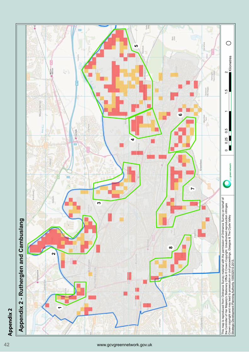
a RutherglenandCambuslang(Appendix2)
Appendix 1 - South Lanarkshire Strategic Green Network Opportunities
O0 3 6 9 121.5Kilometres
This map is reproduced from Ordnance Survey material with the permission of Ordnance Survey on behalf of the Controller of Her Majesty's Stationery Office © Crown Copyright. Unauthorised reproduction infringes Crown copyright and may lead to prosecution or civil proceedings. Glasgow & The Clyde Valley Strategic Development Planning Authority 100032510 2013.
Legend
Very high opportunities
High opportunities
SLC_Boundary
19
Figure1-StrategicGreenNetworkOpportunities

Green Network Opportunities Mapping
www.gcvgreennetwork.gov.uk www.gcvgreennetwork.gov.uk www.gcvgreennetwork.gov.uk www.gcvgreennetwork.gov.uk 20
1 Shawfield
Opportunityforbroadleavedwoodlandandneutralgrasslandhabitatcreationassociated withdevelopmentandenhancementofbusinessamenityopenspace.Possible opportunityforcorepathdeliveryandenhancementthroughdevelopment.
2 CuningarLoop
Opportunityforbroadleavedwoodlandandneutralgrasslandhabitatcreationassociated withForestryCommissionenhancementwork.Possibleopportunityforcorepathdelivery andenhancement.
3 HooverSite,Cambuslang
Opportunityforbroadleavedwoodlandandneutralgrasslandhabitatcreationassociated withHooversitedevelopmentandenhancementofbusinessamenityopenspace.Possible opportunityforcorepathdeliveryandenhancementthroughdevelopment.
4 AreaAroundWestburnCemetery
Opportunityforbroadleavedwoodlandandneutralgrasslandhabitatcreationassociated withopenspaceenhancement.Possibleopportunityforcorepathdeliveryand enhancement.
Appendix 2 - Rutherglen and Cambuslang
O0 0.5 1 1.5 20.25Kilometres
This map is reproduced from Ordnance Survey material with the permission of Ordnance Survey on behalf of the Controller of Her Majesty's Stationery Office © Crown Copyright. Unauthorised reproduction infringes Crown copyright and may lead to prosecution or civil proceedings. Glasgow & The Clyde Valley Strategic Development Planning Authority 100032510 2013.
12
3
5
6
7
8
4
Figure2-RutherglenandCambuslang
www.gcvgreennetwork.gov.uk www.gcvgreennetwork.gov.uk
www.gcvgreennetwork.gov.uk www.gcvgreennetwork.gov.uk
21
5 NewtonCGA
Majoropportunityfordeliveryofhighqualityopenspaceandpathnetworkthrough CGA.Alsoopportunityforwetland(possiblyalignedwithSUDSprovision),broadleaved woodlandandneutralgrasslandhabitatcreationthroughdevelopment.
6 SouthCairnsArea
Opportunityforbroadleavedwoodland,wetlandandneutralgrasslandhabitatcreation associatedwithEastGreenleesandGilberfieldRoaddevelopments.Additionalopportunity fordeliverythroughamenityopenspaceenhancement.Possibleopportunityforcorepath deliveryandenhancementthroughdevelopments.
7 Springhall,WhitelawburnandBorgieGlenArea
Opportunityforbroadleavedwoodlandandneutralgrasslandhabitatcreation associatedwithopenspaceenhancementandtoamorelimiteddegreethroughthe CathkinHighSchoolandBelmontRoaddevelopments.Possibleopportunityforcorepath deliveryandenhancementthroughdevelopmentsandamenityopenspaceenhancement.
8 Fernhill
Opportunityforbroadleavedwoodland,wetlandandneutralgrasslandhabitatcreation associatedwithopenspaceenhancementandtoamorelimiteddegreethroughthe FernhillNeighbourhoodCentreandhousingdevelopments.Possibleopportunityforcore pathdeliveryandenhancementthroughdevelopmentsandamenityopenspace enhancement.
Green Network Opportunities Mapping
www.gcvgreennetwork.gov.uk www.gcvgreennetwork.gov.uk www.gcvgreennetwork.gov.uk www.gcvgreennetwork.gov.uk
b EastKilbride(Appendix3)
Note:Ingeneral,manyoftheopportunitiesinEastKilbrideareassociatedwiththeextensiveareasofpark andamenityopenspacewhichcouldprovidemoreinthewayoffunctionalityforresidentsandecological connectivity.
1 WestHairmyresandPeelParkArea Opportunityforbroadleavedwoodland,wetlandandneutralgrasslandhabitatcreation associatedwithNorthPeelParkdevelopment.Additionalopportunityfordeliverythrough openspaceenhancement.Possibleopportunityforcorepathdeliveryandenhancement throughdevelopmentandopenspaceimprovements.
2 EastHairmyres Opportunityforbroadleavedwoodlandandneutralgrasslandhabitatcreationassociated withpotentialparkandamenityopenspaceenhancementandtoalesserextentwith theHairmyresPhase3adevelopment.Possibleopportunityforcorepathdeliveryand enhancementthroughopenspaceimprovements.
3 MossneukRoad,Westwood
Opportunityforbroadleavedwoodlandandneutralgrasslandhabitatcreationassociated withpotentialparkandamenityopenspaceenhancement.Possibleopportunityforcore pathdeliveryandenhancementthroughopenspaceimprovements.
22
Appendix 3 - East Kilbride
O0 0.6 1.2 1.8 2.40.3Kilometres
This map is reproduced from Ordnance Survey material with the permission of Ordnance Survey on behalf of the Controller of Her Majesty's Stationery Office © Crown Copyright. Unauthorised reproduction infringes Crown copyright and may lead to prosecution or civil proceedings. Glasgow & The Clyde Valley Strategic Development Planning Authority 100032510 2012.
1
2
3
4
56
7
Figure3-EastKilbride

www.gcvgreennetwork.gov.uk www.gcvgreennetwork.gov.uk
www.gcvgreennetwork.gov.uk www.gcvgreennetwork.gov.uk 23
4 EastKilbrideCGA
MajoropportunityfordeliveryofhighqualityopenspaceandpathnetworkthroughCGA. Alsoopportunityforwetland(possiblyalignedwithSUDSprovision),broadleaved woodlandandneutralgrasslandhabitatcreationthroughdevelopment.
5 EastMainsRoadArea
Residentstotheeastoftheareahavepooraccesstoopenspaceandthereforethe opportunityexiststoimprovethequalityofthenearestopenspacesortoseek opportunitiestoimproveconnectivitytothespaces.
Opportunityforbroadleavedwoodland,wetlandandneutralgrasslandhabitatcreation associatedwithopenspaceenhancementeithersideofEastMainsRoad.
6 StLeonards
Opportunityforbroadleavedwoodland,wetlandandneutralgrasslandhabitatcreation associatedwithparkandamenityopenspaceandtoalesserextentwithHunterHigh School.Possibleopportunityforcorepathdeliveryandenhancementthrough developmentandopenspaceimprovements.
7 LanglandsWest Opportunityforbroadleavedwoodlandandneutralgrasslandhabitatcreationassociated withLanglandsWestDevelopmentFrameworkandbetteruseofexistingbusinessamenity openspace.Possibleopportunityforcorepathdeliveryandenhancementthroughopen spaceimprovements.

Green Network Opportunities Mapping
www.gcvgreennetwork.gov.uk www.gcvgreennetwork.gov.uk www.gcvgreennetwork.gov.uk www.gcvgreennetwork.gov.uk 24
c Hamilton,UddingstonandBlantyre(Appendix4)
1 Gardenside/WestUddingston
AreasofKyleparkandGardensideareshownashavingpooraccesstoopenspaceand shouldbeinvestigatedmorefullywithpotentialfortheUddingstonGrammarSchool sitetoprovidepartofthesolution.
Additionalopportunityforbroadleavedwoodland,wetlandandneutralgrasslandhabitat creationassociatedwithparkandamenityopenspaceenhancement.Possibleopportunity forcorepathdeliveryandenhancementthroughopenspaceimprovements.
2 Bothwell
AreasofSilverwellsandEastofUddingstonRoadareshownashavingpooraccessto openspaceandshouldbeinvestigatedmorefully.Ifpooraccessisconfirmedthenthe opportunityexiststoimprovethequalityofthenearestopenspacesortoseek opportunitiestoimproveconnectivitytothespaces.
Appendix 4 - Hamilton, Uddingston and Blantyre
O This map is reproduced from Ordnance Survey material with the permission ofOrdnance Survey on behalf of the Controller of Her Majesty's Stationery Office © Crown Copyright. Unauthorised reproduction infringes Crown copyright and may lead to prosecution or civil proceedings. Glasgow & The Clyde Valley Strategic Development Planning Authority 100032510 2012.
0 0.7 1.4 2.1 2.80.35Kilometres
1
3
2
4
5
Figure4-Hamilton,UddingstonandBlantyre

www.gcvgreennetwork.gov.uk www.gcvgreennetwork.gov.uk
www.gcvgreennetwork.gov.uk www.gcvgreennetwork.gov.uk 25
Additionalopportunityforbroadleavedwoodland,wetlandandneutralgrasslandhabitat creationassociatedwithparkandamenityopenspaceenhancement. 3 CraigheadRetreat
Theareaiscurrentlyshownasamixofopenseminaturalandwoodland.Thedevelopment shouldtakecognisanceofthisandseektointegratebroadleavedwoodlandandneutral grasslandhabitatcreationintothedevelopment.Possibleopportunityforcorepath enhancementthroughdevelopment.
4 HamiltonInternationalInvestmentPark
Majoropportunitytodeliverhighqualityopenspaceandpathconnectionsforemployees andresidentsthroughdevelopment.
Additionalopportunityforbroadleavedwoodlandandneutralgrasslandhabitatcreation throughdevelopment.
5 Ferniegair
Majoropportunityfordeliveryofhighqualityopenspaceandpathnetworkthrough releasesite(residentsinAllantonareidentifiedashavingpooraccesstoopenspace). Additionalopportunityforwetland(possiblyalignedwithSUDSprovision),broadleaved woodlandandneutralgrasslandhabitatcreationthroughdevelopment.
d Larkhall,StrathavenandCoalburn(Appendix5)
Appendix 5 - Larkhall, Strathaven and Coalburn
O0 1 2 3 40.5Kilometres
This map is reproduced from Ordnance Survey material with the permission of Ordnance Survey on behalf of the Controller of Her Majesty's Stationery Office © Crown Copyright. Unauthorised reproduction infringes Crown copyright and may lead to prosecution or civil proceedings. Glasgow & The Clyde Valley Strategic Development Planning Authority 100032510 2012.
1
2
Figure5-Larkhall,StrathavenandCoalburn
Green Network Opportunities Mapping
www.gcvgreennetwork.gov.uk www.gcvgreennetwork.gov.uk www.gcvgreennetwork.gov.uk www.gcvgreennetwork.gov.uk
Appendix 6 - Carluke and Lanark
O0 0.95 1.9 2.85 3.80.475Kilometres
This map is reproduced from Ordnance Survey material with the permission of Ordnance Survey on behalf of the Controller of Her Majesty's Stationery Office © Crown Copyright. Unauthorised reproduction infringes Crown copyright and may lead to prosecution or civil proceedings. Glasgow & The Clyde Valley Strategic Development Planning Authority 100032510 2012.
1
2
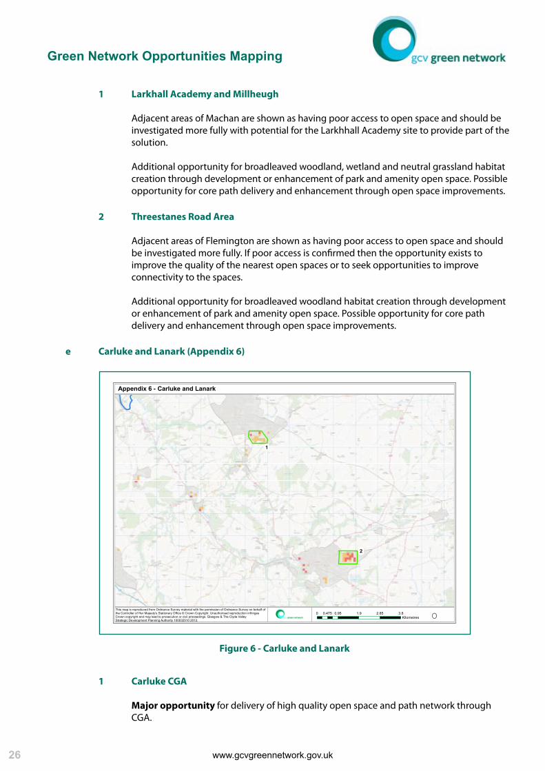
1 LarkhallAcademyandMillheugh
AdjacentareasofMachanareshownashavingpooraccesstoopenspaceandshouldbe investigatedmorefullywithpotentialfortheLarkhhallAcademysitetoprovidepartofthe solution.
Additionalopportunityforbroadleavedwoodland,wetlandandneutralgrasslandhabitat creationthroughdevelopmentorenhancementofparkandamenityopenspace.Possible opportunityforcorepathdeliveryandenhancementthroughopenspaceimprovements.
2 ThreestanesRoadArea
AdjacentareasofFlemingtonareshownashavingpooraccesstoopenspaceandshould beinvestigatedmorefully.Ifpooraccessisconfirmedthentheopportunityexiststo improvethequalityofthenearestopenspacesortoseekopportunitiestoimprove connectivitytothespaces.
Additionalopportunityforbroadleavedwoodlandhabitatcreationthroughdevelopment orenhancementofparkandamenityopenspace.Possibleopportunityforcorepath deliveryandenhancementthroughopenspaceimprovements.
e CarlukeandLanark(Appendix6)
1 CarlukeCGA
Majoropportunityfordeliveryofhighqualityopenspaceandpathnetworkthrough CGA.
Figure6-CarlukeandLanark
26
www.gcvgreennetwork.gov.uk www.gcvgreennetwork.gov.uk
www.gcvgreennetwork.gov.uk www.gcvgreennetwork.gov.uk
Additionalopportunityforthedeliveryofbroadleavedwoodlandandwetland habitatcreationthroughdevelopment.
2 SmyllumParkArea Significantopportunityfordeliveryofhighqualityopenspaceandpathnetworkthrough development.
Additionalopportunityforthedeliveryofbroadleavedwoodlandandwetlandthrough development.
Additionally,smallerclustersandsingleveryhighandhighscoringcellsaredistributedthroughout SouthLanarkshire.Thesecellsstillrepresentsignificantopportunityfordelivery,particularlywhen adjacencyofhighscoringbaselinelayercellsisconsidered,andshouldbeconsideredwhen dealingwithplanningapplications,geographicallytargetedresourcesorfundingapplications.
Note:Wherecorepathenhancementissuggestedaboveitisacknowledgedthatnoqualitative pathdatawasincludedintheanalysisandthepotentialmaynotexistifthecorepathiscurrently ofahighquality.
27

www.gcvgreennetwork.gov.uk www.gcvgreennetwork.gov.uk
analysis of individual
datasets

www.gcvgreennetwork.gov.uk www.gcvgreennetwork.gov.uk
South Lanarkshire - Access Priorities
O0 2.5 5 7.5 101.25Kilometres
This map is reproduced from Ordnance Survey material with the permission of Ordnance Survey on behalf of the Controller of Her Majesty’s Stationery Office ' Crown Copyright. Unauthorised reproduction infringes Crown copyright and may lead to prosecution or civil proceedings. Glasgow & The Clyde Valley Strategic Development Planning Authority 100032510 2013.
Legend
SLC Access Priorities
South Lanarkshire
5 AnalysisofIndividualDatasets
Thepreviousanalysisdescribestheoutputsasanaggregationofthe4baselinedatasets.However,the individualdatasetswhenviewedandmanipulatedsinglyprovideextremelyvaluableinformation.
Theindividualdatasetsoutputsshouldbeusedtoguidedecisionsonhabitatcreationandaccess enhancementatastrategiclocalauthorityscale,atasettlementscaleandatasitescale.
Thehabitatdatasetincludingwoodland,grasslandandwetland,istoocomplextodescribefullyinthis report.ThePartnershipcanhoweverworkwithpartnerstoapplytheoutputstospecificprojectsandsites atarangeofscales.
TheNetworksforPeopledatasetidentifiescommunitieswhicharecurrentlyatadeficitintermsofaccess toopenspaceandisanextremelyusefultoolintargetingeffortandresources.Itisdescribedinmore detailbelow.
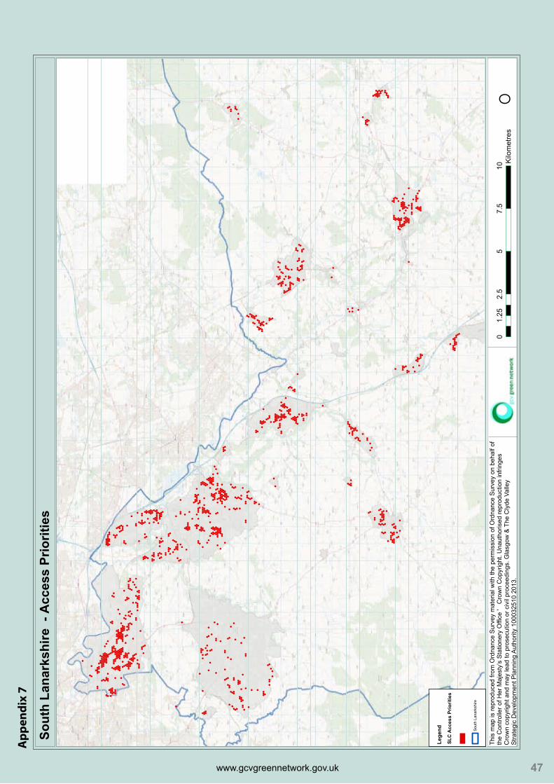
5.1 StrategicAccessPriorities
Figure7(alsoincludedasAppendix7)belowshowsthoseareaofSouthLanarkshire,identifiedthrough NetworksforPeoplenetworkanalysis,whichhavepooraccesstoopenspace.
29
Figure7-AccessPriorities

Green Network Opportunities Mapping
www.gcvgreennetwork.gov.uk www.gcvgreennetwork.gov.uk www.gcvgreennetwork.gov.uk www.gcvgreennetwork.gov.uk 30
TheshadedhexagonsrepresentthecommunitiesinSouthLanarkshirewhicharethemostdisconnected fromtheGreenNetwork.Thenetworkanalysisappliedhasidentifiedtheshadedhexagonsasbeing250m ormorefromanopenspaceidentifiedinSouthLanarkshire’sOpenSpaceAudit(GreenspaceScotlandPAN 65Dataset2011). Thisoutputshouldbeusedtoguidethetargetingofdevelopmentopportunity,planninggainorresources towardstheseareasto,whereverpossible,connectthemtotheGreenNetwork.
Itisrecognisedthatinsomeareastheopportunitywon’texisttocreatenewgreenspaceorpathnetworks toconnectcommunities.Insuchcircumstancesitisimportanttoensurethatthespaceswhichareclosest tothosecommunitiesareofasufficientqualitythatpeoplewouldbewillingtowalkorcyclefurtherto reachthem.Considerationcouldalsobegivento“greening”theon-roadjourneytothespacesbyadopting aDesigningStreets(ScottishGovernment2010)approachusingmeasuressuchasstreettrees,cyclelanes andsignageandprioritisingpedestrianmovement.Thesemeasureswouldmakethelocalenvironment morepermeablefornon-vehicularmovement.
Thebreadthoftheaccessenhancementopportunitiesidentifiedthroughanalysisistooextensivetobe fullydetailedinthisreport.TheGreenNetworkPartnershipExecutiveTeamwouldbehappytoworkwith SouthLanarkshireCouncilOfficerstodevelopamoredetailedanalysisoftheopportunities.

www.gcvgreennetwork.gov.uk www.gcvgreennetwork.gov.uk
www.gcvgreennetwork.gov.uk www.gcvgreennetwork.gov.uk 31

www.gcvgreennetwork.gov.uk www.gcvgreennetwork.gov.uk
conclusions

www.gcvgreennetwork.gov.uk www.gcvgreennetwork.gov.uk
6 Conclusions
6.1 SouthLanarkshireStrategicGreenNetworkOpportunities
TheGISbasedanalysisusedtoidentifyStrategicGreenNetworkOpportunitieswasoriginallydeveloped for,andappliedto,theGlasgowandClydeValleyStrategicDevelopmentPlan.Subsequentmodificationfor applicationtoLocalDevelopmentPlanshasresultedinarobustandpowerfuldecisionsupporttool.
TheSouthLanarkshireoutputsdemonstrateextensivescopefordeliveryofstrategicGreenNetwork prioritiesthroughtheplanningprocessandthetargetingofresources.Thefirstphaseoftheanalysis identifiedeightlocationsacrossSouthLanarkshirewhereinterventionhasahighpotentialtodeliver multipleGreenNetworkbenefitsthroughimprovedinfrastructure.Thesestrategicopportunityareasare:
a RutherglenandCambuslang(Appendix2)
1 Shawfield 2 CuningarLoop 3 HooverSite,Cambuslang 4 AreaaroundWestburnCemetery 5 NewtonCGA 6 SouthCairnsArea 7 Springhall,WhitelawburnandBorgieGlenArea
8 Fernhill
b EastKilbride(Appendix3)
1 WestHairmyresandPeelParkArea 2 EastHairmyres 3 MossneukRoad,Westwood 4 EastKilbrideCGA 5 EastMainsRoadArea 6 StLeonards
7 LanglandsWest
c Hamilton,UddingstonandBlantyre(Appendix4)
1 Gardenside/WestUddingston
2 Bothwell
3 CraigheadRetreat
4 HamiltonInternationalInvestmentPark
5 Ferniegair
d Larkhall,StrathavenandCoalburn(Appendix5)
1 CarlukeCGA 2 SmyllumPark
33

Green Network Opportunities Mapping
www.gcvgreennetwork.gov.uk www.gcvgreennetwork.gov.uk www.gcvgreennetwork.gov.uk www.gcvgreennetwork.gov.uk
ThespecificopportunitiesforeachoftheareasaredetailedintheSection4ofthereport.Astrongunder- lyingthemeacrosstheareasisrelativelypooraccesstoopenspacecompoundedbymanyamenityopen spacesunderperformingintermsofqualityandfunctionality.Muchofthisisundoubtedlyduetothe topographyofSouthLanarkshire’surbanareaswhichareoftenonfairlysteepnorthfacinggroundwith gulliesandrivercoursescreatingeast/westbarrierstomovement.
SouthLanarkshirehasbeenandcontinuestobethefocusofsignificantregenerationandtheplanning systemshouldplayakeyroleinensuringthatdevelopmentandredevelopmentareusedasavehicleto addresstheissuesandrealisetheopportunitiesoutlinedonthisreport.
6.2 SouthLanarkshireGreenNetworkExpansionPriorities
Sections5oftheReportdiscussesthevalueofusingtheindividualdatasetstoinformexpansionofthe GreenNetworkintermsofhabitatandaccess.
TheIntegratedHabitatNetworkPrioritiesandNetworksforPeoplePrioritiesoutputscanbeinterrogated atarangeofscales:localauthoritywide,settlementwideoronasitebysitebasisandshouldbeusedto informtheworkofBiodiversity,AccessandGreenspaceOfficersaswellasPolicyandDevelopment ManagementPlanners.
Moredetailedanalysisofthedatasetsandapplicationofthefindingswouldhelpensuredeliveryofthe GreenNetworkisintegratedinto:
1 Complimentarystrategiese.g.OpenSpace,AccessandBiodiversityStrategies,
2 Landmanagementdecisionse.g.thedesignandmaintenanceofopenspace,
3 Fundingapplicationse.g.ScottishRuralDevelopmentProgramme,CentralScotlandGreen NetworkDevelopmentFund
TheGISanalysishasprovidedextremelydetailedoutputswhicharetoocomplextofullyelaboratewithin thisReport.TheGreenNetworkPartnershipExecutiveTeamwillcontinuetoworkwithSouthLanarkshire Officerstointerpretandapplytheoutputs.
34
Recommendation1
UseoutputsfromGreenNetworkOpportunitiesMappingtoinformthedeliveryofGreenNetworkbenefitsthroughtheplanningprocessinStrategicOpportunityAreasacrossSouthLanarkshire.
Recommendation2
FurtheranalysisandapplicationoftheIntegratedHabitatNetworkandNetworksforPeoplePrioritiesOutputstoinformdeliveryoftheGreenNetworkinSouthLanarkshire.

www.gcvgreennetwork.gov.uk www.gcvgreennetwork.gov.uk
www.gcvgreennetwork.gov.uk www.gcvgreennetwork.gov.uk
6.3 FutureApplicationsofOutputs
6.3.1 LocalDevelopmentPlan
TheCentralScotlandGreenNetworkisaNationalDevelopmentidentifiedinNationalPlanning Framework2andassuchitsdeliveryhastobeaddressedinLocalDevelopmentPlans.
SouthLanarkshire’sMainIssuesReport(MIR),whichwaspublishedinMay2011forconsultation, setsoutavisionforfuturedevelopmentacrossthelocalauthorityarea.Thisdocumentrecognised theimportanceofthegreennetworkandarearenewalinSouthLanarkshire,aswellasthe protectionoflocallyimportantareasofopenspace.
InterimGreenNetworkOpportunitiesMappingoutputswereusedinautumn2012toinformthe writingofLocalDevelopmentPlanpolicieswhichdefine,protect,expandandenhanceSouth Lanarkshire’sGreenNetwork,bothasavaluablelocalresourceandaspartoftheCentralScotland GreenNetwork.ThisrefinedoutputshouldnowbeusedtodevelopdetailedandrobustGreen NetworkSupplementaryGuidance.
6.3.2 MasterplanningandDevelopmentProposals
TheintegrationofGreenInfrastructureintomasterplansanddevelopmentproposalsshouldbe consideredattheoutsetofthedevelopmentprocess.TheGreenNetworkOpportunitiesMapping andtheExpansionPrioritiesoutputsshouldbeusedintheearlystagestoensuredeliveryofthe GreenNetworkisputonanequitablefootingwithotherdevelopmentalconsiderations.
Itisimportanttoemphasisethattheoutputsshouldnotbeviewedasconstraintstothe developmentplanningprocessbutratherdecisionsupporttoolswhichcanassistinfindingan optimalsolutionforbuiltandgreeninfrastructure.
35
Recommendation3
UseoutputsfromtheGreenNetworkOpportunitiesMappingandsupportingdatasetstodeveloprobustanddefensibleSupplementarypolicies.

Green Network Opportunities Mapping
www.gcvgreennetwork.gov.uk www.gcvgreennetwork.gov.uk www.gcvgreennetwork.gov.uk www.gcvgreennetwork.gov.uk
6.3.3 DevelopmentManagement WhenconsideringplanningapplicationsDevelopmentManagementplannershavearange ofissuestoconsiderandensurearereflectedinsiteproposals.GISdatasetsplayanimportant supportingroleintheprocessoftenintheformof“constraints”maps.TheCentralScotlandGreen NetworkisaNationalDevelopmentidentifiedinNationalPlanningFramework2,andtherefore itsdeliverymustalsobeconsideredwhenappraisingplanningapplications.
TheoutputsfromtheGreenNetworkOpportunitiesMapping,andtheindividualdatasetswhich underlietheanalysis,shouldbeusedintoinformDevelopmentManagementdecisionmaking andthetargetingofplanninggain.However,unlikeotherplanningconsiderations,theiruse shouldhighlightopportunitiesfordeliveryoftheGreenNetworkthroughdevelopmentandnot beviewedasaconstrainttodevelopment.
TofacilitateuseinDevelopmentManagementdecisions,theoutputlayersshouldbeaccessible toplannersSouthLanarkshire’sGISsystem.
6.3.4 GreenNetworkStrategyDevelopment
TheGreenNetworkPartnershiphasproducedGreenNetworkStrategiesforarangeoflocations acrosstheGlasgowandClydeValley.ThepurposeoftheStrategiesistodevelopadetailed understandingofspatial,socialandeconomicinteractionsofagivenareaandtoproducea strategicGreenNetworkresponsewhichseekstoaddressthosefactors.
TheSouthLanarkshireanalysisidentifiedfourlocationsacrossthelocalauthorityareafor deliveryoftheGreenNetwork.TheproductionofGreenNetworkStrategiesfortheselocations wouldensurethatthefullrangeofpotentialbenefitswouldbedeliveredbyanyinterventions. AswellasaddressingthedeliveryofGreenNetworkinfrastructure,Strategieswouldintegratethe health,socialandeconomicagendasintoproposals.
36
Recommendation4
UseoutputsfromIHNandN4PPrioritiesMappingtoinformtheearlystagesofmasterplanninganddevelopmentproposals
Recommendation5
MainstreamtheuseofGreenNetworkOpportunitiesMappingandsupportingdatasetoutputsinDevelopmentManagementtoidentifyGreenNetworkopportunitiesandthetargetingofplanninggain

www.gcvgreennetwork.gov.uk www.gcvgreennetwork.gov.uk
www.gcvgreennetwork.gov.uk www.gcvgreennetwork.gov.uk 37
6.3.5 TargetingofResources
Publicbodieshaveanobligationtodelivervalueformoneyandareincreasinglyexpected todeliveranimprovingservicewithdecreasingbudgets.Theeffectivetargetingofresources thereforeismoreimportantthanever.
TheGreenNetworkOpportunitiesMappingoutputsprovideatooltotargetthoselimited resourceseffectivelyandformaximumreturnoninvestment.Theoutputsshouldbeusedto informprioritisedactionplanningandbudgetallocationfordeliveryofGreenNetworkpriorities.
6.3.6 SingleOutcomeAgreements
SingleOutcomeAgreements(SOA)setoutthekeyoutcomesandtargetsthatlocalauthoritiesand theirpartnerscommittoachievinginagreementwithTheScottishGovernment.Itcanbedifficult toidentifyappropriatetargetsinmovingtowardsOutcomesandwaystomeasurewhetherthe targetshavebeenachieved.
TheIntegratedHabitatNetwork(IHN)Modelprovideddetailedandmeasurabledataonecological connectivity,acornerstoneofsustainablemanagementofthenaturalenvironmentandmitigation againstspeciesabilitytoadapttotheeffectsofclimatechange.Themodelshouldbeutilisedtoset andmeasurethesuccessofmeetingSOAtargetsonmanagementofthenaturalenvironment.
TheNetworksforPeople(N4P)Modelalsohasthepotentialtobeusedinsettingaccessibility targetsforaccesstoopenspaceandnaturalenvironmentsandshouldbeinvestigatedmorefully.
Recommendation6
DevelopGreenNetworkStrategiesfortheStrategicOpportunitiesAreasidentifiedthroughtheGreenNetworkOpportunitiesMapping
Recommendation7
UseGreenNetworkOpportunitiesMappingandHabitatandAccessExpansionPrioritiesoutputstoinformthetargetingofbudgetsandactionontheground
Recommendation8
UseIHNModeltosetandmonitorSOAtargetsandinvestigateuseofN4Pmodeltosetaccessibilitytargets

Green Network Opportunities Mapping
www.gcvgreennetwork.gov.uk www.gcvgreennetwork.gov.uk www.gcvgreennetwork.gov.uk www.gcvgreennetwork.gov.uk
TheGCVGreenNetworkPartnershipExecutiveTeamwouldwelcometheopportunitytoworkwithSouthLanarkshireCouncilinthefuturetoofferadviceandtechnicalsupportforalloftheabove.
38

www.gcvgreennetwork.gov.uk www.gcvgreennetwork.gov.uk
www.gcvgreennetwork.gov.uk www.gcvgreennetwork.gov.uk 39
Green Network Opportunities Mapping
www.gcvgreennetwork.gov.uk www.gcvgreennetwork.gov.uk 40
7 Appendices
Appendix1 SouthLanarkshireStrategicGreenNetworkOpportunities
Appendix2 RutherglenandCambuslang
Appendix3 EastKilbride
Appendix4 Hamilton,UddingstonandBlantyre
Appendix5 Larkhall,StrathavenandCoalburn
Appendix6 CarlukeandLanark
Appendix7 SouthLanarkshireAccessPriorities

www.gcvgreennetwork.gov.uk www.gcvgreennetwork.gov.uk
App
endi
x 1
- Sou
th L
anar
kshi
re S
trat
egic
Gre
en N
etw
ork
Opp
ortu
nitie
s
O0
36
912
1.5
Kilo
met
res
This
map
is re
prod
uced
from
Ord
nanc
e S
urve
y m
ater
ial w
ith th
e pe
rmis
sion
of O
rdna
nce
Surv
ey o
n be
half
of
the
Con
trolle
r of H
er M
ajes
ty's
Sta
tione
ry O
ffice
© C
row
n C
opyr
ight
. Una
utho
rised
repr
oduc
tion
infri
nges
C
row
n co
pyrig
ht a
nd m
ay le
ad to
pro
secu
tion
or c
ivil
proc
eedi
ngs.
Gla
sgow
& T
he C
lyde
Val
ley
Stra
tegi
c D
evel
opm
ent P
lann
ing
Auth
ority
100
0325
10 2
013.
Lege
nd Very
hig
h op
portu
nitie
s
Hig
h op
portu
nitie
s
SLC
_Bou
ndar
y
App
endi
x1
www.gcvgreennetwork.gov.uk 41
App
endi
x 2
- Rut
herg
len
and
Cam
busl
ang
O0
0.5
11.
52
0.25
Kilo
met
res
This
map
is re
prod
uced
from
Ord
nanc
e S
urve
y m
ater
ial w
ith th
e pe
rmis
sion
of O
rdna
nce
Surv
ey o
n be
half
of
the
Con
trolle
r of H
er M
ajes
ty's
Sta
tione
ry O
ffice
© C
row
n C
opyr
ight
. Una
utho
rised
repr
oduc
tion
infri
nges
C
row
n co
pyrig
ht a
nd m
ay le
ad to
pro
secu
tion
or c
ivil
proc
eedi
ngs.
Gla
sgow
& T
he C
lyde
Val
ley
Stra
tegi
c D
evel
opm
ent P
lann
ing
Auth
ority
100
0325
10 2
013.
12
3
5
6
7
8
4
www.gcvgreennetwork.gov.uk
App
endi
x2
42

App
endi
x 3
- Eas
t Kilb
ride
O0
0.6
1.2
1.8
2.4
0.3
Kilo
met
res
This
map
is re
prod
uced
from
Ord
nanc
e S
urve
y m
ater
ial w
ith th
e pe
rmis
sion
of O
rdna
nce
Surv
ey o
n be
half
of
the
Con
trolle
r of H
er M
ajes
ty's
Sta
tione
ry O
ffice
© C
row
n C
opyr
ight
. Una
utho
rised
repr
oduc
tion
infri
nges
C
row
n co
pyrig
ht a
nd m
ay le
ad to
pro
secu
tion
or c
ivil
proc
eedi
ngs.
Gla
sgow
& T
he C
lyde
Val
ley
Stra
tegi
c D
evel
opm
ent P
lann
ing
Auth
ority
100
0325
10 2
012.
1 2
3 4
56
7
www.gcvgreennetwork.gov.uk www.gcvgreennetwork.gov.uk
App
endi
x3
43
Appendix 4 - Hamilton, Uddingston and Blantyre
O This map is reproduced from Ordnance Survey material with the permission ofOrdnance Survey on behalf of the Controller of Her Majesty's Stationery Office © Crown Copyright. Unauthorised reproduction infringes Crown copyright and may lead to prosecution or civil proceedings. Glasgow & The Clyde Valley Strategic Development Planning Authority 100032510 2012.
0 0.7 1.4 2.1 2.80.35Kilometres
1
3
2
4
5
www.gcvgreennetwork.gov.uk
App
endi
x4
44

App
endi
x 5
- Lar
khal
l, St
rath
aven
and
Coa
lbur
n
O0
12
34
0.5
Kilo
met
res
This
map
is re
prod
uced
from
Ord
nanc
e S
urve
y m
ater
ial w
ith th
e pe
rmis
sion
of O
rdna
nce
Surv
ey o
n be
half
of
the
Con
trolle
r of H
er M
ajes
ty's
Sta
tione
ry O
ffice
© C
row
n C
opyr
ight
. Una
utho
rised
repr
oduc
tion
infri
nges
C
row
n co
pyrig
ht a
nd m
ay le
ad to
pro
secu
tion
or c
ivil
proc
eedi
ngs.
Gla
sgow
& T
he C
lyde
Val
ley
Stra
tegi
c D
evel
opm
ent P
lann
ing
Auth
ority
100
0325
10 2
012.
1
2
www.gcvgreennetwork.gov.uk www.gcvgreennetwork.gov.uk
App
endi
x5
45

App
endi
x 6
- Car
luke
and
Lan
ark
O0
0.95
1.9
2.85
3.8
0.47
5K
ilom
etre
s
This
map
is re
prod
uced
from
Ord
nanc
e S
urve
y m
ater
ial w
ith th
e pe
rmis
sion
of O
rdna
nce
Surv
ey o
n be
half
of
the
Con
trolle
r of H
er M
ajes
ty's
Sta
tione
ry O
ffice
© C
row
n C
opyr
ight
. Una
utho
rised
repr
oduc
tion
infri
nges
C
row
n co
pyrig
ht a
nd m
ay le
ad to
pro
secu
tion
or c
ivil
proc
eedi
ngs.
Gla
sgow
& T
he C
lyde
Val
ley
Stra
tegi
c D
evel
opm
ent P
lann
ing
Auth
ority
100
0325
10 2
012.
1
2
www.gcvgreennetwork.gov.uk
App
endi
x6
46
Sout
h La
nark
shire
- A
cces
s Pr
iorit
ies
O0
2.5
57.
510
1.25
Kilo
met
res
This
map
is re
prod
uced
from
Ord
nanc
e S
urve
y m
ater
ial w
ith th
e pe
rmis
sion
of O
rdna
nce
Surv
ey o
n be
half
of
the
Con
trolle
r of H
er M
ajes
ty’s
Sta
tione
ry O
ffice
' C
row
n C
opyr
ight
. Una
utho
rised
repr
oduc
tion
infri
nges
C
row
n co
pyrig
ht a
nd m
ay le
ad to
pro
secu
tion
or c
ivil
proc
eedi
ngs.
Gla
sgow
& T
he C
lyde
Val
ley
Stra
tegi
c D
evel
opm
ent P
lann
ing
Aut
horit
y 10
0032
510
2013
.
Lege
nd
SLC
Acc
ess
Prio
ritie
s
Sout
h La
nark
shire
www.gcvgreennetwork.gov.uk www.gcvgreennetwork.gov.uk
App
endi
x7
47

SouthLanarkshireGreenNetworkOpportunitiesMapping
FinalDraftReport
AllyCorbettDevelopmentOfficer
Glasgow&ClydeValleyGreenNetworkPartnershipJune2013
tel. 01412297746fax. 01412214518email.enquiries@gcvgreennetwork.gov.ukweb.www.gcvgreennetwork.gov.uk
desi
gned
and
pro
duce
dby
AM
Cte
l.01
419
566
222,
ww
w.a
nder
son-
mar
ketin
g.co
.uk
Ref
cod
e G
CV
GN
/SLC
/06/
13
Related Documents


