Land Bone & Stone SOUTH DORSET RIDGEWAY EXPLORER GUIDE LAND BONE STONE

Welcome message from author
This document is posted to help you gain knowledge. Please leave a comment to let me know what you think about it! Share it to your friends and learn new things together.
Transcript

Land
Bone &
Stone
S O U T H D O R S E T
R I D G E WAYE X P L O R E R G U I D E
LA
ND
BO
NE
ST
ON
E

Land
Bone &
Stone
Go for a wander
Take a hike
Park up for the views
Keep your eyes peeled while travelling past
. . . a Journey of Discovery
Hidden in the hills between Dorchester and
Weymouth lies a remarkable landscape just
waiting to be discovered.
This is the South Dorset Ridgeway, not just
an ancient trackway but a ridge of high land
that has attracted people for thousands of
years – a special place to celebrate life and
bury their dead.
Experts tell us that this ridge of land is as
important as Stonehenge and Avebury for
the sheer number of monuments and what
they tell us of life in the past. But without a
stone henge, this vast ceremonial landscape
remains one of the UK's best kept secrets!
You don’t need to be a history buff to
enjoy this ‘land of bone and stone’ – it’s an
intriguing mix of wildlife, geology and history
all wrapped up in modern day life.
This Guide will show you that the South
Dorset Ridgeway is a great place not just to
celebrate life but to live it too. Whether
you’re interested in getting out and about
with the kids, letting off steam, going for a
hike, spotting wildlife or simply enjoying a
stunning view … you’ll find plenty to do here.

F IELD GUIDE & WALKING MAPS
Artist Amanda Wallwork has created this stunning pack, giving unique insights into the geology, history and traditions of the South Dorset Ridgeway. Each of the 6 hand drawn maps show at least one suggested walking or cycling route, carefully chosen to provide highlights of this remarkable landscape. The 10 routes range from 1.5 to 7 miles.
DORSET COUNTY MUSEUM
Holding many treasures from the South Dorset Ridgeway, the Museum will reopen in 2020 after major renovation work but check out their website for updates.
I F YOU’VE DIPPED INTO THE
LAND OF BONE & STONE
AND ARE INTRIGUED BY WHAT
YOU'VE FOUND, THERE’S LOTS
OF WAYS TO FIND OUT MORE. . .
The South Dorset Ridgeway Landscape Partnership was supported by the Heritage Lottery Fund and led by the Dorset Area of Outstanding Natural Beauty Partnership.
18
17
16
15
3
3
4
4
5
6
7
7
8
8
9
9
10
Martinstown
Litton Cheney
Eggardon Hillfort
Winterbourne Abbas
Winterbourne Steepleton
Winterborne Monkton
Upwey
Bincombe
Came Down
Kingston Maurward
Preston
Sutton Poyntz
Osmington
Broadmayne
Broadwey
Nottington
Chickerell
Wyke Regis
Puncknowle
West Bexington
West Bay
AbbotsburyPortesham
Rodden
Long BredyLittlebredy
B L A C K D O W N
D O R C H E S T E R
W E Y M O U T H
M A I D E N C A S T L E
A B B OT S B U RY C A S T L E H I L L F O RT
H A R DY M O N U M E N T
C H A L B U RY H I L L F O RT
A3
54
A 3 5
B 3 1 5 7
A 3 5 3B
31
57
A 3 5
A 3 5 2
B 3 1 5 7
6
2
2
1
1
5
11
11
10
12
12
13
13
14
14
15
18
16
17
MAP: Amanda Wallwork DESIGN: 3 Hours West
PUBLIC TRANSPORT INFORMATION: travelinesw.com FOR MORE INFORMATION & WALKS: southdorsetridgeway.org.uk
Eggardon Hillfort
Abbotsbury Hillfort
Kingston Russell Stone Circle
Grey Mare & Her Colts
Poor Lot Cemetery
Nine Stones
Valley of Stones
Hampton Down Stone Circle
Hell Stone
Rocket Quarry
Black Down
Bronkham Hill
Maiden Castle Hillfort
Maumbury Rings
Culliford Tree Barrow
Bincombe Bumps
Chalbury Hillfort
Osmington White Horse
Field Guide Walks
South Dorset Ridgeway National Trail
National Cycle Network (NCN2)
Train Station
Refreshments
Shop
Bus Route (Regular Service)
Parking
MAP3
MAP1
MAP2
MAP4
MAP5
MAP6

ST
ON
E
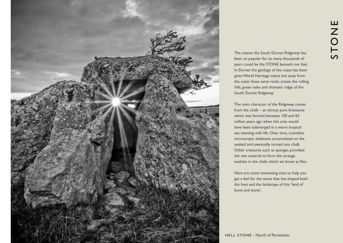
The reason the South Dorset Ridgeway has been so popular for so many thousands of years could be the STONE beneath our feet. In Dorset the geology of the coast has been given World Heritage status but away from the coast these same rocks create the rolling hills, green vales and dramatic ridge of the South Dorset Ridgeway.
The main character of the Ridgeway comes from the chalk – an almost pure limestone which was formed between 100 and 65 million years ago when this area would have been submerged in a warm tropical sea teeming with life. Over time, countless microscopic skeletons accumulated on the seabed and eventually turned into chalk. Other creatures such as sponges provided the raw material to form the strange nodules in the chalk which we know as flint. Here are some interesting sites to help you get a feel for the stone that has shaped both the lives and the landscape of this 'land of bone and stone'.
HELL STONE - North of Portesham

VALLEY OF STONESS Y 5 9 5 8 8 0
This National Nature Reserve has an unusual train of sarsen stones – boulders strewn across the valley, tumbled down from the ridge during the last Ice Age. It is very likely that some of the stones used in stone circles and standing stones on the Ridgeway came from here. See if you can see the difference between stones at the top of the hill and the bottom! Follow the walk on Map 3 of our Field Guide series from Littlebredy, where you can rest up afterwards at the tea rooms or enjoy the lake.
OSMINGTON WHITE HORSES Y 7 1 5 8 4 3
The ultimate proof that the Ridgeway is made of chalk! You can see the White Horse (well, actually off-white), cut in 1808 to commemorate the visits of King George III to Weymouth, from the town itself or pull into the viewing layby for a closer look. You can also follow the South Dorset Ridgeway National Trail along the top of the ridge, see Map 6 in our free Field Guide series.
ROCKET QUARRYS Y 6 1 1 8 5 9
The rock found in this small former quarry above Portesham is Portland and Purbeck limestone. Stone from here was used to build Abbotsbury Abbey and Athelhampton House as well as the Hardy Monument. Rocket Quarry is protected as a Local Geological Site, boasting the remains of a fossilised tree from 140 million years ago. Walk here from Black Down or Portesham village, enjoying the wildflowers and butterflies in the summer, see Field Guide series Map 2. Also in the area is Bishop's Lime Kiln, a restored traditional lime kiln used centuries ago to burn lime to improve the soil. There is a small car park overlooking Abbotsbury and the Jurassic Coast, a good place for a picnic or the start of a Ridgeway ramble.

Lots of additional information, maps and walks available online at
SOUTHDORSETRIDGEWAY.ORG.UK
RIDGEWAY VILLAGES
It’s no surprise that stone from Rocket Quarry and other smaller quarries on the Ridgeway has been used locally to build houses and churches. Take some time to wander through the villages and you’ll see the local limestone and flint – each village has its own character of building depending on what stone was available locally.
You’re spoilt for choice - have a look on the map and you’ll see that most villages have something of interest to draw you in, as well as a pub, café or local shop to keep you fed and watered! Pictured right is an image from Littlebredy, a small village tucked away at the top of the Bride Valley.
AND THE WALLS CAME
TUMBLING DOWN . . .Dry stone walls run up and down the Ridgeway and are a great insight into the rock beneath your feet. Many were built in the 1800s to enclose land, created by picking stone from the fields and laying them in courses with coping stones on the top. Sadly, many have fallen into disrepair but we’ve been working with volunteers, repairing over 2km of walls so far. If you'd like to try your hand at this traditional rural skill, get in touchvia the website.

BO
NE
What makes the South Dorset Ridgeway so special is the number of ancient monuments that remain and the clues they give us to life in the past.
It’s easy to see why the chalk of the Ridgeway has attracted settlement for thousands of years. A source of flint for early tools, freshwater springs, fertile soils and well-drained ground for easy travel have made it a good place to live for the last 5000 years at least!
The Ridgeway is renowned for the dramatic use made of the landscape for the construction of historic monuments in ancient times. The monuments were built in places where they could be seen from far and wide – sending a strong message to locals and incomers from the sea.
These structures include barrows, stone circles and hillforts and you can see many of them today. Read on to find where you can see some of the amazing ancient structures from past lives on the Ridgeway.
VIKING SKULL from 'The Pit of Doom'

LONG & BANK BARROWSLong barrows are associated with the Neolithic period (6000-4500 years ago) and the South Dorset Ridgeway boasts at least 10 of them! These long earth and stone mounds would have contained a chamber for several burials. Three unusually long mounds also exist from this early period, known as ‘bank barrows’. These don’t appear to be associated with burial and may have defined tribal or clan boundaries.
HELL STONES Y 6 0 5 8 6 7
A walk will take you to this enigmatic sounding set of stones, tucked away north of Portesham. The Hell Stone long barrow was constructed around the same time as Grey Mare and her Colts. However, antiquarians in 1866 decided to reconstruct the stone chamber at the front of the long earthen mound, setting these huge stones upright with a cap on top. See Map 2 of our Field Guide series for the route.
GREY MARE & HER COLTSS Y 5 8 4 8 7 0
This long rectangular mound was a Neolithic burial monument, probably built around 5000 years ago and is likely to have been used for generations of a local community who lived close by. The barrow was built high on the ridge, with views to the coastline and beyond.
The walk on Map 3 of our Field Guide series has great views and takes you to these ancient stones. You can use our app to get a taste of the myths and legends associated with these sites.
LO
NG
& B
AN
K B
AR
RO
WS
ST
ON
E C
IRC
LE
S &
HE
NG
ES
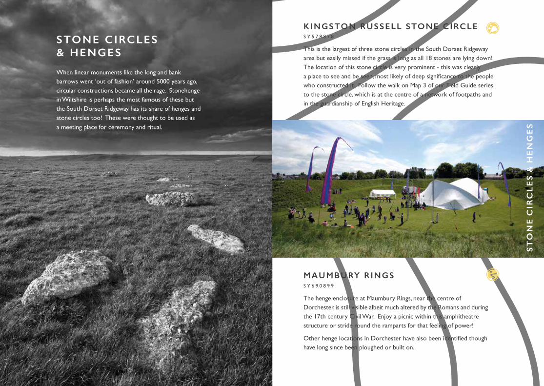
K INGSTON RUSSELL STONE CIRCLES Y 5 7 8 8 7 8
This is the largest of three stone circles in the South Dorset Ridgeway area but easily missed if the grass is long as all 18 stones are lying down! The location of this stone circle is very prominent - this was clearly a place to see and be seen, most likely of deep significance to the people who constructed it. Follow the walk on Map 3 of our Field Guide series to the stone circle, which is at the centre of a network of footpaths and in the guardianship of English Heritage.
MAUMBURY RINGSS Y 6 9 0 8 9 9
The henge enclosure at Maumbury Rings, near the centre of Dorchester, is still visible albeit much altered by the Romans and during the 17th century Civil War. Enjoy a picnic within this amphitheatre structure or stride round the ramparts for that feeling of power!
Other henge locations in Dorchester have also been identified though have long since been ploughed or built on.
STONE CIRCLES & HENGES
When linear monuments like the long and bank barrows went ‘out of fashion’ around 5000 years ago, circular constructions became all the rage. Stonehenge in Wiltshire is perhaps the most famous of these but the South Dorset Ridgeway has its share of henges and stone circles too! These were thought to be used as a meeting place for ceremony and ritual.

NINE STONESS Y 6 1 1 9 0 4
One of the most intriguing stone circles in the UK, Nine Stones is small and located in a river valley rather than the usual exposed hill top. In local folklore the stones are known as the Devil’s Nine Stones, representing the Devil, his wife and family. The stones are also believed to dance at 3pm on certain days! You can walk along a permissive path through fields from Winterbourne Abbas, or get a view from the bus from Dorchester to Bridport - keep your eyes peeled just after Winterbourne Abbas.
HAMPTON DOWN STONE CIRCLES Y 5 9 6 8 6 5
This small circle constructed on the ridge above Portesham 4000 years ago has been greatly altered over its life. In 1908 a photo shows 16 stones but in 1964 it had grown to 28 stones. However, excavation at this time revealed that many of the stones were out of place so it was shifted slightly west and restored with 10 stones to the correct site. You can walk to this stone circle, located on the South Dorset Ridgeway National Trail, using Map 2 in our Field Guide series.
BLACK DOWN STONE CIRCLES Y 6 0 7 8 7 6
This new stone circle has been designed by artist Amanda Moore to celebrate the ‘land of bone and stone'.
The stone blocks are arranged with one facing true north and the others aligning with the summer and winter solstice sunrises and sunsets. The square windows cut into each for viewing the sunrises and sunsets also allow light to shine onto the central Portland Stone during the solstices. For the rest of the year you can enjoy views out across Dorset's amazing landscape and Jurassic Coast!
LO
NG
& B
AN
K B
AR
RO
WS

ROUND BARROWSAt the time henges were starting to appear, there was a shift from communal burials towards individual burials. Long barrows ceased to be used and in came the more popular ‘round barrow’ … so popular that there are thought to have been thousands in the Ridgeway area. These were normally constructed on prominent locations along the ridge. They came in all shapes and sizes of ‘round’ … with bowl, bell, disc, pond and saucer round barrows all to be found here!
BRONKHAM HILLS Y 6 2 3 8 7 2
The South Dorset Ridgeway has one of the greatest concentrations of these Bronze Age funerary monuments in southern England and Bronkham Hill is one of the most spectacular groups of these on the ridge. The group runs for about a mile and includes four bell barrows and a double bowl barrow too! Added to this heady mix are natural hollows called sink holes, formed when a patch of chalk underneath the top layer of sands and gravels is dissolved. It’s easy to walk to from Black Down along the National Trail, see Map 4 in our Field Guide series.
BINCOMBE BUMPSS Y 6 8 9 8 4 6
This group of round barrows is reputed to be musical – if you put your ear to the top of the largest at midday you may hear music! It is also said to be the hill featured in 'The Grand Old Duke of York''.
Follow the walk on Map 5 in our Field Guide series along the National Trail and enjoy the open access land with great views to the coast.
RO
UN
D B
AR
RO
WS

CULLIFORD TREE BARROWS Y 6 9 9 8 5 5
This large bowl barrow later became the meeting point for the area and was planted with a tree ring in 1740. Excavated in 1858, four skeletons including a female with an amber and gold necklace were found. Although on private land, it can be viewed from a footpath to Came Wood.
POOR LOT BARROW CEMETERYS Y 5 8 9 9 0 7
Travelling on the bus between Dorchester and Bridport, keep your eyes peeled for this Bronze Age barrow cemetery with at least 44 round barrows!
CLUES TO THE PASTRound barrows often had a special vessel buried with the dead person as well as daggers, beads and other treasures. Unfortunately, this meant that barrow digging became a popular pursuit in the 19th century – a real treasure hunt - and many of the round barrows have been damaged or altered. Original treasures like the pure gold lozenge found at Clandon Barrow and other barrow finds are kept safe at Dorset County Museum in Dorchester. More recent excavations have occurred when building the new road between Dorchester and Weymouth. In 2009 the building work uncovered 54 beheaded skeletons, thought to be Viking warriors. Now referred to as the ‘Pit of Doom’, this modern-day excavation gives us vital clues about life a thousand years ago.

Lots of additional information, maps and walks available online at
SOUTHDORSETRIDGEWAY.ORG.UK
HIL
LF
OR
TS
H ILLFORTSBy the Iron Age (around 2500 years ago), the tradition of barrow burial had ceased and this was the time when construction of hillforts begun. It is thought that these Ridgeway people didn’t bury their dead and had a different belief system, linked to agricultural production. Early hillforts were small but still needed a substantial amount of social organisation to construct these earthworks. When built, the earthworks would have been deeper and steeper and bright white from the freshly dug chalk, topped with timber palisades and great timber gates guarding the entrances.
MAIDEN CASTLES Y 6 6 9 8 8 5
Probably the biggest and most significant site in the whole of the South Dorset Ridgeway area, it has long been recognised as one of the largest Iron Age hillforts in Europe (around the size of 50 football pitches!) The hillfort was built on barrows and monuments from earlier times, a place of great significance to Ridgeway people for many thousands of years. You can’t help but be impressed by the vast ramparts and spectacular views. Try out the ‘Poetry Parks’ app as you wander to glean snippets about the Castle’s past.
Maiden Castle at the height of its Iron Age occupation

ABBOTSBURY CASTLES Y 5 5 5 8 6 6
Stunning views across the Jurassic Coast would be good enough reason to visit but the triangle shaped hillfort enclosure and large Bronze Age round barrow also make it well worth a visit. From here you can see the remains of the medieval abbey in Abbotsbury village as well as St Catherine’s Chapel (pictured), which is still a site of pilgrimage. Follow the walk around Abbotsbury Castle in our Field Guide series, Map 1.
EGGARDON HILLS Y 5 4 1 9 4 6
Almost as big as Maiden Castle, Eggardon has better views and is a great place to watch the sunset. In the centre of the hillfort is a small octagonal earthwork, originally dug to protect a small plantation of trees. These were planted by famous Dorset smuggler Isaac Gulliver and would act as a seamark for his ships. Half of the hillfort is owned and managed by the National Trust with open access and footpaths around the hillfort ramparts.
CHALBURY HILLFORTS Y 6 9 4 8 3 8
This small Iron Age hillfort is recorded as being one of the oldest in the country but likely to have been abandoned as Maiden Castle expanded. Two round barrows survived the construction of the hillfort and further along the ridge lies a Bronze Age cremation cemetery, where 100 burial urns were found during excavation. The hillfort is set in open access land and accessed by the National Trail and other footpaths. See Map 5 in our Field Guide series.
With over 8000 years of farming heritage in this landscape it’s no surprise we have such a variety of amazing food & drink on offer.
Dorset Food & Drink celebrates the outstanding food & drink produced here. Look out for the logo in shops and eateries to give your taste buds a very Dorset treat!
HIL
LF
OR
TS
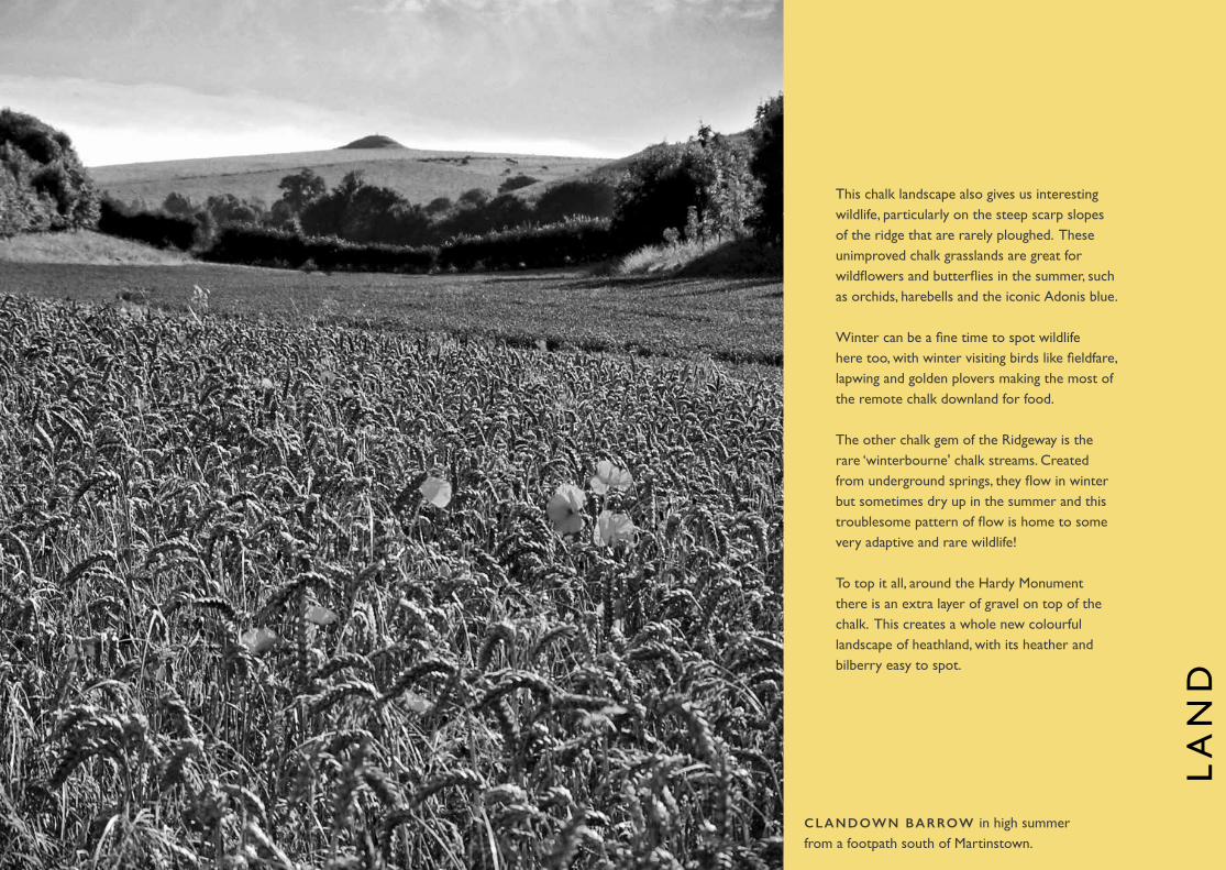
This chalk landscape also gives us interesting wildlife, particularly on the steep scarp slopes of the ridge that are rarely ploughed. These unimproved chalk grasslands are great for wildflowers and butterflies in the summer, such as orchids, harebells and the iconic Adonis blue.
Winter can be a fine time to spot wildlife here too, with winter visiting birds like fieldfare, lapwing and golden plovers making the most of the remote chalk downland for food.
The other chalk gem of the Ridgeway is the rare ‘winterbourne' chalk streams. Created from underground springs, they flow in winter but sometimes dry up in the summer and this troublesome pattern of flow is home to some very adaptive and rare wildlife!
To top it all, around the Hardy Monument there is an extra layer of gravel on top of the chalk. This creates a whole new colourful landscape of heathland, with its heather and bilberry easy to spot.
LA
ND
CLANDOWN BARROW in high summer from a footpath south of Martinstown.

BLACK DOWN (around the Hardy Monument)S Y 6 1 2 8 7 5
Head up to Black Down to see some rare heathland thriving under a new regime of grazing to keep the scrub down. Covered in trees in the not so distant past, this heathland is slowly finding its feet, thanks to grazing managed by Dorset Countryside. The new car park and access paths make this an easy place to explore. Follow short walking routes from Map 4 of our Field Guide series or rest up by the Stone Circle sculpture, inspired by henges of the past.
MARTINSTOWN
Wander around Martinstown village (also known as Winterborne St Martin) to see a winterbourne stream in full glory. Filtered by the chalk, this stream of pure, clear water dominates the village streetscape. Look out for the ancient sheepwash while you are there, a great innovation in its time. Winterbourne Abbas, Winterbourne Steepleton and Winterborne Monkton, Winterborne Herringston and Winterborne Came are also fed by these seasonal streams.
VALLEY OF STONESS Y 5 9 5 8 8 0
This National Nature Reserve has already had a mention for its enigmatic sarsen stones but it is well worth a visit in the summer for its unimproved grassland, uncommon lichens and rare butterflies.
ON THE WAY TO WEYMOUTH
The Weymouth Relief Road may not sound like an obvious destination but if you’re looking for butterflies it’s one of the best places to go! Through careful planting and management, the steep cuttings of the road are awash with native wildflowers and butterflies in spring and summer – get your spotter’s guide out! See Field Guides series Map 5 for details.
NOW YOU SEE IT, NOW YOU DON'T
National Grid is planning to bury an 8km stretch of electricity cables to remove the gigantic pylons which dominate some Ridgeway views. Keep your eyes open for the undergrounding work over the next few years which is bound to be an interesting spectacle in itself! Pl
aces
to g
o

MID WINTER
When it gets cold RAVENS will be very noticeable, slipping along the wind lifted by the ridge and looking for the carrion of other animals that have succumbed to the cold. The size of these ‘wolf birds’ can be hard to judge when in the sky. Look out for a longer, heavier neck than a crow and wedge shaped tail.
BARN OWLS are a Ridgeway icon all year, with roosts and nests in many of the old stone barns. In winter they will be hungry and with dusk so much earlier in the day you will often see them, silent white as they fly low over the fields looking for voles.
DEER are also numerous throughout the year but they are best seen at dawn and dusk, so a good winter spot. Being woodland animals, there is less cover to hide during winter, so we see them more often.
SPRING
BROWN HARE
The Ridgeway is a great place to see ‘mad’ March hares. Like many of our mammals the best time of day to see them is dawn and dusk. They can be seen in many open grass or arable fields throughout the year but in early spring they will be at their most active; you might be lucky enough to see the females ‘boxing’ the amorous males!
Late April is a magical time, many of our summer migrant birds have arrived and this is the peak for dawn chorus birdsong. It means an early start but something everyone should do at least twice! Visit a broadleaf woodland just before dawn, walk slowly and quietly through the wood or settle down somewhere simply to listen.
A YEAR OF WILDLIFE
Spring is also the time of year to enjoy swathes of bluebells, many are in woodland but at Black Down you can enjoy a carpet of bluebells outside of the wood as well!
SUMMER
BUTTERFLIES Late May is the time to see most wildflowers along the Ridgeway, but different plants will flower at times throughout the spring and summer.
Of course wild flowers mean butterflies! The grassland across the ridge is great to spot them. Iconic among our butterflies is the Adonis blue which likes short turf on sunny, southern slopes. Its flight season is May/June and August/September.
A June visit to Black Down at dusk should be rewarded with the strange sound of churring nightjar.
AUTUMN
BATS As the days get shorter but are still warm, this is a great time to look for bats at dusk. There are loads of bat roosts across the Ridgeway, associated with the many old buildings.
REDWINGS & FIELDFARE
from Scandinavia thrive on all the hedgerow berries.
You will see that many of the fine views from the Ridgeway take in the equally fine Jurassic Coast. England's only natural World Heritage Site, it
reveals 185 million years of geological history along its length from Exmouth to Studland Bay. jurassiccoast.org
THE JURASSIC COAST
DEER & RAVENBROWN HARE & BLUEBELLSBARN OWL CORN BUNTING NIGHTJAR & BUTTERFLIES DRAGONFLIES & GRASSHOPPERS BATS REDWING & F IELDFARE

F IELD GUIDE & WALKING MAPS
Artist Amanda Wallwork has created this stunning pack, giving unique insights into the geology, history and traditions of the South Dorset Ridgeway. Each of the 6 hand drawn maps show at least one suggested walking or cycling route, carefully chosen to provide highlights of this remarkable landscape. The 10 routes range from 1.5 to 7 miles.
DORSET COUNTY MUSEUM
Holding many treasures from the South Dorset Ridgeway, the Museum will reopen in 2020 after major renovation work but check out their website for updates.
I F YOU’VE DIPPED INTO THE
LAND OF BONE & STONE
AND ARE INTRIGUED BY WHAT
YOU'VE FOUND, THERE’S LOTS
OF WAYS TO FIND OUT MORE. . .
MYTHS + LEGENDS
Storyteller Martin Maudsley has worked with local schools to develop and re-tell 7 evocative stories. Illustrated by local artists, these stories have been presented as a toolkit for teachers but are also available for all to read on our website.
LISTEN OUT
Hidden in the hills are 'sound pools' of music, poetry and legends inspired by the Land of Bone & Stone. Download the apps and explore them at Maiden Castle, Eggardon Hill, Grey Mare and her Colts, Kingston Russell Stone Circle and Bronkham Hill.
SCHOOL SUPPORT
There are many resources available for schools to find out more about the Land of Bone & Stone, including lesson plans and resource boxes.
IMAGES: Tony Gill, Paul Haynes, James Loveridge, Mike Franklin, Francesca Radcliffe/Dorset County Museum, Oxford Archaeology, Spike Piddock, Dave Penman, Mike Cowley, Anthony Page, Owen Vachell, Historic England Photo Library & Dorset AONB. BONE AND STONE ADVICE: Steve Wallis (Dorset CC) & Sam Scriven (Jurassic Coast Trust).
For additional information, maps and walks please visitS O U T H D O R S E T R I D G E WAY. O R G . U KThis Guide is available in alternative formats on request.
Related Documents