Source vulnerability mapping in carbonate (karst) aquifers by extension of the COP method: application to pilot sites B. Andreo & N. Ravbar & J. M. Vías Abstract A step from resource to source vulnerability mapping is presented, based on the European COST Action 620 approach for karst groundwater protection. Guidelines on vulnerability assessment of the horizontal groundwater flow path within the karst saturated zone (K factor) are proposed. By integrating this into the previously existing COP method for intrinsic resource vulnerability mapping, adequate source protection can be assessed. The proposed “Karst saturated zone (K) factor” assessment considers groundwater travel time (t subfactor), connection and contribution to the source (r subfactor) and active conduit or fissured network (n subfactor). The extended COP method was applied in two carbonate aquifers in southern Spain with different geological, hydrogeological and climate settings. The results are coherent with previous research results of the studied areas. Moreover, they are consistent with the occasional groundwater contamination detected in one of the springs. On the other hand, an absence of contamination, despite high risk, justifies the lower degrees of vulnerability assigned to the sources surveyed. The source vulnerability maps obtained can thus be used as a basis for the delineation of protection zones. Keywords Carbonate aquifer . Spain . Groundwater protection . Vulnerability mapping . COP method Introduction Groundwater from karst aquifers is an important drinking- water resource worldwide (Ford and Williams 2007). The functioning and behaviour of karst aquifers have some peculiarities due to the concentrated recharge of water and its rapid infiltration, the high permeability of aquifer systems and fast transport in karst conduits over large distances. Consequently, such aquifers are particularly vulnerable to contamination. Therefore, COST Action 620 proposed a European approach on Vulnerability and Risk Mapping for the Protection of Carbonate (Karst) Aquifers (Zwahlen 2004). However, several other methodologies for groundwater vulnerability assessment exist. Overviews of some of the most commonly used ones have been prepared by Vrba and Zaporozec (1994), Gogu and Dassargues (2000) and others. The COST Action 620 proposal of the European approach (Daly et al. 2002) for groundwater vulnerability mapping is founded on the assessment of basic factors that control the infiltration of water and contaminants from the land surface towards the groundwater (Fig. 1). Two types of intrinsic vulnerability have been distinguished, depend- ing on the target or receptor of the potential contamina- tion. For resource vulnerability, the target is the groundwater surface or water table within the aquifer and thus only the vertical pathway within the aquifer is considered. The vulnerability assessment includes the overlying layers factor (O), the concentration of flow factor (C) and the precipitation regime factor (P). For source vulnerability, water in wells or springs is the target. Consequently, the pathway additionally includes horizon- tal flow in the saturated zone, depicted as the karst network development factor (K). The European approach does not prescribe detailed guidelines as to how the component factors should be measured and categorised, but the proposed conceptual framework could be adopted into methods appropriate for use in individual karst aquifer systems. The derived COP method (Vías et al. 2006) represents an integral interpre- Received: 15 May 2008 / Accepted: 15 October 2008 * Springer-Verlag 2008 B. Andreo ()) Department of Geology, Faculty of Science, University of Málaga, Campus Universitario de Teatinos, Málaga, 29071, Spain e-mail: [email protected] Tel.: +34-952-132004 Fax: +34-952-132000 N. Ravbar Karst Research Institute SRC SASA, Titov trg 2, 6230, Postojna, Slovenia B. Andreo Department of Geography, University of Málaga, Avda, Cervantes 2, Málaga, 29071, Spain J. M. Vías Department of Geography, University of Málaga, Campus Universitario de Teatinos, Málaga, 29071, Spain Hydrogeology Journal DOI 10.1007/s10040-008-0391-1

Welcome message from author
This document is posted to help you gain knowledge. Please leave a comment to let me know what you think about it! Share it to your friends and learn new things together.
Transcript
Source vulnerability mapping in carbonate (karst) aquifersby extension of the COP method: application to pilot sites
B. Andreo & N. Ravbar & J. M. Vías
Abstract A step from resource to source vulnerabilitymapping is presented, based on the European COSTAction 620 approach for karst groundwater protection.Guidelines on vulnerability assessment of the horizontalgroundwater flow path within the karst saturated zone (Kfactor) are proposed. By integrating this into the previouslyexisting COP method for intrinsic resource vulnerabilitymapping, adequate source protection can be assessed. Theproposed “Karst saturated zone (K) factor” assessmentconsiders groundwater travel time (t subfactor), connectionand contribution to the source (r subfactor) and activeconduit or fissured network (n subfactor). The extendedCOP method was applied in two carbonate aquifers insouthern Spain with different geological, hydrogeologicaland climate settings. The results are coherent with previousresearch results of the studied areas. Moreover, they areconsistent with the occasional groundwater contaminationdetected in one of the springs. On the other hand, anabsence of contamination, despite high risk, justifies thelower degrees of vulnerability assigned to the sourcessurveyed. The source vulnerability maps obtained can thusbe used as a basis for the delineation of protection zones.
Keywords Carbonate aquifer . Spain .Groundwater protection . Vulnerability mapping .COPmethod
Introduction
Groundwater from karst aquifers is an important drinking-water resource worldwide (Ford and Williams 2007). Thefunctioning and behaviour of karst aquifers have somepeculiarities due to the concentrated recharge of water andits rapid infiltration, the high permeability of aquifersystems and fast transport in karst conduits over largedistances. Consequently, such aquifers are particularlyvulnerable to contamination. Therefore, COST Action 620proposed a European approach on Vulnerability and RiskMapping for the Protection of Carbonate (Karst) Aquifers(Zwahlen 2004). However, several other methodologiesfor groundwater vulnerability assessment exist. Overviewsof some of the most commonly used ones have beenprepared by Vrba and Zaporozec (1994), Gogu andDassargues (2000) and others.
The COST Action 620 proposal of the Europeanapproach (Daly et al. 2002) for groundwater vulnerabilitymapping is founded on the assessment of basic factors thatcontrol the infiltration of water and contaminants from theland surface towards the groundwater (Fig. 1). Two typesof intrinsic vulnerability have been distinguished, depend-ing on the target or receptor of the potential contamina-tion. For resource vulnerability, the target is thegroundwater surface or water table within the aquiferand thus only the vertical pathway within the aquifer isconsidered. The vulnerability assessment includes theoverlying layers factor (O), the concentration of flowfactor (C) and the precipitation regime factor (P). Forsource vulnerability, water in wells or springs is the target.Consequently, the pathway additionally includes horizon-tal flow in the saturated zone, depicted as the karstnetwork development factor (K).
The European approach does not prescribe detailedguidelines as to how the component factors should bemeasured and categorised, but the proposed conceptualframework could be adopted into methods appropriate foruse in individual karst aquifer systems. The derived COPmethod (Vías et al. 2006) represents an integral interpre-
Received: 15 May 2008 /Accepted: 15 October 2008
* Springer-Verlag 2008
B. Andreo ())Department of Geology, Faculty of Science,University of Málaga,Campus Universitario de Teatinos, Málaga, 29071, Spaine-mail: [email protected].: +34-952-132004Fax: +34-952-132000
N. RavbarKarst Research Institute SRC SASA,Titov trg 2, 6230, Postojna, Slovenia
B. AndreoDepartment of Geography,University of Málaga,Avda, Cervantes 2, Málaga, 29071, Spain
J. M. VíasDepartment of Geography,University of Málaga,Campus Universitario de Teatinos, Málaga, 29071, Spain
Hydrogeology Journal DOI 10.1007/s10040-008-0391-1
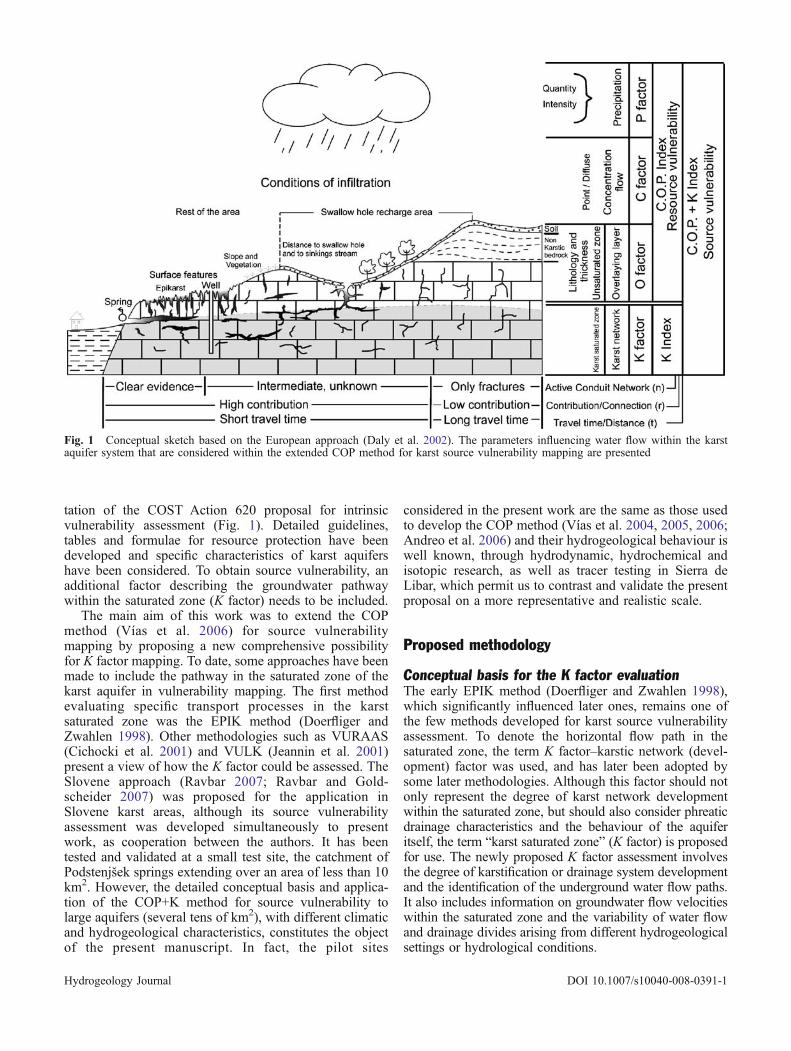
tation of the COST Action 620 proposal for intrinsicvulnerability assessment (Fig. 1). Detailed guidelines,tables and formulae for resource protection have beendeveloped and specific characteristics of karst aquifershave been considered. To obtain source vulnerability, anadditional factor describing the groundwater pathwaywithin the saturated zone (K factor) needs to be included.
The main aim of this work was to extend the COPmethod (Vías et al. 2006) for source vulnerabilitymapping by proposing a new comprehensive possibilityfor K factor mapping. To date, some approaches have beenmade to include the pathway in the saturated zone of thekarst aquifer in vulnerability mapping. The first methodevaluating specific transport processes in the karstsaturated zone was the EPIK method (Doerfliger andZwahlen 1998). Other methodologies such as VURAAS(Cichocki et al. 2001) and VULK (Jeannin et al. 2001)present a view of how the K factor could be assessed. TheSlovene approach (Ravbar 2007; Ravbar and Gold-scheider 2007) was proposed for the application inSlovene karst areas, although its source vulnerabilityassessment was developed simultaneously to presentwork, as cooperation between the authors. It has beentested and validated at a small test site, the catchment ofPodstenjšek springs extending over an area of less than 10km2. However, the detailed conceptual basis and applica-tion of the COP+K method for source vulnerability tolarge aquifers (several tens of km2), with different climaticand hydrogeological characteristics, constitutes the objectof the present manuscript. In fact, the pilot sites
considered in the present work are the same as those usedto develop the COP method (Vías et al. 2004, 2005, 2006;Andreo et al. 2006) and their hydrogeological behaviour iswell known, through hydrodynamic, hydrochemical andisotopic research, as well as tracer testing in Sierra deLibar, which permit us to contrast and validate the presentproposal on a more representative and realistic scale.
Proposed methodology
Conceptual basis for the K factor evaluationThe early EPIK method (Doerfliger and Zwahlen 1998),which significantly influenced later ones, remains one ofthe few methods developed for karst source vulnerabilityassessment. To denote the horizontal flow path in thesaturated zone, the term K factor–karstic network (devel-opment) factor was used, and has later been adopted bysome later methodologies. Although this factor should notonly represent the degree of karst network developmentwithin the saturated zone, but should also consider phreaticdrainage characteristics and the behaviour of the aquiferitself, the term “karst saturated zone” (K factor) is proposedfor use. The newly proposed K factor assessment involvesthe degree of karstification or drainage system developmentand the identification of the underground water flow paths.It also includes information on groundwater flow velocitieswithin the saturated zone and the variability of water flowand drainage divides arising from different hydrogeologicalsettings or hydrological conditions.
Fig. 1 Conceptual sketch based on the European approach (Daly et al. 2002). The parameters influencing water flow within the karstaquifer system that are considered within the extended COP method for karst source vulnerability mapping are presented
Hydrogeology Journal DOI 10.1007/s10040-008-0391-1
Very often, scant data are available on water flow pathswithin the saturated zone and hydraulic connections ofdifferent parts of an aquifer. To obtain the spatialdistribution of the main differences in groundwater flowcharacteristics within the saturated zone, several sourcesof direct and indirect information should be combined.
Speleological exploration is the only direct observationof the karst network, but unfortunately the active cavepassages are usually developed at a local scale and theyare often not accessible. This criterion also has drawbacksand may not be especially relevant, as cave registering canreflect the degree of research work in a certain area. Theconduit size aspect may not be an acceptable parametereither, because small karst conduits, too, permit fast flowand can result in rapid contaminant transport withoutsignificant attenuation.
Indirect information can be obtained by observing thehydrological behaviour of the aquifer (Doerfliger et al.1999; Zwahlen 2004). Thus, hydrodynamic, physico–chemical characteristics, both from springs (hydrographanalyses) and from boreholes (water table variations,pumping test), and laboratory analyses can be used. Tracerexperiments using natural and artificial tracers can provideinformation on groundwater flow velocities, retardationand response to rainfall infiltration.
Crucial for source vulnerability assessment is the size ofthe catchment area. However, watersheds are sometimesdifficult to determine due to their variability in time and thestrong dependence on the respective hydrological condi-tions. Thus, catchment boundaries may vary by several tensof kilometres (Ravbar and Goldscheider 2006; Ravbar2007). Furthermore, the catchment areas of differentsprings can overlap and the flow paths cross each other.
Guidelines for the K factor assessmentTo protect a source from contamination, three mainquestions should be considered (Daly et al. 2002;Brouyère 2004):
– Within what time period will a contaminant arrive atthe source (days, weeks, months...)?
– What proportion of the contaminant will arrive (onlytraces, 1%, 10% or all)?
– How long will a contamination episode last?
Therefore the K factor assessment should be basedmainly on transit time or groundwater flow velocities andon connection and degree of contribution to the source,which are among the most important contaminationaspects. In contrast, the duration of a contamination eventcould be an optional aspect. Additionally, reliable informa-tion on active conduit networks should also be considered.
Hence, the proposed assessment of the K factor shouldmainly be based on the hydraulic properties of the aquifer,together with its geological, geomorphological, speleolog-ical and hydrological characteristics. Besides conventionalsurvey techniques such as speleological investigation,geological mapping, borehole analyses, hydrograph anal-
yses, chemical and isotopic analyses, tracing experiments,remote sensing, geophysical measurements and the quan-titative characterisation of karst hydrological systems areimportant.
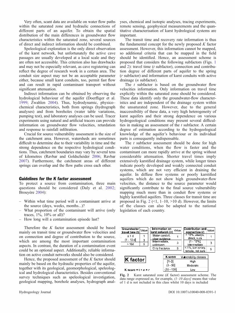
The transit time and recovery rate information is thusthe fundamental concept for the newly proposed K factorassessment. However, this information cannot be mapped,so additional criteria that can be mapped in the fieldshould be identified. Hence, an assessment scheme isproposed that considers the following subfactors (Figs. 1and 2): travel time (t subfactor), connection and contribu-tion degree of different parts of aquifer to the spring(r subfactor) and information of karst conduits with activedrainage (n subfactor).
The t subfactor is based on the groundwater flowvelocities information. Only information on travel timeexplicitly within the saturated zone should be considered.These data identify only the groundwater-flow character-istics and are independent of the drainage system withinthe unsaturated zone. However, due to the generalinaccessibility of these data, a very high heterogeneity ofkarst aquifers and their strong dependence on varioushydrogeological conditions may present several difficul-ties in making an assessment of the t subfactor. A certaindegree of estimation according to the hydrogeologicalknowledge of the aquifer’s behaviour or its individualparts is consequently indispensable.
The t subfactor assessment should be done for highwater conditions, when the flow is faster and thecontaminant can more rapidly arrive at the spring withoutconsiderable attenuation. Shorter travel times implyextensively karstified drainage system, while longer timesindicate poorly developed and weakly connected conduitsystems, which are not very efficient in draining theaquifer. In diffuse flow systems or poorly karstifiedaquifers which do not show high groundwater-flowvelocities, the distance to the source parameter wouldsignificantly contribute to the final source vulnerabilitymapping much more than in conduit flow systems orhighly karstified aquifers. Three classes for transit time areproposed in Fig. 2 (<1, 1–10, >10 d). However, the limitsof the classes can also be adapted to the nationallegislation of each country.
Fig. 2 Karst saturated zone (K factor) assessment scheme. Thedata range expressed as, for example, (1–10 days] means that valueof 1 d is not included in this class whilst 10 days is included
Hydrogeology Journal DOI 10.1007/s10040-008-0391-1
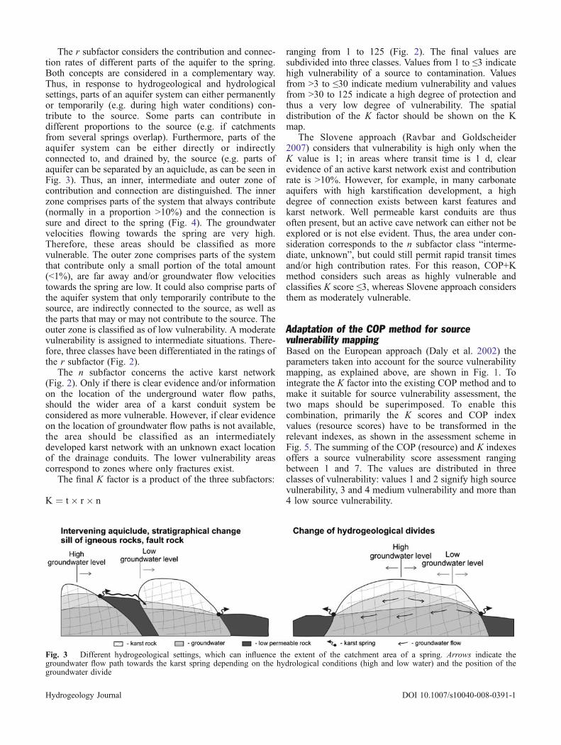
The r subfactor considers the contribution and connec-tion rates of different parts of the aquifer to the spring.Both concepts are considered in a complementary way.Thus, in response to hydrogeological and hydrologicalsettings, parts of an aquifer system can either permanentlyor temporarily (e.g. during high water conditions) con-tribute to the source. Some parts can contribute indifferent proportions to the source (e.g. if catchmentsfrom several springs overlap). Furthermore, parts of theaquifer system can be either directly or indirectlyconnected to, and drained by, the source (e.g. parts ofaquifer can be separated by an aquiclude, as can be seen inFig. 3). Thus, an inner, intermediate and outer zone ofcontribution and connection are distinguished. The innerzone comprises parts of the system that always contribute(normally in a proportion >10%) and the connection issure and direct to the spring (Fig. 4). The groundwatervelocities flowing towards the spring are very high.Therefore, these areas should be classified as morevulnerable. The outer zone comprises parts of the systemthat contribute only a small portion of the total amount(<1%), are far away and/or groundwater flow velocitiestowards the spring are low. It could also comprise parts ofthe aquifer system that only temporarily contribute to thesource, are indirectly connected to the source, as well asthe parts that may or may not contribute to the source. Theouter zone is classified as of low vulnerability. A moderatevulnerability is assigned to intermediate situations. There-fore, three classes have been differentiated in the ratings ofthe r subfactor (Fig. 2).
The n subfactor concerns the active karst network(Fig. 2). Only if there is clear evidence and/or informationon the location of the underground water flow paths,should the wider area of a karst conduit system beconsidered as more vulnerable. However, if clear evidenceon the location of groundwater flow paths is not available,the area should be classified as an intermediatelydeveloped karst network with an unknown exact locationof the drainage conduits. The lower vulnerability areascorrespond to zones where only fractures exist.
The final K factor is a product of the three subfactors:
K ¼ t� r � n
ranging from 1 to 125 (Fig. 2). The final values aresubdivided into three classes. Values from 1 to ≤3 indicatehigh vulnerability of a source to contamination. Valuesfrom >3 to ≤30 indicate medium vulnerability and valuesfrom >30 to 125 indicate a high degree of protection andthus a very low degree of vulnerability. The spatialdistribution of the K factor should be shown on the Kmap.
The Slovene approach (Ravbar and Goldscheider2007) considers that vulnerability is high only when theK value is 1; in areas where transit time is 1 d, clearevidence of an active karst network exist and contributionrate is >10%. However, for example, in many carbonateaquifers with high karstification development, a highdegree of connection exists between karst features andkarst network. Well permeable karst conduits are thusoften present, but an active cave network can either not beexplored or is not else evident. Thus, the area under con-sideration corresponds to the n subfactor class “interme-diate, unknown”, but could still permit rapid transit timesand/or high contribution rates. For this reason, COP+Kmethod considers such areas as highly vulnerable andclassifies K score ≤3, whereas Slovene approach considersthem as moderately vulnerable.
Adaptation of the COP method for sourcevulnerability mappingBased on the European approach (Daly et al. 2002) theparameters taken into account for the source vulnerabilitymapping, as explained above, are shown in Fig. 1. Tointegrate the K factor into the existing COP method and tomake it suitable for source vulnerability assessment, thetwo maps should be superimposed. To enable thiscombination, primarily the K scores and COP indexvalues (resource scores) have to be transformed in therelevant indexes, as shown in the assessment scheme inFig. 5. The summing of the COP (resource) and K indexesoffers a source vulnerability score assessment rangingbetween 1 and 7. The values are distributed in threeclasses of vulnerability: values 1 and 2 signify high sourcevulnerability, 3 and 4 medium vulnerability and more than4 low source vulnerability.
Fig. 3 Different hydrogeological settings, which can influence the extent of the catchment area of a spring. Arrows indicate thegroundwater flow path towards the karst spring depending on the hydrological conditions (high and low water) and the position of thegroundwater divide
Hydrogeology Journal DOI 10.1007/s10040-008-0391-1
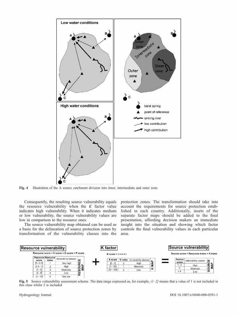
Consequently, the resulting source vulnerability equalsthe resource vulnerability when the K factor valueindicates high vulnerability. When it indicates mediumor low vulnerability, the source vulnerability values arelow in comparison to the resource ones.
The source vulnerability map obtained can be used asa basis for the delineation of source protection zones bytransformation of the vulnerability classes into the
protection zones. The transformation should take intoaccount the requirements for source protection estab-lished in each country. Additionally, insets of theseparate factor maps should be added to the finalpresentation, affording decision makers an immediateinsight into the situation and showing which factorcontrols the final vulnerability values in each particulararea.
Fig. 4 Illustration of the A source catchment division into inner, intermediate and outer zone
Fig. 5 Source vulnerability assessment scheme. The data range expressed as, for example, (1–2] means that a value of 1 is not included inthis class whilst 2 is included
Hydrogeology Journal DOI 10.1007/s10040-008-0391-1
Source vulnerability mapping in pilot sites
The extended COP method for source-vulnerabilitymapping has been applied in two aquifers in the Southof Spain, the aquifers of Sierra de Líbar and Sierra deMijas, both in the province of Malaga (Figs. 6 and 7).The first is a karst aquifer with conduit flow behaviourand with high rainfall quantities throughout the year,whilst the second is a fissured carbonate aquifer withdiffuse flow behaviour and moderate-to-low rainfallconditions. Intrinsic vulnerability mapping (using theCOP and other methods) and validation by tracer test andhydrogeological tools (hydrodynamic, hydrochemicaland isotopic analyses) have previously been applied inboth aquifers (Vías et al. 2005, 2006; Andreo et al.2006). Detailed descriptions of the pilot sites, includingthe C, O and P factors, are provided by Vías et al.(2006). For this reason, only characteristics related to theK factor are described below.
Sierra de LíbarSierra de Líbar has an abundance of karstic landforms(Delannoy 1987), including karren, sinkholes and poljeswith swallow holes in which sinking streams infiltrate.Most of the discharge from the aquifer is via springs(Fig. 6): Cueva del Gato (S-1), Benaoján (S-2), Jimera deLíbar (S-3) and Charco del Moro (S-4). These springsshow typical karst behaviour of quick response toprecipitation and rapid changes in flow and hydrochemicaland isotopic compositions (Benavente and Mangin 1984;Jimenez et al. 2004).
For the source vulnerability mapping, the catchmentareas of each spring have been delineated according tocurrent geological and hydrogeological knowledge, andthe results of a multi-tracer test (Andreo et al. 2004,2006), which also provided information on groundwaterflow velocities for the t subfactor assessment. Groundwa-ter flow velocities vary between 40 and 90 m/h, althoughtravel times higher than 100 m/h have also been detected.These data are typical of a karst conduit system and arecoherent with source hydrograph analyses as well as withthe high variability of hydrochemical and isotopic valuesin response to rainfall events (Andreo et al. 2006).
The individual catchment areas of springs oftenoverlap. The degree of contribution from a given injectionpoint is between 3 and 74%, depending on the spring andinjection point (Andreo et al. 2004). The sinking stream ofthe Pozuelo polje (H-1) is connected to the S-1 and S-2sources, and the Llanos de Libar polje (H-2) proved to bewithin the catchment area of the S-2 and S-3 springs. Therecovery rates strongly depend on hydrological circum-stances, although further information is not available. Theswallow hole H-3 is only connected to the spring S-4. Toassess the r subfactor values, tracer test data were used.Furthermore, the information on the active karst network(n subfactor) can be deduced from the speleologicalmapping of the Hundidero-Gato cave system, to whichthe highest degree of vulnerability has been assigned.
Despite hydrogeological data demonstrating conduit flowbehaviour of the aquifer, in the rest of the area waterconduits are unknown and the area was classed in theintermediate class of the n subfactor.
The resource vulnerability map shows vulnerability tobe high in the more karstified areas and moderate in theless karstified outcrops of limestone, whilst the Cretaceousmarls present low vulnerability for groundwater (Fig. 6a).The final K map shows the highly vulnerable zones nearthe springs and over the large Hundidero-Gato cavesystem (Fig. 6b). Most of the area is considered asmoderately vulnerable due to high travel times and theunknown location of karst conduits.
The source vulnerability map (Fig. 6c) was obtainedby combining the previously assessed resource vulnera-bility (Fig. 6a) and the K factor map (Fig. 6b). Theresulting map shows that most of the area is moderately-to-highly vulnerable. There is only a slight changebetween the resource and source vulnerability maps.Thus, the areas close to the springs are highly vulnerable;but this is also the case in distant zones, where theJurassic limestones are highly karstified. The highvulnerability of the Sierra de Líbar aquifer, as assessedusing the extended COP method, is consistent with actualknown episodes of groundwater contamination. Theseepisodes are normally short lasting and are detected whenwater is abstracted from the S-2 spring to supply thevillage of Benaoján.
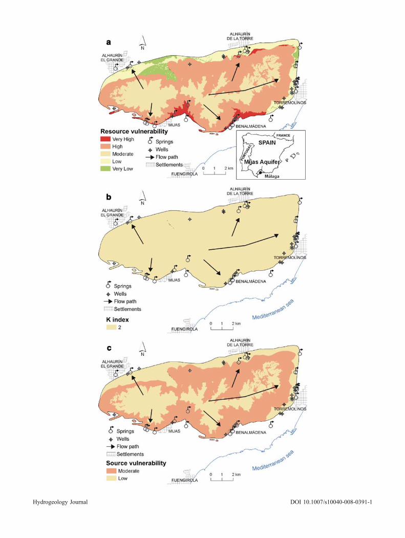
Sierra de MijasKarst morphological features are very scarce in Sierra deMijas and, hydrogeologically, several systems can bedistinguished (Andreo et al. 1997). Hydrograph analysisof the springs and chemical monitoring show diffuse flowbehaviour of the aquifer (Andreo et al. 1997; Andreo andCarrasco 1999). In the immediate vicinity of the springs,many boreholes have been drilled for drinking-watersupply and, consequently the spring dried up. Therefore,source protection in Sierra de Mijas involves both springsand pumping wells.
No data on tracer tests are available for Sierra de Mijas.However, several pumping tests have been made. Astorage capacity (effective porosity) of 0.02, and trans-missivity values of 103 m2/d have been estimated. Thesaturated thickness of the aquifer has an order ofmagnitude of 102 m. Consequently, the permeability isestimated to be about 10 m/d. Considering this latter valueand the effective porosity, the average groundwatervelocity of 20 m/d has been taken into account forassessing the t subfactor. This assumption is congruentwith the historical discharge data from the springs, as wellas chemical and isotopic records from wells, showing anabsence of sharp peaks in the graphs and attenuatedvariations occurring several months after the periods ofhigh rainfall. Tritium data from the springs indicate thatsome of the groundwater abstracted in the eastern part ofSierra de Mijas in 1994 originated from recharge in 1986(Andreo and Carrasco 1999).
Hydrogeology Journal DOI 10.1007/s10040-008-0391-1
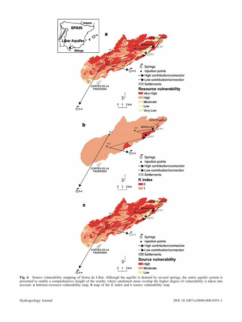
Fig. 6 Source vulnerability mapping of Sierra de Líbar. Although the aquifer is drained by several springs, the entire aquifer system ispresented to enable a comprehensive insight of the results; where catchment areas overlap the higher degree of vulnerability is taken intoaccount. a Intrinsic-resource-vulnerability map, b map of the K index and c source vulnerability map
Hydrogeology Journal DOI 10.1007/s10040-008-0391-1
Hydrogeology Journal DOI 10.1007/s10040-008-0391-1
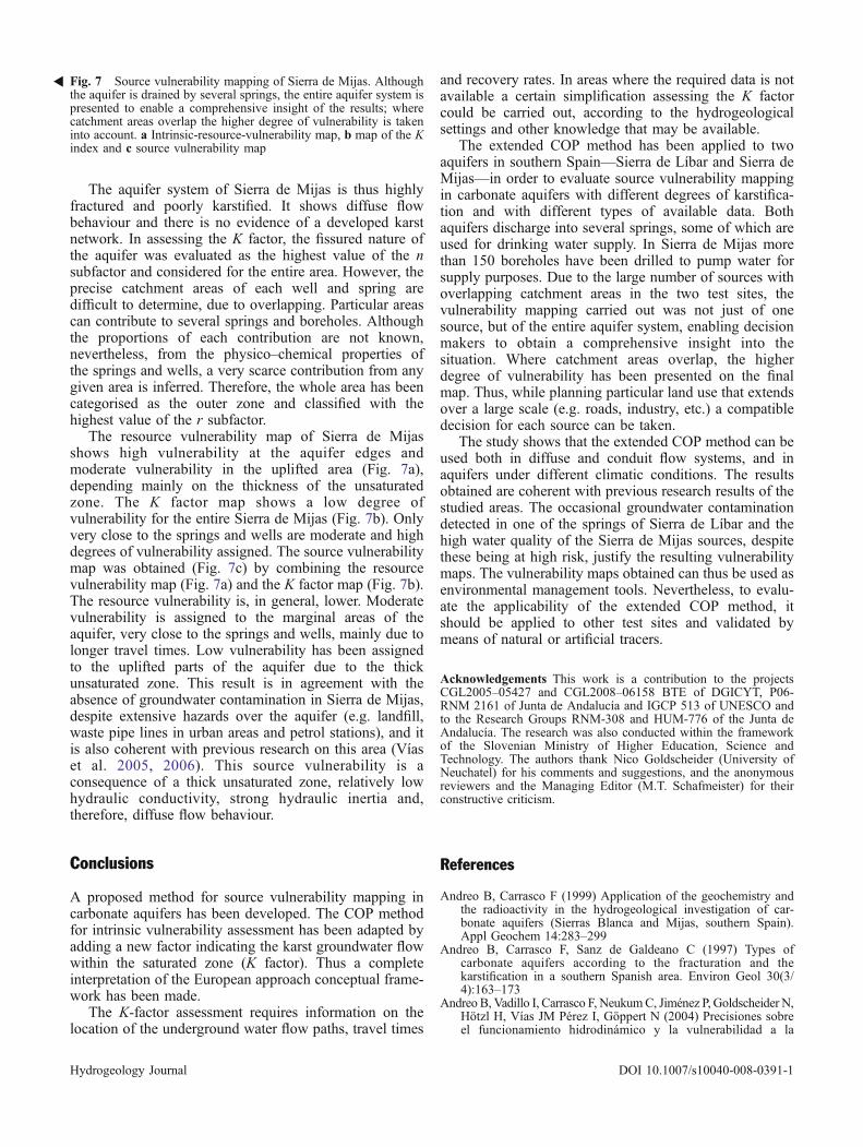
The aquifer system of Sierra de Mijas is thus highlyfractured and poorly karstified. It shows diffuse flowbehaviour and there is no evidence of a developed karstnetwork. In assessing the K factor, the fissured nature ofthe aquifer was evaluated as the highest value of the nsubfactor and considered for the entire area. However, theprecise catchment areas of each well and spring aredifficult to determine, due to overlapping. Particular areascan contribute to several springs and boreholes. Althoughthe proportions of each contribution are not known,nevertheless, from the physico–chemical properties ofthe springs and wells, a very scarce contribution from anygiven area is inferred. Therefore, the whole area has beencategorised as the outer zone and classified with thehighest value of the r subfactor.
The resource vulnerability map of Sierra de Mijasshows high vulnerability at the aquifer edges andmoderate vulnerability in the uplifted area (Fig. 7a),depending mainly on the thickness of the unsaturatedzone. The K factor map shows a low degree ofvulnerability for the entire Sierra de Mijas (Fig. 7b). Onlyvery close to the springs and wells are moderate and highdegrees of vulnerability assigned. The source vulnerabilitymap was obtained (Fig. 7c) by combining the resourcevulnerability map (Fig. 7a) and the K factor map (Fig. 7b).The resource vulnerability is, in general, lower. Moderatevulnerability is assigned to the marginal areas of theaquifer, very close to the springs and wells, mainly due tolonger travel times. Low vulnerability has been assignedto the uplifted parts of the aquifer due to the thickunsaturated zone. This result is in agreement with theabsence of groundwater contamination in Sierra de Mijas,despite extensive hazards over the aquifer (e.g. landfill,waste pipe lines in urban areas and petrol stations), and itis also coherent with previous research on this area (Víaset al. 2005, 2006). This source vulnerability is aconsequence of a thick unsaturated zone, relatively lowhydraulic conductivity, strong hydraulic inertia and,therefore, diffuse flow behaviour.
Conclusions
A proposed method for source vulnerability mapping incarbonate aquifers has been developed. The COP methodfor intrinsic vulnerability assessment has been adapted byadding a new factor indicating the karst groundwater flowwithin the saturated zone (K factor). Thus a completeinterpretation of the European approach conceptual frame-work has been made.
The K-factor assessment requires information on thelocation of the underground water flow paths, travel times
and recovery rates. In areas where the required data is notavailable a certain simplification assessing the K factorcould be carried out, according to the hydrogeologicalsettings and other knowledge that may be available.
The extended COP method has been applied to twoaquifers in southern Spain—Sierra de Líbar and Sierra deMijas—in order to evaluate source vulnerability mappingin carbonate aquifers with different degrees of karstifica-tion and with different types of available data. Bothaquifers discharge into several springs, some of which areused for drinking water supply. In Sierra de Mijas morethan 150 boreholes have been drilled to pump water forsupply purposes. Due to the large number of sources withoverlapping catchment areas in the two test sites, thevulnerability mapping carried out was not just of onesource, but of the entire aquifer system, enabling decisionmakers to obtain a comprehensive insight into thesituation. Where catchment areas overlap, the higherdegree of vulnerability has been presented on the finalmap. Thus, while planning particular land use that extendsover a large scale (e.g. roads, industry, etc.) a compatibledecision for each source can be taken.
The study shows that the extended COP method can beused both in diffuse and conduit flow systems, and inaquifers under different climatic conditions. The resultsobtained are coherent with previous research results of thestudied areas. The occasional groundwater contaminationdetected in one of the springs of Sierra de Líbar and thehigh water quality of the Sierra de Mijas sources, despitethese being at high risk, justify the resulting vulnerabilitymaps. The vulnerability maps obtained can thus be used asenvironmental management tools. Nevertheless, to evalu-ate the applicability of the extended COP method, itshould be applied to other test sites and validated bymeans of natural or artificial tracers.
Acknowledgements This work is a contribution to the projectsCGL2005–05427 and CGL2008–06158 BTE of DGICYT, P06-RNM 2161 of Junta de Andalucía and IGCP 513 of UNESCO andto the Research Groups RNM-308 and HUM-776 of the Junta deAndalucía. The research was also conducted within the frameworkof the Slovenian Ministry of Higher Education, Science andTechnology. The authors thank Nico Goldscheider (University ofNeuchatel) for his comments and suggestions, and the anonymousreviewers and the Managing Editor (M.T. Schafmeister) for theirconstructive criticism.
References
Andreo B, Carrasco F (1999) Application of the geochemistry andthe radioactivity in the hydrogeological investigation of car-bonate aquifers (Sierras Blanca and Mijas, southern Spain).Appl Geochem 14:283–299
Andreo B, Carrasco F, Sanz de Galdeano C (1997) Types ofcarbonate aquifers according to the fracturation and thekarstification in a southern Spanish area. Environ Geol 30(3/4):163–173
Andreo B, Vadillo I, Carrasco F, NeukumC, Jiménez P, Goldscheider N,Hötzl H, Vías JM Pérez I, Göppert N (2004) Precisiones sobreel funcionamiento hidrodinámico y la vulnerabilidad a la
Fig. 7 Source vulnerability mapping of Sierra de Mijas. Althoughthe aquifer is drained by several springs, the entire aquifer system ispresented to enable a comprehensive insight of the results; wherecatchment areas overlap the higher degree of vulnerability is takeninto account. a Intrinsic-resource-vulnerability map, b map of the Kindex and c source vulnerability map
�
Hydrogeology Journal DOI 10.1007/s10040-008-0391-1
contaminación del acuífero kárstico de la Sierra de Líbar(provincias de Málaga y Cádiz, Sur de España) a partir de unensayo de trazadores [Precisions on the hydrodynamic func-tioning and contamination vulnerability mapping of Sierra deLibar karst aquifer]. Rev Soc Geol España 17(3–4):187–197
Andreo B, Goldscheider N, Vadillo I, Vías JM, Neukum C, SinreichM, Jiménez P, Brechenmacher J, Carrasco F, Hötzl H, PerlesMJ, Zwahlen F (2006) Karst groundwater protection: Firstapplication of a Pan-European approach to vulnerability, hazardand risk mapping in the Sierra de Líbar (southern Spain). SciTotal Environ 357(1–3):54–73
Benavente J, Mangin A (1984) Aplicación del análisis de series detiempo al sistema espeleológico Hundidero-Gato [Applicationof time series analysis to Hundidero-Gato speleological system].In: 1st Congreso Español de Geología 3:541–553
Brouyère S (2004) A quantitative point of view of the concept ofvulnerability. In: Zwahlen F (ed) Vulnerability and risk mappingfor the protection of carbonate (karst) aquifers. Final report ofCOST Action 620. European Commission, Directorate-GeneralXII Science, Research and Development, Brussels, pp 10–15
Cichocki G, Zojer H, Zojer Ht (2001) Karst Wasserschutz undVulnerabilität: Entwicklung eines Modells in der KarnischenAlpen. Mitteilungen IAG BOKU [Karstwater protection andvulnerability: development of a model in the Carnic Alps.Memorandum IAG BOKU]. Institut für Angewandte Geologie,Universität für Bodekultur, Vienna
Daly D, Dassargues A, Drew D, Dunne S, Goldscheider N, Neale S,Popescu C, Zwahlen F (2002) Main concepts of the “EuropeanApproach” for (karst) groundwater vulnerability assessment andmapping. Hydrogeol J 10(2):340–345
Delannoy JJ (1987) Reconocimiento biofísico de Espacios Natu-rales de Andalucía [Biophysical survey of natural spaces inAndalusia]. Junta de Andalucía, Madrid
Doerfliger N, Zwahlen F (1998) Practical guide: groundwatervulnerability mapping in karstic regions (EPIK). Swiss Agencyfor the Environment, Forests and Landscape, Bern
Doerfliger N, Jeannin PY, Zwahlen F (1999) Water vulnerabilityassessment in karst environments: a new method of definingprotection areas using a multi-attribute approach and GIS tools(EPIK method). Environ Geol 39(2):165–176
Ford DC, Williams PW (2007) Karst hydrogeology and geomor-phology. Chichester, UK, Wiley
Gogu RC, Dassargues A (2000) Current trends and futurechallenges in groundwater vulnerability assessment usingoverlay and index methods. Environ Geol 39(6):549–559
Jeannin PY, Cornaton F, Zwahlen F, Perrochet P (2001) VULK: atool for intrinsic vulnerability assessment and validation. Paperpresented at the 7th Conference on Limestone Hydrology andFissured Media, Besançon, France, 20–22 September 2001
Jiménez P, Andreo B, Carrasco F (2004) Análisis de la descarga delsector nororiental de la Unidad Hidrogeológica de Líbar(Provincias de Málaga y Cádiz, Sur de España) [Analysis ofthe discharge in the NE sector of Sierra de Líbar hydro-geological unit (Provinces of Malaga and Cadiz, S Spain)].Jornadas Luso-Españolas As Águas Subterrâneas no sul daPenínsula Ibérica [Portuguese-Spanish Congress on Groundwa-ter in the South of the Iberian Peninsula], Faro, Portugal, 2003,pp 117–116
Ravbar N (2007) Vulnerability and risk mapping for the protectionof karst waters in Slovenia: application to the catchment of thePodstenjšek springs. PhD Thesis, University of Nova Gorica,Slovenia
Ravbar N, Goldscheider N (2006) Integrating temporal hydrologicvariations into karst groundwater vulnerability mapping: exam-ples from Slovenia. Paper presented at the 8th Conference onLimestone Hydrogeology, Neuchâtel, 21–23 September 2006
Ravbar N, Goldscheider N, (2007) Proposed methodology ofvulnerability and contamination risk mapping for the protectionof karst aquifers in Slovenia. Acta Carsol 36(3):461–475
Vías JM, Andreo B, Perles MJ, Carrasco F, Vadillo I, Jiménez P(2004) The COP method. In: Zwahlen F. Vulnerability and riskmapping for the protection of carbonate (karst) aquifers. Finalreport of COST Action 620, European Commission, Director-ate-General XII Science, Research and Development, Brussels,pp 163–171
Vías JM, Perles MJ, Andreo B, Carrasco F (2005) A comparativestudy of four schemes for groundwater vulnerability mapping ina diffuse flow carbonate aquifer under Mediterranean climaticconditions. Environ Geol 47:586–595
Vías JM, Andreo B, Perles JM, Carrasco F, Vadillo I (2006)Proposed method for groundwater vulnerability mapping incarbonate (karstic) aquifers: the COP method: application intwo pilot sites in southern Spain. Hydrogeol J 14(6):912–925
Vrba J, Zaporozec A (eds) (1994) Guidebook on mappinggroundwater vulnerability. International association of hydro-geologists. Heise, Hannover
Zwahlen F (ed) (2004) Vulnerability and risk mapping for theprotection of carbonate (karst) aquifers. Final report of COSTAction 620. European Commission, Directorate-General XIIScience, Research and Development, Brussels
Hydrogeology Journal DOI 10.1007/s10040-008-0391-1
Related Documents