GIS REGISTRY Cover Sheet March, 2010 (RR 5367) Source Property Information CLOSURE DATE: I May 10, 2005 BRRTS#: ACTIVITY NAME: 102-41-530534 lcouNTRY FAIR SHOPPING CENTER, HISTORICAL DRY FID #: 1241462320 PROPERTY ADDRESS: 15606 S 108th St DATCP #: I COMM# : I MUNICIPALITY: Hales Corners PARCEL ID#: *WTM COORD NATES: X: 1679345 roximate Center Of Contaminant Source Approximate Source Parcel Center Please check as appropriate: (BRRTS Action Code) Contaminated Media: 1 Groundwater Contamination > ES (236) 1 Contamination in ROW IX So il Contamination > * RCL or ** SSRCL (232) 1 Off-Source Contamination (note: for list of off -source properties see "Impacted Off -Source Property" form) Land Use Controls: 1 N/A (Not Applicable) 1 So il: maintain industrial zoning (220) (note: soil contamination concentrations between non-industrial and industrial levels) 1 Structural Impediment (224) 1 Site Specific Condition (228) Monitoring Wells: 1 Contamination in ROW 1 Off-Source Contamination (note: for list of off-source properties see "Impacted Off -Source Property" form) (5/;__ IX Cover or Barrier (222) (note: maintenance plan for groundwater or direct contact) D 1 Maintain Liability Exemption (230) (note: local government unit or economic development corporation was directed to take a response action) Are all monitoring wells properly abandoned per NR 141? (234) (e Yes (' No (' N/A * Residual Contaminant Level **Site Specific Residual Contaminant Level

Welcome message from author
This document is posted to help you gain knowledge. Please leave a comment to let me know what you think about it! Share it to your friends and learn new things together.
Transcript

GIS REGISTRY Cover Sheet
March, 2010
(RR 5367)
Source Property Information CLOSURE DATE: I May 10, 2005
BRRTS#:
ACTIVITY NAME:
102-41-530534
lcouNTRY FAIR SHOPPING CENTER, HISTORICAL DRY FID #: 1241462320
PROPERTY ADDRESS: 15606 S 108th St DATCP #: I COMM#: I
MUNICIPALITY: Hales Corners
PARCEL ID#:
*WTM COORD NATES:
X: 1679345 roximate Center Of Contaminant Source
Approximate Source Parcel Center
Please check as appropriate: (BRRTS Action Code)
Contaminated Media:
1 Groundwater Contamination > ES (236)
1 Contamination in ROW
IX Soil Contamination > *RCL or **SSRCL (232)
1 Off-Source Contamination
(note: for list of off-source properties see "Impacted Off-Source Property" form)
Land Use Controls:
1 N/A (Not Applicable)
1 Soil: maintain industrial zoning (220)
(note: soil contamination concentrations between non-industrial and industrial levels)
1 Structural Impediment (224)
1 Site Specific Condition (228)
Monitoring Wells:
1 Contamination in ROW
1 Off-Source Contamination
(note: for list of off-source properties
see "Impacted Off-Source Property" form) (5/;__
IX Cover or Barrier (222)
(note: maintenance plan for groundwater or direct contact)
~ D
1 Maintain Liability Exemption (230)
(note: local government unit or economic development corporation was directed to take a response action)
Are all monitoring wells properly abandoned per NR 141? (234)
(e Yes (' No (' N/A
* Residual Contaminant Level **Site Specific Residual Contaminant Level
State of Wisconsin Department of Natural Resources http:/ /dnr.wi.gov
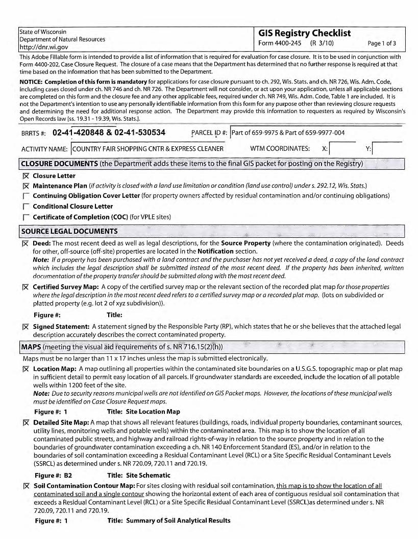
GIS Registry Checklist Form 4400-245 (R 3/10) Page 1 of 3
This Adobe Fillable form is intended to provide a list of information that is required for evaluation for case closure. It is to be used in conjunction with Form 4400-202, Case Closure Request. The closure of a case means that the Department has determined that no further response is required at that time based on the information that has been submitted to the Department.
NOTICE: Completion of this form is mandatory for applications for case closure pursuant to ch. 292, Wis. Stats. and ch. NR 726, Wis. Adm. Code, including cases closed under ch. NR 746 and ch. NR 726. The Department will not consider, or act upon your application, unless all applicable sections are completed on this form and the closure fee and any other applicable fees, required under ch. NR 749, Wis. Adm. Code, Table 1 are included. It is not the Department's intention to use any personally identifiable information from this form for any purpose other than reviewing closure requests and determining the need for additional response a.ction. The Department may provide this information to requesters as required by Wisconsin's Open Records law [ss. 19.31 - 19.39, Wis. Stats.].
BRRTS #: 02-41-420848 & 02-41-530534 .!' ARC EL l,D #: I Part of 659-9975 & Part of 659-9977-004
ACTIVITY NAME: jcouNTRY FAIR SHOPPING CNTR & EXPRESS CLEANER WTM COORDINATES: x: I v:I I CLOSURE DOCUMENTS (the Department adds these items to the final GIS packet for posting on the Registry)
IX Closure Letter
IX Maintenance Plan (if activity is closed with a land use limitation or condition (land use control) under s. 292.12, Wis. Stats.)
1 Continuing Obligation Cover Letter (for property owners affected by residual contamination and/or continuing obligations)
1 Conditional Closure Letter
1 Certificate of Completion (COC) (for VPLE sites)
I SOURCE LEGAL DOCUMENT~
IX Deed: The most recent deed as well as legal descriptions, for the Source Property (where the contamination originated). Deeds for other, off-source (off-site) properties are located in the Notification section. Note: If a property has been purchased with a land contract and the purchaser has not yet received a deed, a copy of the land contract which includes the legal description shall be submitted instead of the most recent deed. If the property has been inherited, written documentation of the property transfer should be submitted along with the most recent deed.
IX Certified Survey Map: A copy of the certified survey map or the relevant section of the recorded plat map for those properties where the legal description in the most recent deed refers to a certified survey map or a recorded plat map. (lots on subdivided or platted property (e.g. lot 2 of xyz subdivision)).
Figure #: Title:
IX Signed Statement: A statement signed by the Responsible Party (RP), which states that he or she believes that the attached legal description accurately describes the correct contaminated property.
I MAPS (meeting the visual aid requirements of s. NR 716.15(2)(h))
Maps must be no larger than 11 x 17 inches unless the map is submitted electronically.
IX Location Map: A map outlining all properties within the contaminated site boundaries on a U.S.G.S. topographic map or plat map in sufficient detail to permit easy location of all parcels. If groundwater standards are exceeded, include the location of all potable wells within 1200 feet of the site. Note: Due to security reasons municipal wells are not identified on GIS Packet maps. However, the locations of these municipal wells must be identified on Case Closure Request maps.
Figure#: 1 Title: Site Location Map
IX Detailed Site Map: A map that shows all relevant features (buildings, roads, individual property boundaries, contaminant sources, utility lines, monitoring wells and potable wells) within the contaminated area. This map is to show the location of all contaminated public streets, and highway and railroad rights-of-way in relation to the source property and in relation to the boundaries of groundwater contamination exceeding a ch. NR 140 Enforcement Standard (ES), and/or in relation to the boundaries of soil contamination exceeding a Residual Contaminant Level (RCL) or a Site Specific Residual Contaminant Levels (SSRCL) as determined under s. NR 720.09, 720.11 and 720.19.
Figure#: 82 Title: Site Schematic
IX Soil Contamination Contour Map: For sites closing with residual soil contamination, this map is to show the location of all contaminated soil and a single contour showing the horizontal extent of each area of contiguous residual soil contamination that exceeds a Residual Contaminant Level (RCL) or a Site Specific Residual Contaminant Level (SSRCL)as determined under s. NR 720.09, 720.11 and 720.19.
Figure#: 1 Title: Summary of Soil Analytical Results
State of Wisconsin Department of Natural Resources
http://dnr.wi.gov
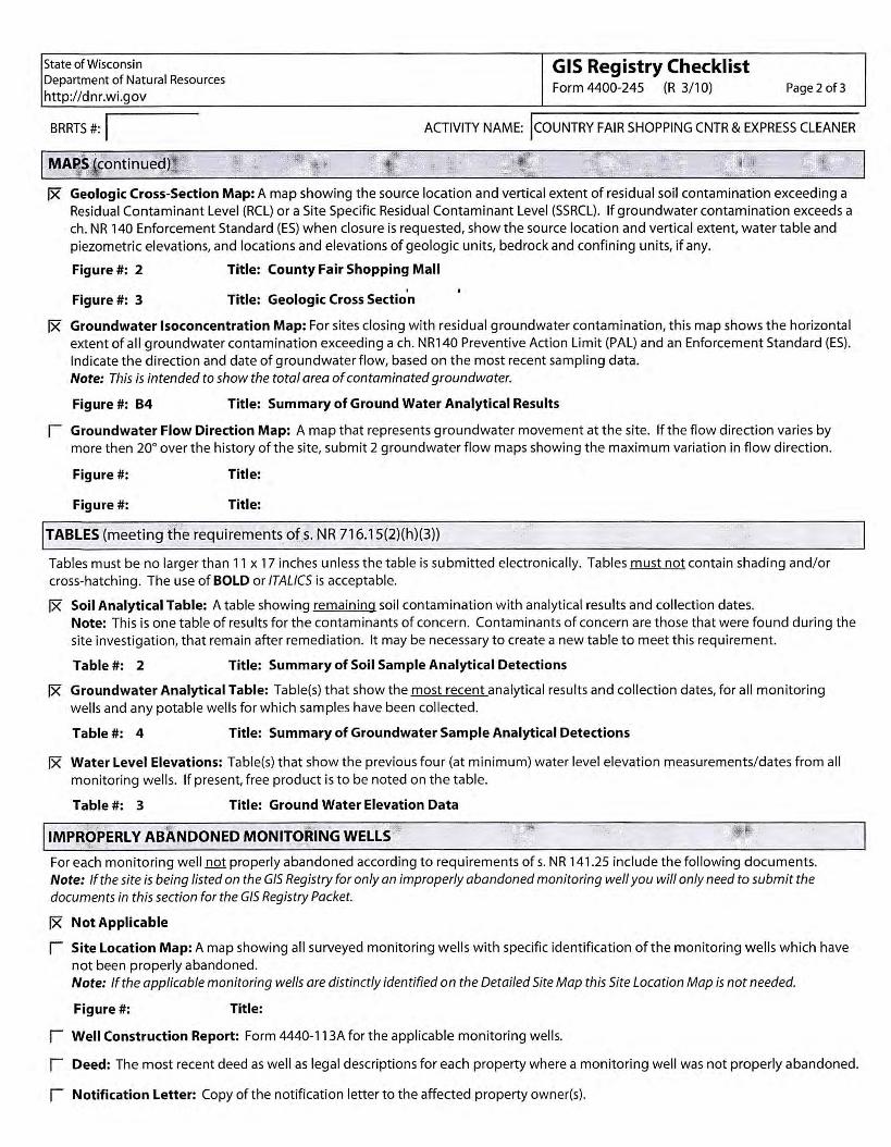
GIS Registry Checklist Form 4400-245 (R 3/10) Page 2 of 3
BRRTS #: I ACTIVITY NAME: lcouNTRY FAIR SHOPPING CNTR & EXPRESS CLEANER
I MAPS (continued) ,,:'
[x Geologic Cross-Section Map: A map showing the source location and vertical extent of residual soil contamination exceeding a Residual Contaminant Level (RCL) or a Site Specific Residual Contaminant Level (SSRCL). If groundwater contamination exceeds a ch. NR 140 Enforcement Standard (ES) when closure is requested, show the source location and vertical extent, water table and piezometric elevations, and locations and elevations of geologic units, bedrock and confining units, if any.
Figure#: 2 Title: County Fair Shopping Mall
' Figure#: 3 Title: Geologic Cross Section
[x Groundwater lsoconcentration Map: For sites closing with residual groundwater contamination, this map shows the horizontal extent of all groundwater contamination exceeding a ch. NRl 40 Preventive Action Limit (PAL) and an Enforcement Standard (ES). Indicate the direction and date of groundwater flow, based on the most recent sampling data. Note: This is intended to show the total area of contaminated groundwater.
Figure#: 84 Title: Summary of Ground Water Analytical Results
1 Groundwater Flow Direction Map: A map that represents groundwater movement at the site. If the flow direction varies by more then 20° over the history of the site, submit 2 groundwater flow maps showing the maximum variation in flow direction.
Figure#: Title:
Figure#: Title:
I TABLES (meeting the requirements of s. NR 716.15(2)(h)(3))
Tables must be no larger than 11 x 17 inches unless the table is submitted electronically. Tables must not contain shading and/or cross-hatching . The use of BOLD or ITALICS is acceptable.
[x Soil Analytical Table: A table showing remaining soil contamination with analytical results and collection dates. Note: This is one table of results for the contaminants of concern. Contaminants of concern are those that were found during the site investigation, that remain after remediation. It may be necessary to create a new table to meet this requirement.
Table#: 2 Title: Summary of Soil Sample Analytical Detections
[x Groundwater Analytical Table: Table(s) that show the most recent analytical results and collection dates, for all monitoring wells and any potable wells for which samples have been collected.
Table#: 4 Title: Summary of Groundwater Sample Analytical Detections
[x Water Level Elevations: Table(s) that show the previous four (at minimum) water level elevation measurements/dates from all monitoring wells. If present, free product is to be noted on the table.
Table#: 3 Title: Ground Water Elevation Data
I 1MPROPERL Y ABANDONED MONITORING WELLS '
For each monitoring well not properly abandoned according to requirements of s. NR 141.25 include the following documents. Note: If the site is being listed on the GIS Registry for only an improperly abandoned monitoring well you will only need to submit the documents in this section for the GIS Registry Packet.
[x Not Applicable
1 Site Location Map: A map showing all surveyed monitoring wells with specific identification of the monitoring wells which have not been properly abandoned. Note: If the applicable monitoring wells are distinctly identified on the Detailed Site Map this Site Location Map is not needed.
Figure#: Title:
1 Well Construction Report: Form 4440-113A for the applicable monitoring wells.
1 Deed: The most recent deed as well as legal descriptions for each property where a monitoring well was not properly abandoned.
1 Notification Letter: Copy of the notification letter to the affected property owner(s).
State of Wisconsin Department of Natural Resources
http://dnr.wi.gov
BRRTS #: I I NOTIFICATIONS
Source Property
IX Not Applicable
GIS Registry Checklist Form 4400-245 (R 3/10) Page 3 of 3
ACTIVITY NAME: lcouNTRY FAIR SHOPPING CNTR & EXPRESS CLEANER
r Letter To Current Source Property Owner: If the source property is owned by someone other than the person who is applying for case closure, include a copy of the letter notifying the current owner of the source property that case closure has been requested.
I Return Receipt/Signature Confirmation: Written proof of date on which confirmation was received for notifying current source property owner.
Off-Source Property Group the following information per individual property and label each group according to alphabetic listing on the "Impacted Off-Source Property" attachment.
Ix Not Applicable
r Letter To "Off-Source" Property Owners: Copies of all letters sent by the Responsible Party (RP) to owners of properties with groundwater exceeding an Enforcement Standard (ES), and to owners of properties that will be affected by a land use control under s. 292.12, Wis. Stats. Note: Letters sent to off-source properties regarding residual contamination must contain standard provisions in Appendix A of ch. NR 726.
Number of "Off-Source" Letters:
r Return Receipt/Signature Confirmation: Written proof of date on which confirmation was received for notifying any off-source property owner.
r Deed of"Off-Source" Property: The most recent deed(s) as well as legal descriptions, for all affected deeded off-source property(ies). This does not apply to right-of-ways. Note: If a property has been purchased with a land contract and the purchaser has not yet received a deed, a copy of the land contract which includes the legal description shall be submitted instead of the most recent deed. If the property has been inherited, written documentation of the property transfer should be submitted along with the most recent deed.
I Letter To "Governmental Unit/Right-Of-Way" Owners: Copies of all letters sent by the Responsible Party (RP) to a city, village, municipality, state agency or any other entity responsible for maintenance of a public street, highway, or railroad right-of-way, within or partially within the contaminated area, for contamination exceeding a groundwater Enforcement Standard (ES) and/or soil exceeding a Residual Contaminant Level (RCL) or a Site Specific Residual Contaminant Level (SSRCL).
Number of "Governmental Unit/Right-Of-Way Owner" Letters:
/ (
( .
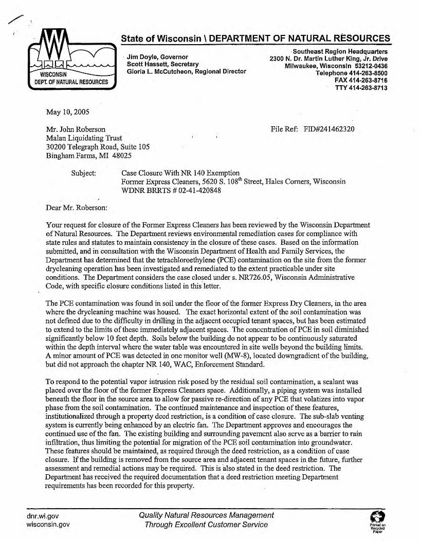
State of Wisconsin\ DEPARTMENT OF NATURAL RESOURCES
WISCONSIN DEPT. OF NATURAL RESOURCES
· Jim Doyle, Governor Scott Hassett, Secretary Gloria L. Mccutcheon, Regional Director
· Southeast Region Headquarters 2300 N. Dr. Martin Luther King, Jr. Drive
Milwaukee, Wisconsin 53212-0436 Telephone 414-263-8500
FAX 414-263-8716 TTY 414-263-8713
May 10, 2005
Mr. John Roberson Malan Liquidating Trust
File Ref: FID#241462320
30200 Telegraph Road, Suite 105 Bingham Farms, MI 48025
Subject:
Dear Mr. Roberson:
Case Closure With NR 140 Exemption Fonner Express Cleaners, 5620 S. 108th Street, Hales Comers, Wisconsin WDNR BRRTS # 02-41-420848
Your request for closure of the Fonner Express Cleaners has been reviewed by the Wisconsin Department of Natural Resources. The Department reviews environmental remediation cases for compliance with state rules and statutes to maintain consistency in the closure of these cases. Based on the information submitted, and in consultation with the Wisconsin Department of Health and Family Services, the Department has determined that the tetrachloroethylene (PCE) contamination on the site from the former drycleaning operation has been investigated and remediated to the extent practicable under site conditions. The Department considers the case closed under s. NR726.05, Wisconsin Administrative Code, with specific closure conditions listed in this· letter.
The PCE contamination was found in soil under the floor of the former Express Dry Cleaners, in the area where the drycleaning machine was housed. The exact horizontal extent of the soil contamination was not defined due to the 4ifficulty in drilling in the adjacent occupied tenant spaces, but has been estimated to extend to the limits of these immediately adjacent spaces. The concentration of PCE in soil diminished significantly below 10 feet depth. Soils below the building do not appear to be continuously saturated within the depth interval where the water table was encountered in site wells beyond the building limits. A minor amount of PCE was detected in one monitor well (MW-8), located downgradient of the building, but did not approach the chapter NR 140, WAC, Enforcement Standard.
To respond to the potential vapor intrusion risk posed by the residual soil contamination, a sealant was placed over the floor of the former Express Cleaners space. Additionally, a piping system was installed beneath the floor in the source area to allow for passive re-direction of any PCE that volatizes into vapor phase from the soil contamination. The continued maintenance and inspection of these features, institutionalized through a property deed restriction, is a condition of case closure. The sub-slab venting system is currently being enhanced by an electric fan. The Department approves and encourages the c·ontinued use of the fan. The existing building and surrounding pavement also serve as a barrier to rain infiltration, thus limiting the potential for migration of the PCE soil contamination into groundwater. These features should be maintained, as required through the deed restriction, as a condition of case closure. lfthe building is removed from the source area and adjacent tenant spaces in the future, further assessment and remedial actions may be required. This is also stated in the deed restriction. The Department has received the required documentation that a deed restriction meeting Department requirements has been recorded for this property.
dnr.wi.gov wisconsin.gov
Quality Natural Resources Management Through Excellent Customer Service
0 Plinted on Recyded
Paper
Your case closure submittal and site work complies with Department standards in accordance with s. NR 726.05, Wis. Adm. Code. As contained within the deed restriction, the remedial features, which include the vapor barrier, passive vapor venting system and infiltration barrier, must be maintained as a condition of case closure. If the building floor is ever removed from the area of the former Express Cleaners or the adjacent tenant spaces, additional investigation and remediation may be required, and the Department should be notified in the event the building is removed.
. . Your site will be listed on the DNR Remediation and Redevelopment GIS Registry of Closed Remediation Sites. Information that was submitted with your closure request application will be included on the registry. To review the sites on the GIS Registry ,web page, visit http://gomapout.dnr.state.wi.us/org/at/et/geo/gwur/iri.dex.htm
Chapter NR 140, Wisconsin Administrative Code Exemption: Recent groundwater monitoring data at this site indicates exceedances of the NR 140 preventive action limit (PAL) for perchloroethylene at monitor well "MW-7, but compliance with the NR 140 enforcement standard. The Department may grant an exemption to a PAL for a substance of public health concern, other than nitrate, pursuant to s. NR 140.28(2)(b), Wis. Adm. Code, if all of the following criteria are met:
1. The measured or anticipated increase in the concentration of the substance will be minimized to the extent technically and economically feasible.
2. Compliance with the PAL is either not technically or economically feasible. 3. The enforcement standard for the substance will not be attained or exceeded at the point of
standards application. 4. Any existing or projected increase in the concentration of the substance above
the background concentration does not present a threat to public health or welfare.
Based on the information you provided, the Department believes that the above criteria have been or will be met because the source area is covered by the building and there is no longer a drycleaning operation at the location. The levels found at this monitoring location were very low and never exceeded the enforcement standard. Therefore, pursuant to s. NR 140.28(2)(b), Wis. Adm. Code, an exemption to the PAL is granted for perchloroethylene at monitonng well MW-7. This letter serves as your exemption.
Please be aware that this case may be reopened pursuant to s. NR 726.09, Wis. Adm. Code, if additional information regarding site conditions indicates that contamination on or from the site poses a threat to public health, safety, or welfare or to the environment.
We appreciate your efforts to restore the environment at this site. If you have any questions regarding this letter, please contact me at 414-263-8758.
o~~+~ Pamela A. Mylotta, Hydrogeologist Remediation & Redevelopment Program Southeast Region, Milwaukee Service Center
cc: Bill Phelps, DG/2 Mr. Bruce Keyes - Foley & Lardner

CAP MAINTENANCE AND VAPOR BARRIER MAINTENANCE PLAN
EXPRESS CLEANER AND msTORIC DRY CLEANER SITES
Two fonner dry cleaning facilities, the former Express Cleaners (5620 South 108th Street) and Historic Dry Cleaner (5606 South 108111 Street), were located in the Country Fair Shopping Center (CFSC), Hales Comers, Wisconsin. Soil and ground water impacts associated with the former dry cleaners remain beneath the CFSC founda1ion and parking areas. In order to close the sites, a strategy to prevent ground water infiltration, direct contact exposure and vapor intrusion into buildings bas been enacted. The building foundation and parking area pavement (CAP) will be maintained as an infiltration and direct contact barrier. An epoxy sealant that has been applied to the fonner Express Cleaners tenant space will be maintained to prevent vapor in~ion into t{le building. A ~';)lH~ c,~ fifi, pe .. e+r ... \-i"j +-~ 11~.,o~ b .. r..-ic,.. a...J, j~pre"'d•;) tu Q
ro~~ro" J;,w~t. f•I--+ wi\l 1,-f, 1\\#\1\+A\II\U cd A f'•Ul\1-C.. V,el"t-1~ t-,.Sktl-\ fo-r V~forJ
The epoxy vapor barrier was installed in February 2004, then reapplied dwing building o.,.,,; .. , ➔i'"J renovations in October 2004. On February 2, through February 6, 2004 a vapor barrier was \,t."' "-" H 41
applied over the former Express Cleaners tenant space concrete foundation. The floor was shot- +lie e,c11+ 1"'J blasted to provide a suitable surface for the vapor barrier to adhere with the cement floor. This s I•"• was followed by applying an epoxy sealant to cracks in the floor and flexible sealant to any expansion joints. A liberal amount of epoxy primer was then applied to fill any pore spaces in the concrete. Finally an epoxy floor sealant (Corro--Shield Low Viscosity) was applied to the entire floor to an approximate thickness of 40 mils. During previous Mannik & Smith Group, Inc (MSG) investigative activities, the CFSC structure and parking areas were noted to be in acceptable condition in order to serve as an infiltration/direct contact barrier. The continued maintenance of these barrieis has been required for Site closure by the Wisconsin Department of Natural Resources (WDNR). \.a'"'~ ~ t. t, ~ ~-,.,.. v t v,\-i/ 5:) s +t. ""
Semiannual lnspectlons and Maintenance
On a semiannual basis, the epoxy sealant and paved parking areas will be inspected. Required repairs will be completed prior to the next scheduled inspection. In the event that necessary maintenance activities expose the underlying soil, the owner must inform maintenance workers of the direct contact exposure hazard and provide them with appropriate personal protection equipment (PPE). The owner must also sample any soil that is excavated from the Site prior to disposal to ascertain if contamination remains. The soil must be treated, stored, and disposed of by the owner in accordance with applicable State and Federal regulations and, if possible, any soils should be placed back into the excavation from which they were removed.
Inspection/Maintenance Log
A log of the inspections will be maintained on Site and attached as the CAP and Vapor Barner Inspection/Maintenance Logs. The inspections include recommendations for necessary repairs. Once repairs are completed they will be documented on the appropriate inspection log.
Vapor Barrier Any breach (including, but not limited to, cracks, chips, and/or boles) in the sealant will be recorded on the maintenance log and scheduled for repair. The condition of any flexible sealant
VaPQf S.nict Mainlcmncc Pla11 l!ljftl3.doc

placed at expansion joints. wall floor joints, protrusions by plumbing or at anchor points into the floor will be noted and if needed scheduled for repair/replacement.
In the event that the vapor barrier is repaired or replaced, a floor sealant equivalent to the . previously installed vapor barrier (40 mils epoxY,) must be applied over the repaired/replaced flooring and extended well beyond any disturbed area. Any of the flexible sealant that had been placed at the floor-wall joints amJ~or expapsion joints must be replaced if disturbed. Additionally. a flexible sealant will be liberally applied at and immediately surrounding any anchor points or other areas where the epoxy floor sealant is breached (screw boles, nail holes, plumbing fixtures ... ). Any replacement barrier will be subject to identical maintenance and inspection guidelines unless indicated otherwise by the WDNR or it successor.
CAP If exposed soils or excess cracking are noted during the semi-annual inspections or at any other time oN he year, repairs will be scheduled as soon as practical. Maintenance activities can include sealing cracks, patching and filling operations or they can include larger rcsurf acing or construction operations. In the event that the cap is replaced, the replacement barrier must be equally sufficient to prevent infiltration and direct contact with the soil. The replacement barrier will be subject to identical maintenance and inspection guidelines unless indicated by the WDNR or it successor.
WDNR GIS Registry of Closed Remediation Sites
If soil contamination is removed or rcmediated, the owner may obtain an updated Site closure from the WDNR and have the Site taken off of the GIS Registry of Closed Remediation Sites.
f'~y~~ t'-'~-r ~ llt>w, +k~ Vflll +i., oP VII.for.)
1ht. f'•f::, s J .s\-t 1'\
'\ ~J t'A,:,, c. l .. ,._, e.r +o °' . '°(lo'lf~~~ -rlt. e,-.;f+;~ +It)• r
s , .. J,
ro » l h, I' !,~ .. ,,K C f\-t,,.J i:, V't ,. -}-/c. ... ~ t-"o~ -Ke
\IC"'.\ c.,,. ... Pt,L.(re.c.l. ~ .5k~ \ \ be. ~ .. J "'t- .. \ II\ ( J as c.,1,,-rrt.,.+!.J
f'-'t. r~e I ;~ S( r-e .J-t~ "1 I rt-I.~
~hoo~G o~tr; D, t O\;-J>\trJ
- I; "t. · blo\..JLr to ~ )/ow tl(.., s:; ~ .J-e""' ~ Of<:ro.-\-l G\~ 1\-\-
~ .... ~h•-- Ci\' lit .... ~ c.,~f\l G s ... ~ - .s l,a, ~ ck,re .S} .. r1 l. ,.+-;'°o"" ~.) l t<:."°'.
Vapor Barner MaiatcaaDCe Plan mjft)J,doc: 2
fo
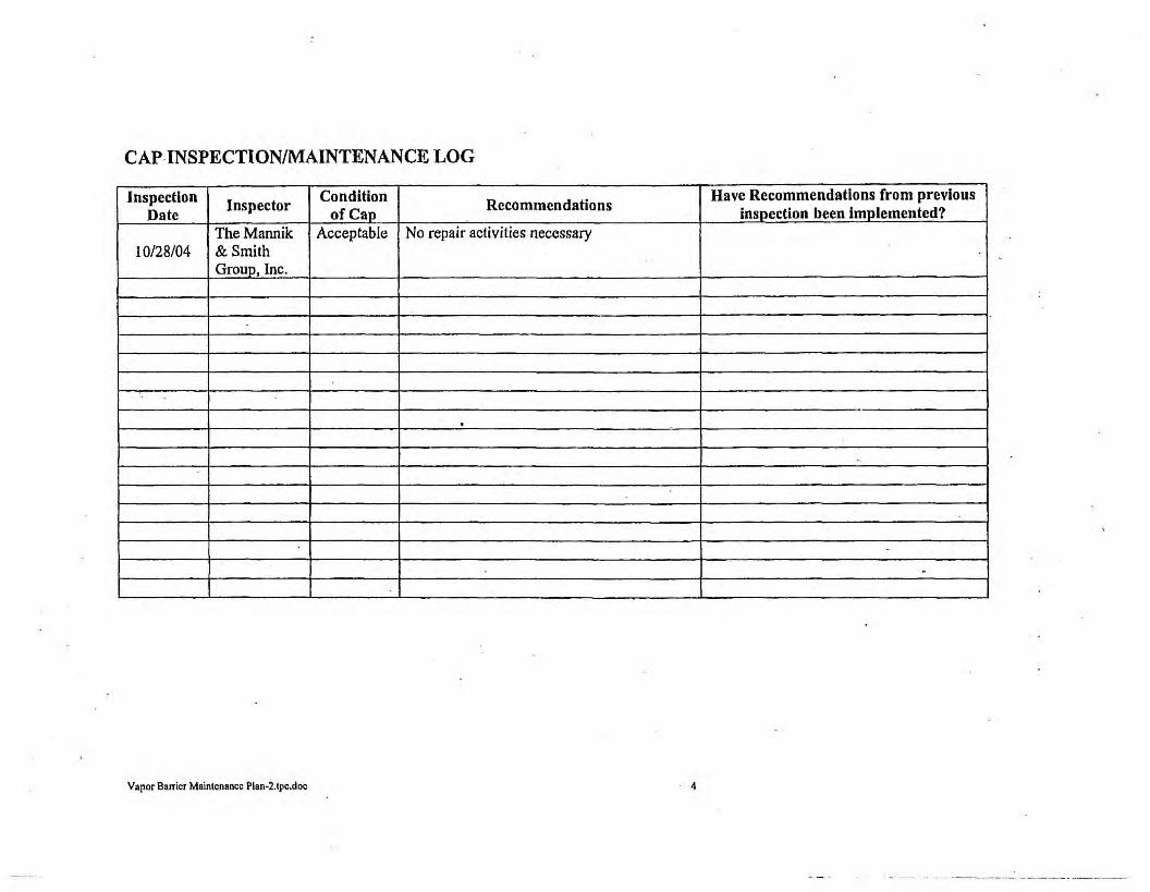
CAP INSPECTION/MAINTENANCE LOG
Inspection Inspector Condition
Recommendations Have Recommendations from previous
Date of Cap inspection been implemented? TheMannik Acceptable No repair activities necessary
10/28/04 & Smith Group, Inc .
.. -. -
..
.
Vapor Barrier Maintenance Plan-2.lpc.doc 4
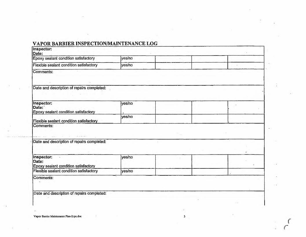
VAPOR BARRIER INSPECTION/MAINTENANCE LOG Inspector: Date: Epoxy sealant condition satisfactory yes/no
Flexible sealant condition satisfactory yes/no
Comments:
Date and description of repairs completed:
Inspector: yes/no Date: · Epoxy sealant condition satisfactory .
yes/no Flexible sealant condition satisfactory Comments:
- -- - . . . . . . -
Date and description of repairs completed:
Inspector: yes/no Date: Epoxy sealant condition satisfactory Flexible sealant condition satisfactory yes/no
Comments:
Date and description of repairs completed:
Vapor Bnrricr Maintenance Plan-2.lpc.doc
.
"
3
•,
( r

PARKING
----------
.. ,, _____ ._ ____________ _,
/ / / .,/
g/ u,~ ,,
I= ~ ~z / ~l"l ~-< Ulm ~~ u, u,
~s:' O> u,
BASKIN ROBBINS (5532)
MINUTEMAN PRESS (5634)
~~
1. MAP ADAPTED FROM WAH YEE ASSOCIATES, l'LOOR PLAN AND ELEVATION a: CANOPY OCTAIL5, DATED FEBRUARY 4. 1974. 2. UNLESS OntER\\ISE NOTED ADOl!E=s ARE LOCATED ON sount 108nt STREET. 3. ASSUMED LOCATION Of ECKl,NjD BORING BASED ON \1SUAL E\1O!:NCE OBTAINED BY MSC ON OCT08ER 1. 2002. ANALYTCAL INFORMATION WAS 08TAINED FROM ECKLAND LITTER TITLED LIMITED PHASE II SUBSURFACE INVESTIGATION, DA TED .UL Y 10, 20-02. A MAP DEP1CTING lHE LOCATION AND ACTUAL ANALYTICAL DATA WAS NOT AVAILABLE FOR MSC RE\1EW.
0 0 u, :,: ~::r:
0 0 l"l a, a, u, -< 0
8 C ;,;J n
;,;J l"l ,..,
/
/
/ /
/
4. A - EXCEEDS USEPA SOIL SCREENING 1£\£1.S FOR SOIL TO GROUNDWATER 8 - EXCEEDS USEPA SOIL SCREENING LEVELS FOR AMBIENT VOl>. llLE INHALATION C - EXCf:EOS USEPA SOIL SCREENING LEVELS FOR INGESllON
5. PCE - lDRACHLOROETNY\DIE MC - METHYLENE CHLORIDE VOC - VOLATILE ORGANIC COMPOUNDS ND - NON DETECT (J) - ESTIMATED CONCOITRATION 8£1.0W LASORATORY QI.Wffll'ATION 1.EVE1.
N
I SCALE: 1· = 30'
o' 15' 30' 60'
LEGEND -$- GEOPR08£ BORIHG ANO
HC-ECI/ MONITORING WElJ. LOCATIONS uw,
MH ®
0
CEOPROBE BORING LOCATlONS
SE'JE:R HANHOLE: LCOAT!ON
CA1'CH BASIN
APPROXIMATE EXTENT or SOIL IMPACT'S
e• WATER MAIN
GAS MAIN
TELEPHONE UNES
STORM SEWER
UNOERCROUND EI.Ec;fRIC
APPROXIUATE PROPER-RI BOUNCW!\'
VAPOR BARRIER
lENANT SPACES TO BE INVESTlCATtD IF /WHEN BUILDING FOUNDATION REMOVED
AREA OF DEED RESTRICTION
n.. ~ Mannllc r:1 Smith
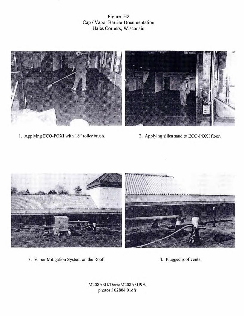
Figure H2 Cap I Vapor BaITier Documentation
Hales Comers, Wisconsin
I. Applying ECO-POX I with 18" roller brush. 2. Applying silica sand to ECO-POXI floor.
3. Vapor Mitigation System on the Roof.
M208A3 U/Docs/M208A3 U9E. photos. I 02804.0 I dfr
4. Plugged roof vents.

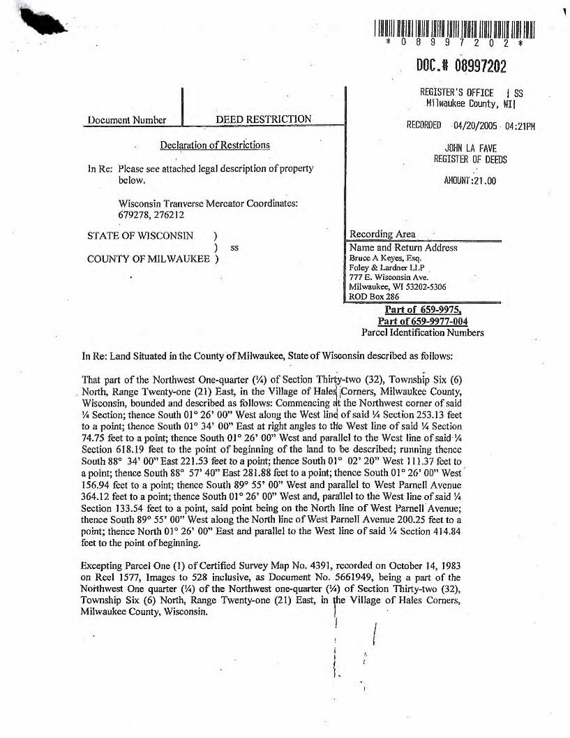
Document Number DEED RESTRICTION
Declaration of Restrictions
ln Re: Please see attached legal description of property below.
Wisconsin Tranverse Mercator Coordinates: 679278,276212
STATE OF WISCONSIN ) ) ss
COUNTY OF MILWAUKEE )
1111111 111111111111111 lllll lllll lllll 1111111111111 * 0 8 9 9 7 2 0 2 *
DOC.I 08997202 REGISTER'S OFFICE I SS
Milwaukee County, WI I
RECORDED 04/20/2005 04:21PM
JOHN LAFAVE REGISTER OF DEEDS
AMOUNT:21.00
Recording Area
Name and Return Address Bruce A Keyes, Esq. Foley & Lardner LLP . 777 E. Wisconsin Ave. Milwaukee, WI 53202-5306 ROD Box 286
Part of 659-9975, Part of 659-9977-004
Parcel Identification Numbers
In Re: Land Situated in the County of Milwaukee, State of Wisconsin described as follows:
. . That part of the Northwest One-quarter (¼) of Section Th1· y-two (32), Township Six (6) North, Range Twenty-one (21) East, in the Village of Hale jeomers, Milwaukee County, Wisconsin, bounded and described as follows: Commencing t the Northwest corner of said ¼ Section; thence South 01° 26' 00" West along the West Jin~ of said¼ Section 253.13 feet to a point; thence South O 1 ° 34' 00" East at right angles to die West line of said ¼ Section 74.75 feet to a point; thence South 01° 26' 00" West and parallel to the West line of said¼ Section 6 J 8.19 feet to the point of beginning of the land to be described; running thence South 88° 34' 00" East 221.53 feet to a point; thence South 0 1 ° 02' 20" West l 1 l .3 7 feet to a point; thence South 88° 57' 40" East 281.88 feet to a point; thence South OJ O 26' 00" West ·· 156.94 feet to a point; thence South 89° 55' 00" West and parallel to West Parnell Avenue 364.12 feet to a point; thence South 01 ° 26' 00" West and, parallel to the West line of said ¼ Section 133.54 feet to a point, said point being on the North line of West Parnell Avenue; thence South 89° 55' 00" West along the North line of West Parnell Avenue 200.25 feet to a point; thence North O 1 ° 26' 00" East and paral1el to the West line of said ¼ Section 4 14.84 feet to the point of beginning.
Excepting Parcel One {I) of Certified Survey Map No. 4391, recorded on October 14, 1983 on Reel 1577, Jmages to 528 inclusive, as Document No. 5661949, being a part of the Northwest One quarter (¼) of the Northwest one-quarter (¼) of Section Thirty-two (32), Township Six (6) North, Range Twenty-one (21) East, in ,he Village of Hales Comers, Milwaukee County, Wisconsin. ·
I I
I i I I
L '
WHEREAS. Country Fair, LLC. a Nevada limited liability company. is the owner of record for the above-described property.
WHEREAS. as of July I, 2004, when soil samples were collected on this property. and November 29. 2004, when groundwater samples were collected on this property, soil and groundwater contaminated with tetrachloroethylene (PCE) and trichloroethylene (TCE) remained on this property at the following location: beneath the 5620 South I 08th Street tenant space. beneath the 5606 South 108th Street tenant space and in the rear alleyway of the Country Fair Shopping Center as indicated on ATTACHMENT 1, labeled Summary of Soil Analytical Result!>·.
WHEREAS, it is the desire and intention of the property owner to impose on the property restrictions which will make it unnecessary to conduct further soil remediation activities on the property at the present time.
NOW THEREFORE, the owner hereby declares that all of the property described above is held and shall be held, conveyed or encumbered, leased, rented, used, occupied, and improved subject to the following limitation and restrictions:
Certain paved surfaces and building foundations that existed on the above-described property on the date that this restriction was signed form a barrier that must be maintained in order to prevent direct contact with residual soil contamination that might otherwise pose a threat to human health. These structures are also required in order to minimize theinfiltration of water and prevent groundwater contamination that would violate the groundwater quality .standards in ch. NR 140, Wis. Admin. Code. The certain paved surfaces and buildt· g foundations shall be maintained on the above-described property in the ·1ocations shown n the attached map, labeled A IT ACHMENT 2, unless another barrier, with an infiltration te of 10-7 cm/sec or less, is installed and maintained in their place. The existing structures, and any replacement barrier with an infiltration rate of 10-7 cm/sec or less, shall be maint~ined on the abovedescribed property in compliance with the Cap Maintenance and Vapor Barrier Maintenance Plan that was submitted to the Wisconsin Department of Natural Resources by Malan Liquidating Trust, as required by section NR 724.13(2), Wis. Adm. Code (I 999).
In addition, the following activities are prohibited on any portion of the above-described property depicted on ATTACHMENT 2, where an impervious cap has been placed or where impervious surfaces exist unless prior written approval has been obtained from the Wisconsin Department of Natural Resources or its successor or assign: (]) excavating or grading of the land surface; (2) filling on capped areas and areas with impervious surfaces; (3) plowing for agricultural cultivation; and (4) construction or installation of a building or other structure with a foundation that would sit on or be placed within the cap or impervious surfaces.
Interior space limitations in the area of the adjacent tenant spaces, identified as Tenant Spaces 5618 S. l 08th St., 5628 S. 108th St., 5608 S. 108th St., and 5602 S. 108th St. on ATTACHMENT 1, existing at the time of the investigation and remediql action, made complete investigation of the soil contamination on this property impract&cable. lfthe building foundations adjacent to the former Express Cleaners are removetl, the property
i I ~
L
I
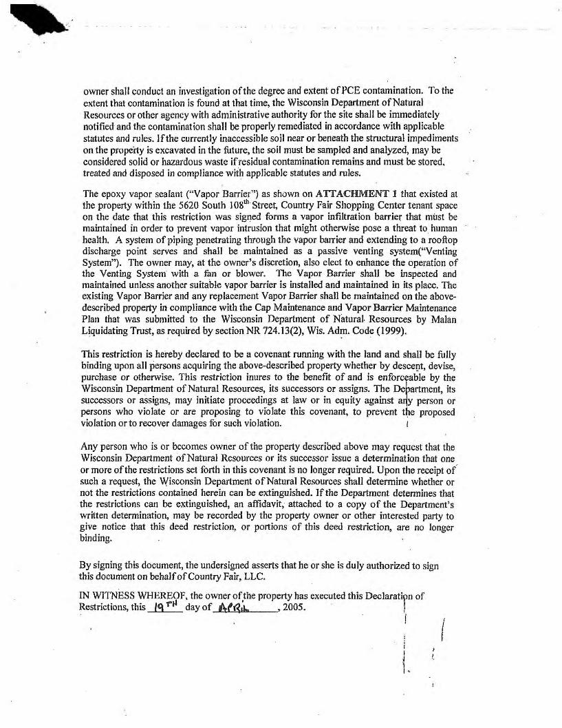
owner shall conduct an investigation of the degree and extent of PCE contamination. To the extent that contamination is found at that time, the Wisconsin Department of Natura} Resources or other agency with administrative authority for the site shall be immediately notified and the contamination shall be properly remediated in accordance with applicable statutes and rules. Jf the currently inaccessible soil near or beneath the structural impediments on the property is excavated in the future, the soil must be sampled and analyzed, may be considered solid or hazardous waste if residual contamination remains and must be stored. treated and disposed in compliance with applicable statutes and rules.
The epoxy vapor sealant ( .. Vapor Barrier'') as shown on ATTACHMENT l that existed at the property within the 5620 South I 08th Street, Country Fair Shopping Center tenant space on the date that this restriction was signed forms a vapor infiltration barrier that must be maintained in order to prevent vapor intrusion that might otherwise pose a threat to human health. A system of piping penetrating through the vapor barrier and extending to a rooftop discharge point serves and shall be maintained as a passive venting system("Venting System"). The owner may, at the owner's discretion, also elect to enhance the operation of the Venting System with a fan or blower. The Vapor Barrier shall be inspected and maintained unless another suitable vapor barrier is installed and maintained in its place. The existing Vapor Barrier and any replacement Vapor Barrier shall be maintained on the abovedescribed property in compliance with the Cap Maintenance and Vapor Barrier Maintenance Plan that was submitted to the Wisconsin Department of Natural- Resources by Malan Liquidating Trust, as required by section NR 724.13(2), Wis. Ad~. Code ( 1999).
This restriction is hereby declared to be a covenant running with the land and shall be fully binding upon all persons acquiring the above-described property whether by descevt, devise, purchase or otherwise. This restriction inures to the benefit of and is enfor~le by the Wisconsin Department of Natural Resources, its successors or assigns. The-De ment, its successors or assigns, may initiate proceedings at law or in equity against a y person or persons who violate or are proposing to violate this covenant, to prevent the proposed violation or to recover damages for such violation. 1
Any person who is or becomes owner of the property described above may request that the Wisconsin Department of Natural Resources or its successor issue a determination that one or more of the restrictions set forth in this covenant is no longer required. Upon the receipt of such a request, the Wisconsin Department of Natural Resources shall determine whether or not the restrictions contained herein can be extinguished. If the Department detennines that the restrictions can be extinguished, an affidavit, attached to a copy of the Department's written determination, may be recorded by the property owner or other interested party to give notice that this deed restriction, or portions of this deed restriction, are no longer binding.
By signing this document, the undersigned asserts that he or she is duly authorized to sign this document on behalfofCountry Fair, LLC.
IN WITNESS WHEREOF, the owner of.the property has executed this Declarati~n of Restrictions, this 19 T"J.I day of l\f~"" , 2005. !
I
i I
( I •
I I

ST A TE OF JJ e v rd a,.,,
County of w(J,,ShcL
) ) ss )
Coun~ ~---------..
By:_~--=-------,----Name: ~"~ L,, 1 f) .. t\l,'-C.Se~ Title: J'CA~y':._? /tU>t IJ1.Jf
Personally came before me this _J_j__ day of NfB., \ , 2001r,the above named R..obe ".- F iii', ds:..e A (name), h\.o.. n6...~ ,~ h4 ro b:c (title), who
executed the foregoing instrument and c wledged the same on behalf of said corporation.
IN WITNESS WHEREOF, I hereto set my hand and notarial seal.
tu 1;.J a P~ u Name: .:J7.i A ;'th fl ,
Notary Public, State of fl)~ v ~~ My Commission Expires: 7-31-07
I I
\ I ,,
This document was drafted by Bruce A. Keyes, Esq., Foley & Lardner LLP, 777 East l, Wisconsin Avenue, Milwaukee, Wisconsin 53202. ·
I I I I ~
L
I

NOTE:
f"IRST I.ADY NAILS (56J0)
BASKIN ROBBINS (56J2)
MINUTEI.IAN PRESS (56J4)
1. 11>.P ADAPTED FROM WAH '1££ ASSOCIATES. Fl.DOR Pl.AN AHO E1£VATION at CANOPY DETAILS, DATED f'EBRIJAAY 4, 1974. 2. UNLESS OTHER\llst NOTED ADOREsstS ARE LOCA TEO ON SOUTH 10llTH STREET. J . ASSUMED LOCATION OF ECKLAND BORING BASED ON \ISUAL E\llltNCE OBTAINED BY 11SO ON OGTOBER 1, 2002. ANALYTICAL INfORIIATlON WAS OBTAINm FROM EO<t.AHO LETTEJI llll.[I) LIMITED PHAst n SUBSURFACE INIIESTlG,.llON, D"1EO .A.ILY 10, 2002. " 11>.P DEl'ICllHG lHE LOCATION ANO ACl\Jill. ANALYTICAL D"T" WAS NOT AVAILABLE fOft 11SO RE\'IEW.
PARKING
4. A - EXCEEDS USEPA SOIL SCIIEOIING LEIIELS fOR SOIL TO GROJNDWA TER 8 - EXCEEDS USEPA SOIL SCREENING LEVEl.S FOR AMBIENT VOV.lllE IHH~TlOH ' C - EXCEEDS USEPA SOil SCRtINIHG LEVELS fOR IIICESTION
5. PCE - TETRACHLOROElHYLENE IIC - WE1H'ILEII£ CHLORIOE VOC - vot.AT11£ ORGANIC COIIPOUNDS NO - HOH DEIECT (J) - ~TED CONCENT!tATKlN BELOW LABORATORY QlWmTAllON LEVn.
LEGEND ~
HC-EC1/ MW1
• HC-EC2
11H
®
B
SCALE: t • • 30'
60'
st\lER HAIIIILt LCIIA TIIJi
CATai BASIN
Al'l'IIOllllA'lt EXIEKI' Of SOil IWl'ACTS
8" W.TER WAIN
Co\51,1,111
TtUPHONE Illa
STORM SEWVI
UlllEJIGIIOlHI fll.CTRIC
APPIIOKIIIATE PROPD!n' IIDUNIWfl'
mim VAPOR aAAR0
lDIANT SPACES 10 8E
D~~ IIDl<MD
Nl£A Of" DEEi Rl:SllllCll0II

~ l.;t
.:-•
~ ~ ~ ~ ~
I I , ~ I It
. I ' ·
-~
"' 1' i ,. I .: ,; ~- ~ ~ \. ·I ~ '!.,
,, \ ,t,;;,.• ~ .,
·' 111 · ..
~ .. ~~~ "= ,, ... ~ ... ~ \, ;; !i ~~~ ,, ... ,. ~~~ q _ '.I, \.._ !I:::,. ... '."r..~"'
~ct'' · .. ~~ ~H t .... ~
..JIRIC/t '"'" C/J,J,:l'ET/" ..ii/JC}
_fffll1P(,¥C
i"•, -_,, ..
"·
f
I ' PAiCEL+-II
12 8. 04 IS 11.n: l .9J9, AC. ·. l
I 1
SCAL.£: 1 • .. -40'
~ ~ ).
~ ,, \i
l o· 20· -40• so·
LEGEND
W.fTtr~.fll( .l'..U/'M...,-~ I' 11 ,rnf.pBfli ! 11 , ,,11~1'J-'A AUO P4f.NI, '171'895 l'A/Cll- 'A'
:~4·· w. ?81. 8,
,,,,/ .,, .. / .,.,, ,, ,~;,,~; /
· , 1,~• . .iJI ~11,'IP' // .4,,,Y ,ir..1• .· /
. .,•.Ji'!., _ r,1,~ r£ jl ./ f~~ J r ,11;.Y . f! , .. " of ,,i 1:.-' \
·' ,11~•~· .A~A} . ' ,.- ,,.,i·,s·s-- . ., / , +-\''
\l'
PARCEL BOUNDARY
RESTIUCTID AREA
NOTES: 1, WAI' ADAl'l[J) FROM NA llONAL SURVEY I: ENCINEERJNO PUT OF SURVEY MAP, DATED fEBRIJARY 3, 111114.
'-\_ \ , ._
·,.,
' ,·. \ .. ,~ ..
·l
/
CERTIFICATE NO. 276783 STATE OF WISCONSIN MILWAUKEE COUNTY
OFFICE OF REGISTER OF DEEDS
) _/
I, the undersigned Register pf Deeds of Milwaukee County, hemby certify that ;his document is a true a.nd co;rect copy of 1he-original en fi!e or record in this office.
Witness my hand and official seal this
I---
\
w ::> z w ~ w 0
~ 0
LEGEND
,------ie.-----, r---------e-------------1 I I I I
e--------J t 96.30' r----ir- ___ ..J
I lJ I I I I
\._ 32.IO'- -
I I I f L_- 41,33'- f --, ~ _ KMART r
_\ t ] 11
14 00'
I 92'00 ll1°1'33' 1 ISS ◄ -2002 AUTO ! 'T" .,.-t-------+-_J crnTJ:o,':/~~DING7--f,---t-\ \...LL-_________________ ◄_:ol'L40~1---ll5.00"--
I ~o.10 ··--~--------<101.Jo'------------i
~ • IS73-~94 AUTO r---- r., __ _J r CENTER LDCA TION , •L
I I I I I I I I I I I I I I I PARCEL Ill f I I I I l I I I I I I I L------------~lt,-----------J
NORTH BOUND 108TH STREET
NOTE:
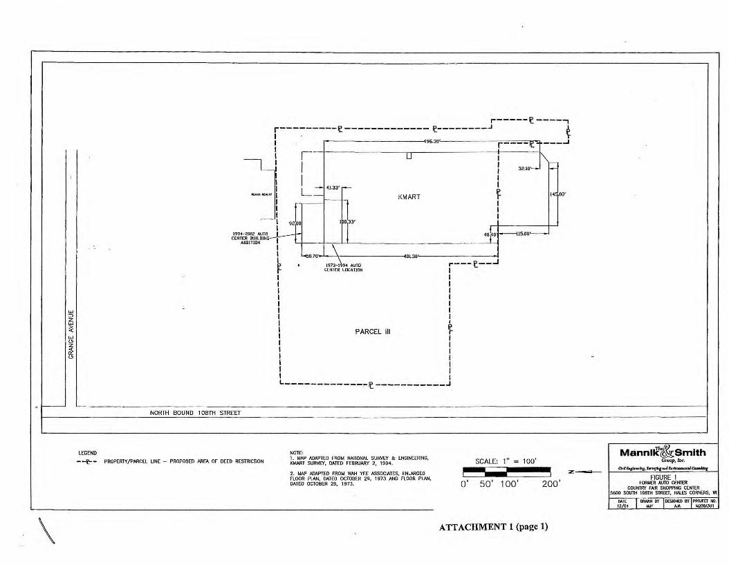
-~- PROPERlY/PARCEL LINE - PROPOSED AREA OF DEED RESTRICTION 1. MAP ADAPTED FROM NATIONAL SURVEY & ENGINEERING KMART SURVEY, DATED FEBRUARY 2, 1994. ' SCALE: 1" = 100'
2. MAP ADAPTED FROM WAH YEE ASSOCIATES, ENLARGED FLOOR PLAN, DATED OCTOBER 29, 1973 AND FLOOR PLAN DATED OCTOBER 29, 1973. ' o· 50' 1 oo' 200·
ATTACHMENT 1 (page 1)
z:-
Mann1ic{&smlth Group, Inc.
a,or.,,-,y...,.,-,,...i&,.__..,a.-Jdot
FIGURE I FORMER AVTO CENTER
COUNTRY FAIR SHOPPING CENTER 5600 SO\ITII 108TH STREET, HAI.ES CORNERS, W1
MTE 12 04
DRAWN BY OEStGHEO B'f PROJECT HO. IJJf AJA MZ08A3UI
REM AX REAL TY
------------ ft:_---------------------------------------------I I
I
HC-GP17. HC- GP16$(MW-4)
I
1994-2002 AUTO CENTER i BUILDING ADDITION 1
--~--------------------------HC-
18• HC- GP191 HC-GP20.HC-GP
22I _________________ _j __ _
HC-GP15 HC-GP14. HC-GP13
HC-GP3~ HC-GP29. • HC-GP28
.HC-GP36
HC-GP1 Oe • HC-GP33
~ HC-GP31
•
• HC- GP27
• HC-GP26
HC-GP9 HC-GP8
HC-GP21e
,-------- --HC-GP12 / • HC-GP24
: I HC - GP12AI
0
HC-GP11 • •
• HC-GP25
GARDEN CENTER
1994-2002 OIL/WATER SEPARATORS
LEGEND
MW~ • MONITORING WELL LOCATION
GEOPROBE BORING LOCATIONS
HC-GP35 HC-GP23 HC-EC6
[8J FlRE HYDRANT
1973-1994 OIL/WATER s· w1..rrn t.lAIN
SEPARATOR GASt.lAIN
- -it- - PROPERTY/PARCEL LINE - PROPOSED AREA OF DEED RESTRICTION
1973-1994 AUTO CENTER
FORMER 1,000-GALLON WASTE OIL UNDERGROUND STORAGE TANK
FENCE
NOTE: 1. MAP ADAPTED FROM NATIONAL SURVEY & ENGINEERING, KMART SURVEY, OATEO FEBRUARY 2, 1994.
2. MAP All/lPTEO FROM WAH YEE ASSOCIATES, ENLAAGED FLOOR PLAN, DATED OCTOBER 29, 1973 ANO FLOOR PLAN, DATED OCTOBER 29, 1 973.
SCALE: 1" 20'
o' 1 o· 20· 40•
ATTACHMENT 1 (page 2)
i
i SCALE: t9 "" 160'
Mannl~Smlth Group, Inc.
a,a_,.,,,...,.,,.,,...,..,._.ia.....uy FIGURE 2
FORMER AUTO CENT!R COUNTRY FAIR SHOPPING CENTER
5600 SOUTH 108TH STREET, HAL.ES CORNERS, WI
MlE DRAWN DY DESIGNED BY PROJECT HO. 12 04 Wf AA M208A3UI

·./
MEYMi AREA-279,307 SQ.FT.
~r,,....u....t,:...,1.L --~---'--<· @-~.412AC.
J£/Cl.'t:t7HanT .4/Dt:r
JU/IP/HG PARCEL-II
AREA-128,045 SQ.FT. 2.9395 AC.
..Blla;F~'8Nt:U7TIUV
JVIIP/H~ • OJT,IP,iUNr
• ~ IIJl.-1-
..§RICK' - ~PNC..NIJCJ.' ..P/liPIHG
"K·MAn• _flYJJ.11/N/& .,u,r,1r 1111, ~'1 Sf.Fl "
ATTACHMENT 2
PARCEL BOUNDARY AND RESTRICTED AREA (RED):

March 15, 2005
Ms. Victoria Stovall, Program Assistant Remediation and Redevelopment Program Wisconsin Department of Natural Resources 2300 North Martin Luther King Drive Milwaukee, WI 53212
RE: Statement of Responsible Party 5606 and 5620 South 108th Street, Hales Comers, WI 53130
Dear Ms. Stovall:
As required for site closure under the Wisconsin Department of Natural Resources Geographic Information System Registry of Closed Remediation Sites, Malan Liquidating Trust, the responsible party for the sites located at 5606 and 5620 South 108th Street, Hales Comers, believes that the legal description for the sites being submitted to the Wisconsin Department of Natural Resources is complete and accurate.
Roberson Malan Liquidating Trust
I ½ 0 I Ml_[ ET..=:3:·- ::::i--:==t==,__=-!_~~=:E.::a:;:=:::===:a=~=~==~:===::;=:=:='===='===='3 .
tOCO C 1000 200:> 30CO 4000 5000 0000 7000 FE'E I S'::S::f3":: -=:F-= :-:-- J_ -·-: •-==-~--:i:=: __ :J
I 5 0 I l{ILOr-<ETEP ~ ~""':E3----rn='.:.J::::::'-• = .:;j
CONTOUR INTERVAL 10 F[E-;-NATIONAL r.EODF.TIC VERTICAL DATUM OF 1929
NOTE: MAP ADAPTED FROM uses HALES CORNERS. \\1. 7.5 MINUTE OVADRAMGLE SERIES, DATED 1959. PHOTOREVISED 199t.
SCALE 1 "=2000'
Manni~~Smith Group, Inc.
I SJ/JO Rocmda Drfri,, s,,;,., 306 Dcorbom, !flcl,!g:ul 48 I 20 Ttkpbaie: (J/J) 171-1223
FIGURE 1.0 SITE LOCATION MAP
COUNTRY FAIR SHOPPING CEtlTER 5600 S. 108TH STREET, HALES CORNERS, WI
DATE 12/03
ORAl'/tl BY DJG
DESIGNED FlY PROJECT NO. SAC M208A3U I

State of Wisconsin Department of Natural Resources PO Box 7921 , Madison WI 53707-7921 dnr.wi.gov
Remediation & Redevelopment Continuing Obligation Review Form 4400-232 (R 11/13) Page 1 of 4
BRRTS ID No.02-41-530534
Reviewer: Lee Delcore & Linda Michalets Review Date: 08/15/2014 ----------------Site Name:Country Fair Shopping Center, Historical Dry Region: SER ----------------
See RR5242 for instructions http://intranet.dnr.state.wi.us/int/aw/rr/guidance/RR5242.pdf. Steps with an *denote DNR follow up; ** denote RP/ ro e
1. Review the file and BRRTS, identify the following:
Address City
5606 S I 08th St Hales Comers County Parcel Identification Number (PIN) FID Number
95.x:, Current Property Owner
24146232Q) 3 I .J
6599977004 ( Country Fair, LLC ..
Original Responsible Person
Milan Liquidating Trust, 30200 Telegraph Rd., Ste. I 05, Bingham Farms, MI 48025
Has the property been transferred since the restriction was recorded/condition applied? @ Yes
How was site selected for audit? (AC = BRRTS Action Code)
O Vapor Mitigation AC 226 O Green Space Grant AC 605 O Age of Remedy
State
WI
QNo
0 VPLE with AC 56 C8J AC 220, 222, 224, 228, or 230 O Enforcement Follow-up O Deed Restriction AC 52 or 696 (LGU)
O Complaint Received
O Regional Priority
0 Other:
ZIP Code
53130
---------------------------------------Date of:
C8J Final Closure 06/02/2005 0 Remedial Action Plan Approval
O Certificate of Completion O General Liability Clarification Letter ----------- -----------
□ Green Space Grant O Local Gov't Unit (LGU) Letter
*Select all continuing obligations applied (at case closure or RAP approval or letter to LGU) :
Action Add to Code AC AC Meaning BRRTS (AC) in
BRRTS 51 Deed notice
52 Deed restriction for soil
730 Groundwater use restriction
95 Deed instrument conditions met (for audits, use if deed restriction was updated by filing a deed notice)
101 GIS Registry PDF modified - date DNR letter sent
104 Site removed from GIS Registry - date DNR letter sent
696 Continuing obligation required of LGU to maintain liability exemption
605 Green Space Grant awarded (deed restriction)
X 56 Continuing Obligation applied (use with codes 220-238)
220 Soil at industrial use level
X 222 Cover/engineered containment system (pavement, soil cover, etc.)
224 Structural impediment {buildings or other structures)
226 Vapor mitigation/response
228 Site-specific (identify in comment field)
230 LGU was directed to take a protective action
X 232 Residual soil contamination > RCLs/SS RC Ls (use with AC 222, 224)
234 Monitoring well needs to be abandoned
236 Site closed with groundwater contamination > ES

.,
Remediation & Redevelopment Continuing Obligation Review
BRRTS Number: 02-41-530534 Form 4400-232 (R 11 /13) Page 2 of 4
Add to Action
BRRTS Code (AC) AC AC Meaning in BRRTS
238 Maintenance and inspection documentation required to be submitted
X 185 Closure Compliance Review completed
186 Closure Compliance Review - RP follow up needed
187 Closure Compliance Review follow up completed
99 use this code with comments, for actions not listed under AC 186
Describe any site-specific requirements that the site owner and/or responsible party needed to address:
Is the site on the GIS Registry? @Yes
Were neighboring properties affected? Q Yes
Q No - Add it to the GIS Registry*
@No
If yes, are these properties listed on the GIS Registry and in BRRTS?
Q Yes Q No - Update the GIS Registry/BRRTS, use form 4400-246*
Was a maintenance plan required at closure? @ Yes QNo QNA
0 Is it in the file @ or PDF 0 or missing?
If no maintenance plan was required, offer the property owner the template model with inspection log, and note in the follow up section of the audit that one was provided on the audit date
Was/were the appropriate restriction(s) recorded with the Register of Deeds? @ Yes
Has a restriction been amended, or been nullified by DNR? O Yes
If yes, was BRRTS updated? (95)
Was the GIS Registry PDF updated? Site Visit:
2. Contact the site owner for access.
QYes
QYes
Q No*
Q No*
QNo
@No
QNA
3. Walk the site (ideally with the owner or responsible party) to review the site conditions against the conditions documented at closure/other to verify or change answers to questions in #1.
4. With the site owner/RP (if possible), answer the following for DNR RR records:
Did the site owner know about the continuing obligation(s)? @Yes Q No
Have site conditions changed since closure that would affect either a deed restriction or other restrictions O Yes @ No or requirements associated with the site? If yes, explain:
Examples: 1)a building has been razed and investigation and remediation occurred. 2.)excavation or residential development has occurred in a restricted area.
Has a pavement (asphalt or concrete) cover, soil cover or other sort of cover, such as a building, been removed or is it in disrepair?
Should it be replaced or repaired? 0 Yes O No
If a performance standard was the final remedy, has it been altered? Q Yes If yes, explain:
If yes, was the DNR notified? Q Yes QNo
@No
QYes @ No/NA
Remediation & Redevelopment Continuing Obligation Review
BRRTS Number: 02-41-530534 Form 4400-232 (R 11/13) Page 3 of 4
Have local zoning changes occurred since closure? 0 Yes @ No/NA
If yes, does it appear to impact the effectiveness of the restriction? 0 Yes
If yes, describe: Q No
Is soil sampling needed to determine if the final remedy has been modified such that a direct contact threat exists? 0 Yes @ No If yes, describe:
For example, an asphalt cover has been removed or is in disrepair, or a new contaminated site is present upgradient, etc.
Has additional monitoring or remediation been done since the site was closed? Q Yes @ No
If yes, describe:
Does a new threat to public health or the environment exist (e.g . new sources or exposure routes)? 0 Yes @ No
If yes, does sampling need to be performed? QYes O No If yes, describe what should be done to address the problem, and by whom:
Is the vapor mitigation system or sub-slab depressurization system (SSDS) operating as designed? (pressure gradient being maintained) If no, describe any follow up needed .
QYes Q No @NA
Have any of the exposure assumptions used for closure changed at this site?
If yes, describe any follow up needed. QYes @No Q NA
Has the land use at this site changed such that a vapor intrusion pathway may now ex·ist?
If yes, describe any follow up needed.
COMPLIANCE AND FOLLOW-UP: 5. Identify compliance and any follow up needed. Is the site in compliance with the continuing obligations/closure approval document?
If no, describe what's not in compliance and the reasons for noncompliance:
QYes @No
QYes @ No
No evidence was provided that semi-annual inspections were being conducted. Site brought back into compliance during the inspection by filling out Inspection & Maintenance Log 4400-305 during the inspection. The completed form has been added to the file. Notified the manager of this continuing requirement, and the owner in a follow-up letter.
May depend on extent of non-compliance, non-maintenance of remedy or changed ownership or conditions. If case is out of compliance, it should be prioritized by the region, for new casework or enforcement, as needed.

Remediation & Redevelopment Continuing Obligation Review
BRRTS Number: 02-41-530534 Form 4400-232 (R 11 /1 3) Page 4 of 4
Has the maintenance agreement required at closure been followed? Q Yes (!) No Q NA If no, describe: The Continuing Obligations Inspection and Maintenance Log has not been completed semi-annually, as was required in the Deed Restriction and Cap Maintenance and Vapor Barrier Maintenance Plan recorded at the Milwaukee County register of Deeds on April 20, 2005.
6. **Are additional actions by the RP property owner warranted at the site? The intent is to return the site to compliance with continuing obligation. If further remedial action is needed, determine if the site meets the NR 726 reopening criteria.)
If yes, describe any actions needed to return the site to compliance and identify who is responsible:
Add AC 186, use AC 99 for actions not listed under AC 186.
7. *Does the site require follow up by DNR? Q Yes (!) No
QYes (!) No
D contact or enforcement to return site to compliance with continuing obligation
D updating the GIS Registry (adding or modifying a packet)
D reopen site (add ACs 186 and 13)
D other: ------------------------8. *Attach photographs of the site, documenting site conditions. Label the photos with the site name/BRRTS Activity
number/date/view. If a follow-up letter is sent, include a copy with the audit. (audiUphotos/follow-up letter)
9. *Save a copy of the audit using the following naming convention: BRRTS# _ COA U DIT _ Year. pdf (example: 0365001149 _ COAU DIT _ 2008. pdf).
10. Update applicable BRRTS action codes on the Table on page 1. Send a copy of the audit to your Regional EPA for updating ACs and uploading the PDF into BRRTS.
11. *Add a PDF copy of this audit to the case file. Send a copy electronically (PDF) to Central Office.

Interior, Exterior, and Basement Pictures from August 15, 2014 Continuing Obligation Audit of
Country Fair Shopping Center, Historic Drycleaners at 5606 S 108th Street, Hales Corners, WI -
BRRTS # 02-41-530534
Interior- Historic pipe and crack patching along
eastern wall
Interior - Fine crack in concrete floor
Interior- Facing N along E wall
Interior - Facing S along W wall

Interior, Exterior, and Basement Pictures from August 15, 2014 Continuing Obligation Audit of
Country Fair Shopping Center, Historic Drycleaners at 5606 S 108th Street, Hales Corners, WI -
BRRTS # 02-41-530534
Exterior - Alley facing NW toward Tandy Leather
door
Exterior - Tandy back entrance and basement
entrance to the right
Exterior - Tandy Leath er front entrance facing SW
Exterior -Alley facing NW (closer view)

Interior, Exterior, and Basement Pictures from August 15, 2014 Continuing Obligation Audit of
Country Fair Shopping Center, Historic Drycleaners at 5606 S 108th Street, Hales Corners, WI -BRRTS # 02-41-530534
Adjacent Basement - W wall next to Tandy
Leather facing S
Adjacent Basement - Step-Crack in W wall
Adjacent Basement - Gap in W wall
Adjacent Basement - Holes in W wall

Historic 0 8/ ry Cleaner ( 15/2014 s current T:
andy Leath erJ, 5606 s losth
St, Hates Co rners, BRRTS # 0
'2-41 -53053 4 F/Ofl
341099550 D ate of Photos:
Facing southwest toward site - now Tandy Leather Within site building- floor along east wall. Sealed pipe.
First two photos taken from middle of the building - facing north - east and west walls (large, very heavy (immovable) tables in between;
third photo facing south from the front of the building, along the west wall.

Historic Dry Cleaners (current Tandy Leather), 5606 S 108th St, Hales Corners, BRRTS # 02-41-530534 FID # 341099550 Date of Photos:
8/15/2014
Facing southwest toward site - now Tandy Leather Within site building - floor along east wall. Sealed pipe.
First two photos taken from middle of the building - facing north - east and west walls (large, very heavy (immovable) tables in between;
third photo facing south from the front ofthe building, along the west wall.

Three photos of the basement wall adjacent, to the east, of the site building. Recommend filling the gap and holes in this wall. It is
anticipated that contaminated soil is on the other side of this wall (to the west), which is beneath the former dry cleaner site.
Two photos along basement wall adjacent to the Historic Dry
Cleaner site
Close-up of floor within the site facility- fine
cracks

Back of Tandy Leather building - facing northwest Back of Tandy Leather building - facing northeast
Parking area in front of site - facing west
State of Wisconsin DEPARTMENT OF NATURAL RESOURCES 2300 N. Dr. Martin Luther King, Jr. Drive Milwaukee, WI 53212-3128
Scott Walker, Governor Cathy Stepp, Secretary
Telephone 608-266-2621 Toll Free 1-888-936-7463
TTY Access via relay - 711 DEPT. OF NATURAL RESOURCES
August 29, 2014
Country Fair, LLC Attn: Robert F. Nielsen 380 Linden St. Reno, NV 89502
SUBJECT: Site Visit for Continuing Obligation Audit 5606 S. IOst11 St. , Hales Corners, WI 53130 FID ~ BRRTS #02-41-530534
Dear Mr. Nielsen : 31.J / ~ 9 9 5'.50 On August 15, 2014, Wisconsin Department of Natural Resources (DNR) representatives Lee Delcore and Linda Michalets met with Gil Blinkewitz, from Siegel-Gallagher, who does maintenance on the property identified above. The purpose of the meeting was to inspect the continuing obligations that have been implemented on your property. Mr. Blinkewitz was provided with a copy of the DNR's new Continuing Obligations inspection and Maintenance Log (Form 4400-305).
This site was a former dry cleaning facility. The site was investigated concurrently with the former Express Cleaners at 5620 S. I 08th St. (BRR TS #02-41-420848). Soil at the site was impacted with volatile organic compounds (VOCs) from dry cleaning solvents at concentrations greater than residual contaminant levels for soil. No active remedial actions were require or conducted for this activity. The activity was granted closure on June 2, 2005, with continuing obligations.
As a condition of closure, a Cap Maintenance and Vapor Barrier Maintenance Plan ( copy enclosed) was developed and approved to I) minimize the infiltration of water into soil and prevent groundwater contamination ; 2) prevent human contact with residual soil contamination; and 3) prevent VOC vapors from entering the building. For the 5606 property, the Plan requires semi-annual inspection and documentation of the building foundation and parking areas conditions and repairs.
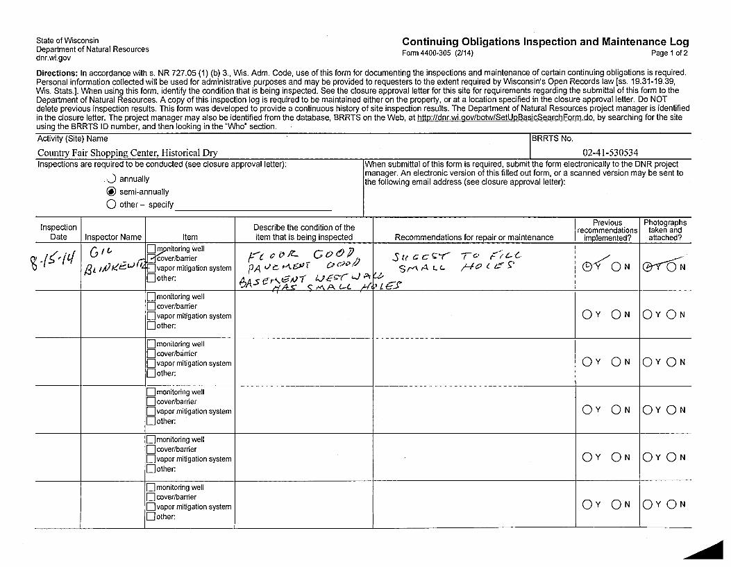
During the DNR visit, it was determined that the concrete floor and parking areas were generally in good condition. Several small holes in the western wall of the adjoining basement were identified. The maintenance record indicates that those holes will be sealed. The site is in general compliance with applicable site closure criteria with the exception ofrecords management. Mr. Blinkewitz was given a copy of the DNR' s new Continuing Obligations Inspection and Maintenance Log (Form 4400-305) to complete semi-annually. The new form was completed and submitted to the DNR during our visit (copy and photos enclosed for your records). In the future , it is recommended that any maintenance or repair activities be recorded on Form 4400-305 as they are completed.
A copy of the Remediation & Redevelopment Continuing Obligation Review form, documenting the audit of your site, is enclosed for your records. Thank you for your continued efforts to protect Wisconsin's environment. lfyou have any questions, please contact me by phone at (920) 893-8524 or e-mail at [email protected].
Si~ely, i?,. a// _ __ ... -· _ / / : '14!✓,J::r,_,,c,,---
f .r~ ./ ' /_ v ('.,-
Lee R. Delcore Hydrogeologist Remediation & Redevelopment
Enclosures: April 20, 2005 Deed Restriction & Cap Maintenance and Vapor Barrier Maintenance Plan June 2, 2005 Case Closure with NR 140 Exemption August 15, 2014 DNR Form 4400-305 August 15, 2014 Remediation & Redevelopment Continuing Obligation Review Form 4400-232
cc: Mr. Gil Blinkewitz, Siegel-Gallagher Ms. Linda Michalets, DNR
dnr.wi .gov wisconsin.gov Nat~rally WISCONSIN -
PRINTED ON RECYCLED PAPER
State of Wisconsin Department of Natural Resources dnr.wi.gov
Continuing Obligations Inspection and Maintenance Log Form 4400-305 (2/14) Page 1 of 2
Directions: In accordance withs. NR 727.05 (1) (b) 3., Wis. Adm. Code, use of this form for documenting the inspections and maintenance of certain continuing obligations is required. Personal information collected will be used for administrative purposes and may be provided to requesters to the extent required by Wisconsin's Open Records law [ss. 19.31-19.39, Wis. Stats.]. When using this form, identify the condition that is being inspected. See the closure approval letter for this site for requirements regarding the submittal of this form to the Department of Natural Resources. A copy of this inspection log is required to be maintained either on the property, or at a location specified in the closure approval letter. Do NOT delete previous inspection results. This form was developed to provide a continuous history of site inspection results. The Department of Natural Resources project manager is identified in the closure letter. The project manager may also be identified from the database, BRRTS on the Web, at http://dnr.wi.gov/botw/SetUpBasicSearchForm.do, by searching for the site using the BRRTS ID number, and then looking in the "Who" section.
Activity (Site) Name IBRRTS No.
Country Fair Shopping Center, Historical Dry 02-41-530534 Inspections are required to be conducted (see closure approval letter): When submittal of this form is required, submit the form electronically to the DNR project
,__) annually manager. An electronic version of this filled out form, or a scanned version may be sent to the following email address (see closure approval letter):
@ semi-annually
0 other - specify
Inspection Describe the condition of the Previous Photographs
recommendations taken and Date Inspector Name Item item that is being inspected Recommendations for repair or maintenance implemented? attached?
-(5' (l{ G fl, ~;1ooogwell /:'t t: o ~ CO rt) i}, St< c cc--r ,o F'(t-C.., er/barrier
0-<QN ~~ /3L JPK~L,)~ or mitigation system PA vc.. MOJf oc.H.•/.l SM.A LC.. /-ft?(_ e ~l
Oother: 6A5 er,GNt lJEf:"c -...J A-(.,t,
HA-- C' , ,'I\ A C-l J-1; ,LG".S D monitoring well D cover/barrier
QY QN QYQN D vapor mitigation system Oother:
D monitoring well D cover/barrier
QY QN QYQN □vapor mitigation system Oother:
D monitoring well D cover/barrier
QY QN QYQN D vapor mitigation system Oother:
D monitoring well D cover/barrier
QY QN QYQN □vapor mitigation system Oother:
D monitoring well D cover/barrier
QY QN QYQN □vapor mitigation system Oother:

02-41-530534 Country Fair Shopping Center, Historical Dry BRRTSNo. Activity (Site) Name
{Click to Add/Edit Image} Date added:
Title:
- --- - ,_
Continuing Obligations Inspection and Maintenance Log Form 4400-305 (2/14) Page 2 of 2
{Click to Add/Edit Image} Date added:
Title:
Document Number DEED RESTRICTION
Declaration of Restrictions
ln Re: Please see attached legal description of property below.
Wisconsin Tranverse Mercator Coordinates: 679278,276212
STATE OF WISCONSIN ) ) ss
COUNTY OF MJLWAUKEE )
1111111 lllll lllll lllll lllll lllll lllll 1111111111111 · * 0 8 9 9 7 2 0 2 *
DOC.I 08997202 REGISTER 'S OFFICE I SS
Milwaukee County, WII
RECORDED -04/20/2005 - 04:21PM
JOHN LAFAVE REGISTER OF DEEDS
AMOUNT:21.00
Recording Area
Name and Return Address Bruce A Keyes, Esq. Foley & Lardner LLP . 777 E. Wisconsin Ave. Milwaukee, WI 53202-5306 ROD Box286
Part of 659-9975, Part of 659-9977-004
Parcel Identification Numbers
In Re: Land Situated in the County of Milwaukee, State of Wisoonsin described as follows:
. . That part of the Northwest One-quarter (¼) of Section Thirty-two (32), Township Six (6)
.· North, Range Twenty-one (21) East, in the Village of Hale{Comers, Milwaukee County, Wisco~sin, bounded and described as follows: Commencin~ ~t the ~orthwest_ corner of said ¼ Section; thence South 01° 26' 00" West along the West Im~ ofsatd ¼ Section 253.13 feet to a point; thence South 01° 34' 00" East at right angles to tlie West line of said ¼ Section 74.75 feet to a point; thence South 01° 26' 00" West and parallel to the West line of said ·¼ Section 618; 19 feet to the point of beginning of the land to he described; running thence South 88° 34' 00" East 221.53 feet to a point; thence South 01° 02' 20" West 111.37 feet to a point; thence South 88° 57' 40" East 281.88 feet to a point; thence South 01 ° 26' 00" West · 156.94 feet to a point; thence South 89° 55' 00" West and parallel to West Parnell Avenue 364.12 feet to a point; thence South 01 ° 26' 00" West and, parallel to the West line of said ¼ Section 133.54 feet to a point, said point being on the North line of West Parnell Avenue; thence South 89° 55' 00" West along the North line of West Parnell Avenue 200.25 feet to a point; thence North 01° 26' 00" East and parallel to the West line of said¼ Section 414.84 feet to the point of beginning.
Excepting Parcel One (I) of Certified Survey Map No. 4391, recorded on October 14, 1983 on Reel 1577, Images to 528 inclusive, as Document No. 5661949, being a part of the Northwest One quarter (¼) of the Northwest one-quarter (¼) of Section Thirty-two (32), Township Six (6) North, Range Twenty-one (21) East, in ,he Village of Hales Corners, Milwaukee County, Wisconsin. I ·
I I
t i I I
L '

WHEREAS. Country Fair, LLC. a Nevada limited liability company, is the owner of record for the above-described property.
WHEREAS. as· of July I, 2004; when soil samples were collected on this property, and November 29. 2004, when groundwater samples were collected on this property, soil and groundwater contaminated with tetrachloroethylene (PCE) and trichloroethylene (TCE) remained on this property at the following location: beneath the _5620 South 108th Street -tenant space. beneath the 5606 South 108th Street tenant space and in the rear alleyway of the Country Fair Shopping Center as indicated on AT1TACHMENT 1, labeled Summary of Soil Analytical Results.
WHEREAS, it is the desire and intention ofthe property owner to impose on the property restrictions which will make it unnecessary to conduct further soil remediation activities on the property at the present time.
NOW THEREFORE, the owner hereby declares that aU of the property described above is held and shall be held, conveyed or encumbered, leased, rented, used, occupied, and improved subject to the following limitation and restrictions:
Certain paved surfaces and building foundations that existed on the above-described property on the date that this restriction was signed fonn a barrier that must be maintained in order to prevent direct contact with residual soil contamination that might otherwise pose a threat to human health. These structures are also required in _order to minimize the.infiltration of water and prevent groundwater contamination that would violate the groundwater qua1ity.standards in ch. N~ 140, Wis. Admin. Code. The certain paved surfaces and buildt· g foundations sha11 be maintained on the above-described property in the 'locations shown n the attached map, labeled A 1T ACHMENT 2, unless another barrier, with an· infiltration te of 10-7 cm/sec or less, is installed and maintained in their place. The existing structures, ~nd any replacement barrier with an infiltration rate of 10-7 cm/sec or less, shall be maint~ined on the abovedescribed property iri compliance with the Cap Maintenance and Vapor Barrier Maintenan·ce Plan that was submitted to the Wisconsin Department of Natural Resources by Malan Liquidating Trust, as required by section NR 724.13(2), Wis. A~m. Code(1999).
In addition, the following activities are prohibited on any portion of the above-described property depicted on ATTACHMENT 2, where an impervious cap has been placed or where impervious surfaces exist unless prior written approval has been obtained from the Wisconsin
· Department of Natural Resources or its successor or assign: (]) excavating or gradi~g of the land surface; (2) filling on capped areas and areas with impervious surfaces; (3) plowing for agricultural cultivation; and (4) consfruction or installation of a building or other structure wit~ a foundation that would sit on or be placed within the cap or impervious surfaces.
Interior space limitations in the area of the adjacent.tenant spaces, identified as Tenant· Spaces 5618 S. 108th St., 5628 S. l 08th St., 5608 S. l 08th St., and 5602 S. 108th St. on ATTACHMENT 1, existing at the time of the investigation and remedi<\I action, made complete investigation of the soil contamination on this property impractkable. If the building foundations adjacent to the former Express Cleaners are removetl, the property
I
i I ~
l.
l ,'
{
...... .. _.,.~ owner shall conduct an investigation of the degree and extent of PCE contamination. To the extent that contamination is found at that time, the Wisconsin Department of Natural Resources or other agency with administrative authority for the site shall be immediately notified and the contamination sha11 be properly remediated in accordance with applicable statutes and rules. If the currently inaccessible soil near or beneath the structural impediments on the property is excavated in the future, the soil must be sampled and analyzed, may be considered solid or hazardous waste if residual contamination remains and must be stored, treated and disposed in compliance with applicable statutes and rules.
The epoxy vapor sealant ("Vapor Barrier") as shown on ATTACHMENT I that existed at the property within the 5620 South 108th Street, Country Fair Shopping Center tenant space on the date that this restriction was signed forms a vapor infiltration barrier that must be maintained in order to prevent vapor intrusion that might otherwise pose a threat to human health. A system of piping penetrating through the vapor barrier and extending to a rooftop discharge point serves and shall be . maintained as a passive venting system("Venting System"). The owner may, at the owner's discretion, also elect to enhance the operation of the Venting System with a fan or blower. The Vapor Barrier shall be inspected and maintained unless another suitable vapor barrier is installed and maintained in its place. The existing Vapor Barrier and any replacement Vapor Barrier shall be maintained on the abovedescribed property in compliance with the Cap Maintenance and Vapor Barrier Maintenance Plan that was submitted to the Wisconsin Department of Natural, Resources by Malan Liquidating Trust, as required by section NR 724.13(2), Wis. Ad~. Code ( 1999).
This restriction is hereby declared to be a covenant running with the land and shalJ be fully binding upon all persons acquiring the above-described property whether by descevt, devise, purchase or otherwise. This restriction inures to the benefit of and is enforfrble by the Wisconsin Department of Natural Resources, its successors or assigns. The De ment, its successors or assigns, may initiate proceedings at law or in equity against a y person or persons who violate or are proposing to violate this covenant, to prevent the proposed violation or to recover damages for such violation. 1
Any person who is or becomes owner of the property described above may request that the Wisconsin Department of Natural Resources or its successor issue a determination that one or more of the restrictions set forth in this covenant is no longer required. Upon the receipt of such a request, the Wisconsin Department of Natural Resources shall determine whether or not the restrictions contained herein can be extinguished. If the Department determines that the restrictions can be extinguished, an affidavit, attached to a copy of the Department's written determination, may be recorded by the property owner or other interested party to give notice that this deed restriction, or portions of this deed restriction, are no longer binding.
By signing this document, the undersigned asserts that he or she is duly authorized to sign this document on behaJfofCountry Fair, LLC.
IN WITNESS WHEREOF, the owner of.the property has executed this Dec]aratifn of Restrictions, this 19 r,-1 day of l\c'~d.. , 2005. · !
. I
i
i I ( f <
I
!,
I
! I

STATE OF Ai<'vr~ 1<'>->
County of i.Jrt.Sha~
) ) ss )
Coun~.~--------.... By:_~,..__,,~-~-~-Name: ~o\ '-" 1' () .. Ntt..C.Se~ Title: jhAtuA.7,:,..7 ~ IJcJf
Personally came before me this _J_j_ day of llr.z: \ · , 200Zf,' the above named R.ok"--i-- F &'it. is-.RA (name), h\a.nlb~'k66 h'lJm.PRC (title), who
executed the foregoing instrumerif and c wledged the same on behalf of said corporation.
IN WITNESS WHEREOF, I hereto set my hand and notarial seal.
J~- a P4 Name:· .J:71 ,\ i'th fl .
Notary P~blic, State of /IJ..e I) J~ My Commission Expires: 7-31-07
I
"
. . . I This document was drafted by Bruce A. Keyes, Esq., Foley & Lardner LLP, 777 East J
. Wisconsin Avenue, Milwaukee, Wisconsin 53202. 1 I I
L
( I:
C

1~ ... -lflQ[ UlllA I
I-• r-;::, ""._,
1=· I I
flRST LADY NAlLS (5630)
8.l.SKIN ROBBINS (5632)
PARKING
.. • • ✓~~-✓-~
I MINUTEMAN PRESS ,....,,------1-- --~----_-_-_-_·--_-_-_-_ -_ -_--+----1 (5634) ~/ ___ _:-:-__ i ______ =._ ________ :::_ ________ :::_'.":,_ _____ _
I :::::==----=:::'. - ... ✓,..... HN"a•r ---c-~ ___ -___ -_/" NOTE:
I. I.IAP ADAPTED FROM WAH 'l'i£ ASSOCIATES. fl.DOR PlAN AND El.EVAllON 8t CANOPY DETAILS, DA TED FEBRUARY 4. 1974. 2. UNLESS OTHERYIISE ND TED NlORESSl'.S AR£ LOCATED OIi SOOlH 106Tl1 STIIEET. J . ASSUI.IEO LOCATIOII OF ECKLAND BORING OASED OIi "1SUAI. E\10£NCE OOTAINEO BY lolSG OH OCTOIIER I, 2002. ANALYTICAi. INFORMATION WAS 08TAINED FROM EO<LANO LETTER TITLED LIMITED PttASE II SUBSURFACE INVESllGAllON, DATED ..ULY 10, 2002. A I.IAP DEl'ICllNC lHE LOCATION ANO ACl\J/,1,. AN/,1,. YllC/,1,. DATA WAS NOT AVAA.ABLE FOR I.ISG Rf;w;W.
4. A - EXCEEDS USEP A SOIL SCREENING LEID.$ FOR SOIL TO CllllONDWATOI B - EXCEEDS USEPA SOIL SCREENING LEVD.S FOR AMBIENT VOLATILE INHlll.).TION ' C - EXCEEDS USEPA SOIL SCREENING LEVELS FOR INGf:SllDN
5. PCE - TETRACI-ILOROEIHYLENE lolC - 1!£1HYLENE ClllORIDE V00 - VOl.AllLE ~IC COI.IPOUNDS NO - NOH orn:cr {J) - ESTIMAm> CONCENTRATION BELOW LAl!ORATORI' OUAHTITA110N LEVEl.
O'
LEGEND
~ HC-EC1/
IIWI
• HC-EC2
Iii
®
5
SCALE: 1 • =- 30'
15' 30' 60'
Gf:Ol'ROIIE IIOftlNQ LOC/illONS
SE\/ER NAHIO..[ LCOA T!Di
CATal IIASIII
APPROJ1Wir£ EXlDIT Of SOIL llll'ACTS
a• WATER ~N
CA51Wj
Tn£PH0HE Utei
STORM SEWOt
UlllERGl!OUNO E1LClRIC
APl'ROXIIIAlE ~ IIOUNIIAII'(
VN'OR IIAARlfR
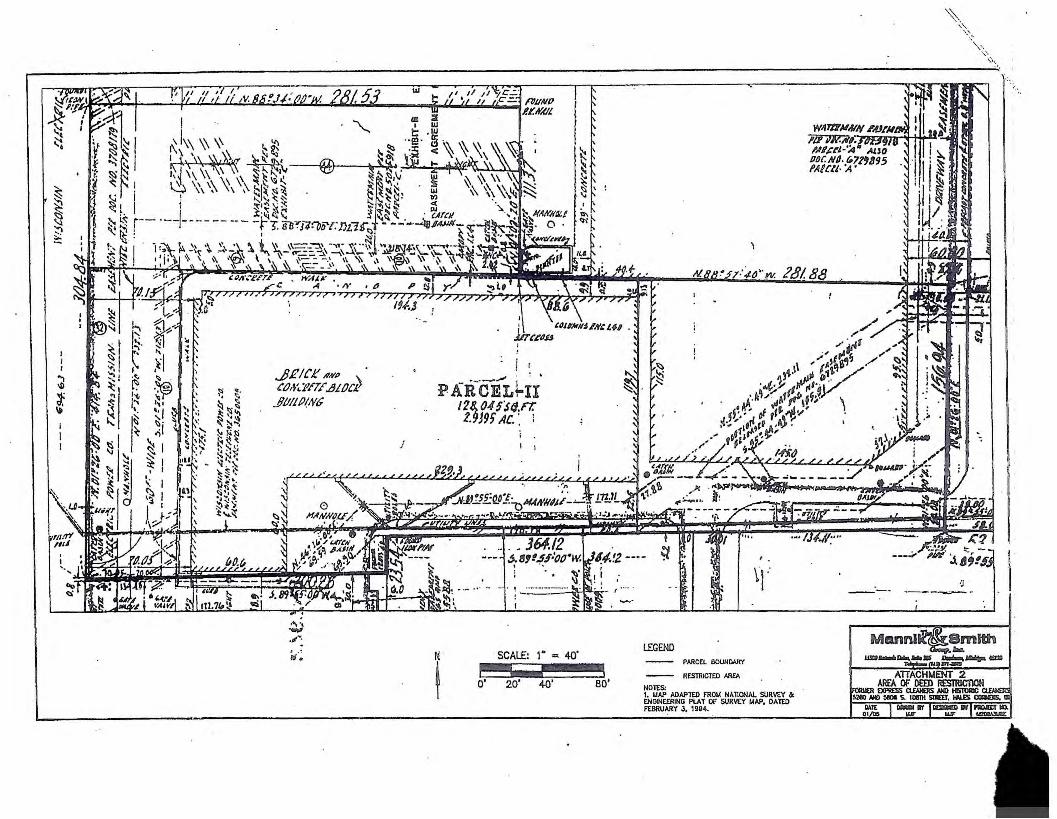
I I I
~ i ~
..J)RICJ:' .#KP \.
CtM',,"i'ETE .!Ji/JC.I! .111111 IJ(NC
1,-, -_,, ..
I I .,,,., . : "
PAlfCEL~II 128, 045S{J.n: t.9J9f AC. ·. l
I I
I SCALE: 1 • = 40'
o' 20' +o' ao'
LEGEND PARCEL BOUNIWr/
RESTRK:TID AR£A
N01£S;
?rS/88
\j.-
1. MAP ADAPTED FROIA HAllONAI. SUR~Y ck ENGINEERING PLAT Of SUR~Y MAP, DATED FEBRUARY 3. 1gg~.
'-\_ ' ~.\.
,:_,
',, ... ·-,-. , .. _
·J I
CERTIFICATE NO. 276783 STATE OF WISCONSIN MILWAUKEE COUNTY
OFFICE OF REGISTER OF DEEDS
) _/
I, the undersigned Register ~f Deeds of Milwaukee County, hcn~by certify that this document ia a true a.nd correct copy of'the- original en fi!e er record in this office.
Witness mv hand and official seal this
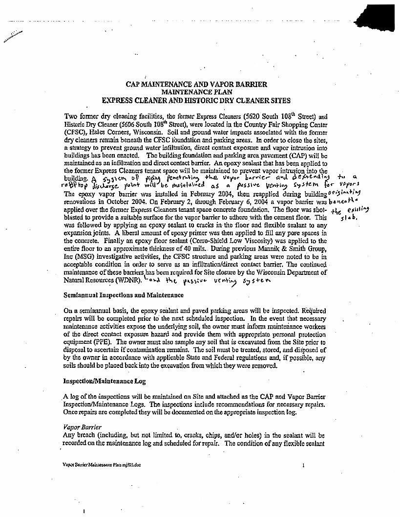
CAP MAINTENANCE AND VAPOR BARRIER MAINTENANCE PLAN
EXPRESS CLEANER AND IDSTORIC DRY CLEANER SITES
Two fonner dry cleaning facilities, the fonner Express Cleaners (5620 South 108th Street) and Historic Dcy Cleaner (5606 South 108th Street), were located in the Country Fair Shopping Center (CFSC)r Hales Comers, Wisconsin. Soil and ground water impacts associated with the fonner dry cleaners remain beneath the CFSC foundatfon and parking areas. In order to close the sites, a ·strategy to prevent ground water infiltration, direct contact exposure and vapor intrusion into buildings has been enacted. The building foundation and parking area pavement (CAP) will be maintained as an infiltration and direct contact barrier. An epoxy sealant that has been applied to the fonner Express Cleaners tenant space will be maintained to prevent vapor int:rm;ion into the . building. A t•,)')\-C..~ 0~ fi~, fe"'ctr--H~ +t....e. '!/flvor b .. r..-jc,... a..J, o,t,M-C.""d~~ fu Q.
ro/o~+of c,\;;J...i~t. f"'"+ will b-c. ~,~+4\lo\W ~$ C. f•SS\\1-t.. velt\rl~ t'1.S~)\,\ ~ ..... VP.p~~J
The epoxy vapor barrier was installed in February 2004, then reapplied during building01'•)l .. ,~P'J' renovations in October 2004. On February 2, through February 6, 2004 a vapor barrier was b~~t ... H" applied over the former Express Cleaners terumt space concrete foundation. The floor was shot- +lie e,:11t:") blasted to provide a .suitable surface for the vapor barrier to adhere .With the cement floor. This s I• h, was followed by applying an epoxy sealant to cracks in the floor and flexible sealant to any expansion joints. A liberal amount of epoxy primer was then applied to fill any pore spaces in the concrete. Finally an epoxy floor sealant (Corro--Shield Low Viscosity) was applied to the entire floor to an approximate thickness of 40 mils .. During previous Mannik & Smith Group, Inc (MSG) investigative activities, the CFSC structure and parking areas were noted ta be in acceptable condition in order to serve as an infiltration/direct contact barrier. The continued • maintenance of these barriers has been required for Site closure by the Wisconsin Deparbnent of NaturalResourc~s (WDNR). '-CH.~ ~c,. t'~~'""' ve r->\-i/ 5:J s +-e"
Semiannual Inspections and Maintenance
On a semiannual basis, the epoxy sealant and paved parking areas will be inspected. Required repairs will be completed prior to· the next scheduled inspection. In the event that necessary maintenance activities expose the underlying soi1, the owner must inform maintenance workers of the direct contact exposure hazard and provide them with appropriate personal protection equipment (PPE). The owner must also sample any soil that is excavated from the Site prior to disposal to ascertain if contamination remains. The sail must be treated, stored, and disposed of by the owner in accordance with applicable State and Federal regulations and, if possible, any soils should be placed back into the excavation from which they were removed.
Inspection/Maintenance Log
_A log of the inspections will be maintained on Site and attached as the CAP and Vapor Barner Inspection/Maintenance Logs. The inspections include recommendations for necessary repairs. Once repairs are completed they will be documented on the appropriate inspection log.
Vapor Barrier Any breach (including. but not limited to, cracks, chips, and/or holes) in the sealant will be recorded on the maintenance log and scheduled for repair. The condition of any flexible sealant
VeJIQf Bame1 M&inlCil~cc PILll mjftl3.doc

. . . ts '\.Vall floor joints, protrusions by plumbing or at anchor points into the placed at expansion J°:-r ;eeded scheduled for repair/replacement. · floor will be noted an i
· th a.por barrier is repaired or replaced, a floor sealant equivalent to the . In the evei:t tllat :av or barrier (40 mils epox.y) must be applied over the repaired/replaced previously mstalle! d ~ell beyond any disturbed area. Any of the flexible se~lant that had been flooring and exten e -wall joints an~or exp8:D5ion joints m115t be replaced if disturbed. placed at the floo:ble sealant will be liberally applied at and immediately surrounding any AdcUti.ona~ty, a fie; areas where the epoxy floor sealant is breached (screw holes, nail holes, anchor_ points or O ;r AnY replacement ba.t?er will be subject _to identical maintenance and plumb1~g fix~l~ .. - • unless indicated otherwise by the WDNR or 1t successor. inspection guide mes
CAP . cess (;racking are noted during the semi-annual inspections or at any other If exposed sotls or ex airs will be scheduled as soon as practical. Maintenance activities can time of'the _year. r~, patching and filling operati?ns or they can include larger re~urfacing or include sealing ~ ns ln the event that the cap 1s replaced, the replacement bamer must be constroction ~peratio re'-vent infiltration and direct contact with the soil. The replacement barrier equally su~c1ent ~~ ~tical maintenance and inspection guidelines unless indicated by the WDNR will be subject to 1 e or it successor.
gis~ of Closed Remediation Sites WDNRGISRe '1,AJ •
. t' 011 is removed or remediated, the owner may obtain an updated Site closure If soil con~a ~d have the Site taken off of the GIS Registry of Closed Remediation Sites. from the WDl-..J."
ol,)'cl ... r;e.r +o °', ;-o.:.f' to/ f'~e
(_ t,"' P;, LCrC. tJ. $-
2
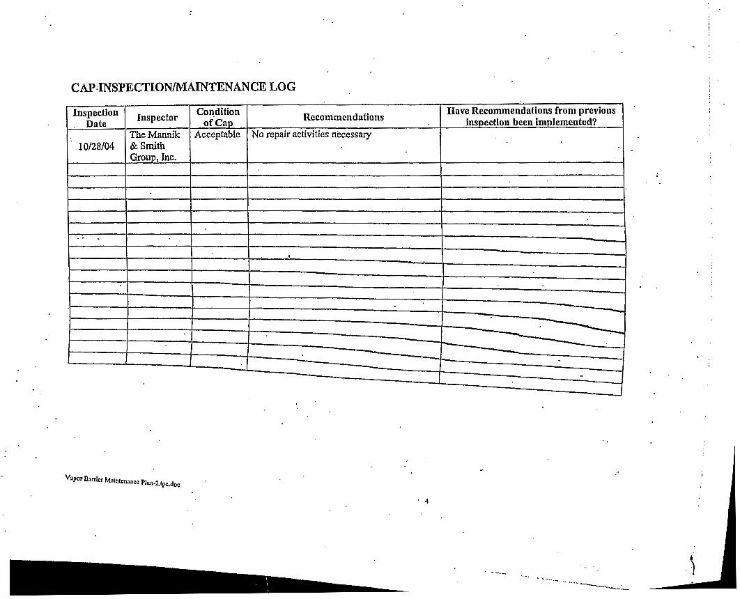
CAP.-INSPECTION/MAINTENANCE LOG
Inspection Inspector Condition Recommendations
Have Recommendations from previous Date of Cap inspection been imolementcd?
TheMannik Acceptable No repair activities necessary 10/28/04 & Smith
Grouo, Inc .
. . -•
------ ~ -
. .
Vapor Barrier Maintenance Plan-2.tpc.doc
. 4
.... __ ~ -----
... --------:_

State of Wisconsin \ DEPARTMENT OF NATURAL RESOURCES
Jim Doyle, Governor Scott Hassett, Secretary Gloria L. Mccutcheon, Regional Director
Southeast Region Headquarters 2300 N. Dr. Martin Luther King, Jr. Drive
Milwaukee, Wisconsin 53212-0436 Telephone 414-263-8500
FAX 414-263-8716 TTY 414-263-8713
June 2, 2005
Mr. John Roberson Malan Liquidating Trust 110 Pacific Avenue, #107
File Ref: FID#341099550
San Francisco, CA 94111-1962
Subject: Case Closure With NR 140 Exemption Historic Cleaner, 5606 South 108th Street, Hales Corners, WI 53130 WDNR BRRTS # 02-41-530534
Dear Mr. Roberson:
Your request for closure of the Historic Cleaners site has been reviewed by the Wisconsin Department of Natural Resources. The Department reviews environmental remediation cases for compliance with state rules and statutes to maintain consistency in the closure of these cases. Based on the information submitted, and in consultation with the Wisconsin Department of Health and Family Services, the Department has determined that the tetrachloroethylene (PCE) contamination on the site from the former drycleaning operation has been investigated and remediated to the extent practicable under site conditions. The Department considers the case closed under s. NR726.05, Wisconsin Administrative Code, with specific closure conditions listed in this letter.
The PCE contamination was found in soil under the floor of the former Historic Cleaners. The exact horizontal extent of the soil contamination was not defined due to the difficulty in drilling in the adjacent occupied tenant spaces, but has been estimated to extend to points within the limits of these immediately adjacent spaces. The concentration of PCE in soil diminished significantly below 10 feet depth. Soils below the building do not appear to be continuously saturated within the depth interval where the water table was encountered in site wells beyond the building limits. A minor amount of PCE was detected in one monitor well (MW-7), located downgradient of the building, but did not approach the chapter NR 140, WAC, Enforcement Standard.
Your case closure submittal and site work complies with Department standards in accordance with s. NR 726.05, Wis. Adm. Code. The Department has received the required documentation that a deed restriction meeting Department requirements has been recorded for this property. The existing building and surrounding pavement serve as a barrier to direct contact and rain infiltration, and limit the potential for migration of the PCE soil contamination into groundwater. These features should be maintained, as required through the deed restriction, as a condition of case closure. If the building is removed from the source area and adjacent tenant spaces in the future, further assessment and remedial actions may be required. The Department should be notified in the event the building is removed. This is also stated in the deed restriction.
Your site will be listed on the DNR Remediation and Redevelopment GIS Registry of Closed Remediation Sites. fuformation that was submitted with your closure request application will be included on the registry. To review the sites on the GIS Registry web page, visit http://gomapout.dnr.state.wi.us/org/at/et/geo/gwur/index.htm
dnr.wi.gov wisconsin.gov
Quality Natural Resources Management Through Excellent Customer Service Printed on
Recycled Paper

♦'
Chapter NR 140, Wisconsin Administrative Code Exemption: Recent groundwater monitoring data at this site indicates exceedances of the NR 140 preventive action limit (PAL) for tetrachloroethylene at monitor well MW-7, but compliance with the NR 140 enforcement standard. The Department may grant an exemption to a PAL for a substance of public health concern, other than nitrate, pursuant to s. NR 140.28(2)(b), Wis. Adm. Code, if all of the following criteria are met:
1. The measured or anticipated increase in the concentration of the substance will be minimized to the extent technically and economically feasible.
2. Compliance with the PAL is either not technically or economically feasible. 3. The enforcement standard for the substance will not be attained or exceeded at the point of
standards application. 4. Any existing or projected increase in the concentration of the substance above
the background concentration does not present a threat to public health or welfare.
Based on the information you provided, the Department believes that the above criteria have been or will be met because the source area is covered by the building and there is no longer a drycleaning operation at the location. The levels found at this monitoring location were very low and never exceeded the enforcement standard. Therefore, pursuant to s. NR 140.28(2)(b), Wis. Adm. Code, an exemption to the PAL is granted for tetrachloroethylene at monitoring well MW-7. This letter serves as your exemption.
Please be aware that this case may be reopened pursuant to s. NR 726.09, Wis. Adm. Code, if additional information regarding site conditions indicates that contamination on or from the site poses a threat to public health, safety, or welfare or to the environment.
We appreciate your efforts to restore the environment at this site. If you have any questions regarding this letter, please contact me at 414-263-8758.
~~+&, Pamela A. Mylotta, Hydrogeologist Remediation & Redevelopment Program Southeast Region, Milwaukee Service Center
cc: Bill Phelps, DG/2 Mr. Bruce Keyes - Foley & Lardner
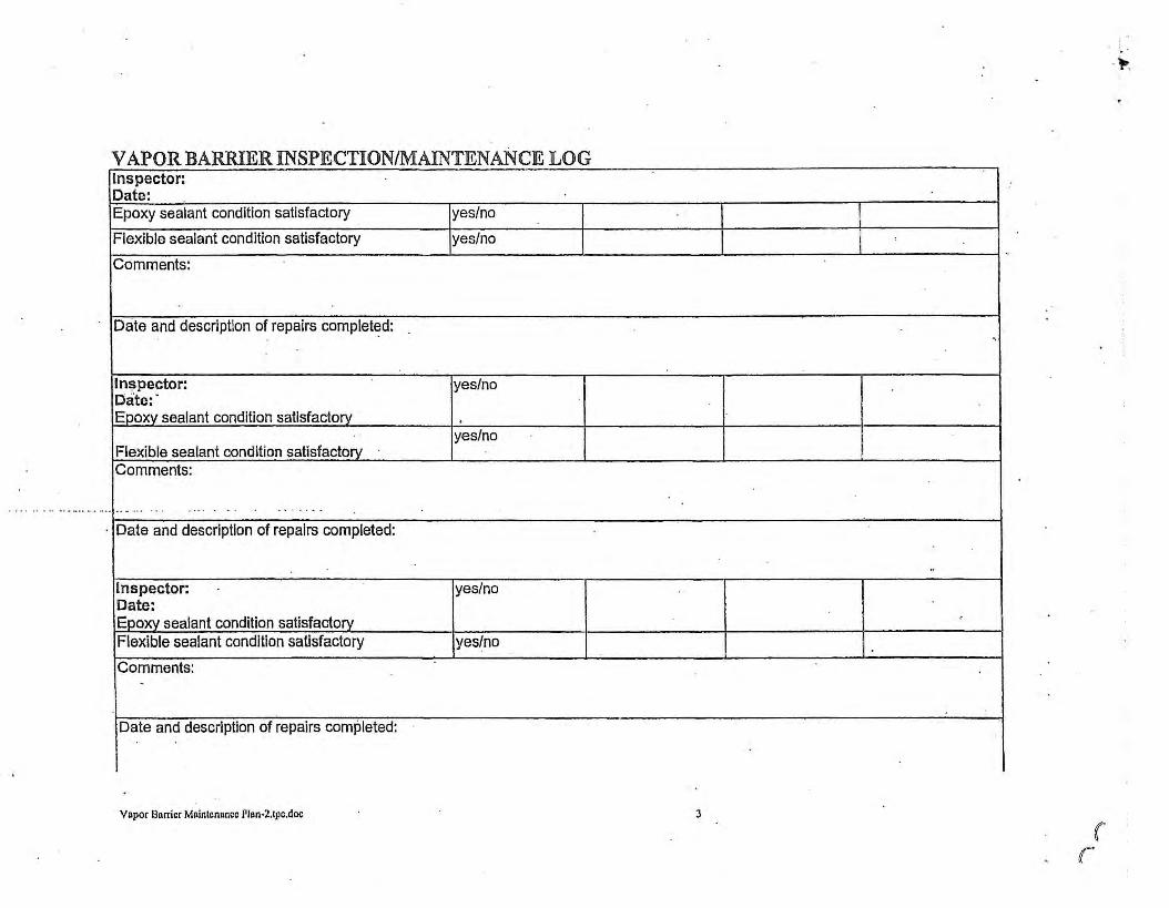
VAPOR BARRIER INSPECTION/MAINTENANCE LOG Inspector: Date: Epoxy sealant condition satisfactory yes/no
Flexible sealant condition satisfactory yes/no
Comments:
Date and description of repairs completed:
ln~pector: yes/no Date:· Eooxy sealant condition satisfactory .
yes/no Flexible sealant condition satisfactory Comments:
-- -· - .. . . .. ... . - . - . - - . - -
· Date and description of repairs completed:
Inspector: yes/no Date: Epoxy sealant condition satisfactorv Flexible sealant condition satisfactory yes/no
Comments: .
Date and description of repairs completed:
Vapor Burrier Maintenance Plan•2,tpc.doc
-.
"
'
J
( r
. . -~
1,1; -;;;-~ r r 0) -
~-< _z u, Cl) ~,; ~~ a .!;,~ :,:
0 en Cil
Cl) C -< ·o
" 8 c;: :v0lJ Al
/Tl
PARKING
;\! ;:s ~,.,,
u, u, 0, "'
0 u, ~:r: 0 m u; 0 C -;o n rn
/
·O .· 0
-c;-~•-0, . -
- 0 Cl
-'-:"":;ti m ,.,-
·~ _/tut-,f~? L!..:::
APPl<OXIJ.!ATE ~lEN{o, 111ST0R1c , · · , _,- ' -,~ -•~/~ D"1'Cl£/,NER~SOILOJP,',C'T'S __ , _,-· , . ..-: ru~--,
.· . . . 'I . , .- / , ,,__.,-_,,. . _ •. - . • . .-· ~ · I H,-\-cf. ,'t r--"--~
' .· . ~-> . ) f , . '. ~ ,:_,,,. ~.~} . ' . . I<>-= ,r_,. r..;,•·"'~ -· ~ lf.1 '. ' "Q_"Jr;Ji§__j . ~~~~\=.~'i~~.,,~~-• / / .· / ,' ~ •• .,_, 1"'-= ,! .. -4' (?\II l.!!S:....:..@"(;I_ A •, ,.;-; M£ .,.
f'---...;......;. ___ ;__ __ -'-----'--" ~ ~ . · .. ~~ '@Cli~liJ· ~ CB
F!RSf(5ttfci) NAILS ~ '£ "° - - . . .. •· ---· i ,/' -. , ·_! . . . - . . - . . . - J_~-l-------------, rlH ,.:-= H-!-ttlll ~ -·ic~- -- .. 1e-a----c _ . ~,.l~H / ·,
8AS(~~:l~)08BINS @- - ·--;z:Gl - liC-=>IW---7 ·7 --/2.+-"---~-------_,.,,,. ; ,ic--o::a · - - • _;,r,.,,_,,,,, s~· (♦MD5! >:o-c;>-3 • • ..,, C</1Vt13l ,
;
0 10'-11 · (7/1/04) !PC:: I o..-xo9 ... J. . '-OC" HD :
MINUTEMAN PRESS (5634)
. ''°" '"' I HC-a:10 10•-,,· (7/t/o.)I ALLEY J Uc--a:n B-s" '/0~ PC:E: tU!.I A.
~ ..,.,..-------j-- -------- ·---·-'-'---/ . __ _ ____ ! ~ ....... ·' · - ·-· -- ·-·- ·---- ·- ·-·-·- ·- ·-·-·-·- - ·-·-·-
,,,,,,,,, H::-!:07( ·-- - / - _____ _. _
__/ ....
\. I.IAP AlJAPi£0 FROU WAA Yc:E ASSOCIA'TES, f'l.OOR FLAN AND Ewc.-VA110N &: '•· A - EXCEEDS USEPA SOJL SCR££NlNG lE\,0.5 FOR SOIL TO CRCUNDWA,<R
5. PCE - TE"TRACHLOR0..""1)-IYLE'{E MC - MElH'l'l.ENE CHLO.'llDE
CANOPY DETAILS, 0A11:D FEBRUARY .of, 19,74. 2. UNLESS 0Tf1£RV~SE NOTEO AflDRESst:S ARE LOCA11:D ON SOUTH 108TH SlREET. 3, ASSUMED LOCATION Of' ECKLAND BORING BA= ON VlSUAL EVlDENC£ OBTAlNED BY- ldSG ON OCTOBER 1, 2002. ANALYTICAL INFORl.4ATION WAS OBTAINED FROM ECl(l.AND l..."TTER TITLED UMl11:D PHASE JI SUBSURFACE INVESTIGA110N, DAtED JULY 10, 2002. A MAP DEPlC11NC 11,E LOCATION AND ACTIJAL ANALYTICAL OATA \'/AS NOT AVAILABLE FOR MSG REVlEIV.
6 - EXCEEDS US<PA SOiL SCREENl!\G l.EYol.S FOR AMBIENT VOLA llLE INHALA llON C - EXCEEDS USEPA SOIL SCREENING LEVELS FOR INCESllON
voe - VDU.TILE ORGANIC COIAPOUNDS NO - NON DETECT (J) - ESTIMAIDJ• CONC€NJRATION BELOW LAS-ORATORY QUN-IITTATION L...'V""<.l.
I :SCALE: 1" == 30'
o· 15' 60'
LEGEN!)
-$-HC-EC1/
lll'/1
GEOPROBE BORING AND LIONffORINC· WEIJ. i.OCATIONS
0 HC-EC2
GC:OPROBE· BORING LOCATIONS
MH @ ·SEVE:R -NANHOLE LCOATltlN '
SJ! U CATCH. BASIN
. APPROXIMATE EXTENT .. OF SQJL -l!APACIS
6 " WATER 1.!AIN
CAS~WN
TELEPHONE: UNES
-STORM SEVIER
.UNDERGROUND, ELEC'!R!C
APPROXIMATE · PROPrafill BOUNDARY
j.::;:;_::;:j VAF'OR" BARRIER
TENANT SPACES TO BEr-::71 - IN\/ESTICA.TED IF /WHEN L...-..:.1 BUILDING FOUNDATION
REMOVED
AREA Or DEED · RESTRiCTION

... • Ii,, •
Figure H2 Cap I Vapor B.atTier Docum<;lntation
Hales Comers, Wisconsin
1. Applying ECO-POXI ·with 18" roller brush. 2. Applying silica sand to ECO-POXI floor.
...,;..,........f.,.,,;-..T"'t .... ,, . .... , .,. .... .. ... .,... _ . ..
' I .. I . .
3. Vapor Mitigation System on the Roof.
M208A3 U/Docs/M20 8A3U9E. photos.102804.0 I dfr
4. Plugged roof vents.

"D }> :::0 ;;,-;: z G)
I I
: I
~
I HO .....,_,
' t£-CC4nN'~J PARKING
~ [ ---,.;..i:c,;.::.-- -~ ------- - IOC--<PI
10 2'--4' (11/l l - 71-,J>l>R!)XIIL\TE om:,rr Of' ----------------
,u '"" I ~ ttc..cr, $ HC-0:t 4'-t' (4/ 4/0S) / ' , C\.£-"IER S/IE S04l 1UP,,,gPfl£SS -
.. . , ._ \ lC-lCI/W-1~ _,./'
FIRST LADY NAILS (5630)
BASKIN ROBBINS (5632)
MINUTEMAN PRESS (5634)
,/ I :r: rn ;o
~Vl (JI r OlQ ;;; .,, '-'o .,,
:::J (') ),, r
11; r ,-
~-< Ulm ~ )! ~c ~ U)
C: .,, -0
~ 1/1'/0JJ
HH @-
I I 1 ..... , (8/ 17,
... .,, 0
r¾cf' z u,~ ~ 0 ~~ ~ ,-~z ~i;; ~ s; 0 "'"' -< Ol 0 ~ )> Ul V1 0 ;o
~2~7 ~ ~ u,Vl "' I, 6-., z '-' -< 0 0 (/) ;o ;o '-' :r: "' z :r: 0 rn ......., . ... _ , . (1/17/04) =l 0 rn [l) PC£ 00'2&4 C [l) V1 .~~-1 ____ ,.. ~ -< 0
C: ~ ;o 0 (')
;o fT1
rn f/17/1>4)
~Rg~~1~~~f t~P~o;M:".,.
(f/12/03)
- ,.- Cl! ,,:-cce .c-cc,g ~ .,.,,,--·-· ------.;;-:;:;r -- --;-. _ _____________ _J_ 0 .,--- --~ _l _a:::::__ 1-:,•C•C~ ' --~ - "MH . -;,""- . --..
l<-CC'tnnl-7 '. -- +--- . IIC•C<' • -• -· - ®----- - - / '
IC-«11 IC>'-11' (1/1/0<J - w:c';-G>? l' . • 4 /OJ)~ ~ ::;-::_-;(4/5/0JJ ------ - - _/
"'° 110 ""° • I ~ HC-ECIS ID'-11' (7/1/0,~ A
PC< ... , A -- LLEY .,,,.--- ----1-----
~J - /_ - ---- ----->-/ .1--- -- _-:--:::.--:-1 ____ __ :-:._ ,_ , _ __ __ :-::_ ___ _ _ --=--=--=--.,,.,, ,c-n:i,( - ·- ·- ·- ·- ·- ·-
~ I
LI - - --- -
,mTE. ------- -------
/
I . J.IAP ADAPT£0 FROM WAH YEE ASSOCIATI:S, fl.000 PLAN ANO ELEVATION &. CANOPY DETAILS, DATED FEBRUARY ◄ . 19 7 ◄. 2. UNLESS O'TliER\\ISE NOTtD AOORESS[S ARE LOCATED ON SOUlll 108TH STREET. J. ASSUt.,EO LOCA llo.>1 or ECKLAND RORI NG BASED ON VISU/\L EVIDENCE OBTAINED or t.,SG OIi OCTOBER I , 2002. ANALYTICAL INFOOMATION WAS OBTAINED fR0t.4 ECKLAND LETTER nn.ro UMITEO PHASE II SUBSURFACE INVESllGATION, DAT'(O JJLY 10, 2002. A MAP DEPICTING THE LOCATION AND AClUAL Ml Al. YTICAL DATA WAS NOT AVAILABLE FOR t.,SG REVIEW.
◄. A - EXCEEDS USE PA SOIL SCREENING LEVELS FOR SOIL TO GROUNDWATER B - EXCEEDS USEPA SOIL SCREENING LEVElS FOR A"BIENl VOLATILE INHALATION C - EXCEEDS US€PA S04L SCREENING LEVELS FOR INGESTION
5. PC[ - TETRACHLOROCJll'l'l(N( MC - MEntYLENE CHLORlDE VOC - VOLATILE ORCANIC COMPOUN DS NO - Natl DETECT (J) - ESTIMATED CONCENTRATION BELOW I.ABORATORY OUANTITATION LEVEL
N
t SCALE: 1" = 30'
o· ,s· 30' 60 '
LEGEND
~ GEOPROBE BORING ANO
flC-ECI / IAONITORINC WELL LOCATIONS
MWI
• GEOPROBE SORING LOCATIONS HC-EC2
(El ASSUMED LOCATION or [CKLANO 2002 BORING
HH
® S[ \ICR HANHOLC L CDATION
0 CATCH BASIN
APPROXIWITE EXTENT or SOIL lt.,PACTS
e• WATER WJN
GAS WJN
TELEPHONE LINES
STORt., SEWER
UNDERGROUND ELECTRIC
APPROXIWITE PROPERlY 80UNDARY
~ SEGMENTED BASEMENT
n.J~M annll<~ Smlth c.o..,,. loc.
·----"" ........ ~ 411/0 •- 11•1/m= FIGURE 0 1
SUll'IAAt Ir SOL NW.YWi. ~ TS I~) r0RUER EXPRESS CILANERS
5260 S. 108TH SIR[[T, HALES CORNERS, W1
DAit 1/05
DftA'loll Ir( I DG!CHtD g1 I PROJCCI NO. W( UKl UiWJv<lf

f
PARKING I I
Fl - ---- - - - - --· :__=--=-~;.r _______ ---- -- ---- ---~-L __ HC-EC2. - - - --
u )> ::;o 7' z C)
1 I
I
A
HC-ECJ
•
HC-ECI/ -1
Cl ;u ► z ~o
~c -o ~I
'-
"' ::;; r
"' ;u (/)
RADIO SHA (5628)
FIRST LADY NAILS (5630)
BASKIN ROBBINS (5632)
MINUTEMAN PRESS (5634)
I "' ;u
~(/) u, r mo ;;; -u ~o
-u -< () ► r
• HC-CC3
,/ /
I ____ _._I_
L --------- ---~-- ,/'
-u 0 CJ\ i c5A-I z ~ 0 ►
~~ ~" r "'o Ul "1 ~"' g-< "'0 Ul t/1 0 ;u O> (/) O> ~. 0
~-< t;;! H,H N-.,
0 (/) ~c ;u ;u ~I "' 10 0 rn z
"' rn =i ;u C
(/) ;u 0 "' C HA-3 ;o 0 0
"'
HA-4
0
HA-5
0
' I ALLEY /,
/ -------1---- - - ----------------------- / /
,/4 , ✓, •• --_- _--=-~1 - - - -=--_ - - - -=--_ - - - --=- -=- - - - --=--=--/ / • HC-EC\7 r
NOTE,
1. MAP AOAPTEO FROM WAH YEE ASSOCIATES. FLOOR PLAN ANO ELEVATION & CANOPY DETAILS, OATED FEBRUARY 4, 1974. 2. UNLESS OTHERWISE NOTED ADDRESSES ARE LOCATED ON SOUTH 108TH STREET. 3. ASSUMED LOCATION OF ECKLAND SORING SASED ON \/1SUAL E\/1DENCE OBTAINED BY MSG ON OCTOBER 1, 2002. ANALYTICAL INFORMATION WAS OBTAINED FROM ECKLAND LETTER TITLED LIMITED PHASE II SUBSURFACE INVESTIGATION , DATED JULY 10, 2002. A MAP DEPICTING THE LOCATION AND ACTIJAL ANALYTICAL DATA WAS NOT AVAILABLE FOR MSC RE\/1EW.
N
~ SCALE: 1" 30'
o· 16' 30' 60'
LEGEND
• GEOPROSE BORING LOCATIONS HG-EC2
(t) ASSUMED LOCATION OF ECKLAND 2002 BORING
0 HANO AUGER BORING LOCATION
@ AIR SAMPLE LOCATION
HH
® SEWER MANHOLE LOCATION
CB
0 CATCH BASIN
GEOLOGIC CROSS SECTION LOCATION
8" WATER MAIN
GAS MAIN
TELEPHONE LINES
STORM SEWER
UNDERGROUND ELECTRIC
APPROXIMATE PROPERTY BOUNDARY
~ SEGMENTED BASEMENT
Manniil~ Smith Group, Inc.
ISlOOJlotlaUDrliT,Sllim.JOlf ~.~ 41110 TJ I (JIJ) n t.111J
FIGURE 2.0 CoutllRY f;JR SHOPPiNG COO!'R SCHEMATIC
/HD SAMPUNG LOCAOON MAP (HISTORIC ORY Clf>HERS ANO EXPRESS Ct.fANfRS SITES)
5608 S. 108ni STREET tw£S CORNERS 'M OAT[ ORAWN BY OESICNEO BY PFIOJECr NO.
10 04 Afr "T M208.U\J90

r I
WEST APPROXIMATE CROUNO SURf"ACE EAST
A 0 HC-EC4 MW-2/
HC-EC13 HC-EC12 HC-EC10 A' 1----- - - ---~------ ---- 0
5
10
15
20
....: . --:::z:::
L__ /
=::z:: -~ -:::::z:::: /
--:z::::::= ~ ..
,---
EOB 14~
NORTH B
.. . cw .. -·
/ /
/
/
/
/
; . : cY/~: ·: ·=·· ' .
/ 7%,,i ;~e::y
~,~
-:::z=
/
"'-- / =-7- / /
~
/ / /
~-_L
/ / / :::z::
EOB 14' EOB 14'
N'PROXlt.lATE GROUND SUFIFAC£
~~ --'-::;-- ~-EOB 16'
/ ---
HC-EC14
5 CROSS-SECTION VERTICAL: 1" HORIZONTAL
10
15
20
HC-EC11 HC-EC 12 BUILDING
= 1"
SCALE 5'
- · 20'
0 HC-EC6/MW-3 I HC-EC1 / Mw-1 1 ----- - - - - - - ---- -= --------- - - - - - -- I
(L__ t=z= t===2
5 -1-L-
'---' se .
rz== ~
10 -t=z:::::
Q.. SP
cL---
15
20
: GW•• '••
/
"· ...
/
/
·.· :: ... · .. ·
/
/
/
/
. ·.· ... •. · .
I /
"' /
/ ': ~ : '. .'~ . ' . ~
F ·
0--,~--~/ ______ -
/
;•: i .• .. :r;,,:
/ /
- . ....... /
. _:·. -Y;-----/~---,
/ /
/
/ "'
. ,. / . ·. .,_.- -. .,
/
/ / / /
-/
/ / / /
/ / /
- / / / / /
/ /
/ / / /
.J--
;· . .,·· ·;
. ·. ' . ;· ..
/
/
/
/
NOTE:
1. LOCATION OF CROSS-SECTIONS ARE DEPICTED ON F1GURE 2.0, SITE SCHEMATIC, 2. SOIL CLASSIFICATIONS ARE TAKEN FROM SOIL BORING CONDUCTED ON APRIL 4 AND 5, 200J ANO AUGUST 21, 2003. J. SOIL CLASSlflCATIONS ADAPTED FROM UNITED STATES GEOLOGICAL SURVEY flELO CLASSIFICATIONS.
LEGEND,
ML - INORGANIC SILTS AND VERY FlNF. SANOS, ROCK FLOUR, SILTY OR ClAYfY FINE SANDS, OR CLAYEY SILTS Willi SLIGHT PLASTICITY. . SM - SILTY SJNOS, SANO-SILT MIXTURES SP- POORLY GRADED SANOS OR GRAVELLY SANDS, umE OR NO FINES. CW-WELL GRADED GRAVELS OR GRAVEL-SANO MIXTURES, LITTLE OR NO FINES.
- ASPHALT t:~ .. :\3~:; '.~.:~:~:\ SANO & GRAVEL
[TI] CONCRITT ~ SILT
t;·~~\:;\sg SANO ~ NO RECOVERY
SOUTH B'
HC-ECB 0
. _...::,
5 ,--------, -
/ =z= /
/ ===z:: -:::z:::::=
/ __.L_ 10 -,--------, -
/ =z= / ~
15
Mannl~~Smlth
20
Group, Inc.
CMl&p,c,cnn,, SurwJia1-'£.atiroammcalCoruultitit
FIGURE 3 G[Ol.(x;IC CROSS-SECTION
FORMER EXPRESS CLEANERS 5620 SOUTH 108TH STREET, HALES CORNERS, W1
DATE 4/0J
DRAWN BY OESICiNEO BY PROJECT NO. OJC AJA M208AJU
C"l ;u )> z ~o
~c - o ~I
c... fTl :E r fTl ;u
C-[C15(J)
,SB- I
-(CIO
l SHACK ,628)
)Y NAILS iO)
ROBBINS 52)
I PRESS 34)
I fTl ;u
~V) Ul, mo c,; "O .....,0
"O -, 0 )> r
- - - - --
V) )> r
~ ~ Ul CD ~ fTl ~ )> .....,c ~ V)
C "O "O
~
-, "O 0 -, HA-I z
~ ;u ~ 0 -z;;~ ( ) )>
Ul )> ~. ~" 0) - r ~~ °'o u, fTl _z ~ fTl ~-< 0) 0
.!:';, )> Ul Vl 0 :0 m Vl Ol
....., , 0 z N "TJ - ..__, -, fTl .....,c 0 0 V) :0
~( HA-2 ;u ..__, I fTl ) z I 0 fTl I
0 fTl fTl ~
KMAR CD :0 C CD V) ;u -< 0 fTl
C HA-J V) ;u () -, 0 0 ;u fTl fTl
HA- ◄
CD
HA-5
<D
CB ~;~-• o~------ -7- -,
HC - "..:_- 2 i HC- GP-J /B 'H / ,M~-,;2H~B:i_t-1::!1 "'~c· -:,!·'~c.~••;•c_1- r~c~,e~==-=::j~i::-==-=~"c◄.,;,_lr:=c1=•-=-:::::==-:~:-:'.'.:::::===·~U-[ , ,,, ~ - ~ A-.~-- - -----__,,,
HC- [C9/H\/- 7 I
I HC- £C!I
•
' ' · ' ,~---1 ALLEY / '\ ,,,,,,--------L-_______________________ __/
"' ~--- -- I
--------- ,.?
.::'/;;(,~ / ~ - - - _ - , __J- _-_ _ - _ :-=.. -:--_-__ - _ -_ _ -_-=--:--_-__ -__ -_-_-=- :-=._-__ -__ - _ - --=--=- . - . - . - -=- -=-1-- -= --=
/ NOTE:
1. MAP ADAPTED FROM WAH YEE ASSOCIATES, FLOOR PLAN ANO ELEVATION & CANOPY DETAILS, DATED FEBRUARY 4, 1974. 2. UNLESS OTHERV.,SE NOTED AOORESSES AR[ LOCATED ON SOUTH 108TH STREET. J . ASSUIAEO LOCATION or ECKLAND BORING BA SEO ON VISUAL EVIDENCE OBTAINED BY MSG ON OCTOBER 1, 2002. ANALYTICAL INFORMATION WAS OBTAINED FROM ECKLAND LETTER TITLED LIMITED PHASE 11 SUBSURFACE INVESTIGATION, DATED JULY 10, 2002. A MAP DEPICTING TH[ LOCATION ANO ACTUAL ANALYTICAL DATA WAS NOT AVAILABLE FOR MSC REVIEW.
o·
LEGEND
• HC-EC2
0
HH
®
B
N
~ SCALE: 1 .. 25'
12.5' 25 ' 50'
CEOPROBE BORING ~OCATIONS
ASSUMED LOCATION OF ECKLAND 2002 BORING
HANO AUGER BORING LOCATION
SEWER MANHOLE LOCATION
CATCH BASIN
GEOLOGIC CROSS SECTION LOCATION
8" WATER WJN
GAS MAIN
TELEPHONE LINES
STORM SEWER
UNDERGROUND ELECTRIC
APPROXIMATE PROPERTY BOUNDARY
- SEGMENTED BASEMENT
n. P. Mannll< ~ Smith
Group, lac.
IIJCOlotm4Drlr.'$&&'la~ll)=~ 4'110
FIGURE 87 CEOLOCIC X-SECTION PROflLE LOCATION IMP
HISTORIC DRY CLEANERS 5606 S. 108TH STREET, IW.ES CORNERS, WI
0,.1[ I o,
DRAWN BY D[SJCN[O 8Y PROJCCJ NO. .A.IT AJl M206AJU9[

A NORTH
0
5
10
7 Q.
" I (.) :,:
A' SOUTH
0
5
15 -------------------------------------------15
,-.. I
B ~ "' "' B' a:, '- "'
WEST ~ 0 Ol
&i I I
EAST (.) Q. Q. w w w " " I I I I I I (.) (.) (.) (.) (.) (.)
0 :,: :,: :,: :,: :,: :,:
0
5 5
10 10
15 15
[09 16'
20----------- ------------------ 20
SCALE: VERTICAL: t • = 5' HORIZONTAL t • = 20'
l(GENO:
- CONCRETE/ASPHALT
~ SU/ClAY
[7J SANO
H ~; ·-. ~<.: I CRAVEL
BLl P[AT
□ CR0Ut40 WA.YER SAMPl.£ INTERVAL
I SOIL SAUPL( INl[RVAL
UOT[S:
1. SOIL B0RINC:S WERE C0UPLO£D 8Y use ON 4/5/D>. 6/12/ol. 1/1/04, 6/17/04, mo 6/24/0}.
2. EOB - mo or BORING
3. 7 - 0(tWT(S VNKNO'NN (XT(Nl or STRATVU
Mann1~•J Smith Group, Inc.
,.uroAaa.:1.iflrft..S..W Drt.+.cn.~ "'10 J'. ·(JU)»J-1Jtl
FIGURE 88 GEOLOGIC CROSS SECTIONS A-A' AND B-B'
HISTORIC ORY CLEANERS 5606 S. 108TH STREET, IW.ES CORNERS, WI
DAI£ I 05
DAAWH BY D£SICN(O BY PROJECJ HO. OJG AJT M20&\lUi[

1111-3
""' 1111-3
""' IIW-3
""' IIW-3
""" ND
C)
~ z ~o ~?5 ~I
RADIO SHACK (5628)
FIRST LADY NAILS {5630)
BASKIN ROBBINS (5632)
I
"' ;o ~Vl U>r V) --< Ol 0 )> u,~ i,;" r ~o r ~z ~-<
" U> CD ~ )> --< 0 ~i;.' z
0 . -,,:. ~c ::c ~ 0
VI a,
C ~ " " Vl !::, --<
0 ;u
"'
MH @--
PARKING
" 0 z '< 0 ~r r
~~ ~"' u, Vl o, Vl ex,
~ ... 0 Vl ;o ~::c "' 0 "' "'
)>
~" u, "' Ol 0 0
DAl'-NO S.WPLC ..., .., ~c
;u z ::; C
VI 0
;u fT1
C ;o 0 -"'
OR'f-HO SA).IP\.£
HC-EC-8 (8/12/0J)
™--8 & 17 CH OAl'-00 SAl,IPl(
-'
ALLEY MINUTEMAN PRESS
(5634)
@::'.::~g'.------j---------------------
NOTE,
1. MAP AOAPTEO FROM WAH YEE ASSOCIATES, FLOOR PLAN ANO ELEVA !ION & CANOPY DETAILS, DA T(O FEBRUARY ◄, 197◄ . 2. UNLESS OTHERl'.ISE NOTCO ADDRESSES ARE LOCATCO ON SOUTli 108TH STREET. 3. A - EXCEEDS NR 140 ENFORCEMENT STANDARDS 8 - EXCEEDS NR HO PREVENTATIVE ACTION LIMITS
· - --1 . _ __ __ -- ·- ·-·--- ·- · ·- ·- _---
◄ . PCE - TETRACHLOROETHYLENE EB - ETHYLBENZENE V0C - VOLATILE ORGANIC COMPOUNDS NO - NON DETECT (J) - ESTIIAATEO CONCENTRATION BELOW LABORATORY QUANTITATION LEVEL
N
I SCALE: 1" 30'
o· 15' 30' 60'
LEGEND
-$- C[OPRDBE BORING ANO MONITORING WELL LOCATIONS HC-ECI/
MW1
• CEOPROBE BORING LOCATIONS HC-EC2
HH
© SEVER MANHOLE LOCATION
0 CATCH BASIN
a• WATER MAIN
GAS MAIN
TELEPHONE UNES
STORM SEWER
UNDERGROUND ELECTRIC
APPROXIMATE PROPERTY BOUNDARY
m SECI.IENTED BASEMENT
® DIRECTIONAL WELL SURFACE MW-6 EXPRESSION
HV-6 DIRECTIONAL VELL
©) SCREENED INTERVAL
DIRECTIONAL WELL
Mannl~"J Smith Group, lac.
IIJQJJOQM Qm. 5i,lc,: .W ~ .Mi:11,-. 41110 i . IJ)nJ•11lJ
FIGURE B4 SUUIIIRY ~ CROONO WA1£.R /JW.YOCAI. RfSlllS (uq/l)
FORMER EXPRESS CLEANERS ~260 S. 108TH STREET. HAI.ES CORNERS, W1
0,.1[
1 OS DRAWN BY D(SICHED BY PROJ[CJ NO.
UJr LIHZ M20MJV9(
FOLEY
VIA HAND DELIVERY
Ms. Pamela A. Mylotta State of Wisconsin Department of Natural Resources Regional Remediation and Redevelopment
Team 2300 N. Dr. Martin Luther King, Jr. Drive Milwaukee, Wisconsin 53212
March 24, 2005
777 EAST WISCONSIN AVENU . MILWAUKEE, WI 53202-5306 414.271.2400 TEL 414.297.4900 FAX www.foley .com
WRITER'S DIRECT LINE 414.297.5657 klaza rsk [email protected] EMAIL
CLIENT/ MATTER NUM BER 035095-0113
Re: Express Cleaners (BRRTS # 02-41-420848) Historic Cleaners (BRRTS # 02-41-530534)
Dear Pam:
Enclosed, per our conversation yesterday, please find the GIS packages for the Express and Historic Cleaners sites in Hales Corners, Wisconsin. As we discussed, these packages contain a draft deed restriction. The deed restriction will be finalized and recorded upon WDNR's approval.
I am not submitting an electronic version of the packages at this time. I will phone you to determine the preferred way to create and transmit an electronic version.
Enclosures
cc: Bruce A. Keyes
BOSTON BRUSSELS CHICAGO DETROIT
JACKSONVI LLE LOS ANG ELES MADISON MI LWAUKEE
NEW YORK ORLANDO SACRAMENTO SAN DIEGO
Best Regards,
{@,uJf (Q n ~ Katherine E. Lazar~~,,
SAN DIEGOi DEL MAR SAN FRANCISCO SILICON VALLEY TALLAHASSEE
TAMPA TOKYO WASHINGTON, D.C. WEST PALM BEACH
001 .1795625.1
FOLEY
VIA HAND DELIVERY
Ms. Pamela A. Mylotta State of Wisconsin Department of Natural Resources Regional Remediation and Redevelopment
Team 2300 N. Dr. Martin Luther King, Jr. Drive Milwaukee, Wisconsin 53212
March 16, 2005
·------. I ll~ l] ill ~ ~ ~!J MA~ 2 7005 ~j
jfi _ By_
FOLEY & LARDNER LLP ATTORNEYS AT LAW
777 EAST WISCONSIN AVENUE MILWAUKEE, WI 53202-5306 414.271. 2400 TEL 414.297.4900 FAX www.foley.com
WRITER' S DIRECT LINE 414.297.5657 klazarski@foley. com EMAI L
CLIENT/ MATTER NUMBER 035095-0113
Received .br0 (<.. / SER.. 3/17 Jos
Re: Malan Liquidating Trust/Express Cleaners and Historic Cleaners
Dear Pam:
I am enclosing, on behalf of Malan Liquidating Trust, three checks payable to the WDNR consisting of the following:
I.
2.
Check number 896830 in the amount of $200.00 for soil GIS fees for Expre.ss Cle31.9,,~rs; _f~{) F\ D ;)_'-II L\(p?.. 3 ')..0 Q, RP.is o~-41- 4)..08'4'is - (;f:f;5 ~~ 1~
Check number 896831 in the amount of $750.00 for fees for case clostfrf fu r Historic Cleaners;
3. Check number 896829 in the amount of $200.00 for soil GIS fees for Historic Cleaners. FIO 3~1099550 8P-P--Ts OJ-4(-530'53~ 150 -rSC'/ I ~f;cJD
I am also enclosing two copies of the Closure Report for the Historic Dry Cleaners, dated March 11, 2005, and two copies of the Closure Report for the Express Cleaners, also dated March 11, 2005. Per our conversation earlier today, complete GIS packages will be submitted upon finalization of the deed restriction.
Please call if you have any questions or require anything further . Thank you for your assistance with this project.
Enclosures
BOSTON BRUSSELS CHICAGO DETROIT
JACKSONVILLE LOS ANGELES MADISON MILWAUK EE
NEW YO RK ORLANDO SACRAM ENTO SAN DI EGO
Best Regards,
SAN DI EGO/DEL MAR SAN FRANCISCO SI LI CON VA LLEY TALLAHASS EE
TAM PA TOKYO WASHINGTON, D.C. WEST PALM BEAC H
001.1790089.1

PARK ING I I
I i---------------[- -----------------~ L __ __ __ __ _ L____ __ __ __ _ ------ - - ------ ------ -- -------- --- "•~L
I HC-cc1e HC!<Cl/: -~-cc, l -------------
--u )> ::u 7' z G)
I I
I I I
I I I
I I
I I I
I I
HC-CCl
•
HC-[$/UW- 2
"' X 0 -u
"' ~ - G?,.. ~5 u, V>O 0, "' ~fi ~n~ ~ r ro ~:,:
i;;!"' '-z • ~ fT1 HC- [ CU
"' r t/l "' ;o • C-CCl !I> (/) HC-CCIJ SB-2 ..
~c•:..
RADIO SHACK (5628)
FIRST LADY NAILS (5630)
:,: l'1
"' ~U) U> r U) 0, 0 -;, -u r-
r ~o ~-< -u
"' a, --< ~ I,; n )> ~c r
=< U)
C -u -u '<
.... -u ti,~ ~ 0, - r -Z ~"' ~ )> "' U) z 0, U)
0 0 U)
0 0
~~ 0"' ()) ~ ....
"' ~I I 0 0 a, l'1
l'1 l'1
m t/l -< 0 U) C --< ;o 0 n
"' l'1
"'
"""'~ OHA..S Ulz 0, 0 a:-< ~r
£ HA-• 0 I
l'1
"' •~-:,
0
HA·o
HA-5 0
OQ..,
z )>
~"' "' "' 0, 0 0 "'..., ~ c
"' z :::j C
"' l'1
•·
CB
0.,,..--
i BASKIN ROBBINS (5632)
kC·Gf'-i? I IIC-GP·l . - /- . ---......
MH UC-CCI tC-CCl8 ttC -CC l6 • . • MH / ,
~ ~-~--~~~----- ~ - --~-------------I I
I I
I I
MINUlEMAN PRESS (5634)
HC-[C~
•
I I
~ --t_~-=----~-=----~-~✓ I NOTE.
1. MAP ADAPTED FROM WAH YEE ASSOCIATES, FLOOR PLAN AND ELEVATION & CANOPY DETAILS, DATED FEBRUARY 4, 1 97 ◄ . 2. UNLESS OTHERWISE NOTED ADDRESSES ARE LOCATED ON SOUTH 108TH STREET. J . ASSUMED LOCATION Of ECKLAND BORING BASED ON VISUAL EVIDENCE OBTAINED BY MSC ON OCTOBER 1, 2002. ANALYIICAL INFORMAIION WAS OBTAINED FROM ECKLAND LETTER TITLED LIMITED PHASE II SUB SURF ACE INVESTlCATION, DATED JULY 10, 2002. A MAP OEPICTINC THE LOCATION AND ACTUAL ANALYTICAL DA TA WAS NO i AVAILABLE FOR MSC REVIEW.
I
I ALLEY ~------1--- ------------ -- - -- -
/./ . .,,..- - _-:-:.,-1 - - - -=--_ - - - -=--- - - __ -=. -:-:.. - - -;"' HC-cc11(
/ . __ _J_
o·
LEGEND
-$-HC-EC1/
MW1
• HC-EC2
0 HH
® CB 0
----- - -- -- ·- ·---------- -----
N
I SCALE: 1" = 30'
15' 30 ' 60'
CEOPROBE BORING ANO MONITORING WELL LOCATIONS
CEOPROBE BORING LOCATIONS
ASSUMED LOCATION OF ECKLAND 2002 BORINC
SE\IER HANH□LE LC□ATIDN
CATCH BASIN
8" WATER MAIN
CAS MAIN
TELEPHONE LINES
STORM SEWER
UNDERGROUND ELECTRIC
APPROXIMATE PROPERTY BOUNDARY
FIGURE 82 SITE SCHEMATIC
fOR• (R [XPRESS CLfAN(RS mo HISIORIC CLEmERS 5260 AHO 5606 S. 108IH SlR(ET, HAI.ES CORN(RS, WI
OA1( I DRAWN BY 10£SICH(0 BY I PROJ[CT HO. I /05 wr MHZ M20MJU9[
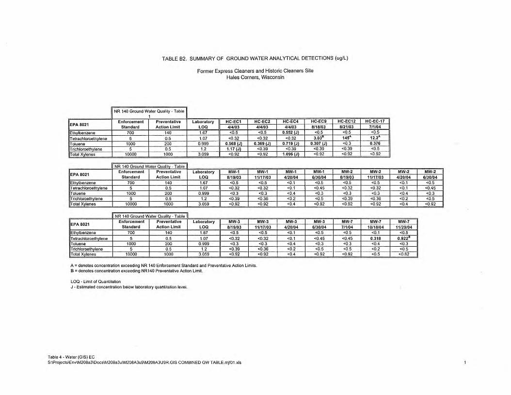
TABLE B2. SUMMARY OF GROUND WATER ANALYTICAL DETECTIONS (ug/L)
Former Express Cleaners and Historic Cleaners Site Hales Corners, Wisconsin
NR 140 Ground Waler Quality - Table 1
Enforcement Preventative Laboratory HC-EC1 HC-EC2 EPA 8021 Standard Action Limit LOQ 4/4/03 4/4/03 Ethvlbenzene 700 140 1.67 <0.5 <0.5
T etrachloroethylene 5 0 .5 1.07 <0 .32 <0.32 Toluene 1000 200 0.999 0.568 (J) 0.369 (J) Trichloroethylene 5 0.5 1.2 1.17 (Jl <0.39 Total Xylenes 10000 1000 3.059 <0.92 <0.92
NR 140 Ground Waler Quality - Table
EPA 8021 Enforcement Preventative Laboratory MW-1 MW-1
Standard Action Limit LOQ 8/19/03 11/17/03 Ethylbenzene 700 140 1.67 <0.5 <0.5 Telrachloroethvlene 5 0.5 1.07 <0.32 <0.32 Toluene 1000 200 0.999 <0.3 <0.3 Trichloroelhvlene 5 0.5 1.2 <0.39 <0.36 Total Xvlenes 10000 1000 3.059 <0.92 <0.92
NR 140 Ground Waler Quality - Table
EPA 8021 Enforcement Preventative Laboratory MW-3 MW-3
Standard Action Limit LOQ 8/19/03 11/17/03 Ethvlbenzene 700 140 1.67 <0.5 <0.5
T etrachloroelhvlene 5 0.5 1.07 <0.32 <0.32 Toluene 1000 200 0.999 <0.3 <0.3 Trichloroelhvlene 5 0.5 1.2 <0.39 <0.36 Total Xylenes 10000 1000 3.059 <0.92 <0.92
A= denotes concentration exceeding NR 140 Enforcement Standard and Preventative Action Limits. B = denotes concentration exceeding NR 140 Preventative Action Limit.
LOQ - Limit of Quantitation J - Estimated concentration below laboratory qualllilalion level.
Table 4 - Waler (GIS) EC S:\Projects\Env\M208a3\Docs\M208a3u\M208A3u9\M208A3U9R.GIS COMB IN ED GW T ABLE.mjf01 .xls
HC-EC4 HC-EC9 4/4/03 8/18/03
0.552 IJl <0.5
<0.32 3.038
0.719 IJl 0.307 (Jl <0.39 <0.39
1.096 IJl <0.92
MW-1 MW-1 4/20/04 6/30/04
<0.1 <0.5 <0.1 <0.45 <0.4 <0.3 <0.2 <0.5 <0.4 <0.92
MW-3 MW-3 4/20/04 6/30/04
<0.1 <0.5
<0.1 <0.45 <0.4 <0.3 <0.2 <0.5 <0.4 <0.92
HC-EC12 8/21/03
<0.5 145A <0.3 <0.39 <0.92
MW-2 8/19/03
<0.5 <0.32 <0.3
<0.39 <0.92
MW-7 7/1/04 <0.5
<0.45 <0.3 <0.5
<0.92
HC-EC-17 7/1/04 <0.5 12.2A 0.376 <0.5 <0.92
MW-2 MW-2 MW-2 11/17/03 4/20/04 6/30/04
<0.5 <0.1 <0.5 <0.32 <0.1 <0.45 <0.3 <0.4 <0.3 <0.36 <0.2 <0.5 <0.92 <0.4 <0.92
MW-7 MW-7 10/18/04 11/29/04
<0.1 <0.5
0.318 0.9228
<0.4 <0.3 <0.2 <0.5 <0.5 <0.82

~2 <jC:'S04l WW-2 (O/J0/04)
(voe IND I ---u )> ;o 7'
z G")
HC-[C2
C) ,, > ~a
"'r ~o ~I
RADIO SHACK (5628)
FIRST LADY NAILS (5630)
BASKIN ROBBINS (5632)
MINUTEMAN PRESS I (5634)
I
I fT1 ,,
~v, u, r l/l 0, 0 > ,;, "l) r r ~o ~-<
"l) u, OJ --< ~ t;;! n ► ~c r
=< l/l C "l) "l)
~
MH @--
--< ~,, ~~ _z ~> z
0
I 0 OJ OJ -< U) --< 0 ,, f"'l
PARK ING
"U
'< r ~f"'l "'l/l "' U)
0 U) ~I
0 f"'l
0 z 0 ►
~~ ~" "'fT1 0, 0 0 ,, 0
~ .... "'7'l ~c ;o ,, rn z fT1 ::;
C (/)
0
,, fT1
C ,, 0 f"'l
HC-EC-11 (8/12/0J) ORY-NO SN.4PL[
HC-EC- 11 1 04) CB ORY-NO SAl,IPL[ •·• 0,,-------
- ~> . - r . ----• t.C - CP - 2 HC -CP..--::::--~ / '
- - --~H ______ _.,,-
'>""=.:.::..,.c7,__1:i.;04) :RY-:: :.t:tcOJ) Off'l'-NO SAWPL[
ALLEY ~~~-----i---------------------
· - - - -1 ·- ·- ·- ·- - ·- - - -- ·- ·- - - ---
r -- -- t_=-=-----~=----=-=---/ /' NOTE;
1. MAP ADAPTED FROM WAH YEE ASSOCIATES, FLOOR PLAN AND ELEVATION & CANOPY DETAILS, DATED FEBRUARY 4, 19H. 2. UNLESS OTHERWISE NOTED ADDRESSES ARE LOCA TED ON SOUTH 108TH STREET. 3. A - EXCEEDS NR 140 ENFORCEMENT STANDARDS B - EXCEEDS NR 140 PREVENTATIVE ACTION LIMITS
4. PCE - TETRACHLOROETHYLENE EB - ETHYLBENZENE voe - VOLATILE ORGANIC COMPOUNDS ND - NON DETECT (J) - ESTIMATED CONCENTRATION BELOW LABORATORY QUANTITATION LEVEL
o·
LEGEND
-$-HC-ECI/
MWl
• HC-EC2 MH
0 CB
0
~ l8)
MW-6
MIJ-6
@)
N
I SCALE: 1" 30'
15' 30' 60'
GEOPROBE BORING AND MONITORING WELL LOCATIONS
GEOPROBE BORING LOCATIONS
SE\JER MANHOLE LOCATION
CATCH BASIN
8" WATER MAIN
GAS MAIN
TELEPHONE LINES
STORM SEWER
UNDERGROUND ELECTRIC
APPROXIMATE PROPERTY BOUNDARY
SEGMENTED BASEMENT
DIRECTIONAL WELL SURF ACE EXPRESSION
DIRECTIONAL \JELL SCREENED INTERVAL
DIRECTIONAL WELL
Mannlk°'J Smith Group,liic.
/SJOOAoc..d.Drin,Sialta.11¥ ~.wat,- 41110 T. :(JIJ)171•111J
FIGURE B4 SUUIIIKI <J GROUND WATER .IW.LYIK'& Rf:SlUS (ug/l)
FORMER EXPRESS CLEANERS 5260 S. 108TH STREET. HALES CORNERS, WI
041( 1 05
DRAWN BY D£SICN£D BY PROJECT NO. MJr MHZ M208AJU9(
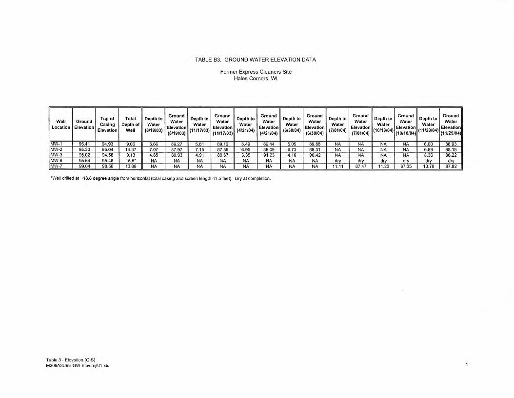
Top of Total Depth to Ground
Well Ground Water Location Elevation
Casing Depth of Water Elevation
Elevation Well (8/19/03) (8/19/03)
W-1 95.41 94.93 9.06 5.66 89.27 W-2 95.30 95.04 14.37 7.07 87.97 W-3 95.02 94.58 9.13 4.65 89.93 W-6 95.64 95.45 15.s• NA NA W-7 99.04 98.58 13.88 NA NA
TABLE B3. GROUND WATER ELEVATION DATA
Depth to Water
(11/17/03)
5.81 7.15 4.91 NA NA
Former Express Cleaners Site Hales Corners, WI
Ground Depth to
Ground Depth to
Water Water Elevation
Water Elevation
Water
(11/17/03) (4/21/04)
(4/21/04) (6/30/04)
89.12 5.49 89.44 5.05 87.89 ·6.95 88.09 6.73 89.67 3.35 91.23 4.16
NA NA NA NA NA NA NA NA
Ground Water
Elevation (6/30/04)
89.88 88.31 90.42
NA NA
·well drilled at -18.8 degree angle from horizontal (total casing and screen length 41.5 feet). Dry at completion.
Table 3 • Elevation (GIS) M208A3U9E.GW Elev.mjf01 .xls
Depth to Ground
Depth to Ground
Depth to Ground
Water Water Water Water
Elevation Waler
Elevation Water
Elevation (7/01/04)
(7/01/04) (10/18/04)
(10/18/04) (11/29/04)
(11/29/04)
NA NA NA NA 6.00 88.93 . . NA NA NA NA 6.89 88.15 NA NA NA NA 8.36 86.22 dry dry dry dry dry dry
11 .11 87.47 11.23 87.35 10.76 87.82
NR 4400-202 (rev. IO _29-02) Page l WDNR BRRTS CASE# 02 -41 - 530534 WDNR SITE NAME: Historic Cleaners - Hales Comers, WI DNR FID#: 34109955
WISCONSIN DEPARTMENT OF NATURAL RESOURCES Case Summary and Close Out Form
The Case Summary and Close Out Form is designed to provide responsible parties, environmental consultants, Department staff, and other interested persons with instructions and a list of infonnation that must be submitted for evaluation for case closure. The closure of a case means that the Department has determined that no further response is required at that time based on the information that has been submitted to the Department. Responsible parties and their consultants should specify which option for closure has been selected for the soil and groundwater at the site. Groundwater quality standards found in ch. NR 140 and soil standards found in ch. NR 720 must generally be met. However, NR 726 has an option for case closure where standards are not met, if an institutional control is applied, such as placing the site on the GIS Registry of Closed Remediation Sites or requiring the recording of a deed restriction. Where natural attenuation is the final remedy for Voluntary Party Liability Exemption (VPLE) sites, pollution liability insurance is required to be purchased as a condition of receiving the liability exemption certificate of completion at the time that a case is closed. See RR Publication RR-606 "Guidance on Case Close Out and the Requirements for Institutional Controls and VPLE Environmental Insurance" .
In order to expedite the closure process, you should provide a complete and accurate closure package according to the following instructions. Submit the Case Summary and Close Out Form and the required attachments as a stand-alone package. Please do not submit the close out request or attachments in a bound report. All maps should be no larger than 8.5 x 14 inches except maps that are submitted in electronic form in portable document format (pdf) readable by the adobe acrobat reader. For electronic document submittal requirements, see http://www.dnr.state.wi.us/org/aw/rr/archives/pubs/RR690.pdf. Please do not use shading or highlights on any of the analytical tables and maps as the shading obscures the information that is scanned for inclusion in the GIS Registry. Instead, you may use a bold font on information of importance. If more than one table is submitted for contaminated media data (eg. pre- and post-remedial data) please put them in chronological order. Include the level of detection for results which are below the detection level (i.e. do not just list as ND). Tabulate all data in the format specified in ss. NR 716.15(2)(g)3 and 716.15(2)(h)3. (Do not submit lab data sheets unless these have not been submitted in a previous report.) If applicable, document free product recovery estimates as required ins. NR 708 .15 . All GIS Registry information (in section B) is to be included with this package at the time it is submitted to the department in order for the application to be considered complete. If a deed restriction or deed notice is required as a condition of closure of the selected remedy, include a draft of the document with the close out application.
NOTE: Completion of this form is mandatory for applications for case closure pursuant to ch. 292, Wis. Stats. and ch. NR 726, Wis. Adm. Code, including cases closed under ch. NR 746 and ch. NR 726. The Department will not consider, or act upon your application, unless all applicable sections are completed on this form and the closure fee and any other applicable fees , required under ch. NR 749, Wis. Adm. Code, Table 1 are included. It is not the Department's intention to use any personally identifiable information from this form for any purpose other than reviewing close out requests and determining the need for additional response action.
Wisconsin Department of Natural Resources P.O. Box 792 1, Madison, WI 53707
NR 4400-202 (rev.10_29-02) Page 2 WDNR BRRTS CASE# 02 - 41 - 530534 WDNR SITE NAME: Historic Cleaners - Hales Corners, WI DNR FID#: 34109955
I certify that, to the best ofmy knowledge, the information presented on.and attached to this form is true and accurate. This recommendation for case closure is based upon all available data as of 12/31/2004. I have read the Case Summary and Close Out Form instructions and I required information has been included.
Form Completed By: ---..L....t.:....==....:....,,=-.::::,.___._ __ ==---'--=:::'--------------------(Signature) (Date)
_X_ $750.00 Closeout Review Fee Attached __ $250.00 GIS Registry Maintenance fee GW sites Fee Attached _X_ $200.00 GIS Registry Maintenance fee for Soil sites Fee Attached
Printed Name: Thomas P. Cok Company Name: The Mannik & Smith Group. Inc.
Email address: [email protected]
If not site owner, relationship to site owner: environmental consultant
Address: 15300 Rotunda Drive. Suite 306 Dearborn. Michigan 48120
Telephone Number: (113) 271-2223 FAX Number: (113) 271-3076
Environmental Consultant (if different then above): _______________________ _
Address: _____________________________________ _
Tele hone Number: FAX Number:
The following items should be included in the order shown (if any item is not included, please attach an explanation as part of attachment A): ·
1\. .. 1\._ JJrtf:f'\"1'\--i1-ten Case Iri~tory shOl!!d be atts:.::hed is 1\ttachn"irnt 1\ th:11 _ir.rindt·-·:: t_},~-- f.':-·,,:,(~tHfY~:: :)1:;!~•-nary
from the Site Investigation Report, a succinct summary of any investigative activities conducted subsequent to the Site Investigation Report, and a summary of the interim and remedial actions taken at the site and the justification for case closure. The summary should also specify the pathway to closure requested for both the soil and groundwater as specified in section H of the form and include a description of any residual contamination in soils or groundwater and their locations on the property(s) within the contamination site boundaries. Submission of ~balatcd analytic~! results from previGas reports is acceptable (i.e., it is not neccssa;y to crcat(; new tz.!.ik~). D0 n0~ attach previously submitted reports, but please make sure you correctly reference these reports in the case summary as applicable. 1. Site Name: Historic Cleaners
StreetAddress: 5606 South 108th Street City: Hales Comers. _________________________________ -,-
2. BRRTS #: 02-41-530534 3. DNR FID #: 34109955 PECF A Claim#: NA 4. Responsible Party Name & Complete
Address: Malan Liquidating Trust 30200 Telegraph Rd. Bingham Farms. MI 48025
5. Date of Incident/Discovery: Contaminant Type(s): PCE, Methylene Cl. Chloromethane 6. Quantity Released: =u=nkn=o~wn~------------------------7. Post Remedial Zoning Classification: non-industrial land use (do not abbreviate zoning
terms) 8. Method Used to Obtain GPS Coordinates:__ On-site using GPS Locator converted or projected onto
WTM83/91 _K__Using RR GIS Registry web site to get WTM83/91 coordinates __ Other (specify):
- - -· ·-----··"'------·-·. -9. On _Y __ x.__1-.; m· Ofi.'_Y _X._N Source Property Grou11owater Contnmmation Remaining (>ES) 10. On _x_ Y N or Off_ Y _x_ N Source Property Residual Soil Contamination> Generic or Site-Specific RCL?

NR 4400-202 (rev. IO_ 29-02) Page 3 WDNR BRRTS CASE# 02 - 41 - 530534 WDNR SITE NAME : Historic Cleaners - Hales Comers, WI DNR FID#: 34109955
11. Contamination in Right of Way: __x_ X N
B. Required Site Information and GIS Registry Information to be included as attachment B to this form in the following order (allows for efficient data entry by DNR staff):
1. Copy(s) of most recent deed, including legal description(s), for all affected properties within or partially within contaminated site boundary. (NOTE: If a property has been purchased with a land contract and the purchaser has not yet received a deed, a copy of the land contract which includes the legal description shall be submitted instead of the most recent deed. If the property has been inherited, written documentation of the property transfer should be submitted along with the most recent deed.)
2. A copy of certified survey map(s), as required bys. NR 716.15(2)(i)(2), or the relevant section of the recorded plat map for those properties where the legal description in the most recent deed refers to a certified survey map or a recorded plat map (lots on subdivided or platted property (e.g., lot 2 ofxyz subdivision).
3. The parcel identification number (if county uses them) for each property within the contaminated site boundaries. Include the address of each property within the contaminated site boundary (regardless of whether parcel id# exists). Geographic position data for each property (meters in WTM83/91 projection) in compliance with the requirements ofs. NR 716.15 (2)(k), unless this information was previously submitted to the agency with administrative authority for the site as part of the site investigation report, or unless the agency with administrative authority has directed that the responsible party does not need to provide geographic position data for a specific site.
4. A site location map which outlines all properties within the contaminated site boundaries on a U.S.G.S. topographic map or plat map in sufficient detail to permit the easy location of all parcels. If groundwater standards are exceeded, the map must also include the location of all municipal and potable wells within 1200 feet of the site. (If only one property, combine with map required in next item #5.)
5. A map of contaminated properties within the site boundary showing buildings, roads, property boundaries, contaminant sources, utility lines, monitoring wells and potable wells. This map shall also show the location of all contaminated public streets, and highway and railroad rights-of-way in relation to the source property and in relation to the boundaries of groundwater contamination exceeding ch. NR 140 enforcement standards, and/or in relation to the boundaries of soil contamination exceeding generic or site-specific residual contaminant levels as determined under s. NR 720.09, 720.11 and 720.19.
6. A table of the most recent analytical results, with sample collection dates from all monitoring wells, and any potable wells for which samples have been collected for groundwater, and/or showing results for all contaminants found in pre-remedial sampling and in the most recent soil sampling event, for soils (without shading or crosshatching). (Note occurrence of free product.)
7. An isoconcentration map, ifrequired as part of the site investigation (SI), of the contaminated properties within the site boundaries. The map must include the areal extent of groundwater contamination exceeding PALS and the areal extent of groundwater contamination exceeding ESs, groundwater flow direction( s) based on the most recent data, and sample collection dates. If an isoconcentration map was not required as part of the SI, substitute a map showing the horizontal extent of contamination, based on the most recent data. Note free product location(s).
8. A table of the previous 4 water level elevation measurements from all monitoring wells, at a minimum, with the date measurements were made, is to be included. (If present, free product elevation and thickness is to be noted on the table.)
9. A groundwater flow direction map representative of groundwater movement at the site. If the flow direction varies by more than 20° over the history of the site, 2 groundwater flow maps showing the maximum variation in flow direction are to be submitted. (Maps should be prepared according to the applicable portions of ss. NR 716.15(2)(g)5-8 and 716.15(2)(h)l-2.) .
10. For sites closing with residual soil contamination, include a map showing the location of all soil samples and a single contour showing the horizontal extent of each area of contiguous residual soil contamination that exceeds generic or site specific residual contaminant levels.
11. A geologic cross section, if required as part of the SI, showing vertical extent and location of residual soil contamination exceeding generic or site specific RCLs and residual groundwater contamination, source extent and location, isoconcentrations for all groundwater contaminants that exceed P ALs that remain when closure is

NR 4400-202 (rev. IO_ 29-02) Page 4 WDNR BRRTS CASE# 02 - 41 - 530534 WDNR SITE NAME: Historic Cleaners - Hales Corners, WI DNR FID#: 34109955
requested; water table and peizometric elevations, and the location and elevation of geologic units, bedrock, and confining units, if any.
12. A statement signed by the responsible party, which states that he or she believes that the legal description has been attached for each property that is within, or partially within, the contaminated site boundary. (The point here is that a legal description for each of the contaminated properties has been submitted. The RP is not required to attest to the accuracy of the attached legal descriptions.)
13. A copy of the letters sent by the RP to all owners of properties with groundwater exceeding ESs (including the current source- property owner, if the RP is not the current source-property owner) as required by s. NR 726.05(3)(a)(4)(g). (Off source properties are listed separately on the GIS Registry with a link to the source property.) Letters must contain standard provisions of Appendix A of ch. NR 726.
14. A copy of all written notifications provided to the City/village/municipal/state agency or other entity responsible for maintenance of a public street or highway or railroad right-of-way, within or partially within the boundaries of the contaminated site, for contamination exceeding groundwater ESs and/or soil exceeding generic or site specific RCLs.
C. RECEPTORS 1. Identify all pre-remedial actual receptors, the assessed risk and their locations (e.g., both on- and off-site utility
corridors, basements or sumps of nearby buildings, direct contact threat from soil, water supplies, surface waters, sediments, etc.) (For definitions, refer to s. NR 700.03 (47), Wis. Adm. Code): Risk from soil to
ground water transmission to human and animal ingestion.
2. Have the remedial actions addressed the potential or actual impacts to these receptors? ___J5_ Y __ N If no, provide details in case history summary. If yes, please identify the nature of the remaining risk and the receptor at risk, if any The remaining risk at the Site is from soil to ground water transmission to human and animal ingestion
D. SOIL INVESTIGATION INFORMATION
1. Extent Defined? ..JL_Y __ N If not, explain why?
2. Soil Type(s): silty clay Depth of Contamination: ~0.5' - 11' below ground surface 3. Type of Bedrock: dolomite and shale Depth to Bedrock: ~70' bgs 4. Is Any Contaminated Soil (Unsaturated or Saturated) in Contact With the Bedrock? __ Y _LN 5. List All Contaminants Found in Soil (Regardless of ch. NR 720 standards/attach table as part of attachment D
if necessary: see Tables in Attachment D 6. Measurable Free Product? _Y _x_ N Depth/Location: NA 7. Attach the Following Maps to this Form as Attachment D:
a. Pre-Remedial Soil Sample Location Map(s) that depict all soil sample locations relative to site facilities. Note in bold font those sample locations that exceed ch. NR 720 (including free product location) and identify the extent of contamination. Maps should be prepared according to the applicable portions of s. NR 716.15(2) (h) 1. You may submit more than one map, for example various contaminant isoconcentration maps.
b. Pre-Remedial Geologic Cross Section(s) including source location(s), extent of soil and groundwater contamination, free product location/depth, soil sample locations, water table elevation, and bedrock elevation, if encountered. Maps should be prepared according to the requirements in ss. NR 716.15(2)(g)5-8 and 716.15(2)(h)l-2.
E. SOIL REMEDIATION INFORMATION
1. Remedial Action Completed? J_ Y __ N s. NR 720.19 Analysis? __ Y _L N If yes, Attach supporting documentation as Attachment E.
2. Were Immediate or Interim Actions Conducted? __y_ X N If yes, what action was taken? ______________ _
3. Brief Description of Remedial Action Taken: GIS Registy/Deed Restriction details are included in Attachment E.
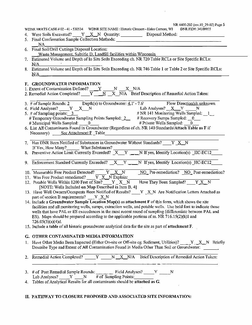
NR 4400-202 (rev.10_29-02) Page 5 WDNR BRRTS CASE# 02 -41 - 530534 WDNR SITE NAME: Historic Cleaners - Hales Comers, WI DNR FID#: 34109955
4. Were Soils Excavated? __ Y _LN Quantity:____ Disposal Method: ________ _ 5. Final Confirmation Sample Collection Methods: ____________________ _
NA 6. Final Soil/Drill Cuttings Disposal Location:
Waste Management, Subtitle D, Landfill facilities within Wisconsin 7. Estimated Volume and Depth ofln Situ Soils Exceeding ch. NR 720 Table RCLs or Site Specific RCLs:
NIA 8. Estimated Volume and Depth ofln Situ Soils Exceeding ch. NR 746 Table 1 or Table 2 or Site Specific RCLs:
NIA
F. GROUNDWATERINFORMATION 1. Extent of Contamination Defined? ___:t_ __ N _X_N/A 2. Remedial Action Completed? __ Y __N _X_N/A Brief Description of Remedial Action Taken:
3. # of Sample Rounds: 2 Depth(s) to Groundwater: 1,1' - 7.6' Flow Direction(s): unknown 4. Field Analyses? __ Y _ X_N Lab Analyses? _x_ Y __ N 5. # of Sampling points:_3_ # NR 141 Monitoring Wells Sampled: _l_
# Temporary Groundwater Sampling Points Sampled:_2_ # Recovery Sumps Sampled: _ O_ # Municipal Wells Sampled: __ 0__ # Private Wells Sampled: _0_
6. List All Contaminants Found in Groundwater (Regardless of ch. NR 140 Standards/Attach Table as F if Necessary) See Attachment F _Table _______________________ _
7. Has DNR Been Notified of Substances in Groundwater Without Standards? __ Y _LN If Yes, How Many? ___ What Substances? ____________________ _
8. Preventive Action Limit Currently Exceeded? _X_Y ~N If yes, Identify Location(s) ~HC-EC12 __
9. Enforcement Standard Currently Exceeded? _X_Y __ N If yes, Identify Location(s) _HC-ECI2 __
10. Measurable Free Product Detected? __ Y J_N NO Pre-remediation? _NO Post-remediation? 11. Was Free Product remediated? __ Y _LN Explain: __________________ _ 12. Potable Wells Within 1200 Feet ofSite? __ Y _X_N Have They Been Sampled? __ Y_lLN
[NOTE: Wells Included on Map Described in Item B. 4] 13. Have Well Owners/Occupants Been Notified ofResults? __ Y _lLN Are Notification Letters Attached as
part of section B requirements? _Y _lLN 14. Include a Groundwater Sample Location Map(s) as attachment F of this form, which shows the site
facilities and all monitoring wells, sumps, extraction wells, and potable wells. Use bold font to indicate those wells that have PAL or ES exceedances in the most recent round of sampling ( differentiate between PAL and ES). Maps should be prepared according to the applicable portions of ss. NR 716.15(2)(h) 1 and 726.05(3)(a)(4)d.
15. Include a table of all historic groundwater analytical data for the site as part of attachment F.
G. OTHER CONTAMINATED MEDIA INFORMATION
1. Have Other Media Been Impacted (Either On-site or Off-site eg. Sediment, Utilities)? __ Y _LN Briefly Describe Type and Extent of All Contamination Found in Media Other Than Soil or Groundwater:
2. Remedial Action Completed? __ Y __ N J_N/A Brief Description of Remedial Action Taken:
3. # of Post Remedial Sample Rounds: ____ Field Analyses? __ Y __ N Lab Analyses? __ Y __ N # of Sampling Points: ___ _
4. Tables of Analytical Results for all contaminants should be attached as G.
H. PATHWAY TO CLOSURE PROPOSED AND ASSOCIATED SITE INFORMATION:
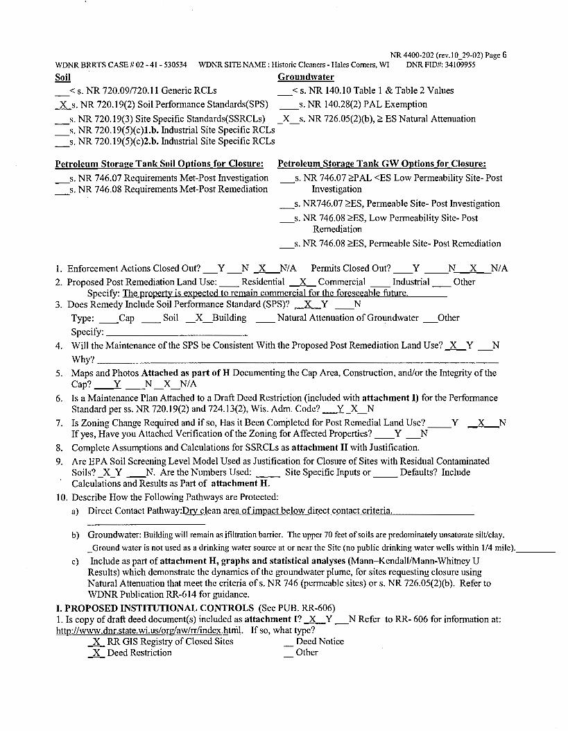
NR 4400-202 (rev.10_29-02) Page 6 WDNR BRRTS CASE# 02 - 41 - 530534 WDNR SITE NAME: Historic Cleaners -Hales Comers, WI DNR FID#: 34109955
Soil
< s. NR 720.09/720.11 Generic RCLs
_.X_s. NR 720.19(2) Soil Performance Standards(SPS)
Groundwater
< s. NR 140.10 Table 1 & Table 2 Values
__ s. NR 140.28(2) PAL Exemption
_s. NR 720.19(3) Site Specific Standards(SSRCLs) _X_s. NR 726.05(2)(b), ~ ES Natural Attenuation _s. NR 720.19(5)(c)l.b. Industrial Site Specific RCLs _s. NR 720.19(5)(c)2.b. Industrial Site Specific RCLs
Petroleum Storage Tank Soil Options for Closure:
_s. NR 746.07 Requirements Met-Post Investigation _s. NR 746.08 Requirements Met-Post Remediation
Petroleum Storage Tank GW Options for Closure:
_s. NR 746.07 ~AL <ES Low Permeability Site-Post Investigation
_s. NR746.07 ~ES, Permeable Site- Post Investigation
_s. NR 746.08 ~ES, Low Permeability Site- Post Remediation
_s. NR 746.08 ~ES, Permeable Site- Post Remediation
1. Enforcement Actions Closed Out? _Y _N 3_N/ A Permits Closed Out? y N X NIA 2. Proposed Post Remediation Land Use: __ Residential _L Commercial __ Industrial __ Other
Specify: The property is expected to remain commercial for the foreseeable future. 3. Does Remedy Include Soil Performance Standard (SPS)? _LY __ N
Type: __ Cap __ Soil _X_Building __ Natural Attenuation of Groundwater _Other Specify: ___________ _
4. Will the Maintenance of the SPS be Consistent With the Proposed Post Remediation Land Use? .JL.... Y _N Why? __________________________________ _
5. Maps and Photos Attached as part ofH Documenting the Cap Area, Construction, and/or the Integrity of the Cap? ____.:t_ __ N _X_N/A
6. Is a Maintenance Plan Attached to a Draft Deed Restriction (included with attachment I) for the Performance Standard per ss. NR 720.19(2) and 724.13(2), Wis. Adm. Code? __s_ _ X _ N
7. Is Zoning Change Required and if so, Has it Been Completed for Post Remedial Land Use? __ Y If yes, Have you Attached Verification of the Zoning for Affected Properties? __ Y _N
8. Complete Assumptions and Calculations for SSRCLs as attachment H with Justification.
X N
9. Are EPA Soil Screening Level Model Used as Justification for Closure of Sites with Residual Contaminated Soils?_ X _ Y __ N. Are the Numbers Used: __ Site Specific Inputs or __ Defaults? Include Calculations and Results as Part of attachment H.
10. Describe How the Following Pathways are Protected:
a) Direct Contact Pathway:Dr:y clean area of impact below direct contact criteria.
b) Groundwater: Building will remain as ifiltration barrier. The upper 70 feet of soils are predominately unsaturate silt/clay.
_Groundwater is not used as a drinking water source at or near the Site (no public drinking water wells within 1/4 mile). ___ _
c) Include as part of attachment H, graphs and statistical analyses (Mann-Kendall/Mann-Whitney U Results) which demonstrate the dynamics of the groundwater plume, for sites requesting closure using Natural Attenuation that meet the criteria of s. NR 746 (permeable sites) ors. NR 726.05(2)(b). Refer to WDNR Publication RR-614 for guidance.
I. PROPOSED INSTITUTIONAL CONTROLS (See PUB. RR-606) 1. Is copy of draft deed document( s) included as attachment I? .JL.._ Y _N Refer to RR- 606 for information at: http://www.dnr.state.wi.us/org/aw/rr/index.htnil. If so, what type?
_x_ RR GIS Registry of Closed Sites Deed Notice _x_ Deed Restriction Other

NR 4400-202 (rev.10_29-02) Page 7 WDNR BRR TS CASE# 02 - 41 - 530534 WDNR SITE NAME : Historic Cleaners - Hales Comers, WI DNR FID#: 34109955
FOR DEPARTMENT USE ONLY
PROJECT MANAGER: _______________ Date Reviewed: _______ _
FIRST REVIEW DATE: ______ _ [ ] Approved [ ] Denied
(Signature) (Signature)
SECOND REVIEW DATE: _____ _
(Signature) (Signature)
COMMITTEE RECOMMENDATION: __ Closure Approved With:
No Restrictions __ Listing on GIS Registry __ Zoning Verification
Deed Restriction Deed Notice
__ Site Specific Close Out Letter Well Abandonment Documentation
__ Soil Disposal Documentation
(Signature)
] Approved [ ] Denied
(Signature)
(Signature)
(Signature)
__ NR 140 Exemption For: ______________________ _ Other Conditions/Comments: ____________________ _
Closure Denied, Needs More: __ Investigation __ Groundwater Monitoring
Soil Remediation Groundwater Remediation
__ Documentation of Soil Landspreading or Biopile Destiny __ Specific Comments: ________________________ _
ATTACHMENT A
BRIEF WRJITEN CASE HISTORY
THE MANNIK & SMITH GROUP, INC.

ATTACHMENT A: Brief Written Case History
This Brief Written Case History for the Historic Dry Cleaner located at 5606 South 108th Street, Hales Corners, Wisconsin (Site) was prepared for Malan Realty Investors, Inc. (Malan) and is being submitted on behalf of Malan to the Wisconsin Department of Natural Resources (WDNR) by The Mannik & Smith Group (MSG). The Case Closure Report, which this case history was summarized from, was prepared in general accordance with Chapter NR 716 and Chapter NR 726 of the Wisconsin Administrative Code (WAC) and applicable technical guidance documents, as referenced herein. Applicable public health and environmental laws, including NR 700 to NR 746 have been satisfied at the Site and are documented within this report.
The Historic Dry Cleaner Site is located within the Country Fair Shopping Center (CFSC) at tenant space 5606. Another former dry cleaner, the Express Cleaners, was also located in the CFSC, at the 5620 tenant space. A site investigation for the Express Cleaners site reported in the MSG Site Investigation Report dated April 29, 2003, identified the Express Cleaners site as a source of a dry cleaning solvents (tetrachloroethylene a.k.a. PCE) impacting soil beneath its former tenant space.
A supplemental site investigation (SSI) was initiated at the CFSC during the course of which, the Historic Dry Cleaner was identified as an additional source of PCE in soil. Results of the SSI pertaining to the Historic Dry Cleaner are presented in this report in support of case closure.
PCE concentrations in soil associated with the Historic Dry Cleaner exceed risk based screening values protective of ground water and ingestion. PCE concentrations detected in ground water samples collected from two temporary wells have also exceeded the NR140 Preventative Action Limit and Enforcement Standard; however, samples results from a permanent monitoring installed at one of the temporary well locations were below laboratory detection limits.
The predominant soil encountered in borings was a stiff to very stiff silt/clay. Ground water of limited extent was encountered in discontinuous sand lenses and utility corridor backfill within the silt/clay soils.
Technical assistance meetings were held with WDNR on May 25, 2004 and August 5, 2004, to. discuss the status of the SSI and request guidance on the investigative needs to bring the site(s) to closure. The SSI concurrently completed the investigation requirements for both the Historic Dry Cleaner and the former Express Cleaners sites. Based on guidance obtained during the technical assistance meetings, institutional controls are the proposed remedy to bring both the Historic Dry Cleaner and Express Cleaners sites to closure.
The proposed institutional controls for the Historic Dry Cleaner consist of placing the property on the GIS Registry of Closed Remediation Sites and placing a land use ( deed) restrictions on the CFSC property parcel. The deed restriction will require the CFSC building and pavement to be maintained as a direct contact and filtration barrier.
The Historic Dry Cleaner and former Express Cleaners have similar impacts and are located on the same parcel of property (CFSC Parcel II). The proposed institutional controls are applied to the sites jointly over the entire CFSC Parcel II (note: the deed restriction would also require maintenance of a vapor mitigation system in the former Express Cleaners tenant space). The supporting closure documentation including the GIS registry package, and WDNR Case Summary and Close Out Form with draft deed restriction for the Historic Dry Cleaner and former Express Cleaners sites are being submitted to the WDNR simultaneously with this report.

ATTACHMENT D
SOIL INVESTIGATION INFORMATION
THE MANNIK & SMITH GROUP, INC.

TABLE 01 . SUMMARY OF SOIL SAMPLE ANALYTICAL DETECTIONS (mg/kg)
US EPA Soil Saeornng le"ell
Amblen1 SoN lo SB1 .. , .. , i£PAI021 lngHt.lon • Volat.la. GrouDd ll .5-41 IJ-3.51 fJ .J.51
lnh,1laUon • Water• 11/15102 11115102 11/15102 IChloromelhane 4'0 04 0.0029 <0025 <O 025 <0025 Melhvlene CNcricle 763 25 0.0016 <0.025 <0.025 <0.025
TetrachlotoelhlMlne 1.23 2 11 004 1 ,.,
1.- 1.5" TrichloroelhVlene 5 81 0 .85 0037 <0.025 <0.025 <0.025
U:,; EPA Soil :,;crooning Levell
AmbMlnt Soll to HC.£C10 HC.£C10 HC-E.C1D EPA 1021 Ln91alion • Volatile GrOYnd 12-4) (1-11 (12-141
Inhalation• Watar' 8/21/03 8/21/03 1121/03 Chloromelhana 440 0 .4 0.0029 <0025 CSH <0.025 CSH <0.025 CSH Meth Iona Chloride 763 ,. 00016 <0025 <0.025 <0.025 Tetrachloroelhlliene 1.23 2.11 0.04 1 ,,. 27.4"' <0.025 Trichloroethvlona '" 0.85 0.037 <0 025 <0 025 <0.025
US EPA Soil Screening level&
Ambiant SoUto HC-E.C15 HC-E.c:;15 HC<C1S !EPAl021 ln911Uon • Volali l1 Ground 12◄1 11-11 112-141
Inhalation• Water ' lf21f03 1121/03 1121/0J fehloromethane 440 0.4 0 .0029 <0.025 CSH <0.025 CSH <0.025 CSH
Mothv1Gnl Chloride 763 2.S 0 .0016 <0025 <0.025 <0.025 Tetrachlome\hlllene 123 2.11 0 .041 11., .. JU" 0.115 Tnchloroethv1ene '" 0.85 0037 <0025 <0025 <0025
US EPA Soil Screening l evels
Ambi•nt Soil to HAl HAl ...... EPA 1021 lng•ation • Volalil• Ground O.S-1 ft. 3.5-4 fl 0.5-1 fl
Inhalation • Watar • 111/04 111/04 911104
hloromelhan• 440 " 00029 <O 025 <0.025 <0.025 Meth lon1 Chloride 763 25 0.00 18 <O 025 <0025 <0 025
Tetrachlomelh.A•ne 123 2 11 0.04 1 0.0284 0.07" 0.0841 ... Trichl0f0elh-vlen1 • 81 0 •• 0.037 <0,025 <O 025 <0.025
' Value• denved lrom Ille USEPA So~ Screenl/"lg websile u linQ W1K00Sln Hon•lnduslriel delauU p•rameters
A • denote& paramele1& e.ceoding USEPA Sod Screoning level& IDf S011 lo Ground Water
HC-GPt HC-GP2 (J• HC-GPJ (4 • !4-61 " " 41510] 415/03 415103
<0.025 <0.025 <0.025 0 .155A <0 025 <0025
<0.025 0.1105 <0025 <0.025 <O 025 <0.025
HC-E.C11 HC-E.C11 H~.£C11 12-41 11-11 (12-14)
ln1103 1121103 8/21/03 <0.025 CSH <0.025 CSH <0.025 CSH
<0.025 <0.025 <0.025 .,. 711.7 0.386 o.042r <0025 <0.025
HC-EC11 {10 HC-E.C11 HC-GP1
111 110-111 14-61
7/1/04 711/04 415103 <0.025 CSH.LCH <0.025 CSH,LCH <0.025
<0.025 <0.025 0.155 ...
0.161 <0.025 <0.025 <0025 <0025 <0.025
HA5 HAS HAI 1-1.5ft. 4.5-Sft. 1-1.5fL
111/04 111104 Q/1104
0.0808" 0.0778 <0.054g <O 0564 <00607 <O 054g
0.609" 1.57' <0.05411 <0025 <O 025 <0025
B • donolH paramuters ••ceoding USEPA Soil SaMn.ng Levels lot SOIi to Ground Waler and Soil Sa-eening Levels Jor lnges11on.
C • oenotes p;1rame1er1 e•ceod,og USEPA Soil Screening Levels lor So~ to Ground Water. Soil Screening Level• for- lngHtion, and Ambient Volatile Inhalation .
CSH • Check 1tandard lor thi& anllly\8 e•hiblled II high bi.it.a. Sample results mya alM> be biased high. CSL - Check standard lor 1111& analyle e•hlbiled a low 1>1&1 . Sample row!ts may allO be biased low. LCL • The labot'alory control &le lor lnis analyle e•hit:Mled a low bias. Sample reMilts may al50 be binod low.
Table 2 . Soll S·\Pro)8c15\En~\M208AJ\Ooc&\M208A3u9\M208AJU9R.GIS COMBINED SOIL TABLE 111fl01 .di
Former EKpress Cleaners and Historic Cleaners Site Hates Corners, Wisconsin
HC-EC1 HC-EC2 HC-ECJ HC-EC◄ (10 HC-ECS 1• ll-41 fl--11 ft2 •14I 121 II
4/4103 414/03 414/03 4/4/03 415103 <0.025 <0.025 <0.025 <O 025 <0025
<O 025 <0025 <0.025 <0025 <0.025
<O 025 <0.025 <0 .025 <0025 <0.025
<0.025 <0.025 <0.025 <0.025 <0.025
HC-E.C 12 HC-E.C12 HC-E.C12 HC-E.C12 HC.£C1l
14-61 c1-11 (8-10) 11 2-141 12-41 ll'21103 1121/03 ll'21/03 1'21103 1121/03
<0.025 CSH <0.025 CSH <0.025 CSH <0.025 CSH <0.025 CSH <0.025 <0.025 <0025 <0.025 <0.025
118 10.l"" 1.116 .. 0.2311 0.6111"'
0.0306 <0.025 <0025 <0.025 <0.025
HC-GP2 HC-GP3 HC-E.CS HC-ECI HC-E.CI /J-4\ 14-61 11-11 12◄1 16--8'
415103 415/0l 415103 1112/03 1112103
<0.025 <0.025 <0.025 .029 CSl.LCL.OU 025 CSL.LCL.OU
<O 025 <0.025 <0.025 <0.029 fCSl.LCLI <0.025 (CSL.LCL)
0.905" <0.025 <0.025 <0029 <D.025
<0.025 <0.025 <0025 <0025 <O 025
...... 4.S-5ft
1/1/04
0.0111" <00535
<O 0535 <O 025
HC-ECI HC-EC I HC-ECI HC-E.Ci HC-ECI HC-ECI 12-41 11-61 110-121 12-41 {10.12) 111-18'
1112103 1112103 8/12/03 1/12101 1112103 1112/0J c:Q ON CSL.LCL.OUP <0.025 CSL.LCL.DUP <O 025 CSL ,LCL.DUP <0.025 CSL.LCL.DUP <O 025 CSL,LCL,DUP <0.025 CSL LCL.OUP
<0.029 CSL.LCL l <0.025 ICSL.LCLl <O 025 fCSl .LCLl <O 025 ICSl LCLl <O 0 25 ICSL.LCLl <0.025 fCSL,LCll
<0029 <0025 <O 025 <0025 <0.025 <0.025 <0.029 <0025 <O 025 <O 025 <0025 <0.025
HC.£C13 ( Ii• HC-ECU {12 HC.£C14 HC-ECU HC.£C t◄ ... " 141 12-41 11-81 112.14i fEctdandl
1121103 1/21103 1l21/tl3 1121/0J 1/21103 <O 025 CSH <O 025 CSH <0.025 CSH <0025 CSH <0.025 CSH Unknown
<0.025 <0025 <O 025 <0.025 <0,025 Unknown
0.2113" <0.025 0.313 0 .086 c0.025 0.27 5"
<0.025 <0.025 <O 025 <0.025 <0.025 Unknown
HC-ECI HC.£CII HC-EC9 HC-E.CI HC-EC11 HC-E.C11 110-121 12-41 110-121 116-111 110-11\ 110-111
1112/03 1112/03 1/12/03 1112/0J 711/04 7/1104 <0.025 CSL.LCL,DUP <0.025 CSL.LCL.DUP <0.025 CSl ,LCL.OUP) <O 025 CSL.LCL.DUP <0.025 CSH <0.025 CSH
<O 025 fCSL.LCll <0.025 !CSL.LCLI <0.025 (CSL.LCU <O 025 (CSL LCLI <0.025 <0025
<0025 c0025 <O 025 <0.025 0.111" <0.025 <0025 <0025 <0.025 <0025 <0.025 <0.025

NOTE:
FIRST LADY NAILS (5630)
BASKIN ROBBINS (5632)
MINUTEMAN PRESS (5634)
_/ I ,.., :.,
~Vl u,,-mo ;;; "'C ~o
"'C ::!
~
~ --< ~~ ,... ,...
~-< ~z u,m ~► ~~ z
c:,
~§ I 0
Vl m C
m "'C -< "'C '-'l '< 0
1'1/1131 ;,J ,..,
PARKING
"'C c:,
~ 0 ~,-,... ~~ ~,..,
U1 Vl m Vl .s..., 0 Vl :., ~::c ,..,
0 ,.., ,..,
Vl 0 C :., n ,..,
HC-GP1
W.-1 17 ..,_,
4/04)
, '-"'-J=<=-"-' CB / ' 0,,,,.--
~ •-•- l~I r.~ ~ •111:~~MH //·~.,
~~ I - -- ~ -- ~--------tte-[C5 HC-C~IJIN-7 _ __.- - --;. . • 4 ,/0$) 3 4•4 (4/1/03)
' I 10'-11" (7/1/04) Pa:. D.905 A Y0C NII
~<4/5,: "" Ptt?"' ~----ALLEY __________________ _
~/ - - --:...-J: - - - _-;-_ - - ·- -=.-:-_ - - - -=.:-:... - - --,,,,.,, MC-Ctt7( .
/
1. MAP ADAPTED FROM WAH YEE ASSOCIATES, FLOOR PLAN ANO ELEVATION & CANOPY DETAILS, DATED FEBRUARY 4, 1974.
4. A - EXCEEDS USEPA SOIL SCREENING LEVELS FOR SOIL TO GROUNDWATER B - EXCEEDS USEPA SOIL SCREENING LEVELS FOR AMBIENT VOLATILE INHALATION
5. PCE - TETRACHLOROETHYLENE MC - METIHYLENE CHLORIDE voe - VOLATILE ORGANIC COMPOUNDS ND - NON DETECT 2. UNLESS OTHERWISE NOTED ADDRESSES ARE LOCATED ON SOUTH 108TH STREET.
3 . ASSUMED LOCATION OF ECKLAND BORING BASED ON ',1SUAL EVIOENCE OBTAINED BY MSG ON OCTOBER 1, 2002. ANALYTICAL INFORMATION WAS OBTAINED FROM ECKLAND LETTER TITLED LIMITED PHASE II SUBSURFACE INVESTIGATION, DATED JJLY 10, 2002. A MAP DEPICTING THE LOCATION ANO ACTUAL ANALYTICAL DATA WAS NOT AVAILABLE FOR MSG RE',1EW.
C - EXCEEDS USEPA SOIL SCREENING LEVELS FOR INGESTION (J) - ESTIMATED CONCENTRATION BELOW LABORATORY OUANmATION LEVEL
N
I SCALE: 1" 30'
o· 15' 30' 60'
LEGEND
~ GEOPROBE BORING AND
HC-EC1/ MONITORING WELL LOCATIONS
MW1
• GEOPROBE BORING LOCATIONS HC-EC2
<D ASSUMED LOCATION OF ECKLAND 2002 BORING
MH
® SE\IER MANHOLE LC□ATl□N
0 CATCH 8,\SIN
APPROXIMATE EXTENT OF SOIL IMPACTS
8" WATER MAIN
G,\S MAIN
TELEPHONE LINES
STORM SEWER
UNDERGROUND ELECTRIC
APPROXIMATE PROPEITTY BOUNDARY - SEGMENTED 8"5EMENT
Mannllf°J Smith Group, .loc. , __ .....,__ ................ .,,,.
T◄ (JIJ)m.mJ
FIGURE D1 gJIUl1 If ~ AIW.YOC.11. Im.TS ling/II])
FORMER EXPRESS CUANERS 5260 S. 108TH STREU, HALES CORNERS. Wt
lll,l[ I 05
DRAWN 8V DE'StGNED BY PROJECT NO. ME WHZ M20MJU9£
ATTACHMENT F
GROUND WATER INFORMATION
THE MANNIK & SMITH GROUP, INC.

TABLE F1 . SUMMARY OF GROUND WATER ANALYTICAL DETECTIONS (ug/L)
Former Express Cleaners and Historic Cleaners Site Hales Corners, Wisconsin
NR 140 Ground Waler Quality - Table 1
EPA 8021 Enforcement Preventative Laboratory HC-EC1 HC-EC2
Standard Action Limit LOQ 4/4/03 4/4/03 Elhvlbenzene 700 140 1.67 <0.5 <0.5
Tetrachloroethylene 5 0.5 1.07 <0.32 <0.32 Toluene 1000 200 0.999 0.568 (Jl 0.369 !Jl T richloroethvlene 5 0.5 1.2 1.17 (Jl <0.39 Total Xvlenes 10000 1000 3.059 <0.92 <0.92
NR 140 Ground Water Quality - Table
EPA 8021 Enforcement Preventative Laboratory MW-1 MW-1
Standard Action Limit LOQ 8119/03 11117/03 Elhylbenzene 700 140 1.67 <0.5 <0.5 Tetrachloroethvlene 5 0.5 1.07 <0.32 <0.32 Toluene 1000 200 0.999 <0.3 <0.3 Trichloroethvlene 5 0.5 1.2 <0.39 <0.36 Total Xylenes 10000 1000 3.059 <0.92 <0.92
NR 140 Ground Water Quality - Table
EPA 8021 Enforcement Preventative Laboratory MW-3 MW-3
Standard Action Limit LOQ 8/19103 11117/03 Ethylbenzene 700 140 1.67 <0.5 <0.5 Telrachloroethvlene 5 0.5 1.07 <0.32 <0.32 Toluene 1000 200 0.999 <0.3 <0.3 T richloroethvlene 5 0.5 1.2 <0.39 <0.36 Total Xylenes 10000 1000 3.059 <0.92 <0.92
A= denotes concentration exceeding NR 140 Enforcement Standard and Preventative Action Limits. B = denotes concentration exceeding NR 140 Preventative Action Limit.
LOO - Limit of Quantilation J - Estimated concentration below laboratory quanlital ion level .
Table 4 • Water (GIS) EC S:\Projecls\Env\M208a3\Docs\M208a3u\M208A3u9\M208A3U9R.GIS COMBINED GW TABLE.mjf01 .xls
HC-EC4 HC-EC9 4/4/03 8/18/03
0.552 {J) <0.5
<0.32 3.038
0.719 !Jl 0.307 {Jl <0.39 <0.39
1.096 !Jl <0.92
MW-1 MW-1 4120104 6/30104
<0.1 <0.5 <0.1 <0.45 <0.4 <0.3 <0.2 <0.5 <0.4 <0.92
MW-3 MW-3 4120104 6130104
<0.1 <0.5
<0.1 <0.45 <0.4 <0.3 <0.2 <0.5 <0.4 <0.92
HC-EC12 8/21/03
<0.5 145A
<0.3 <0.39 <0.92
MW-2 8/19/03
<0.5 <0.32 <0.3 <0.39 <0.92
MW-7 7/1104 <0.5
<0.45 <0.3 <0.5
<0.92
HC-EC-17 711104 <0.5 12.2A
0.376 <0.5
<0.92
MW-2 MW-2 MW-2 11/17103 4120/04 6130104
<0.5 <0.1 <0.5 <0.32 <0.1 <0.45 <0.3 <0.4 <0.3
<0.36 <0.2 <0.5 <0.92 <0.4 <0.92
MW-7 MW-7 10/18104 11129/04
<0.1 <0.5
0.31 8 0.9228
<0.4 <0.3 <0 .2 <0.5 <0.5 <0.82
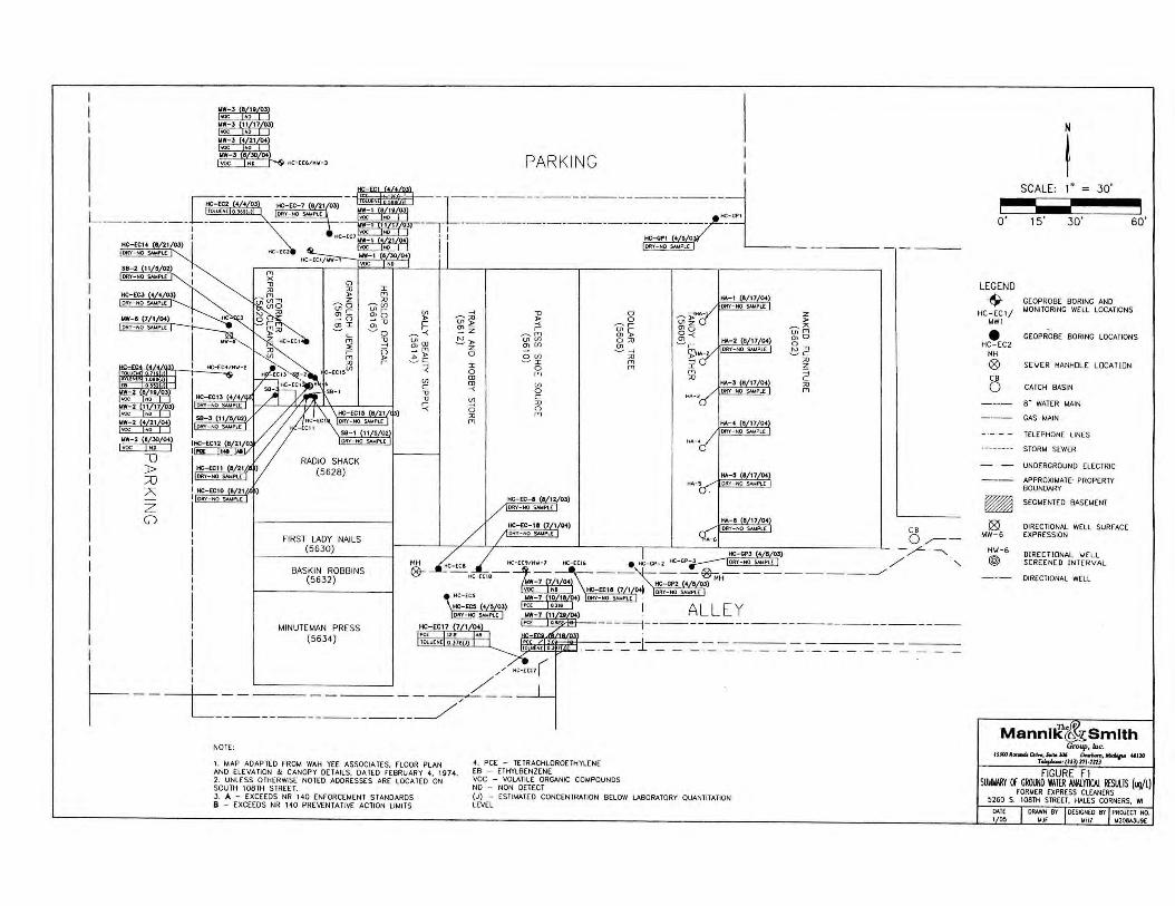
I I
I I I
I I
I I
I I I I
HC·[C6/H\f ·J
HC- CC2
HC - [CI/MW-
" ~ ~5 "' r "' -- o ~I
RADIO SHACK (5628)
FIRST LADY NAILS (5630)
BASKIN ROBBINS (5632)
MINUTEMAN PRESS (563 4)
I fT1 ;o
~vi "'r (/) mo )> ;,; -0 r r ~o ~-<
-0 u, a, ... fj ~ ~ )> .:'.-c r
~ (/) C -0 -0
~
MH
0-
... ~;o "' )> a,-- Z ~ )>
z 0
I 0 a, a, -< U) ... 0 ;o fT1
PARK ING
-0 )>
-< r ~,,, "' U) O> (/)
0 U) ~:r:
0 fT1
U)
0 C ;o 0 fT1
HC-EC-1 1/ 12/ 0l) ORY-NO SAMPl[
0 0 ~ r
~ c;;: 0 ;o Ol ~ ...
;o fT1 fT1
HA-l
tv.-J (8 17 04 ORY-NO S.WPU'.
tv.-4 (8 17 04 ORY- NO SAMPLE
tv.-5 (8 17 04 DRY-NO SI.UPI.[
z )>
~" u, fT1 "'0 0
"' "" ~ c ;o z :; C ;o fT1
I ALLE Y ~~g'.------------1------ ------ -------- -
- · - --1 __ , _ __ -- ·-· - ·- -- ·- - -
--L-~-=----~-=----~-~ / NOTE:
1. MAP ADAP TED FROM WAH YEE ASSOCIATES. fLOOR PLAN ANO ELE VA TION & CANOPY DETAILS. DATED f EBRUARY 4, 1974. 2. UNLESS OTHER"1SE NOTED ADDRESSES ARE LOCA lED ON SOU TH 108TH STREET. 3. A - EXCEEDS NR 140 [ Nf ORCEMENT STANDARDS 8 - EXCEEDS NR 14 0 PREVENTATIVE ACTI ON LIMI TS
4. PCE - TE TR ACHLOROETHYLENE EB - ETHYLBENZENE voe - VOLATIL E ORGANIC C0'-4POUNOS NO - NON DETECT (J) - ESTIMATED CONCENTRATION BELOW LABORATORY QUANTITATION LEVEL
N
I SCALE: 1" 30'
o· 15' 30' 60'
LEGEND
-$- GEOPROBE BORING ANO
HC -EC l / MONITORING WE LL LOCATIONS
MW l
• GEOPROBE BORING LOCATIONS HC - EC2
MH
® SEYER MANHOLE LOCA TION
CB
0 CATCH BASIN
8" WATER MAIN
GAS MAIN
TELEPHONE LINES
STORM SEWER
UNDERGROUND ELECTRIC
APPROXIMATE· PROPERTY BOUNDARY
R SEGMENTED BASEMENT
18) DIRECTIONAL WELL SURf ACE MW-6 EXPRESSION
MIJ -6 DIRE CTIONAL \JELL
@) SCREENE D I NTERVAL
DIRECTIONAL WELL
Mannnf•J Smith G""'f', lac.
I.SJOOa«ia4Drl"',Swr. JC¥ ~.~ "''° l : (JU ) 171-U 1J
FIGURE Fl SUW141RY If GROUND WAlfR >M.Yltll. R£Sll1S (ug/L)
FORM ER EXPRESS CLEANERS 5260 S. 108TH STREET. HALES CORNERS, WI
DAI( 1 05
DRAWN BY 0£SICN(O BY PROJ[CT HO. MJr MHZ M208AJU9[

ATTACHMENT I
PROPOSED !NSTITUTIONAL CONTROLS
THE MANNIK & SMITH GROUP, INC.

Note: Deed Restriction is in DRAFT pending review by Pamela Mylotta.
XXX.XXXXXX.XA

Document Number DEED RESTRICTION
Declaration of Restrictions
In Re: Please see attached legal description of property below.
Wisconsin Tranverse Mercator Coordinates: 679278,276212
ST A TE OF WISCONSIN ) ) ss
COUNTY OF MIL WAUKEE )
DRAFT
Recording Area Name and Return Address Bruce A Keyes, Esq. Foley & Lardner LLP 777 E. Wisconsin Ave. Milwaukee, WI 53202-5306 ROD Box 286
Part of 659-9975, Part of 659-9977-004
Parcel Identification Numbers
In Re: Land Situated in the County of Milwaukee, State of Wisconsin described as follows:
That part of the Northwest One-quarter (¼) of Section Thirty-two (32), Township Six (6) North, Range Twenty-one (21) East, in the Village of Hales Comers, Milwaukee County, Wisconsin, bounded and described as follows: Commencing at the Northwest comer of said ¼ Section; thence South 01° 26' 00" West along the West line of said¼ Section 253.13 feet to a point; thence South O 1 ° 34' 00" East at right angles to the West line of said ¼ Section 74.75 feet to a point; thence South 01 ° 26' 00" West and parallel to the West line of said ¼ Section 618.19 feet to the point of beginning of the land to be described; running thence South 88° 34' 00" East 221.53 feet to a point; thence South O 1 ° 02' 20" West 111.3 7 feet to a point; thence South 88° 57' 40" East 281.88 feet to a point; thence South 01 ° 26' 00" West 156.94 feet to a point; thence South 89° 55' 00" West and parallel to West Parnell Avenue 364.12 feet to a point; thence South O 1 ° 26' 00" West and, parallel to the West line of said ¼ Section 133.54 feet to a point, said point being on the North line of West Parnell Avenue; thence South 89° 55' 00" West along the North line of West Parnell Avenue 200.25 feet to a point; thence North 01 ° 26' 00" East and parallel to the West line of said ¼ Section 414.84 feet to the point of beginning.
Excepting Parcel One (1) of Certified Survey Map No. 4391, recorded on October 14, 1983 on Reel 1577, Images to 528 inclusive, as Document No. 5661949, being a part of the Northwest One quarter (¼) of the Northwest one-quarter (¼) of Section Thirty-two (32), Township Six (6) North, Range Twenty-one (21) East, in the Village of Hales Comers, Milwaukee County, Wisconsin.
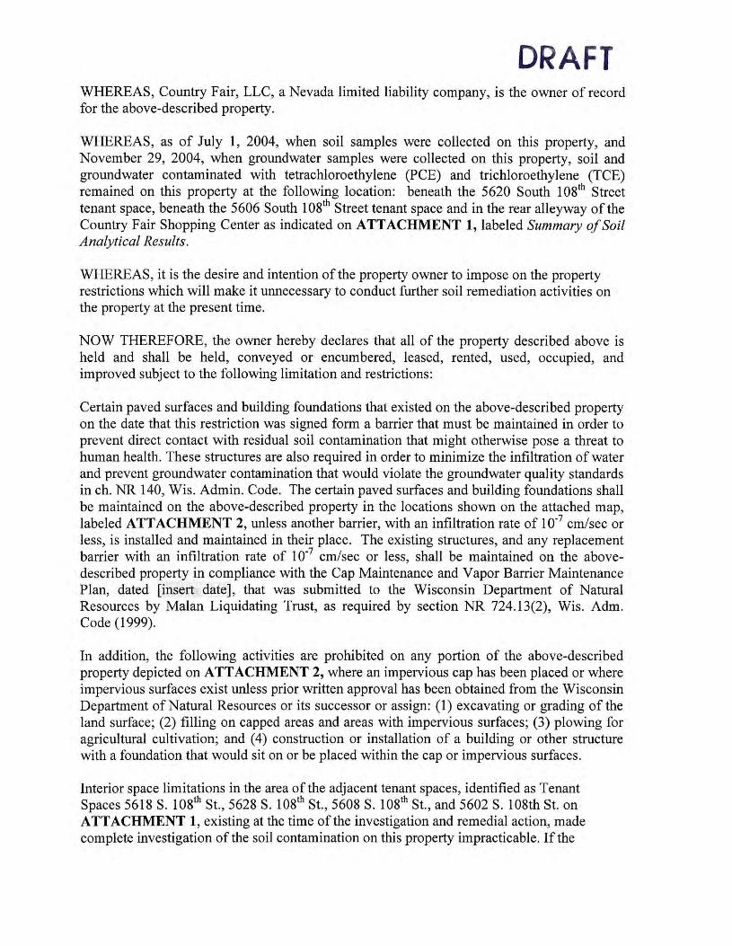
DRAFT WHEREAS, Country Fair, LLC, a Nevada limited liability company, is the owner of record for the above-described property.
WHEREAS, as of July 1, 2004, when soil samples were collected on this property, and November 29, 2004, when groundwater samples were collected on this property, soil and groundwater contaminated with tetrachloroethylene (PCE) and trichloroethylene (TCE) remained on this property at the following location: beneath the 5620 South 108th Street tenant space, beneath the 5606 South 108th Street tenant space and in the rear alleyway of the Country Fair Shopping Center as indicated on ATTACHMENT 1, labeled Summary of Soil Analytical Results.
WHEREAS, it is the desire and intention of the property owner to impose on the property restrictions which will make it unnecessary to conduct further soil remediation activities on the property at the present time.
NOW THEREFORE, the owner hereby declares that all of the property described above is held and shall be held, conveyed or encumbered, leased, rented, used, occupied, and improved subject to the following limitation and restrictions:
Certain paved surfaces and building foundations that existed on the above-described property on the date that this restriction was signed form a barrier that must be maintained in order to prevent direct contact with residual soil contamination that might otherwise pose a threat to human health. These structures are also required in order to minimize the infiltration of water and prevent groundwater contamination that would violate the groundwater quality standards in ch. NR 140, Wis. Admin. Code. The certain paved surfaces and building foundations shall be maintained on the above-described property in the locations shown on the attached map, labeled ATTACHMENT 2, unless another barrier, with an infiltration rate of 10-7 cm/sec or less, is installed and maintained in their place. The existing structures, and any replacement barrier with an infiltration rate of 10-7 cm/sec or less, shall be maintained on the abovedescribed property in compliance with the Cap Maintenance and Vapor Barrier Maintenance Plan, dated [insert date], that was submitted to the Wisconsin Department of Natural Resources by Malan Liquidating Trust, as required by section NR 724.13(2), Wis. Adm. Code (1999).
In addition, the following activities are prohibited on any portion of the above-described property depicted on ATTACHMENT 2, where an impervious cap has been placed or where impervious surfaces exist unless prior written approval has been obtained from the Wisconsin Department of Natural Resources or its successor or assign: (1) excavating or grading of the land surface; (2) filling on capped areas and areas with impervious surfaces; (3) plowing for agricultural cultivation; and ( 4) construction or installation of a building or other structure with a foundation that would sit on or be placed within the cap or impervious surfaces.
Interior space limitations in the area of the adjacent tenant spaces, identified as Tenant Spaces 5618 S. 108th St., 5628 S. 108th St., 5608 S. 108th St., and 5602 S. 108th St. on ATTACHMENT 1, existing at the time of the investigation and remedial action, made complete investigation of the soil contamination on this property impracticable. If the

DRAFT building foundations adjacent to the former Express Cleaners are removed, the property owner shall conduct an investigation of the degree and extent of PCE contamination. To the extent that contamination is found at that time, the Wisconsin Department of Natural Resources or other agency with administrative authority for the site shall be immediately notified and the contamination shall be properly remediated in accordance with applicable statutes and rules. If the currently inaccessible soil near or beneath the structural impediments on the property is excavated in the future, the soil must be sampled and analyzed, may be considered solid or hazardous waste if residual contamination remains and must be stored, treated and disposed in compliance with applicable statutes and rules.
The epoxy vapor sealant ("Vapor Barrier") as shown on ATTACHMENT 1 that existed at the property within the 5620 South 108th Street, Country Fair Shopping Center tenant space on the date that this restriction was signed forms a vapor infiltration barrier that must be maintained in order to prevent vapor intrusion that might otherwise pose a threat to human health. The Vapor Barrier shall be inspected and maintained unless another suitable vapor barrier is installed and maintained in its place. The existing Vapor Barrier and any replacement Vapor Barrier shall be maintained on the above-described property in compliance with the Cap Maintenance and Vapor Barrier Maintenance Plan [insert final date], that was submitted to the Wisconsin Department of Natural Resources by Malan Liquidating Trust, as required by section NR 724.13(2), Wis. Adm. Code (1999).
This restriction is hereby declared to be a covenant running with the land and shall be fully binding upon all persons acquiring the above-described property whether by descent, devise, purchase or otherwise. This restriction inures to the benefit of and is enforceable by the Wisconsin Department of Natural Resources, its successors or assigns. The Department, its successors or assigns, may initiate proceedings at law or in equity against any person or persons who violate or are proposing to violate this covenant, to prevent the proposed violation or to recover damages for such violation.
Any person who is or becomes owner of the property described above may request that the Wisconsin Department of Natural Resources or its successor issue a determination that one or more of the restrictions set forth in this covenant is no longer required. Upon the receipt of such a request, the Wisconsin Department of Natural Resources shall determine whether or not the restrictions contained herein can be extinguished. If the Department determines that the restrictions can be extinguished, an affidavit, attached to a copy of the Department's written determination, may be recorded by the property owner or other interested party to give notice that this deed restriction, or portions of this deed restriction, are no longer binding.
By signing this document, the undersigned asserts that he or she is duly authorized to sign this document on behalf of Country Fair, LLC.
IN WITNESS WHEREOF, the owner of the property has executed this Declaration of Restrictions, this ___ day of ______ , 2005.
Country Fair, LLC

By: _________ _
Name: Title:
STATE OF _______ -J
) ss DRAFT
County of _________ -/
Personally came before me this __ day of ______ ~ 2004, the above named ______ (name), _________________ (title), who executed the foregoing instrument and acknowledged the same on behalf of said corporation.
IN WITNESS WHEREOF, I hereto set my hand and notarial seal.
Name: -----------Notary Public, State of _____ _ My Commission Expires: _____ _
This document was drafted by Bruce A. Keyes, Esq., Foley & Lardner LLP, 777 East Wisconsin Avenue, Milwaukee, Wisconsin 53202.
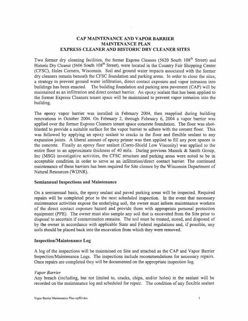
CAP MAINTENANCE AND VAPOR BARRIER MAINTENANCE PLAN
EXPRESS CLEANER AND HISTORIC DRY CLEANER SITES
Two former dry cleaning facilities, the former Express Cleaners (5620 South 108th Street) and Historic Dry Cleaner (5606 South 10s1h Street), were located in the Country Fair Shopping Center (CFSC), Hales Corners, Wisconsin. Soil and ground water impacts associated with the former dry cleaners remain beneath the CFSC foundation and parking areas. In order to close the sites, a strategy to prevent ground water infiltration, direct contact exposure and vapor intrusion into buildings has been enacted. The building foundation and parking area pavement (CAP) will be maintained as an infiltration and direct contact barrier. An epoxy sealant that has been applied to the former Express Cleaners tenant space will be maintained to prevent vapor intrusion into the building.
The epoxy vapor barrier was installed in February 2004, then reapplied during building renovations in October 2004. On February 2, through February 6, 2004 a vapor barrier was applied over the former Express Cleaners tenant space concrete foundation. The floor was shotblasted to provide a suitable surface for the vapor barrier to adhere with the cement floor. This was followed by applying an epoxy sealant to cracks in the floor and flexible sealant to any expansion joints. A liberal amount of epoxy primer was then applied to fill any pore spaces in the concrete. Finally an epoxy floor sealant (Carro-Shield Low Viscosity) was applied to the entire floor to an approximate thickness of 40 mils. During previous Mannik & Smith Group, Inc (MSG) investigative activities, the CFSC structure and parking areas were noted to be in acceptable condition in order to serve as an infiltration/direct contact barrier. The continued maintenance of these barriers has been required for Site closure by the Wisconsin Department of Natural Resources (WDNR).
Semiannual Inspections and Maintenance
On a semiannual basis, the epoxy sealant and paved parking areas will be inspected. Required repairs will be completed prior to the next scheduled inspection. In the event that necessary maintenance activities expose the underlying soil, the owner must inform maintenance workers of the direct contact exposure hazard and provide them with appropriate personal protection equipment (PPE). The owner must also sample any soil that is excavated from the Site prior to disposal to ascertain if contamination remains. The soil must be treated, stored, and disposed of by the owner in accordance with applicable State and Federal regulations and, if possible, any soils should be placed back into the excavation from which they were removed.
Inspection/Maintenance Log
A log of the inspections will be maintained on Site and attached as the CAP and Vapor Barrier Inspection/Maintenance Logs. The inspections include recommendations for necessary repairs. Once repairs are completed they will be documented on the appropriate inspection log.
Vapor Barrier Any breach (including, but not limited to, cracks, chips, and/or holes) in the sealant will be recorded on the maintenance log and scheduled for repair. The condition of any flexible sealant
Vapor Barrier Maintenance Plan mjf03 .doc

•• • ....... ~••w.,,••,.1,,-~-.. ,o-n~ ......
placed at expansion joints, wall floor joints, protrusions by plumbing or at anchor points into the floor will be noted and if needed scheduled for repair/replacement.
In the event that the vapor barrier is repaired or replaced, a floor sealant equivalent to the previously installed vapor barrier ( 40 mils epoxy) must be applied over the repaired/replaced flooring and extended well beyond any disturbed area. Any of the flexible sealant that had been placed at the floor-wall joints and/or expansion joints must be replaced if disturbed. Additionally, a flexible sealant will be liberally applied at and immediately surrounding any anchor points or other areas where the epoxy floor sealant is breached (screw holes, nail holes, plumbing fixtures ... ). Any replacement barrier will be subject to identical maintenance and inspection guidelines unless indicated otherwise by the WDNR or it successor.
CAP If exposed soils or excess cracking are noted during the semi-annual inspections or at any other time of the year, repairs will be scheduled as soon as practical. Maintenance activities can include sealing cracks, patching and filling operations or they can include larger resurfacing or construction operations. In the event that the cap is replaced, the replacement barrier must be equally sufficient to prevent infiltration and direct contact with the soil. The replacement barrier will be subject to identical maintenance and inspection guidelines unless indicated by the WDNR or it successor.
WDNR GIS Registry of Closed Remediation Sites
If soil contamination is removed or remediated, the owner may obtain an updated Site closure from the WDNR and have the Site taken off of the GIS Registry of Closed Remediation Sites.
Vapor Barrier Maintenance Plan mjf03.doc 2

VAPOR BARRIER INSPECTION/MAINTENANCE LOG Inspector: Date: Epoxy sealant condition satisfactory yes/no
Flexible sealant condition satisfactory yes/no
Comments:
Date and description of repairs completed:
Inspector: yes/no Date: Epoxy sealant condition satisfactory
yes/no Flexible sealant condition satisfactory Comments:
Date and description of repairs completed:
Inspector: yes/no Date: Epoxy sealant condition satisfactory Flexible sealant condition satisfactory yes/no
Comments:
Date and description of repairs completed:
Vapor Barri er Maintenance Plan-2.tpc .doc 3

NOlE:
BASKIN ROBBINS (5632)
MINUTEMAN PRESS (5634)
~~ OI ID
~~ ~~
PARKING
- EXlDff OF EXPRESS Cl£ANER sm: SOIL IMPM:1$
u,~ "ll
~z ~~ ~~ OI (I)
0, (/)
0 0(/) :I:
~::c 0 0 ,,,
ID
~ (/) 0
!!l C ;o
0 0 ;o ,,, ,,,
______________ __,/"
-
1. MAP ADAPlED FROM WAH "l'EE ASSOCIAlES, FLOOR PLAN AND ELEVATION a: CANOPY DETAILS, DAlED FEBRUARY 4, 1974.
4. A - EXCEEDS USEPA SOIL salEENING l£VEI..S FOR SOIL TO GROUND WA 1ER
2. UNLESS OlHERWISE NOlED ADDRESSES ARE L.OCA 1ED ON SOUlH 1081H STREET. 3. ASSUMED LOCATION CF ECKLAND BORING BASED ON VISUAL EVIDENCE OBTAINED BY MSG ON OCTOBER 1, 2002. ANAL YllCAL INFORMA 110N WAS OBTAINED FROM ECKLAND LETTER TITLED UMllED PHASE II SUB SURF ACE IN\'ESTIGA TION, DA 1ED .AIL Y 10, 2002. A MAP DEP1CTING lHE LOCATlON AND ACTUAL ANALYTICAL DATA WAS NOT AVAILABLE FOR MSG REVIEW,
B - EXCEEDS USEPA SOIL SCREENING LEVELS FDR AMBIENT YOl.A TILE INHALATION C - EXCEEDS USEPA SOIL SCREENING l£VEI..S FOR INGESTION
~- PCE - TElRACHLDROElH'ILENE MC - MElH'ILENE CHLORIDE VOC - VOLATILE ORGANIC COMPOUNDS NO - NON DETECT (J) - ESTIMAlED CONCENTRAllON 11E1..0W LABORATORY 0UANTITATION l£VEl
'
N
I SCALE: 1" = 30'
~ 0' 15' 30' 60'
LEGEND -$- GEOPROBE BORING AND
HC-EC1/ MONITORING WELL LOCAllONS
MW1
• GEOPROBE BORING LOCAT10NS HC-EC2
~ ASSUMED LOCAllON OF ECK~ijK>~~N
MH
® SE\/ER MANHOLE LCOA TlllN
B CATCH BASIN
APPROXIMATE EXTENT OF SOIL IMPACTS
8" WAlER MAIN
~ MAIN
TELEPHONE LINES
STORM SEWER
UNDERGROUND ELECTRIC
APPROXIMATE ~ BOUNDARY
mm! VAPOR BARRIER
fZJ TENANT SPACES TO BE INVEST1GA1ED IF~EN BUILDING FOUN :rJClN REMOVED
AREA OF DEED RESTR1Cl10N
Mann1.r"J Smith c.-a.,,..1ac. ·-----.= ...... ,.
ATTACHMENT I Sllll,IRY Cf SCI.. AN,11.YJDL lllilllS (
El1PIIESS CWNERS N«> HISllllllC 5260 Nil 5606 S. 1081li STREET, IW£S CORNERS,
-Br U(
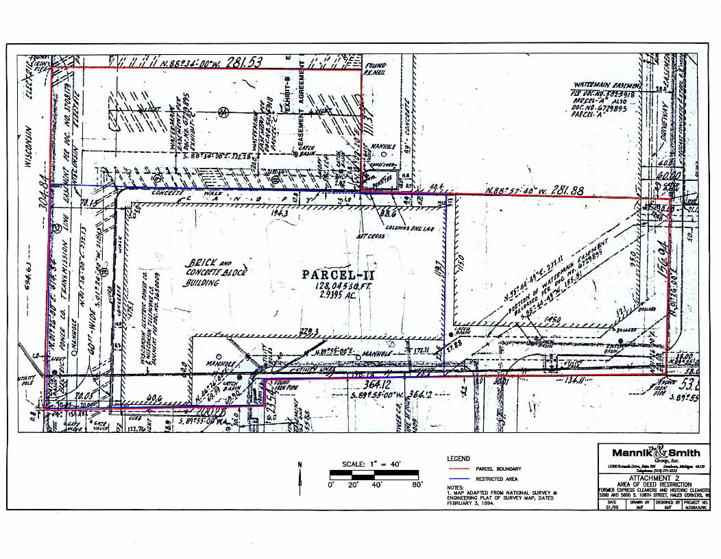
I I I
~ ~ ~
JR/Cl:' AKP •
,tJtY,i'llE ...ittJcl JIii/PiNG
J
l
~
II \ &~/.Jl,ffKS-✓H~ f.,f,I •
j),. t'.F4S.I ·. .
PAiic-tJii I 28, O,U'JtJ.rt: t.9J9, ~c. \ .
I I I I
.::_ ]64.12 J.81f.5.l•PP•w. 1,4.!2 ._ _;~
I --! -.. •
SCALE: 1 " = 40'
o· 20· 40• ao·
LEGEND PARCEL BOUNDARY
RESTRlCTED N!£A
NOTES: 1. MAP ADAPTED FROM NAllONAL SURVEY a: ENGINEERING PLAT OF SURVEY MAP, DATED FEBRUARY J, 199 ••
The I! Mannllc ~ Smith
~Inc:. ·--~-~. =-.,. .,,,. ATTACHMENT 2
AAfA OF DEED RESTRICTION EXPRESS ClENl£RS Nil H1S10A1C
5280 NIO 5806 S. 101TH srmr, IW£s C01NRS. WI
-lll'OESICNEDlll'PROJECTlll. - - ~

F, O 3 '-fJ o 9 9 S so
CLOSURE REPORT
HISTORIC DRY CLEANERS
5606 SOUTH 108TH STREET
H ALES CORNERS, WISCONSIN 53130
MARCH 11, 2005
MALAN LIQUIDATING TRUST
30200 TELEGRAPH ROAD
BINGHAM FARMS, Ml 48025
Prepared by:
The Ma 1111ik & Sm ith Group, In c. 1800 Indian Wood Circle Ma umee, Ohio 43537 (419) 891-2222 (419) 891-1595fax www.ma1111 iksm ithgroup. com
CIVIL ENGINEERING, S URVEYING AND
ENVIRONME NTAL CONSULTING TOLEDO • MONROE • DEARBORN • DETROIT • LANSING

TABLE OF CONTENTS
SECTION PAGE
EXECUTIVE SUMMARY ................................................................................................................... i 1.0 INTRODUCTION ................................................................................................................... 1 2.0 GENERAL SITE INFORMATION ........................................................... '. .......................... 1
2.1 Site Contact Information .............. .... .. ....... .. .. .... ....... ...... ........ ... .... ...... ... .......... .. .......... 1 2.2 Site Location and Description ............... ................... .. ........................................... .. ... .. 2
3.0 GEOLOGIC SETTING .......................................................................................................... 4 3.1 Topography ...................... ... ....... .. ...... .. ....... ............... .. .... ..... .... ............ ............ .. ........ . 4 3.2 Soils .... .... ........ ..... ... .... .... ......... .. ............. ..... ... ............... ... ..... .... .... ... .... ..... ......... ..... ..... 4 3 .3 Regional Geology ........ ............. .... ........ .. ...................... ...... .............. ...................... .. .... 4 3.4 Regional Hydrogeology .. ... ..... ..... ............... .. ...... ...... .... .... ... .. ...... .... .... .......... .... ......... . 4
4.0 PREVIOUS INVESTIGATIONS ........................................................................................... 4 4.1 MSG Phase I ESA .. .. ..... ... ........ ..... .. ......... ........... ..... ............. ....................... .. ... ........... 5 4.2 Limited Subsurface Investigation Activities ............ ...................... .. ............ ...... ........ .. 5 4.3 Site Investigation Report ... .... .................... ... ................. ....... ............... .. ....................... 5
5.0 SSI SCOPE OF WORK & METHOLOGIES ...................................................................... 6 5.1 Direct Push/Hand Auger Soil Borings and Sample Collection ... ..... .... .. .... .... .... .. .. .. .... 7 5.2 Monitoring Well Installation and Ground Water Sample Collection ........... ..... .. ........ 8 5 .3 Disposal ... ...... ........ .... ........... .............. .. ...... ... ............... ... ........ ..... ... .. ........ .. ........ ..... .... 8
6.0 INVESTIGATIVE RESULTS ................................................................................................ 9 6.1 Hydrogeology ................... ........ .. ... .... ........ ..... ... .......... ....... ... ... .. ....... .... .... ....... ... .... .. ... 9 6.2 Soil Sample Analytical Results .. .............. ... ... ............ .. ..... .. ...... ................ ................... 9 6.3 Ground Water Analytical Results ....... ..... ................................................................... 10
7.0 SCREENING LEVEL SELECTION AND PATHWAY EVALUATION ....................... 11 7 .1 Selection of Screening Levels .... .. .. ........ .. ................................ .. ................................ 11 7.2 Pathway Evaluation .......... .. ...... ... ........... .... ... .. .................... ..... ..... .... .... ...... .. .. ........... 11
8.0 CASE CLOSURE .................................................................................................................. 12 8.1 Institutional Controls ........................... ..................... ..... ................... ........ .... .............. 13 8.2 Case Summary and Close Out Form ........... ................. .. ... ...... ........ .... ........... ... ...... ... 13
TABLES
Table 1 Table 2 Table 3 Table 4
FIGURES
Figure 1 Figure 2 Figure 3 Figure 4 Figure 5 Figure 6
Laboratory Sample Selection Summary Summary of Soil Sampling Analytical Detections Summary Ground Water Sampling Analytical Detections Ground Water Elevation Data
Site Locations Map Country Fair Shopping Center Schematic and Boring Location Map Historic Dry Cleaner Boring Location Map Geologic Cross-Sections A-A' and B-B' Distribution of Soil Analytical Detections Distribution of Ground Water Samples Analytical Detections
APPENDICES
Appendix A Appendix B Appendix C
Appendix D
TABLE OF CONTENTS (Continued)
Site Survey and Legal Description WDNR Site Correspondence Soil Boring Logs, Monitoring Well Construction Logs and Bore Hole Abandonment Forms Analytical Data
EXECUTIVE SUMMARY
This Case Closure Report for the Historic Dry Cleaner located at 5606 South 1 Osth Street, Hales Comers, Wisconsin (Site) was prepared for Malan Realty Investors, Inc. (Malan) and is being submitted on behalf of Malan to the Wisconsin Department of Natural Resources (WDNR) by The Mannik & Smith Group (MSG). This Case Closure Report was prepared in general accordance with Chapter NR 716 and Chapter NR 726 of the Wisconsin Administrative Code (WAC) and applicable technical guidance documents, as referenced herein. Applicable public health and environmental laws, including NR 700 to NR 746 have been satisfied at the Site and are documented within this report.
The Historic Dry Cleaner Site is located within the Country Fair Shopping Center (CFSC) at tenant space 5606. Another former dry cleaner, the Express Cleaners, was also located in the CFSC, at the 5620 tenant space. A site investigation for the Express Cleaners site reported in the MSG Site Investigation Report dated April 29, 2003, identified the Express Cleaners site as a source of a dry cleaning solvents (tetrachloroethylene a.k.a. PCE) impacting soil beneath its former tenant space.
A supplemental site investigation (SSI) was initiated at the CFSC during thecourse of which, the Historic Dry Cleaner was identified as an additional source of PCE in soil. Results of the SSI pertaining to the Historic Dry Cleaner are presented in this report in support of case closure.
The predominant soil encountered in borings was a stiff to very stiff silt/clay. Ground water of limited extent was encountered in discontinuous sand lenses and utility corridor backfill within the silt/clay soils.
PCE concentrations in soil associated with the Historic Dry Cleaner exceed risk based screening values protective of ground water and ingestion. PCE concentrations detected in ground water samples have slightly exceeded the NR140 Preventative Action Limit and Enforcement Standard. The presence of a storm water collection drain may have provided a mechanism for some minimal release to the limited ground water. The DNR Project Manager concluded "the levels detected (in ground water) are extremely low and do not require additional response actions, beyond maintenance of the existing surface barrier."
Technical assistance meetings were held with WDNR on May 25, 2004 and August 5, 2004, to discuss the status of the SSI and request guidance on the investigative needs to bring the site(s) to closure. The SSI concurrently completed the investigation requirements for both the Historic Dry Cleaner and the former Express Cleaners sites. Based on guidance obtained during the technical assistance meetings, institutional controls are the proposed remedy to bring both the Historic Dry Cleaner and Express Cleaners sites to closure.
The proposed institutional controls for the Historic Dry Cleaner consist of placing the property on the GIS Registry of Closed Remediation Sites and placing a land use ( deed) restrictions on the CFSC property parcel. The deed restriction will require the CFSC building and pavement to be maintained as a direct contact and filtration barrier.
The Historic Dry Cleaner and former Express Cleaners have similar impacts and are located on the same parcel of property (CFSC Parcel II). The proposed institutional controls are applied to the sites jointly over the entire CFSC Parcel II (note: the deed restriction would also require maintenance of a vapor mitigation system in the former Express Cleaners tenant space). The supporting closure documentation including the GIS registry package, and WDNR Case Summary and Close Out Form with draft deed restriction for the Historic Dry Cleaner and former Express Cleaners sites are being submitted to the VlDNR simultaneously with this report.
i S:\Projec ts\Env\m208a3\DOCS\m208a3u-Hales Comer,Wl\M208A3U9\ Historic DryCleaner\HDC Exe Su m.tpc0 I .doc
1.0 INTRODUCTION
This Case Closure Report for the Historic Dry Cleaner located at 5606 South 108th Street, Hales Comers, Wisconsin (Site) was prepared for Malan Liquidating Trust (Malan) and is being submitted on behalf of Malan to the Wisconsin Department of Natural Resources (WDNR) by The Mannik & Smith Group (MSG). This Case Closure Report was prepared in general accordance with Chapter NR 716 and Chapter NR 726 of the Wisconsin Administrative Code (WAC) and applicable technical guidance documents, as referenced herein . Applicable public health and environmental laws, including NR 700 to NR 746 have been satisfied at the Site and are documented within this report.
The Historic Dry Cleaner Site is located within the Country Fair Shopping Center (CFSC) at tenant space 5606. Another former dry cleaner, the Express Cleaners, was also located in the CFSC, at the 5620 tenant space. A site investigation for the Express Cleaners site was conducted and reported in the MSG Site Investigation Report dated April 29, 2003. The Express Cleaners Site Investigation Report identified the Historic Dry Cleaner as a suspected additional source of dry cleaning solvents.
A supplemental site investigation (SSI) was initiated at the CFSC. Two technical assistance meetings were held with the WDNR project manager on May 25, 2004 and August 5, 2004, to discuss the status of the SSI and request guidance on any additional investigative needs to bring the site(s) to closure. In accordance with WDNR technical assistance meetings guidance and subsequent technical discussions, additional investigation of the Historic Dry Cleaner was undertaken as part of the SSI that confirmed it as an additional source of dry cleaning solvents.
The SSI concurrently completed the investigation requirements for both the Historic Dry Cleaner and the former Express Cleaners sites. Results of the SSI pertaining to the Historic Dry Cleaner are presented in this report in support of case closure.
2.0 GENERAL SITE INFORMATION
The following subsections identify specific Site contact personnel, and describe the Site in detail.
2.1 Site Contact Information
Site Name and Address
Historical Dry Cleaner 5606 South 108 th Street Hales Comers, Wisconsin 53130 FID: 34109955 BRRTS: 02-41-530534
Current Site Owner Country Fair, LLC c/o Shelter Properties 380 Linden Street Reno, Nevada 89502 Phone: (775) 825-0909 Fax: (775) 825-9012
THE MANNIK & SMITH G RO UP, INC. Page I of 13 S:\Projects\Env\m208a3\DOCS\m208a3u-Hales Comer, Wl\M208A3 U91Historic DryCleaner\ HDC .Closure.draft rpt.jan06. tpc .doc

Previous Site Owner/Responsible Party
M~\a..~ L'fl''·cl~-\-ivH\ --r'('"u ~--r Malan Realt, I vcstors, Ine . d 30200 Telegraph Road Bingham Farms, Michigan 48025 Owner Representative: John Roberson Phone: (248) 644-7110 Fax: (248) 644-7880
Environmental Consultant
The Mannik & Smith Group 15300 Rotunda Drive, Suite 306 Dearborn, Michigan 48120 Project Director: John S. Browning III, P.E. Project Manager: Thomas P. Cok, CPG Phone: (313) 271-2223 Fax: (313) 271-3076
Drilling Contractors
North Shore Drilling 1214 Washington Grafton, Wisconsin 53024 Contact Name: Matt Sweet Phone: (262) 375-8121 Fax: (262) 375-8122
On-site Environmental Services, Inc . P.O. Box 280 Sun Prairie, Wisconsin 53 590 Contact Name: Kim Kapugi Phone: (608) 837-8992 Fax: (608) 837-5906
Laboratory Analytical Services
US Filter/Enviroscan WDNR Certified Petroleum and Volatile Lab 301 West Military Road Rothschild, Wisconsin 54474 ID: 73 7053130 Phone: (715) 359-7226
2.2 Site Location and Description
The location of the Site is depicted on Figure 1, Site Location Map. Specifically, the Site is located in the Northwest ¼ of the Northwest ¼ of Section 32, Township 6 North, Range 21 East. The Historic Dry Cleaner street address is 5606 South 108th Street, Hales Comers, Wisconsin, which is located within the Country Fair Shopping Center (CFSC) retail shops. The retail shops
THE MA NNIK & SMITH GROUP, INC. Page 2 of 13 S:\Projects1Envlm208a31DOCS\m208a3u-Hales Comer,WIIM208A3U91Historic DryC leanerl HDC.Closure .draft rpt.jan06.tpc .doc

occupy Parcel II within the CFSC. A site survey and legal property description CFSC are included in Appendix A, Site Survey and Legal Description.
Parcel II is approximately 3 acres in size. The primary building structure is approximately 27,000 square feet and is currently occupied by retail shops. An addition built onto a large commercial structure (Kmart store) on the adjacent parcel to the north extends onto the eastern portion of Parcel II. The current tenants within the retail shops include the following:
Current Tenants Address Number Operation
Naked Furniture 5602 Furniture Store Tandy Leather 5606 Leather Shop
(Historical Dry Cleaners) Dollar Tree 5608 Dollar Store Payless Shoe Source 5610 Shoe Store The Train & Hobby Shoppe 5612 Toy & Hobby Store Sally Beauty Supply 5614 Health and Beauty Store Herslop Optical 5616 Optometrist Grandlich Jewelers 5618 Jeweler
Moondance Coffee Company 5620 Coffee Shop (Former Express Cleaners Corp) . (Former Dry Cleaners) Radio Shack 5628 Electronics Store First Lady Nails 5630 Nail Salon Baskin Robbins 5632 Ice Cream Shop
Minuteman Press 5634 Printers
According to available information, the retail shops (Parcel II) were originally constructed in 1958. There is currently a segmented basement beneath the eastern and middle portions of the retail shops. The eastern basement is located beneath Naked Furniture (east-end of the building) and is currently used for storage. The middle basement is located beneath Sally Beauty Supply (middle of the building) and is currently used for storage by Radio Shack.
Previous reports and a 1966 Sanborn map indicate a dry cleaner had operated in the 5606 South 108 th Street tenant space in the CFSC. An interview was conducted with a long term CFSC tenant, Mr. Tom Grandlich of Grandlich Jewelers in which he indicated the Historical Dry Cleaner ceased operations in approximately 1966.
Express Cleaners Corporation operated a dry cleaning business in the 5620 tenant space within the CFSC retail shops from December 1994 through March 2003 . The location of the Historic Dry Cleaner, the current occupants of other tenant spaces and segregated basement locations are depicted on Figure 2, Country Fair Shopping Center Schematic and Boring Locations Map.
Land use in the vicinity of the Site is generally mixed commercial and residential. The properties directly adjacent to the east of the CFSC are residential. The CFSC is bounded to the west by 108th Street. Beyond 108th Street are a psychic, doctor and dentist office, salon, bank and a Shell Gas Station. The adjacent property to the south contains Cousin 's Subs, Milwaukee Bike Works, beyond which is Parnell Avenue. The property directly adjacent to the north is the Kmart, Auto Zone, Re/Max, and an apartment complex, beyond which is Grange A venue.
THE MANN IK & SM ITH GROUP, INC. Page 3 of 13 s: \Projects\En v\m208a3\ DOCS\m208a3 u-Hales Comer, WI\M 208A3 U9\H is toric DryCleaner\H DC. Closure .dra ti rpt.j an 06. tpc .doc

3.0 GEOLOGICAL SETTING
MSG reviewed available aerial photographs, soils information and geological resource maps to determine the physical and geological setting of the Site and surrounding area.
3.1 Topography
A United States Geological Survey (USGS) topographical maps titled "Hales Corners, Wisconsin Quadrangle" dated 1959, photo revised 1994 for the Site and surrounding area was reviewed for this study (Figure 1) . The USGS map depicts the Site situated upon a relative topographic high ridge oriented in a northwest/southeast direction. The surface topography in the immediate vicinity of the Site has little relief. The elevation of the Site is approximately 790 feet above mean sea level (msl).
3.2 Soils
The soils in the area of the Site consist of Ozaukee-Morley-Mequon association. These soils are sandy loam to silty loam and are moderately permeable.
3.3 Regional Geology
The near surface geology consists of unconsolidated Quaternary age glacial till and outwash deposits to an approximate depth of 70 feet. The Site is situated along the eastern border of Wisconsin within the Lake Michigan Basin. The underlying bedrock is Silurian age bedrock consisting mostly of dolomite and limestone but locally may contain interbedded shale and evaporite beds.
3.4 Regional Hydrogeology
The nearest surface water bodies include an unnamed creek, located approximately 1/3 mile southwest of the Site (surface water elevation of 760 feet above msl). The Root River is located approximately ½ mile northeast of the Site (surface water elevation of 720 feet above msl).
A review of the USGS topographic map (Hales Comers, Wisconsin 1959, photo revised in 1994) indicated the Site is situated upon a relative topographical high ridge (approximately 790 feet above msl). This ridge is located just north of the Site and is orientated in a northwest/southeast direction. The direction of shallow ground water flow generally follows the surface topography, moving from high ground to low-lying areas which suggest a ground water divide may be present proximal to the Site. Ground water within the vicinity of the Site is anticipated to flow south towards the unnamed creek, while ground water flow north of the apparent divide likely flows northeast towards the Root River.
4.0 PREVIOUS INVESTIGATIONS
Prior to the SSI, MSG conducted a Phase I Environmental Site Assessment (ESA), limited subsurface investigation and a site investigation to evaluate the environmental concerns at the CFSC. The following subsections summarize, in part, some of the pertinent activities and results of these previous investigations.
THE MANNIK & SMITH GROUP, INC. Page 4 of 13 S :\Projects\En v\m208a3\DOCS\m208a3 u-Hales Comer, Wl\M 208A3 U9\H istoric DryC leaner\H DC. Closure .draft rpt.j an 06. tpc .doc

4.1 MSG Phase I ESA
MSG prepared a Phase I ESA report dated November 15, 2002, for the CFSC. The MSG Phase I ESA included a site visit and a historical/regulatory file review of the CFSC and surrounding properties. The MSG Phase I ESA identified the following potential environmental concerns regarding a Historic Dry Cleaner and the former Express Cleaners and that was also located within the CFSC:
Historic Dry Cleaner • A 1966 Sanborn map identifies the 5606 South 108 th tenant space (a.k.a. tenant space 101) as
a dry cleaners. In a MSG interview with Mr. Tom Grandlich of Grandlich Jewelers (25-year tenant), Mr. Grandlich indicated the Historic Dry Cleaner ceased operations in approximately 1966. Dry cleaning facilities are identified as a potential environmental concern due to the common environmental impacts resulting from use of dry cleaning solvents.
• Eckland Consultants Incorporated, (Eckland) conducted a limited subsurface investigation at the CFSC that included advancing a soil boring proximal to the Historic Dry Cleaner. Eckland's Limited Phase II Subsurface Exploration report dated July 10, 2002, describes the presence of tetrachloroethene (PCE), a dry cleaning solvent, in a soil sample collected from behind the Historic Dry Cleaner. PCE was reportedly detected at a concentration of 0.275 mg/kg in the soil sample. However, the Eckland report is incomplete and does not contain a map indicating the location of the sample, sample depth, soil boring logs or laboratory data sheets.
Express Cleaners • The Express Cleaners Corporation was identified on the RCRJS-SQG list with no violations
reported in the regulatory database review. According to the Express Cleaners manager, PCE that was used in the dry cleaning process was stored in a tank located under the dry cleaning machine and used PCE was stored in a 55-gallon drum located behind the dry cleaning machine. The manager indicated all hazardous materials that were generated on site were properly disposed of off site. There were no signs of leaking or staining near the tank or any of the drums. Although no obvious impacts were identified as part of the property assessment, the Express Cleaners Site was identified as a potential environmental concern due to the environmental impacts common at dry cleaning facilities.
4.2 Limited Subsurface Investigation
In November 2002, MSG conducted a limited subsurface investigation of the Express Cleaners site. Three hand auger soil borings (SB-1 , through SB-3) were advance beneath the Express Cleaners tenant foundation. The locations of the Limited Subsurface Investigation soil borings are depicted on Figure 2. Laboratory analysis of soil samples for volatile organic compounds (VOC) identified PCE impacts in soil. MSG subsequently submitted a Hazardous Substance Release Notification form to the WDNR for the Express Cleaners site .
4.3 Site Investigation Report
MSG completed a site investigation for the Express Cleaners site that also included a preliminary investigation of the Historic Dry Cleaner. Results of the site investigation are reported in the MSG Site Investigation Report, dated April 29, 2003. MSG concluded that the Historic Dry Cleaner is likely an additional source of PCE and recommended further investigation. However, a WDNR hydrogeologist reviewed the Site Investigation Report and stated that there was a lack
TH E MANNIK & SMITH G RO UP, INC. Page 5 of 13 S:\Projects\Env\m208a3\ DOCS\m208a3 u-Hales Comer,WI\M208A3U9\Historic DryCleaner\HDC.Closure .draft rpt.j an06.tpc.doc

of evidence of a release from the Historic Dry Cleaner and did not concur with the MSG proposal for additional investigation of the Historic Dry Cleaner. The WDNR SI Report review letter is contained in Appendix B.
Soil and groundwater sample locations, descriptions and analytical results from the Site Investigation Report as they pertain to the Historic Dry Cleaner and the Express Cleaners are summarized below. The locations of the Site Investigation soil borings are depicted in Figure 2.
Historic Dry Cleaner • In April 2003 , three (3) direct push soil borings (HC-GPl through HC-GP3) were advanced
to a maximum depth of 12 feet below ground surface (bgs) outside the Historic Dry Cleaner tenant space. Soil boring locations are depicted on Figure 2 and Figure 3,Historic Dry Cleaner Boring Location Map. One soil sample from each boring location was submitted for laboratory analysis of VOCs by USEP A Method 8021. Relevant information regarding the soil sample interval selection and laboratory methodology pertaining to the Historic Dry Cleaner are identified in Table 1, Laboratory Sample Selection Summary.
• PCE was detected in the soil sample collected from HC-GP2 at a concentration of 0.905
µg/kg, exceeding the USEPA Soil Screening Level for Soil to Ground Water of 0.041 µg/kg. A summary of the analytical soil results pertaining to the Historic Dry Cleaner is given in Table 2, Summary of Soil Sampling Analytical Detections.
Express Cleaners • Five (5) direct push soil borings (HC-ECl through HC-EC5) were advanced to a maximum
depth of 16 feet bgs outside the Express Dry Cleaners at 5620 South 108 th Street tenant space. One soil sample from each boring location was submitted for laboratory analysis of VOCs by USEPA Method 8021. Saturated soils were encountered at three of the boring locations (HCEC 1, HC-EC2 and HC-EC4) and a ground water sample was collected for laboratory analysis ofVOC by USEPA Method 8020.
• Laboratory analysis did not detect PCE or any other VOC in the soil samples collected from the perimeter of the Express Cleaners site. Analytical results identified traces of trichloroethylene, ethylbenzene, toluene, and xylenes above laboratory detection limits but below quantification limits in the water samples.
5.0 SSI SCOPE OF WORK & METHODOLOGIES
Based on WDNR comments given in the review of the Site Investigation Report (Appendix B), the focus of the SSI scope of work was originally limited to the Express Cleaners Site. However, upon transference of the Express Cleaners Site to the DERF program and with additional information obtaining during the course of the investigation, the scope of work was expanded to include a comprehensive investigation of the Historic Dry Cleaner. The expanded scope of work was completed accordance with WDNR DERF project manager (Ms. Gina Keenan) guidance obtained at two technical assistance meetings held on May 25 , 2004 and August 5, 2004.
The SSI was undertaken to define the extent of soil impacts and evaluate ground water conditions associated with the Historic Dry Cleaner and former Express Cleaners tenant spaces. The SSI investigative activities consisted of advancing thirteen (13) direct push soil borings, advancement of six h~nd auger soil borings, collection of thirty-three (33) soil samples, installation of six temporary wells, installation of five permanent monitoring wells and collection of ground water samples ( one from each
THE MANNIK & SMITH GRO UP, INC. Page 6 of 13 S :\Projec ts\Env\m208a3\ DOCS\m208a3 u-Hales Comer, W IIM208AJ U91H istori c DryCleanerlH DC. Closure .drati fl)t.j an06. tpc . doc

I I I
temporary well and up to four sampling events from the permanent monitoring wells). The location of the SSI soil borings and monitoring wells are depicted in Figure 2.
The portion of the SSI pertaining to the Historic Dry Cleaner Site (hand auger borings HA-1 through HA-6, direct push soil borings HC-EC5, HC-EC8, HC-EC9, HC-EC16 through HC-EC18, and monitoring well MW-7) is discussed in the following subsections. A detailed discussion of the Express Cleaners Site portion of the SSI is included in the MSG Express Cleaners Site Closure Report, dated March 11 , 2005 that is being submitted to the WDNR in concurrently with this report. The location of the Historic Dry Cleaner Site borings and monitoring wells are depicted on Figure 3.
Soil and ground water samples collected during the SSI were submitted to US Filter/Environscan a Wisconsin certified laboratory for analysis in accordance with NR 149. Sample selection for laboratory analysis was based on PID screening, visual/olfactory evidence of impacts, soil type, depth and presence of ground water. Soil samples were preserved in methanol and analyzed for VOCs utilizing USEPA Method 8021. Ground water samples were preserved with hydrochloric acid and analyzed for VOCs utilizing USEPA Method 8260. Relevant information regarding the soil sample interval selection and laboratory methodology pertaining to the Historic Dry Cleaner are identified in Table I.
5.1 Direct Push/Hand Auger Soil Borings and Sample Collection
In August 2003 and July 2004, five direct push soil borings (HC-EC8, HC-EC9, and HC-EC16 through HC-EC18) were advanced in the vicinity of the Historic Dry Cleaner. In August 2004, MSG advanced six hand auger borings (HA-1 through HA-6) in the Historic Dry Cleaner tenant space. Soil boring locations are depicted on Figure 3.
Details concerning soil types, presence of ground water, drilling methods, bore hole abandonment, and personnel are provided in Appendix C, Soil Boring Logs, Monitor Well Construction Logs and Bore Hole Abandonment Forms. Soil descriptions presented on the individual soil boring logs are based upon visual identification of the soils encountered in the field using the Unified Soil Classification System (USCS) as per American Society for Testing and Materials (ASTM) Standard Practice for Description and Identification of Soils (VisualManual Procedure) D2488-93. Soil samples recovered directly from the sampler are numbered in the order obtained on the soil boring logs. The stratification lines shown on the logs represent the approximate boundary between soil types; however, the transitions between soil types may be gradual.
Direct Push Soil Borings Direct push soil borings HC-EC8, HC-EC9, and HC-EC16 through HC-EC18 (note borings HCGP-1, HC-GP-2, HC-GP-3 and HC-EC5 were advanced during the previous Site investigation in April 2003) were advanced to a maximum depth of 18 feet bgs in the rear alleyway near the Historic Dry Cleaner. Continuous soil profiles were obtained at each direct push boring by sampling at intervals up to 4-foot from grade to boring terminus using a 48-inch long 2-inch inner diameter stainless-steel Macro-Core® sampler. It should be noted that the density of the encountered soil during advancement of the direct push borings caused multiple equipment failure .
HC-EC8 and HC-EC9 are in the alley southwest of the Historic Dry Cleaner tenant space. HCEC8 and HC-EC9 were advanced to assess the potential of the storm sewer utility corridor acting as a migration pathway from the Express Cleaners release. Three soil samples were collected from each of these borings. Ground water was encountered and a sample collected from a temporary monitoring well at soil boring HC-EC9. A WDNR technical assistance meeting was
TH E MANN IK & SM ITH GROUP, INC. Page 7 of 13 S :\Projec ts\ Env\m208a3\DOCS1m208a3 u-Hales Comer, WIIM208A3 U9\H istoric DryCleanerlH DC. Closure .draft rpt.j an06. tpc .doc
held with Ms. Keenan ori May 25, 2004, in which she requested three (3) additional soil borings in the vicinity of HC-EC9 to further define Site conditions. The three additional soil borings, HC-EC16 through HC-EC18, were installed on July 1, 2004. Soil samples were collected from HC-EC16 and HC-EC18. A ground water sample was obtained from HC-ECl 7.
Hand Auger Soil Borings A second WDNR technical assistance meeting was held with Ms. Keenan on August 5, 2004, in which she requested collection of a soil sample from inside the Historic Dry Cleaner tenant space at the former location of the dry cleaning machine location. Due to lack of information regarding the dry cleaning machine location, six (6) hand auger borings were advanced beneath the Historic Dry Cleaner tenant space (HA-1 through HA-6). A 4-inch diameter cement coring machine was used to core through the tenant space concrete foundation. After coring through the foundation, MSG used a 2-inch diameter hand auger equipped with extensions to collect soil samples. Hand auger borings extended to five feet bgs or until refusal was meet. Based on field screening of soil and the most likely former location of the dry cleaning machine, seven soil samples were collected from four of the hand auger borings (HA-3 through HA-6) for laboratory analysis.
5.2 Monitoring Well Installation and Ground Water Sample Collection
At the WDNR technical assistance meeting held on May 25 , 2004, WDNR staff requested additional permanent monitoring well to be installed at the water-bearing zone encountered in soil boring HC-EC9. In July 2004, permanent monitoring well MW-7 was installed at the HC-EC9 boring location. Monitoring well and soil boring locations are depicted in Figure 3.
Permanent monitoring well screen interval was selected based on depth of water bearing zones encountered during the direct push soil profiling at HC-EC9. Monitoring well MW-7 was installed by using hollow stem auger (HSA) method and was constructed with 2 inch PVC casing and slotted screen, then finished with a flush mount protective cover. Details concerning soil types, presence of ground water, drilling methods, bore hole abandonment, and personnel are provided in Appendix C.
MSG surveyed top of casing and ground elevations relative to a temporary benchmark (top of fire hydrant located approximately 60 feet northwest of Kmart structure) with an assumed elevation of 100.00 feet. Static water elevation measurements were obtained on June 30 or July 1, 2004 for the Historic Dry Cleaner Site monitoring well MW-7 and the Express Cleaners Site monitoring wells MW-1, MW-2, MW-3 and MW-6. Table 4, Ground Water Elevation Data, list the top of casing, ground and water level elevations for each monitoring well.
5.3 Disposal
Soil cuttings and drilling fluids produced as a result of drilling activities at the Site were placed in 55-gallon drums and staged on-site, pending proper characterization for disposal. Similarly, decontamination, purge, and sampling water were also stored on-site in 55-gallon drums pending proper characterization for disposal. Following characterization of the soil cuttings and decontamination/purge water, the materials were transported and disposed of at a licensed facility.
THE MANNIK & SMITH GRO UP, INC. Page 8 of 13 S:\Projects\Env\m208a3\DOCS\m208a3 u-Hales Comer,Wl\M208A3U9\Histori c DryCleaner\HDC .Closure.draft rpt .jan06.tpc.doc

6.0 INVESTIGATIVE RESULTS
The following subsections contain a discussion of the Site hydrogeology, soil sampling results and ground water sampling results. During the August 5, 2004 second WDNR technical assistance meeting, MSG presented the data supporting two distinct source areas. WDNR concurred with the two source areas and requested submission of a release notification for the Historic Dry Cleaner and additional investigation of soil impacts. MSG submitted a Notification for Hazardous Substance Discharge form 4400-225 to the WDNR on August 8, 2004 for the Historic Dry Cleaner, a copy of which is included in Appendix B. WDNR requested MSG to advance a hand auger soil boring at the former location of the Historic Cleaner ' s dry cleaning machine. Due to lack of information regarding the dry cleaning machine location, six (6) hand auger borings were advanced beneath the Historic Dry Cleaner tenant space.
Laboratory analytical data sheets pertaining to the Historic Dry Cleaner investigation are provided in Appendix D, Analytical Data. Results from the previous MSG Site Investigation Report, dated April 29, 2003 pertaining to the Historic Dry Cleaner investigation are included in the tables and figures .
6.1 Hydrogeology
The maximum depth of investigation was 18 feet bgs. The predominant soil encountered was a stiff to very stiff silt/clay. Discontinuous sand lenses and utility corridor backfill were encountered in the silt/clay soils. Figure 4, Geologic Cross-Sections A-A ' and B-B ', illustrate the relationship between the soils encountered at each boring location. The location of the crosssection is depicted on Figure 3.
Saturated soil conditions were encountered within a sand lens in two direct push soil boring locations pertaining to the Historic Dry Cleaner investigation (HC-EC9/MW-7 and HC-EC 17). The absence of saturated soil conditions and/or the silty sand lenses in adjacent borings supports the discontinuous nature of the wet zones. Additional evidence that supports the limited extent of the wet zones is that the basement found under portions of the CFSC, which is approximately 13 feet deep, remains dry.
Five permanent monitoring wells (MW-1, MW-2, MW-3, MW-6 and MW-7) were installed as part of the CFSC investigation of the Historic Dry Cleaner and Express Cleaner sites (note MW-4 and MW-5 were install at the adjacent Kmart parcel). The permanent monitoring wells were installed at the limited direct push soil boring locations that previously encountered ground water. One of the monitoring wells, MW-6, has remained dry after installation. Elevation survey results and static water level measurements are listed in Table 4. No attempt was made to contour the ground water elevation data due to the isolated nature of the wet zones.
6.2 Soil Sample Analytical Results
Laboratory analysis detected VOC in soils at two general areas: 1) the Historic Dry Cleaner tenant space and 2) the former Express Cleaner tenant space. Table 1 identifies pertinent information regarding the soil sample interval selection and laboratory methodology. Soil sample analytical results from the SSI and previous investigations are summarized in Table 2 The sampling locations and distribution of detected VOCs the in soil samples pertaining to the Historic Dry Cleaner Site are depicted on Figure 5, Distribution of Soil Analytical Detections (mg/kg). A copy of the soil sampling laboratory data sheets pertaining to the Historic Dry Cleaner Site for the August 2003 and 2004 sampling events are included in Appendix D.
THE MANNIK & SM ITH G RO UP, INC. Page 9 of 13 S:\Projects\Env\m208a31DOCS1m208a3u-Hales Com er,W I\M208A3U9\Historic DryCleaner\HDC .Closure.draft rpt .jan06.tpc .doc

PCE and methylene chloride were the only compounds identified above laboratory detection limits in the direct push boring soil samples that pertain to the Historic Dry Cleaner investigation. PCE was detected in two MSG soil samples collected near the rear entrance to the Historic Dry Cleaner tenant space, HC-GP2 and HC-EC16 at 0.905 mg/kg and 0.161 mg/kg respectively. Methylene chloride was above laboratory detection limits in boring HC-GPl. However, this methylene chloride detection is a known common laboratory contaminant.
PCE and chloromethane were the only compounds detected above laboratory detection limits in the hand auger soil samples collected beneath the Historic Dry Cleaner tenant space. The highest PCE concentrations detected in soil was at HA-5, which is likely in the vicinity of the former dry cleaning machine. Chloromethane was identified in soil samples HA-5 (1-1.5), HA-5 ( 4.5-5), and HA-6 (4.5-5). Chloromethane is not a known degradation product of PCE. MSG contacted Mr. Jim Salkowski of US Filter/Enviroscan on September 16, 2004, regarding the detection of the chloromethane. Mr. Salkowski indicated that detected chloromethane is likely associated with the septum of the sample bottles and could be considered a laboratory contaminant.
6.3 Ground Water Analytical Results
During the investigation activities ground water samples were obtained from temporary monitoring wells installed in borings HC-EC9 and HC-ECl 7. One (1) permanent monitoring well MW-7 was installed at soil boring location HC-EC9.
· A total of three (3) ground water samples (from temporary and permanent monitoring wells) were collected for laboratory analysis. Laboratory analytical methodology and sampling details are summarized in Table 1. Ground water sample analytical results are summarized in Table 3. The sampling locations and distribution of detected VOCs in ground water samples are depicted on Figure 6, Distribution of Ground Water Analytical Detections (mg/L).
During the May 25, 2004 technical assistance meeting, WDNR had requested a permanent well be installed and soil borings stepped out to investigate the low level PCE impacts detected in HCEC9. Monitoring well MW-7 was installed at boring location HC-EC9. The initial sampling event for MW-7 was conducted on July 1, 2004 and results were non-detect for all VOC
(<0.45µg/l for PCE) . PCE was detected at 0.318 µg/1 during a second MW-7 sampling event conducted on October 18, 2004. During a third sampling event PCE was detected at a
concentration of 0.922 µg/1. Ground water samples collected from temporary wells often yield an artificially high concentration as a result of dragging impacted soils down or by entraining impacted particulate in the sample. Consequently the result from temporary wells should be used as a general indicator of environmental impact and not for comparison to any environmental standard.
A sample from temporary well HC-ECl 7 installed south of HC-EC9 detected PCE at 12.2 µg/1
and Toluene at 0.376 µg/1. As indicated above and demonstrated at the temporary/permanent well locations, samples collected from temporary wells often yield an artificially high chemical concentrations and should not be used to evaluate compliance with a regulatory standard. WDNR concluded during the August 5, 2004 technical assistance meeting, that the PCE detected in HCECl 7 is likely associated with the Historic Dry Cleaner. The presence of a storm water collection drain may have provided a mechanism for some minimal release to groundwater. WDNR also indicated that no further investigation of the Historical Dry Cleaner would be required for ground water provided the Site is placed on the GIS registry of ground water impacted sites. This was
THE MANNIK & SMITH G ROUP, INC. Page 10 of 13 S :\Proj ects1Envlm208a31DOCS1m208a3 u-Ha I es Comer, W IIM208A3 U9\H istoric DryC leaner\ H DC. Closure.draft rpt.j an06. tpc .doc

confirmed in a Technical Clarification Letter provide by WDNR project manager on December 22, 2004.
7.0 SCREENL~G LEVEL SELECTION Al"fil PATHWAY EVALUATION
State of Wisconsin NR 720 soil cleanup criteria, NR 140 ground water cleanup criteria or when Wisconsin criteria was not available, risk based screening levels, were compared to the analytical results to assess the potential risk and/or need for corrective actions. A pathway evaluation was completed for potential receptors based on the media impacted, detected chemical concentrations and physical setting in the vicinity CFSC as described in the previous sections.
7.1 Selection of Screening Levels
Soils The chemical compound of concern detected in soils at the Historic Dry Cleaner was PCE. This chemical compound was not listed in NR 720 tables; therefore, soil screening values were derived from the USEPA Soil Screening Website using Wisconsin Non-Industrial default parameters. USEPA Soil Screening Values were calculated for Soil Ingestion, Ambient Air Inhalation, and Soil to Ground Water at 1.23 mg/kg, 2.11 mg/kg and 0.041 mg/kg respectively. Analytical results exceeding the various soil screen values are highlighted in Table 2.
The USEPA Soil Screening Value for PCE Soil to Ground Water is 0.041 mg/kg and was exceeded in 5 of the 19 soil samples analyzed during the investigation pertaining to the Historic Dry Cleaner, HC-GP2 (3-4), HC-EC16 (10-11), HA-3 (3 .5-4), HA-4 (0.5-1), HA-5 (1-1.5) and HA-5 (4.5-5). PCE concentrations in soil also exceeded screening values for Ingestion in soil sample HA-5 ( 4.5-5) beneath the Historic Dry Cleaner tenant space at a concentration detected of 1.57 mg/kg.
Water Water samples were compared to NR 140 Ground Water Preventative Action Limit (PAL) and Enforcement Standard (ES). Analytical ground water results that exceed the PAL or ES are highlighted in Table 3.
Ground water was only encountered and sampled at two soil boring locations, HC-EC9/MW-7 and
HC-EC 17. Laboratory analysis detected a PCE concentration of 3 .03 µg/1 in a temporary well water
sample from HC-EC9 exceeding the PCE PAL of 0.5 µg/1. Toluene was also detected in the water
sample from HC-EC9 at a concentration of 0.307 µg/1 below the NR140 PAL of 200 µg/1. Permanent monitoring well MW-7 was installed at boring location HC-EC9 with its screen spanning the same saturated interval. MW-7 was non-detect for all VOC during an initial sampling event and PCE was detected at low levels during a second and third sampling events.
PCE was detected in temporary well water sample collected from HC-ECl 7 at a concentration of
12.2 µg/1 exceeding the PCE ES of 5 µg/1. Toluene was also detected in the water sample from
HC-ECl 7 at a concentration of 0.376 µg/1 below the NR140 PAL of 200 µg/1. As indicated above and demonstrated at the temporary/permanent well location, samples collected from temporary wells often yield an artificially high chemical concentrations and should not be used to evaluate compliance with a regulatory standard. The presence of a storm water collection drain may have provided a mechanism for some minimal release to groundwater. The DNR Project Manager concluded "the levels detected (in ground water) are extremely low and do not require additional
TH E MANN IK & SMITH GROUP, INC. Page 11 of 13 S :\Projec ts\Env\m208a3 \DOCS\m208a3 u-Ha !es Comer, Wl\M 208A3 U9\H istoric DryCleaner\H DC. Closure .draft rpt.j an 06. tpc .doc
response actions, beyond maintenance of the existing surface barrier." (see Appendix B, letter dated December 22, 2004).
7.2 Pathway Evaluation
An exposure pathway evaluation was completed for the Historic Dry Cleaner impacts. Exposure pathways were evaluated for each media of concern in consideration of affected or potentially affected human and environmental receptors to assess the need for corrective actions. An assessment of available Site information was reviewed to evaluate the likely hazardous substance migration pathways.
The Historic Dry Cleaner is the primary source for PCE. The soil, air, groundwater, and surface water exposure pathways were evaluated based on the physical setting and regional geology/hydrogeology. Based on the evaluation, the relevance of each Exposure Pathway follows:
• Soil Ingestion PCE concentrations in soil have been identified exceeding the Soil Screening Level for Ingestion in HA-5 (4.5-5). Given the depth of the sample, ingestion is eliminated as a pathway of concern. Furthermore, provided the building remains in place, it will serve as an effective exposure barrier and prevent ingestion of the impacted soils.
• Soil to Volatile Inhalation The air exposure pathway would include occupants in the structure above and near the VOC impacted soils. PCE concentrations in soil did not exceed the USEP A Ambient Volatile Inhalation Screening Level. Therefore this potential exposure pathway is eliminated as a pathway of concern.
• Soil to Ground Water
•
•
PCE concentrations in soil exceed the screening values for Soil (leaching) to Ground Water beneath the building and alleyway located at the rear entrance of the Historic Dry Cleaner. In order for the soil to ground water exposure pathway to affect a receptor the hydrogeologic conditions must be conducive to transportation of the chemical impacts to a receptor. The soils are primarily low permeability silt and clay with discontinuous sand/gravel lenses that may be saturated. Local water supply well records indicate the low permeability soils extend to an approximate depth of 70 feet. Furthermore, the building and pavement will act as an infiltration barrier and prevent leaching from precipitation. Therefore this potential exposure pathway is eliminated as a pathway of concern. Ground Water Ingestion The majority of the soil borings did not encounter ground water. PCE concentrations detected in ground water samples collected from two temporary (HC-EC9 and HC-ECl 7) wells have slightly exceeded the NR140 PAL and ES. A permanent well install at one of these temporary well location intermittently exceed the NR140 PAL. The presence of a storm water collection drain may have provided a mechanism for some minimal release to groundwater. The DNR Project Manager concluded "the levels detected (in ground water) are extremely low and do not require additional response actions, beyond maintenance of the existing surface barrier." Surface Water (Ingestion/Dermal Contact) The nearest surface water body is over 1/3 mile away. Based on the location and distance to the nearest surface water body, the discontinuous nature of the saturated zones, and
THE MANNIK & SMITH GROUP, INC. Page 12 of 13 S:\Projects1Env\m208a31DOCS1m208a3u-Hales Comer,W IIM208A3U91Historic DryCleaner\HDC.Closure.draft rpt.jan06. tpc .doc

predominant presence of low permeability soil, the pathway is eliminated as a pathway of concern.
8.0 CASE CLOSURE
The remedial action goal for the Site is to address the soil and ground water impacts at the Site as necessary to obtain "closure" as defined by regulations and rules of Chapter NR 726 of the WAC. Soil risk based screening values for PCE were exceeded for Soil (leaching) to Ground Water, Soil Screening Level for Ingestion and possibly for ground water PAL/ES ( only in two temporary wells, permanent monitoring well levels ranged from non-detect to slightly over PAL). However, under current site conditions, the exposure pathways are not complete to any receptors. Under current site conditions, corrective actions are not required to protect human health or the environment.
A course to site closure for the Historic Dry Cleaner was developed during two technical assistance meetings held with the WDNR on May 25, 2004 and August 5, 2004 along with follow up discussions. The SSI concurrently completed the investigation requirements for both the Historic Dry Cleaner and the former Express Cleaners sites. Results of the SSI pertaining to the Express Cleaners site are presented in the MSG Express Cleaners Closure Report date March 11 , 2005 that is being submitted concurrently with this report in support of case closure. Both the Historic Dry Cleaner and former Express Cleaners have similar impacts and are located on the same parcel of property. Based on guidance obtained during the technical assistance meetings, institutional controls are the proposed remedy to bring the sites to closure and are applied to both sites jointly over the entire CFSC Parcel II.
8.1 Institutional Controls
NR 720 of the WAC has an option for case closure where cleanup standards are not met, if institutional controls are applied. Institutional controls are defined as legal and administrative mechanisms that minimize the potential for human exposure to impacted media by limiting land use, require or prohibit certain actions by property owners to protect human health or the environment, or that give notice to prospective purchasers and other interested parties.
Institutional controls may consist of restricting access, land use ( deed) restrictions or placing the Site on the GIS registry of Closed Remediation Sites. The proposed corrective action is by institutional controls consisting of listing the CFSC Parcel II on the GIS Registry of Closed Remediation Sites and a deed restriction requiring the CFSC building and pavement to be maintained as a direct contact and filtration barrier. The deed restriction provides a provision for incomplete investigation due to limits on access to the adjacent tenant spaces. Additionally the deed restriction would include maintenance of a vapor mitigation system in the former Express Cleaners tenant space, as discussed in the Express Cleaners Closure Report, dated March 11 ,2005.
8.2 Case Summary and Close Out Form
The Historical Dry Cleaner and the Express Cleaners sites are on the same Parcel of property. The deed restriction includes institutional controls that are applied to both sites. WDNR approval of the deed restrictions and the proposed remedy is requested at this time, with the request that a final closure letter be issued upon proof that all groundwater monitoring wells have been properly abandoned and proof of recording of the deed restriction. The Historical Dry Cleaner Closure Report and supporting closure documentation is being submitted concurrently with this report.
THE MANNIK & SM ITH GROUP, INC. Page 13 of 13 S: \Projects\Env\m208a3 \DOCS\m208a3 u-Hales Comer, W JIM 208A 3 U9\H istoric DryCleaner\H DC. Closure .draft rpt.j an06 . tpc .doc

FIGURES
THE MANNIK & SMITH GROUP, !NC.
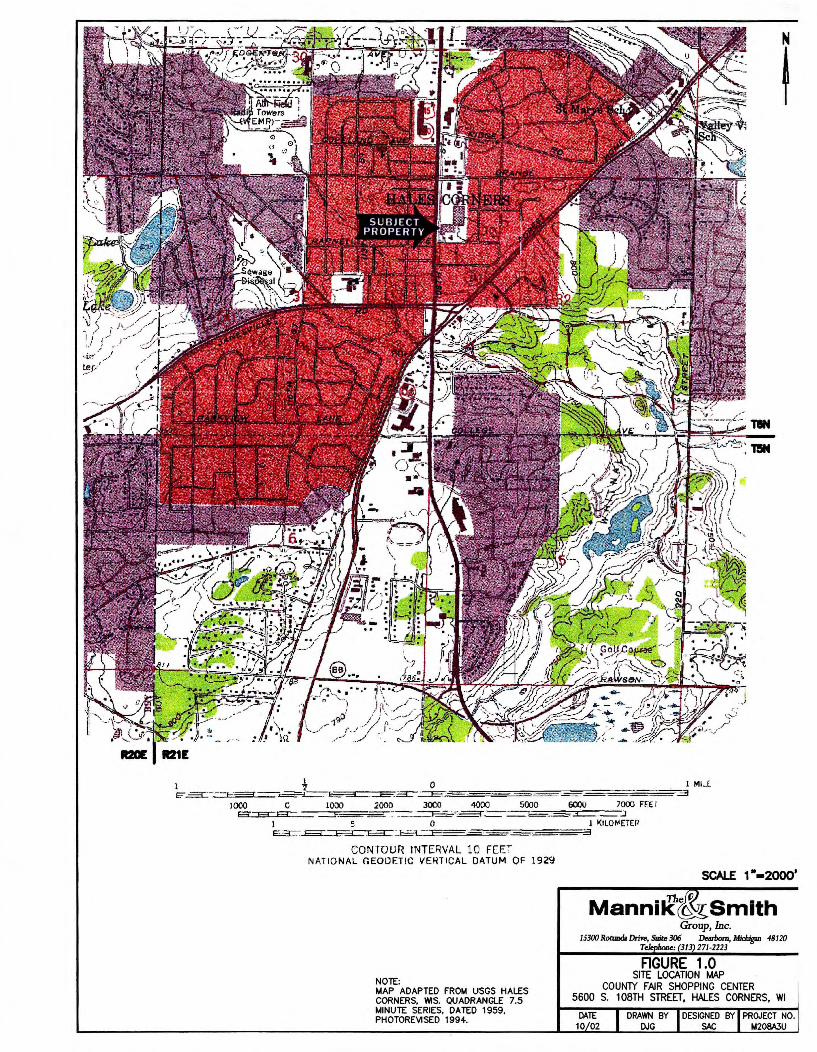
N
t
I t O I Ml.( E="-=3::- - - 1--====r-=,__=,i_~.=e-~;;:-=c==========-====:========;;:,3
1000 C 1000 2000 3000 4000 5000 6000 7000 FEE r f-3:::::S:::EC: ::::::.i :--==: __ ,_:::_: -- -==--========---~ _ :J
l 5 0 l l<JLOr,tETEP ~~~ ··r=====: .J
CONTOUR INTERVAL 10 FCC NATIONAL <:EOOF.:TIC \I El-tTICAL DATUM OF 1929
SCALE 1 •-2000•
NOTE: MAP ADAPTED FROM USGS HALES CORNERS, WIS. QUADRANGLE 7.5 MINUTE SERIES, DATED 1959, PHOTOREVISED 1994.
Smith Group, Inc.
153/JO Rotunda Dme, Suit.e 306 Desb«n, Mldugu, -48120 T, : 313 271-2223
FIGURE 1.0 SITE LOCATION MAP
COUN1Y FAIR SHOPPING CENTER 5600 S. 108TH STREET, HALES CORNERS, WI
DATE 10 02
DRAWN BY DESIGNED BY PROJECT NO. DJG SAC M208A3U

$ HC-ECG/Mll-3 PARKING
r------- ------[ -------------------------L----------H~-EC7. ----------T: ----------------------- HC-GPl. _
HC-ECJ
• .. ~-"-
HC-EC4/MW-2 $
HC-EC2. $ HC-ECl/MW-1
[Tl X C) '"O :;o :;o }> ,.....,_ GJ.,., z
(.J1 (/) 0 ,..---,..0 0) :;o C.J1 r
0) -~ OS: ~o '-'rf"Tl OJ I
j;;o '-' c....
z • f"Tl [Tl HC-EC14 :i: :;o r '" (/)
f"Tl :;o .-" C-EC15U'l
HC-EC13'~~2~
HC-ECl.MII 6 SB- SB-1
• HC-EC11 HC-EC10
RADIO SHACK (5628)
FIRST LADY NAILS (5630)
BASKIN ROBBINS (5632)
I f"Tl :;o ,.....,_ (/)
C.Jlr '"O 0 ---i 0) 0 z
;;; '"O }> 0 ,..---,.. }> OHA-1 }> -< -----r C.Jlz ,.....,_:,;:
...__,a r ~~
mo (.J1 f"Tl ,---. f"Tl g -< '"O u, (/) C) ;o 0) 0 ---i 0) (/) co ...___,r 0
0 '---' ---i fT1 N-,-, '-'c
}> 0 (/) ;o }> HA- 2 ;o r '-'I f"Tl :to
0 f"Tl z f"Tl fT1 =i
;:o C (/) ;:o 0 f"Tl
C HA-3 :;o 0 0 f"Tl
HA-4
0
HA-5
0
HC-EC5 . ' I ALLEY ,,,,
MINUTEMAN PRESS ~--------j---------------------------__/
I (5634) /.,, . __ --=-_1 _--=-_____ --=-~- _-=---=- _ _ __ I // HC-ECl7 (
I '------ / ---t--- ---------_______________ ,,//
NOTE:
1. MAP ADAPTED FROM WAH YEE ASSOCIATES, FLOOR PLAN AND ELEVATION & CANOPY DETAILS, DATED FEBRUARY 4, 1974. 2. UNLESS OTHERWISE NOTED ADDRESSES ARE LOCATED ON SOUTH 108TH STREET. 3 . ASSUMED LOCATION OF ECKLAND BORING BASED ON VISUAL EVIDENCE OBTAINED BY MSG ON OCTOBER 1, 2002. ANALYTICAL INFORMATION WAS OBTAINED FROM ECKLAND LETTER TITLED LIMITED PHASE II SUBSURFACE INVESTIGATION, DATED JULY 10, 2002. A MAP DEPICTING THE LOCATION AND ACTUAL ANALYTICAL DA TA WAS NOT AVAILABLE FOR MSG REVIEW.
N
I SCALE: 1 .. = 30'
o· 16' 30' 60'
LEGEND
• GEOPROBE BORING LOCATIONS HC-EC2
0
MH
0 CB
0
---------
- •- ·- --
--------
- · -
----
~
ASSUMED LOCATION OF ECKLAND 2002 BORING
HAND AUGER BORING LOCATION
SEWER MANHOLE LOCATION
CATCH BASIN
8" WATER MAIN
GAS MAIN
TELEPHONE LINES
STORM SEWER
UNDERGROUND ELECTRIC
APPROXIMATE PROPERTY BOUNDARY
SEGMENTED BASEMENT
Manni~c&smith Group, Inc.
1 S300 Rotund. Drire, Suit,: 306 v..rbom, MkJiigm 48120 Telq,boae: (313) 271-2223
FIGURE 2.0 COUN'TRY FAIR SHOPPING CENTER SCHEMATIC
AND BORJNG LOCATION MAP (HISTORIC DRY CLEANERS AND EXPRESS CLEANERS SITES)
5606 S. 108TH STREET HALES CORNERS W1
DATE DRAWN BY DESIGNED BY PROJECT NO. 1 D/ 04 AJT AJT M208AJU9D

I ---------i------------------------1 A HC-GP1
----------- ------------------------------- --1
I I
C) ::::0 )> z
,-....0
(J1 ' 0) -~o CO I
'--"' c_ fT1 ::§:
' fT1 ::::0
C-EC15 (/)
-S8-1
-EC10
l SHACK >628)
)Y NAILS iO)
ROBBINS 32)
~ PRESS 34)
I fT1 ::::0
,-.... (f)
(J1 ' mo ~-u CJ)
'--"' 0 u ---1 0 )>
'
---------
I
HC-ECS
•
Ll )> --< ' ,-.... rTJ
(.Jl (f) CJ) (f)
0 (f) '--"' I
0 rTJ
(f)
0 C ::::0 0 fT1
0 ---1 z 0
,-.... )> )> ,-...., (J1 z ,-.... ;;,;;: g; ~ 0) 0 u, fT1
0 --< 0 ::::0 0) CJ) 0
co '--"' ' 0 '--"' ~ rTJ N '7
'--"' C ::::0 )> ::::0 fT1 ~
fT1 I z fT1 =i ::::0 C
::::0 fT1
~~~ - /
--------
KMAR
CB o~-------7- ---...
HC-EC!B HC-EC16 . HC-GP-3 ~H /
---,--A,~--------_J
/
/
HC-EC9/MV-7
I "~---
I ALLEY /' \ ~ _____ J_ _______________________ __/'
////_,,-____ --_- - _---~-1-_____ - - - - - - - - - - - - - - - - - - - - _ __ -_-------
,,". / / HC-EC17(
,, I
NOTE:
1. MAP ADAPTED FROM WAH YEE ASSOCIATES, FLOOR PLAN AND ELEVATION & CANOPY DETAILS, DATED FEBRUARY 4, 1974. 2 . UNLESS OTHERWISE NOTED ADDRESSES ARE LOCATED ON SOUTH 108TH STREET. 3 . ASSUMED LOCATION OF ECKLAND BORING BASED ON VISUAL EVIDENCE OBTAINED BY MSG ON OCTOBER 1, 2002. ANALYTICAL INFORMATION WAS OBTAINED FROM ECKLAND LETTER TITLED LIM ITED PHASE II SUBSURFACE INVESTIGATION, DATED JULY 10, 2002. A MAP DEPICTING THE LOCATION AND ACTUAL MIAL YTICAL DA TA WAS NOT AVAILABLE FOR MSG REVIEW.
SCALE: 1" = 25'
o' 12.5' 25' 50'
LEGEND
• GEOPROBE BORING LOCATIONS HC-EC2
0
MH
® CB 0
ASSUMED LOCATION OF ECKLAND 2002 BORING
HAND AUGER BORING LOCATION
SEWER MANHOLE LOCATION
CATCH BASIN
GEOLOGIC CROSS SECTION LOCATION
8 " WATER MAIN
GAS MAIN
TELEPHONE LINES
STORM SEWER
UNDERGROUND ELECTRIC
---- APPROXIMATE PROPERTY BOUNDARY
- SEGMENTED BASEMENT
Manni~~Smith Group, Inc.
I 5300 Rotm>d., Drfre, Suite 306 Dearborn, Mkliigu, 48120 Telepbo,,c: (113) 271-2223
FIGURE 3.0 HISTORIC DRY CLEANER BORING LOCATION MAP
HISTORIC DRY CLEANERS 5606 S. 108TH STREET, HALES CORNERS, WI
DATE DRAWN SY DESIGNED BY PROJECT NO. 09/04 AJT AJT M208A.3U9D
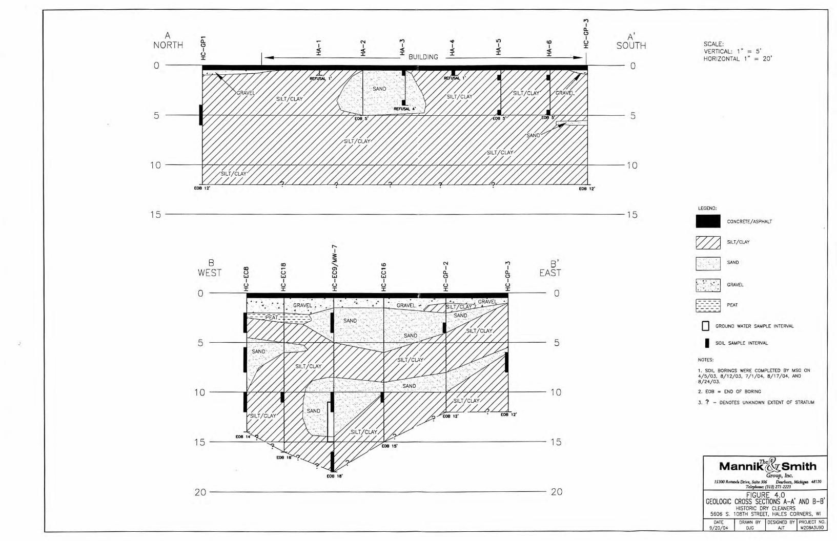
~ I
a. A 0 A' I
NORTH a. N ~ ""'
I!) (0 (.) SOUTH 0 I I I I I I :r:
I <( <( <( <( <( <( (.) :r: :r: :r: :r: :r: :I: :r: BUILDING
0 0
5
1 0
£08 12· EOB 1z•
15 --------------------------------------------15
r--I
3:: 8 ::::E
N ~ 8' co ' (0
WEST (X) .... Ol - I I
EAST (.) (.) (.) (.) a. a. w w w w 0 0 I I I I I I
(.) (.) (.) (.) CJ CJ
0 :r: :r: :r: :r: :r: :r:
0
-' 5 5
10 10
15 15
EOB 111'
20 20
SCALE: VERTICAL: 1" = 5' HORIZONTAL 1" = 20'
LEGEND:
- CONCRETE/ ASPHALT
~ SILT/ CLAY
□ SAND
t~< ~~~e:1 GRAVEL
~========j PEAT
□ GROUND WATER SAMPLE INTERVAL
I SOIL SAMPLE INTERVAL
NOTES:
1. SOIL BORINGS WERE COMPLETED BY MSG ON 4/5/03, 8/ 12/03, 7/ 1/ 04, 8/ 17/ 04, AND
-8/24/03.
2. EOB = END OF BORING
3 . ? - DENOTES UN KNOWN EXTENT OF STRATUM
Manni~ci&smith Group, Inc.
I 5300 Rotund. Drfre, Suite 306 Dearborn, Mid,igm 48120 Telepl,oae: (313) 271-2223
FIGURE 4.0 GEOLOGIC CROSS SECTIONS A-A' AND 8-8'
HISTORIC DRY CLEANERS 5606 S. 108TH STREET, HALES CORNERS, WI
DATE
9/ 20/ 04 DRAWN BY DESIGNED BY PROJECT NO.
DJG AJT M208A3U9D
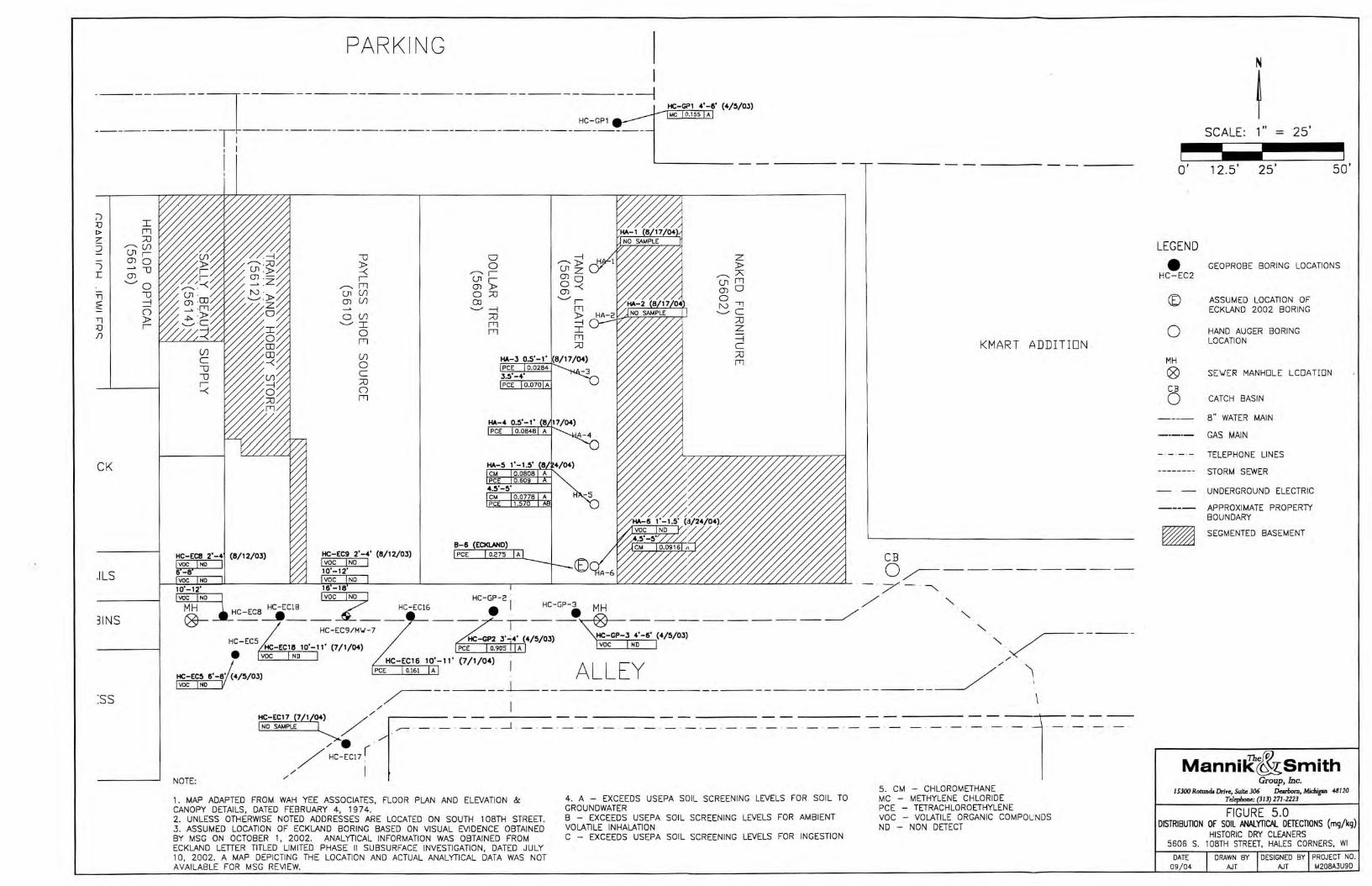
PARKING I -------i-----------------------~
HC-GP1
------ -- --------------------------------1
I I
HC-GP1 4'-6' (4/5/0J) MC 0.155 A
;-) :0 I C> rri 2: :::0 ::J ,,.......__ (.I)
u, r )
(J) 0
r: ;; ---0
'--' 0 -:'.] ---0
~ 2:::
0 TJ )> :0 r I)
CK
.!LS
31NS
:ss
I
---0 0 ~ z ~ 0
,,.......__ )> )> --------r u, z ,,.......__:;,;;:
r u, r (J) 0 ,,.......__ rri (J) )> 0 -< (J1 fT1
(J) 0 (J1 (/) 0 :::0 CJ)
(J) (.I) co .___, r 0 ..___, ~ rri N ""Tl
0 (/) :::0 )> ..___, C
:::0 ..._____,, I rri ~
0 rrl :r: z rri rri ~
:::0 C KMART ADDITION (.I) :::0 0 fT1 C :::0 0 rri
HA-4 0.5'-1 ' PCE
B-6 (ECl<l..ANO)
HC-ECS HC-EC18 10'-11' (7/1/04) •
HC-EC5 t!'-8' (4/5/0J)
"~----1 ALLEY /,/ ,
~-----J_ _______________________ __/ '
voe ND
voe ND
NOTE:
/ I HC-EC17 7 1 04) / - - -----
,o -~ / ✓1- . --_J /. .
/ HC-EC17(
// I
1. MAP ADAPTED FROM WAH YEE ASSOCIATES, FLOOR PLAN AND ELEVATION & CANOPY DETAILS, DATED FEBRUARY 4 , 1974. 2. UNLESS OTHERWISE NOTED ADDRESSES ARE LOCATED ON SOUTH 108TH STREET. 3. ASSUMED LOCATION OF ECKLAND BORING BASED ON VISUAL EVIDENCE OBTAINED BY MSG ON OCTOBER 1, 2002. ANALYTICAL INFORMATION WAS OBTAINED FROM ECKLAND LETTER TITLED LIMITED PHASE 11 SUBSURFACE INVESTIGATION, DATED JULY 10, 2002. A MAP DEPICTING THE LOCATION AND ACTUAL ANALYTICAL DATA WAS NOT AVAILABLE FOR MSG REVIEW.
4. A - EXCEEDS USEPA SOIL SCREENING LEVELS FOR SOIL TO GROUNDWATER B - EXCEEDS USEPA SOIL SCREENING LEVELS FOR AMBIENT VOLATILE INHALATION C - EXCEEDS USEPA SOIL SCREENING LEVELS FOR INGESTION
--~---____ I ___ _
5 . CM - CHLOROMETHANE MC - METHYLENE CHLORIDE PCE - TETRACHLOROETHYLENE voe - VOLATILE ORGANIC COMPOUNDS ND - NON DETECT
o·
LEGEND
• HC-EC2
0
MH
® CB
0
SCALE: 1" = 25'
12.5' 25' 50'
GEOPROBE BORING LOCATIONS
ASSUMED LOCATION OF ECKLAND 2002 BORING
HAND AUGER BORING LOCATION
SE~ER MANHOLE LCOATION
CATCH BASIN
8" WATER MAIN
GAS MAIN
TELEPHONE LINES
STORM SEWER
UNDERGROUND ELECTRIC
APPROXIMATE PROPERTY BOUNDARY
~ SEGMENTED BASEMENT
Manni.rc&smith Group, Inc.
15300 RotmJd. Drfre, Suite 306 Demiom, Midugan 48120 Telephone: (313) 271-2223
FIGURE 5.0 DISTRIBUTION OF SOIL mALYTIC>J.. DETECTIONS (mg/kg)
HISTORIC DRY CLEANERS 5606 S. 108TH STREET, HALES CORNERS, WI
DATE DRAWN BY DESIGNED BY PROJECT NO. 09 / 04 AJT AJT ~208A3U9D

PAR KING
- ----------,---------------------------------------1~H~~=;~:-~-OU-NT-ER-E~D
------------T~---------------------------- HC-GP1 ---
;-:, D I t> rrl z: :::0 ::J ,--.... (I)
u, r )
0) 0
r: ;; -0 ...___,.. 0
Tl -0 f --4
0 Tl )> D r I)
CK
.!LS
31NS
:ss
1 I
I I
HC-EC8 HC-EC18
-0
~ r
,--.... rrl (Jl (I) 0) (./)
0 (./) ...___,.. :r: 0 rrl
(./)
0 C Al 0 rrl
0 0 ,--....r
u, r 0) )> 0 :::0 co
...___,.. --4 :::0 rrl rrl
HA-3 I NOT ENCOUNTERED I
HA-4 I NOT ENCOUNTERED I
HA-5 I NOT ENCOUNTERED I
B-6 ECKi.ANO
z )>
,--....A (Jl rrl 0) 0 0 N '1 .____,,,c
:::0 z =i C :::0 rrl
KMART AD
CB NOT ENCOUNTERED NOT ENCOUNTERED o~--------
HC-GP2 . . / - . -_
MH HC-EC16 • I HC-GP3 MH / '-._ l'Cc,__ ___a!C-EC8__._ _ _ _ • / v::sr- HC-EClB HC-EC9/ M\J-7 ---- ,---~-------_- ________ _,/ '-._ '-._
· ""'~C-GP3 · ~------HC-ECS
• HC-EC16
HC-GP2 NOT ENCOUNTERED
~ I I NOT ENCOUNTERED I " . ✓
I ALLEY /,/ \ NOT ENCOUNTERED
HC-EC5 NOT ENCOUNTERED ~-----L------------------------~
,,/ I
NOTE:
· :~'~:c~ 1.- . ~ -_-_ _l ____ _ _ - . - · -. - . - . - · - . - . - · - . - . - . - . - . - . - . - . -· - . -------i=--_-_-__ . 1. MAP ADAPTED FROM WAH YEE ASSOCIATES, FLOOR PLAN AND ELEVATION & CANOPY DETAILS, DATED FEBRUARY 4, 1974. 2. UNLESS OTHERWISE NOTED ADDRESSES ARE LOCATED ON SOUTH 108TH STREET. 3. ASSUMED LOCATION OF ECKLAND BORING BASED ON VISUAL EVIDENCE OBTAINED BY MSG ON OCTOBER 1, 2002. ANALYTICAL INFORMATION WAS OBTAINED FROM ECKLAND LETTER TITLED LIMITED PHASE II SUBSURFACE INVESTIGATION, DATED JULY 10, 2002 . A MAP DEPICTING THE LOCATION AND ACTUAL ANALYTICAL DATA WAS NOT AVAI LABLE FOR MSG REVIEW.
4. A - EXCEEDS NR 140 GROUND WATER QUALITY ENFORCEMENT STANDARD B - EXCEEDS NR 140 GROUND WATER QUALITY PREVENTATIVE ACTION LIMIT
5 . PCE - TETRACHLOROETHYLENE voe - VOLATI LE ORGANIC COMPO L.J t~DS ND - NON DETECT
N
t SCALE: 1 " = 25'
O' 12.5 ' 25' 50'
LEGEND
• GEOPROBE BORING LOCATIONS HC-EC2
0
MH
0 CB 0
ASSUMED LOCATION OF ECKLAND 2002 BORING
HAND AUGER BORING LOCATION
SE\JER MANHOLE LCDATIDN
CATCH BASIN
8" WATER MAIN
GAS MAIN
TELEPHONE LINES
STORM SEWER
- · - UNDERGROUND ELECTRIC
APPROXIMATE PROPERTY BOUNDARY
~ SEGMENTED BASEMENT
Manni.r~smith Group, Inc.
15300 Rotunda Dme, Suite 306 Dearborn, M;d,igaa 48120 Tele e: (3/3)271-2223
FIGURE 6.0 DISTRIBUTION OF GROUND WATER ANALYTICAL DillCTIONS (mg/kg)
HISTORIC DRY CLEANERS 5606 S. 108TH STREET, HALES CORNERS, WI
DATE DRAWN BY DESIGNED BY PROJECT NO.

TABLES
THE MANNIK & SMITH GROUP, INC.
Boring ID Boring Location * Sample Type
15' north of the former dry cleaner - tenan Soil HC-GP1
space 101
HC-GP2 1 O' south of the Dollar Tree tenant space Soil
1 O' south of the former dry cleaner - tenant Soil HC-GP3
space 101 23' southeast from the corner behind the
Soil HC-EC5 Retail Shops
Soil
HC-EC8 22' southeast from the corner behind the
Soil Retail Shops
Soil
Soil
Soil 58' southeast from the corner behind the
HC-EC9 Retal Shops Soil
Ground Water
MW-7 on site of HC-EC9 Ground Water
HC-EC16 20' east of MW-7 Soil
HC-EC17 25' south of MW-7 Ground Water
HC-EC18 20' west of MW-7 Soil
HA-1 22' south-center from the store front Soil HA-2 15' south of HA-1 Soil
HA-3 15' south of HA-2 Soil
Soil
HA-4 20' south of HA-3 Soil
HA-5 15' south of HA-4 Soil
Soil
HA-6 15' south of HA-5, adjacent to Eckland Soil
boring Soil
• Soil Boring Locations Depicted on Figure 2, Site Schematic.
TaJle 1
Laboratory Sample Selection Summary
Historic Dry Cleaner 5606 South 108ht Street
Hales Corners, Wisconsin
Sample Depth • Soll
Sample ID Below Ground Type
Surface (bgs)
HC-GP1 (4-6) 4 - 6 feet bgs ML
HC-GP2 (3-4) 3 - 4 feet bgs SP
HC-GP3 (4-6) 4 - 6 feet bgs SM
HC-EC5 (6-8) 6 - 8 feet bgs ML
HC-EC8 (2-4) 2 - 4 feet bgs SM
HC-EC8 (6-8) 6 - 8 feet bgs SP
HC-EC8 (10-12) 10 - 12 feet bgs ML
HC-EC9 (2-4) 2 - 4 feet bgs SP
HC-EC9 (10-12) 10 - 12 feet bgs SP
HC-EC9 (16-18) 16 - 18 feet bgs ML
HC-EC9 12.5 - 15.5 feet bgs NIA
MW-7 9 - 14 feet bgs ML
HC-EC16 1 O - 11 feet bgs ML
HC-EC17 10-15 feet bgs ML
HC-EC18 10 - 11 feet bgs ML
No Sample - -No Sample - -
M208A3U9D-HA3 SS1 -MJF 0.5 - 1 feet bQs SP
M208A3U9D-HA3 SS2-MJF 3.5 - 4 feet bgs SP
M208A3U9D-HA4 SS1-MJF 0.5 - 1 feet bgs SM
HA-5 (1 -1.5) 1 - 1.5 feet bgs SM
HA-5 (4.5-4) 4.5 - 5 feet bgs SM
HA-6 (1-1 .5) 1 - 1.5 feet bgs SM
HA-6 (4.5-5) 4.5 - 5 feet bgs SM
Date Time Sample Collected Collected Odor?
415103 820am No
4/5103 1007am No
4/5/03 1045am No
415103 930am No
8/12/03 115pm No
8/12/03 120pm No
8112/03 125pm No
8112/03 210pm No
8112/03 215pm No
8112/03 220pm No
8118103 855am NIA
7/1/04 520pm No
7/1 /04 1000am No
7/1/04 1000am No
7/1104 1050am No
- - -- - -
8117104 820pm No
8117104 830pm No
8117104 900pm No
6124104 510pm No
6124104 525pm No
8124104 430pm No
8124104 440pm No
PID Preservation
Reading
0.0 Methanol
0.0 Methanol
0.0 Methanol
0.0 Methanol
0.0 Methanol
0.0 Methanol
0.0 Methanol
0.0 Methanol
0.0 Methanol
0.0 Methanol
NIA Hydrochloric
Acid
0.0 Hydrochloric
Acid
0.0 Methanol
0.0 Hydrochloric
Acid
0.0 Methanol
. -- -
0.0 Methanol
0.0 Methanol
0.0 Methanol
0 .0 Methanol
0.0 Methanol
0.0 Methanol
0.0 Methanol
Analysis Performed
VOC- USEPA Method 8260
VOC- USEPA Method 8260
VOC-USEPA Method 8260
VOC-USEPA Method 8260
VOC-USEPA Method 8260
VOC-USEPA Method 8260
VOC-USEPA Method 8260
VOC-USEPA Method 8260
VOC-USEPA Method 8260
VOC-USEPA Method 8260
VOC-USEPA Method 8260
VOC-USEPA Method 8021
VOC - USEPA Method 8021
VOC-USEPA Method 8021
VOC-USEPA Method 8021
VOC - USEPA Method 8021
VOC-USEPA Method 8021
VOC- USEPA Method 8021
VOC -USEPA Method 8260
VOC-USEPA Method 8260
VOC- USEPA Method 8260
VOC-USEPA Method 8260
SOILanalytical tables.dfrD1 Table 1 - Summary
Table 2 Summary of Soll Sampling Analytical Detections (mg/kg)
Historic Dry Cleaner 5606 South 1 08th Street
Hales Corners, Ml
US EPA Soil Screenin J Levels Ambient Soil to HC-GP1 HC-GP2 HC-GP3 HC-ECS HC-EC8 HC-EC8 HC-EC8
EPA8021 Ingestion• Volatile Ground (4-6) (3-4) (4-6) (6-8) (2-4) (6-8) (10-12) Inhalation • Water• 4/5/03 4/5/03 4/5/03 4/5/03 8/12/03 8/12/03 8/12/03
Chloromethane 440 0.4 0.0029 <0.025 <0.025 <0.025 <0.025 <0.029 (CSL LCL,DUPl <0.025 (CSL,LCL DUPl <0.025 ICSL,LCL,DUP) Methylene Chloride 763 2.5 0.0016 0.155 <0.025 <0.025 <0.025 <0.029 (CSL,LCLl <0.025 (CSL LCLl <0.025 (CSL,LCL) Tetrachloroethvtene 1.23 2.11 0.041 <0.025 0.905 <0.025 <0.025 <0.029 <0.025 <0.025
US EPA Soil Screenin Levels
Ambient Soll to HC-EC9 HC-EC9 HC-EC9 HC-EC16 HC-EC18 B-6 EPA 8021 Ingestion• Volatile Ground (2-4) (10-12) (16-18) (10-11) (10-11) (Eckland)
Inhalation • Water• 8/12/03 8/12/03 8/12/03 7/1/04 7/1/04 Chloromethane 440 0.4 0.0029 <0.025 (CSL,LCL DUP <0.025 (CSL LCL,DUPl <0.025 /CSL LCL,DUPl <0.025 ICSHl <0.025 (CSHl Unknown Methviene Chloride 763 2.5 0.0016 <0.025 /CSL LCLl <0.025 /CSL LCLl <0.025 (CSL LCLl <0.025 <0.025 Unknown Tetrachloroethviene 1.23 2.11 0.041 <0.025 <0.025 <0.025 0.111 <0.025 0.275
US EPA Soil Screenin Levels
Ambient Soilto HA3 HA3 HA4 HAS HAS HA6 HA6 EPA8021 Ingestion• Volatile Ground 0.S-1 ft. 3.5-4 ft. 0.5-1 ft. 1-1 .Sft. 4.5-Sft. 1-1.Sft. 4.S-Sft
Inhalation • Water• 911/04 9/1/04 9/1/04 9/1/04 9/1/04 9/1/04 9/1/04 Chioromethane 440 0.4 0.0029 <0.025 <0.025 <0.025 0.0808 0.0778 <0.0549 0.0916 Methvlene Chloride 763 2.5 0.0016 <0.025 <0.025 <0.025 <0.0564 <0.0607 <0.0549 <0.0535 Tetrachloroethvlene 1.23 2.11 0.041 0.0284 0.07 0.0848 o.eoe 1.57 <0.0549 <0.0535
• Values derived from the USEPA Soil Serening website using Wisconsin Non-Industrial default parameters. Note: Analytical information for the Eckland boring B-6 was obtained from the Eckland Letter titled Limited Phase II Subsurface Investigation, dated July 10,2002. Actual analytical data sheets were not available for MSG review.
G n shading denotes parameters exceeding USEPA Soil Screening Levels for Soil to Ground Water. shading denotes parameters exceeding USEPA Soil Screening Levels for Soil to Ground Water and Ingestion.
CSL - Check standard for this analyte exhibited a low bias. Sample results may also be biased low. LCL - The Laboratory control sample for this analyte exhibited a low bias. Sample results may also be biased low. DUP - Result of duplicate analysis in this quality assurance batch exceeds the limits for precision. CSH - Check standard for this analyte exhibited a high bias. Sample results mya also be biased high.
Page 1 of 1 S:\Projects\Envlm208aMX>CS/m208a3u9/SOILanalyticaltable.dfr01 .xts
Table 3-GW
Table 3 Summary of Ground Water Sampling Analytical Detections (ug/L)
Historic Dry Cleaner 5606 South 108th Street
Hales Corners, Wisconsin
NR 140 Ground Water Quality -Table 1
EPA 8021 Enforcement Preventative Laboratory HC-EC9 MW-7 MW-7
Standard Action Limit LOQ 8/18/03 7/1/04 10/18/04 MW-7 HC-EC-17
11 /29/04 7/1 /04 700 140 1.67 0 <0.5 <0.1 <0.5 <0.5
5 0.5 1.07 <0.45 0.318 ! • . ' I J I - --- L...____ - -
200 0.999 <0.3 <0.4 <0.3 0.376 5 0.5 1.2 <0.39 <0.5 <0.2 <0.5 <0.5
10000 1000 3.059 <0.92 <0.92 <0.5 <0.82 <0.92
Blue shading denotes concentration exceeding NR 140 Enforcement Standard and Preventative Action Limits. Green shading denotes concentration exceeding NR140 Preventative Action Limit.
LOO - Limit of Quantitation J - Estimated concentration below laboratory quantitation level.
S:\Projects\Env\M208a3\Docs\M208a3u\M208A3u9\Historic DryCleaner\SOILanalytical tables.dfr01.xlsTable 3 - GW
Top of Well Ground
Location Elevation Casing
Elevation
MW-1 95.41 94.93 MW-2 95.30 95 .04 MW-3 95.02 94.58 MW-6 95.64 95.45 MW-7 99.04 98.58
Table 4 - Elevation SOILanalytical tables.dfr01
Total Depth of
Well
9.06 14.37 9.13 15.5* 13.88
TABLE 4. GROUND WATER ELEVATION DATA
Depth to Water
(8/19/03)
5.66 7.07 4.65 NA NA
Historic Dry Cleaner Site 5606 South 108th Street
Hales Corners, WI
Ground Depth to
Ground Depth to
Water Water Elevation
Water Elevation
Water
(8/19/03) (11/17/03)
(11/17/03) (4/21/04)
89.27 5.81 89.12 5.49 87.97 7.15 87.89 6.95 89.93 4.91 89.67 3.35
NA NA NA NA NA NA NA NA
Ground Water
Elevation (4/21/04)
89.44 88.09 91.23
NA NA
Depth to Ground
Depth to Ground
Water Water Water
Elevation Water
Elevation (6/30/04)
(6/30/04) (7/01/04)
(7/01/04)
5.05 89.88 NA NA 6.73 88.31 NA NA 4.16 90.42 NA NA NA NA dry dry NA NA 11.11 87.47

I
APPENDIX A
SITE SURVEY AND LEGAL DESCRIPTION
THE MANNIK & SMITH GROUP, INC.

APPENDU{B
WDNR SITE CORRESPONDENCE
THE MANNIK & SMITH GROUP, !NC.
DEPT. OF NATURAL RESOURCES
August 18, 2004
M2B8A3u9f)
State of Wisconsin \ DEPARTMENT OF NATURAL RESOURCES
Jim Doyle, Governor Scott Hassett, Secretary Gloria L. Mccutcheon, Regional Director
Southeast Region Headquarters 2300 N. Dr. Martin Luther King, Jr. Drive
PO Box 12436 Milwaukee, Wisconsin 53212-0436
Telephone 414-263-8500 FAX 414-263-8606
TTY 711
FID:34109955 BRRTS: 02-41-530534
Malan Realty Investors, Inc. John Robertscn The Manriik & Smith Group, Inc. 30200 Telegr2.ph Rd. Suite 105 Bingham Farms, MI 48026
Subject: Reported Contamination at the Country Fair Shopping Center, historical dry cleaners, 5606 S. 108 th St., Hales Corners
Dear Mr. Robertson:
On AJgust 09, 2004, Thomas P. Cck, of The Mannik and Smith Group, on behalf of Malan Realty Investors, Inc., notified the Wisconsin Department of Natural Resources (WDNR) that soil and potential groundwater contamination had been detected at the site described above.
Based on the information submitted to the WDNR;- we· believe that Malan Realty Investors, Inc. is responsible for restoring the environment at the referenced site under Section 292, Wisconsin Stats., known as the hazardous substances spills law.
This letter describes your legal responsibilities as a person who is responsible under section 292.11, explains what you need to _do to investigate, and clean up the contamination; provides you with information about cleanups, environmental consultants, and possible financial assistance; and working cooperatively with the Department of Natural Resources and Department of Commerce ("Commerce").
Legal Responsibilities:
Your legal responsibilities are defined both in statute and in administrative codes. The hazardous substances spill law, Section 292.11 (3) Wisconsin Statutes, states:
• RESPONSIBILITY. A person who possesses or controls a hazardous substance which is discharged or who causes the discharge of hazardous substance shall take the actions necessary to restore the environment to the extent practicable and minimize the harmful effects from the discharge to the air, !~'1.ds, or waters of the state.
Wisconsin Administrative Code chapters NR 700 through NR 7 49 establish requirements for emergency and interim actions, public information, site investigations, design and operation of remedial action systems, and case closure. Chapter NR 708 includes provisions for immediate actions in response to limited contamination. Wisconsin Administrative Code chapter NR 140 establishes groundwater standards for contaminants that reach groundwater.
www.dnr.st2te.wi.us www.wiscorsin .gov
Quality Natural Resources Management Through Excel,ent Customer Service Printed on
Recycled Pacer

Unless otherwise requested, please send only one copy of plans and reports. To speed processing, correspondence should reference the BRRTS and FID numbers (if assigned) shown at the top of this letter.
Additional Ir..formation for Site Owners: fuformation to help you select a consultant, and materials on controlling costs, understanding the cleanup process, and choosing a site cleanup method are enclosed. fu addition, Fact Sheet 2, Voluntary Party Remediation and E:cempt:'on from Liability provides information on obtaining the protection of limited liability under s. 292.15, Stats.
Financial Assistance: Reimbursement from the Petroleum Environmental Cleanup Fund (PECF A) may be available for some of the costs of cleaning up contamination from eligible petroleum storage tanks. Please refer to the enclosed information sheet entitled "Information about PECFA " for more information on eligibility a,7.d regulations for this program. For more information on the PECFA program, please call the Department of Commerce at 608-266-2424 or visit their web site at: http://www.comrner~e.state.wi.us/COM/Com-Petroleum.html. Funding is also available for cleanup at some drycleaning sites.
Call the DNR Victoria Stovall, Program Assistant at (414) 263-8688 for more information on eligibility or visit the RR web site. http://www.dnr.state.\.-...i.us/orn:/aw/rr. You may also contact this person for all other questions regarding this letter.
Thank you for your cooperation.
Sillcv~~p Victoria Stovall Program Assistant Remediation & Redevelopment Program Southeast Region
Enclosures: 1. 2. 3. 4 .
. 5.
Fact Sheet Selecting a consultant Fact Sheet 2, VPLE Env. Services Contractors List fuf. About PECF A Fact Sheet
c: Thomas P. Cok-Mannik and Smith Group WDNR SER Files
'·

-State of Wisconsin Department of Natural Resources Fax Notification For Hazardous Substance Discharge
(Non-Emergency Only) Fom, 4400-225 (07/03) Page l of 2
Emergency Discharges/ Spills should be reported via the 24-Hour Hotline: 1-800-943-0003
Notice: Hazardous substance discharges must be reported immediately according to the "Spills Law", s. 292.11 Wis. Stats., Section NR 706.05(1 ){b), Wis. Adm. Code, requires that hazardous substance discharges are to be reported by one of three methods: telephoning the Depar!ment (toll free Spill Hotline number above), telefaxing a report to the Department or visiting a Department office in person. If you choose to notify the Department by telefax, you should use this form to be sure that all necessary information is included. However use of this form is not mandatory. Under s. 292.99, Wis. Stats ., the penalty for violating the reporting requirements of ch. 292 Wis. Stats ., shall be no less than $10 nor more than $5000 for each violation. Each day of continued violation is a separate offense. It is not the Department's intention to use any personally identifiable information from this form for any purpose other than program administration . However, information submitted on this form may also be made available to requesters under Wisconsin's Open Records Law (ss. 19.31 - 19.39, Wis. Stats.). Confirmatory laboratory data should be included with this form, to assist the DNR in processing this Hazardous Substance Release Notification.
Complete this form. lYPE or PRINT LEGIBLY. FAX it to the appropriate DNR region (see next page) IMMEDIATELY upon discovery of a potential release from (check one): D Underground Petroleum Storage Tank System D Aboveground Petroleum Storage Tank System D Dry Cleaner Facility (DERP eligibility based on: D Facility owner/operator D Property owner of licensed facility) D Other - Describe:
TO DNR, ATTN: R & R Program Assistant (Area Code) FAX Number (414) 263-8483
Name Firm Thomas P. Cok The Mannik & Smith Group
Mailing Address 15300 Rotunda Dr. Suite 306 Dearborn Ml 48120
(Area Code) Phone Number
(313) 271-2223
Name of site at which discharge occurred. Include local name of site/business, not responsible party name, unless a
residence I vacant property Country Fair Shopping Center, Historical Dry Cleaners
Location: Include street address, not PO Box. If no street address, describe as precisely as possible, i.e., 1/4 mile NW of CTHs 60 & 123 on E side of CTH 60
5606 S. 108th Street
Municipality (City, Village, Township) Specify municipality in which the site is located, not mailing address/city
Hales Corners
County: Milwaukee
Legal Description: NW 1/4, NW 1/4, Section 32, Tn 6N, Range 21 E E0 or WO
O Responsible Party Name: Business or owner name that is responsible for cleanup. If more than one, list all Attach additional pages as necessary Malan Realty Investors, Inc.
0 Reported in compliance with s. 292.11 (2), Wis. Stats. , by a local government exempt from liability under s. 292.11 (9)(e), Wis. Stats. For more information see http://www.dnr.state.wi.us/org/aw/rr/liability/muni 1.html
Contact Person Name (if different) John Roberson
Mailing Address City
30200 Telegraph Rd, Suite 105 Bingham Farms
Phone Number (248) 644-7110
State
Ml
ZIP Code
48025
(continued)
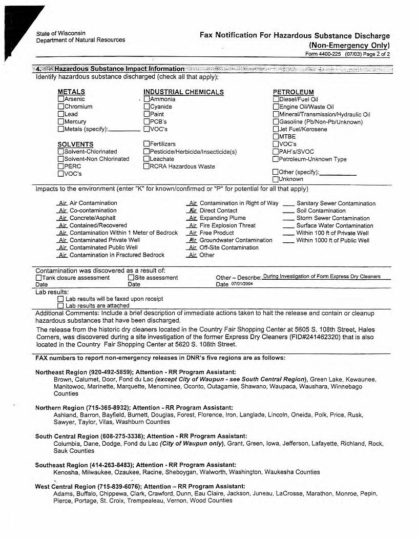
State of Wisconsin Department of Natural Resources
Fax Notification For Hazardous Substance Discharge (Non-Emergency Only)
Form 4400-225 (07/03) Page 2 of 2
''i: 4:Ji~;.~Hazan:fous0 Substance: lmpact:rnfortnation?\,~,s;,,;;. C,<"IT~f~~:~::c;.,~~,:., ~,;;-~;+..;~.,~.~:'~¥J:,Cc-,;_7)-C:,:'!?.:.:r;::. -. ·: .,sf;,:, "!i<1 ,:':::+ ;,<; ' ; -.~•/;! ,,:, ·,1,,_'-;c•;,:,_: , ··_, 1
Identify hazardous substance discharged (check all that apply):
METALS INDUSTRIAL CHEMICALS □Arsenic . □Ammonia □Chromium □Cyanide □Lead □Paint □Mercury OPCB's □Metals (specify): ____ OVOC's
SOLVENTS □Solvent-Chlorinated □Solvent-Non Chlorinated OPERC ovoc·s
□Fertilizers D Pesticide/Herbicid e/I nsecticide( s) □Leachate ORCRA Hazardous Waste
PETROLEUM □Diesel/Fuel Oil □Engine Oil/Waste Oil □Mineral/Transmission/Hydraulic Oil □Gasoline (Pb/Non-Pb/Unknown) □Jet Fuel/Kerosene OMTBE ovoc·s OPAH's/SVOC □Petroleum-Unknown Type
□Other (specify): -----□Unknown
Impacts to the environment (enter "K" for known/confirmed or "P" for potential for all that apply)
...Air. Air Contamination
...Air.. Co-contamination
...Air.. Concrete/Asphalt
...Air. Contained/Recovered
...Air. Contamination Within 1 Meter of Bedrock
...Air.. Contaminated Private Well
...Air.. Contaminated Public Well
...Ai.c.. Contamination in Fractured Bedrock
....8.ir. Contamination in Right of Way ~ Direct Contact ....8.ir. Expanding Plume ....8.ir. Fire Explosion Threat
Air Free Product __&[_ Groundwater Contamination ....8.ir. Off-Site Contamination ....8.ir. Other
__ Sanitary Sewer Contamination __ Soil Contamination __ Storm Sewer Contamination __ Surface Water Contamination __ Within 100 ft of Private Well __ Within 1000 ft of Public Well
Contamination was discovered as a result of: □Tank closure assessment □Site assessment Date Date
Other_ Describe: During Investigation of Form Express Ory Cleaners Date 01,0112004
Lab results : 0 Lab results will be faxed upon receipt 0 Lab results are attached
Additional Comments: Include a brief description of immediate actions taken to halt the release and contain or cleanup hazardous substances that have been discharged.
The release from the historic dry cleaners located in the Country Fair Shopping Center at 5605 S. 108th Street, Hales Comers, was discovered during a site investigation of the former Express Dry Cleaners (FID#241462320) that is also located in the Country Fair Shopping Center at 5620 S. 108th Street.
FAX numbers to report non-emergency releases in DNR's five regions are as follows:
Northeast Region (920-492-5859); Attention - RR Program Assistant: Brown. Calumet, Door, Fond du Lac (except City of Waupun - see South Central Region), Green Lake, Kewaunee, Manitowoc, Marinette, Marquette, Menominee, Oconto, Outagamie, Shawano, Waupaca, Waushara, Winnebago Counties
Northern Region (715-365-8932); Attention - RR Program Assistant: Ashland, Barron, Bayfield, Burnett, Douglas, Forest, Florence, Iron, Langlade, Lincoln, Oneida, Polk, Price, Rusk, Sawyer, Taylor, Vilas, Washburn Counties
South Central Region (608-275-3338); Attention - RR Program Assistant: Columbia, Dane, Dodge, Fond du Lac (City of Waupun only), Grant, Green, Iowa, Jefferson, Lafayette, Richland, Rock, Sauk Counties
Southeast Region (414-263-8483); Attention - RR Program Assistant: Kenosha, Milwaukee, Ozaukee, Racine, Sheboygan, Walworth, Washington, Waukesha Counties
West Central Region (715-839-6076); Attention - RR Program Assistant: Adams. Buffalo, Chippewa, Clark, Crawford, Dunn. Eau Claire, Jackson, Juneau, Lacrosse, Marathon, Monroe, Pepin, Pierce, Portage, St. Croix, Trempealeau, Vernon, Wood Counties

State of Wisconsin \ DEPARTMENT OF NATURAL RESOURCES
WISCONSIN DEPT. OF NATURAL RESOURCES
Jim Doyle, Governor Scott Hassett, Secretary Gloria L. Mccutcheon, Regional Director
Southeast Region Headquarters 2300 N. Dr. Martin Luther King, Jr. Drive
PO Box 12436 Milwaukee, Wisconsin 53212-0436
Telephone 414-263-8500 FAX 414-263-8716 TTY 414-263-8713
December 22, 2004
Mr. John Roberson Malan Liquidating Trust 30200 Telegraph Road, Suite 105 Bingham Farms, MI 48025
Subject: Country Fair Shopping Center
Historic Cleaner 5606 South 108th Street Hales Comers, WI 53130 FID:341099550 BRRTS: 02-41-530534
Dear Mr. Roberson:
Express Cleaners 5620 South 108th Street Hales Comers, WI 53130 FID: 241462320 BRRTS: 02-41-420848
Kmart 5600 South 108th Street Hales Comers, WI 53130 FID: 241866240 BRRTS: 02-41-520860
On December 22, 2004, we received a request for technical clarification with regard to property in Hales Comers, Wisconsin that is owned by Malan Liquidating Trust. The property includes the Express Cleaners site, Kmart Auto Center site and Historic Cleaner site, referenced above. We understand that a closure request is pending for the Kmart Auto Center and forthcoming for the Express Cleaners and Historic Cleaner. The request for technical clarification focused on the Express Cleaners and Historic Cleaners sites.
Over the past several weeks, the Wisconsin Department of Natural Resources (WDNR) and the Wisconsin Department of Health and Family Services (WDHFS) have been working with your attorney and consultant to resolve environmental issues related to releases from drycleaning operations formerly located at the Country Fair Shopping Center in Hales Comers. There are two locations within the shopping center that formerly housed drycleaning operations. These are referred to as the former "Express Cleaners" and the "Historic Cleaners". The drycleaning machines and materials have been removed from these locations and subsurface investigations conducted. An additional response action has been taken at Express Cleaners. The Express Cleaners site was recently renovated and now contains an operating coffee shop. Historic Cleaners was decommissioned as far back as the 1960 's and adapted to other retail uses .
The building and pavement surrounding Express Cleaners and Historic Cleaners act as a barrier to rainwater infiltration, and this has resulted in little downward migration of the contaminants. The only area of impacted groundwater appears to be in the loading lot area, where the presence of a stormwater collection drain may have provided a mechanism for some minimal release to groundwater in that area. The levels detected are extremely low and do not require additional response actions, beyond maint~nance of the existing surface barrier. The concrete floors also act as a barrier to direct contact and vapor migration.
dnr.wi.gov wisconsin.gov
Quality Natural Resources Management Through Excellent Customer Service ~
Printed on Recyd ed
Paper
Based on the information we hav~ received, no further investigation or groundwater monitoring are required to obtain case closure for the Historic Cleaner site. No further response actions would be required beyond filing WDNR approved deed restrictions to maintain the building, especially the concrete floors in the Historic Cleaners tenant space and the immediately adjacent spaces, and the adjacent pavement in the loading lot area. We have received draft deed restrictions for the property and will review the specific wording when we provide a review of the forthcoming request for case closure. Because residual soil contamination will remain on the property, the site will also be posted on the WDNR's GIS Registry of contaminated sites, upon case closure.
We understand that the Express Cleaners was only recently decommissioned and to ensure that spills to the concrete floor in the Express Cleaners facility would not release vapors to that air space, the floor was sealed with an epoxy sealant, any penetrations for drains, plumbing and electrical connections into the floor were caulked with a sealant and a subslab depressurization piping system was installed. A rooftop mounted electric fan was attached to the depressurization system, to ensure that the pressure gradient would remain directed downward from the floor. Despite the actions taken, indoor air samples collected from the former Express Cleaners site detected tetrachloroethene (PCE), which is the drycleaning compound previously used, and the contaminant of concern. The concentration of PCE detected in the indoor air samples is very low, and according to WDHFS, represents an excess cancer risk level for a commercial facility of approximately 5 in one million, slightly above the agencies' goal of one in one million or less.
The continued detection of indoor air impacts poses the singular issue for obtaining case closure for the Express Cleaners site. The electric fan operation appears to be contributing to the movement of PCE vapors from under the floor slab in the area, which may be preventing indoor air concentrations from being any higher. But with the information collected, it is difficult to determine this with certainty. In addition, very recent testing by WDHFS suggests that vapors venting to the rooftop might be migrating to the nearby air intake for the Heating, Ventilating and Air Conditioning ("HV AC") system and reentering the Express Cleaners tenant space. If, in fact, vapors are migrating from the rooftop vent to the HV AC air intake, steps should be taken to redirect the vapor discharge to better prevent infiltration into any tenant space air intakes.
As of this time, because of the unknowns at this site, the WDNR will require that the fan continue to be operated with the exhaust piping re-located to prevent interception by the HV AC intakes on the roof, unless additional information is received to more clearly demonstrate that the fan is not needed, or other response actions are taken to eliminate the need for the fan.
The investigation and remediation of vapor migration and indoor air quality issues is somewhat of an emerging area for both the regulatory and private community to deal with in the context of environmental response actions. The WDNR currently views the operation of any mechanical device that interrupts or collects or treats contamination as a form of on-going active remedy, and cannot issue a case closure until such active remediation is no longer needed. However, our regulations and guidelines are not specific on this issue as it relates to vapor intrusion, and we are currently in the process of working with the WDHFS to develop more specific technical and policy guidelines, including a re-evaluation of how we consider subslab depressurization systems. Because the continued operation of the fan is required and, absent clear guidance to the contrary, because the fan could be considered active remediation, we cannot provide case closure at this time to the Express Cleaners site. I have discussed this with your attorney, and suggest the following possible courses of action to get to case closure for the Express Cleaners site.
1. Undertake further sampling efforts to more clearly demonstrate that the fan is not needed to prevent ' · future indoor air contamination.
a. Based on the preliminary.results from the recent WDHFS air samples, a good place to start would be to turn off the fan and temporarily seal the exhaust on the subslab venting system, allow time for the coffee shop and roof air spaces to be vented to remove existing PCE vapor, and re-sample the coffee shop air space under normal HVAC operating conditions. We recommend that a background air sample be collected from near the HY AC intake on the roof at the same time. If this sampling protocol indicates that there is not continued vapor intrusion, verification sampling should be conducted under the same protocol. With favorable results, you should seek case closure based on maintenance of the floor sealant and passive depressurization piping system.
b. Alternatively, or based on inconclusive results, the WDNR will recommend turning off the fan for an extended period with the system exhaust opened and re-located, during which time indoor air samples are periodically collected. If the results indicate that the indoor air PCE concentrations are continuing to decline, then it may be concluded that the vapor migration is being sufficiently interrupted by the floor sealant and passive depressurization piping system, and case closure may be granted with a requirement to inspect and maintain those features. If you obtain rising or fluctuating PCE concentrations, you may choose to seek the second option for case closure listed below.
2. Elect to operate the fan as the final remedy and submit a request for closure with the feature to be maintained through a deed restriction. You will need to await the WDNR's policy development period for a final determination as to whether we would close the case with this restriction. In light of the issues at this site and in response to the issue having been raised by the State's Brownfield Study Group, the policy development process appears to be on a fast track, with meetings to be held early in January 2005.
3. You may choose to undertake additional response actions, such as removal of the concrete floor and immediately underlying contaminated soil to attempt to reduce the contaminant mass that may be contributing the indoor air impacts.
The WDNR and WDHFS will continue to work with your attorney and consultant as requested to provide technical guidance. If you undertake the recommended first sampling efforts next week, please have your consultant contact Henry Nehls Lowe at WDHFS, (608) 266-3479, to discuss technical issues related to that sampling. Please contact me with any questions at (414) 263-8758.
Sincerely,
Pamela A. Mylotta, Hydrogeologist Remediation & Redevelopment Program Southeast Region, Milwaukee Service Center
Cc: Bruce A. Keyes - Foley & Lardner Thomas Cok - The Mannik & Smith Group
APPENDIXC
SOIL BORING LOGS, MONITOR WELL CONSTRUCTION LOGS Ai"ID BORE HOLE ABANDONMENT FORivfS
THE MANNIK & SMITH GROUP, INC.

I
I
St:it.c ofW"=sin Department of Natural Rcsour-...cs
SOIL BORING LOG INFORMATION Form 4400-122 Rc:v. 7-98
Route To: W&tc:nhcd/Wutcwatc:r D Wast.c Man1.3emcnt D Rcmcd.iation/Rcvelopmcnt J8I_ Other D .------
WI Unique Wdl No. I DNR Well ID No. l'Ocll Name
Local Grid Origin □ tescimau:d: □ l or Boring Location □ State Planc _______ N, ______ E
I\\ E 1/4 of ~l/4 of Section ~D . T {o N, R ~ Facility ID !County
\J\ I\ \ l Yl lA \cu_ 8
- 'i :l Soil/Rock Dcsai.pcion
P:i.ge __l__ of 2
Date Drilling S~ Da.1.c Drilling Completed Drilling Method
~, ..o ~ 1:-.9 93.. 2 ':!., .9 It :ZM ~ ~ ,,,_,,.. n ,,. V"\,, m m d d Y Y Y Y m m d d Y Y 1 1 ~•LUI .... 'I;.
Final Static Wiler Level Surf.ace Elcvuion !Borehole Diameter
Feet MSL Feet MSL inches
I ut o , • Loca.l Grid Location
-o-,-. □ N □ E Long Feet □ S Feet□ w
Soil Prooerties
~ -i And Geologic Origin For .E [ Ea.ch Major Unit ~ -~ 5 o ~l CIJ 1 .. 'ii 5> ~ 8a => o.3~i:5 ii:
---<e---+--+-- r---------------1---+ c:,O - 0..':)()~\..,J,_ --s IJIC1 Ii l.JP.)._ ~ \ \ -\ l.\'6"} -_,
(o -'-\) '-12..''
-'S -1 ','6"/
C-t-%'") Lj~"
~
S-3 ~~·t ('6"-\2~ ½'t''
- 'oMw'f\ \ ~ ru . .\i ~( '-+ w,~ ~ ,... t:.. -\Q.Q.c,'- ~(l.()...\/~\ I z. ,-.-
Ml \
00
= 3 bel£W~~~ -= i b<\.D.u'<\\q~ ~,l-\- w'AV\ ~ q, (\!)..,\JQ.A....
= ~ 311 of SOJlcl~ ~ <10..,va..L c-..-\ 5'
HL o.O
io.o
c, C
o C
' . I,
-:....111--------------...L--L..!.....1..L-.J...____.Ji__...J..._.J...___J_...J..._..L... __ _
I hereby certify that the information on this form is true and correct to the best of my knowledge.
This foi;rn is authorized by Chapters 2 , 283,289,291,292,293,295, and 299, Wis. Stats. Completion of this form is mandatory. Failure to file this form may result in forfeiture ofbetween SIO and 525,000, or imprisonment for up to one year. depending on the program and conduct involved. Penonally identifiable information on this form is not intended to be used for any other purpose. NOTE: See instructions for more information,
including where the completed form should be sent
... ·-.. · .. .
i : :

-~-
/.,,,,._
-.,
(~\
Ei:D
---
;;,. I~ u✓
, I
Nu
mb
a _2
,, lJJ
an
d~
i f;
J ,
Len
gth
Au.
& IQ
. l[
Rcc
ovcr
od (
in C
l ..,
. I -B
low
Cou
ntJ
1111
111
II 'I
111
1 I I
ll 'I
111
1111
1 'I
' 11
1111
1111
1111
1111
1111
1111
1111
1111
11 I
I I'
111
1 II
I I
111
1111
I I
111
1111
1111
D
epth
in F
eet
I"
~ 01
~
~u 0
g.
oJ
, ~
'8· w
. g
1r fr
. ~
iif
. .
·"8
0 "
if e·
<- ~
,,-··
' c.
J)
use
s >
-G
rapl
uc
---L
og
~
' W
ell
Dia
gr~
C
, PI
D/P
ID
0 C
ompr
essi
ve
Su-c
ngth
Moi
stur
e C
l)
Con
tc:n
t &
L
iqui
d a
Uin
it
a
Plas
ticity
~
Inde
x ~
I"' P
200
,. R
QD
/ -~
C
omm
ent,

State oCW°ISC0l1Sil1 Department of Natural Resources
WELIJDRILLHOLE/BOREHOLEABANDONMENT Fonn 3300-5 2/2000 Page 1 of2
Notice: Please complete Form 3300-5 and return it to the appropiate DNR office and burea1L Completion of this report is required by chs.160, 281,283,289, 291,292,293,295, and 299, Wis. Stats.,and ch. NR 141, WLS. Adm. Code. In accordance with chs. 281,289, 291, 292,293,295, and 299, Wis. Stats., failure to file this form may result in a forteiture of between SlO and $25,000, or imprisonment for up toooe year, depending on the program and conduct involved. Penonally identifiable information on this form is not intended to be used for any other purpose. NOTE: See the instructions for more information.
Route to· 0 Drinklng Watff 0Watershed/Wastcwater D Waste Management l!J Remedialion/Redr:Yclopmcnt 00thcr . (1) GENERAL INFORMATION (2) FACILITY/ OWNER m.1<u&.~lAUUN WI Unique Well No. IDNR Well ID No. ,County Facility Name
MILWAUKEE Country Fair Shopping Center
HC-GPl Facility ID I License/Permit/Monitoring No. Common Well Name --- Gov'tLot <If applicable)
NE SW 30 6 21 (X] E Street Address of Well -- 1/4 of __ 1/4 of Sec. __ ; T. __ N;R __ □ w 5602. 5634 S. 108th Street Grid Location
ft. 0 N. 0 S., ft. □ E. □ w. City, Village, or Town Hales Corners
Local Grid Origin 0 ( estimated: D ) or Well Location D Prescru Well Owncc !Original Owner . • " • • II Lat _____ . Long ____ . or
s C N Street Address or Route of Owner
St. Plane ft. N. ft. E. DOD Zone Reason For Abandornncnt 1:1 Unique Well No. City, Swe. Zip Code Completion of Sampling Event (Replacement Well
(3) WELUDRILLHOLE/BOREHOLE INFORMATION 4) PUMP, LINER. SCREEN, CASING, & SEALING MATERIAL
Original Construction Date 4/5/03 Pump &. Piping Rcnovcd7 □ Yes 0 NoeJ Not Applicable
0 Monitoring Well LiDCI(s) Removed? □ Yes 0 No [XJ Not Applicable
I If a Well Construction Report Scrccn. Removed? □ Yea 0Noef Not Applicable D warcrwcii Is available, please attach. Casing Left in Place? □ Yes 0 No [!] Borehole/ Drillhole
Wu Casing Cut Off Below Surface? 0 Ycs~No Consttuction Type:
□ Dug Did Scaling Material Rise to Surface? D Yes(!] No □ Drilled □ Driven (Sandpoint)
Did Material Settle After 24 Hours? D Yes[!] No ~ Other (Specify) Geoprobe
If Yes, Was Hole Retoppcd? D YesD No Faanation Type: Required Method of Placing Scaling Material [!I Unconsolidated Formation □ Bedrock □ Conductar Pipe-Gnvity 0 Conductor Pipe-Pwnped
Total Well Depth (ft.) 12
Casing Diameter ("m.) ~ Screened & Poured □ Other (Explain) (Bentonlte Chips)
(From groundsurface) Ca.sing Depth (ft.) Sc&ling Materials For monitoring wells and
Lower Drillhole Diameter ("m.) 0 Neat Cement Grout monitoring well boreholes only
0 Sand-Cement (Cona-cte) Grout I ~ Bent:onite Chips Was Well Annular Space Grouted? D Yes D No D Unknown □ Coru:rcm ·
I I D Granular Bcntonite 0 Clay-Sand Slurry (11 lbJgaL wt.) I
If Yes, To What Depth? Feet I D Bcnt:onite • Cement Groul n BcnlOnite-Sand Slnny " " I I D Bentonite - Sand Slurry Depth to Water (Feet) ~ Bentonlte Chips
No. lards, (Circle Mix Ratio (5) Mat1::ri.al Used To Fill Wcll/Drillholo From (Fl) To (Ft.) Sacks Sealant or Mud Weight or Volume One)
3/8" Bentonite Chips Surface
...
(6) Comments: -------------------------------------------
(7) Name of Person or Finn Doing Scaling Wort'.
The Mannik & Smith Group
rk
S1:r0et oc Roure 15300 Rotunda Dr. Ste. 306
City, Stale,. Zip Code Dearborn MI 48120-
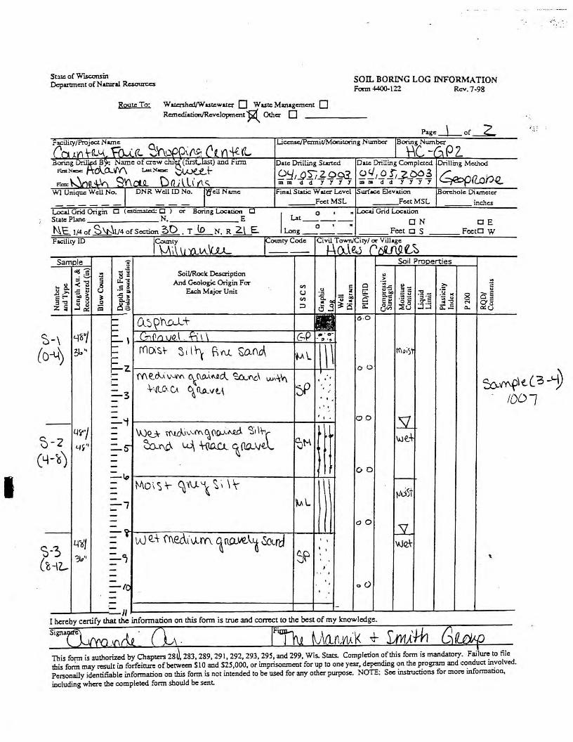
I
Staci: of W =in Department of N atunl Resources
SOIL BORING LOG INFORMATION Fonn 4400-122 Rev. 7-98
Route To: Wa1<:nlu:d/Wasci:watcr D Waste Management D Rcmcd.iation/Revclopmcnt ~ Other 0
Pagc_j_ f~ 0
Facility/Project Name
.('1"'1 m\-(U,.A,_ ~ct ~~'II)(){~{'~ J"l'+{f1,,, Liccnse/Pcnnir/Monitoring Number j8"'µ,Y'~Z p L
Boring~ B~ Name of crew chit5 (fusf.,Iast) and FlI'lll Date Drilling St.utcd Da.t.c Drilling Completed. Ori lling Method f"tt>t:-laDC: r:A_o._'{-(\ Lao<:"....: ~+- 9!::i I __Q ~ ..f. g .93_ ~ ::!. , .9 I, _z_~ ~ ~a.one. r= \.... \nn ~ q '(\ ril o D (l ; l l\' (\ <:.. mmddJJJJ mm dd JYJJ
WI Unique Well No. I DNR Well ID No. l'Q'eU Name Final Sia.tic Wal.er Level .Surface Elevation iBorcholc Diameter FcctMSL FcctMSL inches
Local Grid Origin □ (cstimal.c:d: □ l Of' Boring Location □ I O • " Local Grid Location
State Plane N, E Lat _____
N, E 1/4 of ~1/4 of Section ~D , T lo 0 • • ON □ E
N.R~ Long Feet □ S Feet□ W Facility JD !County
\-.. ;\:, \ \ l Yl lA \cu_ f=ty Code Civil
1 Town/Ciry/ or Village
J_: r\l~ rfRMf.-~ Samele 3 Soil Pro□erties
.g- -!I .s j 8 ~ Soil/Rocle Description u ..; ~
... 8. < "8 ~l And Gcolog;c Origin For -~ !I
-= ~ C.J Each Major Unit Cl'! $ Cl 3-5 ~= ?:- C:
u >, C.J -~ t::: :g II(
u .J:l E-
58 3' -5 1' .i::: - ... ~~ - u ]-= 8 o E ~-:, a.~ Cl'! ~ o<
- .. 0 -~ = ~~ 0 u • e~ a- e o= z 5 i:i ~e. ~o a: Oo M
,.J 0:: ::i 0 j 8r.n :::E C.J :J :.:i - C: c.. o::8 c.. -,...
i}_j~'r\LL-l+ 6-0 ,... ,...
-\ '-18"/ =- \ G,(1ro\10.\ . B1\ c;P -.·tr • 0 . , s
( O-t{) 31,~ ,-
['(1().'~l;-,-
E2
Si \f\ f:.N... ~O.Nl\ \ \ 'M\..
f{\<);)1
oo '('(\ to--\ \,'-.'ff\ ~~---fl.RO... ~'{\(J\ w~.l.i't\ '
,-. $:,..~\ - +·-RC~-C.A c~ C\A.vt.\ ~ =-3 .·
. '. ID - ... -
(
=-i , ' . po 11 --Wt'J - ~:~z~~:l ·tt
- we.+ -2 - ~M 4V' =-s-y-b') ---=-~ ' 00
- MO,~'t" ~N.\ ~; \lr
) >--
- ~st -- ~l -=-l -- ao - LY. - - -- • W Q;t ff\e(,\l\lrn. ~ no.,ve,\.O ~rd 4~•, - ' ' \l.JQ\-·3 -- I ' ~·· : °1 ~ " i-rz_ - >
., . -- 0 <) =-IC ' -
-- II I hereby certify that the information on this fonn is true and correct to the best of my knowledge.
This fo{TTI is authorized by Chapters 28 283,289,291,292,293,295, and 299, Wis. Stats. Completion of this form is mandatory. Failure to file this form may result in forfeiture ofbctween Sl0 and S25,000, or imprisorunent for up to one year, depending on the program and conduct involved. Per3ooaily identifiable information on this form is not intended to be used for any other purpose. NOTE: See instructions for more information,
including where the completed form should be sent

,--:_:~
-....
•·· (~
) .e:-
-:;n
~.~
;;
\;,
.. 1l-,}
-',·.
I , , N
wnb
cr
UI
r' V
J an
d T
ype
r.i ,~
'--"
3
n
~U
>
Len
gth
Att.
~-~ ~
Rcc
ovcn
d (m
~
• I
Illo
wC
ount
J {
. I
I I
I I
11 I
II
11 I
II
11 I
I I
11
I I
I 11
I I
I I
' I
I I
I '
I I
I I
I I
I I
11 I
I I
11
I I
I 11
I I
I
Dep
th ln
Pee
t I
11
11
1 I
I I
I I
II I
11 Ill 1
11
11
1I1
11
11
11
11
11
I I
I ~
1 ~
ti -
019
p·
fa
. 0
..P
s::: 0
. ~ ~
~-~-
S' oJ
~
ft ~ ~
9. .
:.,.
0\
g.cg•'
B.
-c/)
"n
8 ~
~ ~
E,
r·
5
' C
/1
use
s -0
r---
Gra
pluc
I:;
::;:;:
Log
W
ell
' D
iagr
am
PID
/PID
Com
pres
sive
S1
rcng
th
Moi
stur
e g1
C
onte
nt
Liq
uid
J' L
iinit
...
Plas
ticity
i
Inde
x
P2
00
~ ~
w
.-C
onur
u:nt
1
? I l'1 'I. ,~
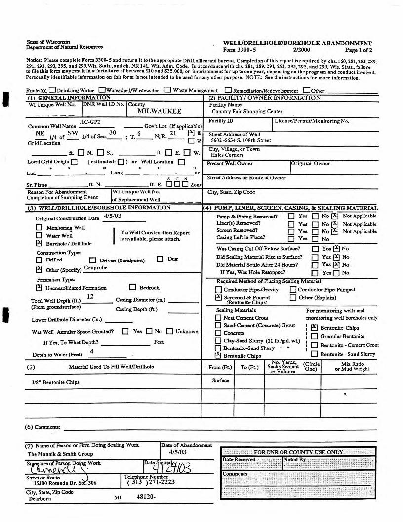
I
I
Stae of WISC0lWll Department of Narural Resoun:c:s
WELL/DRILLHOLE/BOREHOLEABANDONMENT Form 3300-5 2/2000 Page 1 of2
Notice: Please complete Form 3300-5 and return it~ the appropiate DNR office and bureau. Completion ofthis report is required by chs.160, 281, 28:3, 289, 291,292,293,295, and 299, Wis. Stat.s.,and ch. NR141, Wis. Adm. Code. In accordance with chs. 281, 289, 291, 292, 293,295, and 299, Wis. Stats., failure lo file this form may result in a forteiture of between Sl O and S25,000, or imprisonment for up to one year, depending on the program and conduct involved. Personally identifiable information on this form is not intended to be used for any other purpose. NOTE: See the instructions for more information.
Route to· 0 Drinking Water 0Wat=hed/Wastcwacer O Waste Management D Remcdiation/Redc,,elopmcnt 00ther . (1) GENERAL INFORMATION (2) FACILln / OWN.t+,K .U''Hi uRMAUON WI Unique Well No. IDNR Well ID No. ,County Facility Name
MILWAUKEE Country Fair Shopping Center
HC-GP2 Facility ID I License/Permit/J'\,lonitoring No. Common Well Name --- Gov't Lot (If applicable)
NE SW 30 . T 6 N· R. 21 (X] E Street Address of Well -- 1/4 of __ 1/4 of Sec. __ . ·-- . -- Ow 5602 -5634 S. 108th Street Grid Location
ft. 0 N. 0 S., ft. □ E. □ w. City, Village, or Town Hales Corners
Local Grid Origin 0 ( estimated: D ) or Well Location D Prescru Well Owner 'Original Owner • • " • ' II
Lat. ____ . Lon° . or ., ____ Street Address or Route of Owner s C N
St. Plane ft. N. ft. E. DOD Zone Reason For Abandonment r Unique Well No. City, State, Zip Code Completion of Sampling Event fReplacementWell
(3) WELUDRILLHOLE/BOREHOLE INFORMATION 4) PUMP,~ SCREEN, CASING, & SEALING MATERIAL
Original Construction Date 4/5/03 Pump &. Piping R=iovcd? □ Yes 0NoeJ Not Applicable
0 Monitoring Well Liner{s) R£movcd? □ Yes 0 No [Xj Not Applicable
D WaraWcll I If a Well Construction Report ScreaiRcmovcd? □ Yes 0NoeJ Not Applicable
Is a~allable, please attach. Casing Left in Place? □ Yes 0 No eJ Borehole / Drlllhole Was Casing Cut Off Below Surface? D Yes~No
Construction Type:
□ Drilled □ Driven (Sandpoint) □ Dug Did Scaling Mar.cial Rise to Surface? D Yes(!] No
Did Mataial Settle Afti:I' 24 Hours? D YeseJ No ~ Other (Specify) Geo probe -If Yes, Wu Hole Retopped? D Yes0No Formation Type: Required Method of Placing Scaling Material (!] Unconsolidated Formation □ Bedrock □ Conductoc Pipe-Gravity 0 Conductor Pipe-Pumped
Total Well Depth (ft.) 12
Casing Diameter ("m.) ~ Screened & Poured 0 Other (Explain) (Bentonlte Chips)
(From groundsurfacc) Casing Depth (ft.) Scaling Materials For monitoring wells and
Lower Dnllhole Diameter ("m.) 0 Neat Cement Grout monitoring well borclioles only
0 Sand-Cement (Cooaete) Grout I ~ Bcntonite Chips Wu Weil Annular Space Groutcd? D Yes D No D Unknown □ Coru:rcti,
I I D Gnmular Bentonill:
0 Clay-Sam Slurry (11 lbJgal wt.) I
UYes, To What Depth? Feet I D Bcntonite - Cement Groul n Bc:monite-Smd Sluny " " I
4 I D Bentonite - Sand Slurry Depth to Watu (Feet) [!I Bentonite Chips No. larda, (Circle Mix Ratio
(5) Ma11:rial Used To Pill Well/Drillholo From (Ft.) To (Ft.) Sa.clo Sealant orVohnnc One) or Mud Weight
3/8" Bentonite Chips Surface
'
(6) Comments:
(7) Name of Person or Finn Doing Scaling Won:
The Mannik & Smith Group
Da1e of Abandorunen1
4/5/03
Street or Rowe 15300 Rotunda Dr. Ste. 306
Tclephmu: Number ( 313 )271-2223
City, State, Zip Code: Dearborn MI 48120-

I I
'
St:ite of W =in Department of Natural Resour=s
son. BORING LOG INFORMATION Fonn 44-00-122 Rev. 7-98
Route To: Watcnhc,d/Wastewatc:r O Waste Management 0 Rcmcdiation/Rcvelopmcnt 5'l Othc:r 0
Page / 0 f 2... Fa.ciliry/Projce1 Name
('~ m \--(l~ _ ~ 1.· a. ~\'\oP(.)i: (\!;:; (' t t1 ¥. (L. Llccnsc/Pcrmil/Monitoring Number rorin\4ru:t .fil
Boring Oril~ BS-: Name of crew chi7\ (fust..last) and Fl.rm Date Drilling Si:..ned Da1.e Drilling Completed Ori lling Method '"" ~--- cj.,_0,._'(''(\ usl ~amc: ~l,U(£_. t- 9':1 I _9 ~ 1, _9~ 9 :!., .9 .L .:ZM ~ ~'2.or?Q. ,= \...... \na ..wr, Q'{\,.. o t) n ; \. l i t \ c._ mm d d y y y y m Ill d d y y y 1
WI Unique Well No. I DNR Wd! ID No, lrJ'cll Name IFinal Static W a1.c:r u:vel Surface Elcva1.ion iBorchole Diameter FectMSL FcctMSL inches
Local Grid Ori gin □ ( estimalcd.= □ ) or Boring Location □ I O • " LocaJ Grid Location
State Plane N. E Lat _____
N.E. 1/4 of ~1/4 of Section ~() , T {o N. R-.?:l_E. 0 ' " □ N □ E
Long Feet □ S Feet□ W Facility ID !County \J,, \ \1 Yl 1.A.\cLL
'-ountyCodc Civil, Town/Ciry/ or Village
JJ (\ l eJ r l'iQ ru t,~ Samele J Soil Prooerties
"II~ ,S
I 8 ~ Soil/Rock Dc.saiption ..:~ u
< 13 ""'-;z And Geologic Origin For > !:!
... g_ .5 ! "" 0 J5 ~= ?:--8 ~ .::: ~ u Each Major Unit -~ ~ =
u ti:: : ~ llC
u
~~ 3:· -5 • .&! - ... l:t~ -u :g - o E §:,, o.~ "" ~"' - ... a
., _ :I ·= ~~ 8
0 u • E~ -- = 0 E Oo C' = N
z 5 j~ =i 8a. ::i 0 j ~a a: c3.,, ::Eu :.:I ::i -= a.. o::8 a..-
-- ~ . D - Q~~t • ~-\ Y"e" I -- Q. Oil ve.,\ , h I\ 6-i? ~->• _, . . ... · (_ 0-L\') ~- - · l • - Ofu!:W0 ~"'--~ ~N.. ,o \(\Ql?.lv,.M
E-z. , .u
~QO..( ~~ SO-f\.O "'" St-\
• -=-3 -
r . - b,O =-i -
-2 s ( '-\~)
!J,'6'/
l4i Ii
-=-s-' --- C.00..ua. 9t~~ ~ ~~ I } l .' =-~ o.D ' , , , ,
- ~Af~\'o<l0,,.JA ~~ \.\8~~ \ -- ;, - v..) I \.-""-. t-(tp. CJ_ C~ (lO.. \J.1_, \. =-' ' - ~ -=-?-
. c,o 'H'j -
-3 -' s
( t' -Ii,) 4~\\ = °1 - l -- oD =-IC --- II
I hereby certify that the information on this form is true and correct to the best of my knowledge.
Signa
This form is authorized by Chap 281,283,289,291,292,293,295, and 299, Wis. Stats. Completion of this form is mandatory. Fai ure to file tbis f~rm may result in forfeiture of between Sl0 aod S2S,000, or imprisonment for up to one year, depending on the program and conduct involved. Personally identifiable information on this form is not intended to be used for any other purpose. NOTE: See instructions for more information,
including where the completed form should be sent
i : :

--
,.-::-..
. , , ..
c~,
,
.. I _!.
~
--!>
,...
(f)
~
~~
--
11
11
11
11
11
11
11
11
11
11
11
11
11
11
11
11
11
11
11
11
11
11
11
11
11
11
11
11
11
11
11
11
11
11
11
11
11
11
11
II I 1
1111
11 I
111
1 I
1111
11
t-'
p rn
l
0 t
(1-l
&- G
---<
. \'J
~
-
,, ..
'·
f . ~ ----
'
0 <:Y
,.
--
{{;)
Nu
mb
a
&nd
Type
Len
gth
Au
. &
R
ccov
orod
{in
Blo
wC
O\m
ll
Dep
th in
Pee
t di ~ ~-
[ l~
~'
g'
. .
·'B
..
"t1
s· ij
use
s G
raph
ic
Log
Wel
l D
iagr
am
PID
/PID
Com
pres
sive
S
ITC
l\gth
Moi
stur
e C
onte
nt
Liq
uid
Lii
nit
Plas
ticity
In
dex
P2
00
RQ
D/
Comment■
~
~ ii"1,
( ~ ' ~
(/l g, a a ~ IX
N
~ N

I
I
Sta of W"ISCOrtsin Department ofNaru:nil Resoura:s
WELIJDRILLHOLE/BOREHOLEABANDONMENT Form 3300-5 2/2000 Page 1 of2
Notiai: Please complete Form 3300-5 and return it to the appropiate DNR office and bureau. Completion of this report is required by chs.160, 281,283,289, 291, 292, 293, 295, and 299, Wis. Stats., and ch. NR 141, Wis. Adm. Code. In accordance with chs. 281, 289, 291, 292, 293, 295, and 299, Wis. Stats.. failure to file this form may result in a forteiture of between Sl O and $25,000, or imprisonment for up to one year, depending on the program and conduct involved. Personally identifiable information on this form is not intended to be used for any other purpose. NOTE: See the instructions for more information.
R ut to· 0 D Inking Water 0Wa.tershed/Wa~tewarer O Waste Management eJ Remcdi11tion!Redc:vcloP1T1cnt 00thcr o e . r (1) GENERALINFORMATION (2) FACIUTY/OWNERm.t<uRNIAllUN WI Unique Well No. l°NR Well ID No. I County Facility Name:
MILWAUKEE Country Fair Shopping Center
HC-GP3 Facility ID I License/Pennit/1\fonitoring No. Common Well Name ---Gov't Lot (If applicable:)
NE SW 30 . T 6 N· R. 21 [X] E SCicet Address of Well -- 1/4 of __ 1/4 of Sec. __ . ·-- , -- □ w 5602 - 5634 S. 108th Street Grid Location
ft. 0 N. 0 S., ft. □ E. □ w. City, Village:, or Town Hales Corners
Local Grid Origin 0 ( estimated: D ) or Well Location D Present Well Owner 'Original Owner . • II • • II
Lat __ -- . Long __ . or -- Street Address or Route of Owner s C N
St. Plane ~ N. ~ E. DOD Zone Reason For Abandomnent r Unique Well No. City, State, Zip Code: Completion of Sampling Event f Replacement Well
(3) WELUDRILLHOLE/BOREHOLE INFORMATION K4) PUMP, LINER, SCREEN, CASING, & SEALING MATERIAL
Orlglnal Construction Date 4/5/03 Pump &. Piping Removed? □ Yes 0 NoeJ Not Applicable
0 Monitoring Well Llner(s) Removed? □ Yc:s 0 No [Xj Not Applicable
I If a Well Construction Report Sc:rc:c:n Removed? □ Yes 0NoeJ Not Applicable 0 Warm-Well Is a".ailable, please attach. Casing Lc:ft in P1acel □ Yea □ No eJ Borehole/ Drlllhole Wu Casing Cut OffBc:low Surface:? D Yes~No
Construction Type:: □ Dug
Did Sc:aling Ma=ial Rise to Surface? D Yes[!) No □ Drilled □ Driven (Sandpoint)
Did Material Settle Aftr:r 24 Hours? D YeseJ No ~ Other (Spc:cify) Geo probe
If Yes, Was Hole: Retopped7 D YesD No Formation Type: Required Method of Placing Sealing Material el Unconsolidated Formation □ Bedroclc □ Conductor Pipe-Gravity 0 Conductor Pipe-Pumped
Total Well Depth (ft.) 12 Casing Diameter ("m.) el Screened & Poured □ Other (Explain)
(Bentonite Chips) (From groundsurface) Casing Depth (ft.) Sealing Materials For monitoring wells and
Lower Drillholc: Diameter ("m.) 0 Neat Cement Grout monitoring well boreholes only
0 Sand-Cement. (Concrete) Grout I ~ Bc:ntonite Chips Was Well Annular Space Grouted? ·D Yes D No D Unknown □ Concrete
I I
D Gnnular Bc:ntonitc 0 Clay-Sand Slurry (11 lbJgaL wt.) I
If Yes, To What Depth? Fc:c:t I 0 Bc:ntonitc: - Cement Grout n Bcntoniie-Smd Slmzy " " I I
D Bentonite - Sand Slurry Depth 10 Wa~ (Fc:et) ~ Bentonlte Chips No. Yarda, (Circle: Mix Ratio
(5) Mati=rial Used To Fill Wc:11/Drillholc From (Ft) To (Ft.) Sa.cks Sealant or Mud Weight or Volume: One:)
3/8" Bentonite Chips Surface:
'-
(6) Comments: -----------------------------------------
(7) Name of Person or Finn Doing Scaling Won:
Street or Rowe 15300 Rotunda Dr. Ste. 3
City, S111c, Zip Code Dearborn MI 48120-
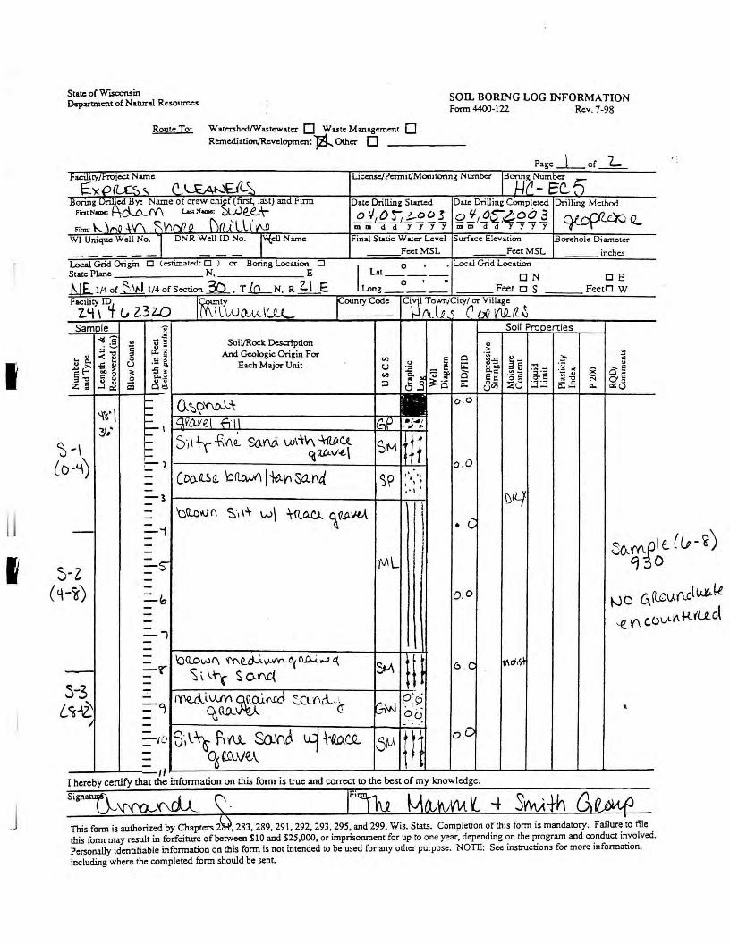
I
I
State of WlSCOflSin Department of N arural Resources
Route To: Watcrshod/Wa.stcwatcr D Wutc Management 0 Remcdiation/Revelopment ~ Other D
son, BORING LOG INFORMATION Form 4400-122 Rev. 7-98
Page_L_or "2.... Facility/Project Name
E')(oa i:-,, flUAt-.£il~ Licensc/Pcrmil/Monitoring Numba IB14f'~"fc.. ~
Boring~cd By: Name of crew chi~t, last) and Finn Date Drilling Started Da1.c Drilling Completed Drilling Method Fin, Nam<: cl.cuY\ (..ast Name: e.e... t- .E J,g L.f-E~ I gJ_,~~~9~~ o/cf'Z-® Q.. Fian: \--._ \J"\O +V\ ~ V',('/1 D \)(Lt l l \ NJ mm d d y y y y mm d d y y y y
WI Unique Well No. l DNR Well !D No. l"'tell Name Final Static W Iler l...,:vel Surface Elevation [.Borehole Diameter FcctMSL Feet MSL inches
Local Grid Origin □ (estimated; □ ) QI" Boring Location □ I O I n Local Grid Location
State Plane N, E Lat __ 0
__ 1
-,.
ON .hlE_ 1/4 of~ 1/4 of So:tion 3b_, T .lo._ N, R 2. \ E.
DE Long Feet o S Feet□ W
F!~ty\ ID4 CJ Z3 U) IMf cwll-1.-dlLL f=tyCode Ciw Town/City/ 01" Village
!"t. li ~ (1 ,-.[j 1Af ttS Samole 8 Soil Pronerties
d!l- ~ .s j - 3 SoiVRock Oc.scri ption
~i 8 - u "- ,I And Geologic Origin FOi" -~ ::I
... 8. .s i Cl"l 5 0 ff-5 ~= ?:- " ~~ ..c u u Each Majot" Unit u .:! G::: :;i_ :~ 11(
., - > :J -5 3' ..c - ... ... .,,
7n ~ 8 o E § -0 58 "- 0 Cl"l ~"' - .. a Cl.= ::, · -
~~ 0 ;6 Eg ·- = o- E o§ 8~ 0 0 N
:z: a .J 0:: ~ ::> 0 j i:: 8<1") ~u :.:i :.:i - = c... - c... o::u .... °' ~?'(\0-.\.-\
o .o .... '\'6' I .... .... Gt'Zlvel fi 11 GP . ..... , "!µ' ---- \
. ,, . #, .... 5·, I -\-y +.V\~ So.~ 1.»i1"V\ ~U.
11/ .... SM ~\ ....
()-L\) C: l ca(lC<.v-t..\
o .O
- coo. Q.S e. 'i::l <lAvA I ~\I) sa..nd ~~ ,'_ .. ,,
- I I I I - .•, I
-l b(L'/-- I - 'QQ.c'#J (\ ~-,\\ w\ ~~AA~ -\ • C -- =-,
- r 00-qgl - I
-z =·S" fv'L -
-i) -=-" o.o ----=-' -
l
- bQow<\ me..~'-#" c.,~-,..4.c:t..
H - SM e:, C - -'r" <s , I.. t-r s o..'f\C{
3-3 -- ~iu.M~~ :::.Clf\ ... -l~i o'.
~~ =-c, 3,v-1 . : ~
q,<'lR: ~ <! oo -J - - . - s·, \:\i f; vu. s.o.'C\t ~:rQDJ'_Q... m oC =-/(.' 5M
~cscve.A I I
I hereby certify that the information on this fonn is true and correct to the best of my knowledge.
~d,s-\
t-JO 6. (lOv.Nl l.i.t,. ~ u.AktU..ct ,€,_'(\ c,b
.._
This form is authorized by Chapters 2 , 283,289,291,292,293,295, and 299, Wis. Stats. Completion of this form is mandatory. Failure to file this fortn may result in forfeiture of between SIO and $25,000, or imprisonment for up to one year, depending on the program and conduct involved. Personally identifiable information on this form is not intended to be used for any other purpose. NOTE: See instructions for more information, including where the completed form should be sent

--
1111
1 I I'
11 I
I 111
1
,-··
--
r-...
c_/)
I -
I rJJ._
'
..£
.,
If tf I
Numbe
r C
l)
X-
\B V
' an
d T
ype
~ <7
L
engt
h A
tt. ~ c
, tn
R
ecov
erod
(m
(>
0l 11
1111
1111
1111
1 11
1 _I I I
11 j
1111
1111
111
1111
11 r
1 -
-4
\ii
? D
epth
in F
eet
~ ½
(P
_fll I
~ CJ
OJ
9 (~
b g_ ~
!H .. ~-[
~-~
~c5:
. ..
. fj
'B.
?8
l· ..
-~ .~1;;~
: .,
-•
' •
Wel
l D
iagr
am
0 \)
CJ
I PID/
FID
\'J
C)
0
C=
,=d
vo
S
tren
gth
Moi
stur
e C
onte
nt
Liq
uid
Lii
nit
Pla
stic
ity
Inde
x I
P2
00
RQ
D/
' C
om
men
t,
I
CJ)
0 - l a ?
~
'"' ~
-lr1
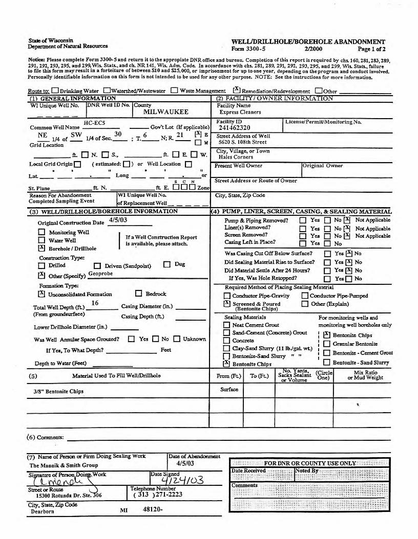
State of Wisa,nsin Department ofN:atural Resources
WELlJDRILLHOLE/BOREHOLEABANDONMENT Form 3300-5 212000 Page 1 012
Notice: Please complete Form 3300-5 and return it to the appropiate DNR office and bureau. Completion of this report is required by chs.160, 281,283,289, 291, 292, 293, 295, and 299, Wis. Stats., and ch. NR 141, Wis. Adm. Code. In accordance with cbs. 281, 289, 291, 292, 293,295, and 299, Wis. Stats., failure to file this form may result in a forteiture of between SlO and S25,000, or imprisonment for up to one year, depending on the program and conduct involved. Penonally identifiable information on this form is not intended to be used for any other purpose. NOTE: See the instructions for more information.
Rout to· 0 Drinking Water 0Wa.tershed/Wastcwater O Waste Management l!J Remediation/Redevelopment 00thcr e '
(1) GENERAL INFORMATION WI Unique Well No. IDNR Well ID No. I County
MILWAUKEE
HC-EC5 Common Well Name ---Gov't Lot af applicable)
NE 1/4 of SW 114 of Sec.~ 6 21 (X] E
; T. __ N;R. __ □ w Grid Location
ft. 0 N. 0 S., ft. □ E. □ w. Local Grid Origin 0 ( estimated: D ) or Well Location D . • II . ' II Lat. _____ . Long ____ . or
s C N
St. Plane ft. N. ft. E. DOD Zone
Reason For Abandonment r Unique Well No. Completed Sampling Event fReplacementWell
(3) WELLJDRILLHOLE/BOREHOLE INFORMATION
Original Construction Date 4/5/03
0 Monitoring Well
0 WatE:Wcll I If a Well Construction Report
[!) Borehole / Drlllhole Is a":allable, please attach.
Consttuction Type:
□ Drilled □ Driv= (Sandpoint) □ Dug
el Other (Specify) Geoprobe
Farmation Type:
[!) Unconsolidawd Formation □ Bcdroclc
Total Well Depth (ft.) 16
Casing Diameter ("'m.)
(From groundNrf'aee) Casing Depth (ft.)
Lower Dcillhole Diameter (in.)
Was Well Annular Space Grouted? D Yes D No D Unknown
Ir Yes, To What Depth? Feet
Depth to Water (Feet)
(5) Mataial Used To Pill Well/Drillholo
3/8" Bentonite Chips
(6) Comments:
(7) Name of Penon or Firm Doing Scaling Wort:
City, State.Zip Code Dearborn MI 48120-
/03
(2) FACIU'n I uvvr~.1£1{ m.l! ORMAllUN Facility Name Express Cleaners
Facility ID I License/Permit/Monitoring No. 241462320
Street Address of Well 5620 S. I 08th Street
City, Village, or Town Hales Corners
Present Well Owner !Original Owner
Street Address or Route of Owner
City, State, Zip Code
4) PUMP, LINER. SCREEN, CASING, & SEALING MATERIAL
Pump & Piping Ranovcd? □ Yes 0 NoeJ Not Applicable
I..iner(s) Removed? □ Yes 0 No [Xj Not Applicable Scrcc:n Rcnovcd7 □ Ye.s 0 Noel Not Applicable Casing Left in Place? □ Yes □ No
Wu Casing Cut Off Below Surface? D YcselNo
Did Scaling Material Rise to Surface? D Yes[!] No
Did Material Settle After 24 Hours? D Yes[!] No If Yes, Was Hole Retoppcd7 D YesD No
Required Method of Placing Scaling Material
□ Conductor Pipe-Gravity 0 Conductor Pipe-Pumped
~ Screened & Poured (Bentonlte Chips)
□ Other (Explain)
Scaling Materials For monitoring well, and
0 Neat Cement Grout monitoring well borcholcs only
0 Sand-Ccmc:.nt (Concn:te) Grout I ~ Bcntonite Chips □ Concrcm
I I D Gnnular Bcntonill: 0 Clay-Saxid Slurry (11 lbJgaL wt.) I I D Bcntonite - Cement Grow n Bcttonitc--Sand Sluny " " I I D Bentonite - Sand Slurry el Bentontte Chips
No. '!anis, (Circle Mix Ratio From (Fr.) To (Ft.) Sacks Sealant
or Volume One) or Mud Weight
Surface
'"
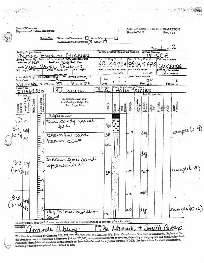
• , . .' .. :· · ;_.. : . .
Sta:= o!W :sa:i=:n Dcpc=c:::.t a!Na.t:::nl Rrnx:m
__ son. BORING LOG lNFOR.'dATION Foe::. ~lZ? Rev_ 7-98
Rc;%;To; W~ur::.w..:c D Wu:::M.t:rug=c:-.t O R=~cvclcpmc::-.i: ~ Othc:; 0
~ } of Z
Loo.l Gr..d Ori gi:t □ C <:S"'....:=.t::e: □ l cr Boring Locirion □ s~~PI.anc ________ N. _______ E
~I/4of~l/4ofS=:e-:t.3D_. T _jg_N. R~
.. -,. ~ ........
s-, 4%} .. -- . (o-L\' ' .. _'. ') l\Z
Soil/Rod: Dc=iption And Geologic Origin Fer
Ea.ch M~jcr Unit
h\\.Ov'"'"'- ~'--V\J., JJo..xvJ\.u\~tJ....-~
• ~1-e u:tc:tc:r Fin;>J St.tic Wi.tc:; L::vd ruri= E.lc:v,,;crt r · I Di ___ Feet MSL ___ Fe:: MS°<- -~-- ir.c:.i<e.:
I ut o , ~,Loc.u C-rid l.oc=ion
--o--,--. ON □ E Long______ Fe:t □ S Feet□ W
... -~
"' :2 -~ 0 U-5 ~-= CJ ~
_.., 3-"'-c: -u
"' C. - ... -~~ ::, ·:: .. ~ '5 0 =" c:-= ::, 0 j a: o:: "'"' ::i ::i CJ"' ::Eu
• •• GM ~
"· & •• •• • ~
0
D
.. ' ' ..
c,.u Ml.
I hereby certify that c.ie information on mis form is true and correct co the best of my l::lowledg:.
Thb form t amhori=i by Oiapt:r:s 281,233,289, - l, 292. 293,295, and 299, Wl.S. Stats. C=p!e::cn oft.bis foim is inao.da!Ory. Failur: to file 1bi, form miy result in furf::ro.= ofbc:tweca Sl0 and 525,000, or ir:ipri3o=t fur up ID aoc y=, d..--pc::icimg on chc progrmn and cotiduct mvolved.. P=lly idc:itifiable infi:ra::lriaa on this form u not mtcndod ID be u.scd for m:r orl= pu:rpc:sc. NO!2; See instruc:iom for more in.fo=-ttioa,
mclu.dmg where the ccmplcmd form 5hould be =t. ·
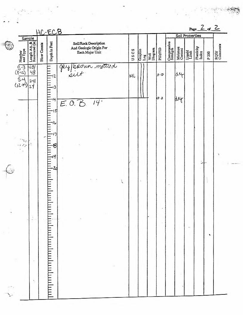
('-
·.- -.-:,.) ~
\, . . ... . ,
l
(
Samele cij,S
=i .s 8. ~3 '::J >
§~ ·a :z: s 3o::
~-3 {; -11..')
W8/ LJB
S-'-\ 2-'-ll 1L-I'-~ 7. 1
. ·-, : .. . : .... _ .....
. . - -
'
~rJ-E.c.,, ....
] 8 ~
.5 -5 ~
0 C. \)
$ 0
'-I-'---::::-12 ----::::....13 ----..... ::::-''t ..... --~,s . ------I-~11,, I-1-- ' I-
-· :::-17 ..... ..... ~'8 ..... --~~ --I-::::_~ I-'-'-'-......_ --------......_ --..... ..... ..... .,__ ..... ..... ..... --......_ I-
. I- - - · --i--I---.... --......_ '-'-I-.... ----.... ---i--I-..... I-I-i--------I------I-.... I-1--
z_ 2.. Pagc __ ol __
Soil Procertles
Soil/Rock Ocsaiption 0
And Geologic Origin For .?
a j Cll 2 5 0 §-s ~c ?;,
Ea.ch Major Unit u .::: E: Cl. CIQ -u ~- 1¾M ~ "° == ~ a e~ .!!I- ~~ - u 8
Cll u -0 C: C". ::i~ O' E ~
::i 0 j ~Q ~ 0- :::.E8 :::J - C: o::8 C.)Cll c..- c..
~)~~~J(YIJ/{Z(Jr/_; ~ - ~~ ML Ot0
£ . o.'t:> I 'f' k;i() ~tt
~
\
i .. - -
'
-
..
'-

Stue of W"ISCOlWll Department of Natural Ruourccs
WELI.JDRILLHOLE/BOREHOLE ABANDONMENT Form 3300-5 2/2000 Page 1 of2
Notice: Please complete Form 3300-5 and return it to'the appropiate DNR office and bureau. Completion of this report is required by chs.160, 281,283,289, 291, 292 293, 295, and 299, Wis. Stats., and ch. NR 141, Wis. Adm. Code. In accordance with chs. 281, 289, 291, 292, 293,295, and 299, Wis. Stats., failure to file this form may result in a forteiture of between Sl 0 and $25,000, or imprisonment for up to one year, depending on the program and conduct involved. Penonally identifiable information on this form is not intended to be used for any other purpose. NOTE: See the instructions for more information.
R ute to· □Drinking Water 0Wateahed/Wastcwau:r D Waste Management ~ Remc:diation/Redi:Yclopmcnt 00thcr 0 . (1) GENERALINFORMATION '2) FAf'TUTY/uw1~.l:£.l<.lNJ:t'•-•~(Vl_& 1 -•I~ WI Unique Well No. IDNR Well ID No. ,County Facility Name
MILWAUKEE EXPRESS CLEANERS
HC-EC8 Facility ID I Llcense/Pennlt/Monitorlng No. Common Well Name ---Gov't Lot (If applicable) 241462320
NW NW 30 • T 6 N· R. 21 (X] E Street Address of Well -- 1/4 of __ 1/-4 of Sec. __ . ·-- , -- Ow 5620 SOUTH 108TH STREET Grid Location
ft. 0 N. 0 S., ft. □ E. □ w. City, Village, or Town HALES CORNERS
Local Grid Origin 0 ( estimated: D ) or Well Location D Present Well Owner IOrlginaJ Owner • • " . • II
Lat ____ . Long _____ . or s C N Street Address or Route of Owner
St. Plane ft. N. ft. E. DOD Zone Reason For Abandonment IWI Unique Well No. City, State. Zip Code COMPLETION OF SAMPLING ,-· _;eplacementWell
(3) WELI.JDRILLHOLE/BOREHOLE INFORMATION 4) PUMP, LINER. SCREEN, CASING, & SEALING MATERIAL
Original Construction Date 8/12/03 Pump &. Piping Removed? □ Yes 0 Noe! Not Applicable
0 Monitoring Well Llner(s) Removed? □ Yes 0 No [Xj Not Applicable
I Ifa Well Construction Report Screen Removed? □ Yea 0 Naef Not Applicable 0 WarerWcll ls available, please attach. Casing Left in Place? □ Yes 0 No eJ Borehole / DriJlbole
Was Cuing Cut Off Below Surface? D Yca0No Construction Type:
□ Dug Did Sealing Material Rise to Surface? D YcsO No
□ Drilled □ Driven (Sandpoint) Did Mau:ria! Settle~ 24 Hours? D YcaO No eJ Other (Specify) GEOPROBE
If Y cs, Was Hole Retoppcd? D YeaO No Formation Type: Required Method of Placing Sealing Material eJ Unconsolidated Fon:nation □ Bedrock □ Conductor Pipe-Gravity 0 Conductor Pipe-Pumped
Total Well Depth (ft.) 14 Casing Diameter ("m.) l!J Screened & Poured 0 Other (Explain)
(Bentonlte Chips) (From groundsurface) Casing Depth (ft.) Scaling Materiili For monitoring wells md
Lower DriDhole Diameter ("m.) 2 0 Neat Cement Grout monitoring well boreholes only
0 Sand-Cement (Coocn:te) Grout I ~ Bentonite Chips Was Well Annular Space Grouted? D Yes D No D Unknown □ Concrete
I I D Gnnular Bcntonib:: 0 Clay-Smd Slurry (11 lbJgaL wt.) I
If Yes, To Wiu.tDcpth? Feet I D Bentonite - Cement Grow n Bcntonite-Sand Slurry " .. I I D Bentonlte - Sand Slurry Deprh to Warr.r (Feet) eJ Bentonlte Chips
No. lard&, (Circle Mix Ratio (5) Matcial Used To Fill Wc11/Drillholo From (Ft.) To (Ft.) Sa.clcs Sealmt One) or Mud Weight orVohnne
3/8" BENTONITE CHIPS Surface
'-
(6) Comments: -----------------------------------------
(7) Name of Person or Firm Doing Scaling Won:
THE MANNIK & SMITH GROUP
Si D3 Street or Rowe
15300 ROTUNDA DR SUITE 306
City, State, Zip Code DEARBORN MI 48120-
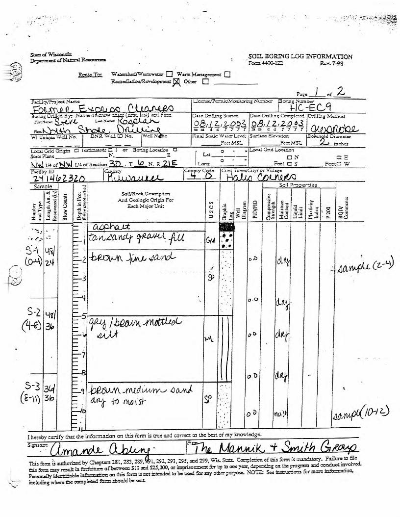
-~ - ~~ _})
~~)
-~ (
__ SO!L BORING LOG INFOR.'1ATION Fa::i 4-400-122 Rev. 7-98
Re,;;;: Iz w w=.'u::c./W u'::::'lnlr: □ w = M.zmg==.t □ R=~./Rcvdcpmc:u ~ Otitc:- D
I'¾-= } of Z
Lo=! Grid Origi::1 □ (er....t=L:C: □ ) or Bor.ng ~ □ Su.tc P!ane _______ N. _______ E
~ 1/4 of~ 1/4 of S=o= .3n_ . T _jQ_ N. R ..zlE.
Samele
.... ' . :
. . . • t .... ; .......
S-2
Soil/Rod: Dc.saipcion And Geologic Origin Fct"
E.a.:h M .. jor Unit
FinaJ Static W >Lc::-1...:vd r..r-f=-= Elcvstion r ")I.le Di2:nctc:r ___ Feet MSL ___ Fe.:: MSc. ;;.(J inc:.~
I Lit o , ,.,L:,c.,.l Grid LocaLian --- .
--a--,--_ ON □ E Long______ Fe:::t □ S F~t□ W
., >
"' ~ - ~ 0 ;:;--: !:::::
CJ ~ -- ~E ~-"' - ""
C.c: ~ -:::: • i3 Cl =~ •- C 0:, c-:
:::i dj a: o- ::i :.:! CJ"' '.::u
G,1.4 -· • ' ,. : ..... -
e, :D clrt /
O ·O
4i/ (~-() "?)p 1~ .bWM_ ,(i1Ktlto,/.,
o-t> l-'\.
- - -- -- .
$-3 0~ ctir
3&f ~.Jmtd~ 1JOJrJ. 1'• I
( ~-\\) '
3b tt~ +o rrto l·s+- ~ . ' · / . ..
D v ri,~~} lit)AU(X(Jf>-I 0 ' ' '
I hereby c.:nify chat t:.':e information on this form is true :111d co~ct to chc best of my ciowfedg=.
Toi3 form i:s aJJihori=i by Cla:pt:::3 281,233,239, - 1,292,293,295, and 299, Wu. St:i:c.. C=pl:::on ofthi.s fornx LS i:nan.6.tory. Fill1= to file thu form m:rJ result in fcrl"ciu= ofbetwcca SlO .md ru,ooo, or impri.so=t fer up to o= J=. ~g oo. the progr= .md condu.c: i:avolved. P::r=lly idartifiablc mfurmatioa on th::s fotm i.s !lot mtl:ruiod to be used farm'/ ocha p~ NaIZ: See io.sttuc:foo.3 form= mfu=:moo., ioclud:ing wbcr= tbc cx,mplctz:d. form 3hould be .scxt. .

. ~ ... '. :-
l Wt -EC q Plgc __ of Z..
Samele Soil Procertles
clg.5 .... Soil/Rock Dcsaiptian. ] 8 0
:I.._, ~ And Goologic Origin For
.?: -~1 - :?:- i:
] 8. .5 Cl.) .g 5 0 ~-5 ~= J;i M u
Ea.ch Major Unit 1:: ~- a~ §~
'::I> ~ -5 C.) I-;:: - ... Cl. "4 -u -;·;: 8 008 -- a gg ~- 'S ~ 0 C. Cl.) .. ..,
u -oc: 1j gc3 .Sc:: s 0 p j ~Q ~8 - C:
~
z~ :) - UCl'l c..- c..
(
--- be_owlt rru cliwrn /J()., YtJJ.._ ., ..... ' ,
'.)-~ ~ i--
. - kJ{,i @ ' . , o-0
~rz. 12. .,;_/ ..
\I-\~ 3~ ..... jp . . \0lt -.....
---13 ,
' --- . , ..... ~I➔ C
i--
s-s- lf<} i--
::::..,s . .. i;(),,ttf Yf ----1y') --- -
--- ~'¼( A,c,U- V~rtt Ai1({ d'i --- - 0 .,0
~/1,, - 1-,i l - · '--
, . ~17 -·-. . ..... . - .• ·-
, .
=-18 . -[)
- E . 0.0 \'a I .-'=:-if \
---- ✓ - .. -r ·· cs) :::_~
.. , -·
---i--i--..... '--..... \. ..... -..... '--..... '--.__ .__ .___ .__ .__ .__ i--i---i-- .
. - - ... . -.. . - - ---.... -· .... ...;. .... .. '--..... I-I-I-
-------i---.__ .__ '--i--i---.__ i--
' --'-----i--..... ..... ..... i---
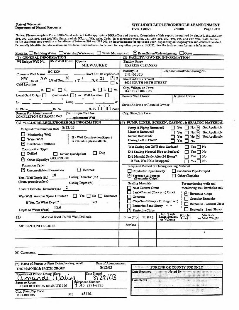
Sta of W"1SC0nsin Department of Narural Resources
WELUDRILLHOLE/BOREHOLE ABANDONMENT Form 3300-5 2/2000 Page 1 of2
Notice: Please complete Form JJ00-5 and return it lo the appropiate DNR office and bureau. Completion of this report is required by chs.160, 281,283,289, 291,292,293,295, and 299, Wis. Stats.,and ch. NR141, Wis. Adm. Code. In accordance with clu. 281,289,291, 292, 29J, 295, and 299, Wis. Stats., failure to file this form may result in a forteiture of between S10 and S25, 000, or imprisonment for up to one year, depending on the program and conduct involved. Personally identifiable information on this form is not intended lo be used for any other purpose. NOTE: See the instructions for more information.
Route to· 0 DrinkJng Water 0Wiuershed/Wutcwacer O Waste Management ~ Remcdiarion/Redl:vclopmcnt Oooer . (1) GENERALINFORMATION WI Unique Well No. l°NR Well ID No. ,County
MILWAUKEE
HC-EC9 Common Well Name --- Gov't Lot (If applicable)
NW 1/4 of NW 1/4 of Sec.~ . T 6 N· R. 21 (X) E . ·--. -- Ow
Grid Location
ft. 0 N. 0 S., ft. □ E. □ w. Local Grid Origin 0 ( estimated: D ) or Well Location D . • II • • II
Lat. ____ . Long _____ . or s C N
St. Plane ft. N. ft. E. DOD Zone
Reason For Abandonment IWI Unique Well No. COMPLETION OF SA.i'1PLING ,-- -~eplacementWell
(3) WELUDRILLHOLE/BOREHOLE INFORMATION
Original Construction Date 8/12/03
0 Monitoring Well
I If a Well Construction Report 0 WataWcll Is available, please attach. [!] Borehole / Drlllhole
Construction Type:
□ Drilled □ Driven (Sandpoint) □ Dug
eJ Other (Specify) GEOPROBE
Formation Type:
[!] Uncoo.solidatl:d Formation □ Bedrock
Total Well Depth (ft.) 18 Casing Diameter ('m.)
(From groundsurf.ace) Cuing Dcp(h (ft.)
Lower Drillholc Diameter ('m.) 2
Was Well Annular Space Grouted? D Yes D No D Unknown
If Yea, To What Depth? Feet
Dcplh to Water (Feet) 12.5
(5) Ma11::rial Used To Fill Well/Drillholo
3/8" BENTONITE CHIPS
(6) Commerus:
(7) Name of Person or Firm Doing Scaling Work
THE MANNIK & SMITH. GROUP
Street or Rowe 15300 ROTUNDA DR SUITE 306
City, Slate. Zip Code DEARBORN MI 48120-
(2) FAuun I UYY i";~J:<.11";.l''U.!<'M A11uN Facility Name EXPRESS CLEANERS
Facility ID I License/Permit/Monitoring No. 241462320
Street Address of Well 5620 SOUTH 108TH STREET
City, Viii.age, or Town IL\LESCORNERS
Present Well Owner IOrlginal Owner
Street Address or Route of Owner
City, State. Zip Code
{4) PUMP, LINER. SCREEN, CASING, & SEALING MATERIAL
Pump & Piping Removed? □ Yes 0NoeJ Not Applicable
I..ina(s) Removed? □ Yes 0 No (Xf Not Applicable ScRcnR=-OYcd? □ Yc.s 0 No(!j Not Applicable Casing Left in Place? □ Yc.s 0 No
Wu Cuing Cut Off Below Surface? D Yes0No
Did Sealing MateriJll Rise to Surface? D YesO No
Did Material Settle After 24 Hours? D YesO No If Yes, Was Hole Retoppcd? D YesD No
Required Method of Placing Sealing Material
□ Conductor Pipe-Gnvity 0 ConductoT Pipe-Pumped
I!] Screened & Poured (Bentonite Chlps)
□ Other (Explain)
Scaling Materials For monitoring wells md
0 Neat Cemen! Grout monitoring well borehole., only
0 Sand-Cement (Coocrcte) Grout I ~ Bentonitc Chips □ Concrcu,
I I
D Granular Bcntonio: 0 Cay-Sand Slurry (11 lbJgaL wt.)
I I
0 Bcntonite - Cement Grow n Bc:monitc-Smd Slnny " " I I
D Bentontte - Sand Slurry eJ Bentontte Chips No. Yards, (Circle Mix Ratio
From(Ft.) To (Ft.) Saclu Scalmt or Volume One) or Mud Weight
Surface
"
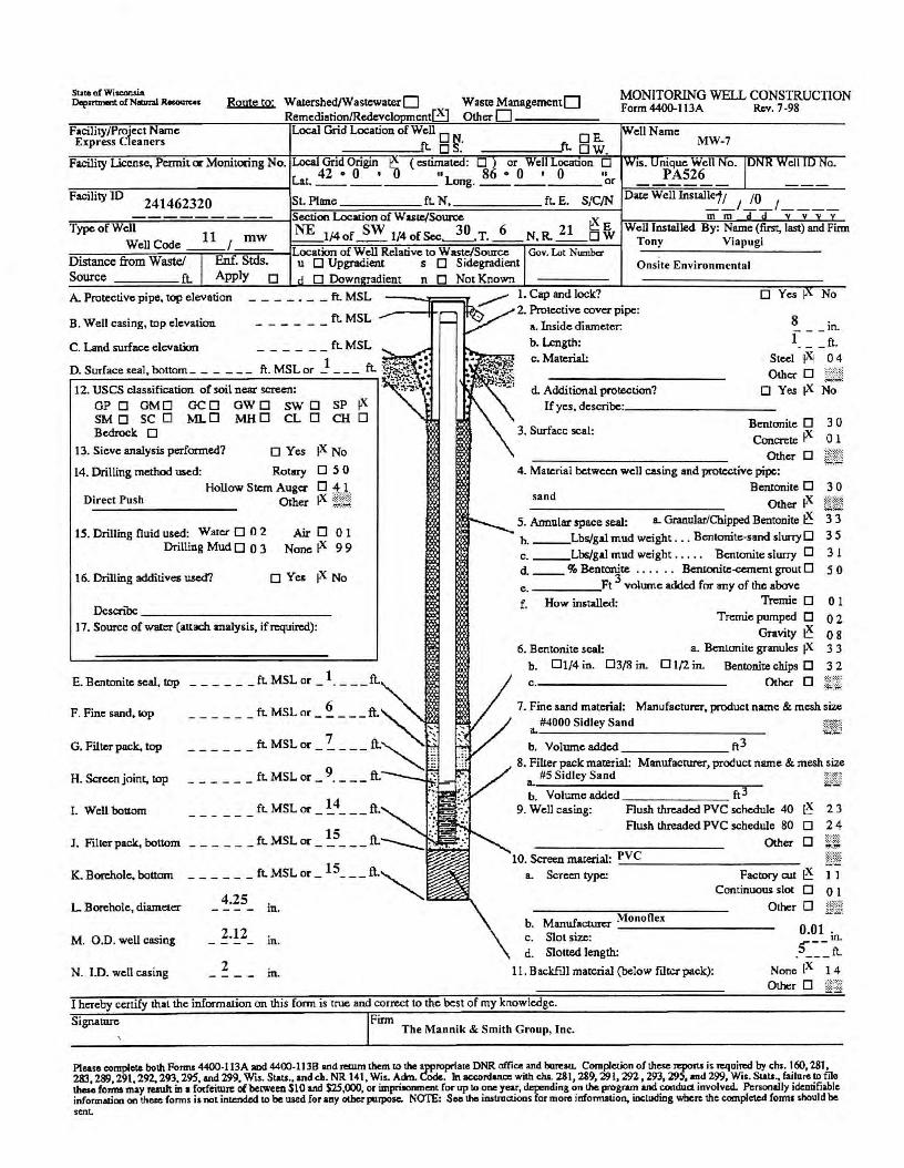
State of Wiscaruln Deportment of Nl!bnal 11....,,,,..., Route to· WalerShed/Wastcwater D Waste ManagementD
Remcdi11tion/Redc:vel cntE9 Other D MONITORING WELL CONSTRUCTION Form4400-113A Rev. 7-98
Facility/Project Name Express Cleaners
Local Grid Location of Well □ ft. N. f □ E. os. t. ow. MW-7
Facility License, Permit or Monitoring No. Gri Origm ( esnmated: D ) or We Locanon □ 1s. nique Well No. La 42 • 0 • "1 86 • 0 • 0 11 PA526
o.
---=--------------1 t. __ ____ ong. __ _ ___ or 1=-=-=:;-;:;:.;-,=;:-=.:-;;:..::;=.--'-----======--
Facility ID 241462320 St. Plmc fLN, fLE. S/C/N DateWelllnstalle1; /0 __ , __ , ___ _ - - - - - - - - - Section Location of W asce,ISouroe ~
Type ofW'!ell Code ~/ mw -~-_1}4 of~ 1/4 of Sec~. T. _6_ N. R. E_o t m m v
Well Installed By: Name (first, last) and Firm
::::--;---;:--;;-;--"."""";--,;--,;s-;o-;,,.......----ILocation of Well Relative to W asce/SoUicc Gov. Lot Number Distance from Waste/ . Stds. u □ Upgradient s □ Sidegradient
Tony Viapugi
Onsite Environmental Source fL Apply □ D Down radient n D Not Known
A. Protective pipe, top elevation .... _ .... _ ..... _ ft. MSL ---._,,;::::::=.r 1. Cap and lock:? □ Yes No
B. Well casing, top elevation ft. MSL _.---ff-,._ 2. Protective cover pipe:
- - - - - - a. Inside diameter. 8 in. f .... - ft.
C. Land surface elevation _ .... .... _ _ .... ft. MSL
1 fL ~•~;. :: D. SUTface seal , bottom ... _ .... - .... .... ft. MSL or - - - - ~t'1:::5,. :. 12. uses classification of soil near screen: ,!';,-,,, •
GP □ GM□ GC □ GW O SW □ SP tx SM D SC O ML □ MH D CL □ CH □ Bedrock □
13. Sieve analysis performed? □ Yes tx No
14. Drilling method used: Rowy D 5 0 Hollow Stem Auga O 4 l
Other !X ¢;µ Direct Push
JS. Drilling fluid used: Water O O 2 Drilling Mud O O 3
AirD0l None ix 99
16. Drilling additives U$ed7 O Yes ix No
Dcscnoc ____________ _
17. Source of water (attach analysis, if required):
E. Bcntonite seal, top
F. Fine sand, sop
G. Filter pack. top
H. Screen joint, top
I. Well boaom
J. Filter pack., bottom
K. Borehole, bottom
L Borehole, diameter
M. O.D . well casing
N. ID. well casing
_ ............ __ fL MSL or_ 1. ___ ft.
_ ............ _ _ fL MSL or .... ~ __ .... ft.~.._
___ .... _ .... fL MSL or _ ?_ ___ ft.~ }
_ ............ __ ft. MSL or _ 9_ .... __ ft. ..
______ ft.MSLor _ !_4 ___ ft.
in.
2.12 in.
2 in.
b. Length: c . Matcrw: Steel !Xi 04
Otha- D J:5 ~ .. ~ :
d. Additional protection? □ Yes tx No Uyes, describe_· _________ _
3. Surface seal: Bcntonile D 3 0 Con~te ix 0 1
Other □ 4. Material between well casing and protective pipe:
sand Bentonite D 3 0
Other ix 5. Annular space seal: a. Granular/Chipped Bentonite ~ 3 3
b. ___ Lbs/gal mud weight .. . Bcntonite-sand slurry□ 35 c. ___ Lbs/gal mud weight . . . . . Bcntonite slurry D 3 1 d. __ % Bent~te . . . . . . Beruonite<ement grout D e. _____ Ft volume added for any of the above
f. How installed: Tremit: D Tremie pumped D
Gravity ~ 6. Bentonite seal: a . Bentunite granules tx
b. Dl/4 in. 03/8 in. D 1(2 in. Bentonitc chips D
C.------------- Other D
50
01
02 08 33 32
7. Fine sand material: Manufacturc:r, product name & mesh size
a. #4000 Sidley Sand ij_~) b. Volumeaddcd _______ ft3
8. Filler pack material: Manufacturer, product name & mesh size #5 Sidley Sand i.fki
~- Volume added _______ ft3 9. Well casing: Flush threaded PVC schedule 40 ~ 2 3
Flush threaded PVC schedule 80 □ 2 4
ooer □ Wt 10. Screen material:P _v_c _________ _
a. Screen type: Factory cut ~ I I Continuous slo< D 0 1
O1her D ;;,:;;;_; b. ManufacturerM __ o_n_o_fl_ex _______ _
c. Slot size: O.Ol in. 5"--d. Slotted length: . __ .... ft.
11. Backfill material (below filter pack): None (X I 4 Other D @@
I hereby certify that the information on this form is true and correct to the best of my knowledge.
Signature Firm The Mannik & Smith Group, Inc.
' ·
Pleas& complete both Forms 4400-l 13A aod 4400-113B and JeCUm them to the appropriate DNR affice and bore11L Completion of these n:poru is required by chs. 160,281, 283 289 291,292.293, 295, and 299. Wi.,. Siau., andd,. NR 141, Wis. Adm. Code. In accordance with cha. 281,289,291,292,293,295, and 299, Wis . Slats ., failareto filo th~ fo.:i,. may result in a forfeitnrc of between $10 and $25,000, or impraonment for op IO one year, deP'mding on the program and conduct involved. Personally identifiable informatioo on these forms i, not intended to be used for any other purpose. NOTE: Soothe inatroctions for more information, including where the completed forms should be sent.
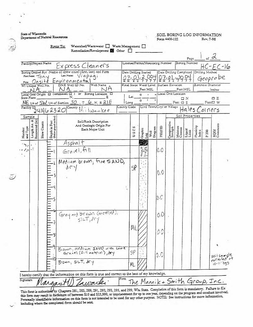
.. . \
v ·
. SOII... BORING LOG L'l'FORMA TION For::i 4400-122 Rev. 7-98
Rqq.;..: To;
fu:ilicy/Projcc.r. Nar.te
Wa.ca:sh,erl./Wa.st::.ww:::- 0 Wu:::M.z:iug=c::-..t 0 R=a!i.tri.oc,/Revdoprn= 11 Othc:- □
o f d,..
I Final Sc..ric W uc::- L:vd !Suri=--: E!cv,li= 13=:-:olc o;_· ir.,c :c.-
F=: MSL F• ·: M Sc. me.'>=
Lo=!GridOrigin D <= D J or- Bonng Loe= O Stic.:Plane _______ N . _______ E
NE 1/4 o{ 5}j_ 1/4- of Sc:=-..:cn ..3.Q_ T (o N R ~ \ f I Lit o , "!Lo=.l Grid Location
--o--,-. □ N Long F~ t □ S
8 ! 5-0 i I/Rock D<:.sc-i p cicn :::..1 A..--:d Geologic Origin Fer . '.: ? . "' 0 -5 ;' .E.ach MijOT' Unit u .g _ ~ ._ ~j_ Gl1 ;" ~ u :1 ~ □- => a.53:o -
---,.----.-----t----;:;---;--i-,-----------+---4 ::: Aso~o.\ t .... . _.
• t .. .-. ...... .. •
.....--f---....:....L---.,,......----------1---i
~ I I r I cc20'ft .. 6 1 o v.f.. ; -n \ . · -~ . , ..... ~
,.... ·o .0 ,
C-J. -,--,__
:::.... '.> -._ I-I--
:::-LI
1-- .,.
I----=-+ ,--I----:::-1 -.... .... /)
tA et\ i l)_ JY\ 'oc ovJf\) ·_r; t'-l -S AD D1
~ r-/
~ rCi ,1 M {_\ b r cv)f\ (M ct+ \ e,,\ ) 1
' 5\L-T Jrj
i-- 1 \3cov-i r, J Meo..'t u.. M s'AIJD ;;,1; fu s,,..t-
cD . . _)f •
E ' 910. ~ ~, ( ~ ; 1\ IWA~;,,1 ) }~y i--\( _____________ 4-__;L_.:._j
§ ·., '3ro..:il"\ 1 SIL-T, J.ry ML ~
0.0
o.o
o.D
o.o
I hereby cc:rufy that t!1~ infonnaoon on this form is true and correct to the best of my lcnowledg:.
Sei l ?n::ce rci es
~§_5 -~;--_=·;,::: -~a :::u
Toi, form u autho · Qapt= 281,233,289,291,292,293,295, and 299, Wu. St:tts. C=pl:ricn ofiliis form is til2ILda!ory. Failure to file thu form crJJ1"f r=ult in~ ofbetweco S10 md S25,000, or impri,o=t fur up ID ooe y=, c!..~g on die program .md cooduct mvolved. P=ooally idc:atifiable infcm:atioa on tbis form is not intended to be used for m'f ot:h.:r purpcsc. NO'G: Sec ins:ruai= for more info=:tcioo..
including w~ tbc compleO:d form should be sent.

.--:-·
·---- - ·· · .' · · - - - - • • :. • • • - - ■ • •• • - ~ • •
WELL/DRILLHOLE/BOREHOLEABANDONMENr FOCD 3300-5 2/2000 Page 1 of2
. ' • .•. ;; .t.·-~ , .. - :ol'..M.1-
Notice: Ple,ase complete Form JJ00-5 and return it to the appropi:ite DNR ofTice and bure:iu. Completion of this report is required by chs. 160, 2Sl , 2SJ, 289, 291,292, 29J, 295, and 299, Wis. Stats... and ch. NR 141 , Wis. Adm. Code. In accordance with cbs. 281, 2S9, 291, 292, 29J, 295, and 299. Wis.. Stats., failure lo file this form may result in a forteiture of between SI O and S:ZS, 000, or imprisonment for up to one ye:ir, depending on the program and conduct involved. Penooally identifiable information on this form is not intended lo be used for any otber purpose. NOTE: See the instructions for more information.
Esmte tQ; D Drinking Water Ow ~ed/W 3stcwacer 0 Waste Mmagemcnt '!KJ Remcdiarion/Redcvcloomc:nt 00thcr (1) GENERAL INFORMATION (2) FAOU11 / OWN~.!{ lf'l.rU.Kt.VlATION W1 Unique WeUNo. r'iR Weil ID No.
1
Cotmty ~A, L-:iti::l},.~2-. Facilicy Name
(DLA l\1('-1 F,:'.{; I S~o oOi/) (o_,.-~r-1
' c-r;c-11 F3Cility ID ,,. )I LlcenselPennil/Monironrlg~i Common Well Name IT · ~ ___ Go-v't Lot (If applicable) ·::h!!n~ 2,c10 ire. 1/4 of <, ~ j 114 of S=.. : {) ; T.-1..a.__ N; R. ,1 \ g E Screct Address a[ Well
1 <:..,...J. Grid LOC11fon W ~:JO 5 , io r+'A ....) . .
ft. 0 N. 0 s.. ft. □ E. □ w. Cicy, V~c, or Town
I \e.s ( ()( f) "?.J5 Local Grid Origin 0 ( estimated: 0) or Well LOC1tioo 0 Presc:n.c Well Owner !Original Owner . . .. . . It
Lat. __ . Lon° . or -- ., __ --s C N Street Address or Route of Owner
St. Plane rt. N . rt. E. ODO Zone Rason For Abandonment I r Unique Well No.
(Qrnp\e~J Yll"DIWI <"vf~ fRepracementWell
City, Swe, Zip Code
(3) WELUDRILLH-OLEJBOREHOLE INFORMATION 4) PUMP, LINER. SCREEN, CASING, & SEALING MATERIAL
Original Coostructloo Date "1 11\oj Pump &. Piping RcmoYcd7 □ Yes □ No~ Not Applicable . I..inc{s) Ri:moYcd? □ Yes 0 No ; Not Applicable D Moniroring Well
I If a Well Construction Report Screen RcnoYC<i? □ Ye.s 0 No Not Applicable D W=-Well is available, please att:ich. Casing Left in. Place? □ Yes □ No ~ Borehole/ Drillhole
Wu Casing Cu Off Below Surface? 0 YesJ8)No Construction Type:
□ Drilled D Driven (Sandpoint) D Dug Did Sealing Material Rise to Surface? D YcslNo \
fil Other (Specify) (qropn>'oe Did Ma.tc:ri:al Scnle Aftz:r 24 Hours? D Yes , No If Y cs. Wac Hole Retoppcd7 D YesO No
Formation Type: Required Method of Placing Scaling M atcria.l
~ Uocon.solida.tcd ~ation □ Bedrock □ Conductor Pipe-Cnvity 0 Conductor Pipe-Pumped
Tel21 Well Dq,rh (ft.) i c;: Casing Di.om.ctr::- ("m.) ~Screened & Poured □ Other (Explain) (Bentonile Chips)
(From groundsurtacc) Cuing Depch (ft.) Scaling MatQ'WS For moniLoring wells md
Lower Dn1lhole Diameta ("m.) 0 Neat Cement Grout monitoring well boreholes only
D Sa:nd-Ccmcnt (Cooc:mc) Grout I D Bcntonite Chips Wu Well Amrul11r Space Grcwed? D Yes D No O Unknown □ Coru:rctc
I I 0 ~ulsr Bcntooitc 0 Oay-Smd Slurry (11 lbJgaL wt.) I
IC Yes, To Wlu.tDcpth? Feet I 0 Bcnionite - Cement Grow □B~Sl=Y " "
I I 0 Beotonite - Sand Slurry Depth to Wari:.r (Fo:t) ~ Bentonlte Chips
No. "'.l'ard.s, (Cuc!e Mix Ratio (5) M:sraul Used To Fi1l Well/Drillbolo From (Ft.) To (Ft.) Sacks Sealant
or Volume One) or Mud Weight
5 le;/ Ee"-h1;, k CJ_·,os Surface
I ~
(6) Carmnc:ut:s: --------------------------------------
Sir-...et or Rollle
15 300 lotuVI 3 City, Sti11e,Zip Code
,,.., I l ' ' .)!N Cc! (\ ' l 1 l
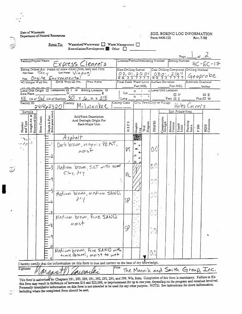
.. ....... ·)
{t~;
I
~- ··
_SOII. BORING LOG INFOIU,1'ATION
Rog;eTo;
f s.cilicy / ?re j = N a.-:i C Ex
W=ht::d/Wut::wuc- 0 Wutz: M.zn.&&=c:-..c. 0 R=e:i.l.rion/Rc:vcloprnc-u:. Othc:::- □
cd By: .Na.me or=-' c:uer (n.,t, 1.1.St) a.id f= F'.nt Yux: '\Of\ 'f r.-, ~"""" \) t' o.. p l-1 ':J; •= 0A ; +-e_ £""" i,.,l'\t~e r1¼..I
W1 UniqUG Wc;U No. DNR. Wc:ll lD No. Well:-,,.°"'"
Loo.l Grid Orig-i:, □ C = □ l or Bcnng Loe= D
F-or.:i 44-00-12:2 Rev. 7-98
Sut<: Punc _______ N. _______ E
_tl_l_ 1/4 o( N 1/4 of S=-.e= E T ~ N R ~ 1 E r
L>t o , "IL.o=l Grid Loc:it.ion --
0--,--. ON DE
Long F-t □ S c-c.::c□ W
o'!! - -~ .S ~ :l :: Soil/Rock Dc.sc:-iption Samele J
~ i § c;:.. ~ A.-:d Geologic Ori~i.n Fer ... g_ ... 0 -= ~- " "' - ,.., _g _,.,. -: ~ U -5 .,, Ea.ch Major Unit u '-' "' -~ :; r § ] J! "' l ~ ~ 2
-~-,-:~.~~-~+---~--t~-+--A;-5-o-r~,-~-1~r-----------1-~-~-~a~3
a -
·' •'> ·· · ~ I [;ork "orc00. 1
o~ ~ r,; c ~E:. P\ T, .:: (f\.0 "::,-r t:-~ 1--
=-3 I-. --.::_q I-.
---=-1i ..... ..... .
~" I-.
I--- . - :f"
t~eJ\ l.lM 'orowr. i 5 !LT ,.;,-\"vi -soPfZ
C\"'i ! )'.c-1
(v\e{'. i t...11v, brovJ(I I i "e. SA 0 Di Mo,s+-
MeJ.i0.y(I. 'oro..vr1, t2t·~ SANO v-1,~
+r.-...a. ~ro-.H\ J rt'lo,-~+ +o v-Je.\--
I
~L
SP
5P
" Ori ,v'
~J.. .::t.
~ on . ~
/' . ·" I/A
J-.
, , . , ...... , i \
; ' J -..
·-
.. ..
, .. f"\
) -' )
I hereby certify chat c.'1e information on this form is true and correct to the best of my J.owledg:::.
l-lci le.s Corner 5 Se il ?r:Jcer.:ies
..
...
Tai3 form' u a.utho · by Ola:pt=. 28 l, 283, 289, 29 l, 292, 293, 295, and 299, Wu. St:tts. Cm:pl::ion ofiliis for.n is tr..aruhtory. Fain= to file tb.u form may r=ilt in furttic.= of between SlO a:od S25,000, or impri50mncot fu-r up to one yezr, c!~g on the prognm md conduct i:avolvcd. P::nooally idc:otifiable infm=a:ioa OD thi:s fctm u not mt::ndcd to be used form'/ otha purpc:= No-2 Sec ins:ruc:i= for more infm=ttioa..
including wbcrr: t!ic complea:<l furm should be =t.

.. . ·~
Samele ~ -. <td;§_ ] ,t : )
tl "8 ~-j;J ] 8. ~13
'::l> ~ §~ "°§ .2 :z:; j~ ~
. ··; :
. : •· __ .-.
'
8 ll-,
.s -= c.. \J
Cl
r-r-,.... ,....
. ' r--' ="" ,....
,-
,-,.... Ii .J
,-,-
~ _it.I . ,-,-r-r- 1"., '
,
,--,-,-...-. ,--- · r-r--
, . r---r-r--,.... ,-r-r-r--,-,-r-,-r--,-r-,-,-r--,.... ---r--r----r--,-,--r-r--,.... ,-,-r-r--r r-r--r-r--r-r-r-r-r--r r-r-r-r--r----r--r-r--:-r--r-r----
Soil/Rock Dcsaiption And Geologic Origin For
Each Major Unit
f. O. 'D,
sP ('f , ..,
,.... (\ ' .) ' \ ......
Soil Prooertles
w<' l "x. f°! er11'd
10- ,::;-' bJ$

\
I
Staaa of Wisconsin Department ofN:arural R.e.sourccs
WELIJDRILLHOLE/BOREHOLE ABANDONMENT Focn 3300-5 2/2000 Page 1 of2
·····-·· .. .... :-.. .... . ~..,~
Notice: Please complete Form JJ00-5 aad return it to the appropi:ite DNR ofTice and bure:,u. Completion of this report is required by chs. 160, 281, 28J, 289, 291, 292, 29J, 295, and 299, •Vis. Suts., and ch. NR 141, Wis. Adm. Code. In 3ccord:ince with cbs. 281,289,291,292,293,295, and 299, Wis. Sbts., failure to file this form may r~ult in a fort.eiture o( between Sl 0 and S2S, 000, or imprisonmeat for up to one ye2r, depending oa the program and conduct involved. Pononally identifiable information on this form is not intended to be used for any other purpose. NOTE: See the instructions for more information.
~ 0 Drinking Water 0Wst::rshed/W3~tewater O Waste Managemc:nt t:iR<!mcdi..rion/Redcvclapmcrt 00ther (1) GENERAL INFORMATION (2) FACIUIY / OW1'4ER lt~.l'UKi.\'iATION
WIUniqucWeUNo. IDt'<RWeillDNo..,County ~k l FacilityName + -;- - Cl ,.., /"",,,,._l-r-lV\J WCUJ~( Co•J;1 r ,f /✓,.fl,~ .__J/\D{..,/)N1 l,., ,T,
11( c, --i. F3Cilitylgu/f 11
..,.,0
rLicenselPennit/MoruroringNo.. CommonWeUName H -.&-L.., --- GoY'tLot (lf.rpplioblc) ,,1 1 lPc,( -;()(
G~foca~~nof Shl 1}4 of Sec.. ~o ; T . ...!L_ N; R~ ~: 1--S-ttcct_c:;_~.;.__O;._ . .;...%.:.;. ..... w:.:;i"o-1~.;;;;.ti< __ .,___ ,;t-, ----------
□ □ ft. O E. O W . City, V!-4,a&e, or Town ____ ft. N. s., ---- ~ 1es CoU\tl$
Local Gr1~ Orig)~ 0 ( ernm:ted: 0) or • Well L~tion O " 1-Prcscnc---'w...:.:;:c~JI-Ownc;.....::.....r ~;;.....:.....;;;..._.,., l'O""r""'i_gi,_na_l ""Own--e-.--------
Lat. _ ___ ---'·'----- Long ____ --•=--__ or 1------------_., ____________ _ S C N
St. Plane rt. N. rt. E. DD D Zone
Reason For Abandonment IWI Uolque WeU No..
{or110\P~J ."tlM nli~a i':;t'/\t lorReplacemeotWell
(3) WELUDRILLHOl::°EIBOREHOLE INFORMATION
Original Constructioo Dare _ :}-__ /_I_ /'Q_)~--0 Monirorin~ Well
Q, w air:r well ~Borehole/ Drillbole
Comtru,ction Type:
I Ira WeU Construction Report ls available, please attach.
D Drilled O Driven (Smdpoint) □ Dug ;EJ. Other (Specify) __._C-_,q=(.=o"""p .... 0-0.;;;a.b"""'e;.._ _____ _
Forma.tion Type;
~ Unconsolidated Formation
Tel21 Well Depth (ft.) / ,:;:;
□ BedrocJc
Casing Di.tmcta [m.) ___ _
(Fram groundsurfacc) Cuing Depch (ft.)
Lower Driilhole Diameter (in.)
W1SWelI AmiularSpaceGroucc:d? 0 Yes O No O Unkn.own
If Ya, To WlutDepth? _______ Feet
Depth to Waru (Feet)
(5) Mall:rW Usa:d To Fill Wcll/Drillbolo
I
Stre1?t Address or Route of Owner
City, Swe. Zip Code
K4) PUMP, LINER, SCREEN, CASING, & SEALING MATERIAL
Pump&. Piping Rcnc,,,cd? D Yes D No (& Not Applicable
Llna(s) R=ovai? 0 Yes D No !2f, Noc Applicable
Ser= RcnOYCd? 0 Yes O No '2f- Not Applicable
Casing Left in. Placcl D Yes O No
Wu Cuing 011 OffBclow Surface? O Yes f;ia No
Did Sczling Maa:rial Rise to Surface? 0 Yes CJ<No
.· Did Mucrw 5cttu, Aftz:r 24 Hours? 0 Y cs )a. No l!Yes, WasHoleReroppcd? O YesO No
Rcxiuired Method of Placing Seiling Material
0 Conductor Pipe-Gravity O Conductor Pipe-Pumped
-@ Saeened & Pou~ D Other (Explain) ,,,_,.... (Bentonite Chips) ·
Scaling Materials For monitoring wells and D Neat Cement Croat monitoring well boreholes only
0 S~ (Cooc:rete) Grout : D Bentonitc Chlps
0 Coru::rco: : 0 ~ular Bentonia: □ Cay~ Shmy (ll JbJgaL wt.) 1 0 Bcntooitc - Cemc:nt Grolll 0 Bcmonitc-Smd Slmry " " : & Bentonlte ChJps O Bentonite - Sand Slurry ,
From (Ft.) To (Ft.)
Surface
No. yards, (Circle Saclc.s Scalmt One)
or Volume
Mix Ratio or Mud Weight
(6) CommcnlS: --------------------------------------
Dare of Abandonment
~)QL{

.__:. . .-.
I
.... _ ..
. son. BORING LOG L'1"FORMATION For.:i 4400-122 R-~. 7-93
Ecw.eio;
scilicy/Projcc.t Name
W~h,:d/Wul:::..,1LC' 0 Wu:: Mi,ug=c:-.L 0 R=eca!ion/Rr:vclc-pmcu ■ Othc:: 0
cd By: N=e or • ciier (n.--;r, l.l.st) a.: F= f'.m:-1,c,c: To"-- y La•)<= V1 ·a. p u~ i ,=: OM·,+-~ ff\..i,', fn.~\
I r7 Pr:: of cl-
~ -- --
W1 Unique Well No. Dl'<R Wc!! lD No. WcU .'i .... -,,c Final Suuc W .ua- L:vcl ISl.!!"f.i.c.:: Ekv3ticn 13 · I Di ~::oc .ir.1c ta-
___ Fc:: MSL ___ Fe:: M SL 4 , ,.1.') inc.'!cs
Lo=! Grid Ori gm D C ~ D l or Boring Locuion D Su!<: Planc _______ N. ________ E
f0t.114o( <,~/ 1/4-ofS=-~= ~o. T ....iLJ... N, R .JI E wt :--, -;lu:,c.i! Grid Locat;t N □ E
long F~t o S F;:.::t□ W
" So il ?rooerties
-~ lj _ Soil/Roel. Dc.scipcion '-' ~ l A.-,d G=logic Origin For .?. -5
3 Ea.ch Major Unit ;:; .g _ ~ O 1!l ~ ~ I ., u
C.. o c.,-, C. °' --:7 °"• ,..,_._ C:..c .,. - .-,,,.; ·== C Q § ~ ~- • - E µ ·5 ~ - ~ ~ I g Cl -o - :::> c .S :?: o - 8~ ::E 8 :..:: :.:: :: -= - :::: 0
---~-.. 4----1---_:::1-- +--P-:-1-s-p-:--'·"-c,-:-\-:-\-----------1-l--41a.::. £~. --+---:---"-+--+---+---J--!----
· • ·'> ·· • ~ j ~{Cl.vf..\ ) ·t=°,11 - .';f --- {qP J_i) " I-'- ,.....
-: L -----=..a.1 ---:::.. '6 -,__ ,__
~~ ---.... ---- ;.
"' ~--.fl+----- ----- ' -- \ \
~ ~Lv 8 ~ ------------------------- L
o.o
ac
0.0
0.0
00
o.c
at the informacion on chis fonn is true l!ld correct to the best of my !cnowfedge.
'
Thfa fortri ·is :wrhori=i Olaptc:s 281,233,289,291,292,293,295, a.od 299, Wu. Stm. C=:ple:icn of this for.n is maruialory. Faih= to file thil form may result in forfcitl= ofbc:twcco S10 and S25,00O, or impri.soamcm fur '-'P to= y=. c!..~g on che program and conduct mvolved. P=ooal.ly idart:ifiable infcmm:ioa 0t1 thi:s form u not mti:nded to be used for m'f other pUipCSC- Nar.2 Sec ~= for more inf~oa.. i:och.uling wbcrt: tbe compleo:,d furm should be =t.

II II II ii I I I I
-;.\ :·j/
;__;,:
~
.s -5 C. ...
Cl
. 1 Id
Psge~of J.. Soil Procertles --
Soil/Rock Desai . And Geologic Ori~;
""--'-M. gin or = 1 aJorUnit
I oro•p" 51L-TY cLAy Jr ) ,/ I
E .o.,

I
-~~ ...
I
l.
.:~ - -·· ·-·-··" .. · ..
Stale of Wisconsin Depuanc:1t ofNzrural Resourc:c:s WELI.JDRILLHOLE/BOREHOLEABANDONMENT
For:m 3300-5 2/2000 Page 1 of2
Notice: Please complete Form 3300-S and return it to the appropi:ite DNR office and bureau. CompletioD of this report is required by chs.160, 281 , 28:J, 2S9, 291, 292, 29J, 295, and 299, Wis. St:its.. aDd ch. NR 141, Wis. Adm. Code. In 3ccordance with cbs. 281, 289, 291, 292, 29), 295, and 299, Wis. Stats.. failure to file this form may r~ult in a fortciture of between SlO and SZS,000, or imprisonment for up to OD< year, depending oa the program aDd coDduct iDvolve<I. Penonally identifiable information OD this form is DOI intended to be used for any other purpose. NOTE: See I.be instructions for more in(orm:atioa.
~ 0 Drinking Water 0W1%::r'Shed/W3stcwater 0 Wam Management OiRemc:diarion/Rc&vclopmO'lt _ D Other (1) GENERALINFORMATION (2) FACTLli x / OWN~R 1NrU1:<.J.VtAl1vN W1 Unique Weil No. IDNR Wei.I ID No. ,County . ) -~ Facility N~e G I ,,--
5hoooira Cerc-k M, \,Q4t)._ . e OLl r,t{'f (-tt ; r l-+(£C-{3 Facility ID U I Llcense/Permit/Moairol-i11g ~
Common WeU Name --- GoY'tLot (If applicable) ]4 I I ,8--._ ~ol Afr:. 1/4 of $1J 1/4 of Sa:. ".0 ; T._k_ N; R. J2L~ E Saect Ad.dress of Well
S, l 01-1-1.- Sf-, Grid Locition W ,::;&i a o ft. □ N. D s.. ft. □ E. □ w.
City, V~'z or Town i"P,.lts Co( rQ.f:;;
Loci.I Grid Origin 0 ( estim:ited: 0 ) or Well Locition 0 Presc:n.c Well Owner IOrigin::il Owner . . .. . . ,. Lat. ____ . Lona . or
., ____ s C N Street Address or Route of Owner
St. Plane ft. N . ft. E. 000Zone Reason For .ANndonmcnt t r UruqueWeUNo. City, Swe, Zip Code
{DMD'\f \eA ~ ,.~,:), rc1 f 1_;<>t1. (Replacement Well
r
(3) 1 WELUDR.IT.LOOLE/BOR.E.."'fOLE 1NFOR.\1A TION ~4) PUMP, LINER. SCREEN, CASING, & SEALING MATERIAL
Original Construction Date Pump &. Piping R.cncM:d7 □ Yes 0 N:-:g- Noc Applicable
0 Moniroriag Well l..mc{s) .R.em0Yed7 □ Yes 0 No Noc Applicable
0 Wa=Wc:Il. I Ifa WeU Construction Report Screen RcnoYCd? □ YC3 0 No 'J2! Not Applicable
is available., please atbch. Casing Left in.Pl.ace? □ Yes □ No ;;;a- Borehole/ Drillhole Wu Casing Olt Off Below Surface? D Yesl'.jNo Cauttuction Type: Did Scaling MalZ:rial Rise to Surface? 0 Ycsl29 No .\
□ Drilled D Drivcn~int) □ Dug O YcsJzf No pt( Otha (Specify) 6-e.o Ci rD e. Did Mau:rial Sctw:: Afrz:r24 Hours?
I If Y cs.. Was Hole Reroppcd7 0 YcsO No F=arion Type; Required Method of Placing Sea.Ling Mataial ~ Uoconsolidatcd Formation □ Bcdroclc □ Conductor Pipc-(inviry 0 Conductor Pipe-Pumped
~ / 1§:' Scrttned & Poured □ Other (Explain) Tot:il Well Deprh (ft.) / J Casing Diam.:= (in.) (Bentonile Chips) (Fram groundsurfa=) Cuing Depth (ft.) Scaling Ma£crials For monitoring w-elb and
Lower Drulhole Diameta (m.) 0 Neat Cement Grout monitoring well bon:holes only
0 Sand-Cement (Cooc=tc) Grout I D Bcnc_onite ChJps Wu Well Annular Space Grou.ccd7 D Yes D No O Unknown □ Coc=co::
I l 0 ~ular Bcntcnitc 0 Oay-Smd Shmy (11 lbJg:iL wt.) I
If Yes, To WlutDcpth? Feet l □ Bcntonite - Cemau: Grolll 0 Bc:ntoniLc-SaDd Slnny .... I
I 0 Bentonite - Sand Slurry Depth 10 Watt:J" (l=ect) m_ Bentonlte Chips .No. ! ards, (Cude Mix Ratio (5) MalZ:rial Used To Fill Well/Dn1lholo From (Ft.) To (Fe.) Sacks Sealmt One) or Mud Weighc or Volume
3/cz' , &tt4oY'·, k. cw/)5 Surface
'-
(6) Canm).cn!S: ----------------------------------------

St.ate of Wisconsin Dc:parnncntoCNarural Reso=
SOIL BORING LOG INFORMATION Form 4400-122 Rev. 7-98
ROU!.CTo: Watc:nhcd/Wa.stewalc:r D Wutc Management D Rcmcdiation/Rcvelopmcnt ~ Other D
Local Grid Origin □ ( estimalcd; □ l er Boring Location □ St.ate Planc _______ N, _______ E
__ 1/4 of __ 1/4 of Section __ , T __ N, R __
Facilicy ID County l-'\- L1AJAJ \lE~
Sam le ~ od- -= .s .. - ~ SoiVRoc:lc Description
~i § 8 -... 8. 0 ~1 And Geologic Origin For
~ ?' -= u CJ Each Major Unit
t§ ;I: -5 3 §-:, c.. o 0
Page _L of _j_ Llccruc/Pc::mil/Mortitoring Numba- oring Nwnbcr
\-IA-Date Drilling SWtcd Da1.e Drilling Complc:tcd. Drilling Method
Q8-,.ll ,"2Q.o:i Q.5,l],.1-~..Q::J HAND m m d d Y Y Y Y m m d d J Y Y J A\..) ER_
Final Static WsJ.cr Level Surface Elcvuion ___ Feet MSL ___ Feet MSL
I o , " Local Grid Location
Lat --o--,-,. □ N Long______ Feet □ S
"' CJ
"' ;:)
.!:! ~ 0 -= ... G:
□ E Feet□ W
~1 zs ...J "' Q --+-t---t:---;-------------+--
~ u: a o.5~o a:
'
I hereby certify that the information on this form is true and correct to the best of my knowledge.
This fcrm is authorized .by Chapters 281,283,289,291,292,293,295, and 299, Wis. Stats. Completion of this form is mandatory. Failure to file this f~ may result in forfeiture of between Sl0 and 525,000, or imprisonment for up to one year, depending on the program and conduct involved. Personally identifiable information on this form is not intended to be used for any other purpose. NOTE: See instructions for more information,
including where the cempleted form should be sent.

Sta of Wisconsin Department of Natural Reaourccs
WELUDRILLHOLE/BOREHOLEABANDONMENT Form 3300-5 2/2000 Page 1 oil
Notice: Please complete Form 330~ 5 and return it to the appropiate DNR office and bureau. Completion of this report is required by chs.160, 281,283,289, 291, 292, 293, 295, and 299, Wis. Stats., and ch. NR 141, Wis. Adm. Code. In accordance with chs. 281, 289, 291, 292, 293, 295, and 299, Wis. Stats., failure to file this form may result in a forteiture of between S10 and S25, 000, or imprisonment for up to one year, depending on the program and conduct involved. Personally identifiable information on this form is not intended to be used for any other purpose. NOTE: See the instructions for more information.
Route to· 0 Drinking Water 0Wa.tershed/Wastewater O Waste Management eJ Remcdiation/Redevelapment DOI.her '
(1) GENERALINFORMATION (2) FACILITY/ U\Vr~..t<.:K 1J.'-i.1''0R.i\.1ATION WI Unique Well No. IDNR Well ID No. I County Facility Name
MILWAUKEE HISTORIC DRY CLEANERS
HA-1 Facility ID I License/Permit/Monitoring No. Common Well Name --- Gov't Lot (If applicable) 34109955
NW NW 32 6 21 [X) E Street Address of Well 1/4 of __ 1/4 of Sec. __ · T N· R -- . ·--,·--Ow 5606 SOUTH 108TH STREET Grid Location
ft. 0 N. 0 S., ft. □ E. □ w. City, Village, or Town HALES CORNERS
Local Grid Origin 0 ( estimated: D) or Well Location D Present Well Owner 'Original Owner 0 • " . ' " Lat. ____ . Long ____ or
s C N Street Address or Route of Owner
St. Plane ft. N. ft. E. ODD Zone
Reason For Abandonment IWI Unique Well No. City, State, Zip Code COMPLETION OF SAMPLING ,- · -~eplacement\Vell _____
(3) WELUDRILLHOLE/BOREHOLE INFORMATION (4) PUMP, LINER, SCREEN, CASING, & SEALING MATERIAL
Original Construction Date 8/17/04 Pump &. Piping Removed? □ Yes 0NoeJ Not Applicable
0 Monitoring Well Liner(s) Removed? □ Yes 0 No [Xj Not Applicable
I If a Well Construction Report Sc:rcc:n Removed? □ Yes □ No~ Not Applicable D Ware-rWell is available, please attach. Casing Left in Place? □ Yes 0 No ~ Borehole/ Drillhole
Conmuction Type: Wu Casing Cut Off Below Surface? D Yes0No
□ Drilled □ Driven (Sandpoint) 0 Dug Did Scaling Material Rise to Surface? D YesD No
eJ Other (Specify) HA!"ID AUGER Did Matcrial Settle After 24 Hours? D Yes~ No
If Yes, Was Hole Re topped? D YesO No Formation Type: Required Method of Placing Sea.ling Material ~ Unconsolidated Formation □ Bedrock □ Conductor Pipe-Gravity 0 Conductor Pipe-Pwnped
Total Well Depth (ft.) 1 Casing Diameter ("m.) D Screened & Poured 0 Other (Explain)
(Bentonite Chips) (From groundsurface) Casing Depth (ft.) Scaling Materials For monitoring wells and
Lower Dn1lhole Diameter (in.) 0 Neat Cement Grout monitoring well boreholes only
0 Sand-Cement (Concrete) Grout I 0 Bentonite Chips Was Well Amrular Space Grouted? D Yes 0 No D Unknown □ Con=:tc
I I D Gnnular Bentonite 0 Clay-SSZld Slurry (11 lbJg:iL wt.) I
IfYes, ToWhatDcpth? Feet I D Bentonite - Cement Grout 0 Bentonitc-Smd Slurry " " I I D Bentonite - Sand Slurry Depth to Water (Feet) 0 Bentontte Chlps
N_o. ·1aroa, (Circle Mix Ratio (5) Material Used To Fill Well/Drillholc From (Ft) To (Ft.) Sacks Sealant
orVolmne One) or Mud Weight
REPLACEMENT QF SOILS Surface
'
(6) Comments:
(7) Name of Person or Firm Doing Sealing Werle
THE MANNIK & SMITH GROUP
Date of Abandonment 8/17/04
City, State, Zip Code DEARBORN MI
ignc /. , I I 4 /b/0'
Telephone Number ( 313 )271-2223
48120-
Date Received
Comments

State of W !SCOnSin Dc:partmc:nt of Natural Resourcc:s SOIL BORING LOG INFORMATION
Form 4400-122 Rev. 7-98
Route To; Wau::rsht:d/Wastcwatcr D Wastc Management 0 Rcnediation/Revelopmcnt ~ Other 0
Local Grid Origin □ (estimaU:d: □ l or Boring Location □ State Plane _______ N, _______ E
__ !/4 of __ 1/4 of So:tion __ . T __ N. R __
Soil/Rocle Description And Geologic Origin For
Ea.ch Major Unit
ar_L Llccruc/Pcrmil/Monitoring Number
Date Drilling Started O&.Lc Drilling Complct'11 Drilling Method
f)~,l ]_,1,.~t} Q8,L "1,~'t. HAA.~})E" m m d d 1 1 1 1 m m d d 1 Y 1 1 VC...J C..
Final Static Waier Level Surface Elevation archaic Diameter ___ Feet MSL ___ Feet MSL ~ inches
I o , " Local Grid Location
ut___ □ N □ E 0 ' •
Long______ Feet □ S Feet□ W
Soil Prooerties
-~ ~ 0 ..c: ~ C
--1---1---.--,----------------~---a ~ u: a o.33:o a:
S?
, . '\ \ ·',
·, '
. \ ,
'' . I
I, •t
_. '· . ' . '
I hereby certify that the information on this form is true and correct to the best of my knowledge.
'-
This form is authorized .by Chapters 281,283, 289,291,292,293,295, and 299, Wis. Stats. Completion of this form is mandatory. Failure to file this form may result in forfeiture of between SI0 and S25,000, or imprisonment for up to one y=, depending on the program and conduct involved. Personally identifiable information on this form is not intended to be used for any other purpose. NOTE: See instructions for more information,
including where the ccmpleted form should be sent

Stuo of Wisconsin Department of N:arural Ruourccs
WELL/DRILLHOLE/BOREHOLEABANDONMENT Form 3300-5 2/2000 Page 1 o1'2
Notice: Please complete Form 3300-5 and return it lo the appropiate DNR office and bureau. Completion of this report is required by chs. 160, 281,283, 289, 291, 292, 293, 295, and 299, Wi~ Stats., and ch. NR 141, Wis. Adm. Code. In accordance with chs. 281, 289, 291, 292, 293, 295, and 299, Wis. Stats., failure to file this form may result in a forteiture of between $10 and S25, 000, or imprisonment for up to one year, depending on the program and conduct involved. Personally identifiable information on this form is not intended to be used for any other purpose. NOTE: See the instructions for more information.
R ute to· DD inking Water 0Watershcd/Wastewacer D Waste Management O Remcdiation/RedcYclopmcnt Ooocr 0 '
r (1) GENERALINFORMATION (2) FACIU'1 I/ UWN.1!,K 11'11' OKl\tlAHUN WI Unique Well No. IDNR Well ID No. !County Facility Name
MILWAUKEE HISTORIC DRY CLEANERS
HA-2 Facility ID I License/Permit/Monitoring No. Common Well Name --- Gov't Lot (If applicable) 34109955
NW NW 32 ; T._6_ N; RE._ ~ : Street Address of Well -- 1/4 of __ 1/4 of Sec. __ 5606 SOUTH 108TH STREET
Grid Location
ft. 0 N. 0 S., ft. 0 E. 0 W . City, Village, or Town HALES CORNERS
Local Grid Origin D ( estimated: D) or Well Location D Present Well Owner 'Original O\>ner . . " • ' II
Lat. _____ . Lono or ., ____ Street Address or Route of O\\ner s C N
St. Plane ft. N. ft. E. ODD Zone
Reason For Abandonment j\VI Unique Well No. City, State, Zip Code COMPLETION OF SAl'\-IPLING ,-· -~eplacement\Vell
(3) WELUDRILLHOLE/BOREHOLE INFORMATION (4) PUMP, LINER, SCREEN, CASING, & SEALING MATERIAL
Original Construction Date 8/17/04 Pump &. Piping Removed? □ Yes 0 NoeJ Not Applicable
□ I...iner(s) Removed? □ Yes 0 No [Xj Not Applicable
Monitoring Well
I If a Well Construction Report Scn:cn Removed? □ Yes □ No~ Not Applicable 0 WaterWell is available, please attach. Casing Left in Place? □ Yes 0 No eJ Borehole / Drillhole
Construction Type: Wu Casing Cut Off Below Surface? 0 Yes0No
□ Drilled □ Driv= (Sandpoint) 0 Dug Did Scaling Maierial Rise to Surface? D YesD No
eJ Other (Specify) HAt"ID AUGER Did Material Settle Afu:r 24 Hours? D YcsO No
If Y cs, Wa, Hole Retoppcd? D YcsD No Formation Type: Required Method of Placing Scaling Material
eJ Unconsolidated Formation 0 Bedrock □ Conductor Pipe-Gravity D Conductor Pipe-Pumped
5 Casing Diameter rm.) 0 Screened & Poured 0 Other (Explain)
Tot.al Well Depth (ft.) (Bentonite Chips) (From groundsurface) Ca.sing Depth (ft.) Scaling Materials For monitoring wells and
Lower Dn1lhole Diameter (in.) 0 Neat Cement Grout monitoring well boreholes only
0 Sand-Cement (Coocn:te) Grout I 0 Bentonite Chips Was Well Annular Space Grouted? D Yes 0No 0 Unknown □ Coru=tc
. I I D Granular Bentonia: 0 Clay-Sand Slurry (11 lbJgal. wt.) I
If Yes, To What Depth? Feet I D Bentonite - Cement Grout 0 Bcntonite-Smd Slurry " " I I D Bentonite - Sand SIWTY Depth to Water (Feet) D Bentonlte Chips
.No. lards, (Circle Mix Ratio (5) Material Used To Fill Well/Drillholc From (Ft.) To (Ft.) Sacks Sealant
or-Volume One) or Mud Weight
REPLACEMENT OF SOILS Surface
'
(6) Comments: -----------------------------------------
(7) Name of Person or Firm Doing Scaling Won
THE MANNIK & SMITH GROUP
Date of Abandorunent 8/17/04
Street or Ro 15300 ROTUNDA DR. SUITE 306
City, State, Zip Code DEARBORN MI
Telephone Number ( 313 )271-2223
48120-

State of Wis=~ Oc:partmcnt ofNatUral Rcsoarccs
Route To: Watashcd/Wa.stewatc:r O Wa.ste M:uugement 0 Rc:mediation/Revelopment ~ Otha 0
son, BORING LOG INFORMATION Form 4400-122 Rev. 7-98
of Li=sc/Pamil/Monitoring Numbci-
Local Grid Origin □ (est:imat,,d: □ ) or Boring Location □ State Plane _______ N. ______ E
SoiVRoclc Dcsaiption And Geologic: Origin For
Each Major Unit
. \
' .. , ' . I
S? : __ ._:
\ -
:.t,,-(2..'(. ~wtJ Lcx>SE F'D'-.lE '-Im t--\E..DLJ~ S~\J -()CZ.'/ s~
1ZEFUSAf_@4• }¼S
I hereby certify that the information on this form is true and correct to the best of my knowledge.
Bor.:hole Diameter
---2_ inches
□ E Feet□ W
So:n .. SAMl'LE zl$3l)9D
H,40-5S I-~~
Cd-L,~ ·S-\ 'b~@
1.0 :2.0
Sort- S AM9 L.£. M2o8A~u'1D- HA -SSt..-~~ Cot..,LbLt"E. D 3 .S- -
4"~.s@ ' 20! 3"()
Tbi.s fqrm is authorized by Chapt= 281,283,289,291,292,293, 29S, and 299, Wu. Stats. Completion of this form is mandatory. Failure to file this forin may result in forfeiture ofbctwcco Sl0 and S25,000, or imprisomnent for up to one ycar, depending on the program and conduct involved. Personally identifiable infonnarion on this form is not intended to be used for any othcr purpose. NOTE: See instructions for more information,
including where the completed form should be sent
Stale of Wisconsin Department of Narural Resources
WELUDRILLHOLE/BOREHOLEABANDONMENT Form 3300-5 2/2000 Page 1 of2
Notice: Please complete Form 3300-5 and return it to the appropiate DNRoffice and bureau. Completion of this report is required by chs.160, 281,283,289, 291, 292, 293, 295, and 299, Wis. Stats., and ch. NR 141, Wis. Adm. Code. In accordance with chs. 281, 289, 291, 292, 293, 295, and 299, Wis. Stats., failure to file this form may result in a forteiture of between Sl O and S:25, 000, or imprisonment for up to one year, depending on the program and conduct involved. Personally identifiable information on this form is not intended to be used for any other purpose. NOTE: See the instructions for more information.
Route to: D Drinking Water □Watershed/Wastewater D Waste Management D Remediation/Redevelopment 00thc:r (1) GENERAL INFORMA TYON WI Unique Well No. IDNR Well ID No. !County
MILWAUKEE
(2) FACILny / OWN~K ml' O..t<J.VIA11vN Facility Name
HISTORIC DRY CLEANERS
HA-3 Facility ID I License/Permit/Monitoring No. Common Well Name --- Gov'tLot (If applicable) 34109955
NW 114
of NW 114
of Sec. 32 ; T._6 __ N; R. _2_1 _
01X] WE 1--s"""crc-et_A_d __ dr_e-ss-o""f,.,.W,.,.e..,.ll,-....... _____________ _
5606 SOUTH 108TH STREET Grid Location
____ ft. 0 N. 0 S., □ □ City, Village, or Town _____ ft. E. W. HALES CORNERS
Local Grid Origin D ( estimated: D) or Well Location D Present Well Owner • • " 0 '
11
Lat. __ ___ ---•'----- Long ____ _ 'Original Owner
-5-~~-N_or t--,S-tr_ee_t_A_dd_r_e-ss_o_r-:R=-o-u-te-of--0""",-vn_e_r_._ ___________ _
St. Plane ft. N. ft. E. ODO Zone
Reason For Abandonment !WI Unique Well No. COMPLETION OF SAMPLL'IG ___ :epiacementWell
(3) WELUDRILLHOLE/BOREHOLE INFORMATION
Original Construction Date Stl 7 to4
0 Monitoring Well
D WarerWell
~ Borehole / Drillhole
Construction Type:
I If a Well Construction Report is ~vailable, please attach.
D Drilled D Driven (Sandpoint) □ Dug
~ Othcr(Specify) _HAl_ND_A_u_c_E_R _________ _
Formation Type:
D Unconsolidated Formation D Bcdroclc
4 Total Well Depth (ft.) _____ Casing Diameter ("m.) ___ _
(From groundsurface) Casing Depth (ft.)
Lower Dn1lhole Diameta (in.) ___ _
Was Well Annular Space Grouted? D Yes D No D Unknown
IfYes, To What Depth? _______ Feet
Depth ta Water (Feet)
(5) Material U5Cd To Pill Weli/Drillhole
REPLACEMENT OF SOIL
City, State, Zip Code
(4) PUMP, LINER, SCREEN, CASING, & SEALING MATERIAL
Pump&: Piping Removed? D Yes D No eJ Not Applicable
Liner(s) Removed? D Yes D No [Xj Not Applicable
Screen Removed? D Yea D No eJ Not Applicable Casing Left in Place? D Yes D No
Was Cuing Cut Off Below Surface?
Did Sealing Material Rise to Surface?
Did Material Settle Afll:I' 24 Hours? If Yes, Was Hole Retopped?
D Yes0No
D YesO No
D YeaO No
D YesO No
Required Method of Placing Sealing Material
D Conductor Pipc-Gnvity D Conductor Pipe-Pumped
D Screened & Poured D Other (Explain) (Bentonite Chips)
Sealing Materials
0 Neat Cement Grout
0 Sand-Cement (Coocrete) Grout
□ Concrete 0 Clay-Sand Slurry (11 lbJgal. wt.)
0 Bcntonite-Sand Slurry " " D Bentontte Chips
For monitoring wells and monitoring well boreholes only
: 0 Bentonitc Chips
: D Gnnular Bentonia:
: D Bentonitc - Cement Grout I 0 Beotonite - Sand Slurry
From (Ft.) To (Ft.) No. 'I'. arda, (Circle
Sacks Sealant One) orVolmne
Mix Ratio or Mud Weight
Surface
(6) Comments: -----------------------------------------
(7) Name of Person or Firm Doing Sealing Wort.: Dare of Abandonment
8/17/04 THE MANNIK & SMITH GROUP
Street or Ro 15300 ROTUNDA DR. SUITE 306
City, State., Zip Code DEARBORN MI
ate Signed ~/11,/i
Telephone Number ( 313 )271-2223
48120-
Comments

I
State of W ISCOl!Sin Dc:paruncnt oCNa=al R==s
SOIL BORING LOG INFORMATION Form 4400-122 Rev. 7-98
Route To: Watc:nhcd/Wa.stcwata O Waste Management 0 Rcncdia.tion/Rcvelopmc:nc ,E Other 0
Liceruc/Pcimir/Monitoring Nurnb<:i-
Date Drilling St.rrt.etl Da1.e Drilling Completed Drilling Method
~8,L l..,.f..991' CB ,LJ.,.ZQ~Y:.. 1-\AN D m m d d Y Y Y Y m m d d Y Y Y 1 j:::\l) ~e._
Local Grid Origin □ ( estimated; □ l or Boring Location □ State Plane _______ N. _______ E
Soil/Rocle Description And Geologic Origin For
Ea.ch Major Unit
Final Static WaJ.a: Level Surfs.cc E!eva1ion ___ Feet MSL ___ Feet MSL
I . o , " ~ Grid Location
Lat . -o-,-., □ N
Long___ Feet □ S
u >
"' 0 ~ Cl -~-5 ~-= CJ E:: :'3-:a ....... ;; ~
"" a 0.c :,·-
"' 0. u =.!:: ·- C er E .. 3: 6 0 0
:::i cS j ii: 8"" :Eu :.J :.:i
jt3~~ 5~F S~c~ Cl)rfE'f. SILT - 1-A<=LST SK
\t-::------------+--4-L.JW ~£.1= V~.AL ~ I I B~ I
I hereby certify that the information on this form is true and correct to the best of my knowledge.
~ :g ,it
r;; u ,. -:I
==-=
□ E Feet□ W
8 N 0.
... C: u
as o" °'8
~01:\.. S AH?-i:, rvrz.o6A3u90 -HA- 4 -S~) -fr1J F
Cct..l.£.c.TEl)0.':)-
1' ~s @ZJ :~
'-
SignaOx:ru-NAL~ This fann is authorized .by Chapters 281,283,289,291,292,293,295, and 299, Wis. Stats. Completion of this form is mandatory. Failure to file this f~ may result in furfeiture of between $10 and 525,000, or imprisonment for up to one ye:Jr, depending on the program and conduct involved. per30nally identifiable information on this form is not intended to be used for any other purpose. NOTE: See instructions for more infonnatioo,
including where the ccmpleted fonn should be sent.

I
Staac of Wisconsin Deputmcnt of Natural Reaourccs
WELL/DRILLHOLE/BOREHOLEABANDONMENT Form 3300-5 2/2000 Page 1 of2
N~: Please complete Form JJ00-5 and return it to the appropiate DNR office and bureau. Completion of this report is required by chs.160, 281, 28J, 289, 291, 292, 29J, 295, and 299, Wis. Stats., and ch. NR 141, Wis. Adm. Code. In accordance with chs. 281, 289, 291, 292, 29J, 295, and 299, Wis. Stats., failure to file this form may result in a forteiture of between $10 and S25, 000, or imprisonment for up to one year, depending on the program and conduct involved. Personally identifiable information on this form is not intended to be used for any other purpose. NOTE: See the instructions for more information.
Route to· 0 Drinking Water □Watershed/Wastewater D Waste Management D Remediation/Redevelopment 00thcr . (1) GENERALINFORMATION (2) FACILITY t uWN.!tR li'ffORJ.\.IATION WI Unique Well No. IDNR Well ID No. ,County Facility Name
MILWAUKEE HISTORIC DRY CLEA..',ERS
HA-4 Facility ID I License/Permit/Monitoring No. Common Well Name --- Gov't Lot (If applicable) 34109955
NW NW 32 6 21 fX] E Street Address of Well 1/4 of __ 1/4 of Sec. __ · T N·R -- . ·--,·--Ow 5606 SOUTH 108TH STREET Grid Location
ft. 0 N. 0 S., ft.DE. Ow. City, Village, or Town HALES CORNERS
Local Grid Origin D ( estimated: D ) or Well Location D Present Well Owner !Original Owner . ' u . . " Lat. ____ Lona or C---- Street Address or Route of Owner s C N
St. Plane ft. N. ft. E. 000 Zone
Reason For Abandonment !WI Unique Well No. City, State, Zip Code COMPLETION OF SA..'\-IPLING __ -~eplacement\Vell
(3) WELUDRILLHOLE/BOREHOLE TNFORMA TION (4) PUMP, LINER, SCREEN, CASING, & SEAI.JNG MATERIAL
Original Construction Date 8/17/04 Pump &. Piping Removed? □ Yes 0 NoeJ Noc Applicable
0 Monitoring Well Liner(s) Removed? □ Yes 0 No [Xj Not Applicable
I If a Well Construction Report Screen Removed? □ Ye.s QNoeJ Noc Applicable D WacerWell is available, please attach. Casing Left in Place? □ Yes 0 No el Borehole/ Drillhole Wu Casing Cut Off Below Surface? D Yes0No
Construction Type:
□ Drilled □ Driven (Sandpoint) 0 Dug Did Sealing Material Rise to Surface? D YesO No
~ Oth.c:r(Specify) HAND AUGER Did Material Settle Aftl:r 24 Hours? D YesO No
If Y cs, Was Hole Retoppcd? D YesO No Formation Type: Required Method of Placing Sealing Material el Unconsolidated Formation □ Bcdroc.k □ Conductor Pipe-Gnvicy 0 Conductor Pipe-Pumped
1 Casing Diameter ("m.) 0 Screened & Poured 0 Other (Explain) Total Well Depth (ft.) (Bentonite Chips) (From groundsurface) Casing Depth (ft.) Sealing Materials For monitoring wells and
Lower Dn1lhole Diameter (in.) 0 Neat Cement Grout monitoring well boreholes only
0 Sand-Cement (Cooaete) Grout I 0 Bentonitc Chips Was Well Annular Space Grouted? □ Yes 0No D Unknown □ Concrete
I I
D Granular Bentonib:: 0 Clay-Sand Slurry (11 ibJgaL wt.) I
If Yes, To Wit.at Depth? Feet . I D Bentonitc - Cement Grout 0 Bcntonite-Sand Sluny " "
I I
D Bentonite - Sand Slurry Depth ta Water (Feet) D Bentontte Chips No. Yards, (Circle Mix Ratio
(5) Material Used To Fill Well/Drillholc From (Ft.) To (Ft.) Sacks Sealant or Volume One) or Mud Weight
REPLACEMENT OF SOILS Surface
'
(6) Comments:
(7) Name of Person or Firm Doing Sealing Worlc
THE MANNIK & SMITH GROUP
Date of Abandonment 8/17/04
City, State, Zip Code DEARBORN MI 48120-
Date,Received ·
Comments

I
State of Wisconsin Dc:parttncnt of Natural Resources SOIL BORING LOG INFORMATION
Form 4400-122 Rev. 7-98
Route To: Wau:rshed/Wasteww:r D Waste Management D Rc:mcdiation/Rcvclopmcnt ~ Other D
ux:al Grid Origin □ (~ □ l or Boring Location □ State Plane _______ N. _______ E
__ 1/4of __ l/4ofSection __ . T __ N, R __
SoiVRock Description And Geologic: Origin For
Ea.ch Major Unit
"f A"1 I ~~l CQ.Dl\l"J \ s11~,; SA\-l\)'-\ SIL,
! 1CQ \j "it) t--i\c:rrSi"
Llccn.sc/Pcnnir/Moni LOring Number
___ FcctMSL
I o , " ux:al Grid Location
Lat -
0-,-,. □ N □ E
Long___ Feet □ S Feet□ W
" -~ "' .:! 5 0 ::-5 CJ 1a: [oo -a ;;, "' u 0 Ee:
c5 j ~ '5 0~ ::) c:: CJ"'
Soil Prooerties
~= :!:-:;! - : ~ ,or - u -~ = :, ·- - u
0 0 C"El '.;I-:, :Eu :J:J - C =--
8 "' Q..
., C: 0 aa o-oi:8
SorL SAMPLE \-lA ..S ( I -1.3)
Col.J._l:_OED@
11: \0
&rt.. S,4t--a>LE AA~:) ( 4.s- -S)
-----eln.D @.. r, ·. 2-s-I hereb·y certify that the information on this fonn is true and correct to the best of my lcnowlcdge.
This form is authorized.by Chapters 281,283,289,291,292,293,295, and 299, Wis. Stats. Completion of this form is mandatory. Failure to tile this forin may result in furfeiture ofbetween SlO i!lld 525,000, or impr:isomneot for up to one year, depending on the program i!lld conduct involved. Persooally identifiable information on this form is not intended to be used for iJllY other purpose. NOTE: Sec instructions for more information,
including where the completed form should be sent.
I
State of Wisconsin Department of Natural Resources
WELIJDRILLHOLE/BOREHOLEABANDONMENT Form 3300-5 2/2000 Page 1 of'l
Notice: Please complete Form 3300-5 and return it to the appropiate DNR office and bureau. Completion of this report is required by chs.160, 281,283,289, 291,292,293,295, and 299, Wis. Stat.s.,and ch. NR141, Wis. Adm. Code. In accordance with chs. 281,289, 291, 292,293,295, and 299, Wis. Stats., failure to file this form may result in a forteiture of between SlO and S25, 000, or imprisonment for up to one year, depending on the program and conduct involved. Personally identifiable information on this form is not intended to be used for any other purpose. NOTE: See the instructions for more information.
R ute to· 0 Drinking Water 0Watershed/Wntewater O Waste Management O Remcdiation/RedcveloP111ent 00ther 0 '
(1) GENERALINFORMATION (2) FACILITY I OWNER L~FORi\L-\ TION WI Unique Well No. IDNR Well ID No. I County Facility Name
MILWAUKEE HISTORIC DRY CLEAi"IERS
HA-5 Facility ID I Licens·e/Permit/Monitoring No. Common Well Name --- Gov't Lot (If applicable) 34109955
NW NW 32 6 21 [X] E Street Address of Well -- 1/4 of __ 1/4 of Sec. __ ; T. __ N;R __ D w 5606 SOUTH 108TH STREET Grid Location
ft. 0 N. 0 S., ft. □ E. □ w. City, Village, or Town HALES COR.'iERS
Local Grill Origin 0 ( estimatell: 0) or Well Location 0 Present Well Owner IOri~nal Owner . ' " . ' " Lat. __ . Long ____ . or -- Street Allllress or Route of Owner s C N
St. Plane ft. N. ft. E. ODO Zone Reason For Abandonment jWI Unique \Veil No. City, State, Zip Code COMPLETION OF SAMPLING ,-- _;eplacement\Vell
(3) WELUDRILLHOLE/BOREHOLE INFORMATION (4) PUMP, LINER, SCREEN, CASING, & SEALING MATERIAL
Original Construction Date 8/24/04 Pump &: Piping Removed? □ Yes 0 NoeJ Not Applicable
□ Liner(s) Removed? □ Yes 0 No [Xf Not Applicable
Monitoring Well
I If a Well Construction Report Screen Removed? □ Yes QNo~ Not Applicable D WaterWell is a_vailable, please attach. Casing Left in Place? □ Yes 0 No eJ Borehole / Drillhole
Consttuetion Type: Waa Casing Cut Off Below Surface? 0 Yes0No
□ Drilled □ Driv= (Sandpoint) □ Dug Did Sealing Material Rise to Surface? D Yes □ No
~ Other (Specify) HAND AUGER Did Material Settle Afll::r 24 Hours? D YesO No
If Yes, Was Hole Retoppcd? 0 YesO No Formation Type: Required Method of Placing Scaling Material eJ Uncon.solida.ted Formation □ Bedrock □ Conductor Pipe-Gravity 0 Conductor Pipe-Pmnpcd
Total Well Depth (ft.) 5
Casing Diameter ("m.) D Screened & Poured 0 Other (Explain) (Bentonite Chips)
(From groundsurfacc) Casing Depth (ft.) Scaling Materials For monitoring wells and
Lower Dn1lholc Diameter (in.) 0 Neat Cement Grout monitoring well boreholes only
0 Sand-Cement (Coocrcte) Grout I 0 Bentonitc Chlps Was Well Annular Space Grouted? □ Yes 0No D Unknown □ Ca=tc
I I D Granular Bcntonit= 0 Clay-Sand Slurry (11 lbJgaL wt.) I
If Yes, To Wlut Depth? Feet I D Bentonitc - Cement Grout 0 Bcntonitc-Sand Slurry " "
I I D Bentonite - Sand Slurry · Depth to Water (Feet) 0 Bentontte Chips
No. Iards, (Circle Mix Ratio (5) Matcr.i.al Used To Fill Well/Drillholc From (Ft.) To (Ft.) Sacks Scalmt One) or Mud Weight or Volume
REPLACEMENT QF SOILS Surface
'-
(6) Comments:
(7) Name of Person or Firm Doing Scaling Worx
THE MANNIK & SMITH GROUP
Date of Abandonment 8/24/04
Street or Rouw 15300 ROTUNDA DR. SUITE 306
City, State. Zip Code DEARBORN MI
Date Received
Comments
48120-
State of Wisc:onsin Dc:parttncnt of N a.tural Rcsoorccs
son. BORING LOG INFORMATION Form 4400-122 Rev. 7-98
Rouu: To: W a..r.cnhcd/W astewatcr D Waste Management 0 Rcmediation/Rcvclopmcnt ~ Other D
P33c__l_orj_ Li=sc/Pcrmir/Monitoring Number oring Nwnbc:r
~ -lo
Final Static W11.a Level Suriacc Elcv&!ion Borehole Di~etcr ___ Feet MSL ___ Feet MSL _L inches
L..ocal Grid Origin □ ( =imau:d: □ l or Boring I...ocation □ State Plane _______ N. _______ E
I o , " Local Grid l...ocation
Lai -a-,-,. □ N □ E Long___ Feet □ S Feet□ W __ 1/4 of __ 1/4 of Section __ • T __ N, R __
Samele ~ -a - -~ .S .. 8 : SoiVRoclc Dcsaiption ~ i § ""' • And Geologic Origin For
li ~ -: ~ 8 ·= i Each Major Unit ~ -~ ~ ~ .c§ .-.,, -u""- § 031: -5 ;,: .<: - ..:._ Q..O C'J'1 0.,C U •"" "" ~~ > ~ Z~ ..Ja::: iii C: ::) 0_3:;,-i:5 i:i: ----4--1--------1'"--;..-.;__--------------1--
Jlf-------=::,-----,------1---U~ I ~.., 3) 0~ 02.J:N c.. I
I hereby certify that the information on this fonn is true and correct to the best of my knowledge.
.. "i: u o E
O' E a:::8
~L. SA""'PL.E ~-1.D L\-1.S) (.l)L.L~C..~
)~'.30
So;n.. ~ AM" l..E HA ~u ( 4 s - 5 ~ uu.t-~o@
1 lt,'!,,l 0
This form is authorized .by Chapters 281,283,289,291,292,293,295, and 299, Wis. Sttts. Completion of this form is mandatory. Failure to file this fom may result in furfeiture ofbetween SlO and S25,000, or imprisonment for up to one year, depending on the program and conduct involved. Personally identifiable information on this form is not intended to be used for any other purpose. NOTE: See instructions for more information,
including where the completed form should be sent.

Stale ofWISCOllSin Department of Natural Reloun:cs
WELL/DRILLHOLE/BOREHOLEABANDONMENT Fonn 3300-5 2/2000 Page 1 of2
N~; Please complete Form 3300-5 and return it to the appropiate DNR office and bureau. Completion of this report is required by chs.160, 281,283,289, 291, 292, 293, 295, and 299, Wis. Stats., and ch. NR 141, Wis. Adm. Code. In accordance with chs. 281, 289, 291, 292, 293, 295, and 299, Wis. Stats., failure to file this form may result in a forteiture of between Sl O and $25,000, or imprisonment for up to one year, depending on the program and conduct involved. Personally identifiable information on this form is not intended to be used for any other purpose. NOTE: See the instructions for more information.
Route to: 0 Drinking Water 0Water'Shed/Wastewater O Waste Management O Remediation/Redevelopment 00thcr (1) GENERALINFORMATION WI Unique Well No. IDNR Well ID No. !County
MILWAUKEE
(2) FACILITY I O\VNER .u'\iFORt\L\TlON Facility Name
HISTORIC DRY CLEAL~ERS
HA--6 Facility ID I License/Permit/Monitoring No. Common Well Name --- Gov't Lot (If applicable) 34109955
NW NW 32 6 21 [X] E ~s=-crc-et_A.,..d-:-d.,.-re_s_s_o-=-f:-:-W.,.-e':".'ll _ _._ _____________ _
-1/4 of _ 1/4 of Sec._ ; T. __ N; R. __ D W
5606 SOUTH 108TH STREET Grid Location t-~--:~:------e::--------------------
□ □ City, Village, or Town ____ ft. 0 N. 0 S., _____ ft. E. W. HALES CORNERS
Local Grid Origin 0 ( estimated: 0) or Well Location 0 Present Well Owner
" II
Lat. __
St. Plane
• Lon° "-- !
Original Owner
_____ or 1---,:,---..,....,,..,...--~-----,,.,,,..--..,_ ___________ _ Street Address or Route of Owner S C N
ft. N. ft. E. ODD Zone Reason For Abandonment jWI Unique '\,Veil No. COMPLETION OF SAi'\-lPLL"IJG ,-· _;eplacementWell
(3) WELUDRILLHOLE/BOREHOLE INFORMA TlON
Original Construction Date 8124104
0 Monitoring Well
0 WarerWell
~ Borehole/ Drillhole
Consttuetion Type:
I If a Well Construction Report is 3:vailable, please attach.
0 Drilled D Driven (Sandpoint) □ Dug ~ Other (Specify) _HAND __ A_U_G_E_R _________ _
Formation Type:
~ Unconsolidated Formation D Bedrock
5 Total Well Depth (ft.)_____ Casing Diameter- ("m.) ___ _
(From groundsurface) Casing Depth (ft.)
Lower Drillhole Diameta (in.) ___ _
Was Well Annular Space Grouted? D Yes D No O Unknown
IfYes, ToWhatDepth? _______ Feet
Depth to Water (Feet)
(5) Maaial Used To Pill Well/Drillholc
REPLACEMENT OF SOILS
City, State, Zip Code
(4) PUMP, LINER, SCREEN, CASING, & SEALING MATERIAL
Pump & Piping Removed? D Yes D No eJ Not Applicable
Liner(s) Removed? D Y cs D No [Xj Not Applicable
Scrcat Removed? D Yes D No eJ Not Applicable Casing Left in Place? D Yes D No
Wu Casing Cut Off Below Surface?
Did Sealing Material Rise to Surface?
Did Material Settle A&i- 24 Hours?
If Yes, Was Hole Rctoppcd7
D Yes0No
D Yes0 No
D YesO No
0 YesO No
Required Method of Placing Sealing Material
D Conductor Pipc,Gnvity D Conductor Pipe-Pumped
D Screened & Poured D Other (Explain) (Bentonite Chips)
Sealing Materials
0 Neat Cement Grout 0 Sand-Cement (Coocrete) Grout
□ Coru=tz: 0 Clay-Sand Slurry (11 lbJgal. wt.)
0 Bcntonite-Sand Slurry " "
D Bentonfte Chlps
For monitoring wells and monitoring well boreholes only
: D Bcntonitc Chips
: D Granular Bcntonitc
: D Bcntonitc - Cement GroUI I D Bentonite - Sand Slurry
From (Ft.) To (Ft.) No. ! aroa, (Circle
Sack.s Sealant One) or Volume
Mix Ratio or Mud Weight
Surface
(6) Comments: -------------------------------------------
(7) Name of Person or Firm.Doing Sealing Watt
THE MANNIK AND SMITH GROUP
Street or Route 15300 ROTUNDA DR. SUITE 306
City, State. Zip Code DEARBORN MI 48120-
Date of Abandorunau 8/24/04
Date Received
Comments

APPENDIXD
ANALYTICAL DATA
THE MANNIK & SMITH GROUP, !NC.

u.~---- ENVIROSCAN SERVICES 301 W EST MILITARY ROAD ROTHSCHILD. WI 54474
TELEPHONE 800-338·7226 ------ --~----------=:-========~ FACSIMILE 715-355-3221 - ------- __ ._..._.._
April 22, 2003
The Mannik & Smith Group 15300 Rotunda Drive Suite 306 Dearborn, MI 48120
Attn: Scott Cesarz
REPORT NO.: 127585 PROJECT NO.: M208A3U
Please find enclosed the analytical report, including the Sample Summary, Sample Narrative and Chain of Custody for your samp~e set received April 8, 2003.
All analyses were performed in accordance with approved methods as indicated on this report.
If you have any questions about the results, please call. Thank you for using USFilter, Enviroscan Services for your analytical needs.
Sincerely,
USFilter, Enviroscan Services
Sharon K. Maltbey Project Manager
www.usfilter.com
I cenify thal tht di11a conzained in this repon has bun generaud and reviewed in accordance with the USFilur, Enviroscan Services Quality Assurance Program. Exceptions, if any, are discussed in the samplt: narrative. Samples will be rerained for 30 days from the di11e of this repon, zhen disposed in an appropriau manner.
USFilur, Enviroscan Services reserves the right 10 rerum samples idenzijied as hazardous. Release of this Fmal Repon is auJhoriud as verified by the following sigtUUure.
Approved by:
All Analyses conducted in accordance with USFilter Quality Assurance Program W isconsin Lob Certification No. 737053130
a VIVENDI Environnement company
a~=====~ - --.-.--- -- --.--- --- - - - ------- ------ -----~ --- -~--ENVIROSCAN SERVICES 301 WEST MILITARY ROAD ROTHSCHILD, WI 54474
TELEPHONE 800-338-7226 FACSIMILE 715-355-3221
www.usfilter.com
Sample Surmary 127585.2
Lab Id Client Sample ID DatelTime Matrix 127585 HC EC5 6-8 04/05/03 09:30 SOIL 127586 HC GP1 4-6 04/05/03 08:20 SOIL 127587 HC GP2 3-4 04/05/03 10:07 SOIL 127588 HC GP3 4-6 04/05/03 10:45 SOIL 127589 HC GP8 6-8 04/04/03 14: 15 SOIL 127590 HC GP10 6-8 04/04/03 15: 15 SOIL 127591 HC GP9 6-8 04/04/03 14:45 SOIL 127592 MECH BLANK-USF 04/04/03 SOIL 127593 HC EC1 3-4 04/04/03 10:50 SOIL 127594 HC EC2 6-8 04/04/03 11:10 SOIL 127595 HC EC3 12-14 04/04/03 12:30 SOIL 127596 HC EC4 10-12 04/04/03 13: 15 SOIL 127597 HC EC1 04/04/03 16: 15 GROUND\JATER 127598 HC EC2 04/04/03 16:20 GROUND\JATER 127599 HC EC4 04/04/03 16:30 GROUND\JATER 127600 HC GP4 6-8 04/05/03 12:00 SOIL 127601 HC GP5 6-8 04/05/03 12:20 SOIL 127602 HC GP6 8-10 04/05/03 12:35 SOIL 127603 HC GP? 6-8 04/05/03 13 : 00 SOIL 127604 HC GP118-10 04/05/03 14:00 SOIL 127605 HC GP4 04/05/03 13: 15 GROUND\JATER 127606 HC GP13 04/05/03 16:30 GROUND\JATER 127607 HC GP12A 8-10 04/05/03 14:30 SOIL 127608 HC GP13 4-6 04/05/03 16:00 SOIL 127609 HC GP14 3-4 04/05/03 15:30 SOIL 127610 HC GP15 3-4 04/05/03 15: 15 SOIL
Sample NarrativeLSamole Status
LOGIN:
GENERAL:
ANALYSES: 127605 EPA 8310:MUD LAYER PRESENT LIQUID DECANTED OFF( MJG) 127606 EPA 8310:MUD LAYER PRESENT LIQUID DECANTED OFF(MJG)
Definitions
LOO= Limit of Detection LOQ = Limit of Quantitation <=Less Than COMP= Complete SUBCON = Subcontracted analysis mv = millivolts pCi/l = picocurie per liter ml/l = mililiters/Liter
All Analyses conducted in accordance with USFiher Quality Assurance Program Wisconsin Lob Certification No. 737053 I 30
~g/l = Micrograms per liter= parts per billion (ppb) ~g/kg = Micrograms per kilogram= parts per billion (ppb) mg/l = Milligrams per liter= parts per million (ppm) mg/kg= Milligrams per kilogram= parts per million (ppm) NOT PRES= Not Present ppth = Parts per thousand CS)= Surrogate Ccxrpound
a VIVENDI Environnement company
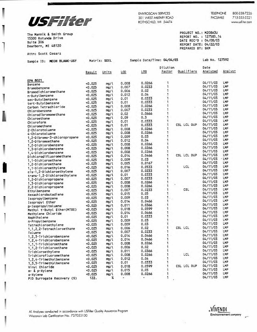
I
u~===~ - --..-..--- --_ _, ____ --------- -------- ------~ --- ._..._.._
The Mannik & Smith Group 15300 Roturda Drive Suite 306 Dearborn, MI 48120
Attn: Scott Cesarz
Sample ID: MECH BL.ANIC-USF Matrix: SOIL
Result Units LOO
EPA 8021 Benzene <0.025 mg/l 0.008 Bromobenzene <0.025 mg/l 0.007 Bromodichloromethane <0.025 mg/l 0.006 n-Butylbenzene <0.025 mg/l 0.012 sec-Butyl benzene <0.025 mg/l 0.01 tert-Butylbenzene <0.025 mg/l 0.01 Carbon Tetrachloride <0.025 mg/l 0.008 Chlorobenzene <0.025 mg/l 0.007 Chlorodi bromomethane <0.025 mg/l 0.02 Chloroethane <0.025 mg/l 0.09 Chloroform <0.025 mg/l 0.01 Chloromethane <0.025 mg/l 0.01 2-Chlorotoluene <0.025 mg/l 0.008 4-Chlorotoluene <0.025 mg/l 0.008 1,2-Dibromo-3-chloropropane <0.025 mg/l 0.009 1,2-Dibromoethane <0.025 mg/l 0.012 1,2-Dichlorobenzene <0.025 mg/l 0.008 1,3-Dichlorobenzene <0.025 mg/l 0.008 1,4-Dichlorobenzene <0.025 mg/l 0.008 Dichlorodifluoromethane <0.025 mg/l 0.014 1,1-Dichloroethane <0.025 mg/l 0.009 1,2-Dichloroethane <0.025 mg/l 0.005 1,1-Dichloroethylene <0.025 mg/l 0.016 cis-1,2-Dichloroethylene <0.025 mg/l 0.007 trans-1,2-Dichloroethylene <0.025 mg/l 0.01 1,2-Dichloropropane <0.025 mg/l 0.007 1,3-Dichloropropane <0.025 mg/l 0.008 2,2-Dichloropropane <0.025 mg/l 0.008 Ethyl benzene <0 . 025 mg/l 0.007 Hexachlorobutadiene <0.025 mg/l 0.015 lsopropylbenzene <0.025 mg/l 0.009 I sopropyl Ether <0.025 mg/l 0.014 p-lsopropyltoluene <0.025 mg/l 0.011 Methyl t·Butyl Ether(MTBE) <0.025 mg/l 0.018 Methylene Chloride <0.025 mg/l 0.014 Naphthalene <0.025 mg/l 0.01 n-Propylbenzene <0.025 mg/l 0.009 Tetrachloroethylene <0.025 mg/l 0.009 1,1,2,2-Tetrachloroethane <0.025 mg/l 0. 006 Toluene <0.025 mg/l 0.007 1,2,3-Trichlorobenzene <0.025 mg/l 0.014 1,2,4-Trichlorobenzene <0.025 mg/l 0.014 1,1,1-Trichloroethane <0.025 mg/l 0.008 1, 1,2-T richloroethane <0.025 mg/l 0.006 Trichloroethylene <0.025 mg/l 0.011 Trichlorofluoromethane <0.025 mg/l 0.008 1,2,4-Trimethylbenzene <0.025 mg/l 0.012 1,3,5-Trimethylbenzene <0.025 mg/l 0.01 Vinyl Chloride <0.025 mg/l 0.018 m- & p-Xylene <0.025 mg/l 0.015 a-Xylene <0.025 mg/l 0.008 PIO Surrogate Recovery (S) 122. X
' ·
All Analyses conducted in accordance with USFilter Quality Assurance Program Wisconsin lob Certification No. 737053130
ENVlROSCAN SERVICES TELEPHONE 8()(}338-7226 30 1 WEST MILITARY ROAD FACSIMILE 715-355-322 1 ROTHSCHILD, WI 54474 www.usfiher.com
PROJECT NO.: M208A3U REPORT NO. : 127585.14 DATE REC'D: 04/08/03 REPORT DATE: 04/22/03 PREPARED BY: SI01
Sample Date/Time: 04/04/03 Lab No. 127592
Dilution Date LOQ Factor Cua l if i ers Ana L:t:zed Anal:i::st
0.0266 1 04/11/03 LMP 0.0233 1 04/11/03 LMP 0.02 1 04/11/03 LMP 0.04 1 04/11/03 LMP 0.0333 1 04/11/03 LMP 0.0333 1 04/11/03 LMP 0.0266 1 04/11/03 LMP 0.0233 1 04/11/03 LMP 0.0666 1 04/11/03 LMP 0.3 1 04/11/03 LMP 0.0333 1 04/11/03 LMP 0.0333 CSL LCL DUP 04/11/03 LMP 0.0266 1 04/11/03 LMP 0.0266 1 04/11/03 LMP 0.03 1 04/11/03 LMP 0. 04 1 04/11/03 LMP 0.0266 1 04/11/03 LMP 0.0266 1 04/11/03 LMP 0.0266 1 04/11/03 LMP 0.0466 1 CSL LCL DUP 04/11/03 LMP 0.03 1 04/11/03 · LMP 0.0167 1 04/11/03 LMP 0.0533 1 LCL 04/11/03 LMP 0.0233 1 04/11/03 LMP 0.0333 1 04/11/03 LMP 0.0233 1 04/11/03 LMP 0.0266 1 04/11/03 LMP 0.0266 1 04/11/03 LMP 0.0233 1 CSL 04/11/03 LMP 0.05 1 04/11/03 LMP 0.03 1 . 04/11/03 LMP 0.0466 1 04/11/03 LMP 0.0366 1 04/11/03 LMP 0.0599 1 04/11/03 LMP 0.0466 1 04/11/03 LMP 0.0333 1 04/11/03 LMP 0.03 1 04/11/03 LMP 0.03 1 04/11/03 LMP 0.02 1 CSL LCL 04/11/03 LMP 0.0233 1 04/11/03 LMP 0.0466 1 04/11/03 LMP 0.0466 1 04/11/03 LMP 0.0266 1 04/11/03 LMP 0.02 1 04/11/03 LMP 0.0366 1 04/11/03 LMP 0.0266 1 LCL 04/11/03 LMP 0.04 1 04/11/03 LMP 0.0333 1 04/11/03 LMP 0.0599 1 CSL LCL DUP 04/11/03 LMP 0.05 1 04/11/03 LMP 0.0266 1 04/11/03 LMP
1 04/11/03 LMP
a VIVENDI Environnement company
., •··

as===-=-=~ - --~------------=--= = = ======--- -- ------- --- _..,_,,_
The Mannik & Smith Group 15300 Rotunda Drive Suite 306 Dearborn, MI 48120
Attn: Scott Cesarz
Sample ID: MECH BL.AMK-USF Matrix: SOIL
EPA 8021 HALL Surrogate Recovery CS) 133. ¾
III DNR Soil Gasoline Range Organic <2.50 mg/l
' ·
All Anolyses conducted in occordance with USFilter Quality Assurance Program Wisconsin Lob Certification No. 737053 130
ENYlROSCAN SERVICES 30 l WEST MJUTARY ROAD ROTHSCHILD. WI 54474
Sample Date/Time: 04/04/03
TELEPHONE 800338-7226 FACSIMILE 715-355-322 l
PROJECT NO.: M208A3U REPORT NO. : 127585.15 DATE REC'D : 04/08/03 REPORT DATE: 04/22/03 PREPARED BY: SKM
Lab No. 127592
www.usfi lter.com
Dilution Date Factor Cual i-fiers Analyzed Analyst
04/11/03 LMP
5.0 04/11/03 LMP
a VIVENDI Environnement company

I
ENVIROSCAN SERV!CES u~=====~ - ----- -.- 30 l WEST MILITARY ROAD ----------------- ROTHSCHILD, WI 5447 4 - ------ ------ -- _..,_._ The Mamik & Smith Group PROJECT NO.:
15300 Rotunda Drive REPORT NO. :
Suite 306 DATE REC'D :
Dearborn, MI 48120 REPORT DATE: PREPARED BY:
Attn: Scott Cesarz
Sample ID: HC ECS 6-8 Matr i x: SOIL Sample Date/Time: 04/05/03 09:30
Dilution Result Units LCD LOQ Factor Cualjfiers
EPA 160.3 Total Solids 86.3 % 0.33
EPA 8021 (Only positively identified analytes are reported on a dry weight basis
Benzene <0.025 mg/kg 0. 008 Bromobenzene <0.025 mg/kg 0.007 Bromodichloromethane <0.025 mg/leg 0.006 n-Butylbenzene <0.025 mg/kg 0.012 sec-Butyl benzene <0.025 mg/kg 0. 01 tert · Butylbenzene <0.025 mg/kg 0.01 Carbon Tetrachloride <0.025 mg/kg 0.008 Chlo robenzene <0.025 mg/kg 0.007 Chlorodibromomethane <0 . 025 mg/kg 0.02 Chloroethane <0.025 mg/kg 0.09 Chloroform <0.025 mg/kg 0.01 Chloromethane <0.025 mg/kg 0.01 2-Chlorotoluene <0.025 mg/kg 0.008 4-Chlorotoluene <0.025 mg/kg 0.008 1,2-Dibromo-3- chloropropane <0 . 025 mg/kg 0.009 1,2-Dibromoethane <0.025 mg/kg 0.012 1,2-Dichlorobenzene <0.025 mg/kg 0.008 1,3-Dichlorobenzene <0.025 mg/kg 0.008 1,4-Dichlorobenzene <0.025 mg/kg 0.008 Dichlorodifluoromethane <0 . 025 mg/kg 0.014 1, 1-Dichloroethane <0.025 mg/kg 0.009 1,2-Dichloroethane <0 . 025 mg/kg 0. 005 1, 1-Dichloroethylene <0.025 mg/kg 0.016 cis-1,2-Dichloroethylene <0.025 mg/kg 0. 007 trans-1,2-Dichloroethylene <0.025 mg/kg 0.01 1,2-Dichloropropane <0.025 mg/kg 0.007 1,3-Dichloropropane <0 . 025 mg/kg 0.008 2,2-Dichloropropane <0.025 mg/kg 0.008 Ethyl benzene <0.025 mg/kg 0.007 Hexachlorobutadiene <0.025 mg/kg 0.015 Isopropylbenzene <0.025 mg/kg 0.009 lsopropyl Ether <0 . 025 mg/kg 0. 014 p·Isopropyltoluene <0 . 025 mg/kg 0.011 Methyl t·Butyl Ether(MTBE) <0 . 025 mg/kg 0.018 Methylene Chloride <0 . 025 mg/kg 0. 014 Naphthalene <0.025 mg/kg 0.01 n·Propylbenzene <0.025 mg/kg 0. 009 Tetrachloroethy lene <0.025 mg/kg 0.009 1,1,2,2-Tetrachloroethane <0.025 mg/kg 0.006 Toluene <0.025 mg/kg 0.007 1,2,3-Trichlorobenzene <0.025 mg/kg 0.014 1,2,4-Trichlorobenzene <0.025 mg/kg 0.014 1,1,1-Trichloroethane <0.025 mg/kg 0.008 1, 1,2-Trichloroethane <0.025 mg/kg 0.006 Trichloroethylene <0.025 mg/kg 0.011 Tr ichlorofluoromethane <0.025 mg/kg 0. 008 1,2,4-Trimethylbenzene <0.025 mg/kg 0. 012 1,3,5-Trimethylbenzene <0.025 mg/kg 0.01 Vinyl Chloride <0.025 mg/kg 0.018
All results calculated on a dry weight basis.
All Analyses conducted in accordance with USFilter Quality Assurance Program Wisconsin Lob Certificotion No. 737053130
0.0266 1 0. 0233 1 0.02 1 0.04 1 0. 0333 1 0.0333 1 0.0266 1 0. 0233 1 0. 0666 1 0.3 1 0. 0333 1 0.0333 1 CSL LCL DUP 0. 0266 1 0. 0266 1 0.03 1 0.04 1 0.0266 1 0.0266 1 0.0266 1 0.0466 1 CSL LCL DUP D.03 1 0.0167 1 0.0533 1 LCL 0.0233 1 0. 0333 1 0.0233 1 0.0266 1 0.0266 1 0.0233 1 CSL 0.05 1 0.03 1 0.0466 1 0.0366 1 0.0599 1 0. 0466 1 0.0333 1 0.03 1 0.03 1 0.02 1 CSL LCL 0.0233 1 0. 0466 1 0.0466 1 0.0266 1 0.02 1 0.0366 1 0. 0266 1 LCL 0.04 1 0.0333 1 0.0599 1 CSL LCL DUP
TELEPHONE 800-338-7226 FACSIMILE 715-355-322 l
www.usfi lter.com
M208A3U 127585.3 04/08/03 04/22/03 SKM
Lab No. 127585
Date Anal:z::zed Analyst
04/09/03 GAG
04/11/03 LMP 04/11/03 LMP 04/11/03 LMP 04/11/03 LMP 04/11/03 LMP 04/11/03 LMP 04/11/03 LMP 04/11/03 LMP 04/11/03 LMP 04/11/03 LMP 04/11/03 LMP 04/11/03 LMP 04/11/03 LMP 04/11/03 LMP 04/11/03 LMP 04/11/03 LMP 04/11/03 LMP 04/11/03 LMP 04/11/03 LMP 04/11/03 LMP 04/11/03 LMP 04/11/03 LMP 04/11/03 LMP 04/11/03 LMP 04/11/03 LMP 04/11/03 LMP 04/11/03 LMP 04/11/03 LMP 04/11/03 LMP 04/11/03 LMP 04/11/03 LMP 04/11/03 LMP 04/11/03 LMP 04/11/03 LMP 04/11/03 LMP 04/11/03 LMP 04/11/03 LMP 04/11/03 LMP 04/11/03 LMP 04/11/03 LMP 04/11/03 LMP 04/11/03 LMP 04/11/03 LMP 04/11/03 LMP 04/11/03 LMP 04/11/03 LMP 04/11/03 LMP 04/11/03 LMP 04/11/03 LMP
a VIVENDI Environnement company

u.~==-=-~ - --..---_..., ______ _ :=--=-======--- -----~ ........ ._..._.~
The Mannik & Smith Group 15300 Rotunda Drive Suite 306 Dearborn, MI 48120
Attn: Scott Cesarz
Sample ID: HC EC5 6-8 Matrix: SOIL
EPA 8021 (Only positively m- & p-Xylene o-Xylene PIO Surrogate Recovery (S) HALL Surrogate Recovery (S)
identified <0.025 <0.025
116. 137.
analytes mg/kg mg/lc:g
7. ¾
All results calculated on a dry weight basis.
ENVIROSCAN SERVICES 30 1 W EST MILITARY ROAD ROTHSCHILD. WI 54474
TELEPHONE 800-338-7226 FACSIMILE 715-355-3221
PROJECT NO.: M208A3U REPORT NO. : 127585.4 DATE REC'D : 04/08/03 REPORT DATE: 04/22/03 PREPARED BY: SKM
www.usfiller.com
Sample Date/Time: 04/05/03 09:30
Dilution
Lab No. 127585
Factor Cual i"fiers
are reported on a dry weight 0.015 0.05 1 0.008 0.0266 1
1 1
basis
Date Analyzed Analyst
04/11/03 LMP 04/11/03 LMP 04/11/03 LMP 04/11/03 LMP
All Anolyses conducred in occordonce wilh USFiher Ouolity As.suronce Program
Wisconsin Lob Cerrificorion No. 737053130 a VIVENDI
Environnement company

ENVIROSCAN SERVICES u~====~ 30 1 WEST MIUTARY ROAD - -------------------------- ROTHSCHILD, WI 5447 4 - -------- --------- --- -~-The Mannik & Smith Group PROJECT NO.:
15300 Rotunda Drive REPORT NO. :
suite 306 DATE REC'D :
Dearborn, MI 48120 REPORT DATE: PREPARED BY:
Attn: Scott Cesarz
Sample ID: HC GP1 4-6 Matrix: SOIL Sample Date/Time: 04/05/03 08:20
Dilution Result Uni ts LOO LOC flligr Cua l i-f i e rs
EPA 8021 (Only positively identified analytes are reported on a dry weight basis Benzene <0.025 mg/kg 0.008 Bromobenzene <0.025 mg/leg 0.007 Bromodichloromethane <0.025 mg/kg 0. 006 n-Butylbenzene <0.025 mg/kg 0.012 sec-Butyl benzene <0.025 mg/kg 0.01 tert-Butylbenzene <0.025 mg/kg 0.01 Carbon Tetrachlor ide <0.025 mg/leg 0.008 Chlorobenzene <0.025 mg/leg 0. 007 Chlorodibromomethane <0.025 mg/kg 0.02 Chloroethane <0.025 mg/kg 0.09 Chloroform <0.025 mg/kg 0.01 Chloromethane <0.025 mg/leg 0.01 2-Chlorotoluene <0.025 mg/kg 0.008 4-Chlorotoluene <0.025 mg/kg 0.008 1,2-Dibromo-3-chloropropane <0.025 mg/leg 0.009 1,2-Dibromoethane <0.025 mg/kg 0.012 1,2-Dichlorobenzene <0.025 mg/kg 0.008 1,3-0ichlorobenzene <0.025 mg/kg 0.008 1,4-0ichlorobenzene <0.025 mg/kg 0.008 0ichlorodifluoromethane <0.025 mg/leg 0.014 1,1-D ichloroethane <0.025 mg/kg 0.009 1,2-Dichloroethane <0.025 mg/kg 0.005 1,1-Dichloroethylene <0.025 mg/kg 0.016 cis-1,2-Dichloroethylene <0.025 mg/kg 0. 007 trans-1,2-Dichloroethylene <0.025 mg/kg 0.01 1,2-Dichloropropane <0.025 mg/leg 0.007 1,3-Dichloropropane <0.025 mg/leg 0.008 2,2-D ichloropropane <0.025 mg/kg 0.008 Ethyl benzene <0.025 mg/leg 0. 007 Hexachlorobutadiene <0.025 mg/leg 0. 015 Isopropylbenzene <0.025 mg/leg 0.009 Isopropyl Ether <0.025 mg/leg 0.014 p-Isopropyltoluene <0.025 mg/leg 0.011 Methyl t·Butyl Ether(MTBE) <0.025 mg/kg 0. 018 Methylene Chloride 0.155 mg/leg 0.014 Naphthalene <0.025 mg/leg 0.01 n·Propylbenzene <0.025 mg/leg 0.009 Tetrachloroethylene <0.025 mg/leg 0.009 1,1,2,2-Tetrachloroethane <0.025 mg/kg 0.006 Toluene <0.025 mg/leg 0.007 1,2,3-Trichlorobenzene <0.025 mg/leg 0.014 1,2 , 4-Trichlorobenzene <0.025 mg/leg 0. 014 1,1,1 -T richloroethane <0.025 mg/leg 0.008 1, 1,2-Trichloroethane <0.025 mg/leg 0. 006 Trichloroethylene <0.025 mg/leg 0.011 Trichlorofluoromethane <0.025 mg/leg 0.008 1,2,4-Trimethylbenzene <0.025 mg/kg 0.012 1,3,5-Trimethylbenzene <0.025 mg/kg 0.01 Vinyl Chloride <0.025 mg/leg 0.018 m· & p·Xylene <0.025 mg/kg 0.015 o·Xylene <0.025 mg/leg 0.008 PIO Surrogate Recovery (S) 116. " All results calculated on a dry weight basis.
All Analyses conducted in accordance with USFilter Quality Assurance Program Wisconsin Lob Certification No. 737053130
0.0266 1 0.0233 1 0.02 1 0.04 1 0.0333 1 0.0333 1 0.0266 1 0.0233 1 0.0666 1 0.3 1 0.0333 1 0.0333 1 CSL LCL CUP 0.0266 1 0.0266 1 0.03 1 0.04 1 0.0266 1 0.0266 1 0.0266 1 0.0466 1 CSL LCL DUP 0.03 1 0.0167 1 0.0533 1 LCL 0.0233 1 0.0333 1 0.0233 1 0.0266 1 0. 0266 1 0.0233 1 CSL 0.05 1 0.03 1 0.0466 1 0. 0366 1 0.0599 1 0.0466 1 0.0333 1 0.03 1 0.03 1 0.02 1 CSL LCL 0.0233 1 0.0466 1 0.0466 1 0.0266 1 0.02 1 0.0366 1 0.0266 1 LCL 0. 04 1 0.0333 1 0.0599 1 CSL LCL DUP 0.05 1 0.0266 1
1
TELEPHONE 800-338-7226 FACSIMILE 715-355-322 1
www.usfilter.com
M208A3U 127585.5 04/08/03 04/22/03 SKM
Lab No. 127586
Date Anal:z:zed Analyst
04/11/03 LMP 04/11/03 LMP 04/11/03 LMP 04/11/03 LMP 04/11/03 LMP 04/11/03 LMP 04/11/03 LMP 04/11/03 LMP 04/11/03 LMP 04/11/03 LMP 04/11/03 LMP 04/11/03 LMP 04/11/03 LMP 04/11/03 LMP 04/11/03 LMP 04/11/03 LMP 04/11/03 LMP 04/11/03 LMP 04/11/03 LMP 04/11/03 LMP 04/11/03 LMP 04/11/03 LMP 04/11/03 LMP 04/11/03 LMP 04/1 1/03 LMP 04/11/03 LMP 04/11/03 LMP 04/11/03 LMP 04/11/03 LMP 04/11/03 LMP 04/11/03 LMP 04/11/03 LMP 04/11/03 LMP 04/11/03 LMP 04/11/03 LMP 04/11/03 LMP 04/11/03 LMP 04/11/03 LMP 04/11/03 LMP 04/11/03 LMP 04/11/03 LMP 04/11/03 LMP 04/11/03 LMP 04/11/03 LMP 04/11/03 LMP 04/11/03 LMP 04/11/03 LMP 04/11/03 LMP 04/11/03 LMP 04/11/03 LMP 04/11/03 LMP 04/11/03 LMP
a VIVENDI Environnement company

- --..-.--u.~===== ~ ------~--------- ------- -----...,, ----- ...... ~--The Mannik & Smith Group 15300 Rotunda Dr ive Suite 306 Dearborn, MI 48120
Attn: Scott Cesarz
Sample ID : HC GP1 4-6 Matri x: SOIL
ENVIROSCAN SERVICES 30 l W EST MILITARY ROAD ROTHSCHILD, WI 54474
TELEPHONE 800-338·7226 FACSIMILE 71 5·355-322 1
PROJECT NO .: M208A3U REPORT NO. : 127585.6 DATE REC'D : 04/08/03 REPORT DATE: 04/22/03 PREPARED BY : SICM
Sample Da t e/Time: 04/05/03 08:20 Lab No . 127586
Di lution Date
www.usfilter.com
Factor Qualif i ers Analyzed Ana lyst
EPA 8021 (Only positively identified analytes are reported on a dry weight basis HALL Surrogate Recovery CS) 133 . ¾ 1
MOSA21-2 Total Solids 85.0
All results calculated on a dry weight basis.
¾
All Analyses conducted in occordonce wirh USFilrer Ouoliry Assurance Program Wisconsin Lob Certification No. 737053 130
0.33
04/11/03 LMP
04/09/03 GAG
a VIVENDI Environnement company
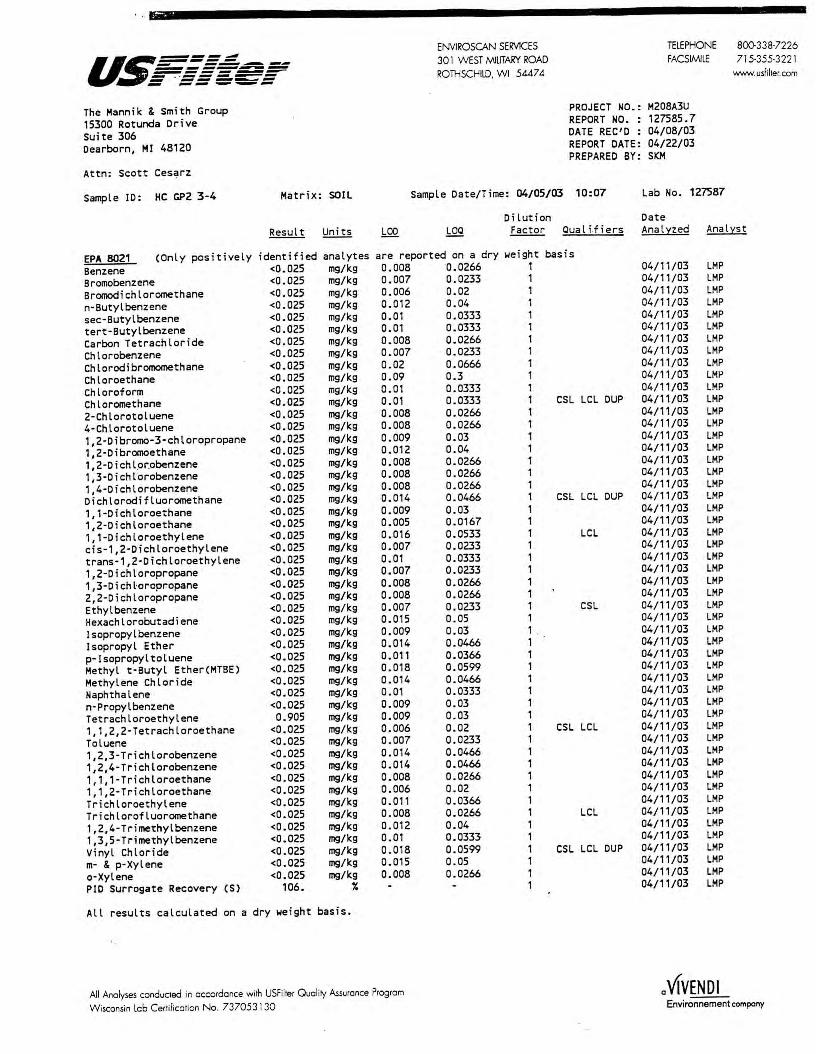
U:.~=-=,;-=--==-= ------. - ···------ - ·-------- --- ___ .._.. __
The Mann ik & Sm i th Group 15300 Rotunda Drive Suite 306 Dearborn, Ml 48120
Attn : Scott Ces~rz
Sample JD : HC GP2 3-4 Matrix : SOIL
ENVIROSCAN SERVICES 30 l W EST MILITARY ROAD ROTHSCHILD, WI 54474
TELEPHONE 800-3 38·7226 FACSIMILE 715·355-3221
PROJECT NO.: M208A3U REPORT NO. : 127585.7 DATE REC'D : 04/08/03 REPORT DATE: 04/22/03 PREPARED BY: SKM
Sample Date/Time: 04/05/03 10:07 Lab No. 127587
Di lut ion Date
www.usfilter. com
Factor Cua l i.f i ers Analyzed Analys t
EPA 8021 (Only posit i vely identified <0.025 <0.025 <0.025 <0.025 <0.025 <0.025 <0.025 <0.025 <0.025 <0.025 <0.025 <0.025 <0.025 <0.025 <0.025 <0.025 <0.025 <0.025 <0.025 <0.025 <0.025 <0.025 <0.025 <0.025 <0 . 025 <0.025 <0.025 <0 . 025 <0.025 <0.025 <0.025 <0.025 <0.025 <0.025 <0.025 <0.025 <0.025
analytes mg/kg mg/kg mg/kg mg/kg mg/kg mg/kg mg/kg mg/kg mg/kg mg/kg mg/kg mg/kg mg/kg mg/kg mg/kg mg/kg mg/kg mg/kg mg/kg mg/kg mg/kg mg/kg mg/kg mg/kg mg/kg mg/kg mg/kg mg/kg mg/kg mg/kg mg/kg mg/kg mg/kg mg/kg mg/kg mg/kg mg/kg mg/kg mg/kg mg/kg mg/kg mg/kg mg/kg mg/kg mg/kg mg/kg mg/kg mg/kg mg/kg mg/kg mg/kg
are reported on a dry weight basis Benzene Bromobenzene Bromodichloromethane n-Butylbenzene sec-Butyl benzene tert-Butylbenzene Carbon Tetrachlor ide Chlorobenzene Chlorodibromomethane Chloroethane Chloroform Chloromethane 2-Chlorotoluene 4-Chlorotoluene 1,2-Dibromo-3-chloropropane 1,2-Dibromoethane 1, 2-D i ch l.or.obenzene 1,3-Dichlorobenzene 1,4-Dichlorobenzene Dichlorodifluoromethane 1,1 -Dichloroethane 1,2-Dichloroethane 1,1-Dich loroethylene cis-1,2-D i chloroethylene trans-1,2-Dichloroethylene 1,2-Dichloropropane 1,3-Dichtoropropane 2,2-Dichloropropane Ethyl benzene Hexachlorobutadiene Jsopropylbenzene Jsopropyl Ether p·Isopropyl toluene Methyl t · Butyl Ether(MTBE) Methylene Chloride Naphthalene n-Propylbenzene Tetrachloroethylene 1, 1,2,2-Tetrachloroethane Toluene 1,2,3-Trichlorobenzene 1,2,4-Tr i chlorobenzene 1, 1,1-Trichloroethane 1, 1,2-Trichloroethane Trichloroethylene Trichlorofluoromethane 1,2,4-Tr imethylbenzene 1,3,5-Trimethylbenzene Vi nyl Chloride m· & p-Xylene o·Xylene PIO Surrogate Recovery (S)
0. 905 <0.025 <0.025 <0.025 <0.025 <0.025 <0.025 <0.025 <0.025 <0.025 <0.025 <0 . 025 <0.025 <0.025
106.
All results calculated on a dry weight basis. "
0.008 0.007 0. 006 0.012 0.01 0.01 0. 008 0.007 0.02 0.09 0.01 0.01 0. 008 0.008 0.009 0.012 0. 008 0.008 0.008 0.014 0.009 0.005 0.016 0.007 0.01 0.007 0.008 0. 008 0.007 0.015 0.009 0.014 0.011 0.018 0.014 0.01 0.009 0.009 0.006 0.007 0.014 0.014 0.008 0.006 0.011 0.008 0.012 0. 01 0.018 0.015 0. 008
All Ana lyses conducred in occordonce w ith USFilrer Quality Assurance Program
Wisconsin Lob Certification No. 737053130
0.0266 0.0233 0.02 0.04 0.0333 0.0333 0.0266 0.0233 0.0666 0. 3 0.0333 0. 0333 0.0266 0.0266 0. 03 0.04 0.0266 0.0266 0.0266 0. 0466 0.03 0.0167 0.0533 0.0233 0.0333 0.0233 0.0266 0.0266 0.0233 0.05 0.03 0.0466 0.0366 0.0599 0. 0466 0.0333 0.03 0.03 0.02 0.0233 0. 0466 0.0466 0.0266 0.02 0.0366 0.0266 0.04 0.0333 0.0599 0.05 0.0266
1 1 1 1 1 1 1 1 1 1 1 1 CSL LCL DUP 1 1 1 1 1 1 1 1 CSL LCL DUP 1 1 1 LCL 1 1 1 1 1 1 CSL 1 1 . 1 1 1 1 1 1 1 1 CSL LCL 1 1 1 1 1 1 1 LCL 1 1 1 CSL LCL DUP 1 1 1
04/11/03 04/11/03 04/11/03 04/11/03 04/11/03 04/11/03 04/11/03 04/11/03 04/11/03 04/11/03 04/11/03 04/11/03 04/11/03 04/11/03 04/11/03 04/11/03 04/11/03 04/11/03 04/11/03 04/11/03 04/11/03 04/11/03 04/11/03 04/11/03 04/11/03 04/11/03 04/11/03 04/11/03 04/11/03 04/11/03 04/11/03 04/11/03 04/11/03 04/11/03 04/11/03 04/11/03 04/11/03 04/11/03 04/11/03 04/11/03 04/11/03 04/11/03 04/11/03 04/11/03 04/11/03 04/11/03 04/11/03 04/11/03 04/11/03 04/11/03 04/11/03 04/11/03
LMP LMP LMP LMP LMP LMP LMP LMP LMP LMP LMP LMP LMP LMP LMP LMP LMP LMP LMP LMP LMP LMP LMP LMP LMP LMP LMP LMP LMP LMP LMP LMP LMP LMP LMP LMP LMP LMP LMP LMP LMP LMP LMP LMP LMP LMP LMP LMP LMP LMP LMP LMP
a VIVENDI Environnement company

- -----u.~===~ ------------------ -----= ==='=-= The Mannik & Smith Group 15300 Rotunda Drive Suite 306 Dearborn, MI 48120
Attn: Scott Cesarz
Sample ID: HC GP2 3-4 Matrix: SOIL
ENVIROSCAN SERVICES 30 1 WEST MILITARY ROAD ROTiiSCHILD, W1 54474
TELEPHONE 8()(}338-7226 FACSIMILE 715-355-3221
PROJECT NO.: M208A3U REPORT NO. : 127585.8 DATE REC'D : 04/08/03 REPORT DATE: 04/22/03 PREPARED BY: SKM
Sample Date/Time: 04/05/03 10:07 Lab No. 127587
Dilution Date
www.usfilter.com
Factor Cuali.fiers Analyzed Analyst
EPA 8021 (Only positively identified analytes are reported on a dry weight basis HALL Surrogate Recovery CS) 127. Z 1
MOSA21-2 Total Solids 92.2
All results calculated on a dry weight basis.
All Analyses conducted in occordonce with USFiher Quality Assurance Progrom Wisconsin Lob Certification No. 737053130
0.33
04/11/03 LMP
04/09/03 GAG
a VIVENDI Environnement company

ENVIROSCAN SERVICES u~--------- 30 l WEST MILITARY ROAD - ---------~--~---------- ROTHSCHILD, WI 5447 4 - ------- --- ----~ ---- _. _. ..... The Mannik & Smith Group PROJECT NO.:
15300 Rotunda Drive REPORT NO. :
Suite 306 DATE REC'D :
Dearborn, Ml 48120 REPORT DATE: PREPARED BY:
Attn: Scott Cesarz
Sample ID: HC GP3 4-6 Matrix: SOIL Sample Date/Time: 04/05/03 10:45
Di Lution Result Units LCD LOO Factor 0ual i-fiers
EPA 8021 (Only positively identified analytes are reported on a dry weight basis
Benzene <0.025 mg/kg 0.008 Bromobenzene <0.025 mg/kg 0.007 Bromodichloromethane <0.025 mg/kg 0.006 n-Butylbenzene <0.025 mg/kg 0.012 sec-Butyl benzene <0.025 mg/kg 0.01 tert-Butylbenzene <0.025 mg/kg 0.01 Carbon Tetrachloride <0.025 mg/kg 0.008 Chlorobenzene <0.025 mg/kg 0.007 Chlorodibromomethane <0.025 mg/kg 0.02 Chloroethane <0.025 mg/kg 0.09 Chloroform <0 . 025 mg/kg 0. 01 Chloromethane <0.025 mg/kg 0.01 2-Chlorotoluene <0.025 mg/kg 0.008 4-Chlorotoluene <0.025 mg/kg 0.008 1,2-Dibromo-3-chloropropane <0.025 mg/kg 0.009 1,2-Dibromoethane <0.025 mg/kg 0.012 1,2-Dichlorobenzene <0 . 025 mg/kg 0.008 1,3-Dichlorobenzene <0.025 mg/kg 0.008 1,4-Dichlorobenzene <0.025 mg/kg 0.008 Dichlorodifluoromethane <0.025 mg/kg 0.014 1, 1-Dichloroethane <0.025 mg/kg 0.009 1,2-Dichloroethane <0.025 mg/kg 0.005 1, 1-Dichloroethylene <0.025 mg/kg 0.016 cis-1,2-Dichloroethylene <0.025 mg/kg 0.007 trans-1,2 -Dichloroethylene <0.025 mg/kg 0.01 1,2-Dichloropropane <0.025 mg/kg 0.007 1,3-Dichloropropane <0.025 mg/kg 0.008 2,2-Dichloropropane <0.025 mg/kg 0.008 Ethyl benzene <0.025 mg/kg 0.007 Hexachlorobutadiene <0.025 mg/kg 0.015 Isopropylbenzene <0.025 mg/kg 0.009 Isopropyl _Ether <0.025 mg/kg 0.014 p-Isopropyltoluene <0.025 mg/kg 0.011 Methyl t-Butyl Ether(MTBE) <0.025 mg/kg 0.018 Methylene Chloride <0.025 mg/kg 0.014 Naphthalene <0.025 mg/kg 0.01 n-Propylbenzene <0 . 025 mg/kg 0.009 Tetrachloroethylene <0.025 mg/kg 0.009 1,1,2,2-Tetrachloroethane <0.025 mg/kg 0.006 Toluene <0.025 mg/kg 0.007 1,2,3-Trichlorobenzene <0.025 mg/kg 0.014 1,2,4-Trichlorobenzene <0.025 mg/kg 0.014 1,1,1-Trichloroethane <0.025 mg/kg 0.008 1, 1,2-Trichloroethane <0 . 025 mg/kg 0.006 Trichloroethylene <0.025 mg/kg 0. 011 Trichlorofluoromethane <0.025 mg/kg 0.008 1,2,4-Trimethylbenzene <0.025 mg/kg 0.012 1,3,5-Trimethylbenzene <0 . 025 mg/kg 0.01 Vinyl Chloride <0.025 mg/kg 0.018 m- & p-Xylene <0.025 mg/kg 0.015 a-Xylene <0.025 mg/kg 0.008 PID Surrogate Recovery CS) 121. ¾
All results calculated on a dry weight basis.
All Analyses conducted in accordance with USFilter Quality Assurance Program Wisconsin lob Certification No. 737053130
0.0266 1 0.0233 1 0.02 1 0.04 1 0.0333 1 0.0333 1 0.0266 1 0.0233 1 0.0666 1 0.3 1 0.0333 1 0.0333 1 CSL LCL DUP 0.0266 1 0.0266 1 0.03 1 0.04 1 0.0266 1 0.0266 1 0.0266 1 0.0466 1 CSL LCL DUP 0.03 1 0.0167 1 0.0533 1 LCL 0.0233 1 0.0333 1 0.0233 1 0.0266 1 0.0266 1 0.0233 1 CSL 0.05 1 0.03 1 0.0466 1 0.0366 1 0. 0599 1 0.0466 1 0.0333 1 0.03 1 0.03 1 0.02 1 CSL LCL 0.0233 1 0.0466 1 0.0466 1 0.0266 1 0.02 1 0.0366 1 0.0266 1 LCL 0. 04 1 0.0333 1 0.0599 1 CSL LCL DUP 0.05 1 0.0266 1
1
TELEPHONE 800-338-7226 FACSIMILE 715-355-322 l
·....ww.usliher.com
M208A3U 127585. 9 04/08/03 04/22/03 SKM
Lab No. 127588
Date Analvzed ~
04/11/03 LMP 04/11/03 LMP 04/11/03 LMP 04/11/03 LMP 04/11/03 LMP 04/11/03 LMP 04/11/03 LMP 04/11/03 LMP 04/11/03 LMP 04/11/03 LMP 04/11/03 LMP 04/11/03 LMP 04/11/03 LMP 04/11/03 LMP 04/11/03 LMP 04/11/03 LMP 04/11/03 LMP 04/11/03 LMP 04/11/03 LMP 04/11/03 LMP 04/11/03 LMP 04/11/03 LMP 04/11/03 LMP 04/11/03 LMP 04/11/03 LMP 04/11/03 LMP 04/11/03 LMP 04/11/03 LMP 04/11/03 LMP 04/11/03 LMP 04/11/03 LMP 04/11/03 LMP 04/11/03 LMP 04/11/03 LMP 04/11/03 LMP 04/11/03 LMP 04/11/03 LMP 04/11/03 LMP 04/11/03 LMP 04/11/03 LMP 04/11/03 LMP 04/11/03 LMP 04/11/03 LMP 04/11/03 LMP 04/11/03 LMP 04/11/03 LMP 04/11/03 LMP 04/11/03 LMP 04/11/03 LMP 04/11/03 LMP 04/11/03 LMP 04/11/03 LMP
a VIVENDI Environnement company
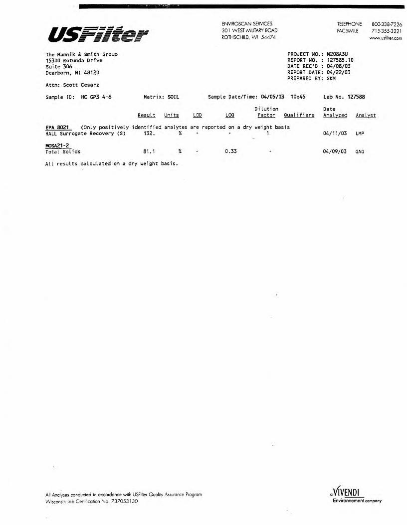
- --~--a~======~ ======-=-~=:;!!!! -- ------- ------- --- _.._.._ The Hannik & Smith Group 15300 Rotunda Drive suite 306 Dearborn, HI 48120
Attn: Scott Cesarz
Sample ID: HC GP3 4-6 Matrix: SOIL
ENVIROSCAN SERVICES 30 l WEST M!UTARY ROAD ROTHSCHILD, WI 5447 4
lELEPHONE 800338·7226 FACSIM!LE 715·355·3221
PROJECT NO.: H208A3U REPORT NO. : 127585.10 DATE REC'D: 04/08/03 REPORT DATE: 04/22/03 PREPARED BY: SKM
Sample Date/Time: 04/05/03 10:45 Lab No. 127588
Dilution Date
www.usfilter.com
Factor Oual .ifiers Analyzed Analyst
EPA 8021 (Only positively identified analytes are reported on a dry weight basis HALL Surrogate Recovery CS) 132. ¾ 1
HOSA21-2 Total Sol ids 81. 1
All results calculated on a dry weight basis.
¾
All Analyses conducted in accordance with USFilter Qual ity Assurance Program Wisconsin lab Certification Na. 737053130
0.33
04/11/03 LHP
04/09/03 GAG
a VIVENDI Envir~compony

ENVIROSCAN SERVICES
REPORT TO:
301 W. MILITARY RD.
Name: .1 · · '. \ \ - ,: ' . _j , 1_t Company: ·._ , , ;'-J , , , :· ,,. : · -:, . \ ; 1 •. , , , : i · · · Address: . -~ i 1\ t: ·_ ,r· , i .. \.c. ,·i ; · k ~,, )le·
\.., ', l , -~! ·"'1-\ ( \ .. 1\ L~ \./ ·.; · y
Phone: ( -·', ·-.. .... I I - !._ .' ) . ' - . . .
p 0 . # -----------------Project# / .. J 7 1~·, 1; .. · r\ ·..:. u Location i1 ~ • _· , , . . - ~ ,
Sample Type (Check all that apply) 0 Groundwater 0 Wastewater ~ Soil/Sol id 0 Drinking Water 0 Oil 0 Vapor. 0 Other
Quote# _____ _
Turnaround Time 0 Normal 0 Rush (Pre-approved by Lab)
Date Needed _____ _ Approved By _____ _
.......... _,,,,,,,, ............... - ..... .......... ............... .............. .......... _ ..... ..... .,_.
ROTHSCHILD, WI 54474 1-800-338-SCAN
BILL TO: (if different from Report To info) Name: ------------------Company: ----------------Address: _______________ _
Phone:( __ _
ANALYTICAL REQUESTS (use separate sheet if necessary)
SAMPLE ID REMARKS
~• IEIAIN OF CUSTODY RECORD
RELINQUISHED B~: (Sign7i.ture)
\__ i \ ·,: ,, · ... :\. '· '"--- .
RELINQUISHED BY: (Signature)
RELINQUISHED BY: (Signature)
DATE/TIME
~\7 '1))µ.) DATE/TIME
DATE/TIME
RECEIVED BY: (Signature)
RECEIVED BY: (Signature)
'1) . . \ ~ . \-,
Comments:

a~===: - --..-.--------------- ------ ------ -----
August 21, 2003
The Mannik & Smith Group 15300 Rotunda Drive Suite 306 Dearborn, MI 48120
Attn: Amanda Abling
REPORT NO.: 137071
ENVIROSCAN SERVICES 301 WEST MILITARY ROAD ROTHSCHILD, WI 5447 4
PROJECT NO.
TELEPHONE FACSIMILE WEBSITE
M208A301
Please find enclosed the analytical report, including the Sample Summary, Sample Narrative and Chain of Custody for your sample set received August 14, 2003.
All analyses were performed in accordance with approved methods as indicated on this report_
If you have any questions about the results, please call. Thank you for using USFilter, Enviroscan Services for your analytical needs.
Sincerely,
USFilter, Enviroscan Services
u ~ 0 t'W.J.. µ . ~l;bc:hhlv
Yvonne M. Dobbertin Project Manager
800.338-7226 715-355-3221
www.usfilter.com
I cenify rhaz rhe data contained in rhis repon has been generaud and reviewed in accordance wirh rhe USFilier, Enviroscan Services Qualiry Assurance Program. Exceprions, if any, are discussed in rhe sample narrative. Samples will be retained for 30 days from rhe dale of rhis repon. rhen disposed in an appropriate manner.
USFilier, Enviroscan Services reserves rhe righr ro recum samples identified as hazardous. Release ofrhis Final Repon is aurhorized as verified by rhe following signature.
Approved by:

u.~-===: - ------------------- ------ ------ -- ---
Lab Id Client Sample 137071 HC EC8 2-4 137072 HC EC8 6-8 137073 HC EC8 10-12 137074 HC 137075 HC 137076 HC
GENERAL:
ANALYSES:
REPORTING:
LOO= Limit of Detection LOQ = Limit of Quantitation <=Less Than COMP= Complete
EC9 2-4 EC9 10-12 EC9 16-18
SUBCON = Subcontracted analysis mv = millivolts pCi/l = picocurie per liter ml/l = mililiters/Liter
ID
Sample
Sample Surrrnary
ENVIROSCAN SERVICES 301 WEST MILITARY ROAD ROTHSCHILD, WI 5447 4
Date/Time 08/12/03 13: 15 08/12/03 13:20 08/12/03 13 : 25 08/12/03 14: 10 08/12/03 14: 15 08/12/03 14:20
TELEPHONE FACSIMILE WEBSITE
137071. 2
Matrix SOIL SOIL SOIL SO IL SOIL SOIL
800-338-7226 715-355-3221
www.usfilter.com
Narrative/Sample Status
Definitions
~g/l = Micrograms per liter= parts per billion (ppb) ~g/kg = Micrograms per kilogram= parts per billion (ppb) mg/ l = Mi l l i grams per · liter = parts per mi l lion ( ppm) mg/kg= Milligrams per kilogram= parts per million (ppm) NOT PRES= Not Present ppth = Parts per thousand (S) = Surrogate Compound

u~=====~ ENVIROSCAN SERVICES TELEPHONE 800-338-7226 - ------------ 30 I WEST MILITARY ROAD FACSIMILE 715-355-3221 ------- ------ -- ----- ROTHSCHILD, WI 5447 4 WEBSITE - -- --- www.usfilter.com
The Mannik & Smith Group PROJECT NO.: M208A301 15300 Rotunda Drive REPORT NO. : 137071 .3
Suite 306 DATE REC'D : 08/14/03
Dearborn, Ml 48120 REPORT DATE: 08/21/03 PREPARED BY: YMD
Attn: Amanda Abling
Sample ID: HC EC8 2-4 Matrix: SOIL Sample Date/Time: 08/12/03 13: 15 Lab No. 137071
Dilut ion Date Result Uni ts LOD LOO Factor Qualifiers Analz:zed Analz:st
EPA 8021 (Only positively identified analytes are reported on a dry weight basis Benzene <0.029 mg/kg 0.008 0.0266 1 . s · 08/20/03 LMP
Bromobenzene <0.029 mg/kg 0.007 0.0233 1 . 5 08/20/03 LMP
Bromodichloromethane <0.029 mg/kg 0.006 a.oz 1 . 5 08/20/03 LMP
n-Butylbenzene <0.029 mg/kg 0.012 0. 04 1 .5 08/20/03 LMP
sec-Butyl benzene <0 . 029 mg/kg 0. 01 0.0333 1 . 5 08/20/03 LMP
tert-Butylbenzene <0.029 mg/kg 0.01 0.0333 1 . 5 08/20/03 LMP
Carbon Tetrachloride <0.029 mg/kg 0.008 0.0266 1 . 5 08/20/03 LMP
Chlorobenzene <0.029 mg/kg 0.007 0.0233 1 . 5 08/20/03 LMP
Chlo rodibromomethane <0.029 mg/kg a.oz 0.0666 1 . 5 08/20/03 LMP
Chloroethane <0.029 mg/kg 0.09 0.3 1.5 CSL LCL 08/20/03 LMP
Chloroform <0 . 029 mg/kg 0.01 0. 0333 1.5 08/20/03 LMP
Chloromethane <0.029 mg/kg 0.01 0.0333 1.5 CSL LCL DUP 08/20/03 LMP
2-Chlorotoluene <0.029 mg/kg 0.008 0.0266 1 . 5 08/20/03 LMP
4-Chlorotoluene <0.029 mg/kg 0.008 0.0266 1.5 08/20/03 LMP
1,2-Dibromo-3-chloropropane <0.029 mg/kg 0.009 0.03 1.5 08/20/03 LMP
1,2-Dibromoethane <0.029 mg/kg 0.012 0.04 1 . 5 08/20/03 LMP
1,2-Dichlorobenzene <0.029 mg/kg 0.008 0.0266 1 -~ 08/20/03 LMP
1,3-Dichlorobenzene <0.029 mg/kg 0. 008 0.0266 1.5 08/20/03 LMP
1,4-Dichlorobenzene <0 . 029 mg/kg 0. 008 0.0266 1 . 5 08/20/03 LMP
Dichlorodifluoromethane <0.029 mg/kg 0. 014 0.0466 1. 5 CSL LCL 08/20/03 LMP
1, 1-Dichloroethane <0.029 mg/kg 0.009 0.03 1 . 5 08/20/03 LMP
1,2-Dichloroethane <0.029 mg/kg 0.005 0.0167 1.5 08/20/03 LMP
1,1-Dichloroethylene <0.029 mg/kg 0.016 0.0533 1.5 08/20/03 LMP
cis-1,2-Dichloroethylene <0.029 mg/kg 0.007 0.0233 1.5 08/20/03 LMP
trans-1,2-Dichloroethylene <0.029 mg/kg 0.01 0.0333 1 . 5 08/20/03 LMP
1,2-Dichloropropane <0.029 mg/kg 0.007 0.0233 1.5 08/20/03 LMP
1,3-Dichloropropane <0.029 mg/kg 0.008 0. 0266 1 . 5 08/20/03 LMP
2,2-Dichloropropane <0.029 mg/kg 0.008 0.0266 1 . 5 CSL 08/20/03 LMP
Ethyl benzene <0.029 mg/kg 0.007 0.0233 1 . 5 08/20/03 LMP
Hexachlorobutadiene <0.029 mg/kg 0.015 0.05 1.5 08/20/03 LMP
Isopropylbenzene <0.029 mg/kg 0.009 0.03 1 . 5 08/20/03 LMP
Isopropyl Ether <0.029 mg/kg 0.014 0.0466 1 . 5 08/20/03 LMP
p-Isopropyltoluene <0.029 mg/kg 0.011 0.0366 1 . 5 08/20/03 LMP
Methyl t-Butyl Ether(MTBE) <0.029 mg/kg 0.018 0.0599 1 . 5 08/20/03 LMP
Methylene Chloride <0 . 029 mg/kg 0.014 0 .0466 1 . 5 CSL LCL 08/20/03 LMP
Naphthalene <0.029 mg/kg 0.01 0.0333 1.5 08/20/03 LMP
n-Propylbenzene <0.029 mg/kg 0.009 0.03 1 . 5 08/20/03 LMP
Tetrachloroethylene <0.029 mg/kg 0.009 0.03 1.5 08/20/03 LMP
1, 1,2,2-Tetrachloroethane <0.029 mg/kg 0.006 0.02 1 . 5 CSL 08/20/03 LMP
Toluene <0.029 mg/kg 0.007 0.0233 1.5 08/20/03 LMP
1,2,3-Trichlorobenzene <0.029 mg/kg 0.014 0.0466 1.5 08/20/03 LMP
1,2,4-Trichlorobenzene <0.029 mg/kg 0.014 0.0466 1.5 08/20/03 LMP
1,1, 1-Trichloroethane <0.029 mg/kg 0.008 0.0266 1.5 08/20/03 LMP
1, 1,2-Trichlo roethane <0.029 mg/kg 0.006 0.02 1.5 08/20/03 LMP
Trichloroethylene <0 . 029 mg/kg 0.011 0.0366 1.5 08/20/03 LMP
Trichlorofluoromethane <0.029 mg/kg 0.008 0.0266 1. 5 08/20/03 LMP
1,2,4-Trimethylbenzene <0.029 mg/kg 0.012 0. 04 1. 5 08/20/03 LMP
1,3,5-Trimethylbenzene <0.029 mg/kg 0.01 0.0333 1.5 08/20/03 LMP
Vinyl Chloride <0.029 mg/kg 0.018 0.0599 1.5 LCL DUP 08/20/03 LMP
m- & p-Xylene <0.029 mg/kg 0.015 a.as 1.5 08/20/03 LMP
o-Xylene <0.029 mg/kg 0.008 0.0266 1.5 08/20/03 LMP
PIO Surrogate Recovery (S) 99.6 % 1 08/20/03 LMP
All results calculated on a dry weight basis.
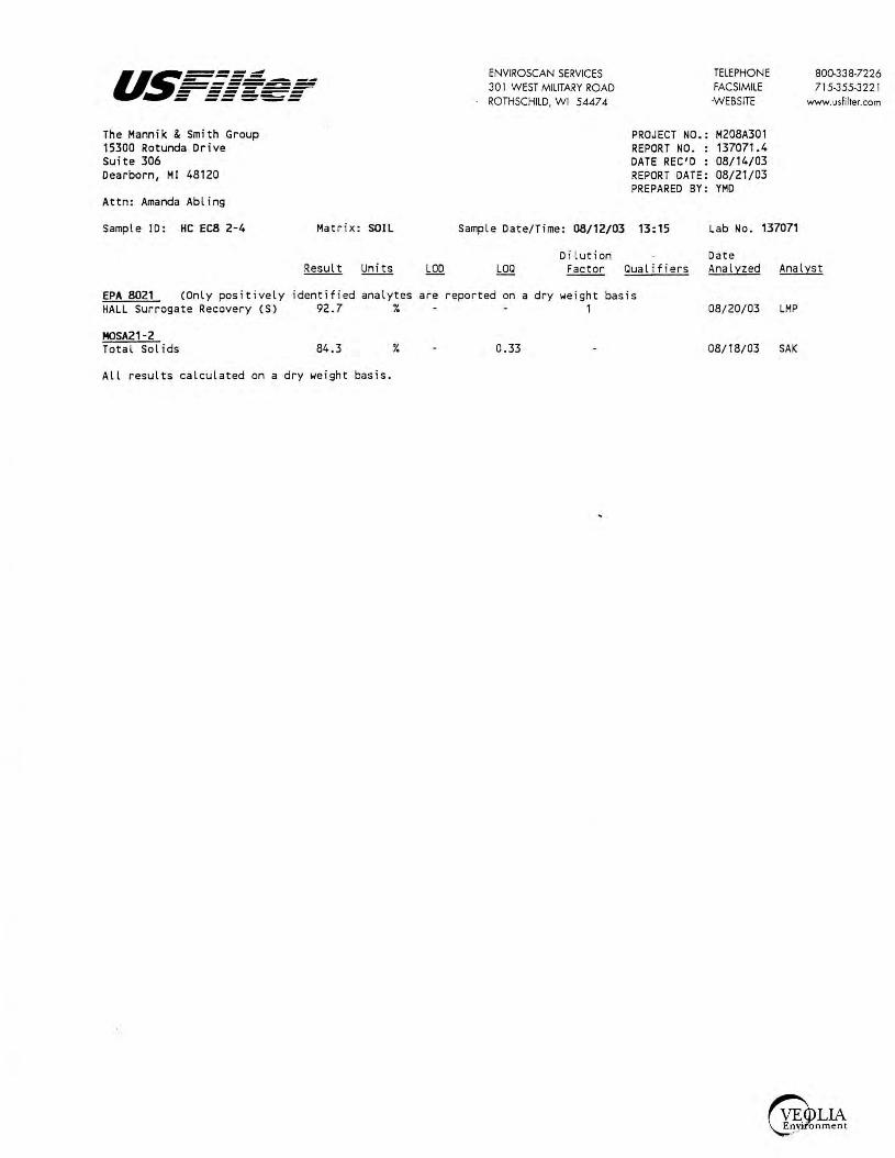
u.~=-=-=~ - ------------------- ------ ------ -- ---The Mannik & Smith Group 15300 Rotunda Drive Suite 306 Dearborn, Ml 48120
Attn: Amanda Abling
Sample ID: HC EC8 2-4 Matrix: SOIL
EPA 8021 (Only positively identified analytes HALL Surrogate Recovery (S) 92.7 ¾
HOSA21-2 Total Sol ids 84.3 ¾
All results calculated on a dry weight basis.
are
ENVIROSCAN SERVICES 301 WEST MILITARY ROAD ROTHSCHILD, WI 5447 4
TELEPHONE FACSIMILE -WEBSITE
PROJECT NO.: M208A301 REPORT NO. : 137071.4 DATE REC'D : 08/14/03 REPORT DATE: 08/21/03 PREPARED BY: YMD
Sample Date/Time: 08/12/03 13:15 Lab No. 137071
Dilution Date
800-338-7226 715-355-322 l
www.usfilter.com
Factor Qualifiers Analyzed Analyst
reported on a dry weight basis 1 08/20/03 LMP
0.33 08/18/03 SAK

us====.: ENVIROSCAN SERVICES TELEPHONE 800-338-7226 - ------------ 301 WEST MILITARY ROAD FACSIMILE 715-355-3221 .=-::~=-;- ROTHSCHILD, WI 5447 4 .WEBSITE www.usfilter.com
The Mannik & Smith Group PROJECT NO.: M208A301 15300 Rotunda Drive REPORT NO. : 137071.5 Suite 306 DATE REC'D : 08/14/03 Dearborn, Ml 48120 REPORT DATE: 08/21/03
PREPARED BY: YMD Attn: Amanda Abling
Sample ID: HC EC8 6-8 Matrix: SOIL Sample Date/Time: 08/12/03 13:20 Lab No. 137072
Dilution Date Result Units LOO LOO Factor Qualifiers Anal:tzed Anal:tst
EPA 8021 (Only positively identified analytes are reported on a dry weight basis Benzene <0.025 mg/kg 0.008 0.0266 1. 1 08/20/03 LMP Bromobenzene <0.025 mg/kg 0.007 0.0233 1. 1 08/20/03 LMP Bromodichloromethane <0.025 mg/kg 0.006 0.02 1. 1 08/20/03 LMP n-Butylbenzene <0.025 mg/kg 0.012 0.04 1.1 08/20/03 LMP sec-Butyl benzene <0.025 mg/kg 0.01 0. 0333 1. 1 08/20/03 LMP tert-Butylbenzene <0.025 mg/kg 0.01 0.0333 1 . 1 08/20/03 LMP Carbon Tetrachloride <0.025 mg/kg 0.008 0.0266 1. 1 08/20/03 LMP Chlorobenzene <0 . 025 mg/kg 0.007 0.0233 1. 1 08/20/03 LMP Chlorodibromomethane <0.025 mg/kg 0.02 0.0666 1. 1 08/20/03 LMP Chloroethane <0 . 025 mg/kg 0.09 0.3 1. 1 CSL LCL 08/20/03 LMP Chloroform <0.025 mg/kg 0.01 0.0333 1. 1 08/20/03 LMP Chloromethane <0.025 mg/kg 0.01 0.0333 1. 1 CSL LCL DUP 08/20/03 LMP 2-Chlorotoluene <0.025 mg/kg 0.008 0. 0266 1. 1 08/20/03 LMP 4-Chlorotoluene <0.025 mg/kg 0.008 0.0266 1. 1 08/20/03 LMP 1,2-Dibromo-3-chloropropane <0.025 mg/kg 0.009 0.03 1. 1 08/20/03 LMP 1,2-Dibromoethane <0.025 mg/kg 0.012 0.04 1. 1 08/20/03 LMP 1,2-Dichlorobenzene <0.025 mg/kg 0.008 0.0266 1., 08/20/03 LMP 1,3-Dichlorobenzene <0.025 mg/kg 0.008 0.0266 1. 1 08/20/03 LMP 1,4-Dichlorobenzene <0.025 mg/kg 0.008 0.0266 1. 1 08/20/03 LMP Dichlorodifluoromethane <0.025 mg/kg 0.014 0.0466 1. 1 CSL LCL 08/20/03 LMP 1, 1-Dichloroethane <0.025 mg/kg 0.009 0.03 1 . 1 08/20/03 LMP 1,2-Dichloroethane <0.025 mg/kg 0.005 0.0167 1. 1 08/20/03 LMP 1, 1-Dichloroethylene <0.025 mg/kg 0.016 0.0533 1. 1 08/20/03 LMP cis-1,2-Dichloroethylene <0.025 mg/kg 0.007 0.0233 1. 1 08/20/03 LMP trans-1,2-Dichloroethylene <0.025 mg/kg 0.01 0.0333 1. 1 08/20/03 LMP 1,2-Dichloropropane <0.025 mg/kg 0.007 0.0233 1. 1 08/20/03 LMP 1,3-Dichloropropane <0.025 mg/kg 0.008 0.0266 1. 1 08/20/03 LMP 2,2-Dichloropropane <0.025 mg/kg 0.008 0.0266 1. 1 CSL 08/20/03 LMP Ethyl benzene <0.025 mg/kg 0.007 0. 0233 1 . 1 08/20/03 LMP Hexachlorobutadiene <0.025 mg/kg 0.015 0.05 1. 1 08/20/03 LMP lsopropylbenzene <0.025 mg/kg 0.009 0.03 1. 1 08/20/03 LMP lsopropyl Ether <0.025 mg/kg 0.014 0.0466 1. 1 08/20/03 LMP p-lsopropyltoluene <0.025 mg/kg 0.011 0.0366 1. 1 08/20/03 LMP Methyl t-Butyl Ether(MTBE) <0.025 mg/kg 0.018 0.0599 1 . 1 08/20/03 LMP Methylene Chloride <0.025 mg/kg 0.014 0.0466 1. 1 CSL LCL 08/20/03 LMP Naphthalene <0.025 mg/kg 0.01 0.0333 1. 1 08/20/03 LMP n-Propylbenzene <0.025 mg/kg 0.009 0.03 1. 1 08/20/03 LMP Tetrachloroethylene <0.025 mg/kg 0.009 0.03 1. 1 08/20/03 LMP 1, 1,2,2-Tetrachloroethane <0.025 mg/kg 0.006 0.02 1. 1 CSL 08/20/03 LMP Toluene <0.025 mg/kg 0.007 0. 0233 1.1 08/20/03 LMP 1,2,3-Trichlorobenzene <0.025 mg/kg 0.014 0.0466 1.1 08/20/03 LMP 1,2,4-Trichlorobenzene <0.025 mg/kg 0.014 0. 0466 1. 1 08/20/03 LMP 1, 1,1-Trichloroethane <0.025 mg/kg 0.008 0.0266 1 . 1 08/20/03 LMP 1, 1,2-Trichloroethane <0.025 mg/kg 0.006 0.02 1 . 1 08/20/03 LMP Trichloroethylene <0.025 mg/kg 0.011 0.0366 1.1 08/20/03 LMP Trichlorofluoromethane <0.025 mg/kg 0.008 0.0266 1. 1 08/20/03 LMP 1,2,4-Trimethylbenzene <0.025 mg/kg 0.012 0.04 1. 1 08/20/03 LMP 1,3,5-Trimethylbenzene <0.025 mg/kg 0.01 0.0333 1. 1 08/20/03 LMP
Vinyl Chloride <0.025 mg/kg 0.018 0.0599 1. 1 LCL DUP 08/20/03 LMP m- & p-Xylene <0.025 mg/kg 0.015 0.05 1.1 08/20/03 LMP
o-Xylene <0.025 mg/kg 0. 008 0.0266 1.1 08/20/03 LMP PIO Surrogate Recovery CS) 101. % 1 08/20/03 LMP
All results calculated on a dry weight basis.

u.~=:=:=.: - ---------...----------- ------ ------ -- ---The Mannik & Smith Group 15300 Rotunda Drive Suite 306 Dearborn, MI 48120
Attn: Amanda Abling
Sample ID: HC EC8 6-8 Matrix: SOIL
ENVIROSCAN SERVICES 30 I WEST MILITARY ROAD ROTHSCHILD, WI 54474
TELEPHONE FACSIMILE
-WEBSITE
PROJECT NO.: M208A301 REPORT NO. : 137071.6 DATE REC'D : 08/14/03 REPORT DATE: 08/21/03 PREPARED BY: YMD
Sample Date/Time: 08/12/03 13:20 Lab No. 137072
Dilution Date
800-338-7226 715-355-3221
www.usfilter.com
Factor Qualifiers Analyzed Analyst
EPA 8021 (Only positively identified analytes are reported on a dry weight basis HALL Surrogate Recovery (S) 94.7 % 1
HOSA21-2 Total Sol ids 79.7
All results calculated on a dry weight basis.
% 0.33
08/20/03 LMP
08/18/03 SAK

us===: ENVIROSCAN SERVICES TELEPHONE 800-338-7226 - ------------ 301 WEST MILITARY ROAD FACSIMILE 715-355-3221 ------- ------ ------ -- --- ROTHSCHILD, WI 5447 4 -WEBSITE www.usfilter.com
The Mannik & Smith Group PROJECT NO.: M208A301 15300 Rotunda Drive REPORT NO. : 137071. 7 Suite 306 DATE REC'D : 08/14/03 Dearborn, Ml 48120 REPORT DATE: 08/21/03
PREPARED BY: YMD Attn: Amanda Abling
Sample ID: HC EC8 10-12 Matrix: SOIL Sample Date/Time: 08/12/03 13:25 Lab No. 137073
Dilution Date Result Units LOO LOO Factor Qualifiers Analyzed Analyst
EPA 8021 (Only positively identified analytes are reported on a dry weight basis Benzene <0.025 mg/kg D.008 0.0266 1 08/20/03 LMP Bromobenzene <0.025 mg/kg 0.007 0.0233 1 08/20/03 LMP Bromodichloromethane <0.025 mg/kg 0.006 0.02 1 08/20/03 LMP n-Butylbenzene <0.025 mg/kg 0.012 0.04 1 08/20/03 LMP sec-Butyl benzene <0.025 mg/kg 0.01 0.0333 1 08/20/03 LMP tert-Butylbenzene <0.025 mg/kg 0.01 0.0333 1 08/20/03 LMP Carbon Tetrachloride <0.025 mg/kg 0.008 0.0266 1 08/20/03 LMP Chlorobenzene <0.025 mg/kg 0.007 0.0233 1 08/20/03 LMP Chlorodibromomethane <0.025 mg/kg 0.02 0.0666 1 08/20/03 LMP Chloroethane <0.025 mg/kg 0.09 0.3 1 CSL LCL 08/20/03 LMP Chloroform <0.025 mg/kg 0.01 0.0333 1 08/20/03 LMP Chloromethane <0.025 mg/kg 0.01 0.0333 1 CSL LCL DUP 08/20/03 LMP 2-Chlorotoluene <0.025 mg/kg 0.008 0.0266 1 08/20/03 LMP 4-Chlorotoluene <0.025 mg/kg 0.008 0.0266 1 08/20/03 LMP 1,2-Dibromo-3-chloropropane <0.025 mg/kg 0.009 0.03 1 08/20/03 LMP 1,2-Dibromoethane <0.025 mg/kg 0.012 0.04 1 08/20/03 LMP 1,2-Dichlorobenzene <0.025 mg/kg 0.008 0.0266 1 08/20/03 LMP 1,3-Dichlorobenzene <0.025 mg/kg 0.008 0.0266 1 08/20/03 LMP 1,4-Dichlorobenzene <0.025 mg/kg 0.008 0.0266 1 08/20/03 LMP Dichlorodifluoromethane <0.025 mg/kg 0.014 0.0466 1 CSL LCL 08/20/03 LMP 1, 1-Dichloroethane <0.025 mg/kg 0.009 0.03 1 08/20/03 LMP 1,2-Dichloroethane <0.025 mg/kg 0.005 0.0167 1 08/20/03 LMP 1, 1-Dichloroethylene <0.025 mg/kg 0.016 0.0533 1 08/20/03 LMP cis-1,2-Dichloroethylene <0.025 mg/kg 0.007 0.0233 1 08/20/03 LMP trans-1,2-Dichloroethylene <0.025 mg/kg 0.01 0.0333 1 08/20/03 LMP 1,2-Dichloropropane <0.025 mg/kg 0.007 0.0233 1 08/20/03 LMP 1,3-Dichloropropane <0.025 mg/kg 0.008 0.0266 1 08/20/03 LMP 2,2-Dichloropropane <0.025 mg/kg 0.008 0.0266 1 CSL 08/20/03 LMP Ethyl benzene <0.025 mg/kg 0.007 0.0233 1 08/20/03 LMP Hexachlorobutadiene <0.025 mg/kg 0.015 0.05 1 08/20/03 LMP lsopropylbenzene <0.025 mg/kg 0.009 0.03 1 08/20/03 LMP Isopropyl Ether <0.025 mg/kg 0.014 0.0466 1 08/20/03 LMP p-lsopropyltoluene <0.025 mg/kg 0.011 0.0366 1 08/20/03 LMP Methyl t-Butyl Ether(MTBE) <0.025 mg/kg 0.018 0.0599 1 08/20/03 LMP Methylene Chloride <0.025 mg/kg 0.014 0.0466 1 CSL LCL 08/20/03 LMP Naphthalene <0.025 mg/kg 0.01 0.0333 1 08/20/03 LMP n-Propylbenzene <0.025 mg/kg 0.009 0.03 1 08/20/03 LMP Tetrachloroethylene <0.025 mg/kg 0.009 0.03 1 08/20/03 LMP 1,1,2,2-Tetrachloroethane <0.025 mg/kg 0.006 0.02 1 CSL 08/20/03 LMP Toluene <0.025 mg/kg 0.007 0.0233 1 08/20/03 LMP 1,2,3-Trichlorobenzene <0.025 mg/kg 0.014 0.0466 1 08/20/03 LMP 1,2,4-Trichlorobenzene <0.025 mg/kg 0.014 0.0466 1 08/20/03 LMP
1, 1, 1-Trichloroethane <0.025 mg/kg 0.008 0.0266 1 08/20/03 LMP 1,1,2-Trichloroethane <0.025 mg/kg 0.006 0.02 1 08/20/03 LMP
Trichloroethylene <0.025 mg/kg 0.011 0.0366 1 08/20/03 LMP Trichlorofluoromethane <0.025 mg/kg 0.008 0.0266 1 08/20/03 LMP 1,2,4-Trimethylbenzene <0 . 025 mg/kg 0.012 0.04 1 08/20/03 LMP 1,3,5-Trimethylbenzene <0.025 mg/kg 0.01 0.0333 1 08/20/03 LMP
Vinyl Chloride <0.025 mg/kg 0.018 0.0599 1 LCL DUP 08/20/03 LMP m- & p-Xylene <0.025 mg/kg 0.015 0.05 1 08/20/03 LMP
a-Xylene <0.025 mg/kg 0.008 0.0266 1 08/20/03 LMP PIO Surrogate Recovery CS) 101 . % 1 08/20/03 LMP
All results calculated on a dry weight basis.

u.5=-=-=.:::: - -------------------- ------ ------ -- _._._ The Hannik & Smith Group 15300 Rotunda Drive Suite 306 Dearborn, HI 48120
Attn: Amanda Abling
Sample ID: HC EC8 10-12 Matrix: SOIL
ENVIROSCAN SERVICES 30 l WEST MILITARY ROAD ROTHSCHILD, WI 5447 4
TELEPHONE FACSIMILE
-WEBSITE
PROJECT NO.: H208A301 REPORT NO. : 137071.8 DATE REC'D : 08/14/03 REPORT DATE: 08/21/03 PREPARED BY: YMD
Sample Date/Time: 08/12/03 13:25 Lab No. 137073
Dilution Date
800-33 8-7226 715-355-322 l
www.usfilter.com
Factor Qualifiers Analyzed Analyst
EPA 8021 (Only positively identified analytes are reported on a dry weight basis HALL Surrogate Recovery (S) 91.6 % 1
MOSA21-2 Total Sol ids 78.6
All results calculated on a dry weight basis.
% 0.33
08/20/03 LMP
08/18/03 SAK
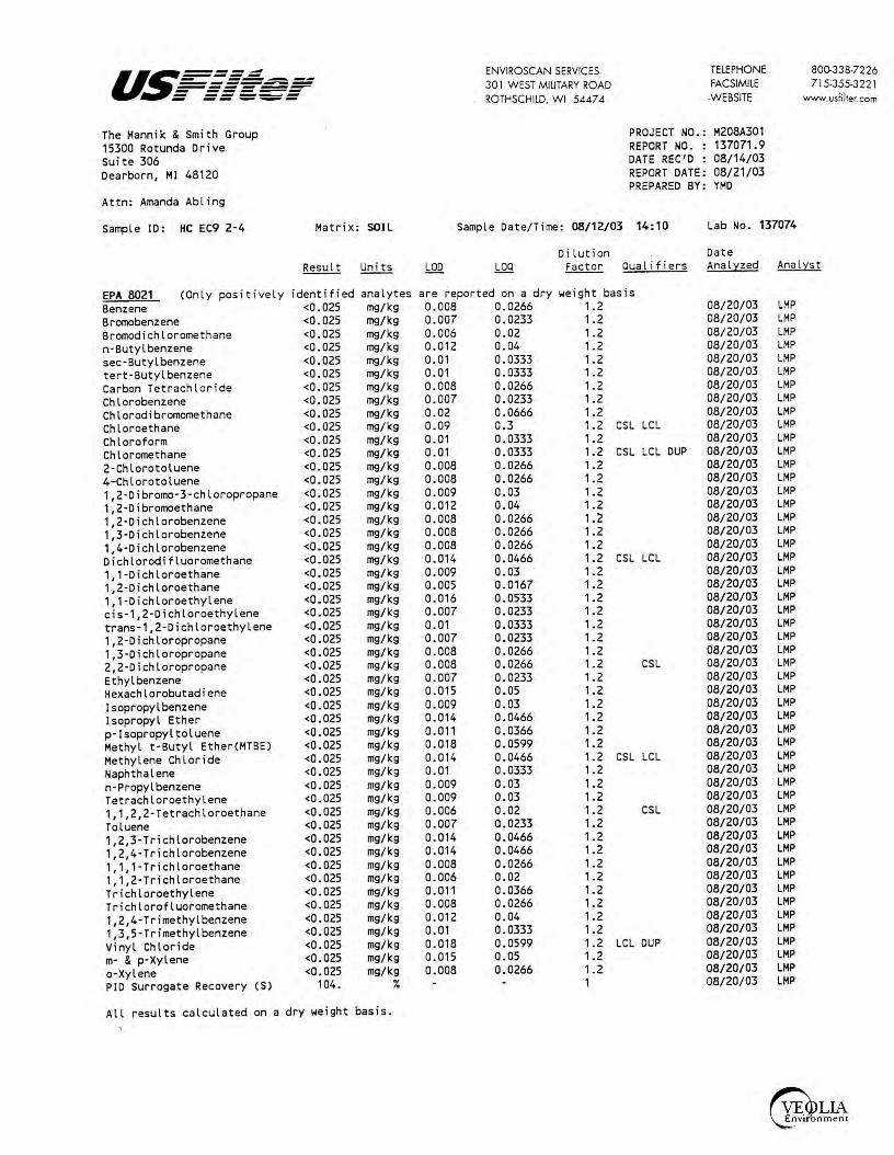
us====:=:: ENVIROSCAN SERVICES TELEPHONE 800-338-7226 - ------------- 301 WEST MILITARY ROAD FACSIMILE 715-355-3221 ------~ - ------ ------ -- --- ROTHSCHILD, WI 5447 4 .WEBSITE www.usfilter.com
The Mannik & Smith Group PROJECT NO.: M208A301 15300 Rotunda Drive REPORT NO. : 137071.9 Suite 306 DATE REC'D : 08/14/03 Dearborn, MI 48120 REPORT DATE: 08/21/03
PREPARED BY: YMD Attn: Amanda Abling
Sample ID: HC EC9 2-4 Matrix: SOIL Sample Date/Time: 08/12/03 14:10 Lab No. 137074
Dilution Date Result Units LOO LOO Factor Qualifiers Analyzed Analyst
EPA 8021 (Only positively identified analytes are reported on a dry weight basis Benzene <0.025 mg/kg 0.008 0.0266 1. 2 08/20/03 LMP Bromobenzene <0.025 mg/kg 0.007 0.0233 1. 2 08/20/03 LMP Bromodichloromethane <0.025 mg/kg 0.006 0.02 1. 2 08/20/03 LMP n-Butylbenzene <0.025 mg/kg 0.012 0.04 1. 2 08/20/03 LMP sec-Butyl benzene <0.025 mg/kg 0.01 0.0333 1. 2 08/20/03 LMP tert-Butylbenzene <0.025 mg/kg 0.01 0.0333 1.2 08/20/03 LMP Carbon Tetrachloride <0.025 mg/kg 0.008 0.0266 1. 2 08/20/03 LMP Chlorobenzene <0.025 mg/kg 0.007 0.0233 1. 2 08/20/03 LMP Chlorodibromomethane <0.025 mg/kg 0.02 0.0666 1.2 08/20/03 LMP Chloroethane <0.025 mg/kg 0.09 0.3 1.2 CSL LCL 08/20/03 LMP Chloroform <0.025 mg/kg 0.01 0.0333 1. 2 08/20/03 LMP Chloromethane <0.025 mg/kg 0.01 0.0333 1. 2 CSL LCL 0UP 08/20/03 LMP 2-Chlorotoluene <0.025 mg/kg 0.008 0.0266 1. 2 08/20/03 LMP 4- Chlorotoluene <0.025 mg/kg 0.008 0.0266 , . 2 08/20/03 LMP 1,2-Dibromo-3-chloropropane <0.025 mg/kg 0.009 0.03 , . 2 08/20/03 LMP 1,2-Dibromoethane <0.025 mg/kg 0.012 0.04 1.2 08/20/03 LMP 1,2-Dichlorobenzene <0.025 mg/kg 0.008 0.0266 , . 2 08/20/03 LMP 1,3-Dichlorobenzene <0.025 mg/kg 0.008 0.0266 , . 2 08/20/03 LMP
1,4·Dichlorobenzene <0.025 mg/kg 0.008 0.0266 , . 2 08/20/03 LMP Dichlorodifluoromethane <0.025 mg/kg 0.014 0.0466 1.2 CSL LCL 08/20/03 LMP 1, 1-Dichloroethane <0.025 mg/kg 0.009 0.03 1. 2 08/20/03 LMP 1,2-Dichloroethane <0.025 mg/kg 0.005 0.0167 1.2 08/20/03 LMP 1, 1-Dichloroethylene <0.025 mg/kg 0.016 0.0533 1.2 08/20/03 LMP cis-1,2-Dichloroethylene <0.025 mg/kg 0.007 0.0233 1.2 08/20/03 LMP trans-1,2-Dichloroethylene <0.025 mg/kg 0.01 0.0333 1. 2 08/20/03 LMP 1,2-Dichloropropane <0.025 mg/kg 0.007 0.0233 1.2 08/20/03 LMP 1,3-Dichloropropane <0.025 mg/kg 0.008 0.0266 1. 2 08/20/03 LMP 2,2-Dichloropropane <0.025 mg/kg 0.008 0.0266 1.2 CSL 08/20/03 LMP
Ethyl benzene <0.025 mg/kg 0.007 0.0233 1. 2 08/20/03 LMP Hexachlorobutadiene <0.025 mg/kg 0.015 0.05 1. 2 08/20/03 LMP
Isopropylbenzene <0.025 mg/kg 0.009 0.03 1. 2 08/20/03 LMP
Isopropyl Ether <0.025 mg/kg 0.014 0.0466 1. 2 08/20/03 LMP
p-Isopropyltoluene <0.025 mg/kg 0.011 0.0366 1. 2 08/20/03 LMP Methyl t-Butyl Ether(MTBE) <0.025 mg/kg 0.018 0.0599 1. 2 08/20/03 LMP
Methylene Chloride <0.025 mg/kg 0.014 0.0466 1.2 CSL LCL 08/20/03 LMP
Naphthalene <0.025 mg/kg 0.01 0.0333 1. 2 08/20/03 LMP
n-Propylbenzene <0.025 mg/kg 0.009 0.03 1. 2 08/20/03 LMP
Tetrachloroethylene <0.025 mg/kg 0.009 0.03 1. 2 08/20/03 LMP
1, 1,2,2-Tetrachloroethane <0.025 mg/kg 0.006 0.02 1. 2 CSL 08/20/03 LMP
Toluene <0.025 mg/kg 0.007 0.0233 1;2 08/20/03 LMP
1,2,3-Trichlorobenzene <0.025 mg/kg 0.014 0.0466 , . 2 08/20/03 LMP
1,2,4·Trichlorobenzene <0.025 mg/kg 0.014 0.0466 1. 2 08/20/03 LMP
1, 1,1-Trichloroethane <0.025 mg/kg 0.008 0.0266 1.2 08/20/03 LMP
1, 1,2-Trichloroethane <0.025 mg/kg 0.006 0.02 1. 2 08/20/03 LMP
Trichloroethylene <0.025 mg/kg 0.011 0.0366 1. 2 08/20/03 LMP
Trichlorofluoromethane <0.025 mg/kg 0.008 0.0266 1.2 08/20/03 LMP
1,2,4-Trimethylbenzene <0.025 mg/kg 0.012 0.04 1. 2 08/20/03 LMP
1,3,5-Trimethylbenzene <0.025 mg/kg 0.01 0.0333 1. 2 08/20/03 LMP
Vinyl Chloride <0.025 mg/kg 0.018 0.0599 , . 2 LCL DUP 08/20/03 LMP
m· & p·Xylene <0.025 mg/kg 0.015 0.05 1. 2 08/20/03 LMP
a-Xylene <0.025 mg/kg 0.008 0.0266 1.2 08/20/03 LMP
PIO Surrogate Recovery (S) 104 . ¾ 1 08/20/03 LMP
All results calculated on a dry weight basis.

u.~=====: - ---------.----------- ------- ------ -- _.._.._ The Mannik & Smith Group 15300 Rotunda Drive Suite 306 Dearborn, MI 48120
Attn: Amanda Abling
Sample ID: HC EC9 2-4 Matrix: SOIL
EPA 8021 (Only positively identified analytes HALL Surrogate Recovery (SJ 89.4 %
HOSA21-2 Total Sol ids 86.6 %
All results calculated on a dry weight basis.
are
ENVIROSCAN SERVICES 30 l W EST MILITARY ROAD ROTHSCHILD, WI 5447 4
TELEPHONE FACSIMILE .WEBSITE
PROJECT NO . : M208A301 REPORT NO. : 137071.10 DATE REC'D : 08/14/03 REPORT DATE: 08/21/03 PREPARED BY: YMD
Sample Date/Time: 08/12/03 14:10 Lab No. 137074
Dilution Date
800-338-7226 715-355-3 22 l
www.usfilter.com
Factor Qualifiers Analyzed Analyst
reported on a dry weight basis 1 08/20/03 LMP
0.33 08/18/03 SAK

us===~ ENVIROSCAN SERVICES TELEPHONE 800-338-7226 - ------------ 30 l WEST MILITARY ROAD FACSIMILE 715-355-322 l ------- ------ ----- ROTHSCHILD, WI 5447 4 WEBSITE - -- --- www.usfilter.com
The Mannik & Smith Group PROJECT NO.: M208A301 15300 Rotunda Drive REPORT NO. : 137071.11 Suite 306 DATE REC'D : 08/14/03 Dearborn, MI 48120 REPORT DATE: 08/21/03
PREPARED BY: YMD Attn: Amanda Abl i ng
Sample ID: HC EC9 10-12 Matrix: SOIL Sample Date/Time: 08/12/03 14: 15 Lab No. 137075
Dilution Date Result Units LOO LOO Factor Qualifiers Anali:::zed Anali:::st
EPA 8021 (Only positively identified analytes are reported on a dry weight basis Benzene <0.025 mg/kg 0.008 0.0266 1 . 1 08/20/03 LMP Bromobenzene <0.025 mg/kg 0.007 0.0233 1. 1 08/20/03 LMP Bromodichloromethane <0.025 mg/kg 0.006 0.02 1 . 1 08/20/03 LMP n-Butylbenzene <0.025 mg/kg 0.012 0.04 1 . 1 08/20/03 LMP sec-Butyl benzene <0.025 mg/kg 0.01 0.0333 1 . 1 08/20/03 LMP tert-Butylbenzene <0.025 mg/kg 0.01 0. 0333 1 . 1 08/20/03 LMP Carbon Tetrachloride <0.025 mg/kg 0.008 0.0266 1 . 1 08/20/03 LMP Chlorobenzene <0.025 mg/kg 0.007 0.0233 1. 1 08/20/03 LMP Chlorodibromomethane <0.025 mg/kg 0.02 0.0666 1 . 1 08/20/03 LMP Chloroethane <0.025 mg/kg 0.09 0.3 1 . 1 CSL LCL 08/20/03 LMP Chloroform <0.025 mg/kg 0.01 0.0333 1 . 1 08/20/03 LMP Chloromethane <0.025 mg/kg 0.01 0.0333 1. 1 CSL LCL DUP 08/20/03 LMP
2-Chlorotoluene <0.025 mg/kg 0.008 0.0266 1. 1 08/20/03 LMP 4-Chlorotoluene <0.025 mg/kg 0.008 0.0266 1. 1 08/20/03 LMP 1,2-Dibromo-3-chloropropane <0.025 mg/kg 0. 009 0.03 1 . 1 08/20/03 LMP 1,2-Dibromoethane <0.025 mg/kg 0.012 0.04 1 . 1 08/20/03 LMP 1,2-Dichlorobenzene <0.025 mg/kg 0.008 0.0266 1 . , 08/20/03 LMP 1,3-0ichlorobenzene <0.025 mg/kg 0.008 0.0266 1. 1 08/20/03 LMP 1,4-Dichlorobenzene <0.025 mg/kg 0.008 0.0266 1. 1 08/20/03 LMP Dichlorodifluoromethane <0.025 mg/kg 0.014 0.0466 1 . 1 CSL LCL 08/20/03 LMP
1, 1-Dichloroethane <0.025 mg/kg 0.009 0.03 1 . 1 08/20/03 LMP 1,2-Dichloroethane <0.025 mg/kg 0.005 0.0167 1. 1 08/20/03 LMP 1,1-0ichloroethylene <0.025 mg/kg 0.016 0.0533 1. 1 08/20/03 LMP cis-1,2-Dichloroethylene <0.025 mg/kg 0.007 0.0233 1. 1 08/20/03 LMP trans-1,2-Dichloroethylene <0.025 mg/kg 0.01 0.0333 1. 1 08/20/03 LMP 1,2-Dichloropropane <0.025 mg/kg 0.007 0.0233 1. 1 08/20/03 LMP 1,3-Dichloropropane <0.025 mg/kg 0.008 0.0266 1 . 1 08/20/03 LMP 2,2-Dichloropropane <0.025 mg/kg 0.008 0.0266 1. 1 CSL 08/20/03 LMP
Ethyl benzene <0.025 mg/kg 0.007 0.0233 1. 1 08/20/03 LMP Hexachlorobutadiene <0.025 mg/kg 0.015 0.05 1. 1 08/20/03 LMP
Isopropylbenzene <0.025 mg/kg 0.009 0.03 1. 1 08/20/03 LMP Isopropyl Ether <0.025 mg/kg 0.014 0.0466 1. 1 08/20/03 LMP
p- Isopropyltoluene <0.025 mg/kg 0.011 0.0366 1 . 1 08/20/03 LMP Methyl t-Butyl Ether(MTBE) <0.025 mg/kg 0.018 0.0599 1 . 1 08/20/03 LMP
Methylene Chloride <0.025 mg/kg 0.014 0.0466 1 . 1 CSL LCL 08/20/03 LMP
Naphthalene <0.025 mg/kg 0.01 0.0333 1 . 1 08/20/03 LMP
n-Propylbenzene <0.025 mg/kg 0.009 0.03 1 . 1 08/20/03 LMP Tetrachloroethylene <0.025 mg/kg 0.009 0.03 1 . 1 08/20/03 LMP
1,1,2,2-Tetrachloroethane <0.025 mg/kg 0.006 0.02 1 . 1 CSL 08/20/03 LMP
Toluene <0.025 mg/kg 0.007 0.0233 L1 08/20/03 LMP
1,2,3-Trichlorobenzene <0.025 mg/kg 0.014 0.0466 1. 1 08/20/03 LMP
1,2,4-Trichlorobenzene <0.025 mg/kg 0.014 0.0466 1 . 1 08/20/03 LMP
1,1, 1-Trichloroethane <0.025 mg/kg 0.008 0.0266 1. 1 08/20/03 LMP
1,1,2-Trichloroethane <0.025 mg/kg 0.006 0.02 1 . 1 08/20/03 LMP
Trichloroethylene <0.025 mg/kg 0. 011 0.0366 1 . 1 08/20/03 LMP
Trichlorofluoromethane <0.025 mg/kg 0.008 0.0266 1. 1 08/20/03 LMP
1,2,4-Trimethylbenzene <0.025 mg/kg 0.012 0.04 1 . 1 08/20/03 LMP
1,3,5-Trimethylbenzene <0.025 mg/kg 0.01 0.0333 1 . 1 08/20/03 LMP
Vinyl Chloride <0.025 mg/kg 0.018 0.0599 1. 1 LCL DUP 08/20/03 LMP
m- & p-Xylene <0.025 mg/kg 0.015 0.05 1. 1 08/20/03 LMP
a-Xylene <0.025 mg/kg 0.008 0. 0266 1 . 1 08/20/03 LMP
PIO Surrogate Recovery (S) 98.8 ¾ 1 08/20/03 LMP
All results calculated on a dry weight basis.
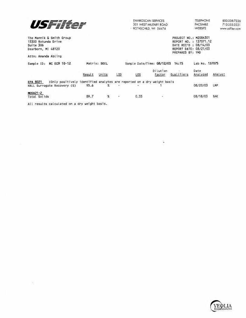
u.~===: - -------------------~ - ------ ------ -- ---The Mannik & Smith Group 15300 Rotunda Orive Suite 306 Dearborn, Ml 48120
Attn: Amanda Abling
Sample ID: HC EC9 10-12 Matrix: SOIL
ENVIROSCAN SERVICES 30 I WEST MILITARY ROAD ROTHSCHILD, WI 54474
TELEPHONE FACSIMILE
-WEBSITE
PROJECT NO.: M208A301 REPORT NO. : 137071. 12 DATE REC'D : 08/14/03 REPORT DATE: 08/21/03 PREPARED BY: YMD
Sample Date/Time: 08/12/03 14:15 Lab No. 137075
Dilution Date
800-338-7226 715-355-322 l
www.usfilter.com
Factor Qualifiers Analyzed Analyst
EPA 8021 (Only positively identified analytes are reported on a dry weight basis HALL Surrogate Recovery CS) 95.6 % 1
MOSA21-2 Total Sol ids 89.7
All results calculated on a dry weight basis.
% 0.33
08/20/03 LMP
08/18/03 SAK

us=::::::.: ENVIROSCAN SERVICES TELEPHONE 800-338-7226 - ------------ 30 I WEST MILITARY ROAD FACSIMILE 715-355-3221 ------- -----~ ===''='= ROTHSCHILD, WI 54474 -WEBSITE www.usfilter.com
The Mannik & Smith Group PROJECT NO.: M208A301 15300 Rotunda Drive REPORT NO. : 137071. 13 Suite 306 DATE REC'D : 08/14/03 Dearborn, MI 48120 REPORT DATE: 08/21/03
PREPARED BY: YMD Attn: Amanda Abling
Sample ID: HC EC9 16-18 Matrix: SOIL Sample Date/Time: 08/12/03 14:20 Lab No. 137076
Dilution Date Result Units LOD L0Q Factor Qualifiers Anal:tzed Anal:tst
EPA 8021 (Only positively identified analytes are reported on a dry weight basis Benzene <0.025 mg/kg 0.008 0.0266 1 08/20/03 LMP Bromobenzene <0.025 mg/kg 0.007 0.0233 1 08/20/03 LMP Bromodichloromethane <0.025 mg/kg 0.006 0.02 1 08/20/03 LMP n-Butylbenzene <0.025 mg/kg 0.012 0.04 1 08/20/03 LMP sec-Butyl benzene <0.025 mg/kg 0.01 0.0333 1 08/20/03 LMP tert-Butylbenzene <0.025 mg/kg 0.01 0.0333 1 08/20/03 LMP Carbon Tetrachloride <0.025 mg/kg 0.008 0.0266 1 08/20/03 LMP Chlorobenzene <0.025 mg/kg 0.007 0.0233 1 08/20/03 LMP Chlorodibromomethane <0.025 mg/kg 0.02 0.0666 1 08/20/03 LMP Chloroethane <0.025 mg/kg 0.09 0.3 1 CSL LCL 08/20/03 LMP Chloroform <0.025 mg/kg 0.01 0.0333 1 08/20/03 LMP Chloromethane <0.025 mg/kg 0.01 0.0333 1 CSL LCL DUP 08/20/03 LMP 2-Chlorotoluene <0.025 mg/kg 0.008 0.0266 1 08/20/03 LMP 4-Chlorotoluene <0.025 mg/kg 0.008 0.0266 1 08/20/03 LMP 1,2-Dibromo-3-chloropropane <0.025 mg/kg 0.009 0.03 1 08/20/03 LMP 1,2-Dibromoethane <0.025 mg/kg 0.012 0.04 1 08/20/03 LMP 1,2-0ichlorobenzene <0.025 mg/kg 0.008 0.0266 1 08/20/03 LMP 1,3-Dichlorobenzene <0.025 mg/kg 0.008 0.0266 1 08/20/03 LMP 1,4-Dichlorobenzene <0.025 mg/kg 0.008 0.0266 1 08/20/03 LMP Dichlorodifluoromethane <0.025 mg/kg 0.014 0.0466 1 CSL LCL 08/20/03 LMP 1,1-Dichloroethane <0.025 mg/kg 0.009 0.03 1 08/20/03 LMP 1,2-0ichloroethane <0.025 mg/kg 0.005 0.0167 1 08/20/03 LMP 1,1-Dichloroethylene <0.025 mg/kg 0.016 0.0533 1 08/20/03 LMP cis-1,2-Dichloroethylene <0.025 mg/kg 0.007 0.0233 1 08/20/03 LMP trans-1,2-Dichloroethylene <0.025 mg/kg 0.01 0.0333 1 08/20/03 LMP 1,2-Dichloropropane <0.025 mg/kg 0.007 0.0233 1 08/20/03 LMP 1,3-Dichloropropane <0.025 mg/kg 0.008 0.0266 1 08/20/03 LMP 2,2-Dichloropropane <0.025 mg/kg 0.008 0.0266 1 CSL 08/20/03 LMP Ethyl benzene <0.025 mg/kg 0.007 0.0233 1 08/20/03 LMP Hexachlorobutadiene <0.025 mg/kg 0.015 0.05 1 08/20/03 LMP Isopropylbenzene <0.025 mg/kg 0.009 0.03 1 08/20/03 LMP Isopropyl Ether <0.025 mg/kg 0.014 0.0466 1 08/20/03 LMP p-Isopropyltoluene <0.025 mg/kg 0.011 0.0366 1 08/20/03 LMP Methyl t-Butyl Ether(MTBE) <0.025 mg/kg 0.018 0.0599 1 08/20/03 LMP Methylene Chloride <0.025 mg/kg 0.014 0.0466 1 CSL LCL 08/20/03 LMP Naphthalene <0.025 mg/kg 0.01 0.0333 1 08/20/03 LMP
n-Propylbenzene <0.025 mg/kg 0.009 0.03 1 08/20/03 LMP Tetrachloroethylene <0.025 mg/kg 0.009 0.03 1 08/20/03 LMP 1, 1,2,2-Tetrachloroethane <0.025 mg/kg 0.006 0.02 1 CSL 08/20/03 LMP
Toluene <0.025 mg/kg 0.007 0.0233 1 08/20/03 LMP
1,2,3-Trichlorobenzene <0.025 mg/kg 0.014 0.0466 1 08/20/03 LMP 1,2,4-Trichlorobenzene <0.025 mg/kg 0.014 0.0466 1 08/20/03 LMP
1, 1, 1-Trichloroethane <0.025 mg/kg 0.008 0.0266 1 08/20/03 LMP 1, 1,2-Trichloroethane <0.025 mg/kg 0.006 0.02 1 08/20/03 LMP
Trichloroethylene <0.025 mg/kg 0.011 0.0366 1 08/20/03 LMP Trichlorofluoromethane <0.025 mg/kg 0.008 0.0266 1 08/20/03 LMP
1,2,4-Trimethylbenzene <0.025 mg/kg 0.012 0.04 1 08/20/03 LMP 1,3,5-Trimethylbenzene <0.025 mg/kg 0.01 0.0333 1 08/20/03 LMP
Vinyl Chloride <0.025 mg/kg 0.018 0.0599 1 LCL DUP 08/20/03 LMP
m- & p-Xylene <0.025 mg/kg 0.015 0.05 1 08/20/03 LMP
o-Xylene <0.025 mg/kg 0.008 0.0266 1 08/20/03 LMP
PID Surrogate Recovery (S) 100. % 1 08/20/03 LMP
All results calculated on a dry weight basis.

u.5==:=:.::::: - ------------------ ------- ------ -- ---The Mannik & Smith Group 15300 Rotunda Drive Suite 306 Dearborn, Ml 48120
Attn: Amanda Abling
Sample ID: HC EC9 16-18 Matri x : SOIL
EPA 8021 (Only positively identified analytes HALL Surrogate Recovery CS) 93.2 %
MOSA21-2 Total Sol ids 88.2 %
All results calculated on a dry weight basis.
are
ENVIROSCAN SERVICES 301 WEST MILITARY ROAD ROTHSCHILD, WI 54474
TELEPHONE FACSIMILE
·WEBSITE
PROJECT NO.: M208A301 REPORT NO. : 137071. 14 DATE REC'D : 08/14/03 REPORT DATE: 08/21/03 PREPARED BY: YMD
Sample Date/Time: 08/12/03 14:20 Lab No . 137076
Dilution Date
800-338-7226 715-355-3221
www.usfilter.com
Factor Qua lifiers Analyzed Analyst
reported on a dry weight basis 1 08/20/03 LMP
0.33 08/18/03 SAK

I u.~=.=:.=: ;;;::f - --------------------- ------ ------ -- ---
The Mannik & Smith Group 15300 Rotunda Drive Suite 306 Dearborn, MI 48120
Attn: Amanda Abling
Qualifier Descriptions
ENVIROSCAN SERVICES 301 W EST MILITARY ROAD ROTHSCHILD, WI 5447 4
CSL Check standard for this analyte exhibited a low bi as . Sample results may also be biased low.
TELEPHONE FACSIMILE -WEBSITE
PROJECT NO.: M208A301 REPORT NO. : 137071.15 DATE REC'D : 08/14/03 REPORT DATE: 08/21/03 PREPARED BY: YMD
LCL The laboratory control sample for th i s analyte exibited a low bias. Sample results may also be biased low.
DUP Result of duplicate analysis in this quality assurance batch exceeds the l imits for precis i on.
800.338-7226 7 15-355-322 1
www.usfilter.com

ENVIROSCAN SERVICES 30 1 WEST MILITARY ROAD ROTHSCHILD. WI 54474
TELEPHONE 800-338-7226
=-- --=~ ---- -~ u.~---- FACSIMILE 715-355-3221 =-======fr -- ------- -- ._..~-
Sample Receipt Report
Client: Date Received: _:[__; IS-; bl.?
Analytical No. : /3 7 o7 I Through / 3 7o 7~
Check all deviations from EPA or WDNR sample protocol.
[ ]
[ ]
[ ]
[ ]
[ ]
[ ]
fX]
[ ]
[ ]
[ ]
Sample(s) received at __ °C which is above the EPA and WDNR limit of 4 °C.
VOC vial(s) received with headspace. Explain:
Sample(s) received in bottles not furnished by Enviroscan. Preservation method, if used, is unknown. Sample(s) not properly preserved per EPA/WDNR protocol for the following:
Sample(s) received beyond EPA holding time for:
Sample date/time not supplied by client. Actual holding time unknown.
GRO/PVOCNOC/DRO (circle appropriate) sample(s) are < 19.5 gms and this report is the flag for that information. Sample(s) under-weight: , 3 7 o 7 / 7 / 7-~
GRO/PVOCNOC (circle appropriate) sample(s) were between 26.4-35.4 gms so methanol was added in a 1:1 ratio. Sample(s) included:. _______________ _
GRO/PVOCNOC/DRO (circle appropriate) sample(s) were > 35.4 gms and are required to
be rejected. Sample(s) included=----------~---------
Other:
Client contact concerning the above deviations:
www.usfil:er.com
Client ~ h-\c. t"\.Ac., Ah 11 ri7 (contact name) notified of the above deviation(s) on <r /IS- /-43 at ....i_: 00 @!pm by ~ <-~ and the client ordered:
(signature) [){ Proceed with analyses as ordered. [ ] Proceed with analyses after taking the following corrective action:
[ ] Do NOT proceed with analyses.
All Analyses conducrec c cccoroccce w ith USF ,her Oual,ry Assurance Prog ram
vv·sccns,n Lab Cen,fc· .-:n No 737053130
a VIVENDI Environnement company
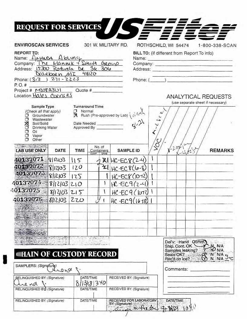
I
rll~ .......... ~ ld❖IUifiilt-]114:\St!.,_, _F ENVIROSCAN SERVICES 301 W. MILITARY RD. ROTHSCHILD, WI 54474 1-800-338-SCAN
REPORT TO:
Name: A fv\4~M A lol,n. c~ . . BILL TO: (if different from Report To info)
Company: T'N f.(\O--l-\.~ ll -¼ ~kA.:Jf\ biwv-f? Address: I S-3'...'0 jsofurt:(ei.. \)t. . 3-k . 30l;
Name: ______________ _ Company: ____________ _
~O-.,Lboq n .ML 4~/20 Address: ------'----------
Phone:(313 )_-Z..__cl~l_-_2:;_::_L_L_s _______ _ Phone:( ______________ _
P. 0 . # ----------------Project # ('v(U)'i 1\30 \ Quote # ____ _ Location \-.\ct.\e ~ Coa Af (l.S
Sample Type (Check all that apply) 0 Groundwater 0 Wastewater ~ Soil/Solid 0 Drinking Water 0 Oil 0 Vapor 0 Other
Turnaround Time 'v 0 Normal . , .J...t:..._ ~ Rush (Pre-approved by Lab) \ \J-i ~ ·
Date Needed_____ , / /),,\ Approved By _____ 'b
No. of TIME nt in rs SAMPLE ID
f 11 BAIN OF CUSTODY RECORD SAMPLERS: (Sign~)
\_}LI._£)~
ELINQUISHED BY: (Signature)
.___o_v\.Cl RELINQUISHED B (Signature)
RELINQUISHED BY: (Signature)
DATE/TIME RECEIVED BY: (Signature)
'5}13()} 3'10 DATE/TIME RECEIVED BY: (Signature)
DATE/TIME
ANALYTICAL REQUESTS (use separate sheet if necessary)
REMARKS
Comments: ______ _
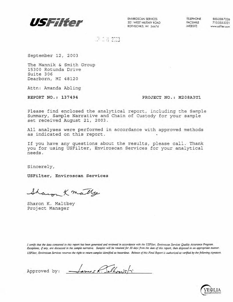
u.~=-=-=,;;;;f - ------------------~ - ------ ------ -- ---
September 12, 2003
The Mannik & Smith Group 15300 Rotunda Drive Suite 306 Dearborn, MI 48120
Attn: Amanda Abling
REPORT NO.: 137494
. ~ .., r, . .., '1 -· ._., ~ . ..; :_J
ENVIROSCAN SERVICES 301 WEST MILITARY ROAD ROTHSCHILD, WI 5447 4
PROJECT NO.
TELEPHONE FACSIMILE WEBSITE
M208A3Ul
Please find enclosed the analytical report, including the Sample Summary, Sample Narrative and Chain of Custody for your sample set received August 21, 2003.
All analyses were performed in accordance with approved methods as indicated on this report.
If you have any questions about the results, please call. Thank you for using USFilter, Enviroscan Services for your analytical needs.
Sincerely,
USFilter, Enviroscan Services
Sharon K. Maltbey Project Manager
800-338-7226 715-355-3221
www.usfilter.com
I cenify thaJ the da!a coniained in rhis repon has been generaud and reviewed in accordance wirh rhe USFilur, Enviroscan Services Quality Assurance Program. E:cceptions, if any, are discussed in rhe sample narraJive. Samples will be retained for 30 days from rhe dale of rhis repon, rhen disposed in an appropriaJe manner.
USFiller, Enviroscan Services reserves the right to rerum samples iden1ijied as hazardous. Release of rhis Final Repon is authorized as verified by rhe following signa1ure.
Approved by:
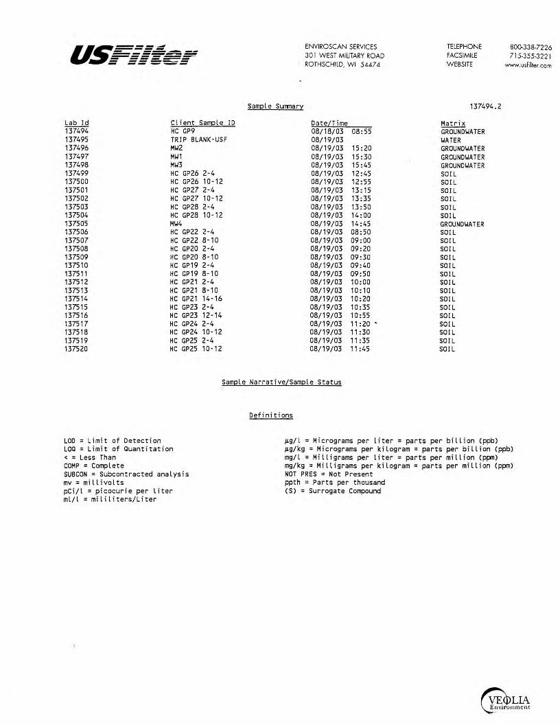
u.5=====.::: - -------------------- ------ ------ -- ---
Lab Id 137494 137495 137496 137497 137498 137499 137500 137501 137502 137503 137504 137505 137506 137507 137508 137509 137510 137511 137512 137513 137514 137515 137516 137517 137518 137519 137520
Client Sample ID HC GP9 TRIP BLANK-USF M\.12 M\.11 M\.13 HC GP26 2-4 HC GP26 10-12 HC GP27 2-4 HC GP27 10-12 HC GP28 2-4 HC GP28 10-12 M\.14 HC GP22 2-4 HC GP22 8-10 HC GP20 2-4 HC GP20 8-10 HC GP19 2-4 HC GP19 8-10 HC GP21 2-4 HC GP21 8-10 HC GP21 14-16 HC GP23 2-4 HC GP23 12-14 HC GP24 2-4 HC GP24 10-12 HC GP25 2-4 HC GP25 10-12
Sample Summary
ENVIROSCAN SERVICES 301 WEST MILITARY ROAD ROTHSCHILD, WI 5447 4
Date/Time 08/18/03 08:55 08/19/03 08/19/03 15:20 08/19/03 15 :30 08/19/03 15:45 08/19/03 12: 45 08/19/03 12:55 08/19/03 13: 15 08/19/03 13:35 08/19/03 13:50 08/19/03 14:00 08/19/03 14:45 08/19 /03 08: 50 08/19/03 09:00 08/19/03 09:20 08/19/03 09:30 08/19/03 09 :40 08/19/03 09:50 08/19/03 10:00 08/19/03 10:10 08/19/03 10:20 08/19/03 10:35 08/19/03 10:55 08/19/03 11:20 • 08/19/03 11:30 08/19/03 11:35 08/19/03 11:45
TELEPHONE FACSIMILE W EBSITE
137494.2
Matr i x GROUND\.IATER \.IATER GROUND\.IATER GROUND\.IATER GROUND\.IATER SOIL SOIL SOIL SOIL SOIL SOIL GROUND\.IATER SOIL SOIL SO IL SOIL SOIL SOIL SOIL SOIL SOIL SOIL SOIL SOIL SOIL SOIL SOIL
800.338-7226 71 5-355-3221
www. usfilter.com
Sample Narrative/Sample Status
LOO= Limit of Detection LOQ = Limit of auantitation <=Less Than COMP= Complete SUBCON = Subcontracted analysis mv = millivolts pCi/l = picocurie per liter ml/l = mi l iliters/Liter
Def i ni tions
µg/l = Micrograms per liter= parts per billion (ppb) µg/kg = Micrograms per kilogram= parts per billion (ppb) mg/l = Milligrams per liter= parts per mi llion (ppm) mg/kg= Milligrams per kilogram= parts per million (ppm) NOT PRES= Not Present ppth = Parts per thousand (S) = Surrogate Compound
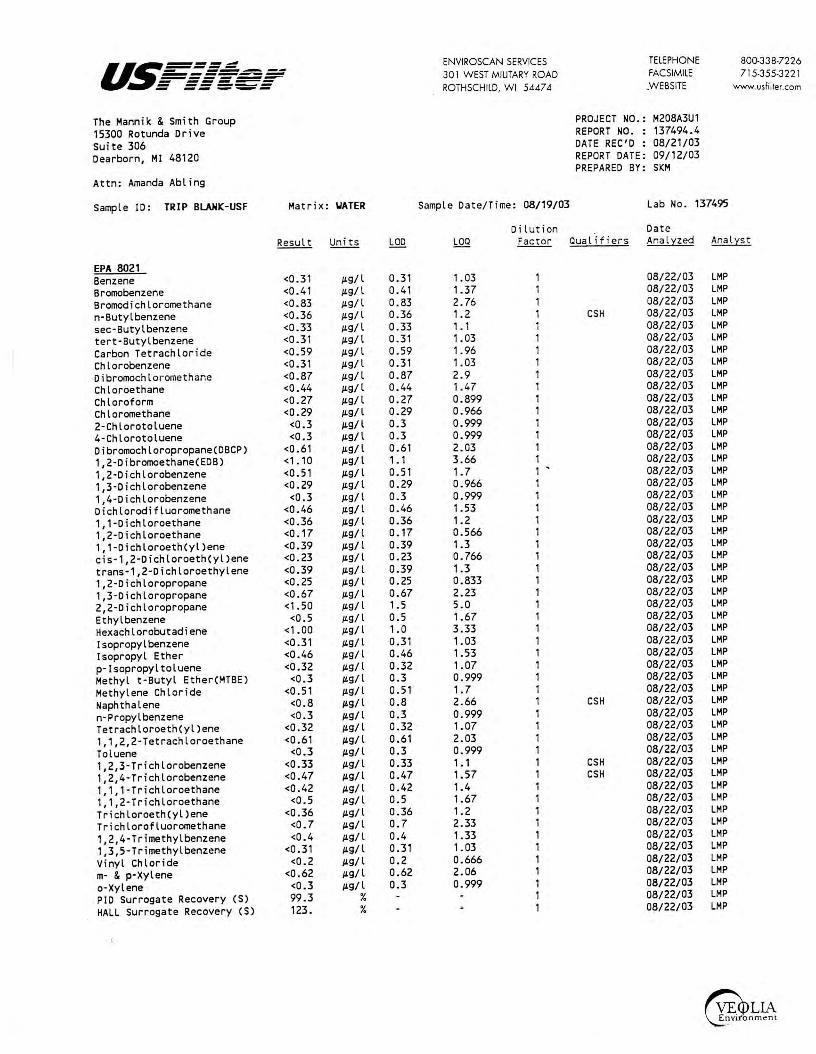
us===~ ENVIROSCAN SERVICES TELEPHONE 800-338-7226 - ------------- 301 WEST MILITARY ROAD FACSIMILE 715-355-3221 ------- ------ ----- ROTHSCHILD, WI 5447 4 WEBS ITE www.usfilter.com - -- ---The Mannik & Smith Group PROJECT NO.: M208A3U1 15300 Rotunda Drive REPORT NO. : 137494.4 Suite 306 DATE REC'D : 08/21/03 Dearborn, Ml 48120 REPORT DATE: 09/12/03
PREPARED BY: SKM Attn: Amanda Abling
Sample ID: TRIP BLANIC-USF Matrix : \JATER Sample Date/Time: 08/19/03 Lab No . 137495
Di lution Date Result Units LOD LOO Facto r Qualifiers Anal }:'.Zed Ana l}:'.st
EPA 8021 Benzene <0 .31 µg/l 0.31 1.03 1 08/22/03 LMP Bromobenzene <0 .4 1 µg/l 0.41 1.37 1 08/22/03 LMP Bromodichloromethane <0.83 µg/l 0.83 2.76 1 08/22/03 LMP n-Butylbenzene <0.36 µg/l 0.36 1.2 1 CSH 08/22/03 LMP sec-Butyl benzene <0.33 µg/l 0.33 1. 1 1 08/22/03 LMP tert-Butylbenzene <0 . 31 µg/l 0.31 1. 03 1 08/22/03 LMP Carbon Tetrachloride <0.59 µg/l 0.59 1.96 1 08/22/03 LMP Chlorobenzene <0.31 µg/l 0.31 1.03 1 08/22/03 LMP Di bromochlo romethane <0.87 µg/l 0.87 2.9 1 08/22/03 LMP Chloroethane <0.44 µg/l 0.44 1.47 1 08/22/03 LMP Chloroform <0.27 µg/ l 0.27 0. 899 1 08/22/03 LMP Chloromethane <0.29 µg/l 0.29 0.966 1 08/22/03 LMP
2-Chlorotoluene <0.3 µg/l 0.3 0.999 1 08/22/03 LMP 4-Chlorotoluene <0.3 µg/l 0.3 0.999 1 08/22/03 LMP Dibromochloropropane(DBCP) <0.61 µg/l 0.61 2.03 1 08/22/03 LMP 1,2-Dibromoethane(EDB) <1. 10 µg/l 1. 1 3.66 1 08/22/03 LMP 1,2-Dichlorobenzene <0.51 µg/l 0.51 1. 7 1 - 08/22/03 LMP 1,3-Dichlorobenzene <0.29 µg/l 0.29 0.966 1 08/22/03 LMP
1,4-Dichlorobenzene <0.3 µg/l 0.3 0.999 1 08/22/03 LMP Dichlorodifluoromethane <0.46 µg/l 0.46 1.53 1 08/22/03 LMP 1,1-Dichloroethane <0.36 µg/l 0. 36 1. 2 1 08/22/03 LMP 1,2-Dichloroethane <0.17 µg/l 0.17 0.566 1 08/22/03 LMP 1,1 -Dichloroeth(yl)ene <0.39 µg/l 0.39 1 .3 1 08/22/03 LMP cis-1,2-Dichloroeth(yl)ene <0.23 µg/l 0.23 0.766 1 08/22/03 LMP trans-1,2-Dichloroethylene <0.39 µg/l 0.39 1 .3 1 08/22/03 LMP 1,2-Dichloropropane <0 . 25 µg/l 0. 25 0.833 1 08/22/03 LMP 1,3-Dichloropropane <0.67 µg/l 0.67 2.23 1 08/22/03 LMP 2,2-Dichloropropane <1.50 µg/l 1. 5 5.0 1 08/22/03 LMP
Ethyl benzene <0.5 µg/l 0.5 1.67 1 08/22/03 LMP Hexachlorobutadiene <1.00 µg/l 1. 0 3.33 1 08/22/03 LMP
lsopropylbenzene <0.31 µg/l 0.31 1.03 1 08/22/03 LMP lsopropyl Ether <0.46 µg/l 0.46 1.53 1 08/22/03 LMP
p-lsopropyltoluene <0.32 µg/l 0.32 1.07 1 08/22/03 LMP Methyl t-Butyl Ether(MTBE) <0.3 µg/l 0.3 0.999 1 08/22/03 LMP
Methylene Chloride <0.51 µg/l 0.51 1. 7 1 08/22/03 LMP
Naphthalene <0.8 µg/l 0.8 2.66 1 CSH 08/22/03 LMP
n-Propylbenzene <0.3 µg/l 0.3 0.999 1 08/22/03 LMP
Tetrachloroeth(yl)ene <0.32 µg/l 0.32 1.07 1 08/22/03 LMP
1, 1,2,2-Tetrachloroethane <0.61 µg/l 0.61 2. 03 1 08/22/03 LMP
Toluene <0.3 µg/l 0.3 0. 999 1 08/22/03 LMP
1,2,3-Trichlorobenzene <0.33 µg/l 0.33 1. 1 1 CSH 08/22/03 LMP
1, 2,4-Trichlorobenzene <0.47 µg/l 0.47 1.57 1 CSH 08/22/03 LMP
1, 1, 1-Trichloroethane <0.42 µg/l 0.42 1.4 1 08/22/03 LMP
1,1,2-Trichloroethane <0.5 µg/l 0.5 1.67 1 08/22/03 LMP
Tr i chloroeth(yl)ene <0.36 µg/l 0.36 1.2 1 08/22/03 LMP
Trichlorofluoromethane <0.7 µg/l 0. 7 2.33 1 08/22/03 LMP
1,2,4-Trimethylbenzene <0.4 µg/l 0. 4 1.33 1 08/22/03 LMP
1, 3,5-Trimethylbenzene <0.31 µg/l 0.31 1.03 1 08/22/03 LMP
Vinyl Chloride <0.2 µg/l 0. 2 0.666 1 08/22/03 LMP
m- & p-Xylene <0.62 µg/l 0. 62 2.06 1 08/22/03 LMP
o-Xylene <0.3 µg/l 0.3 0. 999 1 08/22/03 LMP
PID Surrogate Recovery (S) 99 .3 % 1 08/22/03 LMP
HALL Surrogate Recovery (S) 123. % 1 08/22/03 LMP

us===~ ENVIROSCAN SERVICES TELEPHONE 800-338-7226 - ---------.-- 301 WEST MILITARY ROAD FACSIMI LE 715-355-322 l ------- ------ ----- ROTHSCHILD, WI 5447 4 WEBSITE www.usfilter.com - -- _,._._ The Mannik & Smith Group PROJECT NO.: M208A3U1 15300 Rotunda Drive REPORT NO. : 137494.5 Suite 306 DATE REC'D : 08/21/03 Dearborn, Ml 48120 REPORT DATE: 09/12/03
PREPARED BY: SKM Attn: Amanda Abling
Sample ID: M'J2 Matrix: GRO\ITR Sample Date/Time: 08/19/03 15:20 Lab No. 137496
Dilution Date Result Uni ts LOO LOO Factor Qualifiers Analyzed Analyst
EPA 8021 Benzene <0.31 1Lg/ l 0.31 1.03 1 08/22/03 LMP Bromobenzene <0.41 jLg/ l 0.41 1.37 1 08/22/03 LMP Bromodichloromethane <0.83 1Lg/ l 0.83 2.76 1 08/22/03 LMP n-Butylbenzene <0.36 jLg/ l 0.36 1. 2 1 CSH 08/22/03 LMP sec-Butyl benzene <0.33 jLg/ l 0.33 1 . 1 1 08/22/03 LMP tert-Butylbenzene <0.31 jLg/ l 0.31 1.03 1 08/22/03 LMP Carbon Tetrachloride <0.59 jLg/ l 0.59 1.96 1 08/22/03 LMP Chlorobenzene <0.31 jLg/ l 0.31 1.03 1 08/22/03 LMP Dibromochloromethane <0.87 jLg/ l 0.87 2.9 1 08/22/03 LMP Chloroethane <0.44 jLg/l 0.44 1.47 1 08/22/03 LMP Chloroform <0.27 µ.g/l 0.27 0.899 1 08/22/03 LMP Chloromethane <0.29 jLg/l 0.29 0.966 1 08/22/03 LMP 2-Chlorotoluene <0.3 jLg/l 0.3 0.999 1 08/22/03 LMP 4-Chlorotoluene <0.3 jLg/l 0.3 0.999 1 08/22/03 LMP Dibromochloropropane(DBCP) <0.61 jLg/ l 0.61 2.03 1 08/22/03 LMP 1,2-Dibromoethane(EDB) <1. 10 1Lg/ l ,. 1 3.66 1 08/22/03 LMP 1,2-Dichlorobenzene <0.51 jLg/ l 0.51 1. 7 1 08/22/03 LMP 1,3-Dichlorobenzene <0.29 jLg/ l 0. 29 0.966 1 08/22/03 LMP
1,4-Dichlorobenzene <0.3 µ.g/ l 0.3 0.999 1 08/22/03 LMP Dichlorodifluoromethane <0.46 jLg/ l 0.46 1 .53 1 08/22/03 LMP 1, 1-Dichloroethane <0.36 jLg/l 0.36 1. 2 1 08/22/03 LMP 1,2-Dichloroethane <0. 17 ILg/l 0. 17 0.566 1 08/22/03 LMP 1,1-Dichloroeth(yl)ene <0.39 µ.g/l 0.39 1.3 1 08/22/03 LMP cis-1,2-Dichloroeth(yl)ene <0.23 jLg/l 0.23 0.766 1 08/22/03 LMP trans-1,2-Dichloroethylene <0.39 IL9/ l 0.39 1.3 1 08/22/03 LMP 1,2-Dichloropropane <0.25 jLg/l 0.25 0.833 1 08/22/03 LMP 1,3-Dichloropropane <0.67 jLg/ l 0.67 2.23 1 08/22/03 LMP 2,2-Dichloropropane <1.50 IL9/ l 1.5 5.0 1 08/22/03 LMP Ethyl benzene <0.5 jLg/ l 0.5 1 .67 1 08/22/03 LMP Hexachlorobutadiene <1.00 µ.g/l 1.0 3 .33 1 08/22/03 LMP
Isopropylbenzene <0.31 µ.g/l 0.31 1.03 1 08/22/03 LMP Isopropyl Ether <0.46 IL9/ l 0.46 1.53 1 08/22/03 LMP
p-Isopropyltoluene <0.32 µ.g/ l 0.32 1.07 1 08/22/03 LMP Methyl t-Butyl Ether(MTBE) <0.3 µ.g/ l 0.3 0.999 1 08/22/03 LMP
Methylene Chlor ide <0.51 µ.g/l 0.51 ,. 7 1 08/22/03 LMP
Naphthalene <0.8 jLg/ l 0.8 2.66 1 CSH 08/22/03 LMP
n-Propylbenzene <0.3 jLg/l 0.3 0.999 1 08/22/03 LMP
Tetrachloroeth(yl)ene <0.32 jLg/ l 0.32 1.07 1 08/22/03 LMP
1,1,2,2-Tetrachloroethane <0.61 µ.g/ l 0.61 2. 03 1 08/22/03 LMP
Toluene <0.3 jLg/l 0.3 0.999 1 08/22/03 LMP
1,2,3-Trichlorobenzene <0.33 µ.g/ l 0.33 1.1 1 CSH 08/22/03 LMP
1,2,4-Trichlorobenzene <0.47 µ.g/l 0.47 1.57 1 CSH 08/22/03 LMP
1, 1, 1-Trichloroethane <0.42 jLg/l 0.42 1.4 1 08/22/03 LMP
1,1,2-Trichloroethane <0.5 µ.g/ l 0.5 1.67 1 08/22/03 LMP
Trichloroeth(yl)ene <0.36 jLg/ l 0.36 1. 2 1 08/22/03 LMP
Trichlorofluoromethane <0.7 jLg/l 0.7 2.33 1 08/22/03 LMP
1,2,4-Trimethylbenzene <0.4 IL9/ l 0.4 1.33 1 08/22/03 LMP
1,3,5-Trimethylbenzene <0.31 µg/l 0.31 1.03 1 08/22/03 LMP
Vinyl Chloride <0.2 jLg/ l 0.2 0.666 1 08/22/03 LMP
m- & p-Xylene <0.62 µg/l 0.62 2.06 1 08/22/03 LMP
o-Xylene <0.3 jLg/l 0.3 0.999 1 08/22/03 LMP
PID Surrogate Recovery (S) 103. % 1 08/22/03 LMP
HALL Surrogate Recovery (S) 122. % 1 08/22/03 LMP

us===~ ENVIROSCAN SERVICES TELEPHONE 800.338-7226 - ------------- 301 WEST MILITARY ROAD FACSIMILE 715-355-3221 ------- ------ ----- ROTHSCHILD, WI 5447 4 .WEBSITE - -- --- www.usfilter.com
The Mannik & Smith Group PROJECT NO.: M208A3U1 15300 Rotunda Drive REPORT NO. : 137494.6 Suite 306 DATE REC'D : 08/21/03 Dearborn, Ml 48120 REPORT DATE: 09/12/03
PREPARED BY: SKM Attn: Amanda Abling
Sample ID: M\J1 Matrix: GROIITR Sample Date/Time: 08/19/03 15:30 Lab No. 137497
Dilution Date Result Units LOO LOO Factor Qualifiers Analz:zed Analz:st
EPA 8021 Benzene <0.31 µ,g/ l 0.31 1. 03 1 08/26/03 LMP Bromobenzene <0.41 µ,g/ l 0.41 1.37 1 08/26/03 LMP Bromodichloromethane <0.83 µ,g/ l 0.83 2.76 1 08/26/03 LMP n·Butylbenzene <0.36 µ,g/ l 0.36 1.2 1 08/26/03 LMP
sec-Butyl benzene <0.33 µ,g/ l 0.33 1. 1 1 08/26/03 LMP tert-Butylbenzene <0.31 µ,g/ l 0.31 1.03 1 08/26/03 LMP Carbon Tetrachloride <0.59 µ,g/ l 0.59 1. 96 1 08/26/03 LMP Chlorobenzene <0.31 µ,g/ l 0.31 1.03 1 08/26/03 LMP Dibromochloromethane <0.87 µ,g/ l 0.87 2.9 1 08/26/03 LMP Chloroethane <0.44 µ,g/ l 0. 44 1.47 1 08/26/03 LMP
Chloroform <0.27 µ,g/ l 0.27 0.899 1 08/26/03 LMP Chloromethane <0.29 µ,g/ l 0.29 0.966 1 08/26/03 LMP
2-Chlorotoluene <0.3 µ,g/ l 0.3 0.999 1 08/26/03 LMP
4-Chlorotoluene <0.3 µ,g/ l 0.3 0.999 1 08/26/03 LMP Dibromochloropropane(0BCP) <0.61 µ,g/ l 0.61 2.03 1 CSH 08/26/03 LMP 1,2-Dibromoethane(EDB) <1. 10 µ,g/ l 1 . 1 3.66 1 08/26/03 LMP
1,2-Dichlorobenzene <0.51 µ,g/ l 0.51 1.7 1 - D8/26/03 LMP 1,3-Dichlorobenzene <0.29 µ,g/ l 0.29 0.966 1 08/26/03 LMP
1,4-Dichlorobenzene <0.3 µ,g/ l 0.3 0.999 1 08/26/03 LMP
Dichlorodifluoromethane <0.46 µ,g/ l 0.46 1.53 1 08/26/03 LMP
1,1-Dichloroethane <0.36 µ,g/ l 0.36 1.2 1 08/26/03 LMP
1,2-Dichloroethane <0.17 µ,g/ l 0.17 0.566 1 08/26/03 LMP
1,1-Dichloroeth(yl)ene <0.39 µ,g/ l 0.39 1.3 1 08/26/03 LMP cis-1,2-Dichloroeth(yl)ene <0.23 µ,g/ l 0.23 0.766 1 08/26/03 LMP trans-1,2-Dichloroethylene <0.39 µ,g/ l 0.39 1.3 1 08/26/03 LMP 1,2-Dichloropropane <0.25 µ,g/ l 0.25 0.833 1 08/26/03 LMP
1,3-Dichloropropane <0.67 µ,g/ l 0.67 2.23 1 08/26/03 LMP 2,2-Dichloropropane <1.50 µ,g/ l 1.5 5.0 1 08/26/03 LMP
Ethyl benzene <0.5 µ,g/ l 0.5 1.67 1 08/26/03 LMP
Hexachlorobutadiene <1.00 µ,g/ l 1.0 3.33 1 08/26/03 LMP
Isopropylbenzene <0.31 µ,g/ l 0.31 1.03 1 08/26/03 LMP
Isopropyl Ether <0.46 µ,g/ l 0.46 1.53 1 08/26/03 LMP
p·Isopropyltoluene <0.32 µ,g/ l 0.32 1.07 1 CSH 08/26/03 LMP
I Methyl t·Butyl Ether(MTBE) <0.3 IL9/l 0.3 0.999 1 CSH 08/26/03 LMP
Methylene Chloride <0.51 jLg/l 0.51 1. 7 1 08/26/03 LMP
Naphthalene <0.8 IL9/l 0.8 2.66 1 CSH 08/26/03 LMP
n·Propylbenzene <0.3 IL9/l 0.3 0.999 1 08/26/03 LMP
Tetrachloroeth(yl)ene <0.32 ILg/l 0.32 1.07 1 08/26/03 LMP
1,1,2,2-Tetrachloroethane <0.61 ILg/l 0.61 2.03 1 08/26/03 LMP
Toluene <0.3 IL9/l 0.3 0.999 1 . 08/26/03 LMP
1,2,3-Trichlorobenzene <0.33 ILg/l 0.33 1.1 1 08/26/03 LMP
1,2,4-Trichlorobenzene <0.47 IL9/l 0.47 1.57 1 08/26/03 LMP
1, 1, 1-Trichloroethane <0.42 ILg/l 0.42 1.4 1 08/26/03 LMP
1, 1,2-Trichloroethane <0.5 IL9/l 0.5 1.67 1 08/26/03 LMP
Trichloroeth(yl)ene <0.36 ILg/l 0.36 1.2 1 08/26/03 LMP
Trichlorofluoromethane <0.7 IL9/l 0.7 2.33 1 08/26/03 LMP
1,2,4-Trimethylbenzene <0.4 ILg/l 0.4 1.33 1 08/26/03 LMP
1,3,5-Trimethylbenzene <0.31 ILg/l 0.31 1.03 1 08/26/03 LMP
Vinyl Chloride <0.2 ILg/l 0.2 0.666 1 08/26/03 LMP
m· & p·Xylene <0.62 ILg/l 0.62 2.06 1 08/26/03 LMP
a-Xylene <0.3 IL9/l 0.3 0.999 1 08/26/03 LMP
PID Surrogate Recovery (S) 103. % 1 08/26/03 LMP
HALL Surrogate Recovery (S) 122. % 1 08/26/03 LMP
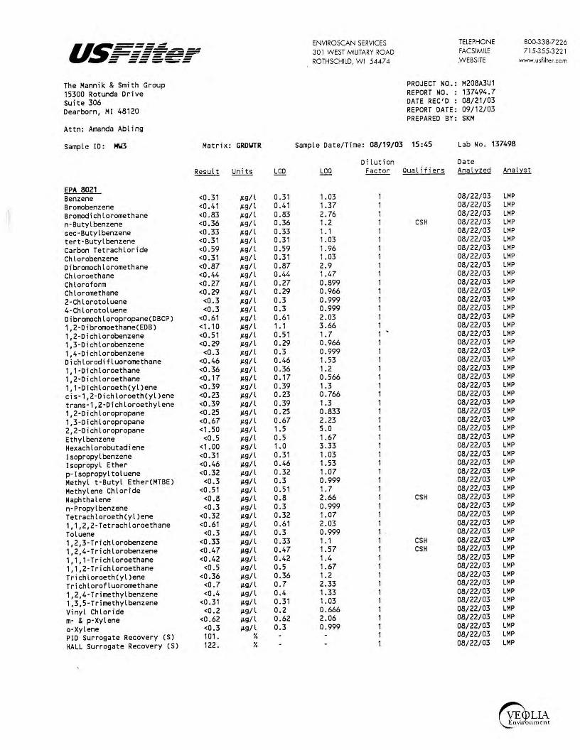
us===~ ENVIROSCAN SERVICES TELEPHONE 800-338-7226 - ------------- 30 1 WEST MILITARY ROAD FACSIMILE 71 5-355-3221 -------- ------ ----- ROTHSCHILD, WI 5447 4 .WEBSITE www.usfilter.com - -- ---The Mannik & Smith Group PROJECT NO.: M208A3U1 15300 Rotunda Drive REPORT NO. : 137494.7 suite 306 DATE REC'D : 08/21/03 Dearborn, Ml 48120 REPORT DATE: 09/12/03
PREPARED BY: SKM
Attn: Amanda Abling
Sample ID: MU3 Matrix: GROIJTR Sample Date/Time: 08/19/03 15:45 Lab No. 137498
Dilution Date Result Units LOO LOO Factor Qualif i ers Analz:zed Analyst
EPA 8021 Benzene <0.31 ,u,g/l 0.31 1.03 1 08/22/03 LMP Bromobenzene <0.41 ,u,g/l 0.41 1.37 1 08/22/03 LMP Bromodichloromethane <0.83 ,u,g/l 0.83 2.76 1 08/22/03 LMP n·Butylbenzene <0.36 µ,g/ l 0.36 1.2 1 CSH 08/22/03 LMP sec·Butylbenzene <0.33 µ,g/ l 0.33 ,. 1 1 08/22/03 LMP tert·Butylbenzene <0.31 µ,g/ l 0.31 1. 03 1 08/22/03 LMP Carbon Tetrachloride <0.59 ,u,g/ l 0.59 1.96 1 08/22/03 LMP Chlorobenzene <0.31 ,u,g/l 0.31 1.03 1 08/22/03 LMP Dibromochloromethane <0.87 ,u,g/ l 0.87 2.9 1 08/22/03 LMP Chloroethane <0.44 µ,g/ l 0.44 1.47 1 08/22/03 LMP Chloroform <0.27 ,u,g/l 0.27 0.899 1 08/22/03 LMP Chloromethane <0.29 ,u,g/ l 0.29 0.966 1 08/22/03 LMP 2·Chlorotoluene <0.3 ,u,g/ l 0.3 0.999 1 08/22/03 LMP 4-Chlorotoluene <0.3 ,u,g/ l 0.3 0.999 1 08/22/03 LMP Dibromochloropropane(DBCP) <0.61 ,u,g/ l 0.61 2.03 1 08/22/03 LMP 1,2-Dibromoethane(EDB) <1.10 ,u,g/ l ,. 1 3.66 1 08/22/03 LMP 1,2-Dichlorobenzene <0.51 µ,g/ l 0.51 ,. 7 1 - 08/22/03 LMP 1,3-Dichlorobenzene <0.29 µ,g/ l 0.29 0.966 1 08/22/03 LMP 1,4-Dichlorobenzene <0.3 ,u,g/ l 0.3 0.999 1 08/22/03 LMP Dichlorodifluoromethane <0.46 ,u,g/ l 0.46 1.53 1 08/22/03 LMP 1,1-Dichloroethane <0.36 µ,g/ l 0.36 1.2 1 08/22/03 LMP 1,2-Dichloroethane <0.17 µ,g/l 0.17 0.566 1 08/22/03 LMP 1,1-Dichloroeth(yl)ene <0.39 ,u,g/ l 0.39 1.3 1 08/22/03 LMP cis-1,2-Dichloroeth(yl)ene <0.23 ,u,g/l 0.23 0.766 1 08/22/03 LMP trans-1,2-Dichloroethylene <0.39 µ,g/l 0.39 1.3 1 08/22/03 LMP 1,2-Dichloropropane <0.25 ,u,g/l 0.25 0.833 1 08/22/03 LMP 1,3-Dichloropropane <0.67 JLg/l 0.67 2.23 1 08/22/03 LMP 2,2-0ichloropropane <1.50 /L9/ l 1 . 5 5.0 1 08/22/03 LMP Ethyl benzene <0.5 /L9/ l 0.5 1.67 1 08/22/03 LMP Hexachlorobutadiene <1.00 /L9/ l 1.0 3.33 1 08/22/03 LMP lsopropylbenzene <0.31 /L9/ l 0.31 1.03 1 08/22/03 LMP Isopropyl Ether <0.46 /L9/ l 0.46 1.53 1 08/22/03 LMP p·Isopropyltoluene <0.32 /L9/ l 0.32 1.07 1 08/22/03 LMP Methyl t·Butyl Ether(MTBE) <0.3 /L9/ l 0.3 0.999 1 08/22/03 LMP Methylene Chloride <0.51 /L9/ l 0.51 ,. 7 1 08/22/03 LMP
Naphthalene <0.8 /L9/l 0.8 2.66 1 CSH 08/22/03 LMP
n·Propylbenzene <0.3 /L9/l 0.3 0.999 1 08/22/03 LMP Tetrachloroeth(yl)ene <0.32 /L9/ l 0.32 1.07 1 08/22/03 LMP 1, 1,2,2-Tetrachloroethane <0.61 /L9/ l 0.61 2.03 1 08/22/03 LMP
Toluene <0.3 ,u,g/l 0.3 0.999 1 . 08/22/03 LMP
1,2,3-Trichlorobenzene <0.33 /L9/l 0.33 ,. 1 1 CSH 08/22/03 LMP 1,2,4-Trichlorobenzene <0.47 JLg/l 0.47 1.57 1 CSH 08/22/03 LMP
1, 1, 1-Trichloroethane <0.42 /L9/ l 0.42 1.4 1 08/22/03 LMP 1, 1,2-Trichloroethane <0.5 JLg/l 0.5 1.67 1 08/22/03 LMP
Trichloroeth(yl)ene <0.36 /L9/l 0.36 1.2 1 08/22/03 LMP
Trichlorofluoromethane <0.7 /L9/ l 0.7 2.33 1 08/22/03 LMP
1,2,4-Trimethylbenzene <0.4 µ,g/ l 0.4 1.33 1 08/22/03 LMP
1,3,5-Trimethylbenzene <0.31 µ,g/ l 0.31 1.03 1 08/22/03 LMP
Vinyl Chloride <0.2 /L9/ l 0.2 0.666 1 08/22/03 LMP
m· & p·Xylene <0.62 µ,g/l 0. 62 2.06 1 08/22/03 LMP
a-Xylene <0.3 µ,g/l 0.3 0.999 1 08/22/03 LMP
PIO Surrogate Recovery (S) 101. % 1 08/22/03 LMP
HALL Surrogate Recovery (S) 122. % 1 08/22/03 LMP
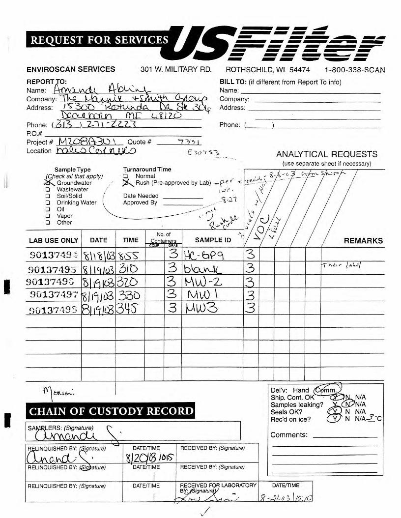
I
I
ENVIROSCAN SERVICES 301 W. MILITARY RD.
Name:
Company: -1..!,:::S,,--C::::..k..~~!,,J,..,.-_!....,ji...,!_L~~-=~~~
Address:
Phone: ( 613 )_2-=--7-'\'---=-=-"""-'-------P.O.# ----,---~=--==------------Project # fvl 1Q8{\3Q \ Quote # Location ~ CQ){ 01 0 W e,;:.;.
..,...,....,,,,,,,, ......... ---~ ...::::~::!. ......... .......... ------...........
ROTHSCHILD, WI 54474 1-800-338-SCAN
BILL TO: (if different from Report To info) Name: ______________ _
Company: Address: ______________ _
Phone:( __ _
ANALYTICAL REQUESTS .. -- .. _
Sample Type Jc;Jieck all that apply) ~ Groundwater D Wastewater 1
D Soil/Solid / D Drinking Water D Oil D Vapor D Other
LAB USE ONLY DATE
9013?49~
90137495 -9013749G 90137497
Turnaround Time · CJ Normal ~ Rush (Pre-approved by Lab) -P-<'. ( <
-~ v \<- . Date Needed ___ _ Approved By
No. of TIME Containers
MP AA
3 b\ac
3 M~D \ 3 µw3
3 3
CHAIN OF CUSTODY RECORD
DATE/TIME RECEIVED BY: (Signature)
,o,s DATE/TIME RECEIVED BY: (Signature)
RELINQUISHED BY: (Signature) DATE/TIME LABORATORY
\,/
(use separate sheet if necessary)
Del'v: Hand Ship. Cont. OK Samples leaking? Seals OK? Rec'd on ice?
Comments:
DATE/TIME
REMARKS

II
ENVIROSCAN SERVICES
ill . . ; ~ ll \!f , ,'. j3 l WEST MILITARY ROAD - .3 t_ ~ THSCHILD, WI 5447 4
DEC O 5 2003 .
TELEPHONE FACSIMILE WEBSITE
800-338-7226 715-355-3221
www.usfilter.com
December 3, 2003
BY:-------------------- M d--(13 A) (A 'I M~tftA-~U t
The Mannik & Smith Group 15300 Rotunda Driv e Suite 306 Dearborn, MI 4812 0
Attn: Molly Zawacki / Tom Cok/ Bogardu s
REPORT NO. 144522 PROJECT NO. M208A3U
Please find enclosed the analytical report, including the Sample Summary, Sample Narrative and Chain of Custody for your sample set received November 18, 2003_
All analyses were performed in accordance wi t h approved methods as indicated on this report.
If you have any questions about the results , please call. Thank you for using USFilter, Enviroscan Serv ices £or your analytical needs_
Sincerely,
USFilter, Enviroscan Services
Sharon K. Maltbey Project Manager
I certify 1hru 1he dnrn comained in this report has been generrued and reviewed in accordance wi1h 1he USFilter, En l'iroscan Services Quality Assurance Program. Exceptions. if any, are discussed in 1he sample narrruive. Samples will be rerained for 30 days from 1he dme of 1his repon, 1hen disposed in an appropriate manner.
USFilier, Enviroscnn Services reserves 1he righ1 10 return samples identified as hawrdous . Release a/this Final Repon is au1hori:ed as verified by the following signawre.
Approved by:
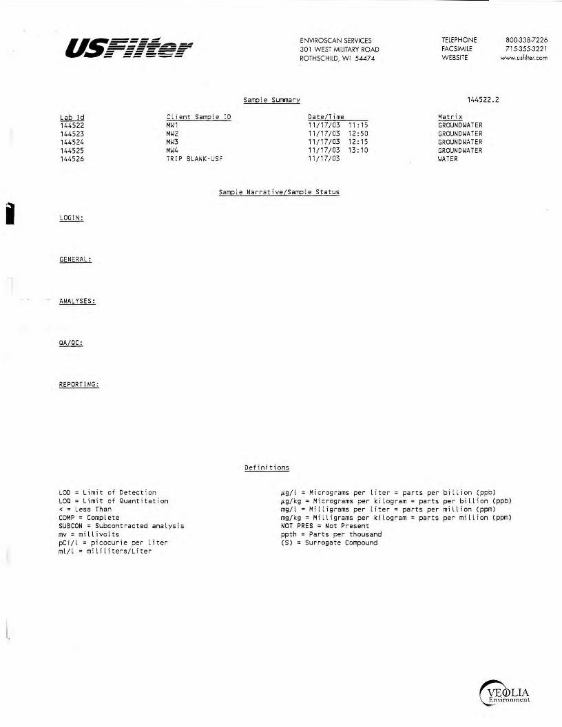
i
I[_
a~===: - -------------------- -----= ==='=-=
Sample
Lab Id Client Samp le ID 144522 MW1 144523 MW2 144524 MW3 144525 MW4 144526 TRIP BLANK ·USF
Surrmary
ENVIROSCAN SERVICES 301 WEST MILITARY ROAD ROTHSCHILD, WI 5447 4
Date/Time 11/17/03 11 : 15 11/17/03 12:50 11/17/03 12: 15 11 / 17/03 13: 10 11 / 17/ 03
TELEPHONE FACSIMILE WEBSITE
144522.2
Matri x GROUNDWATER GROUN DWA TER GROUNDWATER GROUNDWATER WATER
800-338-7226 715-355-3221
www.usfilter.com
Samp le Narrative/Sample Status
GENERAL:
ANALYSES:
REPORTING:
LOD = Limit of Detection LOO= Limit of Ouantitation <=Less Than COMP= Complete SUBCON = Subcontracted anal ysis mv = millivolts pCi/l = picocur ie per liter ml/l = mililiters/Liter
Defi nitions
~g/l = Micrograms per liter= parts per bill ion (ppb) ~g/ kg = Micrograms per ki log ram= par ts per bil lion (ppb) mg/l = Milligrams per liter= parts per million (ppm) mg/kg= Milligrams per ki logram= parts per mill ion (ppm) NOT PRES= Not Present ppth = Parts per thousand (S) = Surrogate Compound

u~===~ ENVIROSCAN SERVICES TELEPHONE 800-338-7226 - --~---------- 301 WEST MILITARY ROAD FACSIMILE 715-355-3221 ------- ------ ------ -- _,_,_ ROTHSCHILD, WI 54474 WEBSITE www.usfilter.com
The Mannik & Smi t h Group PROJECT NO . : M208A3U
15300 Rotunda Dri ve REPORT NO. : 144522.3
Su i te 306 DATE REC ' D : 11/18/ 03
Dearborn, MI 48120 REPORT DATE: 12/03/03 PREPARED BY: SKM
Attn : Moll y Za1,1ac ki / Tom Cok/ Boga rdus
Sample ID : H\J1 Matri x : GRD\JTR Samp le Dat e/T ime: 11/17 /03 11 : 15 Lab No. 144522
Dil ution Da t e Result Uni t s LOD LOO Fac t or 0ua l i·f iers Ana lyzed Ana lys t
EPA 8021 Benzene <0.31 JL g/ l 0.31 1. 03 11 / 25/03 LMP
Bromobenzene <0. 41 JLg / l 0. 41 1 .37 11 /25/03 LMP
Bromod i chloromethane <0.83 JLg / l 0 .83 2. 76 11 / 25/03 LMP
n-Buty lbenzene <0 .36 JLg / l 0 .36 1. 2 11/ 25 /03 LMP
sec-Butyl benzene <0.33 JLg / l 0.33 1. 1 11 / 25/03 LMP
tert-Buty lbenzene <0.31 JLg / l 0 .31 1.03 11/25/03 LMP
Carbon Tetrachlo r ide <0.59 /Lg/ l 0.59 1.96 11 / 25 / 03 LMP
Chlorobenzene <0.31 JLg/ l 0 . 31 1. 03 11/ 25/03 LMP
Dibromochloromethane <0.87 JLg / l 0 .87 2.9 11 / 25/03 LMP
Ch loroeth ane <0 .44 JLg / l 0.44 1. 47 CSL 11 /25/03 LMP
Chloroform <0 . 27 /Lg/ l 0.27 0. 90 11 / 25/03 LMP
Chloromethane <D.29 JLg/ l 0.29 0.97 11 / 25/03 LMP
2-Chlorotoluene <0.3 JLg / l 0.3 1. 0 11 / 25/03 LMP
4-Chlorotoluene <0.3 /Lg / l _0.3 ___ 1. 0 11/ 25/03 LMP
Dibromochloropropane(DBCP ) <0.61 JLg /l 0.61 2.03 1 11 / 25/03 LMP
1,2-D i bromoethane(EDB) <1 . 10 /Lg/ l 1.1 3 .66 1 11/25/03 LMP
1,2-Dichlorobenzene <0 . 51 /Lg/ l 0.51 1. 7 1 11 / 25 / 03 LMP
1,3 -Dichlorobenzene <0.29 JLg / l 0.29 - 0.97 1 11 / 25/03 LMP
1,4-Dichlorobenzene <0.3 /Lg/ l 0.3 1. 0 1 11 / 25/03 LMP
Dichlorodifluoromethane <0 .46 /Lg/ l 0.46 1.53 1 11/25/03 LMP
1, 1-Dichloroethane <0.36 /Lg/ l 0.36 1. 2 1 11 / 25/03 LMP
1,2-Dichloroethane <0. 17 JLg / l 0.17 0.57 1 11 / 25/03 LMP
1,1 -Dichloroeth(yl)ene <0 . 39 JLg / l 0. 39 1. 3 1 11/25/03 LMP ci s-1,2-Dichloroeth( y l)ene <0.23 JLg/ l 0 . 23 0.77 1 11 / 25/03 LMP
trans-1,2-Dich l oroethylene <0.39 JLg/ l 0.39 1 .3 1 11 / 25 / 03 LMP
1, 2-Dichloropropane <0.25 JLg/ l 0.25 0.83 1 11/25/03 LMP
1,3-D i chloropropane <0.67 JLg/ l 0.67 2.23 1 11/25/03 LMP
2,2-Dichloropropane <1. 50 JLg/l 1 . 5 5 . 0 1 11 / 25/03 LMP
Eth yl benzene <0 . 5 JLg/l 0. 5 1.67 1 11 / 25/03 LMP
Hexachlorobutadiene <1 . 00 JLg/ l 1 . 0 3.33 1 11/25/03 LMP
Isopropylbenzene <0.31 JLg / l 0. 31 1. 03 1 11/25/03 LMP
I sopropy l Ether <0 .46 JLg/ l 0. 46 1 .53 1 11/25/03 LMP
p·Isopropyltoluene <0.32 JLg/l 0.32 1.07 1 11/25/03 LMP Meth y l t·Butyl Ether(MTBE) <0 .3 JLg/l 0.3 1. 0 1 11/25/03 LMP
Methyl ene Chloride <0 . 51 JLg/l 0. 51 1. 7 1 11/ 25/03 LMP
Naphthalene <0.8 /Lg/ l 0.8 2.66 1 11/25/03 LMP
n-Propylbenzene <0.3 JLg/l 0.3 1 . 0 1 11/25/03 LMP
Tetrachloroeth( y l)ene <0 . 32 JLg/ l 0.32 1. 07 1 11 /25/03 LMP
1, 1,2 , 2-Tetrachloroethane <0.61 /Lg/ l 0.61 2. 03 1 11 / 25 / 03 LMP
Toluene <0.3 JLg/ l 0.3 1. 0 1 11/25/03 LMP
1,2,3-Trichlorobenzene <0.33 /Lg / l 0 .33 1. 1 1 11/25/03 LMP
1,2,4-Trichlorobenzene <0.47 JLg / l 0.47 1. 57 1 11 / 25/03 LMP
1, 1, 1-Trichloroethane <0 .42 JLg/ l 0.42 1. 4 1 11/25/03 LMP
1,1,2-Trichloroethane <0. 5 JLg / l 0.5 1 .67 1 11/25/ 03 LMP
Trichloroeth( y l)ene <0.36 JLg / l 0.36 1. 2 1 11/25/03 LMP
Tr i chlorofluoromethane <0.7 JLg/l 0. 7 2.33 1 11 /25/03 LMP
1, 2, 4-T rimeth y lbenzene <0.4 /Lg/l 0 .4 1.33 1 11/25/ 03 LMP
1,3,5-Trimethylbenzene <0.31 JLg / l 0. 31 1 .03 1 11 / 25/03 LMP
Vinyl Chloride <0.2 JLg / l 0.2 0 .67 1 11/25/03 LMP
m- & p·Xylene <0.62 JLg / l 0.62 2.06 1 11/25/03 LMP
a-Xylene <0.3 /Lg/ l 0.3 1. 0 1 11 /25/03 LMP
PID Surrogate Recovery (S) 97.3 % 1 11/25/03 LMP
HALL Surrogate Recovery (S) 132. % 1 11/25/03 LMP

u~===: ENVIROSCAN SERVICES TELEPHONE 800-338-7226 - -------------- 30 l WEST MILITARY ROAD FACSIMILE 715-355-322 l =-===~=-- ----- WEBSITE www.usfilter.com ~ -- ._...__,_ ROTHSCHILD, WI 5447 4
The Mannik & Smith Group PROJECT NO.: M208A3U
15300 Rotunda Drive REPORT NO. : 144522.4
Suite 306 DATE REC'D : 11 /18/03
Dearborn, Ml 48120 REPORT DATE: 12/03/03 PREPARED BY: SKM
Attn: Molly Zawacki/ Tom Cole:/ Bogardus
Sample ID: HY2 Matrix: GRD'JTR Sample Date/Ti me: 11/17/03 12:50 Lab No. 144523
Dilution Date Result Units LOO LOO Factor Qualifiers Analyzed Analyst
EPA 8021 Benzene <0.31 1!9/ l 0.31 1. 03 1 11/25/03 LMP
Bromobenzene <0.41 1!9/ l 0.41 1.37 1 11 /25/03 LMP
Bromodichloromethane <0.83 1!9/l 0.83 2.76 1 11 /25/03 LMP
n-Butylbenzene <0. 36 1!9/l 0.36 1 . 2 1 11 /25/03 LMP
sec-Butyl benzene <0.33 1!9/l 0.33 ,_ 1 1 11/25/03 LMP
tert-Butylbenzene <0.31 1!9/l 0.31 1. 03 1 11/25/03 LMP
Carbon Tetrachloride <0.59 1!9/l 0.59 1.96 1 11/25/03 LMP
Chlorobenzene <0.31 1!9/ l 0 . 31 1 .03 1 11/25/03 LMP
Dibromochloromethane <0.87 1!9/ l 0.87 2.9 1 11/25/03 LMP
Chloroethane <0 .44 1!9/ l 0.44 1.47 1 CSL 11/25/03 LMP
Chloroform <0.27 1!9/l 0.27 0.90 1 11/25/03 LMP
Chloromethane <0.29 1!9/l 0.29 0.97 1 11/25/03 LMP
2-Chlorotoluene <0.3 1!9/l 0.3 1.0 1 11/25/03 LMP
4-Chlorotoluene <0.3 ILS/l 0.3 1. 0 1 11/25/03 LMP
Dibromochloropropane(DBCP) <0.61 1!9/l 0.61 2,03 1 11/25/03 LMP
1,2-Dibromoethane(EDB) <1. 10 IL9/l 1 . 1 3.66 1 11/25/03 LMP
1,2-Dichlorobenzene <0.51 IL9/l 0.51 1. 7 1 11/25/03 LMP
1,3 -Dichlorobenzene <0.29 IL9/l 0.29 0.97 1 11/25/03 LMP
1,4-Dichlorobenzene <0.3 1!9/l 0.3 1. 0 1 11 /25/03 LMP
0ichlorodifluoromethane <0.46 IL9/l 0.46 1.53 1 11/25/03 LMP
1, 1-Dichloroethane <0.36 )Lg/l 0.36 1. 2 1 11/25/03 LMP
1,2-Dichloroethane <0 . 17 IL9/l 0.17 0.57 1 11/25/03 LMP
1, 1-Dichloroeth(yl)ene <0.39 IL9/ l 0.39 1 .3 1 11 /25/03 LMP
cis-1,2-Dichloroeth(yl)ene <0.23 1!9/l 0.23 0.77 1 11/25/03 LMP
trans-1,2-Dichloroethylene <0.39 IL9/l 0.39 1. 3 11/25/03 LMP
1,2-Dichloropropane <0.25 IL9/l 0.25 0.83 11/25/03 LMP
1,3-Dichloropropane <0 .67 )Lg/l 0.67 2.23 11/25/03 LMP
2,2-Dichloropropane <1. 50 IL9/l 1 . 5 5.0 11/25/03 LMP
Ethyl benzene <0.5 1!9/ l 0.5 1.67 11/25/03 LMP
Hexachlorobutadiene <1.00 IL9/ l 1. 0 3.33 11/25/03 LMP
Isopropylbenzene <0 .31 )Lg/l 0.31 1. 03 11/25/03 LMP
lsopropyl Ether <0.46 IL9/l 0.46 1. 53 11/25/03 LMP
p-Isopropyltoluene <0.32 IL9/ l 0.32 1.07 1 11/25/03 LMP Methyl t-Butyl Ether(MTBE) <0.3 1!9/ l 0.3 1 . 0 1 11/25/03 LMP
Methylene Chloride <0.51 IL9/ l 0. 51 ,_ 7 1 11 /25/03 LMP
Naphthalene <0.8 IL9/l 0.8 2.66 1 11/25/03 LMP
n-Propylbenzene <0.3 IL9/l 0.3 1 .0 1 11/25/03 LMP
Tetrachloroeth(yl)ene <0.32 IL9/l 0.32 1.07 1 11/25/03 LMP
1, 1,2,2-Tetrachloroethane <0.61 1!9/ l 0.61 2.03 1 11/25/03 LMP
Toluene <0.3 IL9/l 0.3 ,_ 0 1 11/25/03 LMP
1,2,3-Trichlorobenzene <0.33 IL9/l 0.33 1 . 1 1 11/25/03 LMP
1,2,4-Trichlorobenzene <0.47 IL9/l 0.47 1. 57 1 11/25/03 LMP
1, 1, 1-Trichloroethane <0.42 IL9/l 0.42 1.4 1 11/25/03 LMP
1, 1,2-Trichloroethane <0.5 IL9/l 0.5 1 .67 1 11/25/03 LMP
Trichloroeth(yl)ene <0.36 1!9/l 0.36 ,_ 2 1 11/25/03 LMP
Trichlorofluoromethane <0.7 IL9/l 0.7 2.33 1 11/25/03 LMP
1,2,4-Trimethylbenzene <0.4 IL9/l 0.4 1 .33 1 11/25/03 LMP
1,3,5-Trimethylbenzene <0 .31 1!9/ l 0.31 1. 03 1 11/25/03 LMP
Vinyl Chloride <0.2 IL9/l 0.2 0.67 1 11 /25/03 LMP
m- & p-Xylene <0.62 IL9/l 0 . 62 2.06 1 11/25/03 LMP
o-Xylene <0.3 IL9/l 0.3 ,_ 0 1 11 /25/03 LMP
PIO Surrogate Recovery (S) 96 .9 % 1 11/25/03 LMP
HALL Surrogate Recovery (S) 132. % 1 11 /25/03 LMP

us====~ ENVIROSCAN SERVICES TELEPHONE 800-338-7226 - -------------- 30 l WEST MILITARY ROAD FACSIMILE 715-355-322 l ------- ------ ------ -- --- ROTHSCHILD, WI 5447 4 WEBSITE www.usfilter.com
The Mannik & Smith Group PROJECT NO.: M208A3U
15300 Rotunda Drive REPORT NO. : 144522.5
Suite 306 DATE REC'D : 11/18/03
Dearborn, Ml 48120 REPORT DATE: 12/03/03 PREPARED BY: SKM
Attn: Molly Za.iacki/ Tom Cok/ Bogardus
Sample ID: M\13 Matrix: GRDIITR Sample Date/Time: 11/17/03 12: 15 Lab No. 144524
Dilution Date Result Uni ts LOD LOO Factor 0ual i -fiers Anal}:'.zed Ana lvst
EPA 8021 Benzene <0.31 µ.g/l 0.31 1.03 1 11/26/03 LMP
Bromobenzene <0.41 µ.g/l 0.41 1 .37 1 11/26/03 LMP
Bromodichloromethane <0.83 µ.g/l 0.83 2.76 1 11 / 26/03 LMP
n-8utylbenzene <0.36 µ.g/ l 0.36 1. 2 1 11 /26/03 LMP
sec-Butyl benzene <0.33 µ.g/ l 0.33 1.1 1 11/26/03 LMP tert·Butylbenzene <0.31 µ.g/ l 0.31 1.03 1 11/26/03 LMP
Carbon Tetrachloride <0.59 µ.g/ l 0.59 1 .96 1 11/26/03 LM P Chlorobenzene <0. 31 µ.g/ l 0.31 1 .03 1 11 /26/03 LMP Dibromochloromethane <0.87 µ.g/ l 0.87 2.9 1 11/26/03 LMP
Chloroethane <0.44 µ.g/ l 0 .44 1 .47 1 11/26/03 LMP
Chloroform <0.27 µ.g/ l 0.27 0.90 1 11/26/03 LMP
Chloromethane <0.29 µ.g/ l 0.29 0.97 1 11/26/03 LMP
2-Chlorotoluene <0.3 µ.g/ l 0.3 1 . 0 1 11/26/03 LMP
-~- 4-.Ch Lor_otol uene. <0.3 µ.g/ l 0.3 1. 0 1 11/26/03 LMP
Dibromochloropropane(D8CP) <0.61 µ.g/ l 0.61 2.03 1 11/26/03 LMP 1,2-Dibromoethane(EDB) <1. 10 µ.g/ l 1 . 1 3.66 1 11/26/03 LMP
1,2-Dichlorobenzene <0.51 µ.g/ l 0.51 1. 7 1 11/26/03 LMP 1, 3-D i chl orobenzene·- -· <0.29 µ.g/ l 0.29 0.97 1 11/26/03 LMP
1,4-Dichlorobenzene <0.3 µ.g/ l 0.3 1. 0 1 11/26/03 LMP Dichlorodifluoromethane <0.46 µ.g/ l 0.46 1. 53 1 11/26/03 LMP
1, 1-Dichloroethane <0.36 µ.g/l 0.36 1. 2 1 11/26/03 LMP 1,2-Dichloroethane <0. 17 µ.g/ l 0. 17 0.57 1 11/26/03 LMP
1, 1-Dichloroeth(yl)ene <0.39 µ.g/ l 0.39 1. 3 1 11/26/03 LMP cis-1,2-Dichloroeth(yl)ene <0.23 µ.g/ l 0.23 0.77 1 11/26/03 LMP trans - 1,2-Dichloroethylene <0.39 µ.g/ l 0.39 1.3 1 11/26/03 LMP 1,2-Dichloropropane <0.25 µ.g/l 0.25 0.83 1 11/26/03 LMP
1,3-Dichloropropane <0.67 µ.g/ l 0.67 2.23 1 11/26/03 LMP 2,2-Dichloropropane <1. 50 µ.g/ l 1.5 5.0 1 CSL 11 /26/03 LMP
Ethyl benzene <0.5 µ.g/ l 0.5 1 .67 1 11/26/03 LMP Hexachlorobutadiene <1.00 µ.g/ l 1. 0 3.33 1 11/26/03 LMP
Isopropylbenzene <0.31 µ.g/ l 0.31 1 .03 1 11/26/03 LMP
Isopropyl Ether <0.46 µ.g/ l 0.46 1.53 1 11/26/03 LMP
p-Isopropyltoluene <0.32 µ.g/ l 0.32 1. 07 1 11/26/03 LMP Methyl t·Butyl Ether(MTBE) <0.3 µ.g/ l 0.3 1. 0 1 11 /26/03 LMP
Methylene Chloride <0.51 µ.g/l 0.51 1. 7 1 11/26/03 LMP
Naphthalene <0.8 µ.g/l 0.8 2.66 1 11 /26/03 LMP
n-Propylbenzene <0.3 µ.g /l 0.3 1. 0 1 11/26/03 LMP
Tetrachloroeth(yl)ene <0 .32 µ.g/ l 0.32 1.07 1 11/26/03 LMP 1, 1,2,2-Tetrachloroethane <0.61 µ.g/ l 0.61 2.03 1 11/26/03 LMP Toluene <0.3 µ.g/ l 0.3 1. 0 1 11/26/03 LMP
1, 2,3-Trichlorobenzene <0.33 µ.g/ l 0.33 1 . 1 1 11/26/03 LMP 1,2,4-Trichlorobenzene <0.47 µ.g/ l 0.47 1. 57 1 11/26/03 LMP
1, 1,1-Trichloroethane <0.42 µ.g/l 0.42 1. 4 1 11/26/03 LMP 1, 1,2-Trichloroethane <0.5 µ.g/ l 0.5 1.67 1 11/26/03 LMP
Trichloroeth(yl)ene <0.36 µ.g/ l 0.36 1. 2 1 11/26/03 LMP Trichlorofluoromethane <0.7 µ.g/ l 0.7 2.33 1 11/26/03 LMP
1,2,4-Trimethylbenzene <0.4 µ.g/ l 0.4 1.33 1 11/26/03 LMP 1,3,5-Trimethylbenzene <0 . 31 µ.g/ l 0.31 1. 03 1 11 /26/03 LMP
Vinyl Chloride <0.2 µ.g / l 0.2 0.67 1 11/26/03 LMP m- & p-Xylene <0.62 µ.g/ l 0.62 2.06 1 11/26/03 LMP
a-Xylene <0.3 µ.g/ l 0.3 1.0 1 11/26/03 LMP voe Vial pH above 2 7. 00 1 12/01/03 VOL PID Surrogate Recovery (S) 107. % 11/26/03 LMP HALL Surrogate Recovery (S) 114. % 11/26/03 LMP
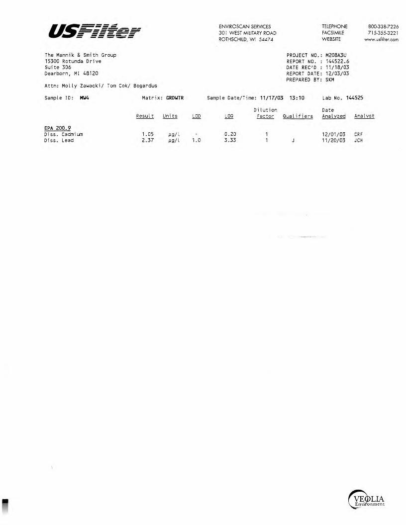
u.~====:=:.:::: - -------------------~ - ------ ------ -- ---The Mannik & Smith Group 15300 Rotunda Drive Su i te 306 Dearborn, Ml 48120
Attn: Molly Zawacki/ Tom Cok/ Bogardus
S amp l e I D : M\J4
EPA 200 . 9 Diss . Cadm ium Diss. Lead
Matrix :
Result
1.05 2. 37
GROIITR
Units LOO
!L9/ l !L9/ l 1. 0
ENVIROSCAN SERVICES 301 WEST MILITARY ROAD ROTHSCHILD, WI 5447 4
Sample Date/T ime: 11/17/03
Dilution LOO Factor
0 . 20 3 .33
TELEPHONE FACSIMILE WEBSITE
PROJECT NO.: M208A3U REPORT NO. : 144522 .6 DATE REC'D : 11/1 8/03 REPORT DATE: 12/03/03 PREPARED BY: SKM
B00-3 3 8-72 2 6 715-355-3221
www.usfilter.com
13: 10 Lab No. 144525
Date Qua lifiers Analyzed Analyst
12/ 01/03 CRF 11 / 20/03 JCH

u~===~ ENVIROSCAN SERVICES TELEPHONE 800-338-7226 - --.--------- 301 WEST MILITARY ROAD FACSIMILE 715-355-3221 ------- ------ ------ -- --- ROTHSCHILD, WI 5447 4 WEBSITE www.usfilter.com
The Mannik & Smith Group PROJECT NO.: M208A3U
15300 Rotunda Drive REPORT NO. : 144522.7
suite 306 DATE REC'D : 11/18/03
Dearborn, Ml 48120 REPORT DATE: 12/03/03 PREPARED BY: SKM
Attn: Molly Za1,1acki/ Tom Cok/ Bogardus
Sample ID: TRIP BLANK-USF Matrix: IJATER Sample Date/Time: 11/17/03 Lab No. 144526
Dilution Date Result Uni ts LOO LOO Factor Qualifiers Analyzed Analyst
EPA 8021 Benzene <0.31 µ.g/ l 0.31 1.03 1 11/25/03 LMP
Bromobenzene <0.41 µ.g/ l 0.41 1.37 1 11/25/03 LMP
Bromodichloromethane <0.83 µ.g/l 0.83 2. 76 1 11 /25/03 LMP
n-Butylbenzene <0.36 µ.g/l 0.36 1. 2 1 11/25/03 LMP
sec-Butyl benzene <D.33 µ.g/l 0.33 1 . 1 1 11/25/03 LMP tert-Butylbenzene <D.31 µ.g/l 0.31 1. 03 1 11/25/03 LMP
Carbon Tetrachloride <D. 59 µ.g/l D. 59 1. 96 1 11/25/03 LMP
Chlorobenzene <0.31 µ.g/l 0.31 1. 03 1 11/25/03 LMP
Dibromochloromethane <0.87 µ.g/l 0.87 2.9 1 11/25/03 LMP Chloroethane <D.44 µ.g/l 0.44 1. 47 1 11/25/03 LMP
Chloroform <D.27 µ.g/l 0.27 0.90 1 11/25/03 LMP
Chloromethane <0.29 µ.g/l 0.29 0.97 1 11 /25/03 LMP
2-Chlorotoluene <0.3 µ.g/l 0.3 1 .0 1 11 /25/03 LMP
4-Chlorotoluene <0.3 µ.g/l 0.3 1. 0 1 11 /25/03 LMP
Dibromochloropropane(DBCP) <D.61 µ.g/l 0 .61 2.03 1 11/25/03 LMP 1,2-Dibromoethane(EDB) <1 . 10 µ.g/l 1 . 1 3.66 1 11/25/03 LMP
1,2-Dichlorobenzene <0.51 µ.g/l 0 .51 1. 7 1 11/25/03 LMP 1,3-Dichlorobenzene <0 .29 µ.g/l 0.29 0.97 1 11/25/03 LMP
1,4-Dichlorobenzene <0.3 µ.g/l 0.3 1.0 1 11/25/03 LMP Dichlorodifluoromethane <0.46 µ.g/ l 0.46 1.53 1 11/25/03 LMP
1, 1-Dichloroethane <0.36 µ.g/ l 0.36 1. 2 1 11 /25/03 LMP 1,2-Dichloroethane <D. 17 µ.g/ l 0. 17 0.57 1 11/25/03 LMP 1, 1-Dichloroeth(yl)ene <0.39 µ.g/l 0.39 1.3 1 11/25/03 LMP cis-1,2-Dichloroeth(yl)ene <0 .23 µ.g/ l 0.23 0.77 1 11/25/03 LMP trans-1,2-Dichloroethylene <D.39 µ.g/l 0.39 1.3 1 11/25/03 LMP 1,2-Dichloropropane <D.25 µ.g/ l 0.25 0.83 1 11/25/03 LMP
1,3-Dichloropropane <D.67 µ.g/ l 0.67 2.23 1 11/25/03 LMP 2,2-Dichloropropane <1. 50 µ.g/ l 1. 5 5.0 1 CSL 11/25/03 LMP
Ethyl benzene <0.5 µ.g/l 0.5 1.67 1 11/25/03 LMP Hexachlorobutadiene <1. DD µ.g/ l 1 . D 3.33 1 11/25/03 LMP
Isopropylbenzene <D.31 µ.g/ l 0.31 1. 03 1 11/25/03 LMP Isopropyl Ether <0.46 µ.g/ l 0.46 1. 53 1 11/25/03 LMP
p-Isopropyltoluene <0.32 µ.g/l 0.32 1. 07 1 11 /25/03 LMP Methyl t-Butyl Ether(MTBE) <0.3 µ.g/l 0.3 1 . 0 1 11 /25/03 LMP
Methylene Chloride <0.51 µ.g/l 0.51 1. 7 1 11/25/03 LMP Naphthalene <0.8 µ.g/l 0.8 2.66 1 11/25/03 LMP
n-Propylbenzene <0.3 µ.g/l 0.3 1. D 1 11 /25/03 LMP Tetrachloroeth(yl)ene <0.32 µ.g/l 0.32 1.07 1 11/25/03 LMP
1, 1,2,2-Tetrachloroethane <D.61 µ.g/ l 0.61 2.03 1 11 /25/03 LMP
Toluene <0.3 µ.g/ l 0.3 1. D 1 11 /25/03 LMP
1,2,3-Trichlorobenzene <D.33 µ.g/ l 0.33 1 . 1 1 11/25/03 LMP 1,2,4-Trichlorobenzene <0.47 µ.g/ l 0.47 1. 57 1 11/25/03 LMP
1, 1, 1-Trichloroethane <0.42 µ.g/ l 0.42 1. 4 1 11/25/03 LMP 1, 1,2-Trichloroethane <0.5 µ.g/ l 0.5 1 .67 1 11/25/03 LMP
Trichloroeth(yl)ene <D.36 µ.g/ l 0.36 1 . 2 1 11 /25/03 LMP Trichlorofluoromethane <D.7 µ.g/ l 0.7 2.33 1 11 /25/03 LMP
1,2,4-Trimethylbenzene <0.4 µ.g/ l 0.4 1 .33 1 11/25/03 LMP
1,3,5-Trimethylbenzene <0.31 µ.g/l 0.31 1.03 1 11/25/03 LMP
Vinyl Chloride <D.2 µ.g/ l 0.2 0.67 1 11 /25/03 LMP m- & p-Xylene <D.62 µ.g/l 0.62 2.06 1 11/25/03 LMP
o-Xylene <0.3 µ.g/ l 0.3 1.0 1 11/25/03 LMP PIO Surrogate Recovery (S) 108. % 1 11 /25/03 LMP HALL Surrogate Recovery (S) 118. % 1 11/25/03 LMP
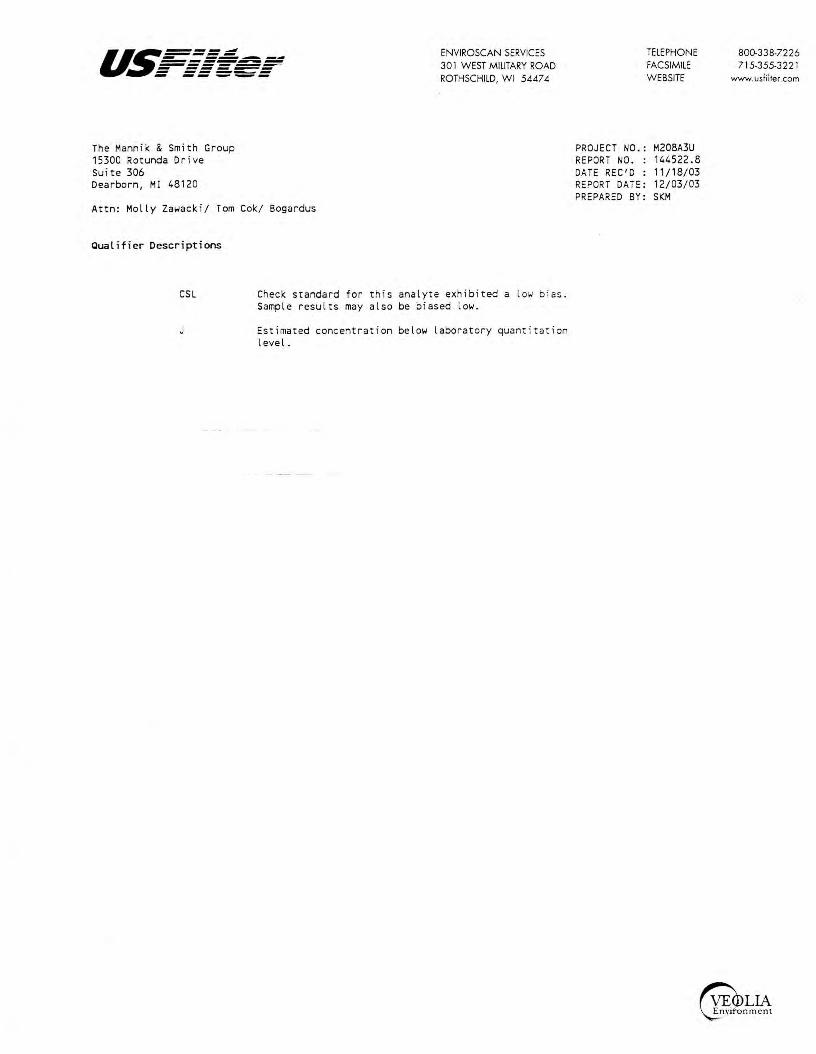
u.~=.=.=;;: - ------------------- ------ ------ -- -----
The Mannik & Sm ith Group 15300 Rotunda Drive Suite 306 Dearborn, MI 48120
Attn: Molly Za~acki/ Tom Cok/ Bogardus
Qualifier Descriptions
ENVIROSCAN SERVICES 30 l WEST MILITARY ROAD ROTHSCHILD, WI 5447 4
CSL Check standard for this analyte exhibited a l ow bi as. Sample results may also be biased lo~.
Estimated concentration belo~ laboratory quant i tation level.
TELEPHONE FACSIMILE W EBSITE
PROJECT NO.: M208A3U REPORT NO. : 144522.8 DATE REC'D : 11/18/03 REPORT DATE: 12/03/03 PREPARED BY: SKM
800-338-7226 715-355-322 l
www.usfilter.com

ENVIROSCAN SERVICES 301 W. MILITARY RD.
..., ..., ..,,,,,,,. ..., ........ ..., :::: ~~=-..., ..., .... ..., .... ~ ...,..., -...,..., .._.. ROTHSCHILD, WI 54474 1-800-338-SCAN
BILL TO;J.if different from Report To info) Name: ....) ef\ Bo.§)?fAl.(,s Company: < ~ ,,4t4
J'-i..lP ~ Address: ______________ _
Phone: ( 3 i:3:, ) 21 I- d,, ~ ~3 Phone: ( __ --1 __________ _
P.O.# ----,----r--r-----:---------~___,,~ Project # ('-'\@3 A3 1.-\ . ~ote # '"l '1, J I Location btz;u<:S lo..f t\ef-S,l.u J- £ , 0 -, <; 3
Sample Type Turnaround Time (Check all that apply) ~ Normal
)<:' Groundwater 0 Rush (Pre-approved by Lab) D Wastewater 0 Soil/Solid Date Needed 0 Drinking Water Approved By 0 Oil 0 Vapor 0 Other
No. of LAB USE ONLY DATE TIME Containers SAMPLE ID
p
. · . . ' "I '"r/o:$ II q5" 9 MvJ-/ 1..'tl-44522
12144523 n\rrlo3 -e:so :2 t'\W -~ I\ 1n--lo3
,-~ 1-\vJ -3 .11144524 lJl;
.. 1\)r,103 \3~0 a ~v-)-Y, .--;119/lc;;ryc::;: ·~- - - - \I.., i.,.._ • +r'P b\£A~\Z _., Al ,'I r',....,-. l\-111 I'-'
0 .Jli."-;.:'tJPwV
RECEIVED BY: (Signature)
RECEIVED BY: (Signature)
ANALYTICAL REQUESTS ,,{ (use separate sheet if necessary)
\ ' ',.._'t.
:~ CJ ,p +. v'
$ , ~ ~_\'__;. ~V) ~ 'J' \i --- --·-··· . ·----~ --
~ , , ' ~ '(,
~ -~ ~ - --· -·-· •· --·- --- . --CJ X X 'f
REMARKS
.2" ,e)-;e ;,J I H lS...
,I'
X "'\-..150ol HNo , ..J \J ,W w.l 11r1
I
~() - J.4-o 7
--r 1S c.1 '1~ 'f., ?, } --{ Q C\ 11 1'--
Del'v: Hand (Cammi Ship. Cont. OK --,,v, . N NIA Samples leaking? A NIA Seals OK? C@ '1:J NIA d Rec'd on ice? (Y) N N/A7---"C
Comments:
J
RELINQUISHED BY: (Signature) DATE/TIME RECEIVED FOR LABORATORY ., f,. ,, DA~~~ ; .;.·:· . BY: (Signature) . //-/ y ~). ~1.,,,-

I
05 / 04/2004 13:41 FAX 715 355 3221 USFILTER.ENVIRONSCAl~ '41001
as-=-==.:! - ------------~s:ecs
May 4, 2004
The Mannik & Smith Group 15300 Rotunda Drive Suite 306 Dearborn, MI 48120
Attn: Tom Cok
eNVIROSCAN SERVICES 301 WEST MIUTAAY ROAD ROTHSCHILD, Wl 54474
TELEPHONE FACSIMILE WEBSITE
REPORT NO.: 153215 PROJECT NO.: M208A3U~
Please find enclosed the analytical report, including the Samrle Summary, Sample Narrative and Chain of Custody for your sample set received April 22, 2004.
All analyses were performed in accordance with approved methoci3 as indicated on this report.
If you have any questions about the results, please call. Thank you for using USFilter, Enviroscan Services for your analyticcrl needs.
Sincerely,
USFilter, Enviroscan Services
J,,~.,~t?~f-James R. Salkowski Laboratory Director
800-338-7226 715-355-322 l
www.uslilter.com
I cenifj /hat the data conlllined in lhis report has been gcneroud and rc~k!wed In accordance with the USFtller, Etrviroscan Services Quality Ass1U'tl1 ,;e, Prr>gram. Exceptums, if arry, fll'e di.sCllJsed in Ilte samp~ narrative. Samples wiU be retained for JO day.< from Ilte dalt of rhls reporr, thl!lt disposed ill an 0}'-.1ropril11e manner.
VSFUrer, Ertviromui Serw:es reserves the right Io return samples idl!lllijied os hazardous. l!.ek/JSt ofrhls FIJtaL lleJJQn is auzho~ as voified i,y th~ •ot/owrng signature.
c,i~µR¥ Approved by:
Certifioa.tiona~ Wisconsin 737053130 Minnesota 055-999-302 Louisiana 04026 Washington C293
All Analyses conducted in accordance with USfiller Quoliry Assurance Program
Wisconsin Lab Certincation No. 737053 130
Oregon (WI-100001) Illinois 200025 Maryland 276 Oklahoma 9925

I
05/04/2004 13:41 FAX 715 355 3221
l.ab Id 153215 153216 153217 153218
Client S.lfflple ID MW1 MW2 Mlol3 TRIP BLANK-USF
USFILTER,ENVIRONSCAN
ENVIROSCAN SERVICES 301 WEST MILITARY ROAD ROTHSCHILD, WI 54474
Sample Summary
Cate/Time 04/21/04 08:25 04/21/04 08:40 04/21/04 08:10 04/21/04
TELEPHONE FACSIMILE WEBSrTE
14]002
800-J38-7226 715.355-3221
www.usfilrer.com
153, 15.2
Matrix GRWNDWATEJ GRWNDWATE' GROOND\JATE' WATER
Sample Narrative/Samol~ Status
GENERAL:
ANALYSES:
REPORTING:
l.00 = Limit of Detl!Ction LOQ:: Limit of Quantitation <=Less Th:in COMP= Complete SUBCON = Subcontracted analysis rt111 = mil U vol ts pCi/l = picocurie per liter ml/l = mililiters/Liter
Def; nit ions
/L9/ l :: Micrograms per liter = parts per billion • ppbl JL9/k9 = Ml crogra.ms per kilogram = parts per bill , on (ppb) 1119/l = Milligrams per lit8r = part$ per million ppm) mg/kg= Milligrams per kilogram= parts per mill :on (pp-n) NOT PRES= Not Present ppth = Parts per thousand (S) ~ Surrogate COflllOUnd m9/m3 ~ MilligrlllllS/meter cube
All Anc:ily.se1 conducted In accordance wirh USFilrer Quoliry ~wrance Program Wisconsin Lab Certification No. 737053130

I
05 / 04 / 2004 13:42 FAX 715 355 3221 USFILTER,ENVIRONSCAN '41003
u,s===.: ENVIROSCAN SERVICES TELEPHONE 800-33B-7:.?26 ~-~-----=:= s=:,------ :!01 WEST MILITARY ROAD · FACSIMILE 715-:355-3221
= =====-= ROTHSCHILD, W1 5'1A74 WEBSITE www.uslilrer.com
The Mamik & Smith Group PROJEc:l' NO.: M208A3U9 15300 Rotunda Drive REPORT NO. : 153215.3 Suite 306 DATE REC 10: 04/22/04 Dearborn, MI 48120 REPORT DATE: 05/04/04
PREPARED BY: JRS Attn: Tom Cok
Sample IO: MW1 Matrix: GltOl,ITR Sample Date/Time: 04/21/04 OS:25 Lab No. 11·,3215
~ Units LOO
EPA 15260 Benzene <0.15 /LS/l 0.15 Bromobenzene <0.1 /Ls/l 0., Bromochloromethane <O. 1 /L9/l 0.1 Bromodichloromethane <O. 1 /L9/l 0. 1 Bromoform <0.2 /LS/ l 0.2 Bromomethane <0.15 /L9/l 0. 1S n·8utylbenzene <0.2 µ.g/l 0.2 sec-Butyl benzene <0 _ 15 p.g/l o_ 15 tert-Butylbenzene <0.15 /L9/ l 0.15 Carbon Tetrachloride <0.2 µ.9/ l 0.2 Chlorobanune <O. 1 µ.9/l 0., Chlor-oethane <0.6 1'9/l 0.6 Chloroform <0.1 µ.g/ l 0. 1 Chloromethane <0.2 JL9/ l 0.2 2-Chlorotoluene <0.1 1'9/l 0., 4-Chlor-otoluene <0.2 /Ls/ l 0.2 Dibromochlcromethane <O. 1 /L.9/ l 0.1 Oibromochlorcpropane(DBCP) <0.3 µ.g/l 0.3 1,2-Dibromoethane(EDS) <0.1 /LQ/l o. 1 Dibromomethane <0.1 µ.g/l 0.1 1,2-Dichlorobenzene <0 . 2 µ.g/l 0.2 1,3-Dichlorobenzene <0.15 /L9/l 0. 15 1,4·Dichlorobenzene <0.25 µ.9/l 0.25 oichlorodifluoromethan~ <0.25 /LSI l 0.25 1, 1-Dichloroethane <0.15 /LQ/l 0.15 1,2·Dichlcroethane <0.1 /L9/ L 0.1 1, 1-0ichloroeth(yl)ene <0, 15 JLQ/ L 0. 15 cis-1,2-DichloroethCyl)ene <O. 1 1'9/l 0., trans-1,2-Dichloroethylene <O. 1 /L.9/ l 0.1 1,2·Dichloropropane <0.1 /J.9/ l 0.1 1,3-Diehloropropane <0.1 µ.g/ l o. 1 2,2-Dichloropropane <:O. 1 1'9/l 0. 1 1, 1·Dichloropropene <0.2 /J.9/ l 0.2 cis•1,3·Dichloropropene <O. 1 JL9/ L 0 .1 trans-1,3-Dlchloropropene <O. 1 1'9/ l 0.1 Ethyl benzene <0.1 /L9/ l 0.1 ~exachlorobutadiene <1.00 µ.g/l 1.0 tsopropylbenzeM <0.1 µ.g/l 0 .1 4-Isopropyltoluene <O. 1 µ.g/l 0. 1 Methylene Chloride <0.25 /L9/ L 0.25 Methyl t-Butyl Ether(MTBE) <0.1 µ.g/ L 0 .1 Naphthalene <1.00 µ.g/l 1 .o n-Propylbenzene <0.1 µ.g/ l 0.1 Styrene <0.1 JL9/ L 0.1 1, 1, 1,2-Tetrachloroethane <0.1 1'9/l 0., 1, 1,2,2-Tetrachloroethane <O. 1 /L9/ l 0. 1 Tetrachlcroeth(yl)ene <0.1 µ,g/ l 0.1 Toluene <0.4 /LS/ l 0.4 1,2,3-Tr-ichlorobenzene <0_5 µ.g/ l 0.5 1,2,4-Trichlorobenzene <0.5 1'9/l 0.5 1, 1,1-Trichloroethane <0.2 11,9/l 0.2 1,1,2-Trichloroethane <O. 1 /LQ/l o. 1
All Ar10lysos conducted in occordonca with USFiifer Quoliry A!MMC! Program
Wl1consln lob Cettlfic,:,~on No. 737053130
Dilution Date LOQ Factor Qualifiers Analyzed Analyst
a.so 1 04/29/04 MRO 0.33 , 04/29/04 MRO 0.33 , 04/29/04 MltD 0.33 , 04/29/04 MRD 0.67 , 04/29/04 MRD 0.50 1 04/29/04 MRD 0.67 1 04/29/04 MRD 0_50 1 CSL 04/29/04 MRD 0.50 1 04/29/04 MRD 0.67 1 04/29/04 MRD 0.33 1 04/29/04 MRD 2.0 1 04/29/04 MRO 0.33 , 04/29/04 MRD 0.67 1 04/29/04 MRD 0.33 , 04(29/04 MRD 0.67 , 04/29/04 MRD 0.33 1 04/29/04 · MRD , .o 1 CSL 04/29/04 HRD 0.33 , 04/29/04 HRD 0.33 , 04/29/04 HRD 0.67 1 04/29/04 MRD 0.50 1 04/29/04 MRD 0.83 1 04/29/04 HRD 0.83 , 04/29/D4 HRD 0.50 1 04/29/04 MRD 0.33 , 04/29/04 MRD 0.50 1 04/29/04 MRD 0.33 1 04/29/04 MRD 0.33 1 04/29/04 MRD 0.33 1 04/29/04 MRO 0.33 1 04/29/04 HRD 0.33 , 04/29/04 MRD 0.67 1 04/29/04 MRD 0.33 1 01./29/04 HRD 0.33 1 04/29/04 · MRD 0.33 , 04/29/04 MRD 3.33 1 04/29/04 MRD 0.33 1 04/29/04 MRD 0.33 1 04/29/04 MR0 0.83 1 04/29/04 MRD 0.33 1 04/29/04 MRD 3.33 1 04/29/04 MRD 0.33 1 04/29/04 MRD 0.33 , Ot./29/04 MRD 0.33 1 04/29/04 . MRD 0.33 , 04/29/04 MRD 0.33 1 04/29/04 MRD 1.33 1 04/29/04 MRD 1.67 1 04/29/04 MRD 1.67 1 04/29/04 MRD 0.67 , 04/29/04 MRD 0.33 1 04/29/04 MRD

I
05/04/2004 13:42 FAX 715 355 3221
as----,=---.=.=...-. ------------------ -----:::; i:==:, t::=-=:':=
The Mannik & Smith Group 15300 Rotunda Drive suite 306 Dearborn, MI 48120
Attn: Tom Cole.
USFILTER,ENVIRONSCAN
ENVlROSCAN SERVICES 301 WEST MILITARY ROAD ROTHSCHILD, WI 54474
TELEPHONE FACSIMILE WEBSITE
PROJECT NO.: M20SA3U9 REPORT NO. ; 153215.4 DATE REC'D : 04/22/04 REPORT DATE: 05/04/04 PREPARED BY: JRS
!41004
800-33 8-7226 715-355-3221
www.uifilter_com
s~le 10: 1111 M~trix; GRDWTll S.imple D~tc/Time: 04/21/04 08:25 Lab No. 11 ':'3215
EPA 8260 Trichloroeth(yl)ene <0.2 /J.9/ l 0.2 Trichlorofluoromethane <0.1 µ.g/l 0. 1 1,2,3-Trichloropropane <0.55 µ.9/l 0.55 1,2,4-Trimethylben%ene <0.15 ,a.g/l 0.15 1,3,S·irimethylbenzene <0.15 JL9/l 0. 15 Vinyl Chloride <0.15 JL9/l 0.15 o·Xylene <O. 1 µg/l 0. 1 m·& p·Xylene <0.4 µ.g/l 0.4
All AnQly,es condl.lcied in oecordon~ with USFilter QvQlily Aiiuron<:e Program Wisconsin lob Certification No. 737053130
Dilution Date LOQ Factor Qualifiers Anal-ned Analyst
0.67 04/29/04 MRD 0.33 04/29/04 · MRD 1.83 04/29/04 MRD a.so 04/29/04 MRD 0.50 04/29/04 MRD □ .so 04/29/04 · M~D 0.33 04/29/04 MRD 1.33 04/29/04 · MRD
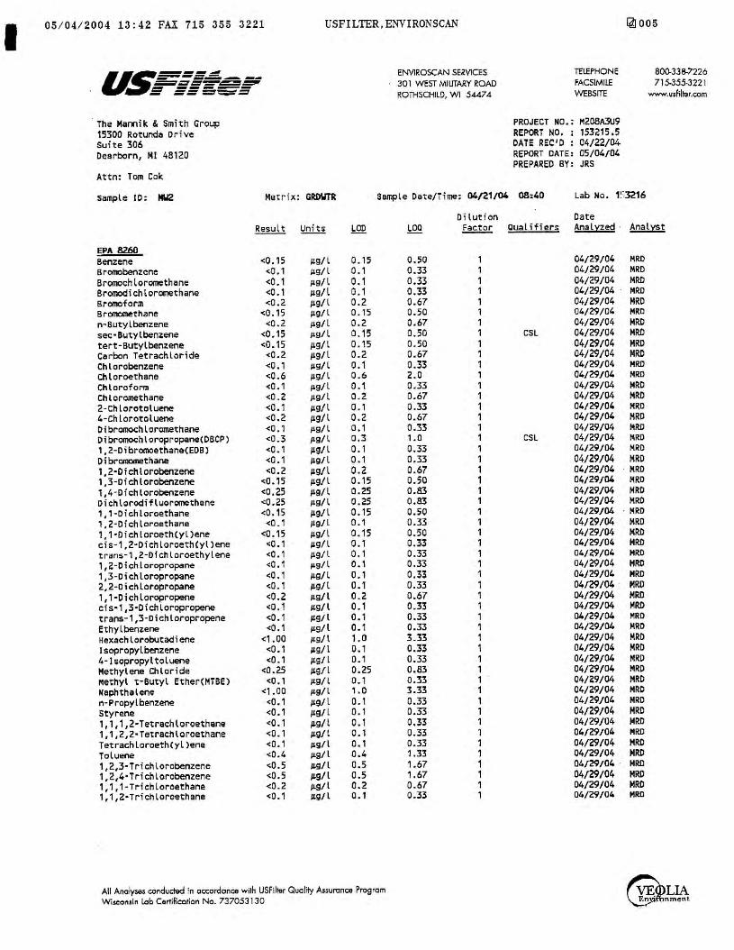
I 05 / 04 / 2004 13: 42 FAX 715 355 3221 USFILTER,ENVIRONSCAN
u~~==~ ENVIROSCAN SERVICES - ----- --=.:::rt::tf-:=-,=;;:::,, 301 WEST MILITARY ROAD t:= ------ ~=:==-~::: ROTHSCHILD, WI 54474
The Mamik & Smith Group PROJECT NO.; 15300 Rotunda Drive REPORT NO, : Suite 306 DATE REC'D : Dearborn, Ml 48120 REPORT DATE:
PREPARED BY: Attn: Tom Coli:
Sample 10: 1112 Matrix: GRDWTR Sample Date/Time: 04/21/04 08:40
Result Units LOO
EPA 8260 Benzene <0.15 µ.g/ l 0.15 Bromobenzene <0.1 .149/l 0. 1 6romochloromethane <0.1 .149/l 0. 1 Bromodichloromethane <0.1 .149/l 0. 1 Bromoform <0.2 µ.g/l 0.2 Bromonw:thane <0.15 µ.g/l 0. 15 n-Butylbenzene <0.2 µ.g/l 0.2 sec·Butylben~ene <0.15 J.Lg/l 0.15 tert-Butylbenzer,e <0.15 µ.g/l 0.15 Carbon Tetrachloride <0.2 µ.g/l 0.2 Chlorobenzene <O. 1 µ.g/l 0.1 Chloroethane <0.6 iig/l 0.6 Chloroform <0.1 119/l 0.1 Chloromethane <0.2 Jtg/l 0.2 2-chlorotoluene <0.1 µ.g/l 0.1 4-Chlorotoluene <0.2 µ.g/ l 0.2 Dibromo<:hlor0lllethane <0.1 µ.9/l o. 1 Dibromochloropropane(DBCP) <0.3 /l9/l o.3 1,2-Dibromoethane(EDB) <0.1 µ.g/l 0. 1 Oibranomethane <0.1 µ.g/l 0. 1 1,2-0ichlorobenzene <0.2 µ.g/l 0.2 1,3-Dichlorobenzene <0.15 µ.g/l 0.15 1,4-0ichlorobenzene <0.25 µ.g/l 0.25 Dichlorodifluoromethane <0.25 /J.9/l 0.25 1, 1-Dichloroethane <0.15 µ.g/l 0.15 1,2-Dichloroethane <0_ 1 µ.g/l 0.1 1, 1·0ichloroeth(yl)ene <0.15 µ.g/l 0.15 cis-1,2·Dichloroeth(yl)ene <0.1 iig/l 0.1 tran$-1,2-Dfchloroethyler,e <O .1 µ.g/l 0.1 1,2-Pichloropropane <O .1 11,9/l 0. 1 1,3-Diehloropropane <O. 1 µ.g/l 0., 2,2-Dichloropropane <O. 1 p.g/l 0 .1 l,l·Dichloropropene <0.2 Jt9/l 0. 2 cis·1,3·Dichloropropene <0.1 ug/l 0. 1 trans-1,3-Diehloropropene <0.1 /L9/l 0. 1 Ethyl benzene <0.1 J£s/l 0., Hexaehlorobutadiene <1.00 /l9/l 1.0 Isopropylb~zene <O. 1 1,19/ L 0., 4-Isopropyltolue11e <O_ 1 /L9/ l 0.1 Methylene Chloride <0.25 µ.g/l 0.25 Methyl t·Butyl Ether(HTBE) <O . l 1'9/l 0., Naphthalene <1 . 00 /19/ l , .0 n-Propylbenzene <O. 1 /J.S/l 0.1 styrene <O. 1 /J.9/ L 0.1 1, 1,1,2-Tetrachloroethane <0.1 p.g/l 0.1 1,1,2,2·Tetrachloroethane <O. 1 µ.g/l 0. 1 Tetrachloroeth(yl)ene <0.1 µg/l 0., Toluene <0.4 /£9/ l 0.4 1,2,3-Trichlorobenzene <0.5 iis/ L 0.5 1,2,4-Trichlorobenzene <0.5 µ.g/ L 0.5 1, 1,1-Trichloroethane <0.2 p.g/1 0.2 1,1,2•Trichloroethane <0.1 µ.g/ l 0. 1
All Analyses conducted in accordonce with USFilh!r Quali1y Assurance Program Wi..eoniln Lab Certlllcorion No. 737053130
Oiluti on LOO ~ Qualifiers
0.50 1 0.33 , 0.33 1 0.33 1 0.67 , 0.50 , 0.67 1 0.50 1 CSL 0. 50 1 0.67 1 0.33 1 2.0 1 0.33 1 0.67 1 0.33 1 0.67 1 0.33 1 1 .0 1 CSL 0.33 , 0.33 1 0.67 1 0.50 1 0.83 1 0.83 1 0. 50 1 0.33 1 0.50 1 0.33 1 0.33 1 0.33 1 0.33 1 0.33 1 0.67 1 0.33 1 0.33 1 0.33 , 3.33 1 0.33 1 0.33 1 0.83 1 0.33 1 3.33 1 0.33 , 0. 33 1 0.33 1 0.33 l 0.33 1 1.33 1 1.67 1 1.67 1 0.67 , 0.33 1
[4]005
TELEPHONE 800-338-7226 FACSIMILE 715-355-322 l WEBSITE www.v$filtor.com
M208A3U9 153215 .5 04/22/04 05/04/04 JRS
Lab No. t ::3216
Date Anal;a~ · Analyst
04/29/04 MRD 04/29/04 MRD 04/29/04 MRO 04/29/04 · MRD 04/29/04 HRO 04/29/04 MRD 04/29/04 MRO 04/29/04 MRO 04/29/04 MRD 04/29/04 MRD 04/29/04 MRD 04/29/04 MRD 04/29/04 MRO 04/29/04 MRO 04/29/04 MRD 0VZ9/04 HRO 04/29/04 !-!RD 04/29/04 MRD 04/29/04 MRD 04/29/04 MRD 04/29/04 · M~D 04/29/04 MRD 04/29/04 MRD 04/29/04 MRO 04/29/04 · MRD 04/29/04 MRO 04/29/04 MRD 04/29/04 HRD 04/29/04 MRD 04/29/04 HRO 04/29/04 MRD 04/29/04 · MRD 04/29/04 HRD 04/29/04 MRD 04/29/04 MRD 04/29/04 MRD 04/29/04 MRD 04/29/04 MRD 04/29/04 HRO 04/29/04 MRO 04/29/04 MRD 04/29/04 HRD 04/29/04 MRD 04/29/04 HRD 04/29/04 MRD 04/29/04 MRD 04/29/04 HRO 04/29/04 MRO 04/29/04 · MRO 04/29/04 MRD 04/29/04 MRO 04/29/04 MRO

05 / 04 / 2004 13:42 FAX 715 355 3221
The Mannik & Smith Group 15300 Rotunda Drive suite 306 Dearborn, MI 48120
Attn: Tom Cok
USFILTER,ENVIRONSCAN
ENVIROSCAN SERVICES 301 WEST MIUTARY ROAD ROTHSCHILD, WI 5.4.474
TELEPHONE FACSIMILE WE!ISITE
PROJECT NO.: M208A3U9 REPORT NO. : 153215.6 DATE REC'D : 04/22/04 REPORT DATE: 05/04/04 PREPARED BY: JRS
14J006
SQ0.338-7226 715-355-3221
www.usfilter.com
S.impl e ID: MW2 Matrix: GR!Xn'R sample D~te/Time: 04/21/04 08:40 Lab No. 1:=:3216
EPA 82.60 Trichloroeth(yl)ene Trichlorofluoromethane 1,2,3·Trichloropropane 1,2,4-Trimethylbenzene 1,3,5·Trimethylbenzene Vinyl Chloride o-Xylene m-t. p-Xylene
<0.2 <0. 1
<0.55 <0.15 <0.15 <0.15
<0. 1 <0 .4
µ.9/ l µ.g/l 11,9/l µ.g/ l µ.g/l µ.g/l 119/l 1'9/l
0.2 0.1 0.55 0.15 0. 15 0. 15 0.1 0.4
All Anolyses conduded in accordance with USfilter Quality Assurance Program
Wl!.COnsin Lab Certification No. 737053130
LOQ
0.67 0.33 1.83 0.50 0.50 o.so 0.33 1.33
Dilution Date ~ Qualifiers Anal:Ged Analyst
1 04/29/04 MRO 1 04/29/04 MRD 1 04/29/04 MRD 1 04./29/04 · MRO 1 04/29/04 MRD 1 04/29/04 MRD 1 04/29/04 · MRD 1 04/29/04 MRD
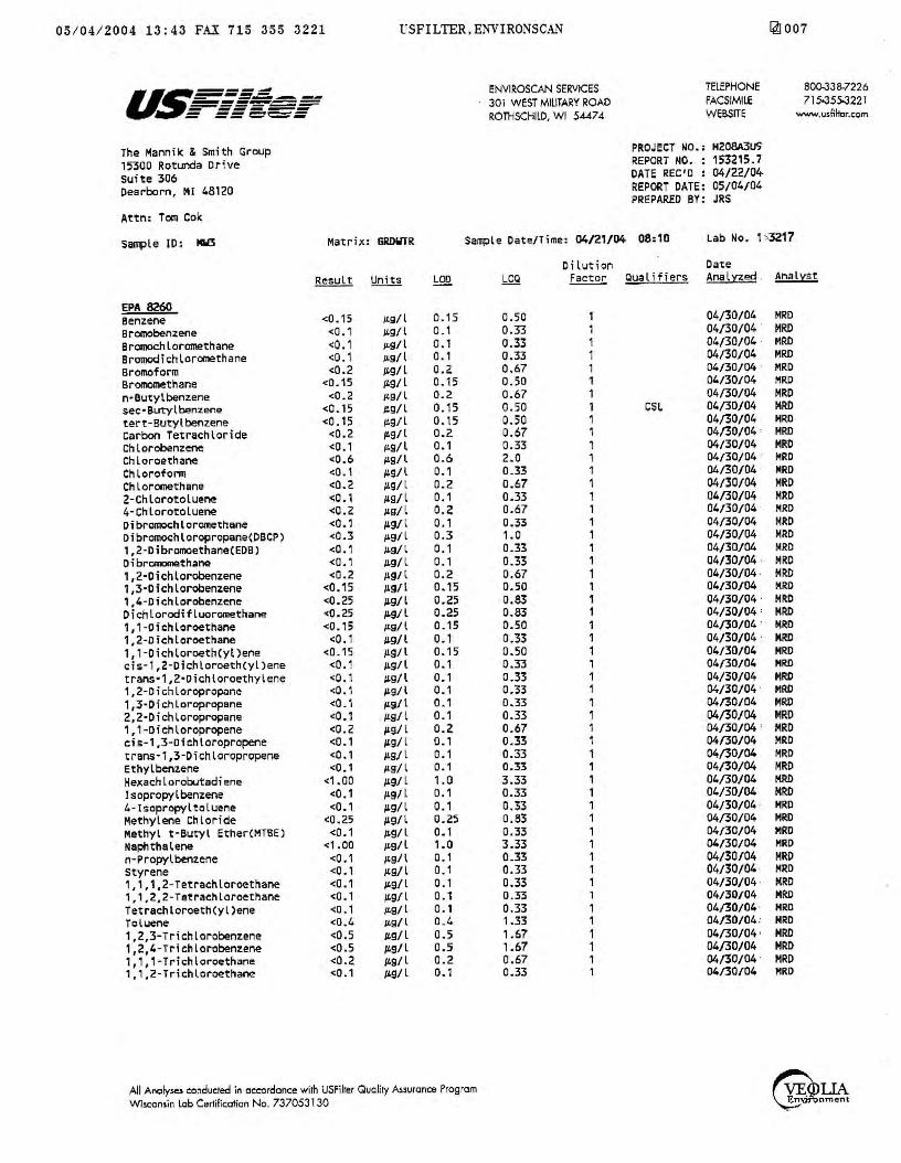
05 / 04/2004 13:43 FAX 715 355 3221 USFILTER,ENVIRONSCAN
u~----- ENVIROSCAN SERVICES ==---~-=-- --___ ,_,, __
30 l WEST MILITARY ROAD ;;;;;;---,;;;; ~ -= === =-~ =~t::t~=- ROTHSCHILD, WI 5.U7.4
The Mannik & Smith Group PROJECT NO.:
15300 Rotunda Drive REPORT NO. :
suite 306 DATE REC'D :
Dearborn, Ml 48120 REPORT DATE: PREPARED BY:
Attn: Tom Cok
S11Tiple ID: MW3 Matrix: GRDWTR Sample Date/Time: 04/21/04 08:10
Result Units !:QQ.
EPA 8260 Benzene <0.15 µ.g/ l 0.15 Bromobenzene <O .1 JLQ/l 0. 1 Bromochloromethane <0.1 µ.g/1 0.1 Bromodichloromethane <0.1 µ.g/l 0.1 Bromoform <0.2 1'9/l 0.2 BronKXMthane <0.15 1'9/ l 0.15 n•Butylbenzene <0.2 µ.g/l 0.2 sec•Butylbenzene <0.15 ILQ/l 0.15 tert-Butylbenzene <O. 15 µ.g/l 0.15 Carbon Tetrachloride <0.2 /£9/l 0.2
· Ch L orobenzene <O. 1 µ.g/l 0.1 Chloroeth11ne <0.6 µ.9/l 0.6 Chlorofonn <0.1 /L9/ l 0., Chloromethane <0.2 JLQ/ l 0.2 2-ChlorotolueM <0.1 /LQ/l o. 1 4-Chlorotoluene <0.2 JL9/l 0.2 Dibrcmochloromethane <0.1 1'9/l 0. 1 Dibromochloropropane(DSCP) <0.3 µ.9/l 0.3 1,2-Dibroo'IOethaneCEDB) <O. 1 /LQ/ l o. 1 Oibromomethane <0.1 ILQ/l 0. 1 1,2·Dichlorobenzene <0.2 /£9/l 0.2 1,3-Dichlorobenzene <0.15 /£9/l 0.15 1,4-oichlorobenzene <0.25 /£9/ l 0.25 Dichlorodifluoromethane <0.25 /£9/ l 0.25 1,1-Dichloroethane <O. 15 µg/l 0. 15 1,2-oichloroethane <0.1 /LQ/l 0. 1 1, 1-0ichloroeth(yl)ene <0.15 JLg/l 0.15 cis-1,2-Dichloroeth(yl)ene <0.1 JLQ/l 0.1 trans·1,2·Dichloroethylene <O . 1 /LQ/l 0., 1,2-Dichloroprop.ine <0.1 /tS/l 0., 1,3·0ichloropropsne <0.1 JL9/l 0 .1 2,2·0ichloropropane <0.1 /LSI L 0 .1 1, 1-Dichloropropene <0.2 1'9/ l 0.2 cis-1,3-Dichloropropene <0.1 1'9/ L 0. 1 trans-1,3-0ichLoropropene <O, 1 /L9/ L 0.1 Ethyl benzene <O. 1 /Ls/l 0.1 Hexachlorobutadiene <1.00 1'9/ L 1.0 lsopropylbenzene <0.1 1'9/ L 0. 1 4-Isopropyltoluene <0 .1 1£9/l 0. 1 Methylene Chloride <0.25 /19/l 0.25 Methyl t-Sutyl Ether(MTBE) <0.1 µ,g/l 0. 1 Naphthalene <1.00 /LSI l 1.0 n-Propylbe:nzene <O. 1 µ.g/ l 0. 1 styrene <0.1 µ.g/ l o. 1 1, 1,1,2-Tetrachloroethane <0.1 µ.g/l o. 1 1,1,2,2-Tetrachloroethane <0. 1 /£9/ l 0.1 Tetrachloroeth(yl)ene <0. 1 µ.g/ l 0.1 Toluene <0 . 4 µg/l 0.4 1,2,3-Trichlorobenzene <0.5 u.g/ l 0.5 1,2,4-Trichlorobenzene <0.5 1'9/ l 0.5 1, 1, 1-Trichloroethane <0.2 JL9/ l 0.2 1, 1,2-Trichlor~thane <0.1 /LS/ l 0.1
All An,;,ly«es ~ndueted in oecordonce with USFilrer Quality Assurance Program WL,comin lob Certification No. 737053130
Dilution LOQ Factor Qualifiers
0.50 1 0.33 1 0.33 1 0.33 1 0.67 1 0.50 1 0.67 1 a.so 1 CSL 0.50 1 0.67 1 0.33 1 2.0 1 0.33 1 0.67 1 0.33 1 0.67 1 0.33 1 1. 0 1 0.33 1 0.33 , 0.67 1 0.50 l 0.83 1 0.83 1 0.50 1 0.33 1 0.50 1 0.33 1 □ .33 1 0.'33 1 0.33 1 0.33 1 0.67 1 0.33 1 0.33 1 0.33 1 3.33 , 0.33 1 0.33 1 0.83 1 0.33 1 . 3.33 1 0.33 1 0.33 1 0.33 , 0.33 0.33 1.33 1.67 1.67 0.67 0.33
141001
TELEPHONE 800-338-7226 FACSIMILE 715.J.55-3221 W~EISIT~ www,usfil!cr,com
H208A3~ 153215.7 04/22/04-05/04/04 JRS
Lab No. t;;3217
Date Analy:ted . Analyst
04/30/04 MRD 04/30/04 . MRD 04/30/04 · MIW 04/30/04 MRD 04/30/04 · MRD 04/30/04 MRD 04/30/04 MRD 04/30/04 MRD 04/30/04 HRD 04/30/04 , HRO 04/30/04 MRD 04/30/04 · MRD 04/30/04 · HRD 04/30/04 MRD 04/30/04 MRD 04/30/04 · HRD 04/30/04 MRD 04/30/04 MRO 04/30/04 MRD 04/30/04 · MRD 04/30/04 . MRO 04/30/04 HRD 04/30/04 · MRO 04/30/04, HRD 04/30/04 · lolRD 04/30/04 · HRC 04/30/04 HRD 04/30/04 HRO 04/30/04 MRC D4/30/04 · MRD 04/30/04 MRO 04/30/04 MRD 04/30/04' MRD 04/30/04 MRD 04/30/04 MRD 04/30/04 MRD 04/30/04 AA!> 04/30/04 MRD 04/30/04 · MRD 04/30/04 MRO 04/30/04 MRD 04/30/04 HRD 04/30/04 MRD 04/30/04 · MRD 04/30/04 · MRO 04/30/04 MRD 04/30/04 · HRO 04/30/04 .· HRD 04/30/04 , HRO 04/30/04 MRD 04/30/04 · MRD 04/30/04 MRD
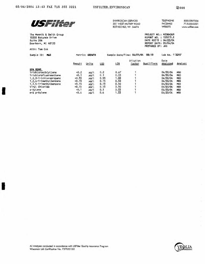
I
I
05 / 04 / 2004 13 : 43 FAX 715 355 3221 USFILTER,ENVIRONSCAN ~008
The Hamik & Smi th Group 15300 Rotunda Drive Suite 306 Dearborn, HI 48120
Attn : Tom Cole;
ENVIROSCAN SERVICES 301 WEST MILITARY ROAD ROiHSCHllD, WI 54474
TELEPHONE FACSIMILE WEBSITE
PROJECT NO.: M208A3U'l REPORT NO. : 153215.~ DATE REC'D : 04/22/04 REPORT DATE: 05/04/04 PREPARED BY: JRS
so0-JJB-n26 715-355-3221
www.u1filter.c:om
Sample ID: ,tW3 Matrix: GROWTR Sample Date/Time: 04/21/04 08:10 Lab No. 1 '~17
EPA 8260 Trichloroeth(yl)ene Trichlorofluoromethane l,2,3·Trichloropropane 1,2,4·Trirnethylbenzene 1,3,5-Trimethylbenzene Vinyl Chloride o-Xylene m·& p•Xylene
<0.2 <O. 1
<0 , 55 <0.15 <0.15 <0.15
<O, 1
<0. 4
µ.g/l µ.g/l µ.g/l µ.g/l µ.g/l /l9/l µ.9/l p.g/l
0.2 0 . 1 0.55 0 .15 0. 15 0.15 0.1 0.4
All Analyse~ conducted in accordance with USFiinlr Quality Assurc:m,e Progrcm Wisconsin lab Cortili~cticn No. 737053130
0.67 0.33 1.83 0.50 0.50 0. 50 0,33 1 .33
Dilut i on Date ~ Ouat if i ers Analyzed . Analyst
04/30/04 MRD 04/30/04 MRD 04/30/04 · MRD 04/30/04 MRD 04/30/04 MRD 04/30/04 · 14RD 04/30/04 MR!> 04/30/04 MRD
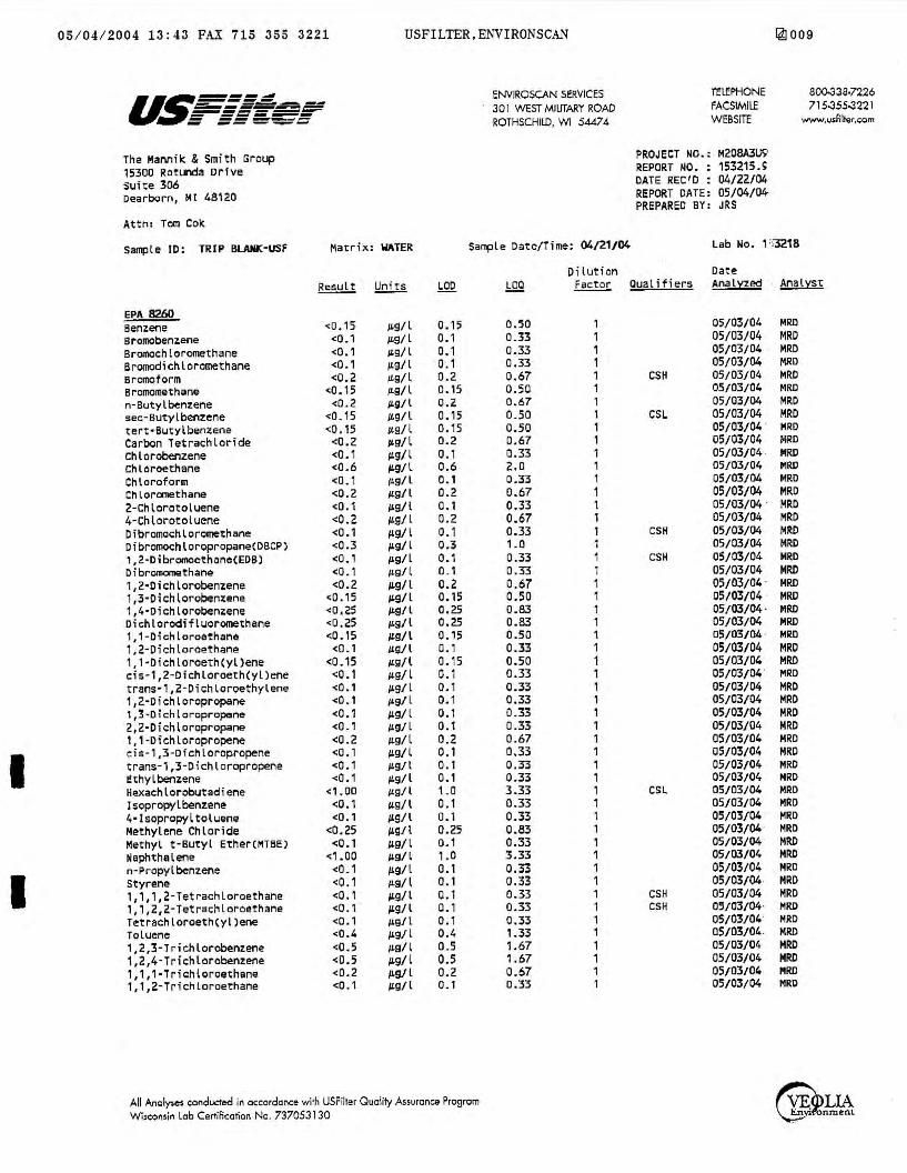
I
I
05 / 04 / 2004 13:43 FAX 715 355 3221 USFILTER,ENVIRONSCAN
u~---- ENVIROSCAN SERVICES -----.::;...._~,:t;;;;;:1..--..-- 301 WEST MILITARY ROAD -~=r-='S=~ = ===-~::: ROTHSCHILD, WI 54474
The MaMik & Smith Group PROJl;CT NO.:
15300 Rotl.Jl'lda Drive REPORT 110. :
suite 306 DATE REC 1D :
Dearborn, Ml 48120 REPORT DATE: PREPARED BY:
Attn: Tom Cok
Sample ID: TRIP BUUD;:•USf Matrix: WATER Sample Date/Time: 04/21/04
Result !d.ui.li LOO
EPA 8260 Benzene <D.15 /L9/ l 0.15 Bromobenzene <0.1 µ,9/ l 0. 1 Bromochloromethane <0 .1 IL9/ l 0.1 Bromodichloromethane <0.1 /LS/ l 0 .1 Bromoform <0.2 /Ls/l 0.2 8romomethane <:0. 15 µ.9/ l 0.15 n-Butylbenr.ene <0.2 µ.g/ l 0.2 sec-Butyl~nzene <0.15 /£9/ l o. 15 tert•Butylbenzene <0 .15 1'9/l 0.15 Carbon Tetrachloride <0.2 J,tg/l 0.2 Chlorobenzene <0. 1 /LS/l o. 1 Chloroethane <0.6 µ.g/l 0.6 Chloroform <0. 1 JL9/l o. 1 ChloromethanO!! <0.2 l'Q/ l 0.2 2-Chlorotoluene <0.1 119/l 0. 1 4-Chlorotoluene <0.2 /£9/ L 0.2 Dibromochloromethane <0.1 µ.g/ l 0.1 Dibromochloropropane(DBCP) <0.3 µ.g/ L 0.3 1,2-Dibromocth~ne(EDB) <0. 1 JLs/l 0.1 DibromomethaM <0. 1 µ.g/l o_, 1,2·Dichlorobenzene <0.2 µ.g/l 0.2 1,3-0ichlorobenzene <0.15 /L9/l 0.15 1,4·Dichlorobenzene <0,25 /£9/l 0.25 Dichlorod;fluoromethane <0,25 µ,9/l 0.25 1,1 -Dichloroethane <O. 15 1'9/l 0.15 1.2-Dichloroethane <0., ILQ/l 0. 1 1, 1·Dichloroeth(yl)ene <0.15 1£9/l 0.15 cis-1,2-0ichloroeth(yl)ene <0.1 1,tg/l 0. 1 trans·1,2-Dichloroethylene <0.1 /£9/l 0. 1 1,2-Dichloropropane <0. 1 µ,9/ L 0.1 1,3-0ichloropropane <0.1 µ.g/ L 0. 1 2,2·Dichloropropane <0.1 /£9/ L 0.1 1,1 -0ichloropropene <0.2 1£9/l 0.2 cis-1,3-Dichloropropene <0. 1 /L9/l o., trans-1,3-Dichloropropene <0.1 /L9/l 0. 1 l:thylbenzene <0.1 µ.9/ l o., Hexachlorobutadiene <1.00 /LQ/l 1.0 l~opropylbenzene <0.1 11s/l 0. 1 4•lsopropyltoluene <0.1 /LS/l 0. 1 Methylene Chloride <0.25 /£9/l 0.25 Methyl t-Butyl Ether(MT8E) <0. 1 /LQ/l 0.1 Maphthalene <1.00 l'Q/ l , .o n-Propylbcenzene <0. 1 /L9/L 0. 1 Styrene <0.1 µ.g/l 0.1 1,1,1,2-Tetrachloroethane <0.1 µ.g/ l 0. 1 1, 1,2,2-Tetrachloroethane <0. 1 µ.g/ l 0. 1 T~trachloroethCyl)ene <0.1 µ,g/ l 0 .1 Toluene <0.4 µ.g/l 0.4 1,2,3-Trichlorobenzene <0.5 ILS/l 0.5 1,2,4-Trichloro~nzer1~ <0.5 p.g/l 0.5 1,1,1-Trichloroethane <0.2 JLg/l 0.2 1, 1,2-Trichloroethane <0.1 /L9/l 0. l
All AnQly,e$ eonducted in oceordance with USFilter Quality Assurance Progrom Wi,c:onsin lob Certificarion No. 737053130
Di lution .bQ£ ~ Qualifiers
0.50 1 0.33 , 0.33 , 0.33 1 0.67 , CSH 0.50 1 0.67 1 0.50 1 CSL 0.50 1 0.67 1 0.33 1 2.0 1 0.33 1 0.67 1 0.33 1 0.67 1 0.33 1 CSH 1.0 1 0.33 1 CSH 0.33 1 0.67 1 0.50 1 0.83 1 0.83 , 0.50 1 0.33 1 0.50 1 0.33 1 0.33 , 0.33 1 0.33 1 0.33 , 0.67 1 0.33 1 0.33 1 0.33 1 3.33 1 CSL 0.33 1 0.33 1 0.83 1 0.33 1 3.33 1 0.33 1 0.33 1 0.33 1 CSH 0.33 1 CSH 0.33 1 1 .33 1 1 .67 1 1.67 1 0.67 1 0.33 1
@009
l'ELEPHONE 800-338•7226 FACSIMILE 715-355-3221 WEBSITE www.usfil1,jr,c;om
H208A3US' 153215.~ 04/22/04 05/04/04 JRS
Lab No. 1 :;3218
Oat~ AML~zed Analyst
05/03/04 MRD 05/03/04 MRD 05/03/04 · MRD 05/03/04 MRD 05/03/04 MRD 05/03/04 HRO 05/03/04 MRD 05/03/04 · MRD 05/03/04 · MRD 05/03/04 MRD 05/03/04 . MRD 05/03/04 MIW 05/03/04 MRO 05/03/04 MRD 05/03/04 · MRD 05/03/04 MRD 05/03/04 MRD 05/03/04 MRO 05/03/04 MRD 05/03/04 MRO 05/03/04 · HRD 05/03/04 · MRD 05/03/04 · MIW 05/03/04 MRO 05/03/04 · Mli!O 05/03/04 MRD 05/03/04 . MRO 05/03/04 MRD 05/03/04 MRD 05/03/04 MRD 05/03/04 MRD 05/03/04 MRO 05/03/04 HRD 05/03/04 MRD 05/03/04 MRO 05/03/04 HRD 05/03/04 MRD 05/03/04 MRO 05/03/04 HRD 0~/03/04 MRD 05/03/04 MRD 05/03/04 MRO 05/03/04 Mli!D 05/03/04 MRD 05/03/04 MRD 05/03/04 MRD 0S/03/04 MRD 05/03/04 MRO 05/03/04 MRO 05/03/04 MRD 05/03/04 MRD 05/03/04 MRD

I
05 / 04 / 2004 13:43 FAX 715 355 3221
The Mannik & Smith Group 15300 Rotunda Drive suite 306 Dearborn, M[ 48120
Attn: Tom Cok
Sample ID : TRIP BLAIIIC·USF
USFILTER , ENVIRONSCAN
Hatr b1: WATER
ENVlROSCAN SERVICES 301 WEST MILITARY ROAD ROTHSCHILD, WI SA.474
Sample Date/Time: 04/21/04
Dilution
TELEPHONE FACSIMILE WEBSITE
PROJECT NO.: M208A3U9 REPORT NO. : 153215.1 DATE REC'D : 04/22/04 REPORT DATE : 05/04/04 PREPARED BY: JRS
141010
a00,33a.n26 715-3.55-3221
www.u,fill.,1.~om
Lab ~o. r',3218
Date LOCI ~ Ousl i Hers Analyzed · Analyst
EPA 8Z60 Tr fchloroeth(yl)ene Trichlorofluoromethane 1,2,3•Trichloropropane 1,2,4·Trimethylbeniene 1,3,5-Trimethylbenzene Vinyl Chloride a-Xylene m·& p-l<ylene
Qualifier Descriptions
CSL
CSH
<0.2 µ9/l 0.2 0.67 1 <0.1 µg/l 0.1 0.33 1
<0.55 µ.g/l 0.55 1.83 1 <□. 15 µ.g/ l 0.15 0.50 1 <D . 15 JLg/l 0. 15 0.50 1 <O. 15 /L9/ l □. 15 0.50 1 <0. 1 µ.9/ l o. 1 0.33 1 <0.4 µ.g/l 0.4 1.33 ,
Check stand.lrd for this analyte exhibited a low bias. Sample results may also be biased low.
Check standard for thi~ analyte exhibited a high bias. Sample results may also be biased high.
All Ano\y$cs eondUcie<:I In occordance with USFilter Quality Assurance Progtom Wi,eoMin lob Certification No. 737053130
05/03/04 MRD 05/03/04 MRO 05/03/04 · MRD 05/03/04 · MRD 05/03/04 MRD 05/03/04 MRD 05/03/04 · MRO 05/03/04 · MRO

I
I
05/04 / 2004 13:44 FAX 715 355 3221 USFILTER,ENVIRONSCAN [4]011 i: ,..~ _,_,~
liii•iiiiN4iiiANW,~ f" ENVIROSCAN SERVICES 301 W. MILITARY RD. ROTHSCHILD, WI 54474 1 ·800 i-338-SCAN
~:~,~~
~=~:Y'~-Ml, 3i, Phone: (313 ) 2]1 - ZZ 2 S :', P.O.#-----,---=-=----------.....,...... · Project # fY zcg ,A 3 LJ 9 Quote # .,,, 'ry ½ '5/ ,./ Location Hales Coant ts E -~~q\\
Sample Type
'
heck a/{ that apply) Groundwater Wastewater
0 SoiVSolid □ Drinking Water a Oil □ Vapor
.. 0 Other
around Time Normal Rush (Pre-approved by Lab)
Date Needed ___ _ Approved By
' .
1~153216 · <(-\D 1~1s3.g17 . L//Zl/lfl· i1u
3:
~·,. . .. · .. ·:_·· .. ·.·/· .. '.,.-.· .. ·.·· .. ; ·.:: ... ·.· ./t ./:: J,::' ·, '. ::·- ~ :. . . jil" • ~-~: s . ,: ::· i~. . : ;, ;_. ·._ . . ..., . ,, ,.; ..
CHAIN OF CUSTODY RECORD
BILL TO: (if different from Report To info) Name: ______________ _
Company: Address: _____________ _
Phone:(,,__ __ _, ___________ _
ANALYTICAL REOUESTS •"" (use separate sheet if " :icessary)
I
3 3 3
Comments:
RECEIVED BY: (SignaturB)
RECEIVED BY: (Signature)
REL.JNQUISHED BY: (Signature) DATE/TlME

I I I
I
U~===.:::::! - -------------------- -----= ===-'='=
July 12, 2004
The Mannik & Smith Group 15300 Rotunda Driv e Suite 306 Dearborn, MI 48120
Attn: Tom Cok/ Molly Zawacki
REPORT NO.: 158064
ENVIROSCAN SERVICES
301 WEST MILITARY ROAD
ROTHSCHILD, WI 5447 4
TELEPHONE
FACSIMILE
WEBSITE
Toe Mannik & Smith Group\ Inc.
PROJECT NO.: M208A3U9
Please find enclosed the analytical report, including the Sample Summary, Sample Narrative and Chain of Custody for your sample set received July 2, 2004.
All analyses were performed in accordance with approved methods as indicated on this report.
If you have any questions about the results, please call. Thank you for using USFilter, Enviroscan Services for your analytical needs.
Sincerely ,
USFilter, Enviroscan Services
__/4 •.. · s/.J:?J,,.;r{ · James R. Salkowski Laboratory Director
715-338-7226 715-355-322 l
www.usfilter.com
I cenify thm the dma conwined in this repon has been genermed and reviewed in accordnnce with the USFilter, Envirorcan Services Qualify Assurance Program. Exceptions, if any. are discussed in the sample narrative. Samples will be retained fo r 30 days from the date of 1his repon. then disposed in an approprime manner. USFiher,
Envirorcan Services reserves the right to ret 1rn samples identified as hazardous. Release of this Final Repon is authorized as verified by the following signmure.
Approved by:
Certifications: Wisconsin 737053130 Minnesota 055-999-302 Maryland 276 Oklahoma 9925
All Analyses conducted in accordance with USFilter Ouclity Assurance Program
Wisconsin Lab Certif ication No. 737053130
Oregon (WI-100001) Illinois 200025 Washington C293

I I
I I
I
3b Id 58064 j8065 58066 j8067 58068 58069 58070
U:.~===: - -----~===.:=:=~ = ===-=-=
Client Samele ID MW1 MW2 MW3 MW7 HC-EC-17 HC-EC-16 HC-EC-18
Samele Surrmary
Date/Time 06/30/04 06/30/04 06/30/04 07/01/04 07/01/04 07/01/04 07/01/04
ENVIROSCAN SERVICES 301 WEST MILITARY ROAD ROTHSCHILD, WI 54474
10:00 14:30 07:20 17:20 11: 30 10:00 10:45
TELEPHONE FACSIMILE WEBSITE
158064.2
Matrix GROUNDWATER GROUNDWATER GROUNDWATER GROUNDWATER GROUNDWATER SOIL SOIL _
Samole Narrative/Samele Status
/AL YSES:
:PORTING:
JD= Limit of Detection ~=Limit of Quantitation = Less Than
lMP = Complete IBCON = Subcontracted analysis • =millivolts :i/l = picocurie per liter /l = mililiters/Liter
Def i n i tions
·~g/l = Micrograms per liter= parts per billion (ppb) ~g/kg = Micrograms per kilogram= parts per billion (ppb) mg/l = Milligrams per liter= parts per million (ppm) mg/kg= Milligrams per kilogram= ·parts per million (ppm) NOT PRES= Not Present ppth = Parts per thousand (S) = Surrogate Compound mg/m3 = Milligrams/meter cube
All Analyses conducted in accordance with USFilter Ouolity Assurance Program Wisconsin lob Certification No. 737053130
715-338-7226 715-355-3221
www.usfilter.com
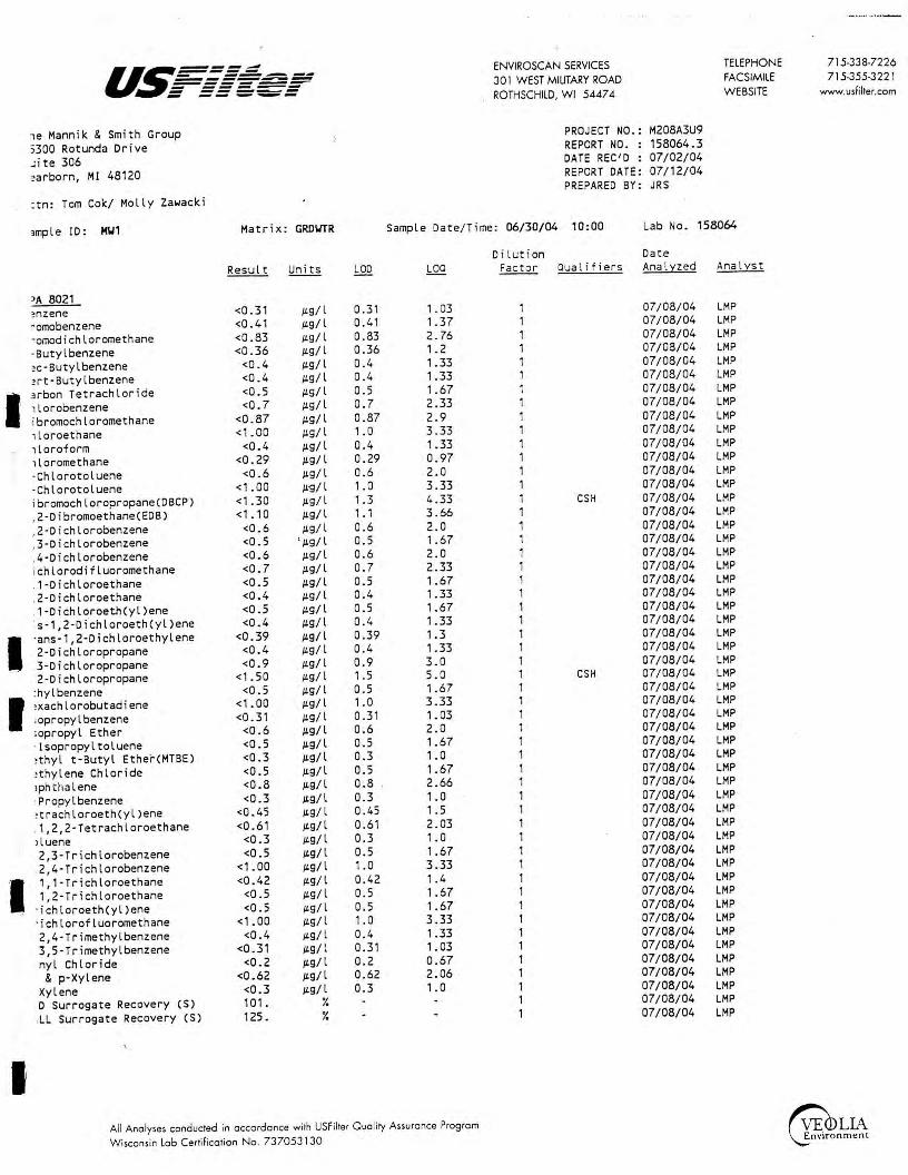
·- ·-·· -·~·-
u~===: ENVIROSCAN SERVICES TELEPHONE 715-338-7226 - --~--------- 301 WEST MILITARY ROAD FACSIMILE 715-355-3221 ------- ------ ----- ROTHSCHILD, WI 54474 WEBSITE www.usfilter.com - -- ---,e Mann i k & Smith Group PROJECT NO.: M208A3U9
5300 Rotunda Drive REPORT NO. : 158064.3
Jite 306 DATE REC'D : 07/02/04
?arborn, Ml 48120 REPORT DATE: 07 /12/04 PREPARED BY: JRS
:tn: Tom Cok/ Molly Zawacki
,mple ID: H'J1 Matrix: GRD\ITR Sample Date/Time: 06/30/04 10:00 Lab No . 158064
Dil ution Dat.e Result Un i ts LOO LOQ Fac t or Qual if iers Anal:i:zed Anal:i:st
~A 8021 ?nzene <0.31 /L9/ l 0.31 1. 03 1 07/08/04 LMP
~omobenzene <0.41 /L9/ l 0.41 1.37 1 07/08/04 LMP
·omodichloromethane <0.83 /L9/ l 0.83 2.76 1 07/08/04 LMP
-Butyl benzene <0.36 /L9/ l 0.36 ,. 2 1 07/08/04 LMP
?c·Butylbenzene <0 . 4 /L9/l 0.4 1.33 1 07/08/04 LMP
?rt·Butylbenzene <0.4 /L9/l 0.4 1.33 1 07/08/04 LMP
I 3rbon Tetrachloride <0.5 /L9/l 0.5 1.67 1 07/08/04 LMP
1lorobenzene <0.7 /L9/l 0 . 7 2.33 1 07/08/04 LMP
ibromochloromethane <0.87 /L9/ l 0.87 2 . 9 1 07/08/04 LMP
1loroethane <1.00 /L9/l 1. 0 3 .33 1 07/08/04 LMP
1 loroform <0.4 /L9/l 0.4 1.33 1 07/08/04 LMP
1loromethane <0.29 /L9/ l 0.29 0.97 1 07/08/04 LMP
-Chlorotoluene <0 . 6 /L9/l 0.6 2.0 1 07/08/04 LMP
·Chlorotoluene <1.00 /L~/l 1.0 3.33 1 07/08/04 LMP
ibromochloropropane(DBCP) <1 .30 /L9/l 1.3 4.33 1 CSH 07/08/04 LMP
, 2-D i bromoethane(EDB) <1. 10 /L9/l 1 . 1 3.66 1 07/08/04 LMP
,2-Dichlorobenzene <0 . 6 /L9/l 0.6 2.0 1 07/08/04 LMP
,3-Dichlorobenzene <0.5 ' /L9/ l 0.5 1.67 1 07/08/04 LMP
,4-Dichlorobenzene <0 . 6 /L9/l 0.6 2.0 1 07/08/04 LMP
ichlorodifluoromethane <0.7 /L9/l 0.7 2.33 1 07/08/04 LMP
.1-Dichloroethane <0.5 /L9/l 0.5 1 .67 1 07/08/04 LMP
.2-Dichloroethane <0.4 /L9/l 0.4 1.33 1 07/08/04 LMP
.1-Dichloroeth(yl)ene <0.5 /L9/l 0.5 1.67 1 07/08/04 LMP
·s-1,2-D i~hloroeth(yl)ene <0.4 /L9/l 0.4 1.33 1 07/08/04 LMP
I ·ans-1,2-Dichloroethylene <0 . 39 µ.g/ l 0.39 1.3 1 07/08/04 LMP
2-Dichloropropane <0.4 /L9/ l 0.4 1.33 1 07/08/04 LMP
3-Dichloropropane <0 . 9 /L9/ l 0.9 3.0 1 07/08/04 LMP
2-Dichloropropane <1. 50 /L9/ l 1 . 5 5.0 1 CSH 07/08/04 LMP
:hylbenzene <0.5 /L9/l 0.5 1 .67 1 07/08/04 LMP
I !Xachlorobutadiene <1. 00 /L9/l 1. 0 3.33 1 07/08/04 LMP
;opropy l benzene <0.31 /L9 / l 0.31 1. 03 1 07/08/04 LMP
;opropyl Ether <0.6 /L9/l 0.6 2.0 1 07/08/04 LMP
· lsopropyltoluene <0.5 /L9/ l 0.5 1 .67 1 07/08/04 LMP
!thyl t-Butyl Ether(MTBE) <0 . 3 /L9/ l 0.3 1. 0 1 07/08/04 LMP
!thylene Chloride <0.5 /L9/l 0.5 1.67 1 07/08/04 LMP
1phtllalene <0.8 /L9/l 0.8 2.66 1 07/08/04 LMP
·Propylbenzene <0 .3 /L9/ l 0.3 1.0 1 07/08/04 LMP
?trachloroeth(yl)ene <0.45 /L9/ l 0. 45 1.5 1 07/08/04 LMP
.1,2,2-Tetrachloroethane <0.61 /L9/ l 0. 61 2.03 1 07/08/04 LMP
i luene <0.3 /L9/ l 0.3 1.0 1 07/08/04 LMP
.2,3-Trichlorobenzene <0.5 /Lg/l 0. 5 1.67 1 07/08/04 LMP
.2,4-Trichlorobenzene <1 .00 /L9/l 1.0 3.33 1 07/08/04 LMP
I .1, 1-Trichloroethane <0.42 /L9/l 0. 42 1. 4 1 07/08/04 LMP
1,2-Trichloroethane <0 . 5 /L9/l 0 .5 1.67 1 07/08/04 LMP
· i ch loroeth(yl )ene <0 . 5 /L9/l 0.5 1.67 1 07/08/04 LMP
· ichlorofluoromethane <1. 00 /L9/l 1 . 0 3.33 1 07/08/04 LMP
2,4-Trimethylbenzene <0.4 /L9/ l 0.4 1.33 1 07/08/04 LMP
3,5-Trimethylbenzene <0.31 µ.g/l 0.31 1. 03 1 07/08/04 LMP
nyl Chloride <0.2 /L9/ l 0.2 0 .67 1 07/08/04 LMP
& p-Xylene <0.62 /Lg/ l 0.62 2. 06 1 07/08/04 LMP
Xylene <0.3 /Lg/ l 0.3 ,. 0 1 07/08/04 LMP
D Surrogate Recovery (S) 101 . ¾ 1 07/08/04 LMP
.LL Surrogate Recovery (S) 125. ¾ 1 07/08/04 LMP
I All Ano lyses conducted in accordance with USF ilter Quali ty Assurance Program ~1¼\ Wisconsin Lob Certification No . 737053130

u~===~ ENVIROSCAN SERVICES - --.----------- 301 WEST MILITARY ROAD ------- ------ ------ -- --- ROTHSCHILD, WI 5447 4
The Mannik & Smith Group PROJECT NO.:
300 Rotunda Drive REPORT NO. :
ite 306 DATE REC'D :
earborn, MI 48120 REPORT DATE: PREPARED BY:
Attn: Tom Cok/ Molly Zawacki
ample ID: H\12 Matrix: GRD\ITR Sample Date/Time: 06/30/04 14:30
Result Units LOO LOO
PA 8021 Benzene <0.31 µg/l 0.31 1.03 qromobenzene <0.41 µg/l 0.41 1.37
[ romodichloromethane <0.83 µg/l 0.83 2. 76 · Butyl benzene <0.36 µg/l 0.36 1. 2 ec·Butylbenzene <0.4 µg/l 0.4 1.33
tert·Butylbenzene <0.4 µg/l 0.4 1.33
larbon Tetrachloride <0.5 µg / l 0.5 1.67 hlorobenzene <0.7 µg/l 0.7 2.33 ibromochloromethane <0.87 µg/ l 0.87 2.9
Chloroethane <1 .00 µg/l 1.0 3 .33 rh loroform <0.4 µg/l 0.4 1.33
~hloromethane <0.29 µg/l 0.29 0.97 ·Chlorotoluene <0.6 µg/l 0.6 2.0 ·Chlorotoluene <1.00 µg/l 1. 0 3.33
Dibromochloropropane(DBCP) <1 .30 µg/l 1.3 4.33 1,2-Dibromoethane(EDB) <1. 10 µg/l 1 . 1 3.66 ,2-Dichlorobenzene <0.6 µg/ l 0.6 2.0 ,3-Dichlorobenzene <0.5 µ.g/ l 0.5 1.67
1,4-Dichlorobenzene <0.6 µg/l 0.6 2.0
r ichlorodifluoromethane <0 . 7 µg/l 0.7 2.33
1,1-Dichloroethane <0.5 µg/l 0.5 1.67 ,2-Dichloroethane <0.4 µg/l 0.4 1.33 , 1-Dichloroeth(yl)ene <0.5 µg/l 0. 5 1.67
cis-1,2-Dichloroeth(yl)ene <0.4 µg/l 0.4 1.33 rans-1,2-Dichloroethylene <0.39 µg/l 0.39 1.3
I • 2-D i ch loropropane <0.4 µg/l 0.4 1 .33 ,3-Dichloropropane <0.9 µg/l 0.9 3.0
2,2-Dichloropropane <1.50 µg/l 1 . 5 5.0 "thylbenzene <0.5 µg/l 0.5 1.67 exachlorobutadiene <1.00 µg/l 1. 0 3.33 sopropylbenzene <0.31 µg/ l 0.31 1. 03 sopropyl Ether <0.6 µg/l 0.6 2.0
p·Isopropyltoluene <0.5 µg/ l 0.5 1 .67 ethyl t·Butyl Ether(MTBE) <0.3 µg/l 0.3 1. 0 ethylene Chloride <0.5 µg/l 0.5 1 .67 aphthalene <0.8 µg/l 0.8 2.66
n·Propylbenzene <0.3 µg/l 0.3 1. 0
.,,,achlocoe<h(yl)eee <0.45 µg/l 0.45 1. 5 , 1,2,2-Tetrachloroethane <0.61 µg/l 0.61 2.03 oluene <0.3 µg/l 0.3 1.0 ,2,3 - Trichlorobenzene <0.5 µg/l 0. 5 1.67
1;2,4-Trichlorobenzene <1.00 µg/l 1. 0 3.33 , 1,1-Trichloroethane <0.42 µg/l 0.42 1. 4 , 1,2-Trichloroethane <0.5 µg/l 0.5 1 .67 richloroeth(yl)ene <0.5 µg/l 0.5 1.67
Trichlorofluoromethane <1 .00 µg/l 1.0 3.33
1,2,4-Trimethylbenzene <0.4 µg/l 0.4 1 .33 ,3,5-Trimethylbenzene <0.31 µg/l 0.31 1.03 inyl Chloride <0.2 µg/ l 0.2 0.67
m· & p·Xylene <0.62 µg/ l 0.62 2.06
a-Xy l ene <0.3 µg/l 0.3 1.0 ID Surrogate Recovery (S) 102. ¾
ALL Surrogate Recovery (S) 122. ¾
All Anolyses conducred in occordonce with USFilter Ouolity Assurance Progrom Wisconsin Lob Certification No. 7370531 30
Dilution Factor Qualifiers
1 1 1 1 1 1 1 1 1 1 1 1 1 1 1 CSH 1 1 1 1 1 1 1 1 1 1 1 1 1 CSH 1 1 1 1 1 1 1 1 1 1 1 1 1 1 1 1 1 1 1 1 1 1 1 1 1
TELEPHONE 715-338-7226 FACSIMILE 715-355-3221 WEBSITE www.usfilter.com
M208A3U9 158064.4 07/02/04 07/12/04 JRS
Lab No. 158065
Date Anal}:'.zed Analyst
07/08/04 LMP 07/08/04 LMP 07/08/04 LMP 07/08/04 LMP 07/08/04 LMP 07/08/04 LMP 07/08/04 LMP 07/08/04 LMP 07/08/04 LMP 07/08/04 LMP 07/08/04 LMP 07/08/04 LMP 07/08/04 LMP 07/08/04 LMP 07/08/04 LMP 07/08/04 LMP 07/08/04 LMP 07/08/04 LMP 07/08/04 LMP 07/08/04 LMP 07/08/04 LMP 07/08/04 LMP 07/08/04 LMP 07/08/04 LMP 07/08/04 LMP 07/08/04 LMP 07/08/04 LMP 07/08/04 LMP 07/08/04 LMP 07/08/04 LMP 07/08/04 LMP 07/08/04 LMP 07/08/04 LMP 07/08/04 LMP 07/08/04 LMP 07/08/04 LMP 07/08/04 LMP 07/08/04 LMP 07/08/04 LMP 07/08/04 LMP 07/08/04 LMP 07/08/04 LMP 07/08/04 LMP 07/08/04 LMP 07/08/04 LMP 07/08/04 LMP 07/08/04 LMP 07/08/04 LMP 07/08/04 LMP 07/08/04 LMP 07/08/04 LMP 07/08/04 LMP 07/08/04 LMP

us===~ ENVIROSCAN SERVICES TELEPHONE 715-338-7226 - --------------- 301 WEST MILITARY ROAD FACSIMILE 715-355-3221 ------- ------ ------ -- --- ROTHSCHILD, WI 5447 4 WEBSITE www.usfilter.com
The Mannik & Smith Group PROJECT NO.: M208A3U9
15300 Rotunda Drive REPORT NO. : 158064.5
Suite 306 DATE REC'D : 07/02/04
Dearborn, MI 48120 REPORT DATE: 07/12/04 PREPARED BY: JRS
Attn: Tom Cok/ Molly Zawacki
Sample ID: H\l3 Matrix: GRDI/TR Sample Date/Time: 06/30/04 07:20 Lab No. 158066
Dilution Date Result Un i ts LOO LOO Factor Qualifiers Anal:r:zed Anat:r:st
EPA 8021 Benzene <0.31 )Lg/l 0.31 1.03 1 07/08/04 LMP
Bromobenzene <0.41 )Lg/l 0.41 1.37 1 07/08/04 LMP
Bromodichloromethane <0.83 )Lg/l 0.83 2.76 1 07/08/04 LMP
n-Butylbenzene <0.36 )Lg/l 0.36 1. 2 1 07/08/04 LMP
sec-Butyl benzene <0.4 SLg/l 0.4 1 .33 1 · 07 /08/04 LMP
tert·Butylbenzene <0.4 )Lg/ l 0.4 1.33 1 07/08/04 LMP
Carbon Tetrachloride <0 . 5 )Lg/l 0.5 1.67 1 07/08/04 LMP
Chlorobenzene <0.7 )Lg/ l 0.7 2.33 1 07/08/04 LMP
Dibromochloromethane <0.87 )Lg/l 0.87 2.9 1 07/08/04 LMP
Chloroethane <1 .00 )Lg/l 1.0 3 .33 1 07/08/04 LMP
Chloroform <0.4 )Lg/ l 0.4 1.33 1 07/08/04 LMP
Chloromethane <0.29 )Lg/ l 0.29 0.97 1 07/08/04 LMP
2-Chlorotoluene <0.6 )Lg/l 0.6 2.0 1 07/08/04 LMP
4-Chlorotoluene <1. 00 SLg/l 1.0 3.33 1 07/08/04 LMP
Dibromochloropropane(DBCP) <1.30 )Lg/ l 1 .3 4.33 1 CSH 07/08/04 LMP
1,2-Dibromoethane(EDB) <1. 10 )Lg/ l ,. 1 3.66 1 07/08/04 LMP
1,2-Dichlorobenzene <0.6 )Lg/ l 0.6 2.0 1 07/08/04 LMP
1,3-Dichlorobenzene <0.5 '/Lg/ l 0.5 1.67 1 07/08/04 LMP
1,4-Dichlorobenzene <0.6 )Lg/l 0.6 2. 0 1 07/08/04 LMP
1oichlorodifluoromethane <0 . 7 )Lg/ l 0.7 2.33 1 07/08/04 LMP
1, 1-Dichloroethane <0.5 µ.g/ l 0.5 1.67 1 07/08/04 LMP
1,2-Dichloroethane <0.4 )Lg/l 0.4 1.33 1 07/08/04 LMP
1,1-Dichloroeth(yl)ene <0.5 )Lg/ l 0.5 1.67 1 07/08/04 LMP
cis-1,2-Dichloroeth(yl)ene <0.4 )Lg/ l 0.4 1.33 1 07/08/04 LMP
trans-1,2-Dichloroethylene <0.39 )Lg/ l 0.39 1.3 1 07/08/04 LMP
1,2-Dichloropropane <0.4 )Lg/l 0.4 1.33 1 07/08/04 LMP
1,3-Dichloropropane <0.9 )Lg/ l 0.9 3.0 1 07/08/04 LMP
2,2-Dichloropropane <1. 50 )Lg/l 1.5 5.0 1 CSH 07/08/04 LMP
Ethyl benzene <0.5 )Lg/ l 0.5 1 .67 1 07/08/04 LMP
Hexachlorobutadiene <1.00 )Lg/ l 1. 0 3 . 33 1 07/08/04 LMP
lsopropylbenzene <0.31 )Lg/ l 0.31 1.03 1 07/08/04 LMP
I sopropyl Ether <0.6 )Lg/l 0.6 2.0 1 07/08/04 LMP
p-Isopropyltoluene <0.5 )Lg/l 0.5 1.67 1 07/08/04 LMP
'Methyl t·Butyl Ether(MTBE) <0.3 )Lg/ l 0.3 ,. 0 1 07/08/04 LMP
Methylene Chloride <0.5 )Lg/l 0.5 1 .67 1 07/08/04 LMP
. Naphthalene <0.8 µ.g/l 0.8 2.66 1 07/08/04 LMP
n-Propylbenzene <0.3 µ.g/ l 0.3 1.0 1 07/08/04 LMP
Tetrachloroeth(yl)ene <0.45 )Lg/ l 0.45 1.5 1 07/08/04 LMP
1, 1,2,2-Tetrachloroethane <0.61 )Lg/ l 0.61 2.03 1 07/08/04 LMP
Toluene <0.3 )Lg/l 0.3 1 . 0 1 07/08/04 LMP
1,2,3-Trichlorobenzene <0.5 )Lg/l 0.5 1.67 1 07/08/04 LMP
1~2,4-Trichlorobenzene <1.00 )Lg/ l 1.0 3.33 1 07/08/04 LMP
1 , 1, 1-Tr i chloroethane <0.42 )Lg/ l 0.42 1.4 1 07/08/04 LMP
t 1, 1,2-Trichloroethane <0.5 )Lg/ l 0.5 1.67 1 07/08/04 LMP
rrichloroeth(yl)ene <0.5 )Lg/ l 0.5 1.67 1 07/08/04 LMP
· rrichlorofluoromethane <1.00 )Lg/ l 1.0 3.33 1 07/08/04 LMP
1,2,4-Trimethylbenzene <0.4 )Lg/ l 0.4 1.33 1 07/08/04 LMP
11,3,5-Trimethylbenzene <0.31 )Lg/ l 0.31 1.03 1 07/08/04 LMP
Vinyl Chloride <0.2 )Lg/ l 0.2 0.67 1 07/08/04 LMP
m- & p-Xylene <0.62 )Lg/ l 0.62 2.06 1 07/08/04 LMP
a-Xylene <0.3 )Lg/ l 0.3 1.0 1 07/08/04 LMP
'ID Surrogate Recovery (S) 101. ¾ 1 07/08/04 LMP
!ALL Surrogate Recovery (S) 123. ¾ 1 07/08/04 LMP
I All Anolyses conducted in accordance with USF ilter Quali ty Assu rance Progrom ~1¼\ Wisconsin Lab Certificat ion No. 737053130

us===.: ENVIROSCAN SERVICES TELEPHONE 715-338-7226 - -------------- 301 WEST MILITARY ROAD FACSIMILE 715-355-3221 ------- -----I =: ===-== ROTHSCHILD, WI 5AA7A WEBSITE www.usfilter.com
The Mannik &. Smith Group PROJECT NO.: M208A3U9
15300 Rotunda Drive REPORT NO. : 158064 . 6
- ;;uite 306 DATE REC'D : 07/02/04
earborn, Ml 48120 REPORT DATE: 07/12/04 PREPARED BY: JRS
Attn: Tom Cok/ Molly Zawacki
· ample ID: M\/7 Matri x : GRO\ITR Sample Date/Time: 07/01/04 17:20 Lab No. 158067
Di lution Date Result Units LOD LOO Fac t or Quali f iers Anal:z::zed Analz:st
PA 8021 enzene <0.31 µg/ l 0.31 1.03 1 07/ 08/04 LMP -r~,.,,.oe <0.41 µg/l 0.41 1.37 1 07/08/04 LMP
romodichloromethane <0.83 µg/l 0.83 2. 76 1 07/08/04 LMP
·Butyl benzene <0.36 µg/l 0.36 1.2 1 CSL 07/ 08/04 LMP
ec·Butylbenzene <0.4 µ.g/ l 0.4 1.33 1 07/08/04 LMP
tert·Butylbenzene <0.4 µg/l 0. 4 1.33 1 07/08/04 LMP
arbon Tetrachlo r ide <0.5 µ.g/ l 0.5 1 .67 1 07/08/04 LMP
hlorobenzene <0 . 7 µ.g/ l 0.7 2.33 1 07/08/04 LMP
_ ibromochloromet hane <0.87 µ.g/l 0.87 2.9 1 07/08/04 LMP
Chloroethane <1.00 µ.g/ l 1. 0 3.33 1 07/08/04 LMP
Chloroform <0.4 µ.g/l 0 . 4 1.33 1 07/08/04 LMP
"h l oromethane <0.29 µ.g/ l 0 . 29 0.97 1 07/08/04 LMP
-Chlorotoluene <0.6 µ.g/ l 0.6 2.0 1 07/08/04 LMP
-Chlorotoluene <1 .00 µ.g/ l 1.0 3 .33 1 07/08/04 LMP
Di bromochloropropane(DBCP) <1.30 µg/l 1.3 4.33 1 07/08/04 LMP
1,2-Dibromoethane(EDB) <1. 10 µ.g/ l ,. 1 3 .66 1 07/08/04 LMP
1,2-Dichlorobenzene <0.6 µ.g/ l 0.6 2 . 0 1 07/08/04 LMP
,3-Dichlorobenzene <0.5 ,µg/ l 0.5 1.67 1 07/08/04 LMP
,4-Dichlorobenzene <0.6 µ.g/ l 0.6 2.0 1 07/08/04 LMP
Dichlorodifluoromethane <0.7 µg/l 0 . 7 2.33 1 CSL 07/08/04 LMP
I, 1-Dichloroethane <0.5 µg/l 0.5 1 .67 1 07/08/04 LMP
1,2-Dichloroethane <0.4 µg/l 0. 4 1.33 1 07/08/04 LMP
1, 1-Dichloroe~h(yl)ene <0.5 µ.g/l 0.5 1.67 1 07/08/04 LMP
cis-1,2-Dithloroeth(yl)ene <0.4 µ.g/l 0.4 1 .33 1 07/08/04 LMP
ltrans-1,2-Dichloroethylene <0.39 µg/l 0.39 1.3 1 07/08/04 LMP
1,2 -Dichloropropane <0.4 µg/l 0.4 1 .33 , 07/08/04 LMP
1,3 -Di chloropropane <0.9 µg/l 0.9 3.0 1 07/08/04 LMP
2,2-Dichloropropane <1 . 50 µ.g/ l 1 . 5 5. 0 1 CSL 07/08/04 LMP
Ethyl benzene <0.5 µg/l 0.5 1.67 1 07/08/04 LMP
exachlorobutadiene <1.00 µ.g/ l 1.0 3.33 , 07/08/04 LMP
sopropylbenzene <0.31 µ.g/ l 0.31 1.03 1 07/08/04 LMP
sopropyl Ether <0.6 µ.g/ l 0.6 2.0 1 07/08/04 LMP
p·lsopropyltoluene <0.5 µ.g/ l 0.5 1 .67 1 07/08/04 LMP
tethyl t·Butyl Ether(MTBE) <0.3 µ.g/ l 0.3 1.0 1 07/08/04 LMP
lethylene Ch lor ide <0 . 5 µg/l 0.5 1 .67 1 07/08/04 LMP
laphthalene <0.8 µ.g/ l 0.8 2.66 1 07/08/04 LMP
n·Propylbenzene <0.3 µ.g/ l 0 .3 1.0 1 07/08/04 LMP
Tetrachloroeth(yl)ene <0.45 µ.g/ l 0.45 1 . 5 1 07/08/04 LMP
, 1,2,2-Tetrachloroethane <0.61 µ.g/ l 0.61 2.03 1 07/08/04 LMP
oluene <0 . 3 µ.g/ l 0.3 ,. 0 1 07/08/04 LMP
;2,3-Trichlorobenzene <0.5 µg/l 0. 5 1 .67 1 07/08/04 LMP
1; 2,4-Trichlorobenzene <1 . 00 µg/l , . 0 3.33 1 07/08/04 LMP
, 1, 1-Trichloroethane <0.42 µg/l 0.42 1 .4 1 07/08/04 LMP
, 1,2-Trichloroethane <0.5 µg/l 0.5 1.67 1 07/08/04 LMP
richloroeth(yl)ene <0.5 µg/l 0.5 1.67 1 07/08/04 LMP
· Trichlorofluoromethane <1.00 µg/l , . 0 3.33 1 07/08/04 LMP
1,2,4-Trimethylbenzene <0.4 µ.g/ l 0.4 1 .33 1 07/08/04 LMP
,,3,5-Trimethylbenzene <0 . 31 µ.g/ l 0.31 1.03 1 07/08/04 LMP
i nyl Chloride <0.2 µ.g/ l 0.2 0. 67 1 07/08/04 LMP
• & p·Xylene <0.62 µg/l 0.62 2.06 1 07/08/04 LMP
a-Xylene <0.3 µg/l 0.3 1.0 1 07/08/04 LMP
ID Surrogate Recovery (S) 101. % 1 07/08/04 LMP
ALL Surrogate Recovery (S) 123. % 1 07/08/04 LMP
I All Analyses conducted in accordance wi th USFilter Qual ity Assurance Program @21½ Wisconsin lab Certification No. 737053 130

us===~ ENVIROSCAN SERVICES - ----- --------- 301 WEST MILITARY ROAD ------- ------ ------ -- --- ROTHSCHILD, WI 5AA7 A
The Mannik & Smith Group PROJECT NO.:
15300 Rotunda Drive REPORT NO. :
suite 306 DATE REC'D :
- earborn, Ml 48120 REPORT DATE: PREPARED BY:
ttn: Tom Cok/ Molly Zawacki
ample ID: HC-EC-17 Matrix: GRD\/TR Sample Date/ Time: 07/01/04 11:30
Result Uni ts LOO LOO
PA 8021 Benzene <0.31 µ.g/ l 0.31 1. 03
romobenzene <0.4 1 µ.g/l 0 . 41 1.37 romodichloromethane <0.83 µ.g/l 0.83 2.76 -Butyl benzene <0.36 µ.g/l 0.36 1. 2
sec-Butyl benzene <0.4 µ.g/l 0.4 1 .33 tert-Butylbenzene <0.4 ILg/l 0.4 1 .33 arbon Tetrach loride <0 . 5 ILg/l 0 . 5 1 .67 hlorobenzene <0.7 ILg/l 0.7 2.33 ibromochloromethane <0.87 ILg/l 0.87 2.9
Chloroethane <1. 00 ILg/l 1.0 3.33
.hloroform <0.4 ILg/l 0.4 1.33 :h l oromethane <0.29 ILg/l 0.29 0.97
!-Chlorotoluene <0 . 6 ILg/l 0.6 2.0 -Chlorotoluene <1 .00 µ.g/ l 1.0 3.33
Dibromochloropropane(0BCPJ <1.30 ILg/l 1.3 4.33 1,2-Dibromoethane(EDBJ <1. 10 1Lg/l 1. 1 3.66 1,2-0ichlorobenzene <0.6 µ.g/ l 0.6 2. 0 1,3-Dichlorobenzene <0.5 '/Lg/ l 0.5 1 .67
1,4-Dichlorobenzene <0.6 ILg/ l 0.6 2.0
! ;chlocod;tl,ocomech,oe <0.7 ILg/l 0 . 7 2.33 , 1-0ichloroethane <0.5 µ.g/l 0.5 1 .67 ,2-Dichloroethane <0.4 µ.g/ l 0.4 1.33 , 1-Dichloroeth(ylJene <0.5 µ.g/l 0.5 1. 67
cis-1,2-Dichloroeth(ylJene <0.4 µ.g/ l 0.4 1.33 rans-1,2-D i chloroethylene <0.39 µ.g/ l 0.39 1 .3 ,2-Dichloropropane <0.4 1Lg/ l 0.4 1.33 ,3-Dichloropropane <0.9 ILg/l 0 . 9 3.0
2,2-Dichloropropane <1.50 ILg/l 1.5 5.0
r y lbeo,eoe <0.5 µ.g/ l 0 . 5 1 .67
exachlorobutadiene <1 .00 µ.g/ l 1.0 3 .33 sopropylbenzene <0.31 ILg/l 0.31 1.03 sopropyl Ether . <0.6 ILg/l 0.6 2. 0
i ·lsopcopyltol,eoe <0.5 ILg/l 0.5 1 .67 ethyl t-Butyl Ether(MTBEJ <0 .3 µ.g/ l 0.3 1.0 ethylene Chloride <0 . 5 ILg/l 0 . 5 1.67 aphthalene <0.8 ILg/l 0.8 2.66
n·Propylbenzene <0.3 ILg / l 0.3 1.0
l etc•chlocoethtyl)eoe - 12. 2 ILg/l 0 . 45 1.5 , 1,2,2-Tetrachloroethane <0.61 ILg/l 0.61 2. 03
oluene . - 0.376 µ.g/ l 0.3 1. 0 ~2,3-Trichlorobenzene <0.5 ILg/l 0.5 1.67
1; 2,4-Trichlorobenzene <1 .00 ILg/ l 1.0 3.33
1
, 1, 1-Trichloroethane <0.42 µ.g/ l 0 . 42 1. 4 , 1,2-Trichloroethane <0.5 µ.g/ l 0.5 1.67 richloroeth(ylJene <0.5 1Lg/ l 0.5 1.67
Trichlorofluoromethane <1.00 ILg/l 1. 0 3.33
,2,4-Trimethylbenzene <0.4 µ.g/ l 0.4 1.33 ,3 , 5-Trimethylbenzene <0.31 ILg/l 0.31 1.03
inyl Chloride <0.2 IL9/ l 0.2 0.67 m- & p-Xylene <0.62 ILg/ l 0 .62 2.06
-Xylene <0.3 µ.g/ l 0.3 1.0 ID Surrogate Recovery (SJ 101. ¾ ALL Surrogate Recovery (SJ 129. ¾
All Anolyses conduc ted in occordonce with USFilter Ouoli ty Assu rance Program Wisconsin Lob Certificat ion No. 737053130
Di lution Factor Qua li f i er s
1 1 1 CSL 1 1 1 1 1 1 1 1 1 1 1 1 1 1 1 1 CSL 1 1 1 1 1 1 1 1 CSL 1 1 1 1 1 1 1 1 1 1 1 1 J 1 1 1 1 1 1 1 1 1 1 1 1 1
. . .. -·· ····- ·
TELEPHONE 715-338-7226 FACSIMILE 715-355-3221 WEBSITE www.usfil ter.com
M208A3U9 158064 . 7 07/02/04 07/12/04 JRS
Lab No. 158068
Date Anal:rzed Ana l :rst
07/08/04 LMP 07/ 08/04 LMP 07/08/04 LMP 07/08/04 LMP 07/ 08/04 LMP 07/08/04 LMP 07/08/04 LMP 07/08/04 LMP 07/08/04 LMP 07/08/04 LMP 07/08/04 LMP 07/08/04 LMP 07/08/04 LMP 07/08/04 LMP 07/08/04 LMP 07/08/04 LMP 07/08/04 LMP 07/08/04 LMP 07/08/04 LMP 07/08/04 LMP 07/08/04 LMP 07/08/04 LMP 07/08/04 LMP 07/08/04 LMP 07/08/04 LMP 07/08/04 LMP 07/08/04 LMP 07/08/04 LMP 07/08/04 LMP 07/08/04 LMP 07/08/04 LMP 07/08/04 LMP 07/08/04 LMP 07/08/04 LMP 07/08/04 LMP 07/08/04 LMP 07/08/04 LMP 07/08/04 LMP 07/08/04 LMP" 07/08/04 LMP 07/08/04 LMP 07/08/04 LMP 07/08/04 LMP 07/08/04 LMP 07/08/04 LMP 07/08/04 LMP 07/08/04 LMP 07/08/04 LMP 07/08/04 LMP 07 /08/04 LMP 07/08/04 LMP 07/08/04 LMP 07/08/04 LMP
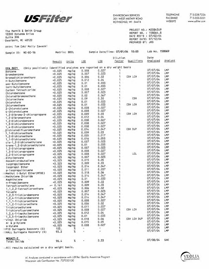
The Mannik & Smith Group 15300 Rotunda Drive Suite 306 Dearborn, MI 48120
ENVIROSCAN SERVICES 301 WEST MILITARY ROAD ROTHSCHILD, WI 5447 4
PROJECT NO.: M208A3U9 REPORT NO. : 158064.8 DATE REC'D : 07/02/04 REPORT DATE : 07/12/04 PREPARED BY: JRS
TELEPHONE FACSIMILE W EBSITE
Attn: Tam Cak/ Mally Zawacki
Sample ID: HC-EC-16 Matrix: SOIL Sample Date/Time: 07/01/04 10:00 Lab Na. 158069
EPA 8021 (Only pa5itively Benzene Bramobenzene Bramodichlaromethane n-Butylbenzene sec-Butyl benzene tert-Butylbenzene Carbon Tetrachloride Chlarobenzene Chlorodibromomethane Chloroe thane Chloroform Chlaromethane 2-Chlarotoluene 4-Chlorotoluene 1,2-Dibromo-3-chloroprapane 1,2-Dibromoethane 1,2-Dichlarobenzene 1,3-Dichlarabenzene 1,4-Dichlarobenzene
ichlorodifluoromethane , 1-Dichlaroethane ,2-Dichloroethane
1, 1-Dichloroethylene cis-1,2-Dichloroethylene trans-1,2-Dichlaroethylene 1,2-Dichlaropropane . 1,3-D i chloropropane 2,2-Dichloropropane Ethyl benzene Hexachlorobutadiene Isoprapylbenzene I soprapyl Ether p·Isopropyltoluene Methyl t - Butyl Ether(MTBE) Methylene Chloride Naphthalene n-Propylbenzene Tetrachloroethylene 1, 1,2,2-Tetrachloroethane Toluene 1~2,3 -Trichlorobenzene 1~2,4-Trichlorobenzene 1,1, 1-Trichloroethane 1, 1,2-Trichlaroethane
- Trichloraethylene Trichlorafluaromethane 1,2,4-Trimethylbenzene 1,3,5-Trimethylbenzene Vinyl Chloride m- & p-Xylene a-Xylene
ID Surrogate Recovery (S) ALL Surrogate Recovery (S)
MOSA21-2 Total Sal ids
identified <0.025 <0.025 <0.025 <0.025 <0.025 <0.025 <0.025 <0.025 <0.025 <0 .025 <0.025 <0.025 <0.025 <0.025 <0.025 <0.025 <0.025 <0.025 <0.025 <0.025 <0.025 <0.025 <0.025 <0.025 <0 . 025 <0.025 <0.025 <0.025 <0.025 <0.025 <0.025 <0 . 025 <0.025 <0.025 <0.025 <0.025 <0.025
,..- 0. 161 <0.025 <0.025 <0.025 <0.025 <0.025 <0.025 <0.025 <0.025 <0.025 <0.025 <0.025 <0.025 <0.025
103. 93.3
96.4
analytes mg/kg mg/kg mg/kg mg/kg mg/kg mg/kg mg/kg mg/kg mg/kg mg/kg mg/kg mg/kg mg/kg mg/kg mg/kg mg/kg mg/kg mg/kg mg/kg mg/kg mg/kg mg/kg mg/kg mg/kg mg/kg mg/kg mg/kg mg/kg mg/kg mg/kg mg/kg mg/kg mg/kg mg/kg mg/kg mg/kg mg/kg mg/kg mg/kg mg/kg mg/kg mg/kg mg/kg mg/kg mg/kg mg/kg mg/kg mg/kg mg/kg mg/kg mg/kg
¾ ¾
¾
All results calculated on a dry weight basis.
are reported on a dry 0.008 0.027 0.007 0.023 0.006 0.02 0.012 0.04 0.01 0.033 0.01 0.033 0.008 0.027 0.007 0.023 0.02 0.067 0.09 0.30 0.01 0.033 0.01 0.033 0.008 0.027 0.008 0.027 0.009 0.03 0.012 0. 04 0.008 0.027 0.008 0.027 0.008 0.027 0.014 0.047 0.009 0.03 0.005 0.017 0.016 0.053 0.007 0.023 0.01 0.033 0 . 007 0.023 0.008 0.027 0.008 0.027 0.007 0.023 0.015 0.05 0.009 0.03 0.014 0.047 0.011 0.037 0.018 0.06 0.014 0.047 0.01 . 0. 033 0.009 0.03 0.009 0.03 0.006 0.02 0.007 0.023 0.014 0. 047 0.014 0.047 0.008 0.027 0.006 0. 02 0.011 0.037 0.008 0.027 0.012 0.04 0.01 0.033 0 . 018 0.06 0.015 0.05 0.008 0.027
0.33
All Analyses conducted in occordonce with USFilter Ouolity Assurance Progrom Wisconsin lob Certificotion No. 737053130
Dilution Date Factor Qual i fiers Analyzed Analyst
weight 1 1 1 1 1 1 1 1 1 1 1 1 1 1 1 1 1 1 1 1 1 1 1 1 1 1 1 1 1 1 1 1 1 1 1 1 1 1 1 1 1 1 1 1 1 1 1 1 1 1 1 1 1
basis
CSH LCH
CSH
CSH LCH
CSH LCH
CSH DUP
LCL
CSH LCH
CSH LCH DUP
07/07/04 07/07/04 07/07/04 07/07/04 07/07/04 07/07/04 07/07/04 07/07/04 07/07/04 07/07/04 07/07/04 07/07/04 07/07/04 07/07/04 07/07/04 07/07/04 07/07/04 07/07/04 07/07/04 07/07/04 07/07/04 07/07/04 07/07/04 07/07/04 07/07/04 07/07/04 07/07/04 07/07/04 07/07/04 07/07/04 07/07/04 07/07/04 07/07/04 07/07/04 07/07/04 07/07/04 07/07/04 07/07/04 07/07/04 07/07/04 07/07/04 07/07/04 07/07/04 07/07/04 07/07/04 07/07/04 07/07/04 07/07/04 07/07/04 07/07/04 07/07/04 07/07/04 07/07/04
LMP LMP LMP LMP LMP LMP LMP LMP LMP LMP LMP LMP LMP LMP LMP LMP LMP LMP LMP LMP LMP LMP LMP LMP LMP LMP LMP LMP LMP LMP LMP LMP LMP LMP LMP LMP LMP LMP LMP LMP LMP LMP LMP LMP LMP LMP LMP LMP LMP LMP LMP LMP LMP
07/08/04 SAK
715-338-7226 715-355-3 22 1
www.usfilter.com

- --..----------U~.= = = ~ ------- ------ ------ -- -----The Mannik & Smith Group 15300 Rotunda Drive
_ uite 306 _ earborn, Ml 48120
ttn: Tom Cok/ Molly Zawacki
ample JD: HC-EC-18
PA 8021 Benzene
(Only positively
romobenzene romodichloromethane -Butyl benzene
sec-Butyl benzene tert-Butylbenzene arbon Tetrachloride hlorobenzene hlorodibromomethane
Chloroethane .hloroform hloromethane -Chlorotoluene -Chlorotoluene
1,2-Dibromo-3-chloropropane ,2-Dibromoethane ,2-Dichlorobenzene ,3-Dichlorobenzene
1,4-Dichlorobenzene
iichlorodifluoromethane , 1-Dichloroethane ,2-Dichloroethane
- , 1-Dichlo_roethylene cis-1,2-Dichloroethylene rans-1,2-Dichloroethylene ,2-Dichloropropane ,3-Dichloropropane
2,2-Dichloropropane
lthylbenzene exachlorobutadiene sopropylbenzene
Jsopropyl Ether
!-Isopropyltoluene ethyl t-Butyl Ether(MTBE) ethylene Chloride aphthalene
n-Propylbenzene etrachloroethylene , 1,2,2-Tetrachloroethane oluene ;2,3-Trichlorobenzene
1~2,4-Trichlorobenzene ,1,1-Trichloroethane ,1,2-Trichloroethane
·richloroethylene Trichlorofluoromethane
,2,4-Trimethylbenzene ,3,5-Trimethylbenzene
1inyl Chloride m- & p-Xylene
-Xylene ID Surrogate Recovery (S) ALL Surrogate Recovery (S)
MOSA21-2 - otal Solids
Matrix: SOIL
identified <0.025 <0.025 <0.025 <0.025 <0.025 <0.025 <0.025 <0.025 <0.025 <0.025 <0.025 <0.025 <0.025 <0.025 <0.025 <0.025 <0.025 <0.025 <0.025 <0.025 <0.025 <0.025 <0.025 <0.025 <0.025 <0.025 <0.025 <0.025 <0.025 <0.025 <0.025 <0.025 <0.025 <0.025 <0.025 <0 . 025 <0.025 <0.025 <0.025 <0.025 <0.025 <0.025 <0.025 <0.025 <0.025 <0.025 <0.025 <0.025 <0.025 <0.025 <0.025
102. 93.0
88.5
analytes mg/kg mg/kg mg/kg mg/kg mg/kg mg/kg mg/kg mg/kg mg/kg mg/kg mg/kg mg/kg mg/kg mg/leg mg/leg mg/leg mg/kg nig/kg mg/kg mg/leg mg/leg mg/leg mg/kg mg/kg mg/kg mg/leg mg/kg mg/kg mg/kg mg/kg mg/leg mg/kg mg/kg mg/leg mg/kg mg/kg mg/leg mg/kg mg/leg mg/kg mg/kg mg/leg mg/kg mg/kg mg/kg mg/kg mg/kg mg/kg mg/kg mg/kg mg/kg
¾ ¾
¾
,ll results calculated on a dry weight basis.
ENVIROSCAN SERVICES
30 l WEST MIUTARY ROAD
ROTHSCHILD, WI 54474
PROJECT NO.: M208A3U9 REPORT NO. : 158064.9 DATE REC'D : 07/02/04 REPORT DATE: 07/12/04 PREPARED BY: JRS
TELEPHONE
FACSIMILE
WEBSITE
Sample Date/Time: 07/01/04 10:45
Dilution
Lab No. 158070
Date Factor Qualif i ers Analyzed Analyst
are reported on a dry we i ght 1
basis 0.008 0.007 0.006 0.012 0.01 0.01 0.008 0.007 0.02 0. 09 0.01 0.01 0.008 0.008 0.009 0.012 0.008 0.008 0.008 0.014 0.009 0.005 0.016 0.007 0.01 0.007 0.008 0.008 0.007 0.015 0.009 0.014 0. 011 0.018 0.014 0. 01 · 0.009 0.009 0.006 0.007 0.014 0.014 0.008 0.006 0.011 0.008 0.012 0.01 0.018 0.015 0.008
0.027 0.023 0.02 0.04 0.033 0.033 0.027 0.023 0.067 0.30 0.033 0.033 0.027 0.027 0.03 0.04 0.027 0.027 0.027 0.047 0.03 0.017 0.053 0.023 0 . 033 0.023 0.027 0.027 0.023 0.05 0.03 0.047 0.037 0.06 0.047 0.033 0.03 0.03 0.02 0.023 0.047 0.047 0.027 0.02 0.037 0.027 0.04 0.033 0.06 0.05 0.027
0.33
1 1 1 1 1 1 1 1 1 1 1 1 1 1 1 1 1 1 1 1 1 1 1 1 1 1 1 1 1 1 1 1 1 1 1 1 1 1 1 1 1 , 1 1 1 1 1 1 1 1 1 1
CSH LCH
CSH
CSH LCH
CSH LCH
CSH DUP
LCL
CSH LCH
CSH LCH DUP
07 /07 /04 07 /07 /04 07 /07 /04 07/07/04 07/07/04 07/07/04 07/07/04 07/07/04 07/07 /04 07/07/04 07/07/04 07/07/04 07/07/04 07/07/04 07/07/04 07/07/04 07 /07 /04 07 /07 /04 07 /07 /04 07/07/04 07/07/04 07/07/04 07/07/04 07 /07 /04 07/07/04 07/07/04 07 /07 /04 07/07/04 07 /07 /04 07 /07 /04 07 /07 /04 07/07/04 07 /07 /04 07/07/04 07/07/04 07/07/04 07/07/04 07/07/04 07/07/04 07/07/04 07/07/04 07/07/04 07/07/04 07 /07 /04 07/07/04 07/07/04 07/07/04 07/07/04 07/07/04 07 /07 /04 07 /07 /04 07/07/04 07/07/04
LMP LMP LMP LMP LMP LMP LMP LMP LMP LMP LMP LMP LMP LMP LMP LMP LMP LMP LMP LMP LMP LMP LMP LMP LMP LMP LMP LMP LMP LMP LMP LMP LMP LMP LMP LMP LMP LMP LMP LMP LMP LMP LMP LMP LMP LMP LMP LMP LMP LMP LMP LMP LMP
07/08/04 SAK
All Analyses conducted in accordance with USFilter Quality Assurance Program
Wisconsin Lob Certification No. 737053 J-30
715-33B-7226
715-355-322 l
www.usfilter.com

U~===~ - --~--------------~ - ------ ------ -- _._.._ ENVIROSCAN SERVICES 301 WEST MILITARY ROAD ROTHSCHILD, WI 5447 4
I .k . he Manni & Smith Group 5300 Rotunda Drive
Suite 306 earborn, Ml 48120
,ttn: Tom Cok/ Molly Zawacki
- )ual ifier Descriptions
CSH
CSL
LCH
DUP
LCL
' ·
Check standard for this Sample results may also
Check standard for th i s Sample results may also
Estimated concentration level.
analyte exhib i ted a high bi as. be biased high.
analyte exhibited a low bias. be biased low.
belo1-1 laboratory quantitation
PROJECT NO.: M208A3U9 REPORT NO. : 158064.10 DATE REC'D : 07/02/04 REPORT DATE: 07/12/04 PREPARED BY: JRS
The laboratory control sample for this analyte exibited a high bias. Sample results may also be biased hi gh .
Result of duplicate analysis in this quality assurance batch exceeds the limits for precision .
The laboratory control sample for this analyte exibited a low bias. Sample results may also be biased lo1-1.
All Analyses conducted in accordance with USFilter Ouolity Assurance Program Wisconsin Lob Certification No. 737053 I 30
TELEPHONE FACSIMILE WEBSITE
715-33B-7226 715-355-3 221
www.usfilter.com

I
U~----~-=-=-.- --=-=====iir = ===-==
ENVIROSCAN SERVICES 30 1 W EST MILITARY ROAD ROTHSCHILD, WI 5AA7 A
TELEPHONE FACSIMILE W EBSITE
Sample Receipt Report
Client: Date Received: _l_t )..__ I 0 ½
Check all deviations from EPA or WDNR sample protocol.
[ ]
[ ]
Sample(s) received at __ °C which is above the EPA and WDNR limit of 4 °C.
VOC vial(s) received with headspace. Explain:
800-338-7226 7 15-355-322 l
www.usfi lter.com
[ ]
[ ]
Sample(s) received in bottles not furnished by Enviroscan. Preservation method, if used, is unknown.
[ ]
[ l
[ ]
[ ]
[ ]
Sample(s) not properly preserved per EPA/WDNR protocol for the following:
Sample(s) received beyond EPA holding time for:
Sample date/time not supplied by client. Actual holding time unknown.
GRO/PVOCNOC/DRO (circle appropriate) sample(s) are < 19.5 gms and this report is the flag for that information. Sample(s) under-weight: ______________ _
GRO/PVOCNOC (circle appropriate) sample(s) were between 26.4-35.4 gms so methanol ~as added in a 1:1 ratio . Sample(s) included: 't" 15-yc;e,9: f- 5.,;n r
/.:>-.Yu 7cJ f . •-:r,
GRO/PVOCNOC/DRO ( circle appropriate) sample(s) were > 35 .4 gms and are required to be rejected. Sample(s) included: ___________________ _
Other:
Client contact concerning the above deviations:
Client ___________ (contact name) notified of the above deviation(s) on _/_/_ at __ : __ am/pm by and the client ordered:
[ ] [ ]
(signature) Proceed with analyses as ordered. Proceed with analyses after talcing the following corrective action:
[ J Do NOT proceed with analyses.
All Anolyses conducted in occordonce with USFil!er Ouol ity Assuronce Program
Wisconsin Lob Certification No. 737053130

ENVIROSCAN SERVICES 301 W. MILITARY RD.
REPORT T9: \\ # -Name: j ,0tVi UJ kJ ~a ~ . lAXt~l I Company n.~ '.~aAn.£~- :~?~,!~TIC. Address: ~~~r~:,&q~-~~ Phone: ( 3 \ 3 )-9~3-..........._I -...... J ....... :)=2=3'------P.0.# -~--~-------------Project# Pt am,A30 q Quote# Location r\ Q. \es Cc1,, ef:'5).0I.
Sample Type (C,heck all that apply)
Ji( Groundwater 0 Wastewater 0 Soil/Solid 0 Drinking Water 0 Oil O Vapor 0 Other
Turnaround Time )!!. Normal 0 Rush (Pre-approved by Lab)
Date Needed ___ _ Approved By
No. of
ROTHSCHILD, WI 54474 1-800-338-SCAN
BILL TO: (if different from Report To info) Name: ______________ _
Company: Address: _____________ _
Phone: ( _______________ _
ANALYTICAL REQUESTS (use separate sheet if necessary)
LAB USE ONLY DATE TIME SAMPLE ID REMARKS
90158064 a i,i..,l
9015806S ·90158066 90158067
90158068 90158069 90158◊70
Del'v: Hand ~ Ship. Cont. OK ~N N/A Samples leaking? ~NIA i Seals OK? (!!_ N N/A - -Rec'd on ice? t!J N N/A J-'·c
{. Comments:
RECEIVED BY: (Signature)
UPS RECEIVED BY: (Signature)
RELINQUISHED BY: (Signature) DATE/flME DATE/TIME
J;)o (5 ()

'i:f'~1W!'.~•'/· ~·7s-:-~:1x~~::'.''.~']" ":r·-·:,· ,,. : ·c.c .. ,;: ·' ~ •. ·:;t!;~t·ii~i;i;'.;: · · ;:'.-,: :,s~r, ,, ,. ,
·■w1;1u,111111,1,1-a· .. ~= :'..ii:~:. .· .· ,,:,\t
·• . r-.. · -- __, _ __,_ . -- ...... ~
· ENVIROSCAN SERVICES 301 W. MILITARY RD. ROTHSCHILD, WI 54474 1-800-338-SCAN .
BILL TO: (if different from Report To info) Name: _______________ _
Company:
Address:------'----------
Phone: Phone:{ __ _
P.O.# ----.----,--,........,----,.-=-----~-----Project# ~~~~-~-Location
Sample Type (Check all that apply)
Ji( Groundwater 0 Wastewater 0 Soil/Solid
~rnaround Time )1::- Normal 0 Rush (Pre-approved by Lab)
0 Drinking Water 0 Oil O Vapor O Other
.. LAB USE ONLY . DATE
. '")t .. ' .. . :····, . . .-. .. ·.,..-..
:: : ,••
Date Needed Approved By
No. of TIME Containers
3 3
. ·. ::,;_ : .,., '1 l i .l 'i I l ·. ?-1'1 - :~ I t '.. ~ ~ J
-\.:_;,,
RELINQUISHED B'f. Signature) 1
·)
RELINQUISHED BY: (Signature) DATE/TIME
SAMPLE ID
H(-[(-1i X
RECEIVED BY: (Signature)
UPS RECEIVED BY: (Signature)
RECEIVED FOR LABORATORY BY: (Signature)
ANALYTICAL REQUESTS (use separate sheet if necessary)
REMARKS
Comments:
.DATE/TIME
I
I
I
A Siemens
The Mannik & Smith Group, Inc.
September 7, 2 OOi:'.l:
The Mannik & Smith Group 15300 Rotunda Drive Suite 306 Dearborn, MI 48120
Attn: Tom Cok
REPORT NO.: 161531
ENVIROSCAN SERVICES 301 WEST MILITARY ROAD ROTHSCHILD, WI 54474
TELEPHONE FACSIMILE WEBSITE
PROJECT NO.: M208A3U9D
Please find enclosed the analytical report, including the Sample Summary, Sample Narrative and Chain of Custody for your sample set received August 26, 2004.
All analyses were performed in accordance with approved methods as indicated on this report.
If you have any qu~stions about the results, please call. Thank you for using USFilter, Enviroscan Services for your analytical needs.
Sincerely,
USFilter, Enviroscan Services
Eric A. Lorge Project Manager
800-338-722 6 715-355-3221
www.usfilter.com·
I certify thru the drua conwined in this reporr has been genermed and reviewed in accordance with the USFilter, Enviruscan Services Q11ality Asrnrm,re Program .
Exceptions, if any, are discussed in the sample narrative. Samples will be rewined for JO days from 1he date ·uf this report. then di,posed in 1111 11ppropriote """""'' ·
USFilter, Enviroscan Services reserves the righc co return samples identified as hazardous. Release of this Final Report is auihori~ed as verified by the following sig1111t11re.
Approved by:
Certifications: Wisconsin 737053130 Minnesota 055-999-302 Maryland 276
Oregon (WI-100001) Illinois 200025 Washington C293
'·
u.~===: - ------------------~ - ------ ------ -----A Siemens Business
ENVIROSCAN SERVICES 301 WEST MILITARY ROAD ROTHSCHILD. WI 54474
TELEPHONE FACSIMILE WEBSITE
800-338-7226 715-355-3221
www.usfilter.com
Sample Surrmary 161531.2
Lab Id 161531 161532 161533 161534 161535
Client Sample ID HA6 1-1. 5' HA6 4.5-5' HAS 1 -1 . 5' HAS 4.5-5' MECH BLANK -U SF
Date/Time 08/24/04 08/24/04 08/24/04 08/24/04 08/24/04
16:30 16:40 17: 10 17: 25
Matrix SOIL SOIL SOIL SO IL SOIL
Sample Narrative/Sample Sratus
GENERAL:
ANALYSES:
REPORTING:
Definitions
LCD= Limit of Detection (Not dilution corrected) LOQ = Limit of Quantitation (Not dilution corrected) <=Less Than COMP= Complete SUBCON = Subcontracted analysis mv = millivolts pCi/l = picocurie per liter ml/l = mililiters/Liter mg= milligrams
µg/l = Micrograms per liter= parts per billion (ppb) µg/kg = Micrograms per kilogram= parts per billion (ppb) mg/l = Milligrams per liter= parts per million (ppm) mg/kg= Milligrams per kilogram= parts per million (ppm) NOT PRES= Not Present ppth = Parts per thouland (S) = Surrogate Compound mg/m3 = Milligrams/meter cube

u~----- ENVIROSCAN SERVICES TELEPHONE 800-338-7226 =---=~----------- 301 WEST MILITARY ROAD FACSIMILE 715-355-3221 =-===-~=-- ----- ROTHSCHILD, WI 54474 WEBSITE www.usfilter.com
A Siemens Business
The Mannik & Smith Group PROJECT NO.: M208A3U9D
15300 Rotunda Drive REPORT NO. : 161531.7
Suite 306 DATE REC'D : 08/26/04
Dearborn, Ml 48120 REPORT DATE: 09/07/04 PREPARED BY: EAL
Attn: Tom Cok
Sample ID: HAS 1-1.5 I Matrix: SOIL Sample Date/Time: 08/24/04 17: 10 Lab No. 161533
Dilution Date Result Uni ts LOD LOO Factor Qualifiers Analyzed Analyse
EPA 8260 Benzene <56.4 JLg/kg 1. 0 3.33 50 09/01/04 MPM
Bromobenzene <56.4 /L9/kg 1. 0 3.33 50 09/01/04 MPM
Bromochloromethane <56.4 /L9/kg 1.0 3.33 50 09/01/04 MPM
Bromodichloromethane <56.4 JLg/kg 1. 0 3.33 50 09/01/04 MPM
Bromoform <56.4 JLg/kg 1.0 3.33 50 09/01/04 MPM
Bromomethane <56.4 JLg/kg 1.0 3.33 50 LCL 09/ 01/04 MPM
n-Butylbenzene <56.4 JLg/kg 1. 0 3.33 50 09/01 / 04 MPM
sec-Butyl benzene <56.4 /L9/kg 1. 0 3.33 50 09/01/04 MPM
tert·Butylbenzene <56.4 JLg/kg 1. 0 3.33 50 09/01/04 MPM
Carbon Tetrachloride <56.4 JLg/kg 1. 0 3.33 50 09/01/04 MPM
Chlorobenzene <56.4 JLg/kg 1. 0 3.33 50 09/01/04 MPM
Chloroethane <56.4 /Lg/kg 1.0 3.33 50 09/01/04 MPM
Chloroform <56.4 JLg/kg 1. 0 3.33 50 09/01/04 MPM
Chloromethane 80.8 JLg/kg 1. 0 3.33 50 09/01/04 MPM
2-Chlorotoluene <56.4 /L9/kg 1 . 0 3.33 50 09/01/04 MPM
4-Chlorotoluene <56.4 /Lg/kg 1.0 3.33 50 09/01/04 MPM
Dibromochloromethane <56.4 JLg/kg 1.0 3.33 50 09/01/04 MPM
Dibromochloropropane(DBCP) <56.4 /Lg/kg 1.0 3.33 50 CSH 09/01/04 MPM
1,2-Dibromoethane(EDBJ <56.4 JLg/kg 0.4 1.33 50 LCH CSH 09/01/04 MPM
Dibromomethane <56 . 4 JLg/kg 1. 0 3.33 50 LCH 09/01/04 MPM
1,2-Dichlorobenzene <56.4 JLg/kg 1. 0 3.33 50 09/01/04 MPM
1,3-Dichlorobenzene <56.4 JLg/kg 0.5 1.67 50 09/01/04 MPM
1,4-Dichlorobenzene <56.4 JLg/kg 1.0 3.33 50 09/01/04 MPM Dichlorodifluoromethane <56.4 JLg/kg 1. 0 3.33 50 LCH CSH 09/01/04 MPM
1, 1-Dichloroethane <56.4 JLg/kg 1 . 0 3.33 50 09/01/04 MPM 1,2-Dichloroethane <56.4 JLg/kg 1.0 3.33 50 09/01/04 MPM 1, 1-Dichloroeth(yl)ene <56.4 JLg/kg 1 . 0 3.33 50 09/01/04 MPM cis-1,2-Dichloroeth(yl)ene <56.4 JLg/kg 1 . 0 3.33 50 09/01/04 MPM trans-1,2-Dichloroethylene <56.4 JLg/kg 1.0 3.33 50 09/01/04 MPM
I 1,2-Dichloropropane <56 . 4 JLg/kg 1. 0 3.33 50 09/01/04 MPM
1,3-Dichloropropane <56.4 JLg/kg 1. 0 3.33 50 09/01/04 MPM
2,2-Dichloropropane <56.4 JLg/kg 1. 0 3.33 50 09/01/04 MPM
1, 1-Dichloropropene <56.4 JLg/ kg 1.0 3.33 50 09/01/04 MPM cis-1,3-Dichloropropene <56 .4 /L9/kg 1. 0 3 .33 50 09/01/04 MPM
trans-1,3-Dichloropropene <56.4 JLg/kg 0 .5 1.67 50 09/01/04 MPM
Ethyl benzene <56.4 JLg/kg 1 .0 3.33 50 09/01/04 MPM
Hexachlorobutadiene <56.4 /L9/kg 1.0 3.33 50 09/01/04 MPM
Isopropylbenzene <56.4 JLg/kg 1. 0 3.33 50 09/01/04 MPM
4-Isopropyltoluene <56.4 JLg/kg 1.0 3.33 50 09/01/04 MPM
Methylene Chloride <56.4 JLg/kg 1. 0 3.33 50 09/01/04 MPM
Methyl t-Butyl Ether(MTBE) <56.4 JLg/kg 1 . 0 3.33 50 09/01/04 MPM
Naphthalene <56.4 JLg/kg 1. 0 3.33 50 09/01/04 MPM
n-Propylbenzene <56.4 /L9/kg 1 . 0 3.33 50 09/01/04 '-MPM
Styrene <56.4 JLg/kg 1.0 3.33 50 09/01/04 MPM
1,1, 1,2-Tetrachloroethane <56.4 JLg/kg 1. 0 3.33 50 09/01/04 MPM
1,1,2,2-Tetrachloroethane <56.4 JLg/kg 1. 0 3.33 50 09/01/04 MPM
Tetrachloroeth(yl)ene 609. JLg/kg 1. 0 3.33 50 09/01/04 MPM
Toluene <56.4 JLg/kg 1.0 3.33 50 09/01/04 MPM
1,2i3-Trichlorobenzene <56.4 JLg/kg 1.0 3.33 50 09/01/04 MPM
1,2,4-Trichlorobenzene <56.4 JLg/ kg 1 . 0 3.33 50 09/01/04 MPM
1, 1, 1-Trichloroethane <56.4 JLg/kg 1. 0 3.33 50 09/01/04 MPM
1, 1,2-Trichloroethane <56.4 /L9/kg 1. 0 3.33 50 09/01/04 MPM
All results calculated on a dry weight basis.
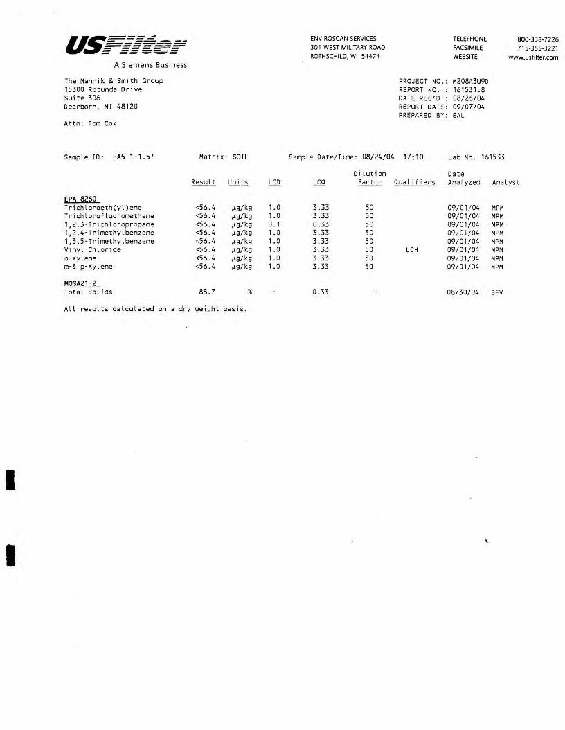
I
I
u.~-----::=---,:-=- - --------------~ - ------ ------ -----A Siemens Business
The Mannik & Smith Group 15300 Rotunda Drive Suite 306 Dearborn, Ml 48120
Attn: Tom Cok
Sample ID: HAS 1-1.5'
EPA 8260 Trichloroeth(yl)ene Trichlorofluoromethane 1,2,3-Trichloropropane 1,2,4-Trimethylbenzene 1,3,5-Trimethylbenzene Vinyl Chloride a-Xylene m-& p-Xylene
M0SA21-2 Total Sol ids
Matr ix : SOIL
Result Uni ts
<56.4 µg/kg <56.4 µg/kg <56.4 µg/kg <56.4 µg/kg <56.4 µg/kg <56.4 µg/kg <56.4 µg/kg <56.4 µg/kg
88.7 %
All results calculated on a dry weight basis.
LOO
1.0 1. 0 0. 1 1.0 1.0 1.0 1. 0 1 . 0
ENVIROSCAN SERVICES 301 WEST MILITARY ROAD ROTHSCHILD, WI 54474
Samp l e Date/Time: 08/24/04
Di lution LOO Facto r
3.33 50 3.33 50 0.33 50 3.33 50 3.33 50 3.33 50 3.33 50 3.33 50
0.33
TELEPHONE FACSIMILE WEBSITE
PROJECT NO.: M208A3U9D REPORT NO. : 161531.8 DATE REC'D : 08/26/04 REPORT DAT E: 09/07/04 PREPARED BY: EAL
800-338-7226 715-355-3221
www.usfilter.com
17: 10 Lab No. 161533
Date Qualifiers Analyzed Analyst
09/01/04 MPM 09/01/04 MPM 09/01/04 MPM 09/01/04 MPM 09/01/04 MPM
LCH 09/01/04 MPM 09/ 01/04 MPM 09/01 /04 MPM
08/30 / 04 BFV

u~===~ ENVIROSCAN SERVICES TELEPHONE 800-338-7226 - ------------------ 301 WEST MILITARY ROAD FACSIMILE 715-355-3221 - ------ ------ ----- ROTHSCHILD, WI 54474 WEBSITE www.usfilter.com
A Siemens Business
The Mannik & Smith Group PROJECT NO.: M208A3U9D
15300 Rotunda Drive REPORT NO. : 161531.9
I Suite 306 DATE REC'D : 08/26/04
Dearborn, Ml 48120 REPORT DATE: 09/07/04 PREPARED BY: EAL
Attn: Tom Cok
Sample ID: HAS 4.5-5' Matrix: SOIL Sample Date/Time: 08/24/04 17:25 Lab No. 161534
Dilution Date Result Units LOO LOO Factor Qualifiers Analtzed Ana lyst
I EPA 8260 Benzene <60.7 JL9/kg 1.0 3.33 50 09/01/04 MPM
Bromobenzene <60.7 JLg/kg 1.0 3.33 50 09/01/04 MPM
Bromochloromethane <60.7 JLgfkg 1. 0 3.33 50 09/01/04 MPM
Bromodichloromethane <60.7 JLgfkg 1.0 3.33 so 09/0 1/04 MPM
Bromoform <60 . 7 JLg/kg 1.0 3.33 so 09/01/04 MPM
Bromomethane <60.7 JLg/kg 1.0 3.33 50 LCL 09/01/04 MPM
n·Butylbenzene <60.7 JL9/kg 1.0 3.33 so 09/01/04 MPM
sec-Butyl benzene <60.7 JL9/kg 1.0 3.33 50 09/01/04 MPM
tert·Butylbenzene <60.7 JLg/kg 1.0 3.33 so 09/01/04 MPM
Carbon Tetrachloride <60 . 7 JL 9/kg 1.0 3.33 50 09/01/04 MPM
Chlorobenzene <60.7 JLg/kg 1. 0 3.33 50 09/01/04 MPM
Chloroethane <60.7 JL9/kg 1. 0 3.33 so 09/01/04 MPM
Chloroform <60.7 JLg/kg 1. 0 3.33 so 09/01/04 MPM
Chloromethane 77.8 JL9/kg 1.0 3.33 so 09/01/04 MPM
2-Chlorotoluene <60.7 JLg/kg 1. 0 3.33 so 09/01/04 MPM
4· Chlorotoluene <60.7 JLg/kg 1.0 3.33 so 09/01/04 MPM
Dibromochloromethane <60.7 JLg/kg 1. 0 3.33 50 09/01/04 MPM
0ibromochloropropane(DBCP) <60.7 JLg/kg 1.0 3.33 50 CSH 09/01/04 MPM
1,2-Dibromoethane(EDB) <60.7 JLg/kg 0.4 1.33 50 LCH CSH 09/01/04 MPM
Dibromomethane <60.7 JLg/kg 1.0 3.33 50 LCH 09/01/04 MPM
1,2-Dichlorobenzene <60.7 JLg/kg 1. 0 3.33 50 09/01/04 MPM
1,3-0ichlorobenzene <60.7 JLg/kg 0.5 1.67 50 09/01/04 MPM
1,4-D i chlorobenzene <60.7 JL9/kg 1.0 3.33 50 09/01/04 MPM
0ichlorodifluoromethane <60.7 JLg/kg 1. 0 3.33 so LCH CSH 09/01/04 MPM
1, 1-Dichloroethane <60.7 JL9/kg 1. 0 3 . 33 50 09/01/04 MPM
1,2-Dichloroethane <60.7 JL9/kg 1.0 3.33 50 09/01/04 MPM
1, 1-Dichloroeth(yl)ene <60.7 JLgfkg 1.0 3.33 50 09/01/04 MPM
cis·1,2·Dichloroeth(yl)ene <60.7 JL9/kg 1.0 3.33 so 09/01/04 MPM
trans·1,2·Dichloroethylene <60.7 JLg/kg 1 .0 3.33 so 09/01/04 MPM
1,2 -Dichloropropane <60.7 JLg/kg 1 .0 3.33 50 09/01/04 MPM
1,3-Dichloropropane <60 .7 JLg/kg 1.0 3.33 so 09/01/04 MPM
2,2-0ichloropropane <60.7 JL9/kg 1. 0 3.33 so 09/01/04 MPM
1, 1-Dichloropropene <60.7 JL9/kg 1.0 3.33 so 09/01/04 MPM
I cis-1,3-Dichloropropene <60.7 JLg/kg 1.0 3.33 50 09/01/04 MPM
trans·1,3·Dichloropropene <60.7 JLgfkg 0.5 1 .67 50 09/01/04 MPM
Ethyl benzene <60.7 JL9/kg 1.0 3.33 50 09/01/04 MPM
Hexachlorobutadiene <60.7 JLg/kg 1. 0 3.33 50 09/01/04 MPM
Isopropylbenzene <60.7 JLg/kg 1.0 3.33 50 09/01/04 MPM
4-Isopropyltoluene <60.7 JLg/kg 1.0 3.33 50 09/01/04 MPM
Methylene Chloride <60.7 JLg/kg 1. 0 3.33 50 09/01/04 MPM
Methyl t·Butyl Ether(MTBE) <60.7 JLg/kg 1. 0 3.33 50 09/01/04 MPM
Naphthalene <60 . 7 JL9/kg 1. 0 3 .33 50 09/01/04 MPM
n·Propylbenzene <60.7 JLgfkg 1 . 0 3.33 50 09/01/04 '-MPM
Styrene <60 . 7 JLgfkg 1.0 3.33 50 09/01/04 MPM
1,1,1,2-Tetrachloroethane <60.7 JLg/kg 1.0 3.33 50 09/01/04 MPM
1, 1,2,2-Tetrachloroethane <60.7 JL9/kg 1. 0 3.33 50 09/01/04 MPM
Tetrachloroeth(yl)ene 1,570. JL9/kg 1.0 3.33 50 09/01/04 MPM
Toluene <60.7 JLg/kg 1. 0 3.33 50 09/01/04 MPM
1,2,3-Trichlorobenzene <60.7 JLgfkg 1. 0 3.33 50 09/01/04 MPM
1,2,4-Trichlorobenzene <60.7 JLg/kg 1.0 3.33 50 09/01/04 MPM
1, 1, 1-Trichloroethane <60.7 JLg/kg 1. 0 3.33 50 09/01/04 MPM
1, 1,2-Trichloroethane <60.7 JLg/kg 1. 0 3.33 50 09/01/04 MPM
All results calculated on a dry weight basis.

u~:===: ENVIROSCAN SERVICES TELEPHONE 800-338-7226 - ------------------- 301 WEST MILITARY ROAD FACSIMILE 71S-355-3221 - ------ ------ ----- ROTHSCHILD. WI 54474 WEBSITE www.usfilter.com A Siemens Business
The Mannik & Smith Group PROJECT NO.: M208A3U9D
I 15300 Rotunda Drive REPORT NO. : 161531.10 Suite 306 DATE REC'D : 08/26/04 Dearborn, Ml 48120 REPORT DATE: 09/07/04
PREPARED BY : EAL Attn: Tom Cok
Sample ID: HAS 4.5-5' Matri x : SOIL Sample Date/Time: 08/24/04 17:25 Lab No. 161534
Dilution Date Result Uni ts LOD LOO Factor Qualifiers Anal:z:zed Anal :z:s t
EPA 8260 Trichloroeth(yl)ene <60.7 µ.g/kg 1.0 3.33 50 09/01/04 MPM Trichlorofluoromethane <60.7 µ.g/kg 1. 0 3.33 50 09/01/04 MPM 1,2,3-Trichloropropane <60.7 µ.g/kg 0.1 0.33 50 09/01/04 MPM 1,2,4 -Trimethylbenzene <60.7 µ.g/kg 1. 0 3.33 50 09/01/04 MPM 1,3,5-Trimethylbenzene <60.7 µ.g/kg 1. 0 3.33 50 09/01/04 MPM Vinyl Chloride <60.7 µ.g/kg 1.0 3 .33 50 LCH 09/01/04 MPM a-Xylene <60.7 µ.g/kg 1.0 3.33 50 09/01/04 MPM m-& p-Xylene <60 . 7 µ.g/kg 1. 0 3.33 50 09/01/04 MPM
HOSA21-2 Total Sol ids 82.4 % 0.33 08/30/ 04 BFV
All results calculated on a dry weight basis.
I
I

u~----- ENVIROSCAN SERVICES TELEPHONE 800-338-7226 ,=---=~----------------- 301 WEST MILITARY ROAD FACSIMILE 715-355-3221 - ------ ------ ----- ROTHSCHILD, WI 54474 WEBSITE www.usfilter.com
A Siemens Business
The Mannik & Smith Group PROJECT NO_: M208A3U9D
15300 Rotunda Drive REPORT NO_ : 161531 .3
Suite 306 DATE REC'D : 08/26/04
Dearborn, Ml 48120 REPORT DATE: 09/07/04 PREPARED BY: EAL
Attn: Tom Cok
Sample ID: HA6 1-1-5' Matr ix : SOIL Sample Date/Time: 08/24/04 16:30 Lab No. 161531
Di lu tion Date Result Units LOO LOO Factor Qualif i ers Ana l ):'.Z ed Anal):'.St
EPA 8260 Benzene <54 . 9 JL9/kg 1. 0 3.33 so 09/ 01/04 MPM Bromobenz.ene <54.9 JLg/kg 1.0 3.33 so 09/ 01/04 MPM
Bromochloromethane <54.9 JLg/kg 1.0 3.33 50 09/ 01/04 MPM Bromodichloromethane <54.9 JLg/kg 1.0 3.33 so 09/01/04 MPM
Bromoform <54.9 JLg/kg 1.0 3.33 so 09/01/04 MPM Bromomethane <54_9 JLg/kg 1.0 3.33 so LCL 09/01/04 MPM n-Butylbenz.ene <54.9 JLg/kg 1. 0 3.33 so 09/ 01/04 MPM sec-Butylbenz.ene <54.9 JLg/kg 1. 0 3.33 so 09/ 01/04 MPM
tert -Butylbenz.ene <5 4 .9 J.Lg/kg 1. 0 3.33 so 09/ 01 / 04 MPM Carbon Tetrachloride <54.9 JLg/kg 1. 0 3 . 33 so 09/ 01 / 04 MPM
Chlorobenz.ene <54.9 µ.g/kg 1 .0 3 . 33 50 09/01 / 04 MPM
Chloroethane <54.9 JLg/kg 1. 0 3.33 so 09/01/04 MPM
Chloroform <54.9 JLg/kg 1. 0 3.33 so 09/ 01/04 MPM
Chloromethane <54.9 µ.g/kg 1. 0 3 .33 so 09/01/04 MPM
2-Chlorotoluene <54.9 JLg/kg 1. 0 3.33 so 09/ 01/04 MPM
4-Chlorotoluene <54.9 JLg/kg 1.0 3.33 so 09/01/04 MPM
Dibromochloromethane <54.9 µ.g/kg 1 .0 3.33 so 09/01/04 · MPM Dibromochloropropane(DBCP) <54.9 JL9/kg 1.0 3.33 50 CSH 09/01/04 MPM
1,2-Dibromoethane(EDB) <54.9 µ.g/kg 0.4 1.33 50 LCH CSH 09/01/04 MPM
Dibromomethane <54.9 µ.g/kg 1.0 3.33 50 LCH 09/01/04 MPM
1,2-Dichlorobenz.ene <54.9 µ.g/kg 1. 0 3.33 50 09/01/04 MPM 1,3-Dichlorobenz.ene <54.9 µ.g/kg 0.5 1.67 50 09/01/04 MPM 1,4-0ichlorobenz.ene <54.9 µ.g/kg 1.0 3.33 50 09/01/04 MPM Dichlorodifluoromethane <54.9 µ.g/kg 1.0 3.33 so LCH CSH 09/01/04 MPM
1,1-Dichloroethane <54 .9 µ.g/kg 1.0 3.33 50 09/01/04 MPM 1,2-Dichloroethane <54.9 µ.g/kg 1.0 3.33 50 09/01/04 MPM 1, 1-Dichloroeth(yl)ene <54.9 µ.g/kg 1.0 3.33 so 09/01/04 MPM cis-1,2-Dichloroeth(yl)ene <54.9 µ.g/kg 1.0 3.33 so 09/01/04 MPM trans-1,2-Dichloroethylene <54.9 JLg/kg 1 . 0 3.33 so 09/01/04 MPM 1,2-Dichloropropane <54.9 µ.g/kg 1.0 3.33 so 09/01/04 MPM 1,3-Dichloropropane <54 .9 JLg/kg 1.0 3.33 so 09/01/04 MPM 2,2-Dichloropropane · <54. 9 JL9/kg 1. 0 3.33 so 09/01/04 MPM 1,1-Dichloropropene <54.9 JL9/kg 1 . 0 3.33 so 09/01/04 MPM
I cis-1,3-Dichloropropene <54.9 µ.g/kg 1.0 3.33 so 09/01/04 MPM trans-1,3-Dichloropropene <54.9 µ.g/kg 0.5 1.67 so 09/01/04 MPM Ethylbenz.ene <54.9 JLg/kg 1. 0 3.33 50 09/01/04 MPM
Hexachlorobutadiene <54.9 µ.g/kg 1.0 3.33 50 09/01/04 MPM lsopropylbenzene <54.9 µ.g/kg 1. 0 3.33 so 09/01/04 MPM
4-Isopropyltoluene <54.9 µ.g/kg 1.0 3.33 so 09/01/04 MPM Methylene Chloride <54.9 JL9/kg 1.0 3.33 so . 09/01/04 MPM
Methyl t-Butyl Ether(MTBE) <54.9 JL9/kg 1. 0 3.33 so 09/01/04 MPM
Naphthalene <54.9 JLg/kg 1.0 3.33 50 09/01/04 MPM
n-Propylbenzene <54.9 µ.g/kg 1.0 3.33 50 09/01/04 '- MPM
Styrene <54.9 µ.g/kg 1. 0 3.33 so 09/01 / 04 MPM
1, 1,1,2-Tetrachloroethane <54.9 µ.g/kg 1. 0 3.33 so 09/01/04 MPM
1,1,2,2-Tetrachloroethane <54.9 µ.g/kg 1. 0 3.33 50 09/01/04 MPM
Tetrachloroeth(yl)ene <54.9 µ.g/kg 1. 0 3.33 50 09/01/04 MPM
Toluene <54.9 µ.g/kg 1.0 3.33 so 09/01/04 MPM
1,2;3-Trichlorobenzene <54.9 µ.g/kg 1.0 3.33 50 09/01/04 MPM
1,2,4-Trichlorobenzene <54.9 µ.g/kg 1.0 3.33 50 09/01/04 MPM
1, 1, 1-Trichloroethane <54.9 µ.g/kg 1.0 3.33 50 09/01/04 MPM
I 1,1,2-Trichloroethane <54.9 µ.g/kg 1.0 3.33 50 09/01/04 MPM
All results calculated on a dry weight basis.
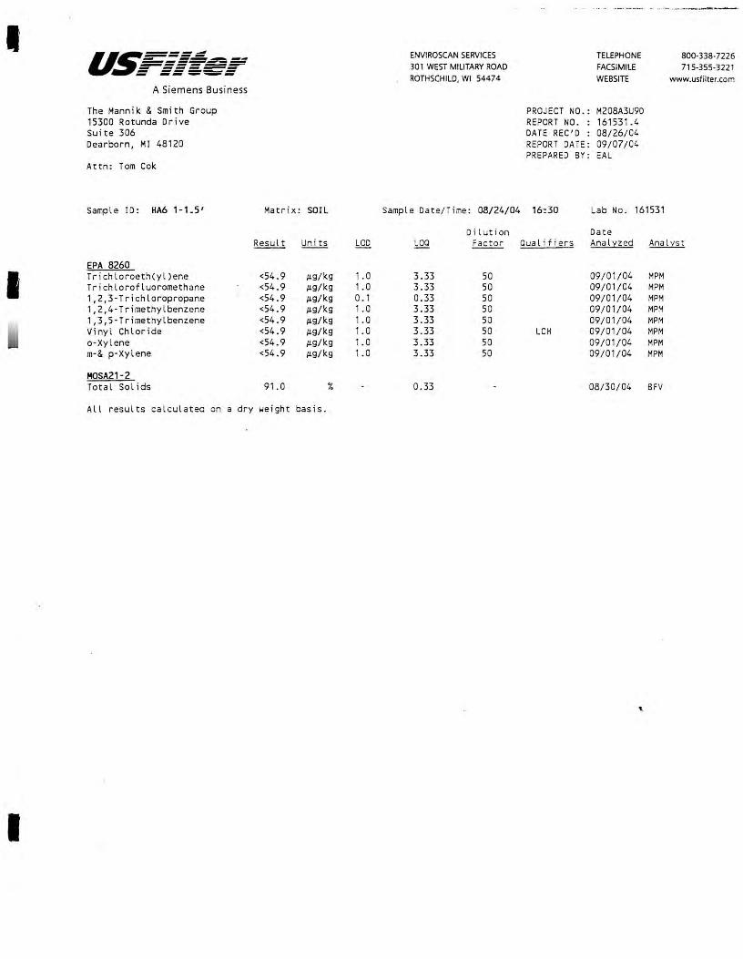
I u~===-==r ENVIROSCAN SERVICES - ----- TELEPHONE 800-338-7226 ------------- 301 WEST MILITARY ROAD FACSIMILE 715-355-3221 - ------ ------ ----- ROTHSCHILD, WI 54474 WEBSITE www.usfilter.com A Siemens Business
The Mannik & Smith Group PROJECT NO.: M208A3U90 15300 Rotunda Drive REPORT NO. : 161531.4 Suite 306 DATE REC'D : 08/26/04 Dearborn, MI 48120 REPORT DATE: 09/07/04
PREPARED SY: EAL Attn: Tom Cok
Sample ID: HA6 1-1.5' Matr ix : SOIL Sample Date/ Time: 08/24/04 16:30 Lab No. 161531
Di lution Date Result Uni ts LOO LOO Factor Qualifiers Analz:zed Analz:st
EPA 8260
I Trichloroeth(yl)ene <54.9 µ.g/kg 1 .0 3.33 50 09/01/04 MPM Trichlorofluoromethane <54.9 µ.g/kg 1.0 3.33 50 09/01/04 MPM 1,2,3-Trichloropropane <54.9 µ.g/kg 0. 1 0.33 50 09/01/04 MPM 1,2,4-Trimethylbenzene <54.9 µ.g/kg 1.0 3.33 50 09/01/04 MPM 1,3,5-Trimethylbenzene <54.9 µ.g/kg 1.0 3.33 50 09/01/04 MPM Vinyl Chloride <54.9 µ.g/kg 1.0 3.33 50 LCH 09/01/04 MPM a -Xy lene <54.9 µ.g/kg 1.0 3 .33 50 09/01/04 MPM m·& p-Xylene <54.9 µ.g/kg 1.0 3.33 50 09/01/04 MPM
MOSA21-2 Total Sol ids 91.0 % 0.33 08/30/04 BFV
All results calculated on a dry weight basis.
I

u~=====~ ENVIROSCAN SERVICES TELEPHONE 800-338-7226 - ------------------ 301 WEST MILITARY ROAD FACSIMILE 715-355-3221 - ------ ------ -- ---- ROTHSCHILD, WI 54474 WEBSITE www.usfilter.com
A Siemens Business
The Mannik & Smith Group PROJECT NO.: M208A3U9D
15300 Rotunda Drive REPORT NO. : 161531.5
Suite 306 DATE REC'D : 08/26/04
Dearborn, Ml 48120 REPORT DATE: 09/07/ 04 PREPARED BY: EAL
Attn: Tom Cok
Sample ID: HA6 4.5-5' Matri x: SOIL Sample Date/Time: 08/24/04 16:40 Lab No. 161532
Dilution Date Result Uni ts LOO LOO Factor Qua l ifiers Analyzed Ana lyst
EPA 8260 Benzene <53.5 J.Lg/kg 1. 0 3.33 50 09/01/04 MPM
Bromobenzene <53 . 5 J.Lg/kg 1.0 3.33 50 09/01/04 MPM
Bromochloromethane <53.5 J.Lg/kg 1.0 3.33 50 09/01/04 MPM Bromodichloromethane <53.5 J.Lg/kg 1.0 3 .33 50 09/01/04 MPM
Bromoform <53.5 J.Lg/kg 1.0 3.33 50 09/01/04 MPM
Bromomethane <53.5 J.Lg/kg 1.0 3 .33 50 LCL 09/01/04 MPM
I n·Butylbenzene <53.5 J.L9/kg 1. 0 3.33 50 09/01/04 MPM
sec·Butylbenzene <53. 5 J.L9/kg 1.0 3 .33 50 09/01/04 MPM
tert·Butylbenzene <53.5 J.Lg/kg 1 .0 3.33 50 09/01/04 MPM
Carbon Tetrachloride <53.5 J.Lg/kg 1. 0 3.33 50 09/01/04 MPM
Chlorobenzene <53.5 J.L9/kg 1. 0 3.33 50 09/01/04 MPM
Chloroethane <53.5 J.L9/kg 1. 0 3 .33 50 09/01/04 MPM
Chloroform <53.5 J.L9/kg 1. 0 3.33 50 09/01/04 MPM
Chloromethane 91.6 J.Lg/kg 1.0 3.33 50 09/01/04 MPM
2-Chlorotoluene <53.5 J.Lg/kg 1.0 3.33 50 09/01/04 MPM
4-Ch lorotoluene <53.5 J.Lg/kg 1.0 3.33 50 09/ 01/04 MPM
Dibromochloromethane <53.5 J.L9/kg 1.0 3.33 50 09/01/04 MPM
Dibromochloropropane(DBCP) <53.5 J.L9/kg 1. 0 3.33 50 CSH 09/01/04 MPM
1,2-Dibromoethane(EDB) <53.5 J.L9/kg 0.4 1 .33 50 LCH CSH 09/01/04 MPM
Dibromomethane <53.5 J.L9/kg 1. 0 3.33 50 LCH 09/01/04 MPM
1,2-Dichlorobenzene <53.5 J.Lg/kg 1.0 3.33 so 09/01/04 MPM
1,3-Dichlorobenzene <53 .5 J.L9/kg 0.5 1.67 so 09/01/04 MPM
1,4-Dichlorobenzene <53 .5 J.Lg/kg 1 .0 3.33 50 09/ 01/04 MPM
Dichlorodifluoromethane <53.5 J.Lg/kg 1. 0 3.33 so LCH CSH 09/01/04 MPM
1, 1·Dichloroethane <53.5 J.L9/kg 1.0 3.33 50 09/01/04 MPM
1,2-D ichloroethane <53.5 J.Lg/kg 1.0 3.33 so 09/01/04 MPM
1, 1-Dichloroeth(yl)ene <53 .5 J.L9/kg 1.0 3.33 50 09/01/04 MPM cis·1,2·Dichloroeth(yl)ene <53.5 J.Lg/kg 1 . 0 3.33 50 09/01/04 MPM
trans·1,2·Dich l oroethylene <53.5 J.L9/kg 1. 0 3.33 50 09/01/04 MPM
1,2-Dichloropropane <53.5 J.L9/kg 1.0 3.33 so 09/01/04 MPM
1,3-Dichloropropane <53 . 5 J.L9/kg 1.0 3.33 50 09/01/04 MPM
2,2-Dichloropropane <53 .5 J.Lg/kg . 1. 0 3.33 50 09/01/04 MPM
1,1-Dichloropropene <53.5 J.Lg/kg 1.0 3.33 so 09/01/04 MPM
I cis·1,3·Dichloropropene <53.5 J.L9/kg 1.0 3.33 50 09/01/04 MPM
trans-1,3-Dichloropropene <53 .5 J.Lg/kg 0 .5 1 .67 so 09/01/04 MPM
Ethyl benzene <53.5 J.Lg/kg 1. 0 3.33 50 09/01/04 MPM
Hexachlorobutadiene <53.5 J.Lg/kg 1.0 3.33 so 09/01/04 MPM
lsopropylbenzene <53.5 J.Lg/kg 1. 0 3 .33 50 09/01/04 MPM
4·lsopropyltoluene <53.5 J.L9/kg 1. 0 3.33 so 09/01/04 MPM
Methylene Chloride <53.5 J.L9/kg 1. 0 3.33 so 09/01/04 MPM
Methyl t·Butyl Ether(MTBE) <53 .5 J.Lg/kg 1.0 3.33 so 09/01/04 MPM
Naphthalene <53.5 J.L9/kg 1 . 0 3.33 50 09/01/04 , _M PM
n·Propylbenzene <53.5 J.L9/kg 1.0 3.33 50 09/01/04 MPM
Styrene <53.5 J.L9/kg 1 . 0 3.33 so 09/01/04 MPM
1, 1,1,2· Tetrachloroethane <53.5 J.L9/kg 1. 0 3 .33 so 09/01/04 MPM
1, 1,2,2-Tetrachloroethane <53.5 J.L9/kg 1. 0 3.33 50 09/01/04 MPM
Tetrar.hloroeth(yl)ene <53.5 J.L9/kg 1 . 0 3.33 50 09/01/04 MPM
Toluene <53.5 J.L9/kg 1.0 3.33 50 09/01/04 MPM
1,2;3-Trichlorobenzene <53.5 J.L9/kg 1 . 0 3.33 so 09/01/04 MPM
1,2,4-Trichlorobenzene <53.5 J.Lg/kg 1 . 0 3.33 50 09/01/04 MPM
1,1,1-Trichloroethane <53.5 J.L9/kg 1 . 0 3.33 50 09/01/04 MPM
1, 1,2-Trichloroethane <53.5 J.Lg/kg 1. 0 3.33 50 09/01/04 MPM
All results calculated on a dry weight basis.
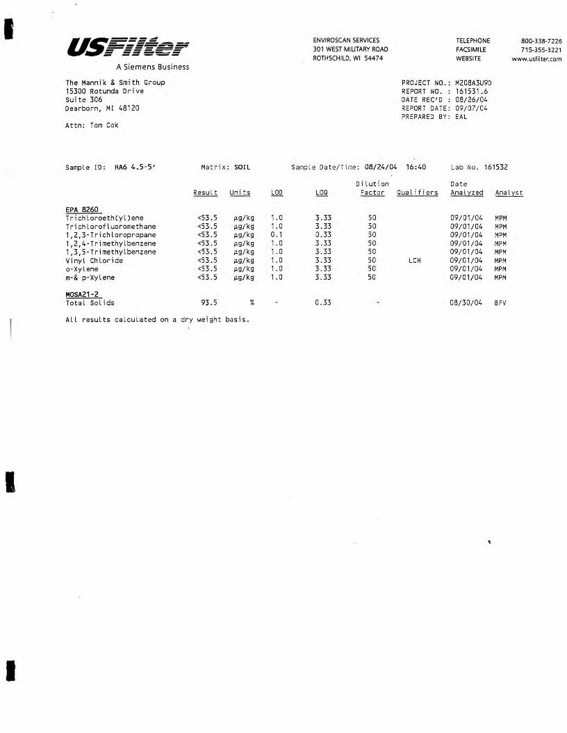
I
I
I
- -----a~===-=-=~ -------------~ - ------ ------ -----A Siemens Business
The Mannik & Smith Group 15300 Rotunda Drive Suite 306 Dearborn, MI 48120
Attn: Tom Cok
Sample !D: HA6 4.5-5'
EPA 8260 Trichloroeth(yl)ene Trichlorofluoromethane 1,2,3-Trichloropropane 1,2,4-Trimethylbenzene 1,3,5-Trimethylbenzene Vinyl Chloride a-Xylene m-& p-Xylene
MOSA21-2 Total Sol ids
All results calculated on a dry
Matrix: SOIL
Result Units
<53.5 IL9/kg <53.5 IL9/kg <53.5 IL9/kg <53.5 IL9/kg <53. 5 IL9/kg <53.5 IL9/kg <53.5 IL9/kg <53.5 IL9/kg
93.5 %
.ieight basis.
LOD
1. 0 1.0 0. 1 1. 0 1. 0 1 . 0 1 . 0 1. 0
ENVIROSCAN SERVICES 301 WEST MILITARY ROAD ROTHSCHILD, WI 54474
Sample Date/Time: 08/24/04
Dilution LOQ Factor
3.33 50 3.33 50 0.33 50 3.33 50 3.33 50 3.33 50 3 .33 50 3.33 50
0.33
TELEPHONE FACSIMILE WEBSITE
PROJECT NO.: M208A3U9D REPORT NO. : 161531.6 DATE REC'D : 08/26/04 REPORT DATE : 09/07/04 PREPARED BY : EAL
800-338-7226 715-355-3221
www.usfilter.com
16:40 Lab No. 161532
Date Qualifiers Analyzed Analyst
09/01/04 MPM 09/01/04 MPM 09/01/04 MPM 09/01/04 MPM 09/01/04 MPM
LCH 09/01/04 MPM 09/01/04 MPM 09/01/04 MPM
08/30/04 BFV
'·
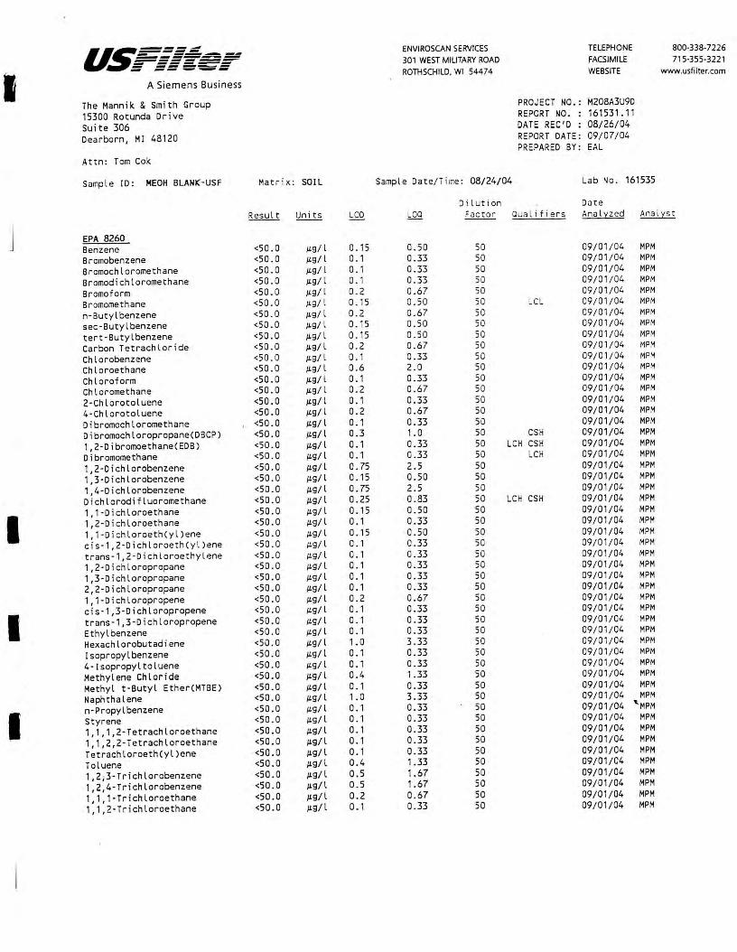
us===; ENVIROSCAN SERVICES TELEPHONE 800-338-7226 - ----------- 301 WEST MILITARY ROAD =-===-~=- FACSIMILE 715-355-3221
I - ----- ROTHSCHILD, WI 54474 WEBSITE www.usfilter.com
A Siemens Business
The Mannik & Smith Group PROJECT NO. : M208A3U9D
15300 Rotunda Drive REPORT NO- : 161531.11
Suite 306 DATE REC'D : 08/26/04
Dearborn, Ml 48120 REPORT DATE: 09/07/04 PREPARED BY: EAL
Attn: Tom Cok
Sample ID: HEOH BLANK-USF Matrix: SOil Sample Date/Time: 08/24/04 Lab No . 161535
Dilution Date Result Units LOD LOO Factor Qualifiers Analyzed Analyst
j EPA 8260 Benzene <50.0 JL91 l 0. 15 0.50 50 09/01/04 MPM Bromobenzene <50.0 JL91 l 0. 1 0.33 so 09/01/04 MPM Bromochloromethane <50.0 JL9/l 0. 1 0.33 so 09/01/04 MPM Bromodichloromethane <50.0 JL91 l 0. 1 0.33 so 09/01/04 MPM
Bromoform <50.0 JLgfl 0.2 0.67 so 09/01/04 MPM Bromomethane <50.0 JL9/ l 0. 15 a.so so LCL 09/01/04 MPM
n-Butylbenzene <50.0 JL9/ l 0.2 0.67 so 09/01/04 MPM
sec-Butyl benzene <50.0 JL9/ l 0. 15 0 .50 so 09/01/04 MPM
tert-Butylbenzene <50 .0 JL9/ l 0. 15 0. so so 09/01/04 MPM Carbon Tetrachloride <50.0 JL9/ l 0 . 2 0.67 so 09/01/04 MPM
Chlorobenzene <50 . 0 JLg/ l 0. 1 0.33 so 09/01/04 MPM
Chloroethane <50 . 0 JL9/ l 0 .6 2.0 so 09/01/04 MPM
Chloroform <50.0 JL9/ l 0. 1 0.33 so 09/01/04 MPM
Chloromethane <50 .0 JL9/ l 0 .2 0.67 so 09/01 /04 MPM
2-Chlorotoluene <50 .0 JL9/ l 0. 1 0.33 so 09/01/04 MPM
4-Chlorotoluene <50.0 JL91 l 0.2 0.67 so 09/01/04 MPM
Dibromochloromethane <50.0 JL9/ l 0 . 1 0.33 so 09/01/04 MPM Dibromochloropropane(DBCP) <50 .0 JL9/ l 0.3 1. 0 so CSH 09/01/04 MPM
1,2-Dibromoethane(EDB) <50.0 JL91 L 0. 1 0.33 50 LCH CSH 09/01/04 MPM
Dibromomethane <50.0 JL91 L 0. 1 0.33 so LCH 09/01/04 MPM
1,2-Dichlorobenzene <50.0 JL91 l 0.75 2.5 50 09/01/04 MPM 1,3-Dichlorobenzene <50.0 JL9/ l 0. 15 0.50 50 09/01/04 MPM
1,4-Dichlorobenzene <50 .0 JL9/ l 0.75 2.5 50 09/01/04 MPM Dichlorodifluoromethane <50.0 JL9/ l 0.25 0.83 50 LCH CSH 09/01/04 MPM
I 1, 1-Dichloroethane <50 .0 JL9/ l 0. 15 0.50 50 09/01/04 MPM 1,2-Dichloroethane <50.0 JL9/ l 0 . 1 0.33 50 09/01/04 MPM 1, 1-Dichloroeth(yl)ene <50.0 JL9/ l 0. 15 0.50 so 09/01/04 MPM cis-1,2-Dichloroeth(yl)ene <50.0 JL9/ l 0. 1 0.33 50 09/01/04 MPM trans-1,2-Dichloroethylene <50 . 0 JL9/ l 0. 1 0.33 50 09/01/04 MPM 1,2-Dichloropropane <50.0 JL9/ l 0. 1 0.33 so 09/01/04 MPM
1,3-Dichloropropane <50.0 JL9/ l 0.1 0.33 50 09/01/04 MPM 2,2-Dichloropropane <50.0 JL9/ l 0. 1 0.33 50 09/01/04 MPM
1, 1-Dichloropropene <50.0 JLg/ l 0.2 0.67 so 09/01/04 MPM
I cis-1,3-Dichloropropene <50.0 JLg/l 0. 1 0.33 50 09/01/04 MPM trans-1,3-Dichloropropene <50.0 JLg/l 0. 1 0.33 50 09/01/04 MPM
Ethyl benzene <50.0 JL9/l 0. 1 0.33 so 09/ 01/04 MPM
Hexachlorobutadiene <50.0 JL9/l 1. 0 3.33 so 09/ 01 / 04 MPM
Isopropylbenzene <50.0 JL9/l 0. 1 0.33 so 09/01/04 MPM
4-lsopropyltoluene <50.0 JLg/l 0. 1 0.33 so 09/01/04 MPM
Methylene Chloride <50.0 JL9/l 0.4 1.33 so . 09/01 / 04 MPM
Methyl t-Butyl Ether(MTBE) <50.0 JL9/ l 0. 1 0.33 50 09/01/04 MPM
Naphthalene <50.0 JL91 l 1. 0 3.33 50 09/01/04 MPM
I n-Propylbenzene <50.0 JL91 l 0. 1 0.33 50 09/01/04 '-MPM
Styrene <50.0 JLg/l 0. 1 0.33 50 09/01/04 MPM
1, 1,1,2-Tetrachloroethane <50.0 JLg/l 0. 1 0.33 50 09/01/04 MPM
1,1,2,2-Tetrachloroethane <50.0 JLgfl 0. 1 0.33 50 09/01/04 MPM
Tetrachloroeth(yl)ene <50.0 JL91 l 0. 1 0.33 50 09/01/04 MPM
Toluene <50.0 JL9/ l 0.4 1.33 50 09/01/04 MPM
1,2;3-Tr i chlorobenzene <50.0 JL91 l 0.5 1.67 50 09/01/04 MPM
1,2,4-Trichlorobenzene <50.0 JL91 l 0.5 1.67 50 09/01/04 MPM
1,1,1-Trichloroethane <50.0 JLg/l 0.2 0.67 50 09/01/04 MPM
1,1,2-Trichloroethane <50.0 JLg/l 0. 1 0.33 50 09/01/04 MPM

I
I
u.~=====~ - -----------------~ - ------ ------ -- ---A Siemens Business
The Mannik & Smith Group 15300 Rotunda Drive suite 306 Dearborn, Ml 48120
Attn: Tom Cok
Sample ID: HEOH BLAHK-USF Matr ix: SOIL
ENVIROSCAN SERVICES 301 WEST MILITARY ROAD
ROTHSCHILD. WI 54474
Samp l e Date/Time: 08/24/04
Dilution
TELEPHONE FACSIMILE WEBSITE
PROJECT NO.: M208A3U9D REPORT NO . : 161531. 12 DATE REC'D : 08/26/04 REPORT DATE: 09/07/04 PREPARED BY: EAL
Lab No. 161535
Date
800-338-7226 715-355-3221
www.usfil ter.com
LOO Factor Qualifiers Analyzed Analyst
EPA 8260 Trichloroeth(yl)ene Trichlorofluoromethane 1,2,3-Trichloropropane 1,2,4-Trimethylbenzene 1,3,5-Trimethylbenzene Vinyl Chloride o-Xylene m-& p-Xylene
Qualifier Descriptions
LCL
CSH
LCH
<50.0 µ.g/ l 0.2 0.67 50 <50.0 µ.g/ l 0. 1 0.33 50 <50.0 µ.g/ l 0.55 1.83 50 <50.0 µ.g/l 0. 15 0.50 50 <50 . 0 µ.g/ l 0. 15 0.50 50 <50.0 µ.g/ l 0. 15 0.50 50 <50.0 µ.g/ l 0.1 0.33 50 <50.0 µ.g/ l 0.4 1.33 50
The laboratory control sample for this analyte exib ited a low bias. Sample results may also be biased low.
Check standard for this analyte exhibited a high bias. Sample results may also be biased high.
The laboratory control sample for this analyte exibited a high bias. Sample results may also be biased high.
09/01/04 MPM 09/01/04 MPM 09/01/04 MPM 09/01/04 MPM 09/01/04 MPM
LCH 09/01/04 MPM 09/01/04 MPM 09/01/04 MPM
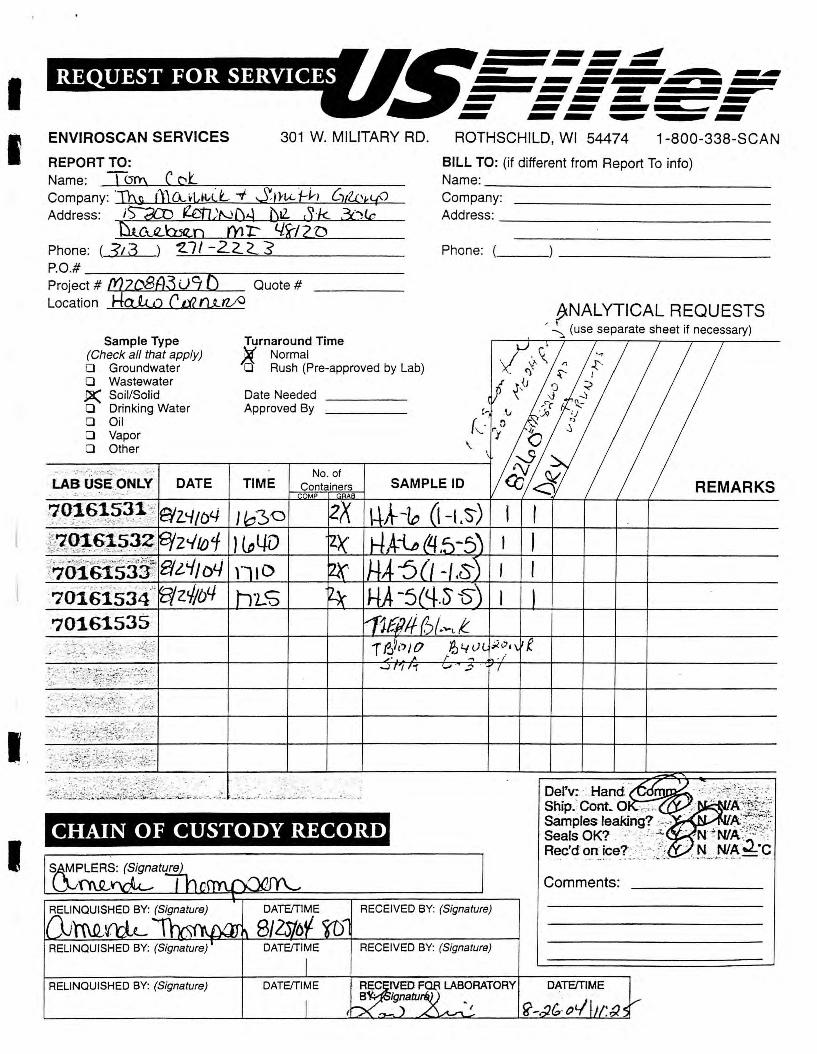
I I
I .
I
ENVIROSCAN SERVICES 301 W. MILITARY RD.
REPORT TO: Name: TQn:\ C c:,l Company: 'Tog I)) CA. ~Ltt,LL -./ Sn,(,(_ j--i,-1 (1(l.Dktf) Address: ~ ~U2ND4 L)IZ. S·k 3i~<c
&~~Jl.o mr:- 4x-Jzn Phone: ( ~13 ) '2......;;;.,,,_7,;_/ -.......;2=2..=--=2__=-=s _____ _
P.O.# ______ ~----------Project # [Y)z()8A3 u?L l5 Quote# Location HaJ.,w C tic ,:U.,zfa
Sample Type {Check all that apply) D Groundwater D Wastewater _P( Soil/Solid D Drinking Water D Oil D Vapor D Other
LAB USE ONLY DATE
Turnaround Time )5. Normal D Rush (Pre-approved by Lab)
Date Needed ___ _ Approved By
No. of TIME
CHAIN OF CUSTODY RECORD
~~S: (Signature
.... _,, ~ ............ .... ........ ............ ........ ._ ............ ....... ~ ROTHSCHILD, WI 54474 1-800-338-SCAN
BILL TO: (if different from Report To info) Name: ______________ _
Company: Address: _____________ _
Phone: ( ______________ _
fNALYTICAL REQUESTS , ~ (use separate sheet if necessary)
REMARKS
Del'v: ·. Hand .,r--,-1m,n✓-.
Ship.· Cont. 0 Samples leakin'g? -,:> ._....._...... Seals OK? . · , _:; -:: Rec'd on ice?·-·\c-:/i ........ ·- .. ,;,.._ ·.~
Comments:
RECEIVED BY: (Signature)
RELINQUISHED BY: (Signature) RECEIVED BY: (Signature)
RELINQUISHED BY: (Signature) DATE/TIME DATE/TIME
I -
_j
I
u.~----=---=-=-.- --=:-=====~ - ------ -- _.._.._
Client:
ENVIROSCAN SERVICES 301 WEST MILITARY ROAD
. ROTHSCHILD, WI 5<1<17 A
Sample Receipt Report
Date Received: fl- /,:JC, /<2L_
Analytical No.: /&/5Ji Through /l-/5J ~
Check all deviations from EPA or WDNR sample protocol.
TELEPHONE FACSIMILE WEBSITE
[] Sample(s) received at __ °C which is above the EPA and WDNR limit of 4 °C.
[ ] VOC vial(s) received with headspace. Explain:
800-338-7226 715-355-322 l
www.usfilter.com
[ ]
[ ]
Sample(s) received in bottles not furnished by Enviroscan. Preservation method, if used, is unknown. Sample(s) not properly preserved per EPA/WDNR protocol for the following:
[ ] Sample(s) received beyond EPA holding time for:
[ ]
[ ]
[ ]
[ ]
Sample date/time not supplied by client. Actual holding time unknown.
GRO/PVOC/VOC/DRO (circle appropriate) sample(s) are < 19.5 gms and this report is the flag for that information. Sample(s) under-weight: _____________ _
GRO/PVOC/VOC (circle appropriate) sample(s) were between 26.4-35.4 gms so methanol was added in a 1:1 ratio. Sample(s) included: !&/ _,S-3 J - 1m I ful-(3.J. · 0""' I I & ( '23 3 - /Um I /& I 5'",.1 Y - 7.,.,,. /
GRO/PVOC/VOC/DRO (circle appropriate) sample(s) were > 35.4 gms and are required to be rejected. Sample(s) included:. __________________ _
Other:
Client contact concernine the above deviations:
Client __________ (contact name) notified of the above deviation(s) on _!_!_ at __ : __ am/pm by and the client ordered:
(signature) ( ] Proceed with analyses as ordered. [ ] Proceed with analyses after taking the following corrective action:
[ ] Do NOT proceed with analyses .
All Analyses conducted in accordance with USF ilter Ouolily Assurance Program
Wisconsin Lab Certification No. 737053130

I
I
I
I
The Mannik & Smith Group, Inc.
September 8 t 2 0 04
The Mannik & Smith Group 15300 Rotunda Driv e Suite 306 Dearborn, MI 4812 0
Attn: Mi ke Friedhoff / Tom Cok
REPORT NO.: 161703
ENVIROSCAN SERVICES 301 WEST MILITARY ROAD ROTHSCHILD, WI 54474
TELEPHONE FACSIMILE WEBSITE
PROJECT NO.: M209A3U9D
Please find enclosed the analy tical report, including the Sample Summary, Sample Narrative and Chain of Custody for your sample set received August 31, 2004.
All anal y ses were performed in accordance with approv ed methods as indicated on this report.
If y ou have any questions about the results, please call. Thank you for using USFilter, Enviroscan Services for your analytical needs.
Sincerely,
USFilter, Enviroscan Services
James R. Salkowski Laboratory Director
800-338-7226 715-355-3221
www.usfilter.com
I cercify thar the data contained in this reporc has been genermed and reviewed in accordance with the USFilter, Enviroscan Services Quality Assurance Program. £rceptions, if any, are discussed in the sample narrarive. Samples will be retained for 30 days from the dau of this repon, then disposed in an appropriate manner. USFilter.
Enviroscan Services reserves the right to return samples identified as hazardous.
Approved by: C,{·, I- l),,j" • . Certifications:
Wisconsin 737053130 Minnesota 055-999-302 Maryland 276
Release of this Final Repon is authorized as verified by the following signawre.
Oregon (WI-100001 ) Illinois 200025 Washington C293
'

. ···- ·----·-- ---·- ·-·· ··-----
A Siemens Business
ENVIROSCAN SERVICES 301 WEST MILITARY ROAD ROTHSCHILD, WI 54474
TELEPHONE FACSIMILE WEBSITE
Samole Summary 161703.2
Lab Id 161703 161704 161705
1161706
Client Samole ID HA3-SS1·MHF HA3·SS2·MHF HA4·SS1 ·MJF MEOH BLANK·USF
Date/Time 08/17/04 08/17/04 08/17/04 08/17/04
20:20 20:30 21 :00
Matrix SOIL SOIL SOIL SOIL
Samole Narrative/Samole Status
GENERAL:
A QC:
EPORTING:
I Definitions
I. OD = Limit of Detection (Not dilution corrected)
OQ = Limit of Quantitation (Not dilution corrected) , = Less Than
COMP= Complete SUBCON = Subcontracted analysis
Iv= millivolts Ci/l = picocurie per liter
ml/l = mililiters/Liter mg = milligrams
~ ..
I
µg/l = Micrograms per liter= parts per billion (ppb) µg/kg = Micrograms per kilogram= parts per billion (ppb) mg/l = Milligrams per liter= parts per million (ppm) mg/kg= Milligrams per kilogram= parts per million (ppm) NOT PRES= Not Present ppth = Parts per thousand (S) = Surrogate Compound mg/m3 = Milligrams/meter cube
'-
800-338-7226 715-355-3221
www.usfilter.com

us====~ ENVIROSCAN SERVICES TELEPHONE 800-338-7226 - ------------------ 301 WEST MILITARY ROAD FACSIMILE 715-355-3221 - ------ ------- ----- ROTHSCHILD, WI 54474 WEBSITE www.usfilter.com
A Siemens Business
The Mannik & Smith Group PROJECT NO. : M209A3U90
15300 Rotunda Drive REPORT NO. ; 161703.3
Suite 306 DATE REC'D ; 08/31/04
Dearborn, MI 48120 REPORT DATE: 09/08/04 PREPARED BY: JRS
Attn: Mi ke Friedhoff/ Tom Cok
Sample ID: HA3-SS1-HHF Matri x : SOIL Sample Date/Time: 08/17/04 20:20 Lab No. 161703
D.~ -( Dilution Date Result Units LOO LOO Factor Qualifiers Analyzed Analyst
EPA 8021 (Onl y positively identified analytes are reported on a dry 11ei ght basis
Benzene <0.025 mg/kg 0.008 0.027 1 09/01/04 LMP
Bromobenzene <0.025 mg/kg 0.007 0.023 1 09/01/04 LMP
Bromod ichloromethane <D.025 mg/kg 0.006 0.02 1 09/01/04 LMP
n-Butylbenzene <0.025 mg/kg 0.012 0.04 1 09/01/04 LMP
sec-Butyl benzene <0.025 mg/kg 0.01 0.033 1 09/01/04 LMP
tert-Butylbenzene <0.025 mg/kg 0.01 0.033 1 09/01/04 LMP
Carbon Tetrachloride <0.025 mg/kg 0.008 0.027 1 D9/01/04 LMP
Ch l orobenzene <0.025 mg/kg 0.007 0.023 1 09/01/04 LMP
Chlorodibromomethane <0.025 mg/kg 0.02 O.D67 1 09/01/04 LMP
Chloroethane <0 . 025 mg/kg 0.09 0.30 1 09/01/04 LMP
Chloroform <0 . 025 mg/kg 0.01 0.033 1 LCH 09/01/04 LMP
Chloromethane <0 . 025 mg/kg 0.01 D.033 1 CSH LCH 09/D1/04 LMP
2-Chlorotoluene <0.025 mg/kg 0.008 0.027 09/01/04 LMP
4-Chlorotoluene <0.025 mg/kg 0.008 0.027 09/01/04 LMP
1,2-Dibromo-3-chloropropane <0.025 mg/kg 0.009 0.03 09/01/04 LMP
1,2-Dibromoethane <0.025 mg/kg 0.012 0.04 09/01/04 LMP
1,2-Dichlorobenzene <0.025 mg/kg D.008 0.027 09/01/04 LMP
1,3-Dichlorobenzene <0.025 mg/kg 0.008 0.027 1 09/01/04 LMP
1,4-Dichlorobenzene <0.025 mg/kg 0.008 0.027 1 09/01/04 LMP
Dichlorodifluoromethane <O.D25 mg/kg 0.014 0.047 1 CSH 09/01/04 LMP
1, 1-Dichloroethane <0.025 mg/kg 0.009 0.03 1 09/01/04 LMP
1,2-Dichloroethane <0 .025 mg/kg 0.005 0.017 1 CSH LCH 09/01/04 LMP
1, 1-Dichloroethylene <0.025 mg/kg 0.016 0.053 1 09/D1/04 LMP
cis-1,2-Dichloroethylene <0.025 mg/kg 0.007 0.023 1 LCH 09/01/04 LMP
trans-1,2-Dichloroethylene <0.025 mg/kg 0.01 0 .033 1 LCH 09/01/04 LMP
1,2-Dichloropropane <0.025 mg/kg 0.007 0.023 1 09/01/04 LMP
1,3-Dichloropropane <0.025 mg/kg 0.008 D.027 1 CSH 09/01/04 LMP
2,2-Dichloropropane <0.025 mg/kg 0.008 0.027 1 CSH LCH DUP 09/01/04 LMP
Ethyl benzene <0.025 mg/kg 0.007 O.D23 1 09/01/04 LMP
Hexachlorobutadiene <0 . 025 mg/kg 0.015 O. D5 1 09/01/04 LMP
Isopropylbenzene <0 .025 mg/kg 0.009 0.03 1 09/01/04 LMP
Isopropyl Ether <0.025 mg/kg 0.014 0.047 1 09/01/04 LMP
p-Isopropyltoluene <0.025 mg/kg 0.011 0.037 1 09/01/04 LMP
~ethyl t-Butyl Ether(MTBE) <0.025 mg/kg 0.018 0.06 1 LCH DUP 09/01/04 LMP
ethylene Chloride <0.025 mg/kg 0 . 014 0.047 1 CS H LCH 09/01/04 LMP
Naphthalene <0.025 mg/kg 0.01 0.033 1 09/01/04 LMP
n-Propylbenzene <0 .025 mg/kg 0.009 0.03 1 09/01/04 LMP Tet rach l oroethy l en·e 0.0284 mg/kg 0.009 0.03 1 09/01/04 LMP
1, 1,2,2-Tetrachloroethane <0.025 mg/kg 0.006 0.02 1 CSH 09/01/04 LMP
-Toluene <0.025 mg/kg 0 . 007 0 . 023 1 09/01/04 LMP
1,2,3-Trichlorobenzene <0.025 mg/kg 0.014 0.047 1 09/01/04 LMP
1,2,4-Trichlorobenzene <0.025 mg/kg 0.014 0.047 1 09/01/04 LMP
, 1, 1-Trichloroethane <0.025 mg/kg 0.008 0.027 1 . LCH 09/01/04 LMP
, 1,2-Trichloroet hane <0 .025 mg/kg 0.006 0.02 1 09/01/04 LMP
richloroethylene <0.025 mg/kg 0.011 0.037 1 09/01/04 LMP
Trichlorofluoromethane <0.025 mg/kg 0.008 0.027 1 CSH 09/01/04 LMP
1,2,4-Trimethylbenzene <0 .025 mg/kg 0.012 0.04 1 09/01/04 LMP
1,3,5-Trimethylbenzene <0.025 mg/kg 0.01 0.033 1 09/01/04 LMP
/ i ny l Ch l or i de <0.025 mg/kg 0.018 0.06 1 09/ 01/04 LMP
n- & p-Xylene <0.025 mg/kg 0.015 0.05 1 09/01/04 LMP
a-Xylene <0.025 mg/kg 0.008 0.027 1 09/01/04 LMP
[D Surrogate Recovery (S) 117. % 1 09/01/04 LMP
ALL Surrogate Recovery ( s) 143. % 1 09/01/04 LMP
HOSA21-2 otal Sol ids 91.3 % 0.33 09/03/04 BFV
ll results calculated on a dry 11ei ght basis.

u.~===~ - ------------=-:=-~= A Siemens Business
The Mannik & Smith Group 15300 Rotunda Drive Suite 306 Dearborn, Ml 48120
Attn : Mi ke Fr iedhoff / Tom Cok
Sample ID: HA3-SS2-HHF
EPA 8021 Benzene
3 ,) -LI (Only positively
Bromobenzene Bromodichloromethane n-But y lbenzene sec-Buty l benzene tert·Buty lbenzene Carbon Tetrach lor ide Chlorobenzene Chlorodibromomethane Chloroethane Chloroform Chloromethane 2-Chlorotoluene 4-Ch l orotoluene 1,2-Dibromo-3-chl oropropane 1,2-Dibromoethane 1,2-Dichlorobenzene 1,3-Dichlorobenzene 1,4-Dichlorobenzene Di chlorodifluoromethane 1, 1-Dichloroethane 1,2-Dichloroethane 1, 1-D i chloroethylene cis - 1,2-Dichloroethylene trans-1,2-Dichloroethylene 1,2-Dichloropropane 1,3-Dichloropropane 2,2-Dichloropropane Eth y l benzene Hexachlorobutadiene Isopropylbenzene Isopropyl Eth er p-lsopropyltoluene Methyl t-Butyl Ether(MTBE) Methylene Chloride Naphthalene n-Propylbenzene Tetrachloroethylene 1, 1,2,2-Tetrachloroethane Toluene 1,2,3-Trichlorobenzene 1,2,4-Trichlorobenzene 1, 1, 1-Trichloroethane 1, 1, 2-Trichloroethane Trichloroethylene Trichlorofluoromethane 1,2,4-Trimethylbenzene 1,3,5-Trimethylbenzene Vinyl Chloride . m- & p-Xylene o-Xylene P!D Surrogate Recovery (S) HALL Surrogate Recovery (S)
HOSA21-2 Total Sol ids
Matri x : SOIL
identified <0.025 <0.025 <0.025 <0.025 <0.025 <0.025 <0.025 <0 . 025 <0.025 <0.025 <0.025 <0.025 <0.025 <0.025 <0.025 <0.025 <0.025 <0.025 <0.025 <0.025 <0.025 <0.025 <0.025 <0.025 <0.025 <0.025 <0.025 <0.025 <0.025 <0 . 025 <0.025 <0.025 <0.025 <O. 025' <0.025 <0.025 <0.025
0.07 <O. 025 <0.025 <0.025 <0.025 <0.025 <0.025 <0.025 <0.025 <0.025 <O. 025 <0.025 <0 . 025 <0.025
109. 150.
91.9
analytes mg/kg mg/kg mg/kg mg/kg mg/kg mg/kg mg/kg mg/kg mg/kg mg/kg mg/kg mg/kg mg/kg mg/kg mg/kg mg/kg 111g/kg mg/kg mg/kg mg/kg mg/kg mg/kg mg/kg mg/kg mg/kg mg/kg mg/kg mg/kg mg/kg mg/kg mg/kg mg/kg mg/kg mg/kg mg/kg mg/kg mg/kg mg/kg mg/kg mg/kg mg/kg mg/kg mg/kg mg/kg mg/kg mg/kg mg/kg mg/kg mg/kg mg/kg mg/kg
% %
%
All results calculated on a dry weight basis.
ENVIROSCAN SERVICES 301 WEST MILITARY ROAD ROTHSCHILD, WI 54474
PROJECT NO. : M209A3U9D REPORT NO. : 161703.4 DATE REC'D : 08/31/04 REPORT DATE: 09/08/04 PREPARED BY: JRS
TELEPHONE FACSIMILE WEBSITE
Sample Date/Time: 08/17/04 20:30 Lab No. 161704
Dilution Dat_e LOO Factor Qualifiers Analyzed Analyst
are reported on a dry 0.008 0.027 0.007 0 .023 0.006 0.02 0.012 0.04 0.01 0.033 0. 01 0. 033 0.008 0.027 0.007 0.023 0.02 0.067 0.09 0.30 0.01 0.033 0.01 0.033 0.008 0.027 0.008 0.027 0.009 0.03 0.012 0.04 0.008 0.027 0.008 0.027 0.008 0.027 0.014 0.047 0.009 0.03 0.005 0.017 0.016 0.053 0.007 0.023 0.01 0.033 0 . 007 0.023 0.008 0.027 0.008 0.027 0.007 0.023 0.015 0.05 0.009 0.03 0.014 0.047 0.011 0.037 0.018 0.06 0.014 0.047 0. 01 0. 033 0.009 0.03 0.009 0.03 0.006 0.02 0.007 0. 023 0 . 014 0.047 0.014 0.047 0.008 0.027 0. 006 0.02 0.011 0.037 0.008 0.027 0.012 0.04 0.01 0.033 0.018 0.06 0.015 0.05 0.008 0.027
0.33
1-ie i ght 1 1 1 1 1 1 1 1 1 1 1 1 1 1 1 1 1 1 1 1 1 1 1 1 1 1 1 1 1 1 1 1 1 1 1 1 1 1 1 1 1 1 1 1 1 1 1 1 1 1 1 1 1
basis
LCH CSH LCH
CSH
CSH LCH
LCH LCH
CSH CSH LCH DUP
LCH DUP CSH LCH
CSH
· LCH
CSH
09/ 01/04 09/ 01/04 09/ 01/04 09/ 01/04 09/ 01/04 09/ 01 / 04 09/01/04 09/ 01/04 09/01/04 09/01/04 09/01/04 09/01/04 09/01/04 09/01/04 09/01/04 09/01/04 09/01/04 09/01/04 09/01/04 09/01/04 09/01/04 09/01/04 09/01/04 09/01/04 09/01/04 09/01/04 09/01/04 09/01/04 09/01/04 09/01/04 09/01/04 09/01/04 09/01/04 09/01/04 09/01/04 09/01/04 09/01/04 09/01/04 09/01/04 09/01/04 09/01/04 09/01/04 09/01/04 09/01/04 09/01/04 09/01/04 09/01/04 09/01/04 09/01/04 09/01/04 09/01/04 09/01/04 09/01/04
LMP LMP LMP LMP LMP LMP LMP LMP LMP LMP LMP LMP LMP LMP LMP LMP LMP LMP LMP LMP LMP LMP LMP LMP LMP LMP LMP LMP LMP LMP LMP LMP LMP LMP LMP LMP LMP LMP LMP LMP LMP LMP LMP LMP LMP LMP LMP LMP LMP LMP LMP LMP LMP
09/03/04 BFV
'·
800-338-7226 715-355-3221
www.usfilter.com
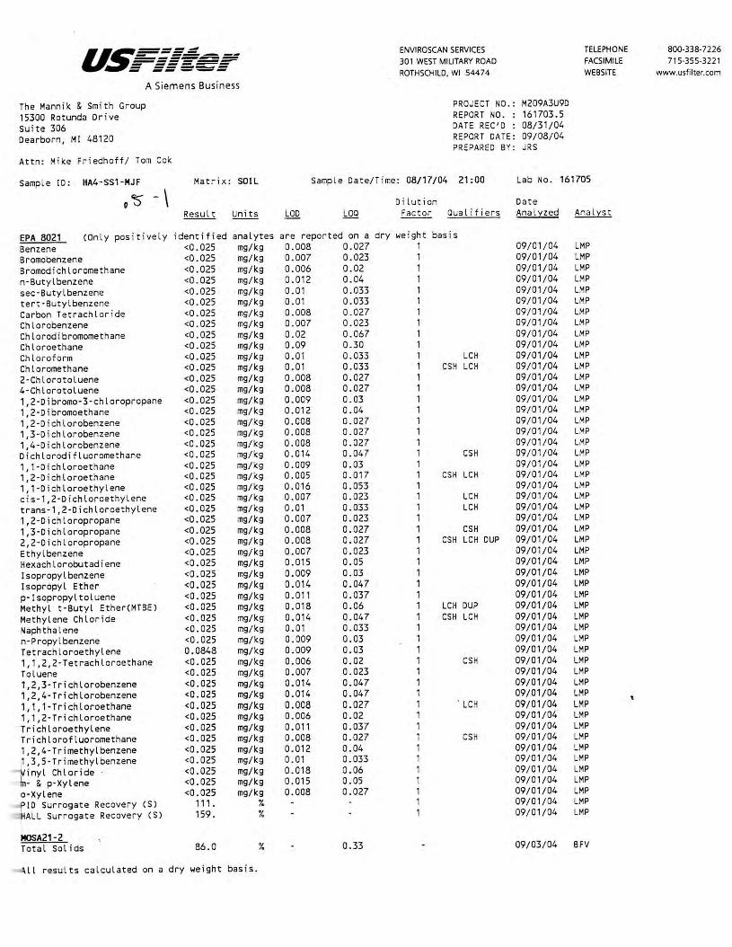
u~====~ ENVIROSCAN SERVICES TELEPHONE 800-338-7226 -=---~=:=,.,,,;;;:!!:,=: ------- 301 WEST MILITARY ROAD FACSIMILE 715-355-3221 - ------ ------ ----- ROTHSCHILD, WI 54474 WEBSITE www.usfi lter.com
A Siemens Business
The Mannik & Smith Group PROJECT NO .: M209A3U9D 15300 Rotunda Dr i ve REPOR T NO. : 161703.5 Suite 306 DATE REC'D : 08/31/04 Dearborn, Ml 48120 REPORT DATE: 09/08/04
PREPARED BY: JRS Attn: Mike Friedhoff / Tom Cok
Sample ID: HA4-SS1-MJF Mat r i x: SOIL Samp le Date/Time : 08/17/04 21:00 Lab No. 161705
0 '$' - \ Di lution Date Resul t Units L0D LOQ Fact or aua l i f iers Analyzed Analyst
EPA 8021 (Onl y posit ive ly identif i ed analytes are reported on a dry weight basis Benzene <0.025 mg/kg 0.008 0.027 1 09/01/04 LMP Bromobenzene <0.025 mg/kg 0.007 0.023 1 09/01/04 LMP Bromod ichloromethane <0 . 025 mg/kg 0.006 0.02 1 09/01/04 LMP n-Butylbenzene <0.025 mg/kg 0.012 0.04 1 09/01/04 LMP sec·Butylbenzene <0.025 mg/kg 0.01 0.033 1 09/01/04 LMP tert·Butylbenzene <0.025 mg/kg 0.01 0 . 033 1 09/01/04 LMP Carbon Tetrachl ori de <0.025 mg/kg 0.008 0 . 027 1 09/ 01/04 LMP Chlorobenzene <0.025 mg/kg 0.007 0.023 1 09/ 01/04 LMP Chlorodibromomethane <0.025 mg/kg 0.02 0 . 067 1 09/ 01/04 LMP Chloroethane <0.025 mg/kg 0.09 0.30 1 09/01/04 LMP Chlor ofo rm <0.025 mg/kg 0.01 0.033 1 LCH 09/01/04 LMP Chloromethane <0.025 mg/kg 0.01 0 . 033 1 CSH LCH 09/01/04 LMP 2-Chlorotoluene <0 . 025 mg/kg 0.008 0.027 1 09/01/04 LMP 4-Chlorotoluene <0.025 mg/kg 0.008 0.027 1 09/01/04 LMP 1,2-Dibromo-3-chloropropane <0.025 mg/kg 0.009 0.03 1 09/01/04 LMP 1, 2-Dibromoethane <0.025 mg/kg 0.012 0.04 1 09/0 1/04 LMP 1,2-Dichlorobenzene <0.025 mg/kg 0.008 0.027 1 09/01/04 LMP 1,3-Dichlorobenzene <0.025 mg/kg 0.008 0.027 1 09/01/04 LMP 1,4-Dichlorobenzene <0.025 mg/kg 0.008 0.027 1 09/ 01/04 LMP Dichlorodifluoromethane <0.025 mg/kg 0.014 0.047 1 CS H 09/ 01/04 LMP 1, 1-Dichloroethane <0.025 mg/kg 0.009 0.03 1 09/ 01/04 LMP 1,2-Dichloroethane <0.025 mg/kg 0 . 005 0.017 1 CS H LCH 09/ 01/04 LMP 1, 1-Dichloroethylene <0.025 mg/kg 0.016 0.053 1 09/01/04 LMP cis-1,2-Dichloroethylene <0.025 mg/kg 0 . 007 0. 023 1 LCH 09/01/04 LMP trans-1,2-Dichloroethylene <0.025 mg/kg 0.01 0.033 1 LCH 09/01/04 LMP 1,2-Dichloropropane <0.025 mg/kg 0.007 0.023 1 09/01/04 LMP 1,3-Dichloropropane <0 . 025 mg/kg 0.008 0.027 1 CSH 09/01/04 LMP 2,2-Dichloropropane <0.025 mg/kg 0 . 008 0.027 1 CSH LCH DUP 09/01/04 LMP
Ethyl benzene <0.025 mg/kg 0.007 0.023 1 09/01/04 LMP Hexachlorobutad i ene <0 . 025 mg/kg 0.015 0.05 1 09/01/04 LMP lsopropylbenzene <0.025 mg/kg 0.009 0.03 1 09/01/04 LMP lsopropyl Ether <0.025 mg/kg 0.014 0.047 1 09/01/04 LMP p·lsopropyltoluene <0.025 mg/kg 0.011 0.037 1 09/01/04 LMP Methyl t-Butyl Ether(MTBEJ <0.025 mg/kg 0.018 0. 06 1 LCH DUP 09/01/04 LMP Methylene Chloride <0.025 mg/kg 0.014 0.047 1 CSH LCH 09/01/04 LMP Naphtha lene <0 . 025 mg/kg 0 . 01 0.033 1 09/01/04 LMP n·Propylbenzene <0.025 mg/kg 0.009 0.03 1 09/01/04 LMP Tetrachloroethylene 0.0848 mg/kg 0.009 0.03 1 09/01/04 LMP 1, 1,2,2-Tetrachloroethane <0.025 mg/kg 0.006 0.02 1 CS H 09/01/04 LMP Toluene <0.025 mg/kg 0.007 0.023 1 09/01/04 LMP 1~2,3-Trichlorobenzene <0.025 mg/kg 0.014 0.047 1 09/01/04 LMP 1,2,4-Trichlorobenzene <0.025 mg/kg 0.014 0.047 1 09/01/04 LMP 1,1, 1-Trichloroethane <0.025 mg/kg 0.008 0.027 1 . LCH 09/01/04 LMP 1,1,2-Tr i chloroethane <0.025 mg/kg 0.006 0.02 1 09/01/04 LMP Tr i chloroethylene <0.025 mg/kg 0.011 0.037 1 09/01/04 LMP Trichlorofluoromethane <0.025 mg/kg 0.008 0.027 1 CSH 09/ 01/04 LMP 1,2,4-Trimethylbenzene <0.025 mg/kg 0. 012 0. 04 1 09/01/04 LMP 1,3,5-Tr imethylbenzene <0.025 mg/kg 0.01 0 . 033 1 09/01/04 LMP
inyl Chloride <0 .025 mg/kg 0.018 0.06 1 09/01/04 LMP
· & p·Xylene <0.025 mg/kg 0.015 0.05 1 09/01/04 LMP
a-Xylene <0 . 025 mg/kg 0.008 0.027 1 09/01/04 LMP
~ID Surrogate Recovery (SJ 111 . % 1 09/01/04 LMP
ALL Surrogate Recovery (SJ 159. % 1 09/ 01/04 LMP
MOSA21-2 Total Solids 86.0 % 0. 33 09/03/04 BFV
~ll results calculated on a dry weight basis.

u~----- ENVIROSCAN SERVICES TELEPHONE 800-338-7226 ~-=~---------------- 301 WEST MILITARY ROAD FACSIMILE 715-355-3221 - ------ ------ ----- ROTHSCHILD. WI 54474 WEBSITE www.usfilter.com A Siemens Business
The Mannik & Smith Group PROJECT NO.: M209A3U9D
15300 Rotunda Drive REPORT NO. : 161703.6 Suite 306 DATE REC'D : 08/31/04
Dearborn, Ml 48120 REPORT DATE: 09/08/04 PREPARED BY: JRS
Attn: Mike Friedhoff/ Tom Cok
Sample ID: MEOH BLANK-USF Matri x: SOIL Sample Date/Time: 08/17/04 Lab No. 161706
Dilution Date Result Units LOO LOQ Factor Qualifiers Anal::z::zed Anal::z::st
EPA 8021 Benzene <0.025 mg/l 0.008 0.027 09/01/04 LMP Bromobenzene <0.025 mg/l 0.007 0.023 09/ 01/04 LMP Bromodichloromethane <0.025 mg/l 0.006 0.02 09/01/04 LMP n-Butylbenzene <0.025 mg/l 0 . 012 0.04 09/01/04 LMP
sec-Butyl benzene <0.025 mg/l 0.01 0. 033 09/01/04 LMP tert-Butylbenzene <0.025 mg/l 0.01 0.033 09/01/04 LMP
Carbon Tetrachlor ide <0.025 mg/l 0.008 0.027 09/01/04 LMP
Chlorobenzene <0.025 mg/l 0.007 0.023 09/01/04 LMP
Chlorodibromomethane <0.025 mg/l 0.02 0.067 1 09/01/04 LMP
Chloroethane <0 .025 mg/l 0.09 0.30 1 09/01/04 LMP
Chloroform <0.025 mg/l 0.01 0.033 1 LCH 09/01/04 LMP
Chloromethane <0.025 mg/l 0.01 0.033 1 CSH LCH 09/01/04 LMP
2-Chlorotoluene <0.025 mg/l 0.008 0.027 1 09/01/04 LMP
4-Chlorotoluene <0.025 mg/l 0.008 0.027 1 09/01/04 LMP 1,2-Dibromo-3-chloropropane <0 .025 mg/ l 0.009 0.03 1 09/01/04 LMP 1,2-0ibromoethane <0.025 mg/l 0.012 0.04 1 09/01/04 LMP
1,2-Dichlorobenzene <0.025 mg/l 0.008 0.027 1 09/01/04 LMP 1,3-Dichlorobenzene <0.025 mg/l 0.008 0.027 1 09/01/04 LMP
1,4-Dichlorobenzene <0.025 mg/l 0.008 0.027 1 09/01/04 LMP Dichlorodifluoromethane <0.025 mg/l 0.014 0.047 1 CSH 09/01/04 LMP 1, 1-Dichloroethane <0.025 mg/l 0.009 0.03 1 09/01/04 LMP 1,2-Dichloroethane <0 . 025 mg/l 0.005 0.017 1 CSH LCH 09/01/04 LMP 1, 1-Dichloroethylene <0.025 mg/l 0.016 0. 053 1 09/01/04 LMP cis-1,2-Dichloroethylene <0.025 mg/l 0.007 0.023 1 LCH 09/01/04 LMP trans-1,2-Dichloroethylene <0.025 mg/l 0.01 0.033 1 LCH 09/01/04 LMP 1,2-Dichloropropane <0.025 mg/l 0.007 0.023 1 09/01/04 LMP
,3-Dichloropropane <0.025 mg/l 0.008 0.027 1 CSH 09/01/04 LMP 2,2-Dichloropropane <0.025 mg/l 0.008 0.027 1 CSH LCH DUP 09/01/04 LMP Ethyl benzene <0.025 mg/l 0.007 0.023 1 09/01/04 LMP
exachlorobutadiene <0.025 mg/ l 0.015 0.05 1 09/01/04 LMP
Isopropylbenzene <0.025 mg/l 0.009 0.03 1 09/01/04 LMP I sopropyl Ether <0.025 mg/l 0.014 0.047 1 09/01/04 LMP p-Isopropyltoluene <0.025 mg/l 0.011 0.037 1 09/01/04 LMP ethyl t-Butyl Ether(MTBE) <0.025 mg/l 0.018 0.06 1 LCH DUP 09/01/04 LMP ethylene Chloride <0.025 mg/l 0.014 0.047 1 CSH LCH 09/01/04 LMP aphthalene <0 . 025 mg/l 0.01 0. 033 1 09/01/04 . LMP
n-Propylbenzene <0.025 mg/l 0.009 0. 03 1 09/01/04 LMP
Tetrachloroethylene <0.025 mg/l 0.009 0.03 1 09/01/04 LMP
, 1,2,2-Tetrachloroethane <0.025 mg/l 0.006 0.02 1 CSH 09/01/04 LMP
oluene <0.025 mg/l 0.007 0.023 1 09/01/04 LMP
·,2,3-Trichlorobenzene <0 . 025 mg/l 0.014 0.047 1 09/01/04 LMP
1,2,4-Trichlorobenzene <0.025 mg/l 0.014 0.047 1 09/01/04 LMP '· ,1, 1-Trichloroethane <0.025 mg/l 0.008 0.027 1 LCH 09/01/04 LMP
,1,2-Trichloroethane <0.025 mg/l 0.006 0.02 1 09/01/04 LMP
richloroethylene <0.025 mg/l 0.011 0.037 1 09/01/04 LMP
Trichlorofluoromethane <0 . 025 mg/l 0.008 0.027 1 CSH 09/01/04 LMP
1,2,4-Trimethylbenzene <0.025 mg/l 0.012 0.04 1 09/01/04 LMP
,3,5-Trimethylbenzene <0.025 mg/l 0.01 0.033 1 09/01/04 LMP
~i nyl Chloride <0.025 mg/ l 0.018 0.06 1 09/01/04 LMP
- & p-Xylene <0.025 mg/l 0.015 0.05 1 09/01/04 LMP
a-Xylene <0.025 mg/l 0.008 0.027 1 09/01/04 LMP ID Surrogate Recovery CS) 119 . % 1 09/01/04 LMP
- iALL Surrogate Recovery ( s) 153 . % 1 09/01/04 LMP
\

U~===: .=-..- ====..=. =: ------~ - ------ ------ -----ENVIROSCAN SERVICES 301 WEST MILITARY ROAD ROTHSCHILD, WI 54474
The Mannik & Smith Group 15300 Rotunda Dri ve Suite 306 Dearborn, Ml 48120
A Siemens Business
PROJECT NO.: M209A3U9D REPORT NO. : 161703.7 DATE REC'D : 08/31/04 REPORT DATE: 09/08/04 PREPARED BY: JRS
Attn: Mike Friedhoff/ Tom Cok
Qualifier Descriptions
LCH
CSH
DUP
The laboratory control sample fo r thi s analyte exibited a high bias. Sample results may also be biased high.
Check standard for this analyte exhibited a high bias. Sample results may also be biased high.
Result of duplicate analysis in this quality assurance batch exceeds · the limits for precision.
TELEPHONE FACSIMILE WEBSITE
800-338-7226 715-355-3221
www.usfilter.com

U~----=-- - =-=-.- --=-= ====~ - ------ -----ENVIROSCAN SERVICES
301 WEST MILITARY ROAD
. ROTHSCHILD, WI 54474
TELEPHONE
FACSIMILE
W EBSITE
800-33 8-7226 7 15-355-322 1
www.usfilter.com
Sample Receipt Report
Date Received: .$:..J Jj_; ..!2_1._
Analytical No.: /(p / 703 Through I& 120 e,
Check all deviations from EPA or WDNR sample protocol.
( ]
[ ]
[ ]
[ ]
[ ]
[ ]
[ ]
[ ]
[ ]
Sample(s) received at __ °C which is above the EPA and WDNR limit of 4 °C.
voe vial(s) received with headspace. Explain:
Sample(s) received in bottles not furnished by Enviroscan. Preservation method, if used, is unknown. Sample(s) not properly preserved per EPA/WDNR protocol for the following:
Sample(s) received beyond EPA holding time for:
Sample date/time not supplied by client. Actual holding time unknown.
GRO/PVOCNOC/DRO (circle appropriate) sample(s) are < 19.5 gms and this report is the flag for that information. Sample(s) under-weight: _____________ _
GRO/PVOCNOC (circle appropriate) sample(s) were between 26.4-35.4 gms so methanol was added in a 1:1 ratio. Sample(s) included: ft:,;/ 7~~ ~ 3~1 - 1617~,S:-J....,,I
GRO/PVOCNOC/DRO (circle appropriate) sample(s) were > 35.4 gms and are required to be rejected. Sample(s) included:. __________________ _
Other:
Client contact concernin2 the above deviations:
Client __________ (contact name) notified of the above deviation(s) on _!_!_ at __ : __ am/pm by and the client ordered:
'· [ ] [ l
(signature) Proceed with analyses as ordered. Proceed with analyses after taking the following corrective action:
[ ] Do NOT proceed with analyses .
All Analyses conducted in accordance with USFilter Quality Assurance Program
Wisconsin Lob Certification No. 737053130

ENVIROSCAN SERVICES 301 W. MILITARY RD.
REPORT TO: ' Name: C(\tL(r:~~ ~~ (GV;:_ Company: --f"' __ ("(\ __ 'L _ 3;:-1( _fL'f. Address: \ 5 300 R.o±:'4bdc Dr-.' 5-h.Jt:>'2
D-c..c- r::: bee:" ('t'tt:. '::t 'i{p.a Phone: ( ¥' I ) 3 \3 _: '6-3:/ - ~3 P.O.# CO ~01 A:3 l) ~ 0 Project# M~D , A:3\.JCY') Quote# -Location =fn,., ck, Le.-tt..,; ~ C.ur~
1 \-\.Q:.
Sample Type (Check all that apply) 0 Groundwater 0 Wastewater ... Soil/Solid 0 Drinking Water O Oil O Vapor O Other
10161705 '\
10161.706·
' ------Turnaround Time ' ~ Normal 0 Rush (Pre-approved by Lab)
Date Needed ___ _ Approved By
No. of TIME Containers
p
· .. ,_ . • , •. _..:... . . · • • • ~ , ·- .. ... >, . ,. --·,
CHAIN OF CUSTODY RECORD
~~....,,,,,,,, ~~~ ~
~~ ~~~ ~~-~~....,...., .._...
ROTHSCHILD, WI 54474 1-800-338-SCAN
BILL TO: (if different from Report To info) Name: _______________ _
Company: Address: ______________ _
Phone: { ______________ _
ANALYTICAL REQUESTS (use separate sheet if necessary)
RECEIVED BY: (Signature)
\JP DATE/TIME RECEIVED BY: (Signature)
RELINQUISHED BY: (Signature) DATE/TIME DATE/TIME
Jo s~

10 / 20 / 2004 13:32 FAX 715 355 3221 USFILTER ,ENVIRONSCAN 14] 001 / 007
as===;d . - ---·------------------~ - ------ ------ -----A Siemens Business
October 20, 2004
The Mannik & Smith Group 15300 Rotunda Drive Suite 306 Dearborn, MI 48120
Attn: Tom Cok
ENVIROSCAN SERVICES
301 WEST MILITARY ROAD ROTHSCHILD, WI 54474
TELEPHONE FACSIMILE WEBSITE
B00-338-7226 715-355-3221
www.usfilter.com
REPORT NO.: 165038 PROJECT NO.: HALESCORNERS
Please find enclosed the analytical report, including the Sample Summary, Sample Narrative and Chain of Custody for your sample set received October 19, 2004.
All analyses were performed in accordance with NELAC Standards using approved methods as indicated on this report.
If you have any questions about the results, please call. Thank you for using USFilter, Enviroscan Services for your analytical needs.
Sincerely,
USFilter, Enviroscan Services
Eric A. Lorge Project Manager
I certify thtU the dara contained in this report has been generated an.d reviewed in accordance wirh the USFilur, Etrviroscan Services Quality Assurance Program. E:cceptioru, if any, are discussed in the sample narrative. Samples will be rerained f or 30 days from the date of this report, then disposed in an appropriau manner.
USFi.ller, Enviroscan Services reserves the right to return samples identified as hazardous. Release of this Finnl Report is authorized as verified by /he fallowing signature.
Approved by:
Certifications: Wisconsin 737053130 Minnesota 055-999-302 Maryland 276
Oregon (WI-100001) Illinois 200025 Washington C293

10 / 20 / 2004 13:33 FAX 715 355 3221 USFILTER,ENVIRONSCAN @002/007
A Siemens Business
ENVIROSCAN SERVICES 301 WESTMIUTARY ROAD ROTHSCHILD. WI 54474
TELEPHONE FACSIMILE WEBSITE
800-338--7226 715-355-3221
www.usfilter.com
Sample SUTM1ary 165038.2
Lab Id 165038 165039
Client Sample lb Ml./7 TRIP 8LANK-USF
Date/Time 10/18/04 12:00 10/18/04
Matrix GROUNDWATER \./ATER
Sample Narrative/Sample Status
GENERAL:
ANALYSES:
REPORTING:
Definitions
LOO = Limit of Detection (Not dilution corrected) LOQ = Limit of Quantitation (Not dilution corrected) <=less Than COMP= Complete SUBCON = Subcontracted analysis mv = millivolts pCi/l = picocurie per l i ter ml/l = mililiters/Liter mg = mil L igrams
~g/1 = Micrograms per liter= parts per billion (ppb) ~g/kg = Micrograms per kilogram= parts per billion (ppb) mg/l = Milligrams per Liter= parts per million (p~) mg/kg= Milligrams per kilogram= parts per million (ppm) NOT PRES= Not Present ppth = Parts per thousand (SJ = Surrogate Compound mg/m3 = Milligrams/meter cube
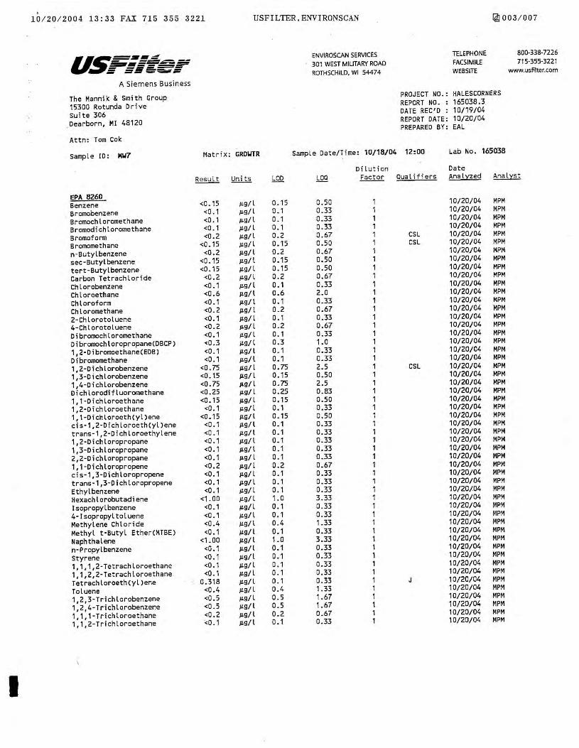
10 / 20 / 200 4 13 : 33 FAX 715 355 3221 USFILTER,ENVIRONSCAN !4] 003 / 007
u~-·-~ ENVIROSCAN SERVICES TELEPHONE 800-338-7226 ~ -~-----~1111=.i:--===~ 301 WEST MILITARY ROAD FACSIMILE 715-355-3221 - -----. = ~==-="-= ROTHSCHILD, WI 54474 WEBSLTE www.usfilter.com
A Siemens Bus iness
The Mannik & Smith Group PROJECT NO.: HALESCORNERS
15300 Rotunda Drive REPORT NO- : 165038.3.
Suite 306 DATE REC'D : 10/19/04
_Dearborn, Ml 48120 REPORT DATE: 10/20/04 PREPARED BY : EAL
Attn: Tom Cok
Sample ID: M\17 Matri x : GRD\HR Sample Date/Time: 10/18/04 12:00 Lab No. 165038
Dilu t ion Date
~ Units LOD LOQ Factor Qualifiers Anal:aed Ana lyst
EPA 8260 Benzene <0 . 15 µ.g/ l 0.15 0.50 1 10/20/04 MPM
Bromobenzene <0 . 1 µ.g/l 0. 1 0.33 1 10/20/04 MPM
Bromochloromethane <0.1 µ.g/l 0.1 0.33 1 10/20/04 MPM
Bromodichlor omethane <O. 1 /L9/ l 0. 1 0_33 1 10/20/04 MPM
Bromoform <0.2 /L9/l 0.2 0.67 1 CSL 10/20/04 MPM
Bromomethane <0 . 15 /L9/l 0.15 0.50 1 CSL 10/20/04 MPM
n-Butylbenzene <0.2 µ.g/ l 0.2 0.67 1 10/20/04 MPM
sec-Butyl benzene <0 .15 µ.g/l 0.15 0. 50 1 10/20/04 MPM
tert-Butylbenzene <0.15 /L9/ l 0.15 0.50 1 10/20/04 MPM
Carbon Tetrachloride <0.2 /L9/l 0.2 0. 67 1 10/20/04 MPM
Chlorobenzene <0.1 JL9/l 0.1 0.33 1 10/20/04 MPM
Chloroethane <0.6 /L9/ l 0.6 2.0 1 10/20/04 MPM
Chloroform <0.1 /L9/l 0 .1 0.33 1 10/20/04 MPM
Chloromethane <0.2 /L9/ l 0.2 0.67 1 10/20/04 MPM
2-Chlorotoluene <0.1 /L9/l 0. 1 0.33 1 10/20/04 MPM 4-Chlorotoluene <0 . 2 JLg/l 0.2 0.67 1 10/20/04 MPM
Dibromochloromethane <0.1 JL9/ l 0. 1 0.33 1 10/20/04 MPM Oibromochloropropane(DBCP) <0.3 IL9/l 0.3 1.0 1 10/20/04 MPM
1,2-Dibromoethane(EDB) <0.1 /L9/l o_ 1 0.33 1 10/20/04 MPM Dibromomethane <O. 1 /L9/ l 0., 0.33 1 10/20/04 MPM 1,2-Dichlorobenzene <0.75 /L9/ l 0.75 2.5 1 CSL 10/20/04 MPM 1,3-Dichlorobenzene <0.15 /L9/l 0.15 0.50 1 10/20/04 MPM 1,4-Dichlorobenzene <0.75 /L9/l 0.75 2.5 , 10/20/04 MPM Dichlorodifluoromethane <0.25 JL9/ l 0.25 0_83 1 10/20/04 MPM 1, 1-Dichloroethane <0.15 JL9/ l 0.15 a.so 1 10/20/04 MPM 1,2-Dichloroethane <0.1 µ.g/l 0.1 0.33 1 10/20/04 MPM 1,1-Dichloroeth(yl)ene <0.15 /L9/ l 0.15 a.so 1 10/20/04 MPM cis-1,2-Dichloroeth(yl)ene <O .1 /L9/ l o_ 1 0.33 1 10/20/04 MPM trans-1,2-Dichloroethylene <0 . 1 /L9/ I 0 .1 0.33 1 10/20/04 MPM 1,2-Dichloropropane <O. 1 /L9/ l 0. 1 0.33 1 10/20/04 MPM 1,3-Dichloropropane <0.1 /L9/ l 0.1 0.33 1 10/20/04 MPM 2,2-Dichloropropane <0.1 µ.g/ l 0.1 0.33 1 10/20/04 MPM 1,1 -Dichloropropene <0.2 /L9/ l 0.2 0.67 1 10/20/04 MPM cis-1,3-Dichloropropene <0.1 1£9/ l 0.1 0.33 1 10/20/04 MPM trans-1,3-Dichloropropene <0.1 µ.g/1 0.1 0.33 1 10/20/04 MPM Ethyl benzene <0 . 1 1-'9/l 0.1 0.33 1 10/20/04 MPM Hexachlorobutadiene <1 . 00 /L9/l 1.0 3.33 1 10/20/04 MPM Isopropylbenzene <0.1 1Ls/l 0.1 0.33 1 10/20/04 MPM 4-Isopropyltoluene <0.1 IL9/l a. 1 0.33 1 10/20/04 MPM Methylene Chloride <0.4 /L9/ l 0. 4 1.33 1 10/20/04 MPM Methyl t·Butyl Ether(MTBE) <0 .1 1£9/ l 0.1 0.33 1 10/20/04 MPM
Naphthalene <1.00 /L9/l 1.0 3.33 1 10/20/04 MPM
n-Propylbenzene <0.1 /L9/l 0 .1 0.33 1 10/20/04 MPM
Styrene <0.1 1ts/l 0 .1 0.33 1 10/20/04 MPM
1,1, 1,2 -Tetrachloroethane <0.1 /L9/ l 0 . 1 0.33 1 10/20/04 MPM
1, 1,2,2-Tetrachloroethane <O . 1 IL9/ l 0.1 0.33 1 10/20/04 MPM
TetrachloroethCyl)ene 0.318 µ.g/l 0 . 1 0.33 1 J 10/20/04 MPM
Toluene <0.4 JL9/ l 0. 4 1.33 1 10/20/04 MPM
1,2,3-Trichlorobenzene <0.5 µg/l 0.5 1. 67 1 10/20/04 MPM
1,2,4-Trichlorobenzene <0.5 J.L9/l o_s 1.67 1 10/20/04 MPM
1,1,1-Trichloroethane <0.2 µ.g/l 0.2 0.67 1 10/20/04 MPM
1, 1,2-Trichloroethane <0.1 /L9/l 0 .1 0.33 1 10/20/04 MPM
'·
I
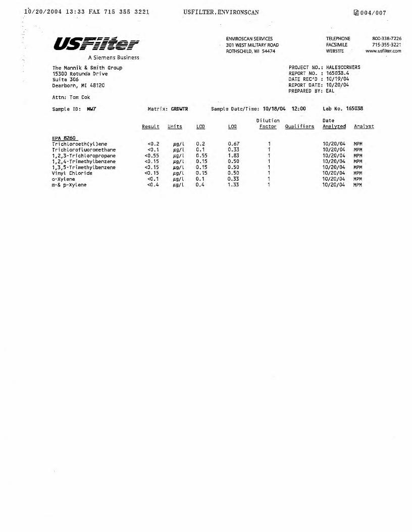
10/ 20/2004 13:33 FAX 715 355 3221 USFILTER,ENVIRONSCAN [41004 / 007
A Siemens Business
The Mannik & Smith Group 15300 Rotunda Drive Suite 306 Dearborn, Ml 48120
Attn: Tom Cok
Sample ID: M\17
EPA 8260 Trichloroeth(yl)ene Trichlorofluoromethane 1,2,3·Trichloropropane 1,2,4- Trimethylbenzene 1,3,5-Trimethylbenzene Vinyl Chloride o-Xylene m-& p-Xylene
Matrix: GRD\ITR
<0.2 µ.g/ l 0.2 <0.1 µ.g/ l 0 .1
<0.55 µ.g/ l 0.55 <0.15 µ.g/l 0.15 <0.15 µ.g/l 0.15 <0.15 µ.g/l 0.15 <0.1 µ.g/l 0. 1 <0.4 µ.g/l 0.4
ENVIROSCAN SERVICES 301 WEST MIUTARY ROAD ROTHSCHILD, WI 54474
Sample Date/Time: 10/18/04
Dilution
TELEPHONE FACSIMILE WEBSITE
PROJECT NO.: HALESCORNERS REPORT NO. : 165038.4 DATE REC'D : 10/19/04 REPORT DATE: 10/20/04 PREPARED BY: EAL
12:00 Lab No. 165038
Date
800-338-7226 715-355-3221
www.usfilter.com
LOO Factor Qualifiers Analyzed Analyst
0.67 1 10/20/04 MPM 0.33 1 10/20/04 MPM 1.83 1 10/20/04 MPM 0.50 1 10/20/04 MPM 0.50 1 10/20/04 MPM 0.50 1 10/20/04 MPM 0.33 1 10/20/04 MPM 1.33 1 10/20/04 MPM
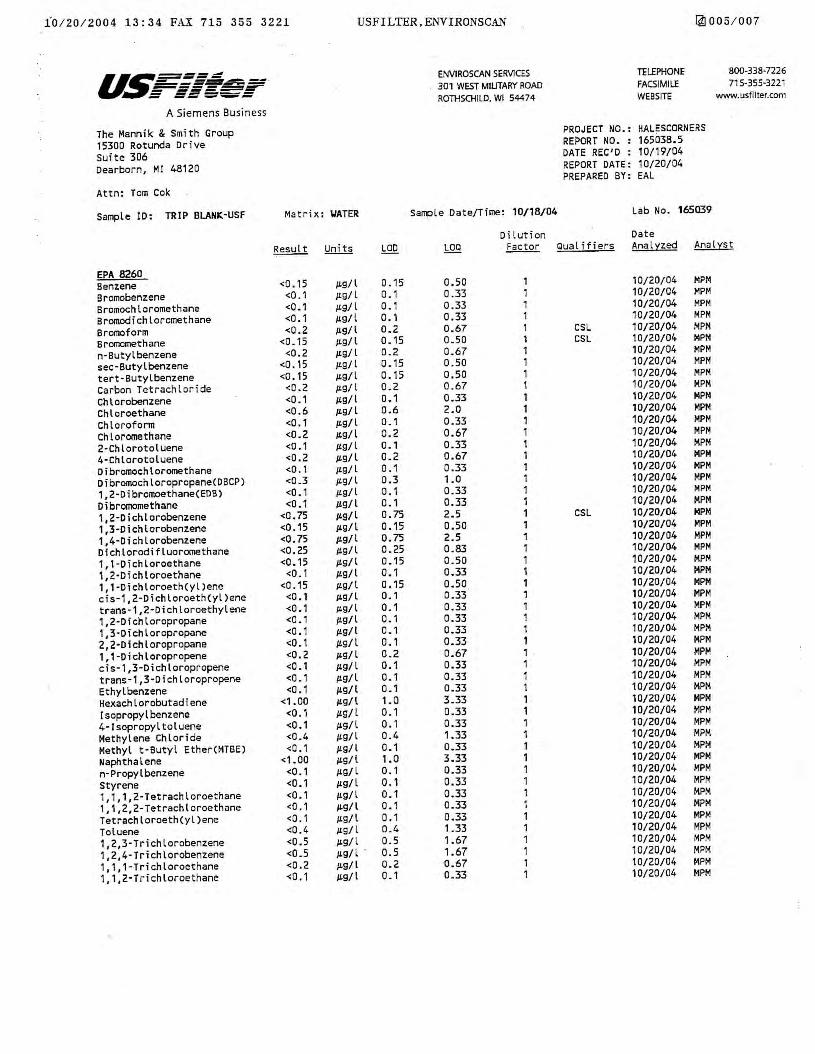
10 / 20 / 2004 13:34 FAX 715 355 3221 USFILTER,ENYIRONSCAN 14] 005 / 007
u~=====-=---- ENVIROSCAN SERVICES TELEPHONE 800-338-7226 ____ ._.__ 301 WEST MILITARY ROAD FACSIMILE 71 5-355-3221 :-s=.=_r ROTHSCHILD, WI 54474 WEBSITE www.usfilter.com
A Siemens Business
The Mannik & Smith Group PROJECT NO.: HALESCORNERS
15300 Rotunda Drive REPORT NO. : 165038.5
Suite 306 DATE REC'D : 10/19/04
Dearborn, Ml 48120 REPORT DATE: 10/20/04 PREPARED BY: EAL
Attn: Tom Cok
Sample ID: TRIP BLANK·USF Matrix: \./ATER Sample Date/Time: 10/18/04 Lab No. 165039
Dilution Date Result Units LOO LOQ Factor Qual i tiers Analyzed Analyst
EPA 8260 Benzene <O .15 µ.g/l 0 .15 0.50 1 10/20/04 MPM
Bromobenzene <0. 1 JLg/l 0. 1 0.33 1 10/20/04 MPM
Bromochloromethane <0.1 JLg/l o. 1 0.33 1 10/20/04 MPM
Bromodichloromethane <0.1 µ.g/ l 0. 1 0.33 1 10/20/04 MPM
Bromoform <0.2 µ.g/ l 0.2 0.67 1 CSL 10/20/04 MPM
Bromomethane <O_ 15 /L9/l 0. 15 Q_5Q l CSL 10/20/04 MPM
n-Butylbenzene <0.2 /L9/ l 0_2 0.67 1 10/20/04 MPM
sec-Butyl benzene <0.15 µ.g/ l 0.15 0.50 1 10/20/04 MPM
tert-Butylbenzene <0. 15 µ.g/l 0.15 0.50 1 10/20/04 MPM
Carbon Tetrachloride <0.2 JL9/l 0. 2 0_67 1 10/20/04 MPM
Chlorobenzene <0.1 /L9/ I 0.1 0.33 1 10/20/04 MPM
Chloroethane <0.6 JL9/ l 0.6 2.0 1 10/20/04 MPt-1
Chloroform <O. 1 JL9/l o_1 0.33 1 10/20/04 MPM
Chloromethane <0.2 µ.g/ l 0.2 0.67 1 10/20/04 MPM
2·Chlorotoluene <0 .1 µ.g/ l 0.1 0.33 1 10/20/04 MPM
4·Chlorotoluene <0.2 /L9/ l 0.2 0.67 1 10/20/04 MPM
Dibromochloromethane <0.1 /LQ/ l 0 _ 1 0.33 1 10/20/04 MPM
Dibromochloropropane(DBCP) <0.3 JL9/ l 0.3 1.0 1 10/20/0/o MPM
1,2-Dibromoethane(EDB) <O. 1 µ.g/l 0. 1 0.33 1 10/20/04 MPM
Dibromomethane <0.1 µ.g/ l 0. 1 0.33 1 10/20/04 MPM
1,2-Dichlorobenzene <O. 75 µ.g/l 0. 75 2.5 1 CSL 10/20/04 MPM
1,3-Dichlorobenzene <0.15 µ.g/l 0.15 0.50 1 10/20/04 MPM
1,4-Dichlorobenzene <0.75 µ.g/ l o. 75 2.5 1 10/20/04 MPM Dichlorodifluoromethane <0.25 µ.g/l 0.25 0.83 1 10/20/04 MPM
1,1-Dichloroethane <0.15 µ.g/l 0.15 0_50 1 10/20/04 MPM
1,2·Dichloroethane <O. 1 µ.g/ I 0. 1 0.33 1 10/20/04 MPM 1,1-Dichloroeth(yl)ene <O .15 IL9/l 0.15 0.50 1 10/20/04 MPM cis-1,2-Dichloroeth(yl)ene <0.1 µ.g/ l 0.1 0.33 1 10/20/04 MPM trans·1,2-Dichloroethylene <0.1 /L9/ l 0.1 0.33 1 10/20/04 MPM 1,2·Dichloropropane <0.1 µ.g/l 0. 1 0.33 1 10/20/04 MPM
1,3·Dichloropropane <0.1 µ.g/1 0.1 0.33 1 10/20/04 MPM
2,2-Dichloropropane <0. 1 ILQ/l 0.1 0.33 1 10/20/04 MPM
1,1-Dichloropropene <0.2 /L9/ l 0.2 0.67 1 10/20/04 MPM cis-1,3-Dichloropropene <O. 1 µ.g/ l 0.1 0.33 1 10/20/04 MPM
trans-1,3-Dichloropropene <0- 1 IL9/ l 0. 1 0.33 1 10/20/04 MPM
Ethyl benzene <O. 1 µ.g/ I 0 -1 0.33 1 10/20/04 MPM
Hexachlorobutadiene <1.00 µ.g/l 1.0 3.33 1 10/20/04 MPM
lsopropylbenzene <O. 1 IL9/ l o. 1 0.33 1 10/20/04 MPM
4-Jsopropyltoluene <0.1 µ.g/l o. 1 0.33 1 10/20/04 MPM
Methylene Chloride <0.4 µ.g/l 0. 4 1.33 1 10/20/04 MPM
Methyl t·Butyl Ether(MTBE) <0.1 /LQ/l 0. 1 0.33 1 10/20/04 MPM
Naphthalene <1.00 /L9/l 1.0 3.33 1 10/20/04 MPM
n-Propylbenzene <0.1 /LQ/ l 0.1 0.33 1 10/20/04 MPM
Styrene <0.1 µ.g/l 0. 1 0.33 1 10/20/04 MPM
1,1, 1,2-Tetrachloroethane <0. 1 µ.g/l 0. 1 0.33 1 10/20/04 MPM
1,1,2,2-Tetrachloroethane <O. 1 µ.g/1 o., 0.33 l 10/20/04 MPM
Tetrachloroeth(yl)ene <O. 1 µ.g/ l o., 0.33 1 10/20/04 MPM
Toluene <0.4 /L9/ l 0.4 1.33 1 10/20/04 MPM
1,2,3·Trichlorobenzene <0.5 µ.g/ l 0.5 1.67 1 10/20/04 MPM
1,2,4-Trichlorobenzene <0_5 µ.g/ l . 0.5 1.67 1 10/20/04 MPM
1, 1, 1-Trichloroethane <0.2 µ.g/l 0.2 0.67 1 10/20/04 MPM
1, 1,2-Trichloroethane <O. 1 ILQ/l 0.1 0.33 1 10/20/04 MPM
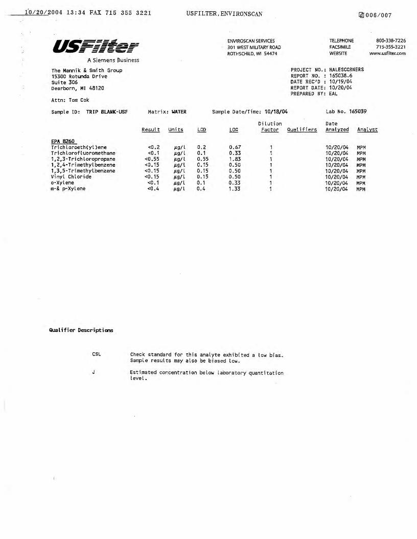
i'0 / 20 / 2004 13:34 FAX 715 355 3221
a~. ___ ...., ~-=-----_,_,, __ ,___
r-:1===-= A Siemens Busi-ness
The Mamik & Smith Group 15300 Rotunda Drive suite 306 Dearborn, MI 48120
Attn: Tom Cok
USFILTER,ENVIRONSCAN
ENVtROSCAN SERVICES 301 WEST MILITARY ROAD ROTHSCHILD, W1 54474
i4J 006 / 007
TELEPHONE FACSIMILE WEBSITE
PROJECT NO.: HALESCORNERS REPORT NO. : 165038.6 DATE REC'D : 10/19/04 REPORT DATE: 10/20/04 PREPARED BY: EAL
800-338-7226 715-355-3221
www.usfilter.com
Sample 10: TRIP BLANK-USF Matrix: "ATER Sample Date/Time: 10/18/04 Lab No. 165039
EPA 8260 Trichloroeth(yl)ene Trichlorofluoromethane 1,2,3-Trichloropropane 1,2,4-Trimethylbenzene 1,3,5 ·Trimethylben·zene Vinyl Chloride a-Xylene m-& p-Xylene
Qualifier Descriptions
CSL
J
<0.2 <0.1
<0.55 <0.15 <0.15 <0.15
<O. 1 <0.4
µ.g/l µ.g/ l µ.g/l µ.g/l µg/l µ.g/l µ.g/l µ.g/ L
0.2 0. 1 0.55 0.15 0.15 0.15 0. 1 0.4
LOO
0.67 0.33 1.83 0.50 0.50 0.50 0.33 1.33
Dilution Factor
1 1 1 1 1 1 1 1
Check standard for this analyte exhibited a low bias. Sample results may also be biased low.
Estimated concentration below Laboratory quantitation level.
Date Qualifiers Analyzed Analyst
10/20/04 MPM 10/20/04 MPM 10/20/04 MPM 10/20/04 MPM 10/20/04 MPM 10/20/04 MPM 10/20/04 MPM 10/20/04 MPM
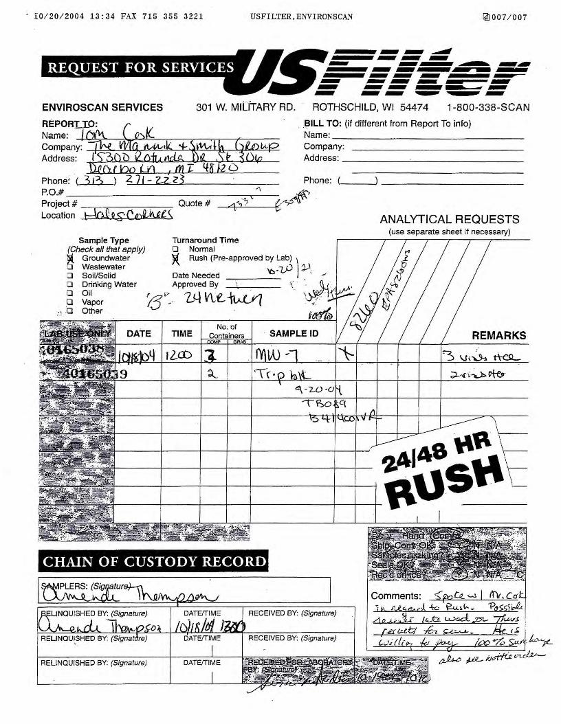
· I0 / 20 / 2004 13:34 FAX 715 355 3221 USFILTER.ENVIRONSCAN 14] 007 / 007
as ~.-~
14i•l1Jiiii•1iii4iti : ._ ~~._...
ENVIROSCAN SERVICES 301 W. MILfTARY RD. ROTHSCHILD, WI 54474 1-800-338-SCAN
Name: / ~ -~ . . . Name:
REPORIJP: ~ . . . -~ILL TO: (if different from Report To info)
~~:~:y: ii0f ~Bt?t~~i~~~p ~~x~::y_: -------------Phone:· ( 3 I'?> ) 2 71 - 2-2. Z ~ · Phone: P.O.# " ~4$;, Project# --,---~----- Quote # .q'.½·7 -~~' · Location tdo,C Q_£:• Ca:iWl \
Sample Type (Check all that apply) ISi1 Groundwater □ Wastewater D Soil/Solid O Drinking Water 0 Oil o Vapor
i-, .'o Other
Turnaround Time O Normal )( Rush (Pre-approved by Lab) )
_?J) J,,\. Date Needed '6 · ,·· Approved By --'.------ ( · ·• Q_ /
f ~., .• ·'J I \ V\.. t'... --h . -, . 1/l \_~Fj Q - L..-'-1 I\A-\./ ( . ..,_
No. of TIME
12.Cb
ANAL YT I CAL REQUESTS (use separate sheet if necessary)
REMARKS
7,A1A8"~'c ------+----+ f'USP \_
CHAIN OF CUSTODY RECORD
RECEIVED BY: (Signature)
RECEIVED BY: (Signature)
RELINQUISHED BY: (Signature) DATE/TIME

State of Wisconsin \ DEPARTMENT OF NATURAL RESOURCES
August 18, 2004
Jim Doyle, Governor Scott Hassett, Secretary Gloria L. Mccutcheon, Regional Director
Malan Realty Investors, Inc. John Robertscn 30200 Telegr2.ph Rd. Suite 105 Bingham Farms, MI 48026
Southeast Region Headquarters 2300 N. Dr. Martin Luther King, Jr. Drive
PO Box 12436 Milwaukee, Wisconsin 53212-0436
Telephone 414-263-8500 FAX 414-263-8606
TTY 711
FID: 34109955 BRRTS: 02-41-530534
Subject: Reported Contamination at the Country Fair Shopping Center, historical dry cleaners, 5606 S. 108th St., Hales Comers
Dear Mr. Robertson:
On A:.igust 09, 2004, Thomas P. Cok, of The Mannik and Smith Group, on behalf of Malan Realty Investors, Inc. , notified the Wisconsin Department of Natural Resources (WDNR) that soil and potential groundwater contamination had been detected at the site described above.
Based on the information submitted to the WDNR;-we believe that Malan Realty Investors, In.c. is responsible for restoring the environment at the referenced site under Section 292, Wisconsin Stats., known as the hazardous substances spills law.
This letter describes your legal responsibilities as a person who is responsible under section 292.11, explains what you need to do to investigate, and clean up the contamination; provides you with information about cleanups, environmental consultants, and possible financial assistance; and working cooperatively with the Department of Natural Resources and Department of Commerce ("Commerce") .
Legal Responsibilities:
Your legal responsibilities are defined both in statute and in administrative codes. The hazardous substances spill law, Section 292.11 (3) Wisconsin Statutes, states:
• RESPONSIBILITY. A person who possesses or controls a hazardous substance which is discharged or who causes the discharge of hazardous substance shall take the actions necessary to restore the environment to the extent practicable and minimize the harmful effects from the discharge to the air, lands, or waters of the state.
Wisconsin Administrative Code chapters NR 700 through NR 749 establish requirements for emergency and interim actions, public information, site investigations, design and operation of remedial action systems, and case closure. Chapter NR 708 includes provisions for immediate actions in response to limited contamination. Wisconsin Administrative Code chapter NR 140 establishes groundwater standards for contaminants that reach groundwater.
www .dnr.st2te .wi.us www.wiscorsin .gov
Quality Natural Resources Management Through Excellent Customer Service Printed on
Recycled Paoer
Steps to Take:
The longer contamination is left in the environment the farther it"can spread and the more it may cost to clean up. Quick action may lessen damage to your property and neighboring properties and reduce your costs in investigating and cleaning up the contamination. To ensure that your cleanup complies with Wisconsin's laws and administrative codes, ·you should hire a professional environmental consultant who understands what needs to be done. These are the first three steps to take:
1. Within the next 30 days, you should submit written verification (such as a letter from the consultant) that you have hired an environmental consultant. If you do not take action within this time frame, tlie WDNR may initiate enforcement action against you. ·
2. Within the next 60 days, your consultant should submit a work plan and schedule for the investigation. The consultant must comply with the requirements in the NR 700 rule series and should refer to WDNR technical guidance documents. To facilitate prompt agency review of your reports, your consultant should use the site investigation and closure formats which are available online at www.dnr.state.wi.us.
Once an investigation has established the degree and extent of contamination involved at your site, your consultant will be able to determine whether Commerce or the Department of Natural Resources has authority over the case.
3. Within 30 days of completion of the site investigation, you or your consultant must provide a site investigation report per s. NR 716.15. As the remedial activities proceed, you or your consultant should also provide a brief progress report at least every 90 days as required bys. NR 724.13(3), Wis. Adm. Code. Quarterly reports need only include one or two pages of text, plus any relevant maps and tables. Should conditions at your site warrant, we may require more frequent contacts.
4. Sites where discharges to the environment have been reported are entered into the Bureau for Remediation and Redevelopment Tracking System ("BRR.TS"), a version of which appears on the Department's Internet site. You may view the information related to your site at any time (http://www.dnr.state.wi.us/org/aw/rr/brrts) and use the feedback system to alert us to any errors in the data.
If you'want a formal response from the Department on a specific submittal, please be aware that a review fee is required in accordance with ch. NR 749, Wis. Adm. Code. If a fee is not submitted with your reports, you should proceed under the advice of your consultant to complete the site investigation to maintain your compliance with the spills law and chs. NR 700 through NR 749. Do not delay the investigation of your site by waiting for a Department response. We have provided detailed technical guidance to environmental consultants. Your consultant is expected to know our technical procedures and administrative codes and should be able to answer your questions on meeting cleanup requirements.
All correspondence regarding this site should be sent to:
Victoria Stovall, Program Assistant Remediation and Redevelopment Program Wisconsin Department of Natural Resources 2300 North Martin Luther King Drive Milwaukee, WI 53212

Unless otherwise requested, please send only one copy of plans and reports. To speed processing, correspondence should reference the BRRTS and FID numbers (if assigned) shown at the top of this letter.
Additional Information for Site Owners: Information to help you select a consultant, and materials on controlling costs, understanding the cleanup process, and choosing a site cleanup method are enclosed. In addition, Fact Sheet 2, Voluntary Party Remediation and Exemption from Liability provides information on obtaining the protection of limited liability under s. 292.15, Stats.
Financial Assistance: Reimbursement from the Petroleum Environmental Cleanup Fund (PECF A) may be available for some of the costs of cleaning up contamination from eligible petroleum storage tanks. Please refer to the enclosed information sheet entitled "Information about PECFA" for more information on eligibility and regulations for this program. For more information on the PECF A program, please call the Department of Commerce at 608-266-2424 or visit their web site at: http://www.commerce.state.wi.us/COM/Com-Petroleum.htrnl. Funding is also available for cleanup at some drycleaning sites.
Call the DNR Victoria Stovall, Program Assistant at (414) 263-8688 for more information on eligibility or visit the RR web site. http://www.dnr.state:wi.us/org/aw/rr. You may also contact this person for all other questions regarding this letter.
Thank you for your cooperation.
Victoria Stovall Program Assistant Remediation & Redevelopment Program Southeast Region
Enclosures: 1. Fact Sheet 2. Selecting a consultant 3. Fact Sheet 2, VPLE 4. Env. Services Contractors List 5. Inf. About PECF A Fact Sheet
c: Thomas P. Cok-Mannik and Smith Group WDNR SER Files

3132713076 MANNIK AND SMITH PAGE 01 / 05 I ,;i.,09 / 2004 12:28
-~~ M -i!i!e_tJ~ ..... ·t'h • ptifi: ann1n. (~s ... m• 1 : • •~!-~J cf:G up 1Ioo,r;.
15300 Rotunda Drive, Suite 306 Dearborn, Michigan 48120
313•271-2223 - Phone 313-271-3076 - Fax
www.manniksmithgroup.com
Project #: M208A3U9B
To: RR Program Assistant, From: Torn Cok # Pages r
Affiliation: _WD_;...:N_R::._ ___________ (incl. cover):---=-.::>~:.... ______________ _
Fax:
Phone:
Subject:
D Ursent
414 263-8483 Date: August 9. 2004
cc: John Roberson (Malan) Bruce Keyes (Foley)
Hazardous Substance Release Notification Form
□ FYI D As requested D Please Reply @ Hard copy to follow
• Comments:
Attached is a hazardous substance release form and analytical data for the Country Fairs Shopping Centers historic dry cleaners located at 5606 S. I 08th Street, Hales Corners, WI. The release from the historic dry cleaner was discovered during a site investigation for the former Express Cleaners (FID# 241462320) also located in the Country Fair Shopping Center. The release from the historic dry cleaners is distinctly separated from the Express Cleaners release and WDNR (Gina Keenan) directed Malan to submit a release notification form for the historic dry cleaners during a technical assistance meeting held on August 5, 2004.
(If there are any problems in transmission or I have sent you something in error, please advise).
~nfidenti.ility Statement:
The information contained in ('his facsimile is intended for the personal and confidential 11.se of the above-named person(s). If the bearerlreaoer of this message is not said person (or, the employee responsible for delivering facsimiles) then you are notified of erroneous reCl>ption of this facsimile and .iny review, copying, or distribution of Chis facsimile Is prohibited,
1VUPl'/FJ1.\SJiARED\SHARf;J)\Pl'OjC.cto·\En•\m1Ul/a3'JX)CS'ml0SaJu.J/alcs Corn,,,, W/1Ml08AJU9'M:!OIJ/I JU98.H;i1or1cal Dry C/e,,,,.,,-J ~clca.n, No1ifiw 1;w Fa<.doc

. . ~G/ 09 / 2004 12:28 3132713076 MANNIK AND SMITH PAGE 02/ 05
~~&9i ·¥-€) State of Wisconsin Department of Natural Resources
Fax Notification For Hazardous Substance Discharge (Non-Emergency Only)
Form 4400-225 (07/03) Pai;ie l of 2
Emergency Discharges/ Spills should be reported via the 24-Hour Hotline: 1-800-943-0003
Notice: Hazardous substance discharges must be reported immediately according to the ~Spills Law", s . 292.11 Wis. Stats., ·Section NR 706.05(1)(b), Wis. Adm. Code, requires that hazardous substance discharges are to be reported by one of three methods: telephoning the Department (toll free Spill Hotline number above), telefaxing a report to the Department or visiting a Department office in pe~on. If you choose to notify the Department by telefax, you should use this form to be sure that all necessary information is included. However use of this form is not mandatory. Under s. 292.99, Wis. Stats., the penalty for violating the reporting requirements of ch. 292 Wis. Stats., shall be no less than $10 nor more than $5000 for each violation. Each .day of continued violation is a separate offense. It is not the Department's intention to use any perSonally identifiable information from this form for any purpose other than program administration. However, information submitted on this form may also be made available to requesters under Wisconsin's Open Records Law (ss. 19.31 -19.39, Wis. Stats.). Confirmatory laboratory data should be included with this form, to assist the DNR in processing this Hazardous Substance Release Notification.
Complete this form. TYPE or PRINT LEGIBLY. FAX it to the appropriate DNR region (see next page) IMMEDIATELY upon discovery of a potential release from (check one): D Underground Petroleum Storage Tank System CJ Aboveground Petroleum Storage Tank System _J [E Dry Cleaner Facility (DERP eligibility based on: D Facility owner/operetor [!I Property owner of licensed facility) EJ Other - Describe:
TO DNR, ATTN: R & R Program Assistant (Area Code) F'AX, Number (4'1.4) 263~84~3 :
:iil:1'.~~r::;~;(f l!IT:\rJ.tS'.C1') '..: . r\ ; .. !f I '''. ''.ijt(ijd:;io: "~::!1J;;:f{!;f:1:rn;!ltW{tl!!ii!ll!ii.:ii:li:!!1~U::l!r l: !H~.'.'.t:'}:.);/t::i::,;t:.tB?1!faHHii! :i; '.i :;::~!:~?tir::~:'.lf.!!:~}:~7-li~•~.'.lni~i!!fl :Mimtk" ~m-;f!~~·::~J:~~~~i :~_:~;::HW!il: !W~fil'tU.if .~ill".( w:i ;~t·:~.~~•tl~!iit";;f;3~l?~!!!J.i!~.
Name _Firm Date FAXed to DNR
,Thqm~$, P:: Cok :!he? rv,~~nik & ~~ith:Gro~p ' ; ,pa10$12qo3 •. :: Mailing Address · 1:530t:Y:R6turida Or.··:s·u,te 306 : : . (Area Code) Phone Number
Q~arb16'rri· Mll46120 ' ' .·· . . ' . , ... ' ... . "' (3:13) 271 ~2223
i;~J:2'•!·~ ... 1~mw:S.ite!~IOIO r,rri'atiQD, :1m !UH !i11! m~~~;:~:;swii.:~~ll~!rn :!!:f :f ;;(h:t W~\1[~;:\?~(i~::;:~: :': :(;: ;:;!~:::; .~i;iii\fillliiW~f ;: :'if ~:.'}~t~::~\~~j~~~~~~:i:~i~;:;,::rn~;i:EW1im!i!i~~!f~t~~r~:1i~Hl .. iifa~-~~iimmmi: :;i:·~;~~·1:i~tl1gm1:ir11'.! ' W!'. i:!!!iilii: Name of site at which discharge occurred. Include local name of site/business, not responsible party name, unless a
residence I vacant property C6uritry F~ir:Shopping Ceht~r. Histori~al Dty (;le~ri~rs . ; i: • : : . :. . . · : · :· • · · Location: Include street address; not PO Box. If no street address, describe as precisely as possible, i.e., 1/4 mile NW of CTHs 60 & 123 on E side of CTH 60
:~eosii 19st~ siteef (.-t!) : :: : : :,: i ; :: .•: :··· :.• ) : : S3.i 3f;) . ·.::: .. ;·. ' .. ;; .
'•, ·
Municipality (City, Village, Township) Specify municipality in which the site is located, not mailing address/city ::8a1e~ ~?.n:~r.~· :: ·· · · · · : · .:.· :· · ·· · ·· ·. ·· · · ··· · ·· ). : · · ·· · .: · · · ·
County: · · ·· : · ·.·:·· · Legal Description: . . ... . MilYJaukee Nw:1/4, NW 1/4, Section 32; Tn 6:f'!, Range 21( E 0 or WO
[J Responsible Party Name: Business or owner name that is responsible for cleanup. If more than one, list all Attach additional pages as necessary Mal~n Realty Investors;; in'ci : .. , .. ' . .
,. ' "' "', ,., .... '
0 Reported in compliance with s. 292.11 (2) , Wis. Stats., by a local government exempt from liability under s. 292.11 (9)(e), Wis. Stats. For more information see http://www.dnr.state.wi.us/org/aw/rr/liability/muni 1.html
Contact Person Name (if different) · . . · · · Phone Number Joh.n Roberson. ici+s) 644':'711 Cl : '
Mailing Address
3020b i~i.~g~a:ph:Ra; s~·it~: to~ · City
BingharrrFarms : · State
. . . .
Ml :
ZIP Code
~8025
., -. .. , ... . ,
(continued)
i ~/ 09/ 2004 12 :28 3132713076 MANNIK AND SMITH PAGE 03 / 05
State of Wisconsin Department of Natural Resources
Fax Notification For Hazardous Substance Discharge (Non-Emergency Only)
Form 4400-225 (07103) Psge 2 of 2
'.:~11~,?•~;~'M:i~!Haza '·.l.tb.ti~iSllti.i ;tar.lc.e~,m·•::acf(jlhtOrm1ati.<l'ri;t;i::~}!i:,~;ji(l;,l!;;;;!{;~~;;1i;;,;!fli~iii!if.:irti.},1;.::~ffrfJf:ii::F.~if~rtri\~f,~jff,{:~t~1f;f/~ji~H1m11iii1/WWHi!iiiiifi:;1~~!H~!J~;unirf:!['?J!i'. '. iri:!!T:.:r.(~r:-.. ·;~~?l~l~iiiii, Identify hazardous substance discharged (check all that apply):
METALS INDUSTRIAL CHEMICALS □Arsenic □Ammonia □Chromium CJ cyanide □Lead □Paint □Mercury . QPCB's □Metals (specify): ____ • OV0C's
S LVENTS Solvent-Chlorinated
□Solvent-Non Chlorinated □PERC ovoc·s
[]Fertilizers D Pesticide/Herbicide/ Insecticide( s) □Leachate ORCRA Hazardous Waste
PETROLEUM □Diesel/Fuel Oil □Engine Oil/Waste Oil OMineralfTransmission/Hydraulic Oil □Gasoline (Pb/Non-Pb/Unknown) □Jet Fuel/Kerosene OMTBE ovoc·s OPAH's/SV0C □Petroleum-Unknown Type
□Other (specify):_ .. ___ __
□Unknown
Impacts to the environment (enter "K" for known/confirmed or "P" for potential for all that apply)
~ Air Contamination _Air:, Contamin.ition in Right of Way ...8.iL Co-contamination K;&r Direct Contact _& Concrete/Asphalt c.Aii:: Expanding Plume __Au:,; Contained/Recovered ~ Fire Explosion Threat ...Aii:c Contamination Within 1 Meter of Bedrock _AI!:. Free Product .Ali. Contaminated Private Well f ..& Groundwater Contamination ~ Contaminated Public Well ...Ail Off-Site Contamination ..Ail:;; Contamination in Fractured Bedrock k Other
_···_·, _· · Sanitary Sewer Contamination ~ Soil Contamination _ . _: Storm Sewer Contamination _ .. _ Surface Water Contamination ~ Within 100 ft of Private Well ~ Within 1000 ft of Public Well
Contamination was discovered as a result o'f: □Tank closure assessment OSite assessment Date :· · '· ··· ··· ·· Date · · ·
Other - Describe: During in~estlgation of Form Express o,y CIEiane~ Date 07/0112004 : ., ;·
Lab results: DJ.ab results will be faxed upon receipt ~ Lab results are attached
Additional Comments: Include a brief description of immediate actions taken to halt the release and contain or cleanup hazardous substances that have been discharged.
::,-he'.rele~~i? :'irorn the hiiforfo dr.y:,cle~nerr106ited.in the Cou.ntfy Fair Sh.opping Cer,,ter, at ssos:;~t:..10.8th :~,treet, Hal~s ;:Come,r~. ~~:~::discovefred ·durt~'fa site investigation oft.he former E,tpress :Dry ci~anei~ <f:IP#24146232~} that .is ~lso . located in the,:Country. f~ifShoppjng Center at 5620 S. 108th Street. · · ··· ·
· :· '!' i· :·: ' , . . : . . .", ' . . , ·· '
FAX numbers to report non-emergency releases in DNR's five regions are as follows:
Northeast Region (920-492-5859); Attention• RR Program Assistant: Brown , Calumet, Door, Fond du Lac (except City of Waupun - see ·south Central Region), Green Lake, Kewaunee, Manitowoc, Marinette, Marquette, Menominee. Oconto, Outagamie, Shawano, Waupaca , Waushara, Winnebago Counties
Northern Region (715-365-8932); Attention - RR Program Assistant: Ashland, Barron, Bayfield, Burnett, Douglas, Forest, Florence, Iron . Langlade, Lincoln, Oneida, Polk, Price, Rusk, Sawyer, Tc1ylor, Vilas, Washburn Counties
South Central Region (608-275-3338); Attention • RR Program Assistant: Columbia, 0ane, Dodge, Fond du Lac (City of Waupun only), Grant, Green, Iowa, Jefferson, Lafayette, Richland, Rock, Sauk Counties
Southeast Region (414-263-8483); Attention - RR Program Assistant: Kenosha, Milwaukee, Ozaukee, Racine, Sheboygan, Walworth, Washington, Waukesha Counties
West Central Region (715-839-6076); Attention - RR Program Assistant: Adams, Buffalo. Chippewa , Clark, Crawford, Dunn, Eau Claire , Jackson , Juneau, LaCrosse, Marethon, Monroe, Pepin, Pierce, Portage, St. Croix, Trempealeau, Vernon, Wood Counties

~ @/ 09 / 2004 12 :28 3132713075
U~-====~ ,.,. ----- --- _,. ------_ ____,. __ ---------,._ _____ ,_ __ - -- ------- __ _,, ---
,e Mannik & smith Group ;300 Rotunda Drive 1ite 306 ~arborn, MI 4812□
:tn: Tom Cok/ Molly Z~wacki
1mple 10: HC•Ec-i6 Matrix; SOIL
MANNIK AND SMITH
ENVIROSCAN SERVICES 301 WEST MILITARY ROAD ROTHSCHILD, WI 5d.d74
PROJECT NO.: M208A3U9 REPORT NO . = 158064.8 OATE REC'D : 07/02/04 REPORT DATE: 07/12/04 PREPARED BY= JRS
TELEPHONE FACSIMILE WEBSITE
sample Date/Time : 07/01/04 10:00 Lab No. 158069
Dilution Date ~ Oualifiers Analyzed Anal>'.§t
'A 8021 (Only positively identified analyte& are reported on a 0.008 0.007 0.006 0 .012 0.01 0.01 0.008 0. 007 0.02 0.09 0 . 01 0.01 0 . 008 0.008 0.009 0.012 Q_008 0.008 0.008 0.014 0.009 0.005 0.016 0.007 0.01 0.007 □ .008 □ .0□ 13 0.007 0.015 0.009 0.014 0.011 0.018 0.014 0.01 0.009 0.009 0 . 0D6 0 . □07 0.014 0.014 0.008 0.006 □ .011 0. 008 0.012 0.01 0.018 0.015 0.008
0.027 0.023 0.02 0 . 04 0.033 0.033 0.027 0.023 0.067 0.30 0.033 0.033 0.027 □ .027 0. 03 0.04 0.027 0.027 0.027 0.047 □ .03 0.017 0.053 0.023 0.033 0.023 0.027 0.027 o. □ 23 0.05 □ .03 0.047 0.037 0.06 0.047 0.033 0.03 0.03 0.02 0.023 0_047 0.047 0.027 0.02 0.037 0.027 0.04 0.033 0.06 0.05 0.027
dry weight basis , 07/07/04 07/07/04 07/07/04 07/07/04 07/07/04 07/07/04 07/07/04 07/07/04 07/07/04 07/07/04 07/07/04 07/07/04 07/07/04 07/07/04 07/07/04 07/07/04 07/07/04 07/07/ □4 07/07/04 07/07/04 07/07/04 D7/07/04 07/07/04 07/07/04 07/07/04 07/07/04 07/07/04 07/07/04 07/07/04 07/07/04 □ 7/07/04 07/07/04 07/07/04 07/07/04 07/07/04 □7/07/04 07/07/04 07/07/04 07/ □7/04 07/07/04 07/07/04 07/07/04 07/07/04 07/07/ □4 07/07/04 07/07/04 07/07/04 07/07/04 07/07/04 07/07/04 07/07/04 07/07/04 07/07/04
LMP LMP LMP LMP LMP LMP LMP LMP LMP LMP LMP LMP LMP LHP LMP LMP LMP LMP LMP LM? LMP LMP LMP LMP l.MP LMP LMP LMP LMP LMP LMP LMP LMP LMP LMP · LMP LMP (Mi> LMP LMP LMP LMP LMP LMP LMI> LMI> LMP LMP LMP LMP LMP LMP LMP
,nzene ·omobenz.ene ·omodi c:h Loromethane Butylb1m?ene ,c-Sutylbenzene •rt· Butyl benzene rbon Tetrachloride loroben2:ene lorodibromomethane loroethane loroform loromethane :hLorotolueM :hlorotoluenc ~-Dibromo-3-chloropropane ~-Di bromoethane ?-Dichloroben2:ene ;-Dichlorobenzene ;-o .i c:h lorobenzene :hlorodifluoromethane •Oichloroethane
!·Oi ch loroethane -o;chloroethylene ,-1,2-Dichloroethylene ,ns-1,2-0ichloroethylene :-o i ch lo ropropane ·Oichloropropane ·Oichloropropane ylbenzene achlorobutadiene propy l ben.:.ene propyl Ether sopropyltoluene hyl t·6utyl Ether(MTBE) hylene Chloride htha lene ropylbenz.ene rachloroethylene ,2,2·Tetrachloraethane Jene ,3-Trichlorobenzene ,4-Trichlorobenzene .1·T.richloroethane 2-Tri~hloroethane
.t, loroethylene hlorofluoromethane 4· Trimethytbenzen~ 5-Trimethylbenzene l Chloridi!: p·Xylene
Lene ;ur-rog.:itc Rc.c:ovcry ( S) Surrog~te Recovery CS)
<0.025 <0.025 <0 . 025 <O.D25 <0.025 <0.025 <0.025 <0.025 <D.025 <0.025 <0.025 -=O.D25 < □ .025 <0.025 <D.025 <□· .025 <0.025 <0.025 <0.025 <0.025 <0.025 <D . 025 <0.025 <0.025 -:0.025 <0.025 <0.025 <0.025 <0.025 <0.025 <0.025 <0.025 <0.025 <0.025 <0 . 025 . < □ . 025 <0.025
..-- 0.161 <0.025 <0.025 <0.025 <0.025 <0.025 <0.025 <0.025 <0.D25 <0.025 <0.025 ,c;0.025 <0.025 <0.025
103. 93.3
96.4
mg/leg mg/kg mg/kg mg / leg ms/kg mg/leg mg/leg mg/lc:9 mg/ks mg/leg mg/leg mg/kg mg/kg mg/kg mg/kg mg/kg mg/kg mg/kg Ing/leg mg/kg mg/kg mg/kg 1119/kg mg/lc:g mg/leg mg/leg rng/kg rng/lc.g mg/kg rng/lcg mg/ kg mg/kg mg/leg ms/kg mg/leg mg/kg mg/kg ms/kg mg/leg mg/kg · mg/kg ms/kg mg/leg m;/kg mg/kg mg/kg mg/lc;g . mg/kg ms/kg mg/kg mg/kg ., ,.
r.
%
esults calcul3tcd on a dr-y weight b~sis.
0.33
All Ancilysei ccnduc1ed in occordcmce with USFiher Ouolity As,uronce Program Wioeonsin Lob Ccrlificr;,lion No. 737053130
l 1 CSH LCH 1 1 , , 1
cs~
CSH ll:H
1 CSH LCH 1 1 1 , 1 CSH DUP 1 1 1 1 , 1 1 1 LCL 1 , 1 1 1 , 1 1 1 , 1 1 1 1 1 1 , 1 CSH LCH 1 , 1 CSH LCH DUP 1 , 1 1
07 /08/04 SAK
PAGE 04 / 05
71S-338-7226 71 S-355-3221
www.usl ilter.com
ll

. . ._ B@/ 09/ 2004 12:28 3132713075 MANNIK AND SMITH
US'i _____ ENVlmSCAN seRVICES TELEPHONE .------ ----------- 301 WEST MlllTARY ROAD FACSIMILE .==-3e.==:=-- -- ._.,__.._ ROTHSCHILD, WI 5.d.i7A WEBSIT-E
,e Msnnik & Smith Group PROJECT NO.: M208A3U9 ;300 Rotunda Drive REPORT NO. : 155064.7 Jite 306 DATE R~C'D : 07/02/04 ~srborn, Ml 48120 REPORT DATE: 07/12/04
PREPARED BY: JRS t~n: Tom Cok/ Molly Zawacki
ample JO: HC·EC-17 Matrix: GRDIJTR Sample Date/Time: 07/01/04 11:30 Lab No. 1S8068
Result ~ .!:..Q.12. !$
PA 8021 enzene <0.31 µ.g/ l 0.31 1.03 romobenzene <0.41 µ.g/l 0.41 1 .37 romodichloromethane <0.83 µ.g/l 0.83 2.76 -Butyl benzene <0.36 µ.g/ l 0.36 1.2 ec-Butylbcnzene <0.4 µ.g/ l 0.4 1.33
ert-Butylbenzene <0.4 µ.g/ l □ .4 1.33 arbon Tetrachloride <0.5 µ.g/ l o.s 1.67 :h lo robenzen·e <0.7 µ.g/ L 0.7 2.33 · i bromoch lorornethane <0.87 µ.g/L O.B7 2.9 :h loroethane <1.00 ,:ig/l 1.0 3.33 :t,lorofom <0 . 4 JLS/l 0.1+ 1.33
:h Loromethane <0.29 µ.g/l 0.29 0.97 :-ch l oroto l uene <0.6 /L9/ l 0.6 2.0 ,-Chlarotoluene <1.00 /L9/ l 1.0 3.33 libromochlorapropane(DBCP) <1.30 µ.g/ l 1.3 4.33 1,2-Dibromoethane(EDB) <1. 10 µ.g/ l ,. , 3.66 I, 2-D i_ch l orobenzene <D.6 ,:ig/l 0.6 2.0 1,3-0ichlorobenzene <0.5 /L9/ l o.s 1.67 1,4-0i~hlorobenzene <0.6 /19/ l 0.6 2.0 )ichlorodifluoromethane <0.7 ILQ/ l 0.7 2.33 1, 1-0ichloroethane <0.5 µ.9/ l 0.5 1.67 1,2-Dichloroethane <0.4 /L9/ I 0.4 1 .33 1,1-o;chloroeth(yl)ene <0.5 µ.g/ L 0.5 1.67 cis•1,2-Dichloroeth(yl)ene <0.4 µ.9/l 0.4 1 .33 trans•1,2·Dichloroethylene <0.39 /L9/l 0.39 1 .3 1,2-Dichloropropane <0.4 ILQ/ l 0.4 1.33 1,3-Dichloropropane <0.9 µ.g/1 0.9 3.0 2,2-Dichloropropane <1.50 /L9/ l . 1.S 5.0 Ethyl benzene <0.5 µ.g/ l 0.5 1 .67 Hexachlorobutadiene <1.00 JL9/ l 1. 0 3.33 !sopropylbenzene <0.31 µ.g/ l 0.31 1 .03 lsopropyl Ether <0.6 µ.g/ l 0.6 2.0 p-lsopropyltoluene <0.5 µ.9/ l 0.5 1.67 Methyl r-Butyl Ether(MTBE) <0.3 ILQ/l 0 .3 ,_o Methylene Chloride <0.5 µ.g/l o.s 1 .67 Naphthalene ~0.8 JLSII 0.8 2.66 n·Propylbenzene <0.3 119/l 0.3 1. 0
Tetrochloroeth(yl)ene ~ 12 .2 /L9/l 0.45 1.5 1,1,2,2-Tetrachloroethane <O .61 1Lg/L 0.61 2.03 10Luene . · 0.376 µ.g/l 0.3 1.0 1,2,3-Trichloroben2ene <0.5 µ.g/l 0.5 1.67 1,2,4-Triehlaroben~ene <1.00 µ.g/l 1.0 3.33 1,1, 1·Trichloroeth~ne <0.42 µ.9/l 0.42 1.4
1. 1,2-Trichloroethane <O.S 1'9/l 0.5 1.67 Trichloroeth(yl)ene <0.5 /LQ/l 0.5 1.67' Trichlorofluoromethane <1.00 µ.g/l 1.0 3.33 1,2,4·Trimethylbenzene <0.4 JI.Q/ l 0.4 1.33 1,3,5-Trimethylbenzene <0.31 /L9/ l 0.31 1.03 Vinyl Chloride <0.2 µ9/ l 0.2 0.67 m- & p-Xylene <0.62 µ.9/ l 0.62 2.06 o·Xylene <·0.3 µ.g/L 0.3 ·1.0
PIO Surrcsate Rec;overy CS) 101. ,:
HALL surrogate Recov~ry (5) 129. %
All Arn;r lyse& i;onduc;lcd in cci;ordance wilh USFilt~, Qu,;,li ty Aisuronc11 Program
Wisconsln Lob Certificorion No. 737053130
Dilution Date ~ 0ual Hiers Anal)!z.ed Ansl;i::st
1 07/08/04 L,.,P 1 07/08/04 LMP , 07/08/04 LMP 1 CSL 07/08/04 LMP 1 07/08/04 LMP 1 07/08/04 LMP , 07/08/04 LMP , 07/08/04 LMP , 07/08/04 LMP 1 07/08/04 LMP 1 07/08/04 LMP 1 07/08/04 LMP 1 07/08/04 LMP , 07/08/01. LMP 1 07/08/04 LMP 1 07/08/04 LMP 1 07/08/04 Ll-1P 1 07/08/04 LMP 1 07/08/04 LMP 1 CSL 07/08/04 LMP 1 07/08/04 L,.,P , 07/08/04 L1'1P 1 07/08/04 LMP 1 07/08/04 LMP 1 07/08/04 LMP , 07/08/04 LMP 1 07/08/04 LMP 1 CSL 07/08/04 LMP , 07/06/04 LMP 1 07/08/04 LMP
07/08/04 LMP 1 07/08/04 LMP 1 07/08/04 LMP , 07/08/04 LMP 1 ·07/08/04 LMP 1 07/08/04 LMP 1 07/08/04 LMP. 1 07/0t,:04 LMP 1 07/0 104· LMP 1 J 07/08/04 LMP , 07/Da/D4 LMP , 07/08/04 LMP 1 07/08/04 LMP 1 07/08/04 LMP 1 07/08/04 LMP 1 07/08/04 LMP 1 07/08/04 LMP 1 07/08/04 LMP 1 07/08/04 LMP , 07/08/04 LMP 1 ,07/08/04 LMP 1 07/08/04 LM? 1 07/08/1>4 LMP
PAGE 05/ 05
715-338-7226 715-355-3221
www.u~fiher.com

•
To: RR Program Assistant,
----
15300 Rotunda Drive, Suite 306 Dearborn, Michigan 48120
313-271-2223 - Phone 313-271-3076 - Fax
www.manniksmithgroup.com
I
Project #: M208A3U9B
From: Tom Cok
Affiliation: WDNR (inct ::::;; .S Fax:
Phone:
Subject:
---------------- --------------------414 263-8483 Date: August 9, 2004
cc: John Roberson (Malan) Bruce Keyes (Foley)
Hazardous Substance Release Notification Form
□ Urgent □ FYI D As requested □ Please Reply 0 Hard copy to follow
• Comments:
Attached is a hazardous substance release form and analytical data for the Country Fairs Shopping Centers historic dry cleaners located at 5606 S. 108th Street, Hales Comers, WI. The release from the historic dry cleaner was discovered during a site investigation for the former Express Cleaners (FID# 241462320) also located in the Country Fair Shopping Center. The release from the historic dry cleaners is distinctly separated from the Express Cleaners release and WDNR (Gina Keenan) directed Malan to submit a release notification form for the historic dry cleaners during a technical assistance meeting held on August 5, 2004.
(If there are any problems in transmission or I have sent you something in error, please advise).
Confidentiality Statement:
The information contained in this facsimile is intended for the personal and confidential use of the above-named person(s). If the bearer/reader of this message is not said person (or, the employee responsible for delivering facsimiles) then you are notified of erroneous reception of this facsimile and any review, copying, or distribution of this facsimile is prohibited.
\VUPITER1SHARED\SHARED'Projects\Env1m208a3\JJOCS1m208a311-Hales Con,er, WJ\M208AJU9\M208A3U9B.Historica/ Dry Clew,ers'Release Notification Fa'<.doc

•
State of Wisconsin Department of Natural Resources
Fax Notification For Hazardous Substance Discharge (Non-Emergency Only)
Form 4400-225 (07/03) Page I of 2
Emergency Discharges/ Spills should be reported via the 24-Hour Hotline: 1-800-943-0003
Notice: Hazardous substance discharges must be reported immediately according to the "Spills Law", s. 292.11 Wis. Stats., ·Section NR 706.05(1)(b), Wis. Adm. Code, requires that hazardous substance discharges are to be reported by one of three methods: telephoning the Department (toll free Spill Hotline number above), telefaxing a report to the Department or visiting a Department office in person. If you choose to notify the Department by telefax, you should use this form to be sure that all necessary information is included. However use of this form is not mandatory. Under s. 292.99, Wis. Stats., the penalty for violating the reporting requirements of ch. 292 Wis. Stats. , shall be no less than $10 nor more than $5000 for each violation. Each day of continued violation is a separate offense. It is not the Department's intention to use any personally identifiable information from this form for any purpose other than program administration. However, information submitted on this form may also be made available to requesters under Wisconsin's Open Records Law (ss . 19.31 - 19.39, Wis. Stats.). Confirmatory laboratory data should be included with this form, to assist the DNR in processing this Hazardous Substance Release Notification.
Complete this form . TYPE or PRINT LEGIBLY. FAX it to the appropriate DNR region (see next page) IMMEDIATELY upon discovery of a potential release from (check one): D Underground Petroleum Storage Tank System D Aboveground Petroleum Storage Tank System __1 !'ii' Dry Cleaner Facility (DERP eligibility based on: D Facility owner/operator 00 Property owner of licensed facility) D Other - Describe:
TO DNR, ATTN: R & R Program Assistant (Area Code) FAX Number (414) 263-8483
Location: Include street address, not PO Box. If no street address, describe as precisely as possible, i.~ :,J/4 rr,iJe Nvy of CTH.? .. 6 .. 0 .. & 123 on . E side of CTH 60
5606 S: 108th street ·· ····· ·· · ·
Municipality (City, Village, Township) Specify municipality in which the site is located, not mailing address/city
Hales .Corners
County: . Milwaukee
Legal Description: NW 1/4, NW 1/4, Section 32; Tn 6N, Range ;21 E
Q Reported in compliance with s. 292.11 (2), Wis. Stats., by a local government exempt from liability under s. 292.11 (9)(e), Wis. Stats. For more information see http://www.dnr.state.wi.us/org/aw/rr/liability/muni 1.html
Contact Person Name (if different) John Roberson
Mailing Address
30200 Telegraph Rd, Suite 105 .
City Bingham Farms
Phone Number (248) 644-7110
State
Ml
ZIP Code
48025
- (continued)

State of Wisconsin Department of Natural Resources
Fax Notification For Hazardous Substance Discharge (Non-Emergency Only)
Form 4400-225 (07/03) Page 2 of 2
METALS INDUSTRIAL CHEMICALS □Arsenic □Ammonia □Chromium □Cyanide □Lead □Paint □Mercury OPCB's □Metals (specify): ____ OVOC's
S LVENTS Solvent-Chlorinated
□Solvent-Non Chlorinated □PERC [JVOC's
□Fertilizers OPesticide/Herbicide/lnsecticide(s) □Leachate ORCRA Hazardous Waste
PETROLEUM □Diesel/Fuel Oil □Engine Oil/Waste Oil □Mineral/Transmission/Hydraulic Oil □Gasoline (Pb/Non-Pb/Unknown) □Jet Fuel/Kerosene □MTBE OVOC's □PAH 's/SVOC □Petroleum-Unknown Type
□Other (specify): ____ _ □Unknown
Impacts to the environment (enter "K" for known/confirmed or "P" for potential for all that apply)
-8.i.c. Air Contamination ....Air. Contamination in Right of Way _Ail:. Co-contamination K!M. Direct Contact "'Ai[ Concrete/Asphalt _Air_ Expanding Plume nAii: Contained/Recovered ....Air. Fire Explosion Threat
--8.1c.: Contamination Within 1 Meter of Bedrock Air Free Product ...AiL Contaminated Private Well f ~ir Groundwater Contamination ...AiL Contaminated Public Well ....Air. Off-Site Contamination ...AiL Contamination in Fractured Bedrock ....Air. Other
Contamination was discovered as a result of:
__ Sanitary Sewer Contamination __ Soil Contamination ____ Storm Sewer Contamination __ Surface Water Contamination __ Within 100 ft of Private Well
Within 1000 ft of Public Well
□Tank closure assessment □Site assessment Other_ Describe: During Investigation of Form Express Dry Cleaners Date Date Date 01101 i2004
Lab results: O)-ab results will be faxed upon receipt ~ Lab results are attached
Additional Comments: Include a brief description of immediate actions taken to halt the release and contain or cleanup hazardous substances that have been discharged.
The releas'e from the hist()rfo dry cleaners locatedjn the Couhtry Fair Sh<:>pping Center at 5605 S. 108th Street, Hales Comers; was discovered ing a site investigation of the forrner Expressl)ry Cleaners (FID#241462320) that is also located in the Country F hopping Center at 5620 S. 108th Street. · ··· ·
FAX numbers to report non-emergency releases in DNR's five regions are as follows:
Northeast Region (920-492-5859); Attention - RR Program Assistant: Brown, Calumet, Door, Fond du Lac (except City of Waupun - see South Central Region), Green Lake, Kewaunee, Manitowoc, Marinette, Marquette, Menominee, Oconto, Outagamie, Shawano, Waupaca, Waushara, Winnebago Counties
Northern Region (715-365-8932); Attention - RR Program Assistant: Ashland, Barron, Bayfield, Burnett, Douglas, Forest, Florence, Iron, Langlade, Lincoln, Oneida, Polk, Price, Rusk, Sawyer, Taylor, Vilas , Washburn Counties
South Central Region (608-275-3338); Attention - RR Program Assistant: Columbia, Dane, Dodge, Fond du Lac (City of Waupun only), Grant, Green, Iowa, Jefferson, Lafayette, Richland, Rock, Sauk Counties
Southeast Region (414-263-8483); Attention - RR ~rogram Assistant: Kenosha, Milwaukee, Ozaukee, Racine , Sheboygan, Walworth, Washington, Waukesha Counties
West Central Region (715-839-6076); Attention - RR Program Assistant: Adams, Buffalo, Chippewa , Clark, Crawford, Dunn, Eau Claire, Jackson, Juneau , Lacrosse , Marathon, Monroe, Pepin, Pierce, Portage, St. Croix, Trempealeau, Vernon, Wood Counties

' - --.-----------u.~=-=-=~ =-=-~==-
The Mannik & Smith Group 15300 Rotunda Drive Suite 306 Dearborn, Ml 48120
ENVIROSCAN SERVICES 301 WEST MILITARY ROAD
ROTHSCHILD, WI 5447 4
PROJECT NO.: M208A3U9 REPORT NO. : 158064.8 DATE REC'D : 07/02/04 REPORT DATE: 07/12/04 PREPARED BY: JRS
TELEPHONE
FACSIMILE WEBSITE
Attn: Tom Cok/ Molly Zawacki
Sample ID: HC-EC-16 Matrix: SOIL Sample Date/Time: 07/01/04 10:00 Lab No. 158069
:PA 8021 lenzene
(Only positively
:romobenzene .romodichloromethane -Butyl benzene ec-Butylbenzene ert-Butylbenzene arbon Tetrachloride ,torobenzene 1lorodibromomethane , l oroethane 1 l oroform 1 l oromethane Chlorotoluene Chlorotoluene 2-Dibromo-3-chloropropane 2-Dibromoethane 2-Dichlorobenzene 3-Dichlorobenzene i-Dichlorobenzene :hlorodifluoromethane ' -Dichloroethane '.-Di ch loroethane -Dichloroethylene -1,2-Dichlo roethylene ns-1,2-Dichloroethylene -Dichloropropane -Dichloropropane -Dichloropropane ylbenzene ichlorobutadiene ,ropy l benzene iropyl Ether ;opropyl toluene 1y l t -Butyl Ether ( MTBE) ylene Chloride thalene opylbenzene achloroethylene 2,2-Tetrachloroethane ~ne 3-Trichlorobenzene i-Trichlorobenzene ' -T, rich l oroethane '.-Trichloroethane l oroethyl ene lorofluoromethane -Trimethylbenzene -Tri methyl benzene Chloride
,-Xylene
Jrrogate Recovery CS) ,urrogate Recovery CS)
-2 Solids
identified <0.025 <0.025 <0.025 <0.025 <0.025 <0.025 <0.025 <0.025 <0.025 <0 .025 <0.025 <0.025 <0.025 <0.025 <0.025 <0.025 <0.025 <0.025 <0 .025 <0.025 <0.025 <0.025 <0.025 <0.025 <0.025 <0.025 <0.025 <0 .025 <0.025 <0.025 <0.025 <0.025 <0.025 <0.025 <0.025 . <0.025 <0.025
,..- 0.161 <0.025 <0.025 <0.025 <0.025 <0.025 <0.025 <0.025 <0.025 <0.025 <0.025 <0.025 <0 .025 <0.025
103. 93.3
96.4
analytes mg/kg mg/kg mg/kg mg/kg mg/kg mg/kg mg/kg mg/kg mg/kg mg/kg mg/kg mg/kg mg/kg mg/kg mg/kg mg/kg mg/kg mg/kg mg/kg mg/kg mg/kg mg/kg mg/kg mg/kg mg/kg mg/kg mg/kg mg/kg mg/kg mg/kg mg/kg mg/kg mg/kg mg/kg mg/kg mg/kg mg/kg mg/kg mg/kg mg/kg mg/kg mg/kg mg/kg mg/kg mg/kg mg/kg mg/kg mg/kg mg/kg mg/kg mg/kg
% %
%
sults calculated on a dry weight basis.
are reported on a dry 0.008 0.027 0.007 0.023 0.006 0.02 0.012 0.04 0. 01 0. 033 0.01 0.033 0 .008 0.027 0.007 0.023 0.02 0.067 0 . 09 0.30 0.01 0.033 0. 01 0. 033 0.008 0.027 0.008 0.027 0.009 0.03 0.012 0.04 0.008 0.027 0.008 0.027 0.008 0.027 0.014 0.047 0. 009 0. 03 0.005 0.017 0.016 0.053 0.007 0.023 0.01 0.033 0.007 0.023 0.008 0.027 0.008 0.027 0.007 0.023 0.015 0.05 0.009 0.03 0.014 0.047 0.011 0.037 0.018 0.06 0.014 0.047 0. 01 0. 033 0.009 0.03 0.009 0.03 0.006 0 . 02 0.007 0.023 0. 014 0. 04 7 0. 014 0. 047 0.008 0.027 0.006 0.02 0.011 0.037 0.008 0.027 0.012 0.04 0.01 0.033 0.018 0.06 0.015 0.05 0.008 0.027
0.33
All Analyses conducted in accordonce with USFilter Quality Assurance Program
Wisconsin Lab Certification No. 737053 130
Dilution Date Factor Qualifiers Analyzed Analyst
weight 1 1 1 1 1 1 1 1 1 1 1 1 1 1 1 1 1 1 1 1 1 1 1 1 1 1 1 1 1 1 1 1 1 1 1 1 1 1 1 1 1 1 1 1 1 1 1 . 1 1 1 1 1 1
basis
CSH LCH
CSH
CSH LCH
CSH LCH
CSH DUP
LCL
CSH LCH
CSH LCH DUP
07/07/04 07/07/04 07/07/04 07/07/04 07/07/04 07/07/04 07/07/04 07/07/04 07 /07 /04 07 /07 /04 07/07/04 07/07/04 07/07/04 07/07/04 07 /07 /04 07/07/04 07/07/04 07/07/04 07/07/04 07/07/04 07/07/04 07/07/04 07/07/04 07 /07 /04 07/07/04 07/07/04 07/07/04 07/07/04 07/07/04 07/07/04 07/07/04 07/07/04 07/07/04 07 /07 /04 07/07/04 07/07/04 07/07/04 07/07/04 07/07/04 07/07/04 07/07/04 07/07/04 07/07/04 07/07/04 07/07/04 07 /07 /04 07/07/04 07/07/04 07/07/04 07/07/04 07/07/04 07/07/04 07/07/04
LMP LMP LMP LMP LMP LMP LMP LMP LMP LMP LMP LMP LMP LMP LMP LMP LMP LMP LMP LMP LMP LMP LMP LMP LMP LMP LMP LMP LMP LMP LMP LMP LMP LMP LMP · LMP LMP LMP LMP LMP LMP LMP LMP LMP LMP LMP LMP LMP LMP LMP LMP LMP LMP
07 /08/04 SAK
715-338-7226
715-355-3221 www.usfilter.com

us=::::;: ENVIROSCAN SERVICES - -------------------~ 301 WEST MILITARY ROAD - ------ -- ----- -- --- ROTHSCHILD, WI 5447 4
The Mannik & Smith Group PROJECT ""·: 15300 Rotunda Drive REPOP- NO. : Suite 306 f1A-r'= REC'D : Dearborn, MI 48120 REPORT DATE:
PREPARED BY:
Attn: Tom Cok/ Molly Za11acki
Sample ID: HC-EC-17 Matrix: GRDw'TR Sample Date/Time: 07/01/04 11:30
Result Units LOO LOQ
EPA 8021 Benzene <0.31 /L9/ l 0.31 1.03 Bromobenzene <0.41 JL9/ l 0.41 1.37 Bromodichloromethane <0.83 JL9/ l 0.83 2.76 n·Butylbenzene <0.36 /L9/ l 0.36 1. 2 sec-Butyl benzene <0.4 /L9/ l 0.4 1.33 tert·Butylbenzene <0.4 /L9/ l 0.4 1.33 Carbon Tetrachloride <0.5 JL9/ l 0.5 1.67 Chlorobenzene <0.7 JLgfl 0.7 2.33 Dibromochloromethane <0.87 JL9/ l 0.87 2.9 Chloroethane <1.00 /L9/ l 1. 0 3.33 Chloroform <0.4 /L9/ l 0.4 1.33 Chloromethane <0.29 JL9/ l 0.29 0.97 2-Chlorotoluene <0 .6 JLg/ l 0.6 2.0 4-Chlorotoluene <1. 00 JL9/ l 1.0 3.33 Dibromochloropropane(DBCP) <1.30 JL9/ l 1. 3 4.33 1,2-Dibromoethane(EDB) <1. 10 JL9/ l 1. 1 3.66 1,2-Dichlorobenzene <0.6 /L9/ l 0.6 2.0 1,3-Dichlorobenzene <0.5 JL9/ l 0.5 1.67 1,4-Dichlorobenzene <0.6 /L9/ l 0.6 2.0 Dichlorodifluoromethane <0.7 /L9/ l 0.7 2.33 1, 1-Dichloroethane <0.5 JL9/ l 0.5 1 .67 1,2-Dichloroethane <0.4 /L9/ l 0.4 1.33 1, 1-Dichloroeth(yl)ene <0.5 JLg/ l 0.5 1.67 cis-1,2-Dichloroeth(yl)ene <0.4 JLg/ l 0.4 1.33 trans-1,2-Dichloroethylene <0.39 JLg/ l 0.39 1.3 1,2-Dichloropropane <0.4 JLg/ l 0.4 1.33 1,3-Dichloropropane <0.9 JLg/ l 0.9 3.0 2,2-Dichloropropane <1.50 JLg/ l 1 . 5 5.0 Ethyl benzene <0.5 JLg/ l 0.5 1 .67 Hexachlorobutadiene <1. OD JLg/ l 1. 0 3.33 Isopropylbenzene <0.31 JLg/ l 0.31 1.03 I sopropyl Ether <0.6 JLg/ l 0.6 2.0 p·Isopropyltol uene <0.5 JLg/ l 0.5 1. 67 Methyl t·Butyl Ether(MTBE) <0.3 JLg/ l 0.3 1.0 Methylene Chloride <0.5 JLg/ l 0.5 1.67 Naphthalene ~0 .8 /L9/ l 0.8 2.66 n·Propylbenzene <0.3 JLg/ l 0.3 1.0 Tetrachl oroeth(y l)ene - 12. 2 JLg/ l 0.45 1.5 1, 1,2,2-Tetrachloroethane <0.61 JLg/ l 0.61 2.03 Toluene - 0.376 JLgf l 0.3 1. 0 1,2,3-Trichlorobenzene <0. 5 JLg/l 0.5 1.67 1,2,4-Trichlorobenzene <1. 00 JLg/ l 1. 0 3.33 1,1,1-Trichloroethane <0.42 JLg/ l 0.42 1.4 1, 1,2-Trichloroethane <0.5 JLgf l 0.5 1.67 Trichloroeth(yl)ene <0.5 JLg/ l 0.5 1.67 Trichlorofluoromethane <1 .00 JLg/ l 1. 0 3.33 1,2,4-Trimethylbenzene <0.4 JLg/ l 0,4 1 .33 1,3,5-Trimethylbenzene <0.31 JLg/ l 0.31 1.03 Vinyl Chloride <0 .2 JLgf l 0.2 0.67 m· & p·Xylene <0.62 JLgfl 0.62 2.06 a-Xylene <0 .3 JLg/ l 0.3 1.0 PID Surrogate Recovery (S) 101. % HALL Surrogate Recovery CS) 129. %
All Analyses conducted in accordance with USFilter Quality Assurance Program Wisconsin Lab Certification No . 737053130
Dilution Factor Qualifiers
CSL 1 1 1 1 1 1 1 1 1 1 1 1 1 1 1 1 CSL 1 1 1 1 1 1 1 1 CSL 1 1 1 1 1 1 1 1 1 1 1 1 J 1 1 1 1 1 1 1 1 1 1 1 1 1
,,, TELEPHOt'-1.t 715-338-7226 fAC3'ol/,',tE 715-355-3221 WEBSITE www.usfilter.com
M208A3U9 158064.7 07/02/04 07/12/04 JRS
Lab No. 158068
Date Analtzed Analtst
07/08/04 LMP 07/08/04 LMP 07/08/04 LMP 07/08/04 LMP 07/08/04 LMP 07/08/04 LMP 07/08/04 LMP 07/08/04 LMP 07/08/04 LMP 07/08/04 LMP 07/08/04 LMP 07/08/04 LMP 07/08/04 LMP 07/08/04 LMP 07/08/04 LMP 07/08/04 LMP 07/08/04 LMP 07/08/04 LMP 07/08/04 LMP 07/08/04 LMP 07/08/04 LMP 07/08/04 LMP 07/08/04 LMP 07/08/04 LMP 07/08/04 LMP 07/08/04 LMP 07/08/04 LMP 07/08/04 LMP 07/08/04 LMP 07/08/04 LMP 07/08/04 LMP 07/08/04 LMP 07/08/04 LMP 07/08/04 LMP 07/08/04 LMP 07/08/04 LMP 07/08/04 LMP. 07/Dft04 LMP 07/0 /04 - LMP 07/08/04 LMP 07/08/04 LMP 07/08/04 LMP 07/08/04 LMP 07/08/04 LMP 07/08/04 LMP 07/08/04 LMP 07/08/04 LMP 07/08/04 LMP 07/08/04 LMP 07/08/04 LMP 07/08/04 LMP 07/08/04 LMP 07/08/04 LMP
<.i ·. ·O iq
' ' r' i '
CROSS E ... $EMENT FOR PARKING
PER DOC. H 0.4 86747 8
111 1 I I 1 1 1 1 1 I 1111 I r I I
0 ~
' 0 ~ ,... ~
~ . • :c ~ . ~ I- ~ . en
'¥¥
= ., 0 ~
~
V, .. "'
~ z ~ 0
"'
I ~ ~
• 0
C z • ~
8 • ~ I
t ~ ¼ ~
" ~ ~ -~
" ~ . 1 I-(/')
~
:c ~
I- ~ (0 0 ,-
. Cl)
' ' ' • :f • I I I
w.
I I I I I 1 1 1111 I I 1
W. GRANGE
" ' /U.,J
#"fJDl)~ - 18
.J1e1cr """"' t ~ CtJ#a'll/ LJL(lCJf PARCE L-II
AREA- 128,045 SO.FT.
2.9395AC.
' ~ ~ ,;;
~
"
__9!//jtJl,V/,i
I I I I I
' '
( ASf'IIAtT
PARNELL (P'JBUC RIGlfT OF WAY)
, I 1 11 I I , I 1
1 !I I I ii I
~ t-0 ... ~ "'
• " 0 ! • 0 a 0 ,
"' ·u V/'IIH'>" J',U,f
I I I I I • 1' I ,
,,,
AVE. 60FT.
! ! I I
' ,
Robert E. & Jeai, M. Semrad
Jack R. & AVi3lee Strook
' Efft: ,Pf/',/'
Clyde R. & Saridra Brinkman Jr.
Stepl71m M. & Susan M. SlockiTJge1
u·,1g ' W'.tlUl'..Pl}Wnl(~
t:-uOUN/'Ph l'lr.N,J ,,589tJ8,/ £",(A'Nl/T·A..'
ll"!I S!e.cfl A. & Eleen M. Cfark
OWNHI,
Carolyn M. O'Connor
1111
ALTA/ ACSM LAND TITLE SURVEY
SITUATED ON SOUTH 108TH STREET, VILLAGE OF HALES CORNERS, MILWAU KEE COUNTY, WISCONSIN
PARCEL II • 5600 SOUTH 108TH STREET THAT PART OF THE NORTHWEST ONE-QUARTER (114) OF SECTION TH IRTY-T'\/\/0 (32), TOWNSHIP SIX (6) NORTH, RANGE TVVENTY-ONE (21) EAST, !N THE V ILLAGE OF HALES CORNERS, MILWAUKEE COUNTY, WISCONSIN BOUNDED AND DESCRIBED AS FOLLOWS: COMMENCING AT THE NORTHWEST CORNER OF SAID 1/4 SECTION: THENCE SOUTH 01"26'00"WEST ALONG THE WEST LINE OF SAID 114 SECTION ~5313 FEET TO A POINT; THENCE SOUTH 88°34'00" EAST AT RIGHT ANGLES TO THE WEST LINE OF SAID H4 SECTION 74.75 FEET TO A POINT; THENCE SOUTH 01"26'00"WEST AND PARALLEL TO THE WEST LINE OF SAID 1/4 SECTION 618 19 FEET TO A PO INT OF BEGINNING OF THE LANDS TO BE DESCRIBED, RUNNING THENCE SOUTH 88°34'00" EAST 28 1.53 FEET TO A POINT: THENCE SOUTH 01"02'20" WEST 111.37 FEET TO A POINT: THENCE SOUTH 88"57'40" EAST 2131 .88 FEET TO A POINT; THENCE SOUTH 01'26'00" WEST 156.94 FEET TOA POINT, THENCE SOUTH 89°55'00"WEST AND PARALLEL TO V.'EST PARNELL AVENUE 364.12 FEET TO A POINT: THENCE SOUTH 01°26'00"WEST ANO PARALLEL TO THE WEST LINE OF SAID 114 SECTION 133.54 FEET TOA POINT, SAID POINT BEING ON THE NORTH LINE OF WEST PARNELL AVENUE THENCE SOUTH 89"55'00" WEST ALONG THE r,,iORTH LINE OF WEST PARNEl.L AVENUE 200.25 FEET TO A f'OINT; THENCE NORTH 01°25'00" EAST AND PARALLEL TO THE WEST LINE OF SAID 11-4 SECTION 414.84 FEET TO THE POINT OF BEGINNING. EXCEPTING PARCEL ONE ( 1) OF CERTIFIED SURVEY MAP NO. 4391 , RECORDED ON OCTOBER 1-4, 1983 ON REEL 1577, IMAGES 526 TO 528 lNCLUSIVE, AS DOCUMENT NO. 5661949, BEING A PART OF THE NORTHWEST ONE-QUARTER (114) OF T HE NORTHWEST ONE.QUARTER {114) OF SECTION THIRTY-TWO (32), TOWNSH IP SIX (6) NORTH, RANGE lWENTY-ONE (21) EAST, IN THE VILLAGE OF HALES CORNERS, MILWAUKEE COUNTY, WISCONSIN
PARCEL 111- 5556 5600 5602 SOUTH 10BTH STREET THAT PART OF THE NoRTHWEST ONE-QUARTER (114) OF SECTION THIRTY-n\10 (32), TOWNSHIP SIX (6) NORTH, RANGE lWENTY-ONE (21} EAST, IN THE VILLAGE OF HALES CORNERS, MILWAUKEE COUNTY, WISCONSIN WHICH IS BOUNDED ANO DESCRIBED AS FOLLOWS: COMMENCING AT THE NORTHWEST CO RNER OF SAID 11-4 SECTION, THENCE SOUTH 01"26'00" WEST ALONG THE WEST LI NE OF SAID 114 SECTION 494.20 FEET TO A POINT: THENCE DUE EAST AND PARALLEL TO THE NORTH UNE OF SAID 114 SECTION 74 77 FEET TO A POINT OF BEGINNING OF TH E LAND TO BE DESCRIBED; CONTINUING THENCE DUE EAST AND PARALLEL TO THE NORTH LINE OF SAID 114 SECTION 593.69 FEET TO A POINT ON TiiE WEST LINE OF E-JAY'S SUBDIVISION, DEING SUBDIVISION OF A PART OF THE NORTHWEST 114 OF SECTION 32, TOWNSHIP 6 NORTH, RANGE 21 EAST, IN THE VILLAGE OF HALES CORNERS: THENCE SOUTH 01'02.!0" WEST ALONG THE WEST LINE OF E-JAY'S SUBDIVISION 497.29 FEET TO THE SOUTHWEST CORNER OF SAID SUBDIVISION· THENCE DUE EAST ALONG THE SOUTH LINE OF SAID SUBDIV1SION 21.12 FEET TO THE NORTHWEST CORNER OF REETZ-SCHOENECKER SUBDIVISION NO. 1, BEI NG A SUBDIVISION OF A PART OF THE NORTHWEST 1/4 OF SECTION 32, TOWNSHIP 6 NOHTH, RANGE 21 EAST, IN TiiE VILLAGE OF HALES CORNERS RUNNING T HENCE SOUTH 01"26'00" WEST AL.ONG THE WEST LINE OF REETZ-SCHOENECKER SUODIVISICIN NO 1 AFORESAID 172.02 FEET TO A PO!NT, SAID POINT BEING 1153.59 FEET SOUTH 01"26'00" WEST OF THE NORTH LINE OF SAID 114 SECTION: THENCE SOUTH 89"55'00" WEST ANO PARALLEL TO THE NORTH LINE OF WEST PARNELL AVENUE 53.88 FEET TO A f'!OINT, THENCE NORTH 01°26'00" EAST 156.94 FEET TO A POINT; THENCE NORTH 68"57'40" WEST 281.88 FEET TO A POINT; THENCE NORTH 01°02'20" ;"'~T,,1 11.37 FEET TO A POINT· THENCE NORTH 89"34'00" WEST 281.5~ FEET TO A POINT: THENCE NORTH 01 2600 EAST AND PARALLEL T◊ THE WEST LINE OF SAID 114 SECTION 3118.99 FEET TO THE POINT OF BEGINNING.
PARCEL IV- 5512 SOUTH 108TH STREET THAT PART OF THE NORTHV'\l'EST ONE-QUARTER (1/4) OF SECTION THIRTY-TWO (32). TOWNSHIP SIX (6) NORTH. RANGE lWENlY-ONE (21) EAST, IN THE VILLAGE OF HALES CORNERS, MILWAUKEE COUNTY, \MSCONSIN WHICH IS BOUNDED AND DESCRIBED AS FOLLOWS; COMMENCING AT T HE NORT HWEST CORNER OF SAID 1/4 SECTION; THENCE SOUTH 01°26'00" WEST ALONG THE WEST LINE OF SAID 114 SECTION 253.13 FEET TO A POINT; THENCE SOUTH BB"34'00" EAST AT RIGHT ANGLES TO THE WEST LINE OF SAID 114 SECTION 74.75 FEET TO THE POINT OF BEGINNING OF THE LAND TO BE DESCRIBED· THENCE CONTINUING SOUTH B8"34'00" EAST 260.00 FEET TO A POINT: THENCE SOUTH 01°26'00"' WEST 'ANO PARALLEL TO THE WEST LINE OF SAID 1/4 SECTION 132.69 FEET TO A POINT: THENCE DUE WEST AND PARALLEL TO THE NORTH LINE OF SAID 114 SECTION 260 09 FEET TO A POINT. THENCE NORTH 01"26'00" EAST AND PARALLEL TO THE WEST LINE OF SAID 1/4 SECTION 139.20 FEET TO THE POINT OF BEGINNING
PARCEL V A NON-EXCLUSIVE EASEMENT GRANTED IN REEL 1347, IMAGE 629 AS DOCUMENT NO. 5448923; AND A NON· EXCLUSIVE EASEMENT FOR INGRESS AND EGRESS AS CONTAINED IN WARRANTY DEED RECORDED ON APRIL 20 1956 IN VOLUME 3564 OF DEEDS, PAGE 520, AS DOCUMENT NO. 3485203; ANO A NO N-EXCLUSIVE EASEMENT FOR INGRESS ANO EGRESS CONTAINED IN AGREEMENT RECORDED ON FEBRUARY 2, 1960, IN REEL400B OF DEEDS, PAGE 260, AS DOCUMENT NO, 3790149.
DECEMBER 20, 2004 MALAN LIQUIDATING TRUST UPDATE PER REVIEW LETTER LEGAL REVISED REVISED PARKING COUNT REVISED PARKING STMT
ENCROACHMENT NOTES
PARCEL IV
& CONCRETE CURB ENCROACHES 8.o·
ill CONCRET E CURB ENCROACHES O 2'
SURVEY NO. 130929-MS REVISION NO. 1 - MS REVISION ON. 2 - SLH
REVISION NO. :J • MS REVISION NO. 4 - SLH
N••,,.,. . .. . ' ';.:
& CONCRETE PAO ENCROACHES 1 3' (ENCROACHES INTO SURVEYED PARCEL)
& ASPHALT ENCROACHES 05' (ENCROACHES INTO SURVEYED PARCEL)
PARCEL Ill
& BUILDING ENCROACHES 0.55' INTO EASEMENT
& NORTHWEST PORTION OF BUILDING ENCROACHES INTO PARKING EASEMENT
& CANOPY ENCROACHES 1.B' INTO SURVEYED PREMISES
PARCEL II
& CONCRETE WALL ENCROACHES 10.0' INTO SURVEYED PARCEL
& WOOD FENCE ENCROACHES 2.3' INTO SURVEYED PARCEL
& WOOD FENCE ENCROACHES 3.7' INTO SURVEYED PARCEL
sc,4u-,·•ffd
SURVEYOR'S CERTIFICATE
NOTES:
A, BEARINGS ARE BASED ON THE NORTH LINE OF THE NORTHWEST 1/4 OF SECTION 23 WHICH IS ASSUMED TO BEAR EAST
B. TH!S SURVEY WAS PREPARED BASED ON LAVVYERS TITLE INSURANCE CORPORATION CASE NO. 22412B/REVISION NO. 3/TS, EFFECTIVE DATE OF NOVEMBER 22, 2004 W HICH LISTS THE FOLLOWING EASEMENTS AND/OR RESTRICTIONS:
14. EASEMENTS FOR INGRESS AND EGRESS OVER THE WEST 60.2 l"EEL OF THE SUBJECT PREMISES AND FOR INGRESS AND EGRESS FROM TH E SUBJECT PREMISES TOW. GRANGE AVENUE AS DISCLOSED IN WARRANTY DEED RECORDED AS DOCUMENT NO. 3485203; AGREEMENT RECORDED AS DOCUMENT NO 3790149 AND EASEMENT RECORDED AS DOCUMENT NO. 4833336. AFFECTS SITE BY LOCATION- SHOWN
15 EASEMENT FOR INGRESS AND EGRESS RECORDED AS DOCUMENT NO. 4633335. (AFFECTS PARCELS 11 . 11 1 AND IV). AFFECTS SITE BY LOCATION-SHOWN
16 BUFFER EASEMENT RECORDED AS DOCUMENT NO. 4833337. (AFFECTS PARCEL Ill) AFFECTS SITE BY LOCATION - SHOWN
17. EASEMENT RECORDED AS DOCUMENT NO 2340343. (AFFECTS PARCELS H, Ill AND IV) GENERAL IN NATURE - CANNOT SE PLOTTED
18. EASEMENT FOR POLE LINES, CONDUITS AND INCIDENTAL PURPOSES RECORDED AS DOCUMENT NO. 3650009. AFFECTS SITE BY LOCATION- SHOWN
19. EASEMENT FOR POLE LINES, CONDUITS AND INCIDENTAL PURPOSES RECORDED AS DOCUMENT NO. 3708179. (AFFECTS PARCELS II AND 111) AFFECTS SITE BY LOCATION -SHOWN
20. EASEMENT FOR CROSS PARKING RECORDED AS DOClJMENT NO. 4887476 . (AFFECTS PARCELS 11, Ill AND IV} NOTE· IT APPEARS THAT A PORTION OF SAID AGREEMENT WAS MODIFIED BY QUIT CLAIM DEEDS RECORDED AS DOCUMENT NOS. 5355580, 5355561, 5355562, 5355563, 5355564, 5355565 AND 5355566 AFFECTS SITE BY LOCAT ION - SHOWN
21 CROSS-PARKING EASEMENT RECORDED AS DOCUMENT NO. 4000461. (AFFECTS PARCELS 11, 111 AND IV) AFFECTS SJTE BY LOCATION- SHOWN
22, EASEMENT FOR SANITARY SEWER RECORDED AS DOCUMENT NO. 4833334 (AFFECTS PARCEL Ill) AFFECTS SITE BY LOCATJON - SHOWN
23. EASEMENT RECORDED AS DOCUMENT NO 3943054. (AFFECTS PARCELS II AND 11 1) AFFECTS SITE BY LOCATION - NOT SHOWN (NO EVIDENCE OF UTILITY POlE ON SI TE)
24. EASEMENT RECORDED AS DOCUMENT NO. 4898891. (AFFECTS PARCEL 111) AFFECTS SITE BY LOCATION - SHOWN
25 DECLARATION, GRANT AND AFFIRMATION OF EASEMENTS AND AGREEMENTS RECORDED AS DOCUMENT NO 4988222. (AFFECTS PARCE LS II. Ill AND IV) DOES NOT AFFECT SITE BY LOCATION -GENERAL IN NATURE, CANNOT BE PLOTTED
26 EASEMENT RECORDED AS DOCUMENT NO. 5025918 WHICH WAS ASSIGNED TO CITY OF MILWAUKEE RECORDED AS DOCUMENT NO. 5025920; PARTIAL RELEASE OF EASEMENT RECORDED AS DOCUMENT NO. 6729895. (AFFECTS PARCELS !I AND Ill} AFFECTS SlTE BY LOCATION - SHOWN
27 EASEMENT RECORDED AS DOCUMENT NO, 5136556 (AFFECTS PARCELS II ANO Ill) AFFECTS SITE BY LOCATION - SHOWN
29 EASEMENT RECORDED AS DOCUMENT NO 5446098. (AFFECTS PARCEL IH} AFFECTS SITE BY LOCATION-SHOWN
29. EASfcMENT RECORDED AS DOCUME:NT NO. 5527157. {AFFECTS PARCEL 111) AFFECTS SITE BY LOCATION- SHOWN
30 REStRVATION $El' f:ORTH IN WARRANTY DEED RECORDED AS DOCUMENT NO 5665588 (AFFECTS PARCELS II, Ill AND IV) AFFECTS SITE BY LOCATION - SHOWN
31 EASEMENT RECORDED AS OOCUMENT NO 4446539 (AFFECTS PARCEL Ill) GENERAL IN NATURE, CANNOT SE PLOTTED
32. EASEMENT RECORDED AS DOCUMENT NO 3608664. GENERAL IN NATURE, CANNOT BE PLOTTED.
33 SIGN EA:SEM ENT RECORDED AS DOCUMENT NO 5476062. (AFFECTS PARCEL IV) AFFECTS SITE BY LOCATION - SHOWN
34. EASEMENT CONTAINED IN AFFIDAVIT RECORDED AS DOCUMENT NO. 5448923 (AFFECTS PARCEL JV) AFFECTS SITE BY LOCATION - SHOWN
35. EASEMENT RECORDED AS DOCUMENT NO. 5461705 (AFFECTS PARCEL 1V} AFFECTS SITE BY LOCATION-SHOWN
36. UNDERGROUND UTILITY EASEM ENT AGREEMENT RECORDED AS DOCUMENT NO. 5468654. (AFFECTS PARCEL IV) AFFECTS SITE BY LOCATION - SHOWN
:n. EASEMENT RECORDED AS DOCUMENT NO. 5484558 (AFFECTS PARCEL IV) AFFECTS SITE BY LOCATION- SHOWN
C. ACCORDING TO FLOOD INSURANCE RATE MAP OF THE VILLAGE OFHALES CORNERS. COMMUNITY PANEL NO. 550524 0001C, EFFECTIVE DATE OF JUNE 5, 1988, THIS SITE FALLS IN ZONE C {AREAS OF MINIMAL FLOODING)
D THERE ARE 425 REGULAR AND 15 HANDICAPPED PARKING SPACES FOR A TOTAL OF 44D PARKING SPACES MARKED ON THI S SITE FOR PARCELS 11 , 111 AND IV.
E THE BASIC ZONING INFORMATION LISTED BELOW IS TAKEN FROM MUNICIPAL CODES AND DOES NOT REFLECT ALL REGULATIONS THAT MAY APPLY. SITE IS ZONED 8-1
FRONT SETBACK• 10' SIDEYARD SETBACK- 10' REARYARDSETBACK- 10' MAXIMUM HEIGHT- 50'
F. THERE IS NO OBSERVABLE EVIDENCE OF EARTH MOVING, BUILDING CONSTRUCTION OR BUILDING ADDITIONS WITHIN RECENT MONTHS,
G. THERE ARE NO CHANGES IN STREET RIGHT OF WAY LINES EITHER COMPLETED OR PROPOSED, AND AVAJLABLE FROM THE CONTROLLING JURISDICTION. NO OBSERVABLE EVIDENCE OF RECENT STREET OR SIDEWALK CONSTRUCTION OR REPAIRS.
H. THERE IS NO OBSERVABLE EVIDENCE OF SITE USE AS A SOLID WASTE DUMP, SUMP OR SANITARY LANDFILL
THE UNDERSIGNED, BEING A DULY LICENSED ANO QUALIFIED SURVEYOR IN AND FOR THE STATE OF WISCONSIN, DOES HEREBY CERTIFY TO COUNTRYWIDE COMMERCIAL REAL ESTATE FINANCIAL, INC., ITS SUCCESSORS ANO/OR ASSIGNS , MALAN LIQUIDATING TRUST, ITS SUCCESSORS AND/OR ASSIGNS, ROBERT F NIELSEN, HIS SUCCESSORS AND ASSIGNS, COUITTRY FAIR LLC, LAWYERS TITLE INSURANCE CORPORATION AND COMMONWEALTH LAND TITLE INSURANCE COMPANY
THIS SURVEY WAS PREPARED BY ME AND WA,S ACTUALLY MADE UPON THE GROUND ON DECEMBER 20, 2004 AND IS BASED ON AN INSPECTION OF TliE ABOVE DESCRI BED REAL ESTATE,
2. THAT IT AND THE INFORMATION, COURSES AND DISTANCES SHOWN THEREON HAVE BEEN MEASURE D AND CALCULATED WITHIN THE PRECISION AND POSITIONAL TOLERANCE REQUIREMENTS STATED IN THE 1999ALTA/ACSM LAND STANDARD DETAIL REQUIREMENTS;
3. THAT T HE TITLE LINES AND LINES OF ACTUAL POSSESSION ARE THE SAME, EXCEPT AS SHOWN;
4. THAT THE SIZE, LOCATION AND TYPE OF BUILDINGS AND IMPROVEMENTS ARE AS SHOWN AND ALL ARE WITHIN THE BOUNDARY LINES ANO APPLICABLE SET-BACK LINES OF THE PROPERTY, ~CEPT AS SHOWN.
5. THAT THE PROPERTY DESCRIBED HEREON IS THE SAME AS THE PROPERTY DESCRIBED IN TITLE COMPANY'S COMMITMENT NO. 224128 DATED NOVEMBER 22, 2004;
6. THAT THE LOCATION AND RECORDING DATA OF ALL EASEMENTS, RIGHTS-OF-WAY AND OTHER MATTERS OF RECORDS LOCATED ON OR OTHERWISE AFFECTING THE PROPERTY AND SHOWN IN THE COMMITMENT. OR APPARENT FROM A PHYSICAL INSPECTION OF THE PROPERTY OR OTHERWISE KNOWN TO ME, HAVE BEEN PLOTTED HEREON OR OTHERWISE NOTED AS TO TiiEIR EFFECT ON THE PROPERTY;
7 THAT THERE ARE NO VISJBLE PARTY WALLS, ENCROACHMENTS OR OVERHANGS AFFECTING THE PROPERTT, EXCEPT AS SHOWN;
S. ALL VISIBLE UTILITIES ARE SHOWN,
9 THAT THE PROPERTY DOES NOT LIES WITHIN A SPEC1Al FLOOD HAZARD AREA AS DEFINED BY THE FEDERAL EMERGENCY MANAGEMENT AGENCY; THE PROPERTY LIES WITH IN ZONE "C" OF THE FLOOD INSURANCE RATE MAP IDENTIFIED AS COMMUNITY PANEL NO. 550524 0001C BEARING AN EFFECTIVE DATE OF JUNE 5, 1S88:
10. PARCEL II HAS DIRECT ACCESS TO SOUTH 107TH STREET ANO INDIRECT ACCESS TO WEST PARNELL AVENUE, DEDICAT ED PUBLIC STREETS
PARCEL III HAS DIRECT ACCESS TO SOUTH 108TH STREET AND INDIRECT ACCESS TO WEST GRANGE AVENUE AND WEST PARNELL AVENUE, DEDICATED PUBLIC STREETS
PARCEL IV HAS INDIRECT ACCESS TO WEST GRANGE AVENUE, SOUTH 108Tii ST REET AND WEST PARNELL AVENUE, DEDICATED PUBLIC STREETS.
11 . THAT THE TOTAL NUMBER OF STRIPED PARKING SPACES ON THE PROPERTY IS 440 PARKING SPACES.
THIS SURVEY ANO ANY SURVEY UPON WHICH IT IS BASED WERE MADE IN ACCORDANCE WITH THE "MINIMUM STANDARD DETAIL REQUIREMENTS FOR ALTIVCASM LAND T ITLE SURVEYS" JOINTLY ADOPTED BY THE AMERICAN LAND TITLE ASSOCIATION , THE AMERICAN CONGRESS ON SURVEYING AND MAPPING AND THE NATIONAL SOCIETY OF PROFESSIONAL SUR\IEYORS IN 1999 AND MEETS THE REQUIREMENTS CONTAINED THEREIN, INCLUDING TABLE A. OPTIONAL rTEMS 1-4, 6, 7(A), 7(8), 7(C), 8-10, 11(AJ AND 13-16.
DECEMBER 20, 2004
STEPHAN G. SOUTHWELL REGISTERED LAND SURVEYOR REGISTRATION NO S-1939
National Survey &
Engineering A. DMsionlll RA ~&~~
I 262-781-1000 Fax 262-797-7373 '16745 W. Bluemowid. Road Suite 200 Brookfield, WI. 53005-5938 www.nsae.com 130929/AS141XW MS
11 ' '
I ' ! 11 1 1 1 1 I I 1 1 I 11 I I I I I I I
Cl .5 ... Q) Q) C: ·o C: w ~
>, Q) > 3
Cl)
as C: 0 :.:: as z
f;,eJ.T> :ar t;z ,l/l -t;3Dv31
VVL(rf Ir
Related Documents