Welcome message from author
This document is posted to help you gain knowledge. Please leave a comment to let me know what you think about it! Share it to your friends and learn new things together.
Transcript

2 1
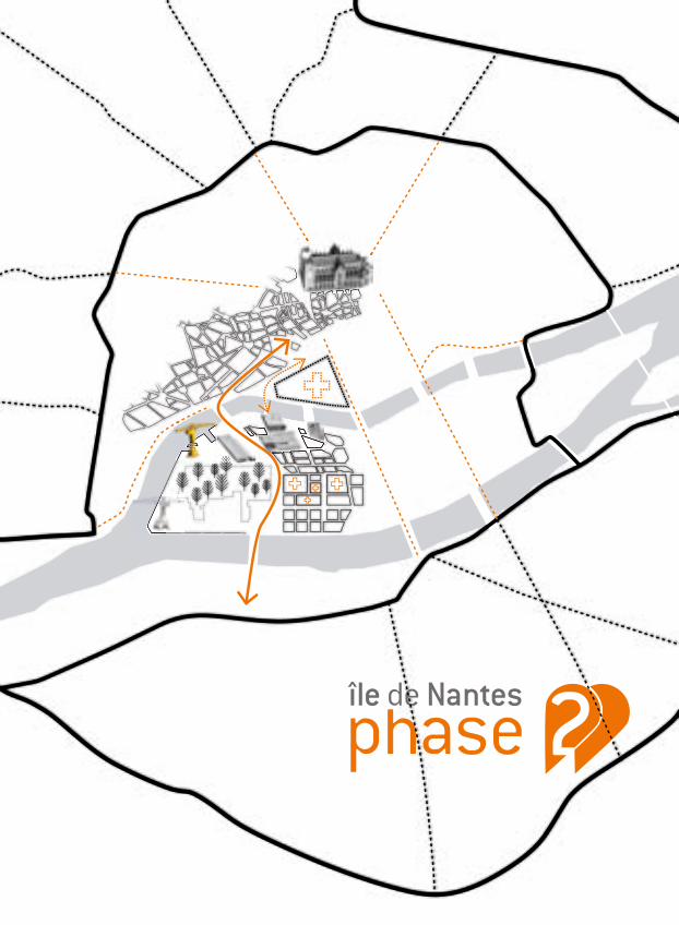
Ici se fabrique la ville de demain, aimable et inventive 3The appealing, inventive city of tomorrow is being built here
L’ADN du projet : ambition, innovation, créativité, responsabilite, partage 5The DNA of the project: ambition, innovation, creativity, responsibility, sharing
Une île, des quartiers, une mutation 7An island, districts, a transformation
Île de Nantes, phase 1 : une transformation rapide en 10 ans 13Ile de Nantes, phase 1: rapid transformation in 10 years
Île de Nantes, Acte 2 : changer d’échelle 15Ile de Nantes, Act 2: a change of scale
Le projet de l’équipe Smets-uapS : l’île dans la métropole 19The project of the Smets-uapS team: The Island in the City
Le Plan des transformations : une figure paysagère qui fédère 27The Transformation Plan: A landscape pattern that unites
Île de Nantes 2 : les projets stratégiques 33Ile de Nantes 2: the strategic projects
Un projet nourri par les débats 37A project supported by discussions
Ce qui change déjà : l’actualité du projet 39What is already changing: project news
Il y a 25 ans, se tournait une page de l’histoire nantaise avec la fermeture des chantiers navals, cette activité économique et sociale qui a constitué un véritable poumon pour la ville, faisant la fierté des Nantais et façonnant l’identité du territoire.
C’est par la volonté de Jean-Marc Ayrault, Maire de Nantes à l’époque, qu’a été lancé et impulsé ce vaste chantier de l’île de Nantes sous l’égide de la Samoa. Après une longue gestation, nourrie de réflexions et de débats, et dix années de travaux qui ont métamorphosé le territoire, l’aventure se poursuit.
La ville de demain se dessine sous nos yeux, une ville tournée vers l’avenir qui assume son histoire navale et ouvrière. Inventer, créer, fédérer, construire, innover, chercher : tels sont les points cardinaux qui orientent l’île de Nantes, véritable laboratoire urbain où germe la métropole nantaise de 2030, conjuguant créativité, cohésion sociale et respect de l’environnement.
L’île de Nantes est aujourd’hui considérée comme l’une des plus importantes opérations de rénovation urbaine en Europe. Dans la continuité de l’ambition qui a été affichée initialement, le projet urbain entre dans une nouvelle étape : transfert du Marché d’intérêt national (MIN), implantation du futur CHU, livraison de la nouvelle école des Beaux-arts au cœur du Quartier de la création (ESBANM), aménagement d’un parc métropolitain arboré, arrivée du Chronobus C5 ainsi que d’une future ligne de transport en site propre au sud… tels sont les quelques grands projets qui vont marquer cette nouvelle phase du projet île de Nantes.
Nantes métropole doit affirmer son rôle au service du territoire et de tous ses habitants, et poursuivre ses efforts pour conforter sa place et son rôle dans le réseau des grandes métropoles européennes. Telles doivent être les lignes directrices de cette nouvelle phase du projet de l’île de Nantes, portée par la volonté politique des élus de Nantes métropole et de la Ville de Nantes.
Patrick Rimbert, Maire de Nantes et Gilles Retière, Président de Nantes métropole
SOMMAIRE
2 3
“The Island, as one of the city’s core strategies, offers the opportunity to welcome people and businesses, focus our potential, and build an alternative to urban sprawl.” Patrick Rimbert, First Deputy Mayor from 2001 to 2012,
Mayor of Nantes since June 2012
The Ile de Nantes urban project was born from the desire to build a city that meets the needs of all the residents of the urban area: housing, work, public transportation, study and leisure activities. Thanks to the rare opportunity of having a largely undeveloped area available just steps from the city centre, the project is well on its way to becoming a reality.The first phase of the project generated a positive dynamic, revealing the island’s diversity and rich natural and urban heritage.
A new phase began in 2010, with the team led by urban planners Marcel Smets and Anne Mie Depuydt (uapS), along with landscaper João Nunes of PROAP, planning and development firm SCE and engineering firm Transsolar. The project took on a whole new scale: large tracts of land became available in the southwest of the island, allowing the planners to imagine new forms of city living, and the island acquired a decisive place in the greater urban area, which runs from Nantes to Saint-Nazaire.
ICI SE FABRIQUE LA VILLE DE DEMAIN, AIMABLE ET INVENTIVETHE APPEALING, INVENTIVE CITY OF TOMORROW IS BEING BUILT HERE
Le projet urbain de l’île de Nantes est né de la volonté de fabriquer une ville qui réponde aux besoins de tous les habitants de la métropole : habiter, travailler, se déplacer, se divertir, créer, étudier… Grâce à cette rare opportunité : disposer d’un territoire encore largement disponible, face au centre historique. La première phase du projet a impulsé une dynamique. Elle a révélé l’île, sa diversité, la richesse de ses patrimoines naturels et urbains.
Une nouvelle étape s’est ouverte en 2010 avec l’équipe dirigée par les urbanistes Marcel Smets et Anne Mie Depuydt (uapS), associés au paysagiste João Nunes de PROAP, à la société d’ingénierie et d’aménagement SCE et au bureau d’études Transsolar. Le projet change d’échelle : de vastes terrains se libèrent au sud-ouest de l’île, qui invitent à imaginer de nouvelles manières de vivre en ville. L’île prend une place décisive dans la grande métropole qui lie Nantes à Saint-Nazaire.
Vue aérienne de l’île de Nantes.© André Bocquel / Samoa
CONTEXTE
« L’île, au cœur de la stratégie de la métropole, offre l’opportunité d’accueillir habitants et activités, de concentrer notre potentiel, de construire une alternative à l’étalement urbain. »Patrick Rimbert, Premier adjoint de 2001 à 2012, Maire de Nantes depuis juin 2012

4 5
As the spearhead of the city’s European ambition, the island is part of the ongoing urban renewal process that Nantes has been conducting for more than twenty years. The Loire is once again a core feature of the city, as the backbone linking the Nantes Saint-Nazaire metropolitan area and a driver of urban and economic development.The challenge: transform an area of 337 hectares with multiple identities, half of which were brownfield sites.The goal: create a city where life is good, that serves a diverse population and is exemplary in terms of sustainable development.The special feature: an area known for experimentation and innovation where arts and culture have emerged as drivers of the urban project.
L’ADN DU PROJET : AMBITION, INNOVATION, CRÉATIVITÉ, RESPONSABILITE, PARTAGETHE DNA OF THE PROJECT: AMBITION, INNOVATION, CREATIVITY, RESPONSIBILITY, SHARING
Fer de lance de l’ambition européenne de la métropole, l’île s’inscrit dans le processus de transformation que poursuit l’agglomération depuis plus de vingt ans. La Loire retrouve sa place au cœur de la ville, elle est l’épine dorsale de la métropole Nantes Saint-Nazaire, moteur du développement urbain et économique.Le défi : transformer un territoire de 337 hectares aux identités multiples, dont la moitié reste à aménager.L’objectif : créer une ville où il fait bon vivre, qui s’adresse à toutes les populations et qui soit exemplaire en matière de développement durable.Une spécificité : un territoire d’expérimentation et d’innovation reconnu, où la culture est affirmée comme accélérateur du projet urbain.
Ilots Calberson.© Vincent Jacques / Samoa
CONTEXTE

6 7
GEOGRAPHY AND HISTORY HAVE GRADUALLY FORMED THIS DIVERSE AREA
The Ile de Nantes was created by several smaller islands that coalesced into one over the centuries, as the arms of the Loire were gradually filled in. This process is visible in the contrasting identities of the neighbourhoods.The area, measuring 4.9 km long by 1 km wide in the western section, has three major entities:
• In the centre of the island, a residential neighbourhood eveloped in the 17th century around the former line of bridges linking the north and south. In the 19th and 20th centuries, several factors split up the area: railroad tracks and embankments, boulevard Victor Hugo and boulevard Martyrs-Nantais.
• To the west, a large industrial area around the harbour and shipyards developed in the 19th century, and in the 20th century the wholesale market and the Beghin-Say factory were built. By 1950, up to 8000 workers were working at the shipyard site.
• To the east, the wet meadows were filled in and urbanized in the 1970s: the boulevard Général de Gaulle created a second line of bridges and the Beaulieu neighbourhood gradually expanded (housing, offices, shopping centre, community facilities).
UNE ÎLE, DES QUARTIERS, UNE MUTATION AN ISLAND, DISTRICTS, A TRANSFORMATION
GÉOGRAPHIE ET HISTOIRE ONT FORMÉ PEU À PEU CE TERRITOIRE MULTIPLE
L’île de Nantes est née de la fusion d’îles, par le comblement en plusieurs siècles des bras de Loire. Le processus se lit encore dans les identités contrastées des différents quartiers.Ce territoire long de 4,9 km pour 1 km de large dans sa partie ouest, compte trois entités majeures :
• Au centre de l’île, un faubourg aggloméré à partir du 17e siècle autour de l’ancienne ligne de ponts reliant nord et sud. Aux 19e et 20e siècles, plusieurs fractures le perturbent : voies ferrées et talus, percement des boulevards Victor-Hugo puis Martyrs-Nantais.
• À l’ouest, se développe dès le 19e siècle un vaste quartier industriel autour du port puis des chantiers navals – avec au 20e siècle l’arrivée du MIN (marché d’intérêt national), de l’usine Béghin-Say… Vers 1950, jusqu’à 8 000 ouvriers travaillent sur le site des chantiers navals.
• À l’est, les prairies inondables sont remblayées et urbanisées à partir des années 1970 : le boulevard du Général-de-Gaulle aménage une seconde ligne de ponts ; le quartier Beaulieu s’étoffe progressivement (logements, bureaux, centre commercial, équipements publics).
Gravure 1888, par Hugo d’Alesi.© Musée Dobrée, Nantes
CONTEXTE
8 9
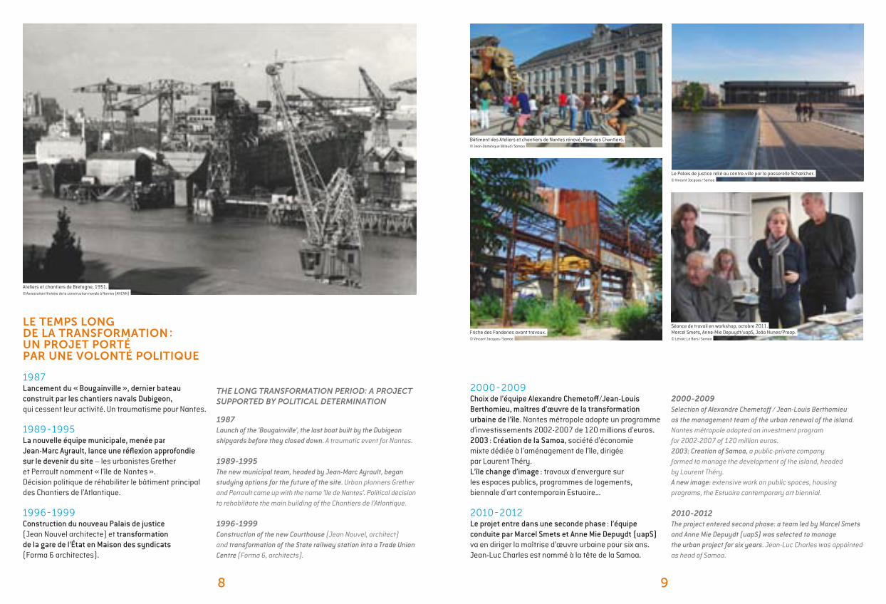
2000-2009 Selection of Alexandre Chemetoff / Jean-Louis Berthomieu as the management team of the urban renewal of the island. Nantes métropole adopted an investment program for 2002-2007 of 120 million euros. 2003: Creation of Samoa, a public-private company formed to manage the development of the island, headed by Laurent Théry.A new image: extensive work on public spaces, housing programs, the Estuaire contemporary art biennial.
2010-2012The project entered second phase: a team led by Marcel Smets and Anne Mie Depuydt (uapS) was selected to manage the urban project for six years. Jean-Luc Charles was appointed as head of Samoa.
THE LONG TRANSFORMATION PERIOD: A PROJECT SUPPORTED BY POLITICAL DETERMINATION
1987Launch of the ‘Bougainville’, the last boat built by the Dubigeon shipyards before they closed down. A traumatic event for Nantes.
1989-1995The new municipal team, headed by Jean-Marc Ayrault, began studying options for the future of the site. Urban planners Grether and Perrault came up with the name ‘Ile de Nantes’. Political decision to rehabilitate the main building of the Chantiers de l’Atlantique.
1996-1999Construction of the new Courthouse (Jean Nouvel, architect) and transformation of the State railway station into a Trade Union Centre (Forma 6, architects).
Le Palais de justice relié au centre-ville par la passerelle Schœlcher.© Vincent Jacques / Samoa
Ateliers et chantiers de Bretagne, 1951.© Association Histoire de la construction navale à Nantes (AHCNN)
LE TEMPS LONG DE LA TRANSFORMATION : UN PROJET PORTÉ PAR UNE VOLONTÉ POLITIQUE
1987Lancement du « Bougainville », dernier bateau construit par les chantiers navals Dubigeon, qui cessent leur activité. Un traumatisme pour Nantes.
1989-1995La nouvelle équipe municipale, menée par Jean-Marc Ayrault, lance une réflexion approfondie sur le devenir du site – les urbanistes Grether et Perrault nomment « l’île de Nantes ». Décision politique de réhabiliter le bâtiment principal des Chantiers de l’Atlantique. 1996-1999Construction du nouveau Palais de justice (Jean Nouvel architecte) et transformation de la gare de l’État en Maison des syndicats (Forma 6 architectes).
2000-2009 Choix de l’équipe Alexandre Chemetoff /Jean-Louis Berthomieu, maîtres d’œuvre de la transformation urbaine de l’île. Nantes métropole adopte un programme d’investissements 2002-2007 de 120 millions d’euros. 2003 : Création de la Samoa, société d’économie mixte dédiée à l’aménagement de l’île, dirigée par Laurent Théry.L’île change d’image : travaux d’envergure sur les espaces publics, programmes de logements, biennale d’art contemporain Estuaire…
2010-2012Le projet entre dans une seconde phase : l’équipe conduite par Marcel Smets et Anne Mie Depuydt (uapS) va en diriger la maîtrise d’œuvre urbaine pour six ans. Jean-Luc Charles est nommé à la tête de la Samoa.
Séance de travail en workshop, octobre 2011.Marcel Smets, Anne-Mie Depuydt/uapS, João Nunes/Proap.© Lénaïc Le Bars / Samoa
Bâtiment des Ateliers et chantiers de Nantes rénové, Parc des Chantiers.© Jean-Dominique Billaud / Samoa
Friche des Fonderies avant travaux.© Vincent Jacques / Samoa

10 11
PROJECT STAKEHOLDERS
Nantes métropoleThe Urban Community of Nantes is composed of 24 municipalities and nearly 600,000 inhabitants. As decision-maker for urban planning and development, Nantes métropole took the opportunity offered by the potential of the Ile de Nantes to create an urban centre with European ambitions.
Ville de NantesNantes is the sixth largest city in France, with over 290,000 inhabitants. The City works hand in hand with Nantes métropole to manage the urban renewal project. Among the priority objectives: provide families with an alternative to moving to the suburbs, with a model of social diversity and quality of life combining housing, economic and cultural activities and sustainable development.
SamoaSince 2003, Samoa (West Atlantic Metropolitan Redevelopment Agency) has directed the Ile de Nantes urban project and acts as the contracting owner. This local public company works to implement the land management policies in the Nantes Saint-Nazaire area. In September 2010, it formed a project team to promote the Creative Arts District. Shareholders: Nantes métropole (majority), City of Nantes, CARENE, Regional Council of Pays de la Loire, County Council of Loire Atlantique, SCOT public-private entity, Nantes Saint-Nazaire, City of Rezé.
Smets/uapSSince 2010, Marcel Smets, architect and urban planner, and Anne-Mie Depuydt of the agency uapS have headed the urban project, along with landscaper João Nunes of PROAP, planning and development firm SCE and engineering firm Transsolar. This team took over from the Atelier de l’Ile de Nantes of Alexander Chemetoff to design the second phase of the project.
KEY FIGURES
The Island in 2012, a few statistics• 18,000 residents (6% of the population of Nantes)• More than 13,000 apartments including 22% social rent units• 22,000 jobs, 1,400 firms in the market sector (including 70 industrial companies and 334 retail businesses)
Household profile• a young population (35% aged 15-29)• few families (58% of households consist of a single person)• a low to middle income population (52 % of residents are non-management employees or blue-collar workers, average income is 20 % lower than in the city centre, and 17% of households live below the poverty line).
The objectives of the urban project over 20 years:1,500,000 m2 of real estate development, including:• 10 000 apartments (700,000 m2)• 450,000 m2 of offices and activities• 350,000 m2 of community facilities• 160 hectares of new or rehabilitated public space• Three new public transit lines
Results of the first phase (2003-2012) 4,400 new housing units built (265,000 m2), including • 23% social rent apartments.• 235,000 m2 of offices and activities• 104,300 m2 of community facilities• 51 hectares of new or rehabilitated public space
The achievements of the past decade demonstrate fast work and strong ambition. By 2015, 5,500 new apartments will have been built (with a goal of 25% social housing and 25% affordable housing for the next period) and more than 8,000 new jobs created.
LES ACTEURSDU PROJET
La communauté urbaine de Nantes regroupe 24 communes et près de 600 000 habitants. Compétente en matière d’aménagement et d’urbanisme, Nantes métropole s’est saisie du potentiel de l’île de Nantes pour doter l’agglomération d’un centre urbain d’ambition européenne.
Avec plus de 290 000 habitants, Nantes est la 6e ville de France. À l’origine du projet de l’île, la Ville conduit sa recomposition urbaine avec Nantes métropole. Parmi les objectifs prioritaires : construire une alternative au départ des familles en périphérie, grâce à un modèle de mixité sociale et une qualité de vie associant habitat, activités économiques et culturelles, développement durable.
Depuis 2003, la Société d’Aménagement de la Métropole Ouest Atlantique assure le pilotage du projet urbain de l’île de Nantes et sa conduite opérationnelle. Société publique locale, elle agit dans le cadre des politiques publiques territoriales, à l’échelle de la métropole Nantes Saint-Nazaire. Depuis septembre 2010, elle est dotée d’une équipe projet pour l’animation du Quartier de la création. Ses actionnaires : Nantes métropole (majoritaire), Ville de Nantes, Communauté d’agglomération de la région nazairienne et de l’estuaire (CARENE), Conseil régional des Pays de la Loire, Conseil général de Loire Atlantique, Syndicat mixte du SCOT Nantes Saint-Nazaire, Ville de Rezé.
Depuis 2010, l’équipe de maîtrise d’œuvre urbaine associe les architectes-urbanistes Marcel Smets et Anne-Mie Depuydt de l’agence uapS, João Nunes, paysagiste de PROAP, la société d’ingénierie et d’aménagement SCE et le bureau d’études énergie Transsolar. Le groupement actuel succède à l’Atelier de l’île de Nantes d’Alexandre Chemetoff, pour concevoir la seconde phase du projet.
CHIFFRES CLÉS
L’ÎLE EN 2012, QUELQUES REPÈRES• 18 000 habitants (environ 6 % de la population nantaise)• Plus de 13 000 logements, dont 22 % de logements sociaux• 22 000 emplois, 1 400 établissements dans le secteur marchand (dont 70 ayant une activité industrielle, et 334 une activité de commerce)
PROFIL DES MÉNAGES• une population jeune (35 % de 15-29 ans)• peu de familles (58 % des foyers sont composés d’une personne seule)• une population plutôt modeste (52 % des habitants sont employés ou ouvriers, le revenu moyen est inférieur de 20 % à celui du centre-ville, 17 % des ménages vivent sous le seuil de pauvreté)
LES OBJECTIFS DU PROJET URBAIN SUR 20 ANS1 500 000 m2 d’opérations immobilières dont• 10 000 logements (700 000 m2)• 450 000 m2 d’activités et bureaux• 350 000 m2 d’équipements• 160 ha d’espaces publics créés ou retraités• Trois nouvelles lignes de transport public en site propre
BILAN DE LA PREMIÈRE PHASE (2003-2012) 4 400 nouveaux logements réalisés (265 000 m2) dont• 23 % de logements sociaux• 235 000 m2 d’activités et bureaux• 104 300 m2 d’équipements• 51 ha d’espaces publics créés ou retraités
Le bilan des réalisations des dix dernières années montre une rapidité d’action et une ambition forte. En 2015, 5 500 logements neufs auront été construits (avec un objectif de 25 % de logements sociaux et 25 % de logements abordables pour la prochaine période) et plus de 8 000 nouveaux emplois créés.
Le jardin des Fonderies.© Jean-Dominique Billaud / Samoa
12 13
“This plan outlines the sharing between the public spaces and the developments, designs the new urban projects on existing outlines, defines the treatment of old and new public spaces and organizes their hierarchy.” Alexandre Chemetoff, Le Plan guide en projet, Éditions MeMo, Nantes 1999
A DEVELOPMENT PLAN FOR LONG-TERM ACTION
Proposed by urban planner Alexander Chemetoff, the development plan guided the transformation of the island until 2010. This unique tool provides a detailed inventory of the existing, which the project is based on: each new operation can be placed in context, while foreshadowing the future of the sector. The development plan was updated regularly as public and private projects were completed.
ÎLE DE NANTES, PHASE 1 : UNE TRANSFORMATION RAPIDE EN 10 ANSILE DE NANTES, PHASE 1: RAPID TRANSFORMATION IN 10 YEARS
UN PLAN GUIDE POUR AGIR DANS LA DURÉE
Proposé par l’urbaniste Alexandre Chemetoff, le Plan guide a encadré jusqu’en 2010 la métamorphose de l’île. Cet outil original établit un état des lieux très fin de l’existant, sur lequel se fonde le projet : chaque nouvelle opération peut s’inscrire dans son contexte, tout en préfigurant le devenir du secteur. Évoluant au fil des projets publics et privés, le Plan guide a été mis à jour régulièrement.
Plan guide de l’Atelier de l’île de Nantes, octobre 2008.© Ain
« Ce plan dessine le partage entre les espaces publics et les îlots, inscrit les nouveaux projets urbains sur les tracés existants, figure le traitement des espaces publics nouveaux ou anciens et organise leur hiérarchie. »Alexandre Chemetoff, Le Plan guide en projet, Éditions MeMo, Nantes 1999

14 15
THE CHALLENGES OF THE CITY OF TOMORROW
The city is changing, as are the expectations of the residents. Faced with today’s climatic, environmental, economic and social issues, what is the best way to ensure harmonious development?
A model of diversityThe island eventually plans to build 10,000 new apartments, thereby doubling its population, with a strong commitment to social diversity: 25% social rent housing and 25% affordable housing to accommodate families.A vibrant city needs shops, services, and a mix of businesses and residential buildings. The new operations will be dense, therefore their architectural and environmental qualities must offer enjoyable and innovative ways of living to attract people to the area.
ÎLE DE NANTES, ACTE 2 : CHANGER D’ÉCHELLE ILE DE NANTES, ACT 2: A CHANGE OF SCALE
LES DÉFIS DE LA VILLE DE DEMAIN
La ville change, ses habitants aussi, comme leurs attentes. Face à la nouvelle donne climatique, environnementale, économique et sociale, comment assurer un développement harmonieux ?
UN MODÈLE DE MIXITÉ SOCIALE L’île compte accueillir à terme quelques 10 000 nouveaux logements et ainsi doubler sa population, avec une forte exigence de mixité sociale : 25 % de logements locatifs sociaux, 25 % de logements abordables, volonté d’accueillir des familles.
Une ville vivante nécessite des commerces, des services, un mélange entre activités et résidences. Les nouvelles opérations seront denses, donc leurs qualités architecturales et écologiques doivent séduire, en offrant des modes d’habiter agréables et innovants.
Un potentiel de 90 hectares mutables sur le sud-ouest de l’île.© André Bocquel / Samoa

16 17
Develop the economic attractivenessIn order to eventually generate 15,000 new jobs, the Ile de Nantes is focusing in part on the knowledge economy - the health sector, cultural and creative industries, training and education.
It will continue to offer a wide range of activities in industry, traditional services, social and solidarity economy, artisanship, retail, and more.In uncertain times, having a diversified economy can help cities handle and adapt to economic changes.
Sustainable developmentThe whole Island is designed as an eco-district, where the city reconnects with nature to offer a more carefree living environment. A sustainable development charter provides the framework for the design, construction and management of the Ile de Nantes urban project. The charter sets forth the European Community sustainable development policies as they apply to the Island: Climate Plan, energy, mobility, biodiversity, water and waste management, soil pollution, economic and social sustainability, etc.
“The new districts provide the opportunity to be more demanding and inventive on environmental issues, waste management, renewable energy, more flexible types of housing.” Opinion of the Citizen Workshop 2012
Le quai François Mitterrand réaménagé redonne vie aux berges de Loire. © Jean-Dominique Billaud / Samoa
DÉVELOPPER L’ATTRACTIVITÉ ÉCONOMIQUEPour accueillir à terme 15 000 nouveaux emplois, l’île de Nantes mise en partie sur l’économie de la connaissance – secteurs de la santé, industries culturelles et créatives, formation…
Elle proposera toujours une large palette d’activités : secteur industriel, tertiaire traditionnel, économie sociale et solidaire, artisanat et commerces…Dans un contexte incertain, la présence d’une grande variété d’activités est le gage d’une meilleure adaptation aux évolutions économiques.
AMÉNAGER DURABLEL’île dans son ensemble est conçue comme un éco-quartier, où la ville renoue avec la nature, pour offrir un cadre de vie apaisé. Une charte d’objectifs de développement durable fixe le cadre général en matière de conception, de réalisation et de conduite du projet urbain de l’île de Nantes. La charte décline, à l’échelle de l’île, les grandes politiques communautaires en matière de développement durable : Plan climat, énergie, mobilité, biodiversité, gestion de l’eau, des déchets, pollution des sols, durabilité sociale et économique…
« Les nouveaux quartiers donnent l’occasion d’être plus exigeant et inventif sur l’écologie, le traitement des déchets, les énergies renouvelables, les typologies des logements à imaginer plus flexibles. » Avis de l’Atelier Citoyen de 2012
L’île rouge, au cœur du Quartier de la création.© Jean-Dominique Billaud / Samoa
18 19
“After 10 years of work, it is now time for the residents of Nantes and the greater urban area to take ownership of this new phase. The Island is a chance for all, an opportunity to share the meaning of metropolitan development.”Jean-Marc Ayrault, Mayor of Nantes from 1989 to 2012
LE PROJET DE L’ÉQUIPE SMETS-UAPS : L’ÎLE DANS LA MÉTROPOLE THE PROJECT OF THE SMETS-UAPS TEAM: THE ISLAND IN THE CITY
« Après 10 ans de travaux, il s’agit maintenant que les Nantais, comme tous les habitants de la métropole, s’approprient cette nouvelle étape, que l’île soit une chance pour tous, une occasion de partager le sens du développement métropolitain. »Jean-Marc Ayrault, Maire de Nantes entre 1989 et 2012
Séance de travail en workshop, mars 2012.© Lénaïc Le Bars / Samoa
Hangar 32. Présentation des urbanistes aux élus locaux, juillet 2011.© Vincent Jacques / Samoa
21
DEVELOP THE PROJECT BASED ON GEOGRAPHY AND HISTORY
The Smets/uapS team used a geographical and historical approach to the landscape of the island. Based on this approach, the planners offered an interpretation of the area as being composed of ‘plates’ - created by the geography and the different phases of urbanization on the Island. These ‘plates’ must be connected or ‘joined’ by developing the infrastructure and public space with this goal in mind. The planners used this interpretation to design a ‘landscape pattern’ as the foundation for the development of the Ile de Nantes.
AN OPPORTUNITY TO EXTEND THE HISTORIC CENTRE
The Island, especially the western part, is expanding and enriching the historic city centre, which has become too small for a booming metropolitan area. Already, several major public facilities are located on the Ile de Nantes. The project’s second phase confirms and amplifies this trend, with a vision of a ‘multipolar’ city centre. With the future hospital, a large park, the Creative Arts District and the new neighbourhoods to the west under development, the island is becoming a popular location (urban planners use the term ‘metacentre’), along with the historic centre and the Euronantes business park near the train station. The transportation network, tourist and recreational sites, business parks and new urban services will enhance the attractiveness of the area.Nantes is taking advantage of this exceptional opportunity of available land in the town centre to grow and exert an influence on a European scale.
20
PARTIR DE LA GEOGRAPHIE ET DE L’HISTOIRE POUR CONCEVOIR LE PROJET
L’équipe Smets/uapS a adopté une approche géographique et historique du paysage de l’île. Au terme de cette approche, les urbanistes analysent le territoire comme un ensemble de « plaques » – nées de la géographie et des différentes phases d’urbanisation de l’île – plaques qu’il convient de relier entre elles ou « de joindre » par un aménagement approprié des infrastructures et de l’espace public. Cette lecture renouvelée du territoire va nourrir la réflexion des urbanistes pour faire émerger une « figure paysagère », véritable trame à partir de laquelle s’organisera le développement de l’île de Nantes.
UNE OPPORTUNITÉ POUR ÉTENDRE LE CENTRE HISTORIQUE
L’île, notamment dans sa partie ouest, vient compléter et enrichir un centre historique devenu trop étroit pour une métropole en plein essor. Elle accueille déjà des équipements majeurs. Le projet confirme et amplifie cette évolution, faisant émerger l’idée d’un cœur d’agglomération multipolaire. Avec l’implantation de l’hôpital, l’aménagement d’un grand parc, le développement du Quartier de la création et de nouveaux quartiers à l’ouest, l’île s’affirme comme pôle d’attraction métropolitaine (appelé « métacentre » par les urbanistes), complémentaire du centre historique et d’Euronantes gare. Son réseau de transports, ses sites touristiques et de loisirs, ses espaces d’activités économiques, ses nouveaux services urbains renforceront l’attractivité de la métropole.Nantes prend appui sur cette opportunité foncière exceptionnelle en cœur de ville pour créer les conditions de son développement et de son rayonnement à l’échelle européenne.
Le rôle de l’île dans l’agglomération.© uapS
Plan Justin Vincent. Nantes 1918.© Archives Municipales de la Ville de Nantes
22 23
Le rôle de l’île dans l’histoire.© uapS
DEVELOP MORE PUBLIC TRANSIT LINES, PROMOTE ‘SOFT’ TRANSIT OPTIONS
By becoming denser, the Island is improving its transit system, which is essential given the future new hospital location. In addition to the C5 Chronobus (by autumn 2013) there will be a new dedicated lane transit line to the south. Connecting to the existing tram and BusWay system, these east-west lines enable users to transfer on the island without having to go through the historic centre. This will considerably improve the transit system city-wide and beyond, giving the island a role in the greater metropolitan area. At the same time, bicycle use is encouraged thanks to a bicycle boulevard and dedicated bike lanes that serve the entire Island.
“In terms of traffic and parking, how can we resolve the contradictions of a transitional period where cars are still seen as essential, and yet we predict that alternative modes will be the majority in a few decades?” Reflections of local residents, at the Citizen Workshop
THE LOIRE IN FOCUS: INTENSIFYING THE DIALOGUE WITH THE TWO SHORES
The new phase of the project cultivates relationships with other banks of the Loire.Detouring around the current hospital, the expansion of the city centre will continue westward, drawn by the Chantiers site, the Creative Arts District, the future hospital and the urban park. In the longer term, the island will be linked to the developments in Bas-Chantenay to the north and Isles de Rezé to the south.
“The idea of a metacentre represents a milestone in Nantes’ commitment to reclaim its river. The island can no longer be treated as such, but requires a broader view that seeks all the connections, where thinking is done in the longer term.”Marcel Smets and Anne-Mie Depuydt
MAILLER LE RÉSEAU DE TRANSPORTS PUBLICS, FAVORISER LES DÉPLACEMENTS DOUX
En se densifiant, l’île améliore son offre de transports, indispensable surtout dans la perspective de l’implantation du CHU. Au Chronobus C5 (dès la rentrée 2013) s’ajoutera à terme une nouvelle ligne de transport public en site propre au sud. Croisant le réseau existant de tramways et de BusWay, ces lignes est-ouest permettent de trouver des correspondances sur l’île sans être obligé de passer par le centre historique. Ces deux nouvelles lignes viennent considérablement améliorer le maillage des transports en commun à l’échelle de l’agglomération, et donnent ainsi à l’île un rôle majeur. Parallèlement, l’usage du vélo est priorisé avec l’aménagement d’une véloroute qui traverse l’île d’est en ouest (voie dédiée et autonome) et de nombreuses pistes cyclables.
« En matière de circulation et de stationnement, comment résoudre les contradictions d’une période de transition où l’automobile reste vécue comme indispensable, même s’il faut prévoir que les autres modes seront majoritaires dans quelques décennies ? »Réflexions d’habitants de l’agglomération réunis dans l’Atelier citoyen
LA LOIRE AU CENTRE :INTENSIFIER LE DIALOGUE AVEC LES DEUX RIVES
La nouvelle phase du projet cultive ses relations avec les autres rives de la Loire.Contournant l’Hôtel-Dieu, le mouvement d’expansion du centre-ville va se poursuivre vers l’ouest, aimanté par le site des chantiers, le Quartier de la création, le futur du CHU et le parc métropolitain… À plus long terme, l’île sera associée au développement du Bas-Chantenay au nord, comme à celui des Isles-de-Rezé au sud.
« L’idée de métacentre représente une étape décisive de la quête engagée par Nantes pour retrouver son fleuve. L’île ne peut plus être traitée en soi mais avec un regard élargi, où l’on recherche toutes les connectivités, où la réflexion se fait à plus long terme. » Marcel Smets et Anne-Mie Depuydt
Restructuration du réseau de TCSP (projection 2025). © uapS

24 25
CONNECTING NEIGHBOURHOODS, PRESERVING IDENTITIES The Ile de Nantes is divided into neighbourhoods, with seven ‘plates’ that the project addresses based on three principles: • Strengthen the identities of the different neighbourhoods. Highlight their special characteristics using different approaches in different places.• Develop new shared public spaces to act as ‘joints’ between the different neighbourhoods. Connect the central locations.• Work on proximities, improve daily life, promote places where people can interact by developing public spaces with these goals in mind.
“To meet the needs of residents, we must create community spaces, squares, family parks, places to play ‘boules’... These are opportunities to show that density can improve the quality of life and the environment”Alain Robert, local elected official and Urban Planning deputy
INTEGRATING THE HOSPITAL, A DRIVER OF CENTRALITY
The Nantes Hospital needs to upgrade some of its equipment and improve efficiency. The project spans ten hectares in the southwest of the island and will combine the activities of Nantes’ Hôtel-Dieu Hospital and Nord-Laënnec Hospital, in 2022. The goal is for this 250,000 m2 centre of excellence to become a defining force for the island, and beyond, for the entire urban area. It will be a public health, university and research centre that will attract laboratories, hotels, businesses related to medical research, housing, community facilities and more.The challenge will be to make this major component blend into and become part of the city.
“Thanks to the close relationship the hospital creates between research and care, it is essential to the development of Nantes, and it would lose this potential if it were located in an outlying area.”Patrick Rimbert, Mayor of Nantes
JOINDRE LES QUARTIERS, CONSERVER LES IDENTITÉS
L’île de Nantes est fragmentée en quartiers, découpage en sept « plaques » que le projet aborde selon trois grands principes : • Conforter les identités des différents quartiers. Mettre en valeur leurs spécificités, par des approches différenciées selon les lieux.• Aménager de nouveaux espaces publics communs, « joints » entre les différents quartiers. Relier leurs lieux de centralité.• Travailler les proximités, prendre soin du quotidien, favoriser les lieux de rencontre.
« Pour répondre aux besoins des habitants, il faut retrouver partout des lieux de proximité, squares, jardins familiaux, jeux de boules... Des occasions de montrer que la densité peut contribuer à améliorer la qualité de vie et de l’environnement. »Alain Robert, élu du quartier et adjoint à l’Urbanisme
INTÉGRER LE CHU, MOTEUR DE CENTRALITÉ
Le CHU de Nantes a besoin de moderniser certains de ses équipements et d’améliorer son efficacité. À partir de 2022, le projet regroupe au sud-ouest de l’île, sur une dizaine d’hectares, les activités de l’Hôtel-Dieu et celles de l’hôpital Nord-Laënnec. L’enjeu : que ce pôle d’excellence de 250 000 m2 devienne un moteur structurant pour l’île, et au-delà, pour toute l’agglomération. Il développe un pôle de santé publique, universitaire et de recherche, qui attire laboratoires, hôtels d’entreprises liées à la recherche médicale, logements, équipements…Le défi : faire en sorte que cette pièce importante fasse corps avec la ville et devienne l’une de ses composantes.
« Grâce à la relation étroite qu’il organise entre la recherche et les soins, l’hôpital est essentiel au développement de Nantes, potentiel qu’il perdrait s’il était regroupé en périphérie. »Patrick Rimbert, Maire de Nantes
Emprises du parc et du CHU© uapS
Projet : les quartiers de l’île et leurs abords. © uapS
26 27
“The Transformation Plan restores the island to its context and connects it to a metropolitan centre, with its different hubs and central locations. It also expresses a rebalancing: detailed thinking about the residential neighbourhood and the east of the island.”Jean-Luc Charles, General Director of Samoa
The new urban planning team will replace Alexandre Chemetoff’s ‘development plan’ with what they call a ‘transformation plan’. This plan sets forth potential transformations of the island over the long term, with enough flexibility to adapt to the opportunities and risks that arise in an uncertain economic and social context, while proposing a framework that establishes the ‘invariants’ of the urban project, in order to stay on course, provide perspective and especially ensure consistency over time. To do this, the planners have developed a generously planted landscape pattern to connect the different neighbourhoods. It is gradually being constituted throughout the public spaces (streets and squares, paths, gardens and parks) designed as places that encourage people to interact and build community ties. It emphasizes the diversity of the island and gives it an overall structure. The landscape pattern is a development strategy: it gives meaning to each project, and each project participates in building the landscape pattern.
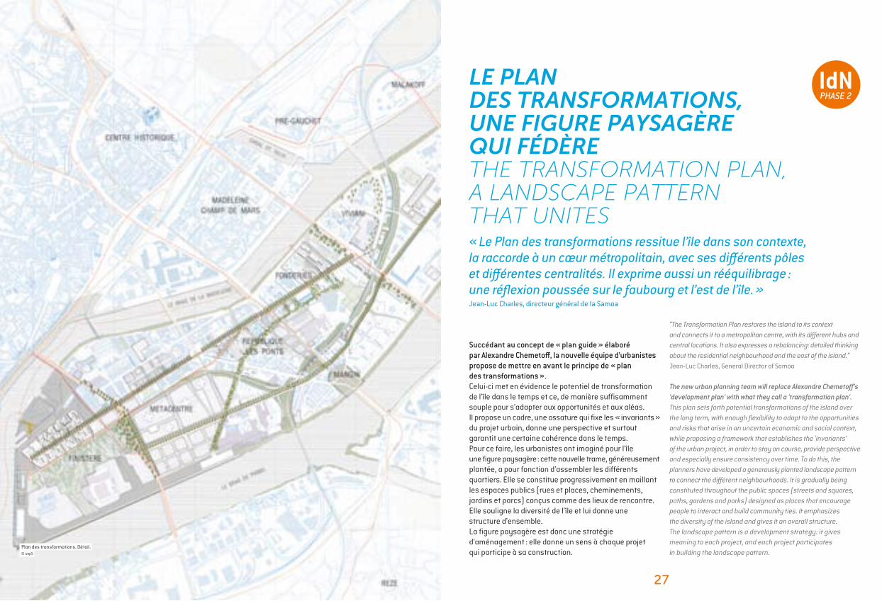
LE PLAN DES TRANSFORMATIONS, UNE FIGURE PAYSAGÈRE QUI FÉDÈRETHE TRANSFORMATION PLAN, A LANDSCAPE PATTERN THAT UNITES
Succédant au concept de « plan guide » élaboré par Alexandre Chemetoff, la nouvelle équipe d’urbanistes propose de mettre en avant le principe de « plan des transformations ».Celui-ci met en évidence le potentiel de transformation de l’île dans le temps et ce, de manière suffisamment souple pour s’adapter aux opportunités et aux aléas. Il propose un cadre, une ossature qui fixe les « invariants » du projet urbain, donne une perspective et surtout garantit une certaine cohérence dans le temps. Pour ce faire, les urbanistes ont imaginé pour l’île une figure paysagère : cette nouvelle trame, généreusement plantée, a pour fonction d’assembler les différents quartiers. Elle se constitue progressivement en maillant les espaces publics (rues et places, cheminements, jardins et parcs) conçus comme des lieux de rencontre. Elle souligne la diversité de l’île et lui donne une structure d’ensemble. La figure paysagère est donc une stratégie d’aménagement : elle donne un sens à chaque projet qui participe à sa construction.
Plan des transformations. Détail. © uapS
« Le Plan des transformations ressitue l’île dans son contexte, la raccorde à un cœur métropolitain, avec ses différents pôles et différentes centralités. Il exprime aussi un rééquilibrage : une réflexion poussée sur le faubourg et l’est de l’île. »Jean-Luc Charles, directeur général de la Samoa
28 29
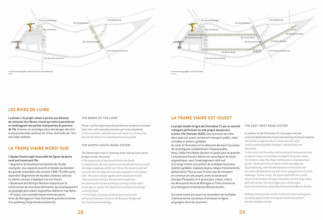
La structure paysagère : bords de Loire et voirie Nord-Sud.© uapS
THE BANKS OF THE LOIRE
Phase 1 of the project has allowed Nantes residents to reclaim their river, with some final touches yet to be completed.In the end, banks’ refurbishment will result in a 12 kms tour around the island, thus doubling the existing walk.
THE NORTH-SOUTH ROAD SYSTEM
The Smets/uapS team is renewing three lines of north-south bridges across the island: • The asymmetry of boulevard Général de Gaulle is emphasized: the open spaces and woodlands that surround the large complexes of 60s and 70s on the western side will contrast with the alignment of urban façades on the eastern side. The same concept applies to the boulevard Viviani.• Boulevard des Martyrs Nantais will benefit from the construction of new buildings, creating a more urban landscape to replace the dilapidated and sparse buildings currently there.• To the west, a parkway (wide planted boulevard) will be built between the Anne-de-Bretagne Bridge and the Trois-Continents Bridge.
THE EAST-WEST ROAD SYSTEM
In addition to the Chronobus C5, the project will add a second dedicated lane transit line serving the future hospital. This will be an opportunity to create two east-west routes combining public transport, vehicle lanes and bike lanes. To the north, the Chronobus and the bicycle boulevard provide an opportunity to completely reconfigure the public space. For instance, allée Paul Nizan will become a neighbourhood garden. Boulevard Vincent-Gâche will be reconfigured asymmetrically, with the development on the south side of a wide sidewalk featuring bike lanes, playgrounds and wide walkways. Further south, the future dedicated lane public transit route between Georges-Pompidou and the large urban park will connect the two bridges Anne de Bretagne and Trois-Continents, extending the boulevard Bénoni-Goullin.
Multiple pathways will connect to the east-west road system, providing opportunities to bring the landscape pattern into the neighbourhoods.
LES RIVES DE LOIRE
La phase 1 du projet urbain a permis aux Nantais de retrouver leur fleuve, travail qui reste à parachever en aménageant les parties manquantes du pourtour de l’île. À terme, la reconfiguration des berges aboutira à une promenade continue de 12 km, dont près de 7 km sont déjà réalisés.
LA TRAME VIAIRE NORD-SUD
L’équipe Smets/uapS renouvelle les lignes de ponts nord-sud traversant l’île :• Asymétrie du boulevard du Général-de-Gaulle soulignée : aux espaces ouverts et boisés qui bordent les grands ensembles des années 1960-70 côté ouest, répondra l’alignement de façades urbaines côté est. Le même concept s’applique à la rue Viviani.• Boulevard des Martyrs-Nantais resserré par la construction de nouveaux bâtiments, qui recomposeront un paysage plus urbain aujourd’hui abîmé et trop lâche.• À l’ouest, une nouvelle liaison entre les ponts Anne-de-Bretagne et Trois-Continents prendra la forme d’un parkway (large boulevard planté).
LA TRAME VIAIRE EST-OUEST
Le projet double la ligne de Chronobus C5 par un second transport performant en site propre desservant le futur CHU (horizon 2020). Une occasion de créer deux axes est-ouest combinant transport public, voies circulées et pistes cyclables. Au nord, le Chronobus et la véloroute donnent l’occasion de reconfigurer complètement l’espace public. Ainsi, l’allée Paul-Nizan devient un jardin pour le quartier. Le boulevard Vincent-Gâche est reconfiguré de façon asymétrique, avec l’aménagement côté sud d’un large trottoir accueillant de multiples fonctions (pistes cyclables, espaces de jeux, larges cheminements piétonniers). Plus au sud, le futur axe de transport en commun en site propre, entre le boulevard Georges-Pompidou et le grand parc urbain, reliera les deux ponts Anne de Bretagne et Trois continents en prolongeant le boulevard Bénoni-Goullin.
Sur cette trame est-ouest se raccordent de multiples cheminements, occasions d’immiscer la figure paysagère dans les quartiers.
La structure paysagère : voirie Est-Ouest.© uapS
Pont Anne de Bretagne
Bd. Léon Bureau
Bd. Vincent GâcheBd. de la Prairie au Duc
Bd. Bénoni GoullinBd. Anatolede Monzie
Bd. Gaëtan Rondeau
Bd. Georges Pompidou
Pont des Trois continents
Pont Georges Clemenceau
Bd. Général de Gaulle
Pont Aristide Briand
Pont Willy BrandtPont Anne de Bretagne
Bd. Léon Bureau
Pont des Trois continents
Pont Georges Clemenceau
Bd. Général de Gaulle
Pont Aristide Briand
Pont Willy Brandt
30 31
“We need the beauty of nature, to breathe, dream, escape... You must complete the banks’ refurbishment. You must plant every- where, not just in the park. Planting wherever possible is a vital need.”Declaration of inhabitants, “Ile de Nantes 2” citizen workshop
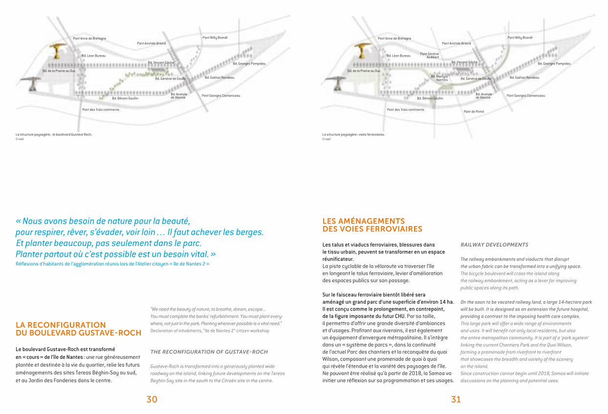
THE RECONFIGURATION OF GUSTAVE-ROCH
Gustave-Roch is transformed into a generously planted wide roadway on the island, linking future developments on the Tereos Beghin-Say site in the south to the Citroën site in the centre.
RAILWAY DEVELOPMENTS
The railway embankments and viaducts that disrupt the urban fabric can be transformed into a unifying space. The bicycle boulevard will cross the island along the railway embankment, acting as a lever for improving public spaces along its path.
On the soon to be vacated railway land, a large 14-hectare park will be built. It is designed as an extension the future hospital, providing a contrast to the imposing health care complex. This large park will offer a wide range of environments and uses. It will benefit not only local residents, but also the entire metropolitan community. It is part of a ‘park system’ linking the current Chantiers Park and the Quai Wilson, forming a promenade from riverfront to riverfront that showcases the breadth and variety of the scenery on the island.Since construction cannot begin until 2018, Samoa will initiate discussions on the planning and potential uses.
LA RECONFIGURATION DU BOULEVARD GUSTAVE-ROCH
Le boulevard Gustave-Roch est transformé en « cours » de l’île de Nantes : une rue généreusement plantée et destinée à la vie du quartier, relie les futurs aménagements des sites Tereos Béghin-Say au sud, et au Jardin des Fonderies dans le centre.
LES AMÉNAGEMENTS DES VOIES FERROVIAIRES
Les talus et viaducs ferroviaires, blessures dans le tissu urbain, peuvent se transformer en un espace réunificateur. La piste cyclable de la véloroute va traverser l’île en longeant le talus ferroviaire, levier d’amélioration des espaces publics sur son passage.
Sur le faisceau ferroviaire bientôt libéré sera aménagé un grand parc d’une superficie d’environ 14 ha. Il est conçu comme le prolongement, en contrepoint, de la figure imposante du futur CHU. Par sa taille, il permettra d’offrir une grande diversité d’ambiances et d’usages. Profitant aux riverains, il est également un équipement d’envergure métropolitaine. Il s’intègre dans un « système de parcs », dans la continuité de l’actuel Parc des chantiers et la reconquête du quai Wilson, composant une promenade de quai à quai qui révèle l’étendue et la variété des paysages de l’île.Ne pouvant être réalisé qu’à partir de 2018, la Samoa va initier une réflexion sur sa programmation et ses usages.
La structure paysagère : le boulevard Gustave Roch.© uapS
La structure paysagère : voies ferroviaires.© uapS
Pont Anne de Bretagne
Bd. Léon Bureau
Bd. Vincent Gâche
Bd. de la Prairie au Duc
Bd. Bénoni GoullinBd. Anatolede Monzie
Bd. Gaëtan Rondeau
Bd. Georges Pompidou
Pont des Trois continents
Pont Georges Clemenceau
Bd. Général de Gaulle
Pont Aristide Briand
Pont Willy Brandt Pont Anne de Bretagne
Bd. Léon Bureau
Bd. Vincent Gâche
Bd. de la Prairie au Duc
Bd. Bénoni GoullinBd. Anatolede Monzie
Bd. Gaëtan Rondeau
Bd. Georges Pompidou
Pont des Trois continents
Pont Georges Clemenceau
Bd. Général de Gaulle
Pont Aristide Briand
Pont GénéralAudibert
Pont de Pirmil
Bd. MartyrsNantais
Pont Willy Brandt
« Nous avons besoin de nature pour la beauté, pour respirer, rêver, s’évader, voir loin… Il faut achever les berges. Et planter beaucoup, pas seulement dans le parc. Planter partout où c’est possible est un besoin vital. » Réflexions d’habitants de l’agglomération réunis lors de l’Atelier citoyen « île de Nantes 2 »
32 33
“It is right to see the Loire both as a river and as a call to the sea, a dimension we must emphasize on the western tip, by assuming the legacy of the seaport.” Gilles Retière, Mayor of Rezé, President of Nantes métropole
TO THE WEST, THE METAMORPHOSIS
The southwest area represents 90 hectares, to be vacated in 2018 by the wholesale market and the railways. Major challenge: facilitate the transfer of the hospital and ensure its integration into a bustling city. The neighbourhoods will cultivate different atmospheres, around several points of interest: the Hospital, the large metropolitan park, the Creative Arts District, the redevelopment of the riverfront, the western tip and the Loire Estuary.The southwest (excluding Prairie-au-duc) will generate 710,000 m2 of real estate developments beyond 2015.
ÎLE DE NANTES 2 : LES PROJETS STRATÉGIQUES ILE DE NANTES 2: THE STRATEGIC PROJECTS
À L’OUEST, LA MÉTAMORPHOSE
Le secteur sud-ouest représente 90 hectares, libérés en 2018 par le MIN (Marché d’intérêt national) et par les voies ferrées. Enjeu majeur : accompagner le transfert du CHU et assurer son intégration dans une ville animée. Les quartiers cultiveront des atmosphères différentes, autour de quelques moteurs : le CHU, le parc métropolitain, le Quartier de la création, le réaménagement des quais, la pointe ouest…
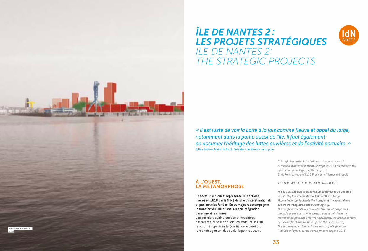
Perspective. Pointe ouest. © uapS
« Il est juste de voir la Loire à la fois comme fleuve et appel du large, notamment dans la partie ouest de l’île. Il faut également en assumer l’héritage des luttes ouvrières et de l’activité portuaire. »Gilles Retière, Maire de Rezé, Président de Nantes métropole
34 35
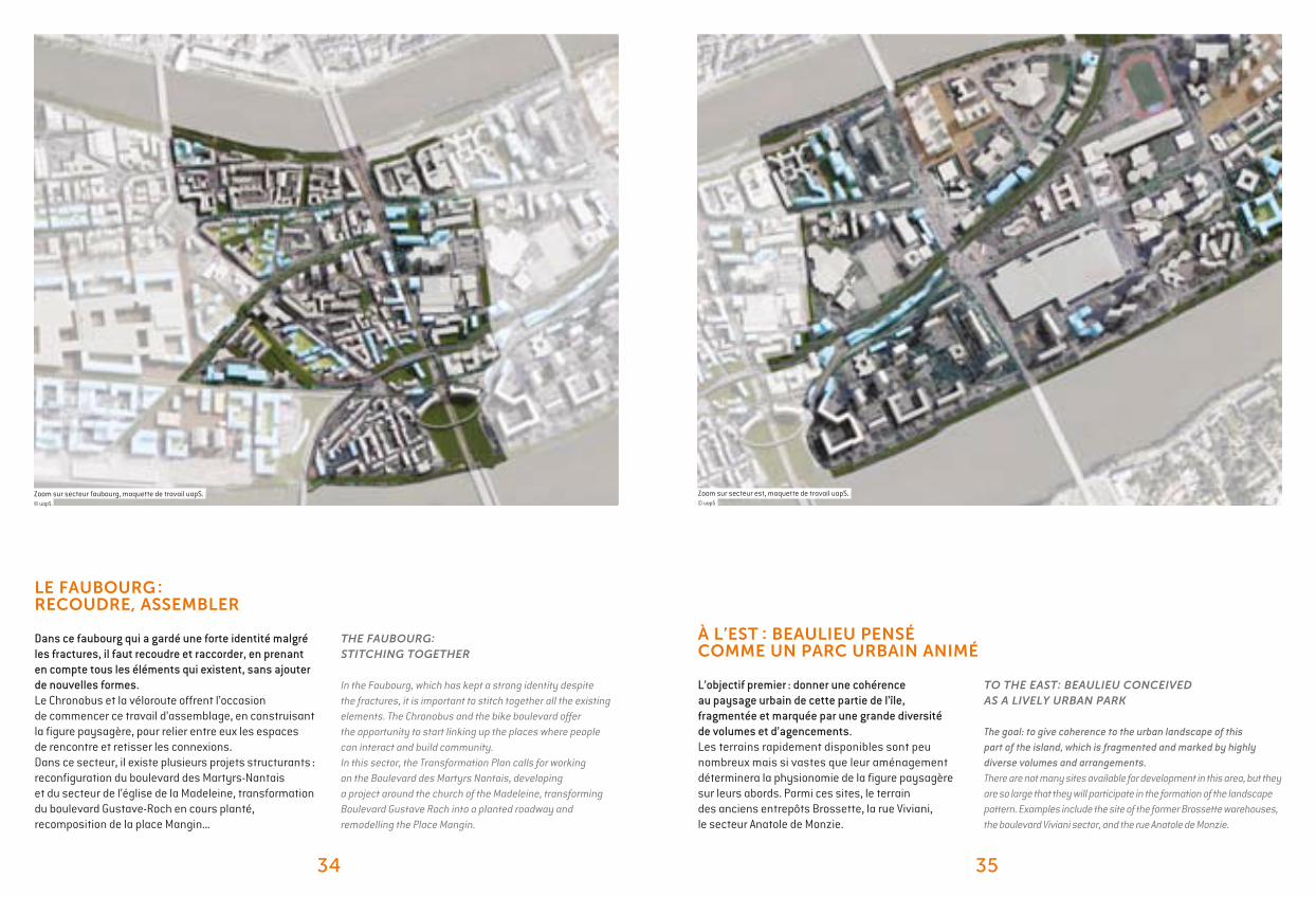
THE FAUBOURG: STITCHING TOGETHER
In the Faubourg, which has kept a strong identity despite the fractures, it is important to stitch together all the existing elements. The Chronobus and the bike boulevard offer the opportunity to start linking up the places where people can interact and build community. In this sector, the Transformation Plan calls for working on the Boulevard des Martyrs Nantais, developing a project around the church of the Madeleine, transforming Boulevard Gustave Roch into a planted roadway and remodelling the Place Mangin.
TO THE EAST: BEAULIEU CONCEIVED AS A LIVELY URBAN PARK
The goal: to give coherence to the urban landscape of this part of the island, which is fragmented and marked by highly diverse volumes and arrangements.There are not many sites available for development in this area, but they are so large that they will participate in the formation of the landscape pattern. Examples include the site of the former Brossette warehouses, the boulevard Viviani sector, and the rue Anatole de Monzie.
Zoom sur secteur faubourg, maquette de travail uapS.© uapS
LE FAUBOURG : RECOUDRE, ASSEMBLER
Dans ce faubourg qui a gardé une forte identité malgré les fractures, il faut recoudre et raccorder, en prenant en compte tous les éléments qui existent, sans ajouter de nouvelles formes. Le Chronobus et la véloroute offrent l’occasion de commencer ce travail d’assemblage, en construisant la figure paysagère, pour relier entre eux les espaces de rencontre et retisser les connexions. Dans ce secteur, il existe plusieurs projets structurants : reconfiguration du boulevard des Martyrs-Nantais et du secteur de l’église de la Madeleine, transformation du boulevard Gustave-Roch en cours planté, recomposition de la place Mangin...
À L’EST : BEAULIEU PENSÉ COMME UN PARC URBAIN ANIMÉ
L’objectif premier : donner une cohérence au paysage urbain de cette partie de l’île, fragmentée et marquée par une grande diversité de volumes et d’agencements.Les terrains rapidement disponibles sont peu nombreux mais si vastes que leur aménagement déterminera la physionomie de la figure paysagère sur leurs abords. Parmi ces sites, le terrain des anciens entrepôts Brossette, la rue Viviani, le secteur Anatole de Monzie.
Zoom sur secteur est, maquette de travail uapS.© uapS
36 37
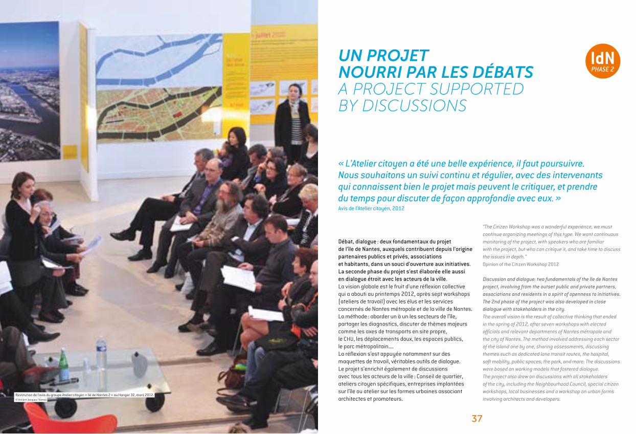
“The Citizen Workshop was a wonderful experience, we must continue organizing meetings of this type. We want continuous monitoring of the project, with speakers who are familiar with the project, but who can critique it, and take time to discuss the issues in depth.”Opinion of the Citizen Workshop 2012
Discussion and dialogue: two fundamentals of the Ile de Nantes project, involving from the outset public and private partners, associations and residents in a spirit of openness to initiatives. The 2nd phase of the project was also developed in close dialogue with stakeholders in the city.The overall vision is the result of collective thinking that ended in the spring of 2012, after seven workshops with elected officials and relevant departments of Nantes métropole and the city of Nantes. The method involved addressing each sector of the island one by one, sharing assessments, discussing themes such as dedicated lane transit routes, the hospital, soft mobility, public spaces, the park, and more. The discussions were based on working models that fostered dialogue.The project also drew on discussions with all stakeholders of the city, including the Neighbourhood Council, special citizen workshops, local businesses and a workshop on urban forms involving architects and developers.
UN PROJET NOURRI PAR LES DÉBATS A PROJECT SUPPORTED BY DISCUSSIONS
Débat, dialogue : deux fondamentaux du projet de l’île de Nantes, auxquels contribuent depuis l’origine partenaires publics et privés, associations et habitants, dans un souci d’ouverture aux initiatives. La seconde phase du projet s’est élaborée elle aussi en dialogue étroit avec les acteurs de la ville.La vision globale est le fruit d’une réflexion collective qui a abouti au printemps 2012, après sept workshops (ateliers de travail) avec les élus et les services concernés de Nantes métropole et de la ville de Nantes. La méthode : aborder un à un les secteurs de l’île, partager les diagnostics, discuter de thèmes majeurs comme les axes de transports en site propre, le CHU, les déplacements doux, les espaces publics, le parc métropolitain.... La réflexion s’est appuyée notamment sur des maquettes de travail, véritables outils de dialogue.Le projet s’enrichit également de discussions avec tous les acteurs de la ville : Conseil de quartier, ateliers citoyen spécifiques, entreprises implantées sur l’île ou atelier sur les formes urbaines associant architectes et promoteurs.
Restitution de l’avis du groupe Atelier citoyen « île de Nantes 2 » au Hangar 32, mars 2012.© Vincent Jacques / Samoa
« L’Atelier citoyen a été une belle expérience, il faut poursuivre. Nous souhaitons un suivi continu et régulier, avec des intervenants qui connaissent bien le projet mais peuvent le critiquer, et prendre du temps pour discuter de façon approfondie avec eux. » Avis de l’Atelier citoyen, 2012

38 39
“Being opportunistic, taking advantage of all the transport routes to build the green structure and connect the new developments to existing ones. The C5 offers the first opportunity for a fluid east-west route, connected to other public transportation options. This is an opportunity to create a green route, with lots of trees.” Marcel Smets
THE EAST-WEST ROUTE, CHRONOBUS AND SOFT MOBILITY
In autumn 2013, the Chronobus C5 will connect the Quai des Antilles to the South Train Station, with guaranteed transit times, frequencies of 5 to 8 minutes during peak hours and 10 to 12 minutes in off-peak hours. Because the Chronobus runs along a different route in each direction, the historic Prairie-au-duc and the parallel Boulevard des Estuaires can be redeveloped. Bike lanes will be created along the route, as well as on allée Paul Nizan which will be completely refurbished, and Vincent-Gâche and Babin-Chevaye, which will be reconfigured. The sectors will be treated from façade to façade, in depth, with playgrounds and wide sidewalks.
CE QUI CHANGE DÉJÀ : L’ACTUALITÉ DU PROJETWHAT IS ALREADY CHANGING: PROJECT NEWS
L’AXE EST-OUEST, CHRONOBUS ET DÉPLACEMENTS DOUX
À partir de la rentrée 2013, le Chronobus C5 reliera le quai des Antilles à la Gare sud avec des temps de parcours garantis, des fréquences de 5 à 8 minutes en heure de pointe et de 10 à 12 minutes en heure creuse. Son tracé en sens dissociés permet de réaménager l’axe historique de la Prairie-au-duc et le boulevard de l’Estuaire parallèle. Les pistes cyclables s’insèrent dans ces parcours, avec également l’allée Paul-Nizan, ancien délaissé urbain profondément réaménagé, et les boulevards Vincent-Gâche et Babin-Chevaye reconfigurés.
Le passage de la nouvelle ligne C5 de Chronobus et de la véloroute comme opportunité de réaménagement de l’espace public sur Paul Nizan. © Didier Ghislain pour uapS
ACTUALITÉ
« Être opportuniste, profiter de tous les axes de transport pour construire la structure verte et pour relier les nouvelles opérations à l’existant. La ligne C5 offre la première de ces opportunités pour une liaison est-ouest fluide, connectée aux autres transports publics. C’est l’occasion de réaliser un axe vert, planté de beaucoup d’arbres. »Marcel Smets
40 41
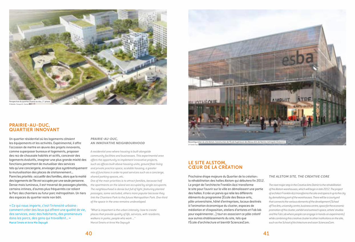
PRAIRIE-AU-DUC, AN INNOVATIVE NEIGHBOURHOOD
A residential area where housing is built alongside community facilities and businesses. This experimental area offers the opportunity to implement innovative projects, such as offices built above housing units, ground floor living and private practice space, scalable housing, a greater mix of functions in order to pool services such as a concierge, shared parking spaces, etc.One of the main priorities is to attract families, because half the apartments on the island are occupied by single occupants.The neighbourhood is dense but full of light, featuring planted passages, some secluded, others more popular because they link the Chantiers Park to the future Metropolitan Park. One-third of the space in the area remains undeveloped.
“What is important is the urban intensity: how to create places that provide quality of life, services, with residents, walkers in parks, people who work ...” Marcel Smets et Anne Mie Depuydt
THE ALSTOM SITE, THE CREATIVE CORE
The next major step in the Creative Arts District is the rehabilitation of the Alstom warehouses, which will begin in late 2012. The project of architect Franklin Azzi transforms the site and opens it up to the city by demolishing part of the warehouses. There will be a courtyard that connects the various elements of the development (School of Fine Arts, university centre, business centre, space for the economic promotion of the cluster, exhibit and outreach space, artists’ studios and the Fab Lab where people can engage in hands-on experiments) while combining this creative cluster to other institutions on the site, such as the School of Architecture and soon SciencesCom.
Perspective du quartier Prairie-au-duc, 1re phase.© Baloïde / Groupe A5 / Samoa
PRAIRIE-AU-DUC, QUARTIER INNOVANT
Un quartier résidentiel où les logements côtoient les équipements et les activités. Expérimental, il offre l’occasion de mettre en œuvre des projets innovants, comme superposer bureaux et logements, proposer des rez-de-chaussée habités et actifs, concevoir des logements évolutifs, imaginer une plus grande mixité des fonctions permettant de mutualiser des services tels qu’une conciergerie, envisager plus systématiquement la mutualisation des places de stationnement…Parmi les priorités : accueillir des familles, alors que la moitié des logements de l’île est occupée par une seule personne.Dense mais lumineux, il est traversé de passages plantés, certains intimes, d’autres plus fréquentés car reliant le Parc des chantiers au futur parc métropolitain. Un tiers des espaces du quartier reste non bâti.
« Ce qui nous importe, c’est l’intensité urbaine : comment créer des lieux qui offrent une qualité de vie, des services, avec des habitants, des promeneurs dans les parcs, des gens qui travaillent… »Marcel Smets et Anne Mie Depuydt
LE SITE ALSTOM, CŒUR DE LA CRÉATION
Prochaine étape majeure du Quartier de la création : la réhabilitation des halles Alstom qui débutera fin 2012. Le projet de l’architecte Franklin Azzi transforme le site pour l’ouvrir sur la ville en démolissant une partie des halles. Il crée un parvis qui relie les différents éléments du programme (École des Beaux-arts, pôle universitaire, hôtel d’entreprises, locaux destinés à l’animation économique du cluster, espaces de médiation et d’exposition, ateliers d’artistes et Fab lab pour expérimenter…) tout en associant ce pôle créatif aux autres établissements du site, tels que l’École d’architecture et bientôt SciencesCom.
Reconfiguration du site Alstom. Construction de l’École Supérieure des Beaux-Arts de Nantes métropole (Esbanm). © Franklin Azzi
42 43
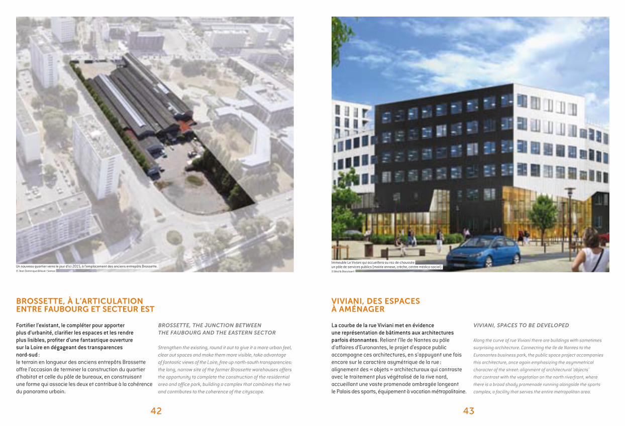
Immeuble Le Viviani qui accueillera au rez-de-chaussée un pôle de services publics (mairie annexe, crèche, centre médico-social). © Béal & Blanckaert
Un nouveau quartier verra le jour d’ici 2015, à l’emplacement des anciens entrepôts Brossette.© Jean-Dominique Billaud / Samoa
BROSSETTE, THE JUNCTION BETWEEN THE FAUBOURG AND THE EASTERN SECTOR
Strengthen the existing, round it out to give it a more urban feel, clear out spaces and make them more visible, take advantage of fantastic views of the Loire, free up north-south transparencies: the long, narrow site of the former Brossette warehouses offers the opportunity to complete the construction of the residential area and office park, building a complex that combines the two and contributes to the coherence of the cityscape.
VIVIANI, SPACES TO BE DEVELOPED
Along the curve of rue Viviani there are buildings with sometimes
surprising architecture. Connecting the Ile de Nantes to the
Euronantes business park, the public space project accompanies
this architecture, once again emphasizing the asymmetrical
character of the street: alignment of architectural ‘objects’
that contrast with the vegetation on the north riverfront, where
there is a broad shady promenade running alongside the sports
complex, a facility that serves the entire metropolitan area.
BROSSETTE, À L’ARTICULATION ENTRE FAUBOURG ET SECTEUR EST
Fortifier l’existant, le compléter pour apporter plus d’urbanité, clarifier les espaces et les rendre plus lisibles, profiter d’une fantastique ouverture sur la Loire en dégageant des transparences nord-sud : le terrain en longueur des anciens entrepôts Brossette offre l’occasion de terminer la construction du quartier d’habitat et celle du pôle de bureaux, en construisant une forme qui associe les deux et contribue à la cohérence du panorama urbain.
VIVIANI, DES ESPACES À AMÉNAGER
La courbe de la rue Viviani met en évidence une représentation de bâtiments aux architectures parfois étonnantes. Reliant l’île de Nantes au pôle d’affaires d’Euronantes, le projet d’espace public accompagne ces architectures, en s’appuyant une fois encore sur le caractère asymétrique de la rue : alignement des « objets » architecturaux qui contraste avec le traitement plus végétalisé de la rive nord, accueillant une vaste promenade ombragée longeant le Palais des sports, équipement à vocation métropolitaine.
3
Catalogue de l’exposition du Hangar 32, espace d’information du projet urbain de l’île de Nantes.
Édité en septembre 2012 par la Samoa.
Rédaction : Frédérique de GravelaineRéalisation graphique : Anima productionsImpression : Imprimerie Allais
Twenty-five years ago, a page turned in the history of Nantes with the closure of the shipyards, the economic and social industry that was the heart and soul of the city, the pride of Nantes and a driving force shaping the area’s identity.
Thanks to the determination of Jean-Marc Ayrault, Mayor of Nantes, the vast Ile de Nantes project was launched and carried out under the aegis of Samoa. After a long period of gestation, sustained reflection and debate, we arrived at this amazing metamorphosis, the adventure continue.
Today, the city of tomorrow is being invented before our very eyes, a city made for all the populations which reinvents its future by leaning on its history and its heritage. Invention, creation, construction, innovation, research: these are the guiding principles orienting the Ile de Nantes, as an urban laboratory where the Nantes metropolis of 2030 is being developed, combining creativity, social cohesion and environmental protection.
The Ile de Nantes is now considered one of the largest urban renewal projects in Europe. In keeping with this ambition, the Ile de Nantes urban project is entering a new phase with the relocation of the wholesale market (MIN) and the future hospital, delivery of the new School of Fine Arts in the Creative Arts District (ESBANM), a city park, the Chronobus C5 and a future transportation line. These are some of the amazing projects that will mark this new phase of the Ile de Nantes project.
Nantes métropole must assert its central role in serving the interests of the local area and all its inhabitants, and continue its efforts to strengthen its position and role in the network of major European cities. These should be the guidelines of this new phase of the Ile de Nantes project, supported by the political determination of the elected officials of Nantes métropole and the City of Nantes.
Patrick Rimbert, Mayor of Nantes and Gilles Retière, President of Nantes métropole


PLAN DES TRANSFORMATIONS FIGUREPAYSAGÈRE MOBILITÉ SITESD’OPPORTUNITÉS
VERSION 03-09-2012PLAN MIS À JOUR TOUS LES 6 MOIS
CLÉS DE LECTURE LÉGENDE
© c
arto
grap
hie
uapS
BÂTIMENTS ICONIQUES
N
PLAN DESTRANSFORMATIONSSEPTEMBRE2012
Related Documents