REVIEW ARTICLE CURRENT SCIENCE, VOL. 96, NO. 9, 10 MAY 2009 1193 *For correspondence. (e-mail: [email protected]) Soils of the Indo-Gangetic Plains: their historical perspective and management D. K. Pal 1, *, T. Bhattacharyya 1 , P. Srivastava 2 , P. Chandran 1 and S. K. Ray 1 1 Division of Soil Resource Studies, National Bureau of Soil Survey and Land Use Planning, Nagpur 440 010, India 2 Department of Geology, University of Delhi, Delhi 110 007, India The Indo-Gangetic Alluvial Plains (IGP) is among the most extensive fluvial plains of the world and cover several states of the northern, central and eastern parts of India. The IGP occupies a total area of approximately 43.7 m ha and represent eight agro-ecological regions (AER) and 14 agro-ecological subregions. The area of the IGP is nearly 13% of the total geographical area of the country, and it produces about 50% of the total foodgrains to feed 40% of the population of the country. Thus the sustainability of the present cropping system and also the health of the soils demand a review on the historical development of the soils and their manage- ment that remained associated with the tectonic, cli- matic and geomorphic history of the IGP since it came into existence due to collision of the Indian and Chi- nese plates during the Middle Miocene. This review provides a state-of-the-art information on the historical development of soils of the IGP, their tectonic-climate- linked natural degradation during the Holocene, and changes in the levels of carbon in soils under agricul- ture (mainly rice–wheat cropping system), practised over the years. In view of the vast area of the IGP, re- search initiatives on benchmark soils are, however, still needed to record the subtilities in pedogenesis, espe- cially their polygenetic history due to climate change during the Holocene. This way a historical soil–climate- crop databank may be established to help in fine-tuning the existing management interventions of the national agricultural research system and also the system- modellers in predicting future projections on the sustainability issue of the rice–wheat cropping system in the IGP. Keywords: Climate change, historical soil development, Indo-Gangetic Plains, polygenesis, soil management inter- ventions. THE Indo-Gangetic Plains (IGP) ranks as one of the most extensive fluvial plains of the world. The deposit of this tract represents the last chapter of earth’s history. It came into existence due to the collision of the Indian and Chi- nese plates during Middle Miocene 1 . The Indian plate is still moving at the rate of 2–5 cm/yr towards the north and forming the world’s highest mountain range on its border. The north-south compression generated through- out the plate ensures that it is continuously under stress and provides the basic source of accumulating strain in the fractured zones 2 . The fluvial deposits and landforms of the IGP have been influenced by the stresses directed towards north and northeast. The major rivers of the IGP have changed their courses and, at present, are flowing in southeast and easterly directions with convexity towards the southeast, which is strikingly similar to the arcuate pattern of the major thrusts bordering the IGP 3 . Thus the IGP shows a series of terraces, bars and meandering scars resulting in microhigh and microlow areas on the appar- ently smooth topography 4,5 . The IGP is still tectonically active and the major sedimentation is taking place from large river systems of the IGP. The IGP developed mainly by the alluvium of the Indus, Yamuna, Ganga, Ramganga, Ghagra, Rapti, Gandak, Bhagirathi, Silai, Damodar, Ajay and Kosi rivers. Geophysical surveys and deep drilling by the Oil and Natural Gas Commission of India 6–8 suggest that the IGP is a vast asymmetric trough with maximum thickness of 10,000 m, that thins out to the south. The IGP covers about 43.7 m ha and represents eight agro-ecologial regions (AERs) and 14 agro-ecological subregions (AESRs; Figure 1) 9 . The nature and properties of the alluvium vary in texture from sandy to clayey, calcareous to non-calcareous and acidic to alkaline. Though the overall topographic situation remains fairly uniform with elevations of 150 m amsl in the Bengal basin, and 300 m amsl in the Punjab plain, local geomorphic variations are significant 10 . Early studies on soils Agriculture was the mainstay of the people of ancient India. The agriculturists then were quite conscious of the nature of soils and its relation to the production of specific crops of good economic return 11,12 . Archaeological investigations along many important sites in the southern, central and western parts of the IGP suggest considerable progress from incipient agricultural activities to well- developed agricultural practices over a span of the last 10,000 years 13–18 . According to recorded information ancient India during the period 2500 BC to AD 600, a vast knowledge acquired by the then agriculturists by

Welcome message from author
This document is posted to help you gain knowledge. Please leave a comment to let me know what you think about it! Share it to your friends and learn new things together.
Transcript

8/6/2019 Soils of the Indo-Gangetic Plainheir
http://slidepdf.com/reader/full/soils-of-the-indo-gangetic-plainheir 1/10

8/6/2019 Soils of the Indo-Gangetic Plainheir
http://slidepdf.com/reader/full/soils-of-the-indo-gangetic-plainheir 2/10
REVIEW ARTICLE
CURRENT SCIENCE, VOL. 96, NO. 9, 10 MAY 20091194
experience has become tradition, and the same has been
passed on from generation to generation. However, a major
part of this has been forgotten and thus has become a
story of the past11,12. Raychaudhuri11 indicated that scien-
tific interest in the characteristics of the Indian soils began
when the Geological Survey of India started studyingthe soils and the underlying strata in 1846. The earliest
investigations by Voelcker19 and Leather20 distinguished
the soils of the IGP as one of the four major soils of the
country. With increasing realization of the fact that the
soils are one of the greatest endowments that nature has
provided to mankind, few resource-oriented surveys were
carried out by the second quarter of the 20th century in
the river-valley projects of some parts of the country.
Later on the Crops and Soils Wing of the Board of Agri-
culture realized the need for more information on soils of
the country for many purposes. Accordingly, the Imperial
(now Indian) Council of Agricultural Research finallysponsored the All India Soil Survey Scheme in 1943.
This scheme examined and collated the available soil-
survey information and the related analytical data which
could be suitably projected on the Soil Map of India. Its
Final Report in 1953 embodied the first comprehensive
work on soil survey in the whole country (British India).
Figure 1. Location map of the Indo-Gangetic Plains (IGP), Indiashowing agro-ecological subregions.
In spite of some limitations, this brought out valuable
information and paved the way for future expansion of
soil survey programmes, both at the Centre and in the
States (then Provinces)21.
Wadia and co-workers22 mentioned that soil groups
were nearly co-terminal with the boundaries of the geo-logical outcrops. Vishwanath and Ukil23 prepared a soil
map (1943) portraying the different climatic types on the
basis of N.S. quotients by adopting colour and texture as
units of classification; these were correlated with four
major climatic zones (arid, semi-arid, humid and perhu-
mid). In 1954, a revised map was prepared at the Indian
Agricultural Research Institute (IARI), New Delhi, on the
scale 1 m = 70 miles, and it showed 20 broad soil classes.
This map was revised by Raychaudhuri24 and later on by
Raychaudhuri and Govindarajan25. It provided the extent,
distribution of different soil classes in the map, and their
equivalents available in the USDA system. The IndusValley Project was the earliest map (1970) that showed
the general characteristics of northwestern Rajasthan and
parts of Pakistan covered by soils of the IGP10. This was
referred to by Wadia and co-workers22 in their publica-
tion on the geological formation of India.
During the past five decades several workers have indi-
cated the various soil-forming processes in soils of the
IGP, such as calcification, leaching, lessivage, saliniza-
tion and alkalinization, gleization and homogenization26.
The temperature regime is hyperthermic (i.e. mean annual
temperature is >22°C and the difference of mean summer
and winter temperature is >6°C), but differences in pre-
cipitation (Figure 2) have contributed to the formation of
a variety of soils in the plains that represent mainly three
soil orders like Entisols, Inceptisols and Alfisols26. Recent
studies indicate that the IGP is dominated by Entisols,
Inceptisols, Alfisols, Mollisols and Aridisols9,27,28. During
the last decade an integrated approach has been helpful to
provide information on the tectonic, geomorphic, palaeo-
climatic and historical aspects on the evolution of soils in
the plains4,5,15,29–32.
Age of the soils
In the recent past, the IGP was considered to consist of older and younger alluvia. The older alluvium marked by
Figure 2. Distribution of mean annual rainfall (MAR) in differentbioclimatic systems in the IGP.

8/6/2019 Soils of the Indo-Gangetic Plainheir
http://slidepdf.com/reader/full/soils-of-the-indo-gangetic-plainheir 3/10
REVIEW ARTICLE
CURRENT SCIENCE, VOL. 96, NO. 9, 10 MAY 2009 1195
a higher degree of pedogenesis was assigned a lower
Pleistocene age33,34 or a minimum age35 of 120,000 yrs.
Recent soil-geomorphic studies on soils of the IGP indi-
cate the presence of more than two soil surfaces younger
than 13,500 cal yrs BP15,31,32,36. Based on their degree of
development, soils of the central and lower IGP havebeen grouped into several members of soil chrono-
association5,15,29,30,32.
Climatic, neotectonic and geomorphic history
Fluvial landforms and alluvial sediments in the IGP are
important Quaternary continental records, which hold
potential for the examination of climatic, tectonic and
lithological controls over their formation37. In response to
the global climatic event during the Quaternary, the IGP
too witnessed climatic fluctuations, especially in the last
post-glacial period. Frequent climatic changes occurred
during the Quaternary38. This palaeoclimatic record has
been documented from the NW and SW parts of India39–41.
Climatic variations has also been inferred from Holocene
soils5,30,31. A cold, arid to semi-arid climate prevailed dur-
ing the Early Holocene to about 7390 cal yrs BP in the
central and western parts of the IGP, favouring pedogenic
calcrete development. Later a warm and humid climate
set in, followed by drier conditions that continued until
the present30,31.
In the IGP pollen studies in a horseshoe indicated four
phases of vegetational development corresponding to very
arid, arid, semi-arid and sub-humid climatic phases dur-ing the last 8000 years42. An earlier study43 on the his-
torical records of climate and vegetation in the northern
IGP by Randhawa indicated that desiccation had set in
about 2000–3000 years ago. The study also pointed out
that the Brij districts of the NW part of the IGP have a
vegetation that is now found in deserts, were covered
with a wet tropical forest of evergreen trees of Indo-
Malayan affinities.
Neotectonics has played a significant role in the evolu-
tion of the geomorphology and soils of the north central30,
north western4,5,15 and lower Gangetic plains32. It has deter-
mined areas of active sedimentation, microtopographical
variations, pedogenesis and erosion. It led to tilting and
sagging of large blocks resulting in shifting and increase
in sinuosity of the rivers. Tectonic slopes/faults deter-
mined the courses of large rivers5,15,29,30,36,37.
Pedogenesis of soils
During the early Holocene to 7390 cal yrs BP and also
during the later warmer and wetter period, weathering of
minerals, illuviation of clay, calcification, decalcifica-
tion5,15,30,44,45 and little addition of organic matter44,45 and
argillipedoturbation32 have been the major pedogenic
processes. These soils are enriched with fine-grained
micas45,46 (Figure 3) which weather to 2 : 1 expanding
clay minerals45–47. However, in soils with vertic characters48
in the lower IGP, clays rich in smectites as the first
weathering product of plagioclase feldspar in the humid
tropical weathering49, were carried by rivers draining the
Rajmahal Basaltic Traps in the west50.There are various processes that are capable of producing
different types of clay minerals51. Among these, the for-
mation of clay minerals during pedogenesis is the most
fundamental. Precipitation, temperature and drainage are
the principal controls of clay mineral formation and these
factors reflect climate and relief 52. Weathering of biotite
was substantial. Preferential downward movement of
weathered products of biotite (di- and trioctahedral
expanding minerals) resulting in decreasing trend of clay
mica is a sure test of clay illuviation, even when clay
skins are absent45. Clay illuviation in soils of the IGP has
not always resulted clay skins or, where present, in purevoid argillans. Instead, ‘impure clay pedofeatures’ are
typical in these soils (Figure 4 a) because of the impair-
ment of parallel orientation of clay platelets, a specific
process different from those described so far for the
genesis of less-oriented void argillans45. The illuviation
of clay particles and their subsequent accumulation in the
Bt horizons of soils of the semi-arid parts of the IGP have
occurred in sodic environment caused by the precipitation
of soluble Ca2+ ions as CaCO3 (Figure 4 b and c), thus
discounting any role of soluble Ca2+ ions and the pres-
ence of CaCO3 in preventing the movement and accumu-
lation of clay particles. Thus the formation of impure clay
pedofeatures and pedogenic CaCO3 are two pedogenic
processes occurring simultaneously in soils of the IGP as
contemporary pedogenic events53 and may act as an
example of pedogenic thresholds in the semi-arid climate
since the last 4000 yrs BP.
Polygenesis of soils
Although it is difficult to determine the characteristic soil
minerals of different climatic zones, clay mineral assem-
blages of soil chrono-association of the northern and central
IGP, indicate that pedogenic smectite–kaolin (Sm/K) canbe considered as a potential indicator for palaeoclimatic
changes, viz. arid to humid climates29,31 during the Holo-
cene. Subsequent studies indicate that not only the clay
mineral but also the detailed micromorphological characters
of clay pedofeatures and calcium carbonates can establish
the polygenetic nature of the soils of the northern and
central IGP54. During pedogenesis two major regional
climatic cycles are recorded; relatively arid climates bet-
ween 10,000–6500 and 3800 yrs BP, and a warm and hu-
mid climate punctuated between these aridic climate31.
The climatic episodes reported so far are reflected in
the alteration of primary and secondary soil minerals and
also in the soil fabrics. Biotite weathered to trioctahedral
8/6/2019 Soils of the Indo-Gangetic Plainheir
http://slidepdf.com/reader/full/soils-of-the-indo-gangetic-plainheir 4/10
REVIEW ARTICLE
CURRENT SCIENCE, VOL. 96, NO. 9, 10 MAY 20091196
Figure 3. Representative scanning electron microscopic (SEM) photographs of sand-sized mica (biotite) in soils of semi-arid ( a, b) and sub-humid ( c, d ) parts of the IGP. (Source: Division of Soil Resource Studies, NBSS&LUP (ICAR),Nagpur.)
vermiculite and smectite in the soils during arid condi-
tions, and smectite was unstable and transformed to Sm/K
during the warm and humid phase (6500–4000 yrs BP).
When the humid climate terminated, vermiculite, smec-
tite and Sm/K have been preserved to the present day.
During the change in climate, the degraded, thick, illuvial
clay pedofeatures record the earliest phase of pedogenesis
in humid conditions (Figure 5 a). In the following semi-
arid conditions pedogenic CaCO3 was formed. The episode
of pedogenic CaCO3 formation was again followed by a
wetter phase, in which further clay illuviation occurred.
During this humid phase, the pedofeatures of earlierphases were also affected; pedogenic CaCO3 was partially
dissolved and reprecipitated in lower horizons (Figure
5 b)54. Development of the IGP soils during the Holocene,
climatic fluctuations appears to be more important than
realized hitherto. Soils older than 2500 yrs BP are relict
palaeosols, but they are polygenetic because of their sub-
sequent alterations31,55.
Degradation of soils
The post-glacial warm period in which human civilizationdeveloped and flourished represents a short epoch which
began 10,000 yrs BP. Within the present interglacial
period too, thermal conditions have continued to change.
It is believed that the monsoons were much stronger in
the early part of the interglacial. Around 4500–3700 yrs
BP, rainfall in the Indus Valley was probably much more
than double the amount received now as for which both
agriculture and forestry flourished43,56. The presence of
animals in the swamps, like elephants and rhinoceros in
Sind and western Punjab, is provided by the seals recov-
ered from Mahanjodaro and Harappa, which date back to
ca. 3250 BC. Sind and western Punjab are practically de-
sert now43. The drought conditions that followed couldhave caused the end of the great Harappan civilization.
According to Randhawa43, vegetation in most parts of the
IGP in the past had been forest. This has been destroyed
both by biotic interference and by the resulting desicca-
tion of the area as a result of deforestation. It is believed
that aridity and desert conditions are now being created
locally over the fertile IGP by ruthless cutting of forests.
Soils under arid and semi-arid parts of the IGP lack
organic carbon due to high rate of decomposition. The
adverse climatic conditions induce precipitation of CaCO3,
thereby depriving the soils of Ca2+ ions on the soil
exchange complex with a concomitant development of sodicity in the subsoils. The subsoil sodicity impairs the

8/6/2019 Soils of the Indo-Gangetic Plainheir
http://slidepdf.com/reader/full/soils-of-the-indo-gangetic-plainheir 5/10
REVIEW ARTICLE
CURRENT SCIENCE, VOL. 96, NO. 9, 10 MAY 2009 1197
hydraulic conductivity of soils. The impairment of perco-
lative moisture regime provides an example of a soil
where gains exceed losses. This self-terminating proc-
ess57 leads to the formation of sodic soils with exchange-
able sodium percentage (ESP) decreasing with depth.
Formation of pedogenic CaCO3, a basic process initiatingdevelopment of sodicity, should be considered as a basic
and natural process of soil degradation55. CaCO3 has been
formed during the semi-arid climate prevailing for the
last 4000 yrs BP and the rate of formation is proceeding
fast. It is estimated to be 0.86 mg/100 g of soil/yr in the
Figure 4. Representative photomicrographs in cross-polarizedlight of ( a) thick, impure clay pedofeatures of Natrustalfs, ( b) claypedofeatures with micrite hypocoating in Typic Natrustalfs and ( c) clay
pedofeatures between two calcium carbonate nodules in Natrustalfs
during the present semi-arid climate of the IGP. (Source: Division of Soil Resource Studies, NBSS&LUP (ICAR), Nagpur.)
first 100 cm of the profile (129 kg ha–1 yr–1 for mean bulk
density of 1.5 Mg m–3)55.
Canal irrigation was introduced at the end of the 19th
century to minimize the problem of aridity and to stabi-
lize crop yields in the northwestern part of the IGP. This
resulted in the expansion of the cultivated area. However,introduction of irrigation during the dry climate without
the provision of drainage led to soil salinization and alka-
linization within a few years, due to rise in the groundwa-
ter table containing high proportion of sodium relative to
divalent cations and/or high residual alkalinity. In addi-
tion, the use of groundwater with high sodic hazards for
irrigation has resulted in the extension of sodic soils58,59.
However, sodic soils interspersed with non-sodic or less
sodic soils occur in both canal-irrigated and unirrigated
areas of the semi-arid part of the IGP. Therefore, intro-
duction of canal irrigation in the IGP is not the only rea-
son for the development of sodic soils. Formation of sodic soils may involve microbiological reduction of sul-
phate and ferric iron to form sulphide, which with CO2
released by biological oxidation of abundant organic mat-
ter forms bicarbonate60. However, this was discounted by
Bandopadhyay61 for the sodic soils of the NW part of the
IGP, which contain neither abundant organic matter nor
Figure 5. Representative photomicrographs in cross-polarized light
of the thick, degraded, illuvial clay pedofeatures of Haplustalfs ( a) anddissolution of pedogenic calcium carbonate of Haplustalfs ( b) during
the earlier humid climate of the IGP. (Source: Division of SoilResource Studies, NBSS&LUP (ICAR), Nagpur.)

8/6/2019 Soils of the Indo-Gangetic Plainheir
http://slidepdf.com/reader/full/soils-of-the-indo-gangetic-plainheir 6/10
REVIEW ARTICLE
CURRENT SCIENCE, VOL. 96, NO. 9, 10 MAY 20091198
sufficient soluble sulphate ions. In addition, these soils
generally lack permanently reducing conditions. In the
NW part of the semi-arid IGP non-sodic and sodic soils
occur on microhigh and highly sodic soils on microlow
positions (Figure 6). Pal and co-workers53 demonstrated
that the main soil-forming processes were clay illuvia-tion, deposition of pedogenic CaCO3 and concomitant
development of subsoil sodicity in these soils. The micro-
lows are repeatedly flooded with surface water during
brief high-intensity showers and so the soils are subject to
cycles of wetting and drying. This provides a steady supply
of alkalis by hydrolysis of feldspar, leading to precipita-
tion of CaCO3 at high pH and development of subsoil so-
dicity. It impairs the hydraulic conductivity of soils and
eventually leads to the formation of sodium-rich soils
(Natrustalfs) with ESP increasing up the profile. The
semi-arid climate and topography interact to facilitate
greater penetration of bicarbonate-rich water in microlowthan microhigh positions. Thin sections show deforma-
tional pedofeatures such as cross and reticulate striation
of plasmic fabric (Figure 7 a), disruption of clay pedofea-
tures (Figure 7 b), carbonate nodules (Figure 7
c) and
elongation of voids (Figure 7 b) as a result of tectonic ac-
tivity during the Holocene. There is also supported from
geodetic observations62,63 that an area under tectonic
compression undergoes horizontal movements and slow
changes in height. By creating microlow and microhigh
sites, the tectonic activity may also have been ultimately
responsible for the formation of more and less sodic
soils4.
Management of soils
The IGP covers approximately 13% of the total geographi-
cal area of India and produces nearly 50% of the coun-
try’s foodgrains to feed 40% of the total population of the
country. The Mughal statistics confirm that much of the
Figure 6. NE–SW profile in Ganga–Yamuna interfluve of the IGP
showing non-sodic soils on microhigh and sodic soils on microlow
sites. (Source: Division of Soil Resource Studies, NBSS&LUP (ICAR),Nagpur.)
land in the IGP was under cultivation. This involved
traditional mixed cropping methods. This land-use pattern
continued till the middle of the 19th century. Over the
last three–four decades the states of the IGP have been
successful in increasing their foodgrain production,
chiefly rice and wheat, by introducing high-input tech-nologies to meet the demands of the exponentially grow-
ing population. The soils under arid climates require
addition of organic matter and phosphorus but not potas-
sium in the initial years of cultivation64. The strategies
Figure 7. Representative photomicrographs in cross-polarized lightof micromorphological features of Haplustalfs and Natrustalfs of theIGP. a, Moderate–strong cross-striated b-fabric. b, Fragmentation
and displaced clay pedofeatures and formation of elongated roughvoids. c, Fragmented and displaced nodule of calcium carbonate.
(Source: Division of Soil Resource Studies, NBSS&LUP (ICAR),Nagpur.)

8/6/2019 Soils of the Indo-Gangetic Plainheir
http://slidepdf.com/reader/full/soils-of-the-indo-gangetic-plainheir 7/10
8/6/2019 Soils of the Indo-Gangetic Plainheir
http://slidepdf.com/reader/full/soils-of-the-indo-gangetic-plainheir 8/10
REVIEW ARTICLE
CURRENT SCIENCE, VOL. 96, NO. 9, 10 MAY 20091200
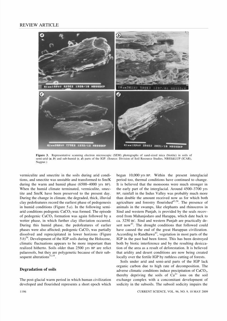
Figure 9. Schematic diagrams showing how CaCO3 can be used as an ameliorant for reclaiming sodic soils through appropriate management
interventions (the size of circles and letters indicates relative proportion of individual components). (Source: Division of Soil Resource Studies,NBSS&LUP (ICAR), Nagpur.)
reclaimed the soils and improved the biological activity75.
It also resulted in a decrease in CaCO3 content during the
corresponding 12-yr period by 1, 1.5 and nearly 2% with
cereal cropping, grasses and agroforestry respectively76
.Although the presence of CaCO3 has been considered of
doubtful significance as displacement of exchangeable
Na by Ca (from CaCO3) in the soils with pH 8.0, it can be
greatly affected by factors like management interven-
tions76 through which SOC content increased considera-
bly77. Thus this fact assumes importance as this component
is more than double the SOC stock in the first 150 cm
depth. This huge SIC stock remains as a hidden treasure
that would improve the drainage and help in the establish-
ment of vegetation and also sequestering OC in the soils9,55.
Information on soils of the IGP has recently been
organized through the GEFSOC Project78 and is available
in several publications on Benchmark soil series27,
SOTER28,79; SOC stock 71 and evaluation of fertilizer tri-
als to judge soil productivity73. The overall increase in
SOC stock in the Benchmark spots under agriculture,
practised for the last 25 years, suggests that agricultural
management practices of the National Agricultural Re-
search System (NARS) did not cause any decline in
SOC74 even amidst the increase in SIC level, indicating
the initiation of chemical degradation55.
Concluding remarks
This review indicates that research contributions of both
earth scientists and soil scientists have led to state-of-the-
art information on the historical development of the IGP
and the soils therein, including the subtilities of pedogene-
sis and polygenesis due to recorded tectonic, climatic and
geomorphic episodes and phenomena during the Holo-cene. The present scenario of change in climate in major
geographical areas of the IGP will continue to remain as a
potential threat. A situation of this nature will therefore,
demand careful management intervention in terms of
restoring and maintaining soil health for sustainable agri-
cultural production in the IGP. It highlights also how soil
carbon dynamics can help in determining the appropri-
ateness of management interventions of the NARS to
raise as well as to maintain agricultural productivity of
soils of the IGP. However, in view of the vast area of the
IGP, new research initiatives are necessary to create the
historical soil–climate-crop databank that would not only
help in the fine-tuning of the existing management inter-
ventions to control the increasing levels of SIC, but also
help system modellers to make future projections on the
sustainability issue of the rice–wheat cropping system
and agro-forestry interventions in the IGP.
1. Parkash, B. and Kumar, S., Indo-Gangetic basin. In Sedimentary
Basin of India. Tectonic Context (eds Tandon, S. K., Pant, C. C.
and Kashyap, S. M.), Gyanodaya Prakashan, Nainital, 1991, pp.
147–170.
2. Gaur, V. K., Evaluation of seismic hazard in India towards mini-
mizing earthquake risk. Curr. Sci., 1994, 67, 324–329.
3.
Parkash, B., Kumar, S., Rao, M. S., Giri, S. C., Kumar, C. S.,Gupta, S. and Srivastava, P., Holocene tectonic movements and

8/6/2019 Soils of the Indo-Gangetic Plainheir
http://slidepdf.com/reader/full/soils-of-the-indo-gangetic-plainheir 9/10
REVIEW ARTICLE
CURRENT SCIENCE, VOL. 96, NO. 9, 10 MAY 2009 1201
stress field in the Western Gangetic Plains. Curr. Sci., 2000, 79,
438–449.
4. Pal, D. K., Srivastava, P., Durge, S. L. and Bhattacharyya, T.,
Role of microtopography in the formation of sodic soils in the
semi-arid part of the Indo-Gangetic Plains, India. Catena, 2003,
51, 3–31.
5. Singh, S., Parkash, B., Rao, M. S., Arora, M. and Bhosle, B.,Geomorphology, pedology and sedimentology of the Deoha/
Ganga-Ghghara Interfluve, Upper Gangetic Plains (Himalayan
Foreland Basin) – extensional tectonic implications. Catena, 2006,
67, 183–203.
6. Sastri, V. V., Venkatachala, B. S., Bhandari, L. L., Raju, A. T. R.
and Datta, A. K., Tectonic framework and subsurface stratigraphy
of the Ganga Basin. J. Geol. Soc. India, 1971, 12, 222–233.
7. Rao, M. B. R., The subsurface geology of Indo-Gangetic Plains. J.
Geol. Soc. India, 1973, 14, 217–242.
8. Raiverman, V., Kunte, S. and Mukherji, A., Basin geometry, Cen-
zoic sedimentation and hydrocarbon prospects in northwestern
Himalaya and Indo-Gangetic Plains. Pet. Asia, 1983, 6, 67–97.
9. Bhattacharyya, T., Pal, D. K., Chandran, P., Mandal, C., Ray, S.
K., Gupta, R. K. and Gajbhiye, K. S., Managing soil carbon stocks
in the Indo-Gangetic Plains, India. Rice–Wheat Consortium for
the Indo-Gangetic Plains, New Delhi, 2004, p. 44.
10. Shankarnarayana, H. S., Morphology, genesis and classification of
soils of the Indo-Gangetic Plains. In Review of Soil Research in
India, Part II , 12th International Congress Soil Science, New
Delhi, 1982, pp. 467–473.
11. Raychaudhuri, S. P., Evolution of classification of soils of India.
Indian Agric., 1975, 19, 163–173.
12. Velayutham, M. and Pal, D. K., Soil classification, India. In
Encyclopedia of Soil Science, Marcel Dekker, New York, 2004,
pp. 1–3.
13. Sharma, G. R., Misra, V. D., Mandal, D., Misra, B. B. and Pal, J.
N., Beginning of Agriculture. Abinash Prakashan, Allahabad,
1980, p. 320.
14. Williams, M. A. J. and Clarke, M. F., Quaternary geology and
prehistoric environments in the Son and Belan valleys, north cen-
tral India. Mem. Geol. Soc. India, 1995, 32, 282–308.
15. Kumar, S., Parkash, B., Manchanda, M. L., Singhvi, A. K. and
Srivastava, P., Holocene landform and soil evolution of the west-
ern Gangetic Plains: implications of neotectonics and climate. Z.
Geomorphol. NF , Suppl., 1996, 103, 283–312.
16. Misra, V. N., Prehistoric human colonization of India. J. Biosci.,
2001, 26, 491–531.
17. Saxena, A., Prasad, V., Singh, I. B., Chauhan, M. S. and Hasan,
R., On the Holocene record of phytoliths of wild and cultivated
rice from Ganga Plain: evidence for rice-based agriculture. Curr.
Sci., 2006, 90, 1547–1552.
18. Williams, M. A. J., Pal, J. N., Jaiswal, M., and Singhvi, A. K.,
River response to Quaternary climatic fluctuations: evidence from
the Son and Belan valleys, north-central India. Quat. Sci. Rev.,
2006, 25, 2619–2631.
19. Voelcker, J. A., Improvement of Indian agriculture. Report sub-
mitted to Famine Commission of 1880, Imperial and Provincial
Agricultural Department, India, 1893.
20. Leather, J. W., On the composition of Indian soils. Agric. Ledger ,
1898, 4, 81–164.
21. Ghosh, A. B., History and development of agriculture in India
with special reference to soil science during 1800–1950. Bull.
Indian Soc. Soil Sci., 1984, 14, 14–28.
22. Wadia, D. N., Krishnan, M. S. and Mukherjee, P. N., Introductory
note on the geological formation of the soils of India. Rec. Geol.
Surv. India, 1935, 68, 369–391.
23. Vishwanath, B. and Ukil, A. C., Soil Map of India, Indian Agricul-
tural Research Institute, New Delhi, 1943.
24.
Raychaudhuri, S. P., Land resources in India. In Indian Soils –Their Classification, Occurrence and Properties, Committee on
Natural Resources, Planning Commission, Govt of India, 1964,
vol. 1.
25. Raychaudhuri, S. P. and Govindarajan, S. V., Soils of India, Indian
Council of Agricultural Research, Technical Bulletin (Agr.), 1971,
No. 25, pp. 1–45.
26. Shankarnarayana, H. S. and Sarma, V. A. K., Soils of India. In
Benchmark Soils of India (eds Murthy, R. S. et al.), NBSS&LUP(ICAR), Nagpur, 1982, pp. 41–70.
27. Ray, S. K. et al., Benchmark Soil Series of the Indo-Gangetic
Plains (IGP), India, Special publication for ‘Assessment of Soil
Organic Carbon Stocks and Change at National Scale’. NBSS&
LUP, Nagpur, 2005, p. 186.
28. Chandran, P. et al., SOTER (Soil and Terrain Digital Databases)
IGP, India. Special publication for ‘Assessment of Soil Organic
Carbon Stocks and Change at National Scale’. NBSS&LUP,
Nagpur, 2005, p. 101.
29. Mohindra, R., Parkash, B. and Prasad, J., Historical geomorphol-
ogy and pedology of the Gandak Megafan, Middle Gangetic Plain,
India. Earth Surf. Process. Landforms, 1992, 17, 643–662.
30. Srivastava, P., Parkash, B., Sehgal, J. L. and Kumar, S., Role of
neotectonics and climate in development of the Holocene geomor-
phology and soils of the Gangetic Plains between Ramganga and
Rapti rivers. Sediment. Geol., 1994, 94, 129–151.
31. Srivastava, P., Parkash, B. and Pal, D. K., Clay minerals in soils
as evidence of Holocene climatic change, Central Indo-Gangetic
Plains, north-central India. Quat. Res., 1998, 50, 230–239.
32. Singh, L. P., Parkash, B. and Singhvi, A. K., Evolution of the
lower Gangetic Plain landforms and soils in West Bengal, India.
Catena, 1998, 33, 75–104.
33. Wadia, D. N., Geology of India, London, McMillan, 1966.
34. Bhattacharya, T. and Banerjee, S. N., Quaternary geology and
geomorphology of the Ajay–Bhagirathi Valley, Birbhum and Mur-
shidabad districts. Indian J. Earth Sci., 1979, 6, 91–102.
35. Singh, I. B. Geological evolution of Gangetic Plains – What we
know and what we do not know? In Workshop on Gangetic
Plains – Terra Incognita, Lucknow University, 1988.
36. Sinha, R. and Friend, P. F., Pedogenic alteration in the overbank
sediments, north Bihar Plains. J. Geol. Soc. India, 1999, 53, 163–
171.
37. Jain, V. and Sinha, R., River systems in the Gangetic plains and
their comparison with the Siwaliks: A review. Curr. Sci., 2003,
84, 1025–1033.
38. Ritter, D. F., Is Quaternary geology ready for the future? Geomor-
phology, 1996, 16, 273–276.
39. Singh, G., Joshi, R. D. and Singh, A. B., Stratigraphic and radio-
carbon evidence for the age and development of the three salt lake
deposits in the Rajasthan, India. Quat. Res., 1972, 2, 496–505.
40. Singh, G., Joshi, R. D., Chopra, S. K. and Singh, A. B., Late Qua-
ternary history of vegetation and climate of the Rajasthan desert,
India. Philos. Trans. R. Soc. London, 1974, 267, 467–501.
41. Singh, G., Wasson, R. J. and Agarwal, D. P., Vegetation and sea-
sonal climate changes since the last full glacial in the Thar desert,
NW India. Rev. Paleobot. Palynol., 1990, 64, 351–358.
42. Gupta, S. P., Origin of the form of Harappan culture – a new
proposition. Puratattva, 1978, 8, 141–146.
43. Randhawa, M. S., Progressive dessication of northern India in
historical times. J. Bombay. Nat. Hist. Soc., 1945, 45, 558–565.
44. Pal, D. K., Deshpande, S. B. and Sehgal, J. L., Development of
soils of Quaternary deposits of north India. Indian J. Earth Sci.,
1987, 14, 329–334.
45. Pal, D. K., Kalbande, A. R., Deshpande, S. B. and Sehgal, J. L.,
Evidence of clay illuviation of sodic soils of north-western part of
the Indo-Gangetic Plain since the Holocene. Soil Sci., 1994, 158,
465–473.
46. Pal, D. K., Srivastava, P., Durge, S. L. and Bhattacharyya, T.,
Role of weathering of fine-grained micas in potassium manage-ment of Indian soils. Appl. Clay Sci., 2001, 20, 39–52.
8/6/2019 Soils of the Indo-Gangetic Plainheir
http://slidepdf.com/reader/full/soils-of-the-indo-gangetic-plainheir 10/10
REVIEW ARTICLE
CURRENT SCIENCE, VOL. 96, NO. 9, 10 MAY 20091202
47. Pal, D. K., Deshpande, S. B. and Durge, S. L., Weathering of bio-
tite in some alluvial soils of different agroclimatic zones. Clay
Res., 1987, 6, 69–75.
48. Soil Survey Staff, Keys to Soil Taxonomy, United States Depart-
ment of Agriculture, National Resources Conservation Service,
Washington, DC, 2003, 9th edn.
49. Pal, D. K. and Deshpande, S. B., Characteristics and genesis of minerals in some benchmark Vertisols of India. Pedologie, 1987,
37, 259–275.
50. Ray, S. K. et al., On the formation of cracking clay soils (Verti-
sols) in West Bengal. Clay Res., 2006, 25, 141–152.
51. Birkland, P. W., Soil and Geomorphology, Oxford University
Press, New York, 1994.
52. Blaise, B., Clay mineral assemblages from late Quaternary depo-
sits on Vancouver Island, southwestern British Columbia, Canada.
Quat. Res., 1989, 31, 41–56.
53. Pal, D. K., Srivastava, P. and Bhattacharyya, T., Clay illuviation
in calcareous soils of the semi-arid part of the Indo-Gangetic
Plains, India. Geoderma, 2003, 115, 177–192.
54. Srivastava, P. and Prakash, B., Polygenetic soils of the north–
central part of the Gangetic Plains: a micromorphological
approach. Catena, 2002, 46, 243–259.
55. Pal, D. K., Dasog, G. S., Vadivelu, S., Ahuja, R. L. and Bhat-
tacharyya, T., Secondary calcium carbonate in soils of arid and
semi-arid regions of India. In Global Climate Change and
Pedogenic Carbonates (eds Lal, R. et al.), Lewis Publishers, Boca
Raton, 2000, pp. 149–185.
56. Prasad, C. R. and Gadgil, S., Climatic change – a global perspec-
tive. Science Age, 1986, pp. 35–40.
57. Yaalon, D. H., Climate, time and soil development. In Pedogene-
sis and Taxonomy: I. Concepts and Interactions (eds Wilding,
L. P., Smeck, N. E. and Hall, G. F.), Elsevier, Amsterdam, 1983,
pp. 233–251.
58. Abrol, I. P., Reclamation of waste lands and world food prospects.
In Whither Soil Research, Panel Discussion Papers, 12th Interna-
tional Congress Soil Science, New Delhi, 1982, pp. 317–337.
59. Abrol, I. P., Reclamation and management of salt-affected soils. In
Review of Soil Research in India, Part II , 12th International Con-
gress Soil Science, New Delhi, 1982, pp. 635–654.
60. Whittig, L. D. and Janitzky, P., Mechanisms of formation of so-
dium carbonate in soils. I. Manifestation of biological conver-
sions. J. Soil Sci., 1963, 14, 322–333.
61. Bandopadhyay, A. K., A note on the formation of bicarbonate in
soil. J. Indian Soc. Soil Sci., 1972, 20, 187–188.
62. Chander, R., Earthquake and elevation changes in the Himalaya.
Curr. Sci., 1994, 67, 306–310.
63. Rajal, B. S. and Madhwal, H. B., Geodetic studies of crustal
deformation and fault displacements. Himalayan Geol., 1996, 17,
17–32.
64. Velayutham, M., Pal, D. K., Bhattacharyya, T. and Srivastava, P.,
Soils of the Indo-Gangetic Plains, India – the historical perspec-
tive. In Land Use – Historical Perspectives – Focus on Indo-
Gangetic Plains (eds Abrol, Y. P., Sangwan, S. and Tiwari, M.),
Allied Publishers Pvt Ltd, New Delhi, 2002, pp. 61–70.
65. Abrol, Y. P., Sangwan, S., Dadhwal, V. K. and Tiwari, M., Land
use/land cover in Indo-Gangetic Plains – history of changes, pre-
sent concerns and future approaches. In Land Use – Historical
Perspectives – Focus on Indo-Gangetic Plains (eds Abrol, Y. P.,
Sangwan, S. and Tiwari, M.), Allied Publishers Pvt Ltd, New
Delhi, 2002, pp. 1–28.
66. Abrol, I. P. and Gupta, R. K., Indo-Gangetic Plains – issues of
changing land use. LUCC Newsl, March 1998, no. 3.
67. Bhandari, A. L., Ladha, J. K., Pathak, H., Padre, A. T., Dawe, D.
and Gupta, R. K., Yield and soil nutrient changes in a long-term
rice–wheat rotation in India. Soil Sci. Soc. Am. J ., 2002, 66, 162–
170.
68. Gupta, R. K., The rice–wheat consortium for the Indo-GangeticPlains: vision and management structure. In Addressing Resource
Conservation Issues in Rice–Wheat Systems for South Asia: A
Resource Book , RWC-CIMMYT, New Delhi, 2003, pp. 1–7.
69. Velayutham, M., Pal, D. K. and Bhattacharyya, T., Organic carbon
stock in soils of India. In Global Climate Change and Tropical
Ecosystems (eds Lal, R., Kimble, J. M. and Stewart, B. A.), Lewis
Publishers, Boca Raton, 2000, pp. 71–95.
70. Saikh, H., Varadachari, C. and Ghosh, K., Changes in carbon,
nitrogen and phosphorus levels due to deforestation and cultiva-
tion: a case study in Simplipal National Park, India. Plant Soil,
1998, 198, 137–145.
71. Bhattacharyya, T. et al., Modelled soil organic carbon stocks and
changes in the Indo-Gangetic Plains, India from 1980 to 2030.
Agric. Ecosyst. Environ., 2007, 122, 84–94.
72. Sahrawat, K. L., Organic matter accumulation in submerged soils.
Adv. Agron., 2004, 81, 169–201.
73. Bhattacharyya, T. et al., Evaluating the Century C model using
long-term fertilizer trials in the Indo-Gangetic Plains, India. Agric.
Ecosyst. Environ., 2007, 122, 73–83.
74. Bhattacharyya, T., Chandran, P., Ray, S. K., Pal, D. K.,
Venugopalan, M. V., Mandal, C. and Wani, S. P., Changes in lev-
els of carbon in soils over years of two important food production
zones of India. Curr. Sci., 2007, 93, 1854–1863.
75. Rao, D. L. N. and Ghai, S. K., Urease and dehydrogenase activity
of alkali and reclaimed soils. Aust. J. Soil Res., 1985, 23, 661–
665.
76. Gupta, R. K. and Abrol, I. P., Salt-affected soils: their reclamation
and management for crop production. In Advances in Soil Science
(ed. Stewart, B. A.), Springer-Verlag, Berlin, 1990, vol. II.
77. Swarup, A., Manna, M. C. and Singh, G. B., Impact of land use
and management practices on organic carbon dynamics in soils of
India. In Global Climate Change and Tropical Ecosystems (eds
Lal, R. et al.), Lewis Publishers, Boca Raton, 2000, pp. 261–281.
78. GEFSOC, Assessment of soil organic carbon stocks and change at
national scale, 2005; http://www,reading.ac.uk/GEFSOC.
79. Batjes, N. H., Bhattacharyya, T., Mandal, C., Dijkshoorn, K., Pal,
D. K., Milne, E. and Gajbhiye, K. S., Soil data derived from
SOTER for studies of carbon stocks and change in the Indo-
Gangetic Plains (India) (Ver. 1.0, GEFSOC Project). Report
2004/06/ISRIC-World Soil Information, Wageningen and
NBSS&LUP (ICAR), 2004, India.
ACKNOWLEDGEMENTS. This article was originally presented at
the 18th World Congress of Soil Science Symposium on the ‘History of
soil science in the developing countries’ and submitted to Current Sci-
ence with the support of the symposium convenors. The encouragement
received from Prof. Dan H. Yaalon (Institute of Earth Sciences, He-
brew University, Israel) is gratefully acknowledged.
Received 1 April 2008; revised accepted 9 March 2009
Related Documents