Author's personal copy Soil tillage and scale effects on erosion from fields to catchment in a Mediterranean vineyard area Damien Raclot a, *, Yves Le Bissonnais b , Xavier Louchart b , Patrick Andrieux b , Roger Moussa b , Marc Voltz b a IRD, Laboratoire d’e ´tude des Interactions Sol-Agrosyste `me-Hydrosyste `me, UMR LISAH INRA-IRD-SupAgro, B.P. 434, El Menzah IV, Tunis, Tunisia b INRA, Laboratoire d’e ´tude des Interactions Sol-Agrosyste `me-Hydrosyste `me, UMR LISAH INRA-IRD-SupAgro, place Viala, 34060 Montpellier Cedex 1, France 1. Introduction Throughout the world, soil erosion by water on cultivated land causes on-site as well as off-site damage, generating profound economic consequences (e.g., Pimentel et al., 1995). Most Mediterranean countries are concerned because of the climate and soil sensitivity and because of the recent intensification of human activities and agricultural practices. In some parts of the Mediterranean area, vineyards represent the largest agro-ecosys- tem and constitute the most important crop by far in terms of income, employment and environmental impact. Indeed, most of the 6 million ha of vineyards in the world lie in the semiarid and Mediterranean regions (Tonietto and Carbonneau, 2004). Vine- yards generally occupy hilly agricultural land prone to runoff and erosion (Arnaez et al., 2007). In order to avoid competition for water by weeds, inter-rows are often artificially maintained without significant plant cover, resulting in large areas exposed to rainfall impact (Ramos and Martı ´nez-Casasnovas, 2006; Tropeano, 1984). In comparison with other typical crops in the Mediterra- nean basin, vineyards constitute the form of agricultural land use that causes the highest soil losses (Martı ´nez-Casasnovas and Sa ´ nchez-Bosch, 2000). Tropeano (1983) measured soil losses of more than 1800 g m 2 per event in vineyards in northern Italy, at a very local scale using Gerlach troughs. In that context, Martı ´nez- Casasnovas and Ramos (2006) related the importance of on-site erosion effects on the final budget of the vine-growers. Cerdan et al. (2006) analyzed an extensive database of medium-term (3–20 years) soil loss measurements under natural rainfall at the plot scale. The authors concluded that vineyards are the agricultural land use that causes the highest soil loss in Europe. Although a promising method using botanical benchmarks has recently been used in Spanish vineyards to determine the long-term erosion rates at field scale (Casalı ´ et al., 2009), knowledge of the rates of soil erosion in Mediterranean vineyards is still very scarce and mainly limited to a few experiments conducted at the plot or field scale (a few m 2 or hundred of m 2 ). In order to define sustainable management policies, accurate estimation of soil water erosion and its driving factors under various land-management and spatial scales is necessary. Agriculture, Ecosystems and Environment 134 (2009) 201–210 ARTICLE INFO Article history: Received 11 March 2009 Received in revised form 15 June 2009 Accepted 30 June 2009 Available online 29 July 2009 Keywords: Erosion Scale Tillage Mediterranean vineyard area Catchment ABSTRACT Soil erosion surveys and modeling approaches often rely on datasets collected from small experimental plots or fields. Therefore, one important issue is to assess to what extent reference data collected on small areas can be affected by soil tillage practices and extrapolated to larger areas. The objectives of this paper are to discuss: (i) the impact of superficial tillage on the erosion rates at field scale and (ii) the impact of the scale on the erosion rates for areas ranging from small fields to 1 km 2 catchments. We analyzed a dataset of 18 rainfall events including runoff and erosion data from fields of approximately 1200 m 2 and 3200 m 2 consisting of vineyards with two contrasting weeding practices – either superficial tillage or no- tillage with chemical weeding – and from the outlet of a 0.91 km 2 catchment that was 70% vineyard. Results showed that superficial tillage significantly reduced (4.5 times) soil losses as compared to no- tillage, with a large event-to-event variability. Considering the natural conditions studied by the authors, no-tillage with chemical weeding is not recommended for the study area. Erosion rates observed at catchment scale were significantly lower than those observed at the scale of individual fields. This trend, which has already been observed by many researchers, confirms that catchment soil loss cannot be estimated by the sum of individual field soil losses. In this context, the scaling transition between the field and the 1 km 2 catchment can be analyzed in terms of the spatial variability of soil management and connectivity between the sediment-producing and deposition areas. ß 2009 Elsevier B.V. All rights reserved. * Corresponding author at: IRD Tunisie, B.P. 434, 5, Impasse Chehrazade, 1004 El Menzah IV, Tunis, Tunisia. Tel.: +216 71750009; fax: +216 71750254. E-mail address: [email protected] (D. Raclot). Contents lists available at ScienceDirect Agriculture, Ecosystems and Environment journal homepage: www.elsevier.com/locate/agee 0167-8809/$ – see front matter ß 2009 Elsevier B.V. All rights reserved. doi:10.1016/j.agee.2009.06.019

Welcome message from author
This document is posted to help you gain knowledge. Please leave a comment to let me know what you think about it! Share it to your friends and learn new things together.
Transcript
Author's personal copy
Soil tillage and scale effects on erosion from fields to catchment in aMediterranean vineyard area
Damien Raclot a,*, Yves Le Bissonnais b, Xavier Louchart b, Patrick Andrieux b, Roger Moussa b, Marc Voltz b
a IRD, Laboratoire d’etude des Interactions Sol-Agrosysteme-Hydrosysteme, UMR LISAH INRA-IRD-SupAgro, B.P. 434, El Menzah IV, Tunis, Tunisiab INRA, Laboratoire d’etude des Interactions Sol-Agrosysteme-Hydrosysteme, UMR LISAH INRA-IRD-SupAgro, place Viala, 34060 Montpellier Cedex 1, France
1. Introduction
Throughout the world, soil erosion by water on cultivated landcauses on-site as well as off-site damage, generating profoundeconomic consequences (e.g., Pimentel et al., 1995). MostMediterranean countries are concerned because of the climateand soil sensitivity and because of the recent intensification ofhuman activities and agricultural practices. In some parts of theMediterranean area, vineyards represent the largest agro-ecosys-tem and constitute the most important crop by far in terms ofincome, employment and environmental impact. Indeed, most ofthe 6 million ha of vineyards in the world lie in the semiarid andMediterranean regions (Tonietto and Carbonneau, 2004). Vine-yards generally occupy hilly agricultural land prone to runoff anderosion (Arnaez et al., 2007). In order to avoid competition forwater by weeds, inter-rows are often artificially maintainedwithout significant plant cover, resulting in large areas exposed to
rainfall impact (Ramos and Martınez-Casasnovas, 2006; Tropeano,1984). In comparison with other typical crops in the Mediterra-nean basin, vineyards constitute the form of agricultural land usethat causes the highest soil losses (Martınez-Casasnovas andSanchez-Bosch, 2000). Tropeano (1983) measured soil losses ofmore than 1800 g m�2 per event in vineyards in northern Italy, at avery local scale using Gerlach troughs. In that context, Martınez-Casasnovas and Ramos (2006) related the importance of on-siteerosion effects on the final budget of the vine-growers. Cerdan etal. (2006) analyzed an extensive database of medium-term (3–20years) soil loss measurements under natural rainfall at the plotscale. The authors concluded that vineyards are the agriculturalland use that causes the highest soil loss in Europe. Although apromising method using botanical benchmarks has recently beenused in Spanish vineyards to determine the long-term erosionrates at field scale (Casalı et al., 2009), knowledge of the rates of soilerosion in Mediterranean vineyards is still very scarce and mainlylimited to a few experiments conducted at the plot or field scale (afew m2 or hundred of m2). In order to define sustainablemanagement policies, accurate estimation of soil water erosionand its driving factors under various land-management and spatialscales is necessary.
Agriculture, Ecosystems and Environment 134 (2009) 201–210
A R T I C L E I N F O
Article history:
Received 11 March 2009
Received in revised form 15 June 2009
Accepted 30 June 2009
Available online 29 July 2009
Keywords:
Erosion
Scale
Tillage
Mediterranean vineyard area
Catchment
A B S T R A C T
Soil erosion surveys and modeling approaches often rely on datasets collected from small experimental
plots or fields. Therefore, one important issue is to assess to what extent reference data collected on small
areas can be affected by soil tillage practices and extrapolated to larger areas. The objectives of this paper
are to discuss: (i) the impact of superficial tillage on the erosion rates at field scale and (ii) the impact of
the scale on the erosion rates for areas ranging from small fields to 1 km2 catchments. We analyzed a
dataset of 18 rainfall events including runoff and erosion data from fields of approximately 1200 m2 and
3200 m2 consisting of vineyards with two contrasting weeding practices – either superficial tillage or no-
tillage with chemical weeding – and from the outlet of a 0.91 km2 catchment that was 70% vineyard.
Results showed that superficial tillage significantly reduced (4.5 times) soil losses as compared to no-
tillage, with a large event-to-event variability. Considering the natural conditions studied by the authors,
no-tillage with chemical weeding is not recommended for the study area. Erosion rates observed at
catchment scale were significantly lower than those observed at the scale of individual fields. This trend,
which has already been observed by many researchers, confirms that catchment soil loss cannot be
estimated by the sum of individual field soil losses. In this context, the scaling transition between the
field and the 1 km2 catchment can be analyzed in terms of the spatial variability of soil management and
connectivity between the sediment-producing and deposition areas.
� 2009 Elsevier B.V. All rights reserved.
* Corresponding author at: IRD Tunisie, B.P. 434, 5, Impasse Chehrazade, 1004 El
Menzah IV, Tunis, Tunisia. Tel.: +216 71750009; fax: +216 71750254.
E-mail address: [email protected] (D. Raclot).
Contents lists available at ScienceDirect
Agriculture, Ecosystems and Environment
journal homepage: www.e lsev ier .com/ locate /agee
0167-8809/$ – see front matter � 2009 Elsevier B.V. All rights reserved.
doi:10.1016/j.agee.2009.06.019
Author's personal copy
The effects of soil management on erosion response remain tobe elucidated. In vineyards, two main systems are widespread:tillage (T) and no-tillage with chemical weeding (NT). A thirdalternative system, involving a natural or permanent sowed grassin the inter-rows, is gaining popularity due to environmentalconsiderations. Few comparisons of T and NT soil managementeffects on erosion responses in vineyards have been completed. Ina three-year experiment under natural rainfall in the Champagnevineyard (France), Ballif and Herre (1986) found no difference inrunoff and a slightly higher soil loss under NT as compared with T(300 g m�2 y�1 vs. 250 g m�2 y�1). In an isolated rainfall simula-tion experiment conducted in the Beaujolais vineyard (France), Gril(1986) found slightly higher runoff volumes under NT comparedwith T and no difference in soil loss. For the Mediterraneanvineyards, Blavet et al. (2004) measured higher runoff and erosionrates on NT as compared with T under rainfall simulation (twotimes and three times, respectively, after 90 mm at 60 mm h�1).Most studies performed in the Mediterranean environmentconcern olive orchards, a row crop with characteristics (locationon hilly areas, bare inter-rows, soil management, etc.) very similarto vineyards with regard to the erosion process. The impact of soilmanagement on this land use is, however, difficult to assessbecause of contradictory results found in the literature. Someauthors (Giraldez et al., 1990; Bruggeman et al., 2005 cited inFleskens and Stroosnijder, 2007) have found that NT produces lesssoil loss than T, whereas others (Gomez et al., 2003, 2004; FranciaMartinez et al., 2006) have found the opposite. As a result, acontroversial debate on the best soil management conservationstrategy is ongoing (Gomez et al., 2008). These authors argued thatthe experimental conditions (such as the slope length or the lengthof the measurement period) may greatly affect the conclusions.They also highlighted the importance of differentiating a no-tillagepractice associated with frequent herbicide application leading tobare soils, from a no-tillage practice associated with a dense cropor grass cover. Additional results will be necessary to support aclearer conclusion.
A related issue concerns the extrapolation of plot or fieldmeasurements to catchments (Kirkby, 2001). If data collection andprocess knowledge mostly originate from the plot scale (Sivapalanand Kalma, 1995), catchment is the operational scale at whichmanagement actions and operations focus (Schulze, 2000). It isalso the pertinent scale for evaluating off-site damage. Frequently,results indicate a decrease of the response of runoff and sedimentyield with increasing area (Le Bissonnais et al., 1998; Joel et al.,2002; Cerdan et al., 2004). This trend may, however, be morecomplex (Cammeraat, 2002), absent (Mathier and Roy, 1996) oreven inverse (Church et al., 1999 cited in De Vente et al., 2007).Several explanations for scale effects have been identified (Bloschl
and Sivapalan, 1995), such as overland process heterogeneity,response non-linearity, threshold effects for some dominantprocess or the development of emerging properties. Extrapolatingthe results from experimental erosion research to larger areas isconsequently a very precarious process (Parsons et al., 2004, 2006;Fleskens and Stroosnijder, 2007; Gomez et al., 2008). These authorsfinally recommend undertaking nested measurements of soil lossat both fields and catchment outlets.
In this paper, we analyze an 18-event dataset of soil lossmeasurements under natural conditions in a Mediterraneanvineyard area belonging to a long-term environmental researchobservatory called OMERE (Mediterranean Observatory of Waterand Rural Environments). Measurements are performed separatelyat the field scale under two soil management systems and at thecatchment scale. The objectives of this paper are to discuss (i) theimpact of soil management (superficial tillage vs. no-tillage withchemical weeding) on erosion response and (ii) the difference inerosion rates between small fields and the catchment scale.
2. Materials and methods
2.1. The study area
The Roujan catchment (0.91 km2) is located in Southern France,60 km west of Montpellier, with central coordinates of 43.498N and03.328E. The climate is Mediterranean sub-humid with aprolonged dry season in summer. Rainfall is usually of highintensity and short duration and presents large year-to-yearvariability. Inter-annual precipitation is about 650 mm; inter-annual potential evapotranspiration is about 1100 mm. The soils ofthe catchment developed from marine, lacustrine or fluvialsediments (Andrieux et al., 1993).
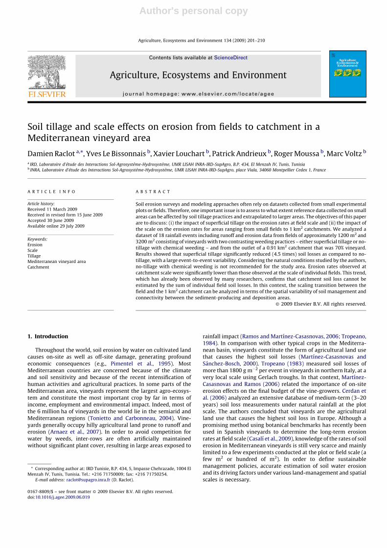
The catchment is organized in four geomorphological domains(Fig. 1a): a plateau (0.25 km2) that peaks at 125 m, terraces(0.30 km2) where slopes can reach 20%, a glacis (0.24 km2) and adepression (0.12 km2) with a minimum elevation of 75 m at theoutlet. Fig. 1b refers to a typical transverse section with soil typesin relation to the geomorphological and topographical domains.The main soil types from top to bottom are chromic luvisols,calcaric regosols, calcaric cambisols, gleyic cambisols (WRB-FAO,1998).
The catchment is divided in 237 fields (Fig. 2a) and is mainlycovered by vineyards (0.59 km2, 1997), except on the depression.The drainage network (Fig. 2b) is formed by man-made ditches andgenerally follows agricultural field limits. Typically, they are 0.7–1.2 m wide and 0.8–1.4 m deep (Lagacherie et al., 2006; Moussa etal., 2002). The total length of the ditch network is about 11 km. Thisdense network (12 km/km2 density on the total catchment)
Fig. 1. Geomorphological domains (a) and synthetic transverse section (b) of the Roujan catchment.
D. Raclot et al. / Agriculture, Ecosystems and Environment 134 (2009) 201–210202
Author's personal copy
hydraulically isolates several fields, drains water tables, collectsoverland field flow and routes water to the catchment outlet (Voltzet al., 1998; Ribolzi et al., 2000; Louchart et al., 2001). The runoffregime is non-permanent, and the runoff response to a rainfallevent is very short, varying from a few minutes at the field scale toa few hours at the catchment scale. It is thus quite easy to relate arunoff event to the associated rainfall event.
Two main soil management approaches to weeding wereidentified in the catchment. In one, herbicides are sprayed over thewhole field without any tillage. In the other, herbicides are onlysprayed along the vine rows and the soil surface is tilled betweenthe rows with a rotary hoe without soil inversion. This superficialtillage (5–10 cm deep) is undertaken one to three times during thegrowing period (March–July). On the Roujan catchment, soilmanagement of the vineyard’s field areas was classified as one oftwo types: non-tilled or tilled. In 1997, these classificationsrepresented areas of 0.43 km2 and 0.16 km2, respectively. The soilmanagement system was identified as a key factor for infiltrationrates, as it greatly affects the topsoil structure (Leonard andAndrieux, 1998).
2.2. Instrumental set-up
The Roujan experimental catchment belongs to a long-termenvironmental research observatory called OMERE (Mediterra-nean Observatory of Water and Rural Environments), which aimsto study the anthropogenic impacts on catchment hydrology andwater quality (Voltz and Albergel, 2002). In 1992, the catchmentwas set up for automatic acquisition of climatic and hydrologicdata. The basic instrumental design consisted of a meteorologicalstation, tipping-bucket rain gauges (0.5 mm), and stream flowrecorders associated with automatic samplers (Fig. 2).
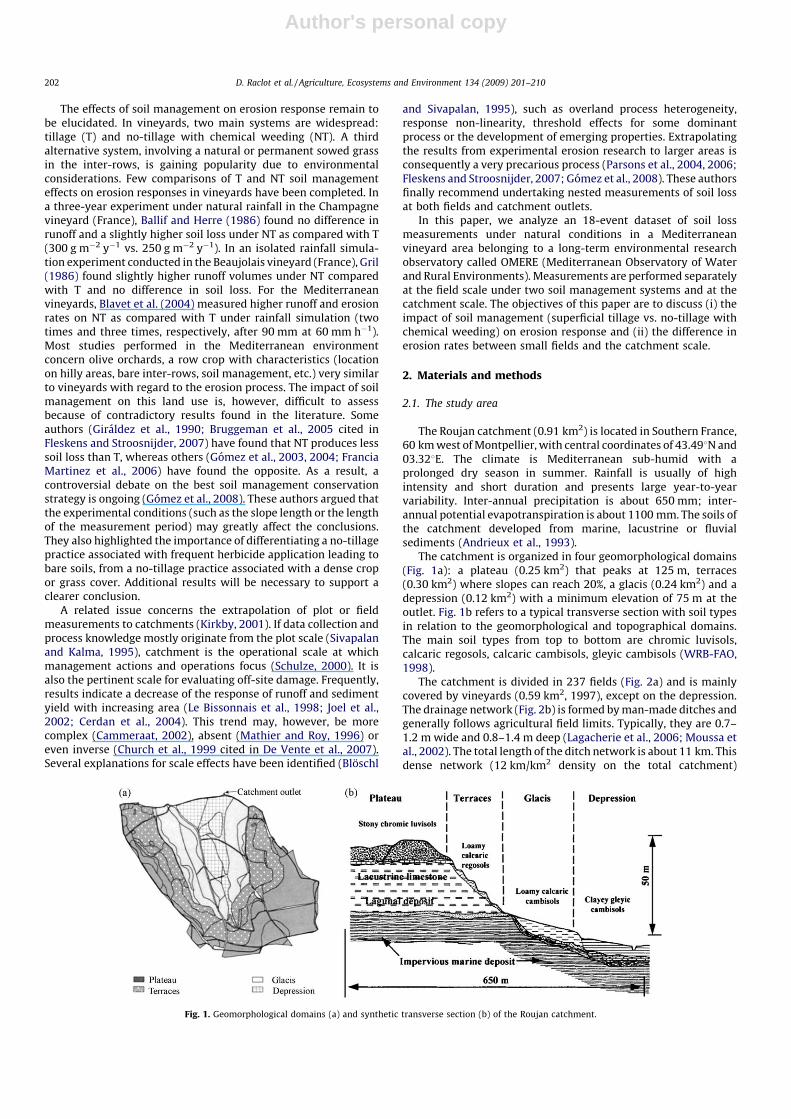
To describe the spatial and temporal variability of erosion, threegauging stations (Fig. 2b) monitored discharge and suspendedsediment using a Venturi channel (Techniflow, Echirolles, France)coupled with an automatic water sampler during the experimentalperiod. The main station was located at the outlet of the catchment(0.91 km2), whereas the two others were located at the outlets oftwo fields: a non-tilled field (1200 m2) and a tilled field (3240 m2),both located on the terraces. The main characteristics of the twomonitored fields are listed in Table 1. Complementary character-istics on soils and vine-stock planting in both fields can be found inLennartz et al. (1997).
The monitoring stations were provided with a capacitive waterlevel sensor (model CCI, SERPE-TESM, Rennes, France) connectedto a datalogger. This allowed us to continuously record waterlevels, which were converted to discharge using rating tablescalibrated in the field and laboratory. An automatic water samplerwith 24 glass bottles (SIGMA Model 800SL; American Sigma,Medina, NY) was used to collect samples during floods in eachgauging station, from which suspended sediment concentrationswere determined. This equipment was programmed to samplewater in relation to the runoff intensity measured at a particularstation. For some events, the automatic sampling was completedmanually. The total mass of transported suspended sediment foran event is then calculated by integrating the sediment concen-trations with flow discharge.
2.3. Data analysis
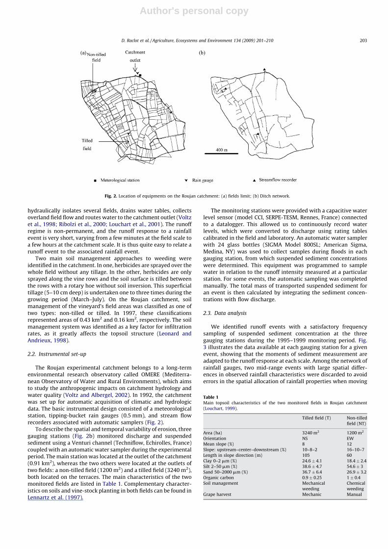
We identified runoff events with a satisfactory frequencysampling of suspended sediment concentration at the threegauging stations during the 1995–1999 monitoring period. Fig.3 illustrates the data available at each gauging station for a givenevent, showing that the moments of sediment measurement areadapted to the runoff response at each scale. Among the network ofrainfall gauges, two mid-range events with large spatial differ-ences in observed rainfall characteristics were discarded to avoiderrors in the spatial allocation of rainfall properties when moving
Fig. 2. Location of equipments on the Roujan catchment: (a) fields limit; (b) Ditch network.
Table 1Main topsoil characteristics of the two monitored fields in Roujan catchment
(Louchart, 1999).
Tilled field (T) Non-tilled
field (NT)
Area (ha) 3240 m2 1200 m2
Orientation NS EW
Mean slope (%) 8 12
Slope: upstream–center–downstream (%) 10–8–2 16–10–7
Length in slope direction (m) 105 60
Clay 0–2 mm (%) 24.6 � 4.1 18.4 � 2.4
Silt 2–50 mm (%) 38.6 � 4.7 54.6 � 3
Sand 50–2000 mm (%) 36.7 � 6.4 26.9 � 3.2
Organic carbon 0.9 � 0.25 1 � 0.4
Soil management Mechanical
weeding
Chemical
weeding
Grape harvest Mechanic Manual
D. Raclot et al. / Agriculture, Ecosystems and Environment 134 (2009) 201–210 203
Author's personal copy
from field to catchment scale. Finally, 18 runoff events, covering awide range of soil surface and climatic conditions, were thusavailable. The distribution of the considered event runoffintensities was verified to be representative of the intensitydistribution for the complete event set. Since the runoff eventsstudied had uniform rainfall patterns, rainfall characteristics werecomputed from only one of the rain gauges located in thecatchment.
Selected runoff events were described with the followingvariables: (i) rainfall depth (Ptot, mm); (ii) maximum rainfallintensity over a 5-min period (I5max, mm h�1); (iii) maximumrainfall intensity over a 30-min period (I30max, mm h�1); (iv)runoff depth (Rd, mm); (v) runoff coefficient (RC, %) evaluated asRd divided by Ptot; (vi) maximal runoff discharge over a 1-minperiod (Q1max, L s�1); (vii) specific erosion as the total mass oftransported suspended sediment per area (Es; g m�2); (viii) meansuspended sediment concentration as the total mass of trans-ported suspended sediment per runoff volume (SSCmean; g L�1).Runoff and sediment measurement errors in our experimental sitewere estimated to be about 20% and 40% respectively, in
accordance with estimations provided by others authors (e.g.,Nearing et al., 1999).
Relationships among all these variables were investigated usingclassical statistical techniques in order to analyze the factorsaffecting erosion. Data were first analyzed at the field scale in orderto evaluate the impact of soil management (tillage vs. no-tillage)on erosion response and then at the catchment scale to evaluatethe scale effects when moving from field to catchment.
3. Results and discussion
3.1. General description of the 18 observed events
The selected events encompassed a wide range of climaticconditions (Table 2). The rainfall duration for the 18 events rangedbetween 20 min (20/11/1997) and 1650 min (03/05/1999). Rain-fall depths (Ptot) varied from less than 4 mm (20/11/1997) to morethan 96 mm (03/05/1999). Maximum rainfall intensities over a 30-min period (I30max) ranged from 7 mm h�1 (20/11/1997) to106 mm h�1 (06/08/1999). According to rainfall amount–duration
Fig. 3. Illustration of the rainfall–runoff–sediment measurements available at each gauging station for the event of June 5, 1997. Rainfall intensity over a 1-min period is first
illustrated (a). The runoff rate (line, left y-axis) and the suspended sediment concentration (diamond shape, right y-axis) measurements related to this rainfall event are
illustrated for non-tilled field (b), tilled field (c) and catchment (d).
D. Raclot et al. / Agriculture, Ecosystems and Environment 134 (2009) 201–210204
Author's personal copy
in the area (Masson, 1980), the return period of the 18 eventsranged from a few days for event 10 to about 25 years for event 18,averaging 62.7 mm in one hour.
The runoff response was highly variable as underlined by therunoff coefficients (RC, Table 2). The latter varied between 0.7%(26/04/1999) and 12.1% (25/11/1997) at the catchment scale, andbetween 1.5% (07/10/1997) and 79.9% (02/05/1998) at the fieldscale. Runoff coefficients were always higher at the field scale (37%mean for the two fields) than at the catchment scale (5% mean) andgenerally higher at the NT field (52% mean) than at the T field (21%mean). This latter result was due to temporary increases in soilroughness and infiltration capacity resulting from tillage thateliminated crusting, whereas NT fields were permanently crusted(Leonard and Andrieux, 1998; Gomez et al., 1999; Lampurlanesand Cantero-Martinez, 2006; Fleskens and Stroosnijder, 2007).However, crusting may have occurred on T fields after someamount of rainfall. Therefore, initially high roughness andinfiltration capacity values decreased, finally reaching values closeto those of NT fields (Andrieux et al., 1996; Chahinian et al., 2005).The lower runoff response observed with increasing area confirmsa general trend commonly reported in the literature, as describedby Cerdan et al. (2004).
In addition, soil losses were highly variable: specific erosion (Es)varied between 0.1 g m�2 (26/04/1999) and 21.0 g m�2 (06/08/1999) at the catchment scale, and between 0.1 g m�2 (07/10/1997)and 1049.6 g m�2 (06/08/1999) at the field scale. Soil losses weregenerally higher at the NT field (about 250 g m�2 on average) thanat the T field (about 55 g m�2 on average) and higher at the fieldscale than at the catchment outlet (about 5 g m�2 on average), asshown in Table 2. The range of variation for the mean suspendedsediment concentrations (SSCmean) was lower. Mean suspendedsediment concentration was generally higher at the NT field(average 17.1 g L�1) than at the T field (average 5.4 g L�1) or at thecatchment outlet (average 4.5 g L�1), as shown in Table 2.
3.2. Relationships between rainfall, runoff-discharge and erosion
variables
In order to understand the factors that might explain the event-to-event variability in soil loss, we evaluated the linear correlationcoefficients between rainfall, runoff-discharge and erosion vari-ables. This analysis involved a Pearson correlation matrixgenerated at the field scale for the NT field and the T field andat the catchment scale for the Roujan catchment (Table 3). The
Ta
ble
2R
ain
fall
–ru
no
ff–
sed
ime
nt
cha
ract
eri
stic
so
fth
e1
8e
ve
nts
an
aly
zed
(NT
=n
on
-til
led
fie
ld,
T=
till
ed
fie
ld,
an
dC
=ca
tch
me
nt
ou
tle
t).
Ev
en
t
nu
mb
er
Da
tee
ve
nt
Ra
infa
ll
du
rati
on
(min
)
Pto
t
(mm
)
I 5m
ax
(mm
h�
1)
I 30m
ax
(mm
h�
1)
Rd
(mm
)R
C(%
)Q
1m
ax
(Ls�
1)
Es
(gm�
2)
SS
Cm
ea
n(g
L�1)
NT
TC
NT
TC
NT
TC
NT
TC
NT
TC
11
3/1
0/1
99
51
70
40
.37
03
92
0.5
26
.22
.65
16
56
17
40
44
91
53
.01
44
.71
0.5
7.5
5.5
4.1
20
8/1
2/1
99
53
80
21
.21
19
7.9
3.9
1.6
38
19
72
21
32
14
.95
.81
.21
.91
.50
.8
30
5/0
5/1
99
75
01
1.2
72
22
5.5
2.9
0.1
49
26
11
01
36
01
52
.51
3.9
0.9
27
.64
.86
.0
40
1/0
6/1
99
73
10
37
.63
01
81
4.8
4.5
1.3
40
12
47
21
08
13
0.0
5.5
0.9
8.8
1.2
0.7
50
5/0
6/1
99
72
40
24
.74
32
01
0.1
4.8
1.4
41
19
61
07
26
71
36
.71
2.3
2.2
13
.52
.61
.6
61
1/0
8/1
99
72
00
36
.99
25
01
3.7
2.7
0.4
37
71
21
15
11
63
90
.32
5.1
1.6
28
.59
.54
.4
70
1/0
9/1
99
72
05
36
.21
57
49
23
.21
1.2
0.6
64
31
24
54
12
01
47
8.0
75
.32
.32
0.6
6.8
3.7
80
7/1
0/1
99
77
58
.75
61
62
.50
.10
.12
92
11
01
47
57
.80
.10
.72
3.3
0.4
6.2
90
3/1
1/1
99
75
15
67
.05
12
63
9.0
16
.45
.55
82
48
14
95
85
25
3.7
8.0
9.7
6.5
0.5
1.8
10
20
/11
/19
97
20
3.7
20
71
.50
.30
.13
98
32
12
78
.20
.20
.35
.60
.82
.4
11
25
/11
/19
97
75
8.7
27
13
4.6
2.3
1.0
54
26
12
55
18
61
2.1
2.8
5.3
2.6
1.3
5.1
12
29
/04
/19
98
11
01
5.7
93
24
11
.72
.60
.37
51
72
39
79
85
55
.21
3.2
7.4
47
.35
.12
4.6
13
02
/05
/19
98
60
9.3
44
18
7.4
3.8
0.5
80
41
61
61
41
57
21
8.6
18
.44
.12
9.5
4.9
7.9
14
26
/04
/19
99
19
51
1.7
14
11
6.2
1.7
0.1
53
15
14
34
73
7.7
3.6
0.1
6.1
2.1
1.8
15
03
/05
/19
99
16
50
96
.11
48
43
.77
.56
.14
68
63
13
42
16
0.6
3.8
5.5
3.7
0.5
0.9
16
17
/05
/19
99
57
03
7.5
30
14
22
.76
.73
.56
11
89
10
10
54
22
60
.61
32
.31
0.9
11
.51
9.6
3.1
17
02
/08
/19
99
14
01
9.1
88
30
9.8
1.2
0.2
51
71
31
49
83
90
.11
2.4
0.6
40
.01
0.0
2.9
18
06
/08
/19
99
12
06
2.7
16
51
07
45
.22
4.1
6.5
72
39
10
44
60
10
95
10
49
.65
16
.42
1.0
23
.22
1.4
3.3
Pto
t:ra
infa
lld
ep
th(m
m);
I 5m
ax
:m
ax
imu
mra
infa
llin
ten
sity
ov
er
a5
-min
pe
rio
d(m
mh�
1);
I 30m
ax
:m
ax
imu
mra
infa
llin
ten
sity
ov
er
a3
0-m
inp
eri
od
(mm
h�
1);
Rd
:ru
no
ffd
ep
th(m
m);
RC
:ru
no
ffco
effi
cie
nt
(%);
Q1m
ax
:m
ax
ima
l
run
off
dis
cha
rge
ov
er
a1
-min
pe
rio
d(L
s�1);
Es:
spe
cifi
ce
rosi
on
as
the
tota
lma
sso
ftr
an
spo
rte
dsu
spe
nd
ed
sed
ime
nt
pe
ra
rea
(gm�
2);
SS
Cm
ea
n:
me
an
susp
en
de
dse
dim
en
tco
nce
ntr
ati
on
as
the
tota
lma
sso
ftr
an
spo
rte
dsu
spe
nd
ed
sed
ime
nt
pe
rru
no
ffv
olu
me
(gL�
1).
Table 3Pearson correlation matrix between the rainfall-runoff and erosion characteristics
of the events for the non-tilled (NT) field, the tilled (T) field and the Roujan
Catchment (n = 18).
NT field T field Catchment
Es SSCmean Es SSCmean Es SSCmean
Ptot 0.368 �0.262 0.368 0.215 0.533* �0.311
I5max 0.859** 0.590** 0.622** 0.570* 0.429 0.272
I30maxa 0.686** 0.541* 0.415 0.320 0.094 0.189
Rd 0.573* �0.156 0.719** 0.400 0.771** �0.299
RC 0.593** 0.399 0.472* 0.240 0.664** �0.232
Q1max 0.885** 0.687** 0.841** 0.619** 0.941** �0.188
Es 0.551* 0.780** 0.110
Correlation is significant at the 0.01 level for ** and at the 0.05 level for *. Ptot:
rainfall depth (mm); I5max: maximum rainfall intensity over a 5-min period
(mm h�1); I30max: maximum rainfall intensity over a 30-min period (mm h�1); Rd:
runoff depth (mm); RC: runoff coefficient (%); Q1max: maximal runoff discharge
over a 1-min period (L s�1); Es: specific erosion as the total mass of transported
suspended sediment per area (g m�2); SSCmean: mean suspended sediment
concentration as the total mass of transported suspended sediment per runoff
volume (g L�1).a Pearson correlation values for I30max are computed without event no. 18
(n = 17).
D. Raclot et al. / Agriculture, Ecosystems and Environment 134 (2009) 201–210 205
Author's personal copy
linear correlation coefficients for I30max have been computedwithout event no. 18 because the exceptional value of I30max forthis event would have strongly influenced the correlation result.
We establish and discuss the correlation coefficients of erosionvs. rainfall and runoff-discharge variables in terms of thepossibility of soil-loss reconstitution.
3.2.1. Relationships among erosion vs. rainfall variables
Total suspended sediment yield (Es) was quite well correlatedwith maximum rainfall intensity at the field scale but poorlycorrelated at the catchment scale. Higher correlation coefficientswere observed for maximum rainfall intensity over a 5-min period(I5max) than for maximum rainfall over a 30-min period (I30max).Correlation coefficients obtained at the field scale between soil lossand maximum rainfall intensity over a 5-min period (R = 0.622 and0.859) were significant. These values were slightly higher than thevalue of 0.6 found at the plot scale in the Mediterranean vineyardcontext by Arnaez et al. (2007). The correlation coefficientsbetween soil loss and maximum rainfall intensity were low and notsignificant (R � 0.429) at the catchment scale. This last result isconsistent with measurements on a Mediterranean badland
catchment described in Nadal-Romero et al. (2008). Totalsuspended sediment yield (Es) and total precipitation (Ptot) weremoderately correlated at the catchment scale (R = 0.533) butpoorly and not significantly correlated at the field scale (R = 0.368).Mean suspended sediment concentration (SSCmean) was poorly tomoderately correlated with maximum rainfall intensity at the fieldscale (R between 0.320 and 0.590). This correlation was weak andnot significant at the catchment scale.
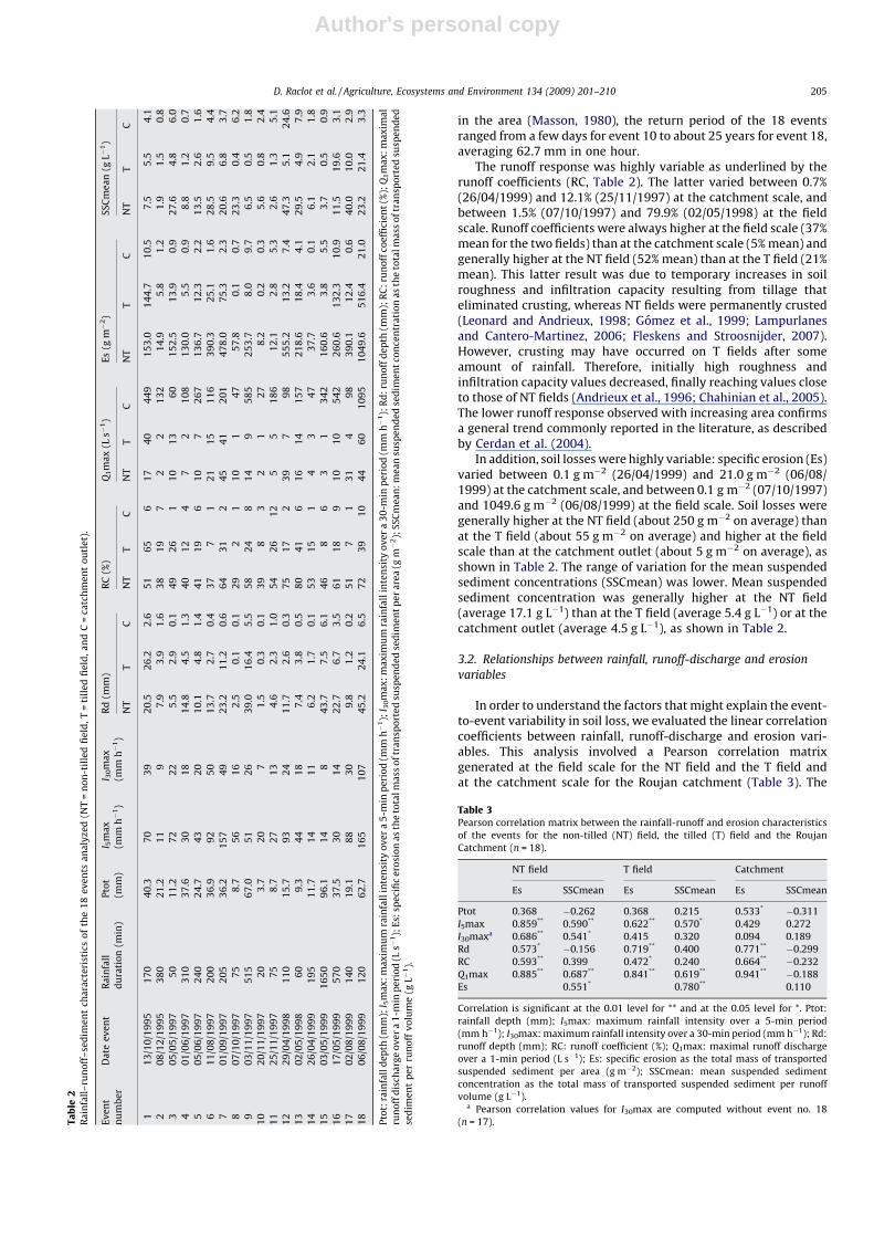
3.2.2. Relationship among erosion vs. runoff-discharge variables
Total suspended sediment yield (Es) was strongly correlatedwith maximal runoff discharge (Q1max) at both field (R 0.841 and0.885) and catchment scales (R = 0.941), as shown in Fig. 4. Thismeans that maximal discharge explained more than 70% of thevariance of the total suspended sediment yield at the field scaleand about 90% at the catchment scale. The correlation wassignificantly stronger than the one found by Nadal-Romero et al.(2008) at the catchment outlet (R = 0.684). Total suspendedsediment yield (Es) was also significantly correlated with runoff(Rd) or runoff coefficient (RC), but with smaller correlationcoefficients. Mean suspended sediment concentration (SSCmean)
Fig. 4. Specific erosion (Es in g m�2) as a function of maximal discharge over a 1-min period (Q1max in L s�1) for the 18 events analyzed for the NT field (non-tilled field, top);
the T field (tilled field, middle) and the catchment scales (down).
D. Raclot et al. / Agriculture, Ecosystems and Environment 134 (2009) 201–210206
Author's personal copy
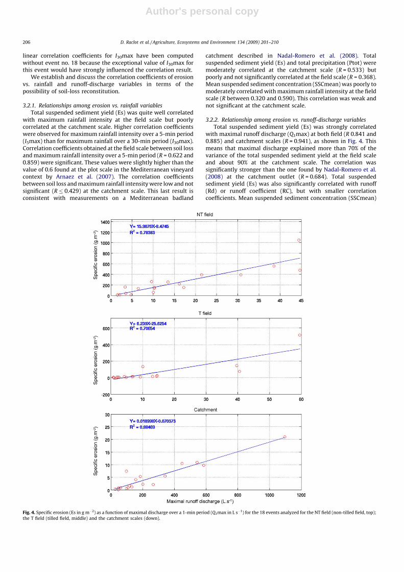
was moderately correlated with maximal runoff discharge(Q1max) at the field scale (R = 0.619 and 0.687). This correlationwas weak and not significant at the catchment scale.
At the field scale, a strong correlation between rainfall intensityand maximal runoff discharge (R = 0.803 and 0.943) was observed.Reconstitution of soil loss can be analyzed using either rainfallintensity or maximal discharge. Maximal discharge should bepreferred because the parameter was significantly better corre-lated with T field and allowed us to explain more than 70% ofvariance. Rainfall intensity over a 5-min period can, however, beused as an alternative if runoff discharge measurements arelacking.
At the catchment scale, the main driving factor of soil loss wasthe maximum discharge (Q1max). This result is consistent with theconclusions of Nadal-Romero et al. (2008). Rainfall intensities werealso a good driving factor of soil loss at the field scale but were notpertinent at the catchment scale. Maximum runoff discharge(Q1max) should be preferred for soil loss reconstitution analysis, asit allowed us to explain 90% of soil loss variance. At this scale,rainfall variables are not recommended for use in the analysis ofsoil loss reconstitution, as they were not well correlated with soilloss.
In reference to the Pearson matrix, it finally appears that thecorrelation values for mean suspended sediment concentration(SSCmean) were always lower than for specific erosion. Theseresults indicate that the prediction of specific erosion may be lessdifficult than the prediction of mean suspended sedimentconcentration.
3.3. Soil management effects on erosion response: the field scale
In spite of some differences in soil texture and in the size and inthe slope of the NT and T fields, results were different enough toderive significant conclusions regarding the effects of soil manage-ment on erosion response. Indeed, specific erosion (Es) was higherfor NT than for T, whatever the event (Table 2). When consideringthe 18 observed events, T proved to significantly (4.5 times) reducetotal soil loss as compared to NT. These results are consistent withthe results that Francia Martinez et al. (2006) and Gomez et al.(2003, 2004) obtained in olive orchards in Spain. Compared to notillage, mechanical weeding induced higher infiltration ratesbecause of changes in soil surface characteristics (Andrieux etal., 1998). The differences in runoff response between the two soilmanagement approaches proved to be highest just after treatmentand then decreased with time and rainfall. In the 18-eventdatabase, we observed higher runoff rates (RC) for NT than for T(Table 2) for all the events except event 1. The lower correlationcoefficient between total precipitation and runoff depth for T fields(R = 0.598) as compared with NT fields (R = 0.947) supports thetime-dependent weeding treatment effect. But were overland flowprocesses entirely responsible for the difference in soil lossresponse?
Analysis of all 18 events proved that differences in overlandflow characteristics between the two soil management systemscould only partially explain the difference in soil loss. Thedifferences in runoff amount were not the determining factor, asthe soil loss ratio between NT and T was indeed about twice as highas the runoff depth ratio (Rd), nor was runoff discharge thedetermining factor; we observed higher mean suspended sedi-ment concentration (SSCmean) for NT than for T, with the samemaximum runoff discharge (Q1max) (Fig. 5). This implies that soilmanagement significantly influenced the erosive process.
These results must, however, be considered cautiously becausethe database does not contain any exceptional event withhundreds of millimeters of rain within a few hours, as can happenin the Mediterranean area (Wainwright, 1996). As a matter of fact,
some authors have mentioned that the effect of tillage on reducingsoil loss could be limited to events of low rainfall intensity (Arnaezet al., 2007). For example, Francia Martınez et al. (2000) reportedthat the single most erosive rainstorm among 18 recorded eventsaccounted for 66% of the total erosion for a no-tillage treatmentand 90% of the total erosion for a tillage treatment. This means thattillage treatment is more sensitive to exceptional events than no-tillage treatment. It is likely that a high intensity and long durationrainfall event occurring after mechanical weeding provides asmuch or higher soil losses on T than on NT. In our database, there isonly one event (event 18 on 06/08/1999) with a high value ofrainfall intensity (I30max > 100 mm h�1) and recent tillage (only50 mm of rainfall since the last tillage). The soil loss response forthis event was clearly higher than for the other events (Es, Table 2).These data may reveal the activation of new mechanisms oferosion, such as rill occurrences, as already described in otherMediterranean vineyards (Martınez-Casasnovas et al., 2005).Unfortunately, this assumption could not be confirmed as theevent was too moderate in total precipitation (Ptot, 63 mm only) togenerate very high soil loss. A long-term observation strategy is ofprimary importance to be able to capture exceptional events and toevaluate the effects of soil management on the entire range ofrainfall discharge.
3.4. Scaling up from field to catchment
A significant decrease in the erosion rates was observed as thecontributing area increased from field to catchment scales. Soillosses (Es) measured at the Roujan catchment outlet were indeedmore than 50 times lower than those measured at the T field and 10times lower than at the NT field. Even if we assume that the terracearea – where the T and NT fields are located and which correspondsto one third of the catchment’s area – was the only area producingsoil losses, there was still a decrease of soil loss of one order ofmagnitude. This means that the sediment soil losses from the fieldsdid not reach the catchment outlet. A decrease in mean sedimentconcentration (SSCmean) was also observed when moving fromfields to catchment. As already observed (Le Bissonnais et al.,1998), this may be due to deposition occurring between the fieldsand catchment outlet. If we refer to the work of Lane et al. (1997)describing the dominant processes controlling sediment yield atvarious scales, it seems that sedimentation is a dominant process
Fig. 5. Mean suspended sediment concentration (SSCmean in g L�1) as a function of
maximal runoff discharge over a 1-min period (Q1max in L s�1) at both tilled (T) and
non-tilled (NT) fields for the 18 events.
D. Raclot et al. / Agriculture, Ecosystems and Environment 134 (2009) 201–210 207
Author's personal copy
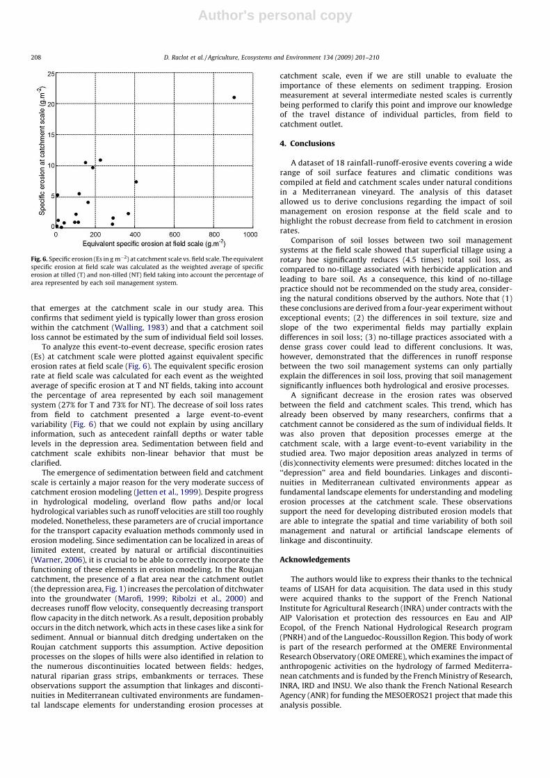
that emerges at the catchment scale in our study area. Thisconfirms that sediment yield is typically lower than gross erosionwithin the catchment (Walling, 1983) and that a catchment soilloss cannot be estimated by the sum of individual field soil losses.
To analyze this event-to-event decrease, specific erosion rates(Es) at catchment scale were plotted against equivalent specificerosion rates at field scale (Fig. 6). The equivalent specific erosionrate at field scale was calculated for each event as the weightedaverage of specific erosion at T and NT fields, taking into accountthe percentage of area represented by each soil managementsystem (27% for T and 73% for NT). The decrease of soil loss ratesfrom field to catchment presented a large event-to-eventvariability (Fig. 6) that we could not explain by using ancillaryinformation, such as antecedent rainfall depths or water tablelevels in the depression area. Sedimentation between field andcatchment scale exhibits non-linear behavior that must beclarified.
The emergence of sedimentation between field and catchmentscale is certainly a major reason for the very moderate success ofcatchment erosion modeling (Jetten et al., 1999). Despite progressin hydrological modeling, overland flow paths and/or localhydrological variables such as runoff velocities are still too roughlymodeled. Nonetheless, these parameters are of crucial importancefor the transport capacity evaluation methods commonly used inerosion modeling. Since sedimentation can be localized in areas oflimited extent, created by natural or artificial discontinuities(Warner, 2006), it is crucial to be able to correctly incorporate thefunctioning of these elements in erosion modeling. In the Roujancatchment, the presence of a flat area near the catchment outlet(the depression area, Fig. 1) increases the percolation of ditchwaterinto the groundwater (Marofi, 1999; Ribolzi et al., 2000) anddecreases runoff flow velocity, consequently decreasing transportflow capacity in the ditch network. As a result, deposition probablyoccurs in the ditch network, which acts in these cases like a sink forsediment. Annual or biannual ditch dredging undertaken on theRoujan catchment supports this assumption. Active depositionprocesses on the slopes of hills were also identified in relation tothe numerous discontinuities located between fields: hedges,natural riparian grass strips, embankments or terraces. Theseobservations support the assumption that linkages and disconti-nuities in Mediterranean cultivated environments are fundamen-tal landscape elements for understanding erosion processes at
catchment scale, even if we are still unable to evaluate theimportance of these elements on sediment trapping. Erosionmeasurement at several intermediate nested scales is currentlybeing performed to clarify this point and improve our knowledgeof the travel distance of individual particles, from field tocatchment outlet.
4. Conclusions
A dataset of 18 rainfall-runoff-erosive events covering a widerange of soil surface features and climatic conditions wascompiled at field and catchment scales under natural conditionsin a Mediterranean vineyard. The analysis of this datasetallowed us to derive conclusions regarding the impact of soilmanagement on erosion response at the field scale and tohighlight the robust decrease from field to catchment in erosionrates.
Comparison of soil losses between two soil managementsystems at the field scale showed that superficial tillage using arotary hoe significantly reduces (4.5 times) total soil loss, ascompared to no-tillage associated with herbicide application andleading to bare soil. As a consequence, this kind of no-tillagepractice should not be recommended on the study area, consider-ing the natural conditions observed by the authors. Note that (1)these conclusions are derived from a four-year experiment withoutexceptional events; (2) the differences in soil texture, size andslope of the two experimental fields may partially explaindifferences in soil loss; (3) no-tillage practices associated with adense grass cover could lead to different conclusions. It was,however, demonstrated that the differences in runoff responsebetween the two soil management systems can only partiallyexplain the differences in soil loss, proving that soil managementsignificantly influences both hydrological and erosive processes.
A significant decrease in the erosion rates was observedbetween the field and catchment scales. This trend, which hasalready been observed by many researchers, confirms that acatchment cannot be considered as the sum of individual fields. Itwas also proven that deposition processes emerge at thecatchment scale, with a large event-to-event variability in thestudied area. Two major deposition areas analyzed in terms of(dis)connectivity elements were presumed: ditches located in the‘‘depression’’ area and field boundaries. Linkages and disconti-nuities in Mediterranean cultivated environments appear asfundamental landscape elements for understanding and modelingerosion processes at the catchment scale. These observationssupport the need for developing distributed erosion models thatare able to integrate the spatial and time variability of both soilmanagement and natural or artificial landscape elements oflinkage and discontinuity.
Acknowledgements
The authors would like to express their thanks to the technicalteams of LISAH for data acquisition. The data used in this studywere acquired thanks to the support of the French NationalInstitute for Agricultural Research (INRA) under contracts with theAIP Valorisation et protection des ressources en Eau and AIPEcopol, of the French National Hydrological Research program(PNRH) and of the Languedoc-Roussillon Region. This body of workis part of the research performed at the OMERE EnvironmentalResearch Observatory (ORE OMERE), which examines the impact ofanthropogenic activities on the hydrology of farmed Mediterra-nean catchments and is funded by the French Ministry of Research,INRA, IRD and INSU. We also thank the French National ResearchAgency (ANR) for funding the MESOEROS21 project that made thisanalysis possible.
Fig. 6. Specific erosion (Es in g m�2) at catchment scale vs. field scale. The equivalent
specific erosion at field scale was calculated as the weighted average of specific
erosion at tilled (T) and non-tilled (NT) field taking into account the percentage of
area represented by each soil management system.
D. Raclot et al. / Agriculture, Ecosystems and Environment 134 (2009) 201–210208
Author's personal copy
References
Andrieux, P., Bouzigues, R., Joseph, C., Voltz, M., Lagacherie, P., Bourlet, M., 1993. Lebassin versant de Roujan: caracteristiques generales du milieu. Report of theFrench National Institute for Agricultural Research (INRA), Montpellier, 35 pp.
Andrieux, P., Louchart, X., Voltz, M., Bourgeois, T. 1996. Determinisme du partageinfiltration-ruissellement sur parcelles de vigne en climat mediterraneen. In:Contribution des eaux souterraines au fonctionnement des hydrosystemes,consequences pour la gestion, Comite national francais de l’AIH, Avignon, 21novembre 1995, Documents du BRGM, 256, Orleans, France, pp. 7–11.
Andrieux, P., Louchart, X., Voltz, M., 1998. Effect of agricultural practices on runoffand erosion in vineyard fields in a mediterranean climate. Annales Geophysicae,Supplement II to volume 16, XXIIIeme EGS General Assembly, Nice, France, 20-24/04/1998, p. C532.
Arnaez, J., Lasanta, T., Ruiz-Flano, P., Ortigosa, L., 2007. Factors affecting runoff anderosion under simulated rainfall in Mediterranean vineyards. Soil and TillageResearch 93 (2), 324–334.
Ballif, J.L., Herre, C., 1986. Ruissellement et erosion dans le vignoble champenois.Synthese des mesures effectuees entre 1981 et 1984. Le vigneron Champenois107, 573–581.
Blavet, D., De Noni, G., Roose, E., Maillo, L., Laurent, J.Y., Asseline, J., 2004. Effets destechniques culturales sur les risques de ruissellement et d’erosion sous vigne enArdeche. Secheresse 15 (1), 111–120.
Bloschl, G., Sivapalan, M., 1995. Scale issues in hydrological modelling. HydrologicalProcesses 9, 251–290.
Bruggeman, A., Masri, Z., Turkelboom, F., 2005. Strategies to sustain productivity ofolive groves on steep slopes in the northwest of the Syrian Arab Republic. In:Benites, J., Pisante, M., Stagnari, F. (Eds.), Integrated Soil and Water Manage-ment for Orchard Development; Role and Importance. FAO Land and WaterBulletin, vol. 10. FAO, Rome, Italy, pp. 75–87.
Cammeraat, L.H., 2002. A review of two strongly contrasting geomorphologicalsystems within the context of scale. Earth Surface Processes and Landforms 27(11), 1201–1222.
Casalı, J., Gimenez, R., De Santisteban, L., Alvarez-Mozos, J., Mena, J., Del Valle deLersundi, J., 2009. Determination of long-term erosion rates in vineyards ofNavarre (Spain) using botanical benchmarks. Catena 78, 12–19.
Cerdan, O., Le Bissonnais, Y., Govers, G., Lecomte, V., van Oost, K., Couturier, A., King,C., Dubreuil, N., 2004. Scale effect on runoff from experimental plots to catch-ments in agricultural areas in Normandy. Journal of Hydrology 299 (1–2), 4–14.
Cerdan, O., Poesen, J., Govers, G., Saby, N., Le Bissonnais, Y., Gobin, A., Vacca, A.,Quinton, J., Auerswald, K., Klik, A., Kwaad, F.F.P.M., Roxo, M.J., 2006. Sheet andrill erosion. In: Boardman, J., Poesen, J. (Eds.), Soil Erosion in Europe. Wiley,Chichester, England, pp. 501–513.
Chahinian, N., Moussa, R., Andrieux, P., Voltz, M., 2005. Comparison of infiltrationmodels to simulate flood events at the field scale. Journal of Hydrology 306,191–214.
Church, M., Ham, D., Hassan, M., Slaymaker, H.O., 1999. Fluvial clastic sedimentyield in Canada: scaled analysis. Canadian Journal of Earth Sciences 36, 1267–1280.
De Vente, J., Poesen, J., Arabkhedri, M., Verstraeten, G., 2007. The sediment deliveryproblem revisited. Progress in Physical Geography 31 (2), 155–178.
Fleskens, L., Stroosnijder, L., 2007. Is soil erosion in olive groves as bad as oftenclaimed? Geoderma 141, 260–271.
Francia Martınez, J.R., Martinez, R.A., Ruiz, G.S., 2000. Erosion en suelo de olivar enfuertes pendientes. Compartimentos de distintos manejos de suelos. Edafologıa7, 147–155.
Francia Martinez, J.R., Duran Zuazo, V.H., Martinez Raya, A., 2006. Environmentalimpact from mountainous olive orchards under different soil-managementsystems (SE Spain). Science of the Total Environment 358 (1–3), 46–60.
Giraldez, J.V., Carrasco, C., Otten, A., Ietswaart, H., Laguna, A., Pastor, M., 1990. Thecontrol of soil erosion in olive orchards under reduced tillage. In: Coutinho,M.A., Tomas, P.P. (Eds.), Proceedings of the Seminar on the Interaction betweenAgricultural Systems and Soil Conservation in the Mediterranean Belt, Septem-ber 4–8, 1990. European Society for Soil Conservation, Oeiras, Portugal, p. 9.
Gomez, J.A., Giraldez, J.V., Pastor, M., Fereres, E., 1999. Effects of tillage method onsoil physical properties, infiltration and yield in an olive orchard. Soil and TillageResearch 52 (3–4), 167–175.
Gomez, J.A., Battany, M., Renschler, C.S., Fereres, E., 2003. Evaluating the impact ofsoil management on soil loss in olive orchards. Soil Use and Management 19 (2),127–134.
Gomez, J.A., Romero, P., Giraldez, J.V., Fereres, E., 2004. Experimental assessment ofrunoff and soil erosion in an olive grove on a Vertic soil in southern Spain asaffected by soil management. Soil Use and Management 20 (4), 426–431.
Gomez, J.A., Giraldez, J.V., Vanwalleghem, T., 2008. Comments on ‘‘Is soil erosion inolive groves as bad as often claimed?’’ by L. Fleskens and L. Stroosnijder.Geoderma 147 (1–2), 93–95.
Gril, J.J., 1986. L’erosion hydrique des sols dans le vignoble. Etude comparative del’influence des techniques culturales: l’exemple du Beaujolais (France). Zeits-chrift fur geomorphologie, Suppl. Bd. 60, 149–160.
Jetten, V., de Roo, A., Favis-Mortlock, D., 1999. Evaluation of field-scale and catch-ment-scale soil erosion models. In: Meeting on Soil Erosion Modelling at theCatchment Scale, APR, 1997, Utrecht, Netherlands. Catena 37 (3–4), 521–541.
Joel, A., Messing, I., Seguel, O., Casanova, M., 2002. Measurement of surface waterrunoff from plots of two different sizes. Hydrological Processes 16, 1467–1478.
Kirkby, M.J., 2001. From plot to continent: reconciling fine and coarse scale erosionmodels. In: Stott, D.E., Mohtar, R.H., Steinhardt, G.C. (Eds.). Sustaining the GlobalFarm. Selected Papers from the 10th International Soil Conservation Organiza-tion Meeting held May 24–29, 1999 at Purdue University and the USDA-ARSNational Soil Erosion Research Laboratory, pp. 860–870.
Lagacherie, P., Diot, O., Domange, N., Gouy, V., Floure, C., Kao, C., Moussa, R., Robbez-Masson, J.M., Szleper, V., 2006. An indicator approach for describing the spatialvariability of artificial stream networks with regard to herbicide pollution incultivated watersheds. Ecological Indicators 6, 265–279.
Lampurlanes, J., Cantero-Martinez, C., 2006. Hydraulic conductivity, residue coverand soil surface roughness under different tillage systems in semiarid condi-tions. Soil and Tillage Research 85 (1–2), 13–26.
Lane, L.J., Hernandez, M., Nichols, M., 1997. Processes controlling sediment yieldfrom watersheds as functions of spatial scale. Environmental Modelling andSoftware 12 (4), 355–369.
Le Bissonnais, Y., Benkhadra, H., Chaplot, V., Fox, D., King, D., Daroussin, J., 1998.Crusting, runoff and sheet erosion on silty loamy soils at various scales andupscaling from m2 to small catchments. Soil and Tillage Research 46, 69–80.
Lennartz, B., Louchart, X., Andrieux, P., Voltz, M., 1997. Diuron and simazine lossesto runoff water in mediterranean vineyards. Journal of Environmental Quality26, 1493–1502.
Leonard, J., Andrieux, P., 1998. Infiltration characteristics of soils in Mediterraneanvineyards in Southern France Catena. 32, 209–223.
Louchart, X., 1999. Transfert de pesticides dans les eaux de surface aux echelles de laparcelle et d’un bassin versant viticole. Etude experimentale et elements demodelisation. Ph.D. Thesis, Ecole Nationale Superieure Agronomique de Mon-tpellier, Montpellier, 263 pp.
Louchart, X., Voltz, M., Andrieux, P., Moussa, R., 2001. Herbicide transport to surfacewaters at field and watershed scales in a Mediterranean vineyard area. Journalof Environmental Quality 30 (3), 982–991.
Marofi, S., 1999. Dynamique des echanges hydrologiques entre reseau de fosses etnappes superficielles dans un bassin versant mediterraneen. These de doctorat,ENSA de Montpellier, 240 pp.
Martınez-Casasnovas, J.A., Sanchez-Bosch, I., 2000. Impact assessment of changes inland use/conservation practices on soil erosion in the Penedes–Anoia vineyardregion (NE Spain). Soil and Tillage Research 57 (1–2), 101–106.
Martınez-Casasnovas, J.A., Ramos, M.C., 2006. The cost of soil erosion in vineyardfields in the Penedes–Anoia Region (NE Spain). Catena 68 (2–3), 194–199.
Martınez-Casasnovas, J.A., Ramos, M.C., Ribes-Dasi, M., 2005. On-site effects ofconcentrated flow erosion in vineyard fields: some economic implications.Catena 60 (2), 129–146.
Masson, J.M., 1980. Analyse d’une longue serie pluviographique montpellier bel Air1920–1971. La Meteorologie 20–21, 105–117.
Mathier, L., Roy, A.G., 1996. A study on the effect of spatial scale on the parametersof a sediment transport equation for sheetwash. Catena 26, 161–169.
Moussa, R., Voltz, M., Andrieux, P., 2002. Effects of the spatial organization ofagricultural management on the hydrological behaviour of a farmed catchmentduring flood events. Hydrological Processes 16, 393–412.
Nadal-Romero, E., Regues, D., Latron, J., 2008. Relationships among rainfall, runoff,and suspended sediment in a small catchment with badlands. Catena 74 (2),127–136.
Nearing, M.A., Govers, G., Norton, L.D., 1999. Variability in soil erosion data fromreplicated plots. Soil Science Society of America Journal 63, 1829–1835.
Parsons, A.J., Wainwright, J., Powell, D.M., Kaduk, J., Brazier, R.E., 2004. A conceptualmodel for determining soil erosion by water. Earth Surface Processes andLandforms 29 (10), 1293–1302.
Parsons, A.J., Brazier, R.E., Wainwright, J., Powell, D.M., 2006. Scale relationships inhillslope runoff and erosion. Earth Surface Processes and Landforms 31 (11),1384–1393.
Pimentel, D., Harvey, C., Resosudarmo, P., Sinclair, K., Kurz, D., Mcnair, M., Crist, S.,Shpritz, L., Fitton, L., Saffouri, R., Blair, R., 1995. Soil-erosion estimates andcosts—reply. Science 269 (5223), 464–465.
Ramos, M.C., Martınez-Casasnovas, J.A., 2006. Nutrient losses by runoff in vineyardsof the Mediterranean Alt Penede’s region (NE Spain). Agriculture Ecosystems &Environment 113 (1–4), 356–363.
Ribolzi, O., Andrieux, P., Valles, V., Bouzigues, R., Bariac, T., Voltz, M., 2000. Con-tribution of groundwater and overland flows to storm flow generation in acultivated Mediterranean catchment. Quantification by natural chemical tra-cing. Journal of Hydrology 233 (1–4), 241–257.
Schulze, R., 2000. Transcending scales of space and time in impact studies of climateand climate change on hygrohydrological responses. Agriculture Ecosystems &Environment 82, 185–212.
Sivapalan, M., Kalma, J.D., 1995. Scale problems in hydrology: contributions of theRobertson Workshop. Hydrological Processes 9, 243–250.
Tonietto, J., Carbonneau, A., 2004. A multicriteria climatic classification system forgrape-growing regions worldwide. Agricultural and Forest Meteorology 124 (1–2), 81–97.
Tropeano, D., 1983. Soil-erosion on vineyards in the tertiary piedmontese basin(NorthWestern Italy) studies on experimental areas. Catena (Suppl. 4), 115–127.
Tropeano, D., 1984. Rate of soil-erosion processes on vineyards in central piedmont(NW Italy). Earth Surface Processes and Landforms 9 (3), 253–266.
Voltz, M., Albergel, J., 2002. OMERE: Observatoire Mediterraneen de l’Environne-ment Rural et de l’Eau—Impact des actions anthropiques sur les transferts demasse dans les hydrosystemes mediterraneens ruraux. Proposition d’Observa-toire de Recherche en Environnement. Ministere de la Recherche, 25 pp.
D. Raclot et al. / Agriculture, Ecosystems and Environment 134 (2009) 201–210 209

Author's personal copy
Voltz, M., Andrieux, P., Bouzigues, R., Lennartz, B., Louchart, X., Moussa, R., Ribolzi,O., 1998. Transport of water and matter in a farmed sedimentary soil system inthe Mediterranean environment. In: Transactions of the 16th World Congress ofSoil Science, Montpellier, France, 20–26 aout 1998, p. 7.
Wainwright, J., 1996. Infiltration, runoff and erosion characteristics of agriculturalland in extreme storm events, SE France. Catena 26 (1–2), 27–47.
Walling, D.E., 1983. The sediment delivery problem. Journal of Hydrology 65, 209–237.
Warner, R.F., 2006. Natural and artificial linkages and discontinuities in a Medi-terranean landscape: some case studies from the Durance Valley, France. Catena66 (3), 236–250.
WRB-FAO, 1998. World Reference Base for Soil Resources. FAO, Rome.
D. Raclot et al. / Agriculture, Ecosystems and Environment 134 (2009) 201–210210
Related Documents