Soil Survey Soil Survey Update, Update, Southwest WY Southwest WY 7/9/2008 7/9/2008 By By Martin J. Rosek Martin J. Rosek

Soil Survey Update, Southwest WY 7/9/2008
Dec 30, 2015
Soil Survey Update, Southwest WY 7/9/2008. By Martin J. Rosek. Field Mapping Completed. Active Project Soil Surveys plus older SCS Mapping. Older SCS Mapping - Purple. Active Mapping - Brown. Projected acres to be mapped in Uinta County, FY 08. - PowerPoint PPT Presentation
Welcome message from author
This document is posted to help you gain knowledge. Please leave a comment to let me know what you think about it! Share it to your friends and learn new things together.
Transcript

Soil Survey Soil Survey Update,Update,
Southwest WY Southwest WY 7/9/20087/9/2008
ByBy
Martin J. RosekMartin J. Rosek

Field Mapping CompletedField Mapping Completed

Active Project Soil Surveys plus older Active Project Soil Surveys plus older SCS MappingSCS Mapping
Active Mapping - Brown
Older SCS Mapping - Purple


Projected acres to be mapped in Projected acres to be mapped in Uinta County, FY 08Uinta County, FY 08
266,737 - 210,000 = 56,737 acres left in 266,737 - 210,000 = 56,737 acres left in Uinta County as of 10/01/08Uinta County as of 10/01/08


Projected acres to be mapped in Projected acres to be mapped in Sublette, County in FY 08Sublette, County in FY 08
276,106 acres (FY 08 mapping plan)276,106 acres (FY 08 mapping plan)


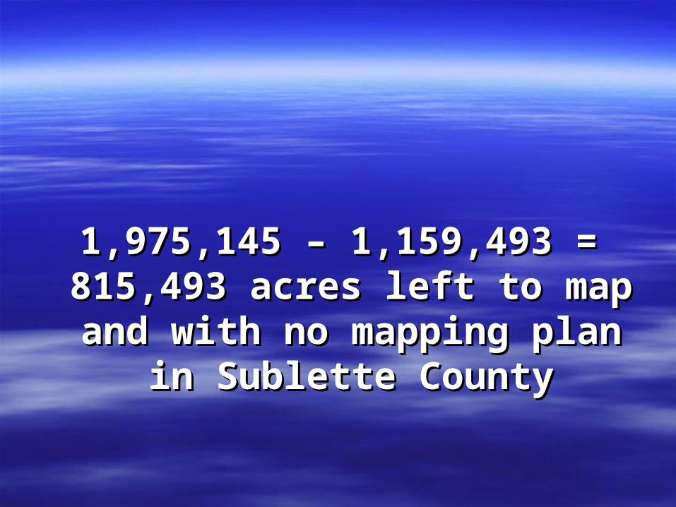
1,975,145 – 1,159,493 = 815,493 1,975,145 – 1,159,493 = 815,493 acres left to map and with no acres left to map and with no
mapping plan in Sublette Countymapping plan in Sublette County


Acres projected to be mapped in Acres projected to be mapped in FY 08, Carbon CountyFY 08, Carbon County
293,175 (FY 08 acres) + 116360 (FY 09 293,175 (FY 08 acres) + 116360 (FY 09 acres) = 409,535 acres projected mapped acres) = 409,535 acres projected mapped in FY 09 in Carbon Countyin FY 09 in Carbon County
330,000 acre goal X 1.5 = 495,000 possible 330,000 acre goal X 1.5 = 495,000 possible acres in FY 08 in Carbon Countyacres in FY 08 in Carbon County


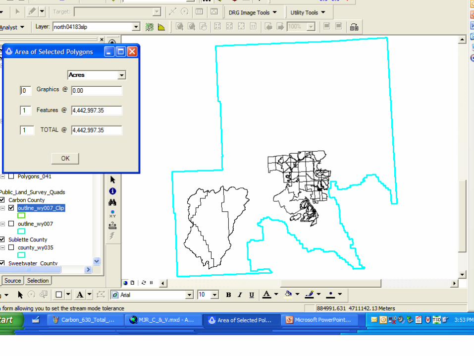
4,442,997 – 696,724 - 89,251 (FY10 4,442,997 – 696,724 - 89,251 (FY10 mapping plan, no shp file) = mapping plan, no shp file) = 3,657,022 acres in Carbon 3,657,022 acres in Carbon
County without a mapping planCounty without a mapping plan

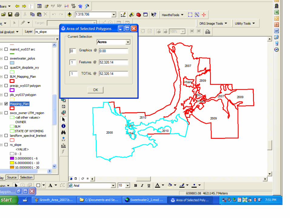


Acceleration of Mapping in Growth Acceleration of Mapping in Growth AreaArea
FY 08 $65000/$1.45/acre @ 45,050 additional acresFY 08 $65000/$1.45/acre @ 45,050 additional acres
52,320 + 44,830 + 45,050* = 142,200 acres mapped 52,320 + 44,830 + 45,050* = 142,200 acres mapped FY 08 for Growth AreaFY 08 for Growth Area *tentative*tentative
48,757 acres FY 09 – 44, 830 = 3927 acres FY 09 48,757 acres FY 09 – 44, 830 = 3927 acres FY 09 leftleft
3927 acres + 22,878 FY 10 acres = 26,805 acres left 3927 acres + 22,878 FY 10 acres = 26,805 acres left to map in Growth Area in FY 09to map in Growth Area in FY 09


Acres with no mapping plan in Acres with no mapping plan in Sweetwater CountySweetwater County
4,859,489 – 156,981 – 45,045* – 73,040 – 49,000 4,859,489 – 156,981 – 45,045* – 73,040 – 49,000 – 7,570 = 4,527,853 acres with no mapping – 7,570 = 4,527,853 acres with no mapping planplan
*tentative*tentative

Acres projected to be mapped in Acres projected to be mapped in Sweetwater County, FY 08Sweetwater County, FY 08
162,691 acres (FY 08 goals) X 1.5 162,691 acres (FY 08 goals) X 1.5 = 244,037 acres= 244,037 acres
Related Documents