1 NATIONAL AGRICULTURAL UNIVERSITY OF UKRAINE, NGO: ECOLOGICAL CENTER “ECO-SOIL” STARODUBTSEV V.M., PETRENKO L.R. SOIL DESERTIFICATION IN THE RIVER DELTAS Part I Edited by Prof. Starodubtsev V.M.

Welcome message from author
This document is posted to help you gain knowledge. Please leave a comment to let me know what you think about it! Share it to your friends and learn new things together.
Transcript

1
NATIONAL AGRICULTURAL UNIVERSITY OF UKRAINE,
NGO: ECOLOGICAL CENTER “ECO-SOIL”
STARODUBTSEV V.M., PETRENKO L.R.
SOIL DESERTIFICATION IN THE RIVER DELTAS
Part I
Edited by Prof. Starodubtsev V.M.
2
NORA-PRINTKYIV -2005
УДК 631.4
Starodubtsev V.M., Petrenko L.R.Soil Desertification in the River Deltas.
Part I. – Kyiv: Nora-print, 2004. – 84 p.
Стародубцев В.М., Петренко Л.Р.Опустелювання грунтів в дельтах річок.
Частина 1. – К.: Нора-прінт, 2004. – 84 с.
ISBN 966-8321-70-7
Розглянуто процеси опустелювання гідроморфнихгрунтів у дельтах річок під впливом водогосподарського будівництва. Наслідком цих процесів є зниження родючості грунтів, їх засолення й дефляція, а також деградація ландшафтів дельт.Книжка призначена для науковців, викладачів
та студентів, а також для широкої громадськості.
The monograph discusses the processes of hydromorphic (excessively wet) soil desertification in the river deltas under the impact of water management construction. The
3
consequences of these processes show themselvesin the reduction of soil fertility, developmentof salinity and wind erosion as well as in degradation of delta landscapes.The publication is meant for the researchers,
teachers, students, and other individuals interested in the discussed topics.
Рецензенти: проф. Гнатенко О.Ф., проф. Мазур Г.А.Reviewers: Prof. Gnatenko O.F., Prof. Mazur
G.A.
Рекомендовано до друку Вченою радою Інститутурослинництва, грунтознавства і екології НАУ.Approved for publication by the Institute of
Plant Cultivation, Soil Science and Ecology of NAU..
ISBN 966-8321-70-7©Стародубцев В.М., Петренко Л.Р., 2004
CONTENTS
1. Water management construction and theenvironment …4-9.
4
2. Soil desertification in the river deltas ofCentral Asia …10-11
3. Changes of the runoff as affected by watermanagement construction activities in the Ily riverbasin ……………12-23
3.1. Development of irrigation and flowregulation in the Ily river basin …………………………………………12-15
3.2. Changes in hydrologic and hydrochemicalregimes of the river Ily ……………………………………………15-23
4. Soil desertification in the Ily river delta………………24-70
4.1. Soils of the Ily river delta …………………………24-32
4.2. Changes in soil-reclamation conditionand soil desertification in the Ily river delta ………………………………32-
70
5. General pattern of changes in soil regimesand properties caused by the Ily’s deltaaridization………………………….71-77

5
6. References…………………………………………….78-83
I. WATER MANAGEMENT CONSTRUCTION AND THEENVIRONMENTT
Intensive construction activity carried outfor the needs of water management in arid andsub-arid regions, beginning from the secondhalf of the XXth century, instigated the unseenever before by their scale environmentalchanges both near the hydraulic structures andin the whole river basins. The construction ofdams and reservoirs, diverting of large volumesof river water for irrigation, industrial andmunicipal water use as well as the return ofthe used and often not properly purified waterback into the rivers – all these practicesdrastically change hydrological andhydrochemical regimes of the rivers(Starodubtsev, 1985). Large areas of land inthe river valleys were inundated by thereservoirs and the landscapes on the banks ofthese artificially created inland water bodieswere also transformed (Starodubtsev, 1986;Starodubtsev, Fedorenko, and Petrenko, 2004).In the river valleys the soils and vegetationdeprived of the regular floods become subjected

6
to degradations. But the most dramatic changesin the natural environment occur in the deltasof rivers with regulated flow. Here, because ofconsiderable reduction of water inflow into thedelta and alleviation (and often – completecessation) of flooding, the landscapes suffer asevere (under desert climate conditions) dryingand desertification, including vegetation andsoils. Delta lakes dry up, ground water tablebecomes lower, soil and ground water salinityincreases. Toxic salts accumulating on thesurface of desertificating soils are carriedoff by the wind to the neighboring areas(Starodubtsev, Petrenko, and Titenko, 1999).The set of these complex natural processescaused or instigated by intensive watermanagement construction creates a challengingscientific and economic management problemwhich remains insufficiently studied to thisday. Our many-yeared research activities (1966-2005) in arid, sub-arid, and humid regions aswell as published data analysis allowed us to acertain extent penetrate the enigma of thenature, character, and extent of theseprocesses’ manifestation and to determine theways to control or prevent the unfavorableconsequences of water management construction.The direct impact of the reservoirs on theenvironment (particularly on the soils) ontheir banks had been discussed by us earlier inthe corresponding monographs (Starodubtsev,1986; Starodubtsev, Fedorenko, and Petrenko,
7
2004). Here we intend to discuss in more detailthe processes of soil drying anddesertification in the river deltas of arid andsub-arid regions. Doing this we shall try todetect the reasons causing the processes likethe changes in hydrologic and hydrochemicalregimes of the rivers with regulated runoff.River flow regulation with the aid of thedams, reservoirs, canals, and pumping stationshas quite a long history (World Register ofDams, 1976-2000; Vendrow and Dyakonov, 1976;Reservoirs of the World, 1979; Starodubtsev,1985, 1986). About 4 thousand years ago theriver runoff regulation was started forirrigation and flood control in the aridregions of Asia, and about 2 thousand years ago– in southern Europe. The XYIII-th century andthe centuries after it saw the ever moreintensive construction of dams with thereservoirs for industrial and communal watersupply. New epoch of water managementconstruction for hydropower generation began onthe verge of XIX-th and XX-th centuries atfirst in Europe and North America, and then inother countries. With the end of the World WarII, began a present-time epoch ofhydrotechnical construction brought about tosolve the complicated problems of powergeneration, irrigation, recreation, fish-breeding, flood control, etc. Giganticreservoirs and their cascades were excavatedall over the world, as well as large canals,

8
including those needed to transfer the largevolumes of water between the basins. Only onthe eve of the XXI-st century, the watermanagement construction in developed countriesbecame less intensive, as a consequence ofenvironmental movements and development of newapproaches to the problem of land and waterresources’ use and protection.The impact of water management construction onthe environment was evident, first of all, onirrigated lands. As early as in ancientMesopotamia, quite intensive were the processesof salinization and swamping on irrigated landsand the areas surrounding them, as well assilting of irrigation ditches and accumulationof irrigation sediments in the fields. Similaroccurrences were known since the time ofancient history in Egypt, India, China andother countries. Much later the environmentaleffects of large reservoirs on the banks weresubjected to research activities. In the formerSoviet Union, the systematic many-disciplinedinvestigations of the reservoirs’ environmentaleffects were started in the 20-30s of the XX-thcentury (Vendrow and Dyakonov, 1976). Theseresearch activities were intensified in the 50-60s of the last century when many rivers of theregion were transformed into cascades ofreservoirs and their impact on the environmentbecame very evident. A necessity appeared tostudy the character of this impact and inurgent cases prevent or minimize their
9
undesirable consequences. However, not all theaspects of the reservoirs’ environmentaleffects became the objects of research. Atfirst the interest was paid only to the “re-forming” (destruction) of banks and reservoirbasins, waterlogging of the managementstructures on the banks, and climatic changeson the riverside territory. Then theresearchers’ attention concentrated on thereservoir-bank soils and vegetation. In thearid regions of Central Asia, the researchactivities of the one of the authors of a givenpublication devoted to the changes in soilcover on the reservoir banks were a priority(Yegorichev and Starodubtsev, 1970;Starodubtsev, 1977, 1981, 1986). The last to be subjected to research was theproblem having extraordinary environmental andeconomic importance especially for the arid andsub-arid regions – that of environmentalchanges in the lower reaches of the rivers withregulated flow. These deep and multiformchanges take place in the river valleys alongthe hundreds of kilometers, from the lowerponds (“biefs”) of the generating stationschemes to the estuaries. In a number of cases,especially in the arid regions, there occursome profound changes in the naturalenvironments of the estuary part of rivers,deltas, internal seas, and even the sea bays.Such environmental changes are dependentmainly upon the physico-geographical conditions
10
(first of all, climate), flow regulation regime(perennial, seasonal, and diurnal), the amountof water used and the character of its use(which is particularly important for theregions of irrigation and runoff transfer), andthe local peculiarities of the river basins. Inthe regions with excessive wetness, theregulation of the river flow by the reservoirsprotects the floodplain areas in the lowerreaches from deep and prolonged inundation inspring and summer, accelerates the subsiding offloods on the tributaries, and improvesdrainage on the surrounding territories. As aresult, soil reclamation conditions onfloodplains, as a whole, improve, andfloodplain lands may be employed foragricultural production. In the steppe regionsas, for example, in the lower reaches of theVolga, Don, Irtysh, Dnipro (Dnepr), and otherrivers, the flow regulation results in thecessation of spring flooding in floodplainareas occupied by the farmlands. Soil andvegetation become steppe-like and degrade, sothat the economical value of floodplain areasbecomes lower. The most profound environmentalchanges take place in the lower reaches of thearid region rivers, like, for example, those ofCentral Asia. Earlier, due to powerful springand summer floods in the lower reaches of therivers, some unique hydromorphic landscapeswere formed with rich flora, fauna, and soils.The intensive runoff regulation and irrevocable

11
use (withdrawal from the course) of the riverwater for irrigation and water supply whichoccurred in the last decades instigated anoticeable aridization of landscapes in thelower reaches. One of the factors of environmentaldegradation occurring in the lower reaches ofrivers is the reduction in the amount of thesolid part of runoff. Thus in the deltas ofmany rivers in the world their advancement intothe sea gives way to their stabilization andeven to the retreat of the mainland. Anintensive abrasive destruction of the delta’scoastal edge occurs in this case. Suchprocesses were observed in the deltas of theDon, Volga, and Kura rivers. But much moreintensively this process takes place in thedeltas of the Nile, Ganges, Huanghe, and manyother rivers. With solid runoff (sediments) thereservoirs accumulate and prevent from theinflow into the landscapes of the floodplainsand deltas the large amounts of organic matter(humus) as well as nutrient elements, such asnitrogen, phosphorus, and potassium. Anexceptionally powerful factor of environmentaldegradation in the lower reaches of rivers isthe growing of water saltiness (Starodubtsev,1985). Additional accumulation of soluble saltsin the lower reaches causes the growth of soilsalinity and ground water saltiness. Some unique manifestation ofthe above-mentioned processes we investigated
12
in the lower reaches of the Syrdarya and Churivers (Kazakhstan). But they are alsowidespread in the lower reaches of many otherrivers in the world (the Euphrates, Colorado,etc.). To weaken the negative consequences of flowregulation and its influence on the naturalenvironment in the lower reaches thespecialists resort to the so-called “ecologicwater allowances” from the reservoirs. But indeciding the regimes and volumes of such

13
Figure 1. River valleys and deltas with the different degree of thenatural environment degradation:

14
1 – weak degradation, 2 – moderate degradation, 3 –strong degradation.
15
“allowances” the interests of different waterconsumers are at sharp variance. Thus for therenovation of vegetation the allowance may bebrief in time but with a high peak of waterdischarges to be able to flood even theelevated land forms in the delta. Fish breedingdemands the spring flood simulation with thelonger periods of water level rising andlowering in order to feed with water the oldriver beds and lakes in the floodplain anddelta for the spawning and putting on weight bythe young fish. Such allowances contradict theinterests of power generation. Now the“ecological allowances” are practiced on manyrivers with regulated flow but the purposes ofsuch practices are seldom if ever reachedcompletely.

16
2. SOIL DESERTIFICATION IN THE RIVER DELTAS OFCENTRAL ASIA
General picture of environmental changes(desertification) in the river deltas triggeredby water management construction and intensiveuse of land and water resources was discussedearlier. Here we are going to analyze only themost far-reaching changes in soil cover andland reclamation conditions caused by thereduction of river runoff and transformation ofriver regimen in conditions of desert climateon the concrete examples of river deltas (thoseof the Ily, Syrdarya, Chu, etc.) in CentralAsia.The specific features of soil formation inriver deltas of arid and subarid regions of theformer Soviet Union were investigated byV.M.Borowsky, A.Z.Genusov, I.P.Gerasimov,M.A.Glazovskaya, G.V.Dobrovolsky, V.V.Yegorov,N.V.Kimberg, V.A.Kovda, P.A.Letunov,

17
Ye.V.Lobova, N.G.Minashina, B.B.Polynov,L.I.Prasolov and other researchers. The mostsignificant publication on Kazakhstan was themonograph by V.M.Borowsky and M.A.Pogrebinsky(1959) which offered the nomenclature andclassification of delta soils that stillremains in active use after corrections(Karazhanov, 1973). The first stage of soils’ drying-up triggeredby water management construction on the deltaplains of Kazakhstan in the 60s of the XX-thcentury has been studied by V.M.Borowsky,K.D.Karazhanov, Yu.M.Popov, T.F.Nekrasova, etal (in the lower reaches of the Syrdaryariver), M.A.Orlova, E.A.Sokolenko, andA.N.Osina (in the lower reaches of the Churiver), and M.A.Pogrebinsky, Yu.M.Popov, andR.Yu.Magasheva (in the lower reaches of the Ilyriver). Numerous research activities werecarried out in the same period of time in theAmudarya, Murgab, and Tedzhen deltas byN.G.Minashina, A.Z.Genusov, K.Redgepbayev andother researchers.But already in the 70-80s the excavation ofnumerous reservoirs and intensive use of landand water resources (especially for irrigation)put the processes of delta soil drying-up onquantitatively and qualitatively new level –that of soil desertification (Kovda, 1977;Yegorov and Minashina, 1977; Starodubtsev etal., 1977, 1978, 1982, and 1983; Nekrasova etal., 1980; Orlova, 1983; Kievskaya, 1983; et
18
al). Some specific features and essentialregularities of soil desertification in deltasof the Ily, Syrdarya, and Chu rivers as well asthe changes in soil salinity and otherproperties will be considered here on theevidence provided by our prolonged researchactivities in 1973-1991. Research resultsanalysis is supported by the informationreflecting the initial soil condition as wellas the changes in river runoff and landmanagement on the verge of the XXI century.The runoff transformation of the regulatedrivers is considered by us as a cause-and-effect relation between water managementconstruction in the river basins andenvironmental changes in the lower reaches ofthe rivers including deltas. We, therefore, paymuch attention and attach importance to thehydrologic and hydrochemical regimes of therivers under consideration as well as to thedevelopment of water management construction intheir basins. At first we shall discuss theproblem on an example of the Ily river basin.
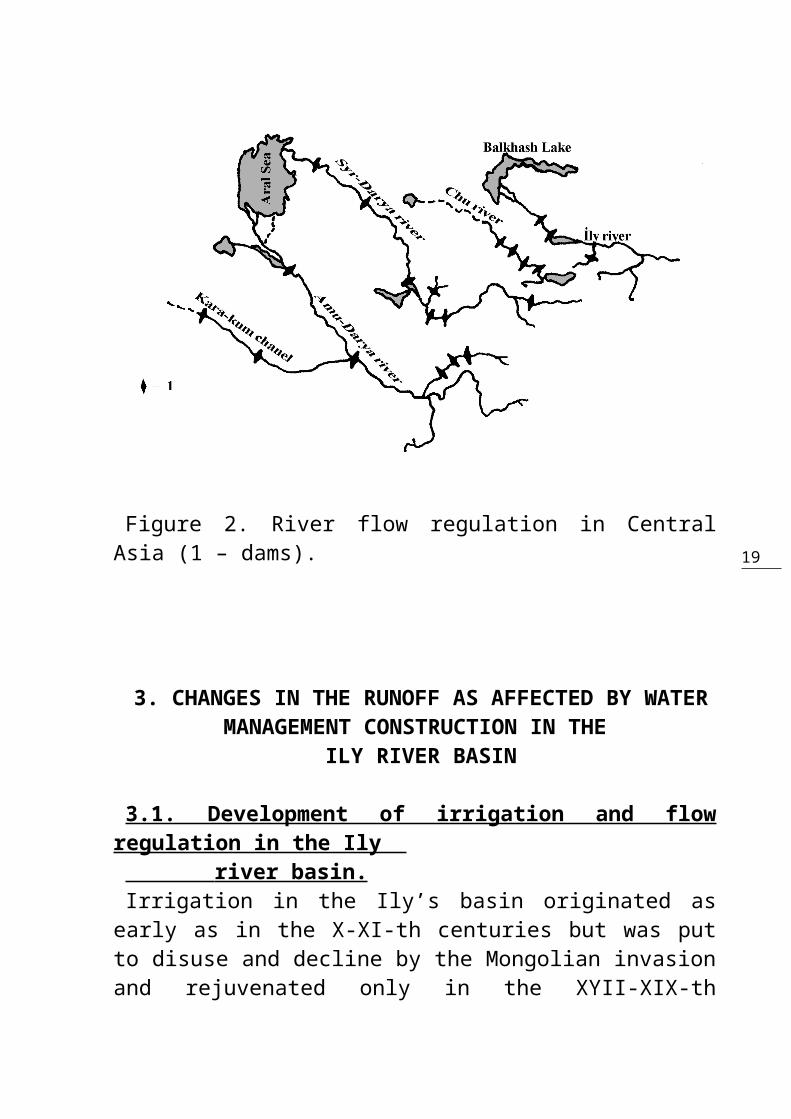
19Figure 2. River flow regulation in CentralAsia (1 – dams).
3. CHANGES IN THE RUNOFF AS AFFECTED BY WATERMANAGEMENT CONSTRUCTION IN THE
ILY RIVER BASIN
3.1. Development of irrigation and flowregulation in the Ily river basin. Irrigation in the Ily’s basin originated asearly as in the X-XI-th centuries but was putto disuse and decline by the Mongolian invasionand rejuvenated only in the XYII-XIX-th
20
centuries. To intensify irrigation in thisbasin, in 1908-1917, an expedition of the“Resettlement management” surveyed the Ily’slower reaches and its left-bank tributary, theChilik. In 1912-1917 the survey party of the“Land Improvement Division” investigated theIly’s basin territory from the Chinese borderto the town of Alma-Ata (now Almaty). In 1926-1927, the Research Institute of Soil Scienceand Geobotany of the Middle-Asian StateUniversity (MASU) found about 500 thousandhectares of land suitable for irrigationwithout any large-scale land-reclaimingactivities. In the period of 1925-1934, theNarkomzem (People’s Comissariat on LandAffairs) of the Kazakh Republic in cooperationwith the project-issuing institute –Vodokanalproekt had developed a workinghypothesis for the land and water resourcesmanagement in the Ily’s basin and proposed tobuild the Kapchagay HPS (hydropower station)with the largest reservoir in the middlereaches of the Ily river. A many-disciplinedIly expedition of the Kazakh Academy ofSciences (1944-1950) supported the creation ofthe Kapchagay reservoir and the preferentialdevelopment of irrigation in the middle part ofthe basin. The irrigating capacity of the Ily’sbasin was estimated as 785 thousand hectareswithout, and 900 thousand hectares with flowregulation. In the latter case it was intendedto irrigate 300 thousand hectares in the Ily’s

21
lower reaches, including the creation of theAkdalinsky rice-producing area. The entireresource of lands suitable for irrigation inthe basin was estimated to reach 1.25 millionhectares. As is evident, the irrigationdevelopment prospects in the Ily’s basin wereestimated at the time with an excess ofoptimism. Actual irrigated area in the entirebasin in 1946 was equal to 207 thousandhectares and the discharge of water forirrigation on the stated area was equal to 2cubic kilometers.
22
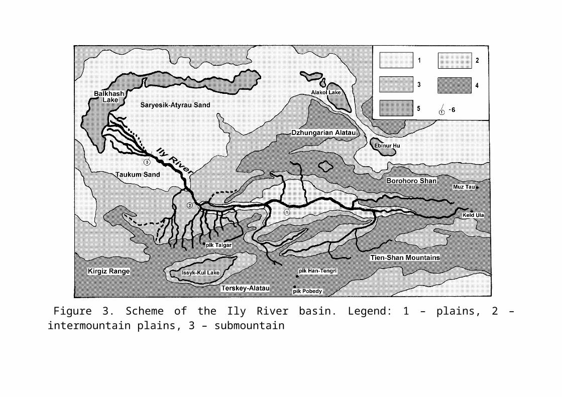
Figure 3. Scheme of the Ily River basin. Legend: 1 – plains, 2 –intermountain plains, 3 – submountain

23
plains, 4 – mountains, 5 – lakes, 6 – hydroposts (1 –171-st km, 2 – Kapchagay, 3 – Ushzharma).

24
The construction of Kapchagay HPS(hydropower station) in 1970 with a reservoir28.1 cubic kilometers in capacity appeared anepoch-making event in the management of landand water resources of the Ily’s basin. TheChingeldinsky irrigation area (15 thousandhectares) was created on the northern bank ofthe reservoir with machinery water supply,whereas in the ancient (Akdala-Bakanass) deltaof the Ily – a rice producing area of 52thousand hectares had been created.By 1980, the irrigated lands in the Ily’sbasin reached 300 thousand hectares, including80 thousand hectares occupied by small-graincrops and 5.7 thousand hectares of sugar beet.The remaining area was divided among forage andvegetable crops, vineyards, orchards, andtobacco plantations. The Great Almatinsky canalwith Bartogay reservoir on the Chilik River(left bank tributary of the Ily)- was excavatedin the same period of time. It allowedirrigating 117 thousand hectares of new area oflands and improving the water supply on 153thousand hectares of already existing plowland.In the entire Ily-Balkhash basin (includingalso the Karatal basin), the area of irrigatedlands reached 562 thousand hectares in 1980.By 2000 it was planned to prepare forirrigation another 550 thousand hectares and toincrease for this purposes the efficiencycoefficient (EC) of irrigation systems from0.55 to 0.70-0.75, to convert about 45 thousand
25
hectares to sprinkler irrigation, utilizecollector-drainage and sewage waters, andirrigate 130 thousand hectares with groundwater.But, as we know, these grandiose projects werenot destined to become real, first of all,owing to the Soviet Union’s disintegration andsubsequent economic crisis which invaded South-eastern Kazakhstan too. In the 90s the reallyexisting irrigated areas diminished to about200 thousand hectares (Contemporary EcologicalCondition…, 2002). Only on the verge of theXXI-st century, the irrigation started torecover in the Kazakh part of the Ily’s basin.At the same time, in the Chinese part of thebasin (in the upper reaches of Ily) theirrigation never ceased to develop but theexact acreages of irrigated lands there are notknown. Flow regulation in the Ily’s basin before 1970was partly undertaken only on the left-banktributaries (the Talgar, Issyk, Turgen, andKaskelen rivers). With the filling of theKapchagay reservoir, the flow regulation on theIly itself began. Tasmurun canal was excavatedbelow Kapchagay HPS to irrigate the Akdalinskyrice-producing (paddy rice) massif, and theproject of a new hydrostation scheme was workedout in Kulanbass flow course linked with theseasonal-regulation reservoir (2 cubickilometers). The riverbed flow regulation inthe Ily’s tributaries is becoming more

26
intensive. In addition to Bartogay reservoir onthe river Chilik, it is projected to regulatethe Charyn’s flow by the cascade (series) ofhydrostation schemes for power generation andirrigation. In the upper reaches of the Ily(within China’s territory), the flow isregulated by the hydrostation dams.
3.2. Changes in hydrologic and hydrochemicalregimes of the river Ily. The Ily flows along the depression between themountain ranges to the distance of 1439kilometers (with Tekes tributary). Total areaof its basin is 140,000 km2, over a half of itbeing within the Kazakhstan. By the characterof its regime and feeding the Ily belongs tothe mountain type of river and is fed by thewater of the high mountain snows and glaciers.Before the flow regulation the annual patternof water level had a spring flood with waterdischarge about 400 m3/s, even more powerfulsummer flood with water discharge about 1000m3/s and low-water flow in the period of autumnand winter when water discharges are within200-300 m3/s (Fig.4). Water levels in theriver, particularly in winter, werecharacterized by great variations (about 2meters), because of ice blocking (ice jams) andother ice-related phenomena. That, in its turn,affected the delta’s watering. Mean annualIly’s water discharge at Kayergan hydraulic

27
section (now – 171 km up from the KapchagayHPS), which is in the upper reaches afterentering Kazakhstan from China, was 386 m3/s.In the middle reaches (Kapchagay hydraulicsection), the average water discharge was 471m3/s, whereas in the lower reaches (Ushzharmahydraulic section) it was 468 m3/s (SurfaceWater Resources of the USSR, vol. 13, issue 2).The volume of the Ily’s runoff according toperennial date, in Kapchagay hydraulic sectionwas equal to 14.8 km3, runoff water losses inthe delta – 3.0 km3, and runoff into the LakeBalkhash – 11.8 km3.With the filling up of the Kapchagayreservoir, the within-year variability(distribution) of runoff below the dam (Fig.4)considerably changed. In the 70-80s the averageannual water discharge in spring and summer didnot exceed 400-500 m3/s reducing over 2 times.The low-water discharge during that periodslightly increased. Only since the end of the80s, when the years with rich water supply weremore frequent, and the filling of the reservoirwas stopped, the low-water discharge becamegreater (Fig.4). Significantly (over 3 km3 orby 26%) reduced in 70-80s the annual waterrunoff into the lower reaches (Starodubtsev,1985), although in the last period of richwater supply (Fig.5) this reduction was notvery significant (Starodubtsev, Burlibaev, andPopov, 2003).
28
The reduction in the volume of annual runoffinto the lower reaches and, particularly, thechange of river’s hydrologic regime,considerably worsened the delta’s waterfeeding, the delta’s area being about 8000 km2,which proved the cause of serious environmentaldegradation in the lower reaches (we shallconsider this in more detail in a givenpublication). The reasons causing the runoffreduction into the lower reaches are thefilling up of a capacious Kapchagay reservoirwith a full capacity of 28.1 km3 andconsiderable diverting of the river water forirrigation (in 1980 3.35 km3 were used forirrigation, including an irrevocable waterconsumption of 2.1 km3). In a given situation,the reduction of runoff into the lower reachescould be much greater were it not for the“compensative” capacities of a basin. Thus theemployment of the left-bank tributaries’(Kaskelen, Issyk, Talgar, and Chilik) runofffor irrigation is partly compensated by thereduction of water losses in the so-called“saza” zone which originates at the interfacesbetween the foothills and the river valley.Additional evaporation of water from thesurface of the Kapchagay reservoir (over 1 km3
a year) is partly compensated by the preventionof water losses on evapotranspiration on thenow inundated (earlier swampy) left-bankplainland. The changes in hydrologic regime ofthe streams in the Ily’s delta (the absence of
29
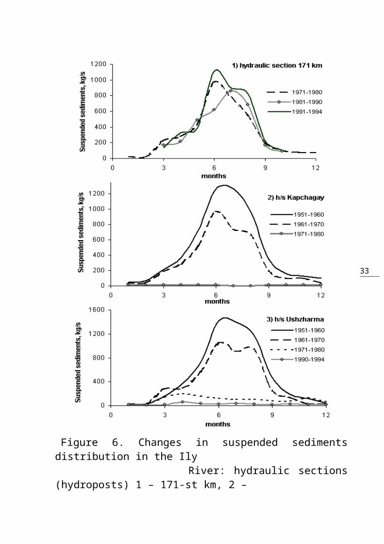
powerful flood overflows) bring about thereduction of water losses on the filling oflakes in the delta and evaporation from themoisture-loving vegetation. Total volume ofcompensating resources in the Ily’s basinexceeds 2 km3.Transformation of the suspended sedimentrunoff is also an important agent of landscapedegradation and delta soil desertification. TheIly is characterized by a great muddiness ofwater and considerable transfer of solidmaterial. The largest solid runoff undernatural conditions was observed in May-August(Fig.6), and the
30
Figure 4. Changes in the water dischargedistribution in the Ily River. Hydraulic sections(hydroposts): 1- 171-st km, 2 – Kapchagay, 3 – Ushzharma.
31
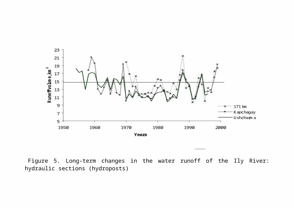
Figure 5. Long-term changes in the water runoff of the Ily River:hydraulic sections (hydroposts)
32
1 – 171-st km, 2 – Kapchagay, 3 – Ushzharma.
33
Figure 6. Changes in suspended sedimentsdistribution in the Ily River: hydraulic sections(hydroposts) 1 – 171-st km, 2 –
34
Kapchagay, 3 – Ushzharma.
landscape-forming role of sediments in deltaduring this period was the greatest. Owing tolarge water discharges and the great extent ofriver’s influence on the delta (very high levelof water and even the river beds above theneighbor territory), the flood runoff wasdistributed over the entire territory of delta,formed its land forms, and determined thecharacter of its development. Solid and liquidrunoffs appeared to be the leading agents oflitho-morphogenesis and soil formation in thedeltas. Suspended solids also contributed tosupplying nutrient elements to the soils ofdelta.The regulation of the Ily’s flow was the causeof profound changes in the runoff of suspendedsolids (Fig.6) in its lower reaches (hydraulicsection at Ushzharma). Now about 15 milliontons of sediments are accumulated every year inthe reservoirs and irrigated fields. Below theKapchagay dam, the runoff of suspendedparticles reaches only 100 thousand tons peryear. But on the length of the river coursefrom the dams of hydroelectric power station(HPS) to the head of the delta, the bottom andbanks of the river are subjected to erosivedestruction. As a result of this, the deltareceives about 3 million tons of sediment peryear; in the years with poor water supply thisamount is even smaller. Moreover, the sediment
35
is no longer a velvet silt of the mountainsoils rich in nutrient elements, but mainlysandy and loamy-sandy material of lowfertility. The role of such sediment in theformation of landscapes and soils becomesimmeasurable weaker. The Ily’s hydrochemical regime has sufferedsome significant changes in the course of thelast decades (Starodubtsev, 1985; Starodubtsev,Fedorenko, and Burlibaev, 2004). In the 30-50sof the nostalgically dear last century thesalinity of the river water in the upperreaches (after the passage of the river coursefrom China to Kazakhstan) was fluctuated about0.31 g/l, from 0.18-0.20 with flood flow to0.40-0.50 g/l with low-water flow. In 70-80s,the average (yearly) water salinity increasedto 0.36 g/l in connection with a more intensiveeconomic activity and predominance of yearswith poor water supply. In the sufficiently wet90s there was no growth of salinity in theupper reaches (Fig. 7). In the middle reaches(hydraulic section Kapchagay), the mean annualwater salinity was also equal to 0.31 g/l,changing from 0.23+0.05 g/l with flood flow to0.51+0.12 g/l with low-water flow. In the 60sowing to the growth of

36
Figure 7. Long-term changes in a water mineralization in the Ily River:hydroposts 1 – 171-st km,
37
2 – Kapchagay, 3 – Ushzharma.
38
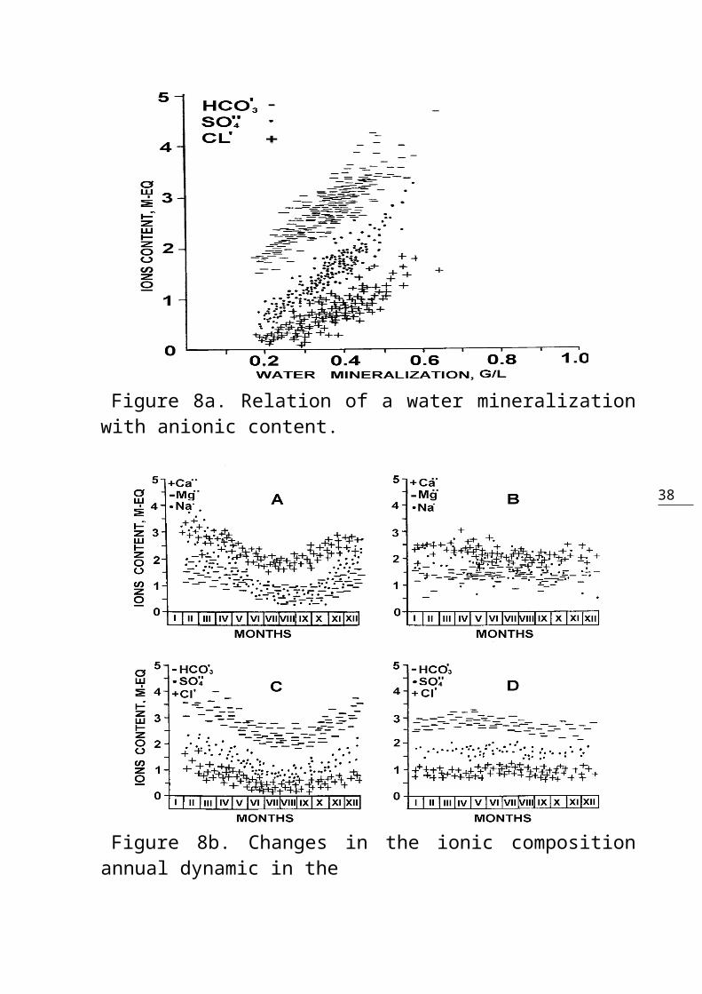
Figure 8a. Relation of a water mineralizationwith anionic content.
Figure 8b. Changes in the ionic compositionannual dynamic in the

39
Ily River water beforeKapchagay dam construction (A, C) and after it (B, D)
40
water consumption for irrigation and industrialand communal needs, the mean annual watersalinity increased to 0.34 g/l. The blocking ofthe Ily’s course by the dam of the KapchagayHPS in 1970 made a more evident effect on itshydrological regime. First of all, thereoccurred a certain equalization of salinity atdifferent stages of hydrologic regime: minimalvalues were within 0.33+0.04 g/l, and maximal –within 0.43+0.03 g/l. Mean annual salinityreached here 0.38 g/l. In the lower reaches,near the village of Ushzharma (delta’s head),the mean annual salinity also reached 0.38 g/land its value were evenly distributed over theseasons of the year. In the ionic compositionof water salinity, there is a predominantincrease in the concentrations of sulfates andsodium (Fig.8a, 8b). The tendency to the growthof salinity of the Ily’s water was distinctlyevident in the first decade of the Kapchagayreservoir’s filling-up, but in the later yearswith increased water supply the salinitydiminished (Fig.7). The most effective agentsof water salinity growth and ionic compositionchange in the Ily’s water were the growth ofwater salinity in the mountain-risentributaries employed for irrigation(Starodubtsev, 1985), salt exchange processeson the banks and in the basin of the Kapchagayreservoir (Starodubtsev, 1986), and the influxof waste communal and industrial waters(Contemporary Environmental Conditions…, 2002).
414. SOIL DESERTIFICATION IN THE ILY RIVER DELTA
4.1. Soils of the Ily river delta.
The soil cover of the Ily river delta had beensurveyed in the 50-60s of the last century bythe specialists from the Research Institute ofSoil Science of the Kazakhstan Academy ofSciences under M.A.Pogrebinsky’s direction (TheValley of the Ily, 1963). Some specificinvestigations of soil changes connected withprojecting and building of a gigantic Kapchagayreservoir on the Ily river were carried out byYu.M.Popv in 1968 (before the implementation ofthe project), T.F.Nekrasova in 1972 (two yearsafter erection of the dam), and

42
V.M.Starodubtsev in 1976-1991, that is in theperiod of delta landscapes desertification.Excessively wet (hydromorphic) soils of theIly river delta are formed in conditions ofdesert climate in close connection with thespecificities of litho-morphogenesis and undera determining impact of a hydrologic factor.Parent materials here are mostly alluvialsediments of variegated but dominantly lighttexture. There are specific delta landformshere – the cells formed by alternation of theriver-bed mounds with wide lowlands between thebeds which in their turn are broken up by thesecond-order elevations (weakly expressed bedridges of dried off and temporary streams). Inthe head part of the delta the river-bed ridgesof the main streams are 100-300 (rarely up to1000) meters wide and their relative heightover the depressions reaches 1-2, rarely 2-3meters. Down along the flow, the width of bedridges reduces to tens of meters and theirheight becomes lower too. They are formed oflight-textured soils and subsoils. From thesurface (0-30 cm) light and medium loams aswell as loamy sands dominate while below (30-100 cm), there are mostly loamy sands and finesands. Very fine sands dominate in the secondmeter of soil depth. The ridges of the bedsgradually pass into between-the-bed lowlands,the area of which fluctuates from 0.2-0.3 to 2-3 square kilometers and more which are composedof more heavy-textured soils (with medium and

43
heavy loams dominating within the first meterof depth), underlain by fine-grained and siltysands. Soil formation and evolution under changingconditions of delta water regime are closelyconnected to soil position on the elements oftopography. The ridges confining the beds andtheir slopes are covered by the meadow-typesoils, whereas the swamp-type soils cover thelowlands. Total area of hydromorphic soilsincluding those subjected to drying-up anddesertification exceeds 460 thousand hectares.Below we attach some brief characterization ofthe dominant soils using soil classificationand nomenclature proposed for delta soils byV.M.Borowsky (1959) and K.D.Karazhanov (1973).
Alluvial-Meadow Soils are formed on the river bedridges and their slopes as well as on flatwatershed elevations under thick meadow grasses(Calamagrostis gigantea and C. epigeios, Elytrigia repens,Phragmites communis, Melilotus officinalis, Euphorbiapalustris, Glycyrrhiza uralensis, Karelinia caspica, etc.).Average productivity of haylands is within 1.2-2.3 mt/ha. On saline soils overgrown withhalophytes the yields of hay reduce to 0.3-0.4mt/ha. Ground waters are at the depth of 1-3meters. They are fresh or slightly saline withgood subsoil outflow and hydrologic regime.Soils and subsoils lithologically arerepresented mainly by loamy sands, light loams,and sands.
44
Water-related regime of these soils isdependent on the short-term spring floods whichdo not occur every year, ground water risecaused by water infiltration from the riverbed, and on water perching from floodedlowlands between the beds. In spring the soilsget wet on the entire depth of aeration zone.Water stocks in the upper meter of soil depthin spring reach 2.6-3.7 thousand cubic metersper hectare, whereas in two meters of soildepth they amount to 6-8 thousand cubic metersper hectare. During the period of plantvegetation, the total stocks of water in the 0-1m layer of the soil diminish by 1.5 thousandcubic meters on the river bed ridge and by 0.8thousand cubic meters on the watershed slopes.The height of capillary rise in such layeredformations (soils and subsoil) fluctuateswithin 135-165 centimeters. Salinity-related regime of alluvial-meadowsoils is determined by salt washing off theirsurface and leaching of the entire soil profileduring spring floods with subsequent capillaryrise of soluble salts towards soil surface asthe soils dry up during the second half of theplant growth period. In general, soil profileis only slightly saline but in autumn theamount of salts in the surface layer may reach1.5-2%. Total amount of soluble salts in the 0-1m layer of soil may reach 23-37 mt/ha inspring and 31-45 mt/ha in autumn. Sulfates,bicarbonates (rarely carbonates), and chlorides
45
of sodium are the dominant agents of soilsalinity. Soil salinity increases from the headto the periphery part of the delta, as well asfrom wet to drying-up sites. In the period ofwinter and spring, soil salinity decreases toinitial levels and salt-related soil regime maybe characterized as seasonally reversible.Soil properties related to water are verychangeable because of parent material (andlithology in general) diversity. Soil particledensity in the surface horizons is within 2.65-2.76 and bulk density – within 1.00-1.56 g/cm3;total soil porosity reaches 52% by volume, andinfiltration rate is within 0.53-0.91meters per24 hours. Loamy layers in the profiles are wellmicroaggregated. The soils are not deficient inavailable nitrogen and phosphorus and wellsupplied with available potassium. On the areas that are rarely subjected tofloods (only in catastrophic cases), but wherethe soils were not yet disconnected with groundwater, some alluvial-meadow drying soils were formedwhich we inscribe to the taxonomic unit ofgenus. Their water-related properties becomeconsiderably worse, the extent soil salinityincreases, and vegetation productivity (yieldof hay) reduces to 0.6-0.8 mt/ha.
Alluvial-Meadow Tugai Soils were formed on thebed-confining ridges of the functioning deltastreams and their slopes directed to the beds.They are the most widespread in the head partof the delta where the ridges are more

46
capacious and well-expressed land forms.Vegetation developed on such soils (thick tugaiforests composed of Elaeagnus turcomanica,different varieties of Salix –S.turanica,S.songarica and others, Halimodendronhalodendron, Tamarix , and meadow grasses) isof great environmental and recreationimportance. Alluvial sediments serving asparent material for the soils are layered withthe dominance of light-textured (sandy andloamy-sandy) layers, whereas loams areencountered mostly like surface (0-30cm)horizons. Ground waters lie at the depth of 1-3meters. They are fresh or only slightly salineand their regime is rigidly controlled by thewater level fluctuations in the rivers.Water regime of tugai soils depends on anearly-spring floods in the years with excessivemoisture incomes (in the periods of ice-blocking) and water infiltration into the bankswhen the rivers are high-watered. In spring theentire profile is saturated with water but insummer and autumn the layer 0.7-1.0 meter thickis subjected to drying as a result oftranspiration and evaporation complimented bysubsiding of the groundwater table. Waterlosses from the upper 1-meter layer of soilreach 2.0-2.5 thousand cubic meters perhectare. The height of capillary rise reaches2.0 meters.Nonsaline and slightly saline soils dominatehere. Salt composition changes from
47
bicarbonatic-sulfatic with sodium and calciumin spring to chloridic-sulfatic in summer.Occasionally sodium-carbonate salinity may beencountered. Salt regime of soils isseasonally-reversible; slight salinization ofsoil surface occur only in summer. The amountof soluble salts in 1-meter layer of soilsaverage within 15-17 mt/ha, whereas in a 2-meter layer this amount reaches 27-28 mt/ha.Organic matter content in the surface soilhorizons is up to 4-5%, the bulk density of thesoil is within 1.29-1.41 g/cm3, particledensity – 2.65-2.75 g/cm3, total porosity – 49-52% by volume, and field moisture – within 13-31%.
Alluvial-Meadow Desertificating Soils areencountered on the river bed ridges, theirslopes, and flat elevations with the absence offloods and ground water no less than 4-5 metersdeep. Soil profile is dried to a greater depth.Vegetation characteristic for the alluvial-meadow desertificating soils is substituted bymore drought-resistant species (Eurotia ceratoides,Salsola orientalis, Alhagi pseudoalhagi, Tamarix, andHalimodendron halodendron). The areas occupied bysuch soils are used as low productivity (0.1-0.2 mt/ha) pastures. Irrigation may permit tocultivate there the crops of the so-calledintermittent irrigation. By the extent of soilsalinity these are mainly slightly andmoderately saline soils. Soil physicalproperties differ only by their natural

48
wetness. Soil bulk density is within 2.68-2.75g/cm3, particle density – 1.37-1.43 g/cm3, totalporosity – 47-50%, natural soil wetnessfluctuates within 2.3-5.9%, field moisturecapacity 14-33% (depending on soil texture),and infiltration rate remains within a narrowrange of 2.01-2.63 meters per 24 hours.
Swampy-Meadow Soils form on the slopes of theriver bed ridges on the areas transitive toperiodically flooded lowlands between the bedswith high ground water tables and ground waterbeing mostly fresh or only slightly saline.Such soils are usually encountered incombinations with alluvial-meadow, meadow-swampy and swampy soils. Vegetation is composedmostly of meadow grasses with an “obligatoryparticipation” of reeds (Phragmites communis) andCalamagrostis epigeios, whereas there is a lot ofsalinity resistant species on salted spots. Thesoils were developed in the layered alluvialsediments with the dominance of light-texturalhorizons alternating with heavy loams andclays. Water regime of swampy-meadow soilsdevelops under the influence of short-termfloods in the years with moderate and highwater supply. The amount of water in the soilafter flood subsiding reaches 5-7 thousandcubic meters per hectare in the 0-2m layer ofthe soil with soil wetness in the upper part ofa profile within the range between fieldcapacity and capillary discontinuity. Byautumn, the ground water table subsides to the

49
depth of 2-3 meters, and the upper 0-30 cmlayer of the soil is subjected to drying-up, sothat soil wetness lies within the range ofcapillary discontinuity to wilting point. Theamount of water in the upper 1-meter layer ofthe soil remains within 0.7-1.3 thousand cubicmeters per hectare.Salt regime of the described soils may bedefined as seasonally-reversible. The amount ofsoluble salts in the upper 1-meter layer iswithin 13-33 mt/ha, whereas in the 0-2 meterlayer it amounts 26-61 mt/ha. Sulfates,bicarbonates, and chlorides of sodium dominateamong the soluble salts. Sodium bicarbonateformation takes place both in the upper drying-up and lower sufficiently wet part of theprofile. Horizon of organic matter accumulation inswampy-meadow soils is up to 80 cm in depth,with a well-developed surface horizon of soilformation. Organic matter content in thesurface layer is up to 8-9% and the soil iswell supplied with nitrogen, phosphorus, andpotassium. By their soil-water relatedproperties, these soils are similar toalluvial-meadow ones, and their infiltrationrate is satisfactory (0.50-0.71 meters per 24hours). The stopping of floods as a result of river-bed processes or river flow regulation withsubsequent lowering of ground water table tothe depth of 3 meters and more, leads to the
50
drying-up of soils and development of salinity inthe surface horizons. The further degradationof the soil-water regime with the lowering ofwater table to the depth of 4-5 and more metersleads to the formation of desertificated soils.Their profile becomes drier than the wetness ofcapillary discontinuity, vegetation becomesstunted and sparse, and the meadow grassspecies are ousted by some xerophytic andhalophytic ones.
Meadow-Swampy Soils are formed in wide and flatcavities of the lowlands sited between theriver beds. They are encountered mostly aslarge homogenous areas and occasionally ascomplexes with alluvial-meadow and swampy-meadow soils. These areas are inundated by theflood water every year. Ground water tablesubsides in autumn to the depth of 1-2 meters,sometimes deeper. Ground waters are fresh oronly slightly saline. Parent and underlyingmaterials are represented by a layered alluviumwith the dominance of heavy-textured layers tothe depth of 1 meter which are underlain bysandy materials. Vegetation is represented bythe overgrowth of reeds with the patches ofmeadow grass species in the lower stand. Theseare the most productive delta haylands.Soil water regime is determined by the annualfloodings of the head part of the delta inspring and its central part in summer. Groundwater salinity is mainly within the range of 1-3 g/l. Sodium carbonate may often be detected
51
in water in the period of floods. The amount ofwater in the upper meter layer of the soilreaches 4 thousand cubic meters per hectare.Towards autumn, only in the 0-30 m-layer soilwetness reduces below the moisture of capillarydiscontinuity. Salt regime of soils is defined as seasonally-reversible. After flood water subsiding thesalts are concentrated essentially in thesurface (crust) layer, whereas in summer andautumn, as a result of internal evaporation inthe soil, the amount of salts increases allover the profile. The subsequent flood againpartly desalinizes the soil profile. In thesoils with varying extent of salinity theamount of salts changes from 10-20 mt/ha to 60-80 mt/ha and more in the upper meter of soildepth. Sodium sulfates and chlorides withparticipation of sodium carbonate dominateamong soluble salts. The most saline are thesoils subjected to only a short-terminundation. Soil horizon of organic matter accumulation is60-80 cm deep. Numerous living and semi-decomposed roots and rhizomes of reeds areencountered in the profile. The soils areseverely gleyed from the depth of 30-70 cm.Organic matter content in the surface horizonfluctuates within a wide range of 2.9-8.8%drastically decreasing with depth. The soilsare poorly supplied with nitrogen, moderately –with phosphorus, and adequately – with

52
potassium. Soil bulk density is within 1.00-1.70 g/cm3, particle density – 2.72-2.79 g/cm3,total porosity – 41-49% by volume, andinfiltration rate – 0.67-0.72 meters per 24hours. The very existence of meadow-swampy soils isconnected with the annual floods. If the floodsdo not occur in the series of years, as aresult of delta formation or river flowregulation, soil-water regime drasticallychanges and meadow-swampy drying soils are formed.Ground waters subside below the depth of 3meters, vegetation becomes stunted, soilsurface is divided by the cracks into polygonalfragments, and the upper meter layer dries upwith the formation of blocky structure. Thetotal amount of water in the upper meter layeris only one-half that in the soils with normalwetness. As the soils dry up, their salt regimechanges from seasonally-reversible toseasonally non-reversible regime ofsalinization. The accumulation of soluble saltsis observed both on the soil surface and in itsprofile, and sodium carbonate is encounteredamong them.As the landscape continues to dry up in theconditions of desert climate, the meadow-swampy desertificating soils are being formed, whichare identified on the taxonomic level of asubtype. The entire soil profile is desiccatedto the moisture below wilting point, and groundwater subsides to the depth below 4-5 meters.

53
The essential soil properties becomeconsiderably degraded.
Swampy Soils are widespread on flat depressionsof the lowland areas extending between theriver beds and the ridges, subjected toprolonged annual inundation by the floods inthe period of spring and summer. Silty-swampy(muck) soils are formed in the areas subjectedto deep and durable flooding. Vegetation hereis represented mainly by some thick outgrowthof reeds. Yearly drying up of the depressionstowards autumn and alteration of aerobic andanaerobic processes cause a rapid humificationof organic residues which hinders the formationof peat (histic) horizons. Ground waters arefresh or slightly saline, and when the floodsubsides, the water table also becomes deeperby a meter or more towards autumn. Swampy soils with peaty surface horizondevelop with shallow flooding lasting for along time. After flood water subsides, soilprofile remains saturated with water during theentire period of plant growth. The amount ofwater in 1-meter layer reach 4.8 thousand cubicmeters per hectare, and ground water tablesubsides to the depth of 0.6-0.7 meters insummer and 1 meter in autumn. The extent ofsoil salinity is variable – from nonsaline toseverely saline depending on ground watersalinity. Usually the soluble salts areconcentrated in the surface layer and only inautumn soil salinity increases all over the
54
profile. The amount of salts may reach 70-80mt/ha.Alluvial sediments serving parent materialsfor swampy soils are layered and dominantlylight-textured (loams, loamy sands, and sands);clay layers are encountered less frequently.Soil particle density in the surface horizonschanges within 1.67-2.70 g/cm3, bulk density –1.32-1.48 g/cm3, total porosity – 47-52%, fieldcapacity – 18-22%, full capacity – 27-36%, andinfiltration rate – 0.62-0.65 meters per 24hours. A specific feature of swampy soils is theirshort-time existence with changing waterregime. The weakening of floods under theinfluence of natural and anthropogenic agentscauses a rapid and deep lowering of groundwater table to the end of plant vegetationperiod due to high transpiration capacity ofreed overgrowth. Because of this, swampy soilsturn into meadow-swampy by their water regimeand some spots of meadow grasses appear amongthe reeds. A more rapid and intensive change ofthe water regime in the soils instigated by theriver flow regulation causes their drying andsubsequent desertification. The soils at thesestages are subjected to an intensivedevelopment of salinity.
Solonchaks in the Ily river delta areencountered mainly in combination withhydromorphic, drying, and desertificatingsoils. They are represented by the ordinary
55
(typical), meadow, swampy, and “sor” solonchaks(with very concentrated brine).
Ordinary solonchaks are encountered on theelevated elements of topography – flatwatershed uplands and the slopes of the riverbed ridges with ground water table at the depthof 3 meters and deeper. Vegetation is scantyand represented by salinity-resistant speciesand single-standing tamarix bushes. In spring,the surface of the soils is covered by a crustof salts which is destroyed in summeruncovering a swelled (pudgy) horizon. Thoughthe salts are concentrated in the surfacehorizons, their amount in the profile is alsosignificant. The amount of salts in 1-meterlayer is within 40-110 mt/ha. Salt compositionis sodium chloridic-sulfatic with sodiumcarbonate participation and rarely –bicarbonatic-chloridic-sulfatic. The entire 2-meter layer of soil and subsoil is subjected todrying during the period of plant growth.
Meadow solonchaks are encountered on gentleslopes of the river bed ridges of thefunctioning streams, on flat elevated areas intransition zone between alluvial-meadow soilsand ordinary solonchaks. Meadow vegetation hereis resistant to salinity (Aeluropus littoralis,reeds – Phragmites communis, various salsolas,and Limonium Gmelini, L. Suffruticosum). Waterregime is like that of meadow soils, but groundwater is more saline. Only the upper 0-50-cmlayer of the profile is subjected to drying in
56
autumn so that soil moisture remains within therange between permanent wilting point (PWP) andthe wetness of capillary discontinuity. Thegreatest amount of salts (2-3%) is concentratedin the surface horizon, and the amount of saltsmay reach 200 mt/ha with domination of sodiumsulfates and chlorides.
Swampy solonchaks are encountered on theelevated elements of microrelief among theareas of swampy soils and on the lake bankswith high water table of saline ground water.Their profile is excessively wet, severelygleyed, and with “salt accumulation maximum” inthe surface horizon. Vegetation is stunted andscanty (salsolas and reeds).
“Sor” solonchaks are encountered along thedepressions between the ridges, on the bottomsof the drying salt lakes, and around theBalkhash Lake. Salt deposits are 10-20centimeters thick, with domination of sodiumcarbonates, bicarbonates, chlorides, andsulfates. There is practically no vegetation tospeak of.
4.2. Changes of soil-reclaiming conditionsand soil desertification in the Ily River delta.
Soil-reclaiming (or soil-ameliorative)conditions in Ily river delta form under theinfluence of floods (inundation) and are

57
closely related to the hydrological regime ofthe river. Under such conditions, any change inthe character of water supply immediatelyaffects the water regime of soils, theirsalinity, as well as level dynamics, andsalinity (mineralization) of ground water.Under natural conditions (before the flowregulation), the dynamics of water level in thelower reaches and the delta was characterizedby two maxima: one in March caused by the iceblocks jam and another during the spring-to-summer floods accompanied by large dischargesof water. In the delta’s head part, due to thewinding of delta springs, water level elevationin early spring was expressed more abruptly,and the flood in the spring-to-summer periodalso started with a more intensive water levelrise in comparison with other parts of thedelta.. As a result, the head of the delta wassubjected to intensive flooding twice a year:the lowland areas between the beds with meadow-swampy soils were filled with water, and sowere lakes, former river beds, and flowpassages. In the years with abundant watersupply the lowlands between the ridges were sooverfilled with water that it flowed onto theareas with alluvial-meadow soils. Soilformation was expressed by two types – meadowand swampy. Periodically percolating soil waterregime and seasonally-reversible salinityregime were the most typical. The essentialareas of tugai vegetation (flood-plain forests)

58
of the Ily’s lower reaches are concentratedhere as well as about 50 thousand hectares ofrich pastures and haylands containing reeds andcouch-grass. Down the stream, due to the discharge of largeamount of water in the head part of delta, theearly-spring maximum of water level in theriver became less impressive and its role inthe water supply in the middle and especiallyin peripheral part of the delta decreased. Themiddle delta received its watering mainlyduring the summer flood whereas peripheraldelta was watered by the flood water to the endof summer. In the same direction occurred thechanges in the structure of soil cover ofhydromorphic landscapes accompanied by thegrowth in the areas of drying anddesertificating (desertifying) soils withincreasing soil salinity, especially at thestage of drying.After the building of Kapchagay reservoir, theamount of water runoff into the delta decreasedby 2-4 km3 a year, and the monthly waterdischarges in summer months decreased from 1000to 400-500 m3/s (to 600 m3/s in cases withspecial ecological allowances of water), butthey increased a little in winter months. Theaccumulation of suspended sediments in thereservoir and the outflow of purified waterinto the lower (outlet) water level of the damcause more intensive erosion processesincluding the incuts of the Ily river bed and
59
the streams of the delta with greatest water-carrying capacity (see part 3). The processesof ice-floe blocking (ice jam) in the essentialbed and delta of the river became significantlyweaker. That was the reason for the changes inthe water-level regime of the river in theupper delta (the village of Ushzharma). InJuly-August when the flood reached its peakunder natural conditions, water levelsdecreased, as an average, by 1 meter, whereasin other months of the spring-summer periodthis reduction was somewhat less considerable.In delta streams the changes in the water levelregime were even greater. In the period ofspring-summer flood water levels reduced by 1-1.5 meters, the extent of reduction increasingfrom the head to the peripheral part of delta.At present time, the maximum water level insummer in the head part of the delta is only bysome 0.2 meters higher than the April minimum,whereas on the periphery it is not expressed atall. Water level subsidence is observed inwinter and early spring months.Deep transformation in the hydrological regimeof the Ily River and its delta streams causedsignificant changes in the character of watersupply of the present-day delta as well ashydromorphic landscape aridization anddegradation of the soil-ameliorationconditions. This is also favored by the growthof the river water salinity, reduction in theinflow of suspended sediments and biogenic
60
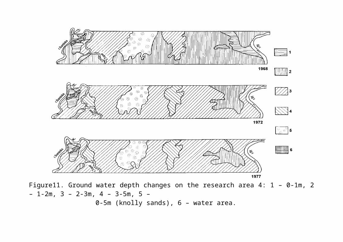
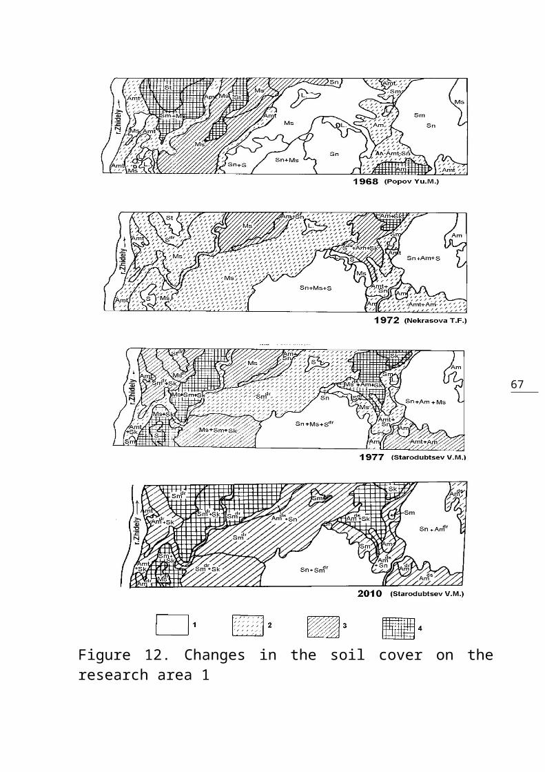
elements to the soils of delta, which weconsidered in more detail earlier (see part 3).In the head part of the Ily river delta, soildrying and desertification as well as thechanges in soil-ameliorative conditions werestudied on two key sites (Fig.9, 10, 11, areas1 and 4), with areas of 1035 and 1188 hectaresrespectively. Here, even before the Ily’srunoff regulation (in 1968), Yu.M. Popovcompleted the soil-ameliorative survey in thescale of 1:25000 which reflected the naturalconditions of soils, vegetation, and groundwaters. The survey was repeated in 1972 byT.F.Nekrasova, and this allowed evaluating thefirst stage of delta drying. Since 1977 weperiodically carried out the analogous surveyswhich detected already quite significantchanges in soil-ameliorating conditions andprocesses of soil desertification(Starodubtsev, Nekrasova, Popov, 1982, 1983;Starodubtsev, Burlibaev, and Popov, 2004).The first stage of changes in the ameliorativeconditions in delta (1970-1972) wascharacterized, first of all, by the drying ofdelta lakes and rapid lowering of the groundwater table from 0-1 to1-2 meters of

61
Figure 9. Research areas (plots) location inthe Ily River delta

62

63
Figure 10. Ground water depth changes on theresearch area 1:

64
1 – 0-1 m, 2 – 1-2 m, 3 – 2-3m, 4 – 0-5 m (knolly sands), 5 – water area.
65
Figure11. Ground water depth changes on the research area 4: 1 – 0-1m, 2– 1-2m, 3 – 2-3m, 4 – 3-5m, 5 – 0-5m (knolly sands), 6 – water area.

66
67
Figure 12. Changes in the soil cover on theresearch area 1
68
(1- nonsaline soils, 2 –slightly saline, 3 – moderately saline, 4 – strongly saline)

69
Figure 13a. Changes in the soil cover on the research area 4. Soilindexes are shown at the next page.
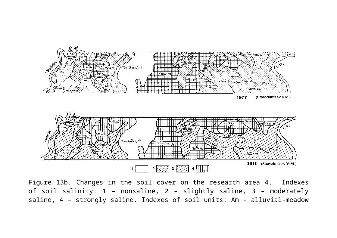
70
Figure 13b. Changes in the soil cover on the research area 4. Indexesof soil salinity: 1 – nonsaline, 2 – slightly saline, 3 – moderatelysaline, 4 – strongly saline. Indexes of soil units: Am – alluvial-meadow

71
soil, Amt – alluvial-meadow tugai soil, M – meadow soil, Sm – swampy-meadow soil, Ms – meadow-swampy soil, S – swampy soil, St – swampy turfsoil, Sn – sands, Sk – solonchaks. Additional indexes: -dr – dryedgenuses of these soils, -ds – desertificating sub-types of these soils,L. – lakes.
72
depth on the more moist right wing of the delta(area 1) and from 1-2 to 2-3 meters – on theleft wing and in the between-the-river (the Ily– Topar) area (area 4). Thus on area 1 thesoils with ground water depth 0-1 and 1-2 meters in 1968 were 32.1 and 30.0%,whereas in 1972 they occupied 7.5 and 49.1%respectively (Table.1). On area 4 thedominating ground water depths were 1-2 meters(56.3%) and 2-3 meters (22.8%), whereas in 1972they were respectively 10.1 and 68.9%. Ingeneral, the areas with the highest water tablewithin the vast lowlands between the beds withground water feeding from prolonged yearlyfloods were subjected to the greatest extent oftransformation. The gradual lowering of watertable on the bed-confining ridges is connectedwith the lowering of water levels in the bedsof the essential delta streams.To preserve the favorable soil-ameliorativeconditions in the head delta, it was envisagedto use the regime of water allowances from theKapchagay reservoir to imitate the early-springoverflows by adding 1.25 cubic kilometers ofwater, due to which the deterioration of soil-water regime in the territory was at first notvery intensive. Later on it was found out thatartificial floods not corresponded with the icesituation in delta did not achieve their aimwhich was the inundation of vast areas for thebenefits of cattle feed production, fishery,
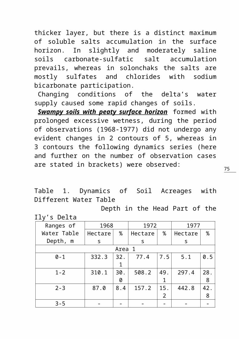
73
musk-rat breeding, and environmentalprotection.The second stage of the head delta drying anddesertification (1972-1977) was going on underconditions of stable flooding of only smallpart of the haylands areas. The factorsdetermining ground water regime were waterinfiltrations from the river and delta streamsadded to the ground water inflow from theupland territories. The dominant ground waterdepths were 2-3 meters (42.8% on area 1 and73.0% on area 4, Table 1). What were the changes in soil cover of theIly’s head delta as caused by the changes inthe territory’s water regime? The generalfeatures of delta soil evolution caused by thenatural dynamics of moisture regime arediscussed in well-known publications byV.A.Kovda, V.M.Borowsky, V.V.Egorov, et al. Adetailed scheme of soil evolution on an exampleof the Syrdarya’s delta was worked out byK.D.Karazhanov (1973). But regulation of theriver runoff significantly changed theconditions of litho-morpho-genesis and soilformation in deltas, the evolutionary series ofsoil changes became shorter, and soil dynamicssuffered technogenic impact. For examples, theprocesses of soil salinity become moreintensive on various elements of topography(land forms). Regional physico-geographicfeatures of the Ily’s delta are also influenced
74
on the intensity of drying, desertification,and development of salinity in soil cover. The soils of the Ily’s delta are mainly light-textured on all the elements of topography.They, therefore, possess low height ofcapillary rise and water-holding capacity,which creates their “pre-disposition” to a morerapid drying and desertification as compared,for example, with the delta soils of theSyrdarya, Chu and other rivers. But in the headpart of the Ily’s delta with high ground watertable, only drying and salinization of soilswere intensive during the period ofobservation. A powerful flood in 1969, “on theeve” of the river locking by the Kapchagay dam,had leached and desalinized the soils to agreat extent. Intensive growth of salinity inhydromorphic soils took place here only by1977, when the areas of moderately and severelysalinated soils on area 1 reached 41.3%, and onarea 4 – 71 % (Table 2, Fig.12, 13a,b). Thefirst to become saline were the slope soils onthe bed ridges, then the soils of small-sized”locked” depressions sited in proximity todelta streams. The last to become saline werethe soils of the vast lowlands between thebeds. The salts in hydromorphic soils areusually concentrated in surface horizons (Table2, profile B-4-162) and more rarely in themiddle part of soil profile (B-1-4). Insolonchaks (very severely salinated soils, B-1-II, B-4-74a) salt accumulation spreads over a
75
thicker layer, but there is a distinct maximumof soluble salts accumulation in the surfacehorizon. In slightly and moderately salinesoils carbonate-sulfatic salt accumulationprevails, whereas in solonchaks the salts aremostly sulfates and chlorides with sodiumbicarbonate participation. Changing conditions of the delta’s watersupply caused some rapid changes of soils.
Swampy soils with peaty surface horizon formed withprolonged excessive wetness, during the periodof observations (1968-1977) did not undergo anyevident changes in 2 contours of 5, whereas in3 contours the following dynamics series (hereand further on the number of observation casesare stated in brackets) were observed:
Table 1. Dynamics of Soil Acreages withDifferent Water Table Depth in the Head Part of theIly’s Delta
Ranges ofWater TableDepth, m
1968 1972 1977Hectare
s% Hectare
s% Hectare
s%
Area 10-1 332.3 32.
177.4 7.5 5.1 0.5
1-2 310.1 30.0
508.2 49.1
297.4 28.8
2-3 87.0 8.4 157.2 15.2
442.8 42.8
3-5 - - - - - -

76
0-5 (KnollySands)
281.3 27.2
285.9 7.6 287.1 27.7
Lakes &Overflows
24.3 2.3 6.3 0.6 2.6 0.2
Total 1035.0 100 1035.0 100 1035.0 100Area 4
0-1 109.3 9.2 38.0 3.2 24.4 2.01-2 668.2 56.
3120.4 10.
181.6 6.9
2-3 271.4 22.8
817.4 68.9
866.8 73.0
3-5 - - 80.0 6.7 82.2 6.90-5 (Knolly
Sands)133.1 11.
2126.2 10.
6128.5 10.
8Lakes &
Overflows6.0 0.5 6.0 0.5 4.5 0.4
Total 1188.0 100 1188.0 100 1188.0 100
1. Swampy soils with peaty surface horizon → meadow-swampy dried soils (1)*.2 .Swampy soils with peaty surface horizon → swampy-meadow dried soils (1).3. Dried swampy soils with peat surface horizon→ meadow-swampy dried soils (1).In 2 cases of 5 an increase in soil salinitywas observed. Series 1-3 are characterized byan increase in the extent of meadow soilformation. This takes place in light-texturedsoils with slow ground water table subsidence
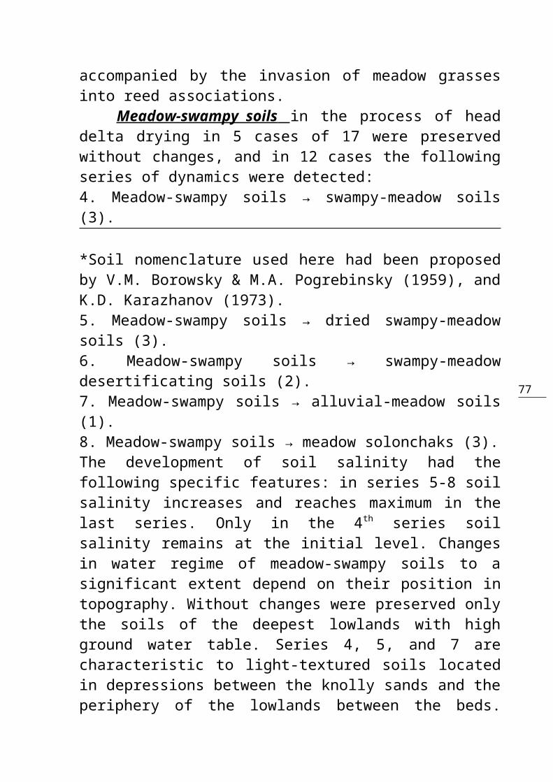
77
accompanied by the invasion of meadow grassesinto reed associations. Meadow-swampy soils in the process of headdelta drying in 5 cases of 17 were preservedwithout changes, and in 12 cases the followingseries of dynamics were detected:4. Meadow-swampy soils → swampy-meadow soils(3).
*Soil nomenclature used here had been proposedby V.M. Borowsky & M.A. Pogrebinsky (1959), andK.D. Karazhanov (1973).5. Meadow-swampy soils → dried swampy-meadowsoils (3).6. Meadow-swampy soils → swampy-meadowdesertificating soils (2).7. Meadow-swampy soils → alluvial-meadow soils(1).8. Meadow-swampy soils → meadow solonchaks (3).The development of soil salinity had thefollowing specific features: in series 5-8 soilsalinity increases and reaches maximum in thelast series. Only in the 4th series soilsalinity remains at the initial level. Changesin water regime of meadow-swampy soils to asignificant extent depend on their position intopography. Without changes were preserved onlythe soils of the deepest lowlands with highground water table. Series 4, 5, and 7 arecharacteristic to light-textured soils locatedin depressions between the knolly sands and theperiphery of the lowlands between the beds.
78
Series 6 and 8 occupy the lower parts of slopesof the between-the-bed ridges. One of theregional specific features of changes occurringin meadow-swampy soils in the process of theIly’s delta drying is a quite rapidsubstitution of the swampy type of soilformation by a meadow one, as well as anintensive development of the surface soilsalinity.
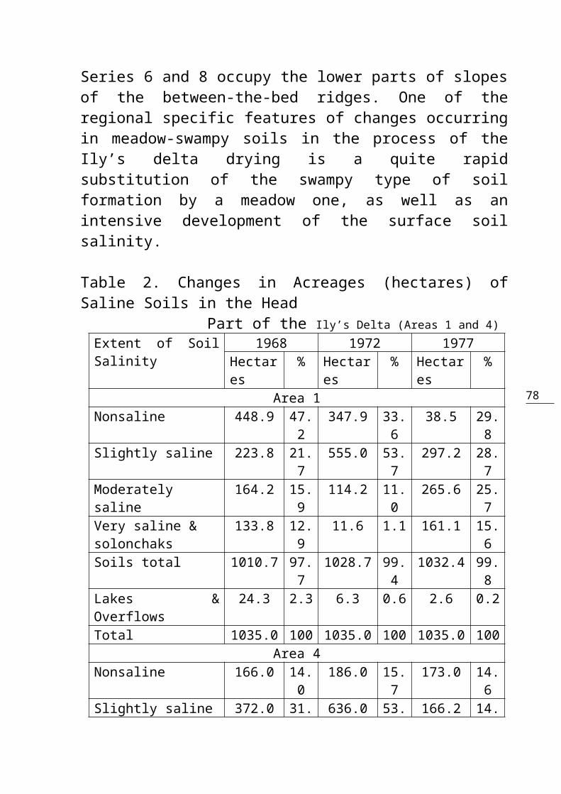
Table 2. Changes in Acreages (hectares) ofSaline Soils in the Head Part of the Ily’s Delta (Areas 1 and 4)Extent of SoilSalinity
1968 1972 1977Hectares
% Hectares
% Hectares
%
Area 1Nonsaline 448.9 47.
2347.9 33.
638.5 29.
8Slightly saline 223.8 21.
7555.0 53.
7297.2 28.
7Moderatelysaline
164.2 15.9
114.2 11.0
265.6 25.7
Very saline & solonchaks
133.8 12.9
11.6 1.1 161.1 15.6
Soils total 1010.7 97.7
1028.7 99.4
1032.4 99.8
Lakes &Overflows
24.3 2.3 6.3 0.6 2.6 0.2
Total 1035.0 100 1035.0 100 1035.0 100Area 4
Nonsaline 166.0 14.0
186.0 15.7
173.0 14.6
Slightly saline 372.0 31. 636.0 53. 166.2 14.
79
3 5 0Moderatelysaline
205.0 17.2
178.5 15.0
482.0 40.5
Very saline & solonchaks
439.0 37.0
181.5 15.3
362.3 30.5
Soils total 1182.0 99.5
1182.0 99.5
1183.5 99.6
Lakes &Overflows
6.0 0.5 6.0 0.5 4.5 0.4
Total 1188.0 100 1188.0 100 1188.0 100
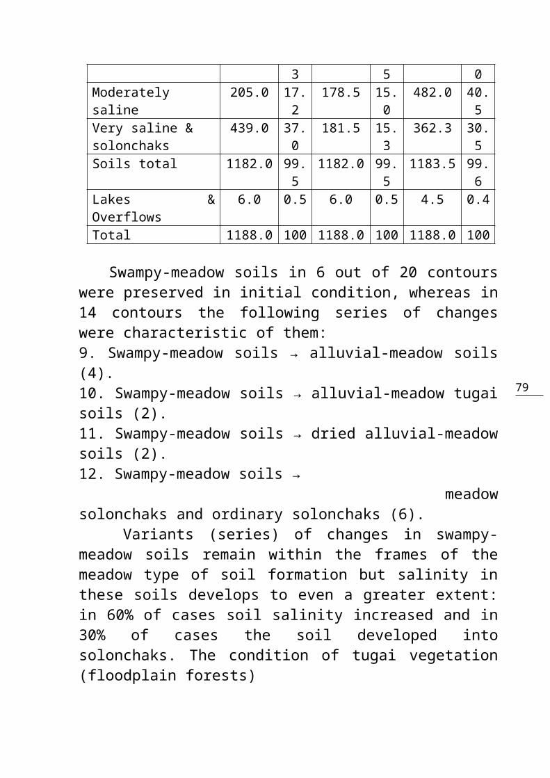
Swampy-meadow soils in 6 out of 20 contourswere preserved in initial condition, whereas in14 contours the following series of changeswere characteristic of them: 9. Swampy-meadow soils → alluvial-meadow soils(4).10. Swampy-meadow soils → alluvial-meadow tugaisoils (2).11. Swampy-meadow soils → dried alluvial-meadowsoils (2).12. Swampy-meadow soils → meadowsolonchaks and ordinary solonchaks (6). Variants (series) of changes in swampy-meadow soils remain within the frames of themeadow type of soil formation but salinity inthese soils develops to even a greater extent:in 60% of cases soil salinity increased and in30% of cases the soil developed intosolonchaks. The condition of tugai vegetation(floodplain forests)
80
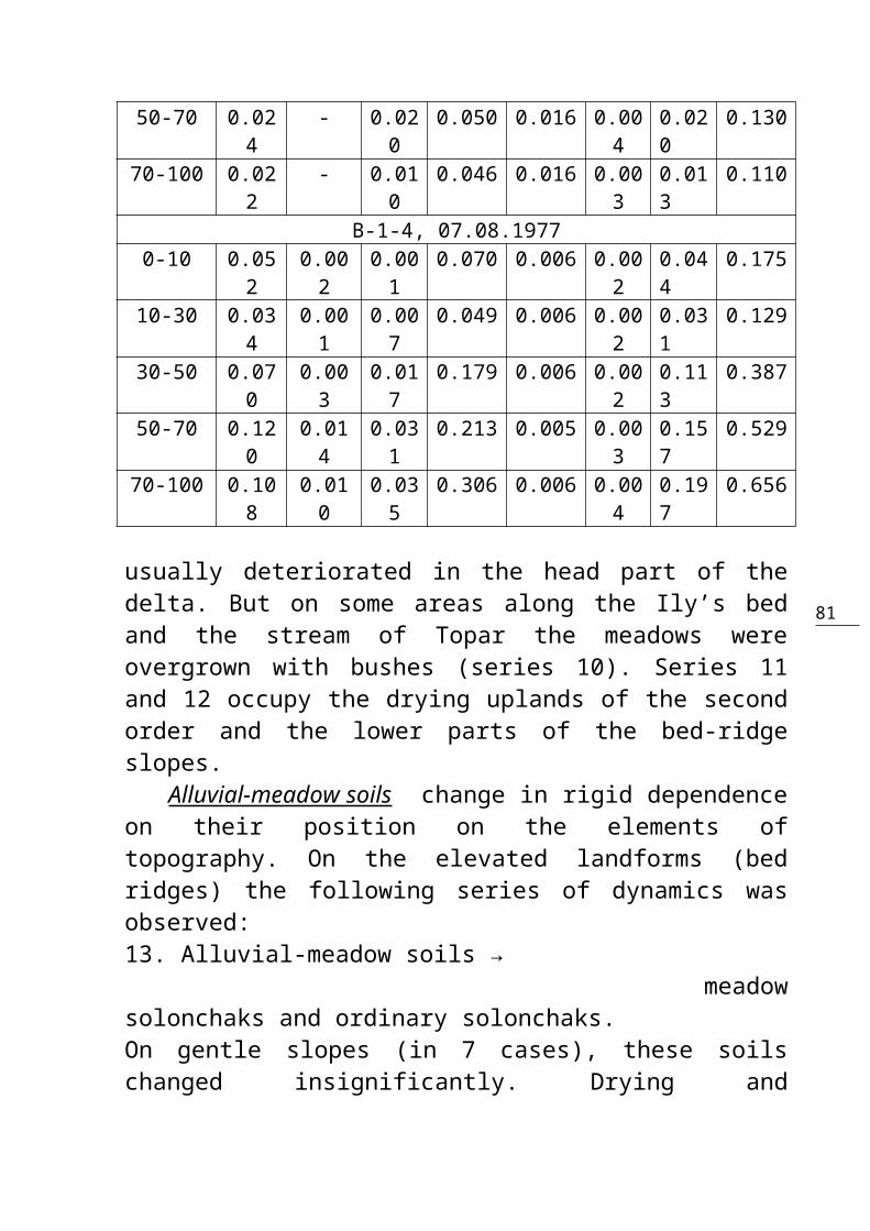
Table 3. Character of Soil Salinity in the HeadPart of the Ily’s Delta (%)Samplingdepth,cm
Alkalinity Cl- SO42- Ca2+ Mg2+ Na+
+K+
Sumof
saltsHCO3
- CO32-
B-1-II, 08.08.19770-5 0.03
10.003
0.852
3.563 0.158 0.302
1.536
6.442
5-17 0.017
- 0.095
0.374 0.038 0.024
0.160
0.708
17-34 0.026
- 0.024
0.117 0.011 0.007
0.056
0.241
47-56 0.019
- 0.043
0.253 0.040 0.013
0.086
0.454
56-100 0.024
- 0.051
0.239 0.032 0.011
0.100
0.457
B-4-74a, 19.08.19770-10 0.33
60.053
0.241
2.756 0.038 0.017
1.512
4.900
10-30 0.288
0.118
0.077
0.186 0.003 0.001
0.243
0.798
30-50 0.269
0.055
0.087
0.163 0.004 0.009
0.215
0.747
50-70 0.190
0.050
0.088
0.172 0.004 0.001
0.205
0.660
70-100 0.142
0.060
0.052
0.118 0.004 0.001
0.138
0.455
B-4-162, 19.08.19770-10 0.03
2- 0.10
90.295 0.031 0.03
50.128
0.630
10-30 0.034
- 0.045
0.145 0.025 0.019
0.048
0.320
30-50 0.036
- 0.025
0.877 0.023 0.007
0.027
0.190
81
50-70 0.024
- 0.020
0.050 0.016 0.004
0.020
0.130
70-100 0.022
- 0.010
0.046 0.016 0.003
0.013
0.110
B-1-4, 07.08.19770-10 0.05
20.002
0.001
0.070 0.006 0.002
0.044
0.175
10-30 0.034
0.001
0.007
0.049 0.006 0.002
0.031
0.129
30-50 0.070
0.003
0.017
0.179 0.006 0.002
0.113
0.387
50-70 0.120
0.014
0.031
0.213 0.005 0.003
0.157
0.529
70-100 0.108
0.010
0.035
0.306 0.006 0.004
0.197
0.656
usually deteriorated in the head part of thedelta. But on some areas along the Ily’s bedand the stream of Topar the meadows wereovergrown with bushes (series 10). Series 11and 12 occupy the drying uplands of the secondorder and the lower parts of the bed-ridgeslopes. Alluvial-meadow soils change in rigid dependenceon their position on the elements oftopography. On the elevated landforms (bedridges) the following series of dynamics wasobserved: 13. Alluvial-meadow soils → meadowsolonchaks and ordinary solonchaks.On gentle slopes (in 7 cases), these soilschanged insignificantly. Drying and

82
desertificating variants of alluvial-meadowsoils practically did not show any change intheir chemical properties. Alluvial-meadow tugai soils in the majority ofcases (4) were subjected to slight salinity,whereas on the areas with died-out tugaivegetation the solonchaks were formed:14. Alluvial-meadow tugai soils → ordinarysolonchaks (1). Finally, we shall consider soil formation inthe basins of dried delta lakes:15. The lake → swampy soils (2).16. The lake → meadow soils (1).17. The lake → dried swampy soils (3). Thus the specific features of surface andground water feeding of the soils in the headpart of the Ily’s delta caused the dominantdevelopment here of the processes of soildrying and salination. Landscape and soildesertification has not yet taken any strongposition here. A considerably expressedregional feature of soil changes here is thetransition of swampy series of soil formationinto a meadow series, which is much lesscharacteristic to heavier-textured soils in theSyrdarya’s, Chu’s and other river’ deltas. Amelioration conditions which develop in theupper part of the Ily’s delta with runoffregulation demand the preservation of a uniqueenvironment and maintenance of the region’seconomic importance to subject the lowlands toperiodic surface floodings to leach the soils

83
from toxic salts and increase the amounts ofsoil moisture. But this aim is not completelyattainable, as was stated earlier, by specialwater allowances from the Kapchagay reservoir.What is really needed is a controlleddistribution of the river water here by thebasin (estuary) irrigation technique. In the central part of the Ily’s delta, thechanges in soils and soil-ameliorationconditions caused by runoff regulation by theKapchagay reservoir were investigated on keyareas 2 and 6 with acreages 535 and 1192hectares respectively. Area 2 characterizes thedelta’s left wing fed by the Ketpenkaldy springwhereas area 6 characterizes its left wing fedby the Ily. Under natural conditions, the floodwaters, as we have already stated, flowed intothis part of the delta in summer. But theregime of water allowances from the reservoirdid not “allow” large water discharge in thesummer period. That is why it was the centralpart of the Ily’s delta that was subjected todrying and desertification first of all. Dynamics of the acreages with differentground water table on the key areas is shown inFig 14 and as well as in Table 4. Under naturalconditions, the dominant ground water depthswere 2-3 meters, due to which hydromorphic andsemi-hydromorphic soils with varying extent ofsalinity were formed here. Much less commonwere the areas with ground water depth 1-2meters (14% on area 2 and 6.4% on area 6),
84
whereas the depths of 3-5 meters wereencountered only on the area 6 (36%). Duringthe period of 1968-1972, the first to reducewere the areas of delta lakes and those withground water depth within 1-2 meters (Table 4).On area 2 some plots appeared with ground waterdepth within 3-5 meters (16.5%), whereas onarea 6 this depth range was dominant (51.4%).It is important to note that the drying of thecentral delta (as well as head) wassignificantly impeded by the extraordinaryabundant water supply of the Ily in 1969,before the locking of this river by theKapchagay dam. With low height of capillaryrise of the delta soils endowed mostly withlight textures the lowering of ground watertable to the depth of 3-5 meters causes thedrying and desertification of soils. The ground water level continued to subsidein the central delta during the period of 1972-1977. The areas with ground water depths within3-5 meters increased, whereas those with 2-3meters became less common. Thus on area 2, theterritory with ground water depths within 3-5meters has already reached 40.1%, and on area 6– 69.6%.
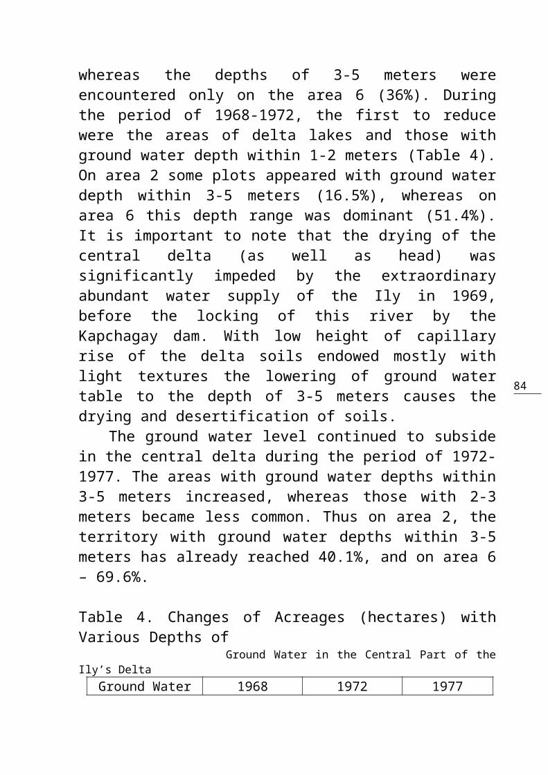
Table 4. Changes of Acreages (hectares) withVarious Depths of Ground Water in the Central Part of theIly’s Delta
Ground Water 1968 1972 1977

85
Depth, m hectares
% hectares
% hectares
%
Area 20-1 - - - - - -1-2 74.9 14.
012.0 2.2 12.0 2.2
2-3 369.9 69.1
377.4 70.5
254.1 47.5
3-5 - - 88.2 16.5
214.5 40.1
0-5 (Knollysands)
54.4 10.2
54.4 10.2
54.4 10.2
Lakes &overflows
35.8 6.7 3.0 0.6 - -
Total 535.0 100 535.0 100 535.0 100Area 6
0-1 11.5 1.0 5.1 0.4 - -1-2 75.8 6.4 75.8 6.4 16.0 1.32-3 622.5 52.
2382.1 32.
0208.6 17.
53-5 373.4 31.
4612.1 51.
4829.1 69.
60-5 (Knolly
sands)100.8 8.4 115.3 9.7 137.6 11.
5Lakes &
overflows7.7 0.6 0.6 0.1 0.6 0.1
Total 1192.0 100 1192.0 100 1192.0 100
Changes in areas of saline soils in thecentral part of the delta are shown in Table 5and Fig.15. While analyzing these data it isnecessary to take into account the powerfulleaching effect of the flood which occurred in1969, “on the eve” of the Ily’s locking by thedam. As a result of this flood’s impact and the
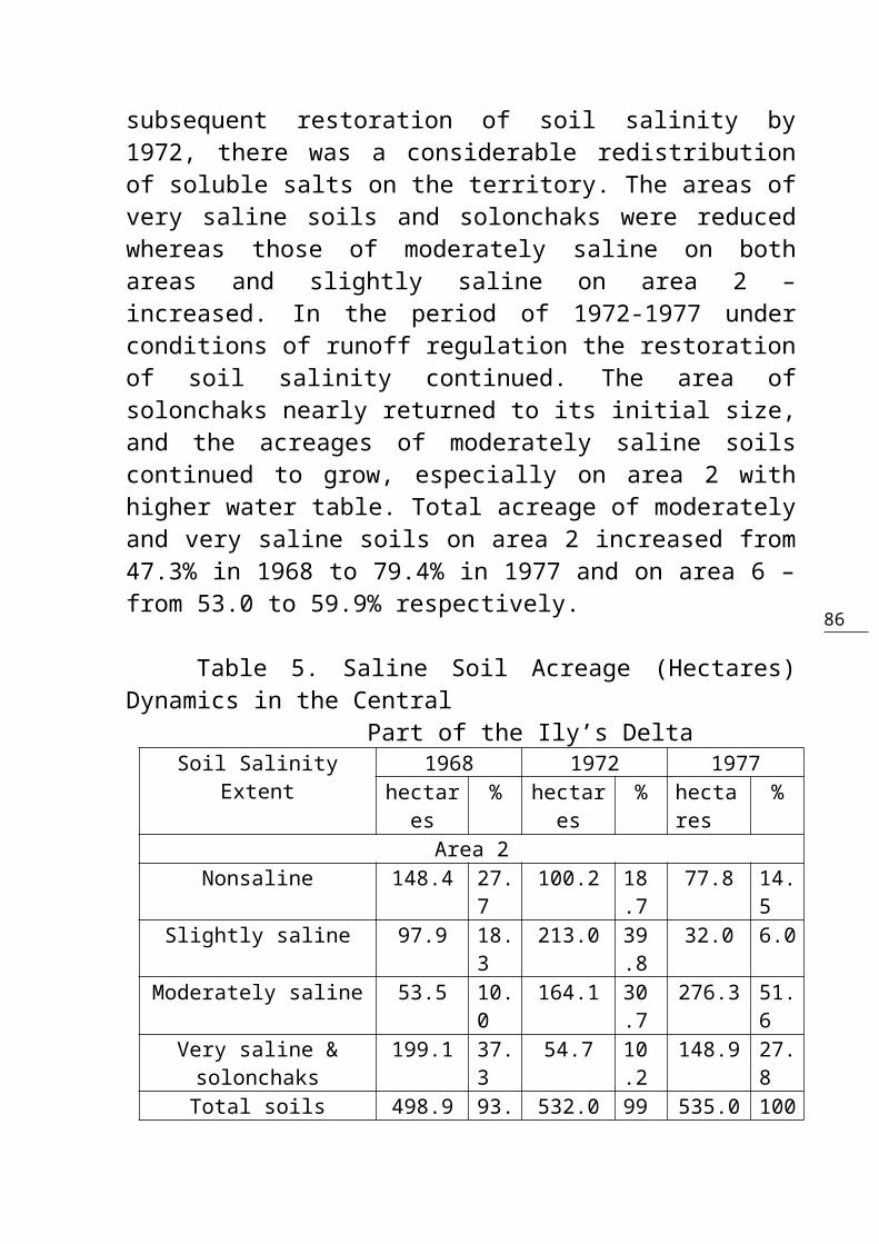
86
subsequent restoration of soil salinity by1972, there was a considerable redistributionof soluble salts on the territory. The areas ofvery saline soils and solonchaks were reducedwhereas those of moderately saline on bothareas and slightly saline on area 2 –increased. In the period of 1972-1977 underconditions of runoff regulation the restorationof soil salinity continued. The area ofsolonchaks nearly returned to its initial size,and the acreages of moderately saline soilscontinued to grow, especially on area 2 withhigher water table. Total acreage of moderatelyand very saline soils on area 2 increased from47.3% in 1968 to 79.4% in 1977 and on area 6 –from 53.0 to 59.9% respectively.
Table 5. Saline Soil Acreage (Hectares)Dynamics in the Central Part of the Ily’s Delta
Soil SalinityExtent
1968 1972 1977hectares
% hectares
% hectares
%
Area 2Nonsaline 148.4 27.
7100.2 18
.777.8 14.
5Slightly saline 97.9 18.
3213.0 39
.832.0 6.0
Moderately saline 53.5 10.0
164.1 30.7
276.3 51.6
Very saline &solonchaks
199.1 37.3
54.7 10.2
148.9 27.8
Total soils 498.9 93. 532.0 99 535.0 100
87
3 .4Lakes & Overflows 36.1 6.7 3.0 0.
6- -
Total areas 535.0 100 535.0 100
535.0 100
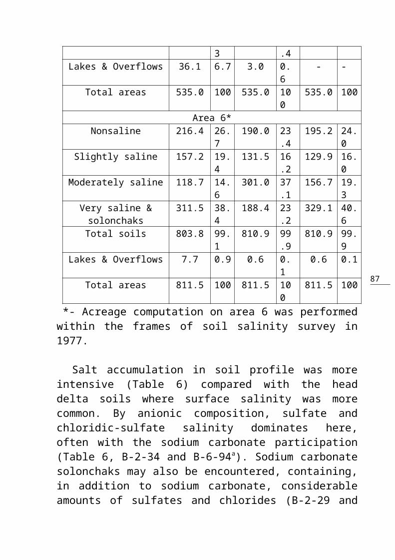
Area 6*Nonsaline 216.4 26.
7190.0 23
.4195.2 24.
0Slightly saline 157.2 19.
4131.5 16
.2129.9 16.
0Moderately saline 118.7 14.
6301.0 37
.1156.7 19.
3Very saline &solonchaks
311.5 38.4
188.4 23.2
329.1 40.6
Total soils 803.8 99.1
810.9 99.9
810.9 99.9
Lakes & Overflows 7.7 0.9 0.6 0.1
0.6 0.1
Total areas 811.5 100 811.5 100
811.5 100
*- Acreage computation on area 6 was performedwithin the frames of soil salinity survey in1977.
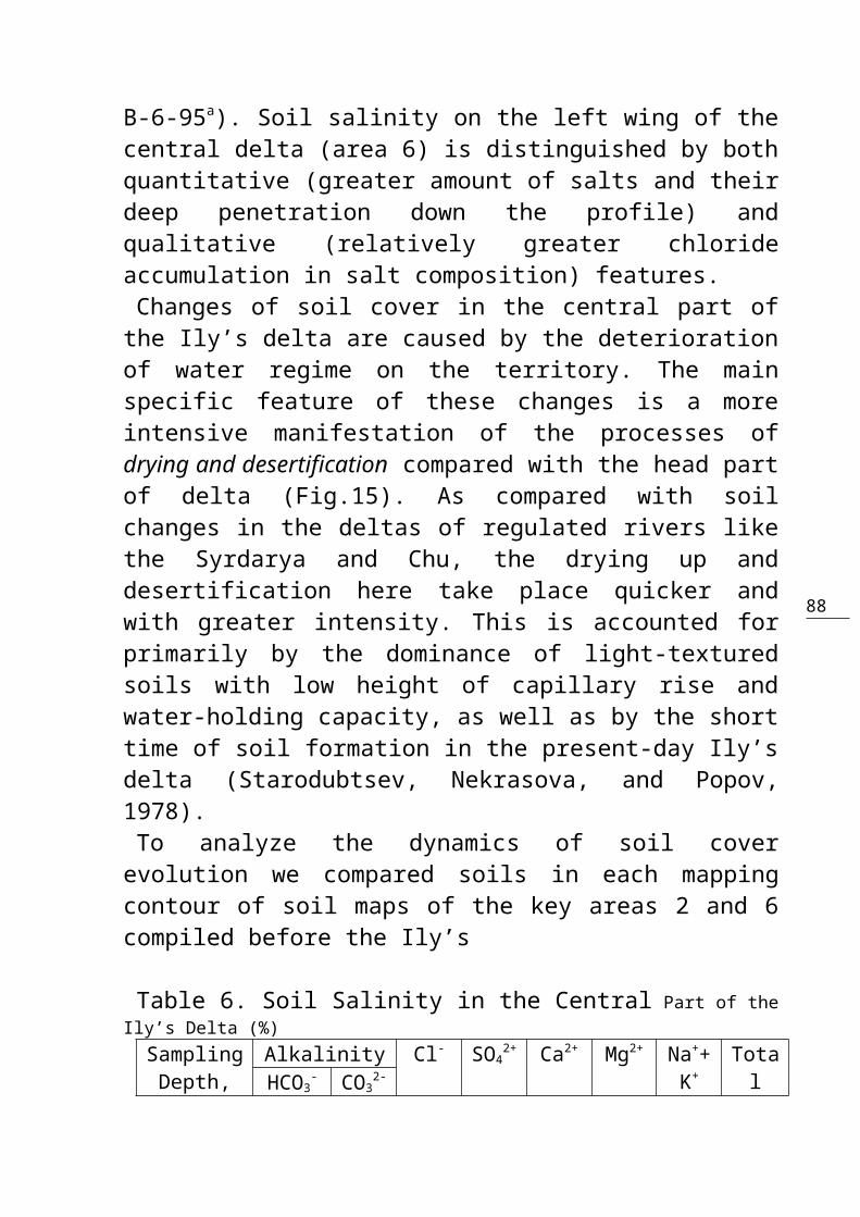
Salt accumulation in soil profile was moreintensive (Table 6) compared with the headdelta soils where surface salinity was morecommon. By anionic composition, sulfate andchloridic-sulfate salinity dominates here,often with the sodium carbonate participation(Table 6, B-2-34 and B-6-94a). Sodium carbonatesolonchaks may also be encountered, containing,in addition to sodium carbonate, considerableamounts of sulfates and chlorides (B-2-29 and
88
B-6-95a). Soil salinity on the left wing of thecentral delta (area 6) is distinguished by bothquantitative (greater amount of salts and theirdeep penetration down the profile) andqualitative (relatively greater chlorideaccumulation in salt composition) features. Changes of soil cover in the central part ofthe Ily’s delta are caused by the deteriorationof water regime on the territory. The mainspecific feature of these changes is a moreintensive manifestation of the processes ofdrying and desertification compared with the head partof delta (Fig.15). As compared with soilchanges in the deltas of regulated rivers likethe Syrdarya and Chu, the drying up anddesertification here take place quicker andwith greater intensity. This is accounted forprimarily by the dominance of light-texturedsoils with low height of capillary rise andwater-holding capacity, as well as by the shorttime of soil formation in the present-day Ily’sdelta (Starodubtsev, Nekrasova, and Popov,1978).To analyze the dynamics of soil coverevolution we compared soils in each mappingcontour of soil maps of the key areas 2 and 6compiled before the Ily’s
Table 6. Soil Salinity in the Central Part of theIly’s Delta (%)SamplingDepth,
Alkalinity Cl- SO42+ Ca2+ Mg2+ Na++
K+TotalHCO3
- CO32-
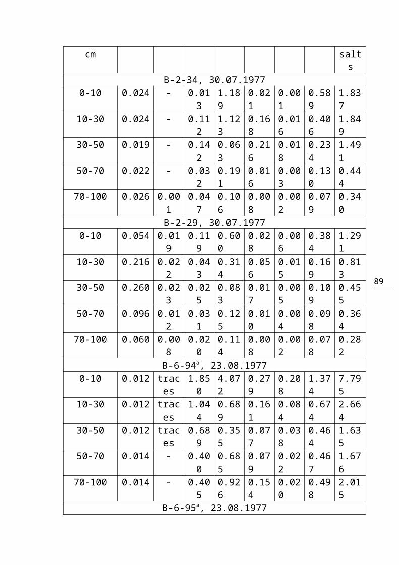
89
cm salts
B-2-34, 30.07.19770-10 0.024 - 0.01
31.189
0.021
0.001
0.589
1.837
10-30 0.024 - 0.112
1.123
0.168
0.016
0.406
1.849
30-50 0.019 - 0.142
0.063
0.216
0.018
0.234
1.491
50-70 0.022 - 0.032
0.191
0.016
0.003
0.130
0.444
70-100 0.026 0.001
0.047
0.106
0.008
0.002
0.079
0.340
B-2-29, 30.07.19770-10 0.054 0.01
90.119
0.600
0.028
0.006
0.384
1.291
10-30 0.216 0.022
0.043
0.314
0.056
0.015
0.169
0.813
30-50 0.260 0.023
0.025
0.083
0.017
0.005
0.109
0.455
50-70 0.096 0.012
0.031
0.125
0.010
0.004
0.098
0.364
70-100 0.060 0.008
0.020
0.114
0.008
0.002
0.078
0.282
B-6-94a, 23.08.19770-10 0.012 trac
es1.850
4.072
0.279
0.208
1.374
7.795
10-30 0.012 traces
1.044
0.689
0.161
0.084
0.674
2.664
30-50 0.012 traces
0.689
0.355
0.077
0.038
0.464
1.635
50-70 0.014 - 0.400
0.685
0.079
0.022
0.467
1.676
70-100 0.014 - 0.405
0.926
0.154
0.020
0.498
2.015
B-6-95a, 23.08.1977

90
0-10 0.394 0.139
1.143
0.958
0.004
0.001
1.345
3.845
10-30 0.194 0.060
0.176
0.161
0.001
0.001
0.262
0.795
30-50 0.161 0.048
0.016
0.026
0.003
0.001
0.079
0.286
50-70 0.100 0.026
0.008
0.032
0.003
0.001
0.053
0.197
70-100 0.070 0.014
0.010
0.048
0.003
0.001
0.051
0.183
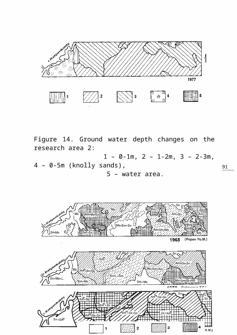
91
Figure 14. Ground water depth changes on theresearch area 2: 1 – 0-1m, 2 – 1-2m, 3 – 2-3m,4 – 0-5m (knolly sands), 5 – water area.
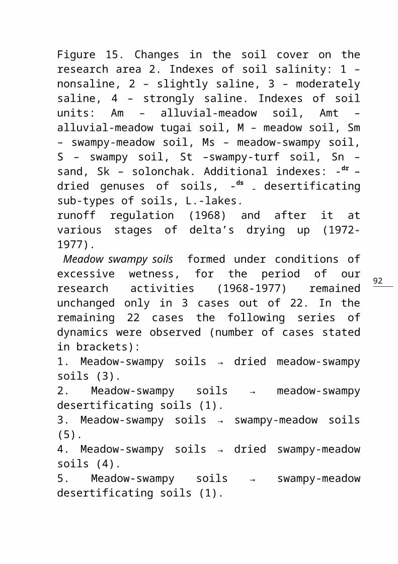
92
Figure 15. Changes in the soil cover on theresearch area 2. Indexes of soil salinity: 1 –nonsaline, 2 – slightly saline, 3 – moderatelysaline, 4 – strongly saline. Indexes of soilunits: Am – alluvial-meadow soil, Amt –alluvial-meadow tugai soil, M – meadow soil, Sm– swampy-meadow soil, Ms – meadow-swampy soil,S – swampy soil, St –swampy-turf soil, Sn –sand, Sk – solonchak. Additional indexes: -dr –dried genuses of soils, -ds
– desertificatingsub-types of soils, L.-lakes.runoff regulation (1968) and after it atvarious stages of delta’s drying up (1972-1977).
Meadow swampy soils formed under conditions ofexcessive wetness, for the period of ourresearch activities (1968-1977) remainedunchanged only in 3 cases out of 22. In theremaining 22 cases the following series ofdynamics were observed (number of cases statedin brackets):1. Meadow-swampy soils → dried meadow-swampysoils (3).2. Meadow-swampy soils → meadow-swampydesertificating soils (1).3. Meadow-swampy soils → swampy-meadow soils(5).4. Meadow-swampy soils → dried swampy-meadowsoils (4).5. Meadow-swampy soils → swampy-meadowdesertificating soils (1).
93
6. Meadow-swampy soils → dried alluvial-meadowsoils (2).7. Meadow-swampy soils → meadow solonchaks (6). Soil accumulation on the surface is commonfor the stages of drying and (to a lesserextent) desertification of meadow-swampy soils.The processes typical to meadow type of soilformation become more evident (increase theirintensity) in the series 3-6.
Swampy-meadow soils were preserved withoutsignificant changes in conditions of regulatedrunoff only in 3 out of 21 cases. Otherwise,the evolution of these soils proceeded in thefollowing way:8. Swampy-meadow soils → dried swampy-meadowsoils (6).9. Swampy-meadow soils → swampy-meadowdesertificating soils (3).10. Swampy-meadow soils → alluvial-meadow soils(4).11. Swampy-meadow soils → meadow and ordinarysolonchaks (4).12. Dried swampy-meadow soils → swampy-meadow desertificating soils (1). Swampy-meadow soils, therefore, weresubjected to drying-up and desertification in agreater measure than meadow-swampy soils. Soilsalinity in this case is characterized by adeeper salt penetration down the profile. Alluvial-meadow soils preserved their morphologyunchanged only on the floodplain areas along
94
the beds. In the majority of cases they weresubjected to intensive drying, desertificationand salinization:13. Alluvial-meadow soils → dried alluvial-meadow soils (6).14. Alluvial-meadow soils → alluvial-meadowdesertificating soils (4).15. Alluvial-meadow soils → ordinary solonchaks(5).16. Dried alluvial-meadow soils → alluvial-meadow desertificating soils (2).17. Dried alluvial-meadow soils → ordinarysolonchaks (2).18. Alluvial-meadow desertificating soils →takyr-like soils (3). Alluvial-meadow tugai soils also started todeteriorate gradually in changed conditions ofwater feeding, and tugai vegetation (floodplainforests) started to thin out and die. Salinityseldom develops in these soils. In two contoursout of 5 the alluvial-meadow tugai soilspreserved their former features but in threecontours they changed in the following way:19. Alluvial-meadow tugai soils → driedalluvial-meadow soils (2).20. Alluvial-meadow tugai soils → alluvial-meadow desertificating soils (1). The drying-up of delta lakes providedopportunity to observe the following dynamicsseries:
95
21. The lake → swampy soils → meadow-swampysoils (1).22. The lake → meadow-swampy soils → dried meadow-swampy soils (1). Thus the leading factor of hydromorphicsoil degradation here is desertification whichproved to be notably more intensive than thatin the head delta. Generally speaking, the soil-reclamationconditions in the central part of the deltaconsiderably deteriorated by the followingcharacteristic features: 1) the areas of flood-caused soil inundation as well as the volume offlood water entering this part of the deltaconsiderably reduced; 2) ground water tablebecame lower on all morphoelements oftopography; and 3) the soils were subjected todrying-up, desertification and salinization. Asa result, the rich and specific hydromorphicdelta landscapes are degrading, and economicimportance of the territory as forage-producingarea devaluates. In the peripheral part of delta, occupying thearea of 200 thousand hectares, after runoffregulation, the effects of artificial waterallowances from the Kapchagay reservoir arepractically negligible. The water flows alongthe beds and streams into the Lake Balkhashcausing the inundation of small areas. Waterlevel lowering in beds causes the reduction inthe ground waters replenishment on the

96
territories surrounding banks. Only in thesecond half of summer and sometimes in autumntoo, the remainder of the runoff comes herealong the beds of the Arystan, Byminey andother streams which flood some lowlands. As aresult, vegetative cover quickly degrades andvaluable for grazing and forage plantassociations give place to salsolas, yields ofhay reducing 3-4 times. At the same time, thereoccurs a considerable ground water tablelowering and soil cover becomes subjected toaridization.Dynamics of areas with different ground watertable in the peripheral part of the delta as aconsequence of the river runoff regulation isgiven in Fig.16a,b and Table 7. Of four keyareas only on area 7 (left bank of the drying-out bed of the Ily river) the changes in groundwater level occurred without any addition ofanthropogenic influence. In 1968 the ranges ofground water depth were from 0-1 to 5-7 meterswith dominance of 2-3 meters (27.4%) and 3-5meters (35.8%). But already in 1972 as a resultof delta’s drying-up, the ranges of 0-1 and 1-2meters were not encountered at all, anddominating range of ground water depth was thatof 3-5 meters (68.2%). In 1977 the absolutelydominant were the areas with ground water tablewithin 5-7 meters deep (76.5%).The area 8 (left bank of the Bayminey stream)was characterized by a reduction in theacreages with high ground water table and

97
growth in the acreages with relatively deeplylaying ground waters (Table 7). For example,the areas with ground waters at the depth of 3-5 meters increased from 275.6 hectares (27.0%)to 466.4 hectares (45.9%). At the same time, inthe south-eastern part of area as a result ofthe Bayminey bed locking by the earthen dam in1977, considerable acreages of haylands weresubjected to flooding. That is why at the timeof soil survey in 1977 the area with groundwaters within 0-1 meters deep was larger thanin 1972.On the area 3 of the delta’s left-wing (thestream Arystan), the first stage of drying(1970-1972) was also accompanied by the groundwater subsidence (Table 7). In 1977 the levelof ground water continued to subside in thepart of the area attached to the bed. But atthe same time, the vast lowland areas wereflooded in the same year (total area – 394.5ha) to increase the moisture of haylands.On the area 10 (delta’s left wing) the generalground water lowering on the right bank of theTopar stream caused by the runoff regulationwas compensated by the development ofirrigation on the left-bank
98
Figure 16a. Ground water depth changes on theresearch area 7:
99
1 – 0-1m, 2 – 1-2m, 3 – 2-3m, 4 – 3-5m, 5 – 5-7m, 6 – 0-5m (knolly sands), 7 –0-15m (knolly sands), 8 – water area.

100
Figure 16b. Ground water depth changes on theresearch area 10:
1 - 0-1m, 2 – 1-2m, 3 – 2-3m, 4 – 3-5m, 5 – 5-7m,6 – 1-2m in complex with 0-5m(knolly sand), 7 –2-3m in complex with 0-5m (knolly sand), 8 – 3-5m
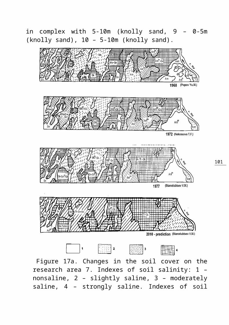
101
in complex with 5-10m (knolly sand, 9 – 0-5m(knolly sand), 10 – 5-10m (knolly sand).
Figure 17a. Changes in the soil cover on theresearch area 7. Indexes of soil salinity: 1 –nonsaline, 2 – slightly saline, 3 – moderatelysaline, 4 – strongly saline. Indexes of soil
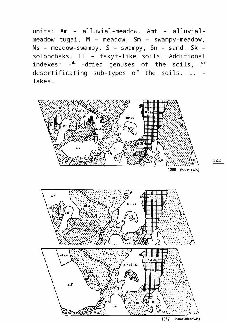
102
units: Am – alluvial-meadow, Amt – alluvial-meadow tugai, M – meadow, Sm – swampy-meadow,Ms – meadow-swampy, S – swampy, Sn – sand, Sk –solonchaks, Tl – takyr-like soils. Additionalindexes: -dr
–dried genuses of the soils, -ds
desertificating sub-types of the soils. L. –lakes.
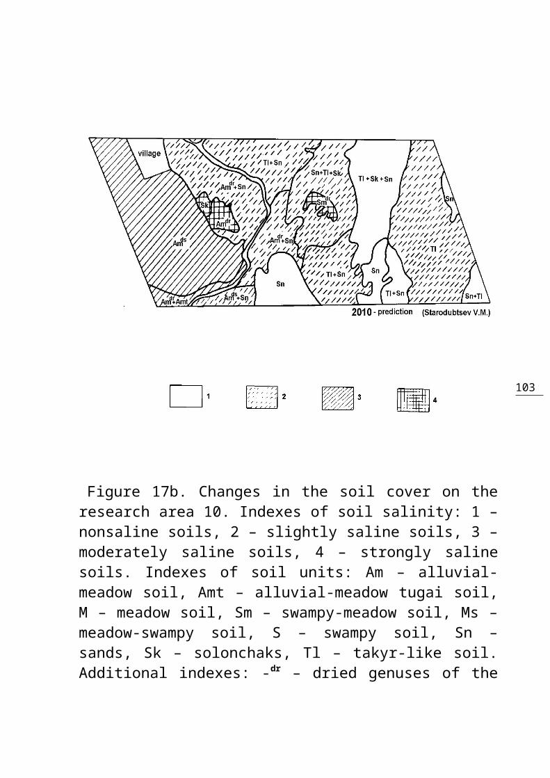
103
Figure 17b. Changes in the soil cover on theresearch area 10. Indexes of soil salinity: 1 –nonsaline soils, 2 – slightly saline soils, 3 –moderately saline soils, 4 – strongly salinesoils. Indexes of soil units: Am – alluvial-meadow soil, Amt – alluvial-meadow tugai soil,M – meadow soil, Sm – swampy-meadow soil, Ms –meadow-swampy soil, S – swampy soil, Sn –sands, Sk – solonchaks, Tl – takyr-like soil.Additional indexes: -dr – dried genuses of the

104
soils, -ds – desertificating sub-types of thesoils, -pl – plowland soils. L. – lake.
part of the area. That is why in 1977 anincrease was observed in the acreages withground water depth within 2-3 meters.The dynamics of areas with different extent ofsalinity (Fig.17 and Table 8) clearly showsthat in the delta’s peripheral part, on thescale of many years, there was a general growthin the area of very saline soils. But thegrowth of soil salinity is not comparable byits significance (more slight) with theintensity of ground water table lowering, soildrying and desertification. In addition, whileevaluating the processes of soil salinizationand leaching, it is necessary to take intoaccount the leaching effect of unobservedbefore for its intensity flood in 1969, whichproved the most severe on the delta’s rightwing (area 3). On area 10 (left wing of thedelta), Table 7. Acreages with Different Ground WaterDepths (Hectares) in the Peripheral Part of the Ily’s Delta
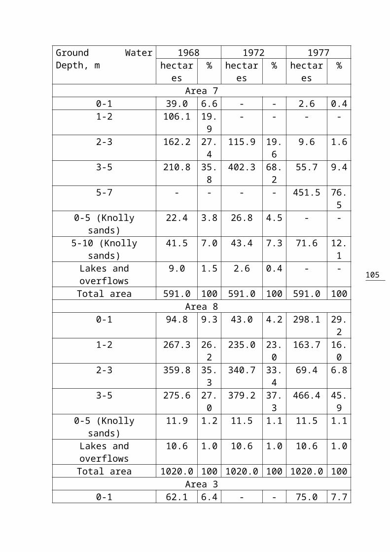
105
Ground WaterDepth, m
1968 1972 1977hectares
% hectares
% hectares
%
Area 70-1 39.0 6.6 - - 2.6 0.41-2 106.1 19.
9- - - -
2-3 162.2 27.4
115.9 19.6
9.6 1.6
3-5 210.8 35.8
402.3 68.2
55.7 9.4
5-7 - - - - 451.5 76.5
0-5 (Knollysands)
22.4 3.8 26.8 4.5 - -
5-10 (Knollysands)
41.5 7.0 43.4 7.3 71.6 12.1
Lakes andoverflows
9.0 1.5 2.6 0.4 - -
Total area 591.0 100 591.0 100 591.0 100Area 8
0-1 94.8 9.3 43.0 4.2 298.1 29.2
1-2 267.3 26.2
235.0 23.0
163.7 16.0
2-3 359.8 35.3
340.7 33.4
69.4 6.8
3-5 275.6 27.0
379.2 37.3
466.4 45.9
0-5 (Knollysands)
11.9 1.2 11.5 1.1 11.5 1.1
Lakes andoverflows
10.6 1.0 10.6 1.0 10.6 1.0
Total area 1020.0 100 1020.0 100 1020.0 100Area 3
0-1 62.1 6.4 - - 75.0 7.7

106
1-2 178.0 18.3
16.5 1.7 87.0 8.9
2-3 416.6 42.7
345.9 35.4
135.4 13.9
3-5 167.7 17.2
475.1 48.8
156.7 16.1
0-5 (Knollysands)
136.6 14.0
126.4 13.0
126.4 13.0
Lakes andoverflows
14.0 1.4 11.1 1.1 394.5 40.4
Total area 975.0 100 975.0 100 975.0 100Area 10
1-2 25.2 1.9 42.9 3.2 33.2 2.52-3 220.6 16.
7165.4 12.
5331.7 25.
23-5 219.2 16.
6165.4 12.
5- -
5-7 347.8 26.5
418.6 31.9
444.2 33.7
Depth ranges 1-2& 0-5 (Knolly
sands)
111.8 8.5 - - - -
Depth ranges 2-3& 0-5 (Knolly
sands)
154.0 11.7
164.1 12.4
169.4 12.8
Depth ranges 3-5& 0-5 (Knolly
sands)
- - 119.3 9.0 110.6 8.4
5-10 (Knollysands)
225.7 17.1
230.1 17.6
228.9 17.4
Lakes andoverflows
13.6 1.0 12.2 0.9 - -
Total area 1318.0 100 1318.0 100 1318.0 100the reduction in the area of saline soils wasobserved which occurred not only due to
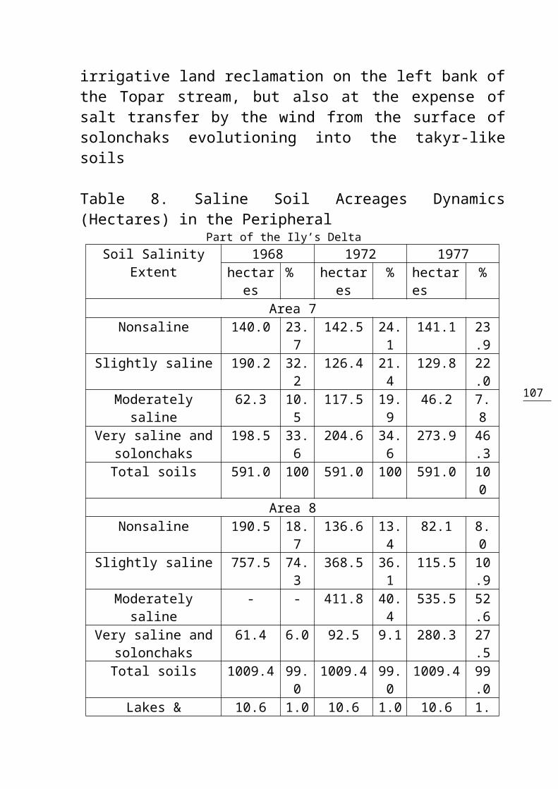
107
irrigative land reclamation on the left bank ofthe Topar stream, but also at the expense ofsalt transfer by the wind from the surface ofsolonchaks evolutioning into the takyr-likesoils
Table 8. Saline Soil Acreages Dynamics(Hectares) in the Peripheral Part of the Ily’s Delta
Soil SalinityExtent
1968 1972 1977hectares
% hectares
% hectares
%
Area 7Nonsaline 140.0 23.
7142.5 24.
1141.1 23
.9Slightly saline 190.2 32.
2126.4 21.
4129.8 22
.0Moderately
saline62.3 10.
5117.5 19.
946.2 7.
8Very saline and
solonchaks198.5 33.
6204.6 34.
6273.9 46
.3Total soils 591.0 100 591.0 100 591.0 10
0Area 8
Nonsaline 190.5 18.7
136.6 13.4
82.1 8.0
Slightly saline 757.5 74.3
368.5 36.1
115.5 10.9
Moderatelysaline
- - 411.8 40.4
535.5 52.6
Very saline andsolonchaks
61.4 6.0 92.5 9.1 280.3 27.5
Total soils 1009.4 99.0
1009.4 99.0
1009.4 99.0
Lakes & 10.6 1.0 10.6 1.0 10.6 1.

108
overflows 0Total area 1020.0 100 1020.0 100 1020.0 10
0Area 3
Nonsaline 215.5 22.1
465.2 47.8
154.2 15.8
Slightly saline 692.6 71.1
346.4 35.5
182.0 18.6
Moderatelysaline
34.4 3.5 - - 75.8 7.8
Very saline andsolonchaks
18.5 1.9 152.3 15.6
168.3 17.3
Total soils 961.0 98.6
963.9 98.9
580.3 59.5
Lakes &overflows
14.0 1.4 11.1 1.1 394.7 40.5
Total area 975.0 100 975.0 100 975.0 100
Area 10Nonsaline 423.4 32.
1385.1 29.
2565.2 42
.9Slightly saline 117.2 8.9 580.1 44.
1571.5 43
.3Moderately
saline580.9 44.
1212.0 16.
148.3 3.
7Very saline and
solonchaks181.6 13.
8129.6 9.8 133.0 10
.0Total soils 1303.1 98.
91306.8 99.
21318.0 10
0Lakes &overflows
14.9 1.1 11.2 0.8 - -
Total area 1318.0 100 1318.0 100 1318.0 100
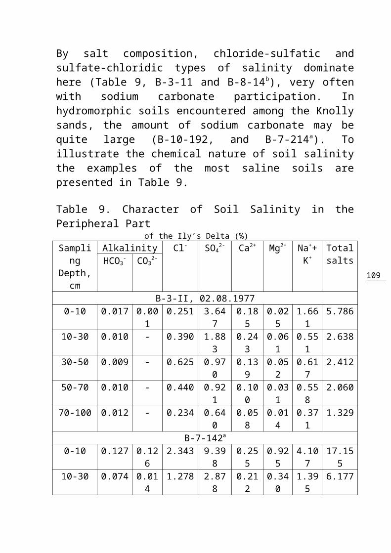
109
By salt composition, chloride-sulfatic andsulfate-chloridic types of salinity dominatehere (Table 9, B-3-11 and B-8-14b), very oftenwith sodium carbonate participation. Inhydromorphic soils encountered among the Knollysands, the amount of sodium carbonate may bequite large (B-10-192, and B-7-214a). Toillustrate the chemical nature of soil salinitythe examples of the most saline soils arepresented in Table 9.
Table 9. Character of Soil Salinity in thePeripheral Part of the Ily’s Delta (%)Sampling
Depth,cm
Alkalinity Cl- SO42- Ca2+ Mg2+ Na++
K+TotalsaltsНСО3
- СО32-
B-3-II, 02.08.19770-10 0.017 0.00
10.251 3.64
70.185
0.025
1.661
5.786
10-30 0.010 - 0.390 1.883
0.243
0.061
0.551
2.638
30-50 0.009 - 0.625 0.970
0.139
0.052
0.617
2.412
50-70 0.010 - 0.440 0.921
0.100
0.031
0.558
2.060
70-100 0.012 - 0.234 0.640
0.058
0.014
0.371
1.329
B-7-142а
0-10 0.127 0.126
2.343 9.398
0.255
0.925
4.107
17.155
10-30 0.074 0.014
1.278 2.878
0.212
0.340
1.395
6.177
110
30-50 0.053 0.007
0.674 1.124
0.058
0.162
0.643
2.714
50-70 0.050 0.007
0.426 0.858
0.024
0.116
0.473
1.947
70-100 0.043 0.007
0.085 0.306
0.013
0.035
0.143
0.615
B-7-214а
0-10 0.238 0.096
0.266 0.513
0.001
0.008
0.492
1.518
10-30 0.113 0.043
0.064 0.082
0.002
0.003
0.123
0.387
30-50 0.065 0.022
0.047 0.030
0.003
0.001
0.068
0.214
50-70 0.053 0.007
0.018 0.023
0.004
0.003
0.035
0.136
70-100 0.046 0.005
0.018 0.025
0.004
0.002
0.036
0.131
B-8-14b
0-10 0.055 0.014
0.412 4.887
0.132
0.276
1.965
7.727
10-30 0.026 - 0.596 0.396
0.069
0.052
0.422
1.561
30-50 0.024 - 0.483 0.348
0.057
0.043
0.350
1.305
50-70 0.024 - 0.540 0.542
0.094
0.042
0.440
1.682
70-100 0.019 - 0.483 0.522
0.070
0.028
0.445
1.567
B-10-192, 30.08.19770-10 0.514 0.18
50.362 1.80
30.008
0.010
1.268
3.965
10-30 0.187 0.055
0.082 0.230
0.001
0.001
0.232
0.733
30-50 0.115 0.026
0.031 0.111
0.001
0.001
0.114
0.373
50-70 0.067 0.01 0.023 0.09 0.00 0.00 0.08 0.276

111
0 9 3 1 370-100 0.041 0.00
50.028 0.10
40.003
0.002
0.077
0.255
Soil cover evolution caused by the reductionof peripheral delta’s water feeding after theKapchagay reservoir excavation depended, firstof all, on the intensity of ground watersubsidence and cessation of regular floods. Onarea 7 and on the parts of areas 3, 8, and 10not subjected to floods or irrigation, theswampy, meadow-swampy, and swampy-meadow soilswere transformed mainly into theirdesertificated variants. Soil desertificationprocesses were accompanied by the rapiddeterioration of vegetative cover, lowering ofsoil productivity, nearly completedisappearance of peaty horizon under impact ofstrong winds, and, very often, by the growth ofsalinity. Desertification was favored by thesmall depth of hydromorphic soil profile andvery shallow underlying by sands. We had morethan one opportunity to observe the beginningof the desertificated soil destruction by thewind. The sites of soil blowing were the areaswith shallow soil deteriorated by agriculturalmachinery and transportation vehicles as wellas by the tunnels of earth-moving animals.Alluvial-meadow soils encountered mainly onthe bed-adjoining ridges are slower to make atransition from the stage of drying-up to thatof desertification. Their evolution is often

112
completed by the formation of ordinarysolonchaks or by aeolian destruction.Desertficating soils of the peripheral part ofthe Ily’s delta by their morphologicalfeatures, composition, properties, and plantcover composition are close to typical takyr-like soils.The evolution series of hydromorphic soils(with the absence of irrigation and any otherartificial water supply) in the peripheral partof the Ily’s delta within the period ofobservations were as follows:1. Swampy soils → swampy desertificatingsoils (2).
2. Swampy soils → solonchaks (1).3. Meadow-swampy soils → dried meadow-swampy soils (5).
4. Meadow-swampy soils → dried swampy-meadow soils (1).
5. Meadow-swampy soils → meadow-swampy desertificating soils (10).6. Meadow-swampy soils → solonchaks (3).7. Dried meadow-swampy soils → meadow-swampy desertificating soils (1).8. Meadow-swampy desertificating soils →sands (1).
9. Swampy-meadow soils → alluvial-meadowsoils (1).
10. Swampy-meadow soils → dried swampy-meadow soils (4).
113
11. Swampy-meadow soils → swampy-meadow desertificating soils (1).12. Swampy-meadow soils → alluvial-meadow desertificating soils (1).13. Swampy-meadow soils → solonchaks (5).14. Dried swampy-meadow soils → swampy-meadow desertificating soils (4).15. Dried swampy-meadow soils → solonchaks(2).
16. Dried swampy-meadow soils → takyr-likesoils (1).
Soil salinity growth in 55% of observed casesis characteristic of the above-listed series ofthe swampy-type soil changes. Unchanged extentof salinity was preserved in 40% of cases andin 5% of cases the extent of salinitydiminished.17. Alluvial-meadow soils = alluvial-meadowsoils (3).
18. Alluvial-meadow soils → dried alluvial-meadow soils (8).
19. Alluvial-meadow soils → alluvial-meadow desertificating soils (6).20. Dried alluvial-meadow soils → alluvial-meadow desertificating soils (1).21. Dried alluvial-meadow soils →solonchaks (3).
114
22. Dried alluvial-meadow soils →desertsands (1).
23. Alluvial-meadow desertificating soils = alluvial-meadowdesertificating soils (7).24. Alluvial-meadow desertificating soils →solonchaks (1).
25. Alluvial-meadow desertificating soils → takyr-like soils (2).26. Alluvial-meadow tugai soils → alluvial-meadow soils (1).
27. Alluvial-meadow tugai soils → alluvial-meadow desertificating soils (1).
Increase in the extent of meadow soils salinityin the process of drying and desertification isa bit less intensive. Only in 40% of cases soilsalinity increased, whereas in another 40% itremained unchanged, and in the remaining 20% ofcases it even diminished especially in thesoils of sands and loamy-sandy texture.28. Solonchaks = solonchaks (3).29. Solonchaks → takyr-like soils (1).30. Takyr-like soils = takyr-like soils(1).
31. Lakes → dried meadow-swampy soils (2).32. Lakes → shor-like solonchaks (1).
On the plots subjected to flooding orirrigation soil hydromorphicity changed independence on their water regime, without
115
definite regularities (tendencies). But theextent of soil salinity mostly increased.As a general rule, the soil cover of theperipheral delta was, first of all, subjectedto desertification and much less commonly – tosalinity and wind erosion destruction. Thecharacter of soil degradation was irreversible.Let us also consider briefly the processestaking place at the banks of Lake Balkhash. Anabrasion-accumulative plain of a 10-15 kmwidth, with drying and desertificating saltedsoil and halophytic vegetation, was formed onthe southern bank within the limits of currentdelta of the Ily River (between river-beds ofits distributaries). Marsh vegetation can befound only on the lake bank. During the fillingof the Kapchagay reservoir, which coincidedwith the low-flow period of the Ily River, thelevel of Lake Balkhash was decreased by 1.5 m,and the coastal line receded to the north by 2-3 km, and sometimes by 7-8 km. The dryingbottom of the lake is mostly salinated. Thesaline soils (i.e. solonchaks) alternate withturfy-swampy dried soils. The example of soilsalinization on the drying-up bottom of thelake and its banks is given in the Table 10.The reason for such heterogeneity is in thespecial character of the water and salts flowsbetween the lake and banks. Back in the 1930s,it was guessed that there was the possibilityof water and salts flowing from the lake to thebanks. Later, M.A. Pogrebinsky (Ily River
116
Valley…,1963) discovered this process in theancient delta. During the soil studies in 1977,it was found (Starodubtsev, Nekrasova, 1983)that in the some areas of the current deltagroundwater flowed from the lake to the deltaplain, and in others areas – from the deltatoward the lake. Such a cyclic character of thewater movement explains the varying degree ofsalinization of the drying lake bottom andcoastal soils. On the sites where groundwateris moving from the lake into the delta, thesalt accumulation achieves 10 thousand tonnesper 1 hectare in the layer between the surfaceand the regional underlying bed. The conceptabout a cyclic (i.e., in space and in time)character of water streams between the lake andits coast is of great importance in view of theevaluation of Lake Balkhash’s salinizationbecause of the runoff regulation. The lower thelake level, the fewer outflows of water andsalts from the lake toward the coast.Accordingly, the water mineralization in thelake may be getting higher. If the lake levelincreases (this was observed in the 1990s) theoutflow of water and salts into the deltareduced water mineralization in the lake, butincreased the accumulation of salts in coastalsoils and parent rocks. More exact evaluationsof hydrogeologists and hydrochemists(Contemporary Ecological Conditions,2002)showed that the outflow of water from the laketoward the coast is, in total, 0.447 km3
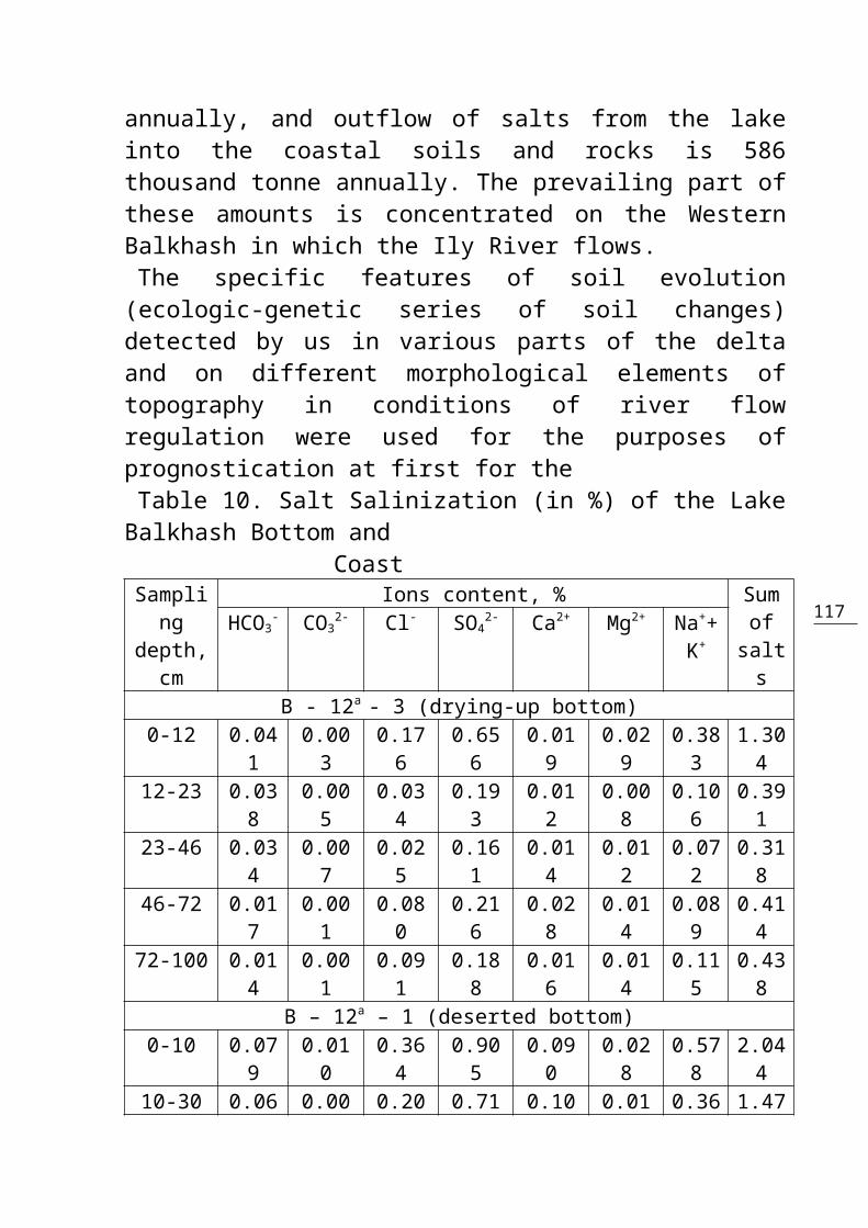
117
annually, and outflow of salts from the lakeinto the coastal soils and rocks is 586thousand tonne annually. The prevailing part ofthese amounts is concentrated on the WesternBalkhash in which the Ily River flows. The specific features of soil evolution(ecologic-genetic series of soil changes)detected by us in various parts of the deltaand on different morphological elements oftopography in conditions of river flowregulation were used for the purposes ofprognostication at first for theTable 10. Salt Salinization (in %) of the LakeBalkhash Bottom and Coast Sampli
ngdepth,
cm
Ions content, % Sumofsalts
HCO3- CO3
2- Cl- SO42- Ca2+ Mg2+ Na++
K+
B - 12a - 3 (drying-up bottom)0-12 0.04
10.003
0.176
0.656
0.019
0.029
0.383
1.304
12-23 0.038
0.005
0.034
0.193
0.012
0.008
0.106
0.391
23-46 0.034
0.007
0.025
0.161
0.014
0.012
0.072
0.318
46-72 0.017
0.001
0.080
0.216
0.028
0.014
0.089
0.414
72-100 0.014
0.001
0.091
0.188
0.016
0.014
0.115
0.438
B – 12a – 1 (deserted bottom)0-10 0.07
90.010
0.364
0.905
0.090
0.028
0.578
2.044
10-30 0.06 0.00 0.20 0.71 0.10 0.01 0.36 1.47
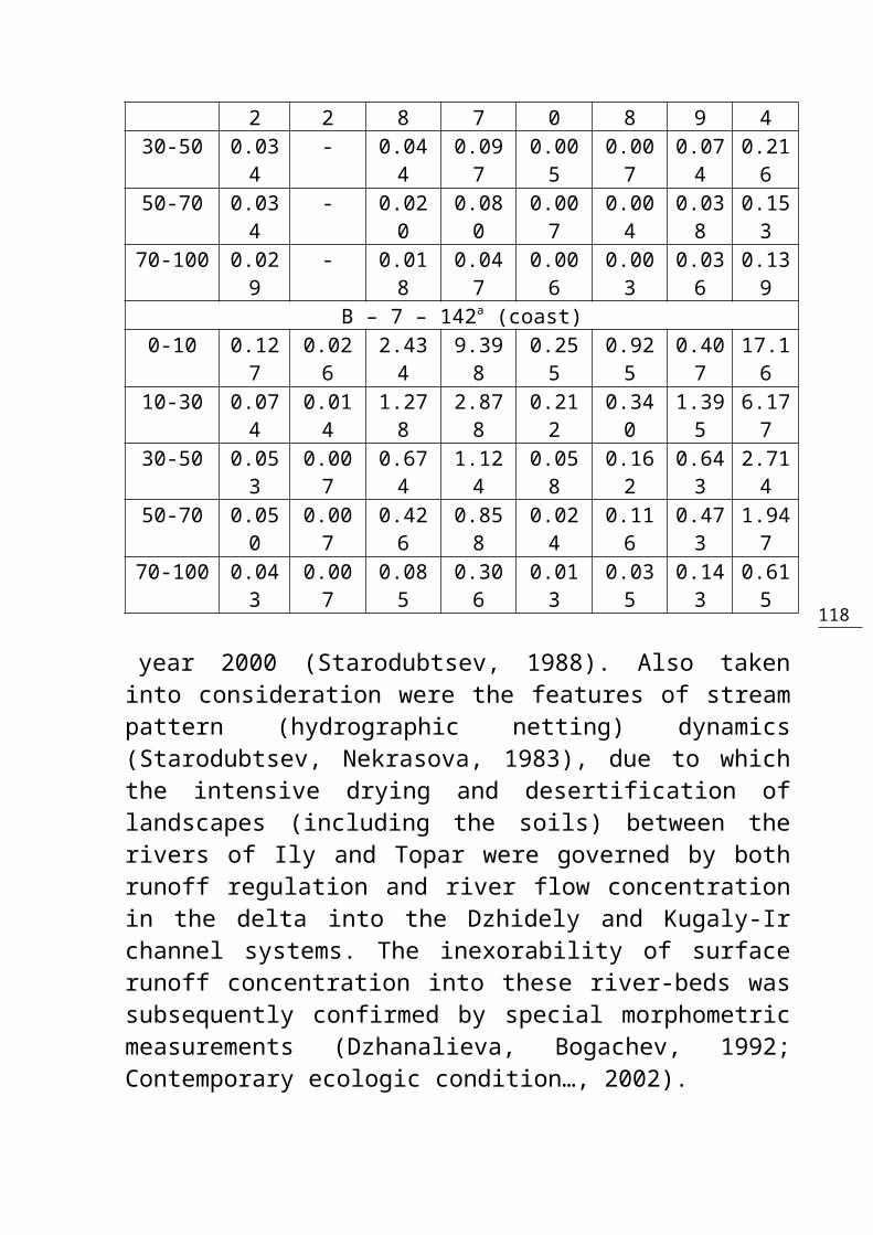
118
2 2 8 7 0 8 9 430-50 0.03
4- 0.04
40.097
0.005
0.007
0.074
0.216
50-70 0.034
- 0.020
0.080
0.007
0.004
0.038
0.153
70-100 0.029
- 0.018
0.047
0.006
0.003
0.036
0.139
B – 7 – 142a (coast)0-10 0.12
70.026
2.434
9.398
0.255
0.925
0.407
17.16
10-30 0.074
0.014
1.278
2.878
0.212
0.340
1.395
6.177
30-50 0.053
0.007
0.674
1.124
0.058
0.162
0.643
2.714
50-70 0.050
0.007
0.426
0.858
0.024
0.116
0.473
1.947
70-100 0.043
0.007
0.085
0.306
0.013
0.035
0.143
0.615
year 2000 (Starodubtsev, 1988). Also takeninto consideration were the features of streampattern (hydrographic netting) dynamics(Starodubtsev, Nekrasova, 1983), due to whichthe intensive drying and desertification oflandscapes (including the soils) between therivers of Ily and Topar were governed by bothrunoff regulation and river flow concentrationin the delta into the Dzhidely and Kugaly-Irchannel systems. The inexorability of surfacerunoff concentration into these river-beds wassubsequently confirmed by special morphometricmeasurements (Dzhanalieva, Bogachev, 1992;Contemporary ecologic condition…, 2002).
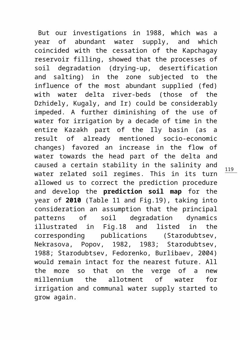
119
But our investigations in 1988, which was ayear of abundant water supply, and whichcoincided with the cessation of the Kapchagayreservoir filling, showed that the processes ofsoil degradation (drying-up, desertificationand salting) in the zone subjected to theinfluence of the most abundant supplied (fed)with water delta river-beds (those of theDzhidely, Kugaly, and Ir) could be considerablyimpeded. A further diminishing of the use ofwater for irrigation by a decade of time in theentire Kazakh part of the Ily basin (as aresult of already mentioned socio-economicchanges) favored an increase in the flow ofwater towards the head part of the delta andcaused a certain stability in the salinity andwater related soil regimes. This in its turnallowed us to correct the prediction procedureand develop the prediction soil map for theyear of 2010 (Table 11 and Fig.19), taking intoconsideration an assumption that the principalpatterns of soil degradation dynamicsillustrated in Fig.18 and listed in thecorresponding publications (Starodubtsev,Nekrasova, Popov, 1982, 1983; Starodubtsev,1988; Starodubtsev, Fedorenko, Burlibaev, 2004)would remain intact for the nearest future. Allthe more so that on the verge of a newmillennium the allotment of water forirrigation and communal water supply started togrow again.
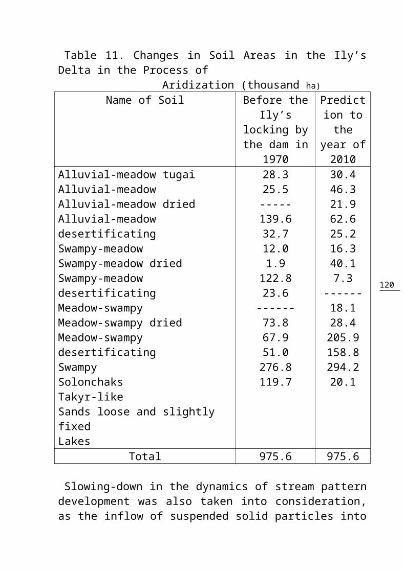
120
Table 11. Changes in Soil Areas in the Ily’sDelta in the Process of Aridization (thousand ha)
Name of Soil Before theIly’s
locking bythe dam in
1970
Prediction tothe
year of2010
Alluvial-meadow tugaiAlluvial-meadowAlluvial-meadow driedAlluvial-meadow desertificatingSwampy-meadowSwampy-meadow driedSwampy-meadow desertificatingMeadow-swampyMeadow-swampy driedMeadow-swampy desertificatingSwampySolonchaksTakyr-likeSands loose and slightly fixedLakes
28.325.5-----139.632.712.01.9122.823.6
------73.867.951.0276.8119.7
30.446.321.962.625.216.340.17.3
------18.128.4205.9158.8294.220.1
Total 975.6 975.6
Slowing-down in the dynamics of stream patterndevelopment was also taken into consideration,as the inflow of suspended solid particles into

121
the delta considerably reduced (Fig. 6.) andthe impact of this inflow on the erosion andaccumulative processes in the beds wassignificant. For further correction of aprediction procedure and their spatial(cartographic) representation a certain valueis attached to detailed landscape surveyscarried out in the delta (Dzhanalieva,Bogachev, 1992), as well as hydrologicalobservations and space monitoring which is nowperformed by a number of organizations.
122
5. GENERAL PATTERN OF CHANGES IN SOIL REGIMESAND PROPERTIES CAUSED BY THE ILY’S DELTA
ARIDIZATION
Soil evolution caused by the delta plainaridization brought about by the watermanagement construction activities in the riverbasins begins from the evolution of soilregimes, especially water and salinity-relatedones. These regimes are determining in soilformation and development of their fertilityand physico-chemical properties in the desertand semi-desert zones. Soil salinity and water-related regimes, therefore, were the firstobjects of detailed research in various partsof the Ily river delta. Soil diagnostics needed for the detection ofthe ecologo-genetic series of soil evolution inthe Ily’s delta had been performed first of allby observing the changes in soil regimes, theirmorphological features, as well as by takinginto account the overall environmentalsituation (character of vegetation, presence ofsalt efflorescences, etc.). Pedogenic processes
123
forming soil properties are more conservativeand change slowly, which is the reason why therapid processes of delta-plain aridization areinexorably encountered with a certain lack ofagreement between soil properties and theirmorphological features.As the soils of the Ily’s delta are mostlylight-textured on all elements of topography(Fig 18), they are endowed with low height ofcapillary rise and water-holding capacity. Theprocesses of drying-up and aridization(desertification), therefore, make more rapidadvances there than in other deltas of theSouthern Kazakhstan, like, for example, in theSyrdarya river delta. The analysis of dataobtained as a result of many years of researchactivities in the Ily’s delta made it clearthat the question of the delta soil waterregime evolution brought about by the watermanagement construction should not beconsidered without some realistic substantialevaluation of the water-related regime in theinitial soils. Working in this plane, weintroduced the concept of “water regime cycles”in hydromorphic soils the formation of whichdepends on the floods of the river. The essenceof this concept lies in the fact that genesisand evolution of hydromorphic soils aredetermined by the water feeding regime of notany single year but cycles of years duringwhich the water feeding of

124
Figure 18. Water regime of hydromorphic soilsin the Ily River delta at desertification. Soilindexes: Am – alluvial-meadow, Sm – swampy-meadow, Ms – meadow-swampy, S – swampy, Tl –takyr-like soils, Sn – sands loose and poorlyfixed, Sk – solonchaks (saline soils). Textureof soils: 1 – clay and heavy loam, 2 – loam, 3– light loam, 4 – loamy-sand, 5 – sand. Formsof moisture in soils: 6 – free water, 7 – TMC-CMC (total moisture capacity – capillarymoisture capacity), 8 – CMC-FMC (capillary
125
water capacity – field moisture capacity). 9 –FMC-CBMC (field moisture capacity – capillary-break moisture capacity), 10 – CBMC-WMC(capillary-break moisture capacity – wiltingmoisture capacity), 11 – less WMC (wiltingmoisture capacity or wilting point). the river changes in the complete cycle range –from the poor to the abundant inclusive. Water supply cycles registered for the riverIly last from 2 to 5 years, but the three-yearcycles are dominant. It was for such cycle thatwe compiled the scheme of water regimeevolution in delta soils (Fig18.). It is quitenatural that any change in the hydrologicregime of the river brought about by watermanagement construction may occur in any year(of the three-year cycle), that is at any stageof the cycle. In this case the water regime ofdrying-up hydromorphic soils is formed indifferent time spell (with taking count of timeneeded for the “exhaustion” of ground waterstocks which under meadow and swamp vegetationusually take place in a year). In alluvial-meadow soils subjected to floods only in theyears with abundant water supply (once in a 3-year period), the regime of drying-up soils iscreated on the second and the fourth yearrespectively. In swampy-meadow soils inundatedonly in the years of abundant and moderatewater supply (in the course of 2 years of the3-year cycle), the regime of drying-up soils isformed on the 2-3-d year after the regulation

126
of flow. In meadow-swampy and swampy soilssubjected to inundation every year (but fordifferent spells of time), the regime ofdrying-up soils is formed on the 1-2nd yearrespectively.But field survey research of soils and soilregimes evolution in the Ily’s delta (Chapter4) showed that rapid diminishing of the delta’swater feeding favors mainly the development ofwater regime specific to drying-up soils. Slow(gradual) diminishing of the water feeding inthe parts of delta with swampy and meadow-swampy soils (which is the case in the headpart of the Ily’s delta), with light texture ofsoils and subsoils, the conditions are createdfor the development of water regimecharacteristic to the soils with a lesserextent of hydromorphicity, which proves theintensifying of the meadow type of soilformation. The similar character of waterregime evolution is evident at the stage ofsoil drying (particularly if this isoccasionally broken by a short-term natural orartificial water feeding), but to a lesserextent. Under such conditions, the dried swampysoils may evolutionize into dried meadow-swampysoils, whereas the dried swampy-meadow soils,for example, may turn into meadow ones.In the many-yeared aspects, the length of timeduring which the water regime of drying soilsexists, is determined by hydrologic,hydrogeologic, and water-managemental situation

127
developed in the delta. Our research found thislength to be, as an average, within 5-7 years.On the areas subjected even to short spells ofgood water supply in “full-water” years or bythe artificial water allowances from thereservoir, such a regime may last for over 10years. The similar situation develops with rarewatering of the forage-producing areas. The further exhaustion of the delta’s waterfeeding leads to the desertification ofhydromorphic soils and the landscapes ingeneral. In the Ily’s delta, especially in itsmiddle and peripheral parts, the hydrologic andhydrogeologic situation drastically changedafter the Kapchagay reservoir excavation.Desertification of the landscapes here wasrapidly growing. In the conditions of aridclimate, water table subsidence, and theabsence of soil inundation by the floods thecapillary fringe sank below the soil profileand water regime of desertificating soils wasformed. Mainly light texture of soils andsubsoils favored the rapid character of soildrying and the desertificated soils were formedfrom the dried-up ones in the course of 5-6years. Such a spell of time was approximatelythe same for the entire series of dried-uphydromorphic soils – from the alluvial-meadowto the swampy ones.The desertificating soils are subjected tofurther evolution into zonal desert soils ofthe delta-accumulative plainlands. Mainly
128
takyr-like soils, solonchaks, and desert sandsare formed on the bed-framing ridges. Withtime, the areas of desert sands increase(especially with light-textured soils andsubsoils), which was detected earlier in otherdeltas (Minashina, 1974). On the slopes of thelowland areas between the river beds, theforming soils are mainly takyr-like,solonchaks, and much less commonly – the desertsands. Takyr-like soils are widespread in thevast lowlands between the beds. The shortestperiod of soil formation registered in theIly’s delta is within 10-12 years, which is asignificant regional feature connected with thelight texture of local soils and subsoilsunderlain by the capacious deposits of sands.The rates of changes in soil salinity are incomplete correspondence with the changes inwater regime. The very nature of deltalandscapes, developing under conditions ofvariable water feeding depending on watersupply, led to the formation of plantassociations with great tolerance to changesdisplayed by both total productivity ofvegetation and its composition by plant speciesin the associations. As a result, the state ofvegetation serves a convincing complimentaryfeature in the carrying out of large-scale soilsurveys in the delta. Composition andproductivity of plant associations of essentialsoil types we showed earlier (chapter 3). Herewe shall only note that the ousting of more
129
hydrophilic vegetation in the process of soildrying and desertification by the other speciesis completed within the period from 10-12 to13-15 years. This is also proved by thegeobotanical research results (Plisak, 1982).The changes in agrochemical and physico-chemical soil properties caused by drying anddesertification come about more slowly, as theyare more conservative than water or salinityregimes. Their changes usually lag behind ofrapidly occurring in the last decadestransformations in water and salinity regimesbrought about by the water-managementconstruction. Soil diagnostics at these stagesby the quantitative indices of agrochemical andphysico-chemical properties is very difficult.Soil organic matter content with drying-up ofmeadow-series soils rapidly decreases, as anaverage, by 0.5%. In drying soils of the swampyseries organic matter content at firstincreases by 0.5-1.5% which is brought about bymore favorable conditions for the humificationof biomass accumulated in the soils in the formof peaty layers, reed rhizomes, and plantresidues. The further desertification of allhydromorphic soils leads to the reduction inhumus content by 1-3%. The subsequent evolutionof desertificating hydromorphic soils intozonal automorphic ones (takyr-like desertsoils) is accompanied by the continuation oforganic matter losses, as an average by 0.5%.The drying and desertificating of hydromorphic
130
soils is accompanied by significant reductionof the C: N ratio in soil organic matter (as anaverage, from 15 to 8-10). Total nitrogenstocks in the soil do not diminish with dryingand desertification as quickly as soil organicmatter content, but the losses of availablenitrogen are significant. The stocks of totalphosphorus reduce less rapidly. In general, the hydromorphic soils of theIly’s delta very quickly lose their naturalfertility at the stage of drying anddesertificating. With water-managementsituation developed in the Ily’s basin thisprocess will go on, although an increased waterfeeding of the last years and considerablereduction of the irrigated areas (caused bysocio- economic crisis in the former SovietUnion) have considerably
131
Figure 19. Prognostic schematic soil map ofthe Ily River delta (1 – sands in a combinationwith desertificating soils, sands in acombination with hydromorphic soils, 3 – salinesoils, 4 – takyr-like soils, 5 –desertificating soils, 6 – alluvial-meadowtugai soils, 7a – alluvial-meadow soils, 7b –alluvial-meadow dried soils, 8a – swampy-meadowsoils, 8b – swampy-meadow dried soil, 9a –meadow-swampy soils, 9b – meadow-swampy dried
132
soils, 10a –swampy soils, 10b – swampy driedsoils, 11 – lakes).
hindered and delayed by a decade or so thedesertification in the Ily’s delta. It isnecessary, therefore, to work out a system ofoptimization in the use of land and waterresources in the whole Ily’s basin in order toprevent the nonreversible degradation(desertification) of delta’s soils and theentire landscapes.The essential patterns of changes detected byus in the soil-reclamation conditions of theIly’s delta as well as direction and intensityof changes in the water-salinity regime andproperties of soils and ecologo-geneticevolution series of hydromorphic soils createdby the processes of drying and desertificationin the delta may serve as a scientific basisfor ecological and soil reclamation-relatedprediction (prognostication). They can also beused for development of projects for therational use of natural resources in the riverbasins and for the environmental protection.

133
REFERENCES
1) Literature, published in Russian (with namestranslated into English):
Боровский В.М., Погребинский М.А. Древняя дельтаСырдарьи и Северные Кызыл-Кумы. Алма-Ата: Наука. –1959. – Т.2. – 514с. / Borowsky V.M. and PogrebinskyM.A. Ancient Delta of the Syrdarya and NorthernKyzyl-Kumy Desert. Alma-Ata: Science Publishers. –1959 - Vol.2. – 514p.
Вендров С.Л., Дьяконов К.Н. Водохранилища иокружающая среда. Москва: Наука. – 1976. – 136с. /Vendrow S.L. and Dyakonov K.N. Reservoirs and the
134
Environment. Moscow: Science Publishers. – 1976. –136p.
Водохранилища мира / Авакян А.Б., Шарапов В.А.,Салтанкин В.П. и др. Москва: Наука. – 1979. – 288с. /Reservoirs of the World. By a collective of authors:Avakyan A.B., Sharapov V.A., Saltankin V.P., etc.Moscow: Science Publishers. – 1979. - 288p.
Водохранилища и их воздействие на окружающуюсреду / Под ред. Г.В. Воропаева и А.Б. Авакяна.Москва: Наука. – 1986. – 368с. /Reservoirs and TheirImpact on the Environment. Edited by G.V. Voropayevand A.B. Avakyan. Moscow: Science Publishers. – 1986.– 368p.
Джаналиева Г.М., Богачев В.П. Ландшафты современнойдельты р. Или и научно-методические основы ихизучения. Алма-Ата: КазГУ. – 1992. / DzhanaliyevaG.M. and Bogachev V.P. Landscapes in the ContemporaryIly’s Delta and Scientific-MethodologicalFundamentals of Their Investigation. Alma-Ata:Kaz.St.U. – 1992.
Егоричев Г.А., Стародубцев В.М. Почвенно-мелиоративные условия в зоне влияния Бугунскоговодохранилища / Проблемы мелиорации почв Средней Азиии Казахстана. Алма-Ата: Наука. – 1970. – С. 280-285. / Yegorichev G.A. and Starodubtsev V.M. SoilReclamation Conditions in the Bugun Reservoir ImpactZone. In: Problems of Soil Reclamation in CentralAsia and Kazakhstan. Alma-Ata: Science Publishers. –1970. – P. 280-285.
Егоров В.В., Минашина Н.Г. Проблемы современноговлияния мелиораций на почвы / Труды Х МеждународногоКонгресса почвоведов. Москва: Наука. – 1974. – С. 19-26. /Yegorov V.V. and Minashina N.G. Problems ofContemporary Reclamation Influence on Soils. In:Transaction of the X International Congress of Soil
135
Science. Moscow: Science Publishers. – 1974. – P.19-26.
Илийская долина, ее природа и ресурсы. Алма-Ата. –1963. – 342с. / The Ily River Valley, Its Nature andResources. Alma-Ata: Science Publishers. – 1963. –342 p.
Каражанов К.Д. Генетические особенностигидроморфных почв современной дельты Сырдарьи.Автореферат дисс… канд. с/х наук. Алма-Ата. – 1973. –28 с. / Karazhanov K.D. Genetic Features ofHydromorphic Soils in the Contemporary Delta of theSyrdarya. Candidate of Sciences (Agriculture) ThesisReferate. Alma-Ata. – 1973. – 28 p.
Кирста Б.Т. Реки пустынь. Ашхабад: Ылым. – 1980. –100 с. / Kirsta B.T. Desert Rivers. Ashkhabad: Ylym.– 1980. – 100 p.
Ковда В.А. Процессы почвообразования в дельтах ипоймах рек континентальных областей СССР / Проблемысоветского почвоведения. Москва: АН СССР. – 1946. –Сб.14. – С. 101-124. / Kovda V.A. Pedogenic Processesin the River Deltas and Flood Plains in theContinental Regions of the USSR. In: Problems ofSoviet Soil Science. Moscow: USSR Academy ofSciences. - 1946. – Collection 14. – P. 101-124.
Ковда В.А. Аридизация суши и борьба с засухой.Москва: Наука. – 1977. – 192 с. / Kovda V.A. Dry LandAridization and Drought Control. Moscow: SciencePublishers. – 1977. – 192 p.
Магашева Р.Ю. Мелиоративные условия современнойдельты р. Или и их изменение в связи сзарегулированием стока Капчагайским водохранилищем.Автореф. дисс… канд. с/х наук. Алма-Ата. – 1977. – 24с. / Magasheva R.Yu. Soil Reclamation Conditions inthe Contemporary Delta of the Ily River and theirChanges Caused by Runoff Regulation by the Kapchagay
136
Reservoir. Candidate of Sciences (Agriculture) ThesisReferate. Alma-Ata. – 1977. – 24 p.
Маккавеев Н.И., Федоров Б.Г. Глубинная эрозия внижних бьефах / Инженерно-географические проблемыпроектирования и эксплуатации крупных равнинныхводохранилищ. Москва: Гидрометеоиздат. – 1972. – С.89-98. / Makkaveyev N.I. and Fedorov B.G. DepthRelated Erosion in the Lower Tails. In: Engineering-Geographic Problems of Design and Exploitation ofLarge Plainland Reservoirs. Moscow: Hydrometeoizdat.– 1972. – P. 89-98.
Минашина Н.Г. Орошаемые почвы пустыни и ихмелиорация. Москва: Наука. – 1973. – 366 с. /Minashina N.G. Irrigated Desert Soils and TheirReclamation. Moscow: Science Publishers. – 1973. –366 p.
Некрасова Т.Ф., Магашева Р.Ю. Изменение почвенно-гидрогеологических условий современной дельты р. Илипри зарегулировании стока // Труды ГГИ. Ленинград:Гидрометеоиздат. – 1974. – Вып. 220. / Nekrasova T.F.and Magasheva R.Yu. Changes in Soil-HydrogeologicConditions of Contemporary Delta of the Ily Riverwith Runoff Regulation. In: Transactions of the StateHydrologic Institute. Leningrad: Hydrometeoizdat. –1974. – Issue 220.
Некрасова Т.Ф. Влияние аридизации на изменениеорганического вещества и элементов плодородия почвнизовьев Сырдарьи // Проблемы освоения пустынь. –1979. – №2. – С. 70-78. / Nekrasova T.F. AridizationEffects on Organic Matter and Productivity of Soilsin the Lower Reaches of the Syrdarya. In: Problems ofDesert Development. – 1979. – n 2. – P. 70-78.
Орлова М.А. Роль эолового фактора в солевом режиметерриторий. Алма-Ата: Наука. – 1983. – 230 с. /Orlova M.A. Eolian Factor in Salt Regime of

137
Territories. Alma-Ata: Science Publishers. – 1983. –230 p.
Плисак Р.П. Изменение растительности дельты р. Илипри зарегулировании речного стока. Алма-Ата: Наука. –1981. – 214 с. / Plisak R.P. Changes in the Ily DeltaVegetation as Effected by the River Flow Regulation.Alma-Ata: Science Publishers. – 1981. – 214 p.
Реджепбаев К. Почвы дельты Теджена и ихсельскохозяйственное использование. Ашхабад: Ылым. –1969. – 130 с. / Redzhepbayev K. Soils of the TedzhenRiver Delta and their Use in Agriculture. Ashkhabad:Ylym. – 1969. – 130 p.
Ресурсы поверхностных вод СССР. Т.13. Вып.2.Ленинград: Гидрометеоиздат. – 1970. – 645 с./Resources of the Surface Water in the USSR. Vol.13.Issue 2. Leningrad: Hydrometeoizdat. – 1970. – 645 p.
Современное экологическое состояние бассейна озераБалхаш. Алматы: Каганат. – 2002. / ContemporaryEcological Conditions of the Balkhash Lake Basin.Almaty: Kahanat. – 2002.
Стародубцев В.М., Попов Ю.М., Барбанаков И.А.Изменение почвенно-мелиоративных условий дельтовыхравнин Южного Казахстана в связи с зарегулированиемречного стока. / Тезисы докладов V делегатскогосъезда ВОП. Минск. – 1977. – Вып. 8. – С. 78-80. /Starodubtsev V.M., Popov Yu.M., and Barbanakov I.A.Changes in Soil Reclamation Conditions of the DeltaPlainlands in Southern Kazakhstan Connected with theRiver Runoff Regulation. Collection of Abstracts ofthe Vth Delegate Congress of the Soil Science Societyof the USSR. Minsk. – 1977. – Issue 8. – P. 78-80.
Стародубцев В.М., Некрасова Т.Ф., Попов Ю.М.Аридизация почв дельтовых равнин Южного Казахстана всвязи с зарегулированием речного стока // Проблемыосвоения пустынь. – 1978. - №5. – С. 14-23. /Starodubtsev V.M., Nekrasova T.F., and Popov Yu.M.
138
Soil Aridization in the Delta Plains of the SouthernKazakhstan with the River Runoff Regulation. In:Problems of Desert Development. – 1978. - # 5. – P.14-23.
Стародубцев В.М. Водно-солевой режим гидроморфныхпочв и изменение мелиоративных условий в низовьях р.Чу // Известия Академии наук Казахской ССР. Сериябиологическая. – 1978. - №2. – С. 59-65. /Starodubtsev V.M. Water and Salinity Related Regimesof Hydromorphic Soils and Changes in ReclamationConditions in the Lower Reaches of the Chu River. In:News from the Kazakh Academy of Sciences. BiologicalSeries. – 1978. – # 2. – P. 59-65.
Стародубцев В.М., Некрасова Т.Ф. Мелиоративныепроцессы в Илийской межгорной впадине в связи ссозданием Капчагайского водохранилища // Тезисыдокладов VI делегатского съезда ВОП. Книга 5.Тбилиси. – 1981. – С. 92-93. / Starodubtsev V.M. andNekrasova T.F. Reclamation Processes in the Ily’sBetween-the-Mountain Depression Connected with theBuilding of the Kapchagay Reservoir. Abstracts ofReports for the VI-th Delegate Congress of the SoilScience Society of the USSR. Book 5. Tbilisi. – 1981.– P. 92-93.
Стародубцев В.М., Некрасова Т.Ф., Попов Ю.М.Динамика мелиоративных условий центральной частидельты р. Или // Известия Академии наук КазахскойССР. Серия биологическая. – 1982. - №4. – С. 62-68. /Starodubtsev V.M., Nekrasova T.F., and Popov Yu.M.Dynamics of Soil Reclamation Conditions in theCentral Part of the Ily’s Delta. In: News of theKazakh Academy of Sciences. Biological Series. –1982. - # 4. – P. 62-68.
Стародубцев В.М., Некрасова Т.Ф., Попов Ю.М.Изменения мелиоративных условий головной части дельты

139
р. Или при зарегулировании речного стока // Водныересурсы. – 1983. - №5. – С. 75-84. / StarodubtsevV.M., Nekrasova T.F., and Popov Yu.M. Changes in SoilReclamation Conditions in the Head Part of the Ily’sDelta with the River Runoff Regulation. In: WaterResources (sci. journal). – 1987. - # 5. – P. 75-84.
Стародубцев В.М., Некрасова Т.Ф. Измененияприродной среды в бассейне р. Или в связи сводохозяйственным строительством // Проблемы освоенияпустынь. – 1983. - №1. – С. 25-33. / StarodubtsevV.M. and Nekrasova T.F. Environmental Changes in theIly River Basin Instigated by Water ManagementConstruction. In: Problems of Desert Development. –1983. - # 1. – P. 25-33.
Стародубцев В.М. Влияние орошения на мелиоративныекачества речного стока. Алма-Ата: Наука. – 1985. –186 с. / Starodubtsev V.M. Influence of Irrigation onSoil Ameliorative Properties of the River Runoff.Alma-Ata: Science Publishers. – 1985. – 186 p.
Стародубцев В.М. Влияние водохранилищ на почвы.Алма-Ата: Наука. – 1986. – 296 с. / Starodubtsev V.M.Impact of Reservoirs on Soils. Alma-Ata: SciencePublishers. – 1986. – 296 p.
Стародубцев В.М. Влияние водохозяйственногостроительства в аридных районах на почвенный покров иречной сток / Природные ресурсы пустынь и ихосвоение. Ашхабад: Ылым. – 1987. – С. 77-80. /Starodubtsev V.M. The Influence of Water ManagementConstruction in Arid Regions on the Soils and RiverRunoff. In: Natural Resources of the Deserts andTheir Reclamation. Ashkhabad: Ylym. – 1987. – P. 77-80.
Стародубцев В.М. Изменения почвенно-мелиоративныхусловий в бассейнах рек при водохозяйственномстроительстве. Автореферат дисс… докт. биол. наук.Новосибирск. – 1988. – 36 с. / Starodubtsev V.M.
140
Changes in Soil Reclamation Conditions in the RiverBasins Caused by Water Management Construction.Referate of the Doctor of Science (Biology) Thesis.Novosibirsk. – 1988. – 36 p.
Стародубцев В.М., Бурлибаев М.Ж., Попов Ю.М.Деградация почвенного покрова дельты реки Или в связис регулированием речного стока // Проблемы освоенияпустынь. – 2003. - №2. – С. 25-29. / StarodubtsevV.M., Burlibaev M.Zh., and Popov Yu.M. SoilDegradation in the Ily Delta Caused by the RiverRunoff Regulation. In: Problems of DesertDevelopment. – 2003. - # 2. – P. 25-29.
Хайдаров Р.М. Динамика дельты реки Или. Авторефератдисс… канд. геогр. наук. – 1972. – 46 с. / KhaidarovR.M. Delta Development Dynamics. Referate of theCandidate of Sciences (Geography) Thesis. – 1972. –46 p.
Чокин Ш.Ч. Центральное звено проблемыводохозяйственного использования реки Или./ Проблемаводохозяйственного использования реки Или. Алма-Ата.– 1950. – С. 7-43. / Chokin Sh.Ch. The Essence of theProblem of the Ily’s Water Resources Use. Alma-Ata. –1950. – P. 7-43.
2) Literature, published in English:Giordano M., Zhu Z., Cai X., et al. Water
Management in the Yellow River Basin: Background,Current Critical Issue and Future Research Needs.Comprehensive Assessment Research Report 3. Colombo,Sri Lanka: Comprehensive Assessment Secretariat. –2004. – 39 p.
Global Desertification: Do Humans Cause Deserts?Dahlem Workshop Reports 88./ J.F. Reynolds and M.Stafford Smith, editors. Berlin: Dahlem UniversityPress. – 2002. – 438 p.
141
Mediterranean Desertification. A Mosaic Processesand Responses./ N.A. Geeson, C.J. Brandt, and J.B.Thornes, editors. Chichester: John Wiley & Sons. –2002. – 440 p.
Starodubtsev V.M., Petrenko L.R., Majar A.G.Ecological Problems Caused by Large-scaleConstruction for Purposes of Water Management andIrrigation in Mesopotamia. Kyiv: NAUU. – 1996. – 30p.
Starodubtsev V.M., Petrenko L.R., Mikala-Dianga R.-A. et al. The Changes in Soils of River Basins Causedby Large-scale Construction for the Purposes of WaterManagement./ 16-th World Congress of Soil Science.Montpellier, France. Summaries. Volume II. Symposia25-45. – 1998. – P. 587.
Starodubtsev V.M. The Soil and EcologicalConsequences of Regulating the Discharge of theRivers in Mesopotamia // Problems of DesertDevelopment. – # 2. – 1998. – P. 11–17.
Starodubtsev V.M., Petrenko L.R., Titenko M.N. SaltTransportation by the Wind as a Factor of SaltRegimes of Soils and Landscapes. Kyiv: Nora-Print. –1999. – 40 p.
Starodubtsev V.M., Burlibaev M.Zh., Popov Yu.M., etal. Toxic Salts Accumulation in Landscapes Resultingfrom Water Management and Amelioration / 6-thInternational Symposium and Exhibition onEnvironmental Contamination in Central and EasternEurope and CIS. Prague, 31.08-04.09-2003. – 2003. –P.160.
Starodubtsev V.M., Fedorenko O.L., and BurlibaevM.Zh. Assessment of Influence of River RunoffRegulation on Ecological Situation / Risk Assessmentas a Tool for Water Resources Decision-Making in
142
Central Asia. Dordrecht: Kluwer Academic Publishers.– 2004. – P. 279-304.
Starodubtsev V.M., Fedorenko O.L., and PetrenkoL.R. Dams and Environment: Effects on Soils. Kyiv:Nora-Print. – 2004. – 84 p.
Starodubtsev V.M., Titenko M.M., Fedorenko O.L. etal. Processes of Salt Accumulation in LandscapesResulting from Water Management / Abstracts of WorldWater Symposium. 16-20 August 2004. – 2004. – P. 343-345.
Man-Made Lakes: Their Problems and EnvironmentalEffects. Washington D.C.: American Geophysical Union.– 1973.
World Atlas of Desertification. Second Edition, N.Middleton and D. Thomas, editors. New York: JohnWiley & Sons. – 1997. – 182 p.
World Register of Dams. ICOLD. Paris. – 1970-2000.

143
З усіх питань щодо цього видання звертатисьдо авторів:
E-mail: [email protected] Поштова адреса: Стародубцев В.М., а/с – 64,
П/в-127, Київ, 03127, Україна
All requests related with this book refer tothe authors:
e-mail: [email protected] address: Starodubtsev V.M., Box-64,
P.O.-127, Kiev, 03127, Ukraine
Наукове видання
Володимир Михайлович Стародубцев, докторбіол. наук
144
Леонід Романович Петренко, кандидат сільгосп.наук
ОПУСТЕЛЮВАННЯ ГРУНТІВ У ДЕЛЬТАХ РІЧОКЧастина 1.
(англійською мовою)
В авторській редакції
УДК 631.4
Starodubtsev V.M., Petrenko L.R.Soil Desertification in the River Deltas.
Part I. – Kyiv: Nora-print, 2004. – 84 p.
Стародубцев В.М., Петренко Л.Р.Опустелювання грунтів в дельтах річок.
Частина 1. – К.: Нора-прінт, 2004. – 84 с.
145
ISBN 966-8321-70-7
Розглянуто процеси опустелювання гідроморфнихгрунтів у дельтах річок під впливом водогосподарського будівництва. Наслідком цих процесів є зниження родючості грунтів, їх засолення й дефляція, а також деградація ландшафтів дельт.Книжка призначена для науковців, викладачів
та студентів, а також для широкої громадськості.
The monograph discusses the processes of hydromorphic (excessively wet) soil desertification in the river deltas under the impact of water management construction. The consequences of these processes show themselvesin the reduction of soil fertility, developmentof salinity and wind erosion as well as in degradation of delta landscapes.The publication is meant for the researchers,
teachers, students, and other individuals interested in the discussed topics.
Рецензенти: проф. Гнатенко О.Ф., проф. Мазур Г.А.Reviewers: Prof. Gnatenko O.F., Prof. Mazur
G.A.
Рекомендовано до друку Вченою радою Інститутурослинництва, грунтознавства і екології НАУ.
146
Approved for publication by the Institute of Plant Cultivation, Soil Science and Ecology of NAU..
ISBN 966-8321-70-7©Стародубцев В.М., Петренко Л.Р., 2004
Related Documents