Brehm UW-L Journal of Undergraduate Research XVII (2014) 1 SOCIAL STRATIFICATION AMONGST NON-ELITE HOUSING OF GRID 12 AT EL’-AMARNA, EGYPT Taylor L. Brehm Faculty Sponsor: Dr. David A. Anderson, Department of Sociology/Archaeology Dr. Mark Chavalas, Department of History ABSTRACT In early Egyptian states, prestige has often been considered an attribute limited to elites because of their notably observable presence amongst society. This creates a two-tiered image of either wealthy or non-wealthy individuals. However, new contextual analyses of architecture and material culture at the New Kingdom site of el’-Amarna suggest the rise of a middle class, indicating that prestige existed outside the elite sphere. This implies non-elite people were able to achieve status, usually by possessing objects with high material value, a diversity of artifact types, and high proportions of those artifacts. This paper defines markers of high status in elite houses and examines how these are reflected in non-elite housing in order to discuss social differentiation in non-elite dwellings. A combination of architectural and artifactual elements in some houses over others indicates variations in status. The contribution of this research will eliminate the black and white image of elite/non-elites and give a better understanding of different statuses at el’-Amarna. INTRODUCTION Characteristic of dynastic Egypt was the visibility of social stratification, meaning different levels of society had “differential access and/or control of economic or productive resources (Adams 1966; John son and Earle 1987:157 cited in Richards 1992:3). Traditional literature emphasizes a dichotomy between elites and non-elites (Kemp 1989; Richards 2005), but recent research has indicated that the actual picture was more complicated than just a two-tiered society (Kemp and Stevens 2010a; Meskell 2002; Spence 2004). This research indicates that many non-elites had the ability attain higher status despite having association with the economic sector of society. Contained in the Grid 12 square of the residential zone known as Main City South at el’-Amarna, commonly known as Amarna, is a cluster of recently excavated housing (Kemp and Stevens 2010a). This cluster consists of eight structures that are representative of non-elite housing. Because of their relative closeness to the elite structure of the officer in the Egyptian charioteers Ranefer (N49.18), it is believed these people were part of the household that supplied labor and materials to keep the elite house functioning. The goods that these people would have made for the wealthy, such as beads or pottery, were made directly at their house compound, since the house was also a workshop. The amount of remnant material from faience production, glass making, and metalworking supports this claim (Kemp and Stevens 2010a). This sampling of housing is a legitimate example of other non-elite concentrations that would surround wealthy estates around Amarna suburbs. The clearest indications of status visible in houses are architecture and material culture, which are the two elements that will be focused upon in this paper. Both of these features symbolize an individual’s position in society, whether it was an important official or pottery maker. Houses provided the best means to distinguish these social positions because the houses are decorated in a certain fashion to reflect their status. It is often easiest to see this reflection in elite homes, which is why they will be examined first to give an impression of what prestige really was. By then observing if these kinds of prestige aspects appear in non-elite housing and in which houses of Grid 12, it can be deduced if status differentiation exists in the non-elite realm. The existence of different social standings among non-elite populations at Grid 12 suggests that they are able to achieve architectural and artifactual components of higher status through

Welcome message from author
This document is posted to help you gain knowledge. Please leave a comment to let me know what you think about it! Share it to your friends and learn new things together.
Transcript

Brehm UW-L Journal of Undergraduate Research XVII (2014)
1
SOCIAL STRATIFICATION AMONGST NON-ELITE HOUSING OF GRID 12 AT EL’-AMARNA, EGYPT Taylor L. Brehm Faculty Sponsor: Dr. David A. Anderson, Department of Sociology/Archaeology
Dr. Mark Chavalas, Department of History
ABSTRACT In early Egyptian states, prestige has often been considered an attribute limited to elites
because of their notably observable presence amongst society. This creates a two-tiered
image of either wealthy or non-wealthy individuals. However, new contextual analyses of
architecture and material culture at the New Kingdom site of el’-Amarna suggest the rise
of a middle class, indicating that prestige existed outside the elite sphere. This implies
non-elite people were able to achieve status, usually by possessing objects with high
material value, a diversity of artifact types, and high proportions of those artifacts. This
paper defines markers of high status in elite houses and examines how these are reflected
in non-elite housing in order to discuss social differentiation in non-elite dwellings. A
combination of architectural and artifactual elements in some houses over others
indicates variations in status. The contribution of this research will eliminate the black
and white image of elite/non-elites and give a better understanding of different statuses at
el’-Amarna.
INTRODUCTION Characteristic of dynastic Egypt was the visibility of social stratification, meaning different levels of
society had “differential access and/or control of economic or productive resources (Adams 1966; Johnson
and Earle 1987:157 cited in Richards 1992:3). Traditional literature emphasizes a dichotomy between elites
and non-elites (Kemp 1989; Richards 2005), but recent research has indicated that the actual picture was
more complicated than just a two-tiered society (Kemp and Stevens 2010a; Meskell 2002; Spence 2004).
This research indicates that many non-elites had the ability attain higher status despite having association
with the economic sector of society.
Contained in the Grid 12 square of the residential zone known as Main City South at el’-Amarna,
commonly known as Amarna, is a cluster of recently excavated housing (Kemp and Stevens 2010a). This
cluster consists of eight structures that are representative of non-elite housing. Because of their relative
closeness to the elite structure of the officer in the Egyptian charioteers Ranefer (N49.18), it is believed
these people were part of the household that supplied labor and materials to keep the elite house
functioning. The goods that these people would have made for the wealthy, such as beads or pottery, were
made directly at their house compound, since the house was also a workshop. The amount of remnant
material from faience production, glass making, and metalworking supports this claim (Kemp and Stevens
2010a). This sampling of housing is a legitimate example of other non-elite concentrations that would
surround wealthy estates around Amarna suburbs.
The clearest indications of status visible in houses are architecture and material culture, which are the
two elements that will be focused upon in this paper. Both of these features symbolize an individual’s
position in society, whether it was an important official or pottery maker. Houses provided the best means
to distinguish these social positions because the houses are decorated in a certain fashion to reflect their
status. It is often easiest to see this reflection in elite homes, which is why they will be examined first to
give an impression of what prestige really was. By then observing if these kinds of prestige aspects appear
in non-elite housing and in which houses of Grid 12, it can be deduced if status differentiation exists in the
non-elite realm.
The existence of different social standings among non-elite populations at Grid 12 suggests
that they are able to achieve architectural and artifactual components of higher status through

Brehm UW-L Journal of Undergraduate Research XVII (2014)
2
using similar features of elites or obtaining better quality and quantity of artifacts. This portrays
Amarna more than just simply a two-tiered society between wealthy individuals and everyone
else, and demonstrates that it may have been one where a middle class exists.
BACKGROUND New Kingdom Egypt and the El’-Amarna Period
Directly preceding the ‘Golden Age’ of ancient Egyptian history was a time of a broken up kingdom
ruled by foreign kings. This era is known as the Second Intermediate Period. The Hyksos, an Asiatic
people from the Syria-Palestinian region, took over the delta area in Lower Egypt while the Kushite, a
kingdom from Nubia, conquered Upper Egypt. Together they allied themselves against the Egyptians to
retain control for about 100 years (Figure 1) (Bryan 2000). After several attempts to dispose of these two
powers by Theban kings, it was Ahmose I who successfully able to do this by sacking the Hyksos capital at
Tell el-Dab’a, also known as Avaris, and staging Nubian campaigns (Hayes 1990:7). It is he whom is
given the title of reunifying the country and establishing the New Kingdom.
The New Kingdom persisted from c. 1550 to 1069 B.C.E. (Figure 1), which includes
dynasties eighteen through twenty (Shaw 2000). It is commonly known as the ‘Golden Age’ of
ancient Egypt due to the expansion of the empire and the influx of goods coming from conquered
areas. It was a prosperous time of wealth and constructions of great monuments. Characteristics
of this time period include idealized depictions of the king as a warrior pharaoh, many treaties
with seized lands, and an increase in contact with outsiders for trade, such as the island-based
kingdom of the Minoans. Despite the new era, “outwardly the style of the New Kingdom was still
firmly in the tradition created in earlier periods,” meaning that monument building, the
governmental system, and ideology were still fundamentally identical before the instability of the
Second Intermediate Period (Kemp 1989:184). However, there is a span of fifteen years within
this stretch that is characteristically very different from the rest of the New Kingdom. This is
known as the Amarna period.

Brehm UW-L Journal of Undergraduate Research XVII (2014)
3
Figure 1. Chronology of ancient Egypt. Note the New Kingdom period is highlighted.
The Rise of Akhenaten. One of the most well-known eighteenth dynasty kings to come to power is
Amenhotep IV, but more commonly known as Akhenaten. He took over from his father, Amenhotep III, in
c. 1352 B.C.E and reigned until c. 1332 B.C.E. (Amarna Project 2010). Although he did add to the
constructions of Karnak Temple in Luxor like most other kings before him, he is most commonly
associated with the radical changes of moving the capital to Amarna and manifesting the Aten religion.
A Change in Religion. Before Akhenaten’s reign, the ancient Egyptian religion contained a pantheon
of gods and goddesses. They were believed to have control over forces and elements of nature and
manifest themselves in humanoid and animal forms. Many cities had their own local deities, such as
Amun-Ra in Thebes (Bard 2008).
When Akhenaten came to power, he banned worship and daily temple rituals of all gods except one,
the Aten. The literal translation of the Aten was “the living one, Ra, the ruler of the horizon who rejoices
in the horizon in his identity of Ra the father who has returned as the sun disc,” although it is better known
as the sun-disc (Van Dijk 2000:270). It is portrayed as a sun with rays extended outward, ending in hands,
which hold ankhs. The ankh is the symbol of life and the sun-disc is usually depicted giving life to the king
and his family (Figure 2) (Bard 2008). The Aten was viewed as the universal creator of all life forms and
the heavenly father of the king himself. Due to his perceived supremacy like that of a king, the Aten was
given the two names (throne and birth names) in cartouches as part of the royal titulary. The translation
stated above was the more known or popular of the two to use (Amarna Project 2010).

Brehm UW-L Journal of Undergraduate Research XVII (2014)
4
Figure 2. Depiction of the Aten (From historyembalmed.org).
Other depictions are centered on the triad portrayal of the king, queen, and the Aten. Akhenaten and
Nefertiti are the only individuals, amongst all other people and gods, who are ever portrayed with the god
because they present themselves as the only ones suitable for the worship of the Aten (Amarna Project
2010). Because Akhenaten was the pharaoh, his exclusive connection with the god, and portrayed himself
as the earthly manifestation of the Aten, he was able to force the new religion upon the masses with the
relocation of the capital.
A Move in Capital. The capital of Egypt at the beginning of the New Kingdom was located in Thebes
(Figure 3). In year five of Akhenaten’s reign, he decided to move from Thebes to a completely new area
never settled before in the north called Amarna (Figure 3) (Van Dijk 2000). It has been suggested that the
reasoning behind Akhenaten’s decision to choose Amarna is that the place gave security for his new
changes to develop (Amarna Project 2010). The separation from Thebes as the center of the Amun-Ra cult
worship allowed the new Aten religion to disassociate itself with that previous religion. Akhenaten could
erect monumental buildings on the landscape, void of constructions built by earlier kings, so as to
consecrate only the memory of him as the greatest king to have ever lived. Amarna provided the means to
start a new beginning and be unchallenged by the works of the past (Amarna Project 2010).

Brehm UW-L Journal of Undergraduate Research XVII (2014)
5
Figure 3. Ancient Egyptian sites (From Oriental Institute Map Series). The white-filled arrow indicates the
location of Thebes while the black-filled arrow denotes Amarna.
Today, the city is called Amarna, but back then it was called Akhetaten, meaning “Horizon of the
Aten.” It existed from 1347 to 1332 B.C.E. and had a population of between 20,000 to 40,000 people
(Amarna Project 2010). The layout of the city includes organic and planned sections, meaning that some
parts of the city were intentionally designed while others were left to grow as more people arrived. The

Brehm UW-L Journal of Undergraduate Research XVII (2014)
6
section of the city that was planned was the North Riverside Palace, where the royal family resided, and the
central city (Figure 4). The central city is where the administrative district was located, which was made
up of the Great Aten Temple and governmental buildings, such as scribal offices, the Military Quarters, and
the Records Office that was used for mostly diplomatic correspondence with various Near East kingdom
(Amarna Project 2010). Encircling the central city were the residential areas of the North Suburb, South
Suburb, and the Main City South. Not much attention was paid to controlling the development of these
areas other than the placement of the three main thoroughfares traveling through, so they are less structured
and more chaotic in arrangement. This is evident in the winding alleys and different sizes of houses
commonly found in this portion of the city (Kemp 1977:128-129). These residential areas are also
noticeable indicators for population growth because houses were built on the outskirts of the suburbs. Such
is the case with the expansion to the southeast in the South Suburb (Figure 5). Farther out from the city is
the Workman’s Village, which served the purpose of housing those responsible for constructing the
mortuary and funerary complexes of Akhenaten and the royal family as well as other various tombs located
next to the high desert plateau (Van Dijk 2000).
Figure 4. Layout of Amarna (From Kemp and Stevens 2010a:Figure 0.1).

Brehm UW-L Journal of Undergraduate Research XVII (2014)
7
Figure 5. Map of Main City South. Noted in the box is the expansion of South Suburb in southeast (From
Kemp and Stevens 2010a:Figure 0.2).
Death of Akhenaten. Upon the death of Akhenaten in 1332 B.C.E., the transformation of the culture
back to the pre-Amarna period was reinstated. This is witnessed through the worship of the old gods,
restoration of temples, and the return of the capital back to Thebes. The second successor of the throne and
his son, Tutankhamun, erected a stone stela at Karnak detailing his personal contributions to this restoration
process:
“And his Person made monuments for the gods – [fashioning] their statues out of the best
genuine electrum from foreign lands; building their shrines anew as monuments for the
length of continuity and endowed with possessions forever; instituting divine offerings
for them, consisting of regular daily sacrifices; and providing their food offerings on
earth” (Murnane 1995:213).
The restoration inscription showed the lengths to which he went in order to restore the cults for his people.
What can also be witnessed is the lack of attachment to Akhenaten and the Aten religion, first
beginning with Tutankhamun. A jar found in his tomb with the expunged inscriptions of Akhenaten and
his immediate successor, Smenkhare, is a prime example of the dissociation (Murnane 1995:209).
Tutankhamun even changed his birth name from Tutankhaten to rid himself of the trend of using ‘aten’ in

Brehm UW-L Journal of Undergraduate Research XVII (2014)
8
the name (Van Dijk 2000:281). Destruction of monumental works pertaining to the Amarna period did not
begin until the reign of Horemheb in 1323 B.C.E. Despite his association with the period as once the
commander-in-chief under Akhenaten, advisor to Tutankhamun, and military leader again to Ay, he still
separated himself (Shaw 2000). This most likely dealt with the peoples’ dissatisfaction under Akhenaten’s
reign and he did not to be connected to a period of such disproval.
In later periods, the Aten, Akhenaten, and many of his successors were demonized. A lawsuit from
Rameses II’s reign shows the vilification of the Amarna period when describing it as “the time of the
enemy of Akhet-Aten” (Murname 1995:241). Also, Horemheb was written down on the king’s list as the
immediate heir to the throne after Amenhotep III, skipping five kings in between. In the ancient Egyptian
mind, if a king was not written down or their name was completely erased, then it was as if they did not
exist, which seems to be the case in this situation. All of Akhenaten and his legacy seem to be a past
everyone wants to forget about and erase from history.
Grid 12 and its Industrial Economy
The focus of this study is upon eight non-elite houses (N50.36 – N50.43) located within the residential
zone of the Grid 12 district of Main City South (Figures 5 and 6) (Kemp and Stevens 2010a:188). Due to
the lack of bureaucratic authority of this area, it appears in a chaotic fashion. By chaotic, this means many
winding alleyways routing off the main thoroughfares and different house sizes, which manifests from the
wealth of the individual (either elite or non-elite) (Amarna Project 2010). There is little organization
whatsoever, leaving the suggestion of some autonomy for the domestic sphere (Kemp 1977:126; Spence
2004:126).
Figure 6. Location of Grid 12 housing within the box (From Kemp and Stevens 2010a:Figure 3.1).
Due to the free rein of living area, Kemp believes the builders of the eight non-elite houses chose to
settle in close proximity to an elite individual (2012). This is because they were an extension of the
household who provided services to that elite person, such as making inlays for furniture or housekeeping.
It is uncertain if that elite individual was Ranefer, an officer in command of the charioteer force, due to the
distance between the housing, but it is undoubted that the cluster was a dependent to an estate. This is
evident by archaeological evidence for faience, glass, and metal production at the site (Kemp and Stevens
2010).
Faience Production. Faience is a type of glazed ceramic that displays the iconic blue-green hue and
popularly used in artifacts, such as jewelry and pottery. Due to the efflorescence quality of the white paste
used, it self-glazes itself to that color during the firing process (Kliebert-Valentine 2010).
Brehm UW-L Journal of Undergraduate Research XVII (2014)
9
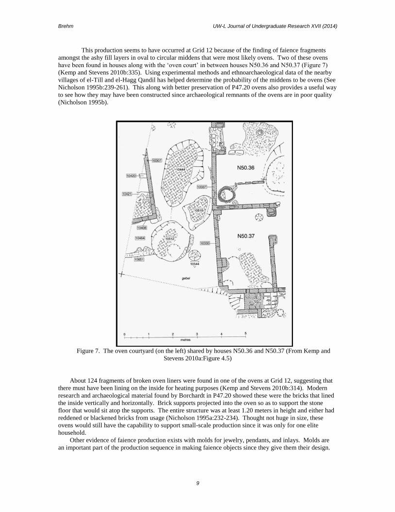
This production seems to have occurred at Grid 12 because of the finding of faience fragments
amongst the ashy fill layers in oval to circular middens that were most likely ovens. Two of these ovens
have been found in houses along with the ‘oven court’ in between houses N50.36 and N50.37 (Figure 7)
(Kemp and Stevens 2010b:335). Using experimental methods and ethnoarchaeological data of the nearby
villages of el-Till and el-Hagg Qandil has helped determine the probability of the middens to be ovens (See
Nicholson 1995b:239-261). This along with better preservation of P47.20 ovens also provides a useful way
to see how they may have been constructed since archaeological remnants of the ovens are in poor quality
(Nicholson 1995b).
Figure 7. The oven courtyard (on the left) shared by houses N50.36 and N50.37 (From Kemp and
Stevens 2010a:Figure 4.5)
About 124 fragments of broken oven liners were found in one of the ovens at Grid 12, suggesting that
there must have been lining on the inside for heating purposes (Kemp and Stevens 2010b:314). Modern
research and archaeological material found by Borchardt in P47.20 showed these were the bricks that lined
the inside vertically and horizontally. Brick supports projected into the oven so as to support the stone
floor that would sit atop the supports. The entire structure was at least 1.20 meters in height and either had
reddened or blackened bricks from usage (Nicholson 1995a:232-234). Thought not huge in size, these
ovens would still have the capability to support small-scale production since it was only for one elite
household.
Other evidence of faience production exists with molds for jewelry, pendants, and inlays. Molds are
an important part of the production sequence in making faience objects since they give them their design.

Brehm UW-L Journal of Undergraduate Research XVII (2014)
10
A rare find of a matching set of a mold to a grape-bunch pendant reveals that indeed Grid 12 was a faience
production center along with the presence of ovens to fire the objects (Kemp and Stevens 2010b:75).
Glass Production. The making of glass was a new burgeoning economy at the turn of the New
Kingdom period. Glass was made much the same way faience was, utilizing the same materials and firing
methods. It was then cooled into bars, rods, or ingots for later reworking into objects, such as beads and
inlays for furniture or wall decoration (Kemp and Stevens 2010a:485). Grid 12 exhibits the presence of the
bars, rods, and ingots, but it is believed that they were transported to the site from elsewhere at Amarna as a
secondary workshop for reworking to make the final product (Nicholson 2007:23). Both within and
outside of Egypt glass is being produced, although whether or not if Egypt imports much of its glass is
uncertain due to the obscurity of production techniques and the few actual finds of glass (Nicholson 2007).
What is certain, however, is that all production stages in glass are found at Amarna, which can be studied to
understand manufacturing techniques.
Metalworking. The type of metal found at Grid 12 is copper alloy. Combining two or more metallic
elements with copper for the purpose of giving greater strength or resisting corrosion makes copper alloy.
The material was melted for recasting in what is known as a crucible, which is a ceramic bowl for melting
substances at very high temperatures (Kemp and Stevens 2010b:361). Experimental methods performed by
Kemp determined that crucibles could withstand temperatures of around 1300 degrees Celsius, much
higher than what is necessary for copper alloy to melt, but proves the metal can be melted for reworking
(2010a:364). Many of the pieces found at Grid 12 are unrecognizable in their function due to their small
size. Generally when tools wear out, Egyptians replaced them with new ones, but it is not the case at Grid
12. This could mean the copper alloy had some sort of valuable quality to them and was worth more to
wear them down or remelt for recasting instead of throwing away (Kemp and Stevens 2010b:343). In this
paper, copper alloy was present within the Grid 12 area, but will not examined because the provenience
could not be connected to a specific house. However, metalworking is still worth mentioning since it may
be applicable to other non-elite industrial areas around the site.
History of Excavation at Amarna
The site of Amarna was first excavated archaeologically by Flinders Petrie from 1891 – 1892. Most of
his work focused on the Central City, where the administrative districts, temple complex, and part of the
royal residence were located. Because of his short excavation season, he worked quickly to uncover as
much as he could (Kemp 2012).
Led by director Ludwig Borchardt, the Deutsche Orient-Gesellschaft (DOG) team excavated from
1911 – 1914. They worked intensively in the Main City area containing houses and drew very meticulous
maps and plans of them. They are so well done that many are still used today. Their most famous find was
the house of Thutmose the sculptor with the bust of Nefertiti inside (Kemp 2012:11).
Next was the Egyptian Exploration Society (EES) in 1921 to 1936 from London. They excavated a
huge proportion of the site, including the residential suburbs, the Workman’s Village, Central City, and
outlying temples and shrines in the low desert nearby. During their excavation of the site, the project went
through the hands of several directors, such as the well-known Leonard Woolley and John Pendlebury
(Egyptian Exploration Society 2014). Today they currently work under the directorship of Barry Kemp.
Barry Kemp took over direction of Amarna in the 1977 and presently is still excavating there. Kemp is
looking at previously excavated areas, such as the Central City, the Workman’s Village, and residential
areas. He has also added the industrial zones of the city, Kom el-Nana (a shrine complex), the South
Tombs Cemetery, and the Stone Village (The Amarna Project 2010). The Grid 12 housing this study looks
at was uncovered by him and excavated from 2002 – 2006. It had been previously ignored or not
excavated yet by both the EES and DOG (Figure 8), meaning the last time it had been exposed was in
antiquity. Almost all of the houses were fully excavated and analysis of the artifacts is mostly complete.

Brehm UW-L Journal of Undergraduate Research XVII (2014)
11
Figure 8. Previous excavations performed by DOG and EES. Grid 12, as noted in the box, shows it had
not been examined by either excavation team (From Kemp and Stevens 2010a:Figure 3.2).
METHODOLOGY As stated previously, elites are often the only people seen having prestige items, suggesting the idea to
the general public that they are the only people who can possess those items. However recent contextual
evidence suggests that higher status goods existed with the rest of society at Amarna. Different statuses
within the non-elite sector imply the probability of a middle class. This thesis utilizes comparative analyses
between non-elite housing to answer the following research questions:
1. Is there evidence of status differentiation among non-elites based on architecture and artifacts?
2. If there is status differentiation, does it imply the existence of a middle class?
To shed light on these concerns, this paper will examine the recent excavations of non-elite industrial
housing at Grid 12 and various other elite structures, conducted by the Egyptian Exploration Society under
the direction of Barry Kemp.
Data Analysis
To address the research questions posed above, (1) architecture found in elite housing and (2)
architecture and objects found at Grid 12 non-elite housing were examined. The eight houses of Grid 12
(N50.36 – N50.43) provide the sample of non-elite housing to represent the population of Amarna.

Brehm UW-L Journal of Undergraduate Research XVII (2014)
12
Observing Architecture. A way of identifying elite architecture is through the characteristics it
possesses, such as bed-niches or wells in courtyards (Crocker 1985; Kemp and Stevens 2010a; Spence
2004). Crocker provides a three-stage method of analysis to determine what these features are, which was
utilized in this paper. The first stage detailed the presence or absence of certain attributes (see Table 7). A
list of these attributes and the presence of any in Grid 12 were tabulated in Microsoft Excel. The second
stage was numerical attributes, characteristics that may be counted. Due to the incompleteness of
excavation in many of the houses and preservation issues with the mud-brick walls, the only trait that could
be utilized from Crocker’s selection was the number of rooms. It will however not be included in the
findings because the total number of rooms per house cannot be ascertained from partially excavated
houses. The third grouping was measurable attributes, meaning quantifiable results. The measurable traits
used for this were house and courtyard areas. As previously stated, with the problems that arose, only the
area of the houses N50.36 and N50.37 are truly known at this time. Although, Kemp and Stevens have
provided an estimated extension of the other houses of what may exist beyond the excavation boundaries
(Figure 9) (2010a:300). These areas were found using AutoCAD, since precise measurements were not
present in the site report. In this two area inspection with the exclusion of the third numerical attributes, the
likelihood of finding elite-considered architecture in some non-elite housing over others suggests a
differentiation of wealth amongst the non-affluent society.
Figure 9. The shaded areas noted estimate the projection of houses beyond the excavation squares (From
Kemp and Stevens 2010a:Figure 4.1).
Observing Artifacts. As for objects, the main resource used was Kemp and Stevens’ publication of
artifacts found at Grid 12 (2010b). Artifacts were tabulated into Microsoft Excel, noting the category of the
Brehm UW-L Journal of Undergraduate Research XVII (2014)
13
object (i.e. jewelry), what the object was (i.e. pendant), the material it was made from, provenience, and
any notes that may aid in analysis. Because it was important to know what artifacts appear in which
houses, the provenience data needed to be changed from the grid square/unit number to the specific house.
This was accomplished through relating the unit numbers to a map of fill areas noted in the preliminary
stages of excavation (Kemp and Stevens 2010a:Figure 3.21) and descriptions of the excavation by each
square grid. Artifacts that appeared outside houses were still assigned if in close proximity to houses, being
probable indications of middens. Those that could not be connected were not included. This was a crucial
step because social stratification could not be determined without knowing which objects came from which
locations.
Once provenience was recovered, 1386 objects from Grid 12 could be evaluated against each other.
One of the techniques used to evaluate objects was using Richards’ wealth index to determine their
potential worth (1992). This calculates the expenditure used to retrieve the material of an object. Items
were scored in five different categories: distance, mode of transportation, method of extraction, pre-
workshop processing, and the difficulty of working with each material.
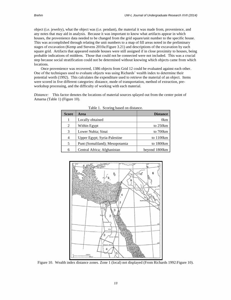
Distance: This factor denotes the locations of material sources splayed out from the center point of
Amarna (Table 1) (Figure 10).
Table 1. Scoring based on distance.
Score Area Distance
1 Locally obtained 0km
2 Within Egypt to 250km
3 Lower Nubia; Sinai to 700km
4 Upper Egypt; Syria-Palestine to 1100km
5 Punt (Somaliland); Mesopotamia to 1800km
6 Central Africa; Afghanistan beyond 1800km
Figure 10. Wealth index distance zones. Zone 1 (local) not displayed (From Richards 1992:Figure 10).

Brehm UW-L Journal of Undergraduate Research XVII (2014)
14
Mode of Transport: This factor acknowledges the difficulty of transport (Table 2). Richards assumed that
water transportation was less effort intensive than land transport (1992:113).
Table 2. Scoring based on mode of transport.
Score Mode
1 Not relevant for local materials
2 Entirely by water
3 By water with land transport of up to 150 km
4 By water with land transport of more than 150 km
Method of Extraction: This factor is to note the difficulty of extracting each material from the
environment (Table 3).
Table 3. Scoring based on method of extraction.
Score Method
1 Gathering only necessary
2 Active extraction (mining) necessary
Pre-workshop Processing: This factor brings to light the steps necessary to take beyond primary
extraction methods (Table 4). For example, glass requires several levels of processing because the mixing
of ingredients and heating of it is needed to acquire its workable, translucent state.
Table 4. Scoring based on pre-workshop processing.
Score Level
1 No significant pre-workshop processing necessary
2 Some pre-workshop processing necessary
3 Several levels of pre-workshop processing necessary
Hardness of Material: This factor indicates the difficulty of working each material to Mohs Scale when
applicable (Table 5).
Table 5. Scoring based on hardness of material.
Score Level
1 Soft - Mohs Scale 1-2
2 Medium - Mohs Scale 3-5
3 Hard - Mohs Scale 6-7
The item was then standardized with each category, so as to prevent one factor from outweighing
another. For example, the hardness of material was multiplied by 1/3 since there are three possible scoring
areas while the distance was multiplied by 1/6 due to that there are six for that category. The five scores
were totaled and given a raw composite score (Richards 1992:111-114). In some cases, the material may
have been able to be obtained in more than one distance zones. For instance, faience may be made locally,
or produced elsewhere within the Egyptian province. For these materials, the scores for all alternatives
were listed and then averaged. The composite scores of all the materials were sorted in numerical order
and assigned a value (Table 6). The application of the wealth index was applied to the material types found

Brehm UW-L Journal of Undergraduate Research XVII (2014)
15
within houses, noting a presence or absence of the type. Those materials that were present were given a
score based upon the rank decided by the wealth index and then collectively added to receive a composite
grade. For example, N50.40 possessed glass, faience, limestone, and clay in its assemblage. Glass would
receive the score of ten because it was ranked the highest on the material value list while faience would
receive a seven due to its lesser worth. With the same application to limestone and clay, the totaled score
when added up for N50.40 is 22. Scores for all houses were tabulated in this fashion and ranked
accordingly. This method tests the “assumption that more prestigious goods tend to be ‘costlier’ in terms
of the energy expended in producing or acquiring them, than ‘ordinary’ goods” (Pollack 1983:271 cited in
Richards 1992:110). It shows rather that the more labor expended into obtaining the material, no matter if
local or non-local, the more valuable the object was. This result could have an impact in determining if the
prestige of a house is related to the value of the artifact’s material.
Table 6. Effort expenditure wealth index.
Rank Materials
10 Glass
9 Quartzite
8 Stone
8 Travertine
8 Gypsum
7 Leather
7 Faience
6 Ivory
5 Carnelian
4 Limestone
3 Steatite
2 Cloth
1 Mud
1 Clays
The other measure used by Richards was her index of assemblage diversity. It assumes that wealthier
individuals have greater diversity in the types of artifacts they possess. This was accomplished by
accounting the total number of categories (15) and recording which houses have artifacts in each of the
categories. The results were then ranked based on the score they received. This would help decide if a
house may have more diversity than others, possibly signifying a higher status.
The remainder of this study was done through proportional analyses. Proportions were chosen as a
way to equalize the artifact numbers when comparing houses. The ranges between the houses at times
were vastly different and would bias the data of higher status towards those with greater artifact quantities.
Thus objects were transferred to proportions on Microsoft Excel. To understand the relation of artifacts
between houses within categories, the proportions of artifacts in each category were numerically ordered
and given a rank. These ranks were tabulated to convey an overall grade of where houses stood in the
hierarchy of the eight. What can be proposed from this is that the house(s) with the greater proportional
assemblages, in comparison with others, may indicate more prestige.
To better rein in the many variables being incorporated in this study, it was necessary to establish an
overall non-elite house index as used by David A. Anderson in his research at el-Mahȃsna (2006). The
artifact proportions, wealth index, and artifact diversity tests were all collaborated together to come up with
a final ranking. With each section, the houses were given a score based upon the rank divided by the
number of ranks, then the three section scores for each house were averaged to create a final rank. For
example, the rank for artifact proportions of N50.39 is five. This, divided by the five possible ranks, leaves
a score of one. Scores for the wealth index and artifact diversity were 0.57 and 0.86 respectively. When

Brehm UW-L Journal of Undergraduate Research XVII (2014)
16
averaged, the non-elite rank for N50.39 is 0.81. The house with the highest position is determined to be the
house with the greatest prestige, indicating that status does exist at the non-elite level.
RESULTS AND DISCUSSION
Architectural Analysis
As aforementioned, Crocker’s analysis on the determinants of elite attributes in architecture was used
in order to see if those traits appeared in the Grid 12 housing. Of those that he lists, the staircase, thick
house walls, courtyard, and vestibule were the only features that were revealed to be in these houses (Table
7). His second analysis of obtaining area of the house and courtyard wielded results also. However, they
do not seem to play a significant role in determining higher status over another.
Table 7. Architectural elements present at Grid 12.
House Number
Elite
Architectural
Elements N50.36 N50.37 N50.38 N50.39 N50.40 N50.41 N50.42 N50.43
imposing
entrance to
compound
chapel
subsidiary
housing
pond/well
staircase x x x x x
dais in central
hall
porch
vestibule
(antechamber) x x
bathroom
bed-niche
lustration slab
(ceremonial
washing)
thick house
walls (greater
than 1 brick) x x x x
shrine in central
hall
center-columned
room beyond
central hall
courtyard x* x* x x
*possibly shared
courtyard
Staircases were a fairly common phenomenon at Amarna, seeing as many possessed them. Grid 12
supports this claim with 62.5% of houses having a staircase present. Presence is indicated by solid
brickwork against an outer wall, which are usually located in relation to the central hall (Amarna Project

Brehm UW-L Journal of Undergraduate Research XVII (2014)
17
2010; Spence 2004:131). Many archaeologists believe that the staircases led to the roof of the house
because roofing fragments are found in the fill within the house and modern people living in the area have
staircases for the purpose of roof accessibility (Bard 2008:225; Kemp 1989:296; Spence 2004:137). It is
presumed the purpose for it is storage or summer sleeping (Kemp 1989:296). Speculations by Spence
suggest the staircases led to upper floors that may have been for more of the private sphere (2004) and the
addition of a second floor would indicate a more prominent status. This hypothesis cannot be supported at
Grid 12 because column bases that would have supported the roof on a second floor were not found
amongst the fill, so a staircase to the roof is more likely.
Houses that possess more than a one brick thickness have been linked with those of a wealthier state
(Crocker 1985). This is due to the fact that elites built on the premises of permanency, meaning their goal
was to design a structure that could last. The solid foundation the thick walls had helped this achieve this
goal. 50% of those at Grid 12 did have a portion of double thicken walls, however they seem to be
attributed to reinforcement in staircases or back-to-back housing. This is such the case with N50.36,
N50.42, and N50.43. While those houses have only had a portion of thickened walls, N50.40 differs by
having two whole walls that are thickened. Those two walls do not come in contact with any other walls,
defeating the notion of back-to-back reinforcement. They are not associated either with staircase
reinforcement because the thickness retains the whole side as opposed to a small portion. Since the walls
of N50.40 appear to be unconnected with any other structure, it could imply that they perhaps have some
wealth over the others.
Courtyards consist of open area spaces within the house compound. Of the houses, only 37.5% exhibit
the trait. It may be possible that N50.37 shares the oven courtyard to the west with N50.36, increasing the
frequency of the trait to 50%. In the three of them where the courtyard is contained within (N50.36,
N50.41, and N50.42), it is likely they possessed ovens due to their ashy-filled middens with brick
fragments (see earlier discussion on faience production) (Bard 2008; Kemp and Stevens 2010a; Kemp and
Stevens 2010b). Besides faience production, the possibility of these ovens serving for food preparation
should be taken into consideration (Bard 2008:225; Wilkinson 2007:69). Their ashy-fill suggests this,
however it is not definite, since floral and faunal analysis was not examined in this paper. This may be
something to consider in the future to determine if the ovens are purposeful for either industrial or cooking
means, or possibly both.
Crocker’s reasoning behind courtyards being of elite quality surrounds the idea of providing “a haven
from the harshness of the immediate environment. The house (and its garden) was to be a place of shade
and gradations of shade, of colour and coolness, of breezes, cleanliness, and quiet. In short, it was to be all
that a desert was not” (1985:65). Although the Grid 12 houses may not have provided its occupants to this
extent, they were certainly a buffer from the desert conditions and provided relief in this way. Because
N50.36, N50.37, N50.41, and N50.42 do have the attribute, they seem to show some wealth over those that
do not. N50.36 though may be the wealthiest of them all due to exhibiting the largest courtyard area (Table
8).
Table 8. Courtyards belonging to houses (m²).
House Number
Measurable
Attribute N50.36 N50.37 N50.38 N50.39 N50.40 N50.41 N50.42 N50.43
Area of
courtyard (m²) 26.69* 19.14 11.15 13.15
*if also shared
courtyard with
N50.37 45.83
The vestibule, otherwise known as an antechamber, was a small connecting room between the outside
and the rest of the house. Only two houses (25%) demonstrated this feature (N50.39 and N50.42), which is
quite unusual for non-elite houses. According to Crocker, in elite houses, 99% of them contain vestibules

Brehm UW-L Journal of Undergraduate Research XVII (2014)
18
while only 22% do in small houses (1985:57). Since these houses are non-elite houses, it can be drawn that
the two houses have more wealth due to the rarity of having a vestibule.
The use of AutoCAD allowed the results of the house area to be more in the realm of what the true
house area would have been. Amongst them, N50.36 has the greatest area, while N50.37 has the smallest.
Table 9 provides the rest of the corresponding areas and a ranking based on their numerical ordering. In
much of the literature on ancient Egyptian houses, size correlates to wealth (Bard 2008; Crocker 1985;
Kemp 1989; Spence 2004), thus N50.36 appears to have the most prestige based on area. However a
caution to note is that the size of the house may otherwise note the number of people living in that
household. As Meskell states, there is a ‘natural waxing and waning of families,” meaning that over a span
of time, the number of occupants in a house is subject to change (2002:53). The large size of N50.36 could
merely be the product of a larger family instead of indicating wealth. These two interpretations are kept in
mind when further examining house area in comparison with artifacts.
Table 9. Area of houses (m²) with corresponding assigned ranks.
House Number Area (m²) Rank
N50.36 86.49 8
N50.40 83.60 7
N50.41 48.32 6
N50.42 32.38 5
N50.43 32.22 4
N50.39 29.43 3
N50.38 28.93 2
N50.37 23.66 1
In conclusion with the architectural analysis, the results are quite all over the board. Some houses
appear to have rarer attributes, such as vestibules and thick walls. Some have courtyards, which have been
designated as the elite fashion of escaping the desert environment and could be attributed to what the Grid
12 occupants may have done. Staircases are what most have. At this point, not much can be concluded
with the architectural data. Once cross-referenced with the analysis of the artifacts, it should provide to be
much more useful for denoting signs of status amongst the non-elite Grid 12.
Object Analysis
Diversity Count. An appearance of social differentiation is apparent when examined through the
diversity of artifact categories present with each house (Table 10). It reveals that out of the fifteen possible
categories, N50.36 has the greatest diversity in artifact classes while N50.40 had the least. There is quite a
large range between the two houses suggesting it correlates to the number of artifacts coming from each
household. From N50.36, 300 artifacts were excavated and only twelve from N50.40, making evident it
could possibly be a factor that may skew the results. It also may be inferred that perhaps N50.40 was a
very poor house and that indeed N50.36 was a wealthy house.
Table 10. Diversity count tabulated scores with corresponding assigned rankings.
House Number Score Rank
N50.36 14 7
N50.39 11 6
N50.38 10 5
N50.37 9 4
N50.43 9 4
N50.41 8 3
N50.42 7 2
N50.40 4 1

Brehm UW-L Journal of Undergraduate Research XVII (2014)
19
Wealth Index. Wealth indices were calculated for each house through an implementation of the
methodology described by Richards (1992) and discussed above. Upon examination of the results, it can
be seen that N50.36 has the highest raw score and thus associated with the highest rank (Table 11). Of the
possible 14 material types present in Grid 12 houses, N50.36 had ten, clearly indicating why it was highly
ranked. Reasoning behind this suggests it correlates very strongly with the amount of artifacts present and
their diversity of materials. N50.36 has more than 25 times the quantity that N50.40 does, allowing for the
possibility of possessing a greater diversity artifacts in each category, which seems to be the case.
Table 11. Tabulated wealth index score with corresponding assigned ranks.
House Number Score Rank
N50.36 56 7
N50.42 42 6
N50.37 36 5
N50.39 31 4
N50.43 31 4
N50.38 30 3
N50.41 23 2
N50.40 22 1
Proportion of Artifact Categories. Since there were such variances in quantities of artifacts
recovered from each house, raw counts of various artifact categories could not be used. Therefore, the
proportion of the total artifact assemblage of each house that each category accounted for was calculated
and compared. Figure 11 shows the results of this analysis and shows the percentages of each of the fifteen
categories in each house.

Brehm UW-L Journal of Undergraduate Research XVII (2014)
20
Figure 11. Stacked proportional graph of artifact categories in each house.
As mentioned in the methodology, houses were ranked accordingly in each of the artifact
categories based on their proportions of artifacts. The fifteen scores were tabulated to give an overall grade
and assigned ranked positions as shown in Table 12. Houses N50.36 received the highest score, indicating
that collectively had the greatest proportions in each category compared to other houses. This correlates
very much so with artifact diversity since those houses that do possess a diverse range of artifacts are
naturally to have a higher ranking. In the case with N50.40, which had only had artifacts in four categories.
Because it does have so few categories present, it is expected to have a low ranking overall. For artifact
proportions in categories, it can be determined that those houses that have great diversity in artifacts will be
higher ranked than those that do not.

Brehm UW-L Journal of Undergraduate Research XVII (2014)
21
Table 12. Tabulated scores for totaled proportions of artifact categories in each house with corresponding
assigned ranks.
House Number Score Rank
N50.36 50 7
N50.39 49 6
N50.41 47 5
N50.42 47 5
N50.43 46 4
N50.38 39 3
N50.37 36 2
N50.40 32 1
Non-Elite Index. Due to the multiple factors of wealth index, artifact proportions within categories,
and artifact diversity, supplying an index to encompass those factors into one ranking for each house was
deemed necessary. Upon calculating the three section scores together, N50.36 received the highest ranking
while N50.40 took the lowest (Figure 12 and Table 13). Every house received a different ranking than its
counterparts, suggesting that different statuses existed among the non-elite. If this were not the case,
distributions would have been more evenly spread comparably from house to house, inferring no social
differentiation at the non-elite level. Since this is not the situation, differential statuses can be concluded.
It can also be determined that N50.36 has more prestige over all other houses based upon the objects
present at Grid 12.
Figure 12. Bar graph of non-elite index scores for each house.

Brehm UW-L Journal of Undergraduate Research XVII (2014)
22
Table 13. Non-elite index of tabulated ranks with corresponding assigned final ranking.
House Number Non-Elite Rank Final Ranking
N50.36 1 8
N50.39 0.76 7
N50.42 0.61 6
N50.38 0.58 5
N50.43 0.57 4
N50.37 0.52 3
N50.41 0.47 2
N50.40 0.14 1
Comparison of the Non-Elite Index to Architecture
Due to preservation issues and parts of houses remaining unexcavated, some of the architectural
aspects looked at were left largely unanswered. With the incorporation of the object analysis, specifically
the non-elite index, to the architecture, it will provide further support for the hypothesis of non-elite status
differentiation.
Apparent in the non-elite index is N50.36 scoring the highest in every category, signaling it has more
status compared to the others at Grid 12. The architecture found in this house is in support of this. The
size of N50.36 itself is very large, which literature has connected bigger houses to a higher status (Bard
2008; Crocker 1985; Kemp 1989; Spence 2004). Not only does the house have a courtyard as well, but the
largest courtyard amongst all houses noted to possess the feature. As said previously, courtyards provided
a way for elite people to escape the harsh realities of the arid landscape. The greater the size in the
courtyard, the more space there is for a well or greenery. Though there is no indication for a well, N50.36
may have contained plants among the kitchen/workshop area that may have provided some distractions
from the desert climate. Also since N50.36 has a bigger sized courtyard than N50.37, N50.41, and N50.42,
it would have greater probability to own more plants and thus provide more comfort. Its size, appearance
of a courtyard, and valuable objects lie it congruent with holding a higher status above other Grid 12
houses.
The correlation between a high non-elite ranking and a large area, as seen in N50.36, is not known
with N50.40. In terms of architecture, it matches the ideal of an elite house: large area size and thick walls.
This would normally indicate wealth, however, it was ranked lowest in all categories involving the non-
elite index, signifying it does not have many valuable objects (Figure 13). One interpretation is that as the
city was being abandoned, people would take their belongings with them, explaining why not much
material culture is left behind (Kemp 1989:301). N50.40 may have just been cleared out better than the
other houses and was not actually a lower status household. Another explanation is that the house may be
that of a poor and largely-sized family. It was previously mentioned that large house sizes can be equated
with bigger families (Meskell 2002:53) and the lack of valuable artifacts can suggest a lowly station. These
interpretations are to be kept in mind because they are factors that do impact the results found. As of in this
paper, N50.40 is designated as a lower status house in the Grid 12 non-elite setting.

Brehm UW-L Journal of Undergraduate Research XVII (2014)
23
Figure 13. Bar graph of the comparison between area and non-elite ranking. Rank is organized from right
to left, in which right denotes the highest rank and proceeds with lesser ranking houses to the left. Note
N50.40 with a low non-elite rank, but a large house area.
Neither do N50.39 nor N50.42 appear to have a large house area, yet they have vestibules, which are
normally indicative with those bigger houses. Both households scored high on the index, N50.39 in second
and N50.42 in third respectively, meaning both have wealthier types of artifacts. The appearance of
vestibules may relate more to their higher status artifacts, indicating that it is not necessarily house size that
reveals prestige, but presence of well-graded objects with elite architectural forms that can. Among the
houses, it could be suggested that N50.39 and N50.42 are near the wealthier end of non-elites.
Of all the houses at Grid 12, N50.37 had the smallest house and the third lowest object ranking, despite
owning the most artifacts (n = 317). The house did not have much diversity in its artifacts, mostly
containing tiles, inlays, and jewelry with not much else. When comparing proportions of artifacts between
houses in categories, it scored the highest in decorations for furnishings/architecture, but otherwise rated
the same or lower to others in the different classes. These two areas provide an explanation to why it was
scored so lowly. N50.37 also is listed as having the elite attribute of a courtyard. The courtyard though is
not found within its compound walls, but to the west and named by Kemp as the oven courtyard (2010a).
In this paper, that courtyard is listed as belonging to N50.37, however since it is outside the house
perimeters, there is the possibility of it not being so. In that case, the attribute can be eliminated and the
low score in objects and house area would explain its lower class.
CONCLUSIONS
Depictions of ancient Egyptian society are often problematic because they show Amarna society
having had only two-tiers: elites and non-elites (Kemp 1989; Richards 2005). Elite organization is quite
defined due to their significant visible presence in material culture, building size, and writings, leaving the
non-elite rather unexplored (Meskell 2002; Richards 1992). They remain much of an undifferentiated
mass, however the evidence found at Grid 12 through architecture and artifacts dismisses this notion. It
proposes that there was not just one non-elite class, but rather two or three.
With the objects, it was frequently noted that N50.36 ranked the highest in all categories examined.
This is due to its diversity of artifacts and the material value of which they were comprised of. Thus,
N50.36 can be seen as a house with much greater status than some of the others, such as N50.40.
Architecture noted N50.36 consisting of a large area with a courtyard, where having a courtyard is
designated as a status aspect (Crocker 1985:52-53). Combining these two factors together, it can be
interpreted that overall, N50.36 seems to hold a higher status than the rest of the houses. In comparison

Brehm UW-L Journal of Undergraduate Research XVII (2014)
24
with N50.36, N50.40 is ranked the lowest in the object categories. It did not have a diverse range of
artifacts nor much effort expended into procuring the materials to make the objects. Despite having a large
residence, it can be interpreted N50.40 housed a poor, large family and is the least prestigious house of the
eight. Since there is such a wide variance in the results between the two houses, it suggests that the
difference is a product of these two belonging in different social classes.
This is further supported with the non-elite index. The calculations resulted in each house to have a
different overall ranking; not one house had the same score as another. If the non-elite were to be
portrayed as a single class entity, all the index values would have been the same or similar in regards to
each other. This however is not the case, meaning that that status differentiation exists and the non-elite at
Grid 12 should be acknowledged as a multi-class society.
With this implication, it can be said that social differentiation does exists among the non-elite
population and insinuates that it is probable there is a middle class. Those within the middle class are able
to separate themselves from the lower sectors of society because their socio-economic status defines them
as having the economic tool to gain more private household wealth. This can be seen through having a
large house, possessing valuable objects, becoming specialized in a certain craft, having more access to
trade, and increased autonomy.
“The material manifestations of size and elaboration of dwelling; dress; and the accumulation of goods
and exotic materials were the most immediate means of communicating status” (Richards 1992:27). This is
due to that they are the most visible displays of indicating the prestige of an individual. A larger house
allows for more leisure to enjoy the escape from the harsh, arid climate than would a small, cramped one.
Possessing objects that involved much more effort expended to make them than others could be considered
better quality. These items can belong to anyone, but it is the higher-class individuals that will have more
of them. A diverse range of artifacts also is noticeable for high status people because it indicates their
ability to acquire a wide variety of items and not just the same object over and over again like a low status
individual. The larger the house, more diverse objects owned, and better quality items sets apart a middle
class person from the remainder sectors of the non-elite.
A specialized craft would be a skill set requiring distinctive knowledge and could be considered
making anything from glass production to weaving. Some people may be better at that craft than others,
signifying that they would be more likely to get paid more or be hired more frequently. Those individuals
that are able to garner better profits at their skill over others are deemed to be of the middle class society,
since it helps them harness more private wealth.
Because Grid 12 was a minor industrial center for an elite household, they received wages for their
work. Wages came in the form of grain, bread, or beer, and often could be exchanged for other
commodities, such as glass tiles or limestone furniture (Richards 1992:41). The exchange for goods is
restricted based on status and those of middle class seem to have more democratization in their system;
they have a greater societal access to higher quality goods over those of lesser ranking. This wider access
allows middle class people to trade for more exotic or high quality objects, maintaining their resource
distinction from lower class society.
The ability for the middle class to obtain larger houses, many valuable objects, becoming very
specialized in crafts, and increased democratization in trade all point to greater autonomy. It is having more
freedom within society to gain more wealth, power, and prestige. Wealth, power, and prestige have usually
been associated with elite factions because of their domination within society. However, it may not be on
the same scale as elites, but middle class people can obtain all of those as well. Some have greater personal
wealth than others or have the power to get exotic materials from far away. Not everyone can achieve this,
but it is evident specific individuals at Grid 12 could. With this knowledge, it can help archaeologists to
better understand what it is meant to be middle class at Amarna.
Limitations
As with any research, there are certain problems that occurred that may have affected the data. One
such situation is that Amarna is a one period occupational site. After Akhenaten died, the city was largely
abandoned and when the people left, they probably took their belongings with them. The artifacts used in
this study do not truly represent all the artifacts that once did exist inside the houses. The outcome of social
status may have been very different if the possibility of retaining these lost objects existed.
Another issue to note is that all the artifacts cataloged are presumed to have belonged to a certain
dwelling, but that may not have been the occasion. Grid 12 worked for an elite household, providing labor
and making objects for them, which evidence of faience production, glass manufacturing, and

Brehm UW-L Journal of Undergraduate Research XVII (2014)
25
metalworking backs this. The artifacts were treated as belonging to the individual houses, but they may
have actually been for the elite home. There is no distinction in the objects to figure out whom they
belonged to, so possession is uncertain and cannot be strictly associated beyond Grid 12 in general.
Because the purpose of this study was to determine social standings among the non-elite, it was deemed
acceptable to denote those objects to Grid 12 houses, but still acknowledging that the possibility of
ownership could be incorrect.
All archaeological sites in general have this problem: preservation. There will always be the perpetual
problem of looters, which there is evidence of in the houses at Grid 12, whether it be recently or in
antiquity (Kemp and Stevens 2010a). They usually take the most valuable items, which in turn can skew
the data. Also the walls of the houses no longer stand at their true height, but a mere two to three meters
high, which is significantly less than the height they used to be (Kemp and Stevens 2010a). Many have
been knocked down from weather conditions or looters. This limits the possibility of knowing if any other
elite attributes listed from Table 7 existed, such as windows or inside house niches for shrines. Knowing
this information about the actual house wall heights and what artifacts looters took could have contributed
to the understanding of non-elite structures and their populous as a whole. They may have been present,
but it will most likely remain unknown.
One other limitation to mention is that most of the houses Grid 12 revealed were not fully excavated.
This affects the data because there may be artifacts in those unexcavated areas that could change the
hierarchy ranking or the composition of the house size if all had been excavated around. Because of this, it
makes it more difficult to decipher the information gained when not all areas are unearthed as much as they
could be. However despite all of these limitations listed, the analysis presented is just one interpretation to
be made at Grid 12.
Future Research
Much more information could be derived from this topic since it is quite broadly based. An ideal focus
would be to compare these findings to other non-elite concentrations around Amarna to see if they are
applicable. The more this can be done, the further it strengthens the argument that there is evidence of a
middle class.
Another interesting comparison would be to examine floral and faunal remains. Zooarchaeologists at
Amarna suggest the possibility of higher status food items over others, such as meat cuts (Amarna Project
2010). Higher status cuts are deemed to be upper hind and forelimbs, while low status are distal limbs
(Kemp and Stevens 2010a:446). Plant remains would not only play a role in looking at food eaten, but
what plant life surrounded these buildings. Some evidence of date palms (phoenix dactylifera) has been
linked to courtyards of high status individuals (Kemp and Stevens 2010a:404), showing that those of
wealthier status can decorate their areas to again escape the desert atmosphere. Both of these factors can be
analyzed more in depth at Grid 12 to see if the higher ranking individuals in this study correspond to higher
status faunal and plant remains.
ACKNOWLEDGEMENTS I would first like to thank Dr. David A. Anderson and Dr. Mark Chavalas for agreeing to be my thesis
advisors and readers. I would not have been able to research and write this thesis without their expertise.
My next thanks goes out to Heather Walder for providing me excellent sources and Dr. Jessi Halligan for
guiding me through the whole thesis process. Spencer Kawell, Justin Meyer, and Cassandra Rosemore
should be thanked as well for reading my many drafts. I would also like to thank my friends and family for
their unwavering support for me throughout those long hours of studying through the night and all the
challenges life brings us.
REFERENCES Alchin, Linda
2012 Aten. Electronic document, http://www.historyembalmed.org/egyptian-gods/aten.htm,
accessed December 26, 2013.
Amarna Project
2010 The Amarna Project. Electronic document, http://www.amarnaproject.com/, accessed

Brehm UW-L Journal of Undergraduate Research XVII (2014)
26
December 26, 2013.
Anderson, David A.
2006 Power and Competition in the pper Egyptian Predynastic: A view from the Predynastic
Settlement at el-Mahȃsna, Egypt. Ph.D. dissertation, Department of Anthropology, University
of Pittsburgh. University Microfilms, Ann Arbor.
Bard, Kathryn A.
2008 An Introduction to the Archaeology of Ancient Egypt. BlackwellPublishing, Oxford.
Bryan, Betsy M.
2000 The 18th Dynasty before the Amarna Period (c.1550-1352 BC). In The Oxford History of
Ancient Egypt, edited by Ian Shaw, pp. 207-264. Oxford University Press Inc., New York.
Crocker, P.T.
1985 Status Symbols in the Architecture of El-‘Amarna. The Journal of Egyptian Archaeology
71:52-65.
Egyptian Exploration Society
2014 Tell el-Amarna. Electronic document, http://www.ees.ac.uk/about-us/tell-el Amarna.html,
accessed March 27, 2014.
Hayes, William C.
1959 The Scepter of Egypt: A Background for the Study of the Egyptian Antiquities in The
Metropolitan Museum of Art. Part II: The Hyksos Period and the New Kingdom (1675-1080
B.C.). Plantin Press, New York.
Kemp, Barry
1977 The City of El-Amarna as a Source for the Study of Urban Society in Ancient Egypt. World
Archaeology 9:123-139.
1989 Ancient Egypt: Anatomy of a Civilization. Routledge, London.
2012 The City of Akhenaten and Nefertiti: Amarna and Its People. Thames and Hudson Ltd,
London.
Kemp, Barry and Anna Stevens
2010a Busy Lives at Amarna: Excavations in the Main City (Grid 12 and the
House of Ranefer, N49.18). Volume I: The Excavations, Architecture and Environmental
Remains. Short Run Press, London.
2010b Busy Lives at Amarna: Excavations in the Main City (Grid 12 and the House of Ranefer,
N49.18). Volume II: The Objects. Short Run Press, London.
Kliebert-Valentine, Michele
2010 Meretites’ Faience shebtis: An Analysis and Determination of Their
Production in a Late Period or Ptolemaic Workshop. Electronic document,
http://mospace.umsystem.edu/xmuli/handle/10355/9260, accessed March 26, 2014.
Meskell, Lynn
2002 Private Life in New Kingdom Egypt. Princeton University Press, Oxford.
Murnane, William J.
1995 Texts from the Amarna Period in Egypt. Scholars Press, Atlanta.
Nicholson, Paul T.
1995a Kiln Excavations at P47.20 (House of Ramose Complex). In Amarna
Reports VI, edited by Barry Kemp, pp. 226-238. Cambridge University Press, Cambridge.
1995b Construction and Firing of an Experimental Updraught Kiln. In Amarna Reports VI, edited
by Barry Kemp, pp. 239-261. Cambridge University Press, Cambridge.
2007 Brilliant Things for Akhenaten: The Production of Glass, Vitreous Materials and Pottery at
Amarna Site O45.1. Short Run Press Ltd, Exeter.
Richards, Janet E.
1992 Mortuary Variability and Social Differentiation in Middle Kingdom Egypt.
Ph.D. dissertation, Department of Anthropology, University of Pennsylvania. University
Microfilms, Ann Arbor.
2005 Society and Death in Ancient Egypt: Mortuary Landscapes of the Middle Kingdom.
Cambridge University Press, Cambridge.
Shaw, Ian (editor)
2000 The Oxford History of Ancient Egypt. Oxford University Press Inc., New
York.

Brehm UW-L Journal of Undergraduate Research XVII (2014)
27
Spence, Kate
2004 The Three-Dimensional Form of the Amarna House. The Journal of
Egyptian Archaeology 90:123-152.
Van Dijk, Jacobus
2000 The Amarna Period and the Later New Kingdom (c.1352-1069 BC). In
The Oxford History of Ancient Egypt, edited by Ian Shaw, pp. 265-307. Oxford University
Press Inc., New York.
Wilkinson, Toby (editor)
2007 The Egyptian World. Routledge, New York.
Related Documents