GEOSPATIAL EXPLOITATION PRODUCTS™ 1 Rick Racine GXP Sales Manager, Federal Accounts SOCET GXP ® Synthetic Aperture Radar exploitation tools © 2017 BAE Systems. All Rights Reserved. ClearFlite, GXP, GXP WebView, GXP Xplorer, SOCET GXP, and SOCET SET are registered trademarks of BAE Systems. This document gives only a general description of the product(s) or service(s) offered by BAE Systems. From time to time, changes may be made in the products or conditions of supply. Approved for public release as of 12/04/2017; This document consists of general information that is not defined as controlled technical data under ITAR Part 120.10 or EAR Part 772. 20171106-35.

Welcome message from author
This document is posted to help you gain knowledge. Please leave a comment to let me know what you think about it! Share it to your friends and learn new things together.
Transcript

© 2017 BAE Systems. All Rights Reserved.
Approved for public release as of 12/04/2017; 20171106-35.
GEOSPATIAL EXPLOITATION PRODUCTS™ 1
Rick RacineGXP Sales Manager, Federal Accounts
SOCET GXP® Synthetic Aperture Radar exploitation tools
© 2017 BAE Systems. All Rights Reserved. ClearFlite, GXP, GXP WebView, GXP Xplorer, SOCET GXP, and SOCET SET are registered trademarks of BAE Systems. This document gives only a general description of the product(s) or service(s) offered by BAE Systems. From time to time, changes may be made in the products or conditions of supply. Approved for public release as of 12/04/2017; This document consists of general information that is not defined as controlled technical data under ITAR Part 120.10 or EAR Part 772. 20171106-35.

© 2017 BAE Systems. All Rights Reserved.
Approved for public release as of 12/04/2017; 20171106-35.
GEOSPATIAL EXPLOITATION PRODUCTS™
Agenda
2
• Introduction to GXP® solutions
• Description of all Synthetic Aperture Radar (SAR) processing capabilities in SOCET GXP®
• Live software demonstration of SOCET GXP showing SAR display options, SAR tools and products for change detection, creating Sub Aperture Stack products, Coherent Change Detection (CCD) product creation, and terrain generation from stereo SAR imagery
© 2017 BAE Systems. All Rights Reserved.
Approved for public release as of 12/04/2017; 20171106-35.
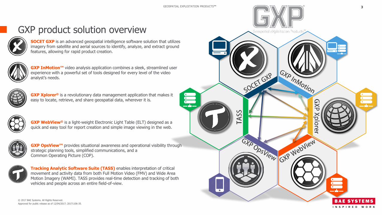
GEOSPATIAL EXPLOITATION PRODUCTS™ 3
GXP product solution overviewSOCET GXP is an advanced geospatial intelligence software solution that utilizes imagery from satellite and aerial sources to identify, analyze, and extract ground features, allowing for rapid product creation.
GXP InMotion™ video analysis application combines a sleek, streamlined user experience with a powerful set of tools designed for every level of the video analyst’s needs.
GXP Xplorer® is a revolutionary data management application that makes it easy to locate, retrieve, and share geospatial data, wherever it is.
GXP WebView® is a light-weight Electronic Light Table (ELT) designed as a quick and easy tool for report creation and simple image viewing in the web.
GXP OpsView™ provides situational awareness and operational visibility through strategic planning tools, simplified communications, and a Common Operating Picture (COP).
Tracking Analytic Software Suite (TASS) enables interpretation of critical movement and activity data from both Full Motion Video (FMV) and Wide Area Motion Imagery (WAMI). TASS provides real-time detection and tracking of both vehicles and people across an entire field-of-view.

© 2017 BAE Systems. All Rights Reserved.
Approved for public release as of 12/04/2017; 20171106-35.
GEOSPATIAL EXPLOITATION PRODUCTS™
Synthetic Aperture Radar
4
• SAR is a coherent side-looking radar system that utilizes the flight path of the platform to simulate an extremely large antenna or aperture electronically
• Sends an active radar signal and collects the return signal
• Can collect at night
• Can see through clouds
• Individual transmit/receive cycles are completed with the data from each cycle being stored electronically
• Signal processing uses magnitude and phase of the received signals over successive pulses from elements of a synthetic aperture
• The stored data can be recombined to create a detected or magnitude image of the ground
© 2017 BAE Systems. All Rights Reserved.
Approved for public release as of 12/04/2017; 20171106-35.
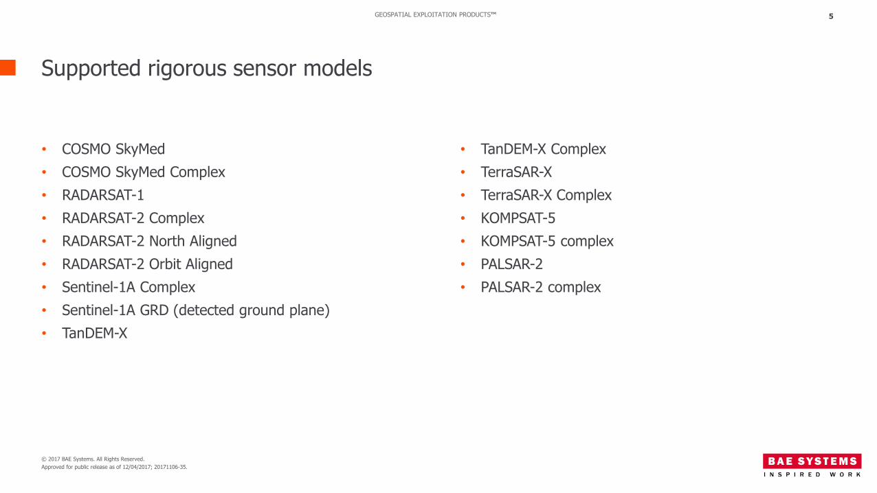
GEOSPATIAL EXPLOITATION PRODUCTS™
Supported rigorous sensor models
5
• TanDEM-X Complex
• TerraSAR-X
• TerraSAR-X Complex
• KOMPSAT-5
• KOMPSAT-5 complex
• PALSAR-2
• PALSAR-2 complex
• COSMO SkyMed
• COSMO SkyMed Complex
• RADARSAT-1
• RADARSAT-2 Complex
• RADARSAT-2 North Aligned
• RADARSAT-2 Orbit Aligned
• Sentinel-1A Complex
• Sentinel-1A GRD (detected ground plane)
• TanDEM-X

© 2017 BAE Systems. All Rights Reserved.
Approved for public release as of 12/04/2017; 20171106-35.
GEOSPATIAL EXPLOITATION PRODUCTS™
Supported Complex formats
6
• COSMO SkyMed Complex (HDF5)
• RADARSAT-2 Complex (TIFF)
• RISAT-1 Complex (CEOS)
• Sentinel-1A Complex (TIFF)
• Sensor Independent Complex Data (SICD)
• TanDEM-X Complex (COSAR)
• TerraSAR-X Complex (COSAR)
• KOMPSAT-5 Complex (HDF5)
• PALSAR-2 Complex (CEOS/TIFF)
Terrasar x image courtesy of Airbus®.
© 2017 BAE Systems. All Rights Reserved.
Approved for public release as of 12/04/2017; 20171106-35.
GEOSPATIAL EXPLOITATION PRODUCTS™
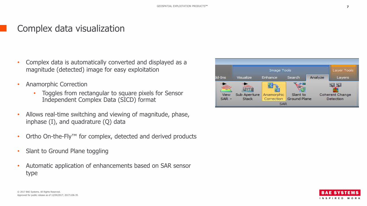
Complex data visualization
7
• Complex data is automatically converted and displayed as a magnitude (detected) image for easy exploitation
• Anamorphic Correction
• Toggles from rectangular to square pixels for Sensor Independent Complex Data (SICD) format
• Allows real-time switching and viewing of magnitude, phase, inphase (I), and quadrature (Q) data
• Ortho On-the-Fly™ for complex, detected and derived products
• Slant to Ground Plane toggling
• Automatic application of enhancements based on SAR sensor type
© 2017 BAE Systems. All Rights Reserved.
Approved for public release as of 12/04/2017; 20171106-35.
GEOSPATIAL EXPLOITATION PRODUCTS™
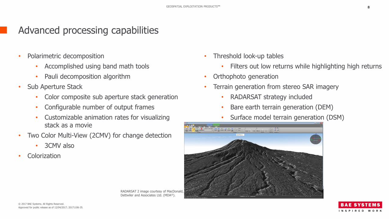
Advanced processing capabilities
8
• Threshold look-up tables
• Filters out low returns while highlighting high returns
• Orthophoto generation
• Terrain generation from stereo SAR imagery
• RADARSAT strategy included
• Bare earth terrain generation (DEM)
• Surface model terrain generation (DSM)
• Polarimetric decomposition
• Accomplished using band math tools
• Pauli decomposition algorithm
• Sub Aperture Stack
• Color composite sub aperture stack generation
• Configurable number of output frames
• Customizable animation rates for visualizing stack as a movie
• Two Color Multi-View (2CMV) for change detection
• 3CMV also
• Colorization
RADARSAT 2 image courtesy of MacDonald, Dettwiler and Associates Ltd. (MDA®).
© 2017 BAE Systems. All Rights Reserved.
Approved for public release as of 12/04/2017; 20171106-35.
GEOSPATIAL EXPLOITATION PRODUCTS™
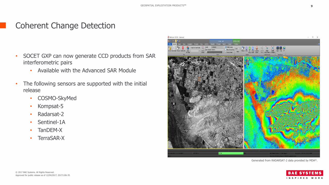
Coherent Change Detection
9
• SOCET GXP can now generate CCD products from SAR interferometric pairs
• Available with the Advanced SAR Module
• The following sensors are supported with the initial release
• COSMO-SkyMed
• Kompsat-5
• Radarsat-2
• Sentinel-1A
• TanDEM-X
• TerraSAR-X
Generated from RADARSAT-2 data provided by MDA®.
© 2017 BAE Systems. All Rights Reserved.
Approved for public release as of 12/04/2017; 20171106-35.
GEOSPATIAL EXPLOITATION PRODUCTS™
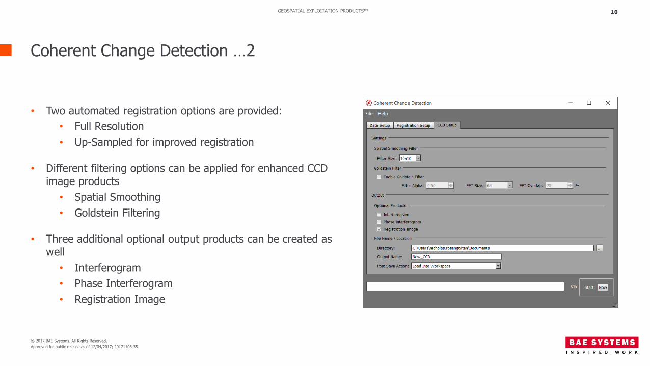
Coherent Change Detection …2
10
• Two automated registration options are provided:
• Full Resolution
• Up-Sampled for improved registration
• Different filtering options can be applied for enhanced CCD image products
• Spatial Smoothing
• Goldstein Filtering
• Three additional optional output products can be created as well
• Interferogram
• Phase Interferogram
• Registration Image

© 2017 BAE Systems. All Rights Reserved.
Approved for public release as of 12/04/2017; 20171106-35.
GEOSPATIAL EXPLOITATION PRODUCTS™
Imagery and LiDAR data providers
11
BAE Systems would like to thank the following organizations for providing data for use throughout this presentation:
• MDA: RADARSAT-2• Airbus
© 2017 BAE Systems. All Rights Reserved.
Approved for public release as of 12/04/2017; 20171106-35.
GEOSPATIAL EXPLOITATION PRODUCTS™ 12
Thank you!
Rick [email protected]
Related Documents