_________________________________________________________________________________________ Page 1 of 44 SMITH/DODD SMALL AREA PLAN Mayor and City Council Jenny Halverson John Bellows Anthony Fernandez Ed Iago Dave Napier Bob Pace Dick Vitelli City Staff Jim Hartshorn, Community Development Director Ben Boike, Asst. Community Development Director Melissa Sonnek, Community Development Coordinator Ross Beckwith, Public Works Director/City Engineer Planning Commission Morgan Kavanaugh (Chair) Jesse Nelson (Vice-Chair) Chris Hubert Derek Leuer John Ramsey Dan McPhillips Hillery Smith Shay Project Advisory Committee Mark Tessmer Nancy Breymeier Leo Exley Howard Paster Jim Casper Charlie Godbout Patty Gnetz Dave Wright Ken Paulman Morgan Kavanaugh Zak Metzger WSB & Associates 701 Xenia Avenue South, Suite 300 Minneapolis, MN 55416 (888) 541-4800 [email protected] October 23, 2017

Welcome message from author
This document is posted to help you gain knowledge. Please leave a comment to let me know what you think about it! Share it to your friends and learn new things together.
Transcript

_________________________________________________________________________________________
Page 1 of 44
SMITH/DODD SMALL AREA PLAN Mayor and City Council Jenny Halverson John Bellows Anthony Fernandez Ed Iago Dave Napier Bob Pace Dick Vitelli City Staff Jim Hartshorn, Community Development Director Ben Boike, Asst. Community Development Director Melissa Sonnek, Community Development Coordinator Ross Beckwith, Public Works Director/City Engineer
Planning Commission Morgan Kavanaugh (Chair) Jesse Nelson (Vice-Chair) Chris Hubert Derek Leuer John Ramsey Dan McPhillips Hillery Smith Shay Project Advisory Committee Mark Tessmer Nancy Breymeier Leo Exley Howard Paster Jim Casper Charlie Godbout Patty Gnetz Dave Wright Ken Paulman Morgan Kavanaugh Zak Metzger
WSB & Associates
701 Xenia Avenue South, Suite 300 Minneapolis, MN 55416
(888) 541-4800 [email protected]
October 23, 2017

_________________________________________________________________________________________
Page 2 of 44
Table of Contents Table of Contents ............................................................................................................................ 2
Background ..................................................................................................................................... 3
Re-alignment of Smith/Dodd Intersection ...................................................................................... 5
Future Land Use ............................................................................................................................ 11
Traffic Softening on Manomin Avenue ........................................................................................ 15
Streetscape Improvements ............................................................................................................ 18
Bicycle Traffic .............................................................................................................................. 22
Building Type, Placement, Parking and Landscaping .................................................................. 28
Redevelopment of 1010 Dodd Road ............................................................................................. 31
PAC Intersection Recommendation .............................................................................................. 32
August 10 Open House Summary ................................................................................................. 34
Recommendations ......................................................................................................................... 36
Implementation ............................................................................................................................. 39
Appendix ....................................................................................................................................... 42

_________________________________________________________________________________________
Page 3 of 44
Background In 2009, five entities joined in collaboration to lead the Smith Avenue Revitalization Initiative: the Riverview Economic Development Association (REDA), the Neighborhood Development Alliance (NeDA), West Side Citizens Organization (WSCO), City of Saint Paul’s Department of Planning and Economic Development (PED) and City of West Saint Paul. Together they set objectives and strategies for the economic, environmental and physical future of the Smith Avenue corridor, which stretches from Dodd Road in West Saint Paul north to the High Bridge in Saint Paul. The Smith Avenue Revitalization Plan (SARP) recommends a variety of action steps for the Smith Avenue corridor to guide its ongoing and future use and redevelopment.
The revitalization plan includes the intersection of Smith Avenue South and Dodd Road. This intersection is located five blocks from the Mendota Heights border to the west, and two blocks from the Saint Paul border to the north. In 2016, West Saint Paul received a Dakota County CDA Planning grant to complete a small area study for the Smith/Dodd neighborhood. In the summer of 2017, WSB & Associates and the Cuningham Group assisted the City with the small area plan for the Smith/Dodd neighborhood. This report includes recommendations on the following city-identified priorities:
Future land use
Building type, placement, parking and landscaping
Streetscape and park improvements
Realignment of the Smith/Dodd intersection
Redevelopment of the city-owned parcel at 1010 Dodd Road
Traffic softening on the adjacent Manomin Avenue
Bicycle traffic
Additionally, WSB and Cuningham identified the following overall redevelopment goals:
Focus retail at two major intersections to ensure its success o Support retail with adequate sidewalk spaces and plaza space o Coordinate transit locations and roadway plans with location of retail o Ensure visibility of retail and adequate parking
Support the stability of surrounding single-family neighborhoods o Concentrate tallest buildings (up to four stories) at the Smith Avenue and Dodd
Road intersection and transition the height of new buildings down along the edges of the redevelopment
o Create a street system that maintains connectivity but does not rely on local residential streets for access
o Maintain the small scale commercial development (no big-box development)

_________________________________________________________________________________________
Page 4 of 44
Improve the use and function of all the parks o Add access or a public edge to Dodd Park. Consider reprogramming Dodd Park o Improve access to Albert Park by incorporating into a larger space that can be
occupied o Formalize the memorial to Officer Scott Patrick
Improve overall connectivity and ensure safe roads and intersections o Provide clear, simple, safe and direct street crossings o Improve bicycle connectivity throughout the study area
WSB & Associates and Cuningham Group conducted meetings with West Saint Paul’s City Council and Planning Commission as well as a Project Advisory Committee (PAC) created for the project. They also hosted open houses to solicit community feedback on the project as it progressed.

_________________________________________________________________________________________
Page 5 of 44
Re-alignment of Smith/Dodd Intersection ConsiderationsThe current intersection of Smith Avenue and Dodd Road is home to businesses, parks, shopping centers, bus stops, single-family homes and vacant lots. Each of these components needs to be considered in the re-alignment. Any re-alignment chosen will result in a construction project that will impact every party with a stake in the intersection.
The Minnesota Department of Transportation (MnDOT) has jurisdiction over Smith Avenue and Dodd Road. North leg of Smith Avenue and the southern leg of Dodd Road, after it intersects Smith Avenue, is State Highway 149. The other streets in this project boundary are city streets. Any realignment work done to the Smith Avenue and Dodd Road intersection must be done in cooperation with MnDOT.
Additionally, Dodd Road currently comes in at a diagonal, creating long crosswalks at the intersection and greater pedestrian unease. Albert Park exists here as a traffic island between Dodd Road and Bernard Street (which comes in from the east and meets Smith Avenue perpendicularly), just north of the Smith Avenue and Dodd Road intersection. Bernard Street is also considered for re-alignment.
The largest stakeholder in terms of land space is the Doddway Shopping Center, home of Oxendale’s Market. Oxendale’s Market provides groceries for the neighborhood which means allowing for a space for deliveries and customer parking with any intersection re-alignment.
Additionally, there are also two transit stops at this intersection. The Metro Transit 62 and 417 buses both stop here, northbound and southbound. Adequate bus and pedestrian refuges must be considered with any re-alignment.
Re‐AlignmentOptionsWSB came up with four intersection re-alignment options, pictured in figures 1 through 4 below. The PAC considered each option and initially rejected option 1, seen in figure 1.

_________________________________________________________________________________________
Page 6 of 44
Figure 1: Re-alignment option 1
This option shows Smith Avenue leading into the Doddway Center parking lot. To proceed down Smith Avenue drivers would have to take a right at the Smith Avenue and Dodd Road intersection and then an immediate left onto Smith. This option also shows Bernard Street ending in a cul-de-sac, never intersecting with Dodd Road. The result would likely be that drivers may use the Doddway Center parking lot to make a connection between Bernard Avenue and Smith Avenue. The PAC recommended to not keep this option in consideration.
The following three re-alignment options are still under consideration.

_________________________________________________________________________________________
Page 7 of 44
Figure 2: Re-alignment option 2
Re-alignment option 2, as seen in figure 2, curves the southwest leg of Dodd Road into the north leg of Smith Avenue creating the easiest travel motion on the two busiest legs of the intersection. This option removes Albert Park between Bernard Street and Dodd Road. Instead, it has Bernard Street and Dodd Road merge before they reach Smith Avenue, perpendicularly at a traffic signal. This intersection would have shorter crosswalks than the current Smith Avenue and Dodd Road intersection. Like option 1, it would also require drivers to take a left after the Smith Avenue and Dodd Road intersection to continue south on Smith Avenue. This turn may help decrease speeds.

_________________________________________________________________________________________
Page 8 of 44
Figure 3: Re-alignment option 3
Re-alignment option 3, as seen in figure 3, again has Dodd Road and Bernard Street merge before they reach Smith Avenue while maintaining Albert Park. But then as Smith Avenue continues south, there is a roundabout at which drivers choose between continuing south on Smith Avenue or going southwest on Dodd Road. There is no traffic light in this option. There are three crosswalks at the roundabout with concrete medians or pedestrian refuges in the middle of each crosswalk. Roundabouts can help to slow speeds.

_________________________________________________________________________________________
Page 9 of 44
Figure 4: Re-alignment option 4
Re-alignment option 4, as seen in figure 4, has Dodd Road and Bernard Street merging before the traffic light at Smith Avenue while maintaining Albert Park, the same as option 3. Smith Avenue continues directly south after the light. To reach Dodd Road again, drivers need to take a 90 degree right turn after the light. This sharp turn serves to decrease speeds on southbound Smith Avenue. It also allows for shorter crosswalks. This option allows for the most on-street parking on Smith Avenue, after the traffic light.

_________________________________________________________________________________________
Page 10 of 44
RecommendationsThe PAC recommends the adoption of re-alignment option 4. In their assessment of the options they focused their analysis on pedestrian and bicyclist comfort, redevelopment opportunities, park space, and traffic calming. They also wanted to make sure that there will be easy access to the businesses at the intersection. Further discussion of the PAC’s recommendations can be found in the section titled, “PAC Intersection Recommendation.”
Smith Avenue Revitalization
Plan Comparison
SARP Strategy Smith-Dodd Small Area Plan Recommendation
Add a “Cross Traffic Does Not Stop” sign to the existing stop sign on Bernard Ave at Smith Ave

_________________________________________________________________________________________
Page 11 of 44
Future Land Use ContextThe land within the study area was predominantly platted in the 1920s. Much of the commercial land north of Dodd Road matches the mixed-use pattern of cities before World War II with some buildings close to the right of way, some of the buildings setback the same distance as the surrounding homes, and two two-and-a-half story apartment buildings at the transition between the commercial and residential areas. South of Dodd Road the physical pattern is like that of a post-World War II suburban community with a residential neighborhood to the west, and the Doddway Center to the east. Smith Avenue is recognized as being a mixed residential and commercial corridor with business nodes at Annapolis Street and Dodd Road. Historically, business attraction and retention have been difficult. Smith Avenue has seen a 20% vacancy rate for the past 30 years. This study particularly examines how the commercial vitality objectives identified in the SARP can be advanced through strategic land use at the two intersections in question.
ConsiderationsCurrently, the land along this segment of Smith Avenue is zoned primarily as B-2 Neighborhood Businesses. This zoning allows for neighborhood retail sales and service businesses supplying commodities or performing a service primarily for residents of the surrounding neighborhood. The largest commercial land use is the Doddway Center, a post-World War II suburban shopping center with a large surface parking lot on the southeast corner of Smith Avenue and Dodd Road. It is out of character with the rest of the neighborhood and the site is suitable for redevelopment into a mixed-use development. Below, see a table describing the dimensional standards dictated for this area’s zoning categories.
Dimensional standards R1-A B-2 building B-2 parking Front yard 20 feet 10 to 40 feet Not permittedRear yard 10 feet 20 feet minimum 10 feet minimum
Rear yard abutting R district 20 feet NA NA Side corner 20 feet NA NA
Side yard 10 feet 0 feet 0 feet Side adjacent to “R” 20 feet 10 feet minimum 10 feet minimum
Side adjacent to street NA 10 to 30 feet 10 feet minimum
CommercialatAnnapolisStreetThe northern intersection of Smith Avenue and Annapolis Street is a secondary commercial node. When compared to the commercial node at Smith Avenue and Dodd Road to the south, it is less commercialized and adheres more strictly to the typical street grid. Most parking for the businesses on this corner is housed in parking lots behind the businesses accessed through the alleys, on street parking, or in a jointly operated parking lot on the northwest corner of the intersection. The whole block face between Annapolis Street and Mina Street on the west side of Smith Avenue, and between Annapolis Street and Dewerff Street on the east side of Smith

_________________________________________________________________________________________
Page 12 of 44
Avenue, is zoned B-2, for neighborhood businesses. Currently, about half of each of those block faces is currently being used for some sort of commercial activity. There is more capacity for commercial to grow on those block faces, as single-family homes can be converted to commercial uses without needing to rezone. In the context of this project, this commercial node at Annapolis Street functions well under current zoning rules. The sidewalk frontage remains relatively undisturbed as parking is housed in the rear of businesses.
The current zoning has built in flexibility as land use does not yet match up with the highest use that zoning allows. However, the commercial buildings at this intersection were built with minimal if any setbacks from the sidewalk. This prevents the businesses there from setting up any outdoor seating areas as there is not enough room on the sidewalk for such patio activity. The Minnesota Department of Transportation will not allow commercial activities, such as seating for the businesses, within the Smith Avenue right-of-way. In order to accommodate richer sidewalk activity, B-2 redevelopments should have some setback. If there is just a bit more space between the sidewalk and the building, more street furniture and other pedestrian friendly amenities can be facilitated.
The overlay district created for this corner should provide for shared parking lots, specifically in the rear of businesses and accessed via alley. To ensure this development choice, the allowed setback distance should decrease. Right now, buildings are allowed to be setback up to 40 feet, which allows for parking in front of buildings. The allowed setback distance should decrease to 15 feet to prevent parking lots from being constructed in front of buildings during redevelopment.
DoddwayCenterPUDThe northern Smith\Annapolis commercial node functions well under current zoning, as does the current Doddway Center, on the east side of the southern intersection of Smith Avenue and Dodd Road. It currently stands as a large commercial development with copious surface parking, with access through multiple driveways off the main streets. There is also a park to the south of the site. The Smith Avenue Revitalization Plan calls for mixed-use development, local businesses and restaurants, which requires increased flexibility, particularly at this location. In order to achieve those goals, this corner of the intersection should not be locked into adherence to the City’s zoning designations that are dominated by a single land use (R1-A for residential and B-2 for businesses), but should instead be a Planned Unit Development (PUD).
The size of the Doddway Center would allow for the redevelopment into multiple separate land uses or a vertical mixed-use building. A PUD would allow developers and planners to work together to come up with a site plan that would advance the goals of the Smith Avenue Revitalization Plan, improve pedestrian experience at the site and integrate the development with the chosen intersection realignment to ease traffic flow and alleviate parking concerns.

_________________________________________________________________________________________
Page 13 of 44
NorthwestCornerofSmithAvenueandDoddRoadThe northwest corner of the Smith Avenue and Dodd Road intersection is also home to commercial development. However, this commercial development is mixed in with single-family residential dwellings, and parking lots. This corner is home to many driveways, an assortment of commercial uses, and many curb cuts for parking access. The commercial uses are different in both form and use, creating a jumbled feel.
Parking is an issue in this area, as there is some parking housed behind buildings with alley access, as it is at the Annapolis Street and Smith Avenue intersection. But other parking is located in front of the businesses, or in parking lots to the side, requiring cars to cross the sidewalk via curb cuts to reach the parking spots. In this corner, the B-2 zoning does not work well. It allows for too great of setbacks, prompting business owners to build parking in front of their buildings. It also does not allow for collaboration between buildings to serve their joint parking needs. This could be addressed with either an amendment to the B-2 zoning ordinance, or with an overlay district. As B-2 zoning exists in scattered locations throughout the city, an overlay district is preferable as it would not create the nonconformities in other commercial areas that a zoning amendment would.
The overlay district created for this corner should provide for shared parking lots, specifically in the rear of businesses and accessed via alley. To ensure this development choice, the allowed setback distance should decrease. Right now, buildings are allowed to be setback up to 40 feet, which allows for parking in front of buildings. The allowed setback distance should decrease to 15 feet to prevent parking lots from being constructed in front of buildings during redevelopment.
RecommendationsWhile most of the land along Smith Avenue is zoned B-2, its actual use differs, especially at Smith and Annapolis. There, many single-family homes are sited on commercially-zoned parcels. In this area, there are still areas of commercial opportunity. On the topic of zoning and land use, the PAC expressed a desire to keep the scale of these commercial nodes intact while building flexibility into the zoning. The disconnect between zoning and current land use provides such flexibility. There are residential parcels that can be redeveloped into neighborhood businesses without having to rezone. Any re-alignment of the Smith and Dodd intersection could promote a strengthening of the current business mix while attracting new businesses. Other recommendations in this plan are presented with related strategies from the SARP. However, the SARP does not speak to specific zoning considerations at the Smith Avenue and Dodd Road intersection, so this sections recommendations stand alone. See the table below for specific recommendations.
Smith-Dodd Small Area Plan Recommendation Maintain current zoning at the intersection of Smith Avenue and Annapolis StreetCommit to realigning the Smith\Dodd intersection to cement this corridor’s status as a neighborhood commercial node

_________________________________________________________________________________________
Page 14 of 44
Create a B-2 overlay district to allow for flexibility beyond the existing B-2 district while requiring a pedestrian scale and reestablishing the automobile use focused to the rear of the buildings

_________________________________________________________________________________________
Page 15 of 44
Traffic Softening on Manomin Avenue ContextManomin Avenue runs north-south beginning in the south at Dodd Road and continuing north through Annapolis Street. The section within this plan is two blocks long. The predominant land use is R-1 Single Family. There is one lot at the intersection of Annapolis Street and Manomin Avenue that is zoned B-2 Neighborhood Business. That lot is currently home to Cherokee Dental Associates. To the east of Manomin Avenue, residential use predominates as the neighborhood moves from being commercial along Smith Avenue, to single-family residential. There are currently no traffic lights at either end of this two-block stretch on Manomin Avenue. There is also no stop sign between the two blocks on Manomin Avenue, so cars are able to drive from Annapolis Street to Dodd Road uninterrupted. This residential street currently has a low volume of traffic.
ConsiderationsAs traffic control measures are implemented on Smith Avenue, as part of the intersection redesign, Manomin Avenue may become a favored thoroughfare for cars who are seeking to travel through this commercial zone unimpeded. Because there are no traffic signals, and stop signs only at the northern and southern ends of this road segment, cars can easily turn onto this street from Dodd Road or Annapolis Street and use it to get between the two while avoiding the slower, controlled intersection to the west. Traffic softening may dissuade cars from using Manomin Avenue as a shortcut, and it may slow the speeds of the cars that do still opt to use it.
It is worth noting that the favored direction of this shortcut between Annapolis Street and Dodd Road is from south to the north. For cars that want to travel north on Smith Avenue, first turning north onto Manomin Avenue, and then using Annapolis Street to get to Smith Avenue would help them to avoid going through the redesigned intersection at Smith Avenue and Dodd Road. Most new traffic on Manomin Avenue as a result of the intersection redesign would be in the form of cars traveling from south to north.
Traffic softening can take varied forms. Common measures include curb extensions or bump-outs, narrowing driving lanes, speed bumps, raised pedestrian crossings, and chicanes—making a straight street curve slightly.

_________________________________________________________________________________________
Page 16 of 44
Figure 5: Traffic softening measures on Manomin Avenue
Figure 5 shows a possible traffic softening approach for Manomin Avenue. This approach includes adding curb bump-outs on either end of the street, as well as signs that allow for “Local Traffic Only.” Adding the bump-outs would require incoming cars to slow down to make the tighter turn radius. The signs would provide an official deterrence to through traffic.
On Manomin Avenue in particular, turning this two-way street into a one-way street could also be an effective traffic slowing measure. As noted above, new traffic would use Manomin Avenue to travel from south to north. Turning Manomin Avenue into a one-way street where traffic is only allowed to travel from north to south would prevent this new traffic volume from entering the street.
RecommendationsTraffic softening measures would help direct cars through the Smith Avenue and Dodd Road intersection instead of using residential side streets as a shortcut. While the traffic softening measures discussed here are particularly in relation to Manomin Avenue, they can be applied to other proximate streets like Ottawa Avenue and Cherokee Avenue. Depending on traffic speed and counts after the intersection realignment, various levels of softening can be implemented. See the following table for specific recommendations.

_________________________________________________________________________________________
Page 17 of 44
SARP Strategy Smith-Dodd Small Area Plan Recommendation
T3.1 Install sidewalk bump-outs at intersections, to narrow the street and slow traffic
Utilize bump-outs specifically on side streets to slow traffic and divert it to the Smith Avenue and Dodd Road intersection

_________________________________________________________________________________________
Page 18 of 44
Streetscape Improvements ContextThe SARP includes streetscape improvements in its list of objectives and strategies. Specifically, it identifies landscaping, public art, branding, tree canopy and uniformity as areas of focus. With regard to pedestrian experience of the streetscape, in an audit of the current streetscape, Cuningham Group found that at Smith Avenue and Annapolis Street the ratio of uninterrupted sidewalk feet to sidewalk feet shared with automobile driveways and entrances is 1:6 (see figure 6). That is, for every 6 feet of uninterrupted sidewalk, there is 1 foot of sidewalk space in which pedestrians must beware of automobiles crossing their paths as they enter parking lots, alleys, or driveways. At the intersection of Smith Avenue and Dodd Road, that ratio is 1:4. The southern intersection has much more space in which cars and pedestrians can encounter each other.
Figure 6: Sidewalks
Currently, there are two parks in the study area: Dodd Park and Albert Park. In the proposal for this plan, WSB noted that Dodd Park should be evaluated for possible expansion of recreational opportunities beyond the playground. Albert Park could be significantly altered based on the intersection realignment option chosen, and should also contain a formal memorial for Officer Scott Patrick.
ConsiderationsThere are multiple ways that the streetscapes can and should be improved. Good urban design involves a consideration of the hardscape or sidewalk, visibility and placement of signage,

_________________________________________________________________________________________
Page 19 of 44
landscaping, pedestrian refuges and transit stops. But the real estate each aspect gets on a sidewalk is dependent on sidewalk width. Signage and landscaping take up space on the sidewalk. Pedestrian refuges often require bollards or cement barriers. This neighborhood also has Metro Transit bus service at both intersections. Smith Avenue and Dodd Road has two stops, Smith Avenue and Annapolis Street has two stops. And as discussed above, Smith Avenue and Dodd Road only has 75% of its sidewalk to work with as 25% of it is taken up by driveways. Smith and Annapolis can use 87% of its total sidewalk feet.
Additionally, the intersection re-alignment that is chosen will influence sidewalk length and park size and location. Different orientations of the Smith Avenue and Dodd Road intersection provide different crosswalks, driveways and commercial frontage to work with.
The SARP also details specific branding strategies that would help to unify the Smith Avenue corridor and beautify the streetscape. This plan supports those strategies by acknowledging their intent and restating them as part of our recommendations for streetscape improvement in the recommendations table in the next paragraph. Additionally, the image below shows what a designed streetscape may look like in this neighborhood.
RecommendationsStreetscape and park improvements are dependent on the intersection re-alignment chosen. The Smith Avenue and Annapolis Street intersection can work independently of that decision, but should build off of the priorities set at the intersection south of it to provide cohesion and a uniformity of pedestrian experience. Park space should be prioritized in the re-alignment,

_________________________________________________________________________________________
Page 20 of 44
ensuring that there are multiple areas for people to relax in the midst of the commercial hubbub. Albert Park should no longer exist as a traffic island but should be woven into the streetscape. Branded signage should link the two intersections as centers of commerce. Bus stops should include attractive shelters and benches to promote public transit. Pedestrian opportunities that could be implemented include standard pedestrian crossing signing and pavement markings, flashing pedestrian crossing signs, pedestrian signing with Rectangular Rapid Flashing Beacons (RRFB), pedestrian flasher LED systems, and flashing in-pavement pedestrian crossing systems. See the table below for specific recommendations.
Any of the three intersection options will have an impact on the park facilities in this area. The most noticeable impacts will be on Albert Park. None of the design options keep it as a traffic island. The three intersection alternatives all merge Albert Park with the Doddway Center property, with the park existing as a public area in the front of the property. This siting of the park allows for a seamless transition between the public and private realm. Pedestrians will no longer have to cross the street to access the park, but can enjoy the space as they travel to their shopping destinations at Doddway Center. While the Doddway Center is private property, the park will be public property. They will sit adjacent to each other and Doddway Center customers will be encouraged to use the park, blurring the boundary between the private and public realms. The park can also become the site of a permanent memorial for Officer Scott Patrick. The park will sit at a gateway intersection and be visible and highly trafficked.
In all intersection alternatives, Dodd Park remains more untouched. It may decrease in size in a redevelopment of the Doddway Center if it allows for the expansion of Albert Park. But the overall area dedicated to park on this block will remain constant. Aesthetically, all design alternatives suggest that the redesign of Doddway Center remove the loading dock that backs onto the park and instead incorporate it into the site via an alley that may run between the shopping center and some new commercial development just south of it. While the physical placement of Dodd Park will not change, updates should be made to it. It is not and will not be a traditional athletic park. Instead, it should incorporate more flexible elements for different-sized groups. The park should include more seating areas and placemaking elements such as public art.

_________________________________________________________________________________________
Page 21 of 44
RecommendationsSmith Avenue Revitalization
Plan Comparison
SARP Strategy Smith-Dodd Small Area Plan Recommendation
PR2.10 Make Albert Park more accessible Park space should be accessible to pedestrians without making them cross an un-signalized intersection to reach it
The parks should contribute to a streetscape that is attractive and walkable
The parks should connect to the broader park network, including Harmon Park and Cherokee Park

_________________________________________________________________________________________
Page 22 of 44
Bicycle Traffic ContextThere are currently no bike lanes or trails in the area of the Smith Avenue and Dodd Road intersection. The City’s Pedestrian and Bicycle Master Plan labels Smith Avenue north of Dodd Road as a “local route”. Bernard Street is also a local route. Smith Avenue south of Dodd Road, and Dodd Road itself are labeled as “access routes”. The bike treatment recommended for local routes is: off-road paved multi-use trail, or an on-road bike lane, bicycle boulevard, or bike route. The bike treatment recommended for access routes is: on-road residential streets shared with vehicles (no special treatments). In the plan, Bernard Street is recommended to have a bicycle boulevard/ bicycle route with sidewalks on both sides. Smith Avenue, between Bernard Street and Annapolis Street is recommended to have a sharrow/bicycle route. The conditions for treatment on these streets are constrained by the desire to keep parking and low traffic volumes. Traffic calming is desired on Bernard Street while Smith Avenue also serves as a bus route, which must be considered.
BicycleTreatmentinAlternative2
Figure 7: Bicycle treatment in intersection alternative 2
Figure 7 shows how bikes might travel through this intersection alternative. The red solid lines show the path of travel. Notably, this option routes bicyclists through Albert Park with an off-road trail. A biker approaching the signal-controlled intersection from the east would need to get on this off-road trail, cross at the light, turn left to continue south on Smith Avenue, and then take another left across traffic at the southern Smith Avenue and Dodd Road intersection, which does not have a traffic signal. This option does not allow for swift and easy bike travel. The

_________________________________________________________________________________________
Page 23 of 44
multiple turns that cars take, which serve to slow them down and increase safety at these intersections also slow bikes down and make bike travel less appealing and more confusing.
BicycleTreatmentinAlternative3
Figure 7: Bicycle treatment in intersection alternative 3
Bicycle travel in this intersection alternative functions similarly to alternative 2. An off-road path takes bicyclists through Albert Park, but making left turns requires crossing at a crosswalk and navigating a roundabout with vehicles. In order to ease their travel, some bicyclists might forgo following the routes prescribed in the diagram and instead behave as cars, and making left turns at the light instead of at the crosswalk, increasing the risk of car-bicycle conflict. Making bicycle routes too confusing can have the effect of bicyclists choosing to ignore prescribed routes all together.

_________________________________________________________________________________________
Page 24 of 44
BicycleTreatmentinAlternative4
Figure 8: Bicycle treatment in intersection alternative 4
Bicycle travel in this intersection alternative is different than the prior two. There still is an off-road path taking bicyclists out of the street around Albert Park. But left turns are made easier by the fact that the southern intersection has a traffic signal and does not require southbound bicyclists to make an extra turn and risk crossing traffic lanes in the process. A sharrow would help to assert bicyclists’ presence on the road and highlight their turns at the north intersection where they must use the crosswalk to turn left from Bernard Street to Smith Avenue.

_________________________________________________________________________________________
Page 25 of 44
BicyclePlanContext
Figure 9: Bicycle plan alternatives
Smith Avenue is and will continue to be a popular thoroughfare for bicyclists. The existing plan is to route bicyclists through the Smith Avenue and Dodd Road intersection via a bike boulevard/route/sharrow. Figure 9 shows two other alternatives to this plan. The first alternative is to create a bicycle route adjacent to Smith Avenue, to the east on Manomin Avenue. Bicyclists using this route to travel north or south would have to turn onto Dodd Road and then turn again onto their destination street, as Manomin Avenue does not run across Dodd Road. The nearest southbound street is Seminole Avenue. This alternative can be implemented before any intersection reconstruction or redevelopment occurs.
The other alternative is to create a bicycle route to the west on Ottawa Avenue. This bicycle route would also take bicyclists through the commercial area on the northwest corner of the Smith Avenue and Dodd Road intersection to connect them to eastbound Bernard Avenue. This alternative cannot occur without redevelopment of the northwest corner of the Smith\Dodd intersection. Acquisition of easement for this bicycle route should occur during the any redevelopment of the northwestern properties.

_________________________________________________________________________________________
Page 26 of 44
Figure 10: Bicycle plan non-alternatives
Figure 10 shows the preferred bicycle route on Smith Avenue as well as two rejected bicycle route alternatives. The first rejected alternative takes bicyclists on Manomin Avenue and then routes them west to meet up with the existing bike route on Bernard Avenue. This alternative requires bicyclists to make a left turn across traffic traveling from Smith Avenue to Bernard Avenue. The other alternative takes bicyclists on Ottawa Avenue. Bicyclists wanting to reach the Bernard Avenue route would travel to the intersection of Ottawa Avenue and Dodd Road and then turn left onto Dodd Road, navigate the Smith Avenue and Dodd Road intersection, and then turn onto Bernard Avenue. This alternative does not provide a convenient east-west connection to Bernard Avenue.
RecommendationsWhile bicycle treatment is constrained by the desire to keep parking, any intersection alternative, choice should consider the ease of bicycle travel in its design. The more complicated bicycle travel routes become, the less likely it is that bicyclists will adhere to them. It is necessary to prioritize logic and ease in the creation of bicycle routes. This report recommends that the Manomin Avenue traffic softening be implemented now. Bicycle treatment for Ottawa Avenue will require the acquisition of easements during the redevelopment process in the future.
The PAC acknowledges that street parking may create issues for bicycle travel, but believes that these softening actions will aid in the ease of travel. The PAC also stands against the

_________________________________________________________________________________________
Page 27 of 44
construction of a roundabout at this intersection because of the increased safety concerns it would cause for bicycles and pedestrians to try and navigate the system alongside cars.
Smith Avenue Revitalization
Plan Comparison
SARP Strategy Smith-Dodd Small Area Plan Recommendation
T2.1 Evaluate installation of a bike route parallel to the Avenue
Bike routes on Manomin Avenue or Ottawa Avenue do not make for logical or convenient travel for cyclists
T2.2 Study the feasibility of a bike route on the Avenue
Create a bicycle boulevard/route/sharrow on Smith Avenue between Annapolis Street and Bernard Avenue

_________________________________________________________________________________________
Page 28 of 44
Building Type, Placement, Parking and Landscaping ContextAs mentioned in the Future Land Use section, the building typology in this area is varied. There are some single-family homes, a post-World War II era strip mall, and some assorted, single story commercial buildings. The setbacks of each of these building types varies as well, and parking is handled in multiple ways. What this plan seeks to do is create a unified approach to building and parking typology.
RedevelopmentOptionsThe following images show what redevelopment could look like with each of the intersection alternatives. Building and parking are handled similarly in all three alternatives. Buildings have minimal setbacks, parking in the rear, and higher heights. The Doddway Center is oriented toward Albert Park, creating a more pedestrian friendly experience. The businesses on the northwest corner of the intersection are now abutting the sidewalk, with their parking handled in the rear. However, the current zoning designations for this area do not prompt this sort of development. In the Future Land Use section, options for zoning were laid out. If options like a PUD are pursued, these images show what an outcome could be.
Figure 11: Possible redevelopment with intersection alternative 2

_________________________________________________________________________________________
Page 29 of 44
Figure 12: Possible redevelopment with intersection alternative 3
Figure 13: Possible redevelopment with intersection alternative 4

_________________________________________________________________________________________
Page 30 of 44
RecommendationsAfter reviewing the intersection alternatives, the PAC expressed the following recommendations:
Smith Avenue Revitalization
Plan Comparison
SARP Strategy Smith-Dodd Small Area Plan Recommendation
LU2.2 Evaluate opportunities to enhance the pedestrian experience
The block faces should be broken up for increased walkability. Mid-block crosswalks should be explored, in order to create “microblocks”
This neighborhood should feel like an area where pedestrians would want to wander
LU1.3 Maintain existing building heights of one to two stories
Future buildings would have a maximum of four stories
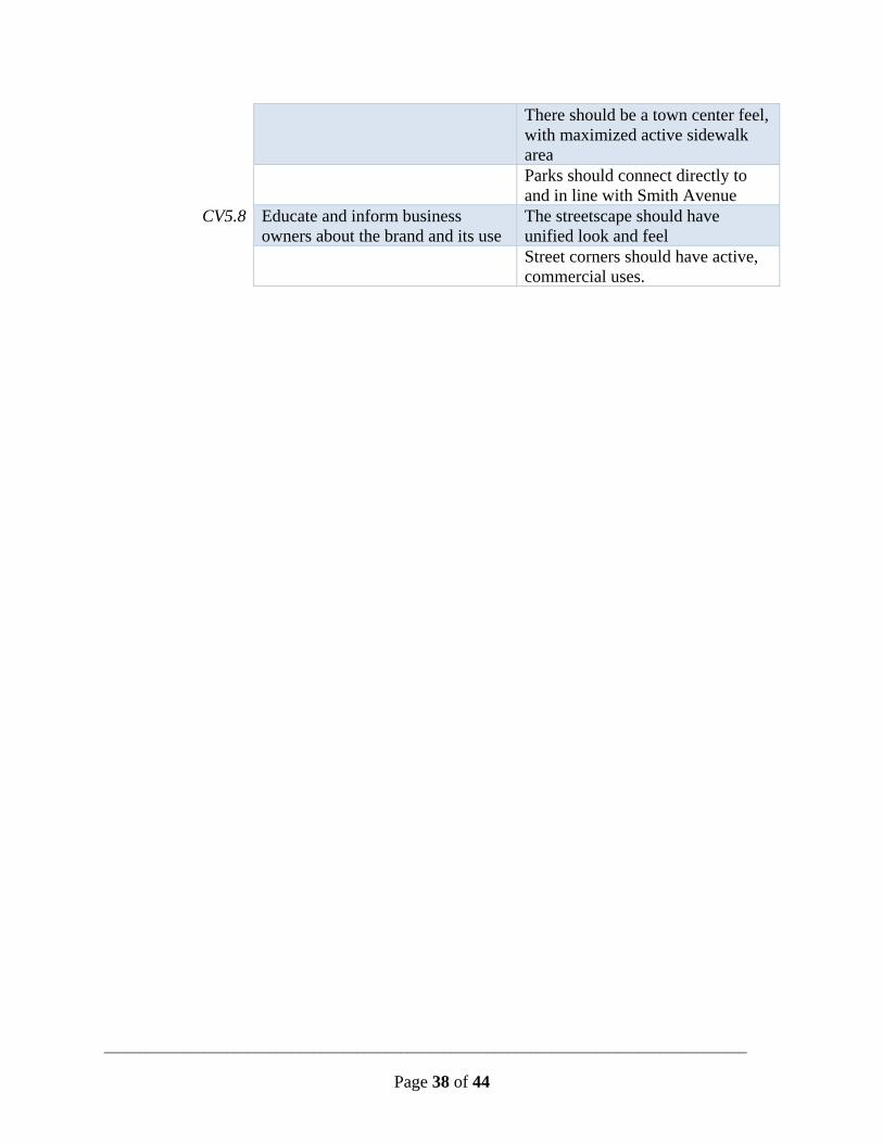
There should be a town center feel, with maximized active sidewalk area
Parks should connect directly to and in line with Smith Avenue
CV5.8 Educate and inform business owners about the brand and its use
The streetscape should have unified look and feel
Street corners should have active, commercial uses.

_________________________________________________________________________________________
Page 31 of 44
Redevelopment of 1010 Dodd Road ContextThe City acquired the 1010 Dodd Road property to aid in the redevelopment of this intersection. When originally acquired, the property was viewed to be a prime commercial redevelopment opportunity because of its strategic placement on the intersection corner. Now, full redevelopment potential for the site will be impacted by the intersection re-alignment plans that are moving forward. All intersection options described in this report impact this property, many of them using up large portions of the site and limiting any potential commercial redevelopment opportunity on the site as-is. While the redevelopment potential of this site may be limited, any intersection re-alignment will also open up new redevelopment opportunities at other sites surrounding the intersection.
Considerations1010 Dodd Road, if reduced significantly by an intersection re-alignment, could become a possible site for a memorial for Officer Scott Patrick. The site is situated as a gateway for the southern legs of Dodd Road and Smith Avenue and the memorial would have maximum visibility at this site.
RecommendationsThe redevelopment potential of 1010 Dodd Road will be significantly impacted by any intersection re-alignment construction. After the re-alignment choice is made, and construction has been completed, the City should evaluate the future of the site. They should consider combining 1010 Dodd Road with adjacent properties to increase the potential for redevelopment. Neighboring properties are currently zoned and used for residential.

_________________________________________________________________________________________
Page 32 of 44
PAC Intersection Recommendation
PAC Intersection Score Option 2 Option 3 Option 4 Total Score 2.125 2.625 1.25
The PAC ranked intersection re-alignment option 4 as their preferred option. Overall, they viewed this option to have the most positive implications for redevelopment, pedestrian comfort, active streetscape, parking, and bicycling safety. Option 4 maintains the continuity of Smith Avenue through the intersection, merges Dodd Road and Bernard Street before they intersect Smith Avenue, and adds a stoplight at the southern intersection of Smith Avenue and Dodd Road. The impacts of this intersection choice on each of the intersection measures are described below by the PAC.
RedevelopmentPotential This option creates great redevelopment opportunities that are placed so as to create a
walkable and drivable place. There is the potential for micro-walkable blocks, as well as street corners where active uses happen.
There is plentiful parking which then allows for upgraded redevelopment in the area.
This option keeps Smith Avenue intact as one cohesive corridor making redevelopment more attractive. Dodd Park and Albert park fit better when they can connect directly to and in line with Smith Avenue.
This option opens up usable streetfront space and captures a lot of existing wasted space while creating the least disruption to existing properties.
ImplicationsonPedestrianExperience There are active corners for pedestrians to cross the street as well as the possibility for
mid-block crossings. This option creates an area that you want to wander through.
Right-angle crossings are more comfortable for pedestrians to navigate.
This option provides the most direct option for crossing to either side of Smith Avenue, which should be the focus.
There should be a traffic signal or enhanced crosswalk at Smith Avenue and Bernard Road—it is not reasonable to assume that people will walk all the way to the traffic light to cross Smith Avenue. Requiring more through-traffic to make turns will slow traffic speeds.
ImplicationsonStreetscape There is potential for the construction of buildings that match the scale of the area.
By keeping Smith Avenue intact, the streetscape can have a unified look and feel rather than breaking up the streetscape to accommodate a road.
This would create a more urban environment by closing in the street a bit. It preserves existing park space while also opening up room for more.

_________________________________________________________________________________________
Page 33 of 44
ImplicationsonParkingImprovements This option allows for plentiful street parking.
This option leaves the most on-street parking, which was requested by the local businesses. This provides better access from Smith Avenue and provides additional parking for the businesses off Dodd Road.
There is a space created for a parking lot which area businesses could use.
This option creates more street parking than the other designs, which can help create a feel more like a commercial street and less like a highway.
ImplicationsonCycling This option provides the best connection between Harmon Park and Cherokee Park with
an easier to navigate intersection from Bernard to Smith, and also from Dodd Nature Center, leaving Smith Avenue an intact direct corridor.
This option creates a safer crossing for bikes. However, there is still a lot of street parking which could create safety issues with bikes.
This layout is easier to incorporate bike lanes into at a future time.

_________________________________________________________________________________________
Page 34 of 44
August 10 Open House Summary 5–7PMonAugust10,2017
DoddwayCenterIntroductionOn Thursday, August 10, the public was invited to offer their thoughts on the Smith/Dodd Small Area Plan at an open house at the Doddway Center. There were 104 attendees who signed in. At the event, attendees viewed boards outlining intersection realignment options, redevelopment possibilities, bicycle infrastructure and possible zoning changes. City and project staff were on hand to answer questions. The event was intended to gain a wide range of feedback on the project.
FindingsBelow is a summary of the findings from the community engagement activities. This information will be considered by the Project Advisory Committee and be used in the development of the plan.
IntersectionRe‐alignmentPreferenceThe chart below shows which intersection re-alignment options attendees favored in their comments. They indicated a preference on provided comment cards. Not every attendee indicated a preference, and some attendees indicated a preference for there to be no changes done at this intersection. The most favored option is alternative 4. Alternative 4 keeps Smith Avenue running straight from north to south, with a stoplight controlling traffic at the southern intersection of Smith Avenue and Dodd Road. North of this intersection, Bernard Street and Dodd Road merge before they meet Smith Avenue at a 90-degree angle.
0%
5%
10%
15%
20%
25%
30%
35%
40%
45%
50%
No Change (5 votes) Alternative 2(12 votes)
Alternative 3(4 votes)
Alternative 4(17 votes)
Open House Comment Summary

_________________________________________________________________________________________
Page 35 of 44
ThemesThe chart below shows how many times certain themes were brought up in attendee’s comment cards. Attendees were most concerned about the possibility of a roundabout at the intersection, expressing strong opposition to that idea. Attendees were also passionate about ensuring that the pedestrian experience in any alternative is safe and pleasant. The intersection has high pedestrian traffic, including young children. Relatedly, attendees also wanted to ensure that traffic would flow, but at slow speeds, further contributing to a sense of pedestrian safety.
While traffic and safety issues are common concerns in all cities, there are a few more unique considerations with this plan. Albert Park is known as being the smallest park in the United States, as certified by Ripley’s Believe It or Not! The intersection re-alignments all currently show Albert Park being added to the property that is currently the Doddway Center. Some attendees expressed concern that this would remove its status as the smallest park.
Another unique concern is for the permanent memorial of West St. Paul police officer Scott Patrick who was killed at this intersection. There is currently a temporary memorial site for him, but many residents want to see a permanent structure honoring his service.
Other comment themes are indicated below.
Anti‐roundabout26%
Building height3%
Commercial access6%
Oxendale's4%
Parking1%
Pedestrian accessibility5%Pedestrian safety
14%
Price tag4%
Pro‐roundabout7%
Scott Patrick memorial4%
Traffic flow8%
Traffic speeds7%
Urban design8%
Albert Park3%

_________________________________________________________________________________________
Page 36 of 44
Recommendations
Smith Avenue Revitalization
Plan Comparison
SARP Strategy Smith-Dodd Small Area Plan Recommendation
Add a “Cross Traffic Does Not Stop” sign to the existing stop sign on Bernard Ave at Smith Ave
Maintain current zoning at the intersection of Smith Avenue and Annapolis Street
Commit to realigning the Smith\Dodd intersection alternative 4 to cement this corridor’s status as a neighborhood commercial node
Create a B-2 overlay district to allow for flexibility beyond the existing B-2 district while requiring a pedestrian scale and reestablishing the automobile use focused to the rear of the buildings
T3.1 Install sidewalk bump-outs at intersections, to narrow the street and slow traffic
Utilize bump-outs specifically on side streets to slow traffic and divert it to the Smith Avenue and Dodd Road intersection
CV5 Capitalize on neighborhood characteristics to create a strong identity and brand for the Avenue
T1.2 Install globe-style lamp posts along the Avenue between Morton Street and Dodd Road
T4.1 Develop a way-finding system for pedestrians and bicyclists along the Avenue
T4.2 Install flowers in the public right-of-way along the Avenue, maintained by local businesses
T4.3 Develop a comprehensive streetscape and tree installation plan
T4.5 Develop a public art plan for the Avenue

_________________________________________________________________________________________
Page 37 of 44
PR2.10 Make Albert Park more accessible Prioritize the creation of green space in the selection of an un-signalized intersection re-alignment
Combine signage, lighting, and transit facilities onto single structures when possible to maximize the amount of space available for pedestrian use
Bury utilities when possible to maximize the amount of space available for pedestrian use
Shorten crosswalks or create pedestrian refuges at crosswalks to increase safety and comfort
Minimize driveways that cross sidewalks
PR2.10 Make Albert Park more accessible Park space should be accessible to pedestrians without making them cross an un-signalized intersection to reach it
The parks should contribute to a streetscape that is attractive and walkable
The parks should connect to the broader park network, including Harmon Park and Cherokee Park
T2.1 Evaluate installation of a bike route parallel to the Avenue
Bike routes on Manomin Avenue or Ottawa Avenue do not make for logical or convenient travel for cyclists
T2.2 Study the feasibility of a bike route on the Avenue
Create a bicycle boulevard/route/sharrow on Smith Avenue between Annapolis Street and Bernard Avenue
LU2.2 Evaluate opportunities to enhance the pedestrian experience
The block faces should be broken up for increased walkability. Mid-block crosswalks should be explored, in order to create “microblocks”
This neighborhood should feel like an area where pedestrians would want to wander
LU1.3 Maintain existing building heights of one to two stories
Future buildings would have a maximum of four stories
_________________________________________________________________________________________
Page 38 of 44
There should be a town center feel, with maximized active sidewalk area
Parks should connect directly to and in line with Smith Avenue
CV5.8 Educate and inform business owners about the brand and its use
The streetscape should have unified look and feel
Street corners should have active, commercial uses.

_________________________________________________________________________________________
Page 39 of 44
Implementation There are 28 implementation strategies listed within this Smith-Dodd Small Area Plan report. Some of these strategies can begin being implemented before the intersection re-alignment is constructed, some strategies that must be included in the design and reconstruction of the intersection, and some strategies that cannot be implemented until some of the properties within the neighborhood decide to be redevelopment. The table below shows the general connection between implementation the various stages of (re)development.
Implementation Strategy Before Intersection Re-Alignment
During Intersection Re-Alignment
With Private Development
Add a “Cross Traffic Does Not Stop” sign to the existing stop sign on Bernard Ave at Smith Ave
X
Maintain current zoning at the intersection of Smith Avenue and Annapolis Street
X
Create a B-2 overlay district to allow for flexibility beyond the existing B-2 district while requiring a pedestrian scale and reestablishing the automobile use focused to the rear of the buildings
X
Utilize bump-outs specifically on side streets to slow traffic and divert it to the Smith Avenue and Dodd Road intersection
X
Capitalize on neighborhood characteristics to create a strong identity and brand for the Avenue
X
Develop a way-finding system for pedestrians and bicyclists along the Avenue
X
Install flowers in the public right-of-way along the Avenue, maintained by local businesses
X
Develop a public art plan for the Avenue
X
Bike routes on Manomin Avenue or Ottawa Avenue do not make for logical or convenient travel for cyclists
X
Educate and inform business owners about the brand and its use
X

_________________________________________________________________________________________
Page 40 of 44
Implementation Strategy Before Intersection Re-Alignment
During Intersection Re-Alignment
With Private Development
Commit to realigning the Smith\Dodd intersection alternative 4 to cement this corridor’s status as a neighborhood commercial node
X
Install globe-style lamp posts along the Avenue between Morton Street and Dodd Road
X
Develop a comprehensive streetscape and tree installation plan
X
Prioritize the creation of green space in the selection of an intersection re-alignment
X
Combine signage, lighting, and transit facilities onto single structures when possible to maximize the amount of space available for pedestrian use
X
Shorten crosswalks or create pedestrian refuges at crosswalks to increase safety and comfort
X
Park space should be accessible to pedestrians without making them cross an un-signalized intersection to reach it
X
The parks should contribute to a streetscape that is attractive and walkable
X
Parks should connect directly to and in line with Smith Avenue
X
The parks should connect to the broader park network, including Harmon Park and Cherokee Park
X X
The block faces should be broken up for increased walkability. Mid-block crosswalks should be explored, in order to create “microblocks”
X X
This neighborhood should feel like an area where pedestrians would want to wander
X X
Bury utilities when possible to maximize the amount of space available for pedestrian use
X X

_________________________________________________________________________________________
Page 41 of 44
Implementation Strategy Before Intersection Re-Alignment
During Intersection Re-Alignment
With Private Development
There should be a town center feel, with maximized active sidewalk area
X X
The streetscape should have unified look and feel
X X
Minimize driveways that cross sidewalks
X
Create a bicycle boulevard/route/sharrow on Smith Avenue between Annapolis Street and Bernard Avenue
X
Future buildings would have a maximum of four stories
X
Street corners should have active, commercial uses.
X

_________________________________________________________________________________________
Page 42 of 44
Appendix Appendix1.ExistingZoningDistricts
R‐1A Single Family Residential
B‐2 Neighborhood Businesses
Lot Area Corner Lot 9,100 square feet No Requirement
Interior Lot 7,000 square feet No Requirement
Lot Width Corner Lot 65 feet No Requirement
Interior Lot 50 feet No Requirement
Building Setback
Front 30 feet 10 to 30 feet
Rear 30 feet/20% of depth 20 feet
Side, Interior 5 feet 0 feet
Side to "R" N\A 10 feet
Side, Corner 20 feet 10 to 30 feet

_________________________________________________________________________________________
Page 43 of 44
_________________________________________________________________________________________
Page 44 of 44
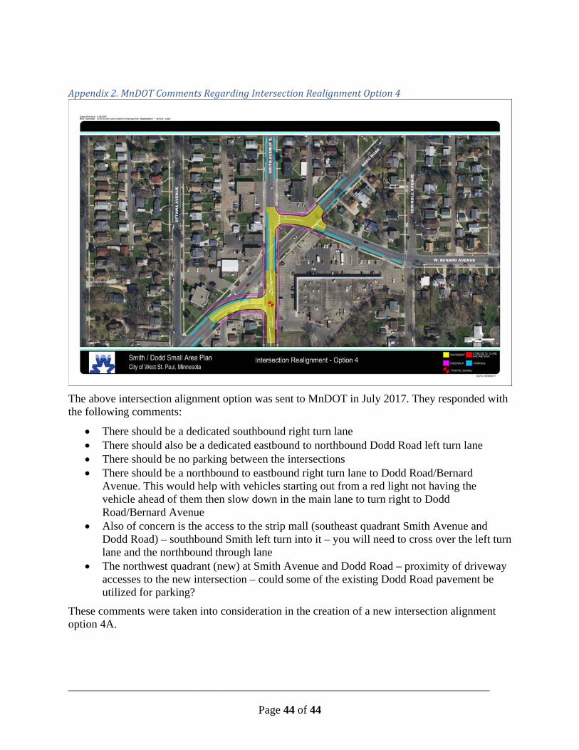
Appendix2.MnDOTCommentsRegardingIntersectionRealignmentOption4
The above intersection alignment option was sent to MnDOT in July 2017. They responded with the following comments:
There should be a dedicated southbound right turn lane There should also be a dedicated eastbound to northbound Dodd Road left turn lane There should be no parking between the intersections There should be a northbound to eastbound right turn lane to Dodd Road/Bernard
Avenue. This would help with vehicles starting out from a red light not having the vehicle ahead of them then slow down in the main lane to turn right to Dodd Road/Bernard Avenue
Also of concern is the access to the strip mall (southeast quadrant Smith Avenue and Dodd Road) – southbound Smith left turn into it – you will need to cross over the left turn lane and the northbound through lane
The northwest quadrant (new) at Smith Avenue and Dodd Road – proximity of driveway accesses to the new intersection – could some of the existing Dodd Road pavement be utilized for parking?
These comments were taken into consideration in the creation of a new intersection alignment option 4A.
Related Documents