SMARTERTRACK EXPRESS PACK PC Navigation with DualNav Positioning Technology Easy to use PC based navigation software with Navionic’s compatibility. Optimised for AIS target tracking and viewing TEL 01179 554474 (US 978 277 1234) www.digitalyachtamerica.com Available Now £275 ex VAT (US$440/€395)

Welcome message from author
This document is posted to help you gain knowledge. Please leave a comment to let me know what you think about it! Share it to your friends and learn new things together.
Transcript

SMARTERTRACK
EXPRESS PACK
PC Navigation with DualNav Positioning TechnologyEasy to use PC based navigation software with Navionic’s compatibility.
Optimised for AIS target tracking and viewing
TEL 01179 554474 (US 978 277 1234)
www.digitalyachtamerica.com
Available Now £275 ex VAT (US$440/€395)

SmarterTrack Express
Note laptop not supplied. Compatible with Windows XP, Vista, 7/8/8.1
SmarterTrack Express is a simple
solution to turn your Windows
notebook or Windows 8.1 tablet
into a powerful electronic charting
system.
The high performance GPS150
DualNav sensor connects via a self
powered USB connection which
makes the package ideal for
portable navigation and great for
use by charter skippers. 10Hz
super fast and super accurate sub
1m positioning is available for the
very best in plotter redraws.
Detailed world wide charting is
available thanks to Navionic’s
compatibility and charts can be
saved onto the PC hard drive and
then utilised in dedicated plotters
too

SmarterTrack – Key Features
• Real time PC based
navigation
• Supplied with DualNav
plug ‘n play GPS-
GLONASS sensor
• GPS & Instrument
interface
• Autopilot output
• Optimised for AIS
overlays
• Portable (or can be
installed)
• Compatible with
Navionics charting
• Easy interface,
powerful functions
• Touch screen or
trackpad/mouse control
• Full tidal route
planning/optimisation

System Approach
OPTION: Add the Digital Yacht uAIS AIS receiver for
AIS target tracking or any Digital Yacht AIS
transponder
SmarterTrack Express ships
with a plug ‘n play DualNav
GPS150 USB sensor offering
10Hz positioning updates with
typical sub 1m accuracy
The GPS150USB is powered
direct from the PC making it
ideal for portable operation or
charter skippers
For connection to
boat NMEA systems
utilise the USB-
NMEA adaptor cable
available as an
accessory
Hi performance DualNav GPS150 USB sensor included in SmarterTrack Express system
SMARTERTRACK
Basic Charting Displays

Navionics Charting
• Global coverage with highly detailed charts
• SmarterTrack can read Navionic’s charting data (GOLD & PLATINUM)
• Copy your Navionic’s chart to the PC hard drive and then continue to use the card in a compatible plotter – saves on doubling up charting costs for plotter/PC based systems
• Great value, easy updates and the best coverage plus the same look and feel as plotter based charts on your PC

Chart Display
Simple controls to zoom
in and out or pan the
chart. Scroll wheel on
mouse or touch screen
also supported
Measure a
bearing
and
distance
easily with
A-B ruler
GPS data from your
on board system
Dockable windows
allow key navigation
data to be displayed
Your position
shown clearly
on screen and
updated in real
time
Your previous
track

Chart Layers
Chart layers allow
the user to select
the data required
allowing a custom
view of any chart –
have as much or as
little information as
required plus
customise depth
contours to your
needs

Optional Touch Toolbar
The optional TOOLBAR
is ideal for use with
touch screen displays
and allows quick and
easy access to most of
the functions required
whilst underway.
Position the toolbar
anywhere on the display

Tidal Data
Click on a <T>
(tidal diamond) and get
instant tidal data for
that point. Change
the date too for future
predictions
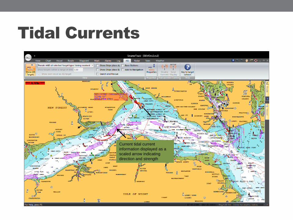
Tidal Currents
Current tidal current
information displayed as a
scaled arrow indicating
direction and strength

Sun & Moon Calculations
The sun and moon
calculator gives sun and
moon rise and set times for
the chosen location.
Future dates can also be
entered

Navaid Information
Right click on a
buoy, object or
navaid and get pop
up detailed
information
buoyage overlaid
onto the chart
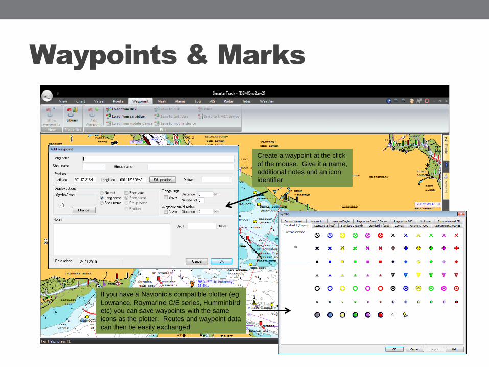
Waypoints & Marks
Create a waypoint at the click
of the mouse. Give it a name,
additional notes and an icon
identifier
If you have a Navionic’s compatible plotter (eg
Lowrance, Raymarine C/E series, Humminbird
etc) you can save waypoints with the same
icons as the plotter. Routes and waypoint data
can then be easily exchanged
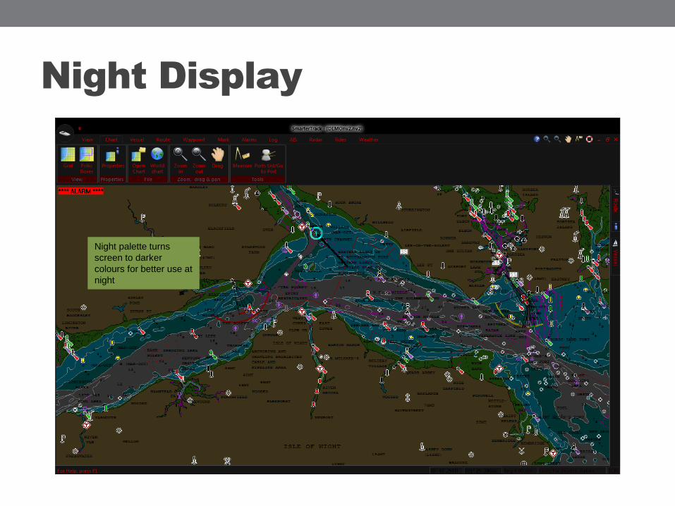
Night Display
Night palette turns
screen to darker
colours for better use at
night
SMARTERTRACK
AIS Target Displays
(Requires connection to AIS)
SmarterTrack has been specifically designed to
integrate with Digital Yacht’s range of AIS
products for the best possible AIS target
presentation. For a portable solution, utilise uAIS

AIS TARGETS – Colour Coding
Easy colour coded AIS
targets

AIS Target Data
Click on an AIS target
and get detailed static
and dynamic data for
the target including
name, mmsi, position,
course and speed
information as well as
CPA and TCPA
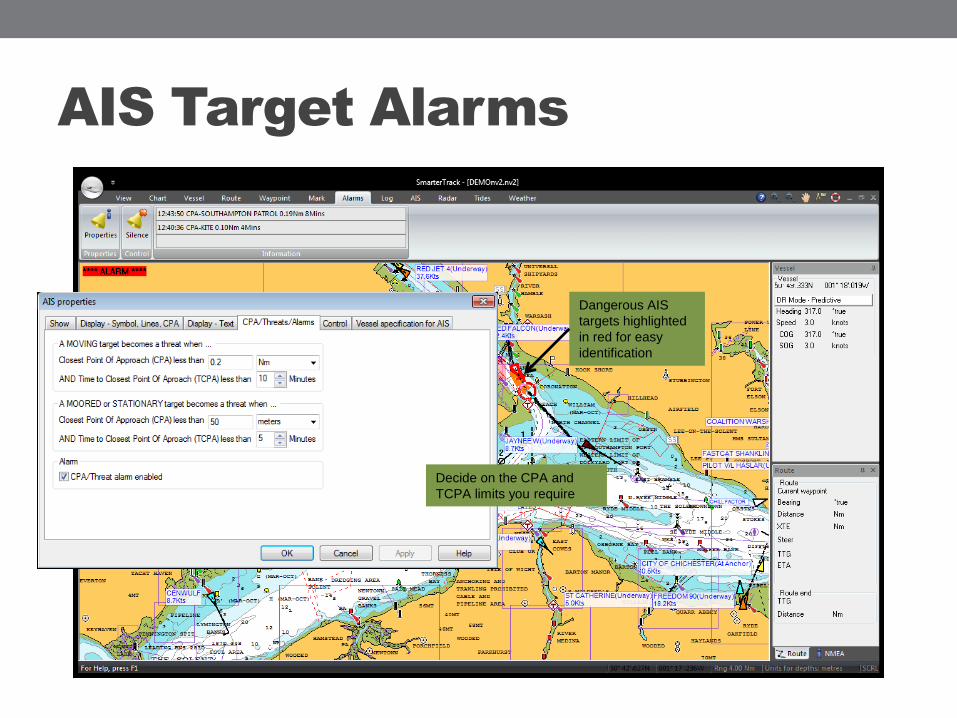
AIS Target Alarms
Decide on the CPA and
TCPA limits you require
Dangerous AIS
targets highlighted
in red for easy
identification

AIS Target Selection
Choose which AIS targets
are displayed. Turn Class
A/B targets on/off

AIS Alarm Functions
SmarterTrack
continuously calculates
CPA (closest point of
approach) and TCPA
(time to CPA) for targets
on a collision course
Alarms also
included for DSC
messages if
interfaced with
VHF, MOB and
position sensor
failure.

Interface with Digital Yacht AIS products
Program and take
control of any
Digital Yacht AIS
transponder
directly from
SmarterTrack’s
menu

SMARTERTRACK
On the move – GOTO and routing functions
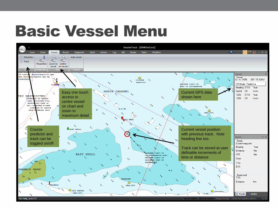
Basic Vessel Menu
Current vessel position
with previous track. Note
heading line too.
Track can be stored at user
definable increments of
time or distance
Easy one touch
access to
centre vessel
on chart and
zoom to
maximum detail
Course
predictor and
track can be
toggled on/off
Current GPS data
shown here

GOTO Function
Click to create
an instant GOTO
Get instant
numeric nav
information
including course,
bearing, XTE and
ETA information
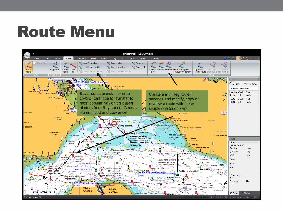
Route Menu
Create a multi leg route in
seconds and modify, copy or
reverse a route with these
simple one touch keys
Save routes to disk - or onto
CF/SD cartridge for transfer to
most popular Navionic’s based
plotters from Raymarine, Geonav,
Humminbird and Lowrance

Route Planning
Once your route is created,
enter the PLANNING mode to
bring up a route properties
list. Select OPTIMUM plan
for an automatic tidal
calculation to give optimum
time for departure. This is
ideal for cross channel
passages.
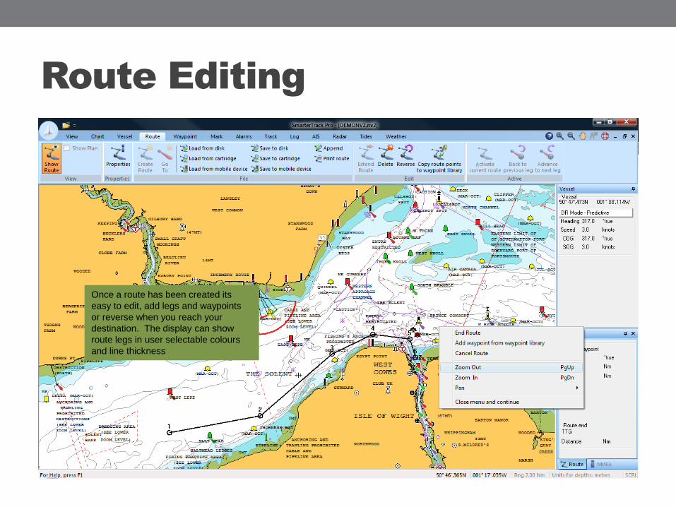
Route Editing
Once a route has been created its
easy to edit, add legs and waypoints
or reverse when you reach your
destination. The display can show
route legs in user selectable colours
and line thickness

Route Optimisation
In tidal waters (especially useful
when crossing the channel),
SmarteTrack will calculate the
optimum time for departure
based on you traversing a tidal
flow.

SMARTERTRACK
Advanced Features
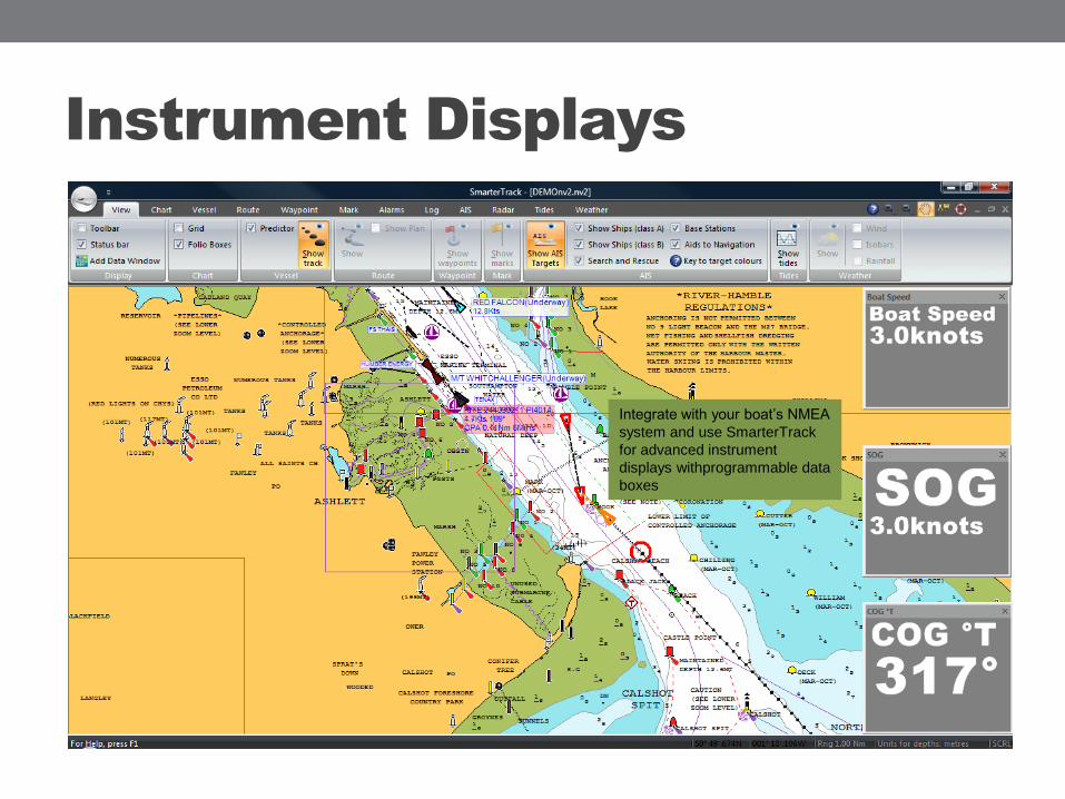
Instrument Displays
Integrate with your boat’s NMEA
system and use SmarterTrack
for advanced instrument
displays withprogrammable data
boxes
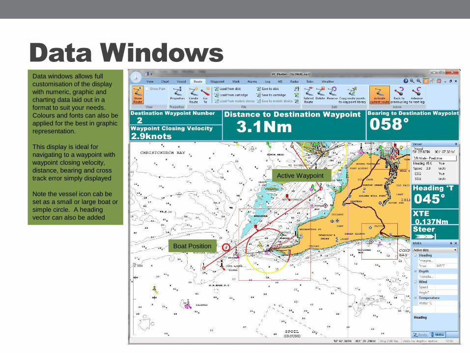
Data Windows
Data windows allows full
customisation of the display
with numeric, graphic and
charting data laid out in a
format to suit your needs.
Colours and fonts can also be
applied for the best in graphic
representation.
This display is ideal for
navigating to a waypoint with
waypoint closing velocity,
distance, bearing and cross
track error simply displayed
Note the vessel icon cab be
set as a small or large boat or
simple circle. A heading
vector can also be added
Boat Position
Active Waypoint
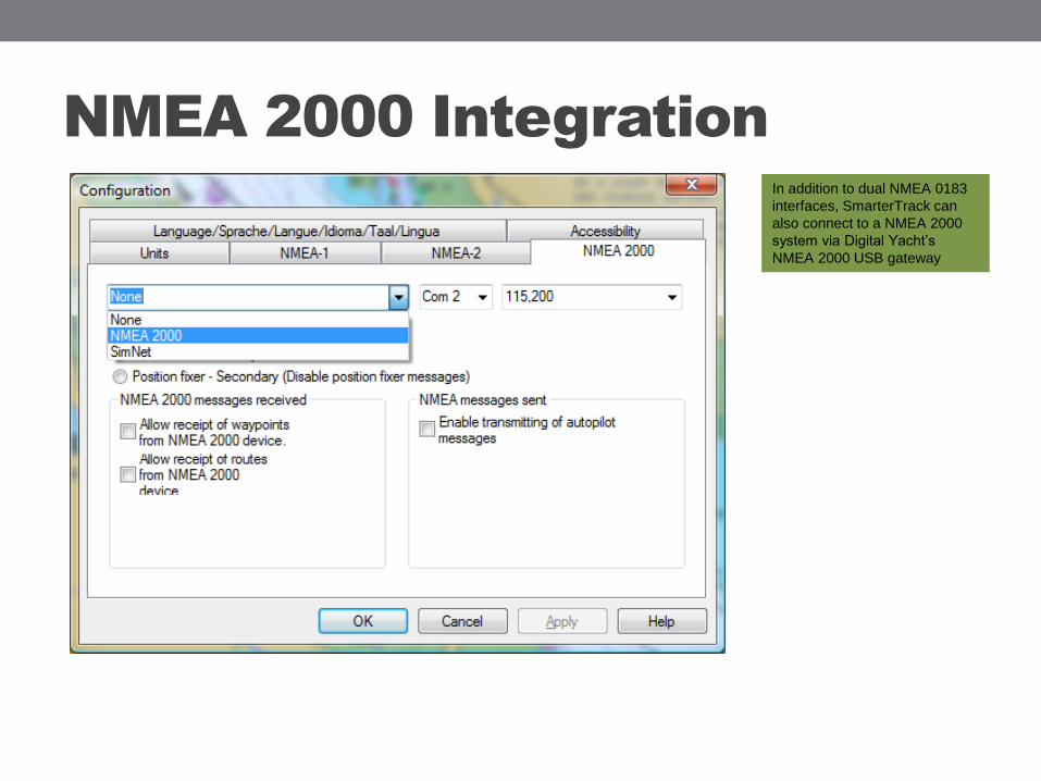
NMEA 2000 Integration
In addition to dual NMEA 0183
interfaces, SmarterTrack can
also connect to a NMEA 2000
system via Digital Yacht’s
NMEA 2000 USB gateway

Theyr Weather Overlays
Theyr is a low cost weather
service available as a
subscription for SmarterTrack
Overlay an animated weather
forecast with wind, temperature
and pressure information.
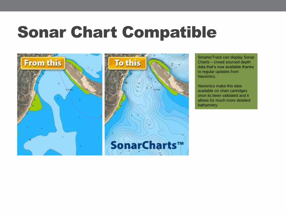
Sonar Chart Compatible
SmarterTrack can display Sonar
Charts – crowd sourced depth
data that’s now available thanks
to regular updates from
Navionics.
Navionics make this data
available on chart cartridges
once its been validated and it
allows for much more detailed
bathymetry

Ordering
Digital Yacht Europe
TEL +44 1179 554474
Digital Yacht America
TEL 978 277 1234
www.digitalyachtamerica.com
Email [email protected]
Related Documents