MINERALS AND GEOSCIENCE DEPARTMENT MALAYSIA MINISTRY OF NATURAL RESOURCES AND ENVIRONMENT MALAYSIA International Symposium on Multi-Hazard and Risk 2015 23-24 March 2015, UTM Kuala Lumpur By: Dato’ Zakaria Mohamad Project Manager PBRC Very high resolution DTM derived from LiDAR LiDAR Ortho image SLOPE HAZARD AND RISK MAPPING: A TECHNOLOGICAL PERSPECTIVE

Welcome message from author
This document is posted to help you gain knowledge. Please leave a comment to let me know what you think about it! Share it to your friends and learn new things together.
Transcript

MINERALS AND GEOSCIENCE DEPARTMENT MALAYSIA
MINISTRY OF NATURAL RESOURCES AND ENVIRONMENT MALAYSIA
International Symposium on Multi-Hazard and Risk 2015
23-24 March 2015, UTM Kuala Lumpur
By:
Dato’ Zakaria Mohamad
Project Manager PBRC
Very high resolution DTM
derived from LiDAR LiDAR Ortho image
SLOPE HAZARD AND RISK MAPPING:
A TECHNOLOGICAL PERSPECTIVE

Slope Hazard and Risk Mapping in the Tropics: Why it is a challenging task?
• In the monsoon-dominated regions, landslides occur in areas characterized
by steep hillslopes, high rainfall intensities, seasonally dry periods, unstable
slopes and also under forests.
• Landslide inventory maps are fundamental for assessing landslide
susceptibility, hazard, and risk.
• The compilation of landslide inventory maps is a tedious procedure due to
the fact that each individual landslide has to be mapped and described
together with their characteristics according to standard practices.
• Conventional landslide mapping
techniques (aerial photos have limitations in a forested
mountainous environment
>> multi-sensor LIDAR is a promising tool for
solving an old geological problem !!

RISK ASSESSMENT:
CHALLENGES AND ISSUES
Gu
nu
ng
Pa
ss
, Pe
rak
Ma
lays
ia
Batu
Cave
s, S
ela
ng
or, M
ala
ys
ia
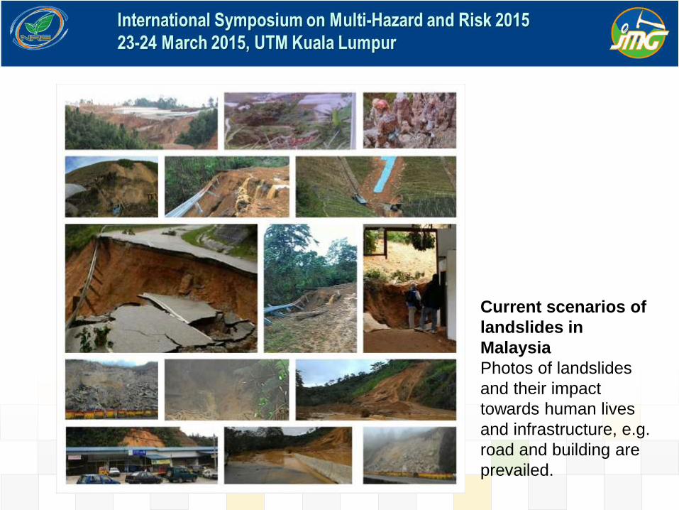
Current scenarios of
landslides in
Malaysia
Photos of landslides
and their impact
towards human lives
and infrastructure, e.g.
road and building are
prevailed.

Hulu Langat 2010 Bukit Antarabangsa
2008
Bukit Antarabangsa
2008
Highland Tower 1993

Sivan Temple 2011
Lebuhraya Mahameru 2014
Bukit Antarabangsa 1999

PBRC PROJECT OBJECTIVES
• To produce slope hazard and risk information in the selected areas for the local authorities in Malaysia for a better slope management.
• To provide conceptual proposal and cost estimation for mitigating and strengthening high risky slopes.
• To assist government agencies and local authorities in land-use planning towards a sustainable land management.
• To develop geospatial infrastructure for national geological terrain and slope information.

Hazard and risk mapping
Landslide prone area
Cameron Highlands (400 km2)
Ipoh (300 km2)
Rawang-Batang Kali (150 km2)
Cheras Selatan-Bangi (200 km2)
Gombak-Kajang-Selayang (300 km2)
Bukit Frasers (100 km2)
Kapit (100 km2)
Landslide Inventory Map For Peninsular Malaysia/East Malaysia
(National Slope Master Plan)
Kota Kinabalu (175 km2)
Kundasang (50 km2)

PBRC PROJECT AREA IN
SELANGOR (650 km2)

PBRC PROJECT AREA IN
CAMERON HIGHLANDS
(275 km2)

PBRC PROJECT AREA IN
IPOH (200 km2)
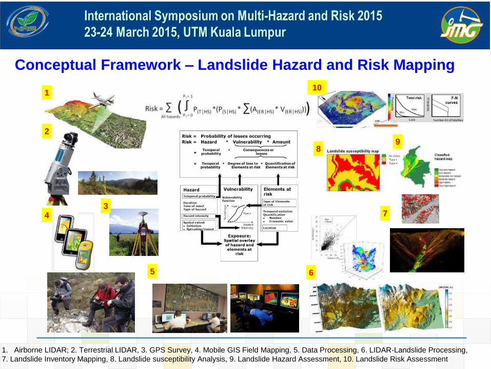
1
2
43
5 6
7
8
10
9
Conceptual Framework – Landslide Hazard and Risk Mapping
1. Airborne LIDAR; 2. Terrestrial LIDAR, 3. GPS Survey, 4. Mobile GIS Field Mapping, 5. Data Processing, 6. LIDAR-Landslide Processing,
7. Landslide Inventory Mapping, 8. Landslide susceptibility Analysis, 9. Landslide Hazard Assessment, 10. Landslide Risk Assessment
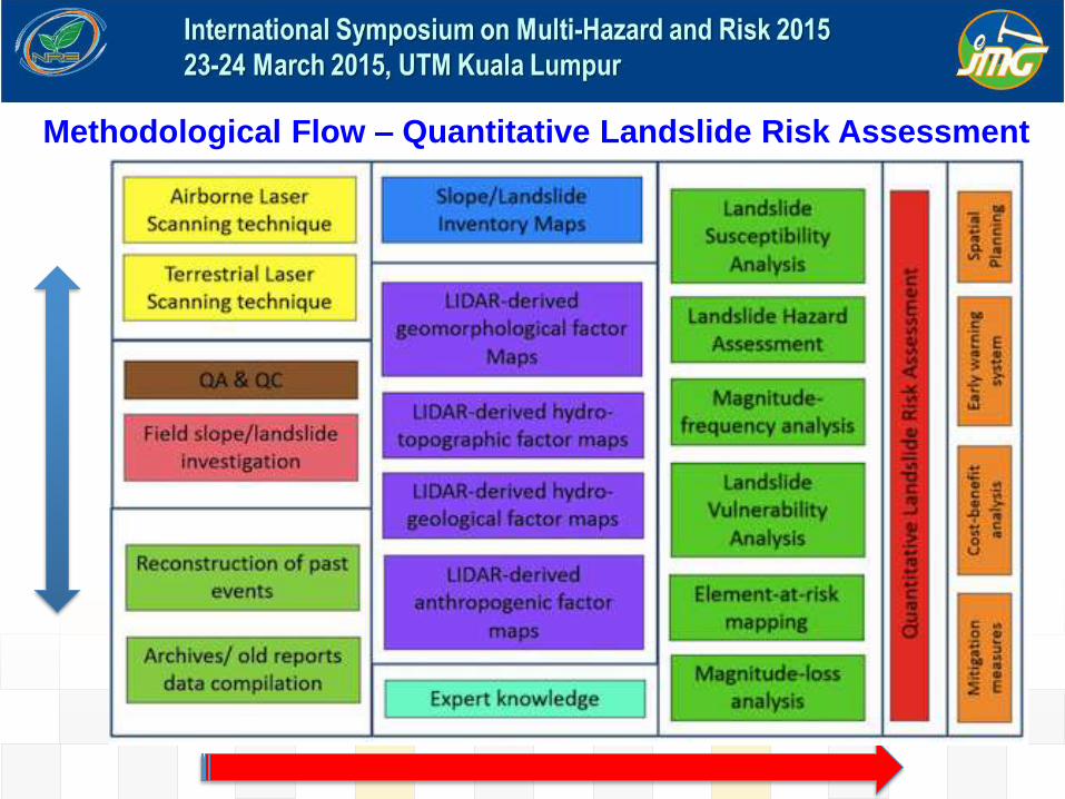
Methodological Flow – Quantitative Landslide Risk Assessment

LiDAR Data
Acquisition in Klang
Valley (Selangor),
Cameron Highlands
and Ipoh
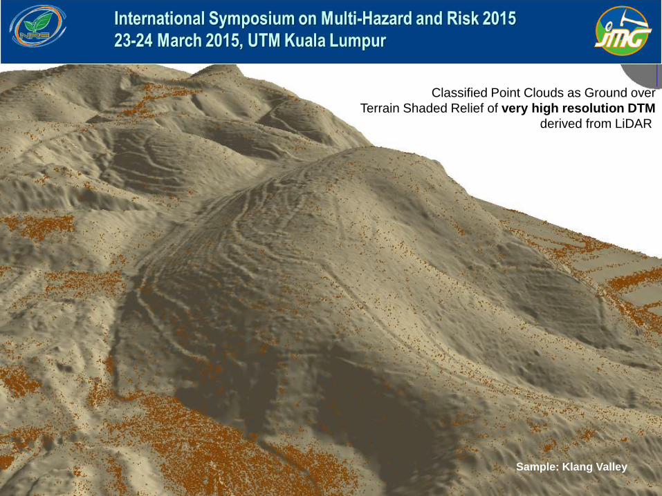
Classified Point Clouds as Ground over
Terrain Shaded Relief of very high resolution DTM
derived from LiDAR
Sample: Klang Valley

Classified Point Clouds as Ground over
Terrain Shaded Relief of very high esolution DTM
derived from LiDAR Ortho image
Sample: Klang Valley

Orthophoto
Digital Terrain Model
Bukit
Antarabangsa
Source: RS GIS
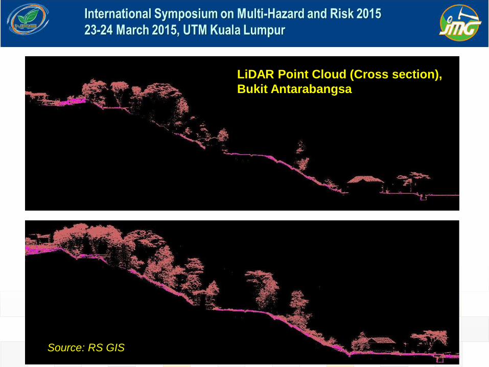
LiDAR Point Cloud (Cross section),
Bukit Antarabangsa
Source: RS GIS

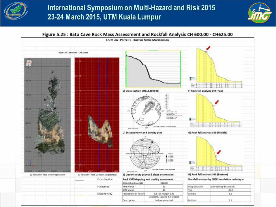
LIMESTONE CLIFF MAPPING USING TERRESTRIAL LASER SCANNING, BATU
CAVES, SELANGOR MALAYSIA
Stage 1 – Planning & Pre-survey Stage 2 – Data Collection Stage 3 - Data Processing and Analysis
Colorized point cloud
derived from TLS LIDAR
Long range TLS
scanner

Rock slope characteristics revealed by hyperspatial TLS data (Batu Caves, Selangor). A) Usual geometric terrain of rock slope. B) Peculiar characteristic of natural rocky limestone.
C) An entire of cross sections coupled with rock cliff boundary and contour line used for geological and
geotechnical assessment.

TLS Ortho Image from the Permatang Kuarza Selangor
(Klang Gate Quartz Ridge), Klang Valley
Source: GPS Land

TLS Ortho Image at Kg. Dumpirin, Kundasang, Sabah
Source: GPS Land

1. Methodological working framework for slope hazard and risk mapping
has been developed for PBRC project
2. Multi sensor (airborne and terrestrial) system is a critical tool for providing
an accurate geospatial data input (very high resolution DTM and DSM) for
landslide hazard and risk assessment in the tropics.
3. PBRC creates a platform for developing a comprehensive landslide
inventory using LiDAR technology for regional and national purposes.
4. PBRC promotes multi-disciplinary and knowledge-based approach for
complex landslide assessment and disaster risk reduction initiative in
Malaysia.
CONCLUSION


Thank you
Related Documents


