Slip rate gradients along the eastern Kunlun fault Eric Kirby, 1 Nathan Harkins, 1 Erqi Wang, 2 Xuhua Shi, 2 Chun Fan, 2 and Douglas Burbank 3 Received 5 August 2006; revised 9 December 2006; accepted 3 January 2007; published 30 March 2007. [1] Whether strike-slip fault systems in Eurasia accomplish eastward extrusion of Tibetan crust and lithosphere depends largely on the kinematics of deformation at the fault tip. Here we present new slip rate determinations using millennial-scale geomorphic markers from sites along the easternmost segment of the Kunlun fault in north central Tibet. This fault system represents one of the major strike-slip faults within the Indo-Asian collision zone, has been argued to exhibit uniform slip rates along much of its length, and plays a central role in models for eastward extrusion of Tibetan lithosphere. Displaced fluvial terrace risers along tributaries of the Yellow River, coupled with 14 C ages of terrace material, provide constraints on slip rates over late Pleistocene to Holocene time. Results indicate that slip rates decrease systematically along the eastern 150 km of the fault from >10 to <2 mm/yr. These data challenge the view that slip along the Kunlun fault remains uniform along the entire length of the fault and instead reveal gradients in displacement similar to those expected at fault tips. Moreover, slip along the fault appears to terminate within the thickened crust of the plateau, and therefore any extrusion of Tibetan lithosphere accomplished by slip along the Kunlun fault must be absorbed by internal deformation of the plateau surrounding the fault tip. Citation: Kirby, E., N. Harkins, E. Wang, X. Shi, C. Fan, and D. Burbank (2007), Slip rate gradients along the eastern Kunlun fault, Tectonics, 26, TC2010, doi:10.1029/2006TC002033. 1. Introduction [2] Since the recognition that active deformation within Eurasia involves lateral displacement on major strike-slip faults oriented approximately orthogonal to the convergence vector between India and Eurasia [Molnar and Tapponnier, 1975; Tapponnier and Molnar, 1977], the relative roles of eastward transport of material along these structures versus thickening of Eurasian crust in accommodating conver- gence has remained contentious. Two end-member views of the kinematics of Eurasian deformation have emerged. The first class of models envision that high slip rates along major strike-slip faults account for a large fraction of the present-day velocity field [Avouac and Tapponnier, 1993; Peltzer and Saucier, 1996] and point to rapid slip rates inferred from displaced geologic and geomorphic features [Chevalier et al., 2005b; Me ´riaux et al., 2004] as evidence of the significance of these structures. In contrast, a class of continuum models of the collision zone predict distributed deformation and thickening throughout the orogen, along with relatively low rates of lateral slip [England and Houseman, 1986; Houseman and England, 1993; Vilotte et al., 1986]. Such models find support in recent geodetic studies that indicate broadly distributed deformation within the Tibetan Plateau [Zhang et al., 2004] and low displace- ment rates along major strike-slip faults [Bendick et al., 2000; Brown et al., 2002; Wang et al., 2001; Wright et al., 2004] over decadal timescales. [3] Although much of the debate historically has been focused on whether these fault systems exhibit high or low slip rates, whether these faults accomplish eastward extru- sion of Tibet depends critically whether high slip rates are maintained along the entire length of the fault system. Studies of fault growth and scaling [e.g., Cowie and Scholz, 1992a] typically reveal systematic relationships between fault length and total displacement [Stirling et al., 1996] that imply, in the absence of interactions with other faults, displacement should decrease toward the fault tip. Few studies of slip rates along Eurasian strike-slip faults, how- ever, have considered this possibility [Bayasgalan et al., 1999]; most kinematic models assign a single slip rate to the entire fault [e.g., Avouac and Tapponnier, 1993]. Although the Altyn Tagh fault is widely considered to terminate at its intersection with the Qilian Shan [Burchfiel et al., 1989; Tapponnier et al., 2001], implying that displacement must decrease along strike [cf. Meyer et al., 1996; Me ´riaux et al., 2005; cf. P. Zhang et al., Late Quaternary and present-day rates of slip along the Altyn Tagh fault, submitted to Tectonics, 2006, hereinafter referred to as Zhang et al., submitted manuscript, 2006], this transform-like behavior is largely dictated by the fact that the Altyn Tagh fault separates deforming regions of Tibet from relatively unde- formed lithosphere of the Tarim basin. Whether such behavior is characteristic of faults within the Tibetan Plateau remains unknown. [4] A critical test of competing models for the role of strike-slip faults in the Indo-Eurasian collision may be con- ducted by ascertaining to what degree lateral displacement along fault systems in Tibet is accommodated by structures beyond the eastern margin of the plateau. With its great length (1500 km), high slip rate (10 mm/yr) [Li et al., 2005; Van der Woerd et al., 1998, 2000, 2002b], and recent seismicity [Lin et al., 2002; Van der Woerd et al., 2002a], TECTONICS, VOL. 26, TC2010, doi:10.1029/2006TC002033, 2007 Click Here for Full Articl e 1 Department of Geosciences, Pennsylvania State University, University Park, Pennsylvania, USA. 2 Institute for Geology, Chinese Academy of Sciences, Beijing, China. 3 Department of Earth Science, University of California, Santa Barbara, California, USA. Copyright 2007 by the American Geophysical Union. 0278-7407/07/2006TC002033$12.00 TC2010 1 of 16

Welcome message from author
This document is posted to help you gain knowledge. Please leave a comment to let me know what you think about it! Share it to your friends and learn new things together.
Transcript
Slip rate gradients along the eastern Kunlun fault
Eric Kirby,1 Nathan Harkins,1 Erqi Wang,2 Xuhua Shi,2 Chun Fan,2 and Douglas Burbank3
Received 5 August 2006; revised 9 December 2006; accepted 3 January 2007; published 30 March 2007.
[1] Whether strike-slip fault systems in Eurasiaaccomplish eastward extrusion of Tibetan crust andlithosphere depends largely on the kinematics ofdeformation at the fault tip. Here we present new sliprate determinations using millennial-scale geomorphicmarkers from sites along the easternmost segmentof the Kunlun fault in north central Tibet. This faultsystem represents one of the major strike-slip faultswithin the Indo-Asian collision zone, has been arguedto exhibit uniform slip rates along much of its length,and plays a central role inmodels for eastward extrusionof Tibetan lithosphere. Displaced fluvial terrace risersalong tributaries of the Yellow River, coupled with 14Cages of terrace material, provide constraints on slip ratesover late Pleistocene to Holocene time. Results indicatethat slip rates decrease systematically along the eastern�150 km of the fault from >10 to <2 mm/yr. These datachallenge the view that slip along the Kunlun faultremains uniform along the entire length of the fault andinstead reveal gradients in displacement similar to thoseexpected at fault tips. Moreover, slip along the faultappears to terminate within the thickened crust of theplateau, and therefore any extrusion of Tibetanlithosphere accomplished by slip along the Kunlunfault must be absorbed by internal deformation of theplateau surrounding the fault tip. Citation: Kirby, E.,
N. Harkins, E. Wang, X. Shi, C. Fan, and D. Burbank (2007), Slip
rate gradients along the eastern Kunlun fault, Tectonics, 26,
TC2010, doi:10.1029/2006TC002033.
1. Introduction
[2] Since the recognition that active deformation withinEurasia involves lateral displacement on major strike-slipfaults oriented approximately orthogonal to the convergencevector between India and Eurasia [Molnar and Tapponnier,1975; Tapponnier and Molnar, 1977], the relative roles ofeastward transport of material along these structures versusthickening of Eurasian crust in accommodating conver-gence has remained contentious. Two end-member viewsof the kinematics of Eurasian deformation have emerged.
The first class of models envision that high slip rates alongmajor strike-slip faults account for a large fraction of thepresent-day velocity field [Avouac and Tapponnier, 1993;Peltzer and Saucier, 1996] and point to rapid slip ratesinferred from displaced geologic and geomorphic features[Chevalier et al., 2005b; Meriaux et al., 2004] as evidenceof the significance of these structures. In contrast, a class ofcontinuum models of the collision zone predict distributeddeformation and thickening throughout the orogen, alongwith relatively low rates of lateral slip [England andHouseman, 1986; Houseman and England, 1993; Vilotteet al., 1986]. Such models find support in recent geodeticstudies that indicate broadly distributed deformation withinthe Tibetan Plateau [Zhang et al., 2004] and low displace-ment rates along major strike-slip faults [Bendick et al.,2000; Brown et al., 2002; Wang et al., 2001; Wright et al.,2004] over decadal timescales.[3] Although much of the debate historically has been
focused on whether these fault systems exhibit high or lowslip rates, whether these faults accomplish eastward extru-sion of Tibet depends critically whether high slip rates aremaintained along the entire length of the fault system.Studies of fault growth and scaling [e.g., Cowie and Scholz,1992a] typically reveal systematic relationships betweenfault length and total displacement [Stirling et al., 1996]that imply, in the absence of interactions with other faults,displacement should decrease toward the fault tip. Fewstudies of slip rates along Eurasian strike-slip faults, how-ever, have considered this possibility [Bayasgalan et al.,1999]; most kinematic models assign a single slip rate to theentire fault [e.g., Avouac and Tapponnier, 1993]. Althoughthe Altyn Tagh fault is widely considered to terminate at itsintersection with the Qilian Shan [Burchfiel et al., 1989;Tapponnier et al., 2001], implying that displacement mustdecrease along strike [cf. Meyer et al., 1996; Meriaux et al.,2005; cf. P. Zhang et al., Late Quaternary and present-dayrates of slip along the Altyn Tagh fault, submitted toTectonics, 2006, hereinafter referred to as Zhang et al.,submitted manuscript, 2006], this transform-like behavior islargely dictated by the fact that the Altyn Tagh faultseparates deforming regions of Tibet from relatively unde-formed lithosphere of the Tarim basin. Whether suchbehavior is characteristic of faults within the Tibetan Plateauremains unknown.[4] A critical test of competing models for the role of
strike-slip faults in the Indo-Eurasian collision may be con-ducted by ascertaining to what degree lateral displacementalong fault systems in Tibet is accommodated by structuresbeyond the eastern margin of the plateau. With its greatlength (�1500 km), high slip rate (�10 mm/yr) [Li et al.,2005; Van der Woerd et al., 1998, 2000, 2002b], and recentseismicity [Lin et al., 2002; Van der Woerd et al., 2002a],
TECTONICS, VOL. 26, TC2010, doi:10.1029/2006TC002033, 2007ClickHere
for
FullArticle
1Department of Geosciences, Pennsylvania State University, UniversityPark, Pennsylvania, USA.
2Institute for Geology, Chinese Academy of Sciences, Beijing, China.3Department of Earth Science, University of California, Santa Barbara,
California, USA.
Copyright 2007 by the American Geophysical Union.0278-7407/07/2006TC002033$12.00
TC2010 1 of 16
the Kunlun fault in north central Tibet (Figure 1) appearswell suited to such a test. Unlike the Altyn Tagh faultsystem, the Kunlun fault separates two actively deformingregions of the plateau. Moreover, recent geologic studiessuggest that millennial-scale slip rates are spatially uniformalong nearly �800 km of the central portion of the fault [Liet al., 2005; Van der Woerd et al., 1998, 2000, 2002b].Regional geodetic estimates of the present velocity field[Zhang et al., 2004] are consistent with geologic slip rates.These geodetic measurements, however, resolve little left-lateral shear [Chen et al., 2000; Zhang et al., 2004] acrossthe inferred trace of the easternmost segment of the fault(east of �100�E) and suggest that the fault may terminatewithin the plateau.[5] Here we report new slip rate estimates derived from
displaced fluvial terrace risers along the eastern Kunlunfault. Our use of millennial-scale geomorphic features toreconstruct fault displacement is motivated by the wide-
spread distribution of these landforms, which afford oppor-tunity to examine multiple sites and thus test for potentialgradients in displacement. Moreover, the generation andabandonment of fluvial terraces appears to be synchronousin this region of Asia since the late Pleistocene [e.g., Hetzelet al., 2002; Van der Woerd et al., 2002b], allowing for sliprate determinations that average displacement across multi-ple seismic cycles, yet are relatively isochronous amongdifferent sites. We compare our slip rate determinations withthose determined for similar time intervals along the centraland western segments of the fault [Li et al., 2005; Van derWoerd et al., 1998, 2000, 2002b]. Finally, we compare thesecollective results of geologic slip rates against geodeticmeasures of present-day velocity to assess the potential roleof transient deformation associated with the seismic cycle[e.g., Chevalier et al., 2005b; Meriaux et al., 2004].Together, these measures of fault slip allow us to charac-terize the deformation field associated with the eastern tip of
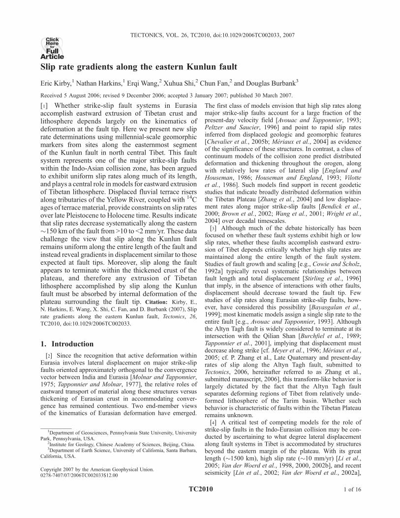
Figure 1. Tectonic map showing major and minor active faults in eastern Tibet. Abbreviations are asfollows; BJ, Bailong Jiang fault; E, Elashan fault; MJ, Min Jiang fault; R, Riyueshan fault; T, Tazangfault. Epicentral locations and focal mechanism solutions of recent seismicity along the Kunlun fault arecompiled from USGS (http://neic.usgs.gov/neis/epic/epic_circ.html), Harvard CMT catalog (http://www.globalcmt.org/CMTsearch.html), and Molnar and Lyon-Caen [1989]. Topographic base isgenerated from the Shuttle Radar Topography Mission (SRTM) data.
TC2010 KIRBY ET AL.: KUNLUN FAULT, SLIP RATE, TIBET
2 of 16
TC2010
the Kunlun fault and to test whether or not slip is trans-mitted beyond the margin of the Tibetan Plateau.
2. Geologic Background
[6] The Kunlun fault, in east central Tibet, represents oneof the key structural elements in the active deformation fieldof Eurasia [Avouac and Tapponnier, 1993]. The fault marksthe northern boundary of the Tibetan Plateau for nearly�1500 km along strike, delineating a transition from acontinuous, low-relief, high-elevation plateau to the southto a northern domain characterized by active high mountainranges and intramontane basins (Figure 1). The fault is alsocoincident with the northern boundary of the Songpan-Garze–Hoh Xil terrane along the Anyemaqen-Kunlunsuture [Yin and Harrison, 2000]. The timing of initiationof left-lateral shear along the fault system is uncertain, buthas been inferred to be coeval with Miocene extension(circa 15 Ma) in the westernmost (west of 91�E) portions ofthe fault system [Jolivet et al., 2003]. A dearth of geologicpiercing points across this boundary, however, has ham-pered efforts to estimate total displacement across the fault;some studies rely on an apparent deflection (�85 km)of the Yellow River along the easternmost fault segment[Gaudemer et al., 1989; Van der Woerd et al., 2002b]. Aswe discuss below, our data do not support this interpreta-tion, and we contend that the finite displacement on the faultremains poorly understood.[7] Slip rates along the Kunlun fault during the Quater-
nary, in contrast, are fairly well known [Kidd and Molnar,1988]. Studies of displaced fluvial and glacial landformsalong the central �600 km of the fault (�94�E to �100�E)indicate slip rates of 11 ± 2 mm/yr over late Pleistocene toHolocene time [Van der Woerd et al., 1998, 2000, 2002b].An additional study near �92�E [Li et al., 2005] alsoyielded mid-Holocene rates of 10 ± 1.5 mm/yr. Togetherthese studies suggest that fault exhibits nearly uniform sliprates along the central �800 km of its length. This behavioris consistent with the predictions of block-like deformation[Tapponnier et al., 1986], and thus the Kunlun fault isconsidered to play a key role in models for extrusion ofcentral Tibet [Li et al., 2005; Van der Woerd et al., 2002b].[8] The central and western segments of the fault have
also hosted a series of large earthquakes in the past century,including the recent 2001 Kokoxilli event (Ms 8.1) [Lin etal., 2002; Van der Woerd et al., 2002a]. Together with the1997 Manyi (Mw 7.6) [Peltzer et al., 1999], 1937 DongxiCo (M � 7.5), and two smaller events [cf. Van der Woerd etal., 2002b], nearly the entire length of the fault west of�100�E has experienced a historic rupture (Figure 1). Incontrast, the eastern segments of the fault appear to haveexperienced little historic seismicity [Gu et al., 1989; Vander Woerd et al., 2002b]. Recent paleoseismic investiga-tions near the town of Maqu (Figure 2), in fact, reveal thatthe most recent rupture along this segment of the Kunlunfault appears to have occurred between 1700 and 3700 ka[He et al., 2007].[9] The question of how displacement is accommodated
at the eastern tip of the fault remains uncertain. The fault
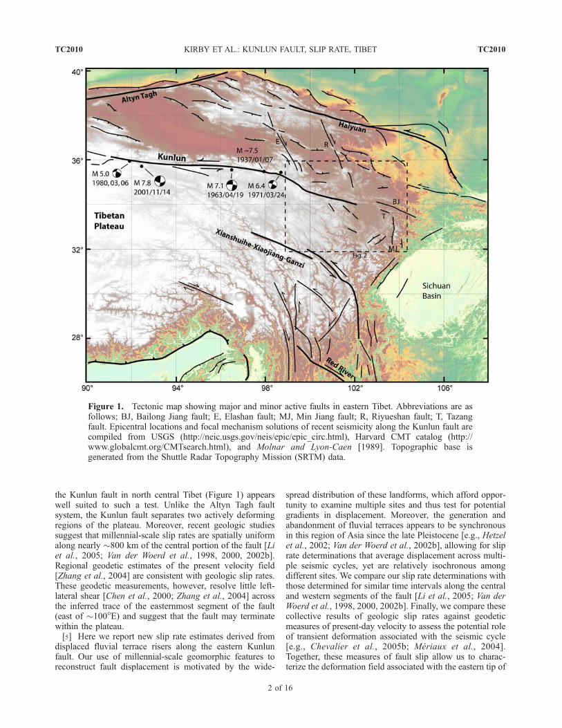
can be traced as a continuous series of scarps through theAnyemaqen Shan, a broad region of high topographywithin the eastern Tibetan Plateau between 99�and 102�E(Figure 2), until it is obscured by sediments in the westernpart of the Rouergai (Zoige) basin (�102�E, Figure 2).Early suggestions that the Kunlun fault linked with activeleft-lateral faults in the Qinling Shan [e.g., Peltzer et al.,1985; e.g., Zhang et al., 1995] seem untenable in light ofthis geometry, as linkage between these systems wouldrequire a northward step of nearly 200 km (Figure 2).Van der Woerd et al. [2002a] interpreted the fault to con-tinue northward across a broad dilational jog to link up withactive faults in the Bailong Jiang (Figure 2). Alternatively,the fault may continue through the Rouergai basin andlink, via the Tazang fault (Figure 2) with active shorteningstructures in the Min Shan [Chen et al., 1994; Kirby et al.,2000]. Finally, it is possible that the fault simply terminateswithin the Tibetan Plateau, west of the plateau margin.
3. Slip Rates Along the Eastern Kunlun Fault
[10] We seek to test among these scenarios by recon-structing slip and slip rates at several sites distributed alongthe easternmost segment of the Kunlun fault (Figure 2).In the eastern Anyemaqen Shan, the fault displaces region-ally correlative fluvial terraces developed and subsequentlyabandoned during incision of the Yellow River (Huang He)and its tributaries. Displacements of terrace risers weredetermined by surveying using a laser rangefinder (centi-meter-scale instrumental precision) at two sites separated by�40 km along the fault (Figure 2). At the western site(Ken Mu Da, site 1), north flowing tributaries drain hightopography south of the Yellow River, whereas at theeastern site (Quor Goth Qu, site 2) a large, south flowingtributary drains highlands north of the fault. Left-lateraldisplacements of terrace risers at each site (Figure 2) allowus to place bounds on the spatial variation of long-term sliprate along the fault. In addition, we examined a third sitealong the Tazang fault, east of the Rouergai basin (Figure 2)in order to test the hypothesis that high slip rates aretransferred via this fault to the Min Shan.
3.1. Determination of Slip Rates From FluvialTerrace Risers
[11] The use of fluvial terrace risers in the determinationof slip rates along strike slip faults is become commonpractice [e.g., Allen et al., 1991;Meyer et al., 1996;Meriauxet al., 2004, 2005; e.g., Sieh and Jahns, 1984; Van derWoerd et al., 1998, 2002b; Weldon and Sieh, 1985],although the method is still subject to uncertainties in theinterpretation of when the terrace riser began to accumulateslip [Meriaux et al., 2005; Van der Woerd et al., 2002b].Many have assumed that lateral erosion of the riser occurredcontinuously during fluvial occupation of the adjacentterrace tread [e.g., Van der Woerd et al., 2002b], and thusdisplacement does not accumulate until abandonment of theadjacent terrace. In this scenario, the best approximation ofthe terrace riser ‘‘age’’ is the age of abandonment of thelower, inset terrace. Such conditions are likely met in cases
TC2010 KIRBY ET AL.: KUNLUN FAULT, SLIP RATE, TIBET
3 of 16
TC2010
where the channel exhibits limited meandering or braidingand where slip along the fault is such that it displacesterraces into the path of the river. However, when displace-ment along the fault shields terrace risers from lateral attack,risers may begin to accumulate slip prior to terrace aban-donment. In the extreme example, the age of abandonmentof the upper terrace may be a more appropriate measure ofthe average slip rate. The uncertainty imparted by thesealternative interpretations of riser age can have a significantimpact on the estimate of slip rate [Cowgill, 2007].[12] It is important to note that in the absence of
additional information regarding the history of lateral bankerosion, the first assumption (‘‘lower surface’’) provides amaximum bound on the slip rate, whereas the latter view(‘‘upper surface’’) yields a minimum bound. Obviously,the ideal sites for slip rates are those with relativelyrapid incision, such that the interval between terrace forma-tion and abandonment is short. In this paper, slip ratesestimates are presented as both maximum and minimumbounds, utilizing the criteria outlined above, and each
incorporating uncertainties in riser position and radiocarbonchronology.
3.2. Tectonic Geomorphology Along the EasternKunlun Fault
[13] Fluvial terraces are ubiquitously developed alongtributaries of the Yellow River, west of the town of Maqu(Figure 2), and consist of strath surfaces beveled intoindurated and weathered alluvium (of undetermined age).Each terrace bears a thin, 1–2 m tread of fluvial gravel withinterbedded sand/silt lenses, and thus they do not appear torecord significant aggradation of the fluvial system. Fluvialdeposits are overlain by a variably developed soil mantle ofaeolian silt (loess) and organic matter. The highest terrace(designated T5) bears a thick mantle of loess (>4–6 m),whereas inset terraces (T4 � T1) exhibit significantly thinnerloess cover (�1–2 m). We note here that all terracedesignations are relative to the number in a given site,increasing from lowest to highest (modern floodplain, T0).Little to no aeolian material is present on the lowest terraces
Figure 2. Map of the eastern segment of the Kunlun fault showing location of active faults and majorphysiographic features. Active faults are represented by heavy lines; dashed where recent activityis inferred. Yellow River (Huang He) is shown as blue line. White boxes represent slip rate estimates(mm/yr) [Van der Woerd et al., 2002b]. Locations of new slip rate determinations are labeled in white circles(1, 2, 3). Focal mechanisms are compiled from USGS (http://neic.usgs.gov/neis/epic/epic_circ.html).
TC2010 KIRBY ET AL.: KUNLUN FAULT, SLIP RATE, TIBET
4 of 16
TC2010
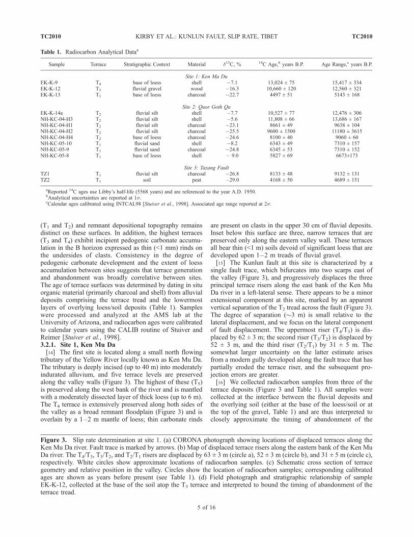
(T1 and T2) and remnant depositional topography remainsdistinct on these surfaces. In addition, the highest terraces(T3 and T4) exhibit incipient pedogenic carbonate accumu-lation in the B horizon expressed as thin (<1 mm) rinds onthe undersides of clasts. Consistency in the degree ofpedogenic carbonate development and the extent of loessaccumulation between sites suggests that terrace generationand abandonment was broadly correlative between sites.The age of terrace surfaces was determined by dating in situorganic material (primarily charcoal and shell) from alluvialdeposits comprising the terrace tread and the lowermostlayers of overlying loess/soil deposits (Table 1). Sampleswere processed and analyzed at the AMS lab at theUniversity of Arizona, and radiocarbon ages were calibratedto calendar years using the CALIB routine of Stuiver andReimer [Stuiver et al., 1998].3.2.1. Site 1, Ken Mu Da[14] The first site is located along a small north flowing
tributary of the Yellow River locally known as Ken Mu Da.The tributary is deeply incised (up to 40 m) into moderatelyindurated alluvium, and five terrace levels are preservedalong the valley walls (Figure 3). The highest of these (T5)is preserved along the west bank of the river and is mantledwith a moderately dissected layer of thick loess (up to 6 m).The T4 terrace is extensively preserved along both sides ofthe valley as a broad remnant floodplain (Figure 3) and isoverlain by a 1–2 m mantle of loess; thin carbonate rinds
are present on clasts in the upper 30 cm of fluvial deposits.Inset below this surface are three, narrow terraces that arepreserved only along the eastern valley wall. These terracesall bear thin (<1 m) soils devoid of significant loess that aredeveloped upon 1–2 m treads of fluvial gravel.[15] The Kunlun fault at this site is characterized by a
single fault trace, which bifurcates into two scarps east ofthe valley (Figure 3), and progressively displaces the threeprincipal terrace risers along the east bank of the Ken MuDa river in a left-lateral sense. There appears to be a minorextensional component at this site, marked by an apparentvertical separation of the T2 tread across the fault (Figure 3).The degree of separation (�3 m) is small relative to thelateral displacement, and we focus on the lateral componentof fault displacement. The uppermost riser (T4/T3) is dis-placed by 62 ± 3 m; the second riser (T3/T2) is displaced by52 ± 3 m, and the third riser (T2/T1) by 31 ± 5 m. Thesomewhat larger uncertainty on the latter estimate arisesfrom a modern gully developed along the fault trace that haspartially eroded the terrace riser, and the subsequent pro-jection errors are greater.[16] We collected radiocarbon samples from three of the
terrace deposits (Figure 3 and Table 1). All samples werecollected at the interface between the fluvial deposits andthe overlying soil (either at the base of the loess/soil or atthe top of the gravel, Table 1) and are thus interpreted toclosely approximate the timing of abandonment of the
Table 1. Radiocarbon Analytical Dataa
Sample Terrace Stratigraphic Context Material d13C, % 14C Age,b years B.P. Age Range,c years B.P.
Site 1: Ken Ma DuEK-K-9 T4 base of loess shell �7.1 13,024 ± 75 15,417 ± 334EK-K-12 T3 fluvial gravel wood �16.3 10,660 ± 120 12,560 ± 321EK-K-13 T1 base of loess charcoal �22.7 4497 ± 51 5143 ± 168
Site 2: Quor Goth QuEK-K-14a T2 fluvial silt shell �7.7 10,527 ± 77 12,476 ± 306NH-KC-04-H3 T2 fluvial silt shell �5.6 11,808 ± 66 13,686 ± 167NH-KC-04-H1 T2 fluvial silt charcoal �23.1 8661 ± 49 9638 ± 104NH-KC-04-H2 T2 fluvial silt charcoal �25.5 9600 ± 1500 11180 ± 3615NH-KC-04-H4 T2 base of loess charcoal �24.6 8100 ± 40 9060 ± 60NH-KC-05-10 T1 fluvial sand shell �8.2 6343 ± 49 7310 ± 157NH-KC-05-9 T1 fluvial sand charcoal �24.8 6345 ± 53 7310 ± 152NH-KC-05-8 T1 base of loess shell � 9.0 5827 ± 69 6673±173
Site 3: Tazang FaultTZ1 T1 fluvial silt charcoal �26.8 8133 ± 48 9132 ± 131TZ2 T1 soil peat �29.0 4168 ± 50 4689 ± 151
aReported 14C ages use Libby’s half-life (5568 years) and are referenced to the year A.D. 1950.bAnalytical uncertainties are reported at 1s.cCalendar ages calibrated using INTCAL98 [Stuiver et al., 1998]. Associated age range reported at 2s.
Figure 3. Slip rate determination at site 1. (a) CORONA photograph showing locations of displaced terraces along theKen Mu Da river. Fault trace is marked by arrows. (b) Map of displaced terrace risers along the eastern bank of the Ken MuDa river. The T4/T3, T3/T2, and T2/T1 risers are displaced by 63 ± 3 m (circle a), 52 ± 3 m (circle b), and 31 ± 5 m (circle c),respectively. White circles show approximate locations of radiocarbon samples. (c) Schematic cross section of terracegeometry and relative position in the valley. Circles show the location of radiocarbon samples; corresponding calibratedages are shown as years before present (see Table 1). (d) Field photograph and stratigraphic relationship of sampleEK-K-12, collected at the base of the soil atop the T3 terrace and interpreted to bound the timing of abandonment of theterrace tread.
TC2010 KIRBY ET AL.: KUNLUN FAULT, SLIP RATE, TIBET
5 of 16
TC2010
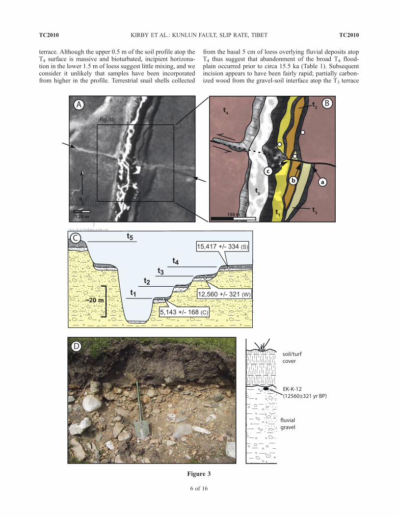
terrace. Although the upper 0.5 m of the soil profile atop theT4 surface is massive and bioturbated, incipient horizona-tion in the lower 1.5 m of loess suggest little mixing, and weconsider it unlikely that samples have been incorporatedfrom higher in the profile. Terrestrial snail shells collected
from the basal 5 cm of loess overlying fluvial deposits atopT4 thus suggest that abandonment of the broad T4 flood-plain occurred prior to circa 15.5 ka (Table 1). Subsequentincision appears to have been fairly rapid; partially carbon-ized wood from the gravel-soil interface atop the T3 terrace
Figure 3
TC2010 KIRBY ET AL.: KUNLUN FAULT, SLIP RATE, TIBET
6 of 16
TC2010
yielded an age of circa 12.5 ka (Table 1). Finally, charcoalfrom the basal 5 cm of soil capping the lowest terrace (T1)yielded an age of circa 5 ka (Table 1), indicating abandon-ment prior to that time.[17] As noted above, estimation of the average slip rate
over these time intervals depends on when the terrace riserbegan to accumulate displacement. Fortunately, ages fromthe T4 and T3 terraces provide a fairly narrow interval thatbrackets the riser age to between circa 15.5 ka and 12.5 ka.Combining these ages with the displacement of the riser(63 ± 3 m) yields a minimum slip rate of 4.1 ± 0.3 mm/yr,using the upper surface age, and a maximum slip rate of5.0 ± 0.4 mm/yr, using the lower surface age (Table 2). Asecond bound on the maximum allowable slip rate at thissite is provided by utilizing the abandonment age of T1
(circa 5 ka) and the offset of the T2/T1 riser (31 ± 5m);this relationship indicates slip rates of no greater than 6.0 ±1.2 mm/yr (Table 2), within uncertainty of the previousestimate. Finally, the age of the T3 terrace and the displace-ment of the T3/T2 (52 ± 3 m) riser places an additionalconstraint on the minimum allowable slip rate of 4.1 ±0.4 mm/yr, nearly identical to the previous estimate.[18] The close correspondence between both maximum
and minimum allowable slip rates from two different terracerisers lends confidence that these estimates represent reli-able slip rate determinations. Although we recognize thatdetrital charcoal incorporated into fluvial deposits can yielderroneously old ages, the fact that our samples all lie eitherat the interface between the soil and underlying fluvialdeposits or within the lower few centimeters of the soilitself argues that these samples were deposited shortly afterfluvial deposition on the terrace ceased. Thus the ages aremore likely to represent a minimum bound on the timing ofterrace abandonment, and our slip rate determinations arelikely a maximum estimate.[19] Moreover, the geomorphology of the site itself
suggests that the lower surface model is a more appropriateapproximation for the time at which risers began to accu-mulate displacement. The channel is deeply incised andstraight, and all three inset terraces are preserved along theeastern valley wall. Thus we infer that rapid incision of thechannel (average rates of �2 mm/yr) occurred withoutsignificant meandering and widening of the floodplain. In
addition, left-lateral displacement of terrace risers preservedalong the right bank of the valley (in a reference frame facingdownstream) make the downstream risers susceptible tolateral bank erosion by the channel (Figure 3). Both con-ditions suggest that the assumption that displacement did notbegin to accumulate until after abandonment of the inset(lower) terrace is likely met at this site, and we favor themaximum allowable slip rate (5 ± 1 mm/yr) as the bestestimate of the slip rate along this portion of the Kunlun fault.3.2.2. Site 2, Quor Goth Qu[20] We determined slip rates at a second site, approxi-
mately 40 km farther east of Ken Mu Da and 30 km west ofthe town of Maqu (Figure 2). This site is located north of theYellow River, and the Quor Goth Qu tributary drains towardthe south (Figure 2). Incision along the Yellow Riverdecreases notably from west to east between the two sites,and consequently the tributary at Quor Goth Qu has incisedby only �15 m into the older alluvium. Four terrace levelsare preserved along the valley; the highest of these (T4) is arelict hill of alluvium exposed near the mountain front(Figure 4). Below this level is a broad alluvial fan/terracecomplex (T3) that bears a 1–2 m thick mantle of loessialsoil. Fluvial gravels immediately below the loess exhibitthin carbonate collars in the B horizon, similar to thoseobserved in the T4 terrace at Ken Mu Da. Inset below theT3 piedmont are two relatively narrow terrace levels. Thehigher of these (T2) forms an extensively preserved surfaceexposed along the entire length of the tributary (Figure 4).Fluvial deposits consist primarily of gravel and minor sandlenses; these are covered by a 50 cm thick loessial soil(Figure 4). The lowest terrace (T1) forms a discontinuoussurface inset 3–5 m below T2 and is exposed primarily inthe lower reaches of the channel, near the Yellow River. TheT1 terrace exhibits a thin 30–50 cm loessial soil (Figure 4).[21] The Kunlun fault west of the Ken Mu Da drainage is
marked by a series of extensional steps that form local sagponds (Figure 4). These coalesce to form a single scarp thatdisplaces the T3/T2 riser along the east side of the valley in aleft-lateral sense (Figure 4). There appears to be a minorextensional component at this site, based on a �2 mapparent vertical separation of the terrace tread (Figure 4).Surveys of the lateral displacement by with laser range-finder and tape indicate that the T2/T3 riser is laterally offset
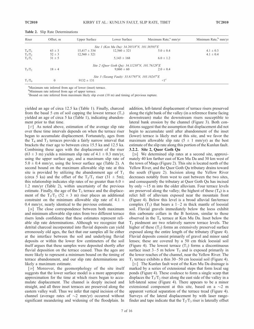
Table 2. Slip Rate Determinations
Riser Offset, m Upper Surface Lower Surface Maximum Rate,a mm/yr Minimum Rate,b mm/yr
Site 1 (Ken Ma Du): 34.20518�N, 101.38593�ET4/T3 63 ± 3 15,417 ± 334 12,560 ± 321 5.0 ± 0.4 4.1 ± 0.3T3/T2 52 ± 3 12,560 ± 321 4.1 ± 0.4T2/T1 31 ± 5 5,143 ± 168 6.0 ± 1.2
Site 2 (Quor Goth Qu): 34.11238�N, 101.76128�ET3/T2 18 ± 4 9,060 ± 60 2.0 ± 0.4
Site 3 (Tazang Fault): 33.81795�N, 103.10247�ET1/T0 0 9132 ± 131 <1c
aMaximum rate inferred from age of lower (inset) terrace.bMinimum rate inferred from age of upper terrace.cBound on rate inferred from maximum likely slip event (10 m) and timing of previous rupture.
TC2010 KIRBY ET AL.: KUNLUN FAULT, SLIP RATE, TIBET
7 of 16
TC2010
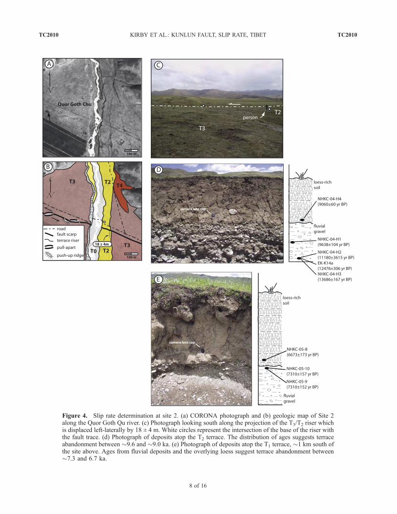
Figure 4. Slip rate determination at site 2. (a) CORONA photograph and (b) geologic map of Site 2along the Quor Goth Qu river. (c) Photograph looking south along the projection of the T3/T2 riser whichis displaced left-laterally by 18 ± 4 m. White circles represent the intersection of the base of the riser withthe fault trace. (d) Photograph of deposits atop the T2 terrace. The distribution of ages suggests terraceabandonment between �9.6 and �9.0 ka. (e) Photograph of deposits atop the T1 terrace, �1 km south ofthe site above. Ages from fluvial deposits and the overlying loess suggest terrace abandonment between�7.3 and 6.7 ka.
TC2010 KIRBY ET AL.: KUNLUN FAULT, SLIP RATE, TIBET
8 of 16
TC2010
by 18 ± 4 m (Figure 4). The uncertainty arises primarilybecause of a slight curvature in the riser near the trace of thefault (Figure 4).[22] We collected radiocarbon samples from both fluvial
deposits and overlying loess on the T2 and T1 terrace levels.Both shell material and charcoal from silt and sandy lenses inT2 gravels yield a range of ages between circa 9.6 ka and13.6 ka (Table 1). Thewide range of agesmay reflect (1) long-lived occupation of the terrace surface, consistent with therelatively limited incision at this site and/or (2) incorporationof older organic material into the fluvial deposits. Regardless,a sample of charcoal from the lower 5 cm of the overlyingloess on T2 indicates abandonment of this surface was locallyaccomplished by circa 9 ka (Table 1). This is consistent withsamples from the inset T1 terrace; two samples of shell andcharcoal from a silt lens within terrace deposits yieldedidentical ages of circa 7.3 ka, and a sample of shell materialfrom the basal portion of the overlying loess yielded anyounger age of circa 6.7 ka (Table 1).[23] Combining the timing of abandonment of the T2
terrace surface with the observed offset of the T3/T2 terraceriser (18 ± 4 m) yields an average slip rate of 2.0 ± 0.4 mm/yr(Table 2). This rate represents a maximum estimate as itassumes that the riser offset accumulated entirely afterabandonment of the T2 surface. We note that the relativelylow incision rates and apparent long-lived occupation of theT2 surface are favorable conditions for lateral erosion by thechannel, and thus we interpret this rate estimate as areasonable value for this portion of the fault. If any slipaccumulated prior to T2 abandonment, however, the actualslip rate could be somewhat lower.3.2.3. Constraints on Slip Along the Tazang Fault[24] East of the town of Maqu, the trace of the Kunlun
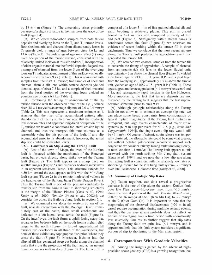
fault is obscured within the marshlands of the Rouergaibasin, but projects directly along strike toward the Tazangfault (Figure 2). The fault appears as a sharp trace onsatellite images (Figure 5) and displaces bedrock interfluvesin an apparent left-lateral sense. This structure extends for�50 km toward the east appears to link with the Min Jiangfault system (Figure 2) in the remote, high-relief valleys inthe headwaters of the Bailong Jiang (White Dragon River).Thus the Tazang fault is one of the primary candidates totransfer slip from the Kunlun fault to shortening structuresat the margin of the Tibetan Plateau [Chen et al., 1994;Kirby et al., 2000; Van der Woerd et al., 2002b]; weconsider the other, the Bailong Jiang fault, in section 5.1.[25] We examined sites along the western 20 km of the
fault, near its intersection with the Rouergai Basin. Imme-diately east of the basin, three small catchments aredeflected in a left-lateral sense across the fault (Figure 5).On the interfluves, the fault forms a uphill-facing scarp thatseparates low bedrock hills on the south from a higher reliefrange to the north (Figure 5). Broad aggradational fillterraces are developed in all three of the watersheds, butnone of these exhibit any topographic disruption where theycross the fault (Figure 5). Moreover, incision into thealluvial fill has generated steep cut banks along the channelwalls that cross the projection of the fault and act as naturaltrench exposures 6–8 m deep (Figure 5). The terrace fill is
composed of a lower 3–4 m of fine-grained alluvial silt andsand; bedding is relatively planar. This unit is buriedbeneath a 3–4 m thick soil composed primarily of turfand peat (Figure 5). Stratigraphy within stream banks iscontinuous across the fault (Figure 5); we observed noevidence of recent faulting within the terrace fill in threecatchments. Thus we conclude that the most recent rupturealong the Tazang fault predates the aggradation event thatgenerated the terrace fill.[26] We obtained two charcoal samples from the terrace fill
to constrain the timing of aggradation. A sample of charcoalfrom an organic-rich silt lens in the lower fluvial unit,approximately 2 m above the channel floor (Figure 5), yieldeda calibrated age of 9132 ± 131 years B.P., and a peat layerfrom the overlying soil, approximately 1.5 m above the fluvialunit, yielded an age of 4689 ± 151 years B.P. (Table 1). Theseages suggest moderate aggradation (�1 mm/yr) between 9 and4 ka, and subsequently rapid incision in the late Holocene.More importantly, the fact that terrace deposits are notdisplaced by the Tazang fault suggests that the last ruptureoccurred sometime prior to circa 9 ka.[27] Although geologic relationships along the Tazang
fault do not allow us to estimate an average slip rate, wecan place some broad constraints from consideration oftypical rupture magnitudes. If the Tazang fault ruptures ininfrequent, but large events characteristic of major strikesystems (6–9 m slip per event for M � 8 [e.g., Wells andCoppersmith, 1994]), the single-event slip rate would stillbe <1 mm/yr. Of course, if seismic strain release was tempo-rally clustered, the allowable rate could be somewhat greater,but without detailed paleoseicmic records to support suchconjecture, we consider it likely Tazang fault ismoving slowly,at rates less than �1 mm/yr. The Tazang fault appears to linkeastward with the north striking Min Jiang fault system[Chen et al., 1994], and we note that a low slip rate alongthe Tazang fault is consistent with the relatively low rates ofshortening inferred for the Min Jiang fault system (�1 mm/yr)over late Pleistocene–Holocene time [Kirby et al., 2000].
3.3. Summary of Geologic Slip Rates
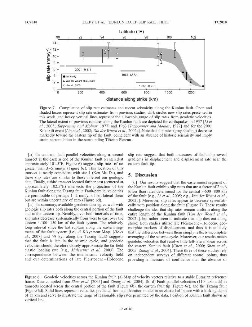
[28] Taken together, our data reveal a progressivedecrease in the rate of slip along the eastern Kunlun faultover late Pleistocene–Holocene time, from >10 mm/yralong the central portion of the fault [Van der Woerd et al.,2002b], to <6 mm/yr at site 1 (Ken Mu Da), to �2 mm/yrat site 2 (Quor Goth Qu). It is important to note that themagnitudes of the observed displacements (>20 m in allcases) require accumulation during multiple seismic events,and thus the decrease in rate probably does not reflect anartifact of averaging over a time period with anomalouslylow seismicity. Our results further suggest that slip ratesalong the Tazang fault are quite low (�1 mm/yr), and itappears unlikely that this fault system transfers a significantportion of slip to shortening in the Min Shan region.
4. Correspondence With Geodetic Velocities
[29] Among the insights gained by the advent of high-precision space geodesy (GPS) is a growing recognition that
TC2010 KIRBY ET AL.: KUNLUN FAULT, SLIP RATE, TIBET
9 of 16
TC2010
a number of intracontinental fault systems exhibit differencesbetween long-term (geologic) slip rates and those inferredfrom short-term (decadal) measurements of surface velocity[Bendick et al., 2000; Meyer et al., 1996; Meriaux et al.,2004, 2005; Wright et al., 2004]. Although such differencesmay reflect transient behavior associated with the seismiccycle [e.g., Chevalier et al., 2005b] or with fault systemevolution [e.g., Bennett et al., 2004], the significance of suchdifferences remains contentious due to contrasting interpre-tations of geologic data [cf. Brown et al., 2005; Chevalier etal., 2005a]. In this section, we utilize published geodeticvelocity fields for central and eastern Tibet [Shen et al., 2005;Zhang et al., 2004] to examine the degree of correspondencebetween geologic slip rates and geodetic velocities along thelength of the Kunlun fault and to test whether strain may beaccumulating at the tip of the fault.
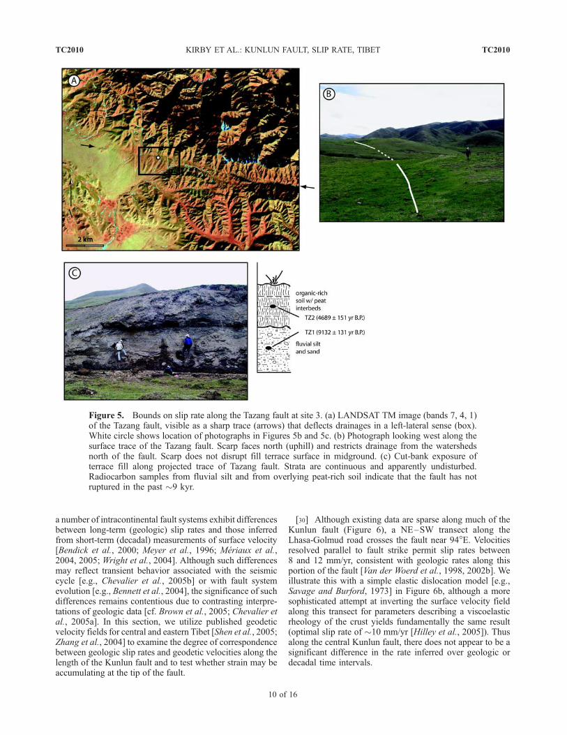
[30] Although existing data are sparse along much of theKunlun fault (Figure 6), a NE–SW transect along theLhasa-Golmud road crosses the fault near 94�E. Velocitiesresolved parallel to fault strike permit slip rates between8 and 12 mm/yr, consistent with geologic rates along thisportion of the fault [Van der Woerd et al., 1998, 2002b]. Weillustrate this with a simple elastic dislocation model [e.g.,Savage and Burford, 1973] in Figure 6b, although a moresophisticated attempt at inverting the surface velocity fieldalong this transect for parameters describing a viscoelasticrheology of the crust yields fundamentally the same result(optimal slip rate of �10 mm/yr [Hilley et al., 2005]). Thusalong the central Kunlun fault, there does not appear to be asignificant difference in the rate inferred over geologic ordecadal time intervals.
Figure 5. Bounds on slip rate along the Tazang fault at site 3. (a) LANDSAT TM image (bands 7, 4, 1)of the Tazang fault, visible as a sharp trace (arrows) that deflects drainages in a left-lateral sense (box).White circle shows location of photographs in Figures 5b and 5c. (b) Photograph looking west along thesurface trace of the Tazang fault. Scarp faces north (uphill) and restricts drainage from the watershedsnorth of the fault. Scarp does not disrupt fill terrace surface in midground. (c) Cut-bank exposure ofterrace fill along projected trace of Tazang fault. Strata are continuous and apparently undisturbed.Radiocarbon samples from fluvial silt and from overlying peat-rich soil indicate that the fault has notruptured in the past �9 kyr.
TC2010 KIRBY ET AL.: KUNLUN FAULT, SLIP RATE, TIBET
10 of 16
TC2010
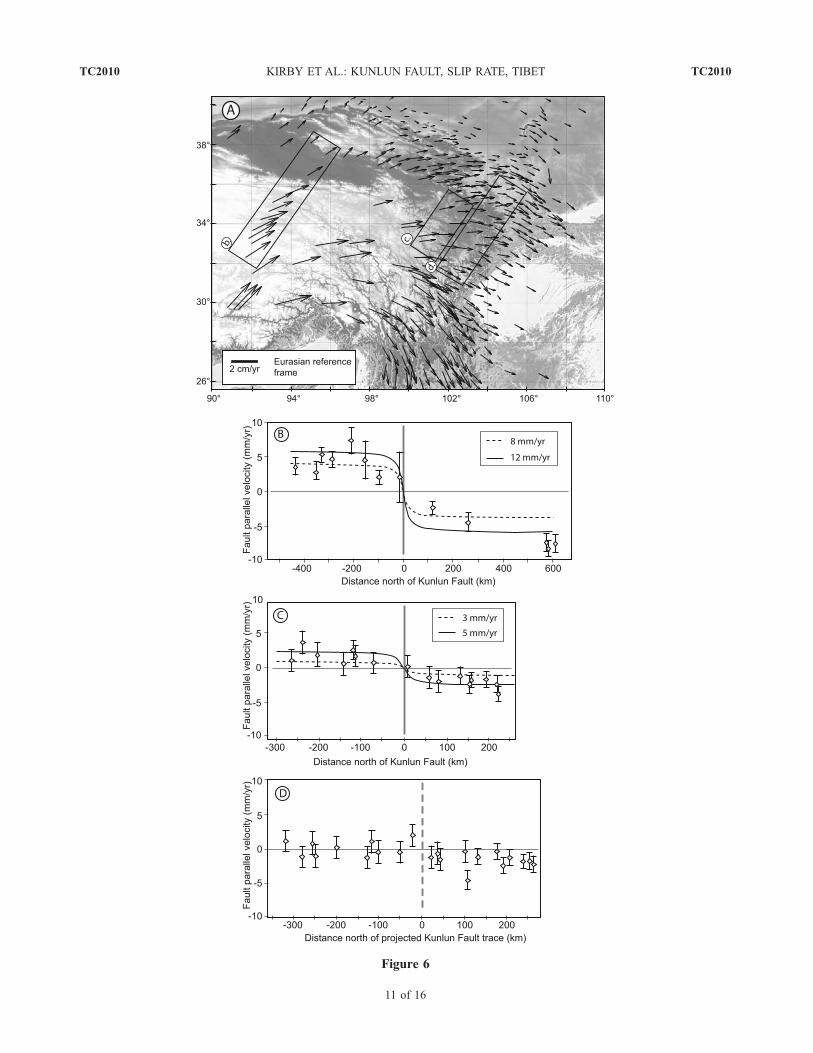
Figure 6
TC2010 KIRBY ET AL.: KUNLUN FAULT, SLIP RATE, TIBET
11 of 16
TC2010
[31] In contrast, fault-parallel velocities along a secondtransect at the eastern end of the Kunlun fault (centered atapproximately 101.5�E, Figure 6) suggest slip rates of nogreater than 3–5 mm/yr (Figure 6c). This location of thistransect is nearly coincident with site 1 (Ken Mu Da), andthese slip rates are similar to those inferred our geologicdata. Finally, a third transect located farther east (centered atapproximately 102.5�E) intersects the projection of theKunlun fault along the Tazang fault. Fault-parallel velocitiesare permissible of perhaps 1–2 mm/yr of left-lateral shearbut are within uncertainty of zero (Figure 6d).[32] In summary, available geodetic data agree well with
geologic slip rates both along the central portion of the faultand at the eastern tip. Notably, over both intervals of time,slip rates decrease systematically from west to east over theeastern �100–150 km of the fault system. The relativelylong interval since the last rupture along the eastern seg-ments of the fault system (i.e., >1.8 kyr near Maqu [He etal., 2007] and >9 kyr along the Tazang fault) suggeststhat the fault is late in the seismic cycle, and geodeticvelocities should therefore closely approximate the far-fieldelastic loading rate [e.g., Malservisi et al., 2003]. Thecorrespondence between the interseismic velocity fieldand our determinations of late Pleistocene–Holocene
slip rate suggest that both measures of fault slip revealgradients in displacement and displacement rate near theeastern fault tip.
5. Discussion
[33] Our results suggest that the easternmost segment ofthe Kunlun fault exhibits slip rates that are a factor of 2 to 6lower than rates determined for the central �600–800 kmof the fault [e.g., Li et al., 2005; e.g., Van der Woerd et al.,2002b]. Moreover, slip rates appear to decrease systemati-cally with position along the fault (Figure 7). These resultschallenge the idea that slip rates remain uniform along theentire length of the Kunlun fault [Van der Woerd et al.,2002b], but rather seem to indicate that slip dies out alongstrike. Both studies utilize late Pleistocene–Holocene geo-morphic markers of displacement, and thus it is unlikelythat the difference between them simply reflects incompleteaveraging of the seismic cycle. Moreover, our results matchgeodetic velocities that resolve little left-lateral shear acrossthe eastern Kunlun fault [Chen et al., 2000; Shen et al.,2005; Zhang et al., 2004]. These three of these studies relyon independent surveys of different control points, thusproviding a measure of confidence that the absence of
Figure 7. Compilation of slip rate estimates and recent seismicity along the Kunlun fault. Open andshaded boxes represent slip rate estimates from previous studies, dark circles new slip rates presented inthis work, and heavy vertical lines represent the allowable range of slip rates from geodetic velocities.The lateral extent of previous ruptures along the Kunlun fault are depicted for earthquakes in 1937 [Li etal., 2005; Tapponnier and Molnar, 1977] and 1963 [Tapponnier and Molnar, 1977] and for the 2001Kokoxili event [Lin et al., 2002; Van der Woerd et al., 2002a]. Note that slip rates (gray shading) decreasemarkedly toward the eastern tip of the fault, coincident with an absence of historic seismicity and implystrain accumulation in the surrounding Tibetan Plateau.
Figure 6. Geodetic velocities across the Kunlun fault. (a) Map of velocity vectors relative to a stable Eurasian referenceframe. Data compiled from Shen et al. [2005] and Zhang et al. [2004]. (b–d) Fault-parallel velocities (110� azimuth) intransects located across the central portion of the fault (Figure 6b), the eastern fault tip (Figure 6c), and the Tazang fault(Figure 6d). Solid lines represent velocities predicted from a dislocation model in an elastic half-space with a locking depthof 15 km and serve to illustrate the range of reasonable slip rates permitted by the data. Position of Kunlun fault shown asvertical line.
TC2010 KIRBY ET AL.: KUNLUN FAULT, SLIP RATE, TIBET
12 of 16
TC2010
velocity gradients across this region of the plateau is real.Therefore we argue that our results reveal spatial gradientsin slip rate along the eastern Kunlun fault (Figure 7) thatappear to be a relatively long-lived feature of this faultsystem. In what follows, we explore hypotheses for mech-anisms by which displacement gradients may be accommo-dated at the eastern tip of the Kunlun fault.
5.1. Transfer to the Bailong Jiang Fault System
[34] One of the principal hypotheses for the terminationof the Kunlun fault system is that displacement is trans-ferred via the Bailong Jiang and Tazang fault systems(Figure 2) to shortening structures adjacent to and northof the Sichuan Basin [Chen et al., 1994; Kirby et al., 2000;Van der Woerd et al., 2002b]. Our work indicates that mostdirect of these proposed linkages, to the Tazang fault,appears to accommodate little, if any, of the displacementalong the eastern Kunlun fault. Here we address thealternate hypothesis that slip is accommodated along theBailong Jiang fault zone.[35] We consider it unlikely that the Bailong Jiang fault
accommodates a significant component of slip from theKunlun fault for several reasons. First, although the BailongJiang fault appears to be active, in that it displaces bedrockinterfluves, the western extent of this activity can only betraced into the headwaters of the Bailong Jiang (Figure 2).There are no active faults recognizable in the field or onremote sensing between the eastern tip of the Kunlun faultnear Maqu (Figure 2) and the western end of the BailongJiang fault, a distance of over 100 km. Second, such ageometry would predict a significant extensional compo-nent, for which there is no evidence. In fact, the interveningranges between the eastern end of the Kunlun and theBailong Jiang faults comprise relatively high, rugged to-pography. In contrast, a releasing step in the fault systemoccurs at Dongxi Co, just west of 99�E (Figure 2), and inthis location the geometry is responsible for the develop-ment of an extensional basin [Van der Woerd et al., 2002b].Finally, ongoing work along the Bailong Jiang fault byresearchers from the Institute of Geology, China EarthquakeAdministration in Gansu suggests that the fault is charac-terized by relatively low slip rates (<3 mm/yr (YuanDaoyang, personal communication, 2006)).
5.2. Similarity to Displacement Gradients AlongCrustal Faults
[36] The fact that slip along the Kunlun fault does notappear to link with structures at the margin of the TibetanPlateau indicates that displacement must somehow beabsorbed by deformation in the volume surrounding thefault tip. Such behavior is directly analogous to that inferredfrom scaling relationships between fault displacement andlength [e.g., Cowie and Scholz, 1992a; Stirling et al., 1996].Linear displacement gradients typically observed near faulttips (x/L � 0.75, where x is the position along the fault andL is the fault half length) are suggested to reflect a finiteyielding in a damage zone surrounding the fault tip [Cowieand Scholz, 1992a, 1992b; Cowie and Shipton, 1998].Existing data for strike-slip faults are consistent with this
model [Peacock, 1991]. Few data are available, however,for intracontinental faults of the scale of the Kunlun[Stirling et al., 1996]. Theoretical treatment of a fault tipembedded in a viscous medium predicts that displacementgradients should depend on the average rheology of thecrust [Barr and Houseman, 1992, 1996]. Our data are notyet sufficient to distinguish whether displacement gradientson the Kunlun fault decrease linearly toward the fault tip[e.g., Peacock, 1991] or in some other way. This will bediscussed in greater detail in a forthcoming paper. However,despite their preliminary nature, our results indicate that theKunlun fault does not behave as a simple transfer structure.Rather, it appears that the termination of the fault systemrequires deformation of the regions of the plateau surround-ing the fault tip (cf. Zhang et al., submitted manuscript,2006).
5.3. Mechanisms to AccommodateDisplacement Gradients
[37] The question of how displacement gradients areaccommodated by deformation within the plateau, however,remains uncertain. In this section, we explore three hypoth-eses that are compatible with our observations of slip rategradients along the eastern Kunlun fault. None of these aremutually exclusive, and it is possible that components ofeach are operating in eastern Tibet. Nonetheless, we posethem as a means to further future work on the question.5.3.1. Eastward Propagation of the Kunlun Fault[38] The presence of displacement gradients near the tip
of the Kunlun fault suggests that the fault may simply berelatively immature and that the system has not yet accu-mulated significant finite displacement. If so, the fault maybe growing in length, and the tip may be propagatingtoward the east in a manner similar to that suggested forcrustal fault systems [e.g., Cowie and Scholz, 1992b;Dawers et al., 1993] as well as for the North Anatolianfault [Flerit et al., 2004]. Two lines of evidence, however,argue against this scenario. First, we do not observe highgeodetic velocities near the fault tip, as might be expectedif strain was accumulating in response to gradients indisplacement. Rather, the geodetic velocities appear todecrease toward the east over length scales of �103 km(Figure 6), similar to those inferred from geologic slip rates.In addition, the apparently long interseismic intervalsinferred for the eastern Kunlun fault [He et al., 2007] areconsistent with slow strain accumulation. Unfortunately, thelack of markers with which to track finite displacement overlonger time intervals than our study prevents a definitivetest of this hypothesis at present, and it remains possible thatthe fault is growing eastward with time.5.3.2. Crustal Thickening in the Anyemaqen Shan[39] The Anyemaqen Shan are a broad, elliptical region
of high topography surrounding the eastern �300 km of theKunlun fault (Figure 2) that marks a step from elevations of�4500 m on the plateau to the southwest to somewhatlower elevations (�3500 m) on the plateau north and east ofthe range (Figure 2). The association between high reliefwithin the range and the tip of the fault suggest thepossibility that active crustal thickening in the Anyemaqen
TC2010 KIRBY ET AL.: KUNLUN FAULT, SLIP RATE, TIBET
13 of 16
TC2010
absorbs some component of the displacement along theKunlun fault. Several minor active faults in the southeasternpart of the range (Figure 2) exhibit an apparent shorteningcomponent, consistent with distributed shortening aroundthe fault tip. In addition, we observed a thrust senseseparation of an alluvial fan surface along a minor fault inthe northern Anyemaqen (Figure 2). Although the slip ratesalong these structures are uncertain, they appear to indicateat least some degree of active deformation within the range.We also note that recent work on the geomorphology of therange suggests that there are systematic spatial patterns inerosion rate that may reflect active differential rock upliftacross the range (N. Harkins et al., Transient fluvial incisionin the headwaters of the Yellow River, northeastern TibetanPlateau, China, submitted to Journal of GeophysicalResearch, 2006). A quantitative analysis of the relationshipof this deformation to the fault tip is, however, beyond thescope of this paper.5.3.3. Rotation of the Kunlun Fault[40] As pointed out by England and Molnar [1990], the
cognitive leap from the observation of rapid displacementalong strike-slip faults to the interpretation of eastwardextrusion of Asian lithosphere carries the implicit assump-tion that the faults themselves are fixed, and do not rotate.Geologic and geodetic evidence from eastern and south-eastern Tibet, however, indicates that the deformation fieldhas been characterized by significant clockwise rotation ofmaterial around the eastern syntaxis of the Himalaya[Burchfiel, 2004; Chen et al., 2000; Holt et al., 1991; Kinget al., 1997; Molnar and Lyon-Caen, 1989; Shen et al.,2005]. Similar velocity gradients in northeastern Tibetdefine a broad (>300 km wide) NE trending zone ofright-lateral shear that coincides with the eastern tip of theKunlun fault (Figure 2) [Shen et al., 2005]. Rotation ofmaterial lines are predicted to be clockwise across this shearzone, and if the Kunlun fault is rotating, then the easterntermination of the fault may merely reflect the eastern extentof this broad shear zone.[41] Simple models of rigidly rotating blocks imply that
displacement should remain constant along the fault, even ifthe faults are rotating. This has been cited as evidence thatrotation of faults with constant curvature will only changethe direction of extrusion, not its magnitude [e.g., Avouacand Tapponnier, 1993]. It is important to note, however,that if the curvature of the faults is not constant (as in thecase of the Kunlun), the bounding regions must deforminternally. North of the Kunlun fault, velocity gradientsappear to be accommodated by coupled shortening on E–Wfault systems and right-lateral displacement along NNWstriking faults (Elashan and Riyueshan faults, Figure 1). It isintriguing to note that these faults roughly coincide with thewestern and eastern extents of the Anyemaqen Shan(Figure 1), and that the Elashan fault coincides with thelarge restraining bend along the Kunlun fault in the westernpart of the range (Figure 2). We speculate that the complexgeometry of the easternmost segments of the Kunlun faultcould be a consequence of rotation of the fault in responseto differential amounts of shortening across northeasternTibet. A definitive test of this hypothesis, however, requires
a significantly more comprehensive understanding of thedistribution and timing of both deformation in the regionthan is presently available.
6. Tectonic Implications
[42] At the heart of the debate over the rates of deforma-tion throughout the Indo-Asian collision lies a fundamentalquestion: Do the rules of plate tectonics govern deformationwithin continental lithosphere? An obvious yet profoundconsequence of slip rate gradients along the eastern Kunlunfault is that displacement along the fault is not transmittedbeyond the eastern margin of the Tibetan Plateau. In fact,our results imply that slip rates decrease to <2 mm/yr near�102�E (Figure 7), some 150–200 km west of the plateaumargin. Thus to the degree that the Kunlun fault is respon-sible for extrusion of central and northern Tibet, it must belimited to the confines of the Tibetan Plateau itself. Weacknowledge that this conclusion strictly pertains to dis-placement over the past circa 10–20 ka. However, it seemsto us unlikely that the Kunlun fault accommodated largefinite displacements at its eastern termination at some timedeeper in the geologic past. The magnitude of shorteningadjacent to the Sichuan Basin (<10 km [Burchfiel et al.,1995]) and in the Min Shan (<1–10 km [Kirby et al., 2000])appears to be consistent with limited finite displacement atthe tip of the Kunlun fault.[43] Our results further suggest that the evolution of the
eastern Kunlun fault is fundamentally linked to the thick-ened crust of the plateau. In contrast to the transform-likebehavior of the Altyn Tagh and perhaps the Haiyuan faultsystems, slip along the Kunlun fault is not absorbed byshortening at the plateau boundary. We infer that thepresence of slip rate gradients along the eastern Kunlunfault implies that regions of the plateau surrounding thefault tip must be deforming internally in order to maintainstrain compatibility. Thus our results support hypothesesthat link lateral displacement with continuum models forplateau deformation [England and Molnar, 2005, 1990].[44] Moreover, even if the fault is propagating toward the
east, it does not appear to drive plateau growth in themanner suggested by Tapponnier et al. [2001]. Rather,crustal thickening appears to lead, not lag, fault growth.This association suggests that deformation of the uppercrust may be decoupled from deformation at depth. Wenote that there is mounting evidence for a weak lower crustin this part of eastern Tibet [Clark et al., 2005; Clark andRoyden, 2000; Royden et al., 1997], and we suspect thisrheologic condition exerts a profound influence on thedistribution of deformation around the fault tip [Barr andHouseman, 1996].[45] Finally, our study demonstrates that rapid and slow
displacement may coexist along a single structure andhighlights the necessity of studying the manner in whichfault displacement and off-fault strain interact. The questionof whether displacement rates along Eurasian strike-slipfaults are low or high is an important, but not sufficient,test of their geodynamic significance. We expect that furtherinvestigation of deformation near the tips of other faults will
TC2010 KIRBY ET AL.: KUNLUN FAULT, SLIP RATE, TIBET
14 of 16
TC2010
reveal similar displacement gradients (e.g., Zhang et al.,submitted manuscript, 2006) that will lend further insightinto the large-scale mechanics of continental deformation inEurasia. Despite uniform slip along the central portion ofthe fault, displacement along the Kunlun fault is nottransmitted beyond the eastern margin of the plateauand thus the fault does not accommodate extrusion ofcentral Tibet.
[46] Acknowledgments. This research was supported by the Tecton-ics and International programs at NSF under award EAR-0229955. Kirbyalso acknowledges support from the NSF Earth Sciences PostdoctoralFellowship program that funded initial reconnaissance for this study. Weare grateful for discussions with Roland Burgmann, Patience Cowie, KevinFurlong, and Peizhen Zhang on various aspects of this work. Peter Molnarand Ramon Arrowsmith provided detailed reviews that improved themanuscript.
TC2010 KIRBY ET AL.: KUNLUN FAULT, SLIP RATE, TIBET
15 of 16
TC2010
ReferencesAllen, C. R., Z. Luo, H. Qian, X. Wen, H. Zhou, and
W. Huang (1991), Field study of a highly activefault zone: The Xianshuihe fault of southwesternChina, Geol. Soc. Am. Bull., 103, 1178–1199.
Avouac, J. P., and P. Tapponnier (1993), Kinematicmodel of active deformation in central Asia, Geo-phys. Res. Lett., 20, 895 –898.
Barr, T. D., and G. A. Houseman (1992), Distributionof deformation around a fault in a non-linear ductilemedium, Geophys. Res. Lett., 19, 1145 –1148.
Barr, T. D., and G. A. Houseman (1996), Deformationfields around a fault embedded in a non-linear duc-tile medium, Geophys. J. Int., 125, 473–490.
Bayasgalan, A., J. Jackson, J. Ritz, and S. Carretier(1999), Field examples of strike-slip fault termina-tions in Mongolia and their tectonic significance,Tectonics, 18, 394–411.
Bendick, R., R. Bilham, J. Freymueller, K. Larson, andG. Yin (2000), Geodetic evidence for a low slip ratein the Altyn Tagh fault system, Nature, 404, 69 –72.
Bennett, R. A., A. M. Friedrich, and K. P. Furlong(2004), Codependent histories of the San Andreasand San Jacinto fault zones from inversion of faultdisplacement rates, Geology, 32, 961 –964.
Brown, E. T., R. Bendick, D. L. Bourles, V. Gaur,P. Molnar, G. M. Raisbeck, and F. Yiou (2002), Sliprates of the Karakorum fault, Ladakh, India, deter-mined using cosmic ray exposure dating of debrisflows and moraines, J. Geophys. Res., 107(B9),2192, doi:10.1029/2000JB000100.
Brown, E. T., P. Molnar, and D. L. Bourles (2005),Comment on ‘‘Slip-rate measurements on the Kar-akorum fault may imply secular variations in faultmotion,’’ Science, 309, 1326b.
Burchfiel, B. C. (2004), New technology; new geo-logical challenges, GSA Today, 14, 4 – 10.
Burchfiel, B. C., et al. (1989), Intracrustal detachmentswithin zones of intracontinental deformation, Geol-ogy, 17, 448–452.
Burchfiel, B. C., Z. Chen, Y. Liu, and L. H. Royden(1995), Tectonics of the Longmen Shan and adja-cent regions, Int. Geol. Rev., 37, 661–735.
Chen, S. F., C. J. L. Wilson, Q. D. Deng, X. L. Zhao, andZ. L. Luo (1994), Active faulting and block move-ment associated with large earthquakes in the MinShan and LongmenMountains, northeastern TibetanPlateau, J. Geophys. Res., 99, 24,025–24,038.
Chen, Z., B. C. Burchfiel, Y. Liu, R. W. King, L. H.Royden, W. Tang, E. Wang, J. Zhao, and X. Zhang(2000), Global Positioning System measurementsfrom eastern Tibet and their implications forIndia/Eurasia intercontinental deformation, J. Geo-phys. Res., 105, 16,215–16,228.
Chevalier, M.-L., et al. (2005a), Response to commenton ‘‘Slip-rate measurements on the Karakorum faultmay imply secular variations in fault motion’’,Science, 309, 1326c.
Chevalier, M.-L., et al. (2005b), Slip-rate measurementson the Karakorum Fault may imply secular varia-tions in fault motion, Science, 307, 411 –414.
Clark, M. K., and L. H. Royden (2000), Topographicooze: Building the eastern margin of Tibet by lowercrustal flow, Geology, 28, 703–706.
Clark, M. K., J. W. M. Bush, and L. H. Royden (2005),Dynamic topography produced by lower crustalflow against rheologic strength heterogeneities bor-
dering the Tibetan Plateau, Geophys. J. Int., 162,575–590.
Cowgill, E. (2007), Impact of riser reconstructions onestimation of secular variation in rates of strike-slipfaulting: Revisiting the Cherchen River site alongthe Altyn Tagh Fault, NW China, Earth Planet. Sci.Lett., 254, 239–255.
Cowie, P. A., and C. H. Scholz (1992a), Displacement-length scaling relationship for faults: Data synthesisand discussion, J. Struct. Geol., 14, 1149–1156.
Cowie, P. A., and C. H. Scholz (1992b), Physicalexplanation for the displacement-length relationshipof faults using a post-yield fracture mechanics model,J. Struct. Geol., 1133–1148.
Cowie, P. A., and Z. K. Shipton (1998), Fault tip dis-placement gradients and process zone dimensions,J. Struct. Geol., 20, 983–997.
Dawers, N. H., M. H. Anders, and C. H. Scholz (1993),Growth of normal faults: Displacement-length scal-ing, Geology, 21, 1107–1110.
England, P., and G. Houseman (1986), Finite straincalculations of continental deformation: 2. Compar-ison with the India-Asia collision zone, J. Geophys.Res., 91, 3664–3676.
England, P. C., and P. Molnar (1990), Right-lateralshear and rotation as the explanation for strike-slipfaulting in eastern Tibet, Nature, 344, 140–142.
England, P., and P. Molnar (2005), Late Quaternary todecadal velocity fields in Asia, J. Geophys. Res.,110, B12401, doi:10.1029/2004JB003541.
Flerit, F., R. Armijo, G. King, and B. Meyer (2004), Themechanical interaction between the propagatingNorth Anatolian Fault and the back-arc extension inthe Aegean, Earth Planet. Sci. Lett., 224, 347–362.
Gaudemer, Y., P. Tapponnier, and D. L. Turcotte(1989), River offsets across active strike-slip faults,Ann. Tectonicae, 3, 55–76.
Gu, G., et al. (1989), Catalogue of Chinese Earthquakes(1831 BC–1969 AD), Science Press, Beijing.
He, W., et al. (2007), Paleo-earthquake study on theMaqu fault of East Kunlun Active Fault, Earth-quake Res. China, in press.
Hetzel, R., et al. (2002), Low slip rates and long termpreservation of geomorphic features in central Asia,Nature, 417, 428–432.
Hilley, G. E., R. Burgmann, P.-Z. Zhang, and P. Molnar(2005), Bayesian inference of plastosphereviscosities near the Kunlun Fault, northern Tibet,Geophys. Res. Lett., 32, L01302, doi:10.1029/2004GL021658.
Holt, W. E., J. F. Ni, T. C. Wallace, and A. J. Haines(1991), The active tectonics of the EasternHimalayan Syntaxis and surrounding regions,J. Geophys. Res., 96, 14,595–14,632.
Houseman, G., and P. England (1993), Crustalthickening versus lateral expulsion in the Indian-Asian continental collision, J. Geophys. Res., 98,12,233–212,249.
Jolivet, M., M. Brunel, D. Seward, Z. Xu, J. Yang,J. Malavieille, F. Roger, A. Leyreloup, N. Arnaud,and C. Wu (2003), Neogene extension and volcan-ism in the Kunlun Fault Zone, northern Tibet: Newconstraints on the age of the Kunlun Fault, Tec-tonics, 22(5), 1052, doi:10.1029/2002TC001428.
Kidd, W. S. F., and P. Molnar (1988), Quaternary andactive faulting observed on the 1985 Academia
Sinica-Royal Society Geotraverse of Tibet, Philos.Trans. R. Soc. London, 327, 337–363.
King, R. W., et al. (1997), Geodetic measurement ofcrustal motion in southwest China, Geology, 25,179 –182.
Kirby, E., et al. (2000), Neotectonics of the Min Shan,China: Implications for mechanisms driving Quatern-ary deformation along the eastern margin of the Tibe-tan Plateau, Geol. Soc. Am. Bull., 112, 375–393.
Li, H., et al. (2005), Slip rate on the Kunlun fault atHongshui Gou, and recurrence time of great eventscomparable to the 14/11/2001, Mw � 7.9 Kokoxiliearthquake, Earth Planet. Sci. Lett., 237, 285–299.
Lin, A., et al. (2002), Co-seismic strike-slip and rupturelength produced by the 2001 Ms 8.1 central Kunlunearthquake, Science, 296, 2015–2017.
Malservisi, R., T. H. Dixon, P. C. La Femina, and K. P.Furlong (2003), Holocene slip rate of the Wasatchfault zone, Utah, from geodetic data: Earthquakecycle effects, Geophys. Res. Lett., 30(13), 1673,doi:10.1029/2003GL017408.
Meriaux, A.-S., F. J. Ryerson, P. Tapponnier,J. Van der Woerd, R. C. Finkel, X. Xu, Z. Xu, andM. W. Caffee (2004), Rapid slip along the centralAltyn Tagh Fault: Morphochronologic evidencefrom Cherchen He and Sulamu Tagh, J. Geophys.Res., 109, B06401, doi:10.1029/2003JB002558.
Meriaux, A.-S., et al. (2005), The Aksay segment ofthe nor thern Al tyn Tagh fau l t : Tec tonicgeomorphology, landscape evolution, and Holoceneslip rate, J. Geophys. Res. , 110 , B04404,doi:10.1029/2004JB003210.
Meyer, B., et al. (1996), Rate of left-lateral movementalong the easternmost segment of theAltyn Tagh fault,east of 96�E (China), Geophys. J. Int., 124, 29–44.
Molnar, P., and H. Lyon-Caen (1989), Fault planesolutions of earthquakes and active tectonics ofthe Tibetan Plateau and its margins, Geophys.J. Int., 99, 123–153.
Molnar, P., and P. Tapponnier (1975), Cenozoic tec-tonics of Asia: Effects of a continental collision,Science, 189, 419–426.
Peacock, D. C. P. (1991), Displacements and segmentlinkage in strike-slip fault zones, J. Struct. Geol.,13, 1025–1035.
Peltzer, G., and F. Saucier (1996), Present-day kine-matics of Asia derived from geologic fault rates,J. Geophys. Res., 101, 27,943–27,956.
Peltzer, G., P. Tapponnier, Z. Zhang, and Z. Q. Xu(1985), Neogene and Quaternary faulting in andalong the Qinling Shan, Nature, 317, 500–505.
Peltzer, G., et al. (1999), Evidence of nonlinear elasti-city of the crust from the Mw 7.6 Manyi (Tibet)earthquake, Science, 286, 272–276.
Royden, L. H., B. C. Burchfiel, R. W. King, E. Wang,Z. Chen, F. Shen, and Y. Liu (1997), Surfacedeformation and lower crustal flow in eastern Tibet,Science, 276, 788–790.
Savage, J. C., and R. O. Burford (1973), Geodeticdetermination of the relative plate motion in centralCalifornia, J. Geophys. Res., 78, 832 –845.
Shen, Z.-K., J. Lu, M. Wang, and R. Burgmann(2005), Contemporary crustal deformation aroundthe southeast borderland of the Tibetan Plateau,J. Geophys. Res., 110, B11409, doi:10.1029/2004JB003421.
TC2010 KIRBY ET AL.: KUNLUN FAULT, SLIP RATE, TIBET
16 of 16
TC2010
Sieh, K. E., and R. H. Jahns (1984), Holocene activityof the San Andreas fault at Wallace Creek,California, Geol. Soc. Am. Bull., 95, 883 –896.
Stirling, M. W., et al. (1996), Fault trace complexity,cumulative slip, and the shape of the magnitude-frequency distribution for strike-slip faults: Aglobal survey, Geophys. J. Int., 124, 833–868.
Stuiver, M., et al. (1998), INTCAL98 radiocarbon agecalibration 24,000 – 0 cal BP, Radiocarbon, 40,1041–1083.
Tapponnier, P., and P. Molnar (1977), Active faultingand tectonics in China, J. Geophys. Res., 82, 2905–2930.
Tapponnier, P., G. Pelzer, and R. Armijo (1986), On themechanics of the collision between India and Asia,in Collision Tectonics, edited by M. P. Coward andA. C. Ries, Geol. Soc. Spec. Publ., 19, 115–157.
Tapponnier, P., et al. (2001), Oblique stepwise rise andgrowth of the Tibet Plateau, Science, 294, 1671–1677.
Van der Woerd, J., et al. (1998), Holocene left-slip ratedetermined by cosmogenic surface dating on theXidatan segment of the Kunlun Fault (Qinghai,China), Geology, 26, 695–698.
Van der Woerd, J., et al. (2000), Uniform slip-rate alongthe Kunlun Fault: Implications for seismic behavior
and large-scale tectonics, Geophys. Res. Lett., 27,2353–2356.
Van der Woerd, J., et al. (2002a), The 14 November2001, Mw = 7.8 Kokoxili earthquake in northernTibet (Qinghai Province, China), Seismol. Res.Lett., 73, 125 –135.
Van der Woerd, J., et al. (2002b), Uniform postgla-cial slip-rate along the central 600 km of theKunlun Fault (Tibet), from 26Al, 10Be, and 14Cdating of riser offsets, and climatic origin of theregional morphology, Geophys. J. Int., 148,356–388.
Vilotte, J. P., et al. (1986), Numerical study of conti-nental collision: Influence of boundary forces andan initial stiff inclusion, Geophys. J. R. Astron. Soc.,84, 279–310.
Wang, Q., et al. (2001), Present-day crustal deformationin China constrained by Global Positioning Systemmeasurements, Science, 294, 574–577.
Weldon, R. J., and K. E. Sieh (1985), Holocene rateof slip and tentative recurrence interval for largeearthquakes on the San Andreas fault in CajonPass, southern California, Geol. Soc. Am. Bull.,96, 793–812.
Wells, D. L., and K. J. Coppersmith (1994), Newempirical relationships among magnitude, rupture
length, rupture width, rupture area, and surface dis-placement, Bull. Seismol. Soc. Am., 84, 974 –1002.
Wright, T. J., et al. (2004), InSAR observations of lowslip rates on the major faults of western Tibet,Science, 305, 236–240.
Yin, A., and T. M. Harrison (2000), Geologic evolutionof the Himalayan-Tibetan orogen, Annu. Rev. EarthPlanet. Sci., 28, 211 –280.
Zhang, P.-Z., et al. (2004), Continuous deformation ofthe Tibetan Plateau from global positioning systemdata, Geology, 32, 809–812.
Zhang, Y. Q., et al. (1995), Active faulting in and alongthe Qinling range (China) inferred from SPOTimagery analysis and extrusion tectonics of southChina, Tectonophysics, 243, 69– 95.
���������N. Harkins and E. Kirby, Department of Geos-
ciences, Pennsylvania State University, University Park,PA 16802, USA. ([email protected])
C. Fan, X. Shi, and E. Wang, Institute for Geology,Chinese Academy of Sciences, Beijing, China.
D. Burbank, Department of Earth Science, Uni-versity of California, Santa Barbara, CA 93110, USA.
Related Documents


