Welcome message from author
This document is posted to help you gain knowledge. Please leave a comment to let me know what you think about it! Share it to your friends and learn new things together.
Transcript


- -i
SKYLINE-PARADISE HILLSCOMMUNITY PLAN
Prepared by
City of San Diego Planning Department202 C Street, MS 4ASan Diego, CA 92101
Printed on recycled paper.This information, or this document (or portions thereof), will be made available in alternative formats upon request.
- -ii
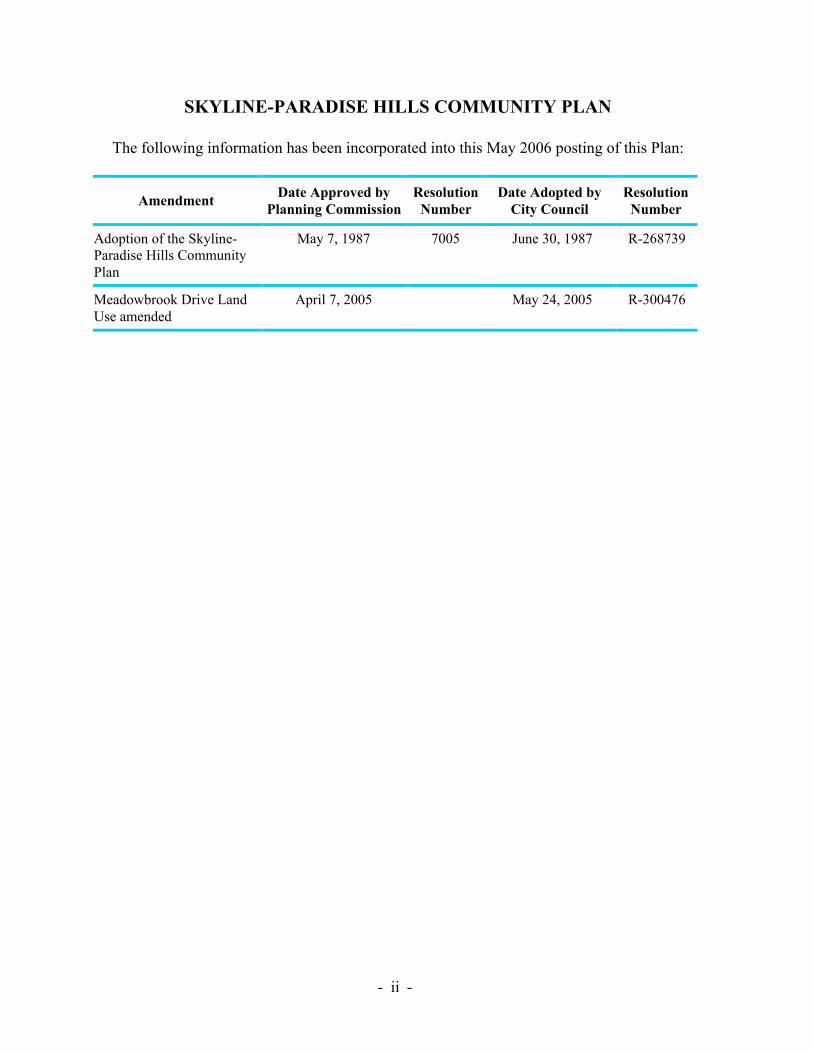
SKYLINE-PARADISE HILLS COMMUNITY PLAN
The following information has been incorporated into this May 2006 posting of this Plan:
AmendmentDate Approved by
Planning CommissionResolution
NumberDate Adopted by
City CouncilResolution
Number
Adoption of the Skyline-Paradise Hills CommunityPlan
May 7, 1987 7005 June 30, 1987 R-268739
Meadowbrook Drive LandUse amended
April 7, 2005 May 24, 2005 R-300476

- -iii
MAYORMaureen O’Connor
CITY COUNCILAbbe WolfsheimerBill CleatorGloria McCollWilliam JonesEd StruiksmaMike GotchJudy McCartyCelia Ballesteros
CITY ATTORNEYJohn W. Witt
CITY MANAGERJohn Lockwood
PLANNING COMMISSIONRon Roberts, ChairpersonPaul Oquita, Vice ChairpersonHenry EmpenoDan GuevaraAlbert KerchevalYvonne LarsonRalph Pesqueira
PLANNING COMMISSIONMichael Stepner, Acting Planning DirectorLee Okeson, Acting Assistant Planning DirectorAllen M. Jones, Deputy DirectorMary Lee Balko, Principal PlannerTheresa R. Wilkinson, Project PlannerRose M. Wong, Associate PlannerJim Atkins, Graphic DesignerDonna Brinkerhoff, Word ProcessorCorazon S. Nuval, Word Processor
- -iv
ACKNOWLEDGEMENTS
Skyline-Paradise Hills Community Planning Committee
Cathy Alegria, ChairpersonTressia Sanders, Vice ChairpersonArtemio (Butch) Aquino, SecretaryHarriett Florence, TreasurerBobby AlegriaAvanell BlanchardBill BrahamMarjorie BrahamDonna ClarkTrudy DownsPearli KillensHenry (Buddy) MilesAl MirelesLaQuita RobbinsPat SextonWalt ShermanLynn Spears

- -v
THE CITY OF SAN DIEGO
WILLIAM D. JONESDEPUTY MAYOR
Dear Neighbor:
When I took office, one of the top priorities on my agenda was the adoption of a complete andcomprehensive Skyline/Paradise Hills Community Plan. In the past, two adopted planning programs wereused for the South & North Bay Terraces communities, but no official community plan existed for guidingplanned development in the communities of Skyline, Paradise Hills, Lomita and Jamacha.
Now after years of research, continual mapping, countless hours of public meetings and field visits fromCity staff and the Skyline/Paradise Hills Planning Committee, the City Council adopted theSkyline/Paradise Hills Community Plan on June 30, 1987.
As San Diego continues to grow, planned development for its communities becomes even more important.Our neighborhoods must be protected from those developments that are insensitive to the community’sneeds. This new community plan will help provide that protection.
The Skyline, Paradise Hills and Bay Terraces communities are unlike many of the inner-city areas of SanDiego. These communities are almost completely populated by single-family homes with a small samplingof high-density multifamily units—very different than most of the urbanized portions of the City.
While most of the Skyline and surrounding communities are zoned for residential use, only a small portionof the community is zoned for commercial use. In the past, owners of commercial property have developedtheir land for residential use, leaving the community with a lack of commercial services. However, theSkyline/Paradise Hills Community Plan has set forth several objectives to ensure that future developmentsof commercial property will provide adequate facilities that offer a variety of foods and services to meet theneeds of the residents.
The Plan will also preserve the existing open space and the undeveloped park sites in the community.Presently, Skyline, Paradise Hills and Bay Terraces have over 140 acres of open space, which preserveexisting natural canyons and hillsides. In addition, over 25 acres of natural and undeveloped land is beingset aside for the development of future parks including, Keiller Park, Skyview Park, Parkside Park andBoone Neighborhood Park.
These communities are very unique. Present and future homeowners are blessed with picturesque views ofrolling hills, the Pacific Ocean, Coronado and San Diego Bay. In addition, residents can benefit from thecentral locality, with easy access to downtown, City beaches and Balboa Park.
Skyline, Paradise Hills and Bay Terraces are some of the best communities to live in and I’m positive thisnewly adopted Plan will preserve the beauty of our neighborhoods. I thank you for your interest and supportfor preserving the quality of life in our neighborhoods we, as residents, deserve.
Best regards,
William D. JonesDeputy Mayor

- -vii
INTRODUCTION...............................................................................................................3
Community Profile ..........................................................................................................3Scope and Purpose ..........................................................................................................5Plan Format.....................................................................................................................6Legislative Framework....................................................................................................7
PLAN SUMMARY............................................................................................................11
Planning Issues..............................................................................................................11Goals and Objectives.....................................................................................................12
BACKGROUND ...............................................................................................................19
Community History.......................................................................................................19Planning History............................................................................................................19Alternative Land Use Plans ...........................................................................................22
PLAN ELEMENTS...........................................................................................................27
Residential Element.......................................................................................................27Commercial Element .....................................................................................................35Transportation Element .................................................................................................45Park and Recreation Element.........................................................................................59Open Space Element .....................................................................................................65Public Facilities Element ...............................................................................................71Cultural and Historical Resources Element....................................................................79
URBAN DESIGN ELEMENT ..........................................................................................83
Introduction...................................................................................................................83Residential Guidelines...................................................................................................85Commercial Guidelines .................................................................................................89General Guidelines........................................................................................................93
NEIGHBORHOOD ELEMENT ....................................................................................103
Introduction.................................................................................................................103Summary of Issues and Recommendations ..................................................................107Recommendations .......................................................................................................108
GENERAL PLAN CONFORMANCE ...........................................................................115
IMPLEMENTATION.....................................................................................................121

- -viii
Table 1 Residential Land Use (1986) ................................................................................ 27Table 2 Housing Trend 1970—1986 ................................................................................. 27Table 3 1986 Land Use in Residential Zones (in acres) ..................................................... 29Table 4 1986 Land Use in Commercial Zones (in acres).................................................... 35Table 5 Community and Neighborhood Parks ................................................................... 60Table 6 Community Parks and Facilities ........................................................................... 61Table 7 Neighborhood Parks and Facilities ....................................................................... 62Table 8 Public School Enrollment ..................................................................................... 73Table 9 Neighborhood Element Summary of Issues and Recommendations .................... 107
Figure 1. Location Map ...................................................................................................... 2Figure 2. Neighboring Communities................................................................................... 4Figure 3. Phased Development Areas ............................................................................... 20Figure 4. Existing Residential Development (1986) .......................................................... 26Figure 5. Existing Residential Zones ................................................................................ 28Figure 6. Recommended Residential Densities ................................................................. 30Figure 7. Project First Class and Community Block Grant Target Area............................. 36Figure 8. Existing Commercial Zones............................................................................... 38Figure 9. Recommended Commercial Designations.......................................................... 40Figure 10. Existing Average Daily Traffic (1986)............................................................... 46Figure 11. Future Average Daily Traffic and Street Classifications..................................... 48Figure 12. Public Transit Routes......................................................................................... 50Figure 13. The San Diego Trolley—East Line Location and Stations.................................. 52Figure 14. Bicycle Routes................................................................................................... 54Figure 15. Bicycle Lane Classifications .............................................................................. 56Figure 16. Parks ................................................................................................................. 58Figure 17. Floodplains........................................................................................................ 66Figure 18. Designated Open Space ..................................................................................... 68Figure 19. Schools.............................................................................................................. 72Figure 20. Public Facilities ................................................................................................. 74Figure 21. Neighborhood Areas........................................................................................ 102Figure 22. General Plan Amendments .............................................................................. 116Figure 23. Recommended Rezonings................................................................................ 120Figure 24. Skyline-Paradise Hills Community Plan Map .................................................. 122

Introduction• Community Profile• Scope and Purpose• Plan Format• Legislative Framework

- -2
Figure 1. Location Map

- -3
INTRODUCTION
COMMUNITY PROFILE
The Skyline-Paradise Hills community is located in the southeastern portion of the City ofSan Diego. The community is bordered by the city of Lemon Grove and the Southeast SanDiego community planning area on the north; the South Bay Freeway and an unincorporatedarea of San Diego County on the south; National City and the Southeast San Diegocommunity planning area on the west; and by an unincorporated area of San Diego Countyon the east (Figure 1).
The Skyline-Paradise Hills community planning area is approximately 4,500 acres in area.The community, as of July 1986, contained a population of about 59,700 persons residing inapproximately 18,000 dwelling units. The community contains six geographic areasrecognized as distinct neighborhoods. They are: Skyline, Paradise Hills, South Bay Terraces,North Bay Terraces, Lomita and Jamacha. The neighborhood areas are shown on Figure 21.The majority of new development within the community has occurred within North andSouth Bay Terraces. The remaining neighborhoods are older portions of the community andhave had minimal development in recent years.
Skyline-Paradise Hills is a predominantly low-density residential community. Single-family,detached housing is the dominant land use throughout the community with multifamilyresidential development located primarily in the south-central portion of the South BayTerraces neighborhood. The majority of the multifamily development within the communitydoes not exceed a density of 30 dwelling units per acre.
There are no large community commercial centers within the Skyline-Paradise Hillscommunity planning area. Commercial services are provided by several small neighborhoodcommercial centers scattered throughout the community and one strip commercial area. Thisexisting commercial development is not adequate to meet the demand and need of thepopulation. Residents rely heavily on commercial centers in adjacent communities due to thelack of commercial services.
The geography of the community planning area includes hills and canyons affording views ofdowntown San Diego, San Diego Bay, the city of Coronado and the Pacific Ocean. A majorgeographic feature of the community is Paradise Valley, which runs on an east-west axisthrough the middle of the community.

- -4
Figure 2. Neighboring Communities
- -5
SCOPE AND PURPOSE
The Skyline-Paradise Hills Community Plan (Plan) is a set of proposals that serves to guidefuture development within the Skyline-Paradise Hills community planning area. The Plancontains a series of goals and objectives established by the community which are consistentwith citywide policies.
Once the Plan is adopted by the City Council, any amendments, additions, or deletions willrequire that the Planning Commission and City Council follow the same public hearingprocedures as were required in the initial adoption. The Plan establishes recommendationsfor implementation and does not establish new regulations or legislation. Controls overzoning, subdivisions, transportation, building construction and other developments must beenacted separately as part of the implementation program. However, many of the Planrecommendations are expected to be implemented simultaneously with the adoption of thePlan through rezonings.
The Plan should not be considered a static document. It is intended to provide guidance forthe orderly growth of the Skyline-Paradise Hills community. The Plan will be continuallymonitored and amended if necessary in response to City needs or unanticipated changes inenvironmental, social or economic conditions of the community. It is anticipated that theSkyline-Paradise Hills Planning Committee and other private citizen organizations willprovide assistance in monitoring the effectiveness of the Plan and recommending changes tothe Plan as conditions change.
Adoption of the Plan will necessitate rescinding the South Bay Terraces Community Planthat was adopted by the City Council in 1978.

- -6
PLAN FORMAT
The Skyline-Paradise Hills Community Plan is divided into eight sections, each of which issummarized below:
Introduction - This section briefly overviews the organization and framework within whichthe Plan was developed.
Plan Summary - This section identifies key issues in the community along with the goalsdeveloped by the Skyline-Paradise Community Planning Committee, which served as thebasis for recommendations in each Plan element.
Background - This section describes planning and development history, the planning areaand its regional context.
Plan Elements - The elements of the Plan are discussed in this section. The Plan elementsinclude an analysis of existing conditions, objectives and recommendations for the entirecommunity.
Urban Design Element - This section discusses the image and character of the communityand makes recommendations to guide future development and revitalize existingdevelopment. These guidelines incorporate major recommendations of the Project First ClassUrban Design Program.
Neighborhood Element - This section identifies the individual neighborhoods of thecommunity, targeting neighborhood issues of concern.
Geeneral Plan Conformance - This section describes the extent to which the recommendedactions in this Plan will help to implement the goals and objectives of the City's ProgressGuide and General Plan (General Plan).
Implementation - This section identifies actions, additional studies and funding conditionswhich are needed to implement the Plan recommendations.

- -7
LEGISLATIVE FRAMEWORK
The Skyline-Paradise Hills Community Plan was developed within the context of alegislative framework consisting of federal, state and local levels. Some of the moresignificant legislation is discussed below.
• Section 65450 of the governmental Code of the state of California (State Planning andZoning Act) gives authority for the preparation of community plans and specifies theelements which must appear in each plan. It also provides the means for adopting andadministering these plans.
• Government Code Chapter 4.3 requires that local governments and agencies provideincentives to developers to include affordable units in housing projects. The City hasprepared an ordinance which would establish an Affordable Housing Density Bonus,providing an increase in maximum permitted density in a given zone to be granted forprojects in which at least a certain percentage of the total housing units are for low- ormoderate-income persons.
• The California Environmental Quality Act of 1970 (CEQA) requires that environmentalreports be prepared for all community plans. Separate, detailed environmental reportsmay also be required for many projects which implement this Plan.
• The Regional Air Quality Strategy (RAQS) was developed in 1977 to achieve a level ofair quality in the San Diego Air Basin that would meet federal air quality standards setforth in the National Clean Air Act. A major recommendation pertinent to this planningeffort is to include air quality considerations in all land use and transportation plans.
• The citywide Zoning and Subdivision Ordinances regulate the development of land andsubdivision of land in preparation for development.
• In addition to legislation, the City Council has adopted a number of policies to serve asguidelines in the decision making process. Many of the policies relate directly to planningissues and should be used in implementing Plan recommendations.
• The Progress Guide and General Plan serves as a basis for the development of the Plan.The General Plan sets forth goals standards and criteria for the provision of facilities thatare essential in the community and possess citywide importance.

Plan Summary• Planning Issues• Goals and Objectives

- -11
PLAN SUMMARY
PLANNING ISSUES
In the initial phase of development of this Plan, the Skyline-Paradise Hills CommunityPlanning Committee raised the following issues of concern to the community:
1. The desire to preserve the low-density, single-family character of the community;
2. The need for housing rehabilitation, including the removal of graffiti and litter, in someareas of the community;
3. The lack of commercial retail and office facilities, including professional services;
4. The need for a centrally-located community commercial facility;
5. Retention and revitalization of existing commercial areas;
6. Improvement of public transportation;
7. The need for open space preservation (Paradise Canyon and the Encanto Expresswayright-of-way) and the establishment of development standards for areas abutting openspace;
8. Improvement of undeveloped park sites;
9. The need for establishment of urban design standards and criteria for residential andcommercial development and major street corridors.

- -12
GOALS AND OBJECTIVES
The issues listed above served as a general framework which guided the Committee and thePlanning Department in developing the goals and objectives of this Plan. The communitygoals and objectives are summarized here to emphasize that the purpose of the Plan is toimplement the goals and objectives of the community through the guidance of public andprivate development.
Primary Residential Goal: Preserve the low-density, single-family character of thecommunity.
Objectives:
1. Establish and maintain Skyline-Paradise Hills as an economically and socially balancedcommunity, accommodating gradual and orderly development consistent with theexisting community.
2. Ensure quality residential development designed in accordance with the urban designprinciples established within this Plan.
3. Ensure that new development is compatible with existing neighborhoods and does notoverburden existing public facilities.
Primary Commercial Goal: Ensure the availability of adequate commercial facilitiesoffering a variety of goods and services to meet the needs of existing and future residents.
Objectives:
1. Revitalize existing commercial facilities through property cleanup, maintenance (repairand painting) and through utilization of the Project First Class Landscaping Programwherever applicable.
2. Enhance pedestrian activity and accessibility to the Reo Drive neighborhoodcommercial strip.
3. Develop a centrally located, community commercial center.
4. Require commercial areas to incorporate landscaping which complements surroundingland use.
5. Promote the design of commercial areas so as to best utilize the existingtransportation system.
6. Prevent, to the extent feasible, the redevelopment of commercial sites for residential use.

- -13
Primary Transportation Goal: Provide a transportation system that maximizes access tocommunity activity centers and to destinations within the metropolitan area, and minimizesadverse environmental effects.
Objectives:
1. Improve existing street systems in conformance with Council Policy 600-4 toaccommodate residential and commercial growth.
2. Develop a system of bikeways to join parks and open space throughout the community.
3. Provide a safe and more accessible pedestrian circulation system, minimizing conflictswith vehicular traffic.
4. Provide an efficient and high level of public transit within and surrounding thecommunity. Design and plan for land uses that will complement and make use of the newSan Diego Trolley East Line.
5. Visually enhance transportation corridors to improve the community’s image.
Primary Park and Recreation Goal: Provide a system of fully developed parks andrecreational facilities to meet the recreational needs of the community.
Objectives:
1. Provide a park system consistent with the City’s General Plan standards to the extentfeasible given existing constraints.
2. Coordinate the use of school recreational facilities for after normal hour usage.
3. Require the provision of private recreational facilities and usable open space in new,larger residential developments.
4. Provide a safe environment in all parks to allow their use by the entire community.

- -14
Primary Open Space Goal: Provide an open space system that preserves existing canyonsand hillsides and ensures open space accessibility.
Objectives:
1. Develop specific open space areas for passive recreational uses such as hiking or biketrails.
2. Provide a linkage system of pedestrian and bicycle facilities connecting parks and openspaces.
3. Ensure that development located adjacent to open space areas is compatible with andenhances open space areas.
4. Preserve visual and physical access to open space areas from public rights-of-way toincrease passive recreational use.
Primary Public Facilities Goal: Establish and maintain a high level of public facilities andservices to meet community needs.
Objectives:
1. Provide public facilities and services in accordance with City standards.
2. Maximize the use of existing public facilities for community activities.
3. Increase safety through measures such as the addition of street lighting.
Primary Cultural and Heritage Resources Goal: Preserve the cultural and heritageresources of the Skyline-Paradise Hills community.
Objectives:
1. Protect the resource value of archaeological artifacts and paleontological remains withinthe community.
2. Preserve buildings of architectural and historical interest in the community.

- -15
Primary Urban Design Goal: Enhance the community’s image through improvements tothe visual and physical character of the community.
Objectives:
1. Ensure that new development is compatible with existing neighborhoods in terms of bulk,scale and design, and that it is sensitive to existing topography.
2. Improve the quality of design of new residential development.
3. Improve the appearance of existing commercial facilities to revitalize existing businessand stimulate the development of new business.
4. Orient development to encourage interest at the pedestrian scale in order to stimulatepedestrian circulation.
5. Improve the streetscape in the vicinity of parks and recreation centers, public buildingsand high visibility streets in order to provide a sense of identity to activity centers and theroutes leading to them.

Background• Community History• Planning History• Alternative Land Use Plans

- -19
BACKGROUND
COMMUNITY HISTORY
The planning area’s recorded history begins with Father Junipero Serra’s visit in 1769.In 1775, the entire South San Diego Bay region was claimed by the Spanish crown as pastureland for the presidio of San Diego. These public lands included what is now National City,Chula Vista, Skyline-Paradise Hills and lands further inland. They were given the nameRancho del Ray or King’s Ranch, later changed to Rancho de la Nacion. These public landswere transferred to private ownership in 1845 and used for lemon orchards and olive groves,pasturing of cattle and cultivation of field crops.
In 1916, the Encanto area, including the Skyline portion of the community, was annexed tothe City, becoming the first territory added to the City’s original Pueblo lands. Paradise Hills,consisting of 1,180 acres, was annexed in 1929. Annexations continued through the 1950sand 1960s ending with the total acreage which comprises North and South Bay Terraces.
A large portion of the community’s single-family, detached housing development occurredwithin the Skyline, Paradise Hills, Lomita and Jamacha neighborhoods prior to World War IIand during the 1950s and early I960s. Since 1969, new construction has been concentrated inthe North and South Bay Terraces neighborhoods. This development has been primarilysingle-family homes with pockets of medium-density, multifamily housing.
PLANNING HISTORY
There have been two adopted planning programs carried out in the Skyline-Paradise Hillscommunity planning area. Both were limited in scope, covering only the North and SouthBay Terraces neighborhoods.
In January of 1969, the City of San Diego adopted the South Bay Terraces Development Planprepared by Peñasquitos, Inc. This plan covered approximately 860 acres of the South BayTerraces area and proposed a concept of higher-density development designed aroundinterior block recreational areas. This plan projected a housing mix of 1,420 detachedsingle-family homes and 6,750 multifamily units.
During 1976 and 1977, Peñasquitos, Inc. submitted a number of revisions to the 1969 Plan,including adjustments to the housing mix, open space and circulation. The planning area wasincreased, covering approximately 2,187 acres. These changes resulted in the development ofa comprehensive community plan for the North and South Bay Terraces neighborhoods.In December of 1978, the City Council adopted this plan as the revised South Bay TerracesCommunity Plan.
The Skyline-Paradise Hills Community Planning Committee was recognized by the CityCouncil in June of 1978. Since that time, the Planning Committee has worked with thePlanning Department in reporting the planning needs of the community and in contributing tothe community planning process for the Skyline-Paradise Hills community.

- -20
Figure 3. Phased Development Areas

- -21
The Skyline-Paradise Hills Community Plan is the first community plan that addresses theareas to the north and southwest of the South Bay Terraces planning area (i.e., theneighborhoods of Skyline, Jamacha, Lomita and Paradise Hills). Development in these areashad been guided by the City’s Zoning Ordinance and the General Plan prior to the adoptionof this Plan.
Project First Class
Project First Class is a comprehensive program of community development which wasapproved by the City Council in May of 1984. The program was established to develop anurban design program, to form a concentrated code enforcement program and to facilitateother public and private improvements for Skyline-Paradise Hills, Southeast San Diego andparts of Golden Hill. The intent of the program is to work toward a better environmentthrough economic development, attention to urban design, street and alleywayimprovements, building code enforcement, residential and commercial rehabilitation and theestablishment of quality housing. This Plan can be considered a step toward implementingthe intent of Project First Class.
Phased Development Areas
The General Plan recognizes two categories of phased development within the community:urbanized and planned urbanizing. The urbanized area in the City includes most of the oldersections as well as the central portion of San Diego. The neighborhoods of Skyline, Jamacha,Lomita and Paradise Hills are identified as urbanized areas in the General Plan. The plannedurbanizing area consists of the newly developing communities. The North and South BayTerraces neighborhoods are identified as planned urbanizing areas. These areas are shownon Figure 3.
In general, urbanized areas require public and private reinvestment with an emphasis oncapital improvement programs and grant funding to provide needed community facilities, incontrast to the reliance on developer financing and assessment districts in plannedurbanizing areas.
The majority of the North and South Bay Terraces neighborhoods has been developed, withthe exception of small parcels of land near Paradise Valley Road and Woodman Street. Forthis reason, the Plan recommends that the planned urbanizing portion of the community beredesignated as urbanized. It is anticipated that public facilities for the community can beprovided through the City’s Capital Improvement Program, grant funding, and privateinvestment.
Prospective Annexation Area
The General Plan identifies an area that borders the northeastern corner of the Skyline-Paradise Hills community as a prospective annexation area and designates the area asplanned urbanizing. This Plan proposes that the area be redesignated as urbanized since mostof the area has been developed and the need to use developer fee financing and assessment

- -22
districts to fund public facilities is not expected. The Skyline-Paradise Hills Community Planwill be amended to include this area if it is annexed to the City. Appropriate land usedesignations will be determined at that time. The prospective annexation area is shown onFigure 3.
ALTERNATIVE LAND USE PLANS
The following plan alternatives were considered in the preparation of the Plan. Because thecommunity is predominantly residential, the variations between alternatives largely pertain todifferences in residential densities and therefore, population. The impact of the nonresidentialalternatives is minimal, except to the extent that they vary the number of residentialdwelling units.
Residential Alternatives
Existing Plan Alternative
This alternative would continue the pattern of the existing South Bay Terraces CommunityPlan (adopted in 1978) for the central sector of the community. This plan recommended thatthe majority of the community be developed at 0-5 dwelling units per acre, with higherresidential densities up to 29 units per acre near major streets, proposed community shoppingcenters and educational and recreational facilities. Current zoning allows higher densitiesthan those recommended in the plan, therefore, a rezoning program would be necessary toachieve consistency between the zones and the 1978 plan designations.
There is no adopted community plan for the areas north and southwest of the South BayTerraces planning area. The General Plan designates the majority of these areas forresidential neighborhoods.
Existing Zoning Alternative
This approach would permit the most intense development of all the alternatives. ExistingR-3000 and R-1500 zoning would permit higher-density redevelopment in recentlydeveloped single-family neighborhoods and in older stable single-family neighborhoods.Approximately 67 acres north of Alsacia, between Alta View Drive and Briarwood Roadhave been recently developed with single-family residences, however, the area is zonedR-3000 which would allow up to 29 units per acre. Approximately 40 acres south of AlsaciaStreet, between Woodman Street and Briarwood Road are zoned R-1500, which would allowup to 29 units per acre. Recent development is attached single-family at an average density of12 units per acre.
Transit Corridor Alternative
This alternative would identify the Imperial Avenue Trolley Corridor as a major publictransit corridor and establish gradients in permitted density determined by the distance fromthe corridor. Highest-density development would be concentrated along Imperial Avenue,

- -23
while density would decrease as distance from Imperial Avenue increases. Factors other thanthe distance from the transit corridor would also be considered in determining permitteddensities, such as the capability of the street system to accommodate traffic generated byhigher-density development and existing neighborhood development patterns. This approachwould require rezoning the primarily single-family area south of Imperial Avenue (currentlyzoned R1-5000) to permit higher-density development. It also might preclude neededcommercial development in the commercially zoned properties along Imperial Avenue.
Density Bonus Alternative (Incentive Zoning)
For each of the residential alternatives examined, the concept of density bonuses could beintroduced in order to allow higher density in return for special project amenities that wouldimplement overall Plan goals. For example, such incentives could be awarded for extrarecreation facilities, day care centers or other amenities. However, in order for densityincentives to be successful and not overburden the community’s public services andfacilities, the bonus system should be applied only in those areas capable of accommodatingthe development. Due to the low-scale type of development prevalent in the community,additional controls would be necessary to ensure that existing stable neighborhoods that areworthy of preservation are not detrimentally impacted.
Commercial Alternatives
Existing Plan Alternative
The 1978 South Bay Terraces Plan designated three sites at the corner of Woodman Streetand Alta View Drive for commercial development that were subsequently developed withmultifamily housing. This alternative would leave those areas designated for commercialdevelopment. However, since the developments are relatively recent, redevelopment tocommercial use is unlikely to occur.
The General Plan identifies only one community commercial site (at Cardiff Street andJamacha Road) for the areas north and southeast of the South Bay Terraces planning area.The Imperial Avenue commercial area is designated for residential neighborhoods. Thisalternative would allow additional residential development in the commercial zones onImperial Avenue.
Existing Zoning Alternative
The existing zoning, like the existing Plan alternative, designates areas for commercialdevelopment that have been developed with multifamily housing and are unlikely toredevelop. In addition, the existing zoning alternative would allow continued residentialdevelopment in the remaining commercially zoned areas. Of the 134 acres of commerciallyzoned land, just 66 acres remain available for commercial use. The existing commercialzones, which allow residential development up to 29 units per acre, will not preserve anadequate amount of commercial acreage to provide the necessary commercial services for thecommunity.

- -24
Consolidated Commercial Area Alternative
This alternative would attempt to consolidate commercial activity into larger commercialcenters by designating existing small, scattered or marginal commercial sites for anotheruse—most likely residential. Commercial uses could be concentrated at Imperial Avenue andLisbon/69th Street, Cardiff Street and Jamacha Road, Reo Drive, and Alta View andWoodman. However, this alternative has the potential to further reduce the availability ofcommercial services by encouraging redevelopment to residential use.
Open Space Alternatives
Existing Plan Alternative
The adopted South Bay Terraces Plan identifies Paradise Canyon as the only open spacesystem within the community. The General Plan identifies the Jamacha open space, along theabandoned Encanto Expressway right-of-way, in addition to Paradise Canyon as designatedopen space. Neither plan contains adequate implementation strategies to protect thesedesignated open space areas.
Existing Zoning Alternative
Existing zoning provides only minimal opportunities to preserve open space areas; the onlyarea zoned Rl-40,000 is the western section of Paradise Canyon. This alternative wouldpermit potential development of the slopes along Paradise Valley Road (adjacent to ParadiseHills Park and Recreation Center), the area surrounding the former Sweetwater land fill site,and those portions of the Jamacha open space system and Paradise Canyon that have not yetbeen acquired by the City.

Plan Elements• Residential• Commercial• Transportation• Parks and Recreation• Open Space• Public Facilities• Cultural and Historical Resources
- -26
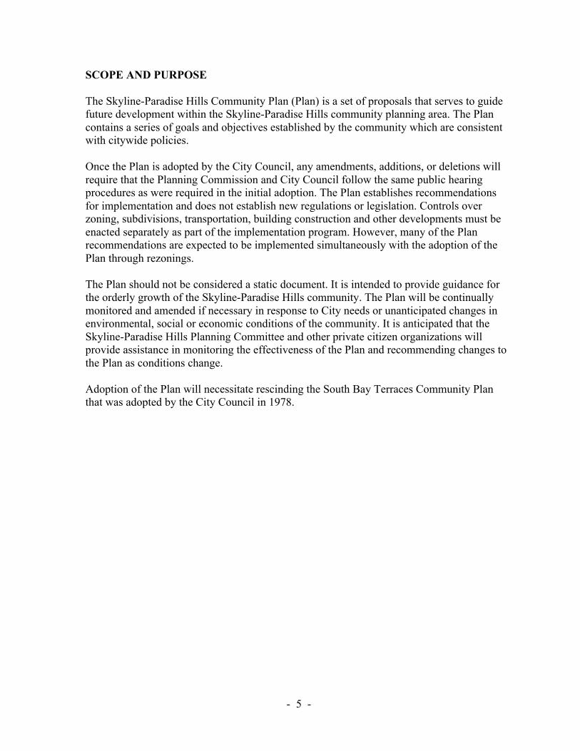
Figure 4. Existing Residential Development (1986)

- -27
RESIDENTIAL ELEMENT
PRIMARY RESIDENTIAL GOAL
Preserve the low density, single-family character of the community.
EXISTING CONDITIONS
Land Use and Zoning
The Skyline-Paradise Hills community contains 3,531 acres of residentially zoned land. Thisis 96 percent of the total plan area excluding rights-of-way.
Single-family detached housing units make up the majority (77 percent) of the availablehousing and occupy over 86 percent of all residential land. Multifamily housing makes up theremaining 14 percent. Residential land use by housing type is shown on Table 1 andFigure 4.
TABLE 1
RESIDENTIAL LAND USE (1986)
Housing Type AcreagePercentage
of TotalDwelling
UnitsPercentage
of Total
Single-family 2,385 86 14,009 77
Multifamily 377 14 4,145 23
Totals 2,762 100 18,154 100
The community has experienced significant buildout of its available vacant land since 1970.The change in number of housing units between 1970 and 1986 is shown on Table 2. As ofJuly 1986, the community contained 18,154 dwelling units. For the most part, newdevelopment has occurred in the North and South Bay Terraces neighborhoods. Theneighborhoods of Skyline, Jamacha, Lomita and Paradise Hills have remained relativelystable since 1970 and are developed predominantly with single-family residences.The multifamily developments are primarily located in the south central area of South BayTerraces and the northern area of Paradise Hills.
TABLE 2
HOUSING TREND 1970 -1986
Housing Type 1970 % 1975 % 1980 % 1986 %Change1970-86
Single-family 6,838 83 8,550 85 10,798 78 14,009 77 7,171
Multifamily 1,428 17 1,548 15 2,984 22 4,145 23 2,717
Totals 8,266 100 10,098 100 13,782 100 18,154 100 9,888

- -28
Figure 5. Existing Residential Zones

- -29
Table 3 indicates residential zoning and existing land use within the community.
TABLE 3
1986 LAND USE IN RESIDENTIAL ZONES (in acres)
Zone (Residential)TotalAcres Single-family Multifamily Commercial
VacantLand
Public/Semipublic
R1-40000 60.98 0.00 0.00 0.00 34.75 26.23
R1-5000 2,948.05 2,208.71 27.76 0.42 490.51 212.22
R-3000 350.87 141.86 175.96 0.15 1.74 31.16
R-1500 166.24 32.42 124.13 0.00 9.69 0.00
R-1000 1.94 0.19 1.54 0.21 0.00 0.00
R-600 3.04 0.39 1.73 0.92 0.00 0.00
R-400 .20 0.00 .20 0.00 0.00 0.00
All Residential Zones 3,531.32 2,383.57 331.32 1.70 536.69 269.61
All Zones 3,665.48 2,384.62 376.92 38.34 575.59 281.40
Existing residential zoning in Skyline-Paradise Hills would permit approximately 36,000dwelling units based on the maximum densities allowed by zone. In addition, existingcommercial zoning would permit approximately 3,900 units. However, the existing zoningpermits residential densities in excess of what can be reasonably expected for the communitygiven existing development. Current zoning permits multifamily development in areas thathave been recently developed with single-family housing, and permits higher densities inolder areas where the prevalent pattern of development is low-density, single-family.Based on the existing land use and the maximum number of dwelling units permitted forvacant property under the proposals of this Plan the projected number of housing units atbuildout is approximately 22,000.
Housing Tenure
Skyline-Paradise Hills has a greater owner occupancy rate than the citywide average. As of1980, 72 percent of the units were owner occupied compared with the citywide owneroccupancy rate of 49 percent. The highest homeownership rates are in the olderneighborhoods of the community: Skyline, Jamacha, Lomita and the southern portion ofParadise Hills. The northern portion of Paradise Hills (which includes a large area of Navyhousing) and North and South Bay Terraces have a higher concentration of rental units.
Income
As of 1980, the median family income in the community ranged from a low of $15,212 in theolder, established neighborhood of northern Paradise Hills to a high of $22,486 in thesouthern Paradise Hills area. The planning area contains all or a part of ten census tracts, fiveof which had a median income greater than the citywide median of $20,134.

- -30
Figure 6. Recommended Residential Densities

- -31
Population
Between 1970 and 1980, the community population increased over 67 percent from 26,807to 44,845 individuals. Between 1980 and 1986, the population increased an additional 33percent to 59,684 people, which is well above the citywide increase in population of 15.7percent for the same time period. As of the 1980 census, the average household size in theSkyline-Paradise Hills planning area was 3.51 persons per household compared to 2.53persons citywide. These figures show a decline in family size since 1970, when thecommunity average was 4.15 persons and the citywide average was 2.80 persons.
Ethnic Composition
The ethnic composition of the community, according to 1980 census data, consists of 47percent whites, 24 percent blacks, 18 percent Asians or Pacific Islanders, and 11 percent ofother ethnic background. Twenty-one percent of the community is of Hispanic origin.Minority categories have had the highest percentage increases of the total population in theten years between 1970 and 1980. The white population comprises approximately 47 percentof the community versus 75 percent citywide, and experienced the lowest percentageincrease within this ten-year period.
OBJECTIVES
1. Establish and maintain Skyline-Paradise Hills as an economically and socially balancedcommunity, accommodating gradual and orderly development consistent with theexisting community.
2. Ensure quality residential development designed in accordance with the urban designprinciples established within this Plan.
3. Ensure that new development is compatible with existing neighborhoods and does notoverburden existing public facilities.
RECOMMENDATIONS
1. The community should maintain its existing pattern of development of low-density,single-family housing with isolated pockets of multifamily housing located primarilywithin the south central area of South Bay Terraces and northern Paradise Hills.
2. Any planned residential developments in the R1-5000 zones should be restricted to adensity not to exceed the average density of all similarly zoned single-family propertywithin a 500-foot radius of the subject property, to ensure that the scale of newdevelopment is compatible with established neighborhoods.
3. All designated open space areas should be rezoned to R1-40,000 or a similar zone topreclude overdevelopment which is inconsistent with the topography.

- -32
4. Residential projects of greater than 30 units or greater than 20 dwelling units per net acreare recommended to be developed or redeveloped under a planned residentialdevelopment permit or other special review to ensure compatibility with surroundingstructures, quality design of the project and its landscaping, and conformance with designguidelines as specified within the Plan.
5. Multifamily developments should incorporate design features that will:
a. Increase the continuity, variety and quality of design within the developmentincluding facade and setback variation such as recessed entryways, balconies, porchesor bay windows.
b. Ensure compatibility of new structures with existing neighborhoods, includingcompatible window treatments, use of similar color, materials or building forms.
c. Recognize the surrounding topography and natural features to implement site plansthat minimize the requirement for high retaining walls or extensive cut and fill.
d. Provide private open space for each unit wherever possible. Open space areas shouldbe oriented to receive good sun penetration and should include shaded areas foroutdoor use in the warmest months.
6. School sites should be zoned at the density of surrounding residential development andshould be placed in the Institutional Overlay Zone. This will ensure adequate reviewbefore the sites are considered for other than institutional or public use. If it is determinedthat the site is not needed for public purposes, the site should be developed at the densityof the underlying residential zone in a manner compatible with the surroundingneighborhood. Recommended rezonings to accomplish this are illustrated on Figure 23.
7. Reviews of conditional use permits for residential care facilities in the community shouldinclude an analysis of whether there is a concentration of similar facilities in thecommunity and an evaluation of possible impacts to the surrounding single-familyneighborhoods. Additionally, residential care facilities should not be approved if theywill exceed an occupancy of six persons in a single-family zone or 12 persons in amultifamily zone.
8. Because move-on housing has potential adverse visual impacts on existingneighborhoods, it should be carefully regulated by requiring discretionary review of allproposals for move-on housing.
9. The following density ranges are recommended to meet the community’s goals andobjectives:
a. Low-Density (0-10 dwelling units per net residential acre). The Plan designates themajority of the community’s residential land (81 percent) at this density to maintainthe existing pattern and scale of development. This designation is intended toaccommodate detached units on individual lots (i.e., one unit per lot) except in thoselocations where clustered residential developments are specifically called for in thisPlan. The Rl-5000 zone is recommended to implement this density designation.
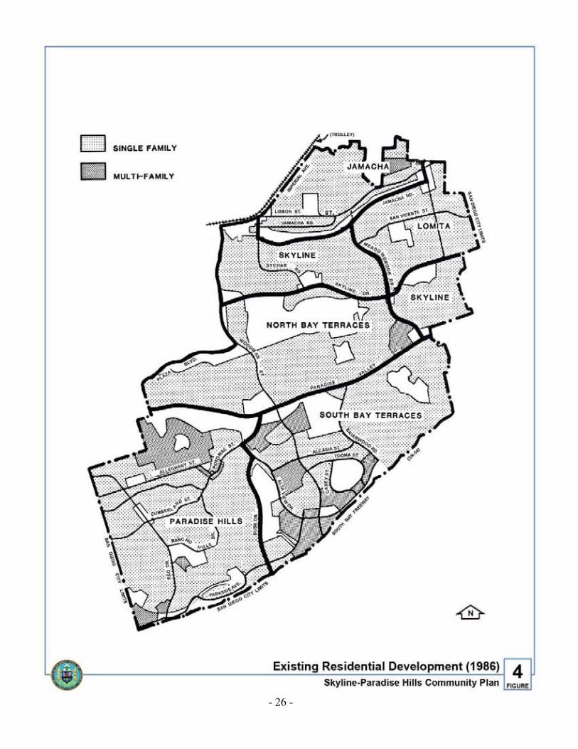
- -33
b. Low-Medium Density (10-15 dwelling units per net residential acre). Approximatelynine percent of the community’s residential land is designated for this density,primarily in the Paradise Hills neighborhood. The largest areas are the Navy housingsite south of Paradise Valley Road and an area bordered by Alleghany Street, SeaBreeze Drive, Winchester Street and the City limits. The R-3000 zone isrecommended to implement this density designation.
c. Medium Density (15-30 dwelling units per net residential acre). Approximately sixpercent of the community’s residential land is designated for this density, consistingof several existing multifamily developments in the South Bay Terracesneighborhood and one in the northwest corner of the North Bay Terracesneighborhood. The R-1500 zone is recommended to implement this densitydesignation.
d. Medium-High Density (30-45 dwelling units per net residential acre). Two smallareas totaling less than six acres in the Paradise Hills neighborhood are designated fora maximum of 45 units per net acre to reflect their existing uses. The areas are zonedR-1000 and R-600.
10. The following recommendations address specific residential areas with unique site orneighborhood characteristics that warrant special consideration:
a. An 18-acre site located north of the intersection of Goode Street and Manzana Way isrecommended to be rezoned to Rl-40,000 because a portion of the site lies on theformer Sweetwater Landfill. The site is owned by the San Diego Unified SchoolDistrict and has been reserved for a possible elementary school. If the School Districtdetermines that the site will not be used for a school, the portion of the site that is notimpacted by the landfill should be developed with a clustered residential developmentat a density of eight to ten units per developable acre. The site should be designed tocomplement the scale and architecture of adjacent residential development. A rezonemay be necessary to achieve this density depending on the amount of acreageavailable for development; however, a community plan amendment would not berequired.
b. A 13.52-acre site located southwest of the intersection of Briarwood Road and AltaView Drive, adjacent to the South Bay Freeway (SR-54), is designated for 0-10dwelling units per net acre. Caltrans has planned a freeway interchange at Briarwoodand SR-54 which would require the southerly extension of Briarwood through thissite. If Caltrans determines that this site is not necessary for construction of theinterchange, a clustered development with a planned residential development permitis recommended for this site because of the site configuration and the proximity to theSouth Bay Freeway. Development plans should be reviewed for compatibility ofdesign with adjacent development, landscaping, visibility from the adjacentresidential developments and from the South Bay Freeway, and for traffic impacts onthe residential neighborhood to the northeast.

- -34
c. A vacant 3.6-acre site west of Woodman Street and south of Fowler Street isdesignated for 0-10 units per net acre. This site should be evaluated to determine if itqualifies for open space acquisition. If so, the site should be purchased by the City,provided the surrounding property owners form an assessment district to maintain thesite as open space. If the site is developed for residential use, the maximum densityallowed under the R1-5000 zone should not be expected because of the site’s difficulttopography and shape, and the limited access to the site.
d. The area bordered by Alleghany Street, Sea Breeze Drive, Winchester Street and theCity limits is developed primarily with single-family residences, however, it is zonedR-3000. Because of the stability of development in this area, it is anticipated thatfuture development will be primarily second unit additions to lots having existingsingle-family homes. Future development in this area should be low-scale withparticular attention paid to surrounding building scale and potential view blockage.
e. Three small areas are designated for 10-15 units per acre: an existing duplexdevelopment in the Jamacha neighborhood, an existing attached single-familydevelopment in the South Bay Terraces neighborhood, and a mobile home park in thesouthwestern corner of the Paradise Hills neighborhood. Any new development orredevelopment in these areas should be low-rise townhouses, duplexes, orlow-density (courtyard-type) apartments.
f. A vacant 18-acre parcel is adjacent to Bay Terrace Community Park. Part of this siteis recommended to be purchased by the City to expand the park. The amount ofacreage necessary to expand the usable area of the park should be determined by thePark and Recreation Department. The remainder of the site should be developed at adensity of 10-15 units per net acre.
g. A vacant 3.2-acre parcel at the northwest corner of Paradise Valley Road andWoodman Street should be developed with 10-15 dwelling units per net acre. Aplanned residential development permit should be required for this parcel to addressspecific site-related issues. Because of the high visibility of this site at a majorintersection and the adjacent elementary school and single-family development,design review is necessary to ensure that development is compatible with thesurrounding neighborhood. Access to this site should also be carefully reviewed tominimize conflicts with the elementary school and the major roadways.

- -35
COMMERCIAL ELEMENT
PRIMARY COMMERCIAL GOAL
Ensure the availability of adequate commercial facilities offering a variety of goods andservices to meet the needs of existing and future residents.
EXISTING CONDITIONS
A very small percentage of the community is zoned for commercial development.Approximately 134 acres or 3.5 percent of the community is commercially zoned (Table 4).Historically, much of the area designated for commercial use has been developed withresidential uses. Forty-five acres, or 33 percent of the commercially zoned land in thecommunity has been developed with multifamily housing. This residential development isparticularly evident in the South Bay Terraces neighborhood where 43 of the 85 acresdesignated for commercial use have been developed with multifamily housing.
TABLE 4
1986 LAND USE IN COMMERCIAL ZONES (in acres)
ZoneTotalAcres
Amount inResidential Use
Amount inCommercial Use
VacantLand
Public/Semipublic
C 5.14 0.88 2.58 0.00 1.68
CA 73.36 41.07 16.56 7.04 8.69
CA-RR 30.25 0.00 6.65 23.60 0.00
CN 20.93 0.50 10.75 8.26 1.42
CO 4.48 4.20 0.28 0.00 0.00
All Commercial Zones 134.16 46.65 36.82 38.90 11.79
All Zones 3,665.48 2,384.62 38.34 575.59 281.40
There are eleven existing commercial sites dispersed throughout the community.The condition of these sites ranges from new or remodeled, well-maintained shoppingcenters to older commercial strips and centers in need of revitalization. Two of the sites areundeveloped.
The Project First Class Urban Design Program is a comprehensive plan for communitydevelopment and design for Council District Four, which includes the Skyline-Paradise Hillscommunity. Included in the design study is a planting program which will recommendlandscaping materials for street corridors in need of improvement. The landscape corridortarget areas have been modified slightly from the original study through the CommunityDevelopment Block Grant (CDBG) eligibility assessment. Three of the existing commercialareas are located within these corridors. Figure 7 shows the location of these targetedcorridors and their relationship to the three adjacent commercial sites. The existingcommercial zones are illustrated on Figure 8.

- -36
Figure 7. Project First Class and Community Block Grant Target Area

- -37
OBJECTIVES
1. Revitalize existing commercial facilities through property cleanup, maintenance (repairand painting) and through utilization of the Project First Class Landscaping Programwherever applicable.
2. Enhance pedestrian activity and accessibility to the Reo Drive neighborhoodcommercial strip.
3. Develop a centrally located, community commercial center.
4. Require commercial areas to incorporate landscaping which complements surroundingland use.
5. Promote the design of commercial areas so as to best utilize the existing transportationsystem.
6. Prevent, to the extent feasible, the redevelopment of commercial sites for residential use.
SUMMARY OF COMMERCIAL RECOMMENDATIONS
1. Revitalization and/or redevelopment is recommended for most commercial centers in thecommunity. Possible programs to expedite improvements to facilities, parking areas andalong the public right-of-way include:
a. Use of the City’s Capital Improvement Program (CIP).
b. Establishment of Business Improvement Districts (BID) and/or Assessment Districts.
c. Utilization of the Project First Class Landscaping Program.
d. Community Development Block Grant (CDBG) funding and related programopportunities such as Demonstration Block or Building grants, improvement rebateprograms and low-interest loans.
2. The existing commercially designated sites should be maintained in order to ensureneeded commercial development within the community. The types of uses permitted inthe larger commercial sites should preclude residential development. These areas aredescribed under Specific Commercial Recommendations.
3. Where residential development is not specifically precluded, the density should notexceed 15 units per net acre where adjacent use is single-family and/or in the Rl-5000zone, due to the low scale of most residential development surrounding commercial sites.
4. Commercial areas should complement surrounding land uses. Mass and bulk of newbuildings should not appear to overpower adjacent structures. Compatible buildingmaterials and colors should be used. Design criteria as recommended in the UrbanDesign Element of the Plan should be followed for redevelopment of commercial sites.

- -38
Figure 8. Existing Commercial Zones

- -39
SPECIFIC COMMERCIAL RECOMMENDATIONS
The following section describes existing commercial sites, proposed uses andrecommendations for improvements. Further discussion of design guidelines for commercialdevelopments can be found under the Urban Design Element of the Plan.
1. Reo Drive, Albemarle Street to CumberlandLocation: Paradise Hills Neighborhood
This 3.34-acre neighborhood site includes the east and west sides of Reo Drive betweenAlbemarle and Cumberland. The existing commercial development includes markets,retail stores, restaurants, professional services and a postal substation.
Recommendations: This area is recommended for neighborhood commercial use.Permitted uses should be those of the CN zone, with the exception of residential use.A commercial revitalization program should be established to upgrade existingdevelopment and to utilize the vacant lots to their full potential. The formation of aBusiness Improvement District is recommended to promote and improve this area.
Any rehabilitation or redevelopment of this area should be sensitive to the adjacentresidential areas. Commercial buildings should remain single-story unless adjacentdevelopment is two-story. If alleys are used for delivery or service access, they should bewell screened with fencing and landscaping to buffer nearby residences.
Where commercial uses back up to residential development, new infill or redevelopedcommercial buildings should be set to the back of the lot with parking provided in frontor at the sides of the building.
Diagonal on-site parking should be considered if parking is to be provided in front of thebuilding, to allow adequate area for auto circulation, a pedestrian walkway along thestorefronts, the replacement of the sidewalk in the public right-of-way and a landscapingstrip.
Flexibility in enforcement of the citywide landscaping ordinance may be necessary toencourage revitalization. The enhancement of the existing palm tree theme withadditional landscaping and a walkway between the palm trees is recommended as analternative to complying with the citywide landscaping ordinance.
When significant owner commitment to improvement is demonstrated, the City shouldgive the area priority for capital improvement projects and available assistance programs.Possible programs include:
a. Street and sidewalk improvements, including paving treatment to define pedestrianwalkways, lighting and street furniture.
b. A landscaping program within the public right-of-way to include planting of streettrees. Maintenance of the landscaping should be the responsibility of the individualstore owners.

- -40
Figure 9. Recommended Commercial Designations

- -41
If private efforts fail to revitalize this area, a publicly initiated redevelopment programshould be explored.
2. Reo Drive and Rancho Hills Commercial CenterLocation: Paradise Hills Neighborhood
This neighborhood commercial site has a total of 6.58 acres. The site includes a servicestation, a laundry/dry cleaner, a beauty shop and a market.
Recommendations: The site should be maintained for neighborhood commercial use.Permitted uses should be those of the CN zone, with the exception of residential use. Thecenter is in need of revitalization to improve the physical setting and attract additionaltenants. The program should be oriented to both public and private investment. Publicimprovements should include sidewalk repairs along the street. Private responsibilityshould include general cleanup and landscaping and upgrading of the parking lot.A coordinated signage program is recommended to enhance the identification of thecenter’s commercial uses.
3. Saipan Drive, Alleghany to Potomac StreetsLocation: Paradise Hills Neighborhood
This neighborhood site is located along the eastern length of the block and covers a total of2.28 acres, all of which are developed for commercial use. These uses include storagegarages, two convenience markets, a laundromat, a music store and a self-service car wash.
Recommendations: Rehabilitation and diversity of uses is needed in this area to offer thecommunity a greater selection of merchandise. Rehabilitation of the area should includestandard design for store signage and a landscaping program to be financed by the privateenterprises. An additional landscaping buffer is needed between the commercial centerand the adjacent R-1500 zoned property. This center is within the target area of theProject First Class landscaping program and should implement the plantingrecommendations along the public right-of-way. The responsibility of maintenance of thelandscaping should be assumed by the business owners. The site should be rezoned to CNto ensure that uses do not conflict with adjacent residential uses.
4. Woodman Street and Alta View DriveLocation: South Bay Terraces Neighborhood
Of the 32.98 acres of commercially zoned property at this intersection 21.42 acres, or 65percent of the area, has been developed with multifamily residential use. The northeastcorner of the intersection has been developed as a neighborhood shopping centerincluding a major grocery store anchor, restaurants and services (dry cleaning,insurance, etc.). The shopping center has been well developed using coordinated signageand landscaping throughout the parking area.
Recommendations: The commercially zoned land that has been developed as multifamilyhousing should be rezoned to reflect the present use.

- -42
5. Skyline Drive, Lausanne to Sychar StreetsLocation: Skyline Neighborhood
Approximately 7.5 acres at this location are commercially zoned, however, 6.5 acres havebeen designated for Skyview Park. Existing uses include a police substation, oneoperating service station and one vacant service station.
Recommendations: This site should be maintained for commercial development andshould be rezoned to CN to ensure that uses do not conflict with adjacent residential uses.A restaurant or professional building is recommended on the site of the vacantservice station.
6. Skyline Drive and Meadowbrook DriveLocation: North Bay Terraces/Skyline Neighborhood
In terms of size, this is the smallest neighborhood commercial site in the community,covering 1.54 acres. It is less than one block in length with the businesses frontingMeadowbrook Drive. The area has a range of commercial development includingmarkets, hair salons, medical care and a restaurant.
Recommendations: This site should remain zoned CN to ensure that uses do not conflictwith adjacent residential areas. Public and privately funded rehabilitation should be usedin this area.
This area would be improved by increased landscaping along the street, which is within theProject First Class Landscape Program area. This program provides funding for landscapingwithin the public right-of-way. Maintenance and graffiti removal should be assumed bybusiness owners. The block should apply for money allocated under CommunityDevelopment Block Grant funds including Demonstration Block funding for façade andsignage improvements and the incorporation of street furniture for pedestrian use.
7. Paradise Valley Road and MeadowbrookLocation: North Bay Terraces Neighborhood
This is one of the largest commercially zoned sites in the community, however, of the29.35 acres, 21.73 have been developed as multifamily residential development. Theremaining 7.62 acres are used for commercial services including markets, a restaurantand an auto service center.
Recommendations: The existing shopping center is in need of landscaping within thecenter and in the public right-of-way, signage control, parking lot resurfacing and ageneral cleanup of surface graffiti and trash. Revitalization could include:
a. Implementation of signage design standards.
b. Incorporation of street furniture.

- -43
c. Landscaping the parking lot medians and areas fronting Meadowbrook and ParadiseValley Road.
d. Cosmetic improvements such as removal of graffiti, and building repair and painting.
The majority of the site is within the Project First Class Landscaping program CDBGtarget area. The center should utilize this program as an initial step to revitalization.
Uses that are permitted under the CA zone, excluding residential development, arerecommended in order to ensure needed commercial development within theneighborhood and the community.
8. Paradise Valley Road and WoodmanLocation: South Bay Terraces Neighborhood
Two sites at this intersection comprise the second largest commercially zoned area withinthe community. The area consists of two parcels on either side of Woodman Street,totaling 23.03 acres. Both sites are vacant and zoned CA-RR.
Recommendations: It is important that both of these sites remain commercially zoned dueto the small amount of available commercial land in the community. The sites haveexcellent exposure potential due to their location at an intersection of two major streets,Paradise Valley Road and Woodman. Due to the higher elevations of adjacent propertiesand development, design features should incorporate use of textural, decorative roofingmaterials such as shake shingles or tile roofing on pitched roofs. Large areas of asphaltshould be avoided. Parking lots should incorporate landscaping including trees andshrubbery. Since these sites are highly visible, additional landscaping treatment should beincorporated along the public right-of-way and at the corner to include low-maintenanceshrubbery and groundcover. Signage that identifies the project should be incorporatedwith the landscaping plan. Entryways should be well defined using alternative pavingmaterials, landscaping and/or signage. Recommended uses would include groceries,financial institutions, drug stores, hardware or home furnishing stores, restaurants orother related enterprises.
9. Cardiff Street and Jamacha RoadLocation: Skyline and Lomita Neighborhoods
This site covers 12.46 acres of CA-zoned land. This commercial center has been recentlyremodeled, offering a number of merchandise and service facilities including restaurants,a grocery store, laundry/cleaner and automotive service. The center provides a number ofneeded services for the neighborhoods and the community.
Recommendations: Due to the center’s recent remodeling, very little rehabilitation isneeded. Private investment responsibility could include provision of additionallandscaping on site.

- -44
10. Imperial Avenue, Ritchey to Foster StreetLocation: Skyline and Jamacha Neighborhoods
This commercial area covers a total of 6.54 acres and is zoned C and CA. Existing usesinclude area designated for the Encanto park, a pet clinic, a boy’s club, restaurants, ameat market, postal substation and other small retail shops.
Recommendations. This area is within the Central Imperial redevelopment project areaand should be revitalized to enhance the trolley’s planned East Urban Line. Measuresshould be taken to encourage pedestrian use including incorporation of street furnishings(benches, bike racks, etc.) or through alternative street materials or pedestrian islands inintersections. Signage standards, façade improvements (including maintenance andgeneral cleanup) and a planting program should be considered as part of adevelopment/redevelopment program. Those parcels currently zoned C should be rezonedto CA, except the area designated for Encanto Park which should be rezoned to R1-5000or an open space zone. Special regulations should preclude residential development.
Expansion of commercial uses into the area bordered by 68th Street, Jamacha Road,Pigeon Street, Foster Street and the existing commercial zone should be considered,however, only with a planned commercial development. Discretionary review would benecessary to ensure coordinated commercial uses which would enhance the trolleycorridor. Circulation design, possible street vacations and lot consolidation would alsoneed to be addressed.
- -45
TRANSPORTATION ELEMENT
PRIMARY TRANSPORTATION GOAL
Provide a transportation system which maximizes access to community activity centers andto destinations within the metropolitan area and minimizes adverse environmental effects.
EXISTING CONDITIONS
Street System
Skyline Drive and Paradise Valley Road provide the major east-west access to and from thecommunity. North-south access is provided primarily by Woodman Street, and to a lesserextent by Reo Drive, Briarwood Road, Meadowbrook Drive and Cardiff Street. In addition tothe surface street system, the community has access to the regional freeway system. There isdirect access to the South Bay Freeway (SR-54) via Reo Drive, Woodman Street, andManzana Lane. The existing traffic volumes, as of 1986, are shown on Figure 10.
The streets in San Diego are classified according to their function, width, and expected trafficvolume, as follows: freeways, primary arterials, major, collector and local streets.
Freeways are designed to carry high volumes of traffic at higher speeds over longerdistances. They are usually four lanes or more with access control and full grade separation atintersections. Freeways are under the jurisdiction of the state of California Department ofTransportation (CALTRANS). State Route 54 (the South Bay Freeway), when fullyimproved, will serve this purpose for Skyline-Paradise Hills.
Primary arterials are usually four lanes or more and are designed to carry through traffic andprovide a network connecting to the state Highway system. Access from abutting property isgenerally restricted. There are no streets in the planning area that are performing or classifiedas primary arterials.
Major streets are usually four lanes or more and are designed to carry through traffic withoutrestricting access to abutting property. The location of recommended major streets in theplanning area is shown on Figure 11.
Collector streets may be either two or four lanes. They are intended to provide for localtraffic movement and access to abutting property, and to function as a feeder of traffic to themajor street system. The locations of recommended two- and four-lane collector streets areshown on Figure 11.
Local streets are usually two lanes and provide direct access to abutting property. All streetsnot otherwise classified are local streets. Local streets are not shown on the CirculationElement map.

- -46
Figure 10. Existing Average Daily Traffic (1986)

- -47
Since portions of the community planning area were developed a number of years ago, manyof its streets are not designed according to the Council-approved street design standards(Council Policy 600-4). The majority of these streets lack sufficient curb-to-curb width fortheir classification for a portion or all of their length. These streets include Cardiff Street,Paradise Valley Road, Jamacha Road, Reo Drive, Lisbon Street, Skyline Drive and PotomacStreet.
Some major and collector streets in the community have accident rates which exceedcitywide averages. The citywide average accident rate for major streets in 1986 was 6.45 permillion vehicle miles. The following major street sections exceeded this rate in 1986:
Reo Drive, from Alleghany to the City limits
Woodman Street, from Imperial to Skyline
Woodman Street, from Alsacia to Alta View
The citywide average accident rate for collector streets in 1986 was 7.92 per million vehiclemiles. The following collector street sections exceeded this rate in 1986:
Alleghany Street, from Munda to Potomac (via Saipan)
Alsacia Street, from Alta View to Woodman
Alta View Drive, from Potomac to Alsacia
Brookhaven Road, from Paradise Valley Road to Meadowbrook (via Briarwood)
Cardiff Street, from Carlisle to San Vicente
San Vicente, from Cardiff to the City limits
Potomac, from Calle Tres Lomas to Paradise Valley Road
Rancho Hills Drive, from Reo to Landscape
Public Transportation
Public transportation is currently provided through bus service and a taxi-feeder service.Future plans to expand public transportation include the extension of the San Diego Trolleyalong the San Diego and Arizona Eastern Railroad right-of-way, which is adjacent toImperial Avenue. These modes service different locations in the community and tie in to oneanother to offer public transit mobility. Bus routes and the proposed trolley extension servicethe community north of Paradise Valley Road and east of Woodman Street. The remainder ofthe community south of Paradise Valley Road has access to bus lines through a taxi-feederservice, as described below.
Bus Routes
Bus service within the community is furnished by the San Diego Transit Corporation. Fourbus routes (4, 11, 36A, 12) are provided offering local (urban) service.

- -48
Figure 11. Future Average Daily Traffic and Street Classifications

- -49
Local or urban routes service main arterial streets making frequent stops to serve peopletraveling moderate distances within the community, and to connect with other local routes.
The following information describes the service area of each route:
Route 4: Connects the northern portion of the community with downtown San Diego, OldTown, Clairemont, and many points in between, including Mesa Community College.
Route 11: Connects the northern portion of the community with downtown San Diego,Kensington, San Diego State University and intervening points.
Route 36A: Connects the extreme northern portion of the community with Lemon Grove,San Diego State University and intervening points.
Route 12: Provides service from the northeastern portion of the community to the EuclidAvenue Trolley Station.
Future improvements to fixed-route service include the extension of National City TransitRoute 602 into Paradise Hills in September, 1987.
Paratransit: DART
San Diego Transit Corporation currently contracts with private taxicab companies in order tooperate a taxi feeder service within the community (Figure 12). DART (Direct Access toRegional Transit) is a demand responsive service available Monday through Saturday,5:30 a.m. to 7:30 p.m. Residents call DART one hour in advance of their destination arrivaltime for a taxi ride to one of three locations where they can transfer to San Diego Transit,National City Transit, or Chula Vista Transit buses. DART can also be used for trips withinthe Paradise Hills and South Bay Terraces neighborhoods. Regular riders can subscribe totheir service so that they do not have to call everyday. DART currently carries approximately200 riders per weekday.
San Diego Trolley
Plans to extend the Trolley’s East Urban line to El Cajon are currently underway. The firstsegment of the line from downtown San Diego to Euclid Avenue and Martin Luther King Jr.Way opened for service in March 1986. Groundbreaking for the El Cajon segment took placein November 1986 and the line is tentatively scheduled to open in July 1989.
The Skyline-Paradise Hills community will be served by this easterly route. The East Urbanline will be constructed on the San Diego and Arizona Eastern Railroad right-of-wayadjacent to Imperial Avenue. Trolley stations are planned for 62nd Street in the Southeast SanDiego community and Massachusetts Avenue in the city of Lemon Grove. Both of theselocations are near the northern boundary of the community and will provide additional transitservice to the community. Additional stations are spaced at approximate 1-1/4 mile intervals.

- -50
Figure 12. Public Transit Routes
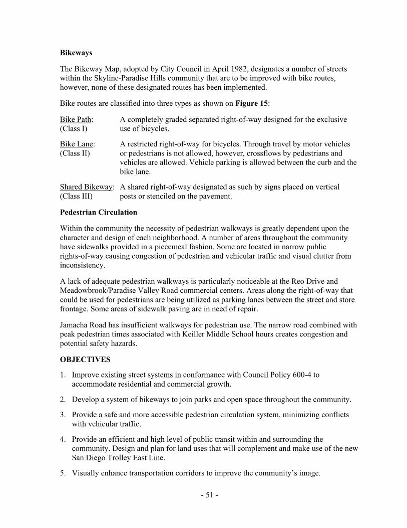
- -51
Bikeways
The Bikeway Map, adopted by City Council in April 1982, designates a number of streetswithin the Skyline-Paradise Hills community that are to be improved with bike routes,however, none of these designated routes has been implemented.
Bike routes are classified into three types as shown on Figure 15:
Bike Path: A completely graded separated right-of-way designed for the exclusive(Class I) use of bicycles.
Bike Lane: A restricted right-of-way for bicycles. Through travel by motor vehicles(Class II) or pedestrians is not allowed, however, crossflows by pedestrians and
vehicles are allowed. Vehicle parking is allowed between the curb and thebike lane.
Shared Bikeway: A shared right-of-way designated as such by signs placed on vertical(Class III) posts or stenciled on the pavement.
Pedestrian Circulation
Within the community the necessity of pedestrian walkways is greatly dependent upon thecharacter and design of each neighborhood. A number of areas throughout the communityhave sidewalks provided in a piecemeal fashion. Some are located in narrow publicrights-of-way causing congestion of pedestrian and vehicular traffic and visual clutter frominconsistency.
A lack of adequate pedestrian walkways is particularly noticeable at the Reo Drive andMeadowbrook/Paradise Valley Road commercial centers. Areas along the right-of-way thatcould be used for pedestrians are being utilized as parking lanes between the street and storefrontage. Some areas of sidewalk paving are in need of repair.
Jamacha Road has insufficient walkways for pedestrian use. The narrow road combined withpeak pedestrian times associated with Keiller Middle School hours creates congestion andpotential safety hazards.
OBJECTIVES
1. Improve existing street systems in conformance with Council Policy 600-4 toaccommodate residential and commercial growth.
2. Develop a system of bikeways to join parks and open space throughout the community.
3. Provide a safe and more accessible pedestrian circulation system, minimizing conflictswith vehicular traffic.
4. Provide an efficient and high level of public transit within and surrounding thecommunity. Design and plan for land uses that will complement and make use of the newSan Diego Trolley East Line.
5. Visually enhance transportation corridors to improve the community’s image.

- -52
Figure 13. The San Diego Trolley—East Line Location and Stations

- -53
RECOMMENDATIONS
Street System
The future travel forecast for Skyline-Paradise Hills has projected traffic volume increasesfor several streets within the community, however, no street facilities are recommended to beupgraded in classification. The travel forecast recommends widening those streets that arenot yet fully improved and prohibiting on-street parking on some streets in order toaccommodate the increased volumes. The recommendations resulting from the travel forecastare listed below.
1. Lisbon Street/Jamacha Road, between 69th Street and Meadowbrook Drive, currentlyvaries from 25 feet to 40 feet in width. It should be widened to a four-lane collectorstreet, 64 feet wide from curb-to-curb with a transition to two lanes east ofMeadowbrook. This widening will require the acquisition of additional right-of-way.
2. Jamacha Road, between Meadowbrook Drive and Glencoe Street, should be improved totwo-lane collector street standards, 40 feet wide from curb-to-curb. The current widthvaries between 25 and 40 feet.
3. Meadowbrook Drive, which currently ends at Blackstone Court, should be extended toJamacha Road as a four-lane collector, with a left-turn lane and signal at Jamacha Road.
4. Skyline Drive should be widened to four-lane major street standards between 58th Streetand 69th Street with left-turn lanes at the major intersections. The current width variesbetween 25 and 68 feet. The south side of Skyline Drive between Sienna Street andDeerock Place should be widened to four-lane major street standards with a centermedian as development occurs. The current street width is 32 feet.
5. Woodman Street should have a suitable transition from a four-lane major street with a78-foot curb-to-curb width south of Skyline, to a two-lane collector street with a 40-footcurb-to-curb width north of Skyline Drive.
6. The south side of Paradise Valley Road, between Woodman Street and Zest Street,should be widened to major street standards, 82 feet from curb-to-curb. The current widthvaries between 65 and 82 feet.
7. Paradise Valley Road, between the westerly City limits and Potomac Street, should bewidened to major street standards with an 82-foot curb-to-curb width. The current widthvaries between 48 and 82 feet. This widening should be coordinated with the city ofNational City to improve Plaza Boulevard/Paradise Valley Road within National City.
8. Briarwood Road, which currently ends at Alta View Drive, should be extended as a four-lane collector street, 64 feet from curb-to-curb, to connect with Briarwood Road south ofSR-54 via an overpass. A freeway interchange at Briarwood and SR-54 is planned byCaltrans, although construction has not been scheduled.

- -54
Figure 14. Bicycle Routes

- -55
9. Reo Drive should be extended at its northern terminus (in National City) to connect toHarbison Street. The section between Plumas Street and Harbison is recommended to beconstructed as a four-lane major street, 68 feet wide curb-to-curb, by the city ofNational City.
10. Reo Drive, between Rancho Hills Drive and the South Bay Freeway (SR-54), should bewidened to 68 feet from curb-to-curb with parking prohibited at intersections to provideseparate left-turn lanes. The current width varies between 26 and 68 feet.
11. A new freeway interchange on SR-54 is planned by Caltrans to replace the existingintersection of Reo Drive and SR-54, although construction has not been scheduled. Thenew interchange would connect with the Valley Road interchange south of SR-54 inNational City. The existing Reo Drive intersection should be maintained until the newfacility is constructed.
These improvements have been determined by the City Engineering and DevelopmentDepartment to provide an adequate level of service and keep future traffic congestion to aminimum. Future congestion is anticipated on Potomac Street, between Alta View andSaipan, on Parkside Avenue between the Valley Road/South Bay Freeway interchange andLandscape Drive, and on Briarwood from Goode Street to the South Bay Freewayinterchange.
Public Transportation
Public transit needs should continue to be monitored in order to provide adequate transitcirculation within the community. Improvements to existing and future transit stops shouldinclude covered waiting areas and street improvements to minimize conflicts between busesor the trolley and other vehicular traffic movements.
Due to the existing inaccessibility of bus service to the area south of Paradise Valley Roadand the steady increase in patronage for taxi-feeder service, continued operation of DARTservice is recommended. Future plans to expand DART include the addition of the areabordered by National City to the west, Plaza Boulevard to the north, Woodman Street to theeast and Paradise Valley Road to the south.
An additional trolley stop should be considered along Imperial Avenue at 68th or 69th Street ifconditions warrant as a result of land use intensification or development of a project with theability to construct a transit station as part of the project. The specific proposals should bereviewed by the City and MTDB, based on standard criteria for such evaluations. The siteevaluation criteria should include considerations such as the proposal’s impact on the overallservice of the line which may result in closing other stations in favor of the new one, theproposal’s minimum effects on the existing transit line schedules and patronage, and the newstation's financing by private development.

- -56
Figure 15. Bicycle Lane Classifications
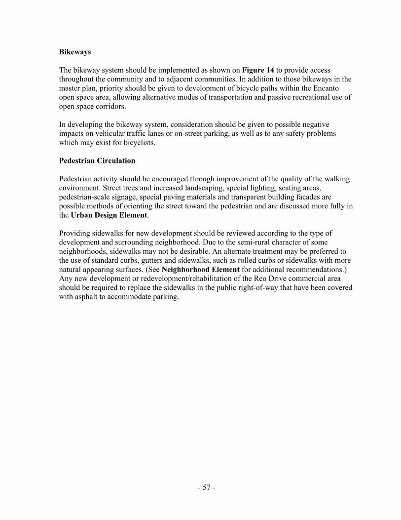
- -57
Bikeways
The bikeway system should be implemented as shown on Figure 14 to provide accessthroughout the community and to adjacent communities. In addition to those bikeways in themaster plan, priority should be given to development of bicycle paths within the Encantoopen space area, allowing alternative modes of transportation and passive recreational use ofopen space corridors.
In developing the bikeway system, consideration should be given to possible negativeimpacts on vehicular traffic lanes or on-street parking, as well as to any safety problemswhich may exist for bicyclists.
Pedestrian Circulation
Pedestrian activity should be encouraged through improvement of the quality of the walkingenvironment. Street trees and increased landscaping, special lighting, seating areas,pedestrian-scale signage, special paving materials and transparent building facades arepossible methods of orienting the street toward the pedestrian and are discussed more fully inthe Urban Design Element.
Providing sidewalks for new development should be reviewed according to the type ofdevelopment and surrounding neighborhood. Due to the semi-rural character of someneighborhoods, sidewalks may not be desirable. An alternate treatment may be preferred tothe use of standard curbs, gutters and sidewalks, such as rolled curbs or sidewalks with morenatural appearing surfaces. (See Neighborhood Element for additional recommendations.)Any new development or redevelopment/rehabilitation of the Reo Drive commercial areashould be required to replace the sidewalks in the public right-of-way that have been coveredwith asphalt to accommodate parking.

- -58
Figure 16. Parks

- -59
PARK AND RECREATION ELEMENT
PRIMARY PARK AND RECREATION GOAL
Provide a system of fully developed parks and recreational facilities to meet the recreationalneeds of the community.
EXISTING CONDITIONS
The planning area is served by three community parks and six neighborhood parks as shownon Figure 16. These parks are population-based parks which are intended to serve the dailyrecreational needs of the surrounding community.
According to the General Plan, community parks should serve a population of 18,000 to25,000 within an approximate 1-1/2 mile radius. Ideally, they should have a minimum usablearea of 13 acres when located adjacent to a junior high school or 20 acres when notso located.
Neighborhood park facilities should serve a population of 3,500 to 5,000 within anapproximate one-half mile radius. Ideally, they should have a minimum usable area of fiveacres when located adjacent to an elementary school or ten acres if not so located.
Table 5 shows how the existing park facilities compare with General Plan park standardsbased on population. According to General Plan standards, the existing population should beserved by two community parks and nine neighborhood parks. The planning area is currentlydeficient in park acreage and in number of neighborhood parks based on General Planstandards, and will have a shortfall of six neighborhood parks when the community isbuilt out.
General Plan standards are difficult to achieve in the urbanized areas of the City and shouldbe considered guidelines only. As in other urbanized areas, new development in Skyline-Paradise Hills will not generate sufficient park fees to provide financing for acquisition anddevelopment of additional facilities to meet General Plan standards. If existing parkdeficiencies are to be mitigated, assessment districts must be considered, however, thesemust be initiated by the community.
The General Plan addresses the problem of acquiring additional park land in urbanized areas:
“In older, already developed parts of the City, where recreation space is difficult toacquire, efforts should be directed toward providing staff and facilities whichcompensate for deficiencies in acreage. Land, equipment and supervision in varyingproportions can still add up to recreational opportunity and service to the residents.If acreage is reduced, facility investment and leadership should be correspondinglyincreased.”

- -60
TABLE 5
COMMUNITY AND NEIGHBORHOOD PARKS
Park Facility
Population-basedSize Requirement
(Usable Acres)Actual Area
(Usable Acres)Development
Status
Community Parks
Skyline P&R Center 20 8.8 developed
Paradise Hills P&R Center 20 12.8 developed
Bay Terrace P&R Center 20 11.0 developed
Neighborhood Parks
Keiller Park* 5 4.0 undeveloped
Encanto Park 10 4.1 partially developed
Lomita Park* 5 2.3 developed
Skyview Park 10 3.0 undeveloped
Boone Park 10 3.0 undeveloped
Parkside Park* 5 5.0 undeveloped
* Park site is adjacent to school field.
The facilities available at the community and neighborhood parks are shown on Tables 6and 7 respectively.
In addition to population-based parks within Skyline-Paradise Hills, Martin Luther KingCommunity Park, which is located just outside the community on Skyline Drive, and thePenn Athletic Area increase park availability to residents of the community. Penn AthleticArea is a multipurpose sports field developed on a 13-acre site leased from the San DiegoUnified School District. There is also a privately-owned little league ball field (Twin HillsYouth Park) in the southwestern portion of the community.
School sites in the community have the potential to serve as additional recreational facilities.The athletic field, courts, playgrounds, auditoriums and other meeting facilities could be usedby the community after the normal school session has ended. Any use of school facilitiesmust be coordinated through the school district, and limitations may be placed on the use ofthese facilities.
Two open space systems within the community also have the potential to increaserecreational opportunities for residents. Paradise Canyon and the Jamacha open space systemcan be used for passive recreational purposes, such as hiking or bicycling, as recommendedin the Open Space Element of this Plan.
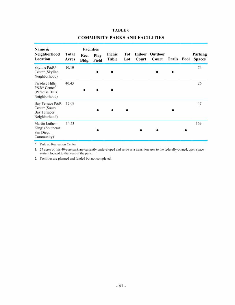
- -61
TABLE 6
COMMUNITY PARKS AND FACILITIES
FacilitiesName &NeighborhoodLocation
TotalAcres
Rec.Bldg.
PlayField
PicnicTable
TotLot
IndoorCourt
OutdoorCourt Trails Pool
ParkingSpaces
Skyline P&R*Center (SkylineNeighborhood)
10.10
• • • •74
Paradise HillsP&R* Center1
(Paradise HillsNeighborhood)
40.43
• • •26
Bay Terrace P&RCenter (SouthBay TerracesNeighborhood)
12.09
• • • •47
Martin LutherKing2 (SoutheastSan DiegoCommunity)
34.53
• • • •169
* Park nd Recreation Center
1. 27 acres of this 40-acre park are currently undeveloped and serve as a transition area to the federally-owned, open spacesystem located to the west of the park.
2. Facilities are planned and funded but not completed.

- -62
TABLE 7
NEIGHBORHOOD PARKS AND FACILITIES
FacilitiesName &NeighborhoodLocation
TotalAcres
PlayField
TotLot
PicnicArea
Rec.Bldg.
TennisCourt
Club-house
BsktballCourt
ParkingSpaces
Undev.Acres
Boone1(NorthBay TerracesNeighborhood)
5.00
Encanto2
(SkylineNeighborhood)
3.51
• • • •8 0
Keiller1
(JamachaNeighborhood)
5.77 0 5.77
Lomita(LomitaNeighborhood)
4.14
• • • •0 0
Parkside3
(Paradise HillsNeighborhood)
5.50 5.50
Skyview3
(SkylineNeighborhood)
4.12
• •4.12
1. Plans for park facilities improvements have not been made.
2. 25 percent is developed and a parcel under private ownership separates undeveloped from developed portions.
3. Facilities are planned and funded but not constructed.

- -63
OBJECTIVES
1. Provide a park system consistent with General Plan standards to the extent feasible givenexisting constraints.
2. Coordinate the use of school recreational facilities for after normal hour usage.
3. Require the provision of private recreational facilities and usable open space in newlarger residential developments.
4. Provide a safe environment in all parks to allow their use by the entire community.
RECOMMENDATIONS
1. Two areas totaling 13.10 acres, which are occupied by the Penn Athletic Area, are leasedto the City of San Diego by the San Diego Unified School District. These two leases arescheduled to expire in 2002 and 2005. This site should be considered for purchase by theCity or the establishment of a neighborhood park.
2. An 18.05-acre vacant site is adjacent to the Bay Terrace Community Park. TheDepartment of the Navy has expressed an interest in purchasing this site for navalhousing. Part of this parcel should be considered for purchase by the City to expand BayTerrace Park to the park acreage standards of the General Plan. The location and amountof additional land necessary to increase the usable acreage of the park should bedetermined by the Park and Recreation department. The remainder of the site should bedeveloped with residential units at a density of 10-15 units per net acre to be compatiblewith adjacent development.
3. Undeveloped neighborhood parks should be improved with playing fields, all-purposecourts and picnic areas as funds becomes available. These parks include Parkside, Boone,Skyview and Keiller neighborhood parks.
4. An increase in park fees for new development is recommended. A special park fee wasadopted for the South Bay Terraces community plan area in 1984. This park fee shouldbe reevaluated and applied throughout the Skyline-Paradise Hills community.
5. The sale of City-owned properties in the community which are not needed or are notsuitable for public use should be explored as a method of obtaining funds for acquiringadditional park acreage and/or additional staff and facilities to compensate for existingpark deficiencies.
6. Because of the limited opportunities for acquisition of additional park sites, retention ofthe Twin Hills Youth Park as a neighborhood serving recreation facility is recommended.The park is encouraged to remain a privately-owned ballfield; however, if the presentowners decide to discontinue this use, the City of San Diego should consider purchasingthe site.

- -64
7. All new multifamily residential developments should be required to provide privaterecreational facilities and/or usable open space areas within the development.
8. The Police Department and Neighborhood Watch organizations should provide regularpatrols and surveillance over parks to ensure that they remain safe and free fromvandalism.
9. In cases where parks are adjacent to school recreational facilities, coordination with theschool district should be sought to allow the use of these facilities after normal schoolhours.
10. In the event that any school sites are declared surplus, first priority should be given toacquisition or lease of the sites for park use.
11. Project First Class landscaping improvements should be targeted toward the approachesto the community parks (Skyline, Bay Terraces and Paradise Hills) to emphasize theseparks as centers of community activity.
12. All City-owned park sites should be rezoned to an open space (OS) zone.

- -65
OPEN SPACE ELEMENT
PRIMARY OPEN SPACE GOAL
Provide an open space system which preserves existing canyons and hillsides and ensuresopen space accessibility.
EXISTING CONDITIONS
Paradise Canyon is one of the principal open space systems proposed for the Skyline-Paradise Hills community. It is located south of Skyline Drive, north of Paradise ValleyRoad, between Division Street and Meadowbrook Drive. Comprising over 45 acres, most ofwhich is within the Hillside Review Overlay Zone, the open space consists of the valley floorand the steep southern slopes of the canyon. The canyon is relatively undisturbed. The Cityhas acquired all land from Division Street extending 700 feet east of Woodman Street,consisting of approximately 30 acres (Figure 18).
The Jamacha open space system (the abandoned Encanto Expressway right-of-way)consisting of approximately 54 acres, is a second open space system within the community.This undeveloped canyon runs parallel to Jamacha Road from Encanto park on the west toCardiff Street on the east. Single-family development lines the canyon’s southern rim and thefloor of the canyon along the foot of the northern canyon wall. Acquisition of this open spacesystem is approximately 80 percent complete.
The slopes along the south side of Paradise Valley Road, east of the City limits, are ownedby the federal government and are a part of the open space system for naval housing. TheCity owns approximately 27 acres of undisturbed slopes on Paradise Valley Road which arepart of Paradise Hills Community Park and serve as a transition area between the federalopen space and the park.
A 16-acre site in the Hillsborough residential development, south of Paradise Valley Roadand east of Briarwood Road, is maintained by a homeowners association as open space.The community also contains two linear open space parks. One of these greenbelts providesaccess to Parkside neighborhood park (not yet developed) and the other leads to PennElementary School. A third open space site provides a landscaped buffer between Bell JuniorHigh School and a single-family neighborhood. The property developer has deeded thesesites to the City and has contributed funds for the rehabilitation necessary to bring the areasup to City standards.
Views of undeveloped hillsides and canyons within the community as well as views towardthe mountains to the east, the Pacific Ocean, San Diego Harbor and the City skyline areimportant assets to this community as they provide visual open space, and thus should beprotected.
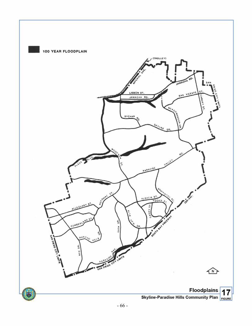
- -66
Figure 17. Floodplains

- -67
Hillside and canyon areas not within the designated open space system have been identifiedas areas that require preservation to the extent possible through sensitive development. Theseareas have been included in the Hillside Review Overlay Zone. The guidelines for hillsidesand canyons outlined in the Urban Design Element of this Plan are intended to providedirection for any future development of these sites.
Four streambeds have been identified in the community. None are subject to the City’sFloodway, Floodplain, or Floodplain Fringe zoning, however, all are subject to flooding, andhave been identified by the City flood hazard maps as areas within the 100-year floodplain(Figure 17). These areas should be maintained as natural open space areas to be used aspossible linkages connecting open space and recreational areas to one another and toresidential and activity centers.
A local equestrian trail (The Encanto Trail) was proposed in the Equestrian Trails andFacilities Plan adopted by the City Council in 1975. The trail was proposed to extend norththrough the South Bay Terraces neighborhood and west through Paradise Canyon. Thefeasibility of implementing this trail should be studied when the equestrian trails plan isupdated. The South Bay Terraces neighborhood is now an urbanized area that may no longerbe suitable for equestrian trails.
OBJECTIVES
1. Develop specified open space areas for passive recreational uses such as hiking or biketrails.
2. Provide a linkage system of pedestrian and bicycle facilities connecting parks and openspaces.
3. Ensure that development located adjacent to open space areas is compatible with andenhances open space areas.
4. Preserve visual and physical access to open space areas from public rights-of-way toincrease passive recreational use.

- -68
Figure 18. Designated Open Space

- -69
RECOMMENDATIONS
1. Paradise Canyon is the community’s highest priority in terms of retention. Those portionsof the canyon not yet acquired should be retained for open space purposes through theplanned residential development permit process or subdivision process and should berezoned to Rl-40,000. The canyon should remain in its natural state except for a five-acreparcel located north of Boone Elementary School which will be developed as aneighborhood park. Future development next to this open space system should bedesigned to ensure that the natural environment remains undisturbed.
2. The Jamacha open space system is on the Open Space Retention List as part of theChollas Creek open space acquisition efforts. It is recommended that this open space bepartially developed with a bicycle trail along the canyon floor. The trail should provide alink between the bikeways designated in the adopted Bikeway Map and connectrecreational facilities in the community. Figure 14 shows the linkage of bicycle trails andthis open space area.
3. The slopes on the south side of Paradise Valley Road between Potomac and Munda,which are owned by the federal government, should remain in their natural state.
4. The community’s linear open space parks, although not part of a larger open spacesystem, are a unique resource in this community as they provide a pedestrian linkagesystem to public facilities and, therefore, should continue to be maintained as open space.
5. Any development adjacent to open space areas should be designed in accordance with theguidelines outlined in the Urban Design Element of this Plan.
6. All slopes which meet the criteria of the Hillside Review (HR) Overlay Zone should bezoned HR and should be developed in accordance with the guidelines for Hillside andSlope Development contained in the Urban Design Element.
7. Areas proposed for open space designation in this Plan should be rezoned to Rl-40,000 topreclude development which is inconsistent with the topography.
8. All City-owned open space areas should be rezoned to an open space (OS) zone. ParadiseCanyon and the Jamacha Open Space System should be rezoned when the City'sacquisition process has been completed. All existing and future open space easementsshould also be subject to an open space zone if brought under public ownership.

- -71
PUBLIC FACILITIES ELEMENT
PRIMARY PUBLIC FACILITIES GOAL
Establish and maintain a high level of public facilities and services to meetcommunity needs.
OBJECTIVES
1. Provide public facilities and services in accordance with City standards.
2. Maximize the use of existing public facilities for community activities.
3. Increase safety through measures such as the addition of street lighting atappropriate locations.
DISCUSSION
Schools
Public education is provided by the San Diego Unified School District. Table 8 showsschools within the community, existing and projected enrollment figures, and operating andtotal enrollment capacities. Operating capacity represents the program demands on classroomconfiguration at the school. It takes into account magnet and other special programs whichrequire smaller numbers of students per classroom. Total or as-built capacity represents themaximum use of space based on 30 students per classroom. This method disregards specialprogram requirements and provides a maximum usage number for baseline purposes.
There are five magnet schools in the community. They are: Freese and Fulton ElementarySchools, Keiller Middle School, Bell Junior High School and Morse Senior High School.Magnet schools offer enriched or special programs and are attended by students outside theschool’s attendance area boundary. Encanto and Valencia Park Elementary Schools, locatedin the Southeast San Diego community, also serve the area.
In September 1986, two new schools, Bethune Elementary and Zamorano Elementary, wereopened which alleviated over-enrollment in most of the community’s elementary schools.Only Freese Elementary currently exceeds its operating capacity. However, according toenrollment projections, Bethune, Zamorano and Boone Elementary Schools are expected toexceed their total, or as-built, capacities by 1990.
Bell Junior High School currently exceeds its operating capacity based on the school’scurrent programs. A site just north of Penn Elementary School has been reserved for anadditional junior high school. The beginning of construction is anticipated in 1990-1991.

- -72
Figure 19. Schools

- -73
TABLE 8
PUBLIC SCHOOL ENROLLMENT
Estimated ProjectedEnrollments Capacity 1986
SchoolOctober 1986Enrollment 1987 1990 Operating Total
Elementary
Bethune 953 1,048 1,134 * 960
Freese 717 737 807 654 930
Robert Lee 816 835 909 816 930
Paradise Hills 962 988 1,106 990 1,170
Penn 899 939 1,014 1,170 1,050
Boone 981 1,140 1,190 1,044 1,110
Fulton 635 743 839 720 900
Audubon 773 757 889 810 900
Perry 742 773 842 1,080 1,020
Zamorano 936 1,104 1,114 * 960
Middle School (6th to 8th grade)
Keiller 653 701 848 608 978
Junior High (7th to 9th grade)
Bell 2,303 2,435 1,618 1,665 2,730
Senior High
Morse 2,124 2,135 2,246 2,309 3,000
* Figures not available from the school district.
The San Diego Unified School District's Long-Range Facilities Master Plan, completed inJanuary 1987, presents strategies and financing methods for accommodating almost a40 percent increase in student enrollment throughout the district by the year 2000. The Planrecommends new school construction, multi-track year-round schools and double-sessionkindergarten as the primary solution strategies; additional recommended strategies includeportable classrooms and boundary changes.
Multi-track year-round schools are recommended for all of the elementary schools inSkyline-Paradise Hills by 1991. Double-session kindergarten is also recommended for allelementary schools except Freese and Fulton, which are magnet schools. Keiller MiddleSchool and Bell Junior High are recommended for multi-track year-round school beginningin 1988-1989. Morse High School is planned to accommodate student enrollment increasesby converting from grades 9-12 to 10-12 with the ninth grade moving to the new juniorhigh facility.

- -74
Figure 20. Public Facilities

- -75
Alternative Uses for School Sites
School sites should be zoned at the density of surrounding residential development andshould be placed in the Institutional Overlay Zone. This will ensure adequate review beforethe sites are considered for other uses. In the event that any school sites are declared surplus,first priority should be given to acquisition or lease of the sites for park use. If a site is foundto be unnecessary or undesirable for park use or another public use, the site should bedeveloped at the density of the underlying residential zone in a manner compatible with thesurrounding neighborhood.
The Paradise Hills Elementary School site and the Audubon Elementary School site arecurrently zoned R-3000. These sites should be rezoned to R1-5000 so that in the event thesites are no longer needed for educational or other public use, they will be developed at adensity compatible with existing neighborhoods.
An 18-acre site south of Paradise Valley Road and east of Briarwood Road is owned by theschool district and has been reserved for a possible future elementary school site. Because thesite lies partially on the former Sweetwater Landfill, it is recommended that this parcel berezoned to R1-40,000. That area which is on the landfill site should remain undeveloped orused for passive recreational use only. If the School District determines that the site will notbe used for a school, the portion of the site that is not impacted by the landfill should bedeveloped with a clustered residential development. A rezone may be necessary to achievethis density depending on the amount of acreage available for development; however, acommunity plan amendment would not be required.
Police
Police protection for the community is provided by the Southeastern Area Substation of theSan Diego Police department, located at Skyline Drive and Sychar (Figure 20). Service tothe community is in two police beats: Beat 411, the southern beat including Paradise Hills,South Bay Terraces and the southern half of North Bay Terraces; and Beat 412, the northernbeat including Skyline, Lomita, Jamacha and the northern part of North Bay Terraces. Duringthe day, there is one designated one-person patrol unit per beat. In the evening, thedesignated patrol increases to two-person coverage and the addition of two secondary unitsfor each beat.
The Police Department heads a neighborhood watch organization called “Community Alert.”It’s purpose is to involve residents with their own neighborhood in a self-protection programagainst crime through an unofficial watch program.
Fire Protection
Fire protection in the community is provided by Engine Company 32, located at 484Briarwood Road. There are many areas (demand zones) that cannot be reached by Engine 32in six minutes or less. The six-minute response time is the Fire Department’s citywideguideline for response to residential areas.

- -76
Due to the community’s location on the City limit boundary, fire protection in thecommunity is augmented by automatic aid agreements with five neighboring jurisdictions:Spring Valley, Lemon Grove, La Mesa, Bonita-Sunnyside and National City. Under theseagreements, fire protection support is provided to an area by the nearest engine company,regardless of district boundaries.
Even with automatic aid from these agencies, the six-minute response time is exceeded.Providing a level of service that is consistent with the rest of San Diego will require theaddition of at least one new fire station and possibly the relocation of Engine Company 32.The appropriate locations will be determined by a response time analysis of potential siteswithin the community, conducted by the Fire Department.
Any new fire station proposed by the Fire Department should be reviewed by the PlanningDepartment for location, design issues and compatibility with the surrounding neighborhood.
Post Office
There are two postal substations within the community: one located on Reo Drive betweenAlbemarle and Cumberland and one on Imperial Avenue at Lisbon Street. There issubstantial patronage at this latter substation due to its accessibility to the Skylinecommunity, neighboring Southeast San Diego and the adjacent commercial uses. Parking andtraffic congestion in the parking lots and the adjacent streets is a problem. Any proposedrelocation or expansion of the Imperial Avenue postal substation should be reviewed by thePlanning Department. A location along the Trolley Corridor is recommended to minimizeimpacts to residential neighborhoods. Planning Department review is recommended toaddress issues such as compatibility with, and enhancement of, the Trolley Corridor,landscaping, minimizing impacts on pedestrian circulation, patron and service access,parking, lighting and noise impacts.
Recommendations for parking and circulation improvements for the Reo Drive substation arediscussed in the Commercial Element under Reo Drive.
Libraries
Library service is provided by the Paradise Hills branch library, located at 5922 Rancho HillsDrive, and the Skyline branch library, located at 480 South Meadowbrook Drive. TheParadise Hills library offers 17,300 volumes (as of Fiscal Year 1986) and has 3,875 squarefeet of service area. The Skyline library offers 15,400 volumes and has 4,400 square feet offloor area.
Standards set forth in the General Plan recommend that branch libraries serve 18,000 to30,000 residents within a maximum service area radius of two miles. Branch libraries shouldhave an eventual capacity of 4.4 volumes or more per square foot of service area. The twobranch libraries meet these criteria. The City should continue the provision of libraryfacilities at the present level of service, with services expanded as the community reaches itsbuildout population.
- -77
Water and Sewer Service
The sewer trunk lines serving the community are located along Jamacha Road, PlazaBoulevard, Paradise Valley Road and Parkside Avenue. All sewage is processed at the PointLoma Treatment Plant.
A new trunk line to replace the trunk line in Plaza Boulevard, also known as the HighlandPark Estates Trunk Sewer, is to be constructed in two phases. Phase I construction isscheduled for Fiscal Year 1987. Phase II design is planned for Fiscal Year 1993 withconstruction to commence in Fiscal Year 1994.
Gas and Electricity
San Diego Gas and Electric’s (SDG&E) Paradise Substation is located near Plaza Boulevardand Woodman Street. Two 69,000 volt transmission lines are also located within thecommunity and require unobstructed access along the lines for patrol, maintenance, andrepair. The substation is indicated on Figure 20.
Landfills
There are two completed landfills in the planning area, which are illustrated on Figure 20.They are the Paradise Landfill (located at Paradise Valley Road and Potomac Street) and theSweetwater Landfill (located south of Parkwood Drive east of Goode Street). Both containnormal refuse and trash (no hazardous substances).
The Paradise Landfill, completed in 1967, is presently the site of the Paradise Hills Park andRecreation Center. The landfill occupies 5.60 acres of the 13-acre property.
The Sweetwater Landfill was completed in 1960. Covering approximately 20 acres, the fillcontains over one million cubic yards of refuse. A privately-owned and maintained openspace area occupies the northern portion of this site. The San Diego Unified School Districtowns the southern portion of the site, which they have designated for a playing field for apossible future elementary school. This site should be rezoned to R1-40,000 as described inthe discussion of school sites.
As with all refuse landfills, there is the likelihood of methane gas leakage and some groundsettling. Due to the sensitivity of this land with respect to development, it is recommendedthat these areas remain undeveloped or reserved for passive recreational uses only.
Alternative Uses for Public Facility Sites
The Institutional Overlay Zone should be applied to all publicly-owned land designated forpublic facilities. This will ensure adequate review before the sites are considered for otherthan institutional or public use.
- -79
CULTURAL AND HISTORICAL RESOURCES ELEMENT
PRIMARY CULTUAL AND HISTORICAL RESOURCES GOAL
Preserve the cultural and historical resources of the Skyline-Paradise Hills community.
EXISTING CONDITIONS
There are eight documented archaeological sites in the community planning area. The mostimportant sites (where artifacts such as blades, flakes, cobble tools, core tools and scraperplanes have been found) provide evidence of the tool-making procedure and the methods ofprocessing animal and plant materials used by an unidentified Indian culture group.
Three of these archaeological sites have been disturbed by either residential development oroff-road activity.
There are three documented paleontological sites in the community. All of the specimensfrom these sites lived during the Pliocene Era, which began ten million years ago and endedone million years ago. These sites have yielded many specimens, including mollusks, sharks,manta rays, dolphins, baleen whales, a sea lion and many types of birds and bony fish. Allthree sites have been disturbed by residential development.
Within the planning area there are outcrops of the San Diego Formation. This formation hasyielded fossil invertebrates and has a high potential for further marine vertebrate finds.
OBJECTIVES
1. Protect the resource value of archaeological artifacts and paleontological resources withinthe community.
2. Preserve buildings of architectural and historical interest in the community.
RECOMMENDATIONS
1. Developments that might impact archaeological or paleontological sites should beidentified during the permit process. These impacts should be mitigated through theenvironmental review process.
2. Structures within the community that are considered historic should be reviewed forinclusion as a City landmark designation. These properties should take advantage ofavailable benefits such as property tax or investment tax credits.

Urban Design Element• Introduction• Residential Guidelines• Commercial Guidelines• General Guidelines

- -83
INTRODUCTION
Urban design addresses a wide range of issues, including the visual impact of newdevelopment, the compatibility of new development with the existing community and thenatural landscape, and perceptions of image, identity and character within a community.Other elements within this Plan address the location, timing, and sequence of developmentand facilities. The Urban Design Element is vital to the cohesiveness between the otherelements of the Plan because it deals with the quality and form that new developmentwill take.
PRIMARY URBAN DESIGN GOAL
Enhance the community’s image through improvements to the visual and physical characterof the community.
EXISTING CONDITIONS
Skyline Paradise Hills is a predominantly urbanized community although the development ofremaining vacant parcels, as well as the redevelopment of existing properties, has thepotential to affect the quality of the community.
The landforms of the area consist of rolling hills and canyons with views of Coronado,San Diego Bay, the Pacific Ocean, mountains to the east of the City and hillsides andcanyons within the community. Development has been relatively responsive to topographyand has produced neighborhoods of winding streets with structures oriented to takeadvantage of views into canyons, open space and to points outside of the community. Streets,especially in the western portion of the community, provide view corridors to the west.In many areas throughout the community, backyards and side yards consist of or abutcanyons and hillsides. These steeper areas have remained free of development and providesmaller open space systems which, although not physically accessible to the general public,do provide visual open space to surrounding residents. Some of the newer residentialdevelopment is repetitive, however, and has left much of the land absent of vegetation.Barren hillsides and sparse street tree planting are characteristic of many new neighborhoods.
Commercial development in the community is primarily older, small-scale andneighborhood-oriented, with the exception of the shopping center at Woodman Street andAlta View Drive. Many of the sites could be more fully utilized and improved withcoordinated design and landscaping. Because of the lack of additional commercial landavailable, revitalization of these older commercial areas is essential to providing adequatecommercial services for the community.
Project First Class was established in 1984 as a comprehensive program of design guidelines,landscape improvements, code enforcement and business development for the FourthCouncil District. The proposals presented in the Project First Class Urban Design Programhave been incorporated into the design guidelines of this Plan.

- -84
OBJECTIVES
1. Ensure that new development is compatible with existing neighborhoods in terms of bulk,scale and design, and that it is sensitive to existing topography.
2. Improve the quality of design of new residential development.
3. Improve the appearance of existing commercial facilities to revitalize existing businessesand stimulate the development of new business.
4. Orient development to encourage interest at the pedestrian scale in order to stimulatepedestrian circulation.
5. Improve the streetscape in the vicinity of parks and recreation centers, public buildings,and high visibility streets in order to provide a sense of identity to activity centers and theroutes leading to them.
RECOMMENDATIONS
The following urban design guidelines are intended to be applied to all new development andrehabilitation of residential and commercial sites in the Skyline-Paradise Hills community.
- -85
RESIDENTIAL GUIDELINES
Building Scale
Height, bulk and scale of buildings are factors which contribute to continuity withindevelopment and adaptability to the surrounding environment. If a community is to exhibitphysical character and identity, its development must occur with some consideration for howdevelopment fits together and works with existing development and landforms.
• New development should be compatible with the scale and character of the surroundingdevelopment. Building scale should be related to the prevailing height, bulk and intensityof use in the area, and to the wider effects upon the neighborhood, views and topography.
• The transitions and visual relationships between new and older buildings should beharmonious. A conscious effort to achieve balance and compatibility in design betweenbuildings is needed. This can be accomplished by repeating existing building lines andsurface treatment and by gradual transitions in height, bulk and density. Abruptdifferences in scale should be avoided.
• Where new buildings are larger than existing structures, large surfaces should bearticulated and textured to reduce their apparent size and to reflect the pattern of existingbuildings.
• Where lot consolidation takes place, special consideration should be given to adjacentparcels to ensure that new development does not visually overwhelm neighboring areas.
• Building bulk should be controlled through the use of ground level and upper levelsetbacks, facade variation and architectural features recessed entryways, porches,balconies, bay windows) which serve to break up building facades into smaller-scalevisual components. Long continuous building masses that create a wall effect shallbe avoided.
• Small courtyard and cluster residences of 15-25 dwelling units are recommended formultifamily residential development.
• Any new development in the R-3000 zone should be low-scale with particular attentionpaid to the bulk and scale of surrounding development, and to potential view blockage.

- -86
Site and Building Design
• In new developments, repetitious use of identical style and type of dwellings should beavoided. Larger projects in particular result in greater visual prominence of development.Using a variety of structures can result in a more interesting appearance, and can alsoproduce a wider range of housing costs. Use of staggered setbacks, varied buildingheights, widths, shapes, orientations and colors should be incorporated. Protectedcourtyards, verandas, facades and porches are also encouraged to promote buildingvariety.
• New residential development should be integrated with existing street and sidewalkpatterns rather than being designed as an enclave or complex apart from theneighborhood. Sidewalks should be provided along at least one side of all private streetsand should link in a clear manner to existing pedestrian and bicycle ways. Sidewalksshould be provided between important shared facilities and to important off-sitedesignations such as transit stops.
• The site’s design should provide clear, direct relationships between the buildings, streetsand the pedestrian circulation system. Buildings should be oriented toward the publicstreet, and each dwelling should visibly relate to the street. Units hidden on the backportion of the site or behind another building should be avoided. Visible street entrancesor street-facing courtyards with dwellings entered from the courtyard are encouraged.
• Usable open space should be provided for each unit. This may be in the form of a garden,courtyard, terrace, or roof deck or other space which allows residents to have their ownterritory outdoors.
• When located on ground level, private open space should be screened from public viewby landscaping or privacy fencing.
• Private open space should be oriented to receive good sun penetration and to provideshade in the warm months.

- -87
Parking Areas for Residential Development
• Off-street parking areas should be placed in unobtrusive locations and should be designedto minimize their visual impact on the site and the surrounding neighborhood.
• Parking lots should not be placed between the front of a residential building and the street.Consideration should be given to prohibiting parking in the required front and side yardareas.
• For multifamily developments, a portion of the parking area should be enclosed by garages,carports, or trellises. These areas should relate in design and scale to the residential unitsand should not significantly block views from the street into the development.
• Where appropriate, and subject to design review, parking spaces should be incorporatedinto the building design using tuck-under parking.
• Several small parking areas are preferable to a few large lots.
• Tandem parking spaces (8.5 feet by 35 feet) may be used to reduce the size of pavedparking areas and increase open space.
• Trash facilities should be easily accessible and designed to be an integral part of theproject.
• Special areas for bicycle parking should be considered.
• Parking lots should not directly abut the building. A landscape and walkway area should beprovided between all parking areas and the building.
• Landscaping islands should be provided at regular intervals in parking areas. Tree canopiesand patterned paving are encouraged to soften large areas of paving.

- -88
• Landscaping should be used to screen parking areas from the street and nearby residences.To allow opportunities for surveillance of parking areas, shrub planting or low walls maybe used to partially screen parking while still allowing a line of site into the area.
• Landscaping should be used to screen parking areas from the street and nearby residences.To allow opportunities for surveillance of parking areas, shrub planting or low walls maybe used to partially screen parking while still allowing a line of site into the area.

- -89
COMMERCIAL GUIDELINES
Site Design and Parking
1. In older commercial areas where existing buildings are close to the property line, thefollowing guidelines shall apply.
a. Buildings should be placed within ten feet of the property line to maintain aconsistent street setback pattern and to enhance pedestrian activity.
b. If buildings are set back from the property line, the area between the building and thepublic right-of-way should be fully landscaped, interrupted only by permitteddriveways. Decorative paving may be used to meet a portion of the landscapingrequirement.
c. Parking lots at the sides or rear of the building should not directly abut buildings. Anintervening area of at least five feet should be used for planting or a pedestrianwalkway of a different finish material than the parking lot.

- -90
d. Where parcels are served by an alley, curb cuts should be limited and the alley shouldbe used for access. This will increase the opportunity for on-street parking, pedestriancirculation and landscaping.
e. Parking lots at the sides of the building should be set back from the public right-of-way at least ten feet with this area fully landscaped.
f. Rows of parking spaces should not be continuous. Landscaped islands should beprovided at a minimum of every eight spaces.
g. New development or redevelopment should be pedestrian-oriented. Buildings onshopping streets should develop a transparency with the pedestrian environment ofthe sidewalk. This will help to avoid blank and solid walls at the sidewalk.Transparency can be accomplished by the use of glass or other transparent materials.
h. Streetscape elements, including widened sidewalks, kiosks, street furniture, streetlighting and signage, should be used to enhance the appearance and function ofcommercial developments. These elements should be compatible with the materials,color and design of the structures and should be planned as a unifying element of thecommercial area.
i. Landscaped buffer areas should be provided between commercial and residentialuses.
- -91
2. In larger scale or auto-oriented commercial centers, the following guidelines shall apply:
a. Parking areas should be set back at least ten feet from the property line and theintervening area fully landscaped.
b. Any walls or fences should be set back from the property line to permit landscapingbetween the right-of-way and the wall or fence.
c. Parking lots should not directly abut the buildings. An intervening area of at least fivefeet should be used for planting or a pedestrian walkway of a different finish than theparking lot.
d. Rows of parking spaces should not be continuous. Landscaped islands at least fourfeet wide should be provided at a minimum interval of every eight spaces.
e. Streetscape elements including kiosks, walkways, seating areas, lighting and signageshould be used to enhance the appearance and function of commercial developments.These elements should be compatible with the materials, color and design of thestructures and should be planned as a unifying element of the commercial area.
f. Landscaped buffer areas should be provided between commercial and residentialuses.

- -93
GENERAL GUIDELINES
Pedestrian Activity
• Streets should be designed and developed as pleasant places to walk as well as drive.Pedestrian areas should be emphasized through the use of wider sidewalks, benches,pedestrian scale signs, paving materials and landscaping.
• Projects should front on the public street and provide identifiable pedestrian access fromthe street into the project, even in areas where parking lots are located between the streetand the project.
• All pedestrian pathways shall have adequate lighting and signing to provide for the safetyof the users.
• Pedestrian linkages should be provided as appropriate between public activity areasincluding schools, libraries, parks and open space areas, shopping areas and transit stops.Such linkages could be in the form of linear parks, landscaped sidewalks or separatepathways.
Streetscape
• Landscaping should be used to tie buildings and site developments to existing streets andsidewalks, visually anchoring buildings to the larger environment of the neighborhood.
• Landscaping which de-emphasizes turf areas and utilizes native and drought resistantplant materials is encouraged.
• Street development should provide for trees and shrubs along sidewalks as well asmedian strips and should utilize native or drought resistant plants where possible.Landscaping should be placed in the median strips of streets wherever feasible.
• Curb cuts should be minimized to allow more landscaping and parking along the streets.
• Taller trees or other type of specialized planting program should be used to mark majorintersections and to add focus.
• A strong sense of edge along public streets and private streets within planneddevelopments should be developed to spatially define streets. This can be accomplishedby the arrangement of street trees near the public right-of-way in a linear pattern. Incommercial areas, consistent building setbacks also help define the street.

- -94
• The five-foot strip between sidewalks and private property lines often creates amaintenance problem, particularly where residences back up to major streets such asParadise Valley Road. Landscaping and maintenance of these strips will do a great dealto improve the visual quality of the community. A possible funding source for street treeplanting in this strip is the Project First Class landscaping program, however,maintenance of the landscaping must be assured by a maintenance district or some otherassessment district.
• Leftover small parcels along major streets and freeways should be conveyed to adjacentowners with deed restrictions or some other mechanism to ensure they are maintained asopen space.
• All street widenings and related improvements should have quality design standards. ThePlanning Department should review all CIP projects and a landscape architect should beconsulted on an as-needed basis to improve the aesthetic quality and cohesiveness ofstreet improvements.
• Fencing along streets that is used to screen or to enclose private yards should avoid“walling off” the street. Shrubbery, trees, and architectural detailing should be used toadd visual interest.

- -95
Project First Class Landscape Improvement Program
A comprehensive landscape improvement program for neighborhoods and important streetcorridors was initiated as part of the Project First Class Urban Design Program (Gerald Gast,AIA, Tectonics, Kercheval and Associates, Inc., and Garrett Eckbo, FASLA, 1985). Theprogram was designed as a joint effort between the City and property owners. An investmentof $1,200,000 in Project First Class funds has been targeted for planting improvements incenters of community activity—parks and recreation centers, public buildings and highvisibility streets—throughout Council District Four.
The City-funded landscape program is the initial step. It will require the cooperation ofprivate property owners to accomplish a long-range program. Citizens are encouraged tocontinue the landscape effort with a neighborhood planting program. The establishment ofLandscape Maintenance Districts is recommended as a means of funding neighborhoodplanting. A relatively small tax on property owners has the potential to provide substantialbenefits including higher property values as the neighborhood environment appreciates. Analternative to the maintenance district would be owner participation agreements with adjacentowners to assure the maintenance of landscaping placed in the right-of-way.
As part of the landscape program, planting guides should be established for neighborhoodareas and important street corridors. Appropriate plant species for each area should beselected based on existing site conditions, existing plant materials and based on the existingor desired character of each area. These species would be recommended for street treeplanting to establish landscaping themes providing an element of identification andcontinuity within the neighborhood areas.
• Centers of community activity such as community parks, libraries and schools should begiven priority for special landscaping programs.
• The following streets should be given the highest priority for street plantingimprovements:
- Skyline Drive
- Paradise Valley Road
- Reo Drive
- Imperial Avenue
• A community nursery is recommended as an element of the landscape program. Thenursery would be a source of plant material for community residents to purchase for theirhomes. It would be managed for community benefit, employ local youth and enlistvolunteer help and retired persons. The nursery could also serve an educational functionby developing an arboretum illustrating gardening principles to community members. Ajoint project with the Park and Recreation Department should be considered. TheDepartment already maintains a large nursery and could administer a community self-serve project, perhaps as a pilot to be used in other areas.

- -96
Lighting
• Street lighting should be of different illumination levels to reinforce circulation hierarchy(public roads, private roads, parking areas, pedestrian walkways). Lighting should bedesigned and located so as to not shine on adjacent properties.
• Where low-level lighting is used, fixtures should be placed so that they do not produceglare. Shatter-proof coverings should be used for all low-level lighting fixtures.
• In addition to walkway lighting, peripheral lighting should be provided for multifamilydevelopments. Peripheral lighting provides security for surveillance of the units andallows residents and visitors to see into their surroundings and determine if passagethrough an area is safe.
Sign Standards
• Signs should be designed for compatibility with the architecture of surroundingdevelopment. Signs should not dominate the streetscape, but blend with it whileproviding an element of interest.
• Building mounted signs should not project above the roofline.
• Multiple signs within a development should have a standardized format and design foruniformity.
• Freestanding signs should be pedestrian scale. These signs should be appropriatelylandscaped and lit.
Screening
• Trash receptacles should be screened. Refuse collection areas should be surrounded by asolid wall or fence with a minimum height of four feet or the height of the container,whichever height is greater. A six-foot solid wall or fence should be constructed betweenthe container and any adjoining residentially zoned property. Wherever possible, refusecollection areas shall be directly accessible from alleys. All enclosures should beconstructed with finishes and colors that are harmonious to the architectural theme of theprimary buildings.
• Service areas and loading docks should be screened. These areas should be located sothat they do not create visual clutter or problems with vehicular/pedestrian circulation.
• Berms, bushes or low fencing should be used to screen parking lots that front roadways.If fencing is used, walls should not be continuous; variation of surface relief, materials orposts at regular intervals should be used and fencing should not be over four feet inheight to allow for protective surveillance.
• Rooftop mechanical equipment should be screened to protect existing and future viewsfrom hillside developments.

- -97
Designing for Defensible Space
The concept of territorial and defensible space should be considered in designing public andprivate improvements. This is accomplished without the building of fortresses and issuccessful when a potential offender perceives that he is intruding on the domain of another,and that he will be noticed if he intrudes. He is then more likely to be deterred from criminalbehavior. The neighborhood watch program successfully uses this premise.
• Buildings and grounds should be designed to be self-policing so that residents mayparticipate in its security.
• Smaller-scale courtyard developments are encouraged, as they are easier to self-policethan large complexes.
• Windows should be positioned to allow residents to easily watch public spaces, parkingareas and entrances to dwellings.
• Common open spaces and entryways should be visible from the street allowing clearvision by neighbors and law enforcement officers.
• Sidewalks or paths should be located between parking areas and residences, and betweenthe street and residences to allow natural surveillance over the entire path.
• Night lighting along walkways, streets and at parking lots should be provided by usingfixtures that will shape and deflect light into a layer close to the ground. This will placelight where it is needed most and reduce interference with windows.
• Parking areas may be buffered from the street with planting while allowing forsurveillance if low shrubs and ground covers are used.
• Residences should be separated, by physical barriers or distance, from possible crimegenerators such as bars, adult entertainment establishments, etc.
• Residences should be separated, by physical barriers or distance, from region-servingfacilities which generate large volumes of pedestrian and vehicle traffic, such as postoffices, regional high schools, shopping centers, hospitals, health clinics and communitypark and recreation centers.
• If security fencing is used, attention should be given to its design. Fencing should be anattractive architectural feature of a project and should be graffiti-resistant, such as in theuse of wrought iron fences integrated into the overall design of the project.
• For buildings fronting a public street, two means of providing a street entrance areencouraged:
1. Through a street-facing courtyard, with dwelling units entered from the courtyard.
2. Through visible street entrances.

- -98
Both configurations have proven to be the best means of providing security to sidewalksand building entrances through natural surveillance opportunities.
Hillside and Slope Development
• The community’s natural base of hillsides, canyons, ravines, streams and vegetation is animportant set of assets that should be protected in new development. Site plans shouldutilize existing topography and preserve existing vegetation, ravines, watercourses andtopographic features.
• Due to the high visibility of sloping sites, views of the slopes from surroundingneighborhoods and public rights-of-way should be given strong consideration. Buildingslocated near hillside rims should be sited in a staggered arrangement and screened withplanting to avoid a wall effect. Large expanses of flat areas such as parking lots should beavoided. Multiple small parking lots are preferable.
• The treatment of rooftops should be varied on sloping sites, rather than consisting ofextended horizontal lines. Rooflines should be used to emphasize the variety in shape andflowing character of the hillside instead of masking it.
• Planned residential development permits are recommended in areas where the naturalslope is 25 percent or greater.
• As has already been done in many of the neighborhoods of Skyline-Paradise Hills,housing should be designed to fit into the hillside, complementing the land’s naturalcharacter, rather than altering the hillside to fit the structure.
• The need for excessive level areas should be minimized through the use of multi-levelstructures and split-level roads.
• Street alignments should follow existing natural contours. Street width should be kept toa minimum to avoid wide graded areas. Curvilinear designs, split-level roadways andone-way streets may be employed to minimize disturbance of the site.

- -99
• Graded slopes should be shaped to conform to existing landforms. Building sites shouldbe graded so that they appear to emerge from the slope. Slopes with a gradient of 25percent or more should minimize flat areas. If slab-on-grade construction is necessary,building floor elevations should be staggered.
• Building and architectural techniques other than preparation of standard pads or cut andfill grading should be used on sloping sites. Buildings should be sited to minimize therequirement for high retaining walls or extensive cut and fill. Structures should minimizethe use of continuous footings and follow the natural slope of the land. Buildings onsloped sites of ten percent or more should step with the grade at regular intervals.
• Site design should adapt to the existing natural drainage system and should not altersurface runoff and water table conditions. It should not impose drainage problems onneighboring properties, nor should it increase the potential for soil erosion.

- -100
• Existing vegetation should be preserved as much as possible. Areas that have beendisturbed by construction should be revegetated with drought tolerant plant materials.New landscaping should employ species similar in scale at maturity to adjacentlandscaping and natural vegetation. Landscaping adjacent to natural canyons or openareas should be selected to be fire retardant while still being sensitive to impacts onactive vegetation.

Neighborhood Element• Introduction• Summary of Issues and Recommendations• Recommendations

- -102
Figure 21. Neighborhood Areas

- -103
INTRODUCTION
The Skyline-Paradise Hills community plan area encompasses approximately 4,500 acres andhouses over 59,000 residents. It includes six neighborhoods, each with subtle differences inphysical and social characteristics. The delineation of these neighborhoods is based ontopographic features, boundaries such as major streets and type and pattern of development.Density ranges throughout these neighborhoods have little variation due to the residentialcommunity makeup, which consists of primarily single-family development and lower-density multifamily development. Currently there are no community identification signswithin the planning area.
The following discussion outlines the existing conditions, issues and recommendations foreach neighborhood.
EXISTING CONDITIONS
Jamacha
The Jamacha neighborhood is located in the northern portion of the community plan area,bordered by the San Diego City limits adjacent to Lemon Grove, the southern boundary ofthe Jamacha open space system, and Imperial Avenue. Lisbon Street, Jamacha Road,Imperial Avenue and Woodrow Avenue provide major access for the neighborhood.
Housing within this neighborhood is among the oldest in the community. Developmentconsists primarily of low-density single-family units, with scattered multifamily unitsdeveloped before the current R1-5000 zoning was established.
Commercial services in the neighborhood are limited to a commercial strip along ImperialAvenue and a few commercial establishments north of Jamacha Road at Cardiff Street whichhave recently been remodeled. The commercial strip is underdeveloped and would beenhanced by landscaping.
There is one park site in the Jamacha neighborhood, Keiller Neighborhood Park, located onthe north side of Lisbon Street adjacent to Keiller Middle School. The primary open space inthe community is the City-owned Jamacha open space system (the abandoned EncantoExpressway) running east-west parallel to Jamacha Road.
Skyline
The Skyline neighborhood is located in the northwestern portion of the community plan area.It is bordered by Skyline Drive, Woodman Street, Imperial Avenue, the southern border ofthe Jamacha open space system, Meadowbrook Drive and the San Diego City limits. Theseroadways also provide major access for the neighborhood.

- -104
This neighborhood is one of the oldest in the community. Generally, housing is in goodcondition and is primarily single-family. Views throughout the neighborhood range frominternal hillside and canyon views on the western side of the neighborhood to broader canyonand nearby City views on the eastern side of the neighborhood.
There is very little commercial land in the neighborhood. The smallest commercial site in thecommunity is located in the eastern portion of the Skyline neighborhood at Skyline andMeadowbrook Drives. This center is in need of revitalization. A second commercially zonedsite at the corner of Skyline Drive and Sychar Road is used for a neighborhood park andpolice substation. A small portion of strip commercial land is located along Imperial Avenue.A postal substation at the Imperial and Chester Street intersection is part of this commercialdevelopment. This commercial area is underdeveloped in terms of maximizing land potentialfor commercial use.
There are three park sites in the neighborhood: Encanto Neighborhood Park, Skyview Parkand Skyline Community Park.
Lomita
The Lomita neighborhood is located in the northeastern portion of the community plan area,bordered by the San Diego City limits, the southern border of the Jamacha open spacesystem, Meadowbrook and Skyline Drives. These roadways along with San Vicente Streetand Cardiff Street provide major access for the neighborhood.
Housing within the neighborhood is among the oldest in the community. Developmentconsists of low-density single-family units. The neighborhood condition varies with anumber of units in need of refurbishing.
Commercial service is provided by a shopping center at Jamacha and Cardiff. This center hasbeen recently remodeled and repaved, and provides community commercial services such asa grocery market, service station, fast food and sit-down restaurants.
There is one park in the neighborhood, Lomita Neighborhood Park, located adjacent toAudubon Elementary School.
North Bay Terraces
The North Bay Terraces neighborhood is located in the central portion of the plan area,bordered by Plaza Boulevard, Woodman Street, Skyline Drive, Meadowbrook Drive andParadise Valley Road. These roadways also provide major access for the neighborhood.
Development consists of primarily low-density single-family units with a small developmentof multifamily housing in the southeast corner of the neighborhood. A majority of the newresidential development within the community occurs in this neighborhood area. Viewsthroughout the neighborhood take advantage of the existing hillsides and open space.

- -105
The area has one commercial center located at the northwest corner of the Paradise ValleyRoad and Meadowbrook intersection. This commercial site is an older center and would beimproved by rehabilitation. The Skyline Hills branch library is also located at this corner.
A site has been designated for Boone Neighborhood Park although facilities have not beenplanned. It will be centrally located and adjacent to the Paradise Canyon open space systemwhich runs east-west just south of Plaza Boulevard.
South Bay Terraces
The South Bay Terraces neighborhood is located in the southern portion of the plan area,bordered by the South Bay Freeway, Paradise Valley Road, Potomac Street, Alta ViewDrive, Dusk Drive and the City limits adjacent to San Diego County.
Access roads throughout this portion of the community include Woodman Street, BriarwoodRoad and Alta View Drive. These roadways serve the western half of the neighborhood. Theeastern portion of the community relies primarily on local roadways, the South Bay Freeway(SR-54) and Paradise Valley Road for access outside the neighborhood. Public transportationis provided by transit routes 4 and 11 on Paradise Valley Road. The remainder of theneighborhood is serviced by Direct Access to Regional Transit (DART).
Housing in this neighborhood is among the newest within the community and of a greatermix of housing types, consisting of low-density single-family and lower-density multifamilyunits. Views vary throughout the neighborhood with views toward the mountains and SpringValley in the southeastern area.
The neighborhood has one fully developed neighborhood commercial center located atWoodman and Alta View Drive. In addition to this developed site, there are two undevelopedsites within this neighborhood designated for commercial use. These sites are located onParadise Valley Road, east and west of Woodman Street.
There are two parks within the neighborhood; Penn Athletic Area and Bay Terrace Park andRecreation Center. Areas of open space are limited to private project open space or openspace immediately adjacent to the South Bay Freeway.
Paradise Hills
Paradise Hills is located in the southwestern portion of the plan area. It is bordered by theSouth Bay Freeway (SR-54), the San Diego City limit, Paradise Valley Road, PotomacStreet, Dusk Drive and Alta View Drive.
Major access roads in this portion of the community include Reo Drive, Dusk Drive, ParadiseValley Road and Potomac. The neighborhood has no fixed-route transit service, but access totransit lines 4, 11, 36 and 12 is provided through the Direct Access to Regional Transit(DART) taxi system.

- -106
The majority of the housing is single-family and two-family. Multifamily housing includes anaval housing project near the northern boundary at Paradise Valley Road and a mobile homepark in the southwest corner of the neighborhood. The neighborhood has commanding viewsof Coronado, downtown San Diego, the San Diego Bay and the mountains. These residentialdevelopments are laced with small canyon and hillside views, accommodated by curvilinear,local streets.
The area has two neighborhood shopping centers: one located on Reo Drive betweenAlbemarle and Cumberland and a second located at the Reo and Rancho Hills intersection.The Paradise Hills branch library is located near this latter commercial site.
Paradise Hills has two major park sites within its boundaries. They are the ParksideNeighborhood Park at the southern end and the Paradise Hills Community Park andRecreation Center at Paradise Valley Road and Potomac Street. This park extends toward thewestern community boundary by a band of undeveloped land. This area consists ofdesignated open space on land owned by the federal government for use by navy personnel,and dictionary lots that have been purchased by the City and dedicated as part of ParadiseHills Park and Recreation Center. A small privately owned ballfield (Twin Hills Youth Park)is located in the southwestern corner of the neighborhood.

- -107
TABLE 9
NEIGHBORHOOD ELEMENTSUMMARY OF ISSUES AND RECOMMENDATIONS
RecommendationsParadise
HillsSouthBay
NorthBay Skyline Lomita Jamacha
Preservation andenhancement ofopen space
Open spacealong ParadiseValley Road
ParadiseCanyon
Jamacha OpenSpace (EncantoExpressway)
Improvementsand/or acquisition ofpark sites
DevelopParkside Park
Acquirevacant sitenear Toomaand Casey.
Acquire PennNeighborhoodPark.
DevelopBoone Park
DevelopSkyview Park
Develop KeillerPark
Commercialupgrading/redevelopment
Reo DrivebetweenAlbemarle andCumberland
Corner ofRancho Hillsand Reo Drive
ParadiseValley RoadandMeadowbrook
Skyline andMeadowbrook
Imperial fromRichey toJamacha
Imperial Avenuefrom Jamacha toFoster
Housingrehabilitation and/orredevelopment
Northwestcorner
Scatteredthroughoutneighborhood
Scatteredthroughoutneighborhood
Scatteredthroughoutneighborhood
Rezonings needed toincreaseconformance of landuse to zoning
Yes Yes Yes Yes Yes Yes
Implementation oflandscapingimprovementprogram of ProjectFirst Class
Along ParadiseValley Road
Reo DrivebetweenAlbemarle andCumberland
AlongSkyline,Woodman andMeadowbrookcorridors
Cardiff,Jamacha,Meadowbrookcorridors
Along JamachaRoad
All neighborhoods:
1. Install identification signs at entry points into each neighborhood.
2. Implement urban design guidelines recommended for commercial and multifamily development.
3. Commercially designated land should be developed precluding residential uses.

- -108
RECOMMENDATIONS
Jamacha
Most of the housing in Jamacha is in good condition and is well maintained. However, someresidences are in need of rehabilitation and should utilize the housing rehabilitation loanprograms available through the Housing Commission where appropriate.
Due to the semi-rural character of this neighborhood, the necessity of sidewalks in areas ofthe neighborhood should be reviewed as projects are proposed. An alternate treatment maybe preferred to the use of standard curbs, gutters and sidewalks. This could include approvalof sidewalks with more natural appearing surfaces, rolled curbs and landscaping along therights-of-way.
Planting programs should be initiated for private properties and rights-of-way engaging theassistance of volunteers or youth groups. This could be accomplished through a LandscapeMaintenance District with a relatively small fee on property owners.
The Jamacha open space system (the abandoned Encanto Expressway) should remain aspublic open space for the neighborhood and community. Partial development of the openspace to include bike paths is recommended. Funding for this development could come fromallocations by the Park and Recreation Department or the City through state-fundedTransportation Development Assistance Grants. Keiller and Encanto Parks should be fullydeveloped as funds become available.
Community Identification Signs: The following locations are recommended for communityidentification signs:
1. Southeast corner of Lisbon Street and Chester Street. Front of sign to face west.
2. Northeast corner of Woodrow Avenue and Shipley Court. Front of sign to face east.
3. Southeast corner of Meadowbrook and the Jamacha open space system. Front of sign toface south.
4. Northwest corner of Jamacha Road and Cardiff. Front of sign to face east.
Skyline
Although most of the housing in the Skyline neighborhood is in good condition, somehousing is in need of rehabilitation and increased owner maintenance. The HousingCommission rehabilitation loan programs should be used to assist homeowners with neededimprovements.
Sidewalks are intermittently placed throughout the residential developments. Due to thesemi-rural character of this neighborhood, the necessity of sidewalks should be reviewed asprojects are proposed. An alternate treatment may be preferred to sidewalks and curbing.This could include approval of sidewalks with more natural appearing surfaces such as rolledcurbs and landscaping along rights-of-way.
- -109
Skyview Neighborhood Park should be fully developed as funds become available.
Bike paths as recommended along Woodman, Sychar, Skyline and Meadowbrook should beimplemented along with consideration for a bike path within the Jamacha open space.
Community Identification Signs: Community identification signs are recommended for thefollowing major entry points:
1. Northeast corner of Woodman Street and Skyline Drive. Front of sign to face southwest.
2. Southeast corner of Woodman Street and Imperial Avenue. Front of sign to face west.
3. Northeast corner of Paradise Valley Road and Meadowbrook. Front of sign to face east.
Lomita
Several homes within the Lomita neighborhood have been recently upgraded and show signsof increased maintenance and pride of ownership. A continuing improvement andrehabilitation effort is needed in Lomita to maintain the area as a stable single-familyneighborhood. Homeowners should utilize the Housing Commissions loan programs whereappropriate. Planting programs should be initiated for private properties and rights-of-way,engaging the assistance of volunteers or youth groups. This could be accomplished through aLandscape Maintenance District with a relatively small fee on property owners.
Community Identification Signs: Community identification signs are recommended for thefollowing major entry points:
1. Southeast corner of San Vicente and Meadowbrook. Front of sign to face west.
2. On the west side of Cardiff Street across from Wade Street. Front of sign to face north.
North Bay Terraces
Some of the single-family housing in the northwest corner of the neighborhood is in need ofrehabilitation. The improvements needed include cleanup, graffiti removal and generalhousing repair. This area is within the Community Development Block Grant target area andis eligible for low-interest loans for home improvements.
The shopping center at Paradise Valley Road and Meadowbrook and the neighborhoodshopping area at Skyline and Meadowbrook are in need of revitalization. This revitalizationcould include:
1. Implementation of signage design standards.
2. Incorporation of street furniture.
3. Landscaping the parking lot medians and areas fronting Meadowbrook and ParadiseValley Road.
4. Cosmetic improvements such as removal of graffiti and building repair and painting.
- -110
This would require organization and support of owners and implementation through availablepublic funding to realize site improvement. Specific recommendations for revitalization arein the Commercial Element of the Plan.
The Paradise Canyon open space should remain as passive recreational space. Developmentof any kind within this canyon is discouraged. Boone Neighborhood Park should bedeveloped as funds become available.
Currently, there are a number of different materials and designs of fencing along ParadiseValley Road. Project First Class funding could be used to provide low-maintenanceshrubbery or plant material for part or all of this fencing. Other materials such as concretecinderblock could be used for privacy fencing. Both of these materials would discouragevandalism.
Community Identification Signs: The following locations are recommended for placement ofidentification signage:
1. Southeast corner of Woodman Street and Skyline Drive. Front of sign to face north.
2. Northeast corner of Paradise Valley Road and Woodman Street. Front of sign to facesouth.
3. Northeast corner of Deep Dell Road and Paradise Valley Road. Front of sign to facesouth.
South Bay Terraces
Two sites within the neighborhood should be reviewed for purchase for park acreage asmoney becomes available:
1. The Penn Athletic Area, which is located between Dusk and Alta View Drives south ofPotomac, currently leased to the City by the San Diego Unified School District.
2. A vacant 18.05-acre parcel immediately adjacent to Bay Terrace Park and RecreationCenter and Zamorano Elementary School. The site is located near Tooma and CaseyStreets.
Community Identification Signs: Placement of community identification signs at major entrypoints is recommended for the following locations:
1. Southwest corner of Paradise Valley Road and Woodman Street. Front of sign to facenorth.
2. Northeast corner of South Bay Freeway and Woodman Street. Front of sign to face south.
3. South of Paradise Valley Road at the City limits. Front of sign to face north.
- -111
Paradise Hills
The City-owned, designated open space south of Paradise Valley Road should remain asundeveloped passive recreational space. Paradise Hills Community Park is fully developedand Parkside Neighborhood Park is scheduled for capital improvements completion by theFall of 1988. As population needs change, the adequacy of park facilities should be reviewedand revised for improvements.
Additional improvement programs should be reviewed by neighborhood residents, theCommunity Recreation Council and the Park and Recreation Board. The privately ownedballfield in the southwestern corner of the neighborhood should be considered for purchaseand developed as a neighborhood park if the present owners decide to discontinue this use.
The commercial sites at Reo Drive between Cumberland and Albemarle and the Reo Driveand Rancho Hills commercial center are in need of rehabilitation. Recommendedimprovements include:
1. Street and sidewalk improvements.
2. Exterior rehabilitation.
3. Implementation of a landscaping program.
4. Common signage design.
5. Redesign of parking areas.
Infill commercial development should be sensitive to existing surrounding neighborhoods, asdescribed in the Commercial Element of the Plan.
Community Identification Signs: Placement of community identification signs at major entrypoints of the community is recommended for the following locations:
1. Southwest corner of Paradise Valley Road and Potomac Streets. Front of sign facingnorth.
2. Northeast corner of Reo Drive and the South Bay Freeway. Front of sign to face south.
3. South side of Paradise Valley Road at the City limits. Front of sign to face north.

General Plan Conformance

- -115
GENERAL PLAN CONFORMANCE
The Skyline-Paradise Hills Community Plan includes specific recommendations intended toimplement the goals of the General Plan. This section describes how the Plan serves toimplement many of the goals of the General Plan and describes amendments to the GeneralPlan that are needed as a result of Plan adoption.
RESIDENTIAL GOALS
The General Plan designates the majority of the Skyline-Paradise Hills community forResidential Neighborhoods, which call for communities of primary residential use containingdwelling units of various types and attendant community services. This Plan emphasizes themaintenance and enhancement of existing stable residential neighborhoods, which isconsistent with the General Plan objectives for older communities which stress thepreservation of established communities, the conservation of the social-environmentalcharacteristics of the community and the rehabilitation of deteriorating neighborhoods.
COMMERCIAL GOALS
The recommendations in this Plan emphasize the rehabilitation of existing commercialdevelopments and the prevention of residential development on commercially zoned land dueto the very small amount of commercial acreage. These recommendations are necessary toassure an adequate supply of commercial land and are consistent with the General Plan goalof developing a system of commercial facilities that effectively meets the needs of theresidents.
The General Plan map will need to be amended to designate the Imperial Avenue commercialarea for Community Commercial use and to delete the Community Commercial designationat Woodman Street and Alta View Drive.
PARKS AND OPEN SPACE GOALS AND STANDARDS
The recommendations for park and open space acquisition and improvements are consistentwith the guidelines and standards for park development in the General Plan to the extentfeasible. It will not be possible to provide park site acreages according to General Planstandards due to the developed nature of the community.
Design guidelines for areas within the Hillside Review Overlay Zone are established in theUrban Design Element to guide development of privately-owned hillsides and canyons.
The General Plan map will need to be amended to add two areas as designated open space:the slopes on the south side of Paradise Valley Road from the City limits east to the ParadiseHills Park and Recreation Center, and a 34-acre site south of Paradise Valley Road.

- -116
Figure 22. General Plan Amendments
- -117
PUBLIC FACILITIES
Because the community is largely developed, most of the basic public facilities have beenprovided. The Plan recognizes the need, however, for an additional fire station and possiblyan additional library as the community reaches full buildout to conform to General Planguidelines for these facilities.
URBAN DESIGN GOALS
This Plan establishes design guidelines which address building bulk and scale, compatibilityof new development with existing neighborhoods, streetscape elements, hillside developmentand designing for safety. These guidelines will help to implement the urban design goal ofthe General Plan when used in the review of projects requiring discretionary approval.
General Plan Amendments
Planned Area: Adoption of the Skyline-Paradise Hills Community Plan will necessitaterescinding the South Bay Terraces Community Plan. Therefore, reference to the South BayTerraces planning area (No. 36) should be deleted and this area should be incorporated intothe Skyline-Paradise Hills planning area (No. 44) on the General Plan map.
Phased Development Areas: This Plan proposes that the area known as the South BayTerraces planning area, which is currently designated a planned urbanizing area, and aprospective annexation area just east of the Skyline-Paradise Hills planning area bedesignated urbanized, as the majority of the area is developed. These two areas are shownon Figure 3.
Annexed Area: A 3.41-acre parcel located on the north side of the South Bay Freeway(SR-54) just south of Tonawanda Drive was annexed to the City of San Diego in 1985.The community plan boundaries have been adjusted to add this area to the Skyline-ParadiseHills community. The General Plan map should show this area designated for ResidentialNeighborhoods. This area should also be designated urbanized on the Phased DevelopmentAreas map.
Land Use Designations: The following amendments to the land use designations on theGeneral Plan map will be necessary following adoption of the Skyline-Paradise HillsCommunity Plan. The recommended General Plan Land Use map reflecting theseamendments is show as Figure 22.
1. Addition of a Community Commercial designation and removal of the ResidentialNeighborhoods designation for the Imperial Avenue commercial area.
2. Deletion of the Community Commercial designation and addition of a ResidentialNeighborhoods designation for the intersection of Woodman Street and Alta View Drive.

- -118
3. Addition of an Open Space designation and removal of the Residential Neighborhoodsdesignation for slopes on the south side of Paradise Valley Road from the City limits tothe Paradise Hills Park and Recreation Center.
4. Addition of an Open Space designation and removal of the Residential Neighborhoodsdesignation for a 34-acre site south of Paradise Valley Road.

Implementation

- -120
Figure 23. Recommended Rezonings

- -121
IMPLEMENTATION
The Skyline-Paradise Hills Community Plan establishes goals and objectives to guide thegrowth and revitalization of the community. However, adoption of this Plan will not resolveissues by itself. Realization of the Plan’s goals requires a comprehensive program ofimplementation actions and the coordinated involvement of private citizens, the CommunityPlanning Committee, the City of San Diego and other agencies to initiate and carry out thoseactions. This section describes the actions necessary to implement the Plan.
Rezonings recommended to implement the plan are shown on Figure 23.
FINANCING OF PUBLIC AND PRIVATE IMPROVEMENTS
It is the responsibility of the community planning process to identify future publicimprovements. The public improvements set forth in the Transportation, Public Facilities,Parks, Open Space and Urban Design Elements of this document provide the combinedlist of public improvements recommended for Skyline-Paradise Hills.
There are two primary methods of financing public improvements for an urbanizedcommunity such as Skyline-Paradise Hills. The traditional or standard method of financingpublic improvements is through the Capital Improvements Program, which is a six-yearprogram adopted annually by the City Council. Public improvements scheduled for the firstyear of the Capital Improvements Program are the recipients of funds appropriated by theCity Council. Public improvements scheduled over the next five years are based upon fundsexpected to be available.
A long-term financing program is the Public Facilities Financing Plan, the formulation ofwhich is undertaken upon the adoption of the Plan. A Public Facility Financing Plan for theSkyline-Paradise Hills community would provide for the rehabilitation and construction ofthe additional public facilities which will be needed as the community develops over the next20 years and will identify the sources of financing for these facilities. This Public FacilitiesFinancing Plan is based on the public facilities recommended in this Plan.
A number of financing mechanisms are available to implement the variety of public andprivate improvements and services called for in this Plan. The following are some of thepotential funding sources.
Issuance of Special Bonds and Assessment Districts
Local governments have traditionally issued bonds to raise the capital needed to constructmajor public improvements—sewer plants, water systems and public buildings.
Revenue bonds are backed by a reliable flow of future revenues from the facility orenterprise they fund, such as the construction of parking facilities and other such publicfacilities. Because revenue bonds are secured by the proceeds from the enterprise they fund,they carry higher interest rates than general obligation bonds.

- -122
Figure 24. Skyline-Paradise Hills Community Plan Map

- -123
Lease revenue bonds are issued by a nonprofit corporation or special authority whichconstructs a facility and leases it to the City. Lease payments provide the revenue to pay offthe bond and, when the bond is retired, the facility is turned over to the City. Some localagencies have used this method to finance administrative centers, schools and parkingfacilities.
The establishment of assessment districts is becoming a more frequently used mechanism tofinance certain improvements in the City. Special assessment bonds are a traditional tool forfinancing sewer, water, street, sidewalk, street lighting, open space acquisition and similarprojects, which benefit property owners within a given area. This method of financingimprovements would entail the prospect of additional financial burdens on all propertyowners within the assessment district. In particular, assessment districts could be consideredfor use in the maintenance of landscaping, the establishment of special lighting districts andspecial trash and graffiti removal efforts, to name a few.
Fees
Another potential mechanism for funding facilities and amenities would be the imposition ofspecial fees on new development within the area.
Unlike taxes which are levied to raise general revenue, fees are levied to finance a specificactivity, facility or service which confers a direct, identifiable benefit on those paying the fee.There are several sources of authority for imposing fees. The Subdivision Map Actauthorizes a city to impose fees in lieu of dedications of land or improvements as a conditionof subdivision approval. There are several limitations on the imposition of in-lieu fees:
1. There must be an expressed or implied authorization for the item to be funded by the fee;
2. Usually, there must be an implementing ordinance; and
3. The fee must be reasonably related to the project being approved.
One important class of fees is development impact fees charged to new development at thetime the project is approved or a building permit is issued. An impact fee is usually chargedat a fixed rate per bedroom or per square foot. In addition to financing interim schoolfacilities, impact fees might be used to finance street improvements, sewer and watersystems, and public facilities serving new development. It is possible that fees could beimposed in Skyline-Paradise Hills for all new development.
Standard citywide park fees are currently collected at both the subdivision map and buildingpermit stages. However, in many urbanized areas of the City these fees are not able to coverall the park improvement costs necessary to upgrade park and recreation facilities. Therefore,in order to provide adequate funding for park improvements, the City Council has selectivelyadopted a special park fee ordinance for many communities. These fees are assessed, in lieuof the standard citywide park fees, on residential development within the community and canonly be utilized within the community. The special park fees collected within the communityare significantly higher than the standard citywide park fees. A special park fee was adoptedfor the South Bay Terraces community plan area in 1984.

- -124
Under various statutory provisions, local governments can charge fees for services such aspolice and fire protection and for maintenance of existing facilities. In addition to specificstate authorization, charter cities, such as San Diego, have a broad implied constitutionalauthority to impose fees for municipal facilities and services. Fees may also be imposed onnew development by the school district to fund improvements to existing school sites or theacquisition of new school sites.
Business Improvement Districts
Business Improvement Districts are a mechanism by which business owners may assessthemselves, with the City's authorization and administration assistance, to raise money forpromotional and other activities which will benefit the business district. A BusinessImprovement District (BID) is formed under the City’s authority but is done so only bypetition of business owners. Payments are made through a surcharge on the businesslicense fee.
Funds may be used for the following:
1. Acquisition, construction or maintenance of parking facilities for benefit of the area.
2. Decoration of public places.
3. Promotion of public events.
4. Furnishing of music in a public place.
5. General promotion of businesses in the district.
The formation of BIDs is recommended in several areas as specified in the CommercialElement of this Plan.
Community Development Block Grant
This funding source is now being used in the City for commercial revitalization efforts andhousing rehabilitation. Its use is restricted to projects which primarily benefit low- andmoderate-income households. It is expected that block grant funding will continue to supportthese projects.
Open Space Bonds
Extensive open space acquisition is currently being accomplished with open space bonds.Efforts should continue to obtain these funds for the appropriate canyon and hillside areas inSkyline-Paradise Hills. A matching fund program could be established to encourage the useof assessment districts in combination with bond financing, if desired and initiated by localproperty owners.

- -125
IMPLEMENTATION—SCHEDULE OF ACTIONS
Proposalor Activity Action Timing
Responsibility forInitiating Action Financing
REVIEW ANDMONITOR PLAN
1. Monitor development activityfor conformance to the Plan;
2. Ensure that the City’s CapitalImprovement Program isconsistent with the goals andrecommendations of this Plan;
3. Review and update thisdocument when necessary.
Continuing Planning DepartmentPlanning CommitteePrivate citizens
City
LAND USEDevelopmentRegulations
Rezone properties consistentwith the recommendations in theResidential, Commercial andOpen Space Elements. Thoseareas recommended for rezoningare shown on Figure 23.
Immediate Planning Department City
RESIDENTIALPreservation ofexistingsingle-familyneighborhoods
1. Retain existing single-familyzoning.
2. Rezone existing single-familyneighborhoods from R-3000 andR-1500 to R-5000 whereappropriate.
3. Require that all projectsinvolving discretionary approvalcomply with existingneighborhoods.
4. Continue concentrated codeenforcement in residentialneighborhoods as establishedunder Project First Class.
Immediate &Continuing
Immediate
Continuing
Continuing
Planning Department
Planning Department
Planning Department
Code EnforcementTeam
City
City
City
Project FirstClass Funds
Ensure quality newdevelopment
Require that undevelopedmultifamily areas develop undera PRD process.
Immediate Planning Department City
URBAN DESIGNProject Review
Utilize the Urban DesignElement to guide approval of alldiscretionary projects.
Continuing Planning Department Applicant
Landscaping Plant street trees and provideadditional landscaping in privateand public projects.
As soon aspossible
Private citizensNew development
Project FirstClass Funds,CDBG
COMMERCIALREVITALIZATION
1. Initiate commercial revitalizationprogram through the formation ofBusiness Improvement Districts.
2. Establish loan/rebate program forfaçade and storefrontimprovements for Meadowbrookand Paradise Valley Road, andSaipan Drive Commercial Areas.
As soon aspossible
As soon aspossible
Business owners withhelp of Econ. Dev.Div. (Property Dept.)
Business owners withhelp of Econ. Dev.Div. (Property Dept.)
BusinessImprovementDistrict Fees
CDBG

- -126
IMPLEMENTATION—SCHEDULE OF ACTIONS (continued)
Proposalor Activity Action Timing
Responsibility forInitiating Action Financing
PARKS 1. Review special park fee adoptedfor South Bay TerracesCommunity Plan and applythroughout the Skyline-ParadiseHills community.
2. Improve undeveloped park sites(Keiller, Boone, Parkside andSkyview).
3. Acquire Penn Athletic Area,additional acreage for BayTerrace Park.
4. Ensure safety of parks throughNeighborhood Watch andPolice Department.
Immediate
Continuing
As soon aspossible
Continuing
Engineering andDevelopmentDepartment
Park and RecreationDepartment
Park and RecreationDepartment
Private citizens, PoliceDepartment
City
CIP,Special ParkFees
CIP,Special ParkFees
City
OPEN SPACE Acquire additional open space tocomplete the Paradise Canyonand Jamacha open space systems.
Continuing Park and RecreationDepartment
Open SpaceBonds
SCHOOLS Monitor school capacities. Ensureadequate resources, physicalfacilities and number ofinstructors for student group sizescomparable to schools outside thecommunity.
Continuing San Diego UnifiedSchool District
School Fees
PUBLICFACILITIES
Adopt a financing plan indicatingtiming and source of funding forneeded public improvementssuch as:
a. additional fire stationb. expansion of library facilitiesc. improved street lightingd. neighborhood identification
signse. sidewalk improvementsf. construction and
maintenance of bike routesg. roadway improvementsh. purchase of park sitesi. park improvements and
maintenancej. street landscaping and
maintenance
Immediate Engineering andDevelopmentDepartment
City
Related Documents