Legend Model Generated Trail Trail Points ¡ © Proposed Bike Path Cranberry Bog Property Boundary Legend Proposed Trail Trail Points ¡ © Proposed Bike Path Cranberry Bog Property Boundary Legend ! . Track Log [ _ Waypoints Property Boundary Siting Walking Trails for a Land Trust: A Methodology Comparison Legend Mahoney Walking Trail Property Boundary Town Line Legend ! . Track Log [ _ Waypoints Property Boundary Town Line Legend Brainard Marsh Walking Trail Property Boundary The goal of this phase of the project was to use GPS data supplied by the Sippican Lands Trust to map out existing walking trails. The map above shows the track logs and waypoints for the Ma- honey Conservation Easement. While using GPS information can be an affordable way to collect data, there are some limitations. The rectangular bare area at the very northern tip of the property is restricted for turtle habitat, which is marked by four waypoints at each corner (shown by the four yellow stars to the left of the bare area). By comparing the discrepancy between the waypoints and the borders of the turtle habitat, I was able to determine that the GPS data was approximately 155 ft to the west of the trail (see resulting trail below). By using this information I was able to move the trail the appro- priate distance to the west, the accuracy of this method is limited, however. Using GPS Data: Mahoney CR Using GPS Data: Brainard Marsh The goal of this phase of the project was to use GPS data supplied by the Sippican Lands Trust to map out existing walking trails. In this example, the GPS data was too far to the west by about 100 ft. Addi- tionally, the GPS points indicate that the trail has two entrances from the road that meet and continue on to the ocean. According to the Sippican Lands Trust, who supplied the data, there is only one en- trance to the trail. The incongruity between the sup- plied data and the situation on the ground makes it difficult to map the trail accurately. This is espe- cially difficult if the cartographer is not able to visit the site. Objective: The goal of this project was to compare methodologies for mapping potential walking trails for the Sippican Lands Trust. The two methods chosen for comparison were siting the trail by eye and mapping the trail using a suitability model. Methodology: Four criteria were used in both steps of the methodology. Densely forested areas (over 93% canopy cover) and water were rated negatively, as dense forest makes establish- ing trails difficult, and walking trails can not go through water. Views and proximity to the cran- berry bog on the site, and access to the proposed bike path to the north of the property were rated positively. Step 1: The trail was sited by eye first, considering the four criteria listed above. When that step was completed, points were placed at the major intersections of the trail. Step 2: The second phase of the methodology analysis sited the trail using a suitability model. The model was run between the points created in step 1, using the same four criteria listed above. Results: The two methods proved to both have strengths and limitations. Siting the trail by eye was more efficient at mapping the trail through the cranberry bog. The model was superior at evaluating the variation in canopy cover, how- ever. This was shown at the north of the property, where the trail done by eye chose to branch off to the east to meet up with the bicycle trail. The model generated trail ended up branching off to the west, due to lesser tree den- sity. The model was also valuable in identifying a suitable trail area south of the cranberry bog, which was not identified when locating the trail by eye. This unexpected result could prove to be a useful addition when the trail is developed. Cartographer: Abey Hardy ~ Data Source: Mass GIS, 2005 National Land Cover Data, 2001 Sippican Lands Trust, 2007 ~ Projection: NAD 1983 State Plane Massachusetts Mainland, Meters

Welcome message from author
This document is posted to help you gain knowledge. Please leave a comment to let me know what you think about it! Share it to your friends and learn new things together.
Transcript
LegendModel Generated Trail
Trail Points
¡© Proposed Bike Path
Cranberry Bog
Property Boundary
LegendProposed Trail
Trail Points
¡© Proposed Bike Path
Cranberry Bog
Property Boundary
Legend!. Track Log
[_ Waypoints
Property Boundary
Siting Walking Trails for a Land Trust: A Methodology Comparison
LegendMahoney Walking Trail
Property Boundary
Town Line
Legend!. Track Log
[_ Waypoints
Property Boundary
Town Line
LegendBrainard Marsh Walking Trail
Property Boundary
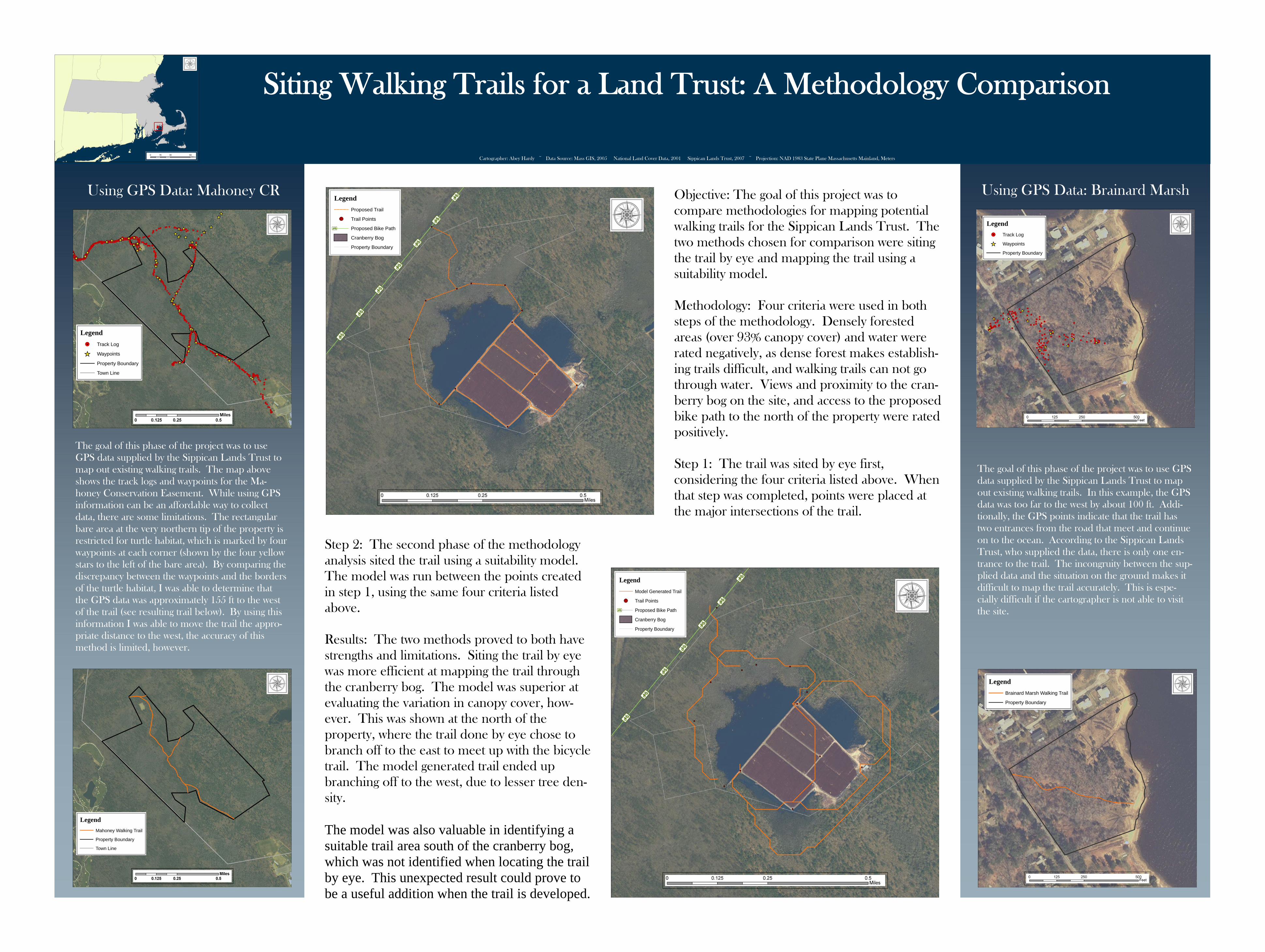
The goal of this phase of the project was to use GPS data supplied by the Sippican Lands Trust to map out existing walking trails. The map above shows the track logs and waypoints for the Ma-honey Conservation Easement. While using GPS information can be an affordable way to collect data, there are some limitations. The rectangular bare area at the very northern tip of the property is restricted for turtle habitat, which is marked by four waypoints at each corner (shown by the four yellow stars to the left of the bare area). By comparing the discrepancy between the waypoints and the borders of the turtle habitat, I was able to determine that the GPS data was approximately 155 ft to the west of the trail (see resulting trail below). By using this information I was able to move the trail the appro-priate distance to the west, the accuracy of this method is limited, however.
Using GPS Data: Mahoney CR Using GPS Data: Brainard Marsh
The goal of this phase of the project was to use GPS data supplied by the Sippican Lands Trust to map out existing walking trails. In this example, the GPS data was too far to the west by about 100 ft. Addi-tionally, the GPS points indicate that the trail has two entrances from the road that meet and continue on to the ocean. According to the Sippican Lands Trust, who supplied the data, there is only one en-trance to the trail. The incongruity between the sup-plied data and the situation on the ground makes it difficult to map the trail accurately. This is espe-cially difficult if the cartographer is not able to visit the site.
Objective: The goal of this project was to compare methodologies for mapping potential walking trails for the Sippican Lands Trust. The two methods chosen for comparison were siting the trail by eye and mapping the trail using a suitability model. Methodology: Four criteria were used in both steps of the methodology. Densely forested areas (over 93% canopy cover) and water were rated negatively, as dense forest makes establish-ing trails difficult, and walking trails can not go through water. Views and proximity to the cran-berry bog on the site, and access to the proposed bike path to the north of the property were rated positively. Step 1: The trail was sited by eye first, considering the four criteria listed above. When that step was completed, points were placed at the major intersections of the trail.
Step 2: The second phase of the methodology analysis sited the trail using a suitability model. The model was run between the points created in step 1, using the same four criteria listed above. Results: The two methods proved to both have strengths and limitations. Siting the trail by eye was more efficient at mapping the trail through the cranberry bog. The model was superior at evaluating the variation in canopy cover, how-ever. This was shown at the north of the property, where the trail done by eye chose to branch off to the east to meet up with the bicycle trail. The model generated trail ended up branching off to the west, due to lesser tree den-sity. The model was also valuable in identifying a suitable trail area south of the cranberry bog, which was not identified when locating the trail by eye. This unexpected result could prove to be a useful addition when the trail is developed.
Cartographer: Abey Hardy ~ Data Source: Mass GIS, 2005 National Land Cover Data, 2001 Sippican Lands Trust, 2007 ~ Projection: NAD 1983 State Plane Massachusetts Mainland, Meters
Related Documents