SITE OE-24C LIVE GRENADE RANGE back to main document

Welcome message from author
This document is posted to help you gain knowledge. Please leave a comment to let me know what you think about it! Share it to your friends and learn new things together.
Transcript
SITE OE-24C
LIVE GRENADE RANGE
back to main document
DraftYL59222 Site OE-24C.doc-FO Harding ESE, Inc. 3-24C-iiNovember 20, 2002
CONTENTS
SITE OE-24C LIVE GRENADE RANGE........................................................................................ 3.24C-1
3.24C Site OE-24C (Live Grenade Range) ........................................................................ 3.24C-13.24C.1 Site Description ....................................................................................... 3.24C-13.24C.2 Site History and Development................................................................. 3.24C-23.24C.3 Potential Ordnance based on Historical Use of the Area......................... 3.24C-43.24C.4 History of OE Investigations ................................................................... 3.24C-53.24C.5 Conceptual Site Model ............................................................................ 3.24C-6
3.24C.5.1 Training Practices ................................................................... 3.24C-63.24C.5.2 Site Features............................................................................ 3.24C-73.24C.5.3 Potential Sources and Location of OE .................................... 3.24C-73.24C.5.4 Potential Exposure Routes ...................................................... 3.24C-7
3.24C.6 Site Evaluation......................................................................................... 3.24C-83.24C.6.1 Literature Review ................................................................... 3.24C-83.24C.6.2 Sampling Review.................................................................... 3.24C-9
3.24C.7 Conclusions and Recommendations ...................................................... 3.24C-143.24C.7.1 Conclusions........................................................................... 3.24C-143.24C.7.2 Recommendations................................................................. 3.24C-15
3.24C.8 References ............................................................................................. 3.24C-15
TABLES
24C-1 Sampling Operations, Site OE-24C24C-2 OE Scrap Found During Sampling, Site OE-24C
PLATES
24C-1 Site OE-24C Location Map – Former Fort Ord24C-2 Site OE-24C; 1951 Aerial Photo24C-3 Site OE-24C; 1966 Aerial Photo24C-4 Site OE-24C; 1999 Aerial Photo24C-5 Conceptual Site Model, OE-24C
ATTACHMENTS
24C-A Evaluation of Previous Work Checklists

DraftYL59222 Site OE-24C.doc-FO Harding ESE, Inc. 3-24C-1November 20, 2002
SITE OE-24C LIVE GRENADE RANGE1
3.24C Site OE-24C (Live Grenade Range)2
This summary report consists of two parts. The first part, contained in Sections 3.24C.1 through 3.24C.5,3
includes a presentation and assessment of archival data. Specific elements include a review of site history4
and development, evaluation of potential ordnance at the site, a summary of previous ordnance and5
explosives (OE) investigations, and a conceptual site model. The above-mentioned information was used6
to support the second part of this report, which is the Site Evaluation (Section 3.24C.6). The Site7
Evaluation was conducted in accordance with the procedures described in the Final Plan for Evaluation8
of Previous Work (Harding Lawson Associates [HLA], 2000) and may contain some information9
presented previously. The Site Evaluation discusses the evaluation of the literature review process10
(Section 3.24C.1) and evaluation of sampling process(es) (Section 3.24C.6.2 ). These discussions were11
generated from information from standardized literature review and sampling review checklists12
(Attachment 24C-A). Section 3.24C.7 provides conclusions and recommendations for the site.13
References are provided in Section 3.24C.8.14
3.24C.1 Site Description15
Site OE-24C is 9.7 acres in size and is located in the west-central portion of the former Fort Ord16
(Fort Ord) to the south of the Main Garrison and just north of the Multi-Range Area (MRA)17
(Plate 24C-1). Site OE-24C was identified through a review of a 1946 Fort Ord historical map as part of18
the Supplement to the Fort Ord Archive Search Report (ASR; U.S. Army Engineer Division, Huntsville19
[USAEDH], 1994).20
Site OE-24C – Live Grenade Range
DraftYL59222 SITE OE-24C.DOC-FO Harding ESE, Inc. 3-24C-2November 20, 2002
3.24C.2 Site History and Development1
Pre-1940s Era2
This site lies within a tract of land purchased from private landowners by the government in 19173
(Arthur D. Little, Inc. [ADL], 1994). Documentation of pre-1940s era use of this area by the army for4
training is limited to 1918 and 1933 topographic maps of the area (Department of the Interior [DOI],5
1918, U.S. Army [Army], 1933). No identifiable features or text were associated with this area.6
Eucalyptus Road is shown on the 1933 topographic map and is close to its present location.7
1940s Era8
Review of 1940s era documentation including historical maps and aerial photographs indicates that9
several training areas including a live grenade range were present in this area in the 1940s.10
• A live grenade range training area is shown on 1945 and 1946 training maps (Army, 1945, 1946). A11
practice hand grenade range (Site OE-24B) is identified northeast of live grenade range. Practice rifle12
grenade ranges and a booby trap training areas are also shown on the map in the vicinity of the live13
grenade range (Sites OE-24D and 24E).14
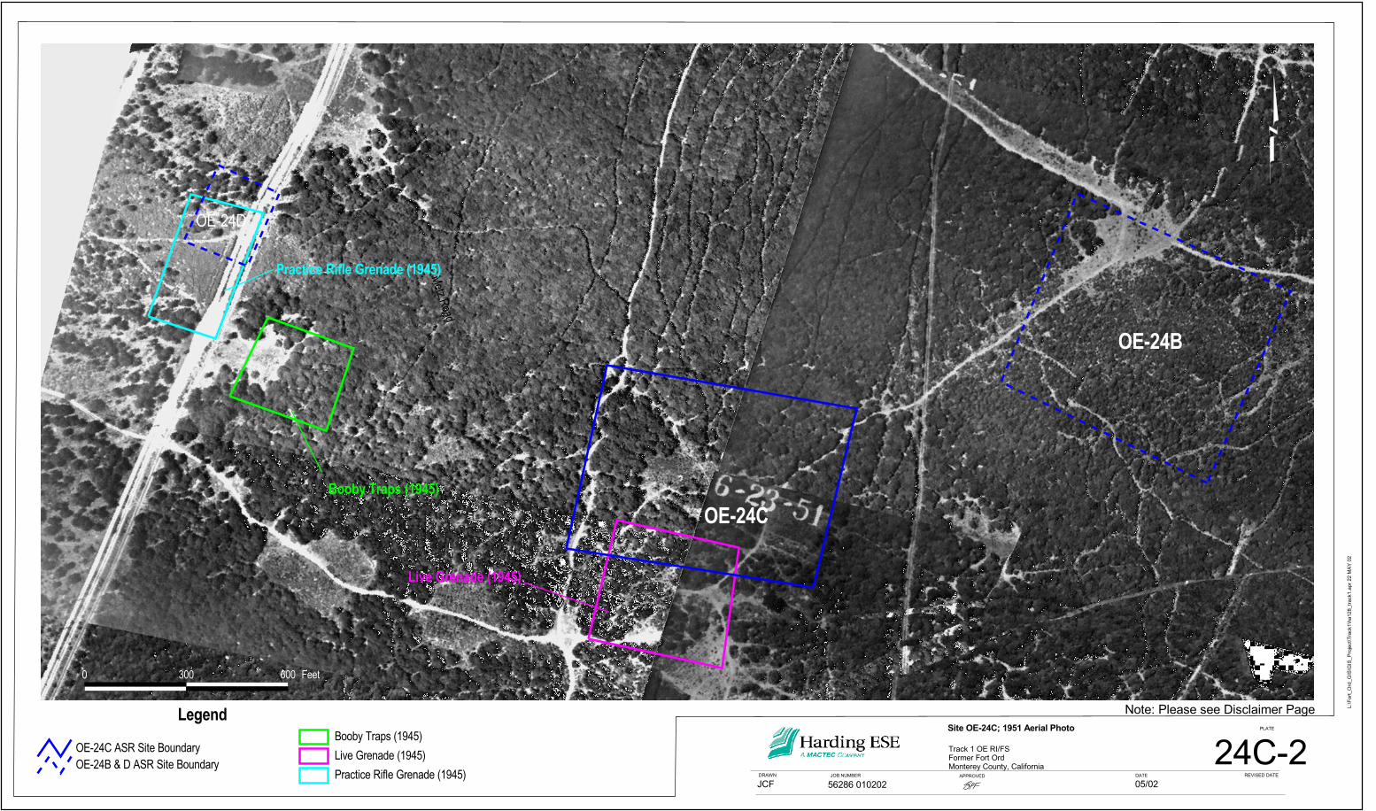
• Aerial photographs from 1949 and 1951 (Plate 24C-2) show disturbed/cleared areas in the vicinity of15
the training areas as identified on the training maps (approximately 300 by 300 feet in size).16
1950s Era17
Review of 1950s era documentation including training maps, aerial photographs, and grading plans18
indicated that live grenade training ended sometime prior to 1954 and that the area was developed as base19
housing by 1959. The following identifies the results of the historical map and aerial photograph review:20
• A field battalion training area (FBTA) and a Reconnaissance Selection and Occupation of Position21
(RSOP) training area is identified on the 1956 training map in the vicinity of this site (Army, 1956).22
Site OE-24C – Live Grenade Range
DraftYL59222 SITE OE-24C.DOC-FO Harding ESE, Inc. 3-24C-3November 20, 2002
• A partially cleared area is present on a 1956 aerial photograph to the south of the site (Site OE-24A).1
• Grading plans dated 1957 are available for the site area showing the planned development of this area2
for the East Officers Housing Area. Plans show as-built revisions dated 1959 (U.S. Army Corps of3
Engineers [USACE], 1959).4
• Aerial photographs from 1959 show the completed East Officers Housing Area (USACE, 1960). It5
appears that the areas that were cleared of vegetation on the 1949 photograph are covered with6
housing or fill material by 1959. A cleared area (OE-24A) is still present south of the site. This area7
is identified as an RSOP area on the 1956 map (Army, 1956).8
1960s to Present9
Military housing was completed in 1959 and 1961 and was occupied from the 1960s to present. The10
closest training areas used from the 1960s until present are south of the site inside the MRA.11
• No training sites are present in this area on training maps from 1964 though 1987 (Army, 1964 and12
1987).13
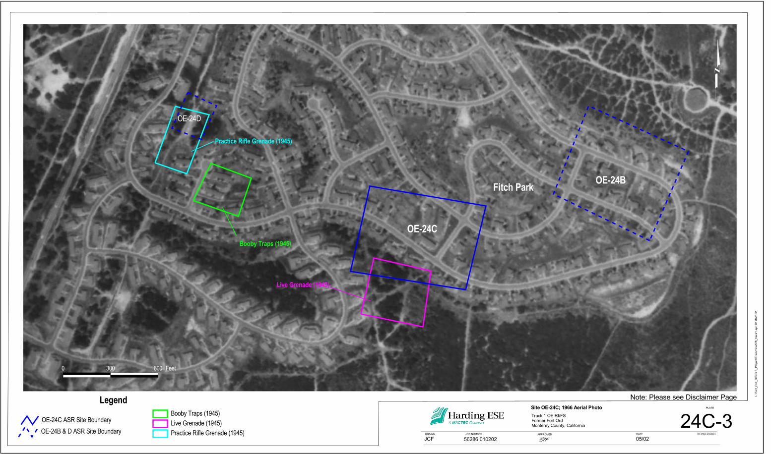
• Housing is present over the former site area on a 1966 aerial photograph (Plate 24C-3). The housing14
is identified as Rogers Fitch Park on a 1967 map (Army, 1967).15
• A rifle smoke grenade and 100 M1 Rounds (both Ball and Tracer small arms ammunition) were16
discovered northeast of the site in February 1993. Two practice 40mm projectiles were discovered17
northwest of the site in August 1997. The 40mm practice projectiles were not available for use in the18
1940s.19
Proposed Future Land Use20
The proposed reuse of this area is continued military housing.21
Site OE-24C – Live Grenade Range
DraftYL59222 SITE OE-24C.DOC-FO Harding ESE, Inc. 3-24C-4November 20, 2002
3.24C.3 Potential Ordnance based on Historical Use of the Area1
This section describes the types of training devices that could have been used at a live grenade range in2
the 1940s. Information on hand grenades used during World War II (WWII) was obtained from The3
American Arsenal, The World War II Official Standard Ordnance Catalog of Small Arms, Tanks,4
Armored Cars, Artillery, Antiaircraft Guns, Ammunition, Grenades, Mines, etcetera (Hogg, 2001).5
Five types of grenades were identified for use in WWII. These include fragmentation, offensive,6
chemical, practice, and training grenades. Because it is not known which grenades were authorized for7
this area, a brief description of each type is provided below:8
• The standard fragmentation grenade used was a MK IIA1-Standard. Fragmentation grenades9
contain a high-explosive charge in a metallic body that is shattered by the explosion of the10
charge.11
• The offensive hand grenade used was a MK IIIA1 – Limited Standard. The offensive hand12
grenade contains a high-explosive charge in a paper body, and is designed for demolition or lethal13
shock effect.14
• The chemical hand grenades contain a chemical agent, which produces a toxic or irritant effect,15
screening smoke, or incendiary action or combination of effects.16
• A MK.II –standard practice grenade was also available that was equipped with a M10A3 igniting17
fuze, and is loaded with a small black powder charge.18
• The training grenade, MK.IA1 was an inert grenade and contained no charge.19
It is also possible that pyrotechnic items could have been used in conjunction with this training. All OE20
items would be expected to be found at the surface or in the near surface.21
Site OE-24C – Live Grenade Range
DraftYL59222 SITE OE-24C.DOC-FO Harding ESE, Inc. 3-24C-5November 20, 2002
3.24C.4 History of OE Investigations1
1994 Archives Search Report, Supplement 12
Site OE-24 was identified as a new site as part of the November 1994 Archives Search Report3
Supplement (USAEDH, 1994). This site is described as containing several rifle and hand grenade ranges,4
both practice and live sites, based on review of a 1946 map. A site visit was conducted and a piece of a5
warhead was found just north of Eucalyptus Road (OE-24A). The warhead was believed to be part of a6
high explosive grenade. Sampling of a 10-acre area surrounding the item find was proposed in the ASR.7
1994 UXB International Investigation8
UXB International, Inc. (UXB) completed land surveying of the sites and may have performed some9
brush cutting within the site boundaries as part of their investigation (USA Environmental [USA], 2000).10
No geophysical activities or intrusive activities were completed. The land surveyed site boundaries are11
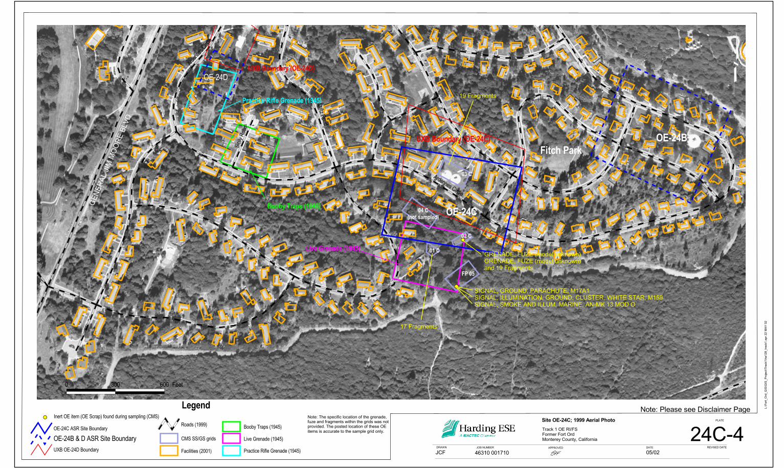
presented on Plate 24C-4. No OE finds are documented in the land surveying report (UXB, 1995).12
1997 CMS Investigation13
CMS Environmental (CMS) completed sampling at Site OE-24C in 1997 (USA, 2000). One 100- by14
200-foot (standard SiteStats/GridStats [SS/GS] sample grid) sample grid and 3 sample grids of non-15
standard dimensions, not 100 by 200 feet, were sampled using the SS/GS sampling program (total of16
48,250 square feet). Two of the four sample grids were established outside of the site boundary due to17
terrain and structures within the site (Plate 24C-4). A Schonstedt Model 52/Cx magnetometer located18
1,850 anomalies, 265 of which were excavated at various depths down to 2 feet. Most of the non-OE19
anomalies excavated were nails, screws, and wires. OE-related items identified during sampling included20
1 expended grenade fuze, a 30 cal Dummy, an M159 ground illumination signal, an M17A1 ground21
signal, parachute, a AN-MK13 Mod 0 Marine smoke and illumination signal, and MK II hand grenade22
fragments. The grenade fragments were detected to a depth of 12 inches and the signals were found23
Site OE-24C – Live Grenade Range
DraftYL59222 SITE OE-24C.DOC-FO Harding ESE, Inc. 3-24C-6November 20, 2002
within a pit at a depth of 2 feet. A tin can was detected at 18 inches. No live items were identified during1
sampling, and no further OE response was recommended in the after action report (USA, 2000).2
3.24C.5 Conceptual Site Model3
Conceptual site models (CSMs) are generally developed during the preliminary site characterization4
phase of work to provide a basis for the sampling design and identification of potential release5
(functioning of the OE item; e.g., detonation) and exposure routes. The CSM presented here is based on6
historical information and OE investigations completed to date. It is provided to help evaluate the7
adequacy of the investigation completed to date and to identify potential release and exposure pathways.8
CSMs usually incorporate information regarding the physical features and limits of the area of concern9
(the site), nature and source of the contamination (in this case OE), and exposure routes (potential10
scenarios that may result in contact with OE).11
The CSM for Site OE-24C is based on currently available site-specific and general information including12
literature reviews, sampling results, aerial photographs, maps, technical manuals, and field observations,13
and the information shown on Plate 24C-5.14
3.24C.5.1 Training Practices15
Site OE 24C is categorized as a live grenade training area. Based on the size of the cleared area (an16
approximately 300- by 300-foot cleared area) it is anticipated that the area was a hand grenade training17
area. Based on 1983 Policies and Procedures for Firing Ammunition for Training, Target Practice and18
Combat (Army, 1983), the danger area for hand grenades is about 450 feet, while the impact area for rifle19
grenades is about 1,200 feet.20
Hand grenade training areas usually consist of throwing bays or trenches, observation bays, and targets.21
According to the 1983 guidance, targets are a minimum of 25 meters from the throwing bays. Throwing22
Site OE-24C – Live Grenade Range
DraftYL59222 SITE OE-24C.DOC-FO Harding ESE, Inc. 3-24C-7November 20, 2002
bays should be separated by 20 meters unless they are separated by another physical barrier such as an1
earthen berm or concrete. It is anticipated that similar guidance would have been used prior to 1983.2
3.24C.5.2 Site Features3
Site OE-24C was identified on historical training maps (1945) as a live grenade training area. A disturbed4
vegetation area with possible manmade throwing bays or other structures is present on both the 1949 and5
1951 aerial photographs. Although maps showing the configuration of hand grenade ranges at Fort Ord6
in the 1940s are not available, the aerial photograph review suggests that the area was used as a grenade7
training area in the 1940s. Review of training maps from the 1950s does not indicate that this area was8
used for grenade training after the 1940s. Housing was constructed in this area between 1957 and 1961.9
Grading was completed prior to construction of the housing.10
3.24C.5.3 Potential Sources and Location of OE11
Site OE-24C was used for live grenade training in the 1940s. Based on the use of this area as a live12
grenade training area the types of OE that would be expected include Mark II Grenades, grenade fuzes,13
and possibly pyrotechnic items associated with training at the grenade range. These items would14
normally be found at the surface of the site; however, it is possible that OE could be below the ground15
surface in areas of the site that were graded prior to construction of the housing.16
No OE was discovered at this site during sampling; however grenade fragments, a grenade fuze, and17
buried pyrotechnic items were discovered. These OE items indicate that the site was used as a live18
grenade range prior to construction of the housing. Review of historical records did not indicate that any19
1940s-era OE items were found during the 40 plus years that the housing area has been occupied.20
3.24C.5.4 Potential Exposure Routes21
Access to this site is currently unrestricted and has been open to the public for over 40 years. Because no22
OE items were discovered during sampling or reported previously, it is unlikely that OE exists at the23
Site OE-24C – Live Grenade Range
DraftYL59222 SITE OE-24C.DOC-FO Harding ESE, Inc. 3-24C-8November 20, 2002
surface in this area. Therefore, it is unlikely that a receptor would come in contact with a OE item on the1
surface.2
Because the site was graded prior to construction of the housing, it is possible that OE could be present3
below the ground surface. Future construction workers could come in contact with OE during excavation4
activities.5
3.24C.6 Site Evaluation6
The available data (e.g., archival and reconnaissance data) regarding Site OE-24C were reviewed and7
evaluated according to procedures described in the Final Plan for Evaluation of Previous Work8
(HLA, 2000). The evaluation process is documented through the completion of a series of checklists.9
Copies of the checklist are provided as Attachment 24C-A. This section presents a summary of the10
results of the checklist evaluation. It is divided into two sections, an assessment of the literature review11
and an assessment of the sampling performed at the site.12
3.24C.6.1 Literature Review13
Type of Training and OE Expected14
According to training maps, Site OE-24C was used as a live hand grenade training area in the 1940s and15
possibly the early 1950s. The literature indicates that this would not be an impact area for fired16
projectiles, but that live hand grenades (high explosive [HE] or smoke-producing items) may have been17
used for training at this site. It is also possible that pyrotechnic items could have been used during18
training.19
Subsequent Use of the Area20
Subsequent use of this area was for residential housing. Review of 1950s grading maps indicates that this21
area was graded prior to construction of the housing. Grading plans indicate that both cut and fill areas22
were present in the OE-24C area. It is anticipated that any OE found during construction of the housing23
Site OE-24C – Live Grenade Range
DraftYL59222 SITE OE-24C.DOC-FO Harding ESE, Inc. 3-24C-9November 20, 2002
in the late 1950s would have been removed; however, this is not documented. After construction of the1
houses, the closest training areas were located within the MRA.2
Establishment of Site Boundaries3
Review of historical aerial photographs and training maps indicates that the hand grenade range is in the4
area where the site boundaries were established in the ASR, although the former Live Grenade Area may5
include an area to the south of the ASR boundaries (Plate 24C-4). Two of the four grids sampled at this6
site are however, located to the south of the ASR boundaries and cover this area to the south of the site7
boundaries.8
Summary of Literature Review Analysis9
Based on a review of site literature there was sufficient historical evidence to warrant sampling of this10
site. The historical information indicated that this area was used as a live grenade range in the 1940s.11
Based on the literature review, the training area may have extended to the south into the area sampled by12
Grid C-1.13
3.24C.6.2 Sampling Review14
This section describes the items that were found during sampling at Site OE-24C and the types of fillers15
that would be used in the items. The review includes a comparison of sampling locations relative to site16
boundaries. Also presented are a review of the equipment used during sampling, a discussion of the17
sampling methods used and the quality control measures used during the investigation.18
Sampling Results (Items Found)19
Sampling was conducted at Site OE-24C in 1997. SS/GS sampling was conducted on four sample grids.20
Three OE scrap items (ground illumination signal, ground parachute signal, and a smoke signal) were21
found 2 feet below ground surface (bgs). The items were found in a pit located within Grid FP05 that is22
located to the south of the site boundaries (Plate 24C-4). These pyrotechnic items included a Navy signal23
Site OE-24C – Live Grenade Range
DraftYL59222 SITE OE-24C.DOC-FO Harding ESE, Inc. 3-24C-10November 20, 2002
that is used for day or night use by aircraft crewmen downed at sea and 2 Army signals used for day or1
nighttime signaling (Table 24C-2). In addition, 54 pieces of grenade fragments (MK II), one expended2
grenade fuze, and a 30 cal Dummy were identified during the sampling. The frag was located in3
Grids 01C, 02C, and 03C (Plate 24C-4) and was discovered at depths of 1 to 12 inches bgs. The4
expended grenade fuze was identified in Grid 02C and the 30 cal Dummy was identified in Grid 03C.5
The grenade fragments support the use of the site as a Live Grenade Area in the 1940s.6
Site Boundaries Review7
A review of the sampling results indicates that the grenade fragments were found in the 3 northernmost8
grid locations, but none were found in the southernmost grid (Grid FP05). The items that were identified9
in Grid FP05 were found in a pit, which may indicate that they were not associated with the grenade10
range. Based on the results of sampling, the training area may have extended south into the area sampled11
by Grid 01C because grenade fragments were found in the grid.12
Equipment Review13
CMS used the Schonstedt Model GA-52/Cx magnetometer to survey Site OE-24C. The Schonstedt14
instruments are passive dual flux-gate magnetometers - highly sensitive magnetic locators that detect15
ferrous (iron) metal objects; however, they cannot detect non-ferrous metal objects (e.g., lead, brass,16
copper, aluminum). Magnetometers make passive measurements of the earth’s natural magnetic field;17
ferrous metal objects (and rocks) are detected because they produce localized distortions (anomalies) in18
the magnetic field. The Schonstedt magnetometers actually detect slight differences in the magnetic field19
(the “gradient”) by means of two sensors mounted a fixed distance apart within the instruments’ staff.20
Because the magnetic response falls off (changes) greatly even over a short distance, a gradient21
magnetometer like the Schonstedt Model GA-52/Cx is especially sensitive to smaller, near-surface ferro-22
metal objects (Breiner, 1973).23
Site OE-24C – Live Grenade Range
DraftYL59222 SITE OE-24C.DOC-FO Harding ESE, Inc. 3-24C-11November 20, 2002
The performance of the Schonstedt Model GA-52/Cx at Fort Ord was evaluated as part of the Ordnance1
Detection and Discrimination Study (ODDS, Parsons Infrastructure & Technology Group, Inc.2
[Parsons], 2001b). As part of the ODDS, studies were performed to evaluate:3
• Signatures of inert OE items suspended in air at varying orientations and distances from the4
goephysical sensor (static tests)5
• The ability of various geophysical instruments to detect and discriminate between different OE items6
buried at various depths (seeded tests).7
• Geophysical instrument performance at actual OE sites (field trial site testing).8
The Schonstedt tools were not evaluated during the static tests; therefore, only the seeded test results and9
the field trial tests are discussed herein. It is recognized that the ODDS study areas may not represent the10
same field conditions as are present at OE-24C; therefore, information from the ODDS should be used11
with caution.12
During the seeded test, the Schonstedt Model GA-52/Cx detected between 67 and 78 percent of Type I13
items (type I items included the MK II hand grenade) buried up to 1 foot below the calculated penetration14
depth. The detection rate percentages presented in the ODDS vary according to the search radius and15
assume a 5-foot wide search lane. These detection rates are considered conservative because an16
additional 1 foot was added to the items’ calculated penetration depth to allow for soil deposition over17
time. Because the field conditions at the seeded test site and orientations of buried items may not be18
comparable to the Site OE-24C conditions, the results should only be used as an indication that the19
equipment is capable of detecting the same types of items.20
Results of the ODDS field trail tests were also reviewed for potential use in evaluating instrument21
performance at Site OE-24C. Detection ranges for the Schonstedt Model GA-52/Cx were calculated for 422
Site OE-24C – Live Grenade Range
DraftYL59222 SITE OE-24C.DOC-FO Harding ESE, Inc. 3-24C-12November 20, 2002
of the 6 test sites; the remaining sites did not have enough OE detected to allow calculation of site1
statistics. The calculated detection rates for the combined sites ranged from 97 to 99 percent depending2
on the search radius used for the calculation. It should be noted that the ODDS field trial sites were3
selected to represent areas with high ordnance density. In comparison, Track 1 sites are expected to have4
very low ordnance densities. Therefore, the field trail results may not be applicable to Track 1 sites.5
Results of the ODDS field trails for the field test site FTS-3, which has an OE item density most like6
Site OE 24C, were also reviewed. Five OE-related items were located at FTS-3 during the investigation,7
and no additional OE items were found after sifting of 10 percent of each grid. This result indicates that it8
is unlikely that OE items would remain at FTS-3. Similar results could be expected at other sites, such as9
OE-24C, after survey and clearance using a Schonstedt Model GA-52/Cx.10
Although not directly comparable to Site OE-24C, the results of the ODDS indicate that the Schonstedt11
model used at this site is capable of detecting the ferrous surface and subsurface OE expected at this site.12
Sampling Methods Discussion13
SS/GS sampling methodologies were used at this site. SS/GS is a computer program used to statistically14
estimate the ordnance density of a site or grid during field investigations. It estimates the number of15
ordnance items at a given site or grid and can be used to assess whether a site has been characterized16
adequately. Excavation of anomalies identified with a magnetometer is performed in accordance with17
direction of the program; generally 32 to 40 percent of the flagged anomalies are investigated using this18
technique (CMS, 1995).19
As part of this sampling at Site OE-24C, four grids varying in size from 4,500 square feet to20
20,000 square feet were sampled (total of 1.11 acres). One thousand eight-hundred fifty anomalies were21
identified within these grids and 265 (14 percent) were sampled. As noted above, no OE items were22
Site OE-24C – Live Grenade Range
DraftYL59222 SITE OE-24C.DOC-FO Harding ESE, Inc. 3-24C-13November 20, 2002
identified, however scrap OE and fragments were identified. Because no OE items were identified in the1
265 anomalies excavated, the expected number of OE items calculated by the SS/GS program is zero.2
Quality Assurance/Quality Control3
Field Sampling4
Throughout the operations at Site OE-24C, the contractor performed daily operational checks and Quality5
Control (QC) inspections of the SS/GS work done on this site (USA, 2000). Quality Assurance (QA)/QC6
performed throughout the field sampling is documented in the AAR (USA, 2000). Because of the nature7
of the SS/GS sampling, QA/QC was limited to inspections of operational activities and documentation.8
No deficiency reports were written during inspections. In accordance with the USA/CMS work plan, all9
instruments requiring maintenance and/or calibration were to be checked prior to the start of each10
workday. Batteries were to be replaced as needed and the instruments were to be checked against a11
known source. The QC specialist was responsible for ensuring that personnel perform operational checks12
and maintain appropriate log entries. The QC specialist also was to perform random unscheduled checks13
of the various sites to ensure that personnel perform the work as specified in the work plan.14
Data Management15
Parsons performed a 100 percent QC review of the data associated with this site (Parsons, 2001a). This16
review followed the guidelines presented in the Standard Operating Procedures (SOPs) provided as17
Appendix A. This review included review of the SS/GS records, review of the field grid records, and18
review of the database created by the OE contractor. The USACE followed up with a 10 percent QA19
review of the Parsons data review. The requirements of this QA review are described in the SOP20
provided as an Appendix B to the Track 1 Remedial Investigation (RI).21
Based on the above information, it appears that the data that were generated at this site are of good22
quality.23
Site OE-24C – Live Grenade Range
DraftYL59222 SITE OE-24C.DOC-FO Harding ESE, Inc. 3-24C-14November 20, 2002
3.24C.7 Conclusions and Recommendations1
The following section presents conclusions and recommendations for this site based on the review and2
analysis of data associated with historical information and sampling performed at the site.3
3.24C.7.1 Conclusions4
Site Use and Development5
• The site appears to have been used as a live hand grenade range in the 1940s. Both historical data and6
sampling data support this conclusion.7
• The sample grids appear to have been placed in the area used as a live grenade range based on review8
of historical information and sampling results.9
• Review of grading plans for the housing development and aerial photographs following development10
of military housing indicates that the site was filled/cut prior to completion of the housing. It is11
expected that any OE identified would have been removed at that time.12
• No incidental OE finds of MK II hand grenades or any other WWII-era ordnance is documented in13
this area. Several incidental finds of 40mm items have been documented in this area, but these items14
were not available for use in the 1940s.15
Sampling Adequacy and Data Quality16
• The Schonstedt Model GA-52/Cx was used for all geophysical surveys. This instrument was17
evaluated as part of the ODDS and is capable of detecting the type of items expected at this site. A18
numerical value for detection of items cannot be calculated for an individual site.19
• The sampling methodology used for this site was SS/GS. Problems with this methodology have been20
identified; however the data collected are useful in evaluating the past use and potential distribution21
of OE at this site.22
Site OE-24C – Live Grenade Range
DraftYL59222 SITE OE-24C.DOC-FO Harding ESE, Inc. 3-24C-15November 20, 2002
• The data are of good quality and sampling and evaluation of previous work followed published work1
plans and SOPs.2
3.24C.7.2 Recommendations3
Based on the review of existing data:4
• It is not anticipated that OE will be found at Site OE-24C5
• However, because Site OE-24C was used for live grenade training, the potential for OE to remain at6
Site OE-24C does exist.7
• Additional investigation is recommended due to the potential for live hand grenades to be present8
below the ground surface at this site.9
3.24C.8 References10
Arthur D. Little, Inc. (ADL), 1994. Final Community Environmental Response Facilitation Act (CERFA)11
Report, Fort Ord Monterey, California. Real Estate Fort Ord (Military Reservation) April.12
Breiner, 1973. Applications Manual for Portable Magnetometers.13
CMS Environmental (CMS). 1995. Site-Specific Work Plan. July 21.14
Department of Interior (DOI), 1918. California (Monterey County) Monterey Quadrangle.15
Franklin K. Lane Secretary, U.S. Geologic Survey, 1918. Edition of 1913, reprinted 1918.16
Harding Lawson Associates (HLA), 2000. Final Plan for Evaluation of Previous Work Ordnance and17
Explosives Remedial Investigation/Feasibility Study, Former Fort Ord, California. December 4.18
Site OE-24C – Live Grenade Range
DraftYL59222 SITE OE-24C.DOC-FO Harding ESE, Inc. 3-24C-16November 20, 2002
Hogg V. Ian, 2001. The American Arsenal, The World War II Official Standard Ordnance Catalog of1
Small Arms, Tanks, Armored Cars, Artillery, Antiaircraft Guns, Ammunition, Grenades, Mine, etcetera.2
Greenhill Books. London.3
Parsons Infrastructure & Technology Group Inc. (Parsons), 2001a. Draft Final Ordnance and Explosives,4
Sampling and Analysis Plan. Former Fort Ord, Monterey, California, Ordnance and Explosive Cleanup.5
July.6
_____, Parsons, 2001b. Draft Final Ordnance Detection and Discrimination Study (ODDS), Former7
Fort Ord, Monterey, California. December.8
USA Environmental (USA), 2000. Final After Action Report, Sitestats/Gridstats OE Sampling, Inland9
Range Contract, Former Fort Ord, California, Site 24B-E and OE-39. December 30.10
U. S. Army (Army) (prepared under the direction of the Chief of Engineers), 1933-34. Camp Ord and11
Vicinity. Terrain Map.12
_____, 1945, Training Facilities, Fort Ord and Vicinity, California, (Map). August.13
_____, 1946. Reservation Boundary and Land Use Map, 53-1-9-2 (Master Plan) April 5.14
_____, 1956. Map of Fort Ord Training Areas and Facilities, December 20.15
______, 1964. Field Training Areas & Range Map, Fort Ord. Appendix 2, Annex O. April 27.16
______, 1967. Back Country Roads, Field Training Area and Range Map, Fort Ord, California.17
January.18
_____, 1983, Policies and Procedures for Firing Ammunition for Training, Target Practice, and Combat.19
Army Regulation 385-63 MCO P3570.1A. October 15.20
Site OE-24C – Live Grenade Range
DraftYL59222 SITE OE-24C.DOC-FO Harding ESE, Inc. 3-24C-17November 20, 2002
______, 1987. Ranges and Training Area Overlay, Fort Ord and Vicinity. Revised 15 November 1987.1
U.S. Army Corps of Engineers (USACE), 1959. Fort Ord 900 Capehart Housing Units East Officers2
Area Section 3 Grading Plan. As Built, Changes Made. San Francisco District. 10 February 1959.3
______, 1960. Fort Ord Aerial Photo Contour Map Main Garrison. San Francisco District. March 214
(Aerial Photograph taken in 1959).5
U.S. Army Engineer Division, Huntsville (USAEDH), 1994. Archives Search Report (Supplement6
No. 1). Fort Ord, California, Monterey County, California. Prepared by the USACE, St. Louis District.7
December.8
______, 1997. Revised Archives Search Report Fort Ord California, Monterey County, California.9
Prepared by U.S. Army Corps of Engineers St. Louis Division. December.10

TABLES1
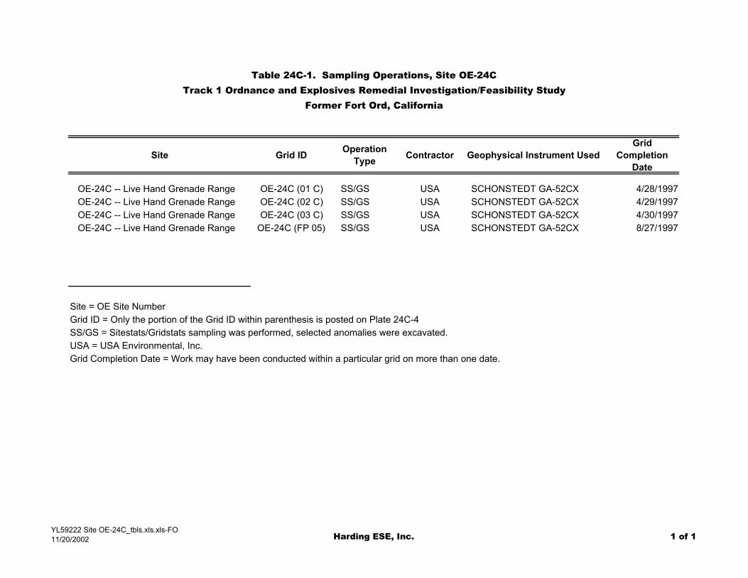
Table 24C-1. Sampling Operations, Site OE-24CTrack 1 Ordnance and Explosives Remedial Investigation/Feasibility Study
Former Fort Ord, California
Site Grid ID Operation Type Contractor Geophysical Instrument Used
Grid Completion
Date
OE-24C -- Live Hand Grenade Range OE-24C (01 C) SS/GS USA SCHONSTEDT GA-52CX 4/28/1997OE-24C -- Live Hand Grenade Range OE-24C (02 C) SS/GS USA SCHONSTEDT GA-52CX 4/29/1997OE-24C -- Live Hand Grenade Range OE-24C (03 C) SS/GS USA SCHONSTEDT GA-52CX 4/30/1997OE-24C -- Live Hand Grenade Range OE-24C (FP 05) SS/GS USA SCHONSTEDT GA-52CX 8/27/1997
Site = OE Site NumberGrid ID = Only the portion of the Grid ID within parenthesis is posted on Plate 24C-4SS/GS = Sitestats/Gridstats sampling was performed, selected anomalies were excavated.USA = USA Environmental, Inc.Grid Completion Date = Work may have been conducted within a particular grid on more than one date.
YL59222 Site OE-24C_tbls.xls.xls-FO11/20/2002 Harding ESE, Inc. 1 of 1
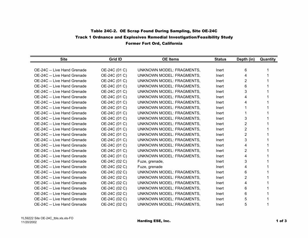
Table 24C-2. OE Scrap Found During Sampling, Site OE-24CTrack 1 Ordnance and Explosives Remedial Investigation/Feasibility Study
Former Fort Ord, California
Site Grid ID OE Items Status Depth (in) Quantity
OE-24C -- Live Hand Grenade OE-24C (01 C) UNKNOWN MODEL: FRAGMENTS, Inert 6 1OE-24C -- Live Hand Grenade OE-24C (01 C) UNKNOWN MODEL: FRAGMENTS, Inert 4 1OE-24C -- Live Hand Grenade OE-24C (01 C) UNKNOWN MODEL: FRAGMENTS, Inert 2 1OE-24C -- Live Hand Grenade OE-24C (01 C) UNKNOWN MODEL: FRAGMENTS, Inert 6 1OE-24C -- Live Hand Grenade OE-24C (01 C) UNKNOWN MODEL: FRAGMENTS, Inert 3 1OE-24C -- Live Hand Grenade OE-24C (01 C) UNKNOWN MODEL: FRAGMENTS, Inert 4 1OE-24C -- Live Hand Grenade OE-24C (01 C) UNKNOWN MODEL: FRAGMENTS, Inert 4 1OE-24C -- Live Hand Grenade OE-24C (01 C) UNKNOWN MODEL: FRAGMENTS, Inert 1 1OE-24C -- Live Hand Grenade OE-24C (01 C) UNKNOWN MODEL: FRAGMENTS, Inert 1 1OE-24C -- Live Hand Grenade OE-24C (01 C) UNKNOWN MODEL: FRAGMENTS, Inert 3 1OE-24C -- Live Hand Grenade OE-24C (01 C) UNKNOWN MODEL: FRAGMENTS, Inert 2 1OE-24C -- Live Hand Grenade OE-24C (01 C) UNKNOWN MODEL: FRAGMENTS, Inert 2 1OE-24C -- Live Hand Grenade OE-24C (01 C) UNKNOWN MODEL: FRAGMENTS, Inert 2 1OE-24C -- Live Hand Grenade OE-24C (01 C) UNKNOWN MODEL: FRAGMENTS, Inert 3 1OE-24C -- Live Hand Grenade OE-24C (01 C) UNKNOWN MODEL: FRAGMENTS, Inert 4 1OE-24C -- Live Hand Grenade OE-24C (01 C) UNKNOWN MODEL: FRAGMENTS, Inert 2 1OE-24C -- Live Hand Grenade OE-24C (01 C) UNKNOWN MODEL: FRAGMENTS, Inert 4 1OE-24C -- Live Hand Grenade OE-24C (02 C) Fuze, grenade, Inert 3 1OE-24C -- Live Hand Grenade OE-24C (02 C) Fuze, grenade Inert 4 1OE-24C -- Live Hand Grenade OE-24C (02 C) UNKNOWN MODEL: FRAGMENTS, Inert 6 1OE-24C -- Live Hand Grenade OE-24C (02 C) UNKNOWN MODEL: FRAGMENTS, Inert 2 1OE-24C -- Live Hand Grenade OE-24C (02 C) UNKNOWN MODEL: FRAGMENTS, Inert 4 1OE-24C -- Live Hand Grenade OE-24C (02 C) UNKNOWN MODEL: FRAGMENTS, Inert 6 1OE-24C -- Live Hand Grenade OE-24C (02 C) UNKNOWN MODEL: FRAGMENTS, Inert 6 1OE-24C -- Live Hand Grenade OE-24C (02 C) UNKNOWN MODEL: FRAGMENTS, Inert 5 1OE-24C -- Live Hand Grenade OE-24C (02 C) UNKNOWN MODEL: FRAGMENTS, Inert 5 1
YL59222 Site OE-24C_tbls.xls.xls-FO11/20/2002 Harding ESE, Inc. 1 of 3
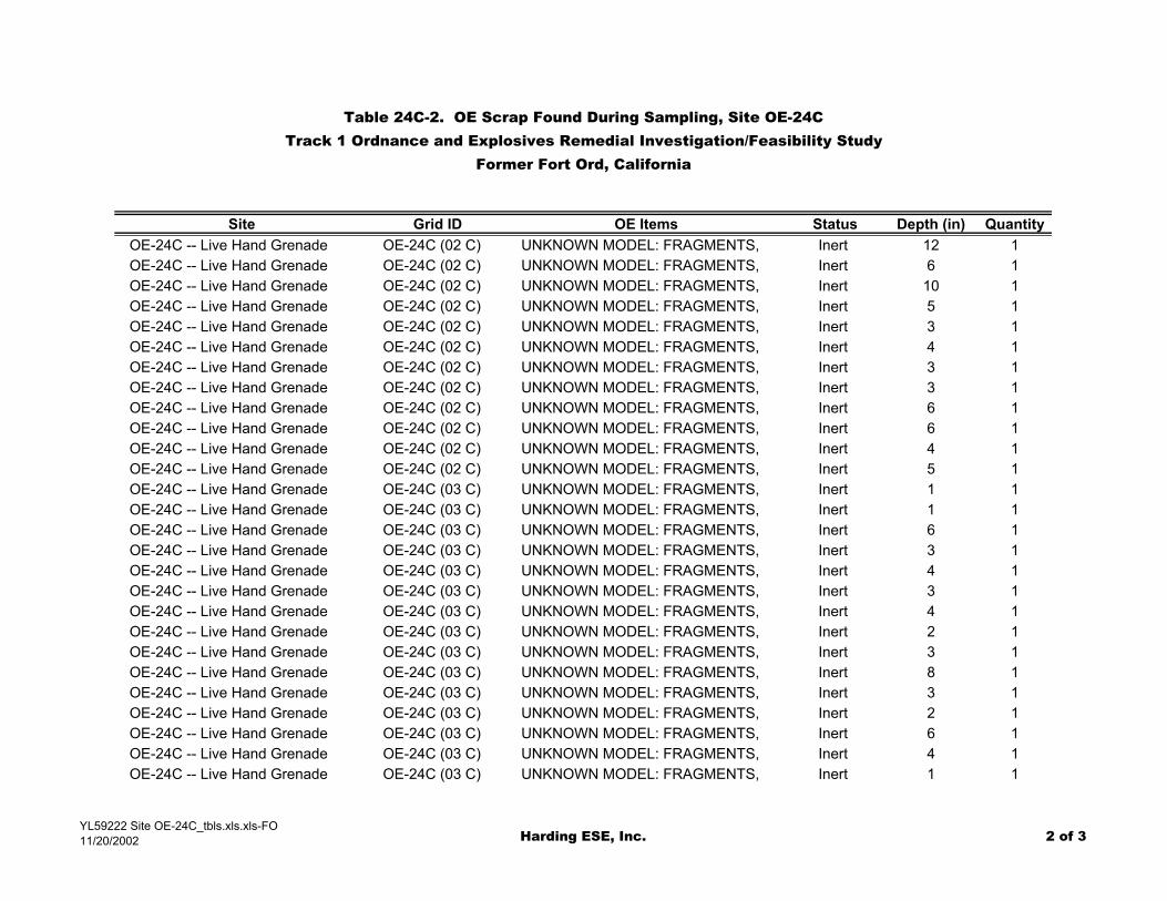
Table 24C-2. OE Scrap Found During Sampling, Site OE-24CTrack 1 Ordnance and Explosives Remedial Investigation/Feasibility Study
Former Fort Ord, California
Site Grid ID OE Items Status Depth (in) QuantityOE-24C -- Live Hand Grenade OE-24C (02 C) UNKNOWN MODEL: FRAGMENTS, Inert 12 1OE-24C -- Live Hand Grenade OE-24C (02 C) UNKNOWN MODEL: FRAGMENTS, Inert 6 1OE-24C -- Live Hand Grenade OE-24C (02 C) UNKNOWN MODEL: FRAGMENTS, Inert 10 1OE-24C -- Live Hand Grenade OE-24C (02 C) UNKNOWN MODEL: FRAGMENTS, Inert 5 1OE-24C -- Live Hand Grenade OE-24C (02 C) UNKNOWN MODEL: FRAGMENTS, Inert 3 1OE-24C -- Live Hand Grenade OE-24C (02 C) UNKNOWN MODEL: FRAGMENTS, Inert 4 1OE-24C -- Live Hand Grenade OE-24C (02 C) UNKNOWN MODEL: FRAGMENTS, Inert 3 1OE-24C -- Live Hand Grenade OE-24C (02 C) UNKNOWN MODEL: FRAGMENTS, Inert 3 1OE-24C -- Live Hand Grenade OE-24C (02 C) UNKNOWN MODEL: FRAGMENTS, Inert 6 1OE-24C -- Live Hand Grenade OE-24C (02 C) UNKNOWN MODEL: FRAGMENTS, Inert 6 1OE-24C -- Live Hand Grenade OE-24C (02 C) UNKNOWN MODEL: FRAGMENTS, Inert 4 1OE-24C -- Live Hand Grenade OE-24C (02 C) UNKNOWN MODEL: FRAGMENTS, Inert 5 1OE-24C -- Live Hand Grenade OE-24C (03 C) UNKNOWN MODEL: FRAGMENTS, Inert 1 1OE-24C -- Live Hand Grenade OE-24C (03 C) UNKNOWN MODEL: FRAGMENTS, Inert 1 1OE-24C -- Live Hand Grenade OE-24C (03 C) UNKNOWN MODEL: FRAGMENTS, Inert 6 1OE-24C -- Live Hand Grenade OE-24C (03 C) UNKNOWN MODEL: FRAGMENTS, Inert 3 1OE-24C -- Live Hand Grenade OE-24C (03 C) UNKNOWN MODEL: FRAGMENTS, Inert 4 1OE-24C -- Live Hand Grenade OE-24C (03 C) UNKNOWN MODEL: FRAGMENTS, Inert 3 1OE-24C -- Live Hand Grenade OE-24C (03 C) UNKNOWN MODEL: FRAGMENTS, Inert 4 1OE-24C -- Live Hand Grenade OE-24C (03 C) UNKNOWN MODEL: FRAGMENTS, Inert 2 1OE-24C -- Live Hand Grenade OE-24C (03 C) UNKNOWN MODEL: FRAGMENTS, Inert 3 1OE-24C -- Live Hand Grenade OE-24C (03 C) UNKNOWN MODEL: FRAGMENTS, Inert 8 1OE-24C -- Live Hand Grenade OE-24C (03 C) UNKNOWN MODEL: FRAGMENTS, Inert 3 1OE-24C -- Live Hand Grenade OE-24C (03 C) UNKNOWN MODEL: FRAGMENTS, Inert 2 1OE-24C -- Live Hand Grenade OE-24C (03 C) UNKNOWN MODEL: FRAGMENTS, Inert 6 1OE-24C -- Live Hand Grenade OE-24C (03 C) UNKNOWN MODEL: FRAGMENTS, Inert 4 1OE-24C -- Live Hand Grenade OE-24C (03 C) UNKNOWN MODEL: FRAGMENTS, Inert 1 1
YL59222 Site OE-24C_tbls.xls.xls-FO11/20/2002 Harding ESE, Inc. 2 of 3
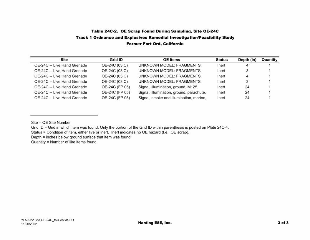
Table 24C-2. OE Scrap Found During Sampling, Site OE-24CTrack 1 Ordnance and Explosives Remedial Investigation/Feasibility Study
Former Fort Ord, California
Site Grid ID OE Items Status Depth (in) QuantityOE-24C -- Live Hand Grenade OE-24C (03 C) UNKNOWN MODEL: FRAGMENTS, Inert 4 1OE-24C -- Live Hand Grenade OE-24C (03 C) UNKNOWN MODEL: FRAGMENTS, Inert 3 1OE-24C -- Live Hand Grenade OE-24C (03 C) UNKNOWN MODEL: FRAGMENTS, Inert 4 1OE-24C -- Live Hand Grenade OE-24C (03 C) UNKNOWN MODEL: FRAGMENTS, Inert 3 1OE-24C -- Live Hand Grenade OE-24C (FP 05) Signal, illumination, ground, M125 Inert 24 1OE-24C -- Live Hand Grenade OE-24C (FP 05) Signal, illumination, ground, parachute, Inert 24 1OE-24C -- Live Hand Grenade OE-24C (FP 05) Signal, smoke and illumination, marine, Inert 24 1
Site = OE Site NumberGrid ID = Grid in which item was found. Only the portion of the Grid ID within parenthesis is posted on Plate 24C-4.Status = Condition of item, either live or inert. Inert indicates no OE hazard (I.e., OE scrap).Depth = inches below ground surface that item was found.Quantity = Number of like items found.
YL59222 Site OE-24C_tbls.xls.xls-FO11/20/2002 Harding ESE, Inc. 3 of 3

PLATES1
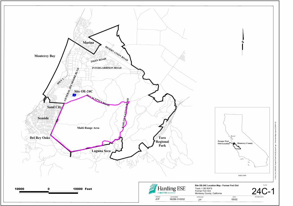
10000 0 10000 Feet
INDEX MAP
L:\Fo
rt_Or
d_GI
S\GI
S_Pr
oject\
Trac
k1\ha
128_
track
1.apr
- Ov
ervie
w Ma
p Lay
out 2
2 MAY
02
24C-1Site OE-24C Location Map - Former Fort OrdTrack 1 OE RI/FSFormer Fort OrdMonterey County, California
JCFREVISED DATE
PLATE
05/02DATEDRAWN
56286 010202APPROVEDJOB NUMBER
#SFormer FortOrd Location Monterey County
Marina
Monterey Bay
Sand City
Seaside
Del Rey Oaks
Site OE-24C
Laguna Seca
ToroRegional
Park
EUCALYPTUS ROAD
INTERGARRISON ROAD
RESERVATION ROADIMJIN ROAD
HWY 1
GENE
RAL J
IM M
OORE
BLVD
BARL
OY C
ANYO
N RO
ADMulti Range Area
JOB NUMBER APPROVED
56286 010202DRAWN DATE
05/02
PLATE
REVISED DATE
JCF
Track 1 OE RI/FSFormer Fort OrdMonterey County, California
Site OE-24C; 1951 Aerial Photo
24C-2
L:\Fo
rt_Or
d_GI
S\GI
S_Pr
oject\
Trac
k1\ha
128_
track
1.apr
22 M
AY 02
Metz Road
Live Grenade (1945)
Booby Traps (1945)
Practice Rifle Grenade (1945)
OE-24C
OE-24D
OE-24B
Legend
0 300 600 Feet
Booby Traps (1945)Live Grenade (1945)Practice Rifle Grenade (1945)
OE-24C ASR Site BoundaryOE-24B & D ASR Site Boundary
Note: Please see Disclaimer Page
JOB NUMBER APPROVED
56286 010202DRAWN DATE
05/02
PLATE
REVISED DATE
JCF
Track 1 OE RI/FSFormer Fort OrdMonterey County, California
Site OE-24C; 1966 Aerial Photo
24C-3
L:\Fo
rt_Or
d_GI
S\GI
S_Pr
oject\
Trac
k1\ha
128_
track
1.apr
22 M
AY 02
Live Grenade (1945)
Booby Traps (1945)
Practice Rifle Grenade (1945)
OE-24C
OE-24D
Fitch Park OE-24B
Legend
0 300 600 Feet
Booby Traps (1945)Live Grenade (1945)Practice Rifle Grenade (1945)
OE-24C ASR Site BoundaryOE-24B & D ASR Site Boundary
Note: Please see Disclaimer Page
JOB NUMBER APPROVED
46310 001710DRAWN DATE
05/02
PLATE
REVISED DATE
JCF
Track 1 OE RI/FSFormer Fort OrdMonterey County, California
Site OE-24C; 1999 Aerial Photo
24C-4
L:\Fo
rt_Or
d_GI
S\GI
S_Pr
oject\
Trac
k1\ha
128_
track
1.apr
22 M
AY 02
#S#S#S
#S#S
OE-24D
OE-24C
03 C
01 C
FP 05
02 C
04 C(not sampled)
UXB Boundary (OE-24C)
UXB Boundary (OE-24D)
Practice Rifle Grenade (1945)
Booby Traps (1945)
Live Grenade (1945)Sic
ily Ro
ad
Ardenne
s Circle
Metz Road
Ardennes Circle
Fitch ParkOE-24B
GENE
RAL J
IM M
OORE
BLV
D
#
SIGNAL, GROUND, PARACHUTE, M17A1SIGNAL, ILLUMINATION, GROUND, CLUSTER, WHITE STAR, M159SIGNAL, SMOKE AND ILLUM, MARINE, AN-MK 13 MOD O
#
GRENADE, FUZE (model unknown)GRENADE, FUZE (model unknown)and 19 Fragments
19 Fragments
17 Fragments
Legend
0 300 600 Feet
Booby Traps (1945)
Live Grenade (1945)
Practice Rifle Grenade (1945)Facilities (2001)
CMS SS/GS grids
Roads (1999)
UXB OE-24D Boundary
OE-24C ASR Site BoundaryOE-24B & D ASR Site Boundary
Note: Please see Disclaimer Page#S Inert OE item (OE Scrap) found during sampling (CMS) Note: The specific location of the grenade,
fuze and fragments within the grids was notprovided. The posted location of these OE items is accurate to the sample grid only.

OE-24C Live Grenade Range (1940s)
OE-24C Military Housing (Present)
Conceptual Site Model, Site OE-24CTrack 1 OE RI/FSFormer Fort OrdMonterey, California
Harding ESEA MACTEC COMPANY
J OB NUMBER
PLATE
REVISEDDATEAPPROVED
24C-5LK
DRAWN
GrenadeFragments
Targets
Vegetation (Oaks and Scrub)
Fuzes
56286 010202 5/02
Soil Berms
GrenadeFragments
PotentialPyrotechnicsGrenades
Scrapmetal
Vegetation(Oaks)
No exposureexpected at surface
Possible exposureto OE duringexcavation
FormerTraining Site
Low for PotentialConstructionActivity
ATTACHMENT 24C - A1
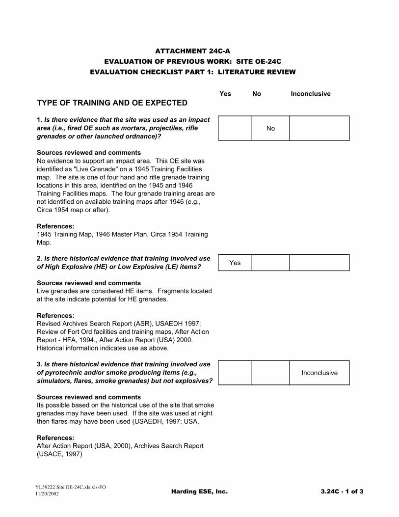
Yes No InconclusiveTYPE OF TRAINING AND OE EXPECTED
1. Is there evidence that the site was used as an impact area (i.e., fired OE such as mortars, projectiles, rifle grenades or other launched ordnance)?
No
Sources reviewed and commentsNo evidence to support an impact area. This OE site was identified as "Live Grenade" on a 1945 Training Facilities map. The site is one of four hand and rifle grenade training locations in this area, identified on the 1945 and 1946 Training Facilities maps. The four grenade training areas are not identified on available training maps after 1946 (e.g., Circa 1954 map or after).
References:1945 Training Map, 1946 Master Plan, Circa 1954 Training Map.
2. Is there historical evidence that training involved use of High Explosive (HE) or Low Explosive (LE) items? Yes
Sources reviewed and commentsLive grenades are considered HE items. Fragments located at the site indicate potential for HE grenades.
References:Revised Archives Search Report (ASR), USAEDH 1997; Review of Fort Ord facilities and training maps, After Action Report - HFA, 1994., After Action Report (USA) 2000. Historical information indicates use as above.
3. Is there historical evidence that training involved use of pyrotechnic and/or smoke producing items (e.g., simulators, flares, smoke grenades) but not explosives?
Inconclusive
Sources reviewed and commentsIts possible based on the historical use of the site that smoke grenades may have been used. If the site was used at night then flares may have been used (USAEDH, 1997; USA,
References:After Action Report (USA, 2000), Archives Search Report (USACE, 1997)
ATTACHMENT 24C-AEVALUATION OF PREVIOUS WORK: SITE OE-24C
EVALUATION CHECKLIST PART 1: LITERATURE REVIEW
YL59222 Site OE-24C.xls.xls-FO11/20/2002 Harding ESE, Inc. 3.24C - 1 of 3
Yes No Inconclusive
ATTACHMENT 24C-AEVALUATION OF PREVIOUS WORK: SITE OE-24C
EVALUATION CHECKLIST PART 1: LITERATURE REVIEW
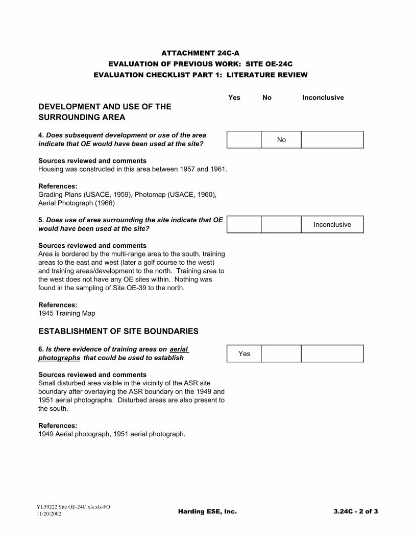
DEVELOPMENT AND USE OF THE SURROUNDING AREA
4. Does subsequent development or use of the area indicate that OE would have been used at the site? No
Sources reviewed and commentsHousing was constructed in this area between 1957 and 1961.
References:Grading Plans (USACE, 1959), Photomap (USACE, 1960), Aerial Photograph (1966)
5. Does use of area surrounding the site indicate that OE would have been used at the site? Inconclusive
Sources reviewed and commentsArea is bordered by the multi-range area to the south, training areas to the east and west (later a golf course to the west) and training areas/development to the north. Training area to the west does not have any OE sites within. Nothing was found in the sampling of Site OE-39 to the north.
References:1945 Training Map
ESTABLISHMENT OF SITE BOUNDARIES
6. Is there evidence of training areas on aerial photographs that could be used to establish Yes
Sources reviewed and commentsSmall disturbed area visible in the vicinity of the ASR site boundary after overlaying the ASR boundary on the 1949 and 1951 aerial photographs. Disturbed areas are also present to the south.
References:1949 Aerial photograph, 1951 aerial photograph.
YL59222 Site OE-24C.xls.xls-FO11/20/2002 Harding ESE, Inc. 3.24C - 2 of 3
Yes No Inconclusive
ATTACHMENT 24C-AEVALUATION OF PREVIOUS WORK: SITE OE-24C
EVALUATION CHECKLIST PART 1: LITERATURE REVIEW
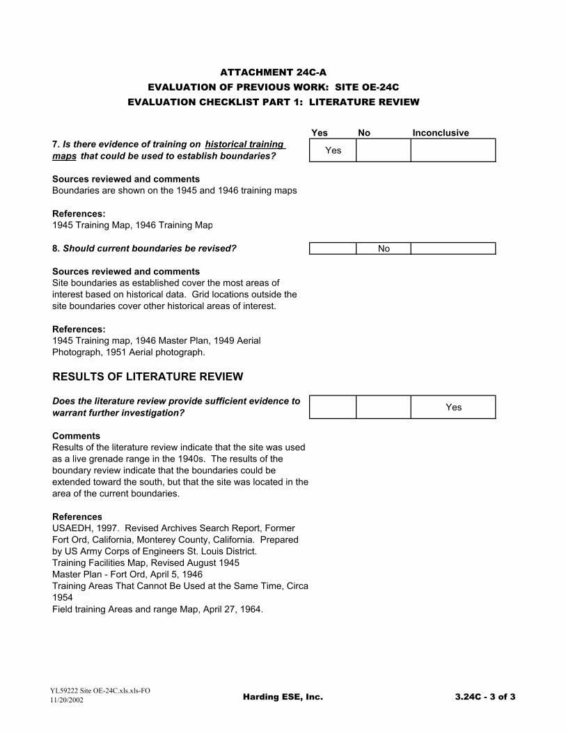
7. Is there evidence of training on historical training maps that could be used to establish boundaries? Yes
Sources reviewed and commentsBoundaries are shown on the 1945 and 1946 training maps
References:1945 Training Map, 1946 Training Map
8. Should current boundaries be revised? No
Sources reviewed and commentsSite boundaries as established cover the most areas of interest based on historical data. Grid locations outside the site boundaries cover other historical areas of interest.
References:1945 Training map, 1946 Master Plan, 1949 Aerial Photograph, 1951 Aerial photograph.
RESULTS OF LITERATURE REVIEW
Does the literature review provide sufficient evidence to warrant further investigation? Yes
CommentsResults of the literature review indicate that the site was used as a live grenade range in the 1940s. The results of the boundary review indicate that the boundaries could be extended toward the south, but that the site was located in the area of the current boundaries.
ReferencesUSAEDH, 1997. Revised Archives Search Report, Former Fort Ord, California, Monterey County, California. Prepared by US Army Corps of Engineers St. Louis District. Training Facilities Map, Revised August 1945Master Plan - Fort Ord, April 5, 1946Training Areas That Cannot Be Used at the Same Time, Circa 1954Field training Areas and range Map, April 27, 1964.
YL59222 Site OE-24C.xls.xls-FO11/20/2002 Harding ESE, Inc. 3.24C - 3 of 3
Yes No Inconclusive
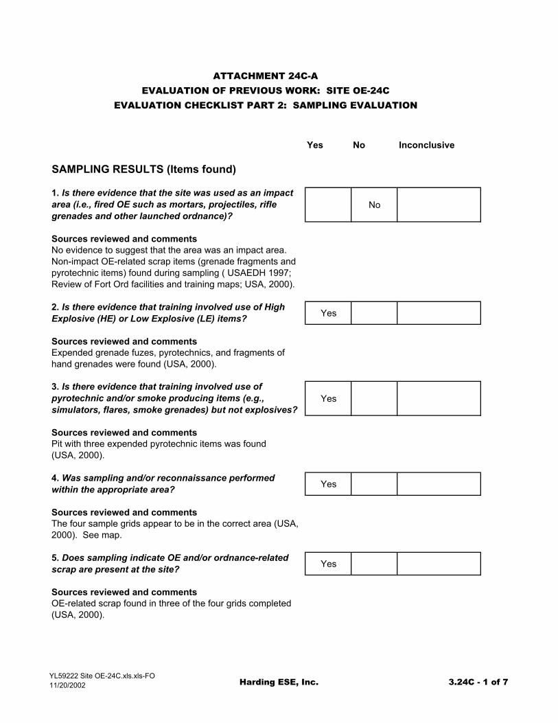
SAMPLING RESULTS (Items found)
1. Is there evidence that the site was used as an impact area (i.e., fired OE such as mortars, projectiles, rifle grenades and other launched ordnance)?
No
Sources reviewed and commentsNo evidence to suggest that the area was an impact area. Non-impact OE-related scrap items (grenade fragments and pyrotechnic items) found during sampling ( USAEDH 1997; Review of Fort Ord facilities and training maps; USA, 2000).
2. Is there evidence that training involved use of High Explosive (HE) or Low Explosive (LE) items? Yes
Sources reviewed and commentsExpended grenade fuzes, pyrotechnics, and fragments of hand grenades were found (USA, 2000).
3. Is there evidence that training involved use of pyrotechnic and/or smoke producing items (e.g., simulators, flares, smoke grenades) but not explosives?
Yes
Sources reviewed and commentsPit with three expended pyrotechnic items was found (USA, 2000).
4. Was sampling and/or reconnaissance performed within the appropriate area? Yes
Sources reviewed and commentsThe four sample grids appear to be in the correct area (USA, 2000). See map.
5. Does sampling indicate OE and/or ordnance-related scrap are present at the site? Yes
Sources reviewed and commentsOE-related scrap found in three of the four grids completed (USA, 2000).
ATTACHMENT 24C-AEVALUATION OF PREVIOUS WORK: SITE OE-24C
EVALUATION CHECKLIST PART 2: SAMPLING EVALUATION
YL59222 Site OE-24C.xls.xls-FO11/20/2002 Harding ESE, Inc. 3.24C - 1 of 7
Yes No Inconclusive
ATTACHMENT 24C-AEVALUATION OF PREVIOUS WORK: SITE OE-24C
EVALUATION CHECKLIST PART 2: SAMPLING EVALUATION
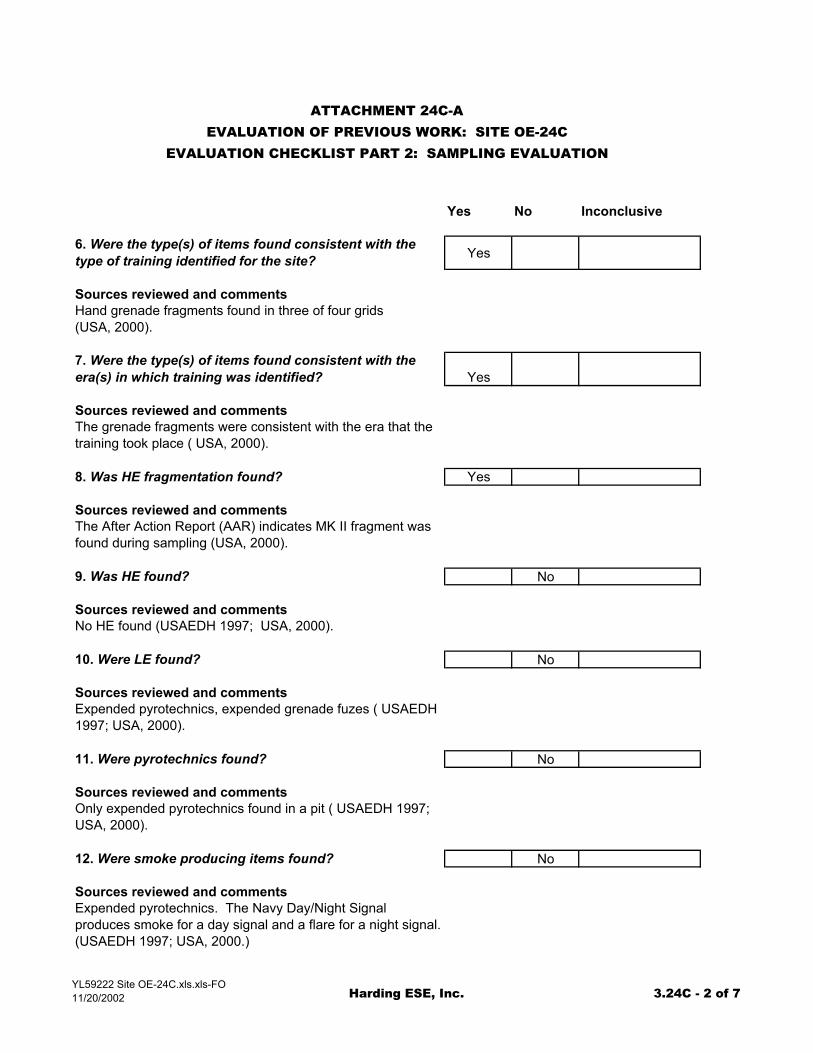
6. Were the type(s) of items found consistent with the type of training identified for the site? Yes
Sources reviewed and commentsHand grenade fragments found in three of four grids (USA, 2000).
7. Were the type(s) of items found consistent with the era(s) in which training was identified? Yes
Sources reviewed and commentsThe grenade fragments were consistent with the era that the training took place ( USA, 2000).
8. Was HE fragmentation found? Yes
Sources reviewed and commentsThe After Action Report (AAR) indicates MK II fragment was found during sampling (USA, 2000).
9. Was HE found? No
Sources reviewed and commentsNo HE found (USAEDH 1997; USA, 2000).
10. Were LE found? No
Sources reviewed and commentsExpended pyrotechnics, expended grenade fuzes ( USAEDH 1997; USA, 2000).
11. Were pyrotechnics found? No
Sources reviewed and commentsOnly expended pyrotechnics found in a pit ( USAEDH 1997; USA, 2000).
12. Were smoke producing items found? No
Sources reviewed and commentsExpended pyrotechnics. The Navy Day/Night Signal produces smoke for a day signal and a flare for a night signal. (USAEDH 1997; USA, 2000.)
YL59222 Site OE-24C.xls.xls-FO11/20/2002 Harding ESE, Inc. 3.24C - 2 of 7
Yes No Inconclusive
ATTACHMENT 24C-AEVALUATION OF PREVIOUS WORK: SITE OE-24C
EVALUATION CHECKLIST PART 2: SAMPLING EVALUATION
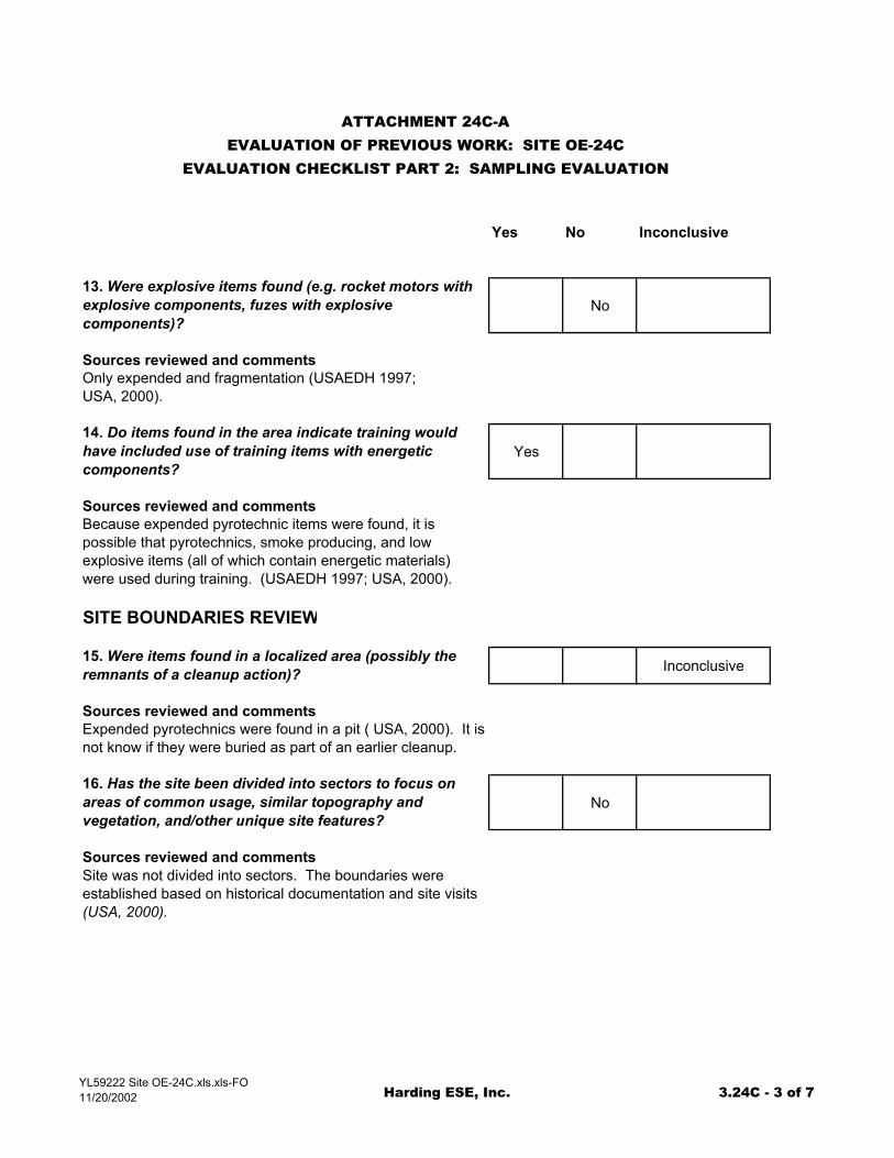
13. Were explosive items found (e.g. rocket motors with explosive components, fuzes with explosive components)?
No
Sources reviewed and commentsOnly expended and fragmentation (USAEDH 1997; USA, 2000).
14. Do items found in the area indicate training would have included use of training items with energetic components?
Yes
Sources reviewed and commentsBecause expended pyrotechnic items were found, it is possible that pyrotechnics, smoke producing, and low explosive items (all of which contain energetic materials) were used during training. (USAEDH 1997; USA, 2000).
SITE BOUNDARIES REVIEW
15. Were items found in a localized area (possibly the remnants of a cleanup action)? Inconclusive
Sources reviewed and commentsExpended pyrotechnics were found in a pit ( USA, 2000). It is not know if they were buried as part of an earlier cleanup.
16. Has the site been divided into sectors to focus on areas of common usage, similar topography and vegetation, and/other unique site features?
No
Sources reviewed and commentsSite was not divided into sectors. The boundaries were established based on historical documentation and site visits (USA, 2000).
YL59222 Site OE-24C.xls.xls-FO11/20/2002 Harding ESE, Inc. 3.24C - 3 of 7
Yes No Inconclusive
ATTACHMENT 24C-AEVALUATION OF PREVIOUS WORK: SITE OE-24C
EVALUATION CHECKLIST PART 2: SAMPLING EVALUATION
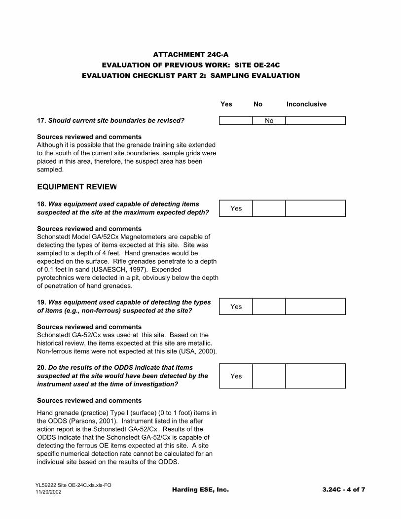
17. Should current site boundaries be revised? No
Sources reviewed and commentsAlthough it is possible that the grenade training site extended to the south of the current site boundaries, sample grids were placed in this area, therefore, the suspect area has been sampled.
EQUIPMENT REVIEW
18. Was equipment used capable of detecting items suspected at the site at the maximum expected depth? Yes
Sources reviewed and commentsSchonstedt Model GA/52Cx Magnetometers are capable of detecting the types of items expected at this site. Site was sampled to a depth of 4 feet. Hand grenades would be expected on the surface. Rifle grenades penetrate to a depth of 0.1 feet in sand (USAESCH, 1997). Expended pyrotechnics were detected in a pit, obviously below the depth of penetration of hand grenades.
19. Was equipment used capable of detecting the types of items (e.g., non-ferrous) suspected at the site? Yes
Sources reviewed and commentsSchonstedt GA-52/Cx was used at this site. Based on the historical review, the items expected at this site are metallic. Non-ferrous items were not expected at this site (USA, 2000).
20. Do the results of the ODDS indicate that items suspected at the site would have been detected by the instrument used at the time of investigation?
Yes
Sources reviewed and comments
Hand grenade (practice) Type I (surface) (0 to 1 foot) items in the ODDS (Parsons, 2001). Instrument listed in the after action report is the Schonstedt GA-52/Cx. Results of the ODDS indicate that the Schonstedt GA-52/Cx is capable of detecting the ferrous OE items expected at this site. A site specific numerical detection rate cannot be calculated for an individual site based on the results of the ODDS.
YL59222 Site OE-24C.xls.xls-FO11/20/2002 Harding ESE, Inc. 3.24C - 4 of 7
Yes No Inconclusive
ATTACHMENT 24C-AEVALUATION OF PREVIOUS WORK: SITE OE-24C
EVALUATION CHECKLIST PART 2: SAMPLING EVALUATION
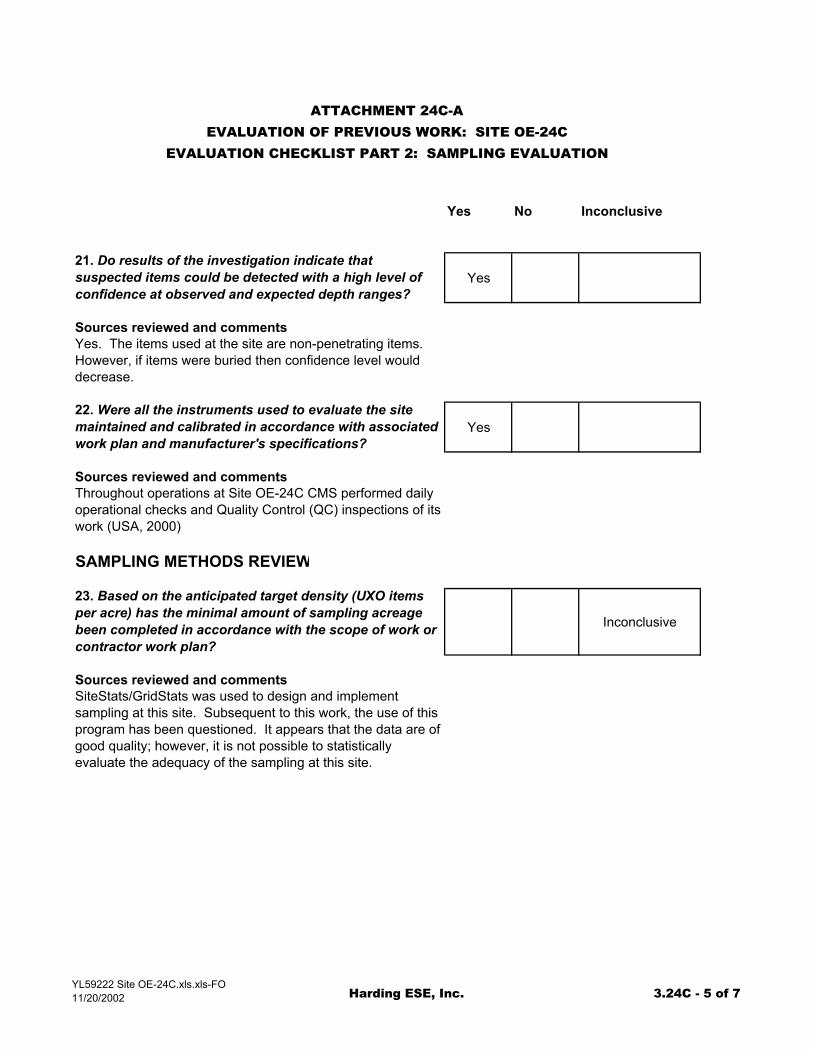
21. Do results of the investigation indicate that suspected items could be detected with a high level of confidence at observed and expected depth ranges?
Yes
Sources reviewed and commentsYes. The items used at the site are non-penetrating items. However, if items were buried then confidence level would decrease.
22. Were all the instruments used to evaluate the site maintained and calibrated in accordance with associated work plan and manufacturer's specifications?
Yes
Sources reviewed and commentsThroughout operations at Site OE-24C CMS performed daily operational checks and Quality Control (QC) inspections of its work (USA, 2000)
SAMPLING METHODS REVIEW
23. Based on the anticipated target density (UXO items per acre) has the minimal amount of sampling acreage been completed in accordance with the scope of work or contractor work plan?
Inconclusive
Sources reviewed and commentsSiteStats/GridStats was used to design and implement sampling at this site. Subsequent to this work, the use of this program has been questioned. It appears that the data are of good quality; however, it is not possible to statistically evaluate the adequacy of the sampling at this site.
YL59222 Site OE-24C.xls.xls-FO11/20/2002 Harding ESE, Inc. 3.24C - 5 of 7
Yes No Inconclusive
ATTACHMENT 24C-AEVALUATION OF PREVIOUS WORK: SITE OE-24C
EVALUATION CHECKLIST PART 2: SAMPLING EVALUATION
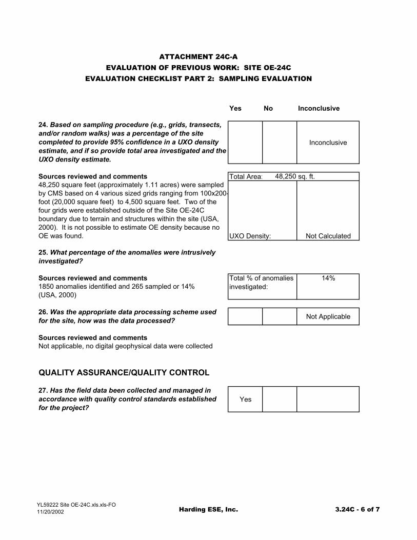
24. Based on sampling procedure (e.g., grids, transects, and/or random walks) was a percentage of the site completed to provide 95% confidence in a UXO density estimate, and if so provide total area investigated and the UXO density estimate.
Inconclusive
Sources reviewed and comments Total Area: 48,250 sq. ft.48,250 square feet (approximately 1.11 acres) were sampled by CMS based on 4 various sized grids ranging from 100x200-foot (20,000 square feet) to 4,500 square feet. Two of the four grids were established outside of the Site OE-24C boundary due to terrain and structures within the site (USA, 2000). It is not possible to estimate OE density because no OE was found. UXO Density: Not Calculated
25. What percentage of the anomalies were intrusively investigated?
Sources reviewed and comments Total % of anomalies 14%1850 anomalies identified and 265 sampled or 14% (USA, 2000)
investigated:
26. Was the appropriate data processing scheme used for the site, how was the data processed? Not Applicable
Sources reviewed and commentsNot applicable, no digital geophysical data were collected
QUALITY ASSURANCE/QUALITY CONTROL
27. Has the field data been collected and managed in accordance with quality control standards established for the project?
Yes
YL59222 Site OE-24C.xls.xls-FO11/20/2002 Harding ESE, Inc. 3.24C - 6 of 7
Yes No Inconclusive
ATTACHMENT 24C-AEVALUATION OF PREVIOUS WORK: SITE OE-24C
EVALUATION CHECKLIST PART 2: SAMPLING EVALUATION
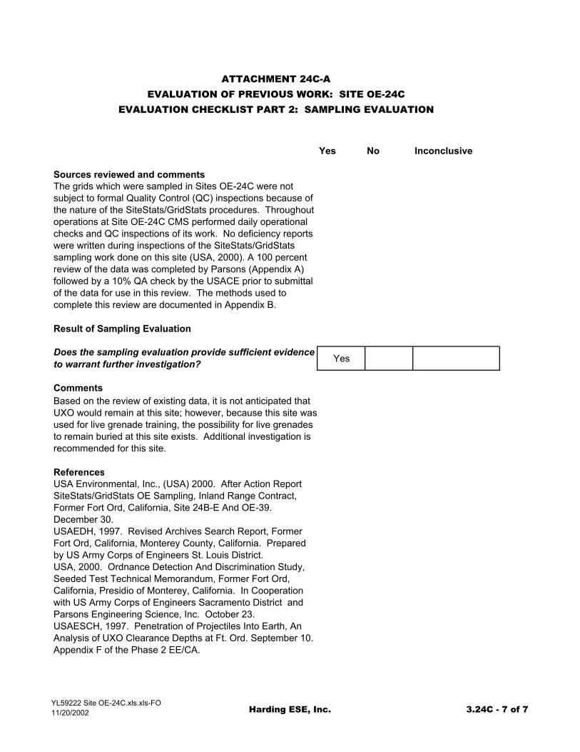
Sources reviewed and commentsThe grids which were sampled in Sites OE-24C were not subject to formal Quality Control (QC) inspections because of the nature of the SiteStats/GridStats procedures. Throughout operations at Site OE-24C CMS performed daily operational checks and QC inspections of its work. No deficiency reports were written during inspections of the SiteStats/GridStats sampling work done on this site (USA, 2000). A 100 percent review of the data was completed by Parsons (Appendix A) followed by a 10% QA check by the USACE prior to submittal of the data for use in this review. The methods used to complete this review are documented in Appendix B.
Result of Sampling Evaluation
Does the sampling evaluation provide sufficient evidence to warrant further investigation? Yes
CommentsBased on the review of existing data, it is not anticipated that UXO would remain at this site; however, because this site wasused for live grenade training, the possibility for live grenades to remain buried at this site exists. Additional investigation is recommended for this site.
ReferencesUSA Environmental, Inc., (USA) 2000. After Action Report SiteStats/GridStats OE Sampling, Inland Range Contract, Former Fort Ord, California, Site 24B-E And OE-39. December 30. USAEDH, 1997. Revised Archives Search Report, Former Fort Ord, California, Monterey County, California. Prepared by US Army Corps of Engineers St. Louis District. USA, 2000. Ordnance Detection And Discrimination Study, Seeded Test Technical Memorandum, Former Fort Ord, California, Presidio of Monterey, California. In Cooperation with US Army Corps of Engineers Sacramento District and Parsons Engineering Science, Inc. October 23. USAESCH, 1997. Penetration of Projectiles Into Earth, An Analysis of UXO Clearance Depths at Ft. Ord. September 10. Appendix F of the Phase 2 EE/CA.
YL59222 Site OE-24C.xls.xls-FO11/20/2002 Harding ESE, Inc. 3.24C - 7 of 7
Related Documents