42 Hampstead Lane London N6 4LL Client: Hassan Golshirazi Engineer: Price & Myers J14154 March 2017 SITE INVESTIGATION & BASEMENT IMPACT ASSESSMENT REPORT

Welcome message from author
This document is posted to help you gain knowledge. Please leave a comment to let me know what you think about it! Share it to your friends and learn new things together.
Transcript
42 Hampstead Lane London N6 4LL
Client: Hassan Golshirazi
Engineer: Price & Myers
J14154
March 2017
SITE INVESTIGATION & BASEMENT IMPACT ASSESSMENT REPORT
42 Hampstead Lane, London, N6 4LL Site Investigation and Hassan Golshirazi Basement Impact Assessment Report
Ref J14154 Issue No 4 29 March 2017
i
Document Control
Project title 42 Hampstead Lane, London, N6 4LL Project ref J14154
Report prepared by
Alex Taylor BSc MSc FGS
With input from
Martin Cooper BSc CEng MICE
John Evans MSc FGS CGeol
Rupert Evans MSc CEnv CWEM MCIWEM AIEMA
Report checked and approved for issue by
Steve Branch BSc MSc CGeol FGS FRGS MIEnvSc
1 Draft 16 June 2014
2 Final 4 July 2014 3 Final (revised) 2 March 2017 4 Final (revised) 29 March 2017
This report has been issued by the GEA office indicated below. Any enquiries regarding the report should be directed to the office indicated or to Steve Branch in our Herts office.
Hertfordshire tel 01727 824666 [email protected]
Nottinghamshire tel 01509 674888 [email protected]
Geotechnical & Environmental Associates Limited (GEA) disclaims any responsibility to the Client and others in respect of any matters outside the scope of this work. This report has been prepared with reasonable skill, care and diligence within the terms of the contract with the Client and taking account of the manpower, resources, investigation and testing devoted to it in agreement with the Client. This report is confidential to the Client and GEA accepts no responsibility of whatsoever nature to third parties to whom this report or any part thereof is made known, unless formally agreed beforehand. Any such party relies upon the report at their own risk. This report may provide advice based on an interpretation of legislation, guidance notes and codes of practice. GEA does not however provide legal advice and if specific legal advice is required a lawyer should be consulted. This report is intended as a Ground Investigation Report (GIR) as defined in BS EN1997-2, unless specifically noted otherwise. The report is not a Geotechnical Design Report (GDR) as defined in EN1997-2 and recommendations made within this report are for guidance only. © Geotechnical & Environmental Associates Limited 2017
42 Hampstead Lane, London, N6 4LL Site Investigation and Hassan Golshirazi Basement Impact Assessment Report
Ref J14154 Issue No 4 29 March 2017
ii
CONTENTS
EXECUTIVE SUMMARY
Part 1: INVESTIGATION REPORT 1.0 INTRODUCTION 1 1.1 Proposed Development 1 1.2 Purpose of Work 1 1.3 Scope of Work 2 1.4 Limitations 3 2.0 THE SITE 3 2.1 Site Description 3 2.2 Site History 4 2.3 Other Information 5 2.4 Geology 5 2.5 Hydrology and Hydrogeology 6 2.6 Preliminary Risk Assessment 7 3.0 SCREENING 8 3.1 Screening Assessment 8 4.0 SCOPING AND SITE INVESTIGATION 11 4.1 Potential Impacts 11 4.2 Exploratory Work 12 4.3 Sampling Strategy 12 5.0 GROUND CONDITIONS 13 5.1 Made Ground 13 5.2 Bagshot Formation 13 5.3 Claygate Member 13 5.4 London Clay 13 5.5 Groundwater 14 5.6 Soil Contamination 14 5.7 Existing Foundations 16
Part 2: DESIGN BASIS REPORT 6.0 INTRODUCTION 17 7.0 GROUND MODEL 17 8.0 ADVICE AND RECOMMENDATIONS 18 8.1 Basement Construction 18 8.2 Spread Foundations 20 8.3 Piled Foundations 20 8.4 Shallow Excavations 21 8.5 Basement Floor Slab 21 8.6 Effect of Sulphates 21 8.7 Site Specific Risk Assessment 21 8.8 Waste Disposal 23
42 Hampstead Lane, London, N6 4LL Site Investigation and Hassan Golshirazi Basement Impact Assessment Report
Ref J14154 Issue No 4 29 March 2017
iii
Part 3: GROUND MOVEMENT ANALYSIS 9.0 INTRODUCTION 25 9.1 Construction Sequence 25 9.2 Ground Movements 26 9.3 Ground Movements - Surrounding the Basement 26 9.4 Movements within the Excavation (Heave) 28 10.0 DAMAGE ASSESSMENT 29 10.1 Damage to Neighbouring Structures 30 10.2 Monitoring of Ground Movements 31 11.0 CONCLUSIONS 31 12.0 BASEMENT IMPACT ASSESSMENT 32 12.1 BIA Conclusion 34 12.2 Non-Technical Summary of Evidence 34 13.0 OUTSTANDING RISK AND ISSUES 37 APPENDIX
42 Hampstead Lane, London, N6 4LL Site Investigation and Hassan Golshirazi Basement Impact Assessment Report
Ref J14154 Issue No 4 29 March 2017
iv
EXECUTIVE SUMMARY This executive summary contains an overview of the key findings and conclusions. No reliance should be placed on any part of the executive summary until the whole of the report has been read. Other sections of the report may contain information that puts into context the findings that are summarised in the executive summary.
BRIEF This report describes the findings of a site investigation carried out by Geotechnical and Environmental Associates Limited (GEA) on the instructions of Price & Myers, on behalf of Mr Hassan Golshirazi, with respect to the demolition of the existing building and subsequent construction of a new three-storey house with a lower ground floor level and single level basement beneath the entire footprint of the building, which is to include a swimming pool. The purpose of the investigation has been to determine the ground conditions, to provide information for the design of new foundations and retaining walls, to assess the impact that the basement will have on the hydrogeology of the surrounding area, and to provide a preliminary assessment of the presence of contamination. The report also includes a Basement Impact Assessment (BIA) to assist with the planning application; the site is located within the London Borough of Haringey but for the purpose of the BIA the approach followed by the London Borough of Camden has been adopted as it is now widely known and is considered to provide a robust approach to the issues of potential concern. The proposals for the development have been amended and this report has been revised to reflect the new proposals. A ground movement assessment has also been included. SITE HISTORY The earliest map studied, dated 1864, shows the site to be undeveloped, comprising part of a wooded area labelled as ‘Bishops Wood’, although Hampstead Lane is shown in its current position. An unspecified, irregularly shaped building is shown 100 m southeast of the site and on the map dated 1870, at which time Kenwood House is shown 150 m south of the site. Between 1896 and 1915 two of the existing houses with associated garden areas were constructed 200 m to the west, which are labelled as ‘East Weald’ and ‘Bishops Mead’. By 1936 the site had been developed with the existing building, and much of the surrounding area was by this time established with the existing houses constructed. The site and the surrounding area have since remained essentially unchanged. GROUND CONDITIONS The investigation has generally confirmed the expected ground conditions in that, below a moderate thickness of made ground, the Bagshot Formation was encountered, and was underlain by the Claygate Member and the London Clay which extended to the maximum depth of the investigation, of 25.00 m. The made ground extended to depths of between 0.50 m and 0.90 m and generally comprised brown silty sandy clay with variable amounts of gravel, brick, concrete, metal, ash and charcoal fragments. The Bagshot Formation generally comprised firm becoming stiff orange-brown mottled brown and grey silty sandy silty clay which extended to depths of between 2.20 m (109.95 m OD) and 2.60 m (111.65 m OD). However, medium dense orange-brown mottled brown very clayey silty fine to medium sand was encountered within Borehole No 1, and extended to a depth of 4.50 m (109.75 m OD). The Claygate Member initially comprised medium dense brown mottled orange-brown slightly clayey silty fine sand with occasional layers of sandy clay extending to depths of 11.20 m (103.05 m OD) and 10.90 m (103.48 m OD) in Borehole Nos 1 and 2 respectively. Stiff grey silty clay with layers of clayey silt and clayey sand was then encountered and extended to depths of 20.70 m (93.55 m OD) and 19.55 m (94.83 m OD) in Borehole Nos 1 and 2. The London Clay Formation generally comprised medium dense grey slightly clayey silt and extended to the full depth of the investigation, of 25.00 m (89.25 m OD). Groundwater was initially encountered at depths of between 4.00 m (108.17 m OD) and 8.80 m (105.58 m OD) below which inflows of groundwater were regularly encountered to the full depth of the investigation, of 25.00 m (89.25 m OD). Groundwater has subsequently been measured at depths of between 4.32 m (107.83 m OD) and 6.60 m (107.65 m OD) within the standpipes installed in a selection of the boreholes. RECOMMENDATIONS Excavations for the proposed basement structure will require temporary support to maintain stability and to prevent any excessive ground movements. Based on the groundwater observations to date, groundwater is likely to be encountered within the 10.19 m deep basement excavation and therefore a secant bored pile wall is likely to be the most appropriate option for supporting the basement excavation. Spread foundations excavated from basement level to bear within the Claygate Member may be designed to provide an allowable bearing pressure of 150 kN/m2, provided that groundwater inflows can be sufficiently controlled, or alternatively piles could be used for the support of the structural loads. BASEMENT IMPACT ASSESSMENT It has been concluded that the impacts identified can be mitigated by appropriate design and standard construction practice. Groundwater is expected to be present at shallow depth beneath the site although inflows from within the Claygate Member would be expected to occur at a very slow rate such that they could be suitably controlled by sump pumping. The proposed works are not considered likely to have any detrimental effect on the local groundwater regime or surrounding structures.
42 Hampstead Lane, London, N6 4LL Site Investigation and Hassan Golshirazi Basement Impact Assessment Report
Ref J14154 Issue No 4 29 March 2017
1
Part 1: INVESTIGATION REPORT This section of the report details the objectives of the investigation, the work that has been carried out to meet these objectives and the results of the investigation. Interpretation of the findings is presented in Part 2. 1.0 INTRODUCTION
Geotechnical and Environmental Associates Limited (GEA) has been commissioned by Price & Myers, on behalf of Mr Hassan Golshirazi, to carry out a desk study and ground investigation at 42 Hampstead Lane, London, N6 4LL. This report also forms part of a Basement Impact Assessment (BIA) which, in the absence of planning guidelines in the London Borough of Haringey, has been carried out in accordance with guidelines from the London Borough of Camden (LBC) in support of a planning application. The proposals for the development have been amended and this report has been revised to reflect the changes. A ground movement assessment has also been included.
1.1 Proposed Development It is understood that consideration is being given to the redevelopment of the site through the demolition of the existing building and the subsequent construction of a new three-storey house with a lower ground floor level and a single level basement beneath the entire footprint of the building, which is to include a swimming pool. The lower ground floor will be formed at a level of 110.17 m OD while the basement level will extend to a level of 105.80 m OD and the swimming pool will extend to a level of 104.20 m OD. This report is specific to the proposed development and the advice herein should be reviewed once the development proposals are finalised.
1.2 Purpose of Work
The principal technical objectives of the work carried out were as follows:
to check the history of the site with respect to previous contaminative uses;
to determine the ground conditions and their engineering properties;
to provide advice and information with respect to the design of shallow foundations and retaining walls;
to assess the impact of the proposed basement on the local hydrogeology; to provide an indication of the degree of soil contamination present; and to assess the risk that any such contamination may pose to the proposed development,
its users or the wider environment.
42 Hampstead Lane, London, N6 4LL Site Investigation and Hassan Golshirazi Basement Impact Assessment Report
Ref J14154 Issue No 4 29 March 2017
2
1.3 Scope of Work In order to meet the above objectives, a desk study was carried out followed by a ground investigation. The desk study comprised: a review of available historical Ordinance Survey (OS) maps; a review of readily available geology maps;
a walkover survey of the site carried out in conjunction with the fieldwork. In the light of this desk study an intrusive ground investigation was carried out which comprised, in summary, the following activities: two boreholes advanced to a maximum depth of 25.00 m by cable percussive
methods;
two boreholes advanced to a depth of 8.00 m by means of an open-drive percussive sampler;
installation of three groundwater monitoring standpipes within the boreholes, to a
maximum depth of 10.00 m;
a series of hand excavated trial pits to investigate the existing foundations;
standard penetration tests (SPTs), carried out at regular intervals in the boreholes, to provide additional quantitative data on the strength of the soils;
testing of selected soil samples for contamination and geotechnical purposes; and provision of a report presenting and interpreting the above data, together with our
advice and recommendations with respect to the proposed development.
The report includes a contaminated land assessment which has been undertaken in accordance with the methodology presented in Contaminated Land Report (CLR) 111 and involves identifying, making decisions on, and taking appropriate action to deal with, land contamination in a way that is consistent with government policies and legislation within the United Kingdom. The risk assessment is thus divided into three stages comprising Preliminary Risk Assessment, Generic Quantitative Risk Assessment, and Site-Specific Risk Assessment.
1.3.1 Basement Impact Assessment The work carried out also includes a Hydrological and Hydrogeological Assessment and Land
Stability Assessment (also referred to as Slope Stability Assessment), all of which form part of the BIA procedure specified in the London Borough of Camden (LBC) Planning Guidance CPG42 and their Guidance for Subterranean Development3 prepared by Arup (the “Arup report”). The aim of the work is to provide information on surface water, land stability and groundwater and in particular to assess whether the development will affect neighbouring properties or groundwater movements and whether any identified impacts can be appropriately mitigated by the design of the development.
1 Model Procedures for the Management of Land Contamination issued jointly by the Environment Agency and the Department
for Environment, Food and Rural Affairs (DEFRA) Sept 2004 2 London Borough of Camden Planning Guidance CPG4 Basements and lightwells 3 Ove Arup & Partners (2010) Camden geological, hydrogeological and hydrological study. Guidance for Subterranean
Development. For London Borough of Camden November 2010
42 Hampstead Lane, London, N6 4LL Site Investigation and Hassan Golshirazi Basement Impact Assessment Report
Ref J14154 Issue No 4 29 March 2017
3
1.3.2 Qualifications The land stability element of the Basement Impact Assessment (BIA) has been carried out by Martin Cooper, a BEng in Civil Engineering, a chartered engineer (CEng), member of the Institution of Civil Engineers (MICE), and Fellow of the Geological Society (FGS) who has over 20 years’ specialist experience in ground engineering. The subterranean (groundwater) flow assessment has been carried out by John Evans, MSc in Hydrogeology, Chartered Geologist (CGeol) and Fellow of the Geological Society of London (FGS). The surface water and flooding assessment has been carried out by Rupert Evans, a hydrologist with more than ten years consultancy experience in flood risk assessment, surface water drainage schemes and hydrology / hydraulic modelling. Rupert Evans is a Chartered Environmentalist, Chartered Water and Environmental Manager and a Member of CIWEM. The assessments have been made in conjunction with Steve Branch, a BSc in Engineering Geology and Geotechnics, MSc in Geotechnical Engineering, a chartered geologist (CGeol) and Fellow of the Geological Society (FGS) with 25 years’ experience in geotechnical engineering and engineering geology. All assessors meet the qualification requirements of the Council guidance.
1.4 Limitations The conclusions and recommendations made in this report are limited to those that can be
made on the basis of the investigation. The results of the work should be viewed in the context of the range of data sources consulted and the number of locations where the ground was sampled. No liability can be accepted for information in other data sources or conditions not revealed by the sampling or testing. Any comments made on the basis of information obtained from the client or other third parties are given in good faith on the assumption that the information is accurate; no independent validation of such information has been made by GEA.
2.0 THE SITE 2.1 Site Description
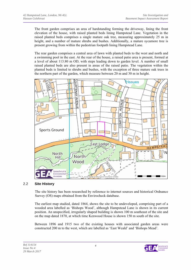
The site is located approximately 1.9 km east of Golders Green London Underground Station, and 1.5 km southwest of Highgate London Underground Station. It fronts onto Hampstead Lane to the south and is bounded by houses with associated garden areas, fronting onto Hampstead Lane, to the east and west, and by the garden of a similar property fronting onto Compton Avenue to the north. The site may be additionally located by National Grid Reference 527169, 187637 and is shown on the map extract overleaf.
A walkover of the site was carried out by a geotechnical engineer from GEA at the time of the fieldwork. The site covers a roughly rectangular area measuring approximately 60 m north-south by 30 m east-west. In the south of the site ground level slopes down to the north from road level at approximately 116 m OD in the south, to a level of 114.18 m OD at the front of the house at an angle in excess of 7 ̊. The rear garden of the site is formed at a lower level of 112 .15 m OD and slopes gently down to the north at an angle of less than 7 ̊, with a lowest level of 111.32 m OD. The site is currently occupied by a three-storey house with associated areas of soft landscaping and hardstanding. Additionally a lower ground floor level is also present in the east of the site, which appears to underlie an extended section.
42 Hampstead Lane, London, N6 4LL Site Investigation and Hassan Golshirazi Basement Impact Assessment Report
Ref J14154 Issue No 4 29 March 2017
4
The front garden comprises an area of hardstanding forming the driveway, lining the front elevation of the house, with raised planted beds lining Hampstead Lane. Vegetation in the raised planted beds comprises a single mature oak tree, measuring approximately 25 m in height, and a number of mature shrubs and bushes. Additionally, a mature sycamore tree is present growing from within the pedestrian footpath lining Hampstead Lane. The rear garden comprises a central area of lawn with planted beds to the west and north and a swimming pool in the east. At the rear of the house, a raised patio area is present, formed at a level of about 113.80 m OD, with steps leading down to garden level. A number of small raised planted beds are also present in areas of the raised patio. The vegetation within the planted beds is limited to shrubs and bushes, with the exception of three mature oak trees in the northern part of the garden, which measure between 20 m and 30 m in height.
2.2 Site History The site history has been researched by reference to internet sources and historical Ordnance Survey (OS) maps obtained from the Envirocheck database. The earliest map studied, dated 1864, shows the site to be undeveloped, comprising part of a wooded area labelled as ‘Bishops Wood’, although Hampstead Lane is shown in its current position. An unspecified, irregularly shaped building is shown 100 m southeast of the site and on the map dated 1870, at which time Kenwood House is shown 150 m south of the site. Between 1896 and 1915 two of the existing houses with associated garden areas were constructed 200 m to the west, which are labelled as ‘East Weald’ and ‘Bishops Mead’.
42 Hampstead Lane, London, N6 4LL Site Investigation and Hassan Golshirazi Basement Impact Assessment Report
Ref J14154 Issue No 4 29 March 2017
5
By 1936 the site had been developed with the existing building, and much of the surrounding area was by this time established with the existing houses constructed. The site and the surrounding area have since remained essentially unchanged.
2.3 Other Information
A search of public registers and databases has been made via the Envirocheck database and relevant extracts from the search are appended. Full results of the search can be provided if required.
The Envirocheck report has indicated no landfill sites, waste management or waste transfer sites located within 1 km of the site.
Two pollution incidents to controlled waters have been recorded within 500 m of the site, the closest of which occurred 342 m to the north of the site. Both incidents are recorded as being Category 3 – Minor Incidents and both occurred more than 20 years ago. As a result neither of the incidents is thought likely to have impacted the site.
The site is not within an area shown by the Environment Agency to be at risk from flooding from rivers or the sea and does not lie within any known areas of sensitive land use. However, Hampstead Heath Wood is present 16 m to the north of the site, which is a site of special scientific interest (SSSI).
Reference to records compiled by the Health Protection Agency (formerly the National Radiological Protection Board) indicates that the site falls within an area where less than 1% of homes are affected by radon emissions and therefore radon protective measures will not be necessary.
2.4 Geology
The British Geological Survey (BGS) map of the area indicates that the site is underlain by the dense fine sands of the Eocene Bagshot Formation, which overlie the sandy silty clays of the Claygate Member which is underlain by the London Clay Formation. The Claygate Member forms the youngest part of the London Clay Formation, the basal boundary of which is shown on the OS map to lie at approximately 94 m OD in this area.
A borehole drilled by the BGS on Hampstead Lane, generally referred to as the Hampstead Heath borehole, to a depth of 66.74 m (61.97 m OD), about 800 m to the southwest of the site at National Grid Reference 526455, 186890, found the Bagshot Formation to extend to a level of 109.71 m OD and penetrated the full thickness of the Claygate Member. This borehole found the Claygate Member to extend to a level of 93.71 m OD and in the lower 5 m to 10 m of the Claygate Member, it encountered yellowish brown silt interbedded with occasional sand and clay with varying quantities of silt, sand and clay. A band of limestone was encountered between 97.06 m OD and 96.76 m OD. The London Clay was encountered which comprised an initial layer of clayey slightly sandy silt with occasional layers of silty clay extending to a depth of 42.92 m (85.82 m OD) which is underlain by layers of fissured grey clay, silty clay and clayey silt and extended to a depth of 66.74 m (61.97 m OD).
According to the British Geological Society memoir, the Claygate Member comprises alternating beds of clayey silt, very silty clay, sandy silt and glauconitic silty fine sand. The lower part of the Claygate Member is generally more bioturbated. A bed of calcareous concretions is present near the base in many places.
The London Clay Formation is homogenous, slightly calcareous silty clay to very silty clay, with some beds of clayey silt grading to silty fine grained sand.
42 Hampstead Lane, London, N6 4LL Site Investigation and Hassan Golshirazi Basement Impact Assessment Report
Ref J14154 Issue No 4 29 March 2017
6
A ground investigation has previously been carried out by GEA at a site located approximately 100 m northeast of the site. Below a moderate thickness of made ground, the Claygate Member was encountered over the London Clay Formation, which was proved to the full depth investigated. The made ground was encountered to depths of between 0.20 m (103.75 m OD) and 1.60 m (101.63 m OD). The Claygate Member initially comprised firm brown mottled orange-brown and grey very silty very sandy clay with pockets of orange-brown fine sand to depths of between 3.30 m (100.15 m OD) and 4.10 m (98.51 m OD). Below the initial horizon, firm becoming stiff dark greenish grey silty sandy clay was encountered to depths of between 7.80 m (95.43 m OD) and 14.50 m (89.45 m OD). The London Clay comprised stiff becoming very stiff brownish grey silty fissured clay with occasional shell fragments and was proved to the maximum depth investigated of 25.00 m (78.23 m OD).
2.5 Hydrology and Hydrogeology
The Bagshot Formation and the Claygate Member are classified as Secondary A Aquifers, which refers to permeable layers capable of supporting water supplies at a local rather than strategic scale, and in some cases forming an important source of base flow to rivers, as defined by the Environment Agency (EA). The London Clay is classified as an Unproductive Stratum, which refers to rock layers or drift deposits with low permeability that have negligible significance for water supply or river base flow. Groundwater is likely to be present within the Bagshot Beds and the Claygate Member, and other investigations carried out around the area of Hampstead Heath indicate that spring lines are present at the interface of the Bagshot Beds and the Claygate Member, and to a much lesser extent at a lower level at the boundary between the Claygate Member and the underlying essentially impermeable London Clay. These springs have been the source of a number of London’s “lost” rivers, notably the Fleet, Westbourne and Tyburn, which all rose on Hampstead Heath, to the south of the current site, at the base of the Bagshot Beds. The nearest surface water feature to the site is located 196 m to the northeast which appears to be a small headwater stream located within Highgate Golf Course which flows south-north for a short distance before flowing underground and re-emerging roughly 220 m north where it then flows to the northwest disappearing below ground level until it is assumed it joins with a pond and series of streams just north of Courtenay Avenue. The site is not within an area at risk from flooding as defined by the EA. Historically4, a tributary to the Fleet, one of London’s “lost” rivers, originated approximately 300 m to the south of the site, flowing through the Highgate pond chain and flowed in a south-southeasterly direction through Camden Town before issuing into the River Thames approximately 7.80 km to the south-southeast of the site, near Blackfriars Bridge. Additionally, the sources for a number of the other “Lost Rivers of London” were located within 500 m of the site, which included the Tyburn and the Westbourne to the south and the Brent to the northwest, generally at the interface between the Bagshot Formation and the underlying Claygate Member. The Tyburn and the Westbourne, then flowed in a generally southerly direction before issuing into the River Thames. Hampstead Lane roughly runs along the top of the ridge formed of Bagshot Beds which forms a watershed between these lost rivers, which flow generally southwards, and streams on the northern side of the ridge, where the site is located, which flowed in a generally northerly direction.
4 Nicholas Barton (2000) London’s Lost Rivers. Historical Publications Ltd
42 Hampstead Lane, London, N6 4LL Site Investigation and Hassan Golshirazi Basement Impact Assessment Report
Ref J14154 Issue No 4 29 March 2017
7
Groundwater is likely to be present within both the Bagshot Formation and the Claygate Member and is likely to flow in a generally northerly direction, following topographic contours. Any groundwater flow within the underlying London Clay will be at a very slow rate, due to its negligible permeability. The permeability will be predominantly secondary, through fissures in the clay. Published data indicates the horizontal permeability of the London Clay to generally range between 1 x 10-11 m/s and 1 x 10⁻⁹ m/s. Vertical permeability within the Claygate is also likely to be slow in view of the presence of layers of clay, but horizontal permeability is likely to be one or two orders of magnitude higher. The Bagshot Formation is likely to have a permeability of about 1 x 10⁻⁵
m/s to 1 x 10⁻⁶ m/s.
During the aforementioned GEA site investigation, groundwater was encountered during drilling at depths of between 4.00 m (98.73 m OD) and 9.20 m (94.75 m OD) within the Claygate Member. Groundwater was subsequently measured at depths of between 1.01 m (102.22 m OD) and 2.46 m (101.49 m OD) during a programme of groundwater monitoring. The site is largely covered by the existing building and hardstanding and therefore infiltration of rainwater into the ground beneath the site is limited to the area of soft landscaping forming the rear and front gardens. The majority of surface runoff is likely to drain into combined sewers in the road.
2.6 Preliminary Risk Assessment Part IIA of the Environmental Protection Act 1990, which was inserted into that Act by Section 57 of the Environment Act 1995, provides the main regulatory regime for the identification and remediation of contaminated land. The determination of contaminated sites is based on a “suitable for use” approach which involves managing the risks posed by contaminated land by making risk-based decisions. This risk assessment is carried out on the basis of a source-pathway-receptor approach.
2.6.1 Source
The desk study findings indicate the site not to have had a particularly contaminative history as the site has been developed with the existing house for its entire developed history.
2.6.2 Receptor The proposed redevelopment of the site for use as a house will result in the end users representing relatively high sensitivity receptors. The site is underlain by Secondary ‘A’ Aquifer and therefore groundwater and adjacent sites should be considered moderately sensitive receptors. The presence of an Unproductive Stratum beneath the secondary aquifers means that the chalk aquifer at depth represents a relatively low sensitivity receptor. Buried services are likely to come into contact with any contaminants present within the soils through which they pass and site workers are likely to come into contact with any contaminants present in the soils during construction works.
2.6.3 Pathway The presence of the Bagshot Sand and the Claygate Member will allow the migration of contaminated groundwater to adjacent sites. The negligible permeability of the underlying London Clay Formation will limit the potential for groundwater percolation into the underlying chalk, and thus a pathway is not considered likely to exist to the major aquifer. Within the site, end users will be largely isolated from direct contact with any contaminants present within the made ground by the presence of the buildings and the extent of the hardstanding. However, in proposed areas of soft landscaping potential contaminant exposure pathways exist with respect to end users. Buried services may be exposed to any contaminants
42 Hampstead Lane, London, N6 4LL Site Investigation and Hassan Golshirazi Basement Impact Assessment Report
Ref J14154 Issue No 4 29 March 2017
8
present within the soil through direct contact and site workers will come into contact with the soils during construction works. There is thus considered to be a low potential for a contaminant pathway to be present between any potential contaminant source and a target for the particular contaminant.
2.6.4 Preliminary Risk Appraisal
On the basis of the above it is considered that there is a low risk of there being a significant contaminant linkage at this site which would result in a requirement for major remediation work.
3.0 SCREENING
The London Borough of Camden guidance suggests that any development proposal that includes a subterranean basement should be screened to determine whether or not a full Basement Impact Assessment (BIA) required.
3.1 Screening Assessment
A number of screening tools are included in the Arup document and for the purposes of this report reference has been made to Appendix E which includes a series of questions within a screening flowchart for three categories; groundwater flow; land stability; and surface water flow. Responses to the questions are tabulated on the following page.
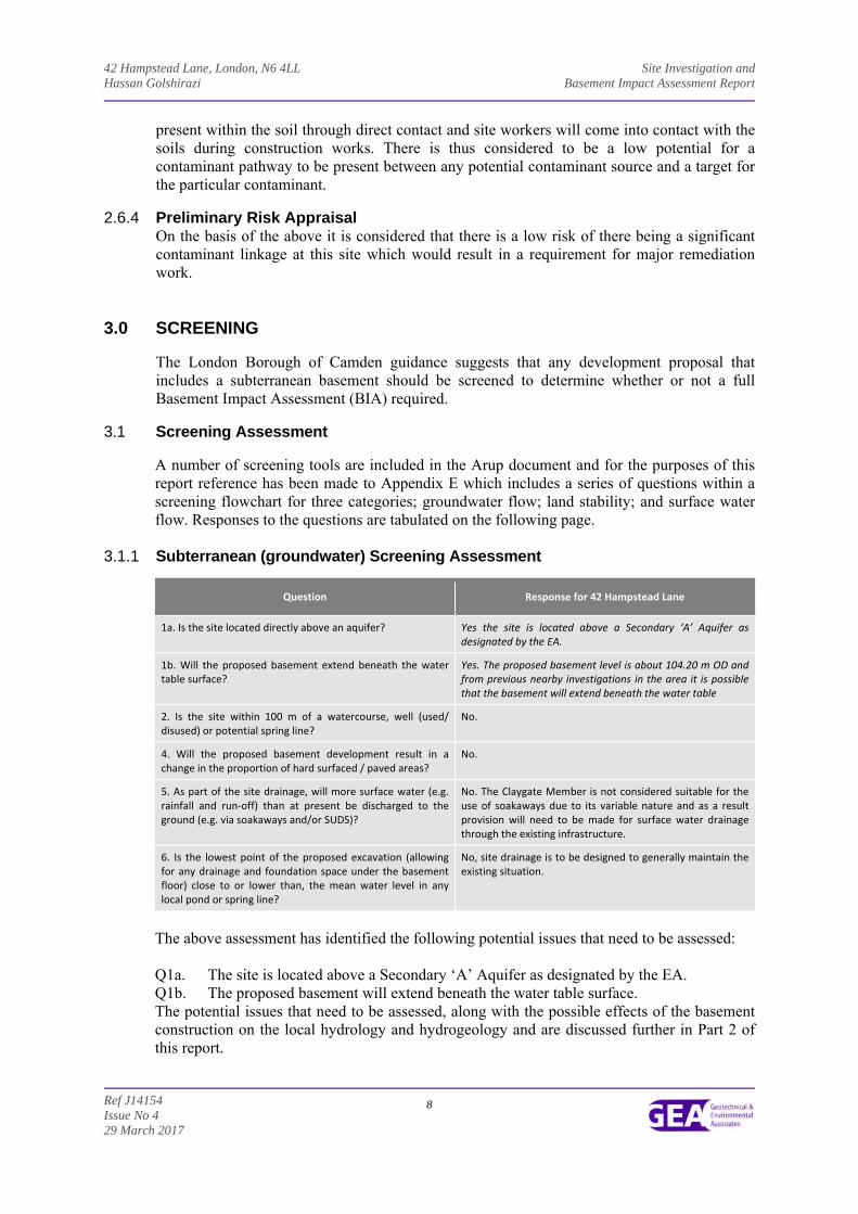
3.1.1 Subterranean (groundwater) Screening Assessment
Question Response for 42 Hampstead Lane
1a. Is the site located directly above an aquifer? Yes the site is located above a Secondary ‘A’ Aquifer as designated by the EA.
1b. Will the proposed basement extend beneath the water table surface?
Yes. The proposed basement level is about 104.20 m OD and from previous nearby investigations in the area it is possible that the basement will extend beneath the water table
2. Is the site within 100 m of a watercourse, well (used/ disused) or potential spring line?
No.
4. Will the proposed basement development result in a change in the proportion of hard surfaced / paved areas?
No.
5. As part of the site drainage, will more surface water (e.g. rainfall and run‐off) than at present be discharged to the ground (e.g. via soakaways and/or SUDS)?
No. The Claygate Member is not considered suitable for the use of soakaways due to its variable nature and as a result provision will need to be made for surface water drainage through the existing infrastructure.
6. Is the lowest point of the proposed excavation (allowing for any drainage and foundation space under the basement floor) close to or lower than, the mean water level in any local pond or spring line?
No, site drainage is to be designed to generally maintain the existing situation.
The above assessment has identified the following potential issues that need to be assessed: Q1a. The site is located above a Secondary ‘A’ Aquifer as designated by the EA. Q1b. The proposed basement will extend beneath the water table surface. The potential issues that need to be assessed, along with the possible effects of the basement construction on the local hydrology and hydrogeology and are discussed further in Part 2 of this report.
42 Hampstead Lane, London, N6 4LL Site Investigation and Hassan Golshirazi Basement Impact Assessment Report
Ref J14154 Issue No 4 29 March 2017
9
3.1.2 Stability Screening Assessment
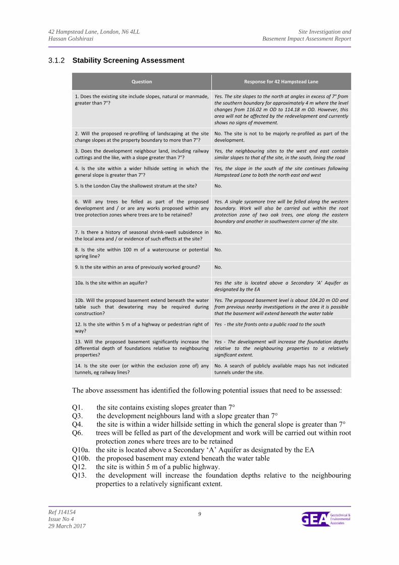
Question Response for 42 Hampstead Lane
1. Does the existing site include slopes, natural or manmade, greater than 7°?
Yes. The site slopes to the north at angles in excess of 7° from the southern boundary for approximately 4 m where the level changes from 116.02 m OD to 114.18 m OD. However, this area will not be affected by the redevelopment and currently shows no signs of movement.
2. Will the proposed re‐profiling of landscaping at the site change slopes at the property boundary to more than 7°?
No. The site is not to be majorly re‐profiled as part of the development.
3. Does the development neighbour land, including railway cuttings and the like, with a slope greater than 7°?
Yes, the neighbouring sites to the west and east contain similar slopes to that of the site, in the south, lining the road
4. Is the site within a wider hillside setting in which the general slope is greater than 7°?
Yes, the slope in the south of the site continues following Hampstead Lane to both the north east and west
5. Is the London Clay the shallowest stratum at the site? No.
6. Will any trees be felled as part of the proposed development and / or are any works proposed within any tree protection zones where trees are to be retained?
Yes. A single sycamore tree will be felled along the western boundary. Work will also be carried out within the root protection zone of two oak trees, one along the eastern boundary and another in southwestern corner of the site.
7. Is there a history of seasonal shrink‐swell subsidence in the local area and / or evidence of such effects at the site?
No.
8. Is the site within 100 m of a watercourse or potential spring line?
No.
9. Is the site within an area of previously worked ground? No.
10a. Is the site within an aquifer? Yes the site is located above a Secondary ‘A’ Aquifer as designated by the EA
10b. Will the proposed basement extend beneath the water table such that dewatering may be required during construction?
Yes. The proposed basement level is about 104.20 m OD and from previous nearby investigations in the area it is possible that the basement will extend beneath the water table
12. Is the site within 5 m of a highway or pedestrian right of way?
Yes ‐ the site fronts onto a public road to the south
13. Will the proposed basement significantly increase the differential depth of foundations relative to neighbouring properties?
Yes ‐ The development will increase the foundation depths relative to the neighbouring properties to a relatively significant extent.
14. Is the site over (or within the exclusion zone of) any tunnels, eg railway lines?
No. A search of publicly available maps has not indicated tunnels under the site.
The above assessment has identified the following potential issues that need to be assessed: Q1. the site contains existing slopes greater than 7° Q3. the development neighbours land with a slope greater than 7° Q4. the site is within a wider hillside setting in which the general slope is greater than 7° Q6. trees will be felled as part of the development and work will be carried out within root
protection zones where trees are to be retained Q10a. the site is located above a Secondary ‘A’ Aquifer as designated by the EA Q10b. the proposed basement may extend beneath the water table Q12. the site is within 5 m of a public highway. Q13. the development will increase the foundation depths relative to the neighbouring
properties to a relatively significant extent.
42 Hampstead Lane, London, N6 4LL Site Investigation and Hassan Golshirazi Basement Impact Assessment Report
Ref J14154 Issue No 4 29 March 2017
10
The potential issues that need to be assessed, along with the possible effects of the basement construction on the local hydrology and hydrogeology and are discussed further in Part 2 of this report.
3.1.3 Surface Flow and Flooding Screening Assessment
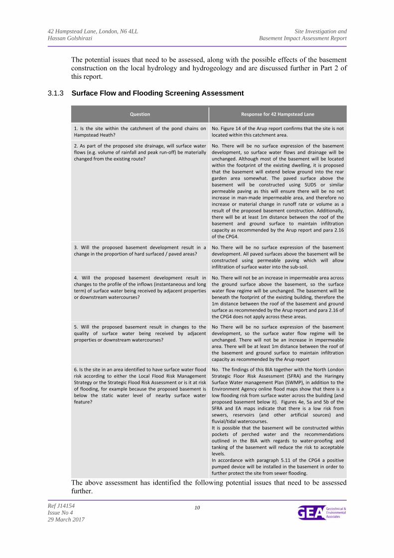
Question Response for 42 Hampstead Lane
1. Is the site within the catchment of the pond chains on Hampstead Heath?
No. Figure 14 of the Arup report confirms that the site is not located within this catchment area.
2. As part of the proposed site drainage, will surface water flows (e.g. volume of rainfall and peak run‐off) be materially changed from the existing route?
No. There will be no surface expression of the basement development, so surface water flows and drainage will be unchanged. Although most of the basement will be located within the footprint of the existing dwelling, it is proposed that the basement will extend below ground into the rear garden area somewhat. The paved surface above the basement will be constructed using SUDS or similar permeable paving as this will ensure there will be no net increase in man‐made impermeable area, and therefore no increase or material change in runoff rate or volume as a result of the proposed basement construction. Additionally, there will be at least 1m distance between the roof of the basement and ground surface to maintain infiltration capacity as recommended by the Arup report and para 2.16 of the CPG4.
3. Will the proposed basement development result in a change in the proportion of hard surfaced / paved areas?
No. There will be no surface expression of the basement development. All paved surfaces above the basement will be constructed using permeable paving which will allow infiltration of surface water into the sub‐soil.
4. Will the proposed basement development result in changes to the profile of the inflows (instantaneous and long term) of surface water being received by adjacent properties or downstream watercourses?
No. There will not be an increase in impermeable area across the ground surface above the basement, so the surface water flow regime will be unchanged. The basement will be beneath the footprint of the existing building, therefore the 1m distance between the roof of the basement and ground surface as recommended by the Arup report and para 2.16 of the CPG4 does not apply across these areas.
5. Will the proposed basement result in changes to thequality of surface water being received by adjacent properties or downstream watercourses?
No There will be no surface expression of the basement development, so the surface water flow regime will be unchanged. There will not be an increase in impermeable area. There will be at least 1m distance between the roof of the basement and ground surface to maintain infiltration capacity as recommended by the Arup report
6. Is the site in an area identified to have surface water flood risk according to either the Local Flood Risk Management Strategy or the Strategic Flood Risk Assessment or is it at risk of flooding, for example because the proposed basement is below the static water level of nearby surface water feature?
No. The findings of this BIA together with the North London Strategic Floor Risk Assessment (SFRA) and the Haringey Surface Water management Plan (SWMP), in addition to the Environment Agency online flood maps show that there is a low flooding risk from surface water across the building (and proposed basement below it). Figures 4e, 5a and 5b of the SFRA and EA maps indicate that there is a low risk from sewers, reservoirs (and other artificial sources) and fluvial/tidal watercourses. It is possible that the basement will be constructed within pockets of perched water and the recommendations outlined in the BIA with regards to water‐proofing and tanking of the basement will reduce the risk to acceptable levels. In accordance with paragraph 5.11 of the CPG4 a positive pumped device will be installed in the basement in order to further protect the site from sewer flooding.
The above assessment has identified the following potential issues that need to be assessed further.

42 Hampstead Lane, London, N6 4LL Site Investigation and Hassan Golshirazi Basement Impact Assessment Report
Ref J14154 Issue No 4 29 March 2017
11
Q4. the proposed basement development may result in changes to the profile of the inflows (instantaneous and long term) of surface water being received by adjacent properties or downstream watercourses
Q5. the proposed basement may result in changes to the quantity of surface water being received by adjacent properties or downstream watercourses
4.0 SCOPING AND SITE INVESTIGATION
The purpose of scoping is to assess in more detail the factors to be investigated in the impact assessment. Potential impacts are assessed for each of the identified potential impact factors. The potential impacts of the proposed development on surface flow and flooding and subterranean flow will need to be dealt with in separate assessments, such that the following section focuses on the potential impacts that may have an impact on slope stability.
4.1 Potential Impacts
The following potential impacts have been identified.
Potential Impact Consequence
The site contains slopes of greater than 7° Local instability within the site and adjoining sites may occur
The development neighbours land with a slope greater than 7°
the site is within a wider hillside setting in which the general slope is greater than 7°
Site within 5 m of a highway or pedestrian right of way. Excavation of a basement may result in structural damage to the road or footway. However, the proposed basement will not extend to within 5.0 m of the public paths and highways to the south of the site. Therefore it is unlikely that any movement would be caused by the development.
Founding depths relative to neighbours. If not designed and constructed appropriately, the excavation of a basement may result in structural damage to neighbouring buildings and structures.
The site is located above a Secondary ‘A’ Aquifer as designated by the EA.
The proposed basement level may be below the water table and this could increase flow paths and/or raise groundwater levels locally.
The proposed basement will extend beneath the water table
The proposed basement development result in changes to the profile of the inflows (instantaneous and long term) of surface water being received by adjacent properties or downstream watercourses
Changes could result in decreased volume, which may affect ecosystems or reduce amenity, or increased flow which may additionally increase the risk of flooding.
A tree will be felled as part of the proposed development and works are proposed within a tree protection zone
The removal of the tree and root systems may result in a recovery of a soil moisture deficit caused by the uptake of water by roots. In the low to moderate plasticity of the Bagshot Formation and Claygate Member this will result in gradual swelling of the ground which may affect slope stability. In additional, the roots of the trees may have a binding effect on the soil which will be lost if the roots are removed.
These potential impacts have been investigated through the site investigation, as detailed in Section 9.0.
42 Hampstead Lane, London, N6 4LL Site Investigation and Hassan Golshirazi Basement Impact Assessment Report
Ref J14154 Issue No 4 29 March 2017
12
4.2 Exploratory Work The scope of the works was specified by the consulting engineers, with input from GEA. In order to meet the objectives described in Section 1.2, two boreholes were drilled by means of a cable percussion rig to a maximum depth of 25 m. In addition, two boreholes were drilled using an opendrive sampling rig, to a depth of 8 m. The boreholes were supplemented by the excavation of three hand excavated trial pits to expose the existing foundations. During boring disturbed and undisturbed samples were obtained from the boreholes for subsequent laboratory examination and testing. Standard Penetration Tests (SPTs) were carried out at regular intervals to provide additional quantitative data on the strength of soils encountered. A selection of the samples recovered from the boreholes was submitted to a soil mechanics laboratory for a programme of geotechnical testing and an analytical laboratory for a programme of contamination testing. All of the above work was carried out under the supervision of a geotechnical engineer from GEA.
The borehole records and results of the contamination laboratory testing are appended, together with a site plan indicating the exploratory positions. The Ordnance Datum (OD) levels indicated on the borehole and trial pit records and quoted within the report have been interpreted from spot heights shown on a topographical survey drawing provided by the consulting engineers (ref. 13/1769, dated August 2013).
4.3 Sampling Strategy
The boreholes were positioned on site by GEA with input from the consulting engineers, in accessible areas whilst avoiding areas of buried services. Three groundwater monitoring standpipes were installed within the boreholes to a maximum depth of 10.00 m, in order to facilitate future monitoring. Each has been monitored on two occasions, approximately one week and two weeks after installation. Six samples of the made ground have been sent for chemical analyses. The analytical suite of testing was selected to identify hydrocarbon contamination resulting from the former use of the site and a range of typical industrial contaminants for the purposes of general coverage. For this investigation the analytical suite for the soil included a range of metals, speciation of total petroleum hydrocarbons (TPH), polycyclic aromatic hydrocarbons (PAH), total cyanide and monohydric phenols. The contamination analyses were carried out at an MCERTs accredited laboratory with the majority of the testing suite accredited to MCERTS standards. A summary of the MCERTs accreditation and test methods are included with the attached results and further details are available upon request. The contamination analyses were carried out at an MCERTs accredited laboratory with the majority of the testing suite accredited to MCERTS standards. Details of the MCERTs accreditation and test methods are included in the Appendix together with the analytical results.
42 Hampstead Lane, London, N6 4LL Site Investigation and Hassan Golshirazi Basement Impact Assessment Report
Ref J14154 Issue No 4 29 March 2017
13
5.0 GROUND CONDITIONS The investigation has generally confirmed the expected ground conditions in that, below a moderate thickness of made ground, the Bagshot Formation was encountered, and was underlain by the Claygate Member which was in turn underlain by the London Clay Formation which extended to the maximum depth of the investigation, of 25.00 m (89.25 m OD). The precise location of the boundary between the Claygate Member and London Clay is often difficult to define due to its gradational contact, and the close similarities in composition and geotechnical properties of each stratum. The boundaries have therefore been placed on the attached borehole records as described below, but part of what is described as Claygate Member may in fact comprise Unit D of the London Clay, and vice versa.
5.1 Made Ground
The made ground extended to depths of between 0.50 m (113.75 m OD) and 0.90 m (111.25 m OD) and generally comprised brown silty sandy clay with variable amounts of gravel, brick, concrete, metal, ash and charcoal fragments. Apart from the presence of fragments of extraneous material noted above, no visual or olfactory evidence of contamination was observed during the fieldwork. Six samples of the made ground have been sent for contamination testing and the results will be included in our final report.
5.2 Bagshot Formation
The Bagshot Formation generally comprised firm becoming stiff orange-brown mottled brown and grey silty sandy silty clay which extended to depths of between 2.20 m (109.95 m OD) and 2.60 m (111.65 m OD). However, medium dense orange-brown mottled brown very clayey silty fine to medium sand was encountered within Borehole No 1, and extended to a depth of 4.50 m (109.75 m OD). The results of laboratory plasticity index tests indicate that the clay is of low to moderate volume change potential.
5.3 Claygate Member The Claygate Member initially comprised medium dense brown mottled orange-brown slightly clayey silty fine sand with occasional layers of sandy clay extending to depths of 11.20 m (103.05 m OD) and 10.90 m (103.48 m OD) in Borehole Nos 1 and 2 respectively. Stiff grey silty clay with layers of clayey silt and clayey sand was then encountered and extended to depths of 20.70 m (93.55 m OD) and 19.55 m (94.83 m OD) in Borehole Nos 1 and 2. The results of laboratory plasticity index tests indicate that the clay is of moderate volume change potential.
5.4 London Clay Formation The London Clay Formation generally comprised medium dense grey slightly clayey silt and extended to the full depth of the investigation, of 25.00 m (89.25 m OD).
42 Hampstead Lane, London, N6 4LL Site Investigation and Hassan Golshirazi Basement Impact Assessment Report
Ref J14154 Issue No 4 29 March 2017
14
5.5 Groundwater
Groundwater was initially encountered at depths of between 4.00 m (108.17 m OD) and 8.80 m (105.58 m OD) after which inflows of groundwater was regularly encountered to the full depth of the investigation, of 25.00 m (89.25 m OD). Three groundwater monitoring standpipes were installed and groundwater has subsequently been monitored on two occasions, approximately one week and three weeks after installation, during which groundwater was measured at depths of between 4.32 m (107.83 m OD) and 6.72 m (107.77 m OD). The results of the groundwater monitoring indicate the groundwater to be flowing in a northerly direction with the local topography.
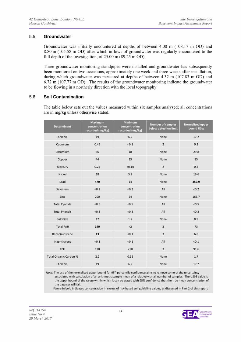
5.6 Soil Contamination
The table below sets out the values measured within six samples analysed; all concentrations are in mg/kg unless otherwise stated.
Determinant Maximum
concentration recorded (mg/kg)
Minimum concentration
recorded (mg/kg)
Number of samples below detection limit
Normalised upper bound US95
Arsenic 19 6.2 None 17.2
Cadmium 0.45 <0.1 2 0.3
Chromium 36 18 None 29.8
Copper 44 13 None 35
Mercury 0.24 <0.10 2 0.2
Nickel 18 5.2 None 16.6
Lead 470 14 None 359.9
Selenium <0.2 <0.2 All <0.2
Zinc 200 24 None 163.7
Total Cyanide <0.5 <0.5 All <0.5
Total Phenols <0.3 <0.3 All <0.3
Sulphide 12 1.2 None 8.9
Total PAH 140 <2 3 73
Benzo(a)pyrene 13 <0.1 3 6.8
Naphthalene <0.1 <0.1 All <0.1
TPH 170 <10 3 91.6
Total Organic Carbon % 2.2 0.52 None 1.7
Arsenic 19 6.2 None 17.2
Note: The use of the normalised upper bound for 95th percentile confidence aims to remove some of the uncertainty associated with calculation of an arithmetic sample mean of a relatively small number of samples. The US95 value is the upper bound of the range within which it can be stated with 95% confidence that the true mean concentration of the data set will fall.
Figure in bold indicates concentration in excess of risk‐based soil guideline values, as discussed in Part 2 of this report
42 Hampstead Lane, London, N6 4LL Site Investigation and Hassan Golshirazi Basement Impact Assessment Report
Ref J14154 Issue No 4 29 March 2017
15
The results of the chemical analyses have indicated elevated US95 concentrations of Lead and a single elevated concentration of total PAH and benzo(a)pyrene.
5.5.1 Generic Quantitative Risk Assessment The use of a risk-based approach has been adopted to provide an initial screening of the test results to assess the need for subsequent site-specific risk assessments. To this end contaminants of concern are those that have values in excess of a generic human health risk based guideline values which are either that of the CLEA5 Soil Guideline Value where available, or is a Generic Guideline Value calculated using the CLEA UK Version 1.06 software assuming a residential with plant uptake end use. The key generic assumptions for this end use are as follows:
that groundwater will not be a critical risk receptor;
that the critical receptor for human health will be young female children aged zero to six years old;
that the exposure duration will be six years;
that the critical exposure pathways will be direct soil and indoor dust ingestion, skin contact with soils and indoor dust, and inhalation of indoor and outdoor dust and vapours; and
that the building type equates to a two-storey small terraced house.
It is considered that these assumptions are acceptable for this generic assessment of this site. The tables of generic screening values derived by GEA and an explanation of how each value has been derived are included in the Appendix. Where contaminant concentrations are measured at concentrations below the generic screening value it is considered that they pose an acceptable level of risk and thus further consideration of these contaminant concentrations is not required. However, where concentrations are measured in excess of these generic screening values there is considered to be a potential that they could pose an unacceptable risk and thus further action will be required which could include; additional testing to zone the extent of the contaminated material and thus reduce the
uncertainty with regard to its potential risk;
site specific risk assessment to refine the assessment criteria and allow an assessment to be made as to whether the concentration present would pose an unacceptable risk at this site; or
soil remediation or risk management to mitigate the risk posed by the contaminant to
a degree that it poses an acceptable risk. The concentrations of the contaminants of concern highlighted by a comparison of the measured concentrations against the generic screening values are tabulated below. This assessment is based upon the potential for risk to human health, which at this site that is underlain by a non-aquifer is considered to be the critical risk receptor.
5 Updated Technical Background to the CLEA Model (Science Report SC050021/SR3) Jan 2009 and Soil Guideline Value reports
for specific contaminants; all DEFRA and Environment Agency.
42 Hampstead Lane, London, N6 4LL Site Investigation and Hassan Golshirazi Basement Impact Assessment Report
Ref J14154 Issue No 4 29 March 2017
16
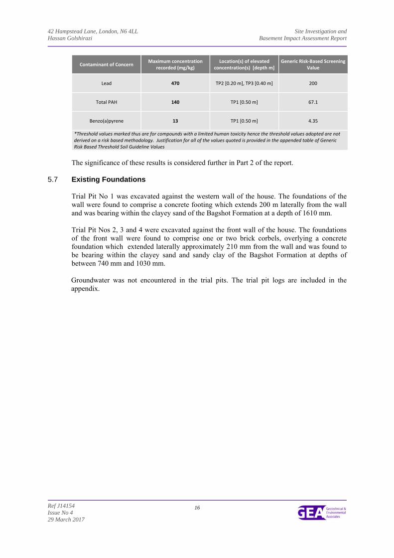
Contaminant of Concern Maximum concentration
recorded (mg/kg) Location(s) of elevated
concentration(s) [depth m] Generic Risk‐Based Screening
Value
Lead 470 TP2 [0.20 m], TP3 [0.40 m] 200
Total PAH 140 TP1 [0.50 m] 67.1
Benzo(a)pyrene 13 TP1 [0.50 m] 4.35
*Threshold values marked thus are for compounds with a limited human toxicity hence the threshold values adopted are not derived on a risk based methodology. Justification for all of the values quoted is provided in the appended table of Generic Risk Based Threshold Soil Guideline Values
The significance of these results is considered further in Part 2 of the report.
5.7 Existing Foundations
Trial Pit No 1 was excavated against the western wall of the house. The foundations of the wall were found to comprise a concrete footing which extends 200 m laterally from the wall and was bearing within the clayey sand of the Bagshot Formation at a depth of 1610 mm. Trial Pit Nos 2, 3 and 4 were excavated against the front wall of the house. The foundations of the front wall were found to comprise one or two brick corbels, overlying a concrete foundation which extended laterally approximately 210 mm from the wall and was found to be bearing within the clayey sand and sandy clay of the Bagshot Formation at depths of between 740 mm and 1030 mm. Groundwater was not encountered in the trial pits. The trial pit logs are included in the appendix.
42 Hampstead Lane, London, N6 4LL Site Investigation and Hassan Golshirazi Basement Impact Assessment Report
Ref J14154 Issue No 4 29 March 2017
17
Part 2: DESIGN BASIS REPORT This section of the report provides an interpretation of the findings detailed in Part 1, in the form of a ground model, and then provides advice and recommendations with respect to the basement excavation and the potential impact on the hydrogeology. 6.0 INTRODUCTION
It is understood that consideration is being given to the redevelopment of the site through the demolition of the existing building and the subsequent construction of a new three-storey house with a lower ground floor level and a single level basement beneath the entire footprint of the building, which is to include a swimming pool. The lower ground floor will be formed at a level of 1110.17 m OD while the basement level will extend to a level of 105.80 m OD and the swimming pool will extend to a level of 104.20 m OD.
7.0 GROUND MODEL
The desk study has revealed that the site has not had a potentially contaminative historical use as the site has been developed with the existing house for its entire developed history, and on the basis of the fieldwork, the ground conditions at this site can be characterised as follows: The investigation encountered a moderate thickness of made ground over the Bagshot
Formation, which was underlain by the Claygate Member, which overlies the London Clay Formation;
the made ground extends to depths of between 0.50 m and 0.90 m and is generally
comprised of brown silty sandy clay with variable amounts of gravel, brick, concrete, metal, ash and charcoal fragments;
the Bagshot Formation initially comprises firm becoming stiff orange-brown mottled
brown and grey silty sandy silty clay which extends to depths of between 2.20 m (109.95 m OD) and 2.60 m (111.65 m OD);
medium dense orange-brown mottled brown very clayey silty fine to medium sand is then present within Borehole No 1, and extends to a depth of 4.50 m (109.75 m OD);
the Claygate Member initially comprises medium dense brown mottled orange-brown slightly clayey silty fine sand with occasional layers of sandy clay extending to depths of 11.20 m (103.05 m OD) and 10.90 m (103.48 m OD)
stiff grey silty clay with layers of clayey silt and clayey sand is then present and extends to depths of 20.70 m (93.55 m OD) and 19.55 m (94.83 m OD);
soils interpreted as the London Clay Formation generally comprise medium dense grey slightly clayey silt extending to the full depth of the investigation, of 25.00 m (89.25 m OD); and
groundwater is present in the more granular layers below a level of 107.83 m OD and
107.65 m OD.
42 Hampstead Lane, London, N6 4LL Site Investigation and Hassan Golshirazi Basement Impact Assessment Report
Ref J14154 Issue No 4 29 March 2017
18
8.0 ADVICE AND RECOMMENDATIONS
The proposed development will, it is understood, be supported by piled foundations and column loads of the development are anticipated to range between 330 kN and 2255 kN. It is understood that the new basement will extend to a maximum depth of 10.19 m (104.20 m OD) below ground level and formation level for the proposed basement is likely to be within the Claygate Member. On the basis of the fieldwork and subsequent monitoring, groundwater is likely to be encountered within the basement excavation.
8.1 Basement Construction 8.1.1 Basement Excavations
It is understood that it is proposed to excavate both a lower ground floor and a basement level, which will also contain a swimming pool and will extend beneath the entire building, to a depth of 8.59 m (105.80 m OD) and more locally, in the area of the proposed swimming pool, to a depth of 10.19 m (104.20 m OD); formation level should therefore be within the Claygate Member.
Groundwater inflows were encountered at depths of between 4.00 m (108.17 m OD) and 8.80 m (105.58 m OD) and subsequent monitoring has indicated groundwater at levels of between 107.83 m OD and 107.65 m OD. On this basis groundwater is likely to be encountered within the basement excavation and at variable depths, although monitoring of the standpipes should be continued to establish equilibrium levels and determine the extent of any seasonal fluctuations. It would also be prudent to carry out rising head tests within the standpipes to establish the rate of rise in groundwater and permeability of the underlying Claygate Member. Groundwater is likely to be present within the Claygate Member as discrete pockets of water rather than in continuous layers. Each individual pocket may therefore be of relatively low volume and individual inflows may cease once the pocket is emptied. However, as the basement excavation will cover a much larger area than that covered by the investigation, it is possible that larger pockets or inter-connected layers of groundwater could be encountered. It would therefore be prudent, once access is available, to carry out a number of trial excavations, to depths as close to the full basement depth as possible, to provide an indication of the likely groundwater conditions. It is likely that the rate of inflow will be relatively slow within the Claygate Member, although it is recommended that the chosen contractor has a contingency plan in place to deal with more significant or prolonged inflows as a precautionary measure if a watertight temporary retention scheme is not adopted.
The design of basement support in the temporary and permanent conditions needs to take account of the need to maintain the stability of the excavation and surrounding structures, namely the neighbouring houses to both the east and west, and to protect against groundwater inflows. A sheet piled wall could be used as a temporary measure, prior to the construction of a permanent retaining wall, although the noise and vibrations associated with the installation of sheet piles maybe unacceptable, unless a “silent” installation method is adopted. Consideration could be given to using pressing techniques, although pressing techniques that use water jetting should be treated with caution in view of the risk of causing heave or settlement of the surrounding structures.
42 Hampstead Lane, London, N6 4LL Site Investigation and Hassan Golshirazi Basement Impact Assessment Report
Ref J14154 Issue No 4 29 March 2017
19
Alternatively consideration could be given to the use of a bored pile wall, which would have the advantage of being incorporated into the permanent works and will be able to provide support for structural loads. Although the monitoring carried out to date would suggest that groundwater will be encountered within the excavation, it may be possible to adopt a contiguous bored pile wall with the use of localised grouting and sump pumping if necessary in order to deal with any groundwater inflows. If however trial excavations indicate that groundwater cannot be adequately controlled through localised grouting and sump pumping, then a secant bored pile wall will be required, which has the advantage of maximising the usable space within the basement area as it could overcome the requirement for any secondary groundwater protection in the permanent works. At this stage it is considered that a secant wall is likely to be the most appropriate solution.
The ground movements associated with the basement excavation will depend on the method of excavation and support and the overall stiffness of the basement structure in the temporary condition. Thus, a suitable amount of propping will be required to provide the necessary rigidity. In this respect the timing of the provision of support to the wall will have an important effect on movements. An assessment of the ground movements associated with the basement excavation may be required as part of the planning process or could be completed as design progresses.
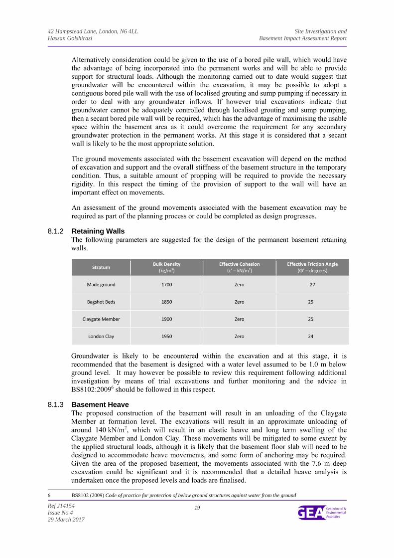
8.1.2 Retaining Walls
The following parameters are suggested for the design of the permanent basement retaining walls.
Stratum Bulk Density
(kg/m3) Effective Cohesion
(c’ – kN/m2) Effective Friction Angle
(Φ’ – degrees)
Made ground 1700 Zero 27
Bagshot Beds 1850 Zero 25
Claygate Member 1900 Zero 25
London Clay 1950 Zero 24
Groundwater is likely to be encountered within the excavation and at this stage, it is recommended that the basement is designed with a water level assumed to be 1.0 m below ground level. It may however be possible to review this requirement following additional investigation by means of trial excavations and further monitoring and the advice in BS8102:20096 should be followed in this respect.
8.1.3 Basement Heave The proposed construction of the basement will result in an unloading of the Claygate Member at formation level. The excavations will result in an approximate unloading of around 140 kN/m2, which will result in an elastic heave and long term swelling of the Claygate Member and London Clay. These movements will be mitigated to some extent by the applied structural loads, although it is likely that the basement floor slab will need to be designed to accommodate heave movements, and some form of anchoring may be required. Given the area of the proposed basement, the movements associated with the 7.6 m deep excavation could be significant and it is recommended that a detailed heave analysis is undertaken once the proposed levels and loads are finalised.
6 BS8102 (2009) Code of practice for protection of below ground structures against water from the ground
42 Hampstead Lane, London, N6 4LL Site Investigation and Hassan Golshirazi Basement Impact Assessment Report
Ref J14154 Issue No 4 29 March 2017
20
8.2 Spread Foundations
The excavation of the basement will result in a formation level in the Claygate Member and it should be possible to adopt moderate width pad or strip foundations in the firm clay, designed to apply a net allowable bearing pressure of 150 kN/m2 below the level of the proposed basement floor. It is unlikely that it will be possible to attain the required depths without encountering groundwater inflows, and if inflows are such that spread foundations cannot be utilised, then recourse should be made to the use of a piled foundation solution.
8.3 Piled Foundations
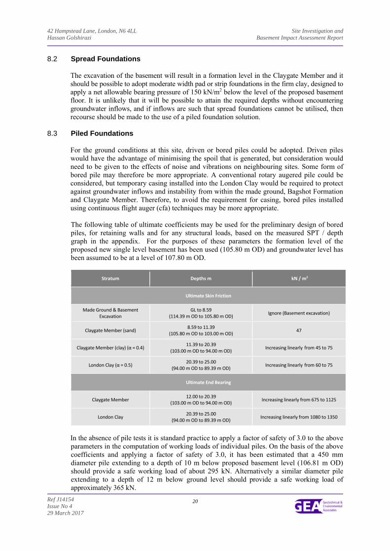
For the ground conditions at this site, driven or bored piles could be adopted. Driven piles would have the advantage of minimising the spoil that is generated, but consideration would need to be given to the effects of noise and vibrations on neighbouring sites. Some form of bored pile may therefore be more appropriate. A conventional rotary augered pile could be considered, but temporary casing installed into the London Clay would be required to protect against groundwater inflows and instability from within the made ground, Bagshot Formation and Claygate Member. Therefore, to avoid the requirement for casing, bored piles installed using continuous flight auger (cfa) techniques may be more appropriate. The following table of ultimate coefficients may be used for the preliminary design of bored piles, for retaining walls and for any structural loads, based on the measured SPT / depth graph in the appendix. For the purposes of these parameters the formation level of the proposed new single level basement has been used (105.80 m OD) and groundwater level has been assumed to be at a level of 107.80 m OD.
Stratum Depths m kN / m2
Ultimate Skin Friction
Made Ground & Basement Excavation
GL to 8.59 (114.39 m OD to 105.80 m OD)
Ignore (Basement excavation)
Claygate Member (sand) 8.59 to 11.39
(105.80 m OD to 103.00 m OD) 47
Claygate Member (clay) (α = 0.4) 11.39 to 20.39
(103.00 m OD to 94.00 m OD) Increasing linearly from 45 to 75
London Clay (α = 0.5) 20.39 to 25.00
(94.00 m OD to 89.39 m OD) Increasing linearly from 60 to 75
Ultimate End Bearing
Claygate Member 12.00 to 20.39
(103.00 m OD to 94.00 m OD) Increasing linearly from 675 to 1125
London Clay 20.39 to 25.00
(94.00 m OD to 89.39 m OD) Increasing linearly from 1080 to 1350
In the absence of pile tests it is standard practice to apply a factor of safety of 3.0 to the above parameters in the computation of working loads of individual piles. On the basis of the above coefficients and applying a factor of safety of 3.0, it has been estimated that a 450 mm diameter pile extending to a depth of 10 m below proposed basement level (106.81 m OD) should provide a safe working load of about 295 kN. Alternatively a similar diameter pile extending to a depth of 12 m below ground level should provide a safe working load of approximately 365 kN.
42 Hampstead Lane, London, N6 4LL Site Investigation and Hassan Golshirazi Basement Impact Assessment Report
Ref J14154 Issue No 4 29 March 2017
21
The above examples are not intended to constitute any form of recommendation with regard to pile size or type, but merely serve to illustrate the use of the above coefficients. Specialist piling contractors should be consulted with regard to the design of an appropriate piling scheme, and their attention should be drawn to the presence of groundwater within the Claygate Member.
8.4 Shallow Excavations
On the basis of the trial pit findings it is considered likely that it will be feasible to form relatively shallow excavations terminating within the made ground, Bagshot Formation and upper horizons of the Claygate Member without the requirement for lateral support, although localised instabilities may occur. Where personnel are required to enter excavations, a risk assessment should be carried out and temporary lateral support or battering of the excavation sides considered in order to comply with normal safety requirements. Significant inflows of groundwater into shallow excavations are not generally anticipated, although seepages may be encountered from perched water tables within the made ground or from within more sandy horizons within the Bagshot Formation, although such inflows should be suitably controlled by sump pumping. However, if deeper excavations are considered or if excavations are to remain open for prolonged periods it is recommended that provision be made for battered side slopes or lateral support. Where personnel are required to enter excavations, a risk assessment should be carried out and temporary lateral support or battering of the excavation sides considered in order to comply with normal safety requirements.
8.5 Basement Floor Slab
Following the excavation of the basement, it is likely that the floor slab for the proposed basement will need to be suspended over a void or layer of suitable compressible material to accommodate the anticipated heave unless the slab can be suitably reinforced to cope with these movements. In addition, consideration may also need to be given to designing the basement to cope with water pressure below the slab. Further consideration will need to be given to these issues once the levels and magnitude of any slab loading are known.
8.6 Effect of Sulphates
Chemical analyses has revealed relatively low concentrations of soluble sulphate and near-neutral pH in accordance with Class DS-2 conditions of Table C2 of BRE Special Digest 1:SD Third Edition (2005). The measured pH values of the samples show that an ACES class of AC-2 would be appropriate for the site. This assumes a mobile water condition at the site. The guidelines contained in the above digest should be followed in the design of foundation concrete.
8.7 Site Specific Risk Assessment The desk study research has indicated that the site has not had a potentially contaminative history, having been occupied by the existing house throughout its developed history.
The chemical analyses have highlighted the presence of elevated concentrations of lead within two of the six samples of made ground tested. These concentrations could pose a potentially unacceptable risk to human health through direct contact, accidental ingestion or inhalation of soil or soil derived dust.
42 Hampstead Lane, London, N6 4LL Site Investigation and Hassan Golshirazi Basement Impact Assessment Report
Ref J14154 Issue No 4 29 March 2017
22
The source of the lead contamination is not known but the made ground was noted to contain fragments of extraneous material throughout the site, and it is likely that fragments of such material, for example old paint fragments, may have been present within the samples tested, accounting for the elevated concentrations. Further assessment of the PAH concentrations indicates that the contamination encountered is probably of a pyrogenic origin, and is typical of made ground containing ash, partly burnt coal, coal tar or pre-war tarmac. Additionally, specific portions of individual PAHs are indicative of the material being degraded bitumen. The made ground throughout the site was noted as containing fragments of ash and other extraneous material and it is likely that such fragments were present within the samples tested, accounting for the elevated concentrations. Both the lead and PAH contamination, including benzo(a)pyrene, is therefore considered unlikely to be in a soluble form, such that a risk to groundwater or adjacent sites is not envisaged. The underlying London Clay is classed as a non-aquifer and an Unproductive Stratum and therefore contamination to chalk aquifer at depth is not anticipated. It is proposed to construct a basement beneath the footprint of the proposed building and some of the rear garden, with the front driveway being maintained as an area of hardstanding and as a results the excavation of the basement will remove much of the contaminated soil, while in the front driveway, the hardstanding would provide a barrier between the contaminated soil and end users. In the rear garden, some areas of soft landscaping are to remain, and in these areas a risk will be posed to end users, through a direct contact pathway.
8.7.1 End Users 8.7.1.1 Direct Contact
End users will be effectively isolated from direct contact with the identified contaminants by the extent of buildings and areas of external hardstanding. Only in garden areas could end users conceivably come into direct contact with the contaminated soils and suitable precautions will need to be taken in these areas to protect end users and to allow successful plant growth. At this stage it is recommended that a cover thickness of imported subsoil and topsoil of 600 mm in thickness should be specified to ensure successful plant growth, in accordance with recommendations from BRE7. It may be possible to reduce the final thickness of cover required, but this will need to be determined once final levels have been established and the concentrations of potential contaminants within the imported material is known
8.7.2 Site Workers
Site workers should be made aware of the contamination and a programme of working should be identified to protect workers handling any soil. The method of site working should be in accordance with guidelines set out by HSE and CIRIA8 and the requirements of the Local Authority Environmental Health Officer.
8.7.3 Buried Services Consideration may need to be given to the protection of buried plastic services if they are to be laid within the made ground which is rich in ash. Details of the proposed protection measures for buried plastic services will in any case need to be approved by the EHO and the relevant service authority prior to the adoption of any scheme. It is possible that unless any such ash rich material is to be removed from service trenches that barrier pipe may be required or that additional testing will need to be carried out to satisfy the Water Authority.
7 BRE (2004) Cover systems for land regeneration. Thickness of cover systems for contaminated land. BRE pub 465 8 CIRIA (1996) A guide for safe working on contaminated sites - Report 132, Construction Industry Research and Information
Association
42 Hampstead Lane, London, N6 4LL Site Investigation and Hassan Golshirazi Basement Impact Assessment Report
Ref J14154 Issue No 4 29 March 2017
23
8.9 Waste Disposal
Under the European Waste Directive, waste is classified as being either Hazardous or Non-Hazardous and landfills receiving waste are classified as accepting hazardous or non-hazardous wastes or the non-hazardous sub-category of inert waste in accordance with the Waste Directive. Waste classification is a staged process and this investigation represents the preliminary sampling exercise of that process. Once the extent and location of the waste that is to be removed has been defined, further sampling and testing may be necessary. The results from this ground investigation should be used to help define the sampling plan for such further testing, which could include WAC leaching tests where the totals analysis indicates the soil to be a hazardous waste or inert waste from a contaminated site. It should however be noted that the Environment Agency guidance WM39 states that landfill WAC analysis, specifically leaching test results, must not be used for waste classification purposes. Any spoil arising from excavations or landscaping works, which is not to be re-used in accordance with the CL:AIRE10 guidance, will need to be disposed of to a licensed tip. Waste going to landfill is subject to landfill tax at either the standard rate of £ £84.40 per tonne (about £150 per m3) or at the lower rate of £2.65 per tonne (roughly £5 per m3). However, the classifications for tax purposes and disposal purposes differ and currently all made ground and topsoil is taxable at the ‘standard’ rate and only naturally occurring soil and stones, which are accurately described as such in terms of the 2011 Order, would qualify for the ‘lower rate’ of landfill tax. Based on the technical guidance provided by the Environment Agency it is considered likely that the soils encountered during this ground investigation, as represented by the chemical analyses carried out, would be generally classified as follows;
Soil Type Waste Classification
(Waste Code) WAC Testing Required Prior
to Landfill Disposal? Comments
Made ground Non‐hazardous
(17 05 04) No ‐
Natural soils Inert
(17 05 03) Should not be required but
confirm with receiving landfill ‐
Under the requirements of the European Waste Directive all waste needs to be pre-treated prior to disposal. The pre-treatment process must be physical, thermal, chemical or biological, including sorting. It must change the characteristics of the waste in order to reduce its volume, hazardous nature, facilitate handling or enhance recovery. The waste producer can carry out the treatment but they will need to provide documentation to prove that this has been carried out. Alternatively, the treatment can be carried out by an approved contractor. The Environment Agency has issued a position paper11 which states that in certain circumstances, segregation at source may be considered as pre-treatment and thus excavated material may not have to be treated prior to landfilling if the soils can be segregated onsite prior to excavation by sufficiently characterising the soils insitu prior to excavation. The above opinion with regard to the classification of the excavated soils is provided for guidance only and should be confirmed by the receiving landfill once the soils to be discarded have been identified.
9 Environment Agency 2015. Guidance on the classification and assessment of waste. Technical Guidance WM3 First Edition 10 CL:AIRE March 2011. The Definition of Waste: Development Industry Code of Practice Version 2 11 Environment Agency 23 Oct 2007 Regulatory Position Statement Treating non-hazardous waste for landfill - Enforcing the new
requirement

42 Hampstead Lane, London, N6 4LL Site Investigation and Hassan Golshirazi Basement Impact Assessment Report
Ref J14154 Issue No 4 29 March 2017
24
The local waste regulation department of the Environment Agency (EA) should be contacted to obtain details of tips that are licensed to accept the soil represented by the test results. The tips will be able to provide costs for disposing of this material but may require further testing.
42 Hampstead Lane, London, N6 4LL Site Investigation and Hassan Golshirazi Basement Impact Assessment Report
Ref J14154 Issue No 4 29 March 2017
25
Part 3: GROUND MOVEMENT ANALYSIS This section of the report comprises an analysis of the ground movements arising from the proposed basement and foundation scheme discussed in Part 2 and the information obtained from the investigation, presented in Part 1 of the report.
9.0 INTRODUCTION
The sides of a basement excavation will move to some extent regardless of how they are supported. The movement will typically be both horizontal and vertical and will be influenced by the engineering properties of the ground, groundwater level and flow, the efficiency or stiffness of the retaining walls supporting the basement.
An analysis has been carried out of the likely movements arising from the proposed basement
excavation and the results of this analysis have been used to predict the effect of these movements on surrounding structures.
9.1 Construction Sequence
For the purposes of the ground movement assessment the depth of foundations and heights of sensitive structures have been measured from ground level. The foundations of No 44 Hampstead Lane have been assumed to be at a similar depth to those of No 42 Hampstead Lane, which is a reasonable assumption as the buildings appear of similar age and construction. No 40 Hampstead Lane is known to have a single level basement beneath the entire footprint of the building. The exact depth of the basement is not known but it has been assumed that the basement extends to a depth of about 4.5 m below ground level. Following the demolition of the existing building, it is proposed to install a secant bored pile retaining wall to support the basement excavation. For the purposes of this analysis the toe of the retaining wall has been modelled at a depth of 15.00 m which equates to an embedment depth of approximately half of the retained height, although this is to be confirmed at a later date. Following the installation of the retaining walls it is proposed to advance the excavation to proposed basement level at a depth of about 8.59 m (105.80 m OD) installing suitable temporary propping as the excavation is advanced. Once the excavation has been completed to this depth, the internal piles to support the column loads will be installed and the floor slab will be cast. The basement will then be constructed before casting the lower ground floor slab, which will act as an additional level of propping to support the retaining walls. Following the completion of the basement, the surface structure, a three-storey house, will be constructed above the southern part of the basement. It is assumed that the retaining walls will be adequately laterally propped and the concrete will be cast and adequately cured prior to excavation of the basement. It is assumed that the corners of the excavation will be locally stiffened by cross-bracing or similar and that the new retaining walls will not be cantilevered at any stage during the construction process. The detail of the support provided to adjacent walls is beyond the scope of this report at this stage and the structural engineer will be best placed to agree a methodology with the piling contractor once appointed.
42 Hampstead Lane, London, N6 4LL Site Investigation and Hassan Golshirazi Basement Impact Assessment Report
Ref J14154 Issue No 4 29 March 2017
26
9.2 Ground Movements
An assessment of ground movements within and surrounding the excavation has been undertaken using the X-Disp and P-Disp computer programs licensed from the OASYS suite of geotechnical modelling software from Arup. These programs are commonly used within the ground engineering industry and are considered to be appropriate tools for this analysis. The X-Disp program has been used to predict ground movements likely to arise from the construction of the proposed basement. This includes the settlement of the ground (vertical movement) and the lateral movement of soil behind the proposed retaining walls (horizontal movement). The analysis of potential ground movements within the excavation, as a result of unloading of the underlying soils, has been carried out using the Oasys P-Disp software package and is based on the assumption that the soils behave elastically, which provides a reasonable approximation to soil behaviour at small strains. For the purpose of these analyses, the corners have been defined by x and y coordinates, with the x-direction being approximately west-east and the y-direction being north-south. Vertical movement is in the z-direction. For this movement analysis, the proposed basement excavation has been modelled as a rectangular shaped box, measuring 26.50 m by 25.50 m in maximum extent, which will be formed as an excavation behind a secant bored pile wall and it is the secant pile walls and associated movements that form the focus of the following analysis. It is assumed that suitable propping will be provided during the construction of the basement and in the permanent condition. The full outputs of all the analyses can be provided on request but samples of the output movement contour plots are included within the appendix
9.3 Ground Movements – Surrounding the Basement
9.3.1 Model Used For the X-Disp analysis, the soil movement relationships used for the embedded retaining walls are the default values within CIRIA report C58012, which were derived from a number of historic case studies of the short term movements that result from wall installation and basement excavation. The analysis has adopted the values for ‘installation of a secant pile wall in stiff clay’ when considering the installation of the new retaining walls and ‘excavation in front of a stiff wall in clay’ for the basement excavation, which are considered to be the most appropriate due to the likely construction method to be utilised. The toe of the new retaining wall is assumed to be installed to a depth of 15.00 m below existing ground level. The magnitudes of ground differential movement predicted by the program have been assessed. For the purpose of the analysis the proposed basement has been simplified into a single polygon extending to a depth of 10.19 m, the proposed depth of the swimming pool in the
12 Gaba, A, Simpson, B, Powrie, W and Beadman, D (2003) Embedded retaining walls – guidance for economic design .CIRIA
Report C580.
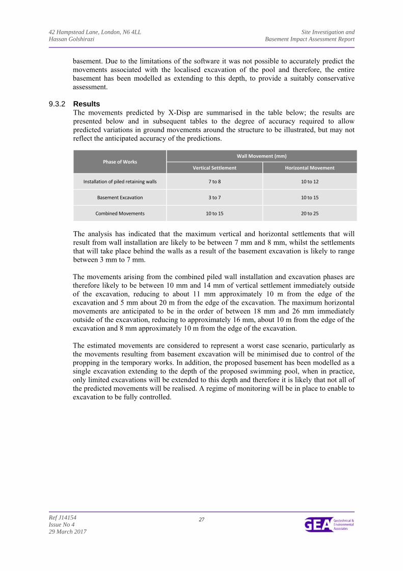
42 Hampstead Lane, London, N6 4LL Site Investigation and Hassan Golshirazi Basement Impact Assessment Report
Ref J14154 Issue No 4 29 March 2017
27
basement. Due to the limitations of the software it was not possible to accurately predict the movements associated with the localised excavation of the pool and therefore, the entire basement has been modelled as extending to this depth, to provide a suitably conservative assessment.
9.3.2 Results The movements predicted by X-Disp are summarised in the table below; the results are presented below and in subsequent tables to the degree of accuracy required to allow predicted variations in ground movements around the structure to be illustrated, but may not reflect the anticipated accuracy of the predictions.
Phase of Works Wall Movement (mm)
Vertical Settlement Horizontal Movement
Installation of piled retaining walls 7 to 8 10 to 12
Basement Excavation 3 to 7 10 to 15
Combined Movements 10 to 15 20 to 25
The analysis has indicated that the maximum vertical and horizontal settlements that will result from wall installation are likely to be between 7 mm and 8 mm, whilst the settlements that will take place behind the walls as a result of the basement excavation is likely to range between 3 mm to 7 mm. The movements arising from the combined piled wall installation and excavation phases are therefore likely to be between 10 mm and 14 mm of vertical settlement immediately outside of the excavation, reducing to about 11 mm approximately 10 m from the edge of the excavation and 5 mm about 20 m from the edge of the excavation. The maximum horizontal movements are anticipated to be in the order of between 18 mm and 26 mm immediately outside of the excavation, reducing to approximately 16 mm, about 10 m from the edge of the excavation and 8 mm approximately 10 m from the edge of the excavation. The estimated movements are considered to represent a worst case scenario, particularly as the movements resulting from basement excavation will be minimised due to control of the propping in the temporary works. In addition, the proposed basement has been modelled as a single excavation extending to the depth of the proposed swimming pool, when in practice, only limited excavations will be extended to this depth and therefore it is likely that not all of the predicted movements will be realised. A regime of monitoring will be in place to enable to excavation to be fully controlled.
42 Hampstead Lane, London, N6 4LL Site Investigation and Hassan Golshirazi Basement Impact Assessment Report
Ref J14154 Issue No 4 29 March 2017
28
9.4 Movements within the Excavation (Heave) 9.4.1 Model Used
At this site unloading of the Claygate Member and underlying London Clay will take place as a result of the basement excavation and the reduction in vertical stress will cause heave to take place. Undrained soil parameters have been used to estimate the potential short term movements, which include the “immediate” or elastic movements as a result of the basement excavation. Drained parameters have been used to provide an estimate of the total long-term movement. The elastic analysis requires values of soil stiffness at various levels to calculate displacements. Values of stiffness for the soils at this site are readily available from published data and we have used a well-established method to provide our estimates. This relates values of Eu and E', the undrained and drained stiffness respectively, to values of undrained cohesion, as described by Padfield and Sharrock13 and Butler14 and more recently by O’Brien and Sharp15. Relationships of Eu = 500 Cu and E’ = 300 Cu for the cohesive soils and 2000 x SPT ‘N’ for granular soils have been used to obtain values of Young’s modulus. More recent published data16 indicates stiffness values of 750 x Cu for the London Clay and a ratio of E’ to Cu of 0.75, but it is considered that the use of the more conservative values provides a sensible approach for this stage in the design. The excavation to proposed lower ground floor level will result in an unloading of between 77.5 kN/m² and 33 kN/m² and the excavation to final basement level will result in a slightly higher unloading of roughly 140 kN/m². The localised excavations for the swimming pool and associated plant will result in a total unloading of 150 kN/m². The unloading due to the demolition of the existing building will result in an unloading of between about 1 kN/m² and 21 kN/m² at proposed lower ground floor level, but will not affect the soils at proposed basement level as the existing loads do not extend to the depth of the proposed basement. The loads of the new building are to be supported by piled foundations and at this stage it is considered that the piles will have a limited effect on the anticipated heave movements, although the retaining wall piles are likely to reduce heave movements at the edges of the excavation. However, in order to provide a conservative assessment, the effect of the piles has not been included within the analysis. A rigid boundary for the analysis has been set at a depth of 52 m (62 m OD) below existing ground level, which is the maximum depth to which the London Clay was proved in the nearby BGS records.
13 Padfield CJ and Sharrock MJ (1983) Settlement of structures on clay soils. CIRIA Special Publication 27 14 Butler FG (1974) Heavily overconsolidated clays: a state of the art review. Proc Conf Settlement of Structures, Cambridge, 531-
578, Pentech Press, Lond 15 O’Brien AS and Sharp P (2001) Settlement and heave of overconsolidated clays - a simplified non-linear method. Part Two,
Ground Engineering, Nov 2001, 48-53 16 Burland JB, Standing, JR, and Jardine, FM (2001) Building response to tunnelling, case studies from construction of the Jubilee
Line Extension. CIRIA Special Publication 200
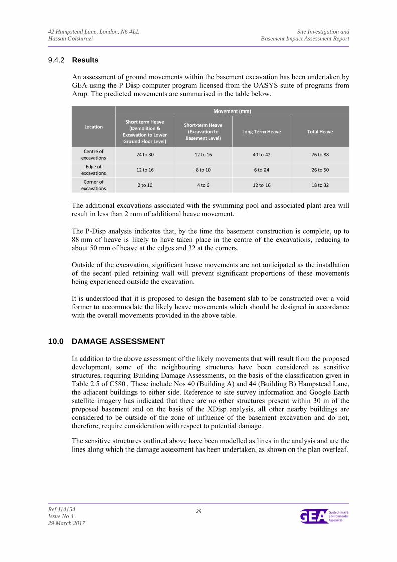
42 Hampstead Lane, London, N6 4LL Site Investigation and Hassan Golshirazi Basement Impact Assessment Report
Ref J14154 Issue No 4 29 March 2017
29
9.4.2 Results An assessment of ground movements within the basement excavation has been undertaken by GEA using the P-Disp computer program licensed from the OASYS suite of programs from Arup. The predicted movements are summarised in the table below.
Location
Movement (mm)
Short term Heave (Demolition &
Excavation to Lower Ground Floor Level)
Short‐term Heave (Excavation to Basement Level)
Long Term Heave Total Heave
Centre of excavations
24 to 30 12 to 16 40 to 42 76 to 88
Edge of excavations
12 to 16 8 to 10 6 to 24 26 to 50
Corner of excavations
2 to 10 4 to 6 12 to 16 18 to 32
The additional excavations associated with the swimming pool and associated plant area will result in less than 2 mm of additional heave movement. The P-Disp analysis indicates that, by the time the basement construction is complete, up to 88 mm of heave is likely to have taken place in the centre of the excavations, reducing to about 50 mm of heave at the edges and 32 at the corners. Outside of the excavation, significant heave movements are not anticipated as the installation of the secant piled retaining wall will prevent significant proportions of these movements being experienced outside the excavation. It is understood that it is proposed to design the basement slab to be constructed over a void former to accommodate the likely heave movements which should be designed in accordance with the overall movements provided in the above table.
10.0 DAMAGE ASSESSMENT In addition to the above assessment of the likely movements that will result from the proposed development, some of the neighbouring structures have been considered as sensitive structures, requiring Building Damage Assessments, on the basis of the classification given in Table 2.5 of C580 . These include Nos 40 (Building A) and 44 (Building B) Hampstead Lane, the adjacent buildings to either side. Reference to site survey information and Google Earth satellite imagery has indicated that there are no other structures present within 30 m of the proposed basement and on the basis of the XDisp analysis, all other nearby buildings are considered to be outside of the zone of influence of the basement excavation and do not, therefore, require consideration with respect to potential damage.
The sensitive structures outlined above have been modelled as lines in the analysis and are the lines along which the damage assessment has been undertaken, as shown on the plan overleaf.
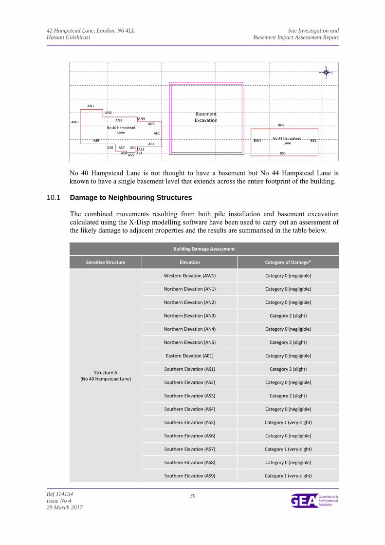
42 Hampstead Lane, London, N6 4LL Site Investigation and Hassan Golshirazi Basement Impact Assessment Report
Ref J14154 Issue No 4 29 March 2017
30
No 40 Hampstead Lane is not thought to have a basement but No 44 Hampstead Lane is known to have a single basement level that extends across the entire footprint of the building.
10.1 Damage to Neighbouring Structures The combined movements resulting from both pile installation and basement excavation calculated using the X-Disp modelling software have been used to carry out an assessment of the likely damage to adjacent properties and the results are summarised in the table below.
Building Damage Assessment
Sensitive Structure Elevation Category of Damage*
Structure A (No 40 Hampstead Lane)
Western Elevation (AW1) Category 0 (negligible)
Northern Elevation (AN1) Category 0 (negligible)
Northern Elevation (AN2) Category 0 (negligible)
Northern Elevation (AN3) Category 2 (slight)
Northern Elevation (AN4) Category 0 (negligible)
Northern Elevation (AN5) Category 2 (slight)
Eastern Elevation (AE1) Category 0 (negligible)
Southern Elevation (AS1) Category 2 (slight)
Southern Elevation (AS2) Category 0 (negligible)
Southern Elevation (AS3) Category 2 (slight)
Southern Elevation (AS4) Category 0 (negligible)
Southern Elevation (AS5) Category 1 (very slight)
Southern Elevation (AS6) Category 0 (negligible)
Southern Elevation (AS7) Category 1 (very slight)
Southern Elevation (AS8) Category 0 (negligible)
Southern Elevation (AS9) Category 1 (very slight)
No 40 Hampstead Lane
Basement Excavation AW1
No 44 Hampstead Lane
AN1
AN2
AN3 AN4
AN5
AE1
AS1 BW1AS9
AS6
AS8 AS7
AS5
AS3
AS4 AS2
BN1
BE1
BS1
42 Hampstead Lane, London, N6 4LL Site Investigation and Hassan Golshirazi Basement Impact Assessment Report
Ref J14154 Issue No 4 29 March 2017
31
Building Damage Assessment
Sensitive Structure Elevation Category of Damage*
Structure B (No 44 Hampstead Lane)
Western Elevation (BW1) Category 1 (very slight)
Northern Elevation (BN1) Category 2 (slight)
Eastern Elevation (BE1) Category 0 (negligible)
Southern Elevation (BS1) Category 1 (very slight)
*From Table 2.5 of C580: Classification of visible damage to walls.
The building damage reports for sensitive structures highlighted in the above table predict that the damage to the nearby structures included in the above analysis would generally be between Category 0 (negligible) and Category 2 (slight). The Camden CPG4 guidance indicates that mitigation measures are required for movements that are predicted in excess of Category 1 and a similar approach may be required for this development. A more rigorous analysis of retaining wall movements, by using a program such as Wallap for example, is likely to allow the predicted movements to be reduced and the propping arrangements to be modelled; the reduced movements can then be used to revise the damage assessment. This additional analysis would ideally be carried out once the design has been progressed and may therefore be dealt with by means of a planning condition.
10.2 Monitoring of Ground Movements The predictions of ground movement based on the ground movement analysis should be checked by monitoring of adjacent properties and structures. The structures to be monitored during the construction stages should include: No 40 Hampstead Lane; and
No 44 Hampstead Lane.
Condition surveys of the above existing structures should be carried out before and after the proposed works. The precise monitoring strategy will be developed at a later stage and it will be subject to discussions and agreements with the owners of the adjacent properties and structures. Contingency measures will be implemented if movements of the adjacent structures exceed predefined trigger levels. Both contingency measures and trigger levels will need to be developed within a future monitoring specification for the works.
11.0 CONCLUSIONS The analysis has concluded that the predicted damage to the neighbouring properties would generally be between ‘negligible’ and ‘slight’. The separate phases of work, including the installation of contiguous bored pile retaining walls and subsequent excavation of the proposed basement, will in practice be separated by a number of weeks, particularly as the basement excavation is to be carried out in phases. This will provide an opportunity for the ground movements during and immediately after excavation to be measured and the data acquired can be fed back into the design and compared with the predicted values. Such a comparison will allow the ground model to be reviewed and the predicted wall movements to be reassessed prior to the main excavation taking place so that propping arrangements can be adjusted if required.
42 Hampstead Lane, London, N6 4LL Site Investigation and Hassan Golshirazi Basement Impact Assessment Report
Ref J14154 Issue No 4 29 March 2017
32
12.0 BASEMENT IMPACT ASSESSMENT
The screening identified a number of potential impacts. The desk study and ground investigation information has been used to review the potential impacts, to assess the likelihood of them occurring and the scope for reasonable engineering mitigation.
The table below summarises the previously identified potential impacts and the additional information that is now available from the previous site investigation in consideration of each impact.
The site investigation indicates that the site is directly underlain by the Claygate Member, which is classified as an unproductive stratum.
Potential Impact Site Investigation Conclusions
The site contains slopes of greater than 7° The site currently contains a slope which has a general angle that is greater than 7 ̊ in the south and is within a wider hillside setting in which the general slope is greater than 7 ̊. Therefore consideration must be given to engineering mitigation of the risk of development causing instability on the site, as well as more widespread instability of the surrounding area.
The development neighbours land with a slope greater than 7°
the site is within a wider hillside setting in which the general slope is greater than 7°
The site is within 5 m of a highway or pedestrian right of way. The investigation has not indicated any specific problems, such as weak or unstable ground, voids, or a high water table, that would make working within 5 m of public infrastructure particularly problematic at this site, although best practice in design and construction will ensure the stability of the highway.
The development will increase the founding depths relative to neighbours.
The development will result in the doubling of the foundation depth of the basement relative neighbouring properties in the west of the site, but the relative foundation depth in the east of the site will not be increased as the basement in this area is to extend to approximately the same depth as the existing basement. A retention system will ensure the stability of the excavation and neighbouring properties at all times.
The site is located above a Secondary ‘A’ Aquifer as designated by the EA.
The investigation has indicated that the basement will extend below the water table. Both the Claygate Member and the Bagshot Formation are classified as Secondary ‘A’ aquifers and the investigations carried out at the site have shown both stratum to comprise layers of clay and granular material. Consequently there is potential for groundwater flow beneath the site and the Claygate Member can support baseflow to watercourses. However, the predominantly granular stratum extend beneath the basement excavation such that groundwater should be able to flow around the outside of the excavation and beneath and should therefore not impact upon groundwater sensitive features.
The proposed basement will extend beneath the water table
The proposed basement development may result in changes to the profile of the inflows (instantaneous and long term) of surface water being received by adjacent properties or downstream watercourses
The proposed basement may result in changes to the quantity of surface water being received by adjacent properties or downstream watercourses
A tree will be felled as part of the proposed development and works are proposed within a tree protection zone
No evidence of the presence of desiccated soils was noted during the investigation. The site is underlain by the Bagshot Formation over the Claygate Member, both of which were found to comprise interbedded layers of granular and cohesive soils and the results of Atterberg Limit tests have indicated the clay layers within these stratum to be of low to moderate volume change potential. Therefore the impact of the removal of trees and roots is considered to be minimal.
42 Hampstead Lane, London, N6 4LL Site Investigation and Hassan Golshirazi Basement Impact Assessment Report
Ref J14154 Issue No 4 29 March 2017
33
The results of the site investigation have been used below to review the remaining potential impacts, to assess the likelihood of them occurring and the scope for reasonable engineering mitigation. The site is located above a Secondary ‘A’ Aquifer as designated by the EA. The proposed basement will extend beneath the water table The site is underlain by the dense fine silty sand of the Bagshot Formation and Claygate Member strata, which are designated as Secondary Aquifer. The proposed basement formation level will be approximately 104.20 m OD and monitoring has established groundwater levels beneath the site to be between 107.65m and 107.83m OD. The proposed basement would therefore extend approximately 3.40 m beneath monitored groundwater levels within saturated Claygate Member strata. The dense fine silty sand of the Claygate Member has been shown to extend around, as well as at least 2 m beneath the proposed basement structure. Additionally, a distance of 8 m of open ground is present between the house and the adjacent house to the west and a distance of 2 m of open ground is present between the house and the adjacent house to the east. Therefore groundwater would be able to continue to flow around the proposed basement structure, maintaining the general groundwater flow regime across the site and to down gradient water features. A search of Camden planning records has indicated that a small basement is present beneath the front driveway of the property to the east which was constructed to house a car lift and there are no records of a basement beneath the property to the west. As a result any risk posed by groundwater level change as a result of this development is unlikely to be significant, provided that the adjacent basement in the east is single storey.
Location of public highway The basement excavation will extend to within 5.0 m from the pathways and highways to the east and therefore the basement excavation may affect the highway. The proposed development will include retaining walls that will be designed to maintain the stability of the surrounding ground, thus protecting the adjacent road and associated infrastructure beyond. There is nothing unusual or exceptional in the proposed development or the findings of the investigation that give rise to any concerns with regard to stability over and above any development of this nature. The site contains a slope of greater than 7° The development neighbours land with a slope greater than 7° The site is within a wider hillside setting in which the general slope is greater than 7° The basement is to extend to a depth of about 10.19 m and is to be excavated from a level area. As the land is already sensibly level, it is considered unlikely that any engineering measures will be required other to ensure that the stability of the slope is maintained. The investigation has not highlighted any issues that give rise to concerns regarding the effectiveness of these normal engineering solutions at this particular site. However, as part of the site is within an area marked in the Arup document as having a slope angle of greater than 7° it would be prudent to carry out a simple slope stability assessment once the proposals are finalised. The proposed basement will significantly increase the differential depth of foundations relative to neighbouring properties
42 Hampstead Lane, London, N6 4LL Site Investigation and Hassan Golshirazi Basement Impact Assessment Report
Ref J14154 Issue No 4 29 March 2017
34
The proposed basement will extend to a significant depth relative to the existing foundations of the neighbouring properties and will need to be designed to ensure the stability of the site and any potentially sensitive structures that are in close proximity to the site. The results of the Ground Movement Analysis and building damage assessment have indicated that the movements arising on adjacent structures as a result of the development can be maintained within tolerable limits by careful control of movements. A tree will be felled as part of the proposed development and work are proposed within tree protection zones where trees are to be retained A single sycamore tree, located along the western boundary of the site will be felled as part of the development and work will also be carried out within the root protection zone of two oak trees, one located in the southwestern corner of the site and another along the eastern boundary with No 44 Hampstead Lane. The basement will be advanced to a depth of about 10 m and as a result the removal of the tree roots and trees and any associated swelling of the clay will have very little effect on the development. In addition, the area of the building is located on a flat portion of the site and therefore the removal of tree root systems should not affect the stability of the ground on the site.
12.1 BIA Conclusion
A Basement Impact Assessment has been carried out following the information and guidance published by the London Borough of Camden. Information from the site investigation has been used to assess potential impacts identified by the screening process. It is concluded that the proposed development is unlikely to result in any specific land or slope stability issues, groundwater or surface water issues.
12.2 Non-Technical Summary of Evidence
This section provides a short summary of the evidence acquired and used to form the conclusions made within the BIA.
12.2.1 Screening The following table provides the evidence used to answer the surface water flow and flooding screening questions.
Question Evidence
1. Is the site within the catchment of the pond chains on Hampstead Heath?
Figures 12 and 14 of the Arup report.
2. As part of the proposed site drainage, will surface water flows (e.g. volume of rainfall and peak run‐off) be materially changed from the existing route?
A site walkover and existing plans of the site have confirmed that the proposed basement scheme will not increase the amount of hardstanding. 3. Will the proposed basement development result in a
change in the proportion of hard surfaced / paved areas?
42 Hampstead Lane, London, N6 4LL Site Investigation and Hassan Golshirazi Basement Impact Assessment Report
Ref J14154 Issue No 4 29 March 2017
35
Question Evidence
4. Will the proposed basement development result in changes to the profile of the inflows (instantaneous and long term) of surface water being received by adjacent properties or downstream watercourses?
As above.
5. Will the proposed basement result in changes to the quantity of surface water being received by adjacent properties or downstream watercourses?
6. Is the site in an area known to be at risk from surface water flooding such as South Hampstead, West Hampstead, Gospel Oak and Kings Cross, or is it at risk of flooding because the proposed basement is below the static water level of a nearby surface water feature?
Flood risk maps acquired from the Environment Agency as part of the desk study, Figure 15 of the Arup report, the Camden Flood Risk Management Strategy dated 2013 and SFRA dated 2014.
The following table provides the evidence used to answer the subterranean (groundwater flow) screening questions.
Question Evidence
1a. Is the site located directly above an aquifer? Aquifer designation maps acquired from the Environment Agency as part of the desk study and Figures 3, 5 and 8 of the Arup report.
1b. Will the proposed basement extend beneath the water table surface?
Site investigation.
2. Is the site within 100 m of a watercourse, well (used/ disused) or potential spring line?
Historical maps acquired as part of the desk study and Figures 11 and 12 of the Arup report.
3. Is the site within the catchment of the pond chains on Hampstead Heath?
Figures 12 and 14 of the Arup report.
4. Will the proposed basement development result in a change in the proportion of hard surfaced / paved areas?
A site walkover and existing plans of the site have confirmed that the basement development will only replace existing hardstanding areas.
5. As part of the site drainage, will more surface water (e.g. rainfall and run‐off) than at present be discharged to the ground (e.g. via soakaways and/or SUDS)?
The details of the proposed development do not indicate the use soakaway drainage.
6. Is the lowest point of the proposed excavation (allowing for any drainage and foundation space under the basement floor) close to or lower than, the mean water level in any local pond or spring line?
Topographical maps acquired as part of the desk study and Figures 11 and 12 of the Arup report.
The following table provides the evidence used to answer the slope stability screening questions.
Question Evidence
1. Does the existing site include slopes, natural or manmade, greater than 7°?
Site survey drawing and Figures 16 and 17 of the Arup report and confirmed during a site walkover
2. Will the proposed re‐profiling of landscaping at the sitechange slopes at the property boundary to more than 7°?
The details of the proposed development provided do not include the re‐profiling of the site to create new slopes.
3. Does the development neighbour land, including railway cuttings and the like, with a slope greater than 7°?
Topographical maps and Figures 16 and 17 of the Arup report and confirmed during a site walkover
4. Is the site within a wider hillside setting in which the general slope is greater than 7°?
42 Hampstead Lane, London, N6 4LL Site Investigation and Hassan Golshirazi Basement Impact Assessment Report
Ref J14154 Issue No 4 29 March 2017
36
Question Evidence
5. Is the London Clay the shallowest strata at the site? Geological maps and Figures 3, 5 and 8 of the Arup report
6. Will any trees be felled as part of the proposed development and / or are any works proposed within any tree protection zones where trees are to be retained?
There are no known plans to remove any trees and an arboriculturist should be consulted to ensure no damage to tree roots and if trees are to be removed
7. Is there a history of seasonal shrink‐swell subsidence in the local area and / or evidence of such effects at the site?
Knowledge on the ground conditions of the area and reference to NHBC guidelines were used to make an assessment of this, in addition to a visual inspection of the buildings carried out during the site walkover
8. Is the site within 100 m of a watercourse or potential spring line?
Topographical maps acquired as part of the desk study and Figures 11 and 12 of the Arup report and the Lost Rivers of London book.
9. Is the site within an area of previously worked ground? Geological maps and Figures 3, 5 and 8 of the Arup report
10. Is the site within an aquifer? Aquifer designation maps acquired from the Environment Agency as part of the desk study and Figures 3, 5 and 8 of the Arup report.
11. Is the site within 50 m of Hampstead Heath ponds? Topographical maps acquired as part of the desk study and Figures 12 and 14 of the Arup report.
12. Is the site within 5 m of a highway or pedestrian right of way?
Site plans and the site walkover.
13. Will the proposed basement significantly increase the differential depth of foundations relative to neighbouring properties?
Camden planning portal and the site walkover confirmed the position of the proposed basement relative the neighbouring properties.
14. Is the site over (or within the exclusion zone of) any tunnels, e.g. railway lines?
Maps and plans of infrastructure tunnels were reviewed.
12.2.2 Scoping and Site Investigation
The questions in the screening stage that there were answered ‘yes’, were taken forward to a scoping stage and the potential impacts discussed in Section 4.0 of this report, with reference to the possible impacts outlined in the Arup report.
A ground investigation has been carried out, which has allowed an assessment of the potential impacts of the basement development on the various receptors identified from the screening and scoping stages. Principally the investigation aimed to establish the ground conditions, including the groundwater level and the engineering properties of the underlying soils to enable suitable design of the basement development. The findings of the investigation are discussed in Part 2 of this report and summarised in the Executive Summary.
12.2.3 Impact Assessment Section 12.0 of this report summarises whether or not, on the basis of the findings of the investigation, the potential impacts still need to be given consideration and identifies ongoing risks that will require suitable engineering mitigation. Section 8.0 of this report also provides recommendations for the design of the proposed development.
42 Hampstead Lane, London, N6 4LL Site Investigation and Hassan Golshirazi Basement Impact Assessment Report
Ref J14154 Issue No 4 29 March 2017
37
13.0 OUTSTANDING RISKS AND ISSUES
This section of the report aims to highlight areas where further work is required as a result of limitations on the scope of this investigation, or where issues have been identified by this investigation that warrant further consideration. The scope of risks and issues discussed in this section is by no means exhaustive, but covers the main areas where additional work is considered to be required.
The ground is a heterogeneous natural material and variations will inevitably arise between the locations at which it is investigated. This report provides an assessment of the ground conditions based on the discrete points at which the ground was sampled, but the ground conditions should be subject to review as the work proceeds to ensure that any variations from the Ground Model are properly assessed by a suitably qualified person.
As discussed throughout the report, groundwater is likely to be encountered during the basement excavation although groundwater monitoring should be continued to confirm equilibrium levels and trial excavations should be considered to assess the extent of inflows to be expected and any instability within the more granular layers of the Bagshot Formation and the Claygate Member.
It is assumed that the basement will extend beneath the depth of any potential desiccation, but foundations should be inspected by a suitably qualified engineer.
If during ground works any visual or olfactory evidence of contamination is identified it is recommended that further investigation be carried out and that the risk assessment is reviewed. These areas of doubt should be drawn to the attention of prospective contractors and further investigation will be required or sufficient contingency should be provided to cover the outstanding risk.
42 Hampstead Lane, London, N6 4LL Site Investigation and Hassan Golshirazi Basement Impact Assessment Report
Ref J14154 Issue No 4 29 March 2017
38
APPENDIX
Borehole Records
Trial Pit Records
Geotechnical Test Results
SPT Cohesion/Depth Plot
Contamination Test Results
Generic Risk-Based Guideline Values
Envirocheck Extracts
Historical Maps
PDisp Outputs:
Tabular Output Extracts Short Term Movement Plot – Demolition and Lower Ground Floor Excavation
Short Term Movement Plot – Basement Excavation Short Term Movement Plot – Swimming Pool Excavation
Overall Term Movement Plot
XDisp Outputs: Tabular Output Extracts
Retaining Wall Installation Movement Plot Basement Excavation Plot Combined Movement Plot
Site Plan
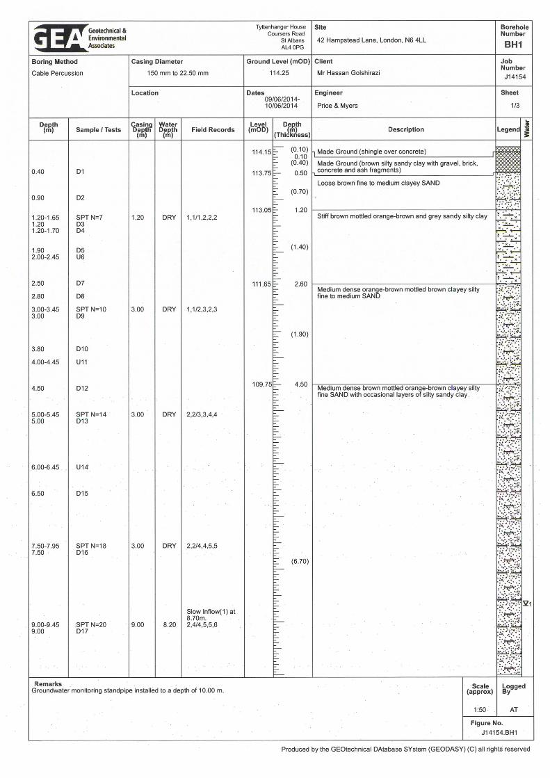
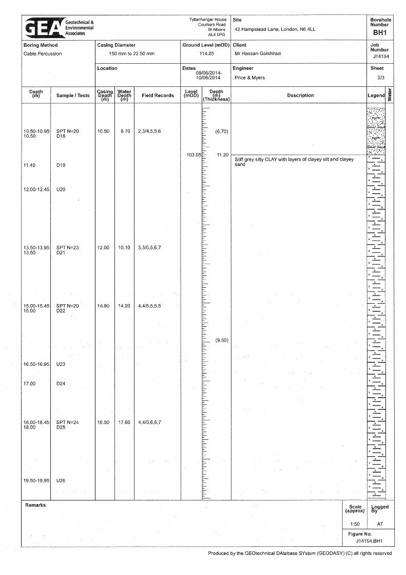
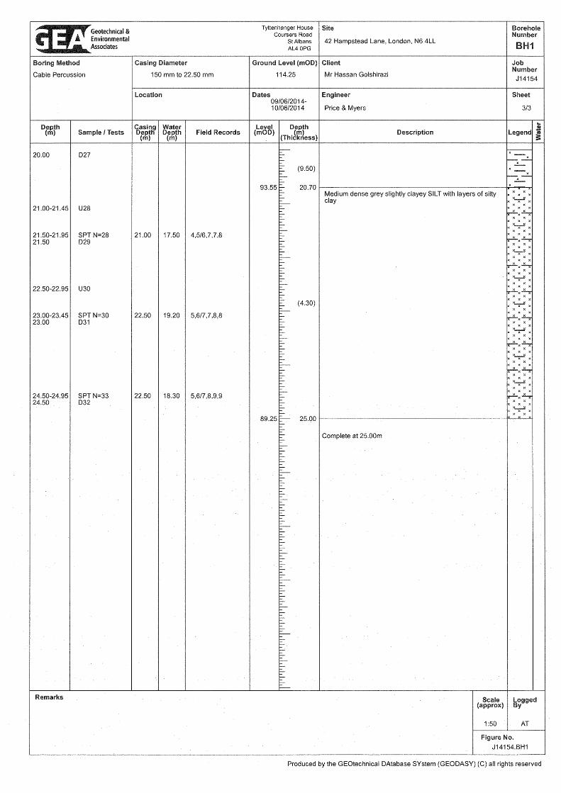
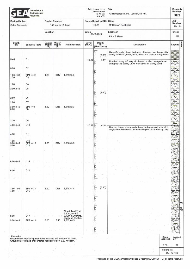
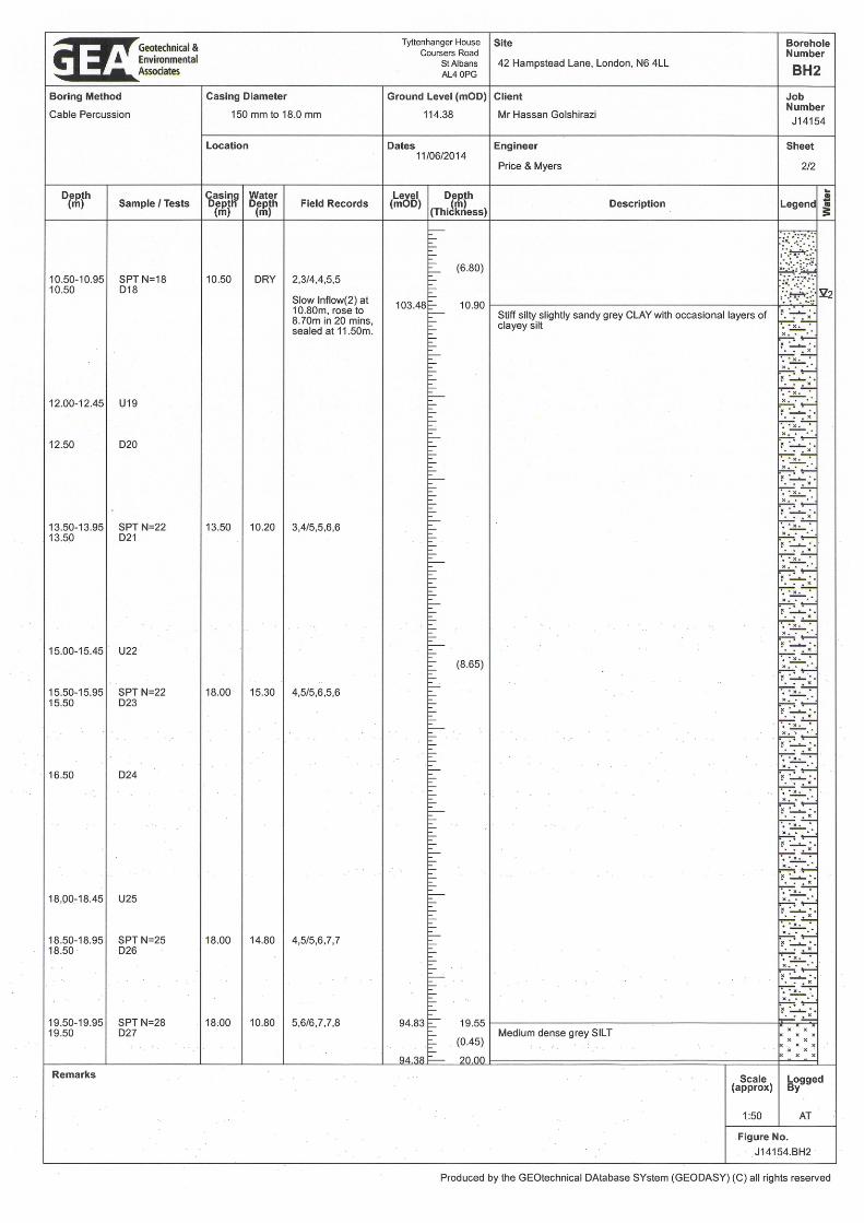
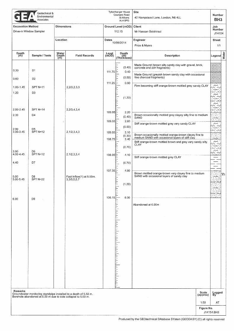
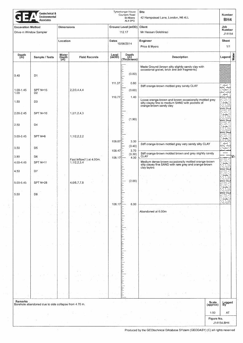
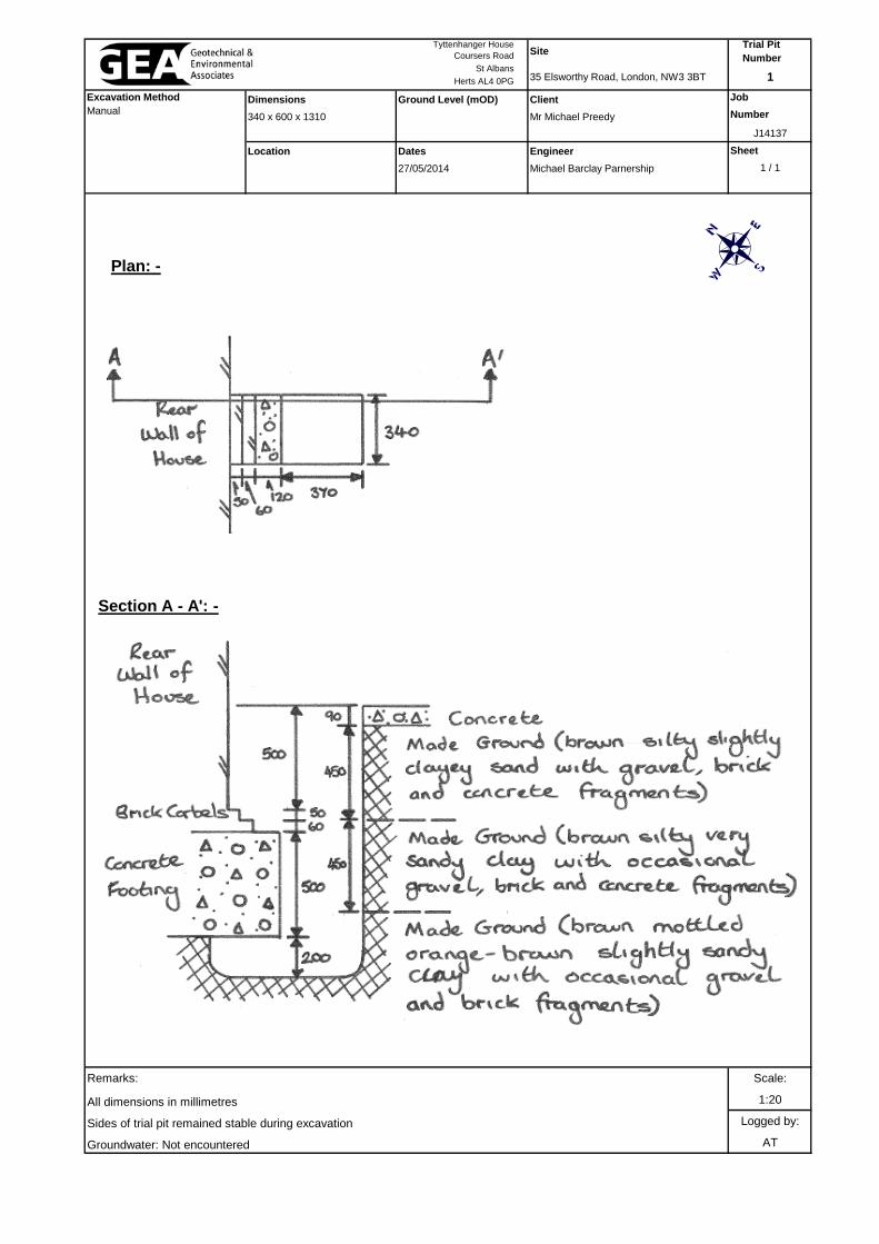
Coursers Road
St Albans
Herts AL4 0PG
Dimensions Ground Level (mOD) Client Job
340 x 600 x 1310 Mr Michael Preedy Number
J14137
Location Dates Engineer Sheet
27/05/2014 Michael Barclay Parnership 1 / 1
Remarks: Scale:
All dimensions in millimetres 1:20
Sides of trial pit remained stable during excavation Logged by:
Groundwater: Not encountered AT
Trial Pit Number
1
Tyttenhanger House
Excavation Method Manual
Site
35 Elsworthy Road, London, NW3 3BT
Section A - A': -
Plan: -
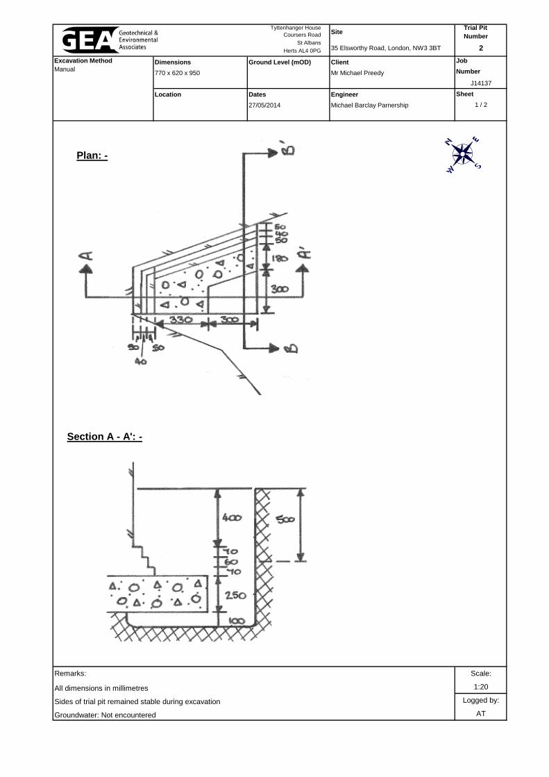
Coursers Road
St Albans
Herts AL4 0PG
Dimensions Ground Level (mOD) Client Job
770 x 620 x 950 Mr Michael Preedy Number
J14137
Location Dates Engineer Sheet
27/05/2014 Michael Barclay Parnership 1 / 2
Remarks: Scale:
All dimensions in millimetres 1:20
Sides of trial pit remained stable during excavation Logged by:
Groundwater: Not encountered AT
Trial Pit Number
2
Tyttenhanger House
Excavation Method Manual
Site
35 Elsworthy Road, London, NW3 3BT
Section A - A': -
Plan: -
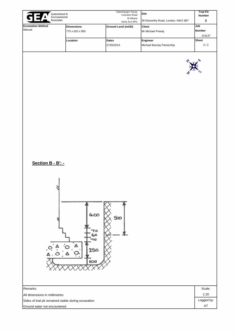
Coursers Road
St Albans
Herts AL4 0PG
Dimensions Ground Level (mOD) Client Job
770 x 620 x 950 Mr Michael Preedy Number
J14137
Location Dates Engineer Sheet
27/05/2014 Michael Barclay Parnership 2 / 2
Remarks: Scale:
All dimensions in millimetres 1:20
Sides of trial pit remained stable during excavation Logged by:
Ground water not encountered AT
Trial Pit Number
2
Tyttenhanger House
Excavation Method Manual
Site
35 Elsworthy Road, London, NW3 3BT
Section B - B': -
Related Documents