1 Fall 2009 SITE ANALYSIS & DESIGN PROGRAM for IONA PARK Hopewell , Pictou County, NS Nahal Sharifi | B00519030 | [email protected] Dalhousie School of Planning Fall 2009

Welcome message from author
This document is posted to help you gain knowledge. Please leave a comment to let me know what you think about it! Share it to your friends and learn new things together.
Transcript
1
Fall 2009
SITE ANALYSIS &
DESIGN PROGRAM for IONA PARK
Hopewell , Pictou County, NS
Nahal Sharifi | B00519030 | [email protected]
Dalhousie School of Planning
Fall 2009
i
Proposed Client: Friends of Iona Park
Contact: Gerald Romsa | [email protected]
Instructor: Jill Grant
Technical Advisor: John Zuck
ii
ACKNOWLEDGEMENTS
Thank you to Friends of Iona Park and East River Valley
Community Development Association (ERVCDA) for inspiring
the Project. Thank you to the East River Valley communities for
participating in the meetings, and sharing their aspirations with
me. Thank you to my technical advisor, John Zuck, for
providing me with constant feedback throughout the process.
Thank you also to my supervisor, Dr. Jill Grant, for her
guidance and willingness to discuss the project with me, and for
facilitating the independent project course.
Thank you to my peer evaluator, Theresa Piorkowski, for
providing me with endless support.
To Lauralee Sim, Brendan Sutton and the rest of the MPLAN
10s - I could not have done this without your intellectual and
emotional support.
Finally, thanks to my family for always believing in me and
supporting me at every stage of my life.
iii
TABLE OF CONTENTS EXECUTIVE SUMMARY ............................................................................ 1
1. SCHEME
1.1. Introduction ........................................................................................ 4
Site Planning & Design Programs
1.2. Purpose of Study ............................................................................ 5
1.3. Statement of the Project ................................................................ 5
1.4. Study Objectives ............................................................................ 6
1.5. Background Studies ................................................................ 6
Planning Context
1.6. Method ........................................................................................ 8
1.7. Data Collection ............................................................................ 10
2. SITE INVENTORY & ANALYSIS
2.1. Introduction ........................................................................................ 12
2.2. General Site Context .................................................... 12
Geographic Location
Land Use
Access System
Parking
2.3. Physical Data ................................................................ 15
Geology
Soil
Topography
Water
Habitat
2.4.Opportunities and Constraints Summary ........................................ 18
iv
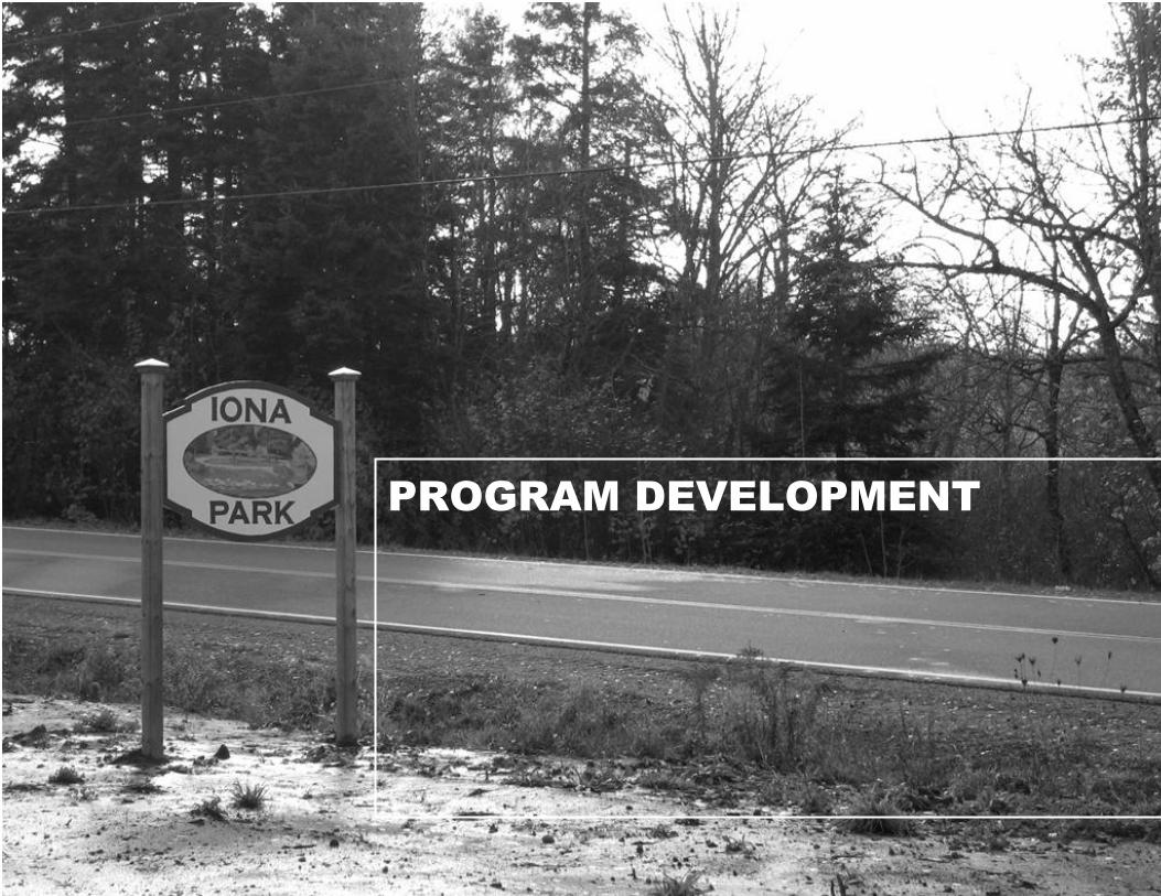
3. PROGRAM DEVELOPMENT
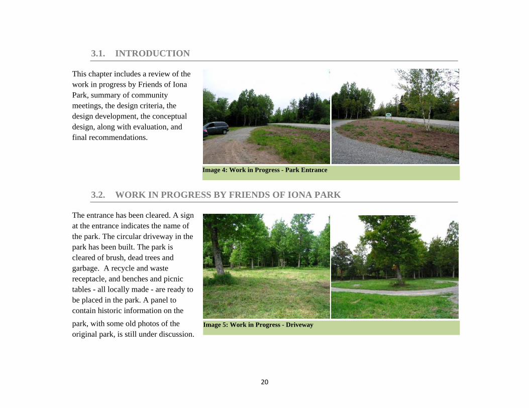
3.1. Introduction ....................................................................................... 20
3.2. Work in Progress by Friends of Iona Park ........................... 20
3.3. First Community Meeting ............................................................... 21
3.4. Second Community Meeting .......................................................... 22
3.5. Design Criteria ........................................................................... 23
3.6. Design Development .............................................................. 26
Access and Parking
Site Furnishing
Walking Trail
Foot Bridge
Outdoor Stage
Playground
Fitness Activity Equipment
3.7. Conceptual Design ............................................................................ 30
3.8. Evaluation ....................................................................................... 31
3.9. Recommendations ............................................................................ 32
REFERENCES
v
LIST OF TABLES – FIGURES - IMAGES
TABLE 1: OPPORTUNITIES & CONSTRAINTS SUMMARY .................................................. 18
FIGURE 1: POTENTIAL LOCATIONS FOR PROGRAM USES ........................................... 2
FIGURE 2: PROCESS ................................................................................................... 8 FIGURE 3: PICTOU COUNTY, NOVA SCOTIA ............................................................ 12
FIGURE 4:HOPEWELL, PICTOU COUNTY ................................................................. 12 FIGURE 5: AERIAL PHOTO 2007, SITE'S NATURAL CONTEXT .................................. 13 FIGURE 6: AERIAL PHOTO, PROPERTY LINES ......................................................... 14
FIGURE 7: SITE SECTION A-A ................................................................................. 16 FIGURE 8: SITE SECTION B-B .................................................................................. 16
FIGURE 9: FLOOD PLAIN ......................................................................................... 17 FIGURE 10: WALKING TRAIL .................................................................................. 24
FIGURE 11: FOOT BRIDGE SAMPLE ......................................................................... 25 FIGURE 12: FOOT BRIDGE SAMPLE ......................................................................... 27
FIGURE 13: OUTDOOR STAGE SAMPLE .................................................................... 28 FIGURE 14: OUTDOOR SEATING SAMPLE ................................................................ 28
FIGURE 15: PLAY EQUIPMENT ................................................................................. 29 FIGURE 16: PLAY EQUIPMENT ................................................................................. 29
FIGURE 17: FITNESS EQUIPMENT ............................................................................ 29 FIGURE 18: CONCEPTUAL DESIGN - POTENTIAL LOCATIONS FOR PROGRAM USES . 30
FIGURE 19: FINAL RECOMMENDATIONS .................................................................. 32
vi
IMAGE 1: PARK ENTRANCE ..................................................................................... 14
IMAGE 2: FLOOD PLAIN ........................................................................................... 17
IMAGE 3: FLOOD PLAIN............................................................................................ 17
IMAGE 4: WORK IN PROGRESS - PARK ENTRANCE .................................................. 20
IMAGE 5: WORK IN PROGRESS - DRIVEWAY ............................................................ 20
IMAGE 6: ST. COLUMBA CHURCH ........................................................................... 21
IMAGE 7: THE BROOK ............................................................................................. 21
IMAGE 8: DRIVEWAY IN THE PARK .......................................................................... 21
IMAGE 9: PEDESTRIAN ACCESS ............................................................................... 22
IMAGE 10: VIEW OF THE BROOK FROM THE DRIVEWAY .......................................... 22
PHOTOGRAPHIC ILLUSTRATIONS | NAHAL SHARIFI
1
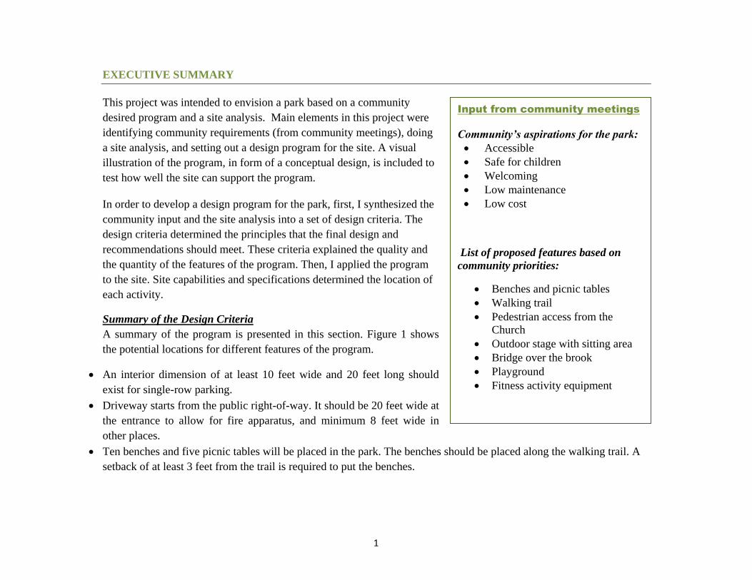
EXECUTIVE SUMMARY
This project was intended to envision a park based on a community
desired program and a site analysis. Main elements in this project were
identifying community requirements (from community meetings), doing
a site analysis, and setting out a design program for the site. A visual
illustration of the program, in form of a conceptual design, is included to
test how well the site can support the program.
In order to develop a design program for the park, first, I synthesized the
community input and the site analysis into a set of design criteria. The
design criteria determined the principles that the final design and
recommendations should meet. These criteria explained the quality and
the quantity of the features of the program. Then, I applied the program
to the site. Site capabilities and specifications determined the location of
each activity.
Summary of the Design Criteria
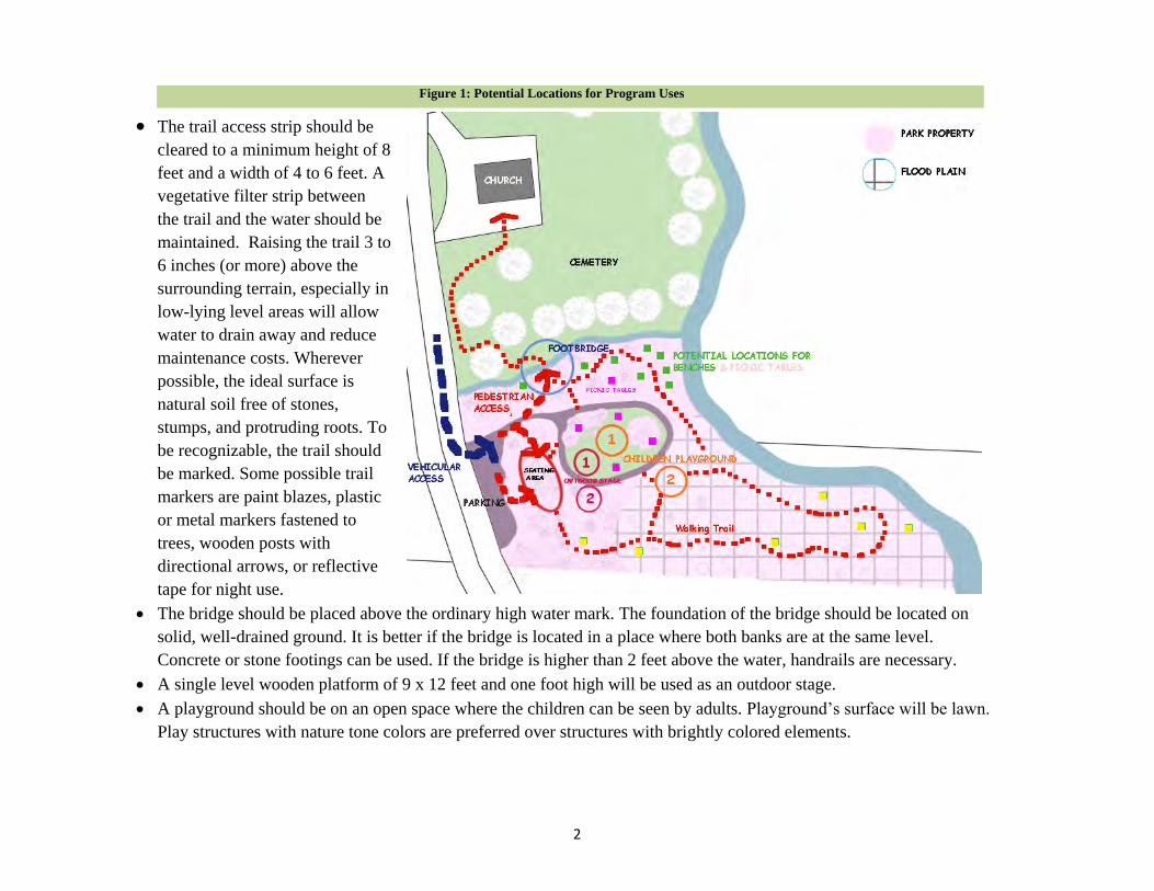
A summary of the program is presented in this section. Figure 1 shows
the potential locations for different features of the program.
An interior dimension of at least 10 feet wide and 20 feet long should
exist for single-row parking.
Driveway starts from the public right-of-way. It should be 20 feet wide at
the entrance to allow for fire apparatus, and minimum 8 feet wide in
other places.
Ten benches and five picnic tables will be placed in the park. The benches should be placed along the walking trail. A
setback of at least 3 feet from the trail is required to put the benches.
Input from community meetings
Community’s aspirations for the park:
Accessible
Safe for children
Welcoming
Low maintenance
Low cost
List of proposed features based on
community priorities:
Benches and picnic tables
Walking trail
Pedestrian access from the
Church
Outdoor stage with sitting area
Bridge over the brook
Playground
Fitness activity equipment
2
The trail access strip should be
cleared to a minimum height of 8
feet and a width of 4 to 6 feet. A
vegetative filter strip between
the trail and the water should be
maintained. Raising the trail 3 to
6 inches (or more) above the
surrounding terrain, especially in
low-lying level areas will allow
water to drain away and reduce
maintenance costs. Wherever
possible, the ideal surface is
natural soil free of stones,
stumps, and protruding roots. To
be recognizable, the trail should
be marked. Some possible trail
markers are paint blazes, plastic
or metal markers fastened to
trees, wooden posts with
directional arrows, or reflective
tape for night use.
The bridge should be placed above the ordinary high water mark. The foundation of the bridge should be located on
solid, well-drained ground. It is better if the bridge is located in a place where both banks are at the same level.
Concrete or stone footings can be used. If the bridge is higher than 2 feet above the water, handrails are necessary.
A single level wooden platform of 9 x 12 feet and one foot high will be used as an outdoor stage.
A playground should be on an open space where the children can be seen by adults. Playground’s surface will be lawn.
Play structures with nature tone colors are preferred over structures with brightly colored elements.
Figure 1: Potential Locations for Program Uses
3
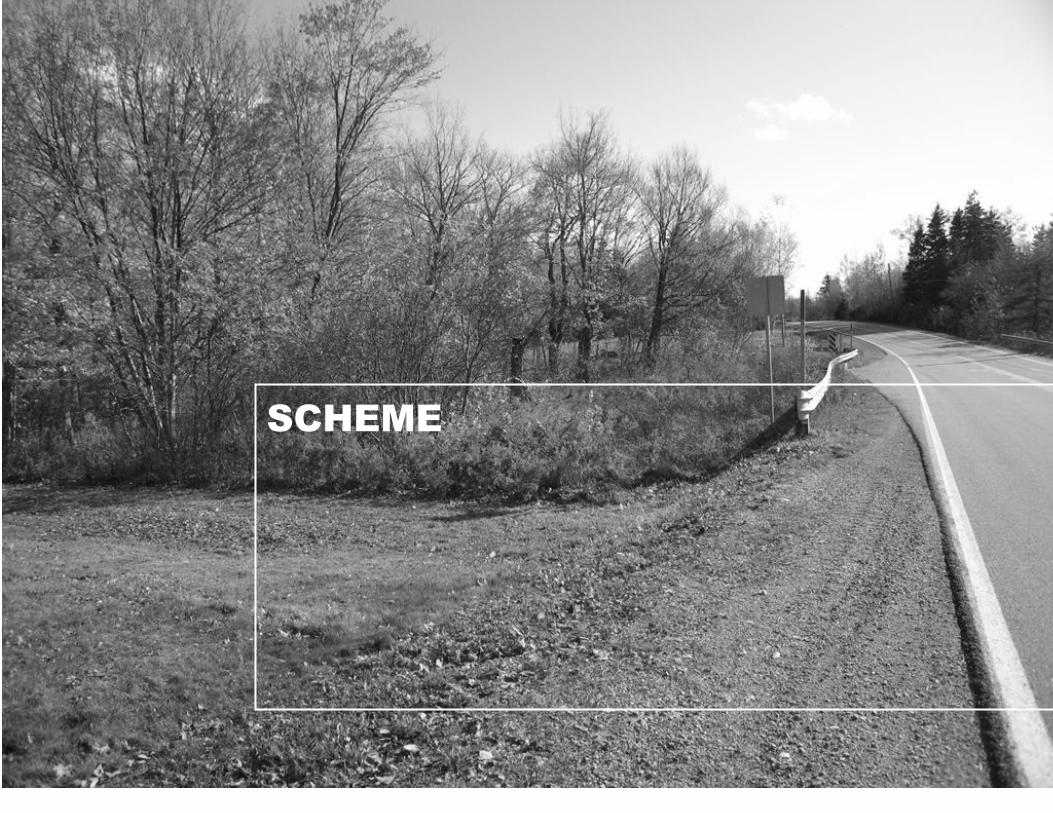
SCHEME

4
1.1. INTRODUCTION
Site Planning & Design Programs
One of the important considerations in a planning/design process is how the proposed project will be used and
the way it connects to the surrounding areas. This will be determined first by the land itself and then, in different cases,
by the values of the developer, the local by-laws, the community standards, and the nature of the project. These are all
balanced during the design process by the designer. (Russ, 2004:301)
Site design is a multiphase process that consists of different steps. These steps have a chronological order. The first step
of a typical land development process is Feasibility/Programming which “initiates the process with a general review of
the proposed program and existing site conditions.” (Dewberry, 2002: 1) Second step is Site Analysis that “determines
the allowable use of the site based on the background information and recommends a course of action to accomplish
the development program.” (Dewberry, 2002: 1) Conceptual Designs, Schematic Design, Final Design, Plan
Submission and Permitting, and Construction are the following steps of the process. (Dewberry, 2002)
As initial steps of the process, Feasibility/Programming and Site Analysis are usually done concurrently. In other words
“the site and the purpose for which it will be used- the two sources of site design- are remarkably interrelated. Purpose
depends on limitations of the site, and site analysis depends on purpose.” (Lynch and Hack, 1994: 29) These studies
result in a complete site inventory, identify usable site area, and form the foundation of further design efforts through
provision of adequate base mapping and establishment of project goals. (Dewberry, 2002: 1)
Engaging the community in order to find out about its interest and needs is an important element in the planning
process. “The communication of facts, ideas, and opinions among planners and public can build a mutual awareness of
problems and needs, which in turn serves as the basis for development of politically acceptable solutions.” (Dandekar,
1982: 127) The process should be structured to provide public with the background information necessary –to form
judgments and to express preferences where appropriate- and opportunities for collaborative exchange and discussion
of information. (Dandekar, 1982)

5
1.2. PURPOSE OF STUDY
In 1960, Men’s Club of the St. Columba Church in the Hopewell Village – East River Valley, NS- opened Iona Park
beside the Church. The park was used for picnics and barbeques. Due to time and as the church lost its members, fewer
people went to the park and Iona Park began to lay dormant (Friends of Iona Park). The Association of the Friends of
Iona Park formed on July 2008 for the purpose of restoring the park. The association comprises members of the
surrounding communities who have a vision to bring the park back to life.
This is a community-based project aiming to envision a park based on a community desired program and a site
analysis. A visual illustration of the program, in form of a conceptual design, is included to test how well the site can
support the program.
1.3. STATEMENT OF THE PROJECT
Develop site analysis and a design program for Iona Park located in Hopewell Village (East River Valley, Pictou
County, Nova Scotia)
Definition of Terms:
Site Analysis is “a diagnostic process that identifies the opportunities and constraints for a specific land use
program.” It will be based on the physical, biological, and cultural data gathered for the site. (LaGro Jr. 2008:
169)
Design Program “defines the project’s objectives and functional requirements, including the proposed activities,
area allocated for each activity, and the functional or spatial relationship among those activities” (LaGro Jr.
2008: 14). The program is typically expressed in terms of the quantity and quality of the spaces needed and
performance statements. (LaGro Jr. 2008: 77)
6
1.4. STUDY OBJECTIVES
The main goals of this project are to
o help the client (Friends of Iona Park) by doing a site analysis and producing a design program for
developing the site.
o test the program for fit with the site.
Main objectives that the study is intended to achieve are
o identifying the limitations and capabilities of the site through a site analysis
o finding about the needs and interest of the community
o developing conceptual designs to test the program and indicate the fit between the program and the site
1.5. BACKGROUND STUDIES
Planning Context
The Municipality of Pictou County, including the towns and the rural areas, has a combined population of over
46,000 people. The towns of Stellarton, New Glasgow, Pictou, Trenton and Westville each have their own councils.
The remaining rural areas are served by the Municipality of Pictou County. Amalgamation of the six municipal units,
consisting of five towns and a rural municipality, in Pictou County is occasionally considered as Pictou County District
Planning Commission. The Commission provides the surrounding communities with planning and development
services, solid waste management, and water pollution control. Land use by-laws are available for the towns of
Stellarton, New Glasgow, Pictou, Trenton and Westville, but no land use regulation has been developed for the rural
areas, including East River Valley communities. (Pictou County District Planning Commission website, n.d.)
“The Pictou Regional Development Commission (PRDC) has been working with the residents of East River Valley
(ERV) since May of 2005. PRDC facilitated three strategic planning sessions with area residents of the 15 communities
in East River Valley, Pictou County. A SWOT analysis (strengths, weaknesses, opportunities and threats) was
conducted and initiatives were identified as unique opportunities to promote tourism and build economic development
7
for the area.” (East River Valley Strategic Plan, 2007) The East River Valley Community Development Association has
developed a Strategic Plan for Community Economic Development based on PRDC planning sessions. The key
elements of the plan are:
1. Infrastructure Development
2. Marketing and Promotion
3. Tourism Development and Promotion
4. Sustainability and Youth Retention
5. Wind Energy/Rural Green Development
The park development is not identified as a project in the strategic plan, but Friends of Iona Park mentioned that they
wanted the design program of the park to be in conformance with the strategic plan. Some of the projects that have
been identified in the strategic plan, with similar directions for developing the study site, are:
Strategic Action 1.2: To install more signage throughout the ERV
Strategic Action 1.4: To identify and clean up unsightly properties
Strategic Action 2.2: To promote year-round recreational/environmental activities and to identify recreational
opportunities
Strategic Action 3.2: To develop and promote Eco-Tourism in the ERV
(East River Valley Strategic Plan, 2007)
Note: PRDC is currently working on a new regional strategic plan that will guide the economic development of the
communities for the next ten years.

8
1.6. METHOD
The project is community-based. Main elements in this
project were identifying community requirements, doing a
site analysis, setting out a design program for the site, and
testing the fit between the site and the program. Public
engagement was an important component of this project.
Community`s preferences and objectives - such as desired
uses, special features, or design styles - were considered as
important elements in developing the program. In this
section I briefly explain different stages of the project.
Literature Review
The literature review provided the base for developing the
method for the project as well as understanding the logical
process of similar projects. A summary of important notes
from the literature review is discussed in the Introduction
section of the report. Subject areas for literature review
included:
Site planning and design
Site analysis
Design Programs
Park planning and design guidelines
Public participation and human behaviour
Recreational development in rural communities
Natural history of Nova Scotia
History of Pictou County Figure 2: Process

9
Site Analysis
In the site analysis, I focused on contextual study of the site in order to evaluate site capabilities for the programmed
uses. I identified the potential and limiting factors of the site through both a regional analysis and a more specific
review of the proposed site. By analysing these features, I highlighted the facts and patterns that have significant
influence on the design program. The product of this section is a summary which explains the important features of the
place as well as limitations and potentials for the site.
User Needs and Preferences
I participated in two community meetings of the Friends of Iona Park to find about the community’s needs and
preferences. At the first community meeting I introduced the project to the community and asked for more information.
Friends of Iona Park talked about their work in progress. The participants discussed what they felt was missing in their
community, and what facilities and activities they wanted in the park.
At the second session, a month after the first session, I discussed site capabilities and the “program” with the
community. I started the session with a quick summary of our first meeting. I presented the summary of the site
analysis along with a base map that represented all the important data (physical characteristics, existing condition and
features, and the context). The participants evaluated the program uses from the first meeting, and ranked them based
on their priorities. The session also contained an ideas workshop. I asked participants to draw their ideas on provided
base maps. Each participant used a different color pencil. At the end of the session, we had a discussion about different
ideas that were presented on the base-maps, and tried to come up with agreements on site improvements.
The meetings were both conducted by Friends of Iona Park. A third meeting may be held at the client’s request to
discuss the final results of the project with the community.

10
Program Development
In order to develop a design program for the park, first, I synthesized the community input and the site analysis into a
set of design criteria. The design criteria determined the principles that the final design and recommendations should
meet. These criteria explained the quality and the quantity of the features of the program. Then, I applied the program
to the site. Site capabilities and specifications determined the location of each activity. I made a map which shows
possible locations for the program uses. I evaluated different options in terms of the program and the site. Finally, I
made recommendations.
1.7. DATA COLLECTION
Some basic information about the site (including the history, ownership, and size, along with some aerial photographs)
was provided by the Friends of Iona Park. More detailed parcel information and the topographic map, as well as a more
recent aerial photograph of the area were obtained from Nova Scotia Land Registration office. Additional data,
including soils information and geology, were compiled from Natural History of Nova Scotia, Nova Scotia Natural
Resources website, and also the maps available at the resource centre of the Faculty of Architecture and Planning,
Dalhousie University.
The initial site reconnaissance trip was performed in July 2009 to prepare the proposal for the project and get familiar
with the area. The second site visit- in September 2009- was done to conduct site analysis studies and compile a
photographic inventory of the existing features and the work in progress. The third site visit was in October 2009 to
verify the produced maps, record some of the seasonal changes, and identify the flood plain on a map. All three site
visits were carried out with members of the community and Friends of Iona Park to gain insight about the existing
challenges and opportunities posed by the existing conditions.
Site analysis and programming for the site were reviewed with the community in the second community meeting.
Together these meetings provided additional information and community feedback that contributed to the development
of the design program for Iona Park.
11
SITE INVENTORY & ANALYSIS
12
2.1. INTRODUCTION
The analysis of the site and its context documents site capabilities and
limitations. A comprehensive understanding of the site leads to a better
design program. Capitalizing on site assets and avoiding constraints
throughout the design process is a way of making sure that the design
and the site support each other and fit together.
2.2. GENERAL SITE CONTEXT
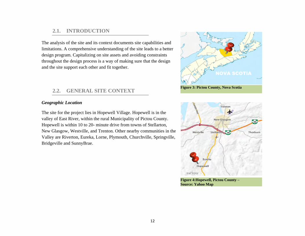
Geographic Location
The site for the project lies in Hopewell Village. Hopewell is in the
valley of East River, within the rural Municipality of Pictou County.
Hopewell is within 10 to 20- minute drive from towns of Stellarton,
New Glasgow, Westville, and Trenton. Other nearby communities in the
Valley are Riverton, Eureka, Lorne, Plymouth, Churchville, Springville,
Bridgeville and SunnyBrae.
NOVA SCOTIA
Figure 3: Pictou County, Nova Scotia
Figure 4:Hopewell, Pictou County –
Source: Yahoo Map
13
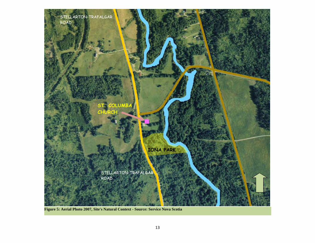
Figure 5: Aerial Photo 2007, Site's Natural Context - Source: Service Nova Scotia
ST. COLUMBA
CHURCH
IONA PARK
STELLARTON-TRAFALGAR
ROAD
STELLARTON-TRAFALGAR
ROAD

14
Land Use
The site is owned by the neighbouring
church (St. Columba Church), and it is
about 1400 sq. Metres. The park
property is surrounded by the River on
the east, St. Columba Church and
Cemetery on the north, a private
property on the south, and the Stellarton-
Trafalgar Road on the west.
Access and Parking
No pedestrian access to the park is
available. The only vehicular access is
from Stellarton-Trafalgar Road, (also
called Route 374) which runs from
Stellarton, and continues to the south.
Two entrance points to the park exist on
the road, but the one on the south will
soon be closed due to low visibility and
poor sight lines. A parking area is on the
entrance of the site. The Church also
owns a piece of property on the other
side of the road. This lot is mainly used
for parking during community events.
Figure 6: Aerial Photo, Property Lines - Source: Friends of Iona Park
Image 1: Park Entrance
This access point will be closed
VEHICULAR ACCESS
STELLARTON-TRAFALGAR ROAD
ST. COLUMBA
CHURCH
CEMETERY
HISTORIC
CEMETERY
STELLARTON-TRAFALGAR ROAD
15
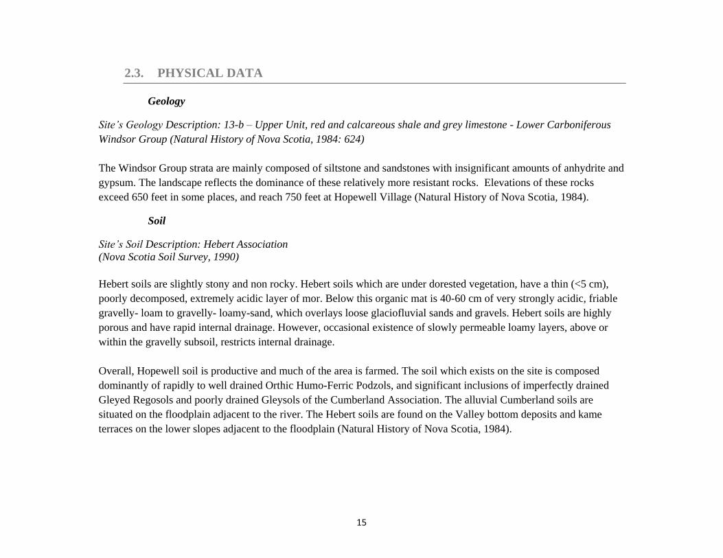
2.3. PHYSICAL DATA
Geology
Site’s Geology Description: 13-b – Upper Unit, red and calcareous shale and grey limestone - Lower Carboniferous
Windsor Group (Natural History of Nova Scotia, 1984: 624)
The Windsor Group strata are mainly composed of siltstone and sandstones with insignificant amounts of anhydrite and
gypsum. The landscape reflects the dominance of these relatively more resistant rocks. Elevations of these rocks
exceed 650 feet in some places, and reach 750 feet at Hopewell Village (Natural History of Nova Scotia, 1984).
Soil
Site’s Soil Description: Hebert Association
(Nova Scotia Soil Survey, 1990)
Hebert soils are slightly stony and non rocky. Hebert soils which are under dorested vegetation, have a thin (<5 cm),
poorly decomposed, extremely acidic layer of mor. Below this organic mat is 40-60 cm of very strongly acidic, friable
gravelly- loam to gravelly- loamy-sand, which overlays loose glaciofluvial sands and gravels. Hebert soils are highly
porous and have rapid internal drainage. However, occasional existence of slowly permeable loamy layers, above or
within the gravelly subsoil, restricts internal drainage.
Overall, Hopewell soil is productive and much of the area is farmed. The soil which exists on the site is composed
dominantly of rapidly to well drained Orthic Humo-Ferric Podzols, and significant inclusions of imperfectly drained
Gleyed Regosols and poorly drained Gleysols of the Cumberland Association. The alluvial Cumberland soils are
situated on the floodplain adjacent to the river. The Hebert soils are found on the Valley bottom deposits and kame
terraces on the lower slopes adjacent to the floodplain (Natural History of Nova Scotia, 1984).

16
Topography
There is a 5-metre difference in elevations of the highest and the lowest points of the site. The park entrance
from the road is 5 metres higher than the flood plain. Figure 7 and Figure 8 show two sections of the site.
The vertical scale of the illustrations is four times the horizontal scale.
Figure 7: Site Section A-A
Figure 8: Site Section B-B
St. Columba Church Cemetery
River
Park Entrance from Stellarton-Trafalgar Rd. Brook
Stellarton-Trafalgar Rd. Slopes Flood Plain
Park’s Boundary
Park’s Boundary
17
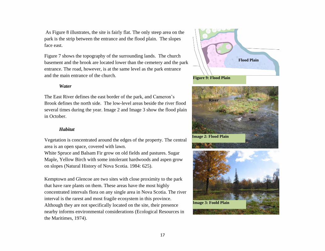
As Figure 8 illustrates, the site is fairly flat. The only steep area on the
park is the strip between the entrance and the flood plain. The slopes
face east.
Figure 7 shows the topography of the surrounding lands. The church
basement and the brook are located lower than the cemetery and the park
entrance. The road, however, is at the same level as the park entrance
and the main entrance of the church.
Water
The East River defines the east border of the park, and Cameron’s
Brook defines the north side. The low-level areas beside the river flood
several times during the year. Image 2 and Image 3 show the flood plain
in October.
Habitat
Vegetation is concentrated around the edges of the property. The central
area is an open space, covered with lawn.
White Spruce and Balsam Fir grow on old fields and pastures. Sugar
Maple, Yellow Birch with some intolerant hardwoods and aspen grow
on slopes (Natural History of Nova Scotia. 1984: 625).
Kemptown and Glencoe are two sites with close proximity to the park
that have rare plants on them. These areas have the most highly
concentrated intervals flora on any single area in Nova Scotia. The river
interval is the rarest and most fragile ecosystem in this province.
Although they are not specifically located on the site, their presence
nearby informs environmental considerations (Ecological Resources in
the Maritimes, 1974).
Image 3: Foold Plain
Image 2: Flood Plain
Figure 9: Flood Plain
Flood Plain
River
Site
18
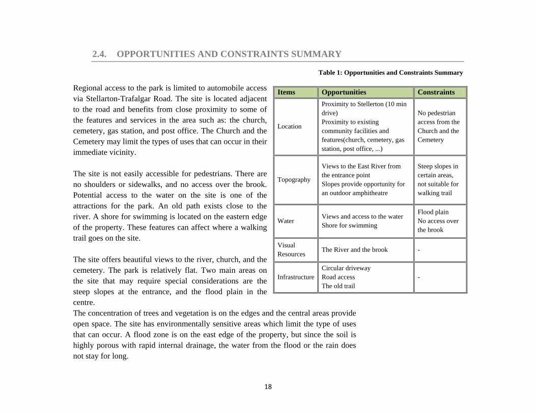
2.4. OPPORTUNITIES AND CONSTRAINTS SUMMARY
Table 1: Opportunities and Constraints Summary
Regional access to the park is limited to automobile access
via Stellarton-Trafalgar Road. The site is located adjacent
to the road and benefits from close proximity to some of
the features and services in the area such as: the church,
cemetery, gas station, and post office. The Church and the
Cemetery may limit the types of uses that can occur in their
immediate vicinity.
The site is not easily accessible for pedestrians. There are
no shoulders or sidewalks, and no access over the brook.
Potential access to the water on the site is one of the
attractions for the park. An old path exists close to the
river. A shore for swimming is located on the eastern edge
of the property. These features can affect where a walking
trail goes on the site.
The site offers beautiful views to the river, church, and the
cemetery. The park is relatively flat. Two main areas on
the site that may require special considerations are the
steep slopes at the entrance, and the flood plain in the
centre.
The concentration of trees and vegetation is on the edges and the central areas provide
open space. The site has environmentally sensitive areas which limit the type of uses
that can occur. A flood zone is on the east edge of the property, but since the soil is
highly porous with rapid internal drainage, the water from the flood or the rain does
not stay for long.
Items Opportunities Constraints
Location
Proximity to Stellerton (10 min
drive)
Proximity to existing
community facilities and
features(church, cemetery, gas
station, post office, ...)
No pedestrian
access from the
Church and the
Cemetery
Topography
Views to the East River from
the entrance point
Slopes provide opportunity for
an outdoor amphitheatre
Steep slopes in
certain areas,
not suitable for
walking trail
Water Views and access to the water
Shore for swimming
Flood plain
No access over
the brook
Visual
Resources The River and the brook -
Infrastructure
Circular driveway
Road access
The old trail
-
19
PROGRAM DEVELOPMENT
20
3.1. INTRODUCTION
This chapter includes a review of the
work in progress by Friends of Iona
Park, summary of community
meetings, the design criteria, the
design development, the conceptual
design, along with evaluation, and
final recommendations.
3.2. WORK IN PROGRESS BY FRIENDS OF IONA PARK
The entrance has been cleared. A sign
at the entrance indicates the name of
the park. The circular driveway in the
park has been built. The park is
cleared of brush, dead trees and
garbage. A recycle and waste
receptacle, and benches and picnic
tables - all locally made - are ready to
be placed in the park. A panel to
contain historic information on the
park, with some old photos of the
original park, is still under discussion.
Image 4: Work in Progress - Park Entrance
Image 5: Work in Progress - Driveway

21
3.3. FIRST COMMUNITY MEETING
Sept. 27th
, 2009 - St. Columba Church, Hopewell- Ten participants
The goal of the first session was to introduce the project to the
community and find about community needs and requirements.
Community’s wish list for the program:
Playground
Walking trail
Fitness activity facilities
Sitting stones for outdoor gatherings and events. Considering
potential for providing a site for performances, including
outdoor performances and temporary events.
Sidewalks to provide pedestrian access to the park from the
church
Bridge over the brook to connect the park to the church as a
part of the pedestrian access
Parking
Community’s aspirations for the park:
Accessible
Safe for children
Welcoming
Low maintenance
Low cost
Image 6: St. Columba Church
Image 7: The Brook
Image 8: Driveway in the Park
22
3.4. SECOND COMMUNITY MEETING
Oct. 25th
, 2009 - St. Columba Church, Hopewell- Eight participants
The main goal of the second session was to agree upon
community requirements and specifications for site
improvement. The second goal of the meeting was to identify
the priorities for phasing the program. Not all of the
suggested uses and activities can go on the site at the same
time. According to the available resources and the budget
limitations, a starting point for site development should be
identified. Some activities can happen later, in a longer time
framework; however, some should get started right away to
help revitalize the park and keep the work going.
List of proposed features based on community priorities:
Benches and picnic tables
Walking trail
Pedestrian access from the Church
Outdoor stage with sitting area
Bridge over the brook
Playground
Fitness activity equipment
Image 10: View of the Brook from the Driveway
Image 9: Pedestrian Access
23
3.5. DESIGN CRITERIA
In this section, the community input and the site analysis are synthesized into a set of design criteria, defining the
program. The design criteria determine the principles that the final design and recommendations should meet.
General design criteria
The proposed use should fit the site in terms of the quantity and size of the required spaces.
The proposed development should respect natural limitations of the site.
The program should protect the health and quality of the environment.
The proposed use should be low maintenance, safe, and low cost.
The design program should possess the following features:
VEHICULAR ACCESS AND PARKING
10 to 15 parking spaces
o The minimum size of a standard parking space is 9 feet wide and 18 feet long. The dimensions can be
reduced to 8 feet wide and 16 feet long.
o An interior dimension of at least 10 feet wide and 20 feet long should exist for single-row parking.
Driveway through the park
o Minimum 8 feet wide at one-way sections
o Minimum 18 feet at two-way sections
o Minimum 20 feet if fire apparatus is required
SITE FURNISHINGS
Ten benches and five picnic tables will be placed throughout the park. The benches should be placed along the
walking trail.
A setback of at least 3 feet from the trail is required to put the benches.
Interpretive panel will be designed and located where it can be seen by users. The panel may include the history
of the park site, flora and fauna identification, hydrology and geology of the site.
24
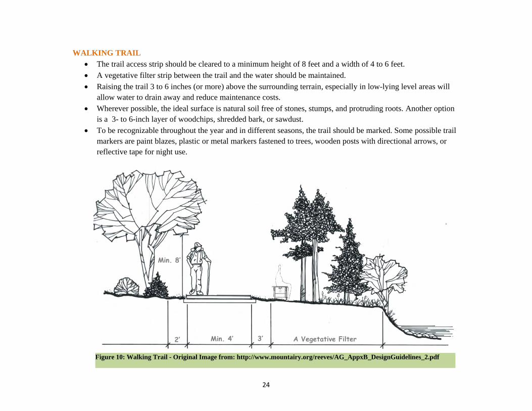
WALKING TRAIL
The trail access strip should be cleared to a minimum height of 8 feet and a width of 4 to 6 feet.
A vegetative filter strip between the trail and the water should be maintained.
Raising the trail 3 to 6 inches (or more) above the surrounding terrain, especially in low-lying level areas will
allow water to drain away and reduce maintenance costs.
Wherever possible, the ideal surface is natural soil free of stones, stumps, and protruding roots. Another option
is a 3- to 6-inch layer of woodchips, shredded bark, or sawdust.
To be recognizable throughout the year and in different seasons, the trail should be marked. Some possible trail
markers are paint blazes, plastic or metal markers fastened to trees, wooden posts with directional arrows, or
reflective tape for night use.
2’
Figure 10: Walking Trail - Original Image from: http://www.mountairy.org/reeves/AG_AppxB_DesignGuidelines_2.pdf
A Vegetative Filter Min. 4’ 3’
Min. 8’
2’
25
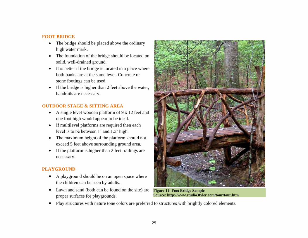
FOOT BRIDGE
The bridge should be placed above the ordinary
high water mark.
The foundation of the bridge should be located on
solid, well-drained ground.
It is better if the bridge is located in a place where
both banks are at the same level. Concrete or
stone footings can be used.
If the bridge is higher than 2 feet above the water,
handrails are necessary.
OUTDOOR STAGE & SITTING AREA
A single level wooden platform of 9 x 12 feet and
one foot high would appear to be ideal.
If multilevel platforms are required then each
level is to be between 1’ and 1.5’ high.
The maximum height of the platform should not
exceed 5 feet above surrounding ground area.
If the platform is higher than 2 feet, railings are
necessary.
PLAYGROUND
A playground should be on an open space where
the children can be seen by adults.
Lawn and sand (both can be found on the site) are
proper surfaces for playgrounds.
Play structures with nature tone colors are preferred to structures with brightly colored elements.
Figure 11: Foot Bridge Sample
Source: http://www.studio3tyler.com/tour/tour.htm

26
3.6. DESIGN DEVELOPMENT
In this section, I have applied the program to the site. Site capabilities and specifications helped to determine the uses
that could go on the site, as well as the location for each activity.
VEHICULAR ACCESS AND PARKING
Vehicular access to the park will be limited to the northern entrance from the Stellarton-Trafalgar Road. A
circular driveway that has been restored on the site provides vehicular access to the central areas and the waterfront.
The driveway starts at the public right-of-way. The width at this section should allow for fire apparatus access, and for
one car waiting while the other one is passing. The required width is 20 feet. This width should be provided if trees get
planted or stone pillars get placed on both sides of the driveway.
Locating the parking at the entrance of the park has the least interference with the park’s existing landscape. For those
who want to drive to the picnic tables, the open space on both sides of the driveway can provide for parking.
SITE FURNISHINGS
The benches and picnic tables have already been made locally. The design program at this stage focuses on
their placement on the site rather than their design specifications.
Benches can provide respite for trail users as well as other people in the park. Two to three benches can be placed by
the waterfront to provide users with a beautiful view. The rest of the benches should be placed on one or both sides of
the trail. Picnic tables are intended to be used for family activities. Placing them close to the driveway and playground
makes them more convenient for the users. The central area has room for three to four picnic tables with reasonable
distance from each other. Putting trash receptacles close to the benches and picnic tables can help keeping the park
clean. Interpretative signage can also encourage use of the trash bins. Site map, site history, and local context can go on
a panel at the entrance of the park.
27
WALKING TRAIL
The walking trail on the site should be constructed in a way that enhances the user’s outdoor experience while
protecting environmental health. The trail should disturb the site as little as possible. Potential destinations for trail
users are the water, the church, and the cemetery. Steep slopes should be avoided. The old path that exists by the river
can be incorporated into the trail design. Connecting the trail to the park entrance, parking area, the bridge that goes
over the brook, and the circular driveway provide better access for users.
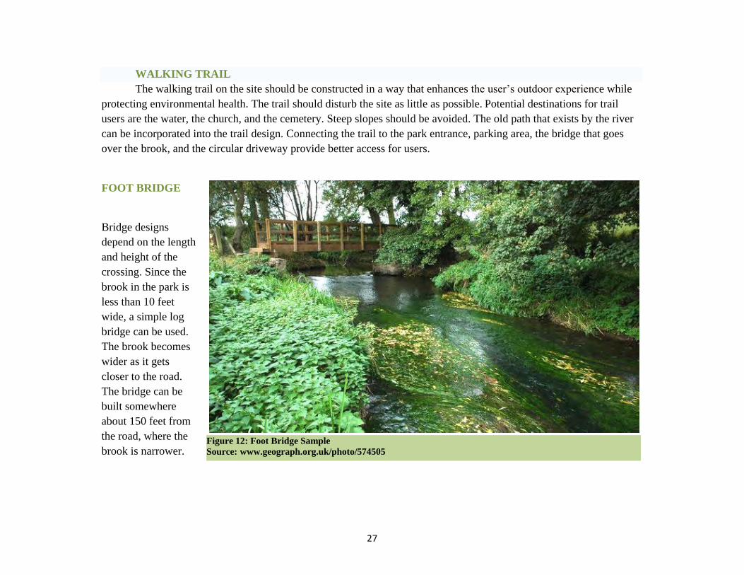
FOOT BRIDGE
Bridge designs
depend on the length
and height of the
crossing. Since the
brook in the park is
less than 10 feet
wide, a simple log
bridge can be used.
The brook becomes
wider as it gets
closer to the road.
The bridge can be
built somewhere
about 150 feet from
the road, where the
brook is narrower.
Figure 12: Foot Bridge Sample
Source: www.geograph.org.uk/photo/574505
28
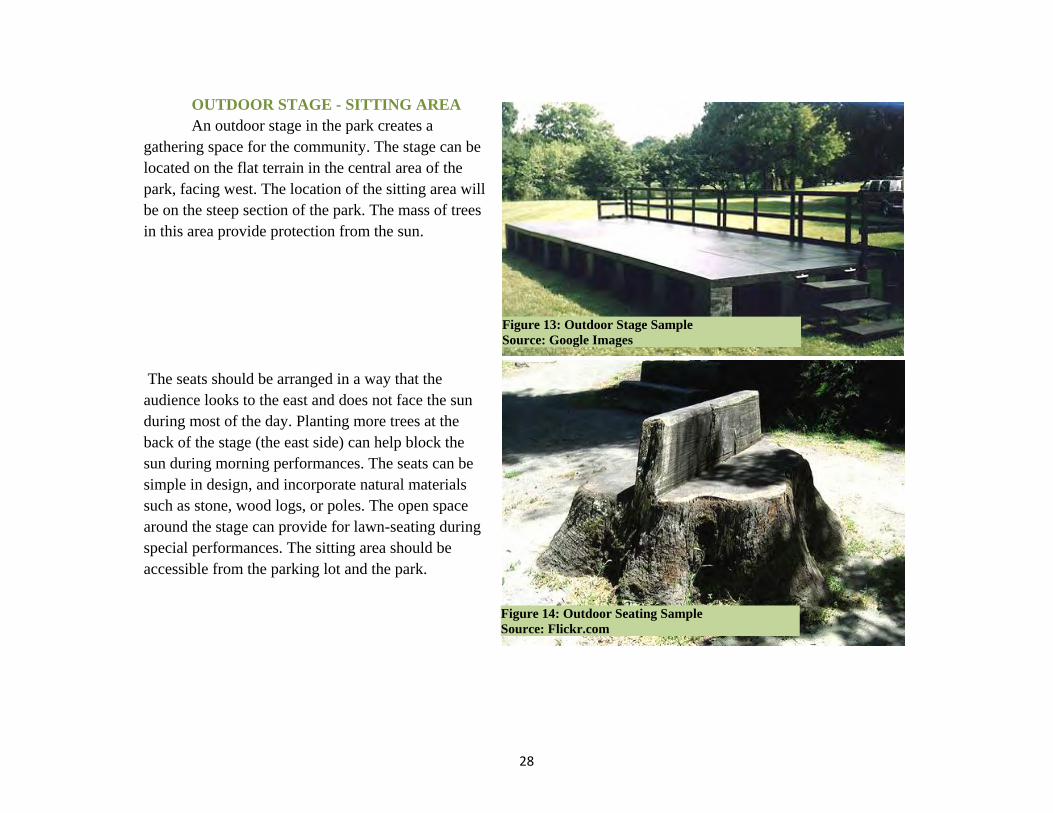
OUTDOOR STAGE - SITTING AREA
An outdoor stage in the park creates a
gathering space for the community. The stage can be
located on the flat terrain in the central area of the
park, facing west. The location of the sitting area will
be on the steep section of the park. The mass of trees
in this area provide protection from the sun.
The seats should be arranged in a way that the
audience looks to the east and does not face the sun
during most of the day. Planting more trees at the
back of the stage (the east side) can help block the
sun during morning performances. The seats can be
simple in design, and incorporate natural materials
such as stone, wood logs, or poles. The open space
around the stage can provide for lawn-seating during
special performances. The sitting area should be
accessible from the parking lot and the park.
Figure 13: Outdoor Stage Sample
Source: Google Images
Figure 14: Outdoor Seating Sample
Source: Flickr.com

29
PLAYGROUND
The right location for a
playground is where the children can
be seen by adults. The playground on
the site should be located in the central
open space on the site. Placing
benches and picnic tables close to the
playground provides a better
monitoring opportunity for the parents.
Lawn is an ideal surface for children's
activities.
Different types of play equipment can be used in the playground. A multi-play item can fully equip the playground;
however, it is not low-cost or low-maintenance. The equipment may also get damaged during the flood season. Locally
made play equipment brings more character to the park, and preserves the natural beauty of the park. These items can
be made by using blocks of wood and logs. They cost less, and need less maintenance.
FITNESS EQUIPMENT
Having fitness equipment in the
park was one the ideas that came up in
the first community meeting; however,
when the participants prioritised the
proposed program uses in the second
meeting, fitness activity equipment
was the last item on the list. The
community can buy fitness equipment;
but making the equipment locally is
more feasible. Some samples of locally
made "work out" features such as chin up bars, crunch boards, and balance exercises can be seen in the images.
Installing the fitness equipment along the walking trail provide more options for the trail users.
Figure 17: Fitness Equipment
Source: http://blog.virginiaparks.org
Figure 16: Play Equipment
Source: Flickr.com
Figure 15: Play Equipment
Source: Flickr.com
30
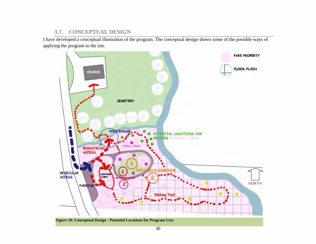
3.7. CONCEPTUAL DESIGN
I have developed a conceptual illustration of the program. The conceptual design shows some of the possible ways of
applying the program to the site.
NORTH
Figure 18: Conceptual Design - Potential Locations for Program Uses

31
3.8. EVALUATION
Figure 17 indicates the conceptual illustration of the program. Some features of the program can be located in different
places on the site. In this section, I evaluate each option, in terms of the program and the site.
Placing the parking at the entrance area has the least interference with site’s existing landscape. The entrance parking
area is more visible to drivers.
Benches are placed along the walking trail. Green spots on Figure 16, show areas with views to the water, and
proximity to the driveway. Yellow spots are located either on the flood zone, or in the dense vegetation. Putting
benches in yellow spots may cause maintenance issues.
The walking trail connects the important features of the site. The trail also connects the site to the church, and provides
the trail users with several access points from the parking, the brook, the seating area, and the central driveway. The
trail on Figure 17 is mainly proposed based on the topography. For instance, to walk from the church’s basement to the
driveway on the site, a trail user does not need to climb up to the parking area, and again walk down to the driveway.
Two possible locations for the playground are shown on Figure 17. The first location is in the centre of park, and
provides a good monitoring opportunity for parents. The area is covered with lawn, and is farther from the flood plain.
The second location is also on an open space, and close to the driveway and picnic tables; however, it’s on the flood
plain.
Two potential locations for the outdoor stage are also marked on Figure 17. The first option is more compatible with
slope aspects, so that the audience looks straight toward the stage. Both options are close to the driveway, and do not
require vegetation removal. However, the second option is closer to the flood plain.
32
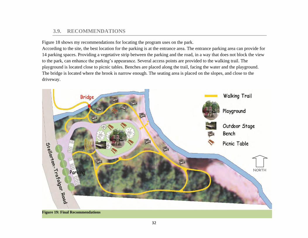
3.9. RECOMMENDATIONS
Figure 18 shows my recommendations for locating the program uses on the park.
According to the site, the best location for the parking is at the entrance area. The entrance parking area can provide for
14 parking spaces. Providing a vegetative strip between the parking and the road, in a way that does not block the view
to the park, can enhance the parking’s appearance. Several access points are provided to the walking trail. The
playground is located close to picnic tables. Benches are placed along the trail, facing the water and the playground.
The bridge is located where the brook is narrow enough. The seating area is placed on the slopes, and close to the
driveway.
Figure 19: Final Recommendations
NORTH
33
REFERENCES
Dandekar, Hemalata C. The Planner`s Use of Information. Hutchinson Ross Publishing Company,
1982
Dewberry & Davis. Land Development Handbook, McGraw-Hill Companies, 2002
Economic Impacts of Protecting Rivers, Trails and Greenway Corridors: A Resource Book. Rivers,
Trails and Conservation Assistance, National Park Service, 1995.
http://www.nps.gov/pwro/rtca/econ_index.htm
Enger, Susan C. Parks/ Open Space/ Recreation Facilities Standards in Level of Service Standards
- Measures for Maintaining the Quality of Community Life, Report No. 31. Municipal Research
and Services Center of Washington, September 1994
http://www.mrsc.org/Publications/levelserv.pdf#Page=20
Enger, Susan C. Planning for Parks and Open Space in Your Community,f or Washington State
Department of Community, Trade and Economic Development and Interagency Committee for
Outdoor Recreation, 2005.
http://www.rco.wa.gov/documents/Manuals&Forms/CTEDIAC_parks_rec_plan_guide.pdf
Fogg, George. Park Planning Guidelines, 3rd ed. National Recreation and Park Association, 1990
Gies, Eric. The Health Benefits of Parks: How Parks Help Keep Americans and Their
Communities Fit and Healthy, Trust for Public Lands, 2006
Guidelines for Developing Public Recreation Facility Standards, Ministry of Culture and
Recreation, Sports and Fitness Division, Ontario, Canada , 2004
http://lin.ca/resource-details/1477
Hesselbarth, Woody. Trail Construction and Maintenance Notebook, 2007 from
http://www.fhwa.dot.gov/environment/fspubs/07232806/index.htm
LaGro Jr. James A. Site Analysis: A Contextual Approach to Sustainable Land Planning and Site
Design, John Wiley & Sons, Inc. 2008
Lynch, Kevin and Hack, Gary. Site Planning, The MIT Press, Cambridge, Massachusetts, And
London, England, 1994
34
Metres, James and Hall, James R. Park, Recreation, Open Space and Greenway Guidelines,
National Recreation and Park Association, 1996
Natural History of Nova Scotia. Prepared by Maritime Resource Management Service Inc. And
Griffiths - Muecke Associates, 1984
Prepared for Parks and Recreation Division Department of Lands and Forests, Nova Scotia
Museum, Department of Education
Nicholls, Sarah. Measuring the Impact of Parks on Property Values, Parks & Recreation, March
2004
Ramsey, Charles George. Ramsey/Sleeper Architectural Graphic Standards. John Wiley & Sons,
Inc. 1988
Russ, Thomas H. Site Planning and Design Handbook. McGraw-Hill Companies, 2004
State of Colorado Small Community Park and Recreation Standards, prepared by RPI Consulting,
2003, via Colorado State Publications Library
http://www.cde.state.co.us/artemis/loc6/loc61202p212003internet.pdf
WEBSITES
Pictou County District Planning Commission: http://www.pcdpc.com/
Pictou Regional Development Commission: http://www.prdc.com/
Related Documents