doi:10.1144/SP301.18 2008; v. 301; p. 295-313 Geological Society, London, Special Publications Rodney H. Grapes Sir Charles Cotton (18851970): international geomorphologist Geological Society, London, Special Publications service Email alerting article to receive free email alerts when new articles cite this click here request Permission to seek permission to re-use all or part of this article click here Subscribe Publications or the Lyell Collection to subscribe to Geological Society, London, Special click here Notes Downloaded by on 21 August 2008 London © 2008 Geological Society of

Welcome message from author
This document is posted to help you gain knowledge. Please leave a comment to let me know what you think about it! Share it to your friends and learn new things together.
Transcript

doi:10.1144/SP301.18 2008; v. 301; p. 295-313 Geological Society, London, Special Publications
Rodney H. Grapes
Sir Charles Cotton (1885�1970): international geomorphologist
Geological Society, London, Special Publications
serviceEmail alerting
article to receive free email alerts when new articles cite thisclick here
requestPermission to seek permission to re-use all or part of this article click here
SubscribePublications or the Lyell Collection
to subscribe to Geological Society, London, Specialclick here
Notes
Downloaded by on 21 August 2008
London © 2008 Geological Society of

Sir Charles Cotton (1885–1970): international geomorphologist
RODNEY H. GRAPES
Department of Earth and Environmental Sciences, Korea University,
Seoul, South Korea
(e-mail: [email protected])
Abstract: Sir Charles Cotton (1885–1970), a New Zealander by birth, was Professor of Geologyat Victoria University of Wellington, New Zealand, between 1921 and 1953. He produced aquartet of well-known textbooks, the most influential being Geomorphology of New Zealandfirst published in 1921, and a remarkable number of pioneering papers on a great variety of sub-jects in geomorphology. Essentially self-taught, much of Cotton’s earlier work followed the ideasof W. M. Davis in terms of an explanatory description of landforms (structure, process, form), buthe also emphasized the importance of climate change and tectonic movements in landscape-forming processes. His work was enhanced by the use of block diagrams to demonstrate progress-ive evolution of landscape features and his simple sketches, in particular, provided a clarity allow-ing people to see the land around them with new interest and understanding. His studies were neverquantitative, and he remained sceptical about illusions of precision and accuracy in the new post-World War II trends and ideas in geomorphology. Cotton’s range of interests was wide, but certainthemes keep returning; in particular, shore processes and shoreline development and classification,the significance of faulting in all its forms, and the geomorphic history of the area of his Welling-ton home in New Zealand. Although Cotton’s work became well known throughout the scientificworld, he did not create a school of geomorphological thought. His international reputation camefrom his scientific papers and especially his books that captured the interest of generations ofuniversity students and citizens from all walks of life. Indeed, the honour of a knighthood in1959 could well have come 30 years earlier when, at the age of 41, he had already gained suchrecognition. He made an outstanding contribution to our understanding of the evolution ofNew Zealand’s landforms. Cotton’s bibliography is included.
A widespread appreciation of geomorphology andlandscape development both in New Zealand andinternationally can be linked to the publications ofSir Charles Cotton (Fig. 1) – a man who was bynature shy and retiring, who took little part inpublic life, but was an exceptional scholar whobrought international recognition to the developingscience of geomorphology through his promotion ofthe rich and varied landforms of a tectonicallyactive New Zealand. Cotton holds a special positionin New Zealand science as he is one of the few whohave been knighted solely for their scientificachievements, the citation of which succinctlysums up his contribution: ‘For outstanding serviceas a geologist in New Zealand, particularly asProfessor of Geology at Victoria University ofWellington, and for research and publications ofinternational repute’. Cotton’s enthusiasm for theNew Zealand landscape was expressed as early as1918: ‘The shores of New Zealand are a veritabletreasure house of beauty, rivalling in their charmthe glaciers of the southern island, the geysers ofthe northern, and the mountains, lakes, and gorgesof both. What a story it is that these fascinatingcoasts reveal!’ His life work was devoted to
unravelling this story through word and illustration,and he achieved this almost single-handed.
Formative years
Born in Dunedin in the southern part of the SouthIsland of New Zealand (see Fig. 2) on 24 February1885, Charles Andrew Cotton spent much of hischildhood aboard his father’s sailing ship ontrading routes between New Zealand, Australia,Mauritius and the Gilbert Islands, where he wastaught by his mother, a Scottish school teacher.High school years at Christchurch (for locationsee Fig. 2) brought a more settled life, but herehe tragically lost the sight of an eye because ofa schoolboy prank with the pen. In 1904, Cottonentered Otago University, Dunedin, and theSchool of Mines where his interest focused onthe technology of mining. He graduated with aBachelor of Science degree in 1907 and, 2weeks before obtaining his Master of Sciencedegree with first class honours in geology, hewas appointed Director of the CoromandelSchool of Mines in the North Island of New
From: GRAPES, R. H., OLDROYD, D. & GRIGELIS, A. (eds) History of Geomorphology and Quaternary Geology.Geological Society, London, Special Publications, 301, 295–313.DOI: 10.1144/SP301.18 0305-8719/08/$15.00 # The Geological Society of London 2008.

Zealand (see Fig. 2) on 22 February 1908. Here hebecame involved in the petrology and miningaspects of the Coromandel goldfields, wherelarge-scale cyanide-processing of quartz fromgold-bearing reefs was being carried out.However, a desire to return to the academicworld of the university prompted him to success-fully apply for a position at Victoria UniversityCollege (later Victoria University) in Wellington(for location see Fig. 2) and, at the age of24, Cotton took up the position of Lecturer inGeology and Examiner in Physical Geography inApril 1909. The same year, his first paper, onthe ‘Geology of Signal Hill, Dunedin’, was pub-lished in the Transactions of the New ZealandInstitute (later to become the Transactions ofthe Royal Society of New Zealand) together withtwo landscape sketches that were to becometypical of Cotton’s later work in a New ZealandGeological Survey Bulletin (Park 1909), andmade while he was a student assistant duringthe fieldwork.
The Geology Department at Victoria Universitywas a one-man department and the geology courserequired practical work, usually in the form ofshort field excursions during the weekend.Although the bedrock geology around Wellingtonis predominantly and monotonously of one rocktype – highly deformed Mesozoic greywacke –the hilly physiography surrounding the largeharbour and the rugged coastline facing Cook Straitbetween the North and South islands (see Fig. 2)offered a great deal of variety, and it was probablythis, more than anything else, that led Cotton intothe study of geomorphology. Many years laterCotton was to remark, ‘Until I came to Wellingtonin 1909, my knowledge of geomorphology wasabsolutely nil. I had, however, discovered W. M.Davis and from 1909 to 1914 I read every word Icould get hold of that he had written. This refersnot so much to the early “classic” papers, whichare criticised ad nauseum – favourably andunfavourably – but to the articles that were thencoming from Davis’s pen; I learned my geomorphol-ogy from its written words, more than from personalcontacts’ (quoted in Collins 1966).
Cotton worked in virtual academic andgeographic isolation, drawing inspiration fromthe well-known North American physiographersJ. K. Powell and G. K. Gilbert, as well as W. M.Davis. Davis had pioneered an approach to geomor-phology that involved the study of landforms basedon fieldwork, mapping and photography, leading toa systematic description and interpretation of thelandscape. The approach typically involved expla-nations of the progressive development of land-forms illustrated by sequential three-dimensional(block) diagrams proceeding from an initial stage,through youth, maturity to old age. With his geo-logical background, Cotton was able to show thatgeomorphology could provide valuable evidencenot only of the latest (Quaternary) geologicalhistory of an area, but also the importance of thecomposition and structure of the underlying rocks.His first geomorphological paper dealt with aspectsof Wellington physiography, particularly the well-preserved coastal platforms (Cotton 1912), that isnotable for the characteristic line drawings (Fig. 3)not dissimilar to the style of Davis. The paper intro-duced into this subdiscipline of New Zealandgeology a new standard of description and expla-nation based on the Davisian ‘generic explanatorymethod’ of landscape interpretation. This was a para-digm that was to permeate all of Cotton’s work, andit was reaffirmed by Davis personally when hevisited New Zealand in 1914 as a member of theAmerican research programme in the Pacific.
During these formative years Cotton was able tomake similar studies in other parts of New Zealand,
Fig. 1. Sir Charles Cotton. Photograph taken on theoccasion of his retirement in 1953 as Professor ofGeology, Victoria University of Wellington, NewZealand (No. VUW100032 Photographer’s Proof Series,held in the J. C. Beaglehole Room. Victoria Universityof Wellington Library).
R. H. GRAPES296

Fig. 2. Map of New Zealand showing localities mentioned in the text and geomorphic provinces delineated by Cottonin 1945. 1. Axial range of the South Island (Alpine province including the Southern Alps) together with marginalmoraine-covered area on the western side and associated alluvial plains of Canterbury (1a) and Westland (1b). Withinthe province are some tectonic basins and the boundary lines separating this province from provinces 2 and 3 areindefinite. 2. Otago basin and range province. 3. Nelson–Marlborough basin and range province transacted bynumerous active faults. 4. Fjordland province: a large terrane of crystalline rocks, heavily glaciated and fringed byfjords. 5. Banks Peninsula province: a large dissected volcanic edifice. 6. Wellington basin and range provincetransacted by numerous active NE-SW-trending faults. It extends northwards to include the axial ranges of the NorthIsland and includes the Manawatu alluvial lowland (6a). 7. Eastern maturely dissected province with complex structure.8. Western maturely dissected weak-rock province with simple structure and drainage pattern. 9. Central volcanicplateau province containing young lava-built structures, lacustrine terraces and plains, and extensive areas covered bypumice and ignimbrite. 10. Auckland basin and range province with relatively low average relief. 11a–c. Youngvolcanoes and lava flows. There are also many small areas of the same nature in the Auckland province.
SIR CHARLES COTTON (1885–1970) 297

Fig. 3. Examples of block diagrams drawn by Cotton to illustrate sequential change of the landscape. (a) Developmentof subsequent drainage on folded rocks (fig. 78 in Geomorphology 1958). (b) Development of terrace slip-offacross-valley slopes and their progressive destruction during successive stages (labelled 1–4) of terrace cutting(fig. 177 in Landscape 1957). (c) Dissection of a fault scarp: A, Initial form; B–D, sequential forms. Debris from
R. H. GRAPES298

particularly Marlborough, north Canterbury, NWNelson and north Otago (see Fig. 2 for locations),that were fundamental to developing his ideas ongeomorphology. Davis had advised him to take upthe study of block mountains, and from this workCotton was to recognize and describe fault-blockmountains, peneplains, fault scarps, orogenic anddenudation episodes in a series of publicationsbetween 1913 and 1916. Perhaps the most import-ant of these was his 1913 paper on the physiographyof the middle Clarence Valley in Marlborough (seeFig. 2) in which he described the valley in terms ofoccupying a fault-angle depression betweenuplifted crustal blocks of the Inland and SeawardKaikoura ranges. Several major stages of develop-ment were recognized: denudation of old basementhighland; deposition of a thick sequence of mainlymarine cover strata; orogenic uplift (the KaikouraOrogeny); a cycle of erosion called the ‘great denu-dation’; and a lesser regional uplift followed byrenewed denudation that was still continuing.Many of the terms introduced in the paper quicklybecame part of the language of New Zealand geo-logists and the significance of vertical movement onthe great faults traversing the area mapped by theGovernment Geologist Alexander McKay in the1890s was clarified by Cotton’s work. A paper onthe structure and later geological history of NewZealand in 1916 more fully elaborated his ideasregarding the evolution of fault-block mountainsand the idea that the landmass was a concourse ofearth blocks of varying size and shape. Papers onblock mountains and fossil denudation surfaces inthe NW Nelson area published in 1916, enlargedto include examples from elsewhere in NewZealand in 1917, all supported by block diagrams,sketches and simplified maps encouraging thecasual observer to see the landscape with a newinterest and understanding. It was during theseproductive years that Cotton was elected Fellowof the Geological Society of London (F.G.S.)(1913) and in 1915, awarded a Doctorate inScience from the University of New Zealand.
Despite the honours and academic output, thewar years were ones of austerity, and Cottonlaboured on at the university with no supportstaff, no equipment and no money. By 1917 hewas involved in giving a series of lectures tocadets and other officers of the Department of Agri-culture, north of Wellington, a ride of some 2 h onhis A.J.S. motorcycle. These trips provided theinspiration for a further paper in 1918 on coastal
progradation along the west coast of the southernpart of the North Island. The following year pro-vided an opportunity for a longer trip togetherwith Professor Noel Benson, Professor of Geologyat Otago University, Dunedin, also riding a motor-cycle, to see, photograph and sketch a variety oflandscapes in Southland and Fiordland (see thelocations in Fig. 2), many of which were used inhis publications and signed ‘C.A.C. 1918’.
Early in 1921, at the age of 36, Cotton waspromoted to Professor of Geology at VictoriaUniversity and in the same year was elected aFellow of the New Zealand Institute (F.N.Z.I.),later to become the Royal Society of NewZealand. At this point in his career he had published29 papers and had clearly established himself as theundisputed leader of geomorphological studies inNew Zealand. The year 1922 saw the publicationof his first and most influential book, Geomor-phology of New Zealand, bringing him almostimmediate worldwide recognition as a leader inexpounding the Davisian idea of landscape evolutionin terms of structure, process and stage. The bookwas regarded as something new and dynamic, andit quickly became the standard textbook for studentsand working geologists alike. The impact of the bookwas largely determined by the fact that it wascopiously illustrated with 442 figures, block dia-grams, landscape sketches and half-tone picturesproviding evidence of a remarkably compact diver-sity of physiographical features in New Zealand.The book was favourably reviewed by Davis (1923):
Cotton’s book is the work of a young physiographic geologist
[Davis was 85 at the time] who for the past fifteen years has had
abundant observational experience in New Zealand, who has
carried into his richly varied yet compact field a trained mind unu-
sually competent in the rational study of landforms and a skilful
hand exceptionally successful in reproducing landscapes in
simple outlines, and who, when it comes to describing what he
has seen, has decided unequivocally in favour of a modern,
generic, explanatory method as against the old-fashioned and
empirical method.
This last statement is hardly surprising given thatthe book closely followed the Davisian ‘method’of explaining landscape development. The Geomor-phology of New Zealand was to be republishedseven times between 1924 and 1958, the thirdedition of 1942 being considerably revised,enlarged and its title changed to Geomorphology:An Introduction to the Study of Landforms.
In 1928 Cotton broadened his first-handobservational experience when he attended the
Fig. 3. (Continued) dissection of the fault scarp may be removed by the river in B, C; or accumulate as fans in D(fig. 173 in Geomorphology 1958). (d) Development of synclinal subsequent ridges and inversion relief (fig. 81 inGeomorphology 1958). (e) An even-crested ridge developed along the outcrop of a resistant rock layer preserving aremnant of a peneplain (flattened upper surface in a) at a later period (b) (fig.138 in Geomorphology 1958).
SIR CHARLES COTTON (1885–1970) 299

Fig. 4. Examples of sketches made by Cotton to illustrate geomorphic forms in New Zealand. (a) Small tilted blockat Kurow, Otago, within a complex graben of the Waitaki Valley, Otago (drawn in 1916; reproduced as fig. 163 in
R. H. GRAPES300

British Association meeting in Glasgow. Togetherwith his wife, he took the opportunity of touringBritain and parts of the continent, visitingNorway and Spitzbergen on a German cruiseship where he observed and recorded by way ofsketches and photographs glacial and fjordfeatures, many of which were used to illustrate alater book.
The Depression and later university years
Despite his undoubted international reputation,Cotton’s domain at Victoria University continuedto be a one-man department regardless of the factthat by this time, geography was also his responsi-bility. Repeated requests for assistance had gotnowhere, and it was only in 1930 that he wasfinally granted the use of a part-time assistantafter volunteering money to help pay the salary.The person hired was Lester King, a brilliantstudent of Cotton’s who had completed a thesis onuplifted beaches of Wellington’s SE coast (King1930) and who was to take up a position at NatalUniversity, South Africa, in 1934, where he pro-duced his monumental work, Morphology of theEarth in 1962.
The 1930s began with a reduction in govern-ment funds to the university, and by 1933 theirreserves were all but exhausted. For funding tocontinue, the government requested that cuts bemade and it was requested that the Departmentof Geology, conspicuous as the smallest, shouldbe disestablished despite the fact that its professorwas the most prolific producer of published workin the university. Accordingly, Cotton was givennotice that his position would be terminated inMarch 1934. The other professors protested andCotton attempted to justify continuance ofgeology at the university, arguing that it was ofhigh academic, cultural, practical and aestheticvalue, and that falling student numbers waslargely the result of fee increases made when hewas overseas in 1928–1929. The UniversityCouncil were unpersuaded, but in the end Cottonwas allowed to keep his position only after he vol-unteered to take a substantial cut in salary toalmost half the normal professorial rate. He hadto wait until 1941 before his full salary of £900was reinstated. In recompense, the part-time
position vacated by Lester King was replacedby a demonstrator to run laboratory classes.
These years were also lean of publicationsexcept for a number of review articles that were ameasure of Cotton’s international reputation. Thenew demonstrator, Maxwell Gage, who in 1966was to become Professor of Geology at CanterburyUniversity, Christchurch, found Cotton to be arather remote figure, only appearing to give hisscheduled lectures and leaving him alone to runthe laboratory classes. The professor was busy athome writing research papers and the books thatwere to follow. Another trip to Europe in 1939had to be cancelled because of the outbreak ofwar and, although Cotton was unfit for militaryservice because of his sight impediment, he never-theless joined the Home Guard. Although studentnumbers plummeted to only one in 1941, the waryears were to mark a milestone in Cotton’s creativ-ity with the publication of three books: Landscapein 1941, Climatic Accidents in Landscape Makingin 1942 and Volcanoes and Landscape Forms in1944. These, together with the revised edition ofGeomorphology in 1942, make up the quartet ofbooks for which Cotton is known as one of theworld’s outstanding geomorphologists, In 1945two further books, The Earth Beneath: An Introduc-tion to Geology for Readers in New Zealand andLiving on a Planet, introduced geomorphology tothe wider public.
At the university Cotton’s geomorphologylectures were well illustrated by a large selectionof lantern slides and photographic projections.This managed to keep the students interestedbecause his actual lectures tended to be rather‘dry’, usually read verbatim from one of his text-books with no words wasted. In many ways the lec-tures were a reflection of Cotton’s writing, which,for the most part, consisted of short, incisive sen-tences, but often, to the frustration of readers, punc-tuated with unfamiliar technical terms such asanteconsequent, resequent, insequent, cryopertuer-bation, cryergic, feral, etc. On the other hand,Cotton’s use of block diagram sequences toconvey the notion of evolutional change in the land-scape (Fig. 3) and simple line drawings (Figs 4–6),allowed many to see and understand the landscapefor the first time and this undoubtedly contributedto the popularity of the subject.
Fig. 4. (Continued ) Geomorphology 1958). (b) Escarpments of homoclinal ridges developed on outcrops oflimestone, Waipara Valley, Canterbury (reproduced as fig. 98 in Landscape 1957). (c) A fault-scarp controlling thewestern edge of Lake Taupo, Central Volcanic area of the North Island, trending inland in the southerly direction(drawn in 1919; reproduced as fig. 54 in Landscape 1957). (d) View together with key diagram (above) looking SWalong the trace of the Alpine Fault at the base of the northern part of the Southern Alps, Westland, showing what Cottoninterpreted to be a gently westward-dipping remnant peneplain surface across the top of the Alps that in the distance canbe seen on both sides of the Alpine Fault (after fig. 328 in Landscape 1957).
SIR CHARLES COTTON (1885–1970) 301
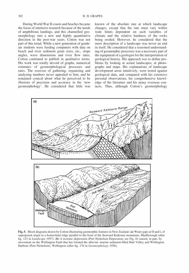
During World War II coasts and beaches becamethe focus of intensive research because of the needsof amphibious landings, and this channelled geo-morphology into a new and highly quantitativedirection in the post-war years. Cotton was notpart of this trend. While a new generation of gradu-ate students were feeding computers with data onbeach and river sediment grain sizes, etc., slopeangles, wave dimensions and river flow rates,Cotton continued to publish in qualitative terms.His work was totally devoid of graphs, numericalestimates of geomorphological processes andrates. The exercise of gathering, organizing andanalysing numbers never appealed to him, and heremained cynical about what he perceived to beillusions of precision and accuracy in the ‘newgeomorphology’. He considered that little was
known of the absolute rate at which landscapechanges, except that the rate must vary withinwide limits dependent on such variables ofclimate and the relative hardness of the rocksbeing eroded. However, he considered that themere description of a landscape was never an endin itself. He considered that a reasoned understand-ing of geomorphic processes was a necessary part ofthe equipment of a geologist for the interpretation ofgeological history. His approach was to define pro-blems by looking at actual landscapes, at photo-graphs and maps. His explanations of landscapedevelopment arose intuitively, were tested againstgeological data, and compared with his extensivepersonal observations, his comprehensive knowl-edge of the literature and his many overseas con-tacts. Thus, although Cotton’s geomorphology
Fig. 5. Block diagrams drawn by Cotton illustrating geomorphic features in New Zealand. (a) Water gaps at D and L ofsuperposed origin in a homoclinal ridge parallel to the front of the Seaward Kaikoura mountains, Marlborough (afterfig. 123 in Landscape 1957). (b) A tectonic depression (Port Nicholson Depression; see Fig. 8) caused, in part, bymovement on the Wellington Fault that has formed the alluvial–marine sediment-filled Hutt Valley and WellingtonHarbour (Port Nicholson), Wellington (after fig. 176 in Geomorphology 1958).
R. H. GRAPES302

remained qualitative, which is probabily the mainreason for its lasting popularity, although it is alsothe reason why he never established a school of geo-morphological thought.
By the late 1950s many geomorphologists hadabandoned the Davisian ‘cyclic’ analysis of land-forms, but Cotton continued to advocate its value,particularly as it facilitated a systematization oflandforms that could be readily understood bythose beginning geomorphic studies. In a postscriptto the seventh edition of Geomorphology in 1958,he reiterated that a cycle may never complete thefull-circle and that, although there may be apparentreversals in the order of evolutionary stages owingto their shortening or suppression, cyclic stagesprovided an unrivalled system of explanatorydescription of landforms with the cyclic conceptproviding a useful framework ‘fitted withconvenient pegs on which to hang discussions ofimportant problems’.
By the end of World War II New Zealand hadbeen covered by low-level (12 000 ft height) aerialphotographs that provided a tremendous leapforward in mapping the country, and making it poss-ible for the first time to observe the landscape directlyfrom above and in stereoscopic vision. Unfortu-nately, Cotton, with only one good eye, was unableappreciate the 3-D image of the landscape from apair of overlapping aerial photographs. He did,however, establish a working relationship withV. C. Browne associated with the New ZealandPublic Works Department and with N. Z. AerialMapping who took Cotton on many flying tripsaround New Zealand in which he used an ex-USairforce handle-grip camera to take areal photographswhile holding the camera outside the plane window.Many of these oblique aerial photographs were usedby Cotton in later editions of his books and theyprovide an additional, dynamic dimension, com-plimentary to his line sketches, for understandingand recognizing landscapes and landscape-formingprocesses from another perspective.
A recurring theme
One interest that Cotton returned to several timeswas the geomorphic development of the ruggedlandscape of the Wellington area where he hadbegan his studies in 1912 with the recognition of
Fig. 6. (Continued) plateau composed of hardHawkesbury Sandstone that is being incised to form toescarpment cliffs (drawn in 1921, fig. 117 in Landscape1957). (e) Needle karst forms (high-peaked hums),Kwangsi, China (drawn from a photograph, fig. 368 inLandscape 1957).
Fig. 6. Sketches made by Cotton of geomorphicfeatures outside New Zealand. (a) Betrunked andincipiently rejuvenated valleys on the French (above)and English (below) coasts of the Straits of Dover(drawn from photographs, fig. 441 in Geomorphology1958). (b) The plateau of Norway at North Cape drawnby Cotton in 1928 (fig. 221 in Landscape 1957). (c)Incised meander of the Meuse River, Fumay, northernFrance (drawn from a photograph, fig. 252 in Landscape1957). (d) The valley of the Grose, Blue Mountains,New South Wales, Australia. The upper surface is the
SIR CHARLES COTTON (1885–1970) 303

Fig. 7. Map of the Wellington Peninsula showing distribution of K-surface, marine benches and alluvial terraces described by Cotton in terms of three erosion cycles (seethe text). The Makara Stream valley consists of Holocene alluvial gravels. Also shown are the Wellington, Ohariu and Shepherds Gully faults with upthrown (u), downthrown
R.
H.
GR
AP
ES
304

cycles of erosion, regional tilting (warping) andactive faulting (Fig. 7). In 1912 Cotton explainedthe geomorphic development of the WellingtonPeninsula in terms of three Davisian erosioncycles corresponding to different base levels.In addition to the three main erosion events,Cotton also recognized other landform remnants,such as successive marine platforms and alluvialterraces, that he considered corresponded to other,short pauses or stillstands in the overall uplift ofthe peninsula. His deductions, in Cotton’s ownwords, were based on ‘hasty traverses and obser-vations made from a distance’, which is probablywhy his 37-page 1912 paper is called, ‘Notes onWellington physiography’. Nevertheless, thegeneral conclusions reached have survived thetest of time and were little modified in subsequentpapers except for the dropping of any rigorousadherence to erosion cycles. Cotton recognizedthe oldest erosion feature in an otherwise hillylandscape as remnants of a mature low reliefsurface (a peneplain he termed the K (¼ key)-surface) with a base level of 244–275 m abovepresent sea level (Fig. 7a). Outcrops of thesurface are deeply weathered and commonly lit-tered with lag boulders of greywacke and veinquartz, and the areas of low relief are borderedby precipitous slopes and ravines producedduring the subsequent cycle. Cotton consideredthat this oldest erosion cycle (termed the Kaukaucycle after the highest peak preserving theK-surface, Fig. 7) reached a stage of late maturitywith an overall elevation close to that of baselevel. Height differences of the K-surfaceremnants were attributed to later differentialmovement or warping of rocks of uniform compo-sition (greywacke) between the NNE-trendingfaults that traverse the Wellington Peninsula(Fig. 7c). Today, Cotton’s ‘K-surface’ is recog-nized as a key pre-late Quaternary markersurface (Ota et al. 1981; Begg & Mazengarb1996), although with an uncertain age ofbetween 0.4 and 4 Ma. One small outcrop offossiliferous Early–Middle Pliocene (c. 3.6–5 Ma) marine mudstone overlying downfaulted
greywacke basement on the Ohariu Fault inthe Makara Valley (Fig. 7) (Grant-Taylor &Hornibrook 1964) may represent part of the Ter-tiary sediments that once covered the K-surface.
The next main erosion cycle, the ‘Tongue Point’or ‘Intermediate’ cycle, proposed by Cotton wasrecognized as the most prominent marine benchpreserved on the Wellington coast at TonguePoint (Fig. 7b), indicating a base level of approxi-mately 50 m above present sea level. Today, thismarine bench is considered to represent the LastInterglacial highstand in sea level (oxygen isotopestage 5e) at approximately 125 000 BP. Inland,for example in the Makara Valley (Fig. 7), Cottonconsidered that there was coeval development ofgraded streams associated with the formation ofwide flood plains (Fig 7d) and that the morphologi-cal stage reached by the Intermediate cycle was oneof adolescence or early maturity in which divideswere reduced to altitudes of 180–240 m by ‘round-ing’ and slope grading.
The youngest geomorphic features on theWellington Peninsula, representing what Cottonterms the ‘Present cycle’ of erosion, are characterizedby the steep lower slopes of valley sides and floodplains and incisement, in many cases with streamscutting steep gorges into the basement greywacke(Fig. 7e), indicating a youthful stage of development.
Later Cotton had doubts about the correlation ofthe marine benches with broad alluvial terracesinland, and considered the possibility that thelatter were a more ancient feature and intermediatein height (and therefore age) between the proposedKaukau and Tongue Point cycle base-levelelevations. The alluvial gravel surfaces in theMakara Valley (Fig. 7d) are now considered to beLate Quaternary and more than 350 ka old. Also,an older, more dissected, marine beach remnantidentified by Cotton landward of the TonguePoint bench at c. 75–100 m above sea level(B in Fig. 7) is now considered to represent theerosion surface created during a sea-level high atapproximately 195 ka (Ota et al. 1981). Cotton’slater, more detailed, work describing a well-developed marine bench exposed to the east of
Fig. 7. (Continued) (d ) sides and sense of horizontal movement (arrows) indicated (after Ota et al. 1981; Begg &Mazengarb 1996). Photographs. (a) Looking SE across the Wellington Peninsula (Port Nicholson in the background),showing the remnant of the Pliocene–late Quaternary K-surface (arrowed; first recognized or earliest erosion cycle) inthe vicinity of Quartz Hill (see the map for location). (b) View looking west along the south Wellington Coast showingthe last Interglacial marine bench at Tongue Point (second erosion cycle) (see the map for location). (c) View lookingeast across the western part of the Wellington Peninsula with Cape Terawhiti in the foreground and Quartz Hill, withthe K-surface (arrowed) in the distance (see the map for location). Note the height accordance (indicative of the firsterosion cycle) of the NNE–SSW-trending parallel ridges that reflect the dominant drainage pattern controlled byregional strike of the greywacke basement rocks and main faults shown in the map. (d) View looking down the MakaraValley showing Late Quaternary alluvial terrace remnants (arrowed; tentatively correlated with the second erosion–deposition cycle) (see the map for location). (e) Stream gorge of the youngest, or third, erosion cycle incised into theinferred second cycle mature surface (upthrown side of the Wellington Fault). See the text.
SIR CHARLES COTTON (1885–1970) 305

Port Nicholson (Wellington Harbour) (Cotton1921), and clearly correlated with the one hedescribed in 1912 west of Wellington, make nomention of the Tongue Point erosion cycle. Fromheight approximations of this and older, higher,marine bench remnants, he proposed an overallwestward tilt towards Port Nicholson (termed thePort Nicholson depression) bounded on thewestern side by the Wellington Fault, and asimilar, more gentle tilting westwards fromTongue Point. A section shown in Figure 8,constructed from localities and heights mentionedin Cotton’s 1912, 1916 and 1921 papers, illustratesthis. A detailed survey of the successive marinebenches preserved along the Wellington coastwith possible correlations, was only made 60years later (Ota et al. 1981), and is in broad agree-ment with Cotton’s work (Fig. 8). Of particularinterest was the effect of uplift, maximum of2.5 m, on the western side of Palliser Bay (Fig. 8)and westward tilting that affected the whole ofthe Wellington Peninsula caused by the 23January 1855 M8 earthquake, described by Lyell(1868) from information supplied to him onchanges in coastal elevation by New Zealand eye-witnesses. Cotton realized that the pattern of west-ward tilting caused by this earthquake event wasthe same as the much older marine benches, imply-ing a long period of earthquake activity to explainthe overall uplift of the Wellington area. In thisrespect, Cotton was following Lyell (1868) whostated that, ‘The geologist has rarely enjoyed sogood an opportunity as that afforded him by thisconvulsion in New Zealand, of observing one ofthe steps by which those great displacementsof the rocks called “faults” may in the course ofages be brought about. The manner also in whichthe upward movement increased from north-westto south-east explains the manner in which bedsmay be made to dip more and more in a givendirection by each successive shock’ (p. 89).
In the case of the 1855 earthquake, uplift wascaused by movement on the now-called WairarapaFault, as recorded by Lyell (1868), but Cotton wasalso interested in the geomorphic effects of uplifton the Wellington Fault, which he also describedin 1912 in terms of an eroded fault scarp where itborders the western side of Wellington Harbour(Fig. 9) and the presence of truncated valleyswhere they intersect the fault. In 1954 he describedstream alignments and ‘trailing’ tributary streamsalong the active trace (called a cicatrice) and,more importantly, reported dextral displacementof one stream and two ridges by approximately60 m (Fig. 9). These offsets were intepreted asbeing the result of cumulative displacement of anumber of earthquakes, as were the dextrallytrailing tributaries the result of many small
earthquake lateral offsets developed on the SEside of the fault (Fig. 9). These were the first obser-vations of lateral displacement of Quaternary geo-morphic features on any of the major active faultsin New Zealand, all of which are now known tohave had a much greater lateral (dextral) thanvertical movement, a feature first noted by Cottonfor movement on the Wellington Fault.
Active retirement and honours
In 1953, at the age of 65, Cotton retired from theChair of Geology at Victoria University after 32years. He was elected Emeritus Professor and wasawarded an Honorary LLD from the University ofNew Zealand the following year, when the univer-sity marked his retirement with the publication ofa book, New Zealand Geomorphology, containingreprints of his selected papers from between 1912and 1925, a decade that was one of amazingly fruit-ful activity in New Zealand geological research ledby Cotton’s statements of new ideas on the latergeological history of the country. An ‘Appreciation’at the beginning of the book contributed by one ofthe leading geomorphologists, Henri Baulig inStrassbourg, paid tribute to this work pointing outthat it ‘demonstrated the fundamental validity ofthe Davisian evolutionary concept and its durablefruitfulness’. Throughout his long career, Cottonreceived many awards and honours. He receivedthe highest distinctions of New Zealand science,the Hector Medal in 1927 and the Hutton Medalin 1947 from the Royal Society of New Zealand.Overseas recognition came in the form of theVictoria Medal of the Royal Geographical Societyof London in 1951, and the Dumont Medal ofthe Geological Society of Belgium in 1954. In theQueen’s Birthday Honours of 1959, Cotton wasmade Knight Commander of the Order of theBritish Empire (K.B.E.). With characteristicmodesty, together with mild humour, he replied toone congratulatory letter: ‘I do not know whetherI am very much better off as Sir Charles: but I doknow my wife gets a great deal of satisfaction outof being Lady Cotton’.
In retirement, Cotton continued to publish fromhis home address on a multitude of topics – coastalgeomorphology, climate change, sea-level change,landscapes formed by fault movement, Pacificislands, erosion in tropical and temperate climates(see the Bibliography). The papers developed bothoriginal ideas as well as revived old ones in a newcontext that gave due prominence to the post-Davisian views of Albrecht and Walther Penck,Lester King, as well as others. As evident fromhis bibliography, Cotton retained his mental alert-ness, and was well aware of the changes in
R. H. GRAPES306

Fig. 8. Height distribution of marine benches along the south Wellington coast projected onto a vertical section striking 3008 between Turakirae Head and Cape Terawhiti as shownon the map of the southern part of the North Island of New Zealand. Solid circles and connecting solid lines are heights and correlations given by Cotton (1912, 1916, 1921).For comparison, thin dashed lines that are inferred marine bench correlations (with question marks) determined from surveyed heights mapped by Ota et al. (1981) are also shown.The block diagram (after fig. 3 of Cotton 1921) shows the marine benches and earthquake-uplifted beach lines, west of Port Nicholson. A block diagram of the form of thePort Nicholson depression is shown in Figure 5b.
SIR
CH
AR
LE
SC
OT
TO
N(1
885
–1970)
307

Fig. 9. Map showing the surface trace of the southern part of the Wellington Fault (after fig. 2 of Cotton 1951),showing stream alignments, trailing stream tributaries and the location of dextrally displaced (shutter) ridges illustratedin the block diagram below (fig. 4. of Cotton 1951). The illustration above shows the eroded scarp of the WellingtonFault that forms the western side of Port Nicholson. The position of the active fault trace lies offshore. See the text.
R. H. GRAPES308

outlook, methods and purpose in geomorphologythat had been underway since the 1950s, until hisdeath on 29 June 1970, aged 85. Out of a total of185 research papers, only five are co-authored,two of which were published posthumously. A col-lection of 16 of his most important papers on coastalgeomorphology, which had been annotated byCotton just before his death, were published as thebook Bold Coasts (Collins 1974).
Illustrative skills
While Cotton’s life’s work was devoted to unravel-ling the story of landscape form and developmentthrough word and illustration, his landscape sketchesare particularly distinctive and possess a simplicityof style that reflects his skill as a landscape artist.They are one of the most endearing aspects ofCotton’s work, a clarification that clears the land-scape of vegetation and buildings to expose theunderlying structure of the land, and in so doingcapture a moment of geological time. A letter fromJapan commemorating his 80th birthday paysparticular tribute to his artistic ability: ‘. . . we [i.e.Japanese geomorphologists] especially entertainfriendly sentiment for his sketches, which sometimesremind us of pictures drawn in Chinese ink – ofthe Southern China School’ – i.e. monochrome inkpainting. In addition to Cotton’s original sketches,he also made a large number from photographs orfrom sketches drawn by overseas geomorphologists(see Fig. 6). In the 33 year period between 1911and 1944, Cotton produced 422 pen and ink draw-ings, and, in total, his line drawings amount toalmost 600. They stand together with his writing asa tribute to the unequalled lifetime work of one man.
Final comment
Cotton pointed out on numerous occasions that onemust bear in mind that no feature of the Earth’ssurface is a finished product; ‘the agencies thateffect changes of form are everywhere at work;every part of the surface is even now undergoingchange, and its future forms will differ from thepresent as the present differs from the past’(Cotton 1947; Preface to 2nd edition of Landscapeas Developed by Processes of Normal Erosion).His life’s work was an attempt to document thesechanges and trace their evolution in terms of a sys-tematized cycle of erosion, fluvial, glacial, marine,arid and karstic, in relation to the Davisian para-digm of structure, process and time that definesthe landscape. Field observation was the core ofhis geomorphological investigations and his quali-tative, largely deductive, conclusions. However,like many of his contemporaries, Cotton alsoemphasized the ‘process’ aspect in introducing the
effects of climate and sea-level change, andtectonic forces, particularly those involving upliftand faulting, i.e. the interaction of exogenic andendogenic forces advanced by Walther Penck.Indeed, Cotton could not have been in a betterplace to develop these ideas but in New Zealand,a tectonically active country where the relationshipbetween geologically recent Earth movements,denudation, erosion and associated deposition isparticularly obvious and ongoing.
I would like to thank M. Johnston (Nelson, New Zealand)and R. Twidale (University of Adelaide, Australia) fortheir constructive comments on an earlier draft ofthe manuscript.
Bibliography of Sir Charles Cotton
Books (date of first editions)
1922. Geomorphology of New Zealand: Part 1 –Systematic: An Introduction to the Study ofLandforms. Dominion Museum, Wellington.
1941. Landscape as Developed by Processes ofNormal Erosion. Cambridge UniversityPress, Cambridge.
1942. Climatic Accidents in Landscape Making.Whitcombe and Tombs, Christchurch.
1944. Volcanoes as Landscape Forms. Whitcombeand Tombs, Christchurch.
1945. Earth Beneath: An Introduction to Geologyfor Readers in New Zealand. Whitcombeand Tombs, Christchurch.
1945. Living on a Planet. Whitcombe and Tombs,Christchurch.
1955. New Zealand Geomorphology (reprints ofselected papers 1912–1925). New ZealandUniversity Press, Wellington.
Journal articles
1909. Geology of Signal Hill, Dunedin. Trans-actions of the New Zealand Institute, 41,111–126.
1912. Typical sections showing the junction of theAmuri limestone and Weka Pass Stone atWeka Pass. (Abs). Transactions of the NewZealand Institute, 44, 84–85.
1912. Notes on Wellington physiography. Trans-actions of the New Zealand Institute, 44,245–265.Recent and sub-Recent movements of upliftand subsidence near Wellington, NewZealand. Scottish Geographic Magazine,28, 306–312.
1913. The physiography of the Middle ClarenceValley, New Zealand. Geographic Journal,42, 225–246.
SIR CHARLES COTTON (1885–1970) 309

The Tuamarina Valley: A note on the Qua-ternary history of the Marlborough Soundsdistrict. Transactions of the New ZealandInstitute, 45, 316–322.
1914. On the relations of the Great MarlboroughConglomerate to the underlying formationsin the Middle Clarence valley, NewZealand. Journal of Geology, 22, 346–363.Preliminary note on the uplifted east coast ofMarlborough. Transactions of the NewZealand Institute, 46, 286–294.Supplementary notes on Wellington physio-graphy. Transactions of the New ZealandInstitute, 46, 294–298.Outline of the physiography of Wellington.In: Handbook for Scientific Visitors. NZScience Congress Committee, Wellington,20–21.The Wellington fault-scarp. In: Handbookfor Scientific Visitors. NZ ScienceCongress Committee, Wellington, 21.Raised beaches at Wellington. In: Handbookfor Scientific Visitors, NZ Science CongressCommittee, Wellington, 21–22.
1916. The structure and later geological history ofNew Zealand. Geological Magazine, 53,243–249.Block mountains and a ‘fossil’ denudationplain in northern Nelson. Transactions ofthe New Zealand Institute, 48, 59–75.Fault coasts in New Zealand. GeographicReview, 1, 20–47.
1917. The fossil plains of North Otago. Trans-actions of the New Zealand Institute, 49,429–432.Block Mountains in New Zealand. AmericanJournal of Science, 44, 249–293.
1918. River terraces in New Zealand. NewZealand Journal of Science and Technology,1, 145–152.The geomorphology of the coastal district ofsouth-western Wellington. Transactions ofthe New Zealand Institute, 50, 212–222.Mountains. New Zealand Journal of Scienceand Technology, 1, 280–285.Conditions of deposition of the continentalshelf and slope. Journal of Geology, 26,135–160.The outline of New Zealand. GeographicReview, 6, 320–340.
1919. Problems presented by the Notocene beds ofcentral Otago. New Zealand Journal ofScience and Technology, 2, 69–72.Rough Ridge, Otago, and its splintered faultscarp. Transactions of the New ZealandInstitute, 51, 281–285.Geomorphology. (Letter to Editor.) Science,49, 423–424.
1921. For how long will Wellington escapedestruction by earthquake? New ZealandJournal of Science and Technology, 3,220–231.Origin of the Upper Waitaki depression.(Letter.) New Zealand Journal of Scienceand Technology, 4, 207–208.Report of physiographic features ofAustralasia Committee: Advances inphysiography of New Zealand in the lastten years. Reports of the AustralasianAssociation for the Advancement ofScience, 15, 335–342.The warped land surface on the south-eastern side of the Port Nicholsondepression. Transactions of the NewZealand Institute, 53, 131–143.
1922. The geomorphology of Wellington. In: NewZealand Nature Notes. Government Printer,Wellington, 3–10.Glaciers and glaciation if the Mount Cookdistrict. In: New Zealand Nature Notes.Government Printer, Wellington, 46–48.
1925. Evidence of Late Tertiary or post-Tertiaryorogeny in New Zealand. GedenkboekVerbeek, Verhenigin Geologie-Mijnbouw,Genootschap Nederland en Kolonien Geolo-gische Series, 8, 89–110.
1926. [Recent Papers on] Geomorphology in NewZealand, 1921–1924. Reports of the Austra-lasian Association for the Advancement ofScience, 17, 50–56.
1936. Geomorphology of Wellington. In: Hand-book for New Zealand. Australia and NewZealand Association for the Advancementof Science, Wellington, 20–21.
1938. The Haldon Hills problem. Journal of Geo-morphology, 1, 187–198.Some peneplanations in Otago, Canterbury,and the North Island of New Zealand. NewZealand Journal of Science and Technology,20B, 1–8.
1939. Lateral planation in New Zealand. NewZealand Journal of Science and Technology,B20, 227–232.Glacial spur-truncation in New Zealand.Journal of Geomorphology, 2, 70–72.
1940. Classification and correlation of riverterraces. Journal of Geomorphology, 3,27–37.Taylor’s hypothesis of headward glacialerosion. Journal of Geomorphology, 3,346–352.Glacial motion: A review of theories. NewZealand Journal of Science and Technology,B21, 281–286.
1941. The longitudinal profiles of glaciatedvalleys. Journal of Geology, 49, 113–128.
R. H. GRAPES310

Notes on two transverse-profile geomorphicproblems. Transactions of the Royal Societyof New Zealand, 71, 1–6.Moraines and outwash of the TasmanGlacier. Transactions of the Royal Societyof New Zealand, 71, 204–207.The shoulders of glacial troughs. GeologicalMagazine, 78, 81–96.Basal remnants of truncated spurs in gla-ciated troughs. Journal of Geomorphology,4, 65–70.Some volcanic landforms in New Zealand.Journal of Geomorphology, 4, 297–306.
1942. Shorelines of transverse deformation.Journal of Geomorphology, 5, 45–58.
1943. Oahu Valley sculpture: A composite review.Geological Magazine, 80, 237–243.
1944. Tropical weathering and landforms: a cor-rection. Geological Magazine, 81, 141–142.
1945. The significance of terraces due to climaticoscillation. Geological Magazine, 82,10–16.Geomorphic provinces in New Zealand.New Zealand Geographer, 1, 40–47.Ruapehu in 1945. New Zealand ScienceReview, 3, 3–4.
1946. The 1945 eruption of Ruapehu. TheGeographical Journal, 107, 140–143.
1947. The Alpine Fault of the South Island of NewZealand from the air. Transactions of theRoyal Society of New Zealand, 76, 369–372.Revival of major faulting in New Zealand.Geological Magazine, 84, 79–88.
1948. The landscape of the Acheron Valleysystem. (Note.) New Zealand Geographer,4, 197.Recent volcanic activity in New Zealand.(Note.) Geographic Journal, 112, 258.The Hamner Plain and the Hope Fault. NewZealand Journal of Science and Technology,B29, 10–17.A note on tectonic and structural landforms.New Zealand Journal of Science and Tech-nology, B29, 96.Query as to the tempo of Australian denuda-tion. Geological Magazine, 85, 54–56.Volcano-eustatism, positive or negative?Geological Magazine, 85, 201–202.The buckling theory of orogeny, island fes-toons and foredeeps. New Zealand ScienceReview, 6, 8–12.The present-day status of coral reef theories.New Zealand Science Review, 6, 111–113.
1949. Plunging cliffs, Lyttelton Harbour. NewZealand Geographer, 5, 130–136.Rejuvenation of the Awatere Fault cicatrice.Transactions of the Royal Society of NewZealand. 77, 273–274.
Recent volcanic activity in New Zealand.Geographic Journal, 112, 258.Earth birth – a flashback to primordialchaos. New Zealand Science Review, 7,120–122.A review of tectonic relief in Australia.Journal of Geology, 57, 280–296.
1950. Tectonic scarps and fault valleys. Bulletinof the Geological Society of America, 61,717–758.Quelques Aspectes de Relief de Failles.Revue Geomorphologie Dynamique, 1,226–234.Tectonic relief. Annual Association ofAmerican Geographers, 40, 181–187.The cause of Ice Ages – is the sun a variablestar. New Zealand Science Review, 8,31–33.Climatic significance of terraces. (Note.)New Zealand Geographer, 6, 85–87.Axes of warping in the New Zealandseismic region. Geological Magazine, 87,360–368.
1951. Redeposition theory of sedimentation. NewZealand Journal of Science and Technology,B32, 19–25.Post-Hokonui Orogeny, erosion, and plana-tion. New Zealand Journal of Science andTechnology, B33, 173–178.Fault valleys and shutter ridges atWellington. New Zealand Geographer, 7,62–68.Seacliffs of Banks Peninsula and Welling-ton: Some criteria for coastal classi-fication. New Zealand Geographer, 7,103–120.Atlantic gulfs, estuaries and cliffs. Geologi-cal Magazine, 88, 113–128.Accidents and interruptions in the cycle ofmarine erosion. Geographic Journal, 117,343–349.Une Cote de deformation transverse aWellington (Nouvelle-Zelande). RevueGeomorphologie Dynamique, 2, 97–109.
1952. The Wellington coast: An essay in coastalclassification. New Zealand Geographer, 8,46–62.Cyclic reseaction of headlands by marineerosion. Geological Magazine, 89,221–225.The erosional grading of convex andconcave slopes. Geographic Journal, 118,197–204.
1953. Submarine canyon hypotheses. NewZealand Science Review, 11, 110–113.Tectonic relief: With illustrations fromNew Zealand. Geographic Journal, 119,213–222.
SIR CHARLES COTTON (1885–1970) 311
1954. Submergence in the lower Wairau Valley.New Zealand Journal of Science andTechnology, 35, 364–369.Terrestrial carbon. New Zealand ScienceReview, 12, 54–55.Earth’s core and its mantle. New ZealandScience Review, 12, 67–71.Notocenozoic: The New Zealand Cretaceo-Tertiary (Sixth Hudson Lecture). NewZealand Science Review, 12, 105–112.Tests of a German non-cyclic theory andclassification of coasts. GeographicJournal, 120, 353–361.Deductive morphology and the geneticclassification of coasts. Science Monthly,78, 163–181.
1955. Review of the Notocenozoic or Cretaceo-Tertiary of New Zealand. Transactions ofthe Royal Society of New Zealand, 82,1071–1122.Ten thousand years of accelerated erosion.Geographic Journal, 121, 241–244.Peneplanation and pediplanation. Bulletin ofthe Geological Society of America, 66,1213–1214.The theory of secular marine planation.American Journal of Science, 253,580–589.Aspects geomorphologiques de la flexurecontinentale. Annales Societe Geologiquede Belgique, 78, B403–418.& TE PUNGA, M. T. Solifluxion and perigla-cially modified landforms at Wellington,New Zealand. Transactions of the RoyalSociety of New Zealand, 82, 1001–1031.& TE PUNGA, M. T. Fossil gullies in theWellington landscape. New Zealand Geo-grapher, 11, 72–75.
1956. Coastal history of southern Westland andnorthern Fiordland. Transactions of theRoyal Society of New Zealand, 83, 483–488.Hawke’s Bay coastal types. Transactionsof the Royal Society of New Zealand, 83,687–694.Geomechanics of New Zealand mountain-building. New Zealand Journal of Scienceand Technology, 38, 187–200.The question of polar wanderings. NewZealand Science Review, 14, 92–93.Rias sensu stricto and sensu lato. Geo-graphic Journal, 122, 360–364.–, Baulig, H. & Wallace, W. H. Geo-morphology, geomorphography, geomor-phogeny, and geography. New ZealandGeographer, 12, 72–75.& Tricart, J. Discussion a propos del’analyse d’un ouvrage. Revue Geomorpho-logie Dynamique, 7, 148–149.
1957. Tectonic features in a coastal setting atWellington. Transactions of the RoyalSociety of New Zealand, 84, 761–790.Pleistocene shorelines on the compoundcoast of Otago. New Zealand Journal ofScience and Technology, 38, 750–762.An example of transcurrent-drift tectonics.New Zealand Journal of Science and Tech-nology, 38, 939–942.The Pukurua tectonic corridor, Wellington.New Zealand Geographer, 13, 117–124.A slow tempo of denudation claimed forEastern Australia. Geological Magazine,94, 341–342.Geomorphic evidence of major structuresassociated with transcurrent faults in NewZealand. Revue Geographie Physique Geo-logie Dynamique, 16–30.Geomorphic contrasts in central NewZealand. Tijdschriftt Kon NederllandeAardrijksk Generalle, 74, 248–253.
1958. Dissection and redissection of theWellington landscape. Transactions ofthe Royal Society of New Zealand, 85,409–425.Evidence of late Pliocene warmth in NewZealand. New Zealand Journal of Geologyand Geophysics, 1, 470–473.Alternating Pleistocene morphogeneticsystems. Geological Magazine, 95,125–136.The rim of the Pacific. Geographic Journal,124, 223–231.Eustatic river terracing complicated byseaward downflexure. Transactions of theEdinburgh Geological Society, 17, 165–178.Fine-textured erosional relief in NewZealand. Zeischrift fur Geomorphogie, 2,187–210.
1959. Notocenozoic; Notopleistocene. In: FLEMING,C. A. (ed.) Lexique Stratigraphique Inter-national (Oceane), Fasicule 4. New Zealand.Centre Nationale de la Rescherche Scientifi-que; for Stratigraphic Commission of Inter-national Geological Congress, Paris, Sce, 6,262–263.
1960. Hutt Valley fault scarps. New Zealand Journalof Geology and Geophysics, 3, 218–221.The origin and history of central-Andeanrelief: divergent views. GeographicJournal, 126, 476–478.Levelling by rock-floor robbing in Brazil.Journal of Geololgy, 68, 573–574.
1961. The last glacial age. New Zealand ScienceReview, 19, 58–60.Growing mountains and infantile islands ofthe western Pacific. Geographic Journal,127, 209–211.
R. H. GRAPES312

The theory of savanna planation. Geogra-phy, 46, 89–101.
1962. Low seal levels in the Late Pleistocene.Transactions of the Royal Society of NewZealand (Geology), 1, 249–252.Plains and inselbergs of the humid tropics.Transactions of the Royal Society of NewZealand (Geology), 1, 269–277.The origin of New Zealand feral (fine-textured) relief. New Zealand Journal ofGeology and Geophysics, 5, 269–270.The volcano-tectonic theory of block fault-ing no longer tenable. New ZealandScience Review, 20, 48–49.La signification de la fossilisation d’unrelief de microdissection sous le head enNovelle Zelande. Rev. Geomorphol. Dyn.,10, 30–32.Dating recent mountain growth by fossilpollens. Tuatara (Journal of the BiologicalSociety, Victoria University of Wellington,New Zealand), 10, 5–12.Holocene marine benches in South Americaand elsewhere. Geologia Colombiana, 3,3–15.
1963. The question of high Pleistocene shorelines.Transactions of the Royal Society of NewZealand (Geology), 2, 51–61.Development of fine-textured landscaperelief in temperature pluvial climates. NewZealand Journal of Geology and Geophy-sics, 6, 528–533.A new theory of the sculpture of middle-latitude landscapes. New Zealand Journalof Geology and Geophysics, 6, 769–774.The rate of down-wasting of land surfaces.Tuatara (Journal of the Biological Society,Victoria University of Wellington, NewZealand), 11, 26–27.Did the Murrumbidgee Aggradations takeplace in Glacial ages? Australian Journalof Science, 26, 54.Levels of planation of marine benches.Zeitschrift fur Geomorphogie, 7, 97–111.
1964. The control of drainage density. NewZealand Journal of Geology and Geophy-sics, 7, 348–352.The cryergic-fluvial valley form. NewZealand Journal of Geology and Geophy-sics, 7, 918–919.
1966. The continental shelf. New Zealand Journalof Geology and Geophysics, 9, 105–110.Antarctic scablands. New Zealand Journalof Geology and Geophysics, 9, 130–132.
1968. Plunging cliffs and Pleistocene coastal cliff-ing in the southern hemisphere. Melanges de
Geographie, 1. Geographie Physique et Geo-graphie Humaine, 37–59.
1969. The pedestals of oceanic volcanic islands.Bulletin of the Geological Society ofAmerica, 80, 749–760.Skeleton islands of New Zealand and else-where. Earth Science Journal (WaikatoGeological Society), 3, 61–76.The Turakirae coastal plain. (Letter.) NewZealand Journal of Geology and Geophy-sics, 12, 838–841.Marine cliffing according to Darwin’stheory. Transactions of the Royal Societyof New Zealand (Geology), 6, 187–208.
1970. Pedestals of oceanic volcanic islands: reply.Bulletin of the Geological Society ofAmerica, 81, 1605.
1972. The duration of the Pleistocene. Journalof the Royal Society of New Zealand, 2,541–544.
References
BEGG, J. G. & MAZENGARB, C. 1996. Geology of theWellington Area. Institute of Geological and NuclearSciences Geological Map 1:50 000, 1 sheet. NewZealand Institute of Geological and Nuclear Sciences,Lower Hutt.
COLLINS, B. W. 1966. Sir Charles Cotton (80th BirthdayIssue). New Zealand Journal of Geology and Geophy-sics, 9.
COLLINS, B. W. (ed.). 1974. Bold Coasts (Annotatedreprints of selected papers on coastal geomor-phology 1916–1969). A. H. and A. W.Reed,Wellington.
DAVIS, W. M. 1923. C. A. Cotton. Geomorphology ofNew Zealand. Part1 – Systematic: An Introductionto the Study of Land-forms. Geographical Review,13, 321–322.
GRANT-TAYLOR, T. L. & HORNIBROOK, N. DE. B. 1964.The Makara faulted outlier and the age of Cook Strait.New Zealand Journal of Geology and Geophysics, 7,299–313.
KING, L. C. 1930. Raised Beaches and other features ofthe south-east coast of the North Island of NewZealand. Transactions of the New Zealand Institute,61, 498–523.
KING, L. C. 1962. Morphology of the Earth. Oliver &Boyd, Edinburgh.
LYELL, C. 1868. Principles of Geology, Volume 2, 10thedn. John Murray, London, 82–89.
OTA, Y., WILLIAMS, D. N. & BERRYMAN, K. 1981. LateQuaternary Tectonic Map of New Zealand. SheetsQ27, R27 and R28, Wellington, Scale 1:50 000 withnotes. New Zealand Department of Scientific andIndustrial Research, Lower Hutt.
PARK, J. 1909. The Geology of the Queenstown Subdivi-sion. New Zealand Geological Survey, Bulletin, 7.
SIR CHARLES COTTON (1885–1970) 313
Related Documents