Reprinted from Simulation Studies in Archaeology Edited by Ian Hodder. Series: New Directions in Archaeology Published by Cambridge University Press

Welcome message from author
This document is posted to help you gain knowledge. Please leave a comment to let me know what you think about it! Share it to your friends and learn new things together.
Transcript

Reprinted from Simulation Studies in Archaeology Edited by Ian Hodder.
Series: New Directions in Archaeology Published by Cambridge University Press
larzimme
Typewritten Text
larzimme
Typewritten Text
larzimme
Typewritten Text
larzimme
Typewritten Text
larzimme
Typewritten Text
larzimme
Typewritten Text
larzimme
Typewritten Text
1978 Simulating Prehistoric Locational Behavior. In I. Hodder (ed.), Simulation Studies in Archaeology. Cambridge University Press. pp. 27-37.
27
Chapter 3
Simulating prehistoric locational behaviour Larry J. Zimmerman
Introduction The perplexing question, why people locate themselves
where they do, has become a focus for archaeology only since settlement pattern analysis developed as an important area of research in the early 1950s. Recent concern for the delineation and explanation of cultural processes has brought the question into sharper focus making prehistoric locational analysis a keystone of entire regional research efforts (Gumerman 1971). That such a focus is important is perhaps obvious: an individual or group has to be somewhere to exploit his (its) environment in a particular way and to relate to his (its) contemporaries in specified ways. Therefore, in many respects human location can be seen to serve as an integrative mechanism, an interface for several cultural subsystems.
Archaeological simulations of human location have been relatively rare, perhaps because locational decision-making is seen to be incredibly complex. Zubrow (197la, 1971 b, 197 5) concerned himself with a model of environmental carrying capacity as a dynamic equilibrating system. As part of his model he simulated the impact of carrying capacity changes on size and location of human settlement in the Hay Hollow Valley of Arizona. Thomas (I 971, 1972, 1973, 1974) used a function-specific model designed to simulate deposition of artifacts resulting from the ethnographic subsistence pattern of the Shoshone of the Great Basin as posited by Steward ( 1941 ). Even though his concern was primarily with artifacts, certain

L.J. Zimmerman 28
of his categories were directly related to settlement pattern. Still, they do make functional choices. Analysing these While both these situations dealt with locational behaviour decisions even with direct access to the decision-maker is thus as a somewhat peripheral issue, Zimmerman ( 1976a, 1977) extremely difficult. Analysis of such decisions in prehistory focused on settlement as the central concern in a simulation of must be considered even more tenuous. locational decision making of Central Plains tradition popu- A number of approaches to locational behaviour have lations in the Glenwood locality of southwestern Iowa near been developed, primarily by economic geographers. Most
the Missouri River. models are concerned with spatial distribution and land-use All three simulations, no matter what the degree of con- patterns, and are essentially normative in that they deal with
sideration of locational behaviour, represent total society simu- idealised patterns rather than actual spatial organisation of lations, a class of simulation that treats a large number, though
not necessarily all, subsystems of a culture. Total society simu· lations are extremely complex; the more subsystems to be modelled and integrated with other subsystems, the greater the order of magnitude of programming and verification problems.
Yet, since anthropological archaeology is an holistically oriented discipline it would seem important that such simulations should eventually be done in order to test the feas
ibility of our reconstructions of lifeways and cultural processes (cf. Whallon 1972, p. 38).
To develop such a simulation is a very time consuming, demanding procedure that, once complete, seems far less frightening than it did at the start. Such a simulation for the
Glenwood locality was attempted and had a modicum of success; an assessment of that effort might prove useful to those contemplating locational or other total society simulations. Consequently, this chapter is not an abridged version of the Glenwood simulation but rather a sort of flexible 'recipe' or list of 'helpful hints'. An effort is made to consider some of the key issues and problems of simulating locational behaviour as a total society simulation.
economic phenomena. The majority of techniques in archaeological application, most notably central place theory, are derived from this normative approach. Such approaches have not gone uncriticised by geographers.
The major criticism of the normative approach focused on its simplicity. Models in economic geography did not take account of the multiplicity of factors that influence spatial organisation (Harvey 1969, p. 369). Further, economic geographers 'failed or refused to regard any spatial distributions or array of economic features on the landscape as the aggregate reflection of individual decisions' (Pred 1967, p. 11 ). These arguments reflect behaviourist influence, which Pred suggests was only considered implicitly; economic geographers tended to accept the generalisations of the environmental determinists and their successors (Pred 1967, p. 11 ). Little direct attention
was paid to the behavioural component of spatial distribution. In recent years economic geographers have realised that behavioural concepts must be introduced into their models. Some of the same criticisms can be levelled against the archaeologist who applies models from economic geography without bearing in mind their normative nature and general lack of
behavioural components. Some theoretical considerations Locational theorists on the other hand were concerned For small-scale societies, hunters and gatherers and horti- primarily with behavioural components of spatial distribution
culturalists, locational behaviour is primarily the result of individual or small-group decision making. The imperatives involved in such a locational decision are relatively few, and they operate within a framework of environmentally and culturally
delimited parameters, functionally set by mutual interaction. To identify these imperatives, let alone the particulars of the parameters, is difficult, perhaps even impossible, even when one is personally involved in making the decision.
In other words, people have a conception of where persons in their 'situation' should or would prefer to live. They
in terms of 'economic man' models derived from economics,
especially the optimising models of Von Neumann and Morgenstern (1953). The optimising models of human behaviour proposed an 'economic man', an omniscient, totally rational construct endowed with perfect predictive powers. He had one goal, that of maximising guided behaviour. 'Optimiser' strategies were those geared to reap maximum benefits from 'best'-choice decisions. Davenport's (1960) study of Jamaican fishermen and Gould's (1963) consideration of Jantilla, Ghana, farm planting strategies demonstrate the limited
'know' in a very general way what major factors (such as avail- effectiveness of their models. ability of key resources or distance to friends or relatives) The efficacy of the optimising framework which contribute to their idea of proper location. The combination assumed that units involved in decision-making acted 'in the of these elements indicates locations that are acceptable according to culturally defined standards of quality of life. The parameters determining settlement location are 'fuzzy', complicated by interaction with each other, factors of lesser importance, and by a number of seemingly random factors. Within this 'fuzzy' framework people decide where to live. They control only some of the variables knowing in a general way the parameters of the imperatives and standards of life. Random factors they cannot control and seldom consider.
guise of "absolutely rational", "unerring", economic man' (Pred 1967, p. 11) can be seen to be minimal. Major criticisms of economic man models in location theory focus on the logical consistency of assumptions of the motives ascribed to economic man and a rejection of the economic man and the high level of knowledge and abilities attributed to him. Man often operates in less than optimal ways but usually in ways that satisfy him in terms of needs (Washburn 1972). This satisfying behaviour is both culturally and situationally defined.
Prehisto
Pred l satisfyit with eq limited or inve ,
Pred th
real wo optimis a behav making
H increasi
increasi decisio! decisio: inform: one th~ If the d a decisi regard~ a simil2 choice option inferiOJ differe1 ability the reb achieve
sets ca of the
A
ofmos capable not be succee~
archae adequa
that all
is thus tory
ave st
l-use with of
chaeare have
cused ttake
~ial
geogras or
egate hese ggests
fended
binists
r:~: r:rchae-rithout r of
lerned
rbution mics,
totally
rers. He ~timiser'
l fr~m ma1can
~ n the Ian' iticisms h.e bed to td the . Man ways
h.is r defined.
Prehistoric locational behaviour
Pred's (1967, 1969) work suggests that perhaps even the satisfying models might not be entirely adequate. When faced with equal options, minimal amounts of information, and limited ability to use the information, man behaves 'randomly' or invents ad hoc rules by which to rationalise his choices. Pred therefore chose to view locational behaviour in terms of real world deviations from the norms provided in both the optimising and satisfying models. He consequently developed a behavioural matrix to account for variability in decisionmaking.
His behavioural matrix has two axes, one a scale of increasing ability to use information, the other a scale of increasing quantity and quality of information. Pred views decisions as adoptive - adaptive. At time 1 (T d when a decision-maker faces a decision with minimal ability to use information and little or no information his decision will be one that has equal probability with all others of being chosen. If the decision he adopts satisfies his needs, the next time (T2 )
a decision needs to be made, he has available the information regarding the T1 decisions and will adopt that same or at least a similar strategy again. If on the other hand his original T1 choice fails to satisfy his needs he will select another different option from the matrix. Given the information about the inferior T 1 strategy, he will choose either a slightly or vastly different option from the matrix at T2 . He increases the probability that a more satisfying strategy will be selected; he thereby adapts. At Tn he will select an optimal, though rarely achieved, strategy. What Pred's matrix allows, that the optimising and satisfying models do not, is the input of random factors, changing abilities to make decisions, and ways to account for real world deviations from 'normal' behaviour.
Consideration of human location in these terms is much like that stated earlier. These more realistic, less normative models bridge the gap between approaches to human location that Hole and Heizer (1973) suggest as characteristic of archaeology and geography. Realistic behaviours can be considered, random factors can be included, and specific problems or data sets can be examined within an adaptive framework. In spite of the utility of these approaches to location, translations of general models developed in other disciplines to particular archaeological problems present further difficulties.
Applications of all the locational models discussed above have been relatively easier in geography than they would be in archaeology. Geographic problems have, in the main, considered living, usually Western, cultures. They therefore usually have abundant data and can meet the criteria that Hiigerstrand (1952) suggests as being necessary for adequate implementation of most geographic models - that data must be complete and capable of quantitative analysis. Completeness of data must not be restricted to one moment in time, and moments should succeed each other at short intervals to give a good idea of order and continuity in the processes under consideration. In archaeology the data are generally incomplete and rarely adequate for one moment in time let alone for short intervals that allow for any real conceptualisation of the processes with
29
which we deal. Archaeological concerns with locational behaviour processes overlap those of the geographer. Archaeology, however, falls short when comparing adequacies of data sets necessary for analysis of the complex variables and their relationships involved in locational behaviour.
Archaeologicallocational problems can perhaps be best considered in two ways. Precise relationships between pertinent locational variables can often be determined by the application of heuristic statistical techniques to a data set. These techniques are similar to those suggested in Haggett (1965) for geography and applied in archaeology by Green (1973) and Washburn (1974). If the data sets are adequate and temporal control is otherwise available, the key variables in locational behaviour and their interactions can be demonstrated. Selection of variables to be considered in the data set is either intuitive or it simply uses those variables most often considered important to location (Trigger 1968). Processes or relationships in statistical form are often difficult to visualise if one is not familiar with statistical usage. The degree of contribution of each of the variables is often not entirely clear. The result even with adequate data can be confusing; with poor data the picture can be even more out of focus. When data sets are not adequate for meaningful statistical evaluation another approach to locational problems can be used - model building. Relationships and processes are no more difficult to conceptualise than those that are expressed statistically.
Model building can begin with relatively little data at hand. Variables relevant to the locational problem can be generated intuitively or drawn from existing models. The variable relationships can then be deduced. Ultimately, the model can be tested by comparison of a real data set, however weak, with the data generated by the hypotheses. The model of particular utility for long-term relationships and processes is a simulation model in which the precision of the data is not a key. It is the processes and hypothesised relationships which are paramount
to the success of the model. Actually the statistical approach and the model-building
approach are complimentary and circular. The inductive methods of the heuristic statistical procedures can generate precise, realistic hypothetical structures to build hypotheticodeductive models. Intuition need not play a key role. If, however, data are not available nor easily accessible, they must be generated . This can be accomplished with simulation modelling.
The utility of simulation The process of simulation encompasses the design and
study of a model of a system; motivations for its use come from a number of sources. As an abstract model becomes less abstract and general and more realistic and specific, it also becomes more intractable mathematically. 'We cannot easily determine the behaviour of systems whose variables are discontinuous, stochastic , and intimately related to many other such variables in a multiplicative fashion ' (Wyman 1970, p. 1 ). We do witness such complexity in the real world and can often
1

L.J. Zimmerman
best comprehend complexity only if we deal with it in as realistic a fashion as possible. Consequently 'simulation's most prominent attractions are intelligible results and freedom from
30
Simulation, then, as the controlled manipulation of symbols representing a real system, is a means by which an investigator can study any particular system without actually
the constraints of mathematical ignorance' (Dutton & Starbuck manipulating the system itself. Its goal remains an understand-1971, p. 4). The implications of relationships that are non- ing of some causal process. Simulation allows the application linear or irregular in some other fashion can be explored with- of a rather rigorous logical framework to an extremely complex out restriction to some mathematically convenient assumptions. situation that is either difficult or impossible to analyse math-Simulation does, however, impose some degree of logical rigour on an investigator by causing him to analyse the temporal structure of modelled processes or systems. For corn-
ernatically. Consequently, the use of simulation to analyse the behaviour of total societies as reflected in locational decisions, a system often deemed too complex to analyse quantitatively,
puter simulations this quality is inherent, in that if assumptions might seem a reasonable step. are not logically structured, no output will be produced. If an investigator builds an operating program he is forced to con- Locational behaviour as a total society simulation sider temporal sequence or at least to specify which operation Dutton and Briggs (1971, p. 1 03) define a simulation of comes before which other operation; in this way he moves behaviour in terms of conditions that must be satisfied. These towards a comprehension of causality. Simulation is a particu- conditions are such that a simulation must: (1) examine a larly useful technique when the real system or situation under behaviour process; (2) give a theory or model which describes consideration is not available for direct manipulation as with and explains the process without ambiguity; (3) show how the prehistoric cultural systems. The extension of a model of an process is affected by its environment; ( 4) be formulated in operating system through time is useful as a predictive device, such a way that inferences about the process may be verified but without the real system, inference drawn from the model by observation. Behaviour process is defined as an activity that remains hypothetical as the inference is only as adequate as any underlying assumptions concerning real system environment or operations.
Those instances where simulation can be usefully employed, but when the real system is not available, pinpoint the greatest disadvantages of simulation. Even though the simulator has too little information to specify the relational and temporal assumptions to be incorporated into his model, he is required to specify them in very precise ways. He is consequently often induced to substitute conjecture or speculation for investigation and fact. Further, the computer languages used in simulation often vary in their facility such that even with precise, adequate information, the conceptual structures of the simulator cannot be realised in the program (Zimmerman 1976b). Finally, the search for realistic forms of output sometimes tends to overshadow the needs for realistic associations between the input and the output. All in all, the simulator is faced with major problems whenever he attempts to create a realistic simulation model.
The quest for realism in an extreme form can lead to what has been labelled 'Bonini's paradox' (Bonini 1963, p. 136) or the complexity dilemma. Simulation models are so constructed that assumptions and functional relations may be as complex or realistic as possible, so that some observed causal process can be better understood. The outputs of the model may resemble reality in such a way that the model will be deemed by the investigator to be an accurate representation of the real process. But, with the model's complex set of assumptions and their relations, the simulation is no easier to understand than the real process. If the researcher, 'hopes to understand complex behaviour, he must construct complex models, but the more complex the model, the harder it is to understand' (Dutton & Briggs 1971, p. 1 03). Since the purpose of science is to make things simpler, constructing a model as complex or more complex than reality is self-defeating.
undergoes transformation through time, depending partly on the initial state of the environment and the subsequent response to that environment by the activity. The activity may both operate on its environment or be determined by its environment. Their view of behaviour is essentially systemic. Their conditions could be a definition for most dynamic models. Simulations of behaviour processes have been executed effectively for relatively low-level human phenomena, particularly in psychology and business management (Starbuck & Dutton 1971, pp. 31-1 02), but few have dealt effectively with the broader behavioural phenomena of human aggregates.
The reason for this relative paucity of broader behavioural simulations is that while it may be possible to study a total society it is impossible to study a total society totally (Pool 1967, p. 45). There is no such thing as a complete description of even the smallest event, let alone a complete description of a total society. As an investigator, one must select from the infinite range of alternative good descriptions. Consequently, there may be an infinite number of problems to be solved and an infinite number of solutions to each of those problems. Seeking an absolutely correct single solution to a problem has led to frustration and confusion; if even at the lowest levels the frustration and confusion exists, how much greater must it be for individuals working at higher, more complex behavioural levels?
The strictures of missing data or 'infinite' data have been suggested as a rationale for not studying total societies (a suggestion that would hurt archaeology badly), and abandoning simulation which requires such precise information for the structuring of models. However, it is not true that a simulation is no more useful than its data (Pool 1967, p. 57). The interest of using a simulation lies as much or more in the study of process as in the measures of particular real world parameter values. If the mechanisms by which a process operates are understood or at least hypothesised by an investigator they can
Prehistor
still be s arbitrary tern's en probabl) problem exarnina with the arneters a means can beg more spl best thai of total of but o
Tl location Such de1 subsyste tern's en become behaviot be estirn behavim a partie~ an exam process. 'sirnulatl show th: assurnpt,
Lo
Th into an~ not an e problem
locationl1
especiall At
removed should b reality. 1 has prob and will
Th simulati< attentim ope ratio cedure. l vides an model bt summari
Mi It is imp designer to be, th

of .han ctually erstandcation complex
e mathlyse the
tion of . These ea cribes
how the ed in erified vity that rtly on t
vity may ItS
temic. ic executed particuk&
vely with tes. ehav-udy a tally te plete ust
to a at the
much ore com-
ave been (a
bandonr for the imulation e interest y of
~ameter
are they can
Prehistoric locational behaviour
still be structured for simulation. Parameter estimations or arbitrary figures can be used for the data necessary to the system's environment or operations. The results derived will probably not be a correct solution for the particular real world problem but the hypothesised structure of a process will be examinable. Perhaps by comparison of the real system results with the results derived from the estimated 'ball park' parameters in combination with the understanding of the process a means for more precisely estimating the real problem data
31
performance of the system. This model's goals stage is basic to the later selection of the variety of model to be used. Once the selection is made, the salient components of the system being modelled, their interactions and relationships, and the system's dynamic behaviour mechanics are isolated in the system analysis stage. System synthesis consists of organising the system's behaviour in accordance with the system analysis stage, in other words, developing a computer program. The model's responses are then compared in the verification stage with
can be generated. Simulation in this instance becomes an ever those which would be anticipated if the model's structure was more specific and accurate cyclical procedure. At any rate, the indeed prepared as intended. The responses resulting from the best that can be hoped for, given the limitations of the study verified model are compared with the observations of and of total societies, is a simulation bound to be a representation measurements from the real system. This is essentially an of but one or a few aspects of a society, never all aspects. effort at validation. The final stage of inference is concerned
with the definition of experiments with and comparisons or response from the verified and validated models. The process is essentially cyclical; at any stage one can drop back to an earlier stage if problems are encountered. If the results produced by the model are deemed to be inadequate, the only assumptions remaining are that the system being modelled is behaving in such a complex and irrational way owing to incomprehensible forces or that the model that we have constructed is simply inadequate (Morrilll965, p. 14). If the latter is seen as the difficulty, the only solution is return to an earlier stage in the modelling process.
Simulating locational behaviour
Thus, when simulation is used to examine prehistoric locational decisions all the factors noted above come into play. Such decisions involve numerous elements from many cultural subsystems and their interfaces as well as input from the system's environment . Such simulations therefore necessarily become total society simulations. In considering locational behaviour in prehistory the data are not often good, so must
be estimated. In most cases then, simulations of locational behaviour will not be correct solutions to a problem related to a particular real world archaeological manifestation but will be an examination of an hypothesised structure of a locational process. As noted by Mosimann and Martin (1975, p. 313) 'simulations can prove nothing about prehistory', but they can show that a particular locational model is feasible given certain assumptions and conditions.
A simple statement of modelling goals before research proceeds can be an extreq1.ely useful tool. The modelling goals not only act as guides to investigation procedures but also
Locational theory into locational simulation determine whether or not the simulation has been successful The translation of a number of theoretical considerations when it is complete. Goals should therefore be very broadly
into an operational simulation model of locational behaviour is not an easy task. Armed with limited data for a particular problem and perhaps only a limited scheme as to how
stated. As an example the modelling goals for the Glenwood I simulation are stated below.
locational decisions might have been made the task may seem especially formidable. ( 1)
At this point all the theoretical considerations seem far removed from one's actual archaeological problem. Perhaps it should be so, for locational theory is only an abstraction from (2) reality. Theory can at this point be temporarily put aside. It has probably already oriented one's thought about the problem and will in essence be tested by the simulation. (3)
The first and most beneficial thing to remember is that simulation is a rather exacting procedure requiring considerable attention to detail. Consequently it is imperative that the operation be guided by strict methodologically sound procedure. Mihram's ( 1972) article 'The modelling process' provides an excellent outline of such a procedure. Simulation model builders are urged to examine it carefully . His scheme is summarised here.
Mihram ( 1972, p. 625) sees six stages to the procedure. It is imperative before any model is constructed that the designer first consider what the specific goals of his model are to be, that is to say , what are the appropriate measures of the
The goals of investigation of Glenwood settlement pat-terns in general are: To account for the variability previously noted in Central Plains tradition settlement patterns of the Glenwood locality; To understand to some degree the processes by which locational decisions might have been made by inhabitants of the locality ; To operationalize and test the implications of a number of assumptions about or reconstructions of Central Plains tradition culture for settlement patterns. Specifically, an explanation of settlement variability in systemic, dynamic terms is seen as desirable. It should however be phrased as realistically as possible so that the investigator can more readily understand its operation, including the impact of randomness on system behaviour. Some means of testing the explanation is also desirable , preferably the generation of simulated settlement patterns that can easily be compared with known settlement distribution. (Zimmerman 1976a, p. 65) These goals have components that are both general,
L.J. Zimmerman
relating to the broader problems of locational processes, and specific, stating that a certain kind of model is desirable. The model must in this case be realistic and testable by comparison of real and simulated settlement distributions. With model goals stated at two different levels of specificity, flexibility can be maintained but particular goals are visible and can be directly monitored for progress throughout the model-building process.
While the modelling goals are important and somewhat difficult to state, the most demanding stage of the modelling process is the system analysis stage. A locational system comprises a number of constituent elements and the intrinsic mechanisms which relate those elements to each other. Thus, the system analysis stage involves determining which elements of culture are important to locational decision-making and the more or less precise relationships of those elements. This consists of 'exiling to the environment those elements which, though they may from time to time affect system entities significantly, are never affected by any of the elements (entities) intrinsic to the system' (Mihram 1972, p. 626). In other words one must conceptualise two important units, the locational system and the environment. System analysis becomes a sorting process.
Isolating the components of the locational systems can be difficult if one is working with very few data. As noted earlier, intuition may play an important role in selection of these factors. Important factors that determine settlement can also be found in such works as Trigger's ( 1968) article 'Determinants of settlement patterns'. In the case of the Glenwood I simulation an algorithm was provided by Anderson and Zimmerman (1976) which outlined many of the key considerations for Glenwood locality settlement. In Thomas' BASIN I simulation his Shoshone settlement/subsistence model had been provided by Steward (1941). One's familiarity with the literature of the culture under examination will probably provide clues as to whether one can use an extant model or must develop a new one. If a large quantity of high quality data exists for the culture it may well be useful to apply a number of statistical techniques to provide clues of what might have been the salient considerations leading to locational decisions. With at least some of these components determined one can begin to build a loosely structured model.
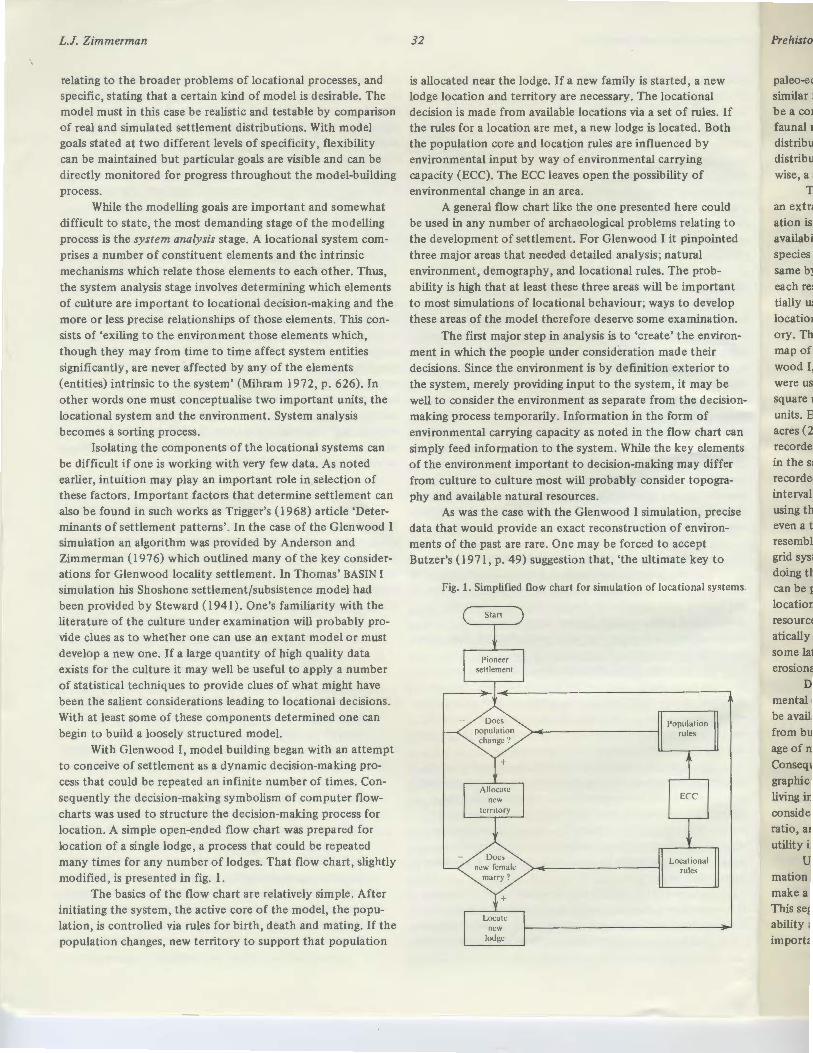
With Glenwood I, model building began with an attempt to conceive of settlement as a dynamic decision-making process that could be repeated an infinite number of times. Consequently the decision-making symbolism of computer flowcharts was used to structure the decision-making process for location. A simple open-ended flow chart was prepared for location of a single lodge, a process that could be repeated many times for any number of lodges. That flow chart, slightly modified, is presented in fig. 1.
The basics of the flow chart are relatively simple. After initiating the system, the active core of the model, the population, is controlled via rules for birth, death and mating. If the population changes, new territory to support that population
32
is allocated near the lodge. If a new family is started, a new lodge location and territory are necessary. The locational decision is made from available locations via a set of rules. If the rules for a location are met, a new lodge is located. Both the population core and location rules are influenced by environmental input by way of environmental carrying capacity (ECC). The ECC leaves open the possibility of environmental change in an area.
A general flow chart like the one presented here could be used in any number of archaeological problems relating to the development of settlement. For Glenwood I it pinpointed three major areas that needed detailed analysis; natural environment, demography, and locational rules. The probability is high that at least these three areas will be important to most simulations of locational behaviour; ways to develop these areas of the model therefore deserve some examination.
The first major step in analysis is to 'create' the environment in which the people under consideration made their decisions. Since the environment is by definition exterior to the system, merely providing input to the system, it may be well to consider the environment as separate from the decisionmaking process temporarily. Information in the form of environmental carrying capacity as noted in the flow chart can simply feed information to the system. While the key elements of the environment important to decision-making may differ from culture to culture most will probably consider topography and available natural resources.
As was the case with the Glenwood I simulation, precise data that would provide an exact reconstruction of environments of the past are rare. One may be forced to accept Butzer's ( 1971, p. 49) suggestion that, 'the ultimate key to
Fig. 1. Simplified flow chart for simulation of locational systems.
Start
Population rules
ECC
Locational rules
Prehistor
paleo-eel similar f be a coili
faunal n distribu distribut
ation is ! availab· species E
same b)'1 each re tially us location ory. Thi map of wood I, were us squareD units. E acres (2 record e . in the s< recorde' interval. using th even at resembl grid sys doing tU
mation make a This se ability, import<

new nal les. If
g
f
·could ting to pointed 1 robortant
tlevelop lination.
environheir riorto ay be
:decisionof chart can elements differ
n, precise
•pt ey to
nal systems.
Prehistoric locational behaviour
paleo-ecology is provided by the modern distribution of similar features'. A reconstructed environment will therefore be a combination of information derived from floral and faunal remains from archaeological sites in the locality and the distribution of modem species assuming that modern and past distributions are similar. Unless one can demonstrate otherwise, a stable topography may also be assumed.
To handle the environment in a detailed way could be an extraordinary simulation in itself; consequently generalisation is necessary. Thomas (1972) did this by considering the availability to the people of certain species or by grouping species into particular life-zones. zihlmerman ( 1977) did the same by dividing the locality into five resource-zone types,
33
Other issues that enter into the demographic core of the model that may be directly accessible from the archaeological record via ceramics or similar artifacts are the kinship systems of the population. Matters to be considered are preferred marriage patterns (e.g. locality exogamy vs. endogamy) and descent systems which may have an important impact on residence patterns.
A set of rules whereby people actually make their locational decisions is that key segment of the model that links the demographic components to the natural environment. As noted, rules can vary widely depending on individual or cultural standards of what 'makes' a proper location. There are usually relatively few rules and they tend to be given priorities
each resource-zone being comprised of flora and fauna poten- by individuals or groups. Therefore when rule 1 is applied to tially used by local populations. These resource-zones and their the set of available locations, the set is reduced to those that locations in space can actually be placed into computer memory. This can be accomplished by placing a grid system over a map of the locality with resource-zones mapped in. For Glenwood I, United States Geological Survey topographic maps were used. This grid divided the forty square mile locality into square mile units with each of these units divided into 100 units. Each of these 4000 data points therefore covered 6.4 acres (2.6 ha). The major resource-zone type was then recorded for each unit. Topographic information was derived in the same way. The average elevation for each unit was recorded and rounded to the nearest preselected contour interval. The topographic averaging process can be tested by using the data to reconstruct a contour map of the locality or even a three-dimensional projection to see if the abstraction
met the requirements of the rule. Rule 2 is then applied to that set, further reducing the number. This procedure can go on as long as one has rules and remaining choices. When one runs out of choices the decision is made. When one runs out of rules, ad
hoc rules are invented or the choice becomes random. Conceptualising locational rules in this way will ease programming during the synthesis stage. It also gives the opportunity to test the impact of randomness on the system again both in terms of what determines the set of possible locations at any given moment and in terms of choices made when no more rules
exist. While conceptualising the rules in this fashion is not par
ticularly difficult, selecting and giving priorities to the rules can present problems. Areas that should be considered are pre-
resembles reality. The number of data points or the size of the ferred residence patterns (matrilocality, etc.), available resources grid system depends largely on the stamina of the individual in the area, especially proximity to water, elevation, and mini-doing the coding. Whatever the number of grid units the data mum or maximum distance to friends and relatives. Some of can be put into data matrices directly accessible to the these rules may be dependent on others. For example distance locational system. If one wishes, changes can be made in to relatives may depend on availability of resources. Locating resources or topography simply by causing a program system- a lodge too near another may well deplete area resources, and atically to change them to other resource types or elevations at would thereby preclude use of that location. some later point in time, thus simulating climatic change, The locational rules for Glenwood I might serve as erosional processes, or whatever might be desired . examples. These rules focused primarily on territorial allo-
Demographic data for particular cultures, like environ- cation and post-marital residence. The primary rules were mental data, may not be available. Some mortality data may economically oriented. The location of a lodge needed to be in be available through detailed analysis of skeletal populations from burial areas, but even then important life data such as age of marriage or year of first parturition may be missing. Consequently, much of the data must be derived by ethnographic analogy with societies at similar levels of culture and living in similar environments. Important information to be considered is mortality, age of marriage, first parturition, sex ratio , and fecundity . These data will probably be of more utility if structured into probability tables.
Unless one has some sort of precise genealogical information for the culture, which is highly unlikely, one cannot make a totally 'realistic' demographic core for one's model. This segment of the model thus becomes a function of probability and the impact of randomness on the system becomes important .
an area where there was adequate resource potential to support a nuclear family unit. This rule was directly linked with the subsistence system of the people which was a mixed huntinggathering/horticulture pattern. Each family unit therefore had to have available enough units of particular resource-zone types to support a nuclear family. The ideal location within this set of possible places was seen to be on ridgelines near the oak- hickory resource zone, so that the people could gather nut crops easily, but not in it, since trees would have had to be cleared in order to plant crops. The ideal location was then within a resource-zone, an ecotone of forest and grassland. Since it is likely that at least two of these units would be available, and since one of these units was deemed necessary to support a single person, a further choice existed. Given more than one unit, that unit with the highest elevation was selected.

L.J. Zimmerman
If units were of equal elevation, the decision was random. These rules functioned once a potential territory was
selected, but given a forty square mile area, many territories of adequate size and composition would be available to support a nuclear family. Consequently a second major group of rules was used to narrow the choice. A new household was established when an eligible female married. For this female a rule of proximal matrilocality went into effect: the available territory meeting subsistence requirements was selected that was the nearest to the bride's mother. When the youngest daughter of a family married she simply took over her parents' territory
34
Many languages, like rORTRAN, were not designed with simulation as a goal; programming a simulation in them may be very difficult and in fact, often wasteful. Therefore the language that is selected should be suitable: the model builder must be able to comprehend it and to communicate problems about it to the specialist. Further, the language should be accessible to the programmer, that is to say it should be available on the computer system on which he will be working. Cost must also be a consideration.
In the case of the Glenwood I simulation, the language SIMSCRIPT was selected after a number of very frustrating
on their deaths. attempts to program in FORTRAN Y and extended discussions In the Glenwood I simulation these locational rules were with a computer specialist, Daniel Moore (see chapter 2 above,
specifically stated and given priorities. During such a simu- where SIMSCRIPT is described). SIMSCRIPT proved to be far lation it is possible to change the locational rules at some time if that is an important part of the model - as it was in the Glenwood I simulation when severe climatic change was assumed to have reduced the available natural resources drastically. The point is that these locational rules can be very flexible or rigid depending on the desire of the model builder. Changing them is a relatively easy matter.
System analysis provides the base on which a model is built, a framework to which continual reference is made as system synthesis occurs. Weaknesses of various model segments may exist in the system analysis stage that do not become apparent until programming of the model actually is under way. Certain segments will have a much larger data or assumptive base (e.g. environment and population) on which to build components and linkages. The locational rules pose the fewest
more suitable in that it retained the familiar FORTRAN-like words, phrases, and symbols, but it was also event oriented, generalised, and an almost 'natural' language making it useful for organising, analysing, and modelling the structure and behaviour of a complex locational system.
Programming in many respects seemed much like the analysis of the system. However, in one aspect it was far more demanding. The analysis had to be made operational, that is, made far more specific so that it could be programmed. T.b.is was done in close collaboration with the specialist who would often say, 'This is far too general and I can't do anything with it.' Thus one is forced to conceive of the environment, demography, and locational rules in increasingly specific and logical ways. What happens in programming is that one proceeds most easily by using the top-down method, that is,
problems for synthesis and the environment the most. Many of programs are built starting with routines that are generalised the difficulties with the system structure only become apparent and then subroutines are developed that are ever more precise during the verification stage of model building. System analysis in their functions. In Glenwood I, for instance, 8 subprograms therefore becomes a continually reiterative process. Ultimate handled the seemingly simple task of determining the location boundaries must, of course, be set lest one becomes trapped in the complexity dilemma.
Many of the conceptual structures that are to be programmed in the system synthesis stage will be generally organ
ised in the system analysis stage. The major task of synthesis, then, is transformation of these general structures into a computer program. Probably the single most important step in synthesis is the selection of a programming language.
Selection of a language can pose serious problems for the archaeologist. Most archaeologists have had little computer training beyond introductory courses in FORTRAN or a similar language. Many have not even had that degree of experience and perhaps have used nothing more than a few 'numbercrunching' library statistical routines (Zimmerman 1976b). With this small experience the prospect of developing an original program of such complexity can be frightening. In this case the archaeologist should make every effort to consult a specialist in computer programming. The problem should be expressed to that individual in as clear a set of terms as is possible. One will probably find that communication can be difficult since neither person is likely to be familiar with the field of the other. With the aid of the specialist a language suitable for the simulation can be selected.
of a lodge and continually monitoring the environment to see if the lodge's location remained within a territory adequate to support the lodge's inhabitants - actually only a small part of the entire simulation. This may seem excessive but this degree of specificity may be needed to develop a realistic simulation. Every extra statement seems to make verification of the model's behaviour more difficult, but output devices incorporated while programming can simplify the chore immensely.
One further matter must be given a great deal of thought - the nature of the output of the program desired by the model builder. While it may be acceptable to derive just locations from the program using some kind of x-y coordinate system, one should try to program as many output functions as possible into the program. One may well want to know the year or season in which a location was established, population statistics, and allocation of resources to support the people in the location. Instead of x-y coordinates alone, one may also be able to generate a line-printed map showing the locations so that one can inspect distribution patterns visually. In short, programming as many output functions as possible or considered useful may provide later benefits.
The utility of many output devices becomes most apparent in the verification stage. Verification is the most
Prehisto,
demand process, sistency the moe intende' pro gran
T progran gram m· the corr
H should pated; s able to ately e\1 the pro1 locatio11 locatio11 end it i devices the synt
In pro grail! ing devi examph form all! excessi\1 to five) ing med simple o are muc
v tions of verificat year to have be ing proiJ found iE seed nm in the s lOOth it unique 1
problem
o! run corn from ve1 the syst another in fact Il or even

Prehistoric locational behaviour
demanding and potentially frustrating part of the simulation process, done for the purpose of determining the logical consistency of the program. Put more simply, it is done to see if the model is behaving in the way in which the programmer intended. This stage can be likened to the term computer programmers often use, 'debugging'.
The first problem of verification is simply getting the program to run on the computer. To complete a run the program must be logically constructed according to the rules of the computer language used. Many programming errors tend to 'creep' into such a complex kind of simulation. Most language manuals however, have a section to assist in working out these sorts of problems and the computer specialist again is invaluable in finding and correcting these errors.
However, just because the computer program runs, one should not assume that the system is behaving as one anticipated; such may well not be the case. The importance of being able to monitor the system variables becomes almost immediately evident when one carefully examines the first runs of the program. It is not enough to have just a final map or list of locations printed at the end of the simulation runs. A locational model's complexity demands much more. To this end it is extremely useful to include as many monitoring devices as possible into the program as noted in discussion of the synthesis stage.
In Glenwood I, even though the simulation ran without programming errors, examination of the output from monitoring devices indicated that problems had cropped up. For example, construction of population curves to verify the performance of the model's stochastic demographic core indicated excessive births, certain women bearing children each year up to five years after their death. While this is perhaps an interesting medical phenomenon, it is simply not known in reality! A simple change solved the problem. Many other sorts of errors are much more difficult to detect and, once detected, to solve.
35
have had. In other words, verification has both its trustrauons and rewards.
Just as the verification stage in a model's development serves as a check on the system synthesis stage, the validation stage is undertaken to check the system analysis stage. Validation is accomplished by comparing the responses from the verified simulation with the corresponding responses of the reallocational system. If valid results cannot be generated, one returns to analysis and makes alterations in the model. With simulation under ideal circumstances experimentation is conducted with both the simulated and real systems. Obviously this cannot be done with prehistoric culture systems. Consequently any inferences that are drawn from the simulation must be tentative. Formal validation procedures very often involve the use of high-powered statistics. However since the reallocational system is not available for experimentation and since the assumptive base for the simulation is probably large, informal validation procedures will need to be developed.
The major task, then, is to compare the distribution of the reallocations with those that have been simulated. While one might naively hope that one's simulation will generate a settlement distribution that corresponds one-to-one with the known settlement distribution in the study area, one must realise that such a fit is highly improbable.
Two general approaches can be used in informal validation. The first, which should not be underrated as an analytical tool, is visual inspection of maps showing both the real and simulated distribution of locations. By comparing the two one can often easily see areas in which there are settlements in reality and none in simulation or vice versa, or one can perhaps begin to spot trends of settlement movements into certain locations. These may not be as obvious using the other approach, statistical analysis. Several statistical techniques are available in order to test the goodness of fit in settlement distribution as discussed in Haggett ( 1965). One-to-
Verification must be done very carefully and few assump- one comparisons of locations are possible but may not be tions of proper system behaviour should be made. The entire verification procedure for Glenwood I took approximately a year to complete. Even then, more verification could perhaps have been done. When one seems to have the system functioning properly, a minor change in a subprogram can have a profound impact on another segment of the model. Changes in seed numbers of a random number generator can cause havoc in the system. A model that seems to be behaving well in the 1 OOth iteration can be fouled in the 1 OOOth iteration by some unique circumstance. Persistence in verification will solve most problems.
Other than solving logical problems to make the program run correctly, there are some positive benefits to be gained from verification. During this stage one sees most clearly how the system operates and the impact of one subsystem on another. Also, errors that appear are not always bad, and can in fact provide avenues toward the solution of some conceptual or even programming difficulties which the model builder may
meaningful. More useful perhaps are statistics that simply test the dispersion or nucleation of settlement across an area.
Two techniques are useful for this kind of comparison, nearest-neighbour analysis as applied by Washburn (1974) to Pueblo I- III sites in New Mexico or the coefficient of dispersion as used by Thomas (1973) in his Reese river valley study. Both measure the deviation of a distribution of a population in space from a random distribution toward either a clustered or anticlustered pattern. The former is somewhat more complex to apply than the latter with approximately the same information resulting.
The statistics developed will show a tendency for a distribution of locations to be clustered or dispersed. When derived for both the real and simulated settlement patterns a comparison is possible that shows how far apart the two are. Experimentation with and alteration of the model may be oriented toward achieving similar measurements for the real and simulated patterns.
L.J. Zimmerman
A combination of both visual and statistical validation was used for Glenwood I. While a perfect fit of coefficients of dispersion and visual congruity was never achieved, a level that was deemed satisfactory visually and statistically was met. For validation, the use of many different techniques should be considered and is recommended.
With the first efforts at validation analysed, one begins to notice areas for possible experimentation with either the parameters or the structure of the model. All the frustrations of system analysis and verification should be put aside at this point, because now the real enjoyment of the simulation begins. One should make every effort to play with the program, asking questions of the sort, 'What if I change the ... ?'. This kind of play will lead to many important insights into the behaviour of the system in terms of the impact of particular variables on locational decisions. As each run with altered components is rejected one essentially tests the feasibility of certain assumptions about the locational system being played with and goes back to limited reanalysis of the system. This basically results in inferences made about the system.
In the case of Glenwood I, many parameters were changed. The primary avenues for experimentation were manipulations of time, climatic fluctuation, and location of pioneer settlement in the Glenwood locality. The result of these experiments led to inferences that the duration of occupation in the locality was far shorter than suspected (this was independently corroborated by radiocarbon dates unknown at the time the simulation was being done), that climatic change had little influence on settlement of the people, that the known distribution of lodges could simply have been the result of preferred postmarital residence patterns rather than alterations in locational rules due to decreased availability of resources, and that locality population levels were far smaller than suspected. While proof for these inferences cannot come from the simulation, corroboration may come with further research focused on these ideas. Again, simulation proves nothing about the prehistory but merely shows that certain ideas are or are not feasible.
An assessment of locational simulation The intent of this paper has been to provide a sort of
primer on the simulation of locational behaviour. To do this, general theoretical conceptions of how locational decisions are made were considered, in order to provide a framework from which to discuss total society simulations with location as a focal point . Mihram's ( 1972) scheme of the modelling process with modelling goals, system analysis, system synthesis, verification, validation, and inference as major stages was presented as a profitable approach to the construction of a locational simulation. Within each of these stages a number of suggestions and examples derived from Zimmerman's (l976a, 1977) Glenwood I simulation were offered as a 'recipe' for locational simulation. While every attempt was made to suggest potential benefits to be derived from simulation as well as potential problems and weaknesses, a final general assessment
36
of simulation of locational behaviour might be useful. It should be noted that while locational simulation is the central issue, many of these comments could apply to any variety of computer simulation.
The major weakness of locational simulation is that it attempts to model a cognitive process of an individual or group and how their perceptions of a number of natural and cultural environmental factors relate to satisfaction of their needs in terms of choice of position on the landscape. The information necessary to build a truely adequate and realistic simulation is perhaps unknowable and even if available would create such complexity that it could not be simulated at reasonable cost. In a sense, however, this weakness can be viewed as a strength: patterns of settlement similar to reality can be generated with relatively little complexity. Reality can thus be simplified and made comprehensible. Simplicity and generality allow one effectively to follow the interaction of variables that influence location.
At the same time, the use of simulation entails detailed, precise analysis of locational processes that must be logically acceptable to the computer. This necessary attention to detail creates an intense involvement in the simulation process that is unique. The programmer becomes a variable in the process that is as important as any other variable. One becomes almost personally involved with the culture being simulated and in a sense becomes a cultural 'button-pusher', providing situations to which simulated beings must react. This involvement promotes serendipity, and one often encounters some totally unexpected situation that offers insights into the locational model's particular behaviour or about one's own thinking about the modelling processes. Out of serendipity come new avenues of experimentation.
Simulation should not be considered a panacea for archaeological problems of locational behaviour; it has many liabilities. The computer is in a sense very limiting. One can conceive many possibilities for a model that are beyond the capabilities of the language one selects, or at least beyond one's ability to program in that language. This can be most frustrating. One must also recognise that proper formal validation for archaeological simulations is impossible and that all inferences drawn from the research are suspect.
Finally, and not of least importance, is the fact that computer simulation is expensive. If one's model is complex and one's programming abilities limited costs can be high. Total costs for the Glenwood I simulation were about ~BOOO with each successful run costing around $25.
In all, the benefits to be gained from locational simulations outweigh the liabilities. If one remembers that simulations prove nothing about prehistory they can be a most useful tool. They are simply methodological devices which allow the researcher a great deal of freedom to hypothesise and provide a limited test of those hypotheses. They do not provide 'the' answer even if 'the' answer can be found.
Simulation for the archaeologist can allow a shift away from the artifacts themselves toward their systemic context
Prehistor
and thei1 a particu archaeo1 reasona~
archaeol
R
Anderson va1 A~
Bonini, 0 thl
Butzer, M A~
DavenpoJ ("\1 UJ
Dutton, J J. Be
Dutton, J & Wi
Gould, P fra 53
Green, E. no
Gumerm; Ag
G Pred, A.
an G

I. It should al issue, of com-
s that it al or ral and f their
e. The realistic
le would d at an be o reality ality can
city and tion of
detailed, logically n to detail cess that is Hocess
es almost
~ and in a ituations ent protally
e most ' al valind that all
at simu-most
/which othesise ~do not hd. ~ift away
loont«t
Prehistoric locational behaviour
and their behavioural correlates if that is seen as desirable for a particular problem. Simulation makes total society study in archaeology feasible; its implementation would seem to be a reasonable methodological extension for locational analysis in archaeology.
References
Anderson, A.D. & Zimmerman, L.J. (1976) 'Settlement/subsistence variability in the Glenwood locality, southwestern Iowa', Plains Anthropologist 21: 141-54
Bonini, C.P. (1963) Simulation of Information and Decision Systems in the Firm, Prentice-Hall
Butzer, K.W. (1971) Environment and Archaeology: An Ecological Approach to Prehistory, Aldine-Atherton
Davenport, W. (1960) Jamaican Fishing: A Game Theory Analysis (Yale University Publications in Anthropology, )lo. 59), Yale University Press
Dutton, J.M. & Briggs, W. (1971) 'Simulation model construction' in J. Dutton & W. Starbuck (eds.) Computer Simulation of Human Behavior, Wiley
Dutton, J .M. & Starbuck, W. (1971) 'The plan of the book' in J. Dutton & W. Starbuck (eds.) Computer Simulation of Human Behavior, Wiley
Gould, P.R. (1963) 'Man against his environment: a game theoretical framework', Annals of the Association of American Geographers 53: 290-7
Green, E.L. (1973) 'Locational analysis of prehistoric Maya sites in northern British Honduras', American Antiquity 38: 279-93
Gumerman, G.J. (1971) The Distribution of Prehistoric Population Aggregates (Prescott College Anthropological Reports, No. 1), Prescott College Press
Hagerstrand, T. (1952) The Propagation of Innovation Waves. Lund Studies in Geography, Series B, No.4
Haggett, P. (1965) Locational Analysis in Human Geography, Arnold Harvey, D. (1969) Explanation in Geography, Arnold Hole, F. & Heizer, R. (1973) An Introduction to Prehistoric Archae
ology, Holt, Rinehart & Winston Mihram, G.A. (1972) 'The modelling process', IEEE Transactions on
Systems, Man, and Cybernetics SMC-2: 621-9 Morrill, R.L. (1965) Migration and the Spread and Growth of Urban
Settlement. Lund Studies in Geography, Series B, No. 26 Mosimann, J.E. & Martin, P.S. (1975) 'Simulating overklll by Palaeo
indians',American Scientist 63: 304 - 13 Pool, I.S. (1967) 'Computer simulations of total societies' in E. Klausner
(ed.) The Study of Total Societies, Doubleday Pred, A. (1967) Behavior and Location: Foundations for a Geographic
and Dynamic Location Theory, Part I. Lund Studies in Geography, Series B, No. 27
Pred, A. (1969) Behaviour and Location: Foundations for a Geographic and Dynamic Location Theory, Part II. Lund Studies in Geography, Series B, No. 28
Starbuck, W.H. & Dutton, J .M. (1971) 'The history of simulation models' in J. Dutton & W. Starbuck (eds.) Computer Simulation of Human Behavior, Wiley
Steward, J. (1941) 'Culture element distribution: XIII, Nevada Shoshone', University of California Anthropological Records 4: 209 - 359
Thomas, D.H. (1971) Prehistoric Subsistence-Settlement Patterns of the Reese River Valley, Central Nevada, University Microfilm
Thomas, D.H. (1972) 'A computer simulation of Great Basin subsistence and settlement patterns' in D.L. Clarke (ed.) Models in Archaeology, Methuen
37
Thomas, D.H. (1973) 'An empirical test of Steward's model for Great Basin settlement patterns', American Antiquity 38: 155-76
Thomas, D.H. (1974) 'An archaeological perspective on Shoshonean bands', American Anthropologist 76: 11-23
Trigger, B. (1968) 'The determinants of settlement patterns' in K.C. Chang (ed.) Settlement Archaeology, National Press Books
Von Neumann, 1. & Morgenstern, 0. (1953) Theory of Games and Economic Behavior, Princeton University Press
Washburn, D.K. (1972) An Analysis of the Spatial Aspects of Site Locations of Pueblo 1-111 Settlement Patterns Along the Middle Rio Puerco, New Mexico, University Microfilm
Washburn, D.K. (1974) 'Nearest neighbor analysis of Pueblo I- III settlement patterns along the Rio Puerco, east New Mexico', American Antiquity 39: 315-35
Whallon, R. (1972) 'The computer in archaeology: a critical survey', Computers and the Humanities 7: 29-45
Wyman, F.P. (1970) Simulation Modeling: A Guide to Using SIMSCRIPT, Wiley
Zimmerman, L.J. (1976a) Prehistoric Locational Behavior: Computer Simulation of Central Plains Tradition Settlement in the Glenwood Locality, Mills County, Iowa, University Microfilm
Zimmerman, L.J. (l976b) 'Selection of languages for archaeological simulations: SIMSCRIPT', Newsletter of Computer Archaeology 11: 30-8
Zimmerman, L.J. (1977) Prehistoric Locational Behavior: A Computer Simulation (Reports of the State Archaeologist of Iowa, No. 1 0), University of Iowa Press
Zubrow, E.B.W. (1971a) A Southwestern Test of an Anthropological Model of Population Dynamics, University Microfilm
Zubrow, E.B.W. (1971b) 'Carrying capacity and dynamic equilibrium in the prehistoric Southwest', American Antiquity 36: 127-38
Zubrow, E.B.W. (1975) Prehistoric Carrying Capacity: A Model, Cummings
Related Documents