Simple tools for assessing the value of nature Alison Smith Environmental Change Institute, University of Oxford Valuing Nature Network Conference, Cardiff, 12-13 November 2018

Welcome message from author
This document is posted to help you gain knowledge. Please leave a comment to let me know what you think about it! Share it to your friends and learn new things together.
Transcript
Simple tools for assessing the value of natureAlison Smith
Environmental Change Institute, University of Oxford
Valuing Nature Network Conference, Cardiff, 12-13 November 2018
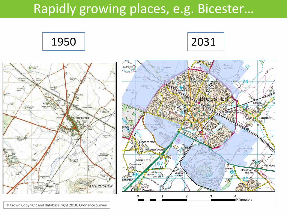
Rapidly growing places, e.g. Bicester…
© Crown Copyright and database right 2018. Ordnance Survey
1950 2031
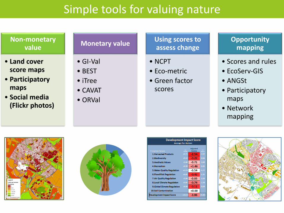
Simple tools for valuing nature
Non-monetary value
• Land cover score maps
• Participatory maps
• Social media (Flickr photos)
Monetary value
• GI-Val
• BEST
• iTree
• CAVAT
• ORVal
Using scores to assess change
• NCPT
• Eco-metric
• Green factor scores
Opportunity mapping
• Scores and rules
• EcoServ-GIS
• ANGSt
• Participatory maps
• Network mapping
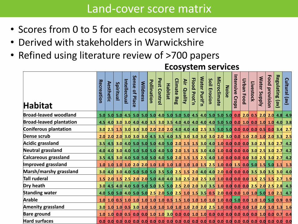
Habitat
Re
creatio
n
Aesth
etic
Spiritu
al
Inte
llectu
al
Sense o
f Place
Wild
ne
ss
Po
llinatio
n
Pe
st Co
ntro
l
Hab
itat
Clim
ate R
eg
Air Q
uality
Floo
d P
rot’n
Wate
r Pu
rif’n
Soil Ero
sion
Micro
climate
No
ise
Inten
sive Cro
ps
Urb
an Fo
od
Livesto
ck
Wate
r Sup
ply
Foo
d p
rovisio
n
Regu
lating (av)
Cu
ltural (av)
Broad-leaved woodland 5.0 5.0 5.0 4.5 5.0 5.0 5.0 4.0 5.0 5.0 5.0 4.5 4.0 5.0 5.0 5.0 0.0 2.0 0.5 2.0 2.0 4.8 4.9
Broad-leaved plantation 4.5 4.0 3.0 3.0 4.0 4.0 3.5 3.0 3.5 4.0 4.0 4.0 4.0 4.0 5.0 5.0 0.0 1.0 0.0 1.0 1.0 4.0 3.8
Coniferous plantation 3.0 2.5 1.5 3.0 3.0 3.0 2.0 2.0 2.0 4.0 4.0 4.0 2.5 3.5 5.0 5.0 0.0 0.0 0.0 0.5 0.0 3.4 2.7
Dense scrub 2.0 2.0 2.0 3.0 3.0 3.0 4.5 3.5 4.0 3.5 3.0 3.0 3.0 3.0 2.0 3.0 0.0 1.0 2.0 1.0 2.0 3.3 2.5
Acidic grassland 3.5 4.5 3.0 4.0 5.0 5.0 5.0 4.0 5.0 2.0 1.5 1.5 3.0 4.0 1.0 0.0 0.0 0.0 3.0 2.5 3.0 2.7 4.2
Neutral grassland 4.0 4.0 3.0 4.0 5.0 5.0 5.0 4.0 5.0 2.0 1.5 1.5 3.0 4.0 1.0 0.0 0.0 0.0 3.0 2.5 3.0 2.7 4.2
Calcareous grassland 3.5 4.5 3.0 4.0 5.0 5.0 5.0 4.0 5.0 2.0 1.5 1.5 2.5 4.0 1.0 0.0 0.0 0.0 3.0 2.5 3.0 2.7 4.2
Improved grassland 1.0 1.0 1.0 1.0 2.0 2.0 1.0 1.0 1.0 1.0 1.0 1.0 1.5 2.5 1.0 0.0 1.5 0.0 5.0 1.5 5.0 1.1 1.3
Marsh/marshy grassland 3.0 4.0 3.0 4.0 5.0 5.0 5.0 3.5 5.0 2.5 1.5 2.0 4.0 4.0 2.0 0.0 0.0 0.0 3.5 3.0 3.5 3.0 4.0
Tall ruderal 1.5 2.0 1.5 2.5 2.0 2.0 5.0 4.0 4.0 3.0 2.5 2.0 2.5 3.0 1.0 0.0 0.0 0.0 1.5 2.5 1.5 2.7 1.9
Dry heath 3.0 4.5 4.0 4.0 5.0 5.0 5.0 3.5 5.0 2.5 2.0 2.0 3.0 3.5 1.0 0.0 0.0 0.0 2.5 2.0 2.5 2.8 4.3
Standing water 4.0 5.0 5.0 4.0 5.0 5.0 2.5 2.0 5.0 2.5 1.0 1.5 3.5 0.5 2.0 0.0 0.0 1.0 1.0 5.0 1.0 2.1 4.7
Arable 1.0 1.0 0.5 1.0 1.0 1.0 1.0 1.0 0.5 1.5 1.0 1.0 1.0 1.0 1.0 0.0 5.0 0.0 1.0 1.0 5.0 0.9 0.9
Amenity grassland 3.0 1.0 1.0 0.5 3.0 1.0 1.0 1.0 1.0 1.0 1.0 2.0 2.0 2.5 1.0 0.0 0.0 0.0 1.0 2.0 1.0 1.3 1.6
Bare ground 1.0 1.0 0.0 0.5 0.0 0.0 1.0 1.0 3.0 0.0 0.0 1.0 1.0 0.0 0.0 0.0 0.0 0.0 0.0 1.0 0.0 0.7 0.4
Hard surfaces 0.0 0.0 0.0 0.0 0.0 0.0 0.0 0.0 0.0 0.0 0.0 0.0 0.0 0.0 0.0 0.0 0.0 0.0 0.0 0.0 0.0 0.0 0.0
Land-cover score matrix
• Scores from 0 to 5 for each ecosystem service• Derived with stakeholders in Warwickshire• Refined using literature review of >700 papers
Ecosystem services
© Crown Copyright and database right 2018. Ordnance Survey 100018504 . This map incorporates biodiversity data supplied by the Thames Valley Environmental Records Centre (TVERC) which is copyright to TVERC and/or its partners
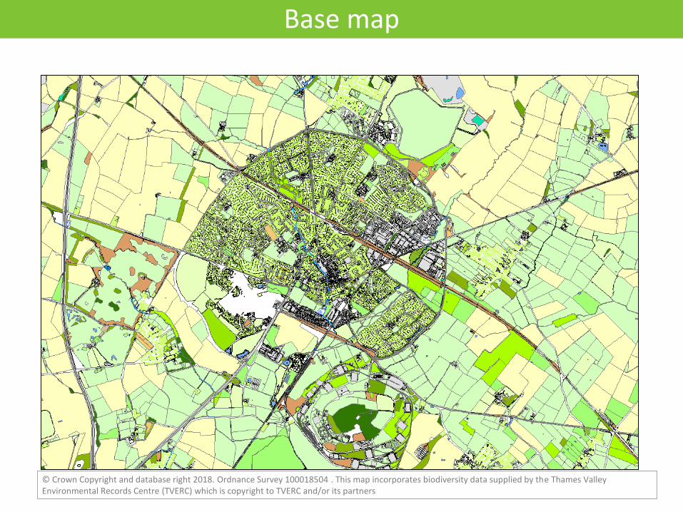
Base map
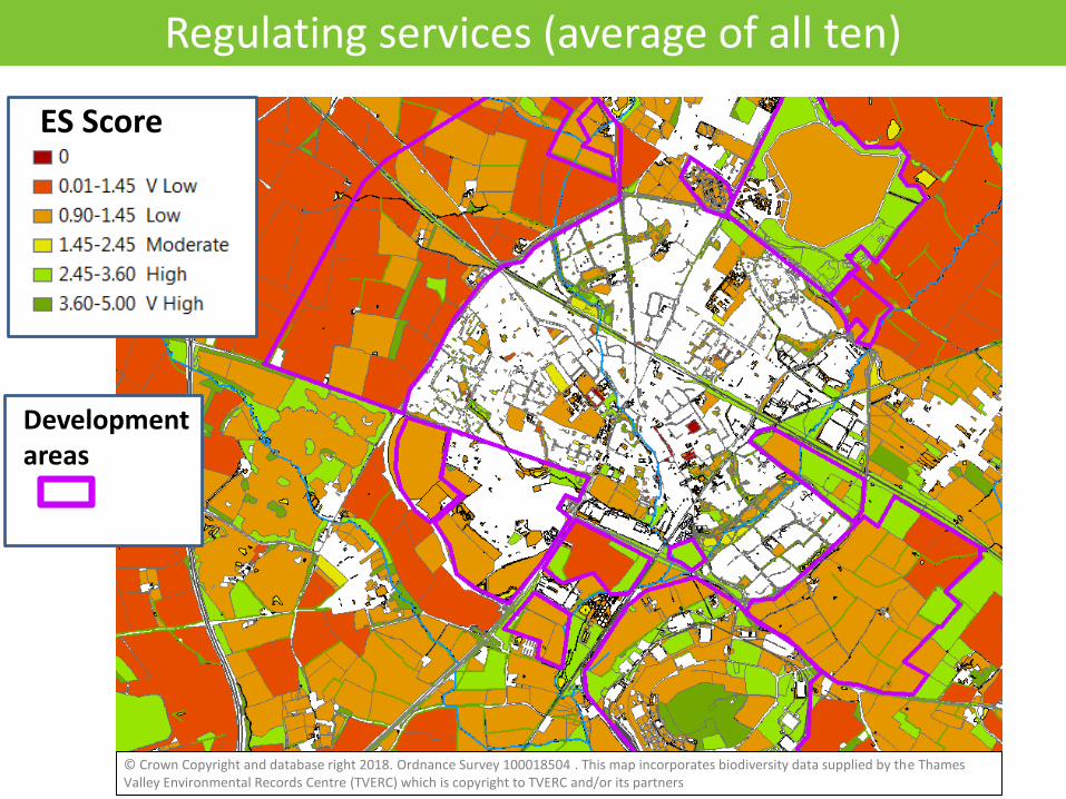
Regulating services (average of all ten)
ES Score
Development areas
© Crown Copyright and database right 2018. Ordnance Survey 100018504 . This map incorporates biodiversity data supplied by the Thames Valley Environmental Records Centre (TVERC) which is copyright to TVERC and/or its partners
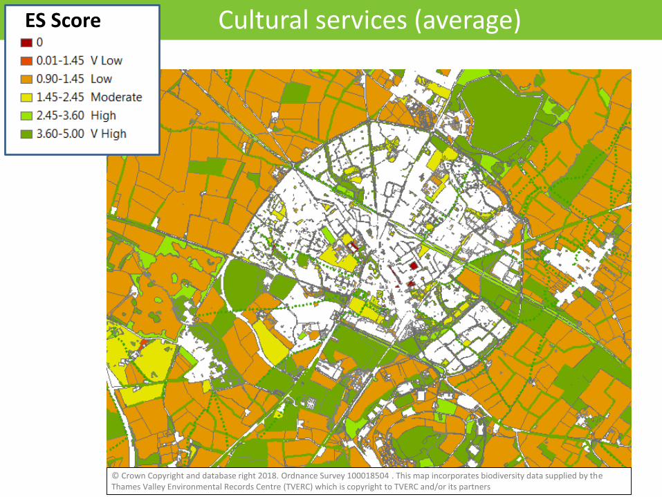
Cultural services (average)ES Score
© Crown Copyright and database right 2018. Ordnance Survey 100018504 . This map incorporates biodiversity data supplied by the Thames Valley Environmental Records Centre (TVERC) which is copyright to TVERC and/or its partners
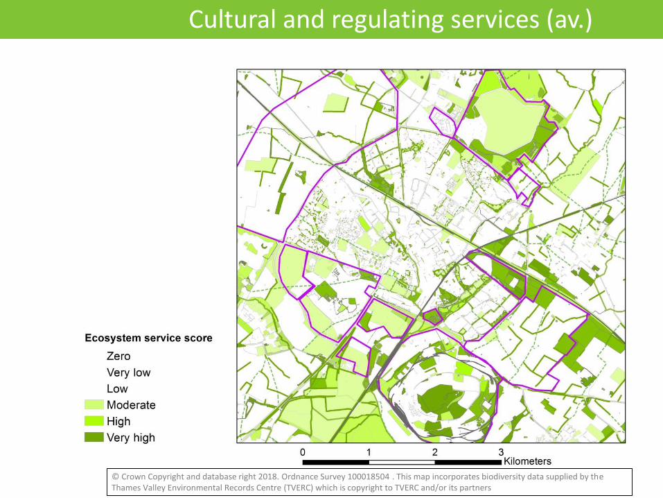
Cultural and regulating services (av.)
© Crown Copyright and database right 2018. Ordnance Survey 100018504 . This map incorporates biodiversity data supplied by the Thames Valley Environmental Records Centre (TVERC) which is copyright to TVERC and/or its partners
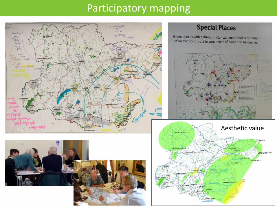
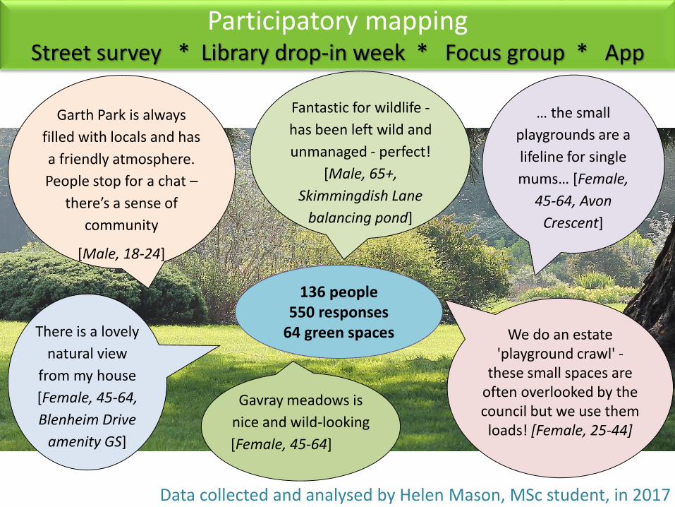
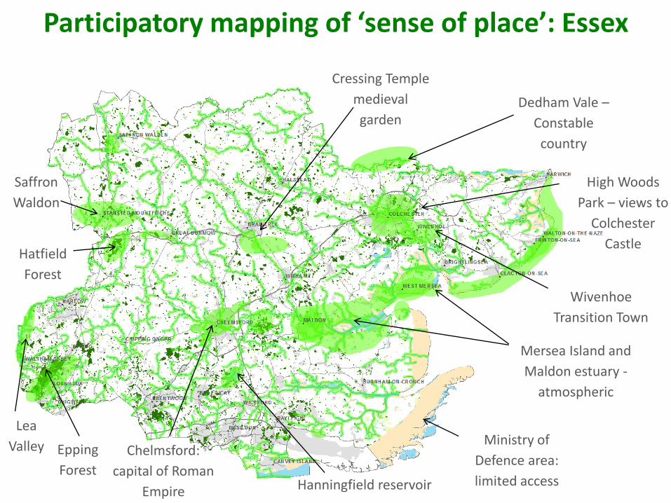
Participatory mapping
Aesthetic value

Dedham Vale –
Constable
country
Wivenhoe
Transition Town
Mersea Island and
Maldon estuary -
atmospheric
Cressing Temple
medieval
garden
High Woods
Park – views to
Colchester
Castle
Chelmsford:
capital of Roman
Empire
Saffron
Waldon
Epping
Forest Hanningfield reservoir
Ministry of
Defence area:
limited access
Hatfield
Forest
Lea
Valley
Participatory mapping of ‘sense of place’: Essex
136 people550 responses
64 green spaces
… the small
playgrounds are a
lifeline for single
mums… [Female,
45-64, Avon
Crescent]
Garth Park is always
filled with locals and has
a friendly atmosphere.
People stop for a chat –
there’s a sense of
community
[Male, 18-24]
There is a lovely
natural view
from my house
[Female, 45-64,
Blenheim Drive
amenity GS]
We do an estate 'playground crawl' -
these small spaces are often overlooked by the council but we use them loads! [Female, 25-44]
Fantastic for wildlife -
has been left wild and
unmanaged - perfect!
[Male, 65+,
Skimmingdish Lane
balancing pond]
Gavray meadows is
nice and wild-looking
[Female, 45-64]
Participatory mappingStreet survey * Library drop-in week * Focus group * App
Data collected and analysed by Helen Mason, MSc student, in 2017
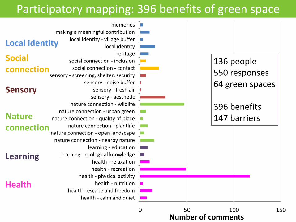
0 50 100 150
health - calm and quiethealth - escape and freedom
health - nutritionhealth - physical activity
health - recreationhealth - relaxation
learning - ecological knowledgelearning - education
nature connection - nearby naturenature connection - open landscape
nature connection - plantlifenature connection - quality of place
nature connection - urban greennature connection - wildlife
sensory - aestheticsensory - fresh air
sensory - noise buffersensory - screening, shelter, security
social connection - contactsocial connection - inclusion
heritagelocal identity
local identity - village buffermaking a meaningful contribution
memories
Number of comments
136 people550 responses64 green spaces
396 benefits147 barriers
Learning
Nature connection
Health
Sensory
Social connection
Local identity
Participatory mapping: 396 benefits of green space
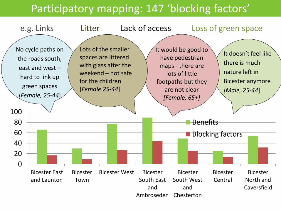
It doesn’t feel like
there is much
nature left in
Bicester anymore
[Male, 25-44]
No cycle paths on
the roads south,
east and west –
hard to link up
green spaces
[Female, 25-44]
It would be good to have pedestrian maps - there are
lots of little footpaths but they
are not clear [Female, 65+]
Lots of the smaller spaces are littered with glass after the weekend – not safe for the children [Female 25-44]
0
20
40
60
80
100
Bicester Eastand Launton
BicesterTown
Bicester West BicesterSouth East
andAmbroseden
BicesterSouth West
andChesterton
BicesterCentral
BicesterNorth andCaversfield
Benefits
Blocking factors
Participatory mapping: 147 ‘blocking factors’
e.g. Links Litter Lack of access Loss of green space
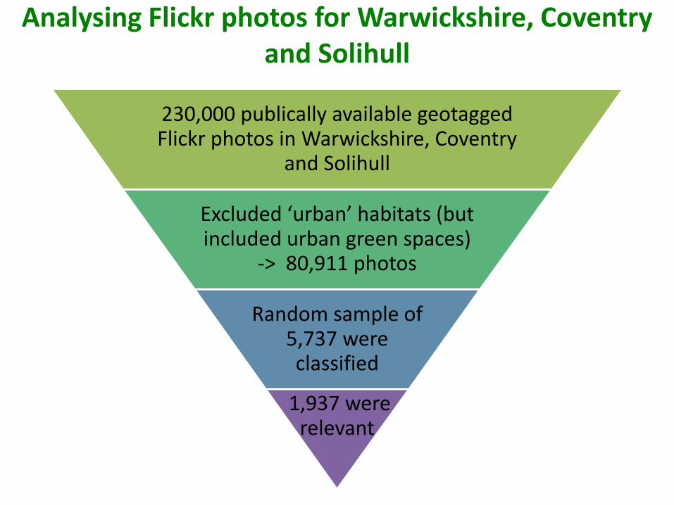
Analysing Flickr photos for Warwickshire, Coventry and Solihull
230,000 publically available geotagged Flickr photos in Warwickshire, Coventry
and Solihull
Excluded ‘urban’ habitats (but included urban green spaces)
-> 80,911 photos
Random sample of 5,737 were classified
1,937 were relevant
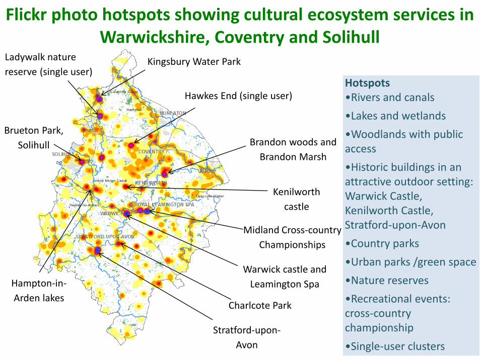
Hotspots•Rivers and canals
•Lakes and wetlands
•Woodlands with public access
•Historic buildings in an attractive outdoor setting: Warwick Castle, Kenilworth Castle, Stratford-upon-Avon
•Country parks
•Urban parks /green space
•Nature reserves
•Recreational events: cross-country championship
•Single-user clusters
Charlcote Park
Kenilworth
castle
Warwick castle and
Leamington Spa
Stratford-upon-
Avon
Kingsbury Water Park
Brandon woods and
Brandon Marsh
Hampton-in-
Arden lakes
Brueton Park,
Solihull
Midland Cross-country
Championships
Flickr photo hotspots showing cultural ecosystem services in Warwickshire, Coventry and Solihull
Hawkes End (single user)
Ladywalk nature
reserve (single user)
19.2
15.4
12.9 12.5
8.1 8.0 7.96.1
4.5 4.23.3 3.1 3.0 2.9 2.9 2.3 2.1
1.0 0.6 0.5 0.2 -
5.00
10.00
15.00
20.00
25.00
Ph
oto
s/h
a d
ivid
ed
by
ave
rage
Which habitats are most popular for photo-taking?
1
Above-average photo densityBelow-average photo density
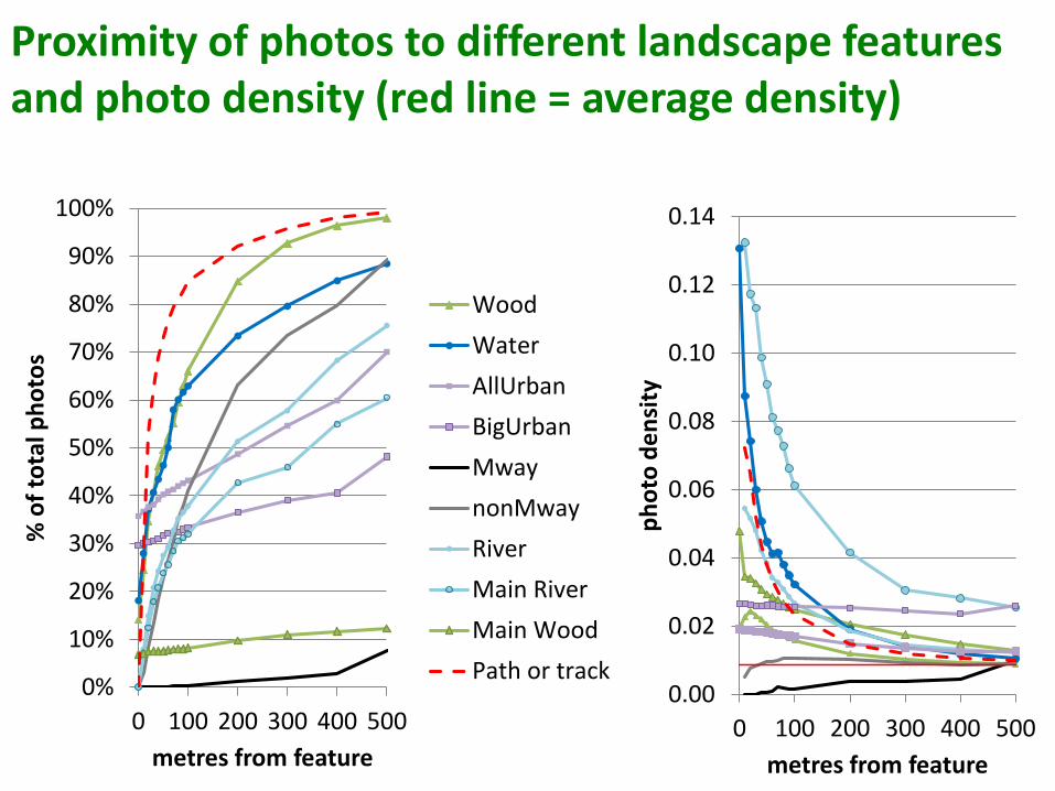
0%
10%
20%
30%
40%
50%
60%
70%
80%
90%
100%
0 100 200 300 400 500
% o
f to
tal p
ho
tos
metres from feature
Wood
Water
AllUrban
BigUrban
Mway
nonMway
River
Main River
Main Wood
Path or track0.00
0.02
0.04
0.06
0.08
0.10
0.12
0.14
0 100 200 300 400 500
ph
oto
de
nsi
ty
metres from feature
Proximity of photos to different landscape features and photo density (red line = average density)
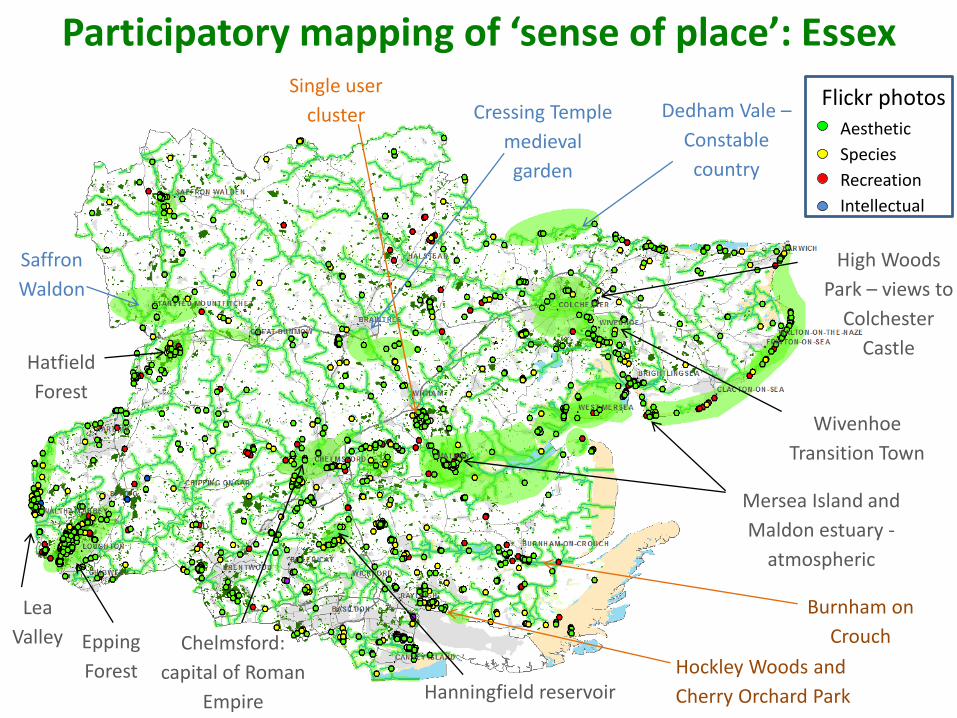
Dedham Vale –
Constable
country
Wivenhoe
Transition Town
Mersea Island and
Maldon estuary -
atmospheric
Cressing Temple
medieval
garden
High Woods
Park – views to
Colchester
Castle
Chelmsford:
capital of Roman
Empire
Saffron
Waldon
Epping
Forest Hanningfield reservoir
Ministry of
Defence area:
limited access
Hatfield
Forest
Lea
Valley
Participatory mapping of ‘sense of place’: Essex
Wivenhoe
Transition Town
Mersea Island and
Maldon estuary -
atmospheric
High Woods
Park – views to
Colchester
Castle
Chelmsford:
capital of Roman
Empire
Dedham Vale –
Constable
country
Cressing Temple
medieval
garden
Saffron
Waldon
Epping
Forest Hanningfield reservoir
Hatfield
Forest
Lea
Valley
Participatory mapping of ‘sense of place’: Essex
Aesthetic
Species
Recreation
Intellectual
Single user
cluster
Burnham on
Crouch
Hockley Woods and
Cherry Orchard Park
Flickr photos
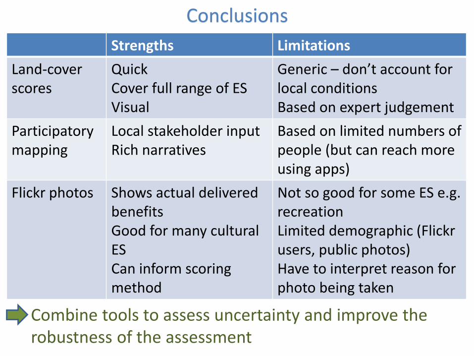
Conclusions
Combine tools to assess uncertainty and improve the robustness of the assessment
Strengths Limitations
Land-cover scores
QuickCover full range of ESVisual
Generic – don’t account for local conditionsBased on expert judgement
Participatory mapping
Local stakeholder inputRich narratives
Based on limited numbers of people (but can reach more using apps)
Flickr photos Shows actual delivered benefitsGood for many cultural ESCan inform scoring method
Not so good for some ES e.g. recreationLimited demographic (Flickr users, public photos)Have to interpret reason for photo being taken

Related Documents