SHOWING THE FLAG: HUGH PALLISER IN WESTERN NEWFOUNDLAND, 1764 1 Olaf Uwe Janzen In the summer of 1764, something rather remarkable occurred in the Bay of Islands on the western coast of Newfoundland. The bay had long been a favourite destination of Breton fishing vessels from St. Malo and Basque craft from St. Jean de Luz and Bayonne. Technically, they should not have been there at all: ever since France signed the Treaty of Utrecht in 1713, her fishermen were prohibited from fishing except on the so-called "French" or "Treaty Shore" to the north. However, the fishing grounds in western Newfoundland were rich and productive and the Bay of Islands had all the ingredients necessary to maintain seasonal shore stations. Best of all, despite its claims of sovereignty, the region was devoid of English patrols. British warships stationed at Newfoundland were virtually unknown north of Bonavista or west beyond Placentia. Western Newfoundland was hardly known to them at all before 1763, when the Lark under Captain Samuel Thompson appeared and remained on station throughout the summer. For the prescient, Lark's visit was the shape of things to come; late in July 1764, not one but three British warships sailed into the Bay of Islands, shortly to be joined by a fourth. Even more remarkable, the squadron was under the command of Captain Hugh Palliser, commander-in-chief of the Newfoundland station and civil governor of the island 2 . Never before had a governor ventured more than a couple of days' sail from St. John's. There could be no mistake about the message that Palliser was delivering: England was no longer indifferent to its claim to Newfoundland beyond the Avalon Peninsula. It was a message only the Royal Navy could have delivered. During the eighteenth century, both France and England held the migratory fishery at Newfoundland in the highest regard. In the conventional wisdom of the age, it was a "nursery for seamen, " not only employing thousands of landsmen every year but also transforming them into experienced mariners who were then available for service in their national navies in the event of war. This made it a strategic asset of the first order. In terms of direct employment, consumption of domestic goods and services, and the generation of a favourable balance of trade with other mercantile powers, the fishery was a source of great national wealth and, by extension in a mercantile age, of great national power. As a result the fishery was so highly prized by both countries that neither would willingly give it up, either in whole or in part. During attempts in 1761 to negotiate an end to the Seven Years' War, members of the British and French governments independently ventured the same opinion: that the Newfoundland fishery was more valuable than Canada and Louisiana combined "as a means of wealth and power. " 3 Yet this perception ironically committed the British government to a policy that discouraged settlement in Newfoundland. Only as long as they returned to England at the end of each fishing season would the fishermen be available if needed for service in the Royal Navy; only if the fishery's goods, services, and trade remained centred on England would the fishery benefit the mother country economically. The Northern Mariner/Le Marin du nord, HI, No. 3 (July 1993), 3-14. 3

Welcome message from author
This document is posted to help you gain knowledge. Please leave a comment to let me know what you think about it! Share it to your friends and learn new things together.
Transcript
SHOWING THE FLAG: HUGH PALLISER IN WESTERN NEWFOUNDLAND, 17641
Olaf Uwe Janzen
In the summer of 1764, something rather remarkable occurred in the Bay of Islands on the western coast of Newfoundland. The bay had long been a favourite destination of Breton fishing vessels from St. Malo and Basque craft from St. Jean de Luz and Bayonne. Technically, they should not have been there at all: ever since France signed the Treaty of Utrecht in 1713, her fishermen were prohibited from fishing except on the so-called "French" or "Treaty Shore" to the north. However, the fishing grounds in western Newfoundland were rich and productive and the Bay of Islands had all the ingredients necessary to maintain seasonal shore stations. Best of all, despite its claims of sovereignty, the region was devoid of English patrols. British warships stationed at Newfoundland were virtually unknown north of Bonavista or west beyond Placentia. Western Newfoundland was hardly known to them at all before 1763, when the Lark under Captain Samuel Thompson appeared and remained on station throughout the summer. For the prescient, Lark's visit was the shape of things to come; late in July 1764, not one but three British warships sailed into the Bay of Islands, shortly to be joined by a fourth. Even more remarkable, the squadron was under the command of Captain Hugh Palliser, commander-in-chief of the Newfoundland station and civil governor of the island2. Never before had a governor ventured more than a couple of days' sail from St. John's. There could be no mistake about the message that Palliser was delivering: England was no longer indifferent to its claim to Newfoundland beyond the Avalon Peninsula. It was a message only the Royal Navy could have delivered.
During the eighteenth century, both France and England held the migratory fishery at Newfoundland in the highest regard. In the conventional wisdom of the age, it was a "nursery for seamen, " not only employing thousands of landsmen every year but also transforming them into experienced mariners who were then available for service in their national navies in the event of war. This made it a strategic asset of the first order. In terms of direct employment, consumption of domestic goods and services, and the generation of a favourable balance of trade with other mercantile powers, the fishery was a source of great national wealth and, by extension in a mercantile age, of great national power. As a result the fishery was so highly prized by both countries that neither would willingly give it up, either in whole or in part. During attempts in 1761 to negotiate an end to the Seven Years' War, members of the British and French governments independently ventured the same opinion: that the Newfoundland fishery was more valuable than Canada and Louisiana combined "as a means of wealth and power. "3 Yet this perception ironically committed the British government to a policy that discouraged settlement in Newfoundland. Only as long as they returned to England at the end of each fishing season would the fishermen be available if needed for service in the Royal Navy; only if the fishery's goods, services, and trade remained centred on England would the fishery benefit the mother country economically.
The Northern Mariner/Le Marin du nord, HI , No. 3 (July 1993), 3-14.
3
4 The Northern Mariner
Newfoundland was therefore perceived as an activity rather than a place. As one imperial administrator later explained, "the Island of Newfoundland has been considered, in all former Times, as a great English Ship moored near the Banks during the Fishing Season, for the Convenience of the English Fishermen. " 4
At least two consequences ensued from this perception. First, it meant that administrative and regulatory measures introduced to Newfoundland were designed first and foremost to serve the needs of the fishery, not the people living on the island. Military garrisons for defence, civil officers to govern the people, magistrates and constables to maintain the peace, and recognition of property rights: all were introduced reluctantly and with severe restrictions to minimize as much as possible any interference with the migratory fishery and to discourage a settled population. Thus, when British officials authorized the appointment of a governor in 1729, the responsibility was assigned to the commander-in-chief of the warships stationed at Newfoundland for the protection and supervision of the fishery, and only for the duration of the fishing season. The governor was no more resident than the majority of fishermen. 5 Second, out of recognition that the fishery was as valuable and important to French as to English power, and that it was accordingly a vital element in the maintenance of a balance of power in the North Atlantic, the British government generally took care to limit, but not to exclude entirely, France from the fishery. Consequently, when British sovereignty over Newfoundland was acknowledged in 1713 by the Treaty of Utrecht, France was accorded fishing privileges on a stretch of coast between Cape Bonavista and Pointe Riche (see figure l ) . 6 Not even a determined foe of French power like William Pitt the Elder could reverse this position fifty years later when negotiating an end to the Seven Years' War. The Due de Choiseul insisted that continued access to the Newfoundland fishery was a sine qua non to a peace; Pitt's refusal to bend in the matter would contribute to the emergence within the British cabinet of more moderate voices and the eventual resignation of Pitt as Prime Minister. 7 Nevertheless, there was a widespread perception that access to the fishery was critical to the ability of France to challenge British power in the north Atlantic. As a result, France was determined after 1763 to push its rights and privileges in the fishery as far as interpretation of the Treaty of Utrecht would permit, while England was equally firm in insisting that those same rights and privileges be observed in as restrictive a fashion as possible.
This had not always been the case. During the decades after 1713, the terms relating to the Treaty Shore had been honoured more in the breach than in the observance. The English fishery and even the settlement frontier had pushed into Notre Dame Bay, which was within the eastern limits of the French Shore. Yet French fishermen were not immediately concerned, for they did not then fish in the region. As long as there was no direct contact between English and French fishermen, there was no problem. 8 Similarly, Basque, Breton, and to a lesser extent Norman fishermen made full use of the western Newfoundland coast during the decades after 1713-Laurier Turgeon referred to the region as "le fief des Basques'—because the area was virtually ignored by the English. 9 The British government was far more concerned by the slow rate at which English fishermen were extending their activities onto the newly-acquired south coast. 10 Though the west coast was rich in fish, furs, timber and other resources, according to a 1715 survey conducted by William Taverner, he conceded that he had not visited the region himself but had relied instead on a Basque fishing captain for his information. A more characteristic British attitude was that of the military commandant at Placentia, who reacted with indifference to reports that French fishing ships were active on the west coast, dismissing the region as a place of "Rocks and Foggs. "" Thus, the west coast remained virtually a terra incognita to English fishermen throughout the first half of the eighteenth century.

Showing the Flag 5

6 The Northern Mariner

Showing the Flag 7
One exception to this general rule arose out of the appearance of a permanent community, consisting of about a dozen families of mixed French and Irish origins, which was established at Codroy in southwestern Newfoundland during the 1720s and 1730s (see figure 2). It was maintained by French metropolitan merchants and probably Anglo-American traders. 12 The settlements became a matter of some concern to the British government, which instructed Lord Waldegrave, the English ambassador to France, to complain that the Codroy inhabitants represented an infraction of the Treaty of Utrecht. 13 The French government responded with assurances that the people of Codroy had not settled in Newfoundland with the permission or support of French authorities but were "Brigands déserteurs" from the French fishery, whose continued presence was an irritant to French efforts to develop the fishery and colony at neighbouring Ile Royale. 14 A visit to Codroy by HMS Roebuck in 1734 quickly reassured the authorities that English sovereignty over the region was not at risk, for the inhabitants claimed they had sworn an oath of allegiance to the local authorities at Placentia. Moreover, they were described as "Miserably poor, and have neither Fortification or arms, and... the Coast is so dangerous, that it is not safe for any thing above a Sloop to venture in with the Land. " 1 5 The clinching argument was made when the French offered to expel the Codroy settlers and burn their homes. 16 England was not anxious to allow France to exercise such powers in British territory, and any question that the Codroy settlers might represent a violation of the Treaty of Utrecht was quietly dropped. When war broke out a few years later, the Codroy settlement was abandoned. Protected by neither France nor England and exposed to the maraudings of privateers, the inhabitants fled for the seeming safety of Louisbourg. The community was re-established after 1748, but this time the British were less inclined to tolerate its existence. When the hostilities which would usher in the Seven Years' War began in 1755, warships were sent to southwestern Newfoundland, where they seized fishing vessels, destroyed dwellings, stages, and fishing craft, and removed more than sixty inhabitants, mostly women and children, landing them at Gabarus Bay near Louisbourg. 17 When settlement resumed at Codroy in the early 1760s, it would be sponsored by an English merchant under the Union Jack.
The questions that arose over the settlements at Codroy and Port aux Basques, and the subsequent responses of the British and French governments, would suggest that both England and France agreed over the extent of British sovereignty over western Newfoundland. Certainly the British claimed jurisdiction, an avowal which the French government had tacitly acknowledged in 1734 and 1735. Yet French outfitters continued to send their fishing vessels to the region in the 1730s and 1740s, so that for the fishery at least the matter had not been settled. On those rare occasions that they gave the matter any conscious consideration, they clearly felt that the west coast was a legitimate part of the French Shore, largely because the Treaty of Utrecht had set its western limit at Pointe Riche and no one would admit precisely where that was. 18 Thus, when the merchants of St. Malo learned in 1733 that the British might begin enforcing their privileges in the fishery more vigorously, they feared that out of ignorance for the precise limits of the French and British fishing zones their vessels might trespass into forbidden territory and be arrested. They therefore desired that the French government clarify the location of Pointe Riche "que personne ne connoit sous ce nom à moins que l'on n'entende parler du cap languille proche le cap de rais. Vis à vis de L'Isle du Cap Breton ou Isle royalle. En ce cas, il nous Serait permis de pescher tout Le long de la Coste d'occidentalle de la ditte Isle De terreneuve... " 1 9
Adding to the ambiguity was the lack of consistency or accuracy in French maps and charts depicting western Newfoundland. For various reasons, the French in the mid-eighteenth century were only beginning to produce reliable charts of North American waters based on scientific principles. 20 While the cartographic survey of the Gulf of St. Lawrence in 1750 by Joseph de Chabert produced excellent charts, those with the greatest impact were drawn by Joseph-Nicholas Bellin, who was employed for three decades by the French depot des cartes to prepare

8 The Northern Mariner
a series of nautical charts that began to appear in atlases in the early 1750s. Bellin's earliest charts do not identify Pointe Riche, though Cape Ray is depicted accurately. Other French charts of this era place Pointe Riche correctly near Port aux Choix or, as it was sometimes called, "P. de Choard. " 2 1 But by 1764, Bellin's charts identified Cape Ray as Pointe Riche and the French government was using them in an attempt to clarify the ambiguities concerning Pointe Riche in its favour. 2 2
French assertion that the west coast lay within its privileged domain was motivated by a very real concern for the future of its sea power. French fishermen returning to Newfoundland after the Seven Years' War discovered that the encroachment of the English on the French shore now extended north beyond Cape St. John and threatened the heart of the area favoured by the French, which they knew as le Petit Nord. British warships were also assigned to patrolling stations far beyond the usual limits of the British fishery and for the first time they were burning shallops and cabins left when French fishermen returned home at the end of the season. 23 Petitions to the Minister of Marine, Duc de Choiseul, warned that these actions were part of a deliberate English strategy to prevent France from reestablishing her navy by forcing her fishermen to abandon the fishery and trade. 24 These were words guaranteed to capture Choiseul's attention, for his willingness in 1762 to continue a losing war rather than cede France's "nursery for seamen" was a matter of record. 25
Within a few years, Choiseul would introduce cash incentives or bounties to outfitters in the fishing industry as part of a programme to rebuild his country's navy. Such direct government encouragement of the fishery was extremely unusual and suggests how closely Choiseul associated the health and vigour of the French fishery with the navy and national sea power. Choiseul also recognized that many of the details in the Treaty of Utrecht were poorly defined and was prepared to use that ambiguity as part of a campaign to secure the French presence in the fishery at Newfoundland. 2 6
The British government, of course, disagreed that Pointe Riche lay as far south as Cape Ray and took immediate steps to challenge the French claim. Moreover, a major redirection of policy was also occurring within the British government towards its overseas trades and possessions. According to Jack Greene, the change "amounted to a shift on the part of imperial authorities from a posture towards the colonies that was essentially permissive to one that was basically restrictive. " 2 7 Though Newfoundland continued to be perceived more as a fishery than a settled society, the island's transformation into a colony had already begun, placing pressure on government to interfere more frequently in its affairs. After the Seven Years' War, government involvement in the fishery become both significant and persistent. The most visible expression of this shift was the decision to appoint Hugh Palliser as governor and commander-in-chief of Newfoundland, beginning in 1764. Palliser would serve longer at Newfoundland than any other eighteenth-century governor and was far more energetic than any of his predecessors in exercising his authority and carrying out his responsibilities in the fishery. 28 With a determined administration in London and an equally resolute governor, the assertion of British sovereignty within the fishery was predictable.
Palliser began his task almost immediately. Months before sailing for Newfoundland, he sought proof for the British interpretation of the geographical limits of the French Shore in London map shops. He pressed James Cook into this service, for he was well acquainted both with the Yorkshireman's cartographic skills and his familiarity with Newfoundland. 29 Together, the two managed to compile a list of maps and atlases which satisfied them that French claims concerning the coincidence of Pointe Riche and Cape Ray were unfounded; as one historian later remarked, "Palliser was triumphant in rebutting the claim of the French ambassador that Cape Ray and not Point Riche was the really intended southern limit in the west coast of French operations. " 3 0 The British Board of Trade quickly submitted a report on the geographic limits of the French Shore

Showing the Flag 9
based on Palliser's findings. However, they also included in their report the claim that "many of Your Majesty's Subjects have long been used to frequent and carry on a fishery in those Harbours, particularly that near Cape Ray and in the Bay of St. George. " 3 1 This was stretching the truth, for the only "Subjects" of King George III in the region were connected with the settlement at Codroy, and as even the Board of Trade should have known, that community had been French until 1755. 32
It was to add weight to these conclusions that Hugh Palliser was directed to "visit all the Coasts and Harbours of the said Islands and Territories under Your Governmt, " a directive which took Palliser and most of the ships in his command to the Bay of Islands during the summer of 1764. 33
Palliser's little squadron departed St. John's on 4 July and made its way to the west coast by way of Placentia and St. Pierre, a small island lying off the south coast of Newfoundland and which, together with the adjacent island of Miquelon, had been turned over to France in 1763 to serve its fishermen as an abri or shelter. Palliser had been disturbed by reports that several terms of the treaty which restored those islands to France were being violated. 34 An exchange of correspondence with the French governor had ensued which gave Palliser the opportunity "to discribe the true Situation of Pointe Riche to be in the Latitude of 50°, 30' N . , and gave them to understand that [he] intended to visit those Parts..., by which [he hoped] that Point is now Established to His Majesty's Satisfaction. " 3 5 Yet when Palliser arrived at St. Pierre, he discovered a French squadron under Commodore Tronjoly preparing to sail for the Gulf of St. Lawrence, then north to visit the harbours of the French Shore. Tronjoly agreed to cancel his plans in the face of Palliser's strong objections, but the incident must have made Palliser more determined to assert England's sovereignty in regions such as the west coast where its presence had heretofore been tenuous at best.
Significantly, Palliser's ships did not stop at Codroy, which was the only settlement of significance on that coast, except to hoist their colours and fire a gun to attract a pilot. 36 Instead, they made directly for the Bay of Islands (see figure 3). This wide bay had long been a preferred destination for French fishermen, who knew it as Baie des trois îles, after the three large islands that stood like sentinels across its entrance. They were attracted by the many smaller coves and harbours, like Little Port and Bottle Cove just outside the bay, and York Harbour and Lark Harbour within the bay. Here was every requirement for a productive shore fishery: locations convenient to excellent fishing grounds; huge schools of capelin and herring to draw the cod inshore in the spring and to provide bait; good stone beaches; wood and water in abundance; warm, sunny summers with steady breezes to dry cod; and perfect shelter from any storms from the Gulf of St. Lawrence. If there were Frenchmen on the west coast in violation of the treaties, the Bay of Islands was where they were most likely to be found. 37 On 24 July, Guernsey, Pearl, and Tweed made their way past Lark Harbour where Captain Thompson had moored his ship the year before and dropped anchor in what became known as York Harbour. A few days later, they were joined by Zephyr.
The crews immediately fell to work at the normal routine of a warship on remote station: collecting wood and water; brewing spruce beer; transferring bread from ship to ship; and enjoying the rare luxury of supplementing their provisions with cod and trout found in abundance. 38 Joseph Gilbert, Guernsey's master, busied himself making charts of the bay. 39 This in itself was not unusual, but the generosity with which his charts sprinkled the local landscape with names that were not only English but unmistakably associated with the visiting warships suggests that Palliser had a hand in the business. Perhaps Palliser was inspired by example; the name "Lark Harbour" pre-dates his visit, and he may have assumed that it was a legacy of Thompson's call the previous year. 40 Certainly Palliser can be forgiven the conceit of leaving a souvenir of his squadron's visit in the local toponymy. After his cartographic inquiries in London earlier that year, he must have appreciated the power that names on a map had in defining sovereignty. As a result, the three
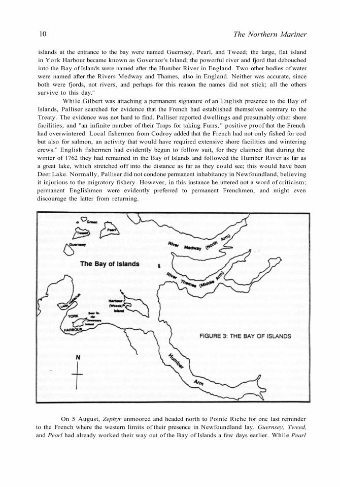
10 The Northern Mariner
islands at the entrance to the bay were named Guernsey, Pearl, and Tweed; the large, flat island in York Harbour became known as Governor's Island; the powerful river and fjord that debouched into the Bay of Islands were named after the Humber River in England. Two other bodies of water were named after the Rivers Medway and Thames, also in England. Neither was accurate, since both were fjords, not rivers, and perhaps for this reason the names did not stick; all the others survive to this day. 41
While Gilbert was attaching a permanent signature of an English presence to the Bay of Islands, Palliser searched for evidence that the French had established themselves contrary to the Treaty. The evidence was not hard to find. Palliser reported dwellings and presumably other shore facilities, and "an infinite number of their Traps for taking Furrs, " positive proof that the French had overwintered. Local fishermen from Codroy added that the French had not only fished for cod but also for salmon, an activity that would have required extensive shore facilities and wintering crews. 42 English fishermen had evidently begun to follow suit, for they claimed that during the winter of 1762 they had remained in the Bay of Islands and followed the Humber River as far as a great lake, which stretched off into the distance as far as they could see; this would have been Deer Lake. Normally, Palliser did not condone permanent inhabitancy in Newfoundland, believing it injurious to the migratory fishery. However, in this instance he uttered not a word of criticism; permanent Englishmen were evidently preferred to permanent Frenchmen, and might even discourage the latter from returning.
On 5 August, Zephyr unmoored and headed north to Pointe Riche for one last reminder to the French where the western limits of their presence in Newfoundland lay. Guernsey, Tweed, and Pearl had already worked their way out of the Bay of Islands a few days earlier. While Pearl
Showing the Flag 11
headed into the Gulf of St. Lawrence, Guernsey and Tweed made for St. John's. Though Palliser would continue to serve as governor of Newfoundland longer than anyone else in the eighteenth century, this visit to the west coast was both his first and last. In 1765 and again in 1767, he devoted attention to Newfoundland's south coast, where illicit contact between the French at St. Pierre, the fishermen of the south coast, and Anglo-American traders had become a problem. Similarly, he would visit the north coast and Labrador, where efforts to invigorate the migratory fishery were threatened by abuses by French, Anglo-American and Newfoundland fishermen and traders. In 1766 and 1768, Palliser gave his attention and energies to the fishery's traditional heartland, the Avalon Peninsula. 43 Yet the west coast was not allowed to fall victim again to indifference and neglect. Even though the Newfoundland station could i l l afford to waste resources, a warship was regularly assigned to patrol the west coast after 1764 4 4 In 1767, James Cook completed his famous cartographic survey of various parts of Newfoundland with a season on the west coast, including a magnificent chart of the Bay of Islands. 45 We can therefore assume that Palliser was satisfied that England's point had been made; documentary and cartographic evidence, supported by a show of force and a toponymie legacy, had confirmed British possession of the west coast.
Certainly the French did not persist in their pretensions to include western Newfoundland within the boundaries of the Treaty Shore. This is not to say that they had given up hope of extending those bounds as far south as Cape Ray. That particular goal, however, would now be assigned to their diplomats who, while conceding that the Treaty Shore did not include the coast south of Pointe Riche, argued that it should be extended south of that point. In exchange for a new definition of the western limits of the Treaty Shore, France suggested that the eastern limit be moved from Cape Bonavista to Cape St. Jean. Although these negotiations were interrupted by the American Revolution, they would form the basis for the re-definition of the Treaty Shore that was incorporated into the Treaty of Versailles in 1783. 46 Consequently, never again in that century would the Royal Navy need to make its presence as strongly felt on the west coast of Newfoundland as it did in that summer of 1764.
From the perspective of Newfoundland history, it is perhaps too easy to dwell upon the unprecedented nature of Palliser's visit to the Bay of Islands. Never before had the governor and commander-in-chief of the Newfoundland station visited this part of his jurisdiction. Yet, as was recently observed, in peace as well as war the Royal Navy was "the essential instrument of coercion, " and the attainment of foreign policy objectives, including the assertion of sovereignty, was one of its principal functions in the eighteenth century. 47 In Newfoundland, possibly more than in any other station, the Royal Navy had long been called upon to play many roles: as an instrument of defence, fisheries administration, judicial and legal administration and social services. For it to function as an agent of diplomacy was therefore quite consistent, both with its performance elsewhere and with the diversity of its role in Newfoundland.
N O T E S
* Olaf Uwe Janzen teaches history at Sir Wilfred Grenfell College in Corner Brook, Nfld. He has been an editorial colleague of Gerry Panting since the inception of The Northern Mariner/he Marin du nord.
1. This paper is based in part on research undertaken with the support of the Social Sciences and Humanities Research Council.
2. The Guernsey, Tweed, and Pearl arrived at the Bay of Islands on 24 July 1764, anchoring at York Harbour; Zephyr appeared on 29 July but did not anchor until the next day. See Public Records Office, Kew [hereafter PRO], Admiralty Papers, Series 51, Captains' Logs [hereafter A D M 51]: A D M 51/4210, No. 3, Guernsey log; A D M 51/674, No. 1, Pearl log; A D M 51/1007, No. 4, Tweed\og; A D M 51/1099, No. 1, Zephyr log. See also PRO, Admiralty Papers, Series 52, Masters' logs [hereafter A D M 52]: A D M 52/1391, Pearl log (master).
12 The Northern Mariner
3. The British Board of Trade maintained that "the Newfoundland Fishery as a means of wealth and power is of more worth than both of the aforementioned provinces; " Gerald Graham, "Fisheries and Sea Power, " Canadian Historical Association Annual Report 1941, reprinted in G A . Rawlyk (ed. ), Historical Essays on the Atlantic Provinces (Ottawa, 1967), 8. At approximately the same time, the French Minister of Marine, the Duc de Choiseul, insisted that "the codfishery in the Gulf of St. Lawrence is worth infinitely more for the realm of France than Canada or Louisiana. " Cited in Max Savelle, The Origins of American Diplomacy: The International History of Anglo-America, 1492-1783 (New York, 1967), 475n. See also Jean-François Brière, "Pêche et politique à Terre-Neuve au XVIIIe siècle. La France véritable gagnante du traité d'Utrecht?" Canadian Historical Review, L X I V , No. 2 (June 1983), 168-170.
4. Statement of William Knox, former Under Secretary of State for the American Department, given in evidence before the Committee appointed to inquire into the state of trade to Newfoundland, 1793 (Second Report, 16-20), reprinted in Great Britain, Privy Council, In the Matter of the Boundary Between the Dominion of Canada and the Colony of Newfoundland in the Labrador Peninsula (London, 1926-1927), IV, Joint Appendix, Part X, No. 722.
5. See Christopher English, "The Development of the Newfoundland Legal System to 1815, " Acadiensis, X X , No. 1 (Autumn 1990), 89-119, esp. 97ff.
6. See Brière, "Pêche et politique, " 168-173, and James K. Hitler, "Utrecht Revisited: The Origins of French Fishing Rights in Newfoundland Waters, " Newfoundland Studies, VII, No. 1 (Spring 1991), 23-39. What the Treaty of Utrecht failed to make clear was whether French fishermen had exclusive or concurrent rights to the use of the Treaty Shore. This failure would lie at the heart of what subsequently became known as the "French Shore Question. "
7. James K. Hiller, "The Newfoundland Fisheries Issue in Anglo-French Treaties, 1761-1783" (Unpublished paper presented at the Ninth Atlantic Canada Studies Conference, St. John's, Newfoundland, May 1992).
8. Brière, "Pêche et politique, " 172-173.
9. Laurier Turgeon, "Les échanges franco-canadiens: Bayonne, les ports basques, et Louisbourg, Ile Royale (1713-1758)" (Unpublished mémoire de maitrise, Université de Pau, 1977), 43; Turgeon, "La crise de l'armement morutier basco-bayonnais dans la première moitié du XVIIIe siècle, " Société des Sciences Lettres et Arts de Bayonne, Bulletin, nouvelle série, No. 139 (1983), 80-85.
10. To explain the seeming reluctance with which Placentia Bay and the coast beyond the Burin Peninsula was incorporated into the normal domain of the English fishery, Ralph Greenlee Lounsbury blamed "the inherent conservatism of the inhabitants and West Countrymen, " as well as the persistence of the former French inhabitants who retained their properties by swearing the oath of allegiance; Lounsbury, The British Fishery at Newfoundland 1634-1763 (1934; reprint, New York, 1969), 246. More recently, C. Grant Head has suggested that the abuse of authority by the military establishment at Placentia was to blame. He singles out Colonel Samuel Gledhill, the military commandant and lieutenant governor of Placentia, 1719-1727, whose "interference at Placentia town itself, key place of the whole southern coast, may have been a large contributing factor to the area's slow development under the British. " Head, Eighteenth Century Newfoundland: A Geographer's Perspective (Ottawa, 1976), 60.
11. Captain DeHaldy's information in William Tavern-er, "Second Report on Survey, Cape St. Mary's to the South Coast, " n. d. [February 1715?, received 20 May 1718), PRO, Colonial Office Papers, Series 194, Newfoundland [hereafter CO 194], vol. 6, 240-241; Lt. Col . John Moody to Mr. Popple, secretary to the Board of Trade, 20 August, 1719, PRO CO 194/6, 302.
12. Olaf Uwe Janzen, "'Une Petite Republique' in Southwestern Newfoundland: The Limits of Imperial Authority in a Remote Maritime Environment, " in Fischer and Minchinton (eds. ), People of the Northern Seas (St. John's, 1992), 1-33.
13. Waldegrave [Paris] to the Duke of Newcastle, 12 June [New Style] 1734, British Library Additional Manuscripts (hereafter BL A D D ) 32, 785, ff. 117-117v.
14. "Mémoire pour servir de Réponse..., " 14 juin 1734, BL A D D 32, 785, ff. 170-170v.
15. Lord Muskerry [St. John's] to Mr . Burchett, Secretary of the Board of Trade, 19 September 1734, PRO A D M 1/1498, No. 1.
16. Memorial enclosed in J. Burnaby [Paris] to John Courand, 2 March [N. S. ] 1735, PRO State Papers, Series 78 (hereafter cited as SP 78), vol. 207, 67v.
17. Admiral E. Boscawen to the Admiralty, 15 November 1755, P R O A D M 1/481, 68. For details of the operation, see PRO A D M 51/940, i i , Captain's Log, H M S Success (March 1754-May 1757); PRO A D M 51/3770, i i i , Captain's log, H M S Arundel. A French perspective of this operation is provided by Jean Lafreche, captain of the Deux Maries out of Ciboure; see his statement of 9 October 1755 in "Registres du greffe de l'amirauté etably a Ciboure, " Archives de la chambre de commerce de
Showing the Flag 13
Bayonne, Bayonne [hereafter cited as A C C B ] , 1. 2/40. The officer in charge of the expulsion of the Codroy settlers was Captain Rous of H M S Success, whose next assignment upon returning from Newfoundland would be the more infamous expulsion of the Chignecto Acadians; see W. A. B. Douglas, "John Rous, " Dictionary of Canadian Biography, III: 1741-1770 (Toronto, 1974), 572-574 [hereafter cited as DCB].
18. William H . Whiteley, James Cook in Newfound-land 1762-1767 (St. John's, 1975), 24.
19. Memorial from the merchants of St. Malo to the Minister of Marine, Comte de Maurepas, 12 April 1733, Archives de la Marine, Paris [hereafter A M ] , B'/361, 530-531.
20. James Pritchard, "The Problem of North America in French Nautical Science During the 17th and 18th Centuries, " in M. Acerra, et al. (eds. ), Les marines de guerre européennes XVII-XVIIle siècles (Paris, 1985), 331-344.
21. See for instance N. Bellin, "Carte de L'Isle de Terre-Neuve, " dated 1742, in AM 6JJ/37, No. 66. There are several French charts in the cartographic collection of the National Maritime Museum in Greenwich which also place Pointe Riche near Port aux Choix; see, for instance, VZ 9/35, a French chart of 1753.
22. According to Whiteley, the French ambassador supported his country's claim "on several maps of Newfoundland, chiefly on ones of Herman M o l l , published in 1715 and 1720. " See William Whiteley, "James Cook, Hugh Palliser and the Newfoundland Fishery, " Newfoundland Quarterly, L X I X , No. 2 (October 1972), 20. If so, the claim was expressed by more recent and authoritative maps, such as those by Bellin. The copy of his "Carte Réduite du Grand Banc et d'une partie de 1 "isle de Terre-Neuve" in the Archives de la Marine in Paris ( A M 6JJ/37, No. 67) is especially curious. It was done entirely in black and white, except for the stretch of coast to the north of Cape Ray, which was done in red and marked "à corriger. " This part of the original chart had been removed and carefully replaced, presumably signifying the "correction. " The result, when compared to Bellin's earlier charts, identifies Cape Ray as Pointe Riche, and places Bay St. George much further south than it should be.
23. Until Lark arrived during the summer of 1763, no British warship had ever been stationed there.
24. "C'est un parti-pris en Angleterre de faire la pesche et la sécherie des morues sur cette coste concurremment avec les François, afin de les forcer succissivement et par des pertes suivies à abandonner entierrement ce commerce, dont ils sentent bien toutte l'influence sur le
rétablissement de la marine françoise. . . . le but [de la politique anglaise] est d'empescher le rétablissement de notre marine..., " cited in Brière, "Pêche et politique, " 174. See also Hiller, "Utrecht Revisited, " 34-35.
25. See Hiller, "The Newfoundland Fisheries Issue in Anglo-French Treaties, 1761-1783, " 3-10.
26. In his seminal study of The French Shore Problem in Newfoundland: An Imperial Study (Toronto, 1961), F. F. Thompson suggests that the attempt to identify Cape Ray as Pointe Riche was a negotiating ruse of 1783; 15. In fact, it was a pressure tactic applied in 1763-1764.
27. Jack P. Greene, " A n Uneasy Connection: An Analysis of the Preconditions of the American Revolution, " in Stephen G Kurtz and James H. Hutson (eds. ), Essays on the American Revolution (Chapel H i l l , N C , 1973), 72.
28. See William Whiteley, "Governor Hugh Palliser and the Newfoundland and Labrador Fishery, 1764- 1768", Canadian Historical Review, L, No. 2 (June 1969), 141-163; see also Whiteley's essay on Palliser in DCB, IV (Toronto, 1979), 597-601.
29. Cook had been mate of Palliser's ship Eagle from 1755 to 1757. Later, as master of Northumberland, Cook's path crossed Palliser's again, when both participated in the successful British effort to recapture St. John's from the French; Glyndwr Williams, "James Cook" DCB, IV, 162-167 and Whiteley, "Hugh Palliser, " ibid., 597-601. Cook used the opportunity to survey St. John's harbour. That was not unusual; because the eighteenth-century Royal Navy did not provide its warships with charts, it was a poor sailing master who did not make his own whenever he visited a new coast or harbour. What was unusual was the impressive quality of Cook's charts, and he was soon brought to the attention of Governor Thomas Graves. As Cook would later acknowledge, it was Graves who secured his employment in surveying and charting the Newfoundland coast, beginning in 1763 with the south coast of Newfoundland and the French islands of St. Pierre and Miquelon, and continuing until 1767 with the west coast; James Cook to Thomas Graves, 15 March 1764, National Maritime Museum, Greenwich (hereafter N M M ) , Graves Papers (hereafter G R V ) , vol. 106, unpaginated: "It is more than probable [that] the Survey of the Island wil l go on until compleatly finished, this useful and necessary thing the World must be obliged to you for. " See also J. C. Beagle-hole, The Life of Captain James Cook (Stanford, 1974), esp. 62-66.
30. Beaglehole, Life of Cook, 11. See James Cook to Palliser, 7 March 1764 and "A List of Maps and Charts in which Cape Ray or Pointe Riche or both have been inserted, " 15 March 1764, both in PRO A D M 1/2300,

14 The Northern Mariner
No. 9, Captain Palliser's Letters; Beaglehole reprints Cook's letter in its entirety.
31. Board of Trade to the King, 20 April 1764, PRO CO 195/9, 330-356.
32. After two months spent patrolling the coast between Port aux Basques and Port aux Choix, Lark returned to England where Samuel Thompson submitted his report. He indicated that the community was English, but mentioned that it had belonged to the French until "the beginning of the late Warr. " Lark's movements can be traced using her master's log in PRO A D M 52/1316, i i . These indicate that for a few days at least she was joined by Tweed (Captain Perceval). Thompson's report to the Admiralty secretary, Philip Stephens, dated 12 March 1764, appears in PRO A D M 1/2590, No. 4, Captain Thompson's Letters. The most detailed description of the Codroy settlement appears in his "Remarks in Answers to Heads of Inquiry" (1763), N M M GRV/105.
33. Board of Trade, draft of instructions for Hugh Palliser, No. 12, 10 April 1764, PRO CO 195/9, 286-287.
34. In particular, Palliser was concerned by reports of French warships in the area, fortification of St. Pierre and Miquelon contrary to the treaties, trade with New Englanders, and French visits to Newfoundland's south coast for wood; see Whiteley, "Palliser and the Fisheries, " 144-145.
35. Palliser to Philip Stephens, 1 September 1764, PRO SP 42/65, No. 30(b), fol. 384-385.
36. See, for instance, Admiralty Hydrography Library, Taunton [hereafter A H L ] , Miscellaneous Papers 27(T), Remark Book, H M S Tweed, Captain Perceval, Mr. James Maxwell , Master, 24 July-1 August 1764.
37. A H L Misc. Papers 27(T), Remark Book, H M S Tweed at York Harbour, Bay of Islands, 24 July-1 August 1764; various logs, including Guernsey (PRO A D M 51/4210, No. 3), Tweed (PRO A D M 51/1007, No. 4), and Zephyr (PRO A D M 51/1099, No. 1).
38. See BL A D D 17, 693a, "A Plan of the Bay of Three Islands in Newfoundland...; " and BL A D D 17, 693c, "A plan of York Harbour and Lark Bay, within the Bay of Three Islands in Newfoundland..., taken on board H M S Guernsey, June [sic] 1764. "
39. The name "Lark Harbour" may in fact pre-date Lark's visit; when the ship arrived at the Bay of Islands for the first time, the master's log reported that she anchored "In a Small harbour in the Bay of Isles cal'd lark harbour. " P R O A D M 52/1316, i i , 13 July 1763.
40. Traditionally, James Cook is given credit for assigning all these English names when he conducted his cartographic survey in 1767; see, for instance, Whiteley, "James Cook in Newfoundland, " 21-22. The mistake is obvious when Gilbert's cruder but older maps, with the names already clearly in place, are examined. The "River Thames" has since become Middle Arm, while the River Medway is known to us today as North Arm. Logic does not always dictate toponymy; Gilbert's appropriately named "Harbour Island" has since become "Woods Island. "
41. Palliser to Philip Stephens, 1 September 1764, PRO SP 42/65, No. 30(b), fol. 384-385. This testimony may have been gleaned from his pilots, but more likely came from the Codroy settlers who, like the French, were drawn to the Bay of Islands by its wealth of marine resources. According to Captain Thompson's remarks in N M M GRV/105, "The Isle of Codroy... is settled by upwards of an hundred People, who carry a Fishery on at the Bay of Islands. " Palliser's remarks on Joseph G i l bert's completed chart also suggest that additional testimony came from "the Reports of the Cape Breton Indians who the last Winter was at Caderoy. " See BL A D D 17, 693a, "A Plan of the Bay of Three Islands... "
42. Whiteley, "Governor Hugh Palliser, " 147-152.
43. Assigned to the Newfoundland station, and in addition to the commodore's flagship, were usually two frigates, two sloops of war, and a couple of schooners, brigs, or cutters.
44. As a result of his work in 1762 with the expedition that recovered St. John's from the French, Cook was commissioned by the Admiralty in 1763 to chart several of the coasts of Newfoundland. The work took him five years, beginning with St Pierre and Miquelon, Newfoundland's Northern Peninsula, the south coast, and finally the west coast. Reflecting the political importance of this assignment, Cook's charts were rich with information about existing fisheries and potential new ones. It is perhaps because of the meticulous, even perfectionist nature of this work that Cook is usually given credit-occasionally erroneously, as this paper maintains—for many of the place names in western Newfoundland. For a full treatment, see previously cited articles by Whiteley together with Williams' essay in DCB, IV.
45. Brière, "Pêche et politique, " 178-185; Hiller, "The Newfoundland Fisheries Issue, " 11-20.
46. Nicholas Tracy, Navies, Deterrence, and American Independence: Britain and Seapower in the 1760s and 1770s (Vancouver, 1988), "Introduction; " see also the several essays in Jeremy Black and Philip Woodfine (eds. ), The British Navy and the Use of Naval Power in the Eighteenth Century (Leicester, 1989).
Related Documents


![UDS 2020 IN...Winnipeg, MB R2G 4H2 [14] Palliser was founded in 1944. Palliser manufactures, distributes and sells UDS to retailers throughout Canada. Palliser manufactures UDS at](https://static.cupdf.com/doc/110x72/6134da4fdfd10f4dd73bff23/uds-2020-in-winnipeg-mb-r2g-4h2-14-palliser-was-founded-in-1944-palliser.jpg)