County of Simcoe Organics Processing Facility, Materials Management Facility, and Co-Located Facility Part 3 – Short List Evaluation Solid Waste Management Department 1110 Highway 26 Midhurst, Ontario, L0L 1X0 184 Front Street East Suite 302 Toronto Ontario M5A 4N3 086822 | Report No 6 | February 26 2016 Final County of Simcoe

Welcome message from author
This document is posted to help you gain knowledge. Please leave a comment to let me know what you think about it! Share it to your friends and learn new things together.
Transcript

County of SimcoeOrganics Processing Facility, Materials Management Facility, and Co-Located Facility Part 3 – Short List Evaluation
Solid Waste Management Department 1110 Highway 26Midhurst, Ontario, L0L 1X0
184 Front Street East Suite 302 Toronto Ontario M5A 4N3 086822 | Report No 6 | February 26 2016
Final
County of Simcoe

GHD | County of Simcoe – OPF, MMF, and Co-Located Facility – Part 3 – Short List Evaluation | 086822 (6) | i
Executive Summary
The County of Simcoe's (County) Solid Waste Management Strategy (Strategy) was approved by Council in 2010, and provides the framework the County's waste disposal options and diversion programs. Regarding source-separated organics (SSO), the Strategy recommended that the County assess development of a central composting facility (CCF) and explore various technology options to meeting long-term processing requirements.
In June 2013, Council directed Staff to review strategies to improve diversion, in particular by including pet waste and diapers in the County's organics. A January 2014 Staff Report presented costing information for various processing facilities, a proposed project plan, and a timeline recommending a phased approach for development of a County facility. This would include development of aerobic composting (Phase I) with the opportunity for future expansion to include anaerobic digestion (Phase II) if and when the energy market is proven and overall costs are reduced.
In addition, the County’s Strategy also outlined options for transfer of materials, including garbage and recyclables to support future processing and/or disposal elements of the waste management system.
Long term transfer requirements were uncertain at the time of the Strategy's development since the procurement of new collection and recycling processing contracts were forthcoming and Council direction on waste export was unclear. A financial analysis completed for the facility determined that a County transfer facility could save approximately $13 million over the next 20 years compared to the current system.
In March of 2014, the County issued Request for Proposals (RFP) No. 2014-021 and awarded the assignment in May 2014 to GHD Limited (GHD) [formerly Conestoga-Rovers & Associates (CRA)], which included consulting services to support the siting of the CCF and the procurement of a contractor to design and construct the facility (Study). To more accurately reflect the nature of this Study, the term CCF was replaced with Organics Processing Facility (OPF). The original scope of work under RFP No. 2014-021 was expanded in November 2014 to include the siting of the County transfer facility. To more accurately reflect the nature of this Study, the term ‘transfer facility’ was replaced with Materials Management Facility (MMF).
The siting process for the OPF was initiated by GHD in May 2014, and subsequently for the MMF in November 2014. In order to facilitate the identification of a preferred location for each facility, it was proposed that the siting process occur in three major stages:
Part 1 – Planning – Siting Methodology and Evaluation Criteria
Part 2 – Long List Evaluation
Part 3 – Short List Evaluation
Following stakeholder consultation through a Community Engagement Committee (CEC) and Public Open Houses, the Part 1 Report, Planning – Siting Methodology and Evaluation Criteria, was submitted for Council approval on February 26, 2015. An overview of the report was also presented to Council by GHD on the same day. On March 10, 2015, County Council endorsed the siting

GHD | County of Simcoe – OPF, MMF, and Co-Located Facility – Part 3 – Short List Evaluation | 086822 (6) | ii
methodology and evaluation criteria for the OPF and MMF. The Part 2 Reports (OPF and MMF), Long List Evaluation, were submitted for Council approval on August 11, 2015. An overview of the reports was also presented to Council by GHD on the same day. The two stage evaluation process resulted in a short list of sites for both facilities – seven for the OPF and five for the MMF. Further, given that the long list evaluation results demonstrated that there were five common short-listed sites that may be suitable for an OPF or a MMF, GHD recommended that the County consider evaluating the potential to co-locate both facilities on one site during Part 3, the Short List Evaluation. On August 25, 2015, County Council endorsed the long list evaluation for the OPF, MMF and co-located facilities, allowing work to proceed on the Part 3 Report, Short List Evaluation, considering sites for the OPF, MMF or a co-located facility.
The main objective of this report is to present the findings of Part 3 – Short List Evaluation, including:
• A review of the Screen 1 and Screen 2 evaluations used to generate the long and short lists of sites.
• A discussion of how public and stakeholder feedback was addressed and incorporated into the evaluation of the short-listed sites.
• The application of Screen 3 evaluation criteria to the short-listed sites.
• The identification of potential effects, mitigation measures, and net effects for the evaluation criteria as they relate to each site.
• The comparative evaluation of the short-listed sites to identify the preferred site(s) for the development of the facilities
• An overview of the next steps in the siting process, including presentation of the results to County Council, further stakeholder consultation, and the procurement of technology and facility design for the preferred site(s).
A total of 502 candidate sites consisting of both County-owned and privately-owned properties were identified for consideration. Application of the Screen 1 criteria resulted in a number of sites being carried forward to the long list for further evaluation (53 sites for the OPF, and 23 sites for the MMF). Screen 2 criteria were subsequently applied to the long list, resulting in a number of sites being carried forward to the short list for further evaluation (7 sites for the OPF, and 5 sites for the MMF and co-located facilities).
Engagement of various stakeholders during the siting process has been ongoing and is an important aspect to the success of this project. In October 2015, ten public consultation sessions were held in the potential host municipalities: six sessions in Springwater, two sessions in Oro-Medonte, and two sessions in Clearview. Two sessions were hosted at each venue: one from 2:00 to 4:00 p.m. and another from 6:00 to 8:00 p.m. Each two-hour session consisted of an open house portion, providing the public and interested stakeholders the opportunity for open discussion with the Project Team, including representatives from GHD. A formal presentation and facilitated question and answer session followed, allowing opportunity for public comment and questions in regard to the project and short-listed sites. The purpose of these sessions was to provide an overview of the project development to date, outline the benefits of developing this infrastructure locally, present the short-listed sites, obtain comments and questions in regard to the sites and the potential to co-locate the OPF with the MMF, and to outline the next steps in the siting process. Comments and feedback received during the consultation process – from the public, Aboriginal

GHD | County of Simcoe – OPF, MMF, and Co-Located Facility – Part 3 – Short List Evaluation | 086822 (6) | iii
communities, and stakeholders – form an important part of the final evaluation of the short-listed sites.
In addition to the public consultation events, the County also met with staff from the potential host municipalities to present information and discuss the projects. In addition to the meetings with the potential host municipalities, and at the request of the Township of Springwater, the County hosted tours of the short-listed sites as well as existing facilities operating in other municipalities. These tours were offered to the Mayor, Deputy Mayor, Ward Councillors with a short-listed site in their ward, and the Chief Administrative Officers from all three potential host municipalities. A daylong tour of three co-located facilities for the transfer of waste and source-separated organics processing was facilitated by the County with the assistance of GHD on September 29, 2015. Facilities visited included the City of Toronto’s Green Bin Facility, the Region of Peel’s Integrated Waste Management Facility, and the City of Guelph’s Waste Resource Innovation Centre.
Broader stakeholder meetings were also held to ensure that agencies, organizations and Aboriginal and First Nations were included in the consultation and engagement sessions. This included sessions with Ministry of Environment and Climate Change (MOECC), local Conservation Authorities, Planning and Public Works departments of the potential host municipalities and the County’s Planning, Forestry and Transportation and Engineering Departments. A number of other agencies were contacted including the Ministry of Natural Resources and Forestry (MNRF), Ministry of Tourism, Culture and Sport (MTCS), Transport Canada, public utilities and services, local school boards, etc., to ensure broad consultation took place. Aboriginal and First Nations consultation is ongoing and as part of the short-list evaluation, the County of Simcoe met with Beausoleil First Nation on Christian Island to discuss the projects and seek direction on further engagement. Chippewas of Rama First Nation, Georgina Island First Nation, Curve Lake First Nation, Mississaugas of Scugog Island First Nation, Hiawatha First Nation and Alderville First Nation, Saugeen Ojibway First Nation, Huron-Wendat First Nation and Métis have also been contacted.
The evaluation of the short-listed sites utilized the Screen 3 criteria, which includes all of the criteria used during the Screen 1 and Screen 2 evaluations as well as additional criteria and indicators. Information related to the Screen 3 criteria was collected and reviewed from a variety of sources, including: the County, lower-tier municipalities, conservation authorities, other stakeholders, and through professional experience (e.g., technical and economic data). Screen 3 criteria maps were prepared for each of the short-listed sites and organized to show all of the criteria used to evaluate the sites.
Conceptual layouts for each facility were developed for the OPF, MMF and co-located facility. Using the Screen 3 criteria mapping and the areas identified within each site that avoided most or all of the identified constraints, the best potential site development areas were identified. Overlaying the conceptual facility layouts with these areas allowed for conceptual site layouts for each facility to be developed on each of the short-listed sites.
The assessment and evaluation of the short-listed sites was conducted in two steps:
Step 1 – Undertake the Net Effects Analysis
- Identify potential effects.
- Develop and apply avoidance, mitigation, compensation and enhancement (AMCE) measures.
- Determine net effects on the environment.

GHD | County of Simcoe – OPF, MMF, and Co-Located Facility – Part 3 – Short List Evaluation | 086822 (6) | iv
Step 2 – Carry out the Comparative Evaluation
- Identify the level of effect (‘No Effect’, ‘Low’, ‘Moderate’ or ‘High’) associated with each short-listed site for each indicator.
- Assign a numerical ranking for each short-listed site based on the identified level of effect from each indicator and the criteria rankings for each short-listed site.
This comparative evaluation methodology is often referred to as the "reasoned argument" or "trade-off" approach. The term "trade‐offs" is defined as "things of value given up in order to gain different things of value". Rankings were combined (aggregated) for each indicator within a criterion into a single ranking for that criterion. The ranking for each criterion within a component was then combined into a single ranking for that component (i.e., Environmental, Social, Cultural, Technical, Economic, Legal). Finally, rankings were further aggregated into a single ranking for each short-listed site.
The comparative evaluation results are shown as follows:
Site Municipal Address Co-Located OPF only MMF only C136 2976 Horseshoe Valley
Road West 1st 1st 1st
C223 Line 5 North, between Old Barrie Road West and Bass Lake Sideroad West
2nd 4th 2nd
C270 1453 Flos Road Three East
3rd Tied 5th 3rd
C164/C107 1473/1273 Old Second South
4th Tied 5th 4th
P083/P084 540/528 Penetanguishene Road
5th 7th 5th
C052 1637 Fairgrounds Road North
N/A 3rd N/A
C189 2249 Flos Road Seven East
N/A 2nd N/A
Site C136 – 2976 Horseshoe Valley Road West in the Township of Springwater was identified as the preferred site for all three facility options (OPF, MMF, and co-located facility). Site C136 is the preferred site for the following reasons:
• 'No' to 'Low' net effects under the Environmental Component.
• 'Low' to ‘Moderate’ net effects under the Social Component.
• 'No' to 'Low' net effects under the Cultural Component.
• A mix of net effects under the Technical Component.
• 'Low' to ‘Moderate’ costs under the Economic Component.
• ‘Low’ Complexity under the Legal Component.
Prior to moving forward with further detailed work and further approvals on the preferred site for the facility, County Council approval and endorsement of the preferred site will be sought. The presentation of the preferred site is anticipated to occur in early 2016.

GHD | County of Simcoe – OPF, MMF, and Co-Located Facility – Part 3 – Short List Evaluation | 086822 (6) | v
The Project Team anticipates undertaking the following steps once County Council have provided further direction on the three options before them:
• Further consultation with neighbouring landowners will occur, with discussion on potential further approvals required (i.e., land use, ECA), facility footprint location on the site, potential design/technology, mitigation measures, Best Management Practices, and anticipated schedule of major milestones. Discussion will also include details on how best to seek their input on future site design and selection of technology.
• Work Plans will be established for each technical discipline involved in further investigations on the site, which may include: planning justification report, geotechnical investigations, Environmental Impact Statement, Traffic Impact Study, noise assessment, site plan, hydrogeological studies, archaeological studies, etc. Timelines for data collection and assessment of findings will be established as part of the Work Plans.
• Further public information/consultation sessions on project milestones and the procurement process.
• Initiation of the Planning approvals process, working in cooperation with both County Planning staff and the host municipalities Planning staff.
• Advancing the site-specific design that will be put forward in the procurement process.
• Preparation of Request for Proposal (RFP) documents as the procurement of processing technology is advanced.
• Continue to seek guidance from the MOECC in preparation for submitting application(s) for ECA(s).

GHD | County of Simcoe – OPF, MMF, and Co-Located Facility – Part 3 – Short List Evaluation | 086822 (6) | vi
Table of Contents
1. Introduction ................................................................................................................................... 1
1.1 Background ........................................................................................................................ 2
1.2 Goals & Objectives ............................................................................................................ 3
2. Methodology ................................................................................................................................. 4
2.1 Screen 1 & 2 Evaluation .................................................................................................... 4
2.2 Public & Stakeholder Consultation .................................................................................... 5
2.2.1 Public Consultation Sessions ........................................................................... 6 2.2.1.1 Advertising ........................................................................................................ 7 2.2.1.2 Communication Material ................................................................................... 7 2.2.1.3 Documentation of Public Input .......................................................................... 8 2.2.2 Municipalities .................................................................................................. 10 2.2.3 Aboriginal Groups and Agencies .................................................................... 11 2.2.4 Agencies & Organizations .............................................................................. 12 2.2.4.1 Conservation Authorities ................................................................................ 12 2.2.4.2 Ministry of the Environment and Climate Change .......................................... 12 2.2.4.3 Transportation ................................................................................................. 13 2.2.4.4 Ministry of Natural Resources and Forestry ................................................... 14 2.2.4.5 Utilities & Services .......................................................................................... 15 2.2.4.6 Local School Boards and Organizations ........................................................ 15 2.2.4.7 Other Agencies and Organizations................................................................. 16 2.2.5 Community Engagement Committee ............................................................. 16
2.3 Screen 3 Evaluation ......................................................................................................... 17
2.3.1 Review of Screen 1 and Screen 2 Evaluation ................................................ 17 2.3.2 Incorporation of Comments and Feedback .................................................... 17 2.3.3 Screen 3 Criteria ............................................................................................. 17 2.3.4 Mapping .......................................................................................................... 21 2.3.4.1 Conceptual Facility Layout ............................................................................. 21 2.3.4.2 Conceptual Site Layout .................................................................................. 22 2.3.5 Site Visits ........................................................................................................ 22 2.3.6 Net Effects Analysis and Comparative Evaluation ......................................... 22 2.3.7 Identification of the Preferred Site(s) .............................................................. 24
3. Evaluation and Results............................................................................................................... 25
3.1 Site C052 – 1637 Fairgrounds Road North ..................................................................... 26
3.2 Site C164/C107 – 1473/1273 Old Second South ............................................................ 27
3.3 Site C136 – 2976 Horseshoe Valley Road West ............................................................. 28
3.4 Site C189 – 2249 Flos Road Seven East ........................................................................ 29
3.5 Site C223 – Line 5 North.................................................................................................. 30
3.6 Site C270 – 1453 Flos Road Three East ......................................................................... 31
3.7 Site P083/P084 – 540/528 Penetanguishene Road ........................................................ 32
3.8 Comparative Evaluation ................................................................................................... 33
3.9 Preferred Site ................................................................................................................... 40
4. Next Steps .................................................................................................................................. 42

GHD | County of Simcoe – OPF, MMF, and Co-Located Facility – Part 3 – Short List Evaluation | 086822 (6) | vii
Figure Index Figure 1 Siting Process
Figure 2 Revised Siting Criteria
Figure 3 Short-Listed Sites
Figure 4 Conceptual Facility Layout (OPF)
Figure 5 Conceptual Facility Layout (MMF)
Figure 6 Conceptual Facility Layout (Co-Located)
Table Index Table 2.1 Short-Listed Sites
Table 2.2 Public Consultation Sessions
Table 2.3 Petitions
Table 2.4 Anticipated Number of Vehicles
Table 2.5 Anticipated Increase in Traffic Volumes
Table 2.6 Site Review Summary
Table 2.7 Facility Sizing and Buffers
Table 3.1 Comparative Evaluation – OPF
Table 3.2 Comparative Evaluation – MMF
Table 3.3 Comparative Evaluation – Co-Located Facility
Table 3.4 Site Ranking
Appendices Appendix A Glossary of Terms
Appendix B Public Feedback and Petitions
Appendix C Site C052 – 1637 Fairgrounds Road North
Appendix D Site C164/C107 – 1473/1273 Old Second South
Appendix E Site C136 – 2976 Horseshoe Valley Road West
Appendix F Site C189 – 2249 Flos Road Seven East
Appendix G Site C223 – Line 5 North
Appendix H Site C270 – 1453 Flos Road Three East
Appendix I Site P083/P084 – 540/528 Penetanguishene Road

GHD | County of Simcoe – OPF, MMF, and Co-Located Facility – Part 3 – Short List Evaluation | 086822 (6) | 1
1. Introduction
The County of Simcoe's (County) Solid Waste Management Strategy (Strategy) was approved by Council in 2010, providing the framework for both short-term and long-term waste disposal options and diversion programs for the next 20 years.
Organics Processing
Regarding processing of source-separated organics (SSO), the Strategy recommended that the County assess the development of a central composting facility (CCF) to meet long-term processing requirements. Specifically, it recommended that the County explore various technology options, including those that could handle the addition of other organic materials to the program (i.e., pet waste and diapers).
Further to this, a full-day Waste Management Strategy session was held on June 27, 2013, which provided County Council with an opportunity to discuss strategies to improve diversion and, in particular, the addition of pet waste and diapers to the organics program. In January 2014, Staff presented costing information for various processing facilities, a proposed project plan, and a timeline recommending a phased approach to the development of a County facility1. This would include development of aerobic composting (Phase I) with the opportunity for future expansion to include anaerobic digestion (Phase II) if and when the energy market is proven and overall costs are reduced.
In March of 2014, the County issued Request for Proposal (RFP) No. 2014-021 and awarded the assignment in May 2014 to GHD Limited (GHD) (formerly Conestoga-Rovers & Associates [CRA]), which includes consulting services to support the siting of the CCF and the procurement of a contractor to design and construct the facility (Study)2. To more accurately reflect the nature of this Study, the term CCF was replaced with Organics Processing Facility (OPF).
The development of Phase I is expected to take approximately 3-4 years, with final commissioning of the facility anticipated in 2019. Initial planning, siting, and procurement tasks are set to occur over a three year timeframe, providing opportunities for Council to review and direct Staff regarding the process, and allowing for input from stakeholders and the general public.
Materials Transfer
With respect to the transfer of garbage, recyclables, and SSO, the Strategy outlined options based on the County's existing system and identified new operations that may be required to support future processing and/or disposal elements of the waste management system. Long term transfer requirements were uncertain at the time of the Strategy's development since the procurement of new collection and recycling processing contracts were forthcoming and Council direction on waste export was unclear.
1 County of Simcoe Staff Report, Item Number CCW 14-025 – Central Composting Facility Update
http://docs.simcoe.ca/ws_cos/idcplg?IdcService=GET_FILE&RevisionSelectionMethod=LatestReleased&dDocName=rsc412849
2 County of Simcoe Staff Report, Item Number CCW 14-246, RFP 2014-021 – Consulting Services – Central Composting Facility http://docs.simcoe.ca/ws_cos/idcplg?IdcService=GET_FILE&RevisionSelectionMethod=LatestReleased&dDocName=rsc429234

GHD | County of Simcoe – OPF, MMF, and Co-Located Facility – Part 3 – Short List Evaluation | 086822 (6) | 2
Work continued on assessing long-term transfer requirements as new contracts began for curbside collection, transfer of recycling, and waste export in 2013. Currently, the County transfers approximately 25,000 tonnes per year of garbage, 10,000 tonnes per year of SSO, and over 25,000 tonnes per year of recyclables (paper fibres and containers).
With detailed information on transfer costs, a financial analysis for a County transfer facility was presented to County Council in August 20143. It outlined the contracted costs for transfer, the estimated capital costs for the building, and the potential for funding from the Continuous Improvement Fund (CIF). The financial analysis determined that a County transfer facility could save approximately $13 million over the next 20 years compared to the current system.
The original scope of work under RFP No. 2014-021 was expanded in November 2014 to include the siting of a County transfer facility. To more accurately reflect the nature of this Study, the term 'transfer facility' was replaced with Materials Management Facility (MMF).
The development of the MMF is expected to take approximately 3-4 years, with procurement and construction of the facility anticipated in 2019.
1.1 Background
The siting process for the OPF was initiated by GHD in May 2014, and subsequently for the MMF in November 2014. In order to facilitate the identification of a preferred location for each facility, it was proposed that the siting process occur in three major stages:
1. Part 1 – Planning – Siting Methodology and Evaluation Criteria – Define the search area, identify a comprehensive list of candidate sites and develop a siting methodology along with a series of criteria to screen and evaluate potential sites.
2. Part 2 – Long List Evaluation – Apply an initial set of screening criteria to the list of candidate sites to arrive at a long list of sites. Apply additional screening criteria to the long list to generate a short list of sites.
3. Part 3 – Short List Evaluation – Comparative evaluation of short-listed sites against all criteria. Assess the potential effects, mitigation measures and net effects of developing a facility on each site, and perform a comparative ranking to determine the preferred site(s).
Following consultation with the Community Engagement Committee (CEC) and public open houses, the Part 1 Reports (OPF and MMF), Planning – Siting Methodology and Evaluation Criteria, were submitted for Council approval on February 26, 20154. An overview of the reports was also presented to Council by GHD on the same day5. On March 10, 2015, County Council endorsed the siting methodology and evaluation criteria for the OPF and MMF.
3 County of Simcoe Staff Report, Item Number CCW 14-253, Transfer Facility Assessment
http://docs.simcoe.ca/ws_cos/groups/public/%40pub-cos-sta-com/documents/web_content/rsc442308.docx 4 County of Simcoe Staff Report, Item Number CCW 15-055 – Organics Processing Facility – Siting Methodology
and Evaluation Criteria http://docs.simcoe.ca/ws_cos/idcplg?IdcService=GET_FILE&RevisionSelectionMethod=LatestReleased&dDocName=rsc466410
5 Conestoga-Rovers & Associates Presentation, Siting Methodology and Evaluation Criteria http://docs.simcoe.ca/ws_cos/idcplg?IdcService=GET_FILE&RevisionSelectionMethod=LatestReleased&dDocNa
me=rsc467730

GHD | County of Simcoe – OPF, MMF, and Co-Located Facility – Part 3 – Short List Evaluation | 086822 (6) | 3
The Part 2 Reports (OPF and MMF), Long List Evaluation, were submitted for Council approval on August 11, 20156. An overview of the reports was also presented to Council by GHD on the same day7. The two-stage evaluation process resulted in a short list of sites for both facilities – seven for the OPF and five for the MMF.
Co-Located Facility
While the screening processes for each facility were undertaken separately, the evaluation results demonstrated that there are five common short-listed sites that may be suitable for an OPF or a MMF. Noting that there may be advantages to co-locating the OPF and MMF on the same site (e.g., financial savings, simplified regulatory process, and streamlined operations), GHD recommended that the County consider evaluating the potential to co-locate both facilities on one site during Part 3, the Short List Evaluation.
Noting that five of the short-listed sites could host a centrally-located waste management centre with adequate space for transfer operations and organics processing, a technical memorandum outlining the potential to co-locate both facilities was submitted with the Part 2 Reports for the consideration of County Council.
On August 25, 2015, County Council endorsed the long list evaluation for the OPF, MMF, and co-located facilities, allowing work to proceed on the Part 3 Report, Short List Evaluation. As the sites will be considered for the OPF, MMF or co-located facility, the Part 3 Report will be a combined report covering all scenarios.
An overview of the siting process and anticipated timeline is presented in Figure 1.
1.2 Goals & Objectives
The ultimate goal of the siting process is to follow a practical siting methodology that applies a series of evaluation criteria to a list of potential sites in order to identify a preferred location for the development of the facilities (i.e., separate OPF and MMF, or co-located facilities). To this end, the siting process should:
• Follow a clearly defined methodology.
• Meet all applicable regulations and standards.
• Be consistent with best practices.
• Consider relevant evaluation criteria.
• Provide opportunities for stakeholder input.
6 County of Simcoe Staff Report, Item Number CCW 15-240 – Organics Processing Facility and Materials
Management Facility – Short List of Sites http://docs.simcoe.ca/ws_cos/idcplg?IdcService=GET_FILE&RevisionSelectionMethod=LatestReleased&dDocName=rsc486996
7 GHD Ltd. Presentation, Organics Processing Facility and Materials Management Facility – Short List of Sites http://docs.simcoe.ca/ws_cos/idcplg?IdcService=GET_FILE&RevisionSelectionMethod=LatestReleased&dDocName=rsc488721

GHD | County of Simcoe – OPF, MMF, and Co-Located Facility – Part 3 – Short List Evaluation | 086822 (6) | 4
With the siting methodology and evaluation criteria established in Part 1, and the evaluation of the long list of potential sites presented in Part 2, the main objective of this report is to present the findings of Part 3 – Short List Evaluation, including:
• A review of the Screen 1 and Screen 2 evaluations used to generate the long and short lists of sites.
• A discussion of how public and stakeholder feedback was addressed and incorporated into the evaluation of the short-listed sites.
• The application of the Screen 3 evaluation criteria to the short-listed sites.
• The identification of potential effects, mitigation measures, and net effects for the evaluation criteria as they relate to each site.
• The comparative evaluation of the short-listed sites to identify the preferred site(s) for the development of the facilities.
• An overview of the next steps in the siting process, including presentation of the results to County Council, further stakeholder consultation, and the procurement of technology and facility design for the preferred site(s).
For ease of reference, a glossary of terms used throughout this report has been included as Appendix A.
2. Methodology
2.1 Screen 1 & 2 Evaluation
The overall methodology and evaluation criteria used in siting the facilities were outlined in the Part 1 Reports. The general approach was modeled after the Ministry of the Environment and Climate Change's (MOECC) Statement of Environmental Values, in that the siting and development of the facilities will consider the prevention of impacts and protection of the existing environment. Although the proposed undertaking is not designated or defined under the Ontario Environmental Assessment Act (OEAA), or Ontario Waste Management Regulation (O. Reg. 101/07), the siting process was modeled after the OEAA by utilizing the broad definition of "environment" under the OEAA as the basis for developing the evaluation criteria.
Evaluation criteria were developed in consultation with the County and other stakeholders, and subdivided into a series of three "screens" to evaluate potential sites using a staged approach. Each criterion was grouped into a common component (similar to those under the OEAA), and assigned a series of indicators that are used in the evaluation. A complete list of the components, evaluation criteria, indicators, and their corresponding screens is provided in Figure 2.
The Part 2 Reports defined the search areas for siting the OPF and MMF, and identified a comprehensive list of 502 candidate sites consisting of both County-owned and privately-owned properties. Applying the Screen 1 criteria resulted in a number of sites being carried forward to the long list for further evaluation (53 sites for the OPF, and 23 sites for the MMF). Screen 2 criteria were subsequently applied to the long list, resulting in a number of sites being carried forward to the short list for further evaluation (7 sites for the OPF, and 5 sites for the MMF and co-located facilities). A map showing the locations of the short-listed sites is presented in Figure 3, while additional details are summarized in Table 2.1.

GHD | County of Simcoe – OPF, MMF, and Co-Located Facility – Part 3 – Short List Evaluation | 086822 (6) | 5
Table 2.1 Short-Listed Sites
Site Number(s)
Municipal Address/Legal Description
Municipality Ownership Size (ha)
Facilities
C052 1637 Fairgrounds Road North
Clearview County- Owned
23 OPF
C164/C107 1473/1273 Old Second South
Springwater County- Owned
91 OPF, MMF, Co-Located
C136 2976 Horseshoe Valley Road West
Springwater County- Owned
84 OPF, MMF, Co-Located
C189 2249 Flos Road Seven East Springwater County- Owned
39 OPF
C223 Line 5 North, between Old Barrie Road West and Bass Lake Sideroad West
Oro-Medonte County- Owned
33 OPF, MMF, Co-Located
C270 1453 Flos Road Three East Springwater County- Owned
44 OPF, MMF, Co-Located
P083/P084 540/528 Penetanguishene Road
Springwater Privately- Owned
17 OPF, MMF, Co-Located
As noted previously, County Council endorsed the long list evaluation in August 2015 and provided direction to proceed with consultation on the short-listed sites, including additional consideration for co-locating both the OPF and MMF on a single site.
Further to this, a comprehensive consultation program for the short-listed sites was commenced in September 2015, consisting of public, Aboriginal, and stakeholder engagement. The purpose of the consultation was to compile local knowledge of the short-listed sites and to seek feedback from neighbouring landowners, potential host municipalities, Aboriginal communities, and government agencies. Although an Environmental Assessment (EA) is not explicitly required for this undertaking, the County has approached these projects with this framework in mind and has proceeded with an extensive consultation program.
2.2 Public & Stakeholder Consultation
Engagement of various stakeholders during the siting process has been ongoing and will be important to the success of this project. Stakeholders include the general public, potential host municipalities, approval agencies such as the MOECC, Conservation Authorities, and other County departments such as Planning and Forestry.
Prior to the public release of the short-listed sites, information packages on the projects were provided to all member municipalities and local Council members. In addition, staff met with representatives from the Barrie District Office and Environmental Approvals Branch of the MOECC and Lake Simcoe Region Conservation Authority to discuss the siting process.
The consultation undertaken to date was summarized in a staff report to Council8, and is discussed further in the sections that follow.
8 County of Simcoe Staff Report, Item Number CCW 15-397 – Infrastructure Projects – Consultation Update
http://docs.simcoe.ca/ws_cos/idcplg?IdcService=GET_FILE&RevisionSelectionMethod=LatestReleased&dDocName=rsc497621

GHD | County of Simcoe – OPF, MMF, and Co-Located Facility – Part 3 – Short List Evaluation | 086822 (6) | 6
2.2.1 Public Consultation Sessions
In October 2015, ten public consultation sessions were held in the potential host municipalities: six sessions in Springwater, two sessions in Oro-Medonte, and two sessions in Clearview. Two sessions were hosted at each venue: one from 2:00 to 4:00 p.m. and another from 6:00 to 8:00 p.m. It should be noted that the original consultation plan was amended, adding four additional sessions as per County Councillor Allen’s (Township of Springwater) request at the August 11, 2015 Committee of the Whole meeting. Both Elmvale and Hillsdale were added as locations, with the first session at the Simcoe County Museum considered the Midhurst event. Table 2.2 summarizes the public consultation sessions undertaken.
Table 2.2 Public Consultation Sessions
Date Location Session Attendance
Afternoon Evening October 6, 2015 Simcoe County Museum
1151 Highway 26, Minesing 65 110
October 8, 2015 Township of Oro-Medonte Administration Centre 148 Line 7 South, Oro-Medonte
44 40
October 15, 2015 Elmvale Community Arena – Springwater Room 14 George Street, Elmvale
31 49
October 20, 2015 Stayner Arena and Community Centre 269 Regina Street, Stayner
21 21
October 26, 2015 Hillsdale Community Centre 4517 Penetanguishene Road, Hillsdale
51 54
Each two-hour session consisted of an open house portion, providing the public and interested stakeholders the opportunity for open discussion with the Project Team, including representatives from GHD. A formal presentation and facilitated question and answer session followed, allowing opportunity for public comment and questions in regard to the project and short-listed sites.
The events were attended by at least five County staff, including the General Manager of Engineering, Planning and Environment, Ms. Debbie Korolnek, the Director of Solid Waste Management, Mr. Rob McCullough, and various staff from Solid Waste Management. Representatives from GHD included company Principal Dr. Tej Gidda, Ph. D., P. Eng., and Project Manager Mr. Brian Dermody, P. Eng. The question and answer period was facilitated at all ten sessions by Warden Marshall. Also in attendance were the Deputy Warden Dowdall (attending nine sessions), various members of County Council, and many local Councillors who attended sessions in their municipality.
The purpose of these sessions was to provide an overview of the project development to date, outline the benefits of developing this infrastructure locally, present the short-listed sites, obtain comments and questions in regard to the sites and the potential to co-locate the OPF with the MMF, and to outline the next steps in the siting process. Additional details on the feedback received during these sessions and how it was incorporated into the evaluation are discussed below in Section 2.2.1.3.

GHD | County of Simcoe – OPF, MMF, and Co-Located Facility – Part 3 – Short List Evaluation | 086822 (6) | 7
2.2.1.1 Advertising
Notification for the public consultation sessions generally consisted of the following:
• Notification by letter to landowners within 500 metres of the short-listed sites – 137 letters sent on September 10, 2015.
• Newspaper advertising (1/2 page, County-wide) – September 24, October 1, and October 15, 2015.
• E-mail sent to project contact list – September 25, 2015.
• “Managing Your Waste” newsletter sent to all households in the County (approximately 138,000) – week of September 28, 2015. The size of this edition was increased to provide comprehensive information on the projects to residents.
• County's Corporate Communications Department media releases outlining the dates of the sessions – August 31, September 15, September 23, October 5, and October 15, 2015.
• Letters sent to various stakeholders – all member municipalities, the separated cities of Barrie and Orillia, the MOECC, and local Conservation Authorities
• Notification to various government agencies by letter, including 45 First Nations and municipal and provincial agencies.
• Information on the County’s main website and the OPF and MMF webpages – updated September 10, 2015 with the dates and locations of the sessions.
• Social media including Facebook and Twitter – updated August 31, September 15, October 2, and October 6, 2015.
2.2.1.2 Communication Material
The communication material presented at the public consultation sessions generally included the following:
• A handout with a map of the short-listed sites9.
• A handout with a list of frequently asked questions (FAQ)10.
• Storyboards11 displayed around the room, providing an overview of project development to date, siting considerations, and evaluation criteria mapping of the short-listed sites.
• A PowerPoint presentation12 outlining the benefits of developing the facilities, project development to date, details on the technical evaluation, and next steps in the process.
9 County of Simcoe Map, Solid Water Infrastructure Projects Short-Listed Sites
http://www.simcoe.ca/SolidWasteManagement/Documents/SWM%20Infrastructure%20Projects%20-%20map%20of%20short-listed%20sites.pdf
10 County of Simcoe Information Sheet, Organics Processing Facility and Materials Management Facility FAQs http://www.simcoe.ca/SolidWasteManagement/Documents/15-10-08%20-%20OPF%2c%20MMF%20-%20FAQs.pdf
11 County of Simcoe Storyboards, Public Consultation Sessions – Short List of Sites http://www.simcoe.ca/SolidWasteManagement/Documents/October%202015%20-%20Public%20Consultation%20-%20Storyboards.pdf
12 County of Simcoe Presentation, Organics Processing Facility and Materials Management Facility – Short List of Sites http://www.simcoe.ca/SolidWasteManagement/Documents/October%202015%20-%20Public%20Consultation%20-%20Presentation.pdf
GHD | County of Simcoe – OPF, MMF, and Co-Located Facility – Part 3 – Short List Evaluation | 086822 (6) | 8
All communication material was available upon request in electronic format. It should be noted that the OPF and MMF projects were presented simultaneously during the open house sessions and were both covered in the subsequent communication material.
2.2.1.3 Documentation of Public Input
Stated at various times during each session, obtaining public feedback on the short-listed sites was the purpose of these meetings and was important to the evaluation of the sites. Comment sheets were provided for residents to submit their written comments at the sessions. Alternatively, comments were accepted via the project webpages, Customer Service (by phone and e-mail), and by mail. The deadline for submission of comments was set for November 6, 2015, with correspondence accepted until November 17, 2015. Correspondence received after this date was included with the project records, but was not considered in this report.
Comments
All public comments received through this process are presented in chronological order in Appendix B. Over 200 comments were received pertaining to all sites and evaluation criteria. Common concerns noted throughout the public comments generally included:
• Odour
• Noise
• Traffic
• Proximity to residences, businesses, and recreational facilities
• Protection of groundwater and surface water
• Protection of wildlife
• Protection of County forests
• Safety (relating to truck traffic and proximity to airports and residential areas)
Comments were reviewed by the Project Team and responses were provided to specific questions as required. Further details on the public feedback and how the information was incorporated into the evaluation of the short-listed sites is provided in Section 2.3.
Petitions
A total of six petitions relating to various sites were also received, as summarized in Table 2.3.
Table 2.3 Petitions
Title of Petition
Referring to Site(s)
Date Received Received From
Number of Signatures
Key Concerns
Stop the Organic Processing and Materials Management Facilities in the Sandford Tract Forest
Line 5 North November 4, 2015
Hardwood Ski and Bike
348 • Impacts to business
• Protection of Environment
• Oro Moraine • Vehicle traffic • Increased
noise/odour

GHD | County of Simcoe – OPF, MMF, and Co-Located Facility – Part 3 – Short List Evaluation | 086822 (6) | 9
Title of Petition
Referring to Site(s)
Date Received Received From
Number of Signatures
Key Concerns
Save the Craighurst/ Millenium Forest Tract
1473/1273 Old Second South
November 6, 2015
ipetitions 317 • Impacts onterrestrial andaquatic wildlife
• Suitability offorest tracts
• Vehicle trafficStop Sites C270 and C136 in Springwater Township
1453 Flos Road Three East, 2976 Horseshoe Valley Road West
November 6, 2015
ipetitions 553 • Wetlands• Wildlife• Zoning• Vehicle traffic• Odours• Impacts to local
organic farmsRegarding Sites C270 and C136 in Springwater Township
1453 Flos Road Three East, 2976 Horseshoe Valley Road West
November 6, 2015
Public 85 • Wetlands• Wildlife• Zoning• Vehicle traffic• Odours• Impacts to local
organic farmsSay No to the Proposed Solid Waste Infrastructure Project at 540/528 Penetang- uishene Road
540/528 Penetang- uishene Road
November 13, 2015
Napoleon Home Comfort
187 • Aquifer• Cost of private
land• Vehicle traffic• Visual impacts• Buffer distances• Odour
Regarding Sites C270 and C136 in Springwater Township
1453 Flos Road Three East, 2976 Horseshoe Valley Road West
November 17, 2015
Public 17 • Wetlands• Wildlife• Zoning• Vehicle traffic• Odours• Impacts to local
organic farms
The full petitions including lists of signatories are provided in Appendix B. Further details on how the information was incorporated into the evaluation of the short-listed sites are provided in Section 2.3.
Audio Recordings
Individual audio recordings were made for each public consultation session, documenting each presentation and question and answer session. Audio recordings were reviewed to ensure that all questions and comments that were not formally submitted were also considered in the evaluation. Further details on how the information was incorporated into the evaluation of the short-listed sites are provided in Section 2.3.
GHD | County of Simcoe – OPF, MMF, and Co-Located Facility – Part 3 – Short List Evaluation | 086822 (6) | 10
2.2.2 Municipalities
Following the release of the short-listed sites and in advance of the public consultation sessions, County staff met with staff from the potential host municipalities to present information and discuss the projects. Meetings were held in the Townships of Springwater (September 1, 2015), Oro-Medonte (September 16, 2015), and Clearview (September 24, 2015). The following municipalities were also notified of the short-listed sites and the project development:
• Township of Adjala-Tosorontio
• Town of Bradford West Gwillimbury
• Town of Collingwood
• Township of Essa
• Town of Innisfil
• Town of Midland
• Town of New Tecumseth
• Town of Penetanguishene
• Township of Ramara
• Township of Severn
• Township of Tay
• Township of Tiny
• Town of Wasaga Beach
• City of Barrie
• City of Orillia
In addition to the meetings with the potential host municipalities, and at the request of the Township of Springwater, the County hosted tours of the short-listed sites as well as existing facilities operating in other municipalities. These tours were offered to the Mayor, Deputy Mayor, Ward Councillors with a short-listed site in their ward, and the Chief Administrative Officers from all three potential host municipalities.
A daylong tour of three co-located facilities for the transfer of waste and source-separated organics processing was facilitated by the County with the assistance of GHD on September 29, 2015. Facilities visited included the City of Toronto’s Green Bin Facility, the Region of Peel’s Integrated Waste Management Facility, and the City of Guelph’s Waste Resource Innovation Centre. The tour provided an opportunity for staff to obtain firsthand knowledge of similar facilities and how operations are conducted.
A tour of the seven short-listed sites under consideration was hosted by the County in the afternoon of October 1, 2015. The tour provided an opportunity for the Project Team to discuss the facilities and the seven short-listed sites with representatives from each of the potential host municipalities.
The Project Team also held individual pre-consultation meetings with Planning staff from the townships of Oro-Medonte (November 30, 2015), Clearview (December 9, 2015), and Springwater (December 21, 2015). These meetings provided the potential host municipalities with an opportunity

GHD | County of Simcoe – OPF, MMF, and Co-Located Facility – Part 3 – Short List Evaluation | 086822 (6) | 11
to ask questions directly to the Project Team and to provide any additional information specific to each of the short-listed sites.
2.2.3 Aboriginal Groups and Agencies
In addition to public consultation, the Project Team has been corresponding with various First Nations and Métis communities, seeking to provide opportunity for meaningful Aboriginal consultation on the potential sites. To assist with this work, the County retained the services of Mr. Cory Jones, P. Eng. of Neegan Burnside Ltd., a member of the Chippewas of Nawash Unceded First Nation (Cape Croker).
The following has been undertaken to date with respect to Aboriginal consultation on the short-listed sites:
• Beausoleil First Nation, Chippewas of Rama First Nation, and Georgina Island First Nation communities have been contacted. Further to this, the County Warden Gerry Marshall and Mrs. Debbie Korolnek – General Manager, engineering, Planning and Environment met with Chief Monague of Beausoleil First Nation on Christian Island on October 8, 2015 to discuss the projects and seek his direction on engagement. The Chippewas of Rama First Nation have indicated that correspondence and updates should be provided through Mr. David Barber, their Director - Operations and Maintenance, who is a member of the project's Community Engagement Committee. Communication is ongoing as the Project Team seeks their direction on effective engagement of their communities.
• A letter was sent to Beausoleil First Nation on December 9, 2015, proposing a meeting with the Chief and Council to provide an opportunity for questions and feedback on the siting process and short-listed sites, noting that any comment on the sites will be in the staff report as the period for comments to be submitted has passed. Further to this, County Warden Gerry Marshall, Mr. Rob McCullough – Director, Solid Waste Management, and Mrs. Stephanie Mack, Special Project Supervisor attended a community meeting on January 23, 2016. An offer for the same engagement/presentation was extended to both the Chippewas of Rama First Nation and the Georgina Island First Nation communities.
• Letters were sent to Curve Lake First Nation, Mississaugas of Scugog Island First Nation, Hiawatha First Nation, and Alderville First Nation notifying them of the project and public consultation sessions.
• With direction from Chief Monague of Beausoleil First Nation and Chief Williams of Curve Lake First Nation, the Williams Treaties First Nations Process Co-ordinator has been contacted. A follow-up letter from the County was sent on October 19, 2015 and the Project Team awaits their direction on further engaging this group of communities.
• Letters were sent to Saugeen Ojibway Nation Environment Office, Huron-Wendat Nation, Métis Consultation Unit, and Montagnais Métis First Nation on September 23, 2015 notifying them of the project and inviting them to attend the public consultation sessions. Preliminary comments were received via email on January 8, 2016 from Mr. Jesse Fieldwebster, Consultation Assessment Coordinator for the Métis Nation of Ontario. These comments related to site C164/C107 and have been reviewed and considered in the evaluation of this site.
• Letters were sent to Indian & Northern Affairs Canada and the Ontario Secretariat for Aboriginal Affairs notifying them of the project and public consultation sessions.

GHD | County of Simcoe – OPF, MMF, and Co-Located Facility – Part 3 – Short List Evaluation | 086822 (6) | 12
2.2.4 Agencies & Organizations
In addition to the meetings and tours with the potential host municipalities, a broader stakeholder session was hosted on October 19, 2015. This session provided an opportunity for a two-way exchange of information between the Project Team and various representatives from the MOECC, local Conservation Authorities, the Planning and Public Works departments of the potential host municipalities (as well as the Town of Collingwood), and the County’s Planning, Forestry, and Transportation and Engineering Departments. Attendees were provided with an overview of the projects, the evaluation methodology, and details of the short-listed sites and given an opportunity to ask questions directly to the consulting team. Feedback received from various stakeholders is discussed in the sections that follow.
2.2.4.1 Conservation Authorities
The Project Team met initially with representatives from the Lake Simcoe Region Conservation Authority (LSRCA) on July 16, 2015 to discuss the project and present details of how the Source Water Protection mapping was applied in the evaluation of sites.
A follow-up meeting was held on November 25, 2015, and included representatives from the LSRCA, the Nottawasaga Valley Conservation Authority (NVCA), and the Severn Sound Environmental Association (SSEA). A brief presentation provided an overview of the siting methodology and preliminary evaluation results for each short-listed site. The presentation was followed by an open discussion, which focused on key indicators under the environmental component such as Source Water Protection, County Greenlands, and Species at Risk.
The conservation authorities also noted specific sites/areas that fall within their regulated areas, as well as the permitting and approvals process that may be required under O. Reg. 172/06 (NVCA) and O. Reg. 179/06 (LSRCA).
In response to comments provided by the NVCA, GHD issued a letter on February 26, 2016. The letter provided details on the site evaluation process as it relates to three key areas: County Greenlands, Source Water Protection, and Best Management Practices/Mitigation Measures. The letter also noted that additional stakeholder consultation and further studies (e.g., scoped Environmental Impact Statement) would be undertaken following the identification of the preferred site(s).
2.2.4.2 Ministry of the Environment and Climate Change
The following consultation meetings were held with the MOECC:
• May 14, 2014 – pre-consultation with MOECC Approvals Branch
• June 26, 2015
• August 14, 2015
• August 26, 2015 – teleconference with Municipal Affairs and Housing
• October 19, 2015 – stakeholder session
It should be noted that the majority of consultation with the MOECC will be required during the design and permitting stage in relation to the Environmental Compliance Approval (ECA) required for the facility which will cover waste, air, noise, and water. Regardless, it is good practice to consult

GHD | County of Simcoe – OPF, MMF, and Co-Located Facility – Part 3 – Short List Evaluation | 086822 (6) | 13
with the MOECC as early in the process as possible in order to provide them with a base level of understanding of the project which should help to streamline the approvals process in the future.
2.2.4.3 Transportation
The design and operation of the facility is dependent on two transportation networks: roads, and to a lesser extent, railways. Roads govern the movement of truck traffic to and from the facility, and aspects such as slopes, curves, turning lanes, signalization, and traffic volumes must be taken into consideration in the evaluation of each potential site. Road crossings of railway lines in close proximity to the sites also have the potential to impact facility design and operations, specifically as they relate to site access and queuing.
The following stakeholder groups and agencies were consulted with respect to the transportation aspects of this project:
• County Transportation and Engineering Department
• Ministry of Transportation of Ontario (MTO)
• GO Transit (Metrolinx)
• Canadian National Railway Properties Inc.
• Canadian Pacific Railway
The number of vehicles associated with each of the proposed facilities is comprised of both inbound and outbound traffic. The number and type of vehicles vary based on the type of facility, but generally consist of: inbound waste (garbage, recyclables, organics) trucks from curbside collection, other County sites, or commercial sources; inbound trucks associated with amendment materials (e.g., leaf and yard waste) for the OPF (although this is dependent on the selected technology); staff vehicles; and outbound trucks hauling materials (e.g., garbage, recyclables, compost, fertilizer) to processing facilities, disposal sites, and end markets.
Estimates of the number of vehicle (including inbound/outbound trucks and staff vehicles) trips for each facility were prepared by the County based on existing collection data and assumptions surrounding waste generation, diversion rate, service levels, population growth, facilities management, and truck capacities. The anticipated (one way) number of vehicles at facility startup (2018) and projected after 30 years of operation (2048) are summarized in Table 2.4.
Table 2.4 Anticipated Number of Vehicles
Scenario OPF MMF Co-Located Vehicles to Accommodate County Materials (2018)
7 80 87
Vehicles to Accommodate 30 Years of Growth (2048)
20 190 210
Further to this, and based on available traffic counts on County roads, the potential impact that the anticipated number of vehicles would have on County roads in proximity to the short-listed sites was assessed (Table 2.5). Calculations were based on the existing average daily two-way traffic volumes from 2014 and 2015, and compared with the anticipated increase in two-way traffic volumes associated with each facility in 2048. It should be noted that these values represent estimates based on current data and assumptions. As presented in Section 3, potential traffic

GHD | County of Simcoe – OPF, MMF, and Co-Located Facility – Part 3 – Short List Evaluation | 086822 (6) | 14
impacts to the transportation network were assessed on a site by site basis. In addition, a detailed Traffic Impact Study will need to be undertaken on the preferred site(s) to confirm the extent of potential impacts.
Table 2.5 Anticipated Increase in Traffic Volumes
Road Section Sites in Proximity % Increase in Traffic (OPF)
% Increase in Traffic (MMF)
% Increase in Traffic (Co- Located)
County Road 22 (Horseshoe Valley Road)
Highway 400 to County Road 27
1453 Flos Road Three East, 2976 Horseshoe Valley Road West, 1473/1273 Old Second South
0.5% 5.7% 6.2%
County Road 11 (Old Barrie Road)
12th Concession to Line 3
Line 5 North 1.4% 14.9% 16.3%
County Road 91
Stayner to County Road 124
1637 Fairgrounds Road North
0.7% 7.8% 8.5%
County Road 93
Georgian Drive to Highway 11
540/528 Penetanguishene Road
0.5% 5.0% 5.5%
The anticipated traffic volumes were reviewed by the MTO Central Region, who confirmed that the volumes do not suggest that any of the sites under consideration will result in major highway impacts. However, it was also noted by the MTO that a detailed Traffic Impact Study would need to be prepared for the preferred site(s) in order to confirm the extent of potential impacts.
The MTO also indicated that the County would be responsible for the design and construction of any required highway works attributable to the project (e.g., signals, turn lanes, etc. if required at key provincial highway intersections and/or interchanges). In terms of facility layout, the MTO’s building and land use policy requires a minimum setback of 14 metres for all buildings and structures adjacent to a Class 1 or 2 highway or a 400 series highway.
While no specific information was available with respect to railway lines, train traffic is only expected to be relevant to one of the short-listed sites (1473/1273 Old Second South). Multiple carriers use this rail corridor and it is understood to be a relatively busy route with several trains per day. Trains were observed at three different times during three separate visits to the site.
2.2.4.4 Ministry of Natural Resources and Forestry
Representatives from the Ministry of Natural Resources and Forestry (MNRF) were invited to the stakeholder meeting on October 19, 2015, but were unable to attend. However, in advance of the meeting, a MNRF biologist undertook a preliminary screening of the short-listed properties for forested areas, wetlands, Areas of Natural Scientific Interest (ANSI), and potential Species at Risk (SAR) based on available habitat. Results of the MNRF's evaluation of the short-listed are discussed further in Section 3.

GHD | County of Simcoe – OPF, MMF, and Co-Located Facility – Part 3 – Short List Evaluation | 086822 (6) | 15
2.2.4.5 Utilities & Services
The following stakeholder groups and agencies were consulted with respect to the utilities and services aspects of this project:
• Hydro One
• Union Gas Limited
• Ontario Power Generation
• InnPower Corporation
• Eastlink
• PowerStream Inc.
• Enbridge Gas Distribution Inc.
• Bell Canada
• Rogers Communications
The facility will require a connection to a power supply, and would also benefit from connections to a sanitary sewer and water supply main. Other utilities such as natural gas are not essential for these types of facilities. The exact requirements associated with each of these utilities will be determined during the detailed design stage.
All of the short-listed sites are located in predominantly rural areas with no existing sanitary sewers or water supply mains within close proximity, and would require on-site systems (e.g., cistern, septic tank) and a hydro supply (preferably three-phase power). Both the availability and distance to the required utilities were considered in the evaluation of each short-listed site.
Further consultation will be required with Hydro One during the detailed design stage to discuss the approximate load requirements of the facility, as well as potential feed-in arrangements should energy generation (associated with the OPF) be considered as part of the design. In addition, it is noted that a hydro transmission corridor exists on one of the sites (Line 5 North), which may require the negotiation of an easement agreement for site access.
2.2.4.6 Local School Boards and Organizations
The following local school boards and organizations were also notified of the project:
• Simcoe County District School Board
• Simcoe Muskoka Catholic District School Board
• Conseil scolaire de district catholique Centre-Sud
• Conseil scolaire publique de district du Centre-Sud-Ouest
• Simcoe County Student Transportation Consortium (SCSTC)
Specific to the SCSTC, information regarding school bus routes was requested. For student privacy, security, and confidentiality reasons, the SCSTC couldn't provide detailed information surrounding school bus routing. Limited information was made available regarding the number of school bus routes currently passing by the sites and the number of school bus stops within the immediate

GHD | County of Simcoe – OPF, MMF, and Co-Located Facility – Part 3 – Short List Evaluation | 086822 (6) | 16
vicinity of the sites, although it was not detailed enough to be used in the comparative evaluation of the sites.
2.2.4.7 Other Agencies and Organizations
In addition to those noted above, the following agencies and organizations were also notified of the project:
• Ministry of Tourism, Culture and Sport
• Canadian Forces Base Borden
• TransCanada Pipelines Limited
• Transport Canada – Aerodrome Safety, Air Navigation Services and Airspace
• Trent-Severn Waterway National Historic Site
• Department of Fisheries and Oceans
• Niagara Escarpment Commission
• Ontario Provincial Police
• Ontario Realty Corporation
• North Simcoe Muskoka Local Health Integration Network
• Simcoe Muskoka District Health Unit
• Barrie Collingwood Railway (c/o Allandale Community Corporation)
• Soldier’s Memorial Hospital (Orillia)
• Royal Victoria Hospital (Barrie)
• Infrastructure Ontario – Realty Planning and Development
• Canada Post Corporation
2.2.5 Community Engagement Committee
The Community Engagement Committee (CEC) was formed in late 2014, with a mandate to provide a forum for focused discussion on public engagement during the siting and procurement process. The non-voting committee consists of County and local municipal staff, a First Nations representative, and public representatives as outlined in the Council-approved Terms of Reference13, 14.
The CEC met on September 14, 2015 to discuss project development to date, and to provide feedback on the draft storyboards and presentation for the public consultation sessions. Revisions and/or additions recommended to the storyboards and presentation were incorporated into the final version, and documented in the meeting minutes15. The Project Team considers the input,
13 County of Simcoe Staff Report, Item Number CCW 14-299 – Organics Processing Facility Update
http://docs.simcoe.ca/ws_cos/groups/public/@pub-cos-sta-com/documents/web_content/rsc442320.docx 14 County of Simcoe Staff Report, Item Number CCW 14-407 – Community Engagement Committee
http://docs.simcoe.ca/ws_cos/groups/public/@pub-cos-sta-com/documents/web_content/rsc455296.docx 15 County of Simcoe, Solid Waste Management – Infrastructure Projects Community Engagement Committee
Meeting Minutes, September 14, 2015 http://www.simcoe.ca/SolidWasteManagement/Documents/15-09-14%20-%20CEC%20Meeting%20Minutes.pdf
GHD | County of Simcoe – OPF, MMF, and Co-Located Facility – Part 3 – Short List Evaluation | 086822 (6) | 17
feedback, and recommendations of the CEC to be a valuable contribution to developing effective engagement.
2.3 Screen 3 Evaluation
2.3.1 Review of Screen 1 and Screen 2 Evaluation
As shown in Figure 2, Screen 3 includes all of the criteria used during the Screen 1 and Screen 2 evaluations as well as additional criteria and indicators. Prior to undertaking the Screen 3 evaluation, the criteria and indicators previously developed at the outset of the project were reviewed with the public during the consultation events and confirmed for application to each of the short-listed sites. With regards to the evaluation criteria, the following components were utilized:
• Environmental
• Social
• Cultural
• Technical
• Economic
• Legal
By establishing evaluation criteria in relation to these components, the site selection process addresses each aspect of the “environment” as defined in the OEAA. To reiterate, the proposed OPF and MMF projects aren’t subject to the OEAA, however, the County undertook a process that was in keeping with the OEAA to ensure that a robust and tested evaluation methodology was applied. In addition, the criteria and indicators were modified in consultation with review agencies and the public to ensure that an appropriate level of scrutiny and rigour was applied in evaluating the potential sites.
2.3.2 Incorporation of Comments and Feedback
Comments and feedback received during the consultation process – from the public, Aboriginal communities, and stakeholders – form an important part of the final evaluation of the short-listed sites.
Feedback received during the consultation process came in several different formats: formal comments submitted by the public (Appendix B), petitions (Appendix B), comments raised during the public consultation sessions (audio recordings), and through discussions with the other stakeholders identified in Section 2.2.
The comments were reviewed, organized by criteria/indicator and by site, and summarized in Table 2.6 – Site Review Summary (following the text). This table forms the basis of the net effects analysis and comparative evaluation discussed in Section 2.3.6.
2.3.3 Screen 3 Criteria
Information related to the Screen 3 criteria was collected and reviewed from a variety of sources, including: the County, lower-tier municipalities, conservation authorities, other stakeholders, and through professional experience (e.g., technical and economic data). Additional information regarding select criteria is summarized below.

GHD | County of Simcoe – OPF, MMF, and Co-Located Facility – Part 3 – Short List Evaluation | 086822 (6) | 18
County Greenlands
In 2008, the County's Official Plan (OP) was updated and adopted by County Council, which altered policies and mapping related to County Greenlands. The most recent version of the “Proposed Modified County of Simcoe OP" is current up to a decision made by the Ontario Municipal Board (OMB) in February, 2016. A number of policies within the OP are currently under appeal to the OMB, which means that portions of the OP have not yet been formally approved. This includes policies and mapping related to the County Greenlands designation.
During the evaluation process, GHD utilized County Greenlands mapping that is currently approved under the previous OP, as well as the 2008 Draft Simcoe County Greenlands Designation/ Mapping – both sets of Greenlands mapping were utilized in the evaluation of the short-listed sites. Notwithstanding this, the status of the OP is being monitored to ensure that OMB decisions and newly-approved policies that may apply are considered in the evaluation process. At this point in time, it is recognized that further investigations and approvals will be necessary should the new County Greenlands mapping come into force prior to the development of the OPF, the MMF, or the co-located facility.
It should be noted that sites that are currently designated or may be designated (under revised 2008 mapping) as County Greenlands were carried forward for evaluation in Screen 3. Under approved OP policies, Section 3.8.17 notes that infrastructure (such as a waste management facility) may be permitted within the County Greenlands designation in accordance with Section 3.3.15 of the OP, which outlines how site alteration/development may take place on lands designated as County Greenlands. Further, a number of criteria used in the site evaluation and selection process already considered certain elements that fall under the County Greenlands designation, including ANSIs, SAR, and significant wetlands (i.e., PSWs, evaluated and unevaluated wetlands).
With respect to completing further work on sites that are mapped as County Greenlands (both approved and pending approval subject to OMB decisions), following the identification of the preferred site(s) the County will follow the processes and policies outlined in the applicable County OP with respect to re-designating lands within the County Greenlands designation. This includes consultation amongst internal departments, affected lower tier municipalities, and external agencies such as Conservation Authorities, to determine the required steps, including a scoped Environmental Impact Statement (EIS), which will be undertaken to support the land use planning applications.
Oro Moraine
The Oro Moraine was taken into consideration from both an environmental and land use planning perspective. The Township of Oro-Medonte has amended their OP to include policies that may affect a proposed development within the Oro Moraine, while the Township of Springwater has not identified specific policies to address the Oro Moraine. Nevertheless, the Project Team followed a conservative approach by identifying the natural landform/feature for sites located on the Oro Moraine and taking the land use planning policies into consideration when completing the net effects analysis and the comparative evaluation.

GHD | County of Simcoe – OPF, MMF, and Co-Located Facility – Part 3 – Short List Evaluation | 086822 (6) | 19
Source Protection
In 2006 the provincial government passed the Clean Water Act, which aims to protect municipal drinking water in the province with a multi-barrier approach, starting with Source Protection (also referred to as Source Water Protection). Within the County, the South Georgian Bay Lake Simcoe Source Protection Committee prepared a Source Protection Plan16 outlining policies to address potential threats to drinking water in four vulnerable areas:
1. Wellhead Protection Areas (WHPA) – WHPA are areas on the land around a municipal well, the size of which is determined by how quickly water travels underground to the well, measured in years. WHPA designations range from WHPA-A to WHPA-D, which represent travel times between zero and 25 years, respectively.
2. Intake Protection Zones (IPZ) – IPZ are the area on the water and land surrounding a municipal surface water intake. The size of each zone is determined by how quickly water flows to the intake, in hours.
3. Highly Vulnerable Aquifers (HVA) – An aquifer is an area underground that is highly saturated with water, enough so to be drawn for human use. A HVA is one that is particularly susceptible to contamination because of either its location near the ground's surface or because of the type of materials found in the ground around it (for instance, clay versus sand versus fractured rock).
4. Significant Groundwater Recharge Areas (SGRA) – These are areas on the landscape that are characterized by porous soils, such as sand or gravel that allow the water to seep readily into the ground and flow to an aquifer. A recharge area is considered significant when it helps maintain the water level in an aquifer that supplies a community with drinking water.
As part of the Source Protection Plan, the County is in the process of adopting the following policy:
The following future uses and activities are prohibited in accordance with Section 57 and Section 59 of the Clean Water Act, where they are or would be a significant threat to drinking water as determined by a Risk Management Official, or another professional duly qualified through the Clean Water Act:
1. Any waste disposal sites, including transfer sites, within the meaning of Part V of the Environmental Protection Act (excluding storage of wastes described in clauses (p), (q), (r), (s), (t), or (u) of the definition of hazardous waste (O. Reg. 347) and storage of hazardous or liquid industrial waste).
Therefore, if a Waste Disposal Site is determined to be a significant threat to drinking water (e.g., located within a WHPA), then the proposed use would be prohibited in that particular location. For clarification, the proposed facility (i.e., OPF, MMF, or co-located facility) is considered as a Waste Disposal Site under the legislation even though it does not necessarily correspond with the conventional definition of waste disposal (i.e., landfill, incineration). The definition of a Waste Disposal Site under Part V of the Environmental Protection Act means:
a) Any land upon, into, in or through which, or building or structure in which, waste is deposited, disposed of, handled, stored, transferred, treated or processed.
b) Any operation carried out or machinery or equipment used in connection with the depositing, disposal, handling, storage, transfer, treatment or processing referred to in clause (a).
16 Approved South Georgian Bay Lake Simcoe Source Protection Plan, July 1, 2015.
http://ourwatershed.ca/assets/downloads/spp/2015-approved-source-protection-plan.pdf

GHD | County of Simcoe – OPF, MMF, and Co-Located Facility – Part 3 – Short List Evaluation | 086822 (6) | 20
During the Screen 1 evaluation, sites with a WHPA, IPZ or HVA constraint were removed from further consideration as these criteria were identified as exclusionary. With respect to the SGRA designation, and in accordance with the Technical Rules: Assessment Report under the Clean Water Act, 2006 (MOE, 2009)17, SGRA mapping must delineate three separate areas – Low, Medium, and High Vulnerability SGRA, with the following corresponding vulnerability scores:
• Low Vulnerability SGRA = 2
• Medium Vulnerability SGRA = 4
• High Vulnerability SGRA = 6
In addition to the vulnerability of an area, potential threats, or more specifically, land use activities (such as a waste facility) are also factored into the decision making process to understand whether the proposed use would pose a Low, Moderate or Significant Threat to drinking water. The vulnerability scoring approach relies upon the extensive Tables of Drinking Water Threats created by the MOECC to identify and rank drinking water threats.
The proposed facility (i.e., OPF, MMF, or co-located facility) is categorized as a municipal Waste Disposal Site (Part V of Environmental Protection Act) and would fall under a Drinking Water Threat that involves the establishment, operation or maintenance of a Waste Disposal Site. In reviewing the Clean Water Act, 2006, Table 1 identifies a number of Drinking Water Threats with respect to the establishment, operation or maintenance of a Waste Disposal Site within the meaning of Part V of the Environmental Protection Act. However, all of the references to “Municipal Waste" only equate a threat to "Land Disposal" as defined in Section 1 of O. Reg. 347. "Land Disposal" means, with respect to a waste, the deposit or disposal of the waste upon, into, in or through land, including:
a. The deposit of the waste at a dump. b. The landfilling of the waste. c. The discharge of the waste into a geological formation by means of a well. d. The landfarming of the waste, in the case of a petroleum refining waste.
It is clear based on the definition above that the proposed facility (i.e., OPF, MMF, or co-located facility) does not involve land disposal. However, to be conservative, GHD reviewed Table 1 (Tables of Drinking Water Threats, Clean Water Act, 2006) for all references to Municipal Waste and Land Disposal18. In all instances relating to Municipal Waste and Land Disposal, the Tables of Drinking Water Threats under the Clean Water Act show that lands identified as SGRA have a Low Threat level in areas with a vulnerability score of 6. Therefore, it is conceivable that the facility could be located within the Low, Medium or High Vulnerability SGRA, as per the provincial legislation. However, sites that had a Medium and High Vulnerability SGRA were removed at Screen 1, while sites that had a Low Vulnerability SGRA were carried forward for further evaluation. This was done to ensure that a conservative approach was taken with respect to the Groundwater criteria and indicators.
Notwithstanding the above, the Source Protection Policies contained within the South Georgian Bay Lake Simcoe Source Protection Plan would still need to be considered. The Source Protection Policies for waste disposal sites were reviewed and it was determined that the policies only apply to Waste Disposal Sites (including the transfer or processing of waste) that are a Significant Threat
17 Clean Water Act, 2006, Technical Rules: Assessment Report, 2009, Section 80-81, p. 35 18 Tables of Drinking Water Threats are provided a Reference Number – all Municipal Solid Waste projects
reviewed for this proposed undertaking are identified as References 1639-1673.

GHD | County of Simcoe – OPF, MMF, and Co-Located Facility – Part 3 – Short List Evaluation | 086822 (6) | 21
which has a vulnerability score of 8 to 10. Because the maximum vulnerability score of 6 is applied to SGRAs, (i.e., not a Significant Threat), the policies prohibiting a waste facility would not apply. This is in keeping with the provincial legislation, Clean Water Act, 2006, which deems Moderate to Significant Threats as having a vulnerability score of 7-10.
Given the review of the provincial legislation and the Source Protection Policies contained within the South Georgian Bay Lake Simcoe Source Protection Plan, coupled with the conservative approach taken with respect to SGRA, it was determined that sites with a Low Vulnerability SGRA should be carried forward for further evaluation.
2.3.4 Mapping
Screen 3 criteria maps were prepared for each of the seven short-listed sites (presented by site in Appendices C through I) and organized by components as follows:
• Figures C.1 to I.1 present the air quality, odour, and noise criteria mapping under the environmental component.
• Figures C.2 to I.2 present the terrestrial and agricultural criteria mapping under the environmental component.
• Figures C.3 to I.3 present the aquatic, surface water, and groundwater criteria mapping under the environmental component.
• Figures C.4 to I.4 present the mapping of the social and cultural components.
It should be noted that not all components, criteria, and indicators are shown in these figures – only those that are well-suited to mapping. However, between the Site Review Summary Table (Table 2.6) and the Screen 3 maps, all components, criteria, and indicators are presented for each short-listed site.
2.3.4.1 Conceptual Facility Layout
As presented in the Part 2 Reports, one of the Screen 1 criteria used in the evaluation was a minimum size requirement for each site. Size requirements were set based on standard facility components, which generally include:
• Receiving area for incoming materials
• Handling area
• Processing area
• Storage area
• Administration building
• Environmental control facilities (e.g., odour abatement, stormwater ponds)
• Loading area for outgoing materials
• Site access
• Utilities corridor
• Buffer areas

GHD | County of Simcoe – OPF, MMF, and Co-Located Facility – Part 3 – Short List Evaluation | 086822 (6) | 22
Table 2.7 summarizes the minimum size requirements for a facility footprint containing each of these components, as well as the minimum site size requirements including the facility and buffer.
Table 2.7 Facility Sizing and Buffers
Facility Approximate Footprint of Facility
Minimum Site Size (including buffer areas)
Organics Processing Facility 2.5 ha 13 ha
Materials Management Facility 1.3 ha 7 ha
Co-Located Facility 4.5 ha 17 ha
Conceptual layouts for each facility are presented in Figures 4, 5, and 6 for the OPF, MMF, and co-located facility, respectively. However, it should be noted that these layouts are conceptual, and will vary based on the selected technology and individual site constraints.
2.3.4.2 Conceptual Site Layout
Using the Screen 3 criteria mapping and the information in Table 2.6, areas were identified within each site that avoided most or all of the noted constraints. These represent the best potential site development areas based on the avoidance of these constraints, and are depicted by white areas on the figures. Overlaying the conceptual facility layouts with these areas, conceptual site layouts for each facility were developed on each of the short-listed sites, as presented in Figures C.5 through I.5. It should be noted that these figures are conceptual, and will vary based on technology selection, additional site investigations, and further stakeholder consultation.
In addition to avoiding constraints, certain minimum setbacks were also maintained while considering site layouts. These include: 120 metres from a PSW, 30 metres from unevaluated wetlands, and the maximum separation distance possible from sensitive receptors. Should a site containing unevaluated wetlands be recommended as the preferred site, further work would be completed by a qualified individual through the Ontario Wetland Evaluation System (OWES), to determine its significance and whether it is part of a larger wetland complex (regionally significant or provincially significant) and to determine the appropriate setback distance. Setback distances have been used for guidance only, and may be revised (increased or decreased) following an EIS to determine appropriate setback distances on a site-specific basis.
2.3.5 Site Visits
To supplement the information from the desktop review, GHD conducted field visits to each of the short-listed sites on November 20, 2015. The field visits were used to confirm site features such as topography, vegetation, surface water, access, and the presence of sensitive receptors. The field visits were completed following the public and stakeholder consultation sessions and also served to validate the site-specific feedback that was received. Photo logs for each site are presented in Appendices C through I.
2.3.6 Net Effects Analysis and Comparative Evaluation
The assessment and evaluation of the short-listed sites was conducted in two steps:
• Step 1 – Undertake the Net Effects Analysis

GHD | County of Simcoe – OPF, MMF, and Co-Located Facility – Part 3 – Short List Evaluation | 086822 (6) | 23
• Step 2 – Carry out the Comparative Evaluation
Step 1: Undertake the Net Effects Analysis
With the Screen 3 evaluation criteria and indicators confirmed, the potential development areas for each site delineated, and a conceptual site layout overlaid on each site, the next step in the process was to carry out the net effects analysis of the short‐listed sites. The net effects analysis consisted of the following steps:
1. Identify potential effects (based on measures) on the environment.
2. Develop and apply avoidance, mitigation, compensation, and enhancement (AMCE) measures.
3. Determine net effects on the environment.
Identify Potential Effects
Potential effects on the environment were based on the information obtained on each of the short-listed sites through secondary source research, site visits, and public and stakeholder comments and submissions. The Screen 3 evaluation criteria were applied to each short-listed site to determine the potential environmental effects associated with siting the facility on that property, within the potential development area identified following the application of buffers and constraints, and as per the identified conceptual site layout. Specifically, this was accomplished by applying the indicators to each short-listed site. The results of applying these indicators are expressed in the context of their corresponding measures, either quantitatively or qualitatively, as appropriate, in the potential effects column of the net effects tables, presented in Appendices C through I for each short-listed site. Table 1 presents the net effects for each site considered for the OPF, Table 2 for the MMF, and Table 3 for the co-located facility.
Develop and Apply AMCE Measures
Once the potential effects under each component were identified for each short‐listed site, the appropriate AMCE measures to minimize potential impacts on each component were developed and documented in the net effects table for each indicator. The intent of these measures is as follows:
Avoidance: The first priority is to prevent the occurrence of negative/adverse effects associated with a particular site.
Mitigation: Where adverse effects cannot be avoided, it is necessary to develop the appropriate measures to remove or alleviate, to some degree, the negative effects associated with a particular site.
Compensation: In situations where appropriate mitigation measures are not available, or significant net adverse effects remain following the application of mitigation measures, compensation may be required to counterbalance the negative effect through replacement in kind, or provision of a substitute or reimbursement.
Enhancement: Wherever possible, the opportunity is taken to enhance the positive environmental effects associated with a particular site rather than simply mitigate and/or compensate.
With these intentions in mind, the AMCE measures were developed based on the professional expertise of the Project Team reflecting current procedures, historical performance, and existing

GHD | County of Simcoe – OPF, MMF, and Co-Located Facility – Part 3 – Short List Evaluation | 086822 (6) | 24
environmental conditions. The developed measures are documented in the AMCE measures column of the net effects tables presented in Appendices C through I for each short-listed site.
Determine Net Effects on the Environment
With the development and application of the appropriate AMCE measures in relation to the potential effects for each short‐listed site, the remaining net negative or net positive effects were determined and documented in the "net effects" column of the net effects table. In cases where the net negative or net positive effect could not be addressed through the application of AMCE measures, the potential net effect remained unchanged and was carried forward as the resulting "net effect". It was these resulting net effects on the environment that were used to compare the short-listed sites to one-another in order to evaluate and rank them.
Step 2: Carry Out the Comparative Evaluation
Following completion of the net effects analysis, the next step was to undertake a comparative evaluation of the short-listed sites. This comparative evaluation methodology is often referred to as the "reasoned argument" or "trade-off" approach. The term "trade‐offs" is defined as "things of value given up in order to gain different things of value". Essentially a balancing of attributes, understanding that attaining all at the same time is not usually possible. This approach is based on the following two activities:
1st Activity Identify the level of effect (‘No Effect’, ‘Low’, ‘Moderate’ or ‘High’) associated with each short-listed site for each indicator
2nd Activity Assign a numerical ranking for each short-listed site based on the identified level of effect from each indicator and the criteria rankings for each short-listed site
Using this approach, the differences between the net effects for each short-listed site were highlighted. Based on these differences, the advantages and disadvantages of each short-listed site were identified according to the evaluation of tradeoffs between the various Screen 3 evaluation criteria and indicators, and a relative ranking can be assigned.
Rankings were combined (aggregated) for each indicator within a criterion into a single ranking for that criterion. The ranking for each criterion within a component was then combined into a single ranking for that component. Finally, rankings were further aggregated into a single ranking for each short-listed site.
2.3.7 Identification of the Preferred Site(s)
The net effects and relative rankings identified for each short-listed site were then compared to one another in order to identify the preferred site(s) for the OPF, MMF, and co-located facility. The significance of potential impacts was examined in order to provide a clear rationale for the selection of the preferred site(s). Using the methodology outlined above, the comparative evaluation of the short-listed sites and the selection of the preferred site(s) follows a clear, traceable, and replicable process.
The rationale (trade‐off) that favours one site over all others was derived from:
1. Study purpose

GHD | County of Simcoe – OPF, MMF, and Co-Located Facility – Part 3 – Short List Evaluation | 086822 (6) | 25
2. Legislation, policies/guidelines
3. Municipal policy
4. Issues/concerns identified during consultation with stakeholders
5. Experience and expertise of the Project Team
6. The site rankings as completed during the comparative evaluation
A more detailed narrative on the key trade-offs and advantages/disadvantages for each of the short-listed sites is provided in Section 3, as well as further documentation showing how a decision was made and the preferred site(s) was identified.
3. Evaluation and Results
With the methodology of assessing and evaluating the short-listed sites presented, the following sub-sections review the net effects analysis for each of the short-listed sites. It should be noted that there are a number of common potential effects across the short-listed sites to which common mitigation measures can be applied. Therefore, a number of Best Management Practices (BMPs) have been developed relating to mitigation measures that are applicable to all sites. Key BMPs that were applied as mitigation measures are detailed in the sections that follow, and referred to in the net effects tables.
It should be noted that these BMPs are not exhaustive, but will be augmented and tailored to the preferred site(s), final design, and technology selected. Further, the BMPs will be reviewed with key stakeholders and neighbours of the preferred site(s) for their input and recommendations.
Dust, Noise & Odour BMPs
• Mitigation through design will address dust, odour and noise, by ensuring that: all material is received and processed indoors; the building will operate under negative air pressure (areas handling SSO material); air pollution control systems and biological filtering are incorporated as required, etc.
• Perimeter plantings, berms or other wind screens will be implemented as required.
• Dust suppression and control through the paving internal roads, routine cleaning, and use of water for suppression as necessary.
• Ensure construction and operation equipment are inspected and in good working condition.
• Trucks should not idle for more than five minutes.
• All construction equipment should meet the sound emission standards as set out by MOECC Publication NPC-115.
• Hours of construction as well as operation will be defined and adhered to.
• Facility layout will be designed to the greatest extent possible to reduce the use of vehicle back-up beepers.

GHD | County of Simcoe – OPF, MMF, and Co-Located Facility – Part 3 – Short List Evaluation | 086822 (6) | 26
Surface Water BMPs
• Develop a Sediment and Erosion Control Plan that includes: sediment fences; minimizing the area and duration of exposed soil; vehicle equipment cleaning to reduce tracking of mud and dirt; restoration/re-vegetation of the site; etc.
• Surface water controls will be put in place to manage run-off from impervious surfaces and directed to appropriate storage or conveyance areas. This will also mitigate any potential effects on groundwater as the surface water controls will protect groundwater. An on-site stormwater management pond is envisioned which will include Oil-Grit Separators (OGS).
• All process water will be contained, re-circulated, or collected and treated either on-site or trucked off-site.
• Emergency management measures will be developed and implemented to address potential accidental spills.
• Storage and refuelling of equipment to prevent potential fuel, oil, and grit runoff.
Terrestrial/Aquatic BMPs
• Confirm through investigations that no Species at Risk are present, or where they are present, habitat is avoided, if possible.
• Minimize removal of vegetation and where vegetation is removed; identify plant material for possible salvage.
• Replace vegetation removed on a minimum 1:1 basis, either on-site or off-site.
• Install appropriate measures to protect trees beyond the clearing limits.
• Minimize grade changes/alterations to topography.
• Minimize loss of Class 1-3 soils (Prime Agricultural Lands).
• Wildlife management (in terms of vectors) includes ensuring all waste is stored in an enclosed area.
Visual BMPs
• Internal roadway should be designed to minimize site lines from the site entrance.
• Berms and vegetated buffers should be implemented as close to the facility as reasonable.
3.1 Site C052 – 1637 Fairgrounds Road North
The application of the Screen 3 evaluation criteria for Site C052 – 1637 Fairgrounds Road North, including the criteria mapping, a conceptual site layout, and net effects table are presented in Appendix C, with key aspects summarized below.
• Site C052 has a majority of ‘No’ to ‘Low’ net effects.
• A number of SAR have been identified through historical records as well as through discussions with MNRF (based on potential habitat). It should be noted that potential SAR habitat was identified by MNRF on all short-listed sites; however, through appropriate avoidance measures, the effects on SAR are likely low. Should this site be preferred, further detailed field investigations will be required to confirm presence (if any) of SAR on site.
GHD | County of Simcoe – OPF, MMF, and Co-Located Facility – Part 3 – Short List Evaluation | 086822 (6) | 27
• Limited vegetation on-site and therefore limited removal requirements. However, this also means that plantings and earthworks would be required for visual screening, as well as for dust and noise mitigation.
• The site is actively farmed and is classified as Prime Agricultural Land, therefore there is a moderate net effect due to the loss of Class 1-3 soil and a loss of a farming operation.
• With the implementation of appropriate design and BMPs for odour, dust, and noise, coupled with the size of the on-site buffer (large site) and distance to sensitive receptors, net effects will be minimized.
• There are nine sensitive receptors within 500 metres of the site boundary. However, this is a relatively large site with the ability to minimize the number of sensitive receptors within 500 metres of the proposed facility footprint.
• There will be a moderate increase in local traffic.
• Amendments to the County and local OP and Zoning By-Law will be required.
• Proximity to Collingwood Airport has been identified as a potential issue and safety concern, resulting in a moderate net effect from a safety perspective.
• Further to the above, should a stack be required (depending on design and technology), additional approvals may be necessary.
• The site’s constraints allow for flexibility with respect to the design/footprint of the facility as well as future expansion potential.
• From a cost perspective, this site would have relatively low capital costs, but higher operating costs given the relatively long distance from feedstock sources.
3.2 Site C164/C107 – 1473/1273 Old Second South
The application of Screen 3 evaluation criteria for Site C164/C107 – 1473/1273 Old Second South, including the criteria mapping, conceptual site layouts, and net effects tables are presented in Appendix D, with key aspects summarized below.
• Site C164/C107 has a mix of ‘No’, ‘Low’ and 'Moderate' net effects for all facilities.
• A number of SAR have been identified through historical records (including a more recent record of a snapping turtle in 2009) as well as through discussions with MNRF (based on potential habitat). It should be noted that potential SAR habitat was identified by MNRF on all short-listed sites; however, through appropriate avoidance measures, the effects on SAR are likely low. Should this site be preferred, further detailed field investigations will be required to confirm presence (if any) of SAR on site.
• Site is forested with some open areas, resulting in a moderate net effect from a vegetation clearing perspective.
• The site has a varied topography generally sloping toward the southwest, which results in greater potential to alter natural drainage patterns, particularly as it relates to two watercourses running through the southern portion of the property. This results in a moderate net effect with respect to surface water.
• The site falls within the Oro Moraine, although the local planning documents (OP and Zoning By-Law) do not mention this in great detail, with no policies governing development or site

GHD | County of Simcoe – OPF, MMF, and Co-Located Facility – Part 3 – Short List Evaluation | 086822 (6) | 28
alteration with respect to the Oro Moraine. However, a conservative approach was taken in reviewing this site for potential impacts to the natural landform, and no net effects are expected.
• With the implementation of appropriate design and BMPs for odour, dust, and noise, net effects will be minimized.
• There are five sensitive receptors within 500 metres of the site boundary, including three residential properties within close proximity to the proposed site access, resulting in moderate net effects from a sensitive receptors perspective. However, this is a relatively large site with the ability to minimize the number of sensitive receptors within 500 metres of the proposed facility footprint.
• Site is constrained with a number of Source Water Protection designations, as well as other surface water features including two watercourses and four unevaluated wetlands, which results in moderate net effects from a surface water perspective.
• There will be an increase in local traffic, with the potential for increased congestion as a result of vehicles having to stop at two railway crossings, resulting in a moderate net effect (OPF) and high net effect (MMF, co-located) from a neighbourhood traffic impacts perspective.
• Additional infrastructure would be required with respect to the crossing of the railway – signalization (OPF) and potential grade-separation (MMF, co-located) resulting in moderate to high net effects from a transportation infrastructure perspective.
• Amendments to the County and local OP and Zoning By-Law will be required.
• Even though the site is relatively large, the site’s constraints reduce flexibility with respect to the design/footprint of the facility as well as future expansion potential.
• From a cost perspective, this site would have moderate capital costs, particularly as it relates to additional infrastructure requirements (road upgrades, signalization).
3.3 Site C136 – 2976 Horseshoe Valley Road West
The application of Screen 3 evaluation criteria for Site C136 – 2976 Horseshoe Valley Road, including the criteria mapping, conceptual site layouts, and net effects tables are presented in Appendix E, with key aspects summarized below.
• Site C136 has a majority of ‘No’ to ‘Low’ net effects for all facilities.
• There are no historical or recent records of SAR; however recent records for snapping turtles exist immediately adjacent to the site. In addition, through discussions with MNRF, the site presents available habitat for SAR. It should be noted that potential SAR habitat was identified by MNRF on all short-listed sites; however, through appropriate avoidance measures, the effects on SAR are likely low. Should this site be preferred, further detailed field investigations will be required to confirm presence (if any) of SAR on site.
• Site is forested with an existing access trail, resulting in moderate net effects from a vegetation clearing perspective. The majority of the forest would remain as natural screening from a visual screening perspective, as well as other nuisance related effects.
- It should be noted that the 2012 OP identifies the entire property as County Greenlands, which is a change from the previous OP, where only a small portion of the site was designated County Greenlands. Consideration of County Greenlands was discussed in Section 2.3.3.

GHD | County of Simcoe – OPF, MMF, and Co-Located Facility – Part 3 – Short List Evaluation | 086822 (6) | 29
• With the implementation of appropriate design and BMPs for odour, dust, and noise, coupled with the relatively large on-site buffer and distance to sensitive receptors, net effects will be minimized.
• There are eleven sensitive receptors within 500 metres of the site boundary. However, this is a relatively large site with the ability to minimize the number of sensitive receptors within 500 metres of the proposed facility footprint.
• While the site has a number of surface water features including unevaluated wetlands to the north and a possible watercourse to the south (not evident during site visits), the site is of sufficient size that the facility will be located away from these constraints, resulting in a low net effect.
• There will be a relatively small increase in local traffic. Further, there may be a need for additional transportation infrastructure, including climbing, turning, and acceleration/deceleration lanes, resulting in a moderate net effect from a transportation infrastructure perspective.
• Amendments to the County and local OP and Zoning By-Law will be required.
• There is a high positive net effect with respect to design flexibility and future expansion potential, due to the large size of the site, the presence of constraint-free areas, and the increased buffer distances to sensitive receptors.
• From a cost perspective, this site would have low to moderate capital costs, particularly as they relate to additional transportation infrastructure requirements, but relatively low operating costs.
3.4 Site C189 – 2249 Flos Road Seven East
The application of Screen 3 evaluation criteria for Site C189 – 2249 Flos Road Seven East, including the criteria mapping, a conceptual site layout, and net effects table are presented in Appendix F, with key aspects summarized below.
• Site C189 has a majority of ‘No’ to ‘Low’ net effects.
• Minimal SAR have been identified through historical records as well as through discussions with MNRF (based on potential habitat). It should be noted that potential SAR habitat was identified by MNRF on all short-listed sites; however, through appropriate avoidance measures, the effects on SAR are likely low. Should this site be preferred, further detailed field investigations will be required to confirm presence (if any) of SAR on site.
• Site is forested, resulting in moderate net effects from a vegetation clearing perspective. The majority of the forest would remain as natural screening from a visual screening perspective, as well as other nuisance related effects.
- It should be noted that the new County OP identifies the entire property as falling under the County Greenlands designation, which is a change from the previous OP, where only a small portion of the site was designated County Greenlands. Consideration of County Greenlands was discussed in Section 2.3.3.
• With the implementation of appropriate design and BMPs for odour, dust, and noise, coupled with the relatively large on-site buffer and distance to sensitive receptors, net effects will be minimized.

GHD | County of Simcoe – OPF, MMF, and Co-Located Facility – Part 3 – Short List Evaluation | 086822 (6) | 30
• There are three sensitive receptors within 500 metres of the site boundary. The site is also relatively large with the ability to minimize the number of sensitive receptors within 500 metres of the proposed facility footprint.
• While the site has a number of surface water features including SGRA to the east, the site is of sufficient size that the facility will be located away from these constraints, resulting in a low net effect.
• While the increase to local traffic will be relatively small, the site is located within close proximity to established neighbourhoods (i.e., Hillsdale approximately 2 km to the south). Further, there may be a need for additional transportation infrastructure, including signalization, turning, and acceleration/deceleration lanes, resulting in a moderate net effect from a transportation infrastructure perspective.
• Amendments to the County and local OP and Zoning By-Law will be required.
• There is a high positive net effect with respect to design flexibility as well as future expansion potential, due to the size of the site, the constraint free areas and the increased on-site buffer distances to sensitive receptors.
• From a cost perspective, this site would have low to moderate capital costs, particularly as they relate to additional transportation infrastructure requirements, but relatively low operating costs.
3.5 Site C223 – Line 5 North
The application of Screen 3 evaluation criteria for Site C223 – Line 5 North, including the criteria mapping, conceptual site layouts, and net effects tables are presented in Appendix G, with key aspects summarized below.
• Site C223 has a mix of ‘No’, ‘Low’ and 'Moderate' net effects for all facilities.
• A number of SAR have been identified through historical records as well as through discussions with MNRF (based on potential habitat). It should be noted that potential SAR habitat was identified by MNRF on all short-listed sites; however, through appropriate avoidance measures, the effects on SAR are likely low. Should this site be preferred, further detailed field investigations will be required to confirm presence (if any) of SAR on site.
• Site is sparsely forested with conifer plantings and large open areas, resulting in low net effects from a vegetation clearing perspective.
• The site is within close proximity to the Oro-Moraine Core Area (local municipal Official Plan designation); however the site is sufficiently large that the facility would not be located within this designation.
• With the implementation of appropriate design and BMPs for odour, dust, and noise, coupled with the size of the on-site buffer and distance to sensitive receptors, net effects will be minimized.
• There are ten sensitive receptors within 500 metres of the site boundary. However, this is a relatively large site with the ability to minimize the number of sensitive receptors within 500 metres of the proposed facility footprint.
• Minimal surface water features exist on-site, although an unevaluated wetland occurs in the southeast corner of the site. Given that the site is located on the Oro Moraine, additional

GHD | County of Simcoe – OPF, MMF, and Co-Located Facility – Part 3 – Short List Evaluation | 086822 (6) | 31
surface water management measures may be required to satisfy local policies, resulting in a low net effect with respect to surface water.
• There will be a moderate to high increase in local traffic. From a transportation infrastructure perspective, some upgrades to road grading and widening may be required, resulting in a moderate net effect.
• Amendments to the County and local OP and Zoning By-Law will be required, with particular attention/focus required to address integration with any Oro Moraine Planning Area requirements.
• Further to the above, additional permits and approvals are more complex with this site, not only for the Oro Moraine Planning Area, but also due to the potential requirement for approvals to cross under the Hydro Corridor (Ministry of Infrastructure).
• There is a moderate positive net effect with respect to design flexibility as well as future expansion potential, given the size of the site and the noted constraints.
• From a cost perspective, this site would have some moderate capital costs, particularly as they relate to additional transportation infrastructure requirements and additional permits and approvals, but relatively low operating costs.
3.6 Site C270 – 1453 Flos Road Three East
The application of Screen 3 evaluation criteria for Site C270 – 1453 Flos Road Three East, including the criteria mapping, conceptual site layouts, and net effects tables are presented in Appendix H, with key aspects summarized below.
• Site C270 has a mix of ‘No’, ‘Low’, 'Moderate', and 'High' net effects for all facilities.
• There are no historical or recent records of SAR. In addition, through discussions with MNRF, the site presents available habitat for SAR. It should be noted that potential SAR habitat was identified by MNRF on all short-listed sites; however, through appropriate avoidance measures, the effects on SAR are likely low. Should this site be preferred, further detailed field investigations will be required to confirm presence (if any) of SAR on site.
• Due to the varied topography with a plateau in the middle of the site, sloping downward to the north, east and south, and the number of unevaluated wetlands, there is a high potential to alter natural drainage patterns. This also affects the constructability of the facilities and capital costs associated with construction, resulting in a high net effect.
• Site is forested, resulting in moderate net effects from a vegetation clearing perspective. The majority of the forest would remain as natural screening from a visual screening perspective, as well as other nuisance related effects.
- It should be noted that the new County OP identifies the entire property as falling under the County Greenlands designation, which is a change from the previous OP, where only a small portion of the site was designated County Greenlands. Consideration of County Greenlands was discussed in Section 2.3.3.
• With the implementation of appropriate design and BMPs for odour, dust, and noise, coupled with the size of the on-site buffer and distance to sensitive receptors, net effects will be minimized.
GHD | County of Simcoe – OPF, MMF, and Co-Located Facility – Part 3 – Short List Evaluation | 086822 (6) | 32
• There are four sensitive receptors within 500 metres of the site boundary. The site is also relatively large with the ability to minimize the number of sensitive receptors within 500 metres of the proposed facility footprint.
• There are a number of surface water features including unevaluated wetlands both on-site and off-site to the south and north. This is a significant constraint on this site and reduces the area available to situate the facility, resulting in a moderate net effect.
• There will be a relatively high increase in local traffic. Upgrades such as grading, paving, and signalization would be required to the existing transportation infrastructure, resulting in a high net effect.
• Amendments to the County and local OP and Zoning By-Law will be required.
• There is a high net effect with respect to design flexibility as well as future expansion potential, due to the constraints on site, particularly with respect to surface water features (unevaluated wetlands).
• From a cost perspective, this site would have relatively high capital costs, particularly as they relate to additional transportation infrastructure requirements, as well as moderate operating costs associated with increased monitoring and mitigation measures.
3.7 Site P083/P084 – 540/528 Penetanguishene Road
The application of Screen 3 evaluation criteria for Site P083/P084 – 540/528 Penetanguishene Road, including the criteria mapping, conceptual site layouts, and net effects tables are presented in Appendix I, with key aspects summarized below.
• Site P083/P084 has a mix of all types of net effects (‘No’ to ‘High’) for all facilities.
• A number of SAR have been identified through historical records (including a more recent record of a snapping turtle in 2009) as well as through discussions with MNRF (based on potential habitat). It should be noted that potential SAR habitat was identified by MNRF on all short-listed sites; however, through appropriate avoidance measures, the effects on SAR are likely low. Should this site be preferred, further detailed field investigations will be required to confirm presence (if any) of SAR on site.
• With the implementation of appropriate design and BMPs for odour, dust, and noise, net effects will be minimized.
• There are fifteen sensitive receptors within 500 metres of the site boundary, including a residential property and a church that directly abut the property. Given the limited on-site buffer area, there will be high net effects from a sensitive receptors perspective.
• Southern portion of the site is entirely forested, however, due to other on-site constraints it is unlikely that the facility would be sited in this area, thereby negating the need to remove vegetation.
• Further to the above, the site has a large unevaluated wetland in the southern portion, resulting in moderate net effects from a surface water perspective.
• Loss of Prime Agricultural Lands as the majority of the site is classified as Class 1-3 Soils. However, the property is currently vacant and is not actively farmed, resulting in a low net effect from an agricultural perspective.

GHD | County of Simcoe – OPF, MMF, and Co-Located Facility – Part 3 – Short List Evaluation | 086822 (6) | 33
• There will be an increase in local traffic, resulting in a low to moderate net effects. From a transportation infrastructure perspective, there are moderate to high net effects due to the potential for required upgrades, particularly as they relate to the Highway 11 interchange.
• Amendments to the County and local OP and Zoning By-Law will be required.
• There is a low positive net effect with respect to design flexibility as well as future expansion potential, due to the amount of constraints on site, particularly with respect to surface water constraints (unevaluated wetlands), site size and layout, and the proximity to sensitive receptors.
• The property is privately-owned, resulting in high capital costs and high complexity, risk, and liability from a land acquisition perspective. Compensation to other nearby landowners may also need to be considered.
• Capital costs associated with design and construction are expected to be relatively high due to the size of the site and the presence of groundwater close to the ground surface, while operating costs are expected to be low to moderate.
3.8 Comparative Evaluation
The comparative evaluation results are summarized in the sections that follow, with additional details provided in the Comparative Evaluation Tables following the text – Table 3.1 presents the comparative evaluation for the OPF, Table 3.2 for the MMF, and Table 3.3 for the co-located facility. Sites are ranked from most preferred (1st) to least preferred (5th or 7th, depending on the facility option considered).
Environmental
Air Quality, Odour, Noise
All sites are expected to be within compliance from an air quality, odour and noise perspective, although there are a few sites where there are more sensitive receptors within close proximity. With the implementation of mitigation measures and BMPs, the overall net effects are reduced across all sites, however Site P083/P084 was ranked as the least preferred site (7th and 5th for the OPF/co-located and MMF, respectively) as all of the indicators for the Air Quality, Odour and Noise criteria were ranked as low net effects. As a comparison, the other potential sites only had one indicator (potential effects to Species of Special Concern, Threatened and/or Endangered) with a low net effect, while the rest of the indicators had no net effects.
Terrestrial
From a terrestrial perspective, there were a number of key similarities between sites with respect to their effects on the indictors of soil type, affected Greenlands and Species of Special Concern, Threatened and/or Endangered. None of the sites for the OPF, MMF or co-located facility were within the Niagara Escarpment Land Use area or the Oak Ridges Moraine Land Use area. Therefore, 5 sites were tied for first as the differences were minimal. Two sites were ranked least preferred – Site C164/C107 and C270. The main differentiating factor relates to the topography, which may create additional constraints under other criteria such as Suitability.
Only two sites are located outside of the County Greenlands designation, Site C052, which is being considered for the OPF only, and Site P083/P084, which is being considered for OPF, MMF and co-

GHD | County of Simcoe – OPF, MMF, and Co-Located Facility – Part 3 – Short List Evaluation | 086822 (6) | 34
located facility. It should be noted that some sites were previously outside of the County Greenlands designation, but are proposed to be designated as County Greenlands based on the new OP. As mentioned in Section 2.3.3, a conservative approach was used with respect to sites designated as County Greenlands by utilizing both the approved and unapproved designations in the evaluation. While 5 of the OPF sites, and 4 of the MMF/co-located sites are on lands designated as County Greenlands, they have been assigned a ranking of low net effects as infrastructure is a permitted use, subject to further study and analysis. Further study and analysis would include an EIS, which would provide additional mitigation and compensation measures to demonstrate that there would be no negative impacts to the natural features to the site. This would be undertaken on the area of the site required for the facility footprint.
Aquatic
With a lack of waterbodies on the sites, all sites ranked the same for this criterion/indicator – no net effect.
Surface Water
Three co-located sites have a significant number of surface water features on-site, which acts as a constraint for siting the facility. This is in comparison to all other sites (four for co-located, two for MMF) that had relatively few surface water features and/or the ability to site the facility a considerable distance away from the features given the size of the respective site. Based on this, sites C052, C136, C189 and C223 were preferred from a surface water perspective.
Groundwater
Three OPF sites, C052, C189 and P083/P084 were all ranked first and therefore preferred with respect to the indicators under the groundwater criteria. This means that only 1 MMF/ co-located site was preferred, P083/P084. There was no discernible difference between all sites with respect to the groundwater depth and groundwater flow/direction indicators, as appropriate mitigation measures and BMPs would ensure that there would be limited to no interaction between surface water and groundwater. Source Protection Areas were the differentiating factor between sites, with sites that did not have a Source Protection Area designation being ranked as more preferred versus those sites that did have a Source Protection Area designation. Further discussion on the approach to Source Protection Areas is provided in Section 2.3.3.
Agricultural
Only two sites are expected to affect Prime Agricultural Lands – C052 and P083/P084 – therefore the remaining five sites were preferred for this criteria. Site C052 was the least preferred from this perspective, as it is both designated as a Prime Agricultural Area and is actively farmed.
Overall – Environmental
Based on the above and the comparative evaluation tables, the following sites were ranked 1st:
• OPF only – Site C189
• MMF only – Site C136 and C223
• Co-located – Site C136 and C223
GHD | County of Simcoe – OPF, MMF, and Co-Located Facility – Part 3 – Short List Evaluation | 086822 (6) | 35
The rationale for these selections is a result of the minimal net effects to the criteria and indictors that make up the Environmental Component, relative to the other short-listed sites. From an OPF perspective, the main difference between C189 and the sites ranked second (C136 and C223) was with respect to the Source Protection indicator under the Groundwater criterion. Site C189 has a small portion of the property with a Source Protection Area designation, but the majority of the site does not. Sites C136 and C223 both have a Low Vulnerability SGRA designation associated with the site, which was a minor differentiating factor. It should be reiterated, as mentioned in Section 2.3.3, that locating a facility such as an OPF/MMF is permissible on a Low Vulnerability SGRA.
With respect to the MMF and co-located sites, there were many differences between the two 1st ranked sites (C136 and C223) and the remaining 3 sites, including, topography, Source Protection Areas and the number and amount of surface water features, particularly unevaluated wetlands. Therefore, sites C136 and C223 were preferred from an MMF and co-located perspective as it relates to the Environmental Component.
Social
Sensitive Receptors
With respect to the OPF and sensitive receptors, sites C136, C189 and C270 ranked as the preferred sites over the other 4 sites due to the combination of the number of sensitive receptors within 500 metres of the site/facility boundary and the proximity of those receptors (i.e., number of residences immediately adjacent to the site boundary, reduced buffers, etc). In terms of the MMF/ co-located facility, both C136 and C270 were preferred over the remaining three sites. In all cases, site P083/P084 was least preferred with respect to the sensitive receptors criterion, given the reduced buffer available on-site (i.e., size of facility footprint on the site) as well as the decreased setbacks to sensitive receptors within 500 metres of the site boundary. Although mitigation measures were applied to this site, the relative setback distances from the proposed facility footprint are the lowest of all potential sites.
Land Use/ Zoning
All sites will require an Official Plan Amendment and a Zoning By-Law Amendment and all sites have similar compatibility issues with respect to nearby/adjacent land uses, with the exception of site P083/P084. This site was ranked least preferred than the other six sites, mainly due to the proximity to the adjacent land uses and the lack of an on-site buffer in comparison to other sites.
Transportation
From a transportation perspective, each site presents its own constraints with respect to the two indicators under this criterion, which relate to existing or required transportation infrastructure and neighbourhood impacts from traffic. Viewing the sites from an OPF-only perspective, 3 sites were identified as being preferred – sites C052, C136 and P083/P084. Sites that were ranked as least preferred compared to the three preferred sites had either both moderate net effects or both high net effects for each indicator. Site C270 was the least preferred site from a Transportation criterion perspective, largely due to the fact that the access to the site is a dead-end road and there are numerous sensitive receptors that front on to the road.
From an MMF/ co-located perspective, site C136 is identified as the preferred site, as it was the only site with a low net effect identified for neighbourhood traffic impacts. This may be rationalized by the type of arterial road that the site utilizes for access, relative to the sensitive receptors and
GHD | County of Simcoe – OPF, MMF, and Co-Located Facility – Part 3 – Short List Evaluation | 086822 (6) | 36
properties within close proximity. Sites C164/C107 and C270 were least preferred for the MMF/ co-located facilities as they had high net effects for both indicators under the Transportation criterion.
Visual
No discernible difference between sites from a visual perspective as each site would need to implement typical mitigation measures to ensure the sites are appropriately screened.
Overall – Social
Based on the above and the comparative evaluation tables, the following sites were ranked 1st:
• OPF only – Site C136
• MMF only – Site C136
• Co-located – Site C136
The rationale for ranking site C136 as the preferred site is a result of the minimal net effects to the criteria and indictors that make up the Social Component, relative to the other short-listed sites. The main differences between site C136 and the sites ranked second under OPF-only (C052 and C189) was with respect to the proximity to and number of sensitive receptors (Site C052, specifically) and the Neighbourhood Traffic Impacts (C189), specifically in relation to the number of vehicles traveling through the established community of Hillsdale.
Similarly, with respect to the MMF and co-located sites, the main differences between site C136 and the sites ranked second (C223 and C270) was with respect to proximity to and number of sensitive receptors (C223) and transportation impacts (C270).
Site C136 provides the best balance of net effects with respect to the criteria and indicators that make up the Social Component, relative to the other short-listed sites.
Cultural
Archaeological
All sites have been ranked low in terms of net effects as each site has the potential for archaeological significance. Further work will be completed on the preferred site (i.e., Stage 1 Archaeological Assessment), and consultation will continue with the relevant First Nations/Aboriginal groups.
Heritage
No net effects for each site relating to built heritage, however the Ministry of Tourism, Culture and Sport (MTCS) may provide additional information as further studies are initiated on the preferred site. We note that there were cultural heritage sites and features pointed out during the public consultation events, however no effects to the sites as a result of developing the facilities are expected to occur, given the relative distance and mitigation measures proposed.
Overall – Cultural
Based on the above and the comparative evaluation tables, no preference for a site from a Cultural Component perspective has been identified. Further work will be completed on the preferred site, as required by the MTCS.

GHD | County of Simcoe – OPF, MMF, and Co-Located Facility – Part 3 – Short List Evaluation | 086822 (6) | 37
Technical
Permitting/Approvals
Site C223 was identified as the least preferred from a feasibility and complexity of permitting/ approvals indicator perspective. This is a result of additional approval requirements above and beyond the other sites that could add some complexity to the process; therefore all other sites were preferred for this criterion.
Safety
From a safety perspective, Sites C136 and P083/P084 were identified as the most preferred over all other sites. These sites were identified as having a low net effect relative to the other sites, as all other sites have another facility or a use that may allow for an interaction and increase the safety risk. This includes Site C052 (proximity to the airport), Site C164/C107 (railway crossing), Site C189 (travel through an established neighbourhood), and Sites C223 and C270 (roadways that are utilized by pedestrians and cyclists).
Utilities and Services
All sites will require the same utilities and services, as they all currently lack common utilities and services, therefore all sites ranked the same for this criterion.
Suitability
From an OPF-only perspective, Site C052 was determined to be the most preferred from a suitability (e.g., topography, site layout, soil conditions) perspective, and the differentiating factor from the other sites was with respect to no perceived issues of compatibility with existing infrastructure. Sites C164/C107, C136, C189 and C223 followed based on their site suitability. It should be noted that sites C270 and P083/P084 were both ranked as least preferred due to the site layout and topography indicators for this specific criteria. Therefore, from an MMF/ co-located perspective, the preferred sites were C164/C107, C136 and C223.
Flexibility
From an OPF-only perspective, 3 sites (C052, C136 and C189) have the greatest advantage with respect to design and operational flexibility as well as surplus, relatively constraint-free lands for expansion, and are therefore preferred over the other 4 sites. Sites C270 and P083/P084 have the greatest amount of constraints, including overall site size, and therefore the least amount of flexibility from a design and future expansion perspective. These sites are least preferred from an OPF-only perspective, as well as from an MMF/ co-located perspective. Site C136 was ranked as most preferred from an MMF/ co-located perspective with the second ranked sites being C164/C107 and C223.
Overall – Technical
Based on the above and the comparative evaluation tables, the following sites were ranked 1st:
• OPF only – Site C136
• MMF only – Site C136
• Co-located – Site C136

GHD | County of Simcoe – OPF, MMF, and Co-Located Facility – Part 3 – Short List Evaluation | 086822 (6) | 38
The rationale for ranking site C136 as the preferred site is a result of the minimal net effects to the criteria and indictors that make up the Technical Component, relative to the other short-listed sites. The main differences between this site and the site ranked second under OPF-only (C052) was with respect to the proximity to the airport and the potential safety risks associated with this use. Although mitigation measures were identified to address the design and operation of the OPF within close proximity to an operating airport, potential safety risks still exist. The operations of the airport are not under the jurisdiction and control of the County and as a result, it will fall to the airport to ensure that their Best Management Practices are followed as it relates to waste management facilities operating within close proximity to their airport. Further, it was pointed out during public consultation events that the airport is slated for expansion, which could also increase the potential safety risks.
With respect to the MMF and co-located sites, the main differences between site C136 and the site ranked second (C164/C107) was with respect to safety risks, namely the railway crossing which could increase the potential for accidents, and with respect to the increased flexibility associated with site C136.
Based on the above and the comparative evaluation tables, site C136 ranks first overall as it has minimal net effects to the criteria and indicators that make up the Technical Component, relative to the other short-listed sites.
Economic
Capital Costs
From a capital costs perspective, the most preferred OPF-only site is C052, with the main differentiating indictors being the infrastructure costs and construction costs being ranked lower than the second placed sites, which were C136 and C189. These costs are based on order of magnitude relative to each site. This criterion sees one of the greater ranges of rankings due to the amount and type of indicators as well as the varying capital costs required for each site. The indictors for Capital Costs include: property acquisition, infrastructure costs, design costs, construction costs, cost to obtain additional permits and approvals and potential for site remediation costs. From a Capital Cost perspective, the private site (P083/P084) was ranked least preferred due to the purchase price relative to the other sites, which are County-owned.
In terms of the MMF/ co-located perspective, Site C136 was identified as the most preferred site, largely to do with the lower costs for the design and construction indictors. Three sites were ranked second, while the private site (P083/P084), as mentioned above, was ranked least preferred due to the purchase price relative to the other sites, which are County-owned.
Operation and Maintenance Costs
From an operation and maintenance costs perspective, site C189 was identified as the preferred OPF-only site, as the site has low costs with respect to facility operation and maintenance and low monitoring and mitigation requirements. All sites were comparable with respect to transportation to markets and end users, while there was a range of costs with respect to transportation from feedstock sources. This is of course due to the location of some sites considered for the OPF-only sites.
In terms of the MMF/ co-located perspective, site C136 was identified as the most preferred site, largely due to the lower costs associated with facility operation and maintenance. Two sites were

GHD | County of Simcoe – OPF, MMF, and Co-Located Facility – Part 3 – Short List Evaluation | 086822 (6) | 39
ranked second, C223 and P083/P084, while site C270 was ranked least preferred, largely to do with the high cost of the mitigation requirements on-site.
It should be noted that similar to the Capital Costs, the Operation and Maintenance Costs were based on order of magnitude relative to each site. This criterion sees one of the greater ranges of rankings due to the amount of indicators as well as the varying operation and maintenance costs required for each site.
Overall – Economic
Based on the above and the comparative evaluation tables, the following sites were ranked 1st:
• OPF only – Site C189
• MMF only – Site C136
• Co-located – Site C136
The rationale for ranking site C189 as the preferred OPF-only site is a result of the minimal net effects to the criteria and indictors that make up the Economic Component, relative to the other short-listed sites. The main difference between this site and the site ranked second under OPF-only (C136) was with respect to the costs associated with monitoring and mitigation between the two sites. With respect to the MMF and co-located sites, the main differences between site C136 and the sites ranked second (C223 and P083/P084) was with respect to costs associated with obtaining additional permits and approvals as well as facility operation and maintenance costs (P083/P084) and costs to implement mitigation requirements (C223).
Based on the above and the comparative evaluation tables, site C189 ranks first overall for OPF-only and site C136 ranks first overall for MMF/ co-located facility, as the sites have minimal net effects to the criteria and indicators that make up the Economic Component, relative to the other short-listed sites.
Legal
Land Acquisition
With respect to OPF-only sites, 4 sites were ranked as most preferred with low complexity, risk and liability associated with the land acquisition criterion. These sites are C052, C136, C223 and C270. The least preferred site was identified as the private site, P083/P084, as the transaction will be more complex, with additional risk and liability.
In terms of the MMF/co-located facility, three sites, C136, C223 and C270, were identified as preferred. Similar to the OPF-only, the least preferred site was identified as the private site, P083/P084, as the transaction will be more complex, with additional risk and liability.
Agreement
For this criterion, all sites are predicted to have a low complexity with respect to their operating agreements and therefore there is no discernible difference between the sites for this criterion.
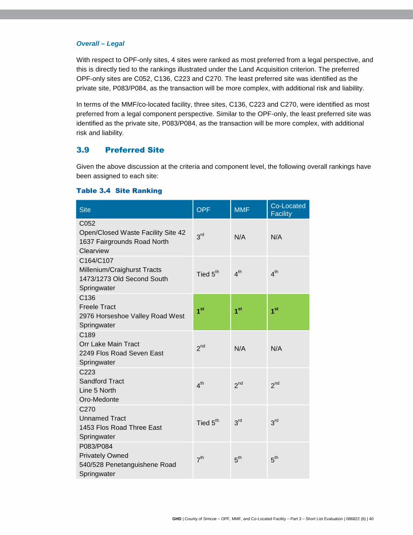
GHD | County of Simcoe – OPF, MMF, and Co-Located Facility – Part 3 – Short List Evaluation | 086822 (6) | 40
Overall – Legal
With respect to OPF-only sites, 4 sites were ranked as most preferred from a legal perspective, and this is directly tied to the rankings illustrated under the Land Acquisition criterion. The preferred OPF-only sites are C052, C136, C223 and C270. The least preferred site was identified as the private site, P083/P084, as the transaction will be more complex, with additional risk and liability.
In terms of the MMF/co-located facility, three sites, C136, C223 and C270, were identified as most preferred from a legal component perspective. Similar to the OPF-only, the least preferred site was identified as the private site, P083/P084, as the transaction will be more complex, with additional risk and liability.
3.9 Preferred Site
Given the above discussion at the criteria and component level, the following overall rankings have been assigned to each site:
Table 3.4 Site Ranking
Site OPF MMF Co-Located Facility
C052 Open/Closed Waste Facility Site 42 1637 Fairgrounds Road North Clearview
3rd N/A N/A
C164/C107 Millenium/Craighurst Tracts 1473/1273 Old Second South Springwater
Tied 5th 4th 4th
C136 Freele Tract 2976 Horseshoe Valley Road West Springwater
1st 1st 1st
C189 Orr Lake Main Tract 2249 Flos Road Seven East Springwater
2nd N/A N/A
C223 Sandford Tract Line 5 North Oro-Medonte
4th 2nd 2nd
C270 Unnamed Tract 1453 Flos Road Three East Springwater
Tied 5th 3rd 3rd
P083/P084 Privately Owned 540/528 Penetanguishene Road Springwater
7th 5th 5th

GHD | County of Simcoe – OPF, MMF, and Co-Located Facility – Part 3 – Short List Evaluation | 086822 (6) | 41
As shown in the table above, Site C136 – 2976 Horseshoe Valley Road West in the Township of Springwater was identified as the preferred site for all three facility options (OPF, MMF, and co-located facility). Site C136 is the preferred site as it has a number of advantages, including:
• 'No' to 'Low' net effects under the Environmental Component
- With the implementation of BMPs, no off-site receptors will be impacted by air quality, odour, or noise.
- There are no historical or recent records of SAR; however recent records for snapping turtles exist immediately adjacent to the site. In addition, through discussions with MNRF, the site presents available habitat for SAR. Through appropriate avoidance measures, the effects on SAR are likely low. Further detailed field investigations will undertaken to confirm the presence (if any) of SAR on site.
• 'Low' to 'Moderate' net effects under the Social Component
- Given the large size of the site, it is possible to site the facility and maintain a minimum buffer of 500 metres from all sensitive receptors
- There will be a relatively small increase in local traffic given the existing traffic volume on Horseshoe Valley Road West.
- Minimal transportation infrastructure (e.g., climbing, turning, and acceleration/deceleration lanes) required relative to other sites.
- While some clearing of vegetation would be required, the majority of the site would remain forested, providing natural visual screening.
• 'No' to 'Low" net effects under the Cultural Component.
• A mix of net effects under the Technical Component
- Permitting and approvals requirements are anticipated to be relatively low, similar to most other sites.
- Fewer potential safety risks relative to other sites.
- The site layout, topography, and soil conditions are favourable compared to some other sites. In addition, the large size of the site provides increased design flexibility and future expansion potential.
• 'Low' to 'Moderate' costs under the Economic Component
- Capital costs are expected to be relatively low: the site is currently owned by the County; transportation infrastructure requirements are relatively minor compared to other sites; and design and construction costs are expected to be relatively low compared to other sites.
- Operation and maintenance costs are expected to be relatively low: the site is located close to feedstock sources and markets and end users, reducing transportation costs; and monitoring and mitigation requirements are expected to be relatively low compared to other sites.
• 'Low' complexity under the Legal Component.
In addition to the advantages and positive attributes noted above, the following constraints were also identified with respect to this site:
• The site is currently forested and would require the removal of some vegetation.

GHD | County of Simcoe – OPF, MMF, and Co-Located Facility – Part 3 – Short List Evaluation | 086822 (6) | 42
• The 2012 OP identifies the entire property as County Greenlands, which is a change from the previous OP, where only a small portion of the site was designated County Greenlands. Consideration of County Greenlands was discussed in Section 2.3.3.
• While the site has a number of surface water (unevaluated wetlands to the north and a possible watercourse to the south) and groundwater (Medium Vulnerability SGRA) features, the site is of sufficient size that the facility will be located away from these constraints.
• Amendments to the County and local OP and Zoning By-Law will be required, although this was common for all short-listed sites.
• There are currently no utilities and services (hydro, water main, sanitary sewer) on-site, although this was common for all short-listed sites.
Site conditions were further confirmed through a field visit on January 27, 2016 by GHD ecologist Mrs. Laura Lawlor. A technical memorandum was issued on February 26, 2016, providing details on existing site features, the County Greenlands designation, and EIS requirements.
4. Next Steps
Prior to moving forward with further detailed work and further approvals on the preferred site for the OPF, County Council approval and endorsement of the preferred site will be sought. The presentation of the preferred site is anticipated to occur in early 2016. County Council will be presented with three options as it relates to the development of an OPF and MMF within the County:
1. Preferred site for the OPF only.
2. Preferred site for the MMF only.
3. Preferred site for a co-located OPF/MMF.
It should be noted that irrespective of the option(s) selected by County Council (i.e., select one site for the OPF and another for the MMF or one site for both the OPF/MMF), the work required from a project development perspective will be similar.
The Project Team anticipates undertaking the following steps once County Council have provided further direction on the three options before them:
• Work Plans will be established for each technical discipline involved in further investigations on the site, which may include: planning justification report, geotechnical investigations, EIS, Traffic Impact Study, noise assessment, site plan, hydrogeological studies, archaeological studies etc. Timelines for data collection and assessment of findings will be established as part of the Work Plans.
• Further consultation with neighbouring landowners will occur, with discussion on potential further approvals required (i.e., land use, ECA), facility footprint location on the site, potential design/technology, mitigation measures, Best Management Practices, and anticipated schedule of major milestones. Discussion will also include details on how best to seek their input on future site design and selection of technology.
• Further public information/consultation sessions on project milestones and the procurement process.

GHD | County of Simcoe – OPF, MMF, and Co-Located Facility – Part 3 – Short List Evaluation | 086822 (6) | 43
• Initiation of the Planning approvals process, working in cooperation with both County planning staff and the host municipalities Planning staff.
• Advancing the site-specific design that will be put forward in the procurement process.
• Preparation of Request for Proposal (RFP) documents as the procurement of processing technology is advanced.
• Continue to seek guidance from the MOECC in preparation for submitting application(s) for ECA(s).

GHD | Report for County of Simcoe -County of Simcoe - OPF, MMF, and Co-Located Facility – Part 3 – Short List Evaluation | 086822 (6)
Figures

propose siting methodology
finalize siting methodology and evaluation criteria – report to County Council
identify potential County-owned sites and willing vendor privately-owned sites
Screen 1 - use exclusionary criteria to remove sites from further evaluation and develop long list of sites
Screen 2 - further screening of remaining sites using additional criteria to determine short list
Screen 3 - detailed comparative evaluation of short list
preferred site presented to County Council
Publi cConsultation
present short list of sites to County Council
technical studies to confirm
site conditions
Summer 2015
Early 2016
Early 2015
December2014
PLANNING - SITING METHODOLOGY
AND EVALUATION CRITERIA
Publi cConsultation
December 2, 2014
LONG LIST EVALUATION
SHORT LIST EVALUATION
Figure 1
SITING PROCESS
COUNTY OF SIMCOE ORGANICS PROCESSING FACILITY
AND MATERIALS MANAGEMENT FACILITYPART 3 - SHORT LIST EVALUATION
SOURCE: CORPORATION OF THE COUNTY OF SIMCOE
jantonijevic
Cross-Out

Wind Speed and Direction X
Proximity to Sensitive Receptors X X
Species of Special Concern, Threatened, and/or Endangered X
Wind Speed and Direction X
Proximity to Sensitive Receptors X X
Noise Proximity to Sensitive Receptors X X
Topography X
Soil Type X
Affected Greenlands4 X X
Niagara Escarpment Land Use X X
Oak Ridges Moraine Land Use2 X X
Species of Special Concern, Threatened, and/or Endangered X
Aquatic Species of Special Concern, Threatened, and/or Endangered X
Surface Water Wetlands, Floodplains and Water Bodies X X
Groundwater Depth X
Groundwater Flow and Direction X
Source Water Protection Areas X X
Agricultural Prime Agricultural Areas4 (Specialty Crop Areas, Class 1, 2, and 33 Agricultural Lands) X X
Number and Distribution of Sensitive Receptors (e.g., residential areas, parks, recreational areas, and institutions) X X
Buffer Zones and Separation Distances to Sensitive Receptors X X
Current Land Use, Zoning, Approved Development Plans, and Proposed Land Use Changes X X
Opportunity for Brownfield Development, Enhanced Use X
Compatibility with Existing Land Uses/Zoning Designations on Adjacent Sites X X
Existing/Required Transportation Infrastructure X X
Neighbourhood Traffic Impacts X
Visual Buffer Zones and Visual Screening X
Land Use/Zoning
Transportation
Sensitive Receptors
Air Quality
Odour
Terrestrial
Groundwater
Cultural
Social
Environmental
Component Criteria Indicator Screen 1 Screen 2 Screen 3
Organics Processing Facilityand Materials Management Facility
figure 2
NOTES: 1. Siting Criteria revised as per public feedback received. 2. Oak Ridges Moraine added as per public feedback received.
3. Revised to reflect all Prime Agricultural Areas based on public feedback to include Class 3 Agricultural Lands. 4. Certain sites may be exempt from meeting this criterion based on existing zoning or land use. Refer to Screen 1 - Evaluation Criteria for details.
Revised1 Siting Criteria
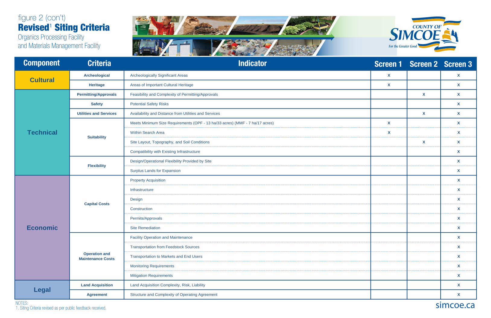
Air Quality
Environmental
Archeological Archeologically Significant Areas X X
Heritage Areas of Important Cultural Heritage X X
Permitting/Approvals Feasibility and Complexity of Permitting/Approvals X X
Safety Potential Safety Risks X
Utilities and Services Availability and Distance from Utilities and Services X X
Meets Minimum Size Requirements (OPF - 13 ha/33 acres) (MMF - 7 ha/17 acres) X X
Within Search Area X X
Site Layout, Topography, and Soil Conditions X X
Compatibility with Existing Infrastructure X
Design/Operational Flexibility Provided by Site X
Surplus Lands for Expansion X
Property Acquisition X
Infrastructure X
Design X
Construction X
Permits/Approvals X
Site Remediation X
Facility Operation and Maintenance X
Transportation from Feedstock Sources X
Transportation to Markets and End Users X
Monitoring Requirements X
Mitigation Requirements X
Land Acquisition Land Acquisition Complexity, Risk, Liability X
Agreement Structure and Complexity of Operating Agreement X
Economic
Capital Costs
Operation and Maintenance Costs
Flexibility
Suitability
Legal
Cultural
Technical
simcoe.ca
Component Criteria Indicator Screen 1 Screen 2 Screen 3
NOTES:1. Siting Criteria revised as per public feedback received.
figure 2 (con’t)
Organics Processing Facilityand Materials Management Facility
Revised1 Siting Criteria
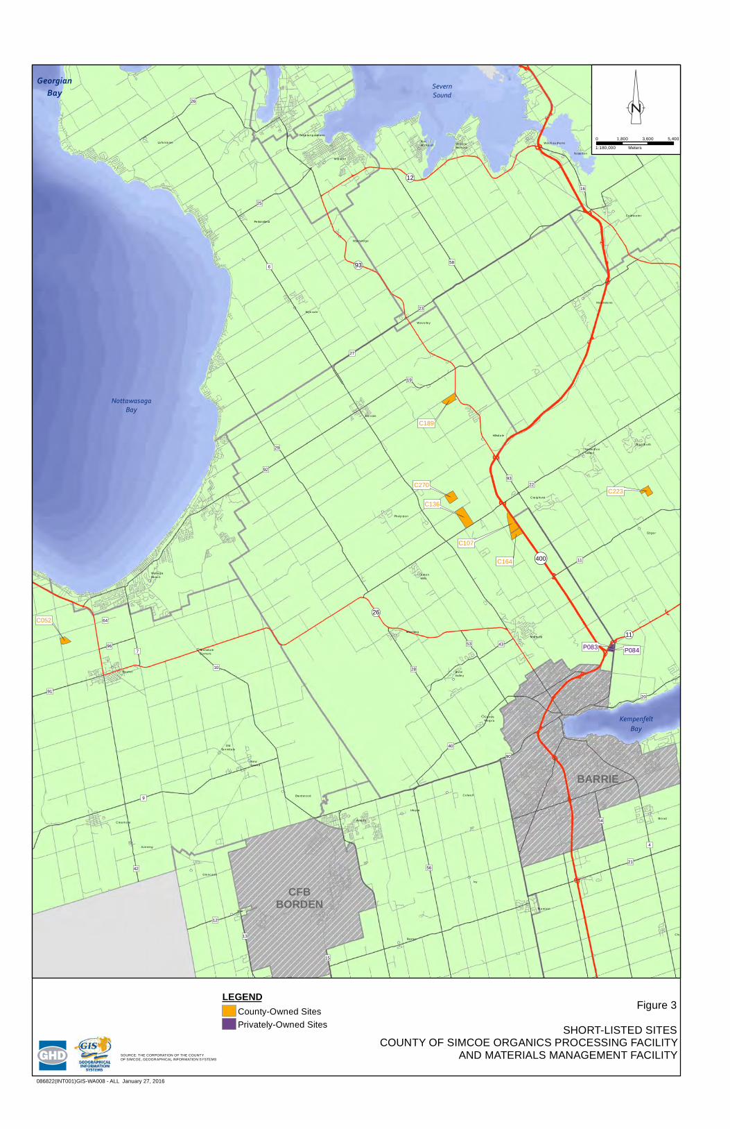
Thornton
Baxter
Ivy
Colwell
Utopia
Angus Stroud
Churchill
Creemore
NewLowell
Stayner
Avening
Brentwood
OldSunnidale
SunnidaleCorners
AntenMills
CentreVespra
Elmvale
Hillsdale
MidhurstMinesing
SnowValley
ShantyBay
Edgar
Craighurst
HorseshoeValley
Sugarbush
Moonstone
VictoriaHarbour
WaubaushenePortMcNicoll
Waverley
Coldwater
Lafontaine
Perkinsfield
Wyevale
Wyebridge
WasagaBeach
FessertonMidland
Penetanguishene
Phelpston
Lisle
Glencairn
!(11
!(12
!(93
!(26
!(400
")90
")15
")96
")12
")43
")4
")54
")16
")40
")64
")20
")29
")42
")7
")23
")19
")11
")53
")22
")17
")93
")13
")91
")6
")9
")27
")25
")28
")56")21
")58
")92
")26
")10
BARRIE
CFBBORDEN
KempenfeltBay
SevernSound
NottawasagaBay
P084P083
C052
C164
C107
C136
C270C223
C189
GeorgianBay
086822(INT001)GIS-WA008 - ALL January 27, 2016
Figure 3
SHORT-LISTED SITESCOUNTY OF SIMCOE ORGANICS PROCESSING FACILITY
AND MATERIALS MANAGEMENT FACILITY
0 1,800 3,600 5,400
Meters1:180,000
LEGENDCounty-Owned SitesPrivately-Owned Sites
SOURCE: THE CORPORATION OF THE COUNTY OF SIMCOE, GEOGRAPHICAL INFORMATION SYSTEMS
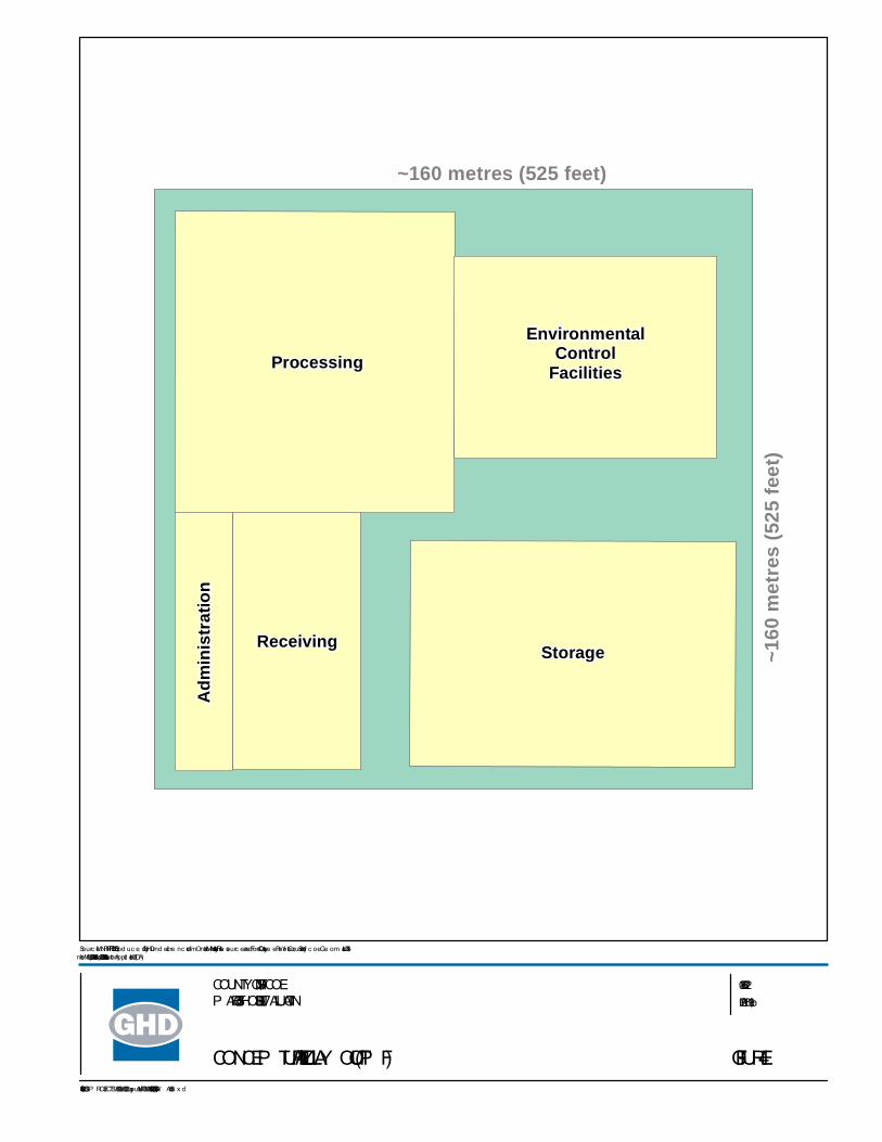
Adm
inis
trat
ion
Processing
StorageReceiving
EnvironmentalControl
Facilities
~160
met
res
(525
feet
)
~160 metres (525 feet)
FIGURE 4
086822 Fe b 19, 2016
GIS File : Q:\GIS\P ROJECTS\86000s\86822\Layouts\INT006\086822(INT006)GIS-W A006.m x d
Sourc e : MNRF NRVIS, 2015. P rod uc e d by GHD und e r lic e nc e from Ontario Ministry of Natural Re sourc e s and Fore stry, © Que e n's P rinte r, County of Sim c oe Ge om atic s 2016Inse t Map: ESRI Data & Maps 2008 Data Distribution Applic ation (DDA)
COUNTY OF SIMCOEP ART 3 – SHORT LIST EVALUATION
CONCEP TUAL FACILITY LAY OUT (OP F)

Handlingand Storage
Adm
inis
trat
ion
Receiving
Loading
EnvironmentalControl
Facilities
~115
met
res
(377
feet
)
~115 metres (377 feet)
FIGURE 5
086822 Feb 19, 2016
GIS File: Q :\GIS\PROJECTS\86000s\86822\La y outs\INT006\086822(INT006)GIS-W A006.m xd
Source : MNRF NRVIS, 2015. Prod uce d by GHD und e r lice nce from Onta rio Ministry of Natura l Re source s a nd Fore stry, © Q ue e n's Printe r, County of Sim coe Ge om a tics 2016Inse t Ma p: ESRI Da ta & Maps 2008 Da ta Distribution Application (DDA)
COUNTY OF SIMCOEPART 3 – SHORT LIST EVALUATION
CONCEPTUAL FACILITY LAY OUT (MMF)
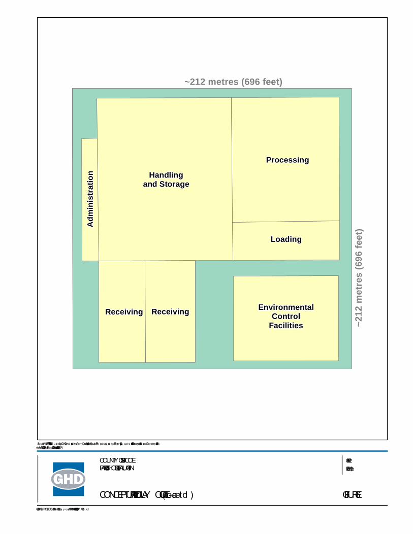
Adm
inis
trat
ion Handling
and Storage
Processing
Receiving
Loading
EnvironmentalControl
FacilitiesReceiving
~212
met
res
(696
feet
)
~212 metres (696 feet)
FIGURE 6
086822 Feb 19, 2016
GIS File: Q :\GIS\PROJECTS\86000s\86822\La y outs\INT006\086822(INT006)GIS-W A006.m xd
Source : MNRF NRVIS, 2015. Prod uce d by GHD und e r lice nce from Onta rio Ministry of Natura l Re source s a nd Fore stry, © Q ue e n's Printe r, County of Sim coe Ge om a tics 2016Inse t Ma p: ESRI Da ta & Maps 2008 Da ta Distribution Application (DDA)
COUNTY OF SIMCOEPART 3 – SHORT LIST EVALUATION
CONCEPTUAL FACILITY LAY OUT (Co-Locate d )

GHD | Report for County of Simcoe -County of Simcoe - OPF, MMF, and Co-Located Facility – Part 3 – Short List Evaluation | 086822 (6)
Tables

OPF only OPF, MMF, and Co-Located Facility
Table 2.6 - Page 1 of 16
Table 2.6 Site Review Summary
Component Criteria Indicator C052 Open/ Closed Waste Facility Site 42 1637 Fairgrounds Road North Clearview
C164/ C107 Millenium/ Craighurst Tracts 1473/ 1273 Old Second South Springwater
C136 Freele Tract 2976 Horseshoe Valley Road West Springwater
C189 Orr Lake Main Tract 2249 Flos Road Seven East Springwater
C223 Sandford Tract Line 5 North Oro-Medonte
C270 Unnamed Tract 1453 Flos Road Three East Springwater
P083/ P084 Privately Owned 540/ 528 Penetanguishene Road Springwater
Environmental
Air Quality Wind Speed and Direction
• Mean wind speed of 5.05 metres per second (m/s) predominately coming from a westerly direction
• Mean wind speed of 4.02 m/s predominantly coming from a northwesterly direction
• Mean wind speed of 4.32 m/s predominantly coming from a northwesterly direction
• Mean wind speed of 4.48 m/s predominately coming from a northwesterly direction
• Mean wind speed of 4.30 m/s predominantly coming from a northwesterly direction
• Mean wind speed of 4.32 m/s predominately coming from a northwesterly direction
• Mean wind speed of 4.85 m/s predominately coming from a northwesterly direction
Proximity to Sensitive Receptors
• Within 500 metres (m) of the site boundary, there are 9 off-site receptors
• Farmhouse adjacent to north property line. Farmhouse across road to the west. Farmhouse inset into southwest property, and additional farmhouse immediately to the south. No buildings evident to the immediate east.
• Multi-use trail adjacent to east of site
• Within 500 m of the site boundary, there are 5 off-site receptors
• Barrie KOA east of the site, across Highway 400
• Three residential properties immediately adjacent to west of site. Additional residential properties along Old Second South.
• Within 500 m of the site boundary, there are 11 off-site receptors
• Residential property adjacent to the east
• Nicholyn Farms adjacent to the west
• Multi-use trail running north/ south through property
• Within 500 m of the site boundary, there are 3 off-site receptors
• Residential property adjacent to the east
• Snowmobile trails and off road trails through site (SCORRA, OFSC)
• Within 500 m of the site boundary, there are 10 off-site receptors
• Residential properties to the northeast and southeast of the site
• Hardwood Ski and Bike to the southeast of the site
• Within 500 m of the site boundary, there are 4 off-site receptors
• Residential properties and farms adjacent to north of site. Additional residential properties and farms along Flos Road Three East.
• Within 500 m of the site boundary, there are 15 off-site receptors
• Two residential properties surrounded by eastern site boundary. Additional residential properties to the east across Penetanguishene Road.
• St. Nektarios Greek Orthodox Church located to the north
• Napoleon Home Comfort warehouse located to the east across Penetanguishene Road
Species of Special Concern, Threatened, and/ or Endangered
• Potential for species at risk (SAR) based on available habitat, as identified by MNRF Management Biologist, include: Butternut (END), Bobolink (THR) and Eastern Meadowlark (THR) if agricultural fields in hay or pasture, Milksnake (SC)
• There are historical records of SAR on the property, including: Northern Myotis, Northern Map Turtle, Little
• Potential for SAR based on available habitat, as identified by MNRF Management Biologist, include: Butternut (END), Little Brown Bat (END), Northern Long-eared Bat (END), Whip-poor-will (THR), Eastern Wood-Pewee (SC), Golden-winged Warbler (SC)
• There are records of SAR species on the property, including: Snapping Turtle,
• Potential for SAR based on available habitat, as identified by MNRF Management Biologist, include: Butternut (END), Little Brown Bat (END), Northern Long-eared Bat (END), Eastern Wood-Pewee (SC), Golden-winged Warbler (SC)
• There are no historical or recent records of SAR identified on NHIC mapping. However,
• Potential for SAR based on available habitat, as identified by MNRF Management Biologist, include: Sensitive Plant Species (END), Butternut (END), Little Brown Bat (END), Northern Long-eared Bat (END), Eastern Wood-Pewee (SC), Canada Warbler (SC), Red-headed Woodpecker (SC), Wood Thrush (SC)
• Historical records for
• Potential for SAR based on available habitat, as identified by MNRF Management Biologist, include: Sensitive Plant Species (END), Butternut (END), Little Brown Bat (END), Northern Long-eared Bat (END), Eastern Wood-Pewee (SC), Canada Warbler (SC), Red-headed Woodpecker (SC), Wood Thrush (SC)
• Historical SAR
• Potential for SAR based on available habitat, as identified by MNRF Management Biologist, include: Sensitive Plant Species (END), Butternut (END), Little Brown Bat (END), Northern Long-eared Bat (END), Eastern Wood-Pewee (SC), Canada Warbler (SC), Red-headed Woodpecker (SC), Wood Thrush (SC)
• There are no recent
• Potential for SAR based on available habitat, as identified by MNRF Management Biologist, include: Butternut (END) if hedgerows present, Bobolink (THR) and Eastern Meadowlark (THR) if agricultural fields in hay or pasture
• Historical SAR records indicate Red-shouldered Hawk (1940) and Snapping Turtle (2009) have been located on or in

OPF only OPF, MMF, and Co-Located Facility
Table 2.6 - Page 2 of 16
Table 2.6 Site Review Summary
Component Criteria Indicator C052 Open/ Closed Waste Facility Site 42 1637 Fairgrounds Road North Clearview
C164/ C107 Millenium/ Craighurst Tracts 1473/ 1273 Old Second South Springwater
C136 Freele Tract 2976 Horseshoe Valley Road West Springwater
C189 Orr Lake Main Tract 2249 Flos Road Seven East Springwater
C223 Sandford Tract Line 5 North Oro-Medonte
C270 Unnamed Tract 1453 Flos Road Three East Springwater
P083/ P084 Privately Owned 540/ 528 Penetanguishene Road Springwater
Environmental
Bluestem-Long-leaved Reed Grass- Great Lakes Wheat Grass dune Grassland Type, Houghton’s Flatsedge, Hawthorn, Stiff Yellow Flax, and Ocellated Darner. It is unlikely that Ocellated Darner is present on the property as suitable habitat is absent.
Milksnake, Red-shouldered Hawk and an unspecified sensitive species. Not all SAR records are dated; however, the Snapping Turtle is identified to be a recent record (2009).
recent records for Snapping Turtle exist immediately adjacent to the parcel and may also be present due to similar habitat availability.
SAR list Beaked Spike-rush (1978) and an unknown sensitive species as the only record of SAR on the property. Other SAR turtle species have been recorded on nearby properties
• Part of the site is a Stratum 2 deer wintering area (adjacent to Stratum 1 deer yard)
records list Ocellated Darner and Zebra Clubtail, two species of dragonfly. Potential habitat for Ocellated Darner may be present on the property.
or historic SAR records recorded
close proximity to the property
Odour Wind Speed and Direction
• Mean wind speed of 5.05 m/s predominately coming from a westerly direction
• Mean wind speed of 4.02 m/s predominantly coming from a northwesterly direction
• Mean wind speed of 4.32 m/s predominantly coming from a northwesterly direction
• Mean wind speed of 4.48 m/s predominately coming from a northwesterly direction
• Mean wind speed of 4.30 m/s predominantly coming from a northwesterly direction
• Mean wind speed of 4.32 m/s predominately coming from a northwesterly direction
• Mean wind speed of 4.85 m/s predominately coming from a northwesterly direction
Proximity to Sensitive Receptors
• Within 500 m of the site boundary, there are 9 off-site receptors
• Farmhouse adjacent to north property line. Farmhouse across road to the west. Farmhouse inset into southwest property, and additional farmhouse immediately to the south. No buildings evident to the immediate east.
• Multi-use trail adjacent to east of site
• Within 500 m of the site boundary, there are 5 off-site receptors
• Barrie KOA east of the site, across Highway 400
• Three residential properties immediately adjacent to west of site. Additional residential properties along Old Second South.
• Within 500 m of the site boundary, there are 11 off-site receptors
• Residential property adjacent to the east
• Nicholyn Farms adjacent to the west
• Multi-use trail running north/ south through property
• Within 500 m of the site boundary, there are 3 off-site receptors
• Residential property adjacent to the east
• Snowmobile trails and off road trails through site (SCORRA, OFSC)
• Within 500 m of the site boundary, there are 10 off-site receptors
• Residential properties to the northeast and southeast of the site
• Hardwood Ski and Bike to the southeast of the site
• Within 500 m of the site boundary, there are 4 off-site receptors
• Residential properties and farms adjacent to north of site. Additional residential properties and farms along Flos Road Three East.
• Within 500 m of the site boundary, there are 15 off-site receptors
• Two residential properties surrounded by eastern site boundary. Additional residential properties to the east across Penetanguishene Road.
• St. Nektarios Greek Orthodox Church located to the north
• Napoleon Home Comfort warehouse located to the east across Penetanguishene Road

OPF only OPF, MMF, and Co-Located Facility
Table 2.6 - Page 3 of 16
Table 2.6 Site Review Summary
Component Criteria Indicator C052 Open/ Closed Waste Facility Site 42 1637 Fairgrounds Road North Clearview
C164/ C107 Millenium/ Craighurst Tracts 1473/ 1273 Old Second South Springwater
C136 Freele Tract 2976 Horseshoe Valley Road West Springwater
C189 Orr Lake Main Tract 2249 Flos Road Seven East Springwater
C223 Sandford Tract Line 5 North Oro-Medonte
C270 Unnamed Tract 1453 Flos Road Three East Springwater
P083/ P084 Privately Owned 540/ 528 Penetanguishene Road Springwater
Environmental
Noise Proximity to Sensitive Receptors
• Within 500 m of the site boundary, there are 9 off-site
• Farmhouse adjacent to north property line. Farmhouse across road to the west. Farmhouse inset into southwest property, and additional farmhouse immediately to the south. No buildings evident to the immediate east.
• Multi-use trail adjacent to east of site
• Within 500 m of the site boundary, there are 5 off-site receptors
• Barrie KOA east of the site, across Highway 400
• Three residential properties immediately adjacent to west of site. Additional residential properties along Old Second South.
• Within 500 m of the site boundary, there are 11 off-site receptors
• Residential property adjacent to the east
• Nicholyn Farms adjacent to the west
• Multi-use trail running north/ south through property
• Within 500 m of the site boundary, there are 3 off-site receptors
• Residential property adjacent to the east
• Snowmobile trails and off road trails through site (SCORRA, OFSC)
• Within 500 m of the site boundary, there are 10 off-site receptors
• Residential properties to the northeast and southeast of the site
• Hardwood Ski and Bike to the southeast of the site
• Within 500 m of the site boundary, there are 4 off-site receptors
• Residential properties and farms adjacent to north of site. Additional residential properties and farms along Flos Road Three East
• Within 500 m of the site boundary, there are 15 off-site receptors
• Two residential properties surrounded by eastern site boundary. Additional residential properties to the east across Penetanguishene Road.
• St. Nektarios Greek Orthodox Church located to the north
• Napoleon Home Comfort warehouse located to the east across Penetanguishene Road
Terrestrial Topography • Low relief area with the ground surface sloping in a general northeasterly direction
• Moderate relief area with the ground surface sloping in general westerly direction
• Moderate relief area with the ground surface sloping in a general northerly to easterly direction
• Moderate relief with a topographically high area in the western portion, ground surface sloping generally towards the northeast
• Area of relatively low relief, with the ground surface generally sloping towards the east
• Moderate relief in a topographically high area, with the ground surface sloping generally south, and to the north to a lesser extent
• Moderate relief, generally sloping downward to the southeast. Highway 11 elevated above site adjacent to the west. Site has been re-graded (leveled) with a steep slope surrounding perimeter of forested area to the south.
Soil Type • Site occurs within the southern portion of a large, extensive area of overburden consisting of finer grained surficial sandy silt till (occasional thin sand layers at depth)
• An area of surficial glaciolacustrine sand with minor gravel occurs further to the
• Overburden consists primarily of glaciofluvial ice-contact stratified deposits comprised of sand or gravelly sand to the northern portion of the site
• Overburden consists primarily of glaciolacustrine very fine to medium grained sand, silt,
• Overburden consists of surficial glaciofluvial outwash sand with minor gravel
• An area of fine-grained glaciolacustrine clayey to sandy silt occurs to the west and glaciolacustrine sand with minor fine gravel to the east
• Overburden consists primarily of ice-contact deposits comprised of substratified to stratified sand, may include some incorporated sandy silt till
• The most easterly portion of the site and just further north consists of
• Overburden consists of glaciofluvial ice-contact stratified sand, gravelly sand and gravel (minor silt and clay)
• Overburden beneath the proposed site is about 69 m (225 feet) thick
• Bedrock consists of Middle Ordovician grey limestone, some
• Overburden consists of glaciofluvial outwash sand with minor gravel
• An area of fine-grained glaciolacustrine clayey to sandy silt occurs to the southwest and glaciolacustrine sand with minor fine gravel to the east
• Overburden in the northern portion of the site consists primarily of stony sandy silt to silt till, with some glaciolacustrine very fine to medium grained sand, silt, with minor clay in the southeast corner. Overburden in the southern portion of

OPF only OPF, MMF, and Co-Located Facility
Table 2.6 - Page 4 of 16
Table 2.6 Site Review Summary
Component Criteria Indicator C052 Open/ Closed Waste Facility Site 42 1637 Fairgrounds Road North Clearview
C164/ C107 Millenium/ Craighurst Tracts 1473/ 1273 Old Second South Springwater
C136 Freele Tract 2976 Horseshoe Valley Road West Springwater
C189 Orr Lake Main Tract 2249 Flos Road Seven East Springwater
C223 Sandford Tract Line 5 North Oro-Medonte
C270 Unnamed Tract 1453 Flos Road Three East Springwater
P083/ P084 Privately Owned 540/ 528 Penetanguishene Road Springwater
Environmental
south and southeast • Overburden beneath
the site is about 21.5 to 23 m (70 to 75 feet) thick
• Bedrock consists of Middle Ordovician grey limestone, some dolostone, of the Lindsay Formation (Simcoe Group)
• Bedrock surface slopes in a general northeasterly to easterly direction
minor clay in the western portion, and glaciofluvial ice-contact stratified deposits comprised of sand or gravelly sand in the southern/ eastern part
• The higher topographic central/ southern area consists of stony silty sand to sand till
• Overburden beneath the site is greater than 107 m (350 feet) thick
• Bedrock consists of Middle Ordovician grey limestone, some dolostone, of the Lindsay Formation (Simcoe Group)
• Overburden beneath the proposed site is greater than 65 m (215 feet) thick
• Bedrock consists of Middle Ordovician grey limestone, some dolostone, of the Lindsay Formation (Simcoe Group)
glaciofluvial sand with minor gravel, and boulder lags at the surface
• Overburden beneath the proposed site is greater than 91 m (300 feet) thick
• Bedrock consists of Middle Ordovician grey limestone, some dolostone, of the Lindsay Formation (Simcoe Group)
dolostone, of the Lindsay Formation (Simcoe Group)
• Overburden beneath the proposed site is about 122 m (400 feet) thick
• Bedrock consists of Middle Ordovician grey limestone, some dolostone, of the Lindsay Formation (Simcoe Group)
the site consists primarily of glaciolacustrine very fine to medium grained sand, silt, with minor clay
• Overburden beneath the proposed site is about 76 to 84 m (250 to 275 feet) thick
• Bedrock consists of Middle Ordovician grey limestone, some dolostone, of the Lindsay Formation (Simcoe Group)
• Bedrock surface slopes in a general southeasterly direction
• Peat and peaty topsoil that existed previously at the site was subexcavated and replaced with earth fill (Terraprobe, 2006)
Affected Greenlands • No County Greenlands
• No forested areas • No Areas of Natural
Scientific Interest (ANSIs)
• Lands designated as County Greenlands (approved in County Official Plan and pending approval in revised County Official Plan)
• Predominantly forested with conifer plantations. Older growth on northern portion, new plantings on southern portion (planted to protect an endangered species of tree, according to public comment). Some open areas
• No ANSIs
• Lands designated as County Greenlands (approved in County Official Plan and pending approval in revised County Official Plan)
• Predominately forested with conifer and mixed forest
• No ANSIs
• Lands designated as County Greenlands (pending approval in revised County Official Plan)
• Predominately forested with mixed forest community
• No ANSIs
• Lands designated as County Greenlands (approved in County Official Plan and pending approval in revised County Official Plan)
• Forested with mixture of hardwood and conifer forest. Some open areas
• Regional Life Science ANSI located within close proximity of southern boundary of parcel
• Lands designated as County Greenlands (pending approval in revised County Official Plan)
• Entirely forested with mixed old growth
• No ANSIs
• No County Greenlands on-site
• Southern portion of property entirely forested
• No ANSIs

OPF only OPF, MMF, and Co-Located Facility
Table 2.6 - Page 5 of 16
Table 2.6 Site Review Summary
Component Criteria Indicator C052 Open/ Closed Waste Facility Site 42 1637 Fairgrounds Road North Clearview
C164/ C107 Millenium/ Craighurst Tracts 1473/ 1273 Old Second South Springwater
C136 Freele Tract 2976 Horseshoe Valley Road West Springwater
C189 Orr Lake Main Tract 2249 Flos Road Seven East Springwater
C223 Sandford Tract Line 5 North Oro-Medonte
C270 Unnamed Tract 1453 Flos Road Three East Springwater
P083/ P084 Privately Owned 540/ 528 Penetanguishene Road Springwater
Environmental
Niagara Escarpment Land Use
• No Niagara Escarpment Land Use areas
• No Niagara Escarpment Land Use areas
• No Niagara Escarpment Land Use areas
• No Niagara Escarpment Land Use areas
• No Niagara Escarpment Land Use areas
• No Niagara Escarpment Land Use areas
• No Niagara Escarpment Land Use areas
Oak Ridges Moraine Land Use
• No Oak Ridges Moraine Land Use areas
• No Oak Ridges Moraine Land Use areas
• No Oak Ridges Moraine Land Use areas
• No Oak Ridges Moraine Land Use areas
• No Oak Ridges Moraine Land Use areas
• No Oak Ridges Moraine Land Use areas
• No Oak Ridges Moraine Land Use areas
Species of Special Concern, Threatened, and/ or Endangered
• Potential for SAR based on available habitat, as identified by MNRF Management Biologist, include: Butternut (END), Bobolink (THR) and Eastern Meadowlark (THR) if agricultural fields in hay or pasture, Milksnake (SC)
• There are historical records of SAR on the property, including: Northern Myotis, Northern Map Turtle, Little Bluestem-Long-leaved Reed Grass- Great Lakes Wheat Grass dune Grassland Type, Houghton’s Flatsedge, Hawthorn, Stiff Yellow Flax, and Ocellated Darner. It is unlikely that Ocellated Darner is present on the property as suitable habitat is absent.
• Potential for SAR based on available habitat, as identified by MNRF Management Biologist, include: Butternut (END), Little Brown Bat (END), Northern Long-eared Bat (END), Whip-poor-will (THR), Eastern Wood-Pewee (SC), Golden-winged Warbler (SC)
• There are records of SAR species on the property, including: Snapping Turtle, Milksnake, Red-shouldered Hawk and an unspecified sensitive species. Not all SAR records are dated; however, the Snapping Turtle is identified to be a recent record (2009).
• Potential for SAR based on available habitat, as identified by MNRF Management Biologist, include: Butternut (END), Little Brown Bat (END), Northern Long-eared Bat (END), Eastern Wood-Pewee (SC), Golden-winged Warbler (SC)
• There are no historical or recent records of SAR identified on NHIC mapping. However, recent records for Snapping Turtle exist immediately adjacent to the parcel and may also be present due to similar habitat availability.
• Potential for SAR based on available habitat, as identified by MNRF Management Biologist, include: Sensitive Plant Species (END), Butternut (END), Little Brown Bat (END), Northern Long-eared Bat (END), Eastern Wood-Pewee (SC), Canada Warbler (SC), Red-headed Woodpecker (SC), Wood Thrush (SC)
• Historical records for SAR list Beaked Spike-rush (1978) and an unknown sensitive species as the only record of SAR on the property. Other SAR turtle species have been recorded on nearby properties
• Part of the site is a Stratum 2 deer wintering area (adjacent to Stratum 1 deer yard)
• Potential for SAR based on available habitat, as identified by MNRF Management Biologist, include: Sensitive Plant Species (END), Butternut (END), Little Brown Bat (END), Northern Long-eared Bat (END), Eastern Wood-Pewee (SC), Canada Warbler (SC), Red-headed Woodpecker (SC), Wood Thrush (SC)
• Historical SAR records list Ocellated Darner and Zebra Clubtail, two species of dragonfly. Potential habitat for Ocellated Darner may be present on the property.
• Potential for SAR based on available habitat, as identified by MNRF Management Biologist, include: Sensitive Plant Species (END), Butternut (END), Little Brown Bat (END), Northern Long-eared Bat (END), Eastern Wood-Pewee (SC), Canada Warbler (SC), Red-headed Woodpecker (SC), Wood Thrush (SC)
• There are no recent or historic SAR records recorded
• Potential for SAR based on available habitat, as identified by MNRF Management Biologist, include: Butternut (END) if hedgerows present, Bobolink (THR) and Eastern Meadowlark (THR) if agricultural fields in hay or pasture
• Historical SAR records indicate Red-shouldered Hawk (1940) and Snapping Turtle (2009) have been located on or in close proximity to the property

OPF only OPF, MMF, and Co-Located Facility
Table 2.6 - Page 6 of 16
Table 2.6 Site Review Summary
Component Criteria Indicator C052 Open/ Closed Waste Facility Site 42 1637 Fairgrounds Road North Clearview
C164/ C107 Millenium/ Craighurst Tracts 1473/ 1273 Old Second South Springwater
C136 Freele Tract 2976 Horseshoe Valley Road West Springwater
C189 Orr Lake Main Tract 2249 Flos Road Seven East Springwater
C223 Sandford Tract Line 5 North Oro-Medonte
C270 Unnamed Tract 1453 Flos Road Three East Springwater
P083/ P084 Privately Owned 540/ 528 Penetanguishene Road Springwater
Environmental
Aquatic Species of Special Concern, Threatened, and/ or Endangered
• No aquatic SAR listed as potentially occurring at this site
• No aquatic SAR listed as potentially occurring at this site
• No aquatic SAR listed as potentially occurring at this site
• No aquatic SAR listed as potentially occurring at this site
• No aquatic SAR listed as potentially occurring at this site
• No aquatic SAR listed as potentially occurring at this site
• No aquatic SAR listed as potentially occurring at this site
Surface Water Wetlands, Floodplains and Water Bodies
• No wetlands on or near siteSite may be susceptible to flooding/ drainage issues given topography
• Watercourses and unevaluated wetlands in southern area of site, watercourse also running through northern tip of site
• The site is partially regulated by the Nottawasaga Valley Conservation Authority due to mapped drainage features and wetlands with associated flooding and erosion concerns
• Unevaluated wetland in northern portion of site and a small watercourse bisects the southern portion, although it was not evident during the site visit
• The site is partially regulated by the Nottawasaga Valley Conservation Authority due to mapped drainage features and wetlands with associated flooding and erosion concerns
• Small pockets of unevaluated wetland adjacent to site in east bordering Penetanguishene Road
• There is a Provincially Significant Wetland (Copeland-Craighurst-Guthrie Complex) to the east, within approximately 500 m of the property
• There is a long-term stream temperature monitoring, benthic invertebrate monitoring and Provincial Water Quality Monitoring Network (PWQMN) station on County Road 27 just south of Elmvale - PWQMN site ID: 03007000502. Severn Sound Environmental Association (SSEA) has several long term stream temperature monitoring and benthic invertebrate monitoring stations around Orr Lake, and has done monitoring of Orr Lake
• The site is in a headwaters area with
• Unevaluated wetland in southeast corner of site
• Since the site is at the headwaters of a number of municipal water systems, on the Oro Moraine, and has limited surface water drainage (e.g., creeks/ streams), the Severn Sound Environmental Association recommends that any treated effluent from the facility (if applicable) be directed to onsite tile fields (i.e., effluent should not leave the site as surface flow)
• Large areas of unevaluated wetlands within and adjacent to site
• The site is partially regulated by the Nottawasaga Valley Conservation Authority due to mapped wetland setbacks (buffers) with additional unmapped wetlands potentially occurring
• Large areas of unevaluated wetlands cover the southern portion of the site

OPF only OPF, MMF, and Co-Located Facility
Table 2.6 - Page 7 of 16
Table 2.6 Site Review Summary
Component Criteria Indicator C052 Open/ Closed Waste Facility Site 42 1637 Fairgrounds Road North Clearview
C164/ C107 Millenium/ Craighurst Tracts 1473/ 1273 Old Second South Springwater
C136 Freele Tract 2976 Horseshoe Valley Road West Springwater
C189 Orr Lake Main Tract 2249 Flos Road Seven East Springwater
C223 Sandford Tract Line 5 North Oro-Medonte
C270 Unnamed Tract 1453 Flos Road Three East Springwater
P083/ P084 Privately Owned 540/ 528 Penetanguishene Road Springwater
Environmental
limited surface water drainage. The SSEA recommends that any treated effluent from the facility (if applicable) be directed to onsite tile fields (i.e., effluent should not leave the site as surface flow)
Groundwater Groundwater Depth • Site occurs within the southern portion of a large, extensive area of overburden consisting of finer grained surficial sandy silt till (occasional thin sand layers at depth)
• An area of surficial glaciolacustrine sand with minor gravel occurs further to the south and southeast
• Overburden beneath the proposed site is about 21.5 to 23 m (70 to 75 feet) thick
• Overburden consists primarily of glaciofluvial ice-contact stratified deposits comprised of sand or gravelly sand to the northern portion of the site
• Overburden consists primarily of glaciolacustrine very fine to medium grained sand, silt, minor clay in the western portion, and glaciofluvial ice-contact stratified deposits comprised of sand or gravelly sand in the southern/ eastern part
• The higher topographic central/ southern area consists of stony silty sand to sand till
• Overburden beneath the proposed site is greater than 107 m (350 feet) thick
• Overburden consists of surficial glaciofluvial outwash sand with minor gravel
• An area of fine-grained glaciolacustrine clayey to sandy silt occurs to the west and glaciolacustrine sand with minor fine gravel to the east
• Overburden beneath the proposed site is greater than 65 m (215 feet) thick
• Overburden consists primarily of ice-contact deposits comprised of substratified to stratified sand, may include some incorporated sandy silt till
• The most easterly portion of the site and just further north consists of glaciofluvial sand with minor gravel, and boulder lags at the surface
• Overburden beneath the proposed site is greater than 91 m (300 feet) thick
• There is a Provincial Groundwater Monitoring Network (PGMN) station in the general vicinity (Bass Lake Sideroad between Line 7 & 8) PGMN map - PGMN well ID: W0000439-1
• Overburden consists of glaciofluvial outwash sand with minor gravel
• An area of fine-grained glaciolacustrine clayey to sandy silt occurs to the southwest and glaciolacustrine sand with minor fine gravel to the east
• Overburden beneath the proposed site is about 122 m (400 feet) thick
• Overburden consists primarily of stony sandy silt to silt till, with some glaciolacustrine very fine to medium grained sand, silt, with minor clay in the southeast corner
• Overburden beneath the proposed site is about 76 to 84 m (250 to 275 feet) thick
• Groundwater table is relatively high, shown to be within approximately 0.3 m from ground surface in some areas during previous monitoring undertaken on site (Terraprobe, 2006)
Groundwater Flow and Direction
• The direction of shallow groundwater flow within the overburden is interpreted to occur in a general northeasterly to
• The direction of shallow groundwater flow within the overburden is interpreted to occur in a general westerly to southwesterly
• The direction of shallow groundwater flow within the overburden is interpreted to occur in a general easterly direction
• The direction of shallow groundwater flow within the overburden is interpreted to occur in a general northeasterly to
• The direction of shallow groundwater flow within the overburden is interpreted to occur in a general northeasterly
• The direction of shallow groundwater flow within the overburden is interpreted to occur in a general easterly to southerly direction
• The direction of shallow groundwater flow within the overburden is interpreted to occur in a general southerly to southeasterly

OPF only OPF, MMF, and Co-Located Facility
Table 2.6 - Page 8 of 16
Table 2.6 Site Review Summary
Component Criteria Indicator C052 Open/ Closed Waste Facility Site 42 1637 Fairgrounds Road North Clearview
C164/ C107 Millenium/ Craighurst Tracts 1473/ 1273 Old Second South Springwater
C136 Freele Tract 2976 Horseshoe Valley Road West Springwater
C189 Orr Lake Main Tract 2249 Flos Road Seven East Springwater
C223 Sandford Tract Line 5 North Oro-Medonte
C270 Unnamed Tract 1453 Flos Road Three East Springwater
P083/ P084 Privately Owned 540/ 528 Penetanguishene Road Springwater
Environmental
easterly direction • The fine-grained
nature of the overburden suggests that the rate of groundwater movement would be relatively low
direction towards the on-site stream, with a component to the west/ northwest also
• The sandy or gravelly sand nature of the overburden in the northern portion suggests that the rate of groundwater movement would be moderate to high
• Silty sand to sand till overburden in the central/ southern portion suggests that the rate of groundwater movement would be somewhat low
• The nature of the overburden suggests that the rate of groundwater movement would be moderate
easterly direction • The sandy to gravelly
nature of the overburden suggests that the rate of groundwater movement would be moderate to high
direction • The sand and
gravelly sand and gravel nature of the overburden suggests that the rate of groundwater movement would be moderate to high
• The fine-grained nature of the overburden suggests that the rate of groundwater movement would be moderate
direction • The presence of
primarily sandy silt to silt till overburden on the northern portion of the site suggests that the rate of groundwater movement would be somewhat low
• The presence of primarily fine to medium sand and silt on the southern portion of the site suggests that the rate of groundwater movement would be moderate
Source Water Protection Areas
• No Source Protection areas noted on or around site
• Site is not located within a vulnerable significant groundwater recharge area or a vulnerable aquifer
• The northern and southwestern portions of the site are located within a high vulnerability significant groundwater recharge area. However, the majority of the remaining site (central/ southeast) does not occur within a vulnerable significant groundwater recharge area
• The site is not located within a wellhead protection area, but a small portion in the southwest central part is considered to be a highly vulnerable aquifer
• The northeast and southeast corners of site are located within a low to medium vulnerability significant groundwater recharge area
• The site is not located within a wellhead protection area or a highly vulnerable aquifer
• The majority of the site is not located within a vulnerable significant groundwater recharge area, with the exception of the northeast portion which occurs within a medium vulnerability significant groundwater recharge area, and a small portion of the southeastern corner which occurs within a low vulnerability significant groundwater recharge area
• The site is not located within a wellhead protection area or a highly vulnerable aquifer
• The site is located within a low vulnerability significant groundwater recharge area
• The site is not located within a wellhead protection area or a highly vulnerable aquifer
• Majority of the site is not located within a vulnerable significant groundwater recharge area with the exception of the southwestern portion of the site within a medium vulnerability significant groundwater recharge area
• The site is not located within a wellhead protection area or a highly vulnerable aquifer
• The majority of the site is not located within a vulnerable significant groundwater recharge area, with the exception of the very southern portion which occurs within a medium vulnerability significant groundwater recharge area
• The site is not located within a wellhead protection area or a highly vulnerable aquifer

OPF only OPF, MMF, and Co-Located Facility
Table 2.6 - Page 9 of 16
Table 2.6 Site Review Summary
Component Criteria Indicator C052 Open/ Closed Waste Facility Site 42 1637 Fairgrounds Road North Clearview
C164/ C107 Millenium/ Craighurst Tracts 1473/ 1273 Old Second South Springwater
C136 Freele Tract 2976 Horseshoe Valley Road West Springwater
C189 Orr Lake Main Tract 2249 Flos Road Seven East Springwater
C223 Sandford Tract Line 5 North Oro-Medonte
C270 Unnamed Tract 1453 Flos Road Three East Springwater
P083/ P084 Privately Owned 540/ 528 Penetanguishene Road Springwater
Environmental Agricultural Prime Agricultural Areas (Specialty Crop Areas, Class 1, 2, and 3 Agricultural Lands)
• Entire site designated as Prime Agricultural Area
• No Prime Agricultural Areas on-site
• Some Prime Agricultural Areas around perimeter of site
• Prime Agricultural Area in southwest corner of site
• Prime Agricultural Area adjacent to northern boundary of site
• Prime Agricultural Area adjacent to northern boundary of site
• Prime Agricultural soils cover majority of site (northern portion – approximately 13 hectares), although it is not currently farmed
Social
Sensitive Receptors
Number and Distribution of Sensitive Receptors (e.g., residential areas, parks, recreational areas, institutions, airports)
• Within 500 m of the site boundary, there are 9 off-site receptors
• Farmhouse adjacent to north property line. Farmhouse across road to the west. Farmhouse inset into southwest property, and additional farmhouse immediately to the south. No buildings evident to the immediate east.
• Multi-use trail adjacent to east of site
• Within 500 m of the site boundary, there are 5 off-site receptors
• Barrie KOA campground east of the site, across Highway 400
• Three residential properties immediately adjacent to west of site. Additional residential properties along Old Second South.
• Within 500 m of the site boundary, there are 11 off-site receptors
• Residential property adjacent to the east
• Nicholyn Farms adjacent to the west
• Multi-use trail running north/ south through property
• Within 500 m of the site boundary, there are 3 off-site receptors
• Residential property adjacent to the east
• Snowmobile trails and off road trails through site (SCORRA, OFSC)
• Within 500 m of the site boundary, there are 10 off-site receptors
• Residential properties to the northeast and southeast of the site
• Hardwood Ski and Bike to the southeast of the site
• Within 500 m of the site boundary, there are 4 off-site receptors
• Residential properties and farms adjacent to north of site. Additional residential properties and farms along Flos Road Three East
• Within 500 m of the site boundary, there are 15 off-site receptors
• Two residential properties surrounded by eastern site boundary. Additional residential properties to the east across Penetanguishene Road.
• St. Nektarios Greek Orthodox Church located to the north
• Napoleon Home Comfort warehouse located to the east across Penetanguishene Road
Buffer Zones and Separation Distances to Sensitive Receptors
• Open site with few natural buffers, apart from a few lines of trees
• Natural buffers include vegetation, topography, and site size. Railway and Highway 400 also act as man-made buffers.
• Natural buffers include vegetation, topography, and site size
• Natural buffers include vegetation and site size
• Natural buffers include topography and some vegetation
• Natural buffers include vegetation
• Open site with few natural buffers, apart from forested area in south. Highway 11 acts as a man-made buffer to the west.
Land Use/ Zoning
Current Land Use, Zoning, Approved Development Plans, and Proposed Land Use Changes
• Official Plan designation for County and Clearview is Agricultural
• Zoning designation is Agricultural
• County Official Plan designation is Greenlands and Rural and Springwater Official Plan designation is Open Space, Rural
• Zoning designation is Open Space, Agricultural, Environmental Protection
• County Official Plan designation is Greenlands and Springwater Official Plan designation is Rural, Agricultural
• Zoning designation is Agricultural
• County Official Plan designation is Greenlands and Springwater Official Plan designation is Rural
• Zoning designation is Agricultural
• County Official Plan designation is Greenlands and Rural and Oro-Medonte Official Plan designation is Rural, Oro Moraine Core/Corridor Area
• Zoning designation Agricultural, Mineral Aggregate Resource Two
• County Official Plan designation is Greenlands and Springwater Official Plan designation is Rural
• Zoning designation is Agricultural
• County Official Plan designation is Rural and Springwater Official Plan designation is Rural, Greenbelt
• Zoning designation is General Industrial/Outside Storage, Environmental Protection

OPF only OPF, MMF, and Co-Located Facility
Table 2.6 - Page 10 of 16
Table 2.6 Site Review Summary
Component Criteria Indicator C052 Open/ Closed Waste Facility Site 42 1637 Fairgrounds Road North Clearview
C164/ C107 Millenium/ Craighurst Tracts 1473/ 1273 Old Second South Springwater
C136 Freele Tract 2976 Horseshoe Valley Road West Springwater
C189 Orr Lake Main Tract 2249 Flos Road Seven East Springwater
C223 Sandford Tract Line 5 North Oro-Medonte
C270 Unnamed Tract 1453 Flos Road Three East Springwater
P083/ P084 Privately Owned 540/ 528 Penetanguishene Road Springwater
Social
Opportunity for Brownfield Development, Enhanced Use
• No opportunity for brownfield development or enhanced use
• No opportunity for brownfield development or enhanced use
• No opportunity for brownfield development or enhanced use
• No opportunity for brownfield development or enhanced use
• No opportunity for brownfield development or enhanced use
• No opportunity for brownfield development or enhanced use
• No opportunity for brownfield development or enhanced use
Compatibility with Existing Land Use/ Zoning Designations on Adjacent Sites
• Adjacent Official Plan designation for County and Clearview is Agricultural
• Adjacent zoning designation is Agricultural
• Adjacent County Official Plan designation is Greenlands and Rural and Adjacent Springwater Official Plan designation is Open Space, Rural
• Adjacent zoning designation is Open Space, Agricultural, Environmental Protection
• Adjacent County Official Plan designation is Greenlands and Adjacent Springwater Official Plan designation is Rural, Agricultural
• Adjacent zoning designation is Agricultural, Environmental Protection
• Adjacent County Official Plan designation is Greenlands and Adjacent Springwater Official Plan designation is Rural, Agricultural
• Adjacent zoning designation is Agricultural, Agricultural Commercial, Open Space
• Adjacent County Official Plan designation is Greenlands and Rural and Adjacent Oro-Medonte Official Plan designation is Rural, Oro Moraine Core/Corridor Area, Agricultural
• Adjacent zoning designation Agricultural, Mineral Aggregate Resource Two, Open Space
• Adjacent County Official Plan designation is Greenlands and Adjacent Springwater Official Plan designation is Rural, Agricultural
• Adjacent zoning designation is Agricultural
• Adjacent County Official Plan designation is Rural and Adjacent Springwater Official Plan designation is Rural, Agricultural, Greenbelt
• Adjacent zoning designation is General Industrial/Outside Storage, Agricultural, Environmental Protection, Highway Commercial
Transportation Existing/ Required Transportation Infrastructure
• Fairgrounds Road is paved, but somewhat narrow. Road is relatively flat with access from both north and south.
• Relatively low traffic volume
• Not all sideroads in area are paved
• Existing laneway with road access
• Emergency access possible from trail at rear of property
• No immediate road access exists
• Closest access from Old Second South through unopened road allowance between parcels
• Access road would need to cross railway line
• Existing site access road from Horseshoe Valley Road West. Alternate access from Rainbow Valley Road.
• Hill on Horseshoe Valley Road West to the west of the site
• Access from Penetanguishene Road, through unopened road allowance for Flos Road 7 East (existing dirt road)
• Access from Line 5 North
• Access may need to cross hydro corridor
• Access may be located at crest in Line 5 North road
• Line 5 North relatively narrow to the south
• Access from Flos Road Three East
• Flos Road Three East is unpaved, with some hills and a dead end
• Curve on Highway 27 at intersection with Flos Road Three East
• Access from Penetanguishene Road
• Close proximity to interchange at Highway 11 - MTO has indicated that upgrades are necessary to this interchange

OPF only OPF, MMF, and Co-Located Facility
Table 2.6 - Page 11 of 16
Table 2.6 Site Review Summary
Component Criteria Indicator C052 Open/ Closed Waste Facility Site 42 1637 Fairgrounds Road North Clearview
C164/ C107 Millenium/ Craighurst Tracts 1473/ 1273 Old Second South Springwater
C136 Freele Tract 2976 Horseshoe Valley Road West Springwater
C189 Orr Lake Main Tract 2249 Flos Road Seven East Springwater
C223 Sandford Tract Line 5 North Oro-Medonte
C270 Unnamed Tract 1453 Flos Road Three East Springwater
P083/ P084 Privately Owned 540/ 528 Penetanguishene Road Springwater
Social Neighbourhood Traffic Impacts
• Relatively low existing traffic volume on Fairgrounds Road North
• Residential properties/ farms along Fairgrounds Road North
• Moderate existing traffic volume on Old Second South
• Residential properties adjacent to unopened road allowance, and along Old Second South
• Railway crossing may cause increased congestion
• Relatively high existing traffic volume on Horseshoe Valley Road
• Moderate existing traffic volume on Penetanguishene Road
• Penetanguishene Road passes through Hillsdale to the south
• Little existing traffic on Line 5 North
• Residential properties in close proximity to site entrance along Line 5 North
• Dead end road with no through traffic
• Very little existing traffic on Flos Road Three East
• Residential properties in close proximity to site entrance and along Flos Road Three East
• Limited traffic impacts given proximity to interchange
• Existing vehicle traffic associated with nearby facilities
Visual Buffer Zones and Visual Screening
• Virtually no visual screening provided by existing site features
• Good visual screening provided by existing vegetation, topography, highway, railway, and buffer distances as a result of site size
• Good visual screening provided by existing vegetation, topography, and buffer distances as a result of site size
• Good visual screening provided by existing vegetation, topography, and buffer distances as a result of site size
• Some visual screening provided by site layout, topography, and vegetation
• Good visual screening provided by existing vegetation, topography, and buffer distances as a result of site size
• Virtually no visual screening provided by existing site features apart from forested area in south
Cultural Archaeological Archeologically Significant Areas
• No known archeologically significant areas on or adjacent to site
• No known archeologically significant areas on or adjacent to site
• No known archeologically significant areas on or adjacent to siteExisting cemetery immediately east of the Site
• Known archeologically significant areas exist in vicinity of site
• No known archeologically significant areas on or adjacent to site
• No known archeologically significant areas on or adjacent to site
• No known archeologically significant areas on or adjacent to site
Heritage Areas of Important Cultural Heritage
• No known areas of important cultural heritage on or adjacent to site
• No known areas of important cultural heritage on or adjacent to site
• No known areas of important cultural heritage on or adjacent to site
• No known areas of important cultural heritage on or adjacent to site
• Site of former Hamilton Inn on adjacent site (Cairn erected by Simcoe County Tourist and Industrial Committee)
• No known areas of important cultural heritage on or adjacent to site
• No known areas of important cultural heritage on or adjacent to site
• No known areas of important cultural heritage on or adjacent to site
• Holy Cross St. Nektarios Creek Orthodox Church and St. James Crown Hill Cemetery adjacent to site
• Penetanguishene Road recognized as a road of Historical Significance (2014) by County

OPF only OPF, MMF, and Co-Located Facility
Table 2.6 - Page 12 of 16
Table 2.6 Site Review Summary
Component Criteria Indicator C052 Open/ Closed Waste Facility Site 42 1637 Fairgrounds Road North Clearview
C164/ C107 Millenium/ Craighurst Tracts 1473/ 1273 Old Second South Springwater
C136 Freele Tract 2976 Horseshoe Valley Road West Springwater
C189 Orr Lake Main Tract 2249 Flos Road Seven East Springwater
C223 Sandford Tract Line 5 North Oro-Medonte
C270 Unnamed Tract 1453 Flos Road Three East Springwater
P083/ P084 Privately Owned 540/ 528 Penetanguishene Road Springwater
Technical
Permitting/ Approvals
Feasibility and Complexity of Permitting/ Approvals
• County and Clearview Official Plan Amendment (OPA) and Clearview Zoning By-Law Amendment (ZBLA) required
• Accompanying studies required (i.e., traffic)
• Environmental Compliance Approval (ECA) required
• County and Springwater OPA and Springwater ZBLA required
• Accompanying studies required (i.e., traffic)
• ECA required • Within Oro Moraine • Permit approval may
be required pursuant to Ontario Regulation 172/06 prior to commencement of development in a NVCA regulated area
• County and Springwater OPA and Springwater ZBLA required
• Accompanying studies required (i.e., traffic)
• ECA required • Permit approval may
be required pursuant to Ontario Regulation 172/06 prior to commencement of development in a NVCA regulated area
• County and Springwater OPA and Springwater ZBLA required
• Accompanying studies required (i.e., traffic)
• ECA required
• County and Oro-Medonte OPA and Oro-Medonte ZBLA required
• Accompanying studies required (i.e., traffic)
• ECA required • Within Oro Moraine • Approval may be
required from Ministry of Infrastructure for work under Hydro corridor
• County and Springwater OPA and Springwater ZBLA required
• Accompanying studies required (i.e., traffic)
• ECA required • Permit approval may
be required pursuant to Ontario Regulation 172/06 prior to commencement of development in a NVCA regulated area
• County and Springwater OPA and Springwater ZBLA required
• Accompanying studies required (i.e., traffic)
• ECA required • Permit approval may
be required pursuant to Ontario Regulation 172/06 prior to commencement of development in a NVCA regulated area
Safety Potential Safety Risks
• Proximity to Collingwood Airport, flight path
• Two school bus routes passing by site, and two school bus stops within immediate vicinity of site noted by SCSTC
• Multi-use trail near site
• Eight school bus routes passing by site, and nine school bus stops within immediate vicinity of site noted by SCSTC
• Some walking trails on site
• Railway crossing required to access site
• Nine school bus routes passing by site, and three school bus stops within immediate vicinity of site noted by SCSTC
• Multi-use trail through site
• No school bus routes passing by site, and no school bus stops identified by SCSTC within immediate vicinity of site
• Snowmobile trails and off road trails through site (SCORRA, OFSC)
• Traffic through Hillsdale Community
• Four school bus routes passing by site, and two school bus stops within immediate vicinity of site noted by SCSTC
• Cyclists and pedestrians noted on area roads
• Hills on area roads • Ski and bike trails
near site
• Two school bus routes passing by site, and two school bus stops within immediate vicinity of site noted by SCSTC
• Hills on area roads • Curve on Highway 27
at intersection with Flos Road Three East
• Twenty-eight school bus routes passing by site, and seven school bus stops within immediate vicinity of site noted by SCSTC
• Close proximity to interchange at Highway 11

OPF only OPF, MMF, and Co-Located Facility
Table 2.6 - Page 13 of 16
Table 2.6 Site Review Summary
Component Criteria Indicator C052 Open/ Closed Waste Facility Site 42 1637 Fairgrounds Road North Clearview
C164/ C107 Millenium/ Craighurst Tracts 1473/ 1273 Old Second South Springwater
C136 Freele Tract 2976 Horseshoe Valley Road West Springwater
C189 Orr Lake Main Tract 2249 Flos Road Seven East Springwater
C223 Sandford Tract Line 5 North Oro-Medonte
C270 Unnamed Tract 1453 Flos Road Three East Springwater
P083/ P084 Privately Owned 540/ 528 Penetanguishene Road Springwater
Technical
Utilities and Services
Availability and Distance from Utilities and Services
• No sanitary sewer in vicinity of site
• No municipal water supply in vicinity of site
• No gas supply line in vicinity of site
• Hydro line on Fairgrounds Road
• No sanitary sewer in vicinity of site
• No municipal water supply in vicinity of site
• No gas supply line in vicinity of site
• Hydro line on Old Second South
• No sanitary sewer in vicinity of site
• No municipal water supply in vicinity of site
• No gas supply line in vicinity of site
• Hydro line on Horseshoe Valley Road West
• No sanitary sewer in vicinity of site
• No municipal water supply in vicinity of site
• No gas supply line in vicinity of site
• Hydro line along front of site, adjacent to Penetanguishene Road
• No sanitary sewer in vicinity of site
• No municipal water supply in vicinity of site
• No gas supply line in vicinity of site
• Hydro line on Line 5 North
• No sanitary sewer in vicinity of site
• No municipal water supply in vicinity of site
• No gas supply line in vicinity of site
• Hydro line on Flos Road Three East
• No sanitary sewer in vicinity of site No municipal water supply in vicinity of site
• Potential gas supply line on Penetanguishene Road
• Hydro line on Penetanguishene Road
Suitability Meets Minimum Size Requirements
• 23 hectares • 91 hectares • 84 hectares • 39 hectares • 33 hectares • 44 hectares • 17 hectares
Within Search Area • Yes • Yes • Yes • Yes • Yes • Yes • Yes Site Layout, Topography, and Soil Conditions
• No major constraints - site relatively flat and almost entirely useable
• Site constrained on all sides: railway, highway, watercourse, and Source Protection Area
• Varied topography, with peak at mid-east point of site, sloping downward to the southwest
• Large potential area for development/ expansion
• Varied topography, sloping downward toward the east
• Unevaluated wetland in northern portion of site and a small watercourse bisects the southern portion (not evident during site visit)
• Large potential area for development/ expansion
• Varied topography, sloping downward toward the east
• Medium vulnerability significant groundwater recharge area in northeast corner of site
• Large potential area for development/ expansion
• Irregular shape limits configuration of facility
• Varied topography, sloping downward toward the east
• Hydro corridor limits development areas
• Limited area for potential development/ expansion
• Restricted by unevaluated wetlands
• Restricted by topography
• Limited area for potential development/ expansion
• Facility layout restricted by site shape
• Restricted by environmentally protected areas
• Restricted by topography
Compatibility with Existing Infrastructure
• Agricultural property with limited existing infrastructure
• Existing farmhouse at front of site
• Site entirely forested with no existing infrastructure
• Railway line running adjacent to west side of site
• Unopened road allowance proposed as site access
• Site entirely forested with no existing infrastructure
• Multi-use trail running north/ south through property
• Site entirely forested with no existing infrastructure
• Snowmobile trails and off road trails through site (SCORRA, OFSC)
• Site mostly forested with no existing infrastructure Hydro corridor crosses front of site
• Site entirely forested with no existing infrastructure
• Open field with no existing infrastructure Private properties surrounded by eastern property boundary
• Existing groundwater well

OPF only OPF, MMF, and Co-Located Facility
Table 2.6 - Page 14 of 16
Table 2.6 Site Review Summary
Component Criteria Indicator C052 Open/ Closed Waste Facility Site 42 1637 Fairgrounds Road North Clearview
C164/ C107 Millenium/ Craighurst Tracts 1473/ 1273 Old Second South Springwater
C136 Freele Tract 2976 Horseshoe Valley Road West Springwater
C189 Orr Lake Main Tract 2249 Flos Road Seven East Springwater
C223 Sandford Tract Line 5 North Oro-Medonte
C270 Unnamed Tract 1453 Flos Road Three East Springwater
P083/ P084 Privately Owned 540/ 528 Penetanguishene Road Springwater
Technical Flexibility Design/ Operational Flexibility Provided by Site
• No major constraints • Site constrained on all sides: railway, highway, watercourse, and Source Protection Area
• No major constraints • No major constraints • Constrained by hydro corridor, site layout, County Greenlands designation
• Oro Moraine zoning may impose other restrictions
• Constrained by unevaluated wetlands, topography
• Constrained by site size, layout, topography, environmentally protected areas, private properties
Surplus Lands for Expansion
• Few restrictions on further site development
• Additional County-owned property adjacent to the east, across trail
• Large site, but northern and southern portions are not suitable for development due to Source Protection Areas and watercourses
• Large site with room for expansion
• Large site with room for expansion
• Additional County-owned property adjacent to the north, across road allowance
• Some room for expansion, although limited by topography, site layout, hydro corridor, County Greenlands
• Limited room for expansion potential due to unevaluated wetlands, topography
• Limited room for expansion given site size, layout, topography, environmentally protected areas, private properties
Economic
Capital Costs Property Acquisition • County-owned • County-owned • County-owned • County-owned • County-owned • County-owned • Privately-owned site - $2.5 - $3.0 million purchase price - to be confirmed
• Potential purchase of two adjacent residential properties
Infrastructure • No major road improvements anticipated
• Hydro on Fairgrounds Road
• Establish road access, potentially through unopened road allowance to Old Second South
• Access road would need to cross railway line - level, bridge, or tunnel
• Signalization may be required - site access, railway crossing, and at Horseshoe Valley Road West
• Turning lanes • Queuing lanes • Hydro on Old Second
South
• Would likely require vehicle turning lanes, acceleration/ deceleration lanes, signalized intersection. Alternate access from Rainbow Valley Road.
• Hydro on Horseshoe Valley Road
• Would likely require vehicle turning lanes, acceleration/ deceleration lanes
• Minor road upgrade to Flos Road Seven East for access
• Hydro on Penetanguishene Road
• Would likely require some re-grading and improved signage
• May require signalization at Old Barrie Road (MMF/ Co-Located Facility)
• Line 5 relatively narrow to the south, and would likely require widening and improvements to grading
• Hydro on Line 5 North
• Flos Road Three East would likely require improvements (paving, re-grading)
• Intersection at Highway 27 would likely require signalization
• Hydro on Flos Road Three East
• Penetanguishene Road would likely require vehicle turning lanes, acceleration/ deceleration lanes, signalized intersection
• Additional improvements may be required to interchange at Highway 11
• Hydro on Penetanguishene Road
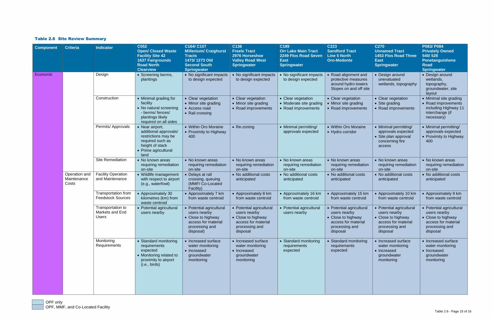
OPF only OPF, MMF, and Co-Located Facility
Table 2.6 - Page 15 of 16
Table 2.6 Site Review Summary
Component Criteria Indicator C052 Open/ Closed Waste Facility Site 42 1637 Fairgrounds Road North Clearview
C164/ C107 Millenium/ Craighurst Tracts 1473/ 1273 Old Second South Springwater
C136 Freele Tract 2976 Horseshoe Valley Road West Springwater
C189 Orr Lake Main Tract 2249 Flos Road Seven East Springwater
C223 Sandford Tract Line 5 North Oro-Medonte
C270 Unnamed Tract 1453 Flos Road Three East Springwater
P083/ P084 Privately Owned 540/ 528 Penetanguishene Road Springwater
Economic
Design • Screening berms, plantings
• No significant impacts to design expected
• No significant impacts to design expected
• No significant impacts to design expected
• Road alignment and protective measures around hydro towers Slopes on and off site
• Design around unevaluated wetlands, topography
• Design around wetlands, topography, groundwater, site layout
Construction • Minimal grading for facility
• No natural screening - berms/ fences/ plantings likely required on all sides
• Clear vegetation • Minor site grading • Access road • Rail crossing
• Clear vegetation • Minor site grading • Road improvements
• Clear vegetation • Moderate site grading • Road improvements
• Clear vegetation • Minor site grading • Road improvements
• Clear vegetation • Site grading • Road improvements
• Minimal site grading • Road improvements
including Highway 11 interchange (if necessary)
Permits/ Approvals • Near airport, additional approvals/ restrictions may be required such as height of stack
• Prime agricultural land
• Within Oro Moraine • Proximity to Highway
400
• Re-zoning • Minimal permitting/ approvals expected
• Within Oro Moraine • Hydro corridor
• Minimal permitting/ approvals expected
• Site plan approval concerning fire access
• Minimal permitting/ approvals expected
• Proximity to Highway 400
Site Remediation • No known areas requiring remediation on-site
• No known areas requiring remediation on-site
• No known areas requiring remediation on-site
• No known areas requiring remediation on-site
• No known areas requiring remediation on-site
• No known areas requiring remediation on-site
• No known areas requiring remediation on-site
Operation and Maintenance Costs
Facility Operation and Maintenance
• Wildlife management with respect to airport (e.g., waterfowl)
• Delays at rail crossing, queuing (MMF/ Co-Located Facility)
• No additional costs anticipated
• No additional costs anticipated
• No additional costs anticipated
• No additional costs anticipated
• No additional costs anticipated
Transportation from Feedstock Sources
• Approximately 30 kilometres (km) from waste centroid
• Approximately 7 km from waste centroid
• Approximately 8 km from waste centroid
• Approximately 16 km from waste centroid
• Approximately 15 km from waste centroid
• Approximately 10 km from waste centroid
• Approximately 9 km from waste centroid
Transportation to Markets and End Users
• Potential agricultural users nearby
• Potential agricultural users nearby
• Close to highway access for material processing and disposal)
• Potential agricultural users nearby
• Close to highway access for material processing and disposal
• Potential agricultural users nearby
• Potential agricultural users nearby
• Close to highway access for material processing and disposal
• Potential agricultural users nearby
• Close to highway access for material processing and disposal
• Potential agricultural users nearby
• Close to highway access for material processing and disposal
Monitoring Requirements
• Standard monitoring requirements expected
• Monitoring related to proximity to airport (i.e., birds)
• Increased surface water monitoring
• Increased groundwater monitoring
• Increased surface water monitoring
• Increased groundwater monitoring
• Standard monitoring requirements expected
• Standard monitoring requirements expected
• Increased surface water monitoring
• Increased groundwater monitoring
• Increased surface water monitoring
• Increased groundwater monitoring

OPF only OPF, MMF, and Co-Located Facility
Table 2.6 - Page 16 of 16
Table 2.6 Site Review Summary
Component Criteria Indicator C052 Open/ Closed Waste Facility Site 42 1637 Fairgrounds Road North Clearview
C164/ C107 Millenium/ Craighurst Tracts 1473/ 1273 Old Second South Springwater
C136 Freele Tract 2976 Horseshoe Valley Road West Springwater
C189 Orr Lake Main Tract 2249 Flos Road Seven East Springwater
C223 Sandford Tract Line 5 North Oro-Medonte
C270 Unnamed Tract 1453 Flos Road Three East Springwater
P083/ P084 Privately Owned 540/ 528 Penetanguishene Road Springwater
Economic Mitigation Requirements
• No natural screening mechanisms (e.g., topography, vegetation, significant buffer) in place for odour, noise, visual
• Cutting grass, maintaining vegetation
• Natural screening mechanisms (e.g., topography, vegetation, significant buffer) already in place for odour, noise, visual
• Protection of Source Protection Areas and watercourses
• Noise mitigation along Old Second South (MMF/ Co-Located Facility)
• Natural screening mechanisms (e.g., topography, vegetation, significant buffer) already in place for odour, noise, visual
• Protection of Source Protection Areas and watercourses
• Natural screening mechanisms (e.g., topography, vegetation, significant buffer) already in place for odour, noise, visual
• Protection of Source Protection Areas and Provincially Significant Wetlands east of site
• Some natural screening mechanisms (e.g., topography, vegetation) already in place for odour, noise, visual
• Protection of County Greenlands, unevaluated wetlands
• Noise mitigation along Line 5 North (MMF/ Co-Located Facility)
• Natural screening mechanisms (e.g., topography, vegetation, significant buffer) already in place for odour, noise, visual
• Protection of unevaluated wetlands, Source Protection Areas
• Noise mitigation along Flos Road Three East (MMF/ Co-Located Facility)
• No natural screening mechanisms (e.g., topography, vegetation, significant buffer) in place for odour, noise, visual
• Protection of unevaluated wetlands, Source Protection Areas
Legal Land Acquisition
Land Acquisition Complexity, Risk, Liability
• County-owned property
• County-owned property
• Potential compensation
• Road allowance
• County-owned property
• Potential compensation
• County-owned property
• May need to purchase nearby residential properties
• County-owned property
• May need to purchase nearby residential properties
• County-owned property
• May need to purchase nearby residential properties
• Privately-owned property. Requires negotiations, legal review, risk review, property investigations.
• May need to purchase nearby residential properties
Agreement Structure and Complexity of Operating Agreement
• Airport concerns around wildlife
• Scheduling (MMF/ Co-Located Facility) and traffic control
• No added complexity expected
• No added complexity expected
• No added complexity expected
• No added complexity expected
• No added complexity expected

Table 3.1 Page 1 of 5
Table 3.1 Comparative Evaluation – OPF
Component Criteria Indicator C052 Open/ Closed Waste
Facility Site 42 1637 Fairgrounds
Road North Clearview
C164/ C107 Millenium/ Craighurst
Tracts 1473/ 1273 Old Second South Springwater
C136 Freele Tract
2976 Horseshoe Valley Road West
Springwater
C189 Orr Lake Main Tract
2249 Flos Road Seven East Springwater
C223 Sandford Tract
Line 5 North Oro-Medonte
C270 Unnamed Tract
1453 Flos Road Three East
Springwater
P083/ P084 Privately Owned
540/ 528 Penetanguishene
Road Springwater
Environmental
Air Quality Wind Speed and Direction NO NET EFFECTS NO NET EFFECTS NO NET EFFECTS NO NET EFFECTS NO NET EFFECTS NO NET EFFECTS LOW NET EFFECTS
Proximity to Sensitive Receptors NO NET EFFECTS NO NET EFFECTS NO NET EFFECTS NO NET EFFECTS NO NET EFFECTS NO NET EFFECTS LOW NET EFFECTS
Species of Special Concern, Threatened, and/or Endangered
LOW NET EFFECTS LOW NET EFFECTS LOW NET EFFECTS LOW NET EFFECTS LOW NET EFFECTS LOW NET EFFECTS LOW NET EFFECTS
Criteria Ranking TIED 1ST TIED 1ST TIED 1ST TIED 1ST TIED 1ST TIED 1ST 7TH
Criteria Rationale With the implementation of Best Management Practices (BMPs) no net effects related to Air Quality are predicted for all sites but one. Low net effects to Species of Special Concern, Threatened and/or Endangered are predicted for all sites.
Odour Wind Speed and Direction NO NET EFFECTS NO NET EFFECTS NO NET EFFECTS NO NET EFFECTS NO NET EFFECTS NO NET EFFECTS LOW NET EFFECTS
Proximity to Sensitive Receptors NO NET EFFECTS NO NET EFFECTS NO NET EFFECTS NO NET EFFECTS NO NET EFFECTS NO NET EFFECTS LOW NET EFFECTS
Criteria Ranking TIED 1ST TIED 1ST TIED 1ST TIED 1ST TIED 1ST TIED 1ST 7TH Criteria Rationale With the implementation of BMPs no net effects related to Odour are predicted for all sites but one.
Noise Proximity to Sensitive Receptors NO NET EFFECTS NO NET EFFECTS NO NET EFFECTS NO NET EFFECTS NO NET EFFECTS NO NET EFFECTS LOW NET EFFECTS
Criteria Ranking TIED 1ST TIED 1ST TIED 1ST TIED 1ST TIED 1ST TIED 1ST 7TH
Criteria Rationale With the implementation of BMPs no net effects related to Noise are predicted for all sites but one.
Terrestrial Topography LOW NET EFFECTS MODERATE NET EFFECTS LOW NET EFFECTS LOW NET EFFECTS LOW NET EFFECTS HIGH NET EFFECTS LOW NET EFFECTS
Soil Type LOW NET EFFECTS NO NET EFFECTS NO NET EFFECTS NO NET EFFECTS NO NET EFFECTS NO NET EFFECTS LOW NET EFFECTS Affected Greenlands NO NET EFFECTS LOW NET EFFECTS LOW NET EFFECTS LOW NET EFFECTS LOW NET EFFECTS LOW NET EFFECTS NO NET EFFECTS Niagara Escarpment Land Use NO NET EFFECTS NO NET EFFECTS NO NET EFFECTS NO NET EFFECTS NO NET EFFECTS NO NET EFFECTS NO NET EFFECTS
Oak Ridges Moraine Land Use NO NET EFFECTS NO NET EFFECTS NO NET EFFECTS NO NET EFFECTS NO NET EFFECTS NO NET EFFECTS NO NET EFFECTS
Species of Special Concern, Threatened, and/ or Endangered
LOW NET EFFECTS LOW NET EFFECTS LOW NET EFFECTS LOW NET EFFECTS LOW NET EFFECTS LOW NET EFFECTS LOW NET EFFECTS
Criteria Ranking TIED 1ST 6TH TIED 1ST TIED 1ST TIED 1ST 7TH TIED 1ST
Criteria Rationale The five sites tied for first are predicted to have low net effects on Topography as it relates to natural drainage patterns, no to low net effects on Soil Type, and no to
low net effects on Affected Greenlands. None of the sites are located within the Niagara Escarpment Land Use or Oak Ridges Moraine Land Use policy areas. Low net effects to Species of Special Concern, Threatened and/or Endangered are predicted for all sites based on a review of existing data.
Aquatic Species of Special Concern, Threatened, and/ or Endangered
NO NET EFFECTS NO NET EFFECTS NO NET EFFECTS NO NET EFFECTS NO NET EFFECTS NO NET EFFECTS NO NET EFFECTS
Criteria Ranking TIED 1ST TIED 1ST TIED 1ST TIED 1ST TIED 1ST TIED 1ST TIED 1ST
Criteria Rationale No net effects to aquatic Species of Special Concern, Threatened and/or Endangered are predicted for all sites. There is no discernible difference between the sites with respect to the Aquatic Criteria.
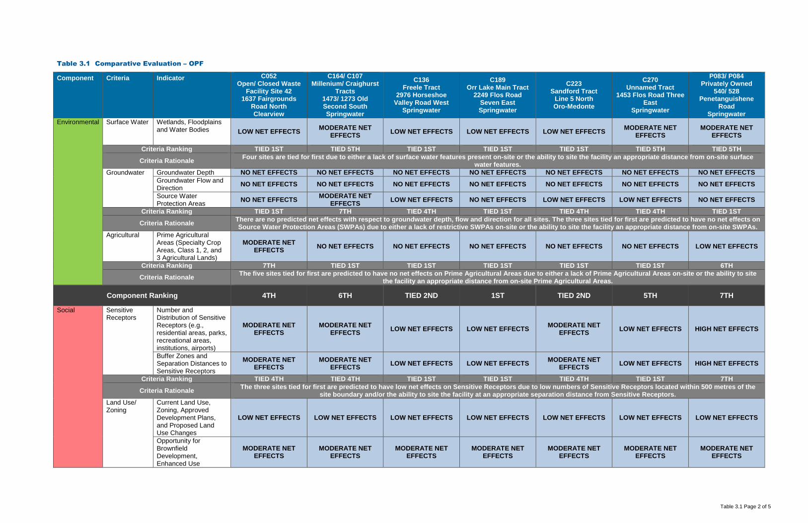
Table 3.1 Page 2 of 5
Table 3.1 Comparative Evaluation – OPF
Component Criteria Indicator C052 Open/ Closed Waste
Facility Site 42 1637 Fairgrounds
Road North Clearview
C164/ C107 Millenium/ Craighurst
Tracts 1473/ 1273 Old Second South Springwater
C136 Freele Tract
2976 Horseshoe Valley Road West
Springwater
C189 Orr Lake Main Tract
2249 Flos Road Seven East Springwater
C223 Sandford Tract
Line 5 North Oro-Medonte
C270 Unnamed Tract
1453 Flos Road Three East
Springwater
P083/ P084 Privately Owned
540/ 528 Penetanguishene
Road Springwater
Environmental Surface Water
Wetlands, Floodplains and Water Bodies LOW NET EFFECTS MODERATE NET
EFFECTS LOW NET EFFECTS LOW NET EFFECTS LOW NET EFFECTS MODERATE NET EFFECTS
MODERATE NET EFFECTS
Criteria Ranking TIED 1ST TIED 5TH TIED 1ST TIED 1ST TIED 1ST TIED 5TH TIED 5TH
Criteria Rationale Four sites are tied for first due to either a lack of surface water features present on-site or the ability to site the facility an appropriate distance from on-site surface water features.
Groundwater Groundwater Depth NO NET EFFECTS NO NET EFFECTS NO NET EFFECTS NO NET EFFECTS NO NET EFFECTS NO NET EFFECTS NO NET EFFECTS Groundwater Flow and Direction NO NET EFFECTS NO NET EFFECTS NO NET EFFECTS NO NET EFFECTS NO NET EFFECTS NO NET EFFECTS NO NET EFFECTS
Source Water Protection Areas NO NET EFFECTS MODERATE NET
EFFECTS LOW NET EFFECTS NO NET EFFECTS LOW NET EFFECTS LOW NET EFFECTS NO NET EFFECTS
Criteria Ranking TIED 1ST 7TH TIED 4TH TIED 1ST TIED 4TH TIED 4TH TIED 1ST
Criteria Rationale There are no predicted net effects with respect to groundwater depth, flow and direction for all sites. The three sites tied for first are predicted to have no net effects on Source Water Protection Areas (SWPAs) due to either a lack of restrictive SWPAs on-site or the ability to site the facility an appropriate distance from on-site SWPAs.
Agricultural Prime Agricultural Areas (Specialty Crop Areas, Class 1, 2, and 3 Agricultural Lands)
MODERATE NET EFFECTS NO NET EFFECTS NO NET EFFECTS NO NET EFFECTS NO NET EFFECTS NO NET EFFECTS LOW NET EFFECTS
Criteria Ranking 7TH TIED 1ST TIED 1ST TIED 1ST TIED 1ST TIED 1ST 6TH
Criteria Rationale The five sites tied for first are predicted to have no net effects on Prime Agricultural Areas due to either a lack of Prime Agricultural Areas on-site or the ability to site the facility an appropriate distance from on-site Prime Agricultural Areas.
Component Ranking 4TH 6TH TIED 2ND 1ST TIED 2ND 5TH 7TH
Social
Sensitive Receptors
Number and Distribution of Sensitive Receptors (e.g., residential areas, parks, recreational areas, institutions, airports)
MODERATE NET EFFECTS
MODERATE NET EFFECTS LOW NET EFFECTS LOW NET EFFECTS MODERATE NET
EFFECTS LOW NET EFFECTS HIGH NET EFFECTS
Buffer Zones and Separation Distances to Sensitive Receptors
MODERATE NET EFFECTS
MODERATE NET EFFECTS LOW NET EFFECTS LOW NET EFFECTS MODERATE NET
EFFECTS LOW NET EFFECTS HIGH NET EFFECTS
Criteria Ranking TIED 4TH TIED 4TH TIED 1ST TIED 1ST TIED 4TH TIED 1ST 7TH
Criteria Rationale The three sites tied for first are predicted to have low net effects on Sensitive Receptors due to low numbers of Sensitive Receptors located within 500 metres of the site boundary and/or the ability to site the facility at an appropriate separation distance from Sensitive Receptors.
Land Use/ Zoning
Current Land Use, Zoning, Approved Development Plans, and Proposed Land Use Changes
LOW NET EFFECTS LOW NET EFFECTS LOW NET EFFECTS LOW NET EFFECTS LOW NET EFFECTS LOW NET EFFECTS LOW NET EFFECTS
Opportunity for Brownfield Development, Enhanced Use
MODERATE NET EFFECTS
MODERATE NET EFFECTS
MODERATE NET EFFECTS
MODERATE NET EFFECTS
MODERATE NET EFFECTS
MODERATE NET EFFECTS
MODERATE NET EFFECTS

Table 3.1 Page 3 of 5
Table 3.1 Comparative Evaluation – OPF
Component Criteria Indicator C052 Open/ Closed Waste
Facility Site 42 1637 Fairgrounds
Road North Clearview
C164/ C107 Millenium/ Craighurst
Tracts 1473/ 1273 Old Second South Springwater
C136 Freele Tract
2976 Horseshoe Valley Road West
Springwater
C189 Orr Lake Main Tract
2249 Flos Road Seven East Springwater
C223 Sandford Tract
Line 5 North Oro-Medonte
C270 Unnamed Tract
1453 Flos Road Three East
Springwater
P083/ P084 Privately Owned
540/ 528 Penetanguishene
Road Springwater
Social Compatibility with Existing Land Use/ Zoning Designations on Adjacent Sites
LOW NET EFFECTS LOW NET EFFECTS LOW NET EFFECTS LOW NET EFFECTS LOW NET EFFECTS LOW NET EFFECTS MODERATE NET EFFECTS
Criteria Ranking TIED 1ST TIED 1ST TIED 1ST TIED 1ST TIED 1ST TIED 1ST 7TH
Criteria Rationale Low net effects due to displacement of current land use and Official Plan Amendment/Zoning By-Law Amendment requirements are predicted for all sites. Moderate net effects due to displacement of current land and lack of opportunity for brownfield redevelopment or enhanced use are predicted for all sites. The six sites tied for first are predicted to have low net effects with respect to compatibility with existing Land Use/Zoning designations on adjacent sites based on the size of the sites, on-site
buffers and application of proven mitigation measures. Transportation Existing/ Required
Transportation Infrastructure
LOW NET EFFECTS MODERATE NET EFFECTS
MODERATE NET EFFECTS
MODERATE NET EFFECTS
MODERATE NET EFFECTS HIGH NET EFFECTS MODERATE NET
EFFECTS
Neighbourhood Traffic Impacts
MODERATE NET EFFECTS
MODERATE NET EFFECTS LOW NET EFFECTS MODERATE NET
EFFECTS MODERATE NET
EFFECTS HIGH NET EFFECTS LOW NET EFFECTS
Criteria Ranking TIED 1ST TIED 4TH TIED 1ST TIED 4TH TIED 4TH 7TH TIED 1ST
Criteria Rationale The three sites tied for first are predicted to have low to moderate net effects with respect to transportation infrastructure requirements and impacts to neighbourhood traffic.
Visual Buffer Zones and Visual Screening LOW NET EFFECTS LOW NET EFFECTS LOW NET EFFECTS LOW NET EFFECTS LOW NET EFFECTS LOW NET EFFECTS LOW NET EFFECTS
Criteria Ranking TIED 1ST TIED 1ST TIED 1ST TIED 1ST TIED 1ST TIED 1ST TIED 1ST
Criteria Rationale All sites are predicted to have low net effects with respect to the Visual Criteria as the installation of visual screening would obscure views of the facility from surrounding areas. There is no discernible difference between the sites with respect to the Visual Criteria.
Component Ranking TIED 2ND TIED 4TH 1ST TIED 2ND TIED 4TH TIED 4TH 7TH
Cultural Archaeological Archeologically Significant Areas LOW NET EFFECTS LOW NET EFFECTS LOW NET EFFECTS LOW NET EFFECTS LOW NET EFFECTS LOW NET EFFECTS LOW NET EFFECTS
Heritage Areas of Important Cultural Heritage NO NET EFFECTS NO NET EFFECTS NO NET EFFECTS NO NET EFFECTS NO NET EFFECTS NO NET EFFECTS NO NET EFFECTS
Criteria Ranking TIED 1ST TIED 1ST TIED 1ST TIED 1ST TIED 1ST TIED 1ST TIED 1ST
Criteria Rationale All sites are predicted to have low net effects on Archaeological and no net effects on Heritage until confirmation is provided through further study. There is no discernible difference between the sites with respect to the Cultural Component.
Component Ranking TIED 1ST TIED 1ST TIED 1ST TIED 1ST TIED 1ST TIED 1ST TIED 1ST
Technical
Permitting/ Approvals
Feasibility and Complexity of Permitting/ Approvals
LOW NET EFFECTS LOW NET EFFECTS LOW NET EFFECTS LOW NET EFFECTS MODERATE NET EFFECTS LOW NET EFFECTS LOW NET EFFECTS
Criteria Ranking TIED 1ST TIED 1ST TIED 1ST TIED 1ST 7TH TIED 1ST TIED 1ST
Criteria Rationale All sites but one are predicted to have low net effects with respect to Permitting and Approvals.
Safety Potential Safety Risks MODERATE NET EFFECTS
MODERATE NET EFFECTS LOW NET EFFECTS MODERATE NET
EFFECTS MODERATE NET
EFFECTS MODERATE NET
EFFECTS LOW NET EFFECTS
Criteria Ranking TIED 3RD TIED 3RD TIED 1ST TIED 3RD TIED 3RD TIED 3RD TIED 1ST
Criteria Rationale All sites are predicted to have low to moderate net effects with respect to potential safety risks. Key differences between the sites with respect to safety include: proximity to an airport, railway crossing, nearby residential communities, and the use of roads by pedestrians/cyclists.

Table 3.1 Page 4 of 5
Table 3.1 Comparative Evaluation – OPF
Component Criteria Indicator C052 Open/ Closed Waste
Facility Site 42 1637 Fairgrounds
Road North Clearview
C164/ C107 Millenium/ Craighurst
Tracts 1473/ 1273 Old Second South Springwater
C136 Freele Tract
2976 Horseshoe Valley Road West
Springwater
C189 Orr Lake Main Tract
2249 Flos Road Seven East Springwater
C223 Sandford Tract
Line 5 North Oro-Medonte
C270 Unnamed Tract
1453 Flos Road Three East
Springwater
P083/ P084 Privately Owned
540/ 528 Penetanguishene
Road Springwater
Technical Utilities and Services
Availability and Distance from Utilities and Services
HIGH NET EFFECTS HIGH NET EFFECTS HIGH NET EFFECTS HIGH NET EFFECTS HIGH NET EFFECTS HIGH NET EFFECTS HIGH NET EFFECTS
Criteria Ranking TIED 1ST TIED 1ST TIED 1ST TIED 1ST TIED 1ST TIED 1ST TIED 1ST
Criteria Rationale All sites are predicted to have high net effects with respect to Utilities and Services as availability and distance from existing utilities and services is minimal for all sites. There is no discernible difference between sites with respect to Utilities and Services.
Suitability Meets Minimum Size Requirements NO NET EFFECTS NO NET EFFECTS NO NET EFFECTS NO NET EFFECTS NO NET EFFECTS NO NET EFFECTS NO NET EFFECTS
Within Search Area NO NET EFFECTS NO NET EFFECTS NO NET EFFECTS NO NET EFFECTS NO NET EFFECTS NO NET EFFECTS NO NET EFFECTS Site Layout, Topography, and Soil Conditions
LOW NET EFFECTS LOW NET EFFECTS LOW NET EFFECTS LOW NET EFFECTS LOW NET EFFECTS HIGH NET EFFECTS HIGH NET EFFECTS
Compatibility with Existing Infrastructure NO NET EFFECTS LOW NET EFFECTS LOW NET EFFECTS LOW NET EFFECTS LOW NET EFFECTS NO NET EFFECTS NO NET EFFECTS
Criteria Ranking 1ST TIED 2ND TIED 2ND TIED 2ND TIED 2ND TIED 6TH TIED 6TH
Criteria Rationale All sites meet the minimum size criteria and are within the search area for the OPF. The site ranked first is predicted to have low net effects with respect to Site Layout,
Topography, and Soil Conditions as the site is able to accommodate the facility with significant setbacks and buffer distances, and no net effects with respect to Compatibility with Existing Infrastructure as no relocation of existing infrastructure is required.
Flexibility Design/ Operational Flexibility Provided by Site
HIGH POSITIVE NET EFFECTS
MODERATE POSITIVE NET
EFFECTS HIGH POSITIVE NET
EFFECTS HIGH POSITIVE NET
EFFECTS MODERATE
POSITIVE NET EFFECTS
LOW POSITIVE NET EFFECTS
LOW POSITIVE NET EFFECTS
Surplus Lands for Expansion HIGH POSITIVE NET
EFFECTS MODERATE
POSITIVE NET EFFECTS
HIGH POSITIVE NET EFFECTS
HIGH POSITIVE NET EFFECTS
MODERATE POSITIVE NET
EFFECTS LOW POSITIVE NET
EFFECTS LOW POSITIVE NET
EFFECTS
Criteria Ranking TIED 1ST TIED 4TH TIED 1ST TIED 1ST TIED 4TH TIED 6TH TIED 6TH
Criteria Rationale The three top ranked sites with respect to Flexibility have the ability to accommodate design and operational flexibility as well as expansion.
Component Ranking 2ND 4TH 1ST 3RD TIED 6TH TIED 6TH 5TH
Economic
Capital Costs Property Acquisition NO COSTS NO COSTS NO COSTS NO COSTS NO COSTS NO COSTS HIGH COST Infrastructure LOW COST MODERATE COST MODERATE COST MODERATE COST MODERATE COST HIGH COST MODERATE COST Design LOW COST LOW COST LOW COST LOW COST LOW COST MODERATE COST HIGH COST Construction LOW COST MODERATE COST MODERATE COST MODERATE COST MODERATE COST MODERATE COST HIGH COST Permits/ Approvals MODERATE COST MODERATE COST LOW COST LOW COST HIGH COST LOW COST LOW COST Site Remediation LOW COST LOW COST LOW COST LOW COST LOW COST LOW COST LOW COST
Criteria Ranking 1ST 4TH TIED 2ND TIED 2ND TIED 5TH TIED 5TH 7TH
Criteria Rationale There are significant cost differences between all of the sites with respect to each of the indicators. The top ranked site has no costs with respect to Property Acquisition as it is owned by the County, and relatively low costs related to Design and Construction.
Operation and Maintenance Costs
Facility Operation and Maintenance MODERATE COST LOW COST LOW COST LOW COST LOW COST LOW COST MODERATE COST
Transportation from Feedstock Sources HIGH COST LOW COST LOW COST MODERATE COST MODERATE COST MODERATE COST LOW COST

Table 3.1 Page 5 of 5
Table 3.1 Comparative Evaluation – OPF
Component Criteria Indicator C052 Open/ Closed Waste
Facility Site 42 1637 Fairgrounds
Road North Clearview
C164/ C107 Millenium/ Craighurst
Tracts 1473/ 1273 Old Second South Springwater
C136 Freele Tract
2976 Horseshoe Valley Road West
Springwater
C189 Orr Lake Main Tract
2249 Flos Road Seven East Springwater
C223 Sandford Tract
Line 5 North Oro-Medonte
C270 Unnamed Tract
1453 Flos Road Three East
Springwater
P083/ P084 Privately Owned
540/ 528 Penetanguishene
Road Springwater
Economic Transportation to Markets and End Users LOW COST LOW COST LOW COST LOW COST LOW COST LOW COST LOW COST
Monitoring Requirements LOW COST MODERATE COST MODERATE COST LOW COST LOW COST MODERATE COST MODERATE COST
Mitigation Requirements MODERATE COST MODERATE COST MODERATE COST LOW COST MODERATE COST MODERATE COST MODERATE COST
Criteria Ranking 7TH TIED 2ND TIED 2ND 1ST TIED 2ND TIED 5TH TIED 5TH
Criteria Rationale There are significant cost differences between all of the sites with respect to each of the indicators. All sites have low costs associated with Transportation to Markets and End Users. The top ranked site has low costs with respect to Facility Operation and Maintenance, moderate costs for Transportation from Feedstock Sources, and
low Monitoring and Mitigation Requirements costs.
Component Ranking 5TH 3RD 2ND 1ST 4TH 6TH 7TH
Legal Land Acquisition
Land Acquisition Complexity, Risk, Liability
LOW COMPLEXITY, RISK & LIABILITY
MODERATE COMPLEXITY, RISK
& LIABILITY LOW COMPLEXITY, RISK & LIABILITY
MODERATE COMPLEXITY, RISK
& LIABILITY LOW COMPLEXITY, RISK & LIABILITY
LOW COMPLEXITY, RISK & LIABILITY
HIGH COMPLEXITY, RISK & LIABILITY
Criteria Ranking TIED 1ST TIED 5TH TIED 1ST TIED 5TH TIED 1ST TIED 1ST 7TH Criteria Rationale The four sites tied for first all have low complexity, risk and liability with respect to Land Acquisition as they are owned by the County.
Agreement Structure and Complexity of Operating Agreement
LOW COMPLEXITY LOW COMPLEXITY LOW COMPLEXITY LOW COMPLEXITY LOW COMPLEXITY LOW COMPLEXITY LOW COMPLEXITY
Criteria Ranking TIED 1ST TIED 1ST TIED 1ST TIED 1ST TIED 1ST TIED 1ST TIED 1ST
Criteria Rationale All sites are predicted to have low complexity with respect to their operating agreements. There is no discernable difference between the sites with respect to the Agreement Criteria.
Component Ranking TIED 1ST TIED 5TH TIED 1ST TIED 5TH TIED 1ST TIED 1ST 7TH
OVERALL RANKING – OPF 3RD TIED 5TH 1ST 2ND 4TH TIED 5TH 7TH

Table 3.2 Page 1 of 4
Table 3.2 Comparative Evaluation – MMF
Component Criteria Indicator C164/ C107 Millenium/ Craighurst Tracts 1473/ 1273 Old Second South
Springwater
C136 Freele Tract
2976 Horseshoe Valley Road West
Springwater
C223 Sandford Tract
Line 5 North Oro-Medonte
C270 Unnamed Tract
1453 Flos Road Three East Springwater
P083/ P084 Privately Owned
540/ 528 Penetanguishene Road
Springwater Environmental
Air Quality Wind Speed and Direction NO NET EFFECTS NO NET EFFECTS NO NET EFFECTS NO NET EFFECTS LOW NET EFFECTS Proximity to Sensitive Receptors NO NET EFFECTS NO NET EFFECTS NO NET EFFECTS NO NET EFFECTS LOW NET EFFECTS Species of Special Concern, Threatened, and/ or Endangered LOW NET EFFECTS LOW NET EFFECTS LOW NET EFFECTS LOW NET EFFECTS LOW NET EFFECTS
Criteria Ranking TIED 1ST TIED 1ST TIED 1ST TIED 1ST 5TH
Criteria Rationale With the implementation of Best Management Practices (BMPs) no net effects related to Air Quality are predicted for all sites but one. Low net effects to Species of Special Concern, Threatened and/or Endangered are predicted for all sites.
Odour Wind Speed and Direction NO NET EFFECTS NO NET EFFECTS NO NET EFFECTS NO NET EFFECTS LOW NET EFFECTS Proximity to Sensitive Receptors NO NET EFFECTS NO NET EFFECTS NO NET EFFECTS NO NET EFFECTS LOW NET EFFECTS Criteria Ranking TIED 1ST TIED 1ST TIED 1ST TIED 1ST 5TH Criteria Rationale With the implementation of BMPs no net effects related to Odour are predicted for all sites but one.
Noise Proximity to Sensitive Receptors NO NET EFFECTS NO NET EFFECTS NO NET EFFECTS NO NET EFFECTS LOW NET EFFECTS Criteria Ranking TIED 1ST TIED 1ST TIED 1ST TIED 1ST 5TH Criteria Rationale With the implementation of BMPs no net effects related to Noise are predicted for all sites but one.
Terrestrial Topography MODERATE NET EFFECTS LOW NET EFFECTS LOW NET EFFECTS HIGH NET EFFECTS LOW NET EFFECTS Soil Type NO NET EFFECTS NO NET EFFECTS NO NET EFFECTS NO NET EFFECTS LOW NET EFFECTS Affected Greenlands LOW NET EFFECTS LOW NET EFFECTS LOW NET EFFECTS LOW NET EFFECTS NO NET EFFECTS Niagara Escarpment Land Use NO NET EFFECTS NO NET EFFECTS NO NET EFFECTS NO NET EFFECTS NO NET EFFECTS Oak Ridges Moraine Land Use NO NET EFFECTS NO NET EFFECTS NO NET EFFECTS NO NET EFFECTS NO NET EFFECTS Species of Special Concern, Threatened, and/ or Endangered LOW NET EFFECTS LOW NET EFFECTS LOW NET EFFECTS LOW NET EFFECTS LOW NET EFFECTS
Criteria Ranking 4TH TIED 1ST TIED 1ST 5TH TIED 1ST
Criteria Rationale The three sites tied for first are predicted to have low net effects on Topography as it relates to natural drainage patterns, no to low net effects on Soil Type, and no to low net effects on Affected Greenlands. None of the sites are located within the Niagara Escarpment Land Use or Oak Ridges Moraine Land Use policy areas. Low net effects to Species of Special Concern, Threatened and/or Endangered are predicted for all sites based on a review of existing data.
Aquatic Species of Special Concern, Threatened, and/ or Endangered NO NET EFFECTS NO NET EFFECTS NO NET EFFECTS NO NET EFFECTS NO NET EFFECTS
Criteria Ranking TIED 1ST TIED 1ST TIED 1ST TIED 1ST TIED 1ST
Criteria Rationale No net effects to aquatic Species of Special Concern, Threatened and/or Endangered are predicted for all sites. There is no discernible difference between the sites with respect to the Aquatic Criteria.
Surface Water Wetlands, Floodplains and Water Bodies MODERATE NET EFFECTS LOW NET EFFECTS LOW NET EFFECTS MODERATE NET EFFECTS MODERATE NET EFFECTS
Criteria Ranking TIED 3RD TIED 1ST TIED 1ST TIED 3RD TIED 3RD
Criteria Rationale Two sites are tied for first due to either a lack of surface water features present on-site or the ability to site the facility an appropriate distance from on-site surface water features.
Groundwater Groundwater Depth NO NET EFFECTS NO NET EFFECTS NO NET EFFECTS NO NET EFFECTS NO NET EFFECTS Groundwater Flow and Direction NO NET EFFECTS NO NET EFFECTS NO NET EFFECTS NO NET EFFECTS NO NET EFFECTS Source Water Protection Areas MODERATE NET EFFECTS LOW NET EFFECTS LOW NET EFFECTS LOW NET EFFECTS NO NET EFFECTS Criteria Ranking 5TH TIED 2ND TIED 2ND TIED 2ND 1ST
Criteria Rationale There are no predicted net effects with respect to groundwater depth, flow and direction for all sites. The site ranked first is predicted to have no net effects on Source Water Protection Areas (SWPAs) due to either a lack of restrictive SWPAs on-site or the ability to site the facility an appropriate distance from on-site
SWPAs. Agricultural Prime Agricultural Areas (Specialty
Crop Areas, Class 1, 2, and 3 Agricultural Lands)
NO NET EFFECTS NO NET EFFECTS NO NET EFFECTS NO NET EFFECTS LOW NET EFFECTS
Criteria Ranking TIED 1ST TIED 1ST TIED 1ST TIED 1ST 5TH

Table 3.2 Page 2 of 4
Table 3.2 Comparative Evaluation – MMF
Component Criteria Indicator C164/ C107 Millenium/ Craighurst Tracts 1473/ 1273 Old Second South
Springwater
C136 Freele Tract
2976 Horseshoe Valley Road West
Springwater
C223 Sandford Tract
Line 5 North Oro-Medonte
C270 Unnamed Tract
1453 Flos Road Three East Springwater
P083/ P084 Privately Owned
540/ 528 Penetanguishene Road
Springwater Environmental Criteria Rationale The four sites tied for first are predicted to have no net effects on Prime Agricultural Areas due to either a lack of Prime Agricultural Areas on-site or the ability
to site the facility an appropriate distance from on-site Prime Agricultural Areas.
Component Ranking 4TH TIED 1ST TIED 1ST 3RD 5TH
Social Sensitive Receptors
Number and Distribution of Sensitive Receptors (e.g., residential areas, parks, recreational areas, institutions, airports)
MODERATE NET EFFECTS LOW NET EFFECTS MODERATE NET EFFECTS LOW NET EFFECTS HIGH NET EFFECTS
Buffer Zones and Separation Distances to Sensitive Receptors MODERATE NET EFFECTS LOW NET EFFECTS MODERATE NET EFFECTS LOW NET EFFECTS HIGH NET EFFECTS
Criteria Ranking TIED 3RD TIED 1ST TIED 3RD TIED 1ST 5TH
Criteria Rationale The two sites tied for first are predicted to have low net effects on Sensitive Receptors due to low numbers of Sensitive Receptors located within 500 metres of the site boundary and/or the ability to site the facility at an appropriate separation distance from Sensitive Receptors.
Land Use/ Zoning
Current Land Use, Zoning, Approved Development Plans, and Proposed Land Use Changes
LOW NET EFFECTS LOW NET EFFECTS LOW NET EFFECTS LOW NET EFFECTS LOW NET EFFECTS
Opportunity for Brownfield Development, Enhanced Use MODERATE NET EFFECTS MODERATE NET EFFECTS MODERATE NET EFFECTS MODERATE NET EFFECTS MODERATE NET EFFECTS
Compatibility with Existing Land Use/ Zoning Designations on Adjacent Sites
LOW NET EFFECTS LOW NET EFFECTS LOW NET EFFECTS LOW NET EFFECTS MODERATE NET EFFECTS
Criteria Ranking TIED 1ST TIED 1ST TIED 1ST TIED 1ST 5TH
Criteria Rationale Low net effects due to displacement of current land use and Official Plan Amendment/Zoning By-Law Amendment requirements are predicted for all sites.
Moderate net effects due to displacement of current land and lack of opportunity for brownfield redevelopment or enhanced use are predicted for all sites. The six sites tied for first are predicted to have low net effects with respect to compatibility with existing Land Use/Zoning designations on adjacent sites based on
the size of the sites, on-site buffers and application of proven mitigation measures. Transportation Existing/ Required Transportation
Infrastructure HIGH NET EFFECTS MODERATE NET EFFECTS MODERATE NET EFFECTS HIGH NET EFFECTS HIGH NET EFFECTS
Neighbourhood Traffic Impacts HIGH NET EFFECTS LOW NET EFFECTS MODERATE NET EFFECTS HIGH NET EFFECTS MODERATE NET EFFECTS Criteria Ranking TIED 4TH 1ST 2ND TIED 4TH 3RD
Criteria Rationale The site ranked first is predicted to have low to moderate net effects with respect to transportation infrastructure requirements and impacts to neighbourhood traffic.
Visual Buffer Zones and Visual Screening LOW NET EFFECTS LOW NET EFFECTS LOW NET EFFECTS LOW NET EFFECTS LOW NET EFFECTS Criteria Ranking TIED 1ST TIED 1ST TIED 1ST TIED 1ST TIED 1ST
Criteria Rationale All sites are predicted to have low net effects with respect to the Visual Criteria as the installation of visual screening would obscure views of the facility from surrounding areas. There is no discernible difference between the sites with respect to the Visual Criteria.
Component Ranking 4TH 1ST TIED 2ND TIED 2ND 5TH
Cultural Archaeological Archeologically Significant Areas LOW NET EFFECTS LOW NET EFFECTS LOW NET EFFECTS LOW NET EFFECTS LOW NET EFFECTS Heritage Areas of Important Cultural Heritage NO NET EFFECTS NO NET EFFECTS NO NET EFFECTS NO NET EFFECTS NO NET EFFECTS
Criteria Ranking TIED 1ST TIED 1ST TIED 1ST TIED 1ST TIED 1ST
Criteria Rationale All sites are predicted to have low net effects on Archaeological and no net effects on Heritage until confirmation is provided through further study. There is no
discernible difference between the sites with respect to the Cultural Component.
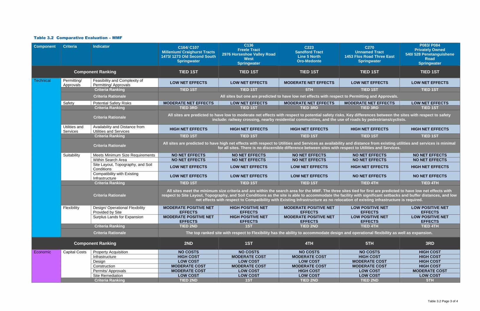
Table 3.2 Page 3 of 4
Table 3.2 Comparative Evaluation – MMF
Component Criteria Indicator C164/ C107 Millenium/ Craighurst Tracts 1473/ 1273 Old Second South
Springwater
C136 Freele Tract
2976 Horseshoe Valley Road West
Springwater
C223 Sandford Tract
Line 5 North Oro-Medonte
C270 Unnamed Tract
1453 Flos Road Three East Springwater
P083/ P084 Privately Owned
540/ 528 Penetanguishene Road
Springwater
Component Ranking TIED 1ST TIED 1ST TIED 1ST TIED 1ST TIED 1ST
Technical Permitting/ Approvals
Feasibility and Complexity of Permitting/ Approvals LOW NET EFFECTS LOW NET EFFECTS MODERATE NET EFFECTS LOW NET EFFECTS LOW NET EFFECTS
Criteria Ranking TIED 1ST TIED 1ST 5TH TIED 1ST TIED 1ST Criteria Rationale All sites but one are predicted to have low net effects with respect to Permitting and Approvals.
Safety Potential Safety Risks MODERATE NET EFFECTS LOW NET EFFECTS MODERATE NET EFFECTS MODERATE NET EFFECTS LOW NET EFFECTS Criteria Ranking TIED 3RD TIED 1ST TIED 3RD TIED 3RD TIED 1ST
Criteria Rationale All sites are predicted to have low to moderate net effects with respect to potential safety risks. Key differences between the sites with respect to safety include: railway crossing, nearby residential communities, and the use of roads by pedestrians/cyclists.
Utilities and Services
Availability and Distance from Utilities and Services HIGH NET EFFECTS HIGH NET EFFECTS HIGH NET EFFECTS HIGH NET EFFECTS HIGH NET EFFECTS
Criteria Ranking TIED 1ST TIED 1ST TIED 1ST TIED 1ST TIED 1ST
Criteria Rationale All sites are predicted to have high net effects with respect to Utilities and Services as availability and distance from existing utilities and services is minimal for all sites. There is no discernible difference between sites with respect to Utilities and Services.
Suitability Meets Minimum Size Requirements NO NET EFFECTS NO NET EFFECTS NO NET EFFECTS NO NET EFFECTS NO NET EFFECTS Within Search Area NO NET EFFECTS NO NET EFFECTS NO NET EFFECTS NO NET EFFECTS NO NET EFFECTS Site Layout, Topography, and Soil Conditions LOW NET EFFECTS LOW NET EFFECTS LOW NET EFFECTS HIGH NET EFFECTS HIGH NET EFFECTS
Compatibility with Existing Infrastructure LOW NET EFFECTS LOW NET EFFECTS LOW NET EFFECTS NO NET EFFECTS NO NET EFFECTS
Criteria Ranking TIED 1ST TIED 1ST TIED 1ST TIED 4TH TIED 4TH
Criteria Rationale All sites meet the minimum size criteria and are within the search area for the MMF. The three sites tied for first are predicted to have low net effects with
respect to Site Layout, Topography, and Soil Conditions as the site is able to accommodate the facility with significant setbacks and buffer distances, and low net effects with respect to Compatibility with Existing Infrastructure as no relocation of existing infrastructure is required.
Flexibility Design/ Operational Flexibility Provided by Site
MODERATE POSITIVE NET EFFECTS
HIGH POSITIVE NET EFFECTS
MODERATE POSITIVE NET EFFECTS
LOW POSITIVE NET EFFECTS
LOW POSITIVE NET EFFECTS
Surplus Lands for Expansion MODERATE POSITIVE NET EFFECTS
HIGH POSITIVE NET EFFECTS
MODERATE POSITIVE NET EFFECTS
LOW POSITIVE NET EFFECTS
LOW POSITIVE NET EFFECTS
Criteria Ranking TIED 2ND 1ST TIED 2ND TIED 4TH TIED 4TH Criteria Rationale The top ranked site with respect to Flexibility has the ability to accommodate design and operational flexibility as well as expansion.
Component Ranking 2ND 1ST 4TH 5TH 3RD
Economic
Capital Costs Property Acquisition NO COSTS NO COSTS NO COSTS NO COSTS HIGH COST Infrastructure HIGH COST MODERATE COST MODERATE COST HIGH COST HIGH COST Design LOW COST LOW COST LOW COST MODERATE COST HIGH COST Construction MODERATE COST MODERATE COST MODERATE COST MODERATE COST HIGH COST Permits/ Approvals MODERATE COST LOW COST HIGH COST LOW COST MODERATE COST Site Remediation LOW COST LOW COST LOW COST LOW COST LOW COST Criteria Ranking TIED 2ND 1ST TIED 2ND TIED 2ND 5TH

Table 3.2 Page 4 of 4
Table 3.2 Comparative Evaluation – MMF
Component Criteria Indicator C164/ C107 Millenium/ Craighurst Tracts 1473/ 1273 Old Second South
Springwater
C136 Freele Tract
2976 Horseshoe Valley Road West
Springwater
C223 Sandford Tract
Line 5 North Oro-Medonte
C270 Unnamed Tract
1453 Flos Road Three East Springwater
P083/ P084 Privately Owned
540/ 528 Penetanguishene Road
Springwater Economic
Criteria Rationale There are significant cost differences between all of the sites with respect to each of the indicators. The top ranked site has no costs with respect to Property Acquisition as it is owned by the County, and relatively low costs related to Design and Construction.
Operation and Maintenance Costs
Facility Operation and Maintenance MODERATE COST LOW COST LOW COST LOW COST MODERATE COST Transportation from Feedstock Sources LOW COST LOW COST MODERATE COST MODERATE COST LOW COST
Transportation to Markets and End Users LOW COST LOW COST LOW COST MODERATE COST LOW COST
Monitoring Requirements MODERATE COST MODERATE COST LOW COST MODERATE COST MODERATE COST Mitigation Requirements HIGH COST MODERATE COST HIGH COST HIGH COST MODERATE COST Criteria Ranking 4TH 1ST TIED 2ND 5TH TIED 2ND
Criteria Rationale There are significant cost differences between all of the sites with respect to each of the indicators. The top ranked site has low Facility Operation and
Maintenance, Transportation from Feedstock Sources, and Transportation to Markets and End Users costs and moderate costs associated with Monitoring and Mitigation Requirements.
Component Ranking 3RD 1ST 2ND TIED 4TH TIED 4TH
Legal Land Acquisition
Land Acquisition Complexity, Risk, Liability
MODERATE COMPLEXITY, RISK & LIABILITY
LOW COMPLEXITY, RISK & LIABILITY
LOW COMPLEXITY, RISK & LIABILITY
LOW COMPLEXITY, RISK & LIABILITY
HIGH COMPLEXITY, RISK & LIABILITY
Criteria Ranking 4TH TIED 1ST TIED 1ST TIED 1ST 5TH Criteria Rationale The three sites tied for first all have low complexity, risk and liability with respect to Land Acquisition as they are owned by the County.
Agreement Structure and Complexity of Operating Agreement LOW COMPLEXITY LOW COMPLEXITY LOW COMPLEXITY LOW COMPLEXITY LOW COMPLEXITY Criteria Ranking TIED 1ST TIED 1ST TIED 1ST TIED 1ST TIED 1ST
Criteria Rationale All sites are predicted to have low complexity with respect to their operating agreements. There is no discernable difference between the sites with respect to Agreement.
Component Ranking 4TH TIED 1ST TIED 1ST TIED 1ST 5TH
OVERALL RANKING – MMF 4TH 1ST 2ND 3RD 5TH

Table 3.3 Page 1 of 4
Table 3.3 Comparative Evaluation – Co-Located Facility
Component Criteria Indicator C164/ C107 Millenium/ Craighurst Tracts 1473/ 1273 Old Second South
Springwater
C136 Freele Tract
2976 Horseshoe Valley Road West
Springwater
C223 Sandford Tract
Line 5 North Oro-Medonte
C270 Unnamed Tract
1453 Flos Road Three East Springwater
P083/ P084 Privately Owned
540/ 528 Penetanguishene Road
Springwater Environmental
Air Quality Wind Speed and Direction NO NET EFFECTS NO NET EFFECTS NO NET EFFECTS NO NET EFFECTS LOW NET EFFECTS Proximity to Sensitive Receptors NO NET EFFECTS NO NET EFFECTS NO NET EFFECTS NO NET EFFECTS LOW NET EFFECTS Species of Special Concern, Threatened, and/ or Endangered LOW NET EFFECTS LOW NET EFFECTS LOW NET EFFECTS LOW NET EFFECTS LOW NET EFFECTS
Criteria Ranking TIED 1ST TIED 1ST TIED 1ST TIED 1ST 5TH
Criteria Rationale With the implementation of Best Management Practices (BMPs) no net effects related to Air Quality are predicted for all sites but one. Low net effects to Species of Special Concern, Threatened and/or Endangered are predicted for all sites.
Odour Wind Speed and Direction NO NET EFFECTS NO NET EFFECTS NO NET EFFECTS NO NET EFFECTS LOW NET EFFECTS Proximity to Sensitive Receptors NO NET EFFECTS NO NET EFFECTS NO NET EFFECTS NO NET EFFECTS LOW NET EFFECTS Criteria Ranking TIED 1ST TIED 1ST TIED 1ST TIED 1ST 5TH Criteria Rationale With the implementation of BMPs no net effects related to Odour are predicted for all sites but one.
Noise Proximity to Sensitive Receptors NO NET EFFECTS NO NET EFFECTS NO NET EFFECTS NO NET EFFECTS LOW NET EFFECTS Criteria Ranking TIED 1ST TIED 1ST TIED 1ST TIED 1ST 5TH Criteria Rationale With the implementation of BMPs no net effects related to Noise are predicted for all sites but one.
Terrestrial Topography MODERATE NET EFFECTS LOW NET EFFECTS LOW NET EFFECTS HIGH NET EFFECTS LOW NET EFFECTS Soil Type NO NET EFFECTS NO NET EFFECTS NO NET EFFECTS NO NET EFFECTS LOW NET EFFECTS Affected Greenlands LOW NET EFFECTS LOW NET EFFECTS LOW NET EFFECTS LOW NET EFFECTS NO NET EFFECTS Niagara Escarpment Land Use NO NET EFFECTS NO NET EFFECTS NO NET EFFECTS NO NET EFFECTS NO NET EFFECTS Oak Ridges Moraine Land Use NO NET EFFECTS NO NET EFFECTS NO NET EFFECTS NO NET EFFECTS NO NET EFFECTS Species of Special Concern, Threatened, and/ or Endangered LOW NET EFFECTS LOW NET EFFECTS LOW NET EFFECTS LOW NET EFFECTS LOW NET EFFECTS
Criteria Ranking 4TH TIED 1ST TIED 1ST 5TH TIED 1ST
Criteria Rationale The three sites tied for first are predicted to have low net effects on Topography as it relates to natural drainage patterns, no to low net effects on Soil Type, and no to low net effects on Affected Greenlands. None of the sites are located within the Niagara Escarpment Land Use or Oak Ridges Moraine Land Use policy areas. Low net effects to Species of Special Concern, Threatened and/or Endangered are predicted for all sites based on a review of existing data.
Aquatic Species of Special Concern, Threatened, and/ or Endangered NO NET EFFECTS NO NET EFFECTS NO NET EFFECTS NO NET EFFECTS NO NET EFFECTS
Criteria Ranking TIED 1ST TIED 1ST TIED 1ST TIED 1ST TIED 1ST
Criteria Rationale No net effects to aquatic Species of Special Concern, Threatened and/or Endangered are predicted for all sites. There is no discernible difference between the sites with respect to the Aquatic Criteria..
Surface Water Wetlands, Floodplains and Water Bodies MODERATE NET EFFECTS LOW NET EFFECTS LOW NET EFFECTS MODERATE NET EFFECTS MODERATE NET EFFECTS
Criteria Ranking TIED 3RD TIED 1ST TIED 1ST TIED 3RD TIED 3RD
Criteria Rationale Two sites are tied for first due to either a lack of surface water features present on-site or the ability to site the facility an appropriate distance from on-site surface water features.
Groundwater Groundwater Depth NO NET EFFECTS NO NET EFFECTS NO NET EFFECTS NO NET EFFECTS NO NET EFFECTS Groundwater Flow and Direction NO NET EFFECTS NO NET EFFECTS NO NET EFFECTS NO NET EFFECTS NO NET EFFECTS Source Water Protection Areas MODERATE NET EFFECTS LOW NET EFFECTS LOW NET EFFECTS LOW NET EFFECTS NO NET EFFECTS Criteria Ranking 5TH TIED 2ND TIED 2ND TIED 2ND 1ST
Criteria Rationale There are no predicted net effects with respect to groundwater depth, flow and direction for all sites. The site ranked first is predicted to have no net effects on Source Water Protection Areas (SWPAs) due to either a lack of restrictive SWPAs on-site or the ability to site the facility an appropriate distance from on-site
SWPAs. Agricultural Prime Agricultural Areas (Specialty
Crop Areas, Class 1, 2, and 3 Agricultural Lands)
NO NET EFFECTS NO NET EFFECTS NO NET EFFECTS NO NET EFFECTS LOW NET EFFECTS
Criteria Ranking TIED 1ST TIED 1ST TIED 1ST TIED 1ST 5TH

Table 3.3 Page 2 of 4
Table 3.3 Comparative Evaluation – Co-Located Facility
Component Criteria Indicator C164/ C107 Millenium/ Craighurst Tracts 1473/ 1273 Old Second South
Springwater
C136 Freele Tract
2976 Horseshoe Valley Road West
Springwater
C223 Sandford Tract
Line 5 North Oro-Medonte
C270 Unnamed Tract
1453 Flos Road Three East Springwater
P083/ P084 Privately Owned
540/ 528 Penetanguishene Road
Springwater Environmental Criteria Rationale The four sites tied for first are predicted to have no net effects on Prime Agricultural Areas due to either a lack of Prime Agricultural Areas on-site or the ability
to site the facility an appropriate distance from on-site Prime Agricultural Areas.
Component Ranking 4TH TIED 1ST TIED 1ST 3RD 5TH
Social Sensitive Receptors
Number and Distribution of Sensitive Receptors (e.g., residential areas, parks, recreational areas, institutions, airports)
MODERATE NET EFFECTS LOW NET EFFECTS MODERATE NET EFFECTS LOW NET EFFECTS HIGH NET EFFECTS
Buffer Zones and Separation Distances to Sensitive Receptors MODERATE NET EFFECTS LOW NET EFFECTS MODERATE NET EFFECTS LOW NET EFFECTS HIGH NET EFFECTS
Criteria Ranking TIED 3RD TIED 1ST TIED 3RD TIED 1ST 5TH
Criteria Rationale The two sites tied for first are predicted to have low net effects on Sensitive Receptors due to low numbers of Sensitive Receptors located within 500 metres of the site boundary and/or the ability to site the facility at an appropriate separation distance from Sensitive Receptors.
Land Use/ Zoning
Current Land Use, Zoning, Approved Development Plans, and Proposed Land Use Changes
LOW NET EFFECTS LOW NET EFFECTS LOW NET EFFECTS LOW NET EFFECTS LOW NET EFFECTS
Opportunity for Brownfield Development, Enhanced Use MODERATE NET EFFECTS MODERATE NET EFFECTS MODERATE NET EFFECTS MODERATE NET EFFECTS MODERATE NET EFFECTS
Compatibility with Existing Land Use/ Zoning Designations on Adjacent Sites
LOW NET EFFECTS LOW NET EFFECTS LOW NET EFFECTS LOW NET EFFECTS MODERATE NET EFFECTS
Criteria Ranking TIED 1ST TIED 1ST TIED 1ST TIED 1ST 5TH
Criteria Rationale Low net effects due to displacement of current land use and Official Plan Amendment/Zoning By-Law Amendment requirements are predicted for all sites.
Moderate net effects due to displacement of current land and lack of opportunity for brownfield redevelopment or enhanced use are predicted for all sites. The six sites tied for first are predicted to have low net effects with respect to compatibility with existing Land Use/Zoning designations on adjacent sites based on
the size of the sites, on-site buffers and application of proven mitigation measures. Transportation Existing/ Required Transportation
Infrastructure HIGH NET EFFECTS MODERATE NET EFFECTS MODERATE NET EFFECTS HIGH NET EFFECTS HIGH NET EFFECTS
Neighbourhood Traffic Impacts HIGH NET EFFECTS LOW NET EFFECTS MODERATE NET EFFECTS HIGH NET EFFECTS MODERATE NET EFFECTS Criteria Ranking TIED 4TH 1ST TIED 2ND TIED 4TH 3RD
Criteria Rationale The site ranked first is predicted to have low to moderate net effects with respect to transportation infrastructure requirements and impacts to neighbourhood traffic.
Visual Buffer Zones and Visual Screening LOW NET EFFECTS LOW NET EFFECTS LOW NET EFFECTS LOW NET EFFECTS LOW NET EFFECTS Criteria Ranking TIED 1ST TIED 1ST TIED 1ST TIED 1ST TIED 1ST
Criteria Rationale All sites are predicted to have low net effects with respect to the Visual Criteria as the installation of visual screening would obscure views of the facility from surrounding areas. There is no discernible difference between the sites with respect to the Visual Criteria.
Component Ranking 4TH 1ST TIED 2ND TIED 2ND 5TH
Cultural Archaeological Archeologically Significant Areas LOW NET EFFECTS LOW NET EFFECTS LOW NET EFFECTS LOW NET EFFECTS LOW NET EFFECTS Heritage Areas of Important Cultural Heritage NO NET EFFECTS NO NET EFFECTS NO NET EFFECTS NO NET EFFECTS NO NET EFFECTS
Criteria Ranking TIED 1ST TIED 1ST TIED 1ST TIED 1ST TIED 1ST
Criteria Rationale All sites are predicted to have low net effects on Archaeology and no net effects on Heritage until confirmation is provided through further study. There is no
discernable difference between the sites with respect to the Cultural environment.

Table 3.3 Page 3 of 4
Table 3.3 Comparative Evaluation – Co-Located Facility
Component Criteria Indicator C164/ C107 Millenium/ Craighurst Tracts 1473/ 1273 Old Second South
Springwater
C136 Freele Tract
2976 Horseshoe Valley Road West
Springwater
C223 Sandford Tract
Line 5 North Oro-Medonte
C270 Unnamed Tract
1453 Flos Road Three East Springwater
P083/ P084 Privately Owned
540/ 528 Penetanguishene Road
Springwater
Component Ranking TIED 1ST TIED 1ST TIED 1ST TIED 1ST TIED 1ST
Technical Permitting/ Approvals
Feasibility and Complexity of Permitting/ Approvals LOW NET EFFECTS LOW NET EFFECTS MODERATE NET EFFECTS LOW NET EFFECTS LOW NET EFFECTS
Criteria Ranking TIED 1ST TIED 1ST 5TH TIED 1ST TIED 1ST Criteria Rationale All sites but one are predicted to have low net effects with respect to Permitting and Approvals.
Safety Potential Safety Risks MODERATE NET EFFECTS LOW NET EFFECTS MODERATE NET EFFECTS MODERATE NET EFFECTS LOW NET EFFECTS Criteria Ranking TIED 3RD TIED 1ST TIED 3RD TIED 3RD TIED 1ST
Criteria Rationale All sites are predicted to have low to moderate net effects with respect to potential safety risks. Key differences between the sites with respect to safety include: railway crossing, nearby residential communities, and the use of roads by pedestrians/cyclists.
Utilities and Services
Availability and Distance from Utilities and Services HIGH NET EFFECTS HIGH NET EFFECTS HIGH NET EFFECTS HIGH NET EFFECTS HIGH NET EFFECTS
Criteria Ranking TIED 1ST TIED 1ST TIED 1ST TIED 1ST TIED 1ST
Criteria Rationale All sites are predicted to have high net effects as availability and distance from existing utilities and services is minimal for all sites. There is no discernable difference between sites with respect to Utilities and Services.
Suitability Meets Minimum Size Requirements NO NET EFFECTS NO NET EFFECTS NO NET EFFECTS NO NET EFFECTS NO NET EFFECTS Within Search Area NO NET EFFECTS NO NET EFFECTS NO NET EFFECTS NO NET EFFECTS NO NET EFFECTS Site Layout, Topography, and Soil Conditions LOW NET EFFECTS LOW NET EFFECTS LOW NET EFFECTS HIGH NET EFFECTS HIGH NET EFFECTS
Compatibility with Existing Infrastructure LOW NET EFFECTS LOW NET EFFECTS LOW NET EFFECTS NO NET EFFECTS NO NET EFFECTS
Criteria Ranking TIED 1ST TIED 1ST TIED 1ST TIED 4TH TIED 4TH
Criteria Rationale All sites meet the minimum size criteria for a Co-Located Facility and are within the search area for the OPF and MMF. The three sites tied for first are predicted
to have low net effects with respect to Site Layout, Topography, and Soil Conditions as the site is able to accommodate the facility with significant setbacks and buffer distances, and low net effects with respect to Compatibility with Existing Infrastructure as no relocation of existing infrastructure is required.
Flexibility Design/ Operational Flexibility Provided by Site
MODERATE POSITIVE NET EFFECTS
HIGH POSITIVE NET EFFECTS
MODERATE POSITIVE NET EFFECTS
LOW POSITIVE NET EFFECTS
LOW POSITIVE NET EFFECTS
Surplus Lands for Expansion MODERATE POSITIVE NET EFFECTS
HIGH POSITIVE NET EFFECTS
MODERATE POSITIVE NET EFFECTS
LOW POSITIVE NET EFFECTS
LOW POSITIVE NET EFFECTS
Criteria Ranking TIED 2ND 1ST TIED 2ND TIED 4TH TIED 4TH Criteria Rationale The top ranked site with respect to Flexibility has the ability to accommodate design and operational flexibility as well as expansion.
Component Ranking 2ND 1ST 4TH 5TH 3RD
Economic
Capital Costs Property Acquisition NO COSTS NO COSTS NO COSTS NO COSTS HIGH COST Infrastructure HIGH COST MODERATE COST MODERATE COST HIGH COST HIGH COST Design LOW COST LOW COST LOW COST MODERATE COST HIGH COST Construction MODERATE COST MODERATE COST MODERATE COST MODERATE COST HIGH COST Permits/ Approvals MODERATE COST LOW COST HIGH COST LOW COST MODERATE COST Site Remediation LOW COST LOW COST LOW COST LOW COST LOW COST Criteria Ranking TIED 2ND 1ST TIED 2ND TIED 2ND 5TH

Table 3.3 Page 4 of 4
Table 3.3 Comparative Evaluation – Co-Located Facility
Component Criteria Indicator C164/ C107 Millenium/ Craighurst Tracts 1473/ 1273 Old Second South
Springwater
C136 Freele Tract
2976 Horseshoe Valley Road West
Springwater
C223 Sandford Tract
Line 5 North Oro-Medonte
C270 Unnamed Tract
1453 Flos Road Three East Springwater
P083/ P084 Privately Owned
540/ 528 Penetanguishene Road
Springwater Economic
Criteria Rationale There are significant cost differences between all of the sites with respect to each of the indicators. The top ranked site has no costs with respect to Property Acquisition as it is owned by the County, and relatively low costs related to Design and Construction.
Operation and Maintenance Costs
Facility Operation and Maintenance MODERATE COST LOW COST LOW COST LOW COST MODERATE COST Transportation from Feedstock Sources LOW COST LOW COST MODERATE COST MODERATE COST LOW COST
Transportation to Markets and End Users LOW COST LOW COST LOW COST MODERATE COST LOW COST
Monitoring Requirements MODERATE COST MODERATE COST LOW COST MODERATE COST MODERATE COST Mitigation Requirements HIGH COST MODERATE COST HIGH COST HIGH COST MODERATE COST Criteria Ranking 4TH 1ST TIED 2ND 5TH TIED 2ND
Criteria Rationale There are significant cost differences between all of the sites with respect to each of the indicators. The top ranked site has low Facility Operation and
Maintenance, Transportation from Feedstock Sources, and Transportation to Markets and End Users costs and moderate costs associated with Monitoring and Mitigation Requirements.
Component Ranking 3RD 1ST 2ND TIED 4TH TIED 4TH
Legal Land Acquisition
Land Acquisition Complexity, Risk, Liability
MODERATE COMPLEXITY, RISK & LIABILITY
LOW COMPLEXITY, RISK & LIABILITY
LOW COMPLEXITY, RISK & LIABILITY
LOW COMPLEXITY, RISK & LIABILITY
HIGH COMPLEXITY, RISK & LIABILITY
Criteria Ranking 4TH TIED 1ST TIED 1ST TIED 1ST 5TH Criteria Rationale The three sites tied for first all have low complexity, risk and liability with respect to Land Acquisition as they are owned by the County.
Agreement Structure and Complexity of Operating Agreement LOW COMPLEXITY LOW COMPLEXITY LOW COMPLEXITY LOW COMPLEXITY LOW COMPLEXITY Criteria Ranking TIED 1ST TIED 1ST TIED 1ST TIED 1ST TIED 1ST
Criteria Rationale All sites are predicted to have low complexity with respect to their operating agreements. There is no discernable difference between the sites with respect to Agreement.
Component Ranking 4TH TIED 1ST TIED 1ST TIED 1ST 5TH
OVERALL RANKING – MMF 4TH 1ST 2ND 3RD 5TH

GHD | Report for County of Simcoe -County of Simcoe - OPF, MMF, and Co-Located Facility – Part 3 – Short List Evaluation | 086822 (6)
Appendix A Glossary of Terms

GHD | County of Simcoe – Materials Management Facility Part 2 – Long List Evaluation | Appendix A | 086822 (5) | 1
Appendix A Glossary of Terms
Advantage A relative term used to indicate that a particular condition is deemed to offer a benefit when compared to another condition.
Area of Natural and Scientific Interest (ANSI)
Areas of land and water containing natural landscapes or features that have been identified as having earth science values related to protection, scientific study or education, and identified as provincially significant by the Ontario Ministry of Natural Resources using evaluation procedures established by the Province, as amended from time to time.
Avoidance Measure Taking actions that aim to prevent the occurrence of negative effects associated with the implementation of an alternative.
Category A broader category, group or element of the environment used for classifying a given set of criteria.
Class 1 Soil Soils that have no significant limitations in use for crops. Soils in Class 1 are level to nearly level, deep, well to imperfectly drained and have good nutrient and water holding capacity. They can be managed and cropped without difficulty.
Class 2 Soil Soils in this class have moderate limitations that reduce the choice of crops, or require moderate conservation practices. The limitations are more severe than for Class 2 soils. They affect one or more of the following practices: timing and ease of tillage; planting and harvesting; choice of crops; and methods of conservation.
Class 3 Soil Soils in this class have moderately severe limitations that reduce the choice of crops or require special conservation practices. The limitations are more severe than for Class 2 soils. They affect one or more of the following practices: timing and ease of tillage; planting and harvesting; choice of crops; and methods of conservation.
County Greenlands Generally, the greenlands designation includes wetlands, ANSI, significant woodlands, significant wildlife habitat, significant valley lands, fish habitat, environmentally sensitive areas (ESA), major lake, river and creek systems and Niagara Escarpment natural areas.

GHD | County of Simcoe – Materials Management Facility Part 2 – Long List Evaluation | Appendix A | 086822 (5) | 2
Cultural Heritage Resource Cultural heritage encompasses material culture, in the form of objects, structures, sites, landscapes and natural environments shaped by cultural practices and traditions over time, as well as living (or expressive) culture as evidenced in forms such as music, crafts, performing arts, literature, oral tradition and language. The emphasis is on cultural continuity from the past, through the present and into the future, with the recognition that culture is organic and evolving.
Endangered A species, landform or terrestrial feature that is at risk of becoming extinct because it is threatened by changing parameters.
Environment The Environmental Assessment Act defines “environment” broadly to include:
i) Air, land or water.
ii) Plant or animal life, including human life.
iii) Social, economic, and cultural conditions influencing the life of humans or a community.
iv) Any building, structure, machine or other device or thing made by humans.
v) Any solid, liquid, gas, odour, heat, sound, vibration, or radiation resulting directly or indirectly from the human activities.
vi) Any part or combination of the foregoing and the interrelationships between any two or more of them, in or of Ontario.
Environmental Compliance Approval (ECA)
By law, a business must have an environmental approval or registration from the Ministry of the Environment and Climate Change if it:
• Releases pollutants into the air, land or water.
• Stores, transports or disposes of waste.
An environmental approval or registration sets out rules of operation for these activities that are intended to protect the natural environment and are legally enforceable.
Environmental Effect The effect that a proposed undertaking or its alternatives has or could potentially have on the environment, either positive or negative, direct or indirect, short- or long-term.
Evaluation A formal process for assessing the relative advantages and disadvantages of alternatives.
Geographic Information System (GIS)
A system for creating, storing, analyzing and managing spatial data and associated attributes.

GHD | County of Simcoe – Materials Management Facility Part 2 – Long List Evaluation | Appendix A | 086822 (5) | 3
Groundwater Water below the surface of the ground that occupies a zone of the earth's mantle that is saturated with water.
Guidelines Not legally enforceable, guidelines are established by government or other agencies to provide general rules or guidance.
Highly Vulnerable Aquifer An aquifer that can be easily changed or affected by contamination from both human activities and natural processes as a result of (a) its intrinsic susceptibility, as a function of the thickness and permeability of overlaying layers, or (b) by preferential pathways to the aquifer.
Indicator An aspect of a criterion that characterizes the potential effects on the environment.
Intake Protection Zone (IPZ) The contiguous area of land and water immediately surrounding a surface water intake, which includes:
• The distance from the intake; a minimum travel time of the water associated with the intake of a municipal residential system or other designated system, based on the minimum response time for the water treatment plant operator to respond to adverse conditions or an emergency.
• The remaining watershed area upstream of the minimum travel time area (also referred to as the total water contributing area) – applicable to inland water courses and inland lakes only.
Ministry of Environment and Climate Change (MOECC)
The Ministry of the Environment and Climate Change is responsible for promoting clean and safe air, land, and water to ensure healthy communities, ecological protection and sustainable development for present and future generations of Ontarians.
Ministry of Natural Resources and Forestry (MNRF)
The Ministry of Natural Resources and Forestry manages and protects Ontario's natural resources for wise use across the province.
Mitigation Measures/ Techniques
Actions that remove or alleviate to some degree the negative effects associated with the implementation of an alternative.
Monitoring A systematic method for collecting information using standard observations according to a schedule and over a sustained period of time.
Niagara Escarpment An environmentally sensitive, geological that includes a variety of topographic features and land uses extending 725 kilometres from Queenston on the Niagara River to the islands off Tobermory on the Bruce Peninsula.

GHD | County of Simcoe – Materials Management Facility Part 2 – Long List Evaluation | Appendix A | 086822 (5) | 4
Oak Ridges Moraine (ORM) An environmentally sensitive, geological landform in south central Ontario, covering 190,000 hectares and is delineated and protected by the Oak Ridges Moraine Conservation Plan.
Oak Ridges Moraine Conservation Plan (ORMCP)
Established under the authority of Section 3 of the Oak Ridges Moraine Conservation Act, 2001. The purpose of the Oak Ridges Moraine Conservation Plan is to provide land use and resource management planning direction to provincial ministers, ministries, and agencies, municipalities, municipal planning authorities, landowners and other stakeholders on how to protect the moraine's ecological and hydrological features and functions.
Provincial Policy Statement (PPS)
Updated in 2014, the Provincial Policy Statement is issued under the authority of Section 3 of the Planning Act. The Provincial Policy Statement provides direction on matters of provincial interest related to land use planning and development, and promotes the provincial "policy-led" planning system.
Provincially Significant Wetland (PSW)
Wetlands identified as provincially significant by the Ministry of Natural Resources using evaluation procedures established by the province, as amended from time to time.
Rationale Explanation of the logical reasons or principles employed in consciously arriving at a decision or estimate.
Sensitive Receptor Any location where routine or normal activities occurring at reasonably expected times would experience adverse effect(s) from odour (or other) discharges from a facility, including one or a combination of:
a. Private residences or public facilities where people sleep (e.g., single and multi-unit dwellings, nursing homes, hospitals, trailer parks, camping grounds).
b. Institutional facilities (e.g., schools, churches, community centres, day care centres, recreational centres).
c. Outdoor public recreational areas (e.g., trailer parks, play grounds, picnic areas).
d. Other outdoor public areas where there are continuous human activities (e.g., commercial plazas, office buildings).
Significant Groundwater Recharge Areas (SGRA)
Areas that are characterized by soils that allow water to easily penetrate into the ground and flow to an aquifer and assist in maintaining the water level of an aquifer.

GHD | County of Simcoe – Materials Management Facility Part 2 – Long List Evaluation | Appendix A | 086822 (5) | 5
Source Protection Plan As a result of the Clean Water Act, Communities in Ontario are required to develop source protection plans in order to protect their municipal sources of drinking water. These plans identify risks to local drinking water sources and develop strategies to reduce or eliminate these risks. The creation of these plans involves extensive consultation with municipalities, Conservation Authorities, property owners, farmers, industry, businesses, community groups, public health officials, and First Nations.
Specialty Crop Areas Areas designated using evaluation procedures established by the province, as amended from time to time, where specialty crops such as tender fruits (peaches, cherries, plums), grapes, other fruit crops, vegetable crops, greenhouse crops, and crops from agriculturally developed organic soil lands are predominantly grown, usually resulting from:
a. Soils that have suitability to produce specialty crops, or lands that are subject to special climatic conditions, or a combination of both.
b. Combination of farmers skilled in the production of specialty crops, and of capital investment in related facilities and services to produce, store, or process specialty crops. (PPS, 2005).
Stakeholder A party that has interest or concern in an organization, enterprise, or project.
Surface Water Water that exists above the substrate or soil surface, including runoff from precipitation events and snow melt, typically occurring in streams, creeks, rivers, lakes, ponds and wetlands.
Surface Water Systems Refers to water-related features on the earth’s surface, including headwaters, rivers, stream channels, inland lakes, seepage areas, recharge/discharge areas, springs, wetlands, and associated riparian lands that can be defined by their soil moisture, soil type, vegetation or topographic characteristics.
Terrestrial Refers to animals and plants living or growing on the ground (land), as opposed to animals and plants living in aquatic environments. Specifically referring to habitats where the water table is rarely or briefly above the surface and where soils are not saturated with water.

GHD | County of Simcoe – Materials Management Facility Part 2 – Long List Evaluation | Appendix A | 086822 (5) | 6
Wellhead Protection Areas The surface and subsurface area surrounding a water well or well field that supplies a public water system and through which contaminants are reasonably likely to move so as eventually to reach the water well or well field.
Wellhead Protection Area A (WHPA-A)
The area within a 100 metre radius surrounding a municipal well.
Wellhead Protection Area B (WHPA-B)
The area with a 2 year travel time for water to enter a municipal well.
Wellhead Protection Area C (WHPA-C)
The area with a 10 year travel time for water to enter a municipal well.
Wellhead Protection Area D (WHPA-D)
The area with a 25 year travel time for water to enter a municipal well.
Wellhead Protection Area E (WHPA-E)
The area on the ground surface through which surface water flows in two hours to a point close to the well. This wellhead protection area is only delineated when studies have shown that surface water can relatively easily seep through the soil and impact the quality of the water at the well. This type of well is known as groundwater under the direct influence of surface water, or a GUDI well.

GHD | Report for County of Simcoe -County of Simcoe - OPF, MMF, and Co-Located Facility – Part 3 – Short List Evaluation | 086822 (6)
Appendix B Public Feedback and Petitions

From: HEATHER RUTHERFORD Sent: Wednesday, October 28, 2015 12:09 PM To: Warden Subject: Flos Road 3 Eastt Site
I had difficulty getting this emailed, so am sending this directly to you. I would like to provide this to Council to express my concerns related to the site at 1453 Flos Road 3 East. If you require a hard copy, I will deliver it to the office. Thank you

Letter to Simcoe County Council Flos 3 East Site
1484 Flos Road 3 East
R.R. 1
Phelpston, Ontario
October 27th, 2015
The public meetings have come to an end and many questions have been answered and many still
remain. The most important question is where this site will take place. Many of us live in fear and
anxiety daily with the advent that the site next to us will be chosen and our lives will be turned into
more turmoil then we are already experiencing. My neighbours regularly discuss their inability to sleep,
the angst that follows them in their waking hours and the disbelief that the very forests that we have
come to love could be decimated and turned into an industrial use. In the past, Simcoe Forests have
never been viewed as real estate by the residents, but considered protected tracts of land for the
benefit of all. With this exercise, we now view them with new eyes, many of us fearing the use that
could be proposed in the future should this go forward.
I am fortunate to live on 50 acres of agricultural and environmentally protected land at the end of a
dead end road. This property was originally purchased due to the location, the wetlands, the farmland
and the privacy. It exceeded my husband’s and my expectations, providing a constant parade of wildlife,
plants and nature with beautiful walking trails in the summer and ski trails in the winter. Some of the
open fields were fenced for our livestock while a local farmer utilized the northerly portion of the
property. We were surrounded with like-minded neighbours who respected the land and had a strong
appreciation of how fortunate we were to live in such a wonderful place.
Almost 5 years ago, my husband died, and I was forced to face the decision as to whether I could
manage to upkeep the property, work full time and keep my home. With the help of my family and my
neighbours, I have been able to remain and with the arrival of retirement, I chose to spend my efforts
on maintaining the property and improving the house. The intent was that my family move in with their
children as I age, to help with the farm and allow my grandchildren to grow up in a rural environment, as
their mother had, to learn an appreciation of nature and all that goes along when living in the country.
When this property was originally purchased, a zoning and official plan search was undertaken to ensure
that no nuisance/incompatible uses were next to, behind or in front of this property and it was zoned
for the uses that we intended for it. This was to be our retirement property and we were investing our
life savings into it. It was with disbelief that I discovered what was proposed in my front yard. There
was no warning, just a neighbour at the door asking me if I was aware of a document in the paper that
the property directly in front and running the whole width of my property was on the top seven list for
an industrial use, that of a waste management facility and/or processing facility. Panic set in as I
realized the threat that I am facing.
My front door is a little over one hundred feet from the centre line of the road. The property
referenced drains directly into mine. We are in a valley, and all the run off is diverted naturally towards
the low land that drains into my well, into my farm field and on into the ponds and swamp areas that

dot this property. The property is alive with wildlife. There is an expression that the health of a
property can be seen in the flora and fauna. We have daily sightings of wildlife, depending on the time
of year from bear, deer, moose, turkeys, racoons, foxes, coyotes, just to mention a few. In the spring
the sound of frogs is deafening, and the variety of birds amazes most bird watchers who have visited the
property. The property is a corridor for wildlife that venture back and forth to the proposed site. We
have never had any issue with them, as we are respectful of their travels and they are content that they
are able to wonder on their paths.
People who live on unpaved dead end roads, do so for a reason. They enjoy the peace and quiet that a
dead end provides. They are aware and familiar with the cars that travel the road. We are the type of
neighbour who enjoys their privacy, but when needed, are there to help out.
Flos Road 3 East is quaint, and perhaps one of the most scenic drives in the County. The rolling nature
adds to its beauty but also requires respect for the lack of visibility over hill tops and wildlife crossing the
road. The intersection at County Road 27 is deadly, with steep inclines, blind turns and in the winter,
the blowing snow making driving visibility nil. With the advent of increased truck traffic, County Road 27
will be lined up with trucks trying to make the grade, and accidents due to the blind high speed curve.
The traffic on Flos 3 will increase to the point that it will remove the enjoyment of country living to the
level of an industrial parkway. Wildlife will be displaced and wander into urban areas, across County
Road 27, ending in their demise.
We object to this proposal in forested tracts of land. This industrial use does not belong on properties
that are not zoned for it. Many of us have contacted professionals in preparation of the fight that may
be before us. As residents of Simcoe County we have done our due diligence to choose an area to settle
in which an industrial use is not part of the equation. Simcoe County’s proposal goes against their own
official plan and the municipalities zoning by-law. This will pit the residents of Springwater Township
against their own Council in an attempt to save their homes and properties.
My hope is that County Council will understand the threat that we feel from this site being developed. It
will result in increased traffic, noise, disruption of wildlife, quality of life, odours generated, threats to
our sensitive wetlands, just a few of our concerns. Our community surrounding this site is strong and
with the advent of this development will mean the breakdown of our basic reasons for living here.
Please preserve this acreage and its natural beauty that we all have come to live beside and not destroy
it and the community turning it into an industrial site.
Sincerely,
Heather J. Rutherford C.E.T., C.B.C.O.

From: HEATHER RUTHERFORD Sent: Thursday, November 05, 2015 5:46 AM To: Mack, Stephanie Subject: Concerns for Flos 3 East and Horseshoe Valley sites for consideration
I am sending you my concerns regarding this site. I would like Council to be aware of these as originally I was proposing a deputation to present, but it appears that our public meetings have made a deputation not possible. If required, I can deliver a hard copy to your office also.

Flos Road 3 East R.R.1 Phelpston, Ontario To: Stephanie Mack Simcoe County Re: Concerns regarding County’s decision for proposed Organic Processing Facility and Solid Waste Management Facility The public meetings are over and still we have concerns related to the siting of these facilities. In particular, I wish to address the Horseshoe Valley and Flos Road 3 East sites. I am not sure who this should be addressed to so I am sending it to yourself to distribute as necessary. When we talk about recycling we are referencing taking something whose use is spent and recreating it into a useful product. This should be considered when discussing the intent of the plans and the locations that are being proposed. History and Background Our neighbourhood became aware of the intentions on September 5th 2015 by a neighbour who had discovered a newspaper article. With this information, several of us knocked on neighbour’s doors on the streets directly affected by the proposal (Flos 3 East, Rainbow Valley Road East and Baseline Road) and distributed the information that we had. The response was overwhelming. Our first action was to meet with the Mayor of Springwater and several members of Council on September 12th, to express our fears and attempt to gain information that they were able to provide to us. Nearly every household was represented. The Mayor explained the importance of the facilities, the need for Simcoe County to proceed and that the process was ongoing so our concerns should be tabled in the appropriate venues. Residents left with a better understanding of the need, but their reservations on these 2 proposed locations was strengthened. Community The community is a mix of Agricultural (forested) properties, wetlands (some environmentally protected), and residential. It is a cohesive community of like‐minded people who have lived on their properties enjoying nature and rural life, without many of the amenities of urban centers. They are independent, productive people who care for their neighbours and properties. Many are long‐time residents whose properties have strong family connections with the communities adjacent to these locations. Rural communities such as we have, are slowly decreasing and a healthy forward based one with families sharing their love of nature, farming and rural life is in the decline. To live in such a community, where neighbour helps neighbour, there is a clear pride of ownership of property and an understanding that each of us is there when needed. Living on a dead end road, we

know whose car is driving by and check up on any visitor to the area that might not have the best intentions. We tend to be strong in family values and have a protective attachment to the land and the creatures that share it with us. To some of us, the intention is to pass the land to our new generation to protect and love as we do. Should development go forward at either of these sites, we see the fracturing of the community. No longer will the reasons we live here be valid. Some are here for their health which comes from the clean air, spring water, the silence, and the relaxation from urban pressures. Some of us are here to retire and pass on the land to our children and grandchildren. For others it is the recreational aspects that are so close by for enjoyment of life. Our farmers will be disrupted, be it traffic, noise or displaced wildlife, with organic farmers facing concerns over the possible contamination from run off from the site. With the advent of this proposal comes concerns on air quality, noise, smell, traffic, and the general disruption of life as we know it. It will no longer be a community united, but displaced. Zoning Both properties in question are Zoned A (agricultural). Properties surrounding the sites affected are zoned A, EP and AC. Today, when buying a property, the zoning is checked to see if the use that the purchasers propose is acceptable. Educated people also check the zoning on properties adjoining/in front and behind to ensure no incompatible/nuisance uses could be proposed in the future. Decisions are made at this point to ensure a cohesive community in which to settle. Usually, decisions to purchase and locate new industries are based on zoning. This ensures that the use will not be contrary to properties located within the vicinity, proper services are available for water, safety concerns, roadways etc. and the infrastructure is in place to facilitate the proposed use. By proposing a site that is not zoned for the use, upper tier government is pitting the municipality against its taxpayers with disruption, dispute and expenses caused by all having to defend themselves based on the very rules that they have had to obey in the past. Several of our residents on these roads have attempted to dispute the zoning bylaw previously, to allow family to share their acreage, and have ended up negatively, to the extent of appearing before the OMB. Broaching a rezoning can be a lengthy process, even when there is no objection. By suggesting a rezone in an area that is not conducive to an industrial use is asking for a long drawn out expensive process, one in which nobody will win. There will be a breakdown in the community involved and serious damage with the relationship with the authority. Traffic/Access Flos Road 3 East is one of the prettiest roads in the county, rolling, tree covered, gravel surfaced, with steep grades and blind hilltops. There have been several accidents on those hilltops in the past, including one with a school bus. The road is heavily used by large farm equipment on the properties it services. It is heavily crossed by wildlife which keeps the speeds down as many of us have experienced close calls or a deer bouncing off the front bumper on this road. It is a dead end road, increasing traffic two fold. Presently it is lightly travelled by residents. County Road 27 already creates problems to the residents. It is a high speed roadway, which is heavily travelled. The steep hill to the south of the intersection makes gaining momentum difficult at the best of times. There is a high speed blind curve to the north which adds to the difficulty and makes turning

onto the roadway dangerous. During the winter, it can be treacherous turning either direction with white out conditions common. The hill and roadway south are always snow/ice covered despite efforts to keep it cleared. There have been many accidents in the stretch between Horseshoe Valley Road and the Phelpston Road that have shut down travel. Flos Road 3 East would have to be totally redesigned to handle what is proposed. Neighbours would be inundated with the constant flow of heavy vehicles past their front door going each way. In case of an emergency at the site, emergency crews would be faced with only one possible access with neighbours, staff and trucks attempting to vacate the property. This is a serious concern, having dealt with emergency situations in the past, vacating and providing expedient services to the site would not be probable in this scenario. County Road 27 would be a nightmare, with trucks lined up trying to climb the hill, accidents occurring as the higher speed drivers meet trucks turning and/or stopped at the intersection. The expense of engineering, designing and building these two roads and intersection would be prohibitive. Similar traffic issues apply to 2976 Horseshoe Valley Road. This property fronts Horseshoe Valley Road and is a heavily travelled access to Highway 400 from the Collingwood areas. This particular Section of road has a steep incline to the westerly section of the property and rolling terrain throughout. Access to this property off this road would be dangerous in the best of weather conditions. The property also fronts on to Rainbow Valley Road East. This is an unpaved rural road with similar issues at County Road 27. This is an area of blowing snow and many accidents during the winter months and an increase of traffic on this portion of road between Horseshoe Valley Road and Flos Road 4 will prove deadly. Wildlife/Environment The location of these properties drain directly into the valleys below it. From the air photos, zoning maps and personal on site investigations, there are significant wet lands, ponds and environmentally protected properties that will be influenced. Originally reforestation in Simcoe County was to control erosion from the sandy silty soils. Experience working on farms in the area has shown that there are underlying layers of clay shelves that carry water distances from higher elevations to lower elevations. With the advent of clear cutting areas for the development, the roots that had previously held the fine and organic material in place will be removed, displacing it in lower regions. Water and liquid based materials will follow the path of least resistance and deposit themselves in the wetlands and environmentally protected areas. Although engineering can alleviate some of the runoff, downpours and adverse weather conditions as we have experienced in the last few years makes the concern of accidental contamination a strong possibility. This area and surrounding properties are subject to flooding. It is not unusual to experience a fluctuation in the water table from 3 to 4 feet depending on the time of year, making it unstable to exterior influences. Presently our properties that are fed by this site, are healthy and a haven for wildlife. Clearing this land for industrial development will disrupt the corridors of native species. Being displaced from their home range, they will wander onto roadways and into urban areas, causing accidents on the roads and eventually their demise as nuisances in the urban areas and farmlands.

Consequences Zoning and Official Plans have a purpose. They are put in place to guide the direction of a solid cohesive community in which to settle. They outline areas that are suitable for growth based on criteria set out by the Province. They allow the residents some measure of confidence that when they settle in an area, the uses and restrictions are spelt out. What is proposed for these sites is not in the Zoning By‐law, or in the Official Plan and is a clear deviation from what this community is about. Should the County decide to choose either one of these sites, there will be public outcry from the residents and possible further actions will impact us as a community. The unfortunate consequences will be, as stated previously, the County will require that our Municipality apply for a rezoning of the property and we, as residents will be forced to confront and fight our elected Council at the expense of all. No one wants this waste of tax payers and residence money, as in the end, it all comes out of our pockets, be it municipal funds (paid by our taxes) or personal funds, paid by our personal tax payers. Actions/Solutions Requested We are requesting that these sites be removed from the short list. As previously stated, recycling is to take something whose use is spent and recreating into a useful product. Taking a pristine woodlot site, decimating it and creating an industrial site that is not zoned for, serviced, or in keeping with the community adjacent it is going against the very definition of recycling and the benefit of the community. This could have been a homestead, a recreational playground for Simcoe County, a managed forest, a farm or any other use that this property is zoned for. This is not an industrial site. It has been stated at numerous public meetings the benefits that this facility will have for Simcoe County, but very little from the County has been the detriment that it will have on the communities that surround it. It has been suggested that the original criteria is flawed, the size of the site appearing to be the driving force with no concern for the communities that surround them. Zoning of this property should have been the first criteria. Taking forested tracts that the County advertises as protected and destroying it and the community surrounding it is a blatant disrespect for the residents of Simcoe County. You have identified seven sites. Five of these sites are identified as suitable for a combined facility. One of these sites is zoned in an industrial zone. This exercise has caused a great deal of distress to the members who live near and about these sites and many of us have lost faith in the direction that this process has taken. In conclusion; History: Important dates; Sept 5, 2015 found out about the site Sept 12, 2015 meeting with Mayor French Sept. 17, 2015 letter re: property received November 6, 2015 last day for submission of comments

Two months from date of knowledge of the proposed use, the County has indicated that we, the residents, must provide final comments. The County has had a number of years to decide. Community: Strong agricultural community that objects to the location of this facility at either sites.
Community already established and not in favour of either locations. Zoning: Strong opposition to the rezoning. Community already established and meeting the
requirements of the zoning by‐law and official plan. Facility is not in keeping with the community and ecosystem surrounding it
Traffic and Access: Both these sites locations are unsuitable to sustain the proposed increase in traffic
required for this facility. This would create an unsafe situation impacting residents and visitors to Simcoe County on the roads generally at these locations and be prohibitive cost wise to implement
Wildlife/Environment: Sites are not suitable. Many wetlands and environmental protected lands
connected to the properties will result in damage to our community and the properties surrounding these forested tracts. There may be possible Riparian rights actions due to the disturbance of the sites affecting those downstream.
We understand the need for establishing a location for the Organic Processing Facility and a Solid Waste\ManagementFacility but request Simcoe County to look at appropriately Zoned properties and allow communities to live in peace without the threat of being forced from their homes and farms. Heather J. Rutherford, C.E.T., C.B.C.O. Resident Simcoe County

From: Rose Red Farm Sent: Wednesday, September 09, 2015 9:45 PM To: Mack, Stephanie <[email protected]> Subject: Re: County of Simcoe ‐ Solid Waste Management Infrastructure Projects
Hi Stephanie, Friday morning would work for us. How would 9:15 work for you, say meet us at the front service counter in the Simcoe County building? I've included a portion of the questions we have to date in hopes you will be able to prepare written responses for our meeting; 1) What is the current volume of solid waste being produced in Simcoe County that is being shipped? (annually or your unit of measurement please breakdown by organics, non-organics) How many trucks are currently loaded each day depositing organic waste? Material waste? How many trucks are used per day to disperse waste that has been processed? What is the anticipated increase in volume of traffic associated to each facility? 2) To what address/company(s) is it currently being shipped to? 3) What township/city location currently produces the greatest volume and what unit of time is this statistic based on (fall - leaves, winter - trees etc)? 4) Does the proposed organics facility design incorporate plastics or biodegradable liner bags? 5) What is the water requirements for the proposed facility? (volume/unit of time) 6) Is the current intention to process only waste from Simcoe County? 7) Is there any guarantee that the waste being processed will only be generated in Simcoe County? i.e. is there intention/discussion to accept waste from neighboring counties etc at ANY point in time? 8) If no environmental assessment being required is being based upon estimated volume, what safe-guards are being considered to ensure that the facility will not exceed the current measurement that is below an environmental assessment being performed? What is the current volume limit before an environmental assessment is required? 9) With population growth and development in Simcoe County, such as the Midhurst Development plan, what amount of volume is being predicted over the next decade and how is that determination made (per household, per capita etc?) 10) If the county is wanting to import waste for processing, what is the volume limit/capacity for processing that the facility will be capable of handling as built? Any incorporation to modify existing plans for the future to allow for increased capacity? 11) Is rail accessibility a consideration for transportation of waste currently or in the future? Is rail in the current rating system?

12) What odour/noise volume control methods are being considered and what is the method of monitoring and frequency of monitoring ammonia levels/sound? 13) What is the minimum square footage (or your unit of measurement acres etc) required for each of the proposed facilities INCLUDING the truck maintenance facility as a third proposal? 14) Is there a reduction in square footage realized if the facilities are combined? 15) With respect to load restrictions in spring, what impacts have been considered per site? What speed restrictions on roads will be considered within a specified distance from the facility(s)? 16) For the Flos Road site proposal, what access/egress points will be used? 17) For the Horseshoe Valley Road site proposal, what access/egress points will be used? Is opening of Baseline Road being considered? Is using Rainbow Valley Road East being considered? 18) For the two sites, have access/egress risk assessments been conducted? If not, at what point will they be conducted? Will access/egress points be designated without consideration for changing them later? 19) Based on the rating that has been given to shortlist of sites, what is the rating for each site or ranking for each site? 20) Is there any documentation, to indicate - similar to an informal FOI request (emails, notes, minutes, assessments, recommendations from any source) that recommends which site(s) are currently preferred? 21) Is the county open to consideration of any sites NOT on the current short list, for example Stayner Dump Site #10? 22) What is a show stopper for a site to be instantly excluded from consideration? For example, an independent environmental assessment? Flood plain? 23) Who will own/operate the facility, and for what period of time (privatization)? 24) What is the projected cost to build (initial funding)of each/all facilities? 25) What is the annualized funding estimates of each/all facilities including salary dollars, ODOE, FTE's, equipment, maintenance? 26) At what point will the county consider depositions from the public in the process?

27) If land is currently zoned agriculture/recreational use, what process does the county follow to modify zoning? 28) What pest control measures are being considered? 29) Will this be a rendering facility? 30) What is exactly is covered under the terminology "organics"? What exactly is covered under the terminology "materials"? 31) Is this a closed facility or a combination of compost rotation? If compost rotation is being using, what volume of waste will be stockpiled to account for freezing temperatures that affect decomposition? Will the stockpiling of materials exceed the volume determination marking an environmental assessment? What contingency plans are in place if the plants experience breakdown, strikes or failed operation due to any cause and what volume of waste would accumulate per day? 32) The sites you reference of Guelph, Peel and Toronto are each different in their operations. Which site most closely mirrors the proposed designs? Each of the three areas are currently or have recently experienced difficulties in operations up to and including law suits, what changes in design are being incorporated to mitigate the issues experienced by the existing facilities? 33) Is this being considered as a money making initiative or a money saving initiative? If the answers to any of these questions are specifically and identically addressed in the material on the website, please provide specific document/paragraph references. Thank you, Scarlett and Ed On Wed, Sep 9, 2015 at 5:04 PM, Mack, Stephanie <[email protected]> wrote:
As follow-up to our discussion today, please see my contact information below should you have further questions or wish to discuss the two proposed Solid Waste Management infrastructure projects – the Organics Processing Facility and Materials Management Facility. Also, Rob McCullough, Director of Solid Waste Management for the County and myself would be available to meet on Friday morning or next Wednesday morning/Thursday at your convenience. Please let me know what time works best and I will make the arrangements. If those days are not good, please let me know.
For information, we will be holding public consultation meetings on the following dates:

Tuesday, October 6 Simcoe County Museum, Springwater
Thursday, October 8 Township of Oro-Medonte Administration Centre, Oro-Medonte
Thursday, October 15 Elmvale Community Arena – Springwater Room, Springwater
Tuesday, October 20 Stayner Arena and Community Centre, Clearview
Monday, October 26 Hillsdale Community Centre, Springwater
There will be two sessions each day and times will be consistent for all locations – 2 to 4 p.m. and 6 to 8 p.m. The format will include a formal presentation taking place at 2:30 and 6:30 p.m. followed by a question and answer period. Please note that the Hillsdale location has limited accessibility.
Regards,
Stephanie Mack, P.Eng.
Special Projects Supervisor
County of Simcoe, Solid Waste Management
1110 Highway 26, Midhurst, ON L0L 1X0
Phone: (705) 726-9300 ext. 1924, Cell: (705) 794-0605
E-mail: [email protected]
simcoe.ca
*****CONFIDENTIALITY NOTICE*****
This electronic transmission and any accompanying attachments may contain privileged or confidential information intended only for use of the individual(s) or organization(s) named above. Any distribution, copying or action taken in reliance on the contents of this communication by anyone other than the intended recipient(s) is STRICTLY PROHIBITED. If you receive this communication in error, please notify the sender at the above email address and delete this email immediately.

From: Mack, Stephanie Sent: Monday, October 05, 2015 7:48 PM To: Rose Red Farm Cc: Korolnek, Debbie <[email protected]>; Rob McCullough <[email protected]> Subject: County of Simcoe ‐ Solid Waste Management Infrastructure Projects Please see attached our written response to your questions submitted on September 9, 2015 and discussed at our meeting on September 11, 2015. Please let us know if we can further clarify the information or you wish to discuss further. Note that consultation sessions for these projects will begin tomorrow, October 6, and will provide opportunity to ask questions and meet the project team. The dates and locations of all sessions can be found at www.simcoe.ca/opf and www.simcoe.ca/mmf. Regards, Stephanie Mack, P.Eng. Special Projects Supervisor County of Simcoe, Solid Waste Management 1110 Highway 26, Midhurst, ON L0L 1X0 Phone: (705) 726-9300 ext. 1924, Cell: (705) 794-0605 E-mail: [email protected] simcoe.ca
*****CONFIDENTIALITY NOTICE*****
This electronic transmission and any accompanying attachments may contain privileged or confidential information intended only for use of the individual(s) or organization(s) named above. Any distribution, copying or action taken in reliance on the contents of this communication by anyone other than the intended recipient(s) is STRICTLY PROHIBITED. If you receive this communication in error, please notify the sender at the above email address and delete this email immediately.
County of Simcoe Solid Waste Management 1110 Highway 26, Midhurst, Ontario L0L 1X0
Main Line (705) 726-9300 Toll Free 1-866-893-9300 Fax (705) 726-9832 simcoe.ca
County of Simcoe – Solid Waste Management Infrastructure Projects Response to S. Graham, M. Krajcir (received via e-mail on September 9, 2015)
1) What is the current volume of solid waste being produced in Simcoe County that is being shipped? (annually or your unit of measurement please breakdown by organics, non-organics) How many trucks are currently loaded each day depositing organic waste? Material waste? How many trucks are used per day to disperse waste that has been processed? What is the anticipated increase in volume of traffic associated to each facility? The tonnage of all waste managed by the County is summarized on pages 17 thru 20 of the 2015 5-Year Update and Current Status Report. This flowchart provides a complete overview of our system. Note that the Organics Processing Facility would manage the organics tonnage (10,230 tonnes collected in 2014) and the Materials Management Facility would manage garbage (38,575 tonnes in 2014), recycling (25,795 tonnes transferred in 2014), and transfer of organics. For materials to the MMF (garbage, organics, and recycling) and staff, approximately 80 vehicles/day will be required to manage County material upon opening the facility. The facility would be designed, however, to accept up to an estimated 190 vehicles daily to accommodate for 30 year growth. For materials to the OPF and staff vehicles, approximately 7 vehicles/day will be required to manage County material upon opening the facility. The OPF would be designed, however, to accept up to 20 vehicles daily to accommodate for 30 year growth.
2) To what address/company(s) is it currently being shipped to? Organics are currently transferred from the County’s landfill sites (Site 11 – Oro and Site 13 – Tos) and from Progressive Waste’s transfer station located in Barrie (320 Saunders Road). This material is hauled by the County to Aim Environmental in Hamilton (1579 Burlington Street East) for processing.
3) What township/city location currently produces the greatest volume and what unit of time is this statistic based on (fall - leaves, winter - trees etc)? Solid Waste Management data is not collected by municipality as collection vehicles do not follow municipal boundaries.
4) Does the proposed organics facility design incorporate plastics or biodegradable liner bags? Currently, the County does not accept plastic bags as part of their green bin program. Compostable bags are accepted. Expansion of the program to include plastics would be dependent on the processing technology selected, to be determined through the procurement process.

5) What is the water requirements for the proposed facility? (volume/unit of time) For the MMF, very little water usage is expected other than for cleaning activities. For the OPF, some water may be required (dependent on technology) but food waste is already high in water content. It is anticipated that water requirements will be below what would require a Permit to Take Water (50 m3/day) from the Ministry of the Environment and Climate Change (MOECC).
6) Is the current intention to process only waste from Simcoe County? The facilities will be designed to accommodate for future growth in the County. Therefore, in the interim, there would be potential capacity to accept source-separated organics for processing or recycling for transfer from other jurisdictions such as the separated cities of Barrie and Orillia. This would offset some of the County’s costs for the facilities.
7) Is there any guarantee that the waste being processed will only be generated in Simcoe County? i.e. is there intention/discussion to accept waste from neighboring counties etc at ANY point in time? See Question 6.
8) If no environmental assessment being required is being based upon estimated volume, what safe-
guards are being considered to ensure that the facility will not exceed the current measurement that is below an environmental assessment being performed? What is the current volume limit before an environmental assessment is required? The regulatory framework for these facilities is discussed further in the Part 1 siting reports in Section 2.0. Under the Ontario Environmental Assessment Act, 1,000 tonnes of residual waste per day from the site for final disposal would require an Environmental Assessment. This is referenced on page 9 of CRA’s OPF Part 1 siting report and page 11 of CRA’s Part 1 – MMF siting report. Requirements for permits under the EA Act are based on the design capacity of the facility. With anticipated growth over a 30-year design period, it is estimated that the County will manage approximately 435 tonnes/day of waste for final disposal (for a combined facility in 2048). This is well below the 1,000 tonnes/day EA trigger and does not take into account any further increases in diversion, which would further lower the projected tonnes of waste for final disposal. Notwithstanding the above, the County has approached this project with an Environmental Assessment framework in mind when undertaking the siting activities. This allows for a comprehensive and transparent process, while ensuring that environmental protection is paramount. We also note that while an Environmental Assessment is not required, the facilities will operate under Environmental Compliance Approvals (ECAs) issued by the Ministry of the Environment and Climate Change (MOECC). These ECAs will cover waste operations, air and noise, and surface water and groundwater monitoring and control. The ECAs are regulatory documents that are overseen and enforced by the MOECC, and will include a number of safeguards determined by the MOECC for ensuring that the facilities do not exceed capacity. This includes compliance monitoring and annual reporting to the MOECC on performance of the facility.

9) With population growth and development in Simcoe County, such as the Midhurst Development plan, what amount of volume is being predicted over the next decade and how is that determination made (per household, per capita etc?) Estimated increases in tonnage have been calculated based on 2% growth and 1% increased waste generation per year. This is in accordance with official population and growth projections provided by Ontario’s Ministry of Municipal Affairs & Housing and observed and predicted trends in waste generation, respectively.
10) If the county is wanting to import waste for processing, what is the volume limit/capacity for processing that the facility will be capable of handling as built? Any incorporation to modify existing plans for the future to allow for increased capacity? Current direction is to further development of an organics facility to process approximately 20,000 tonnes/year of source-separated organics (Item CCW 14-025 – Central Composting Update, January 28, 2014). This would be one of the smaller source-separated organics processing facilities in Ontario. The amount of material that the facilities can accept will be a condition the Environmental Compliance Approval issued by Ministry of the Environment and Climate Change (MOECC). Amendments to an existing ECA, including increased capacity, would require approval from the MOECC.
11) Is rail accessibility a consideration for transportation of waste currently or in the future? Is rail in the current rating system? Rail accessibility was not a consideration in the evaluation and is not foreseeable in the near future. There is very little precedent for rail transport of waste in Ontario.
12) What odour/noise volume control methods are being considered and what is the method of monitoring and frequency of monitoring ammonia levels/sound? Technology for the Organics Processing Facility (OPF) has not been determined. We are currently in the siting process which has been initiated first, noting that odour is a significant consideration in the siting process, design of the facility, and the procurement of technology. Odour control will be based on the technology selected and a very significant factor in the permitting of the facility by the MOECC. The permit, or ECA for the facility, will contain conditions for operating the facility including the monitoring of odours and reporting. Modern organics processing facilities in Canada have been successful at managing odours.

13) What is the minimum square footage (or your unit of measurement acres etc) required for each of the proposed facilities INCLUDING the truck maintenance facility as a third proposal?
Based on initial work by our consultant:
Minimum Site Size (including buffer areas)
Approximate Footprint of Facility
OPF 13 ha 2.5 ha MMF (includes truck servicing facility) 7 ha 1.3 ha
Combined Facility (includes truck servicing facility) 17 ha 4.5 ha
14) Is there a reduction in square footage realized if the facilities are combined?
See Question 13.
15) With respect to load restrictions in spring, what impacts have been considered per site? What speed restrictions on roads will be considered within a specified distance from the facility(s)?
The transportation of waste is exempt from spring load restrictions as per the Highway Traffic Act. Any determination of speed restrictions will be the responsibility of the jurisdiction in charge of roads around each facility.
16) For the Flos Road site proposal, what access/egress points will be used? Unknown at this time. However, consideration of access and egress points will be a component of the evaluation of the short-listed sites. Once the preferred site has been determined, the location of the footprint of the facility and access and egress points will be confirmed.
17) For the Horseshoe Valley Road site proposal, what access/egress points will be used? Is opening of Baseline Road being considered? Is using Rainbow Valley Road East being considered? Unknown at this time. However, consideration of access and egress points will be a component of the evaluation of the short-listed sites. Once the preferred site has been determined, the location of the footprint of the facility and access and egress points will be confirmed.
18) For the two sites, have access/egress risk assessments been conducted? If not, at what point will they be conducted? Will access/egress points be designated without consideration for changing them later? Consideration of access and egress points will be a component of the evaluation of the short-listed sites. Once the preferred site has been determined, the location of the footprint of the facility and access and egress points will be confirmed.

19) Based on the rating that has been given to shortlist of sites, what is the rating for each site or ranking for each site? The results of the Screen 2 evaluation are presented on page 13 of GHD’s Part 2 OPF report and page 13 of their Part 2 MMF report. Also, Table 5 in these reports (at the end of the text) provides a summary of the Screen 2 evaluation. The short-listed sites have not been rated or ranked comparatively at this stage; the short-listed sites are simply those that have passed Screen 1 and Screen 2 evaluation. The next step of the siting process is to undertake the comparative evaluation between the short-listed sites, where they will be ranked relative to one another.
20) Is there any documentation, to indicate - similar to an informal FOI request (emails, notes, minutes, assessments, recommendations from any source) that recommends which site(s) are currently preferred? There is no preferred site at this time as the comparative evaluation between the short-listed sites has not been undertaken. This is the next phase of the work and will be undertaken by our consultant using all criteria (Screen 3).
21) Is the county open to consideration of any sites NOT on the current short list, for example Stayner Dump Site #10? All County-owned open and closed landfill sites were evaluated. This site, Site 10 – Nottawasaga, was evaluated for the OPF on the long list of sites. The results are outlined on Table 5 of GHD’s Part 2 report.
22) What is a show stopper for a site to be instantly excluded from consideration? For example, an independent environmental assessment? Flood plain? Screen 1 outlines the exclusionary criteria that was used to evaluate all 502 candidate sites. This was summarized on Figure 4 of GHD’s Part 2 reports. For reference, Table 1 in both the Part 2 OPF and MMF reports outline how many of these candidate sites were eliminated in the first screen for each exclusionary criteria (e.g. size, wetlands, Source Protection, etc.).
23) Who will own/operate the facility, and for what period of time (privatization)?
This has not been determined by County Council.
24) What is the projected cost to build (initial funding)of each/all facilities?
Note that the cost of the Organics Processing Facility will be dependent on the technology selected. For reference, however, information on costs of the facilities has been provided to County Council in the following staff reports: Item CCW 14-025 – Central Composting Update (January 28, 2014) – page 4 Item CCW 14-253 – Transfer Facility Assessment (August 12, 2014)

25) What is the annualized funding estimates of each/all facilities including salary dollars, ODOE, FTE's, equipment, maintenance? As the technology for the OPF has not been determined, this information is unknown. For the MMF, please see Item CCW 14-253 – Transfer Facility Assessment (August 12, 2014) for the information that was presented to County Council.
26) At what point will the county consider depositions from the public in the process?
Information on public consultation sessions for the development of these facilities is provided on the County’s website. The first event occurs on Tuesday, October 6. There are many opportunities for public feedback and comment in regards to these projects. Submitted comments will form part of the project record and be forwarded to our consultant for consideration in the final evaluation of the short-listed sites. These comments will be appended to the final siting report presented to County Council. Any individual who wishes to appear before a Committee or Council meeting may request to do so by notifying the County Clerk’s office in writing as per the County of Simcoe Request for Delegation/ Deputation Protocol. Information on this can be found at simcoe.ca under the Clerks Department.
27) If land is currently zoned agriculture/recreational use, what process does the county follow to modify zoning? It is difficult to determine the extent of the planning applications that will be required until the preferred site is selected by County Council. However, we anticipate that development of the OPF and MMF projects will require an amendment to the County and Local Municipal Official Plans, a Zoning Bylaw Amendment, and site plan approval.
28) What pest control measures are being considered? Pest control measures will be outlined in the design and operations plans for the facilities. Pest control is an item that will be defined in the ECAs and will be enforced by the MOECC.
29) Will this be a rendering facility? No.
30) What is exactly is covered under the terminology "organics"? What exactly is covered under the terminology "materials"? For the purposes of the OPF project, organic material would include anything currently accepted in the County’s green bin program, potentially pet waste, diapers, sanitary products, brush, and leaf and yard waste.

31) Is this a closed facility or a combination of compost rotation? If compost rotation is being using, what volume of waste will be stockpiled to account for freezing temperatures that affect decomposition? Will the stockpiling of materials exceed the volume determination marking an environmental assessment? What contingency plans are in place if the plants experience breakdown, strikes or failed operation due to any cause and what volume of waste would accumulate per day? Technology for the Organics Processing Facility has not been determined. We are currently in the siting process which has been initiated first. Site design, operations, and contingency have thus not been determined. Please see our response to Question 8 in regards to Environmental Assessment requirements.
32) The sites you reference of Guelph, Peel and Toronto are each different in their operations. Which site most closely mirrors the proposed designs? Each of the three areas are currently or have recently experienced difficulties in operations up to and including law suits, what changes in design are being incorporated to mitigate the issues experienced by the existing facilities? The design of either facility has not been initiated. The sites above were referenced as they have co-located facilities and house both transfer and organics processing operations. Technology for the Organics Processing Facility has not been determined. We are currently in the siting process which has been initiated first.
33) Is this being considered as a money making initiative or a money saving initiative? As the technology for the OPF has not been determined, this information is unknown in regards to the cost savings of processing organics at a County facility. For the MMF, please see Item CCW 14-253 – Transfer Facility Assessment (August 12, 2014) for the information that was presented to County Council.

From: Sent: Friday, September 25, 2015 3:33 PM To: Mack, Stephanie <[email protected]> Subject: proposed sites C136 & C270
Good afternoon, Please read the very important letter attached with my concerns in regard to the proposed Waste Management Facility in Springwater. Thank you, Cindy Mercer Sent from my iPhone
CONFIDENTIALITY NOTICE NOTICE: This message is intended for the use of the individual or entity to which it is addressed and may contain information that is confidential, privileged and exempt from disclosure under applicable law. If the reader of this message is not the intended recipient, you are hereby notified that any printing, copying, dissemination, distribution, disclosure or forwarding of this communication is strictly prohibited. If you have received this communication in error, please contact the sender immediately and delete it from your system. Thank You.

1
Cindy Mercer & Family Rainbow Valley Road East
Phelpston, On. L0L 2K0 Tel: Email: September 25, 2015 County of Simcoe Administration Centre 1110 Highway 26 Midhurst, ON L0L 1X0 Dear Stephanie Mack:
This letter is to express my concerns over the Organics Processing Facility (OPF) and Materials Management Facility (MMF) that have been proposed in our area. In particular, I am concerned about 1453 Flos Road 3 East and 2976 Horseshoe Valley Road West (1301 Rainbow Valley Road E.) both of which have been short-listed as potential sites These sites will have a tremendous impact on my family and me, as well as our community as a whole. I recently had the pleasure of meeting a lady by the name of Heather Rutherford and her family whose home is located directly across the road from Site C270 (1453 Flos Road 3 E.). She invited us into her home to discuss the numerous community concerns about proposed sites C270 and C136. From the private setting of Heather’s front window she has a beautiful view of the sprawling forest as well as the rich and hearty farm fields that surround her home. She is truly in a tranquil paradise that she shares with an abundance of wildlife. As you can imagine, the news of a possible Waste Management Facility existing across the road in place of the natural beauty that exists there now is devastating. Seeing the impact of these proposed sites on all of the residents in our community is nothing short of heartbreaking. This is an area well known to snowmobilers, hikers, hunters and all kinds of outdoor enthusiasts. To anyone who knows the area, it is clearly a little piece of heaven. We have as citizens of Springwater Township respect and protect our forests and lands. The community is long-term residents that have set down roots in this area based on its natural characteristics. We live in homes and homesteads, not houses. We are the foundation to this community and will be greatly impacted in only negative ways from a waste site being built amongst our beautiful forests and agricultural fields. Each of us have our own stories as to why this community is so dear to us and I truly hope they all express them individually to you so you can understand and have the same respect for our community.

2
Our family property on Rainbow Valley Road East holds great historical value to our family. My grandfather settled in Apto with his war bride after returning from the war to start their life together in Canada. Decades later my parents started the journey of settling our family into the same area. They purchased 100 acres of land in Apto in 1988 with no hydro or even road access. With the tireless help of our friends and family, we began the long and difficult task of manually clearing several kilometers of trees back from the existing trail to allow for the extension of Rainbow Valley Road East and in turn the extension of hydro utilities to reach our property. We settled into our new homestead in June 1989 surrounded by forests full of natural beauty and wildlife. I consider myself very lucky to have Apto and all it entails as a valuable part of my upbringing. The next generation of our family; my children and my brother’s children continue to appreciate and utilize all this area has to offer as far as fishing, mountain biking, snowmobiling, cross country skiing, snowshoeing and endless nature walks. Our love for this property is so great, we spent countless hours and money attempting to sever our 100 acre parcel into 4 equal 25 acre parcels which would provide my parents, myself and my two brothers each a piece of our family property to reside and enjoy while keeping and maintaining the natural beauty of our forest. In turn, this property could be passed on to our next generation. Considering all environmental concerns we had an environmental impact study performed on our property and received support from The Notawassaga Conservation Authority. Subsequently, we were denied our application by the Township of Springwater. We continued on our path and enlisted representation to take our request to the Ontario Municipal Board. While it appeared the OMB did not find our request for severance unreasonable, they made the decision to side with the Township of Springwater as it did not conform to the official plan and to the characteristics of the area. Our property is currently registered as Managed forest and has been identified as having 78 acres of mixed forest and 22 acres of coniferous wetland. The wetlands are located on the South West side of our property which boarders with Simcoe County forest #2976 Horseshoe Valley Road West (Site C136). It is accurate to say we share the wetlands with the County Forest. The source of water is drainage from the adjacent properties. The property drains toward the Matheson creek to the east which then flows southwest into the Minesing wetland. The property plays an important role in maintaining stream flow and cool water temperatures for Matheson Creek in addition to the wildlife habitat which includes deer, wild turkeys, coyotes, rabbits, grouse, porcupines and numerous song birds. A Waste Management Processing Facility at this location amongst the forest and wetlands is not characteristic to the area and does not conform to Springwater Townships Official Plan. Site C136 (Freele Tract) #2976 Horseshoe Valley Rd is a very valuable part of a trail system. This Forest trail gets utilized by walkers, joggers, hunters, snowmobilers and many other outdoor enthusiasts. Directly next door to the entrance at County Forest # 2976 Horseshoe Valley Road is the Apto Cemetery (1847-1907) and a farm which offers a unique on-farm market store. Nicolyn Farms works with more than 65 local farmers offering the best from our area. They have loyal customers that are local as well as customers that travel from afar to purchase from their farm store. Other out of
3
town customers travel scenic Horseshoe Valley Road from Carriage Hills Resort to Nicolyn Farms to purchase locally from our community. It would be naïve to think that putting in a waste management facility next to and directly in the heart of Springwater’s farming community, no matter what environmental precautions are taken, will be detrimental. On June 16, 1992 a horribly tragic event changed the paths of many lives forever when the partial remains of missing Waverly teen Cindy Halliday were discovered in a reforestation area off Horseshoe Valley Road. Our family did not know Cindy and cannot possibly imagine the pain of those close to her and the impact her unsolved murder must still play in their lives today. The discovery of Cindy’s partial remains by one of our family members just a few short meters off of our family property is a memory that many of us try to suppress; not intending any disrespect for Cindy, her life or her family but rather to protect us from the reality and the fears that come with it. Twenty-three years has taken its toll on the frayed yellow search ribbons yet some respectfully remain scattered amongst the towering trees on our property and the County Forest (Site C136). A reminder of a tragic event in the past that shocked everyone including our little community. It greatly disheartens us, to hear of the news that the County of Simcoe and the Township of Springwater are considering this Forest area for a future site for Waste Management Facilities. Perhaps a more suitable use for this land would be a protected forest in Cindy’s name honoring her memory. I have opened up our hearts, been brutally honest about our feelings, fears and concerns. I ask that you please take this letter and its contents very seriously into consideration and remove Sites C270 and C136 from the short-list of potential sites for Organic Processing Facility and Materials Management Facility. Please provide confirmation of receipt of his letter via email to . Yours very truly,
Cindy Mercer Cindy Mercer & Family
Rainbow Valley Road East Phelpston, On. L0L 2K0 Tel:


From: Sheila ] Sent: Saturday, September 26, 2015 5:08 PM To: Warden; Dowdall, Terry; Allen, Don; Burkett, Mike; Burton, Barry; Clarke, Basil; Cooper, Sandra; Cox, Judith; Dollin, Lynn; Dubeau, Anita; French, Bill; Hough, Ralph; Hughes, Harry; Keffer, Rob; Leduc, James; Little, Doug; Macdonald, Sandie C.; McKay, Gord A.; Milne, Rick; O'Donnell, John; Rawson, Bill; Ross, Mike; Saunderson, Brian; Small Brett, Mary; Smith, Brian F.; Smith, Jamie; Vanderkruys, Chris; Walma, Steffen; Warnock, Scott; Wauchope, Gord Subject: Selection of OPF and MMF site
Dear Honorable Members of Simcoe County Council, Kudos for deciding to develop the recyling industry locally. This is a very wise move. However, the site selection process has very unwisely opened the door to expensive NIMBY discussions. These discussions become more expensive when the NIMBY side has extremely valid points. In consideration of tax dollars, and huge hassles, please read the note below, which I posted on a petition site. It looks like the first criteria is that it must be a County owned forest. Logic should dictate the selection of a previously altered site. Just a quick look at the property maps reveals 434101000327008. There is no address on this property, but it is the backyard of the County Museum, (where they have their free composted material event). It fronts on Snow Valley Rd; and if the County does not own this, they are drastically infringing on their neighbour. This property is not in a Conservation Regulated Area, most of the rows of pines are already gone, and the road is already constructed, accustomed, and appropriate for truck traffic. Or, they could purchase the well depleted gravel pit next door at 1368 Snow Valley Rd; be paid to take the fill from Toronto, at $50, or so, per load; fill the property and build both facilities. There are also many, many old landfill sites that are quietly nestled throughout the County. They pay a small fortune to a Consulting Company to validate, and 'seemingly' take responsibility for, the selection of illogical sites so that Council can say, "the experts told us to” mow down that undisturbed forest or fill the wetland. Site P083/P084 Privately-owned undeveloped property 540/528 Penetanguishene Road, Springwater is in the floodplain where Willow Creek goes under Hwy 400. Ground water is just inches below grade. The other sites are forests Regulated by Conservation Authorities. These foolish suggestions must be a plan for double the engineering fees. For goodness sake, in five minutes I found a great site in an industrial area, where very little public, or Conservation, consultation would be required. Bottom line: it can build it in their own back yard. No Fuss. No Muss!! If the backyard of the Museum is too close to wealthy people, or, you need to cut down a pine forest, consider part of the 100ac tract at the S/W corner of County Rd's 56 & 21:
not in Regulated area few neighbours, large buffer area available existing about to be improved hydro, gas line and great internet across the road roads are ready, only traffic lights required. water table not too high at that location
The County may own other well serviced, unregulated, sites on well built County roads; perhaps close to a large work-force, The MNR will have a list of depleted aggregate sites outside of regulated areas, the filling of which could offset the cost of the development. The NVCA is busy trying to protect our watershed from private developers; do not add to their load; or a year to the approval process. Logic, honour, and low Engineering Fees should be at the forefront of your decision. Good luck and kind regards from a concerned taxpayer, Sheila Perri Oro Station

From: Michael and Rosemary Shoreman Sent: Tuesday, September 29, 2015 12:15 AM To: %[email protected]; McKay, Gord A.; %[email protected]; Hughes, Harry; %[email protected]; %[email protected]; %[email protected]; Cox, Judith; %[email protected]; Small Brett, Mary; Burkett, Mike; %[email protected]; Hough, Ralph; Milne, Rick; Macdonald, Sandie C.; Cooper, Sandra; Warnock, Scott; %[email protected]; %[email protected]; %[email protected]; %[email protected]; Clarke, Basil; %[email protected]; Dowdall, Terry; %[email protected]; %[email protected]; %[email protected]; %[email protected]; Rawson, Bill; %[email protected] Subject: Organics Processing Facility & Materials Management Facility Please find attached our concerns about the possible siting for both site C270 and site C136 in the Township of Springwater. We expect that on reflection these two sites will be removed from the short-listed sites for OPF and MMF facilities. Michael & Rosemary Shoreman

From: Michael and Rosemary Shoreman Sent: Tuesday, October 06, 2015 8:30 AM To: Cornell, George; Wauchope, Gord; Leduc, James; Smith, Jamie; O'Donnell, John; Dollin, Lynn; Ross, Mike; Walma, Steffen; Smith, Brian F.; Warden; French, Bill; Dubeau, Anita; Brian Sanderson; Burton, Barry; Vanderkruys, Chris; Allen, Don; Little, Doug Subject: Organics Processing Facility & Materials Management Facility
Please find attached our concerns about the possible siting for both site C270 and site C136 in the Township of Springwater. We expect that on reflection these two sites will be removed from the short-listed sites for OPF and MMF facilities.
Michael & Rosemary Shoreman

Michael & Rosemary Shoreman 1385 Baseline Road, R.R.#1
Phelpston, ON L0L 2K0
E-mail - September 28, 2015 Township of Springwater His Worship Bill French, Mayor of Springwater and Members of Council 2231 Nursery Road Minesing, ON L0L 1Y2
and to: County of Simcoe Mr. Gerry Marshall, Warden and Members of County Council 1110 Highway 26 Midhurst, Ontario L0L 1X0 Dear Mr. Mayor, Warden and Members of both Councils:
We just been informed about an Organics Processing Facility (OPF) and Materials Management Facility (MMF) being proposed in our area. There are actually two sites in the short-listed potential sites that will adversely affect our property, namely 1453 Flos Road 3 East (Site 270) and 2976 Horseshoe Valley Road West (Site 136). This information can be found on the Simcoe County website under Item CCW 15-240.
Both of these sites are in close proximity to our property and will impact ourselves as well our neighbours in this community. A local newspaper and Springwater Township's website state that Simcoe County Council has approved a recommendation to move forward with the siting process for both the OPF and MMF, as well as the additional consideration co-locate both facilities on one site.
While we support diversion of waste materials, we are very concerned about:
The effects on our ground and surface water. Our area is rich in spring sources, there are multiple wetlands that surround us, and we have 2 large ponds that feed into Matheson Creek. On our property alone, which is under the Nottawasaga Valley Conservation Authority, has a flowing creek bed that is a tributary to Matheson Creek
Both these sites are situated on tributaries that lead into Matheson Creek and ultimately to a MNR rated Highly Vulnerable Aquifer as well as a significant wetland known as Little Craighurst Wetlands.
Our property also falls within the Greenlands designation (which both of these sites are also designated) of the County of Simcoe Official Plan that requires any development to submit an Environmental Impact Statement. .
The added traffic caused by heavy trucks. It is anticipated that there will be 60 trucks per day traveling to the proposed site. Site 270 access road is a hilly, curvy, gravelled, dead-end sideroad which means the number of trucks will double (in and out) and the entrance from County Road 27 into Flos Road 3 East is on a downhill grade off a blind corner and the exit is a blind corner onto County Road 27. Site 136, although its access is off a paved road, presents entrance and exit problems in that from both directions the road meets at the entrance from steep downhill grades. This will also present problems when the trucks are leaving the site as they will be trying to increase their speed up hill in either direction.
The air quality, odour, noise, and other environmental factors. Since there will be odours coming from the OPF, my husband and I as seniors have health concerns and this will affect us greatly. Also, the noise that will be coming from trucks will greatly impact on the peaceful and tranquil environment that we sought and lead us to relocate to this community 8 years ago.

The effects on wildlife. With the added traffic and noise, there is no doubt that this will have a tremendous impact on the deer, turtle (nearly all of which are endangered in Ontario), hawk, and wild turkey populations. This would have devastating effects on the ecosystems that are present in this area.
The capital cost of upgrading the roads in and out of the site along with the costs of mitigating the environment of the wildlife during and after construction i.e. snake & turtle fencing, culverts for wildlife to travel safely in and around the site, etc., will be way beyond the tax base of the land owners in this area.
All of the above will be in support of an application for an Environment Assessment for either of the two sites that will impact on our lifestyle exponentially.
In consideration of the above concerns, we are counting on the municipality to support us in our recommendation of another site as outlined in our deposition to be delivered at the council meeting on Monday, October 5, 2015 (now postponed at the request of the Township Clerk to Tuesday, October 20, 2015).
Sincerely,
Rosemary & Michael Shoreman
From: Michael and Rosemary Shoreman Sent: Wednesday, November 04, 2015 12:13 PM To: Dubeau, Anita; Burton, Barry; Clarke, Basil; French, Bill; Rawson, Bill; Brian Sanderson; Smith, Brian F.; Vanderkruys, Chris; Dowdall, Terry; Allen, Don; Little, Doug; Cornell, George; McKay, Gord A.; Wauchope, Gord; Hughes, Harry; Leduc, James; Smith, Jamie; O'Donnell, John; Cox, Judith; Dollin, Lynn; Small Brett, Mary; Burkett, Mike; Ross, Mike; Hough, Ralph; Milne, Rick; Macdonald, Sandie C.; Cooper, Sandra; Warnock, Scott; Walma, Steffen; Warden; Customer Service Subject: Simcoe County Proposed Sites for OPF & MMF
Attached is a letter outlining our concerns about the proposed sites for the OPF & MMF.
Rosemary & Michael Shoreman

1 | P a g e
Michael & Rosemary Shoreman 1385 Baseline Road, R.R.#1
Phelpston, ON L0L 2K0
E-mail - November 4, 2015 County of Simcoe Mr. Gerry Marshall, Warden and Members of County Council 1110 Highway 26 Midhurst, Ontario L0L 1X0 and to: Township of Springwater His Worship Bill French, Mayor of Springwater and Members of Council 2231 Nursery Road Minesing, ON L0L 1Y2
Dear Wardebm Mr. Mayor, and Members of both Councils:
We have just attended a number of the County of Simcoe Public Consultation Sessions concerning the potential sites identified for the Organics Processing Facility (OPF) and Materials Management Facility (MMF), as well as the Truck Maintenance Facility to service the entire community of Simcoe County.
We have grave concerns as to the methodology used to identify the potential sites within the County of Simcoe. It was revealed at the above sessions that the County identified a 15 km area which would be the best area to service the entire County and in particular for two sites, namely 1453 Flos Road 3 East (Site 270) and 2976 Horseshoe Valley Road West (Site 136) :
Concern about accuracy of central area identified when the largest concentration of households is more to the south and west of the area identified.
Concern about why 502 sites were listed as being potential when only 95 of these sites were within the central area identified.
Concern about why 95 sites within the 15 km area were considered when a majority of those were not big enough.
Major concern is how any site could be identified as potential when the OPF facility requirements are not even identified.
Cost of OPF facility not known - estimates at Public Consultation Sessions ranged from $10M up to $60M
Cost of Road Improvements not known Traffic Impact not known. The increase of 90 to 180 trucks a day in and out of the
facilities is known. Flos Road 3 site is a dirt road with only one access point. Safety in case of fire or disaster is of grave concern. Horseshoe Valley Road has one
access from a paved road but the other end of the property exits onto a dead end gravel road.
Technology for OPF not known (Anaeorobic digestion which produces methane gas to be captured?)

2 | P a g e
Environmental Compliance Approval not known until technology for OPF known Water usage and protection not known until technology identified for OPF Odor containment, dust containment, noise containment not known, forming part of
EPA compliance requirements Concern about why centralizing these facilites will improve our carbon footprint, e.g. How many
kilometres will a recycling truck have to travel to unload in Springwater each time it fills up in Alliston and can come back to where it left off. Not to mention the hours of travel time. It would take these trucks days to do a pick-up cycle they now do in one day.
Concern about not identifying any sites that have appropriate zoning and land use. Both these sites will require zoning, land use and official plan amendments. This would result in adversarial legal action being taken by affected land owners which include an application for an Environmental Review Tribunal and challeges to the OMB
Concern about the accuracy of applying the Screen 1 siting criteria to eliminate 1453 Flos Road 3 East (Site 270) and 2976 Horseshoe Valley Road West (Site 136) from the list of potential sites:: Both these sites are Affected Greenlands under the County of Simcoe Official Plan Environmental Terrestrial concerns were not addressed with the Nottawasaga Valley Conservation
Authority which has input over the sites withint the 15 km identified area when applying Screen 1 siting but Niagara Escarpment Land Use and Oak RIdges Moraine Land Use was although none of the sites in the 15 km area were within the Niagara Escarpment Land Use or the Oak Ridges Moraine Land Use areas. NOTE: NVCA was finally consulted on October 19, 2015 but we, the concerned residents, have yet to receive any information on their response.
Environmental Surface Water - both these sites flow into Matheson Creek and then to Little Craighurst Wetlands and should have been removed as unacceptable sites.
Environmental Ground Water - both these sites flow into Matheson Creek and then to Little Craighurst Wetlands.
Environmental Agricultural - both these sites have Class 1, 2 and 3 Agricultural Lands.
We are reiterating our previous concerns about the potential sites of 1453 Flos Road 3 East (Site 270) and 2976 Horseshoe Valley Road West (Site 136) as follows::
The effects on our ground and surface water. Our area is rich in spring sources, there are multiple wetlands that surround us, and we have 2 large ponds that feed into Matheson Creek. On our property alone, which is under the Nottawasaga Valley Conservation Authority, has a flowing creek bed that is a tributary to Matheson Creek
Both these sites are situated on tributaries that lead into Matheson Creek and ultimately to a MNR rated Highly Vulnerable Aquifer as well as a significant wetland known as Little Craighurst Wetlands.
Our property also falls within the Greenlands designation (which both of these sites are also designated) of the County of Simcoe Official Plan that requires any development to submit an Environmental Impact Statement. .
The added traffic caused by heavy trucks. It is anticipated that there will be 60 trucks per day traveling to the proposed site. Site 270 access road is a hilly, curvy, gravelled, dead-end sideroad which means the number of trucks will double (in and out) and the entrance from County Road 27 into Flos Road 3 East is on a downhill grade off a blind corner and the exit is a blind corner onto County Road 27. Site 136, although its access is off a paved road, presents entrance and exit problems in that from both directions the road meets at the entrance from steep downhill grades. This will also present problems when the trucks are leaving the site as they will be trying to increase their speed up hill in either direction.
The air quality, odour, noise, and other environmental factors. Since there will be odours coming from the OPF, my husband and I as seniors have health concerns and this will affect us greatly. Also, the noise that will be coming from trucks will greatly impact on the peaceful and tranquil environment that we sought and lead us to relocate to this community 8 years ago.
The effects on wildlife. With the added traffic and noise, there is no doubt that this will have a tremendous impact on the deer, turtle (nearly all of which are endangered in Ontario), hawk, and wild turkey populations. This would have devastating effects on the ecosystems that are present in this area.

3 | P a g e
The capital cost of upgrading the roads in and out of the site along with the costs of mitigating the environment of the wildlife during and after construction i.e. snake & turtle fencing, culverts for wildlife to travel safely in and around the site, etc., will be way beyond the tax base of the land owners in this area.
All of the above will be in support of an application for an Environment Assessment for either of the two sites that will impact on our lifestyle exponentially.
In consideration of the above concerns, we are counting on the County of Simcoe to remove 1453 Flos Road 3 East (Site 270) and 2976 Horseshoe Valley Road West (Site 136) from the list of potential sites for their OPF & MMF facilities.
Sincerely,
Rosemary & Michael Shoreman

Questions re Organic Waste Processing Facility
What is it? What is it intended to accomplish?
Is there a like facility that can be visited?
Do you have impact statements from neighbours?
What will be the impact re traffic?
Is there a study? Can we have a copy?
What will be the impact re smell?
Is there a study? Can we have a copy?
What will be the impact re noise?
OCT 0 ~ 2015
GOUhJTY OF SIMCOE: ~ ,.. RPORATF SERVICEC::: DIVISI0t·

Is there a study? C~n we have a copy?
What will be the impact re insects?
Is there~ study? Can we have a copy?
How can we be sure that groundwater will not be affected? ·
Is there a study? Can we have a copy?
What will happen if groundwater is affected?
Will you fund a water survey/test prior to the start up of the facility?
What if my property values are affected?

RECEIVED
OCT 2 3 2015
COUNTY OF SIMCOE CORPORATE SERVICES DIVISION
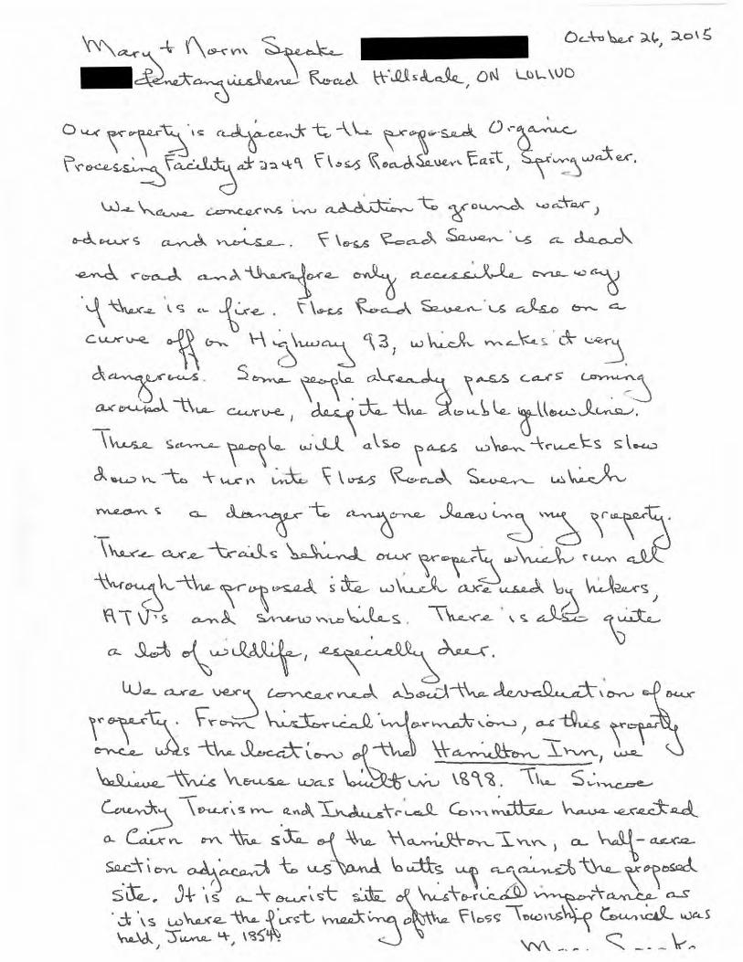
"'""~ ~ (\~V'' ~ -~0~ K...c..6 \;\-·..Q.Q.,.L&._, oN Ll}\... \VO
0«.<\\~·~ r~=,j--~--1.\.... \'1-~ o.-o.~ f .. ~,_~f~J ;>:>.~'\ t \•<? . ~~SA. ........ 'ta<t, ~":'Y".,ier.
w-L."-~ ~~ ·~ ~ "t ~o~ 1..4,)eo:\-.a.x-J
~ r.-c.uc- <; ~ ~. ~ \e-~ ~~ ~ . '-5 c .... ~

OCT 2 6 2015
COUNTY OF Sl lCQ~ CORPORA-, E SERVICES DtVISIO, i

OCT 0 6 2015
--LL.. _ . '() \ M c U' t COUNTY 0 S ' ~Tl'q\-t ioV\: t\-~WJ ' \~ ~ llO~fl CORPORATE SERVICE-.; '
/o Spri ~sVJa.+~ lowV\ sh:p /oiYI1c.oe. Gu.n+y ,
We ho.ve \ ·,vc:cJ on Flos Rd 3 East · Phe.Jpsto.,,o~~'~ .fo~ 39yr6._ We. \a\~ed ou-r chi )dv--e"' here. We ha.ue a.\wa.ys beeVl h o.p fl y I i v i n ~ OVl th i s '\. u i e. -I- a f) r i c.< .. d tu. v-a. I dead eV'Icl ro ~ J. \Ve. We.<"'e ""\ ct.-""e.d -t 0 h~v- fhe. f1 !'of osd p lo.!'\S ,,-f "-' ''o~an i c.S
p l"o cess ; Y\3 "'".\ Mo-te ... i "' s t-\ O.'V) "'J em e. ..... + l=a c i li+y" I'+ 5 3 r I os. ~d 3tl\::o.sf. Th \ s Wo<.A\cl ch~Y\.ete dLAV' ro o.d ctV\J. wou..\cl nevev kl-e. n..-e, so.. Wl e a.g a. i I"\ . ~
. Th-e..Ye. o.v-~ . 3 Fo.~Vl'\S T~o+ p\o."'+ a:ncl haV'Ve..:>t crops aVl
--th,s roa.d \nclucL~9 c>u..'r owV) . \h;s \hvo\ve-s \o.~ee +o.v-V¥1 ~'ll.d Yl.i"h e~+ t'ho + t a. ~es LAf t'he who \e roa.d 0\.+ +-i .-,e.s ~ \ co.Vl'_ t ) ma 5 i 'ne. t~e.se n u.~e. -tra.c.. to(' s etc. ()-\ e.e + i~:J Y'no. Vl y <(} ar \o a~e -\-ru e,;~ S an t'h \S h ; l \ ~ ro~d. . ~ .
We o..V"'e c..oV\Ce.\ne.d o..~ou..t ·the. 'heav'/. tro.ft•L tu.v-~'""\j ., + o~+ of ou..v- roo...d +'f'Oh-1 \twY.1l,<7. ''{ 0 u.. hov--e. Cl blihd c.ofY~e.v ·to ~~ (\or}~+ a oh41/'re h ; \I +o t~e. So~-t4-l-J . Th-e.. S'Yhe.ll of fh;$ Sife..;. r01-ls + m • (..e tha f w ov..Lol be d V"a w Vl tc:>. o ~"' . ~ o n"e.-S - .s CDV1 c:.e..IJ't'l l ~.c::f · + Th\s 6ife tJ,of i6 prorosc=.d ,s '"' ~ .. patr1;oVI sw"-W~P'f'we.: \ a.n c:L ... . *'
Ou ~ h ou. 6.-e. -r G-o.V"'a.c1e ·1 s c\ose +o V'oa.d ... ; f Y"o a.cl w Q.-> w' de..:V'f -e eo.'f'\:>o.{9e tru.c..\Cs wov.\cl' be Jv-iva·Y\~ ve"''l ~\c.s~ to u.& .
\ '=Th,·"' ~ S'Lfo( .S~ ~ PenefaV\-9u\s'heY\e. ftd S~'('~l'\~watet wo~\d eH'ec less s urroV>ol ;,..j ho"'e.s a:s "'- _process i :-'3 s, te.. .. A~·I-J.e..\1' choic~ tot'-''~" a..\:>o~t t'ha.t i.sno-+ a., \.st IS s)fe.~lo ~·6pa~aJ Ou\1"\e ~ o"\~o.wSo..aa S l \'h c...oc:. Cou..n1-y Rc\ b't, Thexe \ooKs tD \o e \ots ".f. f>o~s; b)e \ o.~J to ey. fa.""d -th-e.\1'-e., a.w"--y tv-ol"\o'\ hovne..S. .
W-e. S inc.ere\'1 hof-e. you... w\l\ choose ~ c:lif+ef'eY'-t \ocC\+,on -\ha-t would \J-e bett-e.<' su, ted . On~ tho.-f would no-f a l+ev-ou.v- road 6o d'<'a..m~4ic:.a\\y~ S1nc..e.r\~'i
Lo 'i'('o.i,.., <=.. M ofE]an
~~

OCT 0 G 2015 at-h~:..ntioh ~ S t e..~ h o. V\; e M ct c.."- · COUNTY T S - + - h. / ro~POR?JESER -0 P r- 1 J.) S VI a. -eJt I ow n S • p / S i n1 eo e. Gu n 'f y
'vJe ho.ve \ ·~ vc:cJ on Flos Rd 3 Ea.sf · Phelpsto.,,o~'~ . .CC)f"
3Cf '('5 · We. \a\~ ed ou-r ch i i cl re"' here. We have. a \wo.ys be.eVl
ha.rJOY lovih~ oV\ this 'luie.-1- a(}ric.L(I+u.lf"a.l deo.d eV'Icl roqJ. We. we.-e o. \c:u-,.,ed -to \-\eo.,. the. ~ ro p o::;ec} p la.YIS <l-f o. ''ana ani cs Pl"ocess;,..,,:j<""J Ma-te.-ia.ls Ho.voo.Jeme>'\-1- l=acoli+y" l'+b3 J=los ~d 3t'E:o..sf Th \ s wcu\ol c.h~n.Qe Ol.AV' road ctVlJ. wo<.A.\cl nevev ~-e. v\'e... So.-)")'1 e a.g a. i ~. u
. T\,ev-e. o.....--e.. . 3 Fo.v-V"'\.s tho+ plo.ht a~d hav-ve..sf crors OVl
~h,: :oad ~nclu.d.Y\9 c>u.v- owV'\ . -r~;s \nvolve-s \cc.V'ee +c:Av-m e~u' '(l .""' e~+ tho+ ·to. \-t'es LAf t'he who \e roa.d a+ ·h Yhes~ \ Co.Vt 1 t ) ma5• ne. ·t~e.se nu..<Je. -\rC\.c...to'fS e-\-c. fl'"\e..e..+ tY\~ Yno.vty caar \oet~e -\-ru u~S on t'h\s 'h ; ll ~ roCAd . . ~ .
W-e o..v-e. c..oV'\ ce.rned 0-~ou.t ·t~e. hea.v'i. +f'~f+~ c. tulf'n\hj 1n
+ o~+ o~ o~v- roa.d f''f'oh-t \twy1L;?7. ''{ 0 u. hov-e. a b\ihd cofV\e..v- to ~-e.. nor:~ + a 6h~l('re h; \I -t() +~e. oo~4it . Th-e. . .SYhf!,ll of fh;s Sife-+ rais + mt c..e fho.f wot...A-Lol be dV'a WY1 tD . o~v- ~ OYY\e.s ; .s c.onc.e..\f'V\ '"\:t · + Th i s 6 i 1 e f}, 0 f i<:i. fro f o Sc:.d 1 s 'I? 4 ... J pav--to VJ swu..1;')1P''r we.; \ a.nJ. . ~
ou.~ hou.&-e. + G-o.v-o.l~re ·, s c.\o.se. +o Y.oa.d~; .f Y'oo..d vJ o...S.. w l de.Yyl ~ fjo.lf'\:lo.(9e TV't..Lc..,\CS . wo~\cl' be.Jv-iv•'¥1~ ve'~'l. C!..\osc::. touS> .
l -;-h'" \:: 5''-tOf ~~ ~ Pe..Y\e-to.V'-9u.\s'hene. Rd Sp'('~"'jwa+eV' wt>-~\cl e~~c. \ess s u rronJ ; ",j h o "'e.s as "'- pro cess i n:J s' te. . . A nco> the"' d\0 • «< tot'h&t"\~ ~'ool.V-t t'hett i.sno-t (J~ \,6+ 's s)fe.*lo ~~$po.s~) "Ou.vn.e ~o-\io.wso..aa Si"hC-oc: Cou..V'\ty ~c\ btta The.v-e \ooks t" be. \ots of po.ss; b)e \ o.nd to e.'{. cpo..hd -th-ev-'C!. a.w~:~..y fvo..,... hol-?\e,S . ~
W-e.slnc,ere\'1 hof-e. yo...._ -w~l\ choose. ; Jifte('eY\-t \oc.C\t,on -\hat \AJou.ld ~-e. be-tt-er sui +d. Oh-e. thGt-f wouLd no-f a J-1-ev-o~v- road so d'<"a.m01-4ic.:.C\.\\y, S i nc..e.r\-e..y
L o -r t" a. i, ~ M o f8 a YJ
~~

1 • 1 • O:!.:f.5- ZOI~ -To !<tJ/r Me. C.u.-1/(j ~!lA. ".fof;J W~iP-Mo..#1.4~~~J:-:;;;:._ ___ _
~-~fL......!..f....3o<:e.~-~j?t2..l! ,'oc...._( fro;:.f.ec.ft f~-4/vi,cor
_ /{--€ o->_o ~"'-> No f _ o ~ -L I 'f £.£ F loJ" f<o/... 3 E(.)J'_ r I. X f f'.>- --~ ()._j·~ t- f/Yh.c.a -e._ Co~?c FOr -ec f 12-" // c..y
f-o .(" /a,cA. a-~d--fr~ Col.(JI....I--;7' hr.e_cf- fa~~ i~~~1r~~~---------------------------------------
_ __.2.'='-'-. -~ /0
f.' 6(.. 6-o..d.-- r ~tN:L ~ t.A/a (..c.__lol- c..as_f-yv,_l 1-/t'oh,t= f~ /.,.(_.-!' :1r~Ad~ /I- fVr ~"'?' fc~~-i:-~_/ ~ ___ 1 , ,11 1- c 0 ;-L 1 Gt-Pl.o( f' ,.l""rt..~ .e fi a/.._ z 7 #-e./ e_ ; .r o-
frllnd C.v...cl/L .. fl.~f fuet../cy-~cd_ l-o jLf oV-1-. tf. Th~e_ I/ tJt- c ~~ ;._,·/( Oh. Z.7 w_h.ic_h_ Woc..Jrl...
~ t'f h,a1d- f?or f-ruc./v ~ !}fl-f ~ fo >/'oai .m~~~~ 5; I 'f >"" J A or &b .:! EtJL.;i= i 1. v 4-.C/ c kz..c-R +a ~~r
~c:f-c..e.-~a fJ w~ 1- /~ID.I't~d..~./'--· -----=-----------------------~ • If- wo ~c)... ha.v..L- .fa_ f!.a #cauofA )..~ ct'~tC f-o ~:?Q..
Lf ta:P~o..--9_c_L_e.-'!....!l-u..r ..e. 1-6 J .~-t.d c.A...Cf c ,· o_/_

·~ . . -. . ~~·r ~ n.J- M~~----~----
1 f j ~ (6.d_o r /-U.J".&A-/- lL & -f- /}__is ,:;J G C 0/..... f J / fJ2..... /Jd_ /tL. I #= /0 ~ 4o ~t;Y I' 0 T ILV~-f:_ __ _
a..on5"ikr~d- fJo / 7'6.-L~ /'c:ty~~c__,_i= __ , _______ _
--------------------------------~~a~s~2D~t5 ____ __ ,,.(_ , • I v
CORPOAAIF C:::f.=RVli<ES DtY•SIO'

Development of Infrastructure Projects
Public Consultation Session Tuesday, October 6 Simcoe County Museum
Comment Sheet
Contact Information (optional):
Name: _~
Postal Code: LO~ 2CQ
Date: Oc..-\ . 6 Affiliation: _....J.te...J,.....oLz'-.:.;-=.d....:..e ::..l..a t...L.;,r-/....Lm:...!...l....::ed::....!,~·a..=----------
Address:---------------- Email:
Thank you for taking the time to provide us with your feedback.
Mailing address:
Solid Waste Management Infrastructure Projects County of Simcoe
c/o Ms. Stephanie Mack, P.Eng. 111 0 Highway 26, Midhurst, Ontario R C E I\/ fE
LOL 1XO
1-800-263-31 gg OCT o 6 2015 info@simcoe .ca
simcoe.ca/opf or simcoe.ca/mmf COUNTY OF S,:\llC..~"',
CORPORATE SERII 1 ~'::E '
Comments can be submitted by mail or email during this consultation process. Please note that your response wilt form part of the project record and will be forwarded to our consultant for consideration as the sites are further evaluated. All comments must be received by November 6, 2015.
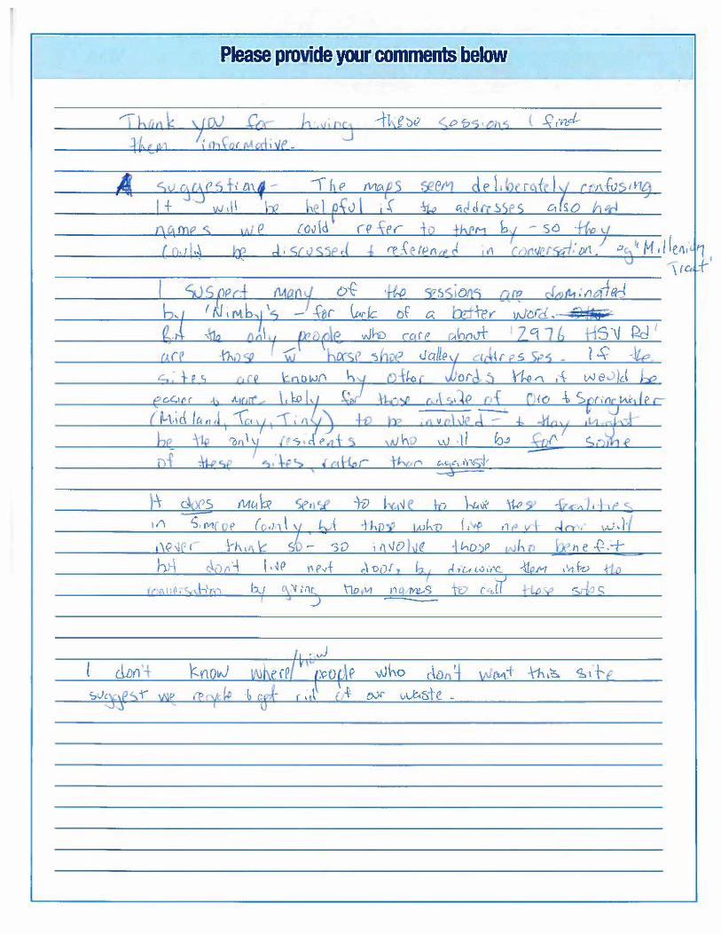
Please provide your comments below
A


Development of Infrastructure Projects
Public Consultation Session ~C !VED Thursday, October 15 Elmvale Community Arena
Comment Sheet
OCT 1 5 2015
Contact Information (optional):
oateUct \shs-: Name:
Address:
I
Affmation: -------------------
Email:-----------
de us WJth your feedback.
Mailing address:
Solid Waste Management Infrastructure Projects County of S1mcoe
c/o Ms. Stephanie Mack, PEng. 1110 Highway 26, M.dhurst. Ontario
LOL 1XO
1 ~800-263~31 99
simcoe.ca/opf or simcoe.ca/mmf
Comments can be submitted by mail or email during thls consultation process. Please note that your response will form part of the project record and will be forwarded to our consultant for consideration as the sites are further evaluated. All comments must be received by November 6, 2015.
Personal information is being collected pursuant to Section 28 of the Munic1pal Freedom of Information and Protection of Privacy Act (MFIPPA) and will be used for the purpose of gamering public 1nput
into the development of the Organics Processing Facility Project and Materials Management Fac1hty PrOJect to respond to inquiries regarding this process. Comments and input provided may form part of the prOJeCts'
documentation. Should you have questions regarding this collection, please contact Stephanie Mack, PEng., Special Projects Supervisor, 705-726-9300, County of S1mcoe.
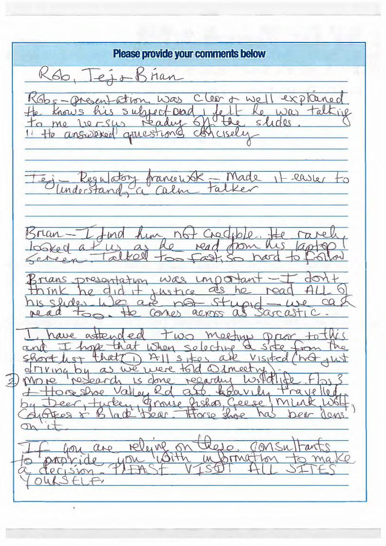
Please provide you~ comments below
Kb\o I ~ g t1CL-vL--

-----·----- --------
-==~~ ~d 1-e.~u;~ ietci ]I~ __ _ - \] l\S3 F't -,. n rA 'Q Sus+ "' , l - __ Pet ~-~~}-~ u fYl1 ~(A.YlJ..J2JC_ = \S -~ W b·\-t"b(\ 'ra-eCcuA.&e- \ l..a:lll~d --
- ~-~\t~_-~-~-o.n.rA--\'f_\~-06£ __
- -~=-~~~-~cWcL~\L-'U.::Clt.X~lAJ L\\_
. ~~~~(_~~-@l-. \1LY-La_fF_l1:JfQ_
= (WJ(_~~, -~-\h)rlb - _£bi_\_1_~NJ\ -- - ~~ \ -+-~s-~ 2ll~- _ w®lot_ ruf:G_ a.lLfJ.t\J_
- ~"'~' \~bwcl.s ~-\i_a.lo._~_l'C\.¢6 ~11I4n£
_ ~-b:L~-b~~ll~._0u,t,~
_ J
--- ·~--
--RECE-1-\!FJ~--
OCT 0 € ~ 5 ---------- ---COUNTY : '; ' ~E
CORPORATE SERV u - VIS:ON

I . . I
I :Th..c. _ \n.e&-\Q,"" -CL-tS:l<:t> ~ s ,£Qs \-- Spo~JA.)a'j4 1\s ~ ~~ \os..o.\.l·a"A becceuSRJ ~) ; l\. ~-·:£ ctmk~ 0. \:N'f\~ ~ lg9g &iJ.t>.e,;--: _- -~-
---,-1~~-~-ch bs kcQl()'\J) q, Cb~Uf-
~r \o\S 9{ i)5di& . I+ o.~_____,a'r\~a~. ___ _
:&o.c} £V\d. '(O::lal \.J.)b\:z..b ~ ~~~,el-\+~~---
~~\\R._ ±if6£:H·c. {\~~~ .bovr\c(~ :fro~
-----..1.-ll ~ ')q; s. .
--r--------Sd4c· 'th\)JQ.
-!------- --·---------~--OC.I_gj_20_15 ___ _ _
--l----------------£e~mv or .1 . , · ~ · : , . - - ·---
CORPORATE SER\o :, 0,\ ··: ON
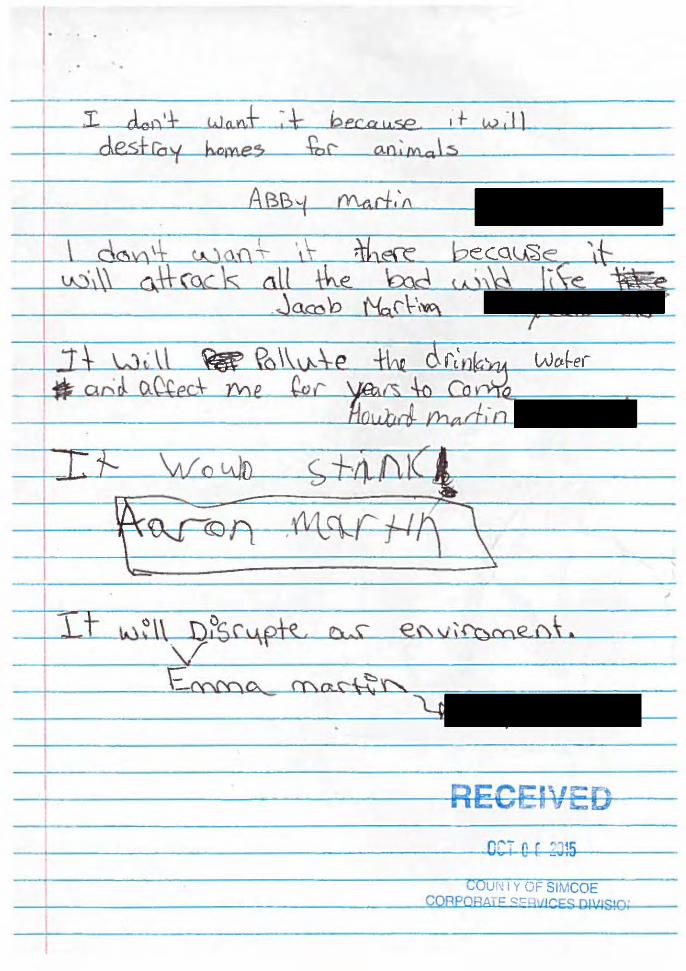
. . .
·----1'"- I dcA't Want _:_-\: ~PCP•A.se . 1f. w,·l} des+ fQ ¥ b.ome:; £, c: a.o: M Q \ s
I RECEI\'ED ~-------------------------------------------------------
tOu r'.! I Y OF SIMCOE CQRPORA• != <:!c hllr:.Es OI"IS!O~

Development of Infrastructure Projects
Public Consultation Session Tuesday, October 6 Simcoe County Museum
Contact Information (optional):
Name:
Postal Code: 1- OL .;< K 0
Address: PH£L..P5T6tJ
Comment Sheet
Date: O e.-f. b ;<.o;.5
Affi liation:-------------------
Email:-----------
Thank you for taking the time to provide us with your feedback.
Mailing address:
Solid Waste Management Infrastructure Projects County of Simcoe
c/o Ms. Stephanie Mack, P.Eng. 1110 Highway 26, Midhurst, Ontario
LOL 1XO
1-800-263-3199
info@simcoe .ca
simcoe.ca/opf or simcoe.ca/mmf
Comments can be submitted by mail or email during this consultation process. Please note that your response will form part of the project record and will be forwarded to our consultant for consideration as the sites are further evaluated. All comments must be received by November 6, 2015.
l RECEIVED OCT 0 ~ 2015
doUNTYbF SIMCOE CORPORATE SERVICES DIVISION
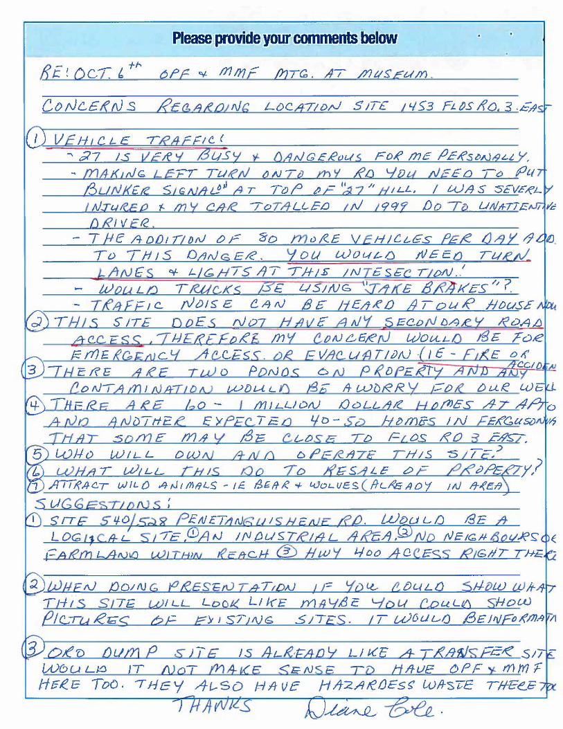
Please provide your comments below
8_ - +t-J: ! OcT. 1:. aPe ¥ mm£ frJT~. AI /J1t1SE um .
(D [J £ I-T t c L E r Rfl r F 1 c. ( '"' .;17 1s v.c;e v £Jusy t D!ltJGERvus FoR me fJER:st>N&'-L Y.
b T WIL-L I y,? 1 ATI~A-CT WILt) A-tJt/11/lLS- IE.
s UG6ESTIDNS : 1 S!7E s q.oLc:;.::t?? P £NETa rJ&u 1SHEtU.E: .&f2 . Wt:>uL.IJ SE .&
L oc;; t1c& i._ St iE /JJA fJ lfV /JLI'S7/.Cit9 ~REA ,(5) No tVEtG,t~ tioct.JfS: (
1-:: A tern L ANilJ WJ.L/:J'N tfE.t±S:..tf @) ti.W Y 4 DO A: 0 CE SS !0GIIT THE. ! -
T I-lt S _ S,/7~ W ILL Loot< Ll kE m 1J LJ..d E Lz'o 'd C,.o u L V\ sHow {JIC..Tu Rr;;;~ bE J;:Y J ST; I\JG SJTE$ . I T u)6u~IJ /3£J'li@ J('17J . .~J II
o ;e'D_ .oum P s 1TG 1s A L&t:/1-D'i Ll Kc A: Tt{h1JsFi5~ S11-
Wt>ULJtJ JT l!JoT tnA-t(e S E-1\J SE TD H /1-UE C>PF ""t tnm'F Hr;R.l3 Too. 11-fE'-/ ,-4t-SD HA-VE HIJ-2.Ate{)Es~ WltsTE TH'Ee.E-
)
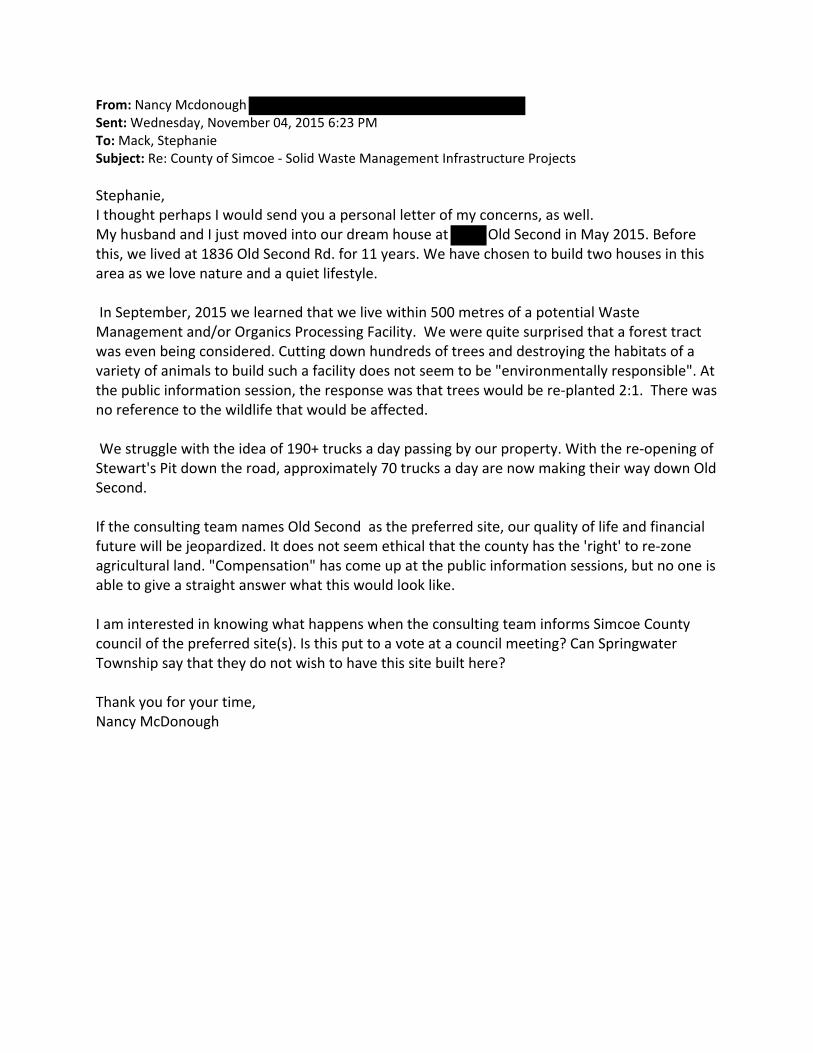
From: Nancy Mcdonough Sent: Wednesday, November 04, 2015 6:23 PM To: Mack, Stephanie Subject: Re: County of Simcoe ‐ Solid Waste Management Infrastructure Projects Stephanie, I thought perhaps I would send you a personal letter of my concerns, as well. My husband and I just moved into our dream house at Old Second in May 2015. Before this, we lived at 1836 Old Second Rd. for 11 years. We have chosen to build two houses in this area as we love nature and a quiet lifestyle. In September, 2015 we learned that we live within 500 metres of a potential Waste Management and/or Organics Processing Facility. We were quite surprised that a forest tract was even being considered. Cutting down hundreds of trees and destroying the habitats of a variety of animals to build such a facility does not seem to be "environmentally responsible". At the public information session, the response was that trees would be re‐planted 2:1. There was no reference to the wildlife that would be affected. We struggle with the idea of 190+ trucks a day passing by our property. With the re‐opening of Stewart's Pit down the road, approximately 70 trucks a day are now making their way down Old Second. If the consulting team names Old Second as the preferred site, our quality of life and financial future will be jeopardized. It does not seem ethical that the county has the 'right' to re‐zone agricultural land. "Compensation" has come up at the public information sessions, but no one is able to give a straight answer what this would look like. I am interested in knowing what happens when the consulting team informs Simcoe County council of the preferred site(s). Is this put to a vote at a council meeting? Can Springwater Township say that they do not wish to have this site built here? Thank you for your time, Nancy McDonough

From: Nancy Mcdonough Sent: Saturday, November 07, 2015 5:07 PM To: Warden <[email protected]>; Dowdall, Terry <[email protected]>; Patterson, Cal <[email protected]>; [email protected]; [email protected]; Warnock, Scott <[email protected]>; Walma, Steffen <[email protected]>; Macdonald, Sandie C. <[email protected]>; Smith, Jamie <[email protected]>; Smith, Jamie <[email protected]>; Small Brett, Mary <[email protected]>; Little, Doug <[email protected]>; Saunderson, Brian <[email protected]>; Ross, Mike <[email protected]>; O'Donnell, John <[email protected]>; Leduc, James <[email protected]>; Dollin, Lynn <[email protected]>; Keffer, Rob <[email protected]>; Hughes, Harry <[email protected]>; Cox, Judith <[email protected]>; Hough, Ralph <[email protected]>; Allen, Don <[email protected]>; Dubeau, Anita <[email protected]>; Macdonald, Sandie C. <[email protected]>; Smith, Jamie <[email protected]>; McKay, Gord A. <[email protected]> Subject: Old Second
Dear Simcoe County Council Members, I wanted to express my concerns about the potential site for a Waste Management/Organics Processing Facility on Old Second Rd. My husband and I just moved into our dream house at 1230 Old Second in May, 2015. Before this, we lived at 1836 Old Second Rd. for 11 years. We have chosen to build two houses in this area as we love nature and a quiet lifestyle. In September, 2015 we learned that we live within 500 metres of a potential Waste Management and/or Organics Processing Facility. We were quite surprised that a forest tract was even being considered. Cutting down hundreds of trees and destroying the habitats of a variety of animals to build such a facility does not seem to be "environmentally responsible". At the public information session, the response was that trees would be re‐planted 2:1. There was no reference to the wildlife that would be affected. We struggle with the idea of 190+ trucks a day passing by our property. With the re‐opening of Stewart's Pit down the road, approximately 70 trucks a day are already making their way down Old Second. If the consulting team names Old Second as the preferred site, our quality of life and financial future will be jeopardized. It does not seem ethical that the county has the 'right' to re‐zone agricultural land. "Compensation" has come up at the public information sessions, but no one is able to give a straight answer what this would look like. I am interested in knowing what happens when the consulting team informs Simcoe County Council of the preferred site(s). Is this put to a vote at a council meeting? Can Springwater Township say that they do not wish to have this site built here? Please help us to protect the Craighurst/Millenium Forest tracts. Sincerely, Nancy and Tom McDonough

From: Geoff House Sent: Thursday, October 08, 2015 8:35 AM To: Mack, Stephanie Subject: Proposed Processing Plant - Flos Road Three East Hello Stephanie, Thank you for your time last week. It was a pleasure to meet you and Rob at your office. I spoke to a few of my neighbours yesterday regarding the meeting on October 6th. It sounds like their was a lot of good discussion. As you requested last week, below are my numerous concerns regarding the proposed processing facility on Flos Road Three East. 1. Hwy 27 going north & south bound is already a very busy traffic artery at any time between 6 AM and 9 PM. Particularly during the summer months. School buses, communters, and tourists fill this road year round. No extra traffic is needed especially by a fleet of garbabe trucks. 2. Currently, the traffic is moving far too fast on Hwy 27 going north bound to Elmvale (coming down the hill) and making either a left or a right turn onto Flos Road Three when there is traffic behind you is already a real issue. On this stretch of the road the average cruising speed is between 80 km’s to 110 km’s per hour (I know this because I drive it every day). Quite frequently, there are OPP set up at Flos Road Three catching people for speeding. Mostly going noth bound. Any additional garbage trucks would make this turn that much more dangerous. 3. Already, most of the residents in Apto Glen Estates turn East off of Hwy 27 at Rainbow Valley Road to access our community (through Morin St) beacause making the turn at Flos Road Three is so dangerous. Especially the left hand turns. 4. Would the County have to consider putting in a set of traffic lights to aid the trucks making these dangerous turns? if so, any new traffic lights at this intersection would also be very dangerous especially in the winter when there is little visability as this part of Hwy 27 is very poorly lit. 5. From a noise perspective, all of the residents in Apto Glen Estates are very concerned about the noise from the transmissions all of these proposed garbage trucks pulling off of and onto Flos Road Three. They will make a lot of noise gearing up to get up the Hill (going south) in the mornings to go out on their runs. Also, on their way back to the plant, going north bound, they will make a lot of noise gearing down coming back down the hill to turn right onto Flos Road Three East. My wife and I moved to Springwater, Apto Glen Estates, 2 years ago because we found it to be a beautiful and peaceful area to raise our family. The main reason we moved to Springwater was to escape the ‘busy’ roads in Barrie and have privacy. We take great pride in living here and we strongly believe that putting the proposed processing facilities in our neighbourhood would be a mistake. Not only will it add to already existing dangerous traffic issues on Hwy 27, it will also create terrible noise pollution and potentially hurt our property values. Our property taxes went up nearly 30% last year and were approximately $6,800. When we first moved to Apto Glen Estates there were approximately 30 families living here. There are now 45. Within the next year or 2 it should be around 60. Our neighbourhood, like in Fergusonvale, is filled with new estate homes occupied by professionals and self employed individuals commuting to work in Barrie, Orillia and Collingwood. In just under 2 years we have seen a remarkable change in this

area for the better. By putting the proposed processing plant on Flos Road Three you will only be hurting and helping to undue what the County of Simcoe wants - communities to grow and flourish. For the Greater Good? For all of these above stated reasons, please do not put the proposed processing facilities onto Flos Road Three East. Best regards. Geoff House
Loftus Rd Phelpston, ON L0L 2K0

From: sharon rhines Sent: October 8, 2015 9:01 AM To: Cc: Customer Service Subject: Proposed OPF/MMF at 1473/1273 Old Second S. Good Morning . I am writing to you today with concerns regarding the proposed site for an OPF/MMF facility at the above noted address. We attended an information session on this Tuesday night, Oct. 6th, at the Simcoe County Museum. We received notification within the last couple weeks that the property directly behind our houses was on a short list for one of these sites, and the only reason we received this in writing was due to it being within 500 meters of our residence. The property in question was replanted within the past couple years with hardwood trees being reintroduced (oaks/hemlock/red pines) by the Hunters and Anglers clubs. Also, there are two creeks running through that property that fall under the NVCA protection. This property has no road access, no services (water/gas/hydro/sewage) but is owned by the County of Simcoe as forest lands. All of us (residents of Old Second S) are on private wells, septic systems and are more than a little concerned with the possibility of one of these facilities being within 500 meters of our property. The chance of contamination of the aquifer, the odour, the traffic (they estimate anywhere between 90 - 190 vehicles PER DAY) is frightening. Currently our drinking wells provide us with clean, cold, fresh water - what's to happen with that? Our water table is not very deep - around 60 feet down in most cases, so very close to the surface, and extremely susceptible to contamination from any type of industrial process. The session last night was not helpful. There seems to be no concrete plan in place for the protection of the aquifer, the protection against noise and odour. The panel just kept reiterating about the "buffer zone", like that will stop at the property line? Really? We cannot believe that this is being considered within meters of a residential community that rely on the the aquifers for our drinking water. It was explained that once they make a choice on their "preferred site" (of which there are 7 on the short list) then there will be applications made for rezoning (currently all are of agricultural/residential zoning), applications submitted to the MOE and the NVCA for regulations regarding the site in question. There is a site currently on the short list, properly zoned, and not near any residential areas - should be a no brainer.

We did not buy and build our homes in the centre of a forested area to have a behemoth of a processing facility in our back yards, not when there are many other sites, already properly zoned, and nowhere near any residential areas. All of the shortlisted sites appear to be either behind, in front or beside residential areas. Not to mention what will happen to the current property values. Our properties will be worth half of what they currently are. We are hoping that this will not be allowed this to happen. Sharon Rhines/Mark Cox
Old Second South Barrie Ontario
cc: MOE, County of Simcoe, Twp. of Springwater

From: Caroline Bowman Sent: October 9, 2015 9:34 AM To: Customer Service Subject: Agencies Pricing facility and Materials management Facility - County of Simcoe Line 5 North Oro-Medonte - L0L 2E0 Caroline and Mike Bowman - Line 5 North Oro-Medonte L0L 2E0 Caroline and Mike attended the afternoon public meeting at the Township office on Thursday Oct 8th 2015 We appreciate that this facility is necessary and thank you for your consideration in sharing the plans you have at this time - But - Comments: - The Area you have shortlisted in the Edgar Oro Medonte area is not an area for an industrial facility - As was noted at the meeting - this area is a highly regarded tourist area throughout the whole year - There is also a Group Home located on the 5th approx 1/2 mile south of the Old Barrie Road where physically and mentally challenged adults daily walk alone this road - The Old Barrie Road is not structurally designed to accommodate the number and the weight of the transport vehicles you have indicated will be on this road - The 5th line is narrow and very hilly and to widen and cut down these hill will be a great expense and in doing so destroy one of the picturest roads in our area as well as destroy our own property and the properties of our neighbours. - There are many many roads that will be effected and this area is NOT designed for large transports on a continuous basis - We are in a snow belt area, the weather changes considerably north of the 3rd line - with more snow, more wind and generally unsuitable driving conditions for large transport vehicals - The Old Barrie Road is considered a very challenging road during the winter months; as well; many tourist use this road during the summer months which already is adding extra stress to the road NO ONE LIVING WITHIN ANY OF THE SITE OPTIONS WANTS THIS IN THEIR BACK YARD WE - LIKE OTHERS - DO NOT UNDERSTAND WHY YOU WOULD EVEN CONSIDER RUINING ANY OF OUR FORESTS AND OUR COUNTRY ROADS FOR AN INDUSTRIAL FACILITY THIS FACILITY NEEDS TO BE IN AN INDUSTRIAL AREA WITHIN A CITY -
WE WOULD LIKE TO TAKE THIS OPPORTUNITY TO RECOMMEND THAT YOU MEET WITH YOUR COMMITTEE AND DISCUSS ALTERNATIVE AREAS. Sincerely Mike and Caroline
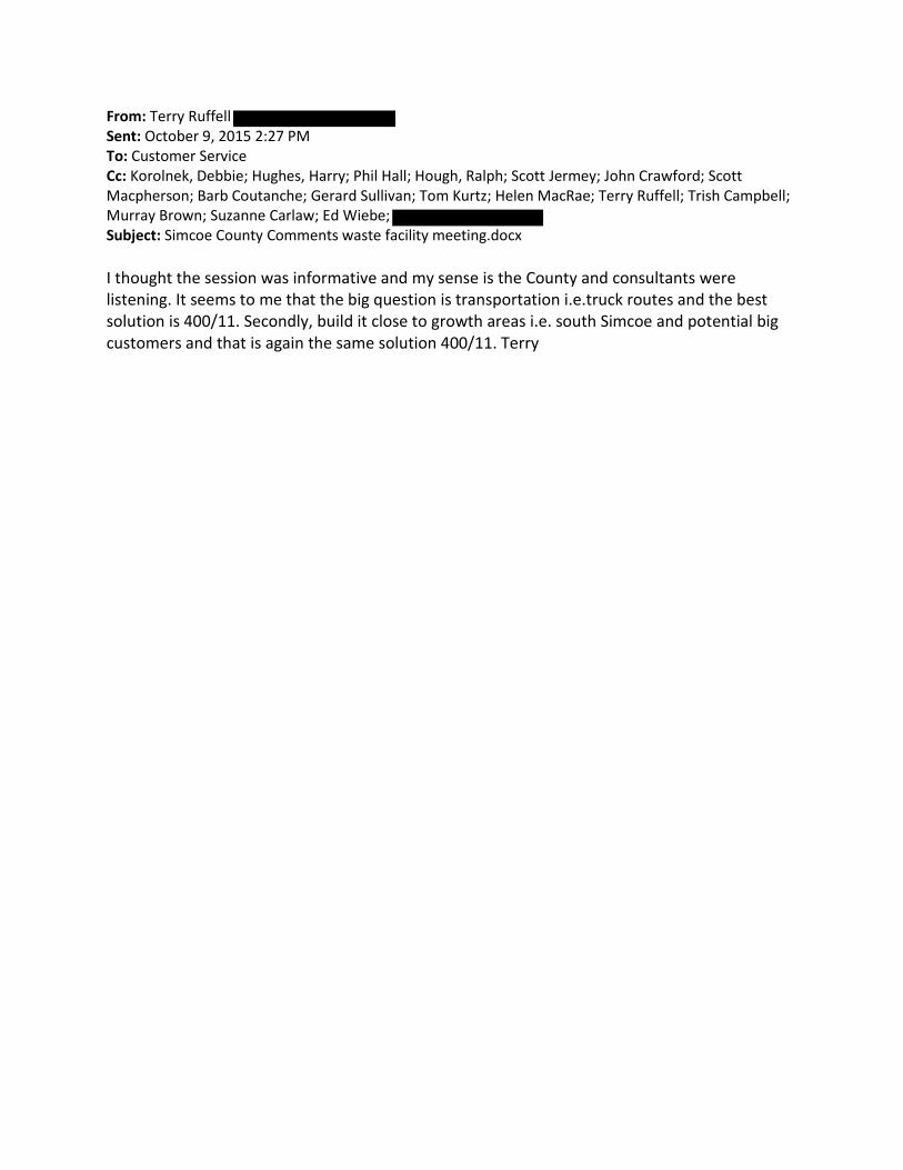
From: Terry Ruffell Sent: October 9, 2015 2:27 PM To: Customer Service Cc: Korolnek, Debbie; Hughes, Harry; Phil Hall; Hough, Ralph; Scott Jermey; John Crawford; Scott Macpherson; Barb Coutanche; Gerard Sullivan; Tom Kurtz; Helen MacRae; Terry Ruffell; Trish Campbell; Murray Brown; Suzanne Carlaw; Ed Wiebe; Subject: Simcoe County Comments waste facility meeting.docx I thought the session was informative and my sense is the County and consultants were listening. It seems to me that the big question is transportation i.e.truck routes and the best solution is 400/11. Secondly, build it close to growth areas i.e. south Simcoe and potential big customers and that is again the same solution 400/11. Terry

Simcoe County Comments
Presentation Oct 8/15
Agreement:
Deal with our own waste much as possible
Agree with cost savings approach
Concerns and Observations:
Proposed facility at Horseshoe Valley Rd[HVR] ,east of 400 would likely
result in more truck traffic on HVR. I presume truck traffic now heading to
Barrie would be re-directed. Please clarify.
The Horseshoe Valley settlement is the largest residential community in
Oro-Medonte. As a result there are school bus stops and # of residential
streets along HVR in the Valley. More truck traffic thru a settlement area =
less safe
Winter months make HVR risky and sometimes unsafe due to weather
Part of the process is Social or residential and this should be a major
location consideration
Oro-Medonte is growing tourist area, especially cycling so Hardwood Hills
should be protected
Simcoe County growth is in the south part of the county
Without question, the best transportation access to a new facility is 400
and 11 site
Recommendations:
Use highways for truck traffic not county rds or township rds
Locate facility as close as possible to growth areas i.e. Bradford and
Innisville
Locate close to potential large customers i.e. Barrie and Orillia
Put the” industrial” waste facility i.e waste management facility in an
industrial area site near 400/11
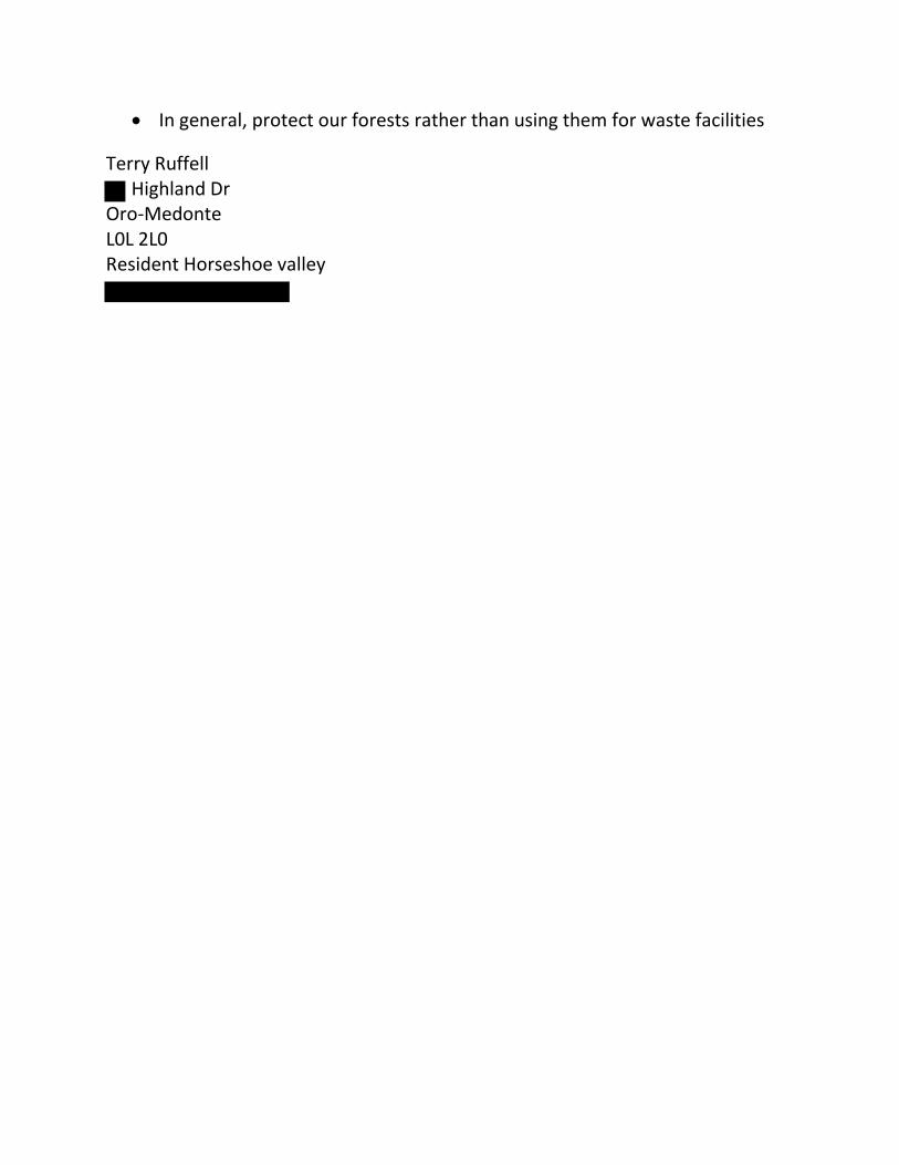
In general, protect our forests rather than using them for waste facilities
Terry Ruffell Highland Dr
Oro-Medonte L0L 2L0 Resident Horseshoe valley
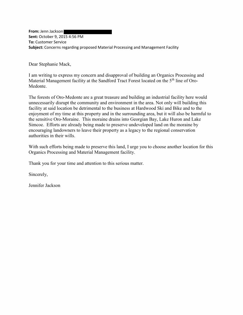
From: Jenn Jackson Sent: October 9, 2015 4:56 PM To: Customer Service Subject: Concerns regarding proposed Material Processing and Management Facility
Dear Stephanie Mack,
I am writing to express my concern and disapproval of building an Organics Processing and Material Management facility at the Sandford Tract Forest located on the 5th line of Oro-Medonte.
The forests of Oro-Medonte are a great treasure and building an industrial facility here would unnecessarily disrupt the community and environment in the area. Not only will building this facility at said location be detrimental to the business at Hardwood Ski and Bike and to the enjoyment of my time at this property and in the surrounding area, but it will also be harmful to the sensitive Oro-Moraine. This moraine drains into Georgian Bay, Lake Huron and Lake Simcoe. Efforts are already being made to preserve undeveloped land on the moraine by encouraging landowners to leave their property as a legacy to the regional conservation authorities in their wills.
With such efforts being made to preserve this land, I urge you to choose another location for this Organics Processing and Material Management facility.
Thank you for your time and attention to this serious matter.
Sincerely,
Jennifer Jackson

From: Tina Petrilli Sent: October 9, 2015 5:01 PM To: Customer Service Subject: Organics Processing and Material Management facility Dear Stephanie Mack, I am writing to express my concern and disapproval of building an Organics Processing and Material Management facility at the Sandford Tract Forest located on the 5th line of Oro-Medonte. Not only will building this facility at said location be detrimental to the business at Hardwood Ski and Bike and to the enjoyment of my time at this property, it will also be harmful to the sensitive Oro-Moraine. This moraine drains into Georgian Bay, Lake Huron and Lake Simcoe. Efforts are already being made to preserve undeveloped land on the moraine by encouraging landowners to leave their property as a legacy to the regional conservation authorities in their wills. With such efforts being made to preserve this land it only makes sense to choose another location for this Organics Processing and Material Management facility. Thank you for your time and attention to this serious matter. Sincerely, Tina Petrilli Concerned Citizen
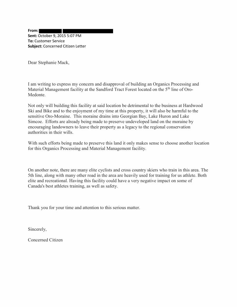
From: Sent: October 9, 2015 5:07 PM To: Customer Service Subject: Concerned Citizen Letter
Dear Stephanie Mack,
I am writing to express my concern and disapproval of building an Organics Processing and Material Management facility at the Sandford Tract Forest located on the 5th line of Oro-Medonte.
Not only will building this facility at said location be detrimental to the business at Hardwood Ski and Bike and to the enjoyment of my time at this property, it will also be harmful to the sensitive Oro-Moraine. This moraine drains into Georgian Bay, Lake Huron and Lake Simcoe. Efforts are already being made to preserve undeveloped land on the moraine by encouraging landowners to leave their property as a legacy to the regional conservation authorities in their wills.
With such efforts being made to preserve this land it only makes sense to choose another location for this Organics Processing and Material Management facility.
On another note, there are many elite cyclists and cross country skiers who train in this area. The 5th line, along with many other road in the area are heavily used for training for us athlete. Both elite and recreational. Having this facility could have a very negative impact on some of Canada's best athletes training, as well as safety.
Thank you for your time and attention to this serious matter.
Sincerely,
Concerned Citizen
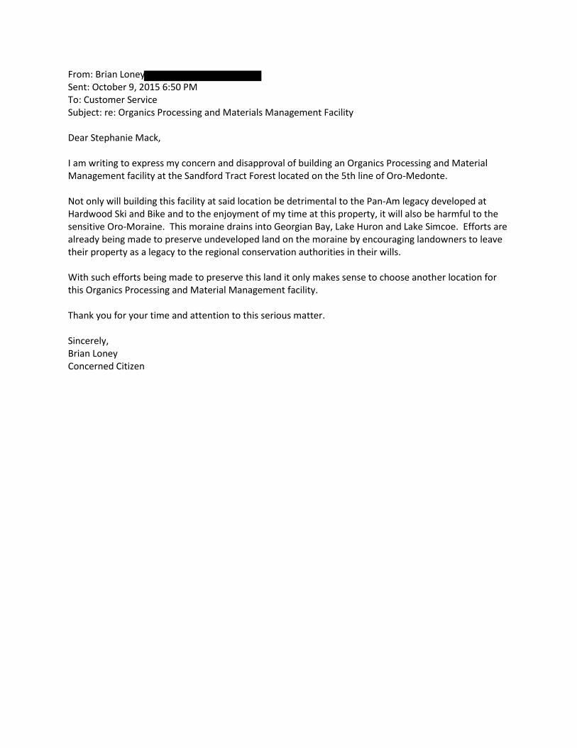
From: Brian Loney Sent: October 9, 2015 6:50 PM To: Customer Service Subject: re: Organics Processing and Materials Management Facility Dear Stephanie Mack, I am writing to express my concern and disapproval of building an Organics Processing and Material Management facility at the Sandford Tract Forest located on the 5th line of Oro-Medonte. Not only will building this facility at said location be detrimental to the Pan-Am legacy developed at Hardwood Ski and Bike and to the enjoyment of my time at this property, it will also be harmful to the sensitive Oro-Moraine. This moraine drains into Georgian Bay, Lake Huron and Lake Simcoe. Efforts are already being made to preserve undeveloped land on the moraine by encouraging landowners to leave their property as a legacy to the regional conservation authorities in their wills. With such efforts being made to preserve this land it only makes sense to choose another location for this Organics Processing and Material Management facility. Thank you for your time and attention to this serious matter. Sincerely, Brian Loney Concerned Citizen

From: Sent: October 9, 2015 7:01 PM To: Customer Service Subject: concern and disapproval of building an Organics Processing and Material Management facility at the Sandford Tract Forest
Dear Stephanie Mack,
I am writing to express my concern and disapproval of building an Organics Processing and
Material Management facility at the Sandford Tract Forest located on the 5th line of Oro-
Medonte.
Not only will building this facility at said location be detrimental to the business at Hardwood
Ski and Bike and to the enjoyment of my time at this property, it will also be harmful to the
sensitive Oro-Moraine. This moraine drains into Georgian Bay, Lake Huron and Lake
Simcoe. Efforts are already being made to preserve undeveloped land on the moraine
by encouraging landowners to leave their property as a legacy to the regional conservation
authorities in their wills.
With such efforts being made to preserve this land it only makes sense to choose another
location for this Organics Processing and Material Management facility.
Thank you for your time and attention to this serious matter.
Sincerely,
Max Noger

From: Richard Fenton Sent: October 9, 2015 7:57 PM To: Customer Service Subject: Organics Processing and Material Management facility
Dear Stephanie Mack,
We are writing to express our concerns and disapproval of building an Organics Processing and
Material Management facility at the Sandford Tract Forest located on the 5th line of Oro-
Medonte.
Not only will building this facility at said location be detrimental to the business at Hardwood
Ski and Bike and to the enjoyment of our family time at this property, it will also be harmful to
the sensitive Oro-Moraine. This moraine drains into Georgian Bay, Lake Huron and Lake
Simcoe. Efforts are already being made to preserve undeveloped land on the moraine
by encouraging landowners to leave their property as a legacy to the regional conservation
authorities in their wills.
With such efforts being made to preserve this land it only makes sense to choose another
location for this Organics Processing and Material Management facility.
Thank you for your time and attention to this serious matter.
Sincerely, Richard and Judi Fenton Members of Hardwood Ski and Bike
Willow Bay Drive Midhurst, Ontario Sent from my iPad

From: Liz Grootenboer Sent: October 9, 2015 8:41 PM To: Customer Service Subject: Please don't put this facility near hardwood
W Old Barrie Road RR 1 Oro-Medonte, ON L0L 2E0 Dear Friends of Hardwood Ski and Bike, We would like to bring to your attention an important issue that will directly affect our business. Simcoe County is planning to build a new Organics Processing and Materials Management Facility within the boundaries of Simcoe County. One of the 5 shortlisted sites for this future development is the Sanford
Tract Forest located on the 5th Line of Oro-Medonte. This proposed land is part of the sensitive Oro Moraine, and borders Hardwood Ski and Bike’s property and trails. If the Sandford Tract Forest location
is chosen, it could have a very detrimental impact on our business and on the environment. The 5th line of Oro-Medonte would become a heavy trucking road with an estimated 210 Heavy Trucks per day. The increase in noise and smell irritants could be damaging to the customer experience. Not only are we concerned about our business but also the severe impact that this will have on the environment. The Oro-Moraine drains into Georgian Bay, Lake Huron and Lake Simcoe. This land needs to be preserved and we want to ensure that happens. The more of us that object to this proposed location the less likely it will be selected as the new home of an organics processing and materials management facility. Please see the attached map that highlights the proposed location in relation to Hardwood Ski and Bike. Please click these links for more information: http://www.simcoe.ca/opf, http://www.simcoe.ca/mmf Attached is a letter that we have drafted to make this process quick and easy for you. All you have to do is download this letter or cut and paste and submit to the email or mailing address below. If you prefer to write your own that would be great as well. We encourage you to express your concerns. Please submit your letters by November 6th. Mailing Address: Solid Waste Management Infrastructure Projects County of Simcoe c/o Stephanie Mack, P.Eng. 1110 Highway 26, Midhurst, Ontario L0L 1X0 1-800-263-3199 Email: [email protected] Sent from my iPhone

From: Grant Sent: October 9, 2015 9:39 PM To: Customer Service Subject:
Dear Stephanie Mack,
I am writing to express my concern and disapproval of building an Organics Processing and
Material Management facility at the Sandford Tract Forest located on the 5th line of Oro-
Medonte.
Not only will building this facility at said location be detrimental to the business at Hardwood
Ski and Bike and to the enjoyment of my time at this property, it will also be harmful to the
sensitive Oro-Moraine. This moraine drains into Georgian Bay, Lake Huron and Lake
Simcoe. Efforts are already being made to preserve undeveloped land on the moraine
by encouraging landowners to leave their property as a legacy to the regional conservation
authorities in their wills.
With such efforts being made to preserve this land it only makes sense to choose another
location for this Organics Processing and Material Management facility.
Thank you for your time and attention to this serious matter.
Sincerely,
Concerned Citizen

From: Matt Zammit Sent: October 9, 2015 11:18 PM To: Customer Service Subject: Organics Processing and Material Management Facility
Dear Stephanie Mack,
I am writing to express my concern and disapproval of building an Organics Processing and Material Management facility at the Sandford Tract Forest located on the 5th line of Oro-Medonte.
Not only will building this facility at said location be detrimental to the business at Hardwood Ski and Bike and to the enjoyment of my time at this property, it will also be harmful to the sensitive Oro-Moraine. This moraine drains into Georgian Bay, Lake Huron and Lake Simcoe. Efforts are already being made to preserve undeveloped land on the moraine by encouraging landowners to leave their property as a legacy to the regional conservation authorities in their wills.
With such efforts being made to preserve this land it only makes sense to choose another location for this Organics Processing and Material Management facility.
Thank you for your time and attention to this serious matter.
Sincerely,
Matt Zammit

From: Mike Fogt Sent: October 9, 2015 11:45 PM To: Customer Service Subject: Proposed organics processing site Dear Stephanie Mack,
I am writing to express my concern and disapproval of building an Organics Processing and
Material Management facility at the Sandford Tract Forest located on the 5th line of Oro-
Medonte.
Not only will building this facility at said location be detrimental to the business at Hardwood
Ski and Bike and to the enjoyment of my time at this property, it will also be harmful to the
sensitive Oro-Moraine. This moraine drains into Georgian Bay, Lake Huron and Lake Simcoe.
Efforts are already being made to preserve undeveloped land on the moraine by encouraging
landowners to leave their property as a legacy to the regional conservation authorities in their
wills.
With such efforts being made to preserve this land it only makes sense to choose another
location for this Organics Processing and Material Management facility.
Thank you for your time and attention to this serious matter.
Sincerely,
Mike Fogt

From: Christi Devenyi Sent: October 10, 2015 8:28 AM To: Customer Service Subject: Proposed waste management site Dear Stephanie Mack, I am writing to express my concern and disapproval of building an Organics Processing and Material Management facility at the Sandford Tract Forest located on the 5th line of Oro-Medonte. My husband and I have been biking at Hardwood since we were children, and we plan to bring our kids there one day. It really is a world class set of trails, and it would be so devastating to so many people if anything were to ruin that. Not only will building this facility at said location be detrimental to the business at Hardwood Ski and Bike and to the enjoyment of my time at this property, it will also be harmful to the sensitive Oro-Moraine. This moraine drains into Georgian Bay, Lake Huron and Lake Simcoe. Efforts are already being made to preserve undeveloped land on the moraine by encouraging landowners to leave their property as a legacy to the regional conservation authorities in their wills. With such efforts being made to preserve this land it only makes sense to choose another location for this Organics Processing and Material Management facility. Thank you for your time and attention to this serious matter. Sincerely, Christi Devenyi
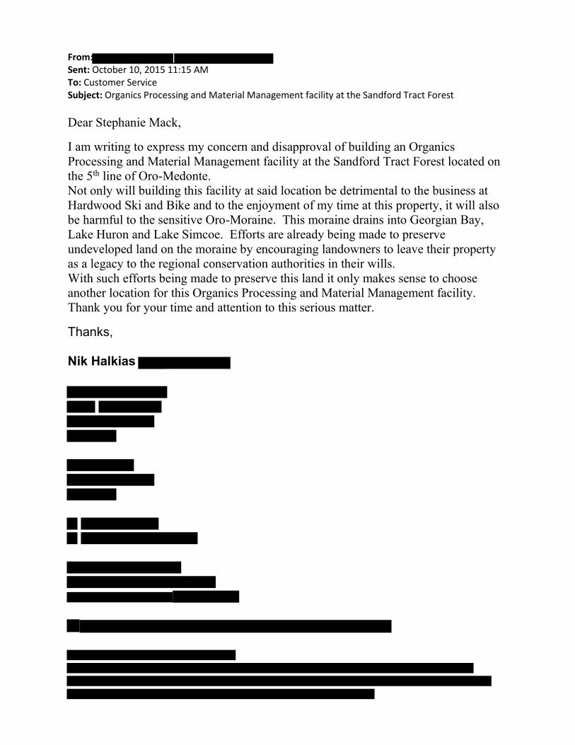
From: Sent: October 10, 2015 11:15 AM To: Customer Service Subject: Organics Processing and Material Management facility at the Sandford Tract Forest
Dear Stephanie Mack,
I am writing to express my concern and disapproval of building an Organics
Processing and Material Management facility at the Sandford Tract Forest located on
the 5th line of Oro-Medonte.
Not only will building this facility at said location be detrimental to the business at
Hardwood Ski and Bike and to the enjoyment of my time at this property, it will also
be harmful to the sensitive Oro-Moraine. This moraine drains into Georgian Bay,
Lake Huron and Lake Simcoe. Efforts are already being made to preserve
undeveloped land on the moraine by encouraging landowners to leave their property
as a legacy to the regional conservation authorities in their wills.
With such efforts being made to preserve this land it only makes sense to choose
another location for this Organics Processing and Material Management facility.
Thank you for your time and attention to this serious matter.
Thanks, Nik Halkias

From: Annette deVries-Belcourt Sent: October 10, 2015 4:16 PM To: Customer Service Subject: Organics facility Dear Stephanie Mack, I am writing to express my concern and disapproval of building an Organics Processing and Material Management facility at the Sandford Tract Forest located on the 5th line of Oro-Medonte. Not only will building this facility at said location be detrimental to the business at Hardwood Ski and Bike and to the enjoyment of my time and my childrens time at this property, it will also be harmful to the sensitive Oro-Moraine. This moraine drains into Georgian Bay, Lake Huron and Lake Simcoe. Efforts are already being made to preserve undeveloped land on the moraine by encouraging landowners to leave their property as a legacy to the regional conservation authorities in their wills. With such efforts being made to preserve this land it only makes sense to choose another location for this Organics Processing and Material Management facility. Thank you for your time and attention to this serious matter. Sincerely, Annette and Ellamarie Belcourt

From: Thom Antonio Sent: October 10, 2015 4:21 PM To: Customer Service Subject: Fwd: Simcoe County OP and MMF Site Selection
Dear Stephanie Mack,
I am writing to express my concern and disapproval of building an Organics Processing and Material Management facility at the Sandford Tract Forest located on the 5th line of Oro-Medonte.
Not only will building this facility at said location be detrimental to the business at Hardwood Ski and Bike and to the enjoyment of my time at this property, it will also be harmful to the sensitive Oro-Moraine. This moraine drains into Georgian Bay, Lake Huron and Lake Simcoe. Efforts are already being made to preserve undeveloped land on the moraine by encouraging landowners to leave their property as a legacy to the regional conservation authorities in their wills.
With such efforts being made to preserve this land it only makes sense to choose another location for this Organics Processing and Material Management facility.
Thank you for your time and attention to this serious matter.
Sincerely,
Thom Antonio
Concerned Citizen
Thom Antonio
St. Andrews Gardens, Toronto, Ontario M4W2E1 | Confidentiality Notice: This e-mail transmission is intended only for the person(s) to whom it is addressed. It may contain confidential or legally privileged information, and the sender does not waive any related rights and obligations. Any unauthorized disclosure, copying, distribution or taking of action on its contents is strictly prohibited. If you have received this message in error, please notify the sender immediately by return e-mail and delete this message without reading, copying or forwarding it to anyone. Please consider the environment before printing this email.
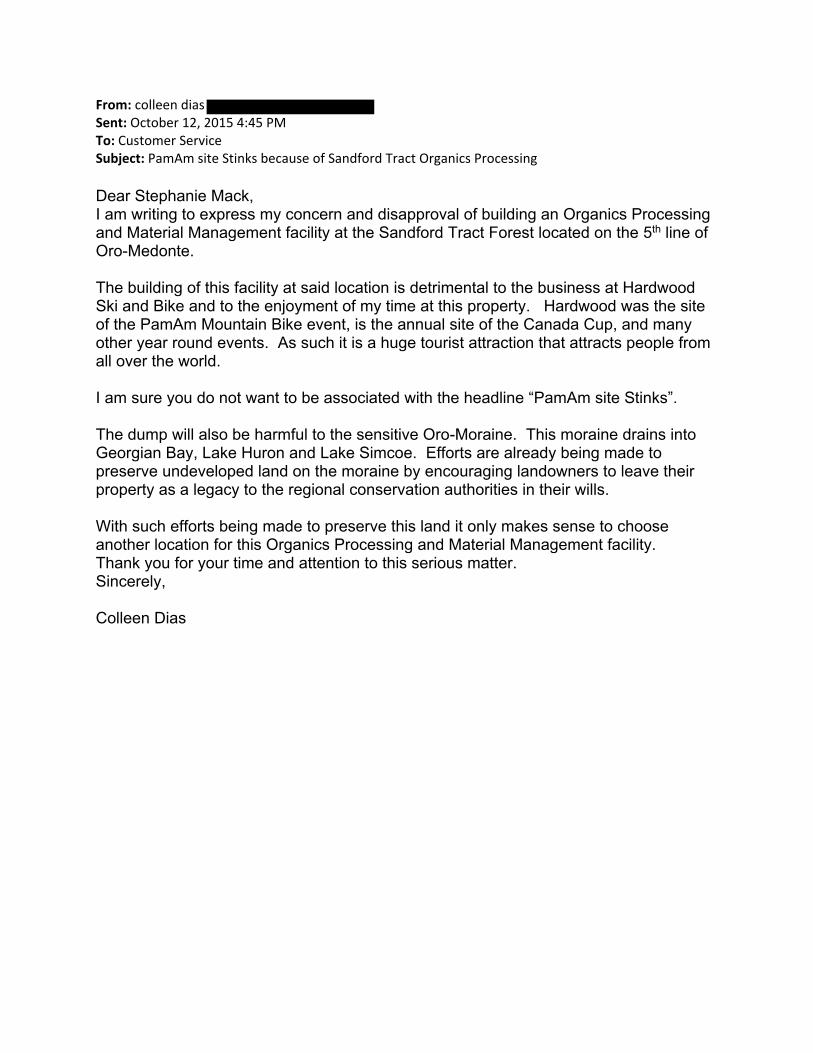
From: colleen dias Sent: October 12, 2015 4:45 PM To: Customer Service Subject: PamAm site Stinks because of Sandford Tract Organics Processing Dear Stephanie Mack, I am writing to express my concern and disapproval of building an Organics Processing and Material Management facility at the Sandford Tract Forest located on the 5th line of Oro-Medonte. The building of this facility at said location is detrimental to the business at Hardwood Ski and Bike and to the enjoyment of my time at this property. Hardwood was the site of the PamAm Mountain Bike event, is the annual site of the Canada Cup, and many other year round events. As such it is a huge tourist attraction that attracts people from all over the world. I am sure you do not want to be associated with the headline “PamAm site Stinks”. The dump will also be harmful to the sensitive Oro-Moraine. This moraine drains into Georgian Bay, Lake Huron and Lake Simcoe. Efforts are already being made to preserve undeveloped land on the moraine by encouraging landowners to leave their property as a legacy to the regional conservation authorities in their wills. With such efforts being made to preserve this land it only makes sense to choose another location for this Organics Processing and Material Management facility. Thank you for your time and attention to this serious matter. Sincerely, Colleen Dias

From: Denis Dias Sent: October 12, 2015 4:48 PM To: Customer Service Subject: PamAM site Stinks because of Sandford Tract Organics Processing Dear Stephanie Mack, I am writing to express my concern and disapproval of building an Organics Processing and Material Management facility at the Sandford Tract Forest located on the 5th line of Oro-Medonte. The building of this facility at said location is detrimental to the business at Hardwood Ski and Bike and to the enjoyment of my time at this property. Hardwood was the site of the PamAm Mountain Bike event, is the annual site of the Canada Cup, and many other year round events. As such it is a huge tourist attraction that attracts people from all over the world. I am sure you do not want to be associated with the headline “PamAm site Stinks”. The dump will also be harmful to the sensitive Oro-Moraine. This moraine drains into Georgian Bay, Lake Huron and Lake Simcoe. Efforts are already being made to preserve undeveloped land on the moraine by encouraging landowners to leave their property as a legacy to the regional conservation authorities in their wills. With such efforts being made to preserve this land it only makes sense to choose another location for this Organics Processing and Material Management facility. Thank you for your time and attention to this serious matter. Sincerely, Denis Dias

From: Evgeny Nuger Sent: October 13, 2015 12:36 PM To: Customer Service Subject: Concern and Disapproval of building an Organics Processing and Material Management facility at the Sandford Tract Forest
Dear Stephanie Mack, I am writing to express my concern and disapproval of building an Organics Processing and Material Management facility at the Sandford Tract Forest located on the 5th line of Oro-Medonte. Not only will building this facility at said location be detrimental to the business at Hardwood Ski and Bike and to the enjoyment of my time at this property, it will also be harmful to the sensitive Oro-Moraine. This moraine drains into Georgian Bay, Lake Huron and Lake Simcoe. Efforts are already being made to preserve undeveloped land on the moraine by encouraging landowners to leave their property as a legacy to the regional conservation authorities in their wills. With such efforts being made to preserve this land it only makes sense to choose another location for this Organics Processing and Material Management facility. Thank you for your time and attention to this serious matter. Sincerely, Concerned citizen EN

Sally Sedore .. Flos Rd 3 East Phelpston, ON LOL2KO
September 23, 2015
Rob McCullough County of Simcoe Solid Waste Management 1110 Hwy26 Midhurstt ON LOL 1XO
To whom it may concern:
tEC IVED OCT 13 2015
<..OUNTY OF SIMCOE CORPORATE SERVICES OIVIS:ON
RE: PROPOSED ORGANICS PROCESSING FACILITY ON 1453 FLOS RD 3 E.
I am a senior living on a quiet road with tranquility. I live on the south side of Flos Rd 3 E and farm 400 acres on Flos Rd 4 E. Needless to say, this proposed facility will have a huge impact on my life.
1 am addressing you re: my objection to this Organics Processing Facility on 1453 Flos Rd3 E.
In my opinion, there are more appropriate sites for this facility.
Flos Rd 3 E enters from Highway 27. At this intersection from the south is a steep hill on a curve. Entering Flos Rd 3 E from the north is also on a blind curve, which at times is extremely dangerous. Construction of a truck lane or any kind of entry would be dangerous.
Why would anyone consider destroying an existing mature forest? There is also a wetlands designation where the pond feeds into Matheson Creek. It is a fact that the water will be polluted from this organic facility.
Upon walking this site, you will see this site is not appropriate.
It goes without saying; the smell, the noise, the traffic and the overall disruption to Flos Rd 3 E will be horrendous.
Please support us in finding a more appropriate site for this facility.
Yours Truly,
Sally Sedore

James Sedore .. FlosRd4E Phelpston, ON LOL2KO
September 23, 2015
To whom it may concern:
RECE VED OCT 1 3 2015
\..-OUNTY OF SIMCOE CORPORATE SERVICES DIVISION
RE: PROPOSED ORGANICS PROCESSING FACILITY ON 1453 FLOS RD 3 E.
I am a fanner living in the area of the proposed Organic Processing Facility at 1453 Flos Rd3 E.
It is very difficult and dangerous at times to travel with farm machinery on the roads.
The increased truck traffic (approximately 60 trucks a day) will be detrimental to our farming practices.
I am sure there are better locations for this project rather than the middle of prime farm land.
i=l~ James Sedore

From: [email protected] [[email protected]]
Sent: October 13, 2015 3:49 PM To: Bill French
Subject: Contact Us: Mayor 2015-10-13 03:49 PM Submission Notification
Contact Us: Mayor 2015-10-13 03:49 PM was submitted by Guest on 10/13/2015 3:49:18 PM (GMT-05:00) US/Eastern
Name Value
Name Niki MacNeill Email
phone
Question
I am writing to express my concerns about the short listed sites (c270 and c136) for the organics and solid waste management plants. Since I reside near both proposed sites I have numerous concerns – the foremost being safety and the environment. Adding the number of trucks required to carry 1000 tonnes of waste per day to the traffic on horseshoe valley road will create conditions that are ripe for collisions. This road is not designed for such volumes; the lanes are narrow, there are blind hills, deep ditches and no passing lanes. In the summer Horseshoe Valley road is congested as it is used as a throughfare for cottagers. While in the winter, the weather makes driving downright dangerous at times with sudden whiteouts and icy conditions. Accidents are a routine occurrence. I also have significant environmental concerns – I have been told that an environmental assessment is not required?? I find this mind boggling especially since I couldn’t even install a pool without getting an environmental engineer to assess our plans and then get approval from the Nottawasaga conservation society. How on earth can a plant designed to deal with waste NOT have to undergo similar scrutiny? This is being proposed in the middle of prime farm land (in fact one site is right next door to an organic farm!). Finally, there must be sites available that are more removed from residential areas and prime farming land where adding large truck to the road will not create a safely hazard. I ask you to please oppose these 2 proposed sites and encourage Simcoe County to seek more suitable sites.

From: Niki MacNeill Sent: Wednesday, November 04, 2015 2:11 PM To: Warden Subject: Organics processing facility
Warden Gerry Marshall Mayor, Town of Penetanguishine I am writing to you as a member of county council, to express my opposition to the proposed sites for organics processing facility and materials management facility on horseshoe valley road west and Flos road 3. I understand that there is an upcoming meeting of county council where this issue will be discussed. Can you please bring my concerns forward? I am sure you are already aware that these sites are not even zoned for such use. I am also certain that you have been presented with eloquent arguments of how putting such facilities at either of these sites will affect the beautiful forests and local wildlife so I will not repeat it. My primary concern is safety. Flos road 3 simply cannot accommodate large trucks safely – there is a tremendous amount of work that would have to take place to make the road usable. Horseshoe valley road on the other hand is a major thoroughfare for summer cottage traffic and winter ski traffic. That being said, it is narrow with almost nonexistent shoulders and many blind hills – including one at the site where the processing plant is being proposed. In the winter the area is prone to sudden whiteouts with visibility being reduced to almost zero; collisions and cars going into the ditch are a regular occurrence. The thought of adding dozens of large slow, turning trucks daily onto this road is alarming. I was present at the last Springwater town council meeting and supported the opposition to these two sites. Given all the space available in Simcoe county, there must be some other site that is already zoned for commercial use and that can safely accommodate an increase in heavy truck traffic. I realize that there is a need for such facilities as Simcoe county grows, but more thought must be put into choosing a site that will not destroy the heavily used and popular nature trails, adjacent farmland and put the lives of all those who travel the roads at risk. Please feel free to contact me Sincerely,
Dr Niki MacNeill

From: Louise Jackson
Sent: October 13, 2015 8:58 PM
To: Customer Service
Subject: Materials Management Facitity.
Dear Stephanie Mack,
I am writing to express my concern and disapproval of building an Organics
Processing and Material Management facility at the Sandford Tract Forest located on
the 5th line of Oro-Medonte.
Not only will building this facility at said location be detrimental to the business at
Hardwood Ski and Bike and to the enjoyment of my time at this property, it will
also be harmful to the sensitive Oro-Moraine. This moraine drains into Georgian
Bay, Lake Huron and Lake Simcoe. Efforts are already being made to preserve
undeveloped land on the moraine by encouraging landowners to leave their
property as a legacy to the regional conservation authorities in their wills.
With such efforts being made to preserve this land it only makes sense to choose
another location for this Organics Processing and Material Management facility.
Thank you for your time and attention to this serious matter.
Sincerely,
L.B Jackson

From: LARRY POLLOCK
Sent: October 14, 2015 9:26 AM
To: Customer Service
Subject: Organics Processing and Material Management facility at the Sandford Tract Forest
Dear Stephanie Mack,
I am writing to express my concern and disapproval of building an Organics Processing and Material Management facility at the Sandford Tract Forest located on the 5th line of Oro-Medonte.
Over the past 19 years my family and I have been visiting this area to escape the noise and adverse atmosphere of the city. We have enjoyed outdoor recreation at the facilities at Hardwood Ski and Bike. It seems that placing the waste facilities, mentioned above, at the Sandford Tract would seriously detract from the enjoyment of the natural surroundings at Hardwood.
Not only will building this facility at said location be detrimental to the business at Hardwood Ski and Bike and to the enjoyment of my time at this property, it will also be harmful to the sensitive Oro-Moraine. This moraine drains into Georgian Bay, Lake Huron and Lake Simcoe. Efforts are already being made to preserve undeveloped land on the moraine by encouraging landowners to leave their property as a legacy to the regional conservation authorities in their wills.
With such efforts being made to preserve this land it only makes sense to choose another location for this Organics Processing and Material Management facility.
Thank you for your time and attention to this serious matter.
Sincerely,
Laurence Pollock

Dear Stephanie Mack,
I am writing to express my concern and disapproval of building an Organics
Processing and Material Management facility at the Sandford Tract Forest located on
the 5th line of Oro-Medonte.
Over the past 19 years my family and I have been visiting this area to escape the
noise and adverse atmosphere of the city. We have enjoyed outdoor recreation at
the facilities at Hardwood Ski and Bike. It seems that placing the waste facilities,
mentioned above, at the Sandford Tract would seriously detract from the
enjoyment of the natural surroundings at Hardwood.
Not only will building this facility at said location be detrimental to the business at
Hardwood Ski and Bike and to the enjoyment of my time at this property, it will
also be harmful to the sensitive Oro-Moraine. This moraine drains into Georgian
Bay, Lake Huron and Lake Simcoe. Efforts are already being made to preserve
undeveloped land on the moraine by encouraging landowners to leave their
property as a legacy to the regional conservation authorities in their wills.
With such efforts being made to preserve this land it only makes sense to choose
another location for this Organics Processing and Material Management facility.
Thank you for your time and attention to this serious matter.
Sincerely,
Laurence Pollock

Development of Infrastructure Projects
- 1J--, COCJIVTY OF ~
SIMCOE~ r-JJooC.WGool~
Public Consultation Session ED
Thursday, October 15 Elmvale Community Arena
OCT 1 5 2015
r.OIJNTY OF SIMCOE
Comment Sheet
Contact Information (optional):
Name: ____________________________________________ __ Date:--------
Postal Code: _____ _ Affiliation: -----------------------------------
Address: ------------------------------ Ema11: --------------
Thank you for taking the tme to provide us w1th your feedback.
Mailing address:
Sohd Waste Management Infrastructure Projects County of Simcoe
c/o Ms. Stephanie Mack, PEng. 111 0 H ghway 26, Midhurst, Ontario
LOL1XO
1-800-263-3199
info®s1mcoe.ca
Slmcoe.ca/opf or simcoe.ca/mmf
Comments can be submitted by ma1 or email during this consultation process. Please note that your response w1ll form part of the prOject record and wil be forwarded to our consu'tant for cons.deration as the sites are further evaluated. All comments must be received by November 6, 2015.
Personal infonnation is being collected pursuant to Section 28 of the Municipal Freedom of Information and Protection of Privacy Act (MFIPPA) and will be used for the purpose of gamering public input
into the development of the Organics Processing Facility Project and Materials Management Facility Project to respond to inquiries regarding this process. Comments and input provided may form part of the proJeCts'
documentation. Should you have questions regarding this collection, please contact Stephanie Mack, P.Eng., Special Projects SupeNisor, 705-726-g3oo. County of Simcoe.

,_ Please provide yolQj comi11ei1IS beloW
/1:>'5c Jrr 1'1 '- - e' blttt.r-,1 .A- ·no J o ,-::: A f /l & .:_, w z7 c.J no nt 7gq ("·,:.;:; (t...!t:r
,v&-7:JE:;:. ~ 4c;..rc: t-)7- or- f/1-f..;
S r?'( ..v.:;- S.IT'Oui,..O --r-cU:: c- /..I -ra Co ,J 5 l D 6g/'1Tr o .c./ Co . ..JC!Cto.J"TI<..t'17t QM 6(
({;.1-'Vt.-d-r/lf>AJ -.) (!~;tlt.f<l:..t;~JI r t=}.;r..;,e,:

From: Sarah Gaudenzi
Sent: October 16, 2015 11:30 AM
To: Customer Service
Subject: Concerned-Citizen-Letter

Dear Stephanie Mack,
I am writing to express my concern and disapproval of building an Organics
Processing and Material Management facility at the Sandford Tract Forest located on
the 5th line of Oro-Medonte.
Not only will building this facility at said location be detrimental to the business at
Hardwood Ski and Bike and to the enjoyment of my time at this property, it will
also be harmful to the sensitive Oro-Moraine. This moraine drains into Georgian
Bay, Lake Huron and Lake Simcoe. Efforts are already being made to preserve
undeveloped land on the moraine by encouraging landowners to leave their
property as a legacy to the regional conservation authorities in their wills.
With such efforts being made to preserve this land it only makes sense to choose
another location for this Organics Processing and Material Management facility.
Thank you for your time and attention to this serious matter.
Sincerely,
Sarah Gaudenzi

From: Stacey Irwin Sent: Friday, October 16, 2015 3:04 PM To: Warden Cc: [email protected]; [email protected]; Customer Service Subject: OPF and MMF concerns To whom it may concern: I attended the public consultation meeting at the Elmvale arena on October 15, 2015. This was the first meeting I have attended in regards to the proposed facilities and their short list of potential sites. My property at 1293 Rainbow Valley Rd. E. is in very close proximity to the Horseshoe Valley proposed site and semi close proximity to the concession 3 proposed site. As such my family will be directly effected by this project should it be placed on either of these sites. While I see the need for these facilities, I am quite concerned about the short list choices. First off, It is not my intention to say "not in my back yard" and suggest you put it in someone else's, in my opinion none of the sites that are located in County Forest or on active farm land should even be under consideration for this project. While I am aware that the residents around each of the proposed sites will have their own concerns and rightly so, I can only speak of the specifics of the area I am most familiar with, that being the Horseshoe Valley site. Since this area is in a county forest tract, let me start with a quote directly from the current Simcoe County Forest Plan 2011‐2030 "...An ecosystem, not just trees. Forest ecosystems, while dominated by trees also include many other components including shrubs, herbs, mammals, birds, microscopic creatures, soil, air and water..." Why are we considering putting any sort of industrial facility on these properties which will directly, immediately and irrevocably impact this ecosystem? There must be a more suitable site for this endeavour. For example, there are 4 adjoining lots available in the Bertram industrial park on County Rd. 27. The total acreage of these combined lots is 11+ Or just over 4 ha. While this does not encompass the entirety of both facilities and their buffer, given that the property is already located in an industrial park I would expect a reduced buffer would be a reasonable compromise and that at least the Materials Management facility could be located here. This site also has established trucking lanes for entry and exit off the main route. Considering, truck traffic was a major issue we heard repeatedly at the meeting last night from residents around all the currently proposed sites I feel this would be worth investigating. I would like to request either this site be revisited, or a reasonable answer as to why this couldn't be used be provided. On a more personal note, I am very concerned about the property value of my home. This was compromised the second you suggested this site a possibility and will remain so if this should go through or at the very least until final decisions have been made. I am now in a position of being unable to sell my home even if I wanted to. I would have to disclose this possibility, and as was stated in the meeting last night, you have no idea what type of building or technology will be put in place, let alone the exact location or transport route. So who in their right mind would buy next to that unknown for any price never mind market value. What happens to our investment? We have been her for 15 years, raising our family, working hard, maintaining, improving, paying our mortgage and our taxes on what was the biggest investment in our life. What happens now? We can't sell for what it's worth if you put either of these projects next door, what happens to our retirement? I ask that you consider the impact on the environment, community and finances of all of the areas under consideration very carefully before going any further. Stacey Irwin
Sent from my iPad
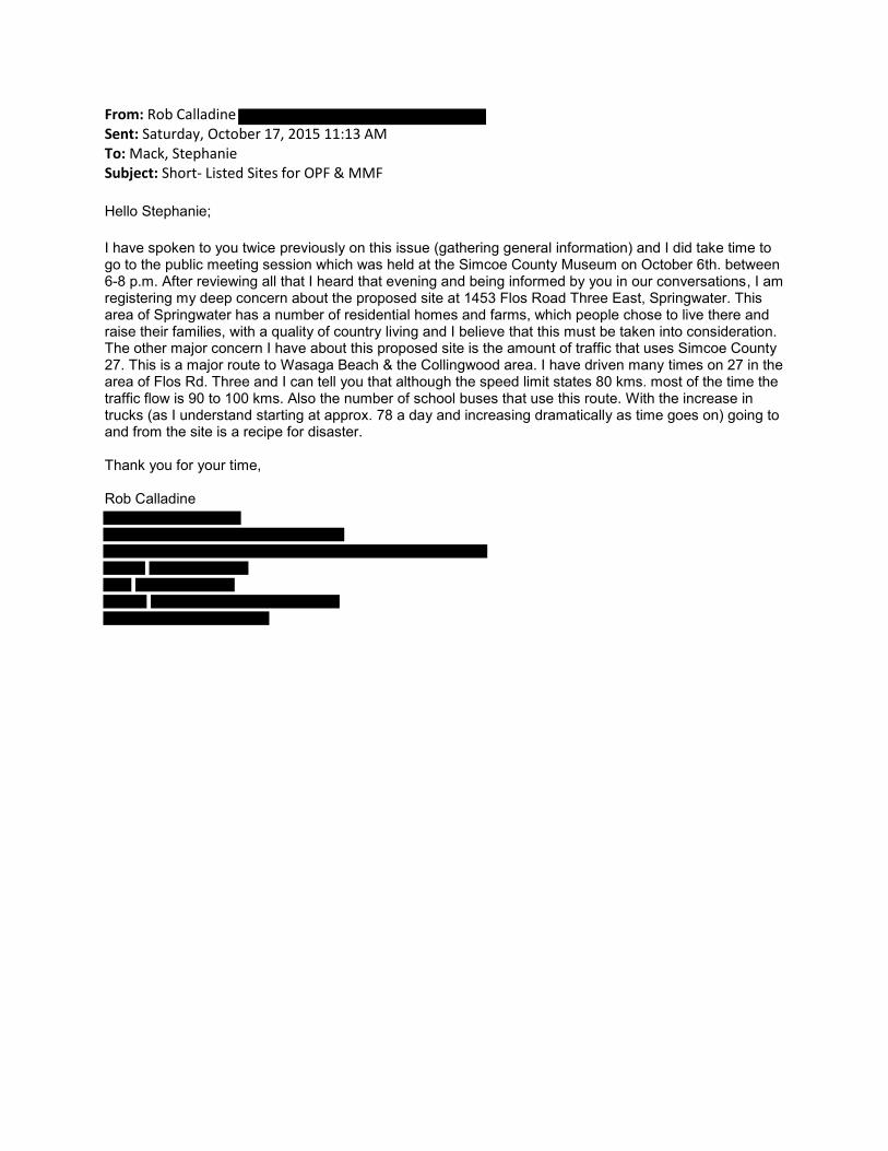
From: Rob Calladine Sent: Saturday, October 17, 2015 11:13 AM To: Mack, Stephanie Subject: Short- Listed Sites for OPF & MMF
Hello Stephanie; I have spoken to you twice previously on this issue (gathering general information) and I did take time to go to the public meeting session which was held at the Simcoe County Museum on October 6th. between 6-8 p.m. After reviewing all that I heard that evening and being informed by you in our conversations, I am registering my deep concern about the proposed site at 1453 Flos Road Three East, Springwater. This area of Springwater has a number of residential homes and farms, which people chose to live there and raise their families, with a quality of country living and I believe that this must be taken into consideration. The other major concern I have about this proposed site is the amount of traffic that uses Simcoe County 27. This is a major route to Wasaga Beach & the Collingwood area. I have driven many times on 27 in the area of Flos Rd. Three and I can tell you that although the speed limit states 80 kms. most of the time the traffic flow is 90 to 100 kms. Also the number of school buses that use this route. With the increase in trucks (as I understand starting at approx. 78 a day and increasing dramatically as time goes on) going to and from the site is a recipe for disaster. Thank you for your time, Rob Calladine

Survey Response: We Want to Hear From You Response GUID: 2383fec8‐e3fb‐4bb6‐b32b‐af8f3a48924d Started: 10/18/2015 3:39:50 PM Completed: 10/18/2015 3:49:38 PM Name: Connie Cowie Email: Comments: I think it is commendable that the County of Simcoe wants to take care of its own waste. We have come very far with waste management with organics and recycling, however, the proposed sites for waste management is concerning. As much as I think technology is great and we have come a long way with it, there is still a great risk involved. No technology is foolproof. Even with the Environmental Permits in place, it is likely they will only find an issue after the damage is done which then is too late. I just don't think you should take that risk with people's well water so close by. Water will be required at the facility for employees, use in the waste management process and to clean the trucks that will be housed there. Where does the run‐off go? Where does the waste residue from washing out these trucks go? If the garages for maintaining the trucks are on site, there is greater increase to damage our well water. The increase of trucks on rural roads is also a concern. Where will the money come from for the increase maintenance of these roads in years to come due to the increase wear and tear? Increased taxes? There is also the concern of using our forest for such a venture. Seems rather ironic that we cut down trees to house a waste facility. How sad. Many people enjoy living in Springwater to be close to the forest and all they have to offer. Many, like myself, use the forest trails on a daily basis to walk our dogs and enjoy the peace and tranquility after a stressful day at work. Others use the trails for snowmobiling, dirt biking or 4‐wheeling. Along with myself I see many joggers as well; easier on the joints and away from the roads and traffic. It is proposed that the buffer zone “may” still be available for public use, however, what damage will be done to this forest by construction. Although they may be told to only take down certain trees, these companies have been known to take down more than required knowing they will only get a slap on the wrist. You cannot replace in our lifetime to enjoy what has taken decades to grow. If you use a county forest for this, what is next? Sell off a parcel of county forest to a developer? Then what? Sell more off for a Costco and Walmart? Is this going to be the beginning of the end of our rural Springwater? I think it is time to go back to the drawing board and maybe cut a deal with Barrie or Orillia if an existing suitable industrial park area cannot be found in Simcoe County. Thank you, Connie Cowie Anten Mills

From: Joe Bailey
Sent: October 18, 2015 5:02 PM
To: Customer Service
Cc: Joe Bailey; Paul Laking; Janice Laking; Jack Sasseville;
Subject: Letter regarding Simcoe County Organics Waste Treatment Facility
Stephanie Mack P. Eng
Solid Waste Infrastructure Projects
Attached is a letter with concerns in regards to the proposed location of a waste treatment facility on
Line 5 Oro.
Joseph Bailey

Dear Stephanie Mack,
I am writing to express my concern and disapproval of building an Organics
Processing and Material Management facility at the Sandford Tract Forest located on
the 5th line of Oro-Medonte.
Not only will building this facility at said location be detrimental to the business at
Hardwood Ski and Bike and to the enjoyment of my time at this property, it will
also be harmful to the sensitive Oro-Moraine. It will also create road safety issues
on Line 5, that would not be addressed easily without major road reconstruction
This moraine drains into Georgian Bay, Lake Huron and Lake Simcoe. Efforts are
already being made to preserve undeveloped land on the moraine by encouraging
landowners to leave their property as a legacy to the regional conservation
authorities in their wills. We are managed Forest owners ouselves and the inclusion
of an industrial type facilty and the smells and traffic would appear counter to our
efforts within the moraine.
We are active cyclists in the area. The surrounding roads are quiet and safe for all
levels of cyclists. The heavy truck traffic on a road that is neither paved for heavy
trucks or wide enough for truck traffic would add safety concerns. The site lines are
poor for fast moving vehicles with narrow hilly contours. The facility would make
more sense in an area less used by non-motorized traffic and where the roads are
designed for heavy trucks.
With such efforts being made to preserve this land it only makes sense to choose
another location for this Organics Processing and Material Management facility.
Thank you for your time and attention to this serious matter.
Sincerely,
Lori and Joe Bailey
Cyclists
Members Hardwood Ski and Bike
Property owners Managed Forest North Part, Lot Concession
Concerned Citizen

From: Susan Maynard
Sent: October 19, 2015 12:11 PM
To: Customer Service
Subject: Public Consultation Session on Recycling Plant
I have attended a consultation session at the Elmvale Arena
I have reviewed a number of the selected sights and have major concerns on transportation given the
number of trucks that would be going up and down rural roads and the congestion that these would
cause. I also have concerns re the protection of the ground water.
It seems to me that this we are looking at the best of the available (owned or for sale) locations within a
given radius rather than looking for the BEST location available.
Every location presented offers many negative aspects and possible permanent harm.
Take the $13 million that will be the “profit” and use this money to buy a location that meets all needs
without having to injure (financially (house values) or physically (bad water, children hurt by trucks)).
Susan Maynard
Flos Road Five East
Phelpston, Ontario, L0L 2K0

Development :UNTYo;-' IIIIPII!Ii!r of Infrastructure SIMCOE_!*\
Pr~f:CEI\IT~~~
Public Consultation Session OCT 1 9 2015 Tuesday, October 20, 2015 Stayner Arena and Community Centre COUNTY OF SIMCOE
CORPORATE SERVICES DIVISJON
Comment Sheet
Contact Information (optional):
Name: Date: C'cf2o/1.s-
Postal Code: L 1 A1 J S 0 Affiliation: ~ 1 h-- , c I< -e..r t d ~ ~- I-
Ema·:
Thank you for tak ng the time to provide us with your feedback.
Mailing address:
Sol1d Waste Management Infrastructure Projects County of Simcoe
c/o Ms. Stephanie Mack, P. Eng. 1110 Highway 26, Midhurst, Ontario
LOL 1XO
1-800-263-3199
simcoe.ca/opf or simcoe.ca/mmf
Comments can be subm1tted by ma I or email during this consu tation process. Please note that your response will form part of the project record and will be forwarded to our consultant for consideration as the sites are further evaruated. All comments must be received by November 6, 2015.
Personal informat1on is being collected pursuant to Sect on 28 of the Municipal Freedom of Information and Protection of Pnvacy Act (MFIPPA) and will be used for the purpose of gamering public input
into the development of the Organ1cs Process ng Fac11ity Prqect and Materials Management Facility Project to respond to inquiries regard1ng th1s process. Comments and input provided may form part of the projects'
documentation. Should you have quest1ons regarding th1s collection, please contact Stephanie Mack. P.Eng., Spec1al Projects Superv1sor. 705-726-9300, County of Simcoe.
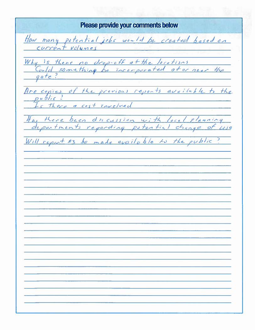

From: Aleta Bidwell Sent: October 20, 2015 3:42 PM To: Customer Service Subject: Agencies Pricing Facility and Materials Management Facility TO WHOM IT MAY CONCERN:
Glenn and I both attended the information meeting regarding the proposed sites for the organics processing and materials management facility on Thursday, October 8. We both felt the meeting was informative for all participants. Below are the reasons we feel that Line 5 of Oro-Medonte would not be a good choice for these facilities.
Devaluation of land: Our property on the 5th line of Oro-Medonte (directly across the road from proposed site) is our "pension" to help us through the rest of our senior years. As Glenn was a farmer his entire life, he did not have the opportunity to pay into a pension plan. Therefore we are limited to the OAS and CPP. Glenn's strategy was to have the farm as our investment to be sold when we need the proceeds to enhance our government pensions. If the facility is built across the road, our farm would be greatly devalued and therefore, through no fault of our own, our "pension" would be drastically decreased. I believe most others in our area feel exactly the same way regarding the devaluation of property.
Safety: Line 5 North is in the middle of a year round tourist area. We have Horseshoe Valley Resort in one direction and Hardwood Hills just around the corner. Because of these tourist businesses, there is increased pedestrian, bike and rollerblade traffic on our road. In addition, of course, the residents enjoy walking along the lovely tree-canopied road at their leisure - this is why they purchased homes on Line 5 N. Due to the rolling hills, visibility is a serious issue even now - with increased truck traffic, the road would become a death trap for all involved, including normal vehicular traffic.
Odour/air quality: Although we have been assured that there will be no odour, no excess fly population, no change in our pristine air quality, we have doubt. There is nothing like foul odour to affect the health of people with allergies or lung issues such as asthma. Again people move to areas such as Line 5 North to get away from cities and industrial areas to avoid this pollution.
Moraine: The proposed site is extremely close, if not directly on top of the moraine. Building such a facility would have a negative impact on the moraine.
Future Industrial Development: If this facility is built on Line 5 North, we fear that it would encourage additional related facilities being built on the same site in the future which would exacerbate the situation even more.
Tourism: In addition to the two large tourist destinations mentioned above, there are several B&Bs in the immediate area, small businesses etc that would be negatively impacted by such a facility being built in their midst.

I'm sure there are other reasons that do not come to mind at this time. Glenn and I feel very strongly that if this facility were to be built on Line 5 North of Oro-Medonte, there would need to be compensation to the tune of similar properties on nearby area roads farther removed from this site. Thank you for your attention to this matter, Sincerely, Glenn and Ali Bidwell

From: Colin Edgar Sent: October 20, 2015 10:29 PM To: Customer Service Subject: Simcoe County Organics Processing and Material Management Facility Dear Stephanie Mack,
I am writing to express my concern and disapproval of building an Organics Processing and
Materials Management Facility at the Sandford Tract Forest located on the 5th Line of Oro-
Medonte. My understanding is that this is one of the locations that have been short-listed as a
potential site for construction of this facility.
As you know, this location is immediately adjacent to Hardwood Ski and Bike, a very popular
recreational facility for cross-country skiing, mountain biking, and other outdoor activities. I
have no connection with Hardwood other than being a frequent visitor over the last 23 years or
so. Hardwood has some of the best trails in Ontario for skiing and cycling, and I have enjoyed
many weekends there. It is a great place to get away from the city and enjoy the fresh air and
quiet surroundings.
I am an engineer myself in the waste treatment business and I fully understand and support the
need and importance of recycling and waste management. However, I also know that
construction and operation of a facility such as this one will create heavy truck traffic on local
roads and produce significant odours. Locating this facility at the Sandford Tract Forest will
have very negative noise and odour impacts on Hardwood Ski and Bike.
Not only will building this facility at said location be detrimental to the business at Hardwood
Ski and Bike and to the enjoyment of my and many other people’s time at this property, it will
also be harmful to the sensitive Oro-Moraine. This moraine drains into Georgian Bay, Lake
Huron, and Lake Simcoe. Efforts are already being made to preserve undeveloped land on the
moraine by encouraging landowners to leave their property as a legacy to the regional
conservation authorities in their wills.
With such efforts being made to preserve this land it only makes sense to choose another
location for this Organics Processing and Materials Management Facility.
Thank you for your time and attention to this serious matter.
Sincerely,
Colin B. Edgar
Richmond Hill, ON
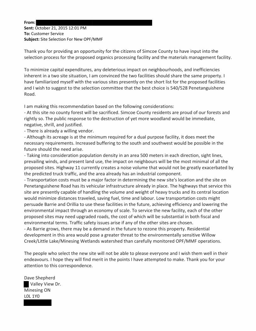
From: Sent: October 21, 2015 12:01 PM To: Customer Service Subject: Site Selection For New OPF/MMF Thank you for providing an opportunity for the citizens of Simcoe County to have input into the selection process for the proposed organics processing facility and the materials management facility. To minimize capital expenditures, any deleterious impact on neighbourhoods, and inefficiencies inherent in a two site situation, I am convinced the two facilities should share the same property. I have familiarized myself with the various sites presently on the short list for the proposed facilities and I wish to suggest to the selection committee that the best choice is 540/528 Penetanguishene Road. I am making this recommendation based on the following considerations: ‐ At this site no county forest will be sacrificed. Simcoe County residents are proud of our forests and rightly so. The public response to the destruction of yet more woodland would be immediate, negative, shrill, and justified. ‐ There is already a willing vendor. ‐ Although its acreage is at the minimum required for a dual purpose facility, it does meet the necessary requirements. Increased buffering to the south and southwest would be possible in the future should the need arise. ‐ Taking into consideration population density in an area 500 meters in each direction, sight lines, prevailing winds, and present land use, the impact on neighbours will be the most minimal of all the proposed sites. Highway 11 currently creates a noise volume that would not be greatly exacerbated by the predicted truck traffic, and the area already has an industrial component. ‐ Transportation costs must be a major factor in determining the new site's location and the site on Penetanguishene Road has its vehicular infrastructure already in place. The highways that service this site are presently capable of handling the volume and weight of heavy trucks and its central location would minimize distances traveled, saving fuel, time and labour. Low transportation costs might persuade Barrie and Orillia to use these facilities in the future, achieving efficiency and lowering the environmental impact through an economy of scale. To service the new facility, each of the other proposed sites may need upgraded roads, the cost of which will be substantial in both fiscal and environmental terms. Traffic safety issues arise if any of the other sites are chosen. ‐ As Barrie grows, there may be a demand in the future to rezone this property. Residential development in this area would pose a greater threat to the environmentally sensitive Willow Creek/Little Lake/Minesing Wetlands watershed than carefully monitored OPF/MMF operations. The people who select the new site will not be able to please everyone and I wish them well in their endeavours. I hope they will find merit in the points I have attempted to make. Thank you for your attention to this correspondence. Dave Shepherd
Valley View Dr. Minesing ON L0L 1Y0

From: Sent: October 21, 2015 1:18 PM To: Customer Service Subject: new Organic s Processing and Materials Management Facility Dear Stephanie Mack,
I am writing to express my concern and disapproval of building an Organics Processing and
Material Management facility at the Sandford Tract Forest located on the 5th line of Oro-
Medonte.
Not only will building this facility at said location be detrimental to the business at Hardwood
Ski and Bike and to the enjoyment of my time at this property, it will also be harmful to the
sensitive Oro-Moraine. This moraine drains into Georgian Bay, Lake Huron and Lake Simcoe.
Efforts are already being made to preserve undeveloped land on the moraine by encouraging
landowners to leave their property as a legacy to the regional conservation authorities in their
wills.
With such efforts being made to preserve this land it only makes sense to choose another
location for this Organics Processing and Material Management facility.
Thank you for your time and attention to this serious matter.
Sincerely,
Concerned Citizen

From: Anne Wilkie
Sent: October 21, 2015 3:35 PM
To: Customer Service
Subject: Proposed Location of Organics Processing & Materials Management Facility
Good afternoon Ms. Mack,
Please see attached letter. Your comments would be appreciated.
Thank you.
Anne Wilkie
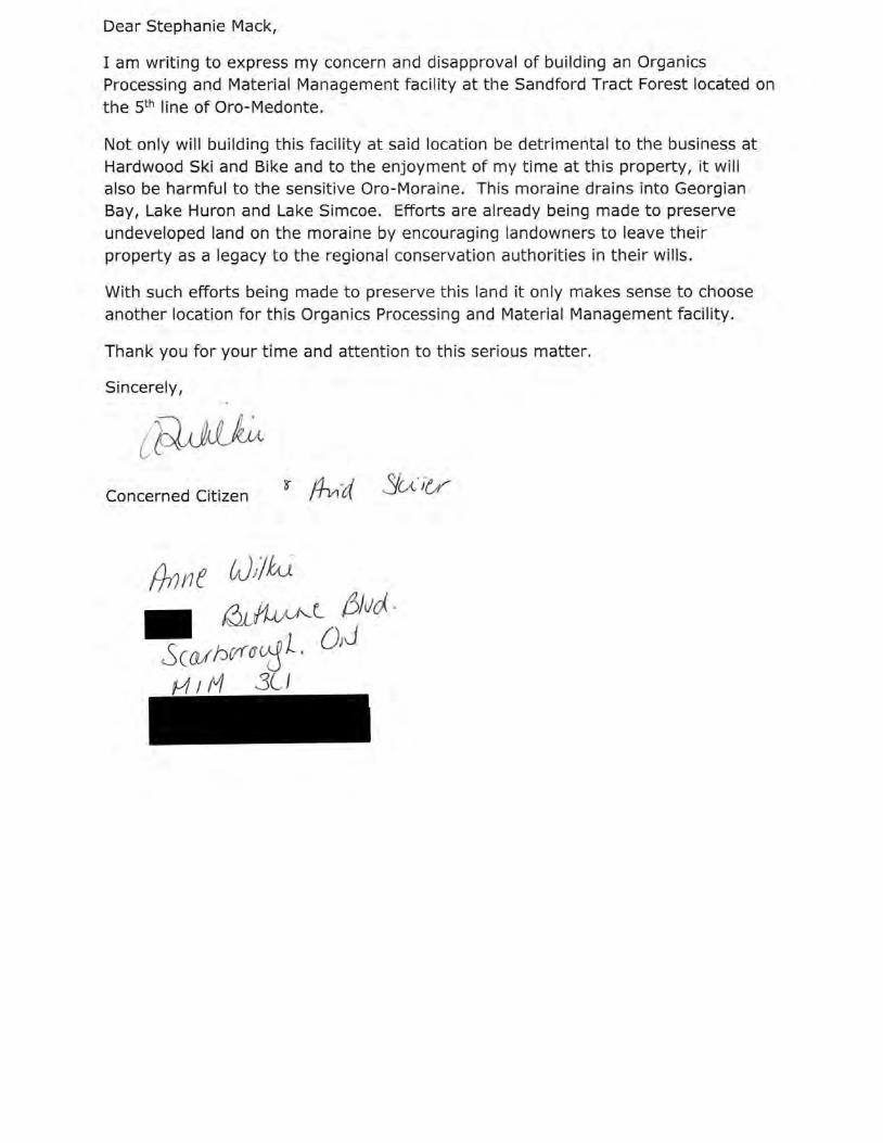
Dear Stephanie Mack,
I am writing to express my concern and disapproval of building an Organics Processing and Material Management facility at the Sandford Tract Forest located on the s th line of Oro-Medonte.
Not only will building this facility at said location be detrimental to the business at Hardwood Ski and Bike and to the enjoyment of my time at this property, it will also be harmful to the sensitive Oro-Moraine. This moraine drains into Georgian Bay, Lake Huron and Lake Simcoe. Efforts are already being made to preserve undeveloped land on the moraine by encouraging landowners to leave their property as a legacy to the regional conservation authorities in their wills.
With such efforts being made to preserve this land it only makes sense to choose another location for this Organics Processing and Material Management facility.
Thank you for your time and attention to this serious matter.
Sincerely,
Concerned Citizen

From: Russell Belk
Sent: October 21, 2015 3:39 PM
To: Customer Service
Subject: Purposed Location of Organics Processing and Materials Management Facility
Attn: Stephanie Mack
Dear Ms. Mack,
My letter of concern about one of the propossed sites for this facility is attached. Please let me
know if I can provide further input.
Bet wishes
Russell Belk
(See attached file: Purposed Location of Organics Processing and Materials Management
Facility Letter.docx)

October 21, 2015
Solid Waste Management Infrastructure Projects County of Simcoe
c/o Stephanie Mack, P. Eng.
1110 Highway 26
Midhurst, Ontario
L0L 1X0
Dear Stephanie Mack,
I am writing to express my grave concern and disapproval of building an Organics
Processing and Material Management facility at the Sandford Tract Forest located on
the 5th line of Oro-Medonte.
Not only will building this facility at this location be detrimental to the business at
Hardwood Ski and Bike and to the enjoyment of my time at this property as a
season passholder, it will also be harmful to the sensitive Oro-Moraine. This
moraine drains into Georgian Bay, Lake Huron and Lake Simcoe (on which I live).
Efforts are already being made to preserve undeveloped land on the moraine by
encouraging landowners to leave their property as a legacy to the regional
conservation authorities in their wills.
With such efforts being made to preserve this land it only makes sense to choose
another location for this Organics Processing and Material Management facility.
Thank you for your time and attention to this serious matter.
Sincerely,
Dr. Russell W. Belk Neon Lane
Keswick, On
L4P 3E9
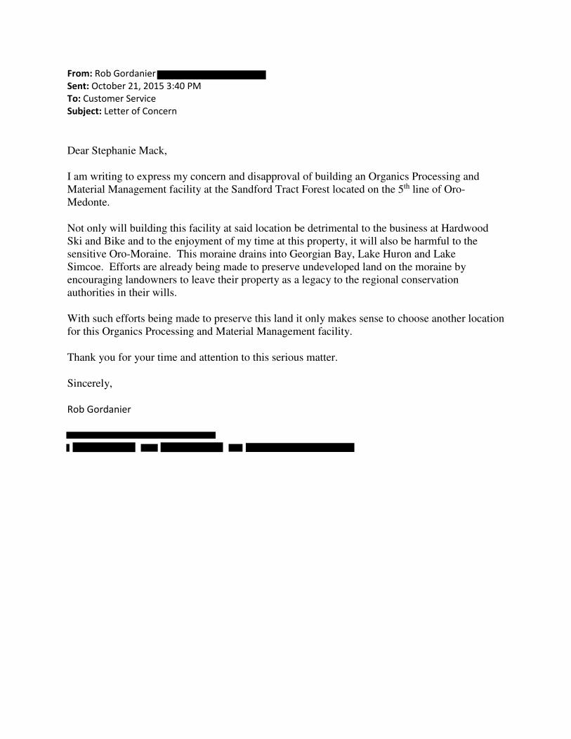
From: Rob Gordanier
Sent: October 21, 2015 3:40 PM
To: Customer Service
Subject: Letter of Concern
Dear Stephanie Mack,
I am writing to express my concern and disapproval of building an Organics Processing and
Material Management facility at the Sandford Tract Forest located on the 5th line of Oro-
Medonte.
Not only will building this facility at said location be detrimental to the business at Hardwood
Ski and Bike and to the enjoyment of my time at this property, it will also be harmful to the
sensitive Oro-Moraine. This moraine drains into Georgian Bay, Lake Huron and Lake
Simcoe. Efforts are already being made to preserve undeveloped land on the moraine by
encouraging landowners to leave their property as a legacy to the regional conservation
authorities in their wills.
With such efforts being made to preserve this land it only makes sense to choose another location
for this Organics Processing and Material Management facility.
Thank you for your time and attention to this serious matter.
Sincerely,
Rob Gordanier
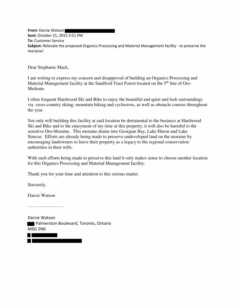
From: Darcie Watson
Sent: October 21, 2015 3:51 PM
To: Customer Service
Subject: Relocate the proposed Organics Processing and Material Management facility - to preserve the
moraine!
Dear Stephanie Mack,
I am writing to express my concern and disapproval of building an Organics Processing and
Material Management facility at the Sandford Tract Forest located on the 5th line of Oro-
Medonte.
I often frequent Hardwood Ski and Bike to enjoy the beautiful and quiet and lush surroundings
via cross-country skiing, mountain biking and cyclocross, as well as obstacle courses throughout
the year.
Not only will building this facility at said location be detrimental to the business at Hardwood
Ski and Bike and to the enjoyment of my time at this property, it will also be harmful to the
sensitive Oro-Moraine. This moraine drains into Georgian Bay, Lake Huron and Lake
Simcoe. Efforts are already being made to preserve undeveloped land on the moraine by
encouraging landowners to leave their property as a legacy to the regional conservation
authorities in their wills.
With such efforts being made to preserve this land it only makes sense to choose another location
for this Organics Processing and Material Management facility.
Thank you for your time and attention to this serious matter.
Sincerely,
Darcie Watson
- - - - - - - - - - - - - - -
Darcie Watson
Palmerston Boulevard, Toronto, Ontario
M6G 2N6

From: Stephanie Jeanneret Manning
Sent: October 21, 2015 3:52 PM
To: Customer Service
Subject: Letter of Concern: Development Plans on Oro Moraine
Stephanie Mack, P.Eng.
Solid Waste Management Infrastructure Projects County of Simcoe
1110 Highway 26
Midhurst, Ontario
L0L 1X0
Dear Ms. Mack:
We are writing to express our concern and disapproval of building an Organics Processing and
Material Management facility at the Sandford Tract Forest located on the 5th line of Oro-
Medonte.
Not only will building a facility at this location be detrimental to the business at Hardwood Ski
and Bike and to the enjoyment of our time at this property, it will also be harmful to the
sensitive Oro-Moraine. This moraine drains into Georgian Bay, Lake Huron and Lake Simcoe.
Efforts are already being made to preserve undeveloped land on the moraine by encouraging
landowners to leave their property as a legacy to the regional conservation authorities in their
wills.
With such efforts being made to preserve this land it only makes sense to choose another
location for this Organics Processing and Material Management facility.
Thank you for your time and attention to this serious matter.
Sincerely,
The Jeanneret Manning Family
(Manet, Stephanie, Simone and Maxine)

From: Marina tchistaia
Sent: October 21, 2015 3:59 PM
To: Customer Service
Subject: Concerned Citizen Letter
Dear Stephanie Mack,
I am writing to express my concern and disapproval of building an Organics Processing and
Material Management facility at the Sandford Tract Forest located on the 5th line of Oro-
Medonte.
Not only will building this facility at said location be detrimental to the business at Hardwood
Ski and Bike and to the enjoyment of my time at this property, it will also be harmful to the
sensitive Oro-Moraine. This moraine drains into Georgian Bay, Lake Huron and Lake
Simcoe. Efforts are already being made to preserve undeveloped land on the moraine by
encouraging landowners to leave their property as a legacy to the regional conservation
authorities in their wills.
With such efforts being made to preserve this land it only makes sense to choose another location
for this Organics Processing and Material Management facility.
Thank you for your time and attention to this serious matter.
Sincerely,
Concerned Citizen
M. Tchistaia

Dear Stephan ie Mack,
I am writing to express my concern and disapproval of bu ilding an Organ ics Processing and Material Management fac ili t y at the Sandford Tract Forest located on the 5th line of Oro-Medonte.
Not only will bu ilding this fac ility at sa id location be detrimenta l to t he business at Hardwood Ski and Bike and to the enjoyment of my t ime at this property, it will also be harmful to the sens itive Oro-Moraine. This moraine dra in s into Georg ian Bay, Lake Huron and Lake Simcoe. Efforts are already be ing made to preserve undeveloped land on t he moraine by encourag in g landowners to leave their property as a legacy to the regional conservat ion authorities in t heir will s.
With such efforts be in g made to preserve th is land it on ly makes sense to choose another location for th is Organ ics Processing and Material Management facility .
Thank you for your t ime and attention to th is serious matter.
Sincere ly,
Concerned Citizen

From: Faye Armstrong
Sent: October 21, 2015 4:03 PM
To: Customer Service
Subject: Proposed Organics Processing facility
Hi Stephanie Mack,
Please see attached letter re: the proposed site for the Organics Processing and Material
Management facility at the Sandford Tract Forest location on the 5th line of Oro-Medonte.
Kind regards,
Faye Armstrong

October 21, 2015
Faye Armstrong
Dear Stephanie Mack,
I am writing to express my concern and disapproval of building an Organics
Processing and Material Management facility at the Sandford Tract Forest located on
the 5th line of Oro-Medonte.
Not only will building this facility at said location be detrimental to the business at
Hardwood Ski and Bike and to the enjoyment of my time at this property, it will
also be harmful to the sensitive Oro-Moraine. This moraine drains into Georgian
Bay, Lake Huron and Lake Simcoe. Efforts are already being made to preserve
undeveloped land on the moraine by encouraging landowners to leave their
property as a legacy to the regional conservation authorities in their wills.
With such efforts being made to preserve this land it only makes sense to choose
another location for this Organics Processing and Material Management facility.
Thank you for your time and attention to this serious matter.
Sincerely,
Faye Armstrong

From: Steve Faraone
Sent: October 21, 2015 4:05 PM
To: Customer Service
Subject: organics processing
Dear Stephanie Mack,
I am writing to express my concern and disapproval of building an Organics Processing and Material
Management facility at the Sandford Tract Forest located on the 5th line of Oro-Medonte.
Not only will building this facility at said location be detrimental to the business at Hardwood Ski and
Bike and to the enjoyment of my time at this property, it will also be harmful to the sensitive Oro-
Moraine. This moraine drains into Georgian Bay, Lake Huron and Lake Simcoe. Efforts are already being
made to preserve undeveloped land on the moraine by encouraging landowners to leave their property
as a legacy to the regional conservation authorities in their wills.
With such efforts being made to preserve this land it only makes sense to choose another location for
this Organics Processing and Material Management facility.
Thank you for your time and attention to this serious matter.
Sincerely,
Steve Faraone
CONFIDENTIALITY WARNING This e-mail message, including any attachment(s), is confidential.
If we sent this communication to you in error, please do not disclose it to anyone else or use
the information in it. Please notify the sender of the transmission error and then delete our
communication from your system without printing, copying or forwarding it. Thank you for your
co-operation. AVERTISSEMENT CONCERNANT LE CARACTERE CONFIDENTIEL DE
L'INFORMATION Le present courriel, y compris toute piece qui y est jointe, est confidentiel. Si
nous vous avons envoye cette communication par erreur, nous vous prions de ne la divulguer a
personne ni a utiliser l’information qu’elle contient. Veuillez informer l’expediteur de l’erreur
de transmission et effacer ensuite notre communication de votre systeme sans l’imprimer, ni la
copier ni la retransmettre. Nous vous remercions de votre cooperation.

From:
Date: Wednesday, October 21, 2015 at 4:08 PM
To:
Subject: Organics Processing and Materials Management Facility site location
Dear Stephanie Mack,
I am writing to express my concern and disapproval of building an Organics Processing and
Material Management facility at the Sandford Tract Forest located on the 5th line of Oro-
Medonte.
Not only will building this facility at said location be detrimental to the business at Hardwood
Ski and Bike and to the enjoyment of my time at this property, it will also be harmful to the
sensitive Oro-Moraine. This moraine drains into Georgian Bay, Lake Huron and Lake
Simcoe. Efforts are already being made to preserve undeveloped land on the moraine by
encouraging landowners to leave their property as a legacy to the regional conservation
authorities in their wills.
With such efforts being made to preserve this land it only makes sense to choose another location
for this Organics Processing and Material Management facility.
Thank you for your time and attention to this serious matter.
Sincerely,
Concerned citizen

From:
Sent: October 21, 2015 4:08 PM
To: Customer Service
Subject:
Dear Stephanie Mack,
I am writing to express my concern and disapproval of building an Organics Processing and Material Management facility at the Sandford Tract Forest
located on the 5th line of Oro-Medonte.
Not only will building this facility at said location be detrimental to the
business at Hardwood Ski and Bike and to the enjoyment of my time at this
property, it will also be harmful to the sensitive Oro-Moraine. This moraine drains into Georgian Bay, Lake Huron and Lake Simcoe. Efforts are already
being made to preserve undeveloped land on the moraine by encouraging landowners to leave their property as a legacy to the regional conservation
authorities in their wills.
With such efforts being made to preserve this land it only makes sense to choose another location for this Organics Processing and Material
Management facility.
Thank you for your time and attention to this serious matter.
Sincerely,
Concerned Citizen

From: Ray Shikatani
Sent: October 21, 2015 4:16 PM
To: Customer Service
Subject: Disapproval of Organics Processing Materials facility
Dear Stephanie Mack,
I am writing to express my concern and disapproval of building an Organics Processing and Material
Management facility at the Sandford Tract Forest located on the 5th line of Oro-Medonte.
Not only will building this facility at said location be detrimental to the business at Hardwood Ski and
Bike and to the enjoyment of my time at this property, it will also be harmful to the sensitive Oro-
Moraine. This moraine drains into Georgian Bay, Lake Huron and Lake Simcoe. Efforts are already being
made to preserve undeveloped land on the moraine by encouraging landowners to leave their property
as a legacy to the regional conservation authorities in their wills.
It is not only critical to preserve this precious land but, also the area for its enjoyment of the community.
With such efforts being made to preserve this land it only makes sense to choose another location for
this Organics Processing and Material Management facility.
Thank you for your time and attention to this serious matter.
Sincerely,
Ray Shikatani

From: Cheryl Hoefer
Sent: October 21, 2015 4:21 PM
To: Customer Service
Subject: Sandford Tract Forest / Proposed Organics Processing and Materials Management Facility
Dear Stephanie Mack, I am writing to express my concern and disapproval of building an Organics Processing and Material Management facility at the Sandford Tract Forest located on the 5th line of Oro-Medonte. Not only will building this facility at said location be detrimental to the business at Hardwood Ski and Bike and to the enjoyment of my time at this property, it will also be harmful to the sensitive Oro-Moraine. This moraine drains into Georgian Bay, Lake Huron and Lake Simcoe. Efforts are already being made to preserve undeveloped land on the moraine by encouraging landowners to leave their property as a legacy to the regional conservation authorities in their wills. With such efforts being made to preserve this land it only makes sense to choose another location for this Organics Processing and Material Management facility. Thank you for your time and attention to this serious matter. Sincerely, Cheryl Hoefer, BA, BEd, JD

From: Dino .
Sent: October 21, 2015 4:24 PM
To: Customer Service
Subject: Disapproval of building an Organics Processing
Dear Stephanie Mack,
I am writing to express my concern and disapproval of building an Organics Processing and
Material Management facility at the Sandford Tract Forest located on the 5th line of Oro-
Medonte.
Not only will building this facility at said location be detrimental to the business at Hardwood
Ski and Bike and to the enjoyment of my time at this property, it will also be harmful to the
sensitive Oro-Moraine. This moraine drains into Georgian Bay, Lake Huron and Lake
Simcoe. Efforts are already being made to preserve undeveloped land on the moraine by
encouraging landowners to leave their property as a legacy to the regional conservation
authorities in their wills.
With such efforts being made to preserve this land it only makes sense to choose another
location for this Organics Processing and Material Management facility.
Thank you for your time and attention to this serious matter.
Sincerely,
DINO SKORDOULIS
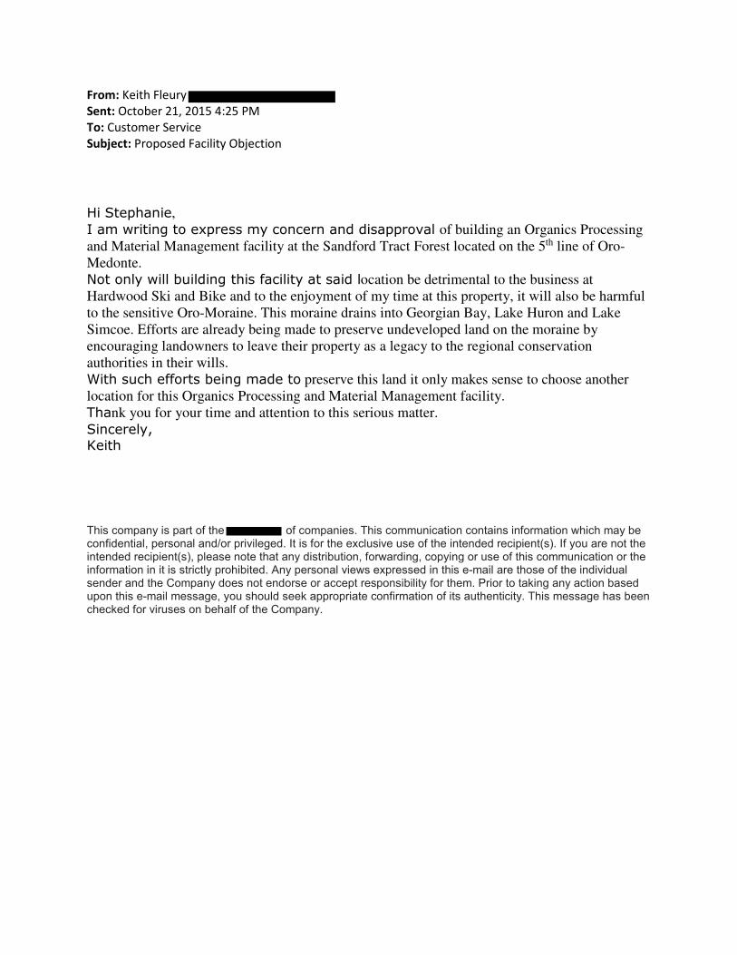
From: Keith Fleury
Sent: October 21, 2015 4:25 PM
To: Customer Service
Subject: Proposed Facility Objection
Hi Stephanie,
I am writing to express my concern and disapproval of building an Organics Processing
and Material Management facility at the Sandford Tract Forest located on the 5th line of Oro-
Medonte.
Not only will building this facility at said location be detrimental to the business at
Hardwood Ski and Bike and to the enjoyment of my time at this property, it will also be harmful
to the sensitive Oro-Moraine. This moraine drains into Georgian Bay, Lake Huron and Lake
Simcoe. Efforts are already being made to preserve undeveloped land on the moraine by
encouraging landowners to leave their property as a legacy to the regional conservation
authorities in their wills.
With such efforts being made to preserve this land it only makes sense to choose another
location for this Organics Processing and Material Management facility.
Thank you for your time and attention to this serious matter.
Sincerely, Keith
This company is part of the of companies. This communication contains information which may be confidential, personal and/or privileged. It is for the exclusive use of the intended recipient(s). If you are not the intended recipient(s), please note that any distribution, forwarding, copying or use of this communication or the information in it is strictly prohibited. Any personal views expressed in this e-mail are those of the individual sender and the Company does not endorse or accept responsibility for them. Prior to taking any action based upon this e-mail message, you should seek appropriate confirmation of its authenticity. This message has been checked for viruses on behalf of the Company.

From: Adam Swayze
Sent: October 21, 2015 4:27 PM
To: Customer Service
Subject: Concerned Citizen
Dear Stephanie Mack,
I am writing to express my concern and disapproval of building an Organics Processing and
Material Management facility at the Sandford Tract Forest located on the 5th line of Oro-
Medonte.
Not only will building this facility at said location be detrimental to the business at Hardwood
Ski and Bike and to the enjoyment of my time at this property, it will also be harmful to the
sensitive Oro-Moraine. This moraine drains into Georgian Bay, Lake Huron and Lake Simcoe.
Efforts are already being made to preserve undeveloped land on the moraine by encouraging
landowners to leave their property as a legacy to the regional conservation authorities in their
wills.
With such efforts being made to preserve this land it only makes sense to choose another
location for this Organics Processing and Material Management facility.
Thank you for your time and attention to this serious matter.
Sincerely,
Adam Swayze
From:
Sent: October 21, 2015 4:29 PM
To: Customer Service
Subject: Organics Processing and Materials Management Facility
Dear Stephanie Mack,
I am writing to express my concern and disapproval of building an Organics Processing and
Material Management facility at the Sandford Tract Forest located on the 5th line of Oro-
Medonte.
Not only will building this facility at said locationbe detrimental to the business at Hardwood Ski
and Bike and to the enjoyment of my time at this property, it will also be harmful to the sensitive
Oro-Moraine. This moraine drains into Georgian Bay, Lake Huron and Lake Simcoe. Efforts
are already being made to preserve undeveloped land on the moraine by encouraging landowners
to leave their property as a legacy to the regional conservation authorities in their wills.
With such efforts being made to preserve this land it only makes sense to choose another location
for this Organics Processing and Material Management facility.
Thank you for your time and attention to this serious matter.
Sincerely,
Concerned Citizen

From: Teresa Neto Sent: October 21, 2015 4:49 PM To: Customer Service Subject: Organics Processing and Materials Management Facility
Dear Stephanie Mack,
I am writing to express my concern and disapproval of building an Organics Processing and Material Management facility at the Sandford Tract Forest located on the 5th line of Oro-Medonte.
Not only will building this facility at said location be detrimental to the business at Hardwood Ski and Bike and to the enjoyment of my time at this property, it will also be harmful to the sensitive Oro-Moraine. This moraine drains into Georgian Bay, Lake Huron and Lake Simcoe. Efforts are already being made to preserve undeveloped land on the moraine by encouraging landowners to leave their property as a legacy to the regional conservation authorities in their wills. With such efforts being made to preserve this land it only makes sense to choose another location for this Organics Processing and Material Management facility.
Thank you for your time and attention to this serious matter.
Sincerely,
Teresa Neto

From: Hill, Don
Sent: October 21, 2015 5:35 PM
To: Customer Service
Subject: Proposed Location of the Organics Processing and Materials Management Facility
To Whom it May Concern,
Attached is a letter voicing my opposition to the proposed location of the Organics Processing and
Materials Management Facility on the 5th line of Oro-Medonte.
Sincerely,
Don Hill

Dear Stephanie Mack,
I am writing to express my concern and disapproval of building an Organics
Processing and Material Management facility at the Sandford Tract Forest located on
the 5th line of Oro-Medonte.
Not only will building this facility at said location be detrimental to the business at
Hardwood Ski and Bike and to the enjoyment of my time at this property, it will
also be harmful to the sensitive Oro-Moraine. This moraine drains into Georgian
Bay, Lake Huron and Lake Simcoe. Efforts are already being made to preserve
undeveloped land on the moraine by encouraging landowners to leave their
property as a legacy to the regional conservation authorities in their wills.
With such efforts being made to preserve this land it only makes sense to choose
another location for this Organics Processing and Material Management facility.
Thank you for your time and attention to this serious matter.
Sincerely,
Don Hill
Member at Hardwood Ski and Bike

From: Bibianne Bird
Sent: Wednesday, October 21, 2015 5:51 PM
To: Mack, Stephanie
Subject: Organics Processing & Material Mgmt Facility - Sandford Tract Forest
Dear Stephanie Mack,
I am writing to express my concern and disapproval of building an Organics Processing and
Material Management facility at the Sandford Tract Forest located on the 5th line of Oro-
Medonte.
Not only will building this facility at said location be detrimental to the business at Hardwood
Ski and Bike and to the enjoyment of my time at this property, it will also be harmful to the
sensitive Oro-Moraine. This moraine drains into Georgian Bay, Lake Huron and Lake
Simcoe. Efforts are already being made to preserve undeveloped land on the moraine by
encouraging landowners to leave their property as a legacy to the regional conservation
authorities in their wills.
With such efforts being made to preserve this land it only makes sense to choose another location
for this Organics Processing and Material Management facility.
Thank you for your time and attention to this serious matter.
Sincerely,
Bibianne Bird

From: on behalf of Laura Grant
Sent: October 21, 2015 6:10 PM
To: Customer Service
Subject: Proposed Location of Organics Processing and Materials Management Facility
--
Laura Grant, BSc, ND
Orillia, ON L3V 3X7
CONFIDENTIALITY NOTICE: This message and all attachments to it are confidential and intended only for the person to whom it is directed. Any other distribution, copying or disclosure is strictly prohibited. If you have received this communication in error, please delete it and all its attachments and notify me immediately.
Wednesday, October 21, 2015 Solid Waste Management Infrastructure Projects County of Simcoe c/o Stephanie Mack, P.Eng. 1110 Highway 26 Midhurst, Ontario L0L 1X0 Dear Stephanie Mack, P.Eng I am writing to express my concern and disapproval of building an Organics Processing and Material Management facility at the Sandford Tract Forest located on the 5th line of Oro-Medonte. Not only will building this facility at said location be detrimental to the business at Hardwood Ski and Bike and to the enjoyment of my time at this property, it will also be harmful to the sensitive Oro-Moraine. This moraine drains into Georgian Bay, Lake Huron and Lake Simcoe. Efforts are already being made to preserve undeveloped land on the moraine by encouraging landowners to leave their property as a legacy to the regional conservation authorities in their wills. With such efforts being made to preserve this land it only makes sense to choose another location for this Organics Processing and Material Management facility. Thank you for your time and attention to this serious matter. Sincerely,
From: Stem
Sent: October 21, 2015 6:36 PM
To: Customer Service
Subject: Concerned_Citizen_Letter.docx
Dear Stephanie Mark,
I'm writing to express my concern about the possible location of proposed Organics facility near
Hardwood Hills. Hardwood Hills acts as a key player for the economy in Simcoe county and provides
excellent entertainment for the GTA and surrounding areas. It also played a key role in the 2015 Pan Am
games. Please see the attached letter and reconsider the facility site for a location away from Hardwood
Hills.
Thank you,
Nelson
Concerned citizen, avid mountain biker and cross country skier.

Dear Stephanie Mack,
I am writing to express my concern and disapproval of building an Organics
Processing and Material Management facility at the Sandford Tract Forest located on
the 5th line of Oro-Medonte.
Not only will building this facility at said location be detrimental to the business at
Hardwood Ski and Bike and to the enjoyment of my time at this property, it will also
be harmful to the sensitive Oro-Moraine. This moraine drains into Georgian Bay,
Lake Huron and Lake Simcoe. Efforts are already being made to preserve
undeveloped land on the moraine by encouraging landowners to leave their
property as a legacy to the regional conservation authorities in their wills.
With such efforts being made to preserve this land it only makes sense to choose
another location for this Organics Processing and Material Management facility.
Thank you for your time and attention to this serious matter.
Sincerely,
Nelson
Concerned citizen, avid mountain biker and cross country skier!

From: Jane Stollar Sent: October 21, 2015 6:44 PM To: Customer Service Subject: Attn Stephanie Mack Re-Oro Medonte Dump sites Please see the attached letter as a concerned user of the highlands in this township. Please don't negatively impact Ontario's premiere cross country ski and bike location - its the closest thing we have here to the great recreation of Vancouver. Thanks for factoring this into the decision making. Jane Stollar

October 21, 2015
Dear Stephanie Mack,
I am writing to express my concern and disapproval of building an Organics
Processing and Material Management facility at the Sandford Tract Forest located on
the 5th line of Oro-Medonte.
Not only will building this facility at said location be detrimental to the business at
Hardwood Ski and Bike and to the enjoyment of my time at this property, it will
also be harmful to the sensitive Oro-Moraine. The odors that already eminate from
the landfill are enough to ruin a ski day, but this move would likely mean that I
would no longer travel to the region to ski at all.
This moraine drains into Georgian Bay, Lake Huron and Lake Simcoe. Efforts are
already being made to preserve undeveloped land on the moraine by encouraging
landowners to leave their property as a legacy to the regional conservation
authorities in their wills.
With such efforts being made to preserve this land it only makes sense to choose
another location for this Organics Processing and Material Management facility.
Thank you for your time and attention to this serious matter.
Sincerely,
Jane Stollar
Concerned Ontario citizen and cross-country skier
From: Marlene Etherington
Sent: October 21, 2015 7:03 PM
To: Customer Service
Subject: Organics Processing and Material Management facility
Dear Stephanie Mack,
I am writing to express my concern and disapproval of building an Organics Processing and Material
Management facility at the Sandford Tract Forest located on the 5th line of Oro-Medonte.
Not only will building this facility at said location be detrimental to the business at Hardwood Ski and
Bike and to the enjoyment of my time at this property, it will also be harmful to the sensitive Oro-
Moraine. This moraine drains into Georgian Bay, Lake Huron and Lake Simcoe. Efforts are already being
made to preserve undeveloped land on the moraine by encouraging landowners to leave their property
as a legacy to the regional conservation authorities in their wills.
With such efforts being made to preserve this land it only makes sense to choose another location for
this Organics Processing and Material Management facility.
Thank you for your time and attention to this serious matter.
Sincerely,
Marlene Etherington

From: Mark Rodgers Sent: October 21, 2015 7:49 PM To: Customer Service Subject: Hardwood ski and bike location Dear Stephanie Mack,
I am writing to express my concern and disapproval of building an Organics Processing and Material Management facility at the Sandford Tract Forest located on the 5th line of Oro-Medonte.
Not only will building this facility at said location be detrimental to the business at Hardwood Ski and Bike and to the enjoyment of my time at this property, it will also be harmful to the sensitive Oro-Moraine. This moraine drains into Georgian Bay, Lake Huron and Lake Simcoe. Efforts are already being made to preserve undeveloped land on the moraine by encouraging landowners to leave their property as a legacy to the regional conservation authorities in their wills.
With such efforts being made to preserve this land it only makes sense to choose another location for this Organics Processing and Material Management facility.
Thank you for your time and attention to this serious matter.
Sincerely,
Mark Rodgers
Sent from Samsung Mobile

From:
Sent: October 21, 2015 8:28 PM
To: Customer Service
Subject: Proposed Organics Site
Dear Stephanie Mack, We am writing to express our concern and disapproval of building an Organics Processing and Material Management facility at the Sandford Tract Forest located on the 5th line of Oro-Medonte. Not only will building this facility at said location be detrimental to the business at Hardwood Ski and Bike and to the enjoyment of our family’s time at this property, it will also be harmful to the sensitive Oro-Moraine. This moraine drains into Georgian Bay, Lake Huron and Lake Simcoe. Efforts are already being made to preserve undeveloped land on the moraine by encouraging landowners to leave their property as a legacy to the regional conservation authorities in their wills. With such efforts being made to preserve this land it only makes sense to choose another location for this Organics Processing and Material Management facility. Thank you for your time and attention to this serious matter. Sincerely, Bronwen & Jason Lash

From:
Sent: October 21, 2015 8:29 PM
To: Customer Service
Subject: Proposed Organics Processing and Materials Management Facility
Dear Stephanie Mack, I am writing to express my concern and disapproval of building an Organics Processing and Material Management facility at the Sandford Tract Forest located on the 5th line of Oro-Medonte. Not only will building this facility at said location be detrimental to the business at Hardwood Ski and Bike and to the enjoyment of my time at this property, it will also be harmful to the sensitive Oro-Moraine. This moraine drains into Georgian Bay, Lake Huron and Lake Simcoe. Efforts are already being made to preserve undeveloped land on the moraine by encouraging landowners to leave their property as a legacy to the regional conservation authorities in their wills. With such efforts being made to preserve this land it only makes sense to choose another location for this Organics Processing and Material Management facility. Thank you for your time and attention to this serious matter. Sincerely, Concerned Citizen

From: Heather Gramlow (Doswell)
Sent: October 21, 2015 8:36 PM
To: Customer Service
Subject: Concern regarding proposed location of Organics Processing & Material Management Facility
Dear Stephanie Mack,
I am writing to express my concern and disapproval of building an Organics Processing and
Material Management facility at the Sandford Tract Forest located on the 5th line of Oro-
Medonte.
I am an avid mountain biker and cross-country skier and visit Hardwood Hills regularly. Not
only will building this facility at said location be detrimental to the business at Hardwood Ski
and Bike and to the enjoyment of my time at this property, it will also be harmful to the sensitive
Oro-Moraine. This moraine drains into Georgian Bay, Lake Huron and Lake Simcoe. Efforts
are already being made to preserve undeveloped land on the moraine by encouraging landowners
to leave their property as a legacy to the regional conservation authorities in their wills.
With such efforts being made to preserve this land it only makes sense to choose another location
for this Organics Processing and Material Management facility.
Thank you for your time and attention to this serious matter.
Sincerely,
Heather Gramlow
Newmarket, ON L3Y 9E5

From: Rob Simmons
Sent: October 21, 2015 9:24 PM
To: Customer Service
Subject: Save Hardwood Hills
Dear Stephanie Mack,
I am writing to express my concern and disapproval of building an Organics Processing and Material Management
facility at the Sandford Tract Forest located on the 5th line of Oro-Medonte.
Not only will building this facility at said location be detrimental to the business at Hardwood Ski and Bike and to
the enjoyment of my time at this property, it will also be harmful to the sensitive Oro-Moraine. This moraine drains
into Georgian Bay, Lake Huron and Lake Simcoe. Efforts are already being made to preserve undeveloped land on
the moraine by encouraging landowners to leave their property as a legacy to the regional conservation authorities in
their wills.
WE travel all the way from Stratford, Ontario, to use the beautiful facility at Hardwood Hills. We treasure the forest
and surrounding areas and would be so disappointed to learn that such a facility would impact this beautiful area.
With such efforts being made to preserve this land it only makes sense to choose another location for this Organics
Processing and Material Management facility.
Thank you for your time and attention to this serious matter.
Sincerely,
THE ENTIRE SIMMONS FAMILY! Rob, Mary Kathryn, Chris, Kathryn and Nicole
Mitchell, Ontario
N0K 1E0

From: Caitlin Pietras Sent: October 21, 2015 9:42 PM To: Customer Service Subject: organics processing facility Dear Stephanie Mack, I am writing to express my concern and disapproval of building an Organics Processing and Material Management facility at the Sandford Tract Forest located on the 5th line of Oro-Medonte. Not only will building this facility at said location be detrimental to the business at Hardwood Ski and Bike and to the enjoyment of my time at this property, it will also be harmful to the sensitive Oro-Moraine. This moraine drains into Georgian Bay, Lake Huron and Lake Simcoe. Efforts are already being made to preserve undeveloped land on the moraine by encouraging landowners to leave their property as a legacy to the regional conservation authorities in their wills. I urge you to consider another location Sincerely, Caitlin Foisy
From: Gav Lah
Sent: October 22, 2015 12:41 AM
To: Customer Service
Subject: Organics Processing and Material Management facility site
Dear Stephanie Mack,
I am writing to express my concern and disapproval of a plan to construct an Organics Processing and
Material Management facility at the Sandford Tract Forest located on the 5th line of Oro-Medonte.
The proposed site will neighbour Hardwood Ski and Bike site which is visited by up to 1000 people any
given weekend and up to few hundreds midweek and serve as a training facility for many athletes, sport
events and used by many local and even GTA schools. All this is greatly contributing to the economy and
people well-being locally and beyond.
Building this facility at said location will completely surround Hardwood site with landfill from one side
(which already diminishing air quality and activity enjoyment for most time of the year) and another
waste process site from another side. It will be devastating for Hardwood Ski and Bike and public that
use it. Increased heavy tracks traffic will also be very detrimental for the business and its users. In
addition it will be harmful to the sensitive Oro-Moraine, which drains into Georgian Bay, Lake Huron and
Lake Simcoe.
It doesn’t make sense to choose the location for this Organics Processing and Material Management
facility. I’ll closely follow the development and will bring my concerns to the office of local MPP Mr. Jim
Wilson.
Thank you for your time and attention to this serious matter.
Sincerely,
Gavriel Lakhozviansky

From: Jackie Balazsovits
Sent: October 22, 2015 8:07 AM
To: Customer Service
Subject: Proposed Location of Organics Processing and Materials Management Facility
Please give the attached letter of opposition to the Hardwood Hills location serious
condideration. There must be other sites available that would create a less detrimental impact.
Thank you,
Jackie Balazsovits

Dear Stephanie Mack,
I am writing to express my concern and disapproval of building an Organics
Processing and Material Management facility at the Sandford Tract Forest located on
the 5th line of Oro-Medonte.
Not only will building this facility at said location be detrimental to the business at
Hardwood Ski and Bike and to the enjoyment of my time at this property, it will
also be harmful to the sensitive Oro-Moraine. This moraine drains into Georgian
Bay, Lake Huron and Lake Simcoe. Efforts are already being made to preserve
undeveloped land on the moraine by encouraging landowners to leave their
property as a legacy to the regional conservation authorities in their wills.
With such efforts being made to preserve this land it only makes sense to choose
another location for this Organics Processing and Material Management facility.
Thank you for your time and attention to this serious matter.
Sincerely,
Concerned Citizen

From: Page, Trevor
Sent: October 22, 2015 9:48 AM
To: Customer Service
Subject: Against Organics Processing facility at Sandford Tract Forest
Dear Stephanie Mack,
I am writing to express my concern and disapproval of building an Organics Processing and Material
Management facility at the Sandford Tract Forest located on the 5th line of Oro-Medonte.
Not only will building this facility at said location be detrimental to the business at Hardwood Ski and
Bike and to the enjoyment of my time at this property, it will also be harmful to the sensitive Oro-
Moraine. This moraine drains into Georgian Bay, Lake Huron and Lake Simcoe. Efforts are already being
made to preserve undeveloped land on the moraine by encouraging landowners to leave their property
as a legacy to the regional conservation authorities in their wills.
With such efforts being made to preserve this land it only makes sense to choose another location for
this Organics Processing and Material Management facility.
Thank you for your time and attention to this serious matter.
Sincerely,
Trevor Page.
Trevor Page
NOTICE: This message is intended only for the use of the individual or entity to
which it is addressed. The message may contain information that is privileged, confidential and
exempt from disclosure under applicable law. If the reader of this message is not the intended
recipient, or the employee or agent responsible for delivering the message to the intended
recipient, you are notified that any dissemination, distribution or copying of this
communication is strictly prohibited. If you have received this communication in error, please
notify Gowlings immediately by email at .

From: Bert Slessor
Sent: Thursday, October 22, 2015 10:26 AM
To: Customer Service
Subject: Letter of Concern
Dear Stephanie Mack, I am writing to express my concern and disapproval of building an Organics Processing and Material Management facility at the Sandford Tract Forest located on the 5th line of Oro-Medonte. Not only will building this facility at said location be detrimental to the business at Hardwood Ski and Bike and to the enjoyment of my time at this property, it will also be harmful to the sensitive Oro-Moraine. This moraine drains into Georgian Bay, Lake Huron and Lake Simcoe. Efforts are already being made to preserve undeveloped land on the moraine by encouraging landowners to leave their property as a legacy to the regional conservation authorities in their wills. With such efforts being made to preserve this land it only makes sense to choose another location for this Organics Processing and Material Management facility. Thank you for your time and attention to this serious matter. Sincerely, Bert Slessor

From:
Sent: October 22, 2015 12:44 PM
To: Customer Service
Subject: Organics Processing & Materials Management Facility proposed site
Please see attached letter of concern.

Dear Stephanie Mack,
I am writing to express my concern and disapproval of building an Organics
Processing and Material Management facility at the Sandford Tract Forest located on
the 5th line of Oro-Medonte.
Not only will building this facility at said location be detrimental to the business at
Hardwood Ski and Bike and to the enjoyment of my time at this property, it will also
be harmful to the sensitive Oro-Moraine. This moraine drains into Georgian Bay,
Lake Huron and Lake Simcoe. Efforts are already being made to preserve
undeveloped land on the moraine by encouraging landowners to leave their
property as a legacy to the regional conservation authorities in their wills.
With such efforts being made to preserve this land it only makes sense to choose
another location for this Organics Processing and Material Management facility.
Thank you for your time and attention to this serious matter.
Sincerely,
Dr. Lynn Dowswell, D.C.

From: J Z
Sent: October 22, 2015 1:08 PM
To: Customer Service
Subject: NEW LOCATION for PLANT with LESS ENVIRONMENTAL IMPACT !!!!
Dear Stephanie Mack,
I am writing to express my concern and disapproval of building an Organics Processing and Material Management facility at the Sandford Tract Forest
located on the 5th line of Oro-Medonte.
Not only will building this facility at said location be detrimental to the
business at Hardwood Ski and Bike and to the enjoyment of my time at this
property, it will also be harmful to the sensitive Oro-Moraine. This moraine drains into Georgian Bay, Lake Huron and Lake Simcoe. Efforts are already
being made to preserve undeveloped land on the moraine by encouraging landowners to leave their property as a legacy to the regional conservation
authorities in their wills.
With such efforts being made to preserve this land it only makes sense to choose another location for this Organics Processing and Material
Management facility.
Thank you for your time and attention to this serious matter.
Sincerely,
Jason Zelman
St. Catharines, ON

From: Luka Senk
Sent: October 22, 2015 1:18 PM
To: Customer Service
Subject: Concerned Citizen
Please see attached letter

Dear Stephanie Mack,
I am writing to express my concern and disapproval of building an Organics
Processing and Material Management facility at the Sandford Tract Forest located on
the 5th line of Oro-Medonte.
Not only will building this facility at said location be detrimental to the business at
Hardwood Ski and Bike and to the enjoyment of my time at this property, it will
also be harmful to the sensitive Oro-Moraine. This moraine drains into Georgian
Bay, Lake Huron and Lake Simcoe. Efforts are already being made to preserve
undeveloped land on the moraine by encouraging landowners to leave their
property as a legacy to the regional conservation authorities in their wills.
With such efforts being made to preserve this land it only makes sense to choose
another location for this Organics Processing and Material Management facility.
Thank you for your time and attention to this serious matter.
Sincerely,
Luka Senk
Concerned Citizen

From: Jamie Cummins
Sent: October 22, 2015 1:51 PM
To: Customer Service
Subject: New Organics Processing and Materials Management Facility
Dear Stephanie Mack,
I am writing to express my concern and disapproval of building an Organics
Processing and Material Management facility at the Sandford Tract Forest located on
the 5th line of Oro-Medonte.
Not only will building this facility at said location be detrimental to the business at
Hardwood Ski and Bike and to the enjoyment of my time at this property, it will
also be harmful to the sensitive Oro-Moraine. This moraine drains into Georgian
Bay, Lake Huron and Lake Simcoe. Efforts are already being made to preserve
undeveloped land on the moraine by encouraging landowners to leave their
property as a legacy to the regional conservation authorities in their wills.
With such efforts being made to preserve this land it only makes sense to choose
another location for this Organics Processing and Material Management facility.
Thank you for your time and attention to this serious matter.
Sincerely,
Jamie Cummins
Concerned Citizen - Oro-Medonte
--
Jamie Cummins
From: L. McWade
Sent: October 22, 2015 3:00 PM
To: Customer Service
Subject: Attn: Stephanie Mack
Please consider my letter as attached.
Thanks in advance,
Laura McWade

!October 22nd, 2015
!Dear Stephanie Mack,
I am writing to express my concern and disapproval of building an Organics
Processing and Material Management facility at the Sandford Tract Forest located on
the 5th line of Oro-Medonte.
Not only will building this facility at this said location be detrimental to the business
at Hardwood Ski and Bike and to the enjoyment of my time at this property, it will
also be harmful to the sensitive Oro-Moraine. This moraine drains into Georgian
Bay, Lake Huron and Lake Simcoe. Efforts are already being made to preserve
undeveloped land on the moraine by encouraging landowners to leave their
property as a legacy to the regional conservation authorities in their wills.
With such efforts being made to preserve this land it only makes sense to choose
another location for this Organics Processing and Material Management facility.
Thank you for your time and attention to this serious matter.
Sincerely,
Laura McWade

From: Susan Forrest
Sent: October 22, 2015 3:31 PM
To: Customer Service
Subject: Sandford Tract Forest located on the 5th line of Oro-Medonte
Dear Stephanie Mack,
I am writing to express my concern and disapproval of building an Organics Processing and Material
Management facility at the Sandford Tract Forest located on the 5th line of Oro-Medonte.
Not only will building this facility at said location be detrimental to the business at Hardwood Ski and Bike
and to the enjoyment of my time at this property, it will also be harmful to the sensitive Oro-Moraine. This
moraine drains into Georgian Bay, Lake Huron and Lake Simcoe. Efforts are already being made to preserve
undeveloped land on the moraine by encouraging landowners to leave their property as a legacy to the
regional conservation authorities in their wills.
With such efforts being made to preserve this land it only makes sense to choose another location for this
Organics Processing and Material Management facility.
Thank you for your time and attention to this serious matter.
Sincerely,
Susan and Kevin Forrest


From: kochman
Sent: October 22, 2015 5:35 PM
To: Customer Service
Subject: Organics Processing and Material Management Facility
Dear Ms. Mack,
I am writing to express my concern and disapproval of building an Organics
Processing and Material Management facility at the Sandford Tract Forest located on
the 5th line of Oro-Medonte.
Not only will building this facility at said location be detrimental to the business at
Hardwood Ski and Bike and to the enjoyment of my time at this property, it will
also be harmful to the sensitive Oro-Moraine. This moraine drains into Georgian
Bay, Lake Huron and Lake Simcoe. Efforts are already being made to preserve
undeveloped land on the moraine by encouraging landowners to leave their
property as a legacy to the regional conservation authorities in their wills.
With such efforts being made to preserve this land it only makes sense to choose
another location for this Organics Processing and Material Management facility.
Thank you for your time and attention to this serious matter.
Sincerely,
Stanley O. Kochman

From:
Sent: October 22, 2015 7:33 PM
To: Customer Service
Subject: Waste processing facility location
Dear Stephanie Mack,
I am writing to express my concern and disapproval of building an Organics Processing and Material
Management facility at the Sandford Tract Forest located on the 5th line of Oro-Medonte.
Not only will building this facility at said location be detrimental to the business at Hardwood Ski and
Bike and to the enjoyment of my time at this property, it will also be harmful to the sensitive Oro-
Moraine. This moraine drains into Georgian Bay, Lake Huron and Lake Simcoe. Efforts are already being
made to preserve undeveloped land on the moraine by encouraging landowners to leave their property
as a legacy to the regional conservation authorities in their wills.
With such efforts being made to preserve this land it only makes sense to choose another location for
this Organics Processing and Material Management facility.
Thank you for your time and attention to this serious matter.
Sincerely,
Concerned Citizen

From:
Sent: October 22, 2015 7:41 PM
To: Customer Service
Subject:
Dear Stephanie Mack,
I am writing to express my concern and disapproval of building an Organics Processing and Material Management facility at the Sandford Tract Forest
located on the 5th line of Oro-Medonte.
Not only will building this facility at said location be detrimental to the
business at Hardwood Ski and Bike and to the enjoyment of my time at this
property, it will also be harmful to the sensitive Oro-Moraine. This moraine drains into Georgian Bay, Lake Huron and Lake Simcoe. Efforts are already
being made to preserve undeveloped land on the moraine by encouraging landowners to leave their property as a legacy to the regional conservation
authorities in their wills.
With such efforts being made to preserve this land it only makes sense to choose another location for this Organics Processing and Material
Management facility.
Please reconsider and do not cause any more harm to the natural riches we
enjoy daily as residents of Oro. Expansion and increased revenue does not justify what you our elected representatives are allowing to take place in our
home. Thank you for your time and attention to this serious matter.
Sincerely,
Concerned and Disgusted Citizen of Oro Staion.

From: Heather Black
Sent: October 22, 2015 11:02 PM
To: Customer Service
Subject: do not build it!!!!!
Dear Stephanie Mack,
I am writing to express my concern and disapproval of building an Organics Processing and
Material Management facility at the Sandford Tract Forest located on the 5th line of Oro-
Medonte.
Not only will building this facility at said location be detrimental to the business at Hardwood
Ski and Bike and to the enjoyment of my time at this property, it will also be harmful to the
sensitive Oro-Moraine. This moraine drains into Georgian Bay, Lake Huron and Lake
Simcoe. Efforts are already being made to preserve undeveloped land on the moraine by
encouraging landowners to leave their property as a legacy to the regional conservation
authorities in their wills.
I also want to add the my kids and my family have been skiing here for years. Our kids took the
jackrabbits program for years and we have such very happpy memories of them skiing. since that
time we have skiied these trails numerous times.....
they say stress can shorten your life...because we live in the city we look forward to our
weekends at Hardwood hills to take away that daily stress and make us slow down to enjoy
nature.
in today's world it's tough to find a place close enough to the city but far enough away from the
crowds to just chill out and enjoy the beauty of nature.
Hardwood hills is unusual in that all these years when there was no snow hardwood always
seemed to have it I remember a year when skiers came all the way from Thunder Bay to ski
because they had no snow.
please do not put the processing plant in this area...the smell, the trucks, etc will just destroy this
beautiful little eden are there are so few places around.
With such efforts being made to preserve this land it only makes sense to choose another location
for this Organics Processing and Material Management facility.
Thank you for your time and attention to this serious matter.
Sincerely,
Heather Black

..
18 October 2015
Solid Waste Management Infrastructure Projects County of Simcoe 1110 Highway 26, Mldhurst, Ontario LOL 1XO
Attention: Stephanie Mack, P.Eng.
Dear Ms. Mack,
R---:.CE.IV D OC1 2 2 20i5
COUNTY OF SIMCOE D~v· ..... 'O"I CO~?ORATE SERVICE~ 1 '-'
1 ,.
I am writing to express my concern and disapproval of building an Organics Processing and Material Management facility at the Sandford Tract Forest located on the 51h line of Oro-Medonte.
Building this facility at the above location would be detrimental to the business at Hardwood Ski and Bike (HSB) and to my enjoyment of my time at this property. HSB Is already negatively impacted by the solid waste facility on Old Barrie Road. This business provides needed local employment and as well, it brings thousands of visitors annually to Simcoe County and Oro-Medonte township. Over the last 20-plus years, my family and I have contributed significantly to the Simcoe County economy through countless hotel stays, restaurant meals and retail shopping because of our love of skiing at HSB.
It could also be harmful to the sensitive Oro-Moraine. This moraine drains Into Georgian Bay, Lake Huron and Lake Simcoe. Efforts are already being made to preserve undeveloped land on the moraine by encouraging landowners to leave their property as a legacy to the regional conservation authorities In their wills. With such efforts being made to preserve this land it only makes sense to choose another location for this Organics Processing and Material Management facility.
Thank you for your time and attention to this serious matter.
- Balsam Avenue Mississauga,ON 15J 1L3
From: Jessica Zelman
Sent: October 23, 2015 10:29 AM
To: Customer Service
Subject: Save Hardwood Hills!
Dear Stephanie Mack,
I am writing to express my concern and disapproval of building an Organics Processing and Material Management facility at the Sandford Tract Forest located on the 5th line of Oro-Medonte.
I grew up on the 15/16 Sideroad in Oro Medonte and this issue is very important to me!
Not only will building this facility at said location be detrimental to the business at Hardwood Ski and Bike and to the enjoyment of my time at this property, it will also be harmful to the sensitive Oro-Moraine. This moraine drains into Georgian Bay, Lake Huron and Lake Simcoe. Efforts are already being made to preserve undeveloped land on the moraine by encouraging landowners to leave their property as a legacy to the regional conservation authorities in their wills.
With such efforts being made to preserve this land it only makes sense to choose another location for this Organics Processing and Material Management facility.
Thank you for your time and attention to this serious matter.
Sincerely,
Jessica Zelman

From: Paul Simms
Sent: October 23, 2015 3:31 PM
To: Customer Service
Subject: Proposed Organics Site
Dear Stephanie Mack,
I am writing to express my concern and disapproval of building an Organics Processing and
Material Management facility at the Sandford Tract Forest located on the 5th line of Oro-
Medonte.
Not only will building this facility at said location be detrimental to the business at Hardwood
Ski and Bike and to the enjoyment of my time at this property, it will also be harmful to the
sensitive Oro-Moraine. This moraine drains into Georgian Bay, Lake Huron and Lake
Simcoe. Efforts are already being made to preserve undeveloped land on the moraine by
encouraging landowners to leave their property as a legacy to the regional conservation
authorities in their wills.
With such efforts being made to preserve this land it only makes sense to choose another location
for this Organics Processing and Material Management facility.
Thank you for your time and attention to this serious matter.
Sincerely,
Paul Simms
Concerned Citizen
From: Allan Hawley
Sent: October 23, 2015 4:00 PM
To: Customer Service
Subject: Proposed Organics Facilty - Sanford Tract Forest
Hi,
One of my favorite places to enjoy the great outdoors sent me some information on what the County of Simcoe and Stephanie Mack, P.Eng. are proposing.
Attached is a letter of my thoughts concerning this matter.
It would be appreciated if could forward it to Stephanie Mack, and any other parties involved with this matter, if not, please let me know and I'll send it by regular mail.
Thank you,
Allan Hawley

Dear Stephanie Mack,
I am writing to express my concern and disapproval of building an Organics
Processing and Material Management facility at the Sandford Tract Forest located on
the 5th line of Oro-Medonte.
Not only will building this facility at said location be detrimental to the business at
Hardwood Ski and Bike and to the enjoyment of my time at this property, it will also
be harmful to the sensitive Oro-Moraine. This moraine drains into Georgian Bay,
Lake Huron and Lake Simcoe. Efforts are already being made to preserve
undeveloped land on the moraine by encouraging landowners to leave their
property as a legacy to the regional conservation authorities in their wills.
The estimated truck loads of material is very concerning. Ottawa got tricked into
such a facility that overestimated waste diversion by about ten fold. We are paying
much more than we should, and will for years to come due to the contracts signed.
Also the model focuses on concentration of the organic material into one giant
processing facility, when in fact one should be a dispersal approach, to half the total
transportation. The compost should be sent to local farmers to replace the soil used
up for all the food they grow and export.
With such efforts being made to preserve this land it only makes sense to choose
another location for this Organics Processing and Material Management facility.
Please consider other alternatives to your organics processing model.
Thank you for your time and attention to this serious matter.
Sincerely,
Allan Hawley, a concerned citizen, who regularly enjoy the trails at Hardwood Ski

ocr 2 3 20:5
.s:z._ ~....,._,__.;_,c N, Y 0~ " VCO!O - /-..,•.;, ~t Sf- \IICL ... ::.W 1"!0~'

Dear Stephanie Mack,
I am writing to express my concern and disapproval of building an Organics Processing and Material Management facility at the Sandford Tract Forest located on the 5th line of Oro-Medonte.
Not only will building this facility at said location be detrimental to the business at Hardwood Ski and Bike and to the enjoyment of my time at this property, it will also be harmful to the sensitive Oro-Moraine. This moraine drains into Georgian Bay, Lake Huron and Lake Simcoe. Efforts are already being made to preserve undeveloped land on the moraine by encouraging landowners to leave their property as a legacy to the regional conservation authorities in their wills.
With such efforts being made to preserve this land it only makes sense to choose another location for this Organics Processing and Material Management facility.
Thank you for your time and attent' to this serious matter.
Sincerely,
Concerned
oc 2 2015
COUN rY Of- SIMCO!: CORPORATE SERVICES Dl !C:~O:--:

From: Peter Van
Sent: October 24, 2015 7:09 AM
To: Customer Service
Subject: proposed landfill site
To whom it may concern: I am a frequent user of the Hardwood mountain bike trails. I have participated in many 8 hour epic races, O-cup races and just normal joy rides, as well as using the facility for fat biking in the winter. I have learned that a parcel of land very close to the trails is being considered for some sort of waste management, and I am stunned. In our current world of obesity issues and aging population, it is imperative that people get out more to enjoy nature and take up some sport to stay in shape. Mountain biking and cross country skiing are both excellent endurance activities. The Hardwood trails are enjoyed by thousands of people from all over. How can Simcoe county really even consider such a move? I thought politicians were here to serve the people, not themselves. It makes absolutely NO sense to build a waste management facitility near a world class sporting venue. I can only surmise that someone is getting kick-backs if the plan goes through. The only thing I dislike about Hardwood is the landfill site that already exists beside it, and when the wind blows from that direction the smell in the park is putrid. Instead of opening another such stain on the land nearby, please close the existing one! Peter Van Maren
Hunter Road Orangeville, ON

From: Lise Dulong
Sent: October 24, 2015 6:08 PM
To: Customer Service
Subject: Concerns for OPMM facility at the Sandford Tract Forest
Dear Stephanie Mack,
I am writing to express my concern and disapproval of building an Organics Processing and Material Management facility at the Sandford Tract Forest
located on the 5th line of Oro-Medonte.
Not only will building this facility at said location be detrimental to the
business at Hardwood Ski and Bike and to the enjoyment of my time at this
property, it will also be harmful to the sensitive Oro-Moraine. This moraine drains into Georgian Bay, Lake Huron and Lake Simcoe. Efforts are already
being made to preserve undeveloped land on the moraine by encouraging landowners to leave their property as a legacy to the regional conservation
authorities in their wills.
With such efforts being made to preserve this land it only makes sense to choose another location for this Organics Processing and Material
Management facility.
Thank you for your time and attention to this serious matter.
Sincerely,
Concerned Citizen
Lise Dulong
Sent from Windows Mail

From: Jason Koulouras
Sent: October 24, 2015 8:10 PM
To: Customer Service
Subject: Organics Processing and Materials Management Facility
Solid Waste Management Infrastructure Projects County of Simcoe
c/o Stephanie Mack, P.Eng.
1110 Highway 26
Midhurst, Ontario
L0L 1X0
Dear Ms. Mack, please see attached my letter of concern and objection regarding use of the Sandford
track for the proposed Organics and MMF facility. As a resident of the United States (and a Canadian
Citizen), I often visit Hardwood Hills with my family members and guests throughout the year and desire
the area to remain generally as is without this facility nearby.
thank you for listening and accepting my submission
--
Kind Regards
Jason Koulouras

Dear Stephanie Mack,
I am writing to express my concern and disapproval of building an Organics
Processing and Material Management facility at the Sandford Tract Forest located on
the 5th line of Oro-Medonte.
Not only will building this facility at said location be detrimental to the business at
Hardwood Ski and Bike and to the enjoyment of my time at this property, it will
also be harmful to the sensitive Oro-Moraine. This moraine drains into Georgian
Bay, Lake Huron and Lake Simcoe. Efforts are already being made to preserve
undeveloped land on the moraine by encouraging landowners to leave their
property as a legacy to the regional conservation authorities in their wills. I love to
visit Hardwood Hills year round for biking and cross-country skiing as a tourism
destination for myself and my family members.
With such efforts being made to preserve this land it only makes sense to choose
another location for this Organics Processing and Material Management facility.
Thank you for your time and attention to this serious matter.
Sincerely,
Jason Koulouras
Stamford, Connecticut, USA

Survey Response: We Want to Hear From You Response GUID: 2d268f3f‐94a3‐4586‐9cf0‐1462a60fdbf6 Started: 10/25/2015 3:46:26 PM Completed: 10/25/2015 3:49:22 PM Name: Email: Comments: Attention : Ms. Stephanie Mack We are landowners at Oro‐Medonte. Prior to our purchase of this land (March 2014), we did our due diligence of all surrounding properties, any proposed residential developments, Landfill, Material Waste & Recycling Operations, Logging Operations, Aggregate Pit Operations and current zoning of all properties in the area. We were assured by Oro‐Medonte Planning Department staff that there were not any of the above in development. Our search for this property was the culmination of several years of exhaustive searching, looking for the perfect setting, ideal location with recreation, wildlife, tranquility and natures beauty all in one. Then we found 'paradise". The mature private and managed forests adjacent to our property and in the surrounding area are magnificent. The wildlife is abundant with natures unmolested beauty as near perfect as we ever thought possible. We attended the OPF/MMF Information Meeting on October 8th, 2015. We left this meeting asking ourselves "What are they thinking. How could they even consider this site to be an option?" While we understand that the County Procurement, Fleet and Property Department (PF&P) has searched for an ideal site with the assistance of a Registered Broker using existing MLS searches of listed properties and posted RFEI's looking for host sites, we feel this process has been flawed, is insufficient and irresponsible. Why not search for the ideal site in an already zoned (Industrial Use) area and knock door to door to canvas landowners that may be interested in selling their property? Using the Property Tax Role send landowners of properties meeting your criteria letters of interest to sell? Just because a landowner did not read a RFEI posted in the back of a classified newspaper does not make them uninterested in selling their property. In our opinion, there may potentially be hundreds of landowners that would be willing to negotiate the sale of their land in a properly suited and zoned area and without a doubt, hundreds of potential sites that would be better suited than our beautiful Line 5 North short‐listed site. Impact on the Line 5 North area residents and users: Safety Spring, Summer, Fall ‐ There are hundreds of daily recreational users of Line 5 North between Old Barrie Rd. and Bass Lake Sideroad. These include cyclists, walkers, in‐line skaters, horseback riders, motorcycle groups. This section of road is very narrow with many rolling hills that create blind sections and needs to be travelled with extreme care and caution as the cyclists are usually travelling two abreast. We have present concerns that one day there may be a tragic accident on our road involving cyclists and a motor vehicle. Even travel by automobile and encountering on‐coming vehicles has been treacherous on this road. Add to this the potential of an additional 210 heavy trucks travelling daily (as stated in the OPF/MMF FAQ's) on this road, an accident would be inevitable. There are no shoulders, no ditches, and the road is lined by mature hardwood trees, some of which are within .5 meter of the paved roadway. There are many sections along this roadway that are also covered with an overhead canopy of mature trees that make this road non‐conducive to large truck travel.

Winter ‐ The roads are even narrower, the snow plow banks on each side are high and encroach on the road widths. The private driveway entrances/exits are also vision obstructed due to the snow plow banks. Increased large truck travel on this road in winter will be a deadly combination to homeowners, school children, Snowmobilers and ATV users alike. Land Enjoyment and Devaluation of Property Having just recently purchased our land, we know it's current value. Our property is within 500 meters of the proposed site. Even with mitigation, there will be a huge impact on our environment. Dust and odour may likely be a direct effect of a OPF/MMF operation and will may have a very detrimental effect on our quality of life, our health and most certainly our property value. My wife and I both have dust allergies. Also, my wife is asthmatic which is induced by dust. We will be seeking compensation for any decreased land enjoyment and land value. Recreation This site is in close proximity of Hardwood Hills, Horseshoe Valley Resort, several Bed and Breakfasts and some Horse Boarding Facilities. Some of these businesses will be negatively impacted financially as a result of locating this facility on Line 5 North. Oro Moraine How can this site be even considered since it is centrally located in the Oro‐Moraine? Has the Nottawasaga Valley Conservation Authority (NVCA) and the Lake Simcoe Region Conservation Authority (LSRCA) been consulted in this process? The Oro Moraine is the headwaters for watersheds draining west to the Nottawasaga Bay, north to Severn Sound and south to Lake Simcoe. Forest cover on the Moraine and wetlands along its base provide important ecological functions and are connected to other natural areas in Simcoe County. Groundwater recharge on the Moraine provides important water supplies for residents. Groundwater discharge on the Moraine provides clean cold baseflow to headwater streams that are needed to support sensitive fish species. Changes in land use within and even next to the Moraine can effect the sensitive ecosystems of the Moraine itself. In closing, our beautiful dream property, "Paradise" is in jeopardy. This proposed facility has become our worst nightmare. Therefore, please be informed that if the proposed site at Line 5 North is selected as the preferred site, we will go on record to object to this site selection, the site selection process and will do everything possible to protect our interests. Sincerely,
Oro‐Medonte Mailing address: Devonleigh
Page Score: 0

From:
Sent: October 25, 2015 3:58 PM
To: Customer Service
Cc:
Subject: Line 5 North - Proposed Site for OPF & MMF - Oro-Medonte
Attention : Ms. Stephanie Mack
We are landowners at Oro-Medonte. Prior to our purchase of this
land (March 2014), we did our due diligence of all surrounding properties, any proposed
residential developments, Landfill, Material Waste & Recycling Operations, Logging Operations,
Aggregate Pit Operations and current zoning of all properties in the area. We were assured
by Oro-Medonte Planning Department staff that there were not any of the above in
development.
Our search for this property was the culmination of several years of exhaustive searching,
looking for the perfect setting, ideal location with recreation, wildlife, tranquility and natures
beauty all in one. Then we found 'paradise". The mature private and managed forests adjacent
to our property and in the surrounding area are magnificent. The wildlife is abundant with
natures unmolested beauty as near perfect as we ever thought possible.
We attended the OPF/MMF Information Meeting on October 8th, 2015. We left this meeting
asking ourselves "What are they thinking. How could they even consider this site to
be an option?"
While we understand that the County Procurement, Fleet and Property Department (PF&P) has
searched for an ideal site with the assistance of a Registered Broker using existing MLS searches
of listed properties and posted RFEI's looking for host sites, we feel this process has been
flawed, is insufficient and irresponsible.
Why not search for the ideal site in an already zoned (Industrial Use) area and knock door to
door to canvas landowners that may be interested in selling their property? Using the Property
Tax Role send landowners of properties meeting your criteria letters of interest to sell?
Just because a landowner did not read a RFEI posted in the back of a classified newspaper does
not make them uninterested in selling their property. In our opinion, there may potentially
be hundreds of landowners that would be willing to negotiate the sale of their land in a
properly suited and zoned area and without a doubt, hundreds of potential sites that would be
better suited than our beautiful Line 5 North short-listed site.
Impact on the Line 5 North area residents and users:
Safety
Spring, Summer, Fall - There are hundreds of daily recreational users of Line 5 North between
Old Barrie Rd. and Bass Lake Sideroad. These include cyclists, walkers, in-line skaters, horseback

riders, motorcycle groups. This section of road is very narrow with many rolling hills that create
blind sections and needs to be travelled with extreme care and caution as the cyclists are
usually travelling two abreast. We have present concerns that one day there may be a tragic
accident on our road involving cyclists and a motor vehicle. Even travel by automobile and
encountering on-coming vehicles has been treacherous on this road. Add to this the
potential of an additional 210 heavy trucks travelling daily (as stated in the OPF/MMF FAQ's) on
this road, an accident would be inevitable. There are no shoulders, no ditches, and the road is
lined by mature hardwood trees, some of which are within .5 meter of the paved roadway.
There are many sections along this roadway that are also covered with an overhead canopy of
mature trees that make this road non-conducive to large truck travel.
Winter - The roads are even narrower, the snow plow banks on each side are high and
encroach on the road widths. The private driveway entrances/exits are also vision obstructed
due to the snow plow banks. Increased large truck travel on this road in winter will be a deadly
combination to homeowners, school children, Snowmobilers and ATV users alike.
Land Enjoyment and Devaluation of Property
Having just recently purchased our land, we know it's current value. Our property is within 500
meters of the proposed site. Even with mitigation, there will be a huge impact on our
environment. Dust and odour may likely be a direct effect of a OPF/MMF operation and will
may have a very detrimental effect on our quality of life, our health and most certainly our
property value. My wife and I both have dust allergies. Also, my wife is asthmatic which is
induced by dust.
We will be seeking compensation for any decreased land enjoyment and land value.
Recreation
This site is in close proximity of Hardwood Hills, Horseshoe Valley Resort, several Bed and
Breakfasts and some Horse Boarding Facilities. Some of these businesses will be negatively
impacted financially as a result of locating this facility on Line 5 North.
Oro Moraine
How can this site be even considered since it is centrally located in the Oro-Moraine?
Has the Nottawasaga Valley Conservation Authority (NVCA) and the Lake Simcoe Region
Conservation Authority (LSRCA) been consulted in this process?
The Oro Moraine is the headwaters for watersheds draining west to the Nottawasaga Bay,
north to Severn Sound and south to Lake Simcoe. Forest cover on the Moraine and wetlands
along its base provide important ecological functions and are connected to other natural areas
in Simcoe County. Groundwater recharge on the Moraine provides important water supplies for
residents. Groundwater discharge on the Moraine provides clean cold baseflow to headwater
streams that are needed to support sensitive fish species. Changes in land use within and even
next to the Moraine can effect the sensitive ecosystems of the Moraine itself.
In closing, our beautiful dream property, "Paradise" is in jeopardy. This proposed facility has
become our worst nightmare. Therefore, please be informed that if the proposed site at Line 5
North is selected as the preferred site, we will go on record to object to this site selection, the

site selection process, and will do everything possible to protect our interests.
Sincerely,
Oro-Medonte
Mailing address:
Devonleigh
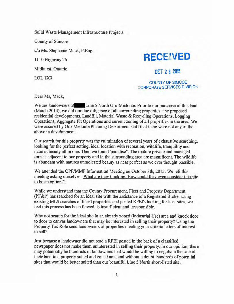
Solid Waste Management Infrastructure Projects
County of Simcoe
c/o Ms. Stephanie Mac~ P.Eng.
111 0 Highway 26
Midhurst, Ontario
LOL1XO
Dear Ms, Mack,
RECE!VED OCT 2 8 2015
COUNTY OF SIMCOE CORPORATE SERVICES DIVISION
We are landowners a- Line 5 North Oro-Medonte. Prior to our purchase of this land (March 2014 ), we did our due diligence of all surrounding properties, any proposed residential developments, Landfill, Material Waste & Recycling Operations, Logging Operations, Aggregate Pit Operations and current zoning of all properties in the area. We were assured by Oro-Medonte Planning Department staff that there were not any of the above in development.
Our search for this property was the culmination of several years of exhaustive searching, looking for the perfect setting, ideal location with recreation, wildlife, tranquility and natures beauty all in one. Then we found 'paradise". The mature private and managed forests adjacent to our property and in the surrounding area are magnificent. The wildlife is abundant with natures unmolested beauty as near perfect as we ever thought possible.
We attended the OPF/MMF Information Meeting on October 8th, 2015. We left this meeting asking ourselves "What are they thinking. How could they even consider this site to be an option?"
While we understand that the County Procurement, Fleet and Property Department (PF&P) has searched for an ideal site with the assistance of a Registered Broker using existing MLS searches of listed properties and posted RFEI's looking for host sites, we feel this process has been flawed, is insufficient and irresponsible.
Why not search for the ideal site in an already zoned (Industrial Use) area and knock door to door to canvas landowners that may be interested in selling their property? Using the Property Tax Role send landowners of properties meeting your criteria letters of interest to sell?
Just because a landowner did not read a RFEI posted in the back of a classified newspaper does not make them uninterested in selling their property. In our opinion, there may potentially be hundreds of landowners that would be willing to negotiate the sale of their land in a properly suited and zoned area and without a doubt, hundreds of potential sites that would be better suited than our beautiful Line 5 North short-listed site.
1
Impact on the Line 5 North area residents and users:
Spring, Summer, Fall- There are hundreds of daily recreational users of Line 5 North between Old Barrie Rd. and Bass Lake Sideroad. These include cyclists, walkers, in-line skaters, horseback riders, motorcycle groups. This section of road is very narrow with many rolling hills that create blind sections and needs to be travelled with extreme care and caution as the cyclists are usually travelling two abreast. We have present concerns that one day there may be a tragic accident on our road involving cyclists and a motor vehicle. Even travel by automobile and encountering on-coming vehicles has been treacherous on this road. Add to this the potential of an additional210 heavy trucks travelling daily (as stated in the OPF/MMF F AQ's) on this road, an accident would be inevitable. There are no shoulders, no ditches, and the road is lined by mature hardwood trees, some of which are within .5 meter of the paved roadway. There are many sections along this roadway that are also covered with an overhead canopy of mature trees that make this road non-conducive to large truck travel.
Winter - The roads are even narrower, the snow plow banks on each side are high and encroach on the road widths. The private driveway entrances/exits are also vision obstructed due to the snow plow banks. Increased large truck travel on this road in winter will be a deadly combination to homeowners, school children, Snowmobilers and ATV users alike.
Land Enjoyment and Devaluation of Property
Having just recently purchased our land, we know it's current value. Our property is within 500 meters of the proposed site. Even with mitigation, there will be a huge impact on our environment. Dust and odour may likely be a direct effect of a OPF/MMF operation and will may have a very detrimental effect on our quality of life, our health and most certainly our property value. My wife and I both have dust allergies. Also, my wife is asthmatic which is induced by dust.
We will be seeking compensation for any decreased land enjoyment and land value.
Recreation
This site is in close proximity of Hardwood Hills, Horseshoe Valley Resort, several Bed and Breakfasts and some Horse Boarding Facilities. Some of these businesses will be negatively impacted financially as a result of locating this facility on Line 5 North.
Oro Moraine
How can this site be even considered since it is centrally located in the Oro-Moraine?
Has the Nottawasaga Valley Conservation Authority (NVCA) and the Lake Simcoe Region Conservation Authority (LSRCA) been consulted in this process?
2

The Oro Moraine is the headwaters for watersheds draining west to the Nottawasaga Bay, north to Severn Sound and south to Lake Simcoe. Forest cover on the Moraine and wetlands along its base provide important ecological functions and are connected to other natural areas in Simcoe County. Groundwater recharge on the Moraine provides important water supplies for residents. Groundwater discharge on the Moraine provides clean cold baseflow to headwater streams that are needed to support sensitive fish species. Changes in land use within and even next to the Moraine can effect the sensitive ecosystems of the Moraine itself.
In closing, our beautiful dream property, "Paradise" is in jeopardy. This proposed facility has become our worst nightmare. Therefore, please be infonned that if the proposed site at Line 5 North is selected as the preferred site, we will go on record to object to this site selection, the site selection process and will do everything possible to protect our interests.
Sincerely,
- Line 5 North
Oro-Medonte
Mailing address:
• Devonleigh Drive
Amaranth, Ontario
L9V 313
3

From:
Sent: October 26, 2015 8:51 AM
To: Customer Service
Subject: Waste Management Facility
Dear Stephanie Mack,
I am writing to express my concern and disapproval of building an Organics Processing and Material
Management facility at the Sandford Tract Forest located on the 5th line of Oro-Medonte.
Not only will building this facility at said location be detrimental to the business at Hardwood Ski and
Bike and to the enjoyment of my time at this property, it will also be harmful to the sensitive Oro-
Moraine. This moraine drains into Georgian Bay, Lake Huron and Lake Simcoe. Efforts are already being
made to preserve undeveloped land on the moraine by encouraging landowners to leave their property
as a legacy to the regional conservation authorities in their wills.
With such efforts being made to preserve this land it only makes sense to choose another location for
this Organics Processing and Material Management facility.
Thank you for your time and attention to this serious matter.
Sincerely,
Concerned Citizen

From: John Alldred Sent: Monday, October 26, 2015 10:45 AM To: Mack, Stephanie Subject: site 1453 flos rd 3 springwater Hello Stephanie Please see my comments in attached letter also mailed. Thanks, John Byron Alldred

Oct 6, 2015 Dear Stephanie Mack Special projects Supervisor County of Simcoe, Solid Waste Management 1110 highway 26, Midhurst, ON , L0L 1X0 Re site 1453 Flos Rd 3 E Springwater
My property comprised of 13.3 acres appears to adjoin the easterly border of this site
Con N PT Lot Flos Rd 3 E, Roll John Byron Alldred
There is concern that waste disposal site aesthetics and odors will have negative impact on enjoyment of and value of adjoining properties. My adjoining property is fairly narrow strip along easterly border of this site therefore any future building or other activity on my property will be in very close proximity to disposal site. Waste disposal sites appear to develop significant elevations above baseline over time adding to aesthetic concerns and raise concerns regarding soil, waste and water erosion and runoff. A big concern would be Leachate escaping over time from the waste disposal site reaching adjoining property and contaminating soil and ground water. How big a buffer is left between dumping area on the site and the border of the site property? I would have thought that the larger the buffer area the less risk that leachate will escape a waste disposal site over time and reach and contaminate adjoining properties. Leachate migration is probably affected by soil conditions and water flow patterns both surface and underground. I would have thought a 1000ft buffer zone between a waste disposal area on a site and the adjoining properties might be desirable to help reduce these concerns. A significant buffer zone would also help alleviate aesthetic and odor concerns as well. What kind of drill holes or other systems are used to monitor migration of leachate from waste disposal sites. A waste disposal site should be set up so that a guarantee can be provided to adjoining property owners that leachate will never reach or be detected on adjoining property either in soils or in water both surface and underground that would negatively affect adjoining property. Samples of soil and water, both surface and underground, could be taken from adjoining property as baseline for future reference to see if leachate contamination of adjoining property has occurred from the disposal site in the future. Adjoining property owners should be guaranteed that building home residences or other buildings or other uses of adjoining property will be able to be enjoyed by present owner or any future owners just as it would be if there were not a waste disposal site on adjoining property? There is obvious concern that water wells in proximity will be at risk of leachate contamination in future years. There is concern for surface water run off to adjoining property. What direction does surface and underground water flow and what direction does underground water table flow? The surface and underground water flow patterns would appear to impact the migration of leachate from the site to adjoining properties over time. There is concern about increased traffic and noise on small country road with several residences in place. I feel that this waste disposal site will greatly reduce the uses and enjoyment of my adjoining property and greatly depreciate the value of my property for present and future owners. Yours Truly,
John Byron Alldred Email west Peninsula Rd, North bay, Ont, P1B8G4

Survey Response: We Want to Hear From You Response GUID: a2b5d8d5‐a762‐491d‐a5f4‐2c716548b62b Started: 10/26/2015 3:51:56 PM Completed: 10/26/2015 4:53:58 PM Name: peter stephan Email: Comments: I am responding in regards to the Millenium Tract proposal. I live on old 2nd and our property borders the Ganaraska trail to the west and the proposed site to the east. As an avid outdoorsman I walk, run and ride the property most days. Snowshoe in the winter. I have personally seen, on several occassions the following widlife in this tract, which clearly acts as not only a home to several species, but as a natural corridor for many others. Black Bears, mothers and cubs, coyotes and or wolves, as the biologist I met tracking them attested. Many Fischers and a few fox. Deer, and turkey, the usual assortment of racoons and squirels. At least 3 different types of snakes, bright red salamanders and larger darker Newts. The frogs in the late spring are amazing to listen to. Large and small owls, hawks and geese in the fall and spring. Many of these animals use this tract as a corridor to travel between the various islands or pockests of forest in the area. This location is particularly sensitive in this regard due to the railway bridge location under the 400 highway. This and the three tunnels underneath the highway which also lead to and from this tract, serve as a link between the above noted islands of forested areas. At the meeting at the Town Hall it became clear to me that the mandate of the Town, although not admitted by them at the time was to consolidate the two proposed sites. Clearly the people in attendance voiced their concern with all of the sites excepting thereout, the one close to the 400 highway. Furthermore, several other considerations were raised by locals aware of other suitable locations for such an endevour. After leaving the meeting that night, I felt betrayed. Betrayed by the very people entrusted to govern the actions of the municipality. Not sure where our elected represenatative stood on the issue but I will find out. But also and especially by the non elected civil servants who are paid by our tax dollars and who have mandated this process. As noted after I left the meeting it occured to me that the entire process was nothing but a big sell job. This was not a bilateral, unbiased information session, this was simply a public relations exercise. There was no attempt to put forth the pros and cons of this entire project, it was just the pros. No discussion of the down side, or the disadvantages of this project, none, not even the slightest attmept to mitigate the message of the tremendous benefit this project would supposedly provide. We were told by the consulting engineer that he has built these sites in downtown locations, and that the impacts are negligible to surrounding space. If thats the case then why would you not place these buildings on present locations where complaints are rampant. Kill two birds with one stone so to speak. There is no question that this project would substantially and irreparably harm the present state of the ecosystem of this drainage and wildlife corridor. Clearly and loudly the people of Springhurst have spoken in relation to all of the proposed sites save one.This site needs to be purchased however and the tone of the engineer when refering thereto was obivous and undeniably unsavory. I heard clear unambigous protests for every site save one. I also heard clear and unambiguous alternatives sited. I would like to know where the people who have proposed this project live. How close would they be in proximity to any one of the sites shortlisted. I would like to know whether anyone in the entire circle of elected or paid individuals involved in this process have purchased or sold land in the direct vicinity of these short listed sites. I am also curious about the extreme and stringent building requirements imposed by the county on any construction in the area. How it must comply with several different levels of scrutiny and how sites of

30 plus acres are limited to one dwelling. Yet all such consideration seems lost on the proposed site development. Furthermore, the state of the road on old 2nd has been a constant source of frustration. And in fact the neglect and untimely reparations thereof nearly cost two young teenage girls their lives last year. But now, the county would step up and consider making the road viable so that 200 of its garbage trucks can lumber over it. In closing I would suggest that this entire process, decimating a complete forest ecosystem, instead of using an already commercialized space, seems like complete and unadultereated negligence. The county has a duty of care to its citizenry and the consequence of its actions herein are both predictable and foreseable. Accountability will be demanded. Based on the entirety of the above I most respectfully submit that this project constitutes an egrigous departure of good government, common sense and an afront to the well being of the people and animals situate close by. Sincerely Yours P.Stephan

From: Mark Zielinski
Sent: Monday, October 26, 2015 5:31 PM
To: Customer Service <[email protected]>
Subject: Purposed Location of Organics Processing and Materials Management Facility
Dear Stephanie Mack,
I am writing to express my concern and disapproval of building an Organics Processing and
Material Management facility at the Sandford Tract Forest located on the 5th line of Oro-
Medonte. My concerns are both economic and environmental.
From an economic point of view, Hardwood Ski and Bike is an employer in the area, and a major
year-round tourist destination. I do not understand why we would want to potentially jeopardize
this successful local business by building an adjacent Organics Processing and Material
Management Facility.
From an environmental point of view, it would also be harmful to the sensitive Oro-
Moraine. This moraine drains into Georgian Bay, Lake Huron and Lake Simcoe. Efforts are
already being made to preserve undeveloped land on the moraine by encouraging landowners to
leave their property as a legacy to the regional conservation authorities in their wills.
Thank you for your time and attention to this serious matter.
Sincerely,
Mark Zielinski
Valleycrest Drive, Oro-Medonte, LOL 2LO
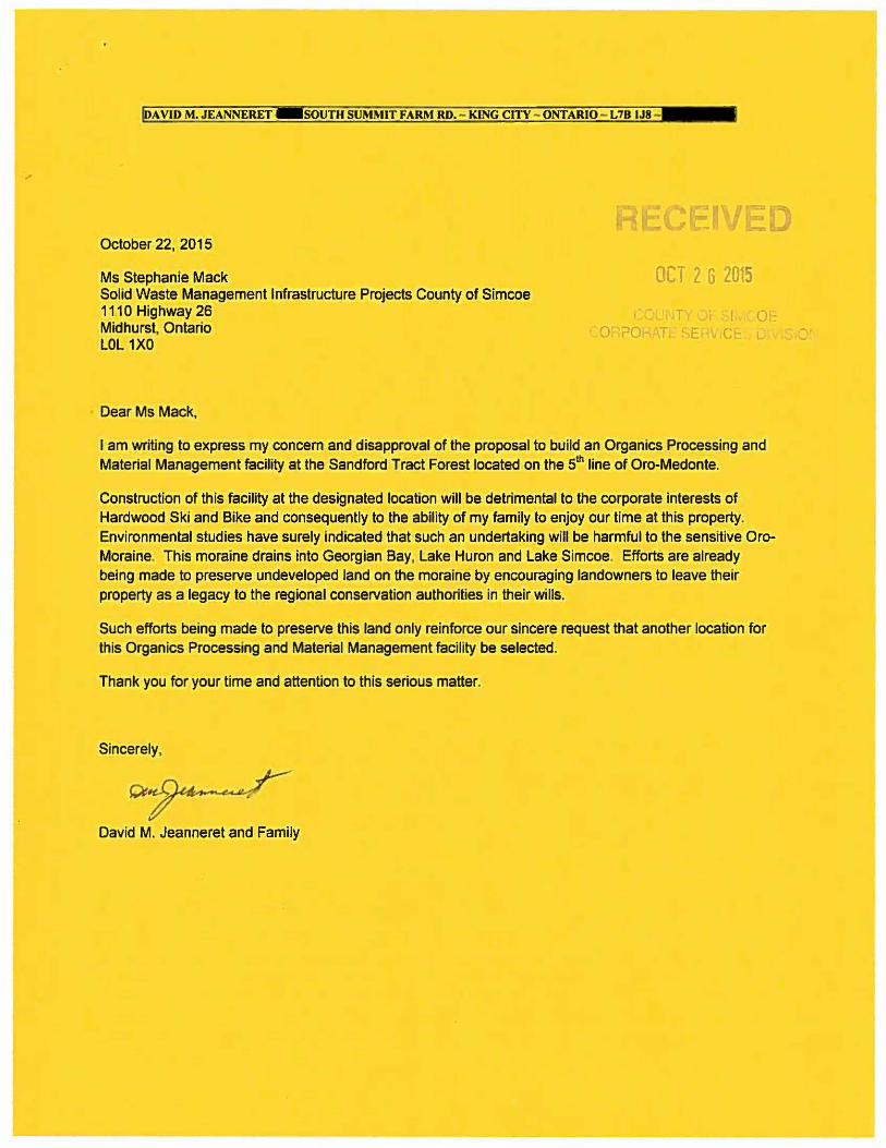
IDA VID M. JEANNERET SOUTH SUMMIT FARM RD. - KING CITY - ONTARIO - L7B IJ8 - ····
October 22, 2015
Ms Stephanie Mack Solid Waste Management Infrastructure Projects County of Simcoe 1110 Highway 26 Midhurst, Ontario LOL 1XO
Dear Ms Mack,
OCT 2 6 2015
T r
I c
0-
I am writing to express my concern and disapproval of the proposal to build an Organics Processing and Material Management facility at the Sandford Tract Forest located on the 5th line of Oro-Medonte.
Construction of this facility at the designated location will be detrimental to the corporate interests of Hardwood Ski and Bike and consequently to the ability of my family to enjoy our time at this property. Environmental studies have surely indicated that such an undertaking will be harmful to the sensitive Oro-Moraine. This moraine drains into Georgian Bay, Lake Huron and Lake Simcoe. Efforts are already being made to preserve undeveloped land on the moraine by encouraging landowners to leave their property as a legacy to the regional conservation authorities in their wills.
Such efforts being made to preserve this land only reinforce our sincere request that another location for this Organics Processing and Material Management facility be selected.
Thank you for your time and attention to this serious matter.
Sincerely,
David M. Jeanneret and Family

Dear Stephanie Mack,
I am writing to express my concern and disapproval of building an Organics Processing and Material Management facility at the Sandford Tract Forest located on the 5th line of Oro-Medonte.
Not only will building this facility at said location be detrimental to the business at Hardwood Ski and Bike and to the enjoyment of my time at this property, it will also be harmful to the sensitive Oro-Moraine. This moraine drains into Georgian Bay, Lake Huron and Lake Simcoe. Efforts are already being made to preserve undeveloped land on the moraine by encouraging landowners to leave their property as a legacy to the regional conservation authorities in their wills.
With such efforts being made to preserve this land it only makes sense to choose another location for this Organics Processing and Material Management facility.
Thank you for your time and attention to this serious matter.
Sincerely,
Concerned Citizen
f~ ~· ~ ~~~ ~ ON L9& 5"'CS""
REC ~IV .
OCT 2 G 20i5
COUNT'r OF SIMCOE CORPORATC SERVICE~ Ol\fl''lO\

Public Consultation Session
Development of Infrastructure Projects
c ED Monday, October 26, 2015 Hillsdale Community Centre OCT 2 6 2015
COmment Sheet COUNl CO POR TE SEI1VICE=S DIViSIO
Contact Information (optional):
Name: ---------------------------------------------- Date: _______ _
Postal Code: _____ _ Affiliation: ____________________________________ _
Address: -------------------------------- Ema: -------------Thank you for taking the time to prov1de us with your feedback.
Mailing address:
Solid Waste Management Infrastructure PrOJects County of Simcoe
c/o Ms. Stephanie Mack, P.Eng. 1110 Highway 26, Midhurst. Ontario
LOL 1XO
1 -800-263-31 99
simcoe.ca/opf or simcoe.ca/mmf
Comments can be submitted by mail or email during thfs consultation process. Ptease note that your response will form part of the project record and wil be forwarded to our consultant for cons deration as the sites are further evaluated. All comments must be received by November 6, 2015.
Personal information is being collected pursuant to Section 28 of the Municipal Freedom or Information and Protection of Privacy Act (MFIPPA) and will be used for the purpose of gamering public 1nput
into the development of the Organics Processing Facility Project and Materials Management Facility Project to respond to inquiries regarding this process. Comments and 1nput prov1ded may form part or the projects'
documentation. Should you have questions regarding this collect on. please contact Stephanie Mack. P.Eng .. Special Projects Supervisor, 705-726-9300, County of S1mcoe.

Please RfQvide YQLili comments below
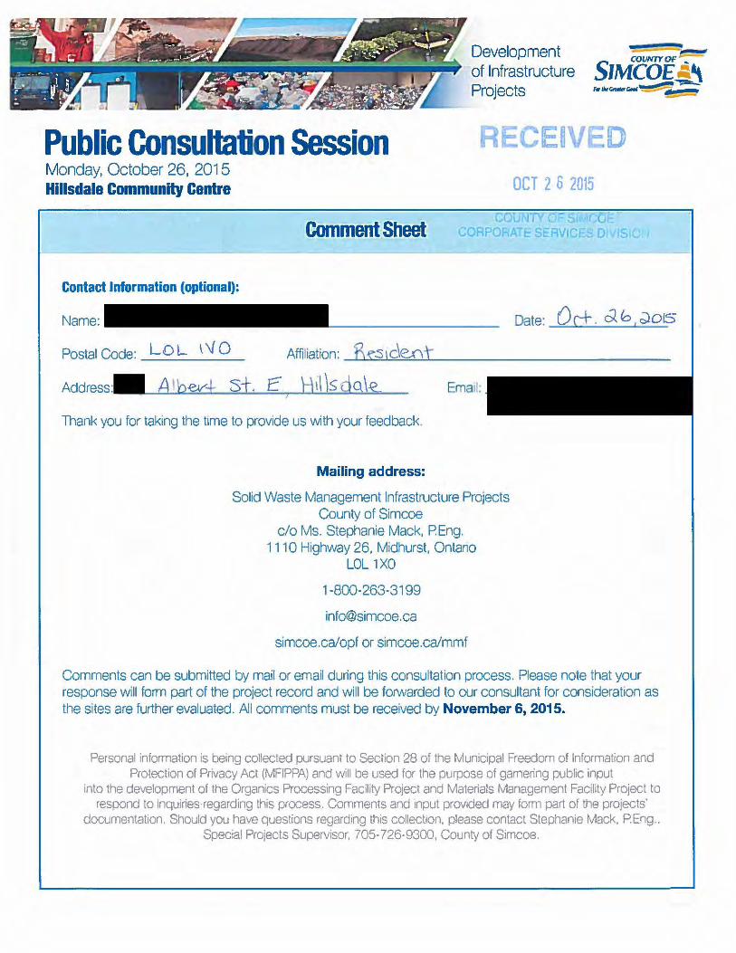
Development of Infrastructure Projects
COUNTYOF ~
SIMCOE A\ f•O.C...O..c-1~~
=--
Public Consultation Session ECEIVED Monday, October 26, 2015 Hillsdale Community Centre
Comment Sheet
Contact Information (optional):
Name:
Postal Code: L 0 1.-. \ \j 0 Affiliation: Bs:.s !de..Dt
Address Emal:
Thank you for taking the t1me to provide us with your feedback.
Mailing address:
Solid Waste Management Infrastructure Projects County of Simcoe
c/o Ms. Stephanie Mack, P. Eng. 1110 Highway 26, Midhurst, Ontano
LOL 1XO
1 -800-263-31 99
simcoe.ca/opf or simcoe.ca/mmf
OCT 2 6 2015
Date: 0 c±. oz b . ~D!S
Comments can be submitted by mail or email during this consultation process. Please note that your response will form part of the project record and will be forwarded to our consultant for consideration as the sites are further evaluated. All comments must be received by November 6, 2015.
Personal information is being collected pursuant to Section 28 of the Municipal Freedom of Information and Protection of Privacy Act (MFIPPA) and will be used for the purpose of gamering public input
into the development of the Organics Processing Facility Project and Materials Management Facility Project to respond to inquiries-regarding this process. Comments and 1nput prov1ded may form part of the projects'
documentation. Should you have questions regarding this collect1on. please contact Stephanie Mack. P.Eng., Special Projects Supervisor, 705-726-9300, County of Simcoe.

Please provide YQur comments below
2.) sLJjz~sv~.,~:!~ ~JhRooOI , s f tr·"{!J'o.+e¥
4t pt 1 LJ ctfP /J [Q,' £\a R d t cOS f rvJ ora M 0 t\ e-:J)

Development of Infrastructure Projects
Pub,lic Consultation Session Monday, October 26, 2015 Hillsdale Community Centre
Comment Sheet
Contact Information (optional):
Name:
Address: Email:
Thank you for taking the time to provide us with your feedback.
Mailing address:
Sohd Waste Management Infrastructure Projects County of S mcoe
c/o Ms. Stephanie Mack, P.Eng. 1110 Highway 26, Midhurst. Ontario
LOL 1XO
1-800-263-3199
simcoe.ca/opf or simcoe.ca/mmf
E E OCT 2 6 2015
Date: ~~ 2b/IS.
Comments can be submitted by ma I or emafl during this consultation process. Please note that your response will form part of the project record and will be forwarded to our consultant for considerat on as the sites are further evaluated. All comments must be received by November 6, 2015.
Personal information 1s be1ng col ected pursuant to Section 28 of the Mun1c1pal Freedom of Information and Protectton of Privacy Act (MFIPPA) and Will be used for the purpose of gamenng public tnput
into the development of the OrganiCs Processing Fa:ility PrOJect and Matenals Management Facthty Pro1ect to respond to inqumes regard1ng th.s process. Comments and 1nput provided may form part of the projects'
documentation. Should you have quest'ons regarding this collectton, please contact Stephanie Mack, P Eng., Spec al Pro ects Supervisor. 705-726·g3oo, County of Stmcoe.

Please p_rovide youli comments belovl
~ ·~ a C\o~ ~ot\,~re{, oo - !.eJ€a;hl'\OI\ sittJ.;O'D (l:c >ll)d:e, Qn \X9j])\ trMkycl: cdotAAD . 0

D
V v J lltl.:liVI

-----Original Message-----
From: Nick Boldt
Sent: Tuesday, October 27, 2015 11:18 AM
To: Customer Service <[email protected]>
Subject: re: new Organics Processing and Materials Management Facility
Dear Stephanie Mack,
I am writing to express my concern and disapproval of building an Organics Processing and Material
Management facility at the Sandford Tract Forest located on the 5th line of Oro-Medonte.
Not only will building this facility at said location be detrimental to the business at Hardwood Ski and
Bike and to the enjoyment of my time at this property, it will also be harmful to the sensitive Oro-
Moraine. This moraine drains into Georgian Bay, Lake Huron and Lake Simcoe. Efforts are already being
made to preserve undeveloped land on the moraine by encouraging landowners to leave their property
as a legacy to the regional conservation authorities in their wills.
With such efforts being made to preserve this land it only makes sense to choose another location for
this Organics Processing and Material Management facility.
Thank you for your time and attention to this serious matter.
Sincerely,
--
Nick Boldt

From: Matt Tribe
Sent: Tuesday, October 27, 2015 11:57 AM
To: Customer Service <[email protected]>
Subject: Organics processing and material management facility disapproval
Dear Stephanie Mack,
I am writing to express my concern and disapproval of building an Organics Processing and
Material Management facility at the Sandford Tract Forest located on the 5th line of Oro-
Medonte.
Not only will building this facility at said location be detrimental to the business at Hardwood
Ski and Bike and to the enjoyment of my time at this property, it will also be harmful to the
sensitive Oro-Moraine. This moraine drains into Georgian Bay, Lake Huron and Lake
Simcoe. Efforts are already being made to preserve undeveloped land on the moraine by
encouraging landowners to leave their property as a legacy to the regional conservation
authorities in their wills.
With such efforts being made to preserve this land it only makes sense to choose another location
for this Organics Processing and Material Management facility.
Thank you for your time and attention to this serious matter.
Sincerely,
Matt Tribe, Concerned Citizen

From: Esther Kelly
Sent: Tuesday, October 27, 2015 2:18 PM
To: Customer Service <[email protected]>
Subject: Recycling and Organics Plant - 5th Line Oro Medonte
Please see the attached letter.

Solid Waste Management Infrastructure Projects County of Simcoe
c/o Stephanie Mack, P.Eng.
1110 Highway 26
Midhurst, Ontario
L0L 1X0
Dear Stephanie Mack,
I am writing to express my concern and disapproval of building an Organics Processing and
Material Management facility at the Sandford Tract Forest located on the 5th Line of Oro-
Medonte.
I fear this facility has the potential to be harmful to the sensitive Oro-Moraine. This moraine
drains into Georgian Bay, Lake Huron and Lake Simcoe. Efforts are already being made to
preserve undeveloped land on the moraine by encouraging landowners to leave their property as
a legacy to the regional conservation authorities in their wills. With such efforts being made to
preserve this land, it only makes sense to choose another location for this Organics Processing
and Material Management facility.
The infrastructure needed to develop the 5th Line and roads leading to it would also destroy the
rural setting of the area. The facility itself will be surrounded by a buffer, but there is no way to
buffer the residences on the truck routes from the huge increase in trucking traffic. The rolling
hills of the 5th Line will be destroyed.
Building this facility at the said location will also be detrimental to the world class facility at
Hardwood Ski and Bike where the PanAm Games were recently held. Many people come from
near and far, truly from around the world, to enjoy this property and this area. The trails wind
through the beautiful forests, for which this area is known. As well, people training for races and
events make use of the surrounding roads to connect to other Simcoe County Forest trails. Truck
traffic required for your facility would make it too dangerous to continue training in the area. It
would become unsafe to hold the road races and biathlon events that generate revenue not just
for Hardwood Ski and Bike but other local businesses as well, such as restaurants and bed and
breakfasts.
Thank you for your time and attention to this serious matter. Please remember that the citizens
of rural Simcoe County have made it their home because of the fact that it is rural land. Such
industrial facilities belong in Industrial Parks where infrastructure is already in existence and
away from areas where people make their homes.
Sincerely,
Esther Kelly
Line 5 North
Oro Medonte ON L0L 2E0

October 21, 2015
Dear Stephanie Mack,
I am writing to express my concern that an Organics Processing and Material Management facility could be located at the Sandford Tract Forest located on the 5th line ofOro-Medonte.
This site is adjacent to Hardwood Ski and Bike, which hosted the Pan-Am mountain bikes races this past summer. It is a well-established, busy, family-oriented business that encourages outdoor activity.
I am concerned that building this facility at this location will be detrimental to the business at Hardwood Ski and Bike and to the enjoyment of my time at this property. It will also lead to increased traffic on the small roads that are necessary to get to Hardwood from Highway 11.
I am also concerned that these facilities will be harmful to the sensitive Oro-Moraine. This moraine drains into Georgian Bay, Lake Huron and Lake Simcoe, and there are significant aquifers in the moraine that could be affected by the facilities.
Efforts are already being made to preserve undeveloped land on the moraine by encouraging landowners to leave their property as a legacy to the regional conservation authorities in their wills.
With such efforts being made to preserve this land it only makes sense to choose another location for this Organics Processing and Material Management facility.
I appreciate that such a facility must go some where and that there will be impacts on people, traffic and the environment wherever it goes. However, I believe there are sufficient reasons to not locate these facilities at this location.
Thank you for your time and attention to this serious matter.
Sincerely,
JeffLaidman, P. Eng.
- Leacock Drive Barrie, Ontario L4N 7X3
c v-OCT 2 7 20i5
COJ\ (\' )~ ., C.C r
COt' PC'F AT::... Sl,.,V i r

Oct.-22-15
Dear Stephanie Mack,
I am writing to express my concern and disapproval of building an Organics Processing and Material Management facility at the Sandford Tract Forest located on the 5th line of Oro-Medonte.
Not only will building this facility at said location be detrimental to the business at Hardwood Ski and Bike and to the enjoyment of my time at this property, it will also be harmful to the sensitive Oro-Moraine. This moraine drains into Georgian Bay, Lake Huron and Lake Simcoe. Efforts are already being made to preserve undeveloped land on the moraine by encouraging landowners to leave their property as a legacy to the regional conservation authorities in their wills.
With such efforts being made to preserve this land it only makes sense to choose another location for this Organics Processing and Material Management facility.
I moved to Barrie in 2004 and one of my favourite Oro line discovery was Line 5. I have enjoyed this most beautiful road on my Road bike on numerous occasions. It is one of the areas that I bring company to when they come for a visit to show them what a special place Oro and the many Oro lines are scenic and with little traffic. This would destroy both of these.
Thank you for your time and attention to this serious matter.
Sincerely,
Guy Villeneuve
Barrie, on
Concerned Citizen OCT 2 7 2015
COUNIY 0 I v CORPORATE SEf-l\IJrr

. 4 Development -COVNTY OF --:--
SIMCOE -~
Public Consultation Session Thursday, October 8
of Infrastructure Projects , •• c-..~~-
Township of Oro-Medonte Administration Centre OCT 2 7 2ot5
Comment Sheet
Contact Information (optional):
Name: Date: O d ;)I, d0t5 ;
Postal Code: LOL .J. L 0
Address: Email:
Thank you for taking the time to provrde us With your feedback.
Rr .· Con. S , No f'-1-h 0 Ro- fY)ec/o n TL Mailing address:
So!td Waste Management Infrastructure Projects County of Smcoe
c/o Ms. Stephanie Mack, P.Eng. 1110 Highway 26, Midhurst, Ontaro
LOL 1XO
1-800-263-3199
simcoe.ca/opf or simcoe.ca/mmf
Comments can be submitted by mail or email during this consultation process. Please note that your response will form part of the project record and will be forwarded to our consultant for consrderation as the sites are further evaluated. All comments must be recerved by November 6, 2015.
Personal1nformat.on 15 berng collected pursuant to Section 28 of the Municrpal Freedom of Informal on and Protection of Prrvacy Act (MFIPP~) and will be used for the purpose of gamenng public input
rnto the development of the Organics Processing Fac11ity Project and Matenals Management Fac11ty Prote:t to respond to rnqurnes regardrng thrs process Comments and input provided may form part of the pro eds'
documentatton. Should you have questtons regardrng thrs collectron, please contact Stephane Ma k, PEng, Specral Projects Supervisor, 705-726-9300, County of Srmcoe.

Please JH:Qvide YQlll' comments below I
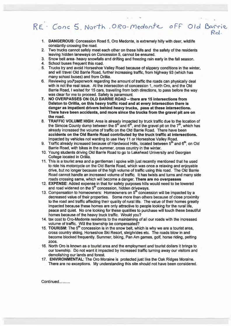
. R £. . c·an c 5. No'f'i-h . 0 Ro- (Y)edonf~ oFF Old ~a:\'ri~
Rd . 1. DANGEROUS: Concession Road 5, Oro Medonte, is extremely hilly with deer, wildlife
constantly crossing the road. 2. Two trucks cannot safely meet each other on these hills and the safety of the residents
leaving hidden laneways on Concession 5, cannot be ensured. 3. Snow belt area- heavy snowfalls and drifting and freezing rain early in the fall season. 4. School buses frequent this road. 5. Trucks try and avoid Horseshoe Valley Road because of slippery conditions in the winter,
and will travel Old Barrie Road, further increasing traffic, from highway 93 (which has many school buses) and from Orillla.
6. Reviewing yoltpaperwork regarding the amount of traffic the roads can physically deal with is not the real issue. At the intersection of concession 1, north Oro, and the Old Barrie Road, I waited for 15 cars, travelling from both directions, to pass before the way was clear for me to proceed. Safety is paramount.
7. NO OVERPASSES ON OLD BARRIE ROAD- there are 151ntersections from Dalston to Orillla, on this heavy traffic road and at every intersection there Is danger as impatient drivers behind heavy trucks, pass at these intersections. There have been accidents, and more since the trucks from the gravel pit are on the road.
8. TRAFFIC VOLUME HIGH: Area is already impacted by truck traffic due to the location of the Simcoe County dump between the 5th and 6th, and the gravel pit on the 7th, which has already increased the volume of traffic on the Old Barrie Road. There have been accidents on the Old Barrie Road contributed by the truck traffic at intersections. Impacted by vehicles not wanting to use Hwy 11 or Horseshoe Valley Road.
9. Traffic already increased because of Hardwood Hills, located between 51h and 61
h, on Old Barrie Road, with bikes in the summer, cross country in the winter.
10. Young students driving Old Barrie Road to go to Lakehead University and Georgian College located in Orillia.
11. This is a tourist area and a gentleman I spoke with just recently mentioned that he used to ride his motorcycle on the Old Barrie Road, which was once a relaxing and enjoyable drive, but no longer because of the high volume of traffic using this road . The Old Barrie Road cannot handle an increased volume of traffic. It has twists and turns and many side roads crossing same, which will become a danger. There are no overpasses
12. EXPENSE: Added expense in that for safety purposes hills would need to be lowered and road widened on the 5th concession, hidden driveways.
13. Compensation to homeowners: Homeowners on 5th concession will be impacted by a decreased value of their properties. Some more than others because of close proximity to the road and traffic affecting their quality of rural life. The value of their homes greatly impacted because these homes are only attractive to people looking for the rural life, peace and quiet No one looking for these qualities to purchase will touch these beautiful homes because of the heavy truck traffic. Would you?
14. tax cost to Oro-Medonte residents to the maintaining of all our roads with the increased volume of traffic. Will the township be compensated?
15. TOURISM: The 5th concession is in the snow belt, which is why we are a tourist area, cross country skiing, Horseshoe Ski Resort, sleighrides etc. The roads blow in and become blocked frequently. Summer, biking, Pan Am games, golf, horse riding, petting zoos.
16. North Oro is known as a tourist area and the employment and tourist dollars it brings to our township. Do not want it impacted by increased traffic turning away our visitors and demolishing our lands and forest.
17. ENVIRONMENTAL: The Oro Moraine is protected just like the Oak Ridges Moraine. There are no exceptions. My understanding this site should not have been considered.
Continued ....... ..

R£ · C~n5J )\lor1h OR0-fY)ecbni~ "'
oFF 0 I d & (' l', e.. Rd .
18. County lands and Forest needs to be protected. Canada cannot survive without Green Belts and farmland. In trying economic times we must protect these lands and find other ways to fund things. County Lands and Forest has previously been sold, (concession 1 N Oro - Bidwell SideRoad) and is now a subdivision and I see the trees now wasted, rotting and falling to the ground around their homes. Why? If you make the decision to build in
~ County Forest, you are destroying what you are trying to protect with this recycling plant. It is the next 2 generations who will be in serious trouble regarding food and water and natural resources.
SUGGESTIONS:
20. look for an industrial site, near a highway with overpasses so there will be less danger to motorists crossing at the many intersections as what are along the Old Barrie Road.
21. Putting the sites other than Lands and Forest, in an area where residents do not mind the hub bub of traffic and noise. Country folk choose to live in the country for peace and quiet. City folk like the hub bud and noise of City life.
22. I suggest Site 540/528 Penetanguishene Rd, Springwater as trucks have access to Hwy 400, Hwy 93, Hwy 11 without the intersections and need for overpasses. Trucks can use Ridge Road, Shanty Bay Road etc.. The increased traffic would be spread out over a number of roads with less impact to any one area. -There is no need to destroy trees as there are none there. Any new homes were built after Napoleon Stove, asphalt plant etc. were located there, so it will not have as much need for compensation to local residents or impact their life style and value of their homes. - In an area where employees can access the job site without the need to travel back snow covered roads. - No need to widen roads, cut down hills. - Less danger to local traffic and school buses - There would be no impact to wildlife. - you would not set a terrible precedent of ignoring the words, •protected Lands and Foresr.
Thanks for the opportunity to comment and that you find the above comments helpful in your decisions making.

From: Amanda Geist Sent: Wednesday, October 28, 2015 10:12 AM To: Greenwood, Allan <[email protected]>; Matanowitsch, Collin <[email protected]> Cc: Subject: Solid Waste Management Infrastructure Projects Comments To Whom it may concern, Please accept my comments for the Flos Rd Seven East OPF proposed location near Hillsdale Regards, John P Geist
Robert blvd, Hillsdale L0L-1V0

Development of Infrastructure Projects
Public Consultation Session Monday, October 26, 2015 Hillsdale Community Centre
Comment Sheet
Contact Information (optional):
Name:
Postal Code: I...6A - 1 v o Affi liation: _________ __________ _
Address: Email:
Thank you for taking the time to provide us with your feedback.
Mailing address:
Solid Waste Management Infrastructure Projects County of Simcoe
c/o Ms. Stephanie Mack, PEng. 11 10 Highway 26, Midhurst, Ontario
LOL 1XO
1-800-263-3199
info@simcoe. ca
simcoe.ca/opf or simcoe.ca/mmf
Comments can be submitted by mail or email during this consultation process. Please note that your response wi ll form part of the project record and will be forwarded to our consultant for consideration as the sites are further evaluated. All comments must be received by November 6, 2015.
Personal information is be1ng collected pursuant to Sect1on 28 of the Municipal Freedom of Information and Protection of Privacy Act (MFIPPA) and will be used for the purpose of gamering public input
into the development of the Organ1cs Process1ng Facility Project and Materials Management Facility Project to respond to Inquiries regarding this process. Comments and input provided may form part of the projects'
documentation. Should you have questions regarding th1s collection, please contact Stephanie Mack, P.Eng., Special Projects Supervisor. 705-726-9300, County of Simcoe.

-
'
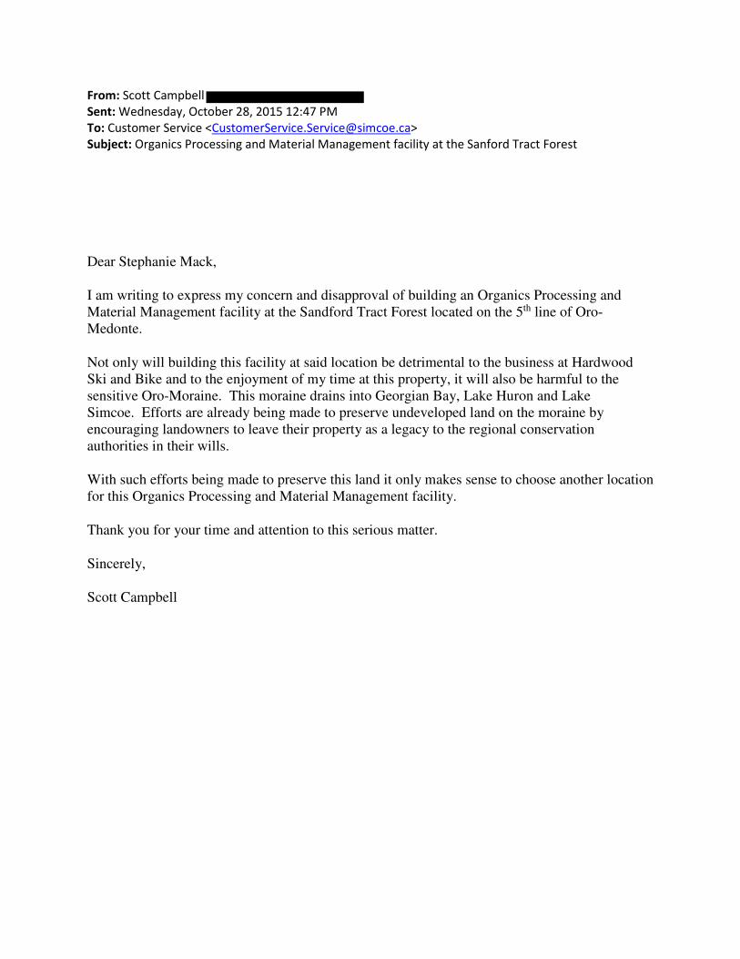
From: Scott Campbell
Sent: Wednesday, October 28, 2015 12:47 PM
To: Customer Service <[email protected]>
Subject: Organics Processing and Material Management facility at the Sanford Tract Forest
Dear Stephanie Mack,
I am writing to express my concern and disapproval of building an Organics Processing and
Material Management facility at the Sandford Tract Forest located on the 5th line of Oro-
Medonte.
Not only will building this facility at said location be detrimental to the business at Hardwood
Ski and Bike and to the enjoyment of my time at this property, it will also be harmful to the
sensitive Oro-Moraine. This moraine drains into Georgian Bay, Lake Huron and Lake
Simcoe. Efforts are already being made to preserve undeveloped land on the moraine by
encouraging landowners to leave their property as a legacy to the regional conservation
authorities in their wills.
With such efforts being made to preserve this land it only makes sense to choose another location
for this Organics Processing and Material Management facility.
Thank you for your time and attention to this serious matter.
Sincerely,
Scott Campbell

From: Rebecca Young
Sent: Wednesday, October 28, 2015 9:36 PM
To: Customer Service <[email protected]>
Subject: Concern
Dear Stephanie Mack,
I am writing to express my concern and disapproval of building an Organics Processing and
Material Management facility at the Sandford Tract Forest located on the 5th line of Oro-
Medonte.
Not only will building this facility at said location be detrimental to the business at Hardwood
Ski and Bike and to the enjoyment of my time at this property, it will also be harmful to the
sensitive Oro-Moraine. This moraine drains into Georgian Bay, Lake Huron and Lake
Simcoe. Efforts are already being made to preserve undeveloped land on the moraine by
encouraging landowners to leave their property as a legacy to the regional conservation
authorities in their wills.
With such efforts being made to preserve this land it only makes sense to choose another location
for this Organics Processing and Material Management facility.
Thank you for your time and attention to this serious matter.
Sincerely,
Rebecca Young

From: peter abolins Sent: Thursday, October 29, 2015 8:59 AM To: French, Bill; Allen, Don; Warden; Dowdall, Terry Cc: Jenni! Subject: Site C136 and C270
Gentlemen, In regards to the proposed industrial waste sites on Flos Rd 3 E and Rainbow Valley Rd E.,(C136 & C270), I voted for the first two recipiants of this note at the past municipal election and I must state that I do not recall this proposal during your campaigns. I and my family of three live just north of these proposed sites, on Flos Rd 4 E and WE DO NOT APPROVE OF NOR SUPPORT THE PROPOSED DUMP SITES! Had these been part of your campaigns you would not have received our electoral support. Please listen to your supporters and reject the proposal. Our forests, wetlands and agricultural heritage are too important to risk. Peter Abolins
From: Julie Cays
Sent: Thursday, October 29, 2015 11:44 AM
To: Customer Service <[email protected]>
Subject: Organics Facility Concerns
Please see letter attached.
Regards,
Julie Cays

October 29, 2015
Dear Stephanie Mack,
We are writing to express our concern and disapproval of building an Organics
Processing and Material Management facility at the Sandford Tract Forest located on
the 5th line of Oro-Medonte.
Not only will building this facility at said location be detrimental to the business at
Hardwood Ski and Bike and to the enjoyment of our family’s time at this property,
it will also be harmful to the sensitive Oro-Moraine. This moraine drains into
Georgian Bay, Lake Huron and Lake Simcoe. Efforts are already being made to
preserve undeveloped land on the moraine by encouraging landowners to leave
their property as a legacy to the regional conservation authorities in their wills.
With such efforts being made to preserve this land it only makes sense to choose
another location for this Organics Processing and Material Management facility.
Thank you for your time and attention to this serious matter.
Sincerely,
Ian and Julie Cays

From:
Sent: Thursday, October 29, 2015 2:22 PM
To: Customer Service <[email protected]>
Subject: Sandford Tract
Dear Stephanie Mack,
I am writing to express my concern and disapproval of building an Organics Processing and Material
Management facility at the Sandford Tract Forest located on the 5th line of Oro-Medonte.
Not only will building this facility at said location be detrimental to the business at Hardwood Ski and
Bike and to the enjoyment of my time at this property, it will also be harmful to the sensitive Oro-
Moraine. This moraine drains into Georgian Bay, Lake Huron and Lake Simcoe. Efforts are already
being made to preserve undeveloped land on the moraine by encouraging landowners to leave their
property as a legacy to the regional conservation authorities in their wills.
With such efforts being made to preserve this land it only makes sense to choose another location for this
Organics Processing and Material Management facility.
Thank you for your time and attention to this serious matter.
Sincerely,
Concerned Citizen

From: Matthew Cays
Sent: Thursday, October 29, 2015 3:22 PM
To: Customer Service <[email protected]>
Subject: Organics Processing facility at Sandford Tract Forest
Dear Stephanie Mack,
I am writing to express my concern and disapproval of building an Organics Processing and
Material Management facility at the Sandford Tract Forest located on the 5th line of Oro-
Medonte.
Not only will building this facility at said location be detrimental to the business at Hardwood
Ski and Bike and to the enjoyment of my time at this property, it will also be harmful to the
sensitive Oro-Moraine. This moraine drains into Georgian Bay, Lake Huron and Lake
Simcoe. Efforts are already being made to preserve undeveloped land on the moraine by
encouraging landowners to leave their property as a legacy to the regional conservation
authorities in their wills.
With such efforts being made to preserve this land it only makes sense to choose another location
for this Organics Processing and Material Management facility.
Thank you for your time and attention to this serious matter.
Sincerely,
Matthew Cays

From: Jim Shields Sent: October 30, 2015 9:10 AM To: [email protected] Subject: oppose sitesC136 and C270
Hello Mr. French, I am writing to strongly oppose waste transfer/composting sites in Springwater. High truck traffic will forever ruin a peaceful natural area as well be detrimental to people living in the area who chose this area to live in. I am suggesting sites along highway 90 between Barrie and Angus in that there are many low population density lots of fairly undesirable lands ideal for recycling as well it is centrally located in Simcoe County, the roads are good to go as far as truck traffic routes. Sincerely, James Shields 4 Platt Ave., Phelpston ON L0L2K0

RECEIVED , __ .._ __ _ _........
QGf . Z.Cf 7
Z.o 12 . r------+---~~~-~-------------------
5
COR I\
5
--~-------~--~~U~G~y~~---------------------

From: M Burghardt
Sent: Friday, October 30, 2015 1:28 PM
To: Customer Service <[email protected]>
Subject: Organic Waste Processing Facility Proposal
Hello,
I am writing to express my concern regarding a potential site being evaluated for the Organics
Processing and Materials Management Facility on Line 5 of Oro-Medonte.
My concerns are two fold. One, this land is part of the Oro Moraine, and as such, is a sensitive an
important natural reserve. As well, the implications of having such a facility on this land may also have
much farther reaching effects, as this moraine drains into Georgian Bay, Lake Huron and Lake Simcoe.
As a homeowner on Lake Simcoe, I have personal concerns for the health of this lake, which is only
recently showing signs of increased vitality and health regarding phosphate levels and fish stocks.
On a second note, this proposed site on Line 5 (designated rural, not industrial land I believe), borders
on the Hardwood Ski and Bike property and trails. As a long time ski membership holder and skier /
biker at Hardwood, I can attest to the natural beauty and environmental sustainability of Hardwood.
This business attracts people from all over the Golden Horseshoe and north to ski and bike the lovely
trails. Clientele seek this site because of the natural surroundings offered. An industrial site sitting
immediately adjacent to this could seriously affect the function of Hardwood and as such, an important
economic contributor to Oro-Medonte and region.
As a physician, I appreciate the large numbers of families attending Hardwood for the children's and
adult's ski and bike programs. Hardwood symbolizes what Canadian medical practitioners are trying to
promote: healthy active living and an appreciation for the benefits of the natural 'outside' world.
Hopefully this will not be marred by a decision such as locating an Industrial -noise and environment
polluting project in the pristine Oro Moraine.
Sincerely,
Margaret Burghardt BSc. MD. CCFP. Dip. Sport Med (CASEM)

Solid Waste Management Infrastructure Projects County of Simcoe c/o Stephanie Mack, P.Eng. 1110 Highway 26 Midhurst, Ontario LOL lXO
Dear Stephanie Mack,
I am writing to express my concern and disapproval of building an Organics Processing and Material Management facility at the Sandford Tract Forest located on the 5th Line ofOroMedonte.
I fear this facility has the potential to be harmful to the sensitive Oro-Moraine. This moraine drains into Georgian Bay, Lake Huron and Lake Simcoe. Efforts are already being made to preserve undeveloped land on the moraine by encouraging landowners to leave their property as a legacy to the regional conservation authorities in their wills. With such efforts being made to preserve this land, it only makes sense to choose another location for this Organics Processing and Material Management facility.
The infrastructure needed to develop the 5th Line and roads leading to it would also destroy the rural setting of the area. The facility itself will be surrounded by a buffer, but there is no way to buffer the residences on the truck routes from the huge increase in trucking traffic. The rolling hills of the 5th Line will be destroyed.
Building this facility at the said location will also be detrimental to the world class facility at Hardwood Ski and Bike where the PanAm Games were recently held. Many people come from near and far, truly from around the world, to enjoy this property and this area. The trails wind through the beautiful forests, for which this area is known. As well, people training for races and events make use of the surrounding roads to connect to other Simcoe County Forest trails. Truck traffic required for your facility would make it too dangerous to continue training in the area. It would become unsafe to hold the road races and biathlon events that generate revenue not just for Hardwood Ski and Bike but other local businesses as well, such as restaurants and bed and breakfasts.
Thank you for your time and attention to this serious matter. Please remember that the citizens of rural Simcoe County have made it their home because of the fact that it is rural land. Such industrial facilities belong in Industrial Parks where infrastructure is already in existence and away from areas where people make their homes.
Sincerely,
~~'-~~ Dr. Jane Smith & Mr. Ross Pityk
IIRobinson Street,
Hawkestone,
Oro Medonte
RECEIVED
OCT 3 'I 2015
COUNTY OF SIMCOE CORPORATE SERVICES DIVISION

Development of Infrastructure Projects
Public Consultation· Session Tuesday, October 6 Simcoe County Museum
Address:
Comment Sheet
l \re Email: ~~P f1L0"-.)
the time to provide us with your feedback.
Mailing address:
Solid Waste Management Infrastructure Projects County of Simcoe
c/o Ms. Stephanie Mack, P.Eng. 1110 Highway 26, Midhurst, Ontario
LOL 1XO
1 ~800~263-3199
simcoe.ca/opf or simcoe.ca/mmf
Comments can be submitted by mail or email during this consultation process. Please note that your response will fonn part of the project record and will be forwarded to our consultant for consideration as the sites are further evaluated. All comments must be received by November 6, 2015.
-~-

Please provide your commentS below

NOTES
r 0\ l I • ~ ~
~~t!ta!U:ob~U:~J~~~ ~tt:b~~fl cw,d G;\\ RaC!d --e~eci±lmf' i\- Co. loS oC SMu.l ±bo w<;,~ffi/-
ove r .. "· .. 7\e.qSQ. Mo.h o-. j i'Jod u-s,- n, P\ , c.a. -theSe. ; (\ \ N{')u$TRIAl
--, ""'-. 'l- l"\ "'.JPA C' ·-n._ ,.,.l'l \t \.L" 1\ ~-\o\c.\~o.-}-; IY\P -\-c lfPV\W ~\ <:.

1" Organics Processing Facility and Materials Management Facility FAOs
What about odours from the Organics Processing Facility?
Odour is a significant consideration when determining the preferred site, design of the facility, and the procurement of processing technology. The siting process has been initiated first and will consider factors to reduce the potential for odour impacts such as buffers and the number and distance to sensitive receptors around each potential site. The design of the facility and odour control will be based on the technology selected and a very important factor in the permitting of the facility by the MOECC. The ECA will contain conditions for operating the facility including the monitoring of odours and reporting.
Modern organics processing facilities in Canada have been successful at managing odours.
How many vehicles would be going to these facilities daily? For materials to the MMF (garbage, organics, and recycling) and staff vehicles, approximately 80 vehicles/day will be required to manage County material upon opening the facility. The facility would be designed to accept up to an estimated 190 vehicles daily to accommodate for 30 year growth.
For materials to the OPF and staff vehicles, approximately seven vehicles/day will be required to manage County material upon opening the facil ity. The OPF would be designed to accept up to 20 vehicles daily to accommodate for 30 year growth.
Will these facilities accept waste from other municipalities?
The facilities will be designed to accommodate current County needs and future growth. In the interim, there would be potential capacity to accept some source-separated organics and recycling from other jurisdictions such as the separated cities of Barrie and Orillia. This would offset some of the County's costs to develop this infrastructure.
Where does the process go from here?
Following the public and stakeholder consultation sessions in October, feedback will be submitted to the County's consultant for consideration as they prepare the third siting reports, set to present the preferred site(s) to County Council in early 2016. All public comments must be submitted by November 6, 2015 for inclusion in the evaluation process.
Where can I find more infonnation?
Additional information- including upcoming milestones, Fast Facts sheets, and related staff reports- can be found at www.simcoe.ca/opf and www.simcoe.ca/mmf. Feedback or questions can be submitted directly via these pages or by calling Customer Service a& 1-800-263-3199.
Page 3 Issue 1 -October 2015

From: Julia ]
Sent: Saturday, October 31, 2015 1:56 PM
To: Customer Service <[email protected]>
Subject: Proposed waste site

Huron Woods Drive, Coldwater, ON
L0K 1E0
October 31, 2015
Dear Stephanie Mack,
I am writing to express my concern and disapproval of building an Organics
Processing and Material Management facility at the Sandford Tract Forest located on
the 5th line of Oro-Medonte.
Not only will building this facility at said location be detrimental to the business at
Hardwood Ski and Bike and to the enjoyment of my time at this property, it will
also be harmful to the sensitive Oro-Moraine. This moraine drains into Georgian
Bay, Lake Huron and Lake Simcoe. Efforts are already being made to preserve
undeveloped land on the moraine by encouraging landowners to leave their
property as a legacy to the regional conservation authorities in their wills.
With such efforts being made to preserve this land it only makes sense to choose
another location for this Organics Processing and Material Management facility.
Thank you for your time and attention to this serious matter.
Sincerely,
Julia Barker

Survey Response: We Want to Hear From You Response GUID: 6e3e1dfc‐7c6e‐4749‐8602‐6a0d9fd24c4a Started: 11/1/2015 4:14:02 PM Completed: 11/1/2015 4:57:16 PM Name: Judy lalonde Email: Comments: From Old Second South. My family has been residents of this area for four generations. I have admired this beautiful lot for 25 years as I passed. Three years ago the property came up for sale. I know we paid more than we should of because of the trains that roar past just a few feet away. But here we are counting our blessings every day. This is where we plan to retire. This is home. If the site for the mmp and organics plant are approved for the lot behind us our property will become worthless and not saleable. Everything we have worked for, down the drain with a fair chunk of mortgage still to pay. I am concerned about the fish in the creek that goes through our property. And concerned about the flow of water that we use to feed the horse. The estimated increase in traffic is the biggest worry. Trucks will be backed up waiting for the trains that stop daily on the double tracks between the properties. There is an estimated 8‐10 trains that pass through the level crossing on Old Second in a 24 hour period causing long wait and idle times for trucks. We understand the value and necessity of this type of facility however considerations to property value, nature and traffic does not make the old second road site an option that makes sense to us. The location selected needs to consider the very residents that have created this community. There are other locations within this county that can accommodate the volume of traffic and offer minimal disruption to the lives of those who live and pay taxes in this community. We feel that a location highway access will offer this and contain the foundation of infrastructure needed to effectively run this type of facility.

From:
Sent: Thursday, November 05, 2015 7:06 PM
To: Customer Service <[email protected]>
Subject: Proposed waste management sites in SC
From Old Second South.
My family has been residents of this area for four generations. I have admired this beautiful lot
for 25 years as I passed by on the drive to and rom my parents home. Three years ago the
property came up for sale. We probably paid more than we should of because of the trains that
roar past just a few feet away. But here we are counting our blessings every day.
This is where we plan to retire. This is home.
If the site for the mmp and organics plant are approved for the lot behind us, our property will
become worthless and not saleable. Everything we have worked for, down the drain with a fair
chunk of mortgage still to pay.
I am concerned about the fish in the creek that goes through our property. And concerned about
the flow of water that we use to feed the horse. We have found the endangered milk snake on the
property and other wildlife passing through.
The estimated increase in traffic is the biggest worry. Trucks will be backed up waiting for the
trains that stop daily on the double tracks between the properties. There is an estimated 8-10
trains that pass through the level crossing on Old Second in a 24 hour period causing long wait
and idle times for trucks.
We understand the value and necessity of this type of facility however considerations to property
value, nature and traffic does not make the old second road site an option that makes sense to us.
The location selected needs to consider the very residents that have created this community.
There are other locations within this county that can accommodate the volume of traffic and
offer minimal disruption to the lives of those who live and pay taxes in this community. We feel
that a location highway access will offer this and contain the foundation of infrastructure needed
to effectively run this type of facility.
The subject of using an existing landfill site has been brought up at various public meetings. The
reasons given of why they would not be suitable have not been satisfactory. The whole idea of
using our beautiful county forests for this endeavor is preposterous. These properties should be
protected.
Signed Judy Lalonde, Michelle Postill
Sent from Windows Mail

From: L@G Bray
Sent: Sunday, November 01, 2015 10:09 PM
To: Customer Service <[email protected]>
Subject: Organics Processing and Material Management Facility at the Sandford Tract Forest
Please add our letter to those expressing concern about a proposal to build an
organics processing and material management facility at the Sandford Tract Forest
located on the 5th line of Oro-Medonte.
Thank you.
George and Laurie Bray

Balsam Street Port Perry, Ontario L9L 1M6
November 1, 2015
Solid Waste Management Infrastructure Projects County of Simcoe c/o Stephanie Mack, P.Eng. 1110 Highway 26 Midhurst, Ontario L0L 1X0
Dear Stephanie Mack,
We are writing to express our concern and disapproval of building an Organics
Processing and Material Management facility at the Sandford Tract Forest located on
the 5th line of Oro-Medonte. We cross-country ski two to three times a week during
the ski season, and occasionally mountain-bike at Hardwood, making regular use of
our timeshare unit at Carriage Hills.
Building this facility at said location will be detrimental to the business at Hardwood
Ski and Bike and to the enjoyment of our time at this property. It will also be
harmful to the sensitive Oro-Moraine. This moraine drains into Georgian Bay, Lake
Huron and Lake Simcoe. Efforts are already being made to preserve undeveloped
land on the moraine by encouraging landowners to leave their property as a legacy
to the regional conservation authorities in their wills.
With such efforts being made to preserve this land it only makes sense to choose
another location for this Organics Processing and Material Management facility.
We have enjoyed the Hardwood Ski and Bike facility for more than 20 years. The
management, and in particular the new team, work exceptionally hard to attract
younger and new skiers to the activity and area. I believe that they have been
somewhat successful in their efforts. It would be a shame to create a disincentive
to their enjoyment of outdoor winter activities that the area provides.
Thank you for your time and attention to this serious matter.
Sincerely,
Laurie and George Bray and Family

From:
Sent: Sunday, November 01, 2015 8:40 PM
To: Customer Service
Subject: Disapproval of building an Organics Processing and Material Management facility
Dear Stephanie Mack, I am writing to express my concern and disapproval of building an Organics Processing and Material Management facility at the Sandford Tract Forest located on the 5th line of Oro-Medonte. Not only will building this facility at said location be detrimental to the business at Hardwood Ski and Bike and to the enjoyment of my time at this property, it will also be harmful to the sensitive Oro-Moraine. This moraine drains into Georgian Bay, Lake Huron and Lake Simcoe. Efforts are already being made to preserve undeveloped land on the moraine by encouraging landowners to leave their property as a legacy to the regional conservation authorities in their wills. With such efforts being made to preserve this land it only makes sense to choose another location for this Organics Processing and Material Management facility. Thank you for your time and attention to this serious matter. Sincerely, Concerned Citizen

From: Maryam Asmai
Sent: Sunday, November 01, 2015 8:58 PM
To: Customer Service
Subject: Concerned for building an Organics Processing and Material Management facility at the
Sandford Tract Forest
Dear Stephanie Mack, I am writing to express my concern and disapproval of building an Organics Processing and Material Management facility at the Sandford Tract Forest located on the 5th line of Oro-Medonte. Not only will building this facility at said location be detrimental to the business at Hardwood Ski and Bike and to the enjoyment of my time at this property, it will also be harmful to the sensitive Oro-Moraine. This moraine drains into Georgian Bay, Lake Huron and Lake Simcoe. Efforts are already being made to preserve undeveloped land on the moraine by encouraging landowners to leave their property as a legacy to the regional conservation authorities in their wills. With such efforts being made to preserve this land it only makes sense to choose another location for this Organics Processing and Material Management facility. Thank you for your time and attention to this serious matter. Sincerely, Maryam Asmai
Hillsdale Ave E M4S 1T6 Toronto, ON

From: Mehrdad Loghmani
Sent: Sunday, November 01, 2015 9:06 PM
To: Customer Service <[email protected]>
Subject: Re: Concerned for building an Organics Processing and Material Management facility at the
Sandford Tract Forest
Dear Stephanie Mack,
I am writing to express my concern and disapproval of building an Organics Processing and
Material Management facility at the Sandford Tract Forest located on the 5th line of Oro-
Medonte.
Not only will building this facility at said location be detrimental to the business at Hardwood
Ski and Bike and to the enjoyment of my time at this property, it will also be harmful to the
sensitive Oro-Moraine. This moraine drains into Georgian Bay, Lake Huron and Lake
Simcoe. Efforts are already being made to preserve undeveloped land on the moraine by
encouraging landowners to leave their property as a legacy to the regional conservation
authorities in their wills.
With such efforts being made to preserve this land it only makes sense to choose another location
for this Organics Processing and Material Management facility.
Thank you for your time and attention to this serious matter.
Sincerely,
Nick Loghmani
Hillsdale Ave E
M4S 1T6
Toronto, ON

Warden Gerry Marshall Warden of Simcoe County
•
Your Worship,
RE: Sites C136 and C270, Springwater Township
October 29, 2015
After recently becoming aware of the proposed short listed properties named above to be considered for a potential waste transfer and/or com posting site, we have taken the opportunity to visit these properties as they are both relatively close to our homes.
We were shocked to find that both of these properties are beautiful forested lands with walking trails and pristine wetlands. If anything, these sites should be preserved as part of Springwater Township's green space rather than developed- especially into a waste facility! Even the far reaching areas surrounding this area would be negatively impacted by additional traffic flow, odor and loss of recreational opportunity to name a few.
We would consider the choice of either of these sites to be a blight on the landscape of our beautiful community.
Please look further afield for a more appropriate site for this waste facility rather than destroying these precious and attractive countryside properties.
Respectfully,
/~-) (:7, I • l t. ~(2.t.~0
Nancy Bigelow and Doug Flucker 1545 Nursery Rd. Minesing, ON
Kevin and Joan Firth 1519 Nursery Rd.
/2
Robert and Judi Clarke 1571 Nursery Rd. Minesing, ON LOL 1Y2
cc Deputy Warden Terry Dowdall, Mayor Bill French, Deputy Mayor Don Allen

Development of Infrastructure Projects
Public Consultation Session Monday, October 26, 2015 Hillsdale Communfty Centre
Comment Sheet
NOV 0 2 2015
COUNTY OF SIMCOE ERVICES DIVISION
Contact Information (optional):
Name:
Address
Date: M~enrbt 1 ~ J.aJ5
Affiliation: ~3 years .. 0/f/cJ da)e re~ i "c n T
Email:-----------
Thank you for taking the time to provide us with your feedback.
Mailing address:
Sol d Waste Management Infrastructure Projects County of Simcoe
c/o Ms. Stephanie Mack, PEng. 1110 Highway 26, Midhurst. Ontario
LOL 1XO
1-800-263-3199
simcoe.ca/opf or simcoe.ca/mmf
Comments can be submitted by mail or emai during this consultaron process. Please note that your response will form part of the project record and will be forwarded to our consultant for consideration as the sites are further evaluated. All comments must be received by November 6, 2015.
Personal informat1on is be ng co lected pursuant to Sect1on 28 of the Municipal Freedom of Information and Protection of Pnvacy Act (MFIPPA) and will be used for the purpose of gamering public input
1nto the development of the Organ1cs Processing Faci'ity Protect and Materials Management Facility Project to respond to 1nqumes regard ng th1s process. Comments and 1nput provided may form part of the projects'
documentation. Should you have questions regarding this collection, please contact Stephanie Mack, PEng., Specta Projects Superv;sor, 705-726-9300, County of Simcoe.
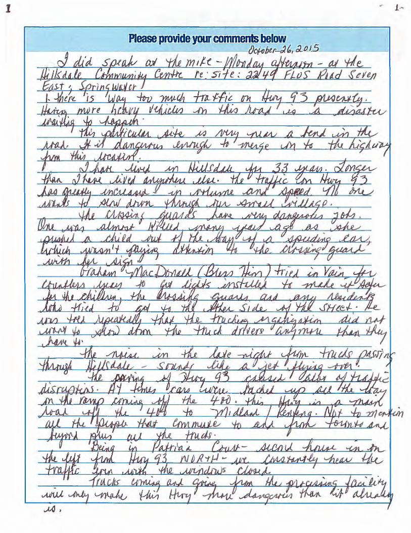
l "'" f ...
Please provide YQur commentS below --/Jefqht.r-J,, (1.o)5 ____ _
a:/ 1/-f. -

... - ..
----------------=

Survey Response: We Want to Hear From You Response GUID: 982d50e8‐f04f‐4600‐a204‐ff98c829bce4 Started: 11/2/2015 6:55:32 PM Completed: 11/2/2015 7:11:41 PM Name: John & Donna Palmer Email: Comments: We live next door to the proposed site for the OPF on Fairgrounds Road. We have lived on this farm all of our married life (52 years) and for almost 20 of them we were involved in talks and negotiations concerning a landfill. When we finally received the news that a landfill was no longer an opinion we were relieved but knew the county owned that property. Now we are once again faced with uncertainty and of course we are much older to deal with it. I seems to us that a site that will contain the OPF and MMF would be much more sensible and save money. We also think the facility should be more centralized. Surely, the county could sell the property to invest it in another. Another concern is the smell that could come from such a facility and rodents that would be present. Both of these would be reasons that our land value would fall immediately. I know I don't want to live near such a place, but perhaps will not have much choice. Then there is the added traffic to our road. I have grandchildren that live next door so there would be no more biking or walking on the side of the road with big trucks coming and going throughout the day. Thank you for your time. The Palmers
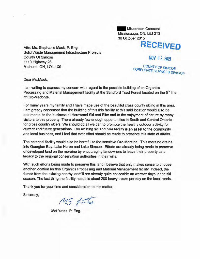
Attn: Ms. Stephanie Mack, P. Eng. Solid Waste Management Infrastructure Projects County Of Simcoe 1110 Highway 26 Midhurst, ON, LOL 1 XO
Dear Ms. Mack,
.. Missenden Crescent Mississauga, ON, L5J 2T3 30 October 2015
RECEIVED
NOV 0 2 2015
CO COUNTY OF SIMCOE RPORATE SERVICES DIVISION
I am writing to express my concern with regard to the possible building of an Organics Processing and Material Management facility at the Sandford Tract Forest located on the 5th line of Oro-Medonte.
For many years my family and I have made use of the beautiful cross county skiing in this area. I am greatly concerned that the building of this this facility at this said location would also be detrimental to the business at Hardwood Ski and Bike and to the enjoyment of nature by many visitors to this property. There already few enough opportunities in South and Central Ontario for cross country skiers. We should do all we can to promote the healthy outdoor activity for current and future generations. The existing ski and bike facility is an asset to the community and local business, and I feel that ever effort should be made to preserve this state of affairs.
The potential facility would also be harmful to the sensitive Oro-Moraine. This moraine drains into Georgian Bay, Lake Huron and Lake Simcoe. Efforts are already being made to preserve undeveloped land on the moraine by encouraging landowners to leave their property as a legacy to the regional conservation authorities in their wills.
With such efforts being made to preserve this land I believe that only makes sense to choose another location for this Organics Processing and Material Management facility. Indeed, the fumes from the existing nearby landfill are already quite noticeable on warmer days in the ski season. The last thing the facility needs is about 200 heavy trucks per day on the local roads.
Thank you for your time and consideration to this matter.
Sincerely,
Mel Yates P. Eng.

From: Lynda Van Casteren On Behalf Of Sent: Tuesday, November 03, 2015 8:29 AM To: Warden; Dowdall, Terry Subject: Letter to Springwater council -final.docx Importance: High

Nick and Lynda Van Casteren 3088 Horseshoe Valley Road West Phelpston L0L 2K0
November 3, 2015 Township of Springwater His Worship Bill French, Mayor of Springwater and Members of Council 2231 Nursery Road Minesing, ON L0L 1Y2
Dear Mr. Mayor and Members of Council:
This letter is to express my concerns over the Organics Processing Facility (OPF) and Materials Management Facility (MMF) that have been proposed in our area. In particular, I am concerned about 1453 Flos Road 3 East and 2976 Horseshoe Valley Road West, both of which have been short-listed as potential sites, according to Item CCW 15-240 found on the Simcoe County website.
These sites will have a tremendous impact on my family, our farm and our on-farm retail market, as well as on our entire community. I have read in the local newspaper and on the Springwater township website that County Council has approved a recommendation to move forward with the siting process for both the OPF and MMF, as well as the additional consideration to co-locate both facilities on one site.
I fully support environmental leadership by investing in diversion of waste materials; however, here are my gravest concerns:
The effects on our ground and surface water. The topography of the Horseshoe Valley Road property is such that it slopes downhill and directly into Matheson Creek.
The added traffic caused by heavy trucks. It is anticipated that there will be 60 trucks per day traveling to the site. This is a hilly and already dangerous road that witnesses many accidents. It is our belief that a turning lane and lights will not stop a tragedy from occurring. How many school buses use this road daily? Our grandchildren are on those school buses!
The air quality, odour, noise, and other environmental factors. Since there will be odours coming from the OPF, I have health concerns. Also, the noise that will be coming from trucks will greatly impact on the peaceful and tranquil environment.
The effects on wildlife. With the added traffic and noise, there is no doubt that this will have a tremendous impact on the deer, turtle (nearly all of which are endangered in Ontario), hawk, and wild turkey populations. This would have devastating effects on the ecosystems that are present in this area.
We are rural employers of 25 full and part time positions. These positions are filled by local residents. The facilities, being on the property adjacent to our farm and business, will dramatically impact our ability to continue to be the premier destination for organic and traditionally raised foods in Central Ontario and specifically Simcoe County!
In 2001, we were denied the opportunity, by the Township, to rezone any of the agriculturally classed properties that we owned, to allow for our on-farm market. Why can Simcoe County forests be rezoned to allow INDUSTRIAL uses?
In consideration of our concerns, we are counting on you to supply written answers to the questions asked above. These actions matter. Please put yourself in our position when asked for your vote.
Sincerely,
Nick and Lynda Van Casteren
Springwater residents raising a third generation of farming entrepreneurs

Survey Response: We Want to Hear From You Response GUID: 4eb16fcc‐8ec3‐41f8‐b6ee‐21d2ee4653b7 Started: 11/3/2015 10:12:59 AM Completed: 11/3/2015 10:23:18 AM Name: Dana Crewson Email: Comments: To whom it may concern, I am a resident of Old Second South in Midhurst and I want to let you know that we strongly oppose the decision to include our quiet country road on the short list for the county waste processing facility. Old Second South is a narrow country road that is not fully paved in spots, there are no shoulders and no sidewalks and it is lined with houses. Families walk their dogs, children ride their bikes and people even ride horses along the road and if you send hundreds of garbage trucks down our road every day this will all be in jeopardy. My other major concern are the children that wait for the school bus at the end of their driveways every morning. There are at least 4 different school buses on our road and all of the students must wait by the side of the road. Having hundreds of trucks roaring past them is unsafe and irresponsible. Can you guarantee the safety of our children? I appreciate that everyone is going to say "not in my backyard" about this project, but if you take a drive out Old Second I'm sure you will agree that it is more residential than rural and our lovely quiet road cannot handle the increase in traffic that will come with this facility. Thank‐you in advance for including my comments.

From: Sent: November 3, 2015 11:39 AM To: Bill French Subject: Contact Us: Mayor 2015-11-03 11:38 AM Submission Notification
Contact Us: Mayor 2015-11-03 11:38 AM was submitted by Guest on 11/3/2015 11:39:06 AM (GMT-05:00) US/Eastern
Name Value
Name Dana Crewson Email
phone
Question
Mayor French, I am a resident of Old Second South in Midhurst and I want to let you know that my family and neighbors are strongly opposed to the Organics Processing Facility proposed for our road. I appreciate that you have a lot on your plate and I have also emailed our Ward 3 councillor Jennifer Coughlin, but we would love to have your support in our fight. The residents of our road have started a petition and are working to bring a presentation to council. Old Second South is a quiet, narrow, country road. It is unpaved in sections and there are no shoulders or sidewalks. Families here walk their dogs, ride bikes and even ride horses along the side of the road daily. Having hundreds of loaded garbage trucks on the road is unsafe and irresponsible. There are no less than 4 school buses that pick up and drop off children every day - how can the County of Simcoe guarantee their safety as they wait by the side of the road while hundreds of trucks roar past? We may be considered "rural" but we are also residential and it makes no sense to put this facility in our neighbourhood. Please appeal to council to support the selection of one of the other sites not located in an established residential area. Thank-you for considering our request. Dana and Cory Crewson
Please note, you must reply to this email within 2 business days in order to comply with customer service standards. Thank you!

From: Sent: Tuesday, November 03, 2015 4:14 PM To: Mack, Stephanie Subject: Site C136 Horseshoe Valley Road W/1301 Rainbow Valley Road E. Importance: High Please read and distribute the attached very important letter in regards to proposed Waste Management Facility (Site C136) Please send confirmation back to this email address confirming you have received this letter. Thank you, Jerry & Sandi Dunlop
Rainbow Valley Road E. Springwater
CONFIDENTIALITY NOTICE NOTICE: This message is intended for the use of the individual or entity to which it is addressed and may contain information that is confidential, privileged and exempt from disclosure under applicable law. If the reader of this message is not the intended recipient, you are hereby notified that any printing, copying, dissemination, distribution, disclosure or forwarding of this communication is strictly prohibited. If you have received this communication in error, please contact the sender immediately and delete it from your system. Thank You.

Jerry & Sandi Dunlop & Family 1601 Rainbow Valley Road East Phelpston, On. LOL 2KO Tel: Email : November 3, 2015 Township of Springwater His Worship Bill French, Mayor of Springwater and Members of Council 223I Nursery Road Minesing, ON LOL 1Y2 Dear Mr. Mayor and Members of Council: This letter is to express our grave concerns over the organics processing Facility (OPF) and Materials Management Facility (MMF) that have been proposed next to our family home at 2976 Horseshoe Valley Road West (1301 Rainbow Valley Road E.). This site has been short-listed as a potential site. An Industrial Facility at this site will have tremendous negative impact on us, our family and our community as a whole. We are very fortunate to own 100 acres of agricultural and environmentally protected forest. Our forest is part of a bigger forest that we share with the County of Simcoe (Site C136). Our settlement to this area and acquiring this property was far from easy. We worked hard and pursued our dreams by purchasing this property in 1988. At that time the governing Township was Flos Township. Our new property did not have the luxury of road access or hydro until we worked tirelessly to manually clear for the allowance of the extension of Rainbow Valley Road E and then for the extension of hydro poles and phone lines. Our entire family and circle of close friends chipped in and helped us to build our dream home. In 1989 we moved into the last house we will ever call home. The governing by Flos Township at that time had made settlement to this area difficult. When the Township of Springwater took over it continued to strictly govern settlement to this area. We have lived in this area for over twenty–seven years and seen very little development allowed in our little community. We tried to sever our property into large twenty-five acre parcels to pass on to our children for the next generation. We were denied by the Township of Springwater as it did not meet with the official plan and the characteristics of the area. We were left devastated but had no choice but to try to respect and understand the decision made by the Township of Springwater. Twelve years have passed with little or no changes to Springwater’s Official Plan and we are now faced with the possibility of this same protected forest being re-zoned to house an Industrial Waste Management Facility. We do not understand the reasoning behind this and clearly do not accept it.
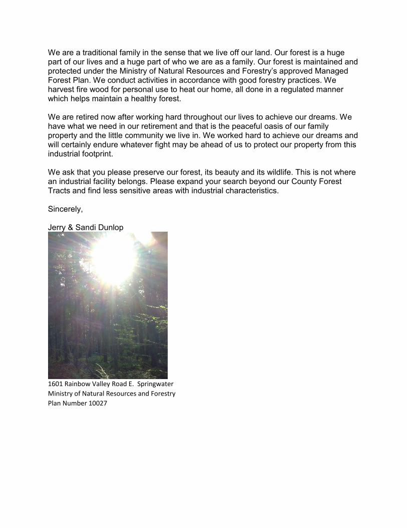
We are a traditional family in the sense that we live off our land. Our forest is a huge part of our lives and a huge part of who we are as a family. Our forest is maintained and protected under the Ministry of Natural Resources and Forestry’s approved Managed Forest Plan. We conduct activities in accordance with good forestry practices. We harvest fire wood for personal use to heat our home, all done in a regulated manner which helps maintain a healthy forest. We are retired now after working hard throughout our lives to achieve our dreams. We have what we need in our retirement and that is the peaceful oasis of our family property and the little community we live in. We worked hard to achieve our dreams and will certainly endure whatever fight may be ahead of us to protect our property from this industrial footprint. We ask that you please preserve our forest, its beauty and its wildlife. This is not where an industrial facility belongs. Please expand your search beyond our County Forest Tracts and find less sensitive areas with industrial characteristics. Sincerely, Jerry & Sandi Dunlop
1601 Rainbow Valley Road E. Springwater
Ministry of Natural Resources and Forestry
Plan Number 10027

Survey Response: We Want to Hear From You Response GUID: eee16d23-406e-4223-8b0d-0898de1a6717 Started: 11/3/2015 7:19:30 PM Completed: 11/3/2015 8:20:27 PM Name: John Orange Email: Comments: I attended the community information meeting at Hillsdale and appreciate the efforts of Simcoe staff and the consultants to provide information. I have a number of comments arising from that meeting that fall in to three categories :- 1. the site evaluation criteria 2. the business case 3. the use of Simcoe forest sites. 1. Site evaluation. It surprised me that all of the short listed sites lie in a relatively small area centred in Springwater Township. I understand from the consultant's representative that this is a result of computing the centroid of population to minimize the distance travelled from collection to the MMF site. However, the computation only appears to take in to account "inputs" to the MMF. It is my understanding from comments at the meeting that all of the non-organic materials are subsequently transferred from the MMF to processing facilities generally in the GTA. A round trip of 165 km was quoted. Computing the centroid with both input and output journeys included would shift it significantly south, even if the number of journeys made for the output is less because of the size of vehicle used. I also understand that the centroid was determined using the population of Barrie and Orillia. However, according to FAQ's provided at the meeting, these are "separated cities" and have their own facilities. As such, the population of those cities should have been excluded from the computation of the centroid. The site selection criteria excluded traffic impact as a factor in screen 1 or 2. However, if the representations regarding odour and noise are taken at face value, the major impact on neighbours to potential sites is likely to be traffic. Even the busiest road will see a 5% increase in traffic, less busy roads will see a correspondingly larger increase. This is a major issue and should be one of the fundamental factors in selecting potential sites. The corollary of course is that if the siting criteria for this facility are appropriate, it follows that ALL other County projects, such as health care facilities, arts centres, libraries an the like should also be located in Springwater as they will then also be equally available to all residents! 2. The business case Whilst I understand the concerns about availability of third party sites in the future, the need to build a self contained Simcoe facility reeks of Empire building. Other opportunities exist, such as partnering with other regions or the "separated cities" or as a PPP with long term, contractually guaranteed access. These do not seem to have been explored.
The savings are projected at $13million over 20 years, or $650,000/year. The construction cost of the OPF alone is between $10 and $35 million. No cost is provided for the MMF, nor any estimate of the infrastructure costs such as road upgrades that may have a significant impact on the overall cost. According to FAQ's secured funding of $1.15million is in place, but this is only 3% of the projected cost for the OPF. It is also contingent on the facility being able to process the materials received. It is unclear whether this contemplates expansion of the MMF to include recycling processes or whether it refers to the organics only. Whilst a business case is to be presented, by excluding other options, the justification is inevitable. 3. Use of Simcoe Forest lands Many of the sites propose to use existing tracts of Simcoe County forest. It appears the Council view these lands as a "land bank" to be developed at whim for projects totally unrelated to forest preservation. Most residents, I believe, view these lands as an asset that contributes to lifestyle available in Simcoe. To hear that it is simply held until some other use can be found for it is disturbing. It is only necessary to consider the zoning for the MMF, namely industrial, to see how inappropriate it is to consider the use of forest tracts for this purpose. Thank you for the opportunity to comment and I look forward to further information in due course.

From: David Myles Sent: Tuesday, November 03, 2015 8:20 PM To: Customer Service <[email protected]> Cc: Hughes, Harry <[email protected]>; [email protected];
; Linda Myles Subject: Fwd: Waste Facility on Line 5
Subject: Waste Facility on Line 5
To the County.
My wife and I are writing this letter to voice our concerns about the proposed Organic waste facility and transfer station on Line 5 in Oro-Medonte. We feel the proposed location is entirely inappropriate for this type of facility. Twp Line 5 is a very quiet rural roadway that currently sees very little traffic. In fact, the entire area, save for the existing landfill site is mostly quiet rural farmland and county forest. The size and scope of the proposed facility is designed for an area zoned industrial that would already have the access roadways. The residents of this very rural area should not be subjected to the heavy truck traffic that would accompany the facility.
We are also very concerned about the impact of the new facility on Hardwood Ski and Bike which is immediately adjacent. Hardwood Ski and Bike is a nationally and internationally respected venue for both cross country ski and mountain bike events. It was the venue for the PanAm games mountain bike event that was attended by thousands of area residents. Hardwood Ski and Bike is an employer of many local residents. It is a regular recreational destination for many Southern Ontario residents, particularly from the GTA who come to enjoy the quiet and beauty of the county forests. School groups from local schools and GTA also come to enjoy Hardwood and the county forests the trails pass through. The visual impact, the noise and possibly smell of this facility would have a very negative impact on Hardwood. Its questionable whether Hardwood would survive this plant built in such an inappropriate location.
In summary, county forests should not be used for a facility that is best placed in an industrial area that already has the roadways and infrastructure in place. County forests should be used for forestry and recreation.
We strongly urge the planners to consider industrial locations other than the Line 5 site.
Thankyou,
David and Linda Myles
Oro-Medonte, Ontario

From: Tamare White-Wolf
Sent: Wednesday, November 04, 2015 6:12 AM
To: Customer Service <[email protected]>
Subject: Solid Waste Management Infrastructure Projects
To whom this Matter Concerns c/o Stephanie Mack P.Eng
Good Morning I was surprised when a few days ago my neighbour asked if I heard of the recycle plant
considered for the creek area across the street from us! I had not, and to be honest don’t know why I
had not until she told me it was because I am more than 500 feet away, tht I was not informed or invited
to the city talk on the subject!! Again I was surprised as this will affect us both and everyone else in the
area negativity in so many ways!
My first response was why would this needed project be considered in an area so close to the
hospital, residential property and most importantly on a flood plain and near our water ways (willow
creek. That certainly feels negligent environmentally, never mind the large vehicle traffic jeopardizing
myself and neighbours.
What about the quality of air around us, I for one cant not concur with these plans in anyway for this
neighbourhood! In fact it would be a far better idea to allow more homes to be built all the way the
highway, seems to me much a better plan to build residentially around the hospital as most cities do!
Besides that it would be much more appropriate to build such a plant on HIGH land, for many reasons,
smell rises, drinking water would not be affected, safety of the people walking, running and driving (this
is a very busy road with folks using it as a fairway to work and home)!
Personally I already have a situation with large vehicles using my driveway as a turn around and it has
cost me greatly as they have ruined my driveway at my cost in repairs, more would not help!
Please reconsider the positioning of this plant, more acreage, higher ground and farther away from the
community neighbourhoods would be best for all!
Regards Tammy Murphy Drinkwalter
Penetanguishene Rd RR#1 Barrie L4M0H1

From: [email protected] [mailto:[email protected]] Sent: Wednesday, November 04, 2015 1:38 PM To: Mack, Stephanie Subject: We want to hear from you Survey Response: We Want to Hear From You Response GUID: 23803405-b6f5-4569-b180-95fd90ec73a8 Started: 11/4/2015 1:32:32 PM Completed: 11/4/2015 1:37:57 PM Name: Jack Sasseville Email: Comments: I will be delivering to the County offices today a petition with 348 names on it. The petition has names collected at Hardwood Ski and Bike to stop the Organic Processing and Material Management Facility from being located in the Sanford Tract on the 5th line of Oro-Medonte. These names are a small fraction of the people who come to Hardwood. We will continue to collect signatures throughout the winter when the bulk of our customers come to see us. Page Score: 0

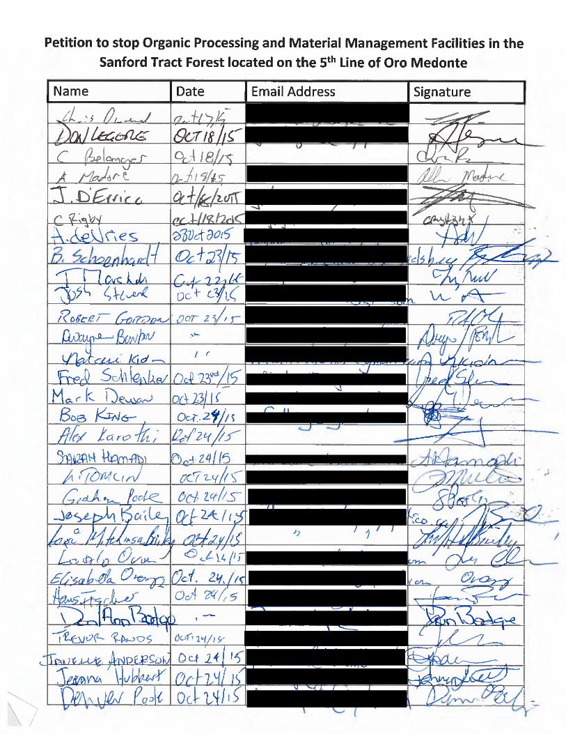
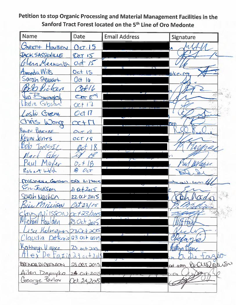


From: Craig Hughes
Sent: Wednesday, November 04, 2015 2:23 PM
To: Customer Service <[email protected]>
Subject: Letter of Concern to Stephanie Mack regarding 5th Line Facility
Solid Waste Management Infrastructure Projects County of Simcoe
Please forward the attached letter to Stephanie Mack regarding concern and disapproval of an Organics
Processing and Material Management facility on 5th line of Oro-Medonte.
Regards,
Craig Hughes

November 4, 2015
Dear Stephanie Mack,
I am writing to express my concern and disapproval of building an Organics Processing and Material Management facility at the Sandford Tract Forest located on the 5 th line of Oro-Medonte.
Not only will building this facility at said location be detrimental to the business at Hardwood Ski and Bike and to the enjoyment of my time at this property, it will also be harmful to the sensitive Oro-Moraine. This moraine drains into Georgian Bay, Lake Huron and Lake Simcoe. Efforts are already being made to preserve undeveloped land on the moraine by encouraging landowners to leave their property as a legacy to the regiona l conservation authorities in their wills.
With such efforts being made to preserve this land it only makes sense to choose another location for this Organics Processing and Material Management facility .
Thank you for your time and attention to this serious matter.
Sincerely,

From: Rosa Zanuzzi Sent: Wednesday, November 04, 2015 4:41 PM To: Mack, Stephanie Subject: FW: Waste Management Sites in the County of Simcoe Importance: High Hi Stephanie, Bill French has asked that I forward you my letter, so that it can be made public. Thanks. Rosa Zanuzzi Controller | Aquicon Construction Co. Ltd. 131 Delta Park Blvd. | Brampton | ON | L6T 5M8 905-458-1313 905-458-6020 fax
. www.aquicon.com
please consider the environment before printing this e-mail.
This e-mail, including any attachments, is intended solely for the person or entity to which it is addressed and may contain confidential, proprietary and/or non-public material. Except as stated above, any review, re-transmission, dissemination or other use of, or taking of any action in reliance upon this information by persons or entities other than an intended recipient is prohibited. If you receive this in error, please so notify the sender and delete the material from any media and destroy any printouts or copies.
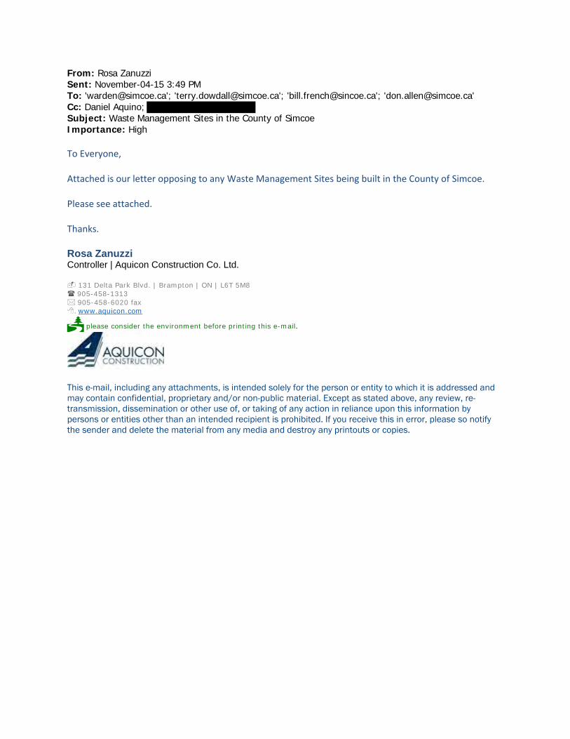
From: Rosa Zanuzzi Sent: November-04-15 3:49 PM To: '[email protected]'; '[email protected]'; '[email protected]'; '[email protected]' Cc: Daniel Aquino; Subject: Waste Management Sites in the County of Simcoe Importance: High
To Everyone, Attached is our letter opposing to any Waste Management Sites being built in the County of Simcoe. Please see attached. Thanks. Rosa Zanuzzi Controller | Aquicon Construction Co. Ltd. 131 Delta Park Blvd. | Brampton | ON | L6T 5M8 905-458-1313 905-458-6020 fax
. www.aquicon.com
please consider the environment before printing this e-mail.
This e-mail, including any attachments, is intended solely for the person or entity to which it is addressed and may contain confidential, proprietary and/or non-public material. Except as stated above, any review, re-transmission, dissemination or other use of, or taking of any action in reliance upon this information by persons or entities other than an intended recipient is prohibited. If you receive this in error, please so notify the sender and delete the material from any media and destroy any printouts or copies.

A qui con Holdings (20 15) Inc.
November 4, 2015
County of Simcoe Administration Centre 1110 Highway 26 Midhurst, Ontario LOL 1XO
RE: PROPOSED INDUSTRICAL WASTE MANAGEMENT SITES
To Whom IT May Concern :
PROPERTY OWNER: AQUICON HOLDINGS (2015) INC.
PROPERTY ADDRESS: 2847 HORSESHORE VALLEY RD
OLD SECOND RD.S.
TOWNSHIP OF SPRINGWATER
COUNTY OF SIMCOE
131 Delta Park Blvd., Brampton, ON L6T 5M8 Tel: (905) 458-1313 Fax: (905) 458-6020
As property owners in the County of Simcoe and the fact that the property is zoned for Adult Lifestyle, placing Waste Management Sites in close proximity to our property with hinder our ability to develop the property. It is to everyone's best interest that we develop this property. Development will bring in many resources and revenue to the area.
As a high tax payer in the area we are very strongly opposed to any Waste Management Facility being built in the area.
Regards, AQUICON HOLDINGS (2015) INC.
~za~~ Contr~i
www.aquicon. com
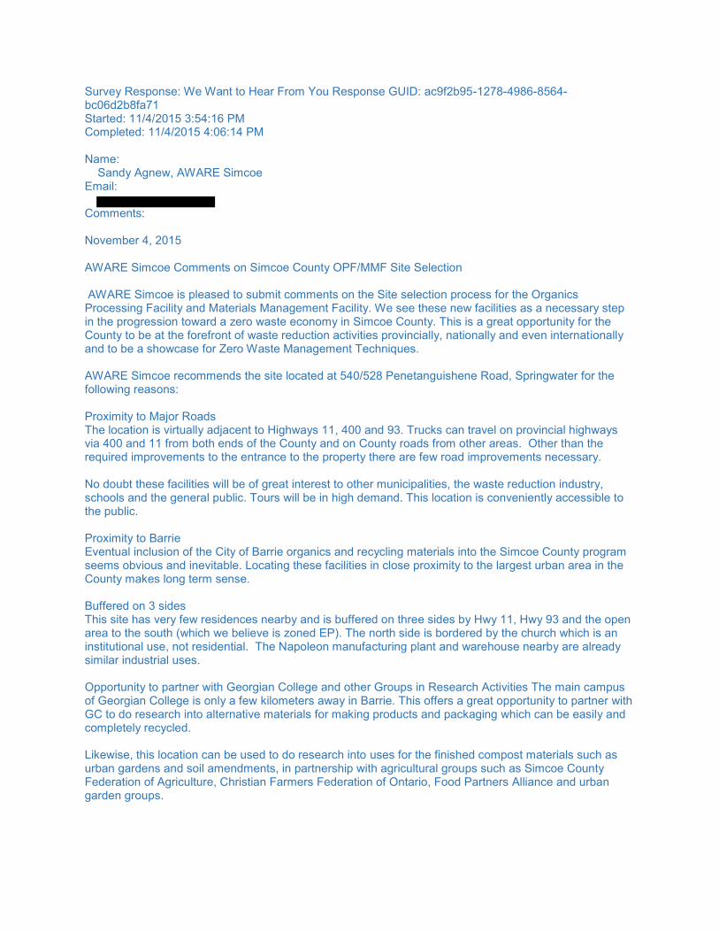
Survey Response: We Want to Hear From You Response GUID: ac9f2b95-1278-4986-8564-bc06d2b8fa71 Started: 11/4/2015 3:54:16 PM Completed: 11/4/2015 4:06:14 PM Name: Sandy Agnew, AWARE Simcoe Email: Comments: November 4, 2015 AWARE Simcoe Comments on Simcoe County OPF/MMF Site Selection AWARE Simcoe is pleased to submit comments on the Site selection process for the Organics Processing Facility and Materials Management Facility. We see these new facilities as a necessary step in the progression toward a zero waste economy in Simcoe County. This is a great opportunity for the County to be at the forefront of waste reduction activities provincially, nationally and even internationally and to be a showcase for Zero Waste Management Techniques. AWARE Simcoe recommends the site located at 540/528 Penetanguishene Road, Springwater for the following reasons: Proximity to Major Roads The location is virtually adjacent to Highways 11, 400 and 93. Trucks can travel on provincial highways via 400 and 11 from both ends of the County and on County roads from other areas. Other than the required improvements to the entrance to the property there are few road improvements necessary. No doubt these facilities will be of great interest to other municipalities, the waste reduction industry, schools and the general public. Tours will be in high demand. This location is conveniently accessible to the public. Proximity to Barrie Eventual inclusion of the City of Barrie organics and recycling materials into the Simcoe County program seems obvious and inevitable. Locating these facilities in close proximity to the largest urban area in the County makes long term sense. Buffered on 3 sides This site has very few residences nearby and is buffered on three sides by Hwy 11, Hwy 93 and the open area to the south (which we believe is zoned EP). The north side is bordered by the church which is an institutional use, not residential. The Napoleon manufacturing plant and warehouse nearby are already similar industrial uses. Opportunity to partner with Georgian College and other Groups in Research Activities The main campus of Georgian College is only a few kilometers away in Barrie. This offers a great opportunity to partner with GC to do research into alternative materials for making products and packaging which can be easily and completely recycled. Likewise, this location can be used to do research into uses for the finished compost materials such as urban gardens and soil amendments, in partnership with agricultural groups such as Simcoe County Federation of Agriculture, Christian Farmers Federation of Ontario, Food Partners Alliance and urban garden groups.

How to turn the Negative Factors for the Site into Positive Attributes More than half the property is Canada Land Inventory Soil Class 1-3. Farmland is a valuable resource. This land appears not to be farmed currently. Topsoil will have to be stripped from the footprint area for the OPF and MMF. This topsoil can be used to create urban gardens in cooperation with the urban garden groups in the County and Barrie. The rest of the Class 1-3 land area could be utilized to demonstrate various crop production techniques in partnership with SCFA, CFFO, local urban garden groups and Food Partners Alliance. A small band on the south end of the property is designated as Medium Vulnerability Groundwater Recharge. The southern end of the property can be used to demonstrate Low Impact Development (LID) groundwater recharge techniques in partnership with NVCA and Georgian College. Other portions of the buffer zone areas could be used by the Simcoe County Forestry Department to demonstrate various forestry management and planting techniques, especially the north and south ends of the property. Solar Energy Demonstration Of course the roofs of the OPF and MMF buildings are the perfect location for solar arrays. Perhaps they can produce enough power to run the facilities. Recommendation This location offers the opportunity for Simcoe County to provide a showcase for multiple facets of sustainable living and land management going into the twenty first century. For all the above reasons AWARE Simcoe supports the location of the OPF and MMF at the 540/528 Penetanguishene Road candidate site. Sandy Agnew, Vice Chair, AWARE Simcoe
,
www.aware-simcoe.ca
November 4, 2015
AWARE Simcoe Comments on Simcoe County OPF/MMF Site Selection AWARE Simcoe is pleased to submit comments on the Site selection process for the Organics Processing Facility and Materials Management Facility. We see these new facilities as a necessary step in the progression toward a zero waste economy in Simcoe County. This is a great opportunity for the County to be at the forefront of waste reduction activities provincially, nationally and even internationally and to be a showcase for Zero Waste Management Techniques. AWARE Simcoe recommends the site located at 540/528 Penetanguishene Road, Springwater for the following reasons: Proximity to Major Roads The location is virtually adjacent to Highways 11, 400 and 93. Trucks can travel on provincial highways via 400 and 11 from both ends of the County and on County roads from other areas. Other than the required improvements to the entrance to the property there are few road improvements necessary. No doubt these facilities will be of great interest to other municipalities, the waste reduction industry, schools and the general public. Tours will be in high demand. This location is conveniently accessible to the public. Proximity to Barrie Eventual inclusion of the City of Barrie organics and recycling materials into the Simcoe County program seems obvious and inevitable. Locating these facilities in close proximity to the largest urban area in the County makes long term sense. Buffered on 3 sides This site has very few residences nearby and is buffered on three sides by Hwy 11, Hwy 93 and the open area to the south (which we believe is zoned EP). The north side is bordered by the church which is an institutional use, not residential. The Napoleon manufacturing plant and warehouse nearby are already similar industrial uses. Opportunity to partner with Georgian College and other Groups in Research Activities The main campus of Georgian College is only a few kilometers away in Barrie. This offers a great opportunity to partner with GC to do research into alternative materials for making products and packaging which can be easily and completely recycled.

Likewise, this location can be used to do research into uses for the finished compost materials such as urban gardens and soil amendments, in partnership with agricultural groups such as Simcoe County Federation of Agriculture, Christian Farmers Federation of Ontario, Food Partners Alliance and urban garden groups. How to turn the Negative Factors for the Site into Positive Attributes More than half the property is Canada Land Inventory Soil Class 1-3. Farmland is a valuable resource. This land appears not to be farmed currently. Topsoil will have to be stripped from the footprint area for the OPF and MMF. This topsoil can be used to create urban gardens in cooperation with the urban garden groups in the County and Barrie. The rest of the Class 1-3 land area could be utilized to demonstrate various crop production techniques in partnership with SCFA, CFFO, local urban garden groups and Food Partners Alliance. A small band on the south end of the property is designated as Medium Vulnerability Groundwater Recharge. The southern end of the property can be used to demonstrate Low Impact Development (LID) groundwater recharge techniques in partnership with NVCA and Georgian College. Other portions of the buffer zone areas could be used by the Simcoe County Forestry Department to demonstrate various forestry management and planting techniques, especially the north and south ends of the property. Solar Energy Demonstration Of course the roofs of the OPF and MMF buildings are the perfect location for solar arrays. Perhaps they can produce enough power to run the facilities. Recommendation This location offers the opportunity for Simcoe County to provide a showcase for multiple facets of sustainable living and land management going into the twenty first century. For all the above reasons AWARE Simcoe supports the location of the OPF and MMF at the 540/528 Penetanguishene Road candidate site. Sandy Agnew, Vice Chair, AWARE Simcoe

Mis
sion
Sta
tem
ent
AWA
RE
Sim
coe
is a
citi
zens
’ gro
up th
at
wor
ks to
pro
tect
wat
er, t
he e
nviro
nmen
t an
d he
alth
thro
ugh
trans
pare
ncy
and
acco
unta
bilit
y in
gov
ernm
ent.
Visit ou
r Web
site
www.aware-‐simcoe.ca
fo
r new
s from Sim
coe Co
unty
Future Generations Need Us to
Act
Simcoe Co
unty is made up
of 16 mun
icipalities
who
se M
ayors a
nd Deputy Mayors a
lso sit as
Simcoe Co
unty Cou
ncillors: Adjala-‐Tosorontio,
Innisfil, Bradford West G
willimbu
ry, Clearview
, Co
llingwoo
d, Essa, M
idland
, New
Tecum
seth,
Oro-‐M
edon
te, Penetanguish
ene, Ram
ara, Tay,
Severn, Springw
ater, Tiny, and W
asaga Beach.
Simcoe Co
unty M
ayors a
nd Cou
ncillors m
ake
decisions affe
cting the who
le co
unty except for
Barrie and
Orillia, w
hich are se
parated citie
s.
Both citie
s are a very impo
rtant p
art o
f life
with
in th
e Simcoe area and
as such they are
also well represented in AW
ARE Simcoe.
AWAR
E Simcoe Pu
rpose
We prom
ote and maintain a healthy commun
ity
with
in th
e carrying ca
pacity of o
ur enviro
nment.
Valu
eAW
ARE
Sim
coe
Core
Val
ue S
tate
men
t
Envi
ronm
enta
l Aw
aren
ess
Envi
ronm
enta
l Aw
aren
ess
will
le
ad to
ste
war
dshi
p ac
ross
our
co
mm
unity
Ethi
csW
e w
ill c
ondu
ct o
urse
lves
with
in
tegr
ity in
all
our
deal
ings
.
Futu
re
Gene
ratio
nsO
ur le
gacy
mus
t dem
onst
rate
th
at w
e ar
e go
od a
nces
tors
.
Acco
unta
bilit
yW
e w
ill b
e ac
coun
tabl
e ad
voca
tes.
Com
mitm
ent
We
are
dete
rmin
ed a
nd
pers
iste
nt.
Info
rmat
ion
shar
ing
Info
rmed
citi
zens
mak
e go
od
deci
sion
s.
How
Can
I H
elp?
J
oin
AW
ARE
Sim
coe
The
mor
e m
embe
rs t
hat
AW
ARE
Sim
coe
has,
the
mor
e ou
r vo
ice
will
be h
eard
. Go
to t
he A
WA
RE S
imco
e we
bsit
e an
d cl
ick
“AW
ARE
” the
n “M
embe
rshi
p”. T
he c
ost
is
$20
sing
le o
r $3
0 fo
r a
fam
ily.
On
the
net,
clic
k A
WA
RE a
nd t
hen
Mem
bers
hip.
We
need
you
r su
ppor
t.
Pa
rticipat
e
Our
boa
rd m
eets
onc
e a
mon
th a
nd
visi
tors
are
wel
com
e. W
e ca
n al
ways
use
ad
diti
onal
peo
ple
and
ther
e ar
e m
any
task
s wa
itin
g to
be
done
.
On
the
webs
ite,
clic
k “C
onta
ct U
s” a
nd
inqu
ire
abou
t da
tes,
tim
es a
nd lo
cati
ons.
Discu
ssD
iscu
ss t
he is
sues
wit
h yo
ur f
rien
ds,
neig
hbou
rs a
nd lo
cal p
olit
icia
ns.
ww
w.a
war
e-si
mco
e.ca
awar
e.si
mco
e@gm
ail.c
om
twit
ter.c
om/A
war
eSim
coe
319
King
St.
N, A
llist
on, O
N L
9R 1
N3
(705
) 435
-516
7
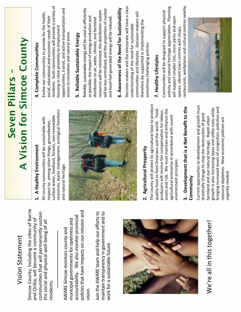
Vision
Statemen
tSimcoe Co
unty, including th
e ciRe
s of B
arrie
and Orillia, w
ill becom
e a commun
ity of
commun
iRes th
at will permanen
tly su
stain
the social and
physic
al well-‐b
eing of all
resid
ents.
We're all in th
is together!
Seve
n Pi
llars
–A
Vis
ion
for
Sim
coe
Coun
ty1. A
Health
y En
vironm
ent
All cou
nty commun
iRes will be sustainable with
respect to, amon
g othe
r things, groun
dwater,
surface water, foo
dland, fo
rests, non
-‐ren
ewable
resources, waste m
anagem
ent, ecological fu
ncRo
ns
and natural herita
ge.
AWAR
E Simcoe monito
rs co
unty and
municipal governm
ents for o
penness a
nd
accountability. W
e also monito
r provincial
policies that h
ave impacts o
n our m
ission and
visio
n.
Join th
e AW
ARE team
and help our effo
rts to
maintain transparency in governm
ent and to
work for a su
stainable future.
4. Com
plete Co
mmun
i@es
Evolve our co
mmun
ities to
provide fo
r the health
, social, edu
catio
nal and
econo
mic needs of their
resid
ents. Such co
mmun
ities will provide a variety of
housing in close proximity to
employment
oppo
rtun
ities, transit, and
active transportatio
n and
access to
recreatio
n and natural areas.
5. R
eliable Sustaina
ble En
ergy
Reliable, su
stainable energy will be used as efficie
ntly
as possib
le; the im
pact of energy productio
n and
distrib
ution on air, water, clim
ate, and farm
land
resources w
ill be minimize
d; th
e distrib
ution system
will be less ce
ntralized; and th
e proportio
n of nuclear
and fossil-‐fuel generated energy will be reduced.
6. Awaren
ess o
f the
Need for S
ustainability
Decisio
n-‐makers a
nd th
e electorate will have a clear
unde
rstand
ing of th
e ne
ed fo
r sustainable
commun
iRes and
lifestyles. De
cisio
n-‐makers w
ill
therefore be
supp
orted in im
plem
enRn
g the
someR
mes challenging po
licies.
7. Health
y Lifestyles
Commun
iRes will be de
signe
d to su
pport p
hysic
al
acRvity
and
natural herita
ge app
reciaR
on. Planning
will su
pport smaller lots, m
ore parks a
nd ope
n spaces, vibrant to
wn centres w
ith sh
ops,
restaurants, workplaces a
nd cultural cen
tres nearby.
2. A
gricultural Prosperity
The coun
ty will protect its a
gricultural base to produ
ce
quality
food
to fe
ed Ontarians and
the world. Foo
d prod
ucers w
ill re
ceive fair compe
nsaR
on fo
r labou
r, assets and
risk. We must m
aintain and en
hance the
agricultural enterprise
in accordance with
soun
d en
vironm
ent p
rinciples.
3. De
velopm
ent tha
t is a
Net Ben
efit to the
Commun
ityCu
rren
t app
roache
s to de
velopm
ent a
nd growth m
ust
drasRcally change to stop
the de
strucRon
of goo
d farm
land
and
our natural herita
ge. Ra
pid urban
grow
th is also
increasin
g taxes a
nd uRlity
costs while
bringing increased levels of con
gesRon
, polluRo
n and
resource dep
leRo
n. N
ew econo
mic policies a
re
urgently neede
d.

. .
County of Simcoe Solid Waste Management Infrastructure Project 1110 High 26, Midhurst Ontario
To Mayor French, Warden Gerry Marshall, and Council
RECEIVED NOV 0 4 20\5
COUNTY OF SIMCOE . CORPORATE SERVICES DIVISION
My husband and I currently reside at 1488 Baseline Rd. My property is the last house on this dead end road, it is just under an acre. Beside me is EP land that is just below the proposed site on Flos 3 East. Any run off from the site will drain into this area as the elevation of the proposed is at a higher elevation. I also own 12 acres at 1440 Baseline Rd which is one lot up from me, and is 500 meters from the proposed site. Fifteen years ago we were looking for the right location for our lifestyle. We found this tranquil peace of paradise, which was the ideal location for my husband's health issues. With heart and respiratory problems the surroundings zoned agricultural and EP land we felt this was the ideal location to design and build our home for the future retirement. Designing our home for the future entailed special access throughout the house.
During our time living here, we have enjoyed watching the wildlife in our yard traveling from the forestry and EP land beside us. The wetlands beside us have an abundance of frogs as well as snakes. We have the endangered red squirrels that eat daily from our feeders. The pileated woodpecker, and downy woodpecker travel throughout this forest, along with bears, wild turkeys, grouse, owls and a variety of birds, just to name a few. The resident deer come to visit at times while getting off their well traveled path. Just down from me are 3 natural spring fed ponds that run the full length of the proposed site on Flos 3 East before emptying into the Matheson creek where a family of beavers live, local resident geese and a variety of ducks nest. This is their home.
I am referred as nana in the woods. When my grandchildren come to visit, they always state how much they love this place. It smells so good. They enjoy drinking our funny tasting water no chlorine, playing with the frogs while hiking through the forest picking wild mushrooms, blackberries, raspberries, and a field of wild leeks. They always come back for homemade maple syrup we've made from our maple trees. They have already decided at this very young age this is the type of environment they want to live. The forest provides all the entertainment they need.
It was just recently while enjoying this tranquil setting in my backyard when a neighbor informed us of the proposed organic/management facility. Panic set in for the fear of change in the quality of our life. With 1453 Flos 3 East and 2976 Horseshoe Valley Rd. West being on the short listed site. This placed us in the middle of these two sites, with Flos 3 East just downwind from us and Horseshoe Valley Rd. site backing onto Rainbow Valley Rd. E.
Hwy 27 being one of the busiest roads in Springwater with people traveling to one of Ontario's largest beach in Wasaga. This is a two lane highway with vehicles traveling at a high speed. The entrance from Flos 3 East onto HWY27 has a restricted curve view and the trucks venturing south will need to climb a grade from a stop creating a traffic hazard. Vehicles will need to brake quickly

because of the slow moving trucks on the uphill grade going south. The 60 plus trucks traveling back and forth daily on Flos 3 East rolling hills, will be a major hazard and detrimental to farmers driving there oversized farm equipment. The effects on Horseshoe Valley Rd. site C136 will have the same impact, travelling at high speed on the rollings hills having to turn north onto this site from a downgrade will have to brake quickly and could be hazardous. Trucks exiting from this site from a stop: venturing west will have to climb an uphill grade and vehicles will have to brake quickly due to the slow moving trucks climbing this hill creating volume. Horseshoe Valley Rd. and HWY 27 are major roads and numerous times has been closed in the winter due to blowing winds with whiteouts and zero visibility.
Site C136 also backs onto Rainbow Valley Rd. East, this road has been built up due to flooding, starting from Simcoe County forest Running parallel to this site .. The ditches along both sides of the road are extra deep on this road. We refer to them as the Suez Canal. In the winter the skidoo trail is open from C136 county forest onto Rainbow Valley Rd. East and runs along Baseline Rd. to the next concession. The shoulder on both sides of Rainbow Valley Rd. East slope downward into the ditch. In the winter it is treacherous, driving in fear of sliding off into the ditch with the skidoo trail on both sides of the road. Leaving the driver no choice but to stay in the middle of the road making it difficult to pass oncoming vehicles. This is a great concern if used as an access point from C 136. This is well travelled road, when trying to turn onto Hwy 27 in either direction the wait is lengthy and at times dangerous. Transport trucks park on the shoulder of Hwy 27 at the gas station facing north, which blocks the view of oncoming traffic. I was in a accident at this intersection due to this problem.
This facility will have a ecological impact on the properties and agricultural land from possible contamination, leachate affecting the aquifer, abundance amount of wildlife some of which are protected. Natural springs and nature including the endangered lady slipper, and red squirrel
My son worked at the Durham compost facility, and said the smell was unbearable and at its best nauseating. The bio-aerosol and off site odours from this potential site will greatly impact this community, properties and surrounding land. We all moved here for the same reason. The better quality of life we all so much enjoy and love. When we come home from a hard day's work, we sit back and visually take it all in, and with that, we feel the weight off our shoulders. We feel at peace! If these compost/management facilities are so safe then why don't, they have compost sites around nursing homes, schools, and hospitals.
My hope is that Council will understand the threat that we feel from either of these sites if developed. The detrimental impact on my husband's health, and the health of surrounding neighbours. The quality of air, the disruption of wildlife from clear cutting the forest, excess traffic flow and noise from the 60 plus trucks travelling back and forth daily, and water table (natural springs, wells, beaver pond, and the nature). Site C270 Flos 3 East and C136 Horseshoe Valley Rd. West is forest; we have agricultural lands all around us. These farmers have been here for generations. To build on agricultural land and have it rezoned to industrial for a compost /management facility would be a gross injustice and is contrary to Springwaters Proposal of the

Safeguarding of Agricultural lands for Future Generations, with possible adverse effects to farmer's crops and surrounding residences of our tranquil community.
With a possibility of increased health risk we will have no choice but to move to a township with a planning department that can actually plan for the future and does not deal with issues as they arrive. Leaving just a few sites available for this facility without zoning in place. It seems Springwater township is going to take away our dream of living in a place where we can retire in peace. Where is this going to end and how many for sale signs are we going to see. These are our homes and being told What's going in our backyards with little or no say on the matter is an injustice to all.
There may be a need for this facility but in an area zoned for this use with all the maximum setbacks in place and taking into consideration any further growth to the facility. There should be a four season evaluation, by physically walking the sites. When we made our decision to move here we did our future planning. If Springwater had done their future planning we wouldn't be in the situation we are today.
A Fitzpatrick

' ..
Development of Infrastructure Projects .
Public Consultation Session Thursday, October 8 Township of Oro-Medonte Administration Centre
Comment Sheet
Date: ?unr 1.
Postal Code:L- Lfl'll 7 c ~ Affiliation: .n..iJZd ~ Address: Email: __________ _
Thank you for taking the time to provide us 'Nith your feedback.
Mailing address: RECEIVED Solid Waste Management Infrastructure Projects
County of Simcoe NOV 0 4 2015 c/o Ms. Stephanie Mack, P.Eng.
1110 Highway 26, Midhurst, Ontario COUNTY OF SIMCOE LOL 1 XO CORPORATE SERVICES DIVISION
1-800-263-3199
simcoe.ca/opf or simcoe.ca/mmf
Comments can be submitted by mail or email during this consultation process. Please note that your response wi I form part of the project record and will be forwarded to our consultant for consideration as the sites are further evaluated. All comments must be received by November 6, 2015.
Personal rnformation rs berng cOlleCted pursuant to Section 28 of tl1e Municipal Freedom of lnformatron and Protectron of Privacy Act (MFIPPA) and wll be used for the purpose of garnenng public input
nto the development of tile Organrcs Processrng Facr rty Project and Matenals Management Facility Pro1ect to respond to inqurnes regard1ng th1s process. Comments and .nput provrded may form part of the projects'
documentation. Should you have questrons regardtng th s col ection. please contact Stephanie Mack, P Eng., Special Projects Supervisor, 705-726-9300. County of Simcoe.

Please provide your comments below
~2 2~

Rosanna Beard - Line 12 South Oro Medonte, ON LOL lTO
Dear Stephanie Mack,
I am writing to express my concern and disapproval of building an Organics Processing and Material Management facility at the Sandford Tract Forest located on the 5th line of Oro-Medonte.
Not only will building this facility at said location be detrimental to the business at Hardwood Ski and Bike and to the enjoyment of my time at this property, it will also be harmful to the sensitive Oro-Moraine. This moraine drains into Georgian Bay, Lake Huron and Lake Simcoe. Efforts are already being made to preserve undeveloped land on the moraine by encouraging landowners to leave their property as a legacy to the regional conservation authorities in their wills.
With such efforts being made to preserve this land it only makes sense to choose another location for this Organics Processing and Material Management facility.
Thank you for your time and attention to this serious matter.
Sincerely,
Rosanna Beard
Concerned Citizen
RECEIVED
NOV 0 4 2015
COUNTY OF SIMCOE CORPORATE SERVICES DIVISION
Wednesday, October 28, 2015
Dear Stephanie Mack,
I am writing to express my concern and disapproval of building an Organics Processing and Material Management facility at the Sandford Tract Forest located on the Sth line of Oro-Medonte.
Not only will building this facility at said location be detrimental to the business at Hardwood Ski and Bike and to the enjoyment of my time at this property, it will also be harmful to the sensitive Oro-Moraine. This moraine drains into Georgian Bay, Lake Huron and Lake Simcoe. Efforts are already being made to preserve undeveloped land on the moraine by encouraging landowners to leave their property as a legacy to the regional conservation authorities in their wills.
With such efforts being made to preserve this land it only makes sense to choose another location for this Organics Processing and Material Management facility.
Thank you for your time and attention to this serious matter.
Sincerely,
~~a..A Tim Moffatt
Special Education Resource Teacher
:~ECEIVED
NOV 0 4 2015
CUUNTY OF SIMCOE CORPORATE SERVICES DIVISION

Development of Infrastructure Projects
SIMCOE~ l•llfc..c.r.tc-1!
Public Consultation Session ~ -~tCEIVED
Monday, October 26, 2015 Hillsdale Community Centre
NOV 0 4 2015
Comment Sheet
Contact Information (optional):
Name: Date: ~v ::L I 1.s-
Postal Code: dred/ r fa Affiliation:-------------------
Address:~ .,£/JtO: tf~ ~ ~J Ema'l:
Thank you for taking the time to provide us with your feedback.
Mailing address:
Solid Waste Management Infrastructure Projects County of Simcoe
c/o Ms. Stephan·e Mack, PEng. 1110 Highway 26, M dhurst. Ontario
LOL 1XO
1·800-263-31 99
simcoe.calopf or simcoe.calmmf
Comments can be submitted by mal or email during th s consultation process. Please note that your response will form part of the project record and w n be forwarded to our consultant for cons deration as the sites are further evaluated. All comments must be received by November 6, 2015.
Personal information 1s be ng collected pursuant to Sect1on 28 of the Muntcpal Freedom of Information and Protectton of Pnvacy Act (MFIPPA) and will be used for the purpose of gamering public input
into the development of the Organ1cs Processing Facility Prqect and Materials Management Facility Project to respond to 1nqu1nes regarding th1s process. Comments and tnput provided may form part of the proJects'
documentatton. Should you have questtons regarding th1s collectton, please contact Stephanie Mack, P.Eng., Specta Projects Supervisor, 705-726-9300, County of Simcoe.

Please proVide ygur comments below .__ _____ _
- {()~~ .if& A4i-r ~ ,? .~~
""j;J; ·4'1'@ ~ dJ"4£4Af0.24a .efMchUAL . .AJv~ .<(at.Li~Ux /.!44 &-?!4ie~,£,. ~~ l.tAY ·<i jed: i~~~ 4/A&d< hbf#~ CMt4 J~'*rM ·'11 ~'--~ zlw~ ~. _ ~J d...rf.a-,i.,hl-<t .442 ~~-4_ A& und.L-~ ~
-f_,/~4? ,-4,
(~:Mf::;~~~~~ .... ~ -. ~<4> ~--11 Lay;Myd. efH=?P'tf .~ (~J
riJdJ-4 d!L1f~Y-= /t-4~ ~ ~ jtfd~ tLtYL<
~:~m2ft:tf::'4u«& .. L.

Survey Response: We Want to Hear From You Response GUID: b6761f5f‐5005‐40d8‐9ff8‐14274fc405d7 Started: 11/4/2015 10:01:53 PM Completed: 11/4/2015 10:03:18 PM Name: Christine Bevan Email: Comments: November 4, 2015 To Whom it May Concern, I am writing as a concerned resident of Simcoe County in regards to the organic processing facility and material sorting sites. Firstly, I find all sites that have been selected as poor choices. Four of five sites are located on properties that would require removal of trees from County forests. The fact that County Council allowed these sites to be considered by the consultants is appalling. The County forests are unique to our area and provide recreational use for many residents for hunting, cycling, snowmobiling, hiking and many others. I find it ironic that the County of Simcoe was just recognized by the Forest Stewardship Council for conservation efforts and ongoing forest expansion initiatives, yet there is consideration to cut down part of theses forests to build a garbage sorting and organic waste facility. In addition to this, the fifth site is located on land that the County does not currently own and would increase the cost of this project by millions of dollars. The Penetanguishene Road site also causes concern for the area with Willow Creek water sources near by, historic cemetery neighbours and extreme traffic concerns on a very busy road with Napoleon trucks already increasing the number of trucks on the road. I would also like to specifically express my concern for the Horseshoe Valley Road site. Horseshoe Valley Road is already a very heavily travelled road. The location of the property would require an entrance on or at the base of the hill. The addition of 200+ trucks to this road in conjunction with the existing traffic of gravel trucks, buses and every day car traffic would create an extremely dangerous drive with this hill. In addition, a slippery road with snow and ice could cause even further problems. I strongly urge the consultants and County staff to review the traffic flow and address these concerns prior to further consideration of this site. All short listed sites are in residential communities that are going to negatively affect the lives of those in the County. Placement of such facility in an industrial area would be much better suited. As a resident, I would like to see all sites reconsidered. I appreciate the opportunity to address my concerns. Sincerely, Christine Bevan Maltman Court
Phelpston, ON L0L 2K0


RECEIVED NOV 0 4 2015
COUNTY OF SIMCOE CORPORATE SERVICES DIVISION

From: Sent: Thursday, November 05, 2015 9:32 AM To: Warden Cc: Dowdall, Terry; French, Bill; Allen, Don Subject: Site C270
Gentlemen - please read attached letter regarding Site 270 Springwater Township. Thank
you! Joan Price
County of Simcoe Administration Centre, 1110 Highway 26, Midhurst, Ont. LOL 1XO
Attention: Warden Gerry Marshall
Dear Sirs:
Re: Site 270- Springwater Township
November 4, 2015
As nearby residents to the above mentioned site which is currently on the shortlist to become an industrially zoned waste transfer and/or composting site for all of Simcoe County in the near future, we would like to make the following statements.
1. We strongly object to the changing of this agriculturally zoned land to Industrial, considering that there is an operational farm next to Site 270.
2. While the adjoining land is comparatively dry at this time of year, for most of the year it is a swamp and only accessible by snowmobile, ATV or dirt bikes or by foot. There are also two ponds at the rear of this projected site and most of the adjoining land is EPA land., as well as many streams which lead directly into the water system of the township.
3. Wildlife abounds in our area- apart from the regular pests, we currently have many deer, bears, fishers and moose, not to mentioned wild birds that use this property for moving from one forest through to another part of the township. As you can imagine their area for habituating is gradually disappearing through development.
4. With regards to our property values falling in value we would mention the fact that there are many homes currently or in the process of being built at the present time. I
would refer to the 68 homes in Apto Glen and the 100 homes slated for Fergusonale,
which would be greatly influenced by this development, not to mention the near-by neighbours who currently live nearby.
5. I would question, why the County would not place this facility on already zoned Industrial lands nearby. Why would they purchase this site in the spring of this year? When they could have better used those funds for the purchase of an industrial site.
6. Our road, Flos Road Three East and West is used by many A TV's; dirt-bikers and snowmobilers who travel this road for rallies and meets to gain access to other trails

and business' in the township. They have been using the road allowance for many years, which abuts the Site 270 and at times we can have as many as 75-100 participants.
7. I would hope that the County gives their full consideration to this site and the volume of traffic that will be using the intersection of Hwy 27 and Concession 3. Since this site has access from only one direction, we would be contending with 180 -360 trucks turning in and out of this intersection. At this point in time this intersection is very unsafe due to the volume of traffic and it only gets busier during the summer months and workdays. Several of our neighbours, including us, have been rear ended while making turns onto our road. Several of the homeowners in Apto Glen find it safer to use Rainbow Valley Road to make their turns on to Highway 27. We deal with traffic speeding down the hill and others coming around a bend, and often have to wait to make a safe t urn. Also consider the weather conditions during the winter and the increase of large trucks turning in and out- how can you guarantee that this intersection will be safe to use in the future.
8. I would question the fact that at one of the recent information meetings you would estimate that this facility would cost approximately 80 Million dollars (which usually ends up costing the taxpayers much more in the long run) and the fact that over the span of 20 years we could save 12 Million dollars. Seems like a large expense to save a smaller amount of monies. Surely this could be better spent in other ways of dealing with our waste. You also indicated that this facility would have a life-span of 20-25 years- what then? We need to build another one?
9. You have indicated that the facility would not include waste from Barrie, Orillia, Borden and First-Nations lands, what will happen to this facility if and when we start taking their waste. A lot of back tracking of trucks, garbage, etc. to bring waste from the south end of the County up here; sort it out and then return down the same route to take it to Hamilton to be processed.
As property owners for the past 41 years we have seen a lot of changes in our area, but feel that this is not an appropriate change for this piece of property ... .it's where we live. We do appreciate that we could attend these information meetings and would ask you to consider taking this Site 270 off of the short list.
Yours truly,
x;;rJ ;Y-'"~:~ Sid & Joan Price.

Cc: Deputy Warden Terry Dowdall Cc: Bill French, Mayor, Township of Springwater Cc: Don Allen, Deputy Mayor, Township of Springwater

From: Anne-Marie Fluney
Sent: Thursday, November 05, 2015 2:00 PM
To: Customer Service <[email protected]>
Subject: Concerned Citizen
Dear Stephanie Mack,
I am writing to express my concern and disapproval of building an Organics
Processing and Material Management facility at the Sandford Tract Forest
located on the 5th line of Oro-Medonte.
My family home, where my husband and myself raise our three children, is
located across the road from this proposed location, and I am shocked that it is even considered appropriate for such a facility. The 5th line is a beautiful
road with a canopy of trees, which is used by many people for biking and
walking. As it is, the shoulders of the road are non-existent, making it challenging for safe biking and walking. The road is known for the amount of
people using it for outdoor activities, and usually cars will travel with care. I would hate to see the dangers that would no doubt arise from heavy trucks
travelling this road.
We have recently had a home appraisal done on our home, we know what our home is valued for right now, if the 5th line were to be selected for this
facility, would we be compensated? I know the value of our home will decrease sufficiently, if this location were to be selected.
I am also wondering why a rural area has been selected for this facility? Why
not an industrial area? That would only make sense. This area is so beautiful, we moved here 5 years ago to be away from the noise and traffic.
I would have to move, if this location were to be selected.
Building this facility will also be detrimental to the business at Hardwood Ski
and Bike and to the enjoyment of my time at this property, it will also be
harmful to the sensitive Oro-Moraine. This moraine drains into Georgian Bay, Lake Huron and Lake Simcoe. Efforts are already being made to
preserve undeveloped land on the moraine by encouraging landowners to leave their property as a legacy to the regional conservation authorities in
their wills.
With such efforts being made to preserve this land it only makes sense to choose another location for this Organics Processing and Material
Management facility.
Thank you for your time and attention to this serious matter.
Sincerely,

Wayne and Anne-Marie Fluney
Line 5 North, Oro Medonte

Survey Response: We Want to Hear From You Response GUID: 3e081034-c278-48de-a843-ee9730ee7209 Started: 11/5/2015 5:25:53 PM Completed: 11/5/2015 5:42:12 PM Name: Donna Millar Email: Comments: I am against the proposed short-listed site on 5th Line N, Oro Medonte. We live within 500 metres of this proposed site. How can you possibly justify situating an industrial plant within the confines of the Oro Moraine? We only have one Oro Moraine. It provides filtration for the world renowned Minesing Wetlands. It is beyond comprehension that the wonderful forest that exists on this proposed site is to be razed. What about the flora and fauna? We keep taking away places where nature can flourish. People in the city come this way to escape industrialization. To enjoy nature. I can't help but be disgusted by all the committee members involved in this despicable act. You all should be ashamed--the County of Simcoe, the Mayors of Barrie and Oro-Medonte. I wonder if all of these people have told their children and grandchildren they are part of the decision making process to take a forest away. Another forest. Who cares?

From: Sharon Lawson Sent: Thursday, November 05, 2015 5:55 PM To: Warden <[email protected]> Subject: Organics Facility Site Selection
I am writing to you to voice my concerns over the proposed Organics/Waste Management Facility sites (C270,C136 and the Craighurst Forest Tract). With obvious negative implications to the environment, lack of infrastructure and loss of the rural lifestyle, we ask that you DO NOT consider the above mentioned sites as a possible location. My wife and I purchased our 175 acre farm on 1098 RainbowValley Rd E over 25 years ago. It was our intention to farm and raise our children in a peaceful, safe environment. We have a daughter with special needs and road safety has always been a major concern. Recently other family members have bought in this area which include and Old Second South and
RainbowValley Rd E. Also and Flos Rd E which is adjacent to the proposed site. We have grave concerns over the safety of family members and grandchildren when our quiet dead end road may possibly see over 200 trucks per day! Proposed sites C270, C136 and the Craighurst Forest Tract all lay on Simcoe County forest surrounded by environmentally protected land. In the Springwater News (Sept 24) Warden Marshall commended the County Forest Department on recieving re-certification from the Forest Stewardship Council. He states "Simcoe County has understood the value of protecting and enhancing our forests for many decades" and how it clearly "demonstrates the environmental and social values provided by our forestry program and recognizes our leadership as one of the greenst regions in Ontario." The article also goes on to say "The Simcoe County Forest provides a multitde of environmental and economic benefits including protection of wildlife, habitats and water resources, public education and recreation and scientific research." How could you be thinking of the environment and all it's benfits when the sites you have short listed will be clear cutted to build a facility? My family have attended several of the public meeting trying to get all the information regarding the proposed sites. Out of the 500 possible sites we STILL do not understand how you short listed Flos Rd 3/Horseshoe Valley Rd. In your fast facts you handed out it states that the site and design of the facility will minimize the impact of traffic on the host community. We are having a hard time buying that! Right now on an average day we are pressed to see 20 cars a day go by our house! I agree that we do need to think of our future and that these facilities are needed to avert more landfill sites, however I DO NOT think the county and it's consultants have done their due dilligence. There has to be alternaive locations that do not include our precious forests and prime agriculture farmland. Surely there are sites that already include the proper zoning and existing infrastructure!

Our family have lived and worked in Simcoe County for well over 50 years. Our rural, quiet lifestyle will definitely be affected if you go ahead with these proposed sites. We beg you to reconsider! Mark and Sharon Lawson

Survey Response: We Want to Hear From You Response GUID: 61abcb2e‐10df‐4f02‐a78f‐49d69085d860 Started: 11/5/2015 8:14:25 PM Completed: 11/5/2015 8:27:21 PM Name: Stephanie Conley Email: Comments: I am concerned with the proposition that the new MMF be built in Crown Hill. It is not only a historical community, but also an agricultural landmark in Simcoe County. The entire community basically lives off of wells, and this new facility could easily cause dangerous affects and contamination to not only residents but the farmers. The amount of light and noise pollution, and traffic caused by this facility will provide an unwelcome lifestyle to the residents who have moved out of Barrie for that very reason and could harm local businesses. The majority of the waste being transferred would be coming from Barrie, and that is exactly where it should stay. There are several lots sitting empty in Barrie that should be considered, such as the old race track. The concern about the current cost of waste disposal also baffles me as the current mayor has literally cut garbage pick up days in half for residents. Please consider not ruining a community past and present residents have works hard to protect and look elsewhere. Page Score: 0

From: James Cooper Sent: Thursday, November 05, 2015 10:16 PM To: Customer Service; Mack, Stephanie Subject: Solid Waste Management Infrastructure Projects
James Cooper
Old Second South, RR#1 Barrie (Springwater) L4M4Y8 In reference to the proposed site on Old Second, it needs to be removed from the list of potential sites for this project. Please consider the following;
There is no access to the site without crossing the railway tracks. Tracks would have to be crossed twice for vehicles going south or coming from the south.
Old Second South is not suited for truck traffic in the volumes that were outlined at the Public meeting. Volumes of that magnitude are better suited for highways. i.e. hwy.11, hwy.93, hwy.400
The site contains a water aquifer of "Springwater" Township. Looking at the Counties GIS mapping system, it is clearly in the highly vulnerable water aquifer area, as indicated by the red shading on map.
There are streams (with fish-brooke trout) on the property that weren't indicated or acknowledged on the maps provided at the Public Consultation meeting.
There are endangered snakes (milk snake) on the property There are endangered species of trees on the property. There was hundreds of volunteer hours spent on the property planting trees for the
purpose of protecting an endangered species of tree. The wells located at Old Second and neighboring residences will be at risk. The value of the property of Old Second and neighboring residences will be
catastrophically diminished.
The County needs to look for an area that is better suited to an Industrial type operation, with roadway infrastructure that can accommodate the capacity. The 13 million dollar savings projection over ten years, is really a very small amount when compared to the County of Simcoe annual budget. It is my expectation that after carefully considering all these factors, the proposed site on Old Second will be removed from the short list. -- James Cooper
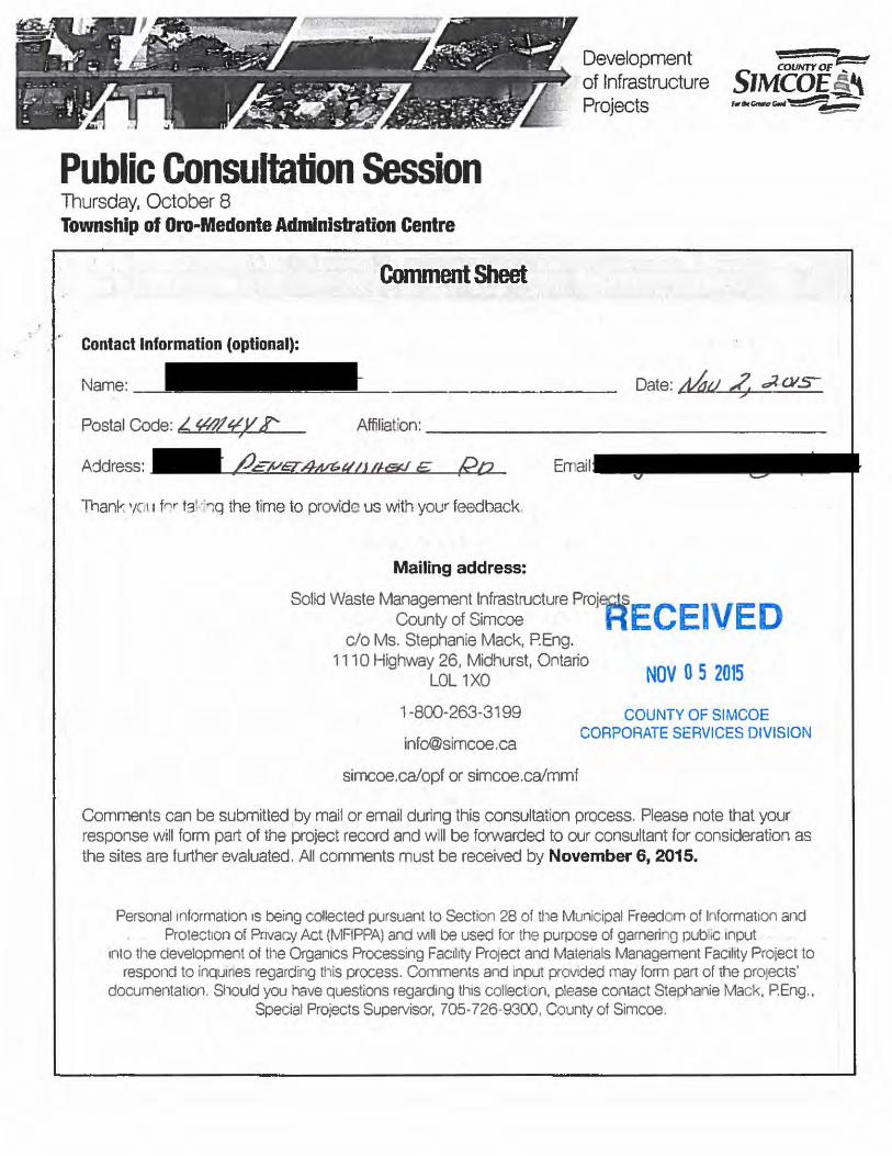
Development of Infrastructure Projects
:UNTY OF 1 ::= E
SIMCOE~ r.,,.,c;,r...~
=--
Public Consultation Session Thursday, October 8 Township of Qro .. Medonte Administration Centre
Comment Sheet
Contact Information (optional):
Name: Date: ;t4.J Aj dl-OIS
Postal Code: L ¥/11¥)/?: Affiliation:-------------------
Thank 1/CII fN tg'<nq the time to provide us with your feedback.
Mailing address:
Solid Waste Management l~frastructure Proj~EC E I VE D County of S1mcoe H _
c/o Ms. Stephanie Mack, P.Eng. 1110 Highway 26, Midhurst, Ontario
LOL 1XO NOV 0 5 2015
1-800-263-3199
simcoe.ca/opf or simcoe.ca/mmf
COUNTY OF SIMCOE CORPORATE SERVICES DIVISION
Comments can be submitted by mail or email during this consultation process. Please note that your response will form part of the project record and will be forwarded to our consultant for consideration as the sites are further evaluated. All comments must be received by November 6, 2015.
Personal 1nformat1on 1s being collected pursuant to Section 28 of t11e Municipal Freedom of lllformatlon and Protection of Pnvac.y Act (MFIPPA) and Will be used for the purpose of garnerino pub 1c 1nput
1nto til e development of the OrganiCS Processing Fac1hty Prq ect and Matenals Management Fac1hty Project to respond to inqumes regarding this process. Comments and input prov1ded may form part of the projects'
documentation. Should you have questions regard1ng th1s collect on. please contact Stephanie Mack, PEng., Special Projects SupeNisor, 705-726-9300, County of Simcoe.

-.. Please provide your comments below
,/ dA~J~:e__.. lvd r0-l Ucc res,;d,Ac:t!-- 71/ ¥~ y&J ~ htv <" 7A r2 4 /Y!"V. / <?A"t q=t:Ut ~ecnt?el <f'lbt:JcJ.;i .tn'j _
Zde Zb<ck -1-&r~,c e-~L:z+=<U /t&ue /'Za 1~/J~i . CUz ,Cev/~rtt£1 harn-4-f ,c CA_/2.: ..fJqCKZ)A;' evmma&iy
I V/1-dcv-;;/;,~~L dAo -R?EfZ2o</re -1 s t/u_. -C!J&'ake- . a?' Om<!PE ~?WAr- . dut t-A~ce l s /l"L<!CC" tf?CJ/lu/e-h 6 .
~ /i .e. Ch.d.( 7 • / bf;:.,. e< ..Jlzl/' · ~It' l?A e I< ~ , e """'""/-/Jd.r-"7~ -tkn., "tlver-e ~ e pa~ ;,7 ,rnu7L

November 1, 2015
Solid Waste Management Infrastructure Projects County of Simcoe c/o Stephanie Mack, P.Eng. 1110 Highway 26 Midhurst, Ontario LOL lXO
Dear Ms. Mack,
We are writing to express our deep concern and disapproval of building an Organics Processing and Material Management facility at the Sandford Tract Forest located on the s•h line of Oro-Medonte.
As regular users of Hardwood Ski and Bike, we and our family have been coming to Oro-Medonte since the mid 1980's. Not only will building this facility at said location be detrimental to the business at Hardwood Ski and Bike and to the enjoyment of our time at this property, it will also be harmful to the sensitive Oro-Moraine. This moraine drains into Georgian Bay, Lake Huron and Lake Simcoe. Efforts are already being made to preserve undeveloped land on the moraine by encouraging landowners to leave their property as a legacy to the regional conservation authorities in their wills.
It should also be noted that Hardwood Ski and Bike is a world class facility, attracting hundreds of thousands of elite athletes and recreational users to Oro-Medonte each year. In addition to hosting its regular sporting events, Hardwood was the site for the 1991 World Cup cross country ski competition and key cycling races for this year's Pan Am Games.
For the reasons stated above, we urge you and your colleagues to consider choosing another location for this Organics Processing and Material Management facility.
Thank you for your time and attention to this serious matter.
Sincerely,
Mary Ann West - Indian Road Toronto, ON M6R2W7 T: __ _
E:
&
RECEIVED
NOV 0 5 2015
COUNTY OF SIMCOE CORPORATE SERVICES DIVISION

From: George Milne I Winthorpe Rd Toronto ON M4E 3Vl
To: Stephanie Mack, P. Eng.
Nov 03/2015
Solid Waste Management Infrastructure Projects County of Simcoe Midhurst ON
Dear Stephanie Mack,
I am writing to express my concern and disapproval of building an Organics Processing and Material Management facility at the Sandford Tract Forest located on the 5th line of Oro-Medonte.
Not only will building this facility at said location be detrimental to the business at Hardwood Ski and Bike and to the enjoyment of my time at this property, it will also be harmful to the sensitive Oro-Moraine. This moraine drains into Georgian Bay, Lake Huron and Lake Simcoe. Efforts are already being made to preserve undeveloped land on the moraine by encouraging landowners to leave their property as a legacy to the regional conservation authorities in their wills.
With such efforts being made to preserve this land it only makes sense to choose another location for this Organics Processing and Material Management facility.
Thank you for your time and attention to this serious matter.
Sincerely,
t:;:ej.~~-P.S. I might add that I have been a cross-country skier at Hardwood Hills since 1984 (two years before the official opening, under the Vineys.)
RECEIVED
NOV 0 5 2015
COUNTY OF SIMCOE CORPORATE SERVICES DIVISION

From: Deana Dobbs
Sent: Friday, November 06, 2015 7:17 AM
To: Customer Service <[email protected]>; Nancy McDonough
Subject: Craighurst Millennium Forest Tract
Importance: High
November 6, 2015
Solid Waste Management Infrastructure Projects
County of Simcoe
1110 Highway 26, Midhurst ON L0L 1X0
Dear Ms. Stephanie Mack,
I am writing you in regard to the selection of 1473/1273 Old Second South as a proposed site for
an Organics Processing Facility and/or Materials Management Facility.
My partner Brian England and I currently reside at Old Second South and were in shock
when we received the initial letter indicating this proposed facility would potentially be built
within 500 meters of our home. Our decision to purchase this home was primarily location; the
peace and quiet of the rural setting, proximity to nature trails in this beautiful forest and
abundance of wildlife. The effects of the proposed facilities on these items are of our personal
utmost concern.
We wonder if your consultants have analyzed how many types of wildlife live in the Craighurst
Millennium Forest Tract. At a gathering of concerned neighbours we discussed a few that we
have been witness to: Bear, Deer, Wild Turkeys, Partridge, Raccoons, Foxes, Rabbits, Turtles,
Brook Trout and even a Milk Snake (which was notified to the Ministry of Natural Resources as
it is an endangered species). Obviously if Old Second is selected as the preferred site, the natural
habitat for these animals will be destroyed. Has this been considered in the consultant’s
analysis?
Our next major concern is safety. From meetings we have attended we have been informed that
the entrance to the proposed facility would be adjacent to the rail road tracks. This particular
section of Old Second and the “S” curve is already a hazard where several accidents have
occurred. Have the consultants considered the potential dangers of having up to 200 trucks per
day using an entrance/exit that is basically hidden from north bound traffic? Not to mention
there are up to 8-10 trains that cross Old Second South on a daily basis with wait times up to 40
minutes. More importantly…..there are five school buses that cross these tracks morning and
night. This is a potential traffic disaster in the making. Has this been considered in the
consultant’s analysis?

We realize there is no perfect site. Residents will dispute any location that is near their home
and fight to protect what is dear to their heart. That is why we are asking you to consider
industrial sites that may potentially meet your criteria. MLS listings change on a daily
basis. Can this be monitored for potential new industrial locations where the trees planted by the
Anglers and Hunters Association are not destroyed; were the natural habitat of our wildlife is not
destroyed and our families are not at risk travelling to school each day?
We just want to protect Craighurst Millennium Forest Tract for our generation, our children and
generations to come. We truly hope that these concerns will be taken into consideration in the
final site selection.
Thank you for your time.
Deana Dobbs & Brian England

From: Deana Dobbs Sent: Sunday, November 08, 2015 9:24 PM To: Deana Dobbs Subject: Craighurst Millennium Forest Tract
November 8, 2015
Solid Waste Management Infrastructure Projects
County of Simcoe
1110 Highway 26, Midhurst ON L0L 1X0
Dear Ms. Stephanie Mack,
I am writing you in regard to the selection of 1473/1273 Old Second South as a proposed site for an
Organics Processing Facility and/or Materials Management Facility.
My partner Brian England and I currently reside at Old Second South and were in shock when
we received the initial letter indicating this proposed facility would potentially be built within 500
meters of our home. Our decision to purchase this home was primarily location; the peace and quiet
of the rural setting, proximity to nature trails in this beautiful forest and abundance of wildlife. The
effects of the proposed facilities on these items are of our personal utmost concern.
We wonder if your consultants have analyzed how many types of wildlife live in the Craighurst
Millennium Forest Tract. At a gathering of concerned neighbours we discussed a few that we have
been witness to: Bear, Deer, Wild Turkeys, Partridge, Raccoons, Foxes, Rabbits, Turtles, Brook
Trout and even a Milk Snake (which was notified to the Ministry of Natural Resources as it is an
endangered species). Obviously if Old Second is selected as the preferred site, the natural habitat for
these animals will be destroyed. Has this been considered in the consultant’s analysis?

Our next major concern is safety. From meetings we have attended we have been informed that the
entrance to the proposed facility would be adjacent to the rail road tracks. This particular section of
Old Second and the “S” curve is already a hazard where several accidents have occurred. Have the
consultants considered the potential dangers of having up to 200 trucks per day using an entrance/exit
that is basically hidden from north bound traffic? Not to mention there are up to 8-10 trains that
cross Old Second South on a daily basis with wait times up to 40 minutes. More
importantly…..there are five school buses that cross these tracks morning and night. This is a
potential traffic disaster in the making. Has this been considered in the consultant’s analysis?
We realize there is no perfect site. Residents will dispute any location that is near their home and
fight to protect what is dear to their heart. That is why we are asking you to consider industrial sites
that may potentially meet your criteria. MLS listings change on a daily basis. Can this be monitored
for potential new industrial locations where the trees planted by the Anglers and Hunters Association
are not destroyed; were the natural habitat of our wildlife is not destroyed and our families are not at
risk travelling to school each day?
We just want to protect Craighurst Millennium Forest Tract for our generation, our children and
generations to come. We truly hope that these concerns will be taken into consideration in the final
site selection.
Thank you for your time.
Deana Dobbs & Brian England

From: John Maynard Sent: Friday, November 06, 2015 9:44 AM To: Customer Service <[email protected]> Cc: French, Bill <[email protected]> Subject: Re: Comment on OPF & MMF Proposals
My apologies .. Item 5 below, should read have read North West (not East) and South West (again not East) ... John Maynard
On Fri, Nov 6, 2015 at 8:49 AM, John Maynard wrote:
I attended one of your information meetings at the Elmvale Arena a couple of weeks ago and would like to provide the following comments:
1. My hearty congratulations and thanks to the Warden, Council and staff on the openness and community engagement in the process to date .. After Site 41, this is very refreshing.
2. I agree & support Warden Marshall’s statement that these projects are the “right thing to do” and cost saving is not the major issue.
3. I believe that the criteria developed and approved to evaluate various sites are the correct ones, but your information was silent on the weighting given to each of these issues and the basis for that weighting .. It appears to me, that based on your short list of sites, that far less weighting has been given to “Transportation” related issues, than I would have expected. With the expectation that truck volume (both in and out) might grow to one every 2-3 minutes during the day .. I would have expected that a premium weighting would have been put on proximity to a major high way intersection.
4. In your presentation, you indicated that your process started by identify sites that were already owned by the county; were on the market; or offered up by their current owners and then apply these criteria to them to create the short list .. What I would have expected (and think you should do) is that you should first start with the criteria and then look for sites that best match them .. whether they are owned or not! .. I believe this would result in a very different and more suitable short list.
5. An example of a site that, in my opinion, would meet your criteria much better and solve the transportation issue, would be to repurpose your existing Sand/Truck Depot on the North East corner of 93 & Flos 4 OR acquire the property immediately south on the South East corner of 93 & Flos 4 down to and possibly including the Hydro right of way. Here you would have industry on all sides, dry vacant land and only a few hundred yards to a significant intersection on 400.
Respectfully submitted .. John Maynard, 1218 Flos Rd 5 E, -
jfairchild
Highlight

From: Michelle Jardine Sent: Friday, November 06, 2015 10:06 AM To: Customer Service <[email protected]> Cc: French, Bill <[email protected]>; Allen, Don <[email protected]> Subject: Concerns over 2976 Horseshoe Valley/Old Second South waste management project sites Attention Stephanie Mack, Hello Stephanie, We live near the above site area and would like to register our concerns and opposition to building either an organic or waste transfer site on these forested areas. We have attended the meetings and Springwater council meeting in support of Simcoe County not moving forward on either of these sites. Our concerns continue to be as follows: Traffic/road infrastructure ‐ In addition to increased traffic, noise and pollution Horseshoe Valley Road is treacherous in the winter, the hills always are icy resulting in many accidents; slow moving trucks at any season would create necessity for passing lanes and require expansion of the road to allow for multi‐lane traffic ‐ without this there will be an increase in accidents due to visability. Sub roads that trucks would use are Gill Road and Old Second South ‐ both of which are not suited for large truck traffic, both have serious road bends/visabililty issues around railway crossings still in use and are through residential areas.. How would the County ensure these roads were not utilized by the trucks? Environment/Aquifer ‐ our area is reknown for the clearness of the water, year‐round water access is provided in a forested area on Gill and utilized by many non‐township dwellers. We sit on one of the largest aquifers in the area. The Horseshoe valley site sits on a hill, contaminated waste water would run downhilll seeping to ground with potential of contamination of our drinking water as well as the local watersheds. Ministry of Environment is currently involved in a well that was lost and we have been told there is a permit to pump 50 thousand litres a day into the watershed, I do believe Nottawasaga Conservation is involved due to wtershed concerns. Simcoe county received stewardship award for managing the largest forest in Ontario I believe, cutting down these forest areas is contradictory to this strategy. Springwater looking to bring in by‐law limiting clear cut of trees. This area abuts farm land, specifically Nichelon Farms which is an organic farm that grows and sells all local farmers grown produce???? These specific sites are primarily residential ‐ this type of site would surely be best suited to an area that already has zoning for industrial use. While a specific building plan has not been decided on, indoor facilities are proven to report significant issues with rats,; our area is also reknown for wildlife, a waste site would draw bears to the area. Both are safety and health concerns.

Lastly, impact on property value, odor and quality of life resulting in all of the above is a personal concern. Thank you for your consideration. Michelle Jardine David Briand property owners 65 Hillview Crescent Midhurst, Ontario
jfairchild
Highlight

From: Dani B
Sent: Friday, November 06, 2015 10:53 AM
To: Customer Service <[email protected]>
Subject: Solid Waste Management Infrastructure Project Simcoe County
Solid Waste Management Infrastructure Projects County of Simcoe
c/o Stephanie Mack, P.Eng.
1110 Highway 26
Midhurst, Ontario
L0L 1X0
Dear Stephanie Mack,
I am writing to express my disapproval of building of an Organics Processing and Material
Management facility at the Sandford Tract Forest located on the 5th Line of Oro-Medonte.
This facility has the potential to be harmful to the Oro-Moraine, which is a sensitive area,
whereby all efforts should be made to protect it now and for future generations.
The infrastructure needed to develop the 5th Line and roads leading to the facility would also
destroy the rural setting of the area. It is imperative that the environment and rural character of
Oro-Medonte be preserved. We choose to live here because of it's natural beauty, clean air, and
because it's quiet and peaceful. If residents wanted to be disrupted by noise and trucking and
other negative aspects that would come with this facility, they would live in the city.
Building this facility at this proposed location would also be detrimental to the world class
facility at Hardwood Ski and Bike where the PanAm Games were recently held. It is a huge part
of the rural community and a draw to many people form all over the world. The trails wind
through the beautiful forests, for which this area is known. As well, people training for races and
events make use of the surrounding roads to connect to other Simcoe County Forest trails. Truck
traffic required for this facility would impact training in the area, as it would become too
dangerous. It would become unsafe to hold the road races and biathlon events that generate
revenue not just for Hardwood Ski and Bike but other local businesses as well, such as
restaurants and bed and breakfasts.
Thank you for your time and attention to this serious matter. The citizens of rural Simcoe
County have made this their home because of the fact that it is rural land. Such industrial
facilities belong in Industrial Parks where infrastructure is already in existence.
Sincerely,
Danielle Berube
Line 8 N
Simcoe County

From: [email protected] [mailto:[email protected]]
Sent: Friday, November 06, 2015 11:30 AM
To: Mack, Stephanie
Subject: We want to hear from you
Survey Response: We Want to Hear From You Response GUID: f3e601fa-a2f6-4fd1-8098-4d18626c5a3b
Started: 11/6/2015 11:09:29 AM
Completed: 11/6/2015 11:30:03 AM
Name:
Jason Vurma
Email:
Comments:
I completely support the County's initiative to process Organics locally instead of bearing the cost to
ship the material to Hamilton.
Having reviewed the locations for all of the proposed sites, I'd encourage to County to select a site that
is close to Hwy 400 or Hwy 11 and on, or very close to, major county-level roadways.
I recognize that selecting a location for a facility like this is about picking a location that has the fewest
draw-backs.
Accepting that no one wants industry right in the their backyard, I'd look for a site where the driving
routes to/from the site are all on major arterial roads. With public safety in mind owning to the
increased truck traffic, they would need to be roads that are wide with good natural visibility.
I would only support a site where the above conditions were met.
With that said, my top pick would be the site at 540/528 Penetanguishene Rd and my second pick would
be the site at 2976 Horseshoe Valley Rd. W. Both are close to highways and on major county level
roads. Both sites are close to waterways, but where isn't in our County, so that would have to be
factored-in.
Best of luck,
Jason Vurma

From: Cassandra Rutherford Sent: Friday, November 06, 2015 12:25 PM To: Customer Service <[email protected]>; Warden <[email protected]> Cc: French, Bill <[email protected]> Subject: Attached Letter To County Council re: OPF MMF Proposed Sites
Hello,
Please find attached my letter to County Council re: Flos 3 East as a proposed site.
Kind Regards,
Cassandra Rutherford

Cassandra Rutherford 14 Oren Blvd. Barrie, ON
L4N4M1
November 5, 2015 County of Simcoe Mr. Gerry Marshall, Warden and Members of County Council 1110 Highway 26 Midhurst, Ontario L0L 1X0 and to: Township of Springwater His Worship Bill French, Mayor of Springwater and Members of Council 2231 Nursery Road Minesing, ON L0L 1Y2 “How do you compensate for my father’s ashes that are spread on the ski trails he created?” This was the question I posed to my mother after we attended the final information meeting given by Simcoe county. My parents purchased their home at the end of Flos rd 3 east over a decade ago. It was the ideal location. They were outdoor enthusiasts that loved horse riding, hiking and cross country skiing. The property is surrounded by wetlands on a beautiful dead end road. When my father was diagnosed with leukemia and passed away 5 years ago my mother decided to stay on the farm. My husband, young children and I currently own a house in the north end of Barrie. We are a phonecall away if any assistance is needed. In four years we were planning to sell our house in town and move onto the farm. If this site is chosen we will not be doing this. After reading many of the letters neighbours have sent in, I will briefly reiterate some of the major concerns:
● Traffic increase on rural area roads and unknown cost to upgrade roads ● Effects on drinking water with placement of sites around aquifers ● Effects on wildlife ● Zoning
It is difficult to write this letter without being angry. It is unfortunate that it has to be done. However, one of the benefits of having to do this is we’ve really gotten to know the neighbours. The stress and grief this proposal has had on the community is hard to describe. Consistently I hear stories of people having difficulty sleeping due to stress about the future of their homes. It is with hope I am sending this letter. Please choose an appropriately zoned area for these facilities. Sincerely, Cassandra Rutherford

From: Sent: Friday, November 06, 2015 12:46 PM To: Customer Service; Dennis Chronoppoulos; Eftihia Ellinas; George; Gus Koutroubis; Nicolas Karagiannis Subject: submission waste process fasility To Whom it May Concern Please accept my submission to the proposed waste process facility Bill Pidlysny Church President Holy Cross St. Nektarios Bill Pidlysny Internment Director St. James Crown Hill Cemetery
Mail Address
Barrie Ontario L4M 4T7 Physical Address
Penetanguishene road Springwater Twp

,·:·
Development : of Infrastructure Projects
Public Consultation Session Thursday, October 8 Township of Oro-Medonte Administration Centre
Contact Information (optional):
Name:
Address: Email: sf'"'' V)~
Thank you tor taking the time to provide us with your feedback. p.
Mailing address:
Solid Waste Management Infrastructure Projects County of Simcoe
c/o Ms. Stephanie Mack, P.Eng. 1110 Highway 26, Midhurst, Ontario
LOL 1XO
1 -800-263-3199
simcoe.ca/opf or simcoe.ca/mmf
Comments can be submitted by mail or email during this consultation process. Please note that your response will form part of the project record and will be forwarded to our consultant for consideration as the sites are further evaluated. All comments must be received by November 6, 2015.
Personal information is being collected pursuant to Section 28 of the Municipal Freedom of Information and Protection of Privacy Act (MFIPPA) and will be_used for the purpose of gamering public input
into the development of the Organics Processing Facility Project and Materials Management Facility Project to respond to inquiries regarding this process. Comments and input provided may form part of tt1e projects·
documentation. Should you have questions regarding this collection, please contact Stephanie Mack, P.Eng., Special Projects Supervisor, 705-726-9300, County of Simcoe.

_·--_<>f.\Jaw--6/Jt:h _-._
~~~~~~~~~~

Survey Response: We Want to Hear From You Response GUID: af0cc9a8‐7094‐43cc‐ba93‐351a3e0e58f7 Started: 11/6/2015 2:13:06 PM Completed: 11/6/2015 2:18:39 PM Name: Bill Pidlysny Email: Comments: The property owner for Penetanguishene rd do not agree with the proposed waste processing facility next to our church & cemetery

From: bryn epp Sent: Friday, November 06, 2015 1:12 PM To: Warden <[email protected]>; Dowdall, Terry <[email protected]>; Allen, Don <[email protected]>; Bifolchi, Nina <[email protected]>; Burkett, Mike <[email protected]>; Burton, Barry <[email protected]>; Cooper, Sandra <[email protected]>; Clarke, Basil <[email protected]>; Cornell, George <[email protected]>; Cox, Judith <[email protected]>; Dollin, Lynn <[email protected]>; Dubeau, Anita <[email protected]>; French, Bill <[email protected]>; Hough, Ralph <[email protected]>; Hughes, Harry <[email protected]>; Keffer, Rob <[email protected]>; Leduc, James <[email protected]>; Little, Doug <[email protected]>; Macdonald, Sandie C. <[email protected]>; McKay, Gord A. <[email protected]>; Milne, Rick <[email protected]>; O'Donnell, John <[email protected]>; Rawson, Bill <[email protected]>; Ross, Mike <[email protected]>; Saunderson, Brian <[email protected]>; Small Brett, Mary <[email protected]>; Smith, Brian F. <[email protected]>; Smith, Jamie <[email protected]>; Vanderkruys, Chris <[email protected]>; Walma, Steffen <[email protected]>; Warnock, Scott <[email protected]>; Wauchope, Gord <[email protected]> Subject: Proposal for Compost and waste management sites C136 and C270
I am the son in-law of Heather Rutherford who lives directly across from site C270. I live in North Barrie with my wife and 2 children. I have long enjoyed the outdoors including taking my young children on extended canoe trips though our hinterland. Currently we have the pleasure of regular visits to Heather's farm. We enjoy long walks, snow shoeing, and skiing through the many trails on her property as well as surrounding areas. Since my father in-law passed away five years ago, I have the job of helping maintain the trails they created on the property and get to see and hear the abundance of wildlife in the area. From coyotes to deer, wood peckers to owls, frogs to mosquitoes, we get to see them all. The other thing we get to see are signs of the very high water table on the eastern side of the property as evidenced by the many ponds, soft spots and entire areas only accessible in winter. The site directly across the road is currently covered by a hardwood transitional forest and drains into these wetlands as well as the connected wetlands to the east and south of the site. With the high water table spring flooding is already a concern in the area. With the clear cutting of site C270 or C136, the water issues for the area will be exacerbated.
The current proposed plans for C270 directly across from this area would not only have direct effect on our current enjoyment of this area but, our 4 year plan to move in with my mother in-law. The plans for C270 and C136 would have a drastic and negative effect on the surrounding wetlands, ruining life for not only humans and livestock but, wild animals of all kinds. Another thing we get to see is the access to these sites. C270 must be accessed by a dead end road that is on a blind corner at the base of a relatively large hill. This intersection already sees more than it fair share of collisions. Adding 180 Heavy trucks a day would only add to this

carnage. It would be only a short matter of time before people where killed. Just in case you think C136 is any better this site is located in the middle of a hill. I heard some one from either Council or the consultants mention traffic lights, That is such a nice naive thought as atr5ffic light on a blind corner or in the middle of a hill will not make things safer, it would only cause more accidents as cars approach the interchange blind with stopped traffic in front of them. It is with deep regrets I have to write a letter like this. I do hope that this council will come to the correct decision and not site the proposed facilities on C136, C270 or similar sites. Kind regards, Bryn Epp 14 Oren Blvd, Barrie, Ontario

From: Helena Spelt
Sent: Friday, November 06, 2015 1:36 PM
To: Customer Service
Subject: Objection to Organic Waste Facility near Hardwood Hills
Dear Stephanie Mack,
I am writing to express my objection to the construction of an organic waste processing facility
at the Sandford Track Forest on the 5th line of Oro-Medonte.
The building of this facility will hurt the enjoyment of all skiers at Hardwood Hills and will
therefore hurt the viability of this business. Hardwood Hills has already suffered because of the
expansion of the dump site right next door. Many people find it unpleasant to ski there because
of the noise and odours coming from the dump. I am convinced that adding an organic waste
processing facility nearby will convince me, as well as many others, to ski elsewhere.
I also believe that building the facility will be harmful to the sensitive Oro Moraine which drains
into Georgian Bay, Lake Simcoe and Lake Huron. It has been my understanding that the
township has consistently blocked efforts by Hardwood Hills to build a little inn near their
facility because of water use concerns. Therefore, how can it possibly be acceptable to now build
an organic waste processing facility in an area with such sensitive water use concerns? As well,
efforts are being made to preserve undeveloped land in the moraine by encouraging landowners
to leave their property as a legacy to the regional conservation authorities in their wills. Who in
their right mind would consider doing this when it appears that the government is prepared to
disregard the importance of the moraine by building such a massive facility in an area it has
previously deemed too sensitive for a tiny inn?
I ask you to please choose a different area for the location of this facility.
Thank you.
Helena and Jan Karel Spelt
Tanager Avenue,
Toronto, Ontario M4G 3R1

From: Eva Zaleski Sent: Friday, November 06, 2015 4:05 PM To: Customer Service Cc: Ian Kay Subject: Attn: Stephanie Mack, Solid Waste Management submission attached
Attn: Stephanie Mack Please acknowledge receipt of the attached pdf: Solid Waste Management submission Eva Zaleski Oro-Medonte, Ontario CANADA

1
To: Solid Waste Management Infrastructure Projects County of Simcoe c/o Ms. Stephanie Mack, P.Eng.
From: Ian Kay & Eva Zaleski Line 6 North, Oro-Medonte, ON, L0L 2E0
Date: November 5, 2015
Subject: Comments on Organics Processing Facility and Materials Management Facility – Short List of Sites
Comments:
We agree that Organics Processing and Materials Management Facilities for composting and recycling in Simcoe County are ‘the right thing to do’, provided they are implemented in the ‘right way’ so as to maximize long-term environmental, social and economic benefits. We have also much appreciated the public engagement and consultation process that we have seen.
Our biggest concern relates to increased vehicle traffic, noise, dust and pollutants off-site. While controlling on-site noise, odours and other concerns has been addressed to some extent, the assessment of peripheral impact comes across as superficial. The status of the existing transportation and other supporting infrastructure that could be adapted to serve the potential sites should have been a criterion at an early stage of the selection process. It can still be applied now of course, looking at financial, environmental and social costs and benefits. Based on the projected number of vehicles going to the combined facilities daily (87 in 2018), on average a truck would leave or enter the site every 3-3.5 minutes (assuming a 10-hour working day and one out-and-back journey per truck). After 30 years of growth, this increases to a truck approximately every 1.5 minutes. This is a lot of extra truck traffic on the roads serving the facilities. This projected volume of traffic needs to be compared to the current usage of the roads around each proposed site, not to the average ‘design capacity’ of County Roads, and not to number of ‘vehicles on the busiest county road’. The addition of 210 vehicles to Highway 400 or Highway 11 would be a small increase over current volumes. Obviously, this number of trucks added to Line 5 or Old Barrie Road represents a major percentage increase.
In the public meeting (Monday, October 26, 2015) it came across that we are really talking about 3 facilities, Organics Processing, Materials Management and a Vehicle Maintenance Yard. This last seems to have been neglected in the site selection process, which means that the potential for chemical spills and the additional requirements was not clear.
Site evaluation should include assessment of the loss of current environmental services that will be incurred by conversion to a waste management facility. For example, evaluation should include wildlife habitat, water protection and recharge, soil protection, and carbon capture and sequestration by vegetation and soils.

2
The most suitable of the short-listed sites are: o 1473/1273 Old Second South, Springwater, bounded on the east by Highway 400, and
on the west by the railway. o 540/528 Penetanguishene Road, Springwater, bounded on the northwest by Highway
11 in an existing industrial or ‘technogenic’ desert.
The proposed site on Line 5 North, Oro-Medonte, is not suitable for the following reasons: o Line 5 is a relatively small country road which at present sees very little traffic. Line 5
would require major upgrading. o Increased traffic volume (compared to present volume) would potentially affect Line 5,
Old Barrie Road, Bass Lake Road, and other area roads. This would be detrimental to area residents (sensitive receptors??) and local businesses (Hardwood Bike and Ski), as well as to road cyclists and pedestrians.
o The loss of environmental services needs to be factored into site characterization and selection criteria. In the case of Line 5, this includes the site itself (County Forest) as well as the vegetated road allowances which would be lost by upgrading roads.
o The site is on top of the Oro Moraine, and hence a likely recharge zone for area and regional water supplies.

From: adelle bailey Sent: Friday, November 6, 2015 4:31 PM
To: [email protected]; [email protected]
Subject: Proposed C270 and C136 letter
Hello, I am writing this letter to express my concern about proposed waste sites C270 and C136. I live at 1271 Flos road 4 east (within the range of the closest properties affected) on the top of the hill and from my property I can see where the proposed site is to be and as of now the view is natural with no evidence of development. My property is 14 acres of land carved out of a larger parcel (over 167 acres) of farmland that reaches the 3rd. My parents purchased this property in 1976 and I am the first born of three children who were all raised in the old home built in 1886. A few years back I moved home from living/educating/working in Toronto, because I wanted to start a family of my own on the same land I was raised - the open fields, natural forests, wildlife, and incomparable water, etc. I speak on behalf of my Mother, Father, Brother, Sister and Husband who all continue to call it home, even when work takes them elsewhere. The proposed plan for the waste site makes little sense and we're surprised we ever made the short list. We are incredibly concerned about our water being potentially threatened in the future, as we have our own well. It only makes sense to preserve such luxuries like pure water and Springwater township should not be called Springwater unless we make all the efforts to keep our water clean. A lot of development has been approved on the 4th in recent years and what was once a road my first dog (early 80's) could lay on for the entire morning without a car coming by is now a major route for massive trucks that shake the earth our house is built on each time they drive by. So much change in an area that is to a degree preserved by large landholders that are not developing. We understand there must be a place where waste is properly dealt with, but in the middle of undeveloped land seems strange to even consider. The deer have been already pushed out of their habitat, because of development on Marni lane, and the cutting into that forest has been painful to watch. So much wildlife has already been disturbed with subdivision development being approved. I have had 36 years to observe this area transform. I feel that my idea of raising my family here is more of a romantic illusion than a logical one, now that it's a fight to protect areas that are natural, where the drinking water is terrific and that is hard to swallow. We are so lucky to have the water we have, but it is continually being threatened by development in general, let alone the accountability on the waste transfer and industrial scale composting sites in Springwater Township to be in the appropriate location. Even the methods of how the waste sites would operate is unknown and to approve such a site without that understanding seems to leave us even more vulnerable. I would hope that Springwater township becomes more aware of how to preserve the water we take from under us, and that happens on the ground where we all need to be continually educating ourselves on the current ways to protect our environment. The day our water table gets affected negatively is the day we can no longer call our township Springwater, because we would not have done our part in the preservation of our clean water, something the entire community has access to. It is a true luxury to access pure drinking water and it's all at risk of great change that nobody is prepared for.

Wherever the waste transfer and industrial scale composting sites end up, it should already be on developed land, there should not be a single tree cut down for this and it should be an example of the most current modes of waste treatment. The future of Springwater is truly at risk if this waste site is not put in the best place possible and also operated with best practices in waste management currently used in some parts of the world. It seems to me a great responsibility to start a new waste site wherever it ends up and the steps to consider happen to be crucial to the future of life here in Springwater. My family has grown fruits and vegetables organically for the home since my parents purchased the place in the late 70's and we had hoped the growing, current awareness of environmental issues were going to spearhead improvement in Springwater township in terms of environmental stewardship. It's an opportunity to advance, not regress. Please consider my letter to speak for the six of us in total as we all call Springwater home. It is hard work to preserve what already exists and perhaps easier these days to build a new home and so that is the changing face of this area. I feel development in Springwater should be a much more careful decision in the future and this waste site is a very crucial and critical example. We appreciate your time and consideration to the proposed waste sites and we truly hope you will successfully protect the 3rd and horseshoe valley road, I can't imagine any positive out of waste sites here. Sincerely, Adelle Bailey 1271 Flos road 4 East Sent from my iPhone

From: David Dunlop Sent: November 6, 2015 5:10 PM To: Customer Service Subject: Re zoning forest areas for waste To whom it may concern; Please reconsider the idea of re zoning forest areas for the purpose of creating waste sites. The forests are the best part of Simcoe County. I am an author, born and raised in and around Barrie. I have been working on a novel series that takes place in Simcoe County. The first novel, "The Quest for the Black Dragon", has been released as an e‐book on Smashwords.com. The forests of Simcoe are a major part of the back drop and scenery. I've been considering the addition of a geocache aspect to the stories to create a more interactive experience and draw more excitement to the story and the beautiful area I still refer to as home. Please don't destroy the forests. Please consider existing industrial zones for future waste sites. Thanks, D.E. Dunlop Sent from my iPhone
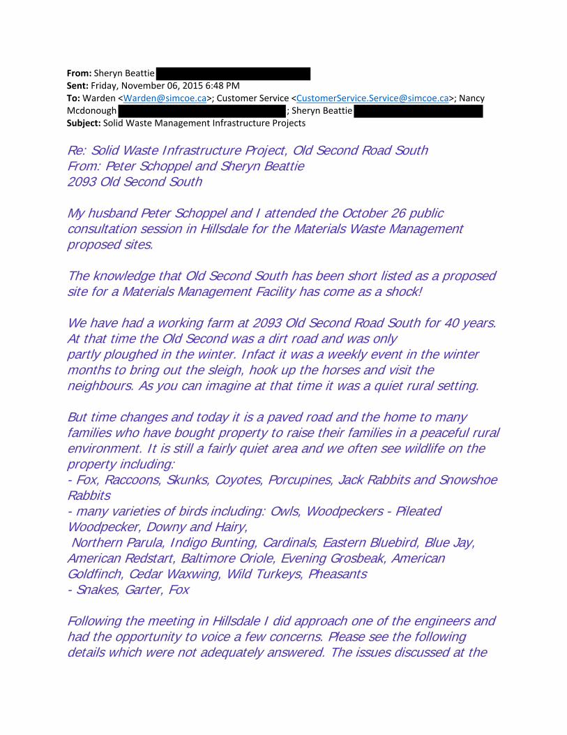
From: Sheryn Beattie Sent: Friday, November 06, 2015 6:48 PM To: Warden <[email protected]>; Customer Service <[email protected]>; Nancy Mcdonough ; Sheryn Beattie Subject: Solid Waste Management Infrastructure Projects
Re: Solid Waste Infrastructure Project, Old Second Road South From: Peter Schoppel and Sheryn Beattie 2093 Old Second South My husband Peter Schoppel and I attended the October 26 public consultation session in Hillsdale for the Materials Waste Management proposed sites. The knowledge that Old Second South has been short listed as a proposed site for a Materials Management Facility has come as a shock! We have had a working farm at 2093 Old Second Road South for 40 years. At that time the Old Second was a dirt road and was only partly ploughed in the winter. Infact it was a weekly event in the winter months to bring out the sleigh, hook up the horses and visit the neighbours. As you can imagine at that time it was a quiet rural setting. But time changes and today it is a paved road and the home to many families who have bought property to raise their families in a peaceful rural environment. It is still a fairly quiet area and we often see wildlife on the property including: - Fox, Raccoons, Skunks, Coyotes, Porcupines, Jack Rabbits and Snowshoe Rabbits - many varieties of birds including: Owls, Woodpeckers - Pileated Woodpecker, Downy and Hairy, Northern Parula, Indigo Bunting, Cardinals, Eastern Bluebird, Blue Jay, American Redstart, Baltimore Oriole, Evening Grosbeak, American Goldfinch, Cedar Waxwing, Wild Turkeys, Pheasants - Snakes, Garter, Fox Following the meeting in Hillsdale I did approach one of the engineers and had the opportunity to voice a few concerns. Please see the following details which were not adequately answered. The issues discussed at the

meeting were related directly to the site itself but seemed to omit assessment of impact on residents. 1. The "environmental criteria" only measured the proposed site. Question Why did this not include a measurement for emissions pollution from the trucks? Also not measured was the noise pollution from the trucks up and down Old Second, apparently there is the potential for a truck every 4 minutes. Why was air and noise pollution not measured? Stops at the railway tracks will increase noise. 2. The proposed site on Old Second South is a low lying area and will impact the health of streams that are moving through the proposed site. Question Why was the impact to the low lying area not assessed? 3. There is a major risk to personal safety with the proposed trucks travelling on Old Second, consider children and adults on bicycles and horseback, cars in and out of drive ways. Question Has the safety of residents in the their daily activities as well as visibility been assessed for safety of the residents? 4. The hills on Old Second obstruct the view of truck traffic moving up and down the road creating a safety concern. Question Has the safety issue regarding visibility of truck traffic been taken into consideration and measured with regard to the hills? 5. There will likely be heavy wear on the road Old Second South. Question Has the heavy truck traffic load been taken into consideration with constant wear on the road surface? 6. The Olds Second is a residential area and residents have bought property to gain a foothold into an environmental, safe and friendly lifestyle. Question Has an alternate entrance into the proposed site been considered, one which does not impact the residents daily movement on Old Second South?

7. There is concern that this site may just be a beginning to a fee for service with Solid Waste Management. Question What are the long term goals for the Materials Waste Management site on Old Second South, can you guarantee that this site will not take in waste form other cities? 8. The residents of Old Second are very concerned about a decline in property values. I understand from the meeting that we will be compensated for lost property value. Question How will the compensation for lost property value be measured? Further discussion should be facilitated to answer the many questions that are of concern to residents. Regards Sheryn Beattie Peter Schoppel
Sheryn Beattie Professor, Marketing

From: Citizen Concern Sent: Friday, November 06, 2015 10:30 PM To: Clark, Brenda; Mack, Stephanie Subject: Feed back as requested deadline November 6th re OPF and WMF

For the attention of the consultants hired for site to site comparison for final recommendations to
Simcoe County;
In a very short period of time, over 500 signatures have been submitted on an e-petition at
www.ipetitions.com/petition/stop-sites-c270-and-c136-in-springwater-township to stop the placement
of any combination or singular of:
1) an Organics Processing Facility (OPF),
2) a Solid Waste Management Facility(SWMF) or
3) a Truck Servicing Facility(TSF)
on either sites:
C136 – 2976 Horseshoe Valley Road (Horseshoe Valley Road Access) or 1491-1493 Rainbow Valley Road
East (Rainbow Valley Road East Access)
- And/Or -
C270 – 1453 Flos Road Three East.
The following information primarily in bold is provided as contra indicators to placement of the
proposed sites at any or all stages of screening criteria applied by the County of Simcoe where public
consultation for determining a site ends November 2015 with expectation of a site to be announced in
or near February 2016.
In each Component: Environmental, Social, Cultural, Technical, Economic and Legal Column to the far
left is the criteria, the center column is the Rationale and the far right column is the applicable
indicators.
Component Criteria Rationale Indicators Environmental Air Quality Air Quality OPFs can produce
gases containing contaminants that affect air quality if they are emitted to the atmosphere. Construction and operation activities at an OPF can lead to increased levels of particulates in the air.
Wind Speed and Direction
The wind prevails from the west, and is constant, strong and persistent blowing toward C136. Two tornados have gone through the path immediately to the west of C136. This will make containment of odour virtually impossible for either C136 or C270 The sites themselves may be able to be contained, however the garbage blowing from the trucks is a

constant concern and one day per week garbage needs to be picked up from regular garbage service due to the high wind volume in this area.
Proximity to Sensitive
Receptors For C270 the report indicates 4 receptors within 500 feet and 8 for C136 for C136 being forgotten are the extensive use of the trail system.
Species of Special Concern,
Threatened, and/or Endangered These areas are abundant with mature forests and plant species. A thorough examination of all lands has not been conducted and would require a full 365 seasonal assessment as not all plant species are available for discovery in November.
Odour Odour Due to the material accepted, during operation of the OPF, odours may be present at the site.
Wind Speed and Direction
Odours will include the vehicle emissions and odours coming from the vehicles servicing the facilities.
Proximity to Sensitive
Receptors These are small marginalized communities consisting of generational farmers. Please place these facilities near urban centers to showcase the technology and responsibility for waste management that Simcoe County is professing.

Noise Noise Construction and operation activities at the facility may result in increased noise levels at the site.
Proximity to Sensitive
Receptors The roads leading to these sites (Flos 3, Horseshoe Valley Road and Rainbow Valley road) are comprised of rolling to steep hills. Trucks will be constantly using engine/air brakes and Occupational Health and Safety requires back up beepers to be used with trucks. The sound of back up beepers carry for MILES and will not be able to be contained at all – during construction or full operation.
Terrestrial Terrestrial OPF construction and operations may remove or disturb the functioning of natural terrestrial habitats and vegetation.
Topography
Soil Type
Clay undersoil with sandy tops, both C136 and C270 are within the Willow Creek Watershed. Flooding on Rainbow Valley Road East is prevalent during spring run off or high rain volume. The lay of the land is HIGH and rolling for C136 and flat and low drainage for C270 – all water flows into the Minesing Swamp and areas of the Matheson Creek are a major recharge area for the drinking water in this entire area. This is Springwater Township and we have the most pristine drinking water in the world. Don’t divert high volumes of truck traffic onto drainage lands.
Affected Greenlands
Niagara Escarpment Land Use
Oak Ridges Moraine Land Use
All water flows into our aquifer – although systems may be contained, water usage and rain run of the roads into and surrounding these facilities will

not be managed.
Species of Special Concern,
Threatened, and/or Endangered
Aquatic Aquatic OPF construction and operations may remove or disturb the functioning of natural aquatic habitats and species.
Species of Special Concern,
Threatened, and/or Endangered Environmentally protected wetlands are directly between C270 and C136 – any water/oil/grease from the road surfaces will contaminate the water.
Surface Water Surface Water The construction of physical works may disrupt natural surface drainage patterns and may alter runoff and peak flows. The presence of the facility may also affect base flow to surface water. Contaminants associated with an OPF have the potential to impact clean surface runoff.
Wetlands, Floodplains and
Water Bodies Not only are C270 and C136 well within the boundaries of the Willow Creek Watershed, flooding is prevalent each year especially in the area of Rainbow Valley Road East and Baseline road – areas immediately adjacent to the egress and access points. *WE HAVE NUMEROUS photographs of the EXTENSIVE flooding on these roads in wet spring and are happy to make available upon demand. This period of examination and visiting to the sites has been in one of the driest falls and summers we have ever seen.
Ground Water Groundwater Contaminants associated with an OPF have the potential to enter the groundwater and impact off‐site receptors. Therefore, if a Waste Disposal Site is determined to be a significant threat to drinking
Groundwater Depth
WATER can be seen running from underneath the ground into the ditches along Rainbow Valley Road East from C136 there are many swampy areas that are wet year round in both of these locations C270 and C136.

water (i.e., within a WHPA), then the proposed use would be prohibited in that particular location. For clarification, an OPF is considered as a Waste Disposal Site under the legislation even though it does not necessarily correspond with the conventional definition of waste disposal (i.e., landfill, incineration), but more so with the fact that source-separated organics will be "processed". The definition of a Waste Disposal Site under Part V of the Environmental Protection Act means: a) Any land upon, into, in or through which, or building or structure in which, waste is deposited, disposed of, handled, stored, transferred, treated or processed. b) Any operation carried out or machinery or equipment used in connection with the depositing, disposal, handling, storage, transfer, treatment or processing referred to in clause (a).
Groundwater Flow and
Direction INTO MATHESON CREEK for both of these locations as well as into the Springwater township aquifer.
Source Water Protection
Areas The run off from even the roads and driveways into the sites and out of the sites will be contaminated with grease/oil and other hazards that cannot possibly be controlled with garbage pick-up. No testing is done on the materials being handled at these facilities because they are being shipped via the SWMF away. The residue from these materials will be present – even if the facility is inside, the truck tires will be subjected to the contaminants extending the surface area run off concerns to the surrounding roads.
Agricultural Agricultural Agricultural land may be displaced by the development of the OPF.
Prime Agricultural Areas15
(i.e., Specialty Crop Areas, and Class 1, 2 and 3 Agricultural Lands)
These lands are zoned agricultural and area residents have gathered regularly since the announcement to vigorously and litigiously oppose any applications for re-zoning. Purchases of existing neighboring farms were made with an expectation that the
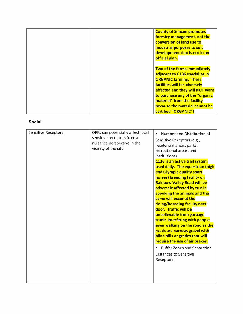
County of Simcoe promotes forestry management, not the conversion of land use to industrial purposes to suit development that is not in an official plan. Two of the farms immediately adjacent to C136 specialize in ORGANIC farming. These facilities will be adversely affected and they will NOT want to purchase any of the “organic material” from the facility because the material cannot be certified “ORGANIC”!
Social Sensitive Receptors OPFs can potentially affect local
sensitive receptors from a nuisance perspective in the vicinity of the site.
Number and Distribution of
Sensitive Receptors (e.g., residential areas, parks, recreational areas, and institutions) C136 is an active trail system used daily. The equestrian (high end Olympic quality sport horses) breeding facility on Rainbow Valley Road will be adversely affected by trucks spooking the animals and the same will occur at the riding/boarding facility next door. Traffic will be unbelievable from garbage trucks interfering with people even walking on the road as the roads are narrow, gravel with blind hills or grades that will require the use of air brakes.
Buffer Zones and Separation
Distances to Sensitive Receptors
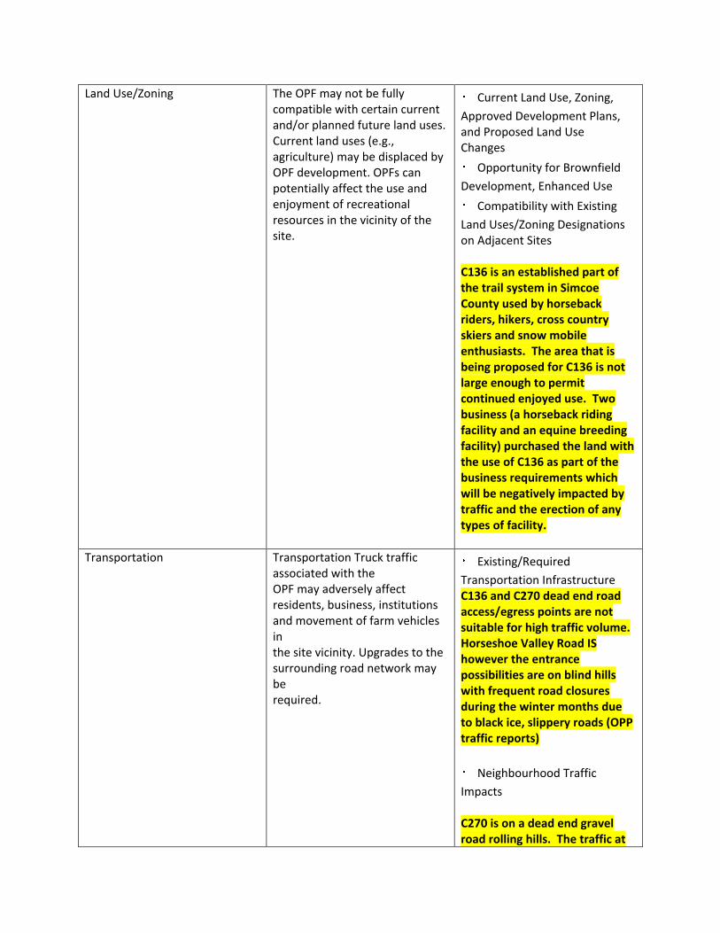
Land Use/Zoning The OPF may not be fully compatible with certain current and/or planned future land uses. Current land uses (e.g., agriculture) may be displaced by OPF development. OPFs can potentially affect the use and enjoyment of recreational resources in the vicinity of the site.
Current Land Use, Zoning,
Approved Development Plans, and Proposed Land Use Changes
Opportunity for Brownfield
Development, Enhanced Use
Compatibility with Existing
Land Uses/Zoning Designations on Adjacent Sites C136 is an established part of the trail system in Simcoe County used by horseback riders, hikers, cross country skiers and snow mobile enthusiasts. The area that is being proposed for C136 is not large enough to permit continued enjoyed use. Two business (a horseback riding facility and an equine breeding facility) purchased the land with the use of C136 as part of the business requirements which will be negatively impacted by traffic and the erection of any types of facility.
Transportation Transportation Truck traffic associated with the OPF may adversely affect residents, business, institutions and movement of farm vehicles in the site vicinity. Upgrades to the surrounding road network may be required.
Existing/Required
Transportation Infrastructure C136 and C270 dead end road access/egress points are not suitable for high traffic volume. Horseshoe Valley Road IS however the entrance possibilities are on blind hills with frequent road closures during the winter months due to black ice, slippery roads (OPP traffic reports)
Neighbourhood Traffic
Impacts C270 is on a dead end gravel road rolling hills. The traffic at

the intersection of Flos 3 is already on a curve. C136 is on a dead end gravel road as well and is subjected to repeat closures in the winter due to icy roads and CONSTANT blowing snow due to open farm fields around it. At least 3 school buses use Rainbow Valley road twice daily to pick up children on bus routes. The road is not designed for traffic use. Being a dead end road all traffic concerns will double. There are concerns with the intersection of Rainbow Valley Road East and County Road 27 due to an existing gas station. It is the location of many very , very serious accidents. This does not improve as you go to the other entrance for Horseshoe Valley road as site C136 is not a flat piece of property, the roll of the land is very significant with blind hills from east and west points of access.
Visual The OPF can affect the visual appeal of a landscape and change the overall perceptions of landscapes and views.
Buffer Zones and Visual
Screening As C136 and C270 are dead end roads, the addition of waste management facilities would encourage people to “dump” garbage at the gates during closed periods. This already occurs frequently near other waste management facilities in the area. These sites should be showcased – the area of Hwy 400 and 93 are in the public’s eye and are a chance for Simcoe County to design a facility that is visually appealing. No

amount of trees or buffer would help C270 or C136 hide the line-up of traffic of garbage trucks expected on a daily operating basis. Hwy 400 site at least has minimal sensors (industrial area and LOW value homes) and is completely capable of handling the traffic capacity.
Cultural Archaeological Archaeological resources are
non‐renewable cultural resources that can be destroyed by the construction of an OPF.
Archeologically Significant
Areas C136 is home in the corner of the Roman Catholic Apto Cemetery and is also the site where the body of the female 17 year old homicide victim Cindy Halliday was found in 1992. The tract should be renamed in her honor, not the site of an actual “dumping grounds”. This is absolutely poor taste and foresight on behalf of Simcoe County. Unbelievably disrespectful.
Heritage Cultural/heritage resources could be displaced by the construction of an OPF. The use and enjoyment of cultural resources may also be disturbed by the ongoing operation.
Areas of Important Cultural
Heritage Land immediately to the east of C136 was the site of First Nation Burial grounds. It will be interesting to see what test holes result in for this area as it is a possible location for further sites. C136 is adjacent to heritage property.
Technical Permitting/Approvals The OPF may not be fully
compatible with certain current Feasibility and Complexity of
Permitting/Approvals
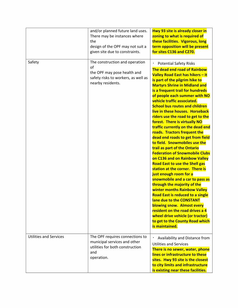
and/or planned future land uses. There may be instances where the design of the OPF may not suit a given site due to constraints.
Hwy 93 site is already closer in zoning to what is required of these facilities. Vigorous, long term opposition will be present for sites C136 and C270.
Safety The construction and operation of the OPF may pose health and safety risks to workers, as well as nearby residents.
Potential Safety Risks
The dead end road of Rainbow Valley Road East has hikers – it is part of the pilgrim hike to Martyrs Shrine in Midland and is a frequent trail for hundreds of people each summer with NO vehicle traffic associated. School bus routes and children live in these houses. Horseback riders use the road to get to the forest. There is virtually NO traffic currently on the dead end roads. Tractors frequent the dead end roads to get from field to field. Snowmobiles use the trail as part of the Ontario Federation of Snowmobile Clubs on C136 and on Rainbow Valley Road East to use the Shell gas station at the corner. There is just enough room for a snowmobile and a car to pass as through the majority of the winter months Rainbow Valley Road East is reduced to a single lane due to the CONSTANT blowing snow. Almost every resident on the road drives a 4 wheel drive vehicle (or tractor) to get to the County Road which is maintained.
Utilities and Services The OPF requires connections to municipal services and other utilities for both construction and operation.
Availability and Distance from
Utilities and Services There is no sewer, water, phone lines or infrastructure to these sites. Hwy 93 site is the closest to city limits and infrastructure is existing near these facilities.

Suitability The OPF must ensure that the site is suitable for construction and operation from a size, location and site constraints perspective.
Meets Minimum Size
Requirements (OPF ‐ 13 ha/33 acres)
Within Search Area
The search area is completely flawed from a SWMF perspective. The center of the target zone should have been determined much further to the south or near HWY 400 where the material will be shipped to anyway and the major artery to handle garbage is already in existence.
Site Layout, Topography, and
Soil Conditions C136 is a ROLLING piece of property and would require considerable excavating to create a flat enough location to support such a facility. C270 and C136 are HEAVILY forested areas with mature trees and significant undergrowth.
Compatibility with Existing
Infrastructure This is a small farming community. The idea of “limited sensitive receptors” is OFFENSIVE. This is a deliberate choice to pick people who are marginalized due to demographics. IF the facilities (in which the technology hasn’t even been picked yet) are so TECHNOLOGICALLY ADVANCED – THEN WHY ARE SENITIVE RECEPTORS EVEN IN QUESTION!!! IF IT IS SO GREAT and it doesn’t smell and it’s so amazingly responsible for the County of Simcoe to be running such an operation – then SHOWCASE IT – DON’T HIDE IT in a PLACE IT WHERE IF people

are actually AFFECTED it’s no big deal because you’ll only get a few complaints…Show some integrity County of Simcoe in what is being promised by the county and place it in an area where you aren’t trying to limit exposure. Pick a highly visible location such as Hwy 93 and 400.
Flexibility The OPF must ensure that there is the potential to amend and expand the facility.
Design/Operational Flexibility
Provided by Site
Surplus Lands for Expansion
There is plenty of land at Hwy 400 and 93 or Old Second South that are much closer to major arteries than C270 or C136. If the facilities are showcased, then the “visual buffer” is not a positive quality, it is a detractor.
Economic Capital Costs The construction of the OPF will
require significant capital investment.
Property Acquisition
Vigorous, long term opposition and legal protest will occur for any rezoning attempts to C270 and C136.
Infrastructure
These sites and the traffic associated to the build and operation of these sites will fracture our communities – already marginalized by small numbers due to occupation – farmers.
Design
Construction
Permits/Approvals
Site Remediation
Some of the types of

residences/farms that are located near these facilities are high end. Property values have been significantly affected by these proposals. Values are in the millions of dollars for at least two sites within proximity to C136. Is the county prepared to offer significant compensation to these property owners?
Operation and Maintenance Costs
The operation of the OPF will require an annual operating budget.
Facility Operation and
Maintenance
Transportation from
Feedstock Sources
Transportation to Markets
and End Users Place the facility near the south end or near Hwy 400 – the end users will be using the existing highway infrastructures. If the trucks went out from the south in the morning, collected materials then brought to facility and parked (yes this should be a consideration – actually house the garbage trucks at the location where they unload) then the materials are already half transported to final destinations.
Monitoring Requirements
Mitigation Requirements
Legal Land Acquisition The construction of the OPF may
require the acquisition of either public or private lands.
Land Acquisition Complexity,
Risk, Liability

Over 500 signatures on a petition, this is a highly motivated group of citizens who oppose the locations of C270 and C136. Anywhere currently zoned agriculture should not be subject to rezoning – choose a location where zoning considerations already exist.
Agreement The operation of the OPF may require an agreement with a future operator.
Structure and Complexity of
Operating Agreement The fact that County of Simcoe will enter into service agreements with other operators brings into question the true pride of ownership of such a venture. Already there are numerous complaints with the current vendor of record in the City of Barrie the county deals with. This was not in the long term plan of Simcoe County – Just because the county owns the properties does not mean that the properties are the best locations within Simcoe County. Put out another expression of interest for purchase, or review MLS listings over a prolonged period of time specific to purchasing a new piece of property.
“An ideal site carried forward in the evaluation process was one that was completely clear of
potential conflicts with Screen 1 criteria. However, it should be noted that most sites contained at
least some areas that were affected by Screen 1 criteria. In these cases, the sites passed Screen 1
if the remaining area of the site with no potential conflicts was large enough to meet the minimum
size requirement of 13 ha. This analysis was only required in a fraction of the sites, as most were
affected by at least one criteria, or the remaining area of the site free from conflicts was too small.”
Find sites that are not in conflict with the screening criteria.

Final assessment considered the exemptions noted in Section 2.3.2. If the potential conflicts could
be rationalized (rationalized by whom? Highly subjective) in a way that would still allow for the
development of the OPF, then the site was carried forward to Screen 2 for further evaluation. This did
not necessarily signify that the criteria in
question would not ultimately rule the site out, but merely that it should be exposed to further
scrutiny during subsequent analyses.
Site C136 – County-Owned – Freele Forest Tract (Figure 10)
• Favourable/Neutral ratings in five of the seven Screen 2 criteria.
• 84 ha in size. ROLLING LAND AND SWAMP!
• Appropriate topography and soil conditions. This is rolling land!
• Approximately 8 sensitive receptors within 500 metres of the site boundary.
• Adjacent to Hazard lands, Rural, Agricultural uses.
• Based on the surrounding land uses, the permitting and approvals are feasible, although some
setback requirements will be reviewed based on the on-site hazard lands.
• Approximately 8 km from the waste centroid, with direct road access and a favourable route to
a major road. Favourable???? Non of the three roads accessing the sites are even close to safe from a
traffic perspective.
• Lack of utilities and services on-site. AND subject to FREQUENT power outages and road closures!
• Current designation and land use will require amendments to the land use instruments.
Site C270 – County-Owned – Unnamed Forest Tract (Figure 13) As above in bold.
• Favourable/Neutral ratings in five of the seven Screen 2 criteria
• 44 ha in size.
• Appropriate topography and soil conditions. SWAMP and recharge (significant) areas
• Approximately 4 sensitive receptors within 500 metres of the site boundary.
• Adjacent to Natural Heritage, Rural and Agricultural land uses.

• Based on the surrounding land uses, the permitting and approvals are feasible.
• Approximately 10 km from the waste centroid, with direct road access and a favourable route to
a major road.
• Lack of utilities and services on-site.
• Current designation and land use will require amendments to the land use instruments.
Site P083/P084 – Privately-Owned – 540/528 Penetanguishene Road (Figure 14)
• Favourable/Neutral ratings in five of the seven Screen 2 criteria.
• Combined 17 ha in size.
• Appropriate topography and soil conditions.
• Approximately 14 sensitive receptors within 500 metres of the site boundary.
• Adjacent to Hazard lands, Rural and Agricultural land uses.
• Based on the surrounding land uses, the permitting and approvals are feasible.
• Approximately 9 km from the waste centroid, with direct road access and a favourable route to
a major road.
• Lack of utilities and services on-site.
• Current designation and land use will require amendments to the land use instruments.
These areas are rich with wildlife and are pristine areas of Springwater Township. It is almost
impossible to find property in Springwater Township or the Barrie/Orillia area that is not impacted by
railway lines, major hydro lines or noise/light pollution. Both Flos road Three and Rainbow Valley
Road East are of the most beautiful in the area.
Rainbow Valley Road seems like a fluffy name until you actually stand at the top of the Rainbow
Valley hill to the east, and look over site C136 to the east. We guarantee you that with every rainfall;
just the right direction of the sun creates a rainbow, if not a double rainbow. Is this really what
Simcoe County wants to find at the end of the rainbow is every single piece of garbage generated in
Simcoe County? Please, we implore you to visit this area during each of the 4 seasons on the quietest
of days to see and appreciate what is being potentially destroyed by lack of long term (not just since
2012) planning. Stand by what the Simcoe County slogan truly is “for the GREATER GOOD”. Property

that you currently own, people expect the greater good to be responsible management of forest and
recreational trails; Purchase a NEW piece of property within the next few years (maybe surplus some
of the other less forested properties to create revenue) and make your intention know that the land
will be purchased for this purpose. Protect our existing forests and communities; stop marginalizing
small population bases; and to that effect, Simcoe County will truly be for the greater good.
Sincerely,
Ed Krajcir
Residence located overlooking C270 to the north-east and C136 to the south-east.

From: [email protected] [mailto:[email protected]]
Sent: Friday, November 06, 2015 11:02 PM
To: Mack, Stephanie
Subject: We want to hear from you
Survey Response: We Want to Hear From You Response GUID: 36f30340-50bd-4179-b10b-5dfccceb6d29
Started: 11/6/2015 10:52:56 PM
Completed: 11/6/2015 11:01:50 PM
Name:
John & Wendy Rumney
Email:
Comments:
- moved here to be in a rural area
- surrounded by wetlands
- zoned Ag - leave it that way
- should be situated where infrastructure is already in place
- should be in an industrial area closer to Barrie
- horseshoevalley road is closed several times in winter due to
vehicles can't make it
up the hills
- where the curve in road is (by old second road) there are a lot
of accidents (black ice)
- snowmobile trail crosses Horseshoevalley Rd.
- don't believe the Engineers are finding the best possible site;
were any of the people at the meetings happy about any of the
sites??? No

From: Sent: Saturday, November 07, 2015 12:02 AM To: Customer Service Subject: Letter for consideration re Craighurst Millenium forest tract
We are writing in opposition of locating the waste management facility in the Craighurst millennium forest tract. After attending a public meeting, reading the information, attending a neighbourhood meeting and knowing the area, we have serious concerns.
We are third generation land owners of our Old Second South parcel of land and home to us sonce 1994 with 37 acres including a forest with a managed forest plan that we've had in place for over 20 years. Brian's grandfather worked with the MNR approx 50 years ago to plant our reforestion area with red pine. We live here as do our neighbours to be close to and enjoy nature and all the amazing healthy lifestyle opportunities it offers. We regularly see cyclists and horseback riders and families out enjoying the trails.
One of our biggest concern is for the environment. It is a forest that is enjoyed by all that surround it and is home to great variety of plants, wildlife and trees. In this day and age of concern for the drastic decline in forest areas around the planet, I can am stunned that anyone would think it’s a good idea to destroy more natural habitat to place a site such as that being proposed. An industrial area would be so much more suitable. The parcel of land being proposed for the site has streams running through it, one of which I have seen for myself with brook trout swimming in it, four MNR unassessed wetlands and over 80% of the parcel is considered a “significant groundwater recharge area”. All of these features can easily be identified by using the Simcoe.ca’s map services. By definition this is an area of land over which precipitation infiltrates into the ground and flows to a groundwater aquifer. These areas are considered significant when they help to maintain the water level in an aquifer that supplies drinking water or supplies groundwater to a cold water ecosystem that is dependent on the recharge to maintain its ecological function.
If the county is truly concerned with approaching this project with, and I quote from your literature “a comprehensive and transparent process while ensuring environmental protection remains paramount”, then we say even if an environmental assessment is not required then one should be done in good faith to prove it will not threaten the environment.
Another equally major concern is for the truck traffic that will be going up and down the road in addition to the trucks already present from the gravel pit. We hope you realize that with the trains switching tracks right across Old Second and where ever it is they plan on crossing the tracks that there will be considerable and unacceptable lineups waiting upwards of 15‐20 mins at times sharing the road and already dangerous S bend with local traffic and our school buses. It is disturbing to think of how congested it will be. There is also increased traffic on Horseshoe Valley Road which will also add to an unacceptable line up of trucks.
‐We fear obviously for the inevitable decline in the value of our properties we are so proud to own and enjoy in an area that already has been invaded by solar farms both north and south of us. Our road is not the place to allow for more and more human encroachment and

development. Please do not take away even more of the natural surroundings that we love so dearly and should be protecting for wildlife and future generations.
Regards,
Brian, Janice, Jake Lalonde
Old Second South
Sent from my BlackBerry 10 smartphone on the Bell network.
jfairchild
Highlight

Development of Infrastructure Projects
COVNTYOF ,
SIMCOE~ r•lkc.-c.-
Public Consultation Session Tuesday, October 20, 2015 Stayner Arena and Community Centre
Comment Sheet
Contact Information (optional):
Name: Date: 0c1 ?.I, 2o r 5
Postal Code: \.-0 M \ S 0 Affiliation: __________________ _
Address:
Thank you for taking the time to provide us with your feedback.
Mailing address: &::CEIVED Sol1d Waste Management Infrastructure Pa~
County of Smcoe NOV 0 6 2015 c/o Ms. Stephanie Mack, P.Eng.
1110 Highway 26, Midhurst. Ontario LOL 1 XO COUNTY OF SIMCOE
CORPORATE SERVICES DIVISION
info@s mcoe.ca
simcoe.ca/opf or simcoe.ca/mmf
Comments can be submitted by mail or ema'l during this consultation process. Please note that your response will form part of the project record and Will be forwarded to our consultant for consideration as the sites are further evaluated. All comments must be received by November 6, 2015.
Personal information is being collected pursuant to Sect1on 28 of the Municipal Freedom of Information and Protection of Privacy Act (MFIPPA) and w111 be used for the purpose of gamering public input
into the development of the Organics Process1ng Fac1hty Prqect and Materials Management Facility Project to respond to inquiries regarding this process. Comments and 1nput provided may fonn part of the projects'
documentation. Should you have quest1ons regarding th1s collection, please contact Stephanie Mack, P.Eng., Special Projects Supervisor, 705-726 9300, County of Simcoe.

~:~b?1~~-1::t~ «t:t!A ~~~ ~~. (p Qud._ 8 iz=w~k.< 1?-"·CI.AL. diu< fk< A('OSu.d o1?f" ~'""!£ , 5:ft>vu£urn . ·,., .~ -{for# j1rl4 """9 t'AAAL ~
~ 1~ t;3:;t~~.tfi~:rt~>
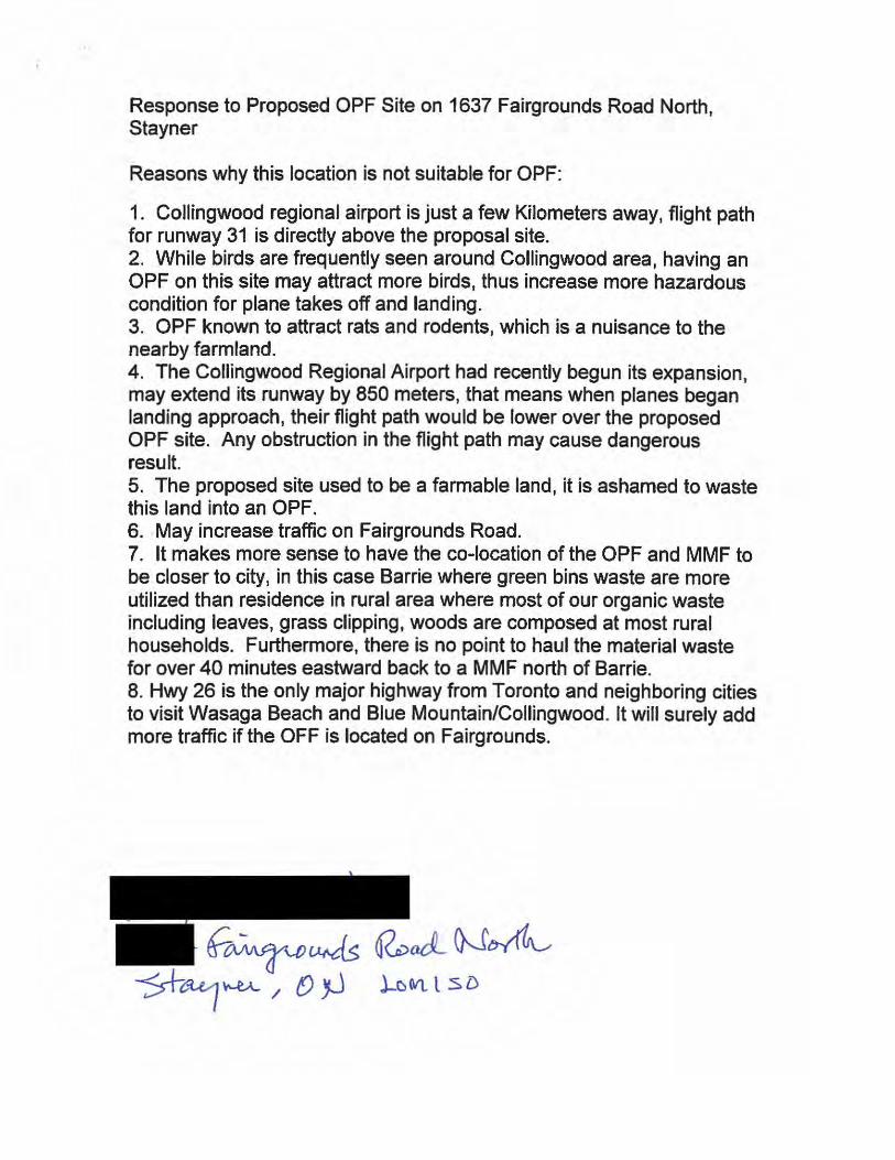
Response to Proposed OPF Site on 1637 Fairgrounds Road North, Stayner
Reasons why this location is not suitable for OPF:
1. Collingwood regional airport is just a few Kilometers away, flight path for runway 31 is directly above the proposal site. 2. While birds are frequently seen around Collingwood area, having an OPF on this site may attract more birds, thus increase more hazardous condition for plane takes off and landing. 3. OPF known to attract rats and rodents, which is a nuisance to the nearby farmland. 4. The Collingwood Regional Airport had recently begun its expansion, may extend its runway by 850 meters, that means when planes began landing approach, their flight path would be lower over the proposed OPF site. Any obstruction in the flight path may cause dangerous result. 5. The proposed site used to be a farmable land, it is ashamed to waste this land into an OPF. 6. May increase traffic on Fairgrounds Road. 7. It makes more sense to have the co-location of the OPF and MMF to be closer to city, in this case Barrie where green bins waste are more utilized than residence in rural area where most of our organic waste including leaves, grass clipping, woods are composed at most rural households. Furthermore, there is no point to haul the material waste for over 40 minutes eastward back to a MMF north of Barrie. 8. Hwy 26 is the only major highway from Toronto and neighboring cities to visit Wasaga Beach and Blue Mountain/Collingwood. It will surely add more traffic if the OFF is located on Fairgrounds.

Stephanie Mack Special Projects Supervisor November 6, 2015
Subject : Short List Site - #528 & 540 Penetanguishene Rd, Springwater
We have provided additional information about the short list site along Penetanguishene Rd - CR93 which is located in Springwater Township.
CULTURAL
The Penetanguishene Road was recognized as a road of Historical Significance in 2014 by the County of Simcoe. In the Fall of 2015, Historical signs were installed on the road from Kempendfeldt (Barrie) to Wyebridge honouring the history of the road & its residents. The signs are a tourist attraction. One sign is located at the StJames Cemetery (1852) and will be overlooking the Facility.
In 1905, and registered on 15 Feb 1907, is By-Law #464 Township of Vespra -to close and sell the original road allowance between the Lots 9 to 12 on theW. Side of Penetanguishene Rd. Also registered on 15 Feb 1907 ,a by-law #827 of the County of Simcoe, confirming Bylaw #464. There was a road to Little Lake just west of Penetanguishene Road within the two parcels of land. It is suggested that an archeological investigation of the site would discover artifacts of historical significance.
The St. James Cemetery (1852) is the resting place of our area Pioneers. It is also the resting place of the former Premier of Ontario, Mr. E.C. Drury. The Church and Cemetery share the Lot Line with #540 Penetanguishene Road.
RECEIVED
NOV 0 6 2015
COUNTY OF SIMCOE CORPORATE SERVICES 01\IIS!"\t

TECHNICAL
Located in the township of Springwater, if emergency services were needed on site, the closest Fire response is located on Snow Valley Road with OPP response coming from Wasaga Beach .
The topography of the site will create problems in the design of the MMF & OPF facility & on site garage. The Facilities would be built in the lower valley of two significant hills: Historically known as No.1 0 Hill to the north (#540) and Oakland Hill to the south with Willow Creek metres from the lot line (#528). Water & spring melt runs down from the elevated ground into the Willow Creek. The MMF & OPF& Garage facility would create a significant risk to the Willow Creek Sub watershed.
The building's tall sack design, might be level with the ridge(Georgian Drive to the south & HWY 11 & 400 to the North) with prevailing winds directing waste towards Georgian Drive. Georgian Drive has significant residential growth with small business and the institutions of Hospital & Georgian College as their addresses.
Odour from an existing Asphalt plant on neighbouring Napoleon Road can be noticed as far away as Shanty Bay to the south and Simoro Golf Course to the north , depending on the conditions.

ENVIROMENTAL
This particular site is located within metres of Willow Creek and Little Lake. Willow Creek is listed with the NVCA as the Willow Creek Subwatershed. Health Check list data is from 2013- before the construction of the Napoleon Warehouse and the upgrades & development on HWY 11 & 400 & Duckworth Street. Newspaper reports suggest that Little Lake is at risk and unhealthy at this time. Stewardship of this resource should be a priority to County Council.
The City of Barrie maintains artesian wells located on the Penetanguishene Road. There is an easement ( int. 193619) attached to these two properties involving these wells and the water line to move the water.
There is also a well located on #540. Source water protection should be top priority to the County!
There is a bi-annual migration of Snapping Turtles across Penetanguishene Road .. .from the wetlands on the Springwater side to the Creek in Oro Township. Neighbours continue to watch and transport the turtles across the road to safer ground on the other side
ECONOMIC & SOCIAL The transportation system in the area of the MMF & OPF site is stressed and need of an upgrade. This is the responsibility of the MTO. To build an industrial site at this location with knowledge of the inadequacies of the current infrastructure, of which the County has no ability to change, is totally unacceptable to the residents of the community.
At the corner of Penetanguishene Road & HWY 11 there is currently a MTO car park, on active Church & Cemetery with two driveways, one surplus Church building being used as a recreation facility, one tourist attraction & farmers market (using two entrances off CR93), a ramp to HWY11/400 S, a ramp to exit off HWY11S- Northbound CR93 only, exit

off HWY11 S - CR93 Southbound and Northbound , exit off HWY 11 N to CR93, entrance to Napoleon RD- shared with Asphalt plant & Napoleon retail store & factory & warehouse, entrance to side road- Gore Rd, Exit from Napoleon warehouse on to CR93 and on ramp to HWY 11 N off CR93. Seriously, all this at one intersection ! ! The intersection of CR93 & HWY 11.
The design of this intersection and the blind corner makes it very dangerous on a good day. Southbound on Penetanguishene Road off HWY 11 N requires traffic to stop and make a left hand turn. Traffic off HWY11S requires traffic to stop and make a right turn. A new exit from Napoleon allows the trucks to enter Penetanguishene Road north or south bound but the road is too narrow and the trucks cross both lines of traffic to exit their location when travelling north while gearing up the No. 1 0 Hill. Its a mess. The safety of drivers & passengers is at risk when driving this road.
The MMR & OPR & Garage will create more truck & automobile traffic through this dangerous intersection and along Penetanguishene Road through the community of Crown Hill to the north. HWY 400 extension does NOT connect with HWY 11. Trucks coming from north Simcoe county, ieCollingwood, Stayner etc. will not be able to take 400Hwy extension directly to the HWY 11 interchange . Exits at Horseshoe Valley (traffic lights) and Forbes Road (4way stop) will be used with trucks travelling to the site through Dalston & Crown Hill (60km) communities.
This section of CR93 is shared with School buses, at least 14 day going and to and from high schools & elementary schools in Barrie, Dalston & Shanty Bay, customers local small businesses, postal workers, and Farm equipment. We already experience heavy commuter traffic from new subdivisions and residential growth along CR93 and those travelling to work at the institutions of Georgian College & the Hospital. Emergency responders use this stretch of road as an ambulance route to
the local Hospital.

The MMR & OPR & Garage facility of this size and potential will have an impact on the traffic through this area. The employee vehicles , fleet
vehicles, service & delivery vehicles and customer trucks will be adding to the dangerous and heavy road use our community already experiences.
The MMR & OPR & Garage will be within WALKING distance of a number of sensitive receptors. There are family homes, a golf course, a historic Church & Cemetery with historic signage, a vineyard & winery, a seasonal family based tourist attraction & farmers market , an equestrian center and family farms. The industrial use of the MMR & OPR & Garage will influence social & cultural changes in our community.
Development in this area is complicated for residents. Penetanguishene Road - CR 93 divides the area in two, with Oro
Township to the east and Springwater to the west: Different municipal councils, different civil servants, different building inspectors, different by-laws but one rural community. Add to the mix MTO and County roads!
This short list site is has the smallest buffer to lessen the impact on its residents, visitors and businesses in the community.
Respectfully submitted, Robert & Patricia Richards 632 Penetanguishene Road
cc.Jim Wilson, MPP, Mayor Bill French, Deputy Mayor Don Allen, Councillor Jack Hanna


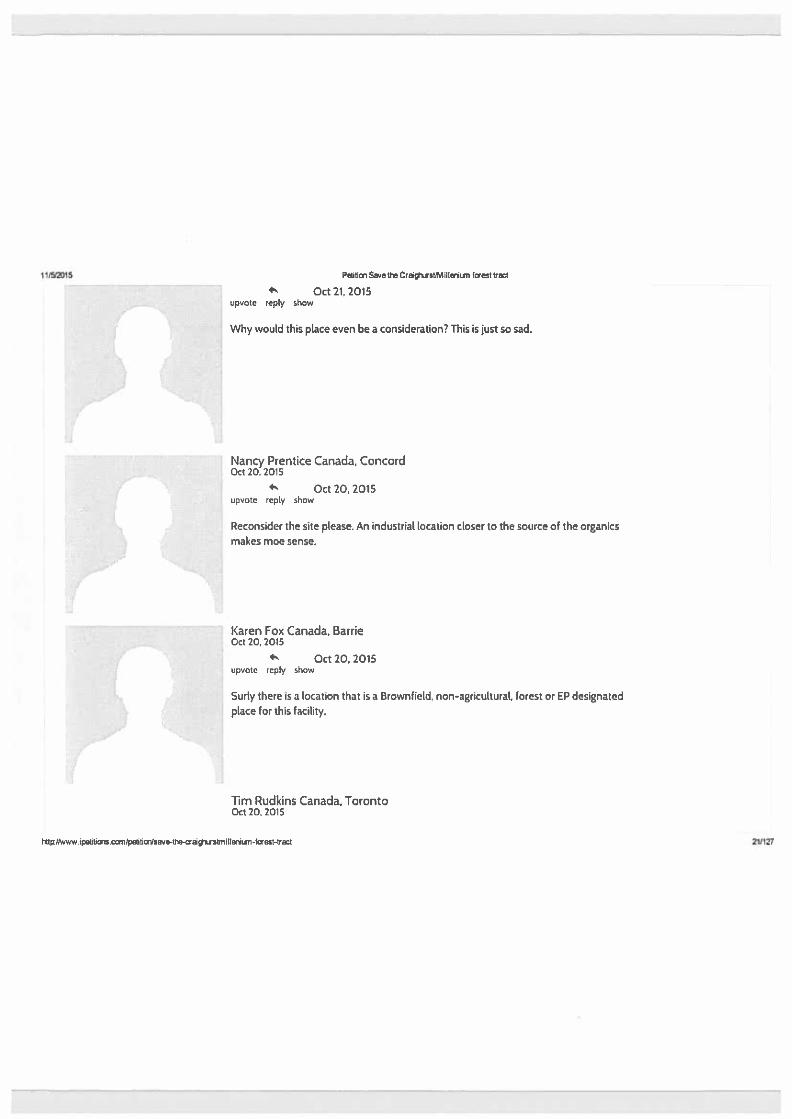


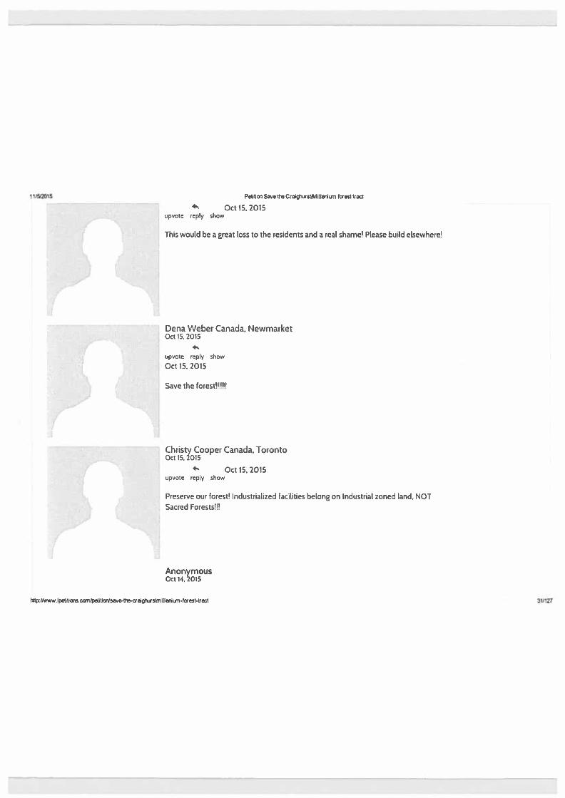


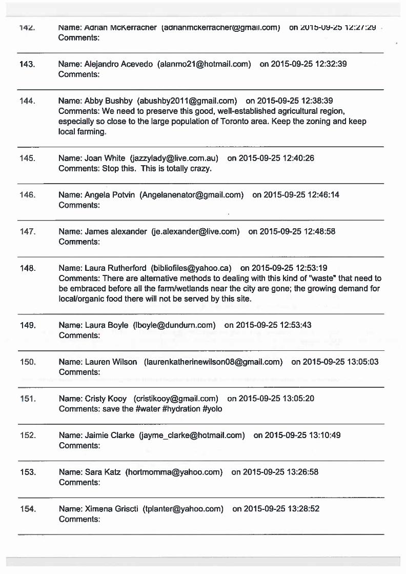

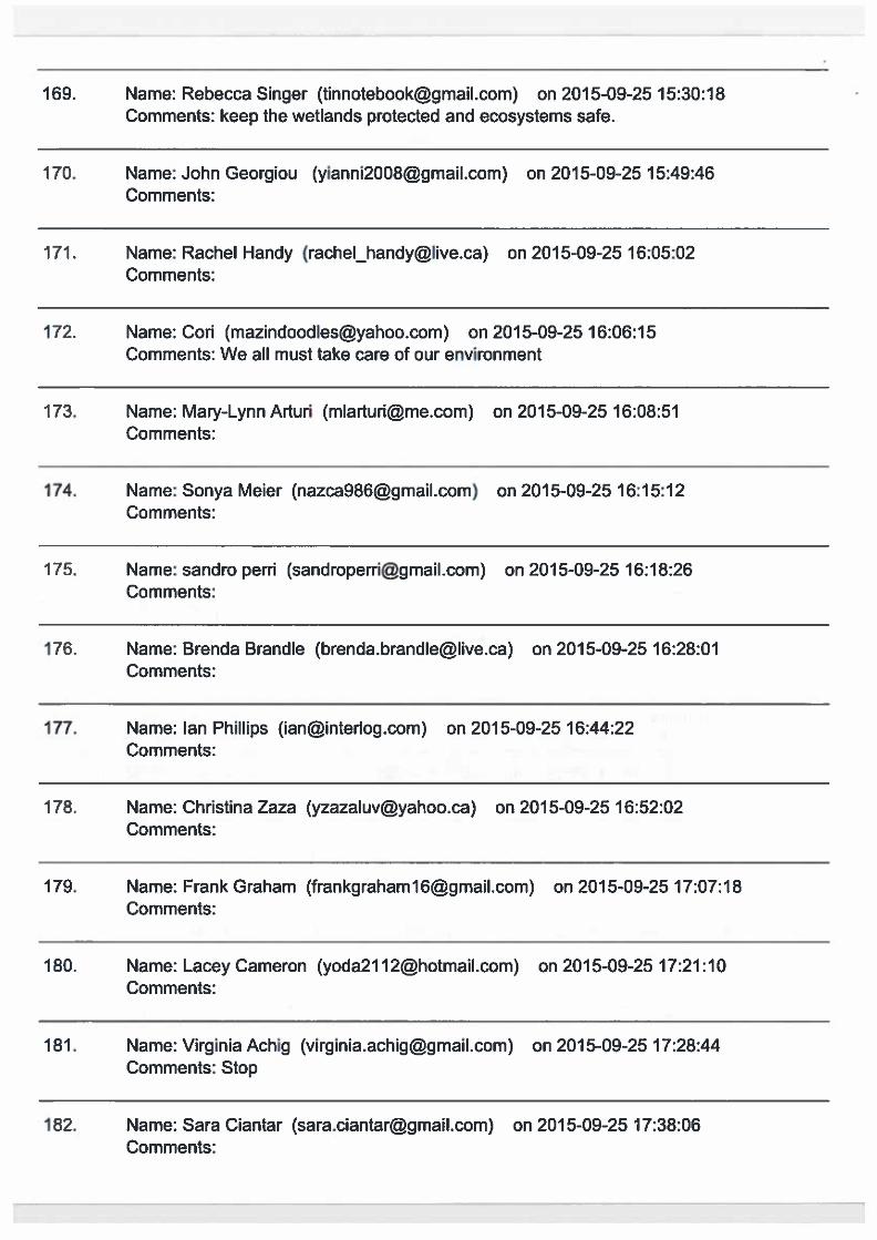


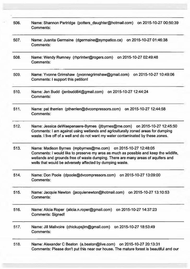


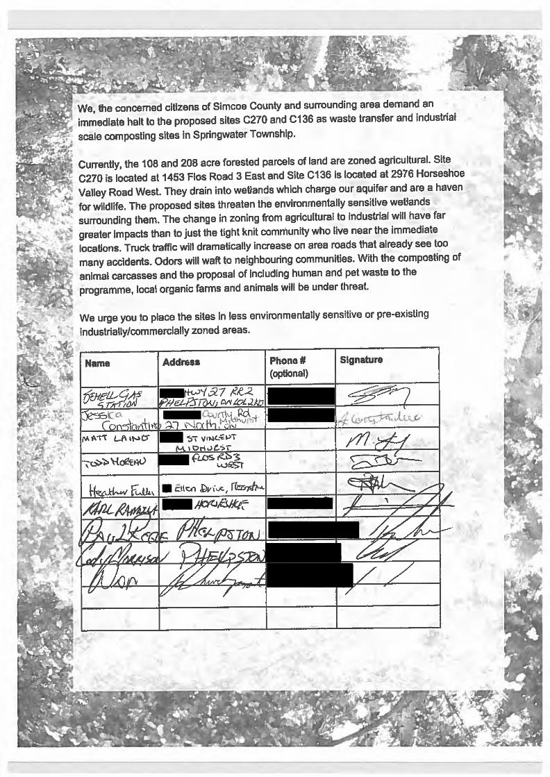


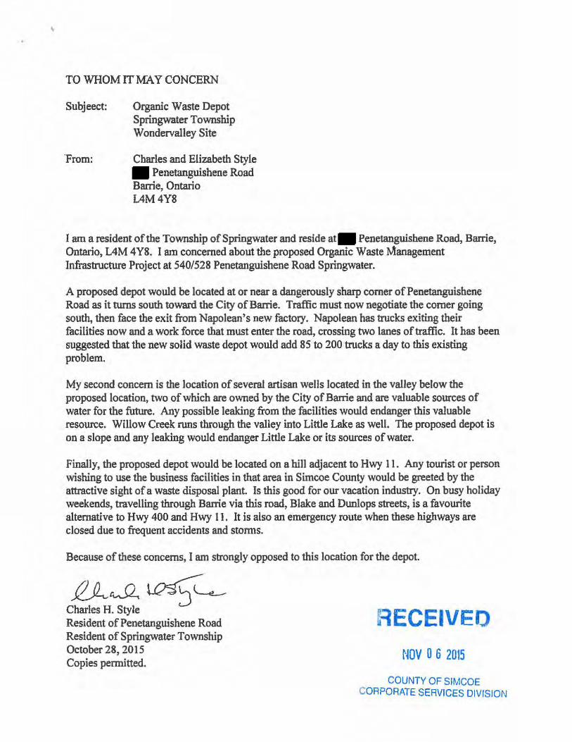
'
TO WHOM ITMA Y CONCERN
Subjeect:
From:
Organic Waste Depot Springwater Township Wondervalley Site
Charles and Elizabeth Style Penetanguishene Road
Barrie, Ontario L4M4Y8
I am a resident of the Township of Springwater and reside at Penetanguishene Road, Barrie, Ontario, L4M 4Y8. I am concerned about the proposed Organic Waste Management Infrastructure Project at 540/528 Penetanguishene Road Springwater.
A proposed depot would be located at or near a dangerously sharp comer ofPenetanguishene Road as it turns south toward the City of Barrie. Traffic must now negotiate the comer going south, then face the exit from Napolean's new factory. Napolean has trucks exiting their facilities now and a work force that must enter the road, crossing two lanes of traffic. It has been suggested that the new solid waste depot would add 85 to 200 trucks a day to this existing problem.
My second concern is the location of several artisan wells located in the valley below the proposed location, two of which are owned by the City of Barrie and are valuable sources of water for the future. Any possible leaking from the facilities would endanger this valuable resource. Willow Creek runs through the valley into Little Lake as well. The proposed depot is on a slope and any leaking would endanger Little Lake or its sources of water.
Finally, the proposed depot would be located on a hill adjacent to Hwy 11 . Any tourist or person wishing to use the business facilities in that area in Simcoe County would be greeted by the attractive sight of a waste disposal plant. Is this good for our vacation industry. On busy holiday weekends, travelling through Barrie via this road, Blake and Dunlops streets, is a favourite alternative to Hwy 400 and Hwy 11. It is also an emergency route when these highways are closed due to frequent accidents and storms.
Because of these concerns, I am strongly opposed to this location for the depot.
f!J_,_rvSl, ~ L..__. Charles H. Sty1e Resident of Penetanguishene Road Resident of Springwater Township October 28, 2015 Copies permitted.
RECEIVEO
NOV 0 6 2015
COUNTY OF SIMCOE CORPORATE SERVICES DIVISION
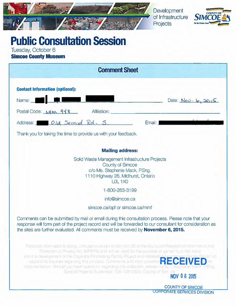
Development of Infrastructure Projects
Public Consultation Session Tuesday, October 6 Simcoe County Museum
Contact Information (optional):
Name:
Comment Sheet
Date: Noo · tot riC\ ' $'
Postal Code: \. ;tf b\. 1 ~ ~ Affiliation:------------------
Address: Q t rJ. Se co.1d J2d. ~ S \
Thank you for taking the time to provide us with your feedback.
Mailing address:
Solid Waste Management Infrastructure Projects County of Simcoe
c/o Ms. Stephanie Mack, P.Eng. 111 0 Highway 26, Midhurst, Ontar"o
LOL 1XO
1·800·263-31 99
info@simcoe .ca
simcoe .ca/opf or simcoe.ca/mmf
Comments can be submitted by mail or email during this consultation process. Please note that your response will form part of the project record and will be forwarded to our consultant for cons'deration as the sites are further evaluated. All comments must be received by November 6, 2015.
NOV 0 6 2015
(;QUNTY OF SIMCOE ATE SERVICES DIVISION

Please provide youl'i comments below
- L1. rbo i
-
-\-dlOzs 0 A Qp

Development of Infrastructure Projects
Public Consultation Session Thursday, October 8 Township of Oro-Medonte Administration Centre
l" , .
Comment Sheet
Contact Information (optional):
Name: Date: Nov f:., Zo\"5
Postal Code: bJfm 4Y8 Affiliation: _IL..:II....lll~-.e~ ...... •..~.n..:;...._....;g;;;.a..:..v....,e...,;CL~---------n l · I j t3A~(UE
Address: reo e t a. Dj u \ S' h e tJ E \<. . Email:---------
Thank you for taking th8 time to provide us with your feedback.
Mailing address:
Solid Waste Management Infrastructure Projects County of Simcoe
c/o Ms. Stephanie Mack, P.Eng. 111 0 H'ghway 26, Midhurst. Ontario
LOL 1XO
1 ·800-263-3199
simcoe.ca/opf or simcoe.ca/mmf
Comments can be submitted by mail or email during this consultation process. Please note that your response will form part of the project record and will be forwarded to our consultant for consideration as the sites are further evaluated. All comments must be received by November 6, 2015.
Personal Information IS being collected pursuant to Section 28 of the Municipal Freedom of Information and Protection of Privacy Act (MFIPPA) and wtll be used for the purposemJmiPCJ:t<Ji12JI-\
1nto the development of the OrganiCs Process1ng Facility Prqect and Matencls ~,_... 1¥~ Wiect to respond to inqu1nes regarding this process. Comments and 1nput provided may form part of the pro1ects'
documentation. Should you have questions regardrng this collection. please conlefdhllew'1r'}'Oh.tlack, P.Eng., Special Projects SupeNrsor, 705-726-9300. County of Sim~~ ~~
COUNTY OF SIMCOE Cu l=<.i'Ol;A7C SE!WICES DIVISION

Please provide your comments below
. T/lv. .& .La.! fl. <~·o*--4-< bv &.i.w_ ~ Ckt'~-= k
;:":: ~~:z-~::~~~:=:r~~Jb m~ ~ ... _L~ z4z&<'~xL:r-~ __ .a.~
.<.1:-. gbi?a/ .L L:;c;J.~ ~;r:r "?/ ''C~ a.., Jt?J.4o fuJ~
~.-:;L~~;:h~,'l;~::!;:~ •

Solid Waste Management Infrastructure Projects, County of Simcoe Care ofMs. Stephanie Mack
We have several comments and concerns about the proposed site for Organics processing Facility, Materials Management Facility and a repair garage at 528 and 540 Penetanguishene Road Barrie, Ontario.
ENVIRONMETAL
Air Quality
We are at 499 Penetanguishene Road Barrie. This property sits kitty comer from the proposed site.
There is no assurance that we will not get an order from the plant, very close to receptors. Several recreational businesses are in the area that would be affected by air quality. Not to mention the other business and residences.
More pollution from extra traffic two hundred and ten large garbage trucks a day times two (four hundred and twenty) daily. Plus the traffic from people bringing their corded items etc. to the site.
Concern about noise pollution with all the beeping of the trucks and the noise from equipment continually running to process the recycle and compost.
Light pollution is a big issue when people live right across the road and there are residences in the immediate area.
WETLANDS
Wetlands are very important to the filtering of our water. Lot nine and part of lot ten are low-lying wetlands.
Of Great Concern is Willow creek it is very important to the IAE.e£ IV E 0 water basin and the Notawasaga water shed.
NOV 0 6 2015
COUNTY OF SIMCOE CORPORATE SERVICES DIVft; 'C' "' '

Spring water official Plan 16:22 Section 16- Natural Heritage (Environmental Protection Policies)
It is the policy of the municipality to protect the sensitive natural environment of the Little Lake basin area although existing used and limited enlargement of these uses may be permitted. No new development shall be permitted except the construction of a dwelling and accessory uses on an existing vacant lot. New development shall not be permitted in the little Lake basin area without development proponents first completing to the satisfaction of the Township and commenting agencies, a Lake Capacity Assessment, a Comprehensive Environmental Impact Assessment, and a Master Drainage Plan. Any approved development in the Little Lake basin area shall be subject to site plan control and municipal design guidelines.
Concern for our drinking water there are several artesian wells in the area. One of the wells is located on the property site. The government or the city ofBarrie owns two of the wells. They are maintained by the city of Barrie. There a aquifer under the entire area which people should protect.
The Snapping Turtles are listed under Ontario's Endangered species Act as a species of special concern, meaning they are currently vulnerable to extinction.
Your site threatens the snapping turtles survival by habitat loss, pollution, and road motility with the added traffic. We have snapping turtles lay eggs on our property every year. I have pictures of a pail of 17 or 18 little snappers. My husband collected them and assisted them back across the road for their trip back to Little Lake. I am not sure why but they travel form Little Lake and cross the 93 Highway around our property and near by property to lay their eggs. It happens every year. It would be a criminal to see them disappear.
Buffer Zones
How can lots 528 and 540 one of the smallest sites have enough property to maintain the adequate size of the required buffer zone?
Transportation

We are concerned for the safety of our children. Fourteen school buses or more pass our house in the morning and again in afternoon. A dangerous traffic situation already exists without the added stress to Highway 11 and 93 not to mention the 400 Highway. They all merge together at the four comers with several blind spots. Accidents have occurred in that area because a dangerous intersection already exists. The trucks coming out of Napoleon take up two lanes of traffic when turning out. I am sure it would be the same for the garbage trucks and tractor-trailers turning in and out of the proposed site. Recently you have had traffic counters on the site road and the road at Dalston. I just wondered if the MTO has contacted you about this area and the work that will continue to happen on the roads in tlus area?
Heritage
Highway 93 has been declared a Heritage Road. It was the first road through Simcoe County from Kempenfelt Bay to Penetanguishene to transport supplies to the soldiers during the war of 1812. I understand it is a corduroy road that continues to be built on and repaired. Will it support more large trucks and all the extra traffic from the compost recycle plant?
The Greek Orthodox Church is immediately adjacent to the proposed site. The Church and St. James located on the church property have a deep rich culture. The Church was built in the early to mid 1800's. The cemetery (a community cemetery) also contains several graves of local and provincial dignitaries one being E. C. Drury the fonner premier of Ontario.
Social
Land use and zoning. I was checking an aerial photos flown in the spring of 2012.
Lot nine may have been rezoned, but is it still not part of the green belt across the road in Oro-Medonte? That is what it looks like on the aerial photo.
SPRINGWATER OFFICIAL PLAN 16.15 SECTION 16 NATURAL HERITAGE (ENVIRONMENTAL PROTECTION POLICIES)
(iii) Tree Clearing and Cutting

' .
(a) The Township shall support the County of Simcoe in the application of its Tree Cutting By-law, and may undertake initiatives with the County and any other agency/ies in order to promote selective cutting and reduce clear cutting and land cleaning activities to minimum levels.
(b) The Township may enact a tree cutting By-law to regulate or restrict the cutting of trees in all or specific areas of the municipality.
(c) The Township requires the appropriate replacement and replanting of trees when tree -clearing activities occur.
Save the taxpayers money and use an existing site of land that is already owned by Simcoe County.
Sincerely,
Roy and Peggy Pratt
Copies to: Harry Hughes Mayor of Oro-Medonte Jeff Lehmen Mayor of Barrie Patrick Brown :MP

From: Councillor Kevin Elwood Sent: November 9, 2015 6:59 AM To: '[email protected]' <[email protected]> Cc: Councillor Kevin Elwood <[email protected]>; Council <[email protected]> Subject: Bird Strike info Hi Nathan, This info is after the Nov 6th closing date for comments as I could not locate the email address outside the website portal for submissions. You had given me your business card when I attended the open house held in Stayner. Could you please pass on the attached Transport Canada accident investigation report that will provide our consultant and waste management personnel an actual recent accident bird strike report with comments related to waste management sites in close proximity to aerodrome. As you know I have concerns with the selected waste management site in close proximity to Collingwood Regional Airport now and into future as this airport is expected to expand in the future. http://www.bst‐tsb.gc.ca/eng/rapports‐reports/aviation/2010/a10q0162/a10q016
2.pdf Thank you for your help in ensuring the consultant and Simcoe County waste management staff receive this information and my comments. Kevin Elwood Councillor Ward 2 Clearview Township
CONFIDENTIALITY NOTICE: This e-mail message (including attachments, if any) is intended for the use of the individual or entity to which it is addressed and may contain information that is privileged, proprietary, confidential and exempt from disclosure. If you are not the intended recipient, you are notified that any dissemination, distribution or copying of this communication is strictly prohibited. If you have received this communication in error, please notify the sender and permanently delete this email.

From: Sent: Monday, November 09, 2015 8:10 AM To: Customer Service Subject: Organics Processing and Material Management facility
Dear Stephanie Mack,
I am writing to express my concern and disapproval of building an Organics
Processing and Material Management facility at the Sandford Tract Forest located on the 5th line of Oro-Medonte.
Not only will building this facility at said location be detrimental to the business at Hardwood Ski and Bike and to the enjoyment of my time at this property, and increased truck traffic will be hazardous for it will also be harmful to the sensitive Oro-Moraine. This moraine drains into Georgian Bay, Lake Huron and Lake Simcoe. Efforts are already being made to preserve undeveloped land on the moraine by encouraging landowners to leave their property as a legacy to the regional conservation authorities in their wills.
With such efforts being made to preserve this land it only makes sense to choose another location for this Organics Processing and Material Management facility.
Thank you for your time and attention to this serious matter.
Sincerely,
Barbara and Owen Steele

From: Dana Sent: November 9, 2015 10:30 AM To: Customer Service Subject: Use municipal water and sewage treatment for solid waste management programs. Protect wetlands Hi I receive notification of proposed proposed solid waste sites 528 and 540 Penetanguishe road. I would suggest to use the municipal water and sewage treatment is this the only safe environmental option . Or will oro medonte accept responsibility for and to pay for daily water testing for a homeowners have spent hundreds and thousands of dollars in our properties . please put a municipal sewage and water treatment plan in place to better protect her wetlands better safe than sorry Have a good day Dana

From: Sent: November 9, 2015 3:14 PM To: Customer Service Subject: solid waste site Dear Stephanie Mack, In the winter months I regularly make the drive from Toronto Oro-Medonte to ski at Hardwood Ski and Bike. It's always a day-long affair, and I spend my "tourist" dollars not only at Hardwood, but also in the community. I am writing to express my concern and disapproval of building an Organics Processing and Material Management facility at the Sandford Tract Forest located on the 5th line of Oro-Medonte. Not only will building this facility at said location be detrimental to the business at Hardwood Ski and Bike and to the enjoyment of my time at this property, it will also be harmful to the sensitive Oro-Moraine. This moraine drains into Georgian Bay, Lake Huron and Lake Simcoe. Efforts are already being made to preserve undeveloped land on the moraine by encouraging landowners to leave their property as a legacy to the regional conservation authorities in their wills. With such efforts being made to preserve this land it only makes sense to choose another location for this Organics Processing and Material Management facility. Thank you for your time and attention to this serious matter. Sincerely, Selga Apse

, 1
Development of Infrastructure Projects
Public Consultation Session RECEIVED Thursday, October 8 NOV 0 9 2015 Township of Oro-Medonte Administration Centre
.. Comment Sheet CORPORATE SERVICES DIVISION
Contact Information (optional):
Name: __ ~ _______________________ _ Date: __,q.~.a.;;:v~/ +,£..:....1 .L~o~:..-_ Postal Code: _____ _ Affiliation:-------------------
AddffiSS: ________________ __ Email:------------
Thnnk you for taking the time to provide us with your feedback.
Mailing address:
Solid Waste Management Infrastructure Projects County of Simcoe
c/o Ms. Stephanie Mack, PEng. 1110 Highway 26, Midhurst, Ontario
LOL 1XO
1 ·800-263-3199
simcoe.ca/opf or simcoe.ca/mmf
Comments can be submitted by mail or email during this consultation process. Please note that your response will form part of the project record and will be forwarded to our consultant for consideration as the sites are further evaluated. All comments must be received by November 6, 2015.
Persona11nformat1on IS being collected pursuant to Section 28 of tt1e Municipal Freedom of lnformat1on and Protection of Pnvacy Act (MFIPPA) and Will be used for the purpose of garnering public input .
1nto the development of the Organics Processing Facility Project and Materials Management Fac11lty Project to respond to inqu1nes regarding this process. Comments and 1nput provided may form part of the projects'
documentation. Sl1ould you have questions regard1ng this collection, please contact Stephanie Mack, P.Eng., Special Projects Supervisor, 705-726-9300, County of Simcoe.

Please provide your comments below

From: Sarah Archer
Sent: Wednesday November 11, 2015 1:36 PM
To: Customer Service <[email protected]>
Subject: waste plant
Hello, I am writing to inquire about line 5 being considered for a waste management facility? This is very concerning for me as a community member who rasies her children here and runs a business that is dependent on the area. I would like to know where these plans stand at the moment? Kindly, Sara Archer
phone email address Horseshoe Valley, ON

From: Genevieve Blais Sent: November 12, 2015 7:46 PM To: Customer Service Cc: ; Hughes, Harry; barbara.coutanche@oro‐medonte.ca Subject: Organics Processing and Material Management facility
Dear Stephanie Mack,
I am writing to express my concern and disapproval of building an Organics Processing and
Material Management facility at the Sandford Tract Forest located on the 5th line of Oro‐
Medonte.
Not only will building this facility at said location be detrimental to the business at Hardwood
Ski and Bike and to the enjoyment of my time at this property, it will also be harmful to the
sensitive Oro‐Moraine. This moraine drains into Georgian Bay, Lake Huron and Lake
Simcoe. Efforts are already being made to preserve undeveloped land on the moraine
by encouraging landowners to leave their property as a legacy to the regional conservation
authorities in their wills.
With such efforts being made to preserve this land it only makes sense to choose another
location for this Organics Processing and Material Management facility.
Thank you for your time and attention to this serious matter.
Sincerely, Genevieve Blais Skier and mountain rider.

From: Kelly Morrison [mailto:[email protected]] Sent: Friday, November 13, 2015 3:00 PM To: McCullough, Rob Cc: French, Bill; Hughes, Harry; [email protected]; [email protected]; [email protected]; Wolfgang Schroeter; Ingrid Schroeter Subject: RE: Solid Waste Management Infrastructure Project at 540/528 Penetanguishene Rd., Springwater Importance: High Good Afternoon Rob, Please find attached a letter from Wolfgang and Ingrid Schroeter, owners of Napoleon, regarding the County of Simcoe – Solid Waste Management Infrastructure Project at 540/528 Penetanguishene Road. (A hard-copy letter will also be sent to you via courier.) Both Wolfgang and Ingrid would be happy to meet with you or any other member of the site selection committee to further present their position and objections. Please do not hesitate to contact me to set-up a mutually convenient time. Regards,
KELLY MORRISON Executive Assistant NAPOLEON FIREPLACES | GRILLS | HEATING & COOLING 24 Napoleon Road | Barrie | Ontario | CA | L4M 0G8 T: 705.721.1212 x263 www.napoleonfireplaces.com | www.napoleongrills.com | www.napoleonheatingandcooling.com
Please don't print this e-mail unless you really need to Disclaimer


From: Kelly Morrison [mailto:[email protected]] Sent: Monday, November 23, 2015 1:51 PM To: Mack, Stephanie Cc: Marshall, Gerry W.; French, Bill; Allen, Don; Hughes, Harry; Hough, Ralph; Aitken, Mark; Korolnek, Debbie; McCullough, Rob; Ron McArthur; Wolfgang Schroeter; Ingrid Schroeter Subject: RE: County of Simcoe ‐ Solid Waste Management Infrastructure Projects This email is being sent on behalf of Wolfgang and Ingrid Schroeter. Good Afternoon Stephanie, Thank you for your quick response to our letter. It was very much appreciated. The updated information posted about the process and selection of OPF/MMF sites on your website is very helpful to clarify the project scope. In regards to your first point about site size, we agree that the site selected should have at least 17 ha of available ground to build a combined facility. Although the candidate site located at 540/528 Penetanguishene Road has 44.29 acres (or 17.92 ha), it only has approximately 60% of usable space. The other 40% is an environmentally protected area. It still baffles us how this site could have been selected to accommodate a combined facility. Why was it included? At this point, we do not require a meeting but appreciate you and Mr. McCullough making yourselves available to us. Please forward this email to your consultants for their records as well. Regards, Wolfgang & Ingrid Schroeter /km From: Mack, Stephanie [mailto:[email protected]] Sent: Monday, November 16, 2015 11:49 AM To: Kelly Morrison Cc: Marshall, Gerry W.; French, Bill; Allen, Don; Hughes, Harry; Hough, Ralph; Aitken, Mark; Korolnek, Debbie; McCullough, Rob Subject: County of Simcoe ‐ Solid Waste Management Infrastructure Projects Ms. Morrison, Thank you for your correspondence. We wish to confirm that we have received the letter from Wolfgang and Ingrid Schroeter, owners of Napoleon, dated November 13, 2015 in regard to the short-listed sites for the Solid Waste Management infrastructure projects. Public and stakeholder feedback on these potential sites will be an important component of the decision-making process. This correspondence will form part of the project record and will be forwarded to our consultant for consideration as the sites are further evaluated. Comments received by the County during the consultation process, the results of the evaluation, and details on the preferred site will form the third siting reports, anticipated to be presented to County Council in early 2016 for their direction. In regard to the questions outlined in the letter, we provide the following response:
The site size for a combined site was outlined to be 17 ha (GHD Technical Memorandum provided as Schedule 3 of Item CCW 15-240, page 5). It outlines that “sharing common elements

will also reduce the overall area required for both the MMF and OPF, resulting in a single site that would be smaller than the two separate sites combined. Combining the individual size requirements for each facility would result in a site 20 ha in size. However, a site that is a minimum of 17 ha should be adequate to accommodate both facilities and still include an appropriate common buffer area on-site. Sites that are smaller than 17 ha may not be able to accommodate a combined facility if sufficient buffer area does not exist around the site. The size of the site selected for the combined facility should also ideally accommodate anticipated expansions of both facilities, and thus would ideally be larger than 17 ha”.
Technical reports on these projects are public information and presented to County Council via
staff reports. For information, staff reports are presented on public agendas one week prior to meetings. For these projects, these reports are also uploaded to the project webpages following County Council. In regard to a detailed cost comparison, the third siting report to be completed by the County’s consultant will provide a comparative evaluation between all short-listed sites. The economic component is one facet of the comprehensive evaluation – other factors such as environmental and technical considerations, for example, will also be part of the evaluation.
Following direction from County Council on the preferred site(s), engineering, environmental, and
planning studies to confirm site conditions and their suitability to host the facilities will be undertaken.
Please note that additional information on these projects – including upcoming project milestones, communication material from the October consultation sessions, and related staff reports – can be found at www.simcoe.ca/opf and www.simcoe.ca/mmf. My contact information is below should you have further questions or require additional information. Also, Rob McCullough and I are available to meet with Mr. and Mrs. Schroeter to discuss the projects and the siting process at their convenience. Please let me know and we can make the arrangements. Regards, Stephanie Mack, P.Eng. Special Projects Supervisor County of Simcoe, Solid Waste Management 1110 Highway 26, Midhurst, ON L0L 1X0 Phone: (705) 726-9300 ext. 1924, Cell: (705) 794-0605 E-mail: [email protected] simcoe.ca
*****CONFIDENTIALITY NOTICE*****
This electronic transmission and any accompanying attachments may contain privileged or confidential information intended only for use of the individual(s) or organization(s) named above. Any distribution, copying or action taken in reliance on the contents of this communication by anyone other than the intended recipient(s) is STRICTLY PROHIBITED. If you receive this communication in error, please notify the sender at the above email address and delete this email immediately.

From: Rita McLean
Sent: Friday, November 13, 2015 6:17 AM
To: Customer Service <[email protected]>
Subject: Organics Processing and Material Management facility beside our sport facilit
Importance: High
Dear Stephanie Mack, I am writing to express my concern and disapproval of building an Organics Processing and Material Management facility at the Sandford Tract Forest located on the 5th line of Oro-Medonte. Not only will building this facility at said location be detrimental to the business at Hardwood Ski and Bike and to the enjoyment of my time at this property, it will also be harmful to the sensitive Oro-Moraine. This moraine drains into Georgian Bay, Lake Huron and Lake Simcoe. Efforts are already being made to preserve undeveloped land on the moraine by encouraging landowners to leave their property as a legacy to the regional conservation authorities in their wills. With such efforts being made to preserve this land it only makes sense to choose another location for this Organics Processing and Material Management facility. Thank you for your time and attention to this serious matter. Sincerely, Rita McLean Skier and mountain rider.


November 10, 2015
Solid Waste Management Infrastructure Projects County of Simcoe c/o Stephanie Mack, P. Eng. 1110 Highway 26 Midhurst ON LOL 1XO
Dear t-1s. Mack:
I am writing to express my concern and disapproval of building an Organics Processing and Material Management facility at the Sandford Tract Forest located on the 5th line of Oro-Medonte.
Not only will building this facility at said location be detrimental to the business at Hardwood Ski and Bike and to the enjoyment of my time at this property, it will also be harmful to the sensitive Oro-Moraine. This moraine drains into Georgian Bay, Lake Huron and Lake Simcoe. Efforts are already being made to preserve undeveloped land on the moraine by encouraging landowners to leave their property as a legacy to the regional conservation authorities in their wills.
With such efforts being made to preserve this land it only makes sense to choose another location for this Organics Processing and Material Management facility.
Thank you for your time and attention to this serious matter.
RECEIVED
NOV 1 7 2015
COUNTY OF SIMCOE CORPORATE SERVICES DIVISION

Name Date Received Feedback Received
Mr. Dave Sills August 8, 2015 I'm glad to see the county is planning to build an organics processing facility. I like the location on Penetanguishene Road ‐ very visible to the public, and not 'out of sight, out of mind'. Let's showcase this technology! Cheers.
Ms. Jacqueline Pegg August 14, 2015
I am extremely disappointed that one of the selected short list sites is located on the 5th Line in Oro‐Medonte. We already have been inundated with facilities such as this within a 10 mile radius. We have the landfill site, not one but two solar farms, an airport, several aggregate facilities and the Burl's Creek expansion! Enough is enough, we are not a dumping ground for Simcoe County and surrounding areas. Our farmland and wetlands around this corridor are being treated as disposable and the residents have little or no input. We also have a "special needs" facility on the 5th Line that requires due diligence with traffic. We moved to this area quite a few years ago and chose it because of the "agricultural" setting thinking that although highway 11 was close, the land around us would be protected. Our wildlife and quiet rural setting should not be further inundated with the sounds, smells and noises of trucks coming and going along the 5th Line and other surrounding routes. I ask that you please, please, leave this area of the township alone as we are getting extremely weary of fighting to protect our lands around here. This will be the final straw for a lot of us and it isn't fair at all. Other areas that benefit from all that our area has had to endure should now be taking their fair share.
Ms. Heather Rutherford
August 20, 2015 to Springwater
August 25, 2015
I am the owner of 1484 Flos Road Three East property and wish information as to how I can get more information regarding this proposed site. I am a widow, retired and live on my own and this proposal is directly across from my property. I have not been informed by the County of the Proposal for the use of this property and wish to protest the site. The road is not suitable, many times we cannot get services in the winter as the road is considered too dangerous for trucks to go down and pick up our waste. If there is a possibility that this goes forward, it will heavily impact all of us, both financially and personally on this road. Please advise who I should approach regarding the proposed change of use of this property.
I wish to protest the location of a waste management facility across the road from my front door and property. When I bought this property, I did a search on the official plan and zoning to ensure that I would not be investing in a property that could negatively impact the type of retirement property that I was purchasing. I am a retired widow, who enjoys the environment that I live in, with rural neighbours and like minded persons who place a high value on preserving the environment. There has been no formal notification to myself as to the use of the property across the road which will definitely impact my property, my financial stability and my lifestyle. Presently I am in state of frustration and fear that the property that I have chosen to retire to will be impacted by decisions that I have not been privy to. I am threatened and willing fight any way that I will need to to preserve what I own. Any further decisions, I wish to be informed of, as it is easy to sit in a comfy chair and make decisions that impact persons with no faces, when person like myself will be devistated at your the results.
Mr. Ian Macdonald September 8, 2015 Thanks for getting back to me. I am very interested as I am concerned about the proposed site on Fairgrounds Rd and the effect it will have on the surrounding area and the potential truck traffic
Ms. Mary McDonald September 24, 2015 This project is a terrific idea and is the logical next step to managing and taking responsibility for the county residents' organic waste within our own geography.
Mr. Robert Wagner September 30, 2015
With regard to the short-listing of the Freele Tract county forest as a waste processing site, we don't need an environmental assessment to knowthat there are numerous aquifers under that forest and the land slopes from west to east, directly to Matheson Creek. Any contaminants will, by gravity alone, end up in the creek. When Site 42 was partially developed as a future landfill site, it was on the basis that several other landfill sites were nearing capacity and eventual closure. That was several years ago. What is the status now of those sites that were nearing capacity? Rather than closing them and then seeking to obliterate additional farmlands or forests(all of which are irreplaceable), wouldn't it make more sense to convert one of those existing landfill sites? They have no other practical use and, given their present status, the impact on the environment and neighbouring residences is already known as a pre-existing condition. It follows that the cost to convert should be lower, and the demands for environmental assents should be minimal.
Norm and Mary Speake November 16, 2015
Hi there. I am back in India but have two items to bring to your attention. First of all, I have checked on the facility Orgaworld - London Composting Facility and have been informed that this facility has quite an odour - it stinks for quite some distance. It is an in-vessel composting system. This information is discouraging to say the least. Would you please include it in my comments on file, thank you. Secondly, neither my husband nor I have received a copy of the minuets of my meeting with you on October 23rd, as was promised. We would appreciate receiving them as soon as possible. Thanks. Mary Speake
Tom and Nancy McDonough
October 6, 2015October 7, 2015October 30, 2015November 3, 2015November 5, 2015
If the Millenium/Craighurst site is chosen for either the OPF and/or MMF we are concerned that our property will be significantly devalued. We purchased 25 acres in the country so that we could enjoy nature and a quiet lifestyle. We JUST built and moved into our home in May, 2015. When we bought this property we had no idea that 500 metres away, an OPF/MMF was being considered. This type of facility should be in an industrial area. There should ONLY be industrial sites on your short-list! The sites that involve cutting down Simcoe County forests are UNACCEPTABLE!
I was at the session last night at the Simcoe County Museum. I left feeling completely disheartened. Would any of these engineers want 190 trucks passing by their home in the country? Not likely! Any short-listed sites that require cutting down trees, destroying habitats (both terrestrial and aquatic) are unacceptable. I understand that the facilities have to go "somewhere". The consulting team states that only one site not currently owned by the county would be suitable. It's for sale. Buy it.
Did you know that many species of animals (fox, coyotes, raccoons, squirrels, grouse, wild turkeys, beaver, deer) live in this area. As well, 10,000 trees have been planted in this forest tract by local groups. Please take this into consideration!
When the consultants tell Simcoe County which is the preferred site for the MMF and/or OPF, what happens next? What if people on council disagree with the chosen site (e.g., a forest tract)? If the preferred site runs into issues with zoning, environmental contingencies, will the decision be made to try for the site that was the second 'runner-up'?
Thank you for your quick and detailed response. I did notice orange spray paint on some stakes and trees (Craighurst tract). I am wondering who is doing this and what is the purpose?N
Mr. Terry Ruffell October 9, 2015I thought the session was informative and my sense is the County and consultants were listening. It seems to me that the big question is transportation i.e.truck routes and the best solution is 400/11. Secondly, build it close to growth areas i.e. south Simcoe and potential big customers and that is again the same solution 400/11. Terry
Ms. Liz Grootenboer October 9, 2015 Please don't put this facility near hardwood
Organics Processing Facility and Materials Management Facility - Additional Public Feedback

Name Date Received Feedback Received
Mr. Konrad Brenner October 13, 2015
The site on Line 5 would not be too desirable if it significantly negatively affects the lease arrangement with Hardwood Hills. Hardwood Hills is the best cross-country ski facility between Toronto and North Bay in the central corridor. (I have skied most of them over the years).
In my opinion it would most desirable to combine both functions on one site regardless which site is chosen.
Mr. Mike Drinkwater October 21, 2015 Please don't build a recycling plant next to hardwood hills. That would really stink.
Mrs. Gesina Johns October 26, 2015She would like to know - why they are considering building an OPF near the residential area? She hears that the hospital is opposing it. She is worried about the City of Barrie annexing to the north and she said Barrie would oppose it. Resident would like to voice her concerns.
Ms. Sandra Collicutt October 27, 2015
I attended the meeting on October 26, as a resident of Hillsdale Main concern is the amount of trucks that would be using Hwy #93 and children who need to cross the Hwy to get to elementary school. We have an adult crossing guard at present and then risk their life daily to cross the children. Very dangerous intersection. More traffic especially heavy trucks, delivering and then transferring the organic waste out???? Crazy!!!!! I also would like to comment that after the meeting I would hope that council will take into consideration that the two facilities in one place makes more sense in my eyes and in the eyes of the consulting company. Thank you
Mrs. Livii Stephenson November 5, 2015
calling regarding the location 528 & 540 Penetanguishene Road - caller is located up hill from proposed site feels this will put too much traffic and transport traffic in this area - concern with the intersection of Highway 11 & County Road 93 - there are already accidents weekly and now if the plant goes in there will be far more congestion - as well concerned about the odour because caller is up hill from proposed location

GHD | County of Simcoe – OPF, MMF, and Co-Located Facility – Part 3 – Short List Evaluation | 086822 (6)
Appendix C Site C052
1637 Fairgrounds Road North

!(
!(
!(
!(
!(
!(
!(
!(
!(
Nottawasaga Sideroad 30 & 31
Fairgrounds Rd N
0 100 200 300
Meters
FIGURE C.1
086822 Feb 1, 2016
GIS File: Q:\GIS\PROJECTS\86000s\86822\Layouts\INT006\086822(INT006)GIS-WA003-C052.mxd
C052 ENVIRONMENTAL -AIR QUALITY, ODOUR, NOISE
Source: MNRF NRVIS, 2015. Produced by GHD under licence from Ontario Ministry of Natural Resources and Forestry, © Queen's Printer 2016Inset Map: ESRI Data & Maps 2008 Data Distribution Application (DDA)
Coordinate System:NAD 1983 UTM Zone 17N
Legend
!( Sensitive ReceptorSite BoundarySite Buffer (500m)Parcel Boundary
COUNTY OF SIMCOEOPF/MMF SITE SELECTION
Wind Rose at 30 metresMean Wind Speed: 5.05 m/s

Nottawasaga Sideroad 30 & 31
Nottawasaga Sideroad 27 & 28
Fairgrounds Rd N
230
232
230
228
226
224
234
212
214
216
218
228
222
208
210
220
21621
6
220
220
218
220220
218
206
218
218
0 100 200 300
Meters
086822 Feb 2, 2016
GIS File: Q:\GIS\PROJECTS\86000s\86822\Layouts\INT006\086822(INT006)GIS-WA002.mxd
Source: MNRF NRVIS, 2016. Produced by GHD under licence from Ontario Ministry of Natural Resources and Forestry, © Queen's Printer, County of Simcoe Geomatics 2016Greenlands Data: County of Simcoe, 2007
Coordinate System:NAD 1983 UTM Zone 17N
Legend
Site BoundaryContour (2m)Canada Land Inventory - Soils Class 1-3
FIGURE C.2C052 ENVIRONMENTAL -TERRESTRIAL, AGRICULTURAL
COUNTY OF SIMCOEOPF/MMF SITE SELECTION

Nottawasaga Sideroad 30 & 31
Fairgrounds Rd N
0 50 100 150
Meters
086822 Feb 2, 2016
GIS File: Q:\GIS\PROJECTS\86000s\86822\Layouts\INT006\086822(INT006)GIS-WA005.mxd
Source: MNRF NRVIS, 2016. Produced by GHD under licence from Ontario Ministry of Natural Resources and Forestry, © Queen's Printer 2016South Georgian Bay Lake Simcoe Source Water Protection: Lake Simcoe Conservation Authority
Coordinate System:NAD 1983 UTM Zone 17N
Legend
Site BoundaryLow Vulnerability Significant Groundwater Recharge Area
FIGURE C.3
C052 ENVIRONMENTAL -AQUATIC, SURFACE WATER, GROUNDWATER
COUNTY OF SIMCOEOPF/MMF SITE SELECTION

!(
!(
!(
!(
!(
!(
!(
!(
!(
Nottawasaga Sideroad 30 & 31
Fairgrounds Rd N
0 100 200 300
Meters
086822 Feb 2, 2016
GIS File: Q:\GIS\PROJECTS\86000s\86822\Layouts\INT006\086822(INT006)GIS-WA010.mxd
Source: MNRF NRVIS, 2016. Produced by GHD under licence from Ontario Ministry of Natural Resources and Forestry, © Queen's Printer 2016Zoning Source: Clearview Zoning By-Law
Coordinate System:NAD 1983 UTM Zone 17N
Legend
Site BoundarySite Buffer (500m)
!( Sensitive Receptor
Zoning
AgriculturalEnvironmental Protection
FIGURE C.4C052 SOCIAL AND CULTURAL
COUNTY OF SIMCOEOPF/MMF SITE SELECTION

!(
!(
!(
!(
!(
!(
!(
!(
!(
Nottawasaga Sideroad 30 & 31
Fairgrounds Rd N
0 50 100 150
Meters
086822 Feb 2, 2016
GIS File: Q:\GIS\PROJECTS\86000s\86822\Layouts\INT006\086822(INT006)GIS-WA011.mxd
Source: MNRF NRVIS, 2016. Produced by GHD under licence from Ontario Ministry of Natural Resources and Forestry, © Queen's Printer 2016
Coordinate System:NAD 1983 UTM Zone 17N
Legend
!( Sensitive ReceptorSite BoundaryAvoidance AreaFacility Access
Approximate OPF Facility Footprint Approximate OPF Facility Buffer
FIGURE C.5C052 CONCEPTUAL SITE FOOTPRINTS
COUNTY OF SIMCOEOPF/MMF SITE SELECTION
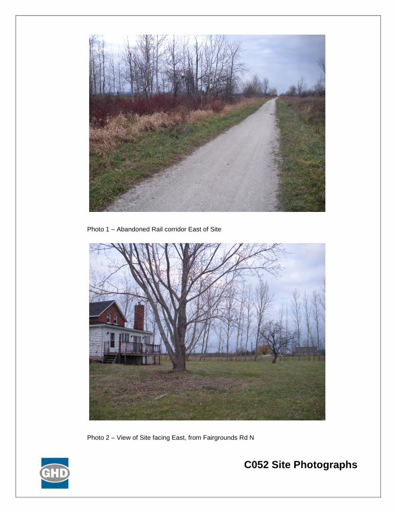
C052 Site Photographs
Photo 1 – Abandoned Rail corridor East of Site
Photo 2 – View of Site facing East, from Fairgrounds Rd N

Table C.1 C052 – 1637 Fairgrounds Road North – OPF
Table C.1 page 1 of 6
Component Criteria Indicators Potential Effects Mitigation Measures Net Effects Environmental Air Quality • Wind speed &
direction • Mean wind speed of 5.05 metres per second (m/s)
predominately coming from a westerly direction • Dust, particulate matter from construction/ operation • Off-gases construction/operation
• As the site is relatively flat, with predominantly open field (few trees), additional mitigation measures through design and Best Management Practices (BMPs) during construction/ operation will be required
• BMPs may include perimeter planting, dust suppression, ensuring construction and operation equipment are inspected and in good working condition
• With the implementation of BMPs, no off-site receptors affected
• Proximity to sensitive receptors
• Within 500 metres (m) of the site boundary, there are 9 off-site receptors (generally along Fairgrounds Road North, to north and south of site) potentially affected by dust and particulate matter from construction and operation of the facility
• Design and implement dust control (routine cleaning of internal paved roads)
• Maximize setback distance between facility footprint and sensitive receptors
• Given the size of the property relative to the facility footprint, the on-site buffer is of a sufficient size to act as a mitigation measure (i.e., levels of dust, particulate matter, etc. will dissipate before reaching the property line)
• Proper management of air quality controls • Implement BMPs to ensure dust generation is minimized
• No off-site receptors affected based on mitigation measures implemented for 9 receptors
• Species of Special Concern, Threatened, and/or Endangered
• Potential species at risk (SAR) based on available habitat, as identified by MNRF Management Biologist, include: Butternut (END), Bobolink (THR) and Eastern Meadowlark (THR) if agricultural fields in hay or pasture, Milksnake (SC)
• There are historical records of SAR on the property, including Northern Myotis, Northern Map Turtle, Little Bluestem-Long-leaved Reed Grass- Great Lakes Wheat Grass dune Grassland Type, Houghton’s Flatsedge, Hawthorn, Stiff Yellow Flax, and Ocellated Darner. It is unlikely that Ocellated Darner is present on the property as suitable habitat is absent.
• Avoidance of any SAR or SAR habitat when siting the facility • Confirmation that SAR are not present will be determined if this site is
carried forward as the preferred and additional mitigation measures/BMPs will be established. In addition, a scoped EIS would be undertaken.
• Low effects to SAR based on review of existing data (MNRF Management Biologist, secondary sources, ortho imagery)
Odour • Wind speed & direction
• Mean wind speed of 5.05 m/s predominately coming from a westerly direction
• Off-gases construction/operation
• As the site is relatively flat, with predominantly open field (few trees), additional mitigation measures through design, which includes odour control (store material in an enclosed space, gas collection, etc.) at the outset of the project
• Implement BMPs to ensure odour is minimized
• With the implementation of appropriate odour control design and BMPs, no off-site receptors affected
• Proximity to sensitive receptors
• Within 500 m of the site boundary, there are 9 off-site receptors (generally along Fairgrounds Road North, to north and south of site) potentially affected by odours from the facility
• Design and implement odour control (store material in an enclosed space, gas collection, etc.) at the outset of the project
• During operation, the facility will always operate under negative pressure
• Maximize setback distance between facility footprint and sensitive receptors
• Given the size of the property relative to the facility footprint, the on-site buffer is of a sufficient size to act as a mitigation measure (i.e., odour units will be reduced before reaching the property line)
• Implement BMPs to ensure odour from facility is minimized
• No off-site receptors affected based on mitigation measures implemented for 9 receptors
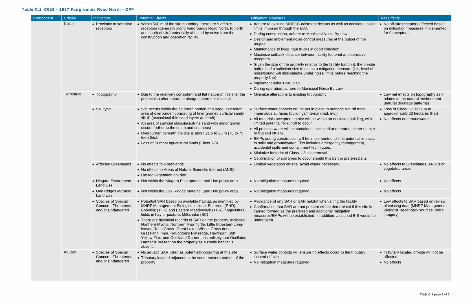
Table C.1 C052 – 1637 Fairgrounds Road North – OPF
Table C.1 page 2 of 6
Component Criteria Indicators Potential Effects Mitigation Measures Net Effects Noise • Proximity to sensitive
receptors • Within 500 m of the site boundary, there are 9 off-site
receptors (generally along Fairgrounds Road North, to north and south of site) potentially affected by noise from the construction and operation facility
• Adhere to existing MOECC noise restrictions as well as additional noise limits imposed through the ECA
• During construction, adhere to Municipal Noise By-Law • Design and implement noise control measures at the outset of the
project • Maintenance to keep haul trucks in good condition • Maximize setback distance between facility footprint and sensitive
receptors • Given the size of the property relative to the facility footprint, the on-site
buffer is of a sufficient size to act as a mitigation measure (i.e., level of noise/sound will dissipate/be under noise limits before reaching the property line)
• Implement noise BMP plan • During operation, adhere to Municipal Noise By-Law
• No off-site receptors affected based on mitigation measures implemented for 9 receptors
Terrestrial • Topography • Due to the relatively consistent and flat nature of this site, the potential to alter natural drainage patterns is minimal
• Minimize alterations to existing topography • Low net effects on topography as it relates to the natural environment (natural drainage patterns)
• Soil type • Site occurs within the southern portion of a large, extensive area of overburden consisting of finer grained surficial sandy silt till (occasional thin sand layers at depth)
• An area of surficial glaciolacustrine sand with minor gravel occurs further to the south and southeast
• Overburden beneath the site is about 21.5 to 23 m (70 to 75 feet) thick
• Loss of Primary agricultural lands (Class 1-3)
• Surface water controls will be put in place to manage run-off from impervious surfaces (buildings/internal road, etc.)
• All materials accepted on-site will be within an enclosed building, with limited potential for runoff to occur
• All process water will be contained, collected and treated, either on-site or trucked off-site
• BMPs during construction will be implemented to limit potential impacts to soils and groundwater. This includes emergency management, accidental spills and containment techniques.
• Minimize footprint of Class 1-3 soil removal • Confirmation of soil types to occur should this be the preferred site
• Loss of Class 1-3 soil (up to approximately 23 hectares (ha))
• No effects on groundwater
• Affected Greenlands • No effects to Greenlands • No effects to Areas of Natural Scientific Interest (ANSI) • Limited vegetation on- site
• Limited vegetation on-site, avoid where necessary • No effects to Greenlands, ANSI’s or vegetated areas
• Niagara Escarpment Land Use
• Not within the Niagara Escarpment Land Use policy area • No mitigation measures required • No effects
• Oak Ridges Moraine Land Use
• Not within the Oak Ridges Moraine Land Use policy area • No mitigation measures required • No effects
• Species of Special Concern, Threatened, and/or Endangered
• Potential SAR based on available habitat, as identified by MNRF Management Biologist, include: Butternut (END), Bobolink (THR) and Eastern Meadowlark (THR) if agricultural fields in hay or pasture, Milksnake (SC)
• There are historical records of SAR on the property, including Northern Myotis, Northern Map Turtle, Little Bluestem-Long-leaved Reed Grass- Great Lakes Wheat Grass dune Grassland Type, Houghton’s Flatsedge, Hawthorn, Stiff Yellow Flax, and Ocellated Darner. It is unlikely that Ocellated Darner is present on the property as suitable habitat is absent.
• Avoidance of any SAR or SAR habitat when siting the facility • Confirmation that SAR are not present will be determined if this site is
carried forward as the preferred and additional mitigation measures/BMPs will be established. In addition, a scoped EIS would be undertaken.
• Low effects to SAR based on review of existing data (MNRF Management Biologist, secondary sources, ortho imagery)
Aquatic • Species of Special Concern, Threatened, and/or Endangered
• No aquatic SAR listed as potentially occurring at this site • Tributary located adjacent to the south-eastern portion of the
property
• Surface water controls will ensure no effects occur to the tributary located off-site
• No mitigation measures required
• Tributary located off-site will not be affected
• No effects
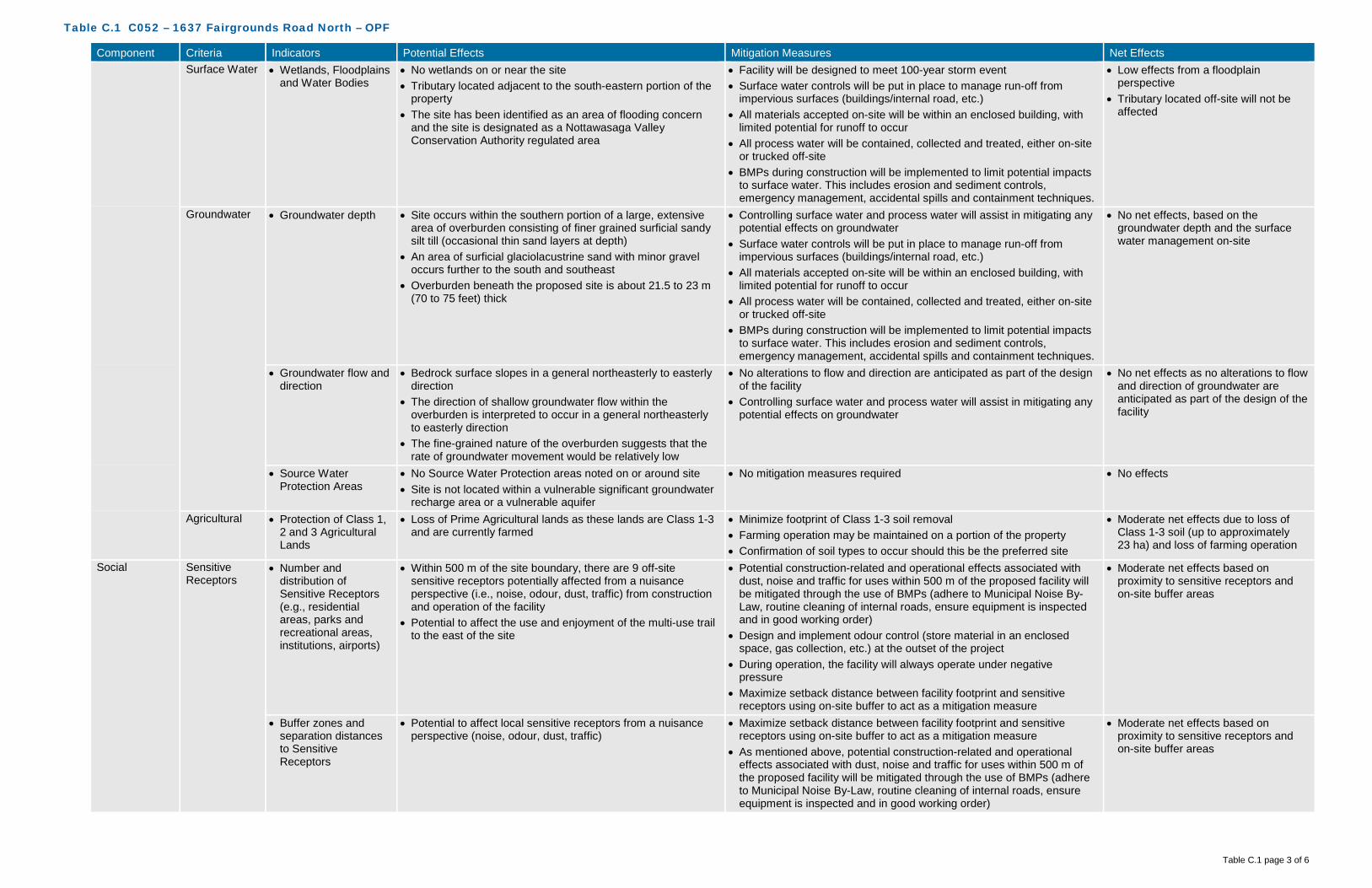
Table C.1 C052 – 1637 Fairgrounds Road North – OPF
Table C.1 page 3 of 6
Component Criteria Indicators Potential Effects Mitigation Measures Net Effects Surface Water • Wetlands, Floodplains
and Water Bodies • No wetlands on or near the site • Tributary located adjacent to the south-eastern portion of the
property • The site has been identified as an area of flooding concern
and the site is designated as a Nottawasaga Valley Conservation Authority regulated area
• Facility will be designed to meet 100-year storm event • Surface water controls will be put in place to manage run-off from
impervious surfaces (buildings/internal road, etc.) • All materials accepted on-site will be within an enclosed building, with
limited potential for runoff to occur • All process water will be contained, collected and treated, either on-site
or trucked off-site • BMPs during construction will be implemented to limit potential impacts
to surface water. This includes erosion and sediment controls, emergency management, accidental spills and containment techniques.
• Low effects from a floodplain perspective
• Tributary located off-site will not be affected
Groundwater • Groundwater depth • Site occurs within the southern portion of a large, extensive area of overburden consisting of finer grained surficial sandy silt till (occasional thin sand layers at depth)
• An area of surficial glaciolacustrine sand with minor gravel occurs further to the south and southeast
• Overburden beneath the proposed site is about 21.5 to 23 m (70 to 75 feet) thick
• Controlling surface water and process water will assist in mitigating any potential effects on groundwater
• Surface water controls will be put in place to manage run-off from impervious surfaces (buildings/internal road, etc.)
• All materials accepted on-site will be within an enclosed building, with limited potential for runoff to occur
• All process water will be contained, collected and treated, either on-site or trucked off-site
• BMPs during construction will be implemented to limit potential impacts to surface water. This includes erosion and sediment controls, emergency management, accidental spills and containment techniques.
• No net effects, based on the groundwater depth and the surface water management on-site
• Groundwater flow and direction
• Bedrock surface slopes in a general northeasterly to easterly direction
• The direction of shallow groundwater flow within the overburden is interpreted to occur in a general northeasterly to easterly direction
• The fine-grained nature of the overburden suggests that the rate of groundwater movement would be relatively low
• No alterations to flow and direction are anticipated as part of the design of the facility
• Controlling surface water and process water will assist in mitigating any potential effects on groundwater
• No net effects as no alterations to flow and direction of groundwater are anticipated as part of the design of the facility
• Source Water Protection Areas
• No Source Water Protection areas noted on or around site • Site is not located within a vulnerable significant groundwater
recharge area or a vulnerable aquifer
• No mitigation measures required • No effects
Agricultural • Protection of Class 1, 2 and 3 Agricultural Lands
• Loss of Prime Agricultural lands as these lands are Class 1-3 and are currently farmed
• Minimize footprint of Class 1-3 soil removal • Farming operation may be maintained on a portion of the property • Confirmation of soil types to occur should this be the preferred site
• Moderate net effects due to loss of Class 1-3 soil (up to approximately 23 ha) and loss of farming operation
Social Sensitive Receptors
• Number and distribution of Sensitive Receptors (e.g., residential areas, parks and recreational areas, institutions, airports)
• Within 500 m of the site boundary, there are 9 off-site sensitive receptors potentially affected from a nuisance perspective (i.e., noise, odour, dust, traffic) from construction and operation of the facility
• Potential to affect the use and enjoyment of the multi-use trail to the east of the site
• Potential construction-related and operational effects associated with dust, noise and traffic for uses within 500 m of the proposed facility will be mitigated through the use of BMPs (adhere to Municipal Noise By-Law, routine cleaning of internal roads, ensure equipment is inspected and in good working order)
• Design and implement odour control (store material in an enclosed space, gas collection, etc.) at the outset of the project
• During operation, the facility will always operate under negative pressure
• Maximize setback distance between facility footprint and sensitive receptors using on-site buffer to act as a mitigation measure
• Moderate net effects based on proximity to sensitive receptors and on-site buffer areas
• Buffer zones and separation distances to Sensitive Receptors
• Potential to affect local sensitive receptors from a nuisance perspective (noise, odour, dust, traffic)
• Maximize setback distance between facility footprint and sensitive receptors using on-site buffer to act as a mitigation measure
• As mentioned above, potential construction-related and operational effects associated with dust, noise and traffic for uses within 500 m of the proposed facility will be mitigated through the use of BMPs (adhere to Municipal Noise By-Law, routine cleaning of internal roads, ensure equipment is inspected and in good working order)
• Moderate net effects based on proximity to sensitive receptors and on-site buffer areas

Table C.1 C052 – 1637 Fairgrounds Road North – OPF
Table C.1 page 4 of 6
Component Criteria Indicators Potential Effects Mitigation Measures Net Effects Land Use/Zoning
• Current land use, zoning, approved development plans, and proposed land use changes
• Official Plan designation for County and Clearview is Agricultural
• Zoning designation is Agricultural • Displacement of current land use as the land is currently
utilized for farming
• County and Clearview Official Plan Amendment (OPA) and Clearview Zoning By-Law Amendment (ZBLA) would be required
• Site has previously been identified as a future waste management facility for the County of Simcoe
• Low net effects due to displacement of current land use and OPA/ZBLA requirements
• Opportunity for brownfield development, enhanced use
• No opportunity for brownfield redevelopment or enhanced use as this site is not classified as a brownfield site
• No mitigation measures • Moderate net effects due to displacement of current land and lack of opportunity for brownfield redevelopment or enhanced use
• Compatibility with existing Land Use/Zoning designations on adjacent sites
• Adjacent Official Plan designation for County and Clearview is Agricultural
• Adjacent zoning designation is Agricultural • County-owned site adjacent to the east, across trail • Potential incompatibility with adjacent land use/ designation
• Given the size of the property relative to the facility footprint, the on-site buffer is of a sufficient size to act as a mitigation measure -mitigation through design
• As mentioned above, potential construction-related and operational effects associated with dust, noise and traffic for uses within 500 m of the proposed facility will be mitigated through the use of BMPs (adhere to municipal Noise By-Law, routine cleaning of internal roads, ensure equipment is inspected and in good working order)
• Low net effects based on the size of the site, on-site buffer and application of proven mitigation measures
Transportation • Existing/required transportation infrastructure
• Fairgrounds Road is paved, but somewhat narrow. Road is relatively flat with access from both north and south.
• Existing laneway with road access • Emergency access possible from trail at rear of property • No major upgrades such as signalization, turning lanes, grade
improvements are anticipated to be required
• Ensure required transportation infrastructure is developed • Design and construct road improvements in accordance with Township
of Clearview policies, standards and practices
• Low net effects due to limited requirement for upgrades
• Neighbourhood traffic impacts
• Relatively low existing traffic volume on Fairgrounds Road North
• Potential to increase traffic on local roads within close proximity to established neighbourhoods and sensitive receptors
• Design and construct road improvements in accordance with Township of Clearview policies, standards and practices
• Define local traffic routing within the local neighbourhood to a avoid impacts
• Moderate net effects due to the increase in local traffic
Visual • Buffer zones and visual screening
• Site is visible from surrounding residents’ properties as the topography is relatively flat in the area
• No on-site screening by way of existing vegetation and berms
• Vegetation buffer treatment to be installed along north, west and south west corner of the property to create visual screen from neighbours
• Vegetation to be planted around the facility to act as a secondary buffer
• Low net effects as installation of visual screening would obscure views of the facility from surrounding areas
Cultural Archaeological • Archaeologically significant areas
• No known archaeological sites on or adjacent to the site • Confirmation through appropriate further study (i.e., Stage 1 Archaeological Assessment) will be completed on the preferred site
• Should further study reveal archaeological potential, those areas should be avoided
• Low net effects until confirmation is provided through further study
Heritage • Areas of important cultural heritage
• No known cultural heritage sites (built or landscape) on or adjacent to the site
• Confirmation through appropriate further study (i.e., Cultural Heritage Assessment) will be completed on the preferred site
• No net effects until confirmation is provided through further study
Technical Permitting/ Approvals
• Feasibility and complexity of permitting/approvals
• County and Clearview OPA and Clearview ZBLA are required • Accompanying studies (i.e., traffic) required • Environmental Compliance Approvals (ECAs) required
• Siting work completed will assist in demonstrating the planning rationale for the proposed amendments
• ECA studies will demonstrate how effects will be mitigated and managed
• Site was previously identified as a future waste management facility
• Low net effects based on approval(s) required
Safety • Potential safety risks • Potential for bird strikes given the proximity to Collingwood Airport (less than 8 kilometres (km))
• Potential for spills, fire, and other emergencies
• No waste will be stored outside, all operations that may be an attractant to birds (i.e., food waste), will be managed in an enclosed area
• If a surface water pond is required, it will be designed to ensure that waterfowl are unable to utilize the pond
• Develop a Health and Safety Plan and an Emergency Management Plan
• Moderate safety risks posed by proximity to airport

Table C.1 C052 – 1637 Fairgrounds Road North – OPF
Table C.1 page 5 of 6
Component Criteria Indicators Potential Effects Mitigation Measures Net Effects Utilities and Services
• Availability and distance from utilities and services
• No sanitary sewer in vicinity of site • No municipal water supply in vicinity of site • No gas supply line in vicinity of site • Hydro line on Fairgrounds Road
• Construction and implementation of required services/utilities • High net effects as availability and distance from existing utilities and services is minimal
Suitability • Meets minimum size requirements
• 23 ha • No mitigation measures required • No net effects
• Within search area • Site is within search area for the OPF • No mitigation measures required • No net effects • Site layout,
topography and soil conditions
• Potential constraint on-site from Hydro corridor in northern portion, running on a diagonal east to west
• No potential effects from the a soil conditions perspective • No potential effects from a topography perspective, site is
relatively flat
• Increase setback distances from Hydro corridor as well as property lines as to increase buffer distances
• Low net effects as majority of the site is able to accommodate the facility with significant setbacks and buffer distances
• Compatibility with existing infrastructure
• No potential for utility conflicts due to lack of existing utilities • No potential for road network conflicts
• Construction and implementation of required services/utilities
• No net effects, as no relocation of existing utilities is required
Flexibility • Design/operational flexibility provided by site
• Site provides for a high level of design and operational flexibility given the site size and the limited constraints
• No mitigation measures required • High positive net effects as the site has the ability to accommodate design and operational flexibility
• Surplus lands for expansion
• Site provides for a high level of surplus lands for expansion given the site size and the limited constraints
• No mitigation measures required • High positive net effects as the site has the ability to accommodate expansion
Economic Capital Costs • Property acquisition • No costs for property acquisition as property is owned by the County
• No mitigation measures required • No cost
• Infrastructure • No major road improvements anticipated • Hydro is available on Fairgrounds Road • Other servicing infrastructure is required
• No mitigation measures required • Low cost
• Design • Berms/fences/plantings likely required on all sides • No mitigation measures required • Low cost • Construction • Minimal grading for facility
• Berms/fences/plantings likely required on all sides • No mitigation measures required • Low cost
• Permits/approvals • Near airport, additional approvals/restrictions may be required such as height of stack
• No mitigation measures required • Moderate cost for additional approvals work required
• Site remediation • No known areas requiring remediation on-site
• At a minimum, undertake a Phase 1 Site Assessment to determine potential contamination (if any)
• Low cost
Operation and Maintenance Costs
• Facility operation and maintenance
• Wildlife management with respect to airport (e.g., waterfowl) • Increased operation and maintenance costs associated with
on-site screening mechanisms and mitigation measures
• No mitigation measures required • Moderate cost associated with operation and maintenance
• Transportation from feedstock sources
• Approximately 30 km from waste centroid • No mitigation measures required • High cost associated with transportation from feedstock sources
• Transportation to markets and end users
• Potential agricultural users nearby • No mitigation measures required • Low cost associated with transportation to markets and end users
• Monitoring requirements
• Standard monitoring requirements expected • Additional monitoring requirements with respect to waterfowl
issue
• No mitigation measures required • Low cost associated with monitoring requirements
• Mitigation requirements
• No natural screening mechanisms (e.g., topography, vegetation, significant buffer) in place for odour, noise, visual
• Cutting grass, maintaining vegetation
• No mitigation measures required • Moderate cost associated with mitigation requirements
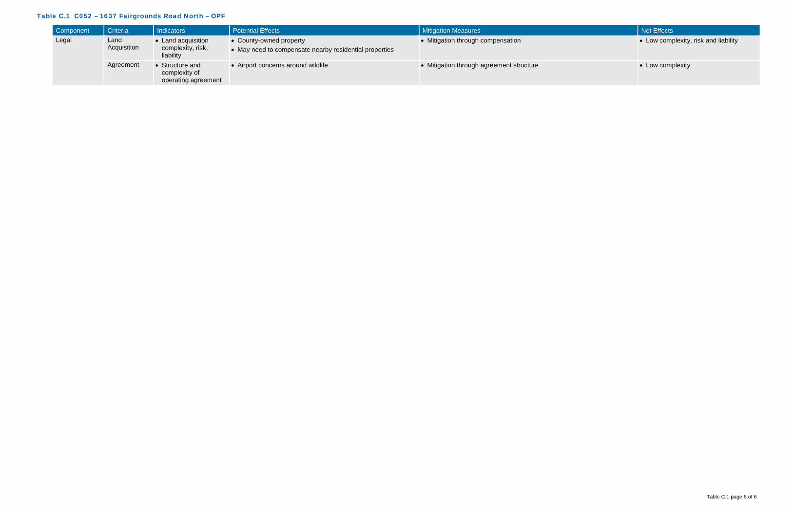
Table C.1 C052 – 1637 Fairgrounds Road North – OPF
Table C.1 page 6 of 6
Component Criteria Indicators Potential Effects Mitigation Measures Net Effects Legal Land
Acquisition • Land acquisition
complexity, risk, liability
• County-owned property • May need to compensate nearby residential properties
• Mitigation through compensation • Low complexity, risk and liability
Agreement • Structure and complexity of operating agreement
• Airport concerns around wildlife • Mitigation through agreement structure • Low complexity

GHD | County of Simcoe – OPF, MMF, and Co-Located Facility – Part 3 – Short List Evaluation | 086822 (6)
Appendix D Site C164/C107
1473/1273 Old Second South

!(
!(
!(!(
!(
Horseshoe Valley Rd W
Hwy 400
Procee Cir
Bidw
ellRd
Penetanguishene Rd
Old 2nd N
OldSecondSouth
Hillview Cres
0 150 300 450
Meters
086822 Feb 1, 2016
GIS File: Q:\GIS\PROJECTS\86000s\86822\Layouts\INT006\086822(INT006)GIS-WA003-C107-164.mxd
Source: MNRF NRVIS, 2015. Produced by GHD under licence from Ontario Ministry of Natural Resources and Forestry, © Queen's Printer 2016Inset Map: ESRI Data & Maps 2008 Data Distribution Application (DDA)
Coordinate System:NAD 1983 UTM Zone 17N
Legend
!( Sensitive ReceptorSite BoundarySite Buffer (500m)Parcel Boundary
Wind Rose at 30 metresMean Wind Speed: 4.02 m/s
FIGURE D.1C164/C107 ENVIRONMENTAL -AIR QUALITY, ODOUR, NOISE
COUNTY OF SIMCOEOPF/MMF SITE SELECTION

Horses
ho
e Valley Rd W
Bidwell Rd
Old Second North
Penetanguishene Rd
Hwy 400
Old Second South
Woodland Cres
Matheson CreekTributary:8356
246
320
314312
310
308
306
302
300298
296
292284
280
27627
4
304
294
290
288
286
220
222224
226228
230232
236
238
302
300
296
312
306
302
298
272
304300
298
296
294
292290
288
286
284
302300298
304
300
296
300
296
294
292
316
314
31030
8304
278
324
322
320
318
316
314310308
278
262
264
298
296
238
288268
262
256
270
260262
264
306
304
288
264
258
258
252
250
248
284
282 280
234
226228
304
238236
266
240
238
272
300
298
234
290
234
302
266
266
236
240
226 230
290288
282
280278
240
284
282
232
232
270
260 302
270
246
310
236
254
266
236
250
234
288
282
238
302
238 240
264 266
270
242
244
248
256
258
256
234
236
292
266
264
276278
274
240
228
230
240
244
230
242
248
246
234
234
236
270
252
276
246244
248
238
236
234
254
246
246
250
268
274274
248
244
246
244
244
246
232
0 150 300 450
Meters
086822 Feb 2, 2016
GIS File: Q:\GIS\PROJECTS\86000s\86822\Layouts\INT006\086822(INT006)GIS-WA002.mxd
Source: MNRF NRVIS, 2016. Produced by GHD under licence from Ontario Ministry of Natural Resources and Forestry, © Queen's Printer, County of Simcoe Geomatics 2016Greenlands Data: County of Simcoe, 2007
Coordinate System:NAD 1983 UTM Zone 17N
Legend
Site BoundaryContour (2m)Simcoe County GreenlandsCanada Land Inventory - Soils Class 1-3
FIGURE D.2C107/C164 ENVIRONMENTAL -TERRESTRIAL, AGRICULTURAL
COUNTY OF SIMCOEOPF/MMF SITE SELECTION
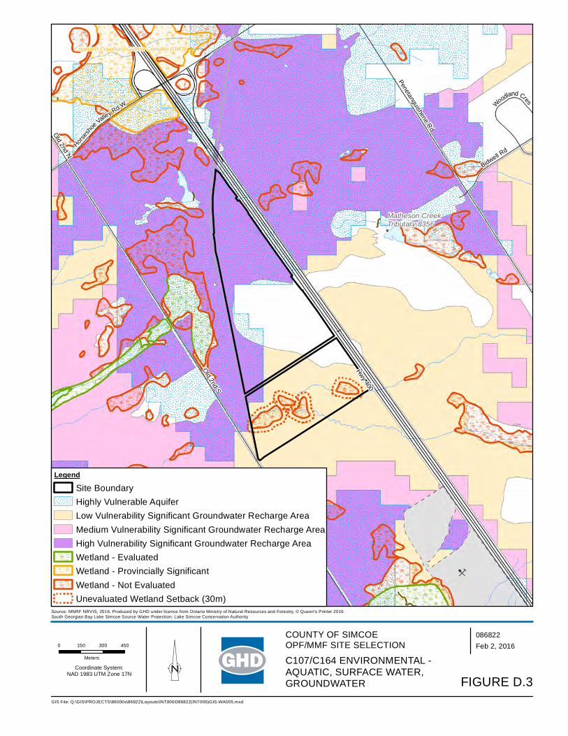
Matheson CreekTributary:8356
B
Horses
ho
e Valley Rd W
Bidwell Rd
Old 2nd N
Penetanguishene Rd
Hwy 400
Old 2nd S
Woodland Cres
Midhurst Swamp (SP5)
Copeland-Craighurst-Guthrie Complex (OM3)
0 150 300 450
Meters
086822 Feb 2, 2016
GIS File: Q:\GIS\PROJECTS\86000s\86822\Layouts\INT006\086822(INT006)GIS-WA005.mxd
Source: MNRF NRVIS, 2016. Produced by GHD under licence from Ontario Ministry of Natural Resources and Forestry, © Queen's Printer 2016South Georgian Bay Lake Simcoe Source Water Protection: Lake Simcoe Conservation Authority
Coordinate System:NAD 1983 UTM Zone 17N
Legend
Site BoundaryHighly Vulnerable AquiferLow Vulnerability Significant Groundwater Recharge AreaMedium Vulnerability Significant Groundwater Recharge AreaHigh Vulnerability Significant Groundwater Recharge AreaWetland - EvaluatedWetland - Provincially SignificantWetland - Not EvaluatedUnevaluated Wetland Setback (30m)
FIGURE D.3
C107/C164 ENVIRONMENTAL -AQUATIC, SURFACE WATER, GROUNDWATER
COUNTY OF SIMCOEOPF/MMF SITE SELECTION

!(
!(
!(!(
!(
Horses
ho
e Valley Rd W
Bidwell Rd
Old Second North
Penetanguishene Rd
Hwy 400
Old Second South
Woodland Cres
0 150 300 450
Meters
086822 Feb 2, 2016
GIS File: Q:\GIS\PROJECTS\86000s\86822\Layouts\INT006\086822(INT006)GIS-WA010.mxd
Source: MNRF NRVIS, 2016. Produced by GHD under licence from Ontario Ministry of Natural Resources and Forestry, © Queen's Printer 2016Zoning Source: Springwater Zoning By-Law
Coordinate System:NAD 1983 UTM Zone 17N
Legend
Site BoundarySite Buffer (500m)
!( Sensitive Receptor
Zoning
AgriculturalCampground CommercialEnvironmental ProtectionOpen Space
FIGURE D.4C107/C164 SOCIAL AND CULTURAL
COUNTY OF SIMCOEOPF/MMF SITE SELECTION
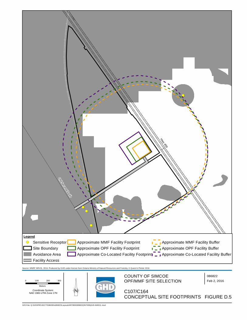
!(
!(!(
!(
Ho
r se
s ho e
V a l l ey
Rd
W
Penetanguishene Rd
Hwy 400
Old Second South
0 100 200 300
Meters
086822 Feb 2, 2016
GIS File: Q:\GIS\PROJECTS\86000s\86822\Layouts\INT006\086822(INT006)GIS-WA011.mxd
Source: MNRF NRVIS, 2016. Produced by GHD under licence from Ontario Ministry of Natural Resources and Forestry, © Queen's Printer 2016
Coordinate System:NAD 1983 UTM Zone 17N
Legend
!( Sensitive ReceptorSite BoundaryAvoidance AreaFacility Access
Approximate MMF Facility FootprintApproximate OPF Facility FootprintApproximate Co-Located Facility Footprint
Approximate MMF Facility BufferApproximate OPF Facility BufferApproximate Co-Located Facility Buffer
FIGURE D.5C107/C164 CONCEPTUAL SITE FOOTPRINTS
COUNTY OF SIMCOEOPF/MMF SITE SELECTION

C107/C164 Site Photographs
Photo 1 – View of plantings on Site
Photo 2 – View of Highway 400 facing East from Site

Table D.1 C164/C107 – 1473/1273 Old Second South – OPF
Table D.1 Page 1 of 6
Component Criteria Indicators Potential Effects Mitigation Measures Net Effects Environmental Air Quality • Wind speed &
direction • Mean wind speed of 4.02 metres per second (m/s)
predominately coming from a northwesterly direction • Dust, particulate matter from construction/operation • Off-gases construction/operation
• As the site has a varied topography, with predominantly forested areas, minimal mitigation measures through design and Best Management Practices (BMPs) during construction/ operation will be required
• BMPs may include planting in key areas after construction, dust suppression, ensuring construction and operation equipment are inspected and in good working condition
• With the implementation of BMPs, no off-site receptors affected
• Proximity to sensitive receptors
• Within 500 metres (m) of the site boundary, there are 5 off-site receptors potentially affected by dust and particulate matter from construction and operation of the facility
• These include 3 residential properties immediately adjacent to the site (west) and a campground (Barrie KOA) on the other side of Highway 400
• Design and implement dust control (routine cleaning of internal paved roads)
• Maximize setback distance between facility footprint and sensitive receptors immediately adjacent to the site using on-site buffer to act as a mitigation measure (reduce levels of dust, particulate matter, before reaching the property line)
• As the site abuts Highway 400, this acts as an additional buffer with respect to proximity to sensitive receptors at the Barrie KOA
• Proper management of air quality controls • Implement BMPs to ensure dust generation is minimized
• No off-site receptors affected based on mitigation measures implemented for 5 receptors
• Species of Special Concern, Threatened, and/or Endangered
• Potential species at risk (SAR) based on available habitat, as identified by MNRF Management Biologist, include: Butternut (END), Little Brown Bat (END), Northern Long-eared Bat (END), Whip-poor-will (THR), Eastern Wood-Pewee (SC), Golden-winged Warbler (SC)
• There are records of SAR species on the property, including Snapping Turtle, Milksnake, Red-shouldered Hawk and an unspecified sensitive species. Not all SAR records are dated; however, the Snapping Turtle is identified to be a recent record (2009).
• Avoidance of any SAR or SAR habitat when siting the facility • Confirmation that SAR are not present will be determined if this site is
carried forward as the preferred and additional mitigation measures/BMPs will be established. In addition, a scoped EIS would be undertaken.
• Low net effects as there is the potential for Species of Special Concern, Threatened, and/or Endangered based on preliminary review and recent records
Odour • Wind speed & direction
• Mean wind speed of 4.02 m/s predominately coming from a northwesterly direction
• Off-gases construction/operation
• As the site has a varied topography, with predominantly forested areas, minimal mitigation measures through design and BMPs during construction/ operation will be required
• BMPs may include planting in key areas after construction, dust suppression, ensuring construction and operation equipment are inspected and in good working condition
• Implement BMPs to ensure odour is minimized
• With the implementation of appropriate odour control design and BMPs, no off-site receptors affected
• Proximity to sensitive receptors
• Within 500 m of the site boundary, there are 5 off-site receptors potentially affected by odours from the facility
• These include 3 residential properties immediately adjacent to the site (west) and a campground (Barrie KOA) campground on the other side of Highway 400
• Design and implement odour control (store material in an enclosed space, gas collection, etc.) at the outset of the project
• During operation, the facility will always operate under negative pressure
• Maximize setback distance between facility footprint and sensitive receptors immediately adjacent to the site using on-site buffer to act as a mitigation measure (reduce odour units before reaching the property line)
• Implement BMPs to ensure odour from facility is minimized
• No off-site receptors affected based on mitigation measures implemented for 5 receptors

Table D.1 C164/C107 – 1473/1273 Old Second South – OPF
Table D.1 Page 2 of 6
Component Criteria Indicators Potential Effects Mitigation Measures Net Effects Noise • Proximity to sensitive
receptors • Within 500 m of the site boundary, there are 5 off-site
receptors potentially affected by noise from the construction and operation of the facility
• These include 3 residential properties immediately adjacent to the site (west) and a campground (Barrie KOA) campground on the other side of Highway 400
• Adhere to existing MOECC noise restrictions as well as additional noise limits imposed through the ECA
• During construction, adhere to Municipal Noise By-Law • Design and implement noise control measures at the outset of the
project • Maintenance to keep haul trucks in good condition • Maximize setback distance between facility footprint and sensitive
receptors immediately adjacent to the site using on-site buffer to act as a mitigation measure (reduce level of noise/sound before reaching the property line)
• Implement noise BMP plan • During operation, adhere to Municipal Noise By-Law
• No off-site receptors affected based on mitigation measures implemented for 5 receptors
Terrestrial • Topography • Due to the varied topography with the peak sloping toward the southwest, there is a greater potential to alter natural drainage patterns, particularly as two surface water features flow through the southern portion of the property
• Minimize alterations to existing topography • Setback facility from slope • Setback facility from surface water features • Minimize surface water flow into creeks through design (conveyance)
• Moderate net effects on topography as it relates to natural environment (natural drainage patterns)
• Soil type • Overburden consists primarily of glaciofluvial ice-contact stratified deposits comprised of sand or gravelly sand to the northern portion of the site
• Overburden consists primarily of glaciolacustrine very fine to medium grained sand, silt, minor clay in the western portion, and glaciofluvial ice-contact stratified deposits comprised of sand or gravelly sand in the southern/eastern part
• The higher topographic central/southern area consists of stony silty sand to sand till
• Overburden beneath the proposed site is greater than 107 m (350 feet) thick
• Surface water controls will be put in place to manage run-off from impervious surfaces (buildings/internal road, etc.)
• All materials accepted on-site will be within an enclosed building, with limited potential for runoff to occur
• All process water will be contained, collected and treated, either on-site or trucked off-site
• BMPs during construction will be implemented to limit potential impacts to soils and groundwater. This includes emergency management, accidental spills and containment techniques.
• Confirmation of soil types to occur should this be the preferred site
• No effects on groundwater
• Affected Greenlands • Effects to lands designated as Greenlands (approved in the County Official Plan and pending approval in the revised County Official Plan)
• No effects to Areas of Natural Scientific Interest (ANSI) • Significant portion of the site is forested with conifer
plantations. Older growth on northern portion, new plantings on southern portion.
• Limited open areas with little to no vegetation – majority of treed area appears to be plantation style plantings
• Most of the property is identified as woodland on NHIC mapping
• Infrastructure not subject to the environmental assessment process may be permitted within the County Greenlands designation or on adjacent lands in accordance with development and site alteration policies within the County Official Plan (Section 3.3.15)
• A scoped EIS would be undertaken as per the Official Plan requirements to develop infrastructure within the County Greenlands designation
• Avoid areas of significant/dense vegetation • Avoid old growth in the northern portion • Compensate for tree removal at a minimum on a 1:1 ratio – either on-
site or on another County owned property in close proximity
• Low effects to lands designated as County Greenlands as an EIS is required. Completing the EIS will demonstrate through further analysis and investigation, as well as more detailed mitigation measures, the most appropriate location of the facility footprint on the site. This net effect would be lowered to “No” once a facility footprint location is determined as the EIS would demonstrate that there will be no negative impacts on natural features and areas and ecological functions of the County or local natural heritage system, and meet the requirements of Section 3.3.15 of the County Official Plan.
• No effects to ANSI’s • Moderate effects to existing
vegetation on-site as removal will be required for the facility
• Niagara Escarpment Land Use
• Not within the Niagara Escarpment Land Use policy area • No mitigation measures required • No net effects
• Oak Ridges Moraine Land Use
• Not within the Oak Ridges Moraine Land Use policy area • No mitigation measures required • No net effects

Table D.1 C164/C107 – 1473/1273 Old Second South – OPF
Table D.1 Page 3 of 6
Component Criteria Indicators Potential Effects Mitigation Measures Net Effects • Species of Special
Concern, Threatened, and/or Endangered
• Potential species at risk (SAR) based on available habitat, as identified by MNRF Management Biologist, include: Butternut (END), Little Brown Bat (END), Northern Long-eared Bat (END), Whip-poor-will (THR), Eastern Wood-Pewee (SC), Golden-winged Warbler (SC)
• There are records of SAR species on the property, including Snapping Turtle, Milksnake, Red-shouldered Hawk and an unspecified sensitive species. Not all SAR records are dated; however, the Snapping Turtle is identified to be a recent record (2009).
• Avoidance of any SAR or SAR habitat when siting the facility • Confirmation that SAR are not present will be determined if this site is
carried forward as the preferred and additional mitigation measures/BMPs will be established. In addition, a scoped EIS would be undertaken.
• Low net effects as there is the potential for Species of Special Concern, Threatened, and/or Endangered based on preliminary review and recent records
Aquatic • Species of Special Concern, Threatened, and/or Endangered
• No aquatic SAR listed as potentially occurring at this site • Two branches of a tributary located in the southern portion of
the site are evident, however no SAR are listed as being associated with surface water features
• Implement appropriate setbacks from the two surface water features and non-evaluated wetlands (minimum 30 metres as per Official Plan and MNRF guidelines)
• Surface water controls will ensure no effects occur to the tributary located off-site
• No aquatic SAR listed as occurring at this site
• No net effects as there are no aquatic SAR listed as occurring at this site
Surface Water • Wetlands, Floodplains and Water Bodies
• Potential to affect 2 watercourses and 4 unevaluated wetlands in the southern portion of the site and a watercourse running through northern tip of site
• Potential to affect these drainage features, (which are regulated by the NVCA) and are associated flooding and erosion concerns
• Implement appropriate setbacks from the two surface water features and non-evaluated wetlands (minimum 30 metres as per Official Plan and MNRF guidelines).
• Further study required on the non-evaluated wetlands (OWES) • Facility will be designed to meet 100-year storm event • Surface water controls will be put in place to manage run-off from
impervious surfaces (buildings/internal road, etc.) and direct them away from natural drainage features.
• All materials accepted on-site will be within an enclosed receiving building, with limited potential for runoff to occur
• All process water will be contained, collected and treated, either on-site or trucked off-site
• BMPs during construction will be implemented to limit potential impacts to surface water. This includes erosion and sediment controls, emergency management, accidental spills and containment techniques.
• Moderate effects to surface water features in the southern portion of the site
Groundwater • Groundwater depth • Overburden consists primarily of glaciofluvial ice-contact stratified deposits comprised of sand or gravelly sand to the northern portion of the site
• Overburden consists primarily of glaciolacustrine very fine to medium grained sand, silt, minor clay in the western portion, and glaciofluvial ice-contact stratified deposits comprised of sand or gravelly sand in the southern/eastern part
• The higher topographic central/southern area consists of stony silty sand to sand till
• Overburden beneath the proposed site is greater than 107 m (350 feet) thick
• Controlling surface water and process water will assist in mitigating any potential effects on groundwater
• Surface water controls will be put in place to manage run-off from impervious surfaces (buildings/internal road, etc.).
• All materials accepted on-site will be within an enclosed building, with limited potential for runoff to occur
• All process water will be contained, collected and treated, either on-site or trucked off-site
• BMPs during construction will be implemented to limit potential impacts to surface water. This includes erosion and sediment controls, emergency management, accidental spills and containment techniques.
• No net effects, based on the groundwater depth and the surface water management on-site
• Groundwater flow and direction
• The direction of shallow groundwater flow within the overburden is interpreted to occur in a general westerly to southwesterly direction towards the on-site stream, with a component to the west/northwest also
• The sandy or gravelly sand nature of the overburden in the northern portion suggests that the rate of groundwater movement would be moderate to high
• Silty sand to sand till overburden in the central/southern portion suggests that the rate of groundwater movement would be somewhat low
• No alterations to flow and direction are anticipated as part of the design of the facility
• Controlling surface water and process water will assist in mitigating any potential effects on groundwater
• No net effects as no alterations to flow and direction of groundwater are anticipated as part of the design of the facility
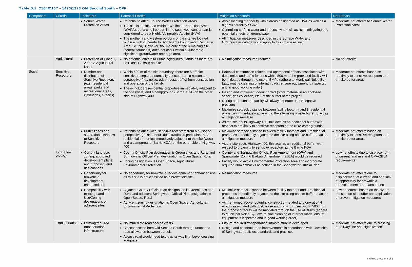
Table D.1 C164/C107 – 1473/1273 Old Second South – OPF
Table D.1 Page 4 of 6
Component Criteria Indicators Potential Effects Mitigation Measures Net Effects • Source Water
Protection Areas • Potential to affect Source Water Protection Areas • The site is not located within a Wellhead Protection Area
(WHPA), but a small portion in the southwest central part is considered to be a Highly Vulnerable Aquifer (HVA)
• The northern and western portions of the site are located within a high vulnerability Significant Groundwater Recharge Area (SGRA). However, the majority of the remaining site (central/southeast) does not occur within a vulnerable significant groundwater recharge area.
• Avoid locating the facility within areas designated as HVA as well as a high vulnerability SGRA
• Controlling surface water and process water will assist in mitigating any potential effects on groundwater
• All mitigation measures described in the Surface Water and Groundwater criteria would apply to this criteria as well
• Moderate net effects to Source Water Protection Areas
Agricultural • Protection of Class 1, 2 and 3 Agricultural Lands
• No potential effects to Prime Agricultural Lands as there are no Class 1-3 soils on-site
• No mitigation measures required • No net effects
Social Sensitive Receptors
• Number and distribution of Sensitive Receptors (e.g., residential areas, parks and recreational areas, institutions, airports)
• Within 500 m of the site boundary, there are 5 off-site sensitive receptors potentially affected from a nuisance perspective (i.e., noise, odour, dust, traffic) from construction and operation of the facility
• These include 3 residential properties immediately adjacent to the site (west) and a campground (Barrie KOA) on the other side of Highway 400
• Potential construction-related and operational effects associated with dust, noise and traffic for uses within 500 m of the proposed facility will be mitigated through the use of BMPs (adhere to Municipal Noise By-Law, routine cleaning of internal roads, ensure equipment is inspected and in good working order)
• Design and implement odour control (store material in an enclosed space, gas collection, etc.) at the outset of the project
• During operation, the facility will always operate under negative pressure
• Maximize setback distance between facility footprint and 3 residential properties immediately adjacent to the site using on-site buffer to act as a mitigation measure
• As the site abuts Highway 400, this acts as an additional buffer with respect to proximity to sensitive receptors at the KOA campgrounds
• Moderate net effects based on proximity to sensitive receptors and on-site buffer areas
• Buffer zones and separation distances to Sensitive Receptors
• Potential to affect local sensitive receptors from a nuisance perspective (noise, odour, dust, traffic), in particular, the 3 residential properties immediately adjacent to the site (west) and a campground (Barrie KOA) on the other side of Highway 400
• Maximize setback distance between facility footprint and 3 residential properties immediately adjacent to the site using on-site buffer to act as a mitigation measure
• As the site abuts Highway 400, this acts as an additional buffer with respect to proximity to sensitive receptors at the Barrie KOA
• Moderate net effects based on proximity to sensitive receptors and on-site buffer areas
Land Use/ Zoning
• Current land use, zoning, approved development plans, and proposed land use changes
• County Official Plan designation is Greenlands and Rural and Springwater Official Plan designation is Open Space, Rural
• Zoning designation is Open Space, Agricultural, Environmental Protection
• County and Springwater Official Plan Amendment (OPA) and Springwater Zoning By-Law Amendment (ZBLA) would be required
• Facility would avoid Environmental Protection Area and incorporate required 30m setbacks as defined in the Springwater Official Plan
• Low net effects due to displacement of current land use and OPA/ZBLA requirements
• Opportunity for brownfield development, enhanced use
• No opportunity for brownfield redevelopment or enhanced use as this site is not classified as a brownfield site
• No mitigation measures • Moderate net effects due to displacement of current land and lack of opportunity for brownfield redevelopment or enhanced use
• Compatibility with existing Land Use/Zoning designations on adjacent sites
• Adjacent County Official Plan designation is Greenlands and Rural and adjacent Springwater Official Plan designation is Open Space, Rural
• Adjacent zoning designation is Open Space, Agricultural, Environmental Protection
• Maximize setback distance between facility footprint and 3 residential properties immediately adjacent to the site using on-site buffer to act as a mitigation measure
• As mentioned above, potential construction-related and operational effects associated with dust, noise and traffic for uses within 500 m of the proposed facility will be mitigated through the use of BMPs (adhere to Municipal Noise By-Law, routine cleaning of internal roads, ensure equipment is inspected and in good working order)
• Low net effects based on the size of the site, on-site buffer and application of proven mitigation measures
Transportation • Existing/required transportation infrastructure
• No immediate road access exists • Closest access from Old Second South through unopened
road allowance between parcels • Access road would need to cross railway line. Level crossing
adequate.
• Ensure required transportation infrastructure is developed • Design and construct road improvements in accordance with Township
of Springwater policies, standards and practices
• Moderate net effects due to crossing of railway line and signalization

Table D.1 C164/C107 – 1473/1273 Old Second South – OPF
Table D.1 Page 5 of 6
Component Criteria Indicators Potential Effects Mitigation Measures Net Effects • Signalization will be required at the railway crossing
• Neighbourhood traffic impacts
• Moderate existing traffic volume on Old Second South • Potential to increase traffic on local roads within close
proximity to established neighbourhoods and sensitive receptors
• Ensure required infrastructure is incorporated (i.e. signalization) • Design and construct road improvements/signalization in accordance
with Township of Springwater and CN policies, standards and practices • Define local traffic routing within the local neighbourhood to a avoid
impacts
• Moderate net effects due to the increase in local traffic
Visual • Buffer zones and visual screening
• Potential effects are limited as the site is well screened by existing vegetation, topography, Highway 400 and CN railway
• Vegetation to be planted around the facility to act as a secondary buffer • Low net effects as installation of visual screening would obscure views of the facility from surrounding areas
Cultural Archaeological • Archaeologically significant areas
• No known archaeological sites on or adjacent to the site • Confirmation through appropriate further study (i.e., Stage 1 Archaeological Assessment) will be completed on the preferred site
• Should further study reveal archaeological potential, those areas should be avoided
• Low net effects until confirmation is provided through further study
Heritage • Areas of important cultural heritage
• No known cultural heritage sites (built or landscape) on or adjacent to the site
• Confirmation through appropriate further study (i.e. Cultural Heritage Assessment) will be completed on the preferred site
• No net effects until confirmation is provided through further study
Technical Permitting/ Approvals
• Feasibility and complexity of permitting/approvals
• County and Springwater OPA and Springwater ZBLA are required
• Potential for permit from Conservation Authority • Accompanying studies (i.e., traffic) required • Environmental Compliance Approvals (ECA) required
• Siting work completed will assist in demonstrating the planning rationale for the proposed amendments
• ECA studies will demonstrate how effects will be mitigated and managed
• Low net effects based on approval(s) required
Safety • Potential safety risks • Access road to cross railway line (level crossing) • Some walking trails through the site • Potential for spills, fire, and other emergencies
• Ensure required infrastructure is incorporated (i.e., signalization) • Restrict access to facility from adjacent trails via fencing and signage • Develop a Health and Safety Plan and an Emergency Management
Plan
• Moderate safety risks due to railway crossing
Utilities and Services
• Availability and distance from utilities and services
• No sanitary sewer in vicinity of site • No municipal water supply in vicinity of site • No gas supply line in vicinity of site • Hydro line on Old Second South
• Construction and implementation of required services/utilities • High net effects as availability and distance from existing utilities and services is minimal
Suitability • Meets minimum size requirements
• 91 hectares • No mitigation measures required • No net effects
• Within search area • Site is within search area for the OPF • No mitigation measures required • No net effects • Site layout,
topography and soil conditions
• High potential constraints on all sides of the site, including the railway, Highway 400, watercourses and Source Protection Areas
• Increase setback distances from constraints to increase buffer distances
• Low net effects as majority of the site is able to accommodate the facility with significant setbacks and buffer distances
• Compatibility with existing infrastructure
• No potential for utility conflicts due to lack of existing utilities • Potential conflicts with the railway line running adjacent to
west side of site
• Construction and implementation of required services/utilities • Signalization required
• Low net effects, as no relocation of existing utilities is required
Flexibility • Design/operational flexibility provided by site
• Site is highly constrained on all sides of the site, including the railway, Highway 400, watercourses and Source Protection Areas
• No mitigation measures required • Moderate positive net effects as the site has the ability to accommodate design and operational flexibility
• Surplus lands for expansion
• Site provides for expansion, but in a limited area of the site given the constraints
• No mitigation measures required • Moderate positive net effects as the site has the ability to accommodate expansion
Economic Capital Costs • Property acquisition • No costs for property acquisition as property is owned by the County
• No mitigation measures required • No cost

Table D.1 C164/C107 – 1473/1273 Old Second South – OPF
Table D.1 Page 6 of 6
Component Criteria Indicators Potential Effects Mitigation Measures Net Effects • Infrastructure • Establish road access, potentially through unopened road
allowance to Old Second South • Access road would need to cross railway line (level crossing) • Signalization required at railway • Turning lanes • Queuing lanes • Hydro on Old Second South
• No mitigation measures required • Moderate infrastructure costs
• Design • No significant impacts to design expected • No mitigation measures required • Low design costs • Construction • Clear vegetation
• Minor site grading • Access road • Rail crossing
• No mitigation measures required • Moderate construction costs
• Permits/approvals • Within Oro Moraine, however there are no policies on the Oro Moraine within local Official Plan/ Zoning By-Law
• Potential for permit from Conservation Authority
• No mitigation measures required • Moderate additional permits/ approvals costs and complexity
• Site remediation • No known areas requiring remediation on-site • No mitigation measures required • Low costs Operation and Maintenance Costs
• Facility operation and maintenance
• No additional costs anticipated • No mitigation measures required • Low costs associated with operation and maintenance
• Transportation from feedstock sources
• Approximately 7 kilometres from waste centroid • No mitigation measures required • Low costs associated with transportation from feedstock sources
• Transportation to markets and end users
• Potential agricultural users nearby • Close to highway access for material processing and disposal
• No mitigation measures required • Low costs associated with transportation to markets and end users
• Monitoring requirements
• Increased surface water monitoring due to proximity to regulated areas (surface water features)
• Increased groundwater monitoring due to proximity to WHPA, HVA designations
• No mitigation measures required • Moderate costs associated with monitoring requirements
• Mitigation requirements
• Natural screening mechanisms (e.g., topography, vegetation, significant buffer) already in place for odour, noise, visual
• Protection of Source Protection Areas and watercourses
• No mitigation measures required • Moderate costs associated with mitigation requirements
Legal Land Acquisition
• Land acquisition complexity, risk, liability
• County-owned property • May need to compensate nearby residential properties and
businesses • Road allowance
• Mitigation through compensation • Moderate complexity, risk and liability
Agreement • Structure and complexity of operating agreement
• No added complexity expected • Mitigation through agreement structure • Low complexity

Table D.2 C164/C107 – 1473/1273 Old Second South – MMF
Table D.2 Page 1 of 6
Component Criteria Indicators Potential Effects Mitigation Measures Net Effects Environmental Air Quality • Wind speed &
direction • Mean wind speed of 4.02 metres per second (m/s)
predominately coming from a northwesterly direction • Dust, particulate matter from construction/operation • Off-gases construction/operation
• As the site has a varied topography, with predominantly forested areas, minimal mitigation measures through design and Best Management Practices (BMPs) during construction/ operation will be required
• BMPs may include planting in key areas after construction, dust suppression, ensuring construction and operation equipment are inspected and in good working condition
• With the implementation of BMPs, no off-site receptors affected
• Proximity to sensitive receptors
• Within 500 metres (m) of the site boundary, there are 5 off-site receptors potentially affected by dust and particulate matter from construction and operation of the facility
• These include 3 residential properties immediately adjacent to the site (west) and a campground (Barrie KOA) on the other side of Highway 400
• Design and implement dust control (routine cleaning of internal paved roads)
• Maximize setback distance between facility footprint and sensitive receptors immediately adjacent to the site using on-site buffer to act as a mitigation measure (reduce levels of dust, particulate matter, before reaching the property line)
• As the site abuts Highway 400, this acts as an additional buffer with respect to proximity to sensitive receptors at the Barrie KOA
• Proper management of air quality controls • Implement BMPs to ensure dust generation is minimized
• No off-site receptors affected based on mitigation measures implemented for 5 receptors
• Species of Special Concern, Threatened, and/or Endangered
• Potential species at risk (SAR) based on available habitat, as identified by MNRF Management Biologist, include: Butternut (END), Little Brown Bat (END), Northern Long-eared Bat (END), Whip-poor-will (THR), Eastern Wood-Pewee (SC), Golden-winged Warbler (SC)
• There are records of SAR species on the property, including Snapping Turtle, Milksnake, Red-shouldered Hawk and an unspecified sensitive species. Not all SAR records are dated; however, the Snapping Turtle is identified to be a recent record (2009).
• Avoidance of any SAR or SAR habitat when siting the facility • Confirmation that SAR are not present will be determined if this site is
carried forward as the preferred and additional mitigation measures/BMPs will be established. In addition, a scoped EIS would be undertaken.
• Low net effects as there is the potential for Species of Special Concern, Threatened, and/or Endangered based on preliminary review and recent records
Odour • Wind speed & direction
• Mean wind speed of 4.02 m/s predominately coming from a northwesterly direction
• Off-gases construction/operation
• As the site has a varied topography, with predominantly forested areas, minimal mitigation measures through design and BMPs during construction/ operation will be required
• BMPs may include planting in key areas after construction, dust suppression, ensuring construction and operation equipment are inspected and in good working condition
• Implement BMPs to ensure odour is minimized
• With the implementation of appropriate odour control design and BMPs, no off-site receptors affected
• Proximity to sensitive receptors
• Within 500 m of the site boundary, there are 5 off-site receptors potentially affected by odours from the facility
• These include 3 residential properties immediately adjacent to the site (west) and a campground (Barrie KOA) on the other side of Highway 400
• Design and implement odour control (store material in an enclosed space, gas collection, etc.) at the outset of the project
• During operation, the facility will always operate under negative pressure
• Maximize setback distance between facility footprint and sensitive receptors immediately adjacent to the site using on-site buffer to act as a mitigation measure (reduce odour units before reaching the property line)
• Implement BMPs to ensure odour from facility is minimized
• No off-site receptors affected based on mitigation measures implemented for 5 receptors

Table D.2 C164/C107 – 1473/1273 Old Second South – MMF
Table D.2 Page 2 of 6
Component Criteria Indicators Potential Effects Mitigation Measures Net Effects Noise • Proximity to sensitive
receptors • Within 500 m of the site boundary, there are 5 off-site
receptors potentially affected by noise from the construction and operation of the facility
• These include 3 residential properties immediately adjacent to the site (west) and a campground (Barrie KOA) on the other side of Highway 400
• Adhere to existing MOECC noise restrictions as well as additional noise limits imposed through the ECA
• During construction, adhere to County Noise By-Law • Design and implement noise control measures at the outset of the
project • Maintenance to keep haul trucks in good condition • Maximize setback distance between facility footprint and sensitive
receptors immediately adjacent to the site using on-site buffer to act as a mitigation measure (reduce level of noise/sound before reaching the property line)
• Implement noise BMP plan • During operation, adhere to Municipal Noise By-Law
• No off-site receptors affected based on mitigation measures implemented for 5 receptors
Terrestrial • Topography • Due to the varied topography with the peak sloping toward the southwest, there is a greater potential to alter natural drainage patterns, particularly as two surface water features flow through the southern portion of the property
• Minimize alterations to existing topography • Setback facility from slope • Setback facility from surface water features • Minimize surface water flow into creeks through design (conveyance)
• Moderate net effects on topography as it relates to natural environment (natural drainage patterns)
• Soil type • Overburden consists primarily of glaciofluvial ice-contact stratified deposits comprised of sand or gravelly sand to the northern portion of the site
• Overburden consists primarily of glaciolacustrine very fine to medium grained sand, silt, minor clay in the western portion, and glaciofluvial ice-contact stratified deposits comprised of sand or gravelly sand in the southern/eastern part
• The higher topographic central/southern area consists of stony silty sand to sand till
• Overburden beneath the proposed site is greater than 107 m (350 feet) thick
• Surface water controls will be put in place to manage run-off from impervious surfaces (buildings/internal road, etc.)
• All materials accepted on-site will be within an enclosed building, with limited potential for runoff to occur
• All process water will be contained, collected and treated, either on-site or trucked off-site
• BMPs during construction will be implemented to limit potential impacts to soils and groundwater. This includes emergency management, accidental spills and containment techniques.
• Confirmation of soil types to occur should this be the preferred site
• No effects on groundwater
• Affected Greenlands • Effects to lands designated as Greenlands (approved in the County Official Plan and pending approval in the revised County Official Plan)
• No effects to Areas of Natural Scientific Interest (ANSI) • Significant portion of the site is forested with conifer
plantations. Older growth on northern portion, new plantings on southern portion.
• Limited open areas with little to no vegetation – majority of treed area appears to be plantation style plantings
• Most of the property is identified as woodland on NHIC mapping
• Infrastructure not subject to the environmental assessment process may be permitted within the Greenlands Designation or on adjacent lands in accordance with development and site alteration policies within the County Official Plan (Section 3.3.15)
• A scoped EIS would be undertaken as per the Official Plan requirements to develop infrastructure within the County Greenlands designation
• Avoid areas of significant/dense vegetation • Avoid old growth in the northern portion • Compensate for tree removal at a minimum on a 1:1 ratio – either on-
site or on another County owned property in close proximity
• Low effects to lands designated as Greenlands as an EIS is required. Completing the EIS will demonstrate through further analysis and investigation, as well as more detailed mitigation measures, the most appropriate location of the facility footprint on the site. This net effect would be lowered to “No” once a facility footprint location is determined as the EIS would demonstrate that there will be no negative impacts on natural features and areas and ecological functions of the County or local natural heritage system, and meet the requirements of Section 3.3.15 of the County Official Plan.
• No effects to ANSI’s • Moderate effects to existing
vegetation on-site as removal will be required for the facility
• Niagara Escarpment Land Use
• Not within the Niagara Escarpment Land Use policy area • No mitigation measures required • No net effects
• Oak Ridges Moraine Land Use
• Not within the Oak Ridges Moraine Land Use policy area • No mitigation measures required • No net effects

Table D.2 C164/C107 – 1473/1273 Old Second South – MMF
Table D.2 Page 3 of 6
Component Criteria Indicators Potential Effects Mitigation Measures Net Effects • Species of Special
Concern, Threatened, and/or Endangered
• Potential species at risk (SAR) based on available habitat, as identified by MNRF Management Biologist, include: Butternut (END), Little Brown Bat (END), Northern Long-eared Bat (END), Whip-poor-will (THR), Eastern Wood-Pewee (SC), Golden-winged Warbler (SC)
• There are records of SAR species on the property, including Snapping Turtle, Milksnake, Red-shouldered Hawk and an unspecified sensitive species. Not all SAR records are dated; however, the Snapping Turtle is identified to be a recent record (2009).
• Avoidance of any SAR or SAR habitat when siting the facility • Confirmation that SAR are not present will be determined if this site is
carried forward as the preferred and additional mitigation measures/BMPs will be established. In addition, a scoped EIS would be undertaken.
• Low net effects as there is the potential for Species of Special Concern, Threatened, and/or Endangered based on preliminary review and recent records
Aquatic • Species of Special Concern, Threatened, and/or Endangered
• No aquatic SAR listed as potentially occurring at this site • Two branches of a tributary located in the southern portion of
the site are evident, however no SAR are listed as being associated with creeks
• Implement appropriate setbacks from the two creeks and non-evaluated wetlands
• Surface water controls will ensure no effects occur to the tributary located off-site
• No aquatic SAR listed as occurring at this site
• No net effects as there are no aquatic SAR listed as occurring at this site
Surface Water • Wetlands, Floodplains and Water Bodies
• Potential to affect 2 watercourses and 4 unevaluated wetlands in the southern portion of the site and a watercourse running through northern tip of site
• Potential to affect these drainage features, (which are regulated by the NVCA) and are associated flooding and erosion concerns
• Implement appropriate setbacks from the two surface water features and non-evaluated wetlands (minimum 30 m as per Official Plan and MNRF guidelines)
• Further study required on the non-evaluated wetlands (OWES) • Facility will be designed to meet 100-year storm event • Surface water controls will be put in place to manage run-off from
impervious surfaces (buildings/internal road, etc.) and direct them away from natural drainage features.
• All materials accepted on-site will be within an enclosed receiving building, with limited potential for runoff to occur
• All process water will be contained, collected and treated, either on-site or trucked off-site
• BMPs during construction will be implemented to limit potential impacts to surface water. This includes erosion and sediment controls, emergency management, accidental spills and containment techniques.
• Moderate effects to surface water features in the southern portion of the site
Groundwater • Groundwater depth • Overburden consists primarily of glaciofluvial ice-contact stratified deposits comprised of sand or gravelly sand to the northern portion of the site
• Overburden consists primarily of glaciolacustrine very fine to medium grained sand, silt, minor clay in the western portion, and glaciofluvial ice-contact stratified deposits comprised of sand or gravelly sand in the southern/eastern part
• The higher topographic central/southern area consists of stony silty sand to sand till
• Overburden beneath the proposed site is greater than 107 m (350 feet) thick
• Controlling surface water and process water will assist in mitigating any potential effects on groundwater
• Surface water controls will be put in place to manage run-off from impervious surfaces (buildings/internal road, etc.).
• All materials accepted on-site will be within an enclosed building, with limited potential for runoff to occur
• All process water will be contained, collected and treated, either on-site or trucked off-site
• BMPs during construction will be implemented to limit potential impacts to surface water. This includes erosion and sediment controls, emergency management, accidental spills and containment techniques.
• No net effects, based on the groundwater depth and the surface water management on-site
• Groundwater flow and direction
• The direction of shallow groundwater flow within the overburden is interpreted to occur in a general westerly to southwesterly direction towards the on-site stream, with a component to the west/northwest also
• The sandy or gravelly sand nature of the overburden in the northern portion suggests that the rate of groundwater movement would be moderate to high
• Silty sand to sand till overburden in the central/southern portion suggests that the rate of groundwater movement would be somewhat low
• No alterations to flow and direction are anticipated as part of the design of the facility
• Controlling surface water and process water will assist in mitigating any potential effects on groundwater
• No net effects as no alterations to flow and direction of groundwater are anticipated as part of the design of the facility

Table D.2 C164/C107 – 1473/1273 Old Second South – MMF
Table D.2 Page 4 of 6
Component Criteria Indicators Potential Effects Mitigation Measures Net Effects • Source Water
Protection Areas • Potential to affect Source Water Protection Areas • The site is not located within a Wellhead Protection Area
(WHPA), but a small portion in the southwest central part is considered to be a Highly Vulnerable Aquifer (HVA)
• The northern and western portions of the site are located within a high vulnerability Significant Groundwater Recharge Area (SGRA). However, the majority of the remaining site (central/southeast) does not occur within a vulnerable significant groundwater recharge area
• Avoid locating the facility within areas designated as HVA as well as a high vulnerability SGRA
• Controlling surface water and process water will assist in mitigating any potential effects on groundwater
• All mitigation measures described in the Surface Water and Groundwater criteria would apply to this criteria as well
• Moderate net effects to Source Water Protection Areas
Agricultural • Protection of Class 1, 2 and 3 Agricultural Lands
• No potential effects to Prime Agricultural Lands as there are no Class 1-3 soils on-site
• No mitigation measures required • No net effects
Social Sensitive Receptors
• Number and distribution of Sensitive Receptors (e.g., residential areas, parks and recreational areas, institutions, airports)
• Within 500 m of the site boundary, there are 5 off-site sensitive receptors potentially affected from a nuisance perspective (i.e. noise, odour, dust, traffic) from construction and operation of the facility
• These include 3 residential properties immediately adjacent to the site (west) and a campground (Barrie KOA) on the other side of Highway 400
• Potential construction-related and operational effects associated with dust, noise and traffic for uses within 500 m of the proposed facility will be mitigated through the use of BMPs (adhere to Municipal Noise By-Law, routine cleaning of internal roads, ensure equipment is inspected and in good working order)
• Design and implement odour control (store material in an enclosed space, gas collection, etc.) at the outset of the project
• During operation, the facility will always operate under negative pressure
• Maximize setback distance between facility footprint and 3 residential properties immediately adjacent to the site using on-site buffer to act as a mitigation measure
• As the site abuts Highway 400, this acts as an additional buffer with respect to proximity to sensitive receptors at the Barrie KOA
• Moderate net effects based on proximity to sensitive receptors and on-site buffer areas
• Buffer zones and separation distances to Sensitive Receptors
• Potential to affect local sensitive receptors from a nuisance perspective (noise, odour, dust, traffic), in particular, the 3 residential properties immediately adjacent to the site (west) and a campground (Barrie KOA) on the other side of Highway 400
• Maximize setback distance between facility footprint and 3 residential properties immediately adjacent to the site using on-site buffer to act as a mitigation measure
• As the site abuts Highway 400, this acts as an additional buffer with respect to proximity to sensitive receptors at the Barrie KOA
• Moderate net effects based on proximity to sensitive receptors and on-site buffer areas
Land Use/ Zoning
• Current land use, zoning, approved development plans, and proposed land use changes
• County Official Plan designation is Greenlands and Rural and Springwater Official Plan designation is Open Space, Rural
• Zoning designation is Open Space, Agricultural, Environmental Protection
• County and Springwater Official Plan Amendment (OPA) and Springwater Zoning By-Law Amendment (ZBLA) would be required
• Facility would avoid Environmental Protection Area and incorporate required 30m setbacks as defined in the Springwater Official Plan
• Low net effects due to displacement of current land use and OPA/ZBLA requirements
• Opportunity for brownfield development, enhanced use
• No opportunity for brownfield redevelopment or enhanced use as this site is not classified as a brownfield site
• No mitigation measures • Moderate net effects due to displacement of current land and lack of opportunity for brownfield redevelopment or enhanced use
• Compatibility with existing Land Use/Zoning designations on adjacent sites
• Adjacent County Official Plan designation is Greenlands and Rural and adjacent Springwater Official Plan designation is Open Space, Rural
• Adjacent zoning designation is Open Space, Agricultural, Environmental Protection
• Maximize setback distance between facility footprint and 3 residential properties immediately adjacent to the site using on-site buffer to act as a mitigation measure
• As mentioned above, potential construction-related and operational effects associated with dust, noise and traffic for uses within 500 m of the proposed facility will be mitigated through the use of BMPs (adhere to Municipal Noise By-Law, routine cleaning of internal roads, ensure equipment is inspected and in good working order)
• Low net effects based on the size of the site, on-site buffer and application of proven mitigation measures
Transportation • Existing/required transportation infrastructure
• No immediate road access exists • Closest access from Old Second South through unopened
road allowance between parcels • Access road would need to cross railway line. Grade-
separated crossing likely required
• Ensure required transportation infrastructure is developed • Design and construct road improvements in accordance with Township
of Springwater policies, standards and practices
• High net effects due to crossing of railway line and signalization

Table D.2 C164/C107 – 1473/1273 Old Second South – MMF
Table D.2 Page 5 of 6
Component Criteria Indicators Potential Effects Mitigation Measures Net Effects
• Neighbourhood traffic impacts
• Moderate existing traffic volume on Old Second South • Potential to increase traffic on local roads within close
proximity to established neighbourhoods and sensitive receptors
• Potential for increased congestion as a result of increased vehicle volume backing up at railway crossing as tracks would need to be crossed twice
• Ensure required infrastructure is incorporated (i.e. signalization) • Design and construct road improvements/signalization in accordance
with Township of Springwater and CN policies, standards and practices • Define local traffic routing within the local neighbourhood to a avoid
impacts
• High net effects due to the increase in local traffic and congestion as a result of railway crossing
Visual • Buffer zones and visual screening
• Potential effects are limited as the site is well screened by existing vegetation, topography, Highway 400 and CN railway
• Vegetation to be planted around the facility to act as a secondary buffer • Low net effects as installation of visual screening would obscure views of the facility from surrounding areas
Cultural Archaeological • Archaeologically significant areas
• No known archaeological sites on or adjacent to the site • Confirmation through appropriate further study (i.e., Stage 1 Archaeological Assessment) will be completed on the preferred site
• Should further study reveal archaeological potential, those areas should be avoided
• Low net effects until confirmation is provided through further study
Heritage • Areas of important cultural heritage
• No known cultural heritage sites (built or landscape) on or adjacent to the site
• Confirmation through appropriate further study (i.e. Cultural Heritage Assessment) will be completed on the preferred site
• No net effects until confirmation is provided through further study
Technical Permitting/ Approvals
• Feasibility and complexity of permitting/approvals
• County and Springwater OPA and Springwater ZBLA are required
• Potential for permit from Conservation Authority • Accompanying studies (i.e., traffic) required • Environmental Compliance Approvals (ECA) required
• Siting work completed will assist in demonstrating the planning rationale for the proposed amendments
• ECA studies will demonstrate how effects will be mitigated and managed
• Low net effects based on approval(s) required
Safety • Potential safety risks • Access road would need to cross railway line, likely via grade-separated crossing
• Some walking trails through the site • Potential for spills, fire, and other emergencies
• Ensure required transportation infrastructure is developed • Restrict access to facility from adjacent trails via fencing and signage • Develop a Health and Safety Plan and an Emergency Management
Plan
• Moderate safety risks
Utilities and Services
• Availability and distance from utilities and services
• No sanitary sewer in vicinity of site • No municipal water supply in vicinity of site • No gas supply line in vicinity of site • Hydro line on Old Second South
• Construction and implementation of required services/utilities • High net effects as availability and distance from existing utilities and services is minimal
Suitability • Meets minimum size requirements
• 91 hectares • No mitigation measures required • No net effects
• Within search area • Site is within search area for the MMF • No mitigation measures required • No net effects • Site layout,
topography and soil conditions
• High potential constraints on all sides of the site, including the railway, Highway 400, watercourses and Source Protection Areas
• Increase setback distances from constraints to increase buffer distances
• Low net effects as majority of the site is able to accommodate the facility with significant setbacks and buffer distances
• Compatibility with existing infrastructure
• No potential for utility conflicts due to lack of existing utilities • Potential conflicts with the railway line running adjacent to
west side of site
• Construction and implementation of required services/utilities • Potential signalization required
• Low net effects, as no relocation of existing utilities is required
Flexibility • Design/operational flexibility provided by site
• Site is highly constrained on all sides of the site, including the railway, Highway 400, watercourses and Source Protection Areas
• No mitigation measures required • Moderate positive net effects as the site has the ability to accommodate design and operational flexibility
• Surplus lands for expansion
• Site provides for expansion, but in a limited area of the site given the constraints
• No mitigation measures required • Moderate positive net effects as the site has the ability to accommodate expansion
Economic Capital Costs • Property acquisition • No costs for property acquisition as property is owned by the County
• No mitigation measures required • No cost

Table D.2 C164/C107 – 1473/1273 Old Second South – MMF
Table D.2 Page 6 of 6
Component Criteria Indicators Potential Effects Mitigation Measures Net Effects • Infrastructure • Establish road access, potentially through unopened road
allowance to Old Second South • Access road would need to cross railway line (bridge or
tunnel) • Signalization required at railway and Old Second South • Turning lanes • Queuing lanes • Hydro on Old Second South
• No mitigation measures required • High infrastructure costs
• Design • No significant impacts to design expected • No mitigation measures required • Low design costs • Construction • Clear vegetation
• Minor site grading • Access road • Rail crossing
• No mitigation measures required • Moderate construction costs
• Permits/approvals • Within Oro Moraine however there are no policies on the Oro Moraine within local Official Plan/ Zoning By-Law
• Potential for permit from Conservation Authority
• No mitigation measures required • Moderate additional permits/ approvals costs and complexity
• Site remediation • No known areas requiring remediation on-site • No mitigation measures required • Low costs Operation and Maintenance Costs
• Facility operation and maintenance
• Delays at railway crossing • No mitigation measures required • Moderate costs associated with operation and maintenance
• Transportation from feedstock sources
• Approximately 7 kilometres from waste centroid • No mitigation measures required • Low costs associated with transportation from feedstock sources
• Transportation to markets and end users
• Potential agricultural users nearby • Close to highway access for material processing and disposal
• No mitigation measures required • Low costs associated with transportation to markets and end users
• Monitoring requirements
• Increased surface water monitoring due to proximity to regulated areas (surface water features)
• Increased groundwater monitoring due to proximity to WHPA, HVA designations
• No mitigation measures required • Moderate costs associated with monitoring requirements
• Mitigation requirements
• Natural screening mechanisms (e.g., topography, vegetation, significant buffer) already in place for odour, noise, visual
• Protection of Source Protection Areas and watercourses • Noise mitigation along Old Second South and site access
road
• No mitigation measures required • High costs associated with mitigation requirements
Legal Land Acquisition
• Land acquisition complexity, risk, liability
• County-owned property • May need to compensate nearby residential properties and
businesses • Road allowance
• Mitigation through compensation • Moderate complexity, risk and liability
Agreement • Structure and complexity of operating agreement
• No added complexity expected • Mitigation through agreement structure • Low complexity

Table D.3 C164/C107 – 1473/1273 Old Second South – Co-Located Facility
Table D.3 Page 1 of 6
Component Criteria Indicators Potential Effects Mitigation Measures Net Effects Environmental Air Quality • Wind speed &
direction • Mean wind speed of 4.02 metres per second (m/s)
predominately coming from a northwesterly direction • Dust, particulate matter from construction/operation • Off-gases construction/operation
• As the site has a varied topography, with predominantly forested areas, minimal mitigation measures through design and Best Management Practices (BMPs) during construction/ operation will be required
• BMPs may include planting in key areas after construction, dust suppression, ensuring construction and operation equipment are inspected and in good working condition
• With the implementation of BMPs, no off-site receptors affected
• Proximity to sensitive receptors
• Within 500 metres (m) of the site boundary, there are 5 off-site receptors potentially affected by dust and particulate matter from construction and operation of the facility
• These include 3 residential properties immediately adjacent to the site (west) and a campground (Barrie KOA) on the other side of Highway 400
• Design and implement dust control (routine cleaning of internal paved roads)
• Maximize setback distance between facility footprint and sensitive receptors immediately adjacent to the site using on-site buffer to act as a mitigation measure (reduce levels of dust, particulate matter, before reaching the property line)
• As the site abuts Highway 400, this acts as an additional buffer with respect to proximity to sensitive receptors at the Barrie KOA
• Proper management of air quality controls • Implement BMPs to ensure dust generation is minimized
• No off-site receptors affected based on mitigation measures implemented for 5 receptors
• Species of Special Concern, Threatened, and/or Endangered
• Potential species at risk (SAR) based on available habitat, as identified by MNRF Management Biologist, include: Butternut (END), Little Brown Bat (END), Northern Long-eared Bat (END), Whip-poor-will (THR), Eastern Wood-Pewee (SC), Golden-winged Warbler (SC)
• There are records of SAR species on the property, including Snapping Turtle, Milksnake, Red-shouldered Hawk and an unspecified sensitive species. Not all SAR records are dated; however, the Snapping Turtle is identified to be a recent record (2009).
• Avoidance of any SAR or SAR habitat when siting the facility • Confirmation that SAR are not present will be determined if this site is
carried forward as the preferred and additional mitigation measures/BMPs will be established. In addition, a scoped EIS would be undertaken.
• Low net effects as there is the potential for Species of Special Concern, Threatened, and/or Endangered based on preliminary review and recent records
Odour • Wind speed & direction
• Mean wind speed of 4.02 m/s predominately coming from a northwesterly direction
• Off-gases construction/operation
• As the site has a varied topography, with predominantly forested areas, minimal mitigation measures through design and BMPs during construction/ operation will be required
• BMPs may include planting in key areas after construction, dust suppression, ensuring construction and operation equipment are inspected and in good working condition
• Implement BMPs to ensure odour is minimized
• With the implementation of appropriate odour control design and BMPs, no off-site receptors affected
• Proximity to sensitive receptors
• Within 500 m of the site boundary, there are 5 off-site receptors potentially affected by odours from the facility
• These include 3 residential properties immediately adjacent to the site (west) and a campground (Barrie KOA) on the other side of Highway 400
• Design and implement odour control (store material in an enclosed space, gas collection, etc.) at the outset of the project
• During operation, the facility will always operate under negative pressure
• Maximize setback distance between facility footprint and sensitive receptors immediately adjacent to the site using on-site buffer to act as a mitigation measure (reduce odour units before reaching the property line)
• Implement BMPs to ensure odour from facility is minimized
• No off-site receptors affected based on mitigation measures implemented for 5 receptors

Table D.3 C164/C107 – 1473/1273 Old Second South – Co-Located Facility
Table D.3 Page 2 of 6
Component Criteria Indicators Potential Effects Mitigation Measures Net Effects Noise • Proximity to sensitive
receptors • Within 500 m of the site boundary, there are 5 off-site
receptors potentially affected by noise from the construction and operation of the facility
• These include 3 residential properties immediately adjacent to the site (west) and a campground (Barrie KOA) on the other side of Highway 400
• Adhere to existing MOECC noise restrictions as well as additional noise limits imposed through the ECA
• During construction, adhere to County Noise By-Law • Design and implement noise control measures at the outset of the
project • Maintenance to keep haul trucks in good condition • Maximize setback distance between facility footprint and sensitive
receptors immediately adjacent to the site using on-site buffer to act as a mitigation measure (reduce level of noise/sound before reaching the property line)
• Implement noise BMP plan • During operation, adhere to Municipal Noise By-Law
• No off-site receptors affected based on mitigation measures implemented for 5 receptors
Terrestrial • Topography • Due to the varied topography with the peak sloping toward the southwest, there is a greater potential to alter natural drainage patterns, particularly as two surface water features flow through the southern portion of the property
• Minimize alterations to existing topography • Setback facility from slope • Setback facility from surface water features • Minimize surface water flow into creeks through design (conveyance)
• Moderate net effects on topography as it relates to natural environment (natural drainage patterns)
• Soil type • Overburden consists primarily of glaciofluvial ice-contact stratified deposits comprised of sand or gravelly sand to the northern portion of the site
• Overburden consists primarily of glaciolacustrine very fine to medium grained sand, silt, minor clay in the western portion, and glaciofluvial ice-contact stratified deposits comprised of sand or gravelly sand in the southern/eastern part
• The higher topographic central/southern area consists of stony silty sand to sand till
• Overburden beneath the proposed site is greater than 107 m (350 feet) thick
• Surface water controls will be put in place to manage run-off from impervious surfaces (buildings/internal road, etc.)
• All materials accepted on-site will be within an enclosed building, with limited potential for runoff to occur
• All process water will be contained, collected and treated, either on-site or trucked off-site
• BMPs during construction will be implemented to limit potential impacts to soils and groundwater. This includes emergency management, accidental spills and containment techniques.
• Confirmation of soil types to occur should this be the preferred site
• No effects on groundwater
• Affected Greenlands • Effects to lands designated as Greenlands (approved in the County Official Plan and pending approval in the revised County Official Plan)
• No effects to Areas of Natural Scientific Interest (ANSI) • Significant portion of the site is forested with conifer
plantations. Older growth on northern portion, new plantings on southern portion.
• Limited open areas with little to no vegetation – majority of treed area appears to be plantation style plantings
• Most of the property is identified as woodland on NHIC mapping
• Infrastructure not subject to the environmental assessment process may be permitted within the Greenlands Designation or on adjacent lands in accordance with development and site alteration policies within the County Official Plan (Section 3.3.15)
• A scoped EIS would be undertaken as per the Official Plan requirements to develop infrastructure within the County Greenlands designation
• Avoid areas of significant/dense vegetation • Avoid old growth in the northern portion • Compensate for tree removal at a minimum on a 1:1 ratio – either on-
site or on another County owned property in close proximity
• Low effects to lands designated as Greenlands as an EIS is required. Completing the EIS will demonstrate through further analysis and investigation, as well as more detailed mitigation measures, the most appropriate location of the facility footprint on the site. This net effect would be lowered to “No” once a facility footprint location is determined as the EIS would demonstrate that there will be no negative impacts on natural features and areas and ecological functions of the County or local natural heritage system, and meet the requirements of Section 3.3.15 of the County Official Plan.
• No effects to ANSI’s • Moderate effects to existing
vegetation on-site as removal will be required for the facility
• Niagara Escarpment Land Use
• Not within the Niagara Escarpment Land Use policy area • No mitigation measures required • No net effects
• Oak Ridges Moraine Land Use
• Not within the Oak Ridges Moraine Land Use policy area • No mitigation measures required • No net effects

Table D.3 C164/C107 – 1473/1273 Old Second South – Co-Located Facility
Table D.3 Page 3 of 6
Component Criteria Indicators Potential Effects Mitigation Measures Net Effects • Species of Special
Concern, Threatened, and/or Endangered
• Potential species at risk (SAR) based on available habitat, as identified by MNRF Management Biologist, include: Butternut (END), Little Brown Bat (END), Northern Long-eared Bat (END), Whip-poor-will (THR), Eastern Wood-Pewee (SC), Golden-winged Warbler (SC)
• There are records of SAR species on the property, including Snapping Turtle, Milksnake, Red-shouldered Hawk and an unspecified sensitive species. Not all SAR records are dated; however, the Snapping Turtle is identified to be a recent record (2009).
• Avoidance of any SAR or SAR habitat when siting the facility • Confirmation that SAR are not present will be determined if this site is
carried forward as the preferred and additional mitigation measures/BMPs will be established. In addition, a scoped EIS would be undertaken.
• Low net effects as there is the potential for Species of Special Concern, Threatened, and/or Endangered based on preliminary review and recent records
Aquatic • Species of Special Concern, Threatened, and/or Endangered
• No aquatic SAR listed as potentially occurring at this site • Two branches of a tributary located in the southern portion of
the site are evident, however no SAR are listed as being associated with surface water features
• Implement appropriate setbacks from the two surface water features and non-evaluated wetlands (minimum 30 m as per Official Plan and MNRF guidelines)
• Surface water controls will ensure no effects occur to the tributary located off-site
• No aquatic SAR listed as occurring at this site
• No net effects as there are no aquatic SAR listed as occurring at this site
Surface Water • Wetlands, Floodplains and Water Bodies
• Potential to affect 2 watercourses and 4 unevaluated wetlands in the southern portion of the site and a watercourse running through northern tip of site
• Potential to affect these drainage features, (which are regulated by the NVCA) and are associated flooding and erosion concerns
• Implement appropriate setbacks from the two surface water features and non-evaluated wetlands (minimum 30 metres as per Official Plan and MNRF guidelines).
• Further study required on the non-evaluated wetlands (OWES) • Facility will be designed to meet 100-year storm event • Surface water controls will be put in place to manage run-off from
impervious surfaces (buildings/internal road, etc.) and direct them away from natural drainage features.
• All materials accepted on-site will be within an enclosed receiving building, with limited potential for runoff to occur
• All process water will be contained, collected and treated, either on-site or trucked off-site
• BMPs during construction will be implemented to limit potential impacts to surface water. This includes erosion and sediment controls, emergency management, accidental spills and containment techniques.
• Moderate effects to surface water features in the southern portion of the site
Groundwater • Groundwater depth • Overburden consists primarily of glaciofluvial ice-contact stratified deposits comprised of sand or gravelly sand to the northern portion of the site
• Overburden consists primarily of glaciolacustrine very fine to medium grained sand, silt, minor clay in the western portion, and glaciofluvial ice-contact stratified deposits comprised of sand or gravelly sand in the southern/eastern part
• The higher topographic central/southern area consists of stony silty sand to sand till
• Overburden beneath the proposed site is greater than 107 m (350 feet) thick
• Controlling surface water and process water will assist in mitigating any potential effects on groundwater
• Surface water controls will be put in place to manage run-off from impervious surfaces (buildings/internal road, etc.).
• All materials accepted on-site will be within an enclosed building, with limited potential for runoff to occur
• All process water will be contained, collected and treated, either on-site or trucked off-site
• BMPs during construction will be implemented to limit potential impacts to surface water. This includes erosion and sediment controls, emergency management, accidental spills and containment techniques.
• No net effects, based on the groundwater depth and the surface water management on-site
• Groundwater flow and direction
• The direction of shallow groundwater flow within the overburden is interpreted to occur in a general westerly to southwesterly direction towards the on-site stream, with a component to the west/northwest also
• The sandy or gravelly sand nature of the overburden in the northern portion suggests that the rate of groundwater movement would be moderate to high
• Silty sand to sand till overburden in the central/southern portion suggests that the rate of groundwater movement would be somewhat low
• No alterations to flow and direction are anticipated as part of the design of the facility
• Controlling surface water and process water will assist in mitigating any potential effects on groundwater
• No net effects as no alterations to flow and direction of groundwater are anticipated as part of the design of the facility

Table D.3 C164/C107 – 1473/1273 Old Second South – Co-Located Facility
Table D.3 Page 4 of 6
Component Criteria Indicators Potential Effects Mitigation Measures Net Effects • Source Water
Protection Areas • Potential to affect Source Water Protection Areas • The site is not located within a Wellhead Protection Area
(WHPA), but a small portion in the southwest central part is considered to be a Highly Vulnerable Aquifer (HVA)
• The northern and western portions of the site are located within a high vulnerability Significant Groundwater Recharge Area (SGRA). However, the majority of the remaining site (central/southeast) does not occur within a vulnerable significant groundwater recharge area.
• Avoid locating the facility within areas designated as HVA as well as a high vulnerability SGRA
• Controlling surface water and process water will assist in mitigating any potential effects on groundwater
• All mitigation measures described in the Surface Water and Groundwater criteria would apply to this criteria as well
• Moderate net effects to Source Water Protection Areas
Agricultural • Protection of Class 1, 2 and 3 Agricultural Lands
• No potential effects to Prime Agricultural Lands as there are no Class 1-3 soils on-site
• No mitigation measures required • No net effects
Social Sensitive Receptors
• Number and distribution of Sensitive Receptors (e.g., residential areas, parks and recreational areas, institutions, airports)
• Within 500 m of the site boundary, there are 5 off-site sensitive receptors potentially affected from a nuisance perspective (i.e. noise, odour, dust, traffic) from construction and operation of the facility
• These include 3 residential properties immediately adjacent to the site (west) and a campground (Barrie KOA) on the other side of Highway 400
• Potential construction-related and operational effects associated with dust, noise and traffic for uses within 500 m of the proposed facility will be mitigated through the use of BMPs (adhere to Municipal Noise By-Law, routine cleaning of internal roads, ensure equipment is inspected and in good working order)
• Design and implement odour control (store material in an enclosed space, gas collection, etc.) at the outset of the project
• During operation, the facility will always operate under negative pressure
• Maximize setback distance between facility footprint and 3 residential properties immediately adjacent to the site using on-site buffer to act as a mitigation measure
• As the site abuts Highway 400, this acts as an additional buffer with respect to proximity to sensitive receptors at the Barrie KOA
• Moderate net effects based on proximity to sensitive receptors and on-site buffer areas
• Buffer zones and separation distances to Sensitive Receptors
• Potential to affect local sensitive receptors from a nuisance perspective (noise, odour, dust, traffic), in particular, the 3 residential properties immediately adjacent to the site (west) and a campground (Barrie KOA) on the other side of Highway 400
• Maximize setback distance between facility footprint and 3 residential properties immediately adjacent to the site using on-site buffer to act as a mitigation measure
• As the site abuts Highway 400, this acts as an additional buffer with respect to proximity to sensitive receptors at the Barrie KOA
• Moderate net effects based on proximity to sensitive receptors and on-site buffer areas
Land Use/ Zoning
• Current land use, zoning, approved development plans, and proposed land use changes
• County Official Plan designation is Greenlands and Rural and Springwater Official Plan designation is Open Space, Rural
• Zoning designation is Open Space, Agricultural, Environmental Protection
• County and Springwater Official Plan Amendment (OPA) and Springwater Zoning By-Law Amendment (ZBLA) would be required
• Facility would avoid Environmental Protection Area and incorporate required 30m setbacks as defined in the Springwater Official Plan
• Low net effects due to displacement of current land use and OPA/ZBLA requirements
• Opportunity for brownfield development, enhanced use
• No opportunity for brownfield redevelopment or enhanced use as this site is not classified as a brownfield site
• No mitigation measures • Moderate net effects due to displacement of current land and lack of opportunity for brownfield redevelopment or enhanced use
• Compatibility with existing Land Use/Zoning designations on adjacent sites
• Adjacent County Official Plan designation is Greenlands and Rural and adjacent Springwater Official Plan designation is Open Space, Rural
• Adjacent zoning designation is Open Space, Agricultural, Environmental Protection
• Maximize setback distance between facility footprint and 3 residential properties immediately adjacent to the site using on-site buffer to act as a mitigation measure
• As mentioned above, potential construction-related and operational effects associated with dust, noise and traffic for uses within 500 m of the proposed facility will be mitigated through the use of BMPs (adhere to Municipal Noise By-Law, routine cleaning of internal roads, ensure equipment is inspected and in good working order)
• Low net effects based on the size of the site, on-site buffer and application of proven mitigation measures
Transportation • Existing/required transportation infrastructure
• No immediate road access exists • Closest access from Old Second South through unopened
road allowance between parcels • Access road would need to cross railway line likely through
grade-separated crossing
• Ensure required transportation infrastructure is developed • Design and construct road improvements in accordance with Township
of Springwater policies, standards and practices
• High net effects due to crossing of railway line and signalization

Table D.3 C164/C107 – 1473/1273 Old Second South – Co-Located Facility
Table D.3 Page 5 of 6
Component Criteria Indicators Potential Effects Mitigation Measures Net Effects • Neighbourhood traffic
impacts • Moderate existing traffic volume on Old Second South • Potential to increase traffic on local roads within close
proximity to established neighbourhoods and sensitive receptors
• Potential for increased congestion as a result of increased vehicle volume backing up at railway crossing as tracks would need to be crossed twice
• Ensure required infrastructure is incorporated (i.e. signalization) • Design and construct road improvements/signalization in accordance
with Township of Springwater and CN policies, standards and practices • Define local traffic routing within the local neighbourhood to a avoid
impacts
• High net effects due to the increase in local traffic and congestion as a result of railway crossing
Visual • Buffer zones and visual screening
• Potential effects are limited as the site is well screened by existing vegetation, topography, Highway 400 and CN railway
• Vegetation to be planted around the facility to act as a secondary buffer • Low net effects as installation of visual screening would obscure views of the facility from surrounding areas
Cultural Archaeological • Archaeologically significant areas
• No known archaeological sites on or adjacent to the site • Confirmation through appropriate further study (i.e., Stage 1 Archaeological Assessment) will be completed on the preferred site
• Should further study reveal archaeological potential, those areas should be avoided
• Low net effects until confirmation is provided through further study
Heritage • Areas of important cultural heritage
• No known cultural heritage sites (built or landscape) on or adjacent to the site
• Confirmation through appropriate further study (i.e. Cultural Heritage Assessment) will be completed on the preferred site
• No net effects until confirmation is provided through further study
Technical Permitting/ Approvals
• Feasibility and complexity of permitting/approvals
• County and Springwater OPA and Springwater ZBLA are required
• Potential for permit from Conservation Authority • Accompanying studies (i.e., traffic) required • Environmental Compliance Approvals (ECA) required
• Siting work completed will assist in demonstrating the planning rationale for the proposed amendments
• ECA studies will demonstrate how effects will be mitigated and managed
• Low net effects based on approval(s) required
Safety • Potential safety risks • Access road would need to cross railway line (bridge or tunnel)
• Some walking trails through the site • Potential for spills, fire, and other emergencies
• Ensure required transportation infrastructure is developed • Restrict access to facility from adjacent trails via fencing and signage • Develop a Health and Safety Plan and an Emergency Management
Plan
• Moderate safety risks associated with railway crossing
Utilities and Services
• Availability and distance from utilities and services
• No sanitary sewer in vicinity of site • No municipal water supply in vicinity of site • No gas supply line in vicinity of site • Hydro line on Old Second South
• Construction and implementation of required services/utilities • High net effects as availability and distance from existing utilities and services is minimal
Suitability • Meets minimum size requirements
• 91 hectares • No mitigation measures required • No net effects
• Within search area • Site is within search area for the OPF and MMF • No mitigation measures required • No net effects • Site layout,
topography and soil conditions
• High potential constraints on all sides of the site, including the railway, Highway 400, watercourses and Source Protection Areas
• Increase setback distances from constraints to increase buffer distances
• Low net effects as majority of the site is able to accommodate the facility with significant setbacks and buffer distances
• Compatibility with existing infrastructure
• No potential for utility conflicts due to lack of existing utilities • Potential conflicts with the railway line running adjacent to
west side of site
• Construction and implementation of required services/utilities • Potential signalization required
• Low net effects, as no relocation of existing utilities is required
Flexibility • Design/operational flexibility provided by site
• Site is highly constrained on all sides of the site, including the railway, Highway 400, watercourses and Source Protection Areas
• No mitigation measures required • Moderate positive net effects as the site has the ability to accommodate design and operational flexibility
• Surplus lands for expansion
• Site provides for expansion, but in a limited area of the site given the constraints
• No mitigation measures required • Moderate positive net effects as the site has the ability to accommodate expansion
Economic Capital Costs • Property acquisition • No costs for property acquisition as property is owned by the County
• No mitigation measures required • No cost

Table D.3 C164/C107 – 1473/1273 Old Second South – Co-Located Facility
Table D.3 Page 6 of 6
Component Criteria Indicators Potential Effects Mitigation Measures Net Effects • Infrastructure • Establish road access, potentially through unopened road
allowance to Old Second South • Access road would need to cross railway line (bridge or
tunnel) • Signalization required at railway and Old Second South • Turning lanes • Queuing lanes • Hydro on Old Second South
• No mitigation measures required • High infrastructure costs
• Design • No significant impacts to design expected • No mitigation measures required • Low design costs • Construction • Clear vegetation
• Minor site grading • Access road • Rail crossing
• No mitigation measures required • Moderate construction costs
• Permits/approvals • Within Oro Moraine, however there are no policies on the Oro Moraine within local Official Plan/ Zoning By-Law
• Potential for permit from Conservation Authority
• No mitigation measures required • Moderate additional permits/ approvals costs and complexity
• Site remediation • No known areas requiring remediation on-site • No mitigation measures required • Low costs Operation and Maintenance Costs
• Facility operation and maintenance
• Delays at railway crossing • No mitigation measures required • Moderate costs associated with operation and maintenance
• Transportation from feedstock sources
• Approximately 7 kilometres from waste centroid • No mitigation measures required • Low costs associated with transportation from feedstock sources
• Transportation to markets and end users
• Potential agricultural users nearby • Close to highway access for material processing and disposal
• No mitigation measures required • Low costs associated with transportation to markets and end users
• Monitoring requirements
• Increased surface water monitoring due to proximity to regulated areas (surface water features)
• Increased groundwater monitoring due to proximity to WHPA, HVA designations
• No mitigation measures required • Moderate costs associated with monitoring requirements
• Mitigation requirements
• Natural screening mechanisms (e.g., topography, vegetation, significant buffer) already in place for odour, noise, visual
• Protection of Source Protection Areas and watercourses • Noise mitigation along Old Second South
• No mitigation measures required • High costs associated with mitigation requirements
Legal Land Acquisition
• Land acquisition complexity, risk, liability
• County-owned property • May need to compensate nearby residential properties and
businesses • Road allowance
• Mitigation through compensation • Moderate complexity, risk and liability
Agreement • Structure and complexity of operating agreement
• Scheduling and traffic control • Mitigation through agreement structure • Low complexity

GHD | County of Simcoe – OPF, MMF, and Co-Located Facility – Part 3 – Short List Evaluation | 086822 (6)
Appendix E Site C136
2976 Horseshoe Valley Road West

!(
!(
!(!(
!(
!(
!( !(
!(
!(!(
!(
!(!(
!(
Gill Rd
Fox Farm Rd
Horseshoe Valley Rd W
Maltman Crt
County Rd 27
Flos Road 3 EOld 2nd N
Rainbow Valley Rd E
Oha
ra L
ane
PineH
ill Dr
Baseline Rd
0 150 300 450
Meters
086822 Feb 1, 2016
GIS File: Q:\GIS\PROJECTS\86000s\86822\Layouts\INT006\086822(INT006)GIS-WA003-C136.mxd
Source: MNRF NRVIS, 2015. Produced by GHD under licence from Ontario Ministry of Natural Resources and Forestry, © Queen's Printer 2016Inset Map: ESRI Data & Maps 2008 Data Distribution Application (DDA)
Coordinate System:NAD 1983 UTM Zone 17N
Legend
!( Sensitive ReceptorSite BoundarySite Buffer (500m)Parcel Boundary
Wind Rose at 30 metresMean Wind Speed: 4.32 m/s
FIGURE E.1C136 ENVIRONMENTAL -AIR QUALITY, ODOUR, NOISE
COUNTY OF SIMCOEOPF/MMF SITE SELECTION

Fox Farm Rd
Gill Rd
Horseshoe Valley Rd W
Maltman Crt
County Rd 27
Flos Road 3 E
Old 2nd N
Rainbow Valley Rd E
Oha
ra L
ane
PineH
ill Dr
Baseline Rd
Old Second North
Mathe
son
Cree
k
MathesonCreek
MathesonCreek
Mat hesonCreek
Mathe
son
Cree
k
Matheso
n
Creek
Matheson
Creek
Mathe
sonCr
eek
Mathe
sonCr
eek
234240
272268
262258
254
252
250
272
260256
256
252
246
262
266
254
250
210
212214
216
218
220
274
270 266
264
262
248
244
258256
254
230
256
264262 23
6
260
258
238
250
236
238
236
232
238
236238
232
234
250
248
236
232
236
238
236
236
240
238
222
236
248
250
252
236
234
228
226
220
222
238
240
236
238
224
226
228
242
242
230
238
234
230
234
250
238
222
226
258
256
232
230
218224
240
230
242
238
238
240
242
220
246
234
234
240
240
242 242
240
240
240
240
252
234
0 150 300 450
Meters
086822 Feb 2, 2016
GIS File: Q:\GIS\PROJECTS\86000s\86822\Layouts\INT006\086822(INT006)GIS-WA002.mxd
Source: MNRF NRVIS, 2016. Produced by GHD under licence from Ontario Ministry of Natural Resources and Forestry, © Queen's Printer, County of Simcoe Geomatics 2016Greenlands Data: County of Simcoe, 2007
Coordinate System:NAD 1983 UTM Zone 17N
Legend
Site BoundaryContour (2m)Simcoe County GreenlandsCanada Land Inventory - Soils Class 1-3
FIGURE E.2C136 ENVIRONMENTAL -TERRESTRIAL, AGRICULTURAL
COUNTY OF SIMCOEOPF/MMF SITE SELECTION

Matheson
Creek
MathesonCreek
Matheson
CreekMatheson
CreekMatheson
CreekMatheson
Creek
Matheson
Creek
Mathe
son
Cree
k
Mathe
son
Cree
k
Gallagher Cres
Fox Farm Rd
Horseshoe Valley Rd W
Gill RdRainbow Valley R
d E
PineHill D
r
Baseline Rd
Oha
ra L
ane
Little Craighurst Wetland (OM17)
Midhurst Swamp (SP5)
0 100 200 300
Meters
086822 Feb 2, 2016
GIS File: Q:\GIS\PROJECTS\86000s\86822\Layouts\INT006\086822(INT006)GIS-WA005.mxd
Source: MNRF NRVIS, 2016. Produced by GHD under licence from Ontario Ministry of Natural Resources and Forestry, © Queen's Printer 2016South Georgian Bay Lake Simcoe Source Water Protection: Lake Simcoe Conservation Authority
Coordinate System:NAD 1983 UTM Zone 17N
Legend
Site BoundaryHighly Vulnerable AquiferLow Vulnerability Significant Groundwater Recharge AreaMedium Vulnerability Significant Groundwater Recharge AreaHigh Vulnerability Significant Groundwater Recharge AreaWetland - EvaluatedWetland - Not EvaluatedUnevaluated Wetland Setback (30m)
FIGURE E.3
C136 ENVIRONMENTAL -AQUATIC, SURFACE WATER, GROUNDWATER
COUNTY OF SIMCOEOPF/MMF SITE SELECTION

!(
!(
!(
!(
!(
!(
!( !(
!(
!(!(
Old Second North
Baseline Rd
Flos Road 3 E
GallagherCres
Fox Farm Rd
Horseshoe Valley Rd W
Gill Rd
Rainbow Valley Rd E
PineHillDr
Baseline Rd
Oha
ra L
ane
0 150 300 450
Meters
086822 Feb 2, 2016
GIS File: Q:\GIS\PROJECTS\86000s\86822\Layouts\INT006\086822(INT006)GIS-WA010.mxd
Source: MNRF NRVIS, 2016. Produced by GHD under licence from Ontario Ministry of Natural Resources and Forestry, © Queen's Printer 2016Zoning Source: Springwater Zoning By-Law
Coordinate System:NAD 1983 UTM Zone 17N
Legend
Site BoundarySite Buffer (500m)
!( Sensitive Receptor
Zoning
Agricultural ConsolidationAgriculturalEnvironmental ProtectionResidential
FIGURE E.4C136 SOCIAL AND CULTURAL
COUNTY OF SIMCOEOPF/MMF SITE SELECTION

!(
!(
!(
!(
!(
!(
!( !(
!(
!(
!(
G a llag he r C re s
Fox Farm Rd
Horseshoe Valley Rd W
Gill R
d
Rainbow Valley Rd E
Pin e
Hi ll D
r
Baseline Rd
Oha
ra L
ane
0 100 200 300
Meters
086822 Feb 2, 2016
GIS File: Q:\GIS\PROJECTS\86000s\86822\Layouts\INT006\086822(INT006)GIS-WA011.mxd
Source: MNRF NRVIS, 2016. Produced by GHD under licence from Ontario Ministry of Natural Resources and Forestry, © Queen's Printer 2016
Coordinate System:NAD 1983 UTM Zone 17N
Legend
!( Sensitive ReceptorSite BoundaryAvoidance AreaFacility Access
Approximate MMF Facility FootprintApproximate OPF Facility FootprintApproximate Co-Located Facility Footprint
Approximate MMF Facility BufferApproximate OPF Facility BufferApproximate Co-Located Facility Buffer
FIGURE E.5C136 CONCEPTUAL SITE FOOTPRINTS
COUNTY OF SIMCOEOPF/MMF SITE SELECTION
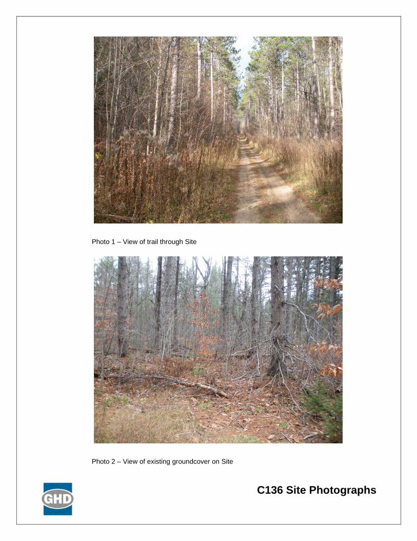
C136 Site Photographs
Photo 1 – View of trail through Site
Photo 2 – View of existing groundcover on Site
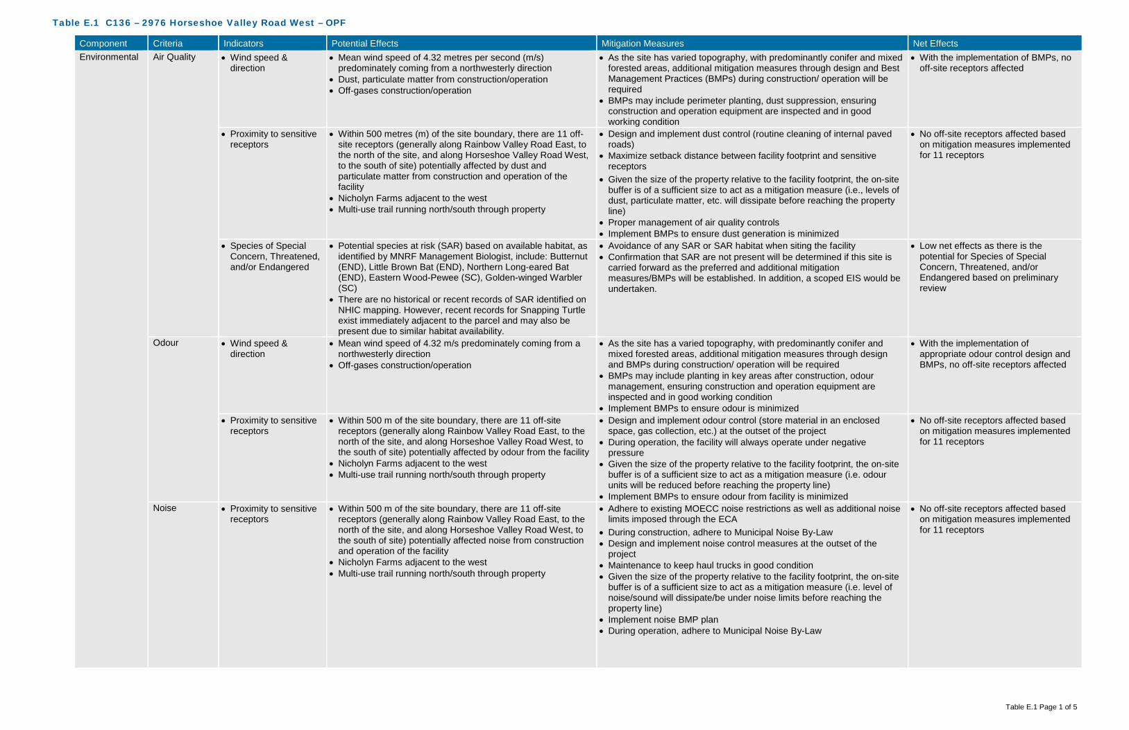
Table E.1 C136 – 2976 Horseshoe Valley Road West – OPF
Table E.1 Page 1 of 5
Component Criteria Indicators Potential Effects Mitigation Measures Net Effects Environmental Air Quality • Wind speed &
direction • Mean wind speed of 4.32 metres per second (m/s)
predominately coming from a northwesterly direction • Dust, particulate matter from construction/operation • Off-gases construction/operation
• As the site has varied topography, with predominantly conifer and mixed forested areas, additional mitigation measures through design and Best Management Practices (BMPs) during construction/ operation will be required
• BMPs may include perimeter planting, dust suppression, ensuring construction and operation equipment are inspected and in good working condition
• With the implementation of BMPs, no off-site receptors affected
• Proximity to sensitive receptors
• Within 500 metres (m) of the site boundary, there are 11 off-site receptors (generally along Rainbow Valley Road East, to the north of the site, and along Horseshoe Valley Road West, to the south of site) potentially affected by dust and particulate matter from construction and operation of the facility
• Nicholyn Farms adjacent to the west • Multi-use trail running north/south through property
• Design and implement dust control (routine cleaning of internal paved roads)
• Maximize setback distance between facility footprint and sensitive receptors
• Given the size of the property relative to the facility footprint, the on-site buffer is of a sufficient size to act as a mitigation measure (i.e., levels of dust, particulate matter, etc. will dissipate before reaching the property line)
• Proper management of air quality controls • Implement BMPs to ensure dust generation is minimized
• No off-site receptors affected based on mitigation measures implemented for 11 receptors
• Species of Special Concern, Threatened, and/or Endangered
• Potential species at risk (SAR) based on available habitat, as identified by MNRF Management Biologist, include: Butternut (END), Little Brown Bat (END), Northern Long-eared Bat (END), Eastern Wood-Pewee (SC), Golden-winged Warbler (SC)
• There are no historical or recent records of SAR identified on NHIC mapping. However, recent records for Snapping Turtle exist immediately adjacent to the parcel and may also be present due to similar habitat availability.
• Avoidance of any SAR or SAR habitat when siting the facility • Confirmation that SAR are not present will be determined if this site is
carried forward as the preferred and additional mitigation measures/BMPs will be established. In addition, a scoped EIS would be undertaken.
• Low net effects as there is the potential for Species of Special Concern, Threatened, and/or Endangered based on preliminary review
Odour • Wind speed & direction
• Mean wind speed of 4.32 m/s predominately coming from a northwesterly direction
• Off-gases construction/operation
• As the site has a varied topography, with predominantly conifer and mixed forested areas, additional mitigation measures through design and BMPs during construction/ operation will be required
• BMPs may include planting in key areas after construction, odour management, ensuring construction and operation equipment are inspected and in good working condition
• Implement BMPs to ensure odour is minimized
• With the implementation of appropriate odour control design and BMPs, no off-site receptors affected
• Proximity to sensitive receptors
• Within 500 m of the site boundary, there are 11 off-site receptors (generally along Rainbow Valley Road East, to the north of the site, and along Horseshoe Valley Road West, to the south of site) potentially affected by odour from the facility
• Nicholyn Farms adjacent to the west • Multi-use trail running north/south through property
• Design and implement odour control (store material in an enclosed space, gas collection, etc.) at the outset of the project
• During operation, the facility will always operate under negative pressure
• Given the size of the property relative to the facility footprint, the on-site buffer is of a sufficient size to act as a mitigation measure (i.e. odour units will be reduced before reaching the property line)
• Implement BMPs to ensure odour from facility is minimized
• No off-site receptors affected based on mitigation measures implemented for 11 receptors
Noise • Proximity to sensitive receptors
• Within 500 m of the site boundary, there are 11 off-site receptors (generally along Rainbow Valley Road East, to the north of the site, and along Horseshoe Valley Road West, to the south of site) potentially affected noise from construction and operation of the facility
• Nicholyn Farms adjacent to the west • Multi-use trail running north/south through property
• Adhere to existing MOECC noise restrictions as well as additional noise limits imposed through the ECA
• During construction, adhere to Municipal Noise By-Law • Design and implement noise control measures at the outset of the
project • Maintenance to keep haul trucks in good condition • Given the size of the property relative to the facility footprint, the on-site
buffer is of a sufficient size to act as a mitigation measure (i.e. level of noise/sound will dissipate/be under noise limits before reaching the property line)
• Implement noise BMP plan • During operation, adhere to Municipal Noise By-Law
• No off-site receptors affected based on mitigation measures implemented for 11 receptors

Table E.1 C136 – 2976 Horseshoe Valley Road West – OPF
Table E.1 Page 2 of 5
Component Criteria Indicators Potential Effects Mitigation Measures Net Effects Terrestrial • Topography • Due to the varied topography with a slope to the east and the
amount of unevaluated wetlands, the potential exists to alter natural drainage patterns
• Minimize alterations to existing topography • Setback facility from slope • Setback facility from unevaluated wetlands • Minimize surface water flow into unevaluated wetlands through design
(conveyance)
• Low net effects on topography as it relates to natural environment (natural drainage patterns)
• Soil type • Overburden consists of surficial glaciofluvial outwash sand with minor gravel
• An area of fine-grained glaciolacustrine clayey to sandy silt occurs to the west and glaciolacustrine sand with minor fine gravel to the east
• Overburden beneath the proposed site is greater than 65 m (215 feet) thick
• Surface water controls will be put in place to manage run-off from impervious surfaces (buildings/internal road, etc.)
• All materials accepted on-site will be within an enclosed building, with limited potential for runoff to occur
• All process water will be contained, collected and treated, either on-site or trucked off-site
• BMPs during construction will be implemented to limit potential impacts to soils and groundwater. This includes emergency management, accidental spills and containment techniques.
• Confirmation of soil types to occur should this be the preferred site
• No effects on groundwater
• Affected Greenlands • Effects to lands designated as Greenlands (approved in County Official Plan and pending approval in revised County Official Plan)
• No effects to Areas of Natural Scientific Interest (ANSI) • Significant portion of the site is forested with dominant conifer
and planted plantation style
• Infrastructure not subject to the environmental assessment process may be permitted within the Greenlands Designation or on adjacent lands in accordance with development and site alteration policies within the County Official Plan (Section 3.3.15)
• A scoped EIS would be undertaken as per the Official Plan requirements to develop infrastructure within the County Greenlands designation
• Avoid areas of significant/dense vegetation • Compensate for tree removal at a minimum on a 1:1 ratio – either on-
site or on another County owned property in close proximity
• Low effects to lands designated as Greenlands as an EIS is required. Completing the EIS will demonstrate through further analysis and investigation, as well as more detailed mitigation measures, the most appropriate location of the facility footprint on the site. This net effect would be lowered to “No” once a facility footprint location is determined as the EIS would demonstrate that there will be no negative impacts on natural features and areas and ecological functions of the County or local natural heritage system, and meet the requirements of Section 3.3.15 of the County Official Plan.
• No effects to ANSI’s • Moderate effects to existing
vegetation on-site as removal will be required for the facility
• Niagara Escarpment Land Use
• Not within the Niagara Escarpment Land Use policy area • No mitigation measures required • No net effects
• Oak Ridges Moraine Land Use
• Not within the Oak Ridges Moraine Land Use policy area • No mitigation measures required • No net effects
• Species of Special Concern, Threatened, and/or Endangered
• Potential SAR based on available habitat, as identified by MNRF Management Biologist, include: Butternut (END), Little Brown Bat (END), Northern Long-eared Bat (END), Eastern Wood-Pewee (SC), Golden-winged Warbler (SC)
• There are no historical or recent records of SAR identified on NHIC mapping. However, recent records for Snapping Turtle exist immediately adjacent to the parcel and may also be present due to similar habitat availability.
• Avoidance of any SAR or SAR habitat when siting the facility • Confirmation that SAR are not present will be determined if this site is
carried forward as the preferred and additional mitigation measures/BMPs will be established. In addition, a scoped EIS would be undertaken.
• Low net effects as there is the potential for Species of Special Concern, Threatened, and/or Endangered based on preliminary review
Aquatic • Species of Special Concern, Threatened, and/or Endangered
• No aquatic SAR listed as potentially occurring at this site • No aquatic SAR listed as occurring at this site • No net effects as there are no aquatic SAR listed as occurring at this site

Table E.1 C136 – 2976 Horseshoe Valley Road West – OPF
Table E.1 Page 3 of 5
Component Criteria Indicators Potential Effects Mitigation Measures Net Effects Surface Water • Wetlands, Floodplains
and Water Bodies • Potential effects on large unevaluated wetland on the
northeast potion of the site, running the full width of Rainbow Valley Road E
• Potential effects to a small watercourse which bisects the southern portion of the site
• Implement appropriate setbacks from the un-evaluated wetland as well as watercourse
• Confirm watercourse is present as it was not present during site visit • Facility will be designed to meet 100-year storm event • Surface water controls will be put in place to manage run-off from
impervious surfaces (buildings/internal road, etc.) and direct them away from natural drainage features
• All materials accepted on-site will be within an enclosed building, with limited potential for runoff to occur
• All process water will be contained, collected and treated, either on-site or trucked off-site
• BMPs during construction will be implemented to limit potential impacts to surface water. This includes erosion and sediment controls, emergency management, accidental spills and containment techniques
• Low effects to surface water features as the site is large and able to be located an appropriate distance from surface water features
Groundwater • Groundwater depth • Overburden consists of surficial glaciofluvial outwash sand with minor gravel
• An area of fine-grained glaciolacustrine clayey to sandy silt occurs to the west and glaciolacustrine sand with minor fine gravel to the east
• Overburden beneath the proposed site is greater than 65 m (215 feet) thick
• Controlling surface water and process water will assist in mitigating any potential effects on groundwater
• Surface water controls will be put in place to manage run-off from impervious surfaces (buildings/internal road, etc.)
• All materials accepted on-site will be within an enclosed building, with limited potential for runoff to occur
• All process water will be contained, collected and treated, either on-site or trucked off-site
• BMPs during construction will be implemented to limit potential impacts to surface water. This includes erosion and sediment controls, emergency management, accidental spills and containment techniques
• No net effects, based on the groundwater depth and the surface water management on-site
• Groundwater flow and direction
• The direction of shallow groundwater flow within the overburden is interpreted to occur in a general easterly direction
• The nature of the overburden suggests that the rate of groundwater movement would be moderate
• No alterations to flow and direction are anticipated as part of the design of the facility
• Controlling surface water and process water will assist in mitigating any potential effects on groundwater
• No net effects as no alterations to flow and direction of groundwater are anticipated as part of the design of the facility
• Source Water Protection Areas
• The site is not located within a Wellhead Protection Area (WHPA)or Highly Vulnerable Aquifer (HVA)
• Potential to affect Source Water Protection Areas, as the northeast and southeast corners of the site are located within a low to medium vulnerability Significant Groundwater Recharge Area (SGRA)
• Avoid locating the facility within the SGRA medium vulnerability areas • Controlling surface water and process water will assist in mitigating any
potential effects on groundwater • All mitigation measures described in the Surface Water and
Groundwater criteria would apply to this criteria as well
• Low net effects to Source Water Protection Areas
Agricultural • Protection of Class 1, 2 and 3 Agricultural Lands
• Potential effects to Prime Agricultural Lands as some areas around the perimeter of the site are Class 1-3 soils
• Avoid Prime Agricultural Lands (Class 1-3) to the greatest extent possible when siting the facility footprint
• Site size is large enough that facility may be located outside of Prime Agricultural lands.
• No net effects to Class 1-3 Agricultural Lands
Social Sensitive Receptors
• Number and distribution of Sensitive Receptors (e.g., residential areas, parks and recreational areas, institutions, airports)
• Within 500 m of the site boundary, there are 11 off-site receptors (generally along Rainbow Valley Road East, to the north of the site, and along Horseshoe Valley Road West, to the south of site) potentially affected from a nuisance perspective (i.e., noise, odour, dust, traffic) from construction and operation of the facility
• Nicholyn Farms adjacent to the west • Potential to affect the use and enjoyment of the multi-use trail
running north/south through property
• Potential construction-related and operational effects associated with dust, noise and traffic for uses within 500 m of the proposed facility will be mitigated through the use of BMPs (adhere to Municipal Noise By-Law, routine cleaning of internal roads, ensure equipment is inspected and in good working order)
• Design and implement odour control (store material in an enclosed space, gas collection, etc.) at the outset of the project
• During operation, the facility will always operate under negative pressure
• Given the size of the property relative to the facility footprint, the on-site buffer is of a sufficient size to act as a mitigation measure
• Setback distances from the facility footprint to the multi-use trail will be implemented to the greatest extent possible
• Low net effects based on proximity to sensitive receptors and on-site buffer areas
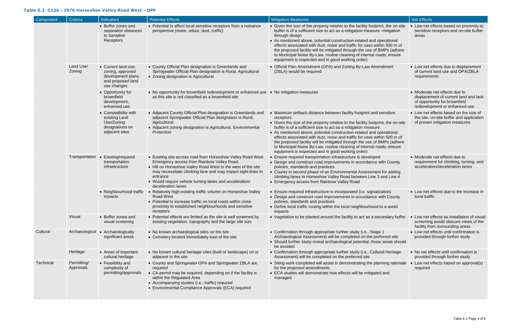
Table E.1 C136 – 2976 Horseshoe Valley Road West – OPF
Table E.1 Page 4 of 5
Component Criteria Indicators Potential Effects Mitigation Measures Net Effects • Buffer zones and
separation distances to Sensitive Receptors
• Potential to affect local sensitive receptors from a nuisance perspective (noise, odour, dust, traffic)
• Given the size of the property relative to the facility footprint, the on-site buffer is of a sufficient size to act as a mitigation measure -mitigation through design
• As mentioned above, potential construction-related and operational effects associated with dust, noise and traffic for uses within 500 m of the proposed facility will be mitigated through the use of BMPs (adhere to Municipal Noise By-Law, routine cleaning of internal roads, ensure equipment is inspected and in good working order)
• Low net effects based on proximity to sensitive receptors and on-site buffer areas
Land Use/ Zoning
• Current land use, zoning, approved development plans, and proposed land use changes
• County Official Plan designation is Greenlands and Springwater Official Plan designation is Rural, Agricultural
• Zoning designation is Agricultural
• Official Plan Amendment (OPA) and Zoning By-Law Amendment (ZBLA) would be required
• Low net effects due to displacement of current land use and OPA/ZBLA requirements
• Opportunity for brownfield development, enhanced use
• No opportunity for brownfield redevelopment or enhanced use as this site is not classified as a brownfield site
• No mitigation measures • Moderate net effects due to displacement of current land and lack of opportunity for brownfield redevelopment or enhanced use
• Compatibility with existing Land Use/Zoning designations on adjacent sites
• Adjacent County Official Plan designation is Greenlands and adjacent Springwater Official Plan designation is Rural, Agricultural
• Adjacent zoning designation is Agricultural, Environmental Protection
• Maximize setback distance between facility footprint and sensitive receptors
• Given the size of the property relative to the facility footprint, the on-site buffer is of a sufficient size to act as a mitigation measure
• As mentioned above, potential construction-related and operational effects associated with dust, noise and traffic for uses within 500 m of the proposed facility will be mitigated through the use of BMPs (adhere to Municipal Noise By-Law, routine cleaning of internal roads, ensure equipment is inspected and in good working order)
• Low net effects based on the size of the site, on-site buffer and application of proven mitigation measures
Transportation • Existing/required transportation infrastructure
• Existing site access road from Horseshoe Valley Road West. Emergency access from Rainbow Valley Road.
• Hill on Horseshoe Valley Road West to the west of the site may necessitate climbing lane and may impact sight lines to entrance
• Would require vehicle turning lanes and acceleration/ deceleration lanes
• Ensure required transportation infrastructure is developed • Design and construct road improvements in accordance with County
policies, standards and practices • County in second phase of an Environmental Assessment for adding
climbing lanes to Horseshoe Valley Road between Line 3 and Line 4 • Emergency access from Rainbow Valley Road
• Moderate net effects due to requirement for climbing, turning, and acceleration/deceleration lanes
• Neighbourhood traffic impacts
• Relatively high existing traffic volume on Horseshoe Valley Road West
• Potential to increase traffic on local roads within close proximity to established neighbourhoods and sensitive receptors
• Ensure required infrastructure is incorporated (i.e. signalization) • Design and construct road improvements in accordance with County
policies, standards and practices • Define local traffic routing within the local neighbourhood to a avoid
impacts
• Low net effects due to the increase in local traffic
Visual • Buffer zones and visual screening
• Potential effects are limited as the site is well screened by existing vegetation, topography and the large site size
• Vegetation to be planted around the facility to act as a secondary buffer • Low net effects as installation of visual screening would obscure views of the facility from surrounding areas
Cultural Archaeological • Archaeologically significant areas
• No known archaeological sites on the site • Cemetery located immediately east of the site
• Confirmation through appropriate further study (i.e., Stage 1 Archaeological Assessment) will be completed on the preferred site
• Should further study reveal archaeological potential, those areas should be avoided
• Low net effects until confirmation is provided through further study
Heritage • Areas of important cultural heritage
• No known cultural heritage sites (built or landscape) on or adjacent to the site
• Confirmation through appropriate further study (i.e., Cultural Heritage Assessment) will be completed on the preferred site
• No net effects until confirmation is provided through further study
Technical Permitting/ Approvals
• Feasibility and complexity of permitting/approvals
• County and Springwater OPA and Springwater ZBLA are required
• CA permit may be required, depending on if the facility is within the Regulated Area
• Accompanying studies (i.e., traffic) required • Environmental Compliance Approvals (ECA) required
• Siting work completed will assist in demonstrating the planning rationale for the proposed amendments
• ECA studies will demonstrate how effects will be mitigated and managed
• Low net effects based on approval(s) required

Table E.1 C136 – 2976 Horseshoe Valley Road West – OPF
Table E.1 Page 5 of 5
Component Criteria Indicators Potential Effects Mitigation Measures Net Effects Safety • Potential safety risks • Multi-use trail through the site
• Potential for spills, fire, and other emergencies • Restrict access to facility from adjacent trails via fencing and signage • Develop a Health and Safety Plan and an Emergency Management
Plan
• Low safety risks
Utilities and Services
• Availability and distance from utilities and services
• No sanitary sewer in vicinity of site • No municipal water supply in vicinity of site • No gas supply line in vicinity of site • Hydro line on Horseshoe Valley Road
• Construction and implementation of required services/utilities • High net effects as availability and distance from existing utilities and services is minimal
Suitability • Meets minimum size requirements
• 84 hectares • No mitigation measures required • No net effects
• Within search area • Site is within search area for the OPF • No mitigation measures required • No net effects • Site layout,
topography and soil conditions
• Low potential constraints on site from a layout, topography and soil conditions perspective
• Increase setback distances from constraints to increase buffer distances
• Low net effects as majority of the site is able to accommodate the facility with significant setbacks and buffer distances
• Compatibility with existing infrastructure
• No potential for utility conflicts due to lack of existing utilities • Potential conflicts with multi-use trail through the property
• Construction and implementation of required services/utilities • Low net effects, as no relocation of existing utilities is required
Flexibility • Design/operational flexibility provided by site
• Site provides for a high level of design and operational flexibility given the site size and the limited constraints
• No mitigation measures required • High positive net effects as the site has the ability to accommodate design and operational flexibility
• Surplus lands for expansion
• Site provides for a high level of surplus lands for expansion given the site size and the limited constraints
• No mitigation measures required • High positive net effects as the site has the ability to accommodate expansion
Economic Capital Costs • Property acquisition • No costs for property acquisition as property is owned by the County
• No mitigation measures required • No cost
• Infrastructure • Would likely require climbing lanes, turning lanes, and acceleration/deceleration lanes
• Emergency access from Rainbow Valley Road • Hydro on Horseshoe Valley Road
• No mitigation measures required • Moderate infrastructure costs
• Design • No significant impacts to design expected • No mitigation measures required • Low design costs • Construction • Clear vegetation
• Minor site grading • Road improvements
• No mitigation measures required • Moderate construction costs
• Permits/approvals • No significant impacts to permitting/approvals expected • No mitigation measures required • Low additional permits/approvals costs and complexity
• Site remediation • No known areas requiring remediation on-site • No mitigation measures required • Low costs Operation and Maintenance Costs
• Facility operation and maintenance
• No additional costs anticipated • No mitigation measures required • Low cost associated with operation and maintenance
• Transportation from feedstock sources
• Approximately 8 kilometres from waste centroid • No mitigation measures required • Low cost associated with transportation from feedstock sources
• Transportation to markets and end users
• Potential agricultural users nearby • Close to highway access for material processing and disposal
• No mitigation measures required • Low costs associated with transportation to markets and end users
• Monitoring requirements
• Increased surface water monitoring due to proximity to regulated areas (surface water features)
• Increased groundwater monitoring
• No mitigation measures required • Moderate cost associated with monitoring requirements
• Mitigation requirements
• Natural screening mechanisms (e.g., topography, vegetation, significant buffer) already in place for odour, noise, visual
• Protection of Source Protection Areas and watercourses
• No mitigation measures required • Moderate cost associated with mitigation requirements

Table E.1 C136 – 2976 Horseshoe Valley Road West – OPF
Table E.1 Page 6 of 5
Component Criteria Indicators Potential Effects Mitigation Measures Net Effects Legal Land
Acquisition • Land acquisition
complexity, risk, liability
• County-owned property • May need to compensate nearby residential properties and
businesses
• Mitigation through compensation • Low complexity, risk and liability
Agreement • Structure and complexity of operating agreement
• No added complexity expected • Mitigation through agreement structure • Low complexity

Table E.2 C136 – 2976 Horseshoe Valley Road West – MMF
Table E.2 Page 1 of 6
Component Criteria Indicators Potential Effects Mitigation Measures Net Effects Environmental Air Quality • Wind speed &
direction • Mean wind speed of 4.32 metres per second (m/s)
predominately coming from a northwesterly direction • Dust, particulate matter from construction/operation • Off-gases construction/operation
• As the site has varied topography, with predominantly conifer and mixed forested areas, additional mitigation measures through design and Best Management Practices (BMPs) during construction/ operation will be required
• BMPs may include perimeter planting, dust suppression, ensuring construction and operation equipment are inspected and in good working condition
• With the implementation of BMPs, no off-site receptors affected
• Proximity to sensitive receptors
• Within 500 metres (m) of the site boundary, there are 11 off-site receptors (generally along Rainbow Valley Road East, to the north of the site, and along Horseshoe Valley Road West, to the south of site) potentially affected by dust and particulate matter from construction and operation of the facility
• Nicholyn Farms adjacent to the west • Multi-use trail running north/south through property
• Design and implement dust control (routine cleaning of internal paved roads)
• Maximize setback distance between facility footprint and sensitive receptors
• Given the size of the property relative to the facility footprint, the on-site buffer is of a sufficient size to act as a mitigation measure (i.e., levels of dust, particulate matter, etc. will dissipate before reaching the property line)
• Proper management of air quality controls • Implement BMPs to ensure dust generation is minimized
• No off-site receptors affected based on mitigation measures implemented for 11 receptors
• Species of Special Concern, Threatened, and/or Endangered
• Potential species at risk (SAR) based on available habitat, as identified by MNRF Management Biologist, include: Butternut (END), Little Brown Bat (END), Northern Long-eared Bat (END), Eastern Wood-Pewee (SC), Golden-winged Warbler (SC)
• There are no historical or recent records of SAR identified on NHIC mapping. However, recent records for Snapping Turtle exist immediately adjacent to the parcel and may also be present due to similar habitat availability.
• Avoidance of any SAR or SAR habitat when siting the facility • Confirmation that SAR are not present will be determined if this site is
carried forward as the preferred and additional mitigation measures/BMPs will be established. In addition, a scoped EIS would be undertaken.
• Low net effects as there is the potential for Species of Special Concern, Threatened, and/or Endangered based on preliminary review
Odour • Wind speed & direction
• Mean wind speed of 4.32 m/s predominately coming from a northwesterly direction
• Off-gases construction/operation
• As the site has a varied topography, with predominantly conifer and mixed forested areas, additional mitigation measures through design and BMPs during construction/ operation will be required
• BMPs may include planting in key areas after construction, odour management, ensuring construction and operation equipment are inspected and in good working condition
• Implement BMPs to ensure odour is minimized
• With the implementation of appropriate odour control design and BMPs, no off-site receptors affected
• Proximity to sensitive receptors
• Within 500 m of the site boundary, there are 11 off-site receptors (generally along Rainbow Valley Road East, to the north of the site, and along Horseshoe Valley Road West, to the south of site) potentially affected by odour from the facility
• Nicholyn Farms adjacent to the west • Multi-use trail running north/south through property
• Design and implement odour control (store material in an enclosed space, gas collection, etc.) at the outset of the project
• During operation, the facility will always operate under negative pressure
• Given the size of the property relative to the facility footprint, the on-site buffer is of a sufficient size to act as a mitigation measure (i.e. odour units will be reduced before reaching the property line)
• Implement BMPs to ensure odour from facility is minimized
• No off-site receptors affected based on mitigation measures implemented for 11 receptors
Noise • Proximity to sensitive receptors
• Within 500 m of the site boundary, there are 11 off-site receptors (generally along Rainbow Valley Road East, to the north of the site, and along Horseshoe Valley Road West, to the south of site) potentially affected noise from construction and operation of the facility
• Nicholyn Farms adjacent to the west • Multi-use trail running north/south through property
• Adhere to existing MOECC noise restrictions as well as additional noise limits imposed through the ECA
• During construction, adhere to Municipal Noise By-Law • Design and implement noise control measures at the outset of the
project • Maintenance to keep haul trucks in good condition • Given the size of the property relative to the facility footprint, the on-site
buffer is of a sufficient size to act as a mitigation measure (i.e. level of noise/sound will dissipate/be under noise limits before reaching the property line)
• Implement noise BMP plan • During operation, adhere to Municipal Noise By-Law
• No off-site receptors affected based on mitigation measures implemented for 11 receptors

Table E.2 C136 – 2976 Horseshoe Valley Road West – MMF
Table E.2 Page 2 of 6
Component Criteria Indicators Potential Effects Mitigation Measures Net Effects Terrestrial • Topography • Due to the varied topography with a slope to the east and the
amount of unevaluated wetlands, the potential exists to alter natural drainage patterns
• Minimize alterations to existing topography • Setback facility from slope • Setback facility from unevaluated wetlands • Minimize surface water flow into unevaluated wetlands through design
(conveyance)
• Low net effects on topography as it relates to natural environment (natural drainage patterns)
• Soil type • Overburden consists of surficial glaciofluvial outwash sand with minor gravel
• An area of fine-grained glaciolacustrine clayey to sandy silt occurs to the west and glaciolacustrine sand with minor fine gravel to the east
• Overburden beneath the proposed site is greater than 65 m (215 feet) thick
• Surface water controls will be put in place to manage run-off from impervious surfaces (buildings/internal road, etc.)
• All materials accepted on-site will be within an enclosed building, with limited potential for runoff to occur
• All process water will be contained, collected and treated, either on-site or trucked off-site
• BMPs during construction will be implemented to limit potential impacts to soils and groundwater. This includes emergency management, accidental spills and containment techniques.
• Confirmation of soil types to occur should this be the preferred site
• No effects on groundwater
• Affected Greenlands • Effects to lands designated as Greenlands (approved in County Official Plan and pending approval in revised County Official Plan)
• No effects to Areas of Natural Scientific Interest (ANSI) • Significant portion of the site is forested with dominant conifer
and planted plantation style
• Infrastructure not subject to the environmental assessment process may be permitted within the Greenlands Designation or on adjacent lands in accordance with development and site alteration policies within the County Official Plan (Section 3.3.15)
• A scoped EIS would be undertaken as per the Official Plan requirements to develop infrastructure within the County Greenlands designation
• Avoid areas of significant/dense vegetation • Compensate for tree removal at a minimum on a 1:1 ratio – either on-
site or on another County owned property in close proximity
• Low effects to lands designated as Greenlands as an EIS is required. Completing the EIS will demonstrate through further analysis and investigation, as well as more detailed mitigation measures, the most appropriate location of the facility footprint on the site. This net effect would be lowered to “No” once a facility footprint location is determined as the EIS would demonstrate that there will be no negative impacts on natural features and areas and ecological functions of the County or local natural heritage system, and meet the requirements of Section 3.3.15 of the County Official Plan.
• No effects to ANSI’s • Moderate effects to existing
vegetation on-site as removal will be required for the facility
• Niagara Escarpment Land Use
• Not within the Niagara Escarpment Land Use policy area • No mitigation measures required • No net effects
• Oak Ridges Moraine Land Use
• Not within the Oak Ridges Moraine Land Use policy area • No mitigation measures required • No net effects
• Species of Special Concern, Threatened, and/or Endangered
• Potential SAR based on available habitat, as identified by MNRF Management Biologist, include: Butternut (END), Little Brown Bat (END), Northern Long-eared Bat (END), Eastern Wood-Pewee (SC), Golden-winged Warbler (SC)
• There are no historical or recent records of SAR identified on NHIC mapping. However, recent records for Snapping Turtle exist immediately adjacent to the parcel and may also be present due to similar habitat availability.
• Avoidance of any SAR or SAR habitat when siting the facility • Confirmation that SAR are not present will be determined if this site is
carried forward as the preferred and additional mitigation measures/BMPs will be established. In addition, a scoped EIS would be undertaken.
• Low net effects as there is the potential for Species of Special Concern, Threatened, and/or Endangered based on preliminary review
Aquatic • Species of Special Concern, Threatened, and/or Endangered
• No aquatic SAR listed as potentially occurring at this site
• No aquatic SAR listed as occurring at this site • No net effects as there are no aquatic SAR listed as occurring at this site

Table E.2 C136 – 2976 Horseshoe Valley Road West – MMF
Table E.2 Page 3 of 6
Component Criteria Indicators Potential Effects Mitigation Measures Net Effects Surface Water • Wetlands, Floodplains
and Water Bodies • Potential effects on large unevaluated wetland on the
northeast potion of the site, running the full width of Rainbow Valley Road E
• Potential effects to a small watercourse which bisects the southern portion of the site
• Implement appropriate setbacks from the un-evaluated wetland as well as watercourse
• Confirm watercourse is present as it was not present during site visit • Facility will be designed to meet 100-year storm event • Surface water controls will be put in place to manage run-off from
impervious surfaces (buildings/internal road, etc.) and direct them away from natural drainage features.
• All materials accepted on-site will be within an enclosed building, with limited potential for runoff to occur
• All process water will be contained, collected and treated, either on-site or trucked off-site
• BMPs during construction will be implemented to limit potential impacts to surface water. This includes erosion and sediment controls, emergency management, accidental spills and containment techniques.
• Low effects to surface water features as the site is large and able to be located an appropriate distance from surface water features
Groundwater • Groundwater depth • Overburden consists of surficial glaciofluvial outwash sand with minor gravel
• An area of fine-grained glaciolacustrine clayey to sandy silt occurs to the west and glaciolacustrine sand with minor fine gravel to the east
• Overburden beneath the proposed site is greater than 65 m (215 feet) thick
• Controlling surface water and process water will assist in mitigating any potential effects on groundwater
• Surface water controls will be put in place to manage run-off from impervious surfaces (buildings/internal road, etc.)
• All materials accepted on-site will be within an enclosed building, with limited potential for runoff to occur
• All process water will be contained, collected and treated, either on-site or trucked off-site
• BMPs during construction will be implemented to limit potential impacts to surface water. This includes erosion and sediment controls, emergency management, accidental spills and containment techniques.
• No net effects, based on the groundwater depth and the surface water management on-site
• Groundwater flow and direction
• The direction of shallow groundwater flow within the overburden is interpreted to occur in a general easterly direction
• The nature of the overburden suggests that the rate of groundwater movement would be moderate
• No alterations to flow and direction are anticipated as part of the design of the facility
• Controlling surface water and process water will assist in mitigating any potential effects on groundwater
• No net effects as no alterations to flow and direction of groundwater are anticipated as part of the design of the facility
• Source Water Protection Areas
• The site is not located within a Wellhead Protection Area (WHPA)or Highly Vulnerable Aquifer (HVA)
• Potential to affect Source Water Protection Areas, as the northeast and southeast corners of the site are located within a low to medium vulnerability Significant Groundwater Recharge Area (SGRA)
• Avoid locating the facility within the SGRA medium vulnerability areas • Controlling surface water and process water will assist in mitigating any
potential effects on groundwater • All mitigation measures described in the Surface Water and
Groundwater criteria would apply to this criteria as well
• Low net effects to Source Water Protection Areas
Agricultural • Protection of Class 1, 2 and 3 Agricultural Lands
• Potential effects to Prime Agricultural Lands as some areas around the perimeter of the site are Class 1-3 soils
• Avoid Prime Agricultural Lands (Class 1-3) to the greatest extent possible when siting the facility footprint
• Site size is large enough that facility may be located outside of Prime Agricultural lands.
• No net effects to Class 1-3 Agricultural Lands
Social Sensitive Receptors
• Number and distribution of Sensitive Receptors (e.g., residential areas, parks and recreational areas, institutions, airports)
• Within 500 m of the site boundary, there are 11 off-site receptors (generally along Rainbow Valley Road East, to the north of the site, and along Horseshoe Valley Road West, to the south of site) potentially affected from a nuisance perspective (i.e., noise, odour, dust, traffic) from construction and operation of the facility
• Nicholyn Farms adjacent to the west • Potential to affect the use and enjoyment of the multi-use trail
running north/south through property
• Potential construction-related and operational effects associated with dust, noise and traffic for uses within 500 m of the proposed facility will be mitigated through the use of BMPs (adhere to Municipal Noise By-Law, routine cleaning of internal roads, ensure equipment is inspected and in good working order)
• Design and implement odour control (store material in an enclosed space, gas collection, etc.) at the outset of the project
• During operation, the facility will always operate under negative pressure
• Given the size of the property relative to the facility footprint, the on-site buffer is of a sufficient size to act as a mitigation measure
• Setback distances from the facility footprint to the multi-use trail will be implemented to the greatest extent possible
• Low net effects based on proximity to sensitive receptors and on-site buffer areas

Table E.2 C136 – 2976 Horseshoe Valley Road West – MMF
Table E.2 Page 4 of 6
Component Criteria Indicators Potential Effects Mitigation Measures Net Effects • Buffer zones and
separation distances to Sensitive Receptors
• Potential to affect local sensitive receptors from a nuisance perspective (noise, odour, dust, traffic)
• Given the size of the property relative to the facility footprint, the on-site buffer is of a sufficient size to act as a mitigation measure -mitigation through design
• As mentioned above, potential construction-related and operational effects associated with dust, noise and traffic for uses within 500 m of the proposed facility will be mitigated through the use of BMPs (adhere to Municipal Noise By-Law, routine cleaning of internal roads, ensure equipment is inspected and in good working order)
• Low net effects based on proximity to sensitive receptors and on-site buffer areas
Land Use/ Zoning
• Current land use, zoning, approved development plans, and proposed land use changes
• County Official Plan designation is Greenlands and Springwater Official Plan designation is Rural, Agricultural
• Zoning designation is Agricultural
• Official Plan Amendment (OPA) and Zoning By-Law Amendment (ZBLA) would be required
• Low net effects due to displacement of current land use and OPA/ZBLA requirements
• Opportunity for brownfield development, enhanced use
• No opportunity for brownfield redevelopment or enhanced use as this site is not classified as a brownfield site
• No mitigation measures • Moderate net effects due to displacement of current land and lack of opportunity for brownfield redevelopment or enhanced use
• Compatibility with existing Land Use/Zoning designations on adjacent sites
• Adjacent County Official Plan designation is Greenlands and adjacent Springwater Official Plan designation is Rural, Agricultural
• Adjacent zoning designation is Agricultural, Environmental Protection
• Maximize setback distance between facility footprint and sensitive receptors
• Given the size of the property relative to the facility footprint, the on-site buffer is of a sufficient size to act as a mitigation measure
• As mentioned above, potential construction-related and operational effects associated with dust, noise and traffic for uses within 500 m of the proposed facility will be mitigated through the use of BMPs (adhere to Municipal Noise By-Law, routine cleaning of internal roads, ensure equipment is inspected and in good working order)
• Low net effects based on the size of the site, on-site buffer and application of proven mitigation measures
Transportation • Existing/required transportation infrastructure
• Existing site access road from Horseshoe Valley Road West. Emergency access from Rainbow Valley Road.
• Hill on Horseshoe Valley Road West to the west of the site may necessitate climbing lane and may impact sight lines to entrance
• Would require vehicle turning lanes and acceleration/ deceleration lanes
• Ensure required transportation infrastructure is developed • Design and construct road improvements in accordance with County
policies, standards and practices • County in second phase of an Environmental Assessment for adding
climbing lanes to Horseshoe Valley Road between Line 3 and Line 4 • Emergency access from Rainbow Valley Road
• Moderate net effects due to requirement for climbing, turning, and acceleration/deceleration lanes and signalized intersection
• Neighbourhood traffic impacts
• Relatively high existing traffic volume on Horseshoe Valley Road West
• Potential to increase traffic on local roads within close proximity to established neighbourhoods and sensitive receptors
• Ensure required infrastructure is incorporated (i.e. signalization) • Design and construct road improvements in accordance with County
policies, standards and practices • Define local traffic routing within the local neighbourhood to a avoid
impacts
• Low net effects due to the increase in local traffic
Visual • Buffer zones and visual screening
• Potential effects are limited as the site is well screened by existing vegetation, topography and the large site size
• Vegetation to be planted around the facility to act as a secondary buffer • Low net effects as installation of visual screening would obscure views of the facility from surrounding areas
Cultural Archaeological • Archaeologically significant areas
• No known archaeological sites on the site • Cemetery located immediately east of the site
• Confirmation through appropriate further study (i.e., Stage 1 Archaeological Assessment) will be completed on the preferred site
• Should further study reveal archaeological potential, those areas should be avoided
• Low net effects until confirmation is provided through further study
Heritage • Areas of important cultural heritage
• No known cultural heritage sites (built or landscape) on or adjacent to the site
• Confirmation through appropriate further study (i.e., Cultural Heritage Assessment) will be completed on the preferred site
• No net effects until confirmation is provided through further study
Technical Permitting/ Approvals
• Feasibility and complexity of permitting/approvals
• County and Springwater OPA and Springwater ZBLA are required
• CA permit may be required, depending on if the facility is within the Regulated Area
• Accompanying studies (i.e., traffic) required • Environmental Compliance Approvals (ECA) required
• Siting work completed will assist in demonstrating the planning rationale for the proposed amendments
• ECA studies will demonstrate how effects will be mitigated and managed
• Low net effects based on approval(s) required
Safety • Potential safety risks • Multi-use trail through the site • Potential for spills, fire, and other emergencies
• Restrict access to facility from adjacent trails via fencing and signage • Develop a Health and Safety Plan and an Emergency Management
Plan
• Low safety risks
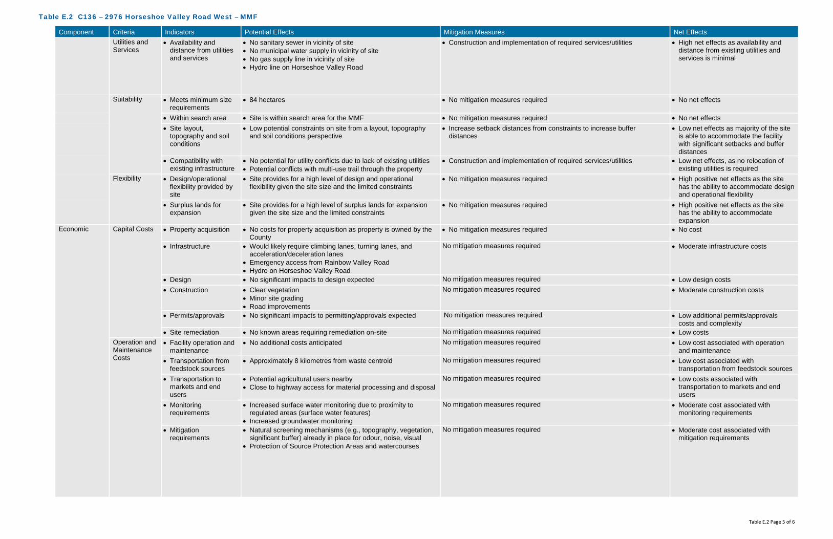
Table E.2 C136 – 2976 Horseshoe Valley Road West – MMF
Table E.2 Page 5 of 6
Component Criteria Indicators Potential Effects Mitigation Measures Net Effects Utilities and Services
• Availability and distance from utilities and services
• No sanitary sewer in vicinity of site • No municipal water supply in vicinity of site • No gas supply line in vicinity of site • Hydro line on Horseshoe Valley Road
• Construction and implementation of required services/utilities • High net effects as availability and distance from existing utilities and services is minimal
Suitability • Meets minimum size requirements
• 84 hectares • No mitigation measures required • No net effects
• Within search area • Site is within search area for the MMF • No mitigation measures required • No net effects • Site layout,
topography and soil conditions
• Low potential constraints on site from a layout, topography and soil conditions perspective
• Increase setback distances from constraints to increase buffer distances
• Low net effects as majority of the site is able to accommodate the facility with significant setbacks and buffer distances
• Compatibility with existing infrastructure
• No potential for utility conflicts due to lack of existing utilities • Potential conflicts with multi-use trail through the property
• Construction and implementation of required services/utilities
• Low net effects, as no relocation of existing utilities is required
Flexibility • Design/operational flexibility provided by site
• Site provides for a high level of design and operational flexibility given the site size and the limited constraints
• No mitigation measures required • High positive net effects as the site has the ability to accommodate design and operational flexibility
• Surplus lands for expansion
• Site provides for a high level of surplus lands for expansion given the site size and the limited constraints
• No mitigation measures required • High positive net effects as the site has the ability to accommodate expansion
Economic Capital Costs • Property acquisition • No costs for property acquisition as property is owned by the County
• No mitigation measures required • No cost
• Infrastructure • Would likely require climbing lanes, turning lanes, and acceleration/deceleration lanes
• Emergency access from Rainbow Valley Road • Hydro on Horseshoe Valley Road
No mitigation measures required • Moderate infrastructure costs
• Design • No significant impacts to design expected No mitigation measures required • Low design costs • Construction • Clear vegetation
• Minor site grading • Road improvements
No mitigation measures required • Moderate construction costs
• Permits/approvals • No significant impacts to permitting/approvals expected No mitigation measures required • Low additional permits/approvals costs and complexity
• Site remediation • No known areas requiring remediation on-site No mitigation measures required • Low costs Operation and Maintenance Costs
• Facility operation and maintenance
• No additional costs anticipated No mitigation measures required • Low cost associated with operation and maintenance
• Transportation from feedstock sources
• Approximately 8 kilometres from waste centroid No mitigation measures required • Low cost associated with transportation from feedstock sources
• Transportation to markets and end users
• Potential agricultural users nearby • Close to highway access for material processing and disposal
No mitigation measures required • Low costs associated with transportation to markets and end users
• Monitoring requirements
• Increased surface water monitoring due to proximity to regulated areas (surface water features)
• Increased groundwater monitoring
No mitigation measures required • Moderate cost associated with monitoring requirements
• Mitigation requirements
• Natural screening mechanisms (e.g., topography, vegetation, significant buffer) already in place for odour, noise, visual
• Protection of Source Protection Areas and watercourses
No mitigation measures required • Moderate cost associated with mitigation requirements

Table E.2 C136 – 2976 Horseshoe Valley Road West – MMF
Table E.2 Page 6 of 6
Component Criteria Indicators Potential Effects Mitigation Measures Net Effects Legal Land
Acquisition • Land acquisition
complexity, risk, liability
• County-owned property • May need to compensate nearby residential properties and
businesses
• Mitigation through compensation • Low complexity, risk and liability
Agreement • Structure and complexity of operating agreement
• No added complexity expected • Mitigation through agreement structure • Low complexity

Table E.3 C136 – 2976 Horseshoe Valley Road West – Co-Located Facility
Table E.3 Page 1 of 6
Component Criteria Indicators Potential Effects Mitigation Measures Net Effects Environmental Air Quality • Wind speed &
direction • Mean wind speed of 4.32 metres per second (m/s)
predominately coming from a northwesterly direction • Dust, particulate matter from construction/operation • Off-gases construction/operation
• As the site has varied topography, with predominantly conifer and mixed forested areas, additional mitigation measures through design and Best Management Practices (BMPs) during construction/ operation will be required
• BMPs may include perimeter planting, dust suppression, ensuring construction and operation equipment are inspected and in good working condition
• With the implementation of BMPs, no off-site receptors affected
• Proximity to sensitive receptors
• Within 500 metres (m) of the site boundary, there are 11 off-site receptors (generally along Rainbow Valley Road East, to the north of the site, and along Horseshoe Valley Road West, to the south of site) potentially affected by dust and particulate matter from construction and operation of the facility
• Nicholyn Farms adjacent to the west • Multi-use trail running north/south through property
• Design and implement dust control (routine cleaning of internal paved roads)
• Maximize setback distance between facility footprint and sensitive receptors
• Given the size of the property relative to the facility footprint, the on-site buffer is of a sufficient size to act as a mitigation measure (i.e., levels of dust, particulate matter, etc. will dissipate before reaching the property line)
• Proper management of air quality controls • Implement BMPs to ensure dust generation is minimized
• No off-site receptors affected based on mitigation measures implemented for 11 receptors
• Species of Special Concern, Threatened, and/or Endangered
• Potential species at risk (SAR) based on available habitat, as identified by MNRF Management Biologist, include: Butternut (END), Little Brown Bat (END), Northern Long-eared Bat (END), Eastern Wood-Pewee (SC), Golden-winged Warbler (SC)
• There are no historical or recent records of SAR identified on NHIC mapping. However, recent records for Snapping Turtle exist immediately adjacent to the parcel and may also be present due to similar habitat availability.
• Avoidance of any SAR or SAR habitat when siting the facility • Confirmation that SAR are not present will be determined if this site is
carried forward as the preferred and additional mitigation measures/BMPs will be established. In addition, a scoped EIS would be undertaken.
• Low net effects as there is the potential for Species of Special Concern, Threatened, and/or Endangered based on preliminary review
Odour • Wind speed & direction
• Mean wind speed of 4.32 m/s predominately coming from a northwesterly direction
• Off-gases construction/operation
• As the site has a varied topography, with predominantly conifer and mixed forested areas, additional mitigation measures through design and BMPs during construction/ operation will be required
• BMPs may include planting in key areas after construction, odour management, ensuring construction and operation equipment are inspected and in good working condition
• Implement BMPs to ensure odour is minimized
• With the implementation of appropriate odour control design and BMPs, no off-site receptors affected
• Proximity to sensitive receptors
• Within 500 m of the site boundary, there are 11 off-site receptors (generally along Rainbow Valley Road East, to the north of the site, and along Horseshoe Valley Road West, to the south of site) potentially affected by odour from the facility
• Nicholyn Farms adjacent to the west • Multi-use trail running north/south through property
• Design and implement odour control (store material in an enclosed space, gas collection, etc.) at the outset of the project
• During operation, the facility will always operate under negative pressure
• Given the size of the property relative to the facility footprint, the on-site buffer is of a sufficient size to act as a mitigation measure (i.e. odour units will be reduced before reaching the property line)
• Implement BMPs to ensure odour from facility is minimized
• No off-site receptors affected based on mitigation measures implemented for 11 receptors
Noise • Proximity to sensitive receptors
• Within 500 m of the site boundary, there are 11 off-site receptors (generally along Rainbow Valley Road East, to the north of the site, and along Horseshoe Valley Road West, to the south of site) potentially affected noise from construction and operation of the facility
• Nicholyn Farms adjacent to the west • Multi-use trail running north/south through property
• Adhere to existing MOECC noise restrictions as well as additional noise limits imposed through the ECA
• During construction, adhere to Municipal Noise By-Law • Design and implement noise control measures at the outset of the
project • Maintenance to keep haul trucks in good condition • Given the size of the property relative to the facility footprint, the on-site
buffer is of a sufficient size to act as a mitigation measure (i.e. level of noise/sound will dissipate/be under noise limits before reaching the property line)
• Implement noise BMP plan • During operation, adhere to Municipal Noise By-Law
• No off-site receptors affected based on mitigation measures implemented for 11 receptors

Table E.3 C136 – 2976 Horseshoe Valley Road West – Co-Located Facility
Table E.3 Page 2 of 6
Component Criteria Indicators Potential Effects Mitigation Measures Net Effects Terrestrial • Topography • Due to the varied topography with a slope to the east and the
amount of unevaluated wetlands, the potential exists to alter natural drainage patterns
• Minimize alterations to existing topography • Setback facility from slope • Setback facility from unevaluated wetlands • Minimize surface water flow into unevaluated wetlands through design
(conveyance)
• Low net effects on topography as it relates to natural environment (natural drainage patterns)
• Soil type • Overburden consists of surficial glaciofluvial outwash sand with minor gravel
• An area of fine-grained glaciolacustrine clayey to sandy silt occurs to the west and glaciolacustrine sand with minor fine gravel to the east
• Overburden beneath the proposed site is greater than 65 m (215 feet) thick
• Surface water controls will be put in place to manage run-off from impervious surfaces (buildings/internal road, etc.)
• All materials accepted on-site will be within an enclosed building, with limited potential for runoff to occur
• All process water will be contained, collected and treated, either on-site or trucked off-site
• BMPs during construction will be implemented to limit potential impacts to soils and groundwater. This includes emergency management, accidental spills and containment techniques.
• Confirmation of soil types to occur should this be the preferred site
• No effects on groundwater
• Affected Greenlands • Effects to lands designated as Greenlands (approved in County Official Plan and pending approval in revised County Official Plan)
• No effects to Areas of Natural Scientific Interest (ANSI) • Significant portion of the site is forested with dominant conifer
and planted plantation style
• Infrastructure not subject to the environmental assessment process may be permitted within the Greenlands Designation or on adjacent lands in accordance with development and site alteration policies within the County Official Plan (Section 3.3.15)
• A scoped EIS would be undertaken as per the Official Plan requirements to develop infrastructure within the County Greenlands designation
• Avoid areas of significant/dense vegetation • Compensate for tree removal at a minimum on a 1:1 ratio – either on-
site or on another County owned property in close proximity
• Low effects to lands designated as Greenlands as an EIS is required. Completing the EIS will demonstrate through further analysis and investigation, as well as more detailed mitigation measures, the most appropriate location of the facility footprint on the site. This net effect would be lowered to “No” once a facility footprint location is determined as the EIS would demonstrate that there will be no negative impacts on natural features and areas and ecological functions of the County or local natural heritage system, and meet the requirements of Section 3.3.15 of the County Official Plan.
• No effects to ANSI’s • Moderate effects to existing
vegetation on-site as removal will be required for the facility
• Niagara Escarpment Land Use
• Not within the Niagara Escarpment Land Use policy area • No mitigation measures required • No net effects
• Oak Ridges Moraine Land Use
• Not within the Oak Ridges Moraine Land Use policy area • No mitigation measures required • No net effects
• Species of Special Concern, Threatened, and/or Endangered
• Potential SAR based on available habitat, as identified by MNRF Management Biologist, include: Butternut (END), Little Brown Bat (END), Northern Long-eared Bat (END), Eastern Wood-Pewee (SC), Golden-winged Warbler (SC)
• There are no historical or recent records of SAR identified on NHIC mapping. However, recent records for Snapping Turtle exist immediately adjacent to the parcel and may also be present due to similar habitat availability.
• Avoidance of any SAR or SAR habitat when siting the facility • Confirmation that SAR are not present will be determined if this site is
carried forward as the preferred and additional mitigation measures/BMPs will be established. In addition, a scoped EIS would be undertaken.
• Low net effects as there is the potential for Species of Special Concern, Threatened, and/or Endangered based on preliminary review
Aquatic • Species of Special Concern, Threatened, and/or Endangered
• No aquatic SAR listed as potentially occurring at this site • No aquatic SAR listed as occurring at this site • No net effects as there are no aquatic SAR listed as occurring at this site

Table E.3 C136 – 2976 Horseshoe Valley Road West – Co-Located Facility
Table E.3 Page 3 of 6
Component Criteria Indicators Potential Effects Mitigation Measures Net Effects Surface Water • Wetlands, Floodplains
and Water Bodies • Potential effects on large unevaluated wetland on the
northeast potion of the site, running the full width of Rainbow Valley Road E
• Potential effects to a small watercourse which bisects the southern portion of the site
• Implement appropriate setbacks from the un-evaluated wetland as well as watercourse
• Confirm watercourse is present as it was not present during site visit • Facility will be designed to meet 100-year storm event • Surface water controls will be put in place to manage run-off from
impervious surfaces (buildings/internal road, etc.) and direct them away from natural drainage features.
• All materials accepted on-site will be within an enclosed building, with limited potential for runoff to occur
• All process water will be contained, collected and treated, either on-site or trucked off-site
• BMPs during construction will be implemented to limit potential impacts to surface water. This includes erosion and sediment controls, emergency management, accidental spills and containment techniques.
• Low effects to surface water features as the site is large and able to be located an appropriate distance from surface water features
Groundwater • Groundwater depth • Overburden consists of surficial glaciofluvial outwash sand with minor gravel
• An area of fine-grained glaciolacustrine clayey to sandy silt occurs to the west and glaciolacustrine sand with minor fine gravel to the east
• Overburden beneath the proposed site is greater than 65 m (215 feet) thick
• Controlling surface water and process water will assist in mitigating any potential effects on groundwater
• Surface water controls will be put in place to manage run-off from impervious surfaces (buildings/internal road, etc.)
• All materials accepted on-site will be within an enclosed building, with limited potential for runoff to occur
• All process water will be contained, collected and treated, either on-site or trucked off-site
• BMPs during construction will be implemented to limit potential impacts to surface water. This includes erosion and sediment controls, emergency management, accidental spills and containment techniques.
• No net effects, based on the groundwater depth and the surface water management on-site
• Groundwater flow and direction
• The direction of shallow groundwater flow within the overburden is interpreted to occur in a general easterly direction
• The nature of the overburden suggests that the rate of groundwater movement would be moderate
• No alterations to flow and direction are anticipated as part of the design of the facility
• Controlling surface water and process water will assist in mitigating any potential effects on groundwater
• No net effects as no alterations to flow and direction of groundwater are anticipated as part of the design of the facility
• Source Water Protection Areas
• The site is not located within a Wellhead Protection Area (WHPA)or Highly Vulnerable Aquifer (HVA)
• Potential to affect Source Water Protection Areas, as the northeast and southeast corners of the site are located within a low to medium vulnerability Significant Groundwater Recharge Area (SGRA)
• Avoid locating the facility within the SGRA medium vulnerability areas • Controlling surface water and process water will assist in mitigating any
potential effects on groundwater • All mitigation measures described in the Surface Water and
Groundwater criteria would apply to this criteria as well
• Low net effects to Source Water Protection Areas
Agricultural • Protection of Class 1, 2 and 3 Agricultural Lands
• Potential effects to Prime Agricultural Lands as some areas around the perimeter of the site are Class 1-3 soils
• Avoid Prime Agricultural Lands (Class 1-3) to the greatest extent possible when siting the facility footprint
• Site size is large enough that facility may be located outside of Prime Agricultural lands.
• No net effects to Class 1-3 Agricultural Lands
Social Sensitive Receptors
• Number and distribution of Sensitive Receptors (e.g., residential areas, parks and recreational areas, institutions, airports)
• Within 500 m of the site boundary, there are 11 off-site receptors (generally along Rainbow Valley Road East, to the north of the site, and along Horseshoe Valley Road West, to the south of site) potentially affected from a nuisance perspective (i.e., noise, odour, dust, traffic) from construction and operation of the facility
• Nicholyn Farms adjacent to the west • Potential to affect the use and enjoyment of the multi-use trail
running north/south through property
• Potential construction-related and operational effects associated with dust, noise and traffic for uses within 500 m of the proposed facility will be mitigated through the use of BMPs (adhere to Municipal Noise By-Law, routine cleaning of internal roads, ensure equipment is inspected and in good working order)
• Design and implement odour control (store material in an enclosed space, gas collection, etc.) at the outset of the project
• During operation, the facility will always operate under negative pressure
• Given the size of the property relative to the facility footprint, the on-site buffer is of a sufficient size to act as a mitigation measure
• Setback distances from the facility footprint to the multi-use trail will be implemented to the greatest extent possible
• Low net effects based on proximity to sensitive receptors and on-site buffer areas

Table E.3 C136 – 2976 Horseshoe Valley Road West – Co-Located Facility
Table E.3 Page 4 of 6
Component Criteria Indicators Potential Effects Mitigation Measures Net Effects • Buffer zones and
separation distances to Sensitive Receptors
• Potential to affect local sensitive receptors from a nuisance perspective (noise, odour, dust, traffic)
• Given the size of the property relative to the facility footprint, the on-site buffer is of a sufficient size to act as a mitigation measure -mitigation through design
• As mentioned above, potential construction-related and operational effects associated with dust, noise and traffic for uses within 500 m of the proposed facility will be mitigated through the use of BMPs (adhere to Municipal Noise By-Law, routine cleaning of internal roads, ensure equipment is inspected and in good working order)
• Low net effects based on proximity to sensitive receptors and on-site buffer areas
Land Use/ Zoning
• Current land use, zoning, approved development plans, and proposed land use changes
• County Official Plan designation is Greenlands and Springwater Official Plan designation is Rural, Agricultural
• Zoning designation is Agricultural • Zoning designation is Agricultural
• Official Plan Amendment (OPA) and Zoning By-Law Amendment (ZBLA) would be required
• Low net effects due to displacement of current land use and OPA/ZBLA requirements
• Opportunity for brownfield development, enhanced use
• No opportunity for brownfield redevelopment or enhanced use as this site is not classified as a brownfield site
• No mitigation measures • Moderate net effects due to displacement of current land and lack of opportunity for brownfield redevelopment or enhanced use
• Compatibility with existing Land Use/Zoning designations on adjacent sites
• Adjacent County Official Plan designation is Greenlands and adjacent Springwater Official Plan designation is Rural, Agricultural
• Adjacent zoning designation is Agricultural, Environmental Protection
• Maximize setback distance between facility footprint and sensitive receptors
• Given the size of the property relative to the facility footprint, the on-site buffer is of a sufficient size to act as a mitigation measure
• As mentioned above, potential construction-related and operational effects associated with dust, noise and traffic for uses within 500 m of the proposed facility will be mitigated through the use of BMPs (adhere to Municipal Noise By-Law, routine cleaning of internal roads, ensure equipment is inspected and in good working order)
• Low net effects based on the size of the site, on-site buffer and application of proven mitigation measures
Transportation • Existing/required transportation infrastructure
• Existing site access road from Horseshoe Valley Road West. Emergency access from Rainbow Valley Road.
• Hill on Horseshoe Valley Road West to the west of the site may necessitate climbing lane and may impact sight lines to entrance.
• Would require vehicle turning lanes and acceleration/ deceleration lanes
• Ensure required transportation infrastructure is developed • Design and construct road improvements in accordance with County
policies, standards and practices • County in second phase of an Environmental Assessment for adding
climbing lanes to Horseshoe Valley Road between Line 3 and Line 4 • Emergency access from Rainbow Valley Road
• Moderate net effects due to requirement for truck climbing, turning, and acceleration/deceleration lanes and signalized intersection
• Low net effects due to temporary construction related effects in completing upgrade works on road/entrance
• Neighbourhood traffic impacts
• Relatively high existing traffic volume on Horseshoe Valley Road West
• Potential to increase traffic on local roads within close proximity to established neighbourhoods and sensitive receptors
• Ensure required infrastructure is incorporated (i.e. signalization) • Design and construct road improvements in accordance with County
policies, standards and practices • Define local traffic routing within the local neighbourhood to a avoid
impacts
• Low net effects due to the increase in local traffic
Visual • Buffer zones and visual screening
• Potential effects are limited as the site is well screened by existing vegetation, topography and the large site size
• Vegetation to be planted around the facility to act as a secondary buffer • Low net effects as installation of visual screening would obscure views of the facility from surrounding areas
Cultural Archaeological • Archaeologically significant areas
• No known archaeological sites on the site • Cemetery located immediately east of the site
• Confirmation through appropriate further study (i.e., Stage 1 Archaeological Assessment) will be completed on the preferred site
• Should further study reveal archaeological potential, those areas should be avoided
• Low net effects until confirmation is provided through further study
Heritage • Areas of important cultural heritage
• No known cultural heritage sites (built or landscape) on or adjacent to the site
• Confirmation through appropriate further study (i.e., Cultural Heritage Assessment) will be completed on the preferred site
• No net effects until confirmation is provided through further study
Technical Permitting/ Approvals
• Feasibility and complexity of permitting/approvals
• County and Springwater OPA and Springwater ZBLA are required
• CA permit may be required, depending on if the facility is within the Regulated Area
• Accompanying studies (i.e., traffic) required • Environmental Compliance Approvals (ECA) required
• Siting work completed will assist in demonstrating the planning rationale for the proposed amendments
• ECA studies will demonstrate how effects will be mitigated and managed
• Low net effects based on approval(s) required

Table E.3 C136 – 2976 Horseshoe Valley Road West – Co-Located Facility
Table E.3 Page 5 of 6
Component Criteria Indicators Potential Effects Mitigation Measures Net Effects Safety • Potential safety risks • Multi-use trail through the site
• Potential for spills, fire, and other emergencies • Restrict access to facility from adjacent trails via fencing and signage • Develop a Health and Safety Plan and an Emergency Management
Plan
• Low safety risks
Utilities and Services
• Availability and distance from utilities and services
• No sanitary sewer in vicinity of site • No municipal water supply in vicinity of site • No gas supply line in vicinity of site • Hydro line on Horseshoe Valley Road
• Construction and implementation of required services/utilities • High net effects as availability and distance from existing utilities and services is minimal
Suitability • Meets minimum size requirements
• 84 hectares • No mitigation measures required • No net effects
• Within search area • Site is within search area for the OPF and MMF • No mitigation measures required • No net effects • Site layout,
topography and soil conditions
• Low potential constraints on site from a layout, topography and soil conditions perspective
• Increase setback distances from constraints to increase buffer distances
• Low net effects as majority of the site is able to accommodate the facility with significant setbacks and buffer distances
• Compatibility with existing infrastructure
• No potential for utility conflicts due to lack of existing utilities • Potential conflicts with multi-use trail through the property
• Construction and implementation of required services/utilities
• Low net effects, as no relocation of existing utilities is required
Flexibility • Design/operational flexibility provided by site
• Site provides for a high level of design and operational flexibility given the site size and the limited constraints
• No mitigation measures required • High positive net effects as the site has the ability to accommodate design and operational flexibility
• Surplus lands for expansion
• Site provides for a high level of surplus lands for expansion given the site size and the limited constraints
• No mitigation measures required • High positive net effects as the site has the ability to accommodate expansion
Economic Capital Costs • Property acquisition • No costs for property acquisition as property is owned by the County
• No mitigation measures required • No cost
• Infrastructure • Would likely require climbing lanes, turning lanes, and acceleration/deceleration lanes
• Emergency access from Rainbow Valley Road • Hydro on Horseshoe Valley Road
No mitigation measures required • Moderate infrastructure costs
• Design • No significant impacts to design expected No mitigation measures required • Low design costs • Construction • Clear vegetation
• Minor site grading • Road improvements
No mitigation measures required • Moderate construction costs
• Permits/approvals • No significant impacts to permitting/approvals expected No mitigation measures required • Low additional permits/approvals costs and complexity
• Site remediation • No known areas requiring remediation on-site No mitigation measures required • Low costs Operation and Maintenance Costs
• Facility operation and maintenance
• No additional costs anticipated No mitigation measures required • Low cost associated with operation and maintenance
• Transportation from feedstock sources
• Approximately 8 kilometres from waste centroid No mitigation measures required • Low cost associated with transportation from feedstock sources
• Transportation to markets and end users
• Potential agricultural users nearby • Close to highway access for material processing and disposal
No mitigation measures required • Low costs associated with transportation to markets and end users
• Monitoring requirements
• Increased surface water monitoring due to proximity to regulated areas (surface water features)
• Increased groundwater monitoring
No mitigation measures required • Moderate cost associated with monitoring requirements
• Mitigation requirements
• Natural screening mechanisms (e.g., topography, vegetation, significant buffer) already in place for odour, noise, visual
• Protection of Source Protection Areas and watercourses
No mitigation measures required • Moderate cost associated with mitigation requirements

Table E.3 C136 – 2976 Horseshoe Valley Road West – Co-Located Facility
Table E.3 Page 6 of 6
Component Criteria Indicators Potential Effects Mitigation Measures Net Effects Legal Land
Acquisition • Land acquisition
complexity, risk, liability
• County-owned property • May need to compensate nearby residential properties and
businesses
• Mitigation through compensation • Low complexity, risk and liability
Agreement • Structure and complexity of operating agreement
• No added complexity expected • Mitigation through agreement structure • Low complexity

GHD | County of Simcoe – OPF, MMF, and Co-Located Facility – Part 3 – Short List Evaluation | 086822 (6)
Appendix F Site C189
2249 Flos Road Seven East
Appendix F Site C189
2249 Flos Road Seven East

!(
!(
!(
Old 2nd N
S Orr Lake Rd
Flos Road 7 E
PenetanguisheneRd
0 100 200 300
Meters
086822 Feb 1, 2016
GIS File: Q:\GIS\PROJECTS\86000s\86822\Layouts\INT006\086822(INT006)GIS-WA003-C189.mxd
Source: MNRF NRVIS, 2015. Produced by GHD under licence from Ontario Ministry of Natural Resources and Forestry, © Queen's Printer 2016Inset Map: ESRI Data & Maps 2008 Data Distribution Application (DDA)
Coordinate System:NAD 1983 UTM Zone 17N
Legend
!( Sensitive ReceptorSite BoundarySite Buffer (500m)Parcel Boundary
Wind Rose at 30 metresMean Wind Speed: 4.48 m/s
FIGURE F.1C189 ENVIRONMENTAL -AIR QUALITY, ODOUR, NOISE
COUNTY OF SIMCOEOPF/MMF SITE SELECTION

Old 2nd N
S Orr Lake Rd
Flos Road 7 E
PenetanguisheneRd
Orr Lake
282
268
266
258
252
250
280
276
234
290
284
282
276
288286
280
278
236
238
274
272270
268
266
242
246
276
272266
276
274
274
272
270
240
274
276
278
280
282
284
238
242
244
246
248
264
238
240
244
234
242
240
262
264
268
274
254
276
274
268
234
234
23623
4
260266
272
280
278276
286
230
280
278
276
240
240
264
260
222224
226
228
244
248
290
264
232
244
262
270
264262
288
236
256
246
248
252
252254
250
246
248
270 268
282
290
240
240
254
250
248
236
250
250 250
272
250
0 100 200 300
Meters
086822 Feb 2, 2016
GIS File: Q:\GIS\PROJECTS\86000s\86822\Layouts\INT006\086822(INT006)GIS-WA002.mxd
Source: MNRF NRVIS, 2016. Produced by GHD under licence from Ontario Ministry of Natural Resources and Forestry, © Queen's Printer, County of Simcoe Geomatics 2016Greenlands Data: County of Simcoe, 2007
Coordinate System:NAD 1983 UTM Zone 17N
Legend
Site BoundaryContour (2m)Simcoe County GreenlandsCanada Land Inventory - Soils Class 1-3
FIGURE F.2C189 ENVIRONMENTAL -TERRESTRIAL, AGRICULTURAL
COUNTY OF SIMCOEOPF/MMF SITE SELECTION
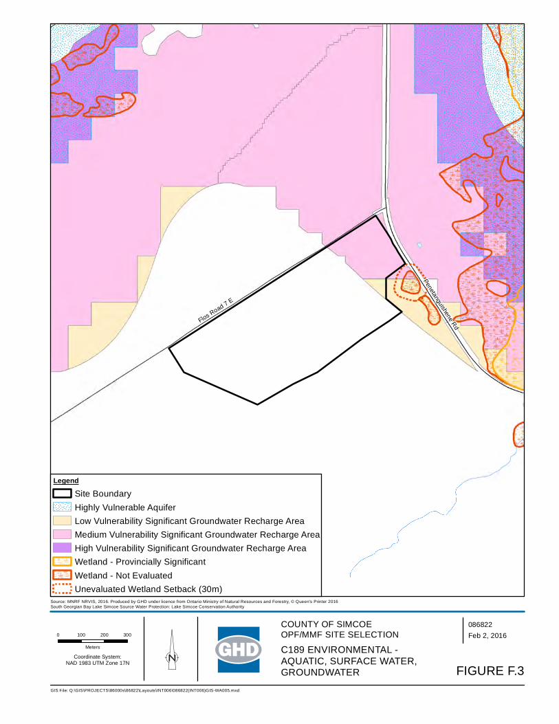
Flos Road 7 E
Penetanguishene Rd
0 100 200 300
Meters
086822 Feb 2, 2016
GIS File: Q:\GIS\PROJECTS\86000s\86822\Layouts\INT006\086822(INT006)GIS-WA005.mxd
Source: MNRF NRVIS, 2016. Produced by GHD under licence from Ontario Ministry of Natural Resources and Forestry, © Queen's Printer 2016South Georgian Bay Lake Simcoe Source Water Protection: Lake Simcoe Conservation Authority
Coordinate System:NAD 1983 UTM Zone 17N
Legend
Site BoundaryHighly Vulnerable AquiferLow Vulnerability Significant Groundwater Recharge AreaMedium Vulnerability Significant Groundwater Recharge AreaHigh Vulnerability Significant Groundwater Recharge AreaWetland - Provincially SignificantWetland - Not EvaluatedUnevaluated Wetland Setback (30m)
FIGURE F.3
C189 ENVIRONMENTAL -AQUATIC, SURFACE WATER, GROUNDWATER
COUNTY OF SIMCOEOPF/MMF SITE SELECTION

!(
!(
!(
#
Flos Road 7 E
Penetanguishene Rd
0 100 200 300
Meters
086822 Feb 2, 2016
GIS File: Q:\GIS\PROJECTS\86000s\86822\Layouts\INT006\086822(INT006)GIS-WA010.mxd
Source: MNRF NRVIS, 2016. Produced by GHD under licence from Ontario Ministry of Natural Resources and Forestry, © Queen's Printer 2016Zoning Source: Springwater Zoning By-Law
Coordinate System:NAD 1983 UTM Zone 17N
Legend
Site BoundarySite Buffer (500m)
# Cultural Heritage Point of Interest
!( Sensitive Receptor
Zoning
AgriculturalAgricultural CommercialEnvironmental ProtectionOpen Space
# Cultural Heritage Point of Interest
FIGURE F.4C189 SOCIAL AND CULTURAL
COUNTY OF SIMCOEOPF/MMF SITE SELECTION

!(
!(
!(
Flos Road 7 E
Penetanguishene Rd
0 50 100 150
Meters
086822 Feb 2, 2016
GIS File: Q:\GIS\PROJECTS\86000s\86822\Layouts\INT006\086822(INT006)GIS-WA011.mxd
Source: MNRF NRVIS, 2016. Produced by GHD under licence from Ontario Ministry of Natural Resources and Forestry, © Queen's Printer 2016
Coordinate System:NAD 1983 UTM Zone 17N
Legend
!( Sensitive ReceptorSite BoundaryAvoidance AreaFacility Access
Approximate OPF Facility Footprint Approximate OPF Facility Buffer
FIGURE F.5C189 CONCEPTUAL SITE FOOTPRINTS
COUNTY OF SIMCOEOPF/MMF SITE SELECTION

C189 Site Photographs
Photo 1 – View from Site to Penatanguishene Road
Photo 2 – View of existing trail on Site

Table F.1 C189 – 2249 Flos Road Seven East – OPF
Table F.1 Page 1 of 6
Component Criteria Indicators Potential Effects Mitigation Measures Net Effects Environmental Air Quality • Wind speed &
direction • Mean wind speed of 4.48 metres per second (m/s)
predominately coming from a northwesterly direction • Dust, particulate matter from construction/operation • Off-gases construction/operation
• The site has a varied topography, with a mixed forest around the north and east boundaries with an open area in the middle of the site
• Additional mitigation measures through design and Best Management Practices (BMPs) during construction/ operation will be required
• BMPs may include perimeter planting, dust suppression, ensuring construction and operation equipment are inspected and in good working condition
• With the implementation of BMPs, no off-site receptors affected
• Proximity to sensitive receptors
• Within 500 metres (m) of the site boundary, there are 3 off-site receptors located to the east potentially affected by dust and particulate matter from construction and operation of the facility
• Snowmobile trails and off-road trails through the site
• Design and implement dust control (routine cleaning of internal paved roads) • Maximize setback distance between facility footprint and sensitive receptors • Given the size of the property relative to the facility footprint, the on-site buffer is of
a sufficient size to act as a mitigation measure (i.e. levels of dust, particulate matter, etc. will dissipate before reaching the property line)
• Proper management of air quality controls • Implement BMPs to ensure dust generation is minimized
• No off-site receptors affected based on mitigation measures implemented for 3 receptors
• Species of Special Concern, Threatened, and/or Endangered
• Potential species at risk (SAR) based on available habitat, as identified by MNRF Management Biologist, include: Sensitive Plant Species (END), Butternut (END), Little Brown Bat (END), Northern Long-eared Bat (END), Eastern Wood-Pewee (SC), Canada Warbler (SC), Red-headed Woodpecker (SC), Wood Thrush (SC)
• Historical records for SAR list Beaked Spike-rush (1978) and an unknown sensitive species as the only record of SAR on the property
• Other SAR turtle species have been recorded on nearby properties
• Avoidance of any SAR or SAR habitat when siting the facility • Confirmation that SAR are not present will be determined if this site is carried
forward as the preferred and additional mitigation measures/BMPs will be established. In addition, a scoped EIS would be undertaken.
• Correspondence with MNRF would be necessary to determine the identity of the sensitive species
• Low net effects as there is the potential for Species of Special Concern, Threatened, and/or Endangered based on preliminary review
Odour • Wind speed & direction
• Mean wind speed of 4.48 m/s predominately coming from a northwesterly direction
• Off-gases construction/operation
• The site has a varied topography, with a mixed forest around the north and east boundaries with an open area in the middle of the site.
• Additional mitigation measures through design and BMPs during construction/ operation will be required
• BMPs may include planting in key areas after construction, odour management, ensuring construction and operation equipment are inspected and in good working condition
• Implement BMPs to ensure odour is minimized
• With the implementation of appropriate odour control design and BMPs, no off-site receptors affected
• Proximity to sensitive receptors
• Within 500 m of the site boundary, there are 3 off-site receptors located to the east potentially affected by odours from the facility
• Snowmobile trails and off-road trails through the site
• Design and implement odour control (store material in an enclosed space, gas collection, etc.) at the outset of the project.
• During operation, the facility will always operate under negative pressure • Given the size of the property relative to the facility footprint, the on-site buffer is of
a sufficient size to act as a mitigation measure (i.e. odour units will be reduced before reaching the property line)
• Implement BMPs to ensure odour from facility is minimized
• No off-site receptors affected based on mitigation measures implemented for 3 receptors
Noise
• Proximity to sensitive receptors
• Within 500 m of the site boundary, there are 3 off-site receptors located to the east potentially affected by noise from the construction and operations of the facility
• Snowmobile trails and off-road trails through the site
• Adhere to existing MOECC noise restrictions as well as additional noise limits imposed through the ECA
• During construction, adhere to Municipal Noise By-Law • Design and implement noise control measures at the outset of the project. • Maintenance to keep haul trucks in good condition • Given the size of the property relative to the facility footprint, the on-site buffer is of
a sufficient size to act as a mitigation measure (i.e. level of noise/sound will dissipate/be under noise limits before reaching the property line)
• Implement noise BMP plan • During operation, adhere to Municipal Noise By-Law
• No off-site receptors affected based on mitigation measures implemented for 3 receptors

Table F.1 C189 – 2249 Flos Road Seven East – OPF
Table F.1 Page 2 of 6
Component Criteria Indicators Potential Effects Mitigation Measures Net Effects Terrestrial • Topography • Due to the varied topography with a sloping toward the
eastern portion of the property, there is a minimal potential to alter natural drainage patterns
• Minimize alterations to existing topography • Setback facility from slope • Setback facility from unevaluated wetlands in southeast corner off-site • Minimize surface water flow into unevaluated wetlands through design
(conveyance)
• Low net effects on topography as it relates to natural environment (natural drainage patterns)
• Soil type • Overburden consists primarily of ice-contact deposits comprised of substratified to stratified sand, may include some incorporated sandy silt till
• The most easterly portion of the site and just further north consists of glaciofluvial sand with minor gravel, and boulder lags at the surface
• Overburden beneath the proposed site is greater than 91 m (300 feet) thick
• Surface water controls will be put in place to manage run-off from impervious surfaces (buildings/internal road, etc.)
• All materials accepted on-site will be within an enclosed building, with limited potential for runoff to occur
• All process water will be contained, collected and treated, either on-site or trucked off-site
• BMPs during construction will be implemented to limit potential impacts to soils and groundwater. This includes emergency management, accidental spills and containment techniques.
• Confirmation of soil types to occur should this be the preferred site
• No effects on groundwater
• Affected Greenlands • Effects to lands designated as Greenlands (pending approval in revised County Official Plan)
• No ANSI’s on-site • Forested with mixed community, coniferous and deciduous
• Infrastructure not subject to the environmental assessment process may be permitted within the Greenlands Designation or on adjacent lands in accordance with development and site alteration policies within the County Official Plan (Section 3.3.15)
• A scoped EIS would be undertaken as per the Official Plan requirements to develop infrastructure within the County Greenlands designation
• Avoid areas of significant/dense vegetation • Compensate for tree removal at a minimum on a 1:1 ratio – either on-site or on
another County owned property in close proximity
• Low effects to lands designated as Greenlands as an EIS is required. Completing the EIS will demonstrate through further analysis and investigation, as well as more detailed mitigation measures, the most appropriate location of the facility footprint on the site. This net effect would be lowered to “No” once a facility footprint location is determined as the EIS would demonstrate that there will be no negative impacts on natural features and areas and ecological functions of the County or local natural heritage system, and meet the requirements of Section 3.3.15 of the County Official Plan.
• No effects to ANSI’s • Moderate effects to existing
vegetation on-site as removal will be required for the facility
• Niagara Escarpment Land Use
• Not within the Niagara Escarpment Land Use policy area • No mitigation measures required • No net effects
• Oak Ridges Moraine Land Use
• Not within the Oak Ridges Moraine Land Use policy area • No mitigation measures required • No net effects

Table F.1 C189 – 2249 Flos Road Seven East – OPF
Table F.1 Page 3 of 6
Component Criteria Indicators Potential Effects Mitigation Measures Net Effects • Species of Special
Concern, Threatened, and/or Endangered
• Potential SAR based on available habitat, as identified by MNRF Management Biologist, include: Sensitive Plant Species (END), Butternut (END), Little Brown Bat (END), Northern Long-eared Bat (END), Eastern Wood-Pewee (SC), Canada Warbler (SC), Red-headed Woodpecker (SC), Wood Thrush (SC)
• Historical records for SAR list Beaked Spike-rush (1978) and an unknown sensitive species as the only record of SAR on the property
• Other SAR turtle species have been recorded on nearby properties
• Avoidance of any SAR or SAR habitat when siting the facility • Confirmation that SAR are not present will be determined if this site is carried
forward as the preferred and additional mitigation measures/BMPs will be established. In addition, a scoped EIS would be undertaken.
• Correspondence with MNRF would be necessary to determine the identity of the sensitive species
• Low net effects as there is the potential for Species of Special Concern, Threatened, and/or Endangered based on preliminary review
Aquatic • Species of Special Concern, Threatened, and/or Endangered
• No aquatic SAR listed as potentially occurring at this site • No aquatic SAR listed as occurring at this site • No net effects as there are no aquatic SAR listed as occurring at this site
Surface Water • Wetlands, Floodplains and Water Bodies
• Small pockets of unevaluated wetland east of the site • Provincially Significant Wetland (Copeland-Craighurst-
Guthrie Complex) located off-site to the east, within approximately 500 m of the property
• Orr Lake is also located to the north of the site (approximately 1.5 km)
• Implement appropriate setbacks from the un-evaluated wetland • Facility will be designed to meet 100-year storm event • Surface water controls will be put in place to manage run-off from impervious
surfaces (buildings/internal road, etc.) and direct them away from natural drainage features
• All materials accepted on-site will be within an enclosed building, with limited potential for runoff to occur
• All process water will be contained, collected and treated, either on-site or trucked off-site
• BMPs during construction will be implemented to limit potential impacts to surface water. This includes erosion and sediment controls, emergency management, accidental spills and containment techniques.
• Low effects to surface water features as the site is large and able to be located an appropriate distance from surface water features
Groundwater • Groundwater depth • Overburden consists primarily of ice-contact deposits comprised of substratified to stratified sand, may include some incorporated sandy silt till
• The most easterly portion of the site and just further north consists of glaciofluvial sand with minor gravel, and boulder lags at the surface
• Overburden beneath the proposed site is greater than 91 m (300 feet) thick
• Controlling surface water and process water will assist in mitigating any potential effects on groundwater.
• Surface water controls will be put in place to manage run-off from impervious surfaces (buildings/internal road, etc.).
• All materials accepted on-site will be within an enclosed building, with limited potential for runoff to occur
• All process water will be contained, collected and treated, either on-site or trucked off-site
• BMPs during construction will be implemented to limit potential impacts to surface water. This includes erosion and sediment controls, emergency management, accidental spills and containment techniques.
• No net effects, based on the groundwater depth and the surface water management on-site
• Groundwater flow and direction
• The direction of shallow groundwater flow within the overburden is interpreted to occur in a general northeasterly to easterly direction
• The sandy to gravelly nature of the overburden suggests that the rate of groundwater movement would be moderate to high
• No alterations to flow and direction are anticipated as part of the design of the facility
• Controlling surface water and process water will assist in mitigating any potential effects on groundwater
• No net effects as no alterations to flow and direction of groundwater are anticipated as part of the design of the facility
• Source Water Protection Areas
• The site is not located within a Wellhead Protection Area (WHPA)or Highly Vulnerable Aquifer (HVA)
• Potential to affect Source Water Protection Areas, however majority of the site is unaffected by Source Water Protection Areas
• Significant Groundwater Recharge Area (SGRA), medium vulnerability in northeast corner of site, with a small portion of the site in the southeastern corner listed as SGRA, low vulnerability
• Avoid locating the facility within the SGRA medium vulnerability areas • Controlling surface water and process water will assist in mitigating any potential
effects on groundwater • All mitigation measures described in the Surface Water and Groundwater criteria
would apply to this criteria as well
• No net effects to Source Water Protection Areas

Table F.1 C189 – 2249 Flos Road Seven East – OPF
Table F.1 Page 4 of 6
Component Criteria Indicators Potential Effects Mitigation Measures Net Effects Agricultural • Protection of Class 1,
2 and 3 Agricultural Lands
• Potential effects to Prime Agricultural Lands are minimal as only a small portion of the site (southwest corner) are Class 1-3
• Avoid Prime Agricultural Lands (Class 1-3) as much as possible • Site size is large enough that facility may be located outside of Prime Agricultural
lands
• No net effects to Class 1-3 Agricultural Lands
Social Sensitive Receptors
• Number and distribution of Sensitive Receptors (e.g., residential areas, parks and recreational areas, institutions, airports)
• Within 500 m of the site boundary, there are 3 off-site receptors located to the east potentially affected from a nuisance perspective (i.e., noise, odour, dust, traffic) from construction and operation of the facility
• Potential to affect the use and enjoyment of the snowmobile trails and off road trails through the site
• Potential construction-related and operational effects associated with dust, noise and traffic for uses within 500 m of the proposed facility will be mitigated through the use of BMPs (adhere to Municipal Noise By-Law, routine cleaning of internal roads, ensure equipment is inspected and in good working order)
• Design and implement odour control (store material in an enclosed space, gas collection, etc.) at the outset of the project
• During operation, the facility will always operate under negative pressure • Given the size of the property relative to the facility footprint, the on-site buffer is of
a sufficient size to act as a mitigation measure
• Low net effects based on proximity to sensitive receptors and on-site buffer areas
• Buffer zones and separation distances to Sensitive Receptors
• Potential to affect local sensitive receptors from a nuisance perspective (noise, odour, dust, traffic)
• Given the size of the property relative to the facility footprint, the on-site buffer is of a sufficient size to act as a mitigation measure -mitigation through design
• As mentioned above, potential construction-related and operational effects associated with dust, noise and traffic for uses within 500 m of the proposed facility will be mitigated through the use of BMPs (adhere to Municipal Noise By-Law, routine cleaning of internal paved roads, ensure equipment is inspected and in good working order)
• Low net effects based on proximity to sensitive receptors and on-site buffer areas
Land Use/ Zoning
• Current land use, zoning, approved development plans, and proposed land use changes
• County Official Plan designation is Greenlands and Springwater Official Plan designation is Rural
• Zoning designation is Agricultural
• County and Springwater Official Plan Amendment (OPA) and Springwater Zoning By-Law Amendment (ZBLA) would be required
• Low net effects due to displacement of current land use and OPA/ZBLA requirements
• Opportunity for brownfield development, enhanced use
• No opportunity for brownfield redevelopment or enhanced use as this site is not classified as a brownfield site
• No mitigation measures • Moderate net effects due to displacement of current land and lack of opportunity for brownfield redevelopment or enhanced use
• Compatibility with existing Land Use/ Zoning designations on adjacent sites
• Adjacent County Official Plan designation is Greenlands and Adjacent Springwater Official Plan designation is Rural, Agricultural
• Adjacent zoning designation is Agricultural, Agricultural Commercial, Open Space
• Given the size of the property relative to the facility footprint, the on-site buffer is of a sufficient size to act as a mitigation measure -mitigation through design
• As mentioned above, potential construction-related and operational effects associated with dust, noise and traffic for uses within 500 m of the proposed facility will be mitigated through the use of BMPs (adhere to Municipal Noise By-Law, routine cleaning of internal roads, ensure equipment is inspected and in good working order)
• Low net effects based on the size of the site, on-site buffer and application of proven mitigation measures
Transportation • Existing/required transportation infrastructure
• Access from Highway 93 Penetanguishene Road, through unopened road allowance (existing dirt road)
• Access at bend in Penetanguishene Road, would likely require improved signage, vehicle turning lanes, acceleration/deceleration lanes
• Ensure required transportation infrastructure is developed • Design and construct road improvements in accordance with MTO policies,
standards and practices
• Moderate net effects due to requirement for minor road upgrade, signage and vehicle turning and acceleration/deceleration lanes
• Neighbourhood traffic impacts
• Moderate existing traffic volume on Highway 93 Penetanguishene Road
• Potential to increase traffic on local roads within close proximity to established neighbourhoods and sensitive receptors
• Ensure required infrastructure is incorporated (i.e. signalization) • Design and construct road improvements in accordance with MTO policies,
standards and practices • Define local traffic routing within the local neighbourhood to a avoid impacts
• Moderate net effects due to the increase in local traffic
Visual • Buffer zones and visual screening
• Potential effects are limited as the site is well screened by exiting vegetation, topography and the large site size
• Vegetation to be planted around the facility to act as a secondary buffer • Low net effects as installation of visual screening would obscure views of the facility from surrounding areas
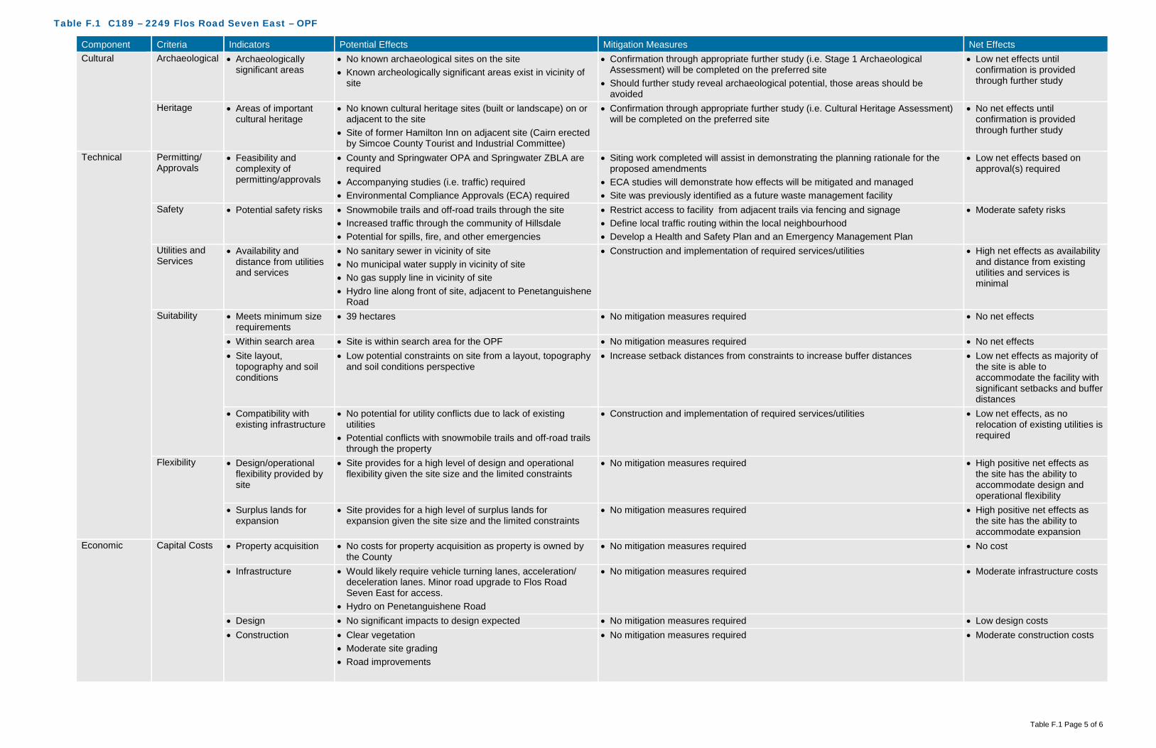
Table F.1 C189 – 2249 Flos Road Seven East – OPF
Table F.1 Page 5 of 6
Component Criteria Indicators Potential Effects Mitigation Measures Net Effects Cultural Archaeological • Archaeologically
significant areas • No known archaeological sites on the site • Known archeologically significant areas exist in vicinity of
site
• Confirmation through appropriate further study (i.e. Stage 1 Archaeological Assessment) will be completed on the preferred site
• Should further study reveal archaeological potential, those areas should be avoided
• Low net effects until confirmation is provided through further study
Heritage • Areas of important cultural heritage
• No known cultural heritage sites (built or landscape) on or adjacent to the site
• Site of former Hamilton Inn on adjacent site (Cairn erected by Simcoe County Tourist and Industrial Committee)
• Confirmation through appropriate further study (i.e. Cultural Heritage Assessment) will be completed on the preferred site
• No net effects until confirmation is provided through further study
Technical Permitting/ Approvals
• Feasibility and complexity of permitting/approvals
• County and Springwater OPA and Springwater ZBLA are required
• Accompanying studies (i.e. traffic) required • Environmental Compliance Approvals (ECA) required
• Siting work completed will assist in demonstrating the planning rationale for the proposed amendments
• ECA studies will demonstrate how effects will be mitigated and managed • Site was previously identified as a future waste management facility
• Low net effects based on approval(s) required
Safety • Potential safety risks • Snowmobile trails and off-road trails through the site • Increased traffic through the community of Hillsdale • Potential for spills, fire, and other emergencies
• Restrict access to facility from adjacent trails via fencing and signage • Define local traffic routing within the local neighbourhood • Develop a Health and Safety Plan and an Emergency Management Plan
• Moderate safety risks
Utilities and Services
• Availability and distance from utilities and services
• No sanitary sewer in vicinity of site • No municipal water supply in vicinity of site • No gas supply line in vicinity of site • Hydro line along front of site, adjacent to Penetanguishene
Road
• Construction and implementation of required services/utilities • High net effects as availability and distance from existing utilities and services is minimal
Suitability • Meets minimum size requirements
• 39 hectares • No mitigation measures required • No net effects
• Within search area • Site is within search area for the OPF • No mitigation measures required • No net effects • Site layout,
topography and soil conditions
• Low potential constraints on site from a layout, topography and soil conditions perspective
• Increase setback distances from constraints to increase buffer distances • Low net effects as majority of the site is able to accommodate the facility with significant setbacks and buffer distances
• Compatibility with existing infrastructure
• No potential for utility conflicts due to lack of existing utilities
• Potential conflicts with snowmobile trails and off-road trails through the property
• Construction and implementation of required services/utilities • Low net effects, as no relocation of existing utilities is required
Flexibility • Design/operational flexibility provided by site
• Site provides for a high level of design and operational flexibility given the site size and the limited constraints
• No mitigation measures required • High positive net effects as the site has the ability to accommodate design and operational flexibility
• Surplus lands for expansion
• Site provides for a high level of surplus lands for expansion given the site size and the limited constraints
• No mitigation measures required • High positive net effects as the site has the ability to accommodate expansion
Economic Capital Costs • Property acquisition • No costs for property acquisition as property is owned by the County
• No mitigation measures required • No cost
• Infrastructure • Would likely require vehicle turning lanes, acceleration/ deceleration lanes. Minor road upgrade to Flos Road Seven East for access.
• Hydro on Penetanguishene Road
• No mitigation measures required • Moderate infrastructure costs
• Design • No significant impacts to design expected • No mitigation measures required • Low design costs • Construction • Clear vegetation
• Moderate site grading • Road improvements
• No mitigation measures required • Moderate construction costs

Table F.1 C189 – 2249 Flos Road Seven East – OPF
Table F.1 Page 6 of 6
Component Criteria Indicators Potential Effects Mitigation Measures Net Effects • Permits/approvals • No significant impacts to permitting/approvals expected • No mitigation measures required • Low additional
Permit/Approval costs • Site remediation • No known areas requiring remediation on-site • No mitigation measures required • Low costs
Operation and Maintenance Costs
• Facility operation and maintenance
• No additional costs anticipated • No mitigation measures required • Low cost associated with operation and maintenance
• Transportation from feedstock sources
• Approximately 16 kilometres from waste centroid • No mitigation measures required • Moderate cost associated with transportation from feedstock sources
• Transportation to markets and end users
• Potential agricultural users nearby • No mitigation measures required • Low cost associated with transportation to markets and end users
• Monitoring requirements
• Standard monitoring requirements expected • No mitigation measures required • Low cost associated with monitoring requirements
• Mitigation requirements
• Natural screening mechanisms (e.g., topography, vegetation, significant buffer) already in place for odour, noise, visual
• Protection of Source Protection Areas
• No mitigation measures required • Low cost associated with mitigation requirements
Legal Land Acquisition
• Land acquisition complexity, risk, liability
• County-owned property • May need to compensate nearby residential properties • Road Allowance
• Mitigation through compensation • Moderate complexity, risk and liability
Agreement • Structure and complexity of operating agreement
• No added complexity expected • Mitigation through agreement structure • Low complexity

GHD | County of Simcoe – OPF, MMF, and Co-Located Facility – Part 3 – Short List Evaluation | 086822 (6)
Appendix G Site C223
Line 5 North

!(
!(
!(
!(
!(
!(
!(
!(
!(
!(
Bass Lake Siderd W
Line 5 N
Old Barrie Rd W
Line 6 N
0 100 200 300
Meters
086822 Feb 1, 2016
GIS File: Q:\GIS\PROJECTS\86000s\86822\Layouts\INT006\086822(INT006)GIS-WA003-C223.mxd
Source: MNRF NRVIS, 2015. Produced by GHD under licence from Ontario Ministry of Natural Resources and Forestry, © Queen's Printer 2016Inset Map: ESRI Data & Maps 2008 Data Distribution Application (DDA)
Coordinate System:NAD 1983 UTM Zone 17N
Legend
!( Sensitive ReceptorSite BoundarySite Buffer (500m)Parcel Boundary
Wind Rose at 30 metresMean Wind Speed: 4.30 m/s
FIGURE G.1C223 ENVIRONMENTAL -AIR QUALITY, ODOUR, NOISE
COUNTY OF SIMCOEOPF/MMF SITE SELECTION

Bass Lake Siderd W
Line 5 N
Old Barrie Rd W
Line 6 N
Martin FarmSouthANSI
332 334
338342
348
330
332
334
342346
348350
352
342
344
382
382
378
374
348
376372
354
356
358
360
368
366
384
332
350
354
340
370
340342
342
364360358
366
364362
352354
350
352
354
356
356
354
356
360
362
362
360358
360356
346
368
366
368
360
358
368
366
362
380
358
362
358
356
356
358
360
358356
354
356
354
354
370
356
360
358
350352
342 344
346
356358
368
344346
358
356
368
366
368
360
350
356
354
366
364
360
358
384
334
334
352
366
348
350
336
356
352
350
368
358
360
366
364
362
334
336
362364
368
368
368
366
348
366
366
364
362
352
364356
362
354
364
364
356
360
358
366
384
358
354
364
356
362
362
352
366 370
354
350
364
368
352
352
358
368
344
356360
350
344
354
348
350
366
364
356
354
356
372
370
366364
362
360
34835
0
358
360
362
360
358
356
358
352
354
346
348
366
342
360
366
354
364
368
354
364
352
354
356
364
356
368
356
354
364
356 356
356
366
360
366
366
362
360
356
364
364
366
0 100 200 300
Meters
086822 Feb 2, 2016
GIS File: Q:\GIS\PROJECTS\86000s\86822\Layouts\INT006\086822(INT006)GIS-WA002.mxd
Source: MNRF NRVIS, 2016. Produced by GHD under licence from Ontario Ministry of Natural Resources and Forestry, © Queen's Printer, County of Simcoe Geomatics 2016Greenlands Data: County of Simcoe, 2007
Coordinate System:NAD 1983 UTM Zone 17N
Legend
Site BoundaryContour (2m)Area of Natural and Scientific InterestLSRCA Regulation AreaSimcoe County GreenlandsCanada Land Inventory - Soils Class 1-3
FIGURE G.2C223 ENVIRONMENTAL -TERRESTRIAL, AGRICULTURAL
COUNTY OF SIMCOEOPF/MMF SITE SELECTION
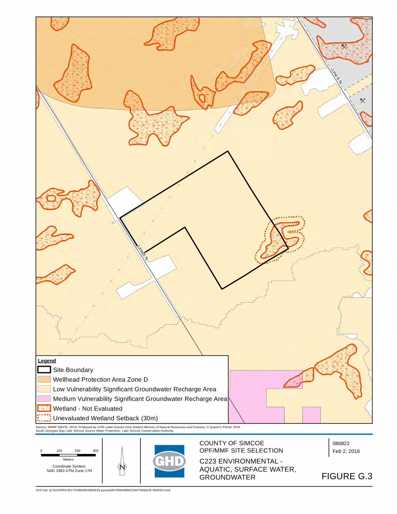
B
B
Line 6 N
Line 5 N
0 100 200 300
Meters
086822 Feb 2, 2016
GIS File: Q:\GIS\PROJECTS\86000s\86822\Layouts\INT006\086822(INT006)GIS-WA005.mxd
Source: MNRF NRVIS, 2016. Produced by GHD under licence from Ontario Ministry of Natural Resources and Forestry, © Queen's Printer 2016South Georgian Bay Lake Simcoe Source Water Protection: Lake Simcoe Conservation Authority
Coordinate System:NAD 1983 UTM Zone 17N
Legend
Site BoundaryWellhead Protection Area Zone DLow Vulnerability Significant Groundwater Recharge AreaMedium Vulnerability Significant Groundwater Recharge AreaWetland - Not EvaluatedUnevaluated Wetland Setback (30m)
FIGURE G.3
C223 ENVIRONMENTAL -AQUATIC, SURFACE WATER, GROUNDWATER
COUNTY OF SIMCOEOPF/MMF SITE SELECTION

!(
!(
!(
!(
!(
!(
!(
!(
!(
!(
Line 6 N
Line 5 N
0 100 200 300
Meters
086822 Feb 2, 2016
GIS File: Q:\GIS\PROJECTS\86000s\86822\Layouts\INT006\086822(INT006)GIS-WA010.mxd
Source: MNRF NRVIS, 2016. Produced by GHD under licence from Ontario Ministry of Natural Resources and Forestry, © Queen's Printer 2016Zoning Source: Oro-Medonte Zoning By-Law
Coordinate System:NAD 1983 UTM Zone 17N
Legend
Site BoundarySite Buffer (500m)
!( Sensitive Receptor
Zoning
AgriculturalMineral Aggregate Resource TwoOpen SpaceRural Residential
FIGURE G.4C223 SOCIAL AND CULTURAL
COUNTY OF SIMCOEOPF/MMF SITE SELECTION

!(
!(
!(
!(
!(
!(
!(
!(
!(
!(
Line 6 N
Line 5 N
0 90 180 270
Meters
086822 Feb 19, 2016
GIS File: Q:\GIS\PROJECTS\86000s\86822\Layouts\INT006\086822(INT006)GIS-WA011.mxd
Source: MNRF NRVIS, 2016. Produced by GHD under licence from Ontario Ministry of Natural Resources and Forestry, © Queen's Printer 2016
Coordinate System:NAD 1983 UTM Zone 17N
Legend
!( Sensitive ReceptorSite BoundaryAvoidance AreaFacility Access
Approximate MMF Facility FootprintApproximate OPF Facility FootprintApproximate Co-Located Facility Footprint
Approximate MMF Facility BufferApproximate OPF Facility BufferApproximate Co-Located Facility Buffer
FIGURE G.5C223 CONCEPTUAL SITE FOOTPRINTS
COUNTY OF SIMCOEOPF/MMF SITE SELECTION

C223 Site Photographs
Photo 1 – View of Hydro Corridor on Site
Photo 2 – View of plantings on Site

Table G.1 C223 – Line 5 North – OPF
Table G.1 Page 1 of 6
Component Criteria Indicators Potential Effects Mitigation Measures Net Effects Environmental Air Quality • Wind speed &
direction • Mean wind speed of 4.30 metres per second (m/s)
predominately coming from a northwesterly direction • Dust, particulate matter from construction/operation • Off-gases construction/operation
• The site has a varied topography, with a mixture of hardwood and conifer forests, which will require additional mitigation measures through design and Best Management Practices (BMPs) during construction/ operation will be required
• BMPs may include perimeter planting, dust suppression, ensuring construction and operation equipment are inspected and in good working condition
• With the implementation of BMPs, no off-site receptors affected
• Proximity to sensitive receptors
• Within 500 metres (m) of the site boundary, there are 10 off-site receptors located to the northwest, west and southwest potentially affected by dust and particulate matter from construction and operation of the facility
• Hardwood Ski and Bike to the southeast of the site
• Design and implement dust control (routine cleaning of internal paved roads)
• Maximize setback distance between facility footprint and sensitive receptors
• Given the size of the property relative to the facility footprint, the on-site buffer is of a sufficient size to act as a mitigation measure (i.e., levels of dust, particulate matter, etc. will dissipate before reaching the property line)
• Proper management of air quality controls • Implement BMPs to ensure dust generation is minimized
• No off-site receptors affected based on mitigation measures implemented for 10 receptors
• Species of Special Concern, Threatened, and/or Endangered
• Potential species at risk (SAR) based on available habitat, as identified by MNRF Management Biologist, include: Sensitive Plant Species (END), Butternut (END), Little Brown Bat (END), Northern Long-eared Bat (END), Eastern Wood-Pewee (SC), Canada Warbler (SC), Red-headed
• Historical SAR records list Ocellated Darner and Zebra Clubtail, two species of dragonfly. Potential habitat for Ocellated Darner may be present on the property.
• Avoidance of any SAR or SAR habitat when siting the facility • Confirmation that SAR are not present will be determined if this site is
carried forward as the preferred and additional mitigation measures/BMPs will be established. In addition, a scoped EIS would be undertaken.
• Low net effects as there is the potential for Species of Special Concern, Threatened, and/or Endangered based on preliminary review
Odour • Wind speed & direction
• Mean wind speed of 4.30 m/s predominately coming from a northwesterly direction
• Off-gases construction/operation
• The site has a varied topography, with a mixture of hardwood and conifer forests, which will require additional mitigation measures through design and Best Management Practices (BMP) during construction/ operation will be required
• BMPs may include planting in key areas after construction, odour management, ensuring construction and operation equipment are inspected and in good working condition
• Implement BMPs to ensure odour is minimized
• With the implementation of appropriate odour control design and BMPs, no off-site receptors affected
• Proximity to sensitive receptors
• Within 500 m of the site boundary, there are 10 off-site receptors located to the northwest, west and southwest potentially affected by odour from the facility
• Hardwood Ski and Bike to the southeast of the site
• Design and implement odour control (store material in an enclosed space, gas collection, etc.) at the outset of the project
• During operation, the facility will always operate under negative pressure
• Maximize setback distance between facility footprint and sensitive receptors
• Given the size of the property relative to the facility footprint, the on-site buffer is of a sufficient size to act as a mitigation measure (i.e., odour units will be reduced before reaching the property line)
• Implement BMPs to ensure odour from facility is minimized
• No off-site receptors affected based on mitigation measures implemented for 10 receptors

Table G.1 C223 – Line 5 North – OPF
Table G.1 Page 2 of 6
Component Criteria Indicators Potential Effects Mitigation Measures Net Effects Noise • Proximity to sensitive
receptors • Within 500 m of the site boundary, there are 10 off-site
receptors located to the northwest, west and southwest potentially affected by noise from construction and operation of the facility
• Hardwood Ski and Bike to the southeast of the site
• Adhere to existing MOECC noise restrictions as well as additional noise limits imposed through the ECA
• During construction, adhere to Municipal Noise By-Law • Design and implement noise control measures at the outset of the
project • Maintenance to keep haul trucks in good condition • Maximize setback distance between facility footprint and sensitive
receptors • Given the size of the property relative to the facility footprint, the on-site
buffer is of a sufficient size to act as a mitigation measure (i.e. level of noise/sound will dissipate/be under noise limits before reaching the property line)
• Implement noise BMP plan • During operation, adhere to Municipal Noise By-Law
• No off-site receptors affected based on mitigation measures implemented for 10 receptors
Terrestrial • Topography • Due to the slightly varied topography with a sloping toward the eastern portion of the property, there is a minimal potential to alter natural drainage patterns
• Minimize alterations to existing topography • Setback facility from slope • Setback facility from unevaluated wetlands • Minimize surface water flow into unevaluated wetlands through design
(conveyance)
• Low net effects on topography as it relates to natural environment (natural drainage patterns)
• Soil type • Overburden consists of glaciofluvial ice-contact stratified sand, gravelly sand and gravel (minor silt and clay)
• Overburden beneath the proposed site is about 69 m (225 feet) thick
• Surface water controls will be put in place to manage run-off from impervious surfaces (buildings/internal road, etc.)
• All materials accepted on-site will be within an enclosed building, with limited potential for runoff to occur
• All process water will be contained, collected and treated, either on-site or trucked off-site
• BMPs during construction will be implemented to limit potential impacts to soils and groundwater. This includes emergency management, accidental spills and containment techniques.
• Confirmation of soil types to occur should this be the preferred site
• No effects on groundwater
• Affected Greenlands • Minimal effects to Greenlands within the southeast portion of the site, which overlaps with the Oro Moraine Core Area
• No effects to Areas of Natural Scientific Interest (ANSI) • Regional Life Science ANSI located within close proximity to
the southern boundary of the site • Forested with mixture of hardwood and conifer forest and
some open areas
• Avoid Greenlands, in particular the Oro Moraine Core Area designation • Avoid areas of significant/dense vegetation • Compensate for tree removal at a minimum on a 1:1 ratio – either on-
site or on another County owned property in close proximity
• Low net effects related to Greenlands, Oro Moraine Core Area or ANSI’s as these areas will be avoided
• Low effects to existing vegetation on-site as removal will be required for the facility
• Niagara Escarpment Land Use
• Not within the Niagara Escarpment Land Use policy area • No mitigation measures required • No net effects
• Oak Ridges Moraine Land Use
• Not within the Oak Ridges Moraine Land Use policy area • No mitigation measures required • No net effects
• Species of Special Concern, Threatened, and/or Endangered
• Potential SAR species at risk based on available habitat, as identified by MNRF Management Biologist, include: Sensitive Plant Species (END), Butternut (END), Little Brown Bat (END), Northern Long-eared Bat (END), Eastern Wood-Pewee (SC), Canada Warbler (SC), Red-headed Woodpecker (SC), Wood Thrush (SC)
• Historical SAR records list Ocellated Darner and Zebra Clubtail, two species of dragonfly. Potential habitat for Ocellated Darner may be present on the property.
• Avoidance of any SAR or SAR habitat when siting the facility • Confirmation that SAR are not present will be determined if this site is
carried forward as the preferred and additional mitigation measures/BMPs will be established. In addition, a scoped EIS would be undertaken.
• Low net effects as there is the potential for Species of Special Concern, Threatened, and/or Endangered based on preliminary review

Table G.1 C223 – Line 5 North – OPF
Table G.1 Page 3 of 6
Component Criteria Indicators Potential Effects Mitigation Measures Net Effects Aquatic • Species of Special
Concern, Threatened, and/or Endangered
• No aquatic SAR listed as potentially occurring at this site • No aquatic SAR listed as occurring at this site • No net effects as there are no aquatic SAR listed as occurring at this site
Surface Water • Wetlands, Floodplains and Water Bodies
• Unevaluated wetland in southeast corner of site • Implement appropriate setbacks from the unevaluated wetland • Facility will be designed to meet 100-year storm event • As the site is at the headwaters of a number of municipal water
systems, on the Oro Moraine, and has limited surface water drainage (e.g., creeks/streams), surface water controls will be put in place to manage run-off from impervious surfaces (buildings/internal road, etc.) and direct them away from natural drainage features and onto fields for tile drainage
• All materials accepted on-site will be within an enclosed building, with limited potential for runoff to occur
• All process water will be contained, collected and treated, either on-site or trucked off-site
• BMPs during construction will be implemented to limit potential impacts to surface water. This includes erosion and sediment controls, emergency management, accidental spills and containment techniques.
• Low effects to surface water features as the site is large and able to be located an appropriate distance from surface water features
Groundwater • Groundwater depth • Overburden consists of glaciofluvial ice-contact stratified sand, gravelly sand and gravel (minor silt and clay)
• Overburden beneath the proposed site is about 69 m (225 feet) thick
• Controlling surface water and process water will assist in mitigating any potential effects on groundwater
• Surface water controls will be put in place to manage run-off from impervious surfaces (buildings/internal road, etc.)
• All materials accepted on-site will be within an enclosed building, with limited potential for runoff to occur
• All process water will be contained, collected and treated, either on-site or trucked off-site
• BMPs during construction will be implemented to limit potential impacts to surface water. This includes erosion and sediment controls, emergency management, accidental spills and containment techniques.
• No net effects, based on the groundwater depth and the surface water management on-site
• Groundwater flow and direction
• The direction of shallow groundwater flow within the overburden is interpreted to occur in a general northeasterly direction
• The sand and gravelly sand and gravel nature of the overburden suggests that the rate of groundwater movement would be moderate to high
• No alterations to flow and direction are anticipated as part of the design of the facility
• Controlling surface water and process water will assist in mitigating any potential effects on groundwater
• No net effects as no alterations to flow and direction of groundwater are anticipated as part of the design of the facility
• Source Water Protection Areas
• The site is not located within a Wellhead Protection Area (WHPA)or Highly Vulnerable Aquifer (HVA)
• Potential effects to Source Water Protection Areas • Entire site is within a low vulnerability Significant Groundwater
Recharge Area (SGRA), which allows for the development of an OPF
• Facility could be located with the SGRA, low vulnerability area, as it is permissible
• Controlling surface water and process water will assist in mitigating any potential effects on groundwater
• All mitigation measures described in the Surface Water and Groundwater criteria would apply to this criteria as well
• Low net effects to Source Water Protection Areas
Agricultural • Protection of Class 1, 2 and 3 Agricultural Lands
• Potential effects to Prime Agricultural Lands are minimal as only a miniscule portion of the site (northern section near hydro corridor) are Class 1-3
• Avoid Prime Agricultural Lands (Class 1-3) • Site size is large enough that facility may be located outside of Prime
Agricultural lands
• No net effects to Class 1-3 Agricultural Lands
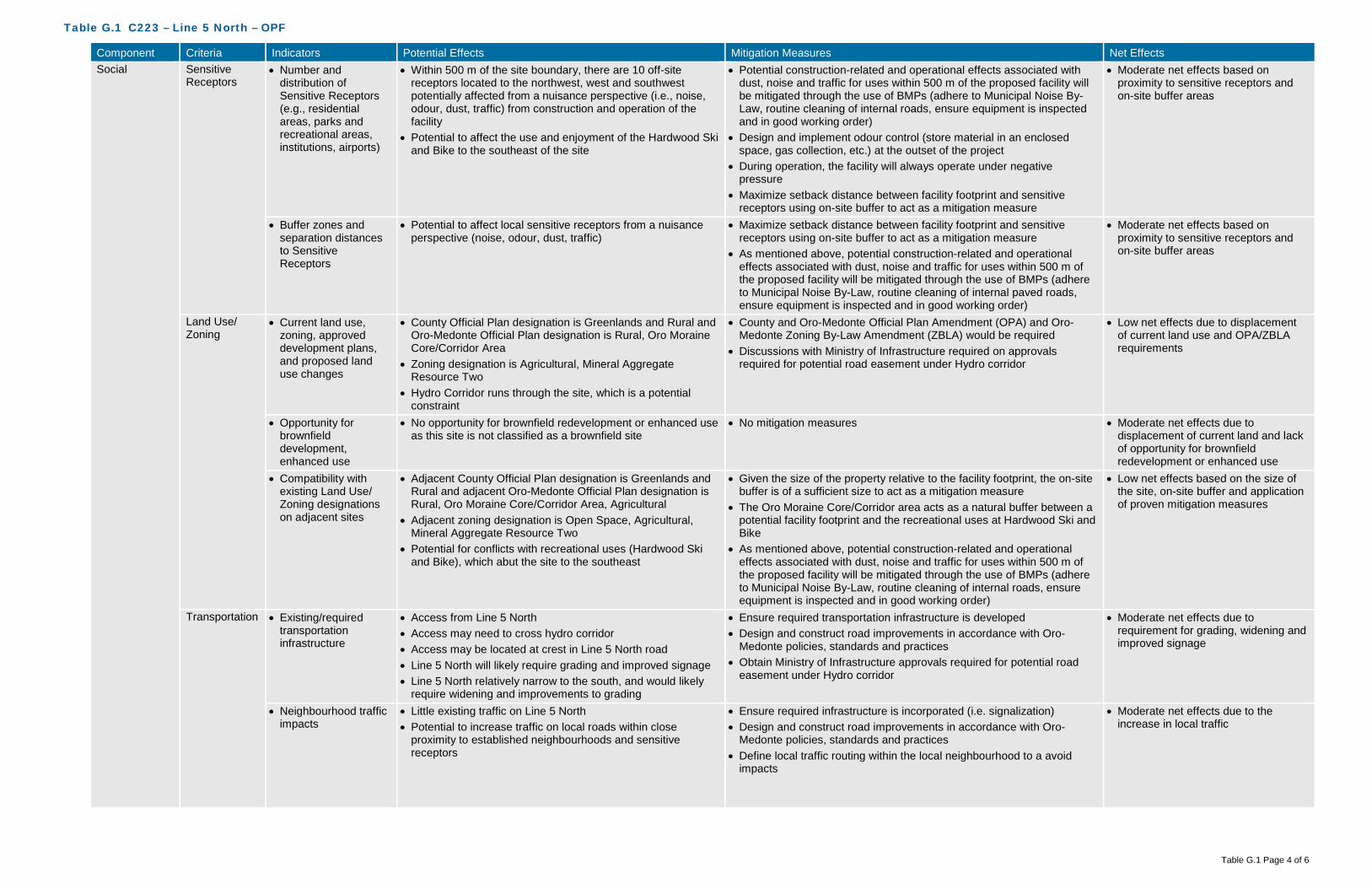
Table G.1 C223 – Line 5 North – OPF
Table G.1 Page 4 of 6
Component Criteria Indicators Potential Effects Mitigation Measures Net Effects Social Sensitive
Receptors • Number and
distribution of Sensitive Receptors (e.g., residential areas, parks and recreational areas, institutions, airports)
• Within 500 m of the site boundary, there are 10 off-site receptors located to the northwest, west and southwest potentially affected from a nuisance perspective (i.e., noise, odour, dust, traffic) from construction and operation of the facility
• Potential to affect the use and enjoyment of the Hardwood Ski and Bike to the southeast of the site
• Potential construction-related and operational effects associated with dust, noise and traffic for uses within 500 m of the proposed facility will be mitigated through the use of BMPs (adhere to Municipal Noise By-Law, routine cleaning of internal roads, ensure equipment is inspected and in good working order)
• Design and implement odour control (store material in an enclosed space, gas collection, etc.) at the outset of the project
• During operation, the facility will always operate under negative pressure
• Maximize setback distance between facility footprint and sensitive receptors using on-site buffer to act as a mitigation measure
• Moderate net effects based on proximity to sensitive receptors and on-site buffer areas
• Buffer zones and separation distances to Sensitive Receptors
• Potential to affect local sensitive receptors from a nuisance perspective (noise, odour, dust, traffic)
• Maximize setback distance between facility footprint and sensitive receptors using on-site buffer to act as a mitigation measure
• As mentioned above, potential construction-related and operational effects associated with dust, noise and traffic for uses within 500 m of the proposed facility will be mitigated through the use of BMPs (adhere to Municipal Noise By-Law, routine cleaning of internal paved roads, ensure equipment is inspected and in good working order)
• Moderate net effects based on proximity to sensitive receptors and on-site buffer areas
Land Use/ Zoning
• Current land use, zoning, approved development plans, and proposed land use changes
• County Official Plan designation is Greenlands and Rural and Oro-Medonte Official Plan designation is Rural, Oro Moraine Core/Corridor Area
• Zoning designation is Agricultural, Mineral Aggregate Resource Two
• Hydro Corridor runs through the site, which is a potential constraint
• County and Oro-Medonte Official Plan Amendment (OPA) and Oro-Medonte Zoning By-Law Amendment (ZBLA) would be required
• Discussions with Ministry of Infrastructure required on approvals required for potential road easement under Hydro corridor
• Low net effects due to displacement of current land use and OPA/ZBLA requirements
• Opportunity for brownfield development, enhanced use
• No opportunity for brownfield redevelopment or enhanced use as this site is not classified as a brownfield site
• No mitigation measures • Moderate net effects due to displacement of current land and lack of opportunity for brownfield redevelopment or enhanced use
• Compatibility with existing Land Use/ Zoning designations on adjacent sites
• Adjacent County Official Plan designation is Greenlands and Rural and adjacent Oro-Medonte Official Plan designation is Rural, Oro Moraine Core/Corridor Area, Agricultural
• Adjacent zoning designation is Open Space, Agricultural, Mineral Aggregate Resource Two
• Potential for conflicts with recreational uses (Hardwood Ski and Bike), which abut the site to the southeast
• Given the size of the property relative to the facility footprint, the on-site buffer is of a sufficient size to act as a mitigation measure
• The Oro Moraine Core/Corridor area acts as a natural buffer between a potential facility footprint and the recreational uses at Hardwood Ski and Bike
• As mentioned above, potential construction-related and operational effects associated with dust, noise and traffic for uses within 500 m of the proposed facility will be mitigated through the use of BMPs (adhere to Municipal Noise By-Law, routine cleaning of internal roads, ensure equipment is inspected and in good working order)
• Low net effects based on the size of the site, on-site buffer and application of proven mitigation measures
Transportation • Existing/required transportation infrastructure
• Access from Line 5 North • Access may need to cross hydro corridor • Access may be located at crest in Line 5 North road • Line 5 North will likely require grading and improved signage • Line 5 North relatively narrow to the south, and would likely
require widening and improvements to grading
• Ensure required transportation infrastructure is developed • Design and construct road improvements in accordance with Oro-
Medonte policies, standards and practices • Obtain Ministry of Infrastructure approvals required for potential road
easement under Hydro corridor
• Moderate net effects due to requirement for grading, widening and improved signage
• Neighbourhood traffic impacts
• Little existing traffic on Line 5 North • Potential to increase traffic on local roads within close
proximity to established neighbourhoods and sensitive receptors
• Ensure required infrastructure is incorporated (i.e. signalization) • Design and construct road improvements in accordance with Oro-
Medonte policies, standards and practices • Define local traffic routing within the local neighbourhood to a avoid
impacts
• Moderate net effects due to the increase in local traffic

Table G.1 C223 – Line 5 North – OPF
Table G.1 Page 5 of 6
Component Criteria Indicators Potential Effects Mitigation Measures Net Effects Visual • Buffer zones and
visual screening • Potential effects are limited as the site is well screened by
exiting vegetation, topography and the large site size • Screening at the access off of Line 5 • Vegetation to be planted around the facility to act as a secondary buffer
• Low net effects as installation of visual screening would obscure views of the facility from surrounding areas
Cultural Archaeological • Archaeologically significant areas
• No known archaeological sites on the site • Confirmation through appropriate further study (i.e. Stage 1 Archaeological Assessment) will be completed on the preferred site
• Should further study reveal archaeological potential, those areas should be avoided
• Low net effects until confirmation is provided through further study
Heritage • Areas of important cultural heritage
• No known cultural heritage sites (built or landscape) on or adjacent to the site
• Confirmation through appropriate further study (i.e. Cultural Heritage Assessment) will be completed on the preferred site
• No net effects until confirmation is provided through further study
Technical Permitting/ Approvals
• Feasibility and complexity of permitting/approvals
• County and Oro-Medonte OPA and Oro-Medonte ZBLA are required
• Located within the Oro Moraine Planning Area Boundary • Approvals from Ministry of Infrastructure for work under Hydro
corridor • Accompanying studies (i.e. traffic) required • Environmental Compliance Approvals (ECA) required
• Siting work completed will assist in demonstrating the planning rationale for the proposed amendments, with an additional focus on the Oro Moraine policies
• Obtain Ministry of Infrastructure approvals required for potential road easement under Hydro corridor
• ECA studies will demonstrate how effects will be mitigated and managed
• Moderate net effects based on approval(s) required
Safety • Potential safety risks • Hardwood Ski and Bike to the southeast of the site • Potential for spills, fire, and other emergencies
• Restrict access to facility from adjacent trails via fencing and signage • Develop a Health and Safety Plan and an Emergency Management
Plan
• Moderate safety risks
Utilities and Services
• Availability and distance from utilities and services
• No sanitary sewer in vicinity of site • No municipal water supply in vicinity of site • No gas supply line in vicinity of site • Hydro line on Line 5 North
• Construction and implementation of required services/utilities • High net effects as availability and distance from existing utilities and services is minimal
Suitability • Meets minimum size requirements
• 33 hectares • No mitigation measures required • No net effects
• Within search area • Site is within search area for the OPF • No mitigation measures required • No net effects • Site layout,
topography and soil conditions
• Low potential constraints on site from a layout, topography and soil conditions perspective
• Potential constraint from the Hydro corridor, particularly as it relates to access
• Increase setback distances from constraints to increase buffer distances
• Obtain Ministry of Infrastructure approvals required for potential road easement under Hydro corridor
• Low net effects as majority of the site is able to accommodate the facility with significant setbacks and buffer distances
• Compatibility with existing infrastructure
• Potential constraint from the Hydro corridor, particularly as it relates to access
• Obtain Ministry of Infrastructure approvals required for potential road easement under Hydro corridor
• Construction and implementation of required services/utilities
• Low net effects, as no relocation of existing utilities is required
Flexibility • Design/operational flexibility provided by site
• Potential constraint from the Hydro corridor, particularly as it relates to access
• Remainder of site provides for a moderate level of design and operational flexibility given the Hydro corridor and Oro Moraine designated lands constraints
• Oro Moraine zoning may impose other restrictions
• No mitigation measures required • Moderate positive net effects as the site has the ability to accommodate design and operational flexibility
• Surplus lands for expansion
• Site provides for a moderate level of surplus lands for expansion given the site size and the limited constraints
• No mitigation measures required • Moderate positive net effects as the site has the ability to accommodate expansion
Economic Capital Costs • Property acquisition • No costs for property acquisition as property is owned by the County
• No mitigation measures required • No cost
• Infrastructure • Line 5 relatively narrow to the south, and would likely require widening and improvements to grading
• Hydro on Line 5 North
• No mitigation measures required • Moderate infrastructure costs
• Design • Road alignment and protective measures around hydro towers
• Slopes on and off site
• No mitigation measures required • Low design costs
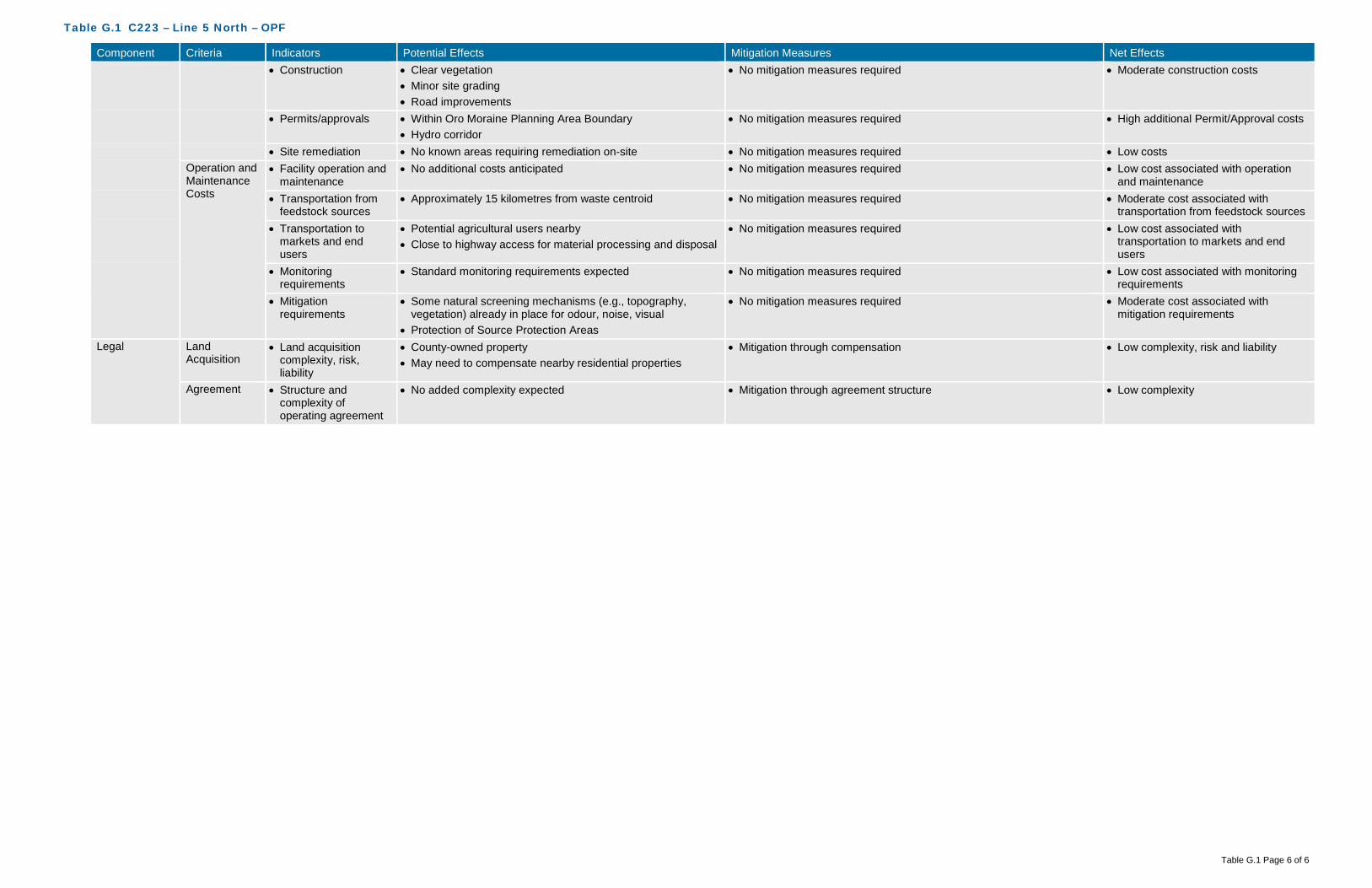
Table G.1 C223 – Line 5 North – OPF
Table G.1 Page 6 of 6
Component Criteria Indicators Potential Effects Mitigation Measures Net Effects • Construction • Clear vegetation
• Minor site grading • Road improvements
• No mitigation measures required • Moderate construction costs
• Permits/approvals • Within Oro Moraine Planning Area Boundary • Hydro corridor
• No mitigation measures required • High additional Permit/Approval costs
• Site remediation • No known areas requiring remediation on-site • No mitigation measures required • Low costs Operation and Maintenance Costs
• Facility operation and maintenance
• No additional costs anticipated • No mitigation measures required • Low cost associated with operation and maintenance
• Transportation from feedstock sources
• Approximately 15 kilometres from waste centroid • No mitigation measures required • Moderate cost associated with transportation from feedstock sources
• Transportation to markets and end users
• Potential agricultural users nearby • Close to highway access for material processing and disposal
• No mitigation measures required • Low cost associated with transportation to markets and end users
• Monitoring requirements
• Standard monitoring requirements expected • No mitigation measures required • Low cost associated with monitoring requirements
• Mitigation requirements
• Some natural screening mechanisms (e.g., topography, vegetation) already in place for odour, noise, visual
• Protection of Source Protection Areas
• No mitigation measures required • Moderate cost associated with mitigation requirements
Legal Land Acquisition
• Land acquisition complexity, risk, liability
• County-owned property • May need to compensate nearby residential properties
• Mitigation through compensation • Low complexity, risk and liability
Agreement • Structure and complexity of operating agreement
• No added complexity expected • Mitigation through agreement structure • Low complexity
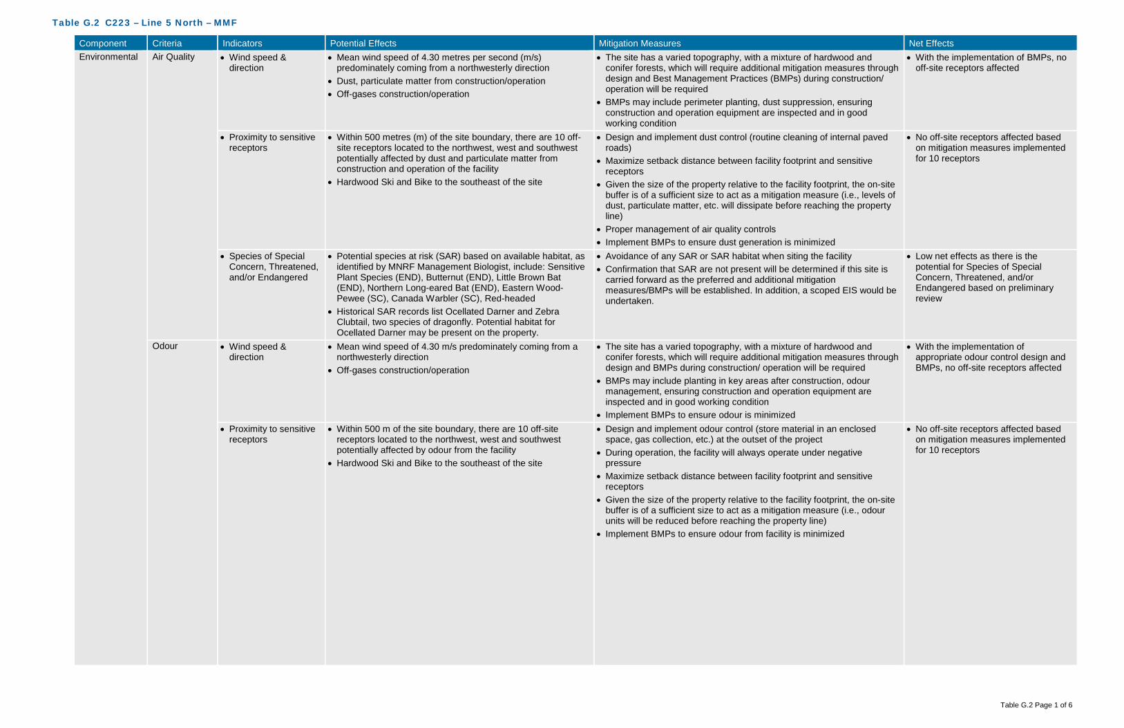
Table G.2 C223 – Line 5 North – MMF
Table G.2 Page 1 of 6
Component Criteria Indicators Potential Effects Mitigation Measures Net Effects Environmental Air Quality • Wind speed &
direction • Mean wind speed of 4.30 metres per second (m/s)
predominately coming from a northwesterly direction • Dust, particulate matter from construction/operation • Off-gases construction/operation
• The site has a varied topography, with a mixture of hardwood and conifer forests, which will require additional mitigation measures through design and Best Management Practices (BMPs) during construction/ operation will be required
• BMPs may include perimeter planting, dust suppression, ensuring construction and operation equipment are inspected and in good working condition
• With the implementation of BMPs, no off-site receptors affected
• Proximity to sensitive receptors
• Within 500 metres (m) of the site boundary, there are 10 off-site receptors located to the northwest, west and southwest potentially affected by dust and particulate matter from construction and operation of the facility
• Hardwood Ski and Bike to the southeast of the site
• Design and implement dust control (routine cleaning of internal paved roads)
• Maximize setback distance between facility footprint and sensitive receptors
• Given the size of the property relative to the facility footprint, the on-site buffer is of a sufficient size to act as a mitigation measure (i.e., levels of dust, particulate matter, etc. will dissipate before reaching the property line)
• Proper management of air quality controls • Implement BMPs to ensure dust generation is minimized
• No off-site receptors affected based on mitigation measures implemented for 10 receptors
• Species of Special Concern, Threatened, and/or Endangered
• Potential species at risk (SAR) based on available habitat, as identified by MNRF Management Biologist, include: Sensitive Plant Species (END), Butternut (END), Little Brown Bat (END), Northern Long-eared Bat (END), Eastern Wood-Pewee (SC), Canada Warbler (SC), Red-headed
• Historical SAR records list Ocellated Darner and Zebra Clubtail, two species of dragonfly. Potential habitat for Ocellated Darner may be present on the property.
• Avoidance of any SAR or SAR habitat when siting the facility • Confirmation that SAR are not present will be determined if this site is
carried forward as the preferred and additional mitigation measures/BMPs will be established. In addition, a scoped EIS would be undertaken.
• Low net effects as there is the potential for Species of Special Concern, Threatened, and/or Endangered based on preliminary review
Odour • Wind speed & direction
• Mean wind speed of 4.30 m/s predominately coming from a northwesterly direction
• Off-gases construction/operation
• The site has a varied topography, with a mixture of hardwood and conifer forests, which will require additional mitigation measures through design and BMPs during construction/ operation will be required
• BMPs may include planting in key areas after construction, odour management, ensuring construction and operation equipment are inspected and in good working condition
• Implement BMPs to ensure odour is minimized
• With the implementation of appropriate odour control design and BMPs, no off-site receptors affected
• Proximity to sensitive receptors
• Within 500 m of the site boundary, there are 10 off-site receptors located to the northwest, west and southwest potentially affected by odour from the facility
• Hardwood Ski and Bike to the southeast of the site
• Design and implement odour control (store material in an enclosed space, gas collection, etc.) at the outset of the project
• During operation, the facility will always operate under negative pressure
• Maximize setback distance between facility footprint and sensitive receptors
• Given the size of the property relative to the facility footprint, the on-site buffer is of a sufficient size to act as a mitigation measure (i.e., odour units will be reduced before reaching the property line)
• Implement BMPs to ensure odour from facility is minimized
• No off-site receptors affected based on mitigation measures implemented for 10 receptors

Table G.2 C223 – Line 5 North – MMF
Table G.2 Page 2 of 6
Component Criteria Indicators Potential Effects Mitigation Measures Net Effects Noise • Proximity to sensitive
receptors • Within 500 m of the site boundary, there are 10 off-site
receptors located to the northwest, west and southwest potentially affected by noise from construction and operation of the facility
• Hardwood Ski and Bike to the southeast of the site
• Adhere to existing MOECC noise restrictions as well as additional noise limits imposed through the ECA
• During construction, adhere to Municipal Noise By-Law • Design and implement noise control measures at the outset of the
project • Maintenance to keep haul trucks in good condition • Maximize setback distance between facility footprint and sensitive
receptors • Given the size of the property relative to the facility footprint, the on-site
buffer is of a sufficient size to act as a mitigation measure (i.e. level of noise/sound will dissipate/be under noise limits before reaching the property line)
• Implement noise BMP plan • During operation, adhere to Municipal Noise By-Law
• No off-site receptors affected based on mitigation measures implemented for 10 receptors
Terrestrial • Topography • Due to the slightly varied topography with a sloping toward the eastern portion of the property, there is a minimal potential to alter natural drainage patterns
• Minimize alterations to existing topography • Setback facility from slope • Setback facility from unevaluated wetlands • Minimize surface water flow into unevaluated wetlands through design
(conveyance)
• Low net effects on topography as it relates to natural environment (natural drainage patterns)
• Soil type • Overburden consists of glaciofluvial ice-contact stratified sand, gravelly sand and gravel (minor silt and clay)
• Overburden beneath the proposed site is about 69 m (225 feet) thick
• Surface water controls will be put in place to manage run-off from impervious surfaces (buildings/internal road, etc.)
• All materials accepted on-site will be within an enclosed building, with limited potential for runoff to occur
• All process water will be contained, collected and treated, either on-site or trucked off-site
• BMPs during construction will be implemented to limit potential impacts to soils and groundwater. This includes emergency management, accidental spills and containment techniques.
• Confirmation of soil types to occur should this be the preferred site
• No effects on groundwater
• Affected Greenlands • Minimal effects to Greenlands within the southeast portion of the site, which overlaps with the Oro Moraine Core Area
• No effects to Areas of Natural Scientific Interest (ANSI) • Regional Life Science ANSI located within close proximity to
the southern boundary of the site • Forested with mixture of hardwood and conifer forest and
some open areas
• Avoid Greenlands, in particular the Oro Moraine Core Area designation • Avoid areas of significant/dense vegetation • Compensate for tree removal at a minimum on a 1:1 ratio– either on-
site or on another County owned property in close proximity
• Low net effects to Greenlands, Oro Moraine Core Area or ANSI’s as these areas will be avoided
• Low effects to existing vegetation on-site as removal will be required for the facility
• Niagara Escarpment Land Use
• Not within the Niagara Escarpment Land Use policy area • No mitigation measures required • No net effects
• Oak Ridges Moraine Land Use
• Not within the Oak Ridges Moraine Land Use policy area • No mitigation measures required • No net effects
• Species of Special Concern, Threatened, and/or Endangered
• Potential SAR species at risk based on available habitat, as identified by MNRF Management Biologist, include: Sensitive Plant Species (END), Butternut (END), Little Brown Bat (END), Northern Long-eared Bat (END), Eastern Wood-Pewee (SC), Canada Warbler (SC), Red-headed Woodpecker (SC), Wood Thrush (SC)
• Historical SAR records list Ocellated Darner and Zebra Clubtail, two species of dragonfly. Potential habitat for Ocellated Darner may be present on the property.
• Avoidance of any SAR or SAR habitat when siting the facility • Confirmation that SAR are not present will be determined if this site is
carried forward as the preferred and additional mitigation measures/BMPs will be established. In addition, a scoped EIS would be undertaken.
• Low net effects as there is the potential for Species of Special Concern, Threatened, and/or Endangered based on preliminary review

Table G.2 C223 – Line 5 North – MMF
Table G.2 Page 3 of 6
Component Criteria Indicators Potential Effects Mitigation Measures Net Effects Aquatic • Species of Special
Concern, Threatened, and/or Endangered
• No aquatic SAR listed as potentially occurring at this site • No aquatic SAR listed as occurring at this site • No net effects as there are no aquatic SAR listed as occurring at this site
Surface Water • Wetlands, Floodplains and Water Bodies
• Unevaluated wetland in southeast corner of site • Implement appropriate setbacks from the unevaluated wetland • Facility will be designed to meet 100-year storm event • As the site is at the headwaters of a number of municipal water
systems, on the Oro Moraine, and has limited surface water drainage (e.g., creeks/streams), surface water controls will be put in place to manage run-off from impervious surfaces (buildings/internal road, etc.) and direct them away from natural drainage features and onto fields for tile drainage
• All materials accepted on-site will be within an enclosed building, with limited potential for runoff to occur
• All process water will be contained, collected and treated, either on-site or trucked off-site
• BMPs during construction will be implemented to limit potential impacts to surface water. This includes erosion and sediment controls, emergency management, accidental spills and containment techniques.
• Low effects to surface water features as the site is large and able to be located an appropriate distance from surface water features
Groundwater • Groundwater depth • Overburden consists of glaciofluvial ice-contact stratified sand, gravelly sand and gravel (minor silt and clay)
• Overburden beneath the proposed site is about 69 m (225 feet) thick
• Controlling surface water and process water will assist in mitigating any potential effects on groundwater
• Surface water controls will be put in place to manage run-off from impervious surfaces (buildings/internal road, etc.)
• All materials accepted on-site will be within an enclosed building, with limited potential for runoff to occur
• All process water will be contained, collected and treated, either on-site or trucked off-site
• BMPs during construction will be implemented to limit potential impacts to surface water. This includes erosion and sediment controls, emergency management, accidental spills and containment techniques.
• No net effects, based on the groundwater depth and the surface water management on-site
• Groundwater flow and direction
• The direction of shallow groundwater flow within the overburden is interpreted to occur in a general northeasterly direction
• The sand and gravelly sand and gravel nature of the overburden suggests that the rate of groundwater movement would be moderate to high
• No alterations to flow and direction are anticipated as part of the design of the facility
• Controlling surface water and process water will assist in mitigating any potential effects on groundwater
• No net effects as no alterations to flow and direction of groundwater are anticipated as part of the design of the facility
• Source Water Protection Areas
• The site is not located within a wellhead protection area (WHPA) or a highly vulnerable aquifer (HVA)
• Potential effects to Source Water Protection Areas • Entire site is within a low vulnerability Significant Groundwater
Recharge Area (SGRA) •
• Facility could be located with the SGRA, low vulnerability area, as it is permissible
• Controlling surface water and process water will assist in mitigating any potential effects on groundwater
• All mitigation measures described in the Surface Water and Groundwater criteria would apply to this criteria as well
• Low net effects to Source Water Protection Areas
Agricultural • Protection of Class 1, 2 and 3 Agricultural Lands
• Potential effects to Prime Agricultural Lands are minimal as only a miniscule portion of the site (northern section near hydro corridor) are Class 1-3
• Avoid Prime Agricultural Lands (Class 1-3) • Site size is large enough that facility may be located outside of Prime
Agricultural lands
• No net effects to Class 1-3 Agricultural Lands

Table G.2 C223 – Line 5 North – MMF
Table G.2 Page 4 of 6
Component Criteria Indicators Potential Effects Mitigation Measures Net Effects Social Sensitive
Receptors • Number and
distribution of Sensitive Receptors (e.g., residential areas, parks and recreational areas, institutions, airports)
• Within 500 m of the site boundary, there are 10 off-site receptors located to the northwest, west and southwest potentially affected from a nuisance perspective (i.e., noise, odour, dust, traffic) from construction and operation of the facility
• Potential to affect the use and enjoyment of the Hardwood Ski and Bike to the southeast of the site
• Potential construction-related and operational effects associated with dust, noise and traffic for uses within 500 m of the proposed facility will be mitigated through the use of BMPs (adhere to Municipal Noise By-Law, routine cleaning of internal roads, ensure equipment is inspected and in good working order)
• Design and implement odour control (store material in an enclosed space, gas collection, etc.) at the outset of the project
• During operation, the facility will always operate under negative pressure
• Maximize setback distance between facility footprint and sensitive receptors using on-site buffer to act as a mitigation measure
• Moderate net effects based on proximity to sensitive receptors and on-site buffer areas
• Buffer zones and separation distances to Sensitive Receptors
• Potential to affect local sensitive receptors from a nuisance perspective (noise, odour, dust, traffic)
• Maximize setback distance between facility footprint and sensitive receptors using on-site buffer to act as a mitigation measure
• As mentioned above, potential construction-related and operational effects associated with dust, noise and traffic for uses within 500 m of the proposed facility will be mitigated through the use of BMPs (adhere to Municipal Noise By-Law, routine cleaning of internal paved roads, ensure equipment is inspected and in good working order)
• Moderate net effects based on proximity to sensitive receptors and on-site buffer areas
Land Use/ Zoning
• Current land use, zoning, approved development plans, and proposed land use changes
• County Official Plan designation is Greenlands and Rural and Oro-Medonte Official Plan designation is Rural, Oro Moraine Core/Corridor Area
• Zoning designation is Agricultural, Mineral Aggregate Resource Two
• Hydro Corridor runs through the site, which is a potential constraint
• County and Oro-Medonte Official Plan Amendment (OPA) and Oro-Medonte Zoning By-Law Amendment (ZBLA) would be required
• Discussions with Ministry of Infrastructure required on approvals required for potential road easement under Hydro corridor
• Low net effects due to displacement of current land use and OPA/ZBLA requirements
• Opportunity for brownfield development, enhanced use
• No opportunity for brownfield redevelopment or enhanced use as this site is not classified as a brownfield site
• No mitigation measures • Moderate net effects due to displacement of current land and lack of opportunity for brownfield redevelopment or enhanced use
• Compatibility with existing Land Use/ Zoning designations on adjacent sites
• Adjacent County Official Plan designation is Greenlands and Rural and adjacent Oro-Medonte Official Plan designation is Rural, Oro Moraine Core/Corridor Area, Agricultural
• Adjacent zoning designation is Open Space, Agricultural, Mineral Aggregate Resource Two
• Potential for conflicts with recreational uses (Hardwood Ski and Bike), which abut the site to the southeast
• Given the size of the property relative to the facility footprint, the on-site buffer is of a sufficient size to act as a mitigation measure
• The Oro Moraine Core/Corridor area acts as a natural buffer between a potential facility footprint and the recreational uses at Hardwood Ski and Bike
• As mentioned above, potential construction-related and operational effects associated with dust, noise and traffic for uses within 500 m of the proposed facility will be mitigated through the use of BMPs (adhere to Municipal Noise By-Law, routine cleaning of internal roads, ensure equipment is inspected and in good working order)
• Low net effects based on the size of the site, on-site buffer and application of proven mitigation measures
Transportation • Existing/required transportation infrastructure
• Access from Line 5 North • Access may need to cross hydro corridor • Access may be located at crest in Line 5 North road • Line 5 North will likely require grading and improved signage • Line 5 North relatively narrow to the south, and would likely
require widening and improvements to grading • Signalization at Old Barrie Road may be required
• Ensure required transportation infrastructure is developed • Design and construct road improvements in accordance with Oro-
Medonte policies, standards and practices • Obtain Ministry of Infrastructure approvals required for potential road
easement under Hydro corridor
• Moderate net effects due to requirement for grading, widening, improved signage, and signalization
• Neighbourhood traffic impacts
• Little existing traffic on Line 5 North • Potential to increase traffic on local roads within close
proximity to established neighbourhoods and sensitive receptors
• Ensure required infrastructure is incorporated (i.e. signalization) • Design and construct road improvements in accordance with Oro-
Medonte policies, standards and practices • Define local traffic routing within the local neighbourhood to a avoid
impacts •
• Moderate net effects due to the increase in local traffic

Table G.2 C223 – Line 5 North – MMF
Table G.2 Page 5 of 6
Component Criteria Indicators Potential Effects Mitigation Measures Net Effects Visual • Buffer zones and
visual screening • Potential effects are limited as the site is well screened by
exiting vegetation, topography and the large site size • Screening at the access off of Line 5 • Vegetation to be planted around the facility to act as a secondary buffer
• Low net effects as installation of visual screening would obscure views of the facility from surrounding areas
Cultural Archaeological • Archaeologically significant areas
• No known archaeological sites on the site • Confirmation through appropriate further study (i.e. Stage 1 Archaeological Assessment) will be completed on the preferred site
• Should further study reveal archaeological potential, those areas should be avoided
• Low net effects until confirmation is provided through further study
Heritage • Areas of important cultural heritage
• No known cultural heritage sites (built or landscape) on or adjacent to the site
• Confirmation through appropriate further study (i.e. Cultural Heritage Assessment) will be completed on the preferred site
• No net effects until confirmation is provided through further study
Technical Permitting/ Approvals
• Feasibility and complexity of permitting/approvals
• County and Oro-Medonte OPA and Oro-Medonte ZBLA are required
• Located within the Oro Moraine Planning Area Boundary • Approvals from Ministry of Infrastructure for work under Hydro
corridor • Accompanying studies (i.e. traffic) required • Environmental Compliance Approvals (ECA) required
• Siting work completed will assist in demonstrating the planning rationale for the proposed amendments, with an additional focus on the Oro Moraine policies
• Obtain Ministry of Infrastructure approvals required for potential road easement under Hydro corridor
• ECA studies will demonstrate how effects will be mitigated and managed
• Moderate net effects based on approval(s) required
Safety • Potential safety risks • Hardwood Ski and Bike to the southeast of the site • Potential for spills, fire, and other emergencies
• Restrict access to facility from adjacent trails via fencing and signage • Develop a Health and Safety Plan and an Emergency Management
Plan
• Moderate safety risks
Utilities and Services
• Availability and distance from utilities and services
• No sanitary sewer in vicinity of site • No municipal water supply in vicinity of site • No gas supply line in vicinity of site • Hydro line on Line 5 North
• Construction and implementation of required services/utilities • High net effects as availability and distance from existing utilities and services is minimal
Suitability • Meets minimum size requirements
• 33 hectares • No mitigation measures required • No net effects
• Within search area • Site is within search area for the MMF • No mitigation measures required • No net effects • Site layout,
topography and soil conditions
• Low potential constraints on site from a layout, topography and soil conditions perspective
• Potential constraint from the Hydro corridor, particularly as it relates to access
• Increase setback distances from constraints to increase buffer distances
• Obtain Ministry of Infrastructure approvals required for potential road easement under Hydro corridor
• Low net effects as majority of the site is able to accommodate the facility with significant setbacks and buffer distances
• Compatibility with existing infrastructure
• Potential constraint from the Hydro corridor, particularly as it relates to access
• Obtain Ministry of Infrastructure approvals required for potential road easement under Hydro corridor
• Construction and implementation of required services/utilities
• Low net effects, as no relocation of existing utilities is required
Flexibility • Design/operational flexibility provided by site
• Potential constraint from the Hydro corridor, particularly as it relates to access
• Remainder of site provides for a moderate level of design and operational flexibility given the Hydro corridor and Oro Moraine designated lands constraints
• Oro Moraine zoning may impose other restrictions
• No mitigation measures required • Moderate positive net effects as the site has the ability to accommodate design and operational flexibility
• Surplus lands for expansion
• Site provides for a moderate level of surplus lands for expansion given the site size and the limited constraints
• No mitigation measures required • Moderate positive net effects as the site has the ability to accommodate expansion
Economic Capital Costs • Property acquisition • No costs for property acquisition as property is owned by the County
• No mitigation measures required • No cost
• Infrastructure • Line 5 relatively narrow to the south, and would likely require widening and improvements to grading
• May require signalization at Old Barrie Road • Hydro on Line 5 North
• No mitigation measures required • Moderate infrastructure costs

Table G.2 C223 – Line 5 North – MMF
Table G.2 Page 6 of 6
Component Criteria Indicators Potential Effects Mitigation Measures Net Effects • Design • Road alignment and protective measures around hydro
towers • Slopes on and off site
• No mitigation measures required • Low design costs
• Construction • Clear vegetation • Minor site grading • Road improvements
• No mitigation measures required • Moderate construction costs
• Permits/approvals • Within Oro Moraine Planning Area Boundary • Hydro corridor
• No mitigation measures required • High additional Permit/Approval costs
• Site remediation • No known areas requiring remediation on-site • No mitigation measures required • Low costs Operation and Maintenance Costs
• Facility operation and maintenance
No additional costs anticipated • No mitigation measures required • Low cost associated with operation and maintenance
• Transportation from feedstock sources
• Approximately 15 kilometres from waste centroid • No mitigation measures required • Moderate cost associated with transportation from feedstock sources
• Transportation to markets and end users
• Potential agricultural users nearby • Close to highway access for material processing and disposal
• No mitigation measures required • Low cost associated with transportation to markets and end users
• Monitoring requirements
• Standard monitoring requirements expected • No mitigation measures required • Low cost associated with monitoring requirements
• Mitigation requirements
• Some natural screening mechanisms (e.g., topography, vegetation) already in place for odour, noise, visual
• Protection of Source Protection Areas • Noise mitigation along Line 5 North
• No mitigation measures required • High cost associated with mitigation requirements
Legal Land Acquisition
• Land acquisition complexity, risk, liability
• May need to compensate nearby residential properties • Mitigation through compensation • Low complexity, risk and liability
Agreement • Structure and complexity of operating agreement
• No added complexity expected • Mitigation through agreement structure • Low complexity

Table G.3 C223 – Line 5 North – Co-Located Facility
Table G.3 Page 1 of 6
Component Criteria Indicators Potential Effects Mitigation Measures Net Effects Environmental Air Quality • Wind speed &
direction • Mean wind speed of 4.30 metres per second (m/s)
predominately coming from a northwesterly direction • Dust, particulate matter from construction/operation • Off-gases construction/operation
• The site has a varied topography, with a mixture of hardwood and conifer forests, which will require additional mitigation measures through design and Best Management Practices (BMPs) during construction/ operation will be required
• BMPs may include perimeter planting, dust suppression, ensuring construction and operation equipment are inspected and in good working condition
• With the implementation of BMPs, no off-site receptors affected
• Proximity to sensitive receptors
• Within 500 metres (m) of the site boundary, there are 10 off-site receptors located to the northwest, west and southwest potentially affected by dust and particulate matter from construction and operation of the facility
• Hardwood Ski and Bike to the southeast of the site
• Design and implement dust control (routine cleaning of internal paved roads)
• Maximize setback distance between facility footprint and sensitive receptors
• Given the size of the property relative to the facility footprint, the on-site buffer is of a sufficient size to act as a mitigation measure (i.e., levels of dust, particulate matter, etc. will dissipate before reaching the property line)
• Proper management of air quality controls • Implement BMPs to ensure dust generation is minimized
• No off-site receptors affected based on mitigation measures implemented for 10 receptors
• Species of Special Concern, Threatened, and/or Endangered
• Potential species at risk (SAR) based on available habitat, as identified by MNRF Management Biologist, include: Sensitive Plant Species (END), Butternut (END), Little Brown Bat (END), Northern Long-eared Bat (END), Eastern Wood-Pewee (SC), Canada Warbler (SC), Red-headed
• Historical SAR records list Ocellated Darner and Zebra Clubtail, two species of dragonfly. Potential habitat for Ocellated Darner may be present on the property.
• Avoidance of any SAR or SAR habitat when siting the facility • Confirmation that SAR are not present will be determined if this site is
carried forward as the preferred and additional mitigation measures/BMPs will be established. In addition, a scoped EIS would be undertaken.
• Low net effects as there is the potential for Species of Special Concern, Threatened, and/or Endangered based on preliminary review
Odour • Wind speed & direction
• Mean wind speed of 4.30 m/s predominately coming from a northwesterly direction
• Off-gases construction/operation
• The site has a varied topography, with a mixture of hardwood and conifer forests, which will require additional mitigation measures through design and BMP during construction/ operation will be required
• BMPs may include planting in key areas after construction, odour management, ensuring construction and operation equipment are inspected and in good working condition
• Implement BMPs to ensure odour is minimized
• With the implementation of appropriate odour control design and BMPs, no off-site receptors affected
• Proximity to sensitive receptors
• Within 500 m of the site boundary, there are 10 off-site receptors located to the northwest, west and southwest potentially affected by odour from the facility
• Hardwood Ski and Bike to the southeast of the site
• Design and implement odour control (store material in an enclosed space, gas collection, etc.) at the outset of the project
• During operation, the facility will always operate under negative pressure
• Maximize setback distance between facility footprint and sensitive receptors
• Given the size of the property relative to the facility footprint, the on-site buffer is of a sufficient size to act as a mitigation measure (i.e., odour units will be reduced before reaching the property line)
• Implement BMPs to ensure odour from facility is minimized
• No off-site receptors affected based on mitigation measures implemented for 10 receptors

Table G.3 C223 – Line 5 North – Co-Located Facility
Table G.3 Page 2 of 6
Component Criteria Indicators Potential Effects Mitigation Measures Net Effects Noise • Proximity to sensitive
receptors • Within 500 m of the site boundary, there are 10 off-site
receptors located to the northwest, west and southwest potentially affected by noise from construction and operation of the facility
• Hardwood Ski and Bike to the southeast of the site
• Adhere to existing MOECC noise restrictions as well as additional noise limits imposed through the ECA
• During construction, adhere to Municipal Noise By-Law • Design and implement noise control measures at the outset of the
project • Maintenance to keep haul trucks in good condition • Given the size of the property relative to the facility footprint, the on-site
buffer is of a sufficient size to act as a mitigation measure (i.e. level of noise/sound will dissipate/be under noise limits before reaching the property line)
• Implement noise BMP plan • During operation, adhere to Municipal Noise By-Law
• No off-site receptors affected based on mitigation measures implemented for 10 receptors
Terrestrial • Topography • Due to the slightly varied topography with a sloping toward the eastern portion of the property, there is a minimal potential to alter natural drainage patterns
• Minimize alterations to existing topography • Setback facility from slope • Setback facility from unevaluated wetlands • Minimize surface water flow into unevaluated wetlands through design
(conveyance)
• Low net effects on topography as it relates to natural environment (natural drainage patterns)
• Soil type • Overburden consists of glaciofluvial ice-contact stratified sand, gravelly sand and gravel (minor silt and clay)
• Overburden beneath the proposed site is about 69 m (225 feet) thick
• Surface water controls will be put in place to manage run-off from impervious surfaces (buildings/internal road, etc.).
• All materials accepted on-site will be within an enclosed building, with limited potential for runoff to occur
• All process water will be contained, collected and treated, either on-site or trucked off-site
• BMPs during construction will be implemented to limit potential impacts to soils and groundwater. This includes emergency management, accidental spills and containment techniques.
• Confirmation of soil types to occur should this be the preferred site
• No effects on groundwater
• Affected Greenlands • Minimal effects to County Greenlands within the southeast portion of the site, which overlaps with the Oro Moraine Core Area
• No effects to Areas of Natural Scientific Interest (ANSI) • Regional Life Science ANSI located within close proximity to
the southern boundary of the site • Forested with mixture of hardwood and conifer forest and
some open areas
• Avoid County Greenlands, in particular the Oro Moraine Core Area designation
• Avoid areas of significant/dense vegetation • Compensate for tree removal at a minimum on a 1:1 ratio – either on-
site or on another County owned property in close proximity
• Low net effects to County Greenlands, Oro Moraine Core Area or ANSI’s as these areas are avoided
• Low effects to existing vegetation on-site as removal will be required for the facility
• Niagara Escarpment Land Use
• Not within the Niagara Escarpment Land Use policy area • No mitigation measures required • No net effects
• Oak Ridges Moraine Land Use
• Not within the Oak Ridges Moraine Land Use policy area • No mitigation measures required • No net effects
• Species of Special Concern, Threatened, and/or Endangered
• Potential SAR species at risk based on available habitat, as identified by MNRF Management Biologist, include: Sensitive Plant Species (END), Butternut (END), Little Brown Bat (END), Northern Long-eared Bat (END), Eastern Wood-Pewee (SC), Canada Warbler (SC), Red-headed Woodpecker (SC), Wood Thrush (SC)
• Historical SAR records list Ocellated Darner and Zebra Clubtail, two species of dragonfly. Potential habitat for Ocellated Darner may be present on the property.
• Avoidance of any SAR or SAR habitat when siting the facility • Confirmation that SAR are not present will be determined if this site is
carried forward as the preferred and additional mitigation measures/BMPs will be established. In addition, a scoped EIS would be undertaken.
• Low net effects as there is the potential for Species of Special Concern, Threatened, and/or Endangered based on preliminary review

Table G.3 C223 – Line 5 North – Co-Located Facility
Table G.3 Page 3 of 6
Component Criteria Indicators Potential Effects Mitigation Measures Net Effects Aquatic • Species of Special
Concern, Threatened, and/or Endangered
• No aquatic SAR listed as potentially occurring at this site • No aquatic SAR listed as occurring at this site • No net effects as there are no aquatic SAR listed as occurring at this site
Surface Water • Wetlands, Floodplains and Water Bodies
• Unevaluated wetland in southeast corner of site • Implement appropriate setbacks from the unevaluated wetland • Facility will be designed to meet 100-year storm event • As the site is at the headwaters of a number of municipal water
systems, on the Oro Moraine, and has limited surface water drainage (e.g., creeks/streams), surface water controls will be put in place to manage run-off from impervious surfaces (buildings/internal road, etc.) and direct them away from natural drainage features and onto fields for tile drainage
• All materials accepted on-site will be within an enclosed building, with limited potential for runoff to occur
• All process water will be contained, collected and treated, either on-site or trucked off-site
• BMPs during construction will be implemented to limit potential impacts to surface water. This includes erosion and sediment controls, emergency management, accidental spills and containment techniques.
• Low effects to surface water features as the site is large and able to be located an appropriate distance from surface water features
Groundwater • Groundwater depth • Overburden consists of glaciofluvial ice-contact stratified sand, gravelly sand and gravel (minor silt and clay)
• Overburden beneath the proposed site is about 69 m (225 feet) thick
• Controlling surface water and process water will assist in mitigating any potential effects on groundwater
• Surface water controls will be put in place to manage run-off from impervious surfaces (buildings/internal road, etc.)
• All materials accepted on-site will be within an enclosed building, with limited potential for runoff to occur
• All process water will be contained, collected and treated, either on-site or trucked off-site
• BMPs during construction will be implemented to limit potential impacts to surface water. This includes erosion and sediment controls, emergency management, accidental spills and containment techniques.
• No net effects, based on the groundwater depth and the surface water management on-site
• Groundwater flow and direction
• The direction of shallow groundwater flow within the overburden is interpreted to occur in a general northeasterly direction
• The sand and gravelly sand and gravel nature of the overburden suggests that the rate of groundwater movement would be moderate to high
• No alterations to flow and direction are anticipated as part of the design of the facility
• Controlling surface water and process water will assist in mitigating any potential effects on groundwater
• No net effects as no alterations to flow and direction of groundwater are anticipated as part of the design of the facility
• Source Water Protection Areas
• The site is not located within a wellhead protection area (WHPA) or a highly vulnerable aquifer (HVA)
• Potential effects to Source Water Protection Areas • Entire site is within a low vulnerability Significant Groundwater
Recharge Area (SGRA)
• Facility could be located with the SGRA, low vulnerability area, as it is permissible
• Controlling surface water and process water will assist in mitigating any potential effects on groundwater
• All mitigation measures described in the Surface Water and Groundwater criteria would apply to this criteria as well
• Low net effects to Source Water Protection Areas
Agricultural • Protection of Class 1, 2 and 3 Agricultural Lands
• Potential effects to Prime Agricultural Lands are minimal as only a miniscule portion of the site (northern section near hydro corridor) are Class 1-3
• Avoid Prime Agricultural Lands (Class 1-3) • Site size is large enough that facility may be located outside of Prime
Agricultural lands
• No net effects to Class 1-3 Agricultural Lands

Table G.3 C223 – Line 5 North – Co-Located Facility
Table G.3 Page 4 of 6
Component Criteria Indicators Potential Effects Mitigation Measures Net Effects Social Sensitive
Receptors • Number and
distribution of Sensitive Receptors (e.g., residential areas, parks and recreational areas, institutions, airports)
• Within 500 m of the site boundary, there are 10 off-site receptors located to the northwest, west and southwest potentially affected from a nuisance perspective (i.e., noise, odour, dust, traffic) from construction and operation of the facility
• Potential to affect the use and enjoyment of the Hardwood Ski and Bike to the southeast of the site
• Potential construction-related and operational effects associated with dust, noise and traffic for uses within 500 m of the proposed facility will be mitigated through the use of BMPs (adhere to Municipal Noise By-Law, routine cleaning of internal roads, ensure equipment is inspected and in good working order)
• Design and implement odour control (store material in an enclosed space, gas collection, etc.) at the outset of the project
• During operation, the facility will always operate under negative pressure
• Maximize setback distance between facility footprint and sensitive receptors using on-site buffer to act as a mitigation measureGiven the size of the property relative to the facility footprint, the on-site buffer is of a sufficient size to act as a mitigation measure
• Moderate net effects based on proximity to sensitive receptors and on-site buffer areas
• Buffer zones and separation distances to Sensitive Receptors
• Potential to affect local sensitive receptors from a nuisance perspective (noise, odour, dust, traffic)
• Maximize setback distance between facility footprint and sensitive receptors using on-site buffer to act as a mitigation measure
• As mentioned above, potential construction-related and operational effects associated with dust, noise and traffic for uses within 500 m of the proposed facility will be mitigated through the use of BMPs (adhere to Municipal Noise By-Law, routine cleaning of internal paved roads, ensure equipment is inspected and in good working order)
• Moderate net effects based on proximity to sensitive receptors and on-site buffer areas
Land Use/ Zoning
• Current land use, zoning, approved development plans, and proposed land use changes
• County Official Plan designation is Greenlands and Rural and Oro-Medonte Official Plan designation is Rural, Oro Moraine Core/Corridor Area
• Zoning designation is Agricultural, Mineral Aggregate Resource Two
• Hydro Corridor runs through the site, which is a potential constraint
• County and Oro-Medonte Official Plan Amendment (OPA) and Oro-Medonte Zoning By-Law Amendment (ZBLA) would be required
• Discussions with Ministry of Infrastructure required on approvals required for potential road easement under Hydro corridor
• Low net effects due to displacement of current land use and OPA/ZBLA requirements
• Opportunity for brownfield development, enhanced use
• No opportunity for brownfield redevelopment or enhanced use as this site is not classified as a brownfield site
• No mitigation measures • Moderate net effects due to displacement of current land and lack of opportunity for brownfield redevelopment or enhanced use
• Compatibility with existing Land Use/ Zoning designations on adjacent sites
• Adjacent County Official Plan designation is Greenlands and Rural and adjacent Oro-Medonte Official Plan designation is Rural, Oro Moraine Core/Corridor Area, Agricultural
• Adjacent zoning designation is Open Space, Agricultural, Mineral Aggregate Resource Two
• Potential for conflicts with recreational uses (Hardwood Ski and Bike), which abut the site to the southeast
• Given the size of the property relative to the facility footprint, the on-site buffer is of a sufficient size to act as a mitigation measure
• The Oro Moraine Core/Corridor area acts as a natural buffer between a potential facility footprint and the recreational uses at Hardwood Hills Ski and Bike Trails
• As mentioned above, potential construction-related and operational effects associated with dust, noise and traffic for uses within 500 m of the proposed facility will be mitigated through the use of BMPs (adhere to Municipal Noise By-Law, routine cleaning of internal roads, ensure equipment is inspected and in good working order)
• Low net effects based on the size of the site, on-site buffer and application of proven mitigation measures
Transportation • Existing/required transportation infrastructure
• Access from Line 5 North • Access may need to cross hydro corridor • Access may be located at crest in Line 5 North road • Line 5 North will likely require grading and improved signage • Line 5 North relatively narrow to the south, and would likely
require widening and improvements to grading • Signalization at Old Barrie Road may be required
• Ensure required transportation infrastructure is incorporated developed • Design and construct road improvements in accordance with County
Oro-Medonte policies, standards and practices • Obtain Ministry of Infrastructure approvals required for potential road
easement under Hydro corridor
• Moderate net effects due to requirement for grading, widening, improved signage, and signalization
• Neighbourhood traffic impacts
• Little existing traffic on Line 5 North • Potential to increase traffic on local roads within close
proximity to established neighbourhoods and sensitive receptors
• Ensure required infrastructure is incorporated (i.e. signalization) • Design and construct road improvements in accordance with Oro-
Medonte policies, standards and practices • Define local traffic routing within the local neighbourhood to a avoid
impacts
• Moderate net effects due to the increase in local traffic

Table G.3 C223 – Line 5 North – Co-Located Facility
Table G.3 Page 5 of 6
Component Criteria Indicators Potential Effects Mitigation Measures Net Effects Visual • Buffer zones and
visual screening • Potential effects are limited as the site is well screened by
exiting vegetation, topography and the large site size • Screening at the access off of Line 5 • Vegetation to be planted around the facility to act as a secondary buffer
• Low net effects as installation of visual screening would obscure views of the facility from surrounding areas
Cultural Archaeological • Archaeologically significant areas
• No known archaeological sites on the site • Confirmation through appropriate further study (i.e. Stage 1 Archaeological Assessment) will be completed on the preferred site
• Should further study reveal archaeological potential, those areas should be avoided
• Low net effects until confirmation is provided through further study
Heritage • Areas of important cultural heritage
• No known cultural heritage sites (built or landscape) on or adjacent to the site
• Confirmation through appropriate further study (i.e. Cultural Heritage Assessment) will be completed on the preferred site
• No net effects until confirmation is provided through further study
Technical Permitting/ Approvals
• Feasibility and complexity of permitting/approvals
• County and Oro-Medonte OPA and Oro-Medonte ZBLA are required
• Located within the Oro Moraine Planning Area Boundary • Approvals from Ministry of Infrastructure for work under Hydro
corridor • Accompanying studies (i.e. traffic) required • Environmental Compliance Approvals (ECA) required
• Siting work completed will assist in demonstrating the planning rationale for the proposed amendments, with an additional focus on the Oro Moraine policies
• Obtain Ministry of Infrastructure approvals required for potential road easement under Hydro corridor
• ECA studies will demonstrate how effects will be mitigated and managed
• Moderate net effects based on approval(s) required
Safety • Potential safety risks • Hardwood Ski and Bike to the southeast of the site • Potential for spills, fire, and other emergencies
• Restrict access to facility from adjacent trails via fencing and signage • Develop a Health and Safety Plan and an Emergency Management
Plan
• Moderate safety risks
Utilities and Services
• Availability and distance from utilities and services
• No sanitary sewer in vicinity of site • No municipal water supply in vicinity of site • No gas supply line in vicinity of site • Hydro line on Line 5 North
• Construction and implementation of required services/utilities • High net effects as availability and distance from existing utilities and services is minimal
Suitability • Meets minimum size requirements
• 33 hectares • No mitigation measures required • No net effects
• Within search area • Site is within search area for the OPF and MMF • No mitigation measures required • No net effects • Site layout,
topography and soil conditions
• Low potential constraints on site from a layout, topography and soil conditions perspective
• Potential constraint from the Hydro corridor, particularly as it relates to access
• Increase setback distances from constraints to increase buffer distances
• Obtain Ministry of Infrastructure approvals required for potential road easement under Hydro corridor
• Low net effects as majority of the site is able to accommodate the facility with significant setbacks and buffer distances
• Compatibility with existing infrastructure
• Potential constraint from the Hydro corridor, particularly as it relates to access
• Obtain Ministry of Infrastructure approvals required for potential road easement under Hydro corridor
• Construction and implementation of required services/utilities
• Low net effects, as no relocation of existing utilities is required
Flexibility • Design/operational flexibility provided by site
• Potential constraint from the Hydro corridor, particularly as it relates to access
• Remainder of site provides for a moderate level of design and operational flexibility given the Hydro corridor and Oro Moraine designated lands constraints
• Oro Moraine zoning may impose other restrictions
• No mitigation measures required • Moderate positive net effects as the site has the ability to accommodate design and operational flexibility
• Surplus lands for expansion
• Site provides for a moderate level of surplus lands for expansion given the site size and the limited constraints
• No mitigation measures required • Moderate positive net effects as the site has the ability to accommodate expansion
Economic Capital Costs • Property acquisition • No costs for property acquisition as property is owned by the County
• No mitigation measures required • No cost
• Infrastructure • Line 5 relatively narrow to the south, and would likely require widening and improvements to grading
• May require signalization at Old Barrie Road • Hydro on Line 5 North
• No mitigation measures required • Moderate infrastructure costs

Table G.3 C223 – Line 5 North – Co-Located Facility
Table G.3 Page 6 of 6
Component Criteria Indicators Potential Effects Mitigation Measures Net Effects • Design • Road alignment and protective measures around hydro
towers • Slopes on and off site
• No mitigation measures required • Low design costs
• Construction • Clear vegetation • Minor site grading • Road improvements
• No mitigation measures required • Moderate construction costs
• Permits/approvals • Within Oro Moraine Planning Area Boundary • Hydro corridor
• No mitigation measures required • High additional Permit/Approval costs
• Site remediation • No known areas requiring remediation on-site • No mitigation measures required • Low costs Operation and Maintenance Costs
• Facility operation and maintenance
• No additional costs anticipated • No mitigation measures required • Low cost associated with operation and maintenance
• Transportation from feedstock sources
• Approximately 15 kilometres from waste centroid • No mitigation measures required • Moderate cost associated with transportation from feedstock sources
• Transportation to markets and end users
• Potential agricultural users nearby • Close to highway access for material processing and disposal
• No mitigation measures required • Low cost associated with transportation to markets and end users
• Monitoring requirements
• Standard monitoring requirements expected • No mitigation measures required • Low cost associated with monitoring requirements
• Mitigation requirements
• Some natural screening mechanisms (e.g., topography, vegetation) already in place for odour, noise, visual
• Protection of Source Protection Areas • Noise mitigation along Line 5 North
• No mitigation measures required • High cost associated with mitigation requirements
Legal Land Acquisition
• Land acquisition complexity, risk, liability
• May need to compensate nearby residential properties • Mitigation through compensation • Low complexity, risk and liability
Agreement • Structure and complexity of operating agreement
• No added complexity expected • Mitigation through agreement structure • Low complexity

GHD | County of Simcoe – OPF, MMF, and Co-Located Facility – Part 3 – Short List Evaluation | 086822 (6)
Appendix H Site C270
1453 Flos Road Three East

!(
!(
!(!(
!(
Flos Road 4 E
Baseline Rd
Flos Road 3 E
Rainbow Valley Rd E
0 100 200 300
Meters
086822 Feb 1, 2016
GIS File: Q:\GIS\PROJECTS\86000s\86822\Layouts\INT006\086822(INT006)GIS-WA003-C270.mxd
Source: MNRF NRVIS, 2015. Produced by GHD under licence from Ontario Ministry of Natural Resources and Forestry, © Queen's Printer 2016Inset Map: ESRI Data & Maps 2008 Data Distribution Application (DDA)
Coordinate System:NAD 1983 UTM Zone 17N
Legend
!( Sensitive ReceptorSite BoundarySite Buffer (500m)Parcel Boundary
Wind Rose at 30 metresMean Wind Speed: 4.32 m/s
FIGURE H.1C270 ENVIRONMENTAL -AIR QUALITY, ODOUR, NOISE
COUNTY OF SIMCOEOPF/MMF SITE SELECTION

Flos Road 3 E
Rainbow Valley Rd E
Baseline Rd278
276
274
272
270266262258
268
264
260
236
240
260258
256
254
252
248
242
242
244
250246
264260
272
272272
262
256
254
270
268
274272
260
258
256
254
248 250
252254
246248
266
264
256
260
258
266
262
268264
240
238
252
258256
242
250
240
238
240
240
258
246
240
242244
242
240
240
240
256
240
250
242
254254
252
250
240
242
0 100 200 300
Meters
086822 Feb 2, 2016
GIS File: Q:\GIS\PROJECTS\86000s\86822\Layouts\INT006\086822(INT006)GIS-WA002.mxd
Source: MNRF NRVIS, 2016. Produced by GHD under licence from Ontario Ministry of Natural Resources and Forestry, © Queen's Printer, County of Simcoe Geomatics 2016Greenlands Data: County of Simcoe, 2007
Coordinate System:NAD 1983 UTM Zone 17N
Legend
Site BoundaryContour (2m)Simcoe County GreenlandsCanada Land Inventory - Soils Class 1-3
FIGURE H.2C270 ENVIRONMENTAL -TERRESTRIAL, AGRICULTURAL
COUNTY OF SIMCOEOPF/MMF SITE SELECTION

Baseline Rd
Rainbow Valley Rd E
Flos Road 3 E
Little Craighurst Wetland (OM17)
0 100 200 300
Meters
086822 Feb 2, 2016
GIS File: Q:\GIS\PROJECTS\86000s\86822\Layouts\INT006\086822(INT006)GIS-WA005.mxd
Source: MNRF NRVIS, 2016. Produced by GHD under licence from Ontario Ministry of Natural Resources and Forestry, © Queen's Printer 2016South Georgian Bay Lake Simcoe Source Water Protection: Lake Simcoe Conservation Authority
Coordinate System:NAD 1983 UTM Zone 17N
Legend
Site BoundaryLow Vulnerability Significant Groundwater Recharge AreaMedium Vulnerability Significant Groundwater Recharge AreaWetland - EvaluatedWetland - Not EvaluatedUnevaluated Wetland Setback (30m)
FIGURE H.3
C270 ENVIRONMENTAL -AQUATIC, SURFACE WATER, GROUNDWATER
COUNTY OF SIMCOEOPF/MMF SITE SELECTION

!(
!(!(
!(
Baseline Rd
Flos Road 3 E
Rainbow Valley Rd E
Baseline Rd
0 100 200 300
Meters
086822 Feb 2, 2016
GIS File: Q:\GIS\PROJECTS\86000s\86822\Layouts\INT006\086822(INT006)GIS-WA010.mxd
Source: MNRF NRVIS, 2016. Produced by GHD under licence from Ontario Ministry of Natural Resources and Forestry, © Queen's Printer 2016Zoning Source: Springwater Zoning By-Law
Coordinate System:NAD 1983 UTM Zone 17N
Legend
Site BoundarySite Buffer (500m)
!( Sensitive Receptor
Zoning
Agricultural ConsolidationAgriculturalEnvironmental Protection
FIGURE H.4C270 SOCIAL AND CULTURAL
COUNTY OF SIMCOEOPF/MMF SITE SELECTION

!(
!(
!(
!(
!(!(
!(
Baseline Rd
Flos Road 3 E
Rainbow Valley Rd E
Baseline Rd
0 100 200 300
Meters
086822 Feb 2, 2016
GIS File: Q:\GIS\PROJECTS\86000s\86822\Layouts\INT006\086822(INT006)GIS-WA011.mxd
Source: MNRF NRVIS, 2016. Produced by GHD under licence from Ontario Ministry of Natural Resources and Forestry, © Queen's Printer 2016
Coordinate System:NAD 1983 UTM Zone 17N
Legend
!( Sensitive ReceptorSite BoundaryAvoidance AreaFacility Access
Approximate MMF Facility FootprintApproximate OPF Facility FootprintApproximate Co-Located Facility Footprint
Approximate MMF Facility BufferApproximate OPF Facility BufferApproximate Co-Located Facility Buffer
FIGURE H.5C270 CONCEPTUAL SITE FOOTPRINTS
COUNTY OF SIMCOEOPF/MMF SITE SELECTION

C270 Site Photographs
Photo 1 – View of existing fencing on Site
Photo 2 – View of dense groundcover on Site

Table H.1 C270 – 1453 Flos Road Three East – OPF
Table H.1 Page 1 of 6
Component Criteria Indicators Potential Effects Mitigation Measures Net Effects Environmental Air Quality • Wind speed &
direction • Mean wind speed of 4.32 metres per second (m/s)
predominately coming from a northwesterly direction • Dust, particulate matter from construction/operation • Off-gases construction/operation
• As the site has a varied topography, and is predominantly forested (mixed old growth), minimal additional mitigation measures through design and Best Management Practices (BMPs) during construction/ operation will be required
• BMPs may include dust suppression, ensuring construction and operation equipment are inspected and in good working condition
• With the implementation of BMPs, no off-site receptors affected
• Proximity to sensitive receptors
• Within 500 metres (m) of the site boundary, there are 4 off-site receptors located to the north and northwest potentially affected by dust and particulate matter from construction and operation of the facility
• Design and implement dust control (routine cleaning of internal paved roads)
• Given the size of the property relative to the facility footprint, the on-site buffer is of a sufficient size to act as a mitigation measure (i.e. levels of dust, particulate matter, etc. will dissipate before reaching the property line)
• Proper management of air quality controls • Implement BMPs to ensure dust generation is minimized
• No off-site receptors affected based on mitigation measures implemented for 4 receptors
• Species of Special Concern, Threatened, and/or Endangered
• Potential species at risk (SAR) based on available habitat, as identified by MNRF Management Biologist, include: Sensitive Plant Species (END), Butternut (END), Little Brown Bat (END), Northern Long-eared Bat (END), Eastern Wood-Pewee (SC), Canada Warbler (SC), Red-headed Woodpecker (SC), Wood Thrush (SC)
• There are no recent or historic SAR records recorded
• Avoidance of any SAR or SAR habitat when siting the facility • Confirmation that SAR are not present will be determined if this site is
carried forward as the preferred and additional mitigation measures/BMPs will be established. In addition, a scoped EIS would be undertaken.
• Low net effects as there is the potential for Species of Special Concern, Threatened, and/or Endangered based on preliminary review
Odour • Wind speed & direction
• Mean wind speed of 4.32 m/s predominately coming from a northwesterly direction
• Off-gases construction/operation
• As the site has a varied topography, and is predominantly forested (mixed old growth), minimal additional mitigation measures through design and BMPs during construction/ operation will be required
• BMPs may include planting in key areas after construction, odour management, ensuring construction and operation equipment are inspected and in good working condition
• Implement BMPs to ensure odour is minimized
• With the implementation of appropriate odour control design and BMPs, no off-site receptors affected
• Proximity to sensitive receptors
• Within 500 m of the site boundary, there are 4 off-site receptors located to the north and northwest potentially affected by odour from the facility
• Design and implement odour control (store material in an enclosed space, gas collection, etc.) at the outset of the project
• During operation, the facility will always operate under negative pressure
• Maximize setback distance between facility footprint and sensitive receptors
• Given the size of the property relative to the facility footprint, the on-site buffer is of a sufficient size to act as a mitigation measure (i.e. odour units will be reduced before reaching the property line)
• Implement BMPs to ensure odour from facility is minimized
• No off-site receptors affected based on mitigation measures implemented for 4 receptors

Table H.1 C270 – 1453 Flos Road Three East – OPF
Table H.1 Page 2 of 6
Component Criteria Indicators Potential Effects Mitigation Measures Net Effects Noise • Proximity to sensitive
receptors • Within 500 m of the site boundary, there are 4 off-site
receptors located to the north and northwest potentially affected by noise from construction and operation of the facility
• Adhere to existing MOECC noise restrictions as well as additional noise limits imposed through the ECA
• During construction, adhere to Municipal Noise By-Law • Design and implement noise control measures at the outset of the
project • Maintenance to keep haul trucks in good condition • Maximize setback distance between facility footprint and sensitive
receptors • Given the size of the property relative to the facility footprint, the on-site
buffer is of a sufficient size to act as a mitigation measure (i.e. level of noise/sound will dissipate/be under noise limits before reaching the property line)
• Implement noise BMP plan • During operation, adhere to Municipal Noise By-Law
• No off-site receptors affected based on mitigation measures implemented for 4 receptors
Terrestrial • Topography • Due to the varied topography with a plateau in the middle of the site, sloping downward to the north, east and south, and the amount of unevaluated wetlands, there is a high potential to alter natural drainage patterns
• Minimize alterations to existing topography • Setback facility from slopes • Setback facility from unevaluated wetlands • Minimize surface water flow into unevaluated wetlands through design
(conveyance)
• High net effects on topography as it relates to natural environment (natural drainage patterns)
• Soil type • Overburden consists of glaciofluvial outwash sand with minor gravel
• An area of fine-grained glaciolacustrine clayey to sandy silt occurs to the southwest and glaciolacustrine sand with minor fine gravel to the east
• Overburden beneath the proposed site is about 122 m (400 feet) thick
• Surface water controls will be put in place to manage run-off from impervious surfaces (buildings/internal road, etc.)
• All materials accepted on-site will be within an enclosed building, with limited potential for runoff to occur
• All process water will be contained, collected and treated, either on-site or trucked off-site
• BMPs during construction will be implemented to limit potential impacts to soils and groundwater. This includes emergency management, accidental spills and containment techniques.
• Confirmation of soil types to occur should this be the preferred site
• No effects on groundwater
• Affected Greenlands • Effects to lands designated as County Greenlands (pending approval in revised Official Plan)
• No Areas of Natural Scientific Interest (ANSI) on site • Site is predominantly forested (mixed old growth)
• Infrastructure not subject to the environmental assessment process may be permitted within the Greenlands Designation or on adjacent lands in accordance with development and site alteration policies within the County Official Plan (Section 3.3.15)
• A scoped EIS would be undertaken as per the Official Plan requirements to develop infrastructure within the County Greenlands designation
• Avoid areas of significant/dense vegetation • Compensate for tree removal at a minimum on a 1:1 ratio – either on-
site or on another County owned property in close proximity
• Low effects to lands designated as County Greenlands as an EIS is required. Completing the EIS will demonstrate through further analysis and investigation, as well as more detailed mitigation measures, the most appropriate location of the facility footprint on the site. This net effect would be lowered to “No” once a facility footprint location is determined as the EIS would demonstrate that there will be no negative impacts on natural features and areas and ecological functions of the County or local natural heritage system, and meet the requirements of Section 3.3.15 of the County Official Plan.
• No effects to ANSI’s • Moderate effects to existing
vegetation on-site as removal will be required for the facility
• Niagara Escarpment Land Use
• Not within the Niagara Escarpment Land Use policy area • No mitigation measures required • No net effects
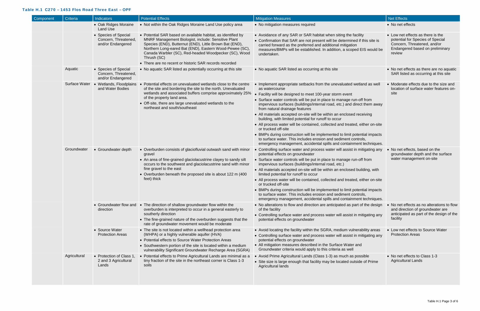
Table H.1 C270 – 1453 Flos Road Three East – OPF
Table H.1 Page 3 of 6
Component Criteria Indicators Potential Effects Mitigation Measures Net Effects • Oak Ridges Moraine
Land Use • Not within the Oak Ridges Moraine Land Use policy area • No mitigation measures required • No net effects
• Species of Special Concern, Threatened, and/or Endangered
• Potential SAR based on available habitat, as identified by MNRF Management Biologist, include: Sensitive Plant Species (END), Butternut (END), Little Brown Bat (END), Northern Long-eared Bat (END), Eastern Wood-Pewee (SC), Canada Warbler (SC), Red-headed Woodpecker (SC), Wood Thrush (SC)
• There are no recent or historic SAR records recorded
• Avoidance of any SAR or SAR habitat when siting the facility • Confirmation that SAR are not present will be determined if this site is
carried forward as the preferred and additional mitigation measures/BMPs will be established. In addition, a scoped EIS would be undertaken.
• Low net effects as there is the potential for Species of Special Concern, Threatened, and/or Endangered based on preliminary review
Aquatic • Species of Special Concern, Threatened, and/or Endangered
• No aquatic SAR listed as potentially occurring at this site • No aquatic SAR listed as occurring at this site • No net effects as there are no aquatic SAR listed as occurring at this site
Surface Water • Wetlands, Floodplains and Water Bodies
• Potential effects on unevaluated wetlands close to the centre of the site and bordering the site to the north. Unevaluated wetlands and associated buffers comprise approximately 25% of the property land area.
• Off-site, there are large unevaluated wetlands to the northeast and south/southeast
• Implement appropriate setbacks from the unevaluated wetland as well as watercourse
• Facility will be designed to meet 100-year storm event • Surface water controls will be put in place to manage run-off from
impervious surfaces (buildings/internal road, etc.) and direct them away from natural drainage features
• All materials accepted on-site will be within an enclosed receiving building, with limited potential for runoff to occur
• All process water will be contained, collected and treated, either on-site or trucked off-site
• BMPs during construction will be implemented to limit potential impacts to surface water. This includes erosion and sediment controls, emergency management, accidental spills and containment techniques.
• Moderate effects due to the size and location of surface water features on-site
Groundwater • Groundwater depth • Overburden consists of glaciofluvial outwash sand with minor gravel
• An area of fine-grained glaciolacustrine clayey to sandy silt occurs to the southwest and glaciolacustrine sand with minor fine gravel to the east
• Overburden beneath the proposed site is about 122 m (400 feet) thick
• Controlling surface water and process water will assist in mitigating any potential effects on groundwater
• Surface water controls will be put in place to manage run-off from impervious surfaces (buildings/internal road, etc.)
• All materials accepted on-site will be within an enclosed building, with limited potential for runoff to occur
• All process water will be contained, collected and treated, either on-site or trucked off-site
• BMPs during construction will be implemented to limit potential impacts to surface water. This includes erosion and sediment controls, emergency management, accidental spills and containment techniques.
• No net effects, based on the groundwater depth and the surface water management on-site
• Groundwater flow and direction
• The direction of shallow groundwater flow within the overburden is interpreted to occur in a general easterly to southerly direction
• The fine-grained nature of the overburden suggests that the rate of groundwater movement would be moderate
• No alterations to flow and direction are anticipated as part of the design of the facility
• Controlling surface water and process water will assist in mitigating any potential effects on groundwater
• No net effects as no alterations to flow and direction of groundwater are anticipated as part of the design of the facility
• Source Water Protection Areas
• The site is not located within a wellhead protection area (WHPA) or a highly vulnerable aquifer (HVA)
• Potential effects to Source Water Protection Areas • Southwestern portion of the site is located within a medium
vulnerability Significant Groundwater Recharge Area (SGRA)
• Avoid locating the facility within the SGRA, medium vulnerability areas • Controlling surface water and process water will assist in mitigating any
potential effects on groundwater • All mitigation measures described in the Surface Water and
Groundwater criteria would apply to this criteria as well
• Low net effects to Source Water Protection Areas
Agricultural • Protection of Class 1, 2 and 3 Agricultural Lands
• Potential effects to Prime Agricultural Lands are minimal as a tiny fraction of the site in the northeast corner is Class 1-3 soils
• Avoid Prime Agricultural Lands (Class 1-3) as much as possible • Site size is large enough that facility may be located outside of Prime
Agricultural lands
• No net effects to Class 1-3 Agricultural Lands

Table H.1 C270 – 1453 Flos Road Three East – OPF
Table H.1 Page 4 of 6
Component Criteria Indicators Potential Effects Mitigation Measures Net Effects Social Sensitive
Receptors • Number and
distribution of Sensitive Receptors (e.g., residential areas, parks and recreational areas, institutions, airports)
• Within 500 m of the site boundary, there are 4 off-site receptors located to the north and northwest potentially affected from a nuisance perspective (i.e., noise, odour, dust, traffic) from construction and operation of the facility
• Potential construction-related and operational effects associated with dust, noise and traffic for uses within 500 m of the proposed facility will be mitigated through the use of BMPs (adhere to Municipal Noise By-Law, routine cleaning of internal roads, ensure equipment is inspected and in good working order)
• Design and implement odour control (store material in an enclosed space, gas collection, etc.) at the outset of the project
• During operation, the facility will always operate under negative pressure
• Given the size of the property relative to the facility footprint, the on-site buffer is of a sufficient size to act as a mitigation measure
• Low net effects based on proximity to sensitive receptors and on-site buffer areas
• Buffer zones and separation distances to Sensitive Receptors
• Potential to affect local sensitive receptors from a nuisance perspective (noise, odour, dust, traffic)
• Given the size of the property relative to the facility footprint, the on-site buffer is of a sufficient size to act as a mitigation measure - mitigation through design
• As mentioned above, potential construction-related and operational effects associated with dust, noise and traffic for uses within 500 m of the proposed facility will be mitigated through the use of BMPs (adhere to Municipal Noise By-Law, routine cleaning of internal roads, ensure equipment is inspected and in good working order)
• Low net effects based on proximity to sensitive receptors and on-site buffer areas
Land Use/ Zoning
• Current land use, zoning, approved development plans, and proposed land use changes
• County Official Plan designation is Greenlands and Springwater Official Plan designation is Rural
• Zoning designation is Agricultural
• County and Springwater Official Plan Amendment (OPA) and Springwater Zoning By-Law Amendment (ZBLA) would be required
• Low net effects due to displacement of current land use and OPA/ZBLA requirements
• Opportunity for brownfield development, enhanced use
• No opportunity for brownfield redevelopment or enhanced use as this site is not classified as a brownfield site
• No mitigation measures • Moderate net effects due to displacement of current land and lack of opportunity for brownfield redevelopment or enhanced use
• Compatibility with existing Land Use/ Zoning designations on adjacent sites
• Adjacent County Official Plan designation is Greenlands and adjacent Springwater Official Plan designation is Rural, Agricultural
• Adjacent zoning designation is Agricultural
• Given the size of the property relative to the facility footprint, the on-site buffer is of a sufficient size to act as a mitigation measure - mitigation through design
• As mentioned above, potential construction-related and operational effects associated with dust, noise and traffic for uses within 500 m of the proposed facility will be mitigated through the use of BMPs (adhere to Municipal Noise By-Law, routine cleaning of internal roads, ensure equipment is inspected and in good working order)
• Low net effects based on the size of the site, on-site buffer and application of proven mitigation measures
Transportation • Existing/required transportation infrastructure
• Access from Flos Road Three East • As Flos Road Three East is unpaved, with some steep grades
and a dead end, improvements to the roadway would be required (i.e., paving, grading)
• Curve on Highway 27 at intersection with Flos Road Three may necessitate signalization
• Ensure required transportation infrastructure is developed • Paving, grading improvements, and a signalized intersection at Highway
27 • Design and construct road improvements in accordance with Township
of Springwater policies, standards and practices
• High net effects due to requirement for paving, grading, and signalization
• Neighbourhood traffic impacts
• Very little existing traffic on Flos Road Three East • Dead end road with no through traffic • Potential to increase traffic on local roads within close
proximity to established neighbourhoods and sensitive receptors
• Ensure required infrastructure is incorporated (i.e. signalization) • Design and construct road improvements in accordance with Township
of Springwater policies, standards and practices • Define local traffic routing within the local neighbourhood to a avoid
impacts
• High net effects due to the increase in local traffic
Visual • Buffer zones and visual screening
• Potential effects are limited as the site is well screened by exiting vegetation, topography and the large site size
• Vegetation to be planted around the facility to act as a secondary buffer • Low net effects as installation of visual screening would obscure views of the facility from surrounding areas

Table H.1 C270 – 1453 Flos Road Three East – OPF
Table H.1 Page 5 of 6
Component Criteria Indicators Potential Effects Mitigation Measures Net Effects Cultural Archaeological • Archaeologically
significant areas • No known archaeological sites on the site • Confirmation through appropriate further study (i.e. Stage 1
Archaeological Assessment) will be completed on the preferred site • Should further study reveal archaeological potential, those areas should
be avoided
• Low net effects until confirmation is provided through further study
Heritage • Areas of important cultural heritage
• No known cultural heritage sites (built or landscape) on or adjacent to the site
• Confirmation through appropriate further study (i.e. Cultural Heritage Assessment) will be completed on the preferred site
• No net effects until confirmation is provided through further study
Technical Permitting/ Approvals
• Feasibility and complexity of permitting/approvals
• County and Springwater OPA and Springwater ZBLA are required
• CA permit may be required, depending on if the facility is within the Regulated Area
• Accompanying studies (i.e. traffic) required • Environmental Compliance Approvals (ECA) required
• Siting work completed will assist in demonstrating the planning rationale for the proposed amendments
• ECA studies will demonstrate how effects will be mitigated and managed
• Low net effects based on approval(s) required
Safety • Potential safety risks • Dead end road with no through traffic • Potential for spills, fire, and other emergencies
• Ensure required infrastructure is incorporated (i.e. signalization) • Develop a Health and Safety Plan and an Emergency Management
Plan
• Moderate safety risks
Utilities and Services
• Availability and distance from utilities and services
• No sanitary sewer in vicinity of site • No municipal water supply in vicinity of site • No gas supply line in vicinity of site • Hydro line on Flos Road Three East
• Construction and implementation of required services/utilities • High net effects as availability and distance from existing utilities and services is minimal
Suitability • Meets minimum size requirements
• 44 hectares • No mitigation measures required • No net effects
• Within search area • Site is within search area for the OPF • No mitigation measures required • No net effects • Site layout,
topography and soil conditions
• High potential constraints on site from a layout, topography and soil conditions perspective
• Increase setback distances from constraints to increase buffer distances
• High net effects as majority of the site is constrained
• Compatibility with existing infrastructure
• No potential for utility conflicts due to lack of existing utilities • Construction and implementation of required services/utilities • No net effects, as no relocation of existing infrastructure is required
Flexibility • Design/operational flexibility provided by site
• Site provides for a low level of design and operational flexibility given the constraints (unevaluated wetlands, topography)
• No mitigation measures required • Low positive net effects as the site has limited ability to accommodate design and operational flexibility
• Surplus lands for expansion
• Site provides for a low level of surplus lands for expansion given the constraints (unevaluated wetlands, topography)
• No mitigation measures required • Low positive net effects as the site has the ability to accommodate expansion
Economic Capital Costs • Property acquisition • No costs for property acquisition as property is owned by the County
• No mitigation measures required • No costs
• Infrastructure • Flos Road Three East would require improvements including paving and grading
• Intersection at Highway 27 would likely require signalization • Hydro on Flos Road Three East
• No mitigation measures required • High infrastructure costs
• Design • Design around unevaluated wetlands, topography • No mitigation measures required • Moderate design costs • Construction • Clear vegetation
• Site grading • Road improvements
• No mitigation measures required • Moderate construction costs
• Permits/approvals • No significant impacts to permitting/approvals expected • Site plan approval concerning fire access
• No mitigation measures required • Low additional Permit/Approval costs
• Site remediation • No known areas requiring remediation on-site • No mitigation measures required • Low costs Operation and Maintenance Costs
• Facility operation and maintenance
• No additional costs anticipated • No mitigation measures required • Low cost associated with operation and maintenance

Table H.1 C270 – 1453 Flos Road Three East – OPF
Table H.1 Page 6 of 6
Component Criteria Indicators Potential Effects Mitigation Measures Net Effects • Transportation from
feedstock sources • Approximately 10 kilometres from waste centroid • No mitigation measures required • Moderate cost associated with
transportation from feedstock sources • Transportation to
markets and end users
• Potential agricultural users nearby • Close to highway access for material processing and disposal
• No mitigation measures required • Low cost associated with transportation to markets and end users
• Monitoring requirements
• Increased surface water monitoring • Increased groundwater monitoring
• No mitigation measures required • Moderate cost associated with monitoring requirements
• Mitigation requirements
• Natural screening mechanisms (e.g., topography, vegetation, significant buffer) already in place for odour, noise, visual
• Protection of Source Protection Areas
• No mitigation measures required • Moderate cost associated with mitigation requirements
Legal Land Acquisition
• Land acquisition complexity, risk, liability
• County-owned property • May need to compensate nearby residential properties
• Mitigation through compensation • Low complexity, risk and liability
Agreement • Structure and complexity of operating agreement
• No added complexity expected • Mitigation through agreement structure • Low complexity

Table H.2 C270 – 1453 Flos Road Three East – MMF
Table H.2 Page 1 of 6
Component Criteria Indicators Potential Effects Mitigation Measures Net Effects Environmental Air Quality • Wind speed &
direction • Mean wind speed of 4.32 metres per second (m/s)
predominately coming from a northwesterly direction • Dust, particulate matter from construction/operation • Off-gases construction/operation
• As the site has a varied topography, and is predominantly forested (mixed old growth), minimal additional mitigation measures through design and Best Management Practices (BMPs) during construction/ operation will be required
• BMPs may include dust suppression, ensuring construction and operation equipment are inspected and in good working condition
• With the implementation of BMPs, no off-site receptors affected
• Proximity to sensitive receptors
• Within 500 metres (m) of the site boundary, there are 4 off-site receptors located to the north and northwest potentially affected by dust and particulate matter from construction and operation of the facility
• Design and implement dust control (routine cleaning of internal paved roads)
• Given the size of the property relative to the facility footprint, the on-site buffer is of a sufficient size to act as a mitigation measure (i.e. levels of dust, particulate matter, etc. will dissipate before reaching the property line)
• Proper management of air quality controls • Implement BMPs to ensure dust generation is minimized
• No off-site receptors affected based on mitigation measures implemented for 4 receptors
• Species of Special Concern, Threatened, and/or Endangered
• Potential species at risk (SAR) based on available habitat, as identified by MNRF Management Biologist, include: Sensitive Plant Species (END), Butternut (END), Little Brown Bat (END), Northern Long-eared Bat (END), Eastern Wood-Pewee (SC), Canada Warbler (SC), Red-headed Woodpecker (SC), Wood Thrush (SC)
• There are no recent or historic SAR records recorded
• Avoidance of any SAR or SAR habitat when siting the facility • Confirmation that SAR are not present will be determined if this site is
carried forward as the preferred and additional mitigation measures/BMPs will be established. In addition, a scoped EIS would be undertaken.
• Low net effects as there is the potential for Species of Special Concern, Threatened, and/or Endangered based on preliminary review
Odour • Wind speed & direction
• Mean wind speed of 4.32 m/s predominately coming from a northwesterly direction
• Off-gases construction/operation
• As the site has a varied topography, and is predominantly forested (mixed old growth), minimal additional mitigation measures through design and BMPs during construction/ operation will be required
• BMPs may include planting in key areas after construction, odour management, ensuring construction and operation equipment are inspected and in good working condition
• Implement BMPs to ensure odour is minimized
• With the implementation of appropriate odour control design and BMPs, no off-site receptors affected
• Proximity to sensitive receptors
• Within 500 m of the site boundary, there are 4 off-site receptors located to the north and northwest potentially affected by odour from the facility
• Design and implement odour control (store material in an enclosed space, gas collection, etc.) at the outset of the project
• During operation, the facility will always operate under negative pressure
• Maximize setback distance between facility footprint and sensitive receptors
• Given the size of the property relative to the facility footprint, the on-site buffer is of a sufficient size to act as a mitigation measure (i.e. odour units will be reduced before reaching the property line)
• Implement BMPs to ensure odour from facility is minimized
• No off-site receptors affected based on mitigation measures implemented for 4 receptors

Table H.2 C270 – 1453 Flos Road Three East – MMF
Table H.2 Page 2 of 6
Component Criteria Indicators Potential Effects Mitigation Measures Net Effects Noise • Proximity to sensitive
receptors • Within 500 m of the site boundary, there are 4 off-site
receptors located to the north and northwest potentially affected by noise from construction and operation of the facility
• Adhere to existing MOECC noise restrictions as well as additional noise limits imposed through the ECA
• During construction, adhere to Municipal Noise By-Law • Design and implement noise control measures at the outset of the
project • Maintenance to keep haul trucks in good condition • Maximize setback distance between facility footprint and sensitive
receptors • Given the size of the property relative to the facility footprint, the on-site
buffer is of a sufficient size to act as a mitigation measure (i.e. level of noise/sound will dissipate/be under noise limits before reaching the property line)
• Implement noise BMP plan • During operation, adhere to Municipal Noise By-Law
• No off-site receptors affected based on mitigation measures implemented for 4 receptors
Terrestrial • Topography • Due to the varied topography with a plateau in the middle of the site, sloping downward to the north, east and south, and the amount of unevaluated wetlands, there is a high potential to alter natural drainage patterns
• Minimize alterations to existing topography • Setback facility from slopes • Setback facility from unevaluated wetlands • Minimize surface water flow into unevaluated wetlands through design
(conveyance)
• High net effects on topography as it relates to natural environment (natural drainage patterns)
• Soil type • Overburden consists of glaciofluvial outwash sand with minor gravel
• An area of fine-grained glaciolacustrine clayey to sandy silt occurs to the southwest and glaciolacustrine sand with minor fine gravel to the east
• Overburden beneath the proposed site is about 122 m (400 feet) thick
• Surface water controls will be put in place to manage run-off from impervious surfaces (buildings/internal road, etc.)
• All materials accepted on-site will be within an enclosed building, with limited potential for runoff to occur
• All process water will be contained, collected and treated, either on-site or trucked off-site
• BMPs during construction will be implemented to limit potential impacts to soils and groundwater. This includes emergency management, accidental spills and containment techniques.
• Confirmation of soil types to occur should this be the preferred site
• No effects on groundwater
• Affected Greenlands • Effects to lands designated as County Greenlands (pending approval in revised Official Plan)
• No Areas of Natural Scientific Interest (ANSI) on site • Site is predominantly forested (mixed old growth)
• Infrastructure not subject to the environmental assessment process may be permitted within the County Greenlands designation or on adjacent lands in accordance with development and site alteration policies within the County Official Plan (Section 3.3.15)
• A scoped EIS would be undertaken as per the Official Plan requirements to develop infrastructure within the County Greenlands designation
• Avoid areas of significant/dense vegetation • Compensate for tree removal at a minimum on a 1:1 ratio – either on-
site or on another County owned property in close proximity
• Low effects to lands designated as County Greenlands as an EIS is required. Completing the EIS will demonstrate through further analysis and investigation, as well as more detailed mitigation measures, the most appropriate location of the facility footprint on the site. This net effect would be lowered to “No” once a facility footprint location is determined as the EIS would demonstrate that there will be no negative impacts on natural features and areas and ecological functions of the County or local natural heritage system, and meet the requirements of Section 3.3.15 of the County Official Plan.
• No effects to ANSI’s • Moderate effects to existing
vegetation on-site as removal will be required for the facility
• Niagara Escarpment Land Use
• Not within the Niagara Escarpment Land Use policy area • No mitigation measures required • No net effects

Table H.2 C270 – 1453 Flos Road Three East – MMF
Table H.2 Page 3 of 6
Component Criteria Indicators Potential Effects Mitigation Measures Net Effects • Oak Ridges Moraine
Land Use • Not within the Oak Ridges Moraine Land Use policy area • No mitigation measures required • No net effects
• Species of Special Concern, Threatened, and/or Endangered
• Potential SAR based on available habitat, as identified by MNRF Management Biologist, include: Sensitive Plant Species (END), Butternut (END), Little Brown Bat (END), Northern Long-eared Bat (END), Eastern Wood-Pewee (SC), Canada Warbler (SC), Red-headed Woodpecker (SC), Wood Thrush (SC)
• There are no recent or historic SAR records recorded
• Avoidance of any SAR or SAR habitat when siting the facility • Confirmation that SAR are not present will be determined if this site is
carried forward as the preferred and additional mitigation measures/BMPs will be established. In addition, a scoped EIS would be undertaken.
• Low net effects as there is the potential for Species of Special Concern, Threatened, and/or Endangered based on preliminary review
Aquatic • Species of Special Concern, Threatened, and/or Endangered
• No aquatic SAR listed as potentially occurring at this site • No aquatic SAR listed as occurring at this site • No net effects as there are no aquatic SAR listed as occurring at this site
Surface Water • Wetlands, Floodplains and Water Bodies
• Potential effects on unevaluated wetlands close to the centre of the site and bordering the site to the north. Unevaluated wetlands and associated buffers comprise approximately 25% of the property land area.
• Off-site, there are large unevaluated wetlands to the northeast and south/southeast
• Implement appropriate setbacks from the unevaluated wetland as well as watercourse
• Facility will be designed to meet 100-year storm event • Surface water controls will be put in place to manage run-off from
impervious surfaces (buildings/internal road, etc.) and direct them away from natural drainage features
• All materials accepted on-site will be within an enclosed receiving building, with limited potential for runoff to occur
• All process water will be contained, collected and treated, either on-site or trucked off-site
• BMPs during construction will be implemented to limit potential impacts to surface water. This includes erosion and sediment controls, emergency management, accidental spills and containment techniques.
• Moderate effects due to the size and location of surface water features on-site
Groundwater • Groundwater depth • Overburden consists of glaciofluvial outwash sand with minor gravel
• An area of fine-grained glaciolacustrine clayey to sandy silt occurs to the southwest and glaciolacustrine sand with minor fine gravel to the east
• Overburden beneath the proposed site is about 122 m (400 feet) thick
• Controlling surface water and process water will assist in mitigating any potential effects on groundwater.
• Surface water controls will be put in place to manage run-off from impervious surfaces (buildings/internal road, etc.)
• All materials accepted on-site will be within an enclosed building, with limited potential for runoff to occur
• All process water will be contained, collected and treated, either on-site or trucked off-site
• BMPs during construction will be implemented to limit potential impacts to surface water. This includes erosion and sediment controls, emergency management, accidental spills and containment techniques.
• No net effects, based on the groundwater depth and the surface water management on-site
• Groundwater flow and direction
• The direction of shallow groundwater flow within the overburden is interpreted to occur in a general easterly to southerly direction
• The fine-grained nature of the overburden suggests that the rate of groundwater movement would be moderate
• No alterations to flow and direction are anticipated as part of the design of the facility
• Controlling surface water and process water will assist in mitigating any potential effects on groundwater
• No net effects as no alterations to flow and direction of groundwater are anticipated as part of the design of the facility
• Source Water Protection Areas
• The site is not located within a wellhead protection area (WHPA) or a highly vulnerable aquifer (HVA)
• Potential effects to Source Water Protection Areas • Southwestern portion of the site is located within a medium
vulnerability Significant Groundwater Recharge Area (SGRA)
• Avoid locating the facility within the SGRA, medium vulnerability areas • Controlling surface water and process water will assist in mitigating any
potential effects on groundwater • All mitigation measures described in the Surface Water and
Groundwater criteria would apply to this criteria as well
• Low net effects to Source Water Protection Areas
Agricultural • Protection of Class 1, 2 and 3 Agricultural Lands
• Potential effects to Prime Agricultural Lands are minimal as a tiny fraction of the site in the northeast corner is Class 1-3 soils
• Avoid Prime Agricultural Lands (Class 1-3) as much as possible • Site size is large enough that facility may be located outside of Prime
Agricultural lands
• No net effects to Class 1-3 Agricultural Lands

Table H.2 C270 – 1453 Flos Road Three East – MMF
Table H.2 Page 4 of 6
Component Criteria Indicators Potential Effects Mitigation Measures Net Effects Social Sensitive
Receptors • Number and
distribution of Sensitive Receptors (e.g., residential areas, parks and recreational areas, institutions, airports)
• Within 500 m of the site boundary, there are 4 off-site receptors located to the north and northwest potentially affected from a nuisance perspective (i.e., noise, odour, dust, traffic) from construction and operation of the facility
• Potential construction-related and operational effects associated with dust, noise and traffic for uses within 500 m of the proposed facility will be mitigated through the use of BMPs (adhere to Municipal Noise By-Law, routine cleaning of internal roads, ensure equipment is inspected and in good working order)
• Design and implement odour control (store material in an enclosed space, gas collection, etc.) at the outset of the project
• During operation, the facility will always operate under negative pressure
• Given the size of the property relative to the facility footprint, the on-site buffer is of a sufficient size to act as a mitigation measure
• Low net effects based on proximity to sensitive receptors and on-site buffer areas
• Buffer zones and separation distances to Sensitive Receptors
• Potential to affect local sensitive receptors from a nuisance perspective (noise, odour, dust, traffic)
• Given the size of the property relative to the facility footprint, the on-site buffer is of a sufficient size to act as a mitigation measure - mitigation through design
• As mentioned above, potential construction-related and operational effects associated with dust, noise and traffic for uses within 500 m of the proposed facility will be mitigated through the use of BMPs (adhere to Municipal Noise By-Law, routine cleaning of internal roads, ensure equipment is inspected and in good working order)
• Low net effects based on proximity to sensitive receptors and on-site buffer areas
Land Use/ Zoning
• Current land use, zoning, approved development plans, and proposed land use changes
• County Official Plan designation is Greenlands and Springwater Official Plan designation is Rural
• Zoning designation is Agricultural
• County and Springwater Official Plan Amendment (OPA) and Springwater Zoning By-Law Amendment (ZBLA) would be required
• Low net effects due to displacement of current land use and OPA/ZBLA requirements
• Opportunity for brownfield development, enhanced use
• No opportunity for brownfield redevelopment or enhanced use as this site is not classified as a brownfield site
• No mitigation measures • Moderate net effects due to displacement of current land and lack of opportunity for brownfield redevelopment or enhanced use
• Compatibility with existing Land Use/ Zoning designations on adjacent sites
• Adjacent County Official Plan designation is Greenlands and adjacent Springwater Official Plan designation is Rural, Agricultural
• Adjacent zoning designation is Agricultural
• Given the size of the property relative to the facility footprint, the on-site buffer is of a sufficient size to act as a mitigation measure - mitigation through design
• As mentioned above, potential construction-related and operational effects associated with dust, noise and traffic for uses within 500 m of the proposed facility will be mitigated through the use of BMPs (adhere to Municipal Noise By-Law, routine cleaning of internal roads, ensure equipment is inspected and in good working order)
• Low net effects based on the size of the site, on-site buffer and application of proven mitigation measures
Transportation • Existing/required transportation infrastructure
• Access from Flos Road Three East • As Flos Road Three East is unpaved, with some steep grades
and a dead end, improvements to the roadway would be required (i.e., paving, grading)
• Curve on Highway 27 at intersection with Flos Road Three may necessitate signalization
• Ensure required transportation infrastructure is developed • Paving, grading improvements, and a signalized intersection at Highway
27 • Design and construct road improvements in accordance with Township
of Springwater policies, standards and practices
• High net effects due to requirement for paving, grading, and signalization
• Neighbourhood traffic impacts
• Very little existing traffic on Flos Road Three East • Dead end road with no through traffic • Potential to increase traffic on local roads within close
proximity to established neighbourhoods and sensitive receptors
• Ensure required infrastructure is incorporated (i.e. signalization) • Design and construct road improvements in accordance with Township
of Springwater policies, standards and practices • Define local traffic routing within the local neighbourhood to a avoid
impacts
• High net effects due to the increase in local traffic
Visual • Buffer zones and visual screening
• Potential effects are limited as the site is well screened by exiting vegetation, topography and the large site size
• Vegetation to be planted around the facility to act as a secondary buffer • Low net effects as installation of visual screening would obscure views of the facility from surrounding areas
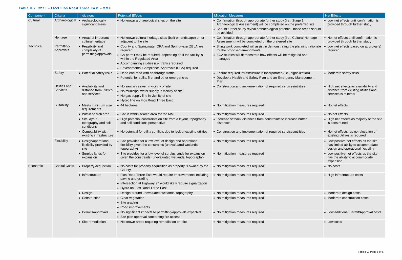
Table H.2 C270 – 1453 Flos Road Three East – MMF
Table H.2 Page 5 of 6
Component Criteria Indicators Potential Effects Mitigation Measures Net Effects Cultural Archaeological • Archaeologically
significant areas • No known archaeological sites on the site • Confirmation through appropriate further study (i.e., Stage 1
Archaeological Assessment) will be completed on the preferred site • Should further study reveal archaeological potential, those areas should
be avoided
• Low net effects until confirmation is provided through further study
Heritage • Areas of important cultural heritage
• No known cultural heritage sites (built or landscape) on or adjacent to the site
• Confirmation through appropriate further study (i.e., Cultural Heritage Assessment) will be completed on the preferred site
• No net effects until confirmation is provided through further study
Technical Permitting/ Approvals
• Feasibility and complexity of permitting/approvals
• County and Springwater OPA and Springwater ZBLA are required
• CA permit may be required, depending on if the facility is within the Regulated Area
• Accompanying studies (i.e. traffic) required • Environmental Compliance Approvals (ECA) required
• Siting work completed will assist in demonstrating the planning rationale for the proposed amendments
• ECA studies will demonstrate how effects will be mitigated and managed
• Low net effects based on approval(s) required
Safety • Potential safety risks • Dead end road with no through traffic • Potential for spills, fire, and other emergencies
• Ensure required infrastructure is incorporated (i.e., signalization) • Develop a Health and Safety Plan and an Emergency Management
Plan
• Moderate safety risks
Utilities and Services
• Availability and distance from utilities and services
• No sanitary sewer in vicinity of site • No municipal water supply in vicinity of site • No gas supply line in vicinity of site • Hydro line on Flos Road Three East
• Construction and implementation of required services/utilities • High net effects as availability and distance from existing utilities and services is minimal
Suitability • Meets minimum size requirements
• 44 hectares • No mitigation measures required • No net effects
• Within search area • Site is within search area for the MMF • No mitigation measures required • No net effects • Site layout,
topography and soil conditions
• High potential constraints on site from a layout, topography and soil conditions perspective
• Increase setback distances from constraints to increase buffer distances
• High net effects as majority of the site is constrained
• Compatibility with existing infrastructure
• No potential for utility conflicts due to lack of existing utilities • Construction and implementation of required services/utilities
• No net effects, as no relocation of existing utilities is required
Flexibility • Design/operational flexibility provided by site
• Site provides for a low level of design and operational flexibility given the constraints (unevaluated wetlands, topography)
• No mitigation measures required • Low positive net effects as the site has limited ability to accommodate design and operational flexibility
• Surplus lands for expansion
• Site provides for a low level of surplus lands for expansion given the constraints (unevaluated wetlands, topography)
• No mitigation measures required • Low positive net effects as the site has the ability to accommodate expansion
Economic Capital Costs • Property acquisition • No costs for property acquisition as property is owned by the County
• No mitigation measures required • No costs
• Infrastructure • Flos Road Three East would require improvements including paving and grading
• Intersection at Highway 27 would likely require signalization • Hydro on Flos Road Three East
• No mitigation measures required • High infrastructure costs
• Design • Design around unevaluated wetlands, topography • No mitigation measures required • Moderate design costs • Construction • Clear vegetation
• Site grading • Road improvements
• No mitigation measures required • Moderate construction costs
• Permits/approvals • No significant impacts to permitting/approvals expected • Site plan approval concerning fire access
• No mitigation measures required • Low additional Permit/Approval costs
• Site remediation • No known areas requiring remediation on-site
• No mitigation measures required • Low costs

Table H.2 C270 – 1453 Flos Road Three East – MMF
Table H.2 Page 6 of 6
Component Criteria Indicators Potential Effects Mitigation Measures Net Effects Operation and Maintenance Costs
• Facility operation and maintenance
• No additional costs anticipated • No mitigation measures required • Low cost associated with operation and maintenance
• Transportation from feedstock sources
• Approximately 10 kilometres from waste centroid • No mitigation measures required • Moderate cost associated with transportation from feedstock sources
• Transportation to markets and end users
• Potential agricultural users nearby • Close to highway access for material processing and disposal
• No mitigation measures required • Moderate cost associated with transportation to markets and end users
• Monitoring requirements
• Increased surface water monitoring • Increased groundwater monitoring
• No mitigation measures required • Moderate cost associated with monitoring requirements
• Mitigation requirements
• Natural screening mechanisms (e.g., topography, vegetation, significant buffer) already in place for odour, noise, visual
• Protection of Source Protection Areas • Noise mitigation along Flos Road Three East
• No mitigation measures required • High cost associated with mitigation requirements
Legal Land Acquisition
• Land acquisition complexity, risk, liability
• County-owned property • May need to compensate nearby residential properties
• Mitigation through compensation • Low complexity, risk and liability
Agreement • Structure and complexity of operating agreement
• No added complexity expected • Mitigation through agreement structure • Low complexity

Table H.3 C270 – 1453 Flos Road Three East – Co-Located Facility
Table H.3 Page 1 of 6
Component Criteria Indicators Potential Effects Mitigation Measures Net Effects Environmental Air Quality • Wind speed &
direction • Mean wind speed of 4.32 metres per second (m/s)
predominately coming from a northwesterly direction • Dust, particulate matter from construction/operation • Off-gases construction/operation
• As the site has a varied topography, and is predominantly forested (mixed old growth), minimal additional mitigation measures through design and Best Management Practices (BMPs) during construction/ operation will be required
• BMPs may include dust suppression, ensuring construction and operation equipment are inspected and in good working condition
• With the implementation of BMPs, no off-site receptors affected
• Proximity to sensitive receptors
• Within 500 metres (m) of the site boundary, there are 4 off-site receptors located to the north and northwest potentially affected by dust and particulate matter from construction and operation of the facility
• Design and implement dust control (routine cleaning of internal paved roads)
• Given the size of the property relative to the facility footprint, the on-site buffer is of a sufficient size to act as a mitigation measure (i.e. levels of dust, particulate matter, etc. will dissipate before reaching the property line)
• Proper management of air quality controls • Implement BMPs to ensure dust generation is minimized
• No off-site receptors affected based on mitigation measures implemented for 4 receptors
• Species of Special Concern, Threatened, and/or Endangered
• Potential species at risk (SAR) based on available habitat, as identified by MNRF Management Biologist, include: Sensitive Plant Species (END), Butternut (END), Little Brown Bat (END), Northern Long-eared Bat (END), Eastern Wood-Pewee (SC), Canada Warbler (SC), Red-headed Woodpecker (SC), Wood Thrush (SC)
• There are no recent or historic SAR records recorded
• Avoidance of any SAR or SAR habitat when siting the facility • Confirmation that SAR are not present will be determined if this site is
carried forward as the preferred and additional mitigation measures/BMPs will be established. In addition, a scoped EIS would be undertaken.
• Low net effects as there is the potential for Species of Special Concern, Threatened, and/or Endangered based on preliminary review
Odour • Wind speed & direction
• Mean wind speed of 4.32 m/s predominately coming from a northwesterly direction
• Off-gases construction/operation
• As the site has a varied topography, and is predominantly forested (mixed old growth), minimal additional mitigation measures through design and BMPs during construction/ operation will be required
• BMPs may include planting in key areas after construction, odour management, ensuring construction and operation equipment are inspected and in good working condition
• Implement BMPs to ensure odour is minimized
• With the implementation of appropriate odour control design and BMPs, no off-site receptors affected
• Proximity to sensitive receptors
• Within 500 m of the site boundary, there are 4 off-site receptors located to the north and northwest potentially affected by odour from the facility
• Design and implement odour control (store material in an enclosed space, gas collection, etc.) at the outset of the project
• During operation, the facility will always operate under negative pressure
• Maximize setback distance between facility footprint and sensitive receptors
• Given the size of the property relative to the facility footprint, the on-site buffer is of a sufficient size to act as a mitigation measure (i.e. odour units will be reduced before reaching the property line)
• Implement BMPs to ensure odour from facility is minimized
• No off-site receptors affected based on mitigation measures implemented for 4 receptors

Table H.3 C270 – 1453 Flos Road Three East – Co-Located Facility
Table H.3 Page 2 of 6
Component Criteria Indicators Potential Effects Mitigation Measures Net Effects Noise • Proximity to sensitive
receptors • Within 500 m of the site boundary, there are 4 off-site
receptors located to the north and northwest potentially affected by noise from construction and operation of the facility
• Adhere to existing MOECC noise restrictions as well as additional noise limits imposed through the ECA
• During construction, adhere to Municipal Noise By-Law • Design and implement noise control measures at the outset of the
project. • Maintenance to keep haul trucks in good condition • Maximize setback distance between facility footprint and sensitive
receptors • Given the size of the property relative to the facility footprint, the on-site
buffer is of a sufficient size to act as a mitigation measure (i.e. level of noise/sound will dissipate/be under noise limits before reaching the property line)
• Implement noise BMP plan • During operation, adhere to Municipal Noise By-Law
• No off-site receptors affected based on mitigation measures implemented for 4 receptors
Terrestrial • Topography • Due to the varied topography with a plateau in the middle of the site, sloping downward to the north, east and south, and the amount of unevaluated wetlands, there is a high potential to alter natural drainage patterns
• Minimize alterations to existing topography • Setback facility from slopes • Setback facility from unevaluated wetlands • Minimize surface water flow into unevaluated wetlands through design
(conveyance)
• High net effects on topography as it relates to natural environment (natural drainage patterns)
• Soil type • Overburden consists of glaciofluvial outwash sand with minor gravel
• An area of fine-grained glaciolacustrine clayey to sandy silt occurs to the southwest and glaciolacustrine sand with minor fine gravel to the east
• Overburden beneath the proposed site is about 122 m (400 feet) thick
• Surface water controls will be put in place to manage run-off from impervious surfaces (buildings/internal road, etc.)
• All materials accepted on-site will be within an enclosed building, with limited potential for runoff to occur
• All process water will be contained, collected and treated, either on-site or trucked off-site
• BMPs during construction will be implemented to limit potential impacts to soils and groundwater. This includes emergency management, accidental spills and containment techniques.
• Confirmation of soil types to occur should this be the preferred site
• No effects on groundwater
• Affected Greenlands • Effects to lands designated as County Greenlands (pending approval in revised Official Plan)
• No Areas of Natural Scientific Interest (ANSI) on site • Site is predominantly forested (mixed old growth)
• Infrastructure not subject to the environmental assessment process may be permitted within the County Greenlands designation or on adjacent lands in accordance with development and site alteration policies within the County Official Plan (Section 3.3.15)
• A scoped EIS would be undertaken as per the Official Plan requirements to develop infrastructure within the County Greenlands designation
• Avoid areas of significant/dense vegetation • Compensate for tree removal at a minimum on a 1:1 ratio – either on-
site or on another County owned property in close proximity
• Low effects to lands designated as County Greenlands as an EIS is required. Completing the EIS will demonstrate through further analysis and investigation, as well as more detailed mitigation measures, the most appropriate location of the facility footprint on the site. This net effect would be lowered to “No” once a facility footprint location is determined as the EIS would demonstrate that there will be no negative impacts on natural features and areas and ecological functions of the County or local natural heritage system, and meet the requirements of Section 3.3.15 of the County Official Plan.
• No effects to ANSI’s • Moderate effects to existing
vegetation on-site as removal will be required for the facility
• Niagara Escarpment Land Use
• Not within the Niagara Escarpment Land Use policy area • No mitigation measures required • No net effects

Table H.3 C270 – 1453 Flos Road Three East – Co-Located Facility
Table H.3 Page 3 of 6
Component Criteria Indicators Potential Effects Mitigation Measures Net Effects • Oak Ridges Moraine
Land Use • Not within the Oak Ridges Moraine Land Use policy area • No mitigation measures required • No net effects
• Species of Special Concern, Threatened, and/or Endangered
• Potential SAR based on available habitat, as identified by MNRF Management Biologist, include: Sensitive Plant Species (END), Butternut (END), Little Brown Bat (END), Northern Long-eared Bat (END), Eastern Wood-Pewee (SC), Canada Warbler (SC), Red-headed Woodpecker (SC), Wood Thrush (SC)
• There are no recent or historic SAR records recorded
• Avoidance of any SAR or SAR habitat when siting the facility • Confirmation that SAR are not present will be determined if this site is
carried forward as the preferred and additional mitigation measures/BMPs will be established. In addition, a scoped EIS would be undertaken.
• Low net effects as there is the potential for Species of Special Concern, Threatened, and/or Endangered based on preliminary review
Aquatic • Species of Special Concern, Threatened, and/or Endangered
• No aquatic SAR listed as potentially occurring at this site • No aquatic SAR listed as occurring at this site • No net effects as there are no aquatic SAR listed as occurring at this site
Surface Water • Wetlands, Floodplains and Water Bodies
• Potential effects on unevaluated wetlands close to the centre of the site and bordering the site to the north. Unevaluated wetlands and associated buffers comprise approximately 25% of the property land area.
• Off-site, there are large unevaluated wetlands to the northeast and south/southeast
• Implement appropriate setbacks from the unevaluated wetland as well as watercourse
• Facility will be designed to meet 100-year storm event • Surface water controls will be put in place to manage run-off from
impervious surfaces (buildings/internal road, etc.) and direct them away from natural drainage features
• All materials accepted on-site will be within an enclosed receiving building, with limited potential for runoff to occur
• All process water will be contained, collected and treated, either on-site or trucked off-site
• BMPs during construction will be implemented to limit potential impacts to surface water. This includes erosion and sediment controls, emergency management, accidental spills and containment techniques.
• Moderate effects due to the size and location of surface water features on-site
Groundwater • Groundwater depth • Overburden consists of glaciofluvial outwash sand with minor gravel
• An area of fine-grained glaciolacustrine clayey to sandy silt occurs to the southwest and glaciolacustrine sand with minor fine gravel to the east
• Overburden beneath the proposed site is about 122 m (400 feet) thick
• Controlling surface water and process water will assist in mitigating any potential effects on groundwater
• Surface water controls will be put in place to manage run-off from impervious surfaces (buildings/internal road, etc.)
• All materials accepted on-site will be within an enclosed building, with limited potential for runoff to occur
• All process water will be contained, collected and treated, either on-site or trucked off-site
• BMPs during construction will be implemented to limit potential impacts to surface water. This includes erosion and sediment controls, emergency management, accidental spills and containment techniques.
• No net effects, based on the groundwater depth and the surface water management on-site
• Groundwater flow and direction
• The direction of shallow groundwater flow within the overburden is interpreted to occur in a general easterly to southerly direction
• The fine-grained nature of the overburden suggests that the rate of groundwater movement would be moderate
• No alterations to flow and direction are anticipated as part of the design of the facility
• Controlling surface water and process water will assist in mitigating any potential effects on groundwater
• No net effects as no alterations to flow and direction of groundwater are anticipated as part of the design of the facility
• Source Water Protection Areas
• The site is not located within a wellhead protection area (WHPA) or a highly vulnerable aquifer (HVA)
• Potential effects to Source Water Protection Areas • Southwestern portion of the site is located within a medium
vulnerability Significant Groundwater Recharge Area (SGRA)
• Avoid locating the facility within the SGRA, medium vulnerability areas • Controlling surface water and process water will assist in mitigating any
potential effects on groundwater • All mitigation measures described in the Surface Water and
Groundwater criteria would apply to this criteria as well
• Low net effects to Source Water Protection Areas
Agricultural • Protection of Class 1, 2 and 3 Agricultural Lands
• Potential effects to Prime Agricultural Lands are minimal as a tiny fraction of the site in the northeast corner is Class 1-3 soils
• Avoid Prime Agricultural Lands (Class 1-3) as much as possible • Site size is large enough that facility may be located outside of Prime
Agricultural lands
• No net effects to Class 1-3 Agricultural Lands

Table H.3 C270 – 1453 Flos Road Three East – Co-Located Facility
Table H.3 Page 4 of 6
Component Criteria Indicators Potential Effects Mitigation Measures Net Effects Social Sensitive
Receptors • Number and
distribution of Sensitive Receptors (e.g., residential areas, parks and recreational areas, institutions, airports)
• Within 500 m of the site boundary, there are 4 off-site receptors located to the north and northwest potentially affected from a nuisance perspective (i.e., noise, odour, dust, traffic) from construction and operation of the facility
• Potential construction-related and operational effects associated with dust, noise and traffic for uses within 500 m of the proposed facility will be mitigated through the use of BMPs (adhere to Municipal Noise By-Law, routine cleaning of internal roads, ensure equipment is inspected and in good working order)
• Design and implement odour control (store material in an enclosed space, gas collection, etc.) at the outset of the project
• During operation, the facility will always operate under negative pressure
• Given the size of the property relative to the facility footprint, the on-site buffer is of a sufficient size to act as a mitigation measure
• Low net effects based on proximity to sensitive receptors and on-site buffer areas
• Buffer zones and separation distances to Sensitive Receptors
• Potential to affect local sensitive receptors from a nuisance perspective (noise, odour, dust, traffic)
• Given the size of the property relative to the facility footprint, the on-site buffer is of a sufficient size to act as a mitigation measure - mitigation through design
• As mentioned above, potential construction-related and operational effects associated with dust, noise and traffic for uses within 500 m of the proposed facility will be mitigated through the use of BMPs (adhere to Municipal Noise By-Law, routine cleaning of internal roads, ensure equipment is inspected and in good working order)
• Low net effects based on proximity to sensitive receptors and on-site buffer areas
Land Use/ Zoning
• Current land use, zoning, approved development plans, and proposed land use changes
• County Official Plan designation is Greenlands and Springwater Official Plan designation is Rural
• Zoning designation is Agricultural
• County and Springwater Official Plan Amendment (OPA) and Springwater Zoning By-Law Amendment (ZBLA) would be required
• Low net effects due to displacement of current land use and OPA/ZBLA requirements
• Opportunity for brownfield development, enhanced use
• No opportunity for brownfield redevelopment or enhanced use as this site is not classified as a brownfield site
• No mitigation measures • Moderate net effects due to displacement of current land and lack of opportunity for brownfield redevelopment or enhanced use
• Compatibility with existing Land Use/ Zoning designations on adjacent sites
• Adjacent County Official Plan designation is Greenlands and adjacent Springwater Official Plan designation is Rural, Agricultural
• Adjacent zoning designation is Agricultural
• Given the size of the property relative to the facility footprint, the on-site buffer is of a sufficient size to act as a mitigation measure - mitigation through design
• As mentioned above, potential construction-related and operational effects associated with dust, noise and traffic for uses within 500 m of the proposed facility will be mitigated through the use of BMPs (adhere to Municipal Noise By-Law, routine cleaning of internal roads, ensure equipment is inspected and in good working order)
• Low net effects based on the size of the site, on-site buffer and application of proven mitigation measures
Transportation • Existing/required transportation infrastructure
• Access from Flos Road Three East • As Flos Road Three East is unpaved, with some steep grades
and a dead end, improvements to the roadway would be required (i.e., paving, grading)
• Curve on Highway 27 at intersection with Flos Road Three may necessitate signalization
• Ensure required transportation infrastructure is developed • Paving, grading improvements, and a signalized intersection at Highway
27 • Design and construct road improvements in accordance with Township
of Springwater policies, standards and practices
• High net effects due to requirement for paving, grading, and signalization
• Neighbourhood traffic impacts
• Very little existing traffic on Flos Road Three East • Dead end road with no through traffic • Potential to increase traffic on local roads within close
proximity to established neighbourhoods and sensitive receptors
• Ensure required infrastructure is incorporated (i.e. signalization) • Design and construct road improvements in accordance with Township
of Springwater policies, standards and practices • Define local traffic routing within the local neighbourhood to a avoid
impacts
• High net effects due to the increase in local traffic
Visual • Buffer zones and visual screening
• Potential effects are limited as the site is well screened by exiting vegetation, topography and the large site size
• Vegetation to be planted around the facility to act as a secondary buffer • Low net effects as installation of visual screening would obscure views of the facility from surrounding areas

Table H.3 C270 – 1453 Flos Road Three East – Co-Located Facility
Table H.3 Page 5 of 6
Component Criteria Indicators Potential Effects Mitigation Measures Net Effects Cultural Archaeological • Archaeologically
significant areas • No known archaeological sites on the site • Confirmation through appropriate further study (i.e. Stage 1
Archaeological Assessment) will be completed on the preferred site • Should further study reveal archaeological potential, those areas should
be avoided
• Low net effects until confirmation is provided through further study
Heritage • Areas of important cultural heritage
• No known cultural heritage sites (built or landscape) on or adjacent to the site
• Confirmation through appropriate further study (i.e. Cultural Heritage Assessment) will be completed on the preferred site
• No net effects until confirmation is provided through further study
Technical Permitting/ Approvals
• Feasibility and complexity of permitting/approvals
• County and Springwater OPA and Springwater ZBLA are required
• CA permit may be required, depending on if the facility is within the Regulated Area
• Accompanying studies (i.e. traffic) required • Environmental Compliance Approvals (ECA) required
• Siting work completed will assist in demonstrating the planning rationale for the proposed amendments
• ECA studies will demonstrate how effects will be mitigated and managed
• Low net effects based on approval(s) required
Safety • Potential safety risks • Dead end road with no through traffic • Potential for spills, fire, and other emergencies
• Ensure required infrastructure is incorporated (i.e. signalization) • Develop a Health and Safety Plan and an Emergency Management
Plan
• Moderate safety risks
Utilities and Services
• Availability and distance from utilities and services
• No sanitary sewer in vicinity of site • No municipal water supply in vicinity of site • No gas supply line in vicinity of site • Hydro line on Flos Road Three East
• Construction and implementation of required services/utilities • High net effects as availability and distance from existing utilities and services is minimal
Suitability • Meets minimum size requirements
• 44 hectares • No mitigation measures required • No net effects
• Within search area • Site is within search area for the OPF and MMF • No mitigation measures required • No net effects • Site layout,
topography and soil conditions
• High potential constraints on site from a layout, topography and soil conditions perspective
• Increase setback distances from constraints to increase buffer distances
• High net effects as majority of the site is constrained
• Compatibility with existing infrastructure
• No potential for utility conflicts due to lack of existing utilities • Construction and implementation of required services/utilities • No net effects, as no relocation of existing utilities is required
Flexibility • Design/operational flexibility provided by site
• Site provides for a low level of design and operational flexibility given the constraints (unevaluated wetlands, topography)
• No mitigation measures required • Low positive net effects as the site has limited ability to accommodate design and operational flexibility
• Surplus lands for expansion
• Site provides for a low level of surplus lands for expansion given the constraints (unevaluated wetlands, topography)
• No mitigation measures required • Low positive net effects as the site has the ability to accommodate expansion
Economic Capital Costs • Property acquisition • No costs for property acquisition as property is owned by the County
• No mitigation measures required • No costs
• Infrastructure • Flos Road Three East would require improvements including paving and grading
• Intersection at Highway 27 would likely require signalization • Hydro on Flos Road Three East
• No mitigation measures required • High infrastructure costs
• Design • Design around unevaluated wetlands, topography • No mitigation measures required • Moderate design costs • Construction • Clear vegetation
• Site grading • Road improvements
• No mitigation measures required • Moderate construction costs
• Permits/approvals • No significant impacts to permitting/approvals expected • Site plan approval concerning fire access
• No mitigation measures required • Low additional Permit/Approval costs
• Site remediation • No known areas requiring remediation on-site • Possible impacts from previous owner
• No mitigation measures required • Low costs
Operation and Maintenance
• Facility operation and maintenance
• No additional costs anticipated • No mitigation measures required • Low cost associated with operation and maintenance

Table H.3 C270 – 1453 Flos Road Three East – Co-Located Facility
Table H.3 Page 6 of 6
Component Criteria Indicators Potential Effects Mitigation Measures Net Effects Costs • Transportation from
feedstock sources • Approximately 10 kilometres from waste centroid • No mitigation measures required • Moderate cost associated with
transportation from feedstock sources • Transportation to
markets and end users
• Potential agricultural users nearby • Close to highway access for material processing and disposal
• No mitigation measures required • Moderate cost associated with transportation to markets and end users
• Monitoring requirements
• Increased surface water monitoring • Increased groundwater monitoring
• No mitigation measures required • Moderate cost associated with monitoring requirements
• Mitigation requirements
• Natural screening mechanisms (e.g., topography, vegetation, significant buffer) already in place for odour, noise, visual
• Protection of Source Protection Areas • Noise mitigation along Flos Road Three East
• No mitigation measures required • High cost associated with mitigation requirements
Legal Land Acquisition
• Land acquisition complexity, risk, liability
• County-owned property • May need to compensate nearby residential properties
• Mitigation through compensation • Low complexity, risk and liability
Agreement • Structure and complexity of operating agreement
• No added complexity expected • Mitigation through agreement structure • Low complexity

GHD | County of Simcoe – OPF, MMF, and Co-Located Facility – Part 3 – Short List Evaluation | 086822 (6)
Appendix I Site P083/P084
540/528 Penetanguishene Road

!(
!(!(
!(
!(!(
!(
!(!(!(
!(
!(
!( !(
!(
Hw
y 11
Gore Rd
Pene
tang
uish
ene
Rd
Hwy400
Napoleon Rd
0 100 200 300
Meters
086822 Feb 2, 2016
GIS File: Q:\GIS\PROJECTS\86000s\86822\Layouts\INT006\086822(INT006)GIS-WA003-P083-84.mxd
Source: MNRF NRVIS, 2015. Produced by GHD under licence from Ontario Ministry of Natural Resources and Forestry, © Queen's Printer 2016Inset Map: ESRI Data & Maps 2008 Data Distribution Application (DDA)
Coordinate System:NAD 1983 UTM Zone 17N
Legend
!( Sensitive ReceptorSite BoundarySite Buffer (500m)Parcel Boundary
Wind Rose at 30 metresMean Wind Speed: 5.05 m/s
FIGURE I.1P083/P084 ENVIRONMENTAL -AIR QUALITY, ODOUR, NOISE
COUNTY OF SIMCOEOPF/MMF SITE SELECTION

Hw
y 11
Gore Rd
Pene
tang
uish
ene
Rd
Hwy400
Napoleon Rd
254
25024624
2238
234
232
254
252248
244
240
236
260
258
252
248 244
240
238
236
250
234
254
246
258
256254
242
230
250
252
232
250
242
246
254
252
244
246
248
254
254
250228
230
260
258
232
230
248
230
252
256
254
232
230
230
252
230
230
232
230
232
252
254
230
258
230
232
232
0 100 200 300
Meters
086822 Feb 2, 2016
GIS File: Q:\GIS\PROJECTS\86000s\86822\Layouts\INT006\086822(INT006)GIS-WA002.mxd
Source: MNRF NRVIS, 2016. Produced by GHD under licence from Ontario Ministry of Natural Resources and Forestry, © Queen's Printer, County of Simcoe Geomatics 2016Greenlands Data: County of Simcoe, 2007
Coordinate System:NAD 1983 UTM Zone 17N
Legend
Site BoundaryContour (2m)Simcoe County GreenlandsCanada Land Inventory - Soils Class 1-3
FIGURE I.2P083/P084 ENVIRONMENTAL -TERRESTRIAL, AGRICULTURAL
COUNTY OF SIMCOEOPF/MMF SITE SELECTION

Hwy 1
1
Gore Rd
Napoleon Rd
Pene
tang
uish
ene
Rd
Hwy 400
0 50 100 150
Meters
086822 Feb 2, 2016
GIS File: Q:\GIS\PROJECTS\86000s\86822\Layouts\INT006\086822(INT006)GIS-WA005.mxd
Source: MNRF NRVIS, 2016. Produced by GHD under licence from Ontario Ministry of Natural Resources and Forestry, © Queen's Printer 2016South Georgian Bay Lake Simcoe Source Water Protection: Lake Simcoe Conservation Authority
Coordinate System:NAD 1983 UTM Zone 17N
Legend
Site BoundaryHighly Vulnerable AquiferMedium Vulnerability Significant Groundwater Recharge AreaHigh Vulnerability Significant Groundwater Recharge AreaWetland - Provincially SignificantWetland - Not EvaluatedUnevaluated Wetland Setback (30m)
FIGURE I.3
P083/P084 ENVIRONMENTAL -AQUATIC, SURFACE WATER, GROUNDWATER
COUNTY OF SIMCOEOPF/MMF SITE SELECTION

!(
!(!(
!(
!(!(
!(
!(!(
!(
!(
!(
!( !(
!(
Hwy 1
1
Gore Rd
Pene
tang
uish
ene
Rd
Hwy400
0 100 200 300
Meters
086822 Feb 2, 2016
GIS File: Q:\GIS\PROJECTS\86000s\86822\Layouts\INT006\086822(INT006)GIS-WA010.mxd
Source: MNRF NRVIS, 2016. Produced by GHD under licence from Ontario Ministry of Natural Resources and Forestry, © Queen's Printer 2016Zoning Source: Springwater Zoning By-Law
Coordinate System:NAD 1983 UTM Zone 17N
Legend
Site BoundarySite Buffer (500m)
!( Sensitive Receptor
Zoning
AgriculturalAgricultureHighway CommercialEnvironmental ProtectionGeneral Industrial/Outside Storage
FIGURE I.4P083/P084 SOCIAL AND CULTURAL
COUNTY OF SIMCOEOPF/MMF SITE SELECTION

!(
!(!(
!(
!(
!(
!(
!(!(
!(
!(
!(
!( !(
!(
Hwy 1
1
Gore Rd
Napoleon
Rd
Pene
tang
uish
ene
Rd
Hwy400
0 50 100 150
Meters
086822 Feb 2, 2016
GIS File: Q:\GIS\PROJECTS\86000s\86822\Layouts\INT006\086822(INT006)GIS-WA011.mxd
Source: MNRF NRVIS, 2016. Produced by GHD under licence from Ontario Ministry of Natural Resources and Forestry, © Queen's Printer 2016
Coordinate System:NAD 1983 UTM Zone 17N
Legend
!( Sensitive ReceptorSite BoundaryAvoidance AreaFacility Access
Approximate MMF Facility FootprintApproximate OPF Facility FootprintApproximate Co-Located Facility Footprint
Approximate MMF Facility BufferApproximate OPF Facility BufferApproximate Co-Located Facility Buffer
FIGURE I.5P083/P084 CONCEPTUAL SITE FOOTPRINTS
COUNTY OF SIMCOEOPF/MMF SITE SELECTION

P083/P084 Site Photographs
Photo 1 – View to surrounding commercial uses from Site
Photo 2 – View of topography change towards South side of Site

Table I.1 P083/P084 – 540/528 Penetanguishene Road – OPF
Table I.1 Page 1 of 5
Component Criteria Indicators Potential Effects Mitigation Measures Net Effects Environmental Air Quality • Wind speed &
direction • Mean wind speed of 4.85 metres per second (m/s)
predominately coming from a northwesterly direction • Dust, particulate matter from construction/operation • Off-gases construction/operation
• As the site has a varied topography, mainly open with a forested area on the southern portion, additional mitigation measures through design and Best Management Practices (BMPs) during construction/ operation will be required
• BMPs may include vegetative screening, dust suppression, ensuring construction and operation equipment are inspected and in good working condition
• Low net effects as there is limited on-site buffer to act as mitigation measure to sensitive receptors (i.e., one off-site receptor encircled by the property boundary)
• Proximity to sensitive receptors
• Within 500 metres (m) of the site boundary there are 15 off-site receptors (generally along Penetanguishene Road, to north, east and south of site) potentially affected by dust and particulate matter from construction and operation of the facility
• These include 2 residential properties that abut the site, as well as a Church (St. Nektarios Greek Orthodox Church) to the north of the site and a business further to north, Napoleon Home Comfort
• Design and implement dust control (routine cleaning of internal paved roads)
• Maximize setback distance between facility footprint and sensitive receptors
• Proper management of air quality controls • Implement BMPs to ensure dust generation is minimized
• Low net effects as there is limited on-site buffer to act as mitigation measure to sensitive receptors (i.e., one off-site receptor encircled by the property boundary)
• Species of Special Concern, Threatened, and/or Endangered
• Potential species at risk (SAR) based on available habitat, as identified by MNRF Management Biologist, include: Butternut (END) if hedgerows present, Bobolink (THR) and Eastern Meadowlark (THR) if agricultural fields in hay or pasture
• Historical SAR records indicate Red-shouldered Hawk (1940) and Snapping Turtle (2009) have been located on or in close proximity to the property
• Avoidance of any SAR or SAR habitat when siting the facility • Confirmation that SAR are not present will be determined if this site is
carried forward as the preferred and additional mitigation measures/BMPs will be established. In addition, a scoped EIS would be undertaken.
• Low net effects as there is the potential for Species of Special Concern, Threatened, and/or Endangered based on preliminary review and recent records
Odour • Wind speed & direction
• Mean wind speed of 4.85 m/s predominately coming from a northwesterly direction
• Off-gases construction/operation
• As the site has a varied topography, mainly open with a forested area on the southern portion, additional mitigation measures through design and BMPs during construction/ operation will be required
• BMPs may include planting in key areas after construction, odour management, ensuring construction and operation equipment are inspected and in good working condition
• Implement BMPs to ensure odour is minimized
• Low net effects as there is limited on-site buffer to act as mitigation measure to sensitive receptors (i.e., one off-site receptor encircled by the property boundary)
• Proximity to sensitive receptors
• Within 500 m of the site boundary, there are 15 off-site receptors (generally along Penetanguishene Road, to north, east and south of site) potentially affected by odour from the facility
• These include 2 residential properties that abut the site, as well as a Church (St. Nektarios Greek Orthodox Church) to the north of the site and a business further to north, Napoleon Home Comfort
• Design and implement odour control (store material in an enclosed space, gas collection, etc.) at the outset of the project
• During operation, the facility will always operate under negative pressure
• Maximize setback distance between facility footprint and sensitive receptors
• Implement BMPs to ensure odour from facility is minimized
• Low net effects as there is limited on-site buffer to act as mitigation measure to sensitive receptors (i.e., one off-site receptor encircled by the property boundary)
Noise • Proximity to sensitive receptors
• Within 500 m of the site boundary, there are 15 off-site receptors (generally along Penetanguishene Road, to north, east and south of site) potentially affected noise from construction and operation of the facility
• These include 2 residential properties that abut the site, as well as a Church (St. Nektarios Greek Orthodox Church) to the north of the site and a business further to north, Napoleon Home Comfort
• Adhere to existing MOECC noise restrictions as well as additional noise limits imposed through the ECA
• During construction, adhere to Municipal Noise By-Law • Design and implement noise control measures at the outset of the
project • Maintenance to keep haul trucks in good condition • Maximize setback distance between facility footprint and sensitive
receptors • Implement noise BMP plan • During operation, adhere to Municipal Noise By-Law
• Low net effects as there is limited on-site buffer to act as mitigation measure to sensitive receptors (i.e., one off-site receptor encircled by the property boundary)
Terrestrial • Topography • As a portion of the site has been re-graded with a steep slope surrounding the perimeter of the forested area/unevaluated wetland to the south, the potential to alter natural drainage patterns is minimized, as alterations have already been completed
• Minimize alterations to existing topography • Setback facility from slopes • Setback facility from unevaluated wetlands • Minimize surface water flow into unevaluated wetlands through design
(conveyance)
• Low net effects on topography as it relates to natural environment (natural drainage patterns)

Table I.1 P083/P084 – 540/528 Penetanguishene Road – OPF
Table I.1 Page 2 of 5
Component Criteria Indicators Potential Effects Mitigation Measures Net Effects • Soil type • Overburden in the northern portion of the site consists
primarily of stony sandy silt to silt till, with some glaciolacustrine very fine to medium grained sand, silt, with minor clay in the southeast corner
• Overburden in the southern portion of the site consists primarily of glaciolacustrine very fine to medium grained sand, silt, with minor clay
• Overburden beneath the proposed site is about 76 to 84 m (250 to 275 feet) thick
• Loss of Primary agricultural lands (Class 1-3)
• Surface water controls will be put in place to manage run-off from impervious surfaces (buildings/internal road, etc.)
• All materials accepted on-site will be within an enclosed building, with limited potential for runoff to occur
• All process water will be contained, collected and treated, either on-site or trucked off-site
• BMPs during construction will be implemented to limit potential impacts to soils and groundwater. This includes emergency management, accidental spills and containment techniques.
• Minimize footprint of Class 1-3 soil removal • Confirmation of soil types to occur should this be the preferred site
• Loss of Class 1-3 soil (up to approximately 13 hectares (ha))
• No effects on groundwater
• Affected Greenlands • No Greenlands designation on site • No Areas of Natural Scientific Interest (ANSI) on site • Southern portion of the site is entirely forested
• Avoid areas of vegetation • Should trees be removed, compensate at a minimum on a 1:1 ratio –
either on-site or on another County owned property in close proximity
• No effects to Greenlands or ANSI’s • Low effects to existing vegetation on-
site as removal will be required for the facility
• Niagara Escarpment Land Use
• Not within the Niagara Escarpment Land Use policy area • No mitigation measures required • No net effects
• Oak Ridges Moraine Land Use
• Not within the Oak Ridges Moraine Land Use policy area • No mitigation measures required • No net effects
• Species of Special Concern, Threatened, and/or Endangered
• Potential SAR based on available habitat, as identified by MNRF Management Biologist, include: Butternut (END) if hedgerows present, Bobolink (THR) and Eastern Meadowlark (THR) if agricultural fields in hay or pasture
• Historical SAR records indicate Red-shouldered Hawk (1940) and Snapping Turtle (2009) have been located on or in close proximity to the property
• Avoidance of any SAR or SAR habitat when siting the facility • Confirmation that SAR are not present will be determined if this site is
carried forward as the preferred and additional mitigation measures/BMPs will be established. In addition, a scoped EIS would be undertaken.
• Low net effects as there is the potential for Species of Special Concern, Threatened, and/or Endangered based on preliminary review
Aquatic • Species of Special Concern, Threatened, and/or Endangered
• No aquatic SAR listed as potentially occurring at this site • No aquatic SAR listed as occurring at this site • No net effects as there are no aquatic SAR listed as occurring at this site
Surface Water • Wetlands, Floodplains and Water Bodies
• Potential effects on a large unevaluated wetland in southern portion of the site (approximately 25% of the site)
• Off-site to the east, and directly abutting the on-site unevaluated wetland, there is another large unevaluated wetland, which may be connected
• Implement appropriate setbacks from the un-evaluated wetland as well as watercourse
• Facility will be designed to meet 100-year storm event • Surface water controls will be put in place to manage run-off from
impervious surfaces (buildings/internal road, etc.) and direct them away from natural drainage features
• All materials accepted on-site will be within an enclosed building, with limited potential for runoff to occur
• All process water will be contained, collected and treated, either on-site or trucked off-site
• BMPs during construction will be implemented to limit potential impacts to surface water. This includes erosion and sediment controls, emergency management, accidental spills and containment techniques
• Moderate effects to surface water features as the site is large and able to be located an appropriate distance from surface water features

Table I.1 P083/P084 – 540/528 Penetanguishene Road – OPF
Table I.1 Page 3 of 5
Component Criteria Indicators Potential Effects Mitigation Measures Net Effects Groundwater • Groundwater depth • Overburden consists primarily of stony sandy silt to silt till,
with some glaciolacustrine very fine to medium grained sand, silt, with minor clay in the southeast corner
• Overburden beneath the proposed site is about 76 to 84 m (250 to 275 feet) thick
• Groundwater table is relatively high, shown to be within approximately 0.3 m from ground surface in some areas during previous monitoring undertaken on site (Terraprobe, 2006)
• Controlling surface water and process water will assist in mitigating any potential effects on groundwater
• Surface water controls will be put in place to manage run-off from impervious surfaces (buildings/internal road, etc.)
• All materials accepted on-site will be within an enclosed building, with limited potential for runoff to occur
• All process water will be contained, collected and treated, either on-site or trucked off-site
• BMPs during construction will be implemented to limit potential impacts to surface water. This includes erosion and sediment controls, emergency management, accidental spills and containment techniques.
• No net effects, based on the groundwater depth and the surface water management on-site
• Groundwater flow and direction
• The direction of shallow groundwater flow within the overburden is interpreted to occur in a general southeasterly direction
• Presence of primarily sandy silt to silt till overburden suggests that the rate of groundwater movement would be somewhat low, with the exception of the southeastern area which would be moderate
• No alterations to flow and direction are anticipated as part of the design of the facility
• Controlling surface water and process water will assist in mitigating any potential effects on groundwater
• No net effects as no alterations to flow and direction of groundwater are anticipated as part of the design of the facility
• Source Water Protection Areas
• The site is not located within a wellhead protection area (WHPA) or a highly vulnerable aquifer (HVA)
• Potential effects to Source Water Protection Areas • Small portion in the site in the south is designated as
Significant Groundwater Recharge Area (SGRA), medium vulnerability
• Avoid locating the facility within the SGRA, medium vulnerability areas • Controlling surface water and process water will assist in mitigating any
potential effects on groundwater • All mitigation measures described in the Surface Water and
Groundwater criteria would apply to this criteria as well
• No net effects to Source Water Protection Areas
Agricultural • Protection of Class 1, 2 and 3 Agricultural Lands
• Loss of Prime Agricultural Lands as the majority of the northern portion of the site is designated Class 1-3 soils
• Minimize footprint of Class 1-3 soil removal • Confirmation of soil types to occur should this be the preferred site
• Low net effects to Class 1-3 soil (up to approximately 13 ha)
Social Sensitive Receptors
• Number and distribution of Sensitive Receptors (e.g., residential areas, parks and recreational areas, institutions, airports)
• Within 500 m of the site boundary, there are 15 off-site receptors (generally along Penetanguishene Road, to north, east and south of site)potentially affected from a nuisance perspective (i.e., noise, odour, dust, traffic) from construction and operation of the facility
• These include 2 residential properties that abut the site, as well as a Church (St. Nektarios Greek Orthodox Church) to the north of the site and a business further to north, Napoleon Home Comfort
• Potential construction-related and operational effects associated with dust, noise and traffic for uses within 500 m of the proposed facility will be mitigated through the use of BMPs (adhere to Municipal Noise By-Law, routine cleaning of internal roads, ensure equipment is inspected and in good working order)
• Design and implement odour control (store material in an enclosed space, gas collection, etc.) at the outset of the project
• During operation, the facility will always operate under negative pressure
• High net effects based on proximity to sensitive receptors and on-site buffer areas
• Buffer zones and separation distances to Sensitive Receptors
• Potential to affect local sensitive receptors from a nuisance perspective (noise, odour, dust, traffic)
• Given the size of the property relative to the facility footprint, the on-site buffer is limited to natural buffer in the south (unevaluated wetlands)
• As mentioned above, potential construction-related and operational effects associated with dust, noise and traffic for uses within 500 m of the proposed facility will be mitigated through the use of BMPs (adhere to Municipal Noise By-Law, routine cleaning of internal roads, ensure equipment is inspected and in good working order)
• High net effects based on proximity to sensitive receptors and on-site buffer areas
Land Use/ Zoning
• Current land use, zoning, approved development plans, and proposed land use changes
• County Official Plan designation is Rural and Springwater Official Plan designation is Rural, Greenbelt
• Zoning designation is General Industrial/Outside Storage, Environmental Protection
• County and Springwater Official Plan Amendment (OPA) and Springwater Zoning By-Law Amendment (ZBLA) would be required
• Low net effects due to displacement of current land use and OPA/ZBLA requirements
• Opportunity for brownfield development, enhanced use
• No opportunity for brownfield redevelopment or enhanced use as this site is not classified as a brownfield site
• No mitigation measures • Moderate net effects due to displacement of current land and lack of opportunity for brownfield redevelopment or enhanced use

Table I.1 P083/P084 – 540/528 Penetanguishene Road – OPF
Table I.1 Page 4 of 5
Component Criteria Indicators Potential Effects Mitigation Measures Net Effects • Compatibility with
existing Land Use/ Zoning designations on adjacent sites
• Adjacent County Official Plan designation is Rural and adjacent Springwater Official Plan designation is Rural, Agricultural, Greenbelt
• Adjacent zoning designation is Agricultural, General Industrial/Outside Storage, Environmental Protection, Highway Commercial
• As mentioned above, potential construction-related and operational effects associated with dust, noise and traffic for uses within 500 m of the proposed facility will be mitigated through the use of BMPs (adhere to Municipal Noise By-Law, routine cleaning of internal roads, ensure equipment is inspected and in good working order)
• Moderate net effects based on the size of the site, on-site buffer and application of proven mitigation measures
Transportation • Existing/required transportation infrastructure
• Access from Penetanguishene Road • Would likely require vehicle turning lane and acceleration/
deceleration lanes • May require signalized intersection at site entrance • Close proximity to interchange at Highway 11, which may
require upgrades (according to MTO)
• Ensure required transportation infrastructure is developed • Vehicle turning lanes, acceleration/ deceleration lanes, signalized
intersection • Upgrade interchange at Highway 11, if necessary • Design and construct road improvements in accordance with County
policies, standards and practices
• Moderate net effects due to requirement for turning and acceleration/deceleration lanes, signalization, Highway 11 interchange upgrade
• Neighbourhood traffic impacts
• Limited traffic impacts given proximity to interchange • Existing vehicle traffic associated with nearby facilities
• Ensure required infrastructure is incorporated (i.e. signalization) • Design and construct road improvements in accordance with County
policies, standards and practices
• Low net effects due to the increase in local traffic
Visual • Buffer zones and visual screening
• Potential effects are high as the site is open, with the exception of the forested area to the south
• Screening required, either as a berm or vegetative • Vegetation to be planted around the facility to act as a secondary buffer
• Low net effects as installation of visual screening would obscure views of the facility from surrounding areas
Cultural Archaeological • Archaeologically significant areas
• No known archaeological sites on the site • Confirmation through appropriate further study (i.e. Stage 1 Archaeological Assessment) will be completed on the preferred site
• Should further study reveal archaeological potential, those areas should be avoided
• Low net effects until confirmation is provided through further study
Heritage • Areas of important cultural heritage
• Penetanguishene Road recognized as a road of Historical Significance (2014) by County - historical plaques installed fall 2015 - one located at St. James Cemetery
• Confirmation through appropriate further study (i.e. Cultural Heritage Assessment) will be completed on the preferred site
• No net effects until confirmation is provided through further study
Technical Permitting/ Approvals
• Feasibility and complexity of permitting/approvals
• County and Springwater OPA and Springwater ZBLA are required
• CA permit may be required, depending on if the facility is within the Regulated Area
• Accompanying studies (i.e. traffic) required • Environmental Compliance Approvals (ECA) required
• Siting work completed will assist in demonstrating the planning rationale for the proposed amendments
• ECA studies will demonstrate how effects will be mitigated and managed
• Low net effects based on approval(s) required
Safety • Potential safety risks • Potential for spills, fire, and other emergencies • Develop a Health and Safety Plan and an Emergency Management Plan
• Low safety risks
Utilities and Services
• Availability and distance from utilities and services
• No sanitary sewer in vicinity of site • No municipal water supply in vicinity of site • No gas supply line in vicinity of site • Hydro line on Penetanguishene Road
• Construction and implementation of required services/utilities • High net effects as availability and distance from existing utilities and services is minimal
Suitability • Meets minimum size requirements
• 17 ha • No mitigation measures required • No net effects
• Within search area • Site is within search area for the OPF • No mitigation measures required • No net effects • Site layout,
topography and soil conditions
• High potential constraints on site from a layout, topography and soil conditions perspective
• Increase setback distances from constraints to increase buffer distances
• High net effects as majority of the site is constrained
• Compatibility with existing infrastructure
• No potential for utility conflicts due to lack of existing utilities • Construction and implementation of required services/utilities • No net effects, as no relocation of existing utilities is required

Table I.1 P083/P084 – 540/528 Penetanguishene Road – OPF
Table I.1 Page 5 of 5
Component Criteria Indicators Potential Effects Mitigation Measures Net Effects Flexibility • Design/operational
flexibility provided by site
• Site provides for a low level of design and operational flexibility given the constraints
• No mitigation measures required • Low positive net effects as the site has limited ability to accommodate design and operational flexibility
• Surplus lands for expansion
• Site provides for a low level of surplus lands for expansion given constraints
• No mitigation measures required • Low positive net effects as the site has the ability to accommodate expansion
Economic Capital Costs • Property acquisition • Privately-owned site - purchase price to be confirmed • Likely need to purchase two adjacent residential properties as
well
• Confirmation of price through Market Analysis • Potential requirement of purchasing 2 adjacent properties as well given proximity and size of site
• High cost • Infrastructure • Penetanguishene Road would likely require vehicle turning
lanes, acceleration/deceleration lanes, signalized intersection • Additional improvements may be required to interchange at
Highway 11 • Hydro on Penetanguishene Road
• No mitigation measures required • Moderate infrastructure costs
• Design • Design around wetlands, topography, groundwater, site layout
• No mitigation measures required • High design costs
• Construction • Minimal site grading • Road improvements, including Highway 11 interchange • Dewatering may be required during construction due to height
of groundwater table
• No mitigation measures required • High construction costs
• Permits/approvals • No significant impacts to permitting/approvals expected • Proximity to Highway 400
• No mitigation measures required • Low additional Permit/Approval costs
• Site remediation • No known areas requiring remediation on-site • No mitigation measures required • Low costs Operation and Maintenance Costs
• Facility operation and maintenance
• Increased odour, noise, dust controls • No mitigation measures required • Moderate costs associated with operation and maintenance
• Transportation from feedstock sources
• Approximately 9 kilometres from waste centroid • No mitigation measures required • Low costs associated with transportation from feedstock sources
• Transportation to markets and end users
• Potential agricultural users nearby. Close to highway access for material processing and disposal
• No mitigation measures required • Low costs associated with transportation to markets and end users
• Monitoring requirements
• Increased surface water monitoring • Increased groundwater monitoring
• No mitigation measures required • Moderate costs associated with monitoring requirements
• Mitigation requirements
• No natural screening mechanisms (e.g., topography, vegetation, significant buffer) in place for odour, noise, visual
• Protection of Source Protection Areas
• No mitigation measures required • Moderate costs associated with mitigation requirements
Legal Land Acquisition
• Land acquisition complexity, risk, liability
• Privately-owned property • Requires negotiations, legal review, risk review, property
investigations • May need to compensate nearby residential properties
• Mitigation through compensation • High complexity, risk and liability
Agreement • Structure and complexity of operating agreement
• No added complexity expected • Mitigation through agreement structure • Low complexity

Table I.2 P083/P084 – 540/528 Penetanguishene Road – MMF
Table I.2 Page 1 of 5
Component Criteria Indicators Potential Effects Mitigation Measures Net Effects Environmental Air Quality • Wind speed &
direction • Mean wind speed of 4.85 metres per second (m/s)
predominately coming from a northwesterly direction • Dust, particulate matter from construction/operation • Off-gases construction/operation
• As the site has a varied topography, mainly open with a forested area on the southern portion, additional mitigation measures through design and Best Management Practices (BMPs) during construction/ operation will be required
• BMPs may include vegetative screening, dust suppression, ensuring construction and operation equipment are inspected and in good working condition
• Low net effects as there is limited on-site buffer to act as mitigation measure to sensitive receptors (i.e., one off-site receptor encircled by the property boundary)
• Proximity to sensitive receptors
• Within 500 metres (m) of the site boundary there are 15 off-site receptors (generally along Penetanguishene Road, to north, east and south of site) potentially affected by dust and particulate matter from construction and operation of the facility
• These include 2 residential properties that abut the site, as well as a Church (St. Nektarios Greek Orthodox Church) to the north of the site and a business further to north, Napoleon Home Comfort
• Design and implement dust control (routine cleaning of internal paved roads)
• Maximize setback distance between facility footprint and sensitive receptors
• Proper management of air quality controls • Implement BMPs to ensure dust generation is minimized
• Low net effects as there is limited on-site buffer to act as mitigation measure to sensitive receptors (i.e., one off-site receptor encircled by the property boundary)
• Species of Special Concern, Threatened, and/or Endangered
• Potential species at risk (SAR) based on available habitat, as identified by MNRF Management Biologist, include: Butternut (END) if hedgerows present, Bobolink (THR) and Eastern Meadowlark (THR) if agricultural fields in hay or pasture
• Historical SAR records indicate Red-shouldered Hawk (1940) and Snapping Turtle (2009) have been located on or in close proximity to the property
• Avoidance of any SAR or SAR habitat when siting the facility • Confirmation that SAR are not present will be determined if this site is
carried forward as the preferred and additional mitigation measures/BMPs will be established. In addition, a scoped EIS would be undertaken.
• Low net effects as there is the potential for Species of Special Concern, Threatened, and/or Endangered based on preliminary review and recent records
Odour • Wind speed & direction
• Mean wind speed of 4.85 m/s predominately coming from a northwesterly direction
• Off-gases construction/operation
• As the site has a varied topography, mainly open with a forested area on the southern portion, additional mitigation measures through design and BMPs during construction/ operation will be required
• BMPs may include planting in key areas after construction, odour management, ensuring construction and operation equipment are inspected and in good working condition
• Implement BMPs to ensure odour is minimized
• Low net effects as there is limited on-site buffer to act as mitigation measure to sensitive receptors (i.e., one off-site receptor encircled by the property boundary)
• Proximity to sensitive receptors
• Within 500 m of the site boundary, there are 15 off-site receptors (generally along Penetanguishene Road, to north, east and south of site) potentially affected by odour from the facility
• These include 2 residential properties that abut the site, as well as a Church (St. Nektarios Greek Orthodox Church) to the north of the site and a business further to north, Napoleon Home Comfort
• Design and implement odour control (store material in an enclosed space, gas collection, etc.) at the outset of the project
• During operation, the facility will always operate under negative pressure
• Maximize setback distance between facility footprint and sensitive receptors
• Implement BMPs to ensure odour from facility is minimized
• Low net effects as there is limited on-site buffer to act as mitigation measure to sensitive receptors (i.e., one off-site receptor encircled by the property boundary)
Noise
• Proximity to sensitive receptors
• Within 500 m of the site boundary, there are 15 off-site receptors (generally along Penetanguishene Road, to north, east and south of site) potentially affected noise from construction and operation of the facility
• These include 2 residential properties that abut the site, as well as a Church (St. Nektarios Greek Orthodox Church) to the north of the site and a business further to north, Napoleon Home Comfort
• Adhere to existing MOECC noise restrictions as well as additional noise limits imposed through the ECA
• During construction, adhere to Municipal Noise By-Law • Design and implement noise control measures at the outset of the
project • Maintenance to keep haul trucks in good condition • Maximize setback distance between facility footprint and sensitive
receptors • Implement noise BMP plan • During operation, adhere to Municipal Noise By-Law
• Low net effects as there is limited on-site buffer to act as mitigation measure to sensitive receptors (i.e., one off-site receptor encircled by the property boundary)

Table I.2 P083/P084 – 540/528 Penetanguishene Road – MMF
Table I.2 Page 2 of 5
Component Criteria Indicators Potential Effects Mitigation Measures Net Effects Terrestrial • Topography • As a portion of the site has been re-graded with a steep slope
surrounding the perimeter of the forested area/unevaluated wetland to the south, the potential to alter natural drainage patterns is minimized, as alterations have already been completed
• Minimize alterations to existing topography • Setback facility from slopes • Setback facility from unevaluated wetlands • Minimize surface water flow into unevaluated wetlands through design
(conveyance)
• Low net effects on topography as it relates to natural environment (natural drainage patterns)
• Soil type • Overburden in the northern portion of the site consists primarily of stony sandy silt to silt till, with some glaciolacustrine very fine to medium grained sand, silt, with minor clay in the southeast corner
• Overburden in the southern portion of the site consists primarily of glaciolacustrine very fine to medium grained sand, silt, with minor clay
• Overburden beneath the proposed site is about 76 to 84 m (250 to 275 feet) thick
• Loss of Primary agricultural lands (Class 1-3)
• Surface water controls will be put in place to manage run-off from impervious surfaces (buildings/internal road, etc.)
• All materials accepted on-site will be within an enclosed building, with limited potential for runoff to occur
• All process water will be contained, collected and treated, either on-site or trucked off-site
• BMPs during construction will be implemented to limit potential impacts to soils and groundwater. This includes emergency management, accidental spills and containment techniques.
• Minimize footprint of Class 1-3 soil removal • Confirmation of soil types to occur should this be the preferred site
• Loss of Class 1-3 soil (up to approximately 13 hectares (ha))
• No effects on groundwater
• Affected Greenlands • No Greenlands designation on site • No Areas of Natural Scientific Interest (ANSI) on site • Southern portion of the site is entirely forested
• Avoid areas of vegetation • Should trees be removed, compensate at a minimum on a 1:1 ratio –
either on-site or on another County owned property in close proximity
• No effects to Greenlands or ANSI’s • Low effects to existing vegetation on-
site as removal will be required for the facility
• Niagara Escarpment Land Use
• Not within the Niagara Escarpment Land Use policy area • No mitigation measures required • No net effects
• Oak Ridges Moraine Land Use
• Not within the Oak Ridges Moraine Land Use policy area • No mitigation measures required • No net effects
• Species of Special Concern, Threatened, and/or Endangered
• Potential SAR based on available habitat, as identified by MNRF Management Biologist, include: Butternut (END) if hedgerows present, Bobolink (THR) and Eastern Meadowlark (THR) if agricultural fields in hay or pasture
• Historical SAR records indicate Red-shouldered Hawk (1940) and Snapping Turtle (2009) have been located on or in close proximity to the property
• Avoidance of any SAR or SAR habitat when siting the facility • Confirmation that SAR are not present will be determined if this site is
carried forward as the preferred and additional mitigation measures/BMPs will be established. In addition, a scoped EIS would be undertaken.
• Low net effects as there is the potential for Species of Special Concern, Threatened, and/or Endangered based on preliminary review
Aquatic • Species of Special Concern, Threatened, and/or Endangered
• No aquatic SAR listed as potentially occurring at this site • No aquatic SAR listed as occurring at this site • No net effects as there are no aquatic SAR listed as occurring at this site
Surface Water • Wetlands, Floodplains and Water Bodies
• Potential effects on a large unevaluated wetland in southern portion of the site (approximately 25% of the site)
• Off-site to the east, and directly abutting the on-site unevaluated wetland, there is another large unevaluated wetland, which may be connected
• Implement appropriate setbacks from the un-evaluated wetland as well as watercourse
• Facility will be designed to meet 100-year storm event • Surface water controls will be put in place to manage run-off from
impervious surfaces (buildings/internal road, etc.) and direct them away from natural drainage features
• All materials accepted on-site will be within an enclosed building, with limited potential for runoff to occur
• All process water will be contained, collected and treated, either on-site or trucked off-site
• BMPs during construction will be implemented to limit potential impacts to surface water. This includes erosion and sediment controls, emergency management, accidental spills and containment techniques.
• Moderate effects to surface water features as the site is large and able to be located an appropriate distance from surface water features

Table I.2 P083/P084 – 540/528 Penetanguishene Road – MMF
Table I.2 Page 3 of 5
Component Criteria Indicators Potential Effects Mitigation Measures Net Effects Groundwater • Groundwater depth • Overburden consists primarily of stony sandy silt to silt till,
with some glaciolacustrine very fine to medium grained sand, silt, with minor clay in the southeast corner
• Overburden beneath the proposed site is about 76 to 84 m (250 to 275 feet) thick
• Groundwater table is relatively high, shown to be within approximately 0.3 m from ground surface in some areas during previous monitoring undertaken on site (Terraprobe, 2006)
• Controlling surface water and process water will assist in mitigating any potential effects on groundwater
• Surface water controls will be put in place to manage run-off from impervious surfaces (buildings/internal road, etc.)
• All materials accepted on-site will be within an enclosed building, with limited potential for runoff to occur
• All process water will be contained, collected and treated, either on-site or trucked off-site
• BMPs during construction will be implemented to limit potential impacts to surface water. This includes erosion and sediment controls, emergency management, accidental spills and containment techniques.
• No net effects, based on the groundwater depth and the surface water management on-site
• Groundwater flow and direction
• The direction of shallow groundwater flow within the overburden is interpreted to occur in a general southeasterly direction
• Presence of primarily sandy silt to silt till overburden suggests that the rate of groundwater movement would be somewhat low, with the exception of the southeastern area which would be moderate
• No alterations to flow and direction are anticipated as part of the design of the facility
• Controlling surface water and process water will assist in mitigating any potential effects on groundwater
• No net effects as no alterations to flow and direction of groundwater are anticipated as part of the design of the facility
• Source Water Protection Areas
• The site is not located within a wellhead protection area (WHPA) or a highly vulnerable aquifer (HVA)
• Potential effects to Source Water Protection Areas • Small portion in the site in the south is designated as
Significant Groundwater Recharge Area (SGRA), medium vulnerability
• Avoid locating the facility within the SGRA, medium vulnerability areas • Controlling surface water and process water will assist in mitigating any
potential effects on groundwater • All mitigation measures described in the Surface Water and
Groundwater criteria would apply to this criteria as well
• No net effects to Source Water Protection Areas
Agricultural • Protection of Class 1, 2 and 3 Agricultural Lands
• Loss of Prime Agricultural Lands as the majority of the northern portion of the site is designated Class 1-3 soils
• Minimize footprint of Class 1-3 soil removal • Confirmation of soil types to occur should this be the preferred site
• Low net effects to Class 1-3 soil (up to approximately 13 ha)
Social Sensitive Receptors
• Number and distribution of Sensitive Receptors (e.g., residential areas, parks and recreational areas, institutions, airports)
• Within 500 m of the site boundary, there are 15 off-site receptors (generally along Penetanguishene Road, to north, east and south of site)potentially affected from a nuisance perspective (i.e., noise, odour, dust, traffic) from construction and operation of the facility
• These include 2 residential properties that abut the site, as well as a Church (St. Nektarios Greek Orthodox Church) to the north of the site and a business further to north, Napoleon Home Comfort
• Potential construction-related and operational effects associated with dust, noise and traffic for uses within 500 m of the proposed facility will be mitigated through the use of BMPs (adhere to Municipal Noise By-Law, routine cleaning of internal roads, ensure equipment is inspected and in good working order)
• Design and implement odour control (store material in an enclosed space, gas collection, etc.) at the outset of the project
• During operation, the facility will always operate under negative pressure
• High net effects based on proximity to sensitive receptors and on-site buffer areas
• Buffer zones and separation distances to Sensitive Receptors
• Potential to affect local sensitive receptors from a nuisance perspective (noise, odour, dust, traffic)
• Given the size of the property relative to the facility footprint, the on-site buffer is limited to natural buffer in the south (unevaluated wetlands)
• As mentioned above, potential construction-related and operational effects associated with dust, noise and traffic for uses within 500 m of the proposed facility will be mitigated through the use of BMPs (adhere to Municipal Noise By-Law, routine cleaning of internal roads, ensure equipment is inspected and in good working order)
• High net effects based on proximity to sensitive receptors and on-site buffer areas
Land Use/ Zoning
• Current land use, zoning, approved development plans, and proposed land use changes
• County Official Plan designation is Rural and Springwater Official Plan designation is Rural, Greenbelt
• Zoning designation is General Industrial/Outside Storage, Environmental Protection
• County and Springwater Official Plan Amendment (OPA) and Springwater Zoning By-Law Amendment (ZBLA) would be required
• Low net effects due to displacement of current land use and OPA/ZBLA requirements
• Opportunity for brownfield development, enhanced use
• No opportunity for brownfield redevelopment or enhanced use as this site is not classified as a brownfield site
• No mitigation measures • Moderate net effects due to displacement of current land and lack of opportunity for brownfield redevelopment or enhanced use
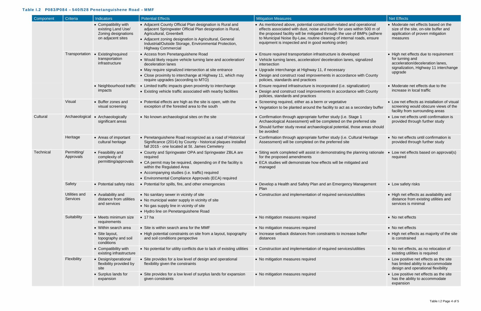
Table I.2 P083/P084 – 540/528 Penetanguishene Road – MMF
Table I.2 Page 4 of 5
Component Criteria Indicators Potential Effects Mitigation Measures Net Effects • Compatibility with
existing Land Use/ Zoning designations on adjacent sites
• Adjacent County Official Plan designation is Rural and adjacent Springwater Official Plan designation is Rural, Agricultural, Greenbelt
• Adjacent zoning designation is Agricultural, General Industrial/Outside Storage, Environmental Protection, Highway Commercial
• As mentioned above, potential construction-related and operational effects associated with dust, noise and traffic for uses within 500 m of the proposed facility will be mitigated through the use of BMPs (adhere to Municipal Noise By-Law, routine cleaning of internal roads, ensure equipment is inspected and in good working order)
• Moderate net effects based on the size of the site, on-site buffer and application of proven mitigation measures
Transportation • Existing/required transportation infrastructure
• Access from Penetanguishene Road • Would likely require vehicle turning lane and acceleration/
deceleration lanes • May require signalized intersection at site entrance • Close proximity to interchange at Highway 11, which may
require upgrades (according to MTO)
• Ensure required transportation infrastructure is developed • Vehicle turning lanes, acceleration/ deceleration lanes, signalized
intersection • Upgrade interchange at Highway 11, if necessary • Design and construct road improvements in accordance with County
policies, standards and practices
• High net effects due to requirement for turning and acceleration/deceleration lanes, signalization, Highway 11 interchange upgrade
• Neighbourhood traffic impacts
• Limited traffic impacts given proximity to interchange • Existing vehicle traffic associated with nearby facilities
• Ensure required infrastructure is incorporated (i.e. signalization) • Design and construct road improvements in accordance with County
policies, standards and practices
• Moderate net effects due to the increase in local traffic
Visual • Buffer zones and visual screening
• Potential effects are high as the site is open, with the exception of the forested area to the south
• Screening required, either as a berm or vegetative • Vegetation to be planted around the facility to act as a secondary buffer
• Low net effects as installation of visual screening would obscure views of the facility from surrounding areas
Cultural Archaeological • Archaeologically significant areas
• No known archaeological sites on the site • Confirmation through appropriate further study (i.e. Stage 1 Archaeological Assessment) will be completed on the preferred site
• Should further study reveal archaeological potential, those areas should be avoided
• Low net effects until confirmation is provided through further study
Heritage • Areas of important cultural heritage
• Penetanguishene Road recognized as a road of Historical Significance (2014) by County - historical plaques installed fall 2015 - one located at St. James Cemetery
• Confirmation through appropriate further study (i.e. Cultural Heritage Assessment) will be completed on the preferred site
• No net effects until confirmation is provided through further study
Technical Permitting/ Approvals
• Feasibility and complexity of permitting/approvals
• County and Springwater OPA and Springwater ZBLA are required
• CA permit may be required, depending on if the facility is within the Regulated Area
• Accompanying studies (i.e. traffic) required • Environmental Compliance Approvals (ECA) required
• Siting work completed will assist in demonstrating the planning rationale for the proposed amendments
• ECA studies will demonstrate how effects will be mitigated and managed
• Low net effects based on approval(s) required
Safety • Potential safety risks • Potential for spills, fire, and other emergencies • Develop a Health and Safety Plan and an Emergency Management Plan
• Low safety risks
Utilities and Services
• Availability and distance from utilities and services
• No sanitary sewer in vicinity of site • No municipal water supply in vicinity of site • No gas supply line in vicinity of site • Hydro line on Penetanguishene Road
• Construction and implementation of required services/utilities • High net effects as availability and distance from existing utilities and services is minimal
Suitability • Meets minimum size requirements
• 17 ha • No mitigation measures required • No net effects
• Within search area • Site is within search area for the MMF • No mitigation measures required • No net effects • Site layout,
topography and soil conditions
• High potential constraints on site from a layout, topography and soil conditions perspective
• Increase setback distances from constraints to increase buffer distances
• High net effects as majority of the site is constrained
• Compatibility with existing infrastructure
• No potential for utility conflicts due to lack of existing utilities • Construction and implementation of required services/utilities • No net effects, as no relocation of existing utilities is required
Flexibility • Design/operational flexibility provided by site
• Site provides for a low level of design and operational flexibility given the constraints
• No mitigation measures required • Low positive net effects as the site has limited ability to accommodate design and operational flexibility
• Surplus lands for expansion
• Site provides for a low level of surplus lands for expansion given constraints
• No mitigation measures required • Low positive net effects as the site has the ability to accommodate expansion

Table I.2 P083/P084 – 540/528 Penetanguishene Road – MMF
Table I.2 Page 5 of 5
Component Criteria Indicators Potential Effects Mitigation Measures Net Effects Economic Capital Costs • Property acquisition • Privately-owned site - purchase price to be confirmed
• Likely need to purchase two adjacent residential properties as well
• Confirmation of price through Market Analysis • Potential requirement of purchasing 2 adjacent properties as well given proximity and size of site
• High cost • Infrastructure • Penetanguishene Road would likely require vehicle turning
lanes, acceleration/deceleration lanes, signalized intersection • Additional improvements may be required to interchange at
Highway 11 • Hydro on Penetanguishene Road
• No mitigation measures required • High infrastructure costs
• Design • Design around wetlands, topography, groundwater, site layout
• No mitigation measures required • High design costs
• Construction • Minimal site grading • Road improvements, including Highway 11 interchange • Dewatering may be required during construction due to height
of groundwater table
• No mitigation measures required • High construction costs
• Permits/approvals • Proximity to Highway 400 • No mitigation measures required • Moderate additional Permit/Approval costs
• Site remediation • No known areas requiring remediation on-site • No mitigation measures required • Low costs Operation and Maintenance Costs
• Facility operation and maintenance
• Increased odour, noise, dust controls • No mitigation measures required • Moderate costs associated with operation and maintenance
• Transportation from feedstock sources
• Approximately 9 kilometres from waste centroid • No mitigation measures required • Low costs associated with transportation from feedstock sources
• Transportation to markets and end users
• Potential agricultural users nearby. Close to highway access for material processing and disposal
• No mitigation measures required • Low costs associated with transportation to markets and end users
• Monitoring requirements
• Increased surface water monitoring • Increased groundwater monitoring
• No mitigation measures required • Moderate costs associated with monitoring requirements
• Mitigation requirements
• No natural screening mechanisms (e.g., topography, vegetation, significant buffer) in place for odour, noise, visual
• Protection of Source Protection Areas
• No mitigation measures required • Moderate costs associated with mitigation requirements
Legal Land Acquisition
• Land acquisition complexity, risk, liability
• Privately-owned property • Requires negotiations, legal review, risk review, property
investigations • May need to compensate nearby residential properties
• Mitigation through compensation • High complexity, risk and liability
Agreement • Structure and complexity of operating agreement
• No added complexity expected • Mitigation through agreement structure • Low complexity

Table I.3 P083/P084 – 540/528 Penetanguishene Road – Co-Located Facility
Table I.3 Page 1 of 5
Component Criteria Indicators Potential Effects Mitigation Measures Net Effects Environmental Air Quality • Wind speed &
direction • Mean wind speed of 4.85 metres per second (m/s)
predominately coming from a northwesterly direction • Dust, particulate matter from construction/operation • Off-gases construction/operation
• As the site has a varied topography, mainly open with a forested area on the southern portion, additional mitigation measures through design and Best Management Practices (BMPs) during construction/ operation will be required
• BMPs may include vegetative screening, dust suppression, ensuring construction and operation equipment are inspected and in good working condition
• Low net effects as there is limited on-site buffer to act as mitigation measure to sensitive receptors (i.e., one off-site receptor encircled by the property boundary)
• Proximity to sensitive receptors
• Within 500 metres (m) of the site boundary there are 15 off-site receptors (generally along Penetanguishene Road, to north, east and south of site) potentially affected by dust and particulate matter from construction and operation of the facility
• These include 2 residential properties that abut the site, as well as a Church (St. Nektarios Greek Orthodox Church) to the north of the site and a business further to north, Napoleon Home Comfort
• Design and implement dust control (routine cleaning of internal paved roads)
• Maximize setback distance between facility footprint and sensitive receptors
• Proper management of air quality controls • Implement BMPs to ensure dust generation is minimized
• Low net effects as there is limited on-site buffer to act as mitigation measure to sensitive receptors (i.e., one off-site receptor encircled by the property boundary)
• Species of Special Concern, Threatened, and/or Endangered
• Potential species at risk (SAR) based on available habitat, as identified by MNRF Management Biologist, include: Butternut (END) if hedgerows present, Bobolink (THR) and Eastern Meadowlark (THR) if agricultural fields in hay or pasture
• Historical SAR records indicate Red-shouldered Hawk (1940) and Snapping Turtle (2009) have been located on or in close proximity to the property
• Avoidance of any SAR or SAR habitat when siting the facility • Confirmation that SAR are not present will be determined if this site is
carried forward as the preferred and additional mitigation measures/BMPs will be established. In addition, a scoped EIS would be undertaken.
• Low net effects as there is the potential for Species of Special Concern, Threatened, and/or Endangered based on preliminary review and recent records
Odour • Wind speed & direction
• Mean wind speed of 4.85 m/s predominately coming from a northwesterly direction
• Off-gases construction/operation
• As the site has a varied topography, mainly open with a forested area on the southern portion, additional mitigation measures through design and BMPs during construction/ operation will be required
• BMPs may include planting in key areas after construction, odour management, ensuring construction and operation equipment are inspected and in good working condition
• Implement BMPs to ensure odour is minimized
• Low net effects as there is limited on-site buffer to act as mitigation measure to sensitive receptors (i.e., one off-site receptor encircled by the property boundary)
• Proximity to sensitive receptors
• Within 500 m of the site boundary, there are 15 off-site receptors (generally along Penetanguishene Road, to north, east and south of site) potentially affected by odour from the facility
• These include 2 residential properties that abut the site, as well as a Church (St. Nektarios Greek Orthodox Church) to the north of the site and a business further to north, Napoleon Home Comfort
• Design and implement odour control (store material in an enclosed space, gas collection, etc.) at the outset of the project
• During operation, the facility will always operate under negative pressure
• Maximize setback distance between facility footprint and sensitive receptors
• Implement BMPs to ensure odour from facility is minimized
• Low net effects as there is limited on-site buffer to act as mitigation measure to sensitive receptors (i.e., one off-site receptor encircled by the property boundary)
Noise • Proximity to sensitive receptors
• Within 500 m of the site boundary, there are 15 off-site receptors (generally along Penetanguishene Road, to north, east and south of site) potentially affected noise from construction and operation of the facility
• These include 2 residential properties that abut the site, as well as a Church (St. Nektarios Greek Orthodox Church) to the north of the site and a business further to north, Napoleon Home Comfort
• Adhere to existing MOECC noise restrictions as well as additional noise limits imposed through the ECA
• During construction, adhere to Municipal Noise By-Law • Design and implement noise control measures at the outset of the
project • Maintenance to keep haul trucks in good condition • Maximize setback distance between facility footprint and sensitive
receptors • Implement noise BMP plan • During operation, adhere to Municipal Noise By-Law
• Low net effects as there is limited on-site buffer to act as mitigation measure to sensitive receptors (i.e., one off-site receptor encircled by the property boundary)

Table I.3 P083/P084 – 540/528 Penetanguishene Road – Co-Located Facility
Table I.3 Page 2 of 5
Component Criteria Indicators Potential Effects Mitigation Measures Net Effects Terrestrial • Topography • As a portion of the site has been re-graded with a steep slope
surrounding the perimeter of the forested area/unevaluated wetland to the south, the potential to alter natural drainage patterns is minimized, as alterations have already been completed
• Minimize alterations to existing topography • Setback facility from slopes • Setback facility from unevaluated wetlands • Minimize surface water flow into unevaluated wetlands through design
(conveyance)
• Low net effects on topography as it relates to natural environment (natural drainage patterns)
• Soil type • Overburden in the northern portion of the site consists primarily of stony sandy silt to silt till, with some glaciolacustrine very fine to medium grained sand, silt, with minor clay in the southeast corner
• Overburden in the southern portion of the site consists primarily of glaciolacustrine very fine to medium grained sand, silt, with minor clay
• Overburden beneath the proposed site is about 76 to 84 m (250 to 275 feet) thick
• Loss of Primary agricultural lands (Class 1-3)
• Surface water controls will be put in place to manage run-off from impervious surfaces (buildings/internal road, etc.)
• All materials accepted on-site will be within an enclosed building, with limited potential for runoff to occur
• All process water will be contained, collected and treated, either on-site or trucked off-site
• BMPs during construction will be implemented to limit potential impacts to soils and groundwater. This includes emergency management, accidental spills and containment techniques.
• Minimize footprint of Class 1-3 soil removal • Confirmation of soil types to occur should this be the preferred site
• Loss of Class 1-3 soil (up to approximately 13 hectares (ha))
• No effects on groundwater
• Affected Greenlands • No County Greenlands designation on site • No Areas of Natural Scientific Interest (ANSI) on site • Southern portion of the site is entirely forested
• Avoid areas of vegetation • Should trees be removed, compensate at a minimum on a 1:1 ratio –
either on-site or on another County owned property in close proximity
• No effects to County Greenlands or ANSI’s
• Low effects to existing vegetation on-site as removal will be required for the facility
• Niagara Escarpment Land Use
• Not within the Niagara Escarpment Land Use policy area • No mitigation measures required • No net effects
• Oak Ridges Moraine Land Use
• Not within the Oak Ridges Moraine Land Use policy area • No mitigation measures required • No net effects
• Species of Special Concern, Threatened, and/or Endangered
• Potential SAR based on available habitat, as identified by MNRF Management Biologist, include: Butternut (END) if hedgerows present, Bobolink (THR) and Eastern Meadowlark (THR) if agricultural fields in hay or pasture
• Historical SAR records indicate Red-shouldered Hawk (1940) and Snapping Turtle (2009) have been located on or in close proximity to the property
• Avoidance of any SAR or SAR habitat when siting the facility • Confirmation that SAR are not present will be determined if this site is
carried forward as the preferred and additional mitigation measures/BMPs will be established. In addition, a scoped EIS would be undertaken.
• Low net effects as there is the potential for Species of Special Concern, Threatened, and/or Endangered based on preliminary review
Aquatic • Species of Special Concern, Threatened, and/or Endangered
• No aquatic SAR listed as potentially occurring at this site • No aquatic SAR listed as occurring at this site • No net effects as there are no aquatic SAR listed as occurring at this site
Surface Water • Wetlands, Floodplains and Water Bodies
• Potential effects on a large unevaluated wetland in southern portion of the site (approximately 25% of the site)
• Off-site to the east, and directly abutting the on-site unevaluated wetland, there is another large unevaluated wetland, which may be connected
• Implement appropriate setbacks from the un-evaluated wetland as well as watercourse
• Facility will be designed to meet 100-year storm event • Surface water controls will be put in place to manage run-off from
impervious surfaces (buildings/internal road, etc.) and direct them away from natural drainage features
• All materials accepted on-site will be within an enclosed building, with limited potential for runoff to occur
• All process water will be contained, collected and treated, either on-site or trucked off-site
• BMPs during construction will be implemented to limit potential impacts to surface water. This includes erosion and sediment controls, emergency management, accidental spills and containment techniques
• Moderate effects to surface water features as the site is large and able to be located an appropriate distance from surface water features

Table I.3 P083/P084 – 540/528 Penetanguishene Road – Co-Located Facility
Table I.3 Page 3 of 5
Component Criteria Indicators Potential Effects Mitigation Measures Net Effects Groundwater • Groundwater depth • Overburden consists primarily of stony sandy silt to silt till,
with some glaciolacustrine very fine to medium grained sand, silt, with minor clay in the southeast corner
• Overburden beneath the proposed site is about 76 to 84 m (250 to 275 feet) thick
• Groundwater table is relatively high, shown to be within approximately 0.3 m from ground surface in some areas during previous monitoring undertaken on site (Terraprobe, 2006)
• Controlling surface water and process water will assist in mitigating any potential effects on groundwater
• Surface water controls will be put in place to manage run-off from impervious surfaces (buildings/internal road, etc.)
• All materials accepted on-site will be within an enclosed building, with limited potential for runoff to occur
• All process water will be contained, collected and treated, either on-site or trucked off-site
• BMPs during construction will be implemented to limit potential impacts to surface water. This includes erosion and sediment controls, emergency management, accidental spills and containment techniques.
• No net effects, based on the groundwater depth and the surface water management on-site
• Groundwater flow and direction
• The direction of shallow groundwater flow within the overburden is interpreted to occur in a general southeasterly direction
• Presence of primarily sandy silt to silt till overburden suggests that the rate of groundwater movement would be somewhat low, with the exception of the southeastern area which would be moderate
• No alterations to flow and direction are anticipated as part of the design of the facility
• Controlling surface water and process water will assist in mitigating any potential effects on groundwater
• No net effects as no alterations to flow and direction of groundwater are anticipated as part of the design of the facility
• Source Water Protection Areas
• The site is not located within a wellhead protection area (WHPA) or a highly vulnerable aquifer (HVA)
• Potential effects to Source Water Protection Areas • Small portion in the site in the south is designated as
Significant Groundwater Recharge Area (SGRA), medium vulnerability
• Avoid locating the facility within the SGRA, medium vulnerability areas • Controlling surface water and process water will assist in mitigating any
potential effects on groundwater • All mitigation measures described in the Surface Water and
Groundwater criteria would apply to this criteria as well
• No net effects to Source Water Protection Areas
Agricultural • Protection of Class 1, 2 and 3 Agricultural Lands
• Loss of Prime Agricultural Lands as the majority of the northern portion of the site is designated Class 1-3 soils
• Minimize footprint of Class 1-3 soil removal • Confirmation of soil types to occur should this be the preferred site
• Low net effects to Class 1-3 Soils (up to approximately 13 ha)
Social Sensitive Receptors
• Number and distribution of Sensitive Receptors (e.g., residential areas, parks and recreational areas, institutions, airports)
• Within 500 m of the site boundary, there are 15 off-site receptors (generally along Penetanguishene Road, to north, east and south of site)potentially affected from a nuisance perspective (i.e., noise, odour, dust, traffic) from construction and operation of the facility
• These include 2 residential properties that abut the site, as well as a Church (St. Nektarios Greek Orthodox Church) to the north of the site and a business further to north, Napoleon Home Comfort
• Potential construction-related and operational effects associated with dust, noise and traffic for uses within 500 m of the proposed facility will be mitigated through the use of BMPs (adhere to Municipal Noise By-Law, routine cleaning of internal roads, ensure equipment is inspected and in good working order)
• Design and implement odour control (store material in an enclosed space, gas collection, etc.) at the outset of the project
• During operation, the facility will always operate under negative pressure
• High net effects based on proximity to sensitive receptors and on-site buffer areas
• Buffer zones and separation distances to Sensitive Receptors
• Potential to affect local sensitive receptors from a nuisance perspective (noise, odour, dust, traffic)
• Given the size of the property relative to the facility footprint, the on-site buffer is limited to natural buffer in the south (unevaluated wetlands)
• As mentioned above, potential construction-related and operational effects associated with dust, noise and traffic for uses within 500 m of the proposed facility will be mitigated through the use of BMPs (adhere to Municipal Noise By-Law, routine cleaning of internal roads, ensure equipment is inspected and in good working order)
• High net effects based on proximity to sensitive receptors and on-site buffer areas
Land Use/ Zoning
• Current land use, zoning, approved development plans, and proposed land use changes
• County Official Plan designation is Rural and Springwater Official Plan designation is Rural, Greenbelt
• Zoning designation is General Industrial/Outside Storage, Environmental Protection
• County and Springwater Official Plan Amendment (OPA) and Springwater Zoning By-Law Amendment (ZBLA) would be required
• Low net effects due to displacement of current land use and OPA/ZBLA requirements
• Opportunity for brownfield development, enhanced use
• No opportunity for brownfield redevelopment or enhanced use as this site is not classified as a brownfield site
• No mitigation measures • Moderate net effects due to displacement of current land and lack of opportunity for brownfield redevelopment or enhanced use

Table I.3 P083/P084 – 540/528 Penetanguishene Road – Co-Located Facility
Table I.3 Page 4 of 5
Component Criteria Indicators Potential Effects Mitigation Measures Net Effects • Compatibility with
existing Land Use/ Zoning designations on adjacent sites
• Adjacent County Official Plan designation is Rural and adjacent Springwater Official Plan designation is Rural, Agricultural, Greenbelt
• Adjacent zoning designation is Agricultural, General Industrial/Outside Storage, Environmental Protection, Highway Commercial
• As mentioned above, potential construction-related and operational effects associated with dust, noise and traffic for uses within 500 m of the proposed facility will be mitigated through the use of BMPs (adhere to Municipal Noise By-Law, routine cleaning of internal roads, ensure equipment is inspected and in good working order)
• Moderate net effects based on the size of the site, on-site buffer and application of proven mitigation measures
Transportation • Existing/required transportation infrastructure
• Access from Penetanguishene Road • Would likely require vehicle turning lane and acceleration/
deceleration lanes • May require signalized intersection at site entrance • Close proximity to interchange at Highway 11, which may
require upgrades (according to MTO)
• Ensure required transportation infrastructure is developed • Vehicle turning lanes, acceleration/ deceleration lanes, signalized
intersection • Upgrade interchange at Highway 11, if necessary • Design and construct road improvements in accordance with County
policies, standards and practices
• High net effects due to requirement for turning and acceleration/deceleration lanes, signalization, Highway 11 interchange upgrade
• Neighbourhood traffic impacts
• Limited traffic impacts given proximity to interchange • Existing vehicle traffic associated with nearby facilities
• Ensure required infrastructure is incorporated (i.e. signalization) • Design and construct road improvements in accordance with County
policies, standards and practices
• Moderate net effects due to the increase in local traffic
Visual • Buffer zones and visual screening
• Potential effects are high as the site is open, with the exception of the forested area to the south
• Screening required, either as a berm or vegetative • Vegetation to be planted around the facility to act as a secondary buffer
• Low net effects as installation of visual screening would obscure views of the facility from surrounding areas
Cultural Archaeological • Archaeologically significant areas
• No known archaeological sites on the site • Confirmation through appropriate further study (i.e. Stage 1 Archaeological Assessment) will be completed on the preferred site
• Should further study reveal archaeological potential, those areas should be avoided
• Low net effects until confirmation is provided through further study
Heritage • Areas of important cultural heritage
• Penetanguishene Road recognized as a road of Historical Significance (2014) by County - historical plaques installed fall 2015 - one located at St. James Cemetery
• Confirmation through appropriate further study (i.e. Cultural Heritage Assessment) will be completed on the preferred site
• No net effects until confirmation is provided through further study
Technical Permitting/ Approvals
• Feasibility and complexity of permitting/approvals
• County and Springwater OPA and Springwater ZBLA are required
• CA permit may be required, depending on if the facility is within the Regulated Area
• Accompanying studies (i.e. traffic) required • Environmental Compliance Approvals (ECA) required
• Siting work completed will assist in demonstrating the planning rationale for the proposed amendments
• ECA studies will demonstrate how effects will be mitigated and managed
• Low net effects based on approval(s) required
Safety • Potential safety risks • Potential for spills, fire, and other emergencies • Develop a Health and Safety Plan and an Emergency Management Plan
• Low safety risks
Utilities and Services
• Availability and distance from utilities and services
• No sanitary sewer in vicinity of site • No municipal water supply in vicinity of site • No gas supply line in vicinity of site • Hydro line on Penetanguishene Road
• Construction and implementation of required services/utilities • High net effects as availability and distance from existing utilities and services is minimal
Suitability • Meets minimum size requirements
• 17 ha • No mitigation measures required • No net effects
• Within search area • Site is within search area for the OPF and MMF • No mitigation measures required • No net effects • Site layout,
topography and soil conditions
• High potential constraints on site from a layout, topography and soil conditions perspective
• Increase setback distances from constraints to increase buffer distances
• High net effects as majority of the site is constrained
• Compatibility with existing infrastructure
• No potential for utility conflicts due to lack of existing utilities • Construction and implementation of required services/utilities • No net effects, as no relocation of existing utilities is required
Flexibility • Design/operational flexibility provided by site
• Site provides for a low level of design and operational flexibility given the constraints
• No mitigation measures required • Low positive net effects as the site has limited ability to accommodate design and operational flexibility
• Surplus lands for expansion
• Site provides for a low level of surplus lands for expansion given constraints
• No mitigation measures required • Low positive net effects as the site has the ability to accommodate expansion

Table I.3 P083/P084 – 540/528 Penetanguishene Road – Co-Located Facility
Table I.3 Page 5 of 5
Component Criteria Indicators Potential Effects Mitigation Measures Net Effects Economic Capital Costs • Property acquisition • Privately-owned site - purchase price to be confirmed
• Likely need to purchase two adjacent residential properties as well
• Confirmation of price through Market Analysis • Potential requirement of purchasing 2 adjacent properties as well given proximity and size of site
• High cost • Infrastructure • Penetanguishene Road would likely require vehicle turning
lanes, acceleration/deceleration lanes, signalized intersection • Additional improvements may be required to interchange at
Highway 11 • Hydro on Penetanguishene Road
• No mitigation measures required • High infrastructure costs
• Design • Design around wetlands, topography, groundwater, site layout
• No mitigation measures required • High design costs
• Construction • Minimal site grading • Road improvements, including Highway 11 interchange • Dewatering may be required during construction due to height
of groundwater table
• No mitigation measures required • High construction costs
• Permits/approvals • Proximity to Highway 400 • No mitigation measures required • Moderate additional Permit/Approval costs
• Site remediation • No known areas requiring remediation on-site • No mitigation measures required • Low costs Operation and Maintenance Costs
• Facility operation and maintenance
• Increased odour, noise, dust controls • No mitigation measures required • Moderate costs associated with operation and maintenance
• Transportation from feedstock sources
• Approximately 9 kilometres from waste centroid • No mitigation measures required • Low costs associated with transportation from feedstock sources
• Transportation to markets and end users
• Potential agricultural users nearby. Close to highway access for material processing and disposal
• No mitigation measures required • Low costs associated with transportation to markets and end users
• Monitoring requirements
• Increased surface water monitoring • Increased groundwater monitoring
• No mitigation measures required • Moderate costs associated with monitoring requirements
• Mitigation requirements
• No natural screening mechanisms (e.g., topography, vegetation, significant buffer) in place for odour, noise, visual
• Protection of Source Protection Areas
• No mitigation measures required • Moderate costs associated with mitigation requirements
Legal Land Acquisition
• Land acquisition complexity, risk, liability
• Privately-owned property • Requires negotiations, legal review, risk review, property
investigations • May need to compensate nearby residential properties
• Mitigation through compensation • High complexity, risk and liability
Agreement • Structure and complexity of operating agreement
• No added complexity expected • Mitigation through agreement structure • Low complexity
GHD Limited 651 Colby Drive Waterloo Ontario N2V 1C2 Canada T 519 884 0510 F 519 884 0525 W www.ghd.com
To: Brian Dermody Ref. No.: 086822
From:
Laura Lawlor/mg/2 rev1 Date: February 26, 2016
CC: Blair Shoniker
Re: Site Review for Development at 2976 Horseshoe Valley Road West, Springwater
1. Introduction and Background
GHD Limited (GHD) has been retained by the County of Simcoe (County) to assist in site selection for an Organics Processing Facility (OPF) and a Materials Management Facility (MMF). A short-list of seven sites were reviewed and evaluated by a suite of criteria, including natural heritage. Natural heritage features of each of the considered sites were analyzed using secondary source information (existing data sources, mapping, ortho-imagery, etc.), augmented by high-level site visits by GHD staff.
Site C136, a forested tract of land located at 2976 Horseshoe Valley Road West, Springwater (property) in the Nottawasaga Valley Conservation Authority (NVCA) watershed was put forward as the recommended site for both the OPF and MMF or co-located facility, after a detailed comparative evaluation of potential sites was undertaken.
In 2008, the County's Official Plan (OP) was updated and adopted by County Council, which altered policies and mapping related to County Greenlands. The most recent version of the "Proposed Modified County of Simcoe OP" is current up to a decision made by the Ontario Municipal Board (OMB) in February, 2016. A number of policies within the OP are currently under appeal to the OMB, which means that portions of the OP have not yet been formally approved. This includes policies and mapping related to the County Greenlands designation. In particular, Site C136 is recommended to change from a small portion of the property in the northeast being designated as County Greenlands, to the entire site being designated as County Greenlands.
During the evaluation process, GHD utilized County Greenlands mapping that is currently approved under the previous OP, as well as the 2008 Draft Simcoe County Greenlands Designation / Mapping – both sets of Greenlands mapping were utilized in the evaluation of the short-listed sites. Notwithstanding this, the status of the OP is being monitored to ensure that OMB decisions and newly-approved policies that may apply are considered in the evaluation process. At this point in time, it is recognized that further investigations and approvals will be necessary should the new County Greenlands mapping come into force prior to the development of the OPF, the MMF, or the co-located facility.

086822Memo-2 rev1 2
It should be noted that sites that are currently designated or may be designated (under revised 2008 mapping) as County Greenlands were carried forward for evaluation in Screen 3. Under approved OP policies, Section 3.8.17 notes that infrastructure (such as a waste management facility) not subject to an Environmental Assessment process, may be permitted within the County Greenlands designation in accordance with Section 3.3.15 of the OP, which outlines how site alteration/development may take place on lands designated as County Greenlands. Further, a number of criteria used in the site evaluation and selection process already considered certain elements that fall under the County Greenlands designation, including ANSIs, SAR, and significant wetlands (i.e., PSWs, evaluated and unevaluated wetlands).
Given the County's request to consider the site already designated as Greenlands, GHD recommended that further review of the site occur via an initial site walk with a qualified ecologist to provide additional details on the site for those natural features that pertain to the Greenlands designation. This memo was prepared to provide preliminary site reconnaissance findings relating to natural heritage features and a technical opinion on the implications of the modified Greenlands designation.
2. Site Reconnaissance
To verify site conditions on the property, a GHD ecologist conducted a site visit to document natural heritage features of the property on January 27th, 2016. Observations made were limited to general vegetation communities, incidental wildlife, and likely location of a mapped watercourse due to the season and snow covered ground, with a focus on the proposed facility footprint and associated development (e.g. access road).
The entire site is treed with some areas of natural trees, although the majority of the site is mixed-species plantation. The topography is undulating with a global slope from west to east across the central and southern portion of the site. Plantation species include red pine (Pinus resinosa), white spruce (Picea glauca), white pine (Pinus strobus), Norway spruce (Picea abies), and European larch (Larix decidua). Tree species in the naturalized areas on site include black locust (Robinia pseudoacacia), ash (Fraxinus spp.), black cherry (Prunus serotina), American beech (Fagus grandifolia; understory only), white birch (Betula papyrifera), and Manitoba maple (Acer negundo). Based on the size of the proposed facility footprint, the development may be situated within a plantation forest stand managed for red pine.
GHD also assessed the property for the presence of watercourses. According to current mapping, there should be a watercourse crossing the property near the southern limit. At the time of site reconnaissance, no evidence of a watercourse was visible in the mapped location. Further investigation in the spring will be required to identify any possible watercourse and assess it for suitability as fish habitat.
3. Freele County Forest
Based on aerial photographs, mapping resources and site verification, the non-wetland area of the Site is characterized as forested, with a large portion consisting of established mixed plantation. Further investigation identified the property as Freele County Forest, which as County owned public land could be used for a variety of recreational uses including hiking, horseback riding, skiing, cycling, snowshoeing or hunting and is open to permitted forest harvesting activities (Simcoe County, 2016). In relation to Greenlands designation, the criteria for significant woodland which pertain to the Freele County Forest include the following:

086822Memo-2 rev1 3
• A minimum of 10 hectares in the Simcoe Uplands
• Interior forest is any part of a patch that is 100 metres or more from all edges of the patch
Simcoe County forestry records indicate most of the plantation stands are approximately 65 years old and dominantly comprised of combinations of red pine, white spruce, and Norway spruce. Selective harvest is conducted in all County forest tracts acting in place of natural disturbance regimes. County foresters target harvest at approximately 90 years, although stand condition often results in younger harvest ages (per. comm. Graeme Davis, 2016). County forest management includes the eventual conversion of plantation tracts to mixed stand forests. As a working forest, the next scheduled assessment of stands within the Freele County Forest is planned for 2017, and will eventually be slated harvested in the future.
Common forest types often associated with the uplands of the Simcoe region are of a mix of deciduous and plantation. Many forests feature predominantly sugar maple (Acer saccharum ssp. saccharum) and beech, with subdominant American basswood (Tilia americana), ash, birch, red and white oak (Quercus rubra and Q. alba), poplar (Populus spp.), hemlock (Tsuga sp.) and white pine (NRSI, 2012), although coniferous plantations are also common.
Based on the size and attributes of the forested area on and adjacent to the property, the characteristics of this forest comply with the criteria of the draft 2012 OP significant woodland definition, and therefore under the County Greenlands designation. It should be noted that the County Greenlands definition from the Official Plan identified above remains "unapproved" as of the date of this memo. Notwithstanding this, GHD undertook a review of the site under the premise that the definition is applicable in order to be conservative and transparent.
3.1.1 Infrastructure
Item 3.8.17 of the 2012 OP has recently been approved by the Ontario Municipal Board. This item allows for infrastructure to be developed within the Greenlands Designation, so long as it complies with Section 3.3.15 of the County's OP. Section 3.3.15 – Natural Heritage remains unapproved in the County's OP, however to be conservative and transparent, GHD have reviewed the requirements and assumed that this Section will be implemented as currently stated. This section of the OP provides guidance on development and site alteration within areas designated as County Greenlands, which requires further study and analysis as described in Section 3.1.2 below.
3.1.2 Environmental Impact Statement (EIS) Requirements
As part of the draft 2012 OP guidelines, development proposed in lands with a Greenlands designation require a scoped Environmental Impact Statement (EIS) as part of the development application to determine potential impacts of development on the natural heritage features and areas and ecological functions on the property, and propose appropriate modification and mitigation strategies. This ensures adequate analysis and protection of ecological and hydrologic functions such as groundwater recharge, stream/river base flow, wildlife movement and biotic diversity as deemed satisfactory to appropriate authorities (NVCA, Simcoe County, and the local municipality).
Specific to the significant woodlands feature of the Freele County forest, woodlands are protected under the County of Simcoe Forest Conservation Bylaw. As part of the required EIS, vegetation communities must be identified, described, mapped, and coded using the Ecological Land Classification (ELC) system. A breeding

086822Memo-2 rev1 4
bird survey and/or amphibian/reptile survey may also be required, dependent on the agreed upon Terms of Reference, during which a qualified professional will conduct a survey during an appropriate time of the breeding season. Any significant wildlife habitat (including incidental sightings or any evidence of use by wildlife) must be documented. Field surveys are typically conducted over two or three seasons, and the seasons of survey will be specified in the agreed Terms of Reference. All species (plant, breeding birds, breeding reptiles/amphibians, other wildlife of interest and fish – if assessed) must be listed, categorized and mapped as necessary by SAR classification.
Also stipulated in the plan is a minimum setback from the edge of a watercourse, as determined by a qualified professional, based on riparian habitat and public safety. Soil type, vegetation type/cover, slope of the land/drainage patterns, natural heritage features including fish habitat, the nature of development and flooding and erosion hazards will be considered in this evaluation. Any development in this area must demonstrate protection of water quality and quantity, prevention of erosion resulting from surface water runoff and structural development or fill, the conservation of the natural heritage features of the shoreline area, the enhancement and conservation of linkages between the water bodies and upland areas, and the conservation and improvement of public access to the shorelines. Any identified fish habitat must be further examined in accordance with provincial and federal requirements.
The Terms of Reference of the EIS will be developed through consultation with the reviewing agencies to ensure all necessary components are addressed.
4. Conclusions and Recommended Next Steps
• The property is comprised of extensive plantation forest stands, dominated by 65 year old red pine. These stands are selectively harvested by County foresters on a routine basis, the next of which is scheduled for 2017.
• Despite being a managed forest, the Freele County Forest does satisfy the description of a Greenland under the 2012 Official Plan (Draft, as amended).
• Nothing was observed during the January 27, 2016 site reconnaissance that would preclude the development of an OPF/MMF on the site.
• If development is to proceed on this property, an EIS is recommended to further identify the ecological function of the property, and any impacts of the proposed development on the natural heritage features or ecological functions.
• Preparation of the EIS will include collecting data during the spring and summer seasons to confirm the ecological function of the forest area, including significant wildlife and fish habitat.
• As part of the EIS, the development of the property with mitigation must demonstrate no negative impact to site natural heritage features and ecological function.

086822Memo-2 rev1 5
5. References
Ministry of Natural Resources and Forestry (MNRF), 2015. Make a Map: Natural Heritage Areas. Last accessed January 2016:http://www.giscoeapp.lrc.gov.on.ca/Mamnh/Index.html?site=MNR_NHLUPS_NaturalHeritage&viewer=NaturalHeritage&locale=en-US
Natural Resources Solutions, Inc., 2012. City of Barrie Annexed Lands Natural Heritage Characterization Report. Barrie: Natural Resources Solutions, Inc.
Nottawasaga Valley Conservation Authority, 2016. Online mapping. Retrieved from County of Simcoe: http://maps.simcoe.ca/NVCA/
Personal Communication, 2016. Correspondence with Graeme Davis, Simcoe County Forester. Email and phone correspondence between February 5 – 12, 2016.
Simcoe County, 2012. Draft - Official Plan of the County of Simcoe. County of Simcoe, approved in parts.
Simcoe County, 2007. Official Plan of the County of Simcoe – Consolidated April 2007. County of Simcoe.
Simcoe County,2015. County of Simcoe Interactive Map: Forest/Recreation. Retrieved from County of Simcoe. Last accessed February 2016. http://maps.simcoe.ca/Public/?MODE=theme&THEME=forestry.
Related Documents