January 2015 PREPARED FOR: FERRY COUNTY AND THE CITY OF REPUBLIC Shoreline Inventory, Analysis, and Characterization Report Ferry County Coalition Shoreline Master Program Update Prepared by: Prepared with assistance from: 8033 W. Grandridge Boulevard, Suite A Kennewick, Washington 99336 Oneza & Associates SCJ Alliance This report was funded through a grant from the Washington State Department of Ecology

Welcome message from author
This document is posted to help you gain knowledge. Please leave a comment to let me know what you think about it! Share it to your friends and learn new things together.
Transcript

January 2015
PREPARED FOR: FERRY COUNTY AND THE CITY OF REPUBLIC
Shoreline Inventory, Analysis, and Characterization Report Ferry County Coalition Shoreline Master Program Update
Prepared by: Prepared with assistance from:
8033 W. Grandridge Boulevard, Suite A Kennewick, Washington 99336
Oneza & Associates SCJ Alliance
This report was funded through a grant from the Washington State Department of Ecology

Shoreline Inventory, Analysis, and Characterization Report January 2015 Ferry County Coalition SMP Update i 141067-01.01
TABLE OF CONTENTS 1 INTRODUCTION ................................................................................................................ 1
1.1 Background and Purpose .................................................................................................1
1.2 Report Organization.........................................................................................................2
2 REGULATORY OVERVIEW............................................................................................... 3
2.1 Local, State, and Federal Plans and Regulations ............................................................3
2.1.1 Cultural Resources Protections for Shoreline Development ...................................6
3 SHORELINE JURISDICTION ANALYSIS ........................................................................... 7
3.1 Shoreline Management Act Shoreline Criteria ..............................................................7
3.2 Study Area ........................................................................................................................8
3.3 Shorelines Currently Designated ....................................................................................8
3.3.1 Shorelines of Statewide Significance .........................................................................8
3.3.2 Shorelines of the State ................................................................................................9
3.4 Preliminary Shoreline Jurisdiction Analysis and Findings for the Shoreline Master Program Update .............................................................................................................10
3.4.1 Shoreline Jurisdiction Data Analysis .......................................................................10
3.4.2 Identification and Verification of Shorelines Meeting the Definition of Shoreline of the State .............................................................................................................................11
3.4.3 Preliminary Shoreline Jurisdiction Areas ...............................................................14
3.5 Reach Breaks ..................................................................................................................15
4 INVENTORY ..................................................................................................................... 17
4.1 Land Use and Planning Inventory ................................................................................17
4.1.1 Ownership ................................................................................................................17
4.1.2 Land Cover ................................................................................................................18
4.1.3 Land Use ....................................................................................................................19
4.1.4 Development .............................................................................................................20
4.1.5 Current Shoreline Master Program Environment Designations ...........................21
4.1.6 Shoreline Uses ...........................................................................................................23
4.2 Environmental Elements Inventory .............................................................................25
4.2.1 Geology .....................................................................................................................25
4.2.2 Climate ......................................................................................................................29
Table of Contents
Shoreline Inventory, Analysis, and Characterization Report January 2015 Ferry County Coalition SMP Update ii 141067-01.01
4.2.3 Water Resources .......................................................................................................30
4.2.4 Geologic Hazards ......................................................................................................34
4.2.5 Cultural Resources ....................................................................................................35
5 SHORELINE ANALYSIS AND CHARACTERIZATION ................................................... 43
5.1 Ecosystem-Wide Processes and Conditions .................................................................43
5.1.1 Hydrology .................................................................................................................43
5.1.2 Sediment ...................................................................................................................44
5.1.3 Water Quality ...........................................................................................................44
5.1.4 Habitat .......................................................................................................................46
5.2 Waterbody-Specific Processes and Conditions ............................................................58
5.2.1 Kettle River and Associated Tributaries ..................................................................58
5.2.2 Columbia River and Associated Tributaries............................................................62
5.2.3 Sanpoil River and Associated Tributaries ...............................................................67
5.2.4 Lake Groups ..............................................................................................................71
5.3 Summary of Ecological Stressors ...................................................................................82
5.4 Reach Characterizations ................................................................................................84
5.5 Future Land Use and Development Potential ..............................................................85
5.5.1 Methodology .............................................................................................................86
5.5.2 Data Gaps ..................................................................................................................87
5.5.3 Land Development Potential Summary ..................................................................87
5.5.4 Preliminary Shoreline Environment Designation Considerations ........................92
6 PUBLIC ACCESS ................................................................................................................ 97
7 INFORMATION SOURCES, ASSUMPTIONS, AND LIMITATIONS ............................. 103
8 REFERENCES .................................................................................................................. 104

Table of Contents
Shoreline Inventory, Analysis, and Characterization Report January 2015 Ferry County Coalition SMP Update iii 141067-01.01
List of Tables Table 1 Critical Areas Buffers Summary (as of 2014) ....................................................... 4
Table 2 Shoreline Criteria Definitions per RCW 90.58.030 and WAC 173-26-020 ...... 7
Table 3 Shorelines of Statewide Significance (Rivers and Streams) per WAC 173-18-140 ................................................................................................... 9
Table 4 Shorelines of the State (Rivers and Streams) per WAC 173-18-140 .................. 9
Table 5 Lakes under Shoreline Jurisdiction per WAC 173-20-220 ............................... 10
Table 6 Shorelines of Statewide Significance to be Included in the SMP Update ....... 12
Table 7 Additional Shorelines of the State to be Included in the SMP Update ........... 13
Table 8 Shoreline Jurisdiction Lakes to be Included in the SMP Update ..................... 13
Table 9 Reaches and Subreaches ..................................................................................... 15
Table 10 Ownership Types within Ferry County Shorelines .......................................... 17
Table 11 Ownership Types within City of Republic Shorelines (Granite Creek) .......... 18
Table 12 Land Cover Type within Ferry County Shorelines........................................... 18
Table 13 Land Cover Type within City of Republic Shorelines ...................................... 19
Table 14 Existing Land Use in Ferry County Shorelines ................................................. 20
Table 15 Existing Land Use in City of Republic Shorelines ............................................ 20
Table 16 Existing Development Areas in Ferry County Shorelines ................................ 21
Table 17 Existing Zoning in City of Republic Shorelines ................................................ 21
Table 18 Summary of Ferry County Shoreline Environment Designations ................... 22
Table 19 Summary of Water-Dependent Uses ................................................................. 23
Table 20 Summary of Water-Related and Water-Enjoyment Uses ................................ 24
Table 21 Geologic Hazards in Ferry County Shorelines .................................................. 35
Table 22 Aquatic ESA-Listed and Washington State Priority Habitat Species in Ferry County ........................................................................................................ 49
Table 23 Riparian Species in Ferry County ...................................................................... 53
Table 24 Terrestrial ESA-Listed and Washington State Priority Habitat Species in Ferry County ........................................................................................................ 56
Table 24 Priority Habitats in Ferry County within the Shoreline Jurisdiction ............. 57
Table 24 Key Stressors Affecting Ecological Functions ................................................... 83
Table 25 Future Development Potential by Main Waterbody ........................................ 88
Table 26 Preliminary Environment Designation Consideration – Rivers ...................... 95
Table 27 Preliminary Environment Designation Consideration – Lakes ....................... 96

Table of Contents
Shoreline Inventory, Analysis, and Characterization Report January 2015 Ferry County Coalition SMP Update iv 141067-01.01
Table 28 Public Access by Reaches and Subreaches ........................................................ 98
List of Appendices Appendix A Kettle River Reach Characterization Tables and Reach Maps
Appendix B Columbia River Reach Characterization Tables and Reach Maps
Appendix C Sanpoil River Reach Characterization Tables and Reach Maps
Appendix D Lake Groups Reach Characterization Tables and Reach Maps
Appendix E Map Folio
Shoreline Inventory, Analysis, and Characterization Report January 2015 Ferry County Coalition SMP Update v 141067-01.01
LIST OF ACRONYMS AND ABBREVIATIONS Anchor QEA Anchor QEA, LLC CAO Critical Areas Ordinance CCC Civilian Conservation Corps cfs cubic feet per second CIA Cumulative Impacts Analysis CMZ channel migration zone Coalition Ferry County Coalition CTCR Confederated Tribes of the Colville Reservation DEM Digital Elevation Model DMA disconnected migration area DNR Washington State Department of Natural Resources DOH Washington State Department of Health Ecology Washington State Department of Ecology ESA Endangered Species Act FEMA Federal Emergency Management Agency GEI GEI Consultants, Inc. GIS Geographic Information System IAC Inventory, Analysis, and Characterization K kilometer KFD Kettle Falls Archaeological District KRAD Kettle River Archaeological District Lake Roosevelt Franklin D. Roosevelt Lake LiDAR Light Image Detection and Ranging LWD large woody debris MAF mean annual flow MSL mean sea level N/A not applicable NASS National Agricultural Statistics Service NHD National Hydrography Dataset NOAA National Oceanic and Atmospheric Administration NPS National Park Service

List of Acronyms and Abbreviations
Shoreline Inventory, Analysis, and Characterization Report January 2015 Ferry County Coalition SMP Update vi 141067-01.01
NRCS Natural Resources Conservation Service NRHP National Register of Historic Places NWPPC Northwest Power Planning Council OHWM ordinary high water mark PDO Pacific Decadal Oscillation RCW Revised Code of Washington Reach Tables Reach Characterization Tables SMA Shoreline Management Act SMP Shoreline Master Program SR Subreach SRSRB Snake River Salmon Recovery Board SSURGO Soil Survey Geographic TMDL total maximum daily load USDA U.S. Department of Agriculture USFS U.S. Forest Service USFWS U.S. Fish and Wildlife Service USGS U.S. Geological Survey UW University of Washington WAC Washington Administrative Code WDFW Washington Department of Fish and Wildlife WRCC Western Regional Climate Center WRIA Water Resource Inventory Area WSDOT Washington State Department of Transportation WSU Washington State University
Shoreline Inventory, Analysis, and Characterization Report January 2015 Ferry County Coalition SMP Update 1 141067-01.01
1 INTRODUCTION
1.1 Background and Purpose
Ferry County and the City of Republic have formed the Ferry County Coalition (Coalition) to update the Shoreline Master Program (SMP) in compliance with the Washington State Shoreline Management Act (SMA) and adopted state shoreline management guidelines. This work is funded by a grant from the Washington State Department of Ecology (Ecology). A primary purpose of this effort is to update the SMP to comply with Chapter 90.58.030 Revised Code of Washington (RCW), the SMA, and Ecology’s 2003 Shoreline Master Program Guidelines (Chapter 173-26 Washington Administrative Code [WAC]). This Inventory, Analysis, and Characterization (IAC) Report provides a technical foundation for the Coalition’s SMP update. This report includes a discussion of the setting and ecosystem-wide processes that influence ecological functions within the Coalition’s shorelines. The IAC Report also discusses alterations based on existing land-use patterns and future potential development within the shoreline jurisdiction areas. Reach Characterization Tables (Reach Tables), summarizing conditions by reach, are provided in Appendices A though D. A map folio is provided in Appendix E. The SMA guidelines require the Coalition to demonstrate that the SMP will result in no net loss to shoreline ecological functions during implementation. This report describes the existing baseline conditions of shoreline ecological function. An associated Shoreline Restoration and Protection Plan and Cumulative Impacts Analysis (CIA) will follow development of the draft SMP and code elements. The CIA will demonstrate how future development under the proposed SMP will result in no net loss of shoreline ecological function. The restoration measures described in the Shoreline Restoration and Protection Plan provide recommendations that could be implemented to improve existing shoreline ecological functions.
Introduction
Shoreline Inventory, Analysis, and Characterization Report January 2015 Ferry County Coalition SMP Update 2 141067-01.01
1.2 Report Organization
The report is organized in the following sections:
• Regulatory Overview – Describes the SMA, the local, state, and federal regulations, and cultural resource considerations
• Shoreline Jurisdiction Analysis – Reviews the data and analysis used to determine the shoreline jurisdiction waterbodies and extents of the SMA shoreline jurisdiction
• Inventory – Provides a description of the project area, including ownership and land-cover characteristics, land-use and SMP environment designations, geology, climate, surface water resources, water quality, floodplains and floodways, channel migration zones (CMZs), groundwater resources, geologic hazards, and cultural resources characteristics
• Shoreline Analysis and Characterization – This section describes the ecosystem processes and the level to which they are currently impaired or altered. The processes most critical to ecological functions are described for the Kettle, Columbia, and Sanpoil rivers and their associated tributaries and lakes within the County. Also included are a review of the reach characterization methods and an overview of the Reach Tables included in Appendices A through D. This section also provides an overview of the future land-use and development potential analysis, which identifies developable lands and associated residential units and commercial areas available for specific geographic areas within the Coalition jurisdictions.
• Public Access – Identifies existing public access goals and policies • Information Sources, Assumptions, and Limitations – Describes information sources,
assumptions, and limitations available at the time this report was prepared
Shoreline Inventory, Analysis, and Characterization Report January 2015 Ferry County Coalition SMP Update 3 141067-01.01
2 REGULATORY OVERVIEW
Counties, cities, and towns develop or update local SMPs to be in compliance with Washington State’s SMA (RCW 90.58.030) and consistent with Ecology’s guidelines. Washington’s SMA addresses concerns about the effects of unregulated development on shorelines. The SMP update process indicates the joint state/local nature of the SMA program as local governments develop SMPs in close coordination with Ecology, are informed by local opportunities and constraints, and remain consistent with state laws and guidelines.
2.1 Local, State, and Federal Plans and Regulations
SMPs provide provisions to protect archaeological resources, historical resources, and environmentally critical areas within the shoreline, as well as to maintain flood hazard protection (WAC 173-26-221). Ferry County has an existing SMP (last updated in 2002), which will be updated to be compliant with Ecology’s 2003 SMP Guidelines (WAC 173-26). The City of Republic will be developing their first SMP as they currently do not have one adopted. Environmentally sensitive areas (critical areas) within Ferry County and the City of Republic include wetlands, critical aquifer recharge areas, frequently flooded areas, geologically hazardous areas, and fish and wildlife habitat conservation areas. Table 1 includes a summary of critical area buffer requirements for wetlands and for fish and wildlife habitat conservation areas, if identified in critical areas regulations for the Coalition jurisdictions.

Regulatory Overview
Shoreline Inventory, Analysis, and Characterization Report January 2015 Ferry County Coalition SMP Update 4 141067-01.01
Table 1 Critical Areas Buffers Summary (as of 2014)
Jurisdiction Code Reference Protection Standards
Ferry County
Wetlands
Critical Areas Ordinance #2014-03
Section 5.00 (adopted 2014)
Wetland Delineation and Rating System
• Washington State Wetlands Identification and Delineation Manual (Ecology Publication #96-94, March 1997; Ecology 1997)
• Washington State Wetlands Rating System for Eastern Washington (Ecology 2007)
Buffers and Mitigation Ratios Category
I II III IV Buffer (feet) – buffer range
based on land-use intensity
Low Habitat 50-100 50-100 40-80 25-50
Moderate Habitat 75-150 75-150 75-150 N/A
High Habitat 100-200 100-200 N/A
Mitigation ratio
Forested 6:1 4:1 2:1 1.5:1
Other 4:1 3:1 Fish and Wildlife Habitat Conservation Areas
Critical Areas Ordinance #2014-03
Section 9.00 (adopted 2014)
Water Typing System Per WAC 222-16-031
Riparian Habitat Buffer Widths (feet) Stream Type
Type 1 and 2 Type 3 Type 4 and 5 150 100 50
Common Loon active breeding sites and nursery pools (Long Lake, Ferry Lake, Round Lake, Swan
Lake, and Twin Lakes)
No new structures shall be allowed within 492 feet of FWHCA-designated Common Loon breeding/nursery sites. Exception: Twin Lakes Rural Service Area – see CAO Section 9 for specific requirements.

Regulatory Overview
Shoreline Inventory, Analysis, and Characterization Report January 2015 Ferry County Coalition SMP Update 5 141067-01.01
Jurisdiction Code Reference Protection Standards
City of Republic
Wetlands
City Ordinance 92-11
Wetland Delineation and Rating System
• 1989 Federal Manual for Identifying and Delineating Jurisdictional Wetlands1
• National Wetland Inventory Maps and Tri-county Wetland Maps
Buffers and Mitigation Ratios Category
I II III IV
Minimum Buffer (feet) Low Intensity 100 50 25 25 High Intensity 200 100 50 25
Fish and Wildlife Habitat Conservation Areas
City Ordinance 92-11
Water Typing System Per WAC 222-16-031
Structure Setback (feet) Stream Type
Types 1, 2, and 3 Type 4 Type 5 50 25 N/A
Notes: 1 = The City of Republic Critical Areas Ordinance references the 1989 Federal Manual; however, this document is no longer being used by federal agencies. Instead, the 1987 U.S. Army Corps of Engineers Wetland Delineation Manual and regional supplements are the currently adopted references. CAO = Critical Areas Ordinance FWHCA = Fish and Wildlife Habitat Conservation Areas N/A = not applicable
Regulatory Overview
Shoreline Inventory, Analysis, and Characterization Report January 2015 Ferry County Coalition SMP Update 6 141067-01.01
Critical areas for each shoreline jurisdiction reach are also described within the Flooding and Geological Hazards and Habitat Characteristics sections of the Reach Tables provided in Appendix A through D. These areas are also identified, as applicable, in the map folio provided in Appendix E. In addition, federal, state, and local regulations also apply to these areas. Examples of federal regulations that may apply include the Rivers and Harbors Act of 1899 (Section 10), the Clean Water Act (Sections 404 and 401), Endangered Species Act (ESA), Migratory Bird Treaty Act, Federal Water Pollution Control Act, National Environmental Policy Act, National Historic Preservation Act, and the National Floodplain Insurance Program. State regulations are administered through the RCW and include the State Environmental Policy Act, the Hydraulic Project Approval, the Bald Eagle Protection Rules, the Surface Mining Act, Forest Practice Rules, the State Water Code and Water Pollution Control Act, and the SMA. Local regulations are administered through city or county code, and may apply based on the SMA or other zoning, land use, and development standards.
2.1.1 Cultural Resources Protections for Shoreline Development
Federal, state, and local cultural resource laws apply to shoreline development. Section 106 of the National Historic Preservation Act requires a cultural resource review process for federally funded and permitted projects. State laws include RCW 27.53 (Archaeological Sites and Records), which prohibits the unpermitted removal of archaeological materials and establishes a permitting process, and RCW 27.44 (Indian Graves and Records), which describes how human remains must be treated.

Shoreline Inventory, Analysis, and Characterization Report January 2015 Ferry County Coalition SMP Update 7 141067-01.01
3 SHORELINE JURISDICTION ANALYSIS
3.1 Shoreline Management Act Shoreline Criteria
The shoreline jurisdiction is the geographic area where the SMA applies and includes all Shorelines of the State and shorelands as defined by the SMA (RCW 90.58.030). Table 2 provides a summary of definitions for areas that are included within a shoreline jurisdiction.
Table 2 Shoreline Criteria Definitions per RCW 90.58.030 and WAC 173-26-020
Term Definition
Shoreline Jurisdiction (WAC)
All "shorelines of the state" and "shorelands" as defined in RCW 90.58.030.
Shorelands (RCW)
• Those lands extending landward for two hundred feet in all directions as measured on a horizontal plane from the ordinary high water mark (OHWM)
• Floodways and contiguous floodplain areas landward two hundred feet from such floodways; and
• All wetlands and river deltas associated with the streams, lakes, and tidal waters which are subject to the provisions of this chapter; the same to be designated as to location by Ecology.
Shorelines of the State (RCW)
The total of all "shorelines" and "shorelines of statewide significance" within the state.
Shorelines (RCW)
All of the water areas of the state, including reservoirs, and their associated shorelands, together with the lands underlying them; except: (i) shorelines of statewide significance; (ii) shorelines on segments of streams upstream of a point where the mean annual
flow is twenty cubic feet per second or less and the wetlands associated with such upstream segments; and
(iii) shorelines on lakes less than twenty acres in size and wetlands associated with such small lakes.
Shorelines of Statewide Significance (RCW)
• Those lakes, whether natural, artificial, or a combination thereof, with a surface acreage of one thousand acres or more measured at the ordinary high water mark.
• The natural rivers or segments thereof as follows: (A) Downstream of a point where the annual flow is measured at two hundred cubic
feet per second or more, or (B) Downstream from the first three hundred square miles of drainage area,
whichever is longer.
Shoreline Jurisdiction Analysis
Shoreline Inventory, Analysis, and Characterization Report January 2015 Ferry County Coalition SMP Update 8 141067-01.01
3.2 Study Area
Ferry County is located in the northeastern portion of Washington, and it includes the City of Republic and several other smaller towns. Ferry County is bordered by the Canadian Province of British Columbia to the north, Stevens County to the east, Lincoln County to the south and southeast, and Okanogan County to the west. The County encompasses a total area of 2,257 square miles (5,846 square kilometers). The Confederated Tribes of the Colville Reservation (CTCR) encompasses 1,079 square miles (2,794 square kilometers; 47.8%) of the southern portion of Ferry County. Private lands held in fee ownership on the CTCR that are along shoreline jurisdiction waterbodies fall under County jurisdiction; as such, entire waterbodies (streams and lakes) were included in shoreline jurisdiction, as applicable, even where they are on the CTCR. Of the 1,178 square miles (3,051 square kilometers) of land in the study area but outside of the CTCR, 1,124 square miles (2,912 square kilometers) are land and 54 square miles (139 square kilometers; 4.6%) are water.
3.3 Shorelines Currently Designated
Shorelines of the State and Shorelines of Statewide Significance for rivers, streams, and lakes are designated by statutes for Ferry County per WAC 173-18-140, 173- 20-220, and 173-20-230. Sections 3.3.1 and 3.3.2 summarize the rivers, streams, and lakes currently identified in the WAC as Shorelines of the State, including two rivers that are currently identified as Shorelines of Statewide Significance. Section 3.4 describes the analysis that was conducted to identify shorelines for the SMP update that currently meet the criteria defined in Table 2.
3.3.1 Shorelines of Statewide Significance
Because Shorelines of Statewide Significance are major resources from which all people of the state derive benefit, local governments that are preparing SMP provisions for Shorelines of Statewide Significance shall give preference to uses that protect statewide interests, preserve resources for future generations, and provide priority uses and development standards that promote the principles in WAC 173-26-251.

Shoreline Jurisdiction Analysis
Shoreline Inventory, Analysis, and Characterization Report January 2015 Ferry County Coalition SMP Update 9 141067-01.01
The rivers and streams currently designated in the County as Shorelines of Statewide Significance are summarized in Table 3. There are no lakes specifically listed in WAC 173-20-230 as meeting the criteria for Lakes of Statewide Significance in Ferry County.
Table 3 Shorelines of Statewide Significance (Rivers and Streams) per WAC 173-18-140
Stream Name Description Estimated Length
(miles)
Columbia River All of the Columbia River (Franklin D. Roosevelt Lake) within Ferry County is under federal jurisdiction.
98.8
Kettle River1
From the United States-Canada border (Section 3, T40N, R32E) downstream to said border (Section 3, T40N, R34E) returning to the United States (Section 2, T40N, R36E) right bank only downstream to (Section 20, T38N, R37E), excluding all Colville National Forest lands. The flow exceeds 200 cfs MAF at United States-Canada boundary.
62.9
Notes: 1 = Portions of the Kettle River are under federal jurisdiction up to the 1,310-foot elevation line above mean sea level. cfs = cubic feet per second MAF = mean annual flow
3.3.2 Shorelines of the State
WAC 173-18-140 identified five other rivers and streams meeting Shorelines of the State criteria that are not Shorelines of Statewide Significance. These waterbodies are summarized in Table 4.
Table 4 Shorelines of the State (Rivers and Streams) per WAC 173-18-140
Stream Name Legal Description Estimated
Length (miles)
Boulder Creek From the Colville National Forest boundary (Section 36, T39N, R36E)
downstream to mouth at Kettle River and Stevens County line (same section)
1.0
Curlew Creek From the confluence of Curlew Creek and St. Peter Creek (Section 11,
T38N, R33E) downstream to Kettle River (Section 14, T39N, R33E) 6.3
Sanpoil River1 From the confluence of Sanpoil River and O'Brien Creek (Section 5, T36N, R33E) downstream to federal boundary (Section 12, T35N, R32E)
10.4

Shoreline Jurisdiction Analysis
Shoreline Inventory, Analysis, and Characterization Report January 2015 Ferry County Coalition SMP Update 10 141067-01.01
Stream Name Legal Description Estimated
Length (miles)
Toroda Creek From the Intersection of Nickolson Creek and Toroda Creek
(Section 30, T40N, R32E) downstream to mouth at Kettle River near Toroda (Section 27, same township)
3.7
Sherman Creek From the Colville National Forest boundary (Section 30, T36N, R37E) downstream to mouth at Columbia River (Section 27, T36N, R37E)
5.0
Note: 1 = Portions of the Sanpoil River are under federal jurisdiction up to the 1,310-foot elevation line above mean sea level. WAC 173-20-220 identifies three lakes that are Shorelines of the State. Table 5 lists the lakes that fall under shoreline jurisdiction (and their acreage) according to WAC 173-20-220.
Table 5 Lakes under Shoreline Jurisdiction per WAC 173-20-220
Lake Name Acreage in Ferry County Mud Lake 23.0
Sanpoil Lake 27.7 Curlew Lake 869.6
3.4 Preliminary Shoreline Jurisdiction Analysis and Findings for the Shoreline Master Program Update
A fundamental goal of the comprehensive SMP update is to ensure all waterbodies meeting the statutory thresholds per RCW 90.58.030 and WAC 173-26-020 (Table 2) are included in the SMP update. When a comprehensive SMP update is approved by Ecology, it becomes the official delineation of Shorelines of the State for that town, city, or county. The maps and lists of Shorelines of the State in the approved SMP will replace the lists of waterbodies contained in WAC 173-18 (rivers and streams) and WAC 173-20 (lakes). Local governments are responsible for determining the shoreline jurisdiction during the SMP planning process.
3.4.1 Shoreline Jurisdiction Data Analysis
Anchor QEA (Anchor QEA, LLC) reviewed the information in the WAC and compared it to a number of data sources to determine, as accurately as possible with the available data, which waterbodies in Ferry County fit the definition of Shorelines of the State. Anchor QEA
Shoreline Jurisdiction Analysis
Shoreline Inventory, Analysis, and Characterization Report January 2015 Ferry County Coalition SMP Update 11 141067-01.01
received and downloaded Geographic Information System (GIS)-format datasets from Ferry County, the U.S. Geologic Survey (USGS), the U.S. Department of Agriculture (USDA), the U.S. Fish and Wildlife Service (USFWS), and Ecology containing information from a variety of sources about the waterbodies and potential shorelands within Ferry County. Anchor QEA has reviewed and appended the existing datasets to identify those waterbodies that meet the definition of Shoreline of the State or Shoreline of Statewide Significance in RCW 90 58 030. Anchor QEA used several data sources in determining whether a waterbody met this definition. Those sources primarily relied on the following data:
• Designated streams named in WAC 173-18-140 • Designated lakes named in WAC 173-20-220 and WAC 173-20-230 • Ecology-suggested shoreline arcs (stream) and points (at which streams reach the
threshold of significance) • Ecology-suggested shoreline polygons (for lakes) • USGS National Hydrography Dataset (NHD) • USDA National Agriculture Imagery Program 2013 imagery (USDA 2013) • Google Earth historical aerial imagery • USFWS National Wetland Inventory • Federal Emergency Management Agency (FEMA) flood insurance rate maps
3.4.2 Identification and Verification of Shorelines Meeting the Definition of Shoreline of the State
Anchor QEA reviewed and classified the accuracy of the ordinary high water mark (OHWM) represented in the USGS’s NHD area, flowline, and waterbody datasets, as well as the Ecology-suggested shoreline polygon. There were significant variations in the accuracy related to differences in the sources of data. In many cases, recent and historical aerial imagery was used to determine which of the available datasets provided the most accurate representation of the actual shoreline locations. Anchor QEA used Ecology’s suggested locations to determine an initial upstream extent of the shoreline jurisdiction of several streams. The suggested locations are based on WAC 173-18-140. Because the statute excludes shoreline waters on Colville National Forest
Shoreline Jurisdiction Analysis
Shoreline Inventory, Analysis, and Characterization Report January 2015 Ferry County Coalition SMP Update 12 141067-01.01
land, data were reviewed to determine if extents should be adjusted to include some of these waterbodies as part of the update. Limited gage data are available, so information from the USGS report developed for determining upstream boundary points in Ferry County (Kresch 1998) was utilized. In addition to the streams listed in WAC 173-18-140, the Kresch report (1998) listed seven additional waterbodies in Ferry County that meet the 20 cubic feet per second (cfs) mean annual flow minimum threshold. All seven of these were included in the analysis. A summary of the review is described in the Ferry County Preliminary Draft Shoreline Determination Memorandum (Anchor QEA 2014).
3.4.2.1 Identification of Shoreline Jurisdiction Rivers and Streams
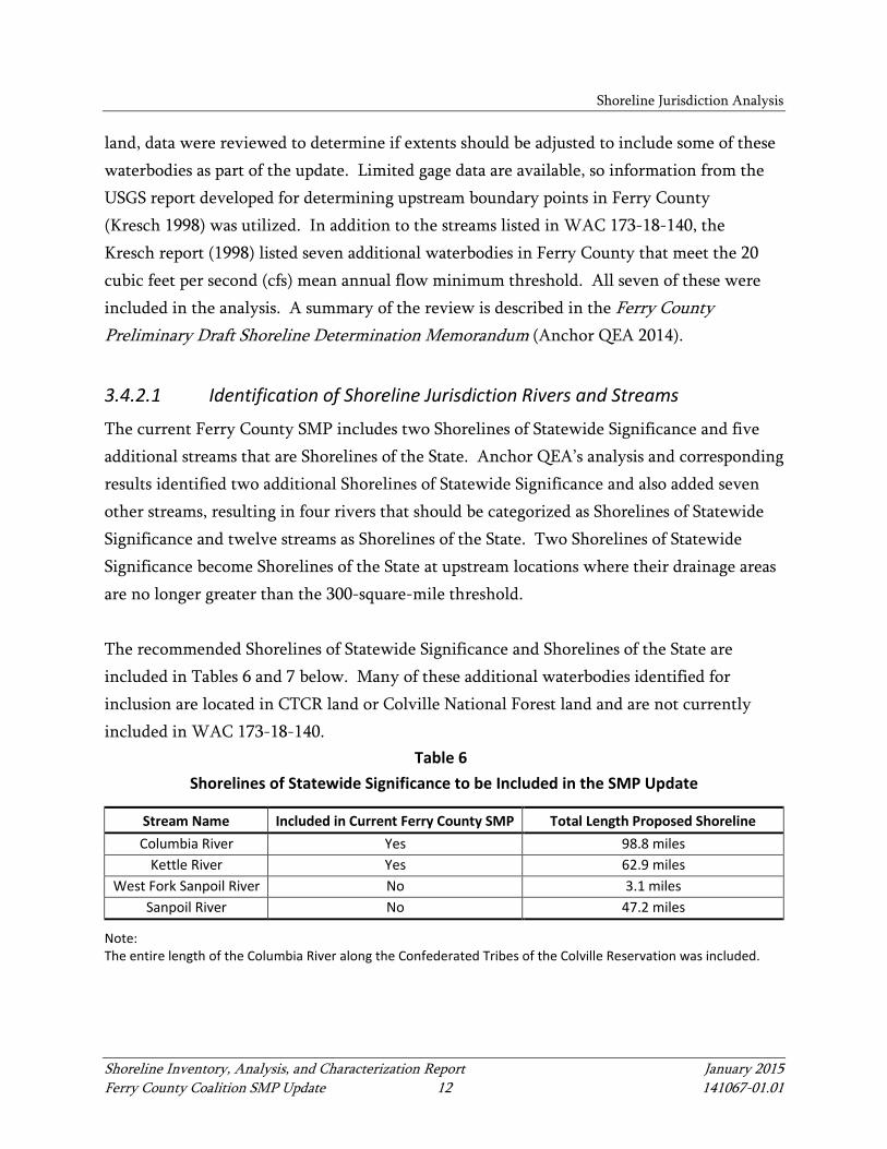
The current Ferry County SMP includes two Shorelines of Statewide Significance and five additional streams that are Shorelines of the State. Anchor QEA’s analysis and corresponding results identified two additional Shorelines of Statewide Significance and also added seven other streams, resulting in four rivers that should be categorized as Shorelines of Statewide Significance and twelve streams as Shorelines of the State. Two Shorelines of Statewide Significance become Shorelines of the State at upstream locations where their drainage areas are no longer greater than the 300-square-mile threshold. The recommended Shorelines of Statewide Significance and Shorelines of the State are included in Tables 6 and 7 below. Many of these additional waterbodies identified for inclusion are located in CTCR land or Colville National Forest land and are not currently included in WAC 173-18-140.
Table 6 Shorelines of Statewide Significance to be Included in the SMP Update
Stream Name Included in Current Ferry County SMP Total Length Proposed Shoreline Columbia River Yes 98.8 miles
Kettle River Yes 62.9 miles West Fork Sanpoil River No 3.1 miles
Sanpoil River No 47.2 miles
Note: The entire length of the Columbia River along the Confederated Tribes of the Colville Reservation was included.
Shoreline Jurisdiction Analysis
Shoreline Inventory, Analysis, and Characterization Report January 2015 Ferry County Coalition SMP Update 13 141067-01.01
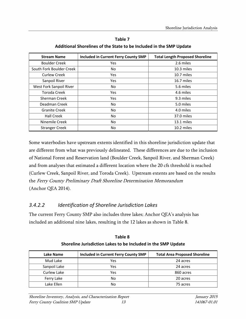
Table 7 Additional Shorelines of the State to be Included in the SMP Update
Stream Name Included in Current Ferry County SMP Total Length Proposed Shoreline Boulder Creek Yes 2.6 miles
South Fork Boulder Creek No 10.3 miles Curlew Creek Yes 10.7 miles Sanpoil River Yes 16.7 miles
West Fork Sanpoil River No 5.6 miles Toroda Creek Yes 4.6 miles
Sherman Creek Yes 9.3 miles Deadman Creek No 5.0 miles Granite Creek No 4.0 miles
Hall Creek No 37.0 miles Ninemile Creek No 13.1 miles Stranger Creek No 10.2 miles
Some waterbodies have upstream extents identified in this shoreline jurisdiction update that are different from what was previously delineated. These differences are due to the inclusion of National Forest and Reservation land (Boulder Creek, Sanpoil River, and Sherman Creek) and from analyses that estimated a different location where the 20 cfs threshold is reached (Curlew Creek, Sanpoil River, and Toroda Creek). Upstream extents are based on the results the Ferry County Preliminary Draft Shoreline Determination Memorandum (Anchor QEA 2014).
3.4.2.2 Identification of Shoreline Jurisdiction Lakes
The current Ferry County SMP also includes three lakes; Anchor QEA’s analysis has included an additional nine lakes, resulting in the 12 lakes as shown in Table 8.
Table 8 Shoreline Jurisdiction Lakes to be Included in the SMP Update
Lake Name Included in Current Ferry County SMP Total Area Proposed Shoreline Mud Lake Yes 24 acres
Sanpoil Lake Yes 24 acres Curlew Lake Yes 860 acres Ferry Lake No 20 acres Lake Ellen No 75 acres

Shoreline Jurisdiction Analysis
Shoreline Inventory, Analysis, and Characterization Report January 2015 Ferry County Coalition SMP Update 14 141067-01.01
Lake Name Included in Current Ferry County SMP Total Area Proposed Shoreline Swan Lake No 54 acres Twin Lakes No 1,661 acres Elbow Lake No 56 acres
Camille Lake No 26 acres Bourgeau Lake No 37 acres
Round Lake No 83 acres La Fleur Lake No 46 acres
3.4.3 Preliminary Shoreline Jurisdiction Areas
As discussed in Section 3.1, the shoreline jurisdiction is the geographic area where the SMA applies and includes all Shorelines of the State and Shorelands as defined by the SMA (RCW 90.58.030). Shorelines of the State to be included in the SMP update are summarized in Section 3.4.2. This section describes how the extent of the shoreline jurisdiction, including the shorelands, was determined. The extent of the preliminary shoreline jurisdiction was determined (mapped) using the following steps:
• All shorelines meeting the definitions provided in Table 2 and identified above were buffered by a 200-foot shoreline jurisdiction area.
• All wetlands from the USFWS National Wetland Inventory dataset that intersected any part of the 200-foot shoreline jurisdiction area were provisionally included.
• Those wetlands identified were reviewed for spatial accuracy to determine if any part intersected the 200-foot shoreline jurisdiction area; if so, they were included.
• Any additional wetlands in the floodway of streams, meeting the shoreline definition above, were provisionally included.
• Those wetlands identified were reviewed for spatial accuracy to determine if any part intersected with the 200-foot shoreline jurisdiction area; if so, they were included.
The preliminary shoreline jurisdictions are shown in the map folio included as Appendix E.
Shoreline Jurisdiction Analysis
Shoreline Inventory, Analysis, and Characterization Report January 2015 Ferry County Coalition SMP Update 15 141067-01.01
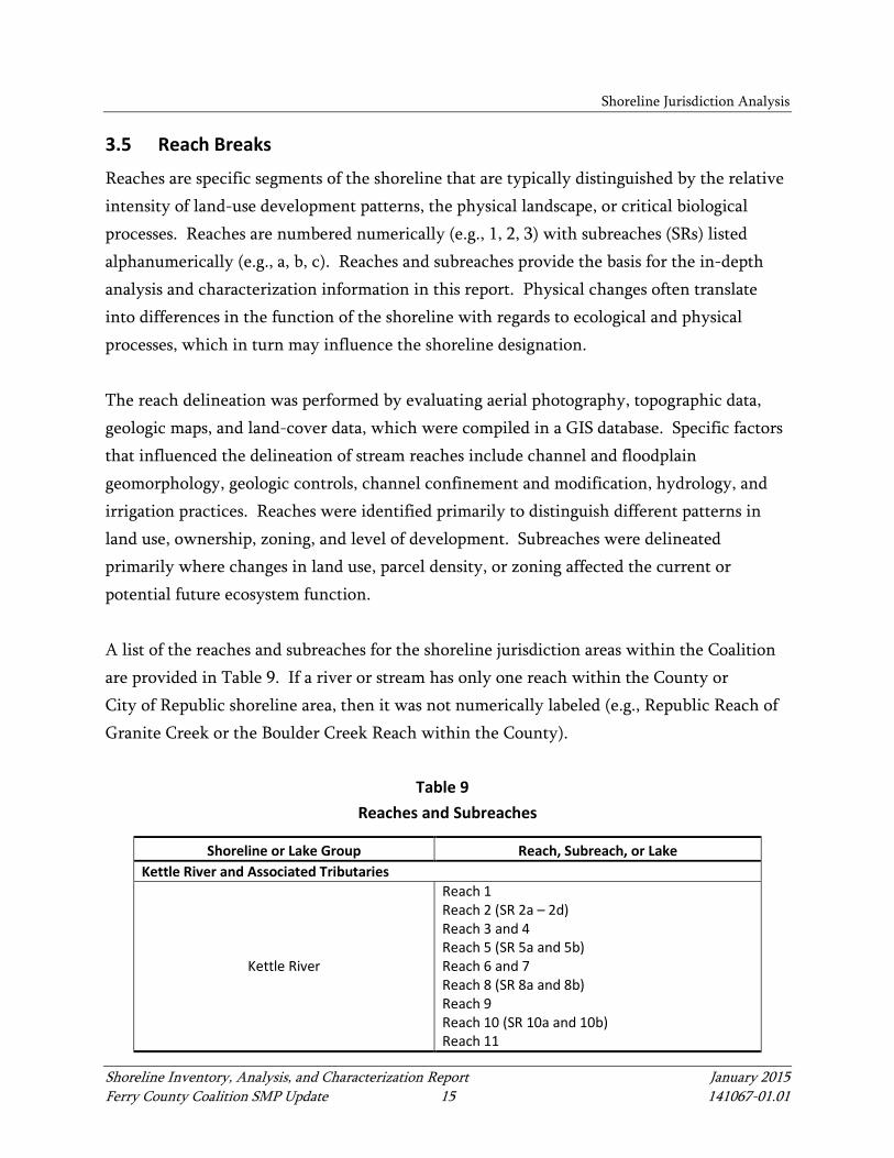
3.5 Reach Breaks
Reaches are specific segments of the shoreline that are typically distinguished by the relative intensity of land-use development patterns, the physical landscape, or critical biological processes. Reaches are numbered numerically (e.g., 1, 2, 3) with subreaches (SRs) listed alphanumerically (e.g., a, b, c). Reaches and subreaches provide the basis for the in-depth analysis and characterization information in this report. Physical changes often translate into differences in the function of the shoreline with regards to ecological and physical processes, which in turn may influence the shoreline designation. The reach delineation was performed by evaluating aerial photography, topographic data, geologic maps, and land-cover data, which were compiled in a GIS database. Specific factors that influenced the delineation of stream reaches include channel and floodplain geomorphology, geologic controls, channel confinement and modification, hydrology, and irrigation practices. Reaches were identified primarily to distinguish different patterns in land use, ownership, zoning, and level of development. Subreaches were delineated primarily where changes in land use, parcel density, or zoning affected the current or potential future ecosystem function. A list of the reaches and subreaches for the shoreline jurisdiction areas within the Coalition are provided in Table 9. If a river or stream has only one reach within the County or City of Republic shoreline area, then it was not numerically labeled (e.g., Republic Reach of Granite Creek or the Boulder Creek Reach within the County).
Table 9 Reaches and Subreaches
Shoreline or Lake Group Reach, Subreach, or Lake Kettle River and Associated Tributaries
Kettle River
Reach 1 Reach 2 (SR 2a – 2d) Reach 3 and 4 Reach 5 (SR 5a and 5b) Reach 6 and 7 Reach 8 (SR 8a and 8b) Reach 9 Reach 10 (SR 10a and 10b) Reach 11
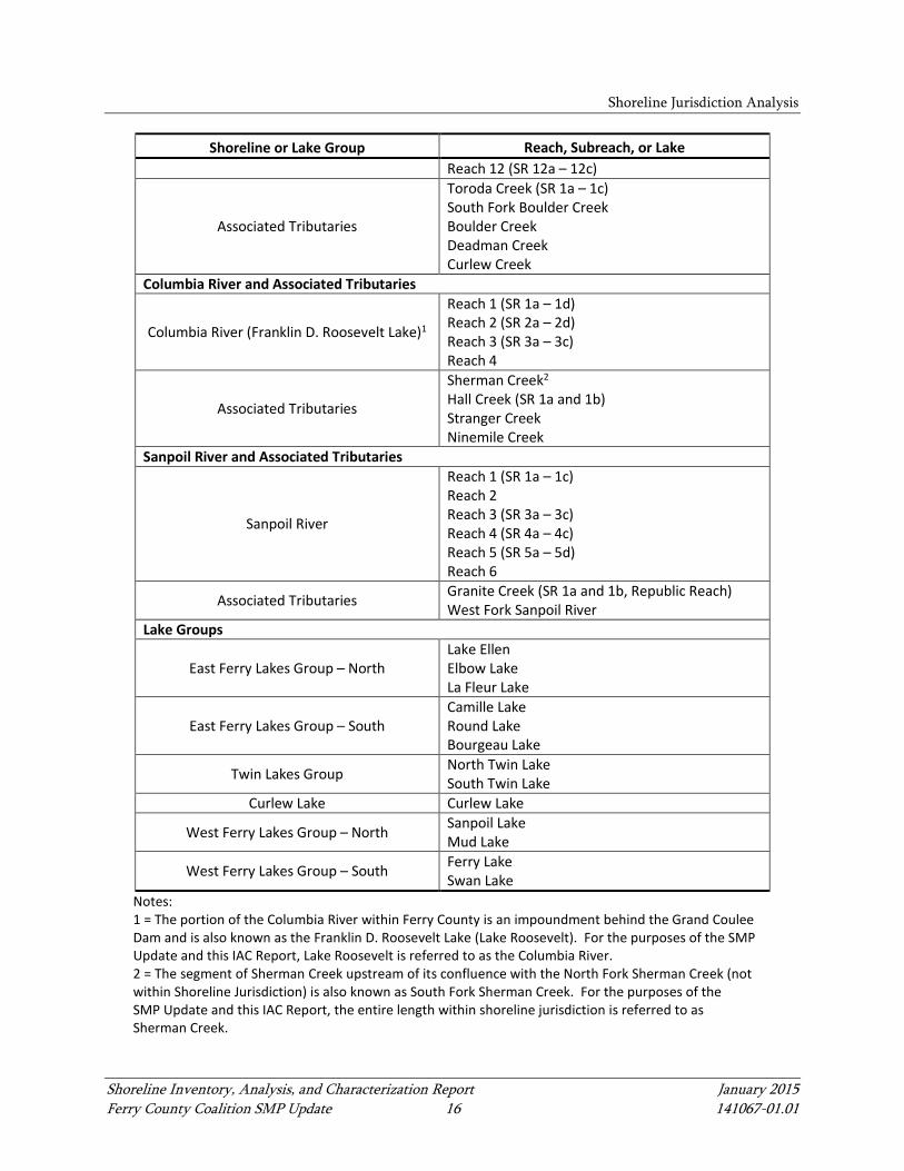
Shoreline Jurisdiction Analysis
Shoreline Inventory, Analysis, and Characterization Report January 2015 Ferry County Coalition SMP Update 16 141067-01.01
Shoreline or Lake Group Reach, Subreach, or Lake Reach 12 (SR 12a – 12c)
Associated Tributaries
Toroda Creek (SR 1a – 1c) South Fork Boulder Creek Boulder Creek Deadman Creek Curlew Creek
Columbia River and Associated Tributaries
Columbia River (Franklin D. Roosevelt Lake)1
Reach 1 (SR 1a – 1d) Reach 2 (SR 2a – 2d) Reach 3 (SR 3a – 3c) Reach 4
Associated Tributaries
Sherman Creek2 Hall Creek (SR 1a and 1b) Stranger Creek Ninemile Creek
Sanpoil River and Associated Tributaries
Sanpoil River
Reach 1 (SR 1a – 1c) Reach 2 Reach 3 (SR 3a – 3c) Reach 4 (SR 4a – 4c) Reach 5 (SR 5a – 5d) Reach 6
Associated Tributaries Granite Creek (SR 1a and 1b, Republic Reach) West Fork Sanpoil River
Lake Groups
East Ferry Lakes Group – North Lake Ellen Elbow Lake La Fleur Lake
East Ferry Lakes Group – South Camille Lake Round Lake Bourgeau Lake
Twin Lakes Group North Twin Lake South Twin Lake
Curlew Lake Curlew Lake
West Ferry Lakes Group – North Sanpoil Lake Mud Lake
West Ferry Lakes Group – South Ferry Lake Swan Lake
Notes: 1 = The portion of the Columbia River within Ferry County is an impoundment behind the Grand Coulee Dam and is also known as the Franklin D. Roosevelt Lake (Lake Roosevelt). For the purposes of the SMP Update and this IAC Report, Lake Roosevelt is referred to as the Columbia River. 2 = The segment of Sherman Creek upstream of its confluence with the North Fork Sherman Creek (not within Shoreline Jurisdiction) is also known as South Fork Sherman Creek. For the purposes of the SMP Update and this IAC Report, the entire length within shoreline jurisdiction is referred to as Sherman Creek.
Shoreline Inventory, Analysis, and Characterization Report January 2015 Ferry County Coalition SMP Update 17 141067-01.01
4 INVENTORY
Section 4 provides an inventory of the existing shoreline areas. The review includes information on existing land use, zoning, shoreline designations, geology, climate, water resources, geologic hazards, and historical and cultural resources.
4.1 Land Use and Planning Inventory
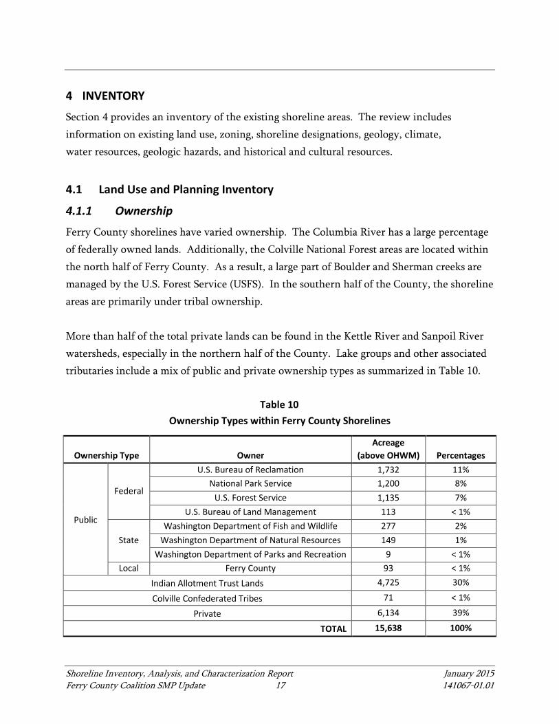
4.1.1 Ownership
Ferry County shorelines have varied ownership. The Columbia River has a large percentage of federally owned lands. Additionally, the Colville National Forest areas are located within the north half of Ferry County. As a result, a large part of Boulder and Sherman creeks are managed by the U.S. Forest Service (USFS). In the southern half of the County, the shoreline areas are primarily under tribal ownership. More than half of the total private lands can be found in the Kettle River and Sanpoil River watersheds, especially in the northern half of the County. Lake groups and other associated tributaries include a mix of public and private ownership types as summarized in Table 10.
Table 10 Ownership Types within Ferry County Shorelines
Ownership Type Owner Acreage
(above OHWM) Percentages
Public
Federal
U.S. Bureau of Reclamation 1,732 11% National Park Service 1,200 8%
U.S. Forest Service 1,135 7% U.S. Bureau of Land Management 113 < 1%
State Washington Department of Fish and Wildlife 277 2%
Washington Department of Natural Resources 149 1% Washington Department of Parks and Recreation 9 < 1%
Local Ferry County 93 < 1% Indian Allotment Trust Lands 4,725 30%
Colville Confederated Tribes 71 < 1%
Private 6,134 39%
TOTAL 15,638 100%
Inventory
Shoreline Inventory, Analysis, and Characterization Report January 2015 Ferry County Coalition SMP Update 18 141067-01.01
Note: OHWM = ordinary high water mark City of Republic shoreline land ownership on Granite Creek is more than 99% private, with less than 1% county-owned land located near the intersection of W 6th Street and Edman Street.
Table 11 Ownership Types within City of Republic Shorelines (Granite Creek)
Ownership Type Owner Acreage
(above OHWM) Percentages
Public Local Ferry County 0.03 < 1%
Private 54 99.9%
TOTAL 54 100%
Note: OHWM = ordinary high water mark
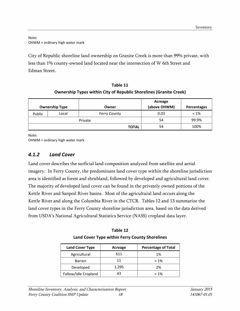
4.1.2 Land Cover
Land cover describes the surficial land composition analyzed from satellite and aerial imagery. In Ferry County, the predominant land cover type within the shoreline jurisdiction area is identified as forest and shrubland, followed by developed and agricultural land cover. The majority of developed land cover can be found in the privately owned portions of the Kettle River and Sanpoil River basins. Most of the agricultural land occurs along the Kettle River and along the Columbia River in the CTCR. Tables 12 and 13 summarize the land cover types in the Ferry County shoreline jurisdiction area, based on the data derived from USDA’s National Agricultural Statistics Service (NASS) cropland data layer.
Table 12 Land Cover Type within Ferry County Shorelines
Land Cover Type Acreage Percentage of Total
Agricultural 611 1% Barren 11 < 1%
Developed 1,295 2% Fallow/Idle Cropland 43 < 1%
Inventory
Shoreline Inventory, Analysis, and Characterization Report January 2015 Ferry County Coalition SMP Update 19 141067-01.01
Land Cover Type Acreage Percentage of Total
Forest 8,910 17% Grassland 549 1%
Open Water 33,980 65% Shrubland 5,533 11% Wetlands 1,495 3%
TOTAL 52,427 100%
Source: U.S. Department of Agriculture National Agricultural Statistics Service Cropland Data 2012
Table 13
Land Cover Type within City of Republic Shorelines
Land Cover Type Acreage Percentage of Total Forest 47 94% Shrubland 3 6%
TOTAL 50 100%
Source: U.S. Department of Agriculture National Agricultural Statistics Service Cropland Data 2012
4.1.3 Land Use
Ferry County's land use is categorized by land ownership in existing land use mapping, where land use is noted as Indian Allotment Trust Lands, private ownership, and public lands instead of traditional uses such as industrial, residential, and agricultural. Within the entire County, almost half of the land area falls under Indian Allotment Trust Lands. However, within shoreline, private ownership is a predominant land use, containing about 39% of the shoreline area, with agriculture, residential, forestry and unimproved uses. See Table 14 for a summary of land use types in the County. Land use within the City of Republic shoreline is mostly private ownership in residential and open space, with only 0.5% of the shoreline area under the public lands category. See Table 15 for a summary of land use types within the City of Republic shoreline.

Inventory
Shoreline Inventory, Analysis, and Characterization Report January 2015 Ferry County Coalition SMP Update 20 141067-01.01
Table 14 Existing Land Use in Ferry County Shorelines
Land Use Type Acreage Percentage of Total Indian Allotment Trust Lands 4,796 31% Private Ownership 5,968 39% Public Lands 4,707 30%
Total 15,471 100%
Source: Ferry County Assessor's Office Note: Data include shoreline area above the ordinary high water mark
Table 15
Existing Land Use in City of Republic Shorelines
Land Use Type Acreage Percentage of Total Private Ownership 167 99.5% Public Lands 1 0.5%
Total 168 100%
Source: Ferry County Assessor's Office Note: Data include shoreline area above the ordinary high water mark
4.1.4 Development
Development regulations are used to regulate different land uses and developments within the County and City. The County has two types of classifications within their development regulations, Rural and Rural Service Areas. Rural Areas constitute about 95%, and Rural Service Areas constitute about 5% of the shoreline area within the County. For the most part, Rural Service Areas are located in areas with relatively higher concentrations of development, including residential, agriculture, and recreation. The City of Republic's zoning demonstrates a higher percentage of Rural Service Areas zoning (24%) than the County and has a higher density of development, including residential, commercial, institutional, and recreation uses. See Tables 16 and 17 for summaries of development areas within Ferry County and the City of Republic.

Inventory
Shoreline Inventory, Analysis, and Characterization Report January 2015 Ferry County Coalition SMP Update 21 141067-01.01
Table 16 Existing Development Areas in Ferry County Shorelines
Areas Acreage Percentage of Total Rural 15,189 95% Rural Service Area 856 5%
TOTAL 16,045 100%
Source: Ferry County Geographic Information System (GIS) Note: Data include shoreline area above the ordinary high water mark
Table 17
Existing Zoning in City of Republic Shorelines
Zoning Acreage Percentage of Total Rural 130 76% Rural Service Area 41 24%
TOTAL 171 100
Source: Ferry County GIS Note: Data include shoreline area above the ordinary high water mark
4.1.5 Current Shoreline Master Program Environment Designations
Ferry County's existing SMP includes four shoreline environment designations as follows:
1. Natural 2. Conservancy 3. Rural 4. Urban
The City of Republic does not currently have an SMP. Table 18 identifies where the four environment designations apply in the County.

Inventory
Shoreline Inventory, Analysis, and Characterization Report January 2015 Ferry County Coalition SMP Update 22 141067-01.01
Table 18 Summary of Ferry County Shoreline Environment Designations
Waterbody and Associated Tributary(ies) Current SMP Environment Designations
Kettle River Natural, Conservancy, Rural
Columbia River Rural, Natural (Sherman Creek)
Sanpoil River Rural, Urban
East Ferry Lakes Group – North Not available
East Ferry Lakes Group – South Not available
Twin Lakes Group Not available
Curlew Lake Conservancy, Rural
West Ferry Lakes Group – North Not available
West Ferry Lakes Group – South Not available
The following summarizes existing environment designation descriptions from Ferry County’s SMP:
• Natural – The intent of the Natural environment designation is to preserve and restore those natural resources systems existing relatively free of human influence and those shoreline areas possessing natural characteristics intolerant of human use or possessing unique historical, cultural, or educational features. These systems restrict the intensities and types of uses permitted in order to maintain the integrity of the shoreline environment.
• Conservancy – The intent of the Conservancy environment designation is to protect, conserve, and manage existing natural resources and valuable historical and cultural areas to achieve sustained resource utilization. The Conservancy environment is for those areas that are intended to maintain their existing character. The Conservancy environment designation is also intended to protect environmentally sensitive areas that are unsuitable for intensive use such as steep slopes presenting erosion and slide hazards, areas prone to flooding, and areas that cannot provide adequate uses compatible with agricultural activities. Examples of appropriate uses in a Conservancy environment include dispersed outdoor recreation activities, timber harvesting on a sustained-yield basis, passive agricultural uses such as pasture and range lands, and other related, low-intensity uses and activities.
Inventory
Shoreline Inventory, Analysis, and Characterization Report January 2015 Ferry County Coalition SMP Update 23 141067-01.01
• Rural – The Rural environment designation is intended to protect agricultural land from urban expansion, restrict intensive development along undeveloped spaces, function as a buffer strip between urban areas, maintain open spaces, and provide opportunities for recreational uses compatible with agricultural uses.
• Urban – The Urban environment is an area of high-intensity land use, including residential, commercial, and industrial development. The objective of the Urban environment designation is to ensure optimum utilization of shorelines within urbanized areas by providing for intensive public use and by managing development so it enhances and maintains shorelines for multiplicity of urban uses.
4.1.6 Shoreline Uses
Shoreline uses are described in this section, including water-dependent, water-related, and water-enjoyment uses.
4.1.6.1 Water-Dependent Uses
Water-dependent use means a use or portion of a use that cannot exist in a location that is not adjacent to the water and is dependent on the water by reason of the intrinsic nature of its operations (WAC 173-26-020(39)). Water-dependent uses commonly include, but are not limited to, fishing, water withdrawal, and cargo loading and unloading. Table 19 presents a summary of water-dependent uses.
Table 19 Summary of Water-Dependent Uses
Waterbody and Associated Tributary(ies) Current Water-dependent Uses
Kettle River Irrigation and water withdrawal, fishing and swimming
Columbia River Boat launch, boat moorage, dock, ferry terminal, fish hatchery, net pens, irrigation and water withdrawal, fishing and swimming
Sanpoil River Irrigation, fishing and swimming
East Ferry Lakes Group – North Boat launch (Lake Ellen), dock (La Fleur Lake), fishing and swimming
East Ferry Lakes Group – South Dock (Round Lake) and fishing and swimming
Twin Lakes Group Boat launch, boat moorage, dock, marina, fishing and swimming

Inventory
Shoreline Inventory, Analysis, and Characterization Report January 2015 Ferry County Coalition SMP Update 24 141067-01.01
Waterbody and Associated Tributary(ies) Current Water-dependent Uses
Curlew Lake Boat moorage and dock, boat launches, net pens, fishing and swimming
West Ferry Lakes Group – North Fishing and swimming
West Ferry Lakes Group – South Dock (Swan Lake), boat launches, fishing and swimming
4.1.6.2 Water-Related and Water-Enjoyment Uses
Water-related use means a use or portion of a use that is not intrinsically dependent on a waterfront location but whose economic viability is dependent upon a waterfront location because a) the use has a functional requirement for a waterfront location such as the arrival or shipment of materials by water or the need for large quantities of water; or b) the use provides a necessary service supportive of the water-dependent uses, and the proximity of the use to its customers makes its services less expensive and/or more convenient (WAC 173-26-020 (40)). Water-enjoyment use means a recreational use or other use that facilitates public access to the shoreline as a primary characteristic of the use. It can also be defined as a use that provides for recreational use or aesthetic enjoyment of the shoreline for a substantial number of people as a general characteristic of the use, and which through location, design, and operation, ensures the public's ability to enjoy the physical and aesthetic qualities of the shoreline. In order to qualify as a water-enjoyment use, the use must be open to the general public, and the shoreline-oriented space within the project must be devoted to the specific aspects of the use that foster shoreline enjoyment (WAC 173-26-020 (37)). Table 20 presents a summary of water-related and water-enjoyment uses.
Table 20 Summary of Water-Related and Water-Enjoyment Uses
Waterbody and Associated Tributary(ies) Current Water-related and Water-enjoyment Uses
Kettle River Campground, trail, beach area, and parks
Columbia River Park, campground, beach area, open space, and trail
Sanpoil River Campground and trail
East Ferry Lakes Group – North Parallel local access road and campground
East Ferry Lakes Group – South Parallel local access road
Twin Lakes Group Campground, beach, and parallel road

Inventory
Shoreline Inventory, Analysis, and Characterization Report January 2015 Ferry County Coalition SMP Update 25 141067-01.01
Waterbody and Associated Tributary(ies) Current Water-related and Water-enjoyment Uses Curlew Lake Park, campground, open space, and trail
West Ferry Lakes Group – North Parallel local access road (Mud Lake)
West Ferry Lakes Group – South Campground, trail, and parallel local access road
4.1.6.3 Non-Water-Related Uses
Non-water-related uses include uses not intrinsically dependent on a waterfront location and not economically dependent upon a waterfront location. These uses in the region include agricultural land, rangeland, and other rural uses.
4.2 Environmental Elements Inventory
4.2.1 Geology
It is currently suggested that the geologic makeup of the County is the result of erosion of pre-ice age geologic units, deposition of sediments carried by the continental glacier and glacial meltwaters, and the formation of the unique topographic features that influence present-day hydrology. The surficial geology, soils, and topography of Ferry County are primarily dictated by the continental glaciation that occurred during the last major glacial period (Fraser Age) as the Cordilleran Ice Sheet advanced south approximately 13,000 to 15,000 years ago (referred to as the Vashon Stade of Fraser-Age Glaciation). The majority of Ferry County was not subject to the catastrophic outburst flooding that occurred throughout a majority of eastern Washington, referred to as the Missoula Floods, which were a series of catastrophic floods that occurred from the failure of ice dams at glacial Lake Missoula. However, outburst flood deposits are found along the very southern and eastern boundaries of the County at the Columbia River. Prior to the glaciation, the geology of the County consisted primarily of rocks of the Colville Igneous Complex, which formed as a result of three distinct phases of igneous activity. The three phases are identified oldest to youngest as: 1) the Keller Butte Suite; 2) the Sanpoil Volcanic; and 3) Klondike Mountain Formations (Morris et al. 2000). The Colville Igneous Complex is located at the southern end of a larger crystalline belt that formed during accretion of the Intermontaine superterrane (landmass) onto the cratonic North America during the late Triassic and Jurassic periods and predates the formation of the

Inventory
Shoreline Inventory, Analysis, and Characterization Report January 2015 Ferry County Coalition SMP Update 26 141067-01.01
Colville Igneous Complex (Morris et al. 2000). The Colville Igneous Complex later intruded the metamorphic crystalline core (Kettle and Okanogan Metamorphic Core Complexes) during the Eocene Period (34 to 56 million years ago). During emplacement of this complex, the formation of Keller, Republic, and Toroda north northeast trending grabens (low-lying landmasses located between gravity [normal] faults) occurred. In addition, other large formations are present in the County, including the Johnny George Plutonic Complex (Eocene Period) and the Covada Group (Ordovician Period). To the south, along the southern border of the County, younger Miocene-aged Columbia River Basalt flows are present and overlay the Colville Igneous Complex (Morris et al. 2000). These basalts are the Priest Rapid’s Member of the Wanapum Basalt and are found in few places (e.g., plateaus) capped with varying thicknesses of wind-blown fine sands and silt known as loess. Additional prominent geologic features present in the County include Palouse Formation loess (wind-blown silt) deposits atop high-relief areas that were not eroded in the floods. Recent fluvial deposits (alluvium) deposited by post-glacial and modern-day streams are present in portions of the major stream valleys; these deposits typically comprise sands and gravels.
4.2.1.1 Kettle River and Associated Tributaries
In its upstream reaches, the Kettle River flows within a wide valley that is flanked by hill slopes that consist of bedrock of mostly the Sanpoil Volcanic Formation. Channel and floodplain materials consist mostly of alluvium and continental glacial drift. Infrastructure is present throughout most of the valley bottom extents, and it includes State Highway 21, U.S. Route 395, and the Burlington Northern Santa Fe rail alignments. In the downstream reaches, the valley width generally narrows near the river’s confluence with the Columbia River. Valley margins consist of a variety of crystalline rocks of igneous and metamorphic origin. Major tributaries to the Kettle River (upper reaches) include Toroda Creek and Curlew Creek, which flow through valleys within members of the Colville Igneous Complex.

Inventory
Shoreline Inventory, Analysis, and Characterization Report January 2015 Ferry County Coalition SMP Update 27 141067-01.01
Toroda Creek flows within the Klondike Mountain Formation, and Curlew Creek flows within mostly the Sanpoil Volcanic Formation. Tributaries within the lower segment of Kettle River include Boulder Creek, South Fork Boulder Creek, and Deadman Creek. Boulder Creek flows within a moderately narrow valley whose channel and floodplain consists of continental glacial drift with a bedrock (mostly as orthogneiss) valley. Deadman Creek flows within a narrow, steep-walled valley that comprises a glacial outwash channel and bedrock (orthogneiss) valley hill slopes.
4.2.1.2 Columbia River and Associated Tributaries
The Columbia River flows within a wide valley carved by the continental glacier and its recessional melt waters. Along its extent in the County, the valley floor and margins consist of a variety of glacial deposits, including glacial outwash, glaciolacutrine deposits, till, and, to lesser extent, outburst flood deposits. Bedrock along its extent includes a wide variety of crystalline rocks with members of the Colville Igneous Complex and the Kettle Metaphoric Core Complex. These include the Keller Butte and Sanpoil Volcanics Formations of the Colville Igneous Complex and a variety of metamorphic and igneous bedrock, including amphibolite, quartzite, argillite, granodiorite, migmatite, and biotite granite. The major tributaries to the Columbia River include Sherman, Hall, Stranger, and Ninemile creeks. Sherman Creek flows within a generally narrow valley with a channel and floodplain that consist of glacial till. Where present along the valley hill slopes, the bedrock consists of orthogneiss and quartzite. Hall Creek channel and floodplain consist of glaciolacustrine deposits. Bedrock is present within the valley and consists of quartzite and Covada Group wacke. Upstream of the Inchelium Covada Road, Stranger Creek flows within a wide, unconfined valley that consists of continental drift. Near its confluence with the Columbia River, Ninemile Creek flows within a steep, confined valley of Johnny George plutonic complex that includes the Ninemile Falls. Upstream of the falls, the stream valley widens and consists of glaciolacustrine and outburst flood deposits (undivided).
4.2.1.3 Sanpoil River and Associated Tributaries
The Sanpoil River flows through a valley that consists of continental drift and the Sanpoil Volcanics Formation. Major tributaries to the Sanpoil River include Granite Creek

Inventory
Shoreline Inventory, Analysis, and Characterization Report January 2015 Ferry County Coalition SMP Update 28 141067-01.01
and the West Fork Sanpoil River. The West Fork Sanpoil River flows within a channel and floodplain consisting of continental glacial drift and, to a lesser extent, glacial outwash. The bedrock in the valley and channel consists of the Sanpoil Volcanic Formation, wacke, and marine meta-sedimentary rocks. Granite Creek flows within a channel and floodplain consisting of continental glacial drift. The bedrock in the valley and channel consists of the Sanpoil Volcanic and Klondike Mountain formations.
4.2.1.4 Lake Groups
East Ferry Lakes Group – North
Lake Ellen, Elbow Lake, and La Fleur Lake are located in topographic lows within the continental glacial drift and bedrock. Lake Ellen’s shoreline consists of mostly bedrock consisting of orthogneiss and wacke. Elbow Lake shoreline consists of some orthogneiss and Hall Creek Gneiss. La Fleur Lake’s shoreline is dominated by continental glacial drift. All lakes outflow to tributaries of the Columbia River.
East Ferry Lakes Group – South
Camille Lake, Round Lake, and Borgeau Lake are located within topographic lows in glacial deposits. The lakes’ outflows drain to the Columbia River via numerous tributaries. Camille Lake’s shoreline consists of mostly glacial till. The lake’s outflow is a tributary to Stranger Creek. Round Lake’s shoreline consists of mostly of continental glacial drift. The lake’s outflow is to Cornstalk Creek. Borgeau Lake shoreline consists of continental glacial drift.
Twin Lakes Group
North and South Twin lakes are located within topographic lows in the continental glacial drift deposits. Bedrock outcrops are present along both lakes' perimeters and consist of granite and granodiorite. Stranger Creek, a tributary to the Columbia River, originates from the lakes’ outflow drainages.

Inventory
Shoreline Inventory, Analysis, and Characterization Report January 2015 Ferry County Coalition SMP Update 29 141067-01.01
Curlew Lake
Curlew Lake is located within a topographic low within the continental glacial drift. Curlew Lake’s major outflow is Curlew Creek, a tributary to the Kettle River. The major inflow to the lake includes Mires, Herron, and Trout creeks. South of Curlew Lake, a large alluvial fan splits valley flows either north towards Curlew Lake or south towards the mainstem of the Sanpoil River (Meussig 1967).
West Ferry Lakes Group – North
Mud Lake and Sanpoil Lake are located within topographic lows within the continental glacial drift. Mud Lake drains to a tributary of Granite Creek. Sanpoil Lake's outflow is the Sanpoil River.
West Ferry Lakes Group – South
Ferry Lake and Swan Lake are located within topographic lows within the continental glacial drift. Both lakes’ outflow is to tributaries of Scatter Creek, which is a tributary to the Sanpoil River.
4.2.2 Climate
Ferry County falls within the Northeastern region of Washington (NOAA 2014a, 2014b). Annual precipitation increases in a northeasterly direction from 17 to 28 inches in the northeastern corner of the state. The average winter season snowfall varies from 40 to 80 inches in the valleys. In the lower elevations, snow reaches a depth of 15 to 30 inches and typically remains on the ground from the first of December until March. Both rainfall and snowfall increase along the slopes of the mountains (WRCC 2014). High temperatures in January can range from 15 to 30 °F. The average minimum temperature varies from -10 to -20 °F. Summer high temperatures are usually 85 to 90 °F with low temperatures of 45 to 50 °F (WRCC 2014).
Inventory
Shoreline Inventory, Analysis, and Characterization Report January 2015 Ferry County Coalition SMP Update 30 141067-01.01
4.2.3 Water Resources
This section includes an inventory of water resources within Ferry County, including resources that do not fall under the shoreline jurisdiction. Water resources discussed in this section include surface water resources and quality, floodplains and floodways, CMZs, and groundwater.
4.2.3.1 Surface Water Resources
The planning area is located in five Water Resource Inventory Areas (WRIAs) as designated by Ecology: Sanpoil (WRIA 52); Lower Lake Roosevelt (WRIA 53); Middle Lake Roosevelt (WRIA 58); Kettle (WRIA 60); and Upper Lake Roosevelt (WRIA 61). Less than 5% of the planning area is open water. Several major surface water resources are located in the planning area, including the Kettle River, Columbia River, and Sanpoil River. Other tributaries in the planning area drain to the rivers listed above. The Kettle River and Sanpoil River are major tributaries of the Columbia River. The portion of the Columbia River within Ferry County is also referred to as Franklin D. Roosevelt Lake (Lake Roosevelt), which is an impoundment regulated by the Grand Coulee Dam. Twelve miles of the Sanpoil River are also impounded by Grand Coulee Dam, and several miles of the Kettle River are also impounded as part of Lake Roosevelt. Additionally, 13 lakes are included in the shoreline jurisdiction, including Curlew Lake and the Twin Lakes. See Table 9 for a summary of waterbodies and associated tributaries included in the shoreline jurisdiction. Surface water resources in the planning area generally have lower flows in late summer and fall and high flows in the spring. The highest flows are typically generated from snowmelt runoff after temperatures are warm enough to melt snowpack accumulated from winter precipitation events. In the Northwest region of the United States, observed regional warming has been linked to changes in the timing and amount of water availability in basins with significant snowmelt contributions to stream flow (Melillo et al. 2014). Hydrologic response to climate change will depend upon the dominant form of precipitation in a particular watershed, as well as
Inventory
Shoreline Inventory, Analysis, and Characterization Report January 2015 Ferry County Coalition SMP Update 31 141067-01.01
other local characteristics, including elevation, aspect, geology, vegetation, and changing land use. The largest responses are expected to occur in basins with significant snow accumulation, where warming increases winter flows and advances the timing of spring melt (Melillo et al. 2014). This may be further affected by Pacific Decadal Oscillation (PDO) that also influences climate conditions. The PDO, sometimes referred to as El Niño and La Niña, is a pattern of Pacific climate variability that results in decades-long (15- to 30-year) warmer and cooler weather patterns associated with North Pacific Ocean surface water temperature conditions (UW 2000). These climate influences may have an effect on hydrology, including stream flow changes and lake expansion and contraction over time, associated changes in riparian vegetation conditions, and shifts in the OHWM.
4.2.3.2 Surface Water Quality
Surface water quality in the planning area is generally affected by climate, natural occurrences such as landslides, wildfire runoff, wildlife waste, dam and hydropower operations, past and current industrial use, agricultural runoff, timber production, grazing, and road construction. These impacts have caused several waterbodies to be impaired by temperature, dissolved oxygen, pH, bacteria, and/or other pollutants. Multiple waterbodies throughout the planning area are on Ecology's 303(d) list of impaired waterbodies requiring a total maximum daily load (TMDL), and several waterbodies are waters of concern on Ecology’s 305(b) rating system. TMDL programs are actively implemented in Boulder Creek and Sherman Creek for temperature and dissolved oxygen. TMDL programs have been approved by the U.S. Environmental Protection Agency for several streams as part of the Colville USFS for temperature, bacteria, pH, and dissolved oxygen. Several Ecology water quality monitoring stations are located in the planning area, including one long-term station (No. 60A070, Kettle River at Barstow Bridge) that is sampled monthly. Surface water quality exceedances are further described for specific waterbodies in Section 5 and Appendices A through E.
Inventory
Shoreline Inventory, Analysis, and Characterization Report January 2015 Ferry County Coalition SMP Update 32 141067-01.01
4.2.3.3 Floodplain and Floodway
Within the planning area, floodways have been identified for portions of the Kettle River. Floodways, as defined in RCW 90.58.030 (2)(b), include areas that have been established in FEMA flood insurance rate maps or floodway maps, or areas that consist of those portions of a river valley upon which flood waters are carried during periods of flooding that occur with reasonable regularity. For those waterbodies classified as shorelines, the presence of a delineated floodway causes the shoreline jurisdiction area to be increased (as applicable) to include the entire floodway and any adjacent 100-year floodplain up to 200 feet landward from the floodway edge. In addition to the floodway areas, FEMA 100-year floodplain mapping is available in digital format for the planning areas outside of the CTCR and outside of the Colville USFS. Floodplains are delineated for most streams in the planning area outside of the CTCR and Colville USFS and include Toroda, Curlew, and Granite creeks and the Sanpoil and Kettle rivers. The most recent floodplain mapping updates completed within the planning area became effective in 2006, and the latest local area amended by Letter of Map Changes, but not full Flood Insurance Rate Map updates, occurred in 2007. At this time, Ferry County has not elected to include the 100-year floodplain as a determining boundary for shoreline jurisdiction.
4.2.3.4 Channel Migration Zone
A CMZ is an area along a river where channels can be reasonably predicted to migrate as a result of natural and normally occurring hydrological and related processes when considered with the characteristics of the river and its surroundings (WAC 173-26-020). These areas adjacent to a stream or river are susceptible to future erosion (Rapp and Abbe 2003). The CMZs were delineated for the shoreline extents in Ferry County. As part of SMP development process, the location of the general CMZ was identified for these shoreline areas (map folio in Appendix E). The CMZs may require implementation of regulations that are unique to these areas due to the migration potential of a given stream throughout its extents.
Inventory
Shoreline Inventory, Analysis, and Characterization Report January 2015 Ferry County Coalition SMP Update 33 141067-01.01
The CMZs were delineated in a GIS database and are presented graphically in the map folio included in Appendix E for the shoreline jurisdiction’s rivers and streams. Associated text is also provided in the Reach Tables included in Appendices A through D. The CMZs represent the existing and potential locations the stream channels may occupy within their valleys. The CMZ delineations are based on the professional judgment of a geomorphologist using a GIS database to complete visual observations of various physical characteristics that indicate evidence of past and potential future channel migration. Analysis included review of existing geology, geomorphology, infrastructure, channel confinement, channel planform, valley width, topography, estimated hydraulic energy, vegetation, soils, and floodplain and wetland extents. Physical characteristics for the CMZ-delineated streams were reviewed in GIS for the shoreline jurisdiction areas along the applicable streams and rivers. Each stream was evaluated along its entire shoreline jurisdiction length, and a CMZ line was delineated along each bank based on the conditions present. At the time of this analysis, Light Image Detection and Ranging (LiDAR) coverage was not available for the stream extents included in the shoreline jurisdiction. Aerial photography was generally limited to recent aerial photos for most shoreline jurisdiction areas in Ferry County.
Disconnected Migration Areas
In addition, disconnected migration areas (DMAs) were identified throughout the CMZ. WAC 173-26-221 allows exclusions of areas where a legally existing artificial structure is likely to restrain channel migration and is built above or constructed to remain intact with appropriate functionality maintenance activities through the 100-year flood. Identified DMAs include bridge crossings (applicable county, state, and federal crossings) and railroad alignments that meet these criteria. The CMZ is also delineated at each DMA bridge crossing; therefore, if the status of a DMA bridge changes to a non-DMA structure, the corresponding CMZ delineation is provided for that location.

Inventory
Shoreline Inventory, Analysis, and Characterization Report January 2015 Ferry County Coalition SMP Update 34 141067-01.01
4.2.3.5 Groundwater Resources
In general, availability and yield of groundwater from bedrock in the planning area is limited by climate and geology. Regionally extensive aquifers (aquifers extending into two or more watersheds) have not been identified or evaluated in northeastern Washington; however, the meta-sedimentary and meta-volcanic basement rocks of the region may be interconnected through faults or fractures (Ecology 1995). The planning area is generally underlain by three basic aquifer systems: 1) a generally localized alluvial system with a high degree of hydrologic continuity with surface water; 2) the layered, generally widespread Columbia River Basalt Group system; and 3) a low-yield, joint- and fracture-controlled system found within the pre-basalt basement rocks (Lincoln County 2010). The majority of groundwater is typically withdrawn from unconsolidated glacial and alluvial deposits of the Quaternary age contained within the river and stream valleys within the planning area. Recharge to the aquifer units occurs from direct precipitation where the aquifer outcrops, from stream seepage where the aquifer unit intersects the base of the stream, and from bank storage or flood water infiltration. The water level in the alluvial aquifer is sustained by direct recharge during flooding and subsequent recharge to the soils and aquifers underlying the floodplain. The alluvial aquifer is also recharged with surface water that is diverted for irrigation of lowland areas during the late spring and summer (Ecology 1995).
4.2.4 Geologic Hazards
Geologically hazardous areas are defined as those lands susceptible to erosion, landslides, seismic, or mine hazard events. Surficial geologic conditions are shown in Map 4 in the map folio (Appendix E). Primary geologic hazards are soils susceptible to erosion and landslides or rock fall areas. Seismic hazards and mine sites are secondary geologic hazards that generally present less of a concern in most areas. Table 21 summarizes each of the hazards that may be associated with the shorelines of Ferry County, as well as the sources of information that were evaluated. While Table 21 includes nine inactive mine sites, many inactive mine sites exist along the various waterbodies within the shoreline jurisdiction.
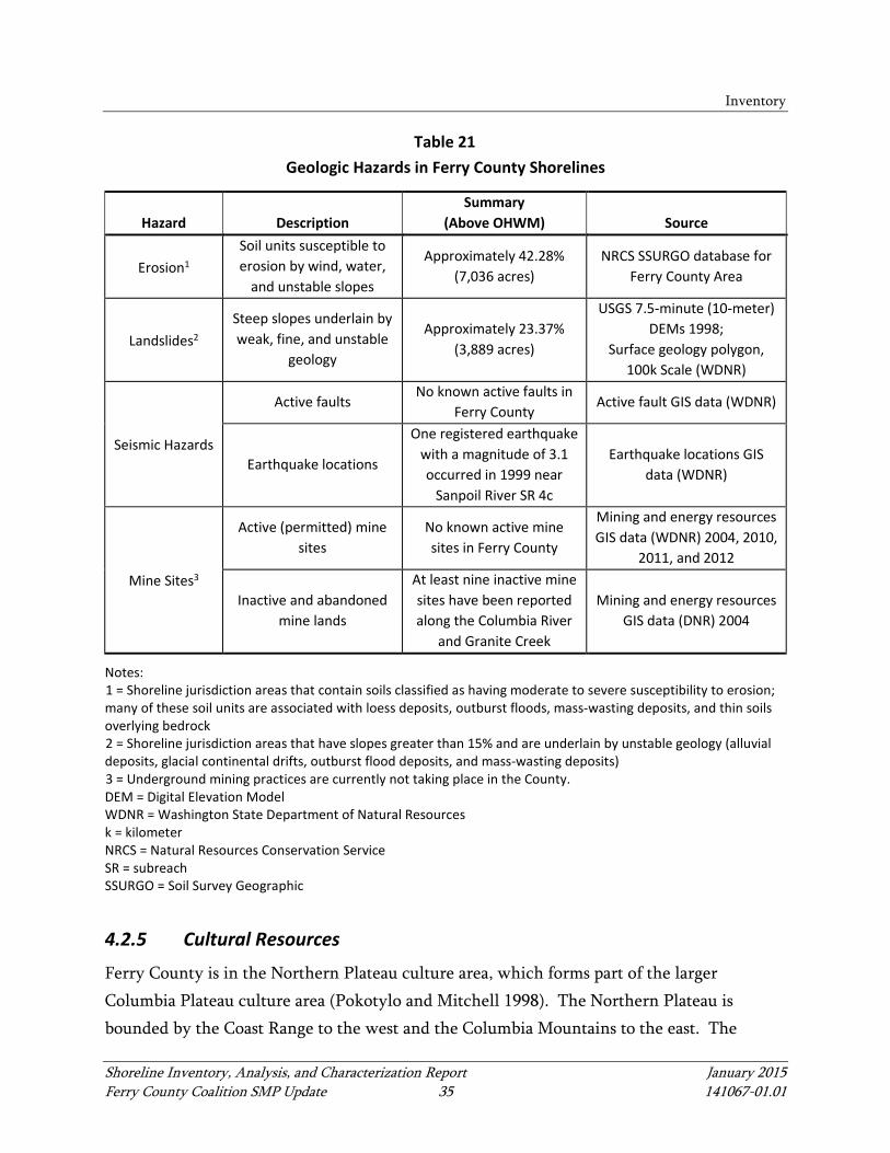
Inventory
Shoreline Inventory, Analysis, and Characterization Report January 2015 Ferry County Coalition SMP Update 35 141067-01.01
Table 21 Geologic Hazards in Ferry County Shorelines
Hazard Description Summary
(Above OHWM) Source
Erosion1
Soil units susceptible to erosion by wind, water,
and unstable slopes
Approximately 42.28% (7,036 acres)
NRCS SSURGO database for Ferry County Area
Landslides2
Steep slopes underlain by weak, fine, and unstable
geology
Approximately 23.37% (3,889 acres)
USGS 7.5-minute (10-meter) DEMs 1998;
Surface geology polygon, 100k Scale (WDNR)
Seismic Hazards
Active faults No known active faults in
Ferry County Active fault GIS data (WDNR)
Earthquake locations
One registered earthquake with a magnitude of 3.1 occurred in 1999 near
Sanpoil River SR 4c
Earthquake locations GIS data (WDNR)
Mine Sites3
Active (permitted) mine sites
No known active mine sites in Ferry County
Mining and energy resources GIS data (WDNR) 2004, 2010,
2011, and 2012
Inactive and abandoned mine lands
At least nine inactive mine sites have been reported along the Columbia River
and Granite Creek
Mining and energy resources GIS data (DNR) 2004
Notes: 1 = Shoreline jurisdiction areas that contain soils classified as having moderate to severe susceptibility to erosion; many of these soil units are associated with loess deposits, outburst floods, mass-wasting deposits, and thin soils overlying bedrock 2 = Shoreline jurisdiction areas that have slopes greater than 15% and are underlain by unstable geology (alluvial deposits, glacial continental drifts, outburst flood deposits, and mass-wasting deposits) 3 = Underground mining practices are currently not taking place in the County. DEM = Digital Elevation Model WDNR = Washington State Department of Natural Resources k = kilometer NRCS = Natural Resources Conservation Service SR = subreach SSURGO = Soil Survey Geographic
4.2.5 Cultural Resources
Ferry County is in the Northern Plateau culture area, which forms part of the larger Columbia Plateau culture area (Pokotylo and Mitchell 1998). The Northern Plateau is bounded by the Coast Range to the west and the Columbia Mountains to the east. The
Inventory
Shoreline Inventory, Analysis, and Characterization Report January 2015 Ferry County Coalition SMP Update 36 141067-01.01
northern and southern boundaries are more difficult to locate. To the north, the Northern Plateau culture blends into more Arctic-oriented cultures in central British Columbia in the vicinity of the Bella Coola River to the west and Quesnel Lake to the east. To the south, the Northern Plateau culture area blends into Southern Plateau culture area in the vicinity of the Ferry-Lincoln County line (Pokotylo and Mitchell 1998). The prehistory and history of the Northern Plateau is briefly summarized in this section. Known archaeological and historical sites are discussed, as well as the potential for archaeological and historical sites.
4.2.5.1 Historical Background
The archaeology of Ferry County is generally not well understood; the vast majority of research has been located in river valley bottoms and been associated with dam construction and monitoring. Archaeological chronologies have been developed for the Okanogan River area in neighboring Okanogan County, as well as the Kettle Falls area on the Columbia River. Unlike the neighboring Southern Plateau, there is scant evidence for late Pleistocene and early Holocene occupation of the Northern Plateau (called the Early Period by Chatters and Pokotylo [1998]). There have been surface finds of tools that are consistent with Early Period assemblages, but none are securely dated (Choquette 1996; Pokotylo and Mitchell 1998). A small handful of sites, dating to the later part of the Early Period, have been recorded in the British Columbia portion of the Northern Plateau. These generally indicate a terrestrially focused subsistence. However, there is some evidence of early sites at Kettle Falls that are thought to be associated with salmon fishing (Pokotylo and Mitchell 1998). More dated sites are associated with the Middle Period, which represents a broad-spectrum, hunter-gatherer culture that developed in the region and persisted until the middle Holocene, around 5,300 years ago. Sites dating to this time period are generally limited to lithic assemblages (basalt projectile points and flake tools) and lack evidence of long-term habitation (Pokotylo and Mitchell 1998).
Inventory
Shoreline Inventory, Analysis, and Characterization Report January 2015 Ferry County Coalition SMP Update 37 141067-01.01
A shift toward more permanent settlement began around 6,000 years ago and initiated a period that lasted until the beginning of the early Holocene, which was around 3,000 years ago (Chatters and Pokotylo 1998). In general, tool assemblages are characterized by the addition of groundstone and bone/antler tools to the existing flaked stone technology. Though subsistence is thought to have focused on ungulate hunting in the British Columbia area of the Northern Plateau, sites from the Okanogan and Columbia rivers in Washington also show evidence of salmon fishing. The appearance of woodworking tools correlates with the first semi-subterranean structures (Pokotylo and Mitchell 1998). Late Holocene cultures in the Plateau region exhibit “a shift in adaptations…to storage-dependent collector strategies” (Chatters and Pokotylo 1998, p. 76), which are characterized by intensive salmon fishing and associated storage features, social inequality, large permanent villages, and diverse tool assemblages. This shift began around 4,000 years ago and persisted until historic contact (Chatters and Pokotylo 1998). In parts of the Northern Plateau, some village sites from this time period show evidence of summer occupation, which is distinct from the ethnographically described winter village (Pokotylo and Mitchell 1998). The late Holocene archaeological cultures correlate with historic ethnographic descriptions. Ferry County is in the traditional territory of Interior Salish and Middle Columbia River Salish tribes speaking dialects of the Okanagan-Colville language (Kennedy and Bouchard 1998). At the time of Euro-American contact, the Colville tribe, an Interior Salish group, occupied the eastern part of what would become Ferry County. Their territory included the culturally and historically significant Kettle Falls area (Ruby and Brown 1986). The western part of the County was occupied by the Middle Columbia Salish groups, including the Southern Okanogan, Nespelem, and Sanpoil tribes. Salish peoples of the Northern plateau were known for extensive trade networks, advanced basketry and fishing technology (including weirs, platforms, and large baskets), and warrior traditions (Miller 1998; Kennedy and Bouchard 1998). They practiced an annual subsistence round, the particulars of which varied by tribe. In general, communities gathered at fishing stations in the summer, gathered plants from spring to fall, and hunted year-round but especially in the fall and winter (Miller 1998; Kennedy and Bouchard 1998). Prior to historic
Inventory
Shoreline Inventory, Analysis, and Characterization Report January 2015 Ferry County Coalition SMP Update 38 141067-01.01
contact, winter villages comprised semi-subterranean houses, which were replaced by mat lodges in historical times (Miller 1998). Mat houses of various sorts were used at resource gathering camps in other seasons. Other structures, such as earth ovens and ceremonial structures, were also used. Technologies included the following items: flaked and ground stone implements; baskets, cordage, and woven items made from birch bark, spruce, or cedar; mortars and pestles of stone or wood; and digging sticks (Miller 1998; Kennedy and Bouchard 1998). The communities of the Northern Plateau began to see the effects of Euro-American contact decades before the first explorers and traders arrived in the area. These effects, beginning around the year 1600, included introduced diseases, trade goods, and the introduction of the horse (Walker and Sprague 1998). Many Colville, Southern Okanogan, Nespelem, Sinaikst (Lakes), and Sanpoil people are currently members of the CTCR. The southern portion of Ferry County is currently the CTCR, and the entire area that would become the County was previously within the CTCR. The CTCR was established by executive order in 1872, but was under almost immediate pressure from non-Indians looking to develop mineral resources (Ruby and Brown 1986). The CTCR was diminished just months after its establishment in 1872, again in 1887 after the passage of the General Allotment Act, and in 1892 by Act of Congress (Ruby and Brown 1986; CTCR 2014). Euro-American exploration in the area probably began around 1800 when trappers passed through the Kettle Falls area (Ruby and Brown 1986). The first documented visit to the area that became Ferry County was by the explorer and map-maker David Thompson in 1811 (Hayes 1999). Early settlers were part of the fur trade and generally linked to the Hudson Bay Company. In 1840, the United States-Canada border was established at its current location (Perry 2008). By the 1890s, mineral prospecting and timber harvesting were the primary occupations for settlers (Arksey 2006). Originally part of Stevens County, Ferry County was formed in 1899. The Colville National Forest reserve was established in 1906.

Inventory
Shoreline Inventory, Analysis, and Characterization Report January 2015 Ferry County Coalition SMP Update 39 141067-01.01
In the late 1930s, the construction of Grand Coulee Dam, “provided jobs, electricity, and irrigation projects which ended the Columbia River salmon runs, drastically changed the county’s shoreline on the river, flooded hundreds of archaeological sites, and forced the towns of Keller and Inchelium to move to higher ground” (Perry 2008, p. 1). Mining activity gradually declined, but residents of the county, which was Washington State’s least populous, remain engaged in mining, timber harvesting, and agriculture (Arksey 2006).
City of Republic
The City of Republic has been the county seat of Ferry County since its establishment in 1899. The town was originally an 1896 mining camp called Eureka, which was established at the junction of several Native American trails. It was platted in 1898 and renamed in 1899 after the local Republic Gold Mine (Perry 2008). The town endured the typical mining boom-and-bust cycles, including economic downturns and fires on the bust side and the value of the large gold deposits on the boom side. Telephones arrived in 1898, schools in 1899, the railroad in 1902, and automobiles in 1913 (Kershner 2009; Perry 2008). Washington State adopted prohibition laws in 1916, bringing bootlegging activity, and the Great Depression brought a revival in gold mining, as well as Civilian Conservation Corps (CCC) projects in the National Forest (Kershner 2009). Mining, timber, and agriculture sustained the small population through the mid-20th century. After several fires in the early 1980s, the City of Republic was rebuilt, with tourism in mind, as a rustic western town from the Victorian era. The 1980s also brought the discovery of a significant fossil deposit and, subsequently, the creation of a museum, interpretive center, and fossil site (Kershner 2009). Tourism is now a developing industry in addition to mining, logging, and agriculture.
4.2.5.2 Recorded Cultural and Historical Resources
Recorded cultural and historical resources fall into two categories—archaeological sites and the built environment. Archaeological sites may be prehistoric or historic and include habitation sites, artifact scatters, campsites, cairns, rockshelters, pictographs, petroglyphs, irrigation ditches, mine shafts, homesteads, and other site types. The built environment includes standing structures such as homes, barns, commercial buildings, bridges, and dams.
Inventory
Shoreline Inventory, Analysis, and Characterization Report January 2015 Ferry County Coalition SMP Update 40 141067-01.01
Ferry County
There are more than 1,000 recorded archaeological sites in Ferry County. Pre-contact sites are concentrated along the Kettle, Sanpoil, and Columbia rivers (sites in the Colville National Forest are predominantly historical mining, agricultural, and CCC features, though pre-contact sites have been identified as well) and Curlew Lake. Identified pre-contact site types include villages, middens, cemeteries, camps, lithic scatters, isolated artifacts, storage pits, talus burials, sweat lodges, and cairns. Historic sites include mining camps, mines (shafts, adits, hoists, and associated rails, trails, and other infrastructure), cabins, homesteads, agricultural infrastructure, cairns, roads, refuse scatters, and isolated artifacts. Five Traditional Cultural Properties are recorded at the Department of Archaeology and Historic Preservation in Ferry County, most documented through the efforts of the CTCR (Creation Site 45FE350, Coyote Rock 45FE349, Ghosty Bluff 45FE351, a sweat lodge 45FE423, and a longhouse site 45FE725). The Kettle River Archaeological District (KRAD), along the Kettle River, and the Kettle Falls Archaeological District (KFD), along the Columbia River just south of the confluence with the Kettle River, are both partly in Ferry County. Both are National Register of Historic Places (NRHP)-listed. They are adjacent but are two separate districts. The KRAD has been determined NRHP-eligible and comprises “prehistoric and historic archaeological sites, Salish Named Places and storied and legendary landscapes” (Pouley 2009, p. 1). There are 29 archaeological sites in the district, dating from the early Holocene to historic era, and most are within Ferry County. The KFD is adjacent to and downstream of the KRAD. It includes 19 archaeological sites, most of which are now drowned by the Columbia River (Lake Roosevelt). They include village sites, artifact scatters, middens, and the location of Fort Colville, as well as a burial site likely linked to an epidemic (Herbeck 1973). The significance of the KRAD and KFD, including nearly 10,000 years of human history and a continued cultural connection to that history, is difficult to overstate. These districts are representative of the rich archaeological record along the rivers of the Northern Plateau. There are certainly many more sites that have not been recorded in the shoreline jurisdiction.

Inventory
Shoreline Inventory, Analysis, and Characterization Report January 2015 Ferry County Coalition SMP Update 41 141067-01.01
There are 15 built environment properties listed on the NRHP in Ferry County, and more than 200 that are over than 50 years old that are determined or potentially NRHP-eligible, but not yet listed. Listed properties include the U.S. Route 395 Bridge over the Columbia River at Kettle Falls, the Barstow and Orient bridges over the Kettle River, a USFS work barn along U.S. Route 395 north of Orient, two border crossing stations, stores and residences in the towns of Danville and Curlew, and the City of Republic. The Curley Bridge is part of the Historic American Engineering Record.
City of Republic
There are seven recorded archaeological sites within the city limits of Republic, including four historic refuse deposits, two pre-contact lithic scatters, and one site with historic and pre-contact components. Given the location of the City at a pre-contact and historic crossroads, more sites are likely present but unrecorded. There are three NRHP-listed structures in Republic, including the Creaser Hotel, Fairweather-Trevitt House, and the Slagle House. Another 37 structures are potentially eligible but not yet listed.
4.2.5.3 Potential for Archaeological and Historical Resources
Given the history of Ferry County from the late Pleistocene to the present, the following archaeological and historical site types could be expected:
• Lithic scatters, quarries, and caches • Pre-contact habitation sites (camps, villages, and cave sites) • Resource procurement, storage, and processing sites (fish traps, weir sites, and
hearths) • Pictographs and petroglyphs • Historical habitation sites (homesteads, farms, cabins, and camps) • Historical mines (shafts, adits, hoists, and other associated infrastructure) • Historical agricultural infrastructure • Historical and pre-contact transportation corridors (trails , routes, railroad grades, and
road grades) • Historical public works infrastructure (dams and transmission corridors)

Inventory
Shoreline Inventory, Analysis, and Characterization Report January 2015 Ferry County Coalition SMP Update 42 141067-01.01
Some sites may be on or near the surface, and others may be deeply buried, depending on the localized geomorphology. Human remains are also found in archaeological sites in the region.
4.2.5.4 Cultural Resources and Shoreline Development
State and local cultural resources laws apply to shoreline development. State laws include RCW 27.53 (Archaeological Sites and Records), which prohibits the unpermitted removal of archaeological materials and establishes a permitting process, as well as RCW 27.44 (Indian Graves and Records), which describes how human remains must be treated. Given the importance of shoreline locations throughout the human history of Ferry County, the potential for cultural resources should be considered high for any shoreline development permit, unless demonstrated otherwise. Because the probability of unrecorded resources is high, applicants should be prepared to follow the provisions of RCW 27.53 and RCW 27.44 if cultural resources are identified or encountered during the planning or construction process.

Shoreline Inventory, Analysis, and Characterization Report January 2015 Ferry County Coalition SMP Update 43 141067-01.01
5 SHORELINE ANALYSIS AND CHARACTERIZATION
5.1 Ecosystem-Wide Processes and Conditions
An ecosystem is a natural system consisting of biological (i.e., plants, animals, and microorganisms), physical, and chemical factors that together comprise the environment. Ecosystem-wide processes are defined in WAC 173-26-020(14) as “the suite of naturally occurring physical and geologic processes of erosion, transport, and deposition; and specific chemical processes that shape landforms within a specific shoreline ecosystem and determine both the types of habitat and the associated ecological functions.” Processes occur at multiple scales and are influenced by hydrology, geology, topography, soils, land cover, and land-use characteristics. These processes determine the types and quality of shoreline functions or services that contribute to the maintenance of aquatic and terrestrial environments that comprise an ecosystem (WAC 173-26-020(13)). The following sections discuss ecosystem processes and habitat structures that these processes form and maintain. This section also describes current conditions, including alterations to the ecosystem processes. Alterations to ecosystem processes can affect habitat structure and the availability of habitat services, especially during long periods of time. Ecosystem processes and conditions in Ferry County are presented through the categories of hydrology, sediment, water quality, and habitat.
5.1.1 Hydrology
The process of water delivery, movement, and storage within an ecosystem is largely affected by landform, geology, soil characteristics, and climate, including precipitation. Rain and snowmelt provide the hydrologic inputs into a watershed. This cycle affects other physical, chemical, and biological functions of the river system. The speed with which water flows through the watershed also affects whether nutrients, sediments, or other materials are deposited or retained in the water and transported through the watershed. Water is delivered to streams primarily from surface water runoff from above and, in some cases, from groundwater. The horizontal structure of river and stream channels includes the wetted channel zone (where water is present during low-flow events), an active channel that is seasonally inundated, and the riparian zone located above seasonal high water elevations.
Shoreline Analysis and Characterization
Shoreline Inventory, Analysis, and Characterization Report January 2015 Ferry County Coalition SMP Update 44 141067-01.01
The vertical structure of these systems includes a benthic zone along the surface of the bottom substrate and the hyporheic zone, which provides a transition between the surface and the groundwater, or phreatic zone. Hyporheic and benthic zones cycle out excessive nutrients and contaminants, store and transport water and sediment, maintain base flows, and can support vegetation and microorganism communities. The interaction of hydrologic and geomorphic processes contributes to habitat structures useful to aquatic species, including shallow-water and off-channel refugia, gravel bars, pools, riffles, and the transport of organic material, including large woody debris (LWD).
5.1.2 Sediment
Sediment delivery through a watershed is based on interactions between gravity, wind, and water across the various geologic features, soils, and land covers. Landslides and mass wasting are a function of slope, soil, and water interacting to create instability. Soil erosion is a function of slope, soil cohesiveness, and ground cover interacting with water or wind forces. Sediments transported by water or wind are deposited wherever and whenever the water or wind transporting them slows. As the size of sediment increases, the water or wind force required to transport the sediment increases, so smaller sediment is able to travel farther than larger sediment when the transporting forces decrease. This often occurs within topographic depressions, where sediment is deposited into lakes and stream pools, wetlands, and floodplains. The sediment erosion, transport, and deposition cycle is a major aspect of river and stream channel formation and channel migration.
5.1.3 Water Quality
The combined processes that deliver, transport, and store water and sediment in the ecosystem have a substantial impact on water quality. Impacts to water quality occur through land cover changes and development, pathogens from waste, temperature, natural processes such as plant respiration, and chemical use in manufacturing, agriculture, and recreation. Human-induced changes to water quality (e.g., industrial effluents, sewer overflows, and runoff from upland areas) can alter river and lake water temperatures, turbidity, and oxygen content, as well as nutrient, toxin, and pathogen concentrations (Karr 1995; Welch and Lindell 2000). Additionally, unmaintained forest roads from forest management activities
Shoreline Analysis and Characterization
Shoreline Inventory, Analysis, and Characterization Report January 2015 Ferry County Coalition SMP Update 45 141067-01.01
can crumble and wash out dirt, rocks, and mudslides into streams, resulting in increased water temperature, turbidity, and sediment deposits into the water (Ecology 2000). In general, these changes can affect the presence, abundance, and vitality of all aquatic organisms. Water delivery and water quality is affected by soil loss, soil compaction, and road and building construction typically associated with development and urbanization. These activities increase the amount of impervious surface (e.g., parking lots and roads), reduce the percolation of precipitation into the ground, and concentrate pollutants into stormwater discharge areas. Reduced water infiltration increases the amount and rate of surface water runoff, causing elevated stream discharge or elevated direct delivery of water to the stream and lake shorelines (Dunne and Leopold 1978; Arnold and Gibbons 1996; Poff et al. 1997). Fertilizers, pesticides, and automobile- and boat-generated pollutants are linked to runoff-borne pollution that enters streams and lakes. Toxins from these and other human-induced changes can settle in river pools, contaminating the sediments of the benthic zone. This leads to toxins either directly affecting benthic species through illness and mortality or indirectly affecting aquatic and terrestrial species through bio-accumulation from animals lower on the food chain. Many pathogenic protozoa, bacteria, and viruses can be found naturally in the environment, some of which occur as a result of fecal wastes deposited by animals. These come from fecal material of wildlife and domesticated animals deposited within upland areas that drain into aquatic ecosystems or deposited directly into them (Sherer et al. 1992; Stanley et al. 2005). A higher concentration of domesticated livestock, such as in livestock farms or concentrated animal feeding operations, can increase the potential of fecal material draining to shoreline areas. Eutrophication can occur as a response to increased levels of nutrients or natural substances being drained into receiving waterbodies. This can result in plant and algal blooms affecting the levels of dissolved oxygen within the waterbody. Solar energy input can be another important factor that impacts water quality, especially in the summer when high temperatures coincide with high nutrient loads from agricultural runoff and decreased river flows. This can result in high water temperatures and very low

Shoreline Analysis and Characterization
Shoreline Inventory, Analysis, and Characterization Report January 2015 Ferry County Coalition SMP Update 46 141067-01.01
levels of dissolved oxygen, both of which can alter the ecology of rivers and streams. Water temperature, a physical characteristic, affects the chemical process of breaking down organic material into nutrients, as well as the biological processes of phytoplankton and zooplankton reproduction and the metabolism of fish species. Water temperatures, plant respiration, and biological decomposition are also inversely related to dissolved-oxygen levels, which play a critical role in supporting aquatic organisms such as salmonids. Similarly, alkalinity/pH and nutrient concentrations influence biological processes, particularly phytoplankton production.
5.1.4 Habitat
This section describes general aquatic and terrestrial habitat processes and the conditions and stressors that may affect the functions provided by these habitats in Ferry County, focusing on habitat types such as aquatic, riparian, shrub-steppe, and other terrestrial systems. It will describe functions such as foraging, breeding/nesting, and migration elements for terrestrial species, as well as spawning, rearing, and migration requirements for aquatic species. This section will also identify stressors that may affect the functions provided by these habitats and opportunities for conservation or restoration of these functions. Section 5.2 describes specific characteristics and conditions of habitats associated with the waterbodies that are included under shoreline jurisdiction for the Ferry County Coalition SMP update.
5.1.4.1 Habitat Structures
Habitat is the natural environment in which particular species or populations have adapted to live. Habitat provides the physical conditions and biological functions needed to support the species as part of a larger ecosystem. The lifecycles of aquatic, avian, and terrestrial species are often interdependent, meaning the habitat requirements of a single species include other species on which they depend. The habitat requirements vary for different species and can vary for different life stages of a species. Habitat is often described in terms of the functions of reproduction, forage, and shelter (Morrison et al. 1992), as follows:
Shoreline Analysis and Characterization
Shoreline Inventory, Analysis, and Characterization Report January 2015 Ferry County Coalition SMP Update 47 141067-01.01
• The reproduction needs of species vary greatly. All species have specific needs for areas to find a mate, reproduce, and successfully rear offspring (often referred to as breeding sites, birthing areas, and nest sites). Some species have very specific needs; for example, amphibians (e.g., frogs, toads, and salamanders) require water or moist areas for laying eggs and larval development.
• Forage includes water and food sources. Water is a universal need of all species, but forage needs vary greatly by species. An important consideration is whether a species is prey or a predator. Predators obviously require that the habitat needs for prey species are met.
• Shelter includes areas for safe resting, refuge or cover from predators, and shelter from environmental hazards (e.g., daytime or nighttime temperatures, extreme weather events, seasonal climate fluctuations, and unpredictable disturbances such as drought, fire, or flooding).
Aquatic Habitat
General Processes
Characteristics of healthy aquatic habitat vary based on waterbody type (e.g., lake or stream), stream channel type, stream size, water source and type, and location. This section discusses aquatic habitat conditions and functions generally found in the freshwater aquatic habitats of Ferry County. Some of the important ecosystem features applicable to determining the health of freshwater aquatic habitat in Ferry County include water quality (including presence of contaminants as well as water temperature), water depth, substrate size, migration access, floodplain health, instream cover (such as large rocks and woody debris), and the extent of aquatic and riparian vegetation. In smaller stream systems, healthy aquatic habitat may be characterized by presence of larger rocky cobbles and gravel substrates on the channel bed and minimal amounts of aquatic vegetation due to the high water velocity. Larger riverine systems or lakes with lower water velocity may be characterized by finer substrates, higher turbidity levels, and more significant aquatic vegetation in the shallow waters along the shoreline.

Shoreline Analysis and Characterization
Shoreline Inventory, Analysis, and Characterization Report January 2015 Ferry County Coalition SMP Update 48 141067-01.01
Water quality constraints, such as low dissolved-oxygen conditions, very low alkalinity, elevated temperature, or high turbidity conditions (also see Section 5.1.3), may affect the ability of aquatic habitat to support native fish species, including salmonids and trout. Water depth in aquatic freshwater habitat is a key factor in determining the suitability of habitat to various species and life stages. Waterways that have artificially hardened shorelines may have less shallow water habitat; therefore, they may not provide suitable function for migrating and rearing juvenile fish species. Floodplain habitat availability is required for many fish species during multiple life stages. Extensive and unaltered floodplains that are accessible to fish species are ideal. In-stream cover and riparian vegetation increases the structural complexity of aquatic habitat through presence of overhanging vegetation, LWD, or larger natural rock outcrops that improve the habitat quality for most fish. Aquatic vegetation can improve habitat, as long as the amount of aquatic vegetation does not create a low dissolved-oxygen issue. In general, native aquatic vegetation provides important habitat conditions and introduced species, such as Eurasian watermilfoil (Myriophyllum spicatum), do not. Native riparian vegetation stabilizes banks, may provide shading that reduces summer water temperatures, provides nutrients through leaf debris and insect fall, and provides in-stream cover through tree fall. Non-native riparian vegetation may also provide some of these services, but may do so in ways that are out of balance with the needs of other native species (for example, non-native riparian plant species may attract an insect community that provides less valuable nutrition for native fish). Modifications to multiple habitat functions may combine to impact aquatic habitat in other ways. Instream cover, presence of riparian vegetation, and human alteration of shorelines each affect the quality and intensity of available light energy in freshwater systems. Light energy affects water temperature, animal behavior (such as the relationship between predators and prey), and plant photosynthesis and growth (Tilzer et al. 1975). Natural light is altered when riparian vegetation is removed and when structures, such as docks, are built that create large expanses of artificial shade and prevent natural light from reaching the water. Reductions in this natural light preclude plant colonization and growth beneath these structures and can cause changes in animal behavior. Natural light can also be reduced by the presence of algal blooms caused by excess nutrient additions that can collect in
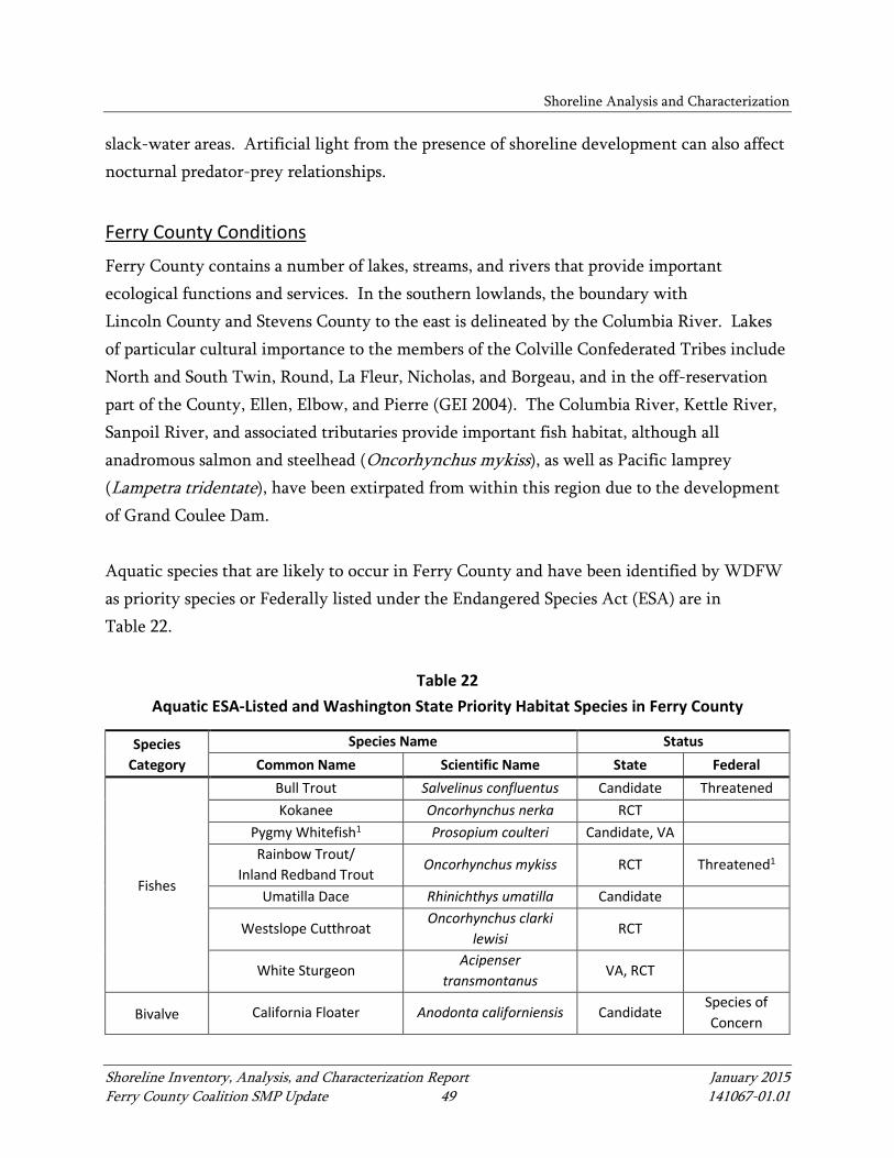
Shoreline Analysis and Characterization
Shoreline Inventory, Analysis, and Characterization Report January 2015 Ferry County Coalition SMP Update 49 141067-01.01
slack-water areas. Artificial light from the presence of shoreline development can also affect nocturnal predator-prey relationships.
Ferry County Conditions
Ferry County contains a number of lakes, streams, and rivers that provide important ecological functions and services. In the southern lowlands, the boundary with Lincoln County and Stevens County to the east is delineated by the Columbia River. Lakes of particular cultural importance to the members of the Colville Confederated Tribes include North and South Twin, Round, La Fleur, Nicholas, and Borgeau, and in the off-reservation part of the County, Ellen, Elbow, and Pierre (GEI 2004). The Columbia River, Kettle River, Sanpoil River, and associated tributaries provide important fish habitat, although all anadromous salmon and steelhead (Oncorhynchus mykiss), as well as Pacific lamprey (Lampetra tridentate), have been extirpated from within this region due to the development of Grand Coulee Dam. Aquatic species that are likely to occur in Ferry County and have been identified by WDFW as priority species or Federally listed under the Endangered Species Act (ESA) are in Table 22.
Table 22 Aquatic ESA-Listed and Washington State Priority Habitat Species in Ferry County
Species Category
Species Name Status Common Name Scientific Name State Federal
Fishes
Bull Trout Salvelinus confluentus Candidate Threatened Kokanee Oncorhynchus nerka RCT
Pygmy Whitefish1 Prosopium coulteri Candidate, VA Rainbow Trout/
Inland Redband Trout Oncorhynchus mykiss RCT Threatened1
Umatilla Dace Rhinichthys umatilla Candidate
Westslope Cutthroat Oncorhynchus clarki
lewisi RCT
White Sturgeon Acipenser
transmontanus VA, RCT
Bivalve California Floater Anodonta californiensis Candidate Species of Concern

Shoreline Analysis and Characterization
Shoreline Inventory, Analysis, and Characterization Report January 2015 Ferry County Coalition SMP Update 50 141067-01.01
Species Category
Species Name Status Common Name Scientific Name State Federal
Amphibians Columbia Spotted Frog Rana luteiventris Candidate
Species of Concern
Western Toad Anaxyrus boreas Candidate Species of Concern
Sources: 1999 Washington Department of Fish and Wildlife Priority Habitat Species List 2014b Washington Department of Fish and Wildlife Priority Habitat Species data occurring in Ferry County with Federal and/or State listing status Notes: 1 = Populations found in Twin Lakes per County comments provided on this report RCT = Recreational/commercial/tribal importance VA = Vulnerable aggregations
Terrestrial Habitat
General Processes
Terrestrial habitat may consist of many patches of interconnected habitat types. Within Ferry County, the terrestrial habitat within and adjacent to the shoreline zone includes riparian, shrub-steppe, grasslands, rangelands, agricultural lands, forested areas, and developed areas. These terrestrial habitats provide functions to support wildlife habitat and movement corridors, fire suppression, cultural and recreational values and services, forest products, and human food supplies produced by crops and livestock. Terrestrial wildlife use a variety of habitats through movement corridors. Terrestrial movement corridors are crucial to wildlife and may be seasonal, depending on the species. The primary function of a corridor is to connect different habitat areas to facilitate migration and dispersal among the areas. Movement corridors provide the following functions essential to healthy wildlife populations:
• Connectivity and, thereby, genetic variation and biodiversity among differing populations and habitats, connection of isolated habitats, and may allow recolonization of extirpated species
• Varying habitats for migration patterns (e.g., foraging, mating and nesting, rearing, shelter, and wintering) and allows populations to move in response to habitat changes such as fires
Shoreline Analysis and Characterization
Shoreline Inventory, Analysis, and Characterization Report January 2015 Ferry County Coalition SMP Update 51 141067-01.01
• Habitat for corridor dwellers, i.e., species that live within corridors for extended periods (Beier and Loe 1992)
The riparian habitat zone along a river, stream, or lake shoreline is an essential movement corridor for terrestrial species, and a healthy riparian zone can also support the health of the adjacent aquatic habitat. Habitat characteristics of healthy riparian areas include a connected corridor for wildlife travel, vegetation types adapted to wetter soils, occasional flooding, and natural disturbance regimes. Healthy riparian habitat supports a healthy freshwater aquatic habitat through the presence of complex vegetation communities that may overhang the shoreline from the uplands. This overhanging vegetation provides cover and refugia to fish and other aquatic species from extreme conditions (e.g., high flows and high temperatures), supports insects that serve as prey for freshwater species, and provides leaf litter and LWD, which are integral components to freshwater ecosystems in terms of nutrient cycling and habitat complexity. Management of stream and river hydrology for irrigation and other activities can significantly influence riparian habitats and the terrestrial plant and wildlife species that occupy them. Riparian zones may be especially important in shrub-steppe regions. Vegetation in the riparian zone within arid and semi-arid regions tends to be unique in comparison to riparian zones in other regions of the United States, and these areas have stronger changes in character between riparian and upland zones (Malanson 1993, as cited in Buffler et al. 2005). Riparian areas in arid lands offer important functions for species that inhabit the shrub-steppe, species more limited in range to the riparian zone, and species that inhabit the adjacent aquatic habitat (Anchor QEA 2013). For shrub-steppe and arid land species, riparian habitat provides access to a critical water source and often provides a more productive environment for forage, escape, thermal cover, nesting sites, and critical winter habitat (Anchor QEA 2013). Riparian areas typically support larger flocks and a greater density of upland birds than shrub-steppe or grassland habitat because of the greater production of biomass and the more complex mosaic of vegetation (Stinson and Schroeder 2012). Land-use changes and land-use activities can have a widespread impact on the functions provided by riparian terrestrial habitat regardless of where is occurs. Organic matter
Shoreline Analysis and Characterization
Shoreline Inventory, Analysis, and Characterization Report January 2015 Ferry County Coalition SMP Update 52 141067-01.01
produced by these habitats supports terrestrial and aquatic insects and other organisms that are then eaten by birds, juvenile salmonids, and other fish species. The removal of native riparian vegetation, the introduction and proliferation of invasive plant species, and the filling or degradation of wetlands along shorelines impact the organic inputs that fuel production of the lower levels of the food chain and, therefore, can have impacts throughout the entire food web. Irrigated agricultural lands may provide greater productivity of certain types of biomass compared to habitat with native shrub-steppe vegetation. Irrigated pasture, for example, produces much higher biomass than native shrub-steppe in arid areas and, therefore, may provide greater potential forage for certain species such as ungulates. Such agricultural areas may also displace native species because their specific lifecycle needs are not met. Agriculture also may change the predator and prey community that affects native species. Agricultural landscapes typically support much higher rodent populations; in turn, this larger population supports higher populations of predators, such as raptors, that also support native species. This artificially higher population of predators may substantially change the balance between native species and introduced species more adapted to human alternation (Dunne and Leopold 1978; Moulton et al. 2006). Cattle grazing can lead to loss of riparian vegetation. In time, the loss of riparian vegetation can lead to erosion and steepening of the riverbank and alteration of the hydrologic regime (Naiman et al. 2005). Developed areas may displace wildlife from habitat and may have impacts elsewhere in the ecosystem. Public road shoulders and right-of-ways are a significant contributor and/or routing network of fine sediment to streams and rivers (SRSRB 2011). Human development of urban and residential areas introduces artificial nighttime lighting associated with roads, parking lots, industrial complexes (including dams), houses, docks, piers, and sports fields. This artificial light can interfere with aquatic and terrestrial animals’ routines, change predator-prey relationships, and interfere with plant production and animal behavior.
Ferry County Conditions
Interior mixed conifer forests, ponderosa pine forests (Pinus ponderosa), eastside interior grasslands, and shrub-steppe habitats occur within Ferry County. The northern half of

Shoreline Analysis and Characterization
Shoreline Inventory, Analysis, and Characterization Report January 2015 Ferry County Coalition SMP Update 53 141067-01.01
Ferry County is characterized by dense, mountainous terrain that makes up much of the Colville National Forest. The highest peak in Ferry County is Copper Butte (7,140 feet). Montane mixed conifer forests, upland aspen forests, and lodgepole pine (Pinus contorta subsp. murrayana) forests are present in the high elevations. Interspersed throughout the higher country are numerous small lakes along with montane coniferous wetlands. As more mountainous terrain gives way in southern Ferry County, the terrestrial system transitions to mid-elevations—dominated by eastside grassland steppe and ponderosa pine forests—and then transitions to forested foothills that give way to drier hills and valleys dotted with shrubs, transitioning to areas of shrub-steppe vegetation along the shorelines of the Columbia River. Agricultural lands are generally found within the Kettle River valley and on the plateaus above the Columbia River. Representative vegetation species in the riparian areas in Ferry County are provided in Table 23 (WDNR 2014a; Kovalchik et al. 2004), along with rare plants from WDNR’s Natural Heritage Program’s list (WDNR 2014). Due to their rare nature, many of the plants on the Natural Heritage Program’s list for Ferry County are often not present in the riparian vegetation in Ferry County.
Table 23 Riparian Species Including Rare Plants in Ferry County
Species Name Status Common Plant Name Scientific Plant Name State Federal
Beaked sedge Carex rostrata Sensitive
Black cottonwood Populus trichocarpa
Black snake-root Sanicula marilandica Sensitive
Columbia crazyweed Oxytropis campestris var. columbiana Endangered
Crenulate moonwort Botrychium crenulatum Sensitive Species of Concern
Currant sp. Ribes spp.
Douglas fir Psuedotsuga menziesii
Douglas maple Acer glabrum
Englemann spruce Picea engelmannii
Green-keeled cotton-grass Eriophorum viridicarinatum Sensitive
Idaho gooseberry Ribes oxyacanthoides var. irriguum Threatened

Shoreline Analysis and Characterization
Shoreline Inventory, Analysis, and Characterization Report January 2015 Ferry County Coalition SMP Update 54 141067-01.01
Species Name Status
Common Plant Name Scientific Plant Name State Federal
Many-headed sedge Carex sychnocephala Sensitive
Mountain alder Alnus incana
Northern blue-eyed grass Sisyrinchium septentrionale Sensitive
Poison oak Toxicodendron diversilobum
Quaking aspen Populus tremuloides
Red-osier dogwood Cornus stolonifera
Reed canarygrass Phalaris arundinacea
Rose Rosa spp.
Sedges Carex spp.
Serviceberry Amelanchier alnifolia
Sheviak’s bog orchid Platanthera aquilonis R1
Skinny moonwort Botrychium lineare Threatened
Small northern bog-orchid Platanthera obtusata ssp. Obtusata Sensitive
Snowberry Symphoricarpus albus
Spruce Picea spp.
Stalked moonwort Botrychium pedunculosum Sensitive Species of Concern
Starry solomonplume Maianthemum stellatum
Subalpine fir Abies lasiocarpa
Triangular-lobed moonwort Botrychium ascendens Sensitive Species of Concern
Twinflower Linnaea borealis
Two-spiked moonwort Botrychium paradoxum Threatened Species of Concern
Water avens Geum rivale Sensitive
Water birch Betula occidentalis
Western larch Larix occidentalis
Western red cedar Thuja plicata
Willows Salix spp.
Yellow lady’s-slipper Cypripedium parviflorum Threatened
Yellow sedge Carex flava Sensitive
Note: R1 = Review group 1. Of potential concern but needs more field work to assign another rank (WDNR 2014) Rural and low-density residential development occurs in the vicinity of the City of Republic, along the Kettle River, and in the vicinity of Curlew Lake (WSDOT 2007). Little

Shoreline Analysis and Characterization
Shoreline Inventory, Analysis, and Characterization Report January 2015 Ferry County Coalition SMP Update 55 141067-01.01
development is likely to occur within the large areas of the County as it is under public ownership (e.g., Colville National Forest), and the CTCR is sparsely populated. Because of the relatively low growth rate and lack of large developments, impacts to timberland are likely limited to clearing of rural lots for home sites and roads. Common impacts to habitat from timber harvest may include habitat alterations and wildlife disturbance, and impacts to water quality from increased sedimentation in streams, altered stream hydrology, and increased water temperatures. Construction of Grand Coulee Dam directly affected more than 20,000 acres of upland forest (Creveling and Renfrow 1986). The southern mountainous areas of Ferry County have been and are dominated by ponderosa pine forests. Under the current forest plan, every tree 21 inches or over DBH is considered old growth; therefore, old growth stands have increased and have not been depleted. Projects that address the following issues may result in significant improvements to habitat within the Ferry County terrestrial system within the shoreline jurisdiction:
• Catastrophic wildfire • Improperly designed, installed, and maintained forest roads and road right-of-ways as
they pertain to sediment • Invasive riparian weeds and competition
Terrestrial species that are likely to occur in Ferry County and have been identified by WDFW as priority species and species of concern or Federally listed under the ESA are Table 24 (WDFW 2014b). The WDFW list for priority habitats occurring with the shorelines of Ferry County are listed in Table 25 (WDFW 2014a).
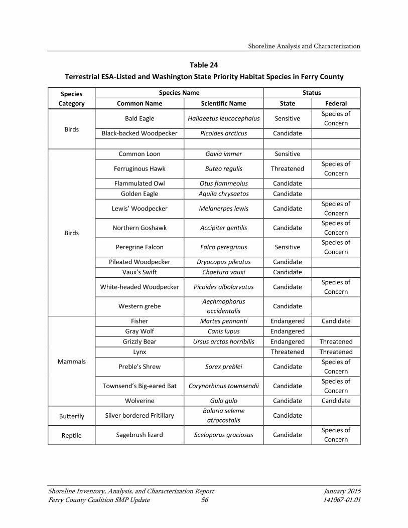
Shoreline Analysis and Characterization
Shoreline Inventory, Analysis, and Characterization Report January 2015 Ferry County Coalition SMP Update 56 141067-01.01
Table 24 Terrestrial ESA-Listed and Washington State Priority Habitat Species in Ferry County
Species Category
Species Name Status Common Name Scientific Name State Federal
Birds Bald Eagle Haliaeetus leucocephalus Sensitive
Species of Concern
Black-backed Woodpecker Picoides arcticus Candidate
Birds
Common Loon Gavia immer Sensitive
Ferruginous Hawk Buteo regulis Threatened Species of Concern
Flammulated Owl Otus flammeolus Candidate Golden Eagle Aquila chrysaetos Candidate
Lewis’ Woodpecker Melanerpes lewis Candidate Species of Concern
Northern Goshawk Accipiter gentilis Candidate Species of Concern
Peregrine Falcon Falco peregrinus Sensitive Species of Concern
Pileated Woodpecker Dryocopus pileatus Candidate Vaux’s Swift Chaetura vauxi Candidate
White-headed Woodpecker Picoides albolarvatus Candidate Species of Concern
Western grebe Aechmophorus
occidentalis Candidate
Mammals
Fisher Martes pennanti Endangered Candidate Gray Wolf Canis lupus Endangered
Grizzly Bear Ursus arctos horribilis Endangered Threatened Lynx Threatened Threatened
Preble's Shrew Sorex preblei Candidate Species of Concern
Townsend’s Big-eared Bat Corynorhinus townsendii Candidate Species of Concern
Wolverine Gulo gulo Candidate Candidate
Butterfly Silver bordered Fritillary Boloria seleme
atrocostalis Candidate
Reptile Sagebrush lizard Sceloporus graciosus Candidate Species of Concern
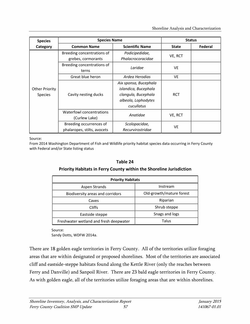
Shoreline Analysis and Characterization
Shoreline Inventory, Analysis, and Characterization Report January 2015 Ferry County Coalition SMP Update 57 141067-01.01
Species Category
Species Name Status Common Name Scientific Name State Federal
Other Priority Species
Breeding concentrations of grebes, cormorants
Podicipedidae, Phalacrocoracidae
VE, RCT
Breeding concentrations of terns
Laridae VE
Great blue heron Ardea Herodias VE
Cavity nesting ducks
Aix sponsa, Bucephala islandica, Bucephala clangula, Bucephala albeola, Lophodytes
cucullatus
RCT
Waterfowl concentrations (Curlew Lake)
Anatidae VE, RCT
Breeding occurrences of phalaropes, stilts, avocets
Scolopacidae, Recurvirostridae
VE
Source: From 2014 Washington Department of Fish and Wildlife priority habitat species data occurring in Ferry County with Federal and/or State listing status
Table 24 Priority Habitats in Ferry County within the Shoreline Jurisdiction
Priority Habitats
Aspen Strands Instream
Biodiversity areas and corridors Old-growth/mature forest
Caves Riparian
Cliffs Shrub steppe
Eastside steppe Snags and logs
Freshwater wetland and fresh deepwater Talus
Source: Sandy Dotts, WDFW 2014a.
There are 18 golden eagle territories in Ferry County. All of the territories utilize foraging areas that are within designated or proposed shorelines. Most of the territories are associated cliff and eastside-steppe habitats found along the Kettle River (only the reaches between Ferry and Danville) and Sanpoil River. There are 23 bald eagle territories in Ferry County. As with golden eagle, all of the territories utilize foraging areas that are within shorelines.

Shoreline Analysis and Characterization
Shoreline Inventory, Analysis, and Characterization Report January 2015 Ferry County Coalition SMP Update 58 141067-01.01
The majority of the territories are located along the Columbia River, utilizing open water and riparian habitats for foraging (WDFW 2014a).
5.2 Waterbody-Specific Processes and Conditions
This section describes processes and conditions, including alterations to the ecosystem process, for the shorelines within Ferry County. Alterations to ecosystem processes can affect habitat structure and the availability of habitat services, especially throughout long periods of time. Ecosystem processes and conditions in Ferry County are presented through the categories of hydrology, sediment, water quality, and habitat for the main waterbodies and their associated tributaries. See Appendix A for reach maps and reach-specific descriptions and Appendix E for the map folio.
5.2.1 Kettle River and Associated Tributaries
The Kettle River is a significant tributary to the Columbia River. The Kettle River originates in southern British Columbia, Canada within the Okanogan Highland and Monashee Mountains. The mainstem of the Kettle River is free flowing (no dams) and enters the United States just south of Midway, British Columbia. After entering the United States, the river flows northward back into Canada crossing the border at Danville, Washington, and joins the Grandby River in Grand Forks, British Columbia, and then returns to the United States near Laurier, Washington, where it continues flowing south to the Columbia River. See Appendix A for reach maps and reach-specific descriptions and Appendix E for the map folio. For the purposes of this IAC Report, the portion of the Kettle River between the United States/Canada border south of Midway, British Columbia and Danville communities, approximately 25 miles, is referred to as the Upper Kettle River, and the portion between Laurier to its confluence with the Columbia River, approximately 25 miles, is referred to as the Lower Kettle River. The Upper Kettle River tributaries that are included in the shoreline jurisdiction include Toroda Creek and Curlew Creek. The Lower Kettle River tributaries included in the
Shoreline Analysis and Characterization
Shoreline Inventory, Analysis, and Characterization Report January 2015 Ferry County Coalition SMP Update 59 141067-01.01
shoreline jurisdiction include Boulder Creek, South Fork Boulder Creek, and Deadman Creek, which are depicted in the map folio in Appendix E.
5.2.1.1 Hydrology
Hydrology for waterbodies in the Kettle River drainage area follow a typical snow-melt dominated flow pattern with strong seasonal peak flows in early to late spring, followed by the lowest flows during late summer through the fall and winter. This pattern reflects the dominance of snowmelt as the main hydrologic event in conjunction with low runoff. In the lower elevations, where precipitation is generally lower and potential evapotranspiration is higher, runoff may occur only during the wetter months, and a water deficit may occur during the drier months of July, August, September, and October. During these drier months, runoff may decline to extreme low flows and may cease altogether (Ecology 1995). USGS operates two active gages on the Kettle River in the planning area. One gage is near the Ferry/Midway border crossing (No. 12401500), and the other is near Laurier, Washington (No. 12404500; USGS 2014a). There are several irrigation diversions along the river upstream of the gage near Ferry. The average discharge recorded at this gage during the period of record (1929 to 2013) is 1,546 cfs (USGS 2014b). Near Laurier, there are irrigation diversions taking water from the Kettle River in the United States and in Canada. The average discharge recorded at the gage near Laurier during the period of record (1930 to 2013) is 2,928 cfs (USGS 2014c).
5.2.1.2 Sediment
Conditions for sediment transport and deposition occur along the Kettle River and its tributaries. Factors such as flow, sediment size and availability, and channel gradient control the occurrence of sediment deposition and transport. Sediment sources throughout reaches in the Kettle River include erodible glacial bank materials, soils prone to moderate to severe erosion, unstable slopes prone to landslides (slopes greater than 15%), and sediment transported in the inflow surface runoff and tributary drainages. In areas of deposition, features such as mid-channel and lateral bars are present in the river and tributaries. Segments of active lateral migration (areas of erosion and sediment input) are also present.
Shoreline Analysis and Characterization
Shoreline Inventory, Analysis, and Characterization Report January 2015 Ferry County Coalition SMP Update 60 141067-01.01
5.2.1.3 Water Quality
Non-point sources of pollutants in the Kettle River subbasin that potentially affect the river are principally agriculture, livestock grazing, and natural sources with other contributions from on-site sewage disposal (septic systems), stormwater and highway runoff, forest practices, land development, landfills, and mining. The Ferry County landfill, which used to operate in the floodplain of Curlew Lake, is currently closed (Ecology 1995). Landfill monitoring wells have not shown any contamination. Waterbodies in this group are impaired by dissolved oxygen and high temperatures throughout the drainage area. Streams are listed on the Ecology 305(b) list as requiring TMDLs for dissolved oxygen, bacteria, and temperature. Some areas may be impacted by agricultural uses, livestock grazing, natural causes, wildlife waste, and nearby septic systems, and the temperature issues are likely caused by natural climate conditions, as well as lack of shade.
5.2.1.4 Habitat
Aquatic Habitat
The Upper Kettle River is impacted by agriculture and residential development and state and county roads that traverse most of the stream's course on both sides of the river. Habitat complexity is generally low in these reaches. The gradient of the river is flat and the channel is broad with few meanders. There is little LWD, few deep pools, and areas of riprap along the county roads that reduce shallow shoreline habitat (GEI 2004). The Lower Kettle River, on the other hand, runs through mostly forested terrain. The gradient in these reaches is steeper, and the river is generally narrower. The present day salmonid fish assemblage in the Kettle River watershed in Ferry County mainly consists of rainbow trout (Oncorhynchus mykiss), mountain whitefish (Prosopium williamsoni), and native redband trout (Oncorhynchus mykiss gairdnerii) populations, as well as a non-native brown trout (Salmo trutta) population. Native redband trout were declining in the 1990s; however, the population seems to be stable as additional populations have been discovered in tributaries to the Kettle River, including Deadman Creek (GEI 2004). Impacts to water quality and habitat, combined with stocking

Shoreline Analysis and Characterization
Shoreline Inventory, Analysis, and Characterization Report January 2015 Ferry County Coalition SMP Update 61 141067-01.01
of non-native species, have resulted in a significant reduction in the density of redband trout, while fish passage barriers at road crossings have impacted the range of redband trout (WDFW 2014). While it is uncertain if bull trout (Salvelinus confluentus) were historically present in the Kettle River above Cascade Falls, there have been unconfirmed bull trout sightings within the last 15 years in the Lower Kettle River. The fisheries resources of the Kettle River and its associated tributaries have been changed extensively by downstream dams, including the Grand Coulee Dam. Historically, anadromous salmon and steelhead utilized the Lower Kettle River for spawning and rearing; however, there are no anadromous fish found in the Kettle River today due to conditions that prevent migration of these species past the Grand Coulee Dam (Ecology 1995). The aquatic habitat of Toroda Creek has undergone severe alterations compared to reference conditions from grazing, negatively impacting riparian condition, habitat diversity, channel stability, and low-flow regime. Although Boulder Creek includes habitat attributes that are most similar to reference conditions and ranked highest for protection, the riparian condition and fine sediments in this reach exhibit a large deviation from the reference habitat conditions for redband trout in the Upper Columbia Subbasin. This is due mostly to USFS not maintaining access across the South Boulder bridge; therefore, traffic is using less desirable routes. In Deadman Creek, obstructions and sediments are identified as a major change from reference conditions experienced within the reach (GEI 2004). In Curlew Creek, riparian vegetation removal has been identified as a major change from reference conditions.
Terrestrial Habitat
The plant communities along the Upper Kettle River are characterized by riparian wetlands along the shorelines and interior grasslands and ponderosa pine forests extending into the uplands. Along the Lower Kettle River reaches, the plant communities are characterized mostly by ponderosa pine forests. Bald eagles (Haliaeetus leucocephalus) winter along the Kettle River and its tributaries. The eagles move into the area during the winter and feed on fish, waterfowl, and road-killed or winter-killed deer. Other terrestrial mammals and avian species that commonly use riparian areas are also present. Most of the golden eagle territories in the County are associated with

Shoreline Analysis and Characterization
Shoreline Inventory, Analysis, and Characterization Report January 2015 Ferry County Coalition SMP Update 62 141067-01.01
the cliff and eastside-steppe habitats, including those along the Kettle River (only the reaches between Ferry and Danville). Roads along both sides of the river in Washington have decreased the presence of vegetation and degraded the habitat value of the riparian area. Even so, waterfowl and great blue herons (Ardea herodias) still use the river where habitat remains suitable, and mule deer (Odocoileus hemionus), and northwest white-tailed deer (Odocoileus virginianus) winter on the breaks above the river. See Map 6a in Appendix E for additional habitat areas and wildlife within the Kettle River subbasin.
5.2.2 Columbia River and Associated Tributaries
The portion of the Columbia River within the Ferry County shoreline jurisdiction is impounded by the Grand Coulee Dam. The impounded area of the Columbia River is known as Lake Roosevelt. The Columbia River tributaries that are included in the shoreline jurisdiction include Sherman Creek, Hall Creek, Stranger Creek, and Ninemile Creek. See Appendix B for reach maps and reach-specific descriptions and Appendix E for the map folio.
5.2.2.1 Hydrology
This portion of the Columbia River is regulated by the Grand Coulee Dam. The water levels range between 1,208 to 1,290 feet above mean sea level (MSL). The spring drawdown levels reflect anticipated snow melt, along with other factors. High flows into the reservoir normally occur in May and June and peak in June; stable low flows usually occur from September through April. The mean annual water retention time with the reservoir is about 40 days. Pool elevations and river discharge can vary daily because of electric power demand and the operations of hydroelectric facilities (Bortleson et al. 1992). Flow targets required by the Federal Columbia River Power System Biological Opinion also influence daily and seasonal pool elevations and river discharges. The flow upstream from Lake Roosevelt is regulated by nine large reservoirs and many smaller reservoirs and power plants. In addition to the Columbia River, the Kettle, Colville, Spokane, and Sanpoil rivers (Bortleson et al. 1992) flow directly into the lake.
Shoreline Analysis and Characterization
Shoreline Inventory, Analysis, and Characterization Report January 2015 Ferry County Coalition SMP Update 63 141067-01.01
5.2.2.2 Sediment
The Columbia River is accumulating sediments within Ferry County because the river is managed as a lake impounded by the Grand Coulee Dam downstream. Sediment input sources include sediment load from the many tributary streams and drainages entering the river, including, in some cases, less successful restoration projects constructed outside of Ferry County's jurisdiction. In addition, the sediment carried by the local overland surface runoff enters the lake. Also, there is the potential for sediment to enter the river from slopes susceptible to land sliding (unstable material on slopes greater than 15%). In addition, the fluctuation of Lake Roosevelt levels may cause some movement of sediment. In the Columbia River tributaries, sediment sources include the erodible glacial deposits, soils prone to moderate and severe erosion, steep slopes prone to landslides (unstable geologic units with greater than 15% slopes), and sediment transported by local runoff and surface drainages. In Ninemile Creek, a small amount of mass wasting deposits (from landslides) is located along the lower extent of the stream. Numerous large floodplain/wetland complexes exist along the Stranger Creek and Hall Creek alignments where deposition is occurring. Where present, the vegetated riparian corridors are likely to limit erosion and the delivery of fine sediment to the stream.
5.2.2.3 Water Quality
Water quality in the Columbia River is impacted from reservoir operations and industrial runoff and effluent. Concentrations of dissolved metals from Canada have historically been relatively high. These metals get transported when suspended in the water and as bedload during high flows (USGS 2010). Subreaches are impaired by dissolved oxygen (SR 1a), mercury (SR 2c), and sediments (SR 3a) in the Columbia River. SR 1a is listed on the Ecology 305(b) list as requiring a TMDL for bacteria. Sherman Creek (an associated tributary of the Columbia River) has a TMDL in place for temperature, requires a TMDL for dissolved oxygen, and is a water of concern for bacteria and pH.

Shoreline Analysis and Characterization
Shoreline Inventory, Analysis, and Characterization Report January 2015 Ferry County Coalition SMP Update 64 141067-01.01
5.2.2.4 Habitat
Aquatic Habitat
The habitat conditions of the Columbia River in Ferry County have been extensively described as part of Washington State watershed and Bonneville Power Administration/Northwest Power and Conservation Council subbasin planning processes, as well as a number of National Park Service (NPS)-related projects related to the Lake Roosevelt National Park. The impoundment of the Columbia River upon completion of the Grand Coulee Dam inundated 12 miles of the Sanpoil River and 15 miles of the Kettle River, as well as numerous other tributaries discussed in this section. At full pool/high water (measured at +1,290 feet MSL), riparian vegetation is dominated by reed canarygrass (Phalaris arundinaceae), which occupies most of the area within a few feet in elevation of the annual high water line. This grass grows extensively in large shallow bays (such as near Kettle Falls Campground) and shoreline marshes (such as near Napoleon Bridge). Other common species present include tickseed (Coreopsis atkinsonii), sedges (Carex lenticularis), and foxtail (Alopecuris aequalis). Additional species are present in lesser abundance (NPS 2014). At elevations that remain submerged for most of the summer, aquatic plant species are dominant. These plants are heavily grazed by waterfowl. Various species of pondweed (Potamogeton) are abundant, with non-native Eurasian watermilfoil (Miriophyllum spicatum) common in certain areas. During the substantial spring drawdown (which may take the pool level down to +1,208 feet MSL), various annuals can be found among the pondweed on the exposed lakebed and shoreline, such as popcornflower (Plagiobothrys) and diminutive annuals in the mustard family, that have been observed but not positively identified (NPS 2014). The Columbia River and the associated tributaries covered within this section support a robust ecosystem of fish and aquatic species. Nearly 50 fish species, including various species of salmonoids, dace (Rhinichthys), crappie (Pomoxis), sucker, sculpin (Cottoidea), whitefish (Prosopium williamsoni), white sturgeon (Acipenser transmontanus), smallmouth bass (Micropterus dolomieu), largemouth bass (Micropterus salmoides), perch (Perca), walleye (Sander vitreus), burbot (Lota lota), brown bullhead (Ameiurus nebulosus), chub (Squalius cephalus), carp (Cyprinus carpio), and northern pikeminnow

Shoreline Analysis and Characterization
Shoreline Inventory, Analysis, and Characterization Report January 2015 Ferry County Coalition SMP Update 65 141067-01.01
(Ptychocheilus oregonensis) have been identified to occur or are presumed to occur within the full extent of Lake Roosevelt; however, all anadromous salmon and steelhead as well as Pacific lamprey have been extirpated from the Columbia River and tributaries above Grand Coulee Dam (GEI 2004). Although the river supports a healthy zooplankton population, benthic macroinvertebrates in the Lake Roosevelt area are limited due in part to annual changes in lake elevation and substrate types (GEI 2004). Benthic productivity may also be affected by presence of contaminants in sediments (Bortelson et al. 2001). In high-water years, reservoir levels can be drawn down more than 80 feet to accommodate large spring freshet and are refilled within 3 to 5 months. These drawdowns are related to decreased invertebrate productivity and reduction of nearshore/littoral habitat used for rearing juvenile fish. This drawdown practice has been identified as a limiting factor for fish and aquatic habitat in Lake Roosevelt by a number of studies (Cichosz et al. 1999; Underwood and Shields 1995; and Griffith and Scholz 1991 as cited in GEI 2004). Drawdowns likely increase fish entrainment of other resident fish. Current hydro-management practices negatively impact resident fish populations and limit the ability to achieve objectives and goals set by tribes or agencies (GEI 2004). Water quality, based on known sediment contamination, is an issue within the Upper Columbia Basin (USGS 2010). Lake Roosevelt bed sediments have been reported to be contaminated with arsenic, lead, and other metals and are characterized by impaired benthic invertebrate communities (Bortelson et al. 2001; USGS 2004). Many aquatic species from benthic organisms to white sturgeon may be greatly affected by these contaminants, along with wildlife that depend on the system. A human health fish consumption advisory is in effect for the entire Upper Columbia River in Ferry County (DOH 2014). The associated tributaries of the Columbia River within Ferry County include Sherman, Hall, Stranger, and Ninemile creeks. Sherman Creek was ranked as having poor riparian condition and channel stability in certain areas, likely due to State Highway 20 limiting channel movement along most of the creek, and it also has high water temperatures (GEI 2004). Hall Creek is one of a few creeks within the Colville National Forest that supports a genetically pure redband trout population (GEI 2004). Habitat attributes of concern for Hall Creek include flow levels, upstream obstructions, elevated water temperature, impaired
Shoreline Analysis and Characterization
Shoreline Inventory, Analysis, and Characterization Report January 2015 Ferry County Coalition SMP Update 66 141067-01.01
riparian condition, and increased levels of fine sediments. Stranger Creek attributes of concern include impaired water quality (fecal coliform), impaired riparian condition, channel stability, reduced habitat diversity, low and high flows, and obstructions. Ninemile Creek attributes of concern include riparian condition, high and low flow, pollutants, elevated levels of fine sediments, obstructions, and impaired riparian conditions.
Terrestrial Habitat
The Columbia River in Ferry County is located in a semi-arid transition zone. Plant communities along the 150-mile-long Lake Roosevelt reservoir are characterized by shrub-steppe plant communities along the southern border of Ferry County and transition to ponderosa pine forest beginning where the Columbia River borders Stevens County. The reservoir has unique aquatic plant species in addition to riparian vegetation along the shorelines. In the uplands, common non-native plant species, including spotted knapweed (Centaurea maculosa), rush skeletonweed (Chondrilla juncea), dalmation toadflax (Linaria dalmatica), and leafy spurge (Euphorbia esula), compete with native species. Areas along the shoreline of the Columbia River experience high levels of slope failure, and there is high erosion potential along the shoreline (GEI 2004). During the spring, when reservoir levels decrease substantially, extensive reaches of potentially contaminated sediments are exposed. Upon drying, the contaminants, which are bound to sediment particles, may be easily transported via winds, and studies are being conducted regarding the human health impacts of breathing airborne contaminants from fugitive dust from the Lake Roosevelt area (DOH 2010). As noted above, Sherman, Hall, Stranger and Ninemile creeks were all identified as having impaired riparian conditions along some locations (GEI 2004). Riparian vegetation and riparian wetlands along Columbia River tributary streams within the shoreline jurisdiction of Ferry County have been affected by combinations of the following activities: water resource developments (i.e., dams and diversions); draining of lands to establish agricultural and grazing lands; roads; timber management; natural and human-caused fire events; and residential development. Timber harvest has affected riparian habitats through removal of overstory dominant trees, alteration of plant community structure, and increased road
Shoreline Analysis and Characterization
Shoreline Inventory, Analysis, and Characterization Report January 2015 Ferry County Coalition SMP Update 67 141067-01.01
density (GEI 2004). Watershed subbasin planning has identified a number of recommended projects to improve riparian conditions, some of which have been implemented or are being implemented by a variety of agencies and organizations. In addition, the Washington State Department of Transportation (WSDOT) is evaluating ways to limit the current impacts of State Highway 20 to instream and riparian habitat along Sherman Creek based on recommendations from an environmental assessment produced by the USFS for Colville National Forest (GEI 2004). Grassland and shrub-steppe habitats along the Columbia River in Ferry County have been greatly reduced and modified from historical conditions. Construction of the Grand Coulee Project resulted in the loss of an estimated 14,000 acres of shrub-steppe habitat for placement of project facilities and creation of the reservoir (Creveling and Renfrow 1986). Many of the bald eagle territories in Ferry County are located along the Columbia River, utilizing open water and riparian habitats for foraging.
5.2.3 Sanpoil River and Associated Tributaries
The Sanpoil River is a major tributary to the Columbia River and originates in the Kettle Range in north central Washington and flows south for approximately 59 miles through the Colville National Forest and CTCR, entering the Columbia River toward the southwest corner of the County. Construction of Grand Coulee Dam resulted in inundation of the lowermost 12 miles of the Sanpoil River (GEI 2004). The Sanpoil River tributaries included in the shoreline jurisdiction are Granite Creek and West Fork Sanpoil River. See Appendix C for reach maps and reach-specific descriptions and Appendix E for the map folio.
5.2.3.1 Hydrology
The Sanpoil Subbasin drains approximately 1,086 square miles of Ferry County. Historically, Curlew Lake had a hydrologic connection to both the Sanpoil River and the Kettle River, but anthropogenic alterations eliminated this connection in the early 1900s. Since that time, all overland flows from Curlew Lake have been directed to the Kettle River via Curlew Creek.
Shoreline Analysis and Characterization
Shoreline Inventory, Analysis, and Characterization Report January 2015 Ferry County Coalition SMP Update 68 141067-01.01
The USGS operates an active gage on the Sanpoil River in the planning area above Jack Creek at Keller, Washington (No. 12434590). There are diversions for irrigation above the station. The average discharge for the period of record (2007 to 2013) is 246 cfs (USGS 2014d).
5.2.3.2 Sediment
Conditions for sediment transport and deposition occur along the Sanpoil River and its tributaries. Factors such as flow, sediment size and availability, and channel gradient control the occurrence of sediment deposition and transport. Sediment sources throughout the Sanpoil River and its tributaries' reaches include erodible glacial bank material, soils prone to moderate to severe erosion, unstable slopes prone to landslides (slopes greater than 15%), and sediment transported in the overland runoff and tributary drainages. In areas of deposition, features such as mid-channel and lateral bars are present in the river. Segments of active lateral migration (areas of erosion and sediment input) are also present. Mass wasting deposits (as landslides) are located in Reach 1 of the Sanpoil River. Areas of widespread deposition occur along the river due the low gradient and limited transport capacity of the sediment load and occur in the numerous large floodplain/wetland complexes. In Reach 6 of the Sanpoil River, sediments are likely accumulating throughout this reach because the river is managed as a lake impounded by the Grand Coulee Dam. Sediment input sources likely include tributary inflow and landslides along steep slopes. Sediment is likely transported through much of Granite Creek and West Fork Sanpoil River due to their moderate to steep gradients. Deposition is likely isolated to localized channel and floodplain features. Both of these waterbodies have intact riparian corridors along their alignments, which help to limit erosion and the delivery of fine sediment to the stream.
5.2.3.3 Water Quality
The upstream extent of Sanpoil River watershed is potentially affected by non-point sources of pollutants such as agricultural, residential, and industrial runoff from upstream developments. Farther downstream, watershed is impacted by forest practices, highway runoff, mining, and recreational activities.

Shoreline Analysis and Characterization
Shoreline Inventory, Analysis, and Characterization Report January 2015 Ferry County Coalition SMP Update 69 141067-01.01
Different reaches in Sanpoil River are impaired by dissolved oxygen (Reach 2 and SRs 1a and 3a), pH (Reach 2 and SR 1a), temperature (Reach 2 and SR 1a), and bacteria (SR 1a, 5c, and 5d). SR 1a and SR 3a are listed on the Ecology 305(b) list as requiring TMDLs for dissolved oxygen and bacteria, respectively. Several associated streams are listed on the Ecology 305(b) list as waters of concern for dissolved oxygen, bacteria, pH, and temperature.
5.2.3.4 Habitat
Aquatic Habitat
The southern-most 12 miles of the Sanpoil River were inundated by creation of the Lake Roosevelt reservoir of Grand Coulee Dam. All anadromous salmon and steelhead, as well as Pacific lamprey, have been extirpated from the region as a consequence of dam construction and operations. Genetically pure, naturally reproducing populations of redband trout are known to exist in the Sanpoil River, including the West Fork Sanpoil River (GEI 2004). The Sanpoil River was historically a single, defined channel with a broad floodplain and heavy canopy cover comprising mature trees. Since the mid 1940s, profound changes have occurred within the Sanpoil River floodplain areas in the upper reaches as a result of development activities, including clearing land for timber and agricultural cultivation, livestock grazing, and road construction. These developments resulted in deforestation of the riparian corridor, bank erosion, and increased sediment loads to the river. In 2004, the channel width was approximately four times higher than historical width, and the riparian areas were largely denuded (GEI 2004). The building of State Highway 21 effectively blocked fish access to a majority of the tributary streams entering the west side of Sanpoil River due to poorly designed or improperly installed culverts. Access was maintained into the West Fork Sanpoil River because a bridge was installed. Review of aerial photography from 1946, 1966, 1973, 1983, and 1991, completed as part of the watershed subbasin planning process, indicated a progressive deterioration of in-stream and floodplain conditions along the river (GEI 2004).
Shoreline Analysis and Characterization
Shoreline Inventory, Analysis, and Characterization Report January 2015 Ferry County Coalition SMP Update 70 141067-01.01
Natural resource use activities have created degraded aquatic habitat conditions for trout. Many riverine habitats exhibit unstable banks, poor riparian communities, high summer temperatures, high substrate embeddedness, and intermittent flows. As a result of habitat modifications and habitat degradation, native resident fish, including redband trout, bull trout, and mountain whitefish, have either disappeared or are only remnant populations. The absence of marine-derived nutrients from anadromous fish has affected productivity within the ecosystem, extending from primary producers to tertiary aquatic consumers and many terrestrial predators. The potential for natural reproduction by native or non-native species has been declining in many of the subwatersheds within the Sanpoil Subbasin (NWPPC 2000). Tributary habitats associated with the Sanpoil River within the Colville National Forest range from poor to good depending upon the past and present level of activities within the subwatersheds. In general, where habitat is poor to fair, road densities are high and many roads are located within the riparian areas of these tributaries. Stream habitat is also degraded where the riparian habitat is easily accessible to livestock, and, in many cases, the vegetation is overgrazed. The tributaries in poor to fair condition have low numbers of pools, lack large instream wood, and exhibit high embeddedness of the streambed substrate that results in an overall decrease in the amount of suitable spawning and rearing habitat. Those tributary reaches in good condition remain so because of a lack of access for livestock or vehicles within the riparian area and tend to be located at higher elevations and gradients (NWPPC 2000).
Terrestrial Habitat
The natural vegetation in the low elevations of the Sanpoil River subbasin is generally dominated by pine savannas with grasses, shrubs, and ponderosa pine trees. As these areas transition into higher elevations with increased precipitation, alpine communities of Douglas fir, ponderosa pine, Western larch, and cedar (Cedrus)/hemlock (Tsuga) develop (NWPPC 2000). Agricultural lands comprise less than 1% of the total area within the subbasin and urbanization is limited. The City of Republic is the largest urban center in the subbasin (GEI 2004).
Shoreline Analysis and Characterization
Shoreline Inventory, Analysis, and Characterization Report January 2015 Ferry County Coalition SMP Update 71 141067-01.01
Dam construction and subsequent inundation resulted in the loss of low-elevation wildlife habitat, and a total of 12 miles of the Sanpoil River was inundated (GEI 2004). Many of the golden eagle territories in the County are associated with the cliff and eastside-steppe habitats, including those along the Sanpoil River (WDFW 2014a).
5.2.4 Lake Groups
There are 13 lakes included in Ferry County’s shoreline jurisdiction. For the purposes of the IAC Report and the SMP update, the lakes are organized into six lake groups based on location and environmental and developed characteristics. See Appendix D for reach maps and reach-specific descriptions and Appendix E for the map folio.
5.2.4.1 Hydrology
Little information was found about the lakes with shoreline jurisdiction in Ferry County. Where data were available, hydrology summaries for those waterbodies are provided below.
Twin Lakes Group
A dam built in 1963 raised the original lake level about 10 feet and connected the North and South Twin lakes. North Twin Lake is fed principally by Granite Creek and drains via Stranger Creek to the Columbia River (Ecology 1990).
Curlew Lake
Curlew Lake is a natural lake that was stabilized by a dam in 1926. Curlew Lake receives perennial water inflow. In addition to recreation, the lake’s water is used for irrigation purposes. Currently the lake drains north into Curlew Creek, which is a tributary to the Kettle River. Groundwater and diffuse surface runoff account for approximately 43% of the inflow into the lake (Ferry County 2012).
5.2.4.2 Sediment
East Ferry Lakes Group – North
Sediment inputs to the Lake Ellen, Elbow Lake, and La Fleur Lake include the erodible continental glacial drift banks, perimeter soils prone to moderate to severe erosion, adjacent
Shoreline Analysis and Characterization
Shoreline Inventory, Analysis, and Characterization Report January 2015 Ferry County Coalition SMP Update 72 141067-01.01
unstable steep slopes prone to landslides, and sediment transported by surface runoff and surface drainages. Where present, the vegetated riparian corridor likely helps to limit the delivery of fine sediment to these lakes. Fine sediment can be transported out of the lakes from the outflow surface drainages.
East Ferry Lakes Group – South
Sediment inputs to the lakes include the erodible continental glacial drift (Borgeau and Round lakes) and till (Camille Lake) banks, perimeter soils prone to moderate to severe erosion, adjacent unstable steep slopes prone to landslides, and sediment transported by overland runoff and surface drainages. Where present, the vegetated riparian corridor likely helps to limit the delivery of fine sediment to the lakes. Fine sediment can be transported out of the lakes from the outflow surface drainages, with the amount depending on local flow and sediment conditions.
Twin Lakes Group
Sediment inputs to North Twin Lake and South Twin Lake includes the erodible continental glacial drift banks, perimeter soils prone to erosion, adjacent steep slopes prone to landslides, and sediment transported by local runoff and surface drainages. Where present, the vegetated riparian corridor likely helps to limit the delivery of fine sediment to the lakes. Fine sediment can be transported out of the lakes from the surface outflow drainages (including Stranger Creek) with the amount depending on local flow and sediment conditions.
Curlew Lake
Sediment inputs to Curlew Lake include the erodible continental glacial drift banks, perimeter soils prone to moderate to severe erosion, adjacent unstable steep slopes prone to landslides, and sediment transported by local runoff and surface drainages, including Curlew Creek. Residential development and riparian vegetation removal may also contribute to sediment inputs. Where present, the vegetated riparian corridor likely helps to limit the delivery of fine sediment to the stream. Fine sediment can be transported out of the lakes from the outflow surface drainages, the largest being Curlew Creek.
Shoreline Analysis and Characterization
Shoreline Inventory, Analysis, and Characterization Report January 2015 Ferry County Coalition SMP Update 73 141067-01.01
West Ferry Lakes Group – North
Sediment inputs to Mud Lake and Sanpoil Lake include the erodible continental glacial drift banks, perimeter soils prone to moderate to severe erosion, and sediment transported by local runoff and surface drainages. Along Mud Lake, the vegetated riparian corridor along the south and southwest shorelines likely helps to limit the delivery of fine sediment to the lake. Vegetation appears absent along portions of Sanpoil Lake’s shoreline, thereby increasing the potential for sediment delivery to the lake. A visible delta has formed along the northwest shore of the lake where an unnamed tributary flows into the lake. The Sanpoil River is likely Sanpoil Lake’s biggest sediment input and output.
West Ferry Lakes Group – South
Sediment inputs to Ferry Lake and Swan Lake include the erodible continental glacial drift banks, perimeter soils prone to moderate to severe erosion, and sediment transported by surface runoff. The vegetated riparian corridor likely helps to limit the delivery of fine sediment to the lakes. Fine sediment can be transported out of Swan Lake from the local surface drainages with the amount depending on local flow and sediment conditions.
5.2.4.3 Water Quality
Little information was found about the lakes with shoreline jurisdiction in Ferry County. None of the waterbodies are listed on the Ecology 305(b) ratings for water quality concerns, and they are located in a natural area with little to no disturbances noted. It is likely that waterbodies in the Lake Groups have better water quality relative to other lakes in the planning area due to these conditions; however, this cannot be confirmed due to a lack of data. Where data were available, water quality summaries for those waterbodies are provided below.
Twin Lakes
The North and South Twin lakes were studied by Washington State University in 1985. At the time of the study, prolific growth of aquatic plants and the presence of blue-green algae indicated declining water quality in the lakes. The Washington Wildlife and Recreation Coalition identified internal recycling of nutrients as the primary source of
Shoreline Analysis and Characterization
Shoreline Inventory, Analysis, and Characterization Report January 2015 Ferry County Coalition SMP Update 74 141067-01.01
nutrient location. Other sources identified include septic tank drainfields, soil erosion from logging operations, and cattle grazing within the watershed. Based on the total phosphorus concentrations and the moderately high amount of aquatic plant growth in North Twin Lake, the lake was estimated as mesotrophic in a 1990 Lake Water Quality Assessment Project (Ecology 1990)
Curlew Lake
Curlew Lake is impaired by heavy residential and recreational development in the surrounding areas. Curlew Lake is listed on the Ecology 305(b) list as requiring TMDLs for total phosphorus.
5.2.4.4 Aquatic and Terrestrial Habitat
East Ferry Lakes Group – North
Lake Ellen
Lake Ellen is an approximately 78-acre lake located at approximately 2,300 feet of elevation in the Colville National Forest, north of Inchelium, Washington. The lake is located in close proximity to Elbow Lake and La Fleur Lake in the Inchelium drainage area, west of the Columbia River. Recreation access is associated with opportunities at the lake such as camping, fishing, swimming, hiking, and bicycling. Lake Ellen is characterized by exposed shorelines surrounded by coniferous forest and lower timberline mountain habitat. Dominating tree species in the area include ponderosa pine and Douglas fir, with western larch found at higher elevations (Larix occidentalis). Shrub species that occur within forested areas of Ferry County and may be present in the area include serviceberry (Amelanchier alnifolia), and other shrub species (Ferry County 2006). The lake provides golden eagle nesting habitat and habitat for rainbow trout, largemouth bass, and green sunfish (Lepomis cyanellus). Lake Ellen is regularly stocked with rainbow trout fry by the Washington Department of Fish and Wildlife (WDFW 2014a, 2014f). An attempt was made in fall 2008 by WDFW to remove largemouth bass and green sunfish, both illegally introduced species. These species have been reestablished in the lake and negatively
Shoreline Analysis and Characterization
Shoreline Inventory, Analysis, and Characterization Report January 2015 Ferry County Coalition SMP Update 75 141067-01.01
affect rainbow trout fry growth and survival, though stocking continues to occur (WDFW 2014f).
Elbow Lake
Elbow Lake, also called Ghost Lake or Horseshoe Lake, is an approximately 51-acre lake located at approximately 2,100 feet of elevation on the CTCR, north of Inchelium, Washington. The lake is located in close proximity to Lake Ellen and La Fleur Lake in the Inchelium drainage area, west of the Columbia River. Elbow Lake is fed by Onion Creek and drains to Barnaby Creek. The shoreline is characterized by exposed sediment surrounded by coniferous forest and lower timberline mountain habitat, and the lake occasionally dries (WSU 2014). Dominating tree species include western larch (Larix occidentalis), Douglas fir, ponderosa pine, and poplar trees (Populus spp.; Ferry County 2006; WSU 2014). The area may include serviceberry and other shrub species (Ferry County 2006). Aquatic macrophytes include shortspike watermilfoil (Myriophyllum exalbescens), the dominant species, and needle spikerush (Eleocharis acicularis), with pondweed, Chara (Chara sp.), and spikerush occurring along the shoreline, extending into shallow water (WSU 2014). Elbow Lake drains into a small fracture in the ground and is dependent on high precipitation years that has historically supported a recreational fishery with fish stocked by CTCR (GotMyFishOn 2014).
La Fleur Lake
La Fleur Lake is an approximately 24-acre lake located at approximately 2,300 feet of elevation on the CTCR north of Inchelium, Washington. The lake is located in close proximity to Lake Ellen and Elbow Lake in the Inchelium drainage area, west of the Columbia River.
Shoreline Analysis and Characterization
Shoreline Inventory, Analysis, and Characterization Report January 2015 Ferry County Coalition SMP Update 76 141067-01.01
La Fleur Lake is characterized by exposed shorelines surrounded by coniferous forest and lower timberline mountain habitat. Dominating tree species in the area include ponderosa pine and Douglas fir and western larch at upper elevations. Shrub species in the area may include serviceberry and other shrub species that are common in forested areas of Ferry County in the vicinity of La Fleur Lake (Ferry County 2006). The lake provides habitat for rainbow trout and eastern brook trout (Salvelinus fontinalis; Select Flies 2014).
East Ferry Lakes Group – South
Camille Lake
Camille Lake is an approximately 20-acre lake located at approximately 2,000 feet of elevation on the CTCR, west of Inchelium, Washington. The lake is located in close proximity to Round Lake, Bourgeau Lake, and the Twin Lakes in the Inchelium drainage area, west of the Columbia River. Camille Lake is characterized by exposed shorelines surrounded by open rangeland with grasses and scattered shrub (Fairbank 2005). Dominating tree species in the area include ponderosa pine and Douglas fir, with western larch at upper elevations (Fairbank 2005; Ferry County 2006). The area may include serviceberry and other shrub species (Ferry County 2006). Camille Lake is a eutrophic waterbody that reaches a maximum depth of 32 feet (Fairbank 2005). Prior to 1975, an aeration system was installed in Camille Lake in an effort to increase dissolved oxygen levels to promote increased salmonid survival, and the lake was stocked with trout. After the attempt was determined to be unsuccessful, fish stocking was discontinued and the aeration system removed. Sampling efforts have documented Western painted turtles (Chrysemys picta) at the lake (Fairbank 2005).
Round Lake
Round Lake is an estimated 53-acre lake located at approximately 2,300 feet of elevation on the CTCR, west of Inchelium, Washington. The lake is located in close proximity to Camille Lake, Bourgeau Lake, and the Twin Lakes in the Inchelium drainage area, west of the Columbia River. Recreation opportunities include boating and fishing.
Shoreline Analysis and Characterization
Shoreline Inventory, Analysis, and Characterization Report January 2015 Ferry County Coalition SMP Update 77 141067-01.01
The lake is situated in a large flat area between forested hills on the north side of Moon Mountain about 5.8 miles west of Inchelium. The lake is fed by Cornstalk Creek, which enters from North Twin Lake through an extensive marsh system on the west side of the lake. The lake is drained from the east by Cornstalk Creek, which then flows to Stranger Creek and ultimately to the Columbia River. The Round Lake basin is circular and steep-sided with a flat bottom. Lakes exhibiting these characteristics are referred to as Chara bench lakes and are common in surrounding areas (WSU 2014). The shores of the lake consist of marl precipitated by the abundant growth of Chara. The low, exposed shores of Round Lake are predominantly covered with the grasses, cattails (Typha spp.), club-rush (Scirpus sp.; Typha-Scirpus band), salix (Salix sp.), and alder (Alnus incana). The emergent vegetation observed at the launch on the north shore also included unbranched bur-reed (Sparganium emersum) and other macrophytes and an unidentified mint (WSU 2014). The lake generally is surrounded by a Typha-Scirpus band of varying widths parallel to the shoreline. The band appears to be contiguous with the shoreline vegetation, with some marsh cinquefoil (Potentilla palustrisi) present along the south shoreline in the Typha-Scirpus band (WSU 2014). Round Lake is surrounded by coniferous forest and lower timberline mountain habitat. Dominating tree species in the area include ponderosa pine and Douglas fir. The area may include serviceberry and other shrub species common to the area (Ferry County 2006). The lake provides habitat for rainbow trout and eastern brook trout and is stocked annually (GEI 2004).
Bourgeau Lake
Bourgeau Lake is an estimated 22-acre lake located at approximately 1,900 feet of elevation on the CTCR, south of Inchelium, Washington. The lake is located in close proximity to Camille Lake, Round Lake, and the Twin Lakes in the Inchelium drainage area, west of the Columbia River. During periods of high flow, Apex Lake and the surrounding uplands drain into Bourgeau Lake (Fairbank 2005). Recreation opportunities include fishing and boating.

Shoreline Analysis and Characterization
Shoreline Inventory, Analysis, and Characterization Report January 2015 Ferry County Coalition SMP Update 78 141067-01.01
Bourgeau Lake is characterized by exposed shorelines surrounded by coniferous forest and lower timberline mountain habitat, and also includes open pasture grazing land (WSU 2014). The southwestern end is open rangeland comprising grass and shrub species and is heavily grazed by livestock (Fairbank 2005). Dominating tree species in the area include ponderosa pine and Douglas fir. Shrub species in the area include red osier dogwood (Cornus sericea), Saskatoon (Amelanchier alnifolia), snowberry (Symphoricarpus albus), and thistle (Cirsium; WSU 2014). The area may include serviceberry and other shrub species (Ferry County 2006). The Bourgeau Lake shoreline is composed mostly of calcium carbonate-based marlstone deposited by the macroalgae common to the region called stonewort (Chara sp.). The deposition of marlstone along the shoreline forms a shallow bench. The lake provides habitat for largemouth bass and is stocked annually with rainbow trout (GEI 2004). Other fish species include pumpkinseed sunfish (Lepomis gibbosus), and brown bullhead, which are abundant in Bourgeau Lake and reproduce naturally (Fairbank 2005).
Twin Lakes Group
North Twin Lake
North Twin Lake is an estimated 917-acre lake located at approximately 2,600 feet of elevation located on the CTCR, west of Inchelium, Washington. The Twin Lakes are in close proximity to Camille Lake, Round Lake, and Bourgeau Lake in the Inchelium drainage area, west of the Columbia River. Recreational access areas at North Twin Lake are related to boating, camping, and fishing. North Twin Lake is characterized by exposed shorelines surrounded by coniferous forest and lower timberline mountain habitat, and also includes open-pasture grazing land (WSU 2014). North Twin Lake is connected to South Twin Lake by a shallow (approximately 6-foot deep), 1,500-foot-long channel (WSU 2014). North Twin Lake has multiple tributaries (Northeast Inlet, Carson Creek, Northwest Inlet, Beaver Dam Creek, and Granite Creek). The lake supports abundant growths of aquatic macrophytes (WSU 2014). Dominating tree

Shoreline Analysis and Characterization
Shoreline Inventory, Analysis, and Characterization Report January 2015 Ferry County Coalition SMP Update 79 141067-01.01
species in the area include ponderosa pine and Douglas fir. The area may include serviceberry and other shrub species common to the area (Ferry County 2006). The shorelines of North Twin Lake provide nesting habitat for priority bird species, including the common loon (Gavia immer), red-necked grebe (Podiceps grisegena), and Western grebe (Aechmophorus occidentalis; WDFW 2013, 2014b). The lake provides habitat to fish species, including rainbow trout, brook trout, largemouth bass, golden shiner (Notemigonus crysoleucas), bridgelip sucker (Catostomus columbianus), redside shiner (Richardsonius balteatus), fathead minnow (Pimephales promelas), and pygmy whitefish (Prosopium coulteri; Christensen and Moore 2008; WDFW 2013).
South Twin Lake
South Twin Lake is an estimated 1,020-acre lake located at approximately 2,600 feet of elevation on the CTCR, west of Inchelium, Washington. South Twin Lake is in close proximity to Camille Lake, Round Lake, and Bourgeau Lake in the Inchelium drainage area, west of the Columbia River. Recreation access is associated with opportunities at North Twin Lake for boating, camping, and fishing. South Twin Lake is characterized by exposed shorelines surrounded by coniferous forest and lower timberline mountain habitat and also includes agricultural land (WSU 2014). South Twin Lake is connected to North Twin Lake by a shallow (approximately 6-foot deep), 1,500-foot long channel (WSU 2014). Dominating tree species in the area include ponderosa pine and Douglas fir. The area may include serviceberry and other shrub species common to the area (Ferry County 2006). The shorelines of South Twin Lake provide nesting habitat for priority bird species, including the bald eagle, common loon, osprey (Pandion haliaetus), red-necked grebe, and Western grebe (WDFW 2013, 2014b). The lake provides habitat to fish species, including rainbow trout, brook trout, and pygmy whitefish (GEI 2004; WDFW 2014b).

Shoreline Analysis and Characterization
Shoreline Inventory, Analysis, and Characterization Report January 2015 Ferry County Coalition SMP Update 80 141067-01.01
Curlew Lake
Curlew Lake
Curlew Lake is an estimated 870-acre lake located at approximately 2,300 feet of elevation in the Colville National Forest, north of Republic, Washington. The lake is located in close proximity to Sanpoil Lake and Mud Lake in the Curlew Lake drainage area, south of Curlew Creek. Curlew Lake State Park is operated by Washington State Parks. Numerous recreation activities occur in the aquatic and terrestrial habitats of the lake, including boating, camping, fishing, swimming, hiking, and bicycling. Curlew Lake is characterized by exposed shorelines surrounded by coniferous forest and lower timberline mountain habitat. Dominating tree species in the area include ponderosa pine and Douglas fir. The area may include serviceberry and other shrub species common to the area (Ferry County 2006). The shorelines and islands of the lake provide habitat for priority bird species, including bald eagle (Haliaeetus leucocephalus), golden eagle (Aquila chrysaetos), osprey, great blue heron, red-necked grebe, and other waterfowl concentrations (WDFW 2014b). Terrestrial priority species include regular concentrations of mule deer, northwest white-tailed deer, and tiger salamander (Ambystoma tigrinum; WDFW 2014b). Fish species at Curlew Lake include rainbow trout, small mouth bass, largemouth bass, northern pikeminnow, eastern brook trout, tui chub (Gila bicolor), suckers (Catostomus spp.), yellow perch, and tiger muskellunge (Esox lucius x E. masquinongy; GEI 2004). Curlew Lake has a net-pen program to raise rainbow trout and is stocked with rainbow trout fry by WDFW (2014c). The lake also provides habitat for priority species, including freshwater mussels known as California floaters (Anodonta californiensis).
West Ferry Lakes Group – North
Mud Lake
Mud Lake is an estimated 20-acre lake located at approximately 2,300 feet of elevation north of Republic, Washington. The lake is in close proximity to Curlew Lake and Sanpoil Lake in the Curlew Lake drainage area, north of the Sanpoil River.
Shoreline Analysis and Characterization
Shoreline Inventory, Analysis, and Characterization Report January 2015 Ferry County Coalition SMP Update 81 141067-01.01
Mud Lake is characterized by exposed shorelines surrounded by agricultural land and roads. Mud Lake was aerated by a local sportsmen club in the mid 1950s and 1960s and produced fish. It is home to many waterfowl.
Sanpoil Lake
Sanpoil Lake is an estimated 28-acre lake located at approximately 2,300 feet of elevation, north of Republic, Washington. The lake is located in close proximity to Curlew Lake and Mud Lake in the Curlew Lake drainage area, north of the Sanpoil River. Recreation opportunities include fishing, and there was significant industrial-type development around the lake. Sanpoil Lake is characterized by exposed shorelines surrounded by lower timberline mountain habitat. Dominating tree species in the area include ponderosa pine and Douglas fir. The area may include serviceberry and other shrub species (Ferry County 2006). The lake provides habitat for rainbow trout and eastern brook trout.
West Ferry Lakes Group – South
Ferry Lake
Ferry Lake is an estimated 20 acre lake located at approximately 3,300 feet of elevation, south of Republic, Washington. The lake is located in close proximity to Swan Lake in the Scatter Creek drainage area, west of the Sanpoil River. Recreation opportunities and access areas at the lake are associated with camping, fishing, hiking, and bicycling. Ferry Lake is characterized by shorelines surrounded by coniferous forest and mid-elevation mountain habitat. Dominating tree species in the area include Douglas fir, lodgepole pine, western red cedar (Thuja plicata), and western larch. Shrub species in the area may include huckleberry, serviceberry, and other shrub species (Ferry County 2006). The shorelines of Ferry Lake provide nesting habitat for the common loon, which is listed as a Sensitive species by the WDFW (2013). Ferry Lake is annually stocked with fry and catchable-size rainbow trout, despite frequent winterkills (WDFW 2014d).

Shoreline Analysis and Characterization
Shoreline Inventory, Analysis, and Characterization Report January 2015 Ferry County Coalition SMP Update 82 141067-01.01
Swan Lake
Swan Lake is an estimated 52-acre lake located at approximately 3,600 feet of elevation, south of Republic, Washington. The lake is located in close proximity to Ferry Lake in the Scatter Creek drainage area, west of the Sanpoil River. Recreation opportunities at the lake primarily include boating, camping, fishing, swimming, hiking, and bicycling. Swan Lake is characterized by shorelines surrounded by coniferous forest and mid-elevation mountain habitat. Dominating tree species in the area include Douglas fir, lodgepole pine, western red cedar, and western larch. The area may include serviceberry and other shrub species (Ferry County 2006). The shorelines of Swan Lake provide nesting habitat for the common loon, which is listed as a Sensitive species by the WDFW (2013). The lake provides habitat for rainbow trout. Swan Lake is annually stocked with rainbow trout fry (WDFW 2014e).
5.3 Summary of Ecological Stressors
The watersheds within Ferry County share similar ecological functions and impairments due to similarities in the physical habitat settings and stressors from land-use practices. Activities such as agriculture, forest practices, infrastructure development (including dams and state and county roads), and residential development and naturally occurring instances have affected riparian conditions, altered channel forms and floodplains, and affected water quality. Today, water quality has improved due to current practices and regulations. Table 24 summarizes the key stressors affecting ecological functions provided by the specific aquatic and terrestrial habitats within shoreline jurisdiction of the waterways within Ferry County.

Shoreline Analysis and Characterization
Shoreline Inventory, Analysis, and Characterization Report January 2015 Ferry County Coalition SMP Update 83 141067-01.01
Table 24 Key Stressors Affecting Ecological Functions
Key Stressors Kettle River Columbia River Sanpoil River Lake Groups
Aquatic Terrestrial Aquatic Terrestrial Aquatic Terrestrial Aquatic Terrestrial
Recreational access – existing - x x x - - x x
Recreational area – potential development
x x x x x x x x
Agricultural use – irrigation x x x - x - - -
Agricultural use – livestock x x x - x x x x
Residential development – existing shoreline development
- - x x x x - -
Residential development – land-use change (e.g., development of new roads, utilities)
x x x x x x x x
Residential development – future shoreline development
x x x x x x x x
Hydrologic management regimes
x x x x x x - -
Notes: x = Stressor present - = Stressor not present

Shoreline Analysis and Characterization
Shoreline Inventory, Analysis, and Characterization Report January 2015 Ferry County Coalition SMP Update 84 141067-01.01
5.4 Reach Characterizations
Characterization of shoreline reaches and subreaches are provided in Appendix A through D. These Reach Tables summarize the following information:
• Existing physical conditions • Characterizations and analyses for water quantity and sediment, water quality, and
habitat and species • Ecological functions analysis, including identifying functional conditions, stressors,
and restoration and protection opportunities • Preliminary shoreline environment designation considerations • Existing public access and potential additional public access opportunities • Cumulative impact considerations
Each reach was categorized overall in terms of ecosystem function. The categories include functioning, partially functioning, or impaired. The framework, definitions, and categories for this analysis were adapted from a system originally developed for Riparian Area Management guidelines proposed by the U.S. Bureau of Land Management (Prichard 1998). This is a relative assessment with some degree of calibration to reflect the overall conditions found in Ferry County and informed by evaluations completed as part of basin-wide planning processes by entities such as the Northwest Power and Conservation Council. The potential ecological function is defined as the highest ecological status that a shoreline reach can attain given no development or management constraints, but which does take into account the extent to which management (particularly water management) supports ecological function. Ecological function is defined here as the degree of similarity between existing physical and biological conditions, and the potential ecological function of a site; the higher the ecological function, the closer the site is to potential. Potential, for this assessment, encompasses all the resources defined by the interaction of hydrology, vegetation, water quality, erosion/deposition (soils), and aquatic and riparian habitat. For example, the potential of the hydrologic component includes the concept of a stream channel’s physical characteristics (dimension, pattern, and profile) being within a normal or usual range (e.g., entrenchment,
Shoreline Analysis and Characterization
Shoreline Inventory, Analysis, and Characterization Report January 2015 Ferry County Coalition SMP Update 85 141067-01.01
sinuosity, width, depth, and slope of the bankfull channel) as defined by landform and geomorphic stream type given current flows. The Reach Tables in Appendix A through D describe ecological function for each reach as either functioning, partially functioning, or impaired, as defined below:
• Functioning is a state of resiliency that will allow a shoreline to remain intact during high-flow events with a high degree of reliability. This resiliency allows an area to then produce desired values such as fish habitat, bird habitat, or forage. Riparian-wetland areas that are not functioning properly cannot sustain these values and are susceptible to stochastic disturbances such as fire.
• Partially functioning is a state in which the ecological function of the shoreline is somewhat compromised by development or management trends, or is particularly susceptible to future degradation due to development, management, or ecological conditions. A partially functioning shoreline has some ability to recover through changes in management or the removal of identified stressors on ecological function.
• Impaired is a state in which the ecological functions of the shoreline are heavily compromised by development or management of the reach. An impaired reach has a low probability of recovery through restoration, due to the degree of structural change to the shoreline, waterbody, and surrounding shorelands. Impaired shorelines can be functionally improved, but are unlikely to be self-sustainable.
5.5 Future Land Use and Development Potential
Ferry County shoreline’s future development potential is limited by the ownership of multiple state and federal agencies. The southern half of the County is within the Confederated Tribes of the Colville Reservation. This limits the development potential along the shoreline on the south side of the County. Existing land uses, including agricultural and forest lands, also limit future high-intensity development potential within the shoreline. Additionally, steep slopes, floodplain, and lack of access and utilities would affect future development. State and federal land ownership could add recreational development but would limit residential development along the shoreline. Additionally, future developments are likely to be impacted by major roads and railroads abutting the shoreline such as Kettle River shoreline bordered by U.S. Route 395.
Shoreline Analysis and Characterization
Shoreline Inventory, Analysis, and Characterization Report January 2015 Ferry County Coalition SMP Update 86 141067-01.01
Residential developments are primarily anticipated on privately owned lands in the form of subdivision, development on existing land, and development of existing vacant lots. Privately owned lands along the Kettle River, Sanpoil River, Deadman Creek, Curlew Creek, and Curlew Lake shorelines anticipate much of the future residential developments. The most intense development may occur within the Rural Service Areas, where smaller lots are allowed such as Curlew Lake and Twin Lakes. Future development along the Columbia River shoreline is limited due to the Lake Roosevelt National Recreational Area and the tribal ownership of land. Little or no development is anticipated within the planning timeframe in some of the lakes that are remotely located and publicly owned such as Round Lake, Bourgeau Lake, and Swan Lake.
5.5.1 Methodology
The future development potential is preliminarily analyzed using existing Ferry County GIS data. Google Earth and Ferry County Mapsifter were used in conjunction with land-use and land-ownership maps. Ferry County’s land-use categories are based on land ownership as indicated in Table 14, sub-section 4.1.3 above. Shoreline areas under private ownership were analyzed for growth potential. The parcel and land ownership datasets were overlaid on the reach map with shoreline jurisdiction boundary. The overlaid map indicated parcels within the shoreline jurisdiction. Among these parcels, privately owned parcels were reviewed and analyzed. In most cases, portions of the parcels fell within the shoreline. In some other instances, already subdivided and vacant lots were identified within the shoreline. The gross length of the shoreline under private ownership was also identified by reaches and sub-reaches. This was compared with the County and municipal codes such as allowed minimum width per lot in order to identify number of developable lots. The analyses used 200 feet for lot width and 2.5 acres for minimum lot size. The total developable number of lots were then analyzed with the past development trend in order to establish a realistic development potential within the planning timeframe. Ferry County has experienced very minimal development within its shoreline in the past 5 years, at a rate of up to four units per year, including new developments and expansions (Whipple 2014). In order to anticipate similar development trend, 5% of the total development capacity was used for each reach.

Shoreline Analysis and Characterization
Shoreline Inventory, Analysis, and Characterization Report January 2015 Ferry County Coalition SMP Update 87 141067-01.01
5.5.2 Data Gaps
Typically, the method for analysis for future land use and development is conducted using data from GIS datasets, including parcel information, parcel length, land ownership, development designations, and comprehensive plan land-use designations. The analysis didn't include the critical areas or steep slopes. Setbacks and other buffers were not factored in the calculation, as these are applied at the time of development. Analysis didn't include recreational improvements on public land.
5.5.3 Land Development Potential Summary
Table 25 shows the future land development potential within the Ferry County shoreline. The purpose of the analysis is to estimate potential residential development that may take place in the planning timeframe along shorelines, according to the existing land use and zoning designations. The analysis uses the existing GIS datasets provided by the County, and existing development trends. These results are intended to provide a general overview of the future development potential, but not to dictate how the development should occur. Future development potential may vary from this analysis based on the overall market condition, intent of the property owner, or other local or regional factors.
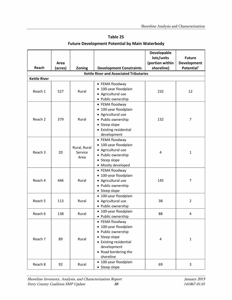
Shoreline Analysis and Characterization
Shoreline Inventory, Analysis, and Characterization Report January 2015 Ferry County Coalition SMP Update 88 141067-01.01
Table 25 Future Development Potential by Main Waterbody
Reach Area
(acres) Zoning Development Constraints
Developable lots/units
(portion within shoreline)
Future Development
Potential1
Kettle River and Associated Tributaries Kettle River
Reach 1 527 Rural
• FEMA floodway • 100-year floodplain • Agricultural use • Public ownership
232 12
Reach 2 379 Rural
• FEMA floodway • 100-year floodplain • Agricultural use • Public ownership • Steep slope • Existing residential
development
132 7
Reach 3 20 Rural, Rural
Service Area
• FEMA floodway • 100-year floodplain • Agricultural use • Public ownership • Steep slope • Mostly developed
4 1
Reach 4 446 Rural
• FEMA floodway • 100-year floodplain • Agricultural use • Public ownership • Steep slope
145 7
Reach 5 113 Rural • 100-year floodplain • Agricultural use • Public ownership
38 2
Reach 6 138 Rural • 100-year floodplain • Public ownership
88 4
Reach 7 89 Rural
• FEMA floodway • 100-year floodplain • Public ownership • Steep slope • Existing residential
development • Road bordering the
shoreline
4 1
Reach 8 92 Rural • 100-year floodplain • Steep slope
69 3
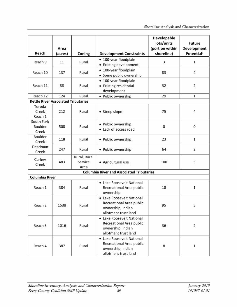
Shoreline Analysis and Characterization
Shoreline Inventory, Analysis, and Characterization Report January 2015 Ferry County Coalition SMP Update 89 141067-01.01
Reach Area
(acres) Zoning Development Constraints
Developable lots/units
(portion within shoreline)
Future Development
Potential1
Reach 9 11 Rural • 100-year floodplain • Existing development
3 1
Reach 10 137 Rural • 100-year floodplain • Some public ownership
83 4
Reach 11 88 Rural • 100-year floodplain • Existing residential
development 32 2
Reach 12 124 Rural • Public ownership 29 1 Kettle River Associated Tributaries
Toroda Creek
Reach 1 212 Rural • Steep slope 75 4
South Fork Boulder Creek
508 Rural • Public ownership • Lack of access road
0 0
Boulder Creek 118 Rural • Public ownership 23 1
Deadman Creek 247 Rural • Public ownership 64 3
Curlew Creek 483
Rural, Rural Service
Area • Agricultural use 100 5
Columbia River and Associated Tributaries Columbia River
Reach 1 384 Rural • Lake Roosevelt National
Recreational Area public ownership
18 1
Reach 2 1538 Rural
• Lake Roosevelt National Recreational Area public ownership; Indian allotment trust land
95 5
Reach 3 1016 Rural
• Lake Roosevelt National Recreational Area public ownership; Indian allotment trust land
36 2
Reach 4 387 Rural
• Lake Roosevelt National Recreational Area public ownership; Indian allotment trust land
8 1
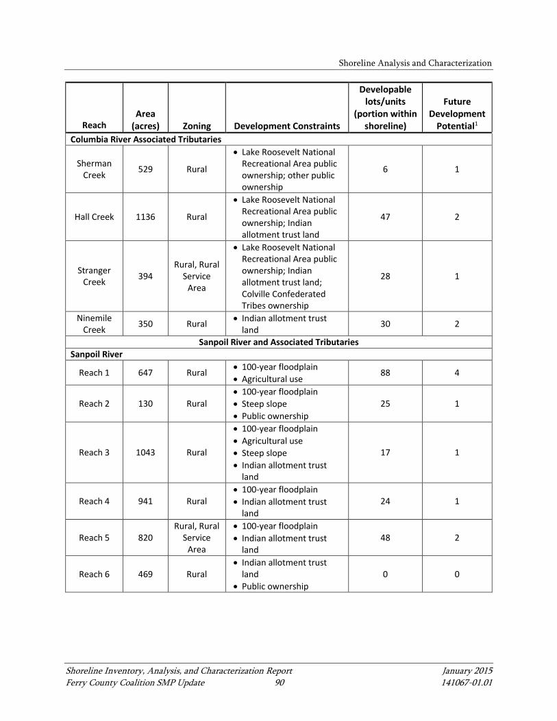
Shoreline Analysis and Characterization
Shoreline Inventory, Analysis, and Characterization Report January 2015 Ferry County Coalition SMP Update 90 141067-01.01
Reach Area
(acres) Zoning Development Constraints
Developable lots/units
(portion within shoreline)
Future Development
Potential1
Columbia River Associated Tributaries
Sherman Creek 529 Rural
• Lake Roosevelt National Recreational Area public ownership; other public ownership
6 1
Hall Creek 1136 Rural
• Lake Roosevelt National Recreational Area public ownership; Indian allotment trust land
47 2
Stranger Creek 394
Rural, Rural Service
Area
• Lake Roosevelt National Recreational Area public ownership; Indian allotment trust land; Colville Confederated Tribes ownership
28 1
Ninemile Creek 350 Rural • Indian allotment trust
land 30 2
Sanpoil River and Associated Tributaries Sanpoil River
Reach 1 647 Rural • 100-year floodplain • Agricultural use
88 4
Reach 2 130 Rural • 100-year floodplain • Steep slope • Public ownership
25 1
Reach 3 1043 Rural
• 100-year floodplain • Agricultural use • Steep slope • Indian allotment trust
land
17 1
Reach 4 941 Rural • 100-year floodplain • Indian allotment trust
land 24 1
Reach 5 820 Rural, Rural
Service Area
• 100-year floodplain • Indian allotment trust
land 48 2
Reach 6 469 Rural • Indian allotment trust
land • Public ownership
0 0
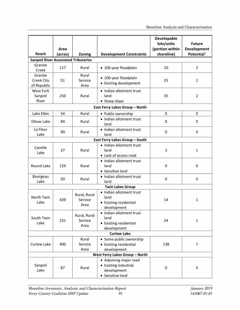
Shoreline Analysis and Characterization
Shoreline Inventory, Analysis, and Characterization Report January 2015 Ferry County Coalition SMP Update 91 141067-01.01
Reach Area
(acres) Zoning Development Constraints
Developable lots/units
(portion within shoreline)
Future Development
Potential1
Sanpoil River Associated Tributaries Granite Creek 117 Rural • 100-year floodplain 10 2
Granite Creek City of Republic
51 Rural
Service Area
• 100-year floodplain • Existing development
25 1
West Fork Sanpoil
River 250 Rural
• Indian allotment trust land
• Steep slope 35 2
East Ferry Lakes Group – North Lake Ellen 54 Rural • Public ownership 0 0
Elbow Lake 84 Rural • Indian allotment trust land
0 0
La Fleur Lake 90 Rural • Indian allotment trust
land 0 0
East Ferry Lakes Group – South
Camille Lake 27 Rural
• Indian allotment trust land
• Lack of access road 3 1
Round Lake 129 Rural • Indian allotment trust
land • Sensitive land
0 0
Bourgeau Lake 50 Rural • Indian allotment trust
land 0 0
Twin Lakes Group
North Twin Lake 439
Rural, Rural Service
Area
• Indian allotment trust land
• Existing residential development
14 1
South Twin Lake 231
Rural, Rural Service
Area
• Indian allotment trust land
• Existing residential development
24 1
Curlew Lake
Curlew Lake 400 Rural
Service Area
• Some public ownership • Existing residential
development 138 7
West Ferry Lakes Group – North
Sanpoil Lake 87 Rural
• Adjoining major road • Existing industrial
development • Sensitive land
0 0
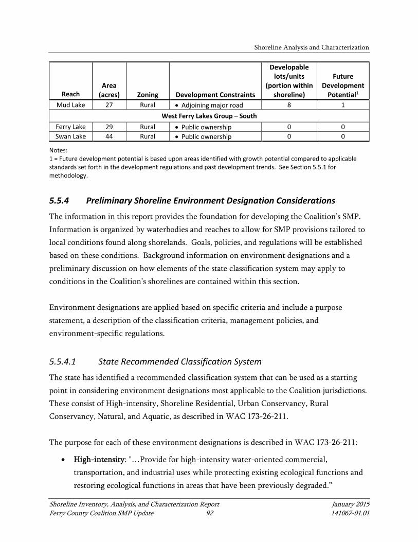
Shoreline Analysis and Characterization
Shoreline Inventory, Analysis, and Characterization Report January 2015 Ferry County Coalition SMP Update 92 141067-01.01
Reach Area
(acres) Zoning Development Constraints
Developable lots/units
(portion within shoreline)
Future Development
Potential1
Mud Lake 27 Rural • Adjoining major road 8 1 West Ferry Lakes Group – South
Ferry Lake 29 Rural • Public ownership 0 0 Swan Lake 44 Rural • Public ownership 0 0
Notes: 1 = Future development potential is based upon areas identified with growth potential compared to applicable standards set forth in the development regulations and past development trends. See Section 5.5.1 for methodology.
5.5.4 Preliminary Shoreline Environment Designation Considerations
The information in this report provides the foundation for developing the Coalition’s SMP. Information is organized by waterbodies and reaches to allow for SMP provisions tailored to local conditions found along shorelands. Goals, policies, and regulations will be established based on these conditions. Background information on environment designations and a preliminary discussion on how elements of the state classification system may apply to conditions in the Coalition’s shorelines are contained within this section. Environment designations are applied based on specific criteria and include a purpose statement, a description of the classification criteria, management policies, and environment-specific regulations.
5.5.4.1 State Recommended Classification System
The state has identified a recommended classification system that can be used as a starting point in considering environment designations most applicable to the Coalition jurisdictions. These consist of High-intensity, Shoreline Residential, Urban Conservancy, Rural Conservancy, Natural, and Aquatic, as described in WAC 173-26-211. The purpose for each of these environment designations is described in WAC 173-26-211:
• High-intensity: "…Provide for high-intensity water-oriented commercial, transportation, and industrial uses while protecting existing ecological functions and restoring ecological functions in areas that have been previously degraded.”
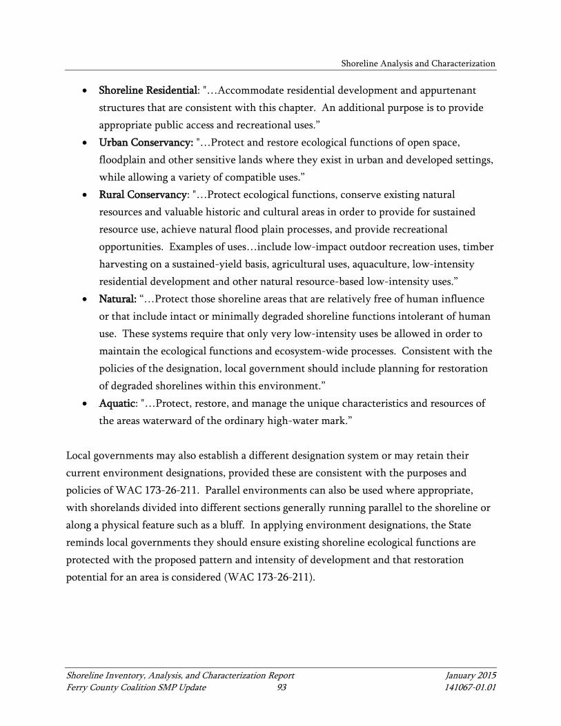
Shoreline Analysis and Characterization
Shoreline Inventory, Analysis, and Characterization Report January 2015 Ferry County Coalition SMP Update 93 141067-01.01
• Shoreline Residential: "…Accommodate residential development and appurtenant structures that are consistent with this chapter. An additional purpose is to provide appropriate public access and recreational uses.”
• Urban Conservancy: "…Protect and restore ecological functions of open space, floodplain and other sensitive lands where they exist in urban and developed settings, while allowing a variety of compatible uses.”
• Rural Conservancy: "…Protect ecological functions, conserve existing natural resources and valuable historic and cultural areas in order to provide for sustained resource use, achieve natural flood plain processes, and provide recreational opportunities. Examples of uses…include low-impact outdoor recreation uses, timber harvesting on a sustained-yield basis, agricultural uses, aquaculture, low-intensity residential development and other natural resource-based low-intensity uses.”
• Natural: “…Protect those shoreline areas that are relatively free of human influence or that include intact or minimally degraded shoreline functions intolerant of human use. These systems require that only very low-intensity uses be allowed in order to maintain the ecological functions and ecosystem-wide processes. Consistent with the policies of the designation, local government should include planning for restoration of degraded shorelines within this environment.”
• Aquatic: "…Protect, restore, and manage the unique characteristics and resources of the areas waterward of the ordinary high-water mark.”
Local governments may also establish a different designation system or may retain their current environment designations, provided these are consistent with the purposes and policies of WAC 173-26-211. Parallel environments can also be used where appropriate, with shorelands divided into different sections generally running parallel to the shoreline or along a physical feature such as a bluff. In applying environment designations, the State reminds local governments they should ensure existing shoreline ecological functions are protected with the proposed pattern and intensity of development and that restoration potential for an area is considered (WAC 173-26-211).

Shoreline Analysis and Characterization
Shoreline Inventory, Analysis, and Characterization Report January 2015 Ferry County Coalition SMP Update 94 141067-01.01
5.5.4.2 Preliminary Considerations
Developing and applying environment designations in each jurisdiction will come in later steps in the SMP update process. In preparation for this, an initial description of shoreland areas with high-intensity, residential, conservancy, and natural characteristics are described in Tables 26 and 27. This initial description will provide a starting point for drafting environment designations, which will be applied at the reach level in the future. The listing of these areas under the high-intensity or other categories does not mean they will be designated as such during the SMP update process. Developing and applying environment designations for Ferry County and the City of Republic will occur with more detailed analysis of the information in this report and input from the Planning Commissions, Councils, and Ecology, as well as input from the public during the shoreline visioning process and other public forums.

Shoreline Analysis and Characterization
Shoreline Inventory, Analysis, and Characterization Report January 2015 Ferry County Coalition SMP Update 95 141067-01.01
Table 26 Preliminary Environment Designation Consideration – Rivers
Shoreland Characteristics
Applicable Geographic Areas
Kettle River and Associated Tributaries Columbia River and Associated
Tributaries Sanpoil River and Associated
Tributaries
Shoreline Residential • Kettle River Reach 3 (Curlew) • Kettle River Reach 9 (Orient)
• Columbia River SR 1c
Urban Conservancy • Granite Creek Republic
Reach
Conservancy
• Kettle River Reaches 1 (Ferry) and 2 • Kettle River Reach 2 • Kettle River Reach 4 • Kettle River Reach 5 (Danville) • Kettle River Reach 6 (Laurier) • Kettle River Reach 7 • Kettle River Reach 8 • Kettle River Reach 10 • Kettle River Reach 11 • Kettle River Reach 12 • Toroda Creek Reach 1 • Boulder Creek • Deadman Creek • Curlew Creek
• Columbia River SR 1a, 1b, and 1d • Columbia River SR 2b and 2d • Columbia River Reaches 3 and 4 • Hall Creek Reach 1 • Stranger Creek • Ninemile Creek
• Sanpoil River Reaches 1 – 6 • Granite Creek Reach 1 • West Fork Sanpoil River
Natural • South Fork Boulder Creek • Columbia River SR 2a and 2c • Sherman Creek
Note: SR = subreach
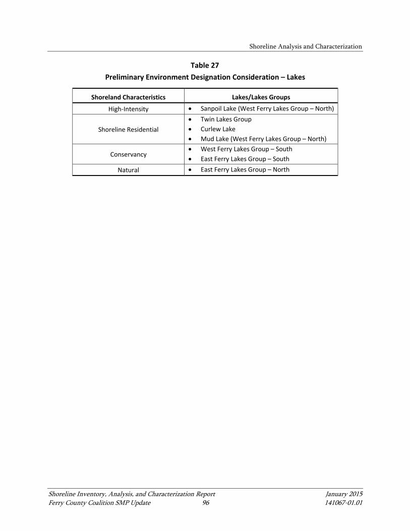
Shoreline Analysis and Characterization
Shoreline Inventory, Analysis, and Characterization Report January 2015 Ferry County Coalition SMP Update 96 141067-01.01
Table 27 Preliminary Environment Designation Consideration – Lakes
Shoreland Characteristics Lakes/Lakes Groups
High-Intensity • Sanpoil Lake (West Ferry Lakes Group – North)
Shoreline Residential • Twin Lakes Group • Curlew Lake • Mud Lake (West Ferry Lakes Group – North)
Conservancy • West Ferry Lakes Group – South • East Ferry Lakes Group – South
Natural • East Ferry Lakes Group – North
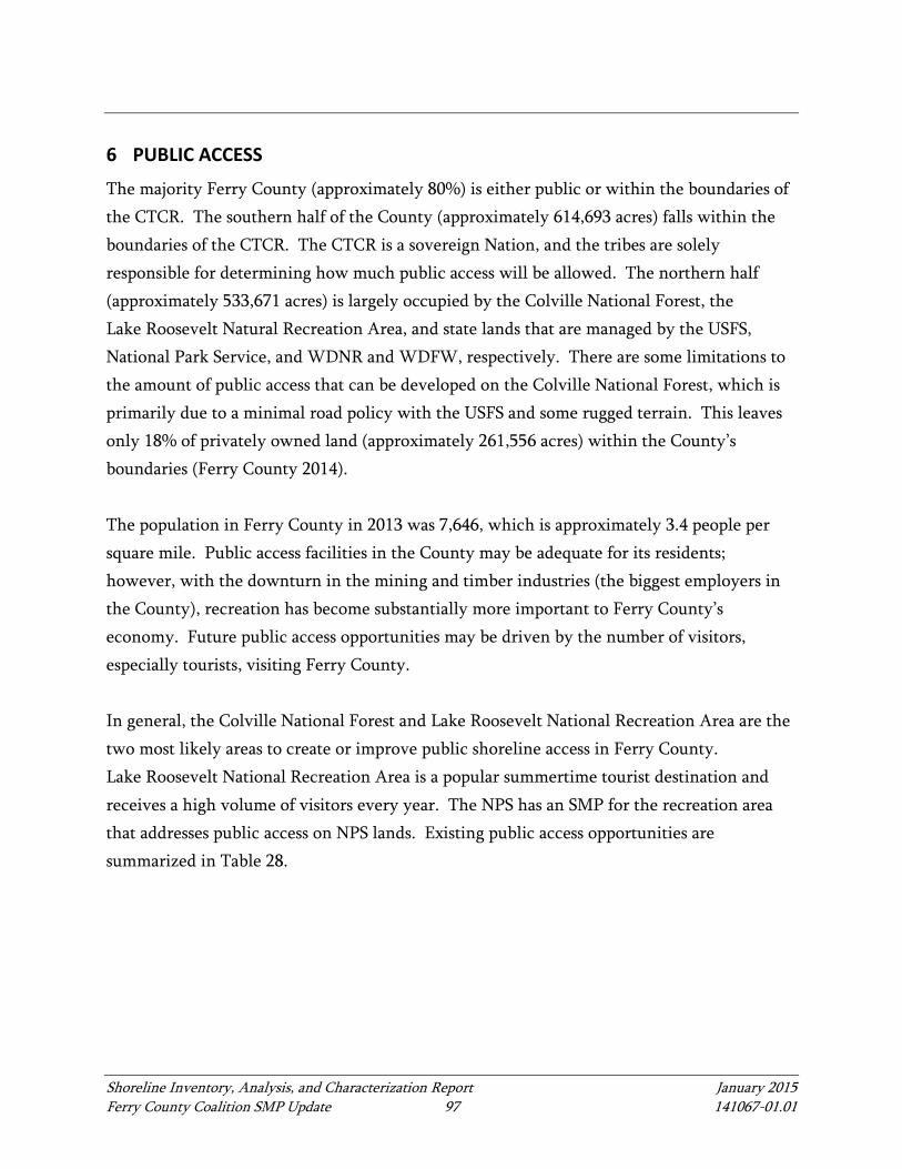
Shoreline Inventory, Analysis, and Characterization Report January 2015 Ferry County Coalition SMP Update 97 141067-01.01
6 PUBLIC ACCESS
The majority Ferry County (approximately 80%) is either public or within the boundaries of the CTCR. The southern half of the County (approximately 614,693 acres) falls within the boundaries of the CTCR. The CTCR is a sovereign Nation, and the tribes are solely responsible for determining how much public access will be allowed. The northern half (approximately 533,671 acres) is largely occupied by the Colville National Forest, the Lake Roosevelt Natural Recreation Area, and state lands that are managed by the USFS, National Park Service, and WDNR and WDFW, respectively. There are some limitations to the amount of public access that can be developed on the Colville National Forest, which is primarily due to a minimal road policy with the USFS and some rugged terrain. This leaves only 18% of privately owned land (approximately 261,556 acres) within the County’s boundaries (Ferry County 2014). The population in Ferry County in 2013 was 7,646, which is approximately 3.4 people per square mile. Public access facilities in the County may be adequate for its residents; however, with the downturn in the mining and timber industries (the biggest employers in the County), recreation has become substantially more important to Ferry County’s economy. Future public access opportunities may be driven by the number of visitors, especially tourists, visiting Ferry County. In general, the Colville National Forest and Lake Roosevelt National Recreation Area are the two most likely areas to create or improve public shoreline access in Ferry County. Lake Roosevelt National Recreation Area is a popular summertime tourist destination and receives a high volume of visitors every year. The NPS has an SMP for the recreation area that addresses public access on NPS lands. Existing public access opportunities are summarized in Table 28.
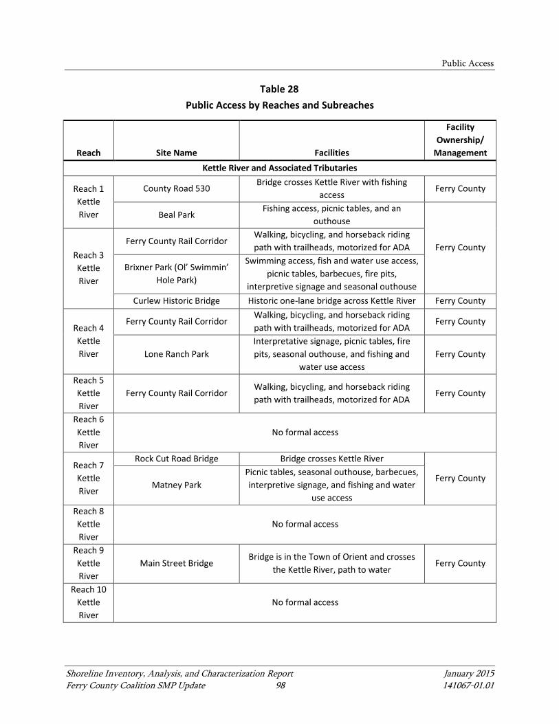
Public Access
Shoreline Inventory, Analysis, and Characterization Report January 2015 Ferry County Coalition SMP Update 98 141067-01.01
Table 28 Public Access by Reaches and Subreaches
Reach Site Name Facilities
Facility Ownership/
Management Kettle River and Associated Tributaries
Reach 1 Kettle River
County Road 530 Bridge crosses Kettle River with fishing
access Ferry County
Beal Park Fishing access, picnic tables, and an
outhouse
Ferry County Reach 3 Kettle River
Ferry County Rail Corridor Walking, bicycling, and horseback riding path with trailheads, motorized for ADA
Brixner Park (Ol’ Swimmin’ Hole Park)
Swimming access, fish and water use access, picnic tables, barbecues, fire pits,
interpretive signage and seasonal outhouse Curlew Historic Bridge Historic one-lane bridge across Kettle River Ferry County
Reach 4 Kettle River
Ferry County Rail Corridor Walking, bicycling, and horseback riding path with trailheads, motorized for ADA
Ferry County
Lone Ranch Park Interpretative signage, picnic tables, fire pits, seasonal outhouse, and fishing and
water use access Ferry County
Reach 5 Kettle River
Ferry County Rail Corridor Walking, bicycling, and horseback riding path with trailheads, motorized for ADA
Ferry County
Reach 6 Kettle River
No formal access
Reach 7 Kettle River
Rock Cut Road Bridge Bridge crosses Kettle River
Ferry County Matney Park
Picnic tables, seasonal outhouse, barbecues, interpretive signage, and fishing and water
use access Reach 8 Kettle River
No formal access
Reach 9 Kettle River
Main Street Bridge Bridge is in the Town of Orient and crosses
the Kettle River, path to water Ferry County
Reach 10 Kettle River
No formal access

Public Access
Shoreline Inventory, Analysis, and Characterization Report January 2015 Ferry County Coalition SMP Update 99 141067-01.01
Reach Site Name Facilities
Facility Ownership/
Management Reach 11
Kettle River
No formal access
Reach 12 Kettle River
Kettle Falls Campground Fee-use, improved campground, restrooms,
boat dock, fire pits, and picnic tables NPS
Barstow Bridge Bridge crosses the Kettle River Ferry County
Napoleon Bridge Bridge crosses the Kettle River Toroda Creek
No formal access
South Fork
Boulder Creek
No formal access
Boulder Creek
No formal access
Deadman Creek
No formal access
Curlew Creek
Ferry County Rails Trail Walking, bicycling, and horseback riding
path Ferry County
Columbia River and Associated Tributaries
Reach 1 Columbia
River
Boat Access Informal boat access along sandy shores
below OHWM
NPS Floating Restroom Restroom and pump-out station for boaters
Haag Cove Campground Fee-area, improved campground, and picnic
area French Rocks Boat Launch Fee-area and improved boat launch
Sherman Creek Wildlife Area Trails, restrooms, and parking WDFW
Reach 2 Columbia
River
Boat Access Informal boat access along sandy shores
below OHWM NPS
Barnaby Island Campground Primitive boat-in campground CTCR
Barnaby Creek Campground Primitive campground and outhouse Floating Restroom Restroom and pump-out station for boaters NPS
Inchelium/Gifford Ferry Free ferry service across Columbia River
CTCR
AA Encampment Primitive campground and boat launch
Roger’s Bar Campground Camping, fire pits, picnic tables, outhouse,
garbage
Wilmont Creek Campground Camping, fire pits, picnic tables, outhouse,
and garbage disposal
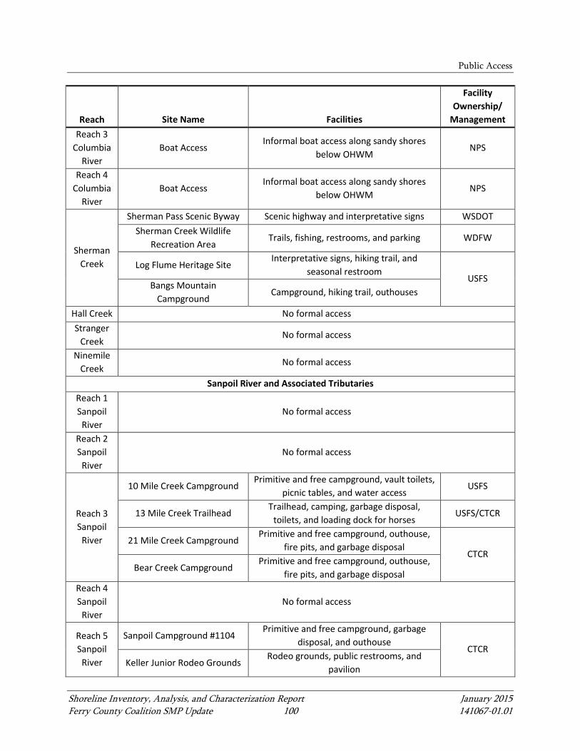
Public Access
Shoreline Inventory, Analysis, and Characterization Report January 2015 Ferry County Coalition SMP Update 100 141067-01.01
Reach Site Name Facilities
Facility Ownership/
Management Reach 3
Columbia River
Boat Access Informal boat access along sandy shores
below OHWM NPS
Reach 4 Columbia
River Boat Access
Informal boat access along sandy shores below OHWM
NPS
Sherman Creek
Sherman Pass Scenic Byway Scenic highway and interpretative signs WSDOT Sherman Creek Wildlife
Recreation Area Trails, fishing, restrooms, and parking WDFW
Log Flume Heritage Site Interpretative signs, hiking trail, and
seasonal restroom USFS
Bangs Mountain Campground
Campground, hiking trail, outhouses
Hall Creek No formal access Stranger
Creek No formal access
Ninemile Creek
No formal access
Sanpoil River and Associated Tributaries Reach 1 Sanpoil
River No formal access
Reach 2 Sanpoil
River No formal access
Reach 3 Sanpoil
River
10 Mile Creek Campground Primitive and free campground, vault toilets,
picnic tables, and water access USFS
13 Mile Creek Trailhead Trailhead, camping, garbage disposal,
toilets, and loading dock for horses USFS/CTCR
21 Mile Creek Campground Primitive and free campground, outhouse,
fire pits, and garbage disposal CTCR
Bear Creek Campground Primitive and free campground, outhouse,
fire pits, and garbage disposal Reach 4 Sanpoil
River No formal access
Reach 5 Sanpoil
River
Sanpoil Campground #1104 Primitive and free campground, garbage
disposal, and outhouse CTCR
Keller Junior Rodeo Grounds Rodeo grounds, public restrooms, and
pavilion

Public Access
Shoreline Inventory, Analysis, and Characterization Report January 2015 Ferry County Coalition SMP Update 101 141067-01.01
Reach Site Name Facilities
Facility Ownership/
Management
Reach 6 Sanpoil
River
Sanpoil Campground Fee-use improved campground, boat dock,
swimming area, and restrooms
Ferry Crossing Outhouse Pull-off and outhouse at Keller Ferry
Crossing Keller Ferry Free ferry across Columbia River WSDOT
Granite Creek
Perry Wilderness Park Trails, bridge access across Granite Creek City of Republic
West Fork Sanpoil
River No formal access
East Ferry Lakes Group – North
Lake Ellen Lake Ellen Campground
Boat ramp, dock, picnic tables, toilets, fire pits, camping, and fee area
USFS Lake Ellen Campground West
Boat ramp, dock, picnic tables, toilets, fire pits, camping, and fee area
Elbow Lake
Fishing Access No formal facilities, open to fishing CTCR
La Fleur Lake
Fishing dock Fishing access
East Ferry Lakes Group – South Camille
Lake No formal access
Round Lake
Fishing Access Fishing dock and informal fishing access CTCR
Bourgeau Lake
Fishing Access No formal facilities, open to fishing
Twin Lakes Group
North Twin Lake
Carson Beach Campground Tribal members only campground CTCR
Rocky Point Campground Primitive and free campground, outhouses, garbage disposal, boat dock, and fire rings
CTCR
Rainbow Beach Resort Full-service resort, boat dock, boat launch,
cabins, swimming, fishing, RV access, private, open to the public
CTCR South
Twin Lake Rainbow Beach Resort
Full-service resort, boat dock, boat launch, cabins, swimming, fishing, RV access,
private, open to the public
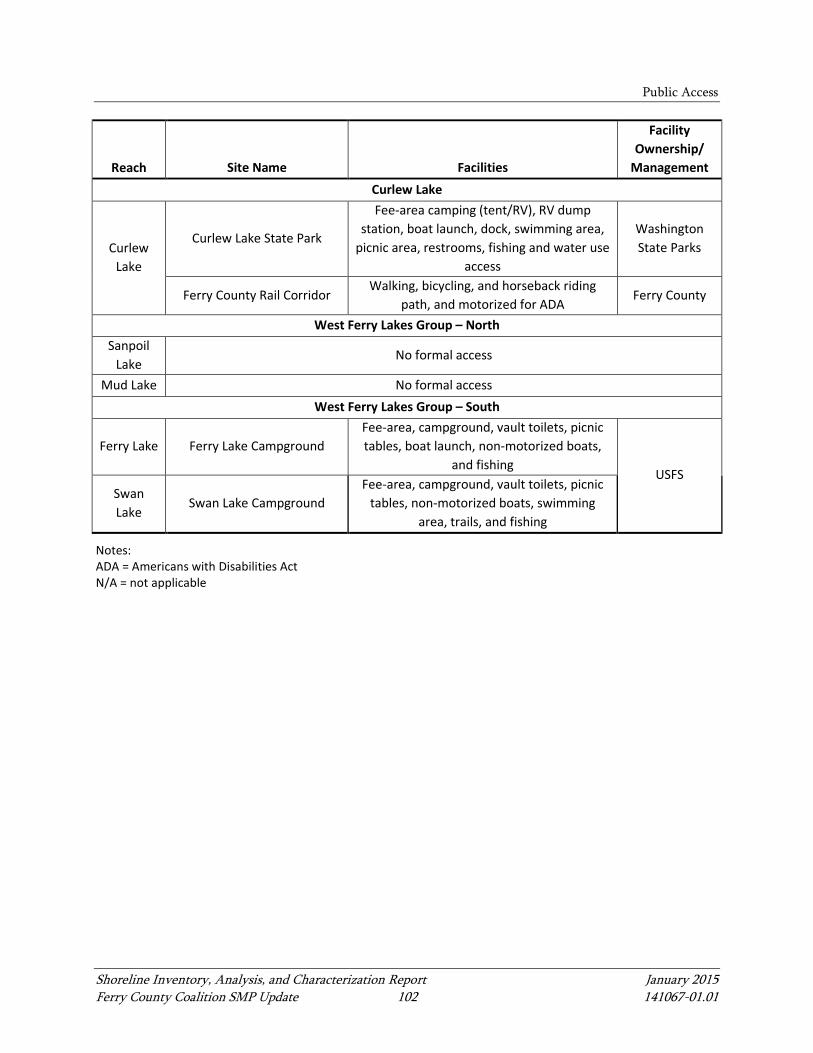
Public Access
Shoreline Inventory, Analysis, and Characterization Report January 2015 Ferry County Coalition SMP Update 102 141067-01.01
Reach Site Name Facilities
Facility Ownership/
Management Curlew Lake
Curlew Lake
Curlew Lake State Park
Fee-area camping (tent/RV), RV dump station, boat launch, dock, swimming area,
picnic area, restrooms, fishing and water use access
Washington State Parks
Ferry County Rail Corridor Walking, bicycling, and horseback riding
path, and motorized for ADA Ferry County
West Ferry Lakes Group – North Sanpoil
Lake No formal access
Mud Lake No formal access West Ferry Lakes Group – South
Ferry Lake Ferry Lake Campground Fee-area, campground, vault toilets, picnic tables, boat launch, non-motorized boats,
and fishing USFS
Swan Lake
Swan Lake Campground Fee-area, campground, vault toilets, picnic
tables, non-motorized boats, swimming area, trails, and fishing
Notes: ADA = Americans with Disabilities Act N/A = not applicable
Shoreline Inventory, Analysis, and Characterization Report January 2015 Ferry County Coalition SMP Update 103 141067-01.01
7 INFORMATION SOURCES, ASSUMPTIONS, AND LIMITATIONS
This report is based on the best information available to the Coalition at the time it was produced. This information was obtained from a variety of sources and was collected and prepared for a variety of purposes throughout a long time period; however, a substantial effort was made to use the most accurate and current information available. Existing data, reports, and information used for the shoreline inventory are provided in the reference section. Generally, the documents used include the Coalition’s comprehensive plans and municipal codes, USFWS, subbasin and habitat conservation plans, historical references, and scientific literature on ecological functions. The GIS data illustrated in the map folio include information on hydrology, soils, topography, vegetation, land cover, priority habitat and species concentrations, and other features. This report relied largely on GIS data and remotely sensed imagery. Integrating various GIS layers into map folio projects often resulted in polygon boundary discrepancies. Rectification of these discrepancies was only conducted for layers and geographic locations most relevant to the SMP update. The identified shoreline jurisdiction areas are only an approximation for purposes of updating the SMP for the Coalition. Precise OHWM delineation and associated shoreline jurisdiction boundaries will be determined on a project-by-project basis and based on site-specific analysis during the proposal development application and review process.

References
Shoreline Inventory, Analysis, and Characterization Report January 2015 Ferry County Coalition SMP Update 104 141067-01.01
8 REFERENCES
Anchor QEA (Anchor QEA, LLC), 2013. Final Draft Semi-Arid Riparian Functions and Associated Regulatory Protections to Support Shoreline Master Program Updates. Prepared for Grant County. June 2013.
Anchor QEA, 2014. Ferry County Preliminary Draft Shoreline Determination Memorandum. Prepared for Ferry County and the City of Republic. April 2014.
Arksey, L., 2006. Ferry County – thumbnail history. HistoryLink.org Essay 7787. Cited July 2014. Available from: http://www.historylink.org/index.cfm?DisplayPage=output.cfm&file_id=7787.
Arnold, C.L., and C.J. Gibbons, 1996. Impervious Surface Coverage: The Emergence of a Key Environmental Indicator. American Planners Association Journal 62:243–258.
Beier, P., and S. Loe, 1992. A checklist for evaluating impacts to wildlife movement corridors. Wildlife Society Bulletin 20:434-440.
Bortleson, G.C., S.E. Cox, M.D. Munn, R.J. Schumaker, and E.K. Block, 1992. Sediment-Quality Assessment of Franklin D. Roosevelt Lake and the Upstream Reach of the Columbia River, Washington. Water-Supply Paper 2496. Prepared for the U.S. Environmental Protection Agency. 1992.
Buffler, S., C. Johnson, J. Nicholson, and N. Mesner, 2005. Synthesis of design guidelines and experimental data for water quality function in agricultural landscapes in the Intermountain West. USDA Forest Service/UNL Faculty Publications.
Chatters, J.C., and D.L. Pokotylo, 1998. Prehistory: Introduction. In Handbook of North American Indians, Volume 12, Plateau, edited by D. E. Walker, pp. 73-80. Smithsonian Institution, Washington, D.C.
Choquette, W., 1996. Early post-glacial habitation of the Upper Columbia Region. In Early Human Occupation in British Columbia, edited by R.L. Carlson and L.Dalla Bona, pp. 45-50. UBC Press, Vancouver, British Columbia.
Christensen, D., and B. Moore, 2008. Summer Habitat Use and Prey Selection of Hatchery Rainbow Trout in Twin Lakes, Washington. Prepared for the Department of Fish and Wildlife Colville Confederated Tribes. Nespelem, Washington. January 2008.

References
Shoreline Inventory, Analysis, and Characterization Report January 2015 Ferry County Coalition SMP Update 105 141067-01.01
Creveling, J., and B. Renfrow, 1986. Wildlife Protection, Mitigation, and Enhancement Planning for Grand Coulee Dam. Final Report, Project No. 86-74. Washington Department of Game, Olympia, Washington.
CTCR (Confederated Tribes of the Colville Reservation), 2014. History of the Colvilles. Cited: July 2014. Available from: http://www.colvilletribes.com/history_of_the_colvilles.php.
DOH (Washington State Department of Health), 2010. Health Consultation: Lake Roosevelt Beaches Sediment Non-Tribal Exposure. Northeast Washington. EPA Facility ID WA0000530279. March 2010.
DOH, 2014. Fish Consumption Advisories on the Columbia River. Accessed July 22, 2014. Available from: http://www.doh.wa.gov/CommunityandEnvironment/Food/Fish/Advisories.aspx#UpperColumbiaRiver.
Dunne T., and L. Leopold, 1978. Water in Environmental Planning. New York, New York: W.H. Freeman and Company.
Ecology (Washington State Department of Ecology), 1976. Reconnaissance Data on Lakes in Washington Volume 5 – Chelan, Ferry, Kittitas, Klickitat, Okanogan, and Yakima Counties. Prepared in cooperation with U.S. Geological Survey.
Ecology, 1990. Lake Water Quality Assessment Project. Publication 92-124. January 1993.
Ecology, 1995. Initial Watershed Assessment Water Resource Inventory Area 60 – Kettle River Watershed. Open-File Technical Report 95-16. May 1995.
Ecology, 1997. Washington State Wetlands Identification and Delineation Manual. Publication #96-94. March 1997. Available from: https://fortress.wa.gov/ecy/publications/publications/9694.pdf.
Ecology, 2000. Focus: Washington State and U.S. Forest Service’s Forest Management Agreement. Focus Number 00-10-048. Updated: November 2000. Available from: https://fortress.wa.gov/ecy/publications/publications/0010048.pdf.
Ecology, 2007. Washington State Wetland Rating System for Eastern Washington. Publication #04-06-015. Published August 2004. Revised March 2007.
References
Shoreline Inventory, Analysis, and Characterization Report January 2015 Ferry County Coalition SMP Update 106 141067-01.01
Fairbank, D., 2005. Colville Confederated Tribes Fish and Wildlife Department Resident Fish Division: Colville Tribal Fish Hatchery Annual Report for 2005. Prepared for U.S. Department of Energy, Bonneville Power Administration, Division of Fish and Wildlife. Portland, Oregon. December 2005.
Ferry County, 2006. Ferry County, Washington Community Wildfire Protection Plan Volume II. Prepared by the Ferry County Community Wildfire Protection Plan Core Team in cooperation with Northwest Management, Inc. December 2006.
Ferry County, 2012. Curlew Lake Subarea Plan, Ferry County, Washington. Adopted by Ordinance #2012-04. September 2012.
Ferry County, 2014. Curlew Lake. Cited: July 25, 2014. Available from: http://www.ferrycounty.com/activities/fishing/curlew-lake/.
GEI (GEI Consultants, Inc.), 2004. Intermountain Province Subbasin Plan. Prepared for the Northwest Power and Conservation Council. Spokane, Washington. May 2004.
GotMyFishOn, 2014. Elbow Lake. Cited: December 31, 2014. Available from: http://www.gotmyfishon.com/washington-lakes/ferry/elbow-lake-a-k-a-ghost-lake
Hayes, D., 1999. Historical Atlas of the Pacific Northwest: Maps of Exploration and Discovery: British Columbia, Washington, Oregon, Alaska, Yukon. Seattle, Washington: Sasquatch Books.
Herbeck, T.E., 1973. Kettle Falls District. National Register of Historic Places nomination form. On file at the Department of Archaeology and Historic Preservation, Olympia, Washington.
Karr, J.R., 1995. Clean water is not enough. Illahee 11: 51-59.
Kennedy, D., and R.T. Bouchard, 1998. Northern Okanagan, Lakes, and Colville. In Handbook of North American Indians, Volume 12, Plateau, edited by D. E. Walker, pp. 238-252. Smithsonian Institution, Washington, D.C.
Kershner, J., 2009. Republic – thumbnail history. HistoryLink.org Essay 9050. Cited: July 2014. Available from: http://www.historylink.org/index.cfm?DisplayPage=output. cfm&file_id=9050.
References
Shoreline Inventory, Analysis, and Characterization Report January 2015 Ferry County Coalition SMP Update 107 141067-01.01
Kresch, D.L., 1998. Determination of Upstream Boundary Points on Northeastern Washington Streams and Rivers Under the Requirements of the Shoreline Management Act of 1971. U.S. Geological Survey Water-Resources Investigation Report 98-4160. Tacoma, Washington.
Kovalchik, B.L., and R.R. Clausnitzer, 2004. Classification and management of aquatic, riparian, and wetland sites on the national forests of eastern Washington: Series Description. General Technical Report PNW-GTR-593. Portland, Oregon: U.S. Department of Agriculture, Forest Service, Pacific Northwest Research Station. September 2004.
Lincoln County, 2010. WRIA 53 (Lower Lake Roosevelt Watershed) Groundwater Inventory and Mapping Project. Publication No. 10-10-019. Prepared for WRIA 53 Planning Unit. June 2010.
Melillo, J.M., T.C. Richmond, and G.W. Yohe, Eds., 2014. Climate Change Impacts in the United States: The Third National Climate Assessment. U.S. Global Change Research Program, 841 pp. doi:10.7930/J0Z31WJ2. Available from: http://nca2014.globalchange.gov/.
Miller, J., 1998. Middle Columbia River Salishans. In Handbook of North American Indians, Volume 12, Plateau, edited by D. E. Walker, pp. 253-270. Washington, D.C.: Smithsonian Institution.
Morris, G.A., P. Larson, and P. Hooper, 2000. ‘Subduction Style’ Megmatism in a Non-subduction Setting: The Colville Igneous Complex, NE Washington State, USA. Journal of Petrology 41(1):45-67.
Morrison, M., B. Marcot, and R. Mannan, 1992. Wildlife-habitat relationships: Concepts and applications. Madison, Wisconsin: The University of Wisconsin Press.
Moulton, C., R. Brady, and J. Beltoff, 2006. Association between wildlife and agriculture: underlying mechanisms and implications in burrowing owls. Journal of Wildlife Management 70:708–716.
Muessig, S., 1967. Geology of the Republic Quadrangle and a part of the Aeneas Quadrangle Ferry County, Washington. Geological Survey Bulletin 1216

References
Shoreline Inventory, Analysis, and Characterization Report January 2015 Ferry County Coalition SMP Update 108 141067-01.01
Naiman, R., H. Decamps, and M. McClain, 2005. Riparia: Ecology, Conservation, and Management of Streamside Communities. Burlington, Vermont: Elsevier Press.
NOAA (National Oceanic and Atmospheric Administration), 2014a. U.S. Climate Data and Maps. Cited: July 17, 2014. Available from: http://www.cpc.ncep.noaa.gov/products/analysis_monitoring/regional_monitoring/CLIM_DIVS/washington.gif.
NOAA, 2014b. Location of U.S. Climate Divisions. Cited: July 17, 2014. Available from: http://www.esrl.noaa.gov/psd/data/usclimdivs/data/map.html#Washington.
NPS (National Park Service), 2014. Environmental Factors of Lake Roosevelt NRA. Accessed July 23, 2014. Available from: http://www.nps.gov/laro/naturescience/environmentalfactors.htm.
NWPPC (Northwest Power Planning Council), 2000. Draft San Poil River Subbasin Summary. November 15, 2000.
NWPPC, 2006. FY 2006 Project and Budget Review. Available from: https://www.nwcouncil.org/fw/reviews/2006/.
Perry, M., 2008. The History of Ferry County. Cited July 2014. Available from: http://www.ferrycountyhs.org/historyfc.html.
Poff, N., J. Allan, M. Bain, J. Karr, K. Prestegaard, B. Richter, R. Sparks, and J. Stromberg, 1997. The Natural Flow Regime: A Paradigm for River Conservation and Restoration. BioScience 47: 769–784.
Pokotylo, D.L., and D. Mitchell, 1998. Prehistory of the Northern Plateau. In Handbook of North American Indians, Volume 12, Plateau, edited by D. E. Walker, pp. 81-102. Washington, D.C.: Smithsonian Institution.
Pouley, J., 2009. National Register Nomination Form, Kettle River Archaeological District, Ferry and Stevens Counties, Washington. On file at the Department of Archaeology and Historic Preservation, Olympia, Washington.
Prichard, D., 1998. A User Guide to Assessing Proper Functioning Condition and the Supporting Science for Lotic Areas. TR 1737-15.

References
Shoreline Inventory, Analysis, and Characterization Report January 2015 Ferry County Coalition SMP Update 109 141067-01.01
Rapp, C., and T. Abbe, 2003. A Framework for Delineating Channel Migration Zones. Final Draft Publication #03-06-027. Washington State Department of Ecology. Olympia, Washington. November 2003.
RCW (Revised Code of Washington) 90.58, Shoreline Management Act of 1971.
Ruby, R., and J. Brown, 1986. A Guide to the Indian Tribes of the Pacific Northwest: Revised Edition. Norman, Oklahoma: University of Oklahoma Press.
Select Flies, 2014. Fly Fishing Tips, Region I NE – Ferry County. Cited: Accessed: July 27, 2014. Available from: http://selectflies.com/wp/selec-flies-for-select-waters-washington-state/region-i/.
Sherer, B.M., J.R. Miner, J.A. Moore, and J.C. Buckhouse, 1992. Indicator bacterial survival in stream sediments. J. Env. Quality 21:591-595.
SRSRB (Snake River Salmon Recovery Board), 2011. Snake River Salmon Recovery Plan for SE Washington Technical Document. Prepared for the Washington Governor’s Salmon Recovery Office, 2011 Version. Available from: http://snakeriverboard.org/wpi/wp-content/uploads/2013/01/Full-Version-SE-WA-recovery-plan-121211.pdf.
Stanley, S., J. Brown, and S. Grigsby, 2005. Protecting aquatic ecosystems: A guide for Puget Sound Planners to understand watershed processes. Washington State Department of Ecology. Publication #05-06-027. Olympia, Washington. Available from: http://www.ecy.wa.gov/b8iblio/0506027.html.
Stinson, D., and M. Schroeder, 2012. Washington State Recovery Plan for the Columbian Sharptailed Grouse. Prepared for the Washington State Department of Fish and Wildlife, Olympia, Washington. 2012.
Tilzer, M., C. Goldman, and E. Amezaga, 1975. The Efficiency of Photosynthetic Light Energy Utilization by Lake Phytoplankton. Verhandlungen Internationale Vereinigung Limnologie 19:800-807.
USDA (U.S. Department of Agriculture), Farm Service Agency, 2013. National Agriculture Imagery Program (NAIP): 2013 data [Ferry County, WA dataset]. Cited: April 15, 2014. Available from: http://datagateway.nrcs.usda.gov/GDGOrder.aspx.

References
Shoreline Inventory, Analysis, and Characterization Report January 2015 Ferry County Coalition SMP Update 110 141067-01.01
USGS (U.S. Geological Survey), 2004. Presentation to Lake Roosevelt Water quality Council. May 2004. Available from: http://wa.water.usgs.gov/projects/roosevelt/data/ppt77_LRWQC_ajp.pdf.
USGS, 2010. USGS Activities at Lake Roosevelt and the Upper Columbia River. Fact Sheet 2010-3056. August 2010.
USGS, 2014a. USGS Water-resources National Water Information System Streamflow Sites Table. Available from: http://waterdata.usgs.gov/wa/nwis/current/?type=flow&group_key=basin_cd.
USGS, 2014b. Water-resources data for the United States, Water Year 2013: U.S. Geological Survey Water-Data Report WDR-US-2013, site 12401500. Available from: http://waterdata.usgs.gov/nwis/inventory?agency_code=USGS&site_no=12401500.
USGS, 2014c. Water-resources data for the United States, Water Year 2013: U.S. Geological Survey Water-Data Report WDR-US-2013, site 12404500. Available from: http://waterdata.usgs.gov/nwis/inventory?agency_code=USGS&site_no=12404500.
USGS, 2014d. Water-resources data for the United States, Water Year 2013: U.S. Geological Survey Water-Data Report WDR-US-2013, site 12434590. Available from: http://waterdata.usgs.gov/nwis/inventory?agency_code=USGS&site_no=12434590.
USGS, 2014e. Water-resources data for the United States, Water Year 2013: U.S. Geological Survey Water-Data Report WDR-US-2013, site 13344500. Available from: http://wdr.water.usgs.gov/wy2013/pdfs/13344500.2013.pdf.
UW (University of Washington), 2000. The Pacific Decadal Oscillation (PDO) data. Prepared by the UW Joint Institute for the Study of the Atmosphere and Ocean. Site last updated January 2000. Available from: http://jisao.washington.edu/pdo/.
WAC (Washington Administrative Code), 2012. Available from: http://apps.leg.wa.gov/wac/.
Walker, D.E., and R. Sprague, 1998. History until 1846. In Handbook of North American Indians, Volume 12, Plateau, edited by D. E. Walker, pp. 138-148. Smithsonian Institution, Washington, D.C.
References
Shoreline Inventory, Analysis, and Characterization Report January 2015 Ferry County Coalition SMP Update 111 141067-01.01
WDFW (Washington Department of Fish and Wildlife), 1999. Priority Habitat Species List. Cited December 31, 2014. Available from: http://wdfw.wa.gov/publications/00165/phs_list_1999.pdf
WDFW 2013. Threatened and Endangered Wildlife in Washington: 2012 Annual Report. 2013.
WDFW, 2014a. Personal communication with Sandy Dotts, WDFW, via comments on the IAC report, phone calls, and e-mail communications.
WDFW, 2014b WDFW Priority Habitat and Species on the Web. Cited: July 25, 2014. Available from: http://apps.wdfw.wa.gov/phsontheweb/.
WDFW, 2014c. WDFW Fishing & Shellfishing: Curlew Lake. Cited: July 25, 2014. Available from: http://wdfw.wa.gov/fishing/washington/221/.
WDFW, 2014d. WDFW Fishing & Shellfishing: Ferry Lake. Cited: July 22, 2014. Available from: http://wdfw.wa.gov/fishing/washington/447/.
WDFW, 2014e. WDFW Fishing & Shellfishing: Swan Lake. Cited: July 22, 2014. Available from: http://wdfw.wa.gov/fishing/washington/463/.
WDFW, 2014f. WDFW Fishing & Shellfishing: Lake Ellen. Cited: July 22, 2014. Available from: http://wdfw.wa.gov/fishing/washington/411/.
WDNR (Washington State Department of Natural Resources), 2014. Washington Natural Heritage Information System: List of Known Occurrences of Rare Plants in Washington – Ferry County, September 2014. Available from: http://www1.dnr.wa.gov/nhp/refdesk/lists/plantsxco/ferry.html
Welch, E., and T. Lindell, 2000. Ecological Effects of Wastewater: Applied Limnology and Pollutant Effects, Second Edition. New Fetter Lane, London: E& FN Spon.
Whipple, I., 2014. Personal communication with Irene Whipple, Planning Director, Ferry County, WA. July 30, 2014.
WRCC (Western Regional Climate Center), 2014. Climate of Washington: Northeastern Region. Cited: July 17, 2014. Available from: http://www.wrcc.dri.edu/narratives/washington/.
References
Shoreline Inventory, Analysis, and Characterization Report January 2015 Ferry County Coalition SMP Update 112 141067-01.01
WSDOT (Washington State Department of Transportation), 2007. Programmatic Biological Assessment for WSDOT Eastern Washington Regions. March 2007.
WSU (Washington State University), 2014. Lakes of the Colville Reservation. Accessed: July 23, 2014. Available from: http://www.wsu.edu/cctfish/index1.html.
Related Documents