Open-File Report 2011–1261 U.S. Department of the Interior U.S. Geological Survey Shallow Coal Exploration Drill-Hole Data—Alabama, Georgia, Kentucky, Louisiana, Mississippi, Missouri, North Carolina, South Carolina, Tennessee, and Texas

Welcome message from author
This document is posted to help you gain knowledge. Please leave a comment to let me know what you think about it! Share it to your friends and learn new things together.
Transcript

Open-File Report 2011–1261
U.S. Department of the InteriorU.S. Geological Survey
Shallow Coal Exploration Drill-Hole Data—Alabama, Georgia, Kentucky, Louisiana, Mississippi, Missouri, North Carolina, South Carolina, Tennessee, and Texas

Shallow Coal Exploration Drill-Hole Data—Alabama, Georgia, Kentucky, Louisiana, Mississippi, Missouri, North Carolina, South Carolina, Tennessee, and Texas
Edited by Brett J. Valentine and Kristin O. Dennen
Open-File Report 2011–1261
U.S. Department of the InteriorU.S. Geological Survey

U.S. Department of the InteriorKEN SALAZAR, Secretary
U.S. Geological SurveyMarcia K. McNutt, Director
U.S. Geological Survey, Reston, Virginia: 2012
For more information on the USGS—the Federal source for science about the Earth, its natural and living resources, natural hazards, and the environment, visit http://www.usgs.gov or call 1–888–ASK–USGS.
For an overview of USGS information products, including maps, imagery, and publications, visit http://www.usgs.gov/pubprod
To order this and other USGS information products, visit http://store.usgs.gov
Any use of trade, product, or firm names is for descriptive purposes only and does not imply endorsement by the U.S. Government.
Although this report is in the public domain, permission must be secured from the individual copyright owners to reproduce any copyrighted materials contained within this report.
Suggested citation:Valentine, B.J., and Dennen, K.O., eds., 2012, Shallow coal exploration drill-hole data—Alabama, Georgia, Kentucky, Louisiana, Mississippi, Missouri, North Carolina, South Carolina, Tennessee, and Texas: U.S. Geological Survey Open-File Report 2011–1261, 102 p.

iii
Contents
A. Overview of Shallow Coal Exploration Drill-Hole Data— Alabama, Georgia, Kentucky, Louisiana, Mississippi, Missouri, North Carolina, South Carolina, Tennessee, and Texas
B. Shallow Coal Exploration Drill-Hole Data, Alabama
C. Shallow Coal Exploration Drill-Hole Data, Georgia
D. Shallow Coal Exploration Drill-Hole Data, Western Kentucky
E. Shallow Coal Exploration Drill-Hole Data, Northern Louisiana
F. Shallow Coal Exploration Drill-Hole Data, Mississippi
G. Shallow Coal Exploration Drill-Hole Data, Southeastern Missouri
H. Shallow Coal and Kaolinite Exploration Drill-Hole Data, North Carolina and South Carolina
I. Shallow Coal Exploration Drill-Hole Data, Western Tennessee
J. Shallow Coal Exploration Drill-Hole Data, Northeast Texas
K. Shallow Coal Exploration Drill-Hole Data, South and East-Central Texas

Overview of Shallow Coal Exploration Drill-Hole Data—Alabama, Georgia, Kentucky, Louisiana, Mississippi, Missouri, North Carolina, South Carolina, Tennessee, and Texas
By Matthew D. Merrill, Brett J. Valentine, and Kristin O. Dennen
Chapter A ofShallow Coal Exploration Drill-Hole Data—Alabama, Georgia, Kentucky, Louisiana, Mississippi, Missouri, North Carolina, South Carolina, Tennessee, and TexasEdited by Brett J. Valentine and Kristin O. Dennen
Open-File Report 2011–1261–A
U.S. Department of the InteriorU.S. Geological Survey

Suggested citation:Merrill, M.D, Valentine, B.J., and Dennen, K.O., 2012, Overview of shalllow coal exploration drill-hole data—Alabama, Georgia, Kentucky, Louisiana, Mississippi, Missouri, North Carolina, South Carolina, Tennessee, and Texas, in Valentine, B.J., and Dennen, K.O., eds., Shallow coal exploration drill-hole data—Alabama, Georgia, Kentucky, Louisiana, Mississippi, Missouri, North Carolina, South Carolina, Tennessee, and Texas: U.S. Geological Survey Open-File Report 2011–1261, ch. A, 6 p. plus appendix. (Available online.)

iii
Contents
Introduction..................................................................................................................................................A1Methods...........................................................................................................................................................1Data ..................................................................................................................................................................1Conclusions.....................................................................................................................................................1References Cited............................................................................................................................................2Appendix A. The North American Coal Corporation letter describing confidentiality
agreements........................................................................................................................................4
Figures A1. Regional map showing drill-hole locations ...........................................................................A2 A2. Generalized stratigraphic chart showing major and minor coal-bearing
formations in the Mississippi Embayment and Gulf Coast Plain ...........................................3

Overview of Shallow Coal Exploration Drill-Hole Data—Alabama, Georgia, Kentucky, Louisiana, Mississippi, Missouri, North Carolina, South Carolina, Tennessee, and Texas
By Matthew D. Merrill, Brett J. Valentine, and Kristin O. Dennen
Introduction Coal exploration drill-hole data from over 24,000 wells
in 10 States are discussed by State in the chapters of this report, and the data are provided in an accompanying spread-sheet. The drill holes were drilled between 1962 and 1984 by Phillips Coal Company, a division of Phillips Petroleum Company (Phillips). The data were donated to the U.S. Geological Survey (USGS) in 2001 by the North American Coal Corporation, which purchased the Phillips assets as part of a larger dataset. Under the terms of the agreement with North American Coal Corporation, the data were deemed proprietary until February 2011, a period of 10 years after the donation (Appendix). Now that the required period of confi-dentiality has passed, the data have been digitized from tabu-lated data files to create unified and spatially consistent coal exploration drill-hole maps and reports for the States of Ala-bama, Georgia, Kentucky, Louisiana, Mississippi, Missouri, North Carolina, South Carolina, Tennessee, and Texas. The data are made publically available by this report.
Methods
Annotated topographic field and county highway maps from Phillips, generally at 1:62,500 to 1:100,000 scale, were utilized to generate the drill-hole datasets. The drill-hole locations in State coordinate plane projections were digitized from hardcopy maps into a geographic information system using ArcMap™ software from the Environmental Systems Research Institute, Inc. (ESRI). Fiducial marks and county boundaries served as reference points. Maps were scanned and georeferenced; drill-hole locations were digitized and shapefile attribute values were populated with data from the maps. The maps and data were then reprojected into a North American Datum of 1983 geographic coordinate system.
DataThe data provide locally dense drill-hole coverage
(fig. A1) for the Gulf of Mexico coal region, the southern part of the Appalachian coal region, and North and South Carolina. A regional stratigraphic chart with major and minor coal-bearing formations in the Gulf of Mexico coal region is shown in figure A2. Each of the 10 State reports (chapters B–K, this volume) has a map of the State with drill-hole coverage that includes drill holes where coal was found and drill holes where there was no coal. In addition, a list of counties is included in each State report with the number of drill holes for each county, and an appendix in each State report directs the reader to a spreadsheet with tabulated coal thickness data. When available, electric log probe depths and indications of core sampling are also included in the tabulated data. The coal thickness data from the State reports have been uploaded to the USGS National Coal Resources Data System UStratigraphic (USTRAT) database, part of the National Coal Resources Data System (NCRDS) at energy.usgs.gov/Tools/NationalCoalResourcesDataSystem.aspx.
ConclusionsThe data provided in the State reports (chapters B–K)
compliment NCRDS State shallow coal resources data because the data include both coal and “no-coal” drill-hole information, whereas the NCRDS accepts only coal thickness data points. The coal thickness data in the spreadsheet(s) that accompany each report reflect corrections for duplicates, mislabeling, and incorrect locations identified by the computer programs used to upload the data to NCRDS. For the States of North and South Carolina, the reports include “no-kaolinite” drill-hole locations as well as “no-coal” drill-hole locations because kaolinite is an economic resource in these States.

A2 Shallow Coal Exploration Drill-Hole Data—AL, GA, KY, LA, MS, MO, NC, SC, TN, TX
References Cited
Ogg, J.G., Ogg, Gabi, and Gradstein, F.M., 2008, The concise geologic time scale: Cambridge, U.K., Cambridge University Press, 184 p.
Warwick, P.D., SanFilipo, J.R., Crowley, S.S., Thomas, R.E., and Freid, J., comps., and Tully, J.K., digital comp., 1997, Map showing outcrop of the coal-bearing units and land use in the Gulf Coast coal region: U.S. Geological Survey Open-File Report 97–172, 1 sheet, accessed April 20, 2011, at pubs.usgs.gov/of/1997/of97-172/.
Figure A1. Regional map showing drill-hole locations.
0 100 200 MILES
0 100 200 KILOMETERS
EXPLANATION
Areas where drill holes
are located
State boundary
Appalachian Coal
Region
Gulf Coast Coal
Region
TEXAS
FLORIDA
GEORGIA
KANSAS
OKLAHOMA
ARKANSAS
ALABAMA
MISSOURI VIRGINIA
LOUISIANA
KENTUCKY
TENNESSEE
MISSISSIPPI
NORTH CAROLINA
SOUTHCAROLINA
ILLINOISWEST
VIRGINIAINDIANA
GULF OF MEXICO
ATLANTIC OCEAN
80°00'85°00'90°00'95°00'100°00'
35°00'
30°00'
25°00'

Overview A3
Midw
ay
Wilc
ox
Jack
son
Chron
ostra
tigrap
hic
Units
Priab
onian
Ypres
ian
Than
etian
Dania
n
Maas
trichti
an
Intern
ation
alSta
ge
Barto
nian
Lutet
ian
Miss
issipp
iLo
uisian
aNo
rthea
stern
Texa
sEa
st-Ce
ntral
Texa
sRio
Gran
deEm
baym
ent
(South
ern Te
xas)
Grou
p or F
ormati
on by
Geog
raphic
Area
Jack
son
Jack
son
Jack
son
Jack
son
Yazo
o
Mood
ys Br
anch
Cock
field
Cook
Mou
ntain
Kosc
iusko
Zilph
a
Talla
hatta
Merid
an Sa
nd
Wino
na
Hatch
etigb
ee
Bash
i
Nana
falia
Tusc
ahom
a
Clayto
nPo
rters
Cree
k
Nahe
ola
Porte
rs Cr
eek
Kinca
id / C
layton
Wills
Point
Kinca
idKin
caid
Cock
field
Cook
Mou
ntain
Spart
aSa
ndCa
ne Ri
ver
Carri
zo Sa
nd
Sabin
etown
Calve
rt Bluf
f
Simsb
oro
Hoop
er
Yegu
a
Cook
Mtn
/ Ston
e City
Spart
aSa
ndWe
ches
Quee
n City
Rekla
w
Carri
zo Sa
nd
Wilc
ox
Yegu
a Cook
Mtn
Spart
aSa
ndWe
ches
Quee
n City
Rekla
wCa
rrizo
Sand
Lared
o
El Pic
oCla
yBig
ford
Uppe
r Lo
wer
Whit
set
Mann
ingWe
lborn
Cadd
ell
Whit
sett
Mann
ingWe
llborn
Cadd
ellMo
odys
Bran
ch
Mosle
y Hill
Danv
ille La
nding
Yazo
o
Pend
leton
Marth
aville
Hall S
ummi
tLim
e Hill
Conv
erse
Cow
Bayo
uDo
let Hi
llsNa
borto
n
Yegu
a Cook
Mtn
Spart
aSa
ndWe
ches
Quee
n City
Rekla
w
Carri
zo Sa
nd
Esco
ndido
Olmos
Nava
rroNa
varro
Nava
rroKe
mp Cl
ayCo
rsica
na M
arl
Naca
toch
Navarro
Arka
delph
iaNa
catoc
h San
dSa
ratog
a Cha
lk
Owl C
reek
Ripley
Alaba
maan
dGe
orgia
Mood
ys Br
anch
Yazo
oJa
ckso
n
Lisbo
n
Lisbo
n
Talla
hatta
Gosp
ort Hatch
etigb
ee
Tusc
ahom
a
Nana
falia
Nahe
ola
Porte
rs Cr
eek
Clayto
n
Ripley
Miss
ouri
and
Tenn
esse
e
Kentu
cky
Jack
son
Jack
son
Cock
field
Cook
Mou
ntain
Memp
his Sa
nd
Wilc
ox
Porte
rs Cr
eek
Clayto
n
Claibo
rne
Porte
rs Cr
eek
Clayto
n
Owl C
reek
McNa
iryMc
Nairy
Flour
Islan
d
Ft. Pi
llow
Sand
Old Br
eastw
orks
Prair
ie Blu
ff Cha
lk/Pr
ovide
nce S
and
North
Ameri
can
Prov
incial
Sta
ge
Jack
sonia
n
Claibo
rnian
Sabin
ian
Midw
ayan
Nava
rroan
Selan
dian
Claiborne
Claiborne
Claiborne
ClaiborneClaiborne
Claiborne
Wilcox
Wilcox
Wilcox
Wilcox
Midway
Midway
Midway
Midway
Midway
Tertiary
Series Eocene Paleocene
CretaceousSystem
Wilcox Midway
Midway
Indio
Upper (part)
Expla
natio
n
disco
nform
ityun
certa
inint
erfing
ering
trans
itiona
l
Major
coal-
beari
ng fo
rmati
onMi
nor c
oal-b
earin
g form
ation
Grou
p Nam
eFo
rmati
on N
ame
Gene
raliz
ed s
tratig
raph
ic c
hart
show
ing
maj
or a
nd m
inor
coa
l-bea
ring
form
atio
ns in
the
Mis
siss
ippi
Em
baym
ent a
nd G
ulf C
oast
Pla
in (m
odifi
ed fr
om
Fi
gure
A2.
War
wic
k an
d ot
hers
, 199
7; O
gg a
nd o
ther
s, 2
008)
.

A4 Shallow Coal Exploration Drill-Hole Data—AL, GA, KY, LA, MS, MO, NC, SC, TN, TX
Appendix A. The North American Coal Corporation letter describing confidentiality agreements.

Overview A5

A6 Shallow Coal Exploration Drill-Hole Data—AL, GA, KY, LA, MS, MO, NC, SC, TN, TX

Shallow Coal Exploration Drill-Hole Data, Alabama
By Matthew D. Merrill, Peter D. Warwick, and Christopher R. Burr
Chapter B ofShallow Coal Exploration Drill-Hole Data—Alabama, Georgia, Kentucky, Louisiana, Mississippi, Missouri, North Carolina, South Carolina, Tennessee, and TexasEdited by Brett J. Valentine and Kristin O. Dennen
Open-File Report 2011–1261–B
U.S. Department of the InteriorU.S. Geological Survey

Suggested citation:Merrill, M.D., Warwick, P.D., and Burr, C.R., 2012, Shallow coal exploration drill-hole data, Alabama, in Valentine, B.J., and Dennen, K.O., eds., Shallow coal exploration drill-hole data—Alabama, Georgia, Kentucky, Louisiana, Mississippi, Missouri, North Carolina, South Carolina, Tennessee, and Texas: U.S. Geological Survey Open-File Report 2011–1261, ch. B, 5 p. plus appendix. (Available online.)

iii
Contents
Introduction..................................................................................................................................................B1Methods ..........................................................................................................................................................1Generalized Coal Geology of Alabama .......................................................................................................1Data ..................................................................................................................................................................1References Cited............................................................................................................................................2Appendix B1. Shallow Coal Exploration Drill-Hole Data for Alabama .................................................2
Figures B1. Map of Alabama showing locations of areas with drill holes ............................................B4 B2. Generalized stratigraphic chart showing major and minor coal-bearing
formations in the Mississippi Embayment and Gulf Coastal Plain .......................................5
Tables B1. Attribute titles and data descriptions and formats for the Alabama coal
exploration drill-hole dataset. ..................................................................................................B2 B2. Explanation of comments used to describe the Alabama drill-hole dataset. .....................3 B3. Alabama counties and the number of drill holes by county. .................................................3

Shallow Coal Exploration Drill-Hole Data, Alabama
By Matthew D. Merrill, Peter D. Warwick, and Christopher R. Burr
IntroductionCoal exploration drill-hole data from 2,520 wells
drilled in Alabama between 1977 and 1979 by Phillips Coal Company, a division of Phillips Petroleum Company (Phillips), are discussed in this chapter, and the data are pro-vided in an accompanying spreadsheet. The data are part of a larger dataset donated to the U.S. Geological Survey by the North American Coal Corporation, which purchased Phillips assets in 2001 (see chapter A, this volume). The data in 10 State reports have been digitized from field maps to create unified and spatially consistent coal exploration drill-hole datasets for each of the States (chapters B–K, this volume). Data for Alabama include a map of the State showing areas with drill-hole coverage (fig. B1), a list of data attributes and explanations of the data format (table B1), a list of comments found in the data and descriptions of them (table B2), a list of counties and the number of drill holes for each county (table B3), and tabulated data in spreadsheet format (see appendix B1).
Methods Annotated topographic field and county highway maps
from Phillips, generally at 1:62,500 to 1:100,000 scale, were utilized to generate the drill-hole datasets. Alabama State coordinate plane projection source material from 1927 was digitized from hardcopy maps into a geographic information system using ArcMap™ software from the Environmental Systems Research Institute, Inc. (ESRI). Fiducial marks and county boundaries served as reference points. Maps were scanned and georeferenced; drill-hole locations were digitized and shapefile attribute values were populated with data from the maps. To facilitate combining this dataset with datasets for other States, the dataset has been projected into a North American Datum of 1983 geographic coordinate system. The shapefile data were exported to a spreadsheet (appendix B1).
Generalized Coal Geology of AlabamaThe Eocene/Paleocene Wilcox Group is a coal-bearing
unit in southern Alabama (Warwick and others, 1997) (fig. B2). Coal-bearing formations in the Wilcox include the Nanafalia, Tuscahoma Sand, and Hatchetigbee. The coal-bear-ing formation of the Paleocene Midway Group is the Naheola Formation (Warwick and others, 1997). The Pennsylvanian age Upper Pottsville Formation is a shallow coal-bearing unit in the Warrior Basin in northwestern Alabama (Hatch and Pawlewicz, 2007).
DataThe Alabama data provide drill-hole coverage in southern
Alabama from the west to the east of the State as well as drill-hole coverage in northwestern Alabama (figs. B1, B2). Probed depth data for 1,867 drill holes range from 17 to 395 feet with a mean depth of 205 feet. The discrepancy between the 2,520 total holes in this dataset and the 1,867 cited above reflects holes that were planned and mapped but may not have been drilled. Location error, due to the reduced resolution and generalized nature of highway maps, is expected to be ±0.25 miles. Shapefile attributes include all original raw data from the Phillips drill-hole location maps (table B1).

B2 Shallow Coal Exploration Drill-Hole Data—AL, GA, KY, LA, MS, MO, NC, SC, TN, TX
References Cited
Gesch, D., Oimoen, M., Greenlee, S., Nelson, C., Steuck, M., and Tyler, D., 2002, The National Elevation Dataset: Photogrammetric Engineering and Remote Sensing, v. 68, no. 1, p. 5-11.
Hatch, J.R., and Pawlewicz, M.J., 2007, Petroleum assess-ment of the Pottsville Coal Total Petroleum System, Black Warrior Basin, Alabama and Mississippi, in Hatch, J.R., and Pawlewicz, M.J., comps., Geologic assessment of undis-covered oil and gas resources of the Black Warrior Basin Province, Alabama and Mississippi: U.S. Geological Survey Digital Data Series DDS–69–I, ch. 4, 28 p., accessed August 31, 2011, at pubs.usgs.gov/dds/dds-069/dds-069-i/REPORTS/69_I_CH_4.pdf.
Ogg, J.G., Ogg, Gabi, and Gradstein, F.M., 2008, The concise geologic time scale: Cambridge, U.K., Cambridge Univer-sity Press, 184 p.
Warwick, P.D., SanFilipo, J.R., Crowley, S.S., Thomas, R.E., and Freid, J., comps., and Tully, J.K., (digital comp., 1997, Map showing outcrop of the coal-bearing units and land use in the Gulf Coast coal region: U.S. Geological Survey Open-File Report 97–172, 1 sheet, accessed April 20, 2011, at pubs.usgs.gov/of/1997/of97-172/.
Appendix B1The Alabama coal exploration drill-hole dataset in
spreadsheet format is available at pubs.usgs.gov/of/2011/1261/Appendices/B1-AL.xls.
Table B1. Attribute titles and data descriptions and formats for the Alabama coal exploration drill-hole dataset.
Attribute title Data description and format
DRILL-HOLE NAME Two-letter county code followed by drill-hole number.COUNTY County where the drill hole is located.ELEVATION Elevation above sea level in feet.DEPTH_TOTAL Depth of drill hole in feet.DEPTH_PROBED Depth of geophysical probe measurement in feet.LATITUDE Decimal degree location values given to 4 decimal places.LONGITUDE Decimal degree location values given to 4 decimal places.X_C Thickness of coal for bed number X in decimal feet.X_CP Thickness of coal and partings combined for bed number X in decimal feet.X_DEPTH Top depth of bed number X in feet.COMMENT Additional information regarding the drill hole. See table B2 for an explanation of comments.

Alabama B3
Table B2. Explanation of comments used to describe the Alabama drill-hole dataset (J.A. Luppens, U.S. Geological Survey, written commun., 2009).
Comment Description
?Carbonaceous; CM
Data DepthDEMInferior LigniteLigniteNCNPNSL
Partially Inferior LignitePoor LigniteTrace LigniteVisual Estimate
There is uncertainty about the drill hole.Coal has a high ash content.
Minimum depth as determined by the deepest coal depth and thickness when well depth is not available.Elevation of the drill-hole determined by a digital elevation model (Gesch, 2002).Lignite found in the drill hole was of poor quality.Lignite was found in the drill hole.Abbreviation for “no coal.” No coal was found during exploration for this drill-hole.Abbreviation for “Not probed.” Geophysical logging never occurred at this location.Abbreviation for “No significant lignite.” Coal may have been found during exploration but because the
coal beds were thin (usually less than 2 ft. thick) no coal data was recorded.Lignite found in the drill hole was of poor quality.Lignite found in the drill hole was of poor quality.The drill hole contained only traces of lignite.Depth to top of coal bed estimated visually—not measured.
Table B3. Alabama counties and the number of drill holes by county.
County Number of drill holes
Barbour 493Butler 331Choctaw 98Coffee 176Conecuh 53Covington 82Crenshaw 209Dale 174Franklin 10Henry 388Houston 19Lamar 7Lowndes 1Marengo 135Marion 135Monroe 143Pike 3Sumter 5Wilcox 58
Total 2,520

B4 Shallow Coal Exploration Drill-Hole Data—AL, GA, KY, LA, MS, MO, NC, SC, TN, TX
Lauderdale
Colbert
FranklinLawrence
Limestone
Marion Winston Cullman
Cleburne
DeKalbMarshall
JacksonMadison
Morgan
LamarFayette
Walker
Pickens Tuscaloosa
Jeffereson
Greene
Sumter
Hale
Bibb
Perry
DallasMarengo
Chilton Tallapoosa
RusselMontgomery
Elmore LeeAutauga
Lowndes
Chambers
Macon
Etowah
Cherokee
St. Clair
Shelby
Talladega
Clay Randolph
Calhoun
Blount
Coosa
Choctaw
Wilcox
Clarke
WashingtonMonroe
Escambia
MobileBaldwin
Conecuh
Pike
Dale
Geneva
CoffeeHouston
Bullock
Covington
Crenshaw
Barbour
Butler
Henry
0"N
34 0’0"N
30 0’0"N
32 0’
0’0"W 86 0’0"W88
°
°
°
° °
EXPLANATION
Areas with drill holes
State boundary
County boundary
SELIM02
0 40 8020 KILOMETERS
0 40 80
Figure B1. Map of Alabama showing locations of areas with drill holes.

Alabama B5
Mid
way
Wilc
ox
Jack
son
Chro
nost
ratig
raph
ic
Units
Pria
boni
an
Ypre
sian
Than
etia
n
Dani
an
Maa
stric
htia
n
Inte
rnat
iona
lSt
age
Barto
nian
Lute
tian
Mis
siss
ippi
Loui
sian
aN
orth
east
ern
Texa
sEa
st-C
entra
lTe
xas
Rio
Gran
deEm
baym
ent
(Sou
ther
n Te
xas)
Grou
p or
For
mat
ion
by G
eogr
aphi
c Ar
ea
Jack
son
Jack
son
Jack
son
Jack
son
Yazo
o
Moo
dys
Bran
chCo
ckfie
ldCo
ok M
ount
ain
Kosc
iusk
oZi
lpha
Talla
hatta
Mer
idan
San
d
Win
ona
Hatc
hetig
bee
Bash
i
Nan
afal
ia
Tusc
ahom
a
Clay
ton
Porte
rs C
reek
Nah
eola
Porte
rs C
reek
Kinc
aid
/ Cla
yton
Will
s Po
int
Kinc
aid
Kinc
aid
Cock
field
Cook
Mou
ntai
nSp
arta
Sand
Cane
Riv
er
Carr
izo S
and
Sabi
neto
wn
Calv
ert B
luff
Sim
sbor
o
Hoop
er
Yegu
a
Cook
Mtn
/ St
one
City
Spar
taSa
ndW
eche
sQu
een
City
Rekl
aw
Carr
izo S
and
Wilc
ox
Yegu
a Cook
Mtn
Sp
arta
Sand
Wec
hes
Quee
n Ci
tyRe
klaw
Carr
izo S
and
Lare
do
El P
ico
Clay
Bigf
ord
Uppe
r Lo
wer
Whi
tset
Man
ning
Wel
born
Cadd
ell
Whi
tset
tM
anni
ngW
ellb
orn
Cadd
ell
Moo
dys
Bran
ch
Mos
ley
Hill
Danv
ille
Land
ing
Yazo
o
Pend
leto
n
Mar
thav
ille
Hall
Sum
mit
Lim
e Hi
llCo
nver
seCo
w B
ayou
Dole
t Hill
sN
abor
ton
Yegu
a Cook
Mtn
Spar
taSa
ndW
eche
sQu
een
City
Rekl
aw
Carr
izo S
and
Esco
ndid
o
Olm
osN
avar
roN
avar
roN
avar
roKe
mp
Clay
Cors
ican
a M
arl
Nac
atoc
hNav
arro
Arka
delp
hia
Nac
atoc
h Sa
ndSa
rato
ga C
halk
Owl C
reek
Ripl
ey
Alab
ama
and
Geor
gia
Moo
dys
Bran
ch
Yazo
oJa
ckso
n
Lisb
on
Lisb
on
Talla
hatta
Gosp
ort
Hatc
hetig
bee
Tusc
ahom
a
Nan
afal
ia
Nah
eola
Porte
rs C
reek
Clay
ton
Ripl
ey
Mis
sour
ian
d Te
nnes
see
Kent
ucky
Jack
son
Jack
son
Cock
field
Cook
Mou
ntai
n
Mem
phis
San
d
Wilc
ox
Porte
rs C
reek
Clay
ton
Clai
born
e
Porte
rs C
reek
Clay
ton
Owl C
reek
McN
airy
McN
airy
Flou
r Isl
and
Ft. P
illow
San
d
Old
Brea
stw
orks
Prai
rie B
luff
Chal
k/Pr
ovid
ence
San
d
Nor
th A
mer
ican
Prov
inci
al
Stag
e
Jack
soni
an
Clai
born
ian
Sabi
nian
Mid
way
an
Nav
arro
an
Sela
ndia
n
Claiborne
Claiborne
Claiborne
ClaiborneClaiborne
Claiborne
Wilcox
Wilcox
Wilcox
Wilcox
Midway
Midway
Midway
Midway
Midway
Tertiary
Series Eocene Paleocene
CretaceousSystem
Wilcox Midway
Midway
Indio
Upper (part)
Expl
anat
ion
disc
onfo
rmity
unce
rtain
inte
rfing
erin
gtra
nsiti
onal
Maj
or c
oal-b
earin
g fo
rmat
ion
Min
or c
oal-b
earin
g fo
rmat
ion
Grou
p N
ame
Form
atio
n N
ame
arw
ick
and
Gene
raliz
ed s
tratig
raph
ic c
hart
show
ing
maj
or a
nd m
inor
coa
l-bea
ring
form
atio
ns in
the
Mis
siss
ippi
Em
baym
ent a
nd G
ulf C
oast
al P
lain
(mod
ified
from
W
Figu
re B
2.ot
hers
, 199
7; O
gg a
nd o
ther
s, 2
008)
.

Shallow Coal Exploration Drill-Hole Data, Georgia
By Matthew D. Merrill and Peter D. Warwick
Chapter C ofShallow Coal Exploration Drill-Hole Data—Alabama, Georgia, Kentucky, Louisiana, Mississippi, Missouri, North Carolina, South Carolina, Tennessee, and TexasEdited by Brett J. Valentine and Kristin O. Dennen
Open-File Report 2011–1261–C
U.S. Department of the InteriorU.S. Geological Survey

Suggested citation:Merrill, M.D., and Warwick, P.D., 2012, Shallow coal exploration drill-hole data, Georgia, in Valentine, B.J., and Dennen, K.O., eds., Shallow coal exploration drill-hole data—Alabama, Georgia, Kentucky, Louisiana, Mississippi, Missouri, North Carolina, South Carolina, Tennessee, and Texas: U.S. Geological Survey Open-File Report 2011–1261, ch. C, 5 p. plus appendix. (Available online.)

iii
Contents
Introduction..................................................................................................................................................C1Methods...........................................................................................................................................................1Data ..................................................................................................................................................................1References Cited............................................................................................................................................1Appendix C1. Shallow Coal Exploration Drill-Hole Data for Georgia ...................................................1
Figures C1. Map of Georgia showing locations of areas with drill holes .............................................C4 C2. Generalized stratigraphic chart showing major and minor coal-bearing
formations in the Mississippi Embayment and Gulf Coastal Plain .......................................5
Tables C1. Attribute titles and data descriptions and formats for the Georgia coal
exploration drill-hole dataset. ..................................................................................................C2 C2. Explanation of comments used to describe the Georgia drill-hole dataset. ......................2 C3. Georgia counties and the number of drill holes by county. ...................................................3

Shallow Coal Exploration Drill-Hole Data, Georgia
By Matthew D. Merrill and Peter D. Warwick
IntroductionCoal exploration drill-hole data from 746 wells drilled
in Georgia between April and November of 1978 by Phillips Coal Company, a division of Phillips Petroleum Company (Phillips), are discussed in this chapter, and the data are provided in an accompanying spreadsheet. The data are part of a larger dataset donated to the U.S. Geological Survey by the North American Coal Corporation, which purchased Phillips assets in 2001 (see chapter A, this volume). The data in 10 State reports have been digitized from field maps to create unified and spatially consistent coal exploration drill-hole datasets for each of the States (chapters B–K, this volume). Data for Georgia include a map of the State showing areas with drill-hole coverage (fig. C1), a list of data attributes and explanations of the data format (table C1), a list of comments found in the data and descriptions of them (table C2), a list of counties and the number of drill holes for each county (table C3), and tabulated data in spreadsheet format (see appendix C1).
MethodsAnnotated topographic field and county highway maps
from Phillips, generally at 1:62,500 to 1:100,000 scale, were utilized to generate the drill-hole datasets. Georgia State coordinate plane projection source material from 1927 was digitized from hardcopy maps into a geographic information system using ArcMap™ software from the Environmental Systems Research Institute, Inc. (ESRI). Fiducial marks and county boundaries served as reference points. Maps were scanned and georeferenced, drill-hole locations were digitized, and shapefile attribute values were populated with data from the maps. To facilitate combining this dataset with datasets for other States, the dataset has been reprojected into a North American Datum of 1983 geographic coordinate system. The shapefile was exported to a spreadsheet (see appendix C1).
DataThe Georgia data provide drill-hole coverage for south-
western Georgia (fig. C1). Drill-hole depths range from 30 to 300 feet with an average depth of 237 feet. For a stratigraphic chart of coal-bearing formations in Georgia, see figure C2. Location error, if present, is the result of those completing the data sheets. The transcription process involved no map digitization; therefore, there are no spatial errors associated with the creation of this dataset. Comparisons between digitized highway map points and their corresponding drill-hole tabulation sheet coordinates indicate that the drilling team accurately determined their locations from local topographic maps. Shapefile attributes include all original raw data with the exception of the landowner information (table C1).
References Cited
Ogg, J.G., Ogg, Gabi, and Gradstein, F.M., 2008, The concise geologic time scale: Cambridge, U.K., Cambridge University Press, 184 p.
Warwick, P.D., SanFilipo, J.R., Crowley, S.S., Thomas, R.E., and Freid, J., comps., and Tully, J.K., digital comp., 1997, Map showing outcrop of the coal-bearing units and land use in the Gulf Coast coal region: U.S. Geological Survey Open-File Report 97–172, 1 sheet, accessed April 20, 2011, at pubs.usgs.gov/of/1997/of97-172/.
Appendix C1The Georgia coal exploration drill-hole dataset in
spreadsheet format is available at pubs.usgs.gov/of/2011/1261/Appendices/C1-GA.xls.

C2 Shallow Coal Exploration Drill-Hole Data—AL, GA, KY, LA, MS, MO, NC, SC, TN, TX
Table C1. Attribute titles and data descriptions and formats for the Georgia coal exploration drill-hole dataset.
Attribute title Data description and format
DRILL-HOLE NAME Two-letter county code followed by drill-hole number.COUNTY County where the drill hole is located.ELEVATION Elevation above sea level in feet.DEPTH_TOTAL Depth of drill hole in feet.DEPTH_PROBED Depth of geophysical probe measurement in feet.LATITUDE Decimal degree location values given to 4 decimal places. LONGITUDE Decimal degree location values given to 4 decimal places.X_C Thickness of coal for bed number X in decimal feet.X_CP Thickness of coal and partings combined for bed number X in decimal feet.COMMENT Additional information regarding the drill hole. See table C2 for an explanation of comments.
Table C2. Explanation of comments used to describe the Georgia drill-hole dataset (J.A. Luppens, U.S. Geological Survey, written commun., 2009).
Symbol/Comment Description
? Questionable data/information.
Inferior Subjective term used to describe low-quality coal.
Inferior Lignite Subjective term used to describe low-quality lignite.
Lignite A low-ranking coal was found during exploration.
NC Abbreviation for “no coal.” No coal was found during exploration for this drill hole.
No Data No data was recorded on the original coal exploration maps for this drill hole.
NP Abbreviation for “not probed.” Geophysical logging never occurred at this location.
NSL Abbreviation for “no significant lignite.” Coal may have been found during exploration but because the coal beds were thin (usually less than 2 feet thick) no coal data was recorded.
Partially Inferior Lignite Used to describe that a portion of the coal bed is of a low quality.

Georgia C3
Table C3. Georgia counties and the number of drill holes by county.
County Number of drill holes
Clay 195Dooly 7Houston 37Macon 77Marion 1Peach 16Quitman 133Randolph 67Schley 40Stewart 43Sumter 50Taylor 1Terrell 8Webster 71
Total 746

C4 Shallow Coal Exploration Drill-Hole Data—AL, GA, KY, LA, MS, MO, NC, SC, TN, TX
Ware
Burke
Clinch
Hall
Laurens
Early
Floyd
Lee
Worth
Bulloch
WayneCoffee
Charlton
Tift
Long
ScrevenHarris
Liberty
Emanuel
Decatur
Troup
Carroll
Bryan
Irwin
Dodge
Grady
Telfair
Wilkes
Polk
Colquitt
CamdenBrooks
Dooly
Bartow
Tattnall
Appling
Sumter
Gilmer
Thomas
Mitchell
Walker
Jones
Talbot
Cobb
Elbert
Taylor
Glynn
Hart
Echols
Stewart
Macon
Coweta
Baker
Fannin Rabun
Washington
Wilcox
Union
Bibb
Jasper
Terrell
Henry
Brantley
Pierce
Crisp
Miller
Upson
Pike
Heard
Gordon
Walton
Clay Bacon
Turner
Cook
Butts
Dougherty
Fulton
Berrien
Jefferson
Lowndes
Hancock
Greene
Marion
Monroe
Twiggs
Murray
Gwinnett
Effingham
Chatham
Wilkinson
Morgan
Putnam
Toombs
Jenkins
Meriwether
Cherokee
Houston
Randolph
McIntosh
White
Jackson
Oglethorpe
Warren
Atkinson
Banks
DeKalb
Newton
LincolnPaulding
JohnsonCrawford
Wheeler
Whitfield
Pulaski
Lumpkin
Madison
Baldwin
Franklin
Jeff Davis
Forsyth
Calhoun
Dade
Columbia
Richmond
Ben Hill
Haralson
Candler
Lanier
Chattooga
McDuffie
Pickens
Evans
Lamar
Towns
Dawson
Seminole
Fayette
Bleckley
Webster
Schley
Treutlen
Habersham
Douglas
Oconee
Peach
Barrow
Spalding
Taliaferro
Muscogee
Catoosa
Stephens
Montgomery
Clayton
Clarke
Quitman
Glascock
Rockdale
81°0'0"W83°0'0"W85°0'0"W
35°0'0"N
33°0'0"N
31°0'0"N
EXPLANATION
Area with drill holes
State boundary
County boundary
0 40 80 KILOMETERS
0 40 80 MILES
Figure C1. Map of Georgia showing locations of areas with drill holes.

Georgia C5
arw
ick
and
Gene
raliz
ed s
tratig
raph
ic c
hart
show
ing
maj
or a
nd m
inor
coa
l-bea
ring
form
atio
ns in
the
Mis
siss
ippi
Em
baym
ent a
nd G
ulf C
oast
al P
lain
(mod
ified
from
W
Figu
re C
2.ot
hers
, 199
7; O
gg a
nd o
ther
s, 2
008)
.
Mid
way
Wilc
ox
Jack
son
Chro
nost
ratig
raph
ic
Units
Pria
boni
an
Ypre
sian
Than
etia
n
Dani
an
Maa
stric
htia
n
Inte
rnat
iona
lSt
age
Barto
nian
Lute
tian
Mis
siss
ippi
Loui
sian
aN
orth
east
ern
Texa
sEa
st-C
entra
lTe
xas
Rio
Gran
deEm
baym
ent
(Sou
ther
n Te
xas)
Grou
p or
For
mat
ion
by G
eogr
aphi
c Ar
ea
Jack
son
Jack
son
Jack
son
Jack
son
Yazo
o
Moo
dys
Bran
chCo
ckfie
ldCo
ok M
ount
ain
Kosc
iusk
oZi
lpha
Talla
hatta
Mer
idan
San
d
Win
ona
Hatc
hetig
bee
Bash
i
Nan
afal
ia
Tusc
ahom
a
Clay
ton
Porte
rs C
reek
Nah
eola
Porte
rs C
reek
Kinc
aid
/ Cla
yton
Will
s Po
int
Kinc
aid
Kinc
aid
Cock
field
Cook
Mou
ntai
nSp
arta
Sand
Cane
Riv
er
Carr
izo S
and
Sabi
neto
wn
Calv
ert B
luff
Sim
sbor
o
Hoop
er
Yegu
a
Cook
Mtn
/ St
one
City
Spar
taSa
ndW
eche
sQu
een
City
Rekl
aw
Carr
izo S
and
Wilc
ox
Yegu
a Cook
Mtn
Sp
arta
Sand
Wec
hes
Quee
n Ci
tyRe
klaw
Carr
izo S
and
Lare
do
El P
ico
Clay
Bigf
ord
Uppe
r Lo
wer
Whi
tset
Man
ning
Wel
born
Cadd
ell
Whi
tset
tM
anni
ngW
ellb
orn
Cadd
ell
Moo
dys
Bran
ch
Mos
ley
Hill
Danv
ille
Land
ing
Yazo
o
Pend
leto
n
Mar
thav
ille
Hall
Sum
mit
Lim
e Hi
llCo
nver
seCo
w B
ayou
Dole
t Hill
sN
abor
ton
Yegu
a Cook
Mtn
Spar
taSa
ndW
eche
sQu
een
City
Rekl
aw
Carr
izo S
and
Esco
ndid
o
Olm
osN
avar
roN
avar
roN
avar
roKe
mp
Clay
Cors
ican
a M
arl
Nac
atoc
hNav
arro
Arka
delp
hia
Nac
atoc
h Sa
ndSa
rato
ga C
halk
Owl C
reek
Ripl
ey
Alab
ama
and
Geor
gia
Moo
dys
Bran
ch
Yazo
oJa
ckso
n
Lisb
on
Lisb
on
Talla
hatta
Gosp
ort
Hatc
hetig
bee
Tusc
ahom
a
Nan
afal
ia
Nah
eola
Porte
rs C
reek
Clay
ton
Ripl
ey
Mis
sour
ian
d Te
nnes
see
Kent
ucky
Jack
son
Jack
son
Cock
field
Cook
Mou
ntai
n
Mem
phis
San
d
Wilc
ox
Porte
rs C
reek
Clay
ton
Clai
born
e
Porte
rs C
reek
Clay
ton
Owl C
reek
McN
airy
McN
airy
Flou
r Isl
and
Ft. P
illow
San
d
Old
Brea
stw
orks
Prai
rie B
luff
Chal
k/Pr
ovid
ence
San
d
Nor
th A
mer
ican
Prov
inci
al
Stag
e
Jack
soni
an
Clai
born
ian
Sabi
nian
Mid
way
an
Nav
arro
an
Sela
ndia
n
Claiborne
Claiborne
Claiborne
ClaiborneClaiborne
Claiborne
Wilcox
Wilcox
Wilcox
Wilcox
Midway
Midway
Midway
Midway
Midway
Tertiary
Series Eocene Paleocene
CretaceousSystem
Wilcox Midway
Midway
Indio
Upper (part)
Expl
anat
ion
disc
onfo
rmity
unce
rtain
inte
rfing
erin
gtra
nsiti
onal
Maj
or c
oal-b
earin
g fo
rmat
ion
Min
or c
oal-b
earin
g fo
rmat
ion
Grou
p N
ame
Form
atio
n N
ame

Shallow Coal Exploration Drill-Hole Data, Western Kentucky
By Christina A. DeVera, Krystina R. Scott-Sanchez, and Peter D. Warwick
Chapter D ofShallow Coal Exploration Drill-Hole Data—Alabama, Georgia, Kentucky, Louisiana, Mississippi, Missouri, North Carolina, South Carolina, Tennessee, and TexasEdited by Brett J. Valentine and Kristin O. Dennen
Open-File Report 2011–1261–D
U.S. Department of the InteriorU.S. Geological Survey

Suggested citation:DeVera, C.A., Scott-Sanchez, K.R., and Warwick, P.D., 2012, Shallow coal exploration drill-hole data, western Kentucky, in Valentine, B.J., and Dennen, K.O., eds., Shallow coal exploration drill-hole data—Alabama, Georgia, Kentucky, Louisiana, Mississippi, Missouri, North Carolina, South Carolina, Tennessee, and Texas: U.S. Geological Survey Open-File Report 2011–1261, ch. D, 5 p. plus appendix. (Available online.)

iii
Contents
Introduction..................................................................................................................................................D1Methods...........................................................................................................................................................1Generalized Coal Geology of Western Kentucky ......................................................................................1Data ..................................................................................................................................................................2References Cited............................................................................................................................................2Appendix D1. Shallow Coal Exploration Drill-Hole Data for Western Kentucky ................................2
Figures D1. Regional map of western Kentucky with generalized geology overlaid with
drill-hole locations .....................................................................................................................D4 D2. Generalized stratigraphic chart showing major and minor coal-bearing
formations in the Mississippi Embayment and Gulf Coastal Plain .......................................5
Tables D1. Attribute titles and data descriptions and formats for the western Kentucky
drill-hole dataset. .......................................................................................................................D3 D2. Explanation of comments used to describe the western Kentucky drill-hole
dataset ............................................................................................................................................3 D3. Western Kentucky counties and the number of drill holes by county. ................................4

Shallow Coal Exploration Drill-Hole Data, Western Kentucky
By Christina A. DeVera, Krystina R. Scott-Sanchez, and Peter D. Warwick
IntroductionCoal exploration drill-hole data from 657 wells in
western Kentucky drilled between 1962 and 1981 by Phillips Coal Company, a division of Phillips Petroleum Company (Phillips), are discussed in this chapter, and the data are provided in an accompanying spreadsheet. The data are part of a larger dataset donated to the U.S. Geological Survey (USGS) by the North American Coal Corporation, which purchased Phillips assets in 2001 (see chapter A, this volume). The data in 10 State reports have been digitized from field maps to create unified and spatially consistent coal explora-tion drill-hole datasets for each of the States (chapters B–K, this volume). Data for western Kentucky include a geologic map of the State with drill-hole coverage (fig. D1), a list of data attributes and explanations of the data format (table D1), a list of comments found in the data and their explanations (table D2), a list of counties and the number of drill holes for each county (table D3), and tabulated data in spreadsheet format (see appendix D1).
MethodsHardcopy Phillips exploration maps, in Kentucky South
1927 State coordinate plane projection, were digitized into a geographic information system using ArcMap™ software from the Environmental Systems Research Institute Inc. (ESRI). Roads and county boundaries served as reference points to georeference scanned maps. Shapefile attribute values were populated with data from drill-hole locations in eight counties in western Kentucky. Comments were added to the attribute table (table D1) to indicate notations made by the coal company as well as general observations made when digitizing the drill-hole points (table D2). The dataset was pro-jected into a North American Datum of 1983 geographic coor-dinate system to facilitate combining this dataset with similar Phillips datasets published by the USGS for other States. The shapefile was exported to a spreadsheet (see appendix D1).
Generalized Coal Geology of Western Kentucky
Western Kentucky is a part of the Jackson Purchase area, which is comprised of the northernmost part of the Mississippi Embayment region of the Gulf Coastal Plain and contains sed-iments of Cretaceous through Quaternary ages (figs. D1, D2) (Cushing and others, 1964; Hackley and others, 2006). Lignite deposits are found in the Gulf Coastal Plain Coal Province that extends into western Kentucky (Cushing and others, 1964; Hackley and others, 2006). The lignite-bearing counties within the Jackson Purchase area of western Kentucky are Bal-lard, Carlisle, Calloway, Fulton, Graves, Hickman, Marshall and McCracken Counties (table D3) (Hackley and others, 2006). The Upper Cretaceous and Lower Tertiary strata of the Jackson Purchase area contain thin, discontinuous lignite beds (Olive and McDowell, 1986; Hackley and others, 2006). The majority of the lignite lenses in western Kentucky are found in the Wilcox, Claiborne, and Jackson Formations and, to a lesser extent, in the McNairy Formation (fig. D2) (Hackley and others, 2006).
The McNairy Formation is Upper Cretaceous in age con-taining marine and freshwater deltaic deposition that produced the lignite beds in this formation (Stephenson, 1914; Hackley and others, 2006). Sediments in the McNairy Formation were deposited in an environment with a subtropical climate, shown through pollen studies (Tschurdy, 1970; Hackley and others, 2006). The lignite in the McNairy Formation is found in north-eastern Calloway County in a bed that is one and one-half feet thick (Olive, 1980; Hackley and others, 2006). Lignite from the McNairy Formation can also be found in the subsurface in McCracken County (Hower and others, 1990; Hackley and others, 2006). McNairy Formation lignite originated from allochthonous organic material (Hower and others, 1990; Hackley and others, 2006).
The Tertiary Age formations in the Jackson Purchase area are the Wilcox, Claiborne, and Jackson Groups. The Wilcox Group sediments are from the Paleocene/Eocene and were deposited in a freshwater environment (Olive, 1980; Hackley and others, 2006). Lignite lenses as thick as 3 feet can be found in northeastern Calloway County (Olive, 1980; Hackley and others, 2006), although they are relatively rare (Hower

D2 Shallow Coal Exploration Drill-Hole Data—AL, GA, KY, LA, MS, MO, NC, SC, TN, TX
and others, 1990). The Wilcox Group also contains sands and clays that include lignitized plant material and leaf imprints (Olive, 1980; Hackley and others, 2006). In the Claiborne Group overlying the Wilcox Group, lignite can be found in beds generally less than 5 feet thick (Olive, 1980; Hackley and others, 2006). This lignite is locally composed of woody fragments of tree trunks and stumps (Olive, 1980; Hackley and others, 2006). Lignite of the Claiborne Group most likely formed from sediment that was deposited in an oxbow lake environment (Potter and Dilcher, 1980; Hower and others, 1990). The Jackson Formation overlies the Claiborne Group and is comprised of similar lithologies (Hackley and others, 2006). Underlying modern stream floodplains are Pliocene, Pleistocene, and Holocene aged sediments that include loess and alluvium. (Olive and Finch, 1969; Olive and McDowell, 1986; Hackley and others, 2006).
DataThe drill-hole dataset from western Kentucky is part
of the data for lignite deposits in the Gulf Coast region (see fig. A1 in chapter A, this volume). A total of 657 drill-hole locations were in western Kentucky, with 31 drill holes that had recorded probe depths. Out of the 657 drill holes, 196 contained coal with an average thickness of 3.72 feet for the coal bed and partings. The minimum depth at which coal was found was 28 feet and the maximum coal depth was 292 feet. The majority of the drill holes with coal were found in Fulton County (244 drill holes containing coal) and to a lesser extent in Hickman County (146 drill holes containing coal) (table D3). There is a ±0.25 mile error in location due to the generalized nature of the drill-hole locations on the original highway maps and georeferencing those maps to a new base layer.
References Cited
Cushing, E.M., Boswell, E.H., and Hosman, R.L., 1964, General geology of the Mississippi Embayment: U.S. Geological Survey Professional Paper 448–B, 28 p.
Hackley, P.C., Warwick, P.D., Thomas, R.E., and Nich-ols, D.J., 2006, Review of lignite resources of Western Tennessee and the Jackson Purchase area, western Ken-tucky: U.S. Geological Survey Open-File Report 2006–1078, 34 p., pubs.usgs.gov/of/2006/1078.
Hower, J.C., Rich, F.J., Williams, D.A., Bland, A.E., and Fiene, F.L., 1990, Cretaceous and Eocene lignite deposits, Jackson Purchase, Kentucky: International Journal of Coal Geology, v. 16, p. 239–254.
Ogg, J.G., Ogg, Gabi, and Gradstein, F.M., 2008, The concise geologic time scale: Cambridge, U.K., Cambridge University Press, 184 p.
Olive, W.W., 1980, Geologic maps of the Jackson Purchase region, Kentucky: U.S. Geological Survey Miscellaneous Investigations Series Map I–1217, scale 1:250,000.
Olive, W.W., and Finch, W.I., 1969, Stratigraphic and mineralogic relations and ceramic properties of clay deposits of Eocene Age in the Jackson Purchase Region, Kentucky, and in adjacent parts of Tennessee: U.S. Geological Survey Bulletin 1282, 35 p.
Olive, W.W., and McDowell, R.C., 1986, Cretaceous and Tertiary systems: U.S. Geological Survey Professional Paper 1151–H, p. H46–H49.
Nicholson, S.W., Dicken, C.L., Horton, J.D., Labay, K.A., Foose, M.P., Mueller, J.A.L., 2005, Preliminary integrated geologic map databases for the United States: Kentucky, Ohio, Tennessee, and West Virginia: U.S. Geological Survey Open-file Report 2005–1324, Version 1.1 (updated December 2007), pubs.usgs.gov/of/2005/1324.
Potter, F.W., Jr., and Dilcher, D.L., 1980, Biostratigraphic analysis of Eocene clay deposits in Henry County, Tennessee, in Dilcher, D.L., and Taylor, T.N., eds., Biostratigraphy of fossil plants: Stroudsburg, Pa., Dowden, Hutchinson, and Ross, p. 211–225.
Stephenson, L.S., 1914, The Cretaceous-Eocene contact in the Atlantic and Gulf Coastal Plain: U.S. Geological Survey Professional Paper 90–J, p. 155–182.
Tschurdy, T.H., 1970, Two new pollen genera (Late Cre-taceous and Paleocene) with possible affinity to the Illiciaceae: U.S. Geological Survey Professional Paper 643–F, 13 p.
Warwick, P.D., SanFilipo, J.R., Crowley, S.S., Thomas, R.E., and Freid, J., comps., and Tully, J.K., digital comp., 1997, Map showing outcrop of the coal-bearing units and land use in the Gulf Coast coal region: U.S. Geological Survey Open-File Report 97–172, 1 sheet, accessed April 20, 2011, at pubs.usgs.gov/of/1997/of97-172/.
Appendix D1The western Kentucky coal exploration drill-hole
dataset in spreadsheet format is available at pubs.usgs.gov/of/2011/1261/Appendices/D1-KY.xls.

Western Kentucky D3
Table D1. Attribute titles and data descriptions and formats for the western Kentucky drill-hole dataset.
Attribute title Data description and format
DRILL-HOLE NAME Two-letter county code followed by drill-hole number.COUNTY The county where the drill hole was located.ELEVATION Elevation above sea level in feet.DEPTH_TOTAL Depth of drill hole in feet.DEPTH_PROBED Depth of geophysical probe measurement in feet.LATITUDE Decimal degree location values given to 4 decimal places.LONGITUDE Decimal degree location values given to 4 decimal places.COMMENT Additional information regarding the entire drill hole.X_C Thickness of coal for bed number X in decimal feet.X_CP Thickness of coal and partings combined for bed number X in decimal feet.X_DEPTH Top depth of bed number X in feet.X_BED A number or letter assigned to different coal beds of the same drill hole, which are not correlated
throughout the dataset.X_COMMENT Additional information regarding coal bed X.
Table D2. Explanation of comments used to describe the western Kentucky drill-hole dataset (modified from J.A. Luppens, U.S. Geological Survey, written commun., 2009).
SYMBOL/COMMENT DESCRIPTION
? Questionable data/information.CORED Indicating that the drill hole was cored.I Abbreviation for “inferior.” Subjective term used to describe poor coal quality.LOCATION FROM LOG Locations were not digitized from coal exploration maps. The locations were acquired from sample
description sheets completed by the geologist onsite. The coordinates originally were in a State plane coordinate system.
NC Abbreviation for “no coal.” No coal was found during exploration for this drill hole.NO DATA No data were recorded on the original coal exploration maps for this drill hole.NP Abbreviation for “not probed.” Geophysical logging never occurred at this location.NSL Abbreviation for “no significant lignite.” Coal may have been found during exploration but because the
coal beds were thin (usually less than 2 feet thick) no coal data was recorded.PI Abbreviation for “partially inferior.” Used to describe that a portion of the coal bed is of a low quality.

D4 Shallow Coal Exploration Drill-Hole Data—AL, GA, KY, LA, MS, MO, NC, SC, TN, TX
Table D3. Western Kentucky counties and the number of drill holes by county.
County Number of drill holes
Ballard 52Carlisle 81Calloway 36Fulton 244Graves 75Hickman 146Marshall 6McCracken 17
Total 657
EXPLANATION
Drill-hole location
State lines
Eocene
Holocene
Pennsylvanian
Mississippian
Paleocene
Permian
Quaternary
Tertiary
Upper Cretaceous
Qh
Q
Te
Tp
Cp
P
Ku
T
Cm
Qh
Qh
Q
Te Tp
T
Ku
P Cp
Cm
KENTUCKY
ILLINOIS
MISSOURI
TENNESSEE
0 10 20 KILOMETERS5
0 10 20 MILES5
88°00'88°30'89°00'89°30'
37°00'
36°30'
Geologic map from Nicholson and others, 2005.
Figure D1. Regional map of western Kentucky with generalized geology overlaid with drill-hole locations.

Western Kentucky D5
arw
ick
and
Gene
raliz
ed s
tratig
raph
ic c
hart
show
ing
maj
or a
nd m
inor
coa
l-bea
ring
form
atio
ns in
the
Mis
siss
ippi
Em
baym
ent a
nd G
ulf C
oast
al P
lain
(mod
ified
from
W
Figu
re D
2.ot
hers
, 199
7; O
gg a
nd o
ther
s, 2
008)
.
Mid
way
Wilc
ox
Jack
son
Chro
nost
ratig
raph
ic
Units
Pria
boni
an
Ypre
sian
Than
etia
n
Dani
an
Maa
stric
htia
n
Inte
rnat
iona
lSt
age
Barto
nian
Lute
tian
Mis
siss
ippi
Loui
sian
aN
orth
east
ern
Texa
sEa
st-C
entra
lTe
xas
Rio
Gran
deEm
baym
ent
(Sou
ther
n Te
xas)
Grou
p or
For
mat
ion
by G
eogr
aphi
c Ar
ea
Jack
son
Jack
son
Jack
son
Jack
son
Yazo
o
Moo
dys
Bran
chCo
ckfie
ldCo
ok M
ount
ain
Kosc
iusk
oZi
lpha
Talla
hatta
Mer
idan
San
d
Win
ona
Hatc
hetig
bee
Bash
i
Nan
afal
ia
Tusc
ahom
a
Clay
ton
Porte
rs C
reek
Nah
eola
Porte
rs C
reek
Kinc
aid
/ Cla
yton
Will
s Po
int
Kinc
aid
Kinc
aid
Cock
field
Cook
Mou
ntai
nSp
arta
Sand
Cane
Riv
er
Carr
izo S
and
Sabi
neto
wn
Calv
ert B
luff
Sim
sbor
o
Hoop
er
Yegu
a
Cook
Mtn
/ St
one
City
Spar
taSa
ndW
eche
sQu
een
City
Rekl
aw
Carr
izo S
and
Wilc
ox
Yegu
a Cook
Mtn
Sp
arta
Sand
Wec
hes
Quee
n Ci
tyRe
klaw
Carr
izo S
and
Lare
do
El P
ico
Clay
Bigf
ord
Uppe
r Lo
wer
Whi
tset
Man
ning
Wel
born
Cadd
ell
Whi
tset
tM
anni
ngW
ellb
orn
Cadd
ell
Moo
dys
Bran
ch
Mos
ley
Hill
Danv
ille
Land
ing
Yazo
o
Pend
leto
n
Mar
thav
ille
Hall
Sum
mit
Lim
e Hi
llCo
nver
seCo
w B
ayou
Dole
t Hill
sN
abor
ton
Yegu
a Cook
Mtn
Spar
taSa
ndW
eche
sQu
een
City
Rekl
aw
Carr
izo S
and
Esco
ndid
o
Olm
osN
avar
roN
avar
roN
avar
roKe
mp
Clay
Cors
ican
a M
arl
Nac
atoc
hNav
arro
Arka
delp
hia
Nac
atoc
h Sa
ndSa
rato
ga C
halk
Owl C
reek
Ripl
ey
Alab
ama
and
Geor
gia
Moo
dys
Bran
ch
Yazo
oJa
ckso
n
Lisb
on
Lisb
on
Talla
hatta
Gosp
ort
Hatc
hetig
bee
Tusc
ahom
a
Nan
afal
ia
Nah
eola
Porte
rs C
reek
Clay
ton
Ripl
ey
Mis
sour
ian
d Te
nnes
see
Kent
ucky
Jack
son
Jack
son
Cock
field
Cook
Mou
ntai
n
Mem
phis
San
d
Wilc
ox
Porte
rs C
reek
Clay
ton
Clai
born
e
Porte
rs C
reek
Clay
ton
Owl C
reek
McN
airy
McN
airy
Flou
r Isl
and
Ft. P
illow
San
d
Old
Brea
stw
orks
Prai
rie B
luff
Chal
k/Pr
ovid
ence
San
d
Nor
th A
mer
ican
Prov
inci
al
Stag
e
Jack
soni
an
Clai
born
ian
Sabi
nian
Mid
way
an
Nav
arro
an
Sela
ndia
n
Claiborne
Claiborne
Claiborne
ClaiborneClaiborne
Claiborne
Wilcox
Wilcox
Wilcox
Wilcox
Midway
Midway
Midway
Midway
Midway
Tertiary
Series Eocene Paleocene
CretaceousSystem
Wilcox Midway
Midway
Indio
Upper (part)
Expl
anat
ion
disc
onfo
rmity
unce
rtain
inte
rfing
erin
gtra
nsiti
onal
Maj
or c
oal-b
earin
g fo
rmat
ion
Min
or c
oal-b
earin
g fo
rmat
ion
Grou
p N
ame
Form
atio
n N
ame

Shallow Coal Exploration Drill-Hole Data, Northern Louisiana
By Celeste D. Lohr, Krystina R. Scott-Sanchez, and Brett J. Valentine
Chapter E ofShallow Coal Exploration Drill-Hole Data—Alabama, Georgia, Kentucky, Louisiana, Mississippi, Missouri, North Carolina, South Carolina, Tennessee, and TexasEdited by Brett J. Valentine and Kristin O. Dennen
Open-File Report 2011–1261–E
U.S. Department of the InteriorU.S. Geological Survey

Suggested citation:Lohr, C.D., Scott-Sanchez, K.R., and Valentine, B.J., 2012, Shallow coal exploration drill-hole data, northern Louisiana, in Valentine, B.J., and Dennen, K.O., eds., Shallow coal exploration drill-hole data—Alabama, Georgia, Kentucky, Louisiana, Mississippi, Missouri, North Carolina, South Carolina, Tennessee, and Texas: U.S. Geological Survey Open-File Report 2011–1261, ch. E, 6 p. plus appendix. (Available online.)

iii
Contents
Introduction.................................................................................................................................................. E1Methods...........................................................................................................................................................1Generalized Coal Geology of Northern Louisiana ....................................................................................1Data ..................................................................................................................................................................1References Cited............................................................................................................................................2Appendix E1. Shallow Coal Exploration Drill-Hole Data for Northern Louisiana .............................2
Figures E1. Map of northern Louisiana showing generalized geology overlaid with drill-hole
locations ...................................................................................................................................... E5 E2. Generalized stratigraphic chart showing major and minor coal-bearing formations
in the Mississippi Embayment and Gulf Coastal Plain ............................................................6
Tables E1. Attribute titles and data descriptions and formats for the northern Louisiana
drill-hole dataset. ....................................................................................................................... E2 E2. Explanation of comments used to describe the northern Louisiana drill-hole
dataset ............................................................................................................................................3 E3. Louisiana parishes and the number of drill holes by parish. .................................................4

Shallow Coal Exploration Drill-Hole Data, Northern Louisiana
By Celeste D. Lohr, Krystina R. Scott-Sanchez, and Brett J. Valentine
IntroductionCoal exploration drill-hole data from 2,910 wells drilled
in northern Louisiana between 1975 and 1984 by Phillips Coal Company, a division of Phillips Petroleum Company (Phillips), are discussed in this chapter, and the data are provided in an accompanying spreadsheet. The data are part of a larger dataset donated to the U.S. Geological Survey (USGS) by the North American Coal Corporation, which purchased Phillips assets in 2001 (see chapter A, this volume). The data in 10 State reports have been digitized from field maps to create unified and spatially consistent coal exploration drill-hole datasets for each of the States (chapters B–K, this volume). Data for Louisiana include a geologic map of the State with drill-hole coverage (fig. E1), a stratigraphic column (fig. E2), a list of data attributes and explanations of the data format (table E1), a list of comments found in the data and descriptions of them (table E2), a list of parishes and the number of drill holes for each parish (table E3), and tabulated data in spreadsheet format (see appendix E1).
MethodsHardcopy Phillips exploration maps, in Louisiana North
1927 state coordinate plane projection, were digitized into a geographic information systems using ArcMap™ software from the Environmental Systems Research Institute, Inc. (ESRI). Roads and parish boundaries served as reference points to georeference scanned maps. Shapefile attribute values were populated with data from drill-hole locations in 18 parishes in northern Louisiana (table E3). The attribute table for each point (table E1) contains basic identification and location references along with depth and thickness data for each coal bed. Changes to the original data did not occur during the digitizing process in order to maintain the integrity of the dataset. Comments were added to the attribute table to indicate any discrepencies or additional information (table E2). After the digitizing was completed, the dataset was projected into a North American Datum of 1983 geographic coordinate system to facilitate combining this dataset with
similar Phillips datasets published by the USGS for other States. The shapefile data were exported to a spreadsheet (see appendix E1).
Generalized Coal Geology of Northern Louisiana
In northern Louisiana, major coal (lignite)-bearing intervals are in the Tertiary Wilcox Group consisting of interbedded sandstone, siltstone, claystone, coal, and limestone (Nilsson, 1984; Warwick and others, 2008, and fig. E2). During the early Cenozoic, peat mires associated with fluvial and deltaic deposits developed across the northern margin of the basin (McIntosh and others, 2010). These peat mires, which are now coal beds, were stacked on a progradational fluvial-deltaic plain and influenced by the positive structural elements of the uplifts in the northeast and the west (Hackley and others, 2007). Lignite coal in the Wilcox Group occurs at depths of 200 feet or less from the surface and, on average, contains 0.81 percent sulfur, 10.72 percent ash, 27.08 percent volatile matter, and 27.09 percent fixed carbon (Louisiana Geological Survey, 2000).
DataThe northern Louisiana drill-hole dataset contains data on
shallow lignite in the Gulf Coast region (fig. E1). Probed depth data for 2,014 drill holes (out of 2,910) had an average depth of 274 feet with a maximum depth of 325 feet. Red River Parish had the densest coverage with 616 drill holes. Bienville Parish also had dense coverage with 532 drill holes. Due to the generalized nature of the original highway maps that contained the drill-hole information and the process of georeferencing these maps to a new base layer, we expect the location error to be ±0.25 miles.

E2 Shallow Coal Exploration Drill-Hole Data— AL, GA, KY, LA, MS, MO, NC, SC, TN, TX
References Cited
Hackley, P.C., Warwick, P.D., and Breland Jr., F.C., 2007, Organic petrology and coalbed gas content, Wilcox Group (Paleocene—Eocene), northern Louisiana: International Journal of Coal Geology, v. 71, p. 54–71.
Louisiana Geological Survey, 2000, Lignite resources in Louisiana, Public Information Series No. 5.
McIntosh, J.C., Warwick, P.D., Martini, A.M., and Osborn, S.G., 2010, Coupled hydrology and biogeochemistry of Paleocene—Eocene coal beds, northern Gulf of Mexico: Geological Society of America Bulletin, v. 122, no. 7/8, p. 1248–1264.
Nilsson, H.D., 1984, Deep-basin lignite in northwest Louisiana: Transactions—Gulf Coast Association of Geological Societies, v. 34, p. 183–186.
Ogg, J.G., Ogg, Gabi, and Gradstein, F.M., 2008, The concise geologic time scale: Cambridge, U.K., Cambridge University Press, 184 p.
Stoeser, D.B., Green, G.N., Morath, L.C., Heran, W.D., Wilson, A.B., Moore, D.W., and Van Gosen, B.S., 2005, Preliminary integrated geologic map databases for the United States central States—Montana, Wyoming, Colorado, New Mexico, Kansas, Oklahoma, Texas, Missouri, Arkansas, and Louisiana: U.S. Geological Survey Open-File Report 2005–1351, version 1.0.
Warwick, P.D., Breland Jr., F.C., and Hackley, P.C., 2008, Biogenic origin of coalbed gas in the northern Gulf of Mexico Coastal Plain, U.S.A.: International Journal of Coal Geology, v. 76, p. 119–137.
Warwick, P.D., SanFilipo, J.R., Crowley, S.S., Thomas, R.E., and Freid, J., comps., and Tully, J.K., digital comp., 1997, Map showing outcrop of the coal-bearing units and land use in the Gulf Coast coal region: U.S. Geological Survey Open-File Report 97–172, 1 sheet, accessed April 20, 2011, at http://pubs.usgs.gov/of/1997/of97-172/.
Appendix E1
The northern Louisiana coal exploration drill-hole dataset in spreadsheet format is available at pubs.usgs.gov/of/2011/1261/Appendices/E1.xls.
Table E1. Attribute titles and data descriptions and formats for the northern Louisiana drill-hole dataset.
Attribute title Data description and format
DRILL_HOLE NAME Two-letter parish code followed by drill-hole number.PARISH Name of parish in which drill hole is located.ELEVATION Elevation above sea level in feet.DEPTH_TOT Total depth of drill hole in feet.DEPTH_PROB Depth of geophysical probe measurement in feet.LAT Latitudinal decimal degree location values given to 8 decimal places.LONG Longitudinal decimal degree location values given to 8 decimal places.COMMENT Additional information regarding the entire drill hole.X_C Thickness of coal for bed number X in feet.X_CP Thickness of coal and partings combined for bed number X in feet.X_DEPTH Top depth of bed number X in feet.X_BED A number or letter assigned to different coal beds of the same drill hole, which are not correlated through-
out the dataset.X_COMMENT Additional information regarding coal bed X.

Northern Louisiana E3
Table E2. Explanation of comments used to describe the northern Louisiana drill-hole dataset (J.A. Luppens, U.S. Geological Survey, written commun., 2009).
Symbol/Comment Description
? Questionable data/information.+ More coal than the amount that was recorded could be expected.CORED Indicating that the drill hole was cored.
Abbreviation for “drill hole.”The drill-hole name was used for two different locations on the original coal exploration maps.Abbreviation for inferior. Subjective term used to describe poor coal quality.Original coal exploration maps could not be accurately georeferenced due to insufficient reference points.
Drill-hole location accuracy may be greater than 0.25 miles.
DHDUPLICATE DH NAMEIINACCURATE LOCATIONNC Abbreviation for “no coal.” No coal was found during exploration for this drill hole.
No data was recorded on original coal exploration maps for this drill hole.NO DATA RECORDEDNO DENSITY CURVE No geophysical denisty data was recorded during exploration.NO ELEVATION RECORDED No ground elevation information was recorded on the original coal exploration maps for this drill hole.NO E-LOG No geophysical logging was completed for this drill hole.NO LOG No geophysical logging was completed for this drill hole.NO PROBE DEPTH RE-
CORDEDNo probe depth information was recorded on original coal exploration maps for this drill hole.
NP Abbreviation for “not probed.” Geophysical logging never occurred at this location.Abbreviation for “no significant lignite.” Coal may have been found during exploration but because the
coal beds were thin (usually less than 2 feet thick) no coal data was recorded.NSL
OTC Notation is on the original coal exploration maps and is listed either by itself under the drill-hole name and elevation or it is listed with a depth range (example: OTC (0-128’)). No information about the definition of this notation is listed on any of the Phillips coal exploration maps or drilling logs. The meaning of the notation is unknown.
OX Abbreviation for “oxidized” or “oxidation.”PI Abbreviation for “partially inferior.” Used to describe that a portion of the coal bed is of a low quality.POOR A subjective term used to describe coal of poor quality. PUNKY LIGNITE Describing a poor quality lignite.
Comment was written next to coal beds that may contain a layer of high ash partings. SPLITVI Abbreviation for “very inferior.” Subjective term used to describe coal of a very low quality.WEATHERED Used to describe coal that has been altered by chemical or physical means.WO Abbreviation for “washout.” Occurs when a friable layer of material is eroded in the bore hole and the
well diameter is enlarged.

E4 Shallow Coal Exploration Drill-Hole Data— AL, GA, KY, LA, MS, MO, NC, SC, TN, TX
Table E3. Louisiana parishes and the number of drill holes by parish.
Parish Number of drill holes
Bienville 532Bossier 92Caddo 143Caldwell 31Claiborne 177De Soto 379East Carroll 40Franklin 75Lincoln 100Morehouse 56Natchitoches 139Ouachita 70Red River 616Richland 143Sabine 41Union 67Webster 93West Carroll 116
Total 2,910

Northern Louisiana E5
!
!
!!
!
!
! ! !!
!
!!
!!
!!
!!
!!
! !
!
!
!
!!
!!
!
!
!
!
!
!!
! !
!
!
!
!
!
! !
!!
!
!
!!
!!!
!
!
!
! !
!
!!
! !
! !
!!
!!
! !!
!!
!!
!!
!!
!
!!!!
!
!! !
!
!!
!!
! ! !
!!!!
!!!!! !
!!!
!
!! !!!
!!
!!
!! !!!!!!!
!!!
!!!!
!!
!!
!
!!!!
!!!!!!
!!
!!! !!
!!!
!!
!!!
!!!
!!!!
!
!!!
!
! !!
! !!
!
!
!!!
! !
!!!
! !!
! !
!
!
!
!
!
!!
!
!
!
!!
!
!!
!!
!
!! !
!
!
! !
!
!!
!
!!
!!!
!! !
!!
!
!
!!
!
!
!!!
!!
!!
!!
!!
!!
!
!!!!!
!
!
!!!!
!!
!
!
!!
!!!
! !
!!!
!!!
!!!!
!
!!!
!!!
! ! !
!!
! !!
!
!!!!
!
!!
!!!!!
!
!!!!!
! !
!
! !!!!!!
! !!!
!!!!! !!!
!!
!!!
!!!!
!!
! !!
!!!!
!!! !
!
!!
!
! !!
! !
!
!
!
!
!!
! !!
!!!!!!!
! !
! ! !
!!!!
!!
!
!!!
!!!
!
!!
!
!!!
!
!!!
!
!
!
!
!
!!
!! !
!
!
!
! ! !
!!!
!
!! !
!
!
!
! ! !
!!!
!
!
!!
! !
!!
!!
! !
!!
!!
!!
!
!
!
!!!
!!
!!
!!
!
!
!
!
!
! !
!!
!!
!
!
!!!
!!!
!
!
!!
!
!!!
!
!
!!
!
!
!
!
!
!
!!
!
!
!
!
!!!
!! !
! !
!
!
! !!
!
!
!! !
!!
!
! !!
!!
!!
!
!
!
!
!!
!
!
!
!!
!
! !
!
!
!!
!!
!
!!
!
!!
!!! ! !
!
!
!
!!
!
!
!!! !
!
!
!
!
!!
! !
!
!!
!!
!
!!
!
!
!!
! !
!
!!
!
!
!!
! ! !
!
!
!
!
!
! !
!
!
!!
!!
!
!!
! !
! ! !
!
!!
!!
!!!!
!
!
!
!
!
!!
!
!!
!!
!
!!!!
! !
!!
!
!
!
! !!!
!
!!
!
!! !
!!
!!!
!
!!
!
!!
! ! !
!!
!
!
!
!
!!!
!
!
!
!! !
!!
!!
!
!!
!
!
!
!
!
!
!!
!!
!!!
!!!!!!
!!!!
!!!!!!!!!!
!! !!!!!!!!!!!!!!!!!!
!!!!!!!
!!!!!!!!!!!!!!
!!!
!!!!! !!!!!!!!!!! !!!!!!!
!!!!!!!!!!!!!!!
!!
! !
!!!!!!!!!!!!!!!!!!!!!!!!!!!!!!!!!!!!! !! !!
!!!!!!
!!!
!!!
!
!
!
!
!!!
!!
!
! !!
!!!!
!
!
!
!!
!! !
!
!!! !
!
! ! !!!
!! !!
!!!
!
!!!!!!
! !!!
!!! !!!!!
!!!
!!!!
!!
!!!!!!!!!!!!
!!!
!
!! !!
!!
!!!
!!!
!!!! !!
!!!
!
!! !!! !
!!!
!
!!!!!!!!! !!! !
!! !
! !!!!!!!!!
!!!!!
!!!!
!!!!
!!!!
!! ! !!!!!! !! !
! !!!!!!!!
!!!!!!!!
!!!!!
!!!!!!!!
!!!!
!!!!!
!!
!!!
!!!!
!!!!!!
!!!!!
!!
!!!!!
!
!!
!!!!
!
!
! !
!
!
! !!!
! !! !!
! !!
!
!
!
! !
!!
!!!
!
!
! ! !! ! ! !
!!!!!
!!
!
!
!!
!!
!
!
!
!
!!
!
!
!
!
! !
!
!
!!
!
!!
!!
!!
!!
!
! !
!
!! !
!
!! !!
!!!!!
!!
!!
!
!!!
!
!!
!
!!!
!
!
!
!
!!!
! ! ! !
!
! !
!!
!
!
!!
!!
!!
!
!
!!!!
!
! ! ! !
!!
!
!!!!
!
!
! !
! !
!
!!
!
!!!
!
! !
!
!
!!
!
!
!!
! !
!! !
!
!
!!!
!
!
! !
!
!!
!
!
! !
!
!
!!
!!
!
!! !
!
!!!
!
! !
!!
!!!
!
! !!
!!
!
!
!
! !
!!!
!!
! !
!
!
!!
!
!!!
!!
!!!!
! ! ! !
!!!
!
!
!!!!
!!!
!
!
!
!!
!!
!
!
!
!
!!
!!!! !! !
!
! !
! !
! !
!
!!
!
!
!!
!
!!
!
!
!
!
!!!
! ! !
! !
! !
! ! !!
! !
!!
!
!!
!!
!
!
!
!!
!
!
!!
!!
!
!
! !
!!
!
!
!
!
!
!!
!
! !
!!
!
!!!
!!
!
!
!!
!!!
! !
! ! !
!
! !
!
!
!
!
!
!
!
! !
!
!!!!!
!
!!
! !
! !
!
!
! ! !!
!
!!
!!
!!
!!!
! !!
!!!!
! !!
!!!!
!!!
!
!!
!!
!! !
!
!
! !
!!!
!!
! !
!!
!!
!!
!
!
!!
! !
!
!
!
! !
!!!
!
! !
!
!
!! !
!!
!
!
!!!
!!
!
!
!
!
!!
!
! !
!
!! ! !
!!
!
!
!!
!
!
!
!
!
!
! !
!
!!
!
!
!
!
!
!
!
!!
!
!
!
!
!
!
!!
!!
!!
!
!
!
!
!
!
!
! !
!
!
!
! !
!
!
!
! !
!
!
!
!
!!
!
!
!
!!
!!
!! ! !
!!
!
!
!!
!!
!
!
!
!!
!!
!
!
!
!
!
!! !
!
!
! !
!
!
!
!!
!
!
!
!
!!
!
!
! ! !
!
!
!
!
! !!!
!
! !!
!!
!!
!
!
!
!
!
!
!
!
!
!
!!
!
! ! !
! !
!
!
!
!!
!
!
!!
!
!
!!!
!
!
!
!
!
! !
!
!!
!
!!
!
!
!!
!
! !
!!
!!
!
!
!
!! !
!
!!!!
!!
!!
!!!
!
! !!
!!! !
! !
!
!!
!
!!!!!
!!
!!
!!!!
!!
! ! !
!
!
! !
!
! !!
!!
!
!!!!!
!!
!!
!
!!
!
!!
! ! ! ! ! ! !
!!!!!!!
!
!
!
!! ! ! ! ! !
!!!
! !
! ! !
!
!
!
!
!
!!!!!!!
!!
!
!!
!!
!!!
!
!!
!!
!
!! !
!
!!
!!
!
!!!
!
!
!
!!!
!
!
!!
!
!!
!!
!
!! !
! ! ! ! ! !!
!!
!!!!!
!!!!
!!
!
!
!
! !
!!
!!
!
!
!
!
!
!
!
! !
!!
!
!
!!!!!
!!!!!
!
!
!
!
!!
!
!
!
! !! ! ! ! !
!!
!
!!
!!
!
!
!!
!!
!
!
!!
!
!!
!!
!
!
!
! !
!
!
!!!!!!
!!!
!
!
!
!!!
!!
!
!! !
! !
!!!!! !
!
!
!
!
!
!
!!
!
!!
!!
!
!
!
!!
! !
!
!
!!
!
!
!
!!
!
!
!!
!!
!!
!
!!
!
!!
!
! !
!
!!
!
!!! !
!! !!
!!!!!!
!!!!!
!!!
!
! !!
!!!!!!!
!
!!!!!
!
!!
!!
!
!!!!!
!!
!!!
!
!!! !
!!!
!!!!!!! !
!!!!
!
!
!
!
!
!
!!!!!!
!
!!!
! !
!
!!
! !!!!!!!!!!!!!!!!!!!!!!!!!!
!!!!!!!!!
!!!!!!!!!!!!!!! !!!!!!!!!!!!!!!!!!!
!!!!!!
!!
!!! !!!!!!
!!!!!!! !
!!!!!!!!
!!!!!!!!!!!!!!
!!!!! !!
!!! !!
!!!
!!!!!! !!!! !!!!!!!!!!!
!!!!
!!
!! !!!!!! !!!!!!!!!!!!!!
!!!!!!!!!!!!!!!
!!!! !!!!!
!!!!!!!!! !! !!! !
!!!!!
! !
! !!!!!
!!!!!!
!!!!!!!!!!
!!!
!!!!!!!
!!!!!!!!!!
!!!!! !!!!
!!!!! !!!!!!!!!!! !!!!
!!!!!!!!
!!! !!!! !!!!!!!!!!!! !
!!!!!
!!!!!!!!!! !!!!!!!!!!!!!!
!!!!!!!!!!!!!!!!
!!!
!! !!!!!!!!!!!!!!!
!!! !!!!!
!!!!!!!!!!!!!!!!!!!!!
!!!!
!!
!!
!
!!!!!!
!!!
!!!
!
!!!!!!
!
!!
!!!!!!!!!!!!!!!!!!!!!!!!!!!!!!
!!
!!!!!!!!!!!!!!!!!! !!!!
!!!!!!!!!!
!!!
!
!!! !
!
!!!!
!!!!!
!!!
!
!
!!!!!!
!!!!!!!!!!!!!!!!!
!!!!!!!
!!!
!
!
!!!!
!!!!!!!!
!!!!
!!!!!!!!!!!!!!
!!!!!!!!!!
!!!!!!
!!!!!!
!
!
91°0'0"W92°0'0"W93°0'0"W94°0'0"W
33°0'0"N
32°0'0"N
31°0'0"N
TEXAS
ARKANSAS
MISSISSIPPIQh
QhTp
Tm
Qp
Qp
Qp
To
To
Te
Te
Qp
Qp
EXPLANATION
Louisiana drill holes
Eocene
Holocene
Miocene
Oligocene
Paleocene
Pleistocene
Qh
Qp
Tm
To
Te
Tp
WaterW
Study Area
060 30 MILES
0 30 60 KILOMETERS
Geologic map by Stoeser and others (2005).
Figure E1. Map of northern Louisiana showing generalized geology overlaid with drill-hole locations.

E6 Shallow Coal Exploration Drill-Hole Data— AL, GA, KY, LA, MS, MO, NC, SC, TN, TX
arw
ick
and
Gene
raliz
ed s
tratig
raph
ic c
hart
show
ing
maj
or a
nd m
inor
coa
l-bea
ring
form
atio
ns in
the
Mis
siss
ippi
Em
baym
ent a
nd G
ulf C
oast
al P
lain
(mod
ified
from
W
Figu
re E
2.ot
hers
, 199
7; O
gg a
nd o
ther
s, 2
008)
.
Mid
way
Wilc
ox
Jack
son
Chro
nost
ratig
raph
ic
Units
Pria
boni
an
Ypre
sian
Than
etia
n
Dani
an
Maa
stric
htia
n
Inte
rnat
iona
lSt
age
Barto
nian
Lute
tian
Mis
siss
ippi
Loui
sian
aN
orth
east
ern
Texa
sEa
st-C
entra
lTe
xas
Rio
Gran
deEm
baym
ent
(Sou
ther
n Te
xas)
Grou
p or
For
mat
ion
by G
eogr
aphi
c Ar
ea
Jack
son
Jack
son
Jack
son
Jack
son
Yazo
o
Moo
dys
Bran
chCo
ckfie
ldCo
ok M
ount
ain
Kosc
iusk
oZi
lpha
Talla
hatta
Mer
idan
San
d
Win
ona
Hatc
hetig
bee
Bash
i
Nan
afal
ia
Tusc
ahom
a
Clay
ton
Porte
rs C
reek
Nah
eola
Porte
rs C
reek
Kinc
aid
/ Cla
yton
Will
s Po
int
Kinc
aid
Kinc
aid
Cock
field
Cook
Mou
ntai
nSp
arta
Sand
Cane
Riv
er
Carr
izo S
and
Sabi
neto
wn
Calv
ert B
luff
Sim
sbor
o
Hoop
er
Yegu
a
Cook
Mtn
/ St
one
City
Spar
taSa
ndW
eche
sQu
een
City
Rekl
aw
Carr
izo S
and
Wilc
ox
Yegu
a Cook
Mtn
Sp
arta
Sand
Wec
hes
Quee
n Ci
tyRe
klaw
Carr
izo S
and
Lare
do
El P
ico
Clay
Bigf
ord
Uppe
r Lo
wer
Whi
tset
Man
ning
Wel
born
Cadd
ell
Whi
tset
tM
anni
ngW
ellb
orn
Cadd
ell
Moo
dys
Bran
ch
Mos
ley
Hill
Danv
ille
Land
ing
Yazo
o
Pend
leto
n
Mar
thav
ille
Hall
Sum
mit
Lim
e Hi
llCo
nver
seCo
w B
ayou
Dole
t Hill
sN
abor
ton
Yegu
a Cook
Mtn
Spar
taSa
ndW
eche
sQu
een
City
Rekl
aw
Carr
izo S
and
Esco
ndid
o
Olm
osN
avar
roN
avar
roN
avar
roKe
mp
Clay
Cors
ican
a M
arl
Nac
atoc
hNav
arro
Arka
delp
hia
Nac
atoc
h Sa
ndSa
rato
ga C
halk
Owl C
reek
Ripl
ey
Alab
ama
and
Geor
gia
Moo
dys
Bran
ch
Yazo
oJa
ckso
n
Lisb
on
Lisb
on
Talla
hatta
Gosp
ort
Hatc
hetig
bee
Tusc
ahom
a
Nan
afal
ia
Nah
eola
Porte
rs C
reek
Clay
ton
Ripl
ey
Mis
sour
ian
d Te
nnes
see
Kent
ucky
Jack
son
Jack
son
Cock
field
Cook
Mou
ntai
n
Mem
phis
San
d
Wilc
ox
Porte
rs C
reek
Clay
ton
Clai
born
e
Porte
rs C
reek
Clay
ton
Owl C
reek
McN
airy
McN
airy
Flou
r Isl
and
Ft. P
illow
San
d
Old
Brea
stw
orks
Prai
rie B
luff
Chal
k/Pr
ovid
ence
San
d
Nor
th A
mer
ican
Prov
inci
al
Stag
e
Jack
soni
an
Clai
born
ian
Sabi
nian
Mid
way
an
Nav
arro
an
Sela
ndia
n
Claiborne
Claiborne
Claiborne
ClaiborneClaiborne
Claiborne
Wilcox
Wilcox
Wilcox
Wilcox
Midway
Midway
Midway
Midway
Midway
Tertiary
Series Eocene Paleocene
CretaceousSystem
Wilcox Midway
Midway
Indio
Upper (part)
Expl
anat
ion
disc
onfo
rmity
unce
rtain
inte
rfing
erin
gtra
nsiti
onal
Maj
or c
oal-b
earin
g fo
rmat
ion
Min
or c
oal-b
earin
g fo
rmat
ion
Grou
p N
ame
Form
atio
n N
ame

Shallow Coal Exploration Drill-Hole Data, Mississippi
By Matthew D. Merrill, Peter D. Warwick, and Christopher R. Burr
Chapter F ofShallow Coal Exploration Drill-Hole Data—Alabama, Georgia, Kentucky, Louisiana, Mississippi, Missouri, North Carolina, South Carolina, Tennessee, and TexasEdited by Brett J. Valentine and Kristin O. Dennen
Open-File Report 2011–1261–F
U.S. Department of the InteriorU.S. Geological Survey

Suggested citation:Merrill, M.D., Warwick, P.D., and Burr, C.R., 2012, Shallow coal exploration drill-hole data, Mississippi, in Valentine, B.J., and Dennen, K.O., eds., Shallow coal exploration drill-hole data—Alabama, Georgia, Kentucky, Louisiana, Mississippi, Missouri, North Carolina, South Carolina, Tennessee, and Texas: U.S. Geological Survey Open-File Report 2011–1261, ch. F, 5 p. plus appendix. (Available online.)

iii
Contents
Introduction...................................................................................................................................................F1Methods...........................................................................................................................................................1Generalized Coal Geology of Mississippi ..................................................................................................1Data ..................................................................................................................................................................1References Cited............................................................................................................................................1Appendix F1. Shallow Coal Exploration Drill-Hole Data for Mississippi ..............................................2
Figures F1. Map of Mississippi showing locations of areas with drill holes.........................................F4 F2. Generalized stratigraphic chart showing major and minor coal-bearing
formations in the Mississippi Embayment and Gulf Coastal Plain .......................................5
Tables F1. Attribute titles and data descriptions and formats for the Mississippi coal
exploration drill-hole dataset. ...................................................................................................F2 F2. Explanation of comments used to describe the Mississippi drill-hole dataset. ................2 F3. Mississippi counties and the number of drill holes by county. .............................................3

Shallow Coal Exploration Drill-Hole Data, Mississippi
By Matthew D. Merrill, Peter D. Warwick, and Christopher R. Burr
IntroductionCoal exploration drill-hole data from 2,789 wells
drilled in Mississippi between 1975 and 1976 by Phillips Coal Company, a division of Phillips Petroleum Company (Phillips), are discussed in this chapter, and the data are pro-vided in an accompanying spreadsheet. The data are part of a larger dataset donated to the U.S. Geological Survey by the North American Coal Corporation, which purchased Phillips assets in 2001 (see chapter A, this volume). The data in 10 State reports have been digitized from field maps to create uni-fied and spatially consistent coal exploration drill-hole datasets for each of the States (chapters B–K, this volume). Data for Mississippi include a map of the State showing areas with drill-hole coverage (fig. F1), a list of data attributes and expla-nations of the data format (table F1), a list of comments found in the data and descriptions of them (table F2), a list of coun-ties and the number of drill holes for each county (table F3), and tabulated data in spreadsheet format (see appendix F1).
MethodsAnnotated field and county highway maps from Phillips,
at scales from 1:62,500 to 1:100,000, were utilized to display the original data. Drill-hole locations in Mississippi 1927 State coordinate plane projection were digitized from hardcopy maps into a geographic information system using ArcMap™ software from the Environmental Systems Research Institute, Inc. (ESRI). Fiducial marks and county boundaries served as reference points. Maps were scanned and georeferenced; drill-hole locations were digitized, and shapefile attribute values were populated with data from the maps. Once the digitizing of the maps was complete, the spatial data were then projected into a North American Datum of 1983 geographic coordinate system in order to standardize all of the Phillips datasets into a common projection. The shapefile data were exported to a spreadsheet (see appendix F1).
Generalized Coal Geology of Mississippi
This dataset explores resources in the Gulf Coast coal region of Mississippi (fig. F2). Coal-bearing strata in this region includes the Claiborne Group (Cockfield, Cook Mountain, Kosciusko, and Meridan Sand Formations), Wilcox Group (Hatchetigbee, Tuscahoma, and Nanafalia Formations), and the Midway Group (Naheola Formations) (Warwick and others, 1997).
DataThe Mississippi data provide drill-hole coverage in
eastern Mississippi (fig. F1). Location error, due to the reduced resolution and generalized nature of highway maps, is expected to be ±0.25 miles. Shapefile attributes include all original raw data from the Phillips coal drill-hole location maps (table F1). The shapefile was exported to a spreadsheet (see appendix F1).
References Cited
Ogg, J.G., Ogg, Gabi, and Gradstein, F.M., 2008, The concise geologic time scale: Cambridge, U.K., Cambridge University Press, 184 p.
Warwick, P.D., SanFilipo, J.R., Crowley, S.S., Thomas, R.E., and Freid, J., comps., and Tully, J.K., digital comp., 1997, Map showing outcrop of the coal-bearing units and land use in the Gulf Coast coal region: U.S. Geological Survey Open-File Report 97–172, 1 sheet, accessed April 20, 2011, at pubs.usgs.gov/of/1997/of97-172/.

F2 Shallow Coal Exploration Drill-Hole Data—AL, GA, KY, LA, MS, MO, NC, SC, TN, TX
Table F1. Attribute titles and data descriptions and formats for the Mississippi coal exploration drill-hole dataset.
Attribute title Data description and format
DRILL-HOLE NAME A one- or two-letter county code followed by the drill-hole number.COUNTY County where the drill hole is located.ELEVATION Elevation above sea level in feet.LATITUDE Decimal degree location values given to 4 decimal places. LONGITUDE Decimal degree location values given to 4 decimal places.X_C Thickness of coal for bed number X in decimal feet.X_CP Thickness of coal and partings combined for bed number X in decimal feet.X_DEPTH Top depth of bed number X in feet.COMMENT Additional information regarding the drill hole.
Table F2. Explanation of comments used to describe the Mississippi drill-hole dataset (J.A. Luppens, U.S. Geological Survey, written commun., 2009).
Symbol/Comment Description
Good Coal Comment was listed on the original coal exploration maps, but no coal data were recorded. The exact meaning is not clear, but the comment seems to indicate that coal was encountered during exploration and that it was of either a good quality or quantity.
NC Abbreviation for “no coal.” No coal was found during exploration for this drill hole.NSL Abbreviation for “no significant lignite.” Coal may have been found during exploration but because the
coal beds were thin (usually less than 2 feet thick) no coal data were recorded.NP Abbreviation for “not probed.” Geophysical logging never occurred at this location.
Appendix F1The Mississippi coal exploration drill-hole dataset in
spreadsheet format is available at pubs.usgs.gov/of/2011/1261/Appendices/F1-MS.xls.

Mississippi F3
Table F3. Mississippi counties and the number of drill holes by county.
County Number of drill holes
Attala 79Benton 94Calhoun 259Choctaw 282Grenada 29Holmes 241Kemper 326Lafayette 234Lauderdale 192Leake 46Madison 54Neshoba 173Newton 12Pontotoc 16Tallahatchie 86Webster 323Winston 298Yazoo 45
Total 2,789

F4 Shallow Coal Exploration Drill-Hole Data—AL, GA, KY, LA, MS, MO, NC, SC, TN, TX
Tisho-mingo
Alcorn
TippahPrentiss
ItawambaLee
Union
Benton
Marshall
Pontotoc
MonroeChickasaw
Lafayette
Calhoun
Clay
LowindesOktibbeha
Webster
Noxubee
Winston
Choctaw
Yalobusha
Grenada
Carroll
Attala
Montgomery
Kemper
NeshobaLeake
LauderdaleNewtonScott
Madison
ClarkeJasperSmith
Rankin
Simpson
WayneJonesCovington
Jefferson Davis
Lawrence
GreenePerry
Forrest
LamarMarion
George
Jackson
StonePearlRiver
Hancock
Harrison
Walthall
PikeAmiteWilkinson
LincolnFranklinAdams
Jefferson
CopiahClaiborne
Warren
Hinds
Yazoo
Humphreys
Issaquena
Holmes
Sharkey
Washington
Sunflower Leflore
Bolivar Tallahatchie
Coahoma Quitman
Tunica
Panola
Tate
Desoto
88°0'0"W90°0'0"W92°0'0"W
35°0'0"N
33°0'0"N
31°0'0"N
EXPLANATION
Areas with drill holes
State boundary
County boundary0 40 8020 MILES
0 40 8020 KILOMETERS
Figure F1. Map of Mississippi showing locations of areas with drill holes.

Mississippi F5
arw
ick
and
Gene
raliz
ed s
tratig
raph
ic c
hart
show
ing
maj
or a
nd m
inor
coa
l-bea
ring
form
atio
ns in
the
Mis
siss
ippi
Em
baym
ent a
nd G
ulf C
oast
al P
lain
(mod
ified
from
W
Figu
re F
2.ot
hers
, 199
7; O
gg a
nd o
ther
s, 2
008)
.
Mid
way
Wilc
ox
Jack
son
Chro
nost
ratig
raph
ic
Units
Pria
boni
an
Ypre
sian
Than
etia
n
Dani
an
Maa
stric
htia
n
Inte
rnat
iona
lSt
age
Barto
nian
Lute
tian
Mis
siss
ippi
Loui
sian
aN
orth
east
ern
Texa
sEa
st-C
entra
lTe
xas
Rio
Gran
deEm
baym
ent
(Sou
ther
n Te
xas)
Grou
p or
For
mat
ion
by G
eogr
aphi
c Ar
ea
Jack
son
Jack
son
Jack
son
Jack
son
Yazo
o
Moo
dys
Bran
chCo
ckfie
ldCo
ok M
ount
ain
Kosc
iusk
oZi
lpha
Talla
hatta
Mer
idan
San
d
Win
ona
Hatc
hetig
bee
Bash
i
Nan
afal
ia
Tusc
ahom
a
Clay
ton
Porte
rs C
reek
Nah
eola
Porte
rs C
reek
Kinc
aid
/ Cla
yton
Will
s Po
int
Kinc
aid
Kinc
aid
Cock
field
Cook
Mou
ntai
nSp
arta
Sand
Cane
Riv
er
Carr
izo S
and
Sabi
neto
wn
Calv
ert B
luff
Sim
sbor
o
Hoop
er
Yegu
a
Cook
Mtn
/ St
one
City
Spar
taSa
ndW
eche
sQu
een
City
Rekl
aw
Carr
izo S
and
Wilc
ox
Yegu
a Cook
Mtn
Sp
arta
Sand
Wec
hes
Quee
n Ci
tyRe
klaw
Carr
izo S
and
Lare
do
El P
ico
Clay
Bigf
ord
Uppe
r Lo
wer
Whi
tset
Man
ning
Wel
born
Cadd
ell
Whi
tset
tM
anni
ngW
ellb
orn
Cadd
ell
Moo
dys
Bran
ch
Mos
ley
Hill
Danv
ille
Land
ing
Yazo
o
Pend
leto
n
Mar
thav
ille
Hall
Sum
mit
Lim
e Hi
llCo
nver
seCo
w B
ayou
Dole
t Hill
sN
abor
ton
Yegu
a Cook
Mtn
Spar
taSa
ndW
eche
sQu
een
City
Rekl
aw
Carr
izo S
and
Esco
ndid
o
Olm
osN
avar
roN
avar
roN
avar
roKe
mp
Clay
Cors
ican
a M
arl
Nac
atoc
hNav
arro
Arka
delp
hia
Nac
atoc
h Sa
ndSa
rato
ga C
halk
Owl C
reek
Ripl
ey
Alab
ama
and
Geor
gia
Moo
dys
Bran
ch
Yazo
oJa
ckso
n
Lisb
on
Lisb
on
Talla
hatta
Gosp
ort
Hatc
hetig
bee
Tusc
ahom
a
Nan
afal
ia
Nah
eola
Porte
rs C
reek
Clay
ton
Ripl
ey
Mis
sour
ian
d Te
nnes
see
Kent
ucky
Jack
son
Jack
son
Cock
field
Cook
Mou
ntai
n
Mem
phis
San
d
Wilc
ox
Porte
rs C
reek
Clay
ton
Clai
born
e
Porte
rs C
reek
Clay
ton
Owl C
reek
McN
airy
McN
airy
Flou
r Isl
and
Ft. P
illow
San
d
Old
Brea
stw
orks
Prai
rie B
luff
Chal
k/Pr
ovid
ence
San
d
Nor
th A
mer
ican
Prov
inci
al
Stag
e
Jack
soni
an
Clai
born
ian
Sabi
nian
Mid
way
an
Nav
arro
an
Sela
ndia
n
Claiborne
Claiborne
Claiborne
ClaiborneClaiborne
Claiborne
Wilcox
Wilcox
Wilcox
Wilcox
Midway
Midway
Midway
Midway
Midway
Tertiary
Series Eocene Paleocene
CretaceousSystem
Wilcox Midway
Midway
Indio
Upper (part)
Expl
anat
ion
disc
onfo
rmity
unce
rtain
inte
rfing
erin
gtra
nsiti
onal
Maj
or c
oal-b
earin
g fo
rmat
ion
Min
or c
oal-b
earin
g fo
rmat
ion
Grou
p N
ame
Form
atio
n N
ame

Shallow Coal Exploration Drill-Hole Data, Southeastern Missouri
By Brett J. Valentine, Krystina R. Scott-Sanchez, Christina A. DeVera, and Peter D. Warwick
Chapter G ofShallow Coal Exploration Drill-Hole Data—Alabama, Georgia, Kentucky, Louisiana, Mississippi, Missouri, North Carolina, South Carolina, Tennessee, and TexasEdited by Brett J. Valentine and Kristin O. Dennen
Open-File Report 2011–1261–G
U.S. Department of the InteriorU.S. Geological Survey

Suggested citation:Valentine, B.J., Scott-Sanchez, K.R., DeVera, C.A., and Warwick, P.D., 2012, Shallow coal exploration drill-hole data, southeastern Missouri, in Valentine, B.J., and Dennen, K.O., eds., Shallow coal exploration drill-hole data—Alabama, Georgia, Kentucky, Louisiana, Mississippi, Missouri, North Carolina, South Carolina, Tennessee, and Texas: U.S. Geological Survey Open-File Report 2011–1261, ch. G, 5 p. plus appendix. (Available online.)

iii
Contents
Introduction..................................................................................................................................................G1Methods...........................................................................................................................................................1Generalized Coal Geology of Southeastern Missouri ..............................................................................1Data ..................................................................................................................................................................1References Cited............................................................................................................................................2Appendix G1. Shallow Coal Exploration Drill-Hole Data for Southeastern Missouri ........................2
Figures G1. Regional Missouri map with generalized geology overlaid with drill-hole
locations ......................................................................................................................................G4 G2. Generalized stratigraphic chart showing major and minor coal-bearing
formations in the Mississippi Embayment and Gulf Coastal Plain .......................................5
Tables G1. Attribute titles and data descriptions and formats for the southeastern
Missouri drill-hole dataset. ......................................................................................................G2 G2. Explanation of comments used to describe the southeastern Missouri
drill-hole dataset. ..........................................................................................................................3 G3. Southeastern Missouri counties and the number of drill holes by county. ........................3

Shallow Coal Exploration Drill-Hole Data, Southeastern Missouri
By Brett J. Valentine, Krystina R. Scott-Sanchez, Christina A. DeVera, and Peter D. Warwick
IntroductionCoal exploration drill-hole data from 1,049 wells in
southeastern Missouri drilled between 1976 and 1978 by Phillips Coal Company, a division of Phillips Petroleum Company (Phillips), are discussed in this chapter, and the data are provided in an accompanying spreadsheet. The data are part of a larger dataset donated to the U.S. Geological Survey (USGS) by the North American Coal Corporation, which purchased Phillips assets in 2001 (see chapter A, this volume). The data in these reports have been digitized from field maps to create unified and spatially consistent coal exploration drill-hole datasets for each of the States (chapters B–K, this volume). Data for southeastern Missouri include a geologic map of the State with drill-hole coverage (fig. G1), a list of data attributes and explanations of the data format (table G1), a list of comments found in the data and descriptions of them (table G2), a list of counties and the number of drill holes for each county (table G3), and tabulated data in spreadsheet format (see appendix G1).
MethodsHardcopy Phillips exploration maps, in Missouri East
1927 State coordinate plane projection, were scanned and georeferenced into a geographic information system (GIS) using ArcMap™ software from the Environmental Systems Research Institute, Inc. (ESRI). Drill-hole locations were then digitized into the GIS, and all coal data were recorded into an attribute table for each drill-hole point. Each data point is uniquely labeled with a two-letter county code followed by a numeral. The attribute table for each point contains basic site information and location references along with informa-tion on the coal beds found during exploration (table G1). For example, drill-hole locations where coal was found will have beds numbered sequentially (that is, 1,2,3…15), followed by thickness of the coal bed (1_C), thickness of coal and part-ings (1_CP), depth to the top of the bed (1_DEPTH), a bed regional name (1_BED), and any comments about quality or other information in regard to the coal bed (1_COMMENTS)
(table G2). All of the depth and thickness measurements are measured in decimal feet. Comments have been added by USGS staff if there were problems or uncertainties during compiling or if any additional information on the maps needed to be described. Once the digitizing of the maps was complete, the spatial data were then projected into a North American Datum of 1983 geographic coordinate system in order to stan-dardize all the Phillips datasets into a common projection. The shapefile data were exported to a spreadsheet (see appendix G1).
Generalized Coal Geology of Southeastern Missouri
The surface geology of southeastern Missouri is domi-nated by Quaternary aged alluvial sediments, with Tertiary and Upper Cretaceous outcrops that extend to the northeast out of Arkansas with Ordovician bedrock bounding the Gulf Coast sediments to the northwest (fig. G1). The major coal-bearing formations of this region are of Tertiary Age and are separated into the Wilcox, Claiborne, and Jackson Groups that formed in a cyclic nearshore deltaic environment (fig. G2). Most of the coal beds form lenses that have limited areal extent, making it difficult to correlate beds across the region (Oman, 1986).
DataThe southeastern Missouri coal exploration drill-hole
dataset contains information on coals in seven counties within the Gulf Coast (fig. G1, table G3). Of the 1,049 drill holes, 593 drill holes are noted as no coal found during exploration, 161 drill holes are listed as “no significant lignite” (NSL), and the remaining 278 drill-hole locations record coal-bed penetrations. Exploration depth ranged from a minimum of 42 feet to a maximum exploration depth of 297 feet. Due to the generalized nature of the original highway maps that contained the drill-hole information and the process of georeferencing these maps to a new base layer, location error is expected to be ±0.25 miles.

G2 Shallow Coal Exploration Drill-Hole Data—AL, GA, KY, LA, MS, MO, NC, SC, TN, TX
References Cited
Ogg, J.G., Ogg, Gabi, and Gradstein, F.M., 2008, The con-cise geologic time scale: Cambridge, U.K., Cambridge University Press, 184 p.
Oman, J.K., 1986, Stratigraphic framework and correlation of the Tertiary lignite-bearing formations from southeast Missouri to the Fort Pillow test well of west Tennessee: U.S. Geological Survey Bulletin 1644, 7 p.
Stoeser, D.B., Green, G.N., Morath, L.C., Heran, W.D., Wilson, A.B., Moore, D.W., and Van Gosen, B.S., 2005, Preliminary integrated geologic map databases for the United States central States—Montana, Wyoming, Colorado, New Mexico, Kansas, Oklahoma, Texas, Missouri, Arkansas, and Louisiana: U.S. Geological Survey Open-File Report 2005–1351, version 1.0.
Warwick, P.D., SanFilipo, J.R., Crowley, S.S., Thomas, R.E., and Freid, J., comps., and Tully, J.K., digital comp., 1997, Map showing outcrop of the coal-bearing units and land use in the Gulf Coast coal region: U.S. Geological Survey Open-File Report 97–172, 1 sheet, accessed April 20, 2011 at pubs.usgs.gov/of/1997/of97-172/.
Appendix G1The Southeastern Missouri coal exploration drill-hole
dataset in spreadsheet format is available at pubs.usgs.gov/of/2011/1261/Appendices/G1-MO.xls.
Table G1. Attribute titles and data descriptions and formats for the southeastern Missouri drill-hole dataset.
Attribute title Data description and format
DRILL_HOLE NAME Two-letter county code followed by drill-hole number.COUNTY County where the drill hole is located.ELEVATION Elevation above sea level in feet.DEPTH_TOTAL Depth of drill hole in feet.DEPTH_PROBED Depth of geophysical probe measurement in feet.LATITUDE Decimal degree location values given to 4 decimal places.LONGITUDE Decimal degree location values given to 4 decimal places.COMMENT Additional information regarding the entire drill hole.X_C Thickness of coal for bed number X in feet.X_CP Thickness of coal and partings combined for bed number X in feet.X_DEPTH Top depth of bed number X in feet.X_BED Regional name for coal bed X. X_COMMENT Additional information regarding coal bed X.

Southeastern Missouri G3
Table G2. Explanation of comments used to describe the southeastern Missouri drill-hole dataset (modified from J.A. Luppens, U.S. Geological Survey, written commun., 2009).
Comment Description
? Questionable data/information.
CORED Indicating that the drill hole was cored.
DH Abbreviation for “drill hole.”
I Abbreviation for inferior. Subjective term used to describe poor coal quality.
NC Abbreviation for “no coal.” No coal was found during exploration for this drill hole.
NP Abbreviation for “not probed.” Geophysical logging never occurred at this location.
NSL Abbreviation for “no significant lignite.” Coal may have been found during exploration but because the coal beds were thin (usually less than 2 feet thick) no coal data were recorded.
ODD DH SYMBOL Location symbol on the original coal exploration maps was square. The meaning of the square symbol is unknown. The majority of drill-hole locations on the Phillips coal exploration maps were marked with a circle; or if the drill hole was cored, a triangle was used.
PI Abbreviation for “partially inferior.” Used to describe that a portion of the coal bed is of a low quality.
Table G3. Southeastern Missouri counties and the number of drill holes by county.
County Number of drill holes
Butler 43Dunklin 198Mississippi 214New Madrid 171Pemiscot 196Scott 68Stoddard 159
Total 1,049

G4 Shallow Coal Exploration Drill-Hole Data—AL, GA, KY, LA, MS, MO, NC, SC, TN, TX
Map
are
a
!(
!(
!(
!(
!(
!(
!(
!(
!(
!(
!(
!(
!(
!(
!(
!(
!(
!(
!(
!(
!(
!(
!(
!(
!(
!(
!(
!(
!(
!(
!(
!(
!(
!(
!(
!(
!(
!(
!(
!(
!(
!(
!(
!(
!(
!(
!(
!(
!(!(
!(
!(
!(
!(
!(
!(
!(
!(
!(
!(!(
!(
!(
!(
!(
!(
!(
!(
!(
!(
!(
!(
!(!(
!(
!(
!(
!(
!(
!(
!(!(
!(
!(
!(
!(
!(
!(
!(
!(
!(
!(
!(
!(
!(
!(
!(
!(!(
!(!(
!(
!(
!(
!(
!(!(
!(!(
!(
!(
!(
!(
!(
!(
!(
!(
!(
!(
!(
!(
!(!(
!(
!(
!(
!(
!(
!(
!(
!(
!(
!(!(
!(
!(
!(
!(
!(
!(
!(
!(
!(
!(
!(
!(
!(
!(
!(
!(
!(
!(
!(
!( !(!(
!(
!(
!( !(
!(
!(
!(
!(
!(
!(
!(!(
!(!(
!(
!(
!(
!(!( !(
!(
!(
!(
!(
!(!(!(
!(
!(
!(
!(
!(
!(
!(!(
!(!(
!(!(
!(
!(
!(
!(
!(
!(
!(
!(
!(
!( !(
!(
!(!(!(
!(
!(
!(
!(!(
!(
!(
!(
!(
!(
!(
!(
!(
!(
!(
!(
!(
!(
!(
!(
!(
!(
!(
!(
!(
!(!(
!( !(
!(
!(
!(
!(!(
!(
!(
!(!(
!(
!(
!(
!(
!(
!(!(!(
!(
!(
!(
!(
!(
!(
!(
!(
!(
!(!(
!(!( !(
!(
!(
!(
!(
!(
!(
!(
!(
!(
!(
!(!(
!(
!(
!(
!(!(
!(
!(!(
!(
!(
!(!(
!(
!(
!(
!(
!(!(
!(
!(
!(
!(
!(
!(
!(
!(
!(
!(!(
!(
!(
!(
!(
!(
!(
!(
!(
!(
!(!(!( !(
!(!(
!(!(
!(
!(
!(
!(!(
!(
!(!(
!(!(
!(
!(
!(
!(
!(!(
!(!(
!(
!(
!(
!(
!(!(!(
!(!(
!(!(
!(
!(
!(
!(
!(
!(
!(
!(
!(!(
!(
!(!(!(
!(
!(
!(
!(
!(
!( !(
!( !(!(
!(
!(
!(
!(
!(
!(
!(
!(
!(
!(
!(!(!(
!(
!(
!(
!(
!(
!(
!(
!(
!(
!(
!(
!(
!(
!(
!(
!(
!(
!(
!(
!(
!(
!(
!(!(
!(
!(
!(!(
!(
!(
!(
!(
!(
!(!(
!(
!(
!(
!(
!(
!(
!(!(
!(
!(
!(
!(
!(
!(
!(
!(
!(!(
!(!(
!(
!(
!(!(
!(
!(
!(
!(
!(
!(
!(
!(
!(
!(
!(
!(
!(
!( !(!(
!( !(
!(!(
!(
!(
!(
!(
!(
!(
!(!(
!(
!(
!(
!(
!(
!(
!(!(
!(
!( !(
!(
!(
!(
!(
!(
!(
!(
!(
!(
!(!(
!(
!(!(
!(!(
!(
!(!(
!(
!(
!(
!(
!(
!(
!(!(
!(
!(
!(
!(
!(
!(
!(
!(
!( !(
!(!(
!(!(
!(
!(
!(
!(
!(
!(
!(
!(
!(!(
!(
!(!(
!(
!(
!(
!(
!(
!(
!(
!(
!(
!(
!(
!(!(
!( !(
!(!(
!(
!(
!(!(
!(
!(
!(
!(
!(!(
!(
!(
!( !(
!(
!(
!(
!(!(
!(
!(
!(
!(
!(!(
!(
!(
!(!(
!(
!(
!(
!(
!(
!(!(
!(
!( !(!(
!(
!(
!(
!(
!(
!(
!(
!(
!(!(
!(!(
!(
!(!(
!(
!(
!(
!(!(
!( !(!(
!(!( !(
!(
!(
!(
!(
!(
!(
!(
!(
!(
!(
!(
!(
!(
!(
!(
!(
!(
!(
!(
!(
!(!(
!(
!(
!(
!(
!(
!(
!(
!(
!( !(
!(
!(
!(
!(
!(
!(
!(
!(
!(
!(
!(
!(
!(
!(
!(
!(
!(
!(!(
!(!(
!(
!(
!(
!(
!(
!(
!(!(
!(
!(
!(
!(
!(
!(
!(!(
!(!(
!(
!(!(
!(
!(
!( !(!(!(
!(!(
!(!(
!(!(
!(!(
!(
!(!( !(
!(!(!(!(
!(
!(!(
!(
!(
!(!(
!(!( !(
!(
!( !(
!( !(
!(!(
!( !( !(
!( !(
!(!(!(
!(!(
!(
!(!(
!(!(!(
!( !(
!( !(
!(
!(!(!(
!(
!( !(!(!(
!(!(
!(!(
!(!( !(
!(!(
!(
!(
!( !(
!(!(!(!(
!(
!(
!(
!(!( !(
!(!(!( !(
!(
!(!( !(
!(!(!( !(
!( !(!(
!(!(
!(
!(
!( !(!(!( !(
!(!(!( !( !(
!( !(
!( !(
!(!(
!(
!(!(!(
!(!(!(
!(
!(!(!(
!(
!( !( !(
!(!(
!(
!(
!( !(
!(
!(!(!(
!(
!(!(
!(
!(!(
!(!( !(
!(
!(
!(!(
!(!(
!(
!(
!(!(
!(!(!( !(!(
!(
!(!(!( !(
!(
!(!(!( !(
!(
!(
!(!(
!(
!(!(
!(!(
!(
!(!(
!(!(!(
!(
!(
!(!(
!(!(
!(!(
!(!( !(
!(!(
!(
!(
!(!( !(
!(!(
!(!(
!( !(
!(!( !(
!(!(
!(
!(!(
!(
!(
!(!(
!(
!(
!(
!(!(
!(!(
!(!(
!(
!(
!(
!( !(
!(
!(!(
!(!(
!(
!(!(
!(!(
!( !(
!( !(!(
!(
!(!(
!(
!(!(
!(
!(!( !( !(!(
!(!(
!(!(
!(!(
!(
!(
!(!(
!(!( !(
!(!(
!(
!(!(
!(
!(!(
!(!(
!(
!( !(
!(!(
!(
!(
!(
!(
!(
!(
!(!(
!(!(
!(!(
!(!(
!(
!(
!(
!(
!(
!(
!(
!(
!(
!(!(
!(!( !(
!(
!(!(
!(
!(
!(
!(
!(
!(
!(
!(
!(!(
89°0
0'89
°30'
90°0
0'90
°30'
37°0
0'
36°3
0'
36°0
0'
010
20 K
ILOM
ETER
S
010
20 M
ILES
EXPL
AN
ATIO
N
!Dr
ill-h
ole
loca
tion
Cam
bria
n
Cret
aceo
us
Ordo
vici
an
Silu
rian
Devo
nian
Prec
ambr
ian
Quat
erna
ry
Terti
ary
Geol
ogic
map
by
Stoe
ser,
D.B.
and
oth
ers
(200
5).
MIS
SOU
RI
ILL
INO
IS
KE
NT
UC
KY
TE
NN
ESS
EE
AR
KA
NSA
S
Figu
re G
1.
Regi
onal
Mis
sour
i map
with
gen
eral
ized
geol
ogy
over
laid
with
dril
l-hol
e lo
catio
ns (S
toes
er a
nd o
ther
s, 2
005)
.

Southeastern Missouri G5
arw
ick
and
Gene
raliz
ed s
tratig
raph
ic c
hart
show
ing
maj
or a
nd m
inor
coa
l-bea
ring
form
atio
ns in
the
Mis
siss
ippi
Em
baym
ent a
nd G
ulf C
oast
al P
lain
(mod
ified
from
W
Figu
re G
2.ot
hers
, 199
7; O
gg a
nd o
ther
s, 2
008)
.
Mid
way
Wilc
ox
Jack
son
Chro
nost
ratig
raph
ic
Units
Pria
boni
an
Ypre
sian
Than
etia
n
Dani
an
Maa
stric
htia
n
Inte
rnat
iona
lSt
age
Barto
nian
Lute
tian
Miss
issip
piLo
uisia
naNo
rthea
ster
nTe
xas
East
-Cen
tral
Texa
sRi
o Gr
ande
Emba
ymen
t
(Sou
ther
n Te
xas)
Grou
p or
Form
atio
n by
Geo
grap
hic
Area
Jack
son
Jack
son
Jack
son
Jack
son
Yazo
o
Moo
dys B
ranc
hCo
ckfie
ldCo
ok M
ount
ain
Kosc
iusk
oZi
lpha
Talla
hatta
Mer
idan
San
d
Win
ona
Hatc
hetig
bee
Bash
i
Nana
falia
Tusc
ahom
a
Clay
ton
Porte
rs C
reek
Nahe
ola
Porte
rs C
reek
Kinc
aid
/ Cla
yton
Wills
Poi
nt
Kinc
aid
Kinc
aid
Cock
field
Cook
Mou
ntai
nSp
arta
Sand
Cane
Rive
r
Carri
zo S
and
Sabi
neto
wn
Calve
rt Bl
uff
Sim
sbor
o
Hoop
er
Yegu
a
Cook
Mtn
/ St
one
City
Spar
taSa
ndW
eche
sQu
een
City
Rekla
w
Carri
zo S
and
Wilc
ox
Yegu
a Cook
Mtn
Sp
arta
Sand
Wec
hes
Quee
n Ci
tyRe
klaw
Carri
zo S
and
Lare
do
El P
ico
Clay
Bigf
ord
Uppe
r Lo
wer
Whi
tset
Man
ning
Wel
born
Cadd
ell
Whi
tset
tM
anni
ngW
ellb
orn
Cadd
ell
Moo
dys B
ranc
h
Mos
ley H
illDa
nville
Land
ing
Yazo
o
Pend
leto
n
Mar
thav
illeHa
ll Sum
mit
Lime
Hill
Conv
erse
Cow
Bay
ouDo
let H
illsNa
borto
n
Yegu
a Cook
Mtn
Spar
taSa
ndW
eche
sQu
een
City
Rekla
w
Carri
zo S
and
Esco
ndid
o
Olm
osNa
varro
Nava
rroNa
varro
Kem
p Cl
ayCo
rsic
ana
Mar
l
Naca
toch
Navarro
Arka
delp
hia
Naca
toch
San
dSa
rato
ga C
halk
Owl C
reek
Ripl
ey
Alab
ama
and
Geor
gia
Moo
dys B
ranc
h
Yazo
oJa
ckso
n
Lisbo
n
Lisbo
n
Talla
hatta
Gosp
ort
Hatc
hetig
bee
Tusc
ahom
a
Nana
falia
Nahe
ola
Porte
rs C
reek
Clay
ton
Ripl
ey
Miss
ouri
and
Tenn
esse
e
Kent
ucky
Jack
son
Jack
son
Cock
field
Cook
Mou
ntai
n
Mem
phis
Sand
Wilc
ox
Porte
rs C
reek
Clay
ton
Clai
born
e
Porte
rs C
reek
Clay
ton
Owl C
reek
McN
airy
McN
airy
Flour
Isla
nd
Ft. P
illow
San
d
Old
Brea
stw
orks
Prai
rie B
luff
Chal
k/Pr
ovid
ence
San
d
North
Am
eric
anPr
ovin
cial
St
age
Jack
soni
an
Clai
born
ian
Sabi
nian
Mid
way
an
Nava
rroan
Sela
ndia
n
Claiborne
Claiborne
Claiborne
ClaiborneClaiborne
Claiborne
Wilcox
Wilcox
Wilcox
Wilcox
Midway
Midway
Midway
Midway
Midway
Tertiary
Series Eocene Paleocene
CretaceousSystem
Wilcox Midway
Midway
Indio
Upper (part)
Expl
anat
ion
disc
onfo
rmity
unce
rtain
inte
rfing
erin
gtra
nsiti
onal
Maj
or c
oal-b
earin
g fo
rmat
ion
Min
or c
oal-b
earin
g fo
rmat
ion
Grou
p Na
me
Form
atio
n Na
me

Shallow Coal and Kaolinite Exploration Drill-Hole Data, North Carolina and South Carolina
By Matthew D. Merrill and Peter D. Warwick
Chapter H ofShallow Coal Exploration Drill-Hole Data—Alabama, Georgia, Kentucky, Louisiana, Mississippi, Missouri, North Carolina, South Carolina, Tennessee, and TexasEdited by Brett J. Valentine and Kristin O. Dennen
Open-File Report 2011–1261–H
U.S. Department of the InteriorU.S. Geological Survey

Suggested citation:Merrill, M.D., and Warwick, P.D., 2012, Shallow coal and Kaolinite exploration drill-hole data, North Carolina and South Carolina, in Valentine, B.J., and Dennen, K.O., eds., Shallow coal exploration drill-hole data—Alabama, Georgia, Kentucky, Louisiana, Mississippi, Missouri, North Carolina, South Carolina, Tennessee, and Texas: U.S. Geological Survey Open-File Report 2011–1261, ch. H, 7 p. plus appendix. (Available online.)

iii
Contents
Introduction..................................................................................................................................................H1Methods...........................................................................................................................................................1Generalized Coal and Kaolinite Geology of North Carolina and South Carolina .................................1Data ..................................................................................................................................................................1References Cited............................................................................................................................................2Appendix H1. Shallow Coal Exploration Drill-Hole Data for North Carolina .......................................2Appendix H2. Shallow Coal Exploration Drill-Hole Data for South Carolina .......................................2
Figures H1. North Carolina regional map with county lines showing the North Carolina coal
exploration drill-hole locations ................................................................................................H5 H2. South Carolina regional map with county lines showing the South Carolina coal
exploration drill-hole locations ...................................................................................................6 H3. Generalized stratigraphic chart of North Carolina and South Carolina upper
Cretaceous through Pleistocene formations in the upper Coastal Plain ............................7
Tables H1. Attribute titles and data descriptions and formats for the North Carolina coal
and kaolinite exploration drill-hole dataset. ..........................................................................H2 H2. Attribute titles and data descriptions and formats for the South Carolina coal
and kaolinite exploration drill-hole dataset. .............................................................................3 H3. Explanation of comments used to describe the North Carolina drill-hole dataset. ..........3 H4. Explanation of comments used to describe the South Carolina drill-hole dataset. ..........3 H5. North Carolina counties and the number of drill holes by county. .......................................4 H6. South Carolina counties and the number of drill holes by county. .......................................4

Shallow Coal and Kaolinite Exploration Drill-Hole Data, North Carolina and South Carolina
By Matthew D. Merrill and Peter D. Warwick
IntroductionCoal and kaolinite exploration drill-hole data from
533 and 200 wells in North Carolina and South Carolina, respectively, drilled between November 1978 and June 1979 by Phillips Coal Company, a division of Phillips Petroleum Company (Phillips), are discussed in this chapter, and the data are provided in accompanying spreadsheets. The data are part of a larger dataset donated to the U.S. Geological Survey by the North American Coal Corporation, which purchased Phillips assets in 2001 (see chapter A, this volume). The data in 10 State reports have been digitized from field maps to create unified and spatially consistent coal exploration drill-hole datasets for each of the States (chapters B–K, this volume). Data for North Carolina and South Carolina include maps of each State with drill-hole coverage (figs. H1 and H2), a list of data attributes and explanations of the data format (tables H1 and H2), a list of comments found in the data and definitions of them (tables H3 and H4), a list of counties and the number of drill holes for each county (tables H5 and H6), and tabulated data in spreadsheet format (see appendixes H1 and H2).
MethodsData from drill-hole tabulation sheets completed by
Phillips were entered into spreadsheets. Annotated field and highway maps from Phillips, generally 1:62,500 to 1:100,000 scale, were utilized to spot check the accuracy of the location information in the drill-hole tabulation sheets. Spot checks were made using the appropriate 1927 State coordinate plane projection source material digitized from hardcopy maps into a geographic information system (GIS) using ArcMap™ soft-ware from the Environmental Systems Research Institute, Inc. (ESRI). Fiducial marks served as reference points. Drill-hole locations were digitized and compared to the locations of the points given in the tabulated data sheets. To facilitate combining this dataset with datasets for other States, the drill-
hole dataset has been reprojected into a North American Datum of 1983 geographic coordinate system. The shapefile data were exported to a spreadsheet (see appendixes H1 and H2).
Generalized Coal and Kaolinite Geology of North Carolina and South Carolina
Upper Cretaceous units in North Carolina and South Carolina contain both lignite and kaolinite (fig. H3). In South Carolina, the Paleocene Sawdust Landing Formation of the Black Mingo Group contains lignite and kaolinite, and the Eocene Huber Formation and an unnamed Miocene unit contain kaolinite (Siesser and others, 1985; Krutak and Beron, 1990; Nystrom and others, 1991; Sohl and Owens, 1991).
DataThe North Carolina and South Carolina data provide drill-
hole coverage for the Atlantic Coastal Plain (figs. H1 and H2). Drill-hole depths range from 10 to 300 feet in North Carolina, with an average depth of 237 feet, and 50 to 310 feet in South Carolina, with an average depth of 240 feet. Exploration data for North Carolina recorded only 14 drill-hole locations (out of a total of 533 drill holes) with coal information and 8 drill holes that were described as having the occurrence of kaolinite; exploration in South Carolina yielded only three locations with coal data (out of a total of 200 drill holes). Comparisons between digitized highway map points and their corresponding drill-hole tabulation sheet coordinates indicate that the drilling team accurately determined their locations from local topographic maps; therefore, there are no spatial errors associated with the creation of this dataset. Shapefile attributes include all original raw data with the exception of the land owner information (tables H1 and H2). The shapefile was exported to spreadsheets (see appendixes H1 and H2).

H2 Shallow Coal Exploration Drill-Hole Data—AL GA, KY, LA, MS, MO, NC, SC, TN, TX
References Cited
Dicken, C.L., Nicholson, S.W., Horton, J.D., Foose, M.P., and Mueller, J.A.L., 2005, Preliminary integrated geologic map databases for the United States: Alabama, Florida, Georgia, Mississippi, North Carolina, and South Carolina: U.S. Geo-logical Survey Open-File Report 2005–1323, version 1.1.
Krutak, P.R., and Beron Jr., P., 1990, Heterostegina zone—A shallow Anahuac (late Oligocene—early Miocene) oil frontier in southern Louisiana and Mississippi: Transac-tions—Gulf Coast Association of Geological Societies, v. 60, p. 397–409.
Nystrom Jr., P.G., Willoughby, R.H., Price, L.K., 1991, Cretaceous and Tertiary stratigraphy of the Upper Coastal Plain, South Carolina, in Horton, J.W., and Zullo, V.A., eds., The geology of the Carolinas: Carolina Geological Society Fiftieth Anniversary Volume, p. 221–240.
Self-Trail, J.M., Wrege, B.M., Prowell, D.C., Seefelt, E.L, and Weems, R.E., 2004, Preliminary physical stratigraphy and geophysical data of the USGS Elizabethtown core (BL-244/BL-C-1-2003), Bladen County, North Carolina: U.S. Geo-logical Survey Open-File Report 2004–1301, 26 p.
Siesser, W.G., Fitzgerald, B.G., Kronman, D.J., 1985, Cor-relation of Gulf Coast provincial Paleogene stages with European standard stages: Geological Society of America Bulletin, v. 96, p. 827–831.
Sohl, N.F., and Owens, J.P., 1991, Cretaceous stratigraphy of the Carolina Coastal Plain, in Horton, J.W., and Zullo, V.A., eds., The geology of the Carolinas: Carolina Geological Society Fiftieth Anniversary Volume, p. 191–220.
Appendix H1The North Carolina coal exploration drill-hole dataset in
spreadsheet format is available at pubs.usgs.gov/of/2011/1261/Appendices/H1-NC.xls.
Appendix H2The South Carolina coal exploration drill-hole dataset in
spreadsheet format is available at pubs.usgs.gov/of/2011/1261/Appendices/H2-SC.xls.
Table H1. Attribute titles and data descriptions and formats for the North Carolina coal and kaolinite exploration drill-hole dataset.
Attribute title Data description and format
DRILL-HOLE NAME Two-letter county code followed by drill-hole number.
COUNTY County where the drill hole is located.
ELEVATION Elevation above sea level in feet.
DEPTH_TOTAL Depth of drill hole in feet.
DEPTH_PROBED Depth of geophysical probe measurement in feet.
LATITUDE Decimal degree location values given to 4 decimal places.
LONGITUDE Decimal degree location values given to 4 decimal places.
X_C Thickness of coal for bed number X in decimal feet.
X_CP Thickness of coal and partings combined for bed number X in decimal feet.
X_DEPTH Top depth of bed number X in feet.
K_THICKNESS Thickness of kaolinite for bed number X in decimal feet.
K_DEPTH Depth of kaolinite for bed number X in feet.
COMMENT Additional information regarding the drill hole.

North Carolina and South Carolina H3
Table H2. Attribute titles and data descriptions and formats for the South Carolina coal and kaolinite exploration drill-hole dataset.
Attribute title Data description and format
DRILL-HOLE NAME Two-letter count code followed by drill-hole number.
COUNTY County where the drill hole is located.
ELEVATION Elevation above sea level in feet.
DEPTH_TOTAL Depth of drill hole in feet.
DEPTH_PROBED Depth of geophysical probe measurement in feet.
LATITUDE Decimal degree location values given to 4 decimal places.
LONGITUDE Decimal degree location values given to 4 decimal places.
X_C Thickness of coal for bed number X in decimal feet.
X_CP Thickness of coal and partings combined for bed number X in decimal feet.
X_DEPTH Top depth of bed number X in feet.
COMMENT Additional information regarding the drill hole.
Table H3. Explanation of comments used to describe the North Carolina drill-hole dataset (modified from J.A. Luppens, U.S. Geological Survey, written commun., 2009).
Symbol/Comment Description
? Questionable data/information.
HUNG PROBE (150’) During exploration the geophysical logging instrument were stuck in the drill hole at 150 feet. Due to this issue no geophysical data were recovered for this drill hole.
KAOLINITE CORED During exploration a kaolinte deposit was encountered and a core sample was taken. The depth of the core is listed in the comment section after the notation.
NC Abbreviation for “no coal.” No coal was found during exploration for this drill hole.
NK Abbreviation for “no kaolinite.” No kaolinite was found during exploration for this drill hole.
NO ELEVATION RECORDED No ground elevation information was recorded on the original coal exploration maps for this drill hole.
NP Abbreviation for “not probed.” Geophysical logging never occurred at this location.
NSL Abbreviation for “no significant lignite.” Coal may have been found during exploration but because the coal beds were thin (usually less than 2 feet thick) no coal data were recorded.
POOR A subjective term used to describe coal of poor quality.
Table H4. Explanation of comments used to describe the South Carolina drill-hole dataset (modified from J.A. Luppens, U.S. Geological Survey, written commun., 2009).
Symbol/Comment Description
NC Abbreviation for “no coal.” No coal was found during exploration for this drill hole.
NSL Abbreviation for “no significant lignite.” Coal may have been found during exploration but because the coal beds were thin (usually less than 2 feet thick) no coal data were recorded.
POOR A subjective term used to describe coal of poor quality.

H4 Shallow Coal Exploration Drill-Hole Data—AL GA, KY, LA, MS, MO, NC, SC, TN, TX
Table H5. North Carolina counties and the number of drill holes by county.
County Number of drill holes
Bladen 33Cumberland 24Greene 38Harnett 4Hoke 11Johnston 23Lenoir 24Pitt 47Robeson 69Sampson 99Wayne 161
Total 533
Table H6. South Carolina counties and the number of drill holes by county.
County Number of drill holes
Berkely 27Clarendon 75Darlington 15Florence 8Lee 9Sumter 27Williamsburg 39
Total 200

North Carolina and South Carolina H5
!
!! !
!
!!
!
!!
!
!
!
!
!
!
!
!
!!
!!
!
!!
!
!!
!
!!
! !
!
! !
!
!
!
!
!
!
!
!
!
!
!
!!
!
!!!
!
!
!!
!
!
!
!!!
!!
!!
!
!
!
!!
!
!
!
!
!
!
!! !
!
!!!
!!
!
!
!
!
!
!
!
!
!
!!
!
!
!
!
!
!!
!
!!
!!
! !
!!
!
!!!
!
!!
!
!
!!!!
!
! !!!
!
!
!
!!
!!
!
!!
!!
!
!! !
!!
!
!
!
!!! !
!
!
!!!
!
!
!!
!!
!
! !!
!
!!
!
!
!
!
!
!!
!! !!
! !
!!
!
! !
!
!!
!
!
!!! !
! !
!
!
!
!
!
!
!!
!
!
!
!
!
!
!
!
! !
!
!
!
!
!
!!
!
! !
!
!
!
!
!!
!
!
!
!
!
! !
!
! !
!
!!!
!!
!
!
!
!
!
!
!
!
!
!
!
!
!
!
!
!
! !!
!
!! !
!
!!
!
!
!
!
!
!
!! !
!
!
!!
!!
!
!!
!
!
!!
!
!!
!
!
!
!
!!
!
!
!
!
!
!
!
!
!
!
!
!
! !
!
! !
!
!!
!
!
!
!
!
!!
!
!
!
!
!
!!
!
!!
!
!
!
!
!
!
!
!
!
!
!
!
!!
! !
!!
!!
!!
!
!
!
! !
!
!
!
!!!
!!
!
!
!!
!!
!
!
!!
!
!
!
!!
!!!!
! !! !
!!! !!
! !!!! !
!
!
!!
!!!
!!!
!
!!!
!!
!!!!
!
!! !
!!!
!
!
! !!
!
!
!
!!
!!
!!!
!
!
!!!
!!
!!!
!
!!!!
!
!
!
!!
!!!!!
! !
!
!
!
!!!!
!!!!!
! !
! !!!! !!
!!!!
!! !
!
! !!
! !!!
!
!!
!
!
!
!
!
!
!
!
Pitt
Wake
Duplin
BladenPender
Robeson
Onslow
Sampson
Columbus
Johnston
Harnett
Wayne
JonesHoke
Brunswick
Lee
Chatham
Lenoir
Wilson
Cumberland
MooreCraven
Nash
Greene
MartinEdgecombeOrangeAlamance Durham
NewHanover
ATLANTIC OCEAN
SOUTH CAROLINA
35°30'
35°00'
34°30'
34°00'
77°30'78°00'78°30'79°00'
RT
Q
T
T
T
T
K
K
J
P-P
CZCZ
EXPLANATION
PzP
20 40 MILES
0 20 40 KILOMETERS
TK
RT
Q P-PCZPzP
Jurassic
Cretaceous
Quaternary
Tertiary
JTriassic
Permian-Pennsylvanian
Cambrian-Late Proterozoic
Paleozoic-Proterozoic
Drill-hole location!
0Geologic map modified from Dicken, C.L. and others (2005).
ATLANTIC OCEAN
VA
SC
GA
TN NC
Map area
KY WV
Figure H1. North Carolina regional map with county lines showing the North Carolina coal exploration drill-hole locations (geologic map modified from Dicken, C.L. and others, 2005).

H6 Shallow Coal Exploration Drill-Hole Data—AL GA, KY, LA, MS, MO, NC, SC, TN, TX
!
!
!
!!
!
!
!
!
!
!
!
!
!
! !
!
!
! !
!
!
! ! !
!!
!
!
!
!!
!
!
!
!
! !
!
!
!
!! !
!
!
!
!
!
!
!
! !!
!
! !
!
!!
!
!
!
!
!
!!
!
!
!
!
!
!
!
!
!
!
!!
!!
!
!!!!!!
!!!!!
!
!!!!
!
!
!!
!
!
!
!
!!
!
!
!
!
!!
!! !!
!
!
!
!
!
!
!
!
!
!!
!
!
!
!
!
!
!
!!
!!
!
!
!
!
!
!
!
!
!
!
!
!
!!
!
!!
!
!!
!
!
! !!
!
!
!!!
!
!
!
!!
!!
!
!
!
!
!
!
!
!
!
!
!
!
!
!!
!
!
!
!
!
!! !
Lee
Sumter
Florence
Berkeley
Williamsburg
Kershaw
Clarendon
Orangeburg
Darlington
Marion
Richland
Georgetown
Dillon
Calhoun
Dorchester
MarlboroChesterfield
79°30'80°00'80°30'
34°00'
33°30'
Geologic map modified from Dicken, C.L. and others (2005).
EXPLANATION
Tp
K
Q
Cretaceous
Quaternary Pliocene
Drill-hole location!
Qp Pleistocene
Qh Holocene
Q
Q
Q
Q
Q
Q
Qh
Qh
T Tertiary
N Neogene
Te Eocene
Te
Te Te
Tp
Tp
Tp
Qp
Qp
Qp
N
N
T
K
K
Tp
0 10 20 KILOMETERS
0 10 20 MILES
SC
GA
NCMap area
ATLANTIC OCEAN
Figure H2. South Carolina regional map with county lines showing the South Carolina coal exploration drill-hole locations (geologic map modified from Dicken, C.L. and others, 2005).

North Carolina and South Carolina H7
Figure H3. Generalized stratigraphic chart of North Carolina and South Carolina upper Cretaceous through Pleistocene formations in the upper Coastal Plain (Siesser and others, 1985; Krutak and Beron, 1990; Nystrom and others, 1991; Sohl and Owens, 1991; Self-Trail and others, 2004).
Lignite- and kaolinite-bearing formation
Kaolinite-bearing formation
Uncomformable
Transitional Unsure
Syst
em
Oran
gebu
rg
Grou
pBl
ack
Min
goGr
oup
Terti
ary
Cret
aceo
us
Waccamaw Formation
North CarolinaFormations
South Carolina Formations
Series Stage
Pleistocene
Pliocene Pinehurst Formation
Miocene
Oligocene
Belgrade Formation
unnamed upland unit
Eocene
Castle Hayne Formation
Barnwell Group
McBean Formation
Warley Hill Formation
Huber Formation
Congaree Formation
Sawdust Landing Formation
Lang Syne Formation
Beaufort Formation
Paleocene
Midwayan
Sabinian
Claibornian
Jacksonian
Vicksburgian
Upper(in part)
Chicasawhayan
Campanian
Santonian
Peedee Formation
Donoho Creek Formation
Bladen Formation
Tar Heel Formation
Middendorf Formation
Quaternary
Maestrichtian
River Bend Formation
Anahuac
Cape Fear Formation

Shallow Coal Exploration Drill-Hole Data, Western Tennessee
By Krystina R. Scott-Sanchez, Brett J. Valentine, and Peter D. Warwick
Chapter I ofShallow Coal Exploration Drill-Hole Data—Alabama, Georgia, Kentucky, Louisiana, Mississippi, Missouri, North Carolina, South Carolina, Tennessee, and TexasEdited by Brett J. Valentine and Kristin O. Dennen
Open-File Report 2011–1261–I
U.S. Department of the InteriorU.S. Geological Survey

Suggested citation:Scott-Sanchez, K.R., Valentine, B.J., and Warwick, P.D., 2012, Shallow coal exploration drill-hole data, western Tennessee, in Valentine, B.J., and Dennen, K.O., eds., Shallow coal exploration drill-hole data—Alabama, Georgia, Kentucky, Louisiana, Mississippi, Missouri, North Carolina, South Carolina, Tennessee, and Texas: U.S. Geological Survey Open-File Report 2011–1261, ch. I, 5 p. plus appendix. (Available online.)

iii
Contents
Introduction................................................................................................................................................... I1Methods...........................................................................................................................................................1Generalized Coal Geology of Western Tennessee ...................................................................................1Data ..................................................................................................................................................................1References Cited............................................................................................................................................2Appendix I1. Shallow Coal Exploration Drill-Hole Data for Western Tennessee ...............................2
Figures I1. Regional geologic map of western Tennessee with county boundaries overlaid
with drill-hole locations from the western Tennessee coal exploration drill-hole dataset .......................................................................................................................................... I4
I2. Cross section of the Mississippi Embayment ..........................................................................4 I3. Generalized stratigraphic chart showing major and minor coal-bearing
formations in the Mississippi Embayment and Gulf Coastal Plain .......................................5
Tables I1. Attribute titles and data descriptions and formats for the western Tennessee
drill-hole dataset. ........................................................................................................................ I2 I2. Explanation of comments used to describe the western Tennessee drill-hole
dataset. ...........................................................................................................................................3 I3. Western Tennessee counties and the number of drill holes by county. .............................3

Shallow Coal Exploration Drill-Hole Data, Western Tennessee
By Krystina R. Scott-Sanchez, Brett J. Valentine, and Peter D. Warwick
IntroductionCoal exploration drill-hole data from 2,390 wells
covering 18 counties in western Tennessee drilled between 1970 and 1977 by Phillips Coal Company, a division of Phillips Petroleum Company (Phillips), are discussed in this chapter, and the data are provided in an accompanying spread-sheet. The data are part of a nationwide dataset donated to the U.S. Geological Survey (USGS) by the North American Coal Corporation in 2001 (see chapter A, this volume). The data were digitized from field maps to create unified and spatially consistent coal exploration drill-hole datasets for each of the States in the donation (chapters B–K, this volume). Data for western Tennessee include a geologic map of the State with drill-hole coverage (fig. I1), a list of data attributes and expla-nations of the data format (table I1), a list of comments found in the data and their explanations (table I2), a list of counties and the number of drill holes for each county (table I3), and tabulated data in spreadsheet format (see appendix I1).
MethodsHardcopy Phillips exploration maps, in western
Tennessee 1927 State coordinate plane projection, were scanned and digitized into a geographic information system (GIS) using ArcMap™ software from the Environmental Systems Research Institute, Inc. (ESRI). Roads and county boundaries served as reference points to georeference the scanned exploration maps. Coal data attributes (table I1) were populated using the information contained on the exploration maps. Comments have been added by USGS staff if there were problems or uncertainties during compiling or if any additional information on the maps needed to be described (table I2). The dataset was projected into a North American Datum of 1983 geographic coordinate system to facilitate combining the data-set with similar Phillips datasets published by the USGS for other States. The data attributes were exported from the GIS to a spreadsheet (see appendix I1).
Generalized Coal Geology of Western Tennessee
Western Tennessee (fig. I1) is part of the Mississippi Embayment structure (fig. I2), which is a syncline filled with several thousands of feet of Upper Cretaceous to Upper Eocene marine and deltaic sediments locally overlain by Pliocene and Quaternary fluvial deposits of the Mississippi River (Cox and Van Arsdale, 2002). Lignite beds and lignitic clays occur as discontinuous lenses in sediments of the Paleogene Wilcox Group, Claiborne Group, Jackson Forma-tion, and less frequently in the Upper Cretaceous McNairy Formation (fig. I3) (Hackley and others, 2006; Parks, 1981). These lignite deposits are part of the Gulf Coastal Plain Coal Province (Hackley and others, 2006).
DataThe western Tennessee drill-hole dataset contains coal
exploration information for 2,390 drill-hole locations within 18 counties in the Gulf Coast region. Geophysical instru-ments were used on a total of 419 drill holes with probe depths ranging from 63 to 300 feet, while the remaining 1,971 drill holes were assigned a probed depth value of 0 feet due to unrecorded probe depths on the original maps. The densest drill-hole coverage is found in the center of western Tennessee in Lauderdale, Dyer, Crockett, and Gibson Counties, which include 40 percent of the total data (table I3). Due to the gen-eralized nature of the original highway maps that contained the drill-hole information and the process of georeferencing these maps to a new base layer, we expect the location error to be ±0.25 mile.

I2 Shallow Coal Exploration Drill-Hole Data—AL, GA, KY, LA, MS, MO, NC, SC, TN, TX
References Cited
Cox, R.T., and Van Arsdale, R.B., 2002, The Mississippi Embayment, North America—A first order continental structure generated by the Cretaceous super plume mantle event: Journal of Geodynamics, v. 34, p. 163–176.
Hackley, P.C., Warwick, P.D., Thomas, R.E., and Nich-ols, D.J., 2006, Review of lignite resources of western Tennessee and the Jackson Purchase Area, western Kentucky: U.S. Geological Survey Open-File Report 2006–1078, 34 p., accessed August 2, 2011, at pubs.usgs.gov/of/2006/1078/.
Nicholson, S.W., Dicken, C.L., Horton, J.D., Labay, K.A., Foose, M.P., and Mueller, J.A.L., 2005, Preliminary integrated geologic map databases for the United States—Kentucky, Ohio, Tennessee, and West Virginia: U.S. Geo-logical Survey Open-File Report 2005–1324, Version 1.1 (updated December 2007), at pubs.usgs.gov/of/2005/1324.
Ogg, J.G., Ogg, Gabi, and Gradstein, F.M., 2008, The concise geologic time scale: Cambridge, U.K., Cambridge University Press, 184 p.
Parks, W.S., 1981, Appraisal of hydrologic information needed in anticipation of lignite mining in Lauderdale County, Tennessee: U.S. Geological Survey Water-Resources Investigations Report 80–54, 67 p.
Warwick, P.D., SanFilipo, J.R., Crowley, S.S., Thomas, R.E., and Freid, J., comps., and Tully, J.K., digital comp., 1997, Map showing outcrop of the coal-bearing units and land use in the Gulf Coast coal region: U.S. Geological Survey Open-File Report 97–172, 1 sheet, accessed April 20, 2011, at pubs.usgs.gov/of/1997/of97-172/.
Appendix I1The western Tennessee coal exploration drill-hole
dataset in spreadsheet format is available at pubs.usgs.gov/of/2011/1261/Appendices/I1-TN.xls.
Table I1. Attribute titles and data descriptions and formats for the western Tennessee drill-hole dataset.
Attribute title Data description and format
DRILL-HOLE NAME Two-letter county code followed by drill-hole number.COUNTY The county where the drill hole was located.ELEVATION Elevation above sea level in feet.DEPTH_TOTAL Depth of drill hole in feet.DEPTH_PROBED Depth of geophysical probe measurement in feet.LATITUDE Decimal degree location values given to 4 decimal places.LONGITUDE Decimal degree location values given to 4 decimal places.COMMENT Additional information regarding the entire drill hole.X_C Thickness of coal for bed number X in decimal feet.X_CP Thickness of coal and partings combined for bed number X in decimal feet.X_DEPTH Top depth of bed number X in feet.X_BED A number or letter assigned to different coal beds of the same drill hole, which is not correlated through-
out the dataset.X_COMMENT Additional information regarding coal bed X.

Western Tennessee I3
Table I2. Explanation of comments used to describe the western Tennessee drill-hole dataset (J.A. Luppens, U.S. Geological Survey, written communication, 2009).
Comment Explanation
BED DEPTH NOT RECORDED No coal-bed depth information was recorded for this coal bed.
I Abbreviation for inferior. Subjective term used to describe poor coal quality.
NC Abbreviation for “no coal.” No coal was found during exploration for this drill hole.
NC/CLAY No coal was found during exploration, but a kaolinitic clay deposit was found during drilling.
NO DATA RECORDED No data were recorded on original coal exploration maps for this drill hole.
NO ELEVATION RECORDED No ground elevation information was recorded on the original coal exploration maps for this drill hole.
NP Abbreviation for “not probed.” Geophysical logging never occurred at this location.
NSLAbbreviation for “no significant lignite.” Coal may have been found during exploration but because the
coal beds were thin (usually less than 2 feet thick) no coal data were recorded.
PI Abbreviation for “partially inferior.” Used to describe that a portion of the coal bed is of a low quality.
Table I3. Western Tennessee counties and the number of drill holes by county.
County Number of drill holes
Benton 1Chester 9Crocket 124Carroll 3Dyer 208Fayette 122Gibson 144Hardeman 204Haywood 181Henry 100Lauderdale 501Lake 39Madison 42Mississippi 2Obion 267Shelby 54Tipton 170Weakley 219
Total 2,390

I4 Shallow Coal Exploration Drill-Hole Data—AL, GA, KY, LA, MS, MO, NC, SC, TN, TX
89°00'90°00'
36°00'
35°00'
Geologic map modified from Nicholson and others, 2005.
Cretaceous
EXPLANATION
Quaternary
Tertiary
Drill-hole location
Devonian
Mississippian
Silurian
Ordovician
KENTUCKY
ARKANSASTENNESSEE
MISSOURI
MISSISSIPPI
Map area
16 KILOMETERS80
16 MILES80
Figure I1. Regional geologic map of western Tennessee with county boundaries overlaid with drill-hole locations from the western Tennessee coal exploration drill-hole dataset (geologic map modified from Nicholson and others, 2005).
1,000 FEET
25 MILES
AA’
Eocene (Eoc) sands and lignite clay beds (38-54 M.Y.)
Paleozoic (Pz) sedimentary rocks (300-570 M.Y.)
Paleocene (PE) terrigenous clay and lignite clay beds (54-65 M.Y.)
Quaternary (Q) alluvial, loess, and fluvial deposits (0-1.8 M.Y.)
Cretaceous (K) sandstone (65-136 M.Y.)
EXPLANATION
Modified from Parks, 1981.
EXPLANATION
Pz
Mississippi River
EP
K
Eoc
Q
A’
A
TNAR
KYMO
MS
Gulf Coast Region Embayment
Cross Section Line
State Boundary
Figure I2. Cross section of the Mississippi Embayment (modified from Parks, 1981).

Western Tennessee I5
Figu
re I3
. Ge
nera
lized
stra
tigra
phic
cha
rt sh
owin
g m
ajor
and
min
or c
oal-b
earin
g fo
rmat
ions
in th
e M
issi
ssip
pi E
mba
ymen
t and
Gul
f Coa
stal
Pla
in (m
odifi
ed fr
om W
arw
ick
and
othe
rs, 1
997;
Ogg
and
oth
ers,
200
8).
Mid
way
Wilc
ox
Jack
son
Chro
nost
ratig
raph
ic
Units
Pria
boni
an
Ypre
sian
Than
etia
n
Dani
an
Maa
stric
htia
n
Inte
rnat
iona
lSt
age
Barto
nian
Lute
tian
Mis
siss
ippi
Loui
sian
aN
orth
east
ern
Texa
sEa
st-C
entra
lTe
xas
Rio
Gran
deEm
baym
ent
(Sou
ther
n Te
xas)
Grou
p or
For
mat
ion
by G
eogr
aphi
c Ar
ea
Jack
son
Jack
son
Jack
son
Jack
son
Yazo
o
Moo
dys
Bran
chCo
ckfie
ldCo
ok M
ount
ain
Kosc
iusk
oZi
lpha
Talla
hatta
Mer
idan
San
d
Win
ona
Hatc
hetig
bee
Bash
i
Nan
afal
ia
Tusc
ahom
a
Clay
ton
Porte
rs C
reek
Nah
eola
Porte
rs C
reek
Kinc
aid
/ Cla
yton
Will
s Po
int
Kinc
aid
Kinc
aid
Cock
field
Cook
Mou
ntai
nSp
arta
Sand
Cane
Riv
er
Carr
izo S
and
Sabi
neto
wn
Calv
ert B
luff
Sim
sbor
o
Hoop
er
Yegu
a
Cook
Mtn
/ St
one
City
Spar
taSa
ndW
eche
sQu
een
City
Rekl
aw
Carr
izo S
and
Wilc
ox
Yegu
a Cook
Mtn
Sp
arta
Sand
Wec
hes
Quee
n Ci
tyRe
klaw
Carr
izo S
and
Lare
do
El P
ico
Clay
Bigf
ord
Uppe
r Lo
wer
Whi
tset
Man
ning
Wel
born
Cadd
ell
Whi
tset
tM
anni
ngW
ellb
orn
Cadd
ell
Moo
dys
Bran
ch
Mos
ley
Hill
Danv
ille
Land
ing
Yazo
o
Pend
leto
n
Mar
thav
ille
Hall
Sum
mit
Lim
e Hi
llCo
nver
seCo
w B
ayou
Dole
t Hill
sN
abor
ton
Yegu
a Cook
Mtn
Spar
taSa
ndW
eche
sQu
een
City
Rekl
aw
Carr
izo S
and
Esco
ndid
o
Olm
osN
avar
roN
avar
roN
avar
roKe
mp
Clay
Cors
ican
a M
arl
Nac
atoc
hNav
arro
Arka
delp
hia
Nac
atoc
h Sa
ndSa
rato
ga C
halk
Owl C
reek
Ripl
ey
Alab
ama
and
Geor
gia
Moo
dys
Bran
ch
Yazo
oJa
ckso
n
Lisb
on
Lisb
on
Talla
hatta
Gosp
ort
Hatc
hetig
bee
Tusc
ahom
a
Nan
afal
ia
Nah
eola
Porte
rs C
reek
Clay
ton
Ripl
ey
Mis
sour
ian
d Te
nnes
see
Kent
ucky
Jack
son
Jack
son
Cock
field
Cook
Mou
ntai
n
Mem
phis
San
d
Wilc
ox
Porte
rs C
reek
Clay
ton
Clai
born
e
Porte
rs C
reek
Clay
ton
Owl C
reek
McN
airy
McN
airy
Flou
r Isl
and
Ft. P
illow
San
d
Old
Brea
stw
orks
Prai
rie B
luff
Chal
k/Pr
ovid
ence
San
d
Nor
th A
mer
ican
Prov
inci
al
Stag
e
Jack
soni
an
Clai
born
ian
Sabi
nian
Mid
way
an
Nav
arro
an
Sela
ndia
n
Claiborne
Claiborne
Claiborne
ClaiborneClaiborne
Claiborne
Wilcox
Wilcox
Wilcox
Wilcox
Midway
Midway
Midway
Midway
Midway
Tertiary
Series Eocene Paleocene
CretaceousSystem
Wilcox Midway
Midway
Indio
Upper (part)
Expl
anat
ion
disc
onfo
rmity
unce
rtain
inte
rfing
erin
gtra
nsiti
onal
Maj
or c
oal-b
earin
g fo
rmat
ion
Min
or c
oal-b
earin
g fo
rmat
ion
Grou
p N
ame
Form
atio
n N
ame

Shallow Coal Exploration Drill-Hole Data, Northeast Texas
By Rachel M. Gesserman, Matthew D. Merrill, and Peter D. Warwick
Chapter J ofShallow Coal Exploration Drill-Hole Data—Alabama, Georgia, Kentucky, Louisiana, Mississippi, Missouri, North Carolina, South Carolina, Tennessee, and TexasEdited by Brett J. Valentine and Kristin O. Dennen
Open-File Report 2011–1261–J
U.S. Department of the InteriorU.S. Geological Survey

Suggested citation:Gesserman, R.M., Merrill, M.D., and Warwick, P.D., 2012, Shallow coal exploration drill-hole data, northeast Texas in Valentine, B.J., and Dennen, K.O., eds., Shallow coal exploration drill-hole data—Alabama, Georgia, Kentucky, Louisiana, Mississippi, Missouri, North Carolina, South Carolina, Tennessee, and Texas: U.S. Geological Survey Open-File Report 2011–1261, ch. J, 8 p. plus appendix. (Available online.)

iii
Contents
Introduction.................................................................................................................................................. J1Methods...........................................................................................................................................................1Generalized Coal Geology of Northeast Texas .........................................................................................1Data ..................................................................................................................................................................1References Cited............................................................................................................................................2Appendix J1. Shallow Coal Exploration Drill-Hole Data for Northeast Texas .....................................2
Figures J1. Geology of northeast Texas with drill-hole locations .......................................................... J6 J2. Geology and structure of northeast Texas ...............................................................................7 J3. Generalized stratigraphic chart showing major and minor coal-bearing
formations in the Mississippi Embayment and Gulf Coastal Plain .......................................8
Tables J1. Attribute titles and data descriptions and formats for the northeast Texas
drill-hole dataset ........................................................................................................................ J3 J2. Explanation of comments used to describe the northeast Texas drill-hole
dataset ............................................................................................................................................3 J3. Northeast Texas counties and the number of drill holes by county ....................................5

Shallow Coal Exploration Drill-Hole Data, Northeast Texas
By Rachel M. Gesserman, Matthew D. Merrill, and Peter D. Warwick
IntroductionCoal exploration drill-hole data from 8,010 wells in
northeast Texas drilled between 1977 and 1982 by Phillips Coal Company, a division of Phillips Petroleum Company (Phillips), are discussed in this chapter, and the data are provided in an accompanying spreadsheet. The data are part of a larger dataset donated to the U.S. Geological Survey (USGS) by the North American Coal Corporation, which purchased Phillips assets in 2001 (see chapter A, this volume). The data in 10 State reports have been digitized from field maps to create unified and spatially consistent coal explora-tion drill-hole datasets for each of the States in the donation (chapters B–K, this volume). Data for northeast Texas include a geologic map of the State with drill-hole coverage (fig. J1), a list of data attributes and explanations of the data format (table J1), a list of comments found in the data and descrip-tions of them (table J2), a list of counties and the number of drill holes for each county (table J3), and tabulated data in spreadsheet format (see appendix J1).
MethodsHardcopy Phillips exploration maps, in Texas North
Central 1927 State coordinate plane projection, were digi-tized into a geographic information system using ArcMap™ software from the Environmental Systems Research Institute, Inc. (ESRI). Roads and county boundaries served as refer-ence points to georeference scanned maps. Shapefile attribute values were populated with data from drill-hole locations in 16 counties in northeast Texas (fig. J1, table J3). All raw data from the Phillips maps were entered into the shapefile attributes, as well as various comments, abbreviations, and symbols that were used to denote information about the drilled wells (table J1 and table J2). Some changes to the original data were made to maintain uniformity throughout the digitized maps. The dataset was projected into a North American Datum of 1983 geographic coordinate system to facilitate combin-ing the dataset with similar Phillips datasets published by the USGS for other States. The shapefile was exported to a spreadsheet (see appendix J1).
Generalized Coal Geology of Northeast Texas
The undivided Paleocene to Eocene Wilcox Group crops out in northeast Texas and is overlain by the Eocene Claiborne Group in the East Texas Basin (Warwick and others, 2002). Correlations between these geologic units in other parts of Texas and Louisiana can be seen in figure J3. Structurally, the Mount Enterprise Fault Zone extends to southern Panola County (fig. J2) and divides the study area into westward dipping strata north of the fault zone and steeper, southward dipping strata south of the fault zone (Kaiser, 1990). To the east in the Sabine Uplift area (fig. J2), Wilcox sediment that was derived from the Ouachita Mountains of Oklahoma and Arkansas is represented in a progradational deltaic depositional system in the lower parts of the group, while the upper Wilcox sediments are characteristic of aggradational fluvial sedimentation (Kaiser, 1990). Lignite occurs through-out the Wilcox Group, but in Texas it is most commonly found in the upper two-thirds of the formation (Kaiser and others, 1980). In Louisiana, lignite is most commonly found in the lower Wilcox (Warwick and others, 2008).
The Claiborne Group represents a cycle of marine trans-gressions and regressions, marked by alternating marine clays and silts with nonmarine, nearshore blanket sands (Eargle, 1968). Surficial formations in the Claiborne Group include the Carrizo Sand, Reklaw Formation, Queen City Sand, Weches Formation, and Sparta Sand (Warwick and others, 2002) (fig. J2).
DataThe northeast Texas drill-hole dataset contains coal
exploration information for 8,010 drill-hole locations in 16 counties in the Gulf Coast region (fig. J1, table J3). Geophysical instruments were used to log a total of 6,836 drill holes and had depths ranging from 54 to 1,000 feet with an average depth of 259 feet. The remaining 1,174 drill holes did not have any probe depth information and were assigned a value of 0 feet. For drill holes that had coal data, the average thickness range of beds, including partings, was 2.04 feet.

J2 Shallow Coal Exploration Drill-Hole Data—AL, GA, KY, LA, MS, MO, NC, SC, TN, TX
The densest drill-hole coverage is found in Hopkins, Rusk, and Harrison Counties, which contain 66 percent of the data plotted. Location error is expected to be ±0.25 mile due to the generalized nature of the original maps and the process of georeferencing a new base layer.
References Cited
Eargle, D.H., 1968, Nomenclature of formations of Claiborne Group, Middle Eocene coastal plain of Texas, in Contributions to general geology, 1967: U.S. Geological Survey Bulletin 1251–D, p. D1–D25.
Kaiser, W.R., 1990, The Wilcox Group (Paleocene-Eocene) in the Sabine Uplift area, Texas—Depositional systems and deep-basin lignite: The University of Texas at Austin, Bureau of Economic Geology, 20 p.
Kaiser, W.R., Ayers, W.B., Jr., and La Brie, L.W., 1980, Lignite resources in Texas: The University of Texas at Austin, Bureau of Economic Geology Report of Investigations No. 104, 52 p.
Ogg, J.G., Ogg, Gabi, and Gradstein, F.M., 2008, The concise geologic time scale: Cambridge, U.K., Cambridge University Press, 184 p.
Stoeser, D.B., Green, G.N., Morath, L.C., Heran, W.D., Wilson, A.B., Moore, D.W., and Van Gosen, B.S., 2005, Preliminary integrated geologic map databases for the United States; central states—Montana, Wyoming, Colorado, New Mexico, North Dakota, South Dakota, Nebraska, Kansas, Oklahoma, Texas, Iowa, Missouri, Arkansas, and Louisiana: U.S. Geological Survey Open-File Report 2005–1351, version 1.2 (updated December 2007) on-line only, accessed August 4, 2011, at pubs.usgs.gov/of/2005/1351/.
Warwick, P.D., SanFilipo, J.R., Crowley, S.S., Thomas, R.E., and Freid, J., comps., and Tully, J.K., digital comp., 1997, Map showing outcrop of the coal-bearing units and land use in the Gulf Coast coal region: U.S. Geological Survey Open-File Report 97–172, 1 sheet, accessed April 20, 2011, at pubs.usgs.gov/of/1997/of97-172/.
Warwick, P.D., Aubourg, C.E., Suitt, S.E., Podwysocki, S.M., and Schultz, A.C., 2002, Preliminary evaluation of the coal resources for part of the Wilcox Group (Paleocene-Eocene), central Texas: U.S. Geological Survey Open-File Report 02–359, 80 p., accessed August 4, 2011, at pubs.usgs.gov/of/2002/of02-359/.
Warwick, P.D., Breland, F.C., Jr., and Hackley, P.C., 2008, Biogenic origin of coalbed gas in the northern Gulf of Mexico coastal plain, USA: International Journal of Coal Geology, v. 76, p. 119–137.
Appendix J1The northeast Texas coal exploration drill-hole dataset in
spreadsheet format is available at pubs.usgs.gov/of/2011/1261/Appendices/J1-TX.xls.

Northeast Texas J3
Table J1. Attribute titles and data descriptions and formats for the northeast Texas drill-hole dataset.
Attribute title Data description and format
DRILL-HOLE NAME County code followed by drill-hole number.COUNTY County where the drill hole is located.ELEVATION Elevation above sea level in feet.DEPTH_TOTAL Depth of drill hole in feet.DEPTH_PROBED Depth of geophysical probe measurement in feet.LATITUDE Decimal degree location values given to 4 decimal places.LONGITUDE Decimal degree location values given to 4 decimal places.COMMENT Additional information regarding the entire drill hole.X_C Thickness of coal for bed number X in decimal feet.X_CP Thickness of coal and partings combined for bed number X in decimal feet.X_DEPTH Top depth of bed number X in feet.X_BED A number or letter assigned to different coal beds of the same drill hole, which is not correlated through-
out the dataset.X_COMMENT Additional information regarding coal bed X.
Table J2. Explanation of comments used to describe the northeast Texas drill-hole dataset (J.A. Luppens, U.S. Geological Survey, written commun., 2009). —Continued
Symbol/Comment Description
- Notation is on the original coal exploration maps and is listed under the drill-hole name and elevation, with no coal data recorded. No information about the definition of this notation is listed on any of the Phillips coal exploration maps or drilling logs. The meaning of the notation is unknown.
? Questionable data/information.
+ More coal than the amount that was recorded could be expected.
< Less than.
> Greater than.
b Found at the end of a drill-hole name if the name had already been used for another location in the dataset. This symbol was added after digitizing in order to give each drill hole a unique drill-hole name.
BAD LOG Indicates a problem with the geophysical log instrument during exploration.
BED DEPTH NOT RECORDED No coal-bed depth information was recorded for this coal bed.
BOTTOMED IN COAL Terminated drilling in a coal bed. Coal extends deeper than the depth explored.
C Found in the comment section of a coal bed, meaning carbonaceous. The coal bed was described to contain a high ash content.
C (after the drill-hole name) Found at the end of the drill-hole name representing that the drill hole was cored.
CADY This comment is written on the original coal exploration maps and the meaning is unknown. It could be a misspelling of “CARBY”, which describes carbonaceous material.
CARBY Describing that the coal bed is “carbonaceous” and that it contains a high ash content.
CM Abbreviation for “carbonaceous material.” The coal was described to contain a high ash content.
CORE SYMBOL Triangle shaped drill-hole symbol meaning the drill hole was cored.
CORED Indicating that the drill hole was cored.

J4 Shallow Coal Exploration Drill-Hole Data—AL, GA, KY, LA, MS, MO, NC, SC, TN, TX
Table J2. Explanation of comments used to describe the northeast Texas drill-hole dataset (J.A. Luppens, U.S. Geological Survey, written commun., 2009). —Continued
Symbol/Comment Description
DH Abbreviation for “drill hole.”
DO Abbreviation for “depth of oxidation.” The depth of the contact between weathered and unweathered material.
DUPLICATE DH Information on the original maps show two drill holes in two separate locations with the same data. It is unclear which location is correct for the data listed.
DUPLICATE DH NAME The drill-hole name was used for two different locations on the original coal exploration maps.H.S. Abbreviation for “hard streak.” Indicates beds of cemented limestone or sandstone that were used as
marker beds.HOLE BOTTOMED IN LIGNITE Drilling was terminated in lignite. Coal extends deeper than the depth explored.
I Abbreviation for “inferior.” Subjective term used to describe poor coal quality.
ILLEGIBLE DH NAME The drill-hole name was not legible on the original coal exploration maps and may not be correct.
NC Abbreviation for “no coal.” No coal was found during exploration for this drill hole.
NL Abbreviation for “no lignite.” No lignite was found during exploration for this drill hole.
NO COAL No coal was found during exploration for this drill hole.
NO DATA No data were recorded on the original coal exploration maps for this drill hole.
NO E-LOG No geophysical logging was completed for this drill hole.
NO LOG No geophysical logging was completed for this drill hole.
NP Abbreviation for “not probed.” Geophysical logging never occurred at this location.
NSL Abbreviation for “no significant lignite.” Coal may have been found during exploration but because the coal beds were thin (usually less than 2 feet. thick) no coal data were recorded.
OX Abbreviation for “oxidized” or “oxidation.”
P Abbreviation for “poor.” A subjective term used to describe a low-quality coal.
P BOTTOM The coal quality at the bottom of the coal bed was found to be poor. Coal quality in the bed decreased with depth.
PI Abbreviation for “partially inferior.” Used to describe that a portion of the coal bed is of a low quality.
POOR A subjective term used to describe coal of poor quality.
POOR LOG Indicates an issue with the geophysical log instrument during exploration.
POOR TOP Poor coal quality on the top section of the coal bed. Quality improved with depth in the coal bed.
PW Abbreviation for “poor weathered.” A subjective term used to describe coal of a poor quality that has been altered by chemical or physical means.
RD (after the drill-hole name) Abbreviation for “re-drill.” Was used when a location had to be re-explored either due to problems with the first drill hole at the location or in some cases the location was re-drilled to explore deeper strata.
SAND A layer of sand was encountered during exploration.
TD IN COAL Terminated drilling in a coal bed. Coal extends deeper than the depth explored.
TRI Abbreviation for “triangle.” Signifies that the drill hole/coal bed was cored.
TRIANGLE Signifies that the drill hole/coal bed was cored.
TWO DH NAMES Drill-hole location had two names. The first name listed was used as the drill-hole name and the sec-ond name is listed in the comment section.
VD Notation was written next to a coal bed on the original coal exploration maps. The meaning of the comment is unknown. Could be a misspelling of “VP.”
VERY POOR Subjective term used to describe coal of a very low quality.
VP Abbreviation for “very poor.” Subjective term used to describe coal of a very low quality.

Northeast Texas J5
Table J2. Explanation of comments used to describe the northeast Texas drill-hole dataset (J.A. Luppens, U.S. Geological Survey, written commun., 2009). —Continued
Symbol/Comment Description
VPW Abbreviation for “very poor, weathered.” A subjective term used to describe coal of a poor quality that has been altered by chemical or physical means.
W Abbreviation for “weathered.” Used to describe coal that has been altered by chemical or physical means.
WEATHERED Used to describe coal that has been altered by chemical or physical means.
Table J3. Northeast Texas counties and the number of drill holes by county.
County Number of drill holes
Bowie 389Camp 15Franklin 205Harrison 1,207Hopkins 2,419Marion 94Morris 2Panola 535Rains 165Red River 69Rusk 1,676Shelby 102Titus 3Upshur 165Van Zandt 140Wood 824
Total 8,010

J6 Shallow Coal Exploration Drill-Hole Data—AL, GA, KY, LA, MS, MO, NC, SC, TN, TX
Base from Stoeser and others, 2005
94°00'95°00'96°00'
34°00'
33°00'
32°00'
Map area
EXPLANATION
Drill-hole Locations
Study Area
Sparta Sand
Weches Formation
Queen City Sand
Reklaw Formation
Carizzo Sand
Wilcox Group Undivided
Other Formations
0 20 4010 MILES
0 20 4010 KILOMETERS
Es
EPAwi
Ec
Er
Eqc
Ew
Es
EPAwi
EcEr
Eqc
Ew
TEXAS
30
30
Figure J1. Geology of northeast Texas with drill-hole locations (Stoeser and others, 2005).

Northeast Texas J7
94°00'95°00'96°00'
34°00'
33°00'
32°00'
EXPLANATIONFault
Basin Axis
Study Area
Contact between Upper and Lower Wilcox
Sparta Sand
Weches Formation
Queen City Sand
Reklaw Formation
Carizzo Sand
Wilcox Group Undivided
Other Formations
0 20 4010 MILES
0 20 4010 KILOMETERS
SABINE UPLIFT
AXIS
MOUNT ENTERPRISE FAULT ZONE
TALCO FAULT ZONE
TEXA
SEA
STBA
SIN
OF
Es
EPAwi
Ec
Er
Eqc
Ew
Es
EPAwi
Ec
Er
Eqc
Ew
TEXAS
Upper and Lower Wilcoxcontact by Kaiser, 1990
Base from Stoeser and others, 2005and Warwick and others, 2002
Map area
30
30
BOWIE COUNTY
RED RIVER COUNTY
LAMAR COUNTYFANNIN COUNTY
HUNT COUNTY
HOPKINS COUNTY
FRANKLINCOUNTY TITUS COUNTY
MORRISCOUNTY
CASS COUNTY
MARION COUNTY
HARRISON COUNTYGREGG
COUNTY
UPSHUR COUNTY
CAMPCOUNTY
WOOD COUNTY
RAINS COUNTY
VAN ZANDT COUNTY
HENDERSON COUNTY
ANDERSON COUNTY
FREESTONECOUNTY
HOUSTON COUNTY
CHEROKEE COUNTY
SMITH COUNTY
RUSK COUNTY
PANOLA COUNTY
SHELBY COUNTY
NACOGDOCHES COUNTY
DELTA COUNTY
Figure J2. Geology and structure of northeast Texas (Kaiser, 1990; Stoeser and others, 2005; Warwick and others, 2002).

J8 Shallow Coal Exploration Drill-Hole Data—AL, GA, KY, LA, MS, MO, NC, SC, TN, TX
Figu
re J
3.
Gene
raliz
ed s
tratig
raph
ic c
hart
show
ing
maj
or a
nd m
inor
coa
l-bea
ring
form
atio
ns in
the
Mis
siss
ippi
Em
baym
ent a
nd G
ulf C
oast
al P
lain
(mod
ified
from
War
wic
k an
d ot
hers
, 199
7; O
gg a
nd o
ther
s, 2
008)
.
Mid
way
Wilc
ox
Jack
son
Chro
nost
ratig
raph
ic
Units
Pria
boni
an
Ypre
sian
Than
etia
n
Dani
an
Maa
stric
htia
n
Inte
rnat
iona
lSt
age
Barto
nian
Lute
tian
Mis
siss
ippi
Loui
sian
aN
orth
east
ern
Texa
sEa
st-C
entra
lTe
xas
Rio
Gran
deEm
baym
ent
(Sou
ther
n Te
xas)
Grou
p or
For
mat
ion
by G
eogr
aphi
c Ar
ea
Jack
son
Jack
son
Jack
son
Jack
son
Yazo
o
Moo
dys
Bran
chCo
ckfie
ldCo
ok M
ount
ain
Kosc
iusk
oZi
lpha
Talla
hatta
Mer
idan
San
d
Win
ona
Hatc
hetig
bee
Bash
i
Nan
afal
ia
Tusc
ahom
a
Clay
ton
Porte
rs C
reek
Nah
eola
Porte
rs C
reek
Kinc
aid
/ Cla
yton
Will
s Po
int
Kinc
aid
Kinc
aid
Cock
field
Cook
Mou
ntai
nSp
arta
Sand
Cane
Riv
er
Carr
izo S
and
Sabi
neto
wn
Calv
ert B
luff
Sim
sbor
o
Hoop
er
Yegu
a
Cook
Mtn
/ St
one
City
Spar
taSa
ndW
eche
sQu
een
City
Rekl
aw
Carr
izo S
and
Wilc
ox
Yegu
a Cook
Mtn
Sp
arta
Sand
Wec
hes
Quee
n Ci
tyRe
klaw
Carr
izo S
and
Lare
do
El P
ico
Clay
Bigf
ord
Uppe
r Lo
wer
Whi
tset
Man
ning
Wel
born
Cadd
ell
Whi
tset
tM
anni
ngW
ellb
orn
Cadd
ell
Moo
dys
Bran
ch
Mos
ley
Hill
Danv
ille
Land
ing
Yazo
o
Pend
leto
n
Mar
thav
ille
Hall
Sum
mit
Lim
e Hi
llCo
nver
seCo
w B
ayou
Dole
t Hill
sN
abor
ton
Yegu
a Cook
Mtn
Spar
taSa
ndW
eche
sQu
een
City
Rekl
aw
Carr
izo S
and
Esco
ndid
o
Olm
osN
avar
roN
avar
roN
avar
roKe
mp
Clay
Cors
ican
a M
arl
Nac
atoc
hNav
arro
Arka
delp
hia
Nac
atoc
h Sa
ndSa
rato
ga C
halk
Owl C
reek
Ripl
ey
Alab
ama
and
Geor
gia
Moo
dys
Bran
ch
Yazo
oJa
ckso
n
Lisb
on
Lisb
on
Talla
hatta
Gosp
ort
Hatc
hetig
bee
Tusc
ahom
a
Nan
afal
ia
Nah
eola
Porte
rs C
reek
Clay
ton
Ripl
ey
Mis
sour
ian
d Te
nnes
see
Kent
ucky
Jack
son
Jack
son
Cock
field
Cook
Mou
ntai
n
Mem
phis
San
d
Wilc
ox
Porte
rs C
reek
Clay
ton
Clai
born
e
Porte
rs C
reek
Clay
ton
Owl C
reek
McN
airy
McN
airy
Flou
r Isl
and
Ft. P
illow
San
d
Old
Brea
stw
orks
Prai
rie B
luff
Chal
k/Pr
ovid
ence
San
d
Nor
th A
mer
ican
Prov
inci
al
Stag
e
Jack
soni
an
Clai
born
ian
Sabi
nian
Mid
way
an
Nav
arro
an
Sela
ndia
n
Claiborne
Claiborne
Claiborne
ClaiborneClaiborne
Claiborne
Wilcox
Wilcox
Wilcox
Wilcox
Midway
Midway
Midway
Midway
Midway
Tertiary
Series Eocene Paleocene
CretaceousSystem
Wilcox Midway
Midway
Indio
Upper (part)
Expl
anat
ion
disc
onfo
rmity
unce
rtain
inte
rfing
erin
gtra
nsiti
onal
Maj
or c
oal-b
earin
g fo
rmat
ion
Min
or c
oal-b
earin
g fo
rmat
ion
Grou
p N
ame
Form
atio
n N
ame

Shallow Coal Exploration Drill-Hole Data, South and East-Central Texas
By Brett J. Valentine, Matthew D. Merrill, Celeste D. Lohr, and Peter D. Warwick
Chapter K ofShallow Coal Exploration Drill-Hole Data—Alabama, Georgia, Kentucky, Louisiana, Mississippi, Missouri, North Carolina, South Carolina, Tennessee, and TexasEdited by Brett J. Valentine and Kristin O. Dennen
Open-File Report 2011–1261–K
U.S. Department of the InteriorU.S. Geological Survey

Suggested citation:Valentine, B.J., Merrill, M.D., Lohr, C.D., and Warwick, P.D., 2012, Shallow coal exploration drill-hole data, south and east-central Texas, in Valentine, B.J., and Dennen, K.O., eds., Shallow coal exploration drill-hole data—Alabama, Georgia, Kentucky, Louisiana, Mississippi, Missouri, North Carolina, South Carolina, Tennessee, and Texas: U.S. Geological Survey Open-File Report 2011–1261, ch. K, 9 p. plus appendix. (Available online.)

iii
Contents
Introduction..................................................................................................................................................K1Methods...........................................................................................................................................................1Generalized Coal Geology of South and East-Central Texas ..................................................................1
South Texas Coal Deposits ..................................................................................................................1East-Central Texas Coal Deposits ......................................................................................................2
Data ..................................................................................................................................................................2South Texas Coal Exploration Drill-Hole Dataset ............................................................................2East-Central Texas Coal Exploration Drill-Hole Dataset .................................................................2
References Cited............................................................................................................................................2Appendix K1. Shallow Coal Exploration Drill-Hole Data for South Texas ............................................3Appendix K2. Shallow Coal Exploration Drill-Hole Data for East-Central Texas ................................3
Figures K1. Regional map of south Texas with county boundaries overlaid with drill-hole
locations and major coal-bearing formations of the Gulf Coast Region ..........................K7 K2. Regional map of east-central Texas with county boundaries overlaid with
drill-hole locations and major coal-bearing formations of the Gulf Coast Region ............8 K3. Generalized stratigraphic chart showing major and minor coal-bearing
formations in the Mississippi Embayment and Gulf Coastal Plain .......................................9
Tables K1. Attribute titles and data descriptions and formats for the south and east-central
Texas drill-hole datasets...........................................................................................................K4 K2. Explanation of comments used to describe the south and east-central Texas
drill-hole atasets. ..........................................................................................................................4 K3. South Texas counties and the number of drill holes by county. ...........................................6 K4. East-central Texas counties and the number of drill holes by county. ...............................6

Shallow Coal Exploration Drill-Hole Data, South and East-Central Texas
By Brett J. Valentine, Matthew D. Merrill, Celeste D. Lohr, and Peter D. Warwick
IntroductionCoal exploration drill-hole data from 3,825 wells in
southern to east-central Texas drilled between 1975 and 1984 by Phillips Coal Company, a division of Phillips Petroleum Company (Phillips), are discussed in this chapter, and the data are provided in an accompanying spreadsheet. The data are part of a larger dataset donated to the U.S. Geological Survey (USGS) by the North American Coal Corporation, which purchased Phillips assets in 2001 (see chapter A, this volume). The data in 10 State reports have been digitized from field maps to create unified and spatially consistent coal explora-tion drill-hole datasets for each of the States included in the donation (chapters B–K, this volume). The drill-hole data for Texas have been divided into three coal exploration drill-hole datasets: northeast Texas, south Texas, and east-central Texas. Included in this report chapter are maps of major coal-bearing formations in south Texas and east-central Texas overlaid with drill-hole locations (figs. K1, K2), a list of data attributes and explanations of the data format (table K1), a list of com-ments found in the data and their descriptions (table K2), a list of counties and the number of drill holes for each county (tables K3, K4), and two electronic files in spreadsheet format with tabulated data for south Texas and east-central Texas (see appendixes K1 and K2). Information for northeast Texas can be found in chapter J of this open-file report.
MethodsHardcopy Phillips exploration maps, in Texas central,
south-central, and south 1927 State coordinate plane projection, were scanned and georeferenced into a geographic information system (GIS) using ArcMap™ software from the Environmental Systems Research Institute, Inc. (ESRI). Drill-hole locations were then digitized in the GIS, and coal data were recorded in an attribute table (table K1) for each drill-hole point. Each data point is uniquely labeled, first identify-ing the county with one or two letters followed by a numeral. The drill-hole name listed is the same name presented on the original maps. Alterations to the name occurred only when text was illegible on the original maps, or in the case of a duplicate
drill-hole name the letter “b” was added after the number in the name. The attribute table for each point contains basic site information and location references along with information on the coal beds found during exploration (tables K1, K2). For example, drill-hole points where coal was found will have the beds numbered sequentially (for example: 1,2,3…16), followed by thickness of coal (1_C), thickness of coal and partings (1_CP), depth to the top of the bed (1_DEPTH), a bed regional name (1_BED), and any comments about quality or information in regard to the coal bed (1_COMMENTS). All of the depth and thickness measurements are measured in decimal feet. Comments have been added by USGS staff if there were problems or uncertainties during compiling or if any additional information on the maps needed to be described. Once the digitizing of the maps was complete, the spatial data were then reprojected into a North American Datum of 1983 geographic coordinate system in order to stan-dardize all of the Phillips datasets into a common projection.
Generalized Coal Geology of South and East-Central Texas
South Texas Coal Deposits
The major coal-bearing formations in south Texas are found in sediments deposited during the Upper Cretaceous and the Tertiary (fig. K3). Upper Cretaceous coal-bearing strata of the Olmos Formation (Navarro Group) extend north out of the Sabinas Basin in Mexico and cross the Rio Grande at Eagle Pass, Texas, where the Olmos Formation’s extent diminishes in the northeastern corner of Maverick County (fig. K1). The Olmos was deposited in a deltaic (fluvial dominated) deposi-tional system (SanFilipo, 1999).
Coal-bearing formations of the Tertiary age in south Texas are found in the lower Wilcox, Claiborne, and Jack-son Groups (fig. K3). Unlike the Olmos Formation, these Paleogene-aged formations can be found throughout the Gulf of Mexico Coastal Plain. While the majority of the coal resources in the Gulf of Mexico Coastal Plain are lignitic,

K2 Shallow Coal Exploration Drill-Hole Data—AL, GA, KY, LA, MS, MO, NC, SC, TN, TX
coals of the Claiborne Group in south Texas are bituminous, blocky, and non-banded, resembling cannel and boghead coals of the bituminous coalfields of the Appalachian basin and Great Britain (Warwick and Hook, 1995). These coals formed in a transitional system between a marine-influenced, sandstone dominated, lower delta plain depositional environ-ment and a more inland, mudstone, predominately freshwater deltaic environment (Warwick and Hook, 1995). Lignite deposits of the lower Wilcox Group and Jackson Group primarily formed in a barrier bar-strandplain depositional system, where clastic sediments were trapped as lagoonal muds up-dip of barrier bars (Kaiser, 1974).
East-Central Texas Coal Deposits
East-central Texas (fig. K2) is dominated with outcrops of Upper Cretaceous- and Tertiary-aged rocks with younger Quaternary sediments distributed along drainage systems of the Colorado, Brazos, and Trinity Rivers. The major coal-bearing formations within the region are found in the Wilcox, Claiborne, and Jackson Groups (see fig. K3). The Wilcox Group is divided into the Hooper, Simsboro, and Calvert Bluff Formations, which dip to the southeast increas-ing from 0.5° to 2°, from northeast to southwest (Tewalt and others, 1983; Tewalt and Jackson, 1991). Coal-bearing strata of the Wilcox Group formed during progradation of a delta in the region during the late Paleocene and early Eocene. The Hooper Formation of the lower Wilcox is character-ized by multi-stacked, upward coarsening sedimentary layers including discontinuous lignites that were deposited as interdistributary peats (Kaiser, 1974). Discontinuously overlying the Hooper Formation is the Simsboro Formation, a massive, cross-bedded, quartz and kaolinitic sand that dis-plays typical fluvial sedimentary structures (Bammel, 1979). Deposition slowed in the lower Eocene, allowing an extensive accumulation of thick blanket peats, mainly of marsh (non-woody) origin, to form at the contact between the Simsboro and the Calvert Bluffs Formations (fig. K3), with some coals containing woody material suggesting formation higher in the deltaic plain (Atlee and others, 1968; Kaiser, 1974). Most of the lignite of the Calvert Bluff Formation can be found at the contact with the Simsboro sands and within 200 feet of the overlying Carrizo Formation (middle Eocene Claiborne Group), but secondary occurrences are scattered irregularly throughout (Johnston and Jobling, 1979; Ayers and Kaiser, 1987).
The late Eocene-aged lignite-bearing intervals of the Yegua Formation (Claiborne Group) and the Manning Formation (Jackson Group) formed during transgressive–regressive cycles of deposition, with each cycle containing sediments from multiple environments (Yancey, 1997). Yancey (1997) characterized the Yegua-Jackson lignites to be part of a strand plain system, where peat was deposited near the marine shoreline, and was preserved as the shoreline migrated over the accumulated organic material.
Data
South Texas Coal Exploration Drill-Hole Dataset
The south Texas drill-hole dataset contains coal explora-tion information for 980 drill-hole locations within eight coun-ties in the Gulf Coast region (fig. K1, table K3). Geophysical instruments were used on 939 drill holes and had an average depth of 254 feet, with a maximum depth of 367 feet. The 41 drill holes that did not have any probe depth information were assigned a depth of 0 within the attribute table. The area that has the densest coverage with 694 drill holes is along the margin of Upper Cretaceous- and Paleocene-aged sediments, extending from Eagle Pass to Bexar County, Texas (fig. K1). The remainder of the data (286 drill holes), explores Oligo-cene- to Eocene-aged sediments located along the Rio Grande from Webb County to Starr County, Texas. Due to the general-ized nature of the original highway maps that contained the drill-hole information and the process of georeferencing these maps to a new base layer, we expect the location error to be ±0.25 mile.
East-Central Texas Coal Exploration Drill-Hole Dataset
The east-central Texas drill-hole dataset contains coal exploration information for 2,845 drill-hole locations within 17 counties in the Gulf Coast region (fig. K2, table K4). Geophysical instruments were used on 2,273 drill holes and had an average probe depth of 228 feet, with a maximum depth of 944 feet. The 572 drill-hole points that did not have a recorded probe depth were given a value of 0 within the attri-bute table. The drill-hole locations are concentrated in areas along the Wilcox and lower Claiborne Formation boundaries shown in figure K2, between Bastrop to Henderson Counties, and along the Upper Claiborne and Jackson Formation bound-aries shown in figure K2, between Fayette and Trinity Coun-ties. Due to the generalized nature of the original highway maps that contained the drill-hole information and the process of georeferencing these maps to a new base layer, we expect the location error to be ±0.25 mile.
References Cited
Atlee, W.A., Elsik, W.C., Frazier, D.E., and Zingula, R.P., Field Committee, 1968, Environments of deposition, Wilcox Group, Texas Gulf Coast: Houston Geological Soci-ety, Field Trip Guidebook, 43 p.

South and East-Central Texas K3
Ayers, W.B., and Kaiser, W.R., 1987, Regional depositional settings, resources, and quality of lignite in the Wilcox Group of east Texas and the Jackson Group of east and south Texas, in Finkelman, R.B., Casagrande, D.J., and Benson, S.A., eds., Gulf Coast lignite geology, Prepared for the fourteenth Biennial Lignite Symposium on the Technology and Utilization of Low-Rank Coals: Environ-mental and Coal Associates, Reston, Va., p. 83–128.
Bammel, B.H., 1979, Stratigraphy of the Simsboro Formation, east-central Texas: Baylor Geological Studies, Baylor Uni-versity, Bulletin No. 37, 40 p.
Johnston, J.E., and Jobling, J.L., 1979, Lignite resources in east-central Texas: American Association of Petroleum Geologists, Society of Economic Paleontologists and Mineralogists Convention, 1979, Houston Geological Society, Field Trip Guidebook, 15 p.
Kaiser, W.R., 1974, Texas lignite—Near-surface and deep-basin resources: Bureau of Economic Geology, University of Texas at Austin, Report of Investigations No. 79, 70 p.
Ogg, J.G., Ogg, Gabi, and Gradstein, F.M., 2008, The con-cise geologic time scale: Cambridge, U.K., Cambridge University Press, 184 p.
SanFilipo, J.R., 1999, Some speculations on coal-rank anomalies of the South Texas Gulf Province and adjacent areas of Mexico and their impact on coal-bed methane and source rock potential 1999 CBM Gulf Coast Region Coal, in Warwick, P.D., Aubourg, C.E., and Willett, J.C., eds., Tertiary coals in south Texas—Anomalous cannel-like coals of Webb County (Claiborne Group, Eocene) and lignites of Atascosa County (Jackson Group, Eocene); geologic set-ting, character, source-rock and coal-bed methane poten-tial: U.S. Geological Survey Open-File Report 99–301, p. 37–47.
Tewalt, S.J., Bauer, M.A., Mathew, D., Roberts, M.P., Ayers, W.B., Jr., Barnes, J.W., and Kaiser, W.R., 1983, Estimation of coal resources in Texas Gulf Coast, Ohio Northern Appalachian, and Wyoming Powder River Basins—A com-parison of statistical approaches: Bureau of Economic Geol-ogy, University of Texas at Austin, Report of Investigations No. 136, 137 p.
Tewalt, S.J., and Jackson, M.L.W, 1991, Estimation of lignite resources in the Wilcox Group of central and east Texas using the National Coal Resources Data System: Bureau of Economic Geology, University of Texas at Austin, Geological Circular 91–1, 44 p.
Warwick, P.D., and Hook, R.W., 1995, Petrography, geochemistry, and depositional setting of the San Pedro and Santo Thomas coal zones—Anomalous algae-rich coals in the middle part of the Claiborne Group (Eocene) of Webb County, Texas: International Journal of Coal Geology, v. 28, p. 303–342.
Warwick, P.D., SanFilipo, J.R., Crowley, S.S., Thomas, R.E., and Freid, J., comps., and Tully, J.K., digital comp., 1997, Map showing outcrop of the coal-bearing units and land use in the Gulf Coast coal region: U.S. Geological Survey Open-File Report 97–172, 1 sheet, accessed April 20, 2011, at http://pubs.usgs.gov/of/1997/of97-172/.
Yancey, T.E., 1997, Depositional environments of Late Eocene lignite-bearing strata, east-central Texas: International Journal of Coal Geology, v. 34, p. 261–275.
Appendix K1The south Texas coal exploration drill-hole dataset in
spreadsheet format is available at pubs.usgs.gov/of/2011/1261/Appendices/K1-STX.xls.
Appendix K2The east-central coal exploration drill-hole dataset in
spreadsheet format is available at pubs.usgs.gov/of/2011/1261/Appendices/K2-ECTX.xls.
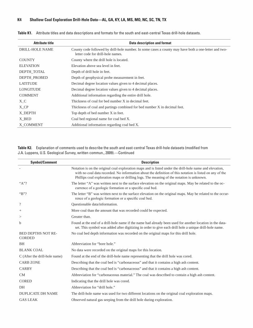
K4 Shallow Coal Exploration Drill-Hole Data—AL, GA, KY, LA, MS, MO, NC, SC, TN, TX
Table K1. Attribute titles and data descriptions and formats for the south and east-central Texas drill-hole datasets.
Attribute title Data description and format
DRILL-HOLE NAME
COUNTYELEVATIONDEPTH_TOTALDEPTH_PROBEDLATITUDELONGITUDECOMMENTX_CX_CPX_DEPTHX_BEDX_COMMENT
County code followed by drill-hole number. In some cases a county may have both a one-letter and two-letter code for drill-hole names.
County where the drill hole is located.Elevation above sea level in feet.Depth of drill hole in feet.Depth of geophysical probe measurement in feet.Decimal degree location values given to 4 decimal places.Decimal degree location values given to 4 decimal places.Additional information regarding the entire drill hole. Thickness of coal for bed number X in decimal feet.Thickness of coal and partings combined for bed number X in decimal feet.Top depth of bed number X in feet.Coal bed regional name for coal bed X.Additional information regarding coal bed X.
Table K2. Explanation of comments used to describe the south and east-central Texas drill-hole datasets (modified from J.A. Luppens, U.S. Geological Survey, written commun., 2009).—Continued
Symbol/Comment Description
-
“A”?
“B”?
?
+
>
b
BED DEPTHS NOT RE-CORDEDBH
BLANK COAL
C (After the drill-hole name)
CARB ZONE
CARBY
CM
CORED
DH
DUPLICATE DH NAME
GAS LEAK
Notation is on the original coal exploration maps and is listed under the drill-hole name and elevation, with no coal data recorded. No information about the definition of this notation is listed on any of the Phillips coal exploration maps or drilling logs. The meaning of the notation is unknown.
The letter “A” was written next to the surface elevation on the original maps. May be related to the oc-currence of a geologic formation or a specific coal bed.
The letter “B” was written next to the surface elevation on the original maps. May be related to the occur-rence of a geologic formation or a specific coal bed.
Questionable data/information.
More coal than the amount that was recorded could be expected.
Greater than.
Found at the end of a drill-hole name if the name had already been used for another location in the data-set. This symbol was added after digitizing in order to give each drill hole a unique drill-hole name.
No coal bed depth information was recorded on the original maps for this drill hole.
Abbreviation for “bore hole.”
No data were recorded on the original maps for this location.
Found at the end of the drill-hole name representing that the drill hole was cored.
Describing that the coal bed is “carbonaceous” and that it contains a high ash content.
Describing that the coal bed is “carbonaceous” and that it contains a high ash content.
Abbreviation for “carbonaceous material.” The coal was described to contain a high ash content.
Indicating that the drill hole was cored.
Abbreviation for “drill hole.”
The drill-hole name was used for two different locations on the original coal exploration maps.
Observed natural gas seeping from the drill hole during exploration.

South and East-Central Texas K5
Table K2. Explanation of comments used to describe the south and east-central Texas drill-hole datasets (modified from J.A. Luppens, U.S. Geological Survey, written commun., 2009).—Continued
Symbol/Comment Description
GRAVEL?
HB
HOLE BRIDGED
I
ILLEGIBLE
ILLEGIBLE DEPTH
ILLEGIBLE PROBE DEPTH
INACCURATE LOCATION
INF
NC
NDE
NO COAL
NO DATA RECORDED
NO ELEVATION RECORDED
NO LOG
NO PROBE DEPTH RE-CORDEDNP
NSL
ODOR
OK
P
P BOTTOM
P.B.
P.T.
PI
POOR
RD (after the drill-hole name)
SCZ
A gravel layer may have been found during exploration.
This comment was written on the original coal exploration maps and the meaning is unknown. Could possibly be the abbreviation for “hole bridged,” meaning that the drill-hole walls collapsed during exploration.
The drill-hole walls collapsed during exploration.
Abbreviation for “inferior.” Subjective term used to describe poor coal quality.
Original information on maps was not legible for this drill hole and may not be correct as transcribed.
The coal depth was not legible on the original coal exploration maps and may not be accurate as tran-scribed.
The probe depth was not legible on the original coal exploration maps and may not be accurate as tran-scribed.
Original coal exploration maps could not be accurately georeferenced due to insufficient reference points. Drill-hole location accuracy maybe greater than 0.25 miles.
Abbreviation for “inferior.” Subjective term used to describe low quality coal.
Abbreviation for “no coal.” No coal was found during exploration for this drill hole.
Abbreviation for “not deep enough.” This comment was used on the original coal exploration maps for a drill hole when a particular coal bed was not found due to insufficient depth of exploration.
No coal was found during exploration for this drill hole.
No data were recorded on original coal exploration maps for this drill hole.
No ground elevation information was recorded on the original coal exploration maps for this drill hole.
No geophysical logging was completed for this drill hole.
No probe depth information was recorded on original coal exploration maps for this drill hole.
Abbreviation for “not probed.” Geophysical logging never occurred at this location.
Abbreviation for “no significant lignite.” Coal may have been found during exploration but because the coal beds were thin (usually less than 2 feet thick) no coal data were recorded.
Comment was written on the original coal exploration maps above the drill-hole name and the meaning is unknown.
Comment was written at the end of coal-bed data on the original coal exploration maps and the meaning is unknown. Typically information written after coal-bed data subjectively describes the coal quality of the bed.
Abbreviation for “poor.” A subjective term used to describe a low quality coal.
The coal quality of the bottom of the coal bed was found to be poor. Coal quality in the bed decreased with depth.
Abbreviation for “poor bottom.” The coal quality of the bottom of the coal bed was found to be poor. Coal quality in the coal bed decreased with depth.
Abbreviation for “poor top.” Poor coal quality on the top section of the coal bed. Quality improved with depth in the coal bed.
Abbreviation for “partially inferior.” Used to describe that a portion of the coal bed is of a low quality.
A subjective term used to describe coal of poor quality. In some cases only a portion of the entire coal bed was listed as “POOR” (example: POOR (1.5’)).
Abbreviation for “re-drill.” Was used when a location had to be re-explored either due to problems with the first drill hole at the location or in some cases the location was re-drilled to explore deeper strata.
Notation is listed with a depth range (example: 15-25’ SCZ) on the original coal exploration maps with no coal data listed at the drill-hole location. No information about the definition of this notation is listed on any of the Phillips coal exploration maps or drilling logs. The meaning of the notation is unknown.

K6 Shallow Coal Exploration Drill-Hole Data—AL, GA, KY, LA, MS, MO, NC, SC, TN, TX
Table K2. Explanation of comments used to describe the south and east-central Texas drill-hole datasets (modified from J.A. Luppens, U.S. Geological Survey, written commun., 2009).—Continued
Symbol/Comment Description
SL Abbreviation for “silt.” A layer of silt was encountered during exploration.
TD IN COAL Terminated drilling in a coal bed. Coal extends deeper than the depth explored.
TRI Abbreviation for “triangle.” Signifies that the drill-hole/coal bed was cored during exploration.
TRIANGLES Signifies that multiple coal beds were cored during exploration.
V. INF Abbreviation for “very inferior.” Subjective term used to describe coal of a very low quality.
VP Abbreviation for “very poor.” Subjective term used to describe coal of a very low quality.
WASHOUT Occurs when a loose layer of material is eroded in the bore hole and the well diameter is enlarged.
WEATHERED Used to describe coal that has been altered by chemical or physical means.
WSOUT Abbreviation for “washout.” Occurs when a loose layer of material is eroded in the bore hole and the well diameter is enlarged.
Table K3. South Texas counties and the number of drill holes by county.
County Number of drill holes
Atascosa 32Bexar 39Maverick 208Medina 374Starr 35Uvalde 41Webb 167Zapata 84
Total 980
Table K4. East-central Texas counties and the number of drill holes by county.
County Number of drill holes
Anderson 4Bastrop 160Brazos 2Burleson 334Falls 7Fayette 258Freestone 591Henderson 38Houston 65Lee 305Leon 4Limestone 629Milam 175Polk 4Trinity 88Walker 48Washington 133
Total 2,845

South and East-Central Texas K7
Figu
re K
1.
Regi
onal
map
of s
outh
Tex
as w
ith c
ount
y bo
unda
ries
over
laid
with
dril
l-hol
e lo
catio
ns a
nd m
ajor
coa
l-bea
ring
form
atio
ns o
f the
Gul
f Coa
st
Regi
on (W
arw
ick
and
othe
rs, 1
997)
.
Rio G
rand
e!
!!
!
! !!
!
!!
!
!
!!! !
!
!!!!
!!
!!! !
!!!!
!
!
!!
!!!! !!
!!
!
!!
!! ! !
!!
! !!
!!
!!
!!!! !!
!!!
!
!!
!
!!
!!
!
!! !
!
!!!!
! !!!!
!!
!
!!!!
!!
!
!
!!!!!! !!
! !!
!!
!!!!! !
!!
!
!!!!!
!!!
!!
!! !!! !
!
!!
!!!!
!! !
!
!
!!!
!! !
!
!!
!
!!!!
!!
!! !!
!
!!!
!! !
! !
!
!!
!!
!!
!
!!!!!!!!
!!!!!
!!
!!
!
!
!!
!!!
!!
!!!! !! !!
!!
!
!
!
!!!
!!
!! !!
!
!!
!!!
!
!
! !! !! !!! !!
!!!!!
! !!!
!
!!
!!!
!! ! !!!!!! !
!!!
!!!
!!! !!! !! !!!! !! !
!! !! !
!!! ! !!!!!!
!! !!
!
! !
! !
!
!! !!!!!!! !!! !
!
!! !!! ! !!!! !!!
!!!!! !!
!
!
!
!
!!!! !!
!! !! !!!! !
!!
!!!!!!!! !!
! !!!!!!!!
!!! !
!!
!!!
!!!
!! !!
!!
!!!! !! !!! !
!!
!!
!
! !
!!
!!!
!
!!
!!
!
!
!! !!! !!
!!!!
!!!
!!!!!!
! !! !! !!!!!!!
!!!!! !!
!!!
!
!! !! !
!! !
!!
! !!!!!! !!
! !!! !! !!!!! !! !!!! ! !!
! !!
!!!
! !
!
!
!
!!!
!!!
!!
!
! !
!!
!!! !!! !
!
!! !!
!!!! !
!! !!!! !! !
!
!!
! !! !! ! !! !!!
!!!! !!!
!
!!!!!!!!
!!!! !! !! !
!
!!!
!!!!!!!!! ! !!
!
!!!! !
!!!!
!
!!!
! !!
!!! !
!
!!
!
!!
!!
!! !
!
!
!!!
! !
!
! !
!
!
! !
! !! !
! !
!!!
!
!!!
!!
!!!
!
!!
!!
!
!!!! !!!
!
!
! !!!
!! !!!
!
!!
!!!
!!
!
! !! ! ! ! !!
!!
!
! !!!!!!! ! !
!
! ! ! !! !!! ! !
!
! !!!!!!!!!
!
!!!! !!! !!!
!
!!! !!
! !!
!
!!
!!!!!
!!
!! !! !! !!! !
!!!!
! !! ! !! !! !!! !!
!!!!!
! !!! ! !
!! !!!! !!! !!
!!! !!!!! !
! !
!
!!!
!!!!!
!!
!
!!!!!
! ! ! !!
!
! !! ! !! !!!!
!
!!
!!
!!!
!!
!
! !
!!
!!
!!
!!
!
!
!!!
!!
!!
!!
!
!
! !
!!
!!
!!!!
!
!!!
!!
!
!!!
!
!
!
!
!!!
!!
!!
!
!
!! !!! !!
!!
!
!!
! !! !
!
WE
BB
CO
UN
TY
DU
VAL
CO
UN
TY
FRIO
CO
UN
TY
STA
RR
CO
UN
TY
UVA
LD
E C
OU
NT
YB
EX
AR
CO
UN
TY
ZAV
AL
A C
OU
NT
Y
KIN
NE
Y C
OU
NT
Y
LA
SA
LL
E C
OU
NT
Y
ME
DIN
A C
OU
NT
Y
BE
EC
OU
NT
YD
IMM
IT C
OU
NT
Y
HID
AL
GO
CO
UN
TY
ZA
PATA
CO
UN
TY
ATA
SCO
SAC
OU
NT
Y
MAV
ER
ICK
CO
UN
TY
KE
NE
DY
CO
UN
TY
BR
OO
KS
CO
UN
TY
LIV
E O
AK
CO
UN
TY
JIM
HO
GG
CO
UN
TY
WIL
SON
CO
UN
TY
MC
MU
LL
EN
CO
UN
TY
KA
RN
ES
CO
UN
TY
VAL
VE
RD
EC
OU
NT
Y
JIM
WE
LL
SC
OU
NT
Y
KL
EB
ER
GC
OU
NT
Y
NU
EC
ES
CO
UN
TY
GU
AD
AL
UPE
CO
UN
TY
ME
XIC
O
Eagl
e Pa
ss
98°0
0'99
°00'
100°
00'
101°
00'
29°0
0'
28°0
0'
27°0
0'
Texa
s
Map
are
a
020
40 M
ILES
020
40 K
ILOM
ETER
S
Clai
born
e Gr
oup
Jack
son
Grou
p
Olm
os F
orm
atio
nW
ilcox
Gro
up
Eoce
ne
Pale
ocen
eLa
te C
reta
ceou
s
EXPL
AN
ATIO
N
Drill
-hol
e lo
catio
ns
Maj
or C
oal-
Bea
ring
For
mat
ions
!
Outc
rop
of c
oal-b
earin
g un
its m
ap b
y W
arw
ick
and
othe
rs (1
997)
.

K8 Shallow Coal Exploration Drill-Hole Data—AL, GA, KY, LA, MS, MO, NC, SC, TN, TX
Figu
re K
2.
Regi
onal
map
of e
ast-c
entra
l Tex
as w
ith c
ount
y bo
unda
ries
over
laid
with
dril
l-hol
e lo
catio
ns a
nd m
ajor
coa
l-bea
ring
form
atio
ns o
f the
Gul
f Co
ast R
egio
n (W
arw
ick
and
othe
rs, 1
997)
.
! ! ! !!! ! !!! !!! ! !!
!!!!
!! ! !!
!
!!
!
!!!! !! !
!!! ! !!!!! !!!!! !!!! !!!!!!!! !!!!!
!!
!
!!!
!
!! !! !!!!!!
!!!
!!! !!! !! !
!!
! !! !!! !
!!!!!!! !!!
!!! !!!! ! !
!! !! !
!!! !
!
!!! !!
!
!! !! !!
!!
!
!
!! !! !!
!
!
!!
!!! !
!
!!! !
!
!!!
!
! !! !
!!
!
! !! !! !!!!!
!
!
! ! ! !!! !
!
!! !!! !! !!!
!
!!!!
!!!!
!!
! !!!
!!
! !!
! ! ! !!
! ! !!!!!!! !
!
!!! !!!
!
!
! !!
!! !!!! !! !!!!! ! ! !
!!!!
! !
! ! ! !! !
!!
!!
!!
!!!
! !!!!!!! !! !
! !
! !! !!!! ! !
!! !! !
!! ! !! !
! !!!!
!!!!!
!
!!! !
!! ! ! !! !
!! ! !! !!!!
!!!! !!!
!!
! !!!!
! ! !!!!
!!!!!
!! !
!
!!
! !!!!!! ! !! ! !
!!! !! !!!!!!! !!!! !
! !!
!!!!!! !!!!! ! !!! !!!
!
! ! !! !! ! !
! ! !!
! !!!!!
!!
!
!
!!
!
!
!
!!
!!!
!!!
!!
!!
!
!
!
!!
!! !! ! !!
!!
! !
!!
! !! !!
!
!
!!!
! !
!
! !
!!
!!! ! !! !!! ! ! !
! !! !!
!!!
!
!
!!
!
! !!
!!
!! !
!
!!
!!!
!!
!
!
!
!!
!!
!!!
!! !!!! ! !!!! !! ! !!!! ! !!!!
!! !
!
!
!
!!
! !! !! !
!
!! !! !!
!! ! !
!
! !!
!! ! !!! !
!
!!!!
!
!!!
!!!
!
!
!
!
!!!
!!!!
!
!
!
!
!!!!!!!
!
!!!
!
!!
!
!
!! !
!
! !!!!!!!
!!!
!
!!!!
!!!!!!
!
!!!!!!
! ! !!!
!!!!!
!
!!!!
!
! !!!!! ! !
!!
!!!!!
!
!
! !!
!
!! !
!!
!!
!
!
!! !
! !!
!!!!! !!
! ! !!!!!! ! !!! ! !!!! !
!
!! !!!!
!! !!!
! ! !!!! !!!!!
! !!! ! !!
!
!
! ! !!!!
!!! !!!!!! !! !
!!
! !!!!!!!!! !
!! !! !! !!!!!
!
!!!
!!
!!
!! !
!
! !
!!! !
!
!
!!
! !!! !!!!! !!
!
! !! !! !
!
!!!!!!
!
!!
!!
!
!
!
!
!!!! !! !! !!!
!! !! !!!!! !!! !
!
!! !!
!!! !!! !!!! !!!!!! !
! !
!!!!
!!! !
!
!! !! !!!! !! !
!!! !
!
!!! !! ! !!!! !! !!
!! !!!!!! !!!
!!! !!!! !
!!
!!
!!
!
!!!! !! ! ! !!
!!!!! !! !!! !!! !! ! !! !!! !! !
!!! !
! !! !! !!!
!!
!!
!
!
! !!!
!!!
!
!
!
!
!!!!
! ! !!! !
!
!!!!! ! !
!!
!
! !! !!! !!
! !
!
!!!
! !! !!! !
!!!! !!! ! ! ! !
!
! !! !
!!!! ! !
!! !!
! !
!
!!
!
!! ! !!!!!! !
!
! !! ! ! !!!! !
!
! ! !!! !! ! !!
!
!
!! ! !
!!!!
! !
!
! !! !
!
!! !
!
!!
!
!!! !!!!!!
!
!!!! !
!!! !!
!
!
!! !! !
! !
! !!
!!! !!
!
!
! !!
!
!
!
!
!
!
! !
!
!!
!!
!
!
!!
!
!!
!!
!
!
!!
!!
!
!!
!!
!
!! !
!!
!
!! !
!
!!
!
!
! !
!
! !!!
! ! ! !
!!
!
!!!
! !!
!
! !!
!
! !! !! ! !
! ! !!
!
!!
! !!
!!
! !
!!!
!
!!!! !
! ! !!!! !! !!!!
!
!! ! !
!!
! !! !!
!!!
!
!
!!
!
!!
!
!
!
!!
!
!!!
!
!!
!!!!!
!
!!
!
!!!!
!
!!!
!!!!!
!!!
!!!
!!
!
!!
!
!
!!!
!
!!
!
!
!
!!! !! !! !!! !!!!!! !! !
!
!! !!!! !! ! !!!!!!!
!! !!
!
!!!
!! !! ! ! ! !! ! !! ! !!!!!!! !!! !!!!
!
!! ! !! !!! !!
!
! ! ! !!!!
!!!
!
!!!
!!!!!! !
!
! ! !!! !! ! !!
!!!!!!!
!! !!
!!! !! !!!!!! !! !!!!! ! !! ! !! !! !!!! !
!!!
! ! !!
!
!! !! !! ! ! !! !!
!!
! ! !!! !!!! !! !!!
!! !! !! !! !! ! !!
!!
!!
!!!!
!!
!!
!!
! ! !!!!!!!!!!! !!!
!
!
!!
!!! ! !!!
!!!!!! !!
!
!
!!! ! !
!!!!!!! ! !
!!!!
!
!!! !!
! ! !
! !! !! !
! !!!!! ! !
!!!!!!!
!! !!!
! !! !
! ! !! !!
!!
! !
!
!! !
!
! !!!!
!!
!
!
!!
!!!
!!!!
! !!
! !!!!!
! !!! ! !! !!!!
!
!
! ! !! ! !! !! !!
!
!!!
!!
!!
!!!
!! !! !!!!!!
!
! ! !! !!!!!
!!
!! !! !!!! !
!
!!! !!!
!!! !! !!! !!!
! ! !!
! !!!!!
!! !!!!
! !!!
! !!!
!
!! !!!
! !! !!!
!!!!
!
!!
!! ! !!! !!
!
! !!!!!!
!
!!
!
!
!
!!
!
!
!
!
!
!
!! !!! !!!!!!! ! !! !! !
!
!! ! !!!!!
!
! !
!!
!
!! ! !!! !
! !
! !!!!!! ! !!!! !!
!!
!!!!! !!!!!! ! !!
!
!
!
! !! !! !
!
!! ! ! ! ! ! !!!! !! ! ! ! !! !!!!!! !!! !! !
!!
!
!!!!!!
!
!
! !!! !
!
!
! !
! !
! !!!
!
!!!
! ! !!!!
!
!! !
!
!
!!
!!!
!!
!
!!
!
!
!
!
!
! ! !!!
! !!
!
! !
!
!
!
!!!!
! !!!
!!
!
!
! ! ! ! !!!! !!
!!!
!! ! ! !!
!! !! ! !! ! !! ! !!
!
!! !! !
! !
!!!! !! !! !!!!! !!
!! !! !!!!
!!!! !!!! !! !
!! ! !! !!!!
!! ! ! !!! ! !! ! !!! !! !
! !!!!!
!! ! !! !!
!
!
!
! !!!! !!
!!!
! !! ! !!!!! !! ! !
!!
! !!!
!! !!! !!
! ! !!!!!!! !!! ! !!! !! !! !! !! !
! !!
!!!
!
!!
!!
!!
!!!!
!!!
! !! ! !
!
!
!!
!!
!
!
!
!
!!
!
! !
! ! !! !!!!
!!
!!
!!
!!! !
!!
!!
!!!
!!!
!
!!
!
!!!
!!
! !!
!!
!
!
!
! ! !! !
!
!! !!!
! !!!
! !!! !!
! ! !! !!!
!!!!!!! !
!!
!
!!
!!
!
!
!
! !
!
!
!!
!!
!!
!
! !!
!
!! !
!!! ! !!
!! !! !!
!
!
!
!
!
!!!
!
!
!
!
!!
!!!
!!!!
!
!
!!
!!!!
!!
!
! !! !!
!
!
!
!
!
! !
!!
!
!
!
!!!
!! !
!
!
!!! !! !! !!
!!! !!!
!
!
!!
!!!
!
!
!!
!
!!
!
!!
!
!
!
!
!!
!!
!!
!!
!
!
!!
!
!
!
!!
!!
!
!!
!!
!
!!
!!
!!
!
!!
!!!!!!! !!
!
!
! !
!!!
!!!!
!!
!!
!!
!!
!
!!!!
!
!
!
!
!
! !! !!!!!! !!
!
! ! !!!!!!
! !
!
!!
!!
!
!
!
!!
!
!
!!
!
!!
!!
!
!!
!!
!
!
!!!!
!!
!!
!
!
!
!!
!
!
!!
!!
!!!
! !
!
!!
!!!!
!
!
!!
!
!! !!
!
!
!
!!
!
!
!
!
!!
!
!
!
!
!!!
!!
!
!
! !! !! !!!!
!
!
!!!! ! !!!!
! !
!!!
!
!
!
!
!!
!
!
!!
!
!!!
!
!
!!
!!
!
! !!!
! ! !
!
!!!! !! !!!
!
!
!
!!!
!
!!
!
!
95°0
0'96
°00'
97°0
0'
32°0
0'
31°0
0'
30°0
0'
HA
RR
IS C
OU
NT
Y
HIL
L C
OU
NT
Y
POL
K C
OU
NT
Y
LE
ON
CO
UN
TY
BE
LL
CO
UN
TY
EL
LIS
CO
UN
TY
LE
E C
OU
NT
Y
RU
SK
CO
UN
TY
FAL
LS
CO
UN
TY
MIL
AM
CO
UN
TY
HO
UN
STO
N C
OU
NT
Y
LIB
ER
TY
CO
UN
TY
NAV
AR
RO
CO
UN
TY
FAY
ET
TE
CO
UN
TY
SMIT
H C
OU
NT
Y
BA
STR
OP
CO
UN
TY
AN
DE
RSO
N C
OU
NT
YC
HE
RO
KE
E
CO
UN
TY
WA
LK
ER
CO
UN
TY
GR
IME
S
CO
UN
TY
TR
INIT
Y C
OU
NT
Y
MC
LE
NN
AN
CO
UN
TY
AU
STIN
CO
UN
TY
FRE
EST
ON
E
CO
UN
TY
LIM
EST
ON
E
CO
UN
TY
HE
ND
ER
SON
CO
UN
TY
CO
LO
RA
DO
CO
UN
TY
BR
AZ
OS
CO
UN
TY
RO
BE
RT
SON
CO
UN
TY
MO
NT
GO
ME
RY
CO
UN
TY
WA
LL
ER
CO
UN
TY
BO
SQU
E
CO
UN
TY
BU
RL
ESO
N C
OU
NT
Y
JOH
NSO
N
CO
UN
TY
FOR
T B
EN
D C
OU
NT
Y
WIL
LIA
MSO
N
CO
UN
TY
SAN
JA
CIN
TO
CO
UN
TY
MA
DIS
ON
CO
UN
TY
AN
GE
LIN
A
CO
UN
TY
WA
SHIN
GTO
N
CO
UN
TY
GO
NZ
AL
ES
CO
UN
TY
TR
AVIS
CO
UN
TY
LAV
AC
A C
OU
NT
Y
NA
CO
GD
OC
HE
S
CO
UN
TY
CA
LD
WE
LL
CO
UN
TY
Trinity River
Brazos River
Colora
do R
iver 0
2040
MIL
ES
2040
KIL
OMET
ERS
0
Clai
born
e Gr
oup
Jack
son
Grou
p
Wilc
ox G
roup
Eoce
ne
Pale
ocen
e
EXPL
AN
ATIO
N
Drill
-hol
e lo
catio
ns
Maj
or C
oal-
Bea
ring
For
mat
ions
!
Map
are
aTe
xas
Outc
rop
of c
oal-b
earin
g un
its m
ap b
y W
arw
ick
and
othe
rs (1
997)
.

South and East-Central Texas K9
Figu
re K
3.
Gene
raliz
ed s
tratig
raph
ic c
hart
show
ing
maj
or a
nd m
inor
coa
l-bea
ring
form
atio
ns in
the
Mis
siss
ippi
Em
baym
ent a
nd G
ulf C
oast
al P
lain
(mod
ified
from
War
wic
k an
d ot
hers
, 199
7; O
gg a
nd o
ther
s, 2
008)
.
Mid
way
Wilc
ox
Jack
son
Chro
nost
ratig
raph
ic
Units
Pria
boni
an
Ypre
sian
Than
etia
n
Dani
an
Maa
stric
htia
n
Inte
rnat
iona
lSt
age
Barto
nian
Lute
tian
Mis
siss
ippi
Loui
sian
aN
orth
east
ern
Texa
sEa
st-C
entra
lTe
xas
Rio
Gran
deEm
baym
ent
(Sou
ther
n Te
xas)
Grou
p or
For
mat
ion
by G
eogr
aphi
c Ar
ea
Jack
son
Jack
son
Jack
son
Jack
son
Yazo
o
Moo
dys
Bran
chCo
ckfie
ldCo
ok M
ount
ain
Kosc
iusk
oZi
lpha
Talla
hatta
Mer
idan
San
d
Win
ona
Hatc
hetig
bee
Bash
i
Nan
afal
ia
Tusc
ahom
a
Clay
ton
Porte
rs C
reek
Nah
eola
Porte
rs C
reek
Kinc
aid
/ Cla
yton
Will
s Po
int
Kinc
aid
Kinc
aid
Cock
field
Cook
Mou
ntai
nSp
arta
Sand
Cane
Riv
er
Carr
izo S
and
Sabi
neto
wn
Calv
ert B
luff
Sim
sbor
o
Hoop
er
Yegu
a
Cook
Mtn
/ St
one
City
Spar
taSa
ndW
eche
sQu
een
City
Rekl
aw
Carr
izo S
and
Wilc
ox
Yegu
a Cook
Mtn
Sp
arta
Sand
Wec
hes
Quee
n Ci
tyRe
klaw
Carr
izo S
and
Lare
do
El P
ico
Clay
Bigf
ord
Uppe
r Lo
wer
Whi
tset
Man
ning
Wel
born
Cadd
ell
Whi
tset
tM
anni
ngW
ellb
orn
Cadd
ell
Moo
dys
Bran
ch
Mos
ley
Hill
Danv
ille
Land
ing
Yazo
o
Pend
leto
n
Mar
thav
ille
Hall
Sum
mit
Lim
e Hi
llCo
nver
seCo
w B
ayou
Dole
t Hill
sN
abor
ton
Yegu
a Cook
Mtn
Spar
taSa
ndW
eche
sQu
een
City
Rekl
aw
Carr
izo S
and
Esco
ndid
o
Olm
osN
avar
roN
avar
roN
avar
roKe
mp
Clay
Cors
ican
a M
arl
Nac
atoc
hNav
arro
Arka
delp
hia
Nac
atoc
h Sa
ndSa
rato
ga C
halk
Owl C
reek
Ripl
ey
Alab
ama
and
Geor
gia
Moo
dys
Bran
ch
Yazo
oJa
ckso
n
Lisb
on
Lisb
on
Talla
hatta
Gosp
ort
Hatc
hetig
bee
Tusc
ahom
a
Nan
afal
ia
Nah
eola
Porte
rs C
reek
Clay
ton
Ripl
ey
Mis
sour
ian
d Te
nnes
see
Kent
ucky
Jack
son
Jack
son
Cock
field
Cook
Mou
ntai
n
Mem
phis
San
d
Wilc
ox
Porte
rs C
reek
Clay
ton
Clai
born
e
Porte
rs C
reek
Clay
ton
Owl C
reek
McN
airy
McN
airy
Flou
r Isl
and
Ft. P
illow
San
d
Old
Brea
stw
orks
Prai
rie B
luff
Chal
k/Pr
ovid
ence
San
d
Nor
th A
mer
ican
Prov
inci
al
Stag
e
Jack
soni
an
Clai
born
ian
Sabi
nian
Mid
way
an
Nav
arro
an
Sela
ndia
n
Claiborne
Claiborne
Claiborne
ClaiborneClaiborne
Claiborne
Wilcox
Wilcox
Wilcox
Wilcox
Midway
Midway
Midway
Midway
Midway
Tertiary
Series Eocene Paleocene
CretaceousSystem
Wilcox Midway
Midway
Indio
Upper (part)
Expl
anat
ion
disc
onfo
rmity
unce
rtain
inte
rfing
erin
gtra
nsiti
onal
Maj
or c
oal-b
earin
g fo
rmat
ion
Min
or c
oal-b
earin
g fo
rmat
ion
Grou
p N
ame
Form
atio
n N
ame

Valentine and Dennen, eds.—Shallow
Coal Exploration Drill-H
ole Data—
AL, G
A, KY, LA
, MS, M
O, NC, SC, TN
and TX—Open-File Report 2011–1261
Printed on recycled paper
Related Documents