State Highway 58 Safety Improvements Scheme Assessment Report Prepared for NZ Transport Agency July 2015 Revision 4

Welcome message from author
This document is posted to help you gain knowledge. Please leave a comment to let me know what you think about it! Share it to your friends and learn new things together.
Transcript

State Highway 58 Safety Improvements Scheme Assessment Report
Prepared for NZ Transport Agency July 2015 Revision 4


State Highway 58 Safety Improvements Scheme Assessment Report
Status: Final Project No.: 80501811 July 2015
This document has been prepared for the benefit of NZ Transport Agency. No liability is accepted by this company or any employee or sub-consultant of this company with respect to its use by any other person.
This disclaimer shall apply notwithstanding that the report may be made available to other persons for an application for permission or approval to fulfil a legal requirement.
QUALITY STATEMENT PROJECT MANAGER PROJECT TECHNICAL LEAD
Jamie Povall Jamie Povall
PREPARED BY
26/08/13
Dhimantha Ranatunga, Simon Stewart, Caroline Van Halderen, Jamie Povall
CHECKED BY
………………………………............... 26/08/13 Steve Muller, Gavin O’Connor
REVIEWED BY
………………………………............... 26/08/13 Phil Peet, Tim Crow
APPROVED FOR ISSUE BY
28/08/13 Phil Peet
WELLINGTON
Level 1, 123 Taranaki Street, Wellington 6011
PO Box 9624, Te Aro, Wellington 6141
TEL +64 4 381 6700, FAX +64 4 381 6739
REVISION SCHEDULE
Rev No Date Description
Signature or Typed Name (documentation on file).
Prepared by Checked by Reviewed by Approved by
1 22/11/13 Addition of Option 4 JP, DR SM PP PP
2 4/03/14 Update following Road Safety Audit and Economic Peer Review
DR JP PP PP
3 15/04/15 April Update JP JP PP PP

State Highway 58 Safety Improvements Scheme Assessment Report
Status: Final Project No.: 80501811 July 2015
Rev No Date Description
Signature or Typed Name (documentation on file).
Prepared by Checked by Reviewed by Approved by
4 27/07/15 Additional tech notes JP JP PP PP

State Highway 58 Safety Improvements Scheme Assessment Report
Status: Final July 2015
Project number: 80501811 Our ref: Haywards SAR_Opt_4_FINAL_July2015
Executive Summary The primary project objective is to reduce the number of deaths and serious injuries along State Highway 58 (SH58) by investing in cost effective treatments that promote a ‘Safe System’; focusing on providing safer roads and roadsides, and safe speeds.
The project scope was to undertake a Scheme Assessment Report, building on a previous 2009 Project Feasibility Report, for the section of SH58 that runs between State Highway 2 (SH2) and the Pauatahanui Roundabout (approximate section length of 10km).
The project length has experienced a large number of high severity (fatal and serious) crashes in recent years. In the last five-year period from 2008 to 2012 there have been a total of 138 crashes, including two fatal and 13 serious injury crashes resulting in 15 deaths and serious injuries (DSi).
As a result of high severity crash density, this section of highway (and the rural entirety of SH58) is classified as a high-risk rural road.
Run off road and head on crashes comprised 70% of the reported crashes and 80% of the high severity crashes. Compared to national figures, this section of highway is overrepresented in high severity run off road crashes. The poor horizontal alignment (24 out of context curves), severe roadside hazards and narrow cross section all contribute to the high injury crash rate.
The NZTA requested that three options be considered for the full project length:
Option 1: where 1.5m shoulders are provided throughout.
Option 2: where 1.5m shoulders are provided throughout and where an additional 2.0 m of seal width is provided for the provision of a flush median.
Option 3: where 1.5m shoulders are provided throughout and where an additional 2.0 m of seal width is provided for the provision of a wire rope median barrier.
In addition, this report considered the realignment of four out of context curve sites on SH58.
Based on the assessment undertaken, Option 2 was marginally the most economic option, achieving a BCR of 2.0 for the 40 year Economic Evaluation Manual analysis period. However Option 3 was considered the preferred option given the BCR was almost identical to Option 2, but favoured on the basis of providing central median barrier throughout (with consequential reduction in risk of high severity crashes).
As an extension to the initial SAR, the project scope was widened to optimise the original Option 3, creating Option 4. Option 4 included the removal of one of the high cost realignment sites, changes to a proposed intersection, and small overall reduction in project extents to the north. The project economics were also further refined and the Do-Minimum and Option speeds were set as 80km/h (reducing the calculated project BCR). Option 4 is estimated to cost $31.1m, yielding a BCR of 1.5.
It is recommended that NZTA undertake:
Engagement of a property consultant to validate and update property costs \ estimates to refine the project estimates.
Further geotechnical testing as per the recommendations of the attached Preliminary Geotechnical Appraisal Report.
A staging assessment to determine if and how the overall package of works could be delivered through block project funding given the current quantum of work is not expected to be financially viable as a single project, at least in the short to medium term.
A detailed design of the preferred option.

State Highway 58 Safety Improvements Scheme Assessment Report
Status: Final July 2015
Project No.: 80501811 Our ref: Haywards SAR_Opt_4_FINAL_July2015
NZ Transport Agency State Highway 58 Safety Improvements Scheme Assessment Report
CONTENTS Executive Summary ................................................................................................................................... i
1 Introduction ......................................................................................................................................... 1
1.1 Project Background ....................................................................................................................... 1
1.2 Objectives and Scope .................................................................................................................... 2
2 Problem Description ........................................................................................................................... 3
3 Site Description .................................................................................................................................. 4
3.1 Project Location and Highway Characteristics .............................................................................. 4
3.2 Services ....................................................................................................................................... 11
4 Collected Data .................................................................................................................................. 12
4.1 Topographical Survey .................................................................................................................. 12
4.2 Traffic Data .................................................................................................................................. 12
4.3 Crash History ............................................................................................................................... 17
4.4 Summary of Preliminary Geotechnical Appraisal Report ............................................................. 25
5 Stakeholder Relationship Management and Consultation ................................................................ 26
6 Options Description .......................................................................................................................... 27
6.2 Option 1: Curve Realignment and Shoulder Widening ................................................................ 28
6.3 Option 2: Curve Realignment, Shoulder Widening and Flush Median ......................................... 29
6.4 Option 3: Curve Realignment, Shoulder Widening and Wire Rope Median Barrier ..................... 30
6.5 Alternatives .................................................................................................................................. 32
7 Option Discussion ............................................................................................................................. 34
7.1 Proposed Cleanfill Site ................................................................................................................ 34
7.2 Guardrail ...................................................................................................................................... 34
7.3 Compliance with Standards ......................................................................................................... 34
7.4 Constructability ............................................................................................................................ 37
7.5 Property ....................................................................................................................................... 37
8 Option Evaluation ............................................................................................................................. 38
8.1 Cost Estimates............................................................................................................................. 38
8.2 SIDRA Modelling ......................................................................................................................... 38
8.3 Economic Evaluation ................................................................................................................... 40
9 Resource Management Issues ......................................................................................................... 49
9.1 District Plan Provisions ................................................................................................................ 49

State Highway 58 Safety Improvements Scheme Assessment Report
Status: Final July 2015
Project No.: 80501811 Our ref: Haywards SAR_Opt_4_FINAL_July2015
9.2 Regional Plan Provisions ............................................................................................................. 50
9.3 Other Provisions .......................................................................................................................... 50
9.4 Future Land Use Proposals ......................................................................................................... 50
10 Risk................................................................................................................................................... 52
11 Preferred Option ............................................................................................................................... 53
11.1 Option 4 ....................................................................................................................................... 53
11.2 Road Safety Audit ........................................................................................................................ 56
11.3 Evaluation .................................................................................................................................... 56
11.4 Resource Management Issues .................................................................................................... 62
11.5 Assessment Profile ...................................................................................................................... 62
12 Scheme Drawings............................................................................................................................. 64
13 Conclusions and Recommendations ................................................................................................ 65
LIST OF TABLES Table 3-1: Existing Structures .................................................................................................................... 6
Table 4-1: Current Traffic Volumes ........................................................................................................ 13
Table 4-2: Telemetry Site Traffic Composition ....................................................................................... 15
Table 4-3: HTS and TDG Dual Tube Speed Surveys ............................................................................ 16
Table 4-4: Estimated Realignment Travel Speeds ................................................................................. 16
Table 4-5: Annual Distribution of Crashes ............................................................................................. 17
Table 4-6: CAS Crash Type ................................................................................................................... 18
Table 4-7: Environmental Factors .......................................................................................................... 18
Table 4-8: Wet/Icy Crash Summary ....................................................................................................... 18
Table 4-9: Hit Object Crashes ................................................................................................................ 19
Table 4-10: HRRRG Crash Type ........................................................................................................... 19
Table 4-11: Crash Causation Factors of Reported Injury Crashes ........................................................ 20
Table 4-12: Estimation of F&S Collective Risk Using Severity Index SH58/Moonshine Road Intersection ................................................................................................................................................................. 23
Table 4-13: Estimation of F&S Collective Risk Using Severity Index SH58 and Flightys/Murphys Road Intersection .............................................................................................................................................. 24
Table 4-14: Midblock Crash Rate .......................................................................................................... 24
Table 4-15: Realignment Crash Rate..................................................................................................... 25
Table 6-1: Option 3 – Intersection Access Arrangements ........................................................................ 30
Table 7-1: Property Estimates ................................................................................................................. 37
Table 8-1: Scheme Estimates .................................................................................................................. 38
Table 8-2: SIDRA Output Summary (1.5% growth)................................................................................ 39
Table 8-3: Economic Analysis Assumptions ............................................................................................ 40
Table 8-4 : Estimated Vehicle Speeds ..................................................................................................... 41
Table 8-5: Telemetry Site Traffic Composition ....................................................................................... 42

State Highway 58 Safety Improvements Scheme Assessment Report
Status: Final July 2015
Project No.: 80501811 Our ref: Haywards SAR_Opt_4_FINAL_July2015
Table 8-6: NPV TTC, VOC and CO2 ........................................................................................................ 44
Table 8-7: Crash Costs ............................................................................................................................ 45
Table 8-8: KAT Option Assessment ....................................................................................................... 46
Table 8-9: Economic Evaluation Summary .............................................................................................. 47
Table 8-10: Option 2 Sensitivity Testing .................................................................................................. 48
Table 10-1: Risk Summary..................................................................................................................... 52
Table 11-1: Economic Analysis Assumptions .......................................................................................... 57
Table 11-2: SIDRA Output Summary (Option 4) .................................................................................... 58
Table 11-3: NPV TTC, VOC and CO2 (40yr, 6%) ..................................................................................... 59
Table 11-4: Crash Costs (Median crash reduction, 40yr, 6%) ................................................................. 60
Table 11-5: Scheme Estimates ................................................................................................................ 60
Table 11-6: Option 4 Benefit Cost Ratio .................................................................................................. 61
Table 11-7: 40 year Sensitivity Testing (New EEM default) ..................................................................... 61
Table 11-8: 30 year Sensitivity Testing .................................................................................................... 62
Table 11-9: SH58 Safety Improvements Assessment Profile ................................................................ 62
LIST OF FIGURES Figure 3-1: Study Extent ............................................................................................................................ 4
Figure 3-2: Approach to Site 1 from the east (Increasing RP0/0.62) ......................................................... 8
Figure 3-3: Approach to the tight, uphill, right hand curve on Site 2 from the east (Increasing RP 0/1.42) 9
Figure 3-4: Approach to the short straight between the two left hand curves in the ‘broken back’ alignment heading west (Increasing RP 0/2.58) ...................................................................................... 10
Figure 3-5: Approach to the existing 70 km/h ‘temporary’ signage and first curve in the ‘broken back’ alignment heading west (Increasing) ....................................................................................................... 11
Figure 3-6: Approach to ‘Washout’ area and second curve in the ‘broken back’ alignment heading west (Increasing) .............................................................................................................................................. 11
Figure 4-1: Haywards SH58 Traffic Growth 1992-2012 ........................................................................... 13
Figure 4-2: Count Site Traffic Composition .............................................................................................. 15
Figure 4-3: SH58 Realignment Site Average Speeds .............................................................................. 16
Figure 4-4: SH58 Crash History 2008-2012 ............................................................................................. 17
Figure 6-1: Option 1 Typical Cross section .............................................................................................. 28
Figure 6-2: Option 2 Typical Cross section .............................................................................................. 29
Figure 6-3: Option 3 Typical Cross section .............................................................................................. 30
Figure 7-1: TDG Winstone Cleanfill Proposed Access ............................................................................ 34

State Highway 58 Safety Improvements Scheme Assessment Report
Status: Final July 2015
Project No.: 80501811 Our ref: Haywards SAR_Opt_4_FINAL_July2015
APPENDICES Appendix A Location Plan and Photographs
Appendix B Traffic Data
Appendix C Crash Data
Appendix D Design Philosophy Statement
Appendix E Scheme Drawings
Appendix F Pavement Design
Appendix G Risk Register
Appendix H Social and Environmental Management Form (PSF 13)
Appendix I Preliminary Geotechnical Appraisal Report
Appendix J Scheme Estimate
Appendix K SIDRA Modelling
Appendix L Economic Evaluation
Appendix M SH58 Strategic Study
Appendix N Pauatahanui Judgeford Structure Plan
Appendix O Safety Audit
Appendix P Economic Peer Review
Appendix Q Consultation Summary
Appendix R Consultation Report
Appendix S Intersection Strategy Technical Note
Appendix T Flightys / Murphys Road Intersection Assessment
Appendix U SH58 Structural Assessment Technical Note

State Highway 58 Safety Improvements Scheme Assessment Report
Introduction
Status: Final July 2015 Project No.: 80501811 Page 1 Our ref: Haywards SAR_Opt_4_FINAL_July2015
1 Introduction 1.1 Project Background The NZTA has a long-term strategic plan for State Highway 58 (SH58) for the 20-year period 2009 to 2029. The SH58 Strategic Study prepared by MWH relates to the entire 15.1 km length of SH58, from the junction with SH2 at Manor Park in the Hutt Valley, to the junction with SH1 at Paremata. Key aspects of the long-term strategic plan are outlined below.
Transmission Gully, Petone to Grenada and the Grade Separation of the SH2/SH58 intersection are assumed to be complete by 2020;
Based on these assumptions, SH58 will be retained as a two-lane two-way highway with the current passing lanes.
The section between SH2 Manor Park and Moonshine Road will be managed as an 80 – 100km/h rural environment with a median barrier (and some provision for turning movements) considered in the long term.
The section between Moonshine Road and Pauatahanui will also be managed as an 80-100 km/h rural environment with minor safety upgrades in the short term. Long term (15-20 years), this section could become a peri-urban environment and roundabouts for safety will be considered at the Moonshine Road and Flightys Road / Murphys Road intersections in conjunction with reducing the speed limit.
The section between Pauatahanui and Postgate Drive will be managed as a 70km/h peri-urban section and the section from Postgate Drive to Paremata will be managed as a 50km/h urban highway with controlled access in the short term.
Minor safety works will continue to be undertaken to address specific crash issues that arise during the study period.
In summary, the SH58 Strategic Study identified that this highway should continue to be managed as a two-lane two-way highway but with safety improvements including minor realignments, wire rope median barrier and roundabouts at key intersections.
Previous strategy studies and corridor plans assumed that Petone to Grenada (P2G) will be constructed before Transmission Gully (TG). However, in November 2012, the New Zealand government gave the NZ Transport Agency approval to finance and build TG using a Public-Private Partnership (PPP) procurement model. The current status is that Transmission Gully could be open before P2G is open.
This latest development has long term implications to the crash risk for the SH58 corridor. SH58 as a regional strategic highway operates as a 2star- 3star safety rated road, well below its classification. Modelling indicates that traffic volumes will increase considerably on SH58 during the period between TG and P2G opening, which will further deteriorate the existing and significant safety problem for SH58.
Given the above, the NZ Transport Agency intends treat this corridor as a priority and accelerate the safety interventions identified.
1.1.1 Project Feasibility Report Recommendations A Project Feasibility Report (PFR) was undertaken by MWH in 2009 as part of the SH58 Strategic Study to investigate the realignment of several out of context cures on SH58 between the SH2/SH58 intersection and Mount Cecil Road, in an effort to reduce the both the number and severity of crashes.
The project involved three substandard curve sites:
Site 1: Includes a series of isolated reverse curves west of the intersection with Hugh Duncan Street;
Site 2: Includes a series of tight reverse curves near Old Haywards Road at a point along the uphill passing lane; and
Site 3: Includes a series of reverse curves and a broken back alignment from Mount Cecil Road to a point 650 m to the east.

State Highway 58 Safety Improvements Scheme Assessment Report
Introduction
Status: Final July 2015 Project No.: 80501811 Page 2 Our ref: Haywards SAR_Opt_4_FINAL_July2015
The recommendations of the PFR are summarised below:
It is recommended that funding be sought to undertake a Scheme Assessment Report for the realignment and widening of SH58 at Sites 2 and 3. The improvements would involve the realignment of the road geometry and widening to an acceptable standard. The benefit of this would be travel time savings and crash reduction savings.
An alternative would be to abandon this project and consider a modification of the project investigated in SH58 – Haywards Hill Road to Moonshine Road Seal Widening and Median Barrier PFR, where only the out of context curves are widened. This would reduce the cost of the improvements as outlined in this report while potentially claiming many of the benefits.
After considering the BCR of each project and the impact of both widening and realignment, the preferred option would be to realign and widen both Site 2 and Site 3, although the degree of realignment should be investigated further in the SAR stage.
1.1.2 Petone to Grenada PFR As part of the Petone to Grenada investigation and reporting, a PFR is currently being undertaken to consider a number of improvements to SH58 from Haywards to Porirua. The outcomes of the PFR will be reported separately and is a separate commission to this SAR.
1.2 Objectives and Scope The primary project objective is to reduce the number of deaths and serious injuries along SH58 by investing in cost effective treatments that promote a ‘Safe System’; focusing on providing safer roads and roadsides, and safe speeds.
1.2.1 Project Scope The scope of this project is the section of SH58 that runs between SH2 and the Pauatahanui Roundabout (section length of just under 10km)
The NZTA requested that three options be considered for the full project length:
Option 1: where 1.5m shoulders are provided throughout.
Option 2: where 1.5m shoulders are provided throughout and where an additional 2.0 m of seal width is provided for the provision of a flush median.
Option 3: where 1.5m shoulders are provided throughout and where an additional 2.0 m of seal width is provided for the provision of a wire rope median barrier. The location of turnaround facilities will also be investigated.
In addition, this report will consider the realignment of four sections of SH58. Three of these are based on the projects described in the 2009 MWH PFR, outlined above. One option for realignment at each of the three sites is investigated. A further site (herein described as Site 4), not included in the aforementioned PFR, is also investigated. For clarity the general location of Site 4 (also known as the washout/dropout section) is approximately RP SH58/0/3.40 to RP SH58/0/4.00.

State Highway 58 Safety Improvements Scheme Assessment Report
Problem Description
Status: Final July 2015 Project No.: 80501811 Page 3 Our ref: Haywards SAR_Opt_4_FINAL_July2015
2 Problem Description The project length, from just west of the SH2/SH58 intersection to the Pauatahanui roundabout, has experienced a large number of high severity (fatal and serious) crashes in recent years. In the last five-year period from 2008 to 2012 there have been a total of 138 crashes, including two fatal and 13 serious injury crashes resulting in 15 deaths and serious injuries (DSi). Run off road and head on crashes attributed to 70% of the reported crashes and 80% of the high severity crashes. Compared to national figures, this section of highway is overrepresented in high severity run off road crashes. A third of high severity crashes occurred in the wet, slightly higher than the region’s average of 28%. As a result of high severity crash density, this section of highway (and the rural entirety of SH58) is classified as a high-risk rural road. The key issues and deficiencies relating to the high crash rate and low 2.7 KiwiRAP star rating include:
The project length contains 24 out of context curves, generally defined as rural curves with a radius less than 400 m and curve speeds 10 km/h lower than the approach speed. A number of these are in succession, creating tight reverse curves and broken-back1 alignments, which reduce forward sight distance.
The road has a high-speed environment of approximately 100 km/h2. The curves in question have curve advisory speeds between 65-75 km/h. Research has shown that curves requiring a reduction in speed of more than 15% from the surrounding speed environment are difficult for drivers to read and will increase the risk of loss of control crashes occurring.
The SH58 carriageway is narrow, with 73% of shoulders along the 10 km section being below 1.5 m; reducing the recovery room for errant vehicles.
80% of the project length has moderate to severe (34%) roadside hazards, consisting of steep slopes, power poles and drop offs. The roadside hazards and narrow shoulders have resulted in approximately 61% of injury crashes involving a hit object (cliff, fence, tree etc.) .
Lack of continuous median barrier protection; there is a single 720 m section of wire rope barrier in the 10 km project length.
o Research has shown that as traffic volumes exceed 6,000 AADT, the head on high severity crash rate exceeds the run off road crash rate3. As the project length has an AADT of 13,600, the head on crash risk is approximately 1.6 times greater than the run off road risk.
o Therefore, although there have been few head-on crashes when compared to run off road crashes, the potential crash risk is high and this supports the provision of wire rope median barrier.
In summary, the poor horizontal alignment (out of context curves), roadside hazards and narrow cross section all contribute to the high injury crash risk.
1 NZTA, SHGDM, Section 4, “Two horizontal curves in the same direction, sometimes joined by a short straight, can form an unsightly alignment which is commonly known as a 'broken back' alignment”. These alignments are hazardous as drivers expect to have exited the curve when in reality they are required to negotiate the next curve almost immediately . 2 Refer Section 4.2.4 for speed survey data. 3 NZTA, High Risk Rural Roads Guide, Figure 3-6.

State Highway 58 Safety Improvements Scheme Assessment Report
Site Description
Status: Final July 2015 Project No.: 80501811 Page 4 Our ref: Haywards SAR_Opt_4_FINAL_July2015
3 Site Description The SH58 corridor is classified as a Regional Strategic highway4, recognising its contribution to the social and economic wellbeing of the Wellington region, which provides an east-west link connecting SH2 Hutt Valley with SH1 Paremata.
3.1 Project Location and Highway Characteristics The project length negotiates a series of hills from SH2 in the Hutt Valley (RP) 0/0.1), rising to Mount Cecil Road in Haywards Hill, through to the Pauatahanui village in the west (RP 0/9.8).
The carriageway consists of a standard two-way two-lane rural highway, but with two eastbound passing lanes and one westbound passing lane. The width of the highway is constrained in a number of locations due to the rolling/mountainous terrain. There are a series of high-speed horizontal and vertical curves. Several of the horizontal curves are out of context and have been posted with curve speed advisory signs of between 65 and 85 km/h.
The dominant land use adjacent to this stretch of road is rural, with the remainder being rural-residential, park reserve or industrial, such as two Transpower substations5, Griffiths Drilling (on the former Downer EDi site), Winstone Dry Creek Quarry and a logging mill. Beyond the immediate neighbouring properties there is a greater focus on rural-lifestyle properties, and also includes commercial activities, such as BRANZ.
An outline of the study area is shown in Figure 3-1 below. A detailed location plan, showing the proposed realignment and widening extents, is attached in Appendix A.
Figure 3-1: Study Extent
4 NZTA, http://www.nzta.govt.nz/planning/process/doc/final-classification.pdf 5 Located at Haywards and just east of the Pauatahanui roundabout.
RP 0/0.1
N
RP 0/9.8

State Highway 58 Safety Improvements Scheme Assessment Report
Site Description
Status: Final July 2015 Project No.: 80501811 Page 5 Our ref: Haywards SAR_Opt_4_FINAL_July2015
Key highway features and constraints along the project length include:
Highway Alignment
o The current State Highway 58 length within the project area is characterised by significant vertical curvature, in additional to the curvilinear horizontal alignment. This is a direct result of the existing topography, with the road running through rolling and mountainous terrain.
o The result of the topography on the SH58 road geometry is considerable with significant grades, 24 out of context curves and narrow shoulders that effect the operation of the road.
Guardrail and Median Barriers
o 760 m of wire rope median barrier from RP 0/1.515-2.275, installed in 2003.
o Limited side protection in the form of W-section guardrail along the project length, with the KiwiRAP Assessment Tool (KAT) records showing guardrail present for 8% (LHS) and 11% (RHS). Installation of new guardrail has since occurred as part of the minor safety programme and these works are outlined in the recent and planned works section below.
Passing and Overtaking
o Three passing lanes;
1.37 km westbound (increasing) uphill passing lane at Haywards, from RP 0/0.880-2.253 (excluding tapers).
Short 150 m eastbound (decreasing) passing lane on approach to Mt Cecil Road, from RP 0/3.183 to 3.337 (excluding tapers). Does not meet NZTA standards6.
1.23 km eastbound (decreasing) downhill passing lane, east of Moonshine Road, from RP 0/5.966-4.735 (excluding tapers).
o 71% of the project length has no overtaking (double yellow lines and/or insufficient sight distance)
Sites of Interest, Signage and Structures
o Winstones Dry Creek Quarry – the private access is effectively a cross intersection with McDougall Grove (access at RP 0/0.30)
o Transpower Haywards Substation – is located approximately 1 km west from the beginning of the study area, with private accesses at Kaitawa Street (RP 0/1.17) and Atiamuri Crescent (RP 0/1.33).
o Griffiths Drilling and a logging mill just east of the Pauatahanui roundabout.
o Variable Message Sign for westbound traffic at RP0/8.7 (approximately 1 km east of the Pauatahanui Roundabout)
Property and Access
o 12 local roads that are accessed via the state highway along the project length, refer Section 4.2 for further detail.
o The highway is designated as a Limited Access Road (LAR) and the NZTA have over the past several years imposed conditions to restrict detrimental development on properties adjoining SH58.
o In saying this, a number of private properties are accessed off the state highway, increasing in frequency on approach to semi-rural Judgeford and Pauatahanui.
Future Land uses
6 NZTA, Passing and Overtaking Guideline, short passing lanes are defined those between 600-800 m excluding tapers. For the purposes of this report, passing lanes less than 600 m have been considered deficient. http://www.nzta.govt.nz/resources/passing-overtaking-guidelines/docs/attachment-a-glossary.pdf.

State Highway 58 Safety Improvements Scheme Assessment Report
Site Description
Status: Final July 2015 Project No.: 80501811 Page 6 Our ref: Haywards SAR_Opt_4_FINAL_July2015
o Transmission Gully (see section 9.4.1)
o Winstone Aggregates Cleanfill Site (see section 7.1)
o Pauatahanui-Judgeford Site (see section 9.4.2)
o Changes in designation (see section 9.1.1)
Public Transport, Walking and Cycling
o Walking and cycling facilities in this area are limited, with no facility other than the road shoulder (of varying width).
o SH58 is part of the Greater Wellington’s regional cycling network 7, with a number of mainly recreational cyclists using the route.
o Public transport along SH58 consists of limited number of bus services, with the majority of these services covering the Porirua to Pauatahanui section only; a single public service covers the entirety of SH588.
o The study length is also part of a school bus route servicing Pauatahanui School, with a bus stop at the SH58/Moonshine Road intersection. This bus stop has been observed as being very busy at peak times, with a number of buses and cars parked on the highway and Moonshine Road (refer Appendix A for photos).
o As part proposed Pauatahanui-Judgeford Site (see section 9.4.2) there will also be opportunities for walkway/cycleways along Pauatahanui Stream as the area is subdivided through the provision of Esplanade Reserves and/or Strips. Refer Appendix N for a map of the proposed transportation improvements of the Pauatahanui to Judgeford structure plan.
Existing Structures
o The existing structures are outlined in the table below.
o A structural assessment technical note is provided in Appendix U.
Table 3-1: Existing Structures
Existing Structure RP Start Length Width
Dry Creek Quarry Culvert 0/0.33 10m 10m
Stock Subway Culvert 0/3.84 10m 8m
Pauatahanui Culvert No. 1 0/5.99 21m 14.6m
Pauth Stream Culvert No. 2 0/6.87 10.5m 7.3m
Golf Course Subway 0/6.92 11.5m 10.3m
Pauth Stream Culvert No. 3 0/7.45 12.8m 7.25m
Murphys Road Culvert 0/8.16 14m 10m
Pearce Bridge 0/8.36 13.3m 12m
Pauth Stream Bridge No. 7 0/8.97 15.9m 8.5m
Pauth Stream Bridge No. 7 0/8.97 18m 9.7m
7 Greater Wellington Regional Cycling Plan (2008), http://www.gw.govt.nz/assets/importedfiles/5938_CyclingPlan2wit_s11794.pdf 8 Metlink, #97, Polytech Link route, http://www.metlink.org.nz/info/network-map/

State Highway 58 Safety Improvements Scheme Assessment Report
Site Description
Status: Final July 2015 Project No.: 80501811 Page 7 Our ref: Haywards SAR_Opt_4_FINAL_July2015
Recent and planned works affecting the project length include:
Recently completed guardrail (Refer Appendix C for maps showing the sites and extent of works)
o Section 1 – 0/0.35 – 0.63 Completed June 2013
o Section 4 – Transpower (Haywards) barrier (lower) built Dec 2012
o Section 5 – Transpower (Haywards) barrier (upper) built Jan 2013
o Section 6 – 0/1.28 – 2.26 built July 2013
o Section 7 – 0/2.45 – 2.95 built June 2013
o Section 10 – 0/3.3 – 3.60 built May 2013
Future Safety Works Investment Prioritisation Process (SWIPP) projects for 2013/14 include:
o Culverts Upgrade: Prioritise worst culverts and install/construct traversable ends on the numerous non-traversable roadside culverts headwalls/ends.
o Further guardrail installation: Approx. 700m of guardrail for hazard protection from Judd’s farm to Britten’s (0/3.7 to 0/4.4).
o Speed limit review: Undertake speed surveys and Speed Limit NZ (SLNZ) surveys to support, or otherwise, speed limit changes.
o Harris Road: the existing intersection has high risk turning movements due to the intersection being located on a crest and at the end of a passing lane.
All proposed options include widening and a right turn bay to limit conflict points.
o Flightys/Murphy’s Road: Widen the carriageway at the narrow crossroad intersection.
All the proposed options include widening of the carriageway through this intersection.
o Signs and Marking: undertake sign and delineation improvements to improve quality and consistency.
o Wire Rope Barrier extension: Extend the existing WRB from 0/2.2 to 0/2.3 to discourage ‘U’ turns.
o Other planned work includes improvements to the Scour site (refer Section 3.1.1.4).
The project team has been in discussion with the Wellington State Highway Network Minor Safe ty team during option development to ensure that the recent and future works outlined above are considered and/or incorporated, as much as practicable, into the preferred option.

State Highway 58 Safety Improvements Scheme Assessment Report
Site Description
Status: Final July 2015 Project No.: 80501811 Page 8 Our ref: Haywards SAR_Opt_4_FINAL_July2015
3.1.1 Proposed Realignment Sites Four sites in particular have been identified as being inconsistent with the adjacent speed environment and have been investigated for realignment, these are outlined below.
3.1.1.1 Site 1 – East of Hugh Duncan Street (RP 0/0.574 to 1.064) Both approaches to this site consist of high-speed straights and curves. Travelling west, the road is on an uphill grade entering into a tight left hand curve followed by a moderate right hand curve. A westbound passing lane develops immediately after this right hand curve, followed by a moderate left hand curve. The first left hand curve travelling west has a speed advisory sign of 75km/h with poor visibility through the curves due to a bank with high vegetation. The lack of sight distance reduces the driver’s ability to read the transition between the tighter curves and increases the risk of a crash occurring. Figure 3-2 below shows the approach to the curve from the east.
Out of context curves along this site include:
147 m radius curve with a length of 150 m, left hand curve (RP0/0.61-0.76) 160 m radius curve with a length of 100 m, right hand curve (RP0/0.76-0.86) 233 m radius curve with a length of 100 m, left hand curve (RP0/0.93-1.03)
Other features include:
Existing 1.4 km westbound uphill passing lane from RP 0/0.89 to RP 0/2.25 (excluding tapers)
Approx. 50 m of drop off protection guardrail eastbound from RP 0/0.66 – 0.71.
Intersection of Hugh Duncan Street and SH58 at RP 0/0.95, 250 ADT, stop controlled with a right turn bay and flush median provided.
Figure 3-2: Approach to Site 1 from the east (Increasing RP0/0.62)

State Highway 58 Safety Improvements Scheme Assessment Report
Site Description
Status: Final July 2015 Project No.: 80501811 Page 9 Our ref: Haywards SAR_Opt_4_FINAL_July2015
3.1.1.2 Site 2 – East of Old Haywards Road (RP 0/1.128 to 1.470) Both approaches to this site consist of high-speed straights. Travelling west, the road is relatively flat with a westbound passing lane and right turn bay for the Haywards Substation access. The road then steepens into an uphill grade and a medium left hand curve followed by a tight right hand curve. This arrangement could lead to vehicles accelerating at the passing lane to overtake vehicles at the beginning of the series of curves. This could lead to an increased risk of a crash occurring. The downhil l approach transitions from a high-speed section with a steep downhill grade onto a tight left hand curve, posted at 65 km/h, which is out of context with the surrounding speed environment.
Out of context curves along this site include:
198 m radius curve with a length of 190 m, left hand curve (RP0/1.20-1.39) 100 m radius curve with a length of 100 m, right hand curve (RP0/1.42-1.52)
Other site features include:
Existing 1.4 km westbound uphill passing lane from RP 0/0.89 to RP 0/2.25 (excluding tapers)
Guardrail eastbound from RP 0/1.00 – 1.36
Two Haywards Substation private access intersections with SH58 including:
o Kaitawa Street (RP 0/1.17), existing RTB.
o Atiamuri Crescent (RP 0/1.33), flush median.
Figure 3-3: Approach to the tight, uphill, right hand curve on Site 2 from the east (Increasing RP 0/1.42)
Section between Site 2 and Site 3
The approximately 1 km section of SH58 between Site 2 and Site 3 is not currently being investigated for realignment as part of this SAR. This section includes a westbound passing lane and wire rope median barrier for the majority of its length which was installed in 2003.
This section contains three out of context curves in a reverse curve arrangement, including one 75 km/h posted speed advisory for a 185 m radius curve right hand curve (75km/h advisory travelling westbound,

State Highway 58 Safety Improvements Scheme Assessment Report
Site Description
Status: Final July 2015 Project No.: 80501811 Page 10 Our ref: Haywards SAR_Opt_4_FINAL_July2015
65km/h advisory eastbound) at RP 0/1.84-2.07. This 75 km/h curve is preceded by a medium, 400 m radius, left hand curve and followed by a tight, 200 m radius, left hand curve.
There have been a total of 22 crashes in the last 5 year period along this section, including both of the fatal crashes along the study length and two minor injury crashes. Both fatal crashes occurred on the out of context curves with radii less than 200 m.
The fatal crashes involved:
o A westbound van losing control while overtaking in heavy rain (worn tyres); and
o A westbound motorcyclist colliding with a westbound van u-turning, visibility limited by curve.
Although highway realignment is not being considered between sites 2 and 3, cross section and delineation improvements (e.g. edgeline and centreline Audio-Tactile Profiled (ATP)) will be undertaken. It is considered that these treatments will reduce the crash risk. In saying this, it is recommended that the crash history be reviewed following the implementation of these measures to determine if future geometric improvements are required.
3.1.1.3 Site 3 – East of Mount Cecil Road (RP 0/2.411 to 3.00) The approach to this site, heading west, enters a right hand curve approximately 200m after the termination of the uphill passing lane. It then enters a left hand curve followed by a short straight and a second left hand curve. This alignment is termed a ‘broken back’ which are hazardous as drivers expect to have exited the curve when in reality they are required to negotiate the next curve almost immediately.
This section of road has a reverse curve sign with a concealed exit (Mt. Cecil Road) on approach to the second left hand curve; however there is no supplementary curve speed advisory sign . It is likely that the speed reduction required for the out of context curves can be exacerbated by vehicles exiting the passing lanes at high speeds as the gradient becomes level at the crest of the hill.
Out of context curves along this site include:
216 m radius curve with a length of 100 m, left hand curve (Broken back) (RP 0/2.46-2.63) 270 m radius curve with a length of 160 m, left hand curve (Broken back) (RP 0/2.70-2.86) 250 m radius curve with a length of 190 m, right hand curve (RP 0/2.91-3.07)
Other site features include:
Intersection of Mt. Cecil Road (no exit) and SH58 at RP 0/2.97, 20 ADT, Give Way controlled with right turn bay provision.
Figure 3-4: Approach to the short straight between the two left hand curves in the ‘broken back’ alignment heading west (Increasing RP 0/2.58)
State Highway 58 Safety Improvements Scheme Assessment Report
Site Description
Status: Final July 2015 Project No.: 80501811 Page 11 Our ref: Haywards SAR_Opt_4_FINAL_July2015
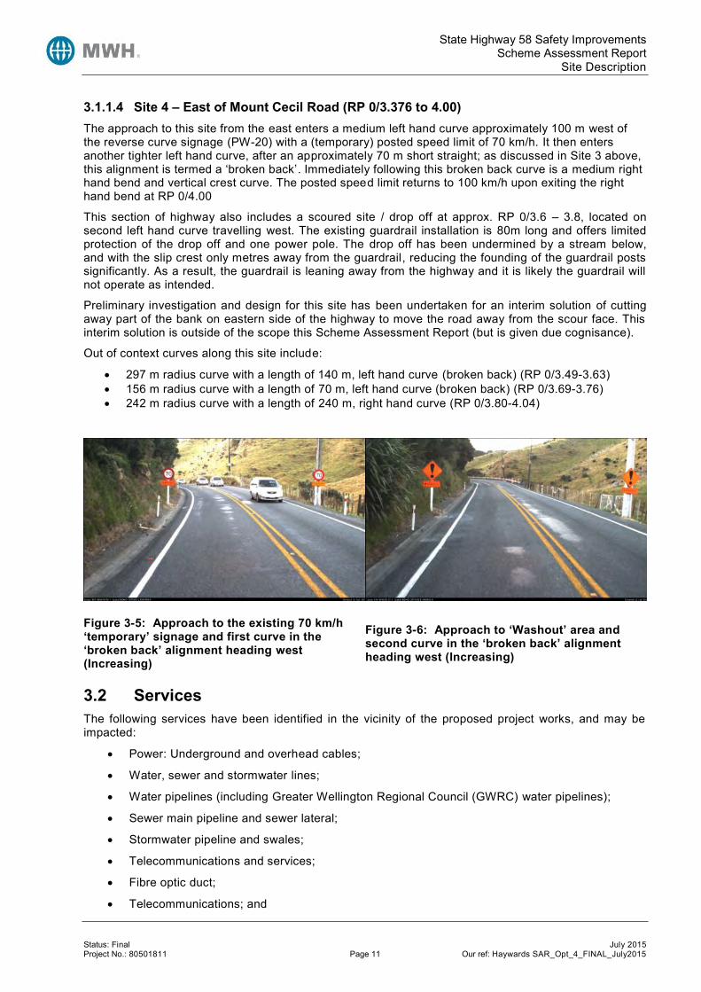
3.1.1.4 Site 4 – East of Mount Cecil Road (RP 0/3.376 to 4.00) The approach to this site from the east enters a medium left hand curve approximately 100 m west of the reverse curve signage (PW-20) with a (temporary) posted speed limit of 70 km/h. It then enters another tighter left hand curve, after an approximately 70 m short straight; as discussed in Site 3 above, this alignment is termed a ‘broken back’. Immediately following this broken back curve is a medium right hand bend and vertical crest curve. The posted speed limit returns to 100 km/h upon exiting the right hand bend at RP 0/4.00
This section of highway also includes a scoured site / drop off at approx. RP 0/3.6 – 3.8, located on second left hand curve travelling west. The existing guardrail installation is 80m long and offers limited protection of the drop off and one power pole. The drop off has been undermined by a stream below, and with the slip crest only metres away from the guardrail, reducing the founding of the guardrail posts significantly. As a result, the guardrail is leaning away from the highway and it is likely the guardrail will not operate as intended.
Preliminary investigation and design for this site has been undertaken for an interim solution of cutting away part of the bank on eastern side of the highway to move the road away from the scour face. This interim solution is outside of the scope this Scheme Assessment Report (but is given due cognisance).
Out of context curves along this site include:
297 m radius curve with a length of 140 m, left hand curve (broken back) (RP 0/3.49-3.63) 156 m radius curve with a length of 70 m, left hand curve (broken back) (RP 0/3.69-3.76) 242 m radius curve with a length of 240 m, right hand curve (RP 0/3.80-4.04)
Figure 3-5: Approach to the existing 70 km/h ‘temporary’ signage and first curve in the ‘broken back’ alignment heading west (Increasing)
Figure 3-6: Approach to ‘Washout’ area and second curve in the ‘broken back’ alignment heading west (Increasing)
3.2 Services The following services have been identified in the vicinity of the proposed project works, and may be impacted:
Power: Underground and overhead cables;
Water, sewer and stormwater lines;
Water pipelines (including Greater Wellington Regional Council (GWRC) water pipelines);
Sewer main pipeline and sewer lateral;
Stormwater pipeline and swales;
Telecommunications and services;
Fibre optic duct;
Telecommunications; and

State Highway 58 Safety Improvements Scheme Assessment Report
Collected Data
Status: Final July 2015 Project No.: 80501811 Page 12 Our ref: Haywards SAR_Opt_4_FINAL_July2015
Vector gas.
Services of significant risk include the high-pressure GWRC water mains and telecommunications that both run alongside (and across) the highway for much of the project length. The concentration of services in the vicinity of the Haywards Substation will also need care during the detail design phase.
It is noted that by the time construction commences there may be additional services that may be impacted by the works.
Further detail is provided in the existing services plan located in Appendix E.
4 Collected Data 4.1 Topographical Survey The initial scope of this SAR was limited to the consideration of three sites for realignment. As such the initial topographical survey data collection was undertaken in two specific parts.
Firstly, ground based topographical survey was undertaken of the three realignment sites which includ ed the full road seal and any existing unsealed road shoulder. In combination with the ground based topographical survey, it was deemed appropriate to take further aerial (LiDAR) survey to capture the topography either side of the existing sealed road. It was necessary to gather this data aerially given the large and steep slope faces in places that would be affected by any proposals for realignment requiring significant cut or fill.
When the project scope was subsequently expanded to include a fourth site for realignment together with an improved cross section to be considered for the entire project extent, further survey data was required. A further aerial survey was then commissioned for the remaining length. Aerial survey was deemed appropriate given the project length and volume of data required for the full project extent (9.5km total). Whilst aerial survey does lack the detail of ground based survey, it is reasonably accurate and can be used for scheme stage design with confidence.
4.2 Traffic Data 4.2.1 Traffic Volumes The telemetry traffic count site located at RP 0/9.1 on SH58 gives a 2012 AADT of 13,600 and a regression analysis of 1992 to 2012 traffic volumes gives a traffic growth rate of 1.7%, as shown in Figure 4-1 below. However, when considering the last ten year period, the growth rate is 0.6%.
A 1.5% growth rate has been adopted9 to account for the following:
An increase in traffic following completion of Transmission Gully10;
A minor increase due to future development in Judgeford and Pauatahanui (see section 9.4.2); and
The likely decrease in traffic on SH58 if the Petone to Grenada link proceeds.
9 Note a 1.5% growth rate was used for the original Options 1-3 only. Following receipt of Petone to Grenada Saturn Modelling results, the preferred option (Option 4) was updated to use 2021 and 2031 SATURN modelling outputs, with a traffic growth rate of 0.5% from 2013 to 2021 and model based growth rates from 2021 to 2041. Refer Section 11.3, Appendix B and Appendix L for further detail. 10 Board of Inquiry, Transmission Gully, Statement of evidence (Tim Kelly), “…an increase in daily volumes using SH58 between the Project and SH2 at Haywards of 18%. This increase is not sufficient to give rise to any significant deterioration in the efficiency or safety of this route. The NZTA has programmed a number of safety and capacity improvements to SH58, including the grade-separation of its intersection with SH2”. “Traffic volumes on both sides of the Pauatahanui Inlet will be significantly reduced, by 25-30% on sections of SH58. The full evidence is provided in the TG evidence of Tim Kelly, paragraphs 52 and 58 apply to SH58.http://www.nzta.govt.nz/projects/transmission-gully-application/docs/evidence-tim-kelly.pdf.

State Highway 58 Safety Improvements Scheme Assessment Report
Collected Data
Status: Final July 2015 Project No.: 80501811 Page 13 Our ref: Haywards SAR_Opt_4_FINAL_July2015
Sensitivity testing has also been undertaken to consider a 0.5% traffic growth future scenario, refer Appendix L.
Figure 4-1: Haywards SH58 Traffic Growth 1992-2012
Table 4-1 below outlines the current traffic volumes of the nearest telemetry count site as well as the local roads located within the three sites.
Table 4-1: Current Traffic Volumes11
Location Type Volume
SH58 West of SH2 - Haywards Hill (RP 0/0.10)
Single Loop, continuous
ID: 05800000
13,594 AADT (2012)
SH58 Pauatahanui East (RP 0/9.14)
Telemetry Site 73
ID: 05800009
13,605 AADT (2012)
Hebden Crescent (RP 0/0.03) Local road count 453 ADT
McDougall Grove (RP 0/0.30) Local road count 99 ADT
Hugh Duncan Street (RP 0/0.95) Local road count 250 ADT
Kaitawa Street (RP 0/1.17) Private Access N/A – Substation Access
Atiamuri Crescent (RP 0/1.33) Private Access N/A – Substation Access
11 SH58 volumes obtained via NZTA’s Traffic Monitoring Systems (TMS), local road counts obtained via CAS (data sourced from RCA RAMM).
y = 255.1x - 498585R² = 0.9237
7,000
8,000
9,000
10,000
11,000
12,000
13,000
14,000
15,000
16,000
17,000
18,000
19,000
1990 1992 1994 1996 1998 2000 2002 2004 2006 2008 2010 2012
An
nu
al A
vera
ge D
aily
Tra
ffic
(vp
d)
Calendar Year
TRAFFIC GROWTH SH58 Haywards1992-2012
West of SH 2(Haywards Hill)
PAUAHATANUIEAST - TelemetrySite 73 - OppositeTimber Mill
Linear(PAUAHATANUIEAST - TelemetrySite 73 - OppositeTimber Mill)
1.7%
1.5%

State Highway 58 Safety Improvements Scheme Assessment Report
Collected Data
Status: Final July 2015 Project No.: 80501811 Page 14 Our ref: Haywards SAR_Opt_4_FINAL_July2015
Location Type Volume
Old Haywards Road (RP 0/1.44) Local road count 99 ADT
Mount Cecil Road (RP 0/2.99) Local road count 20 ADT
Harris Road (RP 0/4.47) Local road count 32 ADT (2009)
Moonshine Road (RP 0/6.32) Local road count 576 ADT (2010) – low count compared to MWH short term pm peak survey (approx. 1,200 vph)
Mulhern Road (RP 0/7.31) Local road count 255 ADT (2009)
Murphys Road /Flightys Road (RP 0/8.01)
Local road count Murphys Road: 221 ADT (2010)
Flightys Road: 488 ADT (2010)
Belmont Road (RP 0/8.37) Local road count 121 ADT (2010)
Bradey Road (RP 0/9.32) Local road count 124 ADT (2007)
4.2.2 Roadway Capacity Traffic modelling12 was undertaken as part of the SH58 Corridor Strategy Study (2009) , with the results from Manor Park (SH2) to the Pauatahanui Roundabout outlined below.
This section of SH58 is currently operating at LOS E during the weekday commuter peak periods, except for the sections with passing lanes which operate at LOS D. This is just below the assessed capacity13.
In 2029 (with Transmission Gully, Petone to Grenada and SH2/SH58 Grade Separation complete), the AM peak eastbound traffic volumes of approximately 1,250 vph will mean that some sections of the route will be operating at capacity. However, in all other situations LOS D or E can be expected.
Refer Appendix B for LoS graphs and 2012 directional peak hour flow graphs.
4.2.3 Traffic Composition The 2012 traffic composition of the count site within the study area and the nearby telemetry site have been assessed with the results shown in Table 4-2 and Figure 4-2 below.
The vehicles classes currently recorded by telemetry sites (and classified surveys) are outlined below:
Light vehicles (LV) are split into two length categories, up to 5.5 m (LV-I cars) and 5.5 m to 11 m (LV-II).
Medium commercial vehicles (MCV) are calculated as 50% of the 5.5-11 m vehicles; these are included in the total number of heavy vehicles.
Heavy commercial vehicles type I (HCV-I) with lengths between 11 m and 17 m.
Heavy commercial vehicles type II (HCV-II) are large vehicles with lengths greater than 17 m.
12 Note: the model included the following assumptions: SH2/SH58 Interchange and the Petone to Grenada projects complete by 2019 and in 2029 the above projects plus Transmission Gully. 13 NZTA, SH58 Corridor Strategy (2009) states “The upper limit of LOS E has been chosen to reflect the capacity of the highway. Ideally, highway upgrades should occur prior to the traffic volumes in peak periods meeting this capacity figure; however, th is often does not happen. The primary reason for this is affordability”.

State Highway 58 Safety Improvements Scheme Assessment Report
Collected Data
Status: Final July 2015 Project No.: 80501811 Page 15 Our ref: Haywards SAR_Opt_4_FINAL_July2015
Heavy vehicles are the sum of MCV, HCV-I and HCV-II.
Table 4-2: Telemetry Site Traffic Composition
Location 2012 Total LV-I LV-II MCV HCV-I HCV-II HVs (MCV, HCV)
West of SH2 (Haywards)
RP 58/0
AADT
(vpd) 13,594 12,754 122 416 215 87 718
% 100% 94% 1% 3% 2% 1% 5%
SH58 Pauatahanui
East
RP 58/9
AADT (vpd) 13,605 12,607 427 427 82 62 571
% 100% 93% 3% 3% 1% 0% 4%
Figure 4-2: Count Site Traffic Composition
4.2.4 Travel Speed Travel speed data has been collected using the following sources:
Dual tube speed survey (NZTA/HTS, 2005) east of the Pauatahanui Roundabout (approx. RP 0/9.1 – near Telemetry site);
Dual tube speed survey (TDG, 2011) near the proposed Winstones Clean Fill site, west of Mt. Cecil Road (approx. RP 0/3.22);
Car following travel time surveys14, July 2013, along the four proposed realignment sections (approx. RP0/0.5 to RP0/4.0); and
Design speed estimates for the existing situation using geometric data15
14 These surveys involved following another vehicle, at approximately the same speed, along each of the four realignment sites and recording the travel time and distance travelled. This was repeated three to four times in each direction.
1275412607
122 427
416
427
21582
87 62
80%
82%
84%
86%
88%
90%
92%
94%
96%
98%
100%
West of SH2 (Haywards) (RP 58/0) PAUATAHUNUI EAST - Telemetry Site 73 (RP 58/9)
Per
cen
t o
f Tr
affi
c
Telemetry Site
SH58 Traffic Composition
HCV-II >17 m
HCV-I 11-17m
MCV* 5.5-11 m
LV 5.5-11 m
LV 2.5-5.5 m

State Highway 58 Safety Improvements Scheme Assessment Report
Collected Data
Status: Final July 2015 Project No.: 80501811 Page 16 Our ref: Haywards SAR_Opt_4_FINAL_July2015
The purpose of collecting and analysing the travel speed and travel time data is to verify the existing speed environment and validate the economic assumptions relating to travel time savings.
The results of the various surveys are outlined in Table 4-3, Table 4-4 and Figure 4-3 below.
Table 4-3: HTS and TDG Dual Tube Speed Surveys
Weekly
HTS Group (RP 0/9.1) TDG (RP 0/3.1)
Increasing Decreasing Increasing Decreasing
April ‘05 August ‘05 April ‘05 August ‘05 Oct ‘11 Oct ‘11
Volume (vpd) 6,742 6,581 6,549 6,345 - -
Mean speed (km/h) 90 91 88 88 92 91
85th %tile (km/h) 97.1 103.1 99.5 99.8 100 99
Table 4-4: Estimated Realignment Travel Speeds
Realignment Site
Car-following Speed Survey (km/h) Design Speed Estimates (km/h)
Westbound (Inc)
Eastbound (Dec) Both Directions Existing
1 77 81 79 70
2 72 82 78 80
3 86 85 86 85
4 84 82 83 82
Figure 4-3: SH58 Realignment Site Average Speeds
As outlined Table 4-3, both the speed surveys conducted in April/August 2005 and October 2011 show similar results with a mean speed of 90 km/h and an 85th percentile speed of 100 km/h. In comparison, the four realignment sites to the east (refer Table 4-4 and Figure 4-3) show much lower mean speeds. This is likely due to the spot speed surveys being located along relatively straight sections, in contrast to
15 Note: Design speed estimates haves been calculated based on the current geometry (with a number of si tes also containing multiple curves). LIDAR data has been used. Therefore, the results are only approximate. Refer Section 8.3.2.1 for the option design speed estimates.
60
65
70
75
80
85
90
RP 0.57-1.06 RP 1.13-1.47 RP 2.41-3.00 RP 3.38-3.90
Site 1 Site 2 Site 3 Site 4: "wash out"
Spe
ed
(km
/h)
SH58 Haywards Hill Average Speeds by Direction
Northbound (inc)
Both directions
Southbound (dec)
Existing DesignSpeed

State Highway 58 Safety Improvements Scheme Assessment Report
Collected Data
Status: Final July 2015 Project No.: 80501811 Page 17 Our ref: Haywards SAR_Opt_4_FINAL_July2015
the average speeds surveys which were conducted along the curvilinear alignment of the realignment sites. Table 4-4 and Figure 4-3 show that site 1 and site 2 had the lowest average speeds of the four realignment sites from the car-following surveys undertaken; these trends correlate well with the existing design speed estimation (refer Figure 4-3, triangular symbols).
The observed travel speeds are similar or higher for three of the four sites when compared to the existing design speed estimates, this is not unsurprising due to the relatively high speed environment.
Further Traffic data, including graphs of AADT, peak hourly flows and speed survey data are detailed in Appendix B.
4.3 Crash History 4.3.1 Crash Data A review of NZTA’s CAS database over the five-year period 2008 to 2012 revealed a total of 138 crashes (15 high severity crashes resulting in 15 DSI) along the approximately 10 km project length, from RP 0/0.1 to RP 0/9.8.
The following tables provide a summary of the CAS output data for the study area:
Additional outputs from the CAS database are Appendix C.
Table 4-5: Annual Distribution of Crashes
Year Fatal Serious Minor Non-Injury Total DSi*
2008 - 2 4 8 14 2
2009 1 2 7 21 31 3
2010 1 1 9 19 30 2
2011 - 3 5 19 27 3
2012 - 5 9 22 36 5
Total 2 13 34 89 138 15 * Death and serious injury casualties
Figure 4-4: SH58 Crash History 2008-2012
Figure 4-4 above shows an increasing trend in deaths and serious injuries from 2010 onwards.
0
5
10
15
20
25
30
35
40
2008 2009 2010 2011 2012
Nu
mb
er
of
Cra
she
s
Year
SH58 Crash History 2008-2012
Non-Injury
Minor
Serious
Fatal
DSi*

State Highway 58 Safety Improvements Scheme Assessment Report
Collected Data
Status: Final July 2015 Project No.: 80501811 Page 18 Our ref: Haywards SAR_Opt_4_FINAL_July2015
Table 4-6: CAS Crash Type
Crash Type Number of Reported Crashes
% of Reported Crashes
% of Reported High Severity Crashes
Bend – Lost Control/Head On 76 55% 40% Rear End / Obstruction 24 17% 20% Straight Road Lost Control/Head On
15 11% 27%
Overtaking Crashes 14 10% 13% Crossing / Turning 5 4% 0% Miscellaneous Crashes 4 3% 0% Pedestrian Crashes 0 0% 0% Total 138 100% 100%
Table 4-7: Environmental Factors
Wet/ Icy Dry Night Day Weekend (Fri 6:00PM to
Monday 5:59AM) Weekday
No. 73 65 33 105 49 89
% 53% 47% 24% 76% 36% 64%
The percentage of all crashes which occurred in the wet is very high at 53% (compared to the Wellington State Highway network average of approximately 30%). Table 4-8 shows that of the 70 crashes occurring in the wet, 30% were injury crashes with 24% being high severity. Overall, 33% of the total fatal and serious crashes occurred in the wet, higher than the regional16 average of 28%.
Table 4-8: Wet/Icy Crash Summary
Road Surface Fatal Serious Minor Non-
injury Total %
Injury % of Total Injury
% High Severity
% of Total F+S
Dry 1 9 17 38 65 42% 55% 37% 67%
Wet 1 4 16 49 70 30% 43% 24% 33%
Icy 0 0 1 2 3 33% 2% 0% 0%
Total 2 13 34 89 138 36% 100% 31% 100%
16 HRRRG, Wellington NMA is in the South-west North Island climate zone. It is noted however, that the HRRRG shows a higher value, proportion of rural road F&S injury crash occurring in the wet, of 36% for bend-lost/Head-on. As the majority of high severity crashes on this section are Bend/Lost control/head-on (40% - table 4-6), the 33% of high severity crashes occurring on this sections is not significantly high.

State Highway 58 Safety Improvements Scheme Assessment Report
Collected Data
Status: Final July 2015 Project No.: 80501811 Page 19 Our ref: Haywards SAR_Opt_4_FINAL_July2015
Table 4-9: Hit Object Crashes
Object Hit* Number of Reported Crashes
% of Reported Crashes
Number of Reported
High Severity Crashes
% High Severity
Number of Reported
Injury Crash
% Injury
Fence 30 25% 2 7% 10 33%
Cliff/Bank 28 23% 2 7% 10 36%
Guard/guide rail & median barrier
15 13% - 0% 1 7%
Tree 11 9% 1 9% 5 45%
Ditch 10 8% - 0% 3 30%
Utility post/pole 10 8% - 0% 6 60%
Overbank/Cliff 7 6% - 0% 3 43%
Other 7 6% 1 14% 3 43%
Water/River 2 2% 1 50% 2 100%
Total 120 100% 7 6% 43 36%
*Note: Some crashes could have involved more than one object hit; 61% of the total number of injury crashes involved one or more objects hit (24% of the total number of injury crashes involved multiple hit objects).
Table 4-10: HRRRG Crash Type
Crash Type Number of Reported Crashes
DSi % of Reported Crashes
% of Reported High Severity
Crashes
Run off Road 86 9 62% 60%
Head On 11 3 8% 20%
Intersection Crashes 15 1 11% 7%
Other 26 2 19% 13%
Total 138 15 100% 100%

State Highway 58 Safety Improvements Scheme Assessment Report
Collected Data
Status: Final July 2015 Project No.: 80501811 Page 20 Our ref: Haywards SAR_Opt_4_FINAL_July2015
Table 4-11: Crash Causation Factors of Reported Injury Crashes
Causation Number of
Reported Crash Causation
Factors
Number of Reported Injury Crash
Causation Factors
% High Severity
Poor handling 46 15 17%
Road factors 40 14 15%
Other (all remaining) 44 15 9%
Alcohol / drugs observed 14 8 29%
Too fast 41 15 7%
Poor observation 38 14 8%
Poor judgement 24 10 8%
Incorrect lanes/position 14 5 14%
Disabled /old / ill 4 4 50%
Failed to keep left 4 3 25%
Vehicle factors 15 2 7%
Weather (excl. animals) 6 2 17%
Enter/exit land use 7 2 0%
Failed to Give Way/Stop 5 2 0%
Fatigue 6 1 0%
Overtaking 5 1 0%
Road factors included:
85% (34 crashes) were due to “Slippery” conditions; 63% of due to rain or ice, 13% (5 crashes) due to oil/fuel and 6% due to surface bleeding/loose material.
5% (2 crashes) due to “Surface” conditions, with one of the crashes due to road maintenance.
The remaining four of crashes were due to visibility limitations (three involving curves).

State Highway 58 Safety Improvements Scheme Assessment Report
Collected Data
Status: Final July 2015 Project No.: 80501811 Page 21 Our ref: Haywards SAR_Opt_4_FINAL_July2015
4.3.2 Crash Summary A summary of the crashes on each of four realignment sites and the remaining midblock sections is outlined below.
Midblock Sections (excluding the four realignment sections) – 93 recorded crashes (11 DSI)
o Two fatal crashes, nine serious crashes, 21 minor injury crashes and 61 non-injury crashes.
o The fatal crashes involved:
A westbound van losing control while overtaking in heavy rain (worn tyres); and
A westbound motorcyclist colliding with a westbound van u-turning, visibility limited by curve.
o The serious crashes involved seven loss of control, one rear end and one overtaking crash.
o 45% of crashes were bend loss of control/head-on, 20% Rear end/obstruction, 13% straight loss of control/head on, 13% overtaking, 5% crossing/turning and 4% miscellaneous.
o When considering the three high risk rural roads guide (HRRRG) high severity crash types, run off road crashes account for 64% (54% nationally), head on 18% (21% nationally) and intersection 9% (13% nationally).
Compared to national figures, this section of highway is overrepresented in high severity run off road crashes.
o 45% of the crashes occurred in wet/icy conditions, including one fatal, two serious, eight minor and 31 non-injury crashes.
Site 1 RP 58/0/0.574 – 1.064: 12 recorded crashes (1 DSI)
o One serious crash, three minor injury crashes and eight non-injury crashes.
o The serious injury crash involved a motorcyclist travelling westbound losing control and colliding with the rear of a car that was travelling very slowly on a left hand curve.
o The minor injury crashes involved:
An eastbound car travelling too fast when entering a corner, losing control when turning right and hitting a bank/tree;
A westbound SUV travelling too fast when entering a corner, swinging wide, and colliding head on with another vehicle; and
A westbound vehicle colliding with another vehicle when changing lanes to the left on a passing lane.
o The non-injury crashes involved six bend loss of control/head on crashes, one u-turning crash and one rear-end crash.
o 50% of the crashes occurred in dark (night/twilight) conditions, including one minor injury crash and five non-injury crashes.
o 58% of the crashes occurred in wet conditions, including two minor injury crashes and five non-injury crashes.
Site 2 RP 58/0/1.128 – 1.470: 5 recorded crashes (0 DSI)
o No fatal or serious crashes, two minor injury crashes and three non-injury crashes.
o The minor injury crashes involved:
A westbound van travelling too fast when entering a corner, losing control when turning left and hitting guardrail; and
A westbound SUV losing control when turning left on a curve and colliding with a cliff/bank.

State Highway 58 Safety Improvements Scheme Assessment Report
Collected Data
Status: Final July 2015 Project No.: 80501811 Page 22 Our ref: Haywards SAR_Opt_4_FINAL_July2015
o 80% of the crashes occurred in wet or icy conditions, including both minor injury crashes.
o 60% of the crashes occurred in dark (night/twilight) conditions, including one minor injury crash.
Site 3 RP 58/0/2.411 – 3.000: 5 recorded crashes (0 DSI)
o No fatal or serious crashes, two minor injury crashes and three non-injury crashes.
o Both minor injury crashes occurred in wet conditions, with the driver entering the corner too fast; resulting in one loss of control while overtaking and one rear end crash.
o The non-injury crashes involved two bend loss of control crashes and one rear-end crash.
o 80% of the reported crashes occurred in wet conditions. However, only one non-injury crash occurred in dark conditions (20%).
Site 4 RP 58/0/3.376 – 4.000: 23 recorded crashes (3 DSI)
o Three serious crashes, six minor injury crashes and 14 non-injury crashes.
o The serious injury crashes involved:
An eastbound van losing control turning right colliding with a fence, flipping down a bank and coming to rest in a small stream.
An eastbound car entering a corner too fast, losing control when turning and colliding with another car head on.
A westbound car losing control on a straight, crossing the centreline and colliding with two eastbound vehicles.
o The three minor injury crashes were bend loss of control followed by hit object (cliff/bank, poles, and fence).
o The non-injury crashes involved 12 bend loss of control, one head on and one rear-end crash.
o 65% of reported crashes occurred in wet conditions, including two serious, three minor and 10 non-injury crashes.
o 26% of crashes occurred in dark conditions, including one serious crash and two minor injury crashes.
4.3.3 Crash Risk The project area has been assessed using both the High Risk Rural Roads Guide17 (HRRRG) and the draft High Risk Intersections Guide18 (HRIG). Refer Appendix C for crash risk calculations.
Based on published 2012 KiwiRAP risk maps, SH 58 from Porirua to SH 2 Upper Hutt has a low-medium personal risk (annual average fatal and serious injury crashes per 100 million vehicle km) and a high collective risk (annual average fatal and serious injury crashes per km). Due to the high collective risk (ranked 12th nationally), SH58 is classified as a high-risk rural road.
The calculated star rating for this section of SH58 is 2.7, resulting in a published KiwiRAP star rating of 2-star. This is below the NZTA’s regional strategic aim “to achieve mostly 3-star KiwiRAP safety risk rating”.
The crash risk for the project length is as follows:
High collective risk (0.31 high severity crashes per km per year)
Medium personal risk (6.12 high severity crashes per 100 million veh km)
17 High Risk Rural Roads Guide (HRRRG), NZTA, September 2011 18 High Risk Intersection Guide (HRIG), NZTA, Draft March 2012

State Highway 58 Safety Improvements Scheme Assessment Report
Collected Data
Status: Final July 2015 Project No.: 80501811 Page 23 Our ref: Haywards SAR_Opt_4_FINAL_July2015
Therefore this section is classified as a high-risk rural road with predominately a ‘Safer Corridors’ treatment strategy. In addition, due to the high volume of the route there is some justification for medium to high cost improvements under a ‘Safe System Transformation’ treatment strategy.
The treatment strategies support the proposed options19 of providing roadside and centreline corridor improvements, in the form of shoulder widening, curve easing and median treatments.
Two intersections in the study area were identified with three or more injury crashes, Moonshine Road and Flightys/Murphys Road. Both intersections were analysed according to the HRIG, refer section 4.3.3.1 and 4.3.3.2 below.
4.3.3.1 Crash Risk: SH58/Moonshine Road Intersection In terms of collective crash risk for the T intersection of SH58/Moonshine Road intersection, there are two methods of calculation:
Reported F&S Crashes: Over the five year assessment period: there have been two F&S crashes reported within 250 m of the intersection, with two DSI.
Estimated F&S Crashes: The second method involves the estimation of F&S crashes that have occurred at an intersection using all injury crashes that have occurred during the crash period. This method takes into account the crash movement type, intersection form and control, and collision speed on crash severity outcomes. The estimated collective crash risk is calculated at 0.7 F&S crashes for a 5-year period. This is presented in the table below:
Table 4-12: Estimation of F&S Collective Risk Using Severity Index SH58/Moonshine Road Intersection
Crash Type Number of Reported Injury Crashes
Adjusted F&S crashes / All injury
crashes20
Estimated Number of F&S Injury
Crashes
Head-on (B Type) 1 0.35 0.35
Cornering (D Type) 1 0.27 0.27
Rear End (F Type) 1 0.08 0.08
Total 3 0.70 Therefore, according to HRIG21 this intersection is considered ‘Low medium’ risk when quantifying collective risk.
When considering personal risk; a calculation is performed which considers the major and minor road traffic volumes to determine the product of flow to standardise the number of potential conflicts that could occur at an intersection. The SH58 / Moonshine intersection is calculated as having a personal risk value of 95. According to HRIG22, this results in a ‘Medium’ personal risk level.
The Level of Safety Service (LoSS)23 for this intersection has been calculated to be 7 which is category V24 and demonstrates a poor safety performance on a five point scale, when compared to other intersections with similar characteristics.
Therefore although this intersection has not resulted in high-risk classification (based on collective and personal risk), the HRIG recommended safety improvement strategy is ‘Safety Management’. However, due to the poor LoSS, further investigation and/or larger cost treatments may be justifiable on safety grounds.
19 Refer Section 7 for option discussion 20 HRIG, Table 8.10 21 HRIG, Table 4-1 22 HRIG, Table 4-2 23 Level of Safety Service, as defined by HRIG, is a method of categorising the safety performance of an intersection compared to other intersections of that type. 24 LoSS categories range from I (one) to V (five) where intersections classified as LoSS I have a safety performance that is bet ter than other intersections of that type, in the same speed environment and with similar traffic flows. For intersections of Category V, the converse is true. Category V have LoSS values greater than 3.

State Highway 58 Safety Improvements Scheme Assessment Report
Collected Data
Status: Final July 2015 Project No.: 80501811 Page 24 Our ref: Haywards SAR_Opt_4_FINAL_July2015
4.3.3.2 Crash Risk: SH58 and Flightys/Murphys Road Intersection In terms of collective crash risk for the crossroads intersection of SH58 and Flightys/Murphys Road, there are two methods of calculation:
For Collective Crash Risk:
Reported F&S Crashes: Over the 5 year assessment period, there have been no F&S crashes.
Estimated F&S Crashes: The estimated collective crash risk is calculated at 0.90 F&S crashes for a 5 year period. This is presented is the table below:
Table 4-13: Estimation of F&S Collective Risk Using Severity Index SH58 and Flightys/Murphys Road Intersection
Crash Type Number of Reported Injury Crashes
Adjusted F&S crashes / All injury
crashes
Estimated Number of F&S Injury
Crashes
Cornering (D Type) 1 0.27 0.27
Loss Control Bend (G Type) 3 0.24 0.72
Total 4 0.90 Therefore, according to HRIG, using F&S injury estimation method the intersection is ‘Medium’ risk. The SH58 and Flightys/Murphys Road Intersection is calculated as having a personal risk value of 140, according to HRIG, this results in a ‘High’ personal risk level.
The Level of Safety Service (LoSS) for this intersection has been calculated to be 3.0 which is category V and demonstrates a poor safety performance on a five point scale, when compared to other intersections with similar characteristics.
This intersection has been classified as having a medium collective risk and a high personal risk, therefore this intersection is high-risk. The HRIG recommended safety improvement strategy is ‘Safe System Transformation Works’ or ‘Safety Management’.
4.3.4 Crash Rate The site specific crash rate for each site has been compared to what would be expected as typical. The typical crash rate was found for each of the curves using the crash prediction model for mid-block crashes in the New Zealand Transport Agency’s Economic Evaluation Manual (EEM1).
4.3.4.1 Midblock An analysis of the 2008 to 2012 crash data shows that 32 injury crashes occurred in the latest five year period (6.4 injury crashes per year). The typical crash rate was found to be 9.6 injury crashes per year based on predicted 2013 traffic flows. This indicates that the crash rate along this section of the road is lower than “typical” but also that a road with this alignment has the potential to cause more injury crashes.
Table 4-14: Midblock Crash Rate
Parameter Injury Crashes per Year
Site Specific Crash Rate 6.4
Typical Crash Rate 8.7
4.3.4.2 Realignment Sites An analysis of the 2008 to 2012 crash data shows that 17 injury crashes occurred in the latest five year period (3.4 injury crashes per year). The typical crash rate was found to be 2.8 injury crashes per year based on predicted 2013 traffic flows. This indicates that the crash rate along this section of the road is approximately 20% higher than expected.

State Highway 58 Safety Improvements Scheme Assessment Report
Collected Data
Status: Final July 2015 Project No.: 80501811 Page 25 Our ref: Haywards SAR_Opt_4_FINAL_July2015
Table 4-15: Realignment Crash Rate
Parameter Injury Crashes per Year
Site Specific Crash Rate 3.4
Typical Crash Rate 2.8
4.3.5 Crash Context Crashes occurring at, and on approach to, the intersection of State Highway 2 and State Highway 58 have been excluded from the analysis as this is the study area and will be addressed in the planned SH2/SH58 Grade Separation Project.
However, due to the proximity of the intersection to the start of the study area, the following comments have been made regarding the crash history:
In the five year period from 2008 to 2012 there have been:
o Seven loss of control crashes on the curve just west of the SH2/SH58 intersection, all occurring in wet conditions.
o Four rear end crashes on approach to the signalised SH2/SH58 intersection, 25% occurring in wet conditions. 50% of these rear ends crashes are attributed to signals, with the remainder due to queuing.
Since the intersection was resealed, with stone mastic asphalt (SMA) in late April 2012 up to RP 0/0.130:
o There have been no loss of control on curve crashes on the SH58 approach to SH2 (excluding the SH2/58 intersection); and
o There has been a single serious injury rear end queuing crash. The crash occurred due to an eastbound vehicle failing to stop and colliding with a stationary vehicle waiting at the signals. The severity of the crash is likely due to the elderly driver.
Hebden Crescent (RP 0/0.04): intersection crossing/turning crashes excluded as the proposed treatments of this SAR (widening/curve realignment) will not have any effect on this section.
The crash data, including a collision diagram is Appendix C.
4.4 Summary of Preliminary Geotechnical Appraisal Report Sh58 follows the side of a steeply incised valley cut down into greywacke bedrock. The existing road alignment has undertaken a combination of cuts into the western (true left, increasing RP) rock faces, and fill to right hand shoulders.
Whilst the existing rock cuttings are generally performing well; the shoulders to the right hand s ide are over-steep, and failing in several locations.
Our appraisal has highlighted the potential areas of concern or requiring specific detailed assessment and design. Generally at this stage, we recommend that cuttings to the left can adopt the existing cut angles as acceptable precedent for design, provided that appropriate catch benches are also included. Fills to the true right are likely to require significant structures or engineered fills in areas that have shown previous signs of instability. Significant detailed assessment and design would be required to undertake widening or realignment to the right side (increasing RP). There are a number of fills in natural gully landforms that will require culvert extension, and there are some instabilities on the gentled soil slopes to the left side, at RP 3.42-3.46, west of Mt Cecil Road that should be avoided. There is an existing scour site under active management to the west of this.
No specific geotechnical risks stand out for the proposal to add 1.5m of shoulder and up to 2m of additional seal width between SH2 and Pauatahanui Roundabout. In general, the potentials for risk may include minor shoulder construction less than 1.0m thick or cuttings less than 1.5m high (toe to crest). Detailed design would be required to confirm that the scale of general widening proposals meets with this assessment, but we do not consider there to be any untreatable risks as part of this work.

State Highway 58 Safety Improvements Scheme Assessment Report
Stakeholder Relationship Management and Consultation
Status: Final July 2015 Project No.: 80501811 Page 26 Our ref: Haywards SAR_Opt_4_FINAL_July2015
Our report includes a recommended testing schedule; Boreholes are recommended at the top of proposed cuttings to confirm ground conditions beyond the limits of conventional mechanical or hand tool methods, to provide detailed information on the existing geology and allow a rip -ability rating assessment to be undertaken. A combination of mechanically excavated test pits and pavement shoulder pit excavations are recommended, along with hand augers for field logging, sampling and in -situ strength testing. Face scrapes and detailed face mapping will also be undertaken within existing cut slopes next to the highway.
Some consenting may be required in advance of the investigations. Access outside of the road reserve may require land-entry agreements prior to undertaking the work. Temporary access tracks up to 120m long are required for some of the boreholes. Traffic management will be required for work affecting the highway.
5 Stakeholder Relationship Management and Consultation
Consultation with affected people and communities provides decision-makers with information that assists in making well-founded decisions. As well as providing information, consultation processes help project proponents understand community values and expectations.
The NZTA has a policy on consultation and communication of which the development of a consultation plan forms the basis. Under the LTMA, NZTA has a specific obligation to consult, particularly on any proposed activity likely to affect Māori land, or Māori historical, cultural or spiritual interests.
A number of principles that help define the meaning of good consultation include:
Consulting as early as possible when the proposal is still flexible and issues raised by interested and affected persons can still be addressed;
Being transparent about project aims and objectives;
Keeping an open mind to people’s responses and to the benefits that might arise from consultation;
Consultation is intended as an exchange of information and requires both the applicant and those consulted to put forward their points of view, and to listen to and consider other perspectives;
While consultation is not an open-ended process, it should not be seen merely as a means to an end;
Consultation may be on-going and may continue after approvals have been sought, and even after a decision has been made;
Consultation does not necessarily mean that all parties have to agree to a proposal, although it is expected that all parties will make a genuine effort. While agreement may not be reached on all issues, points of difference will become clearer or more specific.
A Consultation Plan has been prepared for the project area and consultation will be undertaken in accordance with the plan. The purpose of the plan is to:
Provide a documented process for intended engagement with the community, including the project context, the parties involved, and desired outcomes;
Maximise effective and efficient engagement of community within generally tight time constraints;
Provide the specifics of consultation to be undertaken, including timeframes;
Help the project team to proactively manage risks to the project/project future from inappropriate or inadequate community engagement; and
Help the project team to constructively manage community expectations.
Key stakeholders have been identified and consultation will commence at the appropriate time. Due to the consultation undertaken for the Petone to Grenada project, the NZTA has decided to defer the
State Highway 58 Safety Improvements Scheme Assessment Report
Options Description
Status: Final July 2015 Project No.: 80501811 Page 27 Our ref: Haywards SAR_Opt_4_FINAL_July2015
consultation for SH58 until the Petone to Grenada consultation is likely to be completed as this also includes consultation on the future of SH58.
Details of the consultation, including the full consultation report and summary are provided in Appendix Q and Appendix R.
6 Options Description As presented previously, the investigation is broken into two parts; realignment of the four specific sites and corridor treatment from SH2 to the Pauatahanui Roundabout.
6.1.1 Realignment Site 1
This section of road has two curves both currently posted at 75km/h. The option is to realign the western curve and eastern curve to grant radii of 400m and 280m respectively. The eastern curve would retain an estimated design speed of 75km/h while the western curve would be increased to 90km/h. This realignment would reduce the demand on drivers and make it easier for them to read the required change in speed by ‘stepping’ the speed change. The design speed would also be increased on average throughout the section resulting in travel time saving.
Site 2
This section of road is currently posted at 65km/h on the western curve and 75km/h on the eastern curve. The option is to realign the western curve to grant a radius of 350m with an estimated design speed of 85km/h, This realignment would reduce the demand on drivers and make it easier for them to read the required change in speed. The design speed would also be increased throughout the section resulting in travel time savings.
Site 3
This section of road is currently posted at 75km/h in both directions. The option is to realign the western curve to grant a radius of 400m with an estimated design speed of 90km/h, the eastern curves would then be combined into one large radius curve removing the ‘broken back’ alignment to obtain a design speed of 90km/h. This realignment would reduce the demand on drivers and make it easier for them to read the required change in speed. The realignment would also improve sight distances at the intersection with Mount Cecil Road decreasing the risk of crashes occurring. The design speed would also be increased throughout the section resulting in travel time savings.
Site 4
A further site (herein described as Site 4), not included in the aforementioned PFR, will also be subject to realignment. For clarity the general location of the section in question is approximately RP SH58/0/3.40 to RP SH58/0/4.00. The existing site has poor horizontal geometry and is a combination of three curves of varying radii and transition lengths. This site is also characterised by stream scour on the eastern side of the road. Recently, a temporary speed restriction to 70km/h has been implemented due to the scour in close proximity to the seal. The realignment proposed will grant a radius of 400m with an estimated design speed of 90km/, resulting in travel time savings.
6.1.2 Enhanced Cross Section In addition to the realignment discussed above, an improved cross section is also proposed for the entire route with three options investigated:
Option 1: 3.5m traffic lanes, with 1.5m sealed shoulders
Option 2: 3.5m traffic lanes, with 1.5m sealed shoulders and a 2m flush median
Option 3: 3.5m traffic lanes, with 1.5m sealed shoulders, 2m median and provision of central median wire rope barrier

State Highway 58 Safety Improvements Scheme Assessment Report
Options Description
Status: Final July 2015 Project No.: 80501811 Page 28 Our ref: Haywards SAR_Opt_4_FINAL_July2015
6.2 Option 1: Curve Realignment and Shoulder Widening This option consists of shoulder widening to 1.5 m, with 3.5m traffic lanes to achieve a minimum seal width of 10 m, as shown in Figure 6-1 below. Refer Appendix E for typical guardrail, passing lane and right turn bay cross sections.
Figure 6-1: Option 1 Typical Cross section
Right turn bays have been provided for at intersections with associated flush median development. Where right turn bays are provided the flush median is developed to 2.5m width to provide a safe refuge area for vehicles waiting to turn right. The 2.5m flush median is also considered upstream of a local road intersection to provide for vehicles turning right out of the local road onto SH58.
Central median wire rope barrier is only provided to replace existing – west of the Transpower access between the westbound passing lane and eastbound carriageway (existing WRB from RP 0/1.515-2.275). However the flush median where the wire rope barrier is located is widened to 2.0m (whereas at present this is only approximately 1.5m wide)
The eastbound passing lane east of Moonshine Road (RP 0/5.966-4.735 – excl. tapers) is maintained. However the short substandard eastbound passing lane west of Mount Cecil Road (RP 0/3.183 to 3.337) is removed to provide access to the proposed cleanfill quarry site.
Edge protection is proposed at a number of locations through the project extents to protect against roadside hazards such as drop offs, cliff faces and (proposed) gabion basket retaining structures. Where guardrail is proposed, an additional 600mm widening is proposed to maintain the shoulder width of 1.5m. Due to topography and the propensity for runoff road / strike object type crashes, a considerable length of guardrail, approximately 6.4km (project length total), is proposed for hazard protection.
Additional curve and shoulder widening is also proposed in a number of locations for safety – either for geometric reasons to support movement around horizontal curves, or due to the density of residential accessways to assist with access and egress (generally between Harris Road and Moonshine Road, and between Mulhern Road and Murphys Road). Details are provided on the corresponding scheme plans.
Proposed delineation features, in addition to retaining the existing Raised Reflectorized Pavement Markers (RRPMs), include the installation of both edgeline and centreline Audio-Tactile Profiled (ATP) markings along the project length.
In addition, realignment is considered at all four horizontal curves as described in section 6.1.1. Where realignment has been proposed, radii reflective with the horizontal curves on the extent of the route are proposed for consistency and driver readability.
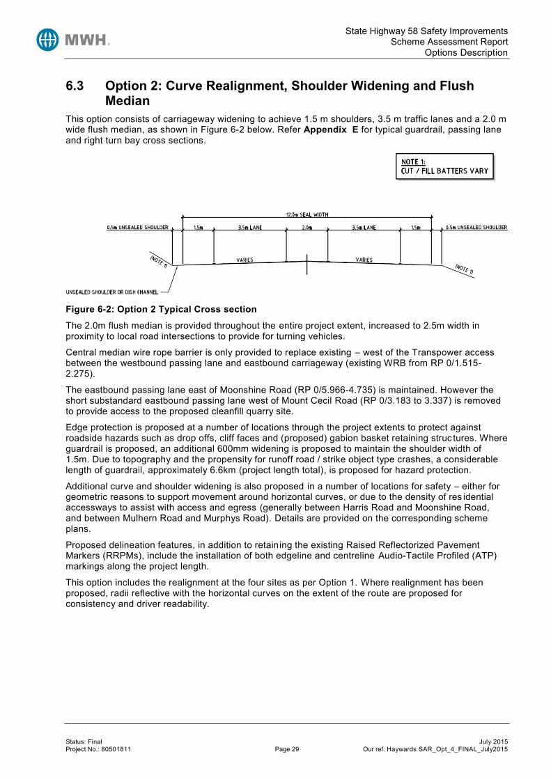
State Highway 58 Safety Improvements Scheme Assessment Report
Options Description
Status: Final July 2015 Project No.: 80501811 Page 29 Our ref: Haywards SAR_Opt_4_FINAL_July2015
6.3 Option 2: Curve Realignment, Shoulder Widening and Flush Median
This option consists of carriageway widening to achieve 1.5 m shoulders, 3.5 m traffic lanes and a 2.0 m wide flush median, as shown in Figure 6-2 below. Refer Appendix E for typical guardrail, passing lane and right turn bay cross sections.
Figure 6-2: Option 2 Typical Cross section
The 2.0m flush median is provided throughout the entire project extent, increased to 2.5m width in proximity to local road intersections to provide for turning vehicles.
Central median wire rope barrier is only provided to replace existing – west of the Transpower access between the westbound passing lane and eastbound carriageway (existing WRB from RP 0/1.515-2.275).
The eastbound passing lane east of Moonshine Road (RP 0/5.966-4.735) is maintained. However the short substandard eastbound passing lane west of Mount Cecil Road (RP 0/3.183 to 3.337) is removed to provide access to the proposed cleanfill quarry site.
Edge protection is proposed at a number of locations through the project extents to protect against roadside hazards such as drop offs, cliff faces and (proposed) gabion basket retaining struc tures. Where guardrail is proposed, an additional 600mm widening is proposed to maintain the shoulder width of 1.5m. Due to topography and the propensity for runoff road / strike object type crashes, a considerable length of guardrail, approximately 6.6km (project length total), is proposed for hazard protection.
Additional curve and shoulder widening is also proposed in a number of locations for safety – either for geometric reasons to support movement around horizontal curves, or due to the density of res idential accessways to assist with access and egress (generally between Harris Road and Moonshine Road, and between Mulhern Road and Murphys Road). Details are provided on the corresponding scheme plans.
Proposed delineation features, in addition to retaining the existing Raised Reflectorized Pavement Markers (RRPMs), include the installation of both edgeline and centreline Audio-Tactile Profiled (ATP) markings along the project length.
This option includes the realignment at the four sites as per Option 1. Where realignment has been proposed, radii reflective with the horizontal curves on the extent of the route are proposed for consistency and driver readability.

State Highway 58 Safety Improvements Scheme Assessment Report
Options Description
Status: Final July 2015 Project No.: 80501811 Page 30 Our ref: Haywards SAR_Opt_4_FINAL_July2015
6.4 Option 3: Curve Realignment, Shoulder Widening and Wire Rope Median Barrier
In addition to including the four realignment sites of Option 1, this option consists of carriageway widening to achieve 1.5 m shoulders, 3.5 m traffic lanes and a 2.0 m wide median with wire rope barrier provision, as shown in Figure 6-3 below. Refer Appendix E for typical guardrail, passing lane and right turn bay cross sections.
Figure 6-3: Option 3 Typical Cross section
This option is the same as Option 2 with the addition of a wire rope median barrier.
The provision of central median wire rope barrier protection has implications for movements at intersections. Decisions on how intersections have been treated in Option 3 has been based on the following; local road traffic volumes, crash history, crash potential (considered on the basis of geometry), existing and proposed strategic plans, and suitability of alternative turnaround locations, including diversion lengths.
The following table describes the proposals at each intersection:
Table 6-1: Option 3 – Intersection Access Arrangements
Location RP Proposed Treatment Right Turn Alternatives Comments
Hebden Crescent
0/0.03 No works, outside of treated area
N/A Wire rope median barrier does not extend this far. Likely part of SH2/SH58.
McDougall Grove
0/0.30 No works, outside of treated area
N/A Wire rope median barrier does not extend this far. Likely part of SH2/SH58.
Hugh Duncan Street
0/0.95 WRB broken to allow all movements, right turn bay provided
None required Based on 250 ADT and no crashes
Kaitawa Street
0/1.17 WRB through intersection left in and out only (LILO)
U turn at Old Haywards Road for entry. For exit, turnaround at McDougall Grove Area
Substation Access. Transpower currently operate with LILO access.
Atiamuri Crescent
0/1.33 WRB through intersection left in and out only
U turn at Old Haywards Road for entry. For exit, turnaround at McDougall Grove Area
Substation Access Transpower currently operate with LILO access.
Old Haywards Road /
0/1.44 WRB broken to allow right turn in only, right turn bay provided
Right turn entry provided for. For exit, turnaround at
Right turn in to maintain access. Right turn out prevented to avoid a merge on

State Highway 58 Safety Improvements Scheme Assessment Report
Options Description
Status: Final July 2015 Project No.: 80501811 Page 31 Our ref: Haywards SAR_Opt_4_FINAL_July2015
Location RP Proposed Treatment Right Turn Alternatives Comments
Substation access
McDougall Grove Area
a passing lane on an uphill 9% grade. It is noted that the substation encourages no right turn out at present, recognising the high risk involved in turning vehicles joining the overtaking lane of a passing lane on a significant uphill grade
Mount Cecil Road
0/2.99 WRB broken to allow all movements, right turn bay provided
None required Very low volumes 20 ADT and on apex of crest but zero crashes and difficult to provide alternatives
Harris Road 0/4.47 WRB broken to allow all movements, right turn bay provided
Right turn entry provided for. For exit, turnaround at Moonshine Road
Low vehicle flows (32 ADT - 2009) however right turn in allowed to cater for business (business access would require relocation from SH58 onto Harris Road). Right turn out to passing lane removed.
Moonshine Road
0/6.32 Roundabout proposed to provide full access and turnaround facilities
None required 576 ADT (2010) – low count compared to MWH short term pm peak survey (approx. 1,200 vph)
Mulhern Road
0/7.31 WRB broken to allow all movements, right turn bay provided
None required Reasonably high local road movements (255 ADT - 2009), no intersection crashes and acceptable visibility
Murphys Road /Flightys Road
0/8.01 WRB broken to allow all movements, right turn bays provided (for both)
None required High vehicle numbers. However there are a number of intersection crashes here and it may be feasible to close this at detailed design stage with vehicles diverting to Pauatahanui and Moonshine roundabouts25,26.
Belmont Road
0/8.37 WRB through intersection left in and out only
Right turn entry turnaround at Moonshine Road. Right turn exit, turnaround at Pauatahanui roundabout
Due to presence of horizontal curves, allowing right turn in and out is not appropriate
25 PFRs were also undertaken by MWH in 2009 investigating a roundabout at Moonshine Road and Murphys/Flightys Road. Due to the negative BCR the recommendation was to revisit both proposals at a later date. 26 Pauatahanui Judgeford Structure Plan Technical Report (2012), Transport and Accessibility, “The NZTA has indicatively planned to subsequently construct two roundabouts at the Flightys/Murphys Roads crossroads and at the Moonshine Hill Road Tee intersection in 15-20 years. However the preliminary assessment outlined above indicates that, depending on rise in SH58 traffic and associated level of acceptance of delays to side road traffic as well as the safety record, the roundabouts might be required earlier”.

State Highway 58 Safety Improvements Scheme Assessment Report
Options Description
Status: Final July 2015 Project No.: 80501811 Page 32 Our ref: Haywards SAR_Opt_4_FINAL_July2015
Location RP Proposed Treatment Right Turn Alternatives Comments
Bradey Road
0/9.32 WRB broken to allow all movements
None required 124 ADT (2007), and good visibility and crash history
A key consideration for this scheme assessment has related to the provision of turning facilities where new central median wire rope barrier is proposed. Whilst some wire rope median barrier is proposed in both Options 1 and Option 2, this is replication of the existing wire rope barrier and results in no change to access.
In Option 3 however, where wire rope is proposed throughout the full project extents, the effect on access provision, either to intersections, or to direct frontage access onto SH58, is considerable.
A thorough assessment has been undertaken as to where the proposed wire rope barrier could be broken and the effect this would have directly on access. In addition, a key component of any proposal to prevent direct access is a consideration of alternative turning locations – in terms of the location, diversion length and safety (both in terms of actual crashes and also crash potential). The full intersection treatment strategy and assessment is contained with Appendix S.
Whilst the proposals submitted are considered a good solution in terms of balancing access provision, safety and reasonable turnaround alternatives, it is accepted that there are other options that exist that may also offer suitable levels of access and could indeed be preferable to some of those affected. It is recognised that the provision of median barrier with the effect of limiting access and forcing vehicles to divert is a highly contentious and emotive issue for those affected.
Alternatives certainly exist in respect of which locations the wire rope is broken. For example a possible alternative option in providing a roundabout at the intersection of Murphys Road and Flightys Road 27 has been discussed previously and this would assist in providing vehicle turn around facilities.
A roundabout is proposed at Moonshine Road which also serves a purpose for both access but also acts as a vehicle turnaround for locations where access has been reduced to left in / left out only. The use of roundabouts as an intersection form certainly assists in providing safe turnaround facilities. However, the provision of new roundabouts has to be carefully considered as the access benefits are offset by the negative economic effect of a roundabout directly located on SH58 due to the delaying effect on all state highway traffic that ordinarily would not have been encountered.
In respect of the roundabout proposed at Moonshine Road under this option, the physical island diameter is shown at 40m as per Austroads standards – however further consideration should be given to the speed environment at detailed design stage as a smaller diameter may be warranted which is more in-keeping with the surrounding road environment.
Furthermore, it is noted that visibility for vehicles travelling east on Moonshine Road to the existing limit line is impeded by the left hand side embankment. With the provision of a roundabout there would be a requirement to improve sight distance by cutting away some of this bank and realigning part of Moonshine Road. The old section of road could then potentially be used to accommodate bus movements that currently stop around this intersection. Two vehicle accessway would also require relocation.
6.5 Alternatives 6.5.1 Reduced Speed Limit A further option that could be considered either in isolation or as part of the tested project option would be for a speed reduction along all (or part of) the route, with roundabouts at Moonshine Road and Flightys/Murphys Road intersections.
27 It may be necessary to realign both Murphy’s and Flightys Road so that the approaches to SH58 provide acceptable visibility for a roundabout. This is shown indicatively on the scheme drawings.

State Highway 58 Safety Improvements Scheme Assessment Report
Options Description
Status: Final July 2015 Project No.: 80501811 Page 33 Our ref: Haywards SAR_Opt_4_FINAL_July2015
A speed limit review is in the 2013/14 SWIPP (refer Section 3.1) and it is recommended for the NZTA to further investigate this option following the results of this review.
6.5.2 Standards Reduction There may be benefit in considering a reduction of standards for the route – for example with the provision of a narrow central median in Option 2 & 3. Other opportunities exist such as removing the additional widening proposed at certain locations to facilitate access.
6.5.3 Addressing Wet Weather Crashes Only Given the high proportion of crashes occurring in wet weather, then a further assessment could be warranted in respect of treating wet weather crashes.
6.5.4 Guardrail Only Implementing guardrail only along the route could provide benefits given the high proportion of runoff road, object struck type of crashes. By protecting roadside hazards, the severity of crashes that do take place is likely to be reduced. Guardrail treatment could be combined with treating wet weather loss of control crashes which would be likely to realise even greater safety benefits.
6.5.5 Addressing Fatal and Serious Injury Crashes Only Consideration may be given to treating only FSi crashes that take place within the project length.

State Highway 58 Safety Improvements Scheme Assessment Report
Option Discussion
Status: Final July 2015 Project No.: 80501811 Page 34 Our ref: Haywards SAR_Opt_4_FINAL_July2015
7 Option Discussion 7.1 Proposed Cleanfill Site It is noted that a resource consent application was made28 for a Cleanfill operation within the extent of this SAR at approximately RP 0/3.22. The access as proposed by the submitted resource consent is shown in the figure below:
Figure 7-1: TDG Winstone Cleanfill Proposed Access
The consent application was refused and therefore no further consideration of this potential use is considered in this SAR.
7.2 Guardrail There are a number of sections of existing guardrail along the route. It is proposed to retain the vast majority of this guardrail, supplemented by additional sections where required to protect against road side hazards (approximately 6.5km in total, varying slightly between the options).
Existing guardrail will remain in-situ where possible and appropriate, to avoid unnecessary cost expenditure. It is however inevitable due to curve realignment and widening that sections will require relocation.
7.3 Compliance with Standards The primary objective for the project is to improve safety throughout the project length. However, given the road geometry is considerably substandard at present, it is not possible to meet all current road design standards whilst staying within the project scope. The current vertical and horizontal alignment is very poor in places at present and therefore to adhere to current standards would require significant sections of realignment, compromising deliverability and affordability.
28 To Greater Wellington Regional Council, Hutt City Council and Porirua City Council

State Highway 58 Safety Improvements Scheme Assessment Report
Option Discussion
Status: Final July 2015 Project No.: 80501811 Page 35 Our ref: Haywards SAR_Opt_4_FINAL_July2015
Therefore, the project proposals and options testing has aimed to meet current standards wherever possible and to provide geometric upgrade where feasible and achievable. However, only four sections of true realignment are proposed29 where the horizontal curvature has been eased significantly, together with improved road cross section for the project extent.
As there are limited works being considered to the horizontal and vertical geometry it is therefore inevitable that there will be considerable remaining sections of substandard alignment. This is understandable given the difficult topography through much of the project.
Nonetheless, it is considered appropriate to detail some of the design issues that have been contemplated. Further details are included with the Preliminary Design Philosophy Statement, refer Appendix D.
7.3.1 Horizontal Alignment With the receipt of topographical information, it has be deemed appropriate to slightly refine the proposals for Option 1 & 2 from what was presented in the PFR to form a more consistent alignment, with similar design speeds and superelevation through each curve. Similarly, the realignment proposals for Site 3&4 have been selected on the basis of curve easing to provide a consent environment where speeds are relatable to preceding curves. This has resulted in many of the horizontal curves throughout this section of the project having design speeds in the range of 75-85 km/h and with horizontal curve radii of approximately 400m.
It is acknowledged that ordinarily, curves within the 300m-450m range are preferably avoided as studies have shown they can prove difficult for drivers to read the severity and therefore misjudging appropriate speeds for the alignment. However, given the existing alignment and variability between adjacent horizontal curves, it is considered that providing consistency between curves is a better solution. Furthermore, the mountainous topography through (and between) the realigned sections results in the perception of a constrained environment which will serve to control, vehicle speeds.
Furthermore, sight distance is constrained at a number of locations due to the obstructions (banks/vegetation/cliffs) on low radii horizontal curves and vertical crests. Along the four realignment sites, the average sight distance is less than 150 m in both directions; this is below the Austroads desirable minimum of 16530 for rural roads.
Minimum intersection sight distance is currently met at all intersection except for Hugh Duncan Street (RP0/0.90), where the increasing (westbound) sight distance is less 125m.
7.3.2 Vertical Alignment The current State Highway 58 length within the project area is characterised by significant vertical curvature, in additional to the curvilinear horizontal alignment. This is a direct result of the existing topography, with the road running through rolling and mountainous terrain.
The result of the existing terrain on the quality of the existing SH58 road geometry is considerable with significant grades that effect the operation of the road. With operating speeds of 100km/h, maximum grades of between 6-8% are recommended31 for mountainous terrain. Presently a number of locations on SH58 are around or marginally above this threshold. It is not considered feasible or economic to attempt to address this substandard geometry as part of this Scheme Assessment given the magnitude of works involved. However cognisance of the effect of grade, particularly on heavy vehicles and the resulting speed differentials has been undertaken.
For the most significant section of uphill grade, of over 9%, the uphill passing lane is retained to allow good overtaking opportunities particularly where heavy vehicles speed will reduce significantly over the course of the long vertical grade increase.
It is also recognised that the length of grades within the current road geometry are substandard, with lengths of grade over 6% longer than the recommended 300m. Again, it is not considered feasible or economic to attempt to rectify these terrain issues as part of this SAR, given significant works that would
29 Note there are a number of minor sections of realignment where the road centre line has been altered slightly to improve geometry or provide for road facilities (such as turnaround provisions) 30 Austroads Guide to Road Design Part 3, Table 5.4, prior to correcting for grade. 31 Austroads Guide to Road Design Part 3, Table 8.3

State Highway 58 Safety Improvements Scheme Assessment Report
Option Discussion
Status: Final July 2015 Project No.: 80501811 Page 36 Our ref: Haywards SAR_Opt_4_FINAL_July2015
be required. However, attempts have been made to provide geometric improvements where possible, that whilst not fully meeting current standards, do provide a level of improvement to the existing situation.
The same is particularly true of K values for vertical curvature in terms of existing and what can reasonably be achieved. As only four sections are proposed for horizontal realignment, with the remaining lengths subject to an improved road cross section, then it is inevitable that many of the substandard K values for vertical curves remain. If a length is being realigned then attempts have been made to improve the associated vertical curve K value – there are 6 vertical crest curves within the four sections of realignment. Five of these have been improved in terms of vertical profile and one has been maintained.
Vertical alignment and other design issues are detailed in the Preliminary Design Philosophy Statement. The locations where vertical curves are (and will remain) deficient despite improvement have been assessed and display surprisingly few crashes. This is most likely as a result drivers attenuating their speed accordingly given the road profile. Therefore a key requirement for locations where the vertical alignment remains substandard is to ensure that vehicle speeds will not be increased. There are two sections subject to realignment where the K values remain substandard. The first is a 100m section immediately west of Hugh Duncan Street that is at the very end of the horizontal realignment for Site 1. Whilst the horizontal curve realignment for this 100m is almost negligible, it is possible that eastbound vehicles travelling from realignment Site 2 could be approaching at an increased speed. Therefore, the existing 75km/h curve advisory warning sign currently located here should be retained.
The second section subject to horizontal realignment where the vertical profile remains substandard is the western-most 150m of Site 3, at Mount Cecil Road. This is a significant crest at present that has been improved. The horizontal realignment is at the very extent of Site 3. The proposed options design speed could increase the existing design speed (and speeds observed by on site car following survey) potentially by 2-3km/h. The effect of a small increase in speed will be offset by the safety benefits of a wider sealed shoulder. Nevertheless, such issues should be considered further in detailed design.
For the project length west of realignment Section 4, where only an improved road cross section is proposed, then no changes are proposed to existing horizontal or vertical profile.
7.3.3 Cleanfill Access Location The proposed access to the cleanfill site is discussed in greater detail in Section 7.1. The location of the access is considered fixed given this has received affected party approval from NZTA and is progressing through the consenting process. However it is acknowledged that this location is not ideal and accommodating the access is difficult.
7.3.4 Effect of Partial Upgrades It is recognised that the existing alignment of SH58 is problematic and fails to meet current design standards in a variety of situations (described earlier). Generally, providing geometric or road cross section upgrades is beneficial and result in consequential safety improvements. However, it is noted that where a full upgrade is not undertaken, and only certain features are improved, then there is the risk that drivers misinterpret the road environment and fail to drive appropriately for the conditions. For example, providing an improved road corridor with wider and consistent road shoulders may be interpreted by drivers as to mean the overall road standard is higher than is actually the case. This can result in increased vehicle speeds (or potentially inattention) and could ultimately have a detrimental effect on safety.
Similarly, caution is required where the horizontal alignment is improved by providing improved curve radii in some locations, but not in others. This has been carefully assessed throughout to try and give a consistent feel for drivers with similar curve radii, superelevation and therefor design speed. Whilst this has generally been achieved, two low radius curves remain, east of the Mount Cecil Road intersection. These have not been subject to realignment and would not be considered as out of context, given the design speeds are within 3km/h of the adjacent curves (which are located in close proximity).
In summary, the realignment and cross section upgrades investigated as part of the SAR are considered reasonable and will result in an improved crash record – this is because the alignment will become consistent in terms of vertical and horizontal profile whilst maintaining the perception of a very constrained mountainous road environment. The improvements should actually serve to ease the existing curvature providing greater route consistency without significant ly improving the overall road

State Highway 58 Safety Improvements Scheme Assessment Report
Option Discussion
Status: Final July 2015 Project No.: 80501811 Page 37 Our ref: Haywards SAR_Opt_4_FINAL_July2015
standard in isolated locations. Generally the route remains punctuated by substandard horizontal and vertical alignment and should be perceived as a relatively low standard by drivers. The enhanced cross section will provide for improved recovery and protection but again not fundamentally altering the driving environment (and by extension the perception drivers will have when using the road).
A further potential effect of partial upgrading can be crash migration. Given the proposed curve easing of the four sites serves to generally provide consistency and homogeneity across the entire route , crash migration is considered unlikely. The same is true of the enhanced cross section where the upgrade is project-wide.
7.4 Constructability Given the existing topography adjacent to the existing road with high sided steep slope faces together with considerable drop offs, consideration of constructability will be required during the detailed design phase (and in engaging a physical works contractor).
In particular, it is noted that some of the earthworks required for cut batters necessary for realignment sections will be major. The effect of this will be to require substantial temporary traffic management (for a lengthy period) to construct.
The effect of temporary traffic control would inevitably be severe given the limited road space available, current high levels of usage and lack of an alternative route.
It is noted that SH58 does not enjoy many obvious locations where contractor facilities could be set up in order to undertake the physical works – for example, a location to store plant and materials and set up staff welfare facilities could be difficult given the existing constrained location, with the length between Hugh Duncan Street and Mount Cecil Road particularly difficult.
7.5 Property A high level property assessment has been undertaken which considers the likely area, and value, of property to be acquired for each of the three options.
Land areas have been calculated using the scheme design drawings. Any earthworks have been included within the land requirement, whereas in reality minor grading / shaping work could potentially be undertaken with an entry agreement and approval of the land owner so not requiring property acquisition.
Land values have been based on a conservative estimate from previous investigation works in a similar location of $200,000 per hectare. This figure relates more to smaller lifestyle blocks and so is a conservative assumption across the entire route. In reality some of the land would be considered rural which is more likely to command land costs in the order of $60,000 to $100,000 per hectare. However a conservative property cost estimation at scheme stage is considered a viable approach, to be refined with the support of property consultants at detailed design.
Table 7-1: Property Estimates
Option Description Calculated Land Requirement (m2)
Estimated Land Acquisition Cost ($M)
Option 1: Curve Realignment and widening 10,000 0.20
Option 2: Curve Realignment, Widening and a 2m flush median
13,000 0.26
Option 3: Curve Realignment, widening and a wire rope median barrier
13,000 0.26

State Highway 58 Safety Improvements Scheme Assessment Report
Option Evaluation
Status: Final July 2015 Project No.: 80501811 Page 38 Our ref: Haywards SAR_Opt_4_FINAL_July2015
8 Option Evaluation 8.1 Cost Estimates The expected and 95th percentile estimates for this project are detailed in the table below.
Table 8-1: Scheme Estimates
Option Description Expected Estimate ($M) 95th Percentile Estimate ($M)
Option 1: Curve Realignment and widening 29.1 35.9
Option 2: Curve Realignment, widening and a 2m flush median
32.0 39.9
Option 3: Curve Realignment, widening and a wire rope median barrier
33.9 42.2
The cost estimates for the option have been calculated using the survey information available. Whilst the four sections of realignment are based on ground based topographical survey, the remaining lengths are reliant on aerial LiDAR survey data which has a greater risk of inaccuracy. That said, the data provided using aerial survey provides sufficiently detailed and accurate survey for a scheme stage assessment to give reasonable confidence in the design solution, and associated costs (and by extension, calculated BCR). Of particular note in terms of the cost estimation undertaken is the effect on major structures 32. No upgrade or widening to any of the existing structures (Refer Table 3-1) has been proposed within the cost estimation – instead it envisaged that any widening or median improvements would cease in advance of existing structures and recommence after the structure terminates. Th is is considered a reasonable approach at scheme assessment stage as widening of structures is not considered to be necessary or cost-effective. This may be revisited at detailed design should there be a desire to improve certain structures.
8.2 SIDRA Modelling Intersection modelling was undertaking using SIDRA (version 6.012) in order to assess the impact of converting the existing T intersection at Moonshine Road into a roundabout, as part of Option 3 (refer Section 6.4 above).
Refer Appendix K for site layout details of both the existing T and roundabout option and SIDRA output tables.
Turning counts for the Moonshine Road intersection were obtained from a 2009 MWH survey, which was factored33 to reflect 2013 time zero. A peak flow factor of 0.91 and peak flow period of 15-30 minutes34 was adopted for the modelled peak periods based on the turning count survey. SIDRA default critical gap parameters were adopted.
Modelling was undertaken for the morning peak, inter-peak and evening peak periods for the years 2013, 2015 (end of construction), 2018, 2024, 2030, 2036 and 2042. The outputs for geometric delay, control delay and fuel consumption were extracted from the models and used in the economic evaluation (refer Section 8.3).
32 An allowance for extending / relocating other stormwater drainage features, such as parallel and lateral drainage culverts, has been allowed for in the cost estimation as these are essential to the on-going operation of the road. 33 Based on 2009 SH58 Telemetry AADT and 2012 SH58 Telemetry AADT. 34 A Peak flow factor (PFF) of 0.91 was calculated from the average PFF for the AM, PM and IP. The peak flow period (PFP) was determined as 15 min for both the morning and afternoon peak, with a 30 min inter-peak.

State Highway 58 Safety Improvements Scheme Assessment Report
Option Evaluation
Status: Final July 2015 Project No.: 80501811 Page 39 Our ref: Haywards SAR_Opt_4_FINAL_July2015
A summary of the SIDRA outputs for three of the modelled years are provided in Table 8-2 below.
Table 8-2: SIDRA Output Summary (1.5% growth)
Period Demand
Flow (vph)
Base (Existing T) Roundabout (40m diameter, single circulating lanes, twin approach)
Total Delay (veh-
hrs/hr)35
Fuel Use (L/hr)
Worst Approach Degree of Saturation
(volume/ capacity)
(95th%tile Queue in veh)
Total Delay
(veh-hrs/hr)
Fuel Use (L/hr
Worst Approach Degree of Saturation
(volume/ capacity)
(95th%tile Queue in veh)
Morning Peak
2015 1,970 2.1 138 0.6 8.8 147 0.6
2024 2,227 3.9 158 1.0 (3.0*) 10.0 167 0.7
2042 2,745 7.6 196 1.0 (4.2) 12.9 207 0.8 (16**)
Interpeak
2015 629 0.2 47 0.2 2.7 51 0.2
2024 709 0.2 54 0.2 3.1 58 0.2
2042 874 0.3 66 0.2 3.8 71 0.2
Afternoon Peak
2015 1,721 1.1 85 0.5 7.5 90 0.5
2024 1,948 2.8 98 1.0 (3.8) 8.5 102 0.5
2042 2,400 3.4 119 1.0 (3.4) 10.6 127 0.7
*For Moonshine Road right turn approach. **For the Porirua (west) through approach. The results show that, predictably, the roundabout option results in a significantly higher total delay. This is due to all SH58 traffic being required to slow down and negotiate the roundabout with a resulting increase in geometric delay leading to a reduction average speed. In contrast, with the existing T-Junction only the low volume movements (i.e. in and out of Moonshine Road) suffer from high delays.
The existing Moonshine Road intersection reaches capacity36 (morning peak) between modelled periods 2018 and 2024, or likely within the next 10 year period. In contrast, the roundabout option will still operate in the 2042 AM peak with a LoS B and degree of saturation of 0.8.
However, because of the low side road flows compared to the state highway, the roundabout has increased travel time and fuel usage even in the future modelled years. An alternative that could be investigated is a slip lane or seagull roundabout configuration.
35 Note: the geometric delay for the existing Moonshine road T junction is between 0.8-1.2 sec/veh, while the roundabout geometric delay is between 15.4-15.6 sec/veh due to the additional distance travelled; therefore the total delay for the roundabout is largely made up of geometric delay, whereas for the T-junction the delay is control delay/queuing. 36 Degree of saturation of >0.9-1.0.

State Highway 58 Safety Improvements Scheme Assessment Report
Option Evaluation
Status: Final July 2015 Project No.: 80501811 Page 40 Our ref: Haywards SAR_Opt_4_FINAL_July2015
8.3 Economic Evaluation 8.3.1 Basis of Analysis An economic evaluation has been carried out in accordance with the full procedures of the Economic Evaluation Manual Volume 1 (EEM1, July 2010). The realignment option was analysed against the Do minimum option. The inputs, assumptions, and results are described in the following sections.
The worksheets used for the economic evaluation are included in Appendix L.
The key assumptions for the economic evaluation are summarised in Table 8-9 below.
Table 8-3: Economic Analysis Assumptions
Option Description
Time Zero 2013
Scheme Opening Year 2015
Construction Period 2014-2015
Base Date for Cost Estimates 2013
Discount Rate and Analysis Period 8% and 30 years
6% and 40 years (sensitivity test)
The following options were considered.
8.3.1.1 Do Minimum Option The do minimum option is to continue annual and periodic maintenance of the existing road section as required. Future maintenance costs were based on the future works programme, noting that there are no significant pavement rehabilitation works planned along the study length.
In addition, the recent guardrail works have been included in the do-minimum.
8.3.1.2 Options Three options have been considered at each site; discussed in Section 6 above and outlined below.
Option 1: Curve realignment of four sites, 3.5m traffic lanes, 1.5m sealed shoulders and the retention of the existing Moonshine Road T intersection.
Option 2: Curve realignment of four sites, 3.5m traffic lanes, 1.5m sealed shoulders, a 2m flush median and the retention of the existing Moonshine Road T intersection.
Option 3: Curve realignment of four sites, 3.5m traffic lanes, 1.5m sealed shoulders, 2m median and provision of central median wire rope barrier. Proposed roundabout at Moonshine Road in addition to limiting right turning movements at intersections (refer Section 6.4).
8.3.2 Travel Time and Vehicle Operating Costs For the purposes of Travel Time Cost (TTC) and Vehicle Operating Cost (VOC) analysis and option comparison, the study length was divided into the following sections:
Curve Realignment: travel time costs and vehicle operating costs arising from the length of highway undergoing curve realignment have been assessed.
Moonshine Road intersection: travel time and vehicle operating costs relating to the delays incurred from the existing Moonshine Road T junction and proposed roundabout (Option 3) have been assessed using SIDRA6.
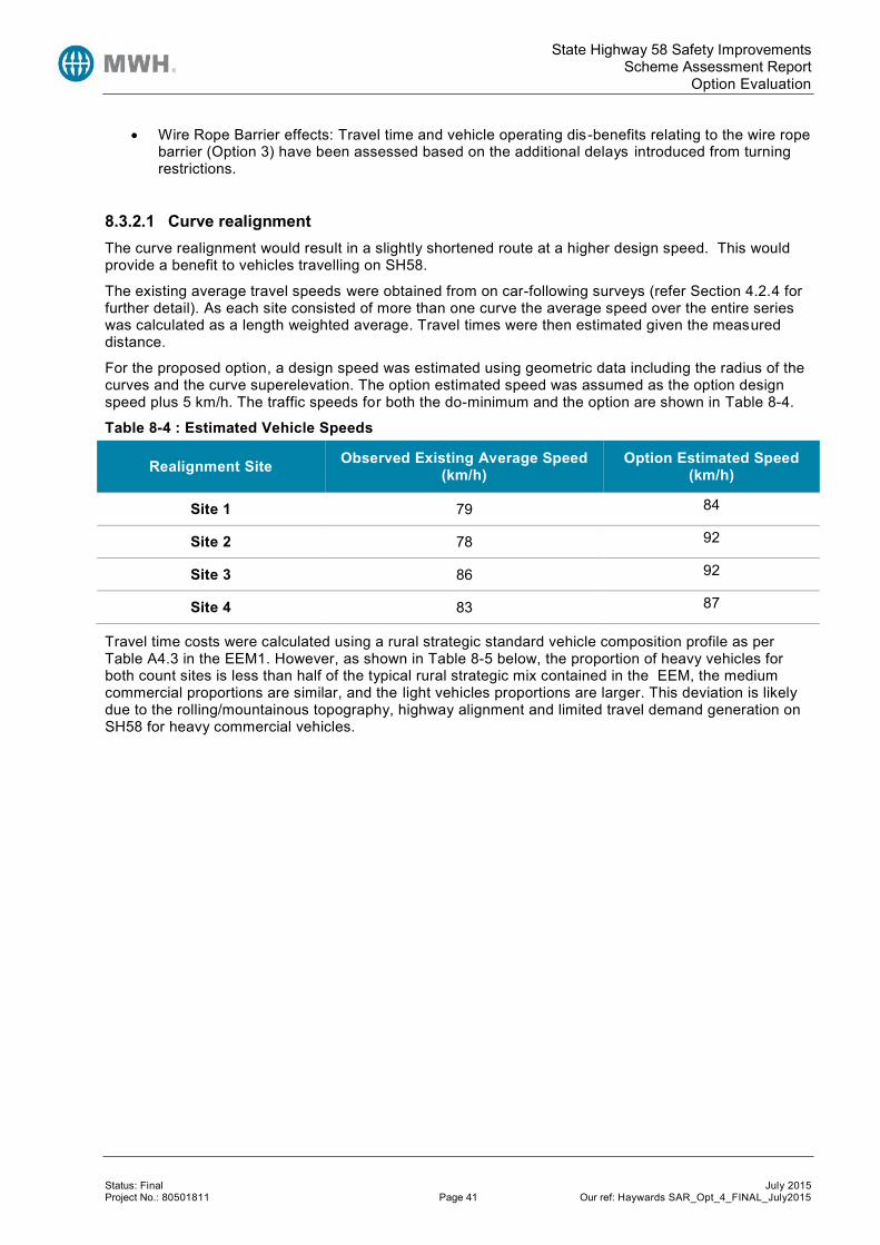
State Highway 58 Safety Improvements Scheme Assessment Report
Option Evaluation
Status: Final July 2015 Project No.: 80501811 Page 41 Our ref: Haywards SAR_Opt_4_FINAL_July2015
Wire Rope Barrier effects: Travel time and vehicle operating dis-benefits relating to the wire rope barrier (Option 3) have been assessed based on the additional delays introduced from turning restrictions.
8.3.2.1 Curve realignment The curve realignment would result in a slightly shortened route at a higher design speed. This would provide a benefit to vehicles travelling on SH58.
The existing average travel speeds were obtained from on car-following surveys (refer Section 4.2.4 for further detail). As each site consisted of more than one curve the average speed over the entire series was calculated as a length weighted average. Travel times were then estimated given the measured distance.
For the proposed option, a design speed was estimated using geometric data including the radius of the curves and the curve superelevation. The option estimated speed was assumed as the option design speed plus 5 km/h. The traffic speeds for both the do-minimum and the option are shown in Table 8-4.
Table 8-4 : Estimated Vehicle Speeds
Realignment Site Observed Existing Average Speed (km/h)
Option Estimated Speed (km/h)
Site 1 79 84
Site 2 78 92
Site 3 86 92
Site 4 83 87
Travel time costs were calculated using a rural strategic standard vehicle composition profile as per Table A4.3 in the EEM1. However, as shown in Table 8-5 below, the proportion of heavy vehicles for both count sites is less than half of the typical rural strategic mix contained in the EEM, the medium commercial proportions are similar, and the light vehicles proportions are larger. This deviation is likely due to the rolling/mountainous topography, highway alignment and limited travel demand generation on SH58 for heavy commercial vehicles.

State Highway 58 Safety Improvements Scheme Assessment Report
Option Evaluation
Status: Final July 2015 Project No.: 80501811 Page 42 Our ref: Haywards SAR_Opt_4_FINAL_July2015
Table 8-5: Telemetry Site Traffic Composition
Location 2012 Total LV-I LV-II MCV HCV-I HCV-II HVs (MCV, HCV)
SH58 Pauatahanui
East (Telemetry)
RP 58/9
AADT (vpd) 13,605 12,607 427 427 82 62 571
% 100% 93% 3% 3% 1% 0% 4%
EEM Rural Strategic Mix % 100% 78% 10% 4% 4% 4% 12%
EEM Urban Arterial Mix % 100% 85% 10% 2% 1% 2% 5%
The table above also shows that SH58 has a similar distribution to the EEM’s urban arterial mix; this is supported by the peak hour flow graphs showing significant morning and afternoon peaks (see Appendix B). However, due to the existing 100 km/h rural speed limit and for consistency with previous work, the economic evaluation has used the rural strategic time values37.
Vehicle operating costs and carbon dioxide costs would increase slightly with the higher speed of vehicles and decrease due to the shorter length when compared to the do-minimum. For this project, the reduction in length outweighs the speed increase, resulting in VOC and CO2 savings.
In addition, road roughness improvements have been included in the assessment. This is based on the existing NAASRA weighted average wheel path value, calculated as 81 for the four realignment sites, which according to table A5.14 of the EEM, has a cost of $0.38/km for a rural strategic highway.
Carbon dioxide savings have been assessed as 4% of the vehicle operating cost saving, in accordance with the guidance in EEM.
8.3.2.2 Moonshine Road Intersection As outlined in Section 8.2, a roundabout would add geometric delay for vehicles travelling straight through on SH58, increasing the distance they are required to travel (increased fuel) and reducing the speed of negotiation (increased delay), thereby resulting in dis-benefits.
For the purposes of this evaluation, the geometric delay, total control delay and fuel usage outputs were used to calculate the travel time costs and vehicle operating costs for the morning peak, inter-peak, afternoon peak period and weekend peak38. It has been assumed that the morning peak and afternoon peaks have a 1.5 hour duration (368 days per year), with the interpeak and weekend peak having 8 hours (interpeak 1960 days per year, weekend 911 days per year).
As above, travel time costs were calculated for the peak periods outlined above using a rural strategic standard vehicle composition profile as per Table A4.3 in the EEM1. An uncongested and congested value of time was also used to differentiate the geometric delay from queuing delay.
The vehicle operating costs have been derived from the SIDRA models from the fuel consumption in litres per hour. The fuel consumption was multiplied by a factor of 1.91 which is derived from Table A5.0 (a) of the EEM, which states that fuel and oil make up 52.3% of the total VOC component for Rural Strategic roads. A resource cost of $ 1.48 / L has been used to calculate the VOC, this is the subsumed value used in EEM in deriving VOC. CO2 cost emissions were calculated as approximately 3.1% of VOC39.
37 A sensitivity test has been undertaking using the urban strategic values of time, refer Appendix L. 38 Weekend flows were assumed as 90% of the surveyed inter-peak flows. 39 Based on a cost of $40 per tonne of CO2 (EEM), light and heavy vehicle tonnes/l values of 0.0022 and 0.0025 and 4% HV.

State Highway 58 Safety Improvements Scheme Assessment Report
Option Evaluation
Status: Final July 2015 Project No.: 80501811 Page 43 Our ref: Haywards SAR_Opt_4_FINAL_July2015
The SIDRA models show that both the travel time costs and vehicle operating costs would be greater for the roundabout option than the do-minimum, resulting in dis-benefits.
8.3.2.3 Option 3: Wire Rope Median Barrier Dis-benefits As outlined in Table 6-1 of Section 6.5, the provision of central median wire rope barrier protection has implications for movements at intersections and property accessways.
An assessment was carried out to determine both the additional distance travelled and additional travel time incurred from the restriction of right turning movements. The key assumptions of the assessment included:
Side road AADTs were extracted from CAS/RAMM databases with values estimated where no records were available.
An assumed 50% of traffic will be affected, i.e. 50% of traffic will be undertaking right in or right out movements.
Existing side road right in or right out turning delays will be equivalent to the introduced right in/right out delays at the nearest intersection. This is based on the fact that traffic volumes along SH58 are consistent, resulting in similar side road gap acceptance. Left turn delays were assumed to be negligible.
Where movements are restricted, distances were measured to the nearest intersection/ turnaround facility40. It is assumed that adequate seal width will be provided for the turning manoeuvres at key turnaround areas. Where appropriate additional manoeuvring time was added to account for u-turning movements.
A 10.4 vpd trip generation rate for a dwelling in accordance with Appendix 5B of the NZTA’s Planning and Policy Manual
There are five intersections, three large commercial accesses41 and approximately 44 dwellings42 which will be affected (i.e. restricted movements) by the provision of a wire rope median barrier along the project length.
Initial calculations have revealed that there will be approximately $105,000 of travel time dis-benefits, $129,000 of vehicle operating cost dis-benefits and $5,200 of CO2 dis-benefits associated with the turning restrictions at intersections and property accesses. Carbon dioxide savings have been assessed as 4% of the vehicle operating cost saving, in accordance with the guidance in EEM.
40 With the exception of the logging mill and Griffiths yard, where it was assumed that the mainly heavy vehicles would use the nearby Pauatahanui and Moonshine roundabouts. 41 Griffiths drilling yard, Pauatahanui logging mill and the Judgeford Golf Club. 42 Estimate based on aerial.
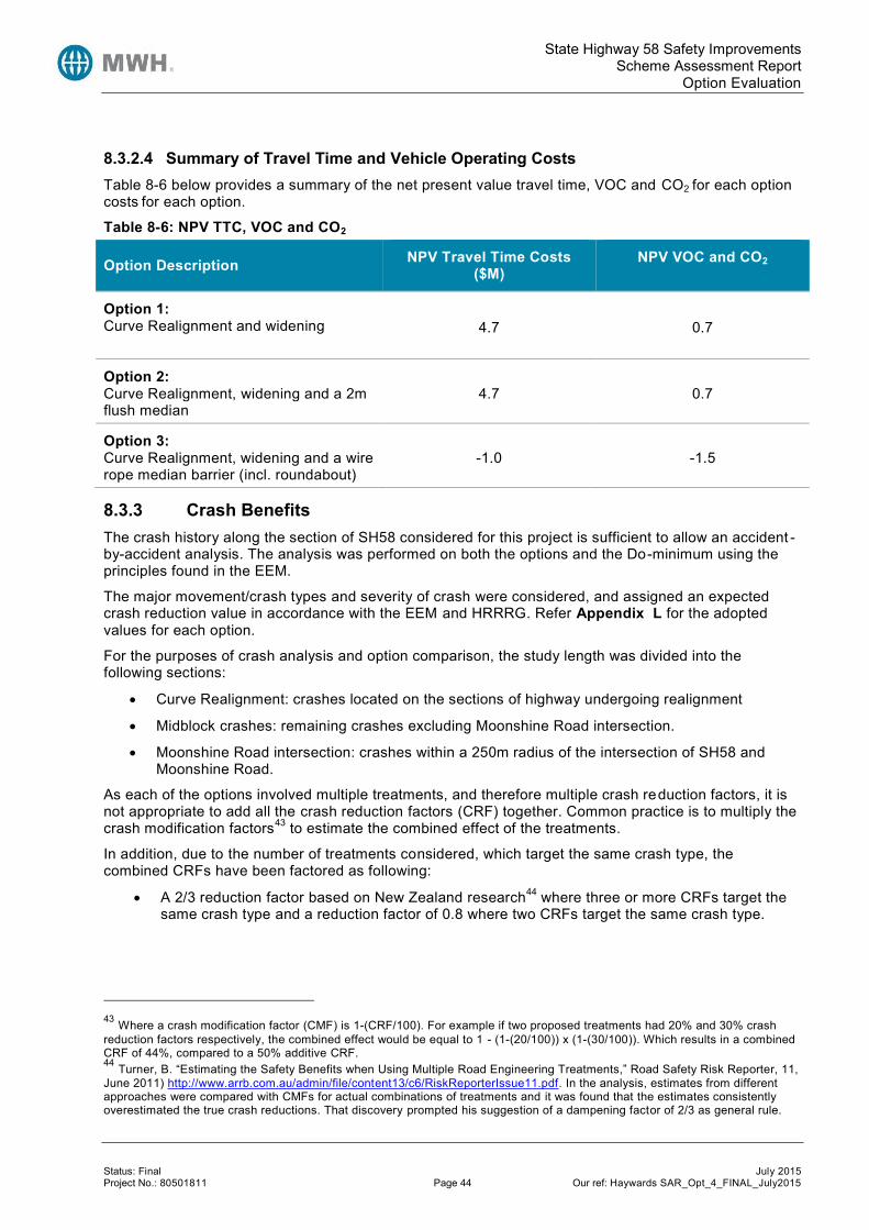
State Highway 58 Safety Improvements Scheme Assessment Report
Option Evaluation
Status: Final July 2015 Project No.: 80501811 Page 44 Our ref: Haywards SAR_Opt_4_FINAL_July2015
8.3.2.4 Summary of Travel Time and Vehicle Operating Costs Table 8-6 below provides a summary of the net present value travel time, VOC and CO2 for each option costs for each option.
Table 8-6: NPV TTC, VOC and CO2
Option Description NPV Travel Time Costs ($M)
NPV VOC and CO2
Option 1: Curve Realignment and widening 4.7 0.7
Option 2: Curve Realignment, widening and a 2m flush median
4.7 0.7
Option 3: Curve Realignment, widening and a wire rope median barrier (incl. roundabout)
-1.0 -1.5
8.3.3 Crash Benefits The crash history along the section of SH58 considered for this project is sufficient to allow an accident -by-accident analysis. The analysis was performed on both the options and the Do-minimum using the principles found in the EEM.
The major movement/crash types and severity of crash were considered, and assigned an expected crash reduction value in accordance with the EEM and HRRRG. Refer Appendix L for the adopted values for each option.
For the purposes of crash analysis and option comparison, the study length was divided into the following sections:
Curve Realignment: crashes located on the sections of highway undergoing realignment
Midblock crashes: remaining crashes excluding Moonshine Road intersection.
Moonshine Road intersection: crashes within a 250m radius of the intersection of SH58 and Moonshine Road.
As each of the options involved multiple treatments, and therefore multiple crash reduction factors, it is not appropriate to add all the crash reduction factors (CRF) together. Common practice is to multiply the crash modification factors43 to estimate the combined effect of the treatments.
In addition, due to the number of treatments considered, which target the same crash type, the combined CRFs have been factored as following:
A 2/3 reduction factor based on New Zealand research44 where three or more CRFs target the same crash type and a reduction factor of 0.8 where two CRFs target the same crash type.
43 Where a crash modification factor (CMF) is 1-(CRF/100). For example if two proposed treatments had 20% and 30% crash reduction factors respectively, the combined effect would be equal to 1 - (1-(20/100)) x (1-(30/100)). Which results in a combined CRF of 44%, compared to a 50% additive CRF. 44 Turner, B. “Estimating the Safety Benefits when Using Multiple Road Engineering Treatments,” Road Safety Risk Reporter, 11, June 2011) http://www.arrb.com.au/admin/file/content13/c6/RiskReporterIssue11.pdf. In the analysis, estimates from different approaches were compared with CMFs for actual combinations of treatments and it was found that the estimates consistently overestimated the true crash reductions. That discovery prompted his suggestion of a dampening factor of 2/3 as general rule.
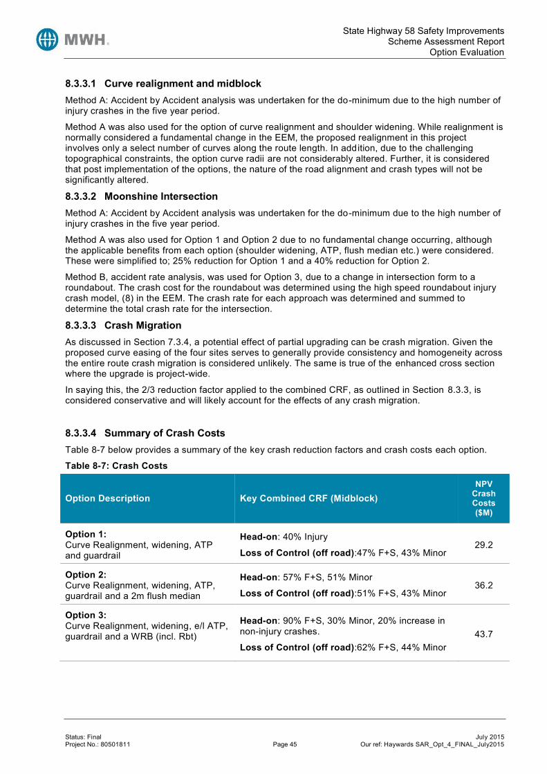
State Highway 58 Safety Improvements Scheme Assessment Report
Option Evaluation
Status: Final July 2015 Project No.: 80501811 Page 45 Our ref: Haywards SAR_Opt_4_FINAL_July2015
8.3.3.1 Curve realignment and midblock Method A: Accident by Accident analysis was undertaken for the do-minimum due to the high number of injury crashes in the five year period.
Method A was also used for the option of curve realignment and shoulder widening. While realignment is normally considered a fundamental change in the EEM, the proposed realignment in this project involves only a select number of curves along the route length. In addition, due to the challenging topographical constraints, the option curve radii are not considerably altered. Further, it is considered that post implementation of the options, the nature of the road alignment and crash types will not be significantly altered.
8.3.3.2 Moonshine Intersection Method A: Accident by Accident analysis was undertaken for the do-minimum due to the high number of injury crashes in the five year period.
Method A was also used for Option 1 and Option 2 due to no fundamental change occurring, although the applicable benefits from each option (shoulder widening, ATP, flush median etc.) were considered. These were simplified to; 25% reduction for Option 1 and a 40% reduction for Option 2.
Method B, accident rate analysis, was used for Option 3, due to a change in intersection form to a roundabout. The crash cost for the roundabout was determined using the high speed roundabout injury crash model, (8) in the EEM. The crash rate for each approach was determined and summed to determine the total crash rate for the intersection.
8.3.3.3 Crash Migration As discussed in Section 7.3.4, a potential effect of partial upgrading can be crash migration. Given the proposed curve easing of the four sites serves to generally provide consistency and homogeneity across the entire route crash migration is considered unlikely. The same is true of the enhanced cross section where the upgrade is project-wide.
In saying this, the 2/3 reduction factor applied to the combined CRF, as outlined in Section 8.3.3, is considered conservative and will likely account for the effects of any crash migration.
8.3.3.4 Summary of Crash Costs Table 8-7 below provides a summary of the key crash reduction factors and crash costs each option.
Table 8-7: Crash Costs
Option Description Key Combined CRF (Midblock) NPV
Crash Costs ($M)
Option 1: Curve Realignment, widening, ATP and guardrail
Head-on: 40% Injury
Loss of Control (off road):47% F+S, 43% Minor 29.2
Option 2: Curve Realignment, widening, ATP, guardrail and a 2m flush median
Head-on: 57% F+S, 51% Minor
Loss of Control (off road):51% F+S, 43% Minor 36.2
Option 3: Curve Realignment, widening, e/l ATP, guardrail and a WRB (incl. Rbt)
Head-on: 90% F+S, 30% Minor, 20% increase in non-injury crashes.
Loss of Control (off road):62% F+S, 44% Minor 43.7

State Highway 58 Safety Improvements Scheme Assessment Report
Option Evaluation
Status: Final July 2015 Project No.: 80501811 Page 46 Our ref: Haywards SAR_Opt_4_FINAL_July2015
8.3.3.5 Crash Risk The options were assessed using the KiwiRAP Assessment Tool (KAT) to determine the effect of the options on KiwiRAP star rating. As the curve easing considered in the options is relatively minor we have adopted a conservative approach and not included it in the KAT modelling at this stage.
Table 8-8: KAT Option Assessment
Option Extent
Average Star Rating
Pub. Star
Rating
30y DSi saved45
Average RPS
Average Run off Road RPS
Average Head On
RPS
Average Intersection
RPS
Do Min 2.78 2 - 12.0 8.2 12.4 0.2
1.5m Shoulder widening (SW) 2.85 2 5 11.2 7.7 11.8 0.2
Option 1: SW and guardrail (GR)** 3.11 3 24 9.2 4.4 11.8 0.2
Option 2:
SW, GR, and flush median
Flush medians are not currently able to be modelled in KAT
SW, WRB and no guardrail 3.33 3 38 7.8 6.9 0.0* 0.1
Option 3:
SW, GR, WRB, RBT at Moonshine Rd
3.91 3 65 4.9 4.0 0.0* 0.1
*Note: the analysis did not account for the breaks in the median barrier. **Semi-rigid guardrail on KAT was placed on sections with severe roadside hazards (approximately 3.1km LHS 4.0km RHS); this is of a similar length as proposed by the options.
Table 8-8 above shows the following:
Shoulder widening alone, without guardrail provision is not sufficient to achieve the Regional Strategic state highway objective of a 3-star KiwiRAP rating.
A combination of guardrail across severe hazards and shoulder widening will be sufficient to achieve a 3 star published rating (i.e. Options 1 and 2).
Option 3, including a WRB median treatment achieves a nearly 4-star calculated rating.
Using a social cost value of $1.12M per DSI46, the calculated annual crash cost for Option 3 was $2.55M (compared to approximately $2.25M in the conventional analysis). Using this value, the BCR for Option 3 decreases slightly from 1.2 to 1.1.
Therefore, all options considered are likely to increase the KiwiRAP star rating to a minimum of 3 stars at current traffic volumes. In order to ensure the 3-star rating is maintained in the medium to long term a wire rope barrier option is recommended.
8.3.4 Maintenance Costs Do-Minimum Future maintenance costs were based on the future works programme, noting that there are no significant pavement rehabilitation works planned along the study length.
45 Calculated according to Figure C-2, Appendix C of the HRRRG. 46 Calculated using EEM 2010 A6.10 tables, 21% Fatal 79% Serious split.

State Highway 58 Safety Improvements Scheme Assessment Report
Option Evaluation
Status: Final July 2015 Project No.: 80501811 Page 47 Our ref: Haywards SAR_Opt_4_FINAL_July2015
Options
Option 1, 2 and 3 maintenance costs increase compared to the Do-minimum due to the extra seal width following shoulder widening and median treatments.
Future annual maintenance costs based on annual chip seal maintenance of $0.12/m 2.
Construction will include a full length 150mm overlay.
Future periodic maintenance costs based on chip seal reseals of $5.50/m2 and additional ATP (edgeline and centreline) maintenance of $25,00047 per km at 8-year cycles (i.e. future year 10, 18 and 26).
Additional maintenance costs to maintain any new structures have not been included.
In addition, wire rope barrier maintenance costs were assessed for Option 3 as follows.
Average cost of repair per hit of $2,430 based on the 2011/12 and 2012/13 maintenance costs for the existing 0.76km of wire rope median barrier on SH58.
Historical number of hits per year per km is 7.89. This has been factored by 0.8, on the basis that the existing wire rope barrier is higher risk (located on an out of context curve and near a passing lane.)
Approximate length of new barrier (excluding existing) is 7.2 km.
Expected number of hits per year is 46, resulting in an expected cost of repair per year of approximately $111,000.
The difference between the maintenance required for the current intersection and the maintenance required for a roundabout (Option 3) is not seen as significant and hence has not been included in the economic evaluation.
8.3.5 Benefit Cost Ratio Results Both the initial BCR and subsequent incremental analysis show that Option 2 is the preferred option in economic terms.
Table 8-9: Economic Evaluation Summary
Option 1:
Curve R & shoulder widening
Option 2:
Curve R, widening & flush median
Option 3:
Curve R, widening & WRB
Costs ($M)
NPV Capital Costs 26.6 29.2 30.9
NPV Maintenance Costs -0.2 -0.1 1.1
NPV Total Costs 26.4 29.1 32.1
Benefits ($M)
NPV Travel Time Costs 4.8 4.8 -1.0
NPV Vehicle Operating Costs & CO2 Emissions 0.7 0.7 -1.5
NPV Crash Costs 29.2 36.2 43.7
47 The Usability and Safety of Audio Tactile Profiled Road Markings, NZTA, The cost of ATP installation and maintenance, http://www.nzta.govt.nz/resources/research/reports/365/docs/365.pdf. It is noted that costs of ATP have since reduced, although the effect is insignificant due to discounting.

State Highway 58 Safety Improvements Scheme Assessment Report
Option Evaluation
Status: Final July 2015 Project No.: 80501811 Page 48 Our ref: Haywards SAR_Opt_4_FINAL_July2015
Option 1:
Curve R & shoulder widening
Option 2:
Curve R, widening & flush median
Option 3:
Curve R, widening & WRB
NPV Total Benefits 34.6 41.6 41.1
Benefit Cost Ratio 1.3 1.4 1.3
First Year Rate of Return 8% 8% 8%
8.3.6 Sensitivity Testing Sensitivity testing was carried out for the following:
Traffic Growth
o 10 year growth (0.5% growth, instead of 1.5%)
o 6% discount rate and 40 year analysis period at 0.5% growth
o Refer Appendix L for future scenarios relating to Transmission Gully modelling results. In summary:
The time frames and assumptions relating to SH2/SH58 grade separation and Petone to Grenada have changed since the model was developed. It is noted that a review of the modelling and underlying assumptions of the TG model is being revisited as part of Petone to Grenada I&R.
Until this update occurs the future traffic growth is uncertain, therefore we have adopted growth rates of 0.5% and 1.5% which cover the likely scenarios, which can be updated once information becomes available.
Discount Rate and Analysis period
o 6% discount rate and 40 year analysis period
o 6% discount rate and 30 year analysis period
Costs:
o Project Base Scheme Estimate
o Project 95% tile Scheme Estimate
Crash Benefits
o Consideration of a single additional fatal head on crash and two serious injury loss of control crashes occurring on the midblock section.
Urban arterial
o Using urban arterial values (rather than rural strategic) of time due to both the traffic composition and daily flow profiles showing urban arterial trends (refer Section 8.3.2.1).
A summary of the sensitivity testing results for Option 2 is provided in Table 8-10 below. Refer Appendix L for full sensitivity analysis for all three options.
Table 8-10: Option 2 Sensitivity Testing
Option 2 Base Value Base BCR Sensitivity value Sensitivity BCR
Analysis period and Discount Rate
30 Year, 8%, (1.5% growth) 1.4
40 years,6% (1.5% growth) 2.0

State Highway 58 Safety Improvements Scheme Assessment Report
Resource Management Issues
Status: Final July 2015 Project No.: 80501811 Page 49 Our ref: Haywards SAR_Opt_4_FINAL_July2015
Option 2 Base Value Base BCR Sensitivity value Sensitivity BCR
Traffic Growth 1.5% 1.4 0.5% 1.2
Crash History Existing Crashes
(2F,13S) 1.4
Additional 1F Head on, 2S LoC on the midblock.
(3F,15S)
1.6
Construction Cost Expected Estimate
$32M 1.4
95th%tile Estimate
$40M 1.1
Traffic Composition Rural Strategic 1.4 Urban Arterial 1.4
The results show that using the upcoming EEM change to a 6% discount rate and 40 year analysis period increases the BCR to 2.0. The effect of three additional crashes also had a significant impact, increasing the BCR to 1.6.
If traffic growth continues at 0.5%, the BCR of Option 2 falls to 1.2 and 1.6 for a 30 year and 40 year analysis period respectively.
The analysis showed that there is little sensitivity in the BCR to altering the traffic composition values; this is due to the value of time changing in both the do-minimum and the option, resulting in a significantly lower total cost for TTC and VOC (for an urban arterial), but a similar net difference.
9 Resource Management Issues The project must meet all statutory requirements. There are a number of documents (both statutory and non-statutory) that must be considered when planning for the state highway improvements. In particular, the requirements of the Resource Management Act, the Porirua City District Plan, Hutt City District Plan, the Upper Hutt District Plan and the Greater Wellington Regional plans will be assessed to ensure that the proposed project meets the plan provisions and follows the statutory process. The social and environmental assessment is provided in Appendix H.
9.1 District Plan Provisions The SH58 designation (and proposed works) is located within the boundaries of three territorial authorities, being Hutt City Council, Upper Hutt City Council and Porirua City Council. The overarching regional council is Greater Wellington (see section 9.2).
9.1.1 Designations State Highway 58 is designated under the district plans of Porirua City Council (being K0404) and Hutt City Council (being TNZ4) as “state highway purposes”. Upgrades to the road within these designations do not require resource consent from the territorial authorities, but will require outline plans to indicate the scale of the proposed works within the designation. For any works outside of the designations, it is recommended to alter the designation where necessary to accommodate these works under s181 RMA. NZTA will be required to give notice (as a Notice of Requirement) to the Council of its requirement to alter the designation. Upper Hutt City Council does not appear to have designated any part of SH58 within its boundary. This will need to be confirmed during the next stage of the planning process. An outline plan may not be required from this council, however resource consents (land use) may be necessary. Other designations in the vicinity of the proposed safety improvements include the Haywards Transpower site in Lower Hutt (TPNZ 1, designated for ‘electricity substation’), and two Wellington

State Highway 58 Safety Improvements Scheme Assessment Report
Resource Management Issues
Status: Final July 2015 Project No.: 80501811 Page 50 Our ref: Haywards SAR_Opt_4_FINAL_July2015
Regional Council designations just west of the Transpower site (both WRC 7, designated for ‘Water supply pumping station’).
9.1.2 Heritage, Archaeology, Cultural and Iwi Issues There are two heritage buildings located close to the SH58 designation, both within the Porirua City boundary. These are the WWII American Camp marker and Community Hall (JB25, NZHPT class I), and St Joseph’s Catholic Church (JA02, NZHPT class II).
The proposed works are unlikely to affect these buildings. It appears that there are no other heritage, archaeological, cultural or waahi tapu sites close to the SH58 designation.
9.2 Regional Plan Provisions The scheme designs and final construction plans will determine what regional consents are required. Given that there is likely to be extensive earthworks associated with the formation of batter slopes, the following resource consents are likely to be required under the Greater Wellington Soil Plan , Freshwater Plan and Air Quality Plan:
Land use consents for the placement/extension of structures in the riverbed;
Bore permits for geotechnical investigation
Stormwater discharges from bulk earthworks
Soil and vegetation disturbance
Discharge of contaminants to land and air from road construction.
It should be noted that the Pauatahanui Stream is mentioned in the list of streams which specifically require the avoidance of adverse effects, as well as being identified in the list of ‘Water Bodies with Nationally Threatened Indigenous Fish Recorded’. Works in the Pauatahanui Stream are therefore likely to require consent under the Freshwater Plan as a Discretionary Activity.
Belmont Regional Park is located along a section of SH58 in the vicinity of the intersection of SH2. The park is managed by Greater Wellington Regional Council and recognises the ecological and cultural values in the area. Part of Belmont Regional Park provided a route between Wellington and Porirua harbours for Ngāti Toa Rangātira and the various Wellington based Taranaki iwi who retain mana whenua over these lands. The Regional Parks Network Management Plan outlines how the park is managed and what future plans are proposed. Future plans for the park in the vicinity of the roading improvements include improving linkages of native ecology across SH58 towards Upper Hutt.
9.3 Other Provisions Given that the proposed works may involve earthworks on river/stream banks, there is the potential to unearth Maori artefacts. It is likely that an Accidental Discovery Protocol will be required to be adopted; in the even that unknown sites or artefacts are discovered, an archaeological authority may be required.
9.4 Future Land Use Proposals There are a number of proposed developments which may affect the capacity of SH58, and the type of traffic that is generated. Known proposed developments include the Winstones Cleanfill site (as discussed in Sections 7.1 and 7.3.3), Transmission Gully, and potential development resulting from the Pauatahanui-Judgeford Structure Plan.
9.4.1 Transmission Gully For the purposes of this report, the Linden to MacKays (Transmission Gully) Roads of National Significance project is assumed to be completed by 2020. The current designation in the Porirua District Plan have been considered, and is unlikely to change significantly before construction.
The expressway crosses SH58 approximately where the project area starts for this report. The implications of the expressway being built include significant earthworks and disruptions to traffic. On

State Highway 58 Safety Improvements Scheme Assessment Report
Resource Management Issues
Status: Final July 2015 Project No.: 80501811 Page 51 Our ref: Haywards SAR_Opt_4_FINAL_July2015
completion, the road is likely to increase the volume of traffic traversing SH58, as discussed in section 0 of this report.
9.4.2 Pauatahanui-Judgeford Structure Plan The Pauatahanui-Judgeford Structure Plan was developed by MWH, Urbanism Plus and Isthmus in May 2012, and is currently in the process of being adopted by the Porirua City Council. The implications of the plan change the zoning of some areas adjacent to SH58, and may result in land use changes such as additional lifestyle-residential, light-industrial and commercial activities.
Key features of the Structure Plan are as follows:
Rural Subdivision - proposed changes to subdivision standards to allow rural lifestyle subdivision, which is linked to a requirement to re-vegetate or retire areas of land and which may include a requirement for a financial contribution towards the cost of replanting or retiring land on another site.
Pauatahanui Village - review of existing zoning and limited rural residential development on the higher ground to the east of the village.
Judgeford Hamlet – the possibility of a small hamlet-style development around the intersection of SH58 and Moonshine Road in Judgeford consisting of rural residential lots ranging in size from 3,000m2 to 2.5ha with a mix of light industry and one or two small convenience or craft shops.
Lanes Flat - options for future development at Lanes Flat once construction of Transmission Gully Motorway is completed.
Logistics Hub - the Judgeford area is highlighted as a “Possible long-term industrial/business growth area” in Porirua City Council’s Porirua Development Framework (2009). The intension is for it to be a cluster of transport, logistics and distribution enterprises managed by a commercially neutral legal body. Facilities would include warehouses, distribution centres, storage areas, offices, truck services, accommodation and catering services for drivers etc.
Refer Appendix N for a map of the proposed transportation improvements of the Pauatahanui to Judgeford structure plan. The plan assumed roundabouts at Moonshine Road and Flightys/Murphys Road would proceed in the long term as part of the NZTA’s SH58 Strategy; however, following the PFRs undertaken in 2009 it was recommended to defer construction and revisit the proposals in the future.

State Highway 58 Safety Improvements Scheme Assessment Report
Risk
Status: Final July 2015 Project No.: 80501811 Page 52 Our ref: Haywards SAR_Opt_4_FINAL_July2015
10 Risk The risks to the project have been assessed using the General Approach as determined in the Risk Management Process Manual (AC/Man/1). A risk register is contained in Appendix G that summarises the main risks currently known. The principal risks to the project are outlined in Table 10-1 below. A geotechnical risk register is also contained in Appendix G.
Table 10-1: Risk Summary
Phase Risk Description Score Category Treatment
Project Property Land Acquisition
Difficulty in acquiring land. Caused by obstructive landowner or excessive cost demands.
210 Cost - Minor
Delay -Substantial
Consultation
Investigation and Reporting
Project objectives not achieved
Investigations indicate that constraints or conditions will not allow full achievement of project intentions and objectives (e.g. inadequate width for median barrier).
200 Cost - Major
H&S - Medium Design
Construction cost changes significantly different from I&R
With no geotechnical testing, there is the chance that basic construction costs will be significantly underestimated. LiDAR data may also lead to inaccurate quantities estimates
120 Cost - Major Cost Estimation
Design and Project Documentation
Appeals to Environment Court
Project taken to Environment Court 120 Delay - Major
Cost - Minor Statutory Planning & Consultation
Consents not achieved Consent not granted 80 Delay - Medium
Cost - Minor Statutory Planning - Early and pre-lodgement engagement with Council(s).
Onerous consent conditions
Consent conditions impose substantial changes to project 80 Delay - Medium
Cost - Minor
MSQA, NZTA Managed Costs and Consent Monitoring fees
Excessive claims by contractor
Contractor may over-claim either in error or to front-load payments. Potential for loss if contractor declares bankruptcy (re SH4 Papatawa)
160 Cost - Medium Supervision
Funding rejected
Construction costs as tendered are in excess of anticipated, and project funding is declined.
120 Delay - Major Estimates
Contractor not adequately skilled for job.
Local terrain and working conditions will challenge contractors, hence need adequately skilled contractors for the work.
120 Cost - Major Delay - Medium Tendering
Pavement design.
under strength pavement design results in rutting/uneven road surface
80 Image - Medium Cost - Major Peer review

State Highway 58 Safety Improvements Scheme Assessment Report
Preferred Option
Status: Final July 2015 Project No.: 80501811 Page 53 Our ref: Haywards SAR_Opt_4_FINAL_July2015
11 Preferred Option Option 2 is the best option economically, achieving a BCR of 1.4 for a 30 year analysis period (8% discount rate) and 2.0 for the 40 year analysis period (6 % discount rate). Option 2 has an assessment profile of HML.
However, as the BCRs of all of the options are almost identical, it is difficult to select a clear preferred option on economics alone. Given the overall step-change safety improvement that Option 3 offers in terms of providing comprehensive wire rope barrier and a consequential reduction in risk48, this option was initially considered as the preferred option. However, it was recognised that there were opportunities to improve the overall scheme design by reducing or removing elements from this option without compromising the overall project viability. Furthermore, other project changes could be undertaken to optimise the project and maximise benefit realisation. By reducing project costs and maximising benefits, the value for money achieved by the project can be enhanced (resulting in a greater BCR and more worthwhile project).
The various elements considered for the optimisation of Opt ion 3 (to become Option 4) are discussed below.
11.1 Option 4 11.1.1 Introduction This option (Option 4) has been subsequently created as an update and optimisation of the original Option 3. It has been created on the basis of identifying any areas within the project extent that can be amended and would improve the efficiency of the overall scheme design.
This optimisation has been necessary for two purposes; firstly to ensure the project fits within a likely envelope of affordability, and secondly, to ensure a suitable level of economic efficiency and value for money.
The various project changes to Option 3 that have been undertaken to create Option 4 are discussed below, together with other aspects that were initially considered but not progressed.
11.1.2 Option Description Generally, Option 4 consists of a number of curve realignments and the provision of an improved cross section throughout.
11.1.2.1 Do-Minimum The do-minimum option speed for the project length was reduced from the current 100km/h posted speed limit, to 80km/h. This reduction was on the basis the NZTA staff advising that they are already planning to reduce the speed limit given the high risk nature of this section of SH58 and the poor crash history.
11.1.2.2 Site 1 Realignment The realignment of the horizontal curve at Site 1 was investigated in greater detail given the significant volumes of cut that would result. The volumes of cut required through Site 1 were calculated as being close to 50,000 m3 which equated to a considerable cost. Whether Site 1 could reasonably be adjusted or removed was therefore reconsidered. In terms of safety, crashes at Site 1 are discussed in Section 4.3.2. In summary, the crashes through Site 1 include one serious, three minor and eight non-injury crashes with loss of control being a key factor in the majority of crashes. This is a concerning number of crashes and therefore it was deemed unreasonable to simply omit any improvements at this location.
48 The 5 year crash record for SH58, which shows a large amount of high severity loss of control crashes, does not actually exhibit a significant number of head-on collisions. Nevertheless, it is recognised that due to the vertical and horizontal alignment that there is high risk of head-on collisions with resulting high severity injuries. This is backed up by the KiwiRAP crash risk analysis in Section 8.3.3.5.

State Highway 58 Safety Improvements Scheme Assessment Report
Preferred Option
Status: Final July 2015 Project No.: 80501811 Page 54 Our ref: Haywards SAR_Opt_4_FINAL_July2015
Therefore, it was determined that the realignment through Site 1 would be omitted, but an improved cross section would be provided through the existing horizontal curve. The full Option 3 cross section of 0.5m drainage channel, 1.5m sealed shoulder, 3.5m traffic lane and 2m flush median was originally considered. However, this still resulted in large volumes of cut due to the significantly high and steep slope face abutting the existing edge of seal. Therefore, the central median was reduced further to a 1.5m width, which ultimately resulted in a significant saving in earthworks quantities (a reduction of 44%).
Whilst the reduction in median width is not considered ideal given a 2m median is preferred for barrier deflection purposes, a median width of 1.5m has on occasion been used elsewhere49.
With Option 4, the curve radius has not been improved (and increased) and is below the generally accepted 200m minimum radius for the provision of wire rope barrier. However, alternative options exist and barrier protection could still be provided (such as W section barrier or specific wire rope barrier design that supports installation on smaller radius curves).
The implications of not realigning this section have been considered in terms of route regularity, the potential for inappropriate approach speeds or driver awareness given realignments further north and the implications for route and curve consistency. The realignment previously proposed through this section treated two curves and therefore these existing radii would now remain, with the southern curve being 180m radius, and the northern curve at 245m. The consistency of design speeds through adjacent curves has been assessed for both westbound and eastbound vehicles and is considered acceptable; with there being no greater than 10 km/h speed differential between adjacent curves. Nevertheless, it is noted that curves of 180m and 245m radii are low and, when considered with existing crash history and proliferation of loss of control type crashes through this section, other safety measures may be warranted at this location50.
With the proposed speed for the do-minimum now considered at 80km/h with an option speed of 80km/h posted speed limit, the decision to omit the Site 1 realignment has been reconsidered. Whilst it is clearly acknowledged that realignment at this location would be positive, the omission of this section for realignment is considered acceptable in conjunction with the cross section improvements.
11.1.2.3 Moonshine Roundabout Proposal A further optimisation that has been carried out concerns the proposed roundabout at Moonshine Road. Various changes to the original Option 3 design have been considered at this proposed roundabout. The need for a roundabout at this location has been documented earlier in this report, refer Section 6.4. The roundabout that was initially proposed had a central island diameter of 40m, as per current Austroads standards for this speed of road (currently 100 km/h). Following further discussions it was agreed to consider a smaller diameter roundabout on the basis that the 40m diameter was of a very high standard of intersection provision, whereas the remainder of much of SH58 is not of the same high standard (even with the proposed improvements). Therefore, a reduced diameter of 32m was considered. With a central island diameter of this size, heavy vehicles can still adequately track through the roundabout if intending to use the intersection as a turnaround (due to turning restrictions created by the median wire rope barrier in the vicinity). The proposed design of the roundabout has also been amended. Providing a roundabout at this location creates significant dis-benefit for SH58 traffic as a result of the queuing and geometric delay created by providing a roundabout whereas the current intersection form of priority does not impede the free flow of state highway traffic. Therefore, whether any form of slip lane could be provided that would reduce the delay and dis-benefit effects of the proposed roundabout for state highway through traffic was considered.
49 1.5m (or narrower) median width has been used on a case by case basis in a number of locations in the Wellington region. 50 Options such as calcined bauxite surfacing may be warranted, though caution is advised given such measures risk losing effectiveness over time.

State Highway 58 Safety Improvements Scheme Assessment Report
Preferred Option
Status: Final July 2015 Project No.: 80501811 Page 55 Our ref: Haywards SAR_Opt_4_FINAL_July2015
The following options were investigated to provide a westbound slip lane (noting that a eastbound slip is not possible due to the presence of Moonshine Road):
Full slip: 150m radius: This would require a significant amount of land and would result in too short a merge length prior to the existing right hand curve west of the proposed roundabout.
Additional roundabout through lane: where the westbound lane is uncontrolled and separated from the inner circulating traffic lane: This would not require significant land acquisition but when modelled provides no benefit due to the tight negotiation radius through the roundabout which still results in delay. In addition, there are safety concerns about this type of layout (where there is a lack of physical separation between the right turn out of Moonshine Road and the SH58 westbound traffic)
70 m slip lane radius: This would require 3 curves and is not considered a safe solution.
Relocate proposed roundabout 50-60 m northwest and provide a 150 m radius slip lane. This is a better solution but would require significant land acquisition and without further design it is not clear whether suitable approach angles of all of the roundabout legs could be achieved.
In conclusion, no option for the roundabout slip has been identified as being wholly acceptable and, whilst the benefits of a slip are duly noted in reducing the dis-benefit for westbound state highway traffic, safety is of greater importance than efficiency in this situation. Therefore the slip lane has not been progressed. Notwithstanding this, certain amendments have been undertaken to the roundabout to improve efficiency. Additional approach lanes have been added for both of the state highway approaches with two lanes proposed for through traffic (with one of the through traffic lanes operating as a turning lane also). The Moonshine Road approach will remain as one lane given low volumes.
11.1.2.4 Projects Northern Extent (Bradey Road) The northern extent of the project was also reconsidered. Previously the northern extent was proposed to extend to just south of the Pauatahanui Roundabout. Given the extent of the proposals for Transmission Gully, the section of SH58 improvements between Bradey Road and Pauatahanui Roundabout have been removed. Accordingly, 610m of the project has been removed with the revised project extent now ending immediately south of Bradey Road. The crash history for the removed extent has been considered and this section is considered low risk, with three non-injury crashes during the five year assessment period. By reducing the project extent and removing this 610m length from the project, a reduction in the physical works costs can be achieved (without a significant reduction in the overall project objective or enhanced safety performance along the corridor).
11.1.2.5 Median Width A further option that was considered during the option optimisation was the reduction of the median width throughout the entire project length from the proposed 2.0m down to 1.5m (noting the section through the area of the previous realignment Site 1 has been reduced to 1.5m median width as discussed in Section 11.1.2.2 above). Reducing the median width for the entire project length would have consequential reductions in physical works cost due to the reduced corridor width which in turn would translate to savings on earthworks quantities and pavement construction. However, after careful consideration, a wholesale median width reduction was not pursued as it was deemed too great a compromise on the safety provision without a corresponding level of cost reduction.

State Highway 58 Safety Improvements Scheme Assessment Report
Preferred Option
Status: Final July 2015 Project No.: 80501811 Page 56 Our ref: Haywards SAR_Opt_4_FINAL_July2015
11.2 Road Safety Audit An external road safety audit was undertaken in December 2013 by Opus International Consultants. The final road safety audit, inclusive of the designer’s response, the (NZTA) safety engineer and the client’s decision are included in Appendix O. As such, only a summary of the key issues is provided here.
Posted Speed: The Safety Audit Team (SAT) recommended that a posted speed reduction from 100km/h to 80km/h would be warranted. Whilst this as originally outside of the scope, it is understood that NZTA have now agreed to a speed reduction to this effect, in advance of, and separate from, the proposed improvements investigated and recommended within this SAR.
Drainage Paths: SAT noted the potential for aquaplaning due to topography. The design philosophy statement has noted this being a potential issue and the safety audit decision is to consider drainage paths in detail design where median drainage or porous surfacing can be used to address surface water depth.
Protection of street furniture: Existing power poles are proposed for undergrounding and significant trees will be considered further during detailed design.
Hugh Duncan Intersection: The SAT raised concern about allowing right turns in and out of this
intersection, suggesting U-turns should be considered in the subsequent design stages of the project. This will be considered further post consultation.
Kaitawa Street / Transpower Access: Rationalisation of accesses (with regard to diversions and U-turning) will be undertaken during and after consultation, with the most appropriate solution implemented during detailed design.
Curve No. 18: The SAT recommended additional guardrail at this location which is accepted.
Moonshine Road Roundabout: The SAT recommended a number of amendments at this location. These included a second exit lane on the eastern exit and hatching at the head of the medians. The SAT also recognised the need to cater for buses (and associated pedestrian movements). The SAT comments have been accepted and the scheme design updated accordingly.
Access to Golf Course: it was noted that the median wire rope barrier was not currently proposed to be broken at the gold course access which would likely result in significant numbers of U-turning vehicles at Mulhern Road. Further consideration of turnaround facilities will be made post-consultation.
Flightys Road and Murphys Road: Further consideration of turnaround facilities at this location to be undertaken post-consultation.
11.3 Evaluation 11.3.1 Basis of Evaluation The economic evaluation of Option 4 was carried out in accordance with modified full procedures of the Economic Evaluation Manual Volume 1 (EEM1, July 2010), with a 40 year analysis period, 6% discount rate and 2013 update factors applied51.
The key inputs, assumptions, and results that differ from the original economic evaluation (Section 8.3) are described in the following sections.
The worksheets used for the economic evaluation are included in Appendix L.
51 It is noted that the November 2013 EEM has recently been released; however, the economic evaluation was completed prior to November 2013.

State Highway 58 Safety Improvements Scheme Assessment Report
Preferred Option
Status: Final July 2015 Project No.: 80501811 Page 57 Our ref: Haywards SAR_Opt_4_FINAL_July2015
Table 11-1: Economic Analysis Assumptions
Option Description
Time Zero July 2013
Scheme Opening Year July 2015
Construction Period 2014-2015
Base Date for Cost Estimates July 2013
Discount Rate and Analysis Period 6% and 40 years
As outlined in Section 11.1.2, the Do-Minimum option speed along the project length was updated from the current 100km/h posted speed limit, to a reduced 80km/h. Updated strategic model outputs52 were provided by Opus as part of the August 2013 draft Petone to Grenada link (P2G) SH58 Scoping Report. The model forecast traffic volumes for 2021 and 2031, which was run with and without P2G, was used for this evaluation. Refer Appendix B for a summary of the modelling results. The Do-Minimum model assumes that both Transmission Gully and the P2G link are constructed by 2021. The Do-Minimum, if the P2G link is not constructed, was also considered as a sensitivity test. As a result of changing the Do-Minimum speed to 80km/h53, Option 4 has also been considered as having a posted speed limit of 80km/h54.
11.3.2 Economic Peer Review An external Economic Peer Review was undertaken in February 2014 by Opus International Consultants. The following sections outline the results of the updated economics implementing the changes as agreed by the peer reviewer and analyst. The Moonshine Road SIDRA model was also updated to reflect the Road Safety Audit recommendations outlined in 11.2. The final economic peer review and analyst responses are included in Appendix P.
11.3.3 SIDRA Modelling The SH58 Moonshine Roundabout SIDRA model, outlined in Section 8.2 above, was updated to account for the new strategic model outputs, geometric changes and efficiency improvements (outlined in Section 11.1.2 above). In addition, the model was updated to reflect the RSA comments outlined in Section 11.2.
Based on the SATURN modelling results, telemetry traffic data and turning survey counts, SIDRA modelling was undertaken for the morning peak, inter-peak and evening peak periods for the years 2013, 2021, 2031 and 2041. The outputs for geometric delay, control delay and fuel consumption were extracted from the models and used in the economic evaluation.
A summary of the SIDRA outputs for the afternoon peak of the future modelled years is provided in Table 11-2 below.
52 Northern Wellington SATURN Model (NWSM) 53 Note the benefits and dis-benefits of reducing the posted speed limit to 80 km/h have not been included in this analysis as this would be undertaken prior to the project commencing. 54 Note: an option at 100 km/h was also evaluated; however, this was removed following the RSA due to safety concerns.

State Highway 58 Safety Improvements Scheme Assessment Report
Preferred Option
Status: Final July 2015 Project No.: 80501811 Page 58 Our ref: Haywards SAR_Opt_4_FINAL_July2015
Refer Appendix K for site layout details of both the existing T and roundabout option and SIDRA output tables.
Table 11-2: SIDRA Output Summary (Option 4)
Period Demand
Flow (vph)55
Base (Existing T) Roundabout (32m diameter, single circulating lanes, twin approach, twin
exits, 80 km/h)
Total Delay (veh-
hrs/hr)56
Fuel Use (L/hr)
Worst Approach Degree of Saturation
(volume/ capacity)
Total Delay
(veh-hrs/hr)
Fuel Use (L/hr)
Worst Approach Degree of Saturation
(volume/ capacity)
Afternoon Peak
2021 1,971 0.7 48 0.5 4.7 54 0.3
2031 2,275 1.2 56 0.6 5.4 62 0.4
2041 2,567 3.1 65 1.057 6.2 71 0.458
The results show that, predictably, the roundabout option results in a significantly higher total delay. This is due to all SH58 traffic being required to slow down and negotiate the roundabout with a resulting increase in geometric delay, leading to a reduction average speed. In contrast, with the existing T-Junction only the low volume movements (i.e. in and out of Moonshine Road) suffer from high delays 59.
The existing Moonshine Road intersection indicatively reaches capacity60 (morning peak) between modelled periods 2031 and 2041. In contrast, the roundabout option will still operate in the 2041 PM peak with an overall LoS A and a degree of saturation of 0.4 (LoS B for the Moonshine Road approach).
However, because of the low side road flows compared to the state highway, the roundabout has increased travel time (approximately double) and marginally higher fuel usage even in the future modelled years.
SIDRA modelling was also undertaken for the scenario of the Petone to Grenada link not being constructed. The higher flows on SH58 do not result in capacity bottlenecks at the Moonshine Road roundabout in future years. However, the draft Opus SH58 Scoping Report showed that if the Petone to Grenada link is not constructed, the eastbound AM peak and westbound PM peak demands in 2021 and 2031 exceed link capacity.
Therefore investigations into capacity improvements for all of SH58 should be considered if the Petone to Grenada link is not progressed.
11.3.4 Travel Time and Vehicle Operating Costs Section 8.3.2 outlines the methodology used in the original economic evaluation in detail. The evaluation of Option 4 and the updated Do-Minimum was similar with the following key changes:
55 Note the demand flow for the roundabout option is slightly higher due the additional u-turning movements created by the wire rope median barrier. 56 Note: the average geometric delay for the existing Moonshine road T junction is less than 1 sec/veh, while the roundabout geometric delay is about 8 sec/veh due to the additional distance travelled; therefore the total delay for the roundabout is largely made up of geometric delay, whereas for the T-junction the delay is control delay/queuing. 57 95th%ile queue of 4 vehicles on the Moonshine Road approach. 58 95th%ile queue of 3.7 vehicles on SH58 Hutt approach. 59 Note the previous SIDRA analysis used an early version of SIDRA 6, this analysis used version 6.0.15.4263 which has resulted in differences in fuel usage and delay; however, the net differences between the existing and option remain similar. 60 Degree of saturation of >0.9-1.0.

State Highway 58 Safety Improvements Scheme Assessment Report
Preferred Option
Status: Final July 2015 Project No.: 80501811 Page 59 Our ref: Haywards SAR_Opt_4_FINAL_July2015
Use of 2021 and 2031 SATURN modelling outputs, with a traffic growth rate of 0.5% from 2013 to 2021 and model based growth rates from 2021 to 2041.
The Do-Minimum and Option 4 posted speed limit of 80 km/h.
Removal of Site 1 travel time benefits and vehicle operating cost benefits .
Use of updated Moonshine intersection SIDRA model outputs outlined in Section 11.3.3 (total delay, geometric delay and fuel use as input data)
Table 11-3 below provides a summary of the net present value travel time, VOC and CO2 for Option 4.
Table 11-3: NPV TTC, VOC and CO2 (40yr, 6%)
Option Description NPV Travel Time Costs ($M)
NPV VOC and CO2 ($M)
Option 4: 80km/h Curve Realignment, widening and a wire rope median barrier (incl. roundabout)
-1.5 -1.3
The results show that the travel time disbenefits of the roundabout at Moonshine Road outweigh the travel time savings from the curve realignment.
11.3.5 Crash Benefits Section 8.3.3 outlines the methodology used in the original economic evaluation. The evaluat ion of Option 4 and the updated Do-Minimum was similar with the following key changes:
Use of 2021 and 2031 SATURN modelling outputs, with a traffic growth rate of 0.5% from 2013 to 2021 and model based growth rates from 2021 to 2041.
The Do-Minimum and Option 4 posted speed limit of 80 km/h.
Removal of Site 1: Crash reduction percentages at this site were reduced from the higher curve realignment reduction percentages into the midblock crash reduction rates used for the remainder of the project.
The removal of three non-injury crashes which occurred on SH58 northwest of Bradey Road (within the Transmission Gully designation).
In addition, the crash reduction factors were reviewed and additional sensitivity tests were carried out on the out on the factor applied to combinations of three or more crash reduction factors (refer Section 8.3.3).
The sensitivity tests included:
Pessimistic: 50% Median (base): 67%61 Optimistic: 80%
Table 11-4 below provides a summary of the key crash reduction factors and crash costs for both option speeds.
61 Turner, B. “Estimating the Safety Benefits when Using Multiple Road Engineering Treatments,” Road Safety Risk Reporter, 11, June 2011) http://www.arrb.com.au/admin/file/content13/c6/RiskReporterIssue11.pdf. In the analysis, estimates from different approaches were compared with CMFs for actual combinations of treatments and it was found that the estimates consistently overestimated the true crash reductions. That discovery prompted his suggestion of a dampening factor of 2/3 as general rule.

State Highway 58 Safety Improvements Scheme Assessment Report
Preferred Option
Status: Final July 2015 Project No.: 80501811 Page 60 Our ref: Haywards SAR_Opt_4_FINAL_July2015
Table 11-4: Crash Costs (Median crash reduction, 40yr, 6%)
Option Description Key Combined CRF (Midblock) NPV Crash Costs
Benefits ($M)
Option 4: 80 km/h Curve Realignment, widening, ATP and guardrail
Head-on: 90% F+S, 20% Minor, 20% increase in non-injury crashes.
Loss of Control (off road):62% F+S, 35% Minor, 30% non-injury
49
As the Do-Minimum was adopted as 80 km/h and the existing five year CAS crash history has been recorded at 100 km/h, the existing crash history was factored down based on HRRRG methodology62 to if it had occurred at 80 km/h. Following the recent October 2013 and February 2014 fatal crashes on SH58, the crash history was reviewed to gauge the effect of updating the five-year period from 2008-2012 to February 2009 - February 2014. However, 2008 contained two serious crashes which would be lost at the gain of two fatal crashes, with minor injury crashes and non-injury crashes remaining fairly similar. The net effect, due to the EEM’s fatal/serious split was in the range of approximately 20-25% higher annual crash cost (2009-2014). This is provided in Section 11.3.7.1 as a sensitivity test.
11.3.6 Cost Estimates The expected and 95th percentile estimates for this project are detailed in the table below.
Table 11-5: Scheme Estimates
Option Description Expected Estimate ($M) 95th Percentile Estimate ($M)
Option 4: Curve Realignment, widening and a wire rope median barrier
31.1 38.6
The cost estimates for the option have been calculated using the survey information available. Whilst the three sections of realignment are based on ground based topographical survey, the remaining lengths are reliant on aerial LiDAR survey data which has a greater risk of inaccuracy. That said, the data provided using aerial survey provides sufficiently detailed and accurate survey for a scheme stage assessment to give reasonable confidence in the design solution, and associated costs (and by extension, calculated BCR). Of particular note in terms of the cost estimation undertaken is the effect on major structures63. No upgrade or widening to any of the existing structures (Refer Table 3-1) has been proposed within the cost estimation – instead it envisaged that any widening or median improvements would cease in advance of existing structures and recommence after the structure terminates. This is considered a reasonable approach at scheme assessment stage as widening of structures is not considered to be
62 NZTA, High Risk Rural Roads Guide Figures 2-3: Relationship between change of mean speed and causalities on rural roads and Figure D-1: Relationship between change in speed limit and change in mean speed. A posted speed limit decrease of 20 km/h (100 km/h – 80 km/h) results in a 6% reduction in mean speed (Fig. D-1). This is turn results in a 25% reduction in fatal casualties, 18% reduction in serious casualties and 10% reduction in minor casualties (Fig. 2-3). These were converted from percent reduction in casualties into percent reduction in crashes using a weighted average of SH58 crashes (08-12) by HRRRG crash type (weighted factor of 1.16 DSI per crash). These converted crash reduction percentages were then applied to the existing five-year crash history (100 km/h) to estimate the 80 km/h crash history. This modified crash history was then used as the basis for Method A crash analysis.
63 An allowance for extending / relocating other stormwater drainage features, such as parallel and lateral drainage culverts, has been allowed for in the cost estimation as these are essential to the on-going operation of the road.

State Highway 58 Safety Improvements Scheme Assessment Report
Preferred Option
Status: Final July 2015 Project No.: 80501811 Page 61 Our ref: Haywards SAR_Opt_4_FINAL_July2015
necessary or cost-effective. This may be revisited at detailed design should there be a desire to improve certain structures.
Refer Appendix J for the full Scheme Estimate.
The maintenance costs for Option 4 are similar to that of Option 3, refer Section 8.3.4, with updated quantities.
11.3.7 Benefit Cost Ratio The calculated BCR for Option 4 is provided in the table below.
Table 11-6: Option 4 Benefit Cost Ratio
Option Speed Analysis Period and Discount Rate Crash Reduction
With P2G (2021)
BCR Safety only BCR
80 40yr 6% Median 1.564 1.6
11.3.7.1 Sensitivity Testing A range of sensitivity tests were carried out for an option speed of 80 km/h, scenarios with and without the Petone to Grenada link, differing crash reduction assumptions, 95th percentile and base cost estimates, and both 30 and 40 year analysis periods. The results are summarised in the tables below.
Table 11-7: 40 year Sensitivity Testing (New EEM default)
Analysis Period and Discount
rate Variable/Comment
With P2G (2021) Without P2G
BCR Safety only BCR BCR Safety
only BCR
40yr 6% Crash Reduction: Pessimistic 1.3 1.4 1.7 1.7
40yr 6% Crash Reduction: Median 1.5 1.6 1.9 1.9
40yr 6% Crash Reduction: Optimistic 1.7 1.7 2.1 2.1
40yr 6% Crash Reduction: Median crash reduction and the approximate effect of including the two recent fatal crashes
1.9 2.0 2.4 2.4
40yr 6% 95th Percentile Project Estimate 1.2 1.3 1.5 1.6
40yr 6% Base Project Estimate 1.7 1.8 2.2 2.2
64 The BCR presented here is reconciled with the economics peer review, as presented in the Appendix

State Highway 58 Safety Improvements Scheme Assessment Report
Preferred Option
Status: Final July 2015 Project No.: 80501811 Page 62 Our ref: Haywards SAR_Opt_4_FINAL_July2015
Table 11-8: 30 year Sensitivity Testing
Analysis Period and Discount
Rate Variable/Comment
With P2G (2021) Without P2G
BCR Safety only BCR BCR Safety
only BCR
30yr 8% Crash Reduction: Pessimistic 0.9 1.0 1.2 1.2
30yr 8% Crash Reduction: Median 1.1 1.2 1.3 1.4
30yr 8% Crash Reduction: Optimistic 1.2 1.3 1.4 1.5
The tables show that the BCR generally lies in the 1.2 to 2.4 range, increasing slightly if only the safety benefits are considered, for a 40 year analysis period.
It is noted that the Petone to Grenada link is now unlikely to be completed until 2024. This would likely result in slightly higher BCRs since not proceeding with P2G has higher BCRs (as shown above, assuming no subsequent capacity improvements are required).
Refer Section 8.3.6 for the likely effect of other sensitivity tests.
11.4 Resource Management Issues Option 4 presents no change to the resource management issues considered in Section 9 of this report, and therefore is not replicated again.
11.5 Assessment Profile The Government Policy Statement on Land Transport Funding (GPS) requires the NZTA to consider a number of matters when evaluating projects. To assist in understanding how projects perform against these matters and hence what investment decisions to make, the NZTA utilises an assessment profile process. The assessment profile is a three-part rating for an activity, rated as high, medium or low e.g. HMM, and representing the assessment for Strategic Fit, Effectiveness and Efficiency respectively. The table below outlines the option assessment profile65 for SH58.
Table 11-9: SH58 Safety Improvements Assessment Profile
Option Strategic Fit Effectiveness Efficiency Profile
Option 4: Curve Realignment, widening and wire rope median barrier
High Medium Low HML
11.5.1 Strategic Fit The strategic fit factor is a measure of how an identified problem, issue or opportunity that is addressed by a proposed activity or combination of activities, aligns with the NZTA’s strategic investment direction. As this project is classified as a High Risk Rural Road, the Strategic Fit is High.
65 NZTA Planning and Investment Knowledge Base, www.pikb.co.nz/assessment-framework

State Highway 58 Safety Improvements Scheme Assessment Report
Preferred Option
Status: Final July 2015 Project No.: 80501811 Page 63 Our ref: Haywards SAR_Opt_4_FINAL_July2015
11.5.2 Effectiveness The effectiveness factor considers the contribution that the proposed solution makes to achieving the potential identified in the strategic fit assessment and to the purpose of the Land Transport Manag ement Act (LTMA).
A wide range of assessment factors are available for use in this effectiveness rating and these draw from the five LTMA areas outlined below:
Economic Development
o The option proposed is not expected to significantly affect Economic Development.
Safety and Personal Security
o The option provides a significant reduction in crash risk; refer Section 8.3 for further detail. In summary, the shoulder widening, ATP, guardrail, curve realignment and wire rope barrier all result in significant crash reductions for the main injury crash types of Loss of Control and Head on.
Access and Mobility
o The option provides travel time savings due to curve realignment and increased design speed.
o The provision of wide shoulders will make this section of State Highway more accessible for cyclists who would otherwise not choose to cycle at this location due to the perceived safety risk of the existing narrow shoulders.
o The installation of a Wire Rope Median Barrier will limit the accessibility of side roads and accessways along its length, with access restricted to at a number of intersections; however, this is slightly offset by a proposed roundabout at Moonshine Road intersection.
Public Health
o The overall effects on public health are expected to be neither positive nor negative. However, there will be a health improvement through physical activity to new cyclists who choose to cycle along this section of State Highway due to the improvement in shoulder width.
Environmental sustainability
o The Pauatahanui Stream in the vicinity of the works is considered a sensitive environment and the effects of sedimentation will need to be addressed, this affects all options.
o There are no heritage, archaeological, cultural or waahi tapu sites close to the SH58 proposed works.
A number of other key criteria may need to be considered including integration, consideration of options and responsiveness.
As this project is part of the SH58 Strategic Study, provides a long term solution and delivers a significantly effective, measureable outcome (reduce DSi), it is recommended that an effectiveness factor of Medium is adopted. This is considered appropriate as the project will contribute positively to safety and is consistent with NZTA’s strategies and plans.
A high rating was not adopted due to the project not making ‘significant contributions to multiple GPS impacts’. While, this project significantly reduced deaths and serious injuries and ‘makes a contribution to multiple GPS impacts’ (medium effectiveness), it is not considered to have a significant effect on economic growth, easing congestion/freight (efficiency), transport mode choice or a reduction environmental effects.
11.5.3 Efficiency The economic efficiency assessment considers how well the proposed solution maximises the value of what is produced from the resources used. This is primarily undertaken by the Benefit Cost Ratio.

State Highway 58 Safety Improvements Scheme Assessment Report
Scheme Drawings
Status: Final July 2015 Project No.: 80501811 Page 64 Our ref: Haywards SAR_Opt_4_FINAL_July2015
The option investigated has a BCR of 1.5. Sensitivity testing shows the BCR has a range of 1.2-2.4 depending on the whether or not Petone to Grenada is constructed and whether the two recent fatal crashes are included in the analysis. Therefore the economic efficiency is Low, with sensitivity testing showing the economic efficiency ranges from low to medium. The BCR presented has been reconciled with the economics peer review undertaken.
12 Scheme Drawings Scheme drawings are provided in Appendix E.

State Highway 58 Safety Improvements Scheme Assessment Report
Conclusions and Recommendations
Status: Final July 2015 Project No.: 80501811 Page 65 Our ref: Haywards SAR_Opt_4_FINAL_July2015
13 Conclusions and Recommendations Of the original three options considered, the analysis confirmed that Option 2, which consisted of curve realignment, widening and a flush median, was economically viable and marginally better than Option 3 (in economic terms). While the wire rope barrier option had the largest crash benefits, a lack of adequate turning provision necessitates a roundabout at Moonshine Road intersection; resulting in dis-benefits. Option 3 was subsequently selected as the preferred option, favoured over Option 2 because of the overarching benefits of the median barrier. This was subsequently optimised (creating Option 4) in an attempt to reduce unnecessary (or less beneficial) expenditure and maximise benefits to deliver a better value for money project with a higher BCR.
Option 4 includes the removal of one of the high cost realignment sites, changes to a proposed intersection, and small overall reduction in project extent to the north. The project economics were also further refined. Option 4 achieves a BCR of 1.5, with sensitivity showing that the BCR ranges between 1.2 and 2.4.
The provision of the improvements considered in Option 4 will ameliorate the existing poor crash history. It is acknowledged that the overall physical works cost is high, primarily resulting from the challenging topography. Nevertheless, it has been demonstrated that a safety improvement pro ject will be beneficial in terms of crash reduction and economic efficiency66.
Following the outcomes of the public consultation, and further assessment undertaken of the intersection form at Flightys and Murphys Road, it is proposed to update the proposed scheme design to include a new roundabout as the preferred intersection form at this location.
It is recommended that NZTA undertake:
Engagement of a property consultant to validate and update property costs \ estimates to refine the project estimates.
Further geotechnical testing as per the recommendations of the attached Preliminary Geotechnical Appraisal Report.
A staging assessment to determine if and how the overall package of works could be delivered through block project funding given the current quantum of work is not expected to be financially viable as a single project, at least in the short to medium term. This assessment should also consider the effect and implications of the current proposal of undertaking the realignment and improvement of the scour site curve (Realignment Section 4 – Curve No. 16) in advance of the main SAR upgrade67.
A detailed design of the preferred option (noting the results of the delayed public consultation (e.g. inclusion of the roundabout treatment at SH58/Flightys/Murphys intersection).
66 Since the commencement of this SAR, there have been two further fatal crashes on SH58, both in the vicinity of Realignment Section 4 – Curve No. 16. As such, it is likely that NZTA will expedite the proposed upgrade at this location, in advance of the main SAR upgrade. This specific location has also been investigated previously as a result of the proximity of the stream and potential scour effect that may be taking place and undermining the batter slopes supporting the pavement structure. These two additional fatal crashes have not been considered in the full economic evaluation undertaken for the project, thoug h a basic sensitivity test has been included as to their impact on the project economics, increasing the BCR to 1.9. It is noted that should Realignment Section 4 be undertaken in advance of the main SAR upgrade, there will be consequential effect on the remaining SAR project BCR. Similarly, if further crashes take place prior to detailed design being undertaken, the project BCR will also change (though this is the situation with any project through the investigation and design life cycle). 67 The effect of a potential time lag in undertaking the Realignment Site 4 works and there being a delay prior to the remaining SAR upgrades is not considered problematic. Given the NZTA are now proposing to lower the posted speed on SH58 to 80km/h, the upgrade to this section in isolation would not result in an out of context curve (noting the upgrade should result in a design speed of 87km/h through the new realigned curve – and which could still be subject to an advisory travel speed).
State Highway 58 Safety Improvements Scheme Assessment Report
Conclusions and Recommendations
APPENDICES Appendix A Location Plan and Photographs
Appendix B Traffic Data
Appendix C Crash Data
Appendix D Design Philosophy Statement
Appendix E Scheme Drawings
Appendix F Pavement Design
Appendix G Risk Register
Appendix H Social and Environmental Management Form (PSF 13)
Appendix I Preliminary Geotechnical Appraisal Report
Appendix J Scheme Estimate
Appendix K SIDRA Modelling
Appendix L Economic Evaluation
Appendix M SH58 Strategic Study
Appendix N Pauatahanui Judgeford Structure Plan
Appendix O Road Safety Audit
Appendix P Economic Peer Review
Appendix Q Consultation Summary
Appendix R Consultation Report
Appendix S Intersection Strategy Technical Note
Appendix T Flightys / Murphys Road Intersection Assessment
Appendix U SH58 Structural Assessment Technical Note

State Highway 58 Safety Improvements Scheme Assessment Report
Appendices
Appendix A Location Plan and Photographs
Figure 13-1: Location Plan
To Pauatahanui
Transmission Gully Proposed Route
(Grade separated interchange with SH58)
To SH1 Paremata
To SH2 Manor Park
Haywards Substation
Moonshine Road
Winstones Aggregates Dry Creek Quarry
Judgeford
Realignment Section Widening only only
RP 0/4.0
RP 0/9.8
RP 0/0.13
RP 0/0.57
N
Flightys Road
Murphys Road

State Highway 58 Safety Improvements Scheme Assessment Report
Appendices
A.1 Photographs

State Highway 58 Safety Improvements Scheme Assessment Report
Appendices
Appendix B Traffic Data B.1 Traffic Growth
y = 255.1x - 498585R² = 0.9237
7,000
8,000
9,000
10,000
11,000
12,000
13,000
14,000
15,000
16,000
17,000
18,000
19,000
1990 1992 1994 1996 1998 2000 2002 2004 2006 2008 2010 2012
An
nu
al A
vera
ge D
aily
Tra
ffic
(vp
d)
Calendar Year
TRAFFIC GROWTH SH58 Haywards1992-2012
West of SH 2(Haywards Hill)
PAUAHATANUIEAST - TelemetrySite 73 - OppositeTimber Mill
Linear(PAUAHATANUIEAST - TelemetrySite 73 - OppositeTimber Mill)
1.7%
1.5%

State Highway 58 Safety Improvements Scheme Assessment Report
Appendices
B.2 Count Data
Figure 13-2: West of SH2 (Haywards) 2013 AADT
Figure 13-3: West of SH2 (Haywards) 2012 AADT
Figure 13-4: Pauatahanui East Telemetry Site 73 2013 AADT
Figure 13-5: Pauatahanui East Telemetry Site 73 2012 AADT
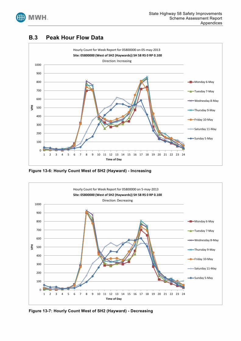
State Highway 58 Safety Improvements Scheme Assessment Report
Appendices
B.3 Peak Hour Flow Data
Figure 13-6: Hourly Count West of SH2 (Hayward) - Increasing
Figure 13-7: Hourly Count West of SH2 (Hayward) - Decreasing
0
100
200
300
400
500
600
700
800
900
1000
1 2 3 4 5 6 7 8 9 10 11 12 13 14 15 16 17 18 19 20 21 22 23 24
VP
H
Time of Day
Site: 05800000 (West of SH2 (Haywards)) SH 58 RS 0 RP 0.100
Monday 6-May
Tuesday 7-May
Wednesday 8-May
Thursday 9-May
Friday 10-May
Saturday 11-May
Sunday 5-May
Hourly Count for Week Report for 05800000 on 05-may-2013
Direction: Increasing
0
100
200
300
400
500
600
700
800
900
1000
1 2 3 4 5 6 7 8 9 10 11 12 13 14 15 16 17 18 19 20 21 22 23 24
VP
H
Time of Day
Site: 05800000 (West of SH2 (Haywards)) SH 58 RS 0 RP 0.100
Monday 6-May
Tuesday 7-May
Wednesday 8-May
Thursday 9-May
Friday 10-May
Saturday 11-May
Sunday 5-May
Hourly Count for Week Report for 05800000 on 5-may-2013
Direction: Decreasing

State Highway 58 Safety Improvements Scheme Assessment Report
Appendices
Figure 13-8: Hourly Count Pauatahanui Telemetry Site 73 - Increasing
Figure 13-9: Hourly Count Pauatahanui Telemetry Site 73 – Decreasing
0
100
200
300
400
500
600
700
800
900
1000
1 2 3 4 5 6 7 8 9 10 11 12 13 14 15 16 17 18 19 20 21 22 23 24
VP
H
Time of Day
Site: 05800009 (PAUATAHUNUI EAST - Telemetry Site 73) SH 58 RS 0 RP 9.140
Monday 6-May
Tuesday 7-May
Wednesday 8-May
Thursday 9-May
Friday 10-May
Saturday 11-May
Sunday 5-May
Hourly Count for Week Report for 05800009 on 5-may-2013
Direction: Increasing
0
200
400
600
800
1000
1200
1 2 3 4 5 6 7 8 9 10 11 12 13 14 15 16 17 18 19 20 21 22 23 24
VP
H
Time of Day
Site: 05800009 (PAUATAHUNUI EAST - Telemetry Site 73) SH 58 RS 0 RP 9.140
Monday 6-May
Tuesday 7-May
Wednesday 8-May
Thursday 9-May
Friday 10-May
Saturday 11-May
Sunday 5-May
Hourly Count for Week Report for 05800009 on 5-may-2013
Direction: Decreasing

State Highway 58 Safety Improvements Scheme Assessment Report
Appendices
B.4 Highway Level of Service Source: SH58 Strategic Study

State Highway 58 Safety Improvements Scheme Assessment Report
Appendices
Figure 13-10: SH58 Eastbound Traffic Volumes – Predicted 2029 Weekday AM Peak
Figure 13-11: SH58 Eastbound Traffic Volumes – Predicted 2029 Weekday PM Peak
0
250
500
750
1000
1250
1500
1750
2000
2250
2500
2750
3000SH
2 (M
ano
r P
ark)
Hu
gh D
un
can
Str
ee
t
Mt
Ce
cil R
oad
Jud
gefo
rd G
olf
Clu
b
Be
lmo
nt
Ro
ad
Pau
atah
anu
i R
ou
nd
abo
ut
Jam
es
Co
ok
Dri
ve
Spin
nak
er
Dri
ve
Po
stga
te D
rive
Ive
y B
ay P
ed
Un
de
rpas
s
SH1
(Par
em
ata)
Traf
fic
Vo
lum
e (
vph
)
Traffic Volume (2029)
Capacity (LOS E)
0
250
500
750
1000
1250
1500
1750
2000
2250
2500
2750
3000
SH2
(Man
or
Par
k)
Hu
gh D
un
can
Str
ee
t
Mt
Ce
cil R
oad
Jud
gefo
rd G
olf
Clu
b
Be
lmo
nt
Ro
ad
Pau
atah
anu
i R
ou
nd
abo
ut
Jam
es
Co
ok
Dri
ve
Spin
nak
er
Dri
ve
Po
stga
te D
rive
Ive
y B
ay P
ed
Un
de
rpas
s
SH1
(Par
em
ata)
Traf
fic
Vo
lum
e (
vph
)
Traffic Volume (2029)
Capacity (LOS E)

State Highway 58 Safety Improvements Scheme Assessment Report
Appendices
Figure 13-12: SH58 Westbound Traffic Volumes – Predicted 2029 Weekday AM Peak
Figure 13-13: SH58 Westbound Traffic Volumes – Predicted 2029 Weekday PM Peak
0
250
500
750
1000
1250
1500
1750
2000
2250
2500
2750
3000SH
2 (M
ano
r P
ark)
Hu
gh D
un
can
Str
ee
t
Mt
Ce
cil R
oad
Jud
gefo
rd G
olf
Clu
b
Be
lmo
nt
Ro
ad
Pau
atah
anu
i R
ou
nd
abo
ut
Jam
es
Co
ok
Dri
ve
Spin
nak
er
Dri
ve
Po
stga
te D
rive
Ive
y B
ay P
ed
Un
de
rpas
s
SH1
(Par
em
ata)
Traf
fic
Vo
lum
e (
vph
)
Traffic Volume (2029)
Capacity (LOS E)
0
250
500
750
1000
1250
1500
1750
2000
2250
2500
2750
3000
SH2
(Man
or
Par
k)
Hu
gh D
un
can
Str
ee
t
Mt
Ce
cil R
oad
Jud
gefo
rd G
olf
Clu
b
Be
lmo
nt
Ro
ad
Pau
atah
anu
i R
ou
nd
abo
ut
Jam
es
Co
ok
Dri
ve
Spin
nak
er
Dri
ve
Po
stga
te D
rive
Ive
y B
ay P
ed
Un
de
rpas
s
SH1
(Par
em
ata)
Traf
fic
Vo
lum
e (
vph
)
Traffic Volume (2029)
Capacity (LOS E)

State Highway 58 Safety Improvements Scheme Assessment Report
Appendices
B.5 Modelling Outputs Source: Draft Opus SH58 Petone to Grenada PFR/Scoping Report

State Highway 58 Safety Improvements Scheme Assessment Report
Appendices
Appendix C Crash Data

State Highway 58 Safety Improvements Scheme Assessment Report
Appendices

State Highway 58 Safety Improvements Scheme Assessment Report
Appendices
Appendix D Design Philosophy Statement Design Speed The current posted legal speed of the road is 100km/h. The design speed of the road is considered as 100km/h, this is on the basis of the following data:
Traffic survey data: o HTS Group Survey Data, 2005: Two surveys showing (combined directional) 100.1km/h
& 99.6km/h 85 percentile speeds o TDG Traffic Survey Data, 2011: Two surveys showing (combined directional) 97.5km/h &
99.5km/h Car following verification surveys
A number of existing advisory curve speeds are also in operation throughout the project length. It is however noted that a substantial length of the project area is substandard and inadequate to support a 100km/h design speed. However, the scope of work for this SAR investigation did not include consideration of a lowering of the posted speed68. Horizontal Alignment The scope includes the realignment of four horizontal curves. The first 3 curves were considered as part of the 2009 PFR report and a fourth location was added to the investigation. The intention was to generally follow the recommendations of the 2009 PFR for Sites 1 & 2, and to optimise Site 3 following collection of topographical data. The additional site, Site 4, was also to be optimised.
Using topographical survey data, Sites 1 & 2 have been refined form the PFR recommendations to form a better more consistent alignment, with similar design speeds and superelevation through each curve. Similarly, the realignment proposals for Site 3&4 have been selected on the basis of curve easing to provide a consent environment where speeds are relatable to preceding curves. This has resulted in most of the horizontal curves throughout this section of the project having design speeds in the range of 75-85 km/h and with horizontal curve radii of approximately 400m.
Approximate horizontal curve data is provide below from Station 0000 to Station 4000 (the sections subject to, and between, the proposed horizontal realignment). Note that this is approximate as there are changes between the 3 different options considered (curve data is provided on the preliminary design plans).
Curve Number Realigned? Station (start of
circular curve) Radius (m) Circular Arc Length (m)
Superelevation (%)
1 - 40 50 55 3
2 - 220 150 50 4
3 - 350 280 75 5
4 Yes 620 200 90 6
5 Yes 790 400 55 5
6 Yes 940 800 65 5
7 Yes 1180 400 195 5
8 Yes 1450 400 40 5
9 - 1730 400 40 5
68 Toward the end of the SAR investigation phase, the NZTA have confirmed they are likely to pursue a lowering of the posted speed from 100km/h to 80km/h (as a result of the crash record and specifically two further fatal crashes having occurred).

State Highway 58 Safety Improvements Scheme Assessment Report
Appendices
Curve Number Realigned? Station (start of
circular curve) Radius (m) Circular Arc Length (m)
Superelevation (%)
10 - 1880 185 130 6
11 - 2140 205 70 6
12 - 2330 750 55 5
13 Yes 2460 405 365 5
14 - 2930 400 120 5
15 - N/A* 1350 N/A* N/A*
16 Yes 3500 400 205 5
17 - 3860 310 5
*Considered as a straight due to large radius
It is acknowledged that ordinarily, curves within the 300m-450m range are preferably avoided as studies have shown they can prove difficult for drivers to read the severity and therefore misjudging appropriate speeds for the However, given the existing alignment and variability between adjacent horizontal curves, it is considered that providing consistency between curves is a better solution. Furthermore, the mountainous topography through (and between) the realigned sections results in the perception of a constrained environment which will serve to control, vehicle speeds.
Stopping Sight Distance Insufficient widening on the inside of corners is an existing issue that should be further considered at the detailed design stage to provide additional widening (particularly for left hand curves to meet SSD requirements for the design speed of 100km/h and deceleration rate on 0.26. The improved cross section would nevertheless provide improvements in respect of SSD but a more thorough assessment of all locations within the project length at detailed design stage. Vertical Alignment The current State Highway 58 length within the project area is characterised by significant vertical curvature, in additional to the curvilinear horizontal alignment. This is a direct result of the existing topography, with the road running through rolling and mountainous terrain.
The result of the topography on the SH58 road geometry is considerable with significant grades that effect the operation of the road.
With operating speeds of 100km/h, maximum grades of between 6-8% are recommended69 for mountainous terrain. Numerous locations on SH58 are around or marginally above this threshold. It is not considered feasible or economic to attempt to address this substandard geometry as part of this Scheme Assessment given the magnitude of works involved.
For the most significant section of uphill grade, of over 9%, the uphill passing lane is retained to allow good overtaking opportunities particularly where heavy vehicles speed will reduce significantly over the course of the long vertical grade increase.
It is also recognised that the length of grades within the current road geometry are substandard, with lengths of grade over 6% longer than the recommended 300m.
The same is particularly true of K values for vertical curvature in terms of existing and achieved. As only four sections are proposed for horizontal realignment, with the remaining lengths subject to an improved road cross section, then it is inevitable that many of the substandard K values for vertical curves remain. Where possible and if the section is being realigned then attempts have been made to improve the associated vertical curve K value – however a number of substandard vertical curves remain within the realignment sections.
69 Austroads Guide to Road Design Part 3, Table 8.3

State Highway 58 Safety Improvements Scheme Assessment Report
Appendices
The vertical curves within the full extent of the realignment (Stn 330 to Stn 4000) have been assessed. There are six crests within this length and as part of the proposed improvements, five of these crest have been improved and one has been maintained.
However, despite this improvement, a number of vertical curves still do not meet the Normal Design Domain requirements, due to existing topography. It is not considered feasible or realistic to fully realign the vertical geometry throughout this length as it would be cost prohibitive due to the existing mountainous terrain (as well as being significantly outside the scope of this investigation). Regardless of the improvements in vertical geometry that these proposals achieve, it is considered important to also contemplate Extended Design Domain (EDD) Parameters.
The use of EDD is considered appropriate for SH58 given this is an existing road upgrade in a constrained location. Furthermore, the use of EDD is stated as being appropriate for ‘realignment of a few geometric elements on existing roads in constrained locations’70.
The minimum crest curve (K value) for sealed roads for the truck-day base case has been used as the appropriate EDD parameter to determine suitability for truck movements.
A reaction time of 2.5 seconds has been used, whilst a design speed of 90km/h has been selected on the basis of the geometry from RP0/0.574 to RP0/0/4.000 being mountainous and therefore trucks being likely to be travelling below the overall 85 th percentile speeds of other vehicles. A 90km/h 85 th percentile speed of trucks is supported by traffic count information assessed which demonstrated HCV 85 th percentile speeds as (combined directions) 88km/h and 91km/h71. It is also worth noting that these speeds were taken on the slightly flatter terrain where speeds are more likely to be higher than through the more mountainous topography. A coefficient of deceleration of 0.29 has been used in the calculations.
An eye height of 2.4m has been used with an object height of 0.8m as per Austroads standards 72. The standard K value (S<L) is provided as 24.9 in Austroads. However, as a result of the significant roadway grade, SSD has been calculated based on the roadway grade, and truck deceleration for all crest curves (for both approach directions). The SSD for every location has then be used (along with algebraic grade change) to calculate the minimum value of K for both scenarios; where sight distance is less than the length of the vertical curve and vice-versa. The figures are provided below:
Option1 Option 2 Option3
Crest Number
Approx. Station
Existing K Value
Min. Calculated K Value
Min. Calculated K Value
Min. Calculated K Value
Required Achieved Required Achieved Required Achieved
1 950-1060 13 29.0 13 29.6 13 25.0 18
2 1330-1560
29 31.4 33 30.9 29 23.5 42
3 2040-2240
16 26.5 19 26.8 20 27.6 20.6
4 2380-2580
16 24.5 70 26.6 72 26.6 71
5 2870- 7 27.8 20.2 26.4 21 27.1 20
70 Austroads Guide to Road Design, Part 3, Appendix A 71 TDG Transportation Assessment for Winstones Cleanfill Site, July 2012 72 Austroads Guide to Road Design, Part 3, Appendix A, Table A17

State Highway 58 Safety Improvements Scheme Assessment Report
Appendices
Option1 Option 2 Option3
Crest Number
Approx. Station
Existing K Value
Min. Calculated K Value
Min. Calculated K Value
Min. Calculated K Value
3020
6 3470-3570
5 29.9 71 29.9 71 24.8 71
In addition to the K Value information contained above, the following should be noted:
Crest 1: This is already a significant vertical crest existing, at the end of a long length of significant uphill (westbound) grade of over 8%. This crest is within the end portion of the realignment of Site 1.
Crest 2: This is an existing crest at the end of another significant uphill (westbound) grade of almost 10%. Part of the crest is outside of the realignment length.
Crest 3: This long crest is outside of any realignment and existing
Crest 4: This existing crest is very minor. This crest is almost entirely contained with the realignment of Site 3.
Crest 5: This crest is existing and is significant with the intersection of Mount Cecil Road sitting at the approximate crown position. The crest is the result of the relatively flat grade followed by a significant downhill (Westbound) grade. The achieved K value has been improved in all options but remains low.
Crest 6: This is a long gentle crest that adequately meets standards.
A further assessment has also been undertaken which considers the minimum EDD K values for sealed roads for the Norm-Day Base Case. A coefficient of deceleration of 0.46 has been used based on wet road conditions. The best achievable scenario for 100km/h design speed requires the use of an eye height of 1.1m, an object height of 1.25m and a reaction time of 2.0 seconds.
The required minimum K values are presented below (adjusted for grade):
Option1 Option 2 Option3
Crest Number
Approx. Station
Existing K Value
Min. Calculated K Value
Min. Calculated K Value
Min. Calculated K Value
Required Achieved Required Achieved Required Achieved
1 950-1060
12 22.1 12.9 22.3 12 22.3 18
2 1330-1560
29 23.1 33 22.9 29 23.4 42
3 2040-2240
16 20.9 19 21 20 21 20.6
4 2380-2580
16 21 70 21 72 21.4 71
5 2870-3020
7 21.6 20.2 21.6 21 21.2 20
6 3470- 5 22.5 71 22.5 71 22.5 71

State Highway 58 Safety Improvements Scheme Assessment Report
Appendices
Option1 Option 2 Option3
Crest Number
Approx. Station
Existing K Value
Min. Calculated K Value
Min. Calculated K Value
Min. Calculated K Value
3570
These K values are less onerous than those required for the 90km/h truck scenario.
Using the 90km/h truck minimum K values, further analysis has been undertaken as to the requirements and practicality of undertaking the physical works required to achieving the minimum K values for Crest 1, 3 and 5.
Work Required to Achieve Min K*
Option Number
Crest Number
Min. Calculated K Value
Reprofile Entire Vertical Curve
(Station)
Earthworks Details
Achieved Required Start End
Option 1
1 29.0 12.9 900 1100 Approximately 1m cut
depth at high point
3 26.5 19 2030 2270 Approximately 0.8m cut
depth at high point
5 27.8 20.2 2850 3040 0.5m cut at high point plus
fill lengths
Option 2
1 29.6 12 900 1100 Approximately 1.1m cut
depth at high point
3 26.8 20 2010 2270 Approximately 0.9m cut
depth at high point
5 26.4 21 2860 3060 0.5m cut at high point plus
fill lengths
Option 3
1 25.0 18 920 1100 Approximately 0.7m cut
depth at high point
3 27.6 20.6 2010 2240 Approximately 0.8m cut
depth at high point
5 27.1 20 2850 3060 0.6m cut at high point plus
fill lengths
*Re-profiling the existing pavement by cutting would also have consequential effects for services and require relocating / protection
It should also be noted that all 3 of the non-complying crests (Crests 1, 3 and 5) are existing crest curves that do not comply with current standards (and the vertical profile is maintained or improved through the works proposed in this investigation). Crests 1 and 5 are within sections of realignment (either entirely or partially) and are being improved with the proposed works, though still do not meet
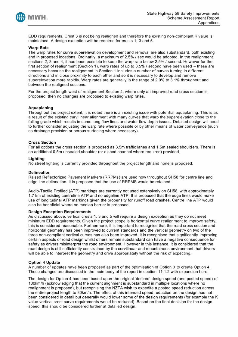
State Highway 58 Safety Improvements Scheme Assessment Report
Appendices
EDD requirements. Crest 3 is not being realigned and therefore the existing non-compliant K value is maintained. A design exception will be required for crests 1, 3 and 5.
Warp Rate The warp rates for curve superelevation development and removal are also substandard, both existing and in proposed locations. Ordinarily, a maximum of 2.5% / sec would be adopted. In the realignment sections 2, 3 and 4, it has been possible to keep the warp rate below 2.5% / second. However for the first section of realignment (Section 1), warp rates of up to 3.5% / second have been used – these are necessary because the realignment in Section 1 includes a number of curves turning in dif ferent directions and in close proximity to each other and so it is necessary to develop and remove superelevation more rapidly. Warp rates are generally in the range of 2.0% to 3.1% throughout and between the realigned sections.
For the project length west of realignment Section 4, where only an improved road cross section is proposed, then no changes are proposed to existing warp rates.
Aquaplaning Throughout the project extent, it is noted there is an existing issue with potential aquaplaning. This is as a result of the existing curvilinear alignment with many curves that warp the superelevation close to the falling grade which results in some long flow lines and water flow depth issues. Detailed design will need to further consider adjusting the warp rate where possible or by other means of water conveyance (such as drainage provision or porous surfacing where necessary).
Cross Section For all options the cross section is proposed as 3.5m traffic lanes and 1.5m sealed shoulders. There is an additional 0.5m unsealed shoulder (or dished channel where required) provided.
Lighting No street lighting is currently provided throughout the project length and none is proposed. Delineation Raised Reflectorized Pavement Markers (RRPMs) are used now throughout SH58 for centre line and edge line delineation. It is proposed that the use of RRPMS would be retained. Audio-Tactile Profiled (ATP) markings are currently not used extensively on SH58, with approximately 1.7 km of existing centreline ATP and no edgeline ATP. It is proposed that the edge lines would make use of longitudinal ATP markings given the propensity for runoff road crashes. Centre line ATP would also be beneficial where no median barrier is proposed.
Design Exception Requirements As discussed above, vertical crests 1, 3 and 5 will require a design exception as they do not meet minimum EDD requirements. Given the project scope is horizontal curve realignment to improve safety, this is considered reasonable. Furthermore, it is important to recognise that the road cross section and horizontal geometry has been improved to current standards and the vertical geometry on two of the three non-compliant vertical curves has also been improved. It is recognised that significantly improving certain aspects of road design whilst others remain substandard can have a negative consequence for safety as drivers misinterpret the road environment. However in this instance, it is considered that the road design is still sufficiently constrained by the curvilinear and mountainous environment that drivers will be able to interpret the geometry and drive appropriately without the risk of expecting. Option 4 Update A number of updates have been proposed as part of the optimisation of Option 3 to create Option 4. These changes are discussed in the main body of the report in section 11.1.2 with expansion here.
The design for Option 4 has been based upon the original ‘desired’ design speed (and posted speed) of 100km/h (acknowledging that the current alignment is substandard in multiple locations where no realignment is proposed), but recognising the NZTA wish to expedite a posted speed reduction across the entire project length to 80km/h. The effect of this intended speed reduction on the design has not been considered in detail but generally would lower some of the design requirements (for example the K value vertical crest curve requirements would be reduced). Based on the final decision for the design speed, this should be considered further at detailed design.

State Highway 58 Safety Improvements Scheme Assessment Report
Appendices
Option 4 has removed Realignment Site 1 (Stn 580-1060) from the project, on the basis of the challenging topography through this section and associated high cost of earthworks. The effect of this removal has been considered in terms of the adjacent curves to ensure an out of context curve is not created, where vehicle speeds on adjacent curves are disparate. The design speeds have been confirmed as being no greater than 10km/h difference through adjacent curves around the now removed section of Realignment Site 1. The improved cross section will enhance safety through these curves though careful signposting of advisory speeds will be required at detailed design stage, and other measures, such as high friction surfacing may be warranted through this set of curves now Site 1 is no longer proposed for realignment.
A substandard vertical crest curve exists between Stn 950-1060 which will not be altered with the Opt 4 proposals (discussed above for Options 1-3). This vertical curve is existing and would require significant re-profiling to improve.
The design changes at Moonshine Road and at the projects northern extent have been considered in detail within the main body of the report and are therefore not subject to further commentary in this DPS.
As with Options 1-3 potential aquaplaning issues will require consideration during the detailed design of stormwater facilities. Superelevation warp rates will also be further considered given the complex topography and the need to develop and remove superelevation through horizontal curves in close proximity.
The design of the proposed cleanfill access (Stn 3220) will also need to be revised (or removed) at detailed design as the current design shown is indicative only based upon the proposals previously supplied to NZ Transport Agency as part of the cleanfill site development proposals (and affected party approval granted). It is understood that this proposal was not issued the necessary resource consents though this decision may still be subject to challenge.

State Highway 58 Safety Improvements Scheme Assessment Report
Appendices
Appendix E Scheme Drawings Provided separately.

State Highway 58 Safety Improvements Scheme Assessment Report
Appendices
Appendix F Pavement Design F.1 Design Report Below is the concept pavement design for the four sites on SH58. We have undertaken a desktop study of the RAMM data of the 4 sites to establish sensible assumptions for scheme design purposes;
Background
The NZTA has requested MWH to undertake a scheme design for State Highway 58. The work involves realigning the horizontal curves on 4 lengths and the approximately RP’s are as follows; RP 0/0.535 to RP0/1.046, RP 0/0.975 to RP0/1.630, RP 0/2.255 to RP0/3.380 and RP 0/3.400 to RP0/4.000
Each site will include two options
Option 1 – 3.5m traffic lanes, with 1.5m sealed shoulders
Option 2 – 3.5m traffic lanes, with 1.5m sealed shoulders and a 2m flush median
Topography of the site
The four sites consist of a series of tight reverse curves with an uphill gradient.
Geotechnical Investigation
A Preliminary Geotechnical Appraisal Report was undertaken. The appraisal was visual only stated the following ‘The existing pavement is performing well. Pavement test pits and RAMM historical data will confirm the nature of the existing construction and this should form a precedent for proposed pavement works’.
As there has not been any pavement test pits undertaken, we have used historical RAMM data for this design. To proceed to detail design further geotechnical investigation is needed to confirm ground conditions and the CBR of the subgrade.
Historical RAMM data - Desktop Assessment
Below is the data from RAMM of the existing pavement for the four sites.
Site 1 SH58 RP 0/0.535 to RP 0/1.046
Average skid resistance – left lane 0.49 and right lane 0.48 – These are acceptable levels so no surfacing renewal is required as yet
Average roughness –80 NASSRA
Average rutting – left lane 6.7mm and right lane 5.9mm – Not bad since it is under 10mm
Existing surfacing – two coat chip seal
Basecourse thickness – 150mm
Site 2 SH58 RP 0/0.975 to RP 0/1.630
Average skid resistance –left lane 0.48 and right lane 0.50
Average roughness – 101 NASSRA (comments in RAMM state that road works were there at the time of survey).

State Highway 58 Safety Improvements Scheme Assessment Report
Appendices
Average rutting –right lane 5.88mm and left lane 6.48mm
Existing surfacing – Two coat chip seal for majority of the site apart from two patch repairs that have Stone Mastic Asphalt surfacing at RP 0/1085 – 1180 and RP 0/1475-1085
Basecourse thickness – 140mm – 150mm
Site 3 SH58 RP 0/2.250 to RP 0/3.380
Average skid resistance – left lane 0.49 and right lane 0.45
Average roughness – 73 NASSRA
Average rutting – left lane 4.03mm and right lane 4.5mm
Existing surfacing - Two coat chip seal
Basecourse thickness – 140mm
Site 4 SH58 RP 0/3.400 to RP 0/4.00
Average skid resistance – left lane 0.46 and right lane 0.45
Average roughness – 77 NASSRA
Average rutting – left lane 4.3mm and right lane 4.98mm
Existing surfacing – Two coat chip seal
Basecourse thickness – 140mm
FWD data 2011
The average deflection for all four sites was 0.52 mm – This indicates a strong overall pavement structure
The above data indicates the pavement for all four sites is still performing well and because of this the pavement design will be based on existing. However the thickness of the granular material will be increased to 2.5 times the size to ensure compaction is met. RAMM data had no record of the CBR although from existing test results of other projects undertaken in the vicinity and the low deflections from the FWD testing carried out in 2011 a CBR of 10% will be assumed for the scheme assessment design.
Pavement Design
Below is the concept pavement design for SH58. The option that has been investigated is an unbound granular pavement with a chip seal surfacing. The minimum subgrade CBR shall not be less than 10% for this state highway given the 25 year design traffic of 5.3 million ESA.
For all four sites the proposed schematic pavement design is as follows:
Unbound Granular Material
Excavate 330mm to subgrade.
Test Subgrade to ensure a CBR of 10% is met.
Place 170mm of AP65

State Highway 58 Safety Improvements Scheme Assessment Report
Appendices
Place 160mm of AP40 M/4
Place grade 3 and 5 two coat chip seal
Considerations for Pavement Widening
Further consideration should be given to the existing pavement when widening as discussed i n section 8.3 of the NZ Supplement 2007 to Austroads Pavement Design Guide. This states the potential risks of only excavating the existing shoulder and bringing the new pavement up to level can result in discontinuity of materials and layer performance in the area of the interface between the old and the new pavement. The discontinuity can be attributed to a number of factors, most notably; segregation of the new aggregate, reduced layer stiffness as a result of removing the lateral restraint provide by the shoulder and difficulties associated with compacting layers with a narrow or irregular shape. This risk should be considered when undertaking detail design and the design shall allow for modifying the upper materials to half or full width of the carriage way to a depth of at least 200mm. Step construction will be necessary to reduce failures at the interface.
Design assumptions:
Design traffic 25 years = 5.3 x 10^6ESA
Growth rate is 1.5%
Combined AADT 13,600 and Heavies 5%
Design subgrade CBR 10.0%
Source Materials for the new Subbase and Basecourse shall comply with TNZ M/4 and TNZ M/3 Notes
It is recommended that Subsoil drainage is installed approximately 650mm deep and to be in accordance with F/2
Design Standards:
Austroads Pavement Technology Part 2: Pavement Structural Design 2008
NZ Supplement 2007 to Austroads Pavement Design Guide
Circly 5 Pavement Analysis and Design Programme
Potential Risks
The in-situ CBR may be less than 10% this could affect the design depth as weaker subgrades will require thicker pavement
Quality of materials/construction is not in accordance with NZTA specifications.
Further testing will need to be undertaken to confirm the CBR assumption of 10% or above.

State Highway 58 Safety Improvements Scheme Assessment Report
Appendices
F.2 Background Data and Circly Output

State Highway 58 Safety Improvements Scheme Assessment Report
Appendices
Appendix G Risk Register

State Highway 58 Safety Improvements Scheme Assessment Report
Appendices
Appendix H Social and Environmental Management Form (PSF 13)

State Highway 58 Safety Improvements Scheme Assessment Report
Appendices
Option Description:
Social and Environmental Screen Social and Environmental Assessment Note to be completed following consultation
Issue Effects Degree of Effect
Requirements Addressing Effects and meeting requirements
Social and environmental issues Describe the potential social and environmental effects of the option, including where the option may improve social and environmental outcomes
High / Medium / Low / N/A
List all legal requirements and relevant Transit social and environmental objectives
List actions to be taken to meet specific social and environmental requirements and objectives and address all effects identified. Include an estimated cost.
Specific Actions Estimated Cost ($)
Noise
e.g. .construction noise, traffic noise, maintenance noise, presence of sensitive receivers (homes, schools, hospitals)
The noise effects of the project will be determined when further details on the design are available. Where necessary, a resource consent may be required. As part of the resource consent application an assessment of effects on the environment will be prepared.
N/A Resource consent / designation conditions details: Specific NZTA objectives details:
Planning Policy Manual and Environmental Plan, relevant guidelines
Other details:
Air Quality
e.g. dust, air pollution, greenhouse gas emissions, odour
The air quality effects of the project will be determined when further details on the design are available. Where necessary, a resource consent may be required. As part of the resource consent application an assessment of effects on the environment will be prepared.
N/A Resource consent / designation conditions details: Specific NZTA objectives details: Planning Policy Manual and Environmental Plan, relevant guidelines
Other details:
Water resources
E.g. sedimentation, contaminants in road run-off, climate change impacts (sea level rise and changing rainfall patterns), impacts on sensitive water bodies, changing hydrological cycles and water flow patterns.
The water resources effects of the project will be determined when further details on the design are available. Where necessary, a resource consent may be required. As part of the resource consent application an assessment of effects on the environment will be prepared. The Pauatahanui Stream in the vicinity of the works is considered a sensitive environment and the effects of sedimentation will need to be addressed.
High Resource consent / designation conditions details: Specific NZTA objectives details: Planning Policy Manual and Environmental Plan, relevant guidelines
Other details:
Erosion and sediment control
e.g. soil slips, landslides, water erosion (raindrop, sheet, rill gully, tunnel, channel) and wind erosion (dust)
The effects of the project will be determined when further details on the design are available. Where necessary, a resource consent may be required. As part of the resource consent application an assessment of effects on the environment will be prepared. The Pauatahanui Stream in the vicinity of the works is considered a sensitive environment and the effects of sedimentation will need to be addressed.
High Resource consent / designation conditions details: Specific NZTA objectives details: Planning Policy Manual and Environmental Plan, Regional Council Stormwater Guidelines
Other details:
Social responsibility
e.g. social, severance, social interaction, connectivity
The effects of the project will be determined when further details on the design are available. Where necessary, a resource consent may be required. As part of the resource consent application an assessment of effects on the environment will be prepared.
N/A Resource consent / designation conditions details: Specific NZTA objectives details: Planning Policy Manual and Environmental Plan, relevant guidelines
Other details:

State Highway 58 Safety Improvements Scheme Assessment Report
Appendices
Option Description:
Social and Environmental Screen Social and Environmental Assessment Note to be completed following consultation
Issue Effects Degree of Effect
Requirements Addressing Effects and meeting requirements
Social and environmental issues Describe the potential social and environmental effects of the option, including where the option may improve social and environmental outcomes
High / Medium / Low / N/A
List all legal requirements and relevant Transit social and environmental objectives
List actions to be taken to meet specific social and environmental requirements and objectives and address all effects identified. Include an estimated cost.
Culture and Heritage
e.g. waahi tapu and Statements of identified Maori interests, archaeological sites, historic buildings, places, trees and special features
The effects of the project will be determined when further details on the design are available. Where necessary, a resource consent may be required. As part of the resource consent application an assessment of effects on the environment will be prepared. The discovery of artefacts will be covered under the agreed discovery protocols.
N/A Resource consent / designation conditions details: Specific NZTA objectives details: Planning Policy Manual and Environmental Plan, relevant guidelines
Other details:
Ecological resources
e.g. significant vegetation, fauna passage, habitat protection, special trees, reinstatement of vegetation, slope stabilisation, use of low-growth vegetation to reduce maintenance costs
The effects of the project will be determined when further details on the design are available. Where necessary, a resource consent may be required. As part of the resource consent application an assessment of effects on the environment will be prepared. The Pauatahanui Stream in the vicinity of the works is considered a sensitive environment and the effects of sedimentation will need to be addressed.
High Resource consent / designation conditions details: Specific NZTA objectives details: Planning Policy Manual and Environmental Plan, relevant guidelines
Other details:
Spill response and contamination
e.g. spills from vehicle accidents, onsite storage of fuels, excavations of contaminated soils/clean fill
The effects of the project will be determined when further details on the design are available. Where necessary, a resource consent may be required. As part of the resource consent application an assessment of effects on the environment will be prepared.
Low Resource consent / designation conditions details: Specific NZTA objectives details: Planning Policy Manual and Environmental Plan, relevant guidelines
Other details:
Resource efficiency
E.g. in situ pavement recycling, energy efficiency, initiatives to reduce waste to landfill, use of local materials.
Tender requirements should address resource efficiency outcomes.
N/A Resource consent / designation conditions details: Specific NZTA objectives details: Planning Policy Manual and Environmental Plan, relevant guidelines
Other details:
Climate change:
Adaptation and mitigation e.g. sea level rise, greenhouse gas emissions, increase incidence of flooding and coastal storms
The effects of climate change on the project will be determined when further details on the design are available. These will be addressed should there be bridge or culvert proposals.
N/A Resource consent / designation conditions details: Specific NZTA objectives details: Planning Policy Manual and Environmental Plan, relevant guidelines
Other details:
Visual quality
e.g. landscaping, retaining walls, noise walls, views from roads neighbouring properties
The effects on the visual quality of the project will be determined when further details on the design are available. Where necessary, a resource consent may be required. As part of the resource consent application an assessment of effects on the environment will be prepared.
N/A Resource consent / designation conditions details: Specific NZTA objectives details: Planning Policy Manual and Environmental Plan, relevant guidelines
Other details:
State Highway 58 Safety Improvements Scheme Assessment Report
Appendices
Option Description:
Social and Environmental Screen Social and Environmental Assessment Note to be completed following consultation
Issue Effects Degree of Effect
Requirements Addressing Effects and meeting requirements
Social and environmental issues Describe the potential social and environmental effects of the option, including where the option may improve social and environmental outcomes
High / Medium / Low / N/A
List all legal requirements and relevant Transit social and environmental objectives
List actions to be taken to meet specific social and environmental requirements and objectives and address all effects identified. Include an estimated cost.
Vibration
E.g. construction and maintenance vibration, pavement surface, heavy traffic vibration, presence of sensitive receivers including historic buildings and features.
The vibration effects of the project will be determined when further details on the design are available. Where necessary, a resource consent may be required. As part of the resource consent application an assessment of effects on the environment will be prepared.
N/A Resource consent / designation conditions details: Specific NZTA objectives details: Planning Policy Manual and Environmental Plan, relevant guidelines
Other details:
Land use and transport integration
E.g. integration of land use and development with transport networks, reverse sensitivity, access management.
The effects on land use and transport integration of the project will be determined when further details on the design are available. Where necessary, a resource consent may be required. As part of the resource consent application an assessment of effects on the environment will be prepared.
N/A Resource consent / designation conditions details: Specific NZTA objectives details: Planning Policy Manual and Environmental Plan, relevant guidelines
Other details:
Urban design
E.g. context sensitive design, including aesthetics of structures (refer PSG/12 for guidance).
The urban design effects of the project will be determined when further details on the design are available. Where necessary, a resource consent may be required. As part of the resource consent application an assessment of effects on the environment will be prepared.
N/A Resource consent / designation conditions details: Specific NZTA objectives details: Planning Policy Manual and Environmental Plan, relevant guidelines
Other details:
Public Health
e.g. stress to individuals and community, personal security, cycling and walking opportunities
The public health effects of the project will be determined when further details on the design are available. Current proposals do not make additional provision for cycling and walking opportunities.
N/A Resource consent / designation conditions details: Specific NZTA objectives details: Planning Policy Manual and Environmental Plan, relevant guidelines
Other details:
Cycling infrastructure
e.g. on highway cycle lanes, segregated cycle path adjacent to SH, links into local cycling network
The effects of the project on cycling infrastructure will be determined when further details on the design are available. Current proposals do not make additional provision for cycling opportunities.
N/A Resource consent / designation conditions details: Specific NZTA objectives details: Planning Policy Manual and Environmental Plan, relevant guidelines
Other details:
Cycle crossing facilities
e.g. shared cycle/pedestrian crossing at traffic signals, widened traffic island to accommodate cyclists where cycle route crosses SH, dropped crossings
The effects of the project on cycle crossing facilities will be determined when further details on the design are available.
N/A Resource consent / designation conditions details: Specific NZTA objectives details: Planning Policy Manual and Environmental Plan, relevant guidelines
Other details:
Walking infrastructure
e.g. new or widened footway, connections to local road footways
The effects of the project on walking infrastructure will be determined when further details on the design are available. It is noted that current proposals do not make provision
N/A Resource consent / designation conditions details: Specific NZTA objectives details: Planning Policy Manual and Environmental Plan, relevant guidelines
State Highway 58 Safety Improvements Scheme Assessment Report
Appendices
Option Description:
Social and Environmental Screen Social and Environmental Assessment Note to be completed following consultation
Issue Effects Degree of Effect
Requirements Addressing Effects and meeting requirements
Social and environmental issues Describe the potential social and environmental effects of the option, including where the option may improve social and environmental outcomes
High / Medium / Low / N/A
List all legal requirements and relevant Transit social and environmental objectives
List actions to be taken to meet specific social and environmental requirements and objectives and address all effects identified. Include an estimated cost.
for walking opportunities given that the road is narrow and winding. Proposals for the expansion of the walking tracks at the Belmont Regional Park are noted.
Other details:
Pedestrian crossing facilities
e.g. signalised crossings, traffic islands, dropped crossings, pedestrian desire lines
The effects of the project on pedestrian crossing facilities will be determined when further details on the design are available. It is noted that the existing road is generally characterised by a rural environment with little pedestrian activity.
N/A Resource consent / designation conditions details: Specific NZTA objectives details: Planning Policy Manual and Environmental Plan, relevant guidelines
Other details:
Bus related Infrastructure
e.g. bus laybys, hardstandings, buildouts into carriageway at bus stop
The effects of the project on bus related infrastructure particularly that relating to school bus shelters, will be determined when further details on the design are available.
N/A Resource consent / designation conditions details: Specific NZTA objectives details: Planning Policy Manual and Environmental Plan, relevant guidelines
Other details:
Priority lanes
e.g. potential to include bus, freight, HOV or HOT lane either through the reallocation of existing roadspace or new construction to make certain modes more efficient and widen travel choice
No priority bus lanes are envisaged for the project given the nature of the environment and the status of the highway.
N/A Resource consent / designation conditions details: Specific NZTA objectives details: Planning Policy Manual and Environmental Plan, relevant guidelines
Other details:
Traffic management
e.g. potential for ITS, variable message signing, variable speed management, ramp signalling
Traffic management will be determined when further details on the design and construction methodology are available.
High Resource consent / designation conditions details: Specific NZTA objectives details: Planning Policy Manual and Environmental Plan, relevant guidelines
Other details:

State Highway 58 Safety Improvements Scheme Assessment Report
Appendices
Appendix I Preliminary Geotechnical Appraisal Report

State Highway 58 Safety Improvements Scheme Assessment Report
Appendices
Appendix J Scheme Estimate

State Highway 58 Safety Improvements Scheme Assessment Report
Appendices
Appendix K SIDRA Modelling K.1 Layout Diagrams
Figure 13-14: Moonshine Road Existing T Intersection Layout (as modelled)
Figure 13-15: Moonshine Road Roundabout Layout

State Highway 58 Safety Improvements Scheme Assessment Report
Appendices
Figure 13-16: Moonshine Road Roundabout Layout (Option 4)
Figure 13-17: Moonshine Road Roundabout Layout (Final Option 4 – Road Safety Audit Update)

State Highway 58 Safety Improvements Scheme Assessment Report
Appendices
K.2 SIDRA Outputs

State Highway 58 Safety Improvements Scheme Assessment Report
Appendices
Appendix L Economic Evaluation

State Highway 58 Safety Improvements Scheme Assessment Report
Appendices
Appendix M SH58 Strategic Study The executive summary from the NZTA’s 2009 SH58 Strategic Study is appended below.
The NZTA has developed a long-term strategic plan along State Highway 58 (SH58) over the
20-year period 2009 to 2029. This SH58 Strategic Study relates to the entire 15.1 km length
of SH58, from the junction with SH2 at Manor Park in the Hutt Valley, to the junction with SH1
at Paremata. SH58 is a regional highway that joins the Hutt Valley with Porirua and the Kapiti
Coast. It provides for travel between these three areas whilst also providing access to local
communities such as Whitby and Pauatahanui. SH58 is also used by heavy vehicle traffic
travelling between the industrial port area of Gracefield/Seaview and destinations to the west
via SH1.
The current highway predominantly provides a single two-way carriageway with roundabouts and
priority controlled intersections. The width of the highway is constrained in many locations due
to the terrain. Traffic volumes vary from 13,800 vehicles per day (vpd) west of SH2 to 9,200
vpd east of James Cook Drive at the end of the Pauatahanui Inlet, and to 16,700 vpd east of
the Paremata Roundabout. The highway is predominantly rural from SH2 to Pauatahanui,
with the urban density increasing from Pauatahanui to SH1 at Paremata.
Increasing traffic volumes will place some sections of the highway under pressure within the 20-
year period, depending on whether or not Transmission Gully and Grenada to Gracefield projects
are completed. The current strategy assumes the Grenada to Gracefield projects are constructed
within the 10 year period and Transmission Gully soon after the ten year period.
The Grenada to Gracefield projects will result in a decrease in traffic volumes on SH58, as traffic
transfers to the new east-west route. However, when Transmission Gully is constructed traffic
volumes on SH58 increase again, but these will only be greater than existing volumes east of the
new gully route as alternative routes will be available into Porirua.
Analysis of the crash data for the 5-year period from 2004 to 2008 indicates that there are
currently an average of about 16 injury crashes and 52 total crashes per year and crash costs
of about $5.3 million per annum along the SH58 Corridor study length. Accordingly, there is
scope for improving the safety along this highway.
Based on the background information, the capacity analysis and the crash statistics, a long-term
strategic plan has been developed for SH58. This can be summarised as follows:
The strategy assumes the Grenada to Gracefield projects will proceed within 10
years and Transmission Gully will be complete soon after the 10 year period.
Based on these assumptions, SH58 will be retained as a two-lane two-way
highway with the current passing lanes.
All intersections will be at-grade, with the exception of the intersections with
SH2 and Transmission Gully, which will both be grade separated.
The section between Manor Park and Moonshine Road will be managed as an
80 – 100km/h rural environment with a median barrier (and some provision
for turning movements) considered in the long term.
The section between Moonshine Road and Pauatahanui will also be managed as
an 80-100km/h rural environment with minor safety upgrades in the short
term. Long term, this section could become a peri-urban environment and
roundabouts for safety will be considered at the Moonshine Road and Flightys
Road / Murphys Road intersections in conjunction with reducing the speed
limit.
The section between Pauatahanui and Postgate Drive will be managed as a
70km/h peri-urban section and the section from Postgate Drive to Paremata
will be managed as a 50km/h urban highway with controlled access in the
short term. The long term status of SH58 from Transmission Gully to Paremata
will be determined as part of the Transmission Gully project.
Minor safety works will continue to be undertaken to address specific crash
issues that arise during the study period.

State Highway 58 Safety Improvements Scheme Assessment Report
Appendices
Appendix N Pauatahanui Judgeford Structure Plan
Figure 13-18: Transportation Option (Source: Appendix D, Pauatahanui Judgeford Structure Plan Technical Report -2012)

State Highway 58 Safety Improvements Scheme Assessment Report
Appendices
Appendix O Safety Audit

State Highway 58 Safety Improvements Scheme Assessment Report
Appendices
Appendix P Economic Peer Review

State Highway 58 Safety Improvements Scheme Assessment Report
Appendices
Appendix Q Consultation Summary Full details of the public consultation is provided in the MWH Consultation Summary Report (April 2015). A summary is provided below:
Consultation Process
The consultation was undertaken in late 2014 to obtain feedback from landowners, stakeholders and the general public on the proposed safety upgrades of Option 4, while design for the improvements were at an early stage. The following actions were undertaken:
Letters were sent to the interested parties to outline progress and options and seeking feedback and arrange a meeting with the Transport Agency representatives to discuss the proposed improvements.
Individual meetings held for directly affected landowners and stakeholders; Open Day sessions held for the general public.
The following groups to be consulted were identified as follows:
Directly Affected Landowners: Landowners whose land is likely to be required for the proposed safety improvements;
Landowners Affected by Access: Landowners adjacent to the project area whose access to SH58 from their properties is affected by the proposed safety improvements(including the proposed median barrier);
Hugh Duncan Street/McDougall Grove residents: Residents and/or the property owners of Hugh Duncan and McDougall Streets while not affected by the upgrades, had been previously involved with proposed upgrades to SH58 by the Transport Agency and were included for this reason;
Interested Stakeholders: The stakeholders included groups such as Cycle Aware, the NZ Police and Iwi.
The consultation activities comprised:
a. Open days at Pauatahanui and Upper Hutt b. Mail out c. One on one meetings with landowners
Consultation Outcomes
The main themes and issues that arose from the consultation are summarised below. These themes and issues have been sourced from the consultation records.
Landowners
Feedback from directly affect landowners and landowners whose access would be affected identified that landowners acknowledged the high number of crashes that occur on SH58 and were generally supportive of the project. Most of the landowners, while being supportive of the proposed speed reductions and realignment of SH58, were concerned about the loss of land, changes to private access to SH58 and the left -in, left-out access that would result from the median barrier.

State Highway 58 Safety Improvements Scheme Assessment Report
Appendices
Submissions
Submissions made using the feedback forms provided at the Open Days and electronically on the project website were compiled an analysed. Seventy one submission forms were filled out from the Pauatahanui Open Day. There were 68 submissions lodged on the project website. Submitters generally supported the proposed safety upgrades (80 % of submissions were in support). Sixty percent of submissions supported the median barrier. Seventy five percent of submitters supported the reduction of speed proposed.
Sixty five percent of respondents supported the proposal to install a wire rope barrier along SH58 Public opinion on the project was gauged via the open days held at the Pauatahanui School and the Upper Hutt library. Over 200 people attended the Open Days. The following themes were gauged through conversations and break-out meetings with attendees:
General support for lowering the speed limit;
General support for fixing the scour site corner and installing the median barrier;
Concern was expressed by the residents of Flightys and Murphys Roads regarding the long wait and confusion at these intersections, particularly when cars are waiting to exit both intersections;
Safety at Flightys and Murphys Roads are exacerbated at school pick up and drop off time due to the bus stops at the intersection. Provision for children crossing the road to get to the bus stop was requested.
The difficult entrance/exit arrangements on/off SH58 at Flightys Road creates an increased probability of crashes
The following themes were derived from the website submissions:
The median barrier will reduce space for cyclists and motorcyclists and will be dangerous;
General support for the reduction in speed;
Those opposed to the reduction in speed generally feel that it would not reduce the amount of crashes on SH58;
General concern about the change in access proposed at intersections, particularly at the intersection of Harris Road and SH58; and
General concern that the design does not cater enough for cyclists who use the road;
Conclusion
The consultation undertaken to date on the proposed SH58 safety improvements concept design was intended to provide information to and seek feedback from affected persons and stakeholders and the general public. The information gathered will inform the next stage of design prior to more detailed consultation with those who are directly affected by the upgrades as part of the preparation of the NoR and any resource consent applications that may be required under the RMA. Relationships have been initiated with landowner, stakeholder and the general public by the exchanging information at an early stage of the design. The feedback sought from the consultation has been recorded. The consultation process has been successful in yielding information that will be used in the next stage of design. The top five issues identified during the consultation by the public, landowners and stakeholders are:

State Highway 58 Safety Improvements Scheme Assessment Report
Appendices
The land purchase proposed; The inconvenience of altered private access to SH58; Safety of turning arrangements at intersections due to the proposed median barrier restricting
right turns; The safety upgrades do not cater for cyclists and motorcyclists; and The upgrades will increase noise and stormwater run-off.

State Highway 58 Safety Improvements Scheme Assessment Report
Appendices
Appendix R Consultation Report

State Highway 58 Safety Improvements Scheme Assessment Report
Appendices
Appendix S Intersection Strategy Technical Note

State Highway 58 Safety Improvements Scheme Assessment Report
Appendices
Appendix T Flightys / Murphys Road Intersection Assessment

State Highway 58 Safety Improvements Scheme Assessment Report
Appendices
Appendix U SH58 Structural Assessment Technical Note
Related Documents