SFILE COPY ENVIRONMENTAL IMPACT RESEARCH PROGRAM * .MISCELLANEOUS PAPER EL-88-3 PROCEEDINGS OF THE US ARMY CORPS OF ENGINEERS RIPARIAN ZONE RESTORATION AND MANAGEMENT WORKSHOP 24-27 FEBRUARY 1986 0 %J by Chester 0. Martin, Hollis H. Allen - Environmental Laboratory DEPARTMENT OF THE ARMY Waterways Experiment Station, Corps of Engineers PO Box 631, Vicksburg, Mississippi 39180-0631 - ~11 "''* February 1988 Final Report Approved For Pubhc Release Distribution Uni mited SELFCTE f 3 0 J AN 1989 Prepared for DEPARTMENT OF THE ARMY US Army Corps of Engineers Washington, DC 20314-1000 Under EIRP Work Unit 32391 89 1 27 040

Welcome message from author
This document is posted to help you gain knowledge. Please leave a comment to let me know what you think about it! Share it to your friends and learn new things together.
Transcript

SFILE COPY ENVIRONMENTAL IMPACTRESEARCH PROGRAM
* .MISCELLANEOUS PAPER EL-88-3
PROCEEDINGS OF THE US ARMY CORPS OFENGINEERS RIPARIAN ZONE RESTORATION
AND MANAGEMENT WORKSHOP24-27 FEBRUARY 1986
0 %J byChester 0. Martin, Hollis H. Allen -
Environmental Laboratory
DEPARTMENT OF THE ARMYWaterways Experiment Station, Corps of EngineersPO Box 631, Vicksburg, Mississippi 39180-0631 -
~11
"''*
February 1988Final Report
Approved For Pubhc Release Distribution Uni mited
SELFCTE f3 0 J AN 1989
Prepared for DEPARTMENT OF THE ARMYUS Army Corps of EngineersWashington, DC 20314-1000
Under EIRP Work Unit 32391
89 1 27 040

UnclassifiedSECURITY CLASSIFICATION OF THIS PAGE
Form ApprovedREPORT DOCUMENTATION PAGE oMs No. 0701-01
Ia. REPORT SECURITY CLASSIFICATION lb RESTRICTIVE MARKINGSUnclassified
2a. SECURITY CLASSIFICATION AUTHORITY 3 DISTRIBUTION /AVAILABILITY OF REPORT
2b. DECLASSIFICATION1 DOWNGRADING SCHEDULE Approved for public release; distribution
unlimited.
4. PERFORMING ORGANIZATION REPORT NUMBER(S) 5. MONITORING ORGANIZATION REPORT NUMBER(S)
Miscellaneous Paper EL-88-3
6a. NAME OF PERFORMING ORGANIZATION 6b. OFFICE SYMBOL 7a. NAME OF MONITORING ORGANIZATIONUSAEWES (f eapial)
Environmentasl Laboratory
6c. ADDRESS ACity, State, and ZIPCode) 7b. ADDRESS (City, State, and ZIP Code)PO Box 631
Vicksburg, MS 39180-0631
11. NAME OF FUNDING/SPONSORING 8b. OFFICE SYMBOL 9 PROCUREMENT INSTRUMENT IDENTIFICATION NUMBERORGANIZATION (If applicable)
US Army Corps of Engineers
8c. ADDRESS (City State, and ZIPCode) 10. SOURCE OF FUNDING NUMBERSPROGRAM PROJECT TASK WORK UNIT
Washington, DC 20314-1000 ELEMENT NO. NO. NO. ACCESSION NO.______________________________________I IRP 32391
11. TITLE (Include Security Clasification)
Proceedings of the US Army Corps of Engineers Riparian Zone Restoration and ManagementWorkshop, 24-27 February 1986
12. PERSONAL AUTHOR(S)Martin, Chester 0.; Allen, Hollis H.
13a. TYPE OF REPORT 13b. TIME COVERED 14. DATE OF REPORT (Year, honthOay) IS. PAGE COUNTFinal report FROM TO February 1988 64
16. SUPPLEMENTARY NOTATION
Available from National Technical Information Service, 5285 Port Royal Road. Springfield,
VA 22161.
17, COSATI CODES 18 SUBJECT TERMS (Continue on reverse if necesary and ilntify by block number)
FIELD GROUP SUB-GROUPSee reverse.
19. ABSTRACT (Continue on reverse if necessary and identify by block number)Riparian zones are extremely valuable and sensitive ecosystems, and their proper
management and protection are important considerations for Civil Works projects. Thedevelopment and management of riparian habitats may also be viable mitigation alternativesfor many US Army Corps of Engineers projects. To address these issues, a new research anddevelopment work unit entitled "Development of Guidelines for Riparian Zone Restoration andManagement" was approved in 1986 by the Office, Chief of Engineers, US ArTp.
- . This report presents the findings of a Corps of Enginlfers wn rkshop on riparian zone"restoration and management held in San Antonio, Tex., on ?4-27 February 1986. The purpose
of the'workshop was to develop the concept of the riparian zone work unit and ensure thatthe study addressed planning and operational needs within the Corps, Topics 4kaeissed -included:ecological studies in riparian habitats, inventory and preservation of project-related riparian areas, development of environmentally beneficial designs for local flood
(continued)-,
20. DISTRIBUTION /AVAILABILITY OF ABSTRACT 21 ABSTRACT SECURITY CLASSIFICATIONX--UNCLASSFIEDAJNLIMITED 0 SAME AS RPT 0 DTIC USERS I Unclassified
22a. NAME OF RESPONSIBLE INDIVIDUAL 22b TELEPHONE (Include Ares Code) 22c OFFICE SYMBOL
DO Form 1473, JUN 86 Previous editions are obsolete. SECURIT6 CL 4SSIFI, ,N OF THIS PAGE

Unclassified
MOVIIYv CLASIVCA I O O TKIS PASS
18. SUBJECT TERMS (Continued).
Bank protection,. 'Floodplain forests $,4,rrr,< 'Bioengineering techniques Floodplairr-mnagement, ( c CBiotechnical methods Riparian corridorsBuffer strips Riparian ecosystemsCorps of Engineers Riparian zone management
19. ABSTRACT (Continued).
.protection projects, riparian habitats associated with multipurpose reservoirs, riparianproblems in urban settis, and restoration of riparian vegetation and associated wild-life habitat throughl1ruse of bioengineering techniques.
- Major riparian concerna expressed by workshop participants are summarized as follows.Corps projects are strongly influenced by surrounding land uses, including agriculture,grazing, industry, urbanization, and recreation. Adverse impacts of these activities areoften detrimental to the riparian zone and the stream itself, especially where a protec-tive buffer strip is not established and maintained as part of the project plan. A majorconcern at most Civil Works projects is the'provision of bank protection and shorelinestabilization to prevent erosion and sedimentation and to reduce adverse impacts of projectconstruction. "It was agreed that bank restoration and stabilization are best achievedthrough a bioengineering approach ing native plant materials as much as possible. AllDistrict and Division representatives reported that riparian zone planning and managementwere important environmental issues within their areas of jurisdiction. Riparian habitatsare concerns of both Planning and Construction-Operations functions within the Corps ofEngineers, and a need was expressed for the Corps at large to recognize the broad environ-mental values and national significance of riparian ecosystems and to develop strategiesand guidance for their protection and management.
Major tasks identified for the work unit are to: (a) synthesize available informa-tion on riparian zones and develop a procedure for transferring technology to the field;(b) coordinate work unit activities with other government agencies and organizations;(c) conduct a broad analysis of riparian functions and values; (d) provide information onbioengineering approaches to vegetation establishment and bank protection appropriate forriparian zones; (e) include riparian zone restoration and management as a topic to beaddressed by the Chief of Engineers' Environmental Advisory Board; (f) obtain informationon riparian zone management programs at Corps projects and prepare a report of casestudies; (g) survey site-specific riparian management activities at Corps projects foranalysis and assessment; and (h) produce a Corps of Engineers guidance document on properprocedures for riparian restoration and management.
Unclassified
SECURITY C.ASIVICATION O THIS PAGE

PREFACE
This work was sponsored by the Office, Chief of Engineers (OCE),
US Army, as part of the Environmental Impact Research Program (EIRP), Work
Unit 32391, entitled "Development of Guidelines for Riparian Zone Restoration
and Management." The Technical Monitors for the study were Dr. John Bushman
and Mr. David P. Buelow, OCE, and Mr. Dave Mathis, Water Resources Support
Center.
This report was prepared by Mr. Chester 0. Martin and Mr. Hollis H.
Allen, Wetlands and Terrestrial habitat Group (WTHG), Environmental Labora-
tory (EL), US Army Engineer Waterways Experiment Station (WES). Corps of
Engineers District and Division representatives prepared individual papers and
are cited as authors within the report. Manuscript reviews were provided by
Dr. James S. Wakeley, Dr. Charles V. Klimas, and Dr. Hanley K. Smith, EL.
Work was performed under the general supervision of Dr. Hanley K. Smith,
Chief, WTHG; Dr. Conrad J. Kirby, Chief, Environmental Resources Division; and
Dr. John Harrison, Chief, EL. Dr. Roger T. Saucier, WES, was Program Manager,
EIRP. The report was edited by Ms. Lee T. Byrne of the WES Information Prod-
ucts Division, Information Technology Laboratory.
COL Dwayne G. Lee, CE, was Commander and Director of WES. Dr. Robert W.
Whalin was Technical Director.
This report should be cited as follows:
Martin, Chester 0., and Allen, Hollis H. 1988. "Proceedings of theUS Army Corps of Engineers Riparian Zone Restoration and Management Work-shop, 24-27 February 1986," Miscellaneous Paper EL-88-3, US Army EngineerWaterways Experiment Station, Vicksburg, Miss.
Accession For
I NTIS CRA&I
DTIC TABUnannouncedJustificatio
LGTED ristribution/
Avail3hility Codes
I Av-il and/or
Dist Special
1-

CONTENTS
Page 7PREFACE ................ ................................ 1
CONVERSION FACTORS, NON-SI TO SI (METRIC) UNITS OF MEASUREMENT ....... 3
PART I: INTRODUCTION ........................ 4
PART II: SUMMARIES OF PRESENTATIONS ........ ................. 6
Development of a Riparian Zone Restoration and ManagementWork Unit for the US Army Corps of Engineers-- H. H. Allen .......... ........................... 6
An Overview of the Status of Riparian Ecosystems and theApplication of Riparian Zone Management to Corps Projects-- C. 0. Martin ......... ............................ 9
Riparian Ecosystem Management in the Wilmington District-- W. F. Adams .......... ......................... .. 12
Environmental Studies of Shoreline Wetlands and AquaticHabitats in the Buffalo District -- J. Bennett .......... 15
Recommendations for Riparian Zone Restoration and ManagementStrategies Based on Project Studies in the New YorkDistrict -- M. L. Benard ........ .................... .. 18
Riparian Zone Management Associated with Reservoir Projectsin the Vicksburg District -- G. Anding . ............. 22
Approaches to Riparian Zone Restoration and Managementin the Fort Worth District -- M. Hathorn .... ............ . 26
Riparian Zone Vegetation Management Programs in theMissouri River Division -- R. E. Lenning ... ............ 29
Strategies for Riparian Zone Restoration in theAlbuquerque District -- M. Sifuentes ..... .............. . 32
Riparian Zone Management at Flood-Control Reservoirs inthe Los Angeles District -- R. Harlacher .... ............ . 36
Riparian Zone Concerns in the South Pacific Division-- H. L. Lieberman and F. J. Kindel ..... .............. . 39
Riparian Zone Management in the North Pacific Division-- E. P. Peloquin ....................... 42
PART III: SUMMARY OF WORKSHOP DISCUSSION .... ............... .... 44
APPENDIX A: WORKSHOP PARTICIPANTS ...... ................... 50
APPENDIX B: PLAN OF STUDY: DEVELOPMENT OF GUIDELINES FOR RIPARIAN
ZONE RESTORATION AND MANAGEMENT .... ............. . 51
APPENDIX C: SELECTED REFERENCES ....... ................... .. 57
2
7:--
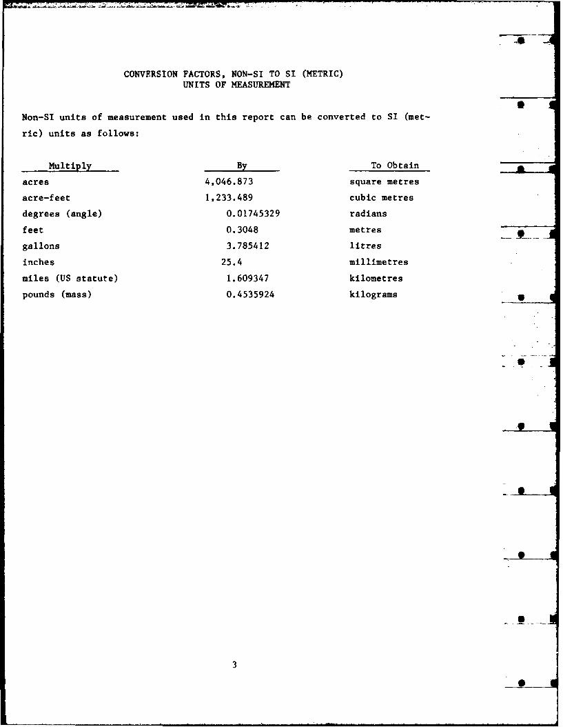
CONVERSION FACTORS, NON-SI TO SI (METRIC)
UNITS OF MEASUREMENT
Non-SI units of measurement used in this report can be converted to SI (met-
ric) units as follows:
Multiply By To Obtain
acres 4,046.873 square metres
acre-feet 1,233.489 cubic metres
degrees (angle) 0.01745329 radians
feet 0.3048 metres
gallons 3.785412 litres
inches 25.4 millimetres
miles (US statute) 1.609347 kilometres
pounds (mass) 0.4535924 kilograms 4
3
0

PROCEEDINGS OF THE US ARMY CORPS OF ENGINEERS RIPARIAN ZONE
RESTORATION AND MANAGEMENT WORKSHOP, 24-27 FEBRUARY 1986
PART I: INTRODUCTION
A Corps of Engineers workshop on riparian zone restoration and manage-
ment was held in San Antonio, Tex., on 24-27 February 1986. The purpose of
the workshop was to present the concept of a new Environmental Impact Research
Program (EIRP) work unit entitled "Development of Guidelines for Riparian Zone
Restoration and Management" (Work Unit 32391) and to ensure that the study
addressed major planning and operational needs within the Corps.
The workshop was convened on 25 February with Mr. Hollis H. Allen and
Mr. Chester 0. Martin, US Army Engineer Waterways Experiment
Station (CEWES-ER-W), serving as workshop coordinators; participants are
listed in Appendix A. Mr. Allen stated the objectives and scope of the work-
shop and presented the preliminary plan of study for the riparian work unit.
Mr. Martin gave an overview of riparian concerns applicable to the Corps of
Engineers. District and Division representatives made presentations on
riparian habitat activities and issues within their areas of jurisdiction.
Presentation summaries are provided in the next section of this report. Each
presentation was followed with a short discussion period, and an extensive
group discussion was held after all presentations were completed. Mr. Phil
Pierce, Office, Chief of Engineers, provided commentary on riparian zone
issues.
A field trip was taken to riparian localities north of San Antonio on
26 February. Arrangements and support for field activities were provided by
the Fort Worth District through Mr. Marty Hathorn. Access to sites and tech-
nical assistance were also provided by the Texas State Nature Conservancy,
Texas Parks and Wildlife Department, and Canyon Lake staff of the Fort Worth
District; Mr. Lee Hunt (ranger, Canyon Lake) accompanied workshop participants
on the trip and provided logistical support. Visits were made to the Guada-
lupe River State Park and Honey Creek Ranch, owned by the Texas Nature Conser-
vancy; riparian areas upstream of Canyon Lake; backwaters of Canyon Lake; and
riparian areas along the Guadalupe River downstream of Canyon Lake. Workshop
participants also had the opportunity to visit the highly urbanized
San Antonio River.
4

The concluding session for the workshop was held on the morning of
27 February. Riparian issues were identified and discussed, and priorities
for research and technology transfer were established. Major topics of dis-
cussion and results of the workshop are provided following the presentation
sunaries. The plan of study for the work unit is enclosed as Appendix B.
5

PART II: SUMMARIES OF PRESENTATION
DEVELOPMENT OF A RIPARIAN ZONE RESTORATION AND MANAGEMENT
WORK UNIT FOR THE US ARMY CORPS OF ENGINEERS
Hollis H. Allen, Ecologist
Wetlands and Terrestrial Habitat Group, Environmental Laboratory
US Army Engineer Waterways Experiment Station
Riparian zones are extremely important and sensitive ecosystems, and
their proper management and protection are often essential to achieving envi-
ronmental benefits at Civil Works projects. The development and management of
riparian habitats are also viable mitigation alternatives for many US Army
Corps of Engineers (CE) projects. To address these issues, a new research and
development work unit entitled "Development of Guidelines for Riparian Zone
Restoration and Management" was initiated this fiscal year (FY 1986) by the
Environmental Impact Research Program of the Office, Chief of Engineers,
US Army; technical aspects of the study have been assigned to the Environmen-
tal Laboratory, US Army Engineer Waterways Experiment Station.
The work unit is designed to provide technology to Corps Districts on
riparian habitat development, restoration, and management. This will involve
an extensive survey of available information and coordination with other
agencies and organizations. A survey of riparian habitat development and man-
agement will be made at Corps projects, and the results of these efforts will
be analyzed. Preliminary topics identified for inclusion in the study are as
follows:
1. Habitat development and revegetation methods suitable for riparian
habitats.
2. Methods for erosion control and bank stabilization.
3. Design and development of buffer zones along riparian corridors.
4. Development of management strategies appropriate for riparian wild-
life habitats.
6
Streambank restoration and stabilization are major concerns for both
engineers and biologists at many Corps projects. Bank erosion may adversely
affect water quality, fish and wildlife habitats, and project features. Sev-
eral Districts are now using a combination of engineering structures and veg-
etation to provide stable and vegetated shorelines. For example, the Missouri
River Division is using composite revetments and vegetation plantings on the
upper Missouri River. The Little Blue River project near Independence, Mo.,
is an example of benefits produced when proper flood-tolerant vegetation is
used for riparian habitat development.
Several biotechnical methods commonly practiced in Europe offer con-
siderable potential for streambank erosion control in the United States. One
method employs the placement of a brush mattress bolstered at the toe with
brush bundles or riprap; the brush is composed of live, sprouting, flood-
tolerant woody species whose roots serve to bind the soil. Other techniques,
such as plant rolls and brush mats, are also available and should be con-
sidered for bank protection at Corps projects.
There are many situations, especially in the West, where streams or
rivers are essentially devoid of vegetation; thus, there is no cover for wild-
life and little shade for fish and other aquatic organisms. In such cases,
the development and protection of vegetated buffer strips should be a major
management objective. Protection of these sites from heavy grazing pressure
end incompatible recreation activities should be an important consideration.
Buffer strips were developed through plantings along the Snake River, Wash-
ington and Oregon, in the Walla Walla District; these efforts were largely
part of a mitigation program and have resulted in substantial improvements to
wildlife habitat. The Stanislaus River Parks system (Sacramento nPstrict) in
central California is another example of wildlife habitat improvement result-
ing from riparian zone protection and restoration; fisheries benefits were
also achieved by providing shade and managing gravel bar habitat.
The work unit has broad application to the Corps of Engineers because
many projects (e.g., local flood control, permit actions, reservoir opera-
tions) influence riparian systems. Thus, riparian concerns are important to a
variety of Corps functions and involve CE Planning, Engineering, Construction-
Operations, and Regulatory offices. Although several Districts are actively
managing streamside areas, there is currently no Corps of Engineers guidance
7

on restoration and management practices appropriate for Civil Works projects.
Information developed through the work unit should be applicable to Corps
projects nationwide.
8

AN OVERVIEW OF THE STATUS OF RIPARIAN ECOSYSTEMS AND THE APPLICATION
OF RIPARIAN ZONE MANAGEMENT TO CORPS PROJECTS
Chester 0. Martin, Wildlife Biologist
Wetlands and Terrestrial Habitat Group, Environmental Laboratory
US Army Engineer Waterways Experiment Station
The protection of dwindling riparian resources has been an important
environmental issue in the United States since the 1960s. To address the
problem, several government agencies have developed programs that deal specif-
ically with riparian ecosystems, and three national and international symposia
(in 1977, 1978, and 1985) have been sponsored by the US Forest Service and
National Park Service along with other Federal and State agencies, universi-
ties, and private organizations; the US Army Corps of Engineers participated
as a cosponsor of the 1978 symposium. Additionally, a forum dealing specifi-
cally with grazing impacts on riparian zones was published by Trout Unlimited
in 1979, and several State and regional workshops have been held. Reports or
summaries are available for most of these meetings.
Several Corps offices have algo conducted studies on riparian habitats
associated with their projects. The North Pacific Division has published
inventories of riparian zones associated with the Snake and Columbia Rivers,
Washington and Oregon, and the lower Clearwater River in Idaho; the Sacramento
District has recently completed a draft riparian planting design manual for
their project lands; and several riparian restoration and monitoring studies
are being conducted by the Albuquerque District. Other Corps studies and
activities will be presented later in this workshop.
To provide a basis for discussion of riparian habitats and their impor-
tance to the Corps of Engineers, I will briefly summarize the following con-
cepts and issues: characterization of riparian ecosystems, values and
benefits of riparian corridors, and riparian problems and conflicts.
Characterization
A variety of definitions have been proposed for riparian zones, but for
the present we will simply consider them broadly as ecosystems associated with
streams and rivers. Common features usually identified with riparian zones
are as follows:
9
1. Riparian zones are ecotonal in nature, occurring between aquatic and
upland ecosystems; however, they tend to have distinct vegetation and soil
characteristics.
2. They have elongate shapes and often have very high edge-to-area
ratios.
3. Riparian zones are characterized by a combination of high species
diversity, high species densities, and high productivity.
4. Functionally, there are continuous interactions among riparian,
aquatic, and upland ecosystems through the exchange of energy, nutrients, and
species. This exchange is active in mobile organisms but also occurs pas-
sively with flooding events.
Depending on their location, riparian habitats may be variously referred
to as alluvial floodplains, riverine wetlands, floodplain forests, bottomland
habitats, bosque woodlands, stringer woodlands, or gallery forests. In the
West, vegetation zones tend to be sharply delineated, and there is a distinct
contrast between the streamside area and adjacent xeric habitats. Vegetation
zones are usually much wider in the East, and a broader ecotone usually occurs
between the stream and upland habitats. However, in agricultural regions much
of the ecotone has been eliminated, and the riparian corridor has become --
structurally and functionally more similar to Western situations.
Values and Benefits
The inherent values of riparian zones have been documented in numerous
studies. Some of the widely accepted benefits resulting from protection and
restoration of riparian corridors in their natural state are as follows:
1. Riparian zones function as a buffer to protect streams and rivers
from the potential impacts of adjacent land uses. As such, they serve as a
filter to ameliorate the effects of agriculture, industry, and urbanization on
water quality and aquatic resources.
2. Stable riparian vegetation reduces streambank erosion, provides
shade, and contributes organic matter to the stream, thereby improving water
quality and fish habitat.
3. Riparian ecosystems are aesthetically important and offer scenic
relief from monotonous man-made landscapes such as agricultural, residential,
and industrial areas. In many areas, establishmrnt of greenbelts along water-
ways has become an important part of urban and regional planning.
10
4. Riparian zones provide important recreational opportunities for both
consumptive and nonconsumptive purposes.
5. Riparian ecosystems are extremely important wildlife habitats. They
provide essential food and cover for a variety of species, provide critical
nesting habitat, serve as corridors for movement, and allow access to avail-
able water. Nationwide, a disproportionate number of fish and wildlife
species depend on riparian habitats for survival; these include many threat-
ened and endangered species.
Problems and Conflictq
Besides the natural value of riparian ecosystems, there are substantial
economic gains that can be derived from the use of these corridors. Some
sources of conflict in resource use are listed below.
1. Rich bottomland soils are of high value for crop production; where
no buffer strip is left intact, soil erosion and runoff of agricultural
chemicals often occur.
2. The quality and high production of forage often make riparian grass-
lands valuable as grazing lands.
3. Industrial development often occurs along waterways.
4. Riparian zones tend to attract high-density recreation activities
that are often incompatible with maintaining habitat quality.
5. Their aesthetic appeal and proximity to recreational opportunities
(coupled with flood insurance subsidies) make riparian zones attractive to
urbanization.
6. Civil Works projects modify natural flows and divert ground and sur-
face waters, thus producing substantial alterations to riparian habitats.
The direct and indirect impacts of Civil Works activities will be major
topics of discussion for the workshop. The following District and Division
presentations address specific riparian zone problems and measures taken to
restore and/or manage these corridors.
I1

-- -.. . . ,_..... ... .. .
RIPARIAN ECOSYSTEM MANAGEMENT IN THE WILMINGTON DISTRICT
William F. Adams, Biologist
Planning Division, Environmental Resources Branch
US Army Engineer District, Wilmington
Local flood protection projects have been the major focus for riparian
zone restoration and management efforts in the US Army Engineer District,
Wilmington. Riverine shoreline erosion has not been a major management con-
cern in the District, as inland navigation traffic is not heavy. Although
shoreline erosion occurs at District reservoir projects, the extent of the
problem has not warranted major management efforts to date.
A variety of design features have been incorporated into local flood-
control projects to minimize their impacts on riparian ecosystems and improve
their aesthetic appearance. Local flood-control projects include stream
channelization (authorized under Section 205 of P. L. 80-858, as amended) and
clearing and snagging projects (Section 208 of P. L. 83-780, as amended).
Environmental design features have been incorporated into both channelization
and clearing and snagging projects and have potentially wide application.
These features are briefly described below. (It should be noted that these
features may not be applicable in every situation. Site adaptation may also
be needed, and future maintenance requirements and costs must be considered).
Channelization Project Measures
I. Project construction should be allowed only on the bank that makes
the lesser contribution to stream shading. This confines disturbance of the
riparian zone to one side of the stream and retains the stream-shading
function provided by riparian vegetation on the opposite side.
2. No disturbance should be allowed on the off-bank (side of stream not
receiving construction) except for cutting trees that lean more than 30 deg*
from vertical. This reduces future bank maintenance by taking out only those
trees most likely to fall, while maintaining riparian zone integrity.
* A table of factors for converting non-SI units of measurement to SI (met-ric) units is presented on page 3.
12

3. Tree "clumps" (consisting of several small trees or one large tree)
can be left at intervals along the construction side. This provides habitat
diversity and additional stream shading. Retaining mast-producing species is
recommended.
4. All tree stumps can be left intact. Leaving the stumps reduces ero-
sion by binding soil and hastens revegetation through stump sprouting.
5. Disposal mounds and travelways should be breached to permit water
interchange between swamplands and the stream during flood events.
6. Wildlife food mixes should be planted on construction travelways,
and shrubs and trees should be planted on disposal sites.
7. Woody debris removed from construction rights-of-way need not be
burned; an alternative is to stack the material in riparian areas to provide
cover for small mammals, reptiles, and amphibians.
8. Construction travelways should be gated after project completion to
prohibit vehicle access.
9. Bench (overflow) channels can be constructed to improve the
hydraulic efficiency of the stream, while preserving the existing stream
bottom.
10. Bikeways and walkways can be constructed along streams in urban
areas.
11. Ornamental trees and shrubs can be planted in urban areas.
12. Mitigation lands should be purchased and managed where necessary.
Clearing and Snagging Project Measures
1. Only trees leaning more than 30 deg from vertical should be cut.
2. All tree stumps should be left intact.
3. Only loose snags (those not embedded) should be pulled out.
4. When a snag is embedded, only the portion above the summer low-water
line should be cut.
5. Removed snags should be pulled back and placed in the riparian zone.
6. Only wide-tracked vehicles should be used when working in riparian
areas.
7. Only trees or shrubs less than 6-in. diameter at breast height
should be cut for construction access.
The above measures represent project features that have recently been
incorporated into the Wilmington District's flood-control projects. Examples
of projects that have, or will contain, many of these features are the Joyce
13

Creek project in Camden County, N. C., the Great Coharie Creek project in
Sampson County, N. C., and the Roanoke River project in Roanoke, Va. Bench
channels were constructed along the Ararat River in Mt. Airy, N. C., and are
proposed for use on the Roanoke River.
Conclusions
Projects planned today are incorporating features that make them more
environmentally acceptable. The current emphasis for flood-control projects
is to keep work out of the stream as much as possible. The following problem
areas have been identified as major concerns in riparian ecosystem analysis
and management:
1. Assessing fisheries and wildlife impacts associated with reduced
frequency of flooding in riparian areas.
2. Assessing fisheries and wildlife impacts associated with reduced
flood stages in riparian areas.
3. Mitigating impacts associated with 1 and 2, above.
4. Assessing water quality impacts associated with reduced overbank
flooding.
Other management measures under consideration for future projects in the
District include (a) potholing of riparian areas to provide additional stand-
ing water, (b) killing selected trees by girdling or chemical injection to
release tree stands and provide dead trees for snag or cavity nesters,
(c) installing wood duck and/or squirrel nest boxes, and (d) placing limited
amounts of structure (rocks and large woody debris) in the stream to serve as
fish attractants and surfaces for the attachment of aquatic invertebrates.
The field of riparian ecosystem management holds great promise for further
refinement of the procedures listed above and for the development of new and
innovative techniques.
14

ENVIRONMENTAL STUDIES OF SHORELINE WETLANDS AND AQUATIC
HABITATS IN THE BUFFALO DISTRICT
James Bennett, Community Planner
Chief/Environmental Branch, Asst. Chief/Planning Branch
US Army Engineer District, Buffalo
The US Army Engineer District, Buffalo, has conducted and contracted a
number of ecological studies on water resources projects since the inception
of the National Environmental Policy Act. Today I will present information on
two projects, the Lake Ontario Shoreline Protection Study and the St. Lawrence
River Study. Field work for both studies was conducted by the US Fish and
Wildlife Service (FWS) and Corps biologists after detailed scopes of work were
developed.
Lake Ontario Shoreline Protection Study
The Lake Ontario study was conducted in the summer of 1980. The objec-
tive was to examine the possible impacts of changes in the Lake Ontario water-
level regulation plan on shoreline wetlands. Two wetlands were selected for
investigation: (a) Campbell Marsh-a streamside wetland approximately
70 acres in size in Jefferson County, N. Y., and (b) Sage Creek Marsh--a flood
pond system about 30 acres in size in Oswego County, N. Y. These marshes were
selected as pilot study sites because they represent the type of areas most
sensitive to changes in lake water levels. Several criteria were established
for selection of the pilot study areas, and candidate wetlands had to be of a
size that could be studied in their entirety.
Field studies congisted of evaluations of selected habitats within each
wetland. Historical conditions in the wetlands were also examined from avail-
able published data. Field reconnaissance and aerial photograph interpreta-
tion revealed six habitat types at Campbell Marsh: (a) aquatic bed,
(b) nonpersistent emergent, (c) persistent emergent, (d) grass/sedge,
(e) scrub/shrub, and (f) deciduous forest. Four habitat types were defined at
the Sage Creek Marsh: (a) aquatic bed, (b) broad-leaved nonpersistent emer-
gent, (c) narrow-leaved nonpersistent emergent, and (d) grass/sedge.
Line transects were run through the different habitat types in the two
wetlands. Water depth and species occurrence in each 1-m segment of transect
15
were recorded. Topographic maps with 1-ft contour intervals were prepared for
each wetland. These shoved that the two wetlands were relatively flat with
areas some distance from Lake Ontario still under the influence of lake water
levels. Happing of present vegetative patterns showed that the different
cover types occurred within rather distinctive elevational ranges. Historical
photography substantiated that changes in vegetation occurred through time as
water conditions changed. For example, much of Campbell Marsh is presently
dominated by cattail (Typha giauca), whereas grasses and sedges were previ-
ously more abundant at both similar and lower water levels.
Results from these pilot studies have shown that the two wetlands exam-
ined are not sufficiently representative of all wetlands found along Lake
Ontario and the St. Lawrence River. Additional wetlands representing a vari-
ety of types and geographic locations need to be examined to better understand
the entire system. The FWS recommended that a total of 15 different wetland
types, as well as selected shoal and beach areas, should be examined for the
Lake Ontario/St. Lawrence River shoreline.
St. Lawrence River (Additional Lock Study)
The St. Lawrence River ecological study was conducted from 1983 through
1985. The study area included the St. Lawrence River from the vicinity of
Clayton, N. Y. (where Lake Ontario enters the St. Lawrence River) downstream
to Massena, N. Y.--a distance of about 70 miles. The study was divided into
two parts: Part A involved a detailed review of historical natural resource
information and habitat changes in the International Section of the
St. Lawrence River, and Part B involved a detailed biological survey of fish,
benthic, and botanical resources.
The first part of the study required mapping habitats for three time
periods: prior to seaway construction, shortly after seaway construction, and
during current conditions. Habitat types included shallow bays, rocky out-
crops or shoals, mud flats, deep channels (greater than 15 ft), shallow chan-
nels, wetlands, beaches, and upland areas adjacent to aquatic habitats.
Supportive information was collected on watershed characteristics, geomorphol-
ogy, geological history, climatology, water quality, water level changes,
hydrology, and current and historical land uses.
The description of biological components focused on fish and selected
warm-blooded vertebrates relative to productivity, nutrient dynamics, detrital
16

and organism fluxes, food webs, and spatial and temporal distribution. Index
species (predominantly fish) were selected for discussion of life history
strategies. Part A studies terminated in a report entitled "The St. Lawrence,
River--Past and Present" dated April 1984, which also identified information
gaps that need to be filled to better understand the ecosystem. Information
gaps addressed were limited to those that would provide data needed to evalu-
ate changes in the river system resulting from navigational alterations
(either due to construction or operation).
The Part B portion of the study involved biological sampling for the
1984-85 field seasons. Transects were established through potential dredging
(channel widening) sites in the study area to collect data on fish eggs, ben-
thic invertebrates, and aquatic macrophytes. As part of this effort, the FWS
developed a "vacuum pump" device to collect fish eggs; detailed information
can be provided on this unique device upon request. A two-volume report on
the Part B studies was completed by the FWS in June 1986.
Conclusions
Although neither of the ecological studies accomplished to date on Lake
Ontario and the St. Lawrence River includes all the information needed to
determine all the impacts of dredging, water-level changes, or construction of
additional locks, results have added substantially to the existing data base.
These studies represent a significant step in helping the District gain
insight into the complex ecosystem of Lake Ontario and the dynamic ecosystem
of the St. Lawrence River with its swift currents and numerous islands.
* U.S. Fish and Wildlife Service. 1984. The St. Lawrence River-past and
present: A review of historical natural resources information and habitatchanges in the International Section of the St. Lawrence River. Part Astudies, April 1984. U.S. Fish and Wildl. Serv., Cortland Ecol. Serv.Field Office, New York, (report prepared under contract to the U.S. ArmyCorps of Eng., Buffalo District).
** . 1986. A biological survey in the International Section ofthe St. Lawrence River--with special emphasis on aquatic macrophytes, fishspawning, and macroinvertebrates. Part B studies (2 Vol.), June 1986.U.S. Fish and Wildl. Serv., Cortland Ecol. Serv. Field JOfice, New York,(report prepared under contract to the U.S. Army Corps of Eng., BuffaloDistrict).
17

RECOMMENDATIONS FOR RIPARIAN ZONE RESTORATION AND MANAGEMENT STRATEGIES
BASED ON PROJECT STUDIES IN THE NEW YORK DISTRICT
M. Lou Benard, Environmental Resources Planner
Planning Division, Passaic River Study Group
US Army Engineer District, New York
The Passaic River Basin Study is a major planning responsibility of the
US Army Engineer District, New York. Although a comprehensive flood-control
plan is being developed for the main stem Passaic River and its tributaries,
several substudies have been conducted to formulate local flooding solutions
independent of the main study. One such local project protects the Ramapo and
Mahwah Rivers, located in Mahwah, N. J., and Suffern, N. Y. Phase I Engineer-
Ing and Design studies have been conducted for these rivers and their flood-
plains. Based on problems that arose during interim project studies, the
following recommendations are made for the Corps of Engineers riparian zone
restoration and management work unit.
Recommendations
1. Develop rules of thumb for the sizes and spacing of rocks and logs
that could be placed on a river's side slopes but would not cause debris jams
during flood stages. The sizing should be proportional to channel width, mean
depth, and velocities during flood stages. Specify minimum design require-
ments for reptile and amphibian (herptile) habitats; this is important because
herptiles are essential biological components of riparian ecosystems but are
often ignored in the assessment of project impacts. Include information on
ground cover that would create the microclimate herptiles require for
survival.
2. Prepare regional lists of indigenous riparian vegetation, including
trees, shrubs, herbs, grasses, and wildflowers, emphasizing species that serve
as wildlife food and cover. Provide detailed planting instructions for native
vegetation, including detailed scopes of work for landscaping contractors. A
Corps-wide goal should be to restore riparian habitats as much as possible to
their original condition using native vegetation.
18

3. Analyze the benefits and costs of inventorying and using existing
natural materials at the construction site for replanting and beautifying the
finished product. This should include the use of boulders to diversify
aquatic habitats, the use of rocks and logs to create herptile habitats on
side slopes, and the use of gravel to create riverside nature trails. Tradi-
tionally, project estimates include the cost of hauling these materials away
(to the benefit of the contractor) in addition to the cost of purchasing newly
quarried rocks for riprap, macadam for trails, etc., and then hauling them to
the site.
Another facet of this suggestion involves inventorying and preserving
the existing riparian habitat as an integral part of the project. This should
include a photoinventory of the site prior to construction. Nursery machinery
capable of picking up shrubs and even trees (up to 12 in. in diameter) by
their roots could be used to remove selected plants and haul them to a tempo-
rary staging/storage area during construction. During storage, the roots
should be protected by burlap bags and watered as necessary. The trees and
shrubs would then be replanted after the project is completed. If it is pos-
sible to protect riverside shade trees and bushes, they should be marked and
fenced to protect them during construction. Postconstruction photos would
hold the contractor to replacing damaged trees that should have been
preserved. If some trees must be cut, they should be positioned in the under-
story to provide herptile habitat, or the wood could be used to build river-
side benches, exercise stations, or other recreational structures. This
suggestion would be more cost effective than the traditional procedure of
clearcutting and grubbing of sites and replacing mature trees with newly pur-
chased saplings.
4. Investigate newly developed construction materials, comparing their
relative merits, costs, and deficiencies. For instance, soil filter fabrics
could be used to hold the soil in place while riparian vegetation reestab-
lishes itself. What would be the optimal thickness of soil filter fabrics and
the optimal pore size for different soil types and flood velocities? Should
the fabrics be permanent or biodegradable? Should these fabrics be used under
riprap? Could they be used instead of riprap or in concert with densely
rooted plants to replace riprap?
19

5. Because so many Corps projects appear sterile (i.e., lined with con-
crete or closely trimmed grass), investigate the feasibility of incorporating
indigenous riparian herbs and forbs on the side slopes of modified channel
reaches. This should include designing channel cross sections that are
slightly wider than required to convey floodwaters in order to compensate for
greater energy losses due to side slope friction. Friction losses from the
herb and forb layer should be compared with friction losses from grassed
slopes so that these values can ultimately be programmed into Hydrologic Engi-
neering Center (HEC) models. Soil erosion should also be measured and com-
pared at these sites. Consider covering slopes between the plants with stones
or soil filter fabrics, particularly during initial plantings.
Incrementally optimize this concept by designing a still wider cross
section of the river and planting even more densely rooted low-growing shrubs,
and test these species under flood conditions. Is there more or less erosion
from planting densely rooted riparian plants? Do the planted shrubs confer
greater or less stability to the side slopes during flood stages? In reaches
where riprap is required, could low shrub plantings be placed on the side
slope along the upper boundary of the riprap, thereby reducing the amount of
transitional riprap required and ameliorating the losses in aesthetics, wild-
life habitat, cover, and shade? Investigate the feasibility of planting among
the riprap stones to ameliorate these same losses. Compare the costs of using
grasses that require repeated mowing with the cost of the suggested side-slope
perennial plantings that are self-maintaining at their maximum height.
Attempt to determine the monetary value of perennial plantings for wildlife
food and refuge as well as for their aesthetic value.
6. Explore the application of existing computerized software packages
for riparian planning. For example, Harvard University Graduate School of
Design's laboratory for computer graphics and spatial analysis has two pro-
grams (called SYMAP and ASPEX) that could be used for riparian zone planning.
ASPEX is a computer program that produces oblique perspective views of three-
dimensional surfaces with a pen plotter and allows the definition of the view-
ing angle (azimuth and altitude). Both the line of site and viewing distance
may be specified.
These programs could be applied to riparian planning activities as fol-
lows. River reaches that would be affected can be modeled with hydraulic and - -
20

hydrologic data that are already available and are being used to run the HEC
models. ASPEX can show perspectives from the river to (a) existing trees,
structures, and wetlands; (b) planned levees; and (c) planned levees with
mitigative plantings. For detailed plans and specifications, a perspective
view of the present landscape in the floodplain can be created using existing
HEC cross sections. The location and height of trees and large understory
bushes can then be specified, and the computer can be directed to map the view
of the current floodplain using summer sun angles to simulate existing shade
patterns over the river. A predictive representation of the modified flood-
plain (with the project implemented) can be created using the HEC models. The
user can determine where trees and shrubs are needed to maintain similar shade
patterns for mitigation. This package could also be useful in optimizing
locations for aquatic habitat structures.
Comments
In conclusion, there is a fundamental problem concerning riparian mit-
igation in the Northeast that is beyond the scope of research efforts.
Rather, it is a policy issue and must be addressed at the Washington, DC,
level. The problem is that through long-term environmental degradation, urban
riparian systems have been all but destroyed, and no one fishes, swims, or
boats in these rivers. Because of this lack of use, it is extremely difficult
to show project benefits for habitat restoration, and there is no mechanism to
reflect improved water quality or the potential uses of the re-created ripar-
ian systems. There is also no established procedure for determining the mone-
tary value of fish and wildlife benefits for inclusion in the recently
required incremental justification for mitigation. Therefore, riparian
systems are not able to achieve their potential as wildlife refuges and impor-
tant recreational resources for the communities. I am hopeful that the work
unit on riparipn zone restoration and management can help Corps Districts in
their efforts to re-create and manage riparian systems to the benefit of the
region and the Nation.
21

I4
RIPARIAN ZONE MANAGEMENT ASSOCIATED WITH RESERVOIR PROJECTS
IN THE VICKSBURG DISTRICT
Grafton Anding, Wildlife Biologist
Operations Division, Project Resources Management Branch
US Army Engineer District, Vicksburg
The Project Resources Management Branch is responsible for managing seven
reservoirs within the jurisdiction of the US Army Engineer District, Vicks-
burg. Four of these projects (Arkabutla, Enid, Grenada, and Sardis Lakes) are
located in northern Mississippi and are managed primarily or flood control.
Lake Greeson, Lake Ouachita, and DeGray Lake are located in Arkansas; these
reservoirs are managed for both flood control and hydroelectric power
production.
Corps lakes in Mississippi were formed by damming rivers and flooding the
adjacent bottomlands, but their impoundment also resulted in the inundation of
several thousand acres of upland habitat. The associated soils of these hills
are highly erodible, poor in nutrients, and unstable in structure. Due to the
characteristics of lake operation for flood control, water levels annually
fluctuate in excess of 30 ft vertically and sometimes vary as much as 40 ft.
As the lakes rise from the conservation pool to the flood-control pool (during
winter and spring months), the shoreline increases in size, thus inundating
the upland soils and exposing them to leaching, soil saturation, and wave
wash. When the lakes begin to discharge and are lowered to their conservation
pools (fall months), bank sloughing and erosion occur. The flood-control
shoreline is usually exposed to drying conditions too late in the growing sea-
son to establish vegetative cover.
The Arkansas projects also inundated bottomlands and several thousand
acres of upland areas, but these uplands consist of mountainous terrain char-
acterized by rock ledges and steep bluffs. Consequently, fluctuations in lake
elevations do not have much effect on the shoreline. In addition, the
hydropower features of these lakes reduce the impact since water levels do not
usually fluctuate more than 5 to 10 ft annually.
22

In an effort to reduce shoreline erosion (primarily on the Mississippi
lakes), the Vicksburg District has used the protective measures described
below:
Structural Methods
The use of concrete revetments, golbi blocks, riprap, and gabion mat-
tresses has been successful from an engineering perspective. However, struc-
tural methods are extremelk expensive in terms of materials and placement
costs. Therefore, their use has been restricted to protection of dams, bridge
piers, culvert facings, and shorelines adjacent to developed features such as
recreation areas.
Stabilization structures (excluding riprap) are placed as follows. The
site is first prepared so that a uniform surface is available for stabiliza-
tion. This is accomplished by filling eroded areas with soil, sand, clay,
gravel, or other suitable material. The site is then compacted, and struc-
tures such as golbi blocks, gabion mattresses, or concrete revetments are
placed on the prepared surface. Placement of riprap is usually accomplished
as follows: (a) the site is prepared to a specified slope, usually 1-ft ver-
tical to 3-ft horizontal; (b) filter cloth (36-ft-wide strips of a plastic
polymer yarn or fabric) is then applied to the site and fixed in place with
securing pins; (c) a 12-in. layer of sand and an 18-in. layer of gravel are
placed on top of the filter cloth; and (d) an 18-in. layer of riprap is spread
uniformly over the gravel. Specific requirements and quantities of materials
will, of course, vary from site to site.
The cost of these methods makes them appropriate only to large-scale ero-
sion problems unless the structural integrity of a dam or important recrea-
tional or historical feature is in jeopardy. Other less effective structural
alternatives used in the Vicksburg District include rubber tires, wooden
fences, and concrete rubble.
Vegetation Establishment
The District has attempted to establish several species of annuals and
woody plants to reduce wave wash and shoreline erosion. However, vegetative
stabilization has proven largely unsuccessful because of the short growing
season (due to the timing of reservoir inundation), shallow root systems, and
saturated soil conditions. Only one species, baldcypress (Taxodi'?
distichwn), has been able to survive the harsh growing conditions, and
23

seedling establishment has only been successful in the upper reaches of the
reservoirs.
Some site preparation is usually required prior to planting. This may
simply consist of scarifying the soil or may involve turning the soil with a
disk or other suitable implement. The amount of site preparation depends in
part on the stability of the site (i.e., erodibility of soils, slope, etc.).
If the site is to be planted in annuals such as browntop millet (Panicum
rcaoswn) or Japanese millet (Echinochloa crusgalli var. frunentacea), the soil
should be scarified as soon as the lake is lowered and the ground is firm
enough to hold the weight of a tractor. A soil sample should first be taken
to determine the proper amounts of fertilizer and lime to be incorporated dur-
ing site preparation. After the site is prepared, it is seeded at a rate of
25 to 35 lb/acre to produce a dense stand. Millets are preferred because they
produce a thick root system, can usually endure extremes in growing con-
ditions, and are dependable seed producers, which is an added benefit to wild-
life. However, factors that limit the potential of these plantings are the
short growing season (July to September), high temperatures during the growing
season, and the shortage of rainfall. The benefits of millets are also
limited because the plants are annuals and provide only one season of --
productivity.
If the site is to be planted in a woody species such as baldcypress, site
preparation is usually not required or may consist only of removing surface
vegetation that could impede planting efforts. Baldcypress seedlings are
usually planted at a rate of 800 seedlings/acre. Baldcypress plantings have
been more successful than other woody species because the seedlings can with-
stand extremes in growing conditions (from saturated soil conditions to
periods when no surface water is available), they can withstand periods of
inundation, and they can tolerate some wave action (the trees will survive if
the soil around the roots is not completely washed away). Once the trees are
established, root development and leaf litter help stabilize the soil.
Establishing baldcypress also provides wildlife and aesthetic benefits.
Vegetative methods for soil stabilization have not been very successful
on most reservoir drawdown areas in the Vicksburg District. Plants exposed to
the harsh growing conditions, infertile soils, wave action, and slopes of the
treatment areas either do not survive or become established at insufficient -
densities.
24

Therefore, vegetative methods are used mostly in protected coves and on large
expanses of mud flats in the upper reaches of reservoirs where conditions are
less extreme.
Comment
Riparian zone management and restoration concerns of the Operations Divi-
sion primarily involve the protection of shoreline zones surrounding flood-
control reservoirs. These management problems are also applicable to many
other impoundments located in the Southeast. To date, very few cost-effective
methods have been successfully demonstrated.
25

APPROACHES TO RIPARIAN ZONE RESTORATION AND MANAGEMENT
IN THE FORT WORTH DISTRICT
Marty Hathorn, Biologist
Planning Division, Environmental Resources Branch
US Army Engineer District, Fort Worth
Major efforts to restore and manage riparian zones in the Fort Worth
District are associated with multipurpose reservoir projects in the planning
stage. Interdisciplinary planning efforts among environmental staff and proj-
ect managers, design engineers, and hydraulic engineers for the most part pro-
vide satisfactory solutions to riparian zone problems on local protection
* projects in urban areas. Measures such as construction on only one side of
the channel, grass-lined channels in lieu of concrete, tree wells on upper
channel slopes to retain mature trees, and landscaping for asthetics and urban
wildlife have been successfully incorporated into detailed project reports.
On operational reservoir projects, shoreline erosion problems exist that
could potentially be addressed by vegetative treatments. These are not true
riparian zones, however, and erosion is occurring because of the loss of xeric
species. Shoreline stabilization on existing reservoirs might be achieved
through plantings of wetland or more hydrophytic vegetation. On planning
projects (for reservoirs), three general approaches are being used to address
riparian zone management. These include the development of recreation corri-
dors, mitigation of riparian losses, and environmental quality planning in the
feasibility stage. The case studies described below illustrate each of the
methods used for preserving, restoring, and managing riparian resources.
Ray Roberts Lake
Ray Roberts Lake is currently under construction; the damsite is located
approximately 14 miles upstream from the headwaters of the existing Lewisville
Lake in north-central Texas. Project authorization (1965) for construction of
the new reservoir included raising the pool elevation of Lewisville Lake and
acquiring and developing contiguous recreation lands and facilities. However,
rapid urban expansion of the Dallas/Fort Worth/Denton metroplex has escalated
26

land costs adjacent to Lewisville Lake, thus precluding acquisition of perim-
eter lands for recreation purposes.
Releases from Ray Roberts Lake will create an enhanced recreation oppor-
tunity along the Elm Fork of the Trinity River between the two lakes. There-
fore, an alternative recreation plan has subsequently been developed in the
project master planning stage to acquire the riparian corridor (1,600 acres)
between the lakes in lieu of traditional recreation developments originally
planned for Lewisville Lake. This "greenbelt corridor" plan will prevent
induced flood losses, protect water quality, and preserve the riparian zone
between the two lakes. It has equivalent economic benefits; lover first
costs; lower Federal costs; lower Operation, Maintenance, and Recreation
costs; one additional recreation sponsor; partial State financing; management
by the most appropriate agency; and broader public support than traditional
facilities development. A Postauthorization Change Notification Report for
the project has been forwarded to Congress for approval.
Applewhite Reservoir
The proposed Applewhite Reservoir would be located just outside the
southwestern city limits of San Antonio, Tex., on the Medina River. The San
Antonio Water Board has applied to the Fort Worth District for Section 404/10
Permits for construction of the dam. The lake would inundate approximately
1,100 acres of cypress (Taxodiwn distichw)-pecan (Carya illinoensis) bottom-
lands, which are categorized by the US Fish and Wildlife Service (FWS) as
Resource Category 2. The riparian zone in the project area is extremely nar-
row, and in-kind mitigation would require a very long and narrow riparian cor-
ridor that could not be managed for hunting.
The FWS has stated opposition to granting permits for the project with-
out mitigation for riparian habitat losses. As a result, and in coordination
with the Texas Parks and Wildlife Department (TPWD), a mitigation plan has
been developed that would include about 1,900 acres of riparian habitat in a
30-mile-long strip upstream of the lake. Narrowness of the corridor makes it
unsuitable for hunting, but it provides excellent potential for low-density
recreation (hiking and canoeing) and for nongame wildlife. The plan would
mitigate 95 percent of the riparian habitat losses caused by lake construc-
tion. Management responsibilities for low-density recreation would be under-
taken by either the San Antonio Parks and Recreation Department or the Parks
Division of the TPWD. In the event that neither of these entities will
27

assume the task, the Wildlife Division of the TPWD will manage the area for
nongame wildlife.
Rockland Lake
The Fort Worth District recently conducted a major feasibility study
that considered preservation of riparian values. The Rockland Lake project on
the Neches River in east Texas has been authorized since 1944. In 1985, the
project was funded for a 1-year "Limited Reevaluation" to determine current
feasibility. Part of that effort was a study to determine flows required to
sustain the viability and productivity of the Big Thicket National Preserve.
The Lower Neches River Corridor Unit of the Big Thicket is an overflow forest
consisting of cypress and mixed hardwoods. An interagency study team composed
of representatives from the FWS, TPWD, Texas Natural Resources Information
System, and Fort Worth District was organized to determine hydrologic require-
ments of the Lower Neches Corridor.
The interagency study consisted of three major work efforts. The first
was to correlate annual flow regimen with productivity as measured from tree
rings, age class and species diversity, and soil indices. These productivity
indices were measured on six 40-acre sample plots. The next effort was to
interpret LANDSAT multispectral scanner (MSS) band intensities of the sample
plots for an array of water years and to correlate MSS reflectance values with
hydrologic regimen. The final task involved correlation of tree growth with
flow parameters (depth, frequency, duration) at each sample plot and develop-
ment of multivariate models to predict tree growth as an index of riparian
hardwood productivity. The primary study objective was to design into the
project an overbank flow regimen that will maintain the downstream riparian
system at an acceptable level of productivity.
28
RIPARIAN ZONE VEGETATION MANAGEMENT PROGRAMS IN THE
MISSOURI RIVER DIVISION
Richard E. Lenning, Biologist
Operations Division, Natural Resources Management Branch
US Army Engineer District, Kansas City
The Operations Division of the Kansas City District is in charge of
18 lake projects in the states of Iowa, Missouri, Kansas, and Nebraska.
Responsibility for the Missouri River Bank Stabilization Project is shared
with the Omaha District, which also operates 25 lake projects including the
6 Missouri River mainstream projects. These two Districts comprise the Mis-
souri River Division (MRD). Riparian vegetation within the Division is char-
acterized by a cottonwood (Populus)-mulberry (Morus)-willow (Satix) complex in
drier grassland regions and a cottonwood-willow-green ash (Fraxinus pennsylva-
nica)-silver maple (Acer saccharinwn)-sycamore (Platanus occidentalis)-pin oak
(Quercus palustris )-buttonbush (Cephalanthue occidentalis) complex in the
wetter portions of the Missouri River basin.
Major Programs
Both the Kansas City and Omaha Districts are involved in Permit Programs
pursuant to Section 404 of the Clean Water Act and are concerned with the loss
of riparian habitats associated with permit activities. Major problems in
this regard are how to characterize the value of riparian areas for wildlife
and other uses and how to ensure that permit conditions mandating protection
of riparian sites are actually followed. An important point is that most
riparian habitat losses within the geographical boundaries of the Division are
associated with private agricultural activities; thus, they are beyond the
control of the Corps of Engineers.
The principal riparian concern at lake projects is land management
within reservoir flood pool areas. Repeated flood events quickly leave these
sites with only a sparse cover of annual weeds and grasses and make adminis-
tration of agricultural leasing programs difficult. General shoreline erosion
is of concern at all lake projects within MRD, but the large water-level
fluctuations, scouring by ice action, and presence of poor soils at many lakes
make vegetation establishment along eroding shorelines almost impossible.
29

As a result, only economically important facilities such as boat ramps, water
intakes, roads, and some campground facilities are protected with riprap.
Special Studies
Several special studies involving riparian zones have been initiated in
MRD. These are briefly described below.
Republican River. The Kansas City District recently completed a plan-
ning study on the Republican River in south-central Nebraska. River flows in
this area are significantly affected by irrigation use, and channel aggra-
dation and subsequent willow growth on sandbars have occurred over the past
30 years. One alternative plan to reduce flood damages involved removal of
vegetation from the channel; however, this was found to be environmentally and
economically unacceptable. Protective levees have been proposed to protect
several local areas, but it is not known at this time if future planning will
continue on the project.
Little Blue River. The Little Blue River channel project was authorized
by the Flood Control Act approved 13 August 1968. It involves channel modi-
fications on approximately 20 miles of stream in rural areas of eastern
Jackson County, Mo. A major project feature consists of a new high-flow chan-
nel that carries flood flows, while a large part of the original channel func-
tions to carry low stream flows and flood flows less than 5 ft in depth. This
design has allowed selected reaches of the original channel and associated
riparian vegetation to remain in a more natural condition. Additional infor-
mation about the project is available from the Kansas City District Planning
Division.
Harry S. Truman Reservoir. The Harry S. Truman Dam and Reservoir proj-
ect involves flood control and hydropower features that impact the downstream
environment adjacent to the city of Warsaw, Mo. To address these impacts and
to satisfy local environmental concerns, a protective levee and other bank
stabilization works were constructed. This project included special plantings
of native grasses, trees, and shrubs on the levee backslope to benefit wild-
life and improve aesthetics.
Harlan County Lake. Harlan County Lake in south-central Nebraska has
been in operation since 1952 for flood control, irrigation, and other project
purposes. Irrigation withdrawals and sedimentation have combined to encourage
the growth of willow and cottonwood stands on the sediment delta at the upper
end of the lake. The resulting problem is how to manage the 2,000 acres of
30

~ ~~. . ......... r . " . • • . ..
willow and cottonwood stands that have developed within the multipurpose pool
and at points 2 to 3 ft above that elevation. The Kansas City District in
cooperation with the Nebraska Game and Parks Commission determined that the
"dog-hair" willow stands should be thinned to increase habitat diversity for
waterfowl and upland game, while the larger cottonwood stands should be har-
vested to provide forest openings for expanding turkey (Meleagris gallopavo)
and white-tailed deer (Odocoileus virginianus) populations. Timber manage-
ment, however, is not a cheap undertaking, and the District has found it dif-
ficult to develop commercial interest in the low-value cottonwood timber.
Controlled burning may be an alternative if lake levels remain low enough to
permit the development of a flammable understory layer.
Summary
A variety of MRD programs are concerned with the preservation, protec-
tion, and restoration of riparian vegetation. Vegetation establishment tech-
niques in lake shoreline areas affected by fluctuating water levels are of
major interest to the Kansas City District, as are ways to protect or preserve
riparian vegetation that would generally have to be removed in the process of
constructing small flood protection works.
31
STRATEGIES FOR RIPARIAN ZONE RESTORATION
IN THE ALBUQUERQUE DISTRICT
Mark Sifuentes, Ecologist
Planning Branch, Engineering and Planning Division
US Army Engineer District, Albuquerque
The riparian zone is the most limited and biologically important eco-
system in the Southwestern United States, and most Civil Works projects in the
region potentially affect this zone. Therefore, measures to restore, rehabil-
itate, and manage riparian systems are of paramount importance to the Albu-
querque District.
Studies of southwestern river systems have shown that they are essential
for producing and maintaining much of the biotic diversity of the region. In
fact, riparian ecosystems are critical to the occurrence and survival of many
plant and animal communities. Although riparian zones represent less than
I percent of all vegetation communities in the Southwest, they support approx-
imately 80 percent of the fauna.
The most extensive remaining stand of cottonwood-willow (Populus-Salix)
forest in the Southwest, locally called "bosque" habitat, occurs along the
Rio Grande in New Mexico. The vegetation of the upper and middle Rio Grande
valleys is unique among southwestern rivers because of the relatively large
amount of Fremont cottonwood (P. fremontii var. wislizenii) and willows, and
the relatively low density of salt cedar (Tamarix chinensis), an undesirable
exotic species that has come to dominate many southwestern riparian zones.
Another important feature of this region is the high altitude (4.500 to 6,000 -
ft above sea level). Most of the riparian forest along the Rio Grande lies
either within or adjacent to flood-control levees that parallel the river.
The width of the riparian zone ranges from a few feet to over 1,000 ft, with a
few hundred feet being the norm. Cottonwoods reach a height of approximately
70 ft in bosque habitats.
Environmental considerations involving both planning and construction in
the Albuquerque District include wetland development and restoration in
riparian zones, replacement of riparian vegetation, and management of riparian
32

ecosystems. Measures used to restore and manage riparian zones are described
below.
Wetland Development
Wetlands were once an abundant and integral part of riparian ecosystems
in the Southwest. However, most of the historical wetlands have been elimi-
nated by agriculture and urban development, and existing wetland habitats are
very small, fragmented, and largely relict. District biologists have recog-
nized that there is considerable potential to restore wetlands along leveed
flood-control projects by modifying borrow pits created during project
construction. Increasing the acreage of marshes and ponds could provide addi-
tional habitat for a variety of wetland species, including some that are rare
or endangered.
To test the feasibility and wildlife value of modifying borrow areas, an
experimental pond ecosystem was developed as a prototype marsh near Albuquer-
que. A small pond was designed incorporating a variety of slopes, water
depths, and shoreline configurations. The pond was constructed in January
1982 in a shallow aquifer with a bulldozer and dragline. The site was
sparsely vegetated, and no plantings were made so that natural plant invasion
and establishment could be examined. Plant invasion was rapid, and a diver-
sity of wetland species have become established. A complex invertebrate com-
munity has also become established, and wildlife use has been high, especially
by amphibians and birds. The experimental marsh is approaching its sixth
growing season, appears to be feasible, and has been beneficial to wildlife.
Riparian Plantings
Experiments to reestablish and rehabilitate riparian vegetation in the
Southwest have been conducted primarily by the Soil Conservation ger-
vice (SCS), and the Albuquerque District is currently implementing many of the
techniques developed by the SCS. Methods of establishment include the use of
whips, bare root plantings, and dormant stock plantings of cottonwood and wil-
low poles and stubs. Willow whips can be cut by hand from existing stands and
simply inserted or dug into moist soil. Some species of riparian plants,
especially willows, can be obtained commercially in bare root form. Commer-
cial sources of native, bare root, cottonwood trees are being developed.
Plantings of dormant cottonwood and Goodding's willow (S. gooddingii)
poles (about 2 in. in diameter) and stubs (3 to 6 in. in diameter) have been
emphasized to date. Cottonwood poles are obtained from "doghair" stands
33
during January and February, and the side branches are removed. At the
revegetation site, holes are augered to the water table (as deep as 15 ft) or
to the capillary fringe; the poles are then inserted, and the holes are back-
filled. Trees are usually spaced approximately 20 ft apart, but this varies
depending on the type of community structure desired. No rooting hormone is
used on the dormant stock plantings. Poles are preferred to stubs if they are
to be planted deep. Survival rates for the plantings range from 95 to
100 percent for the first year and average 80 percent for the second year.
The SCS has supplied most of the dormant stock to date and is in the process
of encouraging private enterprise to develop poles commercially.
Dormant stub cuttings of Goodding's willow and cottonwoods are planted
as follows:
1. Stubs are cut with a chain saw; angle cuts are made on the root end,
and flat cuts are made on the crown end to prevent planting the cuttings
upside down. The cuttings are post size (6 to 7 ft long and 3 to 6 in. in
diameter).
2. A hand ax is used to score 12 to 14 in. of the root end.
3. Cuttings are placed with the tops up in barrels full of water. A
rooting hormone (Rootone F) is mixed with the water at I lb to 35 gal.
Cuttings are placed in the water as soon as possible and hauled to the job
site in the water.
4. Cuttings are placed in holes, and spaces around stubs are filled
with soil and tamped.
5. Melted paraffin is painted on all saw marks; the paraffin will be
completely gone after the second growing season. Tree paint has also been
used successfully.
An advantage of stub plantings is that a tree of appreciable size is
quickly established to provide erosion control and wildlife habitat. Dis-
advantages are the limited availability of planting stock and the labor
required to transport and plant the stubs.
Management of Riparian Ecosystems
Management of riparian cottonwood forests is critical to their preser-
vation and continued value for wildlife and associated recreational uses.
Management recommendations for these resources were developed as part of an
intensive 2-year biological inventory conducted under contract by the
34

Albuquerque District. Major recommendations are briefly summarized as
follows:
1. Allow for periodic flood disturbances (high flows of short duration)
to encourage regeneration of native vegetation.
2. Prohibit vehicles within the riparian woodland.
3. Restore trees by use of pole plantings.
4. Restrict woodcutting, especially cutting of snags.
5. Restrict future residential and commercial development in the adja-
cent floodplain to a distance not less than 1,000 ft from the riparian forest.
35

RIPARIAN ZONE MANAGEMENT AT FLOOD-CONTROL RESERVOIRS
IN THE LOS ANGELES DISTRICT
Rick Harlacher, Ecologist
Operations Branch, Construction-Operations Division
US Army Engineer District, Los Angeles
The Opcrations Branch of the Los Angeles District is responsible primar-
ily for the operation and maintenance of a series of dry reservoirs in south-
ern California. These projects were authorized and constructed to provide
local flood protection; under normal conditions, they contain small amounts of
water near the dam and become inundated only during major flood events. The
projects are located primarily in urban, suburban, and agricultural settings.
Almost all of the project land outside of the flood pool is leased to local
agencies for recreation development.
Dry reservoirs operated by the Corps in the vicinity of Los Angeles,
Calif., include Sepulveda Dam and Reservoir, Hansen Dam and Reservoir,
Whittier Narrows Dam and Reservoir, Santa Fe Dam and Reservoir, and Prado Dam
and Reservoir. Major environmental problems include impacts on biological
resources resulting from development of open lands at the reservoirs, removal
of sand and gravel by private contractors, and establishment of appropriate
mitigation requirements for development projects. An important regional
consideration is that about 95 percent of the original riparian zone has been
eliminated along rivers and streams in southern California. Riparian concerns
regarding dry reservoirs are discussed below for Sepulveda and Prado
reservoirs.
Sepulveda Reservoir
The Sepulveda project is a dry reservoir in a highly urban setting along
the Los Angeles River in the San Fernando Valley. Project lands consist of
approximately 2,000 acres, 1,527 acres of which are leased to the City of
Los Angeles for recreation; some undeveloped areas are leased for agriculture.
The project also includes a 50-acre wildlife reserve near the dam, which is
being expanded to 110 acres as part of a joint effort betwe(a the Corps and
the City of Los Angeles. Habitat management in the wildlife area consists
primarily of revegetation efforts, including the planting of container stock
36

of native vegetation. Over 10,000 trees and shrubs have been planted since
1980. Because of the arid climate, newly established plantings require care-
ful watering by hand or with overhead irrigation; mechanical and chemical
techniques for weed control are also employed to ensure that plants become
established.
In 1979, a 3/4-acre pond was excavated in the wildlife area to provide
aquatic habitat. The pond was planted with mature aquatic and emergent plant
species. This pond and other wetland areas in Sepulveda basin have been man-
aged intensively in the past few years to minimize the risk of encephalitis,
which has been isolated in mosquitoes occurring in the basin. Vegetative
restoration in wetland areas of the wildlife reserve has included plantings of
Arizona ash (Fraxinus velutina), white alder (Alnus rhombifolia), western
sycamore (Platanus racemosa), willows (Salix spp.), wild blackberry (Rubus
ursinus), and desert grape (Vitis girdiana). Some of the willows were planted
using the dormant stub technique, which involves planting 8- to 10-ft-long
cuttings in tree-augered holes; to promote rooting, the bark was scarified on
the lower portion of the cuttings, and a rooting hormone was applied. This
method has been effective only in irrigated areas due to the depth of the
water table.
Expansion of the wildlife reserve includes the development of a 10-acre
seasonal pond and establishment of associated wetland vegetation. This
wetland system will be supplied with treated sewage effluent. Development of
a native California grassland area and a southern oak woodland habitat is also
planned as part of the new reserve. Much of the labor required for revegeta-
tion efforts will be provided by the California Conservation Corps.
Other riparian communities associated with the project consist of narrow
strips along small local drainage channels. Current plans call for vegetation
management, including the replanting of these areas with native species such
as arroyo willow (S. lasiolepis), Fremont cottonwood (Populus fremontii),
boxelder (Acer negundo), and desert grape. Nursery stock of riparian and
upland plant species are maintained at a staging area at the wildlife manage-
ment unit field station at Whittier Narrows Reservoir.
A problem that often affects revegetation efforts is that procedures for
riparian zone management often conflict with traditional maintenance prac-
tices, including the use of mechanical equipment and herbicides to maintain ..
37
_ _ _ _ _ _ _ _ _ _ _ _ _ _ _ _ _ _ _ _ _

urban channels in a vegetation-free state. A riparian study is currently
being conducted on the Los Angeles River to determine if viable habitat can be
restored along a concrete-sided, soft-bottom channel. A hydraulic analysis is
also being conducted to determine effects on flood control.
Prado Reservoir
Prado Reservoir is a 194,000 acre-ft flood-control project on the
Santa Ana River in Riverside and San Bernadino Counties, Calif. The project
often contains large amounts of impounded water compared with other dry reser-
voirs. A major environmental concern is that the largest remaining wooded
wetland (approximately 5,000 acres) in southern California is located on
project lands immediately behind the dam. This high-quality habitat provides
nesting and foraging areas for many sensitive species, including a newly
listed endangered species, the least Bell's vireo (Vireo bellii pusillus).
Prado basin is also home for over 200 species of birds and numerous species of
mammals, reptiles, and amphibians. Protection of this sensitive area is a
critical problem for the Corps, especially since the areas surrounding the
basin are developing rapidly end all recreational lands associated with the
project are leased to local governments and private interests. An additional
problem for the basin's resources is an approved plan for major alteration of
the dam.
Comments
One of the most critical problems facing resource managers in the
Los Angeles District is the intense urbanization of most of southern Califor-
nia. Much of the remaining riparian habitat in the region is associated with
reservoirs or channels owned or maintained by the Corps of Engineers. This
presents a real challenge as we attempt to balance flood-control requirements
with the need to preserve important and sensitive riparian zones.
J
38
RIPARIAN ZONE CONCERNS IN THE SOUTH PACIFIC DIVISION
Howard L. Lieberman, Environmental Resources Planner
Planning Division, Environmental Resources Branch
US Army Engineer Division, South Pacific
and
Fred J. Kindel, Wildlife Biologist
Chief, Environmental Resources Branch, Planning Division
US Army Engineer District, Sacramento
Riparian zone issues in the South Pacific Division primarily involve
mitigation for project-related losses and maintenance of existing riparian
habitats. Protection and restoration of urban riparian habitats are major
problems in some areas. Selected projects in the Sacramento District are dis-
cussed below; Mr. Rick Harlacher previously addressed riparian concerns in the
Los Angeles District.
Lake Sonoma/Warm Springs Dam
The Warm Springs project is located northeast of San Francisco, Calif.,
along Dry Creek, a tributary of the Russian River. The project was authorized
in 1963, prior to the implementation of the National Environmental Policy
Act. At that time, fish and wildlife interests were primarily species-
related, and no special attempt was made to mitigate for lost riparian hab-
itat. Prime concerns were for anadromous fish, mule deer (Odocoileus
hemionus), and peregrine falcon (Falco peregrinus). Channel improvements
downstream from the dam were made with little regard for riparian habitat, and
it has not been determined whether this work was beneficial or damaging to the
corridor. The Russian River supports a diverse riparian ecosystem, and
attempts were made to justify habitat acquisition along Dry Creek during the
construction phase of Warm Springs Dam. However, efforts were unsuccessful
due to strong opposition from area landowners.
Sacramento River Bank Protection Project
This project was authorized in 1960 to preserve the extensive Sacramento
River Flood-Control System, with its network of about 1,000 miles of levees,
39

bypasses, weirs, and other structural features. Due to agricultural devel-
opment, only remnant riparian vegetation remains in the Sacramento Valley,
much of which is associatod with the levee system. Bank protection often
results in adverse environmental impacts, but an active coordination program
has been established among the Corps of Engineers, the State Reclamation Board
(project sponsor), US Fish and Wildlife Service (FWS), and the California
Department of Fish and Game to develop mitigation measures to replace lost
riparian habitat. A series of supplemental Environmental Impact Statements
has been prepared to facilitate mitigation efforts, and the FWS Habitat Eval-
uation Procedures were used extensively to assess mitigation needs.
Sacramento River, Chico Landing to Red Bluff Project
The Chico Landing to Red Bluff project (authorized in 1958) is a contin-
uing construction project that has been halted by an FWS Endangered Species
jeopardy opinion. The opinion provides that further bank protection in the
area jeopardizes the survival of populations of the threatened valley elder-
berry longhorn beetle (Desmocerus californicus dimorphus). The beetle occurs
only in habitat provided by a species of elderberry (Sambucus mexicana), an
important riparian shrub found in the project area. Riparian habitat has
diminished to a remnant of its former abundance in this portion of the Sacra-
mento Valley due primarily to agricultural development. Bank protection mea-
sures provided by the project would cause further losses and eliminate river
meandering, which are important for the preservation of riparian vegetation
and associated fish and wildlife species.
Urban Projects
The Indian Bend Wash Greenbelt Floodway in the vicinity of Phoenix,
Ariz., occurs largely in an urban setting. The floodway was designed
primarily for intensive recreation, and little opportunity was allowed for
riparian habitat management. The project is characterized by a riprap channel
and rocks set in concrete. Some trees have been planted, but providing
habitat for wildlife was not a consideration. Other problems at the project
include fire dangers, the presence of hobo hideouts, and stands of vegetation
too dense to provide optimum wildlife use.
The Corte Madera Creek project (located along a tributary that drains
into the northern part of San Francisco Bay) is an urban project in the Gen-
eral Design Memorandum stage. Although there is limited space available for
40

riparian mitigation, coordination with the FWS and California Department of
Fish and Game has resulted in a plan for protection of existing habitat. The
Wildcat-San Pablo Creek project (along the eastern shore of San Francisco Bay)
is currently under construction. A well-accepted riparian vegetation
mitigation program has been developed for this project by the sponsor, FWS,
Corps of Engineers, and a design team of local organizations.
Extensive flooding in California in February 1986 resulted in several
initiatives to protect existing levee systems and improve the level of flood
protection in metropolitan areas along the American and Sacramento Rivers.
Mitigation of impacts to riparian vegetation, and possibly enhancement, will
be included as important considerations in these studies.
Special Initiatives
As a result of flood-control feasibility studies, the Sacramento
District and FWS recently identified a tentative proposal to preserve 10,000
acres of remnant riparian habitat along the Sacramento River through the
establishment of a national wildlife refuge. Local citizen groups are
strongly supportive of congressional authorization and appropriations to pro-
tect this important resource, and the FWS is presently conducting a feasi-
bility analysis of the proposal. Additionally, the Sacramento River Task
Force (a California legislature initiative known as Assembly Bill 1086) plans
to address riparian zone protection that would be complementary and supple-
mentary to the proposed Sacramento River National Wildlife Refuge.
Conclusions
Protection of riparian vegetation is an important consideration for
Corps projects in the Sacramento District. The District is very active in
coordinating with other agencies regarding potential project impacts and
mitigation needs for riparian habitats. Projects discussed above represent
just a few of the many riparian issues being addressed in the South Pacific
Division.
41

RIPARIAN ZONE MANAGEMENT IN THE NORTH PACIFIC DIVISION
E. Paul Peloquin, Wildlife Biologist
Construction-Operations Division
US Army Engineer Division, North Pacific
The North Pacific Division encompasses Alaska, Idaho, western Montana,
Oregon, and Washington. Major missions for the Division include hydropower,
navigation, flood control, irrigation, water supply, recreation, and fish and
wildlife. North Pacific Division's emphasis on fish and wildlife management
has been heightened by passage of the 1980 P. L. 96-501, Pacific Northwest
Electric Power Planning and Conservation Act (16 U.S.C. 839 et seq.), and
implementation of the Columbia River Basin Fish and Wildlife Program for the
main stem of the Columbia River and its tributaries. Management programs in
the basin are accomplished through the practical and integrated application of
good stewardship, mitigation, and enhancement concepts. Much of the interest
in fish and wildlife and the application of the above management concepts are
focused on the riparian corridor.
Riparian Management
Many conflicting interests compete for riparian corridors in the
Division, as is the case in most of the Western States. Among the various
interests continually drawing on the resource are recreation (fishermen, back-
packers, boaters), transportation services (highways and railways), agricul-
ture (croplands and livestock), and industry (port authorities and industrial
parks). These are conflicts that must be resolved through the master planning
process when associated with a Corps-administered project. Much of the ripar-
ian corridor could be protected and managed if it were properly classified as
an important resource. However, this ecosystem is not treated adequately
within existing Corps policy and guidelines.
Inventories of wildlife and wetland resources have been conducted along
many of the major riparian corridors in the North Pacific Division. These
have provided essential baseline information, and many management units along
these corridors are now monitored on a regular basis to provide an evaluation
42
of management strategies used. Current management practices associated with
riparian habitat on Corps projects include management of wintering areas and
travel lanes for mule deer (Odocoileus hemionu8), Columbian black-tailed deer
(0. h. coZwnbianua), and elk (Cervus elaphus); maintenance of roost sites and
feeding habitat for raptors; provision of artificial nest structures for
cavity-nesting birds; and development of pastures for Canada geese (Branta
Ccaadensis).
The North Pacific Division is attempting to accomplish riparian zone
management through a "good stewardship" concept to supplement ongoing mitiga-
tion and enhancement programs. However, the policies and procedures that
incorporate the various authorities, philosophies, and measures into a single
land management ethic are lacking. The offices of Planning and Construction-
Operations at Corps Districts would mutually benefit from a program that
addresses riparian zone issues in the development of guidance for lakeshore
management, streambank protection, and channel maintenance.
Riparian Needs
Although the North Pacific Division has placed considerable emphasis on
riparian zone management, additional studies and information are needed to do
a more effective job. Examples of study needs are as follows:
I. Demonstration sites would provide information on practical shore and
soil stabilization techniques useful to Corps resource managers and biolo-
gists. The McNary experimental pond, constructed and operated under the
Environmental Water Quality and Operations Program, should be continued as a
demonstration site.
2. Biologists and engineers should work together as a team to address
bioengineering techniques along riprapped streambanks and levees. Such
efforts could result in the development of technology to increase the func-
tional size of the riparian corridor while maintaining the integrity of struc-
tural features.
3. Research and evaluation of setback levees along the braided river
systems of the West (such as those occurring on the Heisse-Roberts and the
Jackson flood-control projects in the Walla Walla District) could provide
immediate and practical applications to existing levee maintenance problems.
43

PART III: SUMMARY OF WORKSHOP DISCUSSION
Each presentation was followed by a brief discussion period, and exten-
sive group discussions were held at the end of the first day's session and on
the final day of the workshop. Discussion sessions were also conducted at
points of interest during the field trip. Major issues are summarized under
selected headings below.
Riparian Zone Definition
Workshop participants agreed that the riparian zone is a corridor con-
sisting of vegetation zones with decreasing moisture tolerances extending as a
continuum from the water's edge to some upland location designated by changes
in biological, hydrologic, and physiographic characteristics. According to
some authorities, the riparian zone is an area identified by the presence of
vegetation that requires free water or conditions more moist than normally
found in the area. Although wetland areas often occur within riparian eco-
systems, the riparian zone will not be considered here as a wetland habitat
type.
Several riparian zone definitions were suggested and discussed by work-
shop participants. It was decided that the following elastic definition for
riparian zone restoration and management would best suit the purpose of the
work unit--"action taken to restore and manage indigenous vegetation commu-
nities directly influenced by the hydrologic regime and geomorphology of the
watercourse." Emphasis should be placed on how restoration and management
affect all the resources of the riparian system, including their uses.
Regional variation in riparian ecosystems was discussed, and several
District representatives compared characteristics among their geographical
areas. Annual precipitation and flooding frequency and duration were noted as
major factors influencing the character of riparian habitats. Ephemeral
western streams and headwater areas often do not support vegetation commu-
nities typical of riparian conditions, but it was agreed that they should be
addressed in the work unit because they are an integral part of the riparian
ecosystem as a whole. Although several presentations included information on
reservoir shorelines, it was decided that lacustrine systems would not be
44

treated specifically as part of the work unit. However, tributaries that
enter reservoirs and tailvater areas will be included.
Riparian Functions and Values
The functional importance of riparian ecosystems was discussed at
length. Benefits associated with riparian zone protection and restoration
include erosion control and bank stabilization, water quality and fishery
enhancement, provision of recreational opportunities, improved aesthetics, and
restoration of wildlife habitats. The riparian zone functions physically to
provide shade, retain sediment, and absorb water, while biologically serving
as an ecotone that provides essential habitat for a distinctive flora and
fauna. The riparian corridor serves as critical habitat for many wildlife
species, and the majority of western plants and animals designated as endan-
gered, threatened, or otherwise sensitive, occur within this zone. -
From a planning perspective, several District representatives recom-
mended that an in-depth investigation of riparian zone functions and values be
conducted. Questions to be addressed include: What is the total area of
influence, and how are riparian zones unique as functional ecosystems? What
physical and vegetative features are needed for riparian zones to be optimally
productive? How much vegetation and what characteristics (dominants, species
diversity, vertical and horizontal layering, etc.) are required for a func-
tional system? What spatial attributes (length, width, total area, shape, ...
continuous versus fragmented) are needed to obtain specific benefits and
achieve management objectives? How do various land uses, Civil Works proj-
ects, and human activities affect the functional values of riparian zones?
How can riparian corridors best be managed to ensure their functional integ-
rity? Finally, it was strongly recommended that riparian zones be assessed
regionally to provide comparative information on their value.
Conflicting Land Uses
Corps projects are strongly influenced by surrounding land uses, includ-
ing agriculture, grazing, industry, urbanization, and recreation. Adverse
impacts of these activities are often detrimental to the riparian zone and the
45

stream itself, especially where a protective buffer scrip is not established
and maintained as part of the project plan. This situation can lead to long-
term degradation of water quality, fisheries, and recreational resources, thus
eliminating many of the economic benefits that could have been achieved
through project construction.
Several Districts indicated a particular need to develop guidelines for
riparian zone restoration and protection in urban settings. Tributaries
entering reservoirs are influenced by urban development upstream of the proj-
ect, and tailwaters and downstream areas are attractive to high-density rec-
reational activities such as boating and rafting. Thus, secondary impacts of
project construction can have a significant impact on the riparian corridor.
Many local flood-control projects in urban areas consist of channel modifica-
tions and bank protection using only structural techniques. These sites could
be improved aesthetically and environmentally by using biotechnical methods
and planting native vegetation.
Project designs should emphasize balanced uses in urban settings, and
low-density rather than intensive recreational activities should be planned to
minimize environmental impacts. Water quality problems are severe in many
urban areas, and the establishment and protection of buffer strips should be
an integral part of project design. The agency or organization responsible
for maintaining the quality of riparian zones must be firmly established
during project planning.
Bank Restoration/Bioengineering
A major concern of most Civil Works projects is the provision of bank
protection and shoreline stabilization to prevent erosion and sedimentation
and to reduce adverse impacts of project construction. From an environmental
and economic perspective, workshop participants agreed that bank restoration
and stabilization are best achieved through a bioengineering approach. A
variety of biotechnical methods have been developed in Europe and the United
States; these should be examined as part of the work unit, and suitable
methods for Civil Works projects should be described in detail in a Corps
guidance document. To facilitate technology transfer, the group agreed that a
bioengineering workshop (to include presentations by international experts)
46

should be planned for the riparian work unit. This perhaps could be sponsored
by the American Society of Civil Engineers (ASCE).
Workshop participants agreed that bank restoration should employ the use
of native plant materials as much as possible. However, information is lack-
ing on suitable plant species and revegetation techniques, and nursery stock
is often difficult to obtain commercially. Therefore, the development of
regional riparian plant species lists, requirements for site preparation, and
planting guidelines should be developed as part of the work unit. Several
Corps Districts and other government agencies have developed information that
could be included in this effort.
Civil Works Projects and Authorities
All District and Division representatives at the workshop reported that
riparian zone planning and management were important environmental issues
within their areas of jurisdiction. Several participants stated that there
was an urgent need for the Corps of Engineers at large to recognize the broad
environmental values and national significance of riparian ecosystems and to
develop strategies and guidance for their protection and management. The
riparian zone is most important as a policy issue in the 11 Western States
(including the Corps North Pacific Division, South Pacific Division, South-
western Division, and Missouri River Division), where much of the riparian
habitat has been destroyed and where State water rights are a major issue.
However, workshop presentations have shown that streamside corridors are also
highly valued resources in the Central and Eastern States.
Riparian zone protection and management are concerns of both Planning
and Construction-Operations functions of the Corps of Engineers. Local flood
protection projects are often implemented under Sections 205 and 208 of the
Continuing Authorities Program (ER 1105-2-50). This authority allows projects
to be constructed in such a way that impacts to streams and their floodplains
are minimized, but a long-term management commitment to the riparian corridor
is usually lacking. Thus, a need was identified to redefine and reissue Corps
instructions for Operation and Maintenance activities at local flood-control
projects, as they pertain to the protection and restoration of riparian
vegetation.
47

It was suggested that the riparian corridor needs to be incorporated as
a land-use classification in master plans prepared for water resource develop-
ment projects. The purpose of a master plan is to organize the multipurpose
goals of a Corps project into a coherent scheme for management. Where other
programs affecting tLe corridor apply, these should be included in the master
plan or in another appropriate document, such as a Feature Design Memorandum
or an exhibit in a Memorandum of Agreement. Approval of the master plan or
other documents and the subsequent funding of the work provide the authority
to conduct proper management on a sustained basis over time.
All District and Division participants recognized a need to address
riparian zone management within and along levee systems. The impacts of con-
tiguous land uses and urban development were expressed as major concerns for
most Civil Works projects. Finally, workshop participants agreed that tech-
niques and Corps guidance for monitoring riparian corridors are urgently
needed.
Work Unit Concensus Items
The following items were agreed upon by workshop participants as major
tasks for the work unit.
1. Synthesize available information regarding riparian zone restoration
and management, and develop a procedure for transferring technology to the
field. The information should be prepared in a way that it can be used as a
planning tool.
2. Coordinate work unit activities with other agencies and organiza-
tions involved with riparian zone management.
3. Conduct a broad analysis of riparian functions and values. Benefits
and uses of riparian systems should be evaluated from a regional perspective
and related to the US Fish and Wildlife Service "resource categories."
4. Provide information on bioengineering approaches for vegetation
establishment and bank protection appropriate for riparian zones. Emphasize
the use of native plant materials, and provide regional guidelines on species
and planting techniques. Plan a bioengineering workshop as a future event for
the work unit, perhaps to be cosponsored by the ASCE.
48

5. Arrange to have riparian zone restoration and management as a major
topic for discussion at a future meeting of the Chief of Engineers' Environ-
mental Advisory Board.
6. Obtain information on successful riparian zone management plgrams
at Corps projects, and prepare a report of case studies.
7. Survey site-specific riparian management activities at Corps proj-
ects, and select demonstration projects for analysis and monitoring.
8. The final product for the work unit should be a Corps of Engineers
guidance document on procedures for riparian zone restoration and management
to achieve multiple environmental benefits.
49

APPENDIX A: WORKSHOP PARTICIPANTS
Mr. William F. Adams (CESAWPD-EA) Mr. Howard L. Lieberman (CESPDPD-R)US Army Engineer District, Wilmington US Army Engineer Division, SouthP.O. Box 1890 PacificWilmington, NC 28402 P.O. Box 2711
Los Angeles, CA 90053-2325 -
Mr. Hollis H. Allen (CEWES-ER-W)
Environmental Laboratory Mr. Chester 0. Martin (CEWES-ER-W)
US Army Engineer Waterways Environmental LaboratoryExperiment Station US Army Engineer Waterways Experiment
P.O. Box 631 StationVicksburg, MS 39180-0631 P.O. Box 631
Vicksburg, MS 39180-0631Mr. Grafton Anding (CELMKOD-M)US Army Engineer District, Vicksburg Mr. E. Paul Peloquin (CENPDCO-O-RM)
P.O. Box 60 US Army Engineer Division, NorthVicksburg, MS 39180 Pacific
P.O. Box 2870Ms. M. Lou Benard (CENANPL-E) Portland, OR 97208
US Army Engineer District, New York26 Federal Plaza Mr. Phillip Pierce (CECW-PP)
New York, NY 10007 Office, Chief of Engineers20 Massachusetts Avenue, NW
Mr. James Bennett (CENCBPD-ER) Washington, DC 20314-1000
US Army Engineer District, Buffalo1776 Niagara Street Mr. Mark Sifuentes (CESWAED-PE)Buffalo, NY 14207 US Army Engineer District, Albuquerque
P.O. Box 1580Mr. Richard Harlacher (CESPLCO-O) Albuquerque, NM 87103US Army Engineer District, Los
Angeles Dr. Hanley K. Smith (CEWES-ER-W)P.O. Box 2711 Environmental LaboratoryLos Angeles, CA 90053-2325 US Army Engineer Waterways Experiment
StationMr. Marty Hathorn (CESWFPL-R) P.O. Box 631US Army Engineer District, Fort Worth Vicksburg, MS 39180-0631819 Taylor StreetFort Worth, TX 76102-0300 Ms. Tammy Wray (CEWES-ER-W)
Environmental Laboratory
Mr. Richard E. Lenning (CEMRKOD-R) US Army Engineer Waterways ExperimentUS Army Engineer District, Kansas Station
City P.O. Box 631700 Federal Bldg. Vicksburg, MS 39180-0631Kansas City, MO 64106
50

* : '- . L I _ . ..... • . ,." . a *, . . . , -
APPENDIX B: PLAN OF STUDY: DEVELOPMENT OF GUIDELINES FOR RIPARIAN ZONERESTORATION AND MANAGEMENT
Riparian zones are extremely important and sensitive ecosystems, and
their proper management and protection are often essential to achieving envi-
ronmental benefits at Civil Works projects. The development and management of -
riparian habitats are also viable mitigation alternatives for many Corps proj-
ects. To address these issues, a new research and development work unit
entitled "Development of Guidelines for Riparian Zone Restoration and Manage-
ment" was initiated in FY 1986 by the Environmental Impact Research Pro-
gram (EIRP) of the Office, Chief ot Engineers, US Army.
The following elastic definit oa for riparian zone restoration and man-
agement has been selected for the work unit--"action taken to restore and
manage indigenous vegetation communities directly influenced by the hydrologic
regime and geomorphology of the watercourse." Emphasis will be placed on how
restoration and management affect all natural resources of the riparian sys-
tem, including their uses.
Objectives
The purpose of the work unit is to examine and develop information on
the management of riparian ecosystems and provide technology to US Army Corps
of Engineers (CE) Districts on revegetation and stabilization of streambanks,
assessment of riparian habitat, and development of habitat management strat-
egies for riparian zones. Emphasis will be on (a) determination of essential
functions and values of riparian systems; (b) assessment, design, and develop-
ment of riparian corridors; (c) riparian habitat management and revegetation
methods; and (d) methods for erosion control and bank stabilization.
Application
The work unit has broad application to the CE as many projects (e.g.,
local flood control, permit actions, reservoir operations) influence riparian
systems to a large degree. Thus, riparian concerns are important to a variety
51

of Corps functions and involve CE Planning, Engineering, Construction-
Operations, and Regulatory offices. Although several Districts are actively
managing streamside areas, there is currently no CE guidance on riparian res-
toration and management practices appropriate for Civil Works projects.
Information developed through the work unit will result in substantial envi-
ronmental benefits at Corps projects nationwide.
Background
Riparian zone status and importance
The protection of dwindling riparian resources has been an important
environmental issue in the United States since the 1960s. To address the
problem, several government agencies have developed programs that deal
specifically with riparian ecosystems, and three national and international
symposia (in 1977, 1978, and 1985) have been sponsored by the US Forest
Service and National Park Servicc along with other Federal and State agencies,
universities, and private organizations; the CE participated as a cosponsor of
the Ic77 symposium. State and regional workshops have also been held, and
several Corps offices have conducted studies of riparian habitats associated
with their projects.
The inherent values of riparian zones have been documented in numerous
studies. Some of the widely accepted benefits resulting from protection and
restoration of riparian corridors are as follows:
1. Riparian zones function as a buffer to protect streams and rivers
from the potential impacts of adjacent land uses. As such, they serve as a
filter to reduce the effects of agriculture, industry, and urbanization on
water quality and aquatic resources.
2. Stable riparian vegetation reduces streambank erosion, provides
shade, and contributes organic matter to the stream, thereby improving water
quality and fish habitat.
3. Riparian ecosystems are aesthetically important and offer scenic
relief from monotonous man-dominated landscapes such as agricultural, residen-
tial, and industrial areas. In many areas, development of greenbelts along
waterways has become an important part of urban and regional planning.
52

4. Riparian zones provide important consumptive and nonconsumptive rec-
reational opportunities.
5. Riparian ecosystems are extremely important wildlife habitats. They
provide essential food and cover for a variety of species, provide critical
nesting habitat, serve as corridors for movement and allow access to available
water. Nationwide, a disproportionate number of fish and wildlife species
depend on riparian habitats for survival; these include many threatened and
endangered species.Major issues and information needs
A CE workshop on riparian zone restoration and management was held in
San Antonio, Tex., on 24-27 February 1986. The purpose of the workshop was to
present the concept of the work unit and to ensure that the study addressed
major planning and operational needs within the Corps. Major concerns
expressed by workshop participants are summarized below.
Corps projects are strongly influenced by surrounding land uses, includ-
ing agriculture, grazing, industry, urbanization, and recreation. Adverse
impacts of these activities are often detrimental to the riparian zone and the
stream itself, especially where a protective buffer strip is not established
and maintained as part of the project plan. This situation can lead to long-
term degradation of water quality, fisheries, wildlife, and recreational
resources, thus eliminating many of the economic benefits that could have been
achieved through project construction.
A major concern at most Civil Works projects is the provision of bank
protection and shoreline stabilization to prevent erosion and sedimentation
and to reduce adverse impacts of project construction. From an environmental
and economic perspective, workshop participants agreed that bank restoration
and stabilization are best achieved through a bioengineering approach using
native plant materials as much as possible. However, information is lacking
on suitable plant species and revegetation techniques, and nursery stock is
often difficult to obtain commercially.
All District and Division representatives at the workshop reported that
riparian zone planning and management were important environmental issues
within their areas of jurisdiction. Several participants stated that there
was an urgent need for the CE at large to recognize the broad environmental
values and national significance of riparian ecosystems and to develop
53

strategies and guidance for their protection and management. Administra-
tively, riparian zone protection and management are concerns of both Planning
and Construction-Operations functions within the CE.
The following items were agreed upon by workshop participants as major
tasks for the work unit:
1. Synthesize available information regarding riparian zone restoration
and management, and develop a procedure for transferring technology to the
field. The information should be prepared in a way that it can be used as a
planning tool.
2. Coordinate work unit activities with other agencies and organiza-
tions involved with riparian zone management.
3. Conduct a broad analysis of riparian functions and values. Benefits
and uses of riparian systems should be evaluated from a regional perspective
and related to the US Fish and Wildlife Service "resource mitigation
categories."
4. Provide information on bioengineering approaches to vegetation
establishment and bank protection appropriate for riparian zones. Emphasize
the use of native plant materials, and provide regional guidelines on species
and planting techniques. Plan a bioengineering workshop as a future event for
the work unit, perhaps to be sponsored by the American Society of Civil Engi-
neers or a similar society that would draw an engineering audience as well as
biologists.
5. Arrange to have riparian zone restoration and management as a major
topic for discussion at a future meeting of the Chief of Engineers' Environ-
mental Advisory Board.
6. Obtain information on successful riparian zone management programs
at Corps projects, and prepare a report of case studies.
7. Survey site-specific riparian management activities at Corps proj-
ects to select demonstration projects for analysis and assessment.
8. The final product for the work unit should be a CE guidance document
on proper procedures for riparian zone restoration and management to achieve
multiple environmental benefits.
54

Work Unit Approach
The goals of the work unit will be accomplished in two major phases. 7i
Phase I (Project Scoping and Information Synthesis) will include coordination
with other Federal agencies having responsibilities for riparian zone man-
agement, review of the technical literature, and consultation with CE District
personnel to identify specific problems and information needs. Phase II
(Problem Solving and Technology Transfer) will include riparian site visits
and problem-oriented field studies, planning and presentation of an interna-
tional workshop on riparian restoration methods, and preparation of reports.
Phase I
Phase I has been partly completed with the initiation of a literature
survey and successful presentation of a planning workshop attended by 10 rep-
resentatives of CE Districts and Divisions. Project scoping will also involve
a review of riparian zone policies and procedures of other Federal agencies
including the Bureau of Land Management, Bureau of Reclamation, Fish and Wild-
life Service, Forest Service, National Park Service, and Soil Conservation
Service. Work unit activities will be coordinated with representatives of
these agencies to avoid duplication of effort and ensure that products will be
useful to a wide audience. Additional consultation and visits to selected CE
Districts will be used to identify field sites needed in Phase II of the work
unit.
Phase II
A major product of the work unit will be the development of a workshop
to communicate the latest technology for riparian zone protection, resto-
ration, and management to CE personnel and other interested parties. The
workshop will feature national and international experts on subjects such as
biotechnical approaches to streambank stabilization, selection and propagation
of indigenous riparian plants, and design of riparian corridors and buffer
strips. Various options for presenting the workshop will be explored, includ-
ing the possibility of holding it in conjunction with an annual meeting of the
American Society of Civil Engineers. Papers based on the presentations will
be published in a proceedings of the workshop and distributed to all CE Dis-
tricts and Divisions.
55

Selected field sites will be visited to develop case studies useful in
CE planning and operations. Outstanding examples of riparian zone restoration
and management performed by Districts will be described and published in coop-
eration with the personnel involved. Existing data will be compiled and ana-
lyzed and, where necessary, new data will be collected to evaluate the success
of riparian zone improvements. The case studies will include recommendations
for the design and execution of future restoration projects.
Additional tasks within Phase II will be initiated as necessary to
address specific riparian management problems raised by CE District personnel.
Possible topics include the prediction of downstream impacts resulting from
altered streamflow regimes, determination of minimum riparian area and con-
figuration for important wildlife species and guilds, and adaptation of com-
puter software and modeling approaches to riparian zone planning. Selected
information needs will be addressed through problem-oriented field studies
and/or computer simulation.
There will be four major reports from the work unit: (a) a synopsis of
the planning workshop; (b) a review of riparian zone functions and values;
(c) a report of case studies of Corps stream restoration activities; and (d) a
final report of guidelines for riparian zone evaluation, restoration, and man-
agement. The review of functions and values will be written from a regional
viewpoint and will emphasize minimum design requirements for riparian corri-
dors to fulfill essential functions. The final guidelines report will include
the latest bioengineering approaches to streambank stabilization, design of
riparian habitats for wildlife mitigation and enhancement, and recent technol-
ogy for assessing and monitoring long-term changes in riparian zone condi-
tions. Additional products of the work unit will include a proceedings of the
international workshop on riparian restoration methods, perhaps published in
cooperation with a major professional society, and reports of specific
problem-oriented studies, as needed.
56

APPENDIX C: SELECTED REFERENCES
Allen, H. H., and C. V. Klimas. 1986. Reservoir shoreline revegetationguidelines. U.S. Army Eng. Waterways Exp. Sta., Tech. Rep. E-86-13.
87 pp.
Anderson, B. W., and R. D. Ohmart. 1985. Riparian vegetation as a mitigatingprocess in stream and river restoration. Pages 41-79 In: J. A.Gore, ed. The Restoration of Rivers and Streams: Theories and Experi-
ences. Butterworth, Boston. 280 pp.
Asherin, D. A., and J. J. Claar. 1976. Inventory of riparian habitats andassociated wildlife along the Columbia and Snake Rivers. Vol. IIIA;Snake River - McNary Reservoir. U.S. Army Corps of Eng., N. PacificDiv., Portland, Oreg. 556 pp.
Barclay, J. S. 1980. Impact of stream alterations on riparian communities insouthcentral Oklahoma. U.S. Fish and Wild. Serv. FWS/OBS-80/17. 91 pp.
Brinson, M. M., B. L. Swift, R. C. Plantico, and J. S. Barclay. 1981. Ripar-ian ecosystems: Their ecology and status. U.S. Fish and Wildl. Serv.,E. Energy and Land Use Team. FWS/OBS-81/17. 155 pp.
Campbell, C. J. 1970. Ecological implications of riparian vegetation man- -
agement. J. Soil and Water Conserv. 25: 49-52.
Cope, 0. B. (ed.) 1979. Grazing and riparian/stream ecosystems: Proceedingsof the forum. Proc. Symp., Nov. 3-4, 1978, Denver, Colo. TroutUnlimited, Inc., Denver, Colo. 94 pp.
Environmental Laboratory. 1986. Field guide for low-maintenance vegetationestablishment and management. U.S. Army Eng. Waterways Exp. Sta. -
Instruction Rep. R-86-2. 111 pp.
Gray, D. H., and A. Leiser. 1982. Biotechnical slope protection and erosioncontrol. Van Nostrand Reinhold, New York. 271 pp.
Haslam, S. M. 1978. River Plants: The Macrophytic Vegetation ofWatercourses. Cambridge Univ. Press, New York. 396 pp.
Hathorn, P. M., and S. F. Atkinson. 1987. Use of LANDSAT MSS data toestimate drought conditions, precedent flow conditions, and tree growthof bottomland hardwoods of the Neches River Basin, Texas. Submitted toJ. Photogrametric Eng. and Remote Sensing.
Hathorn, P. M., and D. A. Tilton. 1987. Multiple parameter analysis ofeffects of flooding on bottomland hardwoods downstream of the proposedRockland Lake project, In: Initial reevaluation report (draft),U.S. Army Eng. District, Fort Worth. 69 pp.
Henderson, J. E., and F. D. Shields, Jr. 1984. Environmental features forstreambank protection projects. U.S. Army Eng. Waterways Exp. Sta.,Tech. Rep. E-84-11. 150 pp.
Johnson, R. R., and D. A. Jones (tech. coords.). 1977. Importance, preserva-tion and management of riparian habitat: A symposium. Proc. Symp.,July 9, 1977, Tucson, Ariz. USDA For. Serv. Gen. Tech. Rep. RM-43.217 pp.
57

Johnson, R. R., and J. F. McCormick (tech. coords.). 1978. Strategies for
protection and management of floodplain wetlands and other riparian eco-systems. Proc. Symp., Dec. 11-13, 1978, Calloway Gardens, Geor.USDA For. Serv. Gen. Tech. Rep. WO-12. 410 pp.
(tech3. C. D. Ziebell, D. R. Patton, P. F. Folliott, and R. H. Hamre(tech. coords.). 1985. Riparian ecosystems and their management:Reconciling conflicting uses. Proc., First North American RiparianConf., April 16-18, Tucson, Ariz. USDA For. Serv. Gen. Tech.Rep. RM-120. 523 pp.
Kauffman, H. B., and W. C. Krueger. 1984. Livestock impacts on riparianecosystems and streamside management implications -- a review. J. RangeManage. 37: 430-438.
Keown, H. P. 1983. Streambank protection guidelines for landowners and localgovernments. Environ. Lab., U.S. Army Eng. Waterways Exp. Sta. 60 pp.
Klingeman, P. C., and J. B. Bradley. 1976. Willamette River Basin streambankstabilization by natural means. U.S. Army Corps of Eng., Portland Dis-trict, Portland, Oreg. 238 pp.
McConnell, C. (chairman). 1983. Stream obstruction removal guidelines.Stream Renovation Guidelines Comm., The Wildl. Soc. and Am. Fish. Soc.,in cooperation with the Internat. Assoc. of Fish and Wildl. Agencies.9 pp.
Miller, R., and G. E. Pope. 1984. An effective technique for planting treesin riparian habitats. Wildl. Resour. Notes 2(4): 1-2.
Motroni, R. 1980. The importance of riparian zones to terrestrial wildlife:An annotated bibliography. Prepared for the U.S. Army Eng. SacramentoDistrict by the U.S. Fish and Wildl. Serv., Div. of Ecol. Serv.,Sacramento, Calif. 83 pp.
Nunnally, N. R., and F. D. Shields, Jr. 1985. Incorporation of environmentalfeatures in flood control channel projects. U.S. Army Eng. WaterwaysExp. Sta. Tech. Rep. E-85-3. 277 pp.
Platts, W. S., W. F. Megahan, and G. W. Minshall. 1983. Methods for evaluat-ing stream, riparian, and biotic conditions. USDA For. Serv. Gen. Tech.Rep. INT-138. 70 pp.
, C. Armour, G. D. Booth, M. Bryant, J. L. Bufford, P. Cuplin,S. Jensen, G. W. Lienkaemper, G. W. Minshall, S. B. Monsen, R. L. Nelson,J. R. Sedell, and J. S. Tuby. 1987. Methods for evaluating riparianhabitats with applications to management. USDA For. Serv. Gen. Tech.Rep. INT-221. 177 pp.
Sands, A. (ed). 1977. Riparian forests in California: their ecology andconservation. Inst. Ecol. Publ. 15 Univ. Calif., Davis. 122 pp.
Sather, J. H., and R. D. Smith. 1984. An overview of major wetland functionsand values. U.S. Fish and Wildl. Serv. FWS/OBS-84/18. 68 pp.
Schiechtl, H. 1980. Bioengineering for Land Reclamation and Conservation.Univ. Alberta Press, Edmonton, Can. 400 pp.
58

Seibert, P. 1968. Importance of natural vegetation for the protection of thebanks of streams, rivers, and canals. Pages 35-67 In Council of EuropeNature and Environment Series 2, Freshwater. 106 pp. (available fromManhattan Publ. Co., New York).
Shields, D. J., Jr. 1982. Environmental features for flood-control channels.U.S. Army Eng. Waterways Exp. Sta. Tech. Rep. E-82-7. 133 pp.
Simcox, D. E., and E. H. Zube. 1985. Arizona Riparian areas: A bibliog-raphy. School of Renewable Nat. Resour., College of Agric., Univ. Ariz.,Tucson. 38 pp.
Simpson, P. W., J. R. Newman, M. A. Keirn, R. M. Matter, and P. A. Guthrie.1982. Manual of stream channelization impacts on fish and wildlife.U.S. Fish and Wildl. Serv. FWS/OBS-82-24. 155 pp.
Thomas, J. W., C. Maser, and J. E. Rodick. 1979. Wildlife habitats in man-aged rangelands -- the Great Basins of southeastern Oregon -- riparianzones. USDA For. Serv. Gen. Tech. Rep. PNW-80. 18 pp.
U.S. Army Corps of Engineers. 1979. Design memorandum for wildlife habitatdevelopment: Supplement No. 1, Lower Snake River Project. U.S. ArmyCorps of Eng., Walla Walla District, Walla Walla, Wash. 178 pp.
• 1986. Riparian planting design manual for the Sacramento River,Chico Landing to Collinsville. Prepared by Aqua Resources, Inc. for theU.S. Army Corps of Eng., Sacramento District, Sacramento, Calif. (draftreport).
USDA Forest Service. 1977. River recreation management and research. Proc.Symp., Jan. 24-27, 1977, Minneapolis, Minn. USDA For. Serv. Gen. Tech.Rep. NC-28. 455 pp.
U.S. Department of Agriculture. 1983. Dormant stock planting for channelstabilization. USDA Soil Conserv. Serv. Tech. Note No. 22, Ariz., 14 pp.
U.S. Fish and Wildlife Service. 1984. The St. Lawrence River - past andpresent: A review of historical natural resources information and hab-itat changes in the International section of the St. Lawrence River.Part A studies, April 1984. U.S. Fish and Wildl. Serv., Cortland Ecol.Serv. Field Office, New York, (report prepared under contract to theU.S. Army Corps of Eng., Buffalo District.
1986. A biological survey in the International Section of theSt. Lawrence River-with special emphasis on aquatic macrophytes, fishspawning, and macroinvertebrates. Part B studies (2 Vol.), June 1986.U.S. Fish and Wild. Serv., Cortland Ecol. Serv. Field Office, New York(report prepared under contract to the U.S. Army Corps of Eng., BuffaloDistrict).
Warner, R. E. 1979. Fish and wildlife resource needs in riparian ecosystems:Proceedings of a workshop. U.S. Fish and Wildl. Serv., E. Energy andLand Use Team. 65 pp.
Warner, R. E., and K. M. Hendrix, (eds.). 1984. California riparian systems.Univ. Calif. Press, Berkeley. 1035 pp.
59

Willy, H. 1986. The advantages and disadvantages of near-natural waterwayflow in comparison to canalized flowing streams. Institute for Hydraulicand Drainage Engineering, "Theodor Rehbock Laboratory," Univ.Fridericiana at Karlsruhe, Prof. Dr. Techn. Peter Larson, publ. 153 pp.
6060
Related Documents


![Comprehension + Comprehensive: The Environmental Design of Spaces + Places [ working copy | under revision ]](https://static.cupdf.com/doc/110x72/631b37a3d5372c006e03d7cf/comprehension-comprehensive-the-environmental-design-of-spaces-places-working.jpg)