Seventeenth-century uplift in eastern Hokkaido, Japan Brian F. Atwater, 1 * Ryuta Furukawa, 2 Eileen Hemphill-Haley, 3 Yasutaka Ikeda, 4 Kaoru Kashima, 5 Kumiko Kawase, 6 Harvey M. Kelsey, 3 Andrew L. Moore, 7 Futoshi Nanayama, 8 Yuichi Nishimura, 9 Satoko Odagiri, 10 Yoko Ota, 11 Sun-Cheon Park, 12 Kenji Satake, 8 Yuki Sawai 8 and Koichi Shimokawa 8 ( 1 U.S. Geological Survey at University of Washington, Seattle, Washington 98195-1310, USA; 2 Institute of Geoscience, GSJ-AIST, Tsukuba 305-8567, Japan; 3 Department of Geology, Humboldt State University, Arcata, California 95521, USA; 4 Department of Geography, University of Tokyo, Faculty of Science Building #5, 7-3-1 Hongo, Bunkyo-ku, Tokyo 113-0033, Japan; 5 Department of Earth and Planetary Sciences, Kyushu University, Fukuoka 812-8581, Japan; 6 Faculty of Education, Ehime University, Matsuyama 790-8577, Japan; 7 Department of Geology, Kent State University, Kent, Ohio 44242, USA; 8 Geological Survey of Japan, AIST, Tsukuba 305-8567, Japan; 9 Institute of Seismology and Volcanology, Hokkaido University, Sapporo 060-0810, Japan; 10 Geographical Survey Institute, Tsukuba, Ibaraki 305-0811, Japan; 11 2-11-13-201, Minami-Senzoku, Ota-ku, Tokyo 145-0063, Japan; 12 Research Center for Earthquake Prediction, Disaster Prevention Research Institute, Kyoto University, Gokasho, Uji, Kyoto 611-0011, Japan) Received 5 February 2003; revised manuscript accepted 11 July 2003 Abstract: Shores of eastern Hokkaido rose by perhaps 1 m a few centuries ago. The uplifted area extended at least 50 km along the southern Kuril Trench. It included the estuaries Akkeshi-ko and Hichirippu, on the Pacific coast, and Fu ¯ren-ko and Onneto ¯, which open to the Okhotsk Sea. At each estuary, intertidal and subtidal flats rose with respect to tide level; wetland plants colonized the emerging land; and peaty wetland deposits thereby covered mud and sand of the former flats. Previous work at Akkeshi-ko and Onneto ¯ showed that such emergence occurred at least three times in the past 3000 years. Volcanic-ash layers date the youngest emergence to the seventeenth century AD. New evidence from Akkeshi-ko, Hichirippu and Fu ¯ren-ko clarifies the age and amount of this youngest emergence. Much of it probably dates from the century’s middle decades. Some of the newly emerged land remained above high tides into the middle of the eighteenth century or later. The emergence in the last half of the seventeenth century probably exceeded 0.5 m (inferred from stratigraphy and diatom palaeoecology) without far exceeding 1 m (estimated by comparing seventeenth- and eighteenth-century descriptions of Akkeshi-ko). The stratigraphy and palaeoecology of the emergence are better explained by tectonic uplift than by bay-mouth blockage, tidal-flat accretion or sea-level fall. Eastern Hokkaido needs occasional uplift, moreover, to help reconcile its raised marine terraces with its chronic twentieth-century subsidence. Because it took place above forearc mantle, eastern Hokkaido’s seventeenth-century uplift probably lacks analogy with coseismic uplift that occurs above typical plate-boundary ruptures at subduction zones. Key words: Uplift, estuaries, sea level, subduction, palaeoecology, palaeoseismology, Japan. Author for correspondence (e-mail: [email protected]) The Holocene 14,4 (2004) pp. 487–501 # Arnold 2004 10.1191/0959683604hl726rp

Welcome message from author
This document is posted to help you gain knowledge. Please leave a comment to let me know what you think about it! Share it to your friends and learn new things together.
Transcript
Seventeenth-century uplift in easternHokkaido, JapanBrian F. Atwater,1* Ryuta Furukawa,2 Eileen Hemphill-Haley,3
Yasutaka Ikeda,4 Kaoru Kashima,5 Kumiko Kawase,6 HarveyM. Kelsey,3 Andrew L. Moore,7 Futoshi Nanayama,8 YuichiNishimura,9 Satoko Odagiri,10 Yoko Ota,11 Sun-Cheon Park,12
Kenji Satake,8 Yuki Sawai8 and Koichi Shimokawa8
(1U.S. Geological Survey at University of Washington, Seattle, Washington98195-1310, USA; 2Institute of Geoscience, GSJ-AIST, Tsukuba 305-8567, Japan;3Department of Geology, Humboldt State University, Arcata, California 95521,USA; 4Department of Geography, University of Tokyo, Faculty of Science Building#5, 7-3-1 Hongo, Bunkyo-ku, Tokyo 113-0033, Japan; 5Department of Earth andPlanetary Sciences, Kyushu University, Fukuoka 812-8581, Japan; 6Faculty ofEducation, Ehime University, Matsuyama 790-8577, Japan; 7Department of Geology,Kent State University, Kent, Ohio 44242, USA; 8Geological Survey of Japan, AIST,Tsukuba 305-8567, Japan; 9Institute of Seismology and Volcanology, HokkaidoUniversity, Sapporo 060-0810, Japan; 10Geographical Survey Institute, Tsukuba,Ibaraki 305-0811, Japan; 112-11-13-201, Minami-Senzoku, Ota-ku, Tokyo 145-0063,Japan; 12Research Center for Earthquake Prediction, Disaster Prevention ResearchInstitute, Kyoto University, Gokasho, Uji, Kyoto 611-0011, Japan)
Received 5 February 2003; revised manuscript accepted 11 July 2003
Abstract: Shores of eastern Hokkaido rose by perhaps 1 m a few centuries ago. The uplifted area extended
at least 50 km along the southern Kuril Trench. It included the estuaries Akkeshi-ko and Hichirippu, on
the Pacific coast, and Furen-ko and Onneto, which open to the Okhotsk Sea. At each estuary, intertidal
and subtidal flats rose with respect to tide level; wetland plants colonized the emerging land; and peaty
wetland deposits thereby covered mud and sand of the former flats. Previous work at Akkeshi-ko and
Onneto showed that such emergence occurred at least three times in the past 3000 years. Volcanic-ash
layers date the youngest emergence to the seventeenth century AD. New evidence from Akkeshi-ko,
Hichirippu and Furen-ko clarifies the age and amount of this youngest emergence. Much of it probably
dates from the century’s middle decades. Some of the newly emerged land remained above high tides into
the middle of the eighteenth century or later. The emergence in the last half of the seventeenth century
probably exceeded 0.5 m (inferred from stratigraphy and diatom palaeoecology) without far exceeding
1 m (estimated by comparing seventeenth- and eighteenth-century descriptions of Akkeshi-ko). The
stratigraphy and palaeoecology of the emergence are better explained by tectonic uplift than by bay-mouth
blockage, tidal-flat accretion or sea-level fall. Eastern Hokkaido needs occasional uplift, moreover, to help
reconcile its raised marine terraces with its chronic twentieth-century subsidence. Because it took place
above forearc mantle, eastern Hokkaido’s seventeenth-century uplift probably lacks analogy with
coseismic uplift that occurs above typical plate-boundary ruptures at subduction zones.
Key words: Uplift, estuaries, sea level, subduction, palaeoecology, palaeoseismology, Japan.
�Author for correspondence (e-mail: [email protected])
The Holocene 14,4 (2004) pp. 487–501
# Arnold 2004 10.1191/0959683604hl726rp
Introduction
Eastern Hokkaido has a modern deficit in tectonic uplift.Though its geology shows a slight net surplus in uplift in thepast 125 000 years (Ota and Omura, 1991; Okumura, 1996;Koike and Machida, 2001) and probably also in the past5000 years (Maeda et al., 1992), its geodesy shows steadysubsidence at average rates of 5�10 mm=yr in the past 100years (Shimazaki, 1974b: 324�26; Kasahara, 1975; Abe,1977; Kasahara and Kato, 1981; Savage, 1983: 4994�95).
On an intermediate timescale, however, Holocene depositsof the region’s estuaries record repeated uplift. The depositsshow that intertidal or subtidal flats quickly changed intofreshwater vegetated wetland at least three times in the past3000 years (Sawai, 2001a; Sawai et al., 2002). As interpretedby Sawai (2001a: 239) these emergence events probablyresulted from plate-boundary earthquakes different from thosein the region’s 200 years of written history.
Here, to learn more about the uplift and its geophysical impli-cations, we explore the most recent time of emergence, whichdates to the seventeenth century AD. We begin with furtherbackground on Quaternary uplift, modern subsidence andepisodic Holocene emergence in eastern Hokkaido. We thenpresent new stratigraphic and micropaleontologic evidence forseventeenth-century emergence among three of the region’sestuaries. We estimate that this emergence resulted fromtectonic uplift, for which we suggest several potential causes.
Setting
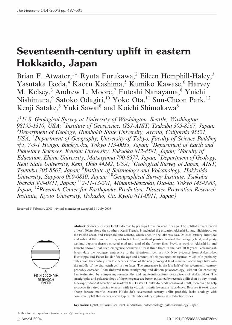
Eastern Hokkaido adjoins a subduction zone that extends2700 km from Kamchatka, past the Kuril Islands, to a triplejunction southeast of central Honshu (Figure 1a). The seawardedge of the zone is marked by the Kamchatka Trench in thenorth, the Japan Trench in the south, and the Kuril Trenchin between. Along the entire zone, Cretaceous lithosphere ofthe Pacific plate is subducting at 8�9 m per century (Larsonet al., 1985; Cande et al., 1989; DeMets, 1992b: 17,619). Over-riding lithosphere has been variously assigned to at least onetectonic plate (DeMets, 1992a; Seno et al., 1996).
In the twentieth century, the zone produced thrust earth-quakes as large as moment magnitude (M) 9.0 along the Pacificcoast of Kamchatka (in 1952; Kanamori, 1976), M 8.5 alongthe Kuril Islands (in 1963; Kanamori, 1970; Beck and Ruff,1987) and M 8.2 off Hokkaido and northern Honshu (in1952; Schwartz and Ruff, 1985; Hirata et al., 2003). The earth-quakes of M 8.5 and 8.2 were part of series that ruptured1000 km of the subduction zone between 1952 and 1973(Fukao and Furumoto, 1979). This series began and endedwith earthquakes off eastern Hokkaido.
Late-Quaternary land-level changesEastern Hokkaido’s marine terraces have risen slightly morethan they have fallen in the late Quaternary. This slight surplusin uplift is shown most widely by Pleistocene marine terraces
Figure 1 Index maps of (a) the northwest Pacific Ocean, (b) Hokkaido and (c) estuaries of eastern Hokkaido; and historical maps of (d) Hokkaido,
(e) Akkeshi-ko and (f) Hichirippu. Tephra plume in (b) from Furukawa et al. (1997); marine terraces in (c) from Okumura (1996: 22).
488 The Holocene 14 (2004)
that overlook much of the Pacific coast east of Kushiro and ex-tend northward to Furen-ko, on the Okhotsk Sea (Figure 1c;Ota and Omura, 1991; Okumura, 1996; Koike and Machida,2001). The lowest terrace probably formed about 125 000 yearsago, during the last interglacial period. Its present altitudeimplies uplift at 0.1�0.4 mm=yr on average (Figure 2a).
In the late Holocene, tectonic uplift has probably continuedto equal or exceed tectonic subsidence in eastern Hokkaido.Despite slight net submergence of Holocene peatland atAkkeshi-ko (Sawai, 2001a: 238), the region emerged from thesea in the past 3000�6000 years (Maeda et al., 1992; 1994).This emergence probably accounts for low terraces that borderAkkeshi-ko and Furen-ko (Figures 2c and 3).
Historical recordsThe uplift at Akkeshi-ko and Furen-ko that we date to the sev-enteenth century coincided with an era of abundant record-keeping in the northern part of Japan’s main island, Honshu.There, about 400 km from eastern Hokkaido, governmentdocuments give highlights from the first half of the seventeenthcentury and provide comprehensive coverage thereafter(details are given below under the heading ‘Tectonic upliftand its alternatives’).
Eastern Hokkaido, by contrast, produced few writtenrecords before the nineteenth century. Until the last decadesof the eighteenth century, Japanese rule extended only asfar north as Matsumae-han, a domain on Hokkaido’s
Figure 1 (continued )
Brian F. Atwater et al.: Seventeenth-century uplift in eastern Hokkaido, Japan 489
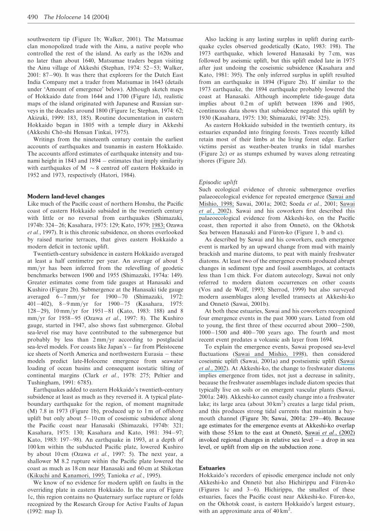
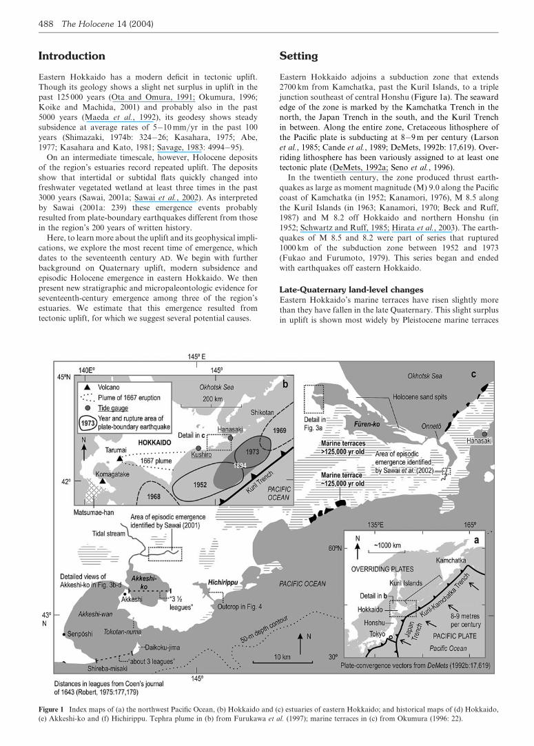
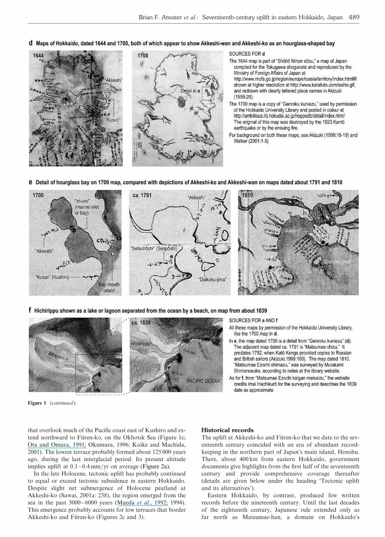
southwestern tip (Figure 1b; Walker, 2001). The Matsumaeclan monopolized trade with the Ainu, a native people whocontrolled the rest of the island. As early as the 1620s andno later than about 1640, Matsumae traders began visitingthe Ainu village of Akkeshi (Stephan, 1974: 52�53; Walker,2001: 87�90). It was there that explorers for the Dutch EastIndia Company met a trader from Matsumae in 1643 (detailsunder ‘Amount of emergence’ below). Although sketch mapsof Hokkaido date from 1644 and 1700 (Figure 1d), realisticmaps of the island originated with Japanese and Russian sur-veys in the decades around 1800 (Figure 1e; Stephan, 1974: 62;Akizuki, 1999: 183, 185). Routine documentation in easternHokkaido began in 1805 with a temple diary in Akkeshi(Akkeshi Cho-shi Hensan I’inkai, 1975).
Writings from the nineteenth century contain the earliestaccounts of earthquakes and tsunamis in eastern Hokkaido.The accounts afford estimates of earthquake intensity and tsu-nami height in 1843 and 1894 � estimates that imply similaritywith earthquakes of M � 8 centred off eastern Hokkaido in1952 and 1973, respectively (Hatori, 1984).
Modern land-level changesLike much of the Pacific coast of northern Honshu, the Pacificcoast of eastern Hokkaido subsided in the twentieth centurywith little or no reversal from earthquakes (Shimazaki,1974b: 324�26; Kasahara, 1975: 129; Kato, 1979; 1983; Ozawaet al., 1997). It is this chronic subsidence, on shores overlookedby raised marine terraces, that gives eastern Hokkaido amodern deficit in tectonic uplift.
Twentieth-century subsidence in eastern Hokkaido averagedat least a half centimetre per year. An average of about 5mm=yr has been inferred from the relevelling of geodeticbenchmarks between 1900 and 1955 (Shimazaki, 1974a: 149).Greater estimates come from tide gauges at Hanasaki andKushiro (Figure 2b). Submergence at the Hanasaki tide gaugeaveraged 6�7 mm=yr for 1900�70 (Shimazaki, 1972:401�402), 8�9 mm=yr for 1900�75 (Kasahara, 1975:128�29), 10 mm=yr for 1951�81 (Kato, 1983: 188) and 8mm=yr for 1958�95 (Ozawa et al., 1997: 8). The Kushirogauge, started in 1947, also shows fast submergence. Globalsea-level rise may have contributed to the submergence butprobably by less than 2 mm=yr according to postglacialsea-level models. For coasts like Japan’s � far from Pleistoceneice sheets of North America and northwestern Eurasia � thesemodels predict late-Holocene emergence from seawaterloading of ocean basins and consequent isostatic tilting ofcontinental margins (Clark et al., 1978: 275; Peltier andTushingham, 1991: 6785).
Earthquakes added to eastern Hokkaido’s twentieth-centurysubsidence at least as much as they reversed it. A typical plate-boundary earthquake for the region, of moment magnitude(M) 7.8 in 1973 (Figure 1b), produced up to 1 m of offshoreuplift but only about 5�10 cm of coseismic subsidence alongthe Pacific coast near Hanasaki (Shimazaki, 1974b: 321;Kasahara, 1975: 130; Kasahara and Kato, 1981: 394�97;Kato, 1983: 197�98). An earthquake in 1993, at a depth of100 km within the subducted Pacific plate, lowered Kushiroby about 10 cm (Ozawa et al., 1997: 5). The next year, ashallower M 8.2 rupture within the Pacific plate lowered thecoast as much as 18 cm near Hanasaki and 60 cm at Shikotan(Kikuchi and Kanamori, 1995; Tanioka et al., 1995).
We know of no evidence for modern uplift on faults in theoverriding plate in eastern Hokkaido. In the area of Figure1c, this region contains no Quaternary surface rupture or foldsrecognized by the Research Group for Active Faults of Japan(1992: map I).
Also lacking is any lasting surplus in uplift during earth-quake cycles observed geodetically (Kato, 1983: 198). The1973 earthquake, which lowered Hanasaki by 7 cm, wasfollowed by aseismic uplift, but this uplift ended late in 1975after just undoing the coseismic subsidence (Kasahara andKato, 1981: 395). The only inferred surplus in uplift resultedfrom an earthquake in 1894 (Figure 2b). If similar to the1973 earthquake, the 1894 earthquake probably lowered thecoast at Hanasaki. Although incomplete tide-gauge dataimplies about 0.2 m of uplift between 1896 and 1905,continuous data shows that subsidence negated this uplift by1930 (Kasahara, 1975: 130; Shimazaki, 1974b: 325).
As eastern Hokkaido subsided in the twentieth century, itsestuaries expanded into fringing forests. Trees recently killedretain most of their limbs at the living forest edge. Earliervictims persist as weather-beaten trunks in tidal marshes(Figure 2c) or as stumps exhumed by waves along retreatingshores (Figure 2d).
Episodic upliftSuch ecological evidence of chronic submergence overliespalaeoecological evidence for repeated emergence (Sawai andMishio, 1998; Sawai, 2001a; 2002; Soeda et al., 2001; Sawaiet al., 2002). Sawai and his coworkers first described thispalaeoecological evidence from Akkeshi-ko, on the Pacificcoast, then reported it also from Onneto, on the OkhotskSea between Hanasaki and Furen-ko (Figure 1, b and c).
As described by Sawai and his coworkers, each emergenceevent is marked by an upward change from mud with mainlybrackish and marine diatoms, to peat with mainly freshwaterdiatoms. At least two of the emergence events produced abruptchanges in sediment type and fossil assemblages, at contactsless than 1 cm thick. For diatom autecology, Sawai not onlyreferred to modern diatom occurrences on other coasts(Vos and de Wolf, 1993; Sherrod, 1999) but also surveyedmodern assemblages along levelled transects at Akkeshi-koand Onneto (Sawai, 2001b).
At both these estuaries, Sawai and his coworkers recognizedfour emergence events in the past 3000 years. Listed from oldto young, the first three of these occurred about 2000�2500,1000�1500 and 400�700 years ago. The fourth and mostrecent event predates a volcanic ash layer from 1694.
To explain the emergence events, Sawai proposed sea-levelfluctuations (Sawai and Mishio, 1998), then consideredcoseismic uplift (Sawai, 2001a) and postseismic uplift (Sawaiet al., 2002). At Akkeshi-ko, the change to freshwater diatomsimplies emergence from tides, not just a decrease in salinity,because the freshwater assemblages include diatom species thattypically live on soils or on emergent vascular plants (Sawai,2001a: 240). Akkeshi-ko cannot easily change into a freshwaterlake; its large area (about 30 km2) creates a large tidal prism,and this produces strong tidal currents that maintain a bay-mouth channel (Figure 3b; Sawai, 2001a: 239�40). Becauseage estimates for the emergence events at Akkeshi-ko overlapwith those 55 km to the east at Onneto, Sawai et al., (2002)invoked regional changes in relative sea level � a drop in sealevel, or uplift from slip on the subduction zone.
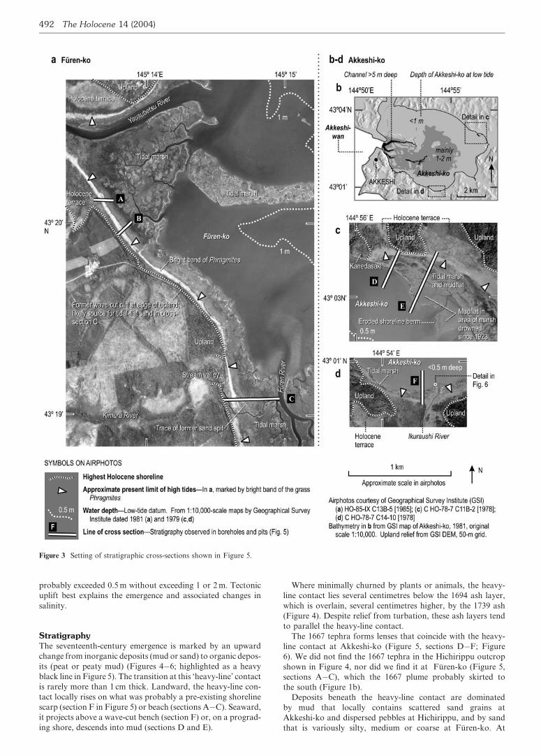
EstuariesHokkaido’s recorders of episodic emergence include not onlyAkkeshi-ko and Onneto but also Hichirippu and Furen-ko(Figures 1c and 3�6). Hichirippu, the smallest of theseestuaries, faces the Pacific coast near Akkeshi-ko. Furen-ko,on the Okhotsk coast, is eastern Hokkaido’s largest estuary,with an approximate area of 40 km2.
490 The Holocene 14 (2004)

Both Akkeshi-ko and Furen-ko have broad shallows and deepchannels (Figure 3). Most of the bottom is less than 2 m deep, ac-cording to 1:10 000-scale bathymetric maps by the GeographicalSurvey Institute, published in 1979 and 1981. Bay-mouth chan-nels, however, reach depths of 13 m. Akkeshi-ko’s connection withAkkeshi-wan, a marine embayment, appears open on maps dated1644 and 1700, and from c. 1791 onward (Figure 1, d and e). Simi-
larly, Furen-ko and Onneto were mapped as open to the sea c.1791 (http:==ambitious.lib.hokudai.ac.jp=hoppodb=detail=index.html=, map 4, ‘Matsumae chizu’). Maps from the 1890s, at1:250 000 scale, show roads interrupted by open mouths ofAkkeshi-ko, Onneto and Furen-ko, as do more detailed mapsfrom 1922�23, surveyed at 1:50 000.
Only Hichirippu, which directly faces the open Pacific, washistorically blocked. A beach completely bars the mouth ofHichirippu on a map from c. 1839 (Figure 1f). A channelperhaps 10 m wide crosses this beach on the 1:50 000-scalemap from 1922.
Parts of all four estuaries are fringed by tidal marshes, someof which grade landward into shrubby freshwater wetlands.The vascular plants of these tidal marshes include Phragmites,Puccinellia and Scirpus (Figure 5). The marshes span no morethan about 0.5 m vertically. This range is small because the tiderange is small; the spring range, for instance, is 1.2 m (Mari-time Safety Agency, 1998: 386).
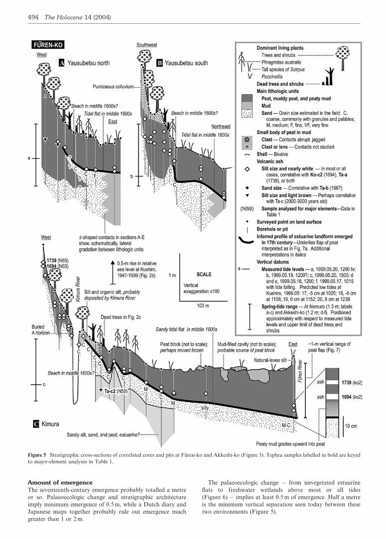
MethodsFieldwork focused on stratigraphy and palaeoecology. AtHichirippu the work was limited to reconnaissance of outcrops(Figure 4). At Akkeshi-ko and Furen-ko, teams used gougecores 2 cm in diameter, shovel pits and natural outcrops tosurvey stratigraphy along levelled cross-sections, three at eachestuary (Figure 5).
Diatoms provide palaeoecologic detail for one of the fieldsites � a shovel pit on the south shore of Akkeshi-ko(Figures 3d and 6). Each diatom sample spanned a strati-graphic thickness of 5 mm or less. Using methods describedelsewhere (Sawai, 2001a), Sawai separated, identified andcounted at least 300 valves per sample. For the species in boldtype in Figure 6b he inferred environmental preference frommodern diatom assemblages along our cross-sections E andF at Akkeshi-ko and along additional transects at Onneto(Sawai et al., 2001b). The other species in Figure 6b are un-known from surface samples in eastern Hokkaido, so Sawai in-ferred their autecology from modern assemblages on othercoasts (Vos and de Wolf, 1993; Sherrod, 1999).
All our dating comes from tephra erupted in southwesternHokkaido at Komagatake and Tarumai volcanoes (Figure 1b).Komagatake layer Ko-c2 (1694) and Tarumai layer Ta-a(1739) blanketed most of eastern Hokkaido (Furukawa et al.,1997). The plume of Ta-b (1667) passed to the south but prob-ably reached Tokotan-numa (Figure 1c), where it accumulatedin a brackish-water lagoon or estuary (Sawai, 2002).
Furukawa used major-element chemistry to help distinguishthe 1667, 1694 and 1739 tephra layers from one another andfrom other volcanic ashes (Table 1). He analysed all the sam-ples for which the date of the tephra is labelled in bold type inFigure 5, including samples from the sequence of ash layersshown in Figure 6.
In the field, we recognized the 1667 tephra as sand-size pum-ice, in contrast with the mainly silt-size ash from 1694 and1739. Where heavily bioturbated or cryoturbated and seenonly in 2 cm diameter cores, the 1694 and 1739 layers are com-monly represented by fewer or more than two ash bodies. Wetherefore logged them in the field as silt-size ash withoutattempting to distinguish between 1694 and 1739 (Figure 5).
Evidence for seventeenth-century uplift
Akkeshi-ko, Hichirippu and Furen-ko share stratigraphic evi-dence that intertidal or subtidal flats became well-vegetatedland late in the seventeenth century. An early part of thisemergence occurred in the 1660s or 1670s, and the emergence
Figure 2 Evidence for opposing land-level changes in eastern Hok-
kaido. Pleistocene marine-terrace heights and age from Okumura
(1996). Tide-gauge data from Coastal Movements Data Center
(1996) and from Japan Meteorological Agency (for the years
1996�99). Wedges on the right of tide-gauge graphs compare net uplift
rates implied by c. 125 000 year-old terraces with average subsidence
rates implied by twentieth-century submergence.
Brian F. Atwater et al.: Seventeenth-century uplift in eastern Hokkaido, Japan 491
probably exceeded 0.5 m without exceeding 1 or 2 m. Tectonicuplift best explains the emergence and associated changes insalinity.
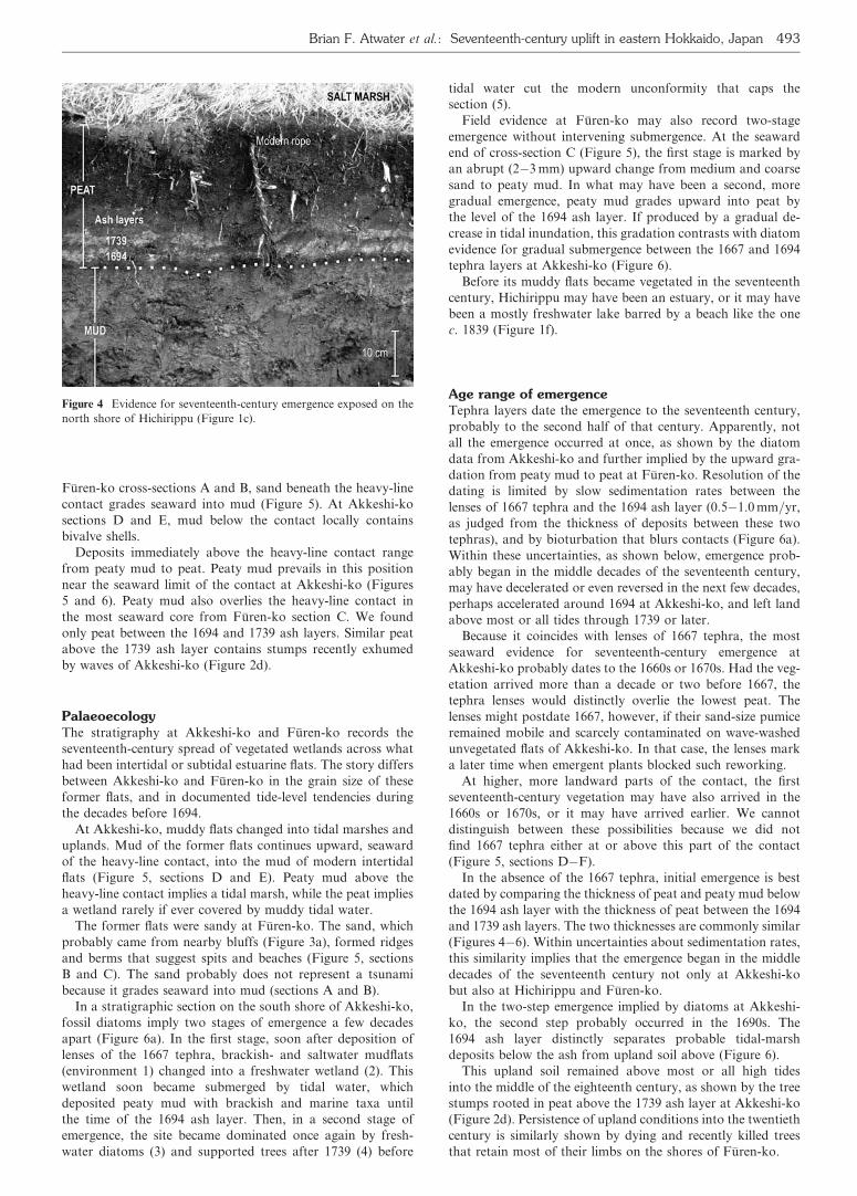
StratigraphyThe seventeenth-century emergence is marked by an upwardchange from inorganic deposits (mud or sand) to organic depos-its (peat or peaty mud) (Figures 4�6; highlighted as a heavyblack line in Figure 5). The transition at this ‘heavy-line’ contactis rarely more than 1 cm thick. Landward, the heavy-line con-tact locally rises on what was probably a pre-existing shorelinescarp (section F in Figure 5) or beach (sections A�C). Seaward,it projects above a wave-cut bench (section F) or, on a prograd-ing shore, descends into mud (sections D and E).
Where minimally churned by plants or animals, the heavy-line contact lies several centimetres below the 1694 ash layer,which is overlain, several centimetres higher, by the 1739 ash(Figure 4). Despite relief from turbation, these ash layers tendto parallel the heavy-line contact.
The 1667 tephra forms lenses that coincide with the heavy-line contact at Akkeshi-ko (Figure 5, sections D�F; Figure6). We did not find the 1667 tephra in the Hichirippu outcropshown in Figure 4, nor did we find it at Furen-ko (Figure 5,sections A�C), which the 1667 plume probably skirted tothe south (Figure 1b).
Deposits beneath the heavy-line contact are dominatedby mud that locally contains scattered sand grains atAkkeshi-ko and dispersed pebbles at Hichirippu, and by sandthat is variously silty, medium or coarse at Furen-ko. At
Figure 3 Setting of stratigraphic cross-sections shown in Figure 5.
492 The Holocene 14 (2004)
Furen-ko cross-sections A and B, sand beneath the heavy-linecontact grades seaward into mud (Figure 5). At Akkeshi-kosections D and E, mud below the contact locally containsbivalve shells.
Deposits immediately above the heavy-line contact rangefrom peaty mud to peat. Peaty mud prevails in this positionnear the seaward limit of the contact at Akkeshi-ko (Figures5 and 6). Peaty mud also overlies the heavy-line contact inthe most seaward core from Furen-ko section C. We foundonly peat between the 1694 and 1739 ash layers. Similar peatabove the 1739 ash layer contains stumps recently exhumedby waves of Akkeshi-ko (Figure 2d).
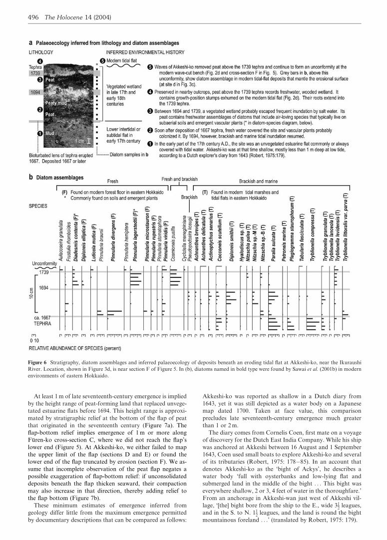
PalaeoecologyThe stratigraphy at Akkeshi-ko and Furen-ko records theseventeenth-century spread of vegetated wetlands across whathad been intertidal or subtidal estuarine flats. The story differsbetween Akkeshi-ko and Furen-ko in the grain size of theseformer flats, and in documented tide-level tendencies duringthe decades before 1694.
At Akkeshi-ko, muddy flats changed into tidal marshes anduplands. Mud of the former flats continues upward, seawardof the heavy-line contact, into the mud of modern intertidalflats (Figure 5, sections D and E). Peaty mud above theheavy-line contact implies a tidal marsh, while the peat impliesa wetland rarely if ever covered by muddy tidal water.
The former flats were sandy at Furen-ko. The sand, whichprobably came from nearby bluffs (Figure 3a), formed ridgesand berms that suggest spits and beaches (Figure 5, sectionsB and C). The sand probably does not represent a tsunamibecause it grades seaward into mud (sections A and B).
In a stratigraphic section on the south shore of Akkeshi-ko,fossil diatoms imply two stages of emergence a few decadesapart (Figure 6a). In the first stage, soon after deposition oflenses of the 1667 tephra, brackish- and saltwater mudflats(environment 1) changed into a freshwater wetland (2). Thiswetland soon became submerged by tidal water, whichdeposited peaty mud with brackish and marine taxa untilthe time of the 1694 ash layer. Then, in a second stage ofemergence, the site became dominated once again by fresh-water diatoms (3) and supported trees after 1739 (4) before
tidal water cut the modern unconformity that caps thesection (5).
Field evidence at Furen-ko may also record two-stageemergence without intervening submergence. At the seawardend of cross-section C (Figure 5), the first stage is marked byan abrupt (2�3 mm) upward change from medium and coarsesand to peaty mud. In what may have been a second, moregradual emergence, peaty mud grades upward into peat bythe level of the 1694 ash layer. If produced by a gradual de-crease in tidal inundation, this gradation contrasts with diatomevidence for gradual submergence between the 1667 and 1694tephra layers at Akkeshi-ko (Figure 6).
Before its muddy flats became vegetated in the seventeenthcentury, Hichirippu may have been an estuary, or it may havebeen a mostly freshwater lake barred by a beach like the onec. 1839 (Figure 1f).
Age range of emergenceTephra layers date the emergence to the seventeenth century,probably to the second half of that century. Apparently, notall the emergence occurred at once, as shown by the diatomdata from Akkeshi-ko and further implied by the upward gra-dation from peaty mud to peat at Furen-ko. Resolution of thedating is limited by slow sedimentation rates between thelenses of 1667 tephra and the 1694 ash layer (0.5�1.0 mm=yr,as judged from the thickness of deposits between these twotephras), and by bioturbation that blurs contacts (Figure 6a).Within these uncertainties, as shown below, emergence prob-ably began in the middle decades of the seventeenth century,may have decelerated or even reversed in the next few decades,perhaps accelerated around 1694 at Akkeshi-ko, and left landabove most or all tides through 1739 or later.
Because it coincides with lenses of 1667 tephra, the mostseaward evidence for seventeenth-century emergence atAkkeshi-ko probably dates to the 1660s or 1670s. Had the veg-etation arrived more than a decade or two before 1667, thetephra lenses would distinctly overlie the lowest peat. Thelenses might postdate 1667, however, if their sand-size pumiceremained mobile and scarcely contaminated on wave-washedunvegetated flats of Akkeshi-ko. In that case, the lenses marka later time when emergent plants blocked such reworking.
At higher, more landward parts of the contact, the firstseventeenth-century vegetation may have also arrived in the1660s or 1670s, or it may have arrived earlier. We cannotdistinguish between these possibilities because we did notfind 1667 tephra either at or above this part of the contact(Figure 5, sections D�F).
In the absence of the 1667 tephra, initial emergence is bestdated by comparing the thickness of peat and peaty mud belowthe 1694 ash layer with the thickness of peat between the 1694and 1739 ash layers. The two thicknesses are commonly similar(Figures 4�6). Within uncertainties about sedimentation rates,this similarity implies that the emergence began in the middledecades of the seventeenth century not only at Akkeshi-kobut also at Hichirippu and Furen-ko.
In the two-step emergence implied by diatoms at Akkeshi-ko, the second step probably occurred in the 1690s. The1694 ash layer distinctly separates probable tidal-marshdeposits below the ash from upland soil above (Figure 6).
This upland soil remained above most or all high tidesinto the middle of the eighteenth century, as shown by the treestumps rooted in peat above the 1739 ash layer at Akkeshi-ko(Figure 2d). Persistence of upland conditions into the twentiethcentury is similarly shown by dying and recently killed treesthat retain most of their limbs on the shores of Furen-ko.
Figure 4 Evidence for seventeenth-century emergence exposed on the
north shore of Hichirippu (Figure 1c).
Brian F. Atwater et al.: Seventeenth-century uplift in eastern Hokkaido, Japan 493
Amount of emergenceThe seventeenth-century emergence probably totalled a metreor so. Palaeoecologic change and stratigraphic architectureimply minimum emergence of 0.5 m, while a Dutch diary andJapanese maps together probably rule out emergence muchgreater than 1 or 2 m.
The palaeoecologic change � from unvegetated estuarineflats to freshwater wetlands above most or all tides(Figure 6) � implies at least 0.5 m of emergence. Half a metreis the minimum vertical separation seen today between thesetwo environments (Figure 5).
Figure 5 Stratigraphic cross-sections of correlated cores and pits at Furen-ko and Akkeshi-ko (Figure 3). Tephra samples labelled in bold are keyed
to major-element analyses in Table 1.
494 The Holocene 14 (2004)
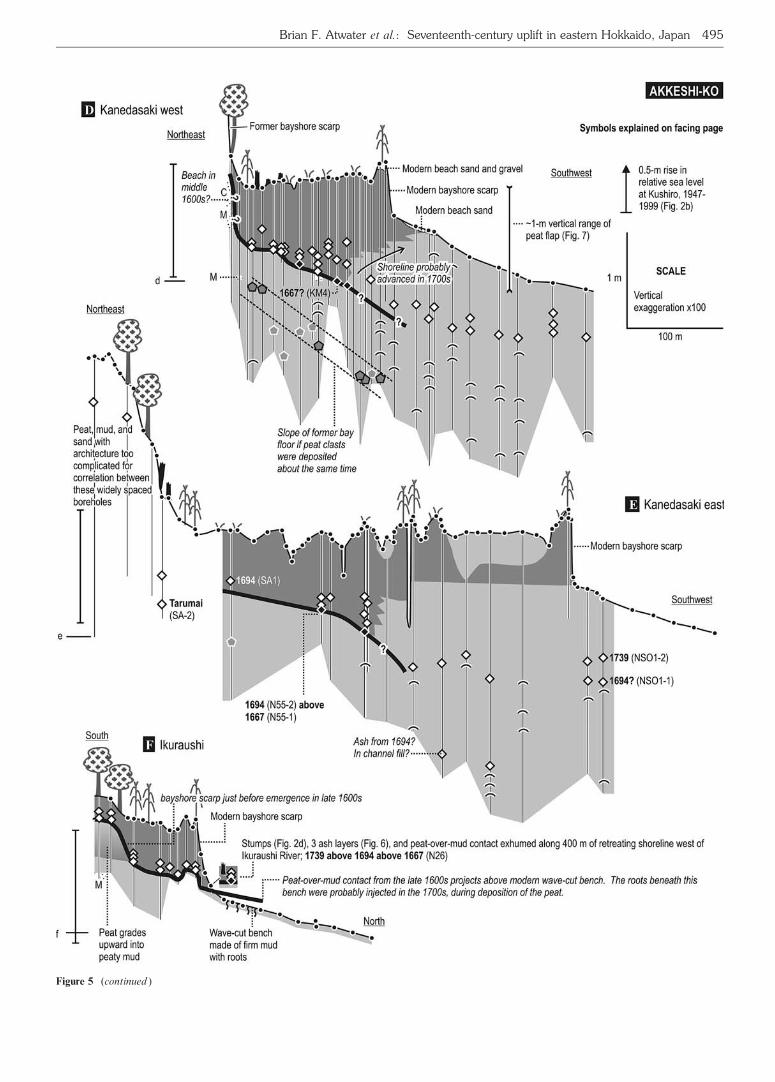
Figure 5 (continued )
Brian F. Atwater et al.: Seventeenth-century uplift in eastern Hokkaido, Japan 495
At least 1 m of late seventeenth-century emergence is impliedby the height range of peat-forming land that replaced unvege-tated estuarine flats before 1694. This height range is approxi-mated by stratigraphic relief at the bottom of the flap of peatthat originated in the seventeenth century (Figure 7a). Theflap-bottom relief implies emergence of 1 m or more alongFuren-ko cross-section C, where we did not reach the flap’slower end (Figure 5). At Akkeshi-ko, we either failed to mapthe upper limit of the flap (sections D and E) or found thelower end of the flap truncated by erosion (section F). We as-sume that incomplete observation of the peat flap negates apossible exaggeration of flap-bottom relief: if unconsolidateddeposits beneath the flap thicken seaward, their compactionmay also increase in that direction, thereby adding relief tothe flap bottom (Figure 7b).
These minimum estimates of emergence inferred fromgeology differ little from the maximum emergence permittedby documentary descriptions that can be compared as follows:
Akkeshi-ko was reported as shallow in a Dutch diary from1643, yet it was still depicted as a water body on a Japanesemap dated 1700. Taken at face value, this comparisonprecludes late seventeenth-century emergence much greaterthan 1 or 2 m.
The diary comes from Cornelis Coen, first mate on a voyageof discovery for the Dutch East India Company. While his shipwas anchored at Akkeshi between 16 August and 1 September1643, Coen used small boats to explore Akkeshi-ko and severalof its tributaries (Robert, 1975: 178�85). In an account thatdenotes Akkeshi-ko as the ‘bight of Ackys’, he describes awater body ‘full with oysterbanks and low-lying flat andsubmerged land in the middle of the bight . . . This bight waseverywhere shallow, 2 or 3, 4 feet of water in the thoroughfare.’From an anchorage in Akkeshi-wan just west of Akkeshi vil-lage, ‘[the] bight bore from the ship to the E., wide 31
2 leagues,and in the S. to N. 11
2 leagues, and the land is round the bightmountainous foreland . . .’ (translated by Robert, 1975: 179).
Figure 6 Stratigraphy, diatom assemblages and inferred palaeoecology of deposits beneath an eroding tidal flat at Akkeshi-ko, near the Ikuraushi
River. Location, shown in Figure 3d, is near section F of Figure 5. In (b), diatoms named in bold type were found by Sawai et al. (2001b) in modern
environments of eastern Hokkaido.
496 The Holocene 14 (2004)

Akkeshi-ko probably remained a broad bay in 1700. It bestexplains the inner half of an hourglass-shaped bay, extendinginland from a small bay-mouth island, on a Japanese sketchmap of Hokkaido dated 1700 (Figure 1d). This map was pre-pared by officials of Matsumae-han, a feudal domain head-quartered at the southern tip of Hokkaido. These officialsmay have copied much of the 1700 map from an earlier mapdated to 1644 (also shown in Figure 1d), or from surveys ofunknown date (Akizuki, 1999: 18�19). However, becauseMatsumae traders routinely visited Akkeshi after about 1640(Stephan, 1974: 52�53; Walker, 2001: 89), the map-makersin 1700 may have also used up-to-date information from fre-quent visitors to Akkeshi. Moreover, the 1700 map containstwo details the 1644 map does not: a bay-mouth island prob-ably equivalent to Daikoku-jima (Figure 1, c and d), and sym-bols for ‘iri-umi’ (probably meaning ‘inlet’) at the straitbetween the two parts of the hourglass-shaped bay. The innerpart of the hourglass-shaped bay in 1700 � what we interpretas Akkeshi-ko � thus probably received tidal water.
A tidal Akkeshi-ko certainly existed around 1800. Itappears, connected to Akkeshi-wan, on several differentJapanese maps of that era (http:==ambitious.lib.hokudai.ac.jp=hoppodb=detail=index.html). The earliest example shortlypre-dates 1792 (Figure 1e).
None of these Japanese maps imply that the Dutch ‘bight ofAckys’ had become chiefly a vegetated wetland by 1700 or1800. Instead, most of Akkeshi-ko apparently persistedthrough the eighteenth century. This likely persistence impliesthat emergence after 1643 did not greatly exceed the waterdepths of 2�4 feet that Coen had noted.
Tectonic uplift and its alternativesWidespread tectonic uplift best explains the seventeenth-century emergence shared by Akkeshi-ko, Furen-ko and
Hichirippu. It can account for the rapid and lasting replace-ment of unvegetated estuarine flat by vegetated wetland, bothbrackish and freshwater. It also provides a logical reason whythe changes do not differ in approximate age among thesethree estuaries � two large estuaries vigorously connected todifferent seas, and a small estuary probably subject to isolationfrom the sea. Finally, it poses fewer problems than do the lead-ing alternatives: conversion of estuaries to lakes behind bay-mouth barriers, sedimentary accretion of estuarine flats, andfall in regional sea level.
Bay-mouth barriers fail to explain the change to freshwaterconditions at Akkeshi-ko not only because the change coin-cided (at least approximately) among three different estuariesbut also because it failed to exclude brackish and marinediatoms from Akkeshi-ko. These diatoms, between the 1667and 1694 ash layers (Figure 6), show that Akkeshi-koremained connected to the sea at least into the 1690s.
Without any drop in tide level, plants can spread across anintertidal flat if sediment builds the flat high enough (Gilbert,1917: 86�88). Two points suggest that such accretion playedlittle role in the seventeenth-century spread of vegetationacross the former flats in eastern Hokkaido. (1) Had thewetlands emerged by accretion, peaty mud with brackish andmarine diatoms should represent the full vertical range of tidalmarshes � about 0.5 m (Figure 5). Instead, in the peaty depos-its that mark the emergence, muddy tidal-marsh depositsrarely exceed 0.1 m in thickness (Figure 6). Similarly in south-western Canada, less than 0.1 m of tidal-marsh deposits repre-sents 0.5 m of tectonic uplift from the first decades after the1700 Cascadia earthquake (Guilbault et al., 1996: 932; Hugheset al., 2002). (2) In the simple case of wetland plants spreadingacross tidal flats without change in tide levels, the resultingpeaty deposits extend horizontally at the lowest level wherethe plants can live. At Furen-ko and Akkeshi-ko, by contrast,
Table 1 Representative major-element composition of glass shards in tephra samples from Furen-ko (C) and Akkeshi-ko (D�F), and in reference
samples from eruptions of Tarumai (Ta) and Komagatake (Ko) volcanoes (analysis by WDS microprobe; beam target 0.01� 0.01 mm)
Section (Figure 5) C C C C C D E E E E E F F F
Sample ko2
upper
ko2
lower
N59 N65
upper
N65
lower
KM4 SA2 N55-1 N55-2 NSO1-1 NSO1-2 N26
upper
N26
middle
N26
lower
SiO2 72.99 72.49 73.23 73.57 70.25 73.23 73.44 73.28 70.80 67.26 73.11 73.89 73.85 74.63
TiO2 0.33 0.41 0.33 0.31 0.38 0.34 0.29 0.33 0.37 0.37 0.31 0.28 0.41 0.33
Al2O3 11.78 11.80 12.33 11.90 11.63 12.10 12.06 12.22 12.14 11.94 11.68 11.35 11.55 11.67
FeO 1.81 2.35 1.94 1.85 2.09 1.89 1.84 2.18 2.32 1.99 1.85 1.91 2.30 2.11
MnO 0.05 0.10 0.02 0.02 0.05 0.00 0.09 0.07 0.10 0.15 0.06 0.02 0.10 0.06
MgO 0.34 0.47 0.36 0.34 0.42 0.36 0.30 0.41 0.48 0.48 0.36 0.35 0.47 0.41
CaO 1.66 2.17 2.04 1.97 2.23 1.99 0.88 2.23 2.24 1.78 1.83 2.08 2.26 2.19
Na2O 2.88 3.13 2.98 3.37 3.10 3.14 3.03 3.35 3.62 3.29 2.94 3.97 4.14 3.89
K2O 2.52 1.87 2.30 2.38 1.75 2.31 2.17 2.32 1.80 1.65 2.34 2.41 1.99 2.38
Total 94.36 94.80 95.51 95.72 91.89 95.36 94.12 96.39 93.85 88.90 94.47 96.25 97.06 97.66
Correlated
eruption
Ta-a Ko-c2 Ta-c2 Ta-a Ko-c2 Ta-b? Tarumai Ta-b Ko-c2 Ko-c2 Ta-a Ta-a Ko-c2 Ta-b
Reference
sample
Ta-a Ta-b Ta-c2 Ko-c2
SiO2 74.12 71.77 75.63 73.95
TiO2 0.34 0.36 0.27 0.46
Al2O3 12.37 12.62 11.80 11.85
FeO 1.91 2.27 1.70 2.21
MnO 0.05 0.03 0.04 0.07
MgO 0.39 0.47 0.30 0.46
CaO 2.33 2.55 1.85 2.25
Na2O 3.99 3.54 3.53 3.39
K2O 2.17 2.12 2.33 1.65
Total 97.68 95.74 97.46 96.29
Brian F. Atwater et al.: Seventeenth-century uplift in eastern Hokkaido, Japan 497
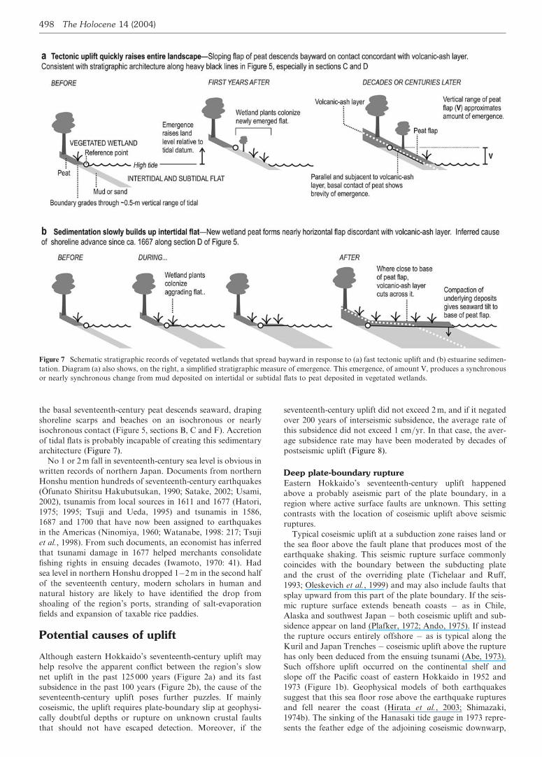
the basal seventeenth-century peat descends seaward, drapingshoreline scarps and beaches on an isochronous or nearlyisochronous contact (Figure 5, sections B, C and F). Accretionof tidal flats is probably incapable of creating this sedimentaryarchitecture (Figure 7).
No 1 or 2 m fall in seventeenth-century sea level is obvious inwritten records of northern Japan. Documents from northernHonshu mention hundreds of seventeenth-century earthquakes(Ofunato Shiritsu Hakubutsukan, 1990; Satake, 2002; Usami,2002), tsunamis from local sources in 1611 and 1677 (Hatori,1975; 1995; Tsuji and Ueda, 1995) and tsunamis in 1586,1687 and 1700 that have now been assigned to earthquakesin the Americas (Ninomiya, 1960; Watanabe, 1998: 217; Tsujiet al., 1998). From such documents, an economist has inferredthat tsunami damage in 1677 helped merchants consolidatefishing rights in ensuing decades (Iwamoto, 1970: 41). Hadsea level in northern Honshu dropped 1�2 m in the second halfof the seventeenth century, modern scholars in human andnatural history are likely to have identified the drop fromshoaling of the region’s ports, stranding of salt-evaporationfields and expansion of taxable rice paddies.
Potential causes of uplift
Although eastern Hokkaido’s seventeenth-century uplift mayhelp resolve the apparent conflict between the region’s slownet uplift in the past 125 000 years (Figure 2a) and its fastsubsidence in the past 100 years (Figure 2b), the cause of theseventeenth-century uplift poses further puzzles. If mainlycoseismic, the uplift requires plate-boundary slip at geophysi-cally doubtful depths or rupture on unknown crustal faultsthat should not have escaped detection. Moreover, if the
seventeenth-century uplift did not exceed 2 m, and if it negatedover 200 years of interseismic subsidence, the average rate ofthis subsidence did not exceed 1 cm=yr. In that case, the aver-age subsidence rate may have been moderated by decades ofpostseismic uplift (Figure 8).
Deep plate-boundary ruptureEastern Hokkaido’s seventeenth-century uplift happenedabove a probably aseismic part of the plate boundary, in aregion where active surface faults are unknown. This settingcontrasts with the location of coseismic uplift above seismicruptures.
Typical coseismic uplift at a subduction zone raises land orthe sea floor above the fault plane that produces most of theearthquake shaking. This seismic rupture surface commonlycoincides with the boundary between the subducting plateand the crust of the overriding plate (Tichelaar and Ruff,1993; Oleskevich et al., 1999) and may also include faults thatsplay upward from this part of the plate boundary. If the seis-mic rupture surface extends beneath coasts � as in Chile,Alaska and southwest Japan � both coseismic uplift and sub-sidence appear on land (Plafker, 1972; Ando, 1975). If insteadthe rupture occurs entirely offshore � as is typical along theKuril and Japan Trenches � coseismic uplift above the rupturehas only been deduced from the ensuing tsunami (Abe, 1973).Such offshore uplift occurred on the continental shelf andslope off the Pacific coast of eastern Hokkaido in 1952 and1973 (Figure 1b). Geophysical models of both earthquakessuggest that this sea floor rose above the earthquake rupturesand fell nearer the coast (Hirata et al., 2003; Shimazaki,1974b). The sinking of the Hanasaki tide gauge in 1973 repre-sents the feather edge of the adjoining coseismic downwarp,
Figure 7 Schematic stratigraphic records of vegetated wetlands that spread bayward in response to (a) fast tectonic uplift and (b) estuarine sedimen-
tation. Diagram (a) also shows, on the right, a simplified stratigraphic measure of emergence. This emergence, of amount V, produces a synchronous
or nearly synchronous change from mud deposited on intertidal or subtidal flats to peat deposited in vegetated wetlands.
498 The Holocene 14 (2004)
landward from the area of coseismic uplift (Shimazaki, 1974b:320).
Beneath this feather edge, the plate boundary may be toodeep for brittle rupture. The boundary here is so deep � over55 km � that the subducting oceanic crust adjoins overridingmantle (Iwasaki et al., 1991: 700, 709). In most subductionzones, including those of northeast Japan, this part of the man-tle probably contains serpentine and talc that promote stablesliding at the plate boundary (Peacock and Hyndman, 1999).Motion detected by global positioning system (GPS) impliesthat the plate boundary beneath northeast Japan lacks strongcoupling at depths greater than 55 km (Ito et al., 2000;Mazzotti et al., 2000).
Shallow faulting in the upper plateEastern Hokkaido has little recognized potential for coseismicuplift by high-angle reverse faulting. As mentioned above, nooffshore fault with Quaternary activity has been reported fromthe vicinity of Akkeshi-ko, Hichirippu or Furen-ko (ResearchGroup for Active Faults of Japan, 1992: map I). Offshore, thesituation is less certain because, through 2002, recently activefaults off the coast between Kushiro and Hanasaki (Figure1b) had yet to be sought in comprehensive seismic-reflectionsurveys.
Onshore and off, scarps of crustal faults are unlikely toescape detection if they, instead of the plate boundary, providethe episodic uplift that balances the region’s uplift budget. Tocompute scarp height conservatively, suppose that surface rup-ture on a crustal fault negates 200 000 years of subsidence, andfurther assume that this subsidence averaged 1 mm=yr � lessthan one-fifth the twentieth-century rates (Figure 2b). Half-shortened by erosion, the resulting scarp would stand 100 mtall.
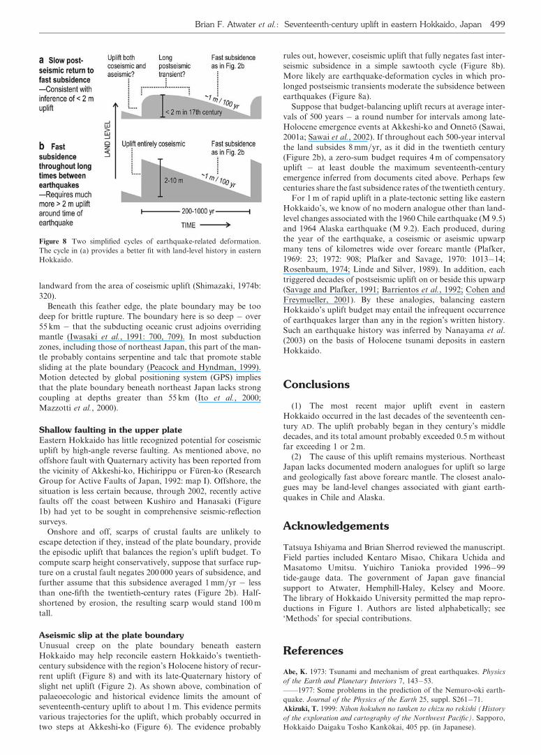
Aseismic slip at the plate boundaryUnusual creep on the plate boundary beneath easternHokkaido may help reconcile eastern Hokkaido’s twentieth-century subsidence with the region’s Holocene history of recur-rent uplift (Figure 8) and with its late-Quaternary history ofslight net uplift (Figure 2). As shown above, combination ofpalaeoecologic and historical evidence limits the amount ofseventeenth-century uplift to about 1 m. This evidence permitsvarious trajectories for the uplift, which probably occurred intwo steps at Akkeshi-ko (Figure 6). The evidence probably
rules out, however, coseismic uplift that fully negates fast inter-seismic subsidence in a simple sawtooth cycle (Figure 8b).More likely are earthquake-deformation cycles in which pro-longed postseismic transients moderate the subsidence betweenearthquakes (Figure 8a).
Suppose that budget-balancing uplift recurs at average inter-vals of 500 years � a round number for intervals among late-Holocene emergence events at Akkeshi-ko and Onneto (Sawai,2001a; Sawai et al., 2002). If throughout each 500-year intervalthe land subsides 8 mm=yr, as it did in the twentieth century(Figure 2b), a zero-sum budget requires 4 m of compensatoryuplift � at least double the maximum seventeenth-centuryemergence inferred from documents cited above. Perhaps fewcenturies share the fast subsidence rates of the twentieth century.
For 1 m of rapid uplift in a plate-tectonic setting like easternHokkaido’s, we know of no modern analogue other than land-level changes associated with the 1960 Chile earthquake (M 9.5)and 1964 Alaska earthquake (M 9.2). Each produced, duringthe year of the earthquake, a coseismic or aseismic upwarpmany tens of kilometres wide over forearc mantle (Plafker,1969: 23; 1972: 908; Plafker and Savage, 1970: 1013�14;Rosenbaum, 1974; Linde and Silver, 1989). In addition, eachtriggered decades of postseismic uplift on or beside this upwarp(Savage and Plafker, 1991; Barrientos et al., 1992; Cohen andFreymueller, 2001). By these analogies, balancing easternHokkaido’s uplift budget may entail the infrequent occurrenceof earthquakes larger than any in the region’s written history.Such an earthquake history was inferred by Nanayama et al.(2003) on the basis of Holocene tsunami deposits in easternHokkaido.
Conclusions
(1) The most recent major uplift event in easternHokkaido occurred in the last decades of the seventeenth cen-tury AD. The uplift probably began in they century’s middledecades, and its total amount probably exceeded 0.5 m withoutfar exceeding 1 or 2 m.
(2) The cause of this uplift remains mysterious. NortheastJapan lacks documented modern analogues for uplift so largeand geologically fast above forearc mantle. The closest analo-gues may be land-level changes associated with giant earth-quakes in Chile and Alaska.
Acknowledgements
Tatsuya Ishiyama and Brian Sherrod reviewed the manuscript.Field parties included Kentaro Misao, Chikara Uchida andMasatomo Umitsu. Yuichiro Tanioka provided 1996�99tide-gauge data. The government of Japan gave financialsupport to Atwater, Hemphill-Haley, Kelsey and Moore.The library of Hokkaido University permitted the map repro-ductions in Figure 1. Authors are listed alphabetically; see‘Methods’ for special contributions.
References
Abe, K. 1973: Tsunami and mechanism of great earthquakes. Physics
of the Earth and Planetary Interiors 7, 143�53.
——1977: Some problems in the prediction of the Nemuro-oki earth-
quake. Journal of the Physics of the Earth 25, suppl. S261�71.
Akizuki, T. 1999: Nihon hokuhen no tanken to chizu no rekishi (History
of the exploration and cartography of the Northwest Pacific). Sapporo,
Hokkaido Daigaku Tosho Kankokai, 405 pp. (in Japanese).
Figure 8 Two simplified cycles of earthquake-related deformation.
The cycle in (a) provides a better fit with land-level history in eastern
Hokkaido.
Brian F. Atwater et al.: Seventeenth-century uplift in eastern Hokkaido, Japan 499
Akkeshi Cho-shi Hensan I’inkai (Committee for Akkeshi town history)
1975: Akkeshi choshi, jokan [History of Akkeshi Town, vol. 1]. Town
of Akkeshi, 839 pp. (in Japanese).
Ando, M. 1975: Source mechanisms and tectonic significance of histori-
cal earthquakes along the Nankai trough, Japan. Tectonophysics 27,
119�40.
Barrientos, S.E., Plafker, G. and Lorca, E. 1992: Postseismic coastal
uplift in southern Chile. Geophysical Research Letters 19, 701�704.
Beck, S.L. and Ruff, L.J. 1987: Rupture process of the great 1963
Kurile Islands earthquake sequence: asperity interaction and multiple
event rupture. Journal of Geophysical Research 92, 14, 123�38.
Cande, S.C., LaBrecque, J.L., Larson, R.L., Pitman, W.C. III,
Golovchenko, X. and Haxby, W.F. 1989: Magnetic lineations of the world’s
ocean basins. Tulsa, Oklahoma: American Association of Petroleum
Geologists (map scale approximately 1:27,400,000 at the equator).
Clark, J.A., Farrell, W.E. and Peltier, W.R. 1978: Global changes in post-
glacial sea level: a numerical calculation. Quaternary Research 9, 265�87.
Coastal Movements Data Center 1996: Tables and graphs of annual
mean sea level along the Japanese coast 1894�1995. Tsukuba: Geo-
graphical Survey Institute, 113 pp.
Cohen, S.C. and Freymueller, J.T. 2001: Crustal uplift in the south
central Alaska subduction zone: new analysis and interpretation of
tide gauge observations. Journal of Geophysical Research 106,
11,259�70.
DeMets, C. 1992a: A test of present-day plate geometries for northeast
Asia and Japan. Journal of Geophysical Research 97, 17,627�35.
——1992b: Oblique convergence and deformation along the Kuril and
Japan Trenches. Journal of Geophysical Research 97, 17,615�25.
Fukao, Y. and Furumoto, M. 1979: Stress drops, wave spectra and re-
currence intervals of great earthquakes � implications of the Etorofu
earthquake of 1958 November 6. Geophysical Journal of the Royal
Astronomical Society 57, 23�40.
Furukawa, R., Yoshimoto, M., Yamagata, K., Wada, K. and Ui, T.
1997: Did Hokkaido Komagatake volcano erupt in 1694?� reappraisal
of the eruptive ages of 17�18th centuries in Hokkaido. Kazan 42,
269�79 (in Japanese with English abstract and figure captions).
Gilbert, G.K. 1917: Hydraulic-mining debris in the Sierra Nevada. U.S.
Geological Survey Professional Paper 105, Washington, DC: United
States Geological Survey, 154 pp.
Guilbault, J.-P., Clague, J.J. and LaPointe, M. 1996: Foraminiferal
evidence for the amount of coseismic subsidence during a late
Holocene earthquake on Vancouver Island, west coast of Canada.
Quaternary Science Reviews 15, 913�37.
Hatori, T. 1975: Tsunami magnitude and wave source regions of his-
torical Sanriku tsunamis in northeast Japan. Bulletin of the Earthquake
Research Institute 50, 397�414 (in Japanese with English captions and
abstract).
——1984. Source area of the East Hokkaido Tsunami generated in
April, 1843. Bulletin of the Earthquake Research Institute, University
of Tokyo 59, 423�31 (in Japanese with English abstract and captions).
——1995: Field investigation of the 1611 Keicho Sanriku tsunami
along the Iwate coast, NE Japan. Rekishi Jishin [Historical Earth-
quakes] 11, 59�66 (in English with Japanese captions).
Hirata, K., Geist, E., Satake, K. and Tanioka, Y. 2003: Slip distribution
of the 1952 Tokachi-oki earthquake (M 8.1) along the Kuril Trench
deduced from tsunami waveform inversion. Journal of Geophysical
Research 108 (B4), 2196, doi: 10.1029=2002JB001976. http:==www.
agu.org (last accessed March 2004).
Hughes, J.F., Mathewes, R.W. and Clague, J.J. 2002: Use of pollen
and vascular plants to estimate coseismic subsidence at a tidal marsh
near Tofino, British Columbia. Palaeoclimatology, Palaeogeography,
Palaeoecology 185, 145�61.
Ito, T., Yoshioka, S. and Miyazaki, S. 2000: Interplate coupling in
northeast Japan deduced from inversion analysis of GPS data. Earth
and Planetary Science Letters 176, 117�30.
Iwamoto, Y. 1970: Kinsei gyoson kyodotai no hensen katei: shohin keizai no
shinten to sonraku kyodotai. [Changing course of early modern fishing village
communities � development of commercial economy and village communi-
ties]. Tokyo: Hanawa Shobo, 256 pp. (in Japanese).
Iwasaki, T., Hirata, N., Kanazawa, T., Urabe, T., Motoya, Y. and
Shimamura, H. 1991: Earthquake distribution in the subduction zone
off eastern Hokkaido, Japan, deduced from ocean-bottom seismographic
and land observations. Geophysical Journal International 105, 693�711.
Kanamori, H. 1970: Synthetics of long-period surface waves and its
application to earthquake source studies � Kuril Islands earthquake
of October 13, 1963. Journal of Geophysical Research 75, 5011�27.
——1976: Re-examination of the Earth’s free oscillations excited by
the Kamchatka earthquake of November 4, 1952. Physics of the Earth
and Planetary Interiors 11, 216�26.
Kasahara, K. 1975: Aseismic faulting following the 1973 Nemuro-oki
earthquake, Hokkaido, Japan (a possibility). Pure and Applied
Geophysics 113, 127�39.
Kasahara, K. and Kato, T. 1981: Aseismic faulting following the 1973
Nemuro-oki earthquake, Hokkaido, Japan (a retrospective study).
Pure and Applied Geophysics 119, 392�403.
Kato, T. 1979: Crustal movements in the Tohoku district, Japan, dur-
ing the period 1900�1975, and their tectonic implications. Tectonophy-
sics 60, 141�67.
——1983: Secular and earthquake-related vertical crustal movements
in Japan as deduced from tidal records (1951�1981). Tectonophysics
97, 183�200.
Kikuchi, M. and Kanamori, H. 1995: The Shikotan earthquake of
October 4, 1994: lithospheric earthquake. Geophysical Research Letters
22, 1025�28.
Koike, K. and Machida, H., editors 2001: Atlas of Quaternary marine
terraces in the Japanese islands. Tokyo: University of Tokyo Press,
105 pp. with two oversize maps and three CDs (in Japanese).
Larson, R.L., Pitman, W.C., Golovchenko, X., Cande, S.C., Dewey,
J.F., Haxby, W.F. and LaBrecque, J.L. 1985: The bedrock geology of
the world. New York: W.H. Freeman and Co., scale 1:23,230,300 at
the equator.
Linde, A.T. and Silver, P.G. 1989: Elevation changes and the great
1960 Chilean earthquake: support for aseismic slip. Geophysical
Research Letters 16, 1305�308.
Maeda, Y., Matsuda, I., Nakada, M., Matsushima, Y., Matsumoto, E.
and Sato, Y. 1994: Holocene sea-level change along the Okhotsk Sea in
Hokkaido, Japan � on the theoretical and observational values of the
high sea-level stand. Bulletin of Yamagata University, Natural
Science13, 205�29 (in Japanese with English abstract).
Maeda, Y., Nakada, M., Matsumoto, E. and Matsuda, I. 1992: Crustal
tilting derived from Holocene sea-level observations along the east
coast of Hokkaido in Japan and upper mantle rheology. Geophysical
Research Letters 19, 857�60.
Maritime Safety Agency 1998: Heisei 11 nen, cho seki hyo (1999 tide
tables). Tokyo: Maritime Safety Agency Publication no. 781, v. 1.
Mazzotti, S., Le Pichon, Z., Henry, P. and Miyazaki, S. 2000: Full
interseismic locking of the Nankai and Japan-west Kurile subduction
zones: an analysis of uniform elastic strain accumulation in Japan
constrained by permanent GPS. Journal of Geophysical Research
105, 13,159�77.
Nanayama, F., Satake, K., Furukuwa, R., Shimokawa, K., Atwater, B.
F., Shigeno, K. and Yamaki, S. 2003: Unusually large earthquakes
inferred from tsunami deposits along the Kuril trench. Nature 424,
660�63.
Ninomiya, S. 1960: Tsunami in Tohoku coast induced by earthquake in
Chile � a chronological review. Tohoku kenkyu 10(6), 19�23 (in
Japanese with English title and abstract).
Okumura, K. 1996: Tephrochronology, correlation, and deformation
of marine terraces in eastern Hokkaido, Japan. Geographical Reports
of Tokyo Metropolitan University 31, 19�26.
Ofunato Shiritsu Hakubutsukan (Ofunato City Museum) editor 1990:
Sanriku-engan jishin tsunami nenpyo � Tohoku-chiho taiheiyo-gawa ni
okeru rekishi-jishin, rekishi-tsunami [Chronology of earthquakes and
tsunamis on the Sanriku coast � historical earthquakes and tsunamis on
Pacific Ocean shores of Tohoku]. Ofunato: Ofunato Shiritsu Haku-
burtsukan (Ofunato City Museum) 132 pp. (in Japanese).
Oleskevich, D.A., Hyndman, R.D. and Wang, K. 1999: The updip and
downdip limits to great subduction earthquakes: thermal and structur-
al models of Cascadia, south Alaska, SW Japan, and Chile. Journal of
Geophysical Research 104, 14,965�91.
Ota, Y. and Omura, A. 1991: Late Quaternary shorelines in the
Japanese Islands. Daiyonki Kenkyu (The Quaternary Research)30,
175�86.
Ozawa, S., Hashimoto, M. and Tada, T. 1997: Vertical crustal move-
ments in the coastal areas of Japan estimated from tidal observations.
Bulletin of the Geographical Survey Institute 43, 1�21.
500 The Holocene 14 (2004)
Peacock, S.M. and Hyndman, R.D. 1999: Hydrous minerals in the
mantle wedge and the maximum depth of subduction thrust earth-
quakes. Geophysical Research Letters 26, 2517�20.
Peltier, W.R. and Tushingham, A.M. 1991: Influence of glacial isostatic
adjustment on tide gauge measurements of secular sea level change.
Journal of Geophysical Research 96, 6779�96.
Plafker, G. 1969: Tectonics of the March 27, 1964 Alaska earthquake.
U.S. Geological Survey Professional Paper 543-I, Washington, DC:
United States Geological Survey, 74 pp.
——1972: Alaskan earthquake of 1964 and Chilean earthquake of
1960: implications for arc tectonics. Journal of Geophysical Research
77, 901�25.
Plafker, G. and Savage J.C. 1970: Mechanism of the Chilean earth-
quakes of May 21 and 22, 1960. Geological Society of America Bulletin
81, 1001�30.
The Research Group for Active Faults of Japan 1992: Maps of active
faults in Japan with an explanatory text. Tokyo: University of Tokyo
Press, 71 pp. and four oversize maps (in Japanese and English).
Robert, C.H. editor 1975: Voyage to Cathay, Tartary and the gold-
and silver-rich islands east of Japan, 1643; the journal of Corneli Jansz.
Coen relating to the voyage of Marten Gerritsz. Fries to the north
and east of Japan, Amsterdam: Philo Press, 294 pp. (in Dutch and
English).
Rosenbaum, J.G. 1974: Theory of warping of southern Alaska
before Alaska earthquake, 1964. Journal of Geophysical Research 79,
3294�301.
Ruff, L. and Kanamori, H. 1980: Seismicity and the subduction pro-
cess. Physics of the Earth and Planetary Interiors 23, 240�52.
Satake, K. 2002: Edo-period seismicity along the Kuril Trench esti-
mated from historic documents in Tohyoku and Kanto regions.
Rekishi Jishin [Historical Earthquakes] 18, 18�33 (in Japanese with
English abstract).
Savage, J.C. 1983: A dislocation model of strain accumulation and
release at a subduction zone. Journal of Geophysical Research 88,
4984�96.
Savage, J.C. and Plafker, G. 1991: Tide gage measurements of uplift
along the south coast of Alaska. Journal of Geophysical Research 96,
4325�35.
Sawai, Y. 2001a: Episodic emergence in the past 3000 years at the
Akkeshi estuary, Hokkaido, northern Japan. Quaternary Research
56, 231�41.
——2001b: Distribution of living and dead diatoms in tidal wetlands
of northern Japan: relations to taphonomy. Palaeogeography, Palaeo-
climatology, Palaeoecology 173, 125�41.
——2002: Evidence for 17th-century tsunamis generated on the Kuril-
Kamchatka subduction zone, Lake Tokotan, Hokkaido, Japan. Jour-
nal of Asian Earth Science 20, 903�11.
Sawai, Y. and Mishio, M. 1998: Marine transgressions and regressions
over the last 3,000 years in Akkeshi Moor, Hokkaido, northern Japan.
Daiyonki Kenkyu (The Quaternary Research) 37, 1�12 (in Japanese
with English abstract).
Sawai, Y., Nasu, H. and Yasuda, Y. 2002: Fluctuations in relative sea-
level during the past 3000 years in the Onnetoh estuary, Hokkaido,
northern Japan. Journal of Quaternary Science 17, 607�22.
Schwartz, S.Y. and Ruff, L.J. 1985: The 1968 Tokachi-oki and the
1969 Kurile Islands earthquakes: variability in the rupture process.
Journal of Geophysical Research 90, 8613�26.
Seno, T., Sakurai, T. and Stein, S. 1996: Can the Okhotsk Plate be
discriminated from the North American Plate? Journal of Geophysical
Research 101, 11, 305�15.
Sherrod, B.L. 1999: Gradient analysis of diatom assemblages in a
Puget Sound salt marsh � can such assemblages be used for quantitat-
ive palaeoecological reconstructions? Palaeogeography, Palaeoclima-
tology, Palaeoecology 149, 213�26.
Shimazaki, K. 1972: Focal mechanism of a shock at the northwestern
boundary of the Pacific plate: extensional feature of the oceanic litho-
sphere and compressional feature of the continental lithosphere. Phys-
ics of the Earth and Planetary Interiors 6, 397�404.
——1974a: Pre-seismic crustal deformation caused by an underthrust-
ing oceanic plate, in eastern Hokkaido, Japan. Physics of the Earth and
Planetary Interiors 8, 148�57.
——1974b: Nemuro-oki earthquake of June 17, 1973: a lithospheric re-
bound at the upper half of the interface. Physics of the Earth and Plan-
etary Interiors 9, 314�27.
Soeda, Y., Kumasaki, N. and Tajima, T. 2001: Paleoenvironment dur-
ing the 10th�18th century around the Akkeshi Bay area, eastern Hok-
kaido. Bulletin of the Historical Museum of Hokkaido 29, 17�36 (in
Japanese with English abstract).
Stephan, J.J. 1974: The Kuril Islands; Russo-Japanese frontier in the
Pacific. Oxford: Clarendon Press, 279 pp.
Tanioka, Y., Ruff, L.J. and Satake, K. 1995: The great Kurile earthquake
of October 4, 1994 tore the slab. Geophysical Research Letters 22, 1025�28.
Tichelaar, B.W. and Ruff, L.J. 1993: Depth of seismic coupling along
subduction zones. Journal of Geophysical Research 98, 2017�37.
Tsuji, Y. and Ueda, K. 1995: Keicho 16 nen (1611), Empo 5 nen (1677),
Horeki 12 nen (1763), Kansei 5 nen (1793), Oyobi Ansei 3 nen (1856)
no kaku Sanriku tsunami no kensho (Study of 1611, 1677, 1763, 1793,
and 1856 Sanriku tsunamis). Rekishi Jishin [Historical Earthquakes]
11, 75�106 (in Japanese).
Tsuji, Y., Ueda, K. and Satake, K. 1998: Japanese tsunami records
from the January 1700 earthquake in the Cascadia subduction zone.
Zisin (Journal of the Seismological Society of Japan)51, 1�17 (in
Japanese with English abstract and captions).
Usami, T. 2002: Historical earthquakes in Japan. In Lee, W.H.K.,
Kanamori, H., Jennings, P.C. and Kisslinger, C., editors, International
handbook of earthquake and engineering seismology, vol. 81A, Amster-
dam: Academic Press, 799�802, with full text and table in CD.
Usami, T. and Daiwa Tansa Gijutsu Kabushikigaisha (Daiwa Explo-
ration and Consulting Company Ltd.), editors 1994: Wagakuni no
rekishi jishin no shindo bunpu, tou shindo sen zu [Intensity distribution
and isoseismals of historical earthquakes in Japan]. Tokyo: Nippon
Denki Kyokai (Japan Electric Association), 647 pp.
Vos, P.C. and de Wolf, H. 1993: Diatoms as a tool for reconstructing
sedimentary environments in coastal wetland; methodological aspects.
Hydrobiologia 267=270, 285�96.
Walker, B.L. 2001: The conquest of Ainu lands; ecology and culture
in Japanese expansion, 1590�1800. Berkeley, CA: University of
California Press, 332 pp.
Wang, K., He, J., Dragert, H. and Khazaradze, G. 2002: Postseismic
deformation of long-rupture (�900 km) great subduction earthquakes
and mantle viscosity (abstract). Seismological Research Letters 73, 235.
Watanabe, H. 1998: Comprehensive list of tsunamis to hit the Japanese
islands, (second edition). Tokyo: University of Tokyo Press, 238 pp.,
(in Japanese).
Brian F. Atwater et al.: Seventeenth-century uplift in eastern Hokkaido, Japan 501

Related Documents