Settlement Hierarchy Background Paper For the East Hampshire District Local Plan Regulation 18 consultation December 2018

Welcome message from author
This document is posted to help you gain knowledge. Please leave a comment to let me know what you think about it! Share it to your friends and learn new things together.
Transcript

Settlement Hierarchy Background Paper
For the East Hampshire District Local Plan Regulation 18 consultation
December 2018
Contents
1. Introduction ................................................................................................................................ 1
2. Background ................................................................................................................................. 1
3. Summary of Methodology .......................................................................................................... 2
4. Ranking and Proposed Settlement Hierarchy ............................................................................. 4
APPENDIX A: SETTLEMENT HIERARCHY METHODOLOGY ....................................................................... 7
Background ......................................................................................................................................... 7
Methodological Approach ................................................................................................................... 9
APPENDIX B: SCORING AND RANKING OF EAST HAMPSHIRE SETTLEMENTS (OUTSIDE THE SOUTH
DOWNS) ................................................................................................................................................ 16
1
Settlement Hierarchy Background Paper (2018)
1. Introduction
1.1. The East Hampshire District Local Plan: Joint Core Strategy (JCS, adopted June 2014) contains a
“settlement hierarchy” which ranks and classifies settlements, based on the availability and
accessibility of a broad range of facilities, a settlement’s economic role and the environmental
constraints to development.
1.2. The classification of towns, villages and rural settlements is important in planning terms, for
purposes of supporting the implementation of local plan policies. Settlements that are in a
higher tier of the hierarchy will often be more sustainable locations for new development,
because residents would be able to access a greater range of services and facilities more easily,
without the need to travel as far by car. A settlement hierarchy can also help decision-makers to
understand the role and character of different settlements, which is necessary for supporting
efforts to maintain and enhance their character.
1.3. The settlement hierarchy needs to be updated for the emerging East Hampshire Local Plan
2017-2036, which will cover those parts of the district outside of the South Downs National
Park. This is because, over time, the number and range of facilities and services changes within
a settlement. This background paper seeks to review and update the settlement hierarchy for
areas of East Hampshire outside of the National Park. It is a technical document that considers
the presence of facilities and services and their accessibility to local populations. The evidence
presented in this paper will inform the draft East Hampshire Local Plan 2017-2036 and will be
updated, if necessary, on the basis of any consultation responses.
1.4. A revised settlement hierarchy for areas outside of the South Downs National Park is put
forward at Section 4 of this background paper, with further supporting information and
evidence included at Appendices A and B.
2. Background
2.1 The Government’s National Planning Policy Framework (NPPF) does not provide specific advice
for the production of settlement hierarchies. However, as a broad matter of principle, it notes
that planning policies and decisions should play an active role in guiding development towards
sustainable solutions, taking local circumstances into account, to reflect the character, needs
and opportunities of each area (paragraph 9, NPPF). Furthermore, to promote sustainable
development in rural areas, housing should be located where it will enhance or maintain the
vitality of rural communities. Planning policies should identify opportunities for villages to grow
and thrive, especially where this will support local services. Where there are groups of smaller
settlements, development in one village may support services in a village nearby (paragraph 77,
NPPF). These aspects of national policy suggest that indicators of service provision and
accessibility should be considered, and the role of different settlements in East Hampshire taken
into account, as part of a future development strategy.
2.2 A settlement hierarchy can be used to inform a series of options for a local plan’s spatial
strategy, to promote a sustainable pattern of development by encouraging close links between
housing, jobs and services. This was the process that was followed to inform East Hampshire’s
Joint Core Strategy, which contains a hierarchy of settlements at paragraphs 4.5-4.11. Five

2
different settlement categories were established, from market towns to rural villages, and two
different hierarchies for the areas to the north and south of the National Park were defined as
follows:
North of South Downs National Park and Whitehill & Bordon
Position in Hierarchy
Alton Market Town
Whitehill & Bordon
Liphook Large Local Service Centre
Four Marks/South Medstead, Grayshott Small Local Service Centres
Arford, Beech, Bentley, Bentley Station, Bentworth, Bramshott
Other settlements with a settlement policy boundary
Southern Parishes Position in Hierarchy
Horndean Large Local Service Centre
Clanfield, Rowlands Castle Small Local Service Centre
Catherington, Lovedean Other settlements with a settlement policy boundary
All other settlements Small rural villages/hamlets within the countryside
1.5. The settlement hierarchy methodology of the JCS was published in a background paper in 20121
and was developed from one used for the East Hampshire District Local Plan: Second Review
(2006). The methodology that has been used for preparing a settlement hierarchy in this
background paper is as detailed at Appendix A. It builds upon the previous methodology for the
JCS, whilst incorporating elements of “best practice” from the examples of other local planning
authorities. The methodology is briefly summarised below.
1.6. To review the JCS settlement hierarchy (for areas outside of the South Downs National Park), a
community facilities audit was undertaken in the summer of 2018, with the assistance of
EHDC’s Communities Team and parish councils. Planning Policy staff have used the results of
this audit and other desk-based resources to score and rank the settlements in East Hampshire
District Council’s planning area. This ranking has been translated into the proposed (revised)
settlement hierarchy that’s included in this paper.
3. Summary of Methodology
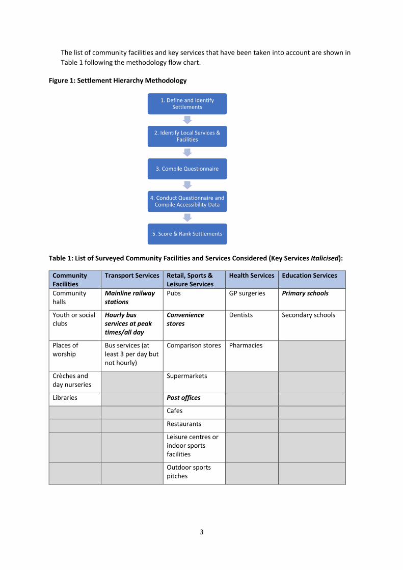
3.1. The following flow chart describes the steps that have been followed for determining a
settlement hierarchy in East Hampshire (excluding the South Downs National Park). Information
on the provision of local services and facilities has been sought from parish councils, by means of
a questionnaire. Other online and GIS information sources have been consulted for the presence
of leisure and recreation facilities, GP and other health services, and public transport provision.
1 The background paper was published to support the Issues and Options document of the Joint Core Strategy as: East Hampshire Settlement Analysis and Hierarchy Background Paper, East Hampshire District Council, May 2012. It relied on guidance contained in the now-superseded Planning Policy Statement 1 to determine a list of “key services” that could be audited for purposes of identifying a settlement hierarchy.
3
The list of community facilities and key services that have been taken into account are shown in
Table 1 following the methodology flow chart.
Figure 1: Settlement Hierarchy Methodology
Table 1: List of Surveyed Community Facilities and Services Considered (Key Services Italicised):
Community Facilities
Transport Services Retail, Sports & Leisure Services
Health Services Education Services
Community halls
Mainline railway stations
Pubs GP surgeries Primary schools
Youth or social clubs
Hourly bus services at peak times/all day
Convenience stores
Dentists Secondary schools
Places of worship
Bus services (at least 3 per day but not hourly)
Comparison stores Pharmacies
Crèches and day nurseries
Supermarkets
Libraries Post offices
Cafes
Restaurants
Leisure centres or indoor sports facilities
Outdoor sports pitches
1. Define and Identify Settlements
2. Identify Local Services & Facilities
3. Compile Questionnaire
4. Conduct Questionnaire and Compile Accessibility Data
5. Score & Rank Settlements
4
3.2. A settlement hierarchy must be based on clear foundations. Therefore, for this exercise, the
term: ‘settlement’ has been defined as a group of homes adjoining at least one recognised
community facility or building that provides either a key service or a public meeting place. This
definition has led to the settlements in Table 2 being identified for the emerging Local Plan.
3.3. A points-based scoring system has used to rank the identified settlements, with points being
gained for the presence of services and facilities. A distinction was made between “key
services”, which are likely to be accessed by many people in a community on daily basis, and
other services and facilities (see Table 1). A settlement’s accessibility to services and facilities
has also taken into account, with more points being gained for good or satisfactory accessibility
to selected services, where the terms: ‘good’ and ‘satisfactory’ were determined by
geographical proximity from the centre of a settlement (see Appendix A for details). The
following principles have been used in scoring the different settlements, with the most
important aspects highlighted in bold:
The presence of key services, which are likely to be accessed by many people on a daily
basis and thus have a greater impact on reducing the need to travel, particularly by less
sustainable modes, should receive the highest relative scores.
Other services which are typically found in larger settlements and may be accessed on a
daily or weekly basis – and which might therefore be accessed by a relatively large
number of people by sustainable modes of transport – should receive higher relative
scores than services which may be accessed less frequently.
Services which may be widely distributed or infrequently accessed should receive the
lowest relative scores, because the presence of these services is likely to have less impact
on reducing the need to travel for service users.
Accessibility to key and other important services should also be taken into account.
‘Accessibility’ is construed as the lack of presence within, but close connection to such
services. Scores for good or fair accessibility should be lower than where these services
are present within a settlement. No score should be given for poor accessibility.
3.4. The scores for each settlement are given at Appendix B, together with comments identifying the
type of services and facilities that were identified and that contributed significantly to the score.
Full results of the scoring are also included in the large matrix of scores within Appendix B, to
enable local residents to comment on all aspects of how the methodology has been
implemented.
4. Ranking and Proposed Settlement Hierarchy
4.1. Table 2 (on the next page) highlights the ranking of the settlements in accordance with the
scores from Appendix B. As noted above, these scores are based purely on the presence of
relevant services and facilities; or a settlement’s proximity to them.

5
Table 2: Ranking of Settlements in East Hampshire (outside of the South Downs National Park)
Based on Presence of and/or Accessibility to Services and Facilities
Ranking based on scores Score out of 40 Name of settlement(s)
1st 40 Alton
2nd 38 Whitehill & Bordon
3rd 35 Liphook
4th 33 Horndean
5th 28 Grayshott
6th 27 Holybourne
7th 25 Rowlands Castle
8th 24 Clanfield, Four Marks & South Medstead, Headley
9th 23 Lovedean, Lindford
10th 22 Bentley
11th 20 Kingsley, Medstead
12th 19 Ropley
13th 18 Catherington
14th 17 Headley Down, Arford, Bramshott, Holt Pound
15th 15 Ropley Dean
16th 14 Passfield Common
17th 13 Bentley Station
18th 10 Upper Froyle, Bentworth
19th 8 Beech, Griggs Green, Lower Froyle,
20th 7 Oakhanger, Shalden, Upper Wield, Lasham
4.2. It would be unreasonable to propose a settlement hierarchy comprising 20 discrete groups,
especially as the difference in scores between many of the identified settlements is very small
(one or two points out of a possible 40 points). Therefore, a grouping of settlements with
different, but similar scores is required.
4.3. The settlement hierarchy of the adopted East Hampshire Local Plan (page 25 of the JCS) included
the following five settlement groupings:
market town;
large local service centre;
small local service centre;
other settlements with a settlement policy boundary; and
small rural villages/hamlets in the countryside
4.4. A similar hierarchy for the emerging Local Plan is proposed in order to remain broadly consistent
with the familiar concepts of the existing JCS settlement hierarchy. Many of the services and
facilities that were considered for the JCS in 2012 remain in operation, but new services are being
delivered most notably in Whitehill & Bordon (as part of the regeneration) and there has been a
greater focus for the emerging Local Plan on rigorously identifying the smallest settlements,
which are captured only by the simple description “all other settlements” in the JCS.

6
4.5. Based on the ranking of settlements in Appendix A, a six-tier hierarchy is proposed for the
emerging Local Plan. The proposed hierarchy is shown at Table 3 (below) and specifically
identifies the smallest settlements that are farthest from the services and facilities under
consideration.
4.6. The proposed designations of the hierarchy are put forward for consultation purposes, which
means that alternative suggestions for how to name the different tiers are welcome. It is
recognised that the everyday categories of ‘town’, ‘village’ and ‘hamlet’ are insufficient to cover
the variety of settlements in East Hampshire, when these are to be described on the basis of their
potential to accommodate development in close proximity to local services and facilities.
Table 3: Proposed Settlement Hierarchy for the Emerging Local Plan
Tier in Hierarchy
Proposed designation Proposed Settlements
1 Town Alton, Whitehill & Bordon
2 Large Local Service Centre Liphook, Horndean
3 Small Local Service Centre Holybourne, Grayshott, Headley, Rowlands Castle, Clanfield, Four Marks & South Medstead
4 Settlement with a Small Number of Services
Lovedean, Lindford, Bentley, Kingsley, Medstead, Ropley, Catherington, Headley Down, Arford, Bramshott, Holt Pound
5 Rural Settlement Passfield Common, Ropley Dean, Bentley Station, Upper Froyle, Bentworth, Beech, Griggs Green, Lower Froyle
6 Other settlements in the countryside
Oakhanger, Shalden, Upper Wield, Lasham
End of Background Paper.

APPENDIX A: SETTLEMENT HIERARCHY METHODOLOGY
1. The new local plan will include a revised settlement hierarchy, based on an accurate and up-to-date
audit of local facilities and services, and their accessibility. This is for the purpose of ensuring that
planned development contributes to the achievement of sustainable development, per the
requirements of legislation2.
2. The existing settlement hierarchy of the JCS was based on an audit of facilities and services in 2012,
but their existence and availability is likely to have changed since that time. It is therefore
appropriate to design and undertake a new audit, which should reflect current best practice. This
paper identifies a suitable approach that can be implemented for the new local plan.
3. The audit of facilities and services will form one part of the method for determining a settlement
hierarchy. The audit results can subsequently be augmented with other information (e.g. population
estimates) to establish a settlement hierarchy.
Background
4. The East Hampshire Settlement Analysis and Hierarchy Background Paper (EHDC, May 2012), which
was prepared to inform the JCS, relied on planning guidance that was contained in the Government’s
PPS1. This national policy statement included a list of suitable “key services” that could be audited
for identifying a settlement hierarchy. In the context of this guidance, the JCS background paper set
out a list of key services that would likely be accessed on a daily basis and which could therefore
generate significant numbers of car journeys. These “key services” were:
Convenience store
Post office
Primary school
Local jobs
Frequent bus service to nearest main centre
Mainline railway station.
5. The JCS background paper presented a ranking of settlements in East Hampshire using scores that
reflected access to local services and facilities. In addition to the key services that are listed above,
the presence of other facilities, such as doctor’s surgeries, were also taken into account. A weighting
was applied to scores so that key services were worth double the amount of points as other services
and facilities. The audit was presented in an appendix to the background paper, in the form of a
settlement analysis matrix.
2 See S.39(2) of the Planning and Compulsory Purchase Act 2004.
6. The JCS background paper was prepared before the Government published the National Planning
Policy Framework (NPPF) in March 2012. The NPPF superseded most of the previous national
planning policies, but it does not provide specific advice and guidance for the production of
settlement hierarchies. However, the first NPPF made clear that planning should take account of the
different roles and character of different areas as a core planning principle. Planning authorities
should also seek to actively manage patterns of growth to make the fullest possible use of public
transport, walking and cycling, and focus significant development in locations which are or can be
made sustainable (paragraph 17, NPPF).
7. The Government published as revised NPPF in 2018. The revised NPPF notes that planning policies
and decisions should play an active role in guiding development towards sustainable solutions, taking
local circumstances into account, to reflect the character, needs and opportunities of each area
(paragraph 9, NPPF). Furthermore, to promote sustainable development in rural areas, housing
should be located where it will enhance or maintain the vitality of rural communities. Planning
policies should identify opportunities for villages to grow and thrive, especially where this will
support local services. Where there are groups of smaller settlements, development in one village
may support services in a village nearby (paragraph 77, NPPF). These aspects of national policy
suggest that indicators of service provision and accessibility should be considered, and the role of
different settlements in East Hampshire taken into account, as part of a future development strategy.
8. An updated audit of facilities and services in East Hampshire should take account of established good
practice from elsewhere. To inform the audit methodology, settlement hierarchy background papers
for Aylesbury Vale, Guildford, Sevenoaks, Vale of White Horse, Warwick and Wycombe districts have
been reviewed. The following bullet points identify the key points from these documents:
Settlements are identified as groups of housing where there are services or community
facilities which can contribute to their sustainability (Sevenoaks).
Population for settlements was determined using the nearest approximate Output Area
boundaries; where very small settlements were concerned, population was determined
using the electoral role and by adding an extra 25% for those not eligible to vote
(Sevenoaks).
“Key services” have been defined as primary schools, post offices, convenience stores and
frequent bus services (one or more services/hour, during peak hours or all day) (Sevenoaks
and Warwick); but have also included pubs or community buildings such as village halls
(Warwick); and GP surgeries (Aylesbury) or access to high-speed broadband (Wycombe). The
presence of primary schools, post offices, convenience stores and frequent bus services is a
common thread for all audits of facilities and services.
Points were awarded for the presence of facilities and services, but additional weight was
given to more frequent bus services and/or the presence of train stations (Aylesbury &
Warwick).
In Warwick district, additional weight was given to primary schools that were not physically
constrained (and so could be expanded) and to village halls, compared to places of worship.

Settlements with a greater number of convenience/comparison shops have been given
higher scores (Guildford and Vale of White Horse). Information on the number of shops was
obtained from town centre health checks.
Employment levels have featured in the audit of services and facilities, as a proxy for the
availability of local employment (Wycombe).
Scores were given to settlements based on their distance to recognised employment sites in
the Vale of White Horse district.
Guildford and Wycombe background papers include national information sources for the
location of post offices, GP’s surgeries, pharmacies and dentists.
9. A good starting point, in the context of the foregoing, is that criteria focusing on the range of local
facilities and services; and accessibility indicators for employment opportunities, education and
health services should be used to propose a settlement hierarchy. Local population levels could also
be considered. For Whitehill & Bordon and surrounding settlements, the improvements in services
and facilities associated with the regeneration of former MoD sites could be taken into account.
Methodological Approach
10. The following flow chart expresses the steps proposed for the overall process which is to be followed
for determining a settlement hierarchy in East Hampshire (excluding the South Downs National Park).
Details on the methodology and its implementation are given afterwards.
11. Settlements are defined as discrete groups of housing adjoining at least one recognised community
facility or building that provides a key service; or adjoining at least one public meeting place.
Community facilities are defined as per the East Hampshire District Local Plan: Joint Core Strategy
1. Define and Identify Settlements
2. Identify Local Services & Facilities
3. Compile Questionnaire
4. Conduct Questionnaire and Compile Accessibility Data
5. Score & Rank Settlements

(JCS), which means that the following are considered: community buildings, meeting halls, pavilions
& changing rooms, youth and social clubs, public toilets, places of worship, crèches, day nurseries,
post offices. Public meeting places include community buildings, meetings halls, places of worship
and libraries, which means that there is significant overlap with the JCS definition of community
facilities.
12. The location of these facilities and meeting places is to be determined using existing desk-based
information sources, such as GIS, online searches and the Council’s local plan evidence base. Key
services include those that have previously been considered important on a daily basis (see
background section above), although for this purpose they exclude bus transport connections and
places of work, as it is considered unreasonable to identify a settlement merely on the basis of a bus
stop; and a place of work might not provide a service for the majority of a community, many of
whom could be retired or in education.
13. The details of relevant facilities and services will be compiled to inform a questionnaire that will be
issued to parish councils and neighbourhood planning groups. For all of the identified settlements,
the presence or absence of each facility or service will be recorded along with names for these
facilities/services. The following table identifies those community facilities and key services that will
be considered for purposes of the audit:
Community Facilities
Transport Services Retail, Sports & Leisure Services
Health Services Education Services
Community halls
Mainline railway stations
Pubs GP surgeries Primary schools
Youth or social clubs
Hourly bus services at peak times/all day
Convenience stores
Dentists Secondary schools
Places of worship
Bus services (at least 3 per day but not hourly)
Comparison stores Pharmacies
Crèches and day nurseries
Supermarkets
Libraries Post offices
Cafes
Restaurants
Leisure centres or indoor sports facilities
Outdoor sports pitches
*Please note: items highlight in bold and italicised text will be counted as “key services” for purposes of the audit of
facilities and services. Additional weight will be attributed to the scores for these services.
14. The details of services and facilities for each settlement shall inform a questionnaire, to ask
respondents to corroborate the presence of these facilities/services and amend/augment where
necessary. The questionnaire is to be completed by representatives of parish councils and/or
neighbourhood planning groups, to ensure that local knowledge is reflected in the audit. The
questionnaire will also ask questions regarding the quality and use of local facilities, to inform a
future planning policy approach towards community facilities. Although this is separate to the
derivation of a settlement hierarchy, qualitative information can be used as a “check and balance” on
the outcomes to the scoring and ranking of settlements (i.e. to ensure that the presence of poor
quality/unused facilities does not artificially skew the results).
15. At the same time as the questionnaire is being completed, planning officers will compile information
on accessibility to services/facilities for each settlement. This information is to be obtained as
follows:
Accessibility: distances by road from the centre of settlement to key services can be used as an
indicator to categorise accessibility to services. Key services are those that are likely to be most
frequently accessed. Distances by road from the centre of the settlement to the centre of the
nearest employment cluster (as identified through EHDC’s recent employment background
paper) can also be used as an indicator to categorise accessibility to employment facilities. These
distances can be obtained using Google Maps or, potentially, using the Council’s GIS software.
Detailed standards specifying good, fair, poor accessibility will be specified by scrutinising the
results and applying “rules of thumb”; this is to ensure that good practice is followed whilst
respecting the local context for service provision (it needs to be borne in mind that East
Hampshire is a predominantly rural district).
The “rules of thumb” to be applied, vis-à-vis accessibility are as follows:
o ‘Good accessibility’ should generally mean that places are convenient by foot (i.e. by
footpaths or pavements, with distances of 400m or less) or within one mile (1610m) by
car/other vehicle from the centre of a settlement;
o ‘Fair accessibility’ should generally mean that places are within 800m but more than
400m by foot (by footpaths or pavements) or within five miles (8050m) but more than
one mile (1610m) by car/other vehicle from the centre of settlement;
o ‘Poor accessibility’ should generally mean that places are more than 800m by foot or
over five miles (8050m) by car/other vehicle from the centre of a settlement.
16. Settlements will be ranked using a points-based scoring system, which employs a sliding scale of
scores weighted in favour of the presence of key services and good accessibility to these and
employment clusters. Please note that population levels will not form part of the scoring and ranking
exercise but could be considered at a later date to provide a useful comparator, indicating which
settlements have more or less services/accessibility to services and jobs than might be expected
purely on the basis of population size3. The following table provides details on the scoring and
weighting attributed to different facilities and services.
3 Please note that for the draft (Regulation 18) East Hampshire Local Plan 2017-2036, a comparison of service provision with current population levels has not been undertaken. This step has been reserved for further
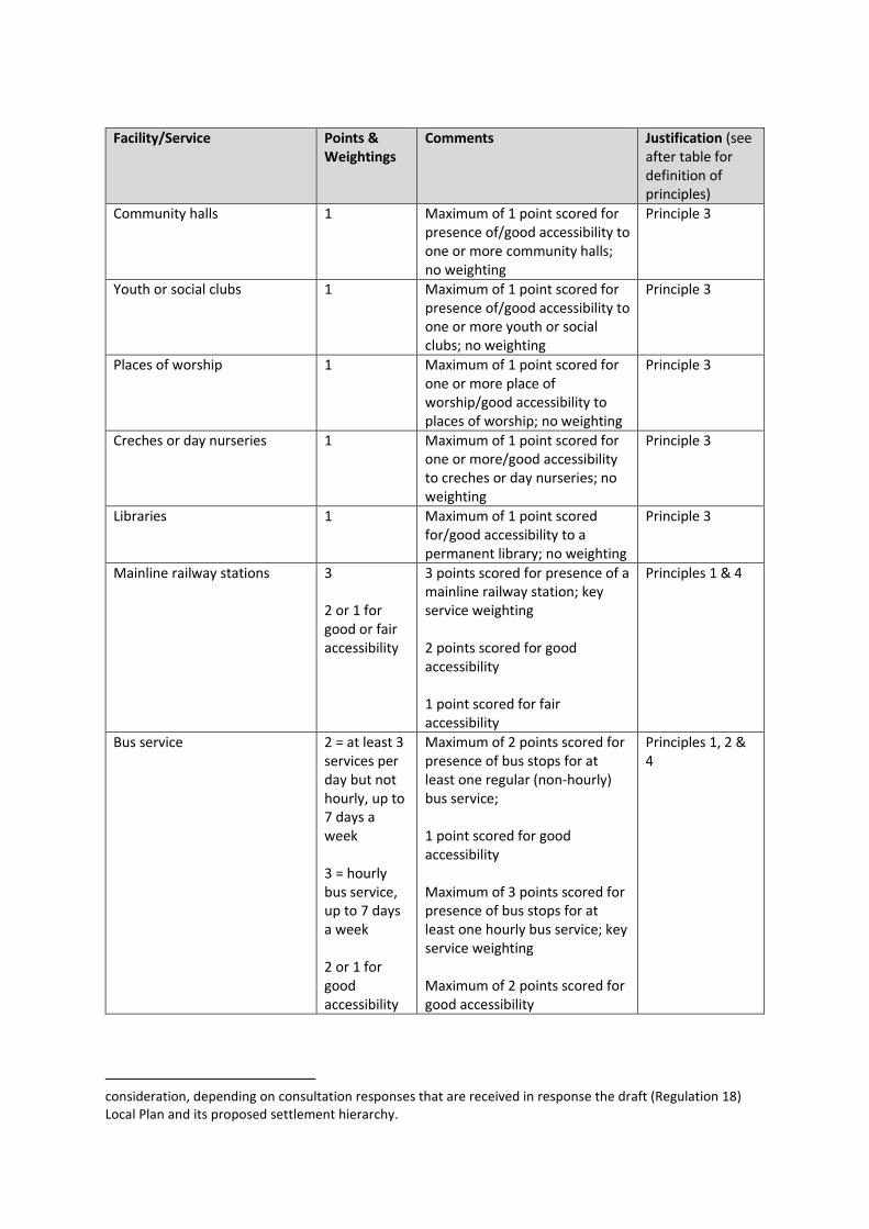
Facility/Service Points & Weightings
Comments Justification (see after table for definition of principles)
Community halls 1
Maximum of 1 point scored for presence of/good accessibility to one or more community halls; no weighting
Principle 3
Youth or social clubs 1 Maximum of 1 point scored for presence of/good accessibility to one or more youth or social clubs; no weighting
Principle 3
Places of worship 1 Maximum of 1 point scored for one or more place of worship/good accessibility to places of worship; no weighting
Principle 3
Creches or day nurseries 1 Maximum of 1 point scored for one or more/good accessibility to creches or day nurseries; no weighting
Principle 3
Libraries 1 Maximum of 1 point scored for/good accessibility to a permanent library; no weighting
Principle 3
Mainline railway stations 3 2 or 1 for good or fair accessibility
3 points scored for presence of a mainline railway station; key service weighting 2 points scored for good accessibility 1 point scored for fair accessibility
Principles 1 & 4
Bus service 2 = at least 3 services per day but not hourly, up to 7 days a week 3 = hourly bus service, up to 7 days a week 2 or 1 for good accessibility
Maximum of 2 points scored for presence of bus stops for at least one regular (non-hourly) bus service; 1 point scored for good accessibility Maximum of 3 points scored for presence of bus stops for at least one hourly bus service; key service weighting Maximum of 2 points scored for good accessibility
Principles 1, 2 & 4
consideration, depending on consultation responses that are received in response the draft (Regulation 18) Local Plan and its proposed settlement hierarchy.
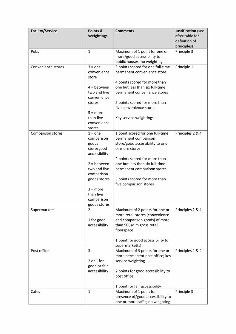
Facility/Service Points & Weightings
Comments Justification (see after table for definition of principles)
Pubs 1 Maximum of 1 point for one or more/good accessibility to public houses; no weighting
Principle 3
Convenience stores 3 = one convenience store 4 = between two and five convenience stores 5 = more than five convenience stores
3 points scored for one full-time permanent convenience store 4 points scored for more than one but less than six full-time permanent convenience stores 5 points scored for more than five convenience stores Key service weightings
Principle 1
Comparison stores 1 = one comparison goods store/good accessibility 2 = between two and five comparison goods stores 3 = more than five comparison goods stores
1 point scored for one full-time permanent comparison store/good accessibility to one or more stores 2 points scored for more than one but less than six full-time permanent comparison stores 3 points scored for more than five comparison stores
Principles 2 & 4
Supermarkets 2 1 for good accessibility
Maximum of 2 points for one or more retail stores (convenience and comparison goods) of more than 500sq.m gross retail floorspace 1 point for good accessibility to supermarket(s)
Principles 2 & 4
Post offices 3 2 or 1 for good or fair accessibility
Maximum of 3 points for one or more permanent post office; key service weighting 2 points for good accessibility to post office 1 point for fair accessibility
Principles 1 & 4
Cafes 1 Maximum of 1 point for presence of/good accessibility to one or more cafés; no weighting
Principle 3

Facility/Service Points & Weightings
Comments Justification (see after table for definition of principles)
Restaurants 1 Maximum of 1 point for presence of/good accessibility to one or more cafés; no weighting
Principle 3
Leisure centres or indoor sports facilities
2 1 for good accessibility
Maximum of 2 points for one or more leisure centres or indoor sports facilities 1 point for good accessibility to leisure centres or indoor facilities
Principles 2 & 4
Outdoor sports pitches 1 Maximum of 1 point for one or more/good accessibility to outdoor sports pitch; no weighting
Principle 3
GP surgeries 1 Maximum of 1 point for one or more/good accessibility to GP surgery; no weighting
Principle 3
Dentists 1 Maximum of 1 point for one or more/good accessibility to dentist; no weighting
Principle 3
Pharmacies 1 Maximum of 1 point for one or more/good accessibility to pharmacy; no weighting
Principle 3
Primary Schools 3 2 or 1 for good or fair accessibility
Maximum of 3 points for one or more primary schools; key service weighting 2 points for good accessibility to primary school 1 point for fair accessibility
Principles 1 & 4
Secondary Schools 2 1 for good accessibility
Maximum of 2 points for one or more secondary schools 1 point for good accessibility to secondary school
Principles 2 & 4
Employment Clusters 2 for good accessibility to large clusters 1 for fair accessibility to large clusters; or good accessibility to small clusters
Maximum of 2 points for good access to employment clusters that host a large number of businesses and are likely to employ a large number of people (e.g. in Alton and Horndean) 1 point for fair access to the aforementioned clusters; or for good access to smaller employment clusters
Principles 2 & 4

17. The principles underpinning the above scorings and weightings are as follows:
1. The presence of key services, which are likely to be accessed by many people on a daily
basis and thus have a greater impact on reducing the need to travel, particularly by less
sustainable modes, should receive the highest relative scores.
2. Other services which are typically found in larger settlements and may be accessed on a
daily or weekly basis – and which might therefore be accessed by a relatively large
number of people by sustainable modes of transport – should receive higher relative
scores than services which may be accessed less frequently.
3. Services which may be widely distributed or infrequently accessed should receive the
lowest relative scores, because the presence of these services is likely to have less impact
on reducing the need to travel for service users.
4. Accessibility to key and other important services should also be taken into account.
‘Accessibility’ is construed as the lack of presence within, but close connection to such
services. Scores for good or fair accessibility should be lower than where these services
are present within a settlement. No score should be given for poor accessibility.
End of Appendix A.
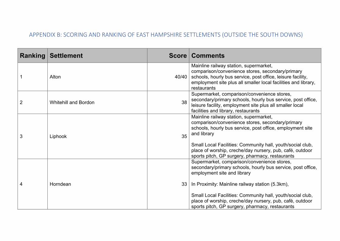
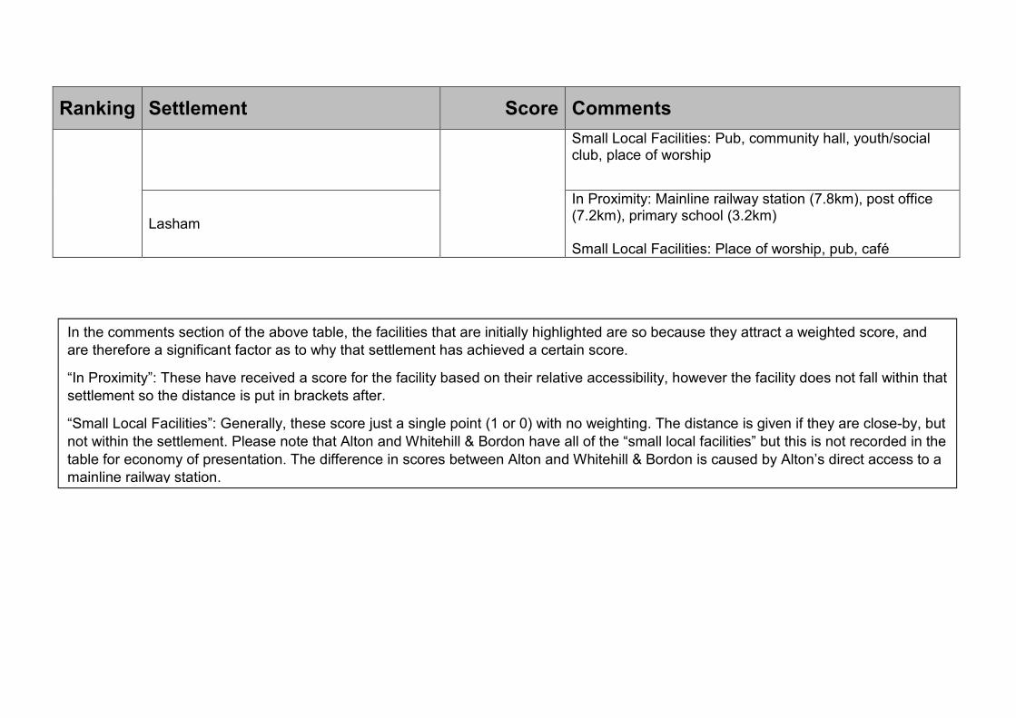
APPENDIX B: SCORING AND RANKING OF EAST HAMPSHIRE SETTLEMENTS (OUTSIDE THE SOUTH DOWNS)
Ranking Settlement Score Comments
1 Alton 40/40
Mainline railway station, supermarket, comparison/convenience stores, secondary/primary schools, hourly bus service, post office, leisure facility, employment site plus all smaller local facilities and library, restaurants
2 Whitehill and Bordon 38
Supermarket, comparison/convenience stores, secondary/primary schools, hourly bus service, post office, leisure facility, employment site plus all smaller local facilities and library, restaurants
3 Liphook 35
Mainline railway station, supermarket, comparison/convenience stores, secondary/primary schools, hourly bus service, post office, employment site and library Small Local Facilities: Community hall, youth/social club, place of worship, creche/day nursery, pub, café, outdoor sports pitch, GP surgery, pharmacy, restaurants
4 Horndean 33
Supermarket, comparison/convenience stores, secondary/primary schools, hourly bus service, post office, employment site and library In Proximity: Mainline railway station (5.3km), Small Local Facilities: Community hall, youth/social club, place of worship, creche/day nursery, pub, café, outdoor sports pitch, GP surgery, pharmacy, restaurants

Ranking Settlement Score Comments
5 Grayshott 28
Hourly bus service, convenience/comparison stores, post office, primary school In Proximity: Mainline railway station (5.8km) Small Local Facilities: Community hall, youth/social club, place of worship, creche/day nursery, pub, café, outdoor sports pitch, GP surgery, pharmacy, restaurants
6 Holybourne
27
Primary/secondary schools (Inc. Treloars School and College), post office, hourly bus service, convenience store In Proximity: Mainline railway station (1.7km), supermarket (1.3km), comparison store (1.1km), employment site (2.1km) Small Local Facilities: Community hall, youth/social club, place of worship, creche/day nursery, pub, outdoor sports pitch, GP surgery (1.6km), dentist (1.6km), pharmacy (1.6km)
7 Rowlands Castle 25
Mainline railway station, frequent bus service, convenience/comparison store, post office, primary school In Proximity: Employment site (5km) Small Local Facilities: Community hall, youth/social club, place of worship, creche/day nursery, pubs/restaurants, café, GP surgery, pharmacy

Ranking Settlement Score Comments
8
Clanfield
24
Hourly bus service, convenience/comparison store(s), post office, primary school In Proximity: Employment site (4.2km), mainline railway station (7.4km) Small Local Facilities: Community hall, youth/social club, place of worship, creche/day nursery, pub, GP surgery, pharmacy, restaurant
Four Marks
Hourly bus service, convenience/comparison stores, primary school, employment site In Proximity: Post office (4km) Small Local Facilities: Community hall, youth/social club, place of worship, creche/day nursery, café, outdoor sports pitch, GP surgery, pharmacy
Headley
GP Surgery, comparison/convenience store, hourly bus service, primary school In Proximity: Mainline railway station (7.7km), employment site (5.1km), post office (3.2km) Small Local Facilities: Community hall, youth/social club, place of worship, creche/day nursery, pub, outdoor sports pitch, GP surgery, pharmacy, dentist (1.4km), restaurant

Ranking Settlement Score Comments
9
Lovedean
23
Hourly bus service, convenience/comparison store(s), post office In Proximity: Mainline railway station (6.2km), supermarket (1.1km), primary school (600m), secondary school (1.6km), employment site (2.5km) Small Local Facilities: Community hall, youth/social club, pub, pharmacy, outdoor sports pitch (1.6km), creche/day nursery (500m), restaurant
Lindford
Hourly bus service, convenience/comparison store(s), post office In Proximity: Mainline railway station (7.1km), primary school (4.6km), employment site (3.8km) Small Local Facilities: Community hall, youth/social club, place of worship, creche/day nursery, pub, outdoor sports pitch, dentist, GP surgery (1.6km), restaurant
10 Bentley 22
Hourly bus service, convenience store, post office, primary school In Proximity: Mainline railway station (1.4km) Small Local Facilities: Community hall, youth/social club, place of worship, creche/day nursery, pub, outdoor sports pitch, GP surgery, restaurants
11 Kingsley 20 Hourly bus service, comparison store, post office, indoor leisure facility

Ranking Settlement Score Comments
In Proximity: Mainline railway station (7.4km), primary school (4.3km), employment site (5.6km) Small Local Facilities: Community hall, youth/social club, place of worship, creche/day nursery, pub/restaurant, café, outdoor sports pitch
Medstead
Convenience store, post office, primary school In Proximity: Mainline railway station (7.9km), employment site (2.5km) Small Local Facilities: Community hall, youth/social club, place of worship, creche/day nursery, pub/restaurant, café, outdoor sports pitch, GP surgery
12 Ropley 19
Post office, convenience store, primary school In Proximity: Hourly bus service (1.2km), employment site (5.9km) Small Local Facilities: Community hall, youth/social club, place of worship, creche/day nursery, café (1.6km), restaurant (1.3km)
13 Catherington
18
Primary school In Proximity: Mainline railway station (6.9km), hourly bus service (1.6km), comparison store (1.6km), post office (1.6km), secondary school (1.6km), employment site (2.7km)

Ranking Settlement Score Comments
Small Local Facilities: Community hall, place of worship, creche/day nursery, pub, outdoor sports pitch (1.6km) GP surgery (1.6km), restaurant
14
Headley Down
17
Hourly bus service, convenience store, post office In Proximity: Mainline railway station (7.4km), primary school (800m), employment site (7.7km) Small Local Facilities: Community hall, youth/social club, place of worship, creche/day nursery
Arford
In Proximity: Hourly bus service (800m), post office (804m), primary school (800m), employment site (5.9km), mainline railway station (7.4km) Small Local Facilities: Community Hall (321m), Youth/social club (321m), place of worship (643m), pub, comparison store (840m), outdoor sports pitch (640m), GP surgery (800m), pharmacy (800m), restaurant (110m)
Bramshott
In Proximity: Mainline railway station (2.4km), hourly bus service (1.4km), comparison store (1.6km), supermarket (1.1km), post office (1.1km), primary school (900m), employment site (2.2km)

Ranking Settlement Score Comments
Small Local Facilities: Place of worship, library (1.6km), pub (1.6km), café (1.6km), GP surgery (1.6km), pharmacy (1.6km), restaurant (1.5km)
Holt Pound
Hourly bus service, comparison store In Proximity: Mainline railway station (4.8km), post office (1.4km), primary school (1.1km) Small Local Facilities: Community hall, place of worship, pub, café, creche/day nursery (1.6km), outdoor sports pitch (1.3km), youth/social club (0.9km), restaurant (0.7km)
15 Ropley Dean 15
Hourly bus service In Proximity: Post office (1.1km), primary school (1.1km), employment site (7.1km) Small Local Facilities: Community hall, youth/social club (1.5km), creche/day nursery (1.2km), café (1.6km), outdoor sports pitch (1.5km)
16 Passfield Common 14
Hourly bus service, convenience store In Proximity: Mainline railway station (4.3km), employment site (4.3km), post office (2.7km) Small Local Facilities: Youth/social club, pub (1.4km)
Ranking Settlement Score Comments
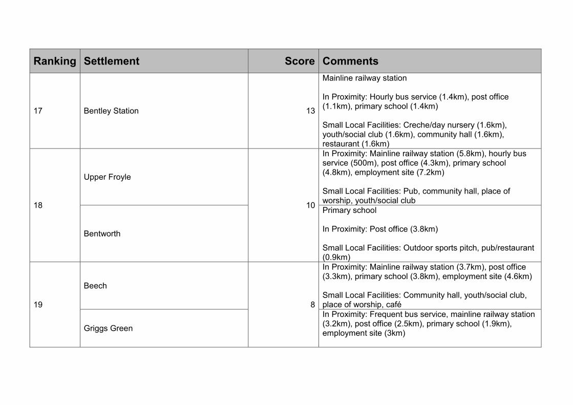
17 Bentley Station 13
Mainline railway station In Proximity: Hourly bus service (1.4km), post office (1.1km), primary school (1.4km) Small Local Facilities: Creche/day nursery (1.6km), youth/social club (1.6km), community hall (1.6km), restaurant (1.6km)
18
Upper Froyle
10
In Proximity: Mainline railway station (5.8km), hourly bus service (500m), post office (4.3km), primary school (4.8km), employment site (7.2km) Small Local Facilities: Pub, community hall, place of worship, youth/social club
Bentworth
Primary school In Proximity: Post office (3.8km) Small Local Facilities: Outdoor sports pitch, pub/restaurant (0.9km)
19
Beech
8
In Proximity: Mainline railway station (3.7km), post office (3.3km), primary school (3.8km), employment site (4.6km) Small Local Facilities: Community hall, youth/social club, place of worship, café
Griggs Green
In Proximity: Frequent bus service, mainline railway station (3.2km), post office (2.5km), primary school (1.9km), employment site (3km)

Ranking Settlement Score Comments
Small Local Facilities: Pub, café, restaurant
Lower Froyle
In Proximity: Employment site (7.2km), primary school (3.8km), mainline railway station (5.4km), post office (3.4km) Small Local Facilities: Pub, community hall (1.6km), youth/social club (1.6km), place of worship (1.6km), restaurant (1.1km)
Oakhanger
In Proximity: Post office (3.8km), primary school (3.5km), employment site (4.6km) Small Local Facilities: Community hall, youth/social club, pub, cafe
20
Oakhanger
7
In Proximity: Post office (3.8km), primary school (3.5km), employment site (4.6km) Small Local Facilities: Community hall, youth/social club, pub, cafe
Shalden
In Proximity: Employment site (6.1km), primary school (2km), post office (5.1km), mainline railway station (5.1km) Small Local Facilities: Pub, creche/day nursery, community hall
Upper Wield In Proximity: Employment site (6.7km), primary school (4.6km), post office (4.2km)
Ranking Settlement Score Comments
Small Local Facilities: Pub, community hall, youth/social club, place of worship
Lasham
In Proximity: Mainline railway station (7.8km), post office (7.2km), primary school (3.2km) Small Local Facilities: Place of worship, pub, café
In the comments section of the above table, the facilities that are initially highlighted are so because they attract a weighted score, and are therefore a significant factor as to why that settlement has achieved a certain score.
“In Proximity”: These have received a score for the facility based on their relative accessibility, however the facility does not fall within that settlement so the distance is put in brackets after.
“Small Local Facilities”: Generally, these score just a single point (1 or 0) with no weighting. The distance is given if they are close-by, but not within the settlement. Please note that Alton and Whitehill & Bordon have all of the “small local facilities” but this is not recorded in the table for economy of presentation. The difference in scores between Alton and Whitehill & Bordon is caused by Alton’s direct access to a mainline railway station.
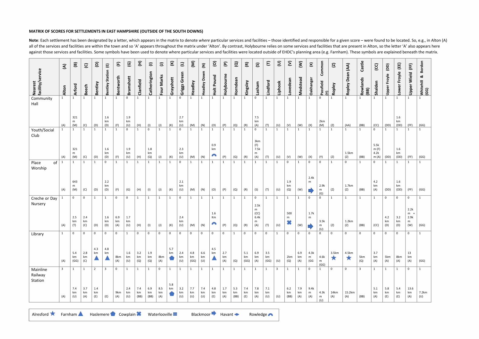
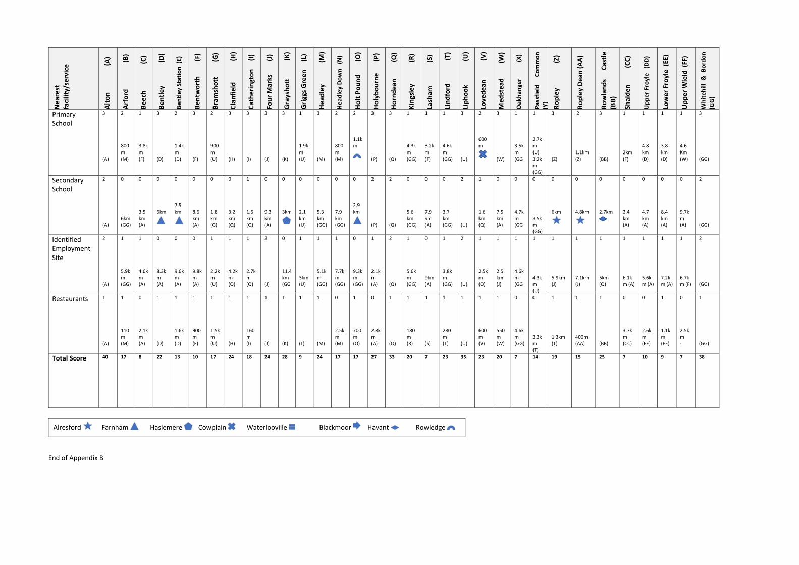
MATRIX OF SCORES FOR SETTLEMENTS IN EAST HAMPSHIRE (OUTSIDE OF THE SOUTH DOWNS)
Note: Each settlement has been designated by a letter, which appears in the matrix to denote where particular services and facilities – those identified and responsible for a given score – were found to be located. So, e.g., in Alton (A)
all of the services and facilities are within the town and so ‘A’ appears throughout the matrix under ‘Alton’. By contrast, Holybourne relies on some services and facilities that are present in Alton, so the letter ‘A’ also appears here
against those services and facilities. Some symbols have been used to denote where particular services and facilities were located outside of EHDC’s planning area (e.g. Farnham). These symbols are explained beneath the matrix.
Ne
are
st
faci
lity/
serv
ice
Alt
on
(
A)
Arf
ord
(
B)
Be
ech
(
C)
Be
ntl
ey
(D
)
Be
ntl
ey
Stat
ion
(E)
Be
ntw
ort
h
(F)
Bra
msh
ott
(G
)
Cla
nfi
eld
(H
)
Cat
her
ingt
on
(
I)
Fou
r M
arks
(J)
Gra
ysh
ott
(
K)
Gri
ggs
Gre
en
(L)
He
adle
y
(M
)
He
adle
y D
ow
n
(N)
Ho
lt P
ou
nd
(O
)
Ho
lyb
ou
rne
(P)
Ho
rnd
ean
(
Q)
Kin
gsle
y
(R
)
Lash
am
(
S)
Lin
dfo
rd
(
T)
Lip
ho
ok
(U
)
Love
de
an
(V
)
Med
ste
ad
(W)
Oak
han
ger
(
X)
Pas
sfie
ld
Co
mm
on
(Y)
Ro
ple
y
(
Z)
Ro
ple
y D
ean
(A
A)
Ro
wla
nd
s C
astl
e (B
B)
Shal
den
(
CC
)
Up
pe
r Fr
oyl
e
(DD
)
Low
er
Fro
yle
(EE
)
Up
pe
r W
ield
(FF
)
Wh
ite
hill
&
B
ord
on
(GG
)
Community Hall
1 (A)
1 321m (M)
1 (C)
1 (D)
1 1.6 km (D)
1 (F)
0 1.9 km (U)
1 (H)
1 (I)
1 (J)
1 (K)
0 2.7 km (U)
1 (M)
1 (N)
1 (O)
1 (P)
1 (Q)
1 (R)
0 7.5 km (A)
1 (T)
1 (U)
1 (V)
1 (W)
1 (X)
0 2km (M)
1 (Z)
1 (AA)
1 (BB)
1 (CC)
1 (DD)
1 1.6 km (DD)
1 (FF)
1 (GG)
Youth/Social Club
1 (A)
1 321m (M)
1 (C)
1 (D)
1 1.6 km (D)
1 (F)
0 1.9 km (U)
1 (H)
0 1.8 km (Q)
1 (J)
1 (K)
0 2.3 km (U)
1 (M)
1 (N)
1 0.9 km
1 (P)
1 (Q)
1 (R)
0 3km (F) 7.5km (A)
1 (T)
1 (U)
1 (V)
1 (W)
1 (X)
1 (Y)
1 (Z)
1 1.5km (Z)
1 (BB)
0 5.5km (F) 4.2km (A)
1 (DD)
1 1.6 km (DD)
1 (FF)
1 (GG)
Place of Worship
1 (A)
1 643m (M)
1 (C)
1 (D)
0 2.2 km (D)
1 (F)
1 (G)
1 (H)
1 (I)
1 (J)
1 (K)
0 2.1 km (U)
1 (M)
1 (N)
1 (O)
1 (P)
1 (Q)
1 (R)
1 (S)
1 (T)
1 (U)
0 1.9 km (Q)
1 (W)
0 2.4km
0 2.9km (G)
1 (Z)
0 1.7km (Z)
1 (BB)
0 4.2 km (A)
1 (DD)
1 1.6 km (DD)
1 (FF)
1 (GG)
Creche or Day Nursery
1 (A)
0 2.5 km (T)
0 2.4 km (C)
1 (D)
1 1.6 km (D)
0 6.9 km (A)
0 1.7 km (U)
1 (H)
1 (I)
1 (J)
1 (K)
0 2.4 km (U)
1 (M)
1 (N)
1 1.6 Km
1 (P)
1 (Q)
1 (R)
0 2.5km (CC) 6.4km (A)
1 (T)
1 (U)
1 500m
1 (W)
0 1.7km
0 3.5km (U)
1 (Z)
1 1.2km (Z)
1 (BB)
1 (CC)
0 4.2 km (D)
0 3.2 km (D)
0 2.2km + 2.9km (W)
1 (GG)
Library 1 (A)
0 5.4 km (GG)
0 2.8 km (C)
0 4.3 km
0 4.8 km
0 8km (A)
1 1.6 km (U)
0 3.2 km (Q)
0 1.9 km (Q)
0 8km (A)
0 5.7 km
0 2.4 km (U)
0 4.8 km (GG)
0 6.6 km (U)
0 4.5 km
0 2.7 km (A)
1 (Q)
0 5.1 km (GG)
0 6.9 km (A)
0 3.5 km (GG)
1 (U)
0 2km (Q)
0 6.9 km (A)
0 4.3km (GG
0 4.6km (GG)
0 3.5km
0 4.5km
0 5km (Q)
0 3.7 km (A)
0 5km (A)
0 8km (A)
0 13 km (A)
1 (GG)
Mainline Railway Station
3 (A)
1 7.4 km (U)
1 3.7 km (A)
2 1.4 km (E)
3 (E)
0 9km (A)
1 2.4 km (U)
1 7.4 km (BB)
1 6.9 km (BB)
0 8.5 km (A)
1 5.8 km
1 3.2 km (U)
1 7.7 km (U)
1 7.4 km (U)
1 4.8 km (E)
1 1.7 km (A)
1 5.3 km (BB)
1 7.4 km (E)
1 7.8 km (A)
1 7.1 km (U)
3 (U)
1 6.2 km (BB)
1 7.9 km (A)
0 9.4km (A)
1 4.3km (U)
0 14km (A)
0 15.2km (A)
3 (BB)
1 5.1 km (A)
1 5.8 km (E)
1 5.4 km (E)
0 13.6km (A)
1 7.2km (U)
Alresford Farnham Haslemere Cowplain Waterlooville Blackmoor Havant Rowledge
Ne
are
st
faci
lity/
serv
ice
Alt
on
(
A)
Arf
ord
(
B)
Be
ech
(
C)
Be
ntl
ey
(D
)
Be
ntl
ey
Stat
ion
(E)
Be
ntw
ort
h
(F)
Bra
msh
ott
(G
)
Cla
nfi
eld
(H
)
Cat
her
ingt
on
(
I)
Fou
r M
arks
(J)
Gra
ysh
ott
(
K)
Gri
ggs
Gre
en
(L)
He
adle
y
(M
)
He
adle
y D
ow
n
(N)
Ho
lt P
ou
nd
(O
)
Ho
lyb
ou
rne
(P)
Ho
rnd
ean
(
Q)
Kin
gsle
y
(R
)
Lash
am
(
S)
Lin
dfo
rd
(
T)
Lip
ho
ok
(U
)
Love
de
an
(V
)
Med
ste
ad
(W)
Oak
han
ger
(
X)
Pas
sfie
ld
Co
mm
on
(Y)
Ro
ple
y
(
Z)
Ro
ple
y D
ean
(A
A)
Ro
wla
nd
s C
astl
e (B
B)
Shal
den
(
CC
)
Up
pe
r Fr
oyl
e
(DD
)
Low
er
Fro
yle
(EE
)
Up
pe
r W
ield
(FF
)
Wh
ite
hill
&
B
ord
on
(GG
)
Bus stop for hourly bus service
3 (A)
2 800m (M)
0 2.4km to bus stop (A)
3 (D)
2 1.4km (D)
0 7.5km to bus stop (A)
2 1.4km to bus stop (U)
3 (H)
2 1.6km to bus stop (Q)
3 (J)
3 (K)
0 2.2km to bus stop
3 (M)
3 (N)
3 (O)
3 (P)
3 (Q)
3 (R)
0 4.5km to bus stop
3 (T)
3 (U)
3 (V)
0 2.6km to bus stop (J)
0 3.7km to (GG
3 (Y)
2 1.2km (AA)
3 (AA)
0 3km to bus stop
0 2.5km to bus stop
2 500m to bus stop
0 2.6km to bus stop (DD)
0 6.2km to bus stop (J)
3 (GG)
Bus stop for frequent (at least 3 per day but not hourly) bus service
N/A (A)
N/A N/A N/A N/A N/A N/A N/A N/A N/A N/A 2 (L)
N/A N/A N/A N/A N/A N/A N/A N/A N/A N/A N/A 0 2.7km bus
N/A N/A N/A 2 (BB)
N/A N/A N/A N/A N/A
Pub 1 (A)
1 (B)
0 2.3 km (A)
1 (D)
0 1.7 km (D)
1 (F)
1 1.6 km (U)
1 (H)
1 (I)
0 3.7 km (W)
1 (K)
1 (L)
1 (M)
0 2.5 km (M)
1 (N)
1 (P)
1 (Q)
1 (R)
1 (S)
1 (T)
1 (U)
1 (V)
1 (W)
1 (X)
1 1.4km (GG)
0 3.5km
0 2.5km
1 (BB)
1 (CC)
1 (DD)
1 (EE)
1 (FF)
1 (GG)
Convenience Stores
5 (A)
0 804m (M)
0 3.2 km (A)
3 (D)
0 1.8 km (D)
0 3.7 km (W)
0 1.1 km (U)
4 (H)
0 1km (H)
4 (J)
4 (K)
0 2.5 km (U)
3 (M)
3 (N)
0 1.4 km
3 (P)
4 (Q)
0 1.8 km (GG)
0 7.2 km (A)
3 (T)
3 (U)
3 (V)
3 (W)
0 3.7km (GG
3 (Y)
3 (Z)
0 1.1km (Z)
3 (BB)
0 6km (A)
0 4.3 km (D)
0 3.4 km (D)
0 4.2 km (W)
5 (GG)
Comparison Stores
3 (A)
1 840m (M)
0 3.2 km (A)
0 7.5 km
0 9km
0 8.5 km (A)
1 1.6 km (U)
1 (H)
1 1.6 km (H)
2 (J)
3 (K)
0 2.4 km (U)
1 (M)
0 3km (M)
1 (O)
1 1.1 km (A)
2 (Q)
1 (R)
0 7.4 km (A)
2 (T)
3 (U)
1 (V)
0 4km (J)
0 4.5km(GG
0 3.5km (U)
0 5.9km (J)
0 5.3km
1 (BB)
0 4.2 km (A)
0 4.3 km (A)
0 6.1 km (A)
0 8.3 km (J)
3 (GG)
Supermarket 2 (A)
0 5km (GG)
0 3.2 km (A)
0 4.3 km
0 8.2 km
0 8.5 km (A)
1 1.1 km (U)
0 4.2 Km (Q)
0 2.4 km (Q)
0 7.4 km (A)
0 5km
0 2.5 km (U)
0 4.3 km (U)
0 6.9 km (GG)
0 5km
1 1.3 km (A)
2 (Q)
0 4.8 km (GG)
0 7.4 km (A)
0 3.2 km (GG)
2 (U)
1 1.1 km (Q)
0 7.4 km (A)
0 3.8km (GG
0 3.7km (U)
0 10.8km (A)
0 12.2km (A)
0 4.8km (Q)
0 4.6 km (A)
0 4.6 km (A)
0 6.4 km (A)
0 13.3km (A)
2 (GG)
Post Office 3 (A)
2 804m (M)
1 3.3 km (A)
3 (D)
2 1.1 km (D)
1 3.8 km (W)
2 1.1 km (U)
3 (H)
2 1.6 km (H)
1 4km (W)
3 (K)
1 2.5 km (U)
1 3.2 km (GG)
3 (N)
2 1.4 km
3 (P)
3 (Q)
3 (R)
1 7.2 km (A)
3 (T)
3 (U)
3 (V)
3 (W)
1 3.8km (GG
3 (Y)
3 (Z)
2 1.1km (Z)
3 (BB)
1 5.1 km (A)
1 4.3 km (D)
1 3.4 km (D)
1 4.2 km (W)
3 (GG)
Alresford Farnham Haslemere Cowplain Waterlooville Blackmoor Havant Rowledge

Ne
are
st
faci
lity/
serv
ice
Alt
on
(
A)
Arf
ord
(
B)
Be
ech
(
C)
Be
ntl
ey
(D
)
Be
ntl
ey
Stat
ion
(E)
Be
ntw
ort
h
(F)
Bra
msh
ott
(G
)
Cla
nfi
eld
(H
)
Cat
her
ingt
on
(
I)
Fou
r M
arks
(J)
Gra
ysh
ott
(
K)
Gri
ggs
Gre
en
(L)
He
adle
y
(M
)
He
adle
y D
ow
n
(N)
Ho
lt P
ou
nd
(O
)
Ho
lyb
ou
rne
(P)
Ho
rnd
ean
(
Q)
Kin
gsle
y
(R
)
Lash
am
(
S)
Lin
dfo
rd
(
T)
Lip
ho
ok
(U
)
Love
de
an
(V
)
Med
ste
ad
(W)
Oak
han
ger
(
X)
Pas
sfie
ld
Co
mm
on
(Y)
Ro
ple
y
(
Z)
Ro
ple
y D
ean
(A
A)
Ro
wla
nd
s C
astl
e (B
B)
Shal
den
(
CC
)
Up
pe
r Fr
oyl
e
(DD
)
Low
er
Fro
yle
(EE
)
Up
pe
r W
ield
(FF
)
Wh
ite
hill
&
B
ord
on
(GG
)
Café 1 (A)
0 3.8 km (GG)
1 (C)
0 4.5 km (O)
0 3.8 km (O)
0 7.2 km (S)
1 1.6 km (U)
0 4.2 km (Q)
0 2.4 km (Q)
1 (J)
1 (K)
1 (L)
0 3.3 km (GG)
0 2.1 km (K)
1 (O)
0 1.8 km (A)
1 (Q)
1 (R)
1 (S)
0 2.1 km (GG)
1 (U)
0 2.2 km (Q)
1 (W)
1 (X)
0 3.8km (GG)
1 1.6km (AA)
1 0.5m (AA)
1 (BB)
0 2.7 km (S)
0 3.8 km (A)
0 3.5 km (A)
0 6.4 km (W)
1 (GG)
Leisure Centre/Indoor Sports Facility
2 (A)
0 5.8 km (GG)
0 2.9 km (A)
0 7.5 km
0 8.8 km
0 7.7 km (A)
0 6.4 km (GG)
0 7.9 km
0 6km
0 5.6 km (A)
0 5km
0 8km
0 5km (GG)
0 7.5 km (GG)
0 5.6 km
0 5.8 km (A)
0 5.3 km
2 (R)
0 7.1 km (A)
0 3.7 km (GG)
0 7km (GG)
0 3.3 km
0 7.1 km (A)
0 3.3km (R)
0 3.7km (GG)
0 9km (A)
0 10.4km (A)
0 4.6km
0 6.4 km (A)
0 9.6 km (A)
0 10.4km
0 11.7km (A)
2 (GG)
Outdoor Sports Pitch
1 1 640m (M)
0 2.7 km (A)
1 (D)
0 2.3 km (D)
1 (F)
0 1.8 km (U)
0 3.2 km (q)
1 1.6 km (Q)
1 (J)
1 (K)
0 2.4 km (U)
1 (M)
0 2.6 km (M)
1 1.3 km
1 (P)
1 (Q)
1 (R)
0 3.8 km (F)
1 (T)
1 (U)
1 1.6 km (Q)
1 (W)
0 3.3km (R)
0 3.7km (U)
1 (Z)
1 1.5km (Z)
0 5.6km (Q)
0 6.1 km (A)
0 5km (D)
0 3.8km (D)
0 5.1 Km (F)
1 (GG)
GP Surgery 1 (D)
1 800m (M)
0 3.8 km (A)
1 (D)
0 1.8 km (D)
0 9km (A)
1 1.6 km (U)
1 (H)
1 1.6 km (H)
1 (J/W)
1 (K)
0 2.4 km (U)
1 (M)
0 2.7 km (M)
0 2.7 km
1 1.6 km (A)
1 (Q)
0 5km (GG)
0 7km (A)
1 1.6 km (M)
1 (U)
0 2.5 km (Q)
1 (J/W)
0 4.6km(GG)
0 3.3km (M)
0 5.1km
0 4.8km
1 (BB)
0 6.4 km (A)
0 4.3 km (D)
0 3.2 km (D)
0 6.4 km (W)
1 (GG)
Dentist 1 (A)
0 2.2 km (T)
0 3.5 km (A)
0 7.2 km
0 8.5 km
0 8.8 km (A)
0 6.6 km (K)
0 5km
0 2.7 km
0 8.3 km (A)
1 (K)
0 8.2 km (GG)
1 1.4 km (T)
0 4km (T)
0 5.3 km
1 1.6km (A)
0 2.4 km
0 4.6 km (GG)
0 7.9 km (A)
1 (T)
0 7.2 Km (K)
0 1.7 km
0 7.9 km (A)
0 3.7km (GG
0 4.3km (GG)
0 5.8km
0 4.8km
0 4.5km
0 5.3 km (A)
0 6.4 km (A)
0 6.3 km (A)
0 5.9 km
1 (GG)
Pharmacy 1 (A)
1 800m (M)
0 2.4 km (A)
0 7.4 km
0 8.8 Km
0 7.7 km (A)
1 1.6 km (U)
1 (H)
0 2.4 km (Q)
1 (J)
1 (K)
0 2.4 km (U)
1 (M)
0 2.7 km (M)
0 4.2 km
1 1.6 km (A)
1 (Q)
0 5.3 km (GG)
0 7.5 km (A)
0 3.7 km (GG)
1 (U)
1 (V)
0 3km (J)
0 4.5km (GG
0 3.3km (M)
0 4km (J)
0 2.8km
1 (BB)
0 5km (A)
0 5.6 km (A)
0 7.2 km (A)
0 9.3 km
1 (GG)
Alresford Farnham Haslemere Cowplain Waterlooville Blackmoor Havant Rowledge
Ne
are
st
faci
lity/
serv
ice
Alt
on
(
A)
Arf
ord
(
B)
Be
ech
(
C)
Be
ntl
ey
(D
)
Be
ntl
ey
Stat
ion
(E)
Be
ntw
ort
h
(F)
Bra
msh
ott
(G
)
Cla
nfi
eld
(H
)
Cat
her
ingt
on
(
I)
Fou
r M
arks
(J)
Gra
ysh
ott
(
K)
Gri
ggs
Gre
en
(L)
He
adle
y
(M
)
He
adle
y D
ow
n
(N)
Ho
lt P
ou
nd
(O
)
Ho
lyb
ou
rne
(P)
Ho
rnd
ean
(
Q)
Kin
gsle
y
(R
)
Lash
am
(
S)
Lin
dfo
rd
(
T)
Lip
ho
ok
(U
)
Love
de
an
(V
)
Med
ste
ad
(W)
Oak
han
ger
(
X)
Pas
sfie
ld
Co
mm
on
(Y)
Ro
ple
y
(
Z)
Ro
ple
y D
ean
(A
A)
Ro
wla
nd
s C
astl
e (B
B)
Shal
den
(
CC
)
Up
pe
r Fr
oyl
e
(DD
)
Low
er
Fro
yle
(EE
)
Up
pe
r W
ield
(FF
)
Wh
ite
hill
&
B
ord
on
(GG
)
Primary School
3 (A)
2 800m (M)
1 3.8km (F)
3 (D)
2 1.4km (D)
3 (F)
2 900m (U)
3 (H)
3 (I)
3 (J)
3 (K)
1 1.9km (U)
3 (M)
2 800m (M)
2 1.1km
3 (P)
3 (Q)
1 4.3km (GG)
1 3.2km (F)
1 4.6km (GG)
3 (U)
2 600m
3 (W)
1 3.5km (GG
1 2.7km (U) 3.2km (GG)
3 (Z)
2 1.1km (Z)
3 (BB)
1 2km (F)
1 4.8 km (D)
1 3.8 km (D)
1 4.6 Km (W)
3 (GG)
Secondary School
2 (A)
0 6km (GG)
0 3.5 km (A)
0 6km
0 7.5 km
0 8.6 km (A)
0 1.8 km (G)
0 3.2 km (Q)
1 1.6 km (Q)
0 9.3 km (A)
0 3km
0 2.1 km (U)
0 5.3 km (GG)
0 7.9 km (GG)
0 2.9 km
2 (P)
2 (Q)
0 5.6 km (GG)
0 7.9 km (A)
0 3.7 km (GG)
2 (U)
1 1.6 km (Q)
0 7.5 km (A)
0 4.7km (GG
0 3.5km (GG)
0 6km
0 4.8km
0 2.7km
0 2.4 km (A)
0 4.7 km (A)
0 8.4 km (A)
0 9.7km (A)
2 (GG)
Identified Employment Site
2 (A)
1 5.9km (GG)
1 4.6km (A)
0 8.3km (A)
0 9.6km (A)
0 9.8km (A)
1 2.2km (U)
1 4.2km (Q)
1 2.7km (Q)
2 (J)
0 11.4km (GG
1 3km (U)
1 5.1km (GG)
1 7.7km (GG)
0 9.3km (GG)
1 2.1km (A)
2 (Q)
1 5.6km (GG)
0 9km (A)
1 3.8km (GG)
2 (U)
1 2.5km (Q)
1 2.5 km (J)
1 4.6km (GG
1 4.3km (U)
1 5.9km (J)
1 7.1km (J)
1 5km (Q)
1 6.1km (A)
1 5.6km (A)
1 7.2km (A)
1 6.7km (F)
2 (GG)
Restaurants 1 (A)
1 110m (M)
0 2.1km (A)
1 (D)
1 1.6km (D)
1 900m (F)
1 1.5km (U)
1 (H)
1 160m (I)
1 (J)
1 (K)
1 (L)
1 (M)
0 2.5km (M)
1 700m (O)
0 2.8km (A)
1 (Q)
1 180m (R)
1 (S)
1 280m (T)
1 (U)
1 600m (V)
1 550m (W)
0 4.6km (GG)
0 3.3km (T)
1 1.3km (T)
1 400m (AA)
1 (BB)
0 3.7km (CC)
0 2.6km (EE)
1 1.1km (EE)
0 2.5km -
1 (GG)
Total Score 40 17 8 22 13 10 17 24 18 24 28 9 24 17 17 27 33 20 7 23 35 23 20 7 14 19 15 25 7 10 9 7 38
End of Appendix B
Alresford Farnham Haslemere Cowplain Waterlooville Blackmoor Havant Rowledge
Related Documents