Session 4h 19 October 2005 eChallenges e-2005 Copyright 2005 CSI Piemonte-Regione Piemonte Technological and Non-Technological Aspects in Building "SITAD", Local Spatial Data Infrastructure in Piedmont Massimo Travostino * Luigi Garretti** Viola Emanuelli* *CSI Piemonte in collaboration with Law Firm Pecoraro-Travostino **Regione Piemonte Italy

Session 4h 19 October 2005 eChallenges e-2005 Copyright 2005 CSI Piemonte-Regione Piemonte Technological and Non-Technological Aspects in Building "SITAD",
Dec 20, 2015
Welcome message from author
This document is posted to help you gain knowledge. Please leave a comment to let me know what you think about it! Share it to your friends and learn new things together.
Transcript
Session 4h 19 October 2005 eChallenges e-2005 Copyright 2005 CSI Piemonte-Regione Piemonte
Technological and Non-Technological Aspects in Building "SITAD", Local Spatial Data
Infrastructure in Piedmont
Massimo Travostino *
Luigi Garretti**
Viola Emanuelli*
*CSI Piemonte in collaboration with Law Firm Pecoraro-Travostino
**Regione Piemonte
Italy

Session 4h 19 October 2005 eChallenges e-2005 Copyright 2005 CSI Piemonte-Regione Piemonte
1. The Context of SITAD
2. The legal framework
3. Methodology:Pursuing interoperability
4. Outcomes and results
5. Conclusions
Summary

Session 4h 19 October 2005 eChallenges e-2005 Copyright 2005 CSI Piemonte-Regione Piemonte
• A highly fragmented contexts strongly need the creation of local Spatial Data Infrastructures
• In Piedmont more than 1200 public authorities collect and manage geographic information in different format (paper, digital) at a municipal, provincial and regional level, through different tools methods and strategies
• Great interest and commitment in developing, collecting and using spatial data, many initiatives have been started by national and local public authorities
but…
1. The context of SITAD

Session 4h 19 October 2005 eChallenges e-2005 Copyright 2005 CSI Piemonte-Regione Piemonte
…difficulties arise in harmonizing the different initiatives on technical, organizational and regulatory side
The lack of coordination may lead to
→ duplication of initiatives and economic efforts either on a local and a national level
→ non sufficient information and dispersion of data and products
→ limited diffusion of spatial data and products toward citizens and private sector
→ non optimal use of economic resources
1. The context of SITAD

Session 4h 19 October 2005 eChallenges e-2005 Copyright 2005 CSI Piemonte-Regione Piemonte
SITAD is basically a Spatial Data Infrastructure created by Regione Piemonte - CSI for managing spatial information, products and services of Italian public entities.
It is based on hardware and software technologies which enable the users to reference, catalogue and retrieve the data.
The main objective of SITAD initiative is to facilitate access and use of spatial data within public entities and citizens, trying to avoid the negative fallouts such as lack of coordination and harmonization
1. The context of SITAD

Session 4h 19 October 2005 eChallenges e-2005 Copyright 2005 CSI Piemonte-Regione Piemonte
The initiative has been developed trying to keep it in line with perspectives outlined by the European Commission initiative known as INSPIRE (Infrastructure for Spatial Information in Europe)
As defined in the INSPIRE proposed directive[4], an SDI consists of a number of elements:
- metadata, - sets of territorial data and services related to territorial data; - network services and technologies; - agreements on the subject of sharing, access to, and use of
data - mechanisms, coordination and monitoring processes and
procedures.
1. The context of SITAD

Session 4h 19 October 2005 eChallenges e-2005 Copyright 2005 CSI Piemonte-Regione Piemonte
Consequently, although building a Spatial Data Infrastructure is closely linked to the technological solutions adopted (web applications, GIS, database, etc.) and to technological standards and specifications, we must also keep in mind the “non-technological” projects issues
1. The context of SITAD

Session 4h 19 October 2005 eChallenges e-2005 Copyright 2005 CSI Piemonte-Regione Piemonte
2. The legal framework
legal framework is crucial
upcoming legislation
• INSPIRE Proposed Directive, • the Directive 2003/98 on Public Sector Information • the Italian new “Code of digital public administration”,
legislative decree n. 82/2005, which shall enter into force on January 1st, 2006,
provide rules which are aimed to harmonize the administrative regulatory framework, as well as the actions and strategies of public administrations at a minimum standard level of homogeneity

Session 4h 19 October 2005 eChallenges e-2005 Copyright 2005 CSI Piemonte-Regione Piemonte
• “Committee for technical rules on public administration spatial data”
→ scope is define the rules for the definition of territorial information databases, documentation, use and exchange of data between central and local authorities
• “National Repository of Spatial Data”
→ to be established according to the above mentioned Code of digital public administration
2. The legal framework
Session 4h 19 October 2005 eChallenges e-2005 Copyright 2005 CSI Piemonte-Regione Piemonte
3.Methodology:Pursuing interoperability
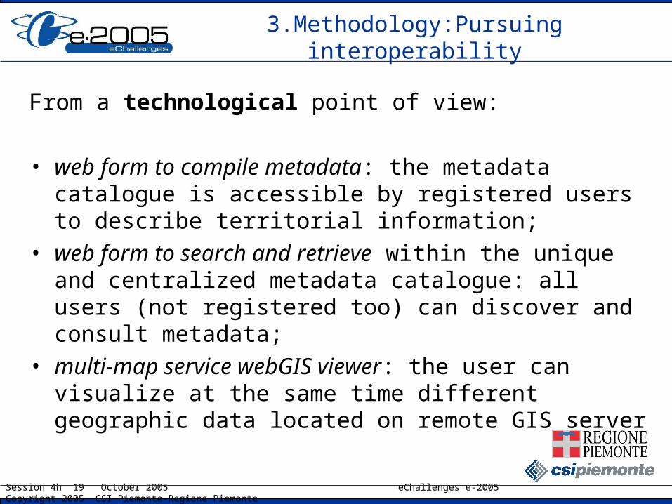
From a technological point of view:
• web form to compile metadata: the metadata catalogue is accessible by registered users to describe territorial information;
• web form to search and retrieve within the unique and centralized metadata catalogue: all users (not registered too) can discover and consult metadata;
• multi-map service webGIS viewer: the user can visualize at the same time different geographic data located on remote GIS server
Session 4h 19 October 2005 eChallenges e-2005 Copyright 2005 CSI Piemonte-Regione Piemonte
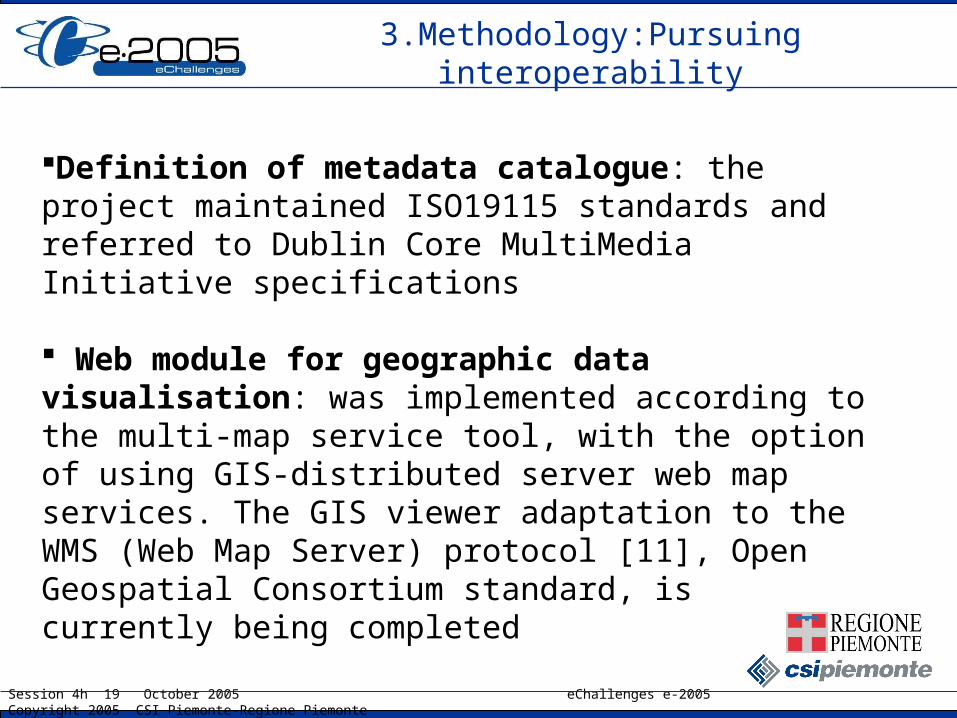
Definition of metadata catalogue: the project maintained ISO19115 standards and referred to Dublin Core MultiMedia Initiative specifications
Web module for geographic data visualisation: was implemented according to the multi-map service tool, with the option of using GIS-distributed server web map services. The GIS viewer adaptation to the WMS (Web Map Server) protocol [11], Open Geospatial Consortium standard, is currently being completed
3.Methodology:Pursuing interoperability

Session 4h 19 October 2005 eChallenges e-2005 Copyright 2005 CSI Piemonte-Regione Piemonte
Cartographic data exchange: advanced data analysis and processing functions are not yet possible, will take place activities about the adoption of another OGC standard, WFS (Web Feature Server)
Supply of metadata: the opportunity of XML files upload will bw considered
3.Methodology:Pursuing interoperability

Session 4h 19 October 2005 eChallenges e-2005 Copyright 2005 CSI Piemonte-Regione Piemonte
SDIs playground currently presents a fragmented context, but either the national perspective as well as the emerging trends require to set a
“legal interoperability”
Main issues : - There is a fragmented national legislation and regulation on
spatial information- It is ambiguous and unclear for public entities which are the
titles and rights on spatial data and geographical products- Contracts and agreements between public administrations
and companies leave often uncertain the ownership of the works which are created
3.Methodology:Pursuing interoperability
Session 4h 19 October 2005 eChallenges e-2005 Copyright 2005 CSI Piemonte-Regione Piemonte
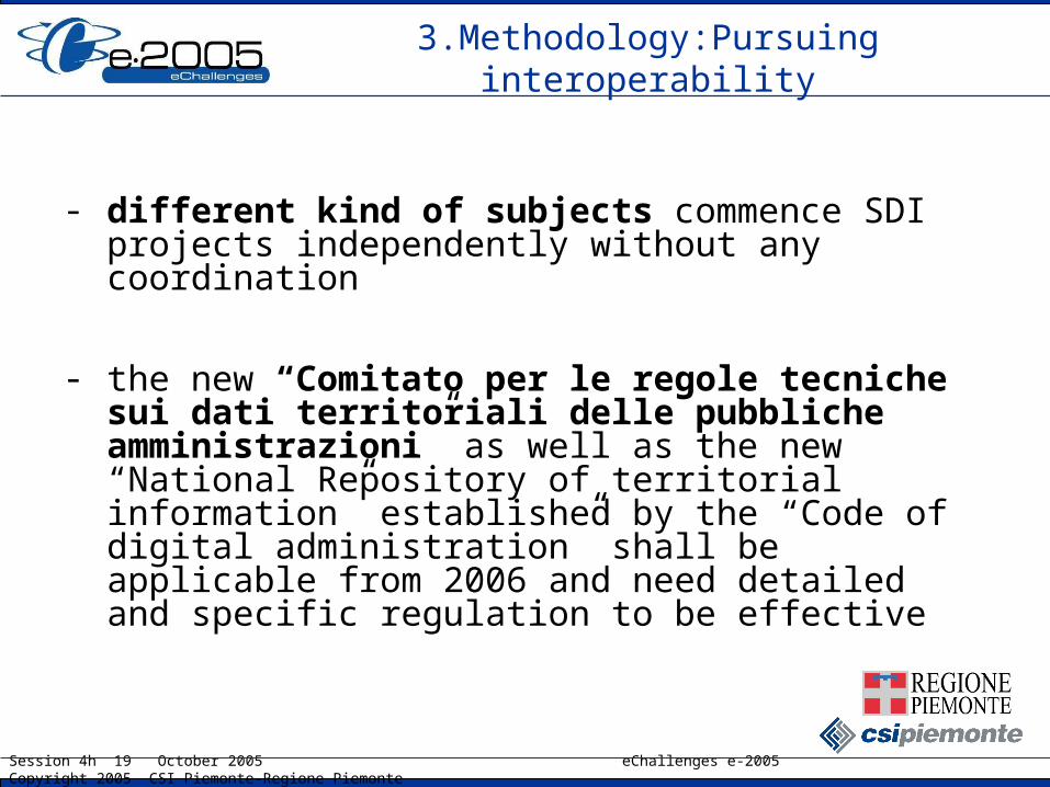
- different kind of subjects commence SDI projects independently without any coordination
- the new “Comitato per le regole tecniche sui dati territoriali delle pubbliche amministrazioni” as well as the new “National Repository of territorial information” established by the “Code of digital administration” shall be applicable from 2006 and need detailed and specific regulation to be effective
3.Methodology:Pursuing interoperability

Session 4h 19 October 2005 eChallenges e-2005 Copyright 2005 CSI Piemonte-Regione Piemonte
- lack of rules or “best practices” for sharing spatial information between public entities or for dissemination of spatial information to citizens
- INSPIRE Directive and Public Sector Information Directive are still under way
- the Atlante Italiano, as well as the Interregional Center for cartography and territorial information are still under way
3.Methodology:Pursuing interoperability
Session 4h 19 October 2005 eChallenges e-2005 Copyright 2005 CSI Piemonte-Regione Piemonte
The INSPIRE Proposed Directive itself, states (“whereas” n. 18) that
“In order to assist the integration of the national infrastructures into the infrastructure for spatial information in the Community, Member States should provide access to their infrastructures … through any access points they themselves decide to operate”
3.Methodology:Pursuing interoperability
Session 4h 19 October 2005 eChallenges e-2005 Copyright 2005 CSI Piemonte-Regione Piemonte
The new role of SITAD General Rules of Use
in order to facilitate the organizational, technical and regulatory harmonization, it has been provided that activities within SITAD shall be regulated by a specific and apposite set of regulations, which any and all the subjects who enter and use SITAD shall have to accept and comply with
3.Methodology:Pursuing interoperability

Session 4h 19 October 2005 eChallenges e-2005 Copyright 2005 CSI Piemonte-Regione Piemonte
The Rules shall be created and established by the owner of the infrastructure and shall basically determine and govern:
- the nature and the discipline of the “objects” (information, products and services) managed by the infrastructure
- the access to the infrastructure: identification, authorization and profile of the user
3.Methodology:Pursuing interoperability

Session 4h 19 October 2005 eChallenges e-2005 Copyright 2005 CSI Piemonte-Regione Piemonte
- the legal title of the user
- the conditions for metadating information, products and services
- the rules for retreiving and using information, products and services
- the role, relations and responsibilities of the players and the relations between them
- the potential conflicts which could arise by using the infrastructure
3.Methodology:Pursuing interoperability

Session 4h 19 October 2005 eChallenges e-2005 Copyright 2005 CSI Piemonte-Regione Piemonte
The nature of SITAD Rules stands between the:
administrative regulation (lex specialis or administrative regulation)
agreed general conditions, depending on the way it will be implemented by the owner Regione Piemonte (enacted-approved by legislative or regulatory bodies or agreed upon by the players acting within SITAD)
3.Methodology:Pursuing interoperability
Session 4h 19 October 2005 eChallenges e-2005 Copyright 2005 CSI Piemonte-Regione Piemonte
Promotion and diffusion tools• Workshops : presently promotional workshops are being
run by municipalities and groups of municipalities, the selected topic is use of geographic information for urban planning; It’s foreseen a direct support to municipalities
• Newsletter: a fortnightly magazine about Spatial Data Infrastructure and Geographical Information distibuited to SITAD users and published on SITAD web site
• Groupware: a system which allows users to access to a forum, to a list of FAQs, and a “document” section in which documentation can be uploaded or downloaded; this system will be used for elearning initiatives
4. Outcomes and results

Session 4h 19 October 2005 eChallenges e-2005 Copyright 2005 CSI Piemonte-Regione Piemonte
Participation to national initiatives (1)•2005 March, Rome - Presentation of SITAD to CNIPA (Centro Nazionale per l’Informatica nella Pubblica Amministrazione), to cooperate on the project “national repository of geographical data ”•2005 April, Rome – Partecipation to OpenGIS Interoperability Day with a paper titled “Geographical sevices and data interoperability in Sistema Piemonte”
4. Outcomes and results

Session 4h 19 October 2005 eChallenges e-2005 Copyright 2005 CSI Piemonte-Regione Piemonte
Participation to national initiatives (2)•2005 April, Rome –Partecipation to the ESRI Italian Users Conference with a paper titled “ A regional SDI – SITAD: Activities in Piedmont”•2005 November, Catania - Partecipation to the National ASITA Conference with a paper titled "SITAD – non-technological aspects in a SDI: legislatives rules and sharing”
4. Outcomes and results

Session 4h 19 October 2005 eChallenges e-2005 Copyright 2005 CSI Piemonte-Regione Piemonte
Participation to international initiatives (1)
• 2005 April – Call of INSPIRE (INfrastructure for SPatial InfoRmation in Europe); SITAD-Sistema Piemonte was proposed like SDIC (Spatial Data Infrastructure Community) and Regione Piemonte like LMO (Legal Mandated Organization)
4. Outcomes and results

Session 4h 19 October 2005 eChallenges e-2005 Copyright 2005 CSI Piemonte-Regione Piemonte
Participation to international initiatives(2)• 2005 June, Luxembourg – Information Day of
eContentplus Programme - A preproposal titled “SITAD experience as a way to reach cross-border information through the use of shared metadata catalogue and promotion tools” was submitted to EC officials
• 2005 October, Lubjana - Partecipation to the eChallenges Conference with a paper titled "Legislative rules and principles in building SITAD, local spatial data infrastructure in Piedmont (Italy)"
4. Outcomes and results
Session 4h 19 October 2005 eChallenges e-2005 Copyright 2005 CSI Piemonte-Regione Piemonte
Benefits of legal interoperability
INSPIRE proposed Directive (“Whereas” n. 3) provides that interoperability should positively affect
availability, quality, organisation and accessibility of spatial information
As GINIE – Geographic Information Network in Europe - Recommendations for Action states
“…a SDI is successful when there is clear authority in managing the frame work”
4. Outcomes and results
Session 4h 19 October 2005 eChallenges e-2005 Copyright 2005 CSI Piemonte-Regione Piemonte
Pricing policies
SITAD cut down the total cost of data management: • through the re-use of map services (and data) already
available,• adding value to spatial information existing at municipal
level with the central metadata catalogue and the web metadata entry application.
4. Outcomes and results
Session 4h 19 October 2005 eChallenges e-2005 Copyright 2005 CSI Piemonte-Regione Piemonte
Technological choices:
Advantages of on-line metadata compilation (1)
• The metadata catalogue is unique and available to all local PA bodies. This, in the research phase, allows better performance compared to distributed catalogues.
• The web application is unique and constantly checked. All processes are server-side, that is to say, independent of the HW-SW configurations of the workstations accessed by PA users.
5. Conclusions

Session 4h 19 October 2005 eChallenges e-2005 Copyright 2005 CSI Piemonte-Regione Piemonte
Technological choices:
Advantages of on-line metadata compilation (2)
• The application can be configured at a layout (multi-layout) level: organisations can consult their own data in a “customised” way.
• Single functional and architectural up-grade. • Definition of “who sees what” is at the discretion of the
user. The metadata “compiler” can indicate required access restrictions and which user profiles can have access to visualise these documents/data.
5. Conclusions

Session 4h 19 October 2005 eChallenges e-2005 Copyright 2005 CSI Piemonte-Regione Piemonte
By giving to the SITAD General Rules such a key role, it should be possible to:
- Provide the SITAD operational framework with specific agreed rules and add confidence and trust to the potential users
- Amend some problems concerning harmonization of the different spatial data initiatives
- Contribute to the spread and dissemination of added-value spatial information
5. Conclusions

Session 4h 19 October 2005 eChallenges e-2005 Copyright 2005 CSI Piemonte-Regione Piemonte
- Facilitate the local authorities to participate to the current activities according to the EC principles of subsidiarity, making the existing systems interoperable, accessible and useable as much as possible
- Anticipate some of the positive effects of the European regulation still to come or to be implemented at the national level
- Raise awareness of importance of issues like protection policies of spatial information titles and interests
5. Conclusions
Related Documents


