MINUTES OF THE SECOND JAPAN-AUSTRALIA GEO-LEO APPLICATIONS WORKSHOP 1 st – 2 nd September 2016 Tokyo, Japan VERSION 1.0

Welcome message from author
This document is posted to help you gain knowledge. Please leave a comment to let me know what you think about it! Share it to your friends and learn new things together.
Transcript

MINUTES OF THE SECOND JAPAN-AUSTRALIAGEO-LEO APPLICATIONS WORKSHOP
1st – 2nd September 2016Tokyo, Japan
VERSION 1.0

2nd Japan-Australia GEO-LEO Applications Workshop1st – 2nd September 2016 Tokyo, JapanMinutes V1.0
Session 1: Introduction
Welcome
Masahiko Honzawa (JAXA) welcomed everyone to the meeting and led a tour-de-table. Participants are listed in Appendix A.
Process & Context
Matt Steventon presented some scene-setting information, noting the background of the initiative, the purpose of the second workshop, and the goal of investigating the potential for focus demonstration projects for the GEO-LEO collaboration around hotspot/haze monitoring and ocean parameter monitoring (sea surface temperature and ocean colour).
He noted that the initiative was founded as a forum to foster Japan-Australia collaboration on the development of applications that benefit from the high temporal and spatial resolution of combined GEO and LEO observations – making the most of Japan’s data streams and Australia’s application capabilities.
The potential benefits of establishing focus projects include:
Focusing our collaborative work to develop innovative new applications; Practically demonstrate the regional benefits of the Japan-Australia GEO-LEO
collaboration; Demonstrate the societal benefits that can be realised from the Himawari programme
and highlight the ROI for the Japanese taxpayer; Commercial and public good opportunities.
Teruyuki Nakajima (JAXA) asked whether CSIRO is currently planning any specific follow up to their 2016 CEOS Chair initiative on Non-Meteorological Applications for Next Generation Geostationary Satellites (NMA). Matt stated that he is unaware of any activities at this stage, and he added that any follow up in the frame of CEOS is pending the finalisation of the NMA ad hoc team’s report and recommendations.
Advanced Performance of Himawari-8 in Operation
Kazumi Kamide (JMA) presented an overview of the Himawari programme. He noted that the spectral characteristics and spatial resolutions of new generation GEO imagers are approaching that of their LEO counterparts, presenting opportunities to unlock new information and develop innovative applications. He noted the temporal characteristics of Himawari-8 and the data dissemination methods, as well as the recent updates to the ground processing system that improve IR band co-registration, coherent noise reduction, and the resampling procedure. See the presentation file for more details of the updates and results.
Himawari-8 related activities in CEReS, Chiba University
The Chiba University Center for Environmental Remote Sensing (CEReS) performs data archiving for JMA, and also maintains copies of data from the GOES, Meteosat, and FY-2 series of satellites. They currently have an archive spanning 10 years and distribute JMA
Page 2

2nd Japan-Australia GEO-LEO Applications Workshop1st – 2nd September 2016 Tokyo, JapanMinutes V1.0
data (HS, NetCDF, PNG) as well as a free-and-open CEReS gridded product. Key users served by CEReS include Chiba University, Yamaguchi University, JAXA, CSIRO, JAMSTEC, and Kyoto University.
Atsushi Higuchi (Chiba University) showed a video that demonstrated the haze/smoke effect that biomass burning in China has on northern Japan. He also demonstrated his research on the use of Himawari-8 imagery to forecast rain occurrence and volume – showing overall good correlation with radar information, despite a few minor errors suspected to be due to resampling. He noted that Chiba University researchers are also using Himawari-8 for the analysis of short-wave IR, which has applications in agriculture.
Chiba University is also developing capabilities for near-real time monitoring and forecasting (via modelling). Higuchi-san closed by noting that CEReS is open to collaborative research opportunities.
Session 2: Status Report – Land, Ocean, and Atmosphere Domain Teams
Land
Koji Kajiwara (Chiba University) spoke about two potential applications of combined Himawari-8 and GCOM-C data. Firstly, he suggested a drought detection system using a Water Stress Index (WSI) derived using high-frequency Himawari-8 solar radiation time series (developed by Dr. Takenaka, JAXA/EORC) in combination with GCOM-C land cover data. Such a system would support early warning of forest fires in the Asian region by observing dry environmental conditions. The second potential application is hot spot detection using high-frequency time series of thermal infrared data. Kajiwara-san presented demonstrations of these applications (see presentation file).
Luigi Renzullo (CSIRO) presented an update on the land domain work ongoing in Australia, including Land Surface Temperature (LST) retrieval investigations and CSIRO’s work with Beijing Normal University to explore the application of AHI visible channels to infer Leaf Area Index (LAI) and Leaf Angle Distribution (LAD).
A joint project between CSIRO (Luigi Renzullo), BOM (Leon Majewski) and Curtin University (Peter Fearns) aims to implement and evaluate AHI LST retrievals and assess: performance against LEO instruments (e.g., MODIS, Landsat); and the accuracy required for surface energy balance studies. Given the similarity between AHI and ABI, CSIRO has adopted the research of Dr. YunYue Yu (NOAA) and is applying recommended Split Window Algorithms (SWAs) to Himawari-8 data to assess the required accuracy for generation of certain products, in particular evapotranspiration (ET). LST retrievals for Australia have been compared with those from MODIS, and while the results display varying degrees of bias, they are overall well correlated.
Luigi closed by outlining some next steps for the LST product development and desired outcomes from the Japan-Australia collaboration. The LST team will investigate the use of ACCESS TCWV, explore alternatives for emissivity (including adapting dynamic land cover classification approaches), evaluate the inclusion of flux tower data (potentially from OzFlux, AsiaFlux, Fluxnet), and explore further application of cloud masking. Luigi is keen to progress collaboration with the Japanese team, noting that the collaboration presents a good opportunity to compare methods, data and results.
Page 3
2nd Japan-Australia GEO-LEO Applications Workshop1st – 2nd September 2016 Tokyo, JapanMinutes V1.0
Shin-ichi Sobue (JAXA) noted the substantial difference in the Himawari-8 and Terra LST bias compared to the Himawari-8 and Aqua LST bias. Luigi reported that the reason for the difference is not clear at this stage.
Ocean
Hiroshi Murakami (JAXA) presented an update on ocean-related EO research ongoing within Japan. He noted in particular that JAXA EORC are producing a variety of sea products from AMSR-2, as well as Sea-Surface Temperature and Chlorophyll-a distributions from AHI. The products derived from Himawari-8 demonstrate a variety of dynamic features/phenomena that are not visible in LEO results. Murakami-san noted that the EORC has also developed methods to estimate solar irradiance in the ocean at various depths using the optical properties of water – facilitating estimation of plant growth in the ocean.
Tim Malthus (CSIRO) presented a summary of Australian ocean domain work on behalf of researchers at Curtin University (ocean colour), CSIRO (ocean colour) and the Australian Bureau of Meteorology (SST).
CSIRO’s work is focused on coastal atmospheric correction based on inverse modelling of radiative transfer simulations using artificial neural networks, as well as extending radiometric measurements and facilitating lab and field inter-comparisons under the Integrated Marine Observing System (IMOS). CSIRO has identified the following potential collaboration opportunities:
The development of ocean/coastal monitoring solutions for developing APEC countries/ the Coral Triangle;
Supporting fisheries management by supplying ocean colour and SST products; Advancing risk management tools for coral bleaching (e.g., the Australian ReefTemp
service) by supplying ocean colour/CDOM products as surrogates for salinity measurements; and,
Exploring the application of the Australian Geoscience Data Cube to deliver services.
Page 4

2nd Japan-Australia GEO-LEO Applications Workshop1st – 2nd September 2016 Tokyo, JapanMinutes V1.0
The Remote Sensing and Satellite Research Group at Curtin University are looking at all domains, but are mostly focused on the environmental impacts of coastal activities, such as dredge operations in north-western Western Australia; river outflows; and the impact of severe storms on the re-suspension of sediments. Curtin University is investigating the use of Himawari-8/AHI for coastal monitoring, LST retrievals, and turbid event compliance. They have reported that the Total Suspended Sediment (TSS) results from AHI appear consistent with those from MODIS.
Curtin University have identified collaboration potential in the following areas:
Suspended sediment algorithm developmento Hyperspectral model applied to MODIS, Landsat, WorldView-2, and AHIo In situ validation
Application of change detection algorithms to coastal monitoringo Dredge monitoring
Compliance Light at depth
o River outflows and their impact on reefs, seagrass, etc.
The Australian Bureau of Meteorology (BOM) relies heavily on satellites for imagery, meteorological products, and non-meteorological products (such as solar radiation, vegetation indices, and SST). BOM has been investigating the application of AHI for cloud mask/detection, SST, and combinations with LEO observations. They have found that AHI SST retrievals demonstrate good performance and high sensor stability/calibration.
BOM has identified the following potential areas of collaboration:
Detector noise improvement/correction (line detection) Navigation correction
o Auto-correlation to detect changeso Coastline match/affine transform to correct
Taking advantage of the high temporal resolution of AHIo Incorporate temporal changes/trendso Cloud object tracking
Improve uncertainty estimateso Fast inter-sensor comparisons
Improve compositing methodologieso Uncertainty basedo Tailored for user needs
Atmosphere
Teruyuki Nakajima (JAXA) presented on behalf of the Japanese atmosphere domain team. He opened by presenting JAXA’s portfolio of Earth observation missions (shown below). He noted that the greatest uncertainty around the effect of radiative forcing is the direct/indirect role of the cloud-aerosol system, and GCOM-C/SGLI and EarthCARE/CPR are key to furthering our understanding of this relationship and future climate scenarios.
Page 5
2nd Japan-Australia GEO-LEO Applications Workshop1st – 2nd September 2016 Tokyo, JapanMinutes V1.0
Nakajima-san presented some further information related to SGLI (see slides for details) and closed by summarising the Himawari-8 products being distributed by JAXA EORC (shown below; underlined products are produced regularly and starred products will be released shortly). JAXA’s products can be obtained via FTP following a simple user registration process, see: http://www.eorc.jaxa.jp/ptree/
Ian Grant (BOM) spoke briefly about work ongoing in Australia related to solar radiation and ozone/UV (aerosols will be covered in a dedicated presentation during the hotspot and haze/aerosol session). While the Bureau’s main focus is applying Himawari-8 data for weather forecasting, there are R&D activities around select non-meteorological applications.
Solar radiation products from Himawari-8 are under development by BOM. The solar radiation scheme implemented by BOM relies on two separate software packages: GEOCAT to process Himawari-8 data and derive cloud properties (Cloud Optical Depth (COD) is the most important cloud parameter for solar radiation); and Heliosat-4, which takes cloud properties and ancillary data to model solar radiation at the surface. BOM hopes to derive UV maps from Himawari-8/AHI data, and the following parameters are necessary:
Total Column Ozoneo Derive from AHI using a regression algorithm
Clear-sky UVo Modelled from AHI Total Column Ozone and other constituents
Cloud-adjusted UVo Adjust clear-sky UV using GEOCAT cloud properties (perhaps based on Heliosat-4)
Page 6

2nd Japan-Australia GEO-LEO Applications Workshop1st – 2nd September 2016 Tokyo, JapanMinutes V1.0
Session 3: Hotspot Detection and Haze/Aerosol Monitoring
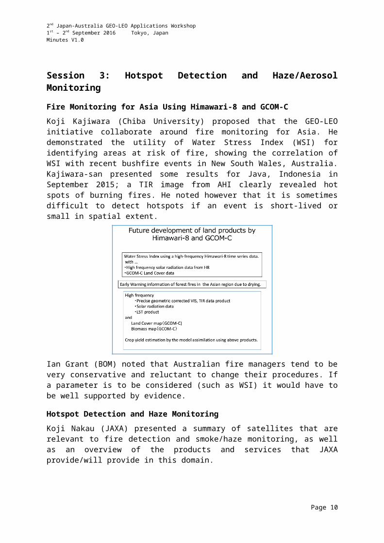
Fire Monitoring for Asia Using Himawari-8 and GCOM-C
Koji Kajiwara (Chiba University) proposed that the GEO-LEO initiative collaborate around fire monitoring for Asia. He demonstrated the utility of Water Stress Index (WSI) for identifying areas at risk of fire, showing the correlation of WSI with recent bushfire events in New South Wales, Australia. Kajiwara-san presented some results for Java, Indonesia in September 2015; a TIR image from AHI clearly revealed hot spots of burning fires. He noted however that it is sometimes difficult to detect hotspots if an event is short-lived or small in spatial extent.
Ian Grant (BOM) noted that Australian fire managers tend to be very conservative and reluctant to change their procedures. If a parameter is to be considered (such as WSI) it would have to be well supported by evidence.
Hotspot Detection and Haze Monitoring
Koji Nakau (JAXA) presented a summary of satellites that are relevant to fire detection and smoke/haze monitoring, as well as an overview of the products and services that JAXA provide/will provide in this domain.
Page 7

2nd Japan-Australia GEO-LEO Applications Workshop1st – 2nd September 2016 Tokyo, JapanMinutes V1.0
Nakau-san outlined the satellite data sets that JAXA uses/will use to derive fire-related products, noting the following dependencies:
Fire location (CIRC, SGLI, Himawari-8/AHI) Smoke (GOSAT, GCOM-C) Fire danger (GSMaP, GCOM-C, GCOM-W)
GSMaP can be used as an input for fire risk index models, and soil water content from AMSR-2 is also very useful. Modelling is used to derive fire smoke production, smoke transportation and fire danger metrics. CIRC is a key instrument for fire detection, and Nakau-san presented some results and methodologies.
A fire location product from Himawari-8 is being developed, and should be released via the JAXA Himawari Monitor in the next Japanese financial year. Nakau-san also noted the online platform: JAXA Satellite Monitoring for Environmental Studies (JASMES), which provides a suite of global and regional environmental products.
Ian Grant (BOM) reported that the Australian Bureau of Meteorology is also working to integrate soil moisture measurements into their fire danger processes.
Aerosol Products from Himawari-8 and the Health Impacts of Smoke in Australia
Ian Grant (BOM) reported that there are two approaches used to derive Aerosol Optical Depth (AOD) in Australia. AOD results are verified using BOM and CSIRO ground stations.
AHI-MODIS/VIIRS aerosol and surface BRDF retrievals can be achieved using the CSIRO Dual-View Algorithm (originally developed for AATSR). The algorithm provides aerosol classifications, and radiative transfer modelling provides a direct link between surface BRDF and Top of Atmosphere (TOA) reflectance. The algorithm requires cross-calibration between AHI and MODIS/VIIRS (spectral band conversion and radiometric calibration). The plan is to extend the algorithm for application to Himawari-8/AHI + GCOM-C/SGLI through a CSIRO-JAXA collaboration.
Multi Angle Implementation of Atmospheric Correction (MAIAC), developed by Alexei Lyapustin (NASA/GSFC) is another method. MAIAC simultaneously retrieves aerosol optical thickness and type, surface reflectance, and cloud masks, and has been applied to MODIS,
Page 8

2nd Japan-Australia GEO-LEO Applications Workshop1st – 2nd September 2016 Tokyo, JapanMinutes V1.0
VIIRS, DSCOVR/EPIC, and GOES-R data. A BOM-NASA collaboration is planned to apply the algorithm to Himawari-8/AHI.
Ian noted the significant health impacts caused by smoke from fires and other particulates, reporting for example that one particular study showed that annually in Australia, up to 430 premature deaths – equivalent to 5800 Years Life Lost (YLL) – can be linked to exposure to anthropogenic particulate matter. Smoke source and transport modelling/forecasting is a key potential application of Himawari data. The Centre for Air quality and health Research and evaluation (CAR) is a key stakeholder. The University of New South Wales is also heavily involved, with their Asia Initiative for Research on Climate and Air Pollution (AIRCAP) project, which aims to investigate the short- and long-term effects of air pollution and climate change on human health in Asia. Ian also noted an Australian-Malaysian research project on forest fire smoke effects, which has funding for a pilot project and will kick-off in late 2016/early 2017.
Ian closed by noting some potential opportunities for the GEO-LEO initiative:
Teruyuki Nakajima (JAXA) noted that JAXA contributes to the Asia Pacific Clean Air Partnership (APCAP) by supporting smoke estimation and modelling. Ian noted that connecting with initiatives such as APCAP is key to realising significant outcomes from the Japan-Australia GEO-LEO initiative.
Aerosol Monitoring
Maki Kikuchi (JAXA) presented on Himawari-8 aerosol product development at the JAXA EORC. JAXA’s Himawari Monitor launched in August 2015 and is the platform used for disseminating images and data.
Two aerosol products are targeted: Level 2 aerosol properties (snapshot every 10 minutes, already released – update planned for autumn 2016) and Level 3 aerosol properties (hourly combined product, also planned for release in autumn this year). The Level 2 algorithm is consistent with JAXA’s algorithms for GCOM-C/SGLI, GOSAT-2/CAI-2, and EarthCARE/MSI.
Kikuchi-san detailed the specifics of the Level 2 snapshot algorithm and also spoke about the update planned for autumn release. The updated algorithm will use an improved cloud flag; a common algorithm for ocean and land; aerosol absorption information from observations,
Page 9
2nd Japan-Australia GEO-LEO Applications Workshop1st – 2nd September 2016 Tokyo, JapanMinutes V1.0
rather than assumptions; and will apply more channels. These changes will result in fewer cloud contaminations and increase the valid area of observation.
The Level 3 hourly combined product removes contaminations due to edge effects, sun glint and cloud effects. Spatiotemporal variability characteristics of aerosol optical thickness are evaluated using data from the surrounding 12.5km and past 1 hour. The resultant characteristics are used to eliminate cloud contaminated pixels and derive a highly accurate aerosol dataset. Aerosol transport dynamics are captured much better than with polar orbiting satellites.
JAXA EORC is working with JMA/MRI, the National Institute for Environmental Studies (NIES) and Kyushu University on data assimilation and aerosol prediction using modelling. The following image shows the potential benefits of data assimilation. An underestimation of anthropogenic air pollution over western Japan and an overestimation of a large dust storm over inner Mongolia/central-east China were improved by using both GEO and LEO data.
Luigi Renzullo (CSIRO) asked why Australia couldn’t just use JAXA EORC products that are available via the Himawari Monitor rather than develop products independently. Ian Grant (BOM) acknowledged the suggestion and stated that Australia could investigate these products.
Action 01Maki Kikuchi, Ian Grant and Luigi Renzullo to initiate a dialogue around the opportunities for validation of JAXA’s AOT products using Australian ground validation sites.
December 2016
Page 10

2nd Japan-Australia GEO-LEO Applications Workshop1st – 2nd September 2016 Tokyo, JapanMinutes V1.0
JMA Asian Dust Monitoring Using Himawari-8 Products
Daisaku Uesawa (JMA) noted some of the Himawari-8 products that are produced by JMA/MSC and provided to the JMA Atmospheric Environment Division (AED) for monitoring dust, including: VIS, IR brightness temperature difference, AOD, and RGBs (true colour and dust). Uesawa-san noted that there are many additional RGBs available via the JMA website in real time. JMA has been providing aeolian asian dust information based on numerical forecasts and surface observations since January 2004, and satellite observations provide key supporting information.
A new type of true colour RGB (TCR – True Colour Reproduction) has been developed through a collaboration between JMA/MSC and the NOAA/NESDIS GOES-R Algorithm Working Group Imagery Team. TCR features improved atmospheric correction (Rayleigh scattering correction) to make the imagery more vivid, optimally adjusted green correction, and RGB chromaticity conversion to sRGB for output devices (i.e. computer displays), among other enhancements. More information is available at: http://www.data.jma.go.jp/mscweb/data/himawari/index.html
An AOD algorithm for Himawari-8 was developed by JMA’s Meteorological Research Institute (MRI) and introduced into the Meteorological Satellite Center (MSC) of JMA. Uesawa-san noted some of the technical details of the AOD product (see slides for details).
Integrating Hotspot Measurements from Himawari-8 into the Sentinel Bushfire Monitoring System
Medhavy Thankappan (GA) introduced the Australian Sentinel Bushfire Monitoring System, which has been operating since 2005 using data from Aqua, Terra, NOAA-19 and Suomi-NPP. GA has received a government grant to introduce 10-minute data from Himawari-8, and are working with the University of Wisconsin to customise an existing hotspot algorithm (WildFire Automated Biomass Burning Algorithm, WFABBA) for application to Himawari-8 (delivered in May 2016, performance evaluation is currently ongoing).
The WFABBA processing time and accuracy have been evaluated across three different time periods and compared to results from MODIS. Most commission errors (i.e. false positives) occurred in day time; with night time images showing good correlation with MODIS hotspots. Many Himawari-8 hotspot commission errors occurred in the Northern Territory during January. Medhavy reported that events with a low Fire Radiative Power (FRP) were most likely to mismatch the results from MODIS.
Page 11

2nd Japan-Australia GEO-LEO Applications Workshop1st – 2nd September 2016 Tokyo, JapanMinutes V1.0
National-scale hotspots support Federal Government information needs; aid fire-related land management in remote areas (e.g., North Australian Fire Information); act as additional data sources for state systems (e.g., Emap-Victoria); and provide redundancy for fire towers, air observations and community reports. The inclusion of Himawari-8 data will enable characterisation for active fires and pre- and post-fire monitoring applications.
Medhavy closed by noting that hotspot information is released to fire managers via secure access to the Sentinel server. Matt Steventon noted a previous comment from Ian Grant (BOM) which suggested that fire managers are reluctant to use new tools and services for their work. Medhavy acknowledged the issue, noting that the data is being released with heavy caveats and primarily as a secondary data source to support other tools/information.
Medhavy noted that GA will be happy to share outputs with the Japanese team if requested.
Dynamic Ecological Observations from Satellites to Inform Aerobiology of Allergenic Grass Pollen
Alfredo Huete (UTS) introduced his research on the potential role of GEO and LEO satellite observations to track pollen aeroallergens for public health applications and forecasts. The project is led by the Australian National Health and Medical Research Council (NHMRC).
Alfredo noted that grass pollens are the most widespread source of aeroallergens globally, inducing allergic asthma and rhinitis – increasingly so since the 1960’s, although the cause for the increase is unknown.
Conventional methods for monitoring airborne pollen require adequate sampling sites, and are based upon site-specific empirical meteorological relationships. In situ measurements are also time and cost prohibitive. Satellite remote sensing of pollen-conducive landscape conditions, in combination with transport modelling, is a potential alternative method for pollen forecasting. Alfredo showed some examples that demonstrated the correlation between growth stages of known aeroallergenic pollen sources and pollen exposure.
Alfredo closed by noting that the increased temporal resolution of GEO imagers such as Himawari-8 will be particularly useful for short-term forecasting.
Page 12

2nd Japan-Australia GEO-LEO Applications Workshop1st – 2nd September 2016 Tokyo, JapanMinutes V1.0
Session 4: Ocean Colour and Sea Surface Temperature Monitoring
Ocean Colour Products from Satellite Data
Hiroshi Murakami (JAXA) spoke about some of the ocean colour products being developed by the JAXA EORC using Himawari-8/AHI and some simulated GCOM-C/SGLI 250m results.
Substantial collaborations – both domestic and international – have been established with researchers to develop products that integrate GCOM-C with in situ and modelled data. The results will enable monitoring and prediction of the ocean carbon budget and the coastal environment.
Murakami-san closed by detailing the specifics of the chlorophyll-a results from Himawari-8/AHI, noting that they are well correlated with in situ results from JMA research vessels and the AERONET-OC Lucinda site (see slides for details). Some other summarising statements are presented below.
Sea Surface Temperature Products from Satellite Data
Misako Kachi (JAXA) noted that JAXA develops and distributes various satellite SST products as a contribution to the GHRSST (Group on High Resolution SST) and the CEOS SST-VC. SST products are distributed in NetCDF format through the JAXA server. Kachi-san also noted that 7GHz passive microwave channels are indispensable for retrieving global SST and soil moisture measurements. All-weather, frequent measurements enable analyses of rapid changes of SST; and time-proven infrared measurements and passive microwave observations are complementary in terms of spatial resolution and error sources.
An impressive Himawari-8 SST demonstration was presented. The animation showed the cooling of the sea surface in the wake of a typhoon passing overhead. Himawari-8 SST products are available via the JAXA Himawari Monitor and they have been developed using the GCOM-C/SGLI SST algorithm as a basis. Some specific technical details were presented and improvements between version 1.1 and 1.2 of the algorithms were presented (see
Page 13

2nd Japan-Australia GEO-LEO Applications Workshop1st – 2nd September 2016 Tokyo, JapanMinutes V1.0
slides). Himawari-8 SST results are being integrated into ocean forecast models operated by JAMSTEC.
Teruyuki Nakajima (JAXA) asked whether AMSR-2 SST data is also being integrated into the models operated by JAMSTEC. Kachi-san reported that this is not yet done, but it is planned for 2016.
Sea Surface Temperature Monitoring for the Western North Pacific at JMA
Toshiyuki Sakurai (JMA) reported that JMA’s Office of Marine Prediction (OMP) is responsible for providing oceanographic information in the western North Pacific. SST analyses/forecasts are one of the key OMP products, supporting fisheries and other marine industries (ship routing, tourism, etc.); recreation; oceanographic environment monitoring (coral bleaching, etc.); ocean data assimilation; and providing boundary conditions for the weather forecasting system. The SST sources used by OMP are noted in the figure below.
JMA’s Meteorological Satellite Center (MSC) produces Himawari-8 Level 3 SST data using the same retrieval algorithm as used by JAXA (based on a quasi-physical algorithm) and the cloud mask is based on JMA’s fundamental cloud product for Himawari-8. The results are
Page 14

2nd Japan-Australia GEO-LEO Applications Workshop1st – 2nd September 2016 Tokyo, JapanMinutes V1.0
verified using buoy networks, and they have been shown to be a significant improvement over those derived from MTSAT-2.
OMP provides three SST products: Himawari-8 SST imagery (operational), Merged satellite and in situ data Global Daily Sea Surface Temperature (MGDSST, operational) and High-resolution MGDSST (HIMSST, experimental).
MGDSST is OMP’s standard SST product, which uses AVHRR (NOAA-18, 19, MetOp-A), AMSR-2, Windsat, and in situ data. The biases of satellites’ data are corrected using in situ measurements. MGDSST is used as a lower boundary condition for NWP models and also as observational data for ocean assimilation systems. Additionally, MGDSST contributes to the GHRSST Multi-Product Ensemble (GMPE) system. HIMSST is a high-resolution MGDSST experimental product using AVHRR, AMSR-2, Himawari-8, and in situ sources.
Sakurai-san closed with the following summary:
Coastal Applications and IMOS Validation Support for Himawari-8
Tim Malthus (CSIRO) reviewed some of the reasons why CSIRO is applying GEO data for ocean colour monitoring. He noted that coastal waters are highly dynamic and require more frequent sampling/observations. Geostationary imagers facilitate the study of diurnal cycles, monitoring and forecasting of the dispersal of flood plumes and harmful algal blooms to improve environmental risk assessment and management, and provide key data for assimilation into biogeochemical models. LEO observations occur during different tidal cycles, making it difficult to perform accurate comparisons.
Tim noted the Schroeder et al. (2007) MERIS atmospheric correction algorithm that is being adapted to Himawari-8 images by CSIRO (see slides for further details). The first results were produced in 2015, and Tim noted that the spatial features were as expected – with higher reflectance in turbid coastal regions – and good de-correlation of atmospheric and oceanic signals over turbid waters (no oceanic features in AOD results). Further development is planned, specifically around accounting for ozone and surface pressure variability during inversion; performing consistency analysis of the diurnal reflectance cycle; inter-comparing results with LEO (MODIS, VIIRS, OLCI); and validation with IMOS ground observations. Collaboration with JAXA is desired for algorithm evaluation and data sharing.
Level 2 validation is performed at the Lucinda Jetty validation site, as well as using ship-borne above-water radiometry. The Lucinda site offers continuous above and in-water
Page 15

2nd Japan-Australia GEO-LEO Applications Workshop1st – 2nd September 2016 Tokyo, JapanMinutes V1.0
optical measurements, as well as fortnightly water quality sampling. A hyperspectral instrument (DALEC) was added to the Lucinda site in May 2016. All optical data is available here: https://portal.aodn.org.au/
Australian BOM SST Products from Himawari-8 and LEO Missions
Ian Grant (BOM) noted that the Australian Bureau of Meteorology uses SST for its NWP schemes, forecasting of typhoon intensity, and fog forecasting. Long SST records are also useful climate data records. BOM uses real time AVHRR at 1km resolution; received directly by regional ground stations (see below). 4km global data is also available with a delay. The Antarctic is also covered for shipping purposes. Many different product types are produced by the Bureau (swath, map, composites) and uncertainties are measured by comparison with floating buoys.
Ian presented the eReefs service – a six-year 30 million AUD collaborative project that combines government commitment to reef protection, world-class scientific innovation and contributions from leading Australian businesses. Commenced in January 2012, the project is focused on the protection and preservation of the Great Barrier Reef, and forms the first step in building a comprehensive coastal information system for Australia. Satellite remote sensing provides SST and ocean colour inputs via the marine water quality dashboard, which enables access to near real-time data on sea surface temperatures, chlorophyll levels, sediments and light for the entire Great Barrier Reef.
Page 16

2nd Japan-Australia GEO-LEO Applications Workshop1st – 2nd September 2016 Tokyo, JapanMinutes V1.0
Ian closed by summarising the approach used for the Bureau’s real-time Himawari-8/AHI SST product. A regression-based approach was selected as it is fast and standalone, however it requires training data, which is provided by NOAA-ACSPO VIIRS SST L2P. A number of models/bands have been trialled, and BOM found that performance is only weakly linkedto complexity. As such, a simpler model using only the LWIR bands was selected – facilitating day and night acquisitions without discontinuities. Further work is planned, as outlined below.
Dredge and Flood Plume Remote Sensing
Peter Fearns (Curtin University) reported on some of the work ongoing at Curtin University to help manage and monitor sensitive coastal environments, comprising multidisciplinary studies of coastal processes, ecosystems and models. Curtin University researchers are using
Page 17

2nd Japan-Australia GEO-LEO Applications Workshop1st – 2nd September 2016 Tokyo, JapanMinutes V1.0
currently under-utilised remote sensing technologies to aid regulatory authorities that manage coastal developments (such as dredging of ports/harbours) across regions of interest that are vast, remote, hostile, and expensive to work in.
As done at the CSIRO Lucinda site, Curtin is using the DALEC hyperspectral instrument for in situ measurements. The measurements are used to validate atmospheric correction algorithms.
Peter demonstrated some results derived from MODIS data that show the effects of dredging and sediment dumping off the coast of Western Australia. Long-term time series were used to derive background TSS levels, for comparison with known dredging events. An analysis has also been performed to judge the accuracy of various Landsat and MODIS TSS algorithms.
There are dramatic changes to the percentage and characteristics of the light that reaches the sea floor with small variations in TSS concentration and depth. The relationship between light, TSS and depth can be applied to any of the TSS metrics to show the expected change in light available at the substrate. This is an important metric to have to estimate plant/sea grass growth in the ocean.
Himawari-8/AHI has been applied to derive a TSS product, and has the potential for near real-time monitoring of sediment plume dispersals, however, unfortunately there is no in situ validation data available, as the field campaign ended just prior to the operation of Himawari-8.
Peter closed with the following summary of Curtin University’s capabilities and findings:
Teruyuki Nakajima (JAXA) asked whether the methods presented could also be applied to inland water bodies such as fresh water lakes etc. Peter reported that there should be no issues as long as there are no substantial edge effects and the water body is large enough.
Page 18

2nd Japan-Australia GEO-LEO Applications Workshop1st – 2nd September 2016 Tokyo, JapanMinutes V1.0
Session 5 & 6: Breakout SessionsFollowing the plenary session, two groups were formed to discuss the focus topics:
1. Hotspot detection and haze/aerosol monitoring; and,2. Ocean colour and sea surface temperature monitoring.
Summaries of the two breakout sessions, as presented during the workshop by Shin-ichi Sobue (JAXA) and Tim Malthus (CSIRO), are attached in Appendix B and C. The resulting actions are recorded in Appendix D, along with those from the plenary session.
Session 7: Wrap UpShin-ichi Sobue (JAXA) presented a brief summary of the workshop. He noted that both breakout groups:
Identified good opportunities for cross-validation of work; Noted the need to establish relationships with user groups; and, Should assess potential contributions to existing frameworks.
Shin-ichi noted that the hotspot detection and haze/aerosol group took an action to write up a summary of products of interest for comparison/validation – including POCs, targets, etc. and he proposed that the ocean colour and sea surface temperature team should do the same.
Shin-ichi noted that we will share our progress and a summary of the workshop at the upcoming CEOS SIT Technical Workshop for information. We would like to be able to present case studies (using existing systems) at the upcoming APRSAF-23 (Manila, November) to report progress and contact stakeholders (for example, the Asian Development Bank, Indonesian authorities, etc.) and then follow up at APRSAF-24 in 2017 with specific demonstrations of the societal benefits of the collaboration focus projects.
We will aim to establish quarterly catch-up teleconferences to keep the communication lines open and track progress while we work towards the next GEO-LEO meeting, to be held in Australia in 2017.
Closing Remarks
Shin-ichi Sobue (JAXA) thanked everyone for their attendance and noted the excellent progress that has been made. On behalf of the Australian team, Ian Grant (BOM) thanked the Japanese team for their hospitality and organisation of a very productive workshop. Shin-ichi wished everybody safe travels and adjourned the meeting.
Page 19

2nd Japan-Australia GEO-LEO Applications Workshop1st – 2nd September 2016 Tokyo, JapanMinutes V1.0
APPENDIX A – Attendees
Organisation Name Organisation NameAustralian BOM Ian Grant JAXA Shin-ichi Sobue
Chiba University Atsushi Higuchi JAXA Shizu Yabe
Chiba University Koji Kajiwara JAXA Teruyuki Nakajima
CSIRO Luigi Renzullo JAXA Yoshiaki Kinoshita
CSIRO Tim Malthus JAXA Yoshinori Yoshimura
Curtin University Peter Fearns JMA Hiroshi Kunimatsu
GAMedhavy Thankappan JMA Hitomi Miyamoto
JAXA Chu Ishida JMA Shiro Ohmori
JAXA Daisuke Tajiri JMA Toshinori Aoyagi
JAXA Hiroshi Murakami JMA Toshiyuki Sakurai
JAXA Ko Hamamoto JMA/MSC Daisaku Uesawa
JAXA Koji Nakau JMA/MSC Kazumi Kamide
JAXA Maki Kikuchi JMA/MSC Masaya Takahashi
JAXA Masahiko Honzawa RESTEC Koji Akiyama
JAXA Matthew Steventon RESTEC Tsugito Nagano
JAXA Misako Kachi RESTEC Yukio Haruyama
JAXA Nozomi Tomizawa UTS Alfredo Huete
JAXA Riko Oki
Page 20

2nd Japan-Australia GEO-LEO Applications Workshop1st – 2nd September 2016 Tokyo, JapanMinutes V1.0
APPENDIX B – Ocean Colour and Sea Surface Temperature Monitoring Breakout Session SummaryOverall Goal: Support fisheries, navigation and conservation related activities in the ‘Coral Triangle’.Fisheries related aspects: Fishing ground detection (SST,
ocean colour, currents) Coping with
overfishing/sustainability, illegal and unregulated fishing
Safety of navigation (currents, etc.) Assimilation with modelsConservation related Preserving coral ecosystems (development impacts, bleaching) Mangrove systems Harmful algal blooms Tourism (water quality, biodiversity, aesthetics)Many of these aspects require high-resolution data, however there is the potential for blended GEO-LEO products that overcome the temporal limitations of LEO sensors. There is also the potential to exploit high temporal resolution Himawari-8 data by assimilating it with models to provide forecasts of, for example, algal blooms and stress related to bleaching. There is also the potential to develop a prototype of a product distribution system for the delivery of data over large regional areas.
Relevant Existing Programmes and Systems
Coral Triangle initiative http://www.coraltriangleinitiative.org/ INDESO – Indonesia http://www.indeso.web.id (shown interest in Himawari-8 data) SEAFDEC – Southeast Asian Fisheries Development Center
http://www.seafdec.org/about/
Activities
Engage with the identified bodies to discuss key themes, their needs, interest in remote sensing data, potential societal benefits, relevant user groups, potential demonstration projects (max. two), and validation data needs.
Identify funding sources (e.g., World Bank, Asian Development Bank, UNEP, DFAT / JICA, USAID) and possibly engage with agencies of regional countries (Indonesia, Philippines, Brunei, Solomon Islands, Papua New Guinea, Malaysia, Borneo, Timor-Leste).
Undertake the following R&D activities:o Continue to advance product generation from GEO sensors: SST, Chl-a, TSM,
attenuation, coral bleaching products (based on ReefTemp, possibly incorporating water quality data).
o Progress blended GEO-LEO products.
Page 21

2nd Japan-Australia GEO-LEO Applications Workshop1st – 2nd September 2016 Tokyo, JapanMinutes V1.0
o Assimilate GEO-LEO data with biogeochemical models.o Advance atmospheric correction algorithms.o Better understand optical complexities/optical properties related to ocean
monitoring from GEO.o Engage with scientists on local research vessels/supply instrumentation to obtain
validation data (e.g., from DALECs). Aim to collect more validation data.
Japan-Australia Cooperation OpportunitiesThe following activities were suggested: Joint Japan-Australia teams will work on the same products, independently deriving
products using different algorithms for comparison. Australia will supply in situ data for parameterization and validation. Sources of in situ
data for the region of interest need to be identified.
Milestones Share status at the 2016 CEOS SIT Technical Workshop side meeting. APRSAF-23 (November 2016): initiate the development of a work plan for the overall
goal, in consultation with countries and donor bodies.o Give a summary presentation
Clarify user needs and potential demonstration projects, as well as the role of GEO data (December 2016).
Next GEO-LEO workshop in 2017 – location is TBC in Australia. APRSAF-24 (November 2017): report the case studies and work plan progress.
Page 22

2nd Japan-Australia GEO-LEO Applications Workshop1st – 2nd September 2016 Tokyo, JapanMinutes V1.0
APPENDIX C – Hotspot Detection and Haze/Aerosol Monitoring Breakout Session SummaryOverall Goal: Provide hotspot and haze/aerosol information derived using GEO and LEO satellites to users in the Asia-Pacific region.It was agreed that the best approach to achieving the overall goal is to identify some achievable first steps that will:i. Help improve the independent systems being developed on both the Japanese and
Australian sides; and,ii. Facilitate the generation of compelling case studies and examples, including of existing
systems, that can be presented to other Asia-Pacific countries and donor bodies (ADB, UNEP, JICA, World Bank, ASEAN Fund, Australian DFAT, APEC) to generate interest and involvement.
Japan-Australia Cooperation OpportunitiesThe following activities were suggested in light of the above agreement: Establish a dialogue and procedure around the exchange of products (incl. cloud mask
algorithms, etc.) and information for the purpose of system validation. It was suggested that a standardised data format for matching hotspots be established in support.
Work together to identify a target area for validation activities – preferably within the coverage of Australian MODIS ground stations. It was suggested that MODIS hotspot products be compared with those from Himawari-8 (Australian team to lead) and CIRC (Japanese team to lead).
Identify potential user groups/end users and possible contributions to existing frameworks (in particular those related to public health, fire management, aviation, etc.) such as AIRCAP (Australian BOM to lead the follow up), UNEP ABC (JAXA to lead the follow up), and the Asia-Pacific Clean Air Partnership.
Prepare case studies that demonstrate the potential societal benefits of GEO and integrated GEO-LEO products – in coordination with user groups (e.g., fire managers and public health bodies).
Investigate (together) the integration of local hotspot products into existing smoke transportation models (e.g., from Kyushu University, CSIRO/BOM (Martin Cope’s work)).
Collaborators will communicate their independent validation of aerosol products and discuss a common validation protocol (sites, dates, metrics).
ALOS-2/ISS CIRC data is available for hotspot measurements (however ISS CIRC observation opportunities are limited). The Australian team will provide the Japanese team with advanced notice of prescribed burn events (at least 3 days beforehand) so that acquisitions can be coordinated.
Relevant Existing Programmes and Systems Hotspot detection systems (Australian Sentinel Bushfire Monitor,
CIRC/GCOM-C/Himawari-8 system (expected in December 2016), Indonesian systems). AERONET (includes CSIRO AOD data), JAXA Himawari Monitor (aerosol products),
SKYNET, WMO GAW (expected to include BOM AOD data).
Page 23

2nd Japan-Australia GEO-LEO Applications Workshop1st – 2nd September 2016 Tokyo, JapanMinutes V1.0
Milestones Share status at the 2016 CEOS SIT Technical Workshop side meeting. APRSAF-23 (November 2016): initiate the development of a work plan for the overall
goal, in consultation with countries and donor bodies.o Give a summary presentation
Clarify user needs and potential demonstration projects, as well as the role of GEO data (December 2016).
Next GEO-LEO workshop in 2017 – location is TBC in Australia. APRSAF-24 (November 2017): report the case studies and work plan progress.
Page 24
2nd Japan-Australia GEO-LEO Applications Workshop1st – 2nd September 2016 Tokyo, JapanMinutes V1.0
APPENDIX D – Action Summary
Plenary Session
No. Action Due date
Action 01Maki Kikuchi, Ian Grant and Luigi Renzullo to initiate a dialogue around the opportunities for validation of JAXA’s AOT products using Australian ground validation sites.
December 2016
Ocean Colour and Sea Surface Temperature Monitoring
No. Action Due date
OC & SST Action 01
Contact identified bodies and agencies of regional countries (Indonesia, Philippines, Brunei, Solomon Islands, Papua New Guinea, Malaysia, Borneo, Timor-Leste) to discuss key themes, their needs, interest in remote sensing data, potential societal benefits, relevant user groups, potential demonstration projects (max. two), and validation data needs.
December 2016
OC & SST Action 02
Identify funding sources for the projects of interest (e.g., World Bank, Asian Development Bank, UNEP, DFAT / JICA, USAID) and initiate the necessary contact.
TBD
Depends on the result of OC & SST
Action 01
OC & SST Action 03
Japanese and Australian teams to each develop and share a programme of R&D based on the priority topics noted above. TBD
OC & SST Action 04
Domain Leads to prepare a statement of products of interest for cross-comparison/validation, including POCs and targets for each. December 2016
OC & SST Action 05
Australian team to identify all sources of in situ data that they have for the region and to initiate a dialogue with the Japanese team on validation data needs and data sharing.
December 2016
Hotspot Detection and Haze/Aerosol Monitoring
No. Action Due date
HD & H/A Action 01 Shin-ichi Sobue to contact UNEP ABC regarding our activities. December 2016
HD & H/A Action 02 Ian Grant to contact AIRCAP regarding our activities. December 2016
HD & H/A Action 03
Medhavy Thankappan and Koji Nakau to compare hotspot results from CIRC and Himawari with the GA Sentinel system. December 2016
HD & H/A Action 04
Medhavy/Ian to follow up the sharing of prescribed burn information/schedules (a week in advance is ideal) and investigate whether suggested dates can be passed to fire management authorities.
December 2016
Page 25

2nd Japan-Australia GEO-LEO Applications Workshop1st – 2nd September 2016 Tokyo, JapanMinutes V1.0
HD & H/A Action 05
Koji Nakau to share ALOS-2/ISS CIRC orbit/image parameters and the required fire size for detection, so that the Australian side can consider negotiating prescribed burn dates with fire agencies.
December 2016
HD & H/A Action 06
Ian to notify the Japanese team when BOM sun photometer data is available via WMO Global Atmosphere Watch. ASAP
HD & H/A Action 07
Ian to suggest to Martin Cope that he integrate JAXA/Australia local hotspot products and/or locally produced aerosol products from JAXA in CSIRO’s smoke transportation model for validation purposes. Ian to keep the Japanese team informed.
December 2016
HD & H/A Action 08 Ian to share the names of the Japanese AIRCAP participants. December 2016
HD & H/A Action 09
Ian/Medhavy, Nakau-san, and Kikuchi-san to prepare a statement of products of interest for cross-comparison/validation (hotspots, aerosol incl. cloud mask) as well as POCs and target areas for each.
December 2016
HD & H/A Action 10
Nakau-san and Hamamoto-san to contact their Indonesian counterparts at LAPAN and BMKG to inform them of our activity. December 2016
Page 26
Related Documents