AUTHORS Ernest A. Mancini Department of Geo- logical Sciences and Center for Sedimentary Basin Studies, University of Alabama, 201 7th Ave., Room 202, Tuscaloosa, Alabama 35487-0338; [email protected] Ernest A. Mancini is a distinguished research professor in petroleum geology and stratigraphy in the Department of Geological Sciences and the director of the Center for Sedimentary Basin Studies at the University of Alabama. His research focus is on sequence stratigraphy, sedimentary basin analysis, petroleum system studies, and reservoir characterization and modeling. Jamal Obid Occidental Oil and Gas Corpo- ration, 5 Greenway Plaza, Suite 110, Houston, Texas 77046; [email protected] Jamal A. Obid earned his Ph.D. from the Uni- versity of Alabama working on Jurassic sequence and seismic stratigraphy of the northeastern Gulf of Mexico. He is currently with Occidental Oil and Gas Corporation working as an explo- ration geoscientist on domestic and international assets. Marcello Badali StatoilHydro ASA, Drammensveien 264, Vækerø, 0246 Oslo, Norway; [email protected] Marcello Badali graduated from the University of Alabama with a Ph.D. His dissertation re- search focused on Lower Cretaceous seismic and sequence stratigraphy in the northeastern Gulf of Mexico. He is currently a staff explora- tion geologist in the South Atlantic Basin Group in StatoilHydro ASA. He works on the Cuba team, focusing on carbonate geology and basin modeling. Kaiyu Liu BP, Expat Sunbury, 2nd floor, BLD A, P.O. Box 4381, Houston, Texas 77210; [email protected] Kaiyu Liu received his Ph.D. from the Univer- sity of Alabama where his research was on Upper Cretaceous scales of cyclicity and strati- graphic correlation in the northeastern Gulf of Mexico. He is currently an exploration geol- ogist for BP in London. Sequence-stratigraphic analysis of Jurassic and Cretaceous strata and petroleum exploration in the central and eastern Gulf coastal plain, United States Ernest A. Mancini, Jamal Obid, Marcello Badali, Kaiyu Liu, and William C. Parcell ABSTRACT The formulation of an integrated sequence-stratigraphic and biostratigraphic framework is fundamental in the design of an effective strategy for petroleum exploration in a sedimentary basin. For the interior salt basins of the Gulf coastal plain of the United States that are filled primarily with Mesozoic post- rift nonmarine to marine siliciclastic and carbonate deposits, a sequence-stratigraphic approach using transgressive-regressive (T-R) sequences and integrated with biostratigraphic informa- tion has utility as a method for establishing such a frame- work. The sequence stratigraphy established for Upper Ju- rassic and Cretaceous strata is used to categorize petroleum reservoirs in the central and eastern Gulf coastal plain. Trans- gressive aggrading eolian, fluvial, and coastal sandstone facies of the T-R sequences include highly productive hydrocarbon reservoirs in the eastern Gulf coastal plain. Productive reser- voirs in the central and eastern Gulf coastal plain include re- gressive infilling fluvial to nearshore marine sandstone facies, and nearshore marine, shelf, ramp, and reef carbonate facies. Transgressive backstepping nearshore marine facies include highly productive reservoirs in the central Gulf coastal plain. These transgressive and regressive facies are recognized by their wireline log patterns and seismic reflection configurations. AAPG Bulletin, v. 92, no. 12 (December 2008), pp. 1655 – 1686 1655 Copyright #2008. The American Association of Petroleum Geologists. All rights reserved. Manuscript received April 3, 2008; provisional acceptance June 4, 2008; revised manuscript received August 13, 2008; final acceptance August 13, 2008. DOI:10.1306/08130808046

Welcome message from author
This document is posted to help you gain knowledge. Please leave a comment to let me know what you think about it! Share it to your friends and learn new things together.
Transcript
AUTHORS
Ernest A. Mancini � Department of Geo-logical Sciences and Center for SedimentaryBasin Studies, University of Alabama, 2017th Ave., Room 202, Tuscaloosa, Alabama35487-0338; [email protected]
Ernest A. Mancini is a distinguished researchprofessor in petroleum geology and stratigraphyin the Department of Geological Sciences andthe director of the Center for SedimentaryBasin Studies at the University of Alabama. Hisresearch focus is on sequence stratigraphy,sedimentary basin analysis, petroleum systemstudies, and reservoir characterization andmodeling.
Jamal Obid � Occidental Oil and Gas Corpo-ration, 5 Greenway Plaza, Suite 110, Houston,Texas 77046; [email protected]
Jamal A. Obid earned his Ph.D. from the Uni-versity of Alabama working on Jurassic sequenceand seismic stratigraphy of the northeasternGulf of Mexico. He is currently with OccidentalOil and Gas Corporation working as an explo-ration geoscientist on domestic and internationalassets.
Marcello Badali � StatoilHydro ASA,Drammensveien 264, Vækerø, 0246 Oslo,Norway; [email protected]
Marcello Badali graduated from the Universityof Alabama with a Ph.D. His dissertation re-search focused on Lower Cretaceous seismicand sequence stratigraphy in the northeasternGulf of Mexico. He is currently a staff explora-tion geologist in the South Atlantic BasinGroup in StatoilHydro ASA. He works on theCuba team, focusing on carbonate geologyand basin modeling.
Kaiyu Liu � BP, Expat Sunbury, 2nd floor,BLD A, P.O. Box 4381, Houston, Texas 77210;[email protected]
Kaiyu Liu received his Ph.D. from the Univer-sity of Alabama where his research was onUpper Cretaceous scales of cyclicity and strati-graphic correlation in the northeastern Gulfof Mexico. He is currently an exploration geol-ogist for BP in London.
Sequence-stratigraphicanalysis of Jurassic andCretaceous strata andpetroleum exploration in thecentral and eastern Gulfcoastal plain, United StatesErnest A. Mancini, Jamal Obid, Marcello Badali,Kaiyu Liu, and William C. Parcell
ABSTRACT
The formulation of an integrated sequence-stratigraphic andbiostratigraphic framework is fundamental in the design of aneffective strategy for petroleum exploration in a sedimentarybasin. For the interior salt basins of the Gulf coastal plain ofthe United States that are filled primarily withMesozoic post-rift nonmarine to marine siliciclastic and carbonate deposits, asequence-stratigraphic approach using transgressive-regressive(T-R) sequences and integrated with biostratigraphic informa-tion has utility as a method for establishing such a frame-work. The sequence stratigraphy established for Upper Ju-rassic and Cretaceous strata is used to categorize petroleumreservoirs in the central and eastern Gulf coastal plain. Trans-gressive aggrading eolian, fluvial, and coastal sandstone faciesof the T-R sequences include highly productive hydrocarbonreservoirs in the eastern Gulf coastal plain. Productive reser-voirs in the central and eastern Gulf coastal plain include re-gressive infilling fluvial to nearshore marine sandstone facies,and nearshore marine, shelf, ramp, and reef carbonate facies.Transgressive backstepping nearshore marine facies includehighly productive reservoirs in the central Gulf coastal plain.These transgressive and regressive facies are recognized by theirwireline log patterns and seismic reflection configurations.
AAPG Bulletin, v. 92, no. 12 (December 2008), pp. 1655–1686 1655
Copyright #2008. The American Association of Petroleum Geologists. All rights reserved.
Manuscript received April 3, 2008; provisional acceptance June 4, 2008; revised manuscript receivedAugust 13, 2008; final acceptance August 13, 2008.
DOI:10.1306/08130808046
Knowledge of the diagnostic wireline log signatures and seis-mic reflection characteristics assists in the detection of explora-tion targets.
INTRODUCTION
The formulation of an integrated sequence-stratigraphic andbiostratigraphic framework is fundamental to the developmentof an effective petroleum exploration strategy for a sedimen-tary basin. Third-order (1 to 10m.y. in duration), unconformity-bounded depositional sequences as recognized in seismic re-flection sections and as defined byMitchum et al. (1977), Vailet al. (1977), Posamentier et al. (1988), and VanWagoner et al.(1988) are generally used to provide the sequence-stratigraphiccomponent in establishing such a framework. These deposi-tional sequences, bounded by unconformities or correlative con-formities, and the systems tracts of these sequences have pro-vided a reliable means to perform stratigraphic analysis andto correlate marine facies deposited in shelf environments(transgressive and highstand systems tract deposits) with thosethat accumulated in slope and abyssal plain environments(lowstand systems tract deposits). In the study of Paleogenestrata in the easternGulf coastal plain, Mancini and Tew (1991,1995) and Tew and Mancini (1995) performed facies analy-sis and constructed paleogeographic maps for interpreting thegeohistory of this area using an integrated approach of bio-stratigraphic (planktonic foraminifera and calcareous nanno-plankton) and sequence-stratigraphic (depositional sequences)criteria. In studying Upper Jurassic and Cretaceous strata of theGulf coastal plain that are characterized by nonmarine tomarinesiliciclastic and carbonate deposition and in which stratal pat-terns are driven by low-frequency, tectonic-eustatic events as-sociated with postrift, passive margin conditions, Mancini andPuckett (2002a, b; 2003a) and Mancini et al. (2004b) foundthat sequence-stratigraphic analysis, based on the transgressive-regressive (T-R) sequences of Embry (1993, 2002) and inte-grated with biostratigraphy, is a useful method for establishing astratigraphic framework for petroleum exploration in the inte-rior salt basins of the Gulf coastal plain. In addition, Donovan(2004) concluded that stratal surfaces used to divide the deposi-tional sequences of Vail et al. (1977) and the T-R sequences ofEmbry (1993, 2002) are the keys to stratigraphic analysis.
The objectives of this article are (1) to build on the existingbody of knowledge on the sequence stratigraphy of Mesozoicstrata in theGulf coastal plain; (2) to demonstrate themerits ofusing an integrated sequence-stratigraphic method, based on
William C. Parcell � Department of Geol-ogy and Geography, Wichita State University,Wichita, Kansas 67260;[email protected]
William C. Parcell is an associate professor inthe Department of Geology and Geographyat Wichita State University. His research focusincludes stratigraphic modeling, geoinformatics,reservoir characterization, and sedimentarybasin analysis.
ACKNOWLEDGEMENTS
We thank Lee Hooper with WesternGeco forpermission to publish the 2-D seismic profilesand the grid of the seismic data included in thisarticle. We are most appreciative of the assis-tance of Jim Donahoe in preparing the graphicsfor this article. We thank the president of theGulf Coast Association of Geological Societies forthe permission to modify our outcrop figuresfrom the 2003 and 2006 Gulf Coast of Associa-tion of Geological Societies Transactions vol-umes for inclusion in this article. The manuscriptreviews by Ashton Embry, Robert W. Scott, andBerry (Nick) H. Tew improved the quality ofthis article. This research was funded by the U.S.Department of Energy (DOE), Office of FossilEnergy through the National Technology Labo-ratory, and the U.S. Minerals ManagementService (MMS). However, any opinions, findings,conclusions, or recommendations expressedherein are those of the authors and do not nec-essarily reflect the views of DOE or MMS.
1656 Sequence-Stratigraphic Analysis and Petroleum Exploration
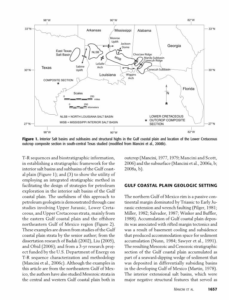
T-R sequences and biostratigraphic information,in establishing a stratigraphic framework for theinterior salt basins and subbasins of the Gulf coast-al plain (Figure 1); and (3) to show the utility ofemploying an integrated stratigraphic method infacilitating the design of strategies for petroleumexploration in the interior salt basins of the Gulfcoastal plain. The usefulness of this approach topetroleum geologists is demonstrated through casestudies involving Upper Jurassic, Lower Creta-ceous, andUpper Cretaceous strata, mainly fromthe eastern Gulf coastal plain and the offshorenortheastern Gulf of Mexico region (Figure 2).These examples are drawn from studies of theGulfcoastal plain strata by the senior author; from thedissertation research of Badali (2002), Liu (2005),and Obid (2006); and from a 3-yr research proj-ect funded by the U.S. Department of Energy onT-R sequence characterization and methodology(Mancini et al., 2006c). Although the examples inthis article are from the northeastern Gulf of Mex-ico, the authors have also studiedMesozoic strata inthe central and western Gulf coastal plain both in
outcrop (Mancini, 1977, 1979;Mancini and Scott,2006) and the subsurface (Mancini et al., 2006a, b;2008a, b).
GULF COASTAL PLAIN GEOLOGIC SETTING
The northern Gulf of Mexico rim is a passive con-tinental margin dominated by Triassic to Early Ju-rassic extension and wrench faulting (Pilger, 1981;Miller, 1982; Salvador, 1987; Winker and Buffler,1988). Accumulation of Gulf coastal plain depos-its was associated with rifted margin tectonics andwas a result of basement cooling and subsidencethat produced accommodation space for sedimentaccumulation (Nunn, 1984; Sawyer et al., 1991).The resultingMesozoic andCenozoic stratigraphicsection of the Gulf coastal plain accumulated aspart of a seaward-dipping wedge of sediment thatwas deposited in differentially subsiding basinsin the developing Gulf of Mexico (Martin, 1978).The interior extensional salt basins, which weremajor negative structural features that served as
Figure 1. Interior Salt basins and subbasins and structural highs in the Gulf coastal plain and location of the Lower Cretaceousoutcrop composite section in south-central Texas studied (modified from Mancini et al., 2008b).
Mancini et al. 1657
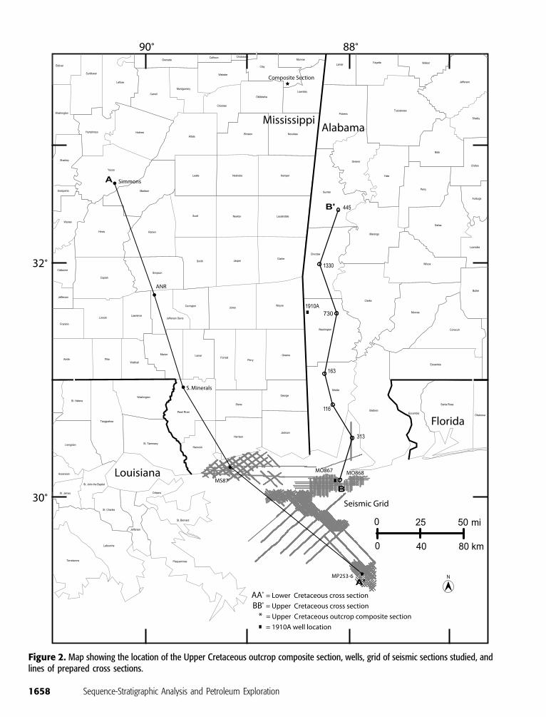
Figure 2. Map showing the location of the Upper Cretaceous outcrop composite section, wells, grid of seismic sections studied, andlines of prepared cross sections.
1658 Sequence-Stratigraphic Analysis and Petroleum Exploration
depocenters, include the east Texas, north Loui-siana, and Mississippi Interior Salt basins and theManila and Conecuh subbasins (Figure 1). Struc-tural elements that affected the general orientationof the strata include basement highs associatedwith plate movement and features formed becauseof halokinesis of the Jurassic Louann Salt. The ma-jor basement paleohighs that influenced the distri-bution and thickness of Mesozoic deposits onshorewere the Sabine uplift,Monroe uplift,Wiggins arch,Jackson dome, Choctaw ridge, and Conecuh ridge.Themovement of the Louann Salt produced an arrayof structural features (Martin, 1978). Salt-relatedstructures include pillows, diapirs, extensional faults,and half-graben systems (Hughes, 1968; Lobao andPilger, 1985).
INTEGRATED SEQUENCE-STRATIGRAPHICFRAMEWORK
The integrated sequence-stratigraphic frameworkestablished in this study is based on combining se-quence stratigraphy (T-R sequences) and bio-stratigraphy (Figure 3). This integrated sequence-stratigraphic framework builds on the work ofmany Gulf Coast geoscientists.
Previous workers have published sequence-stratigraphic classifications at various scales for theMesozoic strata of the Gulf coastal plain. For ex-ample, Todd and Mitchum (1977), Mancini et al.(1990, 2004b), Prather (1992), and Wade andMoore (1993) studied the sequence stratigraphyof Jurassic strata. Obid (2006) compared thesesequence-stratigraphic classifications for Jurassicstrata in the northeastern Gulf of Mexico. Tyrrelland Scott (1989), Scott (1993), Yurewicz et al.(1993), Immenhauser and Scott (1999), Scott et al.(2000, 2003), Scott and Kerans (2004), and Scottand Filkorn (2007) published on the sequence stra-tigraphy of Lower Cretaceous strata, and Manciniet al. (1996), Puckett and Mancini (1998, 2000)and Mancini and Puckett (2003a) reported on thesequence stratigraphy of Upper Cretaceous strata.Most of the above sequence-stratigraphic classifi-cations for the Lower Cretaceous are discussed byMancini and Puckett (2002a), and Liu (2005) eval-
uated the Upper Cretaceous sequence-stratigraphicclassifications. Haq et al. (1988) and Hardenbolet al. (1998) provided global sequence-stratigraphicframeworks for Mesozoic strata.
Biostratigraphic Component
Ammonite, calcareous microfossil, and palyno-morph stratigraphic distributions are used to estab-lish Jurassic and Cretaceous biochronozones in thisstudy. The Jurassic chronostratigraphy is based onthe stratigraphic ranges of ammonites as reportedby Imlay andHerman (1984) and Young andOloriz(1993), calcareous nannofossil ranges as discussedby Cooper and Shaffer (1976), and palynomorphdata from Kirkland and Gerhard (1971) and Rogers(1987). The Lower Cretaceous chronostratigraphyis based on ammonite biochronozones after Young(1966, 1967, 1986) and Hancock et al. (1993) andcalcareousmicrofossil data fromCooper and Shaffer(1976), Scott (1984), Petty et al. (1995), and Scottet al. (2003). TheUpperCretaceous chronostratig-raphy is based on planktonic foraminiferal biochro-nozones after Pessagno (1969), Smith and Pessagno(1973),Mancini (1979), andCaron (1985) (Figure3).The geologic time scale of Gradstein et al. (2004)is used for the Jurassic–Cretaceous section.
Sequence-Stratigraphic Component
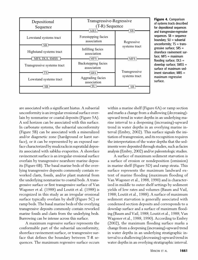
The T-R sequences used in this article follow thedefinition of these sequences as published by Embry(1993, 2002). That is, a T-R sequence consists ofa transgressive systems tract below and a regres-sive systems tract above (Figure 4), which are sepa-rated by a maximum flooding surface. The maxi-mum flooding surface is the downlap surface asviewed in seismic reflection data (Van Wagoneret al., 1988, 1990) and the surface of maximumsediment starvation as observed in wireline logdata and surface exposures (Baum andVail, 1988).Embry (2002) used a subaerial unconformity orshoreface ravinement unconformable surface to rec-ognize the unconformable part of a T-R sequenceboundary and a maximum regressive surface toidentify the conformable part of a T-R sequenceboundary.
Mancini et al. 1659
The following physical surfaces are used inthis study to define the boundaries of the T-R se-quences, systems tracts, and facies association inter-vals: subaerial unconformity, shoreface ravinement
surface, transgressive surface, maximum regressivesurface, and maximum flooding surface. The sub-aerial unconformity, shoreface ravinement surface,and transgressive surface are unconformable and
Figure 3. Chronostratig-raphy, sequence stratig-raphy, and lithostratig-raphy for Jurassic andCretaceous strata in theGulf coastal plain. T-R =transgressive-regressivesequence; GC = Gulf Coast;TA = transgressive ag-grading facies association;TB = transgressive back-stepping facies associa-tion; and RI = regressivefacies association.
1660 Sequence-Stratigraphic Analysis and Petroleum Exploration
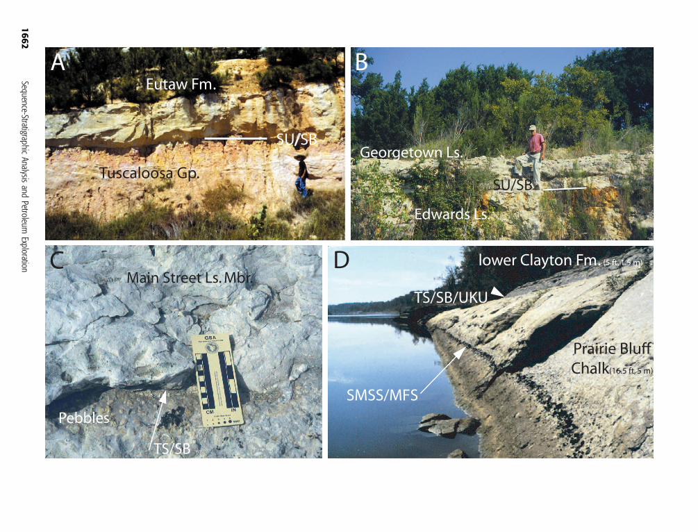
are associated with a significant hiatus. A subaerialunconformity is an irregular erosional surface over-lain by nonmarine or coastal deposits (Figure 5A).A soil horizon can be associated with this surface.In carbonate systems, the subaerial unconformity(Figure 5B) can be associated with a mineralizedand/or diagenetic zone (hardground or karst sur-face), or it can be represented by an exposed sur-face characterizedbymudcracks in supratidal depos-its associated with sabkha evaporites. A shorefaceravinement surface is an irregular erosional surfaceoverlain by transgressive nearshore marine depos-its (Figure 6B). The basal marine beds of the over-lying transgressive deposits commonly contain re-worked clasts, fossils, and/or plant material fromthe underlying nonmarine to coastal beds. A trans-gressive surface or first transgressive surface of VanWagoner et al. (1988) and Loutit et al. (1988) isrecognized in this study as an irregular erosionalsurface typically overlain by shelf (Figure 5C) orramp beds. The basal marine beds of the overlyingtransgressive deposits commonly contain reworkedmarine fossils and clasts from the underlying beds.Burrowing can be intense across this surface.
A maximum regressive surface represents theconformable part of the subaerial unconformity,shoreface ravinement surface, or transgressive sur-face that defines the boundary between T-R se-quences. The maximum regressive surface occurs
within a marine shelf (Figure 6A) or ramp sectionandmarks a change from a shallowing (decreasing)-upward trend in water depths in an underlying ma-rine interval to a deepening (increasing)-upwardtrend in water depths in an overlying marine in-terval (Embry, 2002). This surface signals the ini-tiation of transgression, and its recognition requiresthe interpretation of the water depths that the sed-imentswere deposited through studies, such as faciesanalysis (Embry, 2002) and/or paleontologic studies.
A surface of maximum sediment starvation isa surface of erosion or nondeposition (omission)in marine shelf (Figure 5D) and ramp strata. Thissurface represents the maximum landward ex-tent of marine flooding (maximum flooding ofVan Wagoner et al., 1988, 1990) and is character-ized in middle to outer shelf settings by sedimentyields of low rates and volumes (Baum and Vail,1988; Loutit et al., 1988). A surface of maximumsediment starvation is generally associated withcondensed section deposits and corresponds to adownlap surface and a surface of maximum flood-ing (Baum andVail, 1988; Loutit et al., 1988; VanWagoner et al., 1988, 1990). According to Embry(2002), the maximum flooding surface marks achange from a deepening (increasing)-upward trendin water depths in an underlying stratigraphic in-terval to a shallowing (decreasing)-upward trend inwater depths in an overlying stratigraphic interval.
Figure 4. Comparisonof systems tracts describedfor depositional sequencesand transgressive-regressivesequences. SB = sequenceboundary; SU = subaerialunconformity; TS = trans-gressive surface; SRS =shoreface ravinement sur-face; MFS = maximumflooding surface; DLS =downlap surface; SMSS =surface of maximum sed-iment starvation; MRS =maximum regressivesurface.
Mancini et al. 1661
1662
Sequence-StratigraphicAnalysis
andPetroleum
Exploration
Loutit et al. (1988) reported that water depth isa function of relative sea level and sediment yield,and therefore, themaximumwater depth in a strat-igraphic section can occur at a level above the sur-face of maximum sediment starvation and maxi-mum flooding surface because of differing rates andamounts of sediment accumulation and deposition-al conditions (Naish and Kamp, 1997; Catuneanuet al., 1998; Loutit et al., 1988; Liu, 2005). Thesurface of maximum sediment starvation and themaximum flooding surface are commonly markedby a concentration of microfossils, authigenic glau-conite, phosphatic and sideritic fossil molds (stein-kern), and encrusted and bored fossils (Baum andVail, 1988; Loutit et al., 1988). Burrowing can becommon across these surfaces, and in carbonates, abored hardground can develop.
Because knowledge of the stratigraphic positionof potential reservoir facies in the systems tractsis critical in the formulation of an effective explo-ration strategy, the systems tracts of the T-R se-quences were divided into intervals of facies asso-ciations based on the classification of Jacquin andde Graciansky (1998). Jacquin and de Graciansky(1998) recognized T-R facies cycles in strata in ba-sins of western Europe. They interpreted these fa-cies cycles to represent second-order events andfurther concluded that the cycles were composedof third-order depositional sequences that couldbe grouped into early transgressive or an aggradingsequence, late transgressive or a backstepping se-quence, early regressive or an infilling sequence,and late regressive or a forestepping sequence.
For this work, the transgressive systems tractis divided into an aggrading facies association in-terval of nonmarine and coastal deposits and abackstepping facies association interval of marinedeposits (Figure 4). The aggrading facies associa-tion overlies a subaerial unconformity and is sep-arated from the overlying backstepping facies as-sociation by a shoreface ravinement surface. Theaggrading facies association is not recognized inall of the T-R sequences described in this studybecause of a lack of preservation or nondeposi-tion because of environmental and tectonic con-ditions. The regressive systems tract is divided intoan infilling facies association interval of marine toFi
gure
5.Outcrop
photographsof
Cretaceousstrata:(A)T-RGC12
sequence
boundary
andsubaerialunconformity
insiliciclasticsassociated
with
theTuscaloosa
Group
and
EutawForm
ation,inPhenixCity,RussellCounty,Alabama(m
odified
from
ManciniandPuckett,2003a);(B)
T-RGC9sequence
boundaryandsubaerialunconform
ityincarbonates
associated
with
theEdwards
Limestone
andGeorgetow
nLimestone,BeltonQuarry,
Highw
ay36,BellCounty,
east-central
Texas(m
odified
from
Mancini
andScott,2006),as
interpretedby
Scottetal.(2003)andsupportedby
isotopedata;(C)T-RGC10
sequence
boundary
andunconformabletransgressivesurfaceincarbonates
markedby
thepebble
bedin
theMainStreet
Mem
berof
theGeorgetow
nLimestone,near
Aquilla,White
Rock
Creek,HillCounty,northeastTexas;and(D)T-RGC14
uppersequence
boundary
and
unconformabletransgressivesurfaceassociated
with
theUpper
CretaceousPrairieBluffChalkandPaleoceneClayton
Form
ation(Cretaceous-Paleogeneboundary)andsurfaceof
maximum
sedimentstarvationandmaximum
floodingsurfaceof
theT-RGC14
sequence,atMoscowLandingon
theTombigbee
River,southw
estof
Dem
opolis,SumterCounty,
Alabama(m
odified
from
ManciniandPuckett,2003a).SB=sequence
boundary;SU
=subaerialunconform
ity;TS
=transgressivesurface;SM
SS=surfaceof
maximum
sediment
starvation;
MFS
=maximum
floodingsurface;
UKU=Upper
Cretaceousunconformity
asdescribedby
Mancini
etal.(1989).
Mancini et al. 1663
1664
Sequence-StratigraphicAnalysis
andPetroleum
Exploration
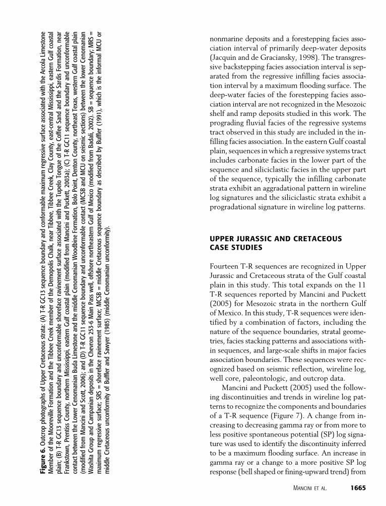
nonmarine deposits and a forestepping facies asso-ciation interval of primarily deep-water deposits(Jacquin and de Graciansky, 1998). The transgres-sive backstepping facies association interval is sep-arated from the regressive infilling facies associa-tion interval by a maximum flooding surface. Thedeep-water facies of the forestepping facies asso-ciation interval are not recognized in theMesozoicshelf and ramp deposits studied in this work. Theprograding fluvial facies of the regressive systemstract observed in this study are included in the in-filling facies association. In the easternGulf coastalplain, sequences inwhich a regressive systems tractincludes carbonate facies in the lower part of thesequence and siliciclastic facies in the upper partof the sequence, typically the infilling carbonatestrata exhibit an aggradational pattern in wirelinelog signatures and the siliciclastic strata exhibit aprogradational signature in wireline log patterns.
UPPER JURASSIC AND CRETACEOUSCASE STUDIES
Fourteen T-R sequences are recognized in UpperJurassic and Cretaceous strata of the Gulf coastalplain in this study. This total expands on the 11T-R sequences reported by Mancini and Puckett(2005) for Mesozoic strata in the northern Gulfof Mexico. In this study, T-R sequences were iden-tified by a combination of factors, including thenature of the sequence boundaries, stratal geome-tries, facies stacking patterns and associations with-in sequences, and large-scale shifts in major faciesassociation boundaries. These sequences were rec-ognized based on seismic reflection, wireline log,well core, paleontologic, and outcrop data.
Mancini and Puckett (2005) used the follow-ing discontinuities and trends in wireline log pat-terns to recognize the components and boundariesof a T-R sequence (Figure 7). A change from in-creasing to decreasing gamma ray or frommore toless positive spontaneous potential (SP) log signa-ture was used to identify the discontinuity inferredto be a maximum flooding surface. An increase ingamma ray or a change to a more positive SP logresponse (bell shaped or fining-upward trend) fromFi
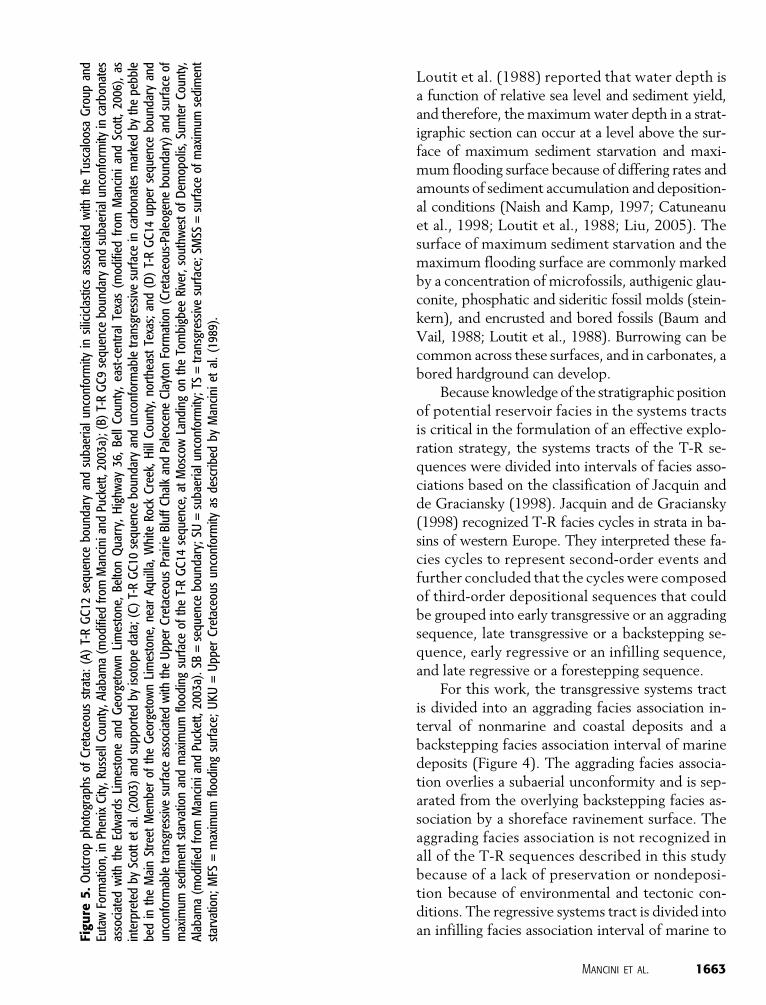
gure
6.O
utcrop
photographsofUpperCretaceousstrata:(A)T-RGC13
sequence
boundaryandconformablemaximum
regressive
surfaceassociated
with
theArcolaLimestone
Mem
beroftheMooreville
Form
ationandtheTibbee
Creek
mem
beroftheDem
opolisChalk,nearTibbee,TibbeeCreek,ClayCounty,east-centralMississippi,eastern
Gulfcoastal
plain;
(B)T-RGC13
sequence
boundary
andunconformableshorefaceravinementsurfaceassociated
with
theTupeloTongue
oftheCoffeeSand
andtheSardisForm
ation,near
Frankstown,PrentissCounty,northern
Mississippi,easternGulfcoastalplain(m
odified
from
ManciniandPuckett,2003a);(C)T-RGC11
sequence
boundary
andunconformable
contactbetweentheLowerCenom
anianBuda
Limestone
andthemiddleCenom
anianWoodbineForm
ation,BoloPoint,DentonCounty,northeastTexas,w
estern
Gulfcoastalplain
(modified
from
ManciniandScott,2006);and(D)T-RGC11
sequence
boundaryandunconformablecontact(MCSB
andMCUon
seismicsections)betweenthelowerCenom
anian
WashitaGroup
andCam
panian
depositsintheChevron
253-6MainPasswell,offshore
northeastern
GulfofMexico(m
odified
from
Badali,2002).SB
=sequence
boundary;M
RS=
maximum
regressive
surface;SRS=shorefaceravinementsurface;MCSB
=middleCretaceoussequence
boundary
asdescribed
byBuffler
(1991),which
istheinform
alMCUor
middleCretaceousunconformity
ofBuffler
andSawyer(1985)
(middleCenom
anianunconformity).
Mancini et al. 1665
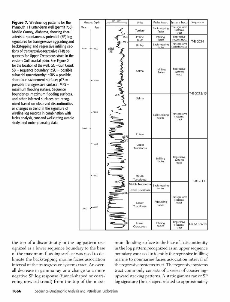
the top of a discontinuity in the log pattern rec-ognized as a lower sequence boundary to the baseof the maximum flooding surface was used to de-lineate the backstepping marine facies associationinterval of the transgressive systems tract. An over-all decrease in gamma ray or a change to a morenegative SP log response (funnel-shaped or coars-ening upward trend) from the top of the maxi-
mum flooding surface to the base of a discontinuityin the log pattern recognized as an upper sequenceboundarywas used to identify the regressive infillingmarine to nonmarine facies association interval ofthe regressive systems tract. The regressive systemstract commonly consists of a series of coarsening-upward stacking patterns. A static gamma ray or SPlog signature (box shaped related to approximately
Figure 7. Wireline log patterns for thePlymouth 1 Hunter-Benn well (permit 730),Mobile County, Alabama, showing char-acteristic spontaneous potential (SP) logsignatures for transgressive aggrading andbackstepping and regressive infilling sec-tions of transgressive-regressive (T-R) se-quences for Upper Cretaceous strata in theeastern Gulf coastal plain. See Figure 2for the location of the well. GC = Gulf Coast;SB = sequence boundary; pSU = possiblesubaerial unconformity; pSRS = possibleshoreface ravinement surface; pTS =possible transgressive surface; MFS =maximum flooding surface. Sequenceboundaries, maximum flooding surfaces,and other inferred surfaces are recog-nized based on observed discontinuitiesor changes in trend in the signature ofwireline log records in combination withfacies analysis, core and well cutting samplestudy, and outcrop analog data.
1666 Sequence-Stratigraphic Analysis and Petroleum Exploration
uniform grain size vertically) is typically charac-teristic of the aggrading nonmarine and coastal fa-cies association interval of the transgressive systemstract. The transgressive aggrading facies associationinterval, where present, directly overlies the lowersequence boundary and is separated from the trans-gressive backstepping facies association interval byadiscontinuity inferred tobe a shoreface ravinementsurface.
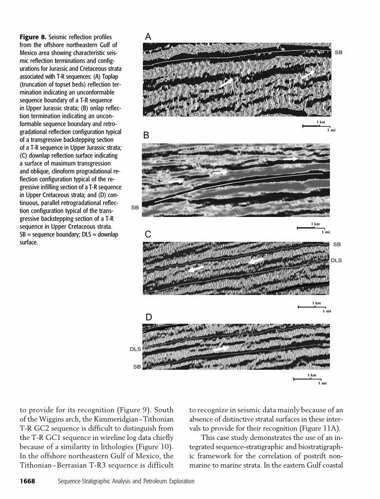
Mancini and Puckett (2005) identified and usedseismic reflection terminations, such as toplap(Figure 8A), onlap (Figure 8B), and downlap(Figure 8C), to recognize horizons in the seismicdata that had the potential to be T-R sequenceboundaries and downlap surfaces after Mitchumet al. (1977). They used seismic reflection config-urations, as reported byVanWagoner et al. (1988)and Yurewicz et al. (1993), to characterize theseismic intervals (potential T-R systems tracts) de-fined by the recognized horizons. Thick (severalseismic cycles) intervals of seismic reflectors ex-hibiting aggradational reflection configurationswere interpreted as characteristic of strata of theaggrading nonmarine and coastal facies associa-tion interval of the transgressive systems tract. Thin(commonly one or two seismic cycles), continuous,parallel, retrogradational seismic reflection config-urations with onlap reflection terminations wereinterpreted as characteristic of strata of the back-stepping marine facies association interval of thetransgressive systems tract (Figure 8B, D). Thick(several seismic cycles), oblique, progradationalseismic reflection configurations showing down-lap were interpreted as prograding clinoforms char-acteristic of the infilling marine to nonmarine faciesassociation interval of the regressive systems tract(Figure 8C).
Upper Jurassic to Lower Cretaceous Example
The T-R sequences recognized in the Gulf coastalplain for the Late Jurassic to Early Cretaceous re-flect the postrift tectonic and depositional condi-tions during this period. This series of sequences isbracketed at the base by the Louann Salt-NorphletFormation contact (Callovian–Oxfordian as re-
ported by Salvador, 1987) and at the top by theCotton Valley Group-Hosston Formation contact(Valanginian as reported by McFarlan and Menes,1991).
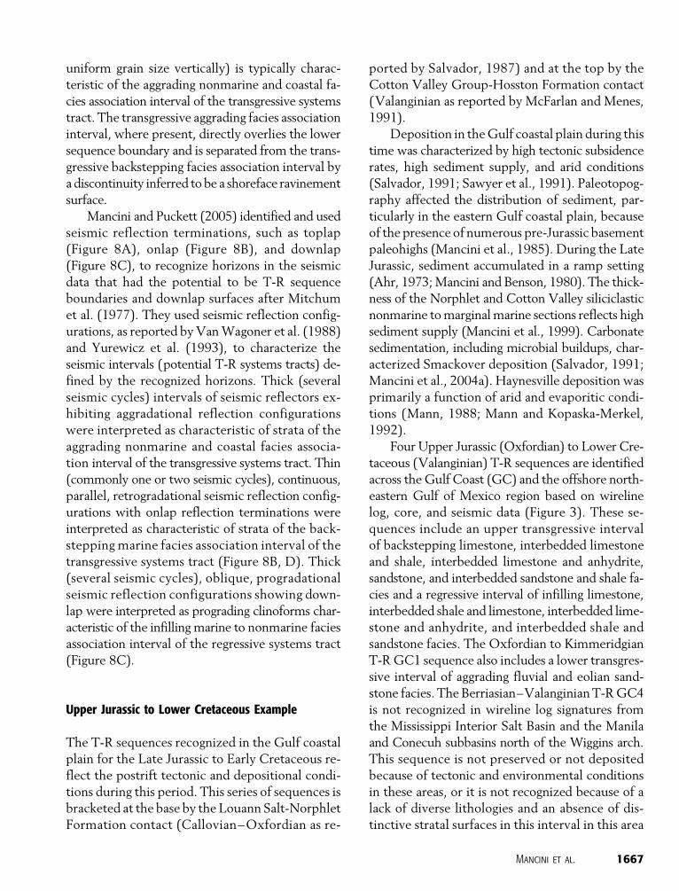
Deposition in theGulf coastal plain during thistime was characterized by high tectonic subsidencerates, high sediment supply, and arid conditions(Salvador, 1991; Sawyer et al., 1991). Paleotopog-raphy affected the distribution of sediment, par-ticularly in the eastern Gulf coastal plain, becauseof the presence of numerous pre-Jurassic basementpaleohighs (Mancini et al., 1985). During the LateJurassic, sediment accumulated in a ramp setting(Ahr, 1973;Mancini and Benson, 1980). The thick-ness of the Norphlet and Cotton Valley siliciclasticnonmarine tomarginalmarine sections reflects highsediment supply (Mancini et al., 1999). Carbonatesedimentation, including microbial buildups, char-acterized Smackover deposition (Salvador, 1991;Mancini et al., 2004a). Haynesville deposition wasprimarily a function of arid and evaporitic condi-tions (Mann, 1988; Mann and Kopaska-Merkel,1992).
Four Upper Jurassic (Oxfordian) to Lower Cre-taceous (Valanginian) T-R sequences are identifiedacross the Gulf Coast (GC) and the offshore north-eastern Gulf of Mexico region based on wirelinelog, core, and seismic data (Figure 3). These se-quences include an upper transgressive intervalof backstepping limestone, interbedded limestoneand shale, interbedded limestone and anhydrite,sandstone, and interbedded sandstone and shale fa-cies and a regressive interval of infilling limestone,interbedded shale and limestone, interbedded lime-stone and anhydrite, and interbedded shale andsandstone facies. The Oxfordian to KimmeridgianT-RGC1 sequence also includes a lower transgres-sive interval of aggrading fluvial and eolian sand-stone facies. The Berriasian–ValanginianT-RGC4is not recognized in wireline log signatures fromthe Mississippi Interior Salt Basin and the Manilaand Conecuh subbasins north of the Wiggins arch.This sequence is not preserved or not depositedbecause of tectonic and environmental conditionsin these areas, or it is not recognized because of alack of diverse lithologies and an absence of dis-tinctive stratal surfaces in this interval in this area
Mancini et al. 1667
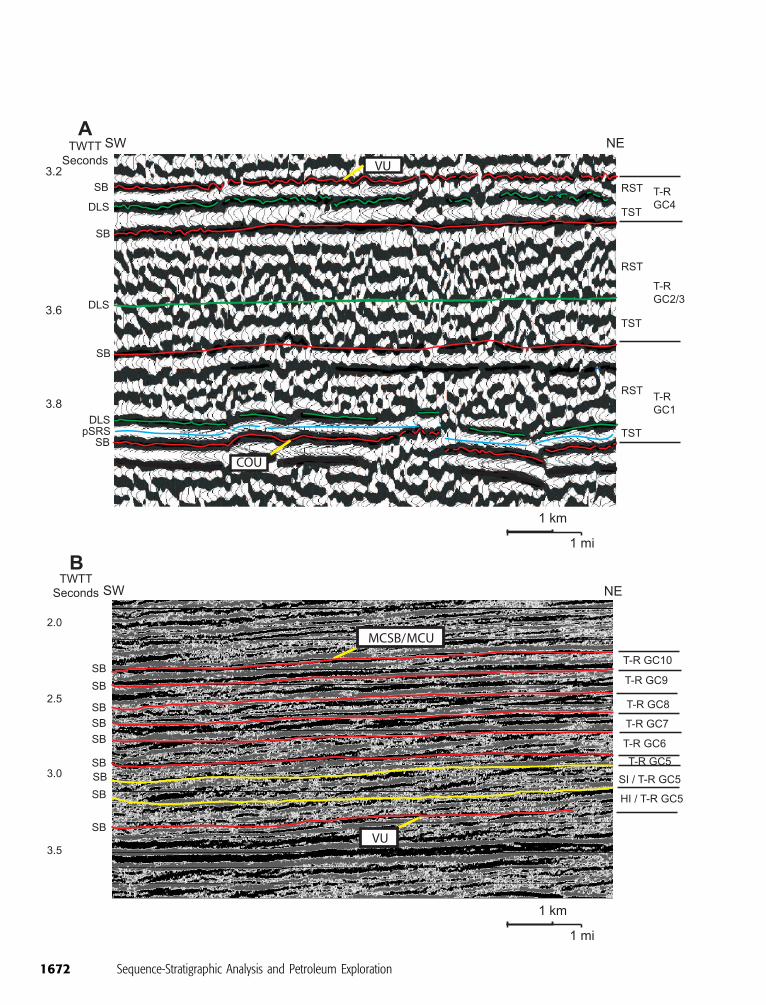
to provide for its recognition (Figure 9). Southof theWiggins arch, the Kimmeridgian–TithonianT-R GC2 sequence is difficult to distinguish fromthe T-R GC1 sequence in wireline log data chieflybecause of a similarity in lithologies (Figure 10).In the offshore northeastern Gulf of Mexico, theTithonian–Berrasian T-R3 sequence is difficult
to recognize in seismic data mainly because of anabsence of distinctive stratal surfaces in these inter-vals to provide for their recognition (Figure 11A).
This case study demonstrates the use of an in-tegrated sequence-stratigraphic and biostratigraph-ic framework for the correlation of postrift non-marine to marine strata. In the eastern Gulf coastal
SB
A
1 mi
1 km
B
SB
1 mi
1 km
DLS
SB
C
1 mi
1 km
D
1 mi
1 km
DLS
SB
Figure 8. Seismic reflection profilesfrom the offshore northeastern Gulf ofMexico area showing characteristic seis-mic reflection terminations and config-urations for Jurassic and Cretaceous strataassociated with T-R sequences: (A) Toplap(truncation of topset beds) reflection ter-mination indicating an unconformablesequence boundary of a T-R sequencein Upper Jurassic strata; (B) onlap reflec-tion termination indicating an uncon-formable sequence boundary and retro-gradational reflection configuration typicalof a transgressive backstepping sectionof a T-R sequence in Upper Jurassic strata;(C) downlap reflection surface indicatinga surface of maximum transgressionand oblique, clinoform progradational re-flection configuration typical of the re-gressive infilling section of a T-R sequencein Upper Cretaceous strata; and (D) con-tinuous, parallel retrogradational reflec-tion configuration typical of the trans-gressive backstepping section of a T-Rsequence in Upper Cretaceous strata.SB = sequence boundary; DLS = downlapsurface.
1668 Sequence-Stratigraphic Analysis and Petroleum Exploration
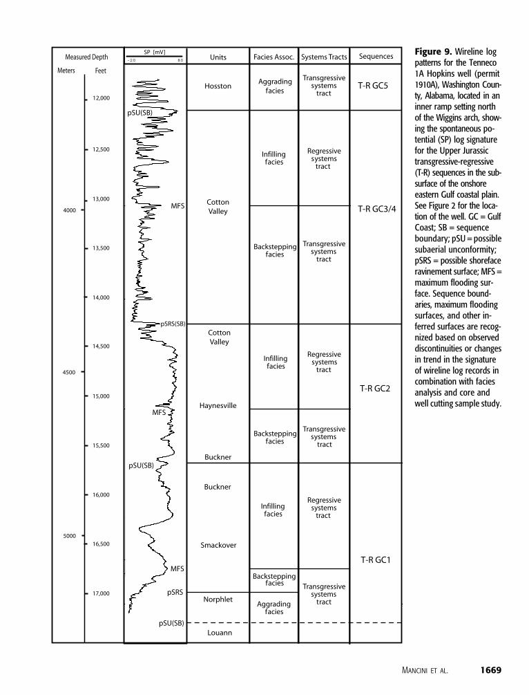
Figure 9. Wireline logpatterns for the Tenneco1A Hopkins well (permit1910A), Washington Coun-ty, Alabama, located in aninner ramp setting northof the Wiggins arch, show-ing the spontaneous po-tential (SP) log signaturefor the Upper Jurassictransgressive-regressive(T-R) sequences in the sub-surface of the onshoreeastern Gulf coastal plain.See Figure 2 for the loca-tion of the well. GC = GulfCoast; SB = sequenceboundary; pSU = possiblesubaerial unconformity;pSRS = possible shorefaceravinement surface; MFS =maximum flooding sur-face. Sequence bound-aries, maximum floodingsurfaces, and other in-ferred surfaces are recog-nized based on observeddiscontinuities or changesin trend in the signatureof wireline log records incombination with faciesanalysis and core andwell cutting sample study.
Mancini et al. 1669
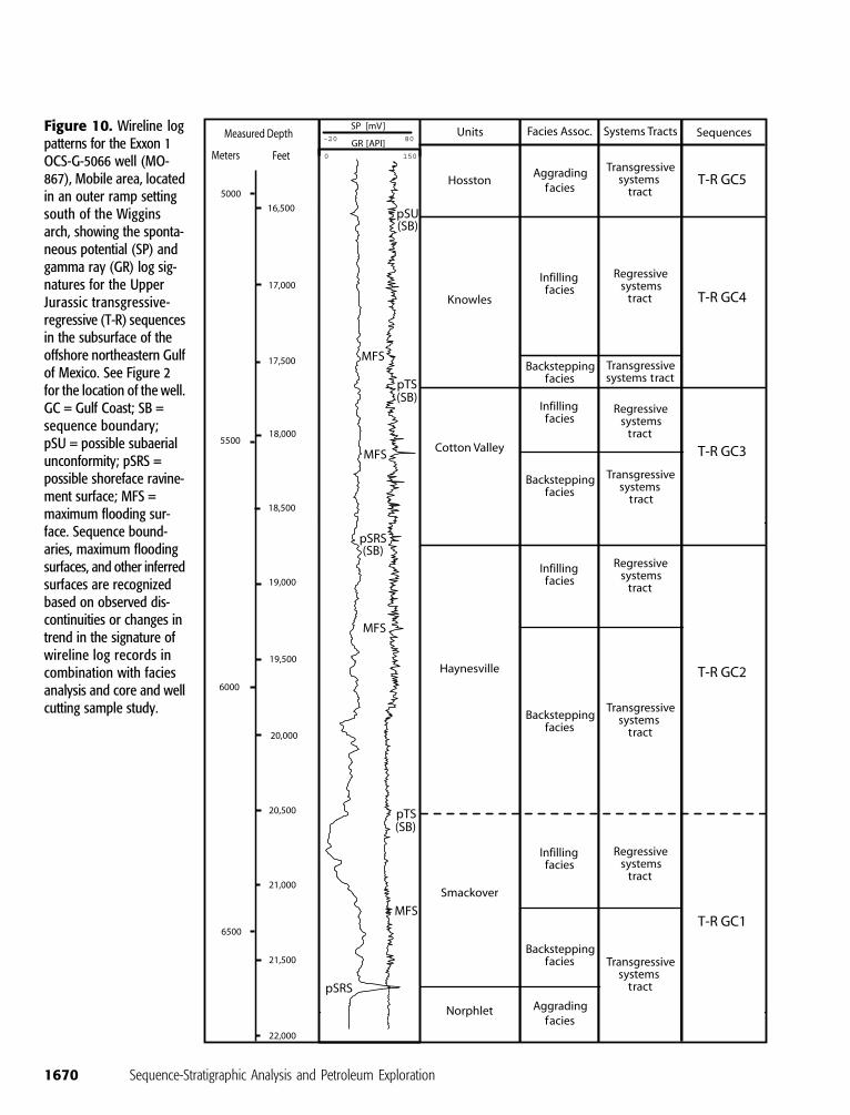
Figure 10. Wireline logpatterns for the Exxon 1OCS-G-5066 well (MO-867), Mobile area, locatedin an outer ramp settingsouth of the Wigginsarch, showing the sponta-neous potential (SP) andgamma ray (GR) log sig-natures for the UpperJurassic transgressive-regressive (T-R) sequencesin the subsurface of theoffshore northeastern Gulfof Mexico. See Figure 2for the location of the well.GC = Gulf Coast; SB =sequence boundary;pSU = possible subaerialunconformity; pSRS =possible shoreface ravine-ment surface; MFS =maximum flooding sur-face. Sequence bound-aries, maximum floodingsurfaces, and other inferredsurfaces are recognizedbased on observed dis-continuities or changes intrend in the signature ofwireline log records incombination with faciesanalysis and core and wellcutting sample study.
1670 Sequence-Stratigraphic Analysis and Petroleum Exploration
plain, these deposits were affected primarily by tec-tonics and high sediment supply, and in the west-ern Gulf coastal plain, these strata were affectedchiefly by tectonics and relative sea level changes(Figure 3). Strata in an updip fluvial to marginalmarine and marine, inner ramp setting (Figure 9)can be correlatedwith strata in a downdip eolian tomarine, outer ramp setting (Figure 10). This casestudy also shows that the identification of strati-graphic sequences and associated stratal surfacesis dependent on the contrast in sedimentary andlithologic characteristics of the rocks, the presenceof distinctive stratal surfaces, and in the resolutionof the tools used for sequence-stratigraphic anal-ysis. The ability to discern the T-R GC2 sequencein the wireline log patterns and cores in the Mis-sissippi Interior Salt Basin andManila andConecuhsubbasins north of the Wiggins arch and the dif-ficulty in recognizing this sequence in wirelinelog data south of the Wiggins arch illustrate thispoint. This difference in being able to recognizethis sequence is attributed to inner to outer rampfacies and lithologic changes in the Smackover-Haynesville interval associated with the Wigginsarch. The Smackover carbonate beds north of theWiggins arch in the eastern Gulf coastal plain areoverlain by a thick section of sabkha and subaqueousanhydrite of the Buckner Member of the Haynes-ville Formation, whereas south of theWiggins archand in the offshore northeastern Gulf of Mexicoregion, the Smackover carbonate beds are overlainby a thick section of carbonate rocks of the lowerpart of the Haynesville Formation (Obid, 2006).The study of core and well cutting samples in con-junctionwith the records of wireline logs is requiredto recognize this sequence in this area.
Lower to Upper Cretaceous Example
The T-R sequences recognized in the Gulf coastalplain for the Early Cretaceous (Valanginian) to theearliest Late Cretaceous (middle Cenomanian) re-cord the paleoenvironmental conditions during thisperiod. This series of sequences is bracketed atthe base by the contact between the Cotton ValleyGroup and the Hosston Formation (Valanginian)and at the top by the contact between theDantzler
Formation or Washita Group and the TuscaloosaGroup and theWashita Group and the WoodbineFormation. The upper contact is the middle Ceno-manian or middle Cretaceous sequence boundary(MCSB) of Buffler (1991) and the informalmiddleCretaceous unconformity (MCU) of Buffler andSawyer (1985).
Sediment accumulation in theGulf coastal plainat this time was dominantly mixed carbonate andsiliciclastic deposition in a continental shelf to slopesetting (Mancini andPuckett, 2002a, b). Siliciclasticdeposition in fluvial to shelf paleoenvironments inproximity to terrigenous source terranes typified theeasternGulf coastal plain, and carbonate sedimentaccumulation in shelf to slope paleoenvironmentsin association with coral-sponge-algal and rudistreefs characterized the western Gulf coastal plain(Scott, 1993; Mancini and Puckett, 2002a).
Six Lower Cretaceous (Valanginian) to lowerUpper Cretaceous (Cenomanian) T-R sequencesare identified across the Gulf Coast and the off-shore northeastern Gulf of Mexico based on out-crop, paleontologic, wireline log, core, and seismicdata (Figure 3). These sequences include an uppertransgressive interval of backstepping limestone,anhydrite, calcareous shale, and shale facies and aregressive interval of infilling limestone, calcare-ous shale, sandy shale, interbedded sandstone andshale, interbedded sandstone and siltstone, andsandstone facies. The Valanginian to upper AptianT-RGC5 sequence also includes a lower transgres-sive interval of aggrading fluvial and coastal sand-stone facies. In much of the Mississippi InteriorSalt Basin and the Manila and Conecuh subbasins,the T-R GC5, T-R GC7, and T-R GC8 sequencesare capped by prograding fluvial facies of the in-filling marine to nonmarine facies association. Theupper Albian to lower Cenomanian T-R GC9 andT-R GC10 sequences are not discernable from themiddle to upper Albian T-RGC8 sequence in wire-line log signatures from the Mississippi Interior SaltBasin and theManila and Conecuh subbasins in theeastern Gulf coastal plain (Figure 12) because thesesequences are not preserved or not deposited be-cause of tectonic and environmental conditions inthis basin and subbasins, or they are not recog-nized because of a lack of diverse lithologies and an
Mancini et al. 1671
1672 Sequence-Stratigraphic Analysis and Petroleum Exploration
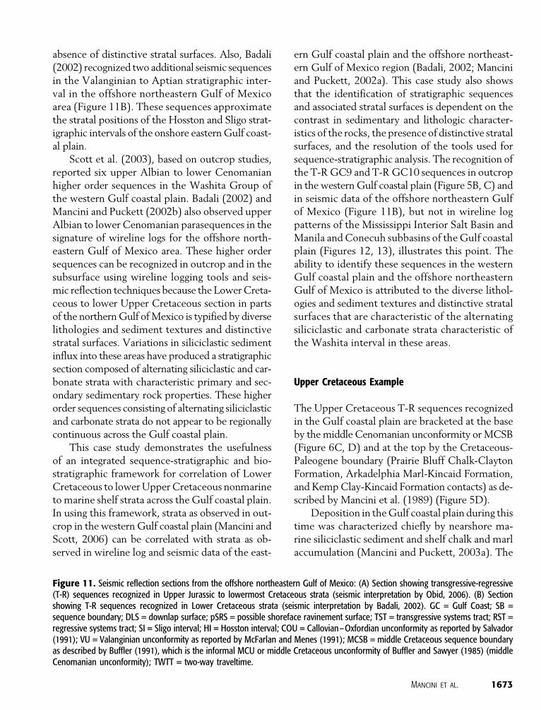
absence of distinctive stratal surfaces. Also, Badali(2002) recognized two additional seismic sequencesin the Valanginian to Aptian stratigraphic inter-val in the offshore northeastern Gulf of Mexicoarea (Figure 11B). These sequences approximatethe stratal positions of the Hosston and Sligo strat-igraphic intervals of the onshore easternGulf coast-al plain.
Scott et al. (2003), based on outcrop studies,reported six upper Albian to lower Cenomanianhigher order sequences in the Washita Group ofthe western Gulf coastal plain. Badali (2002) andMancini and Puckett (2002b) also observed upperAlbian to lower Cenomanian parasequences in thesignature of wireline logs for the offshore north-eastern Gulf of Mexico area. These higher ordersequences can be recognized in outcrop and in thesubsurface using wireline logging tools and seis-mic reflection techniques because the LowerCreta-ceous to lower Upper Cretaceous section in partsof the northernGulf ofMexico is typified by diverselithologies and sediment textures and distinctivestratal surfaces. Variations in siliciclastic sedimentinflux into these areas have produced a stratigraphicsection composed of alternating siliciclastic and car-bonate strata with characteristic primary and sec-ondary sedimentary rock properties. These higherorder sequences consisting of alternating siliciclasticand carbonate strata do not appear to be regionallycontinuous across the Gulf coastal plain.
This case study demonstrates the usefulnessof an integrated sequence-stratigraphic and bio-stratigraphic framework for correlation of LowerCretaceous to lowerUpperCretaceous nonmarineto marine shelf strata across the Gulf coastal plain.In using this framework, strata as observed in out-crop in the western Gulf coastal plain (Mancini andScott, 2006) can be correlated with strata as ob-served in wireline log and seismic data of the east-
ern Gulf coastal plain and the offshore northeast-ern Gulf of Mexico region (Badali, 2002; Manciniand Puckett, 2002a). This case study also showsthat the identification of stratigraphic sequencesand associated stratal surfaces is dependent on thecontrast in sedimentary and lithologic character-istics of the rocks, the presence of distinctive stratalsurfaces, and the resolution of the tools used forsequence-stratigraphic analysis. The recognition ofthe T-RGC9 and T-RGC10 sequences in outcropin the western Gulf coastal plain (Figure 5B, C) andin seismic data of the offshore northeastern Gulfof Mexico (Figure 11B), but not in wireline logpatterns of the Mississippi Interior Salt Basin andManila and Conecuh subbasins of theGulf coastalplain (Figures 12, 13), illustrates this point. Theability to identify these sequences in the westernGulf coastal plain and the offshore northeasternGulf of Mexico is attributed to the diverse lithol-ogies and sediment textures and distinctive stratalsurfaces that are characteristic of the alternatingsiliciclastic and carbonate strata characteristic ofthe Washita interval in these areas.
Upper Cretaceous Example
The Upper Cretaceous T-R sequences recognizedin the Gulf coastal plain are bracketed at the baseby themiddle Cenomanian unconformity orMCSB(Figure 6C, D) and at the top by the Cretaceous-Paleogene boundary (Prairie Bluff Chalk-ClaytonFormation, Arkadelphia Marl-Kincaid Formation,and KempClay-Kincaid Formation contacts) as de-scribed by Mancini et al. (1989) (Figure 5D).
Deposition in theGulf coastal plain during thistime was characterized chiefly by nearshore ma-rine siliciclastic sediment and shelf chalk and marlaccumulation (Mancini and Puckett, 2003a). The
Figure 11. Seismic reflection sections from the offshore northeastern Gulf of Mexico: (A) Section showing transgressive-regressive(T-R) sequences recognized in Upper Jurassic to lowermost Cretaceous strata (seismic interpretation by Obid, 2006). (B) Sectionshowing T-R sequences recognized in Lower Cretaceous strata (seismic interpretation by Badali, 2002). GC = Gulf Coast; SB =sequence boundary; DLS = downlap surface; pSRS = possible shoreface ravinement surface; TST = transgressive systems tract; RST =regressive systems tract; SI = Sligo interval; HI = Hosston interval; COU = Callovian–Oxfordian unconformity as reported by Salvador(1991); VU = Valanginian unconformity as reported by McFarlan and Menes (1991); MCSB = middle Cretaceous sequence boundaryas described by Buffler (1991), which is the informal MCU or middle Cretaceous unconformity of Buffler and Sawyer (1985) (middleCenomanian unconformity); TWTT = two-way traveltime.
Mancini et al. 1673
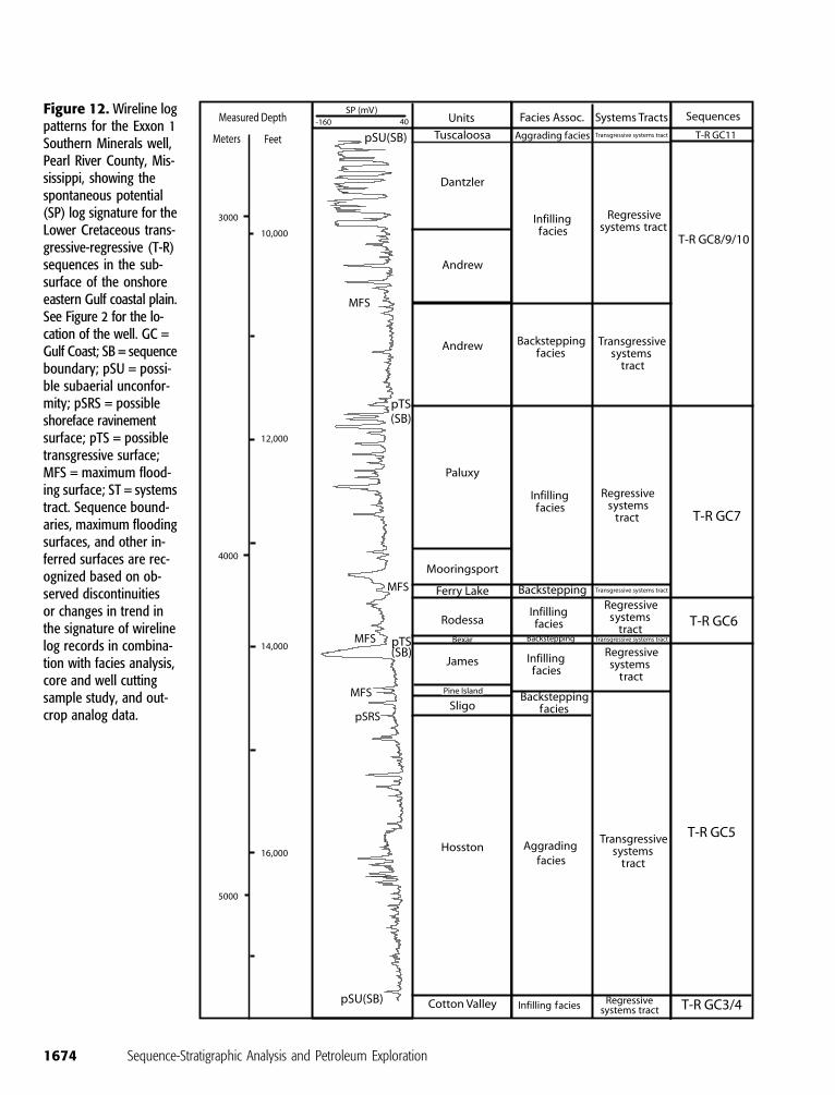
Figure 12. Wireline logpatterns for the Exxon 1Southern Minerals well,Pearl River County, Mis-sissippi, showing thespontaneous potential(SP) log signature for theLower Cretaceous trans-gressive-regressive (T-R)sequences in the sub-surface of the onshoreeastern Gulf coastal plain.See Figure 2 for the lo-cation of the well. GC =Gulf Coast; SB = sequenceboundary; pSU = possi-ble subaerial unconfor-mity; pSRS = possibleshoreface ravinementsurface; pTS = possibletransgressive surface;MFS = maximum flood-ing surface; ST = systemstract. Sequence bound-aries, maximum floodingsurfaces, and other in-ferred surfaces are rec-ognized based on ob-served discontinuitiesor changes in trend inthe signature of wirelinelog records in combina-tion with facies analysis,core and well cuttingsample study, and out-crop analog data.
1674 Sequence-Stratigraphic Analysis and Petroleum Exploration
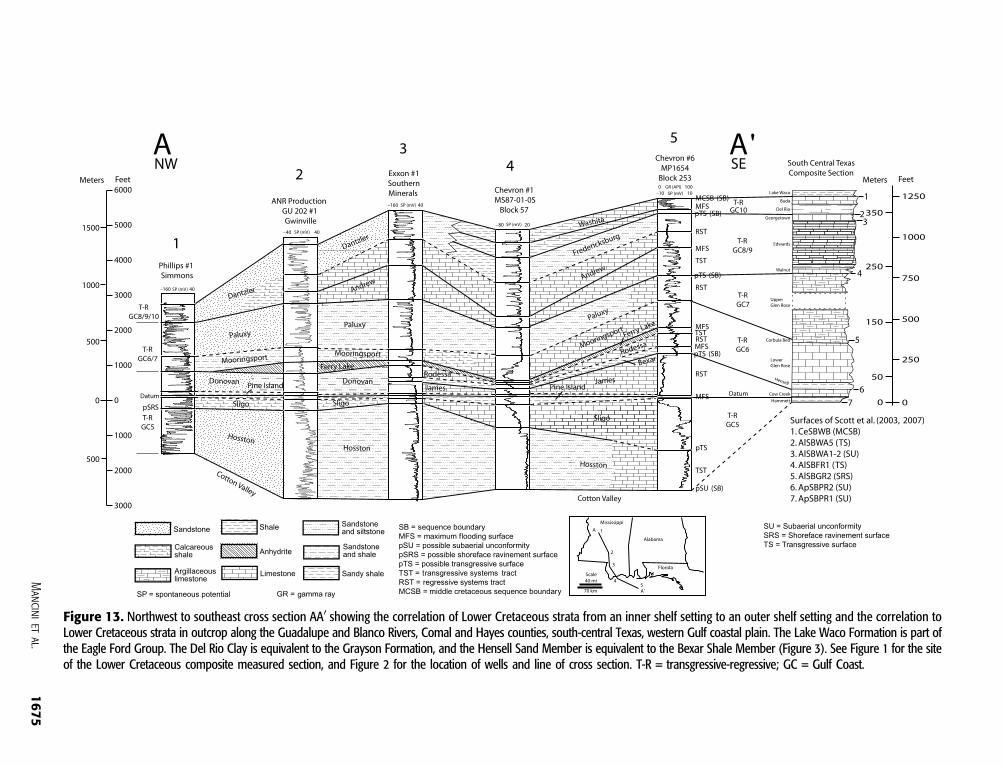
Figure 13. Northwest to southeast cross section AA0 showing the correlation of Lower Cretaceous strata from an inner shelf setting to an outer shelf setting and the correlation toLower Cretaceous strata in outcrop along the Guadalupe and Blanco Rivers, Comal and Hayes counties, south-central Texas, western Gulf coastal plain. The Lake Waco Formation is part ofthe Eagle Ford Group. The Del Rio Clay is equivalent to the Grayson Formation, and the Hensell Sand Member is equivalent to the Bexar Shale Member (Figure 3). See Figure 1 for the siteof the Lower Cretaceous composite measured section, and Figure 2 for the location of wells and line of cross section. T-R = transgressive-regressive; GC = Gulf Coast.
Mancinietal.
1675
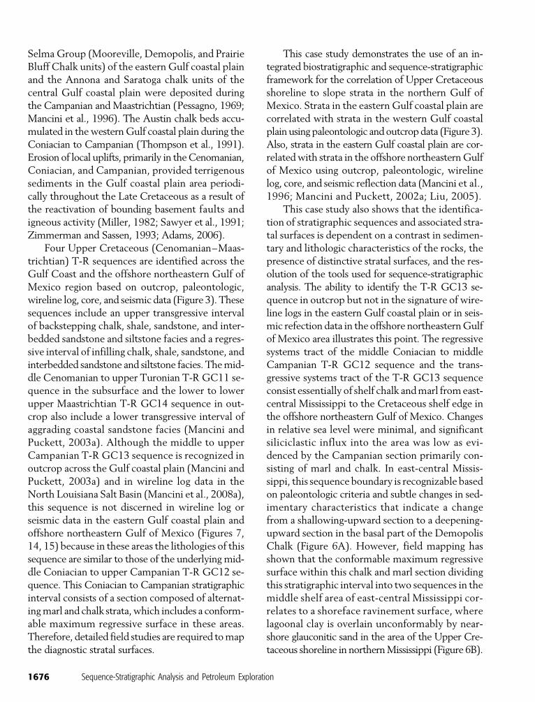
Selma Group (Mooreville, Demopolis, and PrairieBluff Chalk units) of the eastern Gulf coastal plainand the Annona and Saratoga chalk units of thecentral Gulf coastal plain were deposited duringthe Campanian and Maastrichtian (Pessagno, 1969;Mancini et al., 1996). The Austin chalk beds accu-mulated in thewesternGulf coastal plain during theConiacian to Campanian (Thompson et al., 1991).Erosion of local uplifts, primarily in theCenomanian,Coniacian, and Campanian, provided terrigenoussediments in the Gulf coastal plain area periodi-cally throughout the Late Cretaceous as a result ofthe reactivation of bounding basement faults andigneous activity (Miller, 1982; Sawyer et al., 1991;Zimmerman and Sassen, 1993; Adams, 2006).
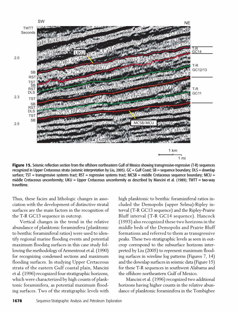
Four Upper Cretaceous (Cenomanian–Maas-trichtian) T-R sequences are identified across theGulf Coast and the offshore northeastern Gulf ofMexico region based on outcrop, paleontologic,wireline log, core, and seismic data (Figure 3). Thesesequences include an upper transgressive intervalof backstepping chalk, shale, sandstone, and inter-bedded sandstone and siltstone facies and a regres-sive interval of infilling chalk, shale, sandstone, andinterbedded sandstone and siltstone facies. Themid-dle Cenomanian to upper Turonian T-R GC11 se-quence in the subsurface and the lower to lowerupper Maastrichtian T-R GC14 sequence in out-crop also include a lower transgressive interval ofaggrading coastal sandstone facies (Mancini andPuckett, 2003a). Although the middle to upperCampanian T-R GC13 sequence is recognized inoutcrop across the Gulf coastal plain (Mancini andPuckett, 2003a) and in wireline log data in theNorth Louisiana Salt Basin (Mancini et al., 2008a),this sequence is not discerned in wireline log orseismic data in the eastern Gulf coastal plain andoffshore northeastern Gulf of Mexico (Figures 7,14, 15) because in these areas the lithologies of thissequence are similar to those of the underlying mid-dle Coniacian to upper Campanian T-R GC12 se-quence. This Coniacian to Campanian stratigraphicinterval consists of a section composed of alternat-ingmarl and chalk strata,which includes a conform-able maximum regressive surface in these areas.Therefore, detailed field studies are required tomapthe diagnostic stratal surfaces.
This case study demonstrates the use of an in-tegrated biostratigraphic and sequence-stratigraphicframework for the correlation of Upper Cretaceousshoreline to slope strata in the northern Gulf ofMexico. Strata in the eastern Gulf coastal plain arecorrelated with strata in the western Gulf coastalplain using paleontologic andoutcropdata (Figure 3).Also, strata in the eastern Gulf coastal plain are cor-relatedwith strata in the offshore northeasternGulfof Mexico using outcrop, paleontologic, wirelinelog, core, and seismic reflection data (Mancini et al.,1996; Mancini and Puckett, 2002a; Liu, 2005).
This case study also shows that the identifica-tion of stratigraphic sequences and associated stra-tal surfaces is dependent on a contrast in sedimen-tary and lithologic characteristics of the rocks, thepresence of distinctive stratal surfaces, and the res-olution of the tools used for sequence-stratigraphicanalysis. The ability to identify the T-R GC13 se-quence in outcrop but not in the signature of wire-line logs in the eastern Gulf coastal plain or in seis-mic refection data in the offshore northeasternGulfof Mexico area illustrates this point. The regressivesystems tract of the middle Coniacian to middleCampanian T-R GC12 sequence and the trans-gressive systems tract of the T-R GC13 sequenceconsist essentially of shelf chalk andmarl fromeast-central Mississippi to the Cretaceous shelf edge inthe offshore northeastern Gulf of Mexico. Changesin relative sea level were minimal, and significantsiliciclastic influx into the area was low as evi-denced by the Campanian section primarily con-sisting of marl and chalk. In east-central Missis-sippi, this sequence boundary is recognizable basedon paleontologic criteria and subtle changes in sed-imentary characteristics that indicate a changefrom a shallowing-upward section to a deepening-upward section in the basal part of the DemopolisChalk (Figure 6A). However, field mapping hasshown that the conformable maximum regressivesurface within this chalk and marl section dividingthis stratigraphic interval into two sequences in themiddle shelf area of east-central Mississippi cor-relates to a shoreface ravinement surface, wherelagoonal clay is overlain unconformably by near-shore glauconitic sand in the area of the Upper Cre-taceous shoreline in northernMississippi (Figure 6B).
1676 Sequence-Stratigraphic Analysis and Petroleum Exploration
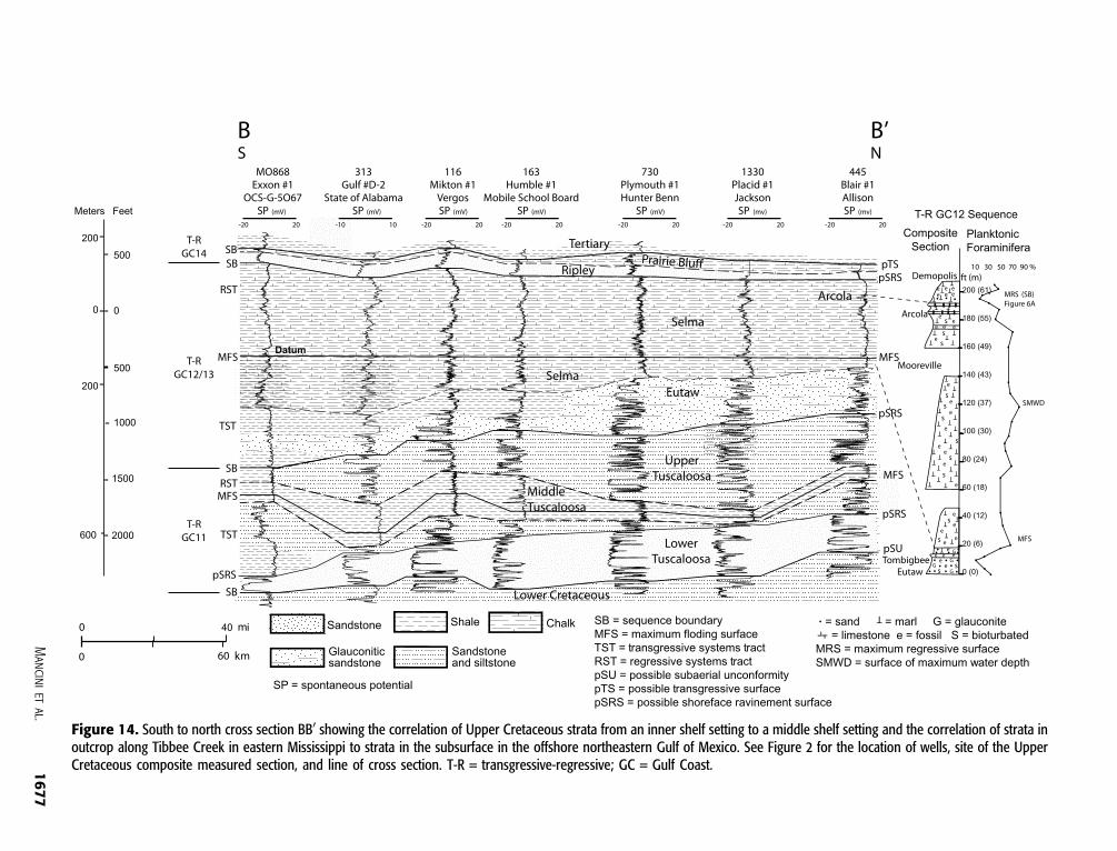
Figure 14. South to north cross section BB0 showing the correlation of Upper Cretaceous strata from an inner shelf setting to a middle shelf setting and the correlation of strata inoutcrop along Tibbee Creek in eastern Mississippi to strata in the subsurface in the offshore northeastern Gulf of Mexico. See Figure 2 for the location of wells, site of the UpperCretaceous composite measured section, and line of cross section. T-R = transgressive-regressive; GC = Gulf Coast.
Mancinietal.
1677
Thus, these facies and lithologic changes in asso-ciation with the development of distinctive stratalsurfaces are the main factors in the recognition ofthe T-R GC13 sequence in outcrop.
Vertical changes in the trend in the relativeabundance of planktonic foraminifera (planktonicto benthic foraminiferal ratios) were used to iden-tify regional marine flooding events and potentialmaximum flooding surfaces in this case study fol-lowing themethodology ofArmentrout et al. (1990)for recognizing condensed sections and maximumflooding surfaces. In studying Upper Cretaceousstrata of the eastern Gulf coastal plain, Manciniet al. (1996) recognized four stratigraphic horizons,which were characterized by high counts of plank-tonic foraminifera, as potential maximum flood-ing surfaces. Two of the stratigraphic levels with
high planktonic to benthic foraminiferal ratios in-cluded the Demopolis (upper Selma)-Ripley in-terval (T-R GC13 sequence) and the Ripley-PrairieBluff interval (T-R GC14 sequence). Hancock(1993) also recognized these two horizons in themiddle beds of the Demopolis and Prairie Bluffformations and referred to them as transgressivepeaks. These two stratigraphic levels as seen in out-crop correspond to the subsurface horizons inter-preted by Liu (2005) to represent maximum flood-ing surfaces in wireline log patterns (Figures 7, 14)and the downlap surfaces in seismic data (Figure 15)for these T-R sequences in southwest Alabama andthe offshore northeastern Gulf of Mexico.
Mancini et al. (1996) recognized two additionalhorizons having higher counts in the relative abun-dance of planktonic foraminifera in the Tombigbee
Figure 15. Seismic reflection section from the offshore northeastern Gulf of Mexico showing transgressive-regressive (T-R) sequencesrecognized in Upper Cretaceous strata (seismic interpretation by Liu, 2005). GC = Gulf Coast; SB = sequence boundary; DLS = downlapsurface; TST = transgressive systems tract; RST = regressive systems tract; MCSB = middle Cretaceous sequence boundary; MCU =middle Cretaceous unconformity; UKU = Upper Cretaceous unconformity as described by Mancini et al. (1989); TWTT = two-waytraveltime.
1678 Sequence-Stratigraphic Analysis and Petroleum Exploration
(Eutaw)-Mooreville (lower Selma) interval. Theyselected the stratigraphic level in the middle toupper Mooreville beds with the highest counts ofplanktonic foraminifera as a potential maximumflooding surface, although they observed no sedi-mentologic evidence in these strata to support thisinterpretation. The stratigraphic level in the lowerMooreville directly above theTombigbee-Moorevillecontact alsowas characterized by a high planktonicto benthic foraminiferal ratio, but this count wasnot as high as the count of planktonic foraminiferaas calculated for the horizon in the middle to up-per Mooreville beds (Figure 14). The high countof planktonic foraminifera directly above theTombigbee-Mooreville contact was interpretedby these authors to represent a change in facies.At this horizon, a transition from nearshore glau-conitic sand to shelf marl and chalk is observed(Figure 14). Liu (2005) has shown that the maxi-mum flooding surface for the T-R GC12 sequenceas determined from theMancini et al. (1996) studyof outcrops does not correspond to the maximumflooding surface as recognized in the subsurface ofsouthwest Alabama and the offshore northeasternGulf ofMexico region. In the subsurface, themaxi-mum flooding surface and downlap surface occurin the lower Selma (Mooreville) beds above theEutaw-Selma contact (Liu, 2005). Therefore, inoutcrop, the stratigraphic level in the transitionalsandy marl beds of the lower Mooreville directlyabove the Tombigbee (Eutaw)-Mooreville (lowerSelma) contact corresponds to themaximumflood-ing surface and downlap surface in the subsurface.The horizon with high counts of planktonic fora-minifera in the middle to upper Mooreville bedsprobably represents themaximumwater depth ob-tained in this interval. The surface of maximumwater depth occurring stratigraphically above thesurface ofmaximumsediment starvation andmaxi-mum flooding surface and in the lower part of theregressive systems tract or highstand systems tractis common because of differing rates and amountsof sediment accumulation and depositional condi-tions (Loutit et al., 1988; Naish and Kamp, 1997;Catuneanu et al., 1998; Liu, 2005). This exampledemonstrates that if only relative fossil abundancepeaks are used to recognize a surface of maximum
sediment starvation and maximum flooding sur-face, errors in stratal correlation can result.
INTRABASIN AND INTERBASIN CORRELATION
TheUpper Jurassic andCretaceous T-R sequencesrecognized provide ameans for intrabasin and inter-basin correlation of the strata in the Gulf coastalplain.Maximum flooding surfaces (and surfaces ofmaximum transgression of Mancini and Puckett,2005) have been identified and correlated in thisarea by Mancini et al. (1996, 2004a), Puckett andMancini (1998), Badali (2002),Mancini andPuckett(2002a, b; 2003a), Liu (2005), Mancini and Scott(2006), and Obid (2006) (Figure 3). These regionalmarine flooding surfaces have been observed to bethe key for potential chronocorrelation by Manciniand Puckett (2005) because these surfaces are as-sumed to approximate synchronous horizons. Basedon available biostratigraphic data, maximum flood-ing surfaces approximate synchroneity in strataof the eastern and western Gulf coastal plain areas(Mancini et al., 1996). Correspondence of theseT-R sequences and their associated maximumflooding surfaces in the eastern Gulf coastal plainwith those of the western Gulf coastal plain dem-onstrates the utility of constructing an integratedsequence-stratigraphic and biostratigraphic frame-work for regional correlation.
BASIN GEOHISTORY INTERPRETATION
By using an integrated sequence-stratigraphic andbiostratigraphic approach for the northern Gulfof Mexico, the geohistory of the basins in this areacan be interpreted. Integral to this interpretation isthe assumption that maximum marine floodingsurfaces identified and correlated provide reason-able data for chronocorrelation and that these sur-faces approximate synchronous horizons. Majormarine flooding events include the following: Ox-fordian (Smackover), Kimmeridgian (Haynesville),Berriasian (CottonValley andKnowles),Aptian (PineIsland or Hammett and Bexar), Albian (Ferry Lakeor Glen Rose , Fredericksburg, and lower Washita),
Mancini et al. 1679
Cenomanian (upperWashita), Turonian (Tuscaloosaor Eagle Ford), Campanian (Mooreville or Brows-town and Demopolis or Marlbrook), Maastricht-ian (Prairie Bluff or Arkadelphia or Corsicana). TheOxfordian, Aptian, Albian, Turonian, Campanian,and Maastrichtian events represent widespread ma-rine transgressions in the northern Gulf of Mex-ico (Salvador, 1991; Mancini and Puckett, 2005).
During the late Callovian to early Oxfordian,middleValanginian, andmiddle Cenomanian, tec-tonic subsidence rates and stratigraphic base levelwere high in theGulf coastal plain, resulting in theproduction of substantial accommodation space(Mancini and Puckett, 2005). These conditions re-sulted in the accumulation of transgressive aggrad-ing eolian and fluvial deposits of the Norphlet For-mation, the aggrading fluvial and coastal depositsof the Hosston Formation, and the aggrading flu-vial and coastal deposits of the lower sandstonesof the Tuscaloosa Group (Mancini and Puckett,2003b). These aggrading facies accumulated duringan initial rise in stratigraphic base level that post-dated the fall in base level that produced the wide-spreadCallovian–Oxfordian, Valanginian, andCe-nomanian regional unconformities recognized inthe northern Gulf of Mexico (Buffler, 1991; Mc-Farlan and Menes, 1991; Salvador, 1991; Manciniand Puckett, 2005). Salvador (1991) provided aseries of paleogeographic maps for key time in-tervals for Mesozoic deposition in the northernGulf of Mexico.
Major base-level falls in the Gulf coastal plainoccurred during the Callovian–Oxfordian (Louann–Norphlet interval), Valanginian (Cotton Valley–Hosston interval), Cenomanian (Dantzler orWashita–Tuscaloosa and Washita–Woodbine in-tervals), Turonian toConiacian (Tuscaloosa–Eutawand Eagle Ford–Tokio or Austin intervals), andCampanian to Maastrichtian (Ripley, Nacatoch,and Nacatoch–Corsicana intervals) (Pessagno,1990; Buffler, 1991; McFarlan and Menes, 1991;Salvador, 1991; Thompson et al., 1991; Manciniet al., 1996). The Callovian–Oxfordian, Valanginian,and Cenomanian unconformities are especiallysignificant products of these episodes of base-levelfall (Buffler, 1991; McFarlan and Menes, 1991;Salvador, 1991).
APPLICATION TO PETROLEUM EXPLORATION
As shown in the case studies for Upper Jurassicand Cretaceous strata in the Gulf coastal plain, theformulation of an integrated sequence-stratigraphicand biostratigraphic framework facilitates the re-construction of the geohistory of a basin. Knowledgeof this geohistory is vital in the design of an effectivepetroleum exploration strategy. Also, an understand-ing of the tectonic, depositional, burial, and thermalmaturation histories is important in modeling fluid-flow pathways in sedimentary basins, in performingpetroleum system analysis, and in assessing the oiland gas resources of a basin as demonstrated byMancini et al. (1999, 2003, 2006a, 2008a, b).
Mancini et al. (2006a) used an integrated strat-igraphic classification in categorizing the petroleumreservoirs in the Gulf coastal plain. These reser-voirs were classified as T-R systems tracts and fa-cies (Table 1). Themajor oil reservoirs for theNorthLouisiana Salt Basin are Upper Cretaceous trans-gressive backstepping marine sandstone facies ofT-R sequences. The chief gas reservoirs in this ba-sin are Cretaceous regressive infilling nearshore ma-rine, shelf, and reef carbonate facies and Cretaceousfluvial and marine sandstone facies (Tables 1, 2).The main oil reservoirs for the Mississippi InteriorSalt Basin are Upper Cretaceous transgressive ag-grading fluvial and coastal sandstone facies, andUpper Jurassic regressive infilling ramp and reef car-bonate facies. The primary gas reservoirs are Cre-taceous transgressive aggrading fluvial and coastalsandstone facies and transgressive backsteppingma-rine facies, and Upper Jurassic regressive infillingramp and reef carbonate facies. Transgressive ag-grading eolian facies of theUpper JurassicNorphletFormation are a major gas reservoir in the offshoreAlabama area (Mancini and Puckett, 2003b). Thetransgressive aggrading eolian and fluvial sandstonefacies of the Norphlet Formation, the fluvial andcoastal sandstone deposits of theLowerCretaceousHosstonFormation, and the fluvial and coastal lowersandstone facies of the Upper Cretaceous Tusca-loosa Group have produced some 36% of the totalgas volume for the onshoreMississippi andAlabamaand offshore Alabama area (Mancini and Puckett,2003b).
1680 Sequence-Stratigraphic Analysis and Petroleum Exploration
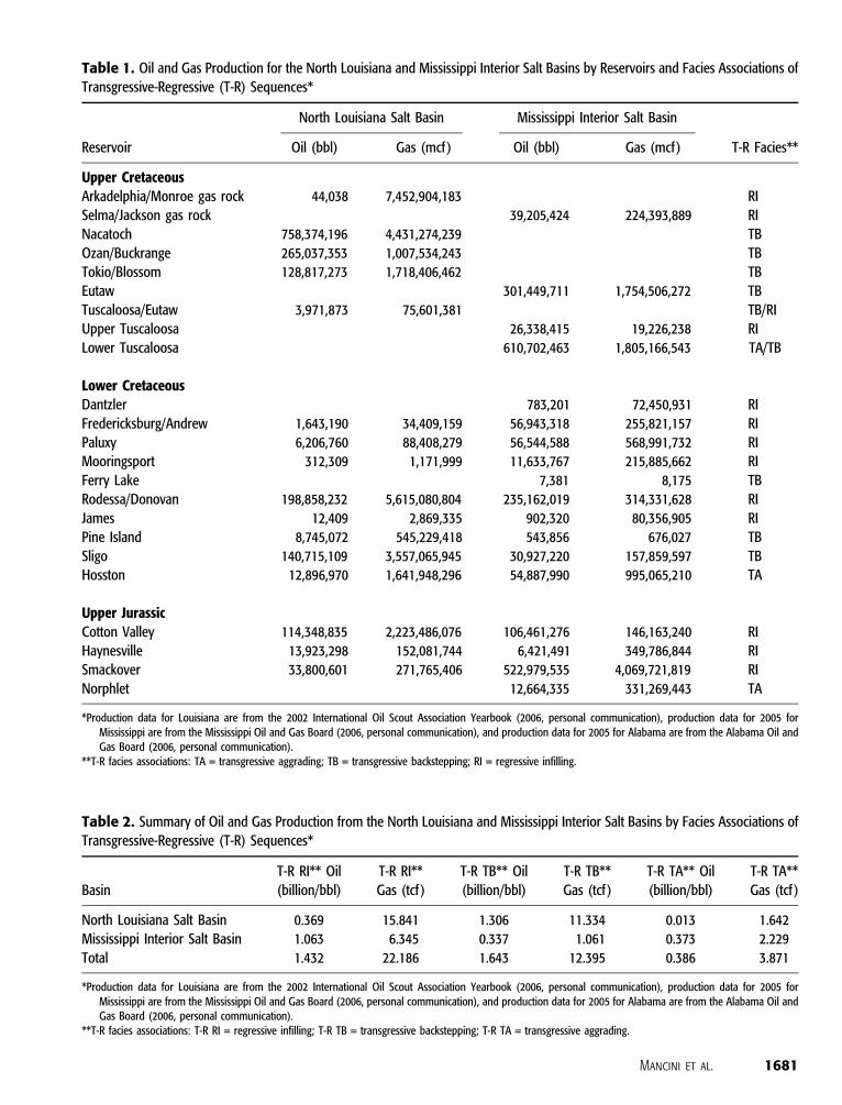
Table 1. Oil and Gas Production for the North Louisiana and Mississippi Interior Salt Basins by Reservoirs and Facies Associations ofTransgressive-Regressive (T-R) Sequences*
Reservoir
North Louisiana Salt Basin Mississippi Interior Salt Basin
T-R Facies**Oil (bbl) Gas (mcf ) Oil (bbl) Gas (mcf)
Upper CretaceousArkadelphia/Monroe gas rock 44,038 7,452,904,183 RI
Selma/Jackson gas rock 39,205,424 224,393,889 RI
Nacatoch 758,374,196 4,431,274,239 TB
Ozan/Buckrange 265,037,353 1,007,534,243 TB
Tokio/Blossom 128,817,273 1,718,406,462 TB
Eutaw 301,449,711 1,754,506,272 TB
Tuscaloosa/Eutaw 3,971,873 75,601,381 TB/RI
Upper Tuscaloosa 26,338,415 19,226,238 RI
Lower Tuscaloosa 610,702,463 1,805,166,543 TA/TB
Lower CretaceousDantzler 783,201 72,450,931 RI
Fredericksburg/Andrew 1,643,190 34,409,159 56,943,318 255,821,157 RI
Paluxy 6,206,760 88,408,279 56,544,588 568,991,732 RI
Mooringsport 312,309 1,171,999 11,633,767 215,885,662 RI
Ferry Lake 7,381 8,175 TB
Rodessa/Donovan 198,858,232 5,615,080,804 235,162,019 314,331,628 RI
James 12,409 2,869,335 902,320 80,356,905 RI
Pine Island 8,745,072 545,229,418 543,856 676,027 TB
Sligo 140,715,109 3,557,065,945 30,927,220 157,859,597 TB
Hosston 12,896,970 1,641,948,296 54,887,990 995,065,210 TA
Upper JurassicCotton Valley 114,348,835 2,223,486,076 106,461,276 146,163,240 RI
Haynesville 13,923,298 152,081,744 6,421,491 349,786,844 RI
Smackover 33,800,601 271,765,406 522,979,535 4,069,721,819 RI
Norphlet 12,664,335 331,269,443 TA
*Production data for Louisiana are from the 2002 International Oil Scout Association Yearbook (2006, personal communication), production data for 2005 forMississippi are from the Mississippi Oil and Gas Board (2006, personal communication), and production data for 2005 for Alabama are from the Alabama Oil andGas Board (2006, personal communication).
**T-R facies associations: TA = transgressive aggrading; TB = transgressive backstepping; RI = regressive infilling.
Table 2. Summary of Oil and Gas Production from the North Louisiana and Mississippi Interior Salt Basins by Facies Associations of
Transgressive-Regressive (T-R) Sequences*
Basin
T-R RI** Oil
(billion/bbl)
T-R RI**
Gas (tcf )
T-R TB** Oil
(billion/bbl)
T-R TB**
Gas (tcf )
T-R TA** Oil
(billion/bbl)
T-R TA**
Gas (tcf )
North Louisiana Salt Basin 0.369 15.841 1.306 11.334 0.013 1.642
Mississippi Interior Salt Basin 1.063 6.345 0.337 1.061 0.373 2.229
Total 1.432 22.186 1.643 12.395 0.386 3.871
*Production data for Louisiana are from the 2002 International Oil Scout Association Yearbook (2006, personal communication), production data for 2005 forMississippi are from the Mississippi Oil and Gas Board (2006, personal communication), and production data for 2005 for Alabama are from the Alabama Oil andGas Board (2006, personal communication).
**T-R facies associations: T-R RI = regressive infilling; T-R TB = transgressive backstepping; T-R TA = transgressive aggrading.
Mancini et al. 1681

Petroleum source rocks in the central and east-ern Gulf coastal plain are lime mudstone and ma-rine shale of the transgressive backstepping faciesassociation interval of T-R sequences (Figure 3).The Upper Jurassic Smackover transgressive limemudstone beds are an effective regional sourcerock in theGulf coastal plain, andUpperCretaceousTuscaloosa transgressive shale beds are an effectivelocal source rock in the Mississippi Interior SaltBasin (Mancini et al., 2008a, b). Additional trans-gressive backstepping marine facies that havefavorable petroleum source rock characteristics in-clude Upper Jurassic and Lower Cretaceous Bos-sier, Pine Island, andMooringsport shale beds. TheSmackover lime mudstone and the uppermost Ju-rassic and Lower Cretaceous shale beds also serveas petroleum seal rocks along with anhydrite bedsof the Upper Jurassic Buckner (mainly regressiveinfilling facies association) and of the Lower Cre-taceous Ferry Lake (transgressive backstepping fa-cies association).
The prediction of potential reservoir facies isimportant in the design of a cost-effective oil andgas exploration strategy. As illustrated by the hy-drocarbon productivity of the transgressive aggrad-ing reservoirs in the eastern Gulf coastal plain, thesefacies have excellent potential as exploration tar-gets. The targets include Norphlet eolian and flu-vial, Hosston fluvial and coastal, and lower Tus-caloosa fluvial and coastal sandstone facies. Theseaggrading facies association intervals exceed a thick-ness of hundreds of feet and have a widespread geo-graphic distribution. The sandstone deposits arequartz rich having porosities of 12 to 28.5% andpermeabilities of 4 to 495md (Mancini and Puckett,2003b). Other high-potential reservoir intervalsinclude Upper Jurassic and Cretaceous regressiveinfilling fluvial to nearshore marine Haynesville,Cotton Valley, Rodessa (Donovan), Mooringsport,Paluxy, Fredericksburg, and Eutaw sandstone facies,and Upper Jurassic Smackover and Upper Creta-ceous Selma (Jackson gas rock)marine shelf, ramp,and reef carbonate facies in the Mississippi In-terior Salt Basin. In the North Louisiana Salt Ba-sin, Upper Cretaceous transgressive backsteppingnearshore marine sandstone facies of the Tokio,Ozan, and Nacatoch formations and regressive in-
filling nearshore marine, shelf, ramp, and reef car-bonate facies of the Upper Jurassic Smackover,Lower Cretaceous Rodessa and Sligo, and UpperCretaceous Arkadelphia (Monroe gas rock) for-mations and fluvial to marine sandstone facies oftheCottonValleyGroup constitute high-potentialreservoir intervals.
The T-R sequences, systems tracts, and faciesassociations are recognized by their characteristicwireline log signatures and seismic reflection con-figurations. The transgressive aggrading nonma-rine and coastal facies association interval is typi-cally characterized by a boxlike smooth gamma rayor static SP wireline log pattern (Figure 7) and bya thick (several seismic cycles) interval of seismicreflectors exhibiting an aggradational reflection con-figuration. The transgressive backstepping ma-rine facies association interval is identified by anoverall increase in gamma ray or a change to amorepositive SP wireline log response (bell shaped)(Figure 7) and by a thin (commonly one to twoseismic cycles) interval of seismic reflectors ex-hibiting a retrogradational reflection configuration(Figure 8). The regressive infilling marine to non-marine facies association interval is recognizedby an overall decrease in gamma ray or a changeto a more negative SP wireline log pattern (funnelshaped) (Figure 7) and by a thick (several cycles)interval of seismic reflectors exhibiting a prograda-tional reflection configuration (Figure 8).
CONCLUSIONS
In studying the interior salt basins and subbasinsof the Gulf coastal plain of the United States thatare filled primarily with Mesozoic postrift non-marine to marine siliciclastic and carbonate de-posits, the establishment of an integrated sequence-stratigraphic and biostratigraphic framework forthese sedimentary basins was critical in the inter-pretation of basin geohistory and in the formulationof an effective strategy for petroleum exploration.
In using T-R sequences as the sequence-stratigraphic component of this classification, 14sequences are recognized in Upper Jurassic and
1682 Sequence-Stratigraphic Analysis and Petroleum Exploration
Cretaceous strata of the Gulf coastal plain. The se-quences consist of a transgressive systems tractthat includes an aggrading nonmarine and coastalfacies association and backstepping marine fa-cies association and a regressive systems tract thatconsists of an infilling marine to nonmarine fa-cies association. These sequences, systems tracts,facies associations, and their associated maximumflooding surfaces are useful for the correlation ofJurassic–Cretaceous strata in the northern Gulf ofMexico.
Knowledge of the characteristic wireline logsignatures and seismic reflection configurations ofthe transgressive aggrading and backstepping andregressive infilling facies associated with the sys-tems tracts of the T-R sequences facilitates the de-sign of a petroleum exploration strategy to identifyand delineate potential Upper Jurassic and Creta-ceous nonmarine to marine siliciclastic and carbon-ate reservoir facies in the Gulf coastal plain.
The integrated sequence-stratigraphic andbio-stratigraphic classification described in this articleis for Mesozoic postrift nonmarine to marine silic-iclastic and carbonate strata in interior salt basinsof the northern Gulf of Mexico. This classificationhas potential for application in other interior saltbasins filled with postrift Mesozoic deposits.
REFERENCES CITED
Adams, R. L., 2006, Basement tectonics and origin of theSabine uplift, in The Gulf Coast Mesozoic SandstoneGas Province Symposium Volume: Tyler, East TexasGeological Society 2006 Symposium, p. 1-1 to 1-31.
Ahr, W. M., 1973, The carbonate ramp; an alternative tothe shelf model: Gulf Coast Association of GeologicalSocieties Transactions, v. 23, p. 221–225.
Armentrout, J.M., R. J. Echols, andD. L. Lee, 1990, Patternsof foraminiferal abundance and diversity: Implicationsfor sequence stratigraphic analysis, in J. M. Armentroutand B. F. Perkins, eds., Sequence stratigraphy as an ex-ploration tool: Concepts and practices in theGulf Coast:Proceedings of the 11th Annual Gulf Coast Section SEPMFoundation Research Conference: p. 53–58.
Badali, M., 2002, Seismic and sequence stratigraphy of theLower Cretaceous strata in the northeastern Gulf ofMexico area: Ph.D. dissertation, University of Alabama,Tuscaloosa, 219 p.
Baum, G. R., and P. R. Vail, 1988, Sequence stratigraphicconcepts applied to Paleogene outcrops, Gulf and At-lantic basins, in C. K. Wilgus, B. S. Hastings, C. A. Ross,
H.W. Posamentier, J. C. VanWagoner, and C. G. St. C.Kendall, eds., Sea level changes: An integrated approach:SEPM (Society for Sedimentary Geology) Special Publi-cation 42, p. 309–327.
Buffler, R. T., 1991, Seismic stratigraphy of the deep Gulf ofMexico Basin and adjacent areas, in A. Salvador, ed.,TheGulf ofMexicoBasin:Geological Society ofAmerica,Decade of North American Geology, v. J, p. 353–387.
Buffler, R. T., and D. S. Sawyer, 1985, Distribution of thecrust and early history, Gulf ofMexico Basin: Gulf CoastAssociation of Geological Societies Transactions, v. 35,p. 333–344.
Caron, M., 1985, Cretaceous planktic foraminifera, inH. M.Bolli, J. B. Saunders, and K. Perch-Nielsen, eds., Planktonstratigraphy: New York, Cambridge University Press,p. 17–86.
Catuneanu, O., A. J.Willis, and A. D.Miall, 1998, Temporalsignificance of sequence boundaries: Sedimentary Geol-ogy, v. 121, p. 157–178.
Cooper,W.W., and B. L. Shaffer, 1976,Nannofossil biostratig-raphy of the Bossier Shale and the Jurassic–Cretaceousboundary: Gulf Coast Association of Geological SocietiesTransactions, v. 26, p. 178–184.
Donovan, A. D., 2004, Escaping the Tower of Babel; a para-digm shift from discontinuity- to surface-bounded strat-igraphic units (abs): International Geological Congress2004 Abstract Volume, part 2, p. 1502.
Embry, A. F., 1993, Transgressive-regressive (T-R) sequenceanalysis of the Jurassic succession of the Sverdrup Basin,Canadian Arctic archipelago: Canadian Journal of EarthSciences, v. 30, p. 301–320.
Embry, A. F., 2002, Transgressive-regressive (T-R) sequencestratigraphy, in J. M. Armentrout and N. C. Rosen, eds.,Sequence stratigraphic models for exploration and pro-duction: Evolving methodology, emerging models andapplication histories: Proceedings of the 22nd AnnualBob F. Perkins Research Conference: Houston, GulfCoast Section, SEPM, p. 151–172.
Gradstein, F.M., J. G.Ogg, A.G. Smith,W. Bleeker, and L. J.Lourens, 2004, A new geologic time scale with specialreference to Precambrian and Neogene: Episodes, v. 27,p. 83–100.
Hancock, J. M., 1993, Transatlantic correlations in theCampanian–Maastrichtian stages by eustatic changes insea level, in E. A. Hailwood and R. B. Kidd, eds., Highresolution stratigraphy in modern and ancient marinesystems: Geological Society (London) Special Publica-tion 70, p. 241–256.
Hancock, J. M., W. J. Kennedy, and W. A. Cobban, 1993, Acorrelation of the upper Albian to basal Coniacian se-quences of northwest Europe, Texas and the UnitedStates western interior, in W. G. E. Caldwell and E. G.Kauffman, eds., Evaluation of the Western Interior Ba-sin: Geological Association of Canada Special Paper 39,p. 453–476.
Haq, B. L., J. Hardenbol, and P. R. Vail, 1988, Mesozoic andCenozoic chronostratigraphy and eustatic cycles, in C. K.Wilgus, B. S. Hastings, C. A. Ross, H. W. Posamentier,J. C. Van Wagoner, and C. G. St. C. Kendall, eds., Sealevel changes: An integrated approach: SEPM (Society
Mancini et al. 1683
for Sedimentary Geology) Special Publication 42, p. 71–108.
Hardenbol, J., J. Thierry, M. B. Farley, T. Jacquin, P.-C. deGraciansky, and P. R. Vail, 1998, Jurassic and Creta-ceous sequence chronostratigraphy, in P.-C. de Gra-ciansky, J. Hardenbol, T. Jacquin, and P. R. Vail, eds.,Mesozoic and Cenozoic sequence stratigraphy of Euro-pean basins: SEPM (Society for Sedimentary Geology)Special Publication 60, Charts 4 and 6, 2 p.
Hughes, D. L., 1968, Salt tectonics as related to severalSmackover fields along the northeast rim of the Gulf ofMexico basin: Gulf Coast Association of GeologicalSocieties Transactions, v. 18, p. 320–330.
Imlay, R. W., and G. Herman, 1984, Upper Jurassic am-monites of the subsurface of Texas, Louisiana, and Mis-sissippi, inW.P. S. Ventress,D.G. Bebout, B. F. Perkins,and C. H. Moore, eds., The Jurassic of the Gulf rim:Proceedings of the 3rd Annual Gulf Coast Section SEPMFoundation Research Conference, p. 149–170.
Immenhauser, A., and R. W. Scott, 1999, Global correlationof middle Cretaceous sea level events: Geology, v. 27,p. 551–554.
Jacquin, T., and P.-C. deGraciansky, 1998,Major transgressive/regressive (second order) facies cycles: The effects oftectono-eustasy, in P.-C. de Graciansky, J. Hardenbol,T. Jacquin, and P. R. Vail, eds., Mesozoic and Cenozoicsequence stratigraphy of European basins: SEPM (So-ciety for Sedimentary Geology) Special Publication 60,p. 31–42.
Kirkland, D.W., and J. E. Gerhard, 1971, Jurassic salt, centralGulf of Mexico, and its temporal relation to circum-Gulfevaporites: AAPG Bulletin, v. 55, p. 680–686.
Liu, K., 2005, Scales of cyclicity and stratigraphic correlationof Upper Cretaceous strata in the northeastern Gulf ofMexico area: Ph.D. dissertation, University of Alabama,Tuscaloosa, 225 p.
Lobao, J. J., and R. H. Pilger Jr., 1985, Early evolution of saltstructures in the North Louisiana Salt Basin: Gulf CoastAssociation Geological Societies Transactions, v. 35,p. 189–198.
Loutit, T. S., J. Hardenbol, P. R. Vail, and G. R. Baum, 1988,Condensed sections: The key to age dating and correla-tion of continental margin sequences, in C. K. Wilgus,B. S. Hastings, C. A. Ross, H.W. Posamentier, J. C. VanWagoner, andC.G. St. C. Kendall, eds., Sea level changes:An integrated approach: SEPM (Society for Sedimen-tary Geology) Special Publication 42, p. 183–213.
Mancini, E. A., 1977, Depositional environment of theGrayson Formation (Upper Cretaceous) of Texas: GulfCoast Association of Geological Societies Transactions,v. 27, p. 334–351.
Mancini, E. A., 1979, Late Albian and early CenomanianGrayson ammonite biostratigraphy in north-central Texas:Journal of Paleontology, v. 53, p. 1013–1022.
Mancini, E. A., and D. J. Benson, 1980, Regional stratigraphyof Upper Jurassic Smackover carbonates of southwestAlabama:Gulf Coast Association ofGeological SocietiesTransactions, v. 30, p. 151–165.
Mancini, E. A., and T. M. Puckett, 2002a, Transgressive-regressive cycles in Lower Cretaceous strata, Mississippi
Interior Salt Basin area of the northeastern Gulf of Mex-ico, U.S.A.: Cretaceous Research, v. 23, p. 409–438.
Mancini, E. A., and T. M. Puckett, 2002b, Transgressive-regressive cycles: Application to petroleum explorationfor hydrocarbons associated with Cretaceous shelf car-bonates and coastal and fluvial-deltaic siliciclastics, north-eastern Gulf of Mexico, in J. M. Armentrout and N. C.Rosen, eds., Sequence stratigraphic models for explora-tion and production: Evolving methodology, emergingmodels and application histories: Proceedings of the 22ndAnnual Bob F. Perkins Research Conference, Houston,Gulf Coast Section, SEPM, p. 173–199.
Mancini, E. A., and T. M. Puckett, 2003a, Integrated bio-stratigraphic and sequence stratigraphic approach for cor-relation and basin interpretation: Gulf Coast Associationof Geological Societies Transactions, v. 53, p. 517–526.
Mancini, E. A., and T. M. Puckett, 2003b, Petroleum poten-tial of aggrading sandstones of transgressive-regressivecycles in the Mississippi-Alabama area: Gulf Coast As-sociation of Geological Societies Transactions, v. 53,p. 527–536.
Mancini, E. A., and T. M. Puckett, 2005, Jurassic and Cre-taceous transgressive-regressive (T-R) cycles, northernGulf of Mexico, U.S.A.: Stratigraphy, v. 2, p. 31–48.
Mancini, E. A., and R.W. Scott, 2006, Sequence stratigraphyof Comanchean Cretaceous outcrop strata of northeastand south central Texas: Implications for enhanced pe-troleum exploration: Gulf Coast Association of Geolog-ical Societies Transactions, v. 56, p. 539–550.
Mancini, E. A., and B. H. Tew, 1991, Relationships of Paleo-gene stage and planktonic foraminiferal zone bound-aries to lithostratigraphic and allostratigraphic contactsin the eastern Gulf coastal plain: Journal of Foraminif-eral Research, v. 21, p. 48–66.
Mancini, E. A., and B. H. Tew, 1995, Geochronology, bio-stratigraphy and sequence stratigraphy of a marginal ma-rine to marine shelf stratigraphic succession: Upper Paleo-cene and lower Eocene,WilcoxGroup, easternGulf coastalplain, U.S.A., inW.A. Berggren, D. V. Kent,M. P. Aubry,and J. Hardenbol, eds., Geochronology, time scales andglobal stratigraphic correlation: SEPM (Society for Sedi-mentary Geology) Special Publication 54, p. 281–293.
Mancini, E. A., R.M.Mink, B. L. Bearden, and R. P.Wilkerson,1985, Norphlet Formation (Upper Jurassic) of south-western and offshore Alabama: Environments of depo-sition and petroleum geology: AAPG Bulletin, v. 69,p. 881–898.
Mancini, E. A., B.H. Tew, andC.C. Smith, 1989,Cretaceous–Tertiary contact, Mississippi and Alabama: Journal of For-aminiferal Research, v. 19, p. 93–104.
Mancini, E. A., B. H. Tew, and R. M. Mink, 1990, Jurassicsequence stratigraphy in the Mississippi Interior SaltBasin of Alabama: Gulf Coast Association of GeologicalSocieties Transactions, v. 40, p. 521–529.
Mancini, E. A., T.M. Puckett, and B. H. Tew, 1996, Integratedbiostratigraphic and sequence stratigraphic frameworkfor Upper Cretaceous strata of the eastern Gulf coastalplain, U.S.A.: Cretaceous Research, v. 17, p. 645–669.
Mancini, E. A., T. M. Puckett, W. C. Parcell, and B. J. Panetta,1999, Topical reports 1 and 2. Basin analysis of the
1684 Sequence-Stratigraphic Analysis and Petroleum Exploration
Mississippi Interior Salt Basin and petroleum systemmod-eling of the Jurassic Smackover Formation, eastern Gulfcoastal plain: U.S. Department of Energy Technical Re-port, Project Number DE-FG22-96BC14946, 425 p.
Mancini, E. A.,W. C. Parcell, T.M. Puckett, andD. J. Benson,2003, Upper Jurassic (Oxfordian) Smackover carbonatepetroleum system characterization and modeling, Missis-sippi Interior Salt Basin area, northeastern Gulf of Mex-ico,U.S.A.: Carbonates and Evaporites, v. 18, p. 125–150.
Mancini, E. A., M. Aurell, J. C. Llinas, W. C. Parcell, B.Badenas, and D. J. Benson, 2004a, Upper Jurassic throm-bolite reservoir play, northeastern Gulf of Mexico: AAPGBulletin, v. 88, p. 1573–1602.
Mancini, E. A., J. Obid, and T. M. Puckett, 2004b, UpperJurassic transgressive-regressive sequences, MississippiInterior Salt Basin area: Gulf Coast Association of Geo-logical Societies Transactions, v. 54, p. 415–424.
Mancini, E. A., D. A. Goddard, R. Barnaby, and P. Aharon,2006a, Resource assessment of the in-place and poten-tially recoverable deep natural gas resource of the onshoreinterior salt basins, north central and northeastern Gulfof Mexico: U.S. Department of Energy Final TechnicalReport, Project Number DE-FC26-03N41875, 173 p.
Mancini, E. A., D.A.Goddard, J. A.Obid, andV.O. Ramirez,2006b, Characterization of Jurassic and Cretaceous fa-cies and petroleum reservoirs in the interior salt basins,central and eastern Gulf coastal plain, in The Gulf CoastMesozoic Sandstone Gas Province Symposium Volume:Tyler, East Texas Geological Society 2006 Symposium,p. 11-1 to 11-27.
Mancini, E. A., W. C. Parcell, and B. S. Hart, 2006c, T-Rcycle characterization and imaging: Advanced diagnosticmethodology for petroleum reservoir and trap detectionand delineation: U.S. Department of Energy Final Tech-nical Report, Project Number DE-FC26-03NT15409,246 p.
Mancini, E. A., D. A. Goddard, M. Horn, R. Barnaby, andP. Aharon, 2008a, Basin analysis and petroleum systemcharacterization and modeling, central and eastern Gulfof Mexico: U.S. Department of Energy Final TechnicalReport, Project Number DE-FC26-03NT15395, 466 p.
Mancini, E. A., P. Li, V. O. Ramirez, D. A. Goddard, and S. C.Talukdar, 2008b, Mesozoic (Upper Jurassic–Lower Cre-taceous) deep gas reservoir play, central and eastern Gulfcoastal plain, U.S.A.: AAPG Bulletin, v. 92, p. 283–308.
Mann, S. D., 1988, Subaqueous evaporates of the BucknerMember, Haynesville Formation, northeastern MobileCounty, Alabama: Gulf Coast Association of GeologicalSocieties Transactions, v. 38, p. 187–196.
Mann, S. D., and D. C. Kopaska-Merkel, 1992, Depositionalhistory of the Smackover–Buckner transition, easternMississippi Interior Salt Basin: Gulf Coast Association ofGeological Societies Transactions, v. 42, p. 245–265.
Martin, R. G., 1978, Northern and eastern Gulf of Mexicocontinental margin: Stratigraphic and structural frame-work: AAPG Studies in Geology, v. 7, p. 21–42.
McFarlan Jr., E., and L. S. Menes, 1991, Lower Cretaceous,inA. Salvador, ed., The Gulf of Mexico Basin: GeologicalSociety of America, Decade of North American Geology,v. J, p. 181–204.
Miller, J. A., 1982, Structural control of Jurassic sedimen-tation in Alabama and Florida: AAPG Bulletin, v. 66,p. 1289–1301.
Mitchum Jr., R. M., P. R. Vail, and S. Thompson III, 1977,The depositional sequence as a basin unit for strati-graphic analysis: Part 2, in C. E. Payton, ed., Seismicstratigraphy— Applications to hydrocarbon exploration:AAPG Memoir 26, p. 53–62.
Naish, T., and P. J. J. Kamp, 1997, Foraminiferal depthpaleoecolgy of late Pliocene shelf sequences and systemstracts, Wanganui Basin, New Zealand: Sedimentary Ge-ology, v. 110, p. 237–255.
Nunn, J. A., 1984, Subsidence histories for the Jurassic sed-iments of the northern Gulf Coast: Thermal-mechanicalmodel, inW. P. S. Ventress, D. G. Bebout, B. F. Perkins,and C. H. Moore, eds., The Jurassic of the Gulf rim:Proceedings of the 3rdAnnual Gulf Coast Section SEPMFoundation Research Conference, p. 309–322.
Obid, J. A., 2006, Sequence and seismic stratigraphy of theJurassic strata in the northeastern Gulf of Mexico: Ph.D.dissertation, University of Alabama, Tuscaloosa, 253 p.
Pessagno Jr., E. A., 1969, Upper Cretaceous stratigraphy of thewestern Gulf Coastal area, Mexico, Texas, and Arkansas:Geological Society of America Memoir 111, 130 p.
Pessagno Jr., E. A., 1990, Cretaceous microfossils of northcentral Texas, micropaleontology field trip: GeologicalSociety of America 1990 Annual Meeting Guidebook,48 p.
Petty, A. J., S. Thieling, and T. Friedman, 1995, Mesozoicstratigraphy of near shelf-edge deposits, southernMissis-sippi, adjacent state and federal waters, in E. Batchelder,G.H. Larre, andB. Shepard, eds.,Geologize:NewOrleans,Minerals Management Service Office, v. 2, p. 9–10.
Pilger Jr., R. H., 1981, The opening of the Gulf of Mexico:Implications for the tectonic evolution of the northernGulf Coast: Gulf Coast Association of Geological So-cieties Transactions, v. 31, p. 377–381.
Posamentier, H. W., M. T. Jervey, and P. R. Vail, 1988,Eustatic controls on clastic deposition: I. Conceptualframework, in C. K. Wilgus, B. S. Hastings, C. A. Ross,H.W. Posamentier, J. C. VanWagoner, and C. G. St. C.Kendall, eds., Sea level changes: An integrated approach:SEPM (Society for Sedimentary Geology) Special Pub-lication 42, p. 109–124.
Prather, B. E., 1992, Evolution of a late Jurassic carbonate/evaporite platform, Conecuh embayment, northeast-ern Gulf Coast, U.S.A.: AAPG Bulletin, v. 76, p. 164–190.
Puckett, T. M., and E. A. Mancini, 1998, Planktonic fora-miniferal Globotruncanita calcarata total range zone:Its global significance and importance to chronostrati-graphic correlation in the Gulf coastal plain, U.S.A.:Journal of Foraminiferal Research, v. 28, p. 124–134.
Puckett, T. M., and E. A. Mancini, 2000, Microfossil charac-teristics of systems tracts in theUpperCretaceousdepositsof Mississippi and Alabama: Gulf Coast Association ofGeological Societies Transactions, v. 50, p. 389–398.
Rogers, R., 1987, A palynological age determination forthe Dorcheat and Hosston formations: The Jurassic–Cretaceous boundary in northern Louisiana: Gulf Coast
Mancini et al. 1685
Association of Geological Societies Transactions, v. 37,p. 447–456.
Salvador, A., 1987, Late Triassic–Jurassic paleogeographyand origin of the Gulf of Mexico Basin: AAPG Bulletin,v. 71, p. 419–451.
Salvador, A., 1991, Origin and development of the Gulf ofMexico basin, in A. Salvador, ed., The Gulf of MexicoBasin: Geological Society of America, Decade of NorthAmerican Geology, v. J, p. 389–444.
Sawyer, D. S., R. T. Buffler, and R. H. Pilger Jr., 1991, Thecrust under the Gulf of Mexico, in A. Salvador, ed., TheGulf of Mexico Basin: Geological Society of America,Decade of North American Geology, v. J, p. 53–72.
Scott, R. W., 1984, Significant fossils of the Knowles Lime-stone, Lower Cretaceous, Texas, in W. P. S. Ventress,D. G. Bebout, B. F. Perkins, and C. H. Moore, eds., TheJurassic of the Gulf rim: Proceedings of the 3rd AnnualGulf Coast Section SEPM Foundation Research Con-ference, p. 333–346.
Scott, R. W., 1993, Cretaceous carbonate platform, U.S.GulfCoast, in J. A. T. Simo, R.W. Scott, and J.-P.Masse,eds., Cretaceous carbonate platforms: AAPG Memoir 56,p. 97–109.
Scott, R. W., and H. F. Filkorn, 2007, Baremian–Albianrudist zones, U.S. Gulf Coast, in R. W. Scott, ed., Cre-taceous rudists and carbonate platforms: Environmentalfeedback: SEPM (Society for Sedimentary Geology) Spe-cial Publication 42, p. 167–180.
Scott, R. W., and C. Kerans, 2004, Late Albian carbonateplatform chronostratigraphy, Devils River Formation cy-cles, west Texas: Courier Forschungsinstitut Senckenberg,no. 247, p. 129–148.
Scott, R. W., W. Schlager, B. Fouke, and S. A. Nederbragt,2000, Are mid-Cretaceous eustatic events recorded inMiddle East carbonate platforms?, in R. W. Scott, ed.,Middle East models of Jurassic/Cretaceous carbonatesystems: SEPM (Society for Sedimentary Geology)Special Publication 69, p. 77–88.
Scott, R. W., D. G. Benson, R. W. Morin, B. L. Shaffer, andF. E. Oboh-Ikueenobe, 2003, Integrated Albian–lowerCenomanian chronostratigraphy standard, Trinity Riversection, Texas, in R. W. Scott, ed., Perkins memorialvolume: U.S. Gulf Coast Cretaceous stratigraphy andpaleoecology: Gulf Coast Section SEPM FoundationSpecial Publications in Geology 1, p. 277–334.
Scott, R. W., A. Molineux, H. Loser, and E. A. Mancini,2007, Lower Albian sequence stratigraphy and coralbuildups; Glen Rose Formation, Texas, U.S.A., in R.W.Scott, ed., Cretaceous rudists and carbonate platforms:Environmental feedback: SEPM (Society for Sedimen-tary Geology) Special Publication 42, p. 181–191.
Smith, C. C., and E. A. Pessagno Jr., 1973, Planktonic fora-minifera and stratigraphy of the Corsicana Formation(Maastrichtian) north-central Texas: Cushman Founda-tion Foraminiferal Research Special Publication 12, 68 p.
Tew, B. H., and E. A. Mancini, 1995, An integrated strati-graphic method for paleogeographic reconstruction: Ex-amples from the Jackson and Vicksburg groups of theeastern Gulf coastal plain: Palaios, v. 10, p. 133–153.
Thompson, L. B., C. J. Heine, S. F. Percival Jr., and M. R.
Selznick, 1991, Stratigraphy and micropaleontology ofthe Campanian shelf in northeast Texas: Micropaleon-tology Special Publication 5, 66 p.
Todd, R. G., and R. M. Mitchum, 1977, Identification ofUpper Triassic, Jurassic, and Lower Cretaceous seis-mic sequences in Gulf of Mexico and offshore west Af-rica: Part 8, in C. W. Payton, ed., Seismic stratigraphy—Applications to hydrocarbon exploration: AAPG Mem-oir 26, p. 145–163.
Tyrrell, W., and R. W. Scott, 1989, Early Cretaceous shelfmargins, Vernon Parish, Louisiana, in A. W. Bally, ed.,Atlas of seismic stratigraphy: AAPG Studies in Geol-ogy, v. 3, p. 11–17.
Vail, P. R., R. M. Mitchum, and S. Thompson, 1977, Relativechanges of sea level from coastal onlaps: Part 3, in C. W.Payton, ed., Seismic stratigraphy—Applications to hy-drocarbon exploration: AAPG Memoir 26, p. 83–97.
Van Wagoner, J. C., H. W. Posamentier, R. M. Mitchum Jr.,J. F., Sarg, T. S. Loutit, and J. Hardenbol, 1988, Anoverview of the fundaments of sequence stratigraphyand key definitions, inC. K.Wilgus, B. S. Hastings, C. A.Ross, H. W. Posamentier, J. C. Van Wagoner, andC. G. St. C. Kendall, eds., Sea level changes: An inte-grated approach: SEPM (Society for Sedimentary Ge-ology) Special Publication 42, p. 39–45.
VanWagoner, J. C., R. M. Mitchum Jr., K. M. Campion, andV. D. Rahmanian, 1990, Siliciclastic sequence stratigra-phy in well logs, cores, and outcrops: AAPGMethods inExploration Series 7, 55 p.
Wade, W. J., and C. H. Moore, 1993, Jurassic sequence stra-tigraphy of southwest Alabama: Gulf Coast Associationof Geological Societies Transactions, v. 43, p. 431–443.
Winker, C. D., and R. T. Buffler, 1988, Paleogeographicevolution of early deep-water Gulf of Mexico and mar-gins, Jurassic to middle Cretaceous (Cenomanian): AAPGBulletin, v. 72, p. 318–346.
Young, K., 1966, Texas Mojisoviczinae (Ammonoidea) andthe zonation of the Fredericksburg: Geological Societyof America Memoir 100, 225 p.
Young, K., 1967, Ammonite zonations, Texas Comanchean(Lower Cretaceous), in L. Hendricks, ed., Comanchean(Lower Cretaceous) stratigraphy and paleontology ofTexas: Tulsa, Permian Basin Section SEPM (Society forSedimentary Geology), p. 65–70.
Young, K., 1986, Cretaceous marine inundations of theSan Marcos Platform, Texas: Cretaceous Research, v. 7,p. 117–140.
Young, K., and F. Oloriz, 1993, Ammonites from the Smack-over Limestone, Cotton Valley field, Webster Parish,Louisiana, U.S.A.: Geobios, v. 15, p. 401–409.
Yurewicz, D. A., T. B. Marler, K. A. Meyerholtz, and F. X.Siroky, 1993, Early Cretaceous carbonate platform, northrim of the Gulf of Mexico, Mississippi and Louisiana, inJ. A. Simo, R.W. Scott, and J. P. Masse, eds., Cretaceouscarbonate platforms: AAPG Memoir 56, p. 81–96.
Zimmerman, R. K., and R. Sassen, 1993, Hydrocarbon trans-fer pathways from Smackover source rocks to youngerreservoir traps in the Monroe gas field, northeast Loui-siana: Gulf Coast Association of Geological SocietiesTransactions, v. 43, p. 473–480.
1686 Sequence-Stratigraphic Analysis and Petroleum Exploration
Related Documents