September 8, 2016 Southern Eden Landing Hydrodynamic Modeling

Welcome message from author
This document is posted to help you gain knowledge. Please leave a comment to let me know what you think about it! Share it to your friends and learn new things together.
Transcript

September 8, 2016 Southern Eden Landing Hydrodynamic Modeling

Agenda 1. Project Background 2. Modeling Overview
a. Purpose b. Input Parameters c. Layout Configurations
3. Modeling Results a. Restoration b. Flood
2
Southern Eden Landing
Alternatives Analysis
Conceptual Design 2016
EIS/R 2017
30-60% Design
Construction by Design-
Builder
Hydrodynamic Modeling
Cris Benton

Project Background
3
Project Goals: 1. Habitat restoration 2. Maintain or improve
existing flood protection
3. Provide public access and recreation
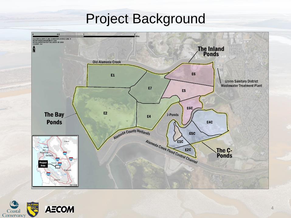
Project Background
4
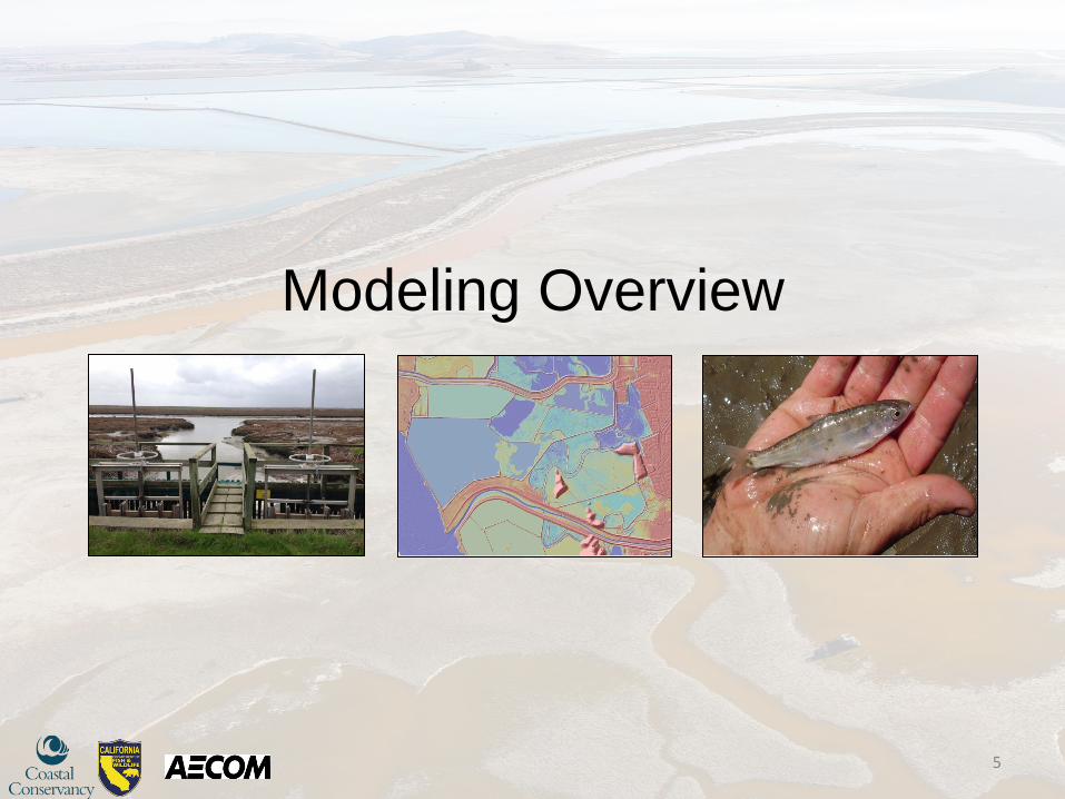
Modeling Overview
5
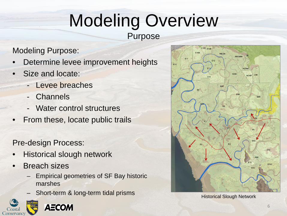
Modeling Overview Purpose
Modeling Purpose: • Determine levee improvement heights • Size and locate:
- Levee breaches - Channels - Water control structures
• From these, locate public trails Pre-design Process: • Historical slough network • Breach sizes
– Empirical geometries of SF Bay historic marshes
– Short-term & long-term tidal prisms
6
Historical Slough Network

Modeling Overview Input Parameters
Model: • MIKE21 Flexible Mesh Combined LiDAR & Bathymetry • Ponds between MSL & MHW Triangular Mesh Elements: • 10 m2 - Narrow levee crests • 200 m2 - Southern ponds • 1,250 m2 - Large flat ponds • 5,000 m2 - Bay Connected Element Paths: • Levee crests and channels
Variable Time Step: • Max: 60 sec • Computed Avg.: 0.25 sec
7
Tide Gates
Railroad Bridge
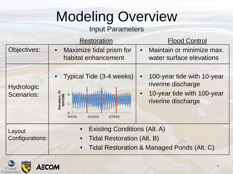
Modeling Overview Input Parameters
8
Restoration • Maximize tidal prism for
habitat enhancement
• Typical Tide (3-4 weeks)
-4
1
6
5/4/15 5/14/15 5/24/15
Elev
atio
n, F
t N
AVD
88
• Existing Conditions (Alt. A) • Tidal Restoration (Alt. B) • Tidal Restoration & Managed Ponds (Alt. C)
Flood Control • Maintain or minimize max.
water surface elevations
• 100-year tide with 10-year riverine discharge
• 10-year tide with 100-year riverine discharge
Objectives: Hydrologic Scenarios: Layout Configurations:

Modeling Overview Layout Configurations
9
Tidal Restoration (Alt. B)

Modeling Overview Layout Configurations
10
Tidal Restoration & Managed Ponds (Alt. C )

Restoration Results
11

Restoration Results Tidal Restoration (Alt. B)
Objective: • Maximize tidal prism for habitat
enhancement Tidal Propagation Results: • Optimized breach & channel size • Tidal exchange sufficient with
connections to Old Alameda Creek
12
Most Flooded
Least Flooded
Restoration Results
13
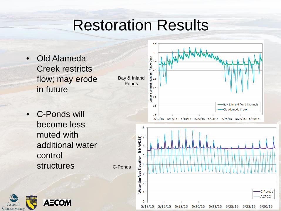
Bay & Inland Ponds
C-Ponds
• Old Alameda Creek restricts flow; may erode in future
• C-Ponds will become less muted with additional water control structures

Flood Results
14
EL 10
Flood Results
Effective 2009 (pending update)
15
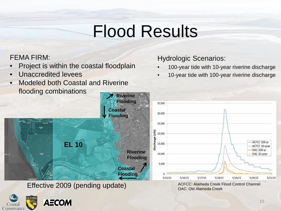
FEMA FIRM: • Project is within the coastal floodplain • Unaccredited levees • Modeled both Coastal and Riverine
flooding combinations
Hydrologic Scenarios: • 100-year tide with 10-year riverine discharge • 10-year tide with 100-year riverine discharge
ACFCC: Alameda Creek Flood Control Channel OAC: Old Alameda Creek
Coastal Flooding
Riverine Flooding
Coastal Flooding
Riverine Flooding
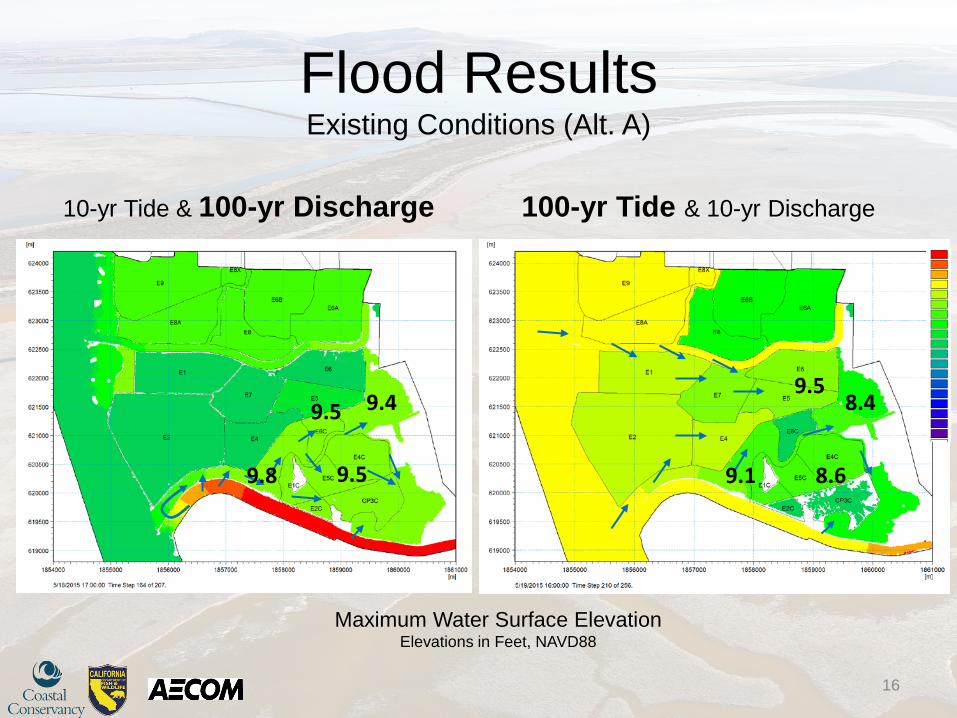
Flood Results Existing Conditions (Alt. A)
10-yr Tide & 100-yr Discharge 100-yr Tide & 10-yr Discharge
16
9.5 9.5
9.5 8.6 9.8 9.1
9.4 8.4
Maximum Water Surface Elevation Elevations in Feet, NAVD88

Flood Results Tidal Restoration (Alt. B)
10-yr Tide & 100-yr Discharge 100-yr Tide & 10-yr Discharge
17
Maximum Water Surface Elevation Elevations in Feet, NAVD88
-0.8 +0.4
+0.2
-0.5 +0.4
+0.8
Landside Levee Max. WSL : 9.9 feet NAVD88
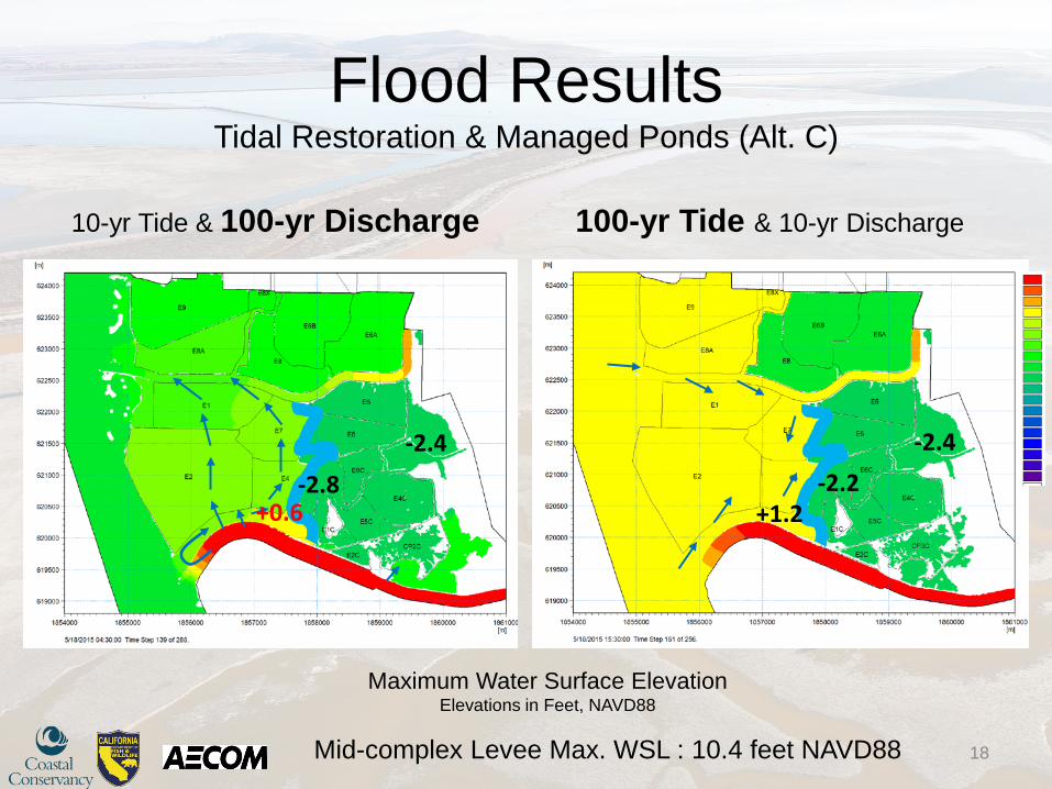
Flood Results Tidal Restoration & Managed Ponds (Alt. C)
10-yr Tide & 100-yr Discharge 100-yr Tide & 10-yr Discharge
18
Maximum Water Surface Elevation Elevations in Feet, NAVD88
+0.6 +1.2 -2.8
-2.4 -2.4 -2.2
Mid-complex Levee Max. WSL : 10.4 feet NAVD88
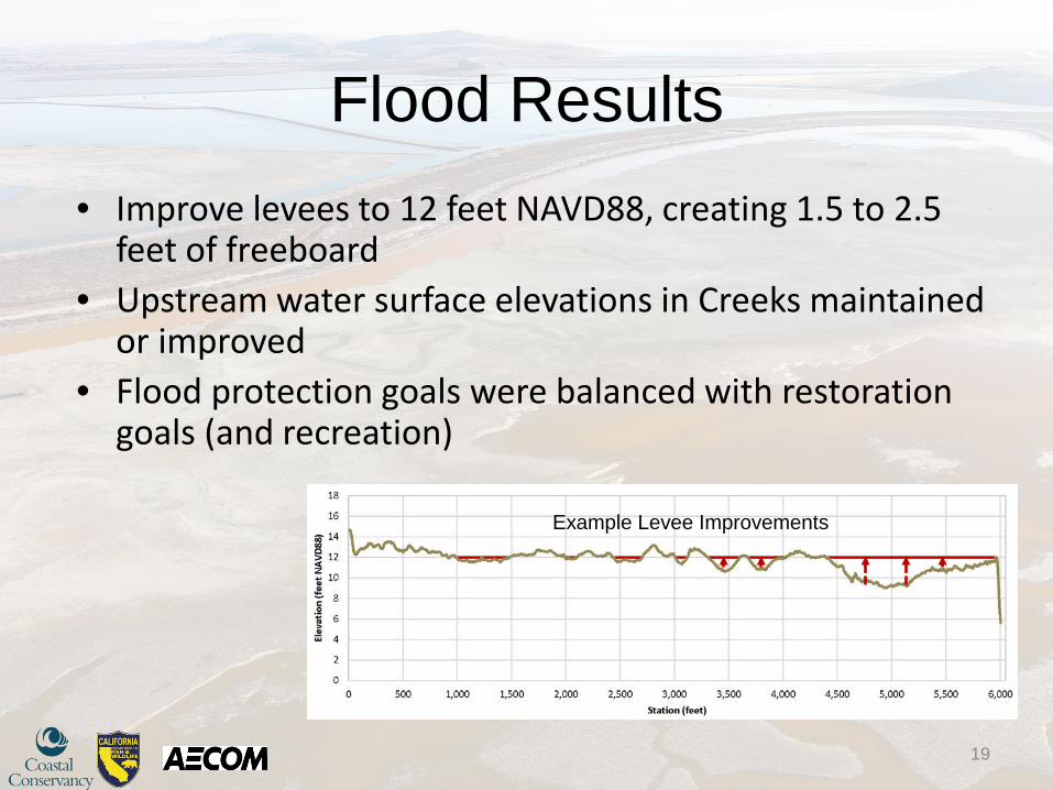
Flood Results
19
• Improve levees to 12 feet NAVD88, creating 1.5 to 2.5 feet of freeboard
• Upstream water surface elevations in Creeks maintained or improved
• Flood protection goals were balanced with restoration goals (and recreation)
Example Levee Improvements
Questions?
20
Related Documents