Semelai agricultural patterns: Toward an understanding of variation among indigenous cultures in southern peninsular Malaysia Rosemary Gianno and Klaus J. Bayr What were the indigenous agricultural and population patterns in peninsular Malaysia’s southern lowlands? What factors produced these patterns? Based on our analysis of ethnographic and historical evidence, as well as aerial photographs taken in 1948 in the Tasek Bera and Sungai Bera watersheds, the Semelai, an Orang Asli group, had a robust and productive subsistence agricultural system emphasising rice but insured by cassava. These photographs, from the P.D.R. Williams-Hunt Collection, provide an unusual record of Semelai agriculture prior to settlement in 1954 and contribute to our knowledge of indigenous economic pat- terns in the southern lowlands, which have received little ethnographic attention. Introduction Compared to the more mountainous north, rivers in the low-lying southern interior of peninsular Malaysia 1 are often navigable to their headwaters as well as linked by portages, providing avenues of water to transport goods across the peninsula and to coastal ports. However, the south is also known for its extensive and forbidding wetlands and peat swamps. While the western lowlands were colonised and developed by Europeans, indigenous groups in the lowland interior were protected to some degree by their natural environment. The landscape encouraged trade but also pro- vided a refuge. Historically, the southern Orang Asli (aboriginal peoples), like those in the north, were sparsely distributed, but the southerners were also more influenced by and acculturated to Malay language and culture, as well as, later on, those of other immigrants. Over the last two centuries, the low indigenous population density, along Professor Rosemary Gianno is a Professor of Anthropology in the Department of Sociology and Anthropology at Keene State College. Professor Klaus J. Bayr is a Professor of Geography in the Department of Geography at Keene State College. Correspondence in connection with this article may be addressed to: [email protected] and [email protected] respectively. While many people have con- tributed to this research, we would particularly like to thank Andrew Abel, George Appell, A. Baer, Geoffrey Benjamin, Harold C. Conklin, Sharon Dennis, Kirk Endicott, Eng Tek, Kerry Fosher, Elizabeth H. Moore, Colin Nicholas, Debra Picchi, Romani Mohamad and Raphael Wust for advice and assistance. Any fault of course remains our own. Stephanie Derrick did much work computer map- ping the aerial photographs. The Orang Asli Archive at Keene State College provided the photographs. We also thank the Jabatan Hal Ehwal Orang Asli and the Economic Planning Unit of the Prime Minister’s Office for permission to conduct ethnographic research in Malaysia. 1 In this paper, ‘southern peninsular Malaysia’ is defined as a mostly lowland region that extends south and west from the downstream eastward stretch of the Sungai Pahang, and includes Melaka, Johor, southern Pahang, and Negeri Sembilan. Journal of Southeast Asian Studies, 40(1), pp 153–185 February 2009. Printed in the United Kingdom. 153 © 2009 The National University of Singapore doi:10.1017/S0022463409000071

Welcome message from author
This document is posted to help you gain knowledge. Please leave a comment to let me know what you think about it! Share it to your friends and learn new things together.
Transcript
Semelai agricultural patterns: Toward anunderstanding of variation among indigenouscultures in southern peninsular Malaysia
Rosemary Gianno and Klaus J. Bayr
What were the indigenous agricultural and population patterns in peninsularMalaysia’s southern lowlands? What factors produced these patterns? Based on ouranalysis of ethnographic and historical evidence, as well as aerial photographstaken in 1948 in the Tasek Bera and Sungai Bera watersheds, the Semelai, anOrang Asli group, had a robust and productive subsistence agricultural systememphasising rice but insured by cassava. These photographs, from the P.D.R.Williams-Hunt Collection, provide an unusual record of Semelai agriculture priorto settlement in 1954 and contribute to our knowledge of indigenous economic pat-terns in the southern lowlands, which have received little ethnographic attention.
IntroductionCompared to the more mountainous north, rivers in the low-lying southern
interior of peninsular Malaysia1 are often navigable to their headwaters as well aslinked by portages, providing avenues of water to transport goods across the peninsulaand to coastal ports. However, the south is also known for its extensive and forbiddingwetlands and peat swamps. While the western lowlands were colonised and developedby Europeans, indigenous groups in the lowland interior were protected to somedegree by their natural environment. The landscape encouraged trade but also pro-vided a refuge. Historically, the southern Orang Asli (aboriginal peoples), like thosein the north, were sparsely distributed, but the southerners were also more influencedby and acculturated to Malay language and culture, as well as, later on, those of otherimmigrants. Over the last two centuries, the low indigenous population density, along
Professor Rosemary Gianno is a Professor of Anthropology in the Department of Sociology andAnthropology at Keene State College. Professor Klaus J. Bayr is a Professor of Geography in theDepartment of Geography at Keene State College. Correspondence in connection with this article maybe addressed to: [email protected] and [email protected] respectively. While many people have con-tributed to this research, we would particularly like to thank Andrew Abel, George Appell, A. Baer,Geoffrey Benjamin, Harold C. Conklin, Sharon Dennis, Kirk Endicott, Eng Tek, Kerry Fosher,Elizabeth H. Moore, Colin Nicholas, Debra Picchi, Romani Mohamad and Raphael Wust for adviceand assistance. Any fault of course remains our own. Stephanie Derrick did much work computer map-ping the aerial photographs. The Orang Asli Archive at Keene State College provided the photographs.We also thank the Jabatan Hal Ehwal Orang Asli and the Economic Planning Unit of the PrimeMinister’s Office for permission to conduct ethnographic research in Malaysia.1 In this paper, ‘southern peninsular Malaysia’ is defined as a mostly lowland region that extends southand west from the downstream eastward stretch of the Sungai Pahang, and includes Melaka, Johor,southern Pahang, and Negeri Sembilan.
Journal of Southeast Asian Studies, 40(1), pp 153–185 February 2009. Printed in the United Kingdom.
153
© 2009 The National University of Singapore doi:10.1017/S0022463409000071
with a terrain that, especially in the west, facilitated trade, has allowed much of thenative flora to be replaced with commercial arboriculture. One result of this historicalgeography is that indigenous cultures in the south have received much less attentionfrom ethnographers than those in the north. For example, only one extended studyhas been published on the Orang Hulu,2 one of the largest Orang Asli groups.
Geoffrey Benjamin’s comparative analysis of peninsular Malaysian culturesprovides a theoretical foundation for our understanding of southern lowland cultures.In addition, recent studies of insular Southeast Asian environmental history have ident-ified environmental factors that interacted with changes in population densities andeconomic formations historically, emphasising particularly the relationship betweencommodity production and patterns of demographic change within different environ-ments.3 This perspective has helped shed new light on the interaction of environment,commodity production, and subsistence agriculture among southern Orang Asli.
The southern Orang Asli have a long history of external trade. Dating back to thefifteenth century CE, if not before, the export of resins, incense woods and otherminor forest products extracted from the luxuriant primary lowland forest has beena major economic focus, encouraging economic development and integration in thesouthern regions.4 While eastern Johor was deficient in good harbours, the restrictionon the peninsula of camphor trees (Dryobalanops aromatica L.) to that area encour-aged forest product trade there. On the west coast, Melaka, during its heyday in thefifteenth and sixteenth centuries, was an entrepot for long-distance trade, as well as anoutlet for local forest products. However, its hinterland was agriculturally unproduc-tive to the point that Melaka had to import rice from Java and Thailand. Late nine-teenth century accounts of southern tribal groups report many cases of agriculturalpractices that seemed disorganised, unproductive, and based on cassava rather thanrice, while time and energy were largely dedicated to the collection and trade of forestproducts like gutta percha (Palaquium gutta L. latex).5
Generally speaking, when trade opportunities arose, southern Orang Asli gravi-tated to them. In the case of Portuguese Melaka, it may be that the demand wasgreat enough for local Orang Asli to largely abandon agriculture to concentrate on for-est extraction.6 The wider southern tendency toward extraction for trade, rather than
2 Narifumi Maeda Tachimoto, The Orang Hulu; A Report on Malaysian Orang Asli in the 1960’s(Subang Jaya: Center for Orang Asli Concerns, 2001), p. 35.3 David Henley, ‘Population and the means of subsistence: Explaining the historical demography ofisland Southeast Asia, with particular reference to Sulawesi’, Journal of Southeast Asian Studies, 36, 3(2005): 337–72; ed. Peter Boomgaard, Freek Colombijn and David Henley, Paper landscapes:Explorations in the environmental history of Indonesia (Leiden: KITLV, 1997); JeyamalarKathirithamby-Wells, Nature and nation: Forests and development in peninsular Malaysia (Honolulu:University of Hawai’i Press, 2005).4 Paul Wheatley, The Golden Khersonese: Studies in the historical geography of the Malay peninsulabefore A.D. 1500 (Kuala Lumpur: Penerbit Universiti Malaya, 1980); F.L. Dunn, Rain-forest collectorsand traders: A Study of resource utilisation in modern and ancient Malaya, Monographs of theMalaysian Branch, Royal Asiatic Society (1975). Mined metals (gold, tin and iron) were also majortrade items from the interior but derived mostly from mountainous regions to the north.5 Lesley M. Potter, ‘A Forest product out of control: Gutta percha in Indonesia and the wider Malayworld, 1845–1915’, in Paper landscapes: Explorations in the environmental history of Indonesia,ed. Peter Boomgaard, Freek Colombijn and David Henley (Leiden: KITLV Press, 1997): 281–308.6 There was also no tradition in the area of surplus rice production for sale.
154 RO S EMARY G IANNO AND KLAU S J . B AYR
subsistence agriculture (whether with rice or without it), has been explained as poss-ibly due to poor lowland soils not providing an adequate subsistence to agricultural-ists. It has also been suggested that rice cultivation among all Orang Asli was notemphasised and that foxtail millet and root crops had been the primary starchstaples.7 Jeyamalar Kathirithamby-Wells has more recently posited that El NiñoSouthern Oscillations (ENSO), bringing periods of drought followed by flooding,caused shifting cultivation to be more reliable than wet rice cultivation.8 The difficul-ties with wet rice cultivation could also help explain the emphasis on forest producttrade in times of economic expansion.
The Williams-Hunt collection of aerial photographsEthno-historical inquiry relative to tribal, non-literate societies in remote regions,
while informed by oral histories, is also often constrained by a dearth of relevant con-temporary documents. When most of the ethnographic and oral history data, as in theSemelai case, postdate a major disjuncture caused by political and land use changesimposed from outside, the task of reconstructing earlier social and economic for-mations becomes that much more formidable.
Semelai agricultural and settlement patterns were markedly and irreversibly alteredby external forces during the anti-communist Malayan Emergency (1948–60) and neverreally returned to the earlier system. In the 1930s, as well as subsequently, the Semelaiproudly identified themselves as rice cultivators who made large swiddens, preferably inprimary forest. H.D. Collings noted their spacious swiddens in the 1930s and 1940s.9
The Williams-Hunt collection of aerial photographs of Southeast Asia constitutesa data set that provides a window into the environmental and economic history ofpeninsular Malaysia. P.D.R. Williams-Hunt was a British colonial administrator aswell as a scholar interested in the archaeology and anthropology of Southeast Asia.During the Second World War, he interpreted aerial photographs for the Royal AirForce of Great Britain. In 1945, he was posted to Malaya and subsequently assembleda collection of over 5,000 aerial photographs of Southeast Asia. He became director ofthe Department of Aboriginal Affairs for the colonial government at the beginning ofthe Emergency. Although Williams-Hunt died prematurely in 1953, his collection,inventoried and catalogued by Elizabeth H. Moore, became available through theSchool for Oriental and African Studies, University of London, and constitutes arich resource for inquiry into land use patterns.10
The 2,632 aerial photos of peninsular Malaysia in the collection were takenbetween 1947 and 1949 during Operation Firedog, which aimed to find evidence ofCommunist activities in the forested interior. While others, especially archaeologists,have already put the aerial photographs of other countries in the collection to good
7 Geoffrey Benjamin, ‘In the long term: Three themes in Malayan cultural ecology,’ in Cultural valuesand human ecology in Southeast Asia, ed. K.L. Hutterer, A.T. Rambo and G. Lovelace (Michigan Paperson South and Southeast Asia, 1985): 219–78; R.D. Hill, Rice in Malaya: A Study in historical geography(Kuala Lumpur: Oxford University Press, 1977).8 Kathirithamby-Wells, Nature and nation: Forests and development in peninsular Malaysia, p. 63.9 H.D. Collings, ‘A Temoq list of words and notes’, Bulletin of the Raffles Museum, Series B 4 (1949): 72.10 Elizabeth H. Moore, ‘Inventory of the Williams-Hunt Collection’, vol. 2 in ‘The Moated Mu’ang ofthe Mun River Basin’ (Ph.D. diss., Institute of Archaeology, University of London, 1986).
S EME LA I AGR I CU LTURA L PAT T ERN S I N SOUTHERN PEN IN SU LAR MALAY S I A 155

use11 as far as we know, this project has been the first attempt to analyse the peninsularMalaysian collection. As McGregor et al. note, ‘These [Malaysian] photographs providea particularly good record of land use, but are difficult to locate in the absence of flightplans and recognizable settlements or transport arteries.’12 An earlier paper describedthe process used to specify the location of a series of 18 aerial photographs taken on3 December 1948 between longitudes E102° to 103° and latitudes N3° to N4°.13 Weidentified the area as a section of the upper Sungai [River] Bera and eastern Tasek[Lake] Bera watersheds in southwestern Pahang, a Semelai region. The photographs,once identified, allowed us to associate areal measurements with the oral histories tobetter describe agricultural patterns prior to the wholesale changes of the 1950s.
Research objectivesOur goals in this report are to determine (1) the nature of the Semelai economy
before the Emergency, (2) the reasons it took that form, and (3) how their economyinfluenced the Semelai pattern of settlement and land use, in order to (4) betterunderstand indigenous tribal economies in southern peninsular Malaysia in general.In order to do this, we look at the environmental and historical context, as well asethnographic accounts and aerial photographs.
Rice, agriculture, language and culture in peninsular Malaysia,with emphasis on the southA linguistic map of insular Southeast Asia reveals the Malay peninsula as an
island, metaphorically speaking, of Austro-Asiatic languages in a sea ofAustronesian (Map 1). Comprising approximately 19 different cultural=linguisticgroupings, the majority of Orang Asli have spoken languages of the Aslian branchof the Mon-Khmer sub-family of Austro-Asiatic, the most ancient in situ languagefamily in Southeast Asia, while several in the south speak dialects of Malay, anAustronesian language.14 While Orang Asli dominated the interior of peninsularMalaysia until the late nineteenth century, their homelands have since been floodedby migrants from Indonesia, China, and India.
Orang Asli cultures have been classified into three groups based on linguistic div-isions as well as socio-economic patterns and perceived racial differences: (1) Semang,mostly northern Aslian speakers who made their living by foraging as well as forest
11 Ibid; Duncan McGregor et al., ‘Mapping the environment in Southeast Asia: The Use of remote sen-sing and geographical information systems’, in Environmental change in Southeast Asia: People, politics,and sustainable development, ed. Michael J.G. Parnwell and Raymond L. Bryant (London & New York:Routledge, 1996): 190–224.12 McGregor et al., ‘Mapping the environment in Southeast Asia’: 208.13 Klaus J. Bayr, Rosemary Gianno and Stephanie Derrick, ‘An Analysis of aerial photographs ofpeninsular Malaysia from the Williams-Hunt collection’ (paper presented at the Proceedings, NewEngland – St. Lawrence Valley Geographical Society, Keene, New Hampshire, 2005). Copies of the aerialphotos (NA48 MALAYA:3C PR118=TF3001–TF3018) at a scale of 1:8,000 were obtained fromE.H. Moore, University of London, and are now housed in the Orang Asli Archive at Keene StateCollege.14 Gerard Diffloth, ‘Les langues mon-khmer de Malaisie: Classification historique et innovations’, Asiedu sud-est et monde insulinde, 6, 4 (1975): 1–19; Geoffrey Benjamin, ‘Map with “peninsular Malaysia”’, inLanguage atlas of the Pacific area, ed. Stephen Wurm and Shiro Hattori (Canberra: Pacific Linguistics,1983), p. 37.
156 RO SEMARY G IANNO AND KLAU S J . B AYR
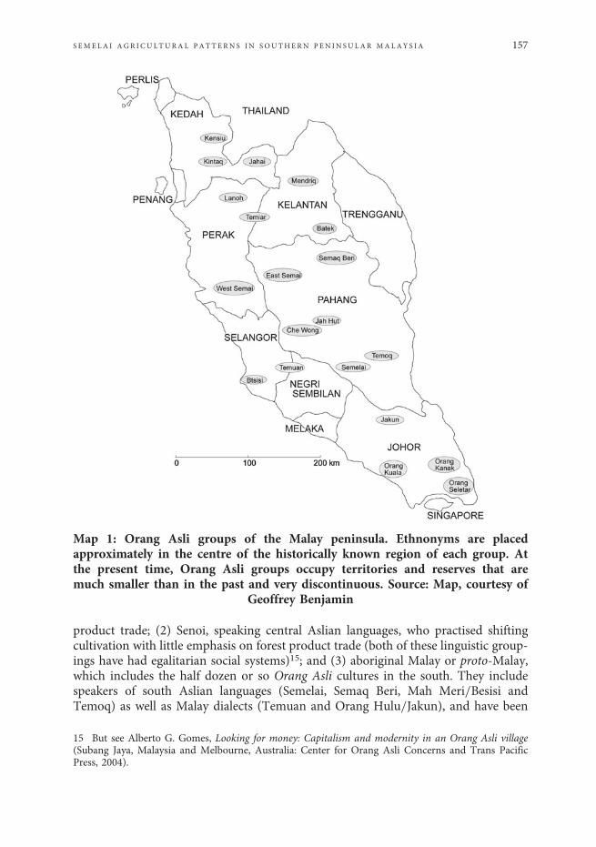
product trade; (2) Senoi, speaking central Aslian languages, who practised shiftingcultivation with little emphasis on forest product trade (both of these linguistic group-ings have had egalitarian social systems)15; and (3) aboriginal Malay or proto-Malay,which includes the half dozen or so Orang Asli cultures in the south. They includespeakers of south Aslian languages (Semelai, Semaq Beri, Mah Meri=Besisi andTemoq) as well as Malay dialects (Temuan and Orang Hulu=Jakun), and have been
Map 1: Orang Asli groups of the Malay peninsula. Ethnonyms are placedapproximately in the centre of the historically known region of each group. Atthe present time, Orang Asli groups occupy territories and reserves that aremuch smaller than in the past and very discontinuous. Source: Map, courtesy of
Geoffrey Benjamin
15 But see Alberto G. Gomes, Looking for money: Capitalism and modernity in an Orang Asli village(Subang Jaya, Malaysia and Melbourne, Australia: Center for Orang Asli Concerns and Trans PacificPress, 2004).
S EME LA I AGR I CU LTURA L PAT T ERN S I N SOUTHERN PEN IN SU LAR MALAY S I A 157
characterised as forest collectors-for-trade with some shifting cultivation.16 GeoffreyBenjamin includes aboriginal Malay cultures within ‘Malayic’, a type of societalgrouping that includes Malays and certain Austronesian, as well as Austro-Asiatic,speaking tribal groups in Malaysia=Indonesia, and is characterised by ‘collecting(fused with horticulture).’17 Just as Semang foragers long used forest product tradeto supplement foraged foods as well as technological (e.g. iron) needs,18 somesouthern Orang Asli groups, like the Temoq, used forest product collection andtrade to supplement meagre subsistence production in the same way. However,Malayic cultures share other features as well, such as inherited social hierarchy andan outward orientation that facilitates trade relationships and intermarriage with out-siders. Benjamin’s observation that ‘the Malayic societal pattern was instituted as ameans of locking into place a productive regime composed of both swidden farmingand intensified collecting’, provides a foundation for the analysis presented here.19
Benjamin includes the Semelai of lowland eastern Negeri Sembilan and southwesternPahang within his ‘Malayic’ societal pattern.20 Among these swidden agriculturalists,the trade provided a surplus beyond their subsistence needs that could supportincipient social differentiation and political hierarchy.
‘Aboriginal Malay’ and ‘proto-Malay’ imply that these groups are genealogicallyMalay sans Islam or statecraft. However, earlier generations of Orang Asli groupswho speak Malay dialects probably spoke Aslian languages, in some cases, as recentlyas the nineteenth century.21 Observers documented considerable interaction,through both trade and marriage, among southern Orang Asli and Malays,22 forinstance, ‘It is not uncommon for them to give their daughters in exchange to theMalays and Chinese who settle in their neighborhood.’23 Prior to the nineteenthcentury, it was probably not unusual for Malay men not only to marry Orang Asliwomen but also take up residence with their wives’ families, just as Chinese men
16 Benjamin, ‘On being tribal in the Malay world’, pp. 10–1.17 ‘It has also been suggested that non-Malayic Austronesians may have introduced Austronesian cul-tural and linguistic elements prior to the Malayic expansion 2,000 years ago. Geoffrey Benjamin, ‘Onbeing tribal in the Malay world,’ in Tribal communities in the Malay World; Historical, cultural and socialperspectives, ed. Geoffrey Benjamin and Cynthia Chou (Leiden, Singapore: International Institute forAsian Studies; Institute of Southeast Asian Studies, 2002), p. 63; Peter Bellwood, Prehistory of theIndo-Malaysian archipelago, revised ed. (Honolulu: University of Hawai’i Press, 1997).’18 Kirk M. Endicott, ‘The Economy of the Batek of Malaysia: Annual and historical perspectives’,Research in Economic Anthropology, 6 (1984): 29–52. David Bulbeck, ‘Hunter-gatherer occupation ofthe Malay peninsula from the Ice Age to the Iron Age’, in Under the canopy: The Archaeology of tropicalrain forests, ed. Julio Mercader (New Brunswick NJ: Rutgers University Press, 2003), pp. 119–60.19 Benjamin, ‘On being tribal in the Malay world’, p. 39.20 Ibid., p. 40.21 Miklucho-Maclay, ‘Dialects of the Melanesian tribes in the Malay peninsula’, Journal of the StraitsBranch of the Royal Asiatic Society, 1 (1878): 38–44.22 For example, J.R. Logan, ‘The Orang Binua of Johore’, Journal of the Indian Archipelago and EasternAsia, 1 (1847): 242–93; Harry W. Lake and H.J. Kelsall, ‘A Journey on the Sembrong River from KualaIndau to Batu Pahat’, Journal of the Straits Branch of the Royal Asiatic Society, 26 (1894): 1–23;A.D. Machado, ‘A Vocabulary of the Jakuns of Batu Pahat, Johore, together with some remarks on theircustoms and peculiarities’, Journal of the Straits Branch of the Royal Asiatic Society, 38 (1902): 29–33.23 N. von Miklucho-Maclay, ‘Ethnological excursions in the Malay peninsula – Nov. 1874 to Oct.1875 (Preliminary communication)’, Journal of the Straits Branch of the Royal Asiatic Society, 2(1878b): 211–2.
158 RO SEMARY G IANNO AND KLAU S J . B AYR
have done,24 and Malay men still do occasionally.25 Malay language and culture couldthen have been shared by these men with their children and new community. On thisbasis, southern tribal peoples can be viewed as blending Austro-Asiatic andAustronesian ancestry and culture, as well as, more recently, Chinese.
The retention on the peninsula of Austro-Asiatic languages in the face ofAustronesian expansion26 can most simply be explained by the prior establishment,dating back to 2,000 BCE, of Mon-Khmer speaking agricultural societies on thepeninsula.27 The Ban Kao archaeological site complex, at approximately 2,000 BCE,extended down the peninsula from Thailand and is believed to have introduced agri-culture and rice into peninsular Malaysia, even though the earliest direct evidence ofrice is only from 1,000 CE.28
Assuming that the Ban Kao people spoke proto-Aslian, is there historical linguis-tic evidence for rice in that language? ‘The Proto-Aslian language had nouns for “therice-plant,” “the rice-grain,” “pestle,” “mortar” and a verb for “to winnow,” all ofwhich were inherited from earlier periods (Proto-Mon-Khmer or evenProto-Austro-Asiatic).’29 This source for Aslian words related to rice implies that itwas an ancient cultigen on the peninsula, making rice’s subsequent relative invisibilityperplexing.
Cultivated rice derives from subtropical Asia and, because of photo-period differ-ences, generally has done less well in the tropical zone.30 Rice is also very sensitive tosoil quality and peninsular soils are generally poor. In comparison to cassava, ricerequires more light and greater land clearance to produce the same number of cal-ories. Rice crops, when ripening, are also vulnerable to predation, which entails eithergreater labour to protect the crop or greater crop loss. Placement of rice swiddens insecondary forest requires weeding while, in primary forest swiddens, large trees mustbe felled.31 At least in its unmilled state, rice is more nutritious than cassava. A greatadvantage of rice for trade is that it is much more easily transported and stored thancassava. Rice is also symbolic of cultural advancement, being primarily associated withlarger and wealthier settled societies.
24 Banseng Hoe, Semelai communities at Tasek Bera: A Study of the structure of an Orang Asli society(Subang Jaya: Center for Orang Asli Concerns, 2001).25 Unless otherwise indicated, ethnographic information presented derives from Gianno’s fieldnotes.26 Austro-Asiatic languages probably extended into Sumatra and Borneo as well. K. Alexander Adelaar,‘Borneo as a cross-roads for comparative Austronesian linguistics’, in The Austronesians: Historical andcomparative perspectives, ed. Peter Bellwood (Canberra: Department of Anthropology, AustralianNational University, 1995), pp. 75–95.27 Leong Sau Heng, ‘Jenderam Hilir and the mid-Holocene prehistory of the west coast plains of penin-sular Malaysia’, Bulletin of the Indo-Pacific Prehistory Association, 10 (1991): 150–60; Leonard Y. Andaya,‘Orang Asli and Melayu relations: A Cross-border perspective’, Antropologi Indonesia, 67 (2000). Thisdoes not explain the persistence of the foraging Semang, but see Bulbeck, ‘Hunter-gatherer occupationof the Malay peninsula from the Ice Age to the Iron Age’, pp. 150–2.28 Bellwood, Prehistory of the Indo-Malaysian archipelago, p. 164.29 Gerard Diffloth, personal communication by email, [email protected] (the Orang Asliresearch distribution list) on 3 May 2004.30 J.E. Spencer, ‘The Migration of rice from mainland Southeast Asia into Indonesia’, in Plants andmigrations of Pacific peoples, ed. Jacques Barrau (Honolulu: Bishop Museum Press, 1963).31 Michael Dove, ‘Development of tribal land-rights in Borneo: The Role of ecological factors’, BorneoResearch Bulletin, 12, 1 (1980): 3–18.
S EME LA I AGR I CU LTURA L PAT T ERN S I N SOUTHERN PEN IN SU LAR MALAY S I A 159
Before the nineteenth century, wet rice monoculture was not predominant on thepeninsula, even among Malays.32 Many nineteenth century accounts describe agricul-tural Orang Asli groups as growing little, if any, rice. The staples most noted werefoxtail millet (Setaria italica, L.), root crops (yams, taro, sweet potatoes and cassava),maize, and Job’s tears (Coix lachrymal-jobi, L.).33 For example, ‘The Jacoons [Semais]are clever gardeners and cultivate sugar cane, plantains, sweet potatoes, and other veg-etables in abundance. Rice they use but little.’34 ‘Here [Johor] they mostly grow ubi-kayu (yams and Caladium) … Rice is a rarity.’35 D.F.A. Hervey had this to say aboutOrang Hulu along the Sungai Endau:
Now the Jakuns cannot get on without rice, of which the Malays have taught them thevalue, but which was not originally in their list of articles of food; they have gone so far asto cultivate it for the last 30 years when allowed the needful leisure.36
Even in the mid-twentieth century, Robert Dentan noted, ‘American crops seemto have entered Semai agriculture before rice.’37
Accordingly, ethnological and historical analyses of agricultural patterns inpeninsular Malaysia38 have emphasised the relative insignificance of rice cultivationby Orang Asli:
In Malaya the use of rice amongst upland-dwelling peoples seems to be a fairly recentphenomenon. The Temiar (Benjamin, pers. comm.), for example, have a story of themillet king who, after a great struggle, was displaced by the rice king. Moreover, amongstthose uplanders who still grow significant amounts of tubers (nowadays mostly manioc),the tubers provide as much as two-thirds or more of basic carbohydrate requirements yetoccupy perhaps one-third of the land and only require that or a lesser portion of thelabour.39
32 Marie-Andree Couillard, ‘Les rapports sociaux dans la société Malaise pré-coloniale: Hypothèses etcommentaires’, Anthropologie et Sociétés, 10, 2 (1986): 145–62; Spencer, ‘The Migration of rice frommainland Southeast Asia into Indonesia’, pp. 83–9.33 Walter William Skeat and Charles Otto Blagden, The Pagan races of the Malay peninsula, Memoir 1(1966 [1906]), p. 340.34 F.A. Swettenham, ‘Note on the Jacoons’, The Journal of the Anthropological Institute of Great Britainand Ireland, 23 (1894): 89.35 Nikolai Nikolaevich Miklukho-Maklai – Papers, 1873–1975, ‘Journeys in the Malay peninsula’,(Sydney: Mitchell Library, 1873–1975), p. 122.36 D.F.A. Hervey, ‘The Endau and its tributaries’, Journal of the Straits Branch of the Royal AsiaticSociety, 8 (1881): 122.37 Robert K. Dentan, ‘Some Senoi Semai dietary restrictions: A Study of food behavior in a Malayan hilltribe’ (Ph.D. diss., Yale University, 1965): 60.38 Hill, Rice in Malaya: A Study in historical geography; Benjamin, ‘In the long term: Three themes inMalayan cultural ecology’; Geoffrey Benjamin, Between isthmus and islands: Reflections on Malayanpalaeo-sociology, Working Papers (Dept. of Sociology, National University of Singapore, 1986);Benjamin, ‘On being tribal in the Malay world’.39 Hill, Rice in Malaya: A Study in historical geography, p. 12. Semelai also have a story. ‘The Discoveryof rice’ also implicates royalty in the adoption of rice cultivation. In this case, both the baten (‘chief’) andthe raja (‘king’) lead their people to see the virtues of this new grain, but instead of millet, wild yams aresuperseded. Hood Mohamad Salleh, ‘Semelai rituals of curing’ (Ph.D. diss., St. Catherine’s College,Oxford, 1978), pp. 316–9.
160 RO SEMARY G IANNO AND KLAU S J . B AYR
Nineteenth-century accounts of southernOrangAsli describe their settlements as dis-tantly spaced one from the other, with shifting cultivation that was often minimally pro-ductive (with or without rice), surrounded by towering, pristine rainforest.40 NarifumiTachimoto, based on ethnographic fieldwork in the 1960s, characterised the economyof the Endau Orang Hulu historically as divided between forest product collection(to exchange for food as well as iron and other commodities), cultivation, hunting andgathering for subsistence needs. His description details the process and ritual of rice culti-vation but also notes that rice was not planted in many swiddens during his stay.41
However, there are also accounts of Orang Asli cultivating rice fields of significantsize with significant care. For example, ‘I have seen among the Jakuns of Johore, somewho had large fields of rice.’42 For the Besisi, ‘The main crop planted is rice….’43
Errington De la Croix described a rice field about five acres in size on a Plus Rivertributary in Perak, with an elaborate system of strings to manually operate scarecrowsin the ripening rice.44 J.R. Logan noted 16 different varieties of rice among the Mintira(Temuan).45 W.W. Skeat and C.O. Blagden summarise Hrolf Vaughn-Stevens’detailed description of rice planting by the Mantra (Temuan) of Malacca, which docu-ments a great effort to ensure, through ritual actions, the retention of the rice soul andan abundant rice harvest.46 While researchers have generally concluded that OrangAsli rice cultivation rituals were Malay borrowings, note that Orang Asli incantationsfor illness are also in Malay, yet illness is nothing new.47
Factors affecting rice cultivation in the pastCan the archaeological and linguistic evidence that points to rice having been
introduced to the peninsula some 4,000 years ago be reconciled with historical sourcessuggesting a late introduction to interior populations? And what could explain thevariations seen in the degree to which different Orang Asli cultures depended uponrice agriculture?
Anthony Reid has noted that, in Indonesia, upland areas above 500 metrestended to be the first to develop intensive agriculture and denser populationswhile decreased soil quality in lowland tropical areas, caused by too much rainfallor rainfall too evenly spread through the year, made agriculture there less pro-ductive.48 Also, the relative lack of contrasting wet and dry seasons in the lowlands
40 Harry Lake, ‘Johore’, The Geographical Journal, 3, 4 (1894): 283–8; Lake and Kelsall, ‘A Journey onthe Sembrong River from Kuala Indau to Batu Pahat’: 1–23; Miklucho-Maclay, ‘Journey in the Malaypeninsula’, p. 4; Logan, ‘The Orang Binua of Johore’: 242–93.41 Tachimoto, The Orang Hulu; A Report on Malaysian Orang Asli in the 1960’s, pp. 27–8, 39–40.42 P. Favre, ‘An Account of the wild tribes inhabiting the Malayan peninsula, Sumatra and a few neigh-boring islands’, Journal of the Indian Archipelago and Eastern Asia, 2, 1 (1848): 259.43 I.H.N. Evans, ‘Notes on the Besisi of Tamboh, Kuala Langat, Selangor’, Journal of the FederatedMalay States Museums, 5 (1913): 4.44 Skeat and Blagden, The Pagan Races of the Malay peninsula, p. 343.45 J.R. Logan, ‘The Superstitions of the Mintira, with some additional remarks on their customs, & c.’,Journal of the Indian Archipelago and Eastern Asia, 1 (1847): 331.46 Skeat and Blagden, The Pagan Races of the Malay peninsula, pp. 344–57.47 Ibid., p. 358.48 Anthony Reid, ‘Inside out: The Colonial displacement of Sumatra’s population’, in Paper landscapes:Exploration in the environmental history of Indonesia, ed. Peter Boomgaard, Freek Colombijn and DavidHenley (Leiden: KITLV, 1997), pp. 61–89.
S EME LA I AGR I CU LTURA L PAT T ERN S I N SOUTHERN PEN IN SU LAR MALAY S I A 161
often made the good burn needed in swidden agriculture difficult to obtain.49 On theMalay peninsula, large sections of the interior exceed 500 metres above sea level buthave so far, yielded no archaeological or historical evidence of agricultural intensifica-tion or population concentration prior to the arrival of Minangkabau in the fifteenthcentury. While the peninsular lowlands also generally lack strongly contrasting pre-cipitation seasons, some areas are drier than others. Using Borneo for comparison,within environments similar to, albeit rainier than those in the southern peninsula,tribal peoples there have rice cultivation traditions dating back to 2,300 BCE.50 Allthings being equal, Bornean swiddeners in areas without a significant dry seasontend to prefer secondary forest. In regions that experience significant dry spells, pri-mary forest is preferable because large trees can dry sufficiently.51 These patternsshould hold on the peninsula as well.
W.L. Dale identified a drier area in ‘central south Malaya – a broad belt extendingfor 175 miles north-westwards from Kluang.’52 Within that belt, southwestern Pahangis particularly dry, receiving less than 1,778 mm of rain annually.53 His south-westregion, including southeastern Negeri Sembilan, southwestern Pahang and westernJohor, has relatively even rainfall distribution throughout the year, but is compara-tively dry, particularly in February and July. Dale’s ‘Port Dickson-Muar region’ wasunusual in having its driest periods, by far, in January and February.54 Finally, easternJohor has much more marked seasonality in rainfall but, even during the southwes-tern monsoon, its driest period, average monthly rainfall is much higher than insouthwestern Pahang.55 That may have meant that primary forest did not burnwell there. If there was not already secondary forest in the area, there may nothave been much incentive to fell primary forest. While rainfall in the southern penin-sula (except eastern Johor) does not have extreme seasonality, the annual totals arerelatively low and particularly low during drier seasons. The relationship of rainfallpatterns in southern peninsular Malaysia to the shifting cultivation process invitesfurther exploration. However, areas like southwestern Pahang may have been condu-cive to dry rice cultivation in primary forest.
Historically uncontextualised ethnographic accounts may also have distorted ourunderstanding of changes in Orang Asli agriculture. Better tasting varieties of cassavawere not available on the peninsula until after 1850.56 Since the late nineteenth cen-tury, cassava has been frequently noted as a major Orang Asli crop. Rice may onlyhave become prominent among some swiddeners on the peninsula when cassavabecame available as a reliable back-up. Alternatively, before 1850, yams, millet,
49 Ibid.50 Peter Bellwood, First farmers: The Origins of agricultural societies (Blackwell, 2005), p. 139.51 George Appell, ‘Systems of land tenure in Borneo: A Problem in ecological determinism’, BorneoResearch Bulletin, 3 (1971): 17–20; Dove, ‘Development of tribal land-rights in Borneo: The Role of eco-logical factors’: 3–18.52 W.L. Dale, ‘The Rainfall of Malaya, Part I’, Journal of Tropical Geography, 13 (1959): 27.53 Ibid.: 37.54 Ibid.: 29.55 Ibid.56 Peter Boomgaard, ‘In the shadow of rice: roots and tubers in Indonesian history, 1500–1950’,Agricultural history, 77, 4 (2003): 597.
162 RO SEMARY G IANNO AND KLAU S J . B AYR
maize, sweet potatoes or a combination of these may have provided insurance againstrice crop failure, albeit perhaps less efficiently.
Rice, from antiquity, was most likely continuously cultivated on the peninsula butprobably not as the dominant crop. It may be that wet rice was mostly planted instreams that traversed or bordered swiddens, as Semelai were wont to do,57 or, in iso-lated cases, as a monoculture. Also, since rice is very labour intensive, requiring con-siderable attention, it was probably more important at times and places where asurplus could be produced intensively by pockets of settled agriculturalists and traded.Its association with larger, more settled and productive societies gave it cachet. Overtime, new dry rice varieties better suited to the lowland tropics may also have spurredcultivation. However, the introduction of improved varieties of cassava in the nine-teenth century likely provided the biggest boost to rice among swidden cultivators.
Trade in Semelai historySemelai have lived in the watershed of the Sungai Bera, which drains into the
Sungai Pahang and includes Tasek Bera and the Sungai Serting, as well as theSungai Teriang watershed, which also empties into the Pahang, and the upper reachesof the Sungai Muar (which flows into the Straits of Melaka). The area is low lying(25 to 30 metres above sea level) with an undulating topography, slow, meanderingwaterways and acidic, highly leached soils.58
The highlands to the west and east of the Semelai area create a double rainshadow which causes the low annual rainfall discussed above. Tasek Bera experiencesan annual rainfall range of 1,400–2,800 mm, averaging 2,060 mm.59 However,rainfall is seasonal enough to provide a dry period (June to September) for felled pri-mary forest trees to dry before firing and before the wet northeastern monsoon arrivesin October.
Semelai territory in general is dotted with marshy areas, but its southeast consistsof Tasek Bera, a huge dendritic freshwater peat swamp, the largest in peninsularMalaysia.60 The Tasek Bera ecosystem, with its mix of water, mud, swamp forestand dry land forest, is difficult to traverse, vast, and generally forbidding to thoseunfamiliar with it. Stewart Wavell described it as ‘the most inaccessible region inMalaya,’ while, according to Spencer Chapman (a British soldier behind enemylines during the Japanese occupation of the Second World War), ‘the journey toTasek Bera was “extremely hazardous” for a Chinese and “quite impossible for a
57 Rosemary Gianno, Semelai culture and resin technology, Memoir 22 (New Haven: ConnecticutAcademy of Arts and Sciences, 1990), p. 33.58 B.K. Maloney, ‘Man’s impact on the rainforests of west Malesia: The Palynological record’, Journal ofBiogeography, 12 (1985): 553.59 Raphael A.J. Wust and R. Marc Bustin, ‘Vegetation classification for a sedge=forest wetlands system,Tasek Bera (peninsular Malaysia) based on Landsat-TM imagery and aerial photo-based field mapping’,Asian Journal of Geoinformatics, 4, 1 (2003): 62.60 Tasek Bera is 34.6 km at its broadest and 25.3 km at its longest points, with an area of 61.50 km2
(Tasek Bera: The Ecology of a freshwater swamp, vol. 47, Monographae Biologicae, ed. J.I. Furtado andS. Mori (The Hague: Dr. Junk Publ., 1982): 7) in a watershed measuring 625 km2. Raphael A.J. Wustand R. Marc Bustin, ‘Late Pleistocene and Holocene development of the interior peat-accumulatingbasin of tropical Tasek Bera, peninsular Malaysia’, Palaeogeography, Palaeoclimatology, Palaeoecology,211 (2004).
S EME LA I AGR I CU LTURA L PAT T ERN S I N SOUTHERN PEN IN SU LAR MALAY S I A 163
European”’.61 This environment provided the local culture with a buffer or refugefrom the outside world. Those who knew it well could get in and out, with tradegoods, much more easily than an outsider.
It is therefore not surprising that little about the area can be found in historicalrecords before the nineteenth century. The one exception is the internationallyrenowned Penarikan or ‘portage’ of the sixteenth and early seventeenth centuries.Many European maps of this period, in addition to Ptolemy’s Geography of the ele-venth century, show a strait traversing the peninsula. Paul Wheatley has argued, con-vincingly, that this cartographic channel was a distortion of a riverinetrans-peninsular route that featured the Penarikan as a bridge between the headwatersof the Muar and Serting.62 By the nineteenth century, the Serting was still navigable,but obstructed by logs out of neglect or perhaps purposefully.63
The Semelai story of Tembeling’s tiger claims they descended from two SertingSemelai sisters and two Temoq brothers, placing their origins in the west.64
Furthermore, R. Cardon matched Semelai currency terms to those used in sixteenth-century Melaka.
The Sĕmĕlai told Mr. Collings that they formerly lived in the Nĕgri Sembilan, that is tosay near, or even on, the Malacca territory. The fact of their having kept in use the systemof counting in kupang, mas, paual, and real is an undeniable proof of former commercialintercourses between them and the Portuguese traders of Malacca.65
Harry Lake described a district around the Penarikan overseen by a Batin Gemelas:
The Batin is the hereditary chief … The Batin’s country consists of 500 square miles[about 1,295 square kilometers] of trackless jungle and swamp, inhabited by wanderingfamilies of Jakuns, save along the bank of the Muar where a number of Malays aresettled. The chief village is Jembu Lepan, which is near the confluence of the Jempoleand Muar rivers. Here the Jempole is separated from the Serting river by a strip offlat swampy land, only 450 yards wide. It is therefore comparatively easy to haul canoes
61 Stewart Wavell, Lost world of the east: An Adventurous quest in the Malayan hinterland (London:Souvenir Press, 1958), pp. 152–3; Harry Miller, Menace in Malaya (London: George G. Harrap, 1954).62 Wheatley, The Golden Khersonese: Studies in the historical geography of the Malay peninsula beforeA.D. 1500. Because of conflicts during the sixteenth and seventeenth centuries between the Dutch,Portuguese and Achehnese, eastern traders preferred the relative safety of the inland route to reachMelaka. After the Portuguese defeat in 1641, the sea route became safe again. W. Linehan, ‘A Historyof Pahang’, Journal of the Malayan Branch of the Royal Asiatic Society, 14, 2 (1936): 39, 189.However, interior peoples continued to use the inland route (John D. Leary, ‘Orang Asli contacts withthe Malays, Portuguese and Dutch in peninsular Malaya from 1400 to 1700’, Asian Studies Review,18, 2 (1994): 102).63 Charles Gray, ‘Journal of a route overland from Malacca to Pahang, across the Malayan peninsula’,Journal of the Indian Archipelago, 6 (1852): 369–75; D.D. Daly, ‘Surveys and explorations in the nativestates of the Malayan peninsula, 1875–1882’, Proceedings of the Geographical Society, London (n.s.),4 (1882): 393–412.64 Collings, ‘A Temoq list of words and notes’: 70–1; Rosemary Gianno, ‘Malay, Semelai, Temoq:Semelai concepts of ethnicity in south-central Malaya’, in Politics, land and ethnicity in the Malay penin-sula and Borneo: Non-Malay indigenous groups and the state, ed. R.L. Winzeler (New Haven: YaleUniversity Southeast Asian Studies Monograph, 1997), pp. 69–70.65 R. Cardon, ‘A Malay tradition’, Journal of the Malaysian Branch of the Royal Asiatic Society, 18,2 (1940): 145.
164 RO SEMARY G IANNO AND KLAU S J . B AYR
from one river to the other, and as the Serting is a tributary of the Bera, which joins thebig Pahang river, travelers are enabled to make a canoe journey from Kwala Muar toPahang, and thence to the China Sea.66
Given the geography, Gemelas was likely Semelai. This account, along withE.C. Foenander’s description of the wealthy batin at Teriang in 1931, indicates thatsome Semelai leaders in the past had significant economic and political power.67
Semelai territory surrounded the Penarikan, a critical junction in the cross-peninsularroute, suggesting that Semelai were active in trade networks from at least the fifteenthcentury.
The Effects of immigrants and slave raidingA comparison of the present day population size of indigenous peoples in penin-
sular Malaysia to those in Borneo suggests that there may have been a significantdepopulation and=or assimilation of indigenous peoples on the peninsula.Peninsular Malaysia is 132,040 km2, while Sarawak is 124,920 km2 and Sabah is56,070 km2 in size. And yet, peninsular Malaysia has only 145,000 indigenous peoplestoday (less than one per cent of the population) while those in Sabah comprise 85 percent of a population of two million and those in Sarawak 44 per cent of a populationof 2.2 million. Both Borneo and the peninsula have poor soils and generally similarenvironmental conditions.68 The peninsula’s status as the last outpost ofnon-Austronesian peoples in western insular Southeast Asia suggests thatAustro-Asiatic speakers there once had a population large enough to withstand out-siders and maintain their distinctive identities. Yet, this manifests itself in historictimes as a tiny indigenous population.
Prior to the fifteenth century, forest products and gold were the dominantexports from the Malay peninsula and Sumatra. However, the ascendance of tinand pepper production and trade began to make forest product traders, for instanceOrang Asli, less economically important.69 When Great Britain became the colonialpower in the nineteenth century, Chinese immigration and capital inflow fuelleddevelopment of the interior. At that point, Orang Asli were simply seen as inthe way.70
The historical record of Minangkabau and other Sumatrans in eastern NegeriSembilan and Pahang initially emphasised intermarriage with Orang Asli womenand the respect accorded indigenous leaders, the Batins,71 but by the late eighteenthcentury, the immigrant groups were becoming more predatory. From approximately1550, Minangkabau colonists in larger numbers began entering Pahang through UluMuar, the Bera and the Triang, developing trading networks to bring metals and
66 Lake, ‘Johore’: 293–4.67 E.C. Foenander, ‘A Trip up the Bera River’, Malayan Forester, 1 (1931).68 Peter Bellwood, ‘Cultural and biological differentiation in peninsular Malaysia: The Last 10,000years’, Asian Perspectives, 32 (1993): 44.69 Leonard Y. Andaya, ‘A History of trade in the sea of Melayu,’ Itinerario, 1 (2000): 87–110.70 Andaya, ‘Orang Asli and Melayu relations: A Cross-border perspective’: 60.71 J.E. Nathan and R.O. Winstedt, ‘Johol, Inas, Ulu Muar, Jempul, Gunong Pasir and Terachi: Theirhistory and constitution’, in Papers on Malay Subjects, ed. P.L. Burns (Kuala Lumpur: OxfordUniversity Press, 1971), pp. 391–468.
S EME LA I AGR I CU LTURA L PAT T ERN S I N SOUTHERN PEN IN SU LAR MALAY S I A 165
forest products to Melaka.72 William Wilder has suggested that the Malays of KualaBera (just downstream from the Semelai area) were originally Minangkabaus fromNegeri Sembilan.73
Population depletion through slave raids may explain the low historic populationdensities of Orang Asli,74 at least in the centuries after Melaka’s decline. Slave raidingof Orang Asli in the Negeri Sembilan=Pahang area dates back at least to the sixteenthcentury but became intense during the late eighteenth century as large numbers frompresent-day Indonesia arrived to seek their fortune. According to Logan,
[The Rawas]… are bold, persevering, and penurious, qualities which have long enabledthem to engross the principal internal traffic between Malacca and Pahang. … They arenow settled in considerable numbers in Rambau, Sungi Ujong and the western part ofPahang, and their numbers and power yearly increase, and become more formidable.About seven months ago, bands of them … attacked the Mintira in different places,killed many of the men and carried away more than a hundred of their women andgirls into Pahang, where they sold them as slaves. The Rawa declared that they wouldhunt down the Mintira everywhere, and deal with them all in the same way, in conse-quence of which the greater number have left their houses and are now scattered farand near.75
While the Mintira (Temuans) are named here, it would seem that the neighboringSemelai would have been affected as well. In fact, based on Logan and I.H.N.Evans, Kirk Endicott wrote, ‘Those groups living in present-day Negri Sembilanand southwestern Pahang were especially severely affected. … This constant harass-ment may also have been responsible for the general cultural poverty of these groupscompared to the Aboriginal Malays of Johore.’76 Orang Hulu at the time wereexploited, but also protected, by Malay penghulu ‘chiefs’ downstream.77 However,in earlier periods of lesser prosperity and political cohesion, these Johor groupswould have been vulnerable to attack as well.
The Sumatran incursions would have disturbed and diminished Orang Asli agri-cultural systems by decreasing population, disrupting their ways of life, and makingsecurity the prime consideration. However, previously, when intergroup relationswere less fraught, contact with Minangkabau may have promoted rice cultivationamong indigenous groups. R.D. Hill observed:
72 Linehan, ‘A History of Pahang’: 40, 189.73 William D. Wilder, Communication, social structure and development in rural Malaysia: A Study ofKampung Kuala Bera, Memoir 56, Monographs on Social Anthropology (New Jersey: Athlone Press,1982). ‘Intermarriage between Minangkabau men and local women in the rantau resulted in the childrenadopting the adat or customs of their mothers and thus modifying Minangkabau identity’ (LeonardY. Andaya, ‘Unravelling Minangkabau ethnicity’, Itinerario, 2 (2000); 24).74 Kirk M. Endicott, ‘The Effects of slave raiding on the aborigines of the Malay peninsula’, in Slavery,bondage, and dependency in Southeast Asia, ed. A. Reid (St. Lucia: University of Queensland Press, 1983),pp. 216–45.75 Logan, ‘The Superstitions of the Mintira, with some additional remarks on their customs, & c.’: 329.76 Logan, ‘The Orang Binua of Johore’; I.H.N. Evans, ‘Notes on the aborigines of the Ulu Langat andKenaboi districts of Selangor and Jelebu,’ Journal of the Federated Malay States Museums, 5, 2 (1914): 75;Endicott, ‘The Effects of slave raiding on the aborigines of the Malay peninsula’, p. 233.77 Endicott, ‘The Effects of slave raiding on the Aborigines of the Malay peninsula’, pp. 233–4.
166 RO SEMARY G IANNO AND KLAU S J . B AYR
By the early sixteenth century several rice growing traditions may be dimly discerned.The most recent and most skilled was that of the migrant Minangkabau, growers ofrice in hillside dry fields, in valley-floor fields flooded by water entrapped on the surface,in fields irrigated by water-wheel on the river terraces.78
While it seems likely that agricultural knowledge as well as perhaps new andimproved varieties of rice could have diffused through contiguity and social inter-action, to what extent Sumatrans may have influenced Orang Asli cultivation practicesremains unclear.
Once slaving was outlawed in 1893, subsistence systems would have become lesstransient and more labour-intensive. While Semelai have stories of slave raiders, forinstance, a grandmother of an elder Semelai living today was named Lari (‘to run’in Malay) because she was born as her family was fleeing into the upper Bera, it ishard to see the Semelai of the 1930s, when Collings visited, as suffering from culturalpoverty. Either they had quickly recovered from these traumas or had been spared insome way, perhaps by their swampy refuges.
Agriculture and settlement in the Bera watershedEvidence for the earliest agriculture in the Tasek Bera watershed is ambiguous.
Morley interpreted pollen cores collected from Tasek Bera to date the earliest defor-estation and cultivation to approximately 1400 CE,79 while B.K. Maloney suggestedthat agriculture there could be much older.80 More recently, Raphael Wust andR. Marc Bustin, based on a detailed analysis of Tasek Bera pollen cores, have ques-tioned whether it is possible to detect, using pollen cores alone, when cultivationfirst began.81
The palynological investigations of Morley (1982) … showed that lowland disturbancetook place around 2000 BP. However, Orang Asli legends about the evolution of thelake system indicate that early human settlements may have occurred in the [TasekBera basin] as early as 3500–4500 BP, when the water level rose and the lake systemwas established.82
However, the events in the Semelai story of the origin of Tasek Bera83 conflictwith the aerial photographs, as well as with other Semelai stories, since Semelai appearto have entered Tasek Bera long after the lake was established. Prior episodes of agri-cultural expansion into Tasek Bera (perhaps by Semelai, perhaps by others) are likely
78 Hill, Rice in Malaya: A Study in historical geography, p. 27.79 R.J. Morley, ‘Origin and history’, in Tasek Bera: The Ecology of a freshwater swamp, ed. J.I. Furtadoand S. Mori, pp. 12–45.80 Maloney, ‘Man’s impact on the rainforests of west Malesia: The Palynological record’: 555.81 Wust and Bustin, ‘Late Pleistocene and Holocene development of the interior peat-accumulatingbasin of tropical Tasek Bera, peninsular Malaysia’: 241–70.82 Ibid.83 H.D. Collings, ‘Aboriginal notes’, Bulletin of the Raffles Museum, Series B, 4 (1949); Hoe, Semelaicommunities at Tasek Bera; A Study of the structure of an Orang Asli society, pp. 3–4; Hood, ‘AnEthnographical investigation of the Semelai of Malaysia’; Gianno, Semelai culture and resin technology,pp. 134–5.
S EME LA I AGR I CU LTURA L PAT T ERN S I N SOUTHERN PEN IN SU LAR MALAY S I A 167
but, at least in the nineteenth century, there must have been a retreat of agricultural-ists to allow the primary forest to regenerate.
Describing Tasek Bera in 1875, D.D. Daly wrote:
This is a shallow lake, with large timber growing in the water. Since our departure fromthe Sungie Sureting, no Malays had been met with so that it was a relief here to comeacross parties of ‘Orang Jacoon’ sometimes called ‘Orang Sakei,’ or wild men of theinterior. They fled on our approach, but some more venturesome of their numberbrought us some fish for barter. They placed no value on money, but accepted clothesand tobacco. These wild people lead a gregarious life, seldom remaining long in oneplace, for fear of their wives and children being kidnapped by the Malays. They hadresting places in the trees, often 20 feet from the ground, so as to be out of reach of tigersand other wild animals. I was informed that they were very numerous in these remoteparts, – the ‘Ulu Pahang’ (interior of Pahang). There was little attempt at cultivationon the banks of the rivers, but I saw clearings on the ranges where they grew drypadi and Indian corn. They live on fish and on mammals or birds that they kill withthe sumpitan (blow-pipe). In warfare they blow poisoned arrows through the sumpitanwith great dexterity.84
According to Semelai oral histories, several pioneers into the Tasek Bera water-shed were within about three generations of elders living in the 1980s. One storyasserts that Semelai from Sungai Bera were invited into Tasek Bera, where theyfound abundant fishing, by Temoq already there.85 Semelai cultivation practiceswould have increased the land mammal biomass by providing more edible vegetationnear the ground. Temoq speak a South Aslian language closely related to Semelai;Temoq were much more dependent on hunting and gathering, but also practicedsome agriculture. Semelai gradually moved upstream, while continuing to coexistand trade with Temoq.86 Collings described Temoq as practicing ‘a little half-heartedhusbandry,’ recently learned from the Semelai, and reliant primarily on cassava,which itself often disappeared because they did not fence their fields.87 By the latetwentieth century, Bera Temoq had become Semelai.
Semelai pioneering into Tasek Bera could have been stimulated at least partly byforces downstream, for example, population pressure leading to depleted primary for-est, fish and game. By the late nineteenth century, the British colonial government waspacifying the interior while expanding tin mining and rubber plantations.88 Rich,
84 Daly, ‘Surveys and explorations in the native states of the Malayan peninsula, 1875–1882’: 400. Notethat, according to both Daly and Charles Gray (‘Journal of a route overland from Malacca to Pahang,across the Malayan peninsula’, p. 372), during the nineteenth century, the Sungai Serting emptiedinto Tasek Bera and not into the Sungai Bera as it does today.85 Gianno, Semelai culture and resin technology. This contrasts with conflicts that developed when Ibanwere pioneering in Borneo (Christine Padoch, Migration and its alternatives among the Iban of Sarawak(The Hague: Martinus Nijhoff, 1982), pp. 15–17).86 Gianno, ‘Malay, Semelai, Temoq: Semelai concepts of ethnicity in south-central Malaya’, pp. 51–83.87 Temoq agriculture in the Jeram River valley more closely resembled Semelai practices with swiddensthree to five acres in size but hill rice only the fourth most important cultigen (Peter Laird, ‘Ritual,territory and region: The Temoq of Pahang, west Malaysia’, Social Analysis, 1 (1979): 54–80).88 Kathirithamby-Wells, Nature and nation: Forests and development in peninsular Malaysia, p. 176.
168 RO SEMARY G IANNO AND KLAU S J . B AYR
under-exploited lowland forests, like those in the Bera watershed, were becomingrarer.
There were also of course disincentives to living upstream; otherwise it wouldnot have been so lightly populated before Semelai settlement. For people orientedtoward trade, Tasek Bera’s distance from markets, if not incorporated in tradenetworks, would have made it less desirable. Because the waterways are shallowin many places, watercraft must be light and small with little draught, inhibitingtransport of large cargos. However, some Chinese established trading posts atTasek Bera before the Emergency; and Semelai also sometimes transported theirown products downstream, seeking a better price. Before the Chinese, Malay tra-ders probably came upstream.89 Or perhaps some Semelais took on the role oftrader. Semelai oral histories do not mention Malay penghulu involvement inthe trade.
During the Emergency, the British colonial government, in order to separate theinsurgents from Orang Asli providing them with food and other support, established aseries of forts in the interior, settling local Orang Asli around them. Fort Iskandar wasestablished at Tasek Bera in 1953 as part of this strategy. Semelai in the area wereforced to abandon their crops and live for a year around the fort, which providedthem with food, medical care, and jobs as the area was cleared of insurgent camps.While they were subsequently allowed to return to their swiddens, they were alsoencouraged to remain nucleated around the fort, which eventually became PosIskandar, a non-military government installation.
As a result, in the 1970s, Iskandar Carey wrote:
The Semelai living in this part of Pahang are able to lead a more or less settled existencebecause they do not rely entirely upon cultivation; but on the contrary, they frequentlygo out into the deep jungle to collect jungle produce, which they sell for cash.90
This settled existence was an artifact of the Emergency. Their settlement, alongwith governmental edicts against cultivation in primary forest, a road from NegeriSembilan, and commercial logging leading to rubber and oil palm plantations, soondiminished the primary forest available to the Semelai, pushing them toward othereconomic pursuits.
Semelai have been alienated from the land and water of their region to the pointthat the landscape in the aerial photographs is very different from what exists theretoday. Part of that area is within a Ramsar Wetland Reserve, established in 1994.Most of the remainder is a government-sponsored FELDA oil palm estate. Semelaihave been under considerable pressure to rapidly re-adapt to a shrinking resourcebase as well as to the Malaysian nation-state. In concert with these changes,Semelai have lost most of their autonomy. Semelai today are mostly reliant on rubbercultivation and out-migration to make a living.
89 Logan, ‘The Orang Binua of Johore’, 261: 88–9.90 Iskandar Carey, Orang Asli: The Aboriginal tribes of peninsular Malaysia (Kuala Lumpur: OxfordUniversity Press, 1976), p. 251.
S EME LA I AGR I CU LTURA L PAT T ERN S I N SOUTHERN PEN IN SU LAR MALAY S I A 169

Pre-Emergency Semelai agricultural practices, from ethnographic sources‘We Semelai … are all swidden cultivators.’91
Historically, the Semelai practiced shifting cultivation. Each year, with someexceptions, each Semelai household would establish a new swidden, often contig-uous to the previous year’s. Houses, which were placed in or next to the swidden,were only built to last a year or two, given the need to move within that time.Families were considered to be the owners of the water and land that theyhad homesteaded. Semelai also actively traded forest products such as rattans,resins and incense woods.92 Primary forest provided the best source for theseresources.
It is likely that plant cultivation by Semelai speakers is ancient. The Semelailanguage has a number of Austro-Asiatic words related to swiddening and rice.The Semelai word for ‘rice plant’ and ‘unhusked rice seed,’ baba, is cognatewith ba’ in most Aslian languages as well as other Austro-Asiatic languagesfurther north.93 Their word for cooked rice (huc) is also Mon-Khmer, whileSemelai for dehusked uncooked rice is bras, from Malay beras. Terminology sur-rounding the technology of rice cultivation is also a mix of Austronesian andAustro-Asiatic. For example, ‘to reap’ (rmɔ ̃ ), ‘to fire a swidden’ (chɔr), gum ‘towinnow’ and ‘winnowing tray’ (chro ) are Austro-Asiatic, while the words fordibble stick (hibul), rice mortar (lsoŋ) and pestle (halu ) are Austronesian.94
While the Semelai word for swidden, d oh, is Mon-Khmer, the term for secondaryforest, d oh pad ey, consists of d oh modified by an Austronesian word for riceplant.
Rice, which has afforded them prestige vis-à-vis other cultures, is highly salient toSemelai agriculture and identity. In fact, they probably cultivated it mostly for its sym-bolic value since it was not traded. Linguistic evidence in Semelai of the culturalimportance of rice cultivation is exemplified by the 24 named stages for the growthhabit of the rice plant: beginning with sksuk mũh ‘nose hairs’ to describe the initialsprouting of the rice plant as well as at least 37 different named varieties of rice recog-nised by the Semelai.95
Ethnographic information about Semelai agricultural practices mostly derivesfrom four sources: Collings did the earliest ethnographic research with bothSemelai and their Temoq neighbours during the 1930s and 1940s, just before theaerial photos were taken; Banseng Hoe in 1964 did six weeks of ethnographic researchon Semelai culture and social organisation at Tasek Bera; Hood Mohd. Salleh didextended stints of ethnographic research with the Semelai between 1972 and 1977;and Rosemary Gianno’s ethnographic and oral history field notes were collected
91 Hood, ‘An Ethnographical investigation of the Semelai of Malaysia’, p. 34.92 Gianno, Semelai culture and resin technology.93 G.H. Luce, Phases of Pre-Pagan Burma (Oxford: Oxford University Press, 1985), p. 3; CharlesHigham, ‘Languages and farming dispersals: Austroasiatic languages and rice cultivation’, inExamining the language=farming hypothesis, ed. Peter Bellwood and Colin Renfrew (Cambridge:McDonald Institute of Archaeological Research, 2003).94 Gerard Diffloth, ‘The Contribution of linguistic paleontology to the homeland of Austro-Asiatic’, inThe Peopling of East Asia: Putting together archaeology, linguistics and genetics, ed. Laurent Sagart, RogerBlench and Alicia Sanchez-Mazas (London and New York: RoutledgeCurzon, 2005), pp. 77–80.95 Gianno, Semelai culture and resin technology, p. 35.
170 RO SEMARY G IANNO AND KLAU S J . B AYR
over seven field trips between 1980 and 2005.96 Gianno outlines the basic vocabularyand process of Semelai cultivation.97 By 1980, many Semelai were no longer practisingshifting cultivation. Note that none of these studies was specifically focused on agri-culture, causing the information provided to be based on relatively cursory obser-vation and interviewing.
These accounts suggest the following patterns for Semelai agriculture: (a) A pri-mary commitment to rice cultivation, with cassava as insurance; (b) A reliance onmagic to assert control over the rice crop; (c) Divination and the creation of islandsof primary forest; (d) A new swidden each year; (e) Preferred placement near navig-able water; (f) An absence of fruit orchards; (g) Preferred placement in primary forest;(h) A preference for fertile soil; (i) A preference for locating this year’s swidden nearlast year’s swidden; (j) A preference for elongated swidden plots extending downslope; and (k) A preference for relatively large swiddens. We discuss each of thesein turn.
(a) A primary commitment to rice cultivation, with cassava as insurance: ‘TheSemelai are husbandmen and grow dry rice as the staple crop, with tapioca as astand-by.’98 Semelai said that if they didn’t eat rice for three days in a row, theyfelt sick and hungry. For Bera Semelai, ‘The ghosts of the newly dead are said toreturn to their old homes and may be heard complaining if there is no rice andwater for them.’99
Among Semelai cultural texts, the Tasek Bera origin myth (see above) assumesthe central importance of rice in Semelai culture. The people at the beginning, beforeflooding erupts, are specifically planting rice as a harmonious group. Many Semelaistories either focus on rice or have it as an important plot element. For example,the Semelai story, ‘The Discovery of Rice,’ emphasises rice’s soothing and satisfyingqualities.100 Semelai stories also tell of the origin of two very productive varieties ofrice, baba bokrok rɔ , ‘decaying harvesting basket rice,’ and baba dara , ‘maidenrice.’ The introduction of more productive varieties like these may have contributedto greater Semelai dependence on rice.
The opposition between swidden and forest makes its way into the shamanicrealm as well. Semelai make a distinction between two different traditions of shamanicritual, tεŋ bri ‘the forest vehicle’, associated with Temoq and the Semelai tεŋ d oh ‘theswidden vehicle.’ tεŋ bri is considered more powerful, but what is significant here isthe distinction itself.
Even though Semelai culture did not value cassava, it is likely that, in combi-nation with rice, it fostered Semelai expansion. While absent in their myths andrituals, cassava provided the food security needed to pursue the more risky cultivationof rice.
96 Collings, ‘Aboriginal notes’: 89–90; Hoe, Semelai communities at Tasek Bera; A Study of the structureof an Orang Asli society, pp. 19–21; Hood, ‘An Ethnographical investigation of the Semelai of Malaysia’,pp. 34–8.97 Gianno, Semelai culture and resin technology, pp. 32–7.98 Collings, ‘Aboriginal notes’: 87.99 I.H.N. Evans, ‘Further notes on the aboriginal tribes of Pahang’, Journal of the Federated MalayStates Museums, 9 (1920): 17.100 Hood Mohamad Salleh, ‘Semelai rituals of curing’ (Ph.D. diss., St. Catherine’s College, Oxford,1978), pp. 316–24.
S EME LA I AGR I CU LTURA L PAT T ERN S I N SOUTHERN PEN IN SU LAR MALAY S I A 171
(b) A reliance on magic to assert control over the rice crop: Semelai rice cultiva-tion was once heavily regulated by magical rituals that carried heavy taboos (pantaŋ),undoubtedly because of the precariousness of rice cultivation. Gianno describes themagic surrounding rice planting and harvesting.101 Among the specifications was aseparate house to store the harvested rice.102 However, most of these proceduresand prohibitions were abandoned around 1930, replaced with Chinese rituals learnedfrom jelutong tappers and traders at Tasek Bera, and which were much less elaboratewith fewer prohibitions.
(c) Divination and the creation of islands of primary forest: Prior to choosing asite for one’s swidden plot, divination was used to determine whether it would angerany resident spirits. If indications were that it would, that patch of forest was notfelled. Over the course of time, this practice created islands, ‘pulaw,’ of primary forest.These are named in the same way that islands surrounded by water are named. Theyprovided easily accessible storehouses for the plant materials needed to make houses,canoes, traps, and the rest of Semelai material culture.
(d) A new swidden each year: ‘A new garden is made each year.’103 However,some years, if a household had planted and harvested a bumper rice crop, morethan a year’s supply, they only planted cassava the following year. Or they couldhelp others harvest their rice and take home part of it. Semelai say that famine hasnever occurred at Tasek Bera because the northeastern monsoon has always comesooner or later.104 The only problem has been if a household waited until after thebeginning of the wet northwest monsoon to fire its swidden. In this case, the optionswere as above.
(e) Preferred placement near navigable water: ‘The cultivated areas, tended by thelocal “orang asli”, are limited to a strip about 1 mile wide on either side of the TasekBera and Sungei Bera….’105 While this quote is based on observations made in the1970s, it is in line with the general pre-Emergency tendency to place swiddens nearbut not along navigable streams. Semelai preferred living near the lakeshore so thatthey could be closer to neighbours, fish and travel by dugout canoe. Crops in swid-dens far from the lake were also considered more vulnerable to animal predation.They did not want to be so near the shore, however, that they might be vulnerableto hostile outsiders. Much of the primary forest left near the lake either had poorsoil or was considered haunted (see above). However, the pull of primary forest,which over time was either further from navigable water or further upstream, even-tually trumped this preference.
(f) An absence of fruit orchards: While Temuans, Orang Hulu and other OrangAsli often planted fruit orchards in their old swiddens that they could frequent during
101 Gianno, Semelai culture and resin technology, p. 123.102 Evans, ‘Further notes on the aboriginal tribes of Pahang’: 18–9. Evans’ description of a Semelai(‘Bera Tribe’) rice harvesting regimen is similar.103 Collings, ‘Aboriginal notes’: 89.104 Given the El Niño Southern Oscillations (ENSO), while this may not strictly be true, it is whatpeople say.105 J.I. Furtado, ‘Conservation survey of the Tasek Bera, Pahang’ (A report to the Malaysian WildlifeConservation Foundation, 1987), not paginated.
172 RO SEMARY G IANNO AND KLAU S J . B AYR
fruit season, as well as use as a source of commodities, this was not the case in theupper Bera watershed. Semelai have said that fruit trees they planted were usuallyknocked down by elephants. Markets for perishables like fruits were likely also toodistant.
(g) A preference for primary forest: ‘The Semelai have lived around Tasek Bera formany generations and the ground has been used over and over again.’ Furthermore, thecreation of a new swidden each year ‘does not mean that fresh maiden forest is alwaysfelled, for they have a kind of “rotation of forest” and when the secondary growth on anold garden, dĕ-u padoi, is tall enough it is felled and used again.’106 This may be true forthe lower Sungai Bera, but, as discussed above, genealogies and oral histories point toSemelai having settled the Tasek Bera and upper Sungai Bera watersheds only withinthe last century or so. For example, according to one woman whose family migratedinto Tasek Bera from the lower Sungai Bera before she was born, ‘They left theSungai Bera because there was a lot of secondary forest.’ While informants sometimessaid that their ancestors had been there for many generations, when genealogies werecollected there were often only two or three generations leading back to the originalsettler at a Tasek Bera lubuk ‘open section of waterway.’
Generally speaking, Semelai preferred primary forest for their swiddens becauseit was more fertile and required less weeding. Swiddens sometimes were placed inolder secondary forest; but according to a Semelai rule of thumb, after clearing andplanting a plot three times, the land was no longer usable. One man in 1980 said,‘Now most swiddens are placed near the lake but before they could be very faraway because people would only put their swiddens in primary forest.’ This testimonyis confirmed by Hoe:
The Semelai say that the fertility of the forested land can be judged by the size of its treetrunks. Land with trees, the trunks of which cannot be encircled by an arm span, is saidto be fertile enough for planting.107
This preference supports our suggestion that the dry season in the upper Berawatershed was dry enough to ensure a good burn.
(h) A preference for fertile soil: ‘A site for a new garden is chosen first of allbecause of the goodness of the soil.’108 However, some people were more fastidiousabout soil quality than others.109
(i) A preference for locating this year’s swidden near last year’s swidden: Usually,two to three Semelai households were clustered together with their separate swiddens,and the second year’s swidden was placed next to, or in the vicinity of, the previousyear’s.110 For the cover picture caption of an unpublished report, Williams-Huntwrote, ‘Typical aboriginal clearing in Ulu Bera, Pahang. In the foreground is lastyear’s ladang [swidden] planted with tapioca whilst behind the new felling has
106 Collings, ‘Aboriginal notes’: 89.107 Hoe, Semelai communities at Tasek Bera; A Study of the structure of an Orang Asli society, p. 20.108 Collings, ‘Aboriginal notes’: 89.109 Gianno, Semelai culture and resin technology, p. 33.110 In Borneo, ‘such unconservative practices as the making of many fields contiguously, the cutting ofvery large fields … are reported for Baleh Iban groups’ (Padoch, Migration and its alternatives among theIban of Sarawak, p. 61).
S EME LA I AGR I CU LTURA L PAT T ERN S I N SOUTHERN PEN IN SU LAR MALAY S I A 173
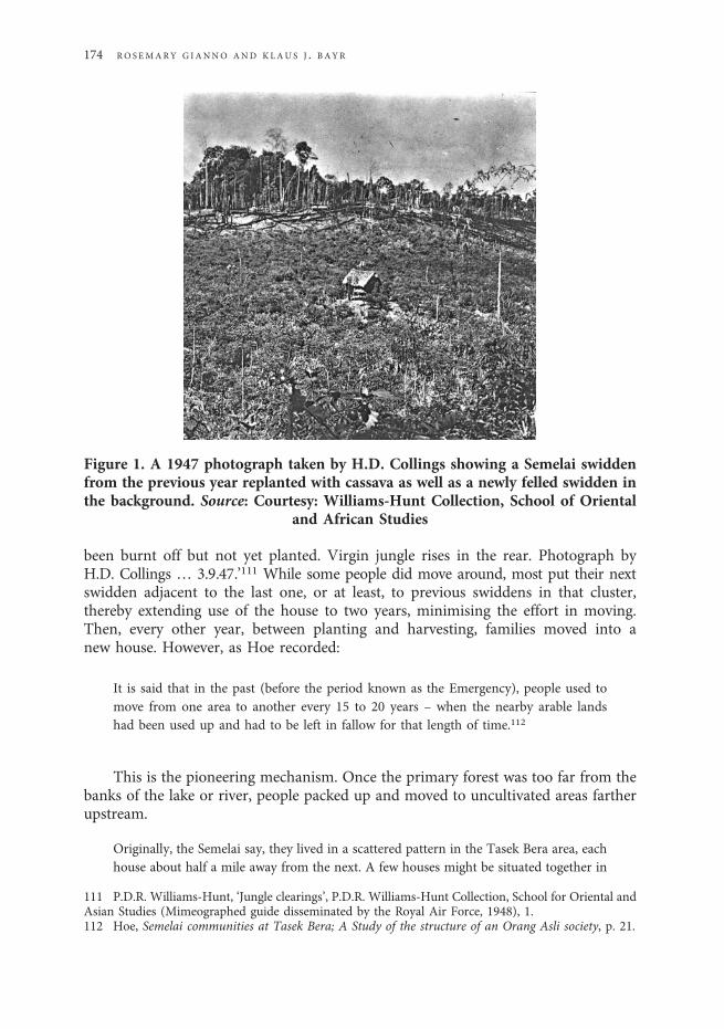
been burnt off but not yet planted. Virgin jungle rises in the rear. Photograph byH.D. Collings … 3.9.47.’111 While some people did move around, most put their nextswidden adjacent to the last one, or at least, to previous swiddens in that cluster,thereby extending use of the house to two years, minimising the effort in moving.Then, every other year, between planting and harvesting, families moved into anew house. However, as Hoe recorded:
It is said that in the past (before the period known as the Emergency), people used tomove from one area to another every 15 to 20 years – when the nearby arable landshad been used up and had to be left in fallow for that length of time.112
This is the pioneering mechanism. Once the primary forest was too far from thebanks of the lake or river, people packed up and moved to uncultivated areas fartherupstream.
Originally, the Semelai say, they lived in a scattered pattern in the Tasek Bera area, eachhouse about half a mile away from the next. A few houses might be situated together in
Figure 1. A 1947 photograph taken by H.D. Collings showing a Semelai swiddenfrom the previous year replanted with cassava as well as a newly felled swidden inthe background. Source: Courtesy: Williams-Hunt Collection, School of Oriental
and African Studies
111 P.D.R. Williams-Hunt, ‘Jungle clearings’, P.D.R. Williams-Hunt Collection, School for Oriental andAsian Studies (Mimeographed guide disseminated by the Royal Air Force, 1948), 1.112 Hoe, Semelai communities at Tasek Bera; A Study of the structure of an Orang Asli society, p. 21.
174 RO SEMARY G IANNO AND KLAU S J . B AYR
one place, but they would be about one or two miles away from the next group of houses.Semelai say they prefer this kind of distribution pattern as then competition amongthemselves for swiddens, fishing spots, and areas for collecting jungle products is notkeen.113
Assuming that most Semelai households in the past only moved from an areaevery 15 years, this practice is in line with the large distances betweenhomesteads.
(j) A preference for swidden plots extending down slope: Swiddens had differentshapes, sometimes circular, sometimes quadrangular, but preferably, swiddens wereelongated down slope, often extending from a ridge to a stream. This orientationaided a felling technique in which the trees down slope were notched first andthen knocked down when the trees above them were felled.114
(k) A preference for larger swiddens: While comparing Temoq, Malays andSemelai, Collings wrote, ‘It is only folk like the Semelai who are relatively stable,for they grow all they need and can make almost everything they want.’115
Similarly, while discussing Orang Hulus at Bukit Serok, Pahang, one Semelai offeredthat ‘the people there have always made very small swiddens and are not really intothat. Therefore, they haven’t turned their land into secondary forest the way Semelaishave.’
Semelai swiddens at Tasek Bera were meant to provide a self-sufficient foodsupply. Combined with the abundant fishing and hunting, each householdintended to produce for its own use. This entailed large swiddens.116 The follow-ing story emphasises the purpose of Semelai agriculture as a means of subsistence,as well as the negative consequences of attempting to produce beyond one’sneeds:
The Rice GhostAll the people cultivated their swiddens to grow enough food to live on. Most of the
people had small swiddens. But one man cultivated a very large swidden, the harvestfrom which would exceed the needs of his family. Unfortunately, the swidden onwhich he laboured did not produce much rice, while the small swiddens producedenough rice for their owners’ families. The man with the large swidden felt very sadand went wandering in the jungle. He came upon a house where an old man invitedhim to enter. The old man showed the rice that he himself had harvested, which waskept in seven different shelters. The wanderer asked the old man’s advice and wastold not to open too large a swidden. The ideal swidden was one just large enough toplant one g ɑnt ɑŋ of rice seed. The old man sympathized with the wanderer and gavehim seven seeds to plant. A few months later, these rice seeds grew beautifully andthe harvest from them required seven storage shelters. It is said the old man is actuallythe rice ghost Jumbarang Padi.117 It is thus traditional that a swidden should not be too
113 Ibid., p. 33.114 Gianno, Semelai culture and resin technology, p. 33.115 Collings, ‘A Temoq list of words and notes’, p. 72.116 Semelai did buy and sell fish from each other, however, and traded for monkey and gibbon meatfrom Temoq.117 Jumbalang is a Minangkabau variant of jembalang in Malay and means ‘gnome of the soil’ or
S EME LA I AGR I CU LTURA L PAT T ERN S I N SOUTHERN PEN IN SU LAR MALAY S I A 175
big. Otherwise, it may antagonize the rice ghost, who may think it is contrary to hisadvice.118
The story cautions against making Semelai swiddens too big. This tendencytoward greater size accords with the Semelai identity as proficient swiddeners andthe larger area needed for rice cultivation. It also demonstrates a tension in Semelaisociety between the urge to generate a surplus and an ethic of leveling potential econ-omic inequality. However, as described above, in cases where there was more to reapthan there was labour in the household, outsiders could help and there wereprocedures for dividing the harvest between the extra harvesters and field owner:The owner got between one-half and two-thirds of what the reaper collected.This helps explain swiddens larger than a household might need. But sinceSemelai rice production was for use and not exchange, it makes one wonder whythey bothered. Why not just grow cassava? It seems that the main advantage ofrice was symbolic, allowing them to assert cultural superiority relative to other groupslike Temoq.
The sizes of Semelai swiddens were elicited by Hoe, Hood and Gianno.119
Responses were in acres. How accurate might these estimates have been? TheSemelai have a method for measuring swiddens. In order to demarcate the boundaryof a prospective swidden, or the line between two swiddens, Semelai cultivators cut apath. Then they used a length of rattan that was one chain or 22 yards long [1 yard =0.914 metre], measured to this length using 13 arm spans. 10 square chains equals oneacre [1 acre = 0.404 hectare].
The size of a swidden depends entirely on the wishes of the head of the household (nor-mally the husband), who in turn will reckon according to the size of the family. Theaverage size of a swidden is around two to three acres. A swidden rarely exceedsfour or five acres because it is normally cultivated by the members of a single house-hold, usually a nuclear family. Each married couple is expected to have their ownswidden.120
In a survey of the size of swiddens in Rapak, an agricultural settlement of ninehouseholds, Hood found that they ranged from four to seven acres, with an averageof 4.5 acres per household.121 One of the two that were seven acres belonged to thejrukrah (a hereditary title) and his wife, the other to his sister married to his wife’sbrother. Semelai say that those who make larger swiddens are more ‘rajin’ (industri-ous) although larger families also require larger swiddens. These variations in sizemay also indicate emerging status differentiation. By 1980, there was only onehousehold left at Rapak because in 1976 the government offered rubber acreageand assistance to Semelai still swiddening to return to Pos Iskandar and abandon
‘hantu tanah’. ‘The j. are the spirits to whom offerings are made when the soil is disturbed for planting orto provide foundations for a house; and ill-luck about a house or building is put down to them,’R.J. Wilkinson, A Malay-English dictionary (Romanised), (Mytilene, Greece: Salavopoulos and Kinderlis,1932), p. 458.118 Hoe, Semelai communities at Tasek Bera; A Study of the structure of an Orang Asli society, pp. 141–2.119 Ibid., p. 20; Hood, ‘An Ethnographical investigation of the Semelai of Malaysia’, p. 36.120 Hoe, Semelai communities at Tasek Bera; A Study of the structure of an Orang Asli society, p. 20.121 Hood, ‘An Ethnographical investigation of the Semelai of Malaysia’, p. 36.
176 RO SEMARY G IANNO AND KLAU S J . B AYR
their fields.122 Gianno, through oral histories, collected size estimates for swiddens inprimary forest that ranged from one acre to 10 acres, but mostly within the four to sixacre per household range.123 The increase in size between 1964 (Hoe) and 1972(Hood) may reflect an actual increase in the size of swiddens because of larger familysizes, increased surplus production or both.
Interpreting the aerial photographsAccording to William-Hunt, ‘The air view is only the introduction to field work
on the ground, which it can never replace. Never interpret beyond the limits of reason.Skill will come with experience, but initially all air work must be checked in detail onthe ground. Later some features can be accepted from the air view but others willalways require ground confirmation.’124 While this is all good advice, we can nolonger go to the photographed clearings to investigate them on the ground.Therefore, our analysis of the photos is necessarily provisional. However, we didfind that a published sketch informed by a ground survey (probably by Collings) isof Swidden 1 in this study.125 Williams-Hunt also provided general analytical advicesuch as, ‘Secondary jungle is distinguished by a closer pattern of growth amongst themore ragged primary jungle which, being much taller, may cast a shadow on theyoung growth.’126
‘In Malaya gardens vary in size from ten to fifty acres and usually support two tothree families.’127 While Semelai swiddens, and derived secondary forest, are clearlyvisible in the aerial photographs, a basic problem is determining from the photo-graphs how many families actually cultivated a cleared area, given that relatedSemelai households often place their swiddens contiguously.128 We identified struc-tures in the photographs to help address this problem. Semelai houses, with theirdried palm leaf roofs, appear on the photographs as white quadrangular speckswith adjacent shadows. We also measured the size of structures in order to identifyancillary rice houses. However, as discussed above, structures could be recently aban-doned and therefore inflate population estimates.
122 Some Semelai subsequently swiddened intermittently, commuting from the Pos Iskandar settle-ment complex. In a 1987 survey of Kampong Bapak households, 17 of 34 were swiddening, but in sec-ondary forest. The average size was 2.6 acres, ranging from 1 to 5.5 acres. The average household had 6.8individuals. On occasion, households have, at least temporarily, returned to their old ways: planting riceand cassava in primary forest and matured secondary forest and then rubber after the harvest.123 Another, more direct way of measuring rice production, commitment, and skill is to compare theratio of rice produced relative to rice seed used. Along those lines, according to one Semelai man, ‘Beforewith five gallons of rice, you got over 100 gallons of rice. Now you get much less’. This 1:20 ratio is simi-lar to yields obtained by Iban households. Refer to J.D. Freeman, Iban agriculture: A Report on the shift-ing cultivation of hill rice by the Iban of Sarawak (London: Her Majesty’s Stationery Office, 1955), p. 110.The gallon in Malay is gantang, the unit in which rice is usually measured. See, for example, Freeman,Iban agriculture, p. 142.124 P.D.R. Williams-Hunt, ‘A Technique for anthropology from the air in Malaya’, Bulletin of the RafflesMuseum, Series B, 4 (1949): 63.125 P.D.R. Williams-Hunt, ‘Anthropology from the air’, Man, 49 (1949): 50.126 Williams-Hunt, ‘A Technique for anthropology from the air in Malaya’: 52.127 Ibid.: 49.128 According to Semelai, the communists there did not grow crops. Also, because the communistsbought only cassava, which is plentiful, from them, swiddens were not enlarged.
S EME LA I AGR I CU LTURA L PAT T ERN S I N SOUTHERN PEN IN SU LAR MALAY S I A 177
The aerial photos in this study were taken on 3 December 1948. The shadows inthe photos are appropriate to a December afternoon, as they cast to the northeast.
Oral history interviews on the placement of houses in relation to swiddens indi-cate that if a swidden was in primary forest, the house was built toward the centre ofthe swidden, away from falling trees. Houses in secondary forest swiddens wereusually placed near the edge, for shade. ‘Houses are normally found at the highestpoint of the ladang [swidden]….’129 While Semelai houses that hosted drinking par-ties were placed high so that the sound of the gongs and drums at night would carry, ifa family had young children, the house was often situated near the stream to facilitatewater transport.
Analysis of the aerial photographsCorelDRAW X3 was used (a) to compile a photo-mosaic based upon stereoscope
identifications and (b) to then distinguish, using coloured overlays, swiddens, second-ary forest, primary forest, and water. Focus of PCIGeomatica was used to measure thesizes of swiddens and other features, as well as total area in the aerial photographs.130
The photographs cover 19.85 km2 within the Sungai Bera and Tasek Bera water-sheds. Within that space, we identified five newly opened swiddens in addition to 19structures,131numerous streams and bodies of water, and large areas of secondary for-est. Map 2 shows that Semelai generally followed a pattern of swidden placement thatprogressively moved upstream and away from navigable water. Large patches of sec-ondary forest without new swiddens, mostly in the northwest, demonstrate the pre-ference for swiddening out an area over a number of years and then movingupstream to establish a new homestead in primary forest.
3 December 1948 would have been at the height of the northeastern monsoon,the wettest part of the year, and approaching the rice harvest. The five whitish patcheson the photographs are swiddens. ‘A newly planted garden in its initial stages willshow much the same as a newly burnt area until the crop has started to grow, nor-mally about six months after planting.’132 The high reflectivity of the swiddens inDecember, near harvest time, we interpret to mean that they were mostly dedicatedto rice, which was turning from green to golden, and that little cassava, much leafierand darker, had yet been planted. Except for a section of Swidden 2, each new clearingin 1948 was placed in primary forest, indicated by large, easily visible logs as well as bystanding primary forest on at least one side of a swidden. Early stages of regrowthcontiguous to four of the five swiddens indicates swidden placement in the vicinityof last year’s.
Swidden 1: Charred logs are visible and there appears to be mostly rice. Groundnotation for this swidden identified the structure (A1) as a field shelter.133 The smallerstructure (A2) may be a rice house.
129 Williams-Hunt, ‘Jungle clearings’, p. 3.130 Bayr, Gianno, and Derrick, ‘An Analysis of aerial photographs of peninsular Malaysia from theWilliams-Hunt collection’.131 While these kinds of data can lend themselves to population density estimates, space limitationsprohibit that discussion here.132 Williams-Hunt, ‘A Technique for anthropology from the air in Malaya’, p. 51.133 Williams-Hunt, ‘Anthropology from the air’, p. 50.
178 RO SEMARY G IANNO AND KLAU S J . B AYR
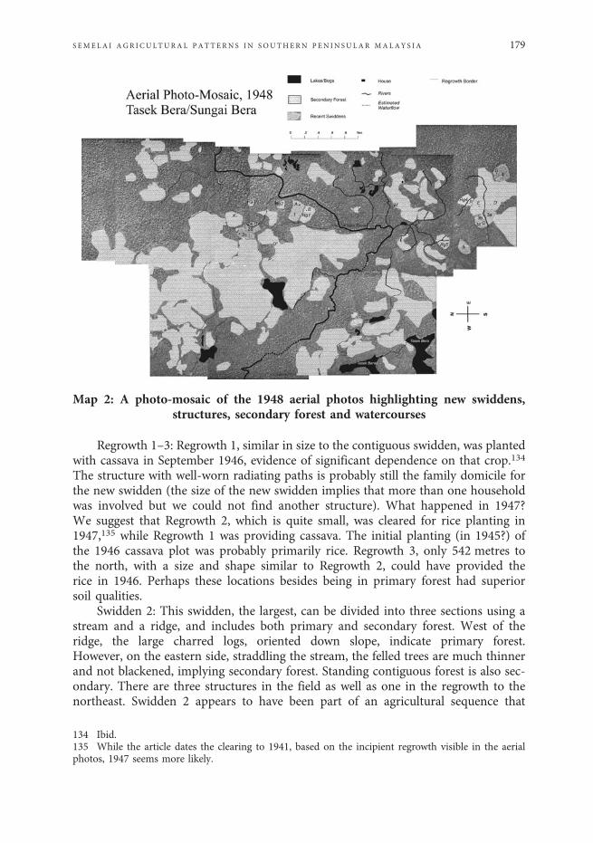
Regrowth 1–3: Regrowth 1, similar in size to the contiguous swidden, was plantedwith cassava in September 1946, evidence of significant dependence on that crop.134
The structure with well-worn radiating paths is probably still the family domicile forthe new swidden (the size of the new swidden implies that more than one householdwas involved but we could not find another structure). What happened in 1947?We suggest that Regrowth 2, which is quite small, was cleared for rice planting in1947,135 while Regrowth 1 was providing cassava. The initial planting (in 1945?) ofthe 1946 cassava plot was probably primarily rice. Regrowth 3, only 542 metres tothe north, with a size and shape similar to Regrowth 2, could have provided therice in 1946. Perhaps these locations besides being in primary forest had superiorsoil qualities.
Swidden 2: This swidden, the largest, can be divided into three sections using astream and a ridge, and includes both primary and secondary forest. West of theridge, the large charred logs, oriented down slope, indicate primary forest.However, on the eastern side, straddling the stream, the felled trees are much thinnerand not blackened, implying secondary forest. Standing contiguous forest is also sec-ondary. There are three structures in the field as well as one in the regrowth to thenortheast. Swidden 2 appears to have been part of an agricultural sequence that
Map 2: A photo-mosaic of the 1948 aerial photos highlighting new swiddens,structures, secondary forest and watercourses
134 Ibid.135 While the article dates the clearing to 1941, based on the incipient regrowth visible in the aerialphotos, 1947 seems more likely.
S EME LA I AGR I CU LTURA L PAT T ERN S I N SOUTHERN PEN IN SU LAR MALAY S I A 179
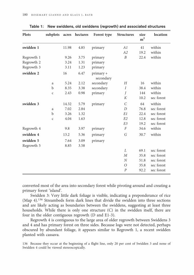
converted most of the area into secondary forest while pivoting around and creating aprimary forest ‘island’.
Swidden 3: Very little dark foliage is visible, indicating a preponderance of rice(Map 4).136 Streambeds form dark lines that divide the swidden into three sectionsand are likely acting as boundaries between the swiddens, suggesting at least threehouseholds. While there is only one structure (C) in the swidden itself, there arefour in the older contiguous regrowth (D and E1-3).
Regrowth 4 is contiguous to the large area of older regrowth between Swiddens 3and 4 and has primary forest on three sides. Because logs were not detected, perhapsobscured by abundant foliage, it appears similar to Regrowth 1, a recent swiddenplanted with cassava.
Table 1: New swiddens, old swiddens (regrowth) and associated structures
Plots subplots acres hectares Forest type Structures sizem2
location
swidden 1 11.98 4.85 primary A1 41 withinA2 19.2 within
Regrowth 1 9.26 3.75 primary B 22.4 withinRegrowth 2 3.24 1.31 primaryRegrowth 3 3.11 1.23 primary
swidden 2 16 6.47 primary +secondary
a 5.24 2.12 secondary H 16 withinb 8.35 3.38 secondary I 38.4 withinc 2.43 0.98 primary J 144 within
K 10.2 sec forest
swidden 3 14.32 5.79 primary C 64 withina 7.02 2.84 D 76.8 sec forestb 3.26 1.32 E1 22.4 sec forestc 4.04 1.63 E2 12.8 sec forest
E3 19.2 sec forestRegrowth 4 9.8 3.97 primary F 34.6 within
swidden 4 13.2 5.36 primary G 30.7 within
swidden 5 7.64 3.09 primaryRegrowth 5 8.85 3.58
L 69.1 sec forestM 35.8 sec forestN 51.8 sec forestO 35.8 sec forestP 92.2 sec forest
136 Because they occur at the beginning of a flight line, only 20 per cent of Swidden 3 and none ofSwidden 4 could be viewed stereoscopically.
180 RO S EMARY G IANNO AND KLAU S J . B AYR
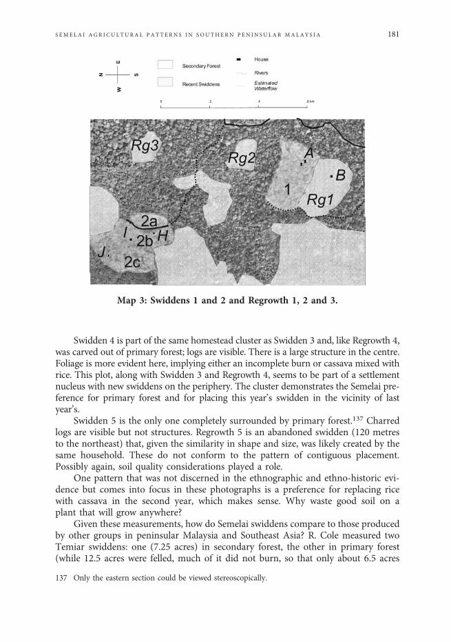
Swidden 4 is part of the same homestead cluster as Swidden 3 and, like Regrowth 4,was carved out of primary forest; logs are visible. There is a large structure in the centre.Foliage is more evident here, implying either an incomplete burn or cassava mixed withrice. This plot, along with Swidden 3 and Regrowth 4, seems to be part of a settlementnucleus with new swiddens on the periphery. The cluster demonstrates the Semelai pre-ference for primary forest and for placing this year’s swidden in the vicinity of lastyear’s.
Swidden 5 is the only one completely surrounded by primary forest.137 Charredlogs are visible but not structures. Regrowth 5 is an abandoned swidden (120 metresto the northeast) that, given the similarity in shape and size, was likely created by thesame household. These do not conform to the pattern of contiguous placement.Possibly again, soil quality considerations played a role.
One pattern that was not discerned in the ethnographic and ethno-historic evi-dence but comes into focus in these photographs is a preference for replacing ricewith cassava in the second year, which makes sense. Why waste good soil on aplant that will grow anywhere?
Given these measurements, how do Semelai swiddens compare to those producedby other groups in peninsular Malaysia and Southeast Asia? R. Cole measured twoTemiar swiddens: one (7.25 acres) in secondary forest, the other in primary forest(while 12.5 acres were felled, much of it did not burn, so that only about 6.5 acres
Map 3: Swiddens 1 and 2 and Regrowth 1, 2 and 3.
137 Only the eastern section could be viewed stereoscopically.
S EME LA I AGR I CU LTURA L PAT T ERN S I N SOUTHERN PEN IN SU LAR MALAY S I A 181
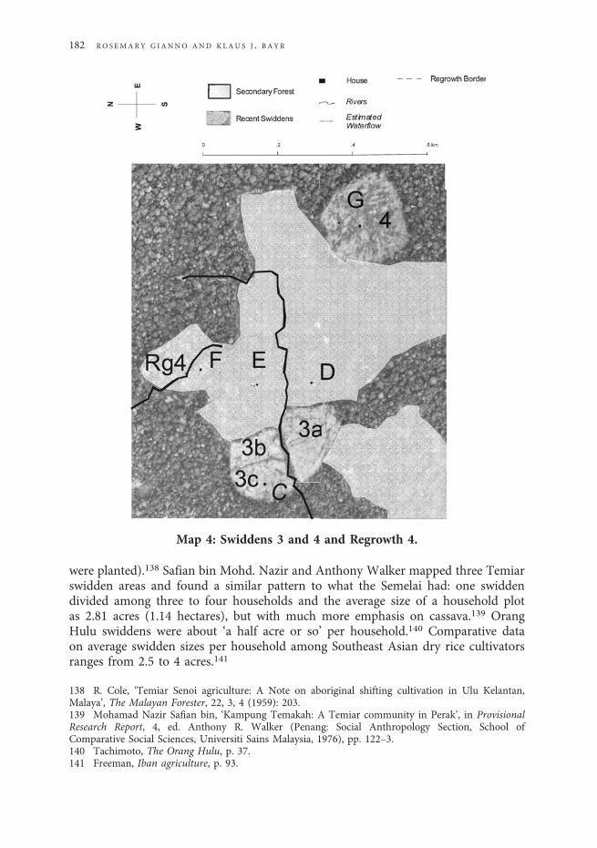
were planted).138 Safian bin Mohd. Nazir and Anthony Walker mapped three Temiarswidden areas and found a similar pattern to what the Semelai had: one swiddendivided among three to four households and the average size of a household plotas 2.81 acres (1.14 hectares), but with much more emphasis on cassava.139 OrangHulu swiddens were about ‘a half acre or so’ per household.140 Comparative dataon average swidden sizes per household among Southeast Asian dry rice cultivatorsranges from 2.5 to 4 acres.141
Map 4: Swiddens 3 and 4 and Regrowth 4.
138 R. Cole, ‘Temiar Senoi agriculture: A Note on aboriginal shifting cultivation in Ulu Kelantan,Malaya’, The Malayan Forester, 22, 3, 4 (1959): 203.139 Mohamad Nazir Safian bin, ‘Kampung Temakah: A Temiar community in Perak’, in ProvisionalResearch Report, 4, ed. Anthony R. Walker (Penang: Social Anthropology Section, School ofComparative Social Sciences, Universiti Sains Malaysia, 1976), pp. 122–3.140 Tachimoto, The Orang Hulu, p. 37.141 Freeman, Iban agriculture, p. 93.
182 RO SEMARY G IANNO AND KLAU S J . B AYR
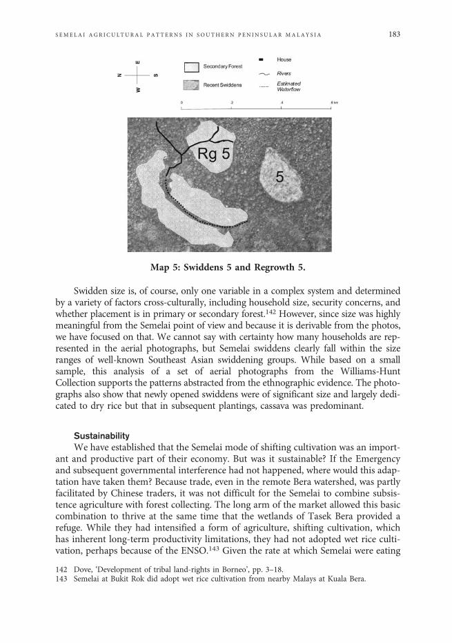
Swidden size is, of course, only one variable in a complex system and determinedby a variety of factors cross-culturally, including household size, security concerns, andwhether placement is in primary or secondary forest.142 However, since size was highlymeaningful from the Semelai point of view and because it is derivable from the photos,we have focused on that. We cannot say with certainty how many households are rep-resented in the aerial photographs, but Semelai swiddens clearly fall within the sizeranges of well-known Southeast Asian swiddening groups. While based on a smallsample, this analysis of a set of aerial photographs from the Williams-HuntCollection supports the patterns abstracted from the ethnographic evidence. The photo-graphs also show that newly opened swiddens were of significant size and largely dedi-cated to dry rice but that in subsequent plantings, cassava was predominant.
SustainabilityWe have established that the Semelai mode of shifting cultivation was an import-
ant and productive part of their economy. But was it sustainable? If the Emergencyand subsequent governmental interference had not happened, where would this adap-tation have taken them? Because trade, even in the remote Bera watershed, was partlyfacilitated by Chinese traders, it was not difficult for the Semelai to combine subsis-tence agriculture with forest collecting. The long arm of the market allowed this basiccombination to thrive at the same time that the wetlands of Tasek Bera provided arefuge. While they had intensified a form of agriculture, shifting cultivation, whichhas inherent long-term productivity limitations, they had not adopted wet rice culti-vation, perhaps because of the ENSO.143 Given the rate at which Semelai were eating
Map 5: Swiddens 5 and Regrowth 5.
142 Dove, ‘Development of tribal land-rights in Borneo’, pp. 3–18.143 Semelai at Bukit Rok did adopt wet rice cultivation from nearby Malays at Kuala Bera.
S EME LA I AGR I CU LTURA L PAT T ERN S I N SOUTHERN PEN IN SU LAR MALAY S I A 183
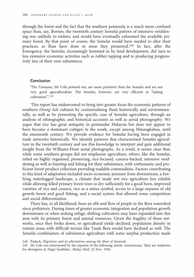
through the forest and the fact that the southern peninsula is a much more confinedspace than, say, Borneo, the twentieth century Semelai pattern of intensive swidden-ing was unlikely to endure, and would have eventually exhausted the available pri-mary forest. By that point of course, the Semelai would have needed to alter theirpractices, as Iban have done in areas they pioneered.144 In fact, after theEmergency, the Semelai, increasingly hemmed in by land development, did turn toless extensive economic activities such as rubber tapping and to producing progress-ively less of their own subsistence.
Conclusion
‘The Temuans, Mr Cole pointed out, are more primitive than the Semelai and are notvery good agriculturalists. The Semelai, however, are very efficient at “ladangcultivation”.’145
This report has endeavoured to bring into greater focus the economic patterns ofsouthern Orang Asli cultures by contextualising them historically and environmen-tally, as well as by presenting the specific case of Semelai agriculture, through ananalysis of ethnographic and historical accounts as well as aerial photography. Weargue that rice has great antiquity in peninsular Malaysia but does not appear tohave become a dominant cultigen in the south, except among Minangkabau, untilthe nineteenth century. We provide evidence for Semelai having been engaged intrade networks historically. We identify patterns that characterised Semelai agricul-ture in the twentieth century and use this knowledge to interpret and gain additionalinsight from the Williams-Hunt aerial photographs. As a result, it seems clear that,while some southern groups did not emphasise agriculture, others, like the Semelai,relied on highly organised, pioneering, rice-focused, cassava-backed, intensive swid-dening as well as hunting and fishing for their subsistence, with enthusiastic and pro-ficient forest product collection providing tradable commodities. Factors contributingto this kind of adaptation included socio-economic pressure from downstream, a low-lying waterlogged landscape, a climate that made wet rice agriculture less reliablewhile allowing felled primary forest trees to dry sufficiently for a good burn, improvedvarieties of rice and cassava, rice as a status symbol, access to a large expanse of oldgrowth forest and good fishing, and a social system that allowed some competitionand social differentiation.
There has, in all likelihood, been an ebb and flow of people in the Bera watershedsince prehistory. During times of greater economic integration and population growthdownstream or when seeking refuge, shifting cultivators may have expanded into thisarea with its primary forest and animal resources. Given the fragility of these net-works, once they broke down, or agricultural yields declined, population density inremote areas with difficult terrain like Tasek Bera would have declined as well. TheSemelai combination of subsistence agriculture with some surplus production made
144 Padoch, Migration and its alternatives among the Iban of Sarawak.145 Mr Cole was interviewed by the reporter of the following article: Anonymous, ‘Men are midwivesfor aborigines in Negri Sembilan’, Malay Mail, 22 Nov. 1956.
184 RO SEMARY G IANNO AND KLAU S J . B AYR

sense, at least in the short term, because the twentieth century was a time when socio-economic integration was very much on the rise.
Perhaps the most important point to take from this analysis has been the need forOrang Asli cultures to be flexible and diversified in the face of changing circum-stances. Because of their proximity to more powerful societies, Orang Asli cultureshave had to make accommodations and adaptations quickly as their social environ-ment denied access to some resources while presenting opportunities for others.
S EME LA I AGR I CU LTURA L PAT T ERN S I N SOUTHERN PEN IN SU LAR MALAY S I A 185
Related Documents