Seismological observations in Northwestern South America: Evidence for two subduction segments, contrasting crustal thicknesses and upper mantle flow Jefferson Yarce, Gaspar Monsalve, Thorsten W. Becker, Agust´ ın Car- dona, Esteban Poveda, Daniel Alvira, Oswaldo Ordo˜ nez-Carmona PII: S0040-1951(14)00507-1 DOI: doi: 10.1016/j.tecto.2014.09.006 Reference: TECTO 126436 To appear in: Tectonophysics Received date: 24 June 2014 Revised date: 17 September 2014 Accepted date: 21 September 2014 Please cite this article as: Yarce, Jefferson, Monsalve, Gaspar, Becker, Thorsten W., Cardona, Agust´ ın, Poveda, Esteban, Alvira, Daniel, Ordo˜ nez-Carmona, Oswaldo, Seis- mological observations in Northwestern South America: Evidence for two subduction segments, contrasting crustal thicknesses and upper mantle flow, Tectonophysics (2014), doi: 10.1016/j.tecto.2014.09.006 This is a PDF file of an unedited manuscript that has been accepted for publication. As a service to our customers we are providing this early version of the manuscript. The manuscript will undergo copyediting, typesetting, and review of the resulting proof before it is published in its final form. Please note that during the production process errors may be discovered which could affect the content, and all legal disclaimers that apply to the journal pertain.

Welcome message from author
This document is posted to help you gain knowledge. Please leave a comment to let me know what you think about it! Share it to your friends and learn new things together.
Transcript
�������� ����� ��
Seismological observations in Northwestern South America: Evidence fortwo subduction segments, contrasting crustal thicknesses and upper mantleflow
Jefferson Yarce, Gaspar Monsalve, Thorsten W. Becker, Agustın Car-dona, Esteban Poveda, Daniel Alvira, Oswaldo Ordonez-Carmona
PII: S0040-1951(14)00507-1DOI: doi: 10.1016/j.tecto.2014.09.006Reference: TECTO 126436
To appear in: Tectonophysics
Received date: 24 June 2014Revised date: 17 September 2014Accepted date: 21 September 2014
Please cite this article as: Yarce, Jefferson, Monsalve, Gaspar, Becker, Thorsten W.,Cardona, Agustın, Poveda, Esteban, Alvira, Daniel, Ordonez-Carmona, Oswaldo, Seis-mological observations in Northwestern South America: Evidence for two subductionsegments, contrasting crustal thicknesses and upper mantle flow, Tectonophysics (2014),doi: 10.1016/j.tecto.2014.09.006
This is a PDF file of an unedited manuscript that has been accepted for publication.As a service to our customers we are providing this early version of the manuscript.The manuscript will undergo copyediting, typesetting, and review of the resulting proofbefore it is published in its final form. Please note that during the production processerrors may be discovered which could affect the content, and all legal disclaimers thatapply to the journal pertain.
ACC
EPTE
D M
ANU
SCR
IPT
ACCEPTED MANUSCRIPT
SEISMOLOGICAL OBSERVATIONS IN NORTHWESTERN SOUTH AMERICA:
EVIDENCE FOR TWO SUBDUCTION SEGMENTS, CONTRASTING CRUSTAL
THICKNESSES AND UPPER MANTLE FLOW
Authors:
Jefferson Yarce Universidad Nacional de Colombia, Medellín Campus
Gaspar Monsalve Universidad Nacional de Colombia, Medellín Campus
Thorsten W. Becker University of Southern California
Agustín Cardona Universidad Nacional de Colombia, Medellín Campus
Esteban Poveda Federal University of Rio Grande do Norte
Daniel Alvira Universidad Nacional de Colombia, Medellín Campus
Oswaldo Ordoñez-Carmona Universidad Nacional de Colombia, Medellín Campus
Corresponding Author Information
E-mail: [email protected]
Telephone (mobile): (+57)3104493651
ACC
EPTE
D M
ANU
SCR
IPT
ACCEPTED MANUSCRIPT
Abstract
The cause of tectonic deformation in northwestern South America and its link to upper
mantle structure and flow are debated. We use a combination of broad-band and short
period travel time seismic data for P-waves to show that observations are consistent with
the presence of two subduction segments in Colombia and contrasting values of crustal
thickness. In Northern Colombia, at latitudes greater than 6°N, most of the seismic stations
are associated with negative teleseismic travel time residuals, relative to a regional mean,
suggesting that the upper mantle is seismically faster than predicted from global models.
In particular, for the Caribbean coastal plains there are no signs of significant anomalies in
the upper mantle, evidenced by the small magnitude of the travel time delays and subdued
Pn speeds (~7.97 km/s). To the southeast of such plains there is an increase in magnitude
of the negative travel time residuals, including the Northern Eastern Cordillera, the Perija
Range and the Merida Andes. An analysis of non-isostatic residual topography, based on
a model of crustal thickness in northwestern South America, is consistent with a slab
associated upper mantle flow beneath the region just east of the Bucaramanga Nest. We
interpret these results to indicate the presence of a Caribbean slab, initially flat beneath
the Caribbean coastal plains, and steepening sharply in the southeast, including the area
of Bucaramanga. For most of the western Andean region and the Pacific coast, south of
6°N, teleseismic differential travel time residuals are predominantly positive, indicating that
the upper mantle is in general seismically slower than the reference model. Beneath the
Central Cordillera, just to the east of this area, residuals become smaller and
predominantly negative; residual non-isostatic topography is negative as well. These
features are probably related to the effect of the Nazca subduction developing an
asthenospheric wedge.
ACC
EPTE
D M
ANU
SCR
IPT
ACCEPTED MANUSCRIPT
1. Introduction
A range of previous studies have focused on the tectonic setting, boundaries and
characteristics of the Nazca and Caribbean plate segments subducting under the North
Andean block (Figure 1). Seismicity and tomographic images have been used for this
purpose. Pennington (1981) proposes the presence of two subduction segments in the
northwesternmost Andes (Bucaramanga and Cauca). Van der Hilst & Mann (1994)
suggest the existence of the Maracaibo (Caribbean related) and Bucaramanga (Nazca
related) slabs beneath the North Andean Block. Taboada et al. (2000) and Cortes &
Angelier (2005) proposed an association between the Bucaramanga Seismic Nest (Figure
1) and Caribbean subduction. Gutscher et al. (2000) presented a model of flat subduction
beneath Northwestern Colombia related to the Panama-Choco Block collision, which
steepens at the location of the Bucaramanga nest. Hypocentral relocations by Ojeda &
Havskov (2001) also suggest the existence of two segments, but their association with
subducted slabs is still unclear.
There are still open questions about the spatial extent of the subducted Nazca and
Caribbean slabs beneath Colombia and their possible interaction in depth. Pennington
(1981) proposes the existence of a WNW-ESE oriented shear zone in the contact area
between both plates, but other authors consider that there is a region where they overlap.
Shih et al. (1991) use results of attenuation of seismic waves, in particular a region of low
attenuation, as evidence for overlapping slabs. Van der Hilst and Mann (1994) and
Corredor (2003) correlate this possible overlapping zone with the absence of volcanism in
the Andean region north of 5.5°N. Taboada et al. (2000) suggest that the interaction
between slabs originates active faulting within both. According to the models of Cortes &
Angelier (2005) there is a region in northern Colombia where both slabs overlap, with the
Caribbean plate on top of the Nazca plate, coinciding with a region of high seismicity; their
ACC
EPTE
D M
ANU
SCR
IPT
ACCEPTED MANUSCRIPT
idea of slab interactions includes a suggestion that the Bucaramanga and Cauca seismic
nests (Figure 1) are the result of tearing of Caribbean and Nazca slabs respectively.
Vargas & Mann (2013) suggested a boundary between Nazca and Caribbean subductions
represented by the ―Caldas Tear‖, a continental extension of the Sandra Ridge, with a
nearly W – E trend at a latitude of ~5.5 °N.
Here, we use travel time data from teleseismic and regional earthquakes recorded at
stations of the National Seismological Network of Colombia (Red Sismológica Nacional de
Colombia, RSNC). Particularly, we looked at travel time residuals of teleseismic events to
separate regions of seismically slow and fast upper mantle, and travel times of regional
events to constrain the spatial variations in the uppermost mantle P-wave speed. This
approach was used to identify regions of contrasting upper mantle temperatures and
crustal thicknesses, related to the complex subduction system beneath the Northern
Andes.
2. Geodynamic Setting
The Andes of Colombia are located in a tectonically complex region where at least three
tectonic plates converge. Much of the deformation resulting from these interactions is
absorbed in the Panama-Choco and the North Andean Blocks (Pennington, 1981; Kellogg
& Vega, 1995; Cortes & Angelier, 2005). The latter includes the Colombian orogenic
system, composed of three cordilleras (Western, Central and Eastern Cordilleras [Figure
1]).
According to Trenkamp et al. (2002) the Nazca Plate is moving in a nearly eastward
direction with a convergence rate of 58 ± 2 mm/yr, and the Caribbean Plate moves in an
ESE direction with a rate of convergence of 20 ± 2 mm/yr, both relative to stable South
America. The North Andean Block, which includes the volcanic arc and the three main
ACC
EPTE
D M
ANU
SCR
IPT
ACCEPTED MANUSCRIPT
cordilleras, moves in NE direction with respect to the South American Plate at an
approximate speed of 6 mm/yr. Volcanic activity in this block started in the Cretaceous
(Marriner & Millward, 1984) and continued through the Cenozoic until it reached its present
configuration (at least a million years ago [Calvache et al. 1997]) and is located ~250 km
from the Nazca trench.
According to Pennington (1981), the Nazca Plate subducts beneath south western
Colombia (the North Andean Block) with an angle of nearly 35° in a NW-SE direction,
defining what he calls the Cauca Segment, which includes the Cauca seismic nest (also
called Viejo Caldas seismic nest [Franco et al., 2002]) (Figure 1), whereas the Caribbean
Plate subducts beneath the North Andean Block at a shallower dip in a WNW-ESE
direction, defining the Bucaramanga Segment, and including the Bucaramanga Seismic
Nest (Figure 1).
The formation of the Nazca plate took place after the fragmentation of the Farallon plate
during the Late Oligocene-Early Miocene (Hoernle et al., 2002; Meschede & Barckhausen,
2000; Lonsdale, 2005).The Nazca plate, in the vicinity of the subduction zone beneath
Colombia, seems to be relatively young: over the last 20 m.y. several events of sea floor
spreading have been reported in this plate, which means very young ages of the
lithosphere distributed in an asymmetric pattern (Müller et al., 2008). Between latitudes 2°
and 6°N, Tibaldi & Ferrari(1992) report ages for the Nazca Plate between 2 and 16 m.y.
The Caribbean Plate originated in the Cretaceous as an oceanic plateau within the Pacific,
and moved first in a north direction and then ENE, until reaching its current location (Kerr
& Tarney, 2005; Kennan & Pindell, 2009).
3. Data and Methods
ACC
EPTE
D M
ANU
SCR
IPT
ACCEPTED MANUSCRIPT
Seismological catalog data in Colombia are available from the RSNC, operated by the
Colombian Geological Survey, since 1993; however, it was not until 2008 that broadband
stations began to be systematically installed all over the country. Combined with the short
period pre-existing stations, this allows us to have a set of reliable arrival times from near
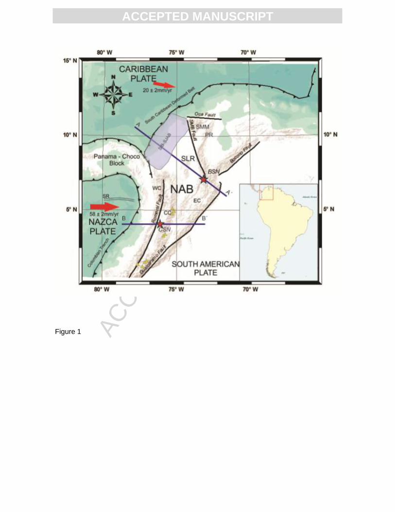
and distant earthquakes. The recording stations are shown in Figure 2.
Travel time residuals are the differences between observed and calculated travel times of
a seismic ray that goes from a source to a receiver. The calculated time can be obtained
by using a reference Earth model, which in our case is iasp91 (Kennett & Engdahl, 1991),
and was computed using the TauP software (Crotwell et al., 1999). When using
teleseismic events, absolute travel time residuals are mainly due to both near-source and
near-receiver effects, which represent anomalies in the crust and/or the upper mantle. The
use of relative (or differential) travel time residuals of global events recorded at a
local/regional network allows us to isolate the effects of near-receiver structure (e.g. Ding
& Grand, 1994; Zhou et al., 1996). Here, we used events recorded at several stations, and
calculated the difference in time residuals among all the possible station pairs. We then
collected the mean differential residual at all stations relative to each one of the others,
and calculate an average of them. This allows us to estimate an average regional residual
and to express the other residuals (time delays) relative to it.
In order to be able to deduce the presence of seismic anomalies in the upper mantle
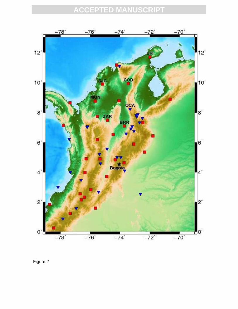
beneath North Western Colombia, we used teleseismic events from January 2008 to
August 2012, with a minimum local magnitude of 5.5 and epicentral distances between 30°
and 90°, recorded at stations of the RSNC, and calculated absolute and relative travel time
residuals. The events used and their azimuthal coverage are illustrated in Figure 3. Events
with magnitudes over 6.5 have an associated P-arrival picking accuracy above 0.2 s,
ACC
EPTE
D M
ANU
SCR
IPT
ACCEPTED MANUSCRIPT
whereas earthquakes of smaller magnitude could have an arrival time uncertainty of up to
0.4 s (see supplemental material for some example seismograms).
If we want to identify the effects of the upper mantle structure in the travel time residuals,
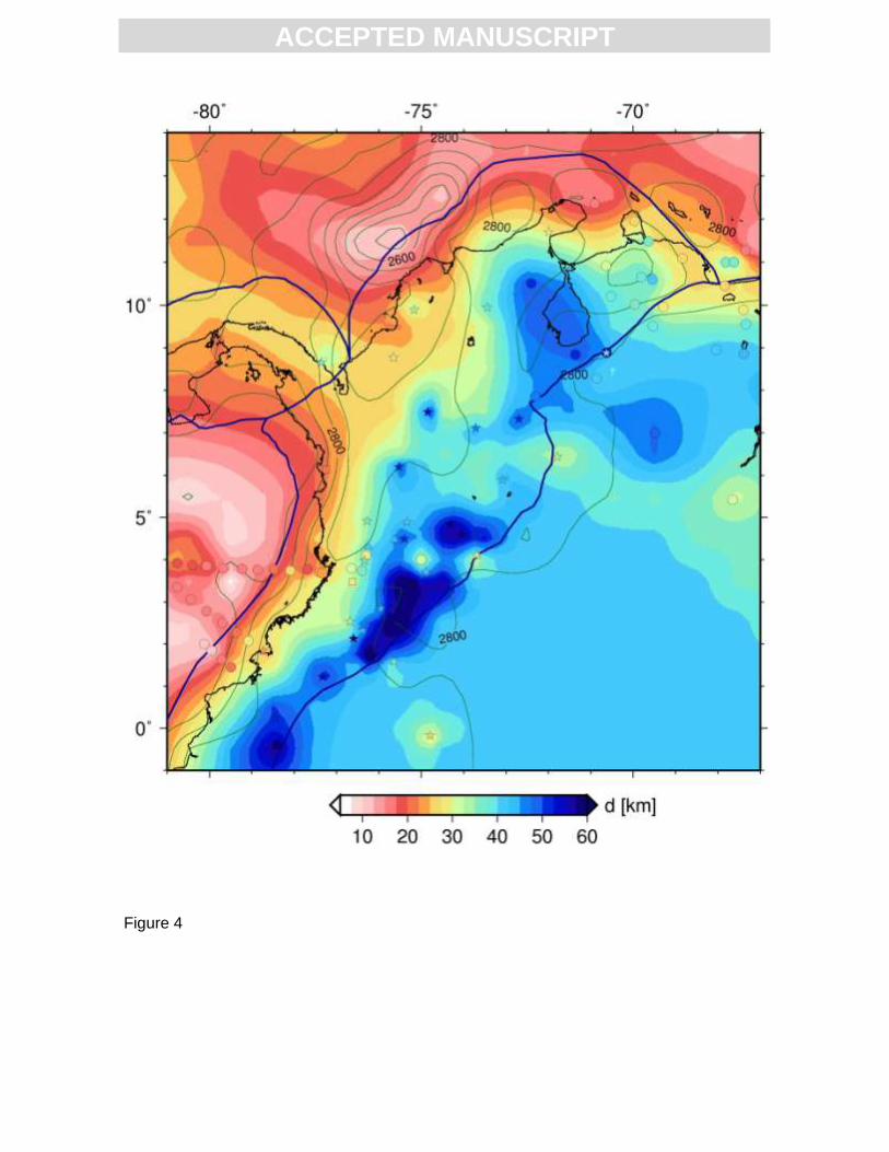
we need to take into account the crustal thickness variations, and take out from the
differential time residual the portion that is due to the difference in crustal thickness
between stations. For crustal thickness beneath the recording stations we used the global
model CRUST 1.0 (Laske et al., 2013), combined with regional crustal thickness
compilations by Assumpção, et al. (2013), and recent receiver function estimates by
Monsalve et al. (2013) and Poveda et al. (submitted). These studies indicate very
contrasting values of crustal thickness in the North Western Andean region, with
thicknesses below 30 km in the Pacific and Caribbean coastal plains, and values of nearly
60 km beneath some of the Andean volcanoes of South Western Colombia and
underneath the Eastern Cordillera in the Bogota area. In the Northern Central Cordillera,
high thicknesses have been reported, which exceed 50 km (Poveda et al., submitted). The
resulting, merged crustal thickness map is illustrated in Figure 4. We took a reference
crustal thickness of 39.8 km, and calculated the residual portion due to the difference in
crustal thickness between any station and this reference value, using a mean crustal P-
wave velocity estimated with the iasp91 model. To find the differential travel time residuals
corrected by crustal thickness variations beneath each station, we used the following
equation:
(1)
Where is the differential travel time residual after correction for crustal
thickness, is the initial differential residual (before crustal correction) and
is a time that we calculated as follows:
ACC
EPTE
D M
ANU
SCR
IPT
ACCEPTED MANUSCRIPT
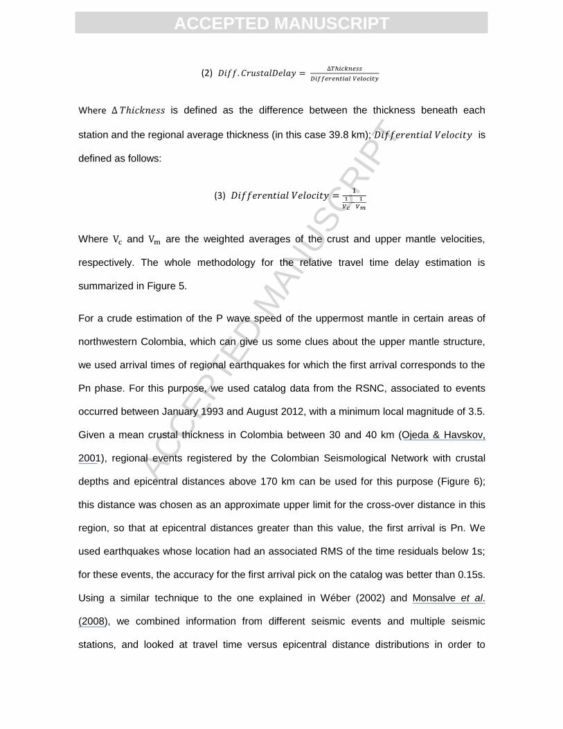
(2)
Where is defined as the difference between the thickness beneath each
station and the regional average thickness (in this case 39.8 km); is
defined as follows:
(3)
Where and are the weighted averages of the crust and upper mantle velocities,
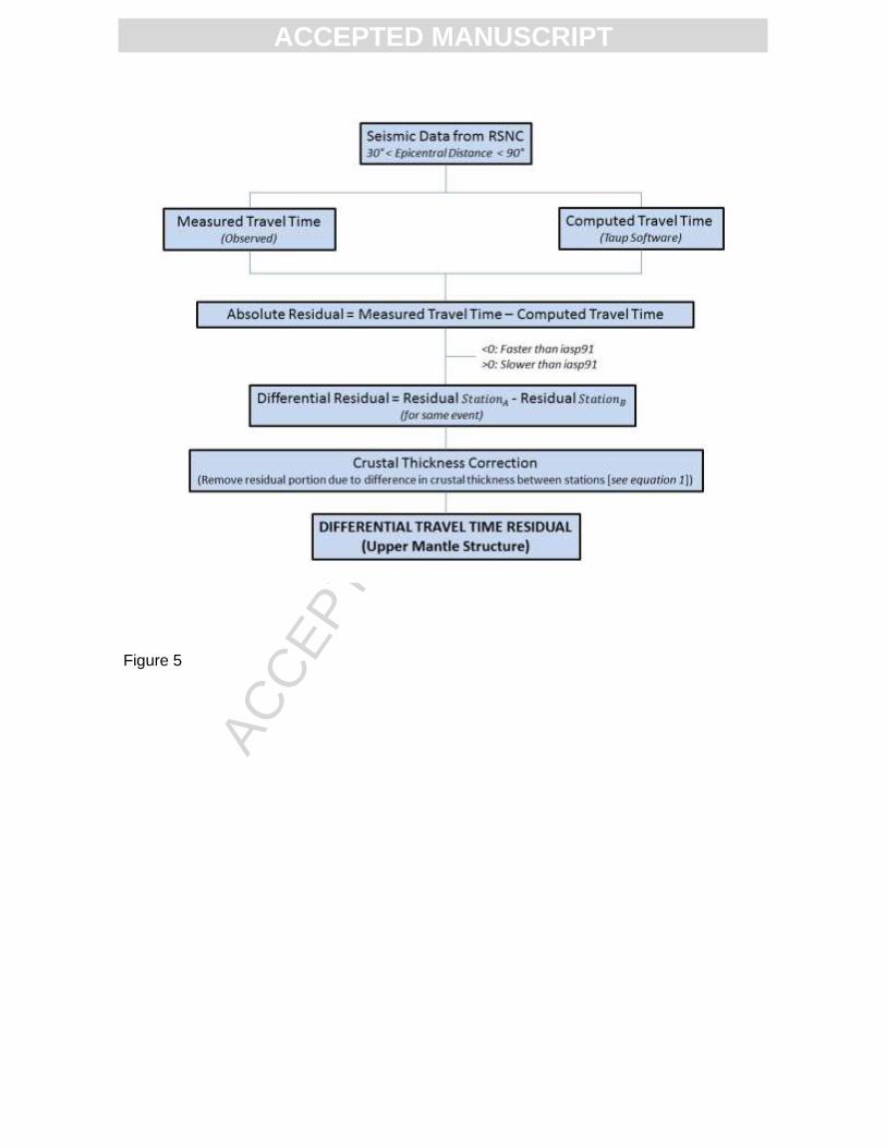
respectively. The whole methodology for the relative travel time delay estimation is
summarized in Figure 5.
For a crude estimation of the P wave speed of the uppermost mantle in certain areas of
northwestern Colombia, which can give us some clues about the upper mantle structure,
we used arrival times of regional earthquakes for which the first arrival corresponds to the
Pn phase. For this purpose, we used catalog data from the RSNC, associated to events
occurred between January 1993 and August 2012, with a minimum local magnitude of 3.5.
Given a mean crustal thickness in Colombia between 30 and 40 km (Ojeda & Havskov,
2001), regional events registered by the Colombian Seismological Network with crustal
depths and epicentral distances above 170 km can be used for this purpose (Figure 6);
this distance was chosen as an approximate upper limit for the cross-over distance in this
region, so that at epicentral distances greater than this value, the first arrival is Pn. We
used earthquakes whose location had an associated RMS of the time residuals below 1s;
for these events, the accuracy for the first arrival pick on the catalog was better than 0.15s.
Using a similar technique to the one explained in Wéber (2002) and Monsalve et al.
(2008), we combined information from different seismic events and multiple seismic
stations, and looked at travel time versus epicentral distance distributions in order to
ACC
EPTE
D M
ANU
SCR
IPT
ACCEPTED MANUSCRIPT
deduce the mean Pn velocities beneath several regions in Colombia, by estimating the
slope of the time versus distance curve. We also made a sphericity correction in order to
take into account the differences between distances traveled along the Moho and their
projections at the earth surface. To be able to appreciate differences in the mean Pn
speeds between various regions with morphotectonic and geodynamic significance, we
grouped together stations in three areas: The Caribbean plains, the northern Eastern
Cordillera, and a region north of 4°N in the Cordilleran system, which includes the Western
Cordillera, the Central Cordillera, and the Eastern Cordillera at latitudes below 5.5°N;
these groups of stations are represented by purple, blue and red inverted triangles in
Figure 6, respectively.
4. Results
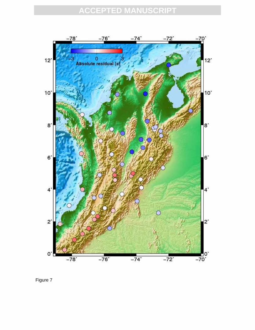
In Figure 7 we show the mean values of the estimated absolute travel time residuals at
different stations in Colombia; the standard deviations are below 3 s, and we made sure
that the number of data points per station was above 10 (see supplemental material for
frequency histograms of absolute residuals at different stations). The average RMS of
these mean absolute travel time residuals is 2.5 s. Negative residuals concentrate in the
northern part of the study area, including the Caribbean coastal plains and the northern
Eastern Cordillera. To the south of latitude ~6°N, the residual signal is more random, with
a tendency to be positive. This suggests that seismic velocities in the crust and/or upper
mantle for the northernmost part of Colombia are faster than they are in the reference
model. In the south, that trend is reversed, indicating that seismic velocities are, in general,
slower than in the reference model.
The calculated absolute travel time residuals are mainly a function of the near-source and
near-receiver structure. The effects of the near-source structure should be minimal due to
the variety of epicentral distances and back-azimuths of the events used (Figure 3) (see
ACC
EPTE
D M
ANU
SCR
IPT
ACCEPTED MANUSCRIPT
supplemental material). Nevertheless, to further minimize such effect and focus on the
near-receiver cause of those delays, we calculated the average differential travel time
residuals at all stations relative to each one of the other receivers. This allows us to
calculate a regional average for those delays, and therefore, to compute the time residuals
relative to such regional mean. Those relative time delays are partially due to the
difference in crustal thickness between stations. Since crustal thickness can have
variations greater than 20 km in the study area (Poveda et al., 2013; Poveda et al.,
submitted), we need to subtract from the differential residuals the effect in time delay of
these differential thicknesses. Therefore, using results of crustal thickness shown in Figure
4, we corrected the relative average time residuals so that they best represent the
differences in upper mantle structure between station locations. For the estimation of time
delays due to differences in crustal thickness we used a weighted average of crustal and
uppermost mantle velocities given by the iasp91 model (Kennett & Engdahl, 1991). The
variability of the relative travel time residuals for all stations before and after crustal
correction stays almost the same, with an RMS of 1.2 s. Uncertainties in Moho depth from
receiver functions calculated by Poveda et al. (submitted) are below ±4 km, which may
represent an uncertainty of around 0.16 s in the crustal travel time of the teleseismic rays.
We normalized those relative time delays to a reference average crustal thickness of 39.8
km.
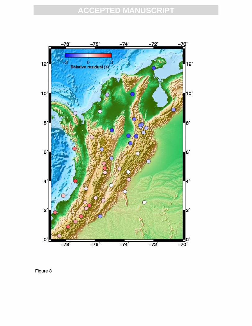
The results of differential travel time residuals, relative to a regional average, with the
effect of differential crustal thickness subtracted from them, are illustrated in Figure 8
where we still observe that negative residuals concentrate more in the north, and the
positive ones are more predominant south of ~6°N; a significant difference in upper mantle
structure must then exist between these two regions: a simple interpretation might suggest
that the upper mantle is colder in the north than it is in the south. Stations near the
ACC
EPTE
D M
ANU
SCR
IPT
ACCEPTED MANUSCRIPT
Caribbean coast (MON, SJC, Figure 2) have relatively small negative time residuals
(Figure 8), indicating that the coldest anomaly should concentrate to the south-east of the
Caribbean coast, including the region of the Bucaramanga nest (Figure 1), where time
delays are strongly negative (Figure 8). At the Pacific coast and the Western and Central
Cordilleras, including the volcanic chain, there is a concentration of positive time delays
(Figure 8), and they become lower towards the east, beneath the intermountain Valley and
the Eastern Cordillera, (Figure 8).
Slopes of travel time versus epicentral distance distributions suggest that Pn speeds have
a mean value of 7.97 ± 0.05 km/s for northernmost continental Colombia (calculated using
arrival times at purple stations in Figure 6), 8.07 ± 0.02 km/s for the northern Eastern
Cordillera (blue stations in Figure 6), and 8.05 ± 0.03 km/s for the Western Cordillera, the
Central Cordillera and the Eastern Cordillera south of ~5°N (red stations in Figure 6). For
these three regions, the number of used data points (Pn arrivals) was 173, 1190 and 686
respectively. The mean Pn values obtained for the three analyzed regions (Figure 6) are
within the typical values for Pn velocities in continental areas, although they are below the
global average of 8.09 km/s (Christensen & Mooney, 1995). Pn speeds below 7.9 km/s are
diagnostic of volcanic areas, magmatic activity, partial melt, water coming from subducted
lithosphere, or a combination of one or several of those with a thin crust (e.g. Hearn & Ni,
1994; Hearn et al., 1994; Wéber, 2002; Stern et al., 2010); values above around 8.15 km/s
are typical of old, stable regions, cold upper mantle and relatively thick crust or lithosphere
(Hearn & Ni, 1994; Lu et al., 2011; Hirn & Sapin, 1984; Amini et al., 2012), and in some
cases they might be associated with continental collision (Hirn & Sapin, 1984; Monsalve et
al., 2008). For the regions analyzed here, neither of those seems to be the case, and the
obtained differences in Pn speeds are likely a consequence of crustal thickness variations.
There is a difference of ~ 0.08 km/s in the Pn speed below Northern Colombia / Caribbean
ACC
EPTE
D M
ANU
SCR
IPT
ACCEPTED MANUSCRIPT
plains and the Andean region. The difference in crustal thickness between these two
regions is between 15 and 30 km (Ceron et al., 2007; Poveda et al., 2013; Poveda et al.,
submitted), which should be enough to account for the observed contrast in Pn speed
(Christensen & Mooney, 1995). Although the relative travel time residual suggest that
there might be a difference in the thermal upper mantle structure between the Caribbean
coastal plains / Northern Eastern Cordillera and the rest of the Colombian Andes / Pacific
coastal plains, the Pn results indicate that the sources of those differences are not at
depths close to the Moho.
5. Discussion
The travel time residuals we measure indicate that there are important differences in the
upper mantle structure between Northern Colombia and its Central and Western
continental regions. The division is at ~6°N, suggesting the presence of two subduction
segments of different nature beneath Northwestern South America, one related to the
Caribbean plate and the other associated with the Nazca plate.
The Caribbean Plate in the vicinities of the Colombian Coast consists mainly (but not
exclusively) of an oceanic Cretaceous plateau (Mauffret & Leroy, 1997). According to
Cloos (1993), a Cretaceous oceanic plateau should be negatively buoyant enough to
subduct, and they are commonly associated with flat subduction (e.g. van Hunen et al.,
2002). The presence of subduction in the Caribbean coastal plains of Colombia has been
documented by Middle Miocene (~13-14 ma) volcanism near station MON (Figure 2) (Lara
et al., 2013), and the current absence of volcanism near the coastline might indicate a
present shallow Caribbean slab subduction. In this region is highly possible that the Moho
depicted in Figure 4 corresponds to the crust-mantle boundary within the subducted
oceanic plate. Relative time delays near the Caribbean coastline (stations MON, SJC,
Figure 2, see time delays in Figure 8), which are relatively small, allow us to infer that
ACC
EPTE
D M
ANU
SCR
IPT
ACCEPTED MANUSCRIPT
there are no significant thermal anomalies in the upper mantle beneath this region, which
is consistent with the absence of an asthenospheric wedge. Although the obtained mean
Pn speed in this region is relatively small (~7.97 km/s), it must be due to the thin crust
(Figure 4) of continental nature (Maya, 1992) beneath the Caribbean Coastal plains, and
there is no evidence for a hot uppermost mantle.
Even though northernmost Colombia has been a region associated with subduction under
a continental margin at least from the middle Miocene (Lara et al., 2013), there is a current
high oblique component in the convergence (Trenkamp et al., 2002). Although there are
signs of a compressional regime at the Sinu - San Jacinto Basin, expressed by the
presence of an accretionary wedge (Flinch, 2003; Toto & Kellogg, 1992), Cardona et al.,
(2012) hypothesize about various stages in the convergence process, which include an
extensional episode of formation and filling of a post-collisional basin during the late
Paleocene through the early Oligocene at the area of Sinu – San Jacinto (Figure 1), and
several changes in the obliquity of the convergence. Montes et al., (2010) presented
evidence for as much as 115 km of extension to the south-west of the Santa Marta Massif
during Oligocene through late Miocene time, probably linked to an oblique convergence
and a clockwise rotation of this massif. To the NE of the Oca Fault Zone (Figure 1), there
is geological and geophysical evidence of extension during Tertiary times (Bonini, 1984),
also documented by the stratigraphic record through the Eocene, Oligocene and Miocene
(Macellari, 1995). These hypotheses are consistent with the seismological observations,
which suggest a thin crust, with an absence of significant thermal anomalies in the
uppermost mantle.
To the SE of the Caribbean coastline, in the vicinities and beneath the Perija Range, the
San Lucas Range and the Northern Eastern Cordillera (Figure 1), the relative time delays
have a strong trend toward negative values (Figure 8, stations ZAR, BRR, OCA, COD and
ACC
EPTE
D M
ANU
SCR
IPT
ACCEPTED MANUSCRIPT
neighboring sites in Figure 2). At these locations, the upper mantle must be colder than
beneath the northern coastal plains. A steepening of the Caribbean slab may occur around
this area, and the cold upper mantle might be related with the slab penetrating the
asthenosphere. In fact, subduction of the Caribbean Plate at a high angle has been
deduced beneath NE Colombia and NW Venezuela, and incorporated in models presented
in Bezada et al. (2010), Masy et al. (2011) and van Benthem et al. (2013).This region
coincides with the location of the Bucaramanga Nest (Taboada et al., 2000; Bezada et al.,
2010) where brittle processes occur at 150-200 km depth, consistent with the existence of
a cold upper mantle.
The greater abundance of positive time residuals in the southern portion (at latitudes south
of 6°) of Figure 7 and Figure 8, with the greatest concentration of positive delays in the
Pacific coast and the Western and Central Cordilleras, indicates the existence of a
relatively slow seismic velocity in the upper mantle, in the region where Nazca subduction
should be ongoing. Despite the very young age of the Nazca Plate (Tibaldi & Ferrari,
1992), its buoyancy should be enough to subduct. According to relocated seismicity by
Pedraza-Garcia et al. (2007), the dip of Nazca subduction beneath western Colombia
varies between 17° and 45°, at least for latitudes south of 5.5°N.
Nazca subduction beneath Colombia is associated with high heat flow values (>0.06 Wm-2)
in the Pacific Coast that indicate a relatively warm forearc (Pollack et al., 1993), according
to classification of Peacock (2003) for subduction zone forearcs. In terms of the age, the
Nazca Plate should be comparable to the Philippine Sea Plate in southwestern Japan
(Peacock & Wang, 1999; Peacock, 2003) but the seismicity suggests that for the most
part, the subduction angle of the Nazca slab beneath Colombia is greater than the
estimates for the Philippine Sea Plate. In any case, even for very young oceanic
lithosphere, the plate should be negatively buoyant enough to subduct and to develop a
ACC
EPTE
D M
ANU
SCR
IPT
ACCEPTED MANUSCRIPT
mantle wedge (Cloos, 1993). Following records of seismicity (Pedraza-García et al., 2007),
lower crustal xenoliths (Weber et al., 2002) and the geochemistry of volcanic rocks
(Kroonenberg et al., 1982), it is clear that subduction of the Nazca Plate beneath western
Colombia, at least at several locations, is steep enough to generate such a wedge of
asthenospheric material.
The boundary between the two subduction segments suggested by our observations
(probably associated to Caribbean and Nazca plates) still remains uncertain: Figure 7 and
Figure 8 suggest that such limit should have a WNW-ESE direction, at latitude near 6°N,
marking the transition between the regions of predominantly blue markers to the north and
mostly red markers to the south. It is well known that the active current volcanism is limited
to latitudes south of 5.5°N indicating that there may be a change in subduction style at that
latitude, where Vargas and Mann (2013) hypothesize the presence of the ―Caldas Tear‖.
The existence of these two contrasting subduction segments in Northwestern South
America should be linked to contrasts in the thermal structure and heat flow of different
basins in the region. Heat flow estimates beneath basins in northernmost Colombia, at the
Caribbean coastal plains, are between 33 and 38 mW/m2 (López & Ojeda, 2006), whereas
for basins to the south (specifically between the Western and Central Cordilleras), flows
are in the range from 40 to 69 mW/m2 (Hamza et al., 2005). The thermal features of
northernmost Colombia may be characteristic of a flat subduction regime, similar to the flat
slab segment in Central Andes of Argentina where the present heat flow estimations are
between ~20 and 30 mW/m2 (Collo et al., 2011).
One way to interpret the path-integrated mantle and lithospheric velocity anomalies that
are implied by our relative travel time anomalies is in light of their possible dynamic effect,
by means of the associated density anomalies and/or the induced mantle flow. Such sub-
crustal anomalies will be reflected on the surface in terms of depressing or elevating
ACC
EPTE
D M
ANU
SCR
IPT
ACCEPTED MANUSCRIPT
topography beyond the level that would be expected from isostasy (e.g., Lachenbruch &
Morgan, 1990). While we do not attempt to model these deep, dynamic topography effects
here, we explore how the non-isostatic residual topography, inferred from the shallow layer
structure, compares with our inferred delay time patterns.
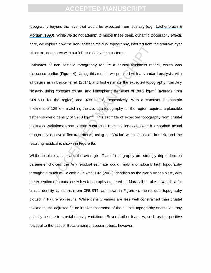
Estimates of non-isostatic topography require a crustal thickness model, which was
discussed earlier (Figure 4). Using this model, we proceed with a standard analysis, with
all details as in Becker et al. (2014), and first estimate the expected topography from Airy
isostasy using constant crustal and lithospheric densities of 2802 kg/m3 (average from
CRUST1 for the region) and 3250 kg/m3, respectively. With a constant lithospheric
thickness of 125 km, matching the average topography for the region requires a plausible
asthenospheric density of 3203 kg/m3. This estimate of expected topography from crustal
thickness variations alone is then subtracted from the long-wavelength smoothed actual
topography (to avoid flexural effects, using a ~300 km width Gaussian kernel), and the
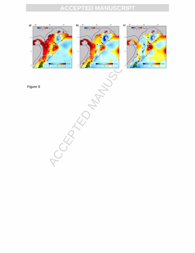
resulting residual is shown in Figure 9a.
While absolute values and the average offset of topography are strongly dependent on
parameter choices, the Airy residual estimate would imply anomalously high topography
throughout much of Colombia, in what Bird (2003) identifies as the North Andes plate, with
the exception of anomalously low topography centered on Maracaibo Lake. If we allow for
crustal density variations (from CRUST1, as shown in Figure 4), the residual topography
plotted in Figure 9b results. While density values are less well constrained than crustal
thickness, the adjusted figure implies that some of the coastal topography anomalies may
actually be due to crustal density variations. Several other features, such as the positive
residual to the east of Bucaramanga, appear robust, however.
ACC
EPTE
D M
ANU
SCR
IPT
ACCEPTED MANUSCRIPT
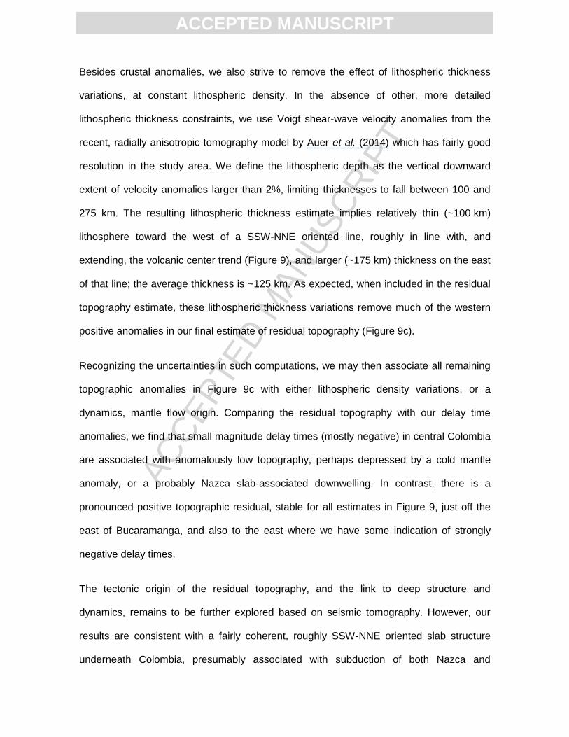
Besides crustal anomalies, we also strive to remove the effect of lithospheric thickness
variations, at constant lithospheric density. In the absence of other, more detailed
lithospheric thickness constraints, we use Voigt shear-wave velocity anomalies from the
recent, radially anisotropic tomography model by Auer et al. (2014) which has fairly good
resolution in the study area. We define the lithospheric depth as the vertical downward
extent of velocity anomalies larger than 2%, limiting thicknesses to fall between 100 and
275 km. The resulting lithospheric thickness estimate implies relatively thin (~100 km)
lithosphere toward the west of a SSW-NNE oriented line, roughly in line with, and
extending, the volcanic center trend (Figure 9), and larger (~175 km) thickness on the east
of that line; the average thickness is ~125 km. As expected, when included in the residual
topography estimate, these lithospheric thickness variations remove much of the western
positive anomalies in our final estimate of residual topography (Figure 9c).
Recognizing the uncertainties in such computations, we may then associate all remaining
topographic anomalies in Figure 9c with either lithospheric density variations, or a
dynamics, mantle flow origin. Comparing the residual topography with our delay time
anomalies, we find that small magnitude delay times (mostly negative) in central Colombia
are associated with anomalously low topography, perhaps depressed by a cold mantle
anomaly, or a probably Nazca slab-associated downwelling. In contrast, there is a
pronounced positive topographic residual, stable for all estimates in Figure 9, just off the
east of Bucaramanga, and also to the east where we have some indication of strongly
negative delay times.
The tectonic origin of the residual topography, and the link to deep structure and
dynamics, remains to be further explored based on seismic tomography. However, our
results are consistent with a fairly coherent, roughly SSW-NNE oriented slab structure
underneath Colombia, presumably associated with subduction of both Nazca and
ACC
EPTE
D M
ANU
SCR
IPT
ACCEPTED MANUSCRIPT
Caribbean plates. On top of this, there is some indication of a hot anomaly, or an
upwelling, off the slab east of Bucaramanga, perhaps associated with flow through a slab
gap, or induced by slab-associated return flow (cf. Faccenna et al., 2010).
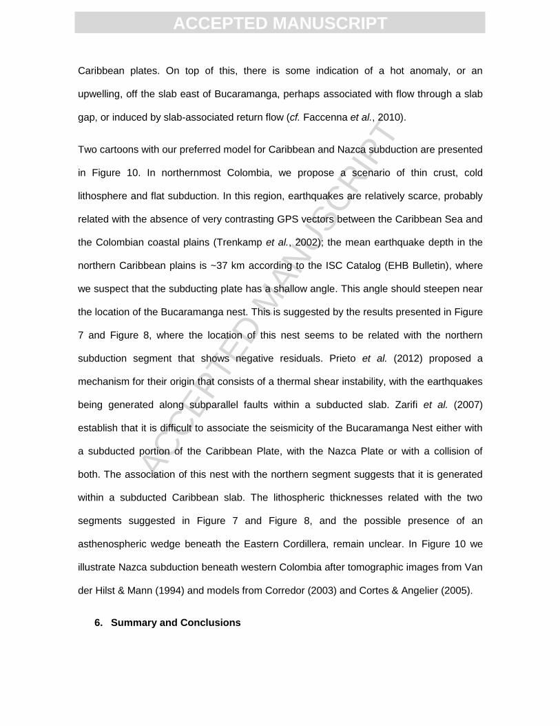
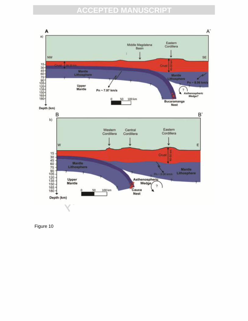
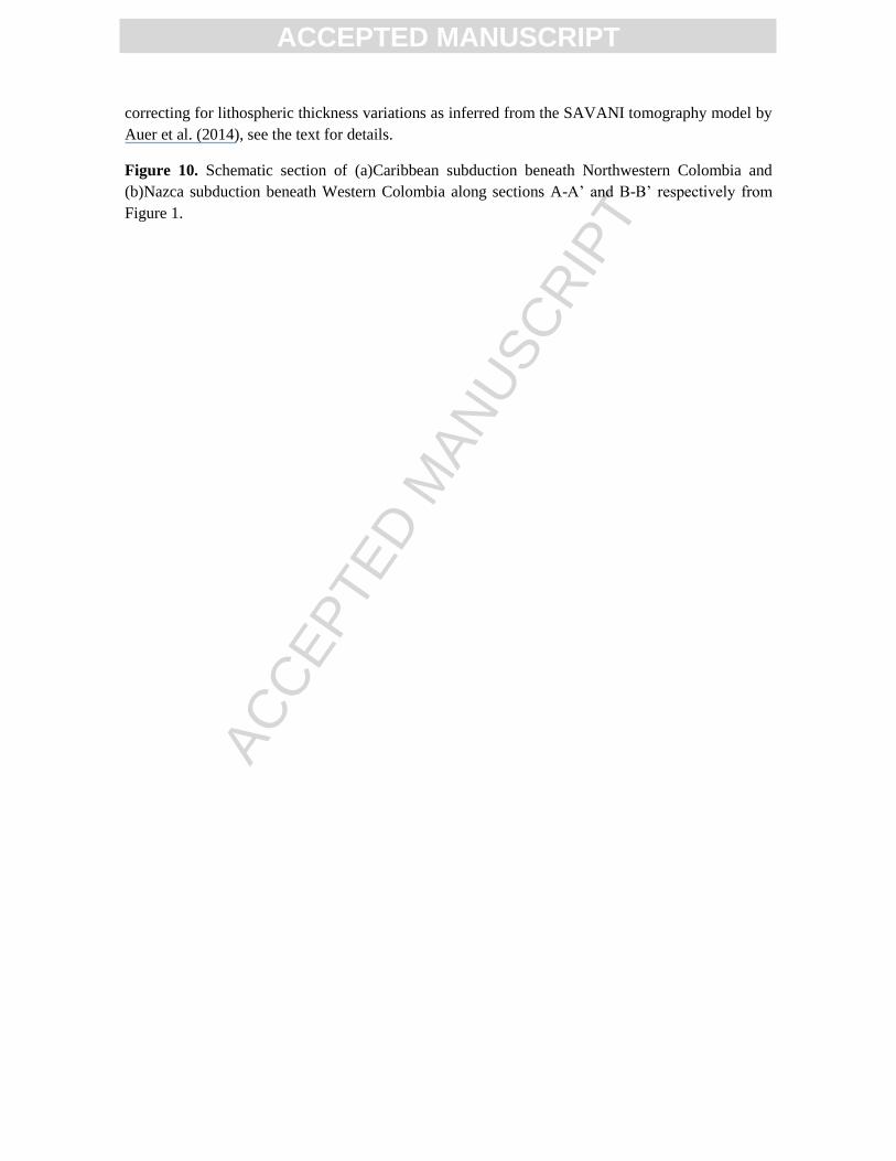
Two cartoons with our preferred model for Caribbean and Nazca subduction are presented
in Figure 10. In northernmost Colombia, we propose a scenario of thin crust, cold
lithosphere and flat subduction. In this region, earthquakes are relatively scarce, probably
related with the absence of very contrasting GPS vectors between the Caribbean Sea and
the Colombian coastal plains (Trenkamp et al., 2002); the mean earthquake depth in the
northern Caribbean plains is ~37 km according to the ISC Catalog (EHB Bulletin), where
we suspect that the subducting plate has a shallow angle. This angle should steepen near
the location of the Bucaramanga nest. This is suggested by the results presented in Figure
7 and Figure 8, where the location of this nest seems to be related with the northern
subduction segment that shows negative residuals. Prieto et al. (2012) proposed a
mechanism for their origin that consists of a thermal shear instability, with the earthquakes
being generated along subparallel faults within a subducted slab. Zarifi et al. (2007)
establish that it is difficult to associate the seismicity of the Bucaramanga Nest either with
a subducted portion of the Caribbean Plate, with the Nazca Plate or with a collision of
both. The association of this nest with the northern segment suggests that it is generated
within a subducted Caribbean slab. The lithospheric thicknesses related with the two
segments suggested in Figure 7 and Figure 8, and the possible presence of an
asthenospheric wedge beneath the Eastern Cordillera, remain unclear. In Figure 10 we
illustrate Nazca subduction beneath western Colombia after tomographic images from Van
der Hilst & Mann (1994) and models from Corredor (2003) and Cortes & Angelier (2005).
6. Summary and Conclusions
ACC
EPTE
D M
ANU
SCR
IPT
ACCEPTED MANUSCRIPT
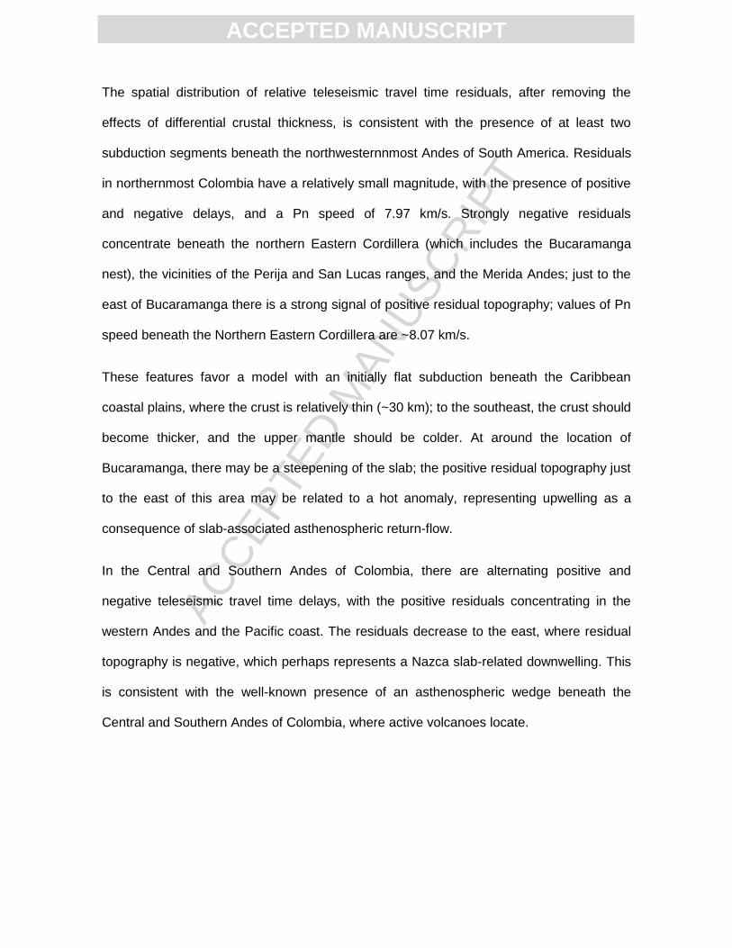
The spatial distribution of relative teleseismic travel time residuals, after removing the
effects of differential crustal thickness, is consistent with the presence of at least two
subduction segments beneath the northwesternnmost Andes of South America. Residuals
in northernmost Colombia have a relatively small magnitude, with the presence of positive
and negative delays, and a Pn speed of 7.97 km/s. Strongly negative residuals
concentrate beneath the northern Eastern Cordillera (which includes the Bucaramanga
nest), the vicinities of the Perija and San Lucas ranges, and the Merida Andes; just to the
east of Bucaramanga there is a strong signal of positive residual topography; values of Pn
speed beneath the Northern Eastern Cordillera are ~8.07 km/s.
These features favor a model with an initially flat subduction beneath the Caribbean
coastal plains, where the crust is relatively thin (~30 km); to the southeast, the crust should
become thicker, and the upper mantle should be colder. At around the location of
Bucaramanga, there may be a steepening of the slab; the positive residual topography just
to the east of this area may be related to a hot anomaly, representing upwelling as a
consequence of slab-associated asthenospheric return-flow.
In the Central and Southern Andes of Colombia, there are alternating positive and
negative teleseismic travel time delays, with the positive residuals concentrating in the
western Andes and the Pacific coast. The residuals decrease to the east, where residual
topography is negative, which perhaps represents a Nazca slab-related downwelling. This
is consistent with the well-known presence of an asthenospheric wedge beneath the
Central and Southern Andes of Colombia, where active volcanoes locate.
ACC
EPTE
D M
ANU
SCR
IPT
ACCEPTED MANUSCRIPT
7. References
Amini, S., Shomali, Z.H., Koyi, H. & Roberts, R.G., 2012.Tomographic upper-mantle
velocity structure beneath the Iranian Plateau. Tectonophysics, 554, pp.42-49.
Assumpção, M., Feng, M., Tassara, A. & Julià, J., 2013.Models of crustal thickness for
South America from seismic refraction, receiver functions and surface wave tomography.
Tectonophysics, 609, pp.82-96.
Auer, L. et al., 2014. Savani: A variable resolution whole mantle model of anisotropic shear
velocity variations based on multiple data sets. Journal of Geophysical Research: Solid
Earth.
Becker, T.W. et al., 2014. Static and dynamic support of western U.S topography. Earth
and Planetary Science Letters.
Bezada, M.J., Levander, A. & Schmandt, B., 2010. Subduction in the Southern Caribbean:
Images from finite-frequency P-wave tomography. Journal of Geophysical Research,
115(B12).
Bird, P., 2003.An updated digital model of plate boundaries. Geochemistry, Geophysics,
Geosystems, 4(3).
Bonini, W.E., 1984. Magnetic provinces in western Venezuela. Geological Society of
America Memoirs, 162, pp.161-74.
Calvache, M.L., Cortés, G.P. & Williams, S.N., 1997. Stratigraphy and chronology of the
Galeras volcanic complex, Colombia. Journal of Volcanology and Geothermal Research,
77(1-4), pp.2-19.
ACC
EPTE
D M
ANU
SCR
IPT
ACCEPTED MANUSCRIPT
Cardona, A. et al., 2012. From arc-continent collision to continuous convergence, clues
from Paleogene conglomerates along the southern Caribbean – South America plate
Boundary. Tectonophysics, 580, pp.58-87.
Ceron, J.F., Kellogg, J.N. & Ojeda, G.Y., 2007. Basement configuration of the
northwestern South America – Caribbean margin from recent geophysical data.CT&F
Ciencia, Tecnología y Futuro, 3, pp.25-49.
Christensen, N.I. & Mooney, W.D., 1995. Seismic Velocity structure and composition of the
continental crust: A global view. Journal of Geophysical Research, 100(B7), pp.9761-88.
Cloos, M., 1993. Lithospheric bouyancy and collisional orogenesis: Subduction of oceanic
plateaus, continental margins, island arcs, spreading ridges, and seamounts. Geological
Society of America, 105(6), pp.715-37.
Collo, G. et al., 2011. Clay mineralogy and thermal history of the Neogene Vinchina Basin,
central Andes of Argentina: Analysis of factors controlling the heating conditions.
Tectonics, 30(4).
Corredor, F., 2003. Seismic strain rates and distributed continental deformation in the
northern Andes and three-dimensional seismotectonics of northwestern South America.
Tectonophysics, 372, pp.147-66.
Cortes, M. & Angelier, J., 2005. Current states of stress in the northern Andes as indicated
by focal mechanisms of earthquakes.Tectonophysics, 403, pp.29-58.
Crotwell, H.P., Owens, T.J. & Ritsema, J., 1999. The TauP Toolkit: Flexible Seismic
Travel-Time and Raypath Utilities. Seismological Research Letters, 70(2), pp.154-60.
Ding, X.-Y.& Grand, S.P., 1994. Seismic structure of the deep Kurile Subduction Zone.
Journal of Geophysical Research: Solid Earth (1978–2012), 99(B12), pp.23767-86.
ACC
EPTE
D M
ANU
SCR
IPT
ACCEPTED MANUSCRIPT
Faccenna, C. et al., 2010. Subduction-triggered magmatic pulses: A new class of plumes?
Earth and Planetary Science Letters, 299(1), pp.54-68.
Flinch, J., 2003. Structural evolution of the Sinu-Lower Magdalena area (Northern
Colombia). En: C. Bartolini, R. Buffler & J. Blickwede, edits. The Circum-Gulf of Mexico
and the Caribbean: Hydrocarbon habitats, basin formation, and plate tectonics. s.l.:AAPG
Memoir 79, pp. 141-143.
Franco, E. et al., 2002. Sismicidad registrada por la Red Sismológica Nacional de
Colombia durante el tiempo de operación: junio de 1993 hasta agosto de 2002. In 1°
Simposio Colombiano de Sismología. Bogotá, 2002. 1° Simposio Colombiano de
Sismologia.
Gutscher, M.-A., Spakman, W., Bijwaard, H. & Engdahl, E.R., 2000. Geodynamics of flat
subduction: Seismicity and tomographic constraints from the Andean margin. Tectonics,
19(5), pp.814-33.
Hamza, V.M., Silva Dias, F.J.S., Gomes, A.J.L. & Delgadilho-Terceros, Z.G., 2005.
Numerical and functional representations of regional heat flow in South America. Physics
of the Earth and Planetary Interiors, 152, p.223256.
Hearn, T.M. & Ni, J.F., 1994. Pn velocities beneath continental collision zones: the
Turkish-Iranian Plateau. Geophysical Journal International, 117(2), pp.273-83.
Hearn, T.M., Rosca, A.C. & Fehler, M.C., 1994. Pn Tomography beneath the Southern
Great Basin. Geophysical Research Letters, 21(20), pp.2187-90.
Hirn, A. & Sapin, M., 1984. The Himalayan zone of crustal interaction: suggestions from
explosion seismology. Annals of Geophysics, 2(2), pp.123-30.
ACC
EPTE
D M
ANU
SCR
IPT
ACCEPTED MANUSCRIPT
Hoernle, K. et al., 2002. Missing history (16–71 Ma) of the Galápagos hotspot: Implications
for the tectonic and biological evolution of the Americas. Geology, 30(9), pp.795-98.
Kellogg, J.N. & Vega, V., 1995. Tectonic development of Panama, Costa Rica, and the
Colombian Andes: Constraints from Global Positioning System geodetic studies and
gravity. In P. Mann, ed. Geologic and Tectonic Development of the Caribbean Plate
Boundary in Southern Central America: Special Paper 295. Boulder, Colorado: Geological
Society of America Special Paper 295. pp.75-90.
Kennan, L. & Pindell, J., 2009. Dextral shear, terrane accretion and basin formation in the
Northern Andes: best explained by interaction with a Pacific-derived Caribbean Plate.
Geological Society of London, Special Publication, 328, pp.487-531.
Kennett, B.L.N. & Engdahl, E.R., 1991. Traveltimes for global earthquake location and
phase identification. Geophysical Journal International, 105, pp.429-65.
Kerr, A.C. & Tarney, J., 2005. Tectonic evolution of the Caribbean and northwestern South
America: The case of two Late Cretaceous oceanic plateaus. Geology, 33(4), pp.269-72.
Kroonenberg, S.B., Pichler, H. & Diederix, H., 1982. Cenozoic alkalibasaltic to ultrabasic
volcanism in the Uppermost Magdalena Valley, South-central Huila Department,
Colombia. Geologianorandina (Bogota), 5, pp.19-26.
Lachenbruch, A.H. & Morgan, P., 1990. Continental extension, magmatism and elevation;
formal relations and rules of thumb. Tectonophysics, 174(1), pp.39-62.
Lara, M. et al., 2013. Middle Miocene near trench volcanism in northern Colombia: a
record of slab tearing due to the simultaneous subduction of the Caribbean Plate under
South and Central America?. Journal of South American Earth Sciences, 45, pp.24-41.
ACC
EPTE
D M
ANU
SCR
IPT
ACCEPTED MANUSCRIPT
Laske, G., Masters, G., Ma, Z. & Pasyanos, M., 2013. Update on CRUST1. 0—a 1-degree
global model of Earth’s crust., 2013. EGU general assembly.
Lonsdale, P., 2005. Creation of the Cocos and Nazca plates by fission of the Farallon
plate. Tectonophysics, 404(3-4), pp.237-64.
Lopez, C. & Ojeda, G.Y., 2006. Heat flow in the Colombian Caribbean from the Bottom
Simulating Reflector (BSR). CT&F - Ciencia, Tecnología y Futuro, 3(2), pp.29-39.
Lu, Y., Ni, S., Liu, B. & Sun, Y., 2011. Pn tomographic velocity and anisotropy beneath the
Tibetan Plateau and the adjacent regions. Earth Planets Space, 63, pp.1169-73.
Macellari, C.E., 1995. Cenozoic sedimentation and tectonics of the southwestern
Caribbean pull-apart basin, Venezuela and Colombia. In A.J. Tankard, R. Suárez & H.J.
Welsink, eds. Petroleum basins of South America. AAPG Memoir 62.pp.757-80.
Marriner, G. & Millward, D., 1984. The petrology and geochemistry of Cretaceous to
Recent volcanism in Colombia; the magmatic history of an accretionary plate margin.
Journal of the Geological Society of London, 141(3), pp. 473-486.
Masy, J., Niu, F., Levander, A. & Schmitz, M., 2011. Mantle flow beneath northwestern
Venezuela: Seismic evidence for a deep origin of the Mérida Andes. Earth and Planetary
Science Letters, 305(3-4), pp.396-404.
Mauffret, A. & Leroy, S., 1997. Seismic stratigraphy and structure of the Caribbean
igneous province. Tectonophysics, 283, pp.61-104.
Maya, M., 1992. Catálogo de dataciones isotópicas en Colombia. Boletín Geológico –
Ingeominas, 32, pp.127-88.
ACC
EPTE
D M
ANU
SCR
IPT
ACCEPTED MANUSCRIPT
Meschede, M. & Barckhausen, U., 2000. Plate tectonic evolution of the Cocos-Nazca
spreading center. In E.A. Silver, G. Kimura & T.H. Shipley, eds. Proceedings of the Ocean
Drilling Program, Scientific Results Volume 170. Hannover, Germany: Federal Institute for
Geosciences and Natural Resources. pp.1-10.
Monsalve, H., Pacheco, J.F., Vargas, C.A. & Morales, Y.A., 2013. Crustal velocity
structure beneath the western Andes of Colombian using receiver-function inversion.
Journal of South American Earth Sciences, 48, pp.106-22.
Monsalve, G., Sheehan, A., Rowe, C. & Rajaure, S., 2008. Seismic structure of the crust
and the upper mantle beneath the Himalayas: Evidence for eclogitization of lower crustal
rocks in the Indean Plate. Journal of Geophysical Research, 113(B08315).
Montes, C. et al., 2010.Clockwise rotation of the Santa Marta massif and simultaneous
Paleogene to Neogene deformation of the Plato - San Jorge and Cesar – Ranchería
basins. Journal of South American Earth Sciences, 29, pp.832-48.
Müller, R.D., Sdrolias, M., Gaina, C. & Roest, W.R., 2008. Age, spreading rates, and
spreading asymmetry of the world's ocean crust. Geochemistry, Geophysics and
Geosystems, 9(4), pp.1-19.
Ojeda, A. & Havskov, J., 2001. Crustal structure and local seismicity in Colombia.Journal
of Seismology, 5, pp.575-93.
Peacock, S.M., 2003. Thermal Structure and Metamorphic Evolution of Subducting Slabs.
In J. Eiler, ed. Inside the Subduction Factory. Washington D.C.: American Geophysical
Union.
ACC
EPTE
D M
ANU
SCR
IPT
ACCEPTED MANUSCRIPT
Peacock, S.M. & Wang, K., 1999. Seismic consequences of warm versus cool subduction
metamorphism: examples from Southwest and Northeast Japan. Science, 286(5441),
pp.937-39.
Pedraza-García, P., Vargas-Jimenez, C.A. & Monsalve J., H., 2007. Geometric model of
the Nazca Plate subduction in Southwest Colombia. Earth Science Research Journal,
11(2), pp.117-30.
Pennington, W.D., 1981. Subduction of the Eastern Panama Basin and Seismotectonics of
Northwestern South America. Journal of Geophysical Research, 86(B11), pp.10753-70.
Pollack, H.N., Hurter, S.J. & Johnson, J.R., 1993. Heat flow from the earth's interior:
analysis of the global data set. Reviews of Geophysics, 31(3), pp.267-80.
Poveda, E., Monsalve, G. & Vargas-Jimenez, C.A., 2013. Receiver function study of the
crustal structure beneath Northern Andes. In AGU Spring Meeting. Abstract T23A-02
presented at 2013 Spring Meeting, AGU, Cancun, Mexico, 14-17 May, 2013.
Poveda, H.E., Monsalve, G. & Vargas, C.A., submitted. Receiver functions and crustal
structure of the northwestern Andean Region, Colombia. Journal of Geophysical
Research.
Prieto, G.A. et al., 2012. Earthquake nests as natural laboratories for the study of
intermediate-depth earthquake mechanics. Tectonophysics, 570-571, pp.42-56. Review
Article.
Shih, X.R., Meyer, R.P. & Schneider, J.F., 1991. Seismic anisotropy above a subducting
plate.Geology, 19, pp.807-10.
Siebert, L. & Simkin, T., 2002. Volcanoes of the world: An illustrated catalog of Holocene
volcanoes and their eruptions. Global Volcanism Program Digital Inf. Ser., GVP, 3.
ACC
EPTE
D M
ANU
SCR
IPT
ACCEPTED MANUSCRIPT
Stern, T. et al., 2010. Crust-mantle structure of the central North Island, New Zealand,
based on seismological observations. Journal of Volcanology and Geothermal Research,
190, pp.58-74.
Taboada, A. et al., 2000. Geodynamics of the northern Andes: Subductions and
intracontinental deformation (Colombia). Tectonics, 19(5), pp.787-813.
Tibaldi, A. & Ferrari, L., 1992. Latest Pleistocene-Holocene tectonics of the Ecuadorian
Andes. Tectonophysics, 205, pp.109-25.
Toto, E. & Kellogg, J., 1992. Structure of the Sinu-San Jacinto fold belt-An active
accretionary prism in northern Colombia. Journal of South American Earth Sciences, 5(1),
pp. 211-222.
Trenkamp, R., Kellogg, J.N., Mora, H.P. & Freymueller, J.T., 2002. Wide plate margin
deformation, southern Central America and northwest South America, CASA GPS
observations. Journal of South American Earth Sciences, 15, pp.157-71.
van Benthem, S., Govers, R., Spakman, W. & Wortel, R., 2013. Tectonic evolution and
mantle structure of the Caribbean. Journal of Geophysical Research: Solid Earth, 118(6),
pp.3019-36.
Van der Hilst, R. & Mann, P., 1994.Tectonic implication of tomographic images of
subducted lithosphere beneath northwestern South America.Geology, 22, pp.451-54.
vanHunen, J., van der Berg, A.P. & Vlaar, N.J., 2002. On the role of subducting oceanic
plateaus in the development of shallow flat subduction. Tectonophysics, 352(3-4), pp.317-
33.
ACC
EPTE
D M
ANU
SCR
IPT
ACCEPTED MANUSCRIPT
Vargas, C.A. & Mann, P., 2013. Tearing and breaking off of subducted slabs as the result
of collision of the Panama Arc-Indenter with Northwestern South America. Bulletin of the
Seismological Society of America, 103(3), pp.2025-46.
Wéber, Z., 2002. Imaging Pn velocities beneath the Pannonian basin. Physics of the Earth
and Planetary Interiors, 129(3-4), pp.283-300.
Weber, M.B.I., Tarney, J., Kempton, P.D. & Kent, R.W., 2002. Crustal make-up of the
northern Andes: evidence based on deep crustal xenolith suites, Mercaderes, SW
Colombia. Tectonophysics, 345(1-4), pp.49-82.
Zarifi, Z., Havskov, J. & Hanyga, A., 2007. An insight into the Bucaramanga nest.
Tectonophysics, 443(1-2), pp.93-105.
Zhou, R., Grand, S.P., Tajima, F. & Ding, X.-Y., 1996.High velocity zone beneath the
southern Tibetan plateau from P-wave differential travel-time data.Geophysical Research
Letters, 23(1), pp.25-28.
ACC
EPTE
D M
ANU
SCR
IPT
ACCEPTED MANUSCRIPT
Figure 1
ACC
EPTE
D M
ANU
SCR
IPT
ACCEPTED MANUSCRIPT
Figure 2
ACC
EPTE
D M
ANU
SCR
IPT
ACCEPTED MANUSCRIPT
Figure 3
ACC
EPTE
D M
ANU
SCR
IPT
ACCEPTED MANUSCRIPT
Figure 4
ACC
EPTE
D M
ANU
SCR
IPT
ACCEPTED MANUSCRIPT
Figure 5
ACC
EPTE
D M
ANU
SCR
IPT
ACCEPTED MANUSCRIPT
Figure 6
ACC
EPTE
D M
ANU
SCR
IPT
ACCEPTED MANUSCRIPT
Figure 7
ACC
EPTE
D M
ANU
SCR
IPT
ACCEPTED MANUSCRIPT
Figure 8
ACC
EPTE
D M
ANU
SCR
IPT
ACCEPTED MANUSCRIPT
Figure 9
ACC
EPTE
D M
ANU
SCR
IPT
ACCEPTED MANUSCRIPT
Figure 10
ACC
EPTE
D M
ANU
SCR
IPT
ACCEPTED MANUSCRIPT
FIGURE CAPTIONS
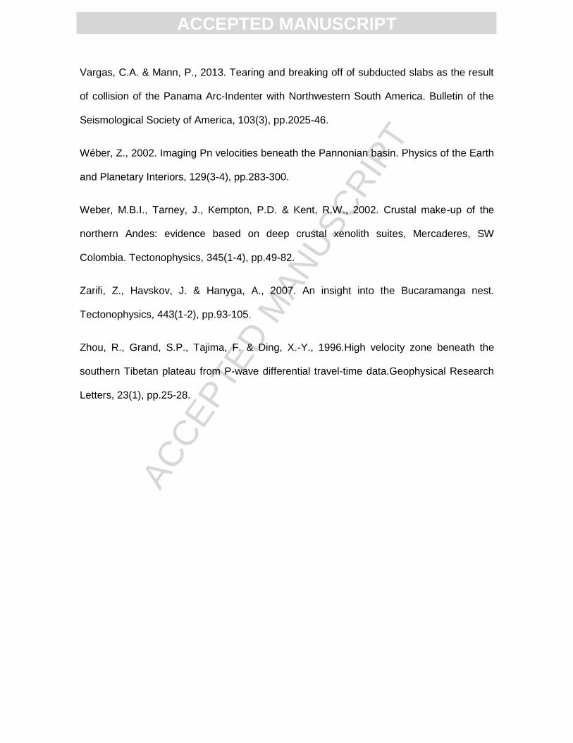
Figure 1. Simplified tectonic map of Colombia with major fault systems: Romeral, Guaicaramo,
Santa Marta – Bucaramanga (SMB), Bocono and Oca Fault. Red stars indicate the location of
seismic nests: Cauca Seismic Nest (CSN) and Bucaramanga Seismic Nest (BSN); main mountain
ranges: Western Cordillera (WC), Central Cordillera (CC), Eastern Cordillera (EC). Red arrows
indicate vectors of movement of each plate relative to stable South America. NAB (Trenkamp et al.,
2002): North Andean Block, SR: Sandra Ridge; SMM: Santa Marta Massif, PR: Perija Range and
SLR: San Lucas Range. SIB-SJAB: Sinu and San Jacinto Basins. Lines AA’ and BB’ correspond to
schematic cross-sections shown in Figure 10. Green triangles represent Volcanic complexes in
Colombia.
Figure 2. Stations of the National Seismological Network of Colombia and neighboring regions
used in this analysis. Red squares represent broad-band stations, inverted blue triangles indicate
short period – one component stations. Station codes are shown for locations mentioned in the
discussion.
Figure 3. a) Events used in this study (epicentral distances from 30° to 90°, with respect to Bogota)
and b) azimuthal coverage, with respect to the city of Bogota, of events shown in a).
Figure 4. Crustal thickness, d, model derived from merging the global, 1o × 1o model CRUST1
(Laske et al., 2013) with the regional compilation from Assumpção et al. (2013) (circle symbols)
and the receiver function estimates from Monsalve et al. (2013) (squares), and Poveda et al.
(submitted) (stars). Superimposed contours indicate crustal density (in 50 kg/m3 contour intervals)
after converting the CRUST1 structure into average layer values. Plate boundaries (dark blue) are
from Bird (2003); most of Colombia is within the “Northern Andes” plate.
Figure 5. Flow chart summarizing the whole methodology to obtain the differential travel time
residuals corrected by crustal thickness variations between stations.
Figure 6. Seismic events (white circles) and stations (inverted triangles) used for P-wave speed
estimations. Purple, blue and red triangles represent stations used to estimate Pn speeds in the
central Andean region, in northern Eastern Cordillera and in northernmost Colombia, respectively.
Figure 7. Average, absolute teleseismic travel time residuals at each station. Note the concentration
of negative travel time residuals to the north of the study region. See text for explanation.
Figure 8. Average differential teleseismic travel time residuals at each station relative to a regional
mean. The effect of differential crustal thickness has been taken out. See text for explanation.
Figure 9. Residual (anomalous, non-isostatic) topography and relative delay times, dt, relative to
station HEL. Plate boundaries are from Bird (2003), and green inverted triangles show recent
volcanism from Siebert & Simkin (2002). a) Residual topography after removal of a constant
density crustal layer with thickness as in Figure 4. b) After removal of a variable density crustal
layer with densities as in Figure 4. c) After removal of a variable density crustal layer, and
ACC
EPTE
D M
ANU
SCR
IPT
ACCEPTED MANUSCRIPT
correcting for lithospheric thickness variations as inferred from the SAVANI tomography model by
Auer et al. (2014), see the text for details.
Figure 10. Schematic section of (a)Caribbean subduction beneath Northwestern Colombia and
(b)Nazca subduction beneath Western Colombia along sections A-A’ and B-B’ respectively from
Figure 1.
ACC
EPTE
D M
ANU
SCR
IPT
ACCEPTED MANUSCRIPT
HIGHLIGHTS
We use teleseismic travel times to infer upper mantle average structure.
We correlate results with the presence of Caribbean and Nazca Slabs.
Results suggest a Caribbean slab with an initially flat subduction.
The Caribbean slab may steepen at around the location of the Bucaramanga Nest.
Results propose a Nazca plate that subducts “normally” beneath Colombia.
Related Documents


![06 subduction [Kompatibilitätsmodus]](https://static.cupdf.com/doc/110x72/625a422ab4366065a263fddd/06-subduction-kompatibilittsmodus.jpg)
