Seismic Monitoring in Northeastern Italy: A Ten-yearExperience E. Priolo, C. Barnaba, P. Bernardi, G. Bernardis, P. L. Bragato, G. Bressan, M. Candido, E. Cazzador, P. Di Bartolomeo, G. Duff, S. Gentili, A. Govoni, P. Klinc, S. Kravanja, G. Laurenzano, L. Lovisa, P. Marotta, A. Michelini, F. Ponton, A. Restivo, M. Romanelli, A. Snidarcig, S. Urban, A. Vuan, and D. Zuliani INTRODUCTION Northeastern Italy (NEI), bordering Slovenia and Austria, consists of the Friuli-Venezia Giulia, Veneto, and Trentino- Alto Adige regions. The area includes the Italian part of the southeastern Alps to the north, and the Veneto and Friuli Plains to the south. Together with its neighboring regions of southern Austria and western Slovenia, this is possibly the most tectonicaUy active area of the Alpine Arc in the present age. The region features the highest seismicity in the Alps, although it can be rated only as moderate level in general terms. According to the CPTI04 catalog (CPTI Working Group, 2004), six earthquakes with MCS intensity greater or equal to IX have struck the area in the last 1,000 years, all with estimated magnitude not exceeding M 6.6 (Figure 1). The last of these occurred in central Friuli on 6 May 1976 (M E 6.4). Except during the 1976 sequence, magnitude 5.5 or greater earthquakes have occurred only four times in the last century: 1924 and 1928 Tolmezzo, 1936 Cansiglio (Slejko et al., 1989), and 1998 Bovec, Slovenia, just across the Italian border (Bajc et al., 2001). Instrumental seismological observations in NEI started at the end of the 19th century with a few observatories in Italy and the former Hapsburg Empire. Since that time, the reference station for the area is in Trieste (Finetti and Morelli, 1972). In 1931 it was taken over by what is now the Istituto Nazionale di Oceanografia e di Geofisica Sperimentale (OGS). It later became part of the World Wide Standardized Seismographic Network (WWSSN, station code TRI-117). Since 1996 the station has been equipped with a Streckeisen STS 1 broadband seismometer managed in collaboration with the Dipartimento di Scienze della Terra dell'Universit~l di Tri- este (DST). It is included in the Mediterranean Very Broad- band Seismographic Network (MEDNET) as station TRI (http://bbtri.inogs.it). In 1977, OGS activated the first five short-period verti- cal seismometers of the Seismometric Network of Friuli-Ven- ezia Giulia in the area of the 1976 ME 6.4 Friuli earthquake. Since that time OGS has installed more stations in Friuli- Venezia Giulia and established a new network in the Veneto region. Together, these two networks constitute the Short- Period Seismometric Network of Northeastern Italy (NEI network, Figure 1). In 1994, the network was substantially improved with the installation of a new acquisition system that provides good-quality digital data. This system provided the opportunity to implement new tools for automatic and manual data processing to support research activities and emergency response by civil protection authorities. In the fol- lowing sections we describe the technical characteristics of the network, review the main results achieved in the last ten years, and illustrate the current developments. Data from the network are available on request. The use of catalog data is unrestricted, while that of the waveforms is subject to approval by OGS. Proposals for cooperation with OGS are encouraged. Data requests must be sent to [email protected]. SHORT-PERIOD SEISMOMETRIC NETWORKOF NORTHEASTERN ITALY The NEI network is run by the Centro di Ricerche Sismolog- iche (CRS), a department of OGS located in Udine. It has 21 stations (Figure 1; Table 1). Seventeen stations are equipped with a 1-Hz three-component Lennartz LE-3D seismometer; one has a Mark L4C 1-Hz vertical seismometer installed in a 100-m-deep borehole; two have a velocimetric/acceleromet- ric couple (BAD and BOO; see Table 1); one (UDI) is equipped with a Guralp CMG-fT accelerometer. The data are transmitted by UHF radio to the CRS cen- tral station in Udine using the Lennartz MARS88/RC digi- tal-acquisition system. It is a hardware/software integrated system that supports signal digitalization, data transmission, storage, and access to data for automatic and manual process- ing. Besides the sensors, each remote station includes: MARS88 digital data logger with 120-dB dynamic range set to acquire at 62.5 sps or 125 sps with an anti-alias fil- ter at 25 Hz or 50 Hz, respectively. The data are stored 446 Seismological Research Letters Volume76,Number4 July/August2005

Welcome message from author
This document is posted to help you gain knowledge. Please leave a comment to let me know what you think about it! Share it to your friends and learn new things together.
Transcript
Seismic Monitoring in Northeastern Italy: A Ten-year Experience E. Priolo, C. Barnaba, P. Bernardi, G. Bernardis, P. L. Bragato, G. Bressan, M. Candido, E. Cazzador, P. Di Bartolomeo, G. Duff, S. Gentili, A. Govoni, P. Klinc, S. Kravanja, G. Laurenzano, L. Lovisa, P. Marotta, A. Michelini, F. Ponton, A. Restivo, M. Romanelli, A. Snidarcig, S. Urban, A. Vuan, and D. Zuliani
INTRODUCTION
Northeastern Italy (NEI), bordering Slovenia and Austria, consists of the Friuli-Venezia Giulia, Veneto, and Trentino- Alto Adige regions. The area includes the Italian part of the southeastern Alps to the north, and the Veneto and Friuli Plains to the south. Together with its neighboring regions of southern Austria and western Slovenia, this is possibly the most tectonicaUy active area of the Alpine Arc in the present age.
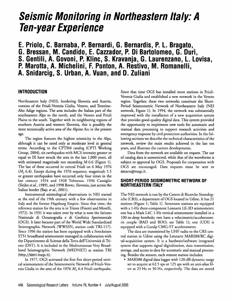
The region features the highest seismicity in the Alps, although it can be rated only as moderate level in general terms. According to the CPTI04 catalog (CPTI Working Group, 2004), six earthquakes with MCS intensity greater or equal to IX have struck the area in the last 1,000 years, all with estimated magnitude not exceeding M 6.6 (Figure 1). The last of these occurred in central Friuli on 6 May 1976 (M E 6.4). Except during the 1976 sequence, magnitude 5.5 or greater earthquakes have occurred only four times in the last century: 1924 and 1928 Tolmezzo, 1936 Cansiglio (Slejko et al., 1989), and 1998 Bovec, Slovenia, just across the Italian border (Bajc et al., 2001).
Instrumental seismological observations in NEI started at the end of the 19th century with a few observatories in Italy and the former Hapsburg Empire. Since that time, the reference station for the area is in Trieste (Finetti and Morelli, 1972). In 1931 it was taken over by what is now the Istituto Nazionale di Oceanografia e di Geofisica Sperimentale (OGS). It later became part of the World Wide Standardized Seismographic Network (WWSSN, station code TRI-117). Since 1996 the station has been equipped with a Streckeisen STS 1 broadband seismometer managed in collaboration with the Dipartimento di Scienze della Terra dell'Universit~l di Tri- este (DST). It is included in the Mediterranean Very Broad- band Seismographic Network (MEDNET) as station TRI (http://bbtri.inogs.it).
In 1977, OGS activated the first five short-period verti- cal seismometers of the Seismometric Network of Friuli-Ven- ezia Giulia in the area of the 1976 ME 6.4 Friuli earthquake.
Since that time OGS has installed more stations in Friuli- Venezia Giulia and established a new network in the Veneto region. Together, these two networks constitute the Short- Period Seismometric Network of Northeastern Italy (NEI network, Figure 1). In 1994, the network was substantially improved with the installation of a new acquisition system that provides good-quality digital data. This system provided the opportunity to implement new tools for automatic and manual data processing to support research activities and emergency response by civil protection authorities. In the fol- lowing sections we describe the technical characteristics of the network, review the main results achieved in the last ten years, and illustrate the current developments.
Data from the network are available on request. The use of catalog data is unrestricted, while that of the waveforms is subject to approval by OGS. Proposals for cooperation with OGS are encouraged. Data requests must be sent to [email protected].
SHORT-PERIOD SEISMOMETRIC NETWORK OF NORTHEASTERN ITALY
The NEI network is run by the Centro di Ricerche Sismolog- iche (CRS), a department of OGS located in Udine. It has 21 stations (Figure 1; Table 1). Seventeen stations are equipped with a 1-Hz three-component Lennartz LE-3D seismometer; one has a Mark L4C 1-Hz vertical seismometer installed in a 100-m-deep borehole; two have a velocimetric/acceleromet- ric couple (BAD and BOO; see Table 1); one (UDI) is equipped with a Guralp CMG-fT accelerometer.
The data are transmitted by UHF radio to the CRS cen- tral station in Udine using the Lennartz MARS88/RC digi- tal-acquisition system. It is a hardware/software integrated system that supports signal digitalization, data transmission, storage, and access to data for automatic and manual process- ing. Besides the sensors, each remote station includes:
�9 MARS88 digital data logger with 120-dB dynamic range set to acquire at 62.5 sps or 125 sps with an anti-alias fil- ter at 25 Hz or 50 Hz, respectively. The data are stored
446 Seismological Research Letters Volume76, Number4 July/August2005
10" 20"
45" 12,5" 13"
2002/02/14
13.5" 14" 14.5" ~ 47"
40" 1996/04/13
1998/04112
6.5" 1873, IX-X
2004/07/!2
. 5 "
695,1X-X
46" ~i:ii::~!~:~i:: ::~ iii: ~
CUSI 6
45.5"- i . . ~ ~ . 5 "
station
'~3C seismometer
~73C accelerometer
5 "
11,5" 12" 12,5" 13" 13.5"
Mo I 0.5 1.5 2.5 3.5 4.5 5,5 [
14" 14.5"
, i Figure 1. Short-period, broadband, and accelerometric stations managed by CRS (TRI and VlNO in collaboration with DST; the broadband station SABO is planned). The different types of instrumentation are explained in the inset. In the background are epicenters of the earthquakes localized between January 1994 and December 1994 (gray circles), with the focal mechanisms of the mainshocks. The epicenters of the strongest historical earthquakes (I o > IX) occur- ring in the area in the last ten centuries (CPTI Working Group, 2004) are also shown.
temporarily on a 4-Mb RAM memory card. An STA/ LTA (short-time versus long-time average) algorithm is used to recognize candidate earthquakes.
�9 radio modem and a radio for bidirectional communica- tion with the central station.
�9 DCF signal radio receiver for time synchronization. �9 solar panels and a battery for power supply.
At the central station of Udine, the acquisition system includes:
�9 Sun Blade 150 workstation running software for the acquisition, management, and online access of data for analysis, and
�9 a PC acting as interface between the workstation and the radio network. The PC is connected to the workstation
through the LAN and to the radio modems via eight serial ports.
Each remote station makes available for transmission only those data recognized as significant by the STA/LTA algo- rithm, whereas the central station collects these data by cycli- cal interrogation of the remote stations. For radio communication we use a set of frequencies in the 400-MHz band with 2%KHz channel bandwidth, allowing transmis- sion at 17,400 bps. Due to the limitations imposed by the Italian telecommunication authority, only seven frequencies are available. Groups of stations share the same frequency based on a token-passing mechanism. Such sharing limits the overall number of acquired components and their sampling rate: Three-component acquisition is possible for 16 stations, only three of which are sampled at 125 sps. In this configura-
Seismological Research Letters July/August 2005 Volume 76, Number 4 447
TABLE 1 Stations of the Short-period Seismometric Network of Northeastern Italy
Code Site
Sensor Lat. N Long. E Elev. Acquired
(~ (~ (m) Vel Acc Channels Sampling Rate (sps) Geology
AFL Alpe Faloria
BAD Bernadia
BOO Bordano
BUA Buia
CAE Caneva
CGRP Cima Grappa
COLI Colloredo
CSM Casera Mimoias
CSO Casso
DRE Drenchia
FAU Forcella Aurine
IESO Jesolo
LSR Lussari
MLN Malnisio
MPRI Monte Prat
MTLO Montello
PLRO Paularo
TEOL Teolo
TLI Talmassons
UDI Udine
ZOU Zoufplan
46.528 12.178 2,235 Lennartz ~ 3 LE-3D Lite
46.234 13.243 590 Lennartz Kinemetrics FBA-23 6 LE-3D Lite
46.320 13.099 444 Lennartz Kinemetrics 3 (1 vel + LE-3D L i t e Episensor 2 acc)
46.217 13.124 320 Lennartz ~ 1 LE-3D Lite
46.009 12.438 870 Lennartz 3 LE-3D Lite
45.881 11.805 1,757 Lennartz - - 3 LE-3D Lite
46.132 13.377 250 Lennartz ~ 3 LE-3D Lite
46.512 12.652 1,640 Lennartz - - 3 LE-3D Lite
46.273 12.324 1,070 Lennartz 3 LE-3D Lite
46.173 13.644 810 Lennartz ~ 3 LE-3D Lite
46.232 11.975 1,430 Lennartz - - 1 LE-3D Lite
45.518 12.546 0 Lennartz ~ 1 LE-3D Lite
46.475 13.527 1,750 Lennartz ~ 3 LE-3D Lite
46.150 12.615 814 Lennartz 3 LE-3D Lite
46.241 12.987 762 Lennartz ~ 3 LE-3D Lite
45.813 12.097 350 Lennartz ~ 1 LE-3D Lite
46.549 13.148 1,420 Lennartz ~ 3 LE-3D Lite
45.362 11.674 370 Lennartz 3 LE-3D Lite
45.921 13.103 -74 Mark L4C ~ 1
46.037 13.253 90 Guralp CMG-5T 3
46.557 12.974 1,896 Lennartz ~ 3 LE-3D Lite
62.5 dolomite
125
125
62.5
62.5
62.5
62.5
62.5
62.5
62.5
62.5
62.5
62.5
62.5
62.5
62.5
62.5
62.5
62.5
62.5
125
limestone
limestone
flysh
limestone
limestone
flysh
flysh
limestone
marly sandstone, fract. limestone
schist
Silt
porphyry, diabase, spilite
limestone
limestone
molasses
diabasi
marn
alluvium
gravels
dolomite
All the stations are equipped with the Lennartz MARS88/RC data logger.
448 Seismological Research Letters Volume 76, Number4 July/August2005
TABLE 2 Stations of the Broadband Seismometric Network of Northeastern Italy Managed by OGS
Code Site Lat. N Long. E Elev. Sensor
(~ (~ (m) Vel Acc Geology Data Logger Owner
ACOM Acomizza
CGRP Cima Grappa
CIMO Cimolais
CUSI Udine
SABO Sabotino
TRI Trieste
VINO Villanova Grotte
46.548 13.513 1,788 Streckeisen STS2 KinemetricsEpisensor limestone FBA ES-T
45.881 11.805 1,757 Streckeisen STS2 KinemetricsEpisensor limestone FBA ES-T
46.311 46.311 600 Streckeisen STS2 KinemetricsEpisensor dolomitic FBA ES-T limestone
46.037 13.253 90 Guralp CMG-40 - - gravels
46.980 13.600 600 StreckeisenSTS2 KinemetricsEpisensor limestone FBA ES-T
45.709 13.764 161 Streckeisen STS1 Guralp limestone CMG-5T
46.256 13.281 608 Guralp Guralp limestone CMG-3T CMG-5T
Quanterra Q330
Quanterra Q330
Quanterra Q4128
Quanterra Q4128
Quanterra Q330
Quanterra Q4126
Quanterra Q4126
CPFVG
CPFVG
OGS
OGS
CPFVG
OGS/DST
OGS/DST
TRI and VlNO are managed in collaboration with DST. Station SABO is planned.
tion, it takes about 4-5 minutes to receive enough data to determine the hypocenter of a local earthquake using P and S arrival times.
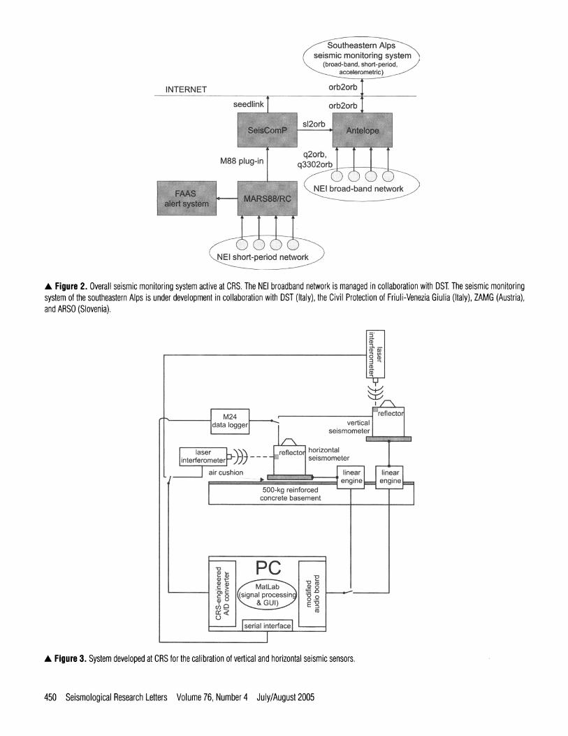
Waveforms from the NEI network are made available over the Internet in near real-time by means of a SeisComP server running on a Linux machine (Figure 2). SeisComP is a freely available software package developed at GFZ Potsdam (Hanka et al., 2001; Heinloo and Trabant, 2003). A Seis- ComP server is able to exchange data with other similar serv- ers in SEED format using the Seedlink protocol, which is a standard for the European seismological community. For this purpose, we have implemented an interface program (a Seis- ComP "plug-in") that feeds the SeisComP server with data from the MARS88/RC acquisition system.
Seismic monitoring capabilities of CRS are completed by seven broadband stations (hexagons in Figure 1; station SABO will be installed by the end of 2005). These stations are part of the Broad-Band Seismometric Network of North- eastern Italy, which is currently under construction in collab- oration with DST. They are described in detail in Table 2. The Udine (CUSI) and Cimolais (CIMO) stations are owned by OGS; the Trieste (TRI) and Villanova Grotte (VINO) sta- tions are jointly owned by OGS and DST; the Cima Grappa (CGRP), Acomizza (ACOM), and Sabotino (SABO) stations are owned by the Civil Protection of the Regione Autonoma Friuli-Venezia Giulia (CPFVG) and are operated by OGS in the framework of a European project that is described below.
CRS also has a network of eight GPS stations, named the Friuli Regional Deformation Network (FReDNet), to moni- tor crustal deformations in Friuli. FReDNet was designed and built and is currently managed in collaboration with the Berkeley Seismological Laboratory of the University of Cali-
fornia. Data from all the stations sampled every 30 s are avail- able in RINEX format at the FReDNet Web page (http:// www.crs.in0gs.it/frednet/). One station (Zoufplan, code ZOUF) is also part of the European EUREF network. FReDNet has been operating since 2003.
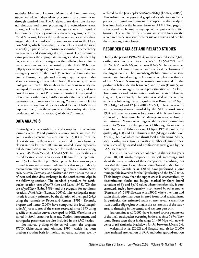
Quantitative seismology studies require accurate calibra- tion of the available seismometers. For this purpose, CRS has developed a procedure that allows the accurate determination of instrument response curves in the frequency range 0.03-100 Hz. The system hardware (Figure 3) features a hor- izontal and a vertical shake table; two laser interferometers; an interface board, developed at CRS, that allows for A/D conversion between the laser interferometer and the personal computer; a modified audio board to drive the shake tables; and an M24 Lennartz data logger. The shake tables are fixed on a 500-kg reinforced cement base. The system software has been written using 3/latLab and also includes a few C pro- grams and shell scripts. A procedure has been devised to determine the response curves of the sensors automatically after the shake table has been properly driven within the tar- get frequency range. For short-period instruments, we have found that reliable response curves can be estimated in a few minutes, whereas longer acquisition times are required for broadband sensors.
FRIULI AUTOMATIC ALERT SYSTEM
The Friuli Automatic Alert System (FAAS; Bragato and Govoni, 2000) is a rapid-location system developed in 1996 to satisfy the requirements of the Civil Protection of Friuli- Venezia Giulia. FAAS runs on the same computer running the MARS88/RC acquisition system. It is composed of three
Seismological Research Letters July/August2005 Volume 76, Number4 449
INTERNET
a s t e ~ seismic monitodng System ,
orb2orb f
seedlink J orb2orb
M88 plug-in ] q2orb,
!1 b~oad-bandVne~work ~ 9
I I - - I g l lU l L - j j I ~ I i'1jl1~11 i i ~ ;~LVV~ ln . ~y
A Figure 2. Overall seismic monitoring system active at CRS. The NEI broadband network is managed in collaboration with DST. The seismic monitoring system of the southeastern Alps is under development in collaboration with DST (Italy), the Civil Protection of Friuli-Venezia Giulia (Italy), ZAMG (Austria), and ARSO (Slovenia).
M24 data logger
, ,
vertical seismometer
!' "laser .... I..L~I_~'~ lref l~orl horizontal ] . i n t e r f e r o m e t e r r " J J ) . . . . . r " I seism~
' t . ' r - - c u ; , , o n ...............
I ====================================concrete 500-kg ................................................ reinforced basement eric line lu,,.L_~n "
......................................................................................................................... . ................. ~ .......... ~..
t,,/ ') l ~ J
:-::-..::..-:..-.--..:-.-.~: ...... l ~ , a l interfacel ..... : ......... ]
A Figure 3. System developed at CRS for the calibration of vertical and horizontal seismic sensors.
450 Seismological Research Letters Volume 76, Number 4 July/August 2005
modules (Analyzer, Decision Maker, and Communicator) implemented as independent processes that communicate through standard files. The Analyzer draws data from the sig- nal database and starts processing if a coincidence arises among at least four stations. It recognizes local earthquakes based on the frequency content of the seismograms, performs P and S picking, locates the earthquakes, and estimates their magnitudes. The results of the analysis are sent to the Deci- sion Maker, which establishes the level of alert and the users to notify (in particular, authorities responsible for emergency management and seismological institutions). The Communi- cator produces the appropriate messages and sends them by fax, e-mail, or short messages on the cellular phone. Auto- matic locations are also reported on the CRS Web page (http://www.crs.inogs.it/) and on a monitor located in the emergency room of the Civil Protection of Friuli-Venezia Giulia. During the night and off-duty days, the system also alerts a seismologist by cellular phone. If necessary, the seis- mologist can reach CRS in about half an hour to verify the earthquake's location, follow any seismic sequence, and sup- port decisions by Civil Protection authorities. For regional or teleseismic earthquakes, FAAS e-mails other seismological institutions with messages containing P arrival times. Due to the transmission modalities described before, FAAS has a response time (from the origin time of the earthquake to the production of the first location) of about 7 minutes.
DATA ANALYSIS
Routinely, seismic signals are visually inspected to recognize seismic events. P and possibly S arrival times are read for events with epicentral distance less then 500 km from the closest station. Earthquakes with epicentral distance from the closest station less than 100 km are located. Good hypocen- tral determinations are obtained for earthquakes occurring between 45.5~176 and 11.5~176 In this area the esti- mated location error is on average 1.01 km for the epicenter and 1.57 km for the depth. When possible, locations are per- formed taking into account bulletin data that we periodically receive from other networks operating in Italy, Croatia, Slov- enia, Austria, Germany, and Switzerland (we discuss the issue of near-real-time data exchange in the southeastern Alps in the following section). The standard procedure for earth- quake location uses Hypo71 (Lee and Lahr, 1975). We also use HypoEllipse (Lahr, 1989) and the program for nonlinear location, NonLinLoc (Lomax, 2005a). The earthquake mag- nitude is usually estimated by the duration of the signal (M D) using the formula by Rebez and Rennet (1991). Recently, Bragato and Tento (2005) have computed the local magni- tude M E for a subset of the events recorded since 1995 using specific attenuation curves developed for NEI. Waveforms are stored in SAC format for later use. Station, instrument, and earthquake parameters are also included in the SAC header.
For manual picking of the arrival times, the program PITSA (Scherbaum and Johnson, 1993), which has been used on a routine basis for the last ten years, has been recently
replaced by the Java applet SeisGram2KApp (Lomax, 2005b). This software offers powerful graphical capabilities and sup- ports a distributed environment for cooperative data analysis. It is launched over the Internet from an HTML Web page on a server and can be run on any type of computer with a Web browser. The results of the analysis are stored back on the server and made available for later use or revision and can be shared among seismologists.
RECORDED DATA SET AND RELATED STUDIES
During the period 1994-2004, we have located some 3,600 earthquakes in the area between 45.5~176 and 11.5~176 with M D in the range 0.6-5.6. Their epicenters are shown in Figure 1 together with the focal mechanisms of the largest events. The Gutenberg-Richter cumulative seis- micity rate plotted in Figure 4 shows a completeness thresh- old at M o -~ 2. Seismicity is mainly concentrated in the piedmont belt at depths between 5 and 17 km (Figure 5; we recall that the average error in depth estimation is 1.57 km). Two clusters stand out in central Friuli and western Slovenia (Figure 1), respectively. The latter is related to the seismic sequences following the earthquakes near Bovec on 12 April 1998 (M D 5.6) and 12 July 2004 (M D 5.1). These two events are the strongest ones recorded by the NEI network since 1994 and have very similar locations and fault mechanisms (strike-slip). They caused limited damage in western Slovenia and saturated S-wave recordings of short-period seismome- ters up to 25 km from the epicenters. Other significant events took place in the Italian area on 13 April 1996 (Claut earth- quake, M D 4.3) and 14 February 2002 (Moggio earthquake, M o 4.9), both of which had thrust focal mechanisms. All the above earthquakes, together with a number of minor ones, were successfully located and notifications were given by the FAAS alert system.
The instrumental data set collected in the last ten years (some 10,000 single-component, vertical recordings and about the same number of three-component recordings) has provided the basis of a number of seismological studies for the NEI region. Gentile et al. (2000) have performed a joint tomographic inversion for the Vp velocity and the Vp/Vs ratio. Their images show that the upper crust is characterized by discontinuous blocks and bulges, marked by sharp lateral variations of Vp and Vp/Vs values where the seismicity is con- centrated. Such a heterogeneity is confirmed by other studies (Bressan et al., 1998; Bressan et al., 2003) where the stress and strain distribution has been inferred from focal mechanisms. In particular, the estimated main stresses reveal a transition from a strike-slip regime acting in the eastern part of the study area, to thrusting in the central and western part of it.
Franceschina et al. (2005) have inferred source parameters of the main earthquakes occurring in the area since 1994. They found Brune stress drops in the range 0.1-10 Mpa with no evi- dence of self-similarity breakdown for M E between 2.0 and 5.6.
Malagnini et al. (2002) and Bragato and Slejko (2005) have analyzed attenuation of PGA and other ground-motion
Seismological Research Letters July/August2005 Volume 76, Number4 451

_
v
o 2 - , v -
O') 0
_
O -
I I I I I
0 6
c~oooo,:OOOoo ~
O
O o
I
Mo
A F i g u r e 4 . Gutenberg-Richter cumulative seismicity rate for the earth- quakes in Figure 1. N is the cumulative number of earthquakes of magni- tude M o or greater. The line fits the data above the completeness threshold.
5 0 0 . . . . ' . . . . ' . . . . ' . . . . ' . . . . ' . . . .
400
300 r.-
o 0
200
100
0 5 1 0 1 5 2 0 2 5
Depth (km) 30
A Figure 5. Depth distribution of the earthquakes in Figure 1.
parameters (Fourier and spectral amplitude, Arias intensity, etc.). Both studies find decreasing PGA attenuation for increasing magnitude. Malagnini et al. (2002) also show that higher frequencies attenuate faster. The two findings are in agreement, as stronger earthquakes are dominated by lower frequencies that are less attenuated. The stronger high-fre- quency attenuation observed in NEI is probably related to the structural complexity of the area. For instance, Govoni et al. (1997) have estimated the quality factor VQc from coda
waves for the Friuli area and obtained the frequency-depen- dent relation
Qc ( f ) = 7 8 f ~ �9 (1)
According to this model, high-frequency, short-length waves are scattered by small heterogeneities to which low-frequency waves are insensitive.
The magnitude-dependent attenuation relation specifi- cally developed for PGA in NEI has some significant conse- quences for probabilistic seismic hazard assessment (Bragato and Slejko, 2005), as it reduces the hazard estimates for short return periods (less than 100 years) in respect to other com- monly used relations.
AUTOMATIC PAND S PICKING
The automatic picking of P and S arrival times is a critical task for quick and reliable earthquake location. At present, FAAS relies on algorithmic solutions by Baer and Kradolfer (1987) for P picking, and by Bragato and Govoni (2000) for S picking. The latter technique exploits the increase of ampli- tude and dominant oscillation period that characterizes S waves with respect to P waves. Both effects contribute to an increase of the energy of the signal in a semiperiod of oscilla- tion. This technique works on the horizontal components and considers a transformation of the original signal x(k) that associates, at each zero-crossing zj, the area beneath the curve of the signal up to the next zero-crossing, that is:
k=zj
A STA/LTA algorithm is run on Y(4"). The S arrival time is individuated as the zero-crossing at which the STA/LTA ratio has maximum value.
Currently we are working on a new picking system based on neural networks (Gentili et al., 2004). It is an evolution of TAP (Time Arrival Picker) developed by Gentili and Miche- lini (2004) for analysis of the data from the 1997 Umbria- Marche sequence (central Italy). Compared to other similar seismological applications, it is innovative, as it uses a formal- ism, called IUANT2 (Gentili, 2003a, 2003b), that allows the automatic design of the best network topology (number of nodes and links) for a given problem based on an objective criterion. In common practice, this task is performed empiri- cally, trying and comparing results for a limited number of alternative topologies.
To individuate arrival times, the system considers a num- ber of features computed for each sample of the signal using a 2-s-wide time window centered on the sample. The features are variance, kurtosis, skewness, and a combination of the lat- ter two and their derivatives. For S picking, it also considers a
452 Seismological Research Letters Volume76, Number4 July/August2005
measure of polarization and a variation of the feature defined by Equation 2. The classification as either pick or nonpick is performed for each sample in a limited portion of the seismo- gram. Two different neural networks are used for P and S picking. With respect to its ancestor TAP, the new system introduces a more accurate analysis of polarization and a weighting criteria for the quality of picks to be used in earth- quake location. According to the preliminary results obtained by comparing automatic and manual picks for a large data set, the new system performs sensibly better than FAAS espe- cially for S picking; it has nearly no systematic error (on aver- age, FAAS picks are 0.15 s earlier than manual picks) and lower standard deviation (0.17 s instead of 0.22 s). The neu- ral system also has higher detection capabilities, since it works reasonably well even for weak signals (signal to noise ratios down to 2), produces more picks, and increases both the number and reliability of the earthquake locations.
ONGOING IMPROVEMENTS: SPREAD-SPECTRUM RADIO LINKS
To obviate the limitations due to the scarcity of the available UHF radio frequencies, we are implementing spread-spec- trum radio links, for which no license is required by law. The devised communication network includes a backbone that goes across Friuli in the north-south direction, and several links connecting the seismic stations to the backbone. The nodes of the backbone are connected by means of Alvarion BreezeNET B 14 radio devices, transmitting at about 6 Mbps on a 20-MHz-wide channel in the 5.47-5.725 GHz fre- quency band. During transmission, the devices are able to switch automatically to a different 20-MHz channel if the quality of the signal decays due to weather conditions, noise, or radar interference. The connection of the seismic stations to the backbone has been implemented by less-expensive WiLAN VIP 110-24 devices, which transmit at about 2 Mbps in the 2.4-GHz frequency band. All the devices have bridging capabilities, so that remote stations are seen as IP nodes of the same private network. The connection to broad- band stations is immediate for Quanterra data loggers, since they have an Ethernet interface. For the Lennartz MARS88 data loggers of the short-period network, which communi- cate through a serial interface, we use the serial to Ethernet converter MOXA NPort Express DE-211. Spread-spectrum communication is also used to connect CRS to the emer- gency room of the Civil Protection of Friuli-Venezia Giulia (about 15 km apart).
TOWARD AN INTEGRATED SEISMIC MONITORING SYSTEM IN THE SOUTHEASTERN ALPS
As shown in Figure 1, a number of strong historical and recent earthquakes have occurred in the border region between Italy, Austria, and Slovenia. These events highlight that the simple periodic exchange of bulletin data is not enough to support emergency management and seismological studies. There is a
need for a more effective and rapid exchange of all available seismological information (waveforms and parametric data) among the institutions that operate in the area. For this pur- pose, OGS; DST; the Civil Protection of the Regione Autonoma Friuli-Venezia Giulia (CPFVG); the Zentralstat fiir Meterologie und Geodynamik, Hauptabteiling Geo- physik, Wien, Austria (ZAMG); and the Agencija Republike Slovenije za okolje, urad za seismologija, Ljubljana, Slovenia (ARSO) started a collaboration in 2002, which led to the project "Transnational Seismological Networks in the South- eastern Alps" (Bragato et al., 2003). The project is supported by the European Union under the framework of the program INTERREG IliA Italy/Austria. The main objective of the project is to merge existing and new seismological instrumen- tation (accelerometric, short-period, and broadband) man- aged by the five institutions into a unique virtual network. Data from the entire network are collected in near real-time at five "peer" data centers established in Udine (Italy), Trieste (Italy), Ljubljana (Slovenia), Vienna (Austria), and Palmanova (Italy) at the emergency room of CPFVG. Data acquisition and storage are based on the BRTT Antelope software package, similarly to those illustrated by Pesaresi and Horn (2004). Each partner acquires signals directly from its own field data loggers and exchanges data with the other partners in near real-time through the Internet by means of the "orb2orb" Antelope program (Figure 2).
CRS contributed to the INTERREG project by estab- lishing its data center in Udine and cooperating with DST to install and maintain the data center at CPFVG. We also make available data from all the short-period and broadband sta- tions shown in Figure 1. Three broadband stations (CGRP, ACOM, and SABO in Figure 1, the latter still not installed) are new and have been financed by the INTERREG project. According to the scheme in Figure 2, broadband data are acquired directly from the data loggers using the programs "q2orb" and "q3302orb" available with the Antelope package. Short-period data are drawn from the SeisComP server described previously using the "slink2orb" interface program developed by ORFEUS (Observatories and Research Facili- ties for EUropean Seismology) for the MEREDIAN project (http ://o rfe us. kn mi. n t/m e redia n/generaL, htm L).
To increase the reliability of the overall monitoring sys- tem running at CRS, its components (MARS88/RC acquisi- tion system, FAAS alert system, SeisComP server, and Antelope system; Figure 2) will be moved to a cluster of two Sun Netra T1 AC200 nodes running the Solaris operating system and clustered using the Sun Cluster software package. Data will be stored on two Sun StorEdge S 1 disk arrays (200 GB each) in a mirror configuration.
CONCLUSIONS
Established in 1977, the Short-Period Network of Northeast- ern Italy was substantially improved during 1994 with a new digital acquisition system. Since then, CRS has implemented tools for automatic and manual data analysis that improve
Seismological Research Letters July/August2005 Volume 76, Number4 453

emergency response capabilities and better support scientific activity. To date, the instrumental data set includes some 10,000 vertical seismograms and almost the same number of three-component recordings for about 3,600 localized earth- quakes.
Recent developments include the installation of broad- band instruments, the integration of the CRS seismic net- work into a transnational seismic network covering the border region of Italy, Austria, and Slovenia, and the creation of a GPS network to monitor crustal deformation. Ongoing improvements of the seismic network include the upgrade of the data transmission system and development of new proce- dures for automatic data analysis. The ultimate aim is to decrease the earthquake response time to less than one minute and increase the quality of the automatic hypocentral determinations. I[:1
ACKNOWLEDGMENTS
The management of the Seismometric Network of Friuli- Venezia Giulia is financially supported by the Civil Protec- tion of the Regione Autonoma Friuli-Venezia Giulia. The Seismometric Network of Veneto is managed by CRS and owned by the Regione Veneto. We thank Dario Slejko, who, as director of CRS during the period 1996-2000, contrib- uted to the results described in this paper..
REFERENCES
Baer, M. and U. Kradolfer (1987). An automatic phase picker for local and teleseismic events, Bulletin of the Seismological Society of Amer- ica 77, 1,437-1,445.
Bajc, J., A. Aoudia, A. Sarao, and P. Suhadolc (2001). The 1998 Bovec- Krn mountain (Slovenia) earthquake sequence, Geophysical Research Letters 28, 1,839-1,842.
Bragato, P. L., G. Costa, E Fitzko, N. Horn, A. Michelini, G. Mocnik and M. 2;iv~i~ (2003). Real-time data and network integration in the Southern Alps, Geophysical Research Abstracts 5, 08690.
Bragato, P. L. and A. Govoni (2000). The Friuli automatic earthquake alert system, Bolletino di Geofisica Teorica e Applicado 41, 59-77.
Bragato, E L. and D. Slejko (2005). Empirical ground motion attenua- tion relations for the eastern Alps in the magnitude range 2.5-6.3, Bulletin of the Seismological Society of America 95, 252-276.
Bragato, Pier Luigi and Alberto Tento (2005). Local magnitude in northeastern Italy, Bulletin of the Seismological Society of America 95, 579-591.
Bressan, G., A. Snidarcig, and C. Venturini (1998). Present state of tec- tonic stress of the Friuli area (eastern Southern Alps), Tectonophys- ics 292, 211-227.
Bressan, G., E L. Bragato, and C. Venturini (2003). Stress and strain tensors based on focal mechanisms in the seismotectonic frame- work of the Friuli-Venezia Giulia region (northeastern Italy), Bul- letin of the Seismological Society of America 85, 1,161-1,176.
Finetti, I. and C. Morelli (1972). Earthquake magnitude determination for Trieste WWSS station, Bolletino di Geofisica Teorica e Applicado 14, 67-83.
Franceschina, G., S. Kravanja, and G. Bressan (2005). Source parameters and scaling relationships in the Friuli-Venezia Giulia (northeastern Italy) region, Physics of the Earth and Planetary Interiors (submitted).
Gentili, S. (2003a). A new method for information update in super- vised neural structures, NeurocomputingJournal 51C, 61-74.
Gentili, S. (2003b). Retrieving Visual Concepts in Image Databases, Ph.D. Thesis Series, Computer Science 2003/3, Forum eds., Udine, Italy.
Gentili, S., P. L. Bragato, and G. Bressan (2004). Sviluppo di un sistema automatico di picking di fasi P ed S e di localizzazione basato sulle reti neurali, presented at XXIII Convegno Nazionale Gruppo Nazi- onale di Geofisica della Terra Solida, Rome, 14-16 December 2004.
Gentile, G. E, G. Bressan, L. Burlini, and R. De Franco (2000). Three- dimensional Vp and Vp/Vs models of the upper crust in the Friuli area (northeastern Italy), Geophysical Journal International 141, 457-478.
Gentili, S. and A. Michelini (2004). Automatic picking of P and S phases using a neural tree, Bulletin of the Seismological Society of America (submitted).
Govoni, A., P. L. Bragato, and G. Bressan (1997). Coda Qc evaluation using local seismic events in the Friuli area, Atti del XV Convegno Annuale del Gruppo Nazionale di Geofisica della Terra Solida, Roma, 11-13 Novembre 1996, Esagrafica, Roma, 389-392.
Gruppo di lavoro CPTI (2004). Catalogo Parametrico dei Terremoti Ital- iani, versione 2004 (CPTI04), INGV, Bologna, http:// emidius.mi.ingv.it/CPTI/.
Hanka, W., A. Heinloo, and K.-H. Jaekel (2001). Networked seismo- graph: GEOFON real-time data distribution, presented at OHP/ ION Symposium, Japan.
Heinloo, A. and C. Trabant (2003). SesisComP 2.0 Manual, Potsdam. Lahr, J. C. (1989). HypoEllipse Version 2.0: A Computer Program for
Determining Local Earthquake Hypocentral Parameters, Magnitude and First Motion Pattern, U.S. Geological Survey Open-File Report 89-116, 92 pp.
Lee, W. H. K. and J. C. Lahr (1975). Hypo 71 (revised): A Computer Program for Determining Hypocenter, Magnitude and First Motion Pattern of Local Earthquakes, USGS Open File Report 75-311, Menlo Park.
Lomax, A. (2005a). The NonLinLoc Software Guide Version 3.0, http:// a Io m ax. free. fr/n Lto c/.
Lomax, A. (2005b). SeisGram2K-Seismogram Visualization and Analy- sis Software for the Internet Version 3.1.1, http://aL0rnax.free.fr/ seisg ram/SeisG ram 2 K. htm L.
Malagnini, L., A. Akinci, R. B. Herrmann, N. A. Pino, and L. Scognamiglio (2002). Characteristics of the ground motion in northeastern Italy, Bulletin of the Seismological Society of America 92, 2,186-2,204.
Pesaresi, Damiano and Nikolaus Horn (2004). Electronic Seismologist: Data integration from the scientific community and CTBTO: The Italian NDC experience with Antelope, Seismological Research Let- ters 75, 379-384.
Rebez, A. and G. Renner (1991). Duration magnitude for the north- eastern Italy seismometric network, Bolletino di Geofisica Teorica e Applicado 33, 177-186.
Scherbaum, E and J. Johnson (1993). Programmable Interactive Toolbox for Seismological Analysis (PITSA), User Manual, Version 4.0.
Slejko, D., G. B. Carulli, R. Nicolich, A. Rebez, A. Zanferrari, A. Cav- allin, C. Doglioni, E Carraro, D. Castaldini, V. Iliceto, E. Semenza, and C. Zanolla (1989). Seismotectonics of the eastern Southern Alps: A review, Bolletino di Geofisica Teorica e Applicado 31,109-136.
OGS Dipartimento Centro Ricerche Sismologiche
Via Treviso, 55 33100 Cussignacco (UD)
Italy [email protected]
(E.P.)
454 Seismological Research Letters Volume76, Number4 July/August2005
Related Documents


