Author: Eng. Alejandro Levy - QA/QC Marine/Land Supervisor 17/12/2015 1 LAND SEISMIC OIL EXPLORATION & HYDRAULIC FRACTURE TECHNIQUE AUTHOR: ENG. ALEJANDRO LEVY – QA/QC SESIMIC SUPERVISOR [email protected] BOLIVIA 2015 ABSTRACT • We are walking trough an “hyper-information” age. At the same time we hear, so many things that are said which some of them are and not are true. The oil and gas, we liked or not, have been with us for more than 50 years in more products that we can imagine. The meaning of this lecture is to present the operations carried out in one of the first steps to the oil and gas production. Explain why is done, in which way, their environmental impact, and risks to human health. Finally the much controversial technique, hydraulics or stimulation fracturing of wells, with the aim of giving the participant of this course a technical understanding of how it's done and their risks.

Welcome message from author
This document is posted to help you gain knowledge. Please leave a comment to let me know what you think about it! Share it to your friends and learn new things together.
Transcript

Author: Eng. Alejandro Levy - QA/QCMarine/Land Supervisor
17/12/2015
1
LAND SEISMIC OIL EXPLORATION&
HYDRAULIC FRACTURE TECHNIQUEAUTHOR:
ENG. ALEJANDRO LEVY – QA/QC SESIMIC SUPERVISOR
BOLIVIA 2015
ABSTRACT
• We are walking trough an “hyper-information” age. At the same time we hear, somany things that are said which some of them are and not are true.The oil and gas, we liked or not, have been with us for more than 50 years in moreproducts that we can imagine.The meaning of this lecture is to present the operations carried out in one of the firststeps to the oil and gas production. Explain why is done, in which way, theirenvironmental impact, and risks to human health.Finally the much controversial technique, hydraulics or stimulation fracturing of wells,with the aim of giving the participant of this course a technical understanding of howit's done and their risks.

Author: Eng. Alejandro Levy - QA/QCMarine/Land Supervisor
17/12/2015
2
TABLE OF CONTENTS• SEISMIC INTRODUCTION
• GEOLOGY BASICS
• 2D – 3D & 4D SEISMIC PURPOSE
• SEISMIC DATA
• LAND SEISMIC SOURCES
• SEISMIC LAND SENSORS “THE GEOPHONE”
• THE SEISMIC LINE
• THE RECORDING TRUCK “WHITE HOUSE”
• SEISMIC DATA PROCESSING & INTERPRETATION
• ENVIRONMENTAL CONCERNS FOR ONSHORE OIL & GAS EXPLORATION
• FRACKING
SEISMIC INTRODUCTION
Author: Eng. Alejandro Levy - QA/QCMarine/Land Supervisor
17/12/2015
3
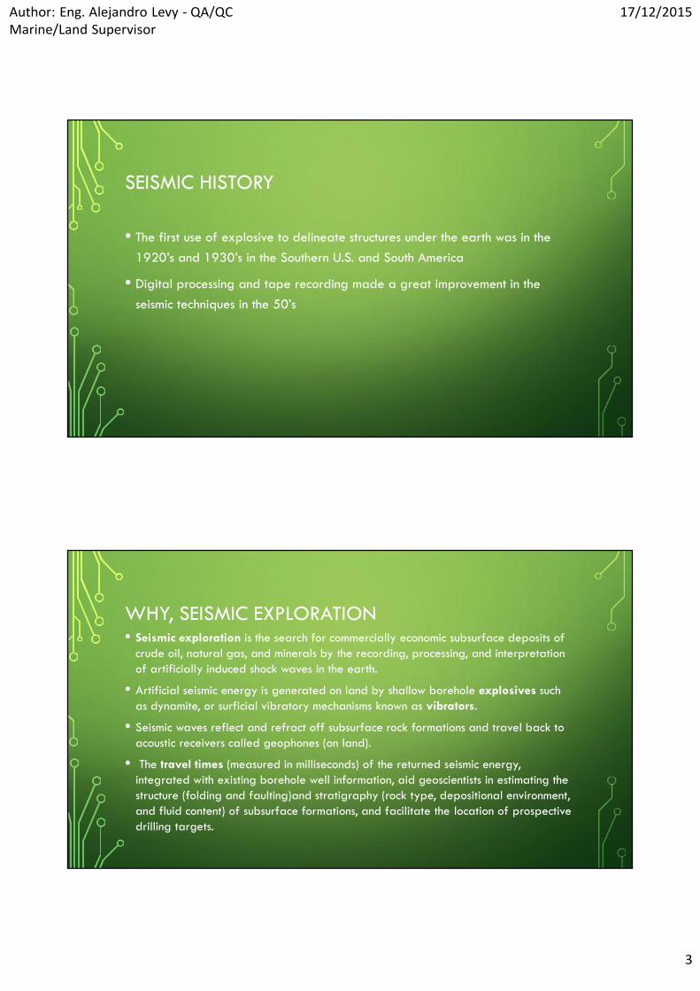
SEISMIC HISTORY
• The first use of explosive to delineate structures under the earth was in the1920’s and 1930’s in the Southern U.S. and South America
• Digital processing and tape recording made a great improvement in theseismic techniques in the 50’s
WHY, SEISMIC EXPLORATION• Seismic exploration is the search for commercially economic subsurface deposits of
crude oil, natural gas, and minerals by the recording, processing, and interpretationof artificially induced shock waves in the earth.
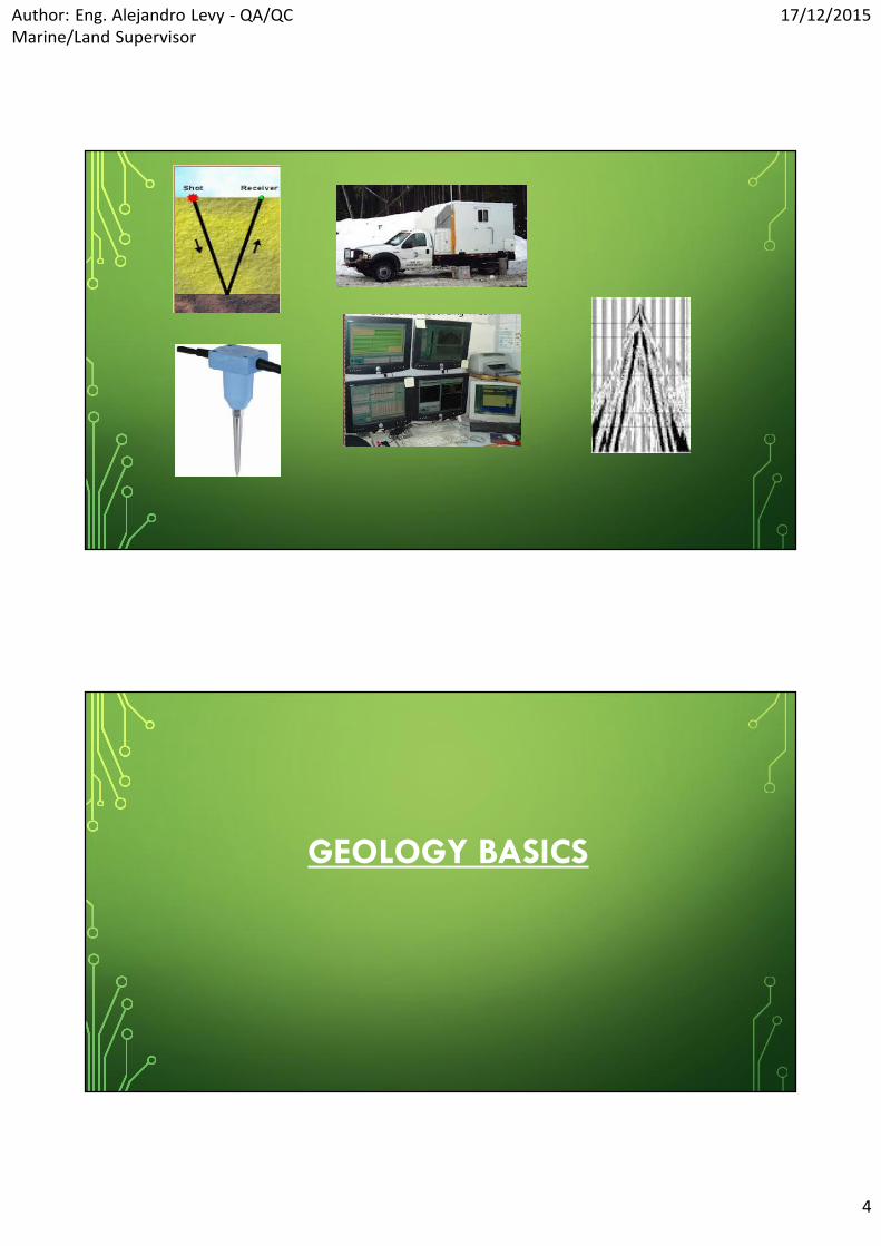
• Artificial seismic energy is generated on land by shallow borehole explosives suchas dynamite, or surficial vibratory mechanisms known as vibrators.
• Seismic waves reflect and refract off subsurface rock formations and travel back toacoustic receivers called geophones (on land).
• The travel times (measured in milliseconds) of the returned seismic energy,integrated with existing borehole well information, aid geoscientists in estimating thestructure (folding and faulting)and stratigraphy (rock type, depositional environment,and fluid content) of subsurface formations, and facilitate the location of prospectivedrilling targets.
Author: Eng. Alejandro Levy - QA/QCMarine/Land Supervisor
17/12/2015
4
GEOLOGY BASICS

Author: Eng. Alejandro Levy - QA/QCMarine/Land Supervisor
17/12/2015
5
ROCK TYPES• Rocks can be classified into three main types, depending on the chemistry of their
formation
a. Igneous Rocks:
These rocks were formed by the cooling and subsequentsolidification of a molten mass of rock material, know as magma.
b. Metamorphic Rocks:
Are those whose composition and texture has been altered by heatand pressure deep within the Earth’s crust.
c. Sedimentary Rocks:
Sedimentary rocks are the weathered debris derived by the slowprocesses of erosion of upland regions containing other rock types.
ROCKSIGNEOUS METAMORPHICS SEDIMENTARY

Author: Eng. Alejandro Levy - QA/QCMarine/Land Supervisor
17/12/2015
6
SEDIMENTARY BASINS
• Sedimentary basins were formed over hundreds of millions of year by theaction of the deposition of eroded material and the precipitation of chemicalsand organic matter in the sea water.
• External geological forces then distort and modify the layered strata.

Author: Eng. Alejandro Levy - QA/QCMarine/Land Supervisor
17/12/2015
7
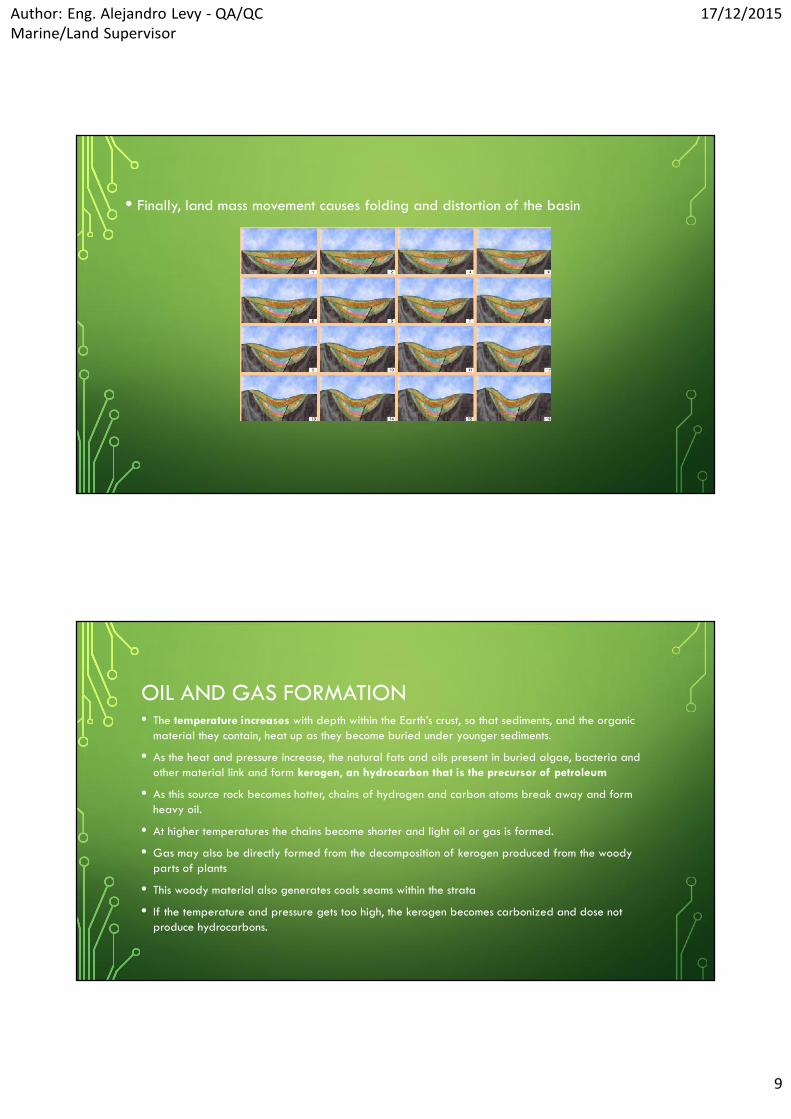
• The following sequences of pictures show (exaggerated) the formation of a typical basin.
• Sediment collects on the sea-bed, the weight causing subsidence.
• Different materials collected at the different times, so producing the regular “layering” ofstrata in the basin.
• Volcanic action, or the movement of land masses, causes faults to appear in thebasin.

Author: Eng. Alejandro Levy - QA/QCMarine/Land Supervisor
17/12/2015
8
• These same forces cause rotation of the overall basin forming a new mount range
• Erosion of the highlands, and additional subsidence forms yet another area of low-lyingland that is filled with water forming another ancient sea.
• Additional sedimentation takes place, causing an “unconformity” in the underlying strata.
Author: Eng. Alejandro Levy - QA/QCMarine/Land Supervisor
17/12/2015
9
• Finally, land mass movement causes folding and distortion of the basin
OIL AND GAS FORMATION• The temperature increases with depth within the Earth’s crust, so that sediments, and the organic
material they contain, heat up as they become buried under younger sediments.
• As the heat and pressure increase, the natural fats and oils present in buried algae, bacteria andother material link and form kerogen, an hydrocarbon that is the precursor of petroleum
• As this source rock becomes hotter, chains of hydrogen and carbon atoms break away and formheavy oil.
• At higher temperatures the chains become shorter and light oil or gas is formed.
• Gas may also be directly formed from the decomposition of kerogen produced from the woodyparts of plants
• This woody material also generates coals seams within the strata
• If the temperature and pressure gets too high, the kerogen becomes carbonized and dose notproduce hydrocarbons.

Author: Eng. Alejandro Levy - QA/QCMarine/Land Supervisor
17/12/2015
10
• The oil and gas produced by these processes may be in any combination and arealmost always mixed with water
• The minute particles of hydrocarbon are produced within the pores of PERMEABLE
ROCKS (i.e.: sandstone) and, being lighter than the surroding material, move upthrough the rock until prevented from doing so by an IMPERMEABLE ROCK.
• Although the initial source rock may only contain minute amount of hydrocarbon, asthe particles of oil, gas and water move or MIGRATE, through the pore spacewithin younger permeable rocks, they coalesce into large volumes
• By the time this movement is stopped by the presence of a cap of impermeable rock(or when they reach the surface) the total hydrocarbon volume may be large enoughto be a produce an oil or gas field that will be profitable to develop.
• The ultimate profitability of such a field depends, of course, on external economicforces and world demand as much as on ease of extraction
• As seismic exploration is concerned with the imaging of sub-surface structures, it isthose structures that may indicate a potential hydrocarbon trap that are of mostinterest to the explorationist.

Author: Eng. Alejandro Levy - QA/QCMarine/Land Supervisor
17/12/2015
11
OIL & GAS FORMATION AND TRAPS
2D – 3D & 4D SEISMIC PURPOSE

Author: Eng. Alejandro Levy - QA/QCMarine/Land Supervisor
17/12/2015
12
2D – 3D & 4D SEISMIC
• 2D Seismic shows a single slice of the earth.
• 3D Seismic Shows a volume of earth.
• 4D Seismic shows a 3D volume at different times in the life of an oil and/orgas field.
• Seismic is the primary choice of data collection today for oil and gasexploration.
2D Seismic 3D Seismic

Author: Eng. Alejandro Levy - QA/QCMarine/Land Supervisor
17/12/2015
13
SEISMIC DATA
WHAT IS THE SEISMIC DATA?
• Seismic data is an image of the earth below the surface of the ground.
• Seismic data shows different rock formations as layers of reflectors.
• Different rock types, and the fluids in the rocks, cause seismic reflection events.
• Seismic data is collected in the field, processed in a computer center, andinterpreted by a geophysicist.

Author: Eng. Alejandro Levy - QA/QCMarine/Land Supervisor
17/12/2015
14
SEISMIC TRACE• The data recorded from one “shot” (one detonation of an explosive or
implosive energy source) at one receive position is referred to as a seismictrace
HOW THE SEISMIC DATA LOOKS LIKE
Author: Eng. Alejandro Levy - QA/QCMarine/Land Supervisor
17/12/2015
15
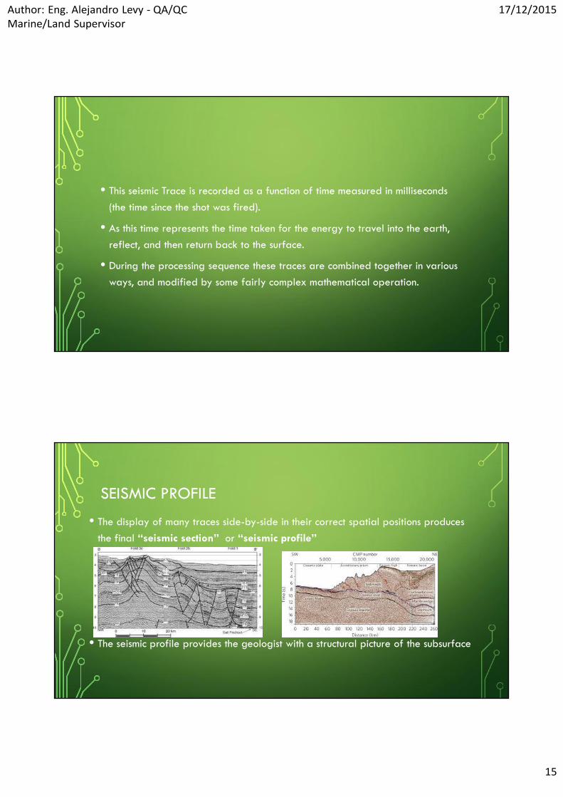
• This seismic Trace is recorded as a function of time measured in milliseconds(the time since the shot was fired).
• As this time represents the time taken for the energy to travel into the earth,reflect, and then return back to the surface.
• During the processing sequence these traces are combined together in variousways, and modified by some fairly complex mathematical operation.
SEISMIC PROFILE
• The display of many traces side-by-side in their correct spatial positions producesthe final “seismic section” or “seismic profile”
• The seismic profile provides the geologist with a structural picture of the subsurface

Author: Eng. Alejandro Levy - QA/QCMarine/Land Supervisor
17/12/2015
16
LAND SEISMIC SOURCES
THE IDEAL SEISMIC SOURCE• Changes in the speed (velocity) of sound and the density within particular
rocks causes reflection and refraction of the sound wave produced by aseismic source.
• Specifically, variation of these parameters at an interface between twodifferent rock types causes a reflection of some of the seismic energy backtowards the surface.
• It is the record of these reflections against time that produce our seismicsection.
Author: Eng. Alejandro Levy - QA/QCMarine/Land Supervisor
17/12/2015
17
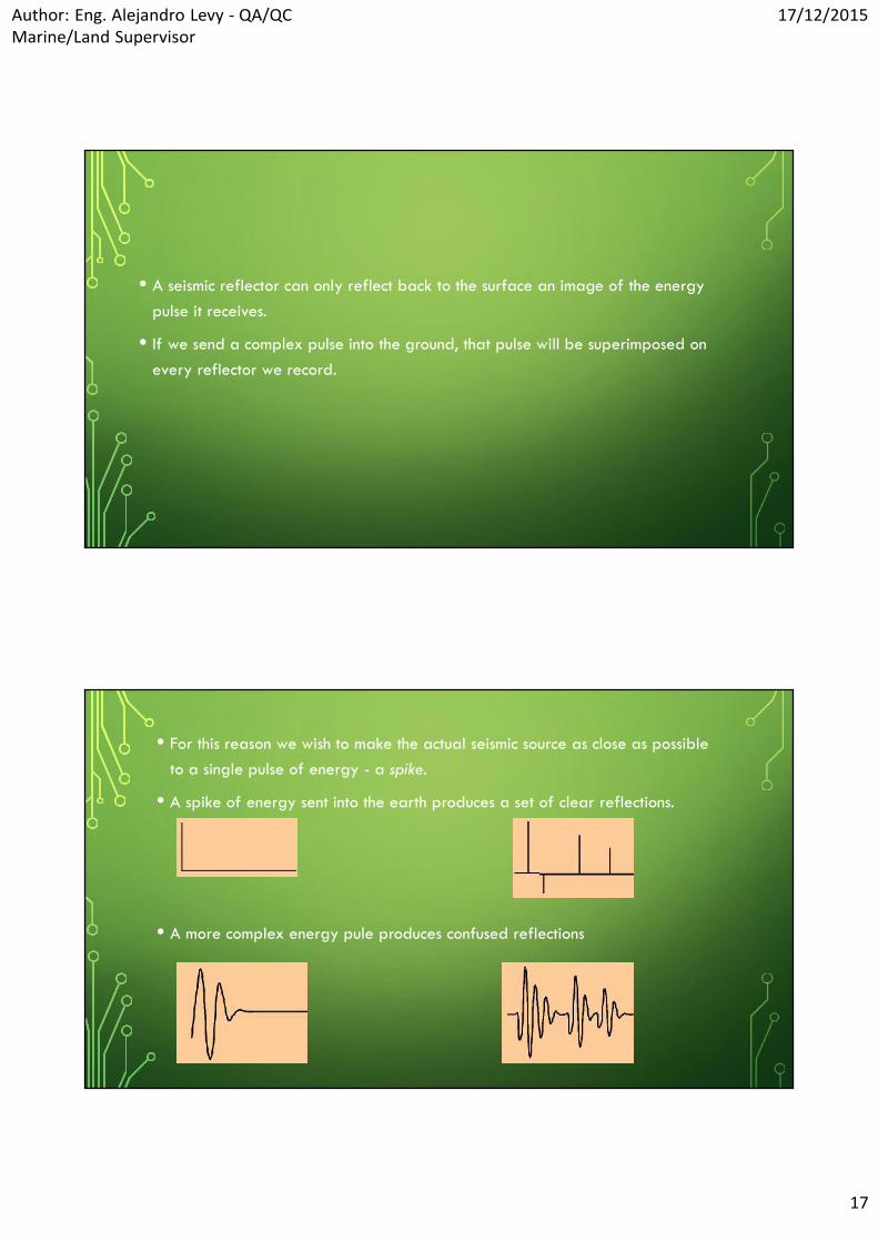
• A seismic reflector can only reflect back to the surface an image of the energypulse it receives.
• If we send a complex pulse into the ground, that pulse will be superimposed onevery reflector we record.
• For this reason we wish to make the actual seismic source as close as possibleto a single pulse of energy - a spike.
• A spike of energy sent into the earth produces a set of clear reflections.
• A more complex energy pule produces confused reflections
Author: Eng. Alejandro Levy - QA/QCMarine/Land Supervisor
17/12/2015
18
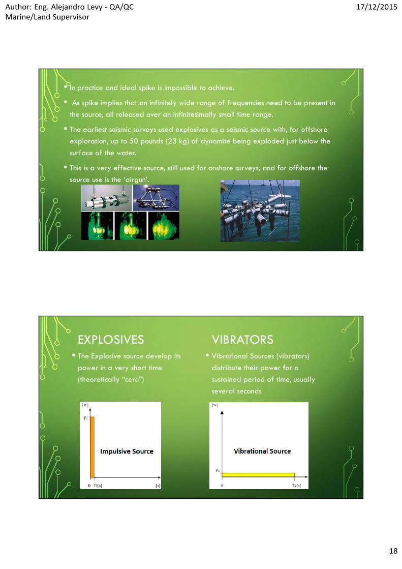
• In practice and ideal spike is impossible to achieve.
• As spike implies that an infinitely wide range of frequencies need to be present inthe source, all released over an infinitesimally small time range.
• The earliest seismic surveys used explosives as a seismic source with, for offshoreexploration, up to 50 pounds (23 kg) of dynamite being exploded just below thesurface of the water.
• This is a very effective source, still used for onshore surveys, and for offshore thesource use is the ‘airgun’.
EXPLOSIVES• The Explosive source develop its
power in a very short time(theoretically “cero”)
VIBRATORS• Vibrational Sources (vibrators)
distribute their power for asustained period of time, usuallyseveral seconds

Author: Eng. Alejandro Levy - QA/QCMarine/Land Supervisor
17/12/2015
19
EXPLOSIVESADVANTAGESDynamite is a high –power source of short
duration
As such, it creates a compact wavelet with awide bandwidth
Other advantages over vibrator trucks areits light weight, low cost, lack of requiredmaintenance and capacity for deploymentin rugged terrain unreachable by vehicles
DISADVANTAGES The process of drilling shot holes, burying the dynamite
and cleaning up after the operation is labor intensive, andwith this option the survey geometry cannot be changedwithout drilling new shot holes.
The input signal can be neither measured nor reliablyrepeated.
Explosive sources are subject to strict security regulationsand permission for use and transportation may be difficultto obtain in some places.
The potential for causing damage prevents their use inpopulated areas.
CHARACTERISTIC OF SEISMIC DYNAMITE
• Explosive developed for seismic work use nitroglycerin and/or nitrocellulose as activeingredients.
• The substances in their pure state are extremely dangerous and highly volatile.
• However, when these highly explosive substances are absorbed by a pores materialsuch as wood pulp, kieselguhr, powdered chalk, or roasted flour they are quite safeto transport, to store and use.
• Currently the gelatin dynamites are the most widely used in seismic work world wide.

Author: Eng. Alejandro Levy - QA/QCMarine/Land Supervisor
17/12/2015
20
• Some of the most important characteristics that seismic dynamite must possess are:
High explosive power
High detonation rate
Great water resistance
Effective detonation under great water pressure
High density
Freezing resistance
Safety in handling
• EMULSION HIGH EXPLOSIVE

Author: Eng. Alejandro Levy - QA/QCMarine/Land Supervisor
17/12/2015
21

Author: Eng. Alejandro Levy - QA/QCMarine/Land Supervisor
17/12/2015
22

Author: Eng. Alejandro Levy - QA/QCMarine/Land Supervisor
17/12/2015
23
SEISMIC EXPLOSIVES
• WesternGeco and Dyno Nobel developed dBX purpose-built seismic explosive, thefirst explosive specifically designed for seismic use.
• The formulation offers significant geophysical benefits over conventional explosive,optimizing energy transfer to the earth and delivering higher S/N and greaterbandwidth than dynamite.
• A comparison test in Canada demonstrated the capability of the dBX source toimprove imaging of deep reflectors
Author: Eng. Alejandro Levy - QA/QCMarine/Land Supervisor
17/12/2015
24
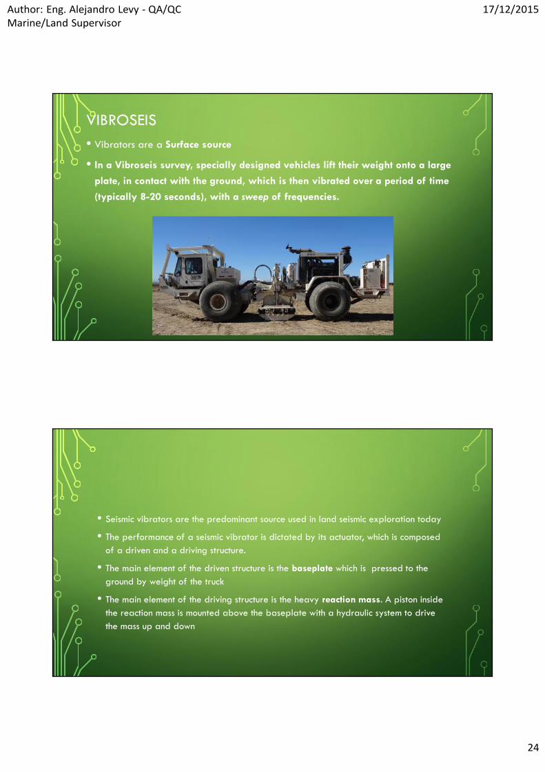
VIBROSEIS• Vibrators are a Surface source
• In a Vibroseis survey, specially designed vehicles lift their weight onto a large
plate, in contact with the ground, which is then vibrated over a period of time
(typically 8-20 seconds), with a sweep of frequencies.
• Seismic vibrators are the predominant source used in land seismic exploration today
• The performance of a seismic vibrator is dictated by its actuator, which is composedof a driven and a driving structure.
• The main element of the driven structure is the baseplate which is pressed to theground by weight of the truck
• The main element of the driving structure is the heavy reaction mass. A piston insidethe reaction mass is mounted above the baseplate with a hydraulic system to drivethe mass up and down

Author: Eng. Alejandro Levy - QA/QCMarine/Land Supervisor
17/12/2015
25
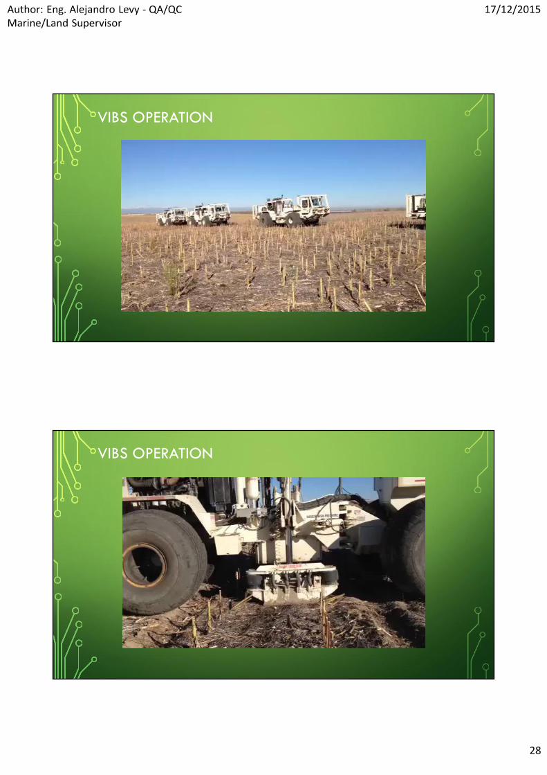
• During operation the vibrator moves into position and lowers the baseplate to theground, where it applies a compression to the earth. By controlling hydraulic fluidflow around the piston inside the mass, the vehicle operator can make the pistonand base plate assembly move up and down at specific frequencies, transmittingenergy through the baseplate and into the ground.
• The base plate is often coupled with a large fixed weight known as the hold-downweight
• During those parts of the cycle in which the reaction mass is moving down and thebase plate is moving up, the hold-down weight applies a compressive force tokeep the base plate in contact with the ground
HOW THE VIBRATOR WORKS
HOW THE VIBRATOR WORKS (CONT.)
• Harmonic distortions, or resonances, both in the vibrator and at theearth/baseplate interface, can have the effect of additional upward-directedforce and must be considered in the selection of the desired vibrator output.
• Increasing the hold-down weight on the vibrator adds stability to the systemand helps establish optimal operating conditions.
• For coupling (base plate/ground) stability the hold down weight limit shouldbe between the 70-85%

Author: Eng. Alejandro Levy - QA/QCMarine/Land Supervisor
17/12/2015
26

Author: Eng. Alejandro Levy - QA/QCMarine/Land Supervisor
17/12/2015
27
• The energy developed in a sweep may or may not be sufficient to meet theproposed requirement (target depth), and therefore must be issued other sweeps(acting the vibrators in "fleet" or groups).
• The fleet’s energy will be added in the Seismograph.
VIBRATORSADVANTAGESThe energy spectrum can be controlled
easily.
The force applied to the ground can bemonitors and adjusted in real time.
Can be used in urban areas and can beequipped with special tires or track fordeployment in environmentally sensitiveareas, such as sand dunes or arcticsnowpack.
DISADVANTAGESThe restriction of access in difficult terrains
like swamps, mountains and coastal areas.
Fleets of vibs are expensive and theirmaintenance as well.
The input signal is not impulsive, soadditional processing is required to extractinterpretable data. A recorded trace iscorrelated with a reference trace to extractthe reflected signal
Author: Eng. Alejandro Levy - QA/QCMarine/Land Supervisor
17/12/2015
28
VIBS OPERATION
VIBS OPERATION

Author: Eng. Alejandro Levy - QA/QCMarine/Land Supervisor
17/12/2015
29
THE VIBROSEIS CONCEPT - SIGNALS USED INVIBROSEIS OPERATIONS
• One of the most important characteristic of the Vibroseis method is thelimitation of the bandwidth of the source.
• By this way, the Vibroseis technique allows us to generate only thosefrequencies we actually need whereas with an impulsive source like dynamite,some of the frequencies generated by the blast are ignored during the seismicacquisition.
VIBROSEIS SYSTEM DESCRIPTION
• The Sercel Vibroseis System is composed of :
• A sweep generator,
• A vibrator to emit the sweep into the earth,
• A correlator to compress the long sweep into a short reflection pulse,
• The correlator consists of a correlation process stage (FTP board in the CentralControl Unit) that detects the reflected sweeps.

Author: Eng. Alejandro Levy - QA/QCMarine/Land Supervisor
17/12/2015
30
HOW TO GENERATE A VIBROSEIS BAND-LIMITEDSIGNAL
• The signal that makes it possible to have a band-limited component amplitudespectrum, through Fourier Transform, is represented in time like that shown in Fig. 1 -c.
• Unfortunately, the shape of that signal is not suited for the Vibroseis technique thatrequires a long, low-power rather than short, high-power signal.
• To describe the signal used in the Vibroseis technique, we have to change the short,high-power signal (c) into a long, low-power signal while preserving the limitedbandwidth of the component amplitude spectrum.
• This signal is virtually a sine wave, called sweep in the Vibroseis terminology

Author: Eng. Alejandro Levy - QA/QCMarine/Land Supervisor
17/12/2015
31
• To expand a short pulse of high peak amplitude into a long sweep of low peakamplitude you need to apply some frequency-dependent delays. The energy inboth forms of the signal (i. e. pulse or sweep form) is the same. That’s why
Vibroseis is not a low energy system but a low power system.

Author: Eng. Alejandro Levy - QA/QCMarine/Land Supervisor
17/12/2015
32
• Naturally, in real-world situations we have to deal with multiple reflectors, hencemultiple reflections. If the reflection time is shorter than the duration of the sweep,this causes the signals picked up by the geophones to overlap:
• Where
• Trace (a) shows the sweep reflected from the first reflector,
• Trace (b) shows the same from the second reflector,
• Trace (c) is the signal detected by the geophone, i. e. the sum of traces (a), and (b).
• Trace (c) is passed through the correlator to generate trace (d).
• The correlator boosts the signal and leaves the noise unchanged

Author: Eng. Alejandro Levy - QA/QCMarine/Land Supervisor
17/12/2015
33
• It should also be noted that for a given sweep amplitude in Vibroseis the way ofincreasing the energy in the sweep is to increase its duration or/and to increase thenumber of vibrators. The fact is, it is the long duration of the sweep that allows us toget the necessary energy into the ground. So, the peak amplitude of the correlatoroutput improves with the duration of the sweep.
• The side lobes of the auto-correlation function of a sweep can be reduced bytapering the start/ends of the sweep.
• It is important to consider that the ground can be mathematically consider asa “Low Pass Filter” since attenuation is greater at higher sweep frequencies.
Author: Eng. Alejandro Levy - QA/QCMarine/Land Supervisor
17/12/2015
34
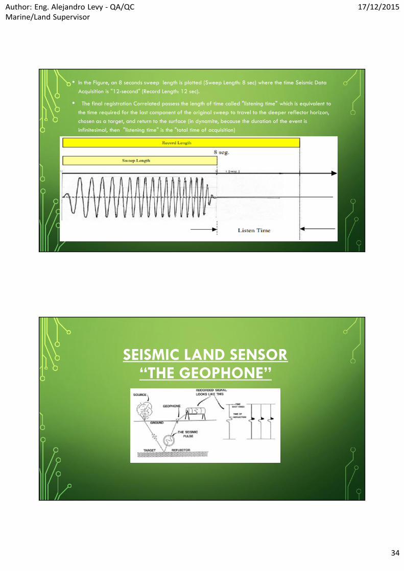
• In the Figure, an 8 seconds sweep length is plotted (Sweep Length: 8 sec) where the time Seismic DataAcquisition is "12-second" (Record Length: 12 sec).
• The final registration Correlated possess the length of time called "listening time" which is equivalent tothe time required for the last component of the original sweep to travel to the deeper reflector horizon,chosen as a target, and return to the surface (in dynamite, because the duration of the event isinfinitesimal, then "listening time" is the "total time of acquisition)
SEISMIC LAND SENSOR“THE GEOPHONE”

Author: Eng. Alejandro Levy - QA/QCMarine/Land Supervisor
17/12/2015
35
GEOPHONE BASICS
• A geophone consist in an element of a coil of wire wound on a former andmounted on springs.
• The idea is that inertia will, in principle, keep the coil fixedin space while a magnet firmly attached to the case movesaround it (above natural frequency).
• When a conductor breaks the magnetic flux lines produced by the magnet acurrent is generated and a voltage is induced (Faraday's Law)
• In our case these current and voltage are the very first stage in my recordingsystem.
• The current produced and the induced voltage are very small so we need toboost the signal.

Author: Eng. Alejandro Levy - QA/QCMarine/Land Supervisor
17/12/2015
36
• The voltage that the geophone produces is proportional to the velocity of theground it is couple to (above natural frequency)
• Just as we need to perform instrument test on recording system we need toperform test on the geophones.
• This ensures the signal that we record on tape is an accurate representation ofthe ground respon to an energy release.
GEOPHONE AND GEOPHONE STRING

Author: Eng. Alejandro Levy - QA/QCMarine/Land Supervisor
17/12/2015
37
THE SEISMIC LINE
SERCEL AREAL NETWORK

Author: Eng. Alejandro Levy - QA/QCMarine/Land Supervisor
17/12/2015
38
• This section presents the organization of all the network of the field equipment aswell as its hardware description.
• The acquisition system is made of a central unit (LCI), boxes (LAUX-428, LAUL-428),and of cables (including FDU-428s).
• The LAUX428s are connected to the control modules through the transverse cables orFiber Optic ; they manage the link between the transverses and the lines andgenerate the power supply and the control of the links on each side of it.
• Inside the lines, the LAUL-428s are regularly connected to power and control thesegment (several links between LAUL-428s). A LAUL-428 can be replaced by aLAUX-428. A link is made of one cable and one or more FDU-428.
FDU: FIELD DIGITIZER UNIT
Author: Eng. Alejandro Levy - QA/QCMarine/Land Supervisor
17/12/2015
39
LAUL: LINE ACQUISITION UNIT LINE
LAUX: LINE ACQUISITION UNIT

Author: Eng. Alejandro Levy - QA/QCMarine/Land Supervisor
17/12/2015
40
ACQUISITION CHANNEL CIRCUITRY - STAGES
• ADC Analog to Digital Converter, a device that will convert an analog
signal into a digital one.
• DSP Digital Signal Processor, a device that will convert the data to 24 bits
and in so doing, apply either a linear or a minimum phase responsecharacteristic.
ACQUISITION CHANNEL CIRCUITRY - DESCRIPTION
• The signal acquisition circuitry is composed of the following four circuits :
• Input filter (FDU-428) : performing initial high-cut filtering.
• Modulators (FDU-428) : consisting of a Delta Sigma analogue-to-digital converter ( ADC).
• Delay Memory (used in LAU Slave) :consisting of a RAM used to provide temporary storagefor signal processing and remove the sample skew by synchronizing the start of acquisition.
• Digital Signal Processors (FDU-428 and used in LAU Slave) : removing all that is of no use inthe signal (including the quantization noise and high frequency components.

Author: Eng. Alejandro Levy - QA/QCMarine/Land Supervisor
17/12/2015
41
THE RECORDING TRUCK“WHITE HOUSE”
CONFIGURATION TOPOLOGY
Author: Eng. Alejandro Levy - QA/QCMarine/Land Supervisor
17/12/2015
42
LCI – DPG – NAS - DSD
• LCI(Line Control Interface): Interface between the spread and the e-428 client/serverarchitecture
• DPG (Digital Pilot Generator): A control unit for the vibrator electronics (DSD).Connects to the LCI-428.
• NAS (Network Attached Storage system): Large-capacity, removable disks to recordyour SEGD files, allowing zero-dead-time shooting.
• DSD (Digital Servo Drive): Digital Servo Drive. Performs real-time control of theenergy imparted into the earth by a vibrator. Communicates with a DPG via a radiolink.
SEISMIC DATA PROCESSING &INTERPRETATION

Author: Eng. Alejandro Levy - QA/QCMarine/Land Supervisor
17/12/2015
43
OBJECTIVES• Using computer software's to reconstruct the process of wave propagation
from the recorded data.
• Based on the established links between wave anomalies and geologicalfeatures, interpret the reconstruct wave fields in terms of subsurface structuresand rock formation properties
ENVIRONMENTAL CONCERNS FORONSHORE OIL AND GAS
EXPLORATION

Author: Eng. Alejandro Levy - QA/QCMarine/Land Supervisor
17/12/2015
44
ONSHORE SEISMIC SOURCES
• There are enormous logistical problems associated with Onshore SeismicExploration. (i.e.: Lakes, cities, mountains, etc. )
• The seismic "line" must first be accurately marked out by surveyors.
Author: Eng. Alejandro Levy - QA/QCMarine/Land Supervisor
17/12/2015
45
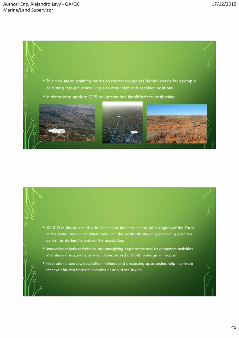
• This may mean painting marks on roads through residential areas for exampleor cutting through dense jungle to mark shot and receiver positions.
• In either case modern GPS equipment has simplified the positioning
• Oil & Gas deposits tend to be in some of the more inhospitable regions of the Earth,so the actual terrain conditions may limit the available shooting/recording positionsas well as define the costs of the acquisition.
• Innovative seismic techniques are energizing exploration and development activitiesin onshore areas, many of which have proved difficult to image in the past.
• New seismic sources, acquisition methods and processing approaches help illuminatereservoir hidden beneath complex near-surface layers

Author: Eng. Alejandro Levy - QA/QCMarine/Land Supervisor
17/12/2015
46
SOURCES OF SEISMIC ENERGY
• Recent advances in source technology are further improving data quality byputting more seismic energy into the earth at a wider range of frequencies
• The ideal source for seismic exploration is an impulsive source thatconcentrates its energy at a point in space and release it instantaneously.
• In practice, sources have finite spatial size and emit signals over a finiteperiod, producing broadened wavelets that add complexity to processing
• Where better surface conditions exist, or access is difficult, a portable form ofdrilling rig may be used.
• Water & mud pumps, compressed air, emulsion and foam have all been used toimprove the circulation of the drill bit in different conditions. The types of drill usedextends from hand-held augers to large truck-mounted hammer drills.
• Production rates for "conventional" (dynamite) exploration depend almost entirelyon the rate at which holes can be drilled.

Author: Eng. Alejandro Levy - QA/QCMarine/Land Supervisor
17/12/2015
47
EXPLORATION IMPACTS
• Potential environmental impacts from exploration activities (including seismicsurveys and exploratory drilling) are generally temporary and of relatively smallmagnitude.
• Activities during the exploration phase (including seismic surveys, testing, andexploratory drilling) are temporary and are conducted at a smaller scale than thoseat the drilling/development, production, and decommissioning/reclamation phases.
• The impacts described for each resource would occur from typical explorationactivities, such as localized ground clearing, vehicular traffic, seismic testing,positioning of equipment, and exploratory drilling.
• Most impacts during the exploration phase would be associated with thedevelopment of access roads and exploratory wells.
NOISE
• Primary sources of noise associated with exploration are:
• Earth-moving equipment,
• vehicle traffic,
• seismic surveys,
• blasting,
• vibrators and drilling operations.

Author: Eng. Alejandro Levy - QA/QCMarine/Land Supervisor
17/12/2015
48
AIR QUALITY
• Impacts on air quality during exploration activities would include emissions and dust fromearth-moving equipment, vehicles, seismic surveys, well completion and testing, and drill rigexhaust.
• Pollutants would include , particulates, oxides of nitrogen, carbon monoxide, sulfur dioxide,and volatile organic compounds (VOCs). Nitrogen oxides and VOCs may combine to formground-level ozone.
• Impacts would depend upon the amount, duration, location, and characteristics of theemissions and the meteorological conditions (e.g., wind speed and direction, precipitation, andrelative humidity). Emissions during this phase would not have a measurable impact on climatechange .
CULTURAL RESOURCES• The amount of surface and subsurface disturbance is minimal during the exploration
phase.
• Cultural resources buried below the surface are unlikely to be affected; whilematerial present on the surface could be disturbed by vehicular traffic, groundclearing, and pedestrian activity (including collection of artifacts).
• Exploration activities could affect areas of interest depending on the placement ofequipment and/or level of visual intrusion.
• Surveys conducted during this phase to evaluate the presence and/or significance ofcultural resources in the area would assist developers in siting project facilities inorder to avoid or minimize impacts to these resources.

Author: Eng. Alejandro Levy - QA/QCMarine/Land Supervisor
17/12/2015
49
ECOLOGICAL RESOURCES• Impacts to ecological resources (vegetation, wildlife, aquatic biota, special
status species, and their habitats) would be minimal and localized duringexploration because of the limited nature of the activities.
• The introduction or spread of some nonnative invasive vegetation could occuras a result of vehicular traffic, but this would be relatively limited in extent.Seismic surveys could disturb wildlife.
• Exploratory well establishment would destroy vegetation and impact wildlife.
• Surveys conducted during this phase to evaluate the presence and/orsignificance of ecological resources in the area would assist developers insiting project facilities in order to avoid or minimize impacts to these resources
ENVIRONMENTAL JUSTICE
• Exploration activities are limited and would not result in significant adverseimpacts in any resource area; therefore, environmental justice is not expectedto be an issue during this phase.

Author: Eng. Alejandro Levy - QA/QCMarine/Land Supervisor
17/12/2015
50
HAZARDOUS MATERIALS AND WASTEMANAGEMENT
• Seismic and exploratory well crews may generate waste (plastic, paper,containers, fuel leaks/spills, food and human waste). Wastes produced byexploratory drilling would be similar, but occur to a lesser extent than thoseproduced during drilling and operation of production wells.
• They would include drilling fluid and muds, used and filters, spilled fuel, drillcutting, spent and unused solvents, scrap metal, solid waste and garbage.
HEALTH AND SAFETY• The potential impacts on human health and safety resulting from exploration activities
could include:
• Occupational accidents and injuries;
• Vehicle or aircraft accidents,
• Exposure to weather extremes,
• Wildlife encounters,
• Trips and falls on uneven terrain,
• Adverse health effects from dust generation and emissions, and contact withhazardous materials (e.g., from spills).
• The potential for these impacts to occur would be low because of the limited range ofactivities and number of workers required during exploration.
Author: Eng. Alejandro Levy - QA/QCMarine/Land Supervisor
17/12/2015
51
LAND USE• Temporary and localized impacts to would result from exploration activities.
• These activities could create a temporary disturbance in the immediate vicinityof a surveying or monitoring site or an exploratory well (e.g., disturbrecreational activities or livestock grazing).
• Wire pin flags used for surveying could be shredded in the making of hay.
• The leftover metal bits can kill livestock that eat the feed.
• Livestock and wildlife can also die after eating ribbons attached to the flags.
• Exploration activities are unlikely to affect mining activities, militaryoperations, or aviation.
PALEONTOLOGICAL RESOURCES
• Paleontological resources are nonrenewable resources. Disturbance to suchresources, whether it is through mechanical surface
• Disturbance, erosion, or paleontological excavation, irrevocably alters ordestroys them.
• Direct impacts to paleontological resources would include surface disturbanceduring seismic surveys and the drilling of exploratory wells and theconstruction of access roads and other ancillary facilities.

Author: Eng. Alejandro Levy - QA/QCMarine/Land Supervisor
17/12/2015
52
PALEONTOLOGICAL RESOURCES
• The amount of subsurface disturbance is minimal during the exploration phase andpaleontological resources buried below the surface are unlikely to be affected.
• Fossil material present on the surface could be disturbed by vehicular traffic, groundclearing, and pedestrian activities (including collection of fossils).
• Surveys conducted during this phase to evaluate the presence and/or significance ofpaleontological resources in the area would assist developers in siting projectfacilities in order to avoid or minimize impacts to these resources
SOCIOECONOMICS
• As the activities conducted during the exploration phase are temporary andlimited in scope, they would not result in significant socioeconomic impacts onemployment, local services, or property values.

Author: Eng. Alejandro Levy - QA/QCMarine/Land Supervisor
17/12/2015
53
SOILS AND GEOLOGIC RESOURCES
• Surface effects from vehicular traffic could occur in areas that contain special(e.g., crypto biotic) soils.
• The loss of biological crusts can substantially increase water and wind erosion.
• Also, soil compaction due to development activities at the exploratory andalong access roads would reduce aeration, permeability, and water-holdingcapacity of the soils and cause an increase in surface runoff, potentiallycausing increased sheet, rill, and gully erosion.
• The excavation and reapplication of surface soils could cause the mixing of shallow ,resulting in a blending of soil characteristics and types.
• This blending would modify physical characteristics of the soils including structure,texture, and rock content, which could lead to reduced permeability and increasedrunoff from these areas.
• Potential impacts to geologic and mineral resources would include depletion ofhydrocarbons and sand and gravel resources.
• It is unlikely that exploration activities would activate geologic hazards.
• Impacts to soils and geologic resources would be proportional to the amount ofdisturbance.
• The amount of surface disturbance and use of geologic materials during explorationwould be minimal.

Author: Eng. Alejandro Levy - QA/QCMarine/Land Supervisor
17/12/2015
54
TRANSPORTATION
• No impacts on transportation are anticipated during the exploration phase.
• Transportation activities would be temporary and intermittent and limited tolow volumes of light utility trucks and personal vehicles
VISUAL RESOURCES
• Impacts to visual resources would be considered adverse if the landscapewere substantially degraded or modified.
• Exploration activities would have only temporary and minor visual effects,resulting from the presence of drill rigs, workers, vehicles, and otherequipment.

Author: Eng. Alejandro Levy - QA/QCMarine/Land Supervisor
17/12/2015
55
WATER RESOURCES (SURFACE WATER ANDGROUNDWATER)
• Minimal impact to water resources (water quality, water flows, and surface water/groundwater interactions) would be anticipated from exploration activities.
• Exploratory wellbores may provide a path for surface contaminants to come intocontact with groundwater or for waters from subsurface formations to commingle.They may also decrease pressure in water wells and affect their quality. Very littleproduced water would likely be generated during the exploration phase.
• Most water needed to support drilling operations could be trucked in from off-site.
HYDRAULIC FRACTURING OR‘FRACKING’

Author: Eng. Alejandro Levy - QA/QCMarine/Land Supervisor
17/12/2015
56
WHAT IS FRACKING
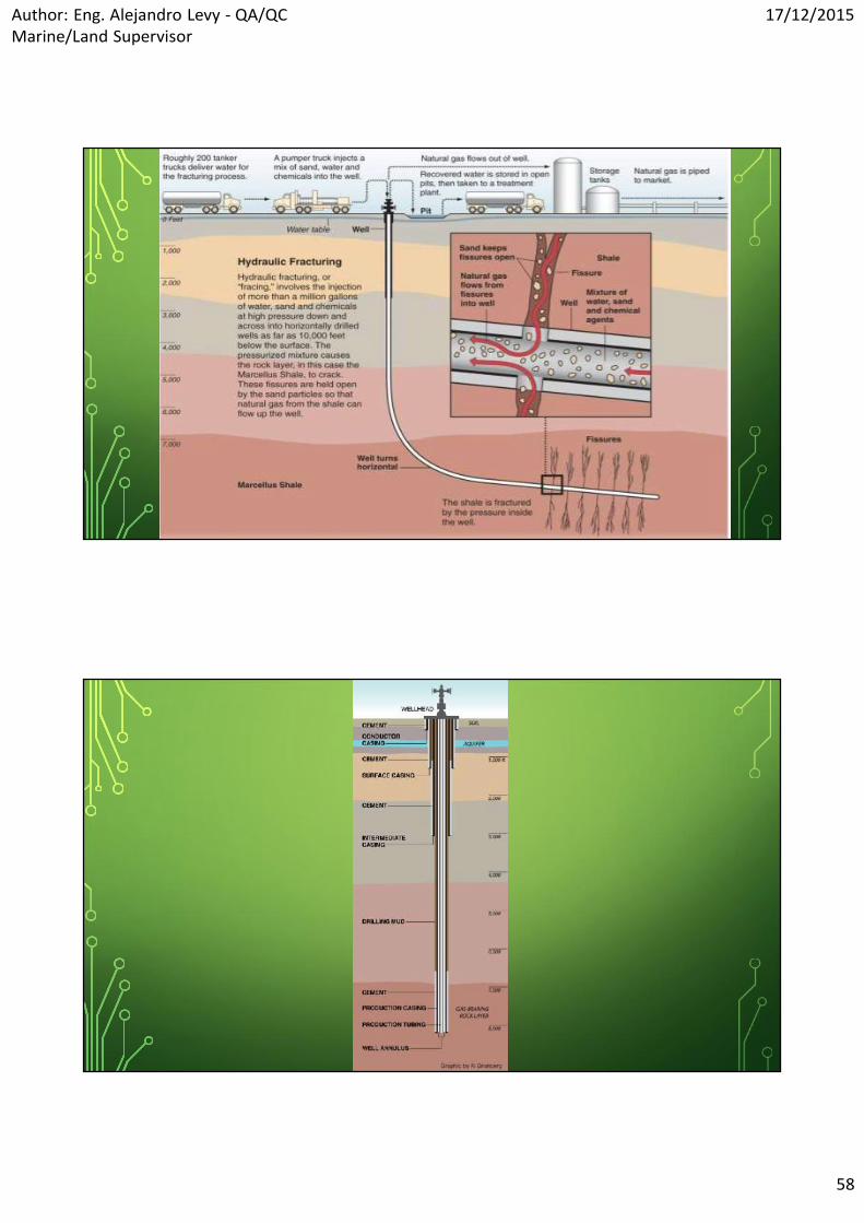
• Hydraulic fracturing, or ‘fracking’, is a method used by drilling engineers to stimulate orimprove fluid flow from rocks in the subsurface. In brief, the technique involves pumping awater-rich fluid into a borehole until the fluid pressure at depth causes the rock to fracture.
• The pumped fluid contains small particles known as proppant (often quartz-rich sand) whichserve to prop open the fractures.
• After the fracking job, the pressure in the well is dropped and the water containing releasednatural gas flows back to the well head at the surface.
• The boreholes themselves are often deviated away from the vertical, into sub-horizontalorientations, to ensure better and more efficient coverage of the targeted shale gas reservoir.

Author: Eng. Alejandro Levy - QA/QCMarine/Land Supervisor
17/12/2015
57
• The fracking fluid also contains small amounts (typically < 2% in total byvolume) of chemical additives such as acid to help initiate fractures, corrosionand scale inhibitors to protect the borehole lining and gelling agents to alterthe fluid viscosity.
POTENTIAL RISKS
• Injecting large volumes of fluid into the subsurface is not without risk.
• Here are highlighted the potential for the following:
A. Earthquakes induced by slip on nearby faults;
B. Contamination of ground water, and possibly even drinking water, with natural gasand other chemicals;
C. Emissions of volatile components, such as CO2 or methane, into the atmosphere;
D. The leakage of contaminated drilling waste fluid from storage ponds
Author: Eng. Alejandro Levy - QA/QCMarine/Land Supervisor
17/12/2015
58

Author: Eng. Alejandro Levy - QA/QCMarine/Land Supervisor
17/12/2015
59
GEOLOGICAL PRINCIPLES OF FRACKING & SHALEGAS EXTRACTION
• Some of the key geological issues with relevance to the potential environmentalimpacts of fracking are:
• The relatively limited understanding of rock fracture patterns and processes inshales;
• The ability to predict and quantify permeable fracture networks in the subsurfacebefore drilling;
• The accuracy and precision with which the geometry (size or extent, position,thickness) of shale formations and aquifers in the subsurface can be determined,especially in areas with complex geological histories.
• The ability of fluids to flow through rock is controlled by a property calledpermeability, itself a function of porosity. The pore space in rocks is made upof a diverse range of voids in the solid rock matrix and includes cracksinduced by stresses.
• The aim of fracking is to massively improve permeability by creating (orreopening) a locally dense network of open and connected – i.e. hydraulicallyconductive – fractures.

Author: Eng. Alejandro Levy - QA/QCMarine/Land Supervisor
17/12/2015
60
• It is important to recognize that the fracking process of pumping large volumes ofwater into a borehole at a certain depth cannot control the type of fractures that arecreated or reactivated.
• This could have implications for the risk of ground water contamination by frackingoperations, as the fracture network generated by the fracking fluid could becomplex and difficult to predict in detail.
• The orientations, sizes and apertures of permeable rock fractures created by afracking operation ultimately control the fate of the fracking fluid and the releasedshale gas, at least in the deep subsurface.
GEOLOGICAL RISKS
• Fracking inherently involves geomechanical risks – i.e. the injection of largevolumes of pressurized water at depth will, by design, alter the in situ stressstate and change the propensity of existing fractures to open or faults to slip,and possibly result in seismic activity (i.e. earthquakes).

Author: Eng. Alejandro Levy - QA/QCMarine/Land Supervisor
17/12/2015
61
• Fracking also entails geochemical or hydrogeological risks. The key issue is the fateof the water (plus additives) after the fracking has occurred. As discussed above,during fracking there is little direct control on the nature of the permeable fracturenetwork created, and how this new network might then connect to any pre-existing(and potentially undetected) fracture network.
• Whilst potential contamination of ground water with the injected fracking fluid istherefore an important concern, another issue is the fate of the initial drilling fluid (or‘mud’) used to lubricate the borehole during drilling.
• An additional risk is that of the natural gas released by the fracking process enteringthe ground water, however there has only been one confirmed case of this kind ofcontamination to date, with natural gas released from a fracking operation
POTENTIAL ENVIRONMENTAL IMPACTS
• The number of proven environmental impacts demonstrated to have beencaused by fracking remains small in relation to the volume of fracking activity.
• One estimate is that approximately one million oil and gas wells have beendrilled and fracked (University of Texas, 2012).

Author: Eng. Alejandro Levy - QA/QCMarine/Land Supervisor
17/12/2015
62
GROUND WATER CONTAMINATION
• The potential risk to ground water comes from two sources: the injected fluid(water + chemical additives) and the released natural gas.
• There are alleged cases of both types (University of Texas, 2012;
• The current opinion shared by several agencies is that all scientificallydocumented cases of ground water contamination associated with frackingare related to poor well casings and their cements, or from leakages of fluidat the surface.
• The potential risks identified from alleged incidents of ground watercontamination so far include:
• Overweight (or ‘overbalanced’) drilling mud causing leakage of drilling fluidsfrom the well bore into near surface aquifers;
• Contamination from solid components in the shale entering the flow back fluid;
• Poor cement jobs on well bore casing, especially at shallow depths.

Author: Eng. Alejandro Levy - QA/QCMarine/Land Supervisor
17/12/2015
63
• Many shales contain quantities of potentially harmful chemical elements andcompounds that could be dissolved into the fracking fluid, and then return towardsthe surface during flow back.
• These include methane (i.e. the target natural gas to be released), carbon dioxide,hydrogen sulphide, nitrogen and helium; trace elements such as mercury, arsenic andlead; naturally occurring radioactive material (radium, thorium, uranium); and“volatile organic compounds” (VOCs) that easily vaporize into the air, such asbenzene (House of Commons Energy & Climate Change Committee, 2011).
• The amount of material dissolved also varies widely, with estimates of between13,000 and 120,000 ppm for shale gas plays in the USA (University of Texas,2012). Careful chemical monitoring of fracking fluids, including the flow back fluidand produced water, is required to mitigate the risks of contamination from thissource.
CHEMICAL ADDITIVES
• Defining the toxicity level of additives used in the fracking phase should be arelatively simple and quantifiable scientific task, however in some countriesfracking companies are under no legal obligation to declare the exactcomposition of this mixture.
• In fact, for companies operating in deregulated market economies there is aclear vested interest in keeping the fluid formula secret for competitiveadvantage.

Author: Eng. Alejandro Levy - QA/QCMarine/Land Supervisor
17/12/2015
64
BLOW OUTS• If the fluid injected into the well head does not fracture the rock volume
around the bottom of the well as intended, then the elevated fluid pressurewill drive the fluid into other open and permeable pathways.
• These pathways can include the injecting well bore, but also any otherboreholes in the vicinity that are not capped for these high pressures (e.g.other oil and gas wells or artesian wells used for drinking water).
• Explosive eruptions of drilling fluid and/or oil and gas from neighboring wellsare a direct consequence of pre-existing permeable connectivity at depth.
• Seepage of any surface spillage from a blow out into the ground could thenlead to ground water contamination.
WATER SOURCES
• Sourcing the vast volumes of water required for an extended fracking programmecan be challenging, especially in arid or depleted areas. Estimates of water volumerequired vary widely, with between 90,000 and 13,500,000 litres per well (MIT,2011).
• Local extraction of water from small catchments could have an impact on the ecologyand hydrology of rivers in these areas.
• Related environmental impacts may also develop from transporting water in to thedrilling site from further afield: construction of new roads to remote drilling sites andincreased heavy road traffic and pollution.

Author: Eng. Alejandro Levy - QA/QCMarine/Land Supervisor
17/12/2015
65
FATE OF THE FRACKING FLUID
• Some operators have chosen to pond this flow back fluid in man-made pools andthen allow it to either evaporate, or be transported away at a later date.Evaporation leads to concentration of the chemical additives, increasing the potentialfor environmental impact if a leak develops.
• At least one operator in the US has successfully reused the flow back fluid in thesubsequent fracking operations at the same well head, with no loss in efficiency.However, the costs involved in processing the flow back fluid to remove anycontaminants collected during the first cycle may deter wider application.
EMISSIONS TO THE ATMOSPHERE FROM FRACKING
• An issue related to the fracking fluid is the emission of gas and/or vapour tothe atmosphere from the fluid, either of original additive chemicals, entrainedcontaminants from the shale formation or the methane released by thefracking process.
• Fracking operators should therefore seek to minimize all emissions to theatmosphere, and monitoring processes need to be actively enforced.

Author: Eng. Alejandro Levy - QA/QCMarine/Land Supervisor
17/12/2015
66
ADVANTAGES• Unlike coal, natural gas does not release sulfur dioxide, mercury and other
particles when burned; ashes, and emits only half the carbon dioxide.
• The inventory of greenhouse gases produced by the Agency for EnvironmentalProtection (EPA) shows that CO2 emissions across the country were 7% lower in2010 than in 2005, representing just over 400 million tons. (Preliminary datafor 2011 indicate that the decline continues).
• Reduced emissions from power plants, especially by switching from coal togas, account for a little over a third of the decline.
• The new legislation developed in 2012 by the EPA require the gas industry tomeasure their missions and the reduced. A major leak occurs when the openingof a well finished and hydraulic fracturing fluids that are at high pressure,returning the well dragging methane. The new rules prescribe that from 2015companies start to capture that gas.

Author: Eng. Alejandro Levy - QA/QCMarine/Land Supervisor
17/12/2015
67
• Some experts believe the capture of methane as a great opportunity, it ismuch easier to control the CO2 to slow global warming, at least in the shortterm, since small amounts of methane have considerable effects and also is avaluable fuel .

Author: Eng. Alejandro Levy - QA/QCMarine/Land Supervisor
17/12/2015
68
REFERENCES
• References: Seismic Course – Robertson Research International Limited – U.S. 1998
Training Course – Sercel – France 2008
Land Seismic Techniques for High Quality Data – Schlumberger – Norwa
Hydraulic Fracturing by Dr Dave Healy
SMT-400 Operator’s Manual - ION Sensor Nederland
NATIONAL GEOGRAPHIC – Los pros y los contras del fracking
Amos B. Batto – El riesgo del fracking en Bolivia
Related Documents
![3-D Seismic Exploration - Metallurgist & Mineral ... · PDF file3-D Seismic Exploration Eaton, D.W.[1], ... The 3-D seismic method involves the acquisition of seismic data on an areal](https://static.cupdf.com/doc/110x72/5a7132177f8b9aa7538ca72a/3-d-seismic-exploration-metallurgist-mineral-nbsppdf-file3-d.jpg)


