This article appeared in a journal published by Elsevier. The attached copy is furnished to the author for internal non-commercial research and education use, including for instruction at the authors institution and sharing with colleagues. Other uses, including reproduction and distribution, or selling or licensing copies, or posting to personal, institutional or third party websites are prohibited. In most cases authors are permitted to post their version of the article (e.g. in Word or Tex form) to their personal website or institutional repository. Authors requiring further information regarding Elsevier’s archiving and manuscript policies are encouraged to visit: http://www.elsevier.com/copyright

Welcome message from author
This document is posted to help you gain knowledge. Please leave a comment to let me know what you think about it! Share it to your friends and learn new things together.
Transcript
This article appeared in a journal published by Elsevier. The attachedcopy is furnished to the author for internal non-commercial researchand education use, including for instruction at the authors institution
and sharing with colleagues.
Other uses, including reproduction and distribution, or selling orlicensing copies, or posting to personal, institutional or third party
websites are prohibited.
In most cases authors are permitted to post their version of thearticle (e.g. in Word or Tex form) to their personal website orinstitutional repository. Authors requiring further information
regarding Elsevier’s archiving and manuscript policies areencouraged to visit:
http://www.elsevier.com/copyright
Author's personal copy
Sedimentological and sequence stratigraphic analysis of Carboniferous depositsin western Libya: Recording the sedimentary response of the northernGondwana margin to climate and sea-level changes
Sebastian Fröhlich a,*, Laurent Petitpierre a, Jonathan Redfern a, Paul Grech b,1,Stéphane Bodin a, Simon Lang c
a North Africa Research Group, School of Earth, Atmospheric and Environmental Sciences, The University of Manchester, Oxford Road, Manchester M13 9PL, UKb Woodside Energy (N.A.) Ltd., Corinthia Bab Africa Hotel, Commercial Centre Zone C Level 3, Tripoli 91964, Libyac Woodside Energy Ltd., GPO Box D188, Perth, Western Australia 6000, Australia
a r t i c l e i n f o
Article history:Received 22 February 2009Received in revised form 16 September2009Accepted 17 September 2009Available online 7 October 2009
Keywords:CarboniferousSequence stratigraphyLibyaMurzuq BasinGhadames Basin
a b s t r a c t
Detailed sedimentological and sequence stratigraphic analysis of Carboniferous (Tournaisian to Mosco-vian) strata exposed in the north-western Murzuq Basin and southern Ghadames Basin, western Libya,provides new insights into the sedimentary response of the northern Gondwana margin to climate andsea-level change.
The Lower Carboniferous Marar and Assedjefar Formations can be divided into five depositionalsequences of 3rd order. In total 27 facies types are defined, grouped into four facies associations: offshoreshales, shallow marine clastics, fluvial sandstones and marine carbonates.
The bulk of the Lower Carboniferous interval is dominated by an alternation of offshore shales and shal-low marine clastics, which were deposited during the transgressive and highstand systems tracts. Theclastic deposits mostly consist of laterally persistent coarsening and thickening upward cycles with acommon succession from basal hummocky cross-stratified sandstones to ripple-laminated sandstones,capped by multidirectional cross-stratified sandstones.
Within the lowstand systems tracts, lenticular sandbodies have been identified, which vary in thicknessfrom 1.5 m (ca. 40 m wide) to 50 m (ca. 1.5 km wide). These are interpreted to be fluvial channel com-plexes based on their geometry, erosive base, and presence of thick stacked sandstones with unidirectionalplanar and trough cross-bedding, the absence of bioturbation and occurrence of land plant fragments.These channel complexes mostly cut down into offshore shales, and are interpreted to be bound at thebase by sequence boundaries. Palaeogeographic maps generated for each lowstand system show the loca-tion and palaeoflow direction of these fluvial channel complexes. They are interpreted to represent largeincised valleys filled with thick fluvial sandstones. Their identification and distribution indicates repeatedexposure of large areas of western Libya, most-likely controlled by major eustatic sea-level changes.
The Assedjefar Formation exibits a gradual decrease in coarse clastic sediment supply throughout theSerpukhovian and by the Bashkirian and Moscovian during the deposition of the Dembaba Formation acarbonate depositional system was established. Limestones are dominantly made up of a heterozoanfauna (brachiopods, crinoids, bryozoans, gastropods) and are mostly preserved as shallow marine stormand coastal deposits. It is hypothesised that a local increase in aridity and/or the gradual erosion anddecreasing topography of the hinterland mountains, with the resulting reduction in discharge, controlledthis shift from clastic to carbonate deposition.
Available data indicate that the Murzuq Basin was interconnected with the Ghadames Basin at this timeand is a postdepositional basin with respect to the Carboniferous interval. The sedimentological andsequence stratigraphic data from the present study offer new insights into the depositional setting andfacies distribution in the Carboniferous, and the recognition of major incised fluvial systems has significantimplications in the search for potential Carboniferous hydrocarbon reservoirs in the Murzuq, Ghadames,and Illizi Basins.
� 2009 Elsevier Ltd. All rights reserved.
1464-343X/$ - see front matter � 2009 Elsevier Ltd. All rights reserved.doi:10.1016/j.jafrearsci.2009.09.007
* Corresponding author. Present address: Statoil ASA, Mølnholtet 42, 9481 Harstad, Norway. Tel.: +47 906 932 58; fax: +47 770 456 44.E-mail address: [email protected] (S. Fröhlich).
1 Present address: PETROM S.A., 1 Piata Eroilor, 100316 Ploiesti, Prahova, Romania.
Journal of African Earth Sciences 57 (2010) 279–296
Contents lists available at ScienceDirect
Journal of African Earth Sciences
journal homepage: www.elsevier .com/locate / ja f rearsc i
Author's personal copy
1. Introduction
Two large sedimentary basins dominate the geology of westernLibya: the Murzuq Basin in the south and the Ghadames Basin inthe north. Both basins are major petroleum provinces in NorthAfrica, although to-date the Carboniferous has not been a majorreservoir target, with only limited hydrocarbons encountered inthe Ghadames Basin. Thick Carboniferous deposits occur in thesubsurface throughout the Murzuq and Ghadames Basins (Belhaj,2000; Abugares, 2003), with extensive outcrops around the Mur-zuq Basin and in the southern Ghadames Basin. The outcrops aremostly in remote desert regions, and only limited previous workhas been undertaken on their sedimentology and depositionalenvironment.
In this paper we present results from two extensive field cam-paigns in 2007 and 2008 to locations in western Libya. The studiedoutcrops provide representative sections through the Carbonifer-ous for both the northern Murzuq and southern Ghadames region.
This paper (1) presents the depositional and palaeogeographicevolution of the Marar Fm., Assedjefar Fm., and Dembaba Fm.,which provide an example of a transition from a siliciclastic to acarbonate system, recording the last stage of marine depositionon northern Gondwana before the Hercynian Orogeny; (2) estab-lishes a regional sequence stratigraphic framework to facilitatethe interpretation of Carboniferous subsurface data in the Murzuq,Ghadames and Illizi Basins, and (3) assesses the influence of cli-mate and glacio-eustasy on observed relative sea-level and facieschanges from Tournaisian to Moscovian times.
2. Geological background and previous work
Following formation of Gondwana at the end of the Pan-AfricanOrogeny 580 Ma ago, throughout the Palaeozoic western Libya waslocated between a large exposed continental landmass in the southand the Palaeotethys in the north (Guiraud et al., 2005). Siliciclas-tic-dominated deposits, more than 1 km thick, accumulated fromCambrian to Late Devonian times. The dominant depositional envi-
ronments were shallow marine and hemipelagic (with depositionof dark graptolitic shales at certain stratigraphic horizons), fluvialand periglacial (during the Ordovician) (Grubic et al., 1991).
The Carboniferous interval of the Murzuq Basin margins wasfirst described by Klitzsch (1963, 1970) after earlier mentions e.g.by Krumbeck (1906) and Lelubre (1948). An interpretation of thesedimentology of the Tournaisian and Viséan Marar Formation inthe southern Ghadames Basin was subsequently undertaken byWhitbread and Kelling (1982). They interpreted the succession asa fluvial/marine deltaic system. Grubic et al. (1991) provided anoverview of the Phanerozoic stratigraphy of SW Libya, in whichthey interpreted the Tournaisian to Moscovian Marar, Assedjefarand Dembaba Formations as being entirely marine clastic and car-bonate deposits. Several studies provided biostratigraphic databoth from outcrop and subsurface samples (e.g. Vachard and Mas-sa, 1984; Mergl and Massa, 2000).
During the Early Carboniferous, western Libya was most-likelysituated at a palaeolatitudinal position between 40� and 30� south,with the gradual northward drift of Gondwana shifting the positionto between 30� and 20� south by the Late Carboniferous (McKer-row et al., 2000; Scotese, 2000; Tait et al., 2000).
Two large intra-cratonic sag-basins dominate western Libya:the Murzuq Basin in the south and the Ghadames Basin in thenorth (Fig. 1). The former is bounded to the west by the TihembokaHigh and to the north by the Gargaf/Atshan Uplift, which separatesthe Murzuq from the Ghadames Basin. Both uplifts were activethroughout the Phanerozoic, e.g. during the Middle and Late Devo-nian and the Late Carboniferous (e.g. Grubic et al., 1991; Davidsonet al., 2000; Hallett, 2002). The Murzuq Basin is bounded by theTibesti High to the east and extends into Niger to the south, whereit is called Djado Basin (Bellini and Massa, 1980). A complete Car-boniferous succession (i.e. Marar, Assedjefar, Dembaba, and Tigu-entourine Formation) occurs throughout most of the MurzuqBasin (Hallett, 2002), although a mid-Carboniferous compressioncreated localised erosional unconformities between the MararFm. and the Assedjefar Fm. in some locations in the centre of thebasin (Davidson et al., 2000).
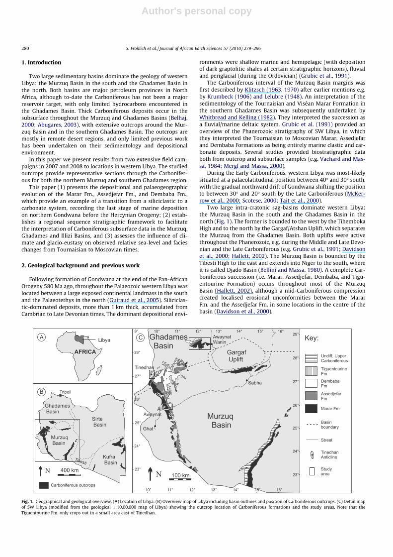
Fig. 1. Geographical and geological overview. (A) Location of Libya. (B) Overview map of Libya including basin outlines and position of Carboniferous outcrops. (C) Detail mapof SW Libya (modified from the geological 1:10,00,000 map of Libya) showing the outcrop location of Carboniferous formations and the study areas. Note that theTiguentourine Fm. only crops out in a small area east of Tinedhan.
280 S. Fröhlich et al. / Journal of African Earth Sciences 57 (2010) 279–296
Author's personal copy
The Ghadames Basin is bounded to the north by the Dahar-Naf-fusah High; its eastern flank is concealed by the overlapping of theyounger Sirt Basin. To the west, the Ghadames Basin extends intosouthern Tunisia and Algeria, where it is also called the Illizi andBerkine Basin. Due to considerable uplift and erosion during theHercynian Orogeny, Carboniferous deposits are only preserved inthe southern half of the Ghadames Basin, unconformably overlainby Mesozoic strata (Echikh, 1998).
In this study three field locations were investigated which offerexcellent exposures of the Marar, Assedjefar and Dembaba Forma-tions (Fig. 1): (1) Close to the town of Al Awaynat (GPS N25�4605100
E10�3304000), the Carboniferous strata are virtually unaffected bytectonics and can easily be accessed from a road. This outcrop ispart of the western Murzuq Basin. (2) About 170 km NNW of AlAwaynat, the Tinedhan Anticline (GPS N27�1005100 E9�5604600) is lo-cated in westernmost Libya, close to the Algerian border. This spec-tacular outcrop does not currently appear on the geological mapsof Libya. It represents the southernmost part of the Ghadames Ba-sin. (3) About 270 km NE of Tinedhan, a Carboniferous successiondipping with a low angle NW can be studied below a wide escarp-ment of Cretaceous rocks west of Awaynat Wanin (GPS N28�2903300
E12�4101500). This is the northernmost outcrop of Carboniferousdeposits in Libya; it is situated in the southern Ghadames Basin.
In the following section, a brief summary is presented of theCarboniferous formations of western Libya based on publisheddata.
2.1. Marar Formation
The age of the Marar Formation is late Tournaisian to latestViséan (Massa et al., 1974; Grubic et al., 1991; Mergl and Massa,2000). The onset of Carboniferous deposition in western Libya ismarked by a major transgression during the late Tournaisian (e.g.Massa et al., 1974; Mergl and Massa, 2000). Due to large-scalepre-Carboniferous erosion along the north-western flank of theMurzuq Basin, which is related to the uplift of the Tihemboka Arch,the base of the Marar Formation unconformably overlies Devonianand Silurian rocks (Jakovljevic, 1984; Protic, 1984; Grubic et al.,1991). The term ‘‘Marar Formation” was first introduced by Lelubre(1948). Its thickness ranges from 45 m in south-western Libya(Galecic, 1984), increasing northward to almost 800 m in the cen-tral Ghadames Basin (Mergl and Massa, 2000). According to Grubicet al. (1991), in the western Murzuq Basin the Marar Formation isdominated by thickening and coarsening upward cycles, made upof shales, siltstones and sandstones with ripple-marks and cross-bedding. A shallow marine environment was proposed by theseauthors. Well data from the north-western Murzuq Basin (Aziz,2000) and outcrop data from the southern Ghadames Basin (Whit-bread and Kelling, 1982) were interpreted to record a deltaic andshallow marine depositional environment.
2.2. Collenia unit
The top of the Marar Formation is characterised by algal stro-matolites, the Collenia Beds. This regional marker bed is easy to rec-ognise in the field and occurs throughout western Libya (with theexception of the southernmost Murzuq Basin), in the Illizi Basin inAlgeria and the Djado Basin in Niger (e.g. Freulon, 1953; Protic,1984; Mergl and Massa, 2000). Several authors have dated the Col-lenia unit using different groups of micro- and macro-fauna (Massaet al., 1974, 1980; Vachard and Massa, 1984; Grubic et al., 1991;Coquel and Massa, 1993), and the most recent work confirms anupper Viséan age in the Illizi, Ghadames, Murzuq and Djado Basinsbased on brachiopods, foraminifera and conodonts (Mergl andMassa, 2000). This unit is a good regional marker for fieldwork
and can be recognised in subsurface well data using typical wire-line logging suites.
2.3. Assedjefar Formation
The age of this formation, which was first identified by Lelubre(1952), was determined as Viséan–Namurian mostly from macro-fauna outcrop samples in the south-western Murzuq Basin (Gale-cic, 1984) and the southern Ghadames Basin (Berendeyev, 1985).However, a subsequent review of available subsurface and outcropdata from western Libya showed that the Assedjefar Formation ismost-likely restricted to the Serpukhovian stage, mainly based onforaminifera and conodonts (Mergl and Massa, 2000) (Fig. 2). Thereis no major change in depositional environment from the underly-ing Marar Formation, and the Assedjefar Formation comprises acyclic repetition of shales and sandstones, with intercalated bio-clastic limestone layers towards the top. A marine depositionalenvironment was proposed by Grubic et al. (1991) and Jakovljevic(1984). Aziz (2000) suggested a non-marine environment for silt-stones and a shoreface environment for sandstones of the Assedje-far Formation based on subsurface data from the north-westernMurzuq Basin.
2.4. Dembaba Formation
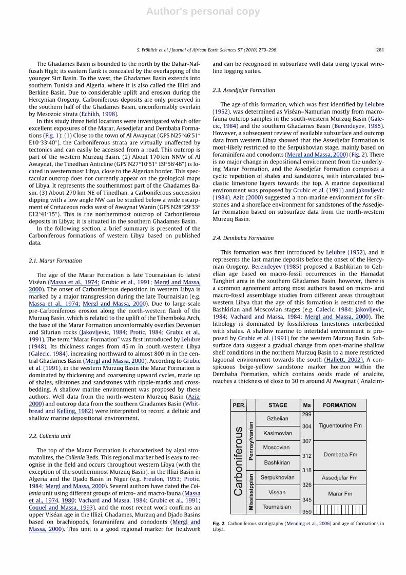
This formation was first introduced by Lelubre (1952), and itrepresents the last marine deposits before the onset of the Hercy-nian Orogeny. Berendeyev (1985) proposed a Bashkirian to Gzh-elian age based on macro-fossil occurrences in the HamadatTanghirt area in the southern Ghadames Basin, however, there isa common agreement among most authors based on micro- andmacro-fossil assemblage studies from different areas throughoutwestern Libya that the age of this formation is restricted to theBashkirian and Moscovian stages (e.g. Galecic, 1984; Jakovljevic,1984; Vachard and Massa, 1984; Mergl and Massa, 2000). Thelithology is dominated by fossiliferous limestones interbeddedwith shales. A shallow marine to intertidal environment is pro-posed by Grubic et al. (1991) for the western Murzuq Basin. Sub-surface data suggest a gradual change from open-marine shallowshelf conditions in the northern Murzuq Basin to a more restrictedlagoonal environment towards the south (Hallett, 2002). A con-spicuous beige-yellow sandstone marker horizon within theDembaba Formation, which contains ooids made of analcite,reaches a thickness of close to 30 m around Al Awaynat (‘Analcim-
Fig. 2. Carboniferous stratigraphy (Menning et al., 2006) and age of formations inLibya.
S. Fröhlich et al. / Journal of African Earth Sciences 57 (2010) 279–296 281
Author's personal copy
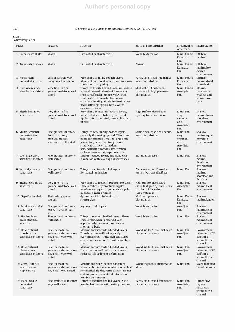
Table 1Sedimentary facies.
Facies Textures Structures Biota and bioturbation Stratigraphicoccurrence
Interpretation
1: Green-beige shales Shales Laminated or structureless Weak bioturbation Marar Fm. toDembabaFm.
Offshoremarine
2: Brown-black shales Shales Laminated or structureless Absent Marar Fm. toDembabaFm.
Offshoremarine, lowoxygenenvironment
3: Horizontallylaminated siltstone
Siltstone, rarely very-fine-grained sandstone
Very-thinly to thinly bedded layers.Abundant horizontal lamination, rare cross-lamination and grading
Rarely small shell fragments;weak bioturbation
Marar Fm. toDembabaFm.
Offshoremarine, distalstorm beds
4: Hummocky cross-stratified sandstone
Very-fine- to fine-grained sandstone, wellsorted
Thinly- to thickly-bedded, medium-beddedlayers dominant. Abundant hummockycross-stratification, some swaley cross-stratification, horizontal lamination,convolute bedding, ripple lamination, in-phase climbing ripples, rarely water-escape-structures
Shell debris, brachiopods,moderate to high pervasivebioturbation
Marar Fm. toAssedjefarFm.
Marine,between fairweather andstorm wavebase
5: Ripple-laminatedsandstone
Very-fine- to fine-grained sandstone, wellsorted
Very-thinly-to medium-bedded layers,interbedded with shales. Symmetricalripples, often bifurcated; rarely climbingripples
High surface bioturbation(grazing traces common)
Marar Fm.verycommon,alsoAssedjefarFm.
Shallowmarine, lowershorefaceenvironment
6: Multidirectionalcross-stratifiedsandstone
Fine-grained sandstonedominant, rarelymedium-grainedsandstone; well sorted
Thinly- to very-thickly-bedded layers,generally thickening upward. Thin shaleinterbeds common. Small-to large-scaleplanar, tangential, and trough cross-stratification showing randompalaeocurrent directions. Reactivationsurfaces common; rip-up clasts occur
Some brachiopod shell debris,weak bioturbation
Marar Fm.verycommon,alsoAssedjefarFm.
Shallowmarine, uppershorefaceenvironment
7: Low-angle cross-stratified sandstone
Fine-grained sandstone,well sorted
Medium-bedded layers; sub-horizontallamination with low-angle discordances
Bioturbation absent Marar Fm. Shallowmarine,foreshoreenvironment
8: Vertically burrowedsandstone
Fine-grained sandstone,well sorted
Thinly to medium-bedded layers.Horizontal lamination
Abundant up to 10 cm deepvertical burrows (Skolithos)
Marar Fm. Shallowmarine,shoreface andforeshore
9: Interference-ripplesandstone
Very-fine- to fine-grained sandstone, wellsorted
Very-thinly to medium-bedded layers, thinshale interbeds. Symmetrical ripples,interference ripples, asymmetrical ripples,in-phase climbing ripples
High surface bioturbation(abundant grazing traces), rareU-tubes with spreite(Diplocraterion)
Marar Fm.,AssedjefarFm.
Shallowmarine, tidalenvironment
10: Gypsiferous shale Shale with gypsumcrystals
Gypsum enriched in laminae orstructureless
Moderate pervasivebioturbation
Marar Fm. toDembabaFm.
Shallowmarine, lagoon
11: Lenticular-beddedsandstone
Fine-grained sandstonelenses in gypsiferousshale
Asymmetrical ripples Weak bioturbation AssedjefarFm.
Shallowmarine, tidalenvironment
12: Herring-bonecross-stratifiedsandstone
Fine-grained sandstone,well sorted
Thinly-to medium-bedded layers. Planarcross-stratification, preserved withopposite palaeocurrent directions inalternating beds
Weak bioturbation Marar Fm. Shallowmarine, tidalenvironment
13: Unidirectionaltrough cross-stratified sandstone
Fine- to medium-grained sandstone, someclay chips; very wellsorted
Medium to very-thickly-bedded layers.Trough cross-stratification, rarelyoverturned cross-strata, load structures,erosion surfaces common with clay chipsabove
Wood, up to 25 cm thick logs;bioturbation absent
Marar Fm.,AssedjefarFm.
Downstreammigration of 3Dbedformswithin fluvialchannel
14: Unidirectionalplanar cross-stratified sandstone
Fine- to medium-grained sandstone, someclay chips; very wellsorted
Medium to very-thickly-bedded layers.Planar cross-stratification, some erosionsurfaces, soft-sediment deformation
Wood, up to 25 cm thick logs;bioturbation absent
Marar Fm.,AssedjefarFm.
Downstreammigration of 2Dbedformswithin fluvialchannel
15: Cross-stratifiedsandstone withripple-marks
Fine- to medium-grained sandstone, someclay chips; well sorted
Medium to thickly-bedded sandstonelayers with thin shale interbeds. Abundantsymmetrical ripples, some planar-, trough-and tangential-cross-stratification, fewreactivation surfaces
Wood fragments; bioturbationabsent
Marar Fm. Wave modifiedfluvial deposits
16: Plane-parallellaminatedsandstone
Fine- grained sandstone;very well sorted
Thinly to medium-bedded layers. Plane-parallel lamination with parting lineation
Rarely small wood fragments;bioturbation absent
Marar Fm.,AssedjefarFm.
Upper flowregimedepositionwithin fluvialchannel
282 S. Fröhlich et al. / Journal of African Earth Sciences 57 (2010) 279–296

Author's personal copy
olitic Beds’) (Jakovljevic, 1984). The exact origin and depositionalsetting for this unit has yet to be determined.
2.5. Tiguentourine Formation
According to the 1:10,00,000 geological map of Libya, the onlyoutcrop of this formation, which was first introduced by Lapparentand Lelubre (1948), is near B’ir Anzawa, close to the Algerian bor-der (Fig. 1). There, it attains a maximum thickness of 23 m (Grubicet al., 1991). It comprises greenish and reddish-brown shales withsome calcareous siltstones, and one approximately 6 m thick inter-val of gypsum and anhydrite.
Using subsurface well data the Tiguentourine Formation canbe mapped throughout the subsurface of the Murzuq Basin andin the southern Ghadames Basin. In the northern Murzuq Basin,a thickness of 533 m was measured in well A1-73 (Hallett,2002). The age of this formation, determined by Fabre (1970),ranges from Stephanian (Kasimovian, Gzhelian) to Asselian,suggesting it could extend into the lowermost Permian. Due togenerally poor outcrops, this formation is difficult to study inthe field and has not been analysed as part of this currentresearch.
3. Methods
Sedimentary facies were studied in the outcrop by using tradi-tional field sedimentary logging, both along transects and beddingplanes. Due to the mild effects of the Hercynian Orogeny in thisarea, Carboniferous strata mostly have a very low dip angle andthus outcrop sections cover areas of many kilometres. To minimiseerror of thickness measurements, a Jacob’s staff was used while‘walking out’ the sections to measure meter intervals. Additionally,the thickness of the measured sections was verified by calculatingthe true thickness using bottom and top GPS locations and dip an-gle of the strata. Samples were collected for subsequent petro-graphic analysis. High resolution satellite images were used toassist in the field and augment information from the geologicalmaps.
4. Facies associations
From the three outcrop locations Al Awaynat, Tinedhan andAwaynat Wanin (Fig. 1), 27 facies have been distinguished(Table 1), which can be grouped into four facies associationsbased on lithology, sedimentary structures, texture, palaeocurrent
Table 1 (continued)
Facies Textures Structures Biota and bioturbation Stratigraphicoccurrence
Interpretation
17: Conglomerate Granules and pebbles;poorly sorted
Thinly to medium-bedded layers. Mostlystructureless, rarely soft-sedimentdeformed
Some bone fragments Marar Fm.,AssedjefarFm.
Deposition duetotransgressivereworking ofthe shoreline
18: Nodular calcareousmudstone
Rare shell fragments andquartz grains incalcareous matrix
Thinly to thickly-bedded layers withnodular appearance interbedded withshales
Few shell fragments DembabaFm.
Marine lowenergyenvironment
19: Hummocky cross-stratified limestone
Quartziferous wacke-/packstone
Thinly to medium-bedded layersinterbedded with shales. Grading,hummocky cross-stratification, convolutebedding, symmetric ripples, erosive base
Abundant shell fragments,crinoidal debris. Somegastropods, bryozoans,foraminifera
DembabaFm.
Marine stormdepositionalenvironment
20: Crinoidal limestone Grainstone to packstone,poorly sorted
Thinly to medium-bedded layersinterbedded with shales. Grading common
Crinoidal debris (completestems up to 8 cm long),brachiopods, shell fragments
DembabaFm.
Marineenvironment,moderate tohigh energy
21: Bioclasticgrainstone
Grainstone, rarely withpebbles, poorly sorted
Thinly bedded layers within shales. Gradingcommon
Abundant brachiopods,crinoids, gastropods, bryozoans;rarely trilobites, solitary corals,orthocone nautiloids.Bioturbation absent
Marar Fm.,AssedjefarFm.,DembabaFm.
Marine highenergyenvironment;possible stormbeds
22: Cross-stratifiedlimestone
Grainstone, moderatelysorted; some quartzgrains
Medium-bedded layers. Planar cross-stratification
Abundant shell fragments,brachiopods, crinoids,gastropods; few rugose corals.Bioturbation absent
LowerAssedjefarFm.
Shallow marinecarbonateshoal
23: Oolitic grainstone Grainstone, moderatly/well sorted. Abundantooids; some peloids,quartz grains and mudchips
Thinly to medium-bedded layers. Grading Abundant shell fragments,crinoids, gastropods. Weakbioturbation
AssedjefarFm.
Shallowmarine, highenergyenvironment
24: Ripple-laminatedlimestone
Packstone to grainstone,well sorted. Some ooids,peloids and extraclasts
Thinly to medium-bedded layers.Symmetrical ripples (ripple height between1–10 cm) often with bifurcations,interference ripples
Abundant shell fragments,crinoids, gastropods, bryozoans;few foraminifera. Weakbioturbation
AssedjefarFm.,DembabaFm.
Shallow marineshoreface totidalenvironment
25: Stromatoliticboundstone
Bindstone; somepeloids, ooids andquartz grains
Thinly to thickly-bedded layers. Mostly SH-type stromatolites, some LLH-type andmicrobial laminites. Rarely symmetricalripples
Microbial mats, few shellfragments
Top MararFm., minorAssedjefarFm.,DembabaFm.
Shallow marinetidal/lagoonalenvironment
26: Oolitic sandstonewith analcite
Very-fine-to fine-grained sandstone; wellsorted
Mostly structureless; rarely ‘sigmoidal’cross-stratification
non observed MiddleDembabaFm.
27: Red mottledsiltstone
Shale to very-fine-grained sandstone;poorly sorted
Mostly structureless, mottled appearance Some rootlets Marar Fm. Palaeosol
S. Fröhlich et al. / Journal of African Earth Sciences 57 (2010) 279–296 283
Author's personal copy
directions, geometry and microfacies. The sedimentology of thefacies associations is described and an interpretation of the depo-sitional environment presented.
4.1. Facies Association 1: offshore shales
Facies Association 1 is dominated by green-beige colouredshales (Facies 1), which can reach a thickness of 90 m. Due tolow resistance to weathering, the shale successions are commonlyexpressed as geomorphological depressions and are often poorlyexposed, especially where covered by Quaternary deposits. Wherethey crop out along hill slopes, horizontal lamination is observed.Rarely, poorly organised burrow systems are preserved.
Brown-black shales (Facies 2) have a maximum thickness of8 m and are much less common than the green-beige shales. Bio-turbation is absent in Facies 2.
Horizontally laminated siltstones between 1–5 cm thick (Facies3), which sometimes show grading, are commonly intercalated infacies 1, often with increasing frequency towards the top of theshale successions. Brachiopod shell fragments are sometimes con-centrated at the base of the siltstone layers.
4.1.1. InterpretationThe occurrence of brachiopod fauna indicates a marine deposi-
tional environment for the shale successions. The thin siltstonelayers are interpreted to be distal storm or event beds, transportedinto the offshore environment. The increasing frequency of silt-stone layers towards the top of shale successions is interpretedto record a gradual shallowing upward.
The brown-black colour of some shale intervals was most-likelycaused by the deposition of organic matter and preservation underoxygen-depleted conditions, also indicated by the absence ofbioturbation.
4.2. Facies Association 2: shallow marine clastics
Facies Association 2 can be subdived into three units:
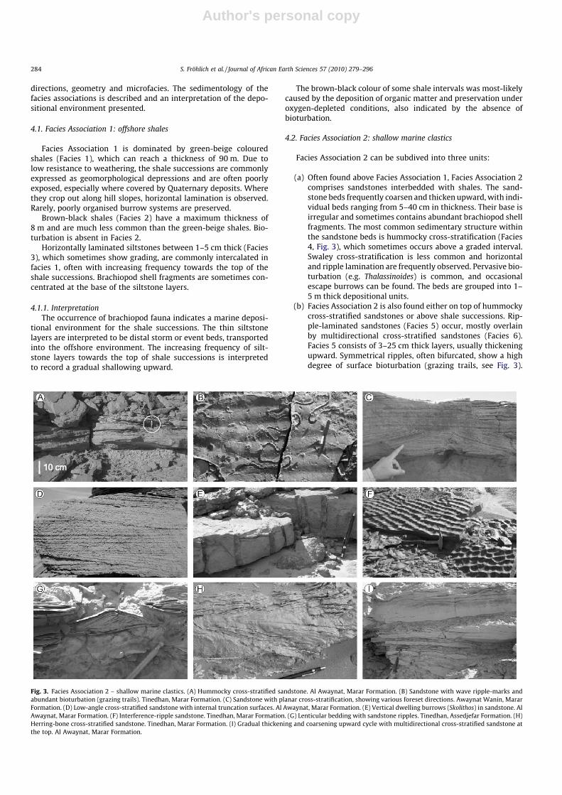
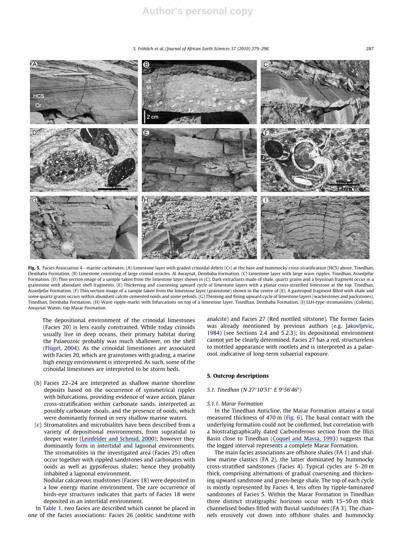
(a) Often found above Facies Association 1, Facies Association 2comprises sandstones interbedded with shales. The sand-stone beds frequently coarsen and thicken upward, with indi-vidual beds ranging from 5–40 cm in thickness. Their base isirregular and sometimes contains abundant brachiopod shellfragments. The most common sedimentary structure withinthe sandstone beds is hummocky cross-stratification (Facies4, Fig. 3), which sometimes occurs above a graded interval.Swaley cross-stratification is less common and horizontaland ripple lamination are frequently observed. Pervasive bio-turbation (e.g. Thalassinoides) is common, and occasionalescape burrows can be found. The beds are grouped into 1–5 m thick depositional units.
(b) Facies Association 2 is also found either on top of hummockycross-stratified sandstones or above shale successions. Rip-ple-laminated sandstones (Facies 5) occur, mostly overlainby multidirectional cross-stratified sandstones (Facies 6).Facies 5 consists of 3–25 cm thick layers, usually thickeningupward. Symmetrical ripples, often bifurcated, show a highdegree of surface bioturbation (grazing trails, see Fig. 3).
Fig. 3. Facies Association 2 – shallow marine clastics. (A) Hummocky cross-stratified sandstone. Al Awaynat, Marar Formation. (B) Sandstone with wave ripple-marks andabundant bioturbation (grazing trails). Tinedhan, Marar Formation. (C) Sandstone with planar cross-stratification, showing various foreset directions. Awaynat Wanin, MararFormation. (D) Low-angle cross-stratified sandstone with internal truncation surfaces. Al Awaynat, Marar Formation. (E) Vertical dwelling burrows (Skolithos) in sandstone. AlAwaynat, Marar Formation. (F) Interference-ripple sandstone. Tinedhan, Marar Formation. (G) Lenticular bedding with sandstone ripples. Tinedhan, Assedjefar Formation. (H)Herring-bone cross-stratified sandstone. Tinedhan, Marar Formation. (I) Gradual thickening and coarsening upward cycle with multidirectional cross-stratified sandstone atthe top. Al Awaynat, Marar Formation.
284 S. Fröhlich et al. / Journal of African Earth Sciences 57 (2010) 279–296
Author's personal copy
Facies 6 (ca. 10–150 cm thick layers) is usually more thicklybedded than Facies 5 and consists of mostly trough- and pla-nar-cross-stratified sandstones with reactivation surfacesand multidirectional palaeocurrents. Some brachiopod andgastropod shell fragments occur, as well as a few mud rip-up clasts. Bioturbation is generally limited. Within very-thickly-bedded layers of Facies 6, channels rarely occur,approximately 1 m thick and 5 m wide. The base of thechannel is marked by a pebble lag, followed by large-scaletrough cross-stratified fine-grained sandstone, often withsymmetrical ripples towards the top. Facies 5 and 6 are com-mon and often occur together within the same depositionalunit (30 cm to 8 m thick), which can be followed in the out-crop laterally over long distances (>20 km) without anynotable facies change.
Low-angle cross-stratified sandstones (Facies 7) are a lesscommon facies. Beds are 20–40 cm thick and comprisesub-horizontally laminated sets (5–15 cm thick), separatedby low-angle discordances (Fig. 3). Bioturbation is absent.This facies sometimes occurs above multidirectional cross-stratified sandstones (Facies 6).Vertically burrowed sandstones (Facies 8) rarely occur. Themostly 10–20 cm thick layers are penetrated by numerousSkolithos burrows.
(c) A common facies within Facies Association 2 is Facies 9,which consists of interference-rippled (ladder-rippled)sandstones. Symmetrical ripples with parallel crests occurtogether with a second generation of slightly smaller rippleswith a crest angle at approximately 90� to the first (Fig. 3).Abundant grazing trails are preserved on the surface of thelayers. Thickness of the sandstone beds vary from 3–30 cm.Gypsiferous shales (Facies 10), often associated with lenticu-lar-bedded sandstones (Facies 11) and herring-bone cross-stratified sandstones (Facies 12), are a less common facies.Facies 11 consists of 3–7 cm thick and 10–15 cm wide sand-stone lenses within the shales, displaying cross-lamination(Fig. 3). Facies 12 is made of 15–30 cm thick sandstone layers,which are planar and tangential cross-stratified. Adjacent sets
within the layers often have bipolar palaeocurrent directions(Fig. 3). Shale layers between the sandstones range from0.5–3 cm thick. While Facies 9 can often be followed laterallyover several hundred meters, both Facies 11 and 12 are later-ally more restricted and rarely extend for more than 40 m.
4.2.1. InterpretationThe nine different facies types present within Facies Association
2 are interpreted to be deposited under shallow marine conditions(Facies 4–12). These can be further subdivided into distal to prox-imal settings, with: (a) storm related deposits, (b) shoreline depos-its, and (c) tidal deposits.
(a) Hummocky and swaley cross-stratification are bedformswhich typically form during storm conditions between thefair weather and the storm wave base, whereby the swaleycross-stratification is deposited in slightly shallower waterrelative to the hummocky cross-stratification (Dumas andArnott, 2006). The irregular, erosive base of sandstone layersand presence of escape burrows indicate rapid deposition ina high energy environment. The coarsening and thickeningupward of individual beds suggests increase in energy andshallowing of the environment, interpreted to reflect deposi-tion dominantly during relative sea-level fall.
(b) Bifurcated symmetrical ripples with a high degree of biotur-bation typically occur in shallow marine environmentsabove fair-weather wave base. The ripple-laminated sand-stones, showing a gradual transition to planar and troughcross-stratified sandstones, are interpreted as lower shore-face deposits. Multidirectional palaeocurrents and theoccurrence of bioturbation and brachiopod shell fragmentssuggest an upper shoreface environment of the latter. Chan-nel bodies, which sometimes occur within these shorefacedeposits, are interpreted as small tidal inlet channels.
Sub-horizontally laminated sandstones with low-angle trun-cation surfaces are interpreted as foreshore deposits. In mod-ern beach environments, these structures develop in theswash zone, landward of the shoreface environment (e.g.Reineck and Singh, 1980).
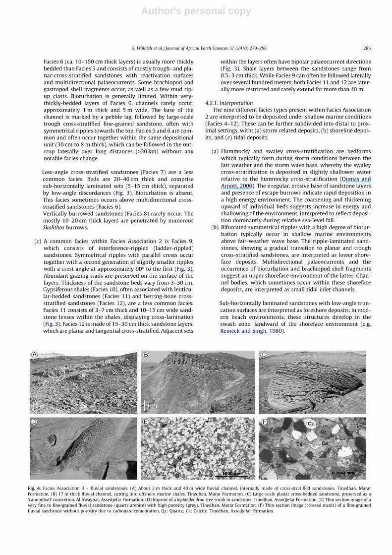
Fig. 4. Facies Association 3 – fluvial sandstones. (A) About 2 m thick and 40 m wide fluvial channel, internally made of cross-stratified sandstones. Tinedhan, MararFormation. (B) 17 m thick fluvial channel, cutting into offshore marine shales. Tinedhan, Marar Formation. (C) Large-scale planar cross-bedded sandstone, preserved as a‘cannonball’ concretion. Al Awaynat, Assedjefar Formation. (D) Imprint of a lepidodendron tree trunk in sandstone. Tinedhan, Assedjefar Formation. (E) Thin section image of avery fine to fine-grained fluvial sandstone (quartz arenite) with high porosity (grey). Tinedhan, Marar Formation. (F) Thin section image (crossed nicols) of a fine-grainedfluvial sandstone without porosity due to carbonate cementation. Qz: Quartz; Ca: Calcite. Tinedhan, Assedjefar Formation.
S. Fröhlich et al. / Journal of African Earth Sciences 57 (2010) 279–296 285
Author's personal copy
(c) Interference ripples, which are common structures, formeddue to the interaction of waves and currents in tidal environ-ments (e.g. Makhlouf, 2000). Lenticular bedding can occur ina variety of depositional environments, including marinedelta front, channel-mouth facies, and tidal environments(Reineck and Singh, 1980). The association with gypsiferousshales suggest a tidal, possibly Sabkha depositional environ-ment, further supported by the presence of herring-bonecross-stratified sandstones, formed due to the reversal ofpalaeocurrent directions between ebb and flood tide.
4.3. Facies Association 3: fluvial sandstones
This facies association is made up of lenticular/channelized sand-bodies which vary in thickness from 1.5 m (ca. 40 m wide) to 50 m(ca. 1.5 km wide). All the sandbodies are characterised by an erosivebase. The sandstones are fine- to medium-grained quartz arenitesand vary from being completely calcite cemented to highly porousand weakly cemented (Fig. 4). The sandstones exhibit trough (Facies13) and planar cross-stratication (Facies 14), which make up the bulkof the sedimentary structures observed, with the latter facies beingslightly dominant. Individual cross-bed sets are 0.5–1 m thick onaverage, but can reach a maximum of 1.5 m. Some overturnedcross-strata and load structures occur. Several internal erosion sur-faces occur within the sandstone bodies, often associated with cmsized mud clasts at the base. Cross-stratified sandstones with rip-ple-marks (Facies 15) and plane-parallel laminated sandstones (Fa-cies 16) with parting lineation occur rarely.
Bioturbation is absent in all the lenticular sandbodies. Plantfragments are common, especially casts of lycopsid axes (Meyer-Berthaud, pers. comm.) and fragments of Lepidodendron (Fig. 4).
Palaeocurrent directions derived from the planar and troughcross-strata vary within single sandbodies by up to 100�, but usu-ally 40–60�. The dominant palaeocurrent direction of lenticularsandbodies thicker than 15 m is towards the northwest; that ofindividual sandstone bodies thinner than 15 m shows a largerrange of flow directions (Fig. 9).
4.3.1. InterpretationThe channel shape morphology of the sandstone bodies, the
presence of an erosive base and cross-bedding, together with theabsence of bioturbation and the occurrence of land plant fragmentsindicate sandstone deposition in fluvial channels. Unidirectionaltrough (Facies 13) and planar cross-stratified sandstones (Facies14) were deposited within the fluvial channel as 3D and 2D bed-forms, respectively. Plane-parallel laminated sandstones (Facies16) with parting lineation formed in the upper flow regime asplane beds. Overturned cross-stratification indicates that river cur-rents with high shear strengths deformed the soft sediment (Owen,1996). The occurrence of erosion surfaces within the lenticularsandstone bodies shows that multiple events of erosion and depo-sition filled the channels.
A dominant palaeocurrent direction towards the northwest isinterpreted for the fluvial system in western Libya during the EarlyCarboniferous. The variation of palaeoflow directions within smal-ler channels could record higher sinuosity smaller rivers feedingthe main fluvial drainage network.
The abundant occurrence of arborescent lycopsids indicatesthat a wet or humid climate prevailed in western Libya duringthe Early Carboniferous (Meyer-Berthaud, pers. comm.).
4.4. Facies Association 4: marine carbonates
All deposits of this facies association within the investigatedarea are made up of laterally continuous very thinly to thickly-bed-
ded carbonates (both limestones and dolomites, dominantly thinlyto medium bedded) interbedded with shales. No carbonate build-ups were observed.
Facies Association 4 can be divided into three units:
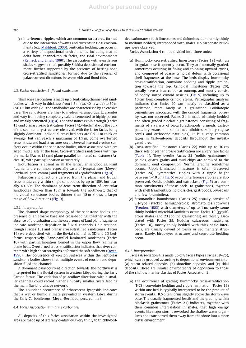
(a) Hummocky cross-stratified limestones (Facies 19) with anirregular base frequently occur. They are normally graded,sometimes occuring in fining and thinning upward cycles,and composed of coarse crinoidal debris with occasionalshell fragments at the base. The beds display hummockycross-stratification, convolute bedding and ripple lamina-tion towards the top. Crinoidal limestones (Facies 20),usually have a blue colour at outcrop, and mostly consistof poorly sorted crinoid ossicles (Fig. 5) including up to10 cm long complete crinoid stems. Petrographic analysisindicates that Facies 20 can mostly be classified as apackstone, more rarely as a grainstone. Poikilotopiccements are associated with the crinoid fragments, poros-ity was not observed. Facies 21 is made of thinly beddedand often graded bioclastic grainstones, consisting of frag-ments of a variety of biota (brachiopods, crinoids, gastro-pods, bryozoans, and sometimes trilobites, solitary rugusecorals and orthocone nautiloids). It is a very commonfacies in Carboniferous deposits throughout the investi-gated area.
(b) Cross-stratified limestones (Facies 22) with up to 30 cmthick sets of planar cross-stratification are a very rare facies(Table 1). They overlie Facies 23 (oolitic grainstones):peloids, quartz grains and mud chips are admixed to thedominant ooid composition. Normal grading sometimesoccurs. Ripple-laminated limestone is often preserved(Facies 24). Symmetrical ripples with a ripple heightbetween 1–10 cm (Fig. 5) occur, interference ripples are alsopreserved. Ooids, peloids and extraclasts (Fig. 5) are com-mon constituents of these pack- to grainstones, togetherwith shell fragments, crinoid ossicles, gastropods, bryozoansand few foraminifera.
(c) Stromatolitic boundstones (Facies 25) usually consist ofSH-type (stacked hemispheroids) stromatolites (Collenia)(Freulon, 1953) with diameters of up to 1 m; rarely somethinly bedded microbial laminites occur. Facies 10 (gypsif-erous shales) and 23 (oolitic grainstones) are closely asso-ciated with Facies 25. Nodular calcareous mudstones(Facies 18), mostly thinly bedded with thick shale inter-beds, are usually devoid of fossils or sedimentary struc-tures. Rarely, birds-eyes structures and convolute beddingoccur.
4.4.1. InterpretationFacies Association 4 is made up of 8 facies types (Facies 18–25),
which can be grouped according to depositional environment into:(a) storm related deposits, (b) shoreline deposits, and (c) tidaldeposits. These are similar environments of deposition to thoseof the shallow marine clastics of Facies Association 2.
(a) The occurrence of grading, hummocky cross-stratification(HCS), convolute bedding and ripple lamination (Facies 19)within one bed is typically interpreted to be the product ofstorm events. HCS often forms slightly above the storm wavebase. The usually fragmented fossils and the grading withinbioclastic grainstones (Facies 21) indicates, together withtheir common intercalation in shales, that high energyevents like major storms reworked the shallow water organ-isms and transported them away from the shore into a moredistal environment.
286 S. Fröhlich et al. / Journal of African Earth Sciences 57 (2010) 279–296
Author's personal copy
The depositional environment of the crinoidal limestones(Facies 20) is less easily constrained. While today crinoidsusually live in deep oceans, their primary habitat duringthe Palaeozoic probably was much shallower, on the shelf(Flügel, 2004). As the crinoidal limestiones are associatedwith Facies 20, which are grainstones with grading, a marinehigh energy environment is interpreted. As such, some of thecrinoidal limestones are interpreted to be storm beds.
(b) Facies 22–24 are interpreted as shallow marine shorelinedeposits based on the occurrence of symmetrical rippleswith bifurcations, providing evidence of wave action, planarcross-stratification within carbonate sands, interpreted aspossibly carbonate shoals, and the presence of ooids, whichwere dominantly formed in very shallow marine waters.
(c) Stromatolites and microbialites have been described from avariety of depositional environments, from supratidal todeeper water (Leinfelder and Schmid, 2000); however theydominantly form in intertidal and lagoonal environments.The stromatolites in the investigated area (Facies 25) oftenoccur together with rippled sandstones and carbonates withooids as well as gypsiferous shales; hence they probablyinhabited a lagoonal environment.Nodular calcareous mudstones (Facies 18) were deposited ina low energy marine environment. The rare occurrence ofbirds-eye structures indicates that parts of Facies 18 weredeposited in an intertidal environment.
In Table 1, two facies are described which cannot be placed inone of the facies associations: Facies 26 (oolitic sandstone with
analcite) and Facies 27 (Red mottled siltstone). The former facieswas already mentioned by previous authors (e.g. Jakovljevic,1984) (see Sections 2.4 and 5.2.3); its depositional environmentcannot yet be clearly determined. Facies 27 has a red, structurelessto mottled appearance with rootlets and is interpreted as a palae-osol, indicative of long-term subaerial exposure.
5. Outcrop descriptions
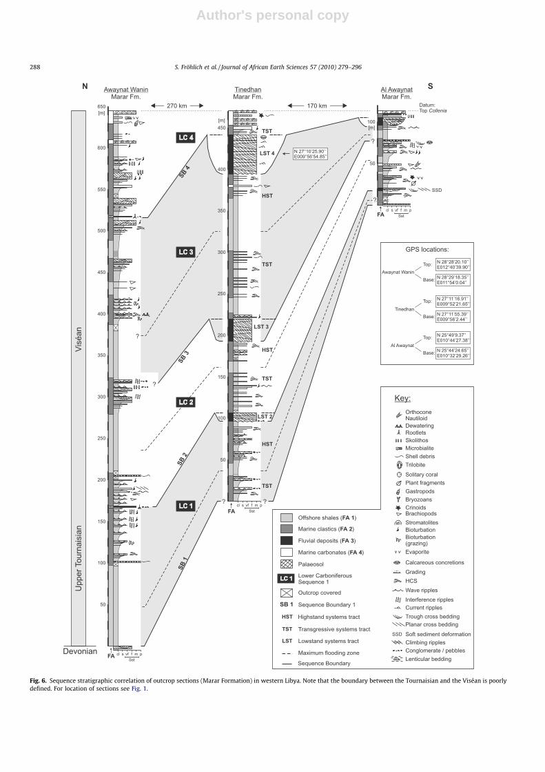
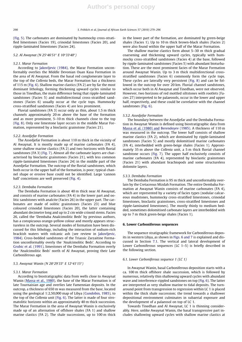
5.1. Tinedhan (N 27�1005100 E 9�5604600)
5.1.1. Marar FormationIn the Tinedhan Anticline, the Marar Formation attains a total
measured thickness of 470 m (Fig. 6). The basal contact with theunderlying formation could not be confirmed, but correlation witha biostratigraphically dated Carboniferous section from the IlliziBasin close to Tinedhan (Coquel and Massa, 1993) suggests thatthe logged interval represents a complete Marar Formation.
The main facies associations are offshore shales (FA 1) and shal-low marine clastics (FA 2), the latter dominated by hummockycross-stratified sandstones (Facies 4). Typical cycles are 5–20 mthick, comprising alternations of gradual coarsening and thicken-ing upward sandstone and green-beige shale. The top of each cycleis mostly represented by Facies 4, less often by ripple-laminatedsandstones of Facies 5. Within the Marar Formation in Tinedhanthree distinct stratigraphic horizons occur with 15–50 m thickchannelised bodies filled with fluvial sandstones (FA 3). The chan-nels erosively cut down into offshore shales and hummocky
Fig. 5. Facies Association 4 - marine carbonates. (A) Limestone layer with graded crinoidal debris (Cr) at the base and hummocky cross-stratification (HCS) above. Tinedhan,Dembaba Formation. (B) Limestone consisting of large crinoid ossicles. Al Awaynat, Dembaba Formation. (C) Limestone layer with large wave ripples. Tinedhan, AssedjefarFormation. (D) Thin section image of a sample taken from the limestone layer shown in (C). Dark extraclasts made of shale, quartz grains and a bryozoan fragment occur in agrainstone with abundant shell fragments. (E) Thickening and coarsening upward cycle of limestone layers with a planar cross-stratified limestone at the top. Tinedhan,Assedjefar Formation. (F) Thin section image of a sample taken from the limestone layer (grainstone) shown in the centre of (E). A gastropod fragment filled with shale andsome quartz grains occurs within abundant calcite cemented ooids and some peloids. (G) Thinning and fining upward cycle of limestone layers (wackestones and packstones).Tinedhan, Dembaba Formation. (H) Wave ripple-marks with bifurcations on top of a limestone layer. Tinedhan, Dembaba Formation. (I) LLH-type stromatolites (Collenia).Awaynat Wanin, top Marar Formation.
S. Fröhlich et al. / Journal of African Earth Sciences 57 (2010) 279–296 287
Author's personal copy
Fig. 6. Sequence stratigraphic correlation of outcrop sections (Marar Formation) in western Libya. Note that the boundary between the Tournaisian and the Viséan is poorlydefined. For location of sections see Fig. 1.
288 S. Fröhlich et al. / Journal of African Earth Sciences 57 (2010) 279–296
Author's personal copy
cross-stratified sandstones. Laterally, the channel sandstoneswedge out (Fig. 8) and shales overlying the channel directly reston shales from below the channel. Marine carbonates (FA 4) arevery rare and occur as 5–20 cm thick bioclastic grainstones (Facies21), dominated by brachiopods. Below the Collenia beds, the youn-gest fluvial sandstone horizon forms a several kilometre large fieldof carbonate cemented concretions up to 2 m in diameter.
5.1.2. Assedjefar FormationThe transition from the Marar to the Assedjefar Formation is
conformable and only defined by the occurrence of the Colleniabeds. The transition to the Dembaba Formation similarly is con-formable, however less clearly defined. Grubic et al. (1991) useda stromatolitic limestone as a marker for the base of the DembabaFormation, but mentioned that this horizon occurs only locally. InTinedhan, the top of the Assedjefar Formation is placed at the baseof a thick shale succession, which is in accordance with the bio-stratigraphically dated section of Coquel and Massa (1993). TheAssedjefar Formation is 220 m thick and comprises dominantlyshallow marine clastics (FA 2); however there is a gradual increasein the number of intercalations of marine carbonates (FA 4) to-
wards the top (Fig. 7). Thinly bedded bioclastic grainstones (Facies21) are very common. Hummocky cross-stratified limestones (Fa-cies 19) and ripple-laminated limestones (Facies 24) occur forthe first time within the Carboniferous succession in the upperAssedjefar Formation.
About 30 m above the Collenia beds, several fluvial channelsandstones (FA 3) occur at one stratigraphic horizon. These areusually a few meters thick and include one 24 m thick channel.Large carbonate concretions are abundant. Approximately 70 mhigher in the stratigraphic column, an approximately 2 m thick flu-vial channel occurs, which represents the youngest fluvial facies inthe Carboniferous succession.
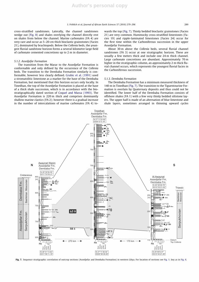
5.1.3. Dembaba FormationThe Dembaba Formation has a minimum measured thickness of
140 m in Tinedhan (Fig. 7). The transition to the Tiguentourine For-mation is overlain by Quaternary deposits and thus could not beidentified. The lower half of the Dembaba Formation consists ofoffshore shales (FA 1) with a few very thinly bedded siltstone lay-ers. The upper half is made of an alternation of blue limestone andshale layers, sometimes arranged in thinning upward cycles
Fig. 7. Sequence stratigraphic correlation of outcrop sections (Assedjefar and Dembaba Formation) in western Libya. For location of sections see Fig. 1; key as in Fig. 6.
S. Fröhlich et al. / Journal of African Earth Sciences 57 (2010) 279–296 289
Author's personal copy
(Fig. 5). The carbonates are dominated by hummocky cross-strati-fied limestones (Facies 19), crinoidal limestones (Facies 20), andripple-laminated limestones (Facies 24).
5.2. Al Awaynat (N 25�4605100 E 10�3304000)
5.2.1. Marar FormationAccording to Jakovljevic (1984), the Marar Formation uncon-
formably overlies the Middle Devonian Ouan Kasa Formation inthe area of Al Awaynat. From the basal red conglomerate layer tothe top of the Collenia beds, the Marar Formation has a thicknessof 115 m (Fig. 6). Shallow marine clastics (FA 2) are by far the mostdominant lithology, forming thickening upward cycles similar tothose in Tinedhan, the main difference being that ripple-laminatedsandstones (Facies 5) and multidirectional cross-stratified sand-stones (Facies 6) usually occur at the cycle tops. Hummockycross-stratified sandstones (Facies 4) are less prominent.
Fluvial sandstones (FA 3) occur only as thin, about 1.5 m thickchannels approximately 20 m above the base of the formationand as more prominent, 5–10 m thick channels close to the top(Fig. 8). Only one limestone layer occurs in the middle Marar For-mation, represented by a bioclastic grainstone (Facies 21).
5.2.2. Assedjefar FormationThe Assedjefar Formation is about 110 m thick in the vicinity of
Al Awaynat. It is mostly made up of marine carbonates (FA 4),some shallow marine clastics (FA 2) and two horizons with fluvialsandstones (FA 3) (Fig. 7). Almost all the carbonate layers are char-acterised by bioclastic grainstones (Facies 21), with less commonripple-laminated limestones (Facies 24) in the middle part of theAssedjefar Formation. The outcrop of the fluvial sandstones, whichboth occur in the upper half of the formation, is poor; typical chan-nel shape or erosive base could not be identified. Large ‘cannonball’ concretions are well preserved (Fig. 4).
5.2.3. Dembaba FormationThe Dembaba Formation is about 40 m thick near Al Awaynat,
and consists of marine carbonates (FA 4) in the lower part and oo-litic sandstones with analcite (Facies 26) in the upper part. The car-bonates are made of oolitic grainstones (Facies 23) and bluecoloured crinoidal limestones (Facies 20), the latter containingabundant decimetre long and up to 2 cm wide crinoid stems. Facies26, called the ‘Dembaba Analcimolitic Beds’ by previous authors,has a conspicuous orange-yellow colour and mostly appears struc-tureless in the outcrop. Several modes of formation have been dis-cussed for this lithology, including the interaction of sodium-richbrackish waters with volcanic ash (see review in Jakovljevic,1984). Cross-bedded sandstones of the Triassic Zarzaitine Forma-tion unconformably overly the ‘Analcimolitic Beds’. According toGrubic et al. (1991), limestones of the Dembaba Formation overlythe ‘Analcimolitic Beds’ north of Al Awaynat, proving their LateCarboniferous age.
5.3. Awaynat Wanin (N 28�2903300 E 12�4101500)
5.3.1. Marar FormationAccording to biostratigraphic data from wells close to Awaynat
Wanin (Massa et al., 1980), the base of the Marar Formation is oflate Tournaisian age and overlies late Famennian deposits. In theoutcrop, a thickness of 650 m was measured from the base, locatedusing the geological 1:2,50,000 map of Libya (Gundobin, 1985), tothe top of the Collenia unit (Fig. 6). The latter is made of four stro-matolitic horizons within an approximately 40 m thick succession.The Marar Formation in the area of Awaynat Wanin is exclusivelymade up of an alternation of offshore shales (FA 1) and shallowmarine clastics (FA 2). The shale successions, up to 100 m thick
in the lower part of the formation, are dominated by green-beigeshales (Facies 1). Up to 10 m thick brown-black shales (Facies 2)were also found within the upper half of the Marar Formation.
The shallow marine clastics form about 5–30 m thick gradualcoarsening and thickening upward cycles, typically with hum-mocky cross-stratified sandstones (Facies 4) at the base, followedby ripple-laminated sandstones (Facies 5) with abundant bioturba-tion. These are the most prominent facies of the Marar Formationaround Awaynat Wanin. Up to 3 m thick multidirectional cross-stratified sandstones (Facies 6) commonly form the cycle tops.These cycles are laterally very persistent (Fig. 8) and can be fol-lowed in the outcrop for over 20 km. Fluvial channel sandstones,which occur both in Al Awaynat and Tinedhan, were not observed.However, two horizons of red mottled siltstones with rootlets (Fa-cies 27) interpreted to be palaeosols, occur in the lower and upperhalf, respectively, and these could be correlative with the channelsandstones (Fig. 6).
5.3.2. Assedjefar FormationThe boundary between the Assedjefar and the Dembaba Forma-
tion in Awaynat Wanin is defined using biostratigraphic data fromMassa et al. (1980) and Berendeyev (1985). A thickness of 110 mwas measured in the outcrop. The lower half consists of shallowmarine clastics (FA 2), which are dominated by ripple-laminatedsandstones (Facies 5) and mostly dolomitised marine carbonates(FA 4), interbedded with green-beige shales (Facies 1). Approxi-mately 35 m above the Collenia unit, a 5 m thick fluvial channelsandstone occurs (Fig. 7). The upper half exclusively consists ofmarine carbonates (FA 4), represented by bioclastic grainstones(Facies 21) with abundant brachiopods and some structurelessdolomite layers.
5.3.3. Dembaba FormationThe Dembaba Formation is 95 m thick and unconformably over-
lain by the Cretaceous Mizdah Formation. The entire Dembaba For-mation at Awaynat Wanin consists of marine carbonates (FA 4),which are represented by a variety of facies types (nodular calcar-eous mudstones, hummocky cross-stratified limestones, crinoidallimestones, bioclastic grainstones, cross-stratified limestones andripple-laminated limestones). The mostly thinly to medium bed-ded, sometimes dolomitised carbonate layers are interbedded withup to 7 m thick green-beige shales (Facies 1).
6. Lower Carboniferous sequences
The sequence stratigraphic framework for Carboniferous depos-its in western Libya, as shown in Figs. 6 and 7 is explained and dis-cussed in Section 7.1. The vertical and lateral development ofLower Carboniferous sequences (LC 1–5) is briefly described inthe following section.
6.1. Lower Carboniferous sequence 1 (LC 1)
In Awaynat Wanin, basal Carboniferous deposition starts with aca. 100 m thick offshore shale succession, which is followed bynumerous, relatively thin shallowing upward cycles with abundantwave and interference-rippled sandstones on top (Fig. 6). The latterare interpreted as very shallow marine to tidal deposits. The turn-around point from transgression to regression within LC 1 is placedwithin the thick shale succession; the trend towards a shallowerdepositional environment culminates in subaerial exposure andthe development of a palaeosol on top of LC 1.
Towards Tinedhan and Al Awaynat, LC 1 is thinning consider-ably. Here, unlike Awaynat Wanin, the basal transgressive part in-cludes shallowing upward cycles with shallow marine clastics at
290 S. Fröhlich et al. / Journal of African Earth Sciences 57 (2010) 279–296
Author's personal copy
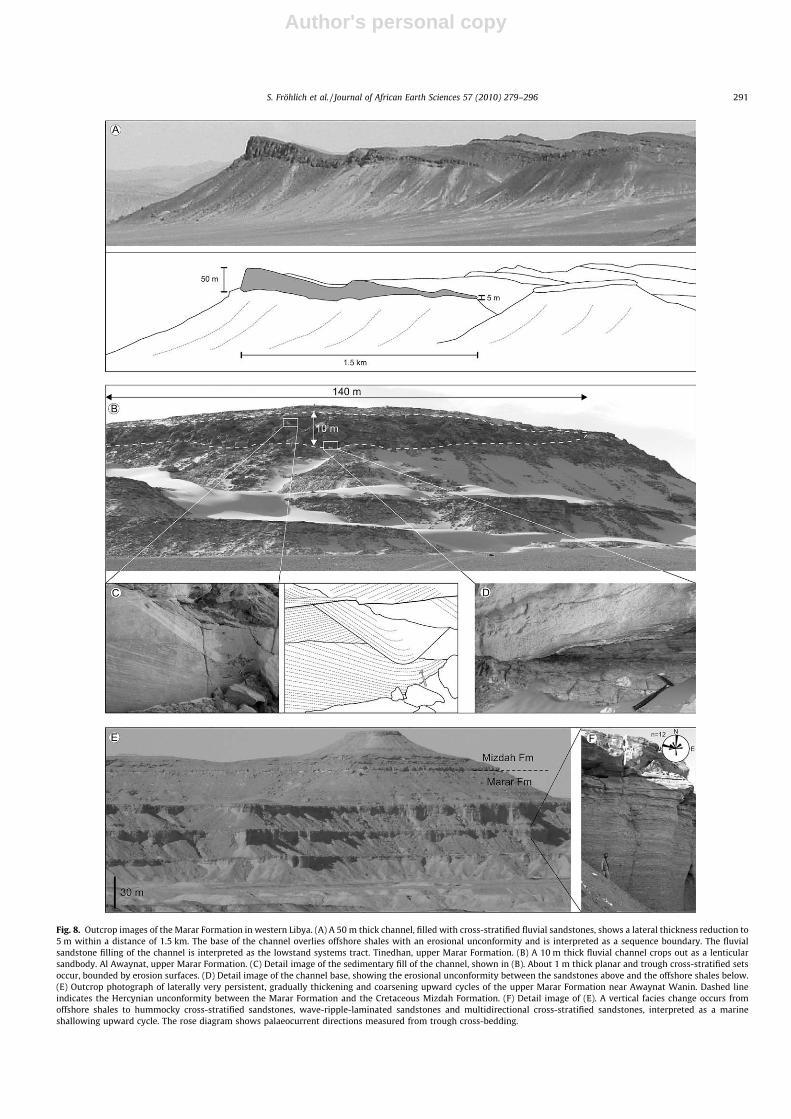
Fig. 8. Outcrop images of the Marar Formation in western Libya. (A) A 50 m thick channel, filled with cross-stratified fluvial sandstones, shows a lateral thickness reduction to5 m within a distance of 1.5 km. The base of the channel overlies offshore shales with an erosional unconformity and is interpreted as a sequence boundary. The fluvialsandstone filling of the channel is interpreted as the lowstand systems tract. Tinedhan, upper Marar Formation. (B) A 10 m thick fluvial channel crops out as a lenticularsandbody. Al Awaynat, upper Marar Formation. (C) Detail image of the sedimentary fill of the channel, shown in (B). About 1 m thick planar and trough cross-stratified setsoccur, bounded by erosion surfaces. (D) Detail image of the channel base, showing the erosional unconformity between the sandstones above and the offshore shales below.(E) Outcrop photograph of laterally very persistent, gradually thickening and coarsening upward cycles of the upper Marar Formation near Awaynat Wanin. Dashed lineindicates the Hercynian unconformity between the Marar Formation and the Cretaceous Mizdah Formation. (F) Detail image of (E). A vertical facies change occurs fromoffshore shales to hummocky cross-stratified sandstones, wave-ripple-laminated sandstones and multidirectional cross-stratified sandstones, interpreted as a marineshallowing upward cycle. The rose diagram shows palaeocurrent directions measured from trough cross-bedding.
S. Fröhlich et al. / Journal of African Earth Sciences 57 (2010) 279–296 291
Author's personal copy
the top. The maximum regression at the top of the sequence inboth areas led to the incision of fluvial channels in marine shales.
6.2. Lower Carboniferous sequence 2 (LC 2)
While a palaeosol was established in Awaynat Wanin at thebase of LC 2, the incised channels in Tinedhan and Al Awaynat werefilled with fluvial sands. The following transgression led to the cyc-lic deposition of hummocky cross-stratified (HCS) sandstones andshales in Tinedhan; the shales are slightly thickening upward. Inthe Al Awaynat area, the maximum transgression within LC 2 isplaced in a relatively thick shale succession, above a limestonebed (Fig. 6). The latter indicates minimum clastic input during LC2. Regressive deposits above are represented by shallow marineclastics and shales, whereby the shales thin upward.
6.3. Lower Carboniferous sequence 3 (LC 3)
The base of sequence LC 3 is most obvious in Tinedhan, where a27 m thick fluvial sandstone within an incised valley shows that aconsiderable regression occurred. In the south (Al Awaynat), a con-glomerate is interpreted to represent this stratigraphic level. To-wards the north (Awaynat Wanin), however, no indications ofsubaerial exposure occur but shallow marine to tidal clastics dom-inate. It is therefore interpreted that the coastline during thisregression was situated between Awaynat Wanin and Tinedhan.
Transgressive deposits of LC 3 are dominated by offshore shaleswith some intercalations of HCS sandstones in Tinedhan. After theturnaround to regressive deposition, which is situated within athick shale succession, shallow marine clastics occur with increas-ing frequency.
6.4. Lower Carboniferous sequence 4 (LC 4)
The base of this sequence is very pronounced in Al Awaynat andTinedhan, where ca. 10 m and ca. 50 m thick fluvial sandstones oc-cur within incised valleys (Fig. 6). A palaeosol developed in Away-nat Wanin during this regression. The following transgression ledto the deposition of shallow marine clastics and carbonates. Thestromatolitic marker beds (Collenia, see Section 2.2.) occur withinLC 4; they are succeeded by offshore shales. Subsequent regressionagain led to the deposition of shallow marine clastics andcarbonates.
6.5. Lower Carboniferous sequence 5 (LC 5)
In Awaynat Wanin and Tinedhan, the base of this sequence is rep-resented by fluvial channels, cutting into marine shales (Fig. 7). Thismaximum regression most-likely correlates with a conglomerate inAl Awaynat. During the following transgression, marine carbonateswere more and more deposited throughout the investigated areaand shallow marine clastics became rare. The middle of a relativelythick offshore shale succession is interpreted as the turnaround fromtransgression to regression; shallow marine carbonates are domi-nating the upper, regressive part of LC 5.
7. Discussion
7.1. Sequence stratigraphy
According to Carr (2002), the base and the top of Carboniferousdeposits represent second-order sequence boundaries throughoutNorth Africa. These two sequence boundaries are very prominentin parts of western Libya. A minor unconformity between upperFamennian and upper Tournaisian rocks can be recognised west
of Awaynat Wanin (Massa et al., 1980), and a major unconformitybetween the Silurian Tanezzuft Formation and upper Tournaisianrocks occurs between Tinedhan and Al Awaynat (Protic, 1984).The unconformity at the top of Carboniferous strata is related tothe Hercynian Orogeny.
This study provides good sedimentological evidence for a num-ber of higher order sequence boundaries within Carboniferousstrata in western Libya. The Marar and Assedjefar Formations (lateTournaisian to late Serpukhovian) are subdivided into five se-quences, which are separated by unconformities interpreted tobe created by relative sea-level falls. This led to subaerial exposureand a repeated establishment of a fluvial channel system on the ex-posed shelf.
In Tinedhan, fluvial channel sandstones erosively cut down15 m and 50 m into offshore marine or storm deposits (Fig. 6).The bases of the fluvial channels are interpreted as third-order se-quence boundaries; the fluvial sandstone fill records depositionduring the lowstand systems tract. Palaeosols were not found onthe interfluves in Tinedhan, which indicates that transgression atthe base of the transgressive systems tract (TST) probably had en-ough energy to erode any palaeosols that were developed and pos-sibly the upper part of the fluvial sandstones. According toPosamentier and Allen (1999), a transgressing shoreline can erodeup to 20 m of sediment in areas of high wave energy. In the inter-fluves at Tinedhan, offshore shales containing storm deposits inter-preted to be part of the basal TST overlie the same sedimentaryfacies from the upper highstand systems tract (HST). So in theinterfluve areas, the sequence boundary and the transgressive sur-face are identical. It can be recognised by a thin pebble lag.
Facies development within the HSTs and TSTs is very similar.However, the stacking pattern of the cycles typically shows thin-ning upward sandstone beds in the TST and thickening upwardin the HST. Distinct maximum flooding surfaces could not be deter-mined in the field; instead, the middle of the thickest shale succes-sion, located at the top of the thinning upward trend of thesandstone beds, is interpreted as a maximum flooding zone.
Following SB 1 at the base of the Carboniferous, three sequenceboundaries occur within the Marar Formation (SB 2–SB 4) (Fig. 6).Biostratigraphic data (e.g. Massa et al., 1980; Coquel and Massa,1993; Mergl and Massa, 2000) suggest that they all occur withinthe Viséan. One sequence boundary (SB 5) was identified withinthe Serpukhovian lower Assedjefar Formation (Fig. 7). There wasno sedimentological evidence of subaerial exposure or significanterosion within the Dembaba Formation, and as such no sequenceboundaries could be recognised.
The expression of SB 2 and SB 4 in Al Awaynat is similar to thatin Tinedhan, however, the fluvial channel sandstones are thinner.SB 3 and SB 5 correlate with conglomeratic layers interpreted astransgressive lags.
In Awaynat Wanin, SB 2 and SB 4 are defined by palaeosols con-sisting of red, mottled siltstones with rootlets (Facies 27). In be-tween these two sequence boundaries, no evidence for subaerialexposure was observed, and as such a correlative conformity toSB 3 is interpreted at this locality.
7.2. Palaeogeographic implications
Western Libya was located in a dominantly marine setting on astable platform during the Early Carboniferous, with a transition toan exposed continental landmass towards the south (Guiraud et al.,2005). Slope and deep-water deposition took place in the area fromnorthern Tunisia to central Morocco. Results from this study con-firm that the majority of sediments from late Tournaisian toMoscovian times were deposited in a shallow marine environment.However, the identification of sequence boundaries with evidencefor significant erosion, fluvial deposition and/or palaeosols indicates
292 S. Fröhlich et al. / Journal of African Earth Sciences 57 (2010) 279–296
Author's personal copy
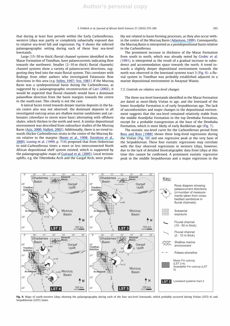
that during at least four periods within the Early Carboniferous,western Libya was partly or completely subaerially exposed dueto relative sea-level fall and regression. Fig. 9 shows the inferredpalaeogeographic setting during each of these four sea-levellowstands.
Large (15–50 m thick) fluvial channel systems identified in theMarar Formation of Tinedhan, have palaeocurrents indicating flowtowards the northwest. Smaller (2–10 m thick) fluvial channels/channel systems show a variety of palaeocurrent directions, sug-gesting they feed into the main fluvial system. This correlates withfindings from other authors who investigated Palaeozoic flowdirections in this area (e.g. Selley, 1997; Vos, 1981). If the MurzuqBasin was a syndepositional basin during the Carboniferous, assuggested by a palaeogeographic reconstruction of Carr (2002), itwould be expected that fluvial channels would have a dominantpalaeoflow direction from the basin margins towards the centreto the south-east. This clearly is not the case.
A lateral facies trend towards deeper marine deposits in the ba-sin centre also was not observed: the dominant deposits in allinvestigated outcrop areas are shallow marine sandstones and car-bonates (shoreface to storm wave base) alternating with offshoreshales, which thicken to the north and west. A similar depositionalenvironment was described from subsurface studies of the MurzuqBasin (Aziz, 2000; Hallett, 2002). Additionally, there is no trend to-wards thicker Carboniferous strata in the centre of the Murzuq Ba-sin relative to the margins (Boote et al., 1998; Davidson et al.,2000). Luning et al. (1999, p. 714) proposed that from Ordovicianto mid-Carboniferous times a more or less interconnected NorthAfrican depositional shelf system existed, which is supported bythe palaeogeographic maps of Guiraud et al. (2005). Local tectonicuplifts, e.g. the Tihemboka Arch and the Gargaf Arch, were proba-
bly not related to basin forming processes, as they also occur with-in the centre of the Murzuq Basin (Adamson, 1999). Consequently,the Murzuq Basin is interpreted as a postdepositional basin relativeto the Carboniferous.
The prominent increase in thickness of the Marar Formationfrom south to north, which was already noted by Grubic et al.(1991), is interpreted as the result of a gradual increase in subsi-dence and accommodation space towards the north. A trend to-wards a slightly deeper depositional environment towards thenorth was observed in the lowstand systems tract 3 (Fig. 9): a flu-vial system in Tinedhan was probably established adjacent to amarine depositional environment in Awaynat Wanin.
7.3. Controls on relative sea-level changes
The three sea-level lowstands identified in the Marar Formationare dated as most-likely Viséan in age, and the lowstand of thelower Assedjefar Formation is of early Serpukhovian age. The lackof unconformities and major changes in the depositional environ-ment suggests that the sea-level remained relatively stable fromthe middle Assedjefar Formation to the top Dembaba Formation,except for a probable transgression at the base of the DembabaFormation, which is most likely of early Bashkirian age (Fig. 7).
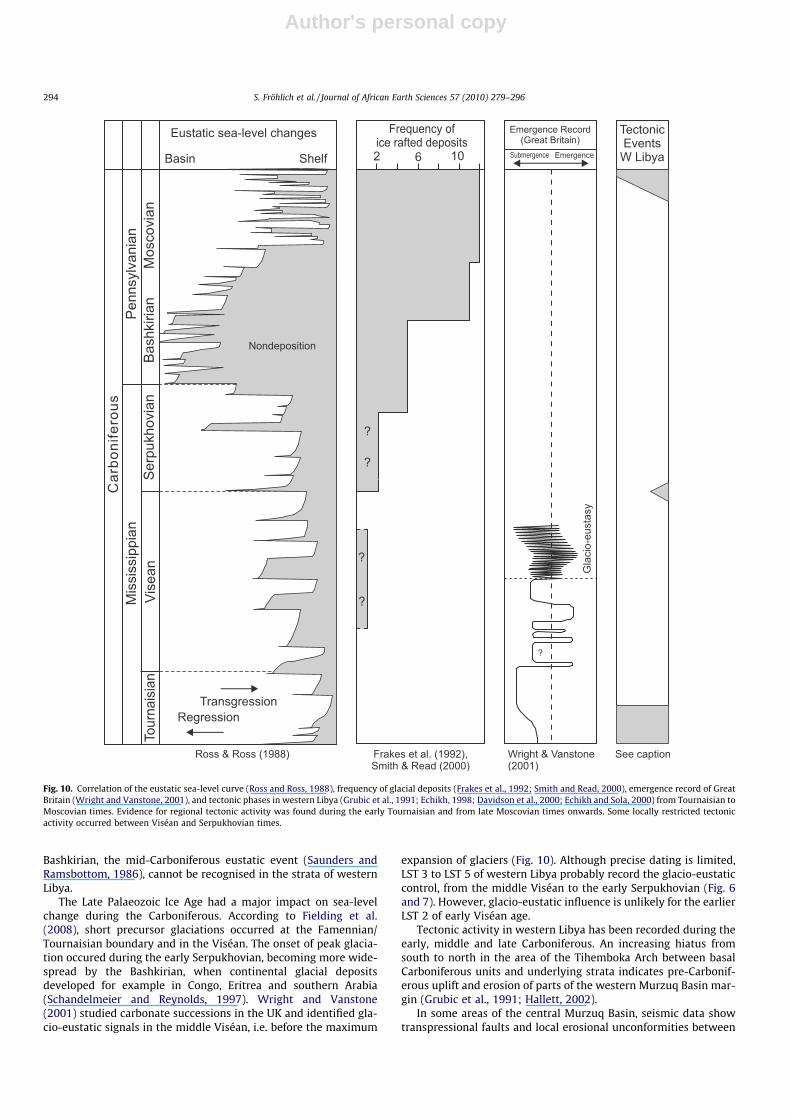
The eustatic sea-level curve for the Carboniferous period fromRoss and Ross (1988) shows three long-lived regressions duringthe Viséan (Fig. 10) and one regressive peak at the very base ofthe Serpukhovian. These four eustatic regressions may correlatewith the four observed regressions in western Libya, however,due to the lack of detailed biostratigraphic data from Libya at thistime this cannot be confirmed. A prominent eustatic regressivepeak in the middle Serpukhovian and a major regression in the
Fig. 9. Maps of south-western Libya showing the palaeogeography during each of the four sea-level lowstands, which probably occurred during Viséan (LST2–4) andSerpukhovian (LST5) times.
S. Fröhlich et al. / Journal of African Earth Sciences 57 (2010) 279–296 293
Author's personal copy
Bashkirian, the mid-Carboniferous eustatic event (Saunders andRamsbottom, 1986), cannot be recognised in the strata of westernLibya.
The Late Palaeozoic Ice Age had a major impact on sea-levelchange during the Carboniferous. According to Fielding et al.(2008), short precursor glaciations occurred at the Famennian/Tournaisian boundary and in the Viséan. The onset of peak glacia-tion occured during the early Serpukhovian, becoming more wide-spread by the Bashkirian, when continental glacial depositsdeveloped for example in Congo, Eritrea and southern Arabia(Schandelmeier and Reynolds, 1997). Wright and Vanstone(2001) studied carbonate successions in the UK and identified gla-cio-eustatic signals in the middle Viséan, i.e. before the maximum
expansion of glaciers (Fig. 10). Although precise dating is limited,LST 3 to LST 5 of western Libya probably record the glacio-eustaticcontrol, from the middle Viséan to the early Serpukhovian (Fig. 6and 7). However, glacio-eustatic influence is unlikely for the earlierLST 2 of early Viséan age.
Tectonic activity in western Libya has been recorded during theearly, middle and late Carboniferous. An increasing hiatus fromsouth to north in the area of the Tihemboka Arch between basalCarboniferous units and underlying strata indicates pre-Carbonif-erous uplift and erosion of parts of the western Murzuq Basin mar-gin (Grubic et al., 1991; Hallett, 2002).
In some areas of the central Murzuq Basin, seismic data showtranspressional faults and local erosional unconformities between
Fig. 10. Correlation of the eustatic sea-level curve (Ross and Ross, 1988), frequency of glacial deposits (Frakes et al., 1992; Smith and Read, 2000), emergence record of GreatBritain (Wright and Vanstone, 2001), and tectonic phases in western Libya (Grubic et al., 1991; Echikh, 1998; Davidson et al., 2000; Echikh and Sola, 2000) from Tournaisian toMoscovian times. Evidence for regional tectonic activity was found during the early Tournaisian and from late Moscovian times onwards. Some locally restricted tectonicactivity occurred between Viséan and Serpukhovian times.
294 S. Fröhlich et al. / Journal of African Earth Sciences 57 (2010) 279–296
Author's personal copy
the Marar and Assedjefar Formations which are related to mid-Car-boniferous compression (Davidson et al., 2000; Echikh and Sola,2000). However, mid-Carboniferous tectonic movements seem tobe restricted to a few local areas and not regional in extent. Signif-icant tectonic unconformities or evidence of structural movementswere not observed in outcrops examined in this study.
The main Hercynian tectonic phase started during the Late Car-boniferous and Early Permian and strongly affected sedimentarybasins throughout North Africa (Boote et al., 1998). In western Li-bya the early precursor to this tectonism and regional inversion re-sulted in the transition from marine deposition in the DembabaFormation to continental deposition in the Tiguentourine Forma-tion with eventual large-scale emergence and non-deposition dur-ing the Permian. The Illizi and Ghadames Basins were moresignificantly affected by regional tilting than the Murzuq Basin(Echikh, 1998; Davidson et al., 2000). During the deposition ofthe Marar, Assedjefar and Dembaba Formations there was little re-corded tectonic activity except for a brief and locally restrictedphase between the Marar and Assedjefar Formations. Tectonicmovements are thus not considered to be the main control on re-peated large-scale emergence of western Libya during the EarlyCarboniferous. The relative sea-level fall and associated emergenceof highstand deposits and subsequent incision of a fluvial systemwere most-likely controlled by eustatic changes in sea-level.
7.4. Controls on the transition from a siliciclastic to a carbonatedepositional environment
The Marar Formation in western Libya consists of siliciclasticdeposits with very few intercalated carbonate layers. Within theAssedjefar Formation, the ratio of carbonate to siliciclastic in-creases steadily until there is almost only carbonate depositionin the Dembaba Formation. Sedimentary structures and stackingpatterns would suggest that the dominant water depth and depo-sitional environment, however, remains very similar: siliciclasticstorm and shoreline deposits are replaced by carbonate stormand shoreline deposits.
The major climate change during the Carboniferous period ex-pressed by the onset of the Late Palaeozoic Ice Age is well docu-mented (e.g. Veevers and Powell, 1987; Fielding et al., 2008).Temperatures in Africa were probably cooling during the earlyBashkirian, as indicated by the development of continental glacialdeposits in Congo, Eritrea and southern Arabia (Schandelmeier andReynolds, 1997). The Carboniferous fauna in western Libya are atypical heterozoan assemblage and thus could have lived in warmor cold waters. Hence temperature change alone is an unlikely rea-son for the onset of carbonate production.
The source of the siliciclastic sediments, i.e. the exposed land tothe south, probably remained in about the same position relativeto the area of deposition in western Libya from Tournaisian toMoscovian times (Guiraud et al., 2005).
This suggests that it is unlikely that changes in water depth, dis-tance to source area and temperature changes were the main con-trols on a change from a dominantly siliciclastic to a carbonatedepositional system.
A possible control could be the reduction of clastic sedimenttransport from the hinterland to the shelf from the Viséan to theBashkirian, either linked to a local increase in aridity and/or tothe gradual erosion and decreasing topography of the hinterlandmountains. An example for this mechanism can be found in Ceno-zoic deposits of the southern Australian shelf (James and von derBorch, 1991). Of special interest are the studies of Raymond et al.(1985) and Wright (1990) who propose seasonal high humidityin northern Gondwana during the Early Carboniferous due to a ma-jor low pressure zone which drew in equatorial air. This theory issupported by the occurrence of arborescent lycopsids in the Marar
and Assedjefar Formations which indicates that a wet or humid cli-mate prevailed in western Libya during the Early Carboniferous(Meyer-Berthaud, pers. comm.) It is hypothesised that the consid-erable climate changes due to the collision of Gondwana and Lau-russia and the onset of Late Carboniferous icehouse conditions ledto increased aridity over northern Gondwana and thus the transi-tion from siliciclastic to carbonate dominated sedimentation dueto a strongly reduced clastic discharge into the basin.
8. Conclusions
This study uses outcrop information from the central Sahara todocument the changes in the sedimentary system of northernGondwana during the Carboniferous.
The main conclusions are:
1. Lower Carboniferous deposits of western Libya consist of fivedepositional sequences, which are divided by 3rd ordersequence boundaries.
2. The lowstand systems tracts are expressed as 1.5 m thick (ca.40 m wide) to 50 m thick (ca. 1.5 km wide) incised channel sys-tems filled entirely with fluvial sandstones. The dominant pal-aeoflow direction of large channels (thicker than 15 m) istowards northwest; smaller channels show a variety of palaeo-flow directions, suggesting they feed into the main fluvialsystem.
3. Sea-level lowstand led to the exposure of most of the westernLibyan shelf three times during the Viséan and once duringthe early Serpukhovian.
4. Both the transgressive (TST) and highstand (HST) systems tractsof the Lower Carboniferous are dominantly made up of shallowmarine, siliciclastic storm and shoreline deposits alternatingwith offshore shales. TSTs typically show a thinning upwardof the sandstone units, while HSTs show a thickening upwardof sandstone units.
5. Deposition of carbonate sediments gradually increased duringthe Serpukhovian. Bashkirian and Moscovian strata are domi-nated by shallow marine, calcareous storm and shorelinedeposits. These are predominantly made up of fragments of aheterozoan fauna in addition to ooids, peloids, extraclasts andquartz grains. Carbonate buildups are absent.
6. There is no evidence for significant tectonic activity in theregion, suggesting that in western Libya, relative sea-levelchanges during the Carboniferous were dominantly controlledby eustasy.
7. The Murzuq Basin was most-likely interconnected with theGhadames Basin during the Carboniferous. With regard to theCarboniferous interval, it is a postdepositional basin. The palae-ogeographic trend is towards a gradually deepening deposi-tional environment towards the north during the lateTournaisian and Viséan.
8. The gradual transition from a clastic dominated depositionalenvironment during the late Tournaisian and Viséan to a car-bonate depositional environment during the Bashkirian andMoscovian is interpreted to record the local increase in aridityand/or decreasing topography of the clastic source area in thehinterland.
Acknowledgements
We are grateful to the sponsors of the North Africa ResearchGroup for financial support. Woodside Energy N.A. provided addi-tional financial and logistical support in the field. The help of J.Guest, K. Morisson and T. Rehill (all Woodside Energy) is especially
S. Fröhlich et al. / Journal of African Earth Sciences 57 (2010) 279–296 295
Author's personal copy
acknowledged. We like to thank B. Meyer-Berthaud (Montpellier)for identifying plant samples, and D. Korn (Berlin) for identifyingcephalopods. The suggestions of the reviewers D. Hallett and S.Lüning improved the paper, which is gratefully acknowledged.
References
Abugares, Y.I., 2003. The Petroleum geology of the Palaeozoic clastics of the MurzuqBasin, Al’Atshan saddle and the southern part of the Ghadames Basin, Libya. In:Salem, M.J., Oun, K.M. (Eds.), The Geology of Northwest Libya. Earth ScienceSociety of Libya, Tripoli, pp. 213–244.
Adamson, K., 1999. Evolution of the Murzuq Basin, southwest Libya, andsurrounding region during the Devonian. Ph.D. Thesis, Univ. of Wales,Aberystwyth.
Aziz, A., 2000. Stratigraphy and hydrocarbon potential of the lower Palaeozoicsuccession of licence NC 115, Murzuq Basin, SW Libya. In: Sola, M.A., Worsley,D. (Eds.), Symposium on Geological Exploration in Murzuq Basin. Elsevier,Amsterdam, pp. 349–368.
Belhaj, F., 2000. Carboniferous and devonian stratigraphy – the M’rar and Tadrartreservoirs, Ghadames Basin, Libya. In: Sola, M.A., Worsley, D. (Eds.), GeologicalExploration in Murzuq Basin. Elsevier Science B.V., pp. 117–142.
Bellini, E., Massa, D., 1980. A Stratigraphic contribution to the Palaeozoic of thesouthern Basins of Libya. In: Salem, M.J., Busrewil, M.T. (Eds.), The Geology ofLibya. Academic Press, London, pp. 3–56.
Berendeyev, N.S., 1985. Sheet Hamadat Tanghirt (NH 32–16), Geological Map ofLibya, Scale 1:2,50,000, Explanatory Booklet. Industrial Research Centre, Tripoli.
Boote, D.R.D., Clark-Lowes, D.D., Traut, M.W., 1998. Palaeozoic petroleum systemsof North Africa. In: MacGregor, D.S., Moody, R.T.J., Clark-Lowes, D.D. (Eds.),Petroleum Geology of North Africa. Geological Society, London, pp. 7–68.Special publication.
Carr, I.D., 2002. Second-order sequence stratigraphy of the Palaeozoic of NorthAfrica. J. Petrol. Geol. 25 (3), 259–280.
Coquel, R., Massa, D., 1993. Apropos d’evenements palynologiques du Carbonifereinferieur (=Mississippien) d’Afrique du Nord. Ann. Soc. Geol. Nord 2, 145–152.
Davidson, L., Beswetherick, S., Craig, J., Eales, M., Fisher, A., Himmali, A., Jho, J.,Mejrab, B., Smart, J., 2000. The structure, stratigraphy and petroleum geology ofthe Murzuq Basin, southwest Libya. In: Sola, M.A., Worsley, D. (Eds.), GeologicalExploration in Murzuq Basin. Elsevier Science B.V., pp. 295–320.
Dumas, S., Arnott, R.W.C., 2006. Origin of hummocky and swaley cross-stratification– the controlling influence of unidirectional current strength and aggradationrate. Geology 34 (12), 1073–1076.
Echikh, K., 1998. Geology and hydrocarbon occurrences in the Ghadames Basin,Algeria, Tunisia, Libya. In: MacGregor, D.S., Moody, R.T.J., Clark-Lowes, D.D.(Eds.), Petroleum Geology of North Africa. Geological Society, London, pp. 109–129. Special publication.
Echikh, K., Sola, M.A., 2000. Geology and hydrocarbon occurrences in the MurzuqBasin, SW Libya. In: Sola, M.A., Worsley, D. (Eds.), Geological Exploration inMurzuq Basin. Elsevier Science B.V., pp. 175–222.
Fabre, J., 1970. Le Paleozoique terminal a facies gres rouge au Sahara central etoccidental. C.R. 6eme Congr. Int. Stratigr. Geol. Carbonifere (Sheffield, 1967) 2,737–744.
Fielding, C., Frank, T.D., Isbell, J.L., 2008. Timing, Duration and Character ofGlaciation During the Late Paleozoic Ice Age. AAPG Annual Convention andExhibition, Abstracts Volume, San Antonio, p. 59.
Flügel, E., 2004. Microfacies of Carbonate Rocks. Springer, Berlin. p. 976.Frakes, L.A., Francis, J.E., Syktu, J.I., 1992. Climate Modes of the Phanerozoic.
University Press, Cambridge. 274 pp.Freulon, J.M., 1953. Existance d’un niveau a stromatolites (Collenia) dans le
Carbonifere marin du Sahara Oriental. Societe Geologique de France, C.R.Somm. Seanc. 11–12, 233–234.
Galecic, M., 1984. Sheet Anay (NG 32–16), Geological Map of Libya, Scale 1:2,50,000,Explanatory Booklet. Industrial Research Center, Tripoli.
Grubic, A., Dimitrijevic, M., Galecic, M., Jakovljevic, Z., Momarnicki, S., Protic, D.,Radulovic, P., Roncevic, G., 1991. Stratigraphy of western Fezzan (SW Libya). In:Salem, M.J., Belaid, M.N. (Eds.), The Geology of Libya. Academic Press, London,pp. 1529–1564.
Guiraud, R., Bosworth, W., Thierry, J., Delplanque, A., 2005. Phanerozoic geologicalevolution of northern and central Africa: an overview. J. African Earth Sci. 43 (1–3), 83–143.
Gundobin, V.M., 1985. Sheet Qararat al Marar (NH 33–13), Geological Map of Libya,Scale 1:2,50,000, Explanatory Booklet. Industrial Research Center, Tripoli.
Hallett, D., 2002. Petroleum Geology of Libya. Elsevier B.V., Amsterdam. p. 503.Jakovljevic, Z., 1984. Sheet Al Awaynat (NG 32–12), Geological Map of Libya, scale
1:2,50,000, Explanatory Booklet. Industrial Research Center, Tripoli.James, N.P., von der Borch, C.C., 1991. Carbonate shelf edge off southern Australia: a
prograding open-platform margin. Geology 19, 1005–1008.Klitzsch, E., 1963. Geology of the north-east flank of the Murzuk basin (Djebel Ben
Ghenema – Dor El Gussa area). Rev. Inst. Fr. Petrole 18, 1411–1427.Klitzsch, E., 1970. Die Strukturgeschichte der Zentralsahara. Neue Erkenntnisse zum
Bau und zur Palaeogeographie eines Tafellandes. Geol. Rundschau 59, 459–527.Krumbeck, L., 1906. Beiträge zur Geologie und Paleontologie von Tripolis.
Palaeontographica 53.
Lapparent, A.F., Lelubre, M., 1948. Interpretation stratigraphique des seriescontinentales entre Ohanet et Bourharet (Sahara central). C.R. Acad. Sci. Paris227, 1106–1108.
Leinfelder, R.R., Schmid, D.U., 2000. Mesozoic reefal thrombolites and othermicrobialites. In: Riding, R.E., Awramik, S.M. (Eds.), Microbial Sediments.Springer, New York, pp. 289–294.
Lelubre, M., 1948. La Paleozoique du Fezzan sudoriental. Compte Rendus Soc. Geol.France 18, 79–81.
Lelubre, M., 1952. Apercu sur la geologie du Fezzan. Bull. Serv. de la carte Geol.d’Algeri. Traveaux Recent. Collaborateurs 3, 109–148.
Luning, S., Craig, J., Fitches, B., Mayouf, J., Busrewil, A., El Dieb, M., Gammudi, A.,Loydell, D.K., McIlroy, D., 1999. Re-evaluation of the petroleum potential of theKufra Basin (SE Libya, NE Chad): does the source rock barrier fall? Marine Petrol.Geol. 16, 693–718.
Makhlouf, I.M., 2000. Early Triassic intertidal/subtidal patterns of sedimentationalong the southern margins of the Tethyan seaway, Jordan. J. Asian Earth Sci. 18(5), 513–518.
Massa, D., Termier, G., Termier, H., 1974. Le Carbonifere de Libye occidentale:stratigraphie et paleontologie. Notes et Mem. � Comp. Franc. Petroles 11, 139–206.
Massa, D., Coquel, R., Loboziak, S., Taugourdeau-Lantz, J., 1980. Essai de synthesestratigraphique et palynologique du Carbonifere en Libye occidentale. Ann. Soc.Geol. Nord 99, 429–442.
McKerrow, W.S., Mac Niocaill, C., Ahlberg, P.E., Clayton, G., Cleal, C.J., Eagar, M.C.,2000. The Late Palaeozoic relations between Gondwana and Laurussia. In:Franke, W., Haak, V., Oncken, O., Tanner, D. (Eds.), Orogenic Processes:Quantification and Modelling in the Variscan Belt. Geological Society, London,pp. 9–20. Special publications.
Menning, M., Alekseev, A.S., Chuvashov, B.I., Davydov, V.I., Devuyst, F.X., Forke, H.C.,Grunt, T.A., Hance, L., Heckel, P.H., Izokh, N.G., Jin, Y.G., Jones, P.J., Kotlyar, G.V.,Kozur, H.W., Nemyrovska, T.I., Schneider, J.W., Wang, X.D., Weddige, K., Weyer,D., Work, D.M., 2006. Global time scale and regional stratigraphic referencescales of Central and West Europe, East Europe, Tethys, South China, and NorthAmerica as used in the Devonian–Carboniferous–Permian correlation chart2003 (DCP 2003). Palaeogeogr., Palaeoclimatol., Palaeoecol. 240 (1–2), 318–372.
Mergl, M., Massa, D., 2000. A Palaeontological review of the Devonian andCarboniferous succession of the Murzuq Basin and the Djado Sub-Basin. In:Sola, M.A., Worsley, D. (Eds.), Geological Exploration in Murzuq Basin. ElsevierScience B.V., pp. 41–88.
Owen, G., 1996. Experimental soft-sediment deformation: structures formed by theliquefaction of unconsolidated sands and some ancient examples.Sedimentology 43 (2), 279–293.
Posamentier, H.W., Allen, G.P., 1999. Siliciclastic Sequence Stratigraphy – Conceptsand Applications. Concepts in Sedimentology and Paleontology, vol. 7. SEPM,Tulsa, p. 204.
Protic, D., 1984. Sheet Tikiumit (NG 32–7), Geological Map of Libya, Scale1:2,50,000, Explanatory Booklet. Industrial Research Center, Tripoli.
Raymond, A., Parker, W.C., Totman Parrish, J., 1985. Phytogeography andpalaeoclimate of the Early Carboniferous. In: Tiffney, B.H. (Ed.), GeologicalFactors and the Evolution of Plants. Yale University Press, New Haven, pp. 169–222.
Reineck, H.-E., Singh, I.B., 1980. Depositional sedimentary environments. SpringerVerlag, Berlin. p. 549.
Ross, C.A., Ross, J.R.P., 1988. Late Paleozoic transgressive–regressive deposition. In:Wilgus, C.W. (Ed.), Sea-Level Changes – An Integrated Approach. SEPM, pp. 227–247, Special publications 42.
Saunders, W.B., Ramsbottom, W.H.C., 1986. The mid-Carboniferous eustatic event.Geology 14, 208–212.
Schandelmeier, H., Reynolds, P.O., 1997. Palaeogeographic-Palaeotectonic Atlas ofNorth-Eastern Africa, Arabia and Adjacent Areas. Balkema, Rotterdam. p. 160.
Scotese, C.R., 2000. PALEOMAP Project. <www.scotese.com>.Selley, R.C., 1997. The sedimentary basins of Northwest Africa: Stratigraphy and
sedimentation. In: Selley, R.C. (Ed.), African Basins, vol. 3. Elsevier, Amsterdam,pp. 3–16. Sedimentary Basins of the World.
Smith, L.B., Read, J.F., 2000. Rapid onset of late Paleozoic glaciation on Gondwana:evidence from Upper Mississippian strata of the Midcontinent, United States.Geology 28 (3), 279–282.
Tait, J., Schaetz, M., Bachtadse, V., Soffel, H., 2000. Palaeomagnetism and Palaeozoicpalaeogeography of Gondwana and European terranes. In: Franke, W., Haak, V.,Oncken, O., Tanner, D. (Eds.), Orogenic Processes: Quantification and Modellingin the Variscan Belt. Geological Society, London, pp. 21–34. Special publications.
Vachard, D., Massa, D., 1984. The Carboniferous of western Libya. In: Sutherland,P.K., Manger, W.L. (Eds.), Biostratigraphy. International Congress onCarboniferous Stratigraphy and Geology, pp. 165–174.
Veevers, J.J., Powell, C., 1987. Late Paleozoic glacial episodes in Gondwanalandreflected in transgressive–regressive depositional sequences in Euramerica.Geol. Soc. Am. Bull. 98, 475–487.
Vos, R.G., 1981. Deltaic sedimentation in the Devonian of western Libya. Sediment.Geol. 29, 67–88.
Whitbread, T., Kelling, G., 1982. Mrar Formation of western Libya – evolution of anearly Carboniferous delta system. AAPG Bull. 66 (8), 1091–1107.
Wright, V.P., 1990. Equatorial aridity and climatic oscillations during the EarlyCarboniferous, southern Britain. J. Geol. Soc., London 147, 359–363.
Wright, V.P., Vanstone, S.D., 2001. Onset of Late Palaeozoic glacio-eustasy and theevolving climates of low latitude areas: a synthesis of current understanding. J.Geol. Soc. London 158 (4), 579–582.
296 S. Fröhlich et al. / Journal of African Earth Sciences 57 (2010) 279–296
Related Documents