SEDIMENT MANAGEMENT AND CONTROL PLAN IN RIVER BASIN Profesor Dr Aminuddin Ab. Ghani Invited Lecture National Hydraulic Research Institute Malaysia (NAHRIM) 7 May 2015

Welcome message from author
This document is posted to help you gain knowledge. Please leave a comment to let me know what you think about it! Share it to your friends and learn new things together.
Transcript

SEDIMENT MANAGEMENT AND CONTROL PLAN IN RIVER BASIN
Profesor Dr Aminuddin Ab. Ghani
Invited LectureNational Hydraulic Research Institute Malaysia
(NAHRIM)
7 May 2015

W e l e a d
CURRENT ISSUES


W e l e a d

W e l e a d
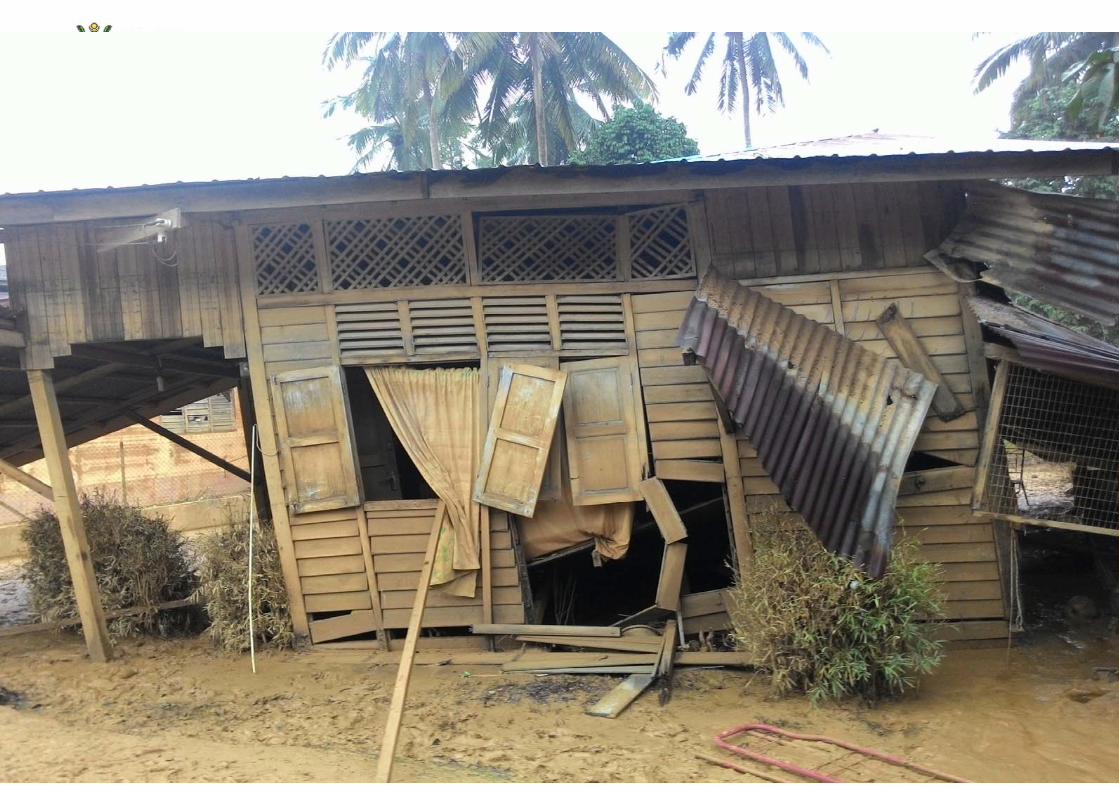


2007 Sungai Pahang Flood
9

15 December 2007 (Second time after 1971 flood)

W e l e a dPotential Scour in River
Type of scour
Local scourContraction scourGeneral scour

W e l e a d
Pier scour Pier scour
Pier scour
Bridge Failure

W e l e a d
Abutment scour Abutment scour
Bridge Failure

W e l e a d
Bridge Failure
Sungai Nenggiri, Gua Musang
Destroyed by floating debris during Dec 2014 flood

W e l e a d
Bridge Failure
Sungai Tanum, Kuala Lipis
Abutment scour during Dec 2014 flood

W e l e a dLocal Scour at Piers

W e l e a d
Uniform Abutment (Without Foundation)
Local Scour at Abutment

W e l e a d
Compound Abutment (With Foundation)
Local Scour at Abutment
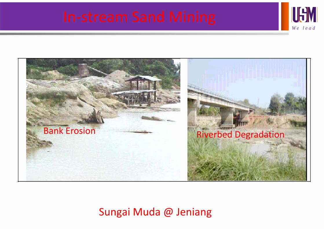
W e l e a dIn‐stream Sand Mining
Sungai Muda @ Jeniang
Bank Erosion Riverbed Degradation

W e l e a d
SEDIMENT TRANSPORT IN RIVERS

W e l e a d
The Fluvial System
W e l e a d
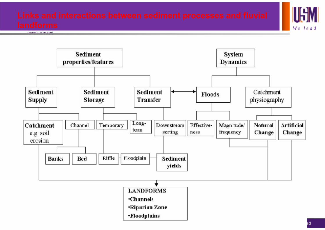
Links and interactions between sediment processes and fluviallandforms

W e l e a d
Natural and anthropogenic catchment and river processesaffecting sediment dynamics

W e l e a d
Sediment movement through the system

W e l e a d
Sediment sources througha river catchment

W e l e a dMeandering River

W e l e a d
Sungai Pahang, Pekan
Mississippi river
Sand Deposition

W e l e a d
Sand Deposition

W e l e a d
A stream may then be classified as either stable or unstable. Achannel that has adjusted dependent variables to accommodatethe basin inputs (independent variables) is said to be stable.Mackin (1948) gave the following definition of a graded or stablestream:
A graded stream is one in which, over a period of years,slope is delicately adjusted to provide, with availabledischarge and with prevailing channel characteristics,just the velocity required for the transportation of theload supplied from the drainage basin. The gradedstream is a system in equilibrium.
Stable or Graded River

W e l e a dStable or Graded River
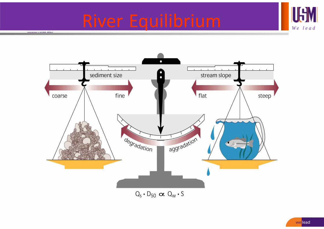
W e l e a dRiver Equilibrium

Bed Material
Bed Load
Suspended Load
Wash Load
Total Bed Material Load
Total Load
Modes of Sediment Transport

W e l e a dIncipient Motion ‐ Shields Diagram(Nalluri & Featherstone 2001)
o = co = c
o = gRSo
W e l e a d
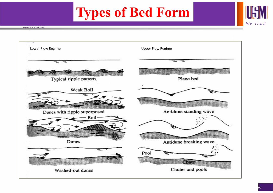
Lower Flow Regime Upper Flow Regime
Types of Bed Form

W e l e a dBed Form in Natural Waterways

W e l e a d
Bed FormSungai Jelai, Batu Kurau

W e l e a dSuggested Manning’s n

W e l e a d
Critical Velocity (Vc) for various materials

W e l e a dPencerapan Data Endapan Sungai

River Mouth CH0
Kg Rantau Panjang CH9.05
Kg Sg Deraka CH1.40
River Mouth CH0.80
Kg Pulau Mertajam CH2.90
New Barrage CH10.74
Merdeka Bridge CH12.96
(a) Bed & Bank Materials Data(50 Sites at Sungai Muda)

Kuari 1 CH13.30Kuari 3 CH19.70
Kuari 2 CH13.9
Kuari 4 CH21.0
Kg Matang Berangan CH23.10
Kuari 5 CH23.60
Kg Lahar Tiang CH21.90
(a) Bed & Bank Materials Data(50 Sites at Sungai Muda)

Pinang Tunggal Bridge CH25.20
Kuari Kg Pinang Tunggal CH25.60
Kuari Kg Seberang Tok Soh CH27.00
Kuari Kg Terong CH29.80
Kg Pantai Perai CH30.80
Kuari Kg Pantai Perai CH31.00
Kg Lubok Ekor CH34.00
(a) Bed & Bank Materials Data(50 Sites at Sungai Muda)

W e l e a d
0
10
20
30
40
50
60
70
80
90
100
0.001 0.01 0.1 1 10 100Size Particle (mm)
Perc
enta
ge P
assi
ng (%
)
MU01 MU02 MU03 MU04 MU05 MU06 MU07 MU08 MU09 MU10MU11 MU12 MU13 MU14 MU15 MU16 MU17 MU18 MU19 MU20MU21 MU22 MU23 MU24 MU25 MU26 MU27 MU28 MU29 MU30MU31 MU32 MU33 MU34 MU35 MU36 MU37 MU38 MU39 MU40MU41 MU42 MU43 MU44 MU45 MU46 MU47 MU48 MU49 MU50
Bed Material Sediment Size Distributions
Sungai Muda

W e l e a d
River Mouth
Kg Sawah
Banting Bridge
Tesco Bantng
Kg Rinching Hilir
Sg Tenang, Semenyih
Sg Batangsi, Semenyih
Sg Semenyih
(a) Bed & Bank Materials Data(30 Sites at Sungai Langat)
Jalan Kacau, Sg Semenyih

W e l e a d
(a) Bed & Bank Materials Data
(30 Sites at Sungai Langat)
Putrajaya (Water Intake)
Taman Permata DengkilStesen Hidrologi
DengkilSg Langat-Sg Labu
Kg Bkt Serdang
Kg Paya Rumput
Kg Labohan Dagang
JPS Kuala Langat Jetty
Sg Beranang Sg Rinching
Sg Machang

W e l e a d
(a) Bed & Bank Materials Data(30 Sites at Sungai Langat)
Hanson Quarry Bridge
Bt 14, Cheras
Sg Long Quarry Bridge
Bandar Mahkota Bridge, Cheras
Kg Sg Balak, CherasBt 18, Kajang
Sg Tangkas (UKM)
Kg Teras Jernang
Jenderam Hilir
Kg Jenderam

W e l e a d
0
10
20
30
40
50
60
70
80
90
100
0.001 0.01 0.1 1 10 100Size Particle (mm)
Perc
enta
ge P
assi
ng (%
)
LA01 LA02 LA03 LA04 LA05 LA06 LA07 LA08 LA09 LA10
LA11 LA12 LA13 LA14 LA15 LA16 LA17 LA18 LA19 LA20
LA21 LA22 LA23 LA24 LA25 LA26 LA27 LA28 LA29 LA30
Sungai Langat
Bed Material Sediment Size Distributions

W e l e a d
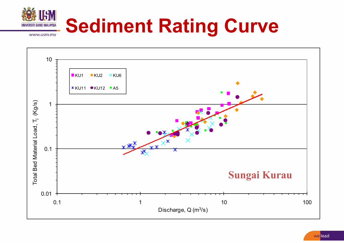
Main Sg Kurau
Sg Kurau
(a) Bed & Bank Materials Data(23 Sites at Sungai Kurau)
Kg Pondok QuinBaharu
Bt 14, Sg Kurau
Sg Kurau, Pondok Tanjong
Kg Relau BerdiriSg Kurau

W e l e a d
0.00
10.00
20.00
30.00
40.00
50.00
60.00
70.00
80.00
90.00
100.00
0.01 0.10 1.00 10.00 100.00Size Particle (mm)
Perc
enta
ge P
assi
ng (%
)
KU1 KU2 KU3 KU4 KU5 KU6 KU7 KU8KU9 KU10 KU11 KU12 KU13 KU14 A1 A2A3 A4 A5 A6 A7 A8 A9
Sungai Kurau
Bed Material Sediment Size Distributions

0.01
0.1
1
10
1 10 100 1000
Tota
l Bed
Mat
eria
l Loa
d, T
j(K
g/s)
Discharge, Q (m3/s)
Jambatan Ladang VictoriaJambatan Dato Syed OmarJambatan TeloiJambatan JeniangJambatan Gajah PutihJambatan Nami
Sungai Muda
Sediment Rating Curve

0.1
1
10
100
1000
1 10 100 1000
Tota
l Bed
Mat
eria
l Loa
d, T
j(K
g/s)
Discharge, Q (m3/s)
Dengkil
Jemderam
Jalan Tangkas
Kg Dusun Nanding
Jambatan Bt 14 Cheras
Jambatan Kg Rinching, Semenyih
Present Study
Sediment Rating Curve for Dengkil Reach
Sungai Langat
0.01
0.1
1
10
0.1 1 10 100
Tota
l Bed
Mat
eria
l Loa
d, T
j(K
g/s)
Discharge, Q (m3/s)
KU1 KU2 KU6
KU11 KU12 A5
Sungai Kurau
Sediment Rating Curve
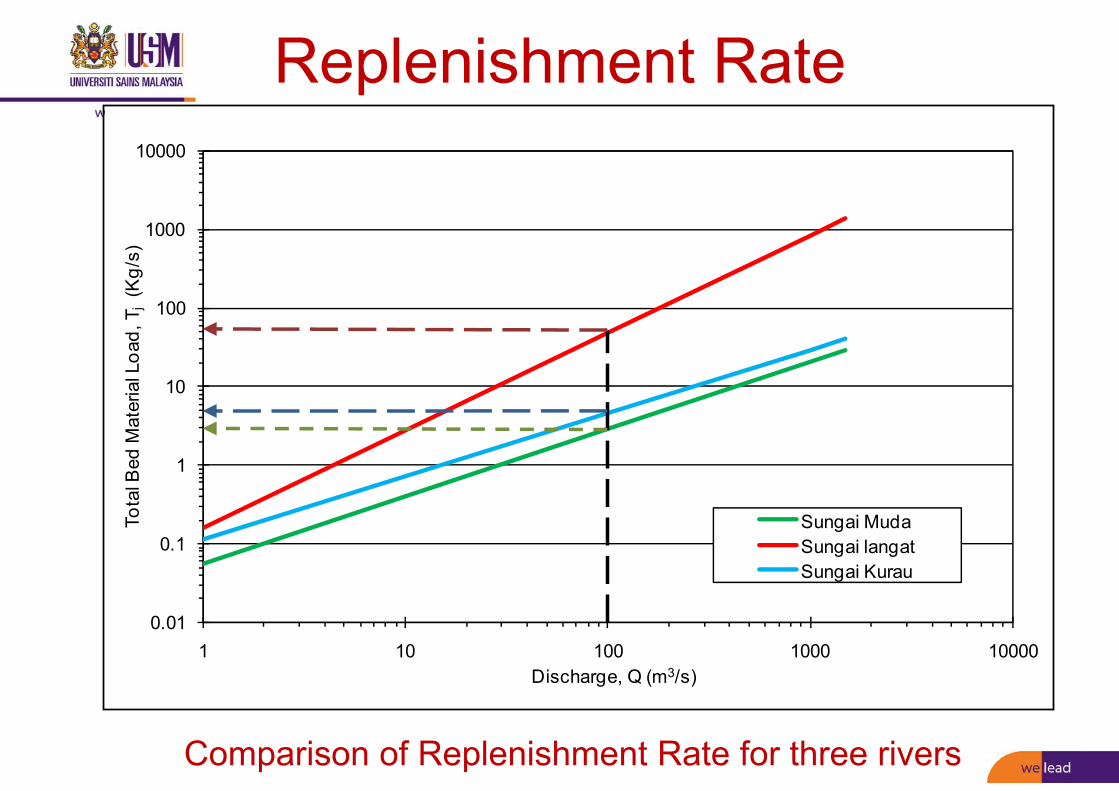
Replenishment Rate
Comparison of Replenishment Rate for three rivers
0.01
0.1
1
10
100
1000
10000
1 10 100 1000 10000
Tota
l Bed
Mat
eria
l Loa
d, T
j(K
g/s)
Discharge, Q (m3/s)
Sungai MudaSungai langatSungai Kurau

Transport Modes EquationRange of
Sediment Size/Flow
Bed Load
Shields 1.56 < d50(mm) < 2.47
Meyer-Peter-Muller 3.17 < d50(mm) < 28.6
Einstein – Brown < 10
Einstein 0.785 < d50(mm) < 28.6
Total Bed Material Load
Graf 0.09 < d50(mm) < 2.78
Engelund & Hansen 0.19 < d50(mm) < 0.93
Yang0.137 < d50(mm) < 1.71yo(m) < 1.0 m
Ackers & White 0.04 < d50(mm) < 4.94
Existing Sediment Transport Equations

W e l e a d
Existing Sediment Transport Equations
Yang
S
ST W
UdWC log457.0log286.0435.5log 50
S
OC
S
O
S
S
WSV
WVS
WUdW loglog314.0log409.0799.1 50
Engelund-Hansen
2/51.0 f
2
2VgRS
f o
Detailed of the equations in Professor Talk booklet.

0.01
0.1
1
10
1 10 100 1000
Tota
l Bed
Mat
eria
l Loa
d, T
j(Kg
/s)
Discharge, Q (m3/s)
Present Study Data
Engelund-Hansen
Yang
Sungai Muda
Assessment of Yang and Engelund-Hansen Equations

0.1
1
10
100
1000
1 10 100 1000
Tota
l Bed
Mat
eria
l Loa
d, T
j(Kg
/s)
Discharge, Q (m3/s)
Present Study Data
Engelund-Hansen
Yang
Sungai Langat
Assessment of Yang and Engelund-Hansen Equations

0.01
0.1
1
10
0.1 1 10 100
Tota
l Bed
Mat
eria
l Loa
d, T
j(K
g/s)
Discharge, Q (m3/s)
Present Study Data
Engelund-Hansen
Yang
Sungai Kurau
Assessment of Yang and Engelund-Hansen Equations

W e l e a d
Latest Sediment Transport Book
Contains all the latest research developments in hydrodynamics of sediment transport

W e l e a d
Sediment Transport Equation for Malaysia
Sinnakaudan, S. K., Ab. Ghani, A., Ahmad, M. S. S., & Zakaria, N.A.(2006). Multiple Linear Regression Model for Total Bed Material Load Prediction, Journal of Hydraulic Engineering, American Society of Civil Engineers, Vol. 132, No. 5, May, pp. 521-528. ISSN 0733-9429

W e l e a d
CASE STUDIES

W e l e a d
HEC-RAS Modeling

HEC-RAS Modelling
Sungai Muda Model Set-up

W e l e a d
CAD of Sungai Muda (2001)
Natural Cross Sections

W e l e a dSediment Input
Sungai Muda
W e l e a d
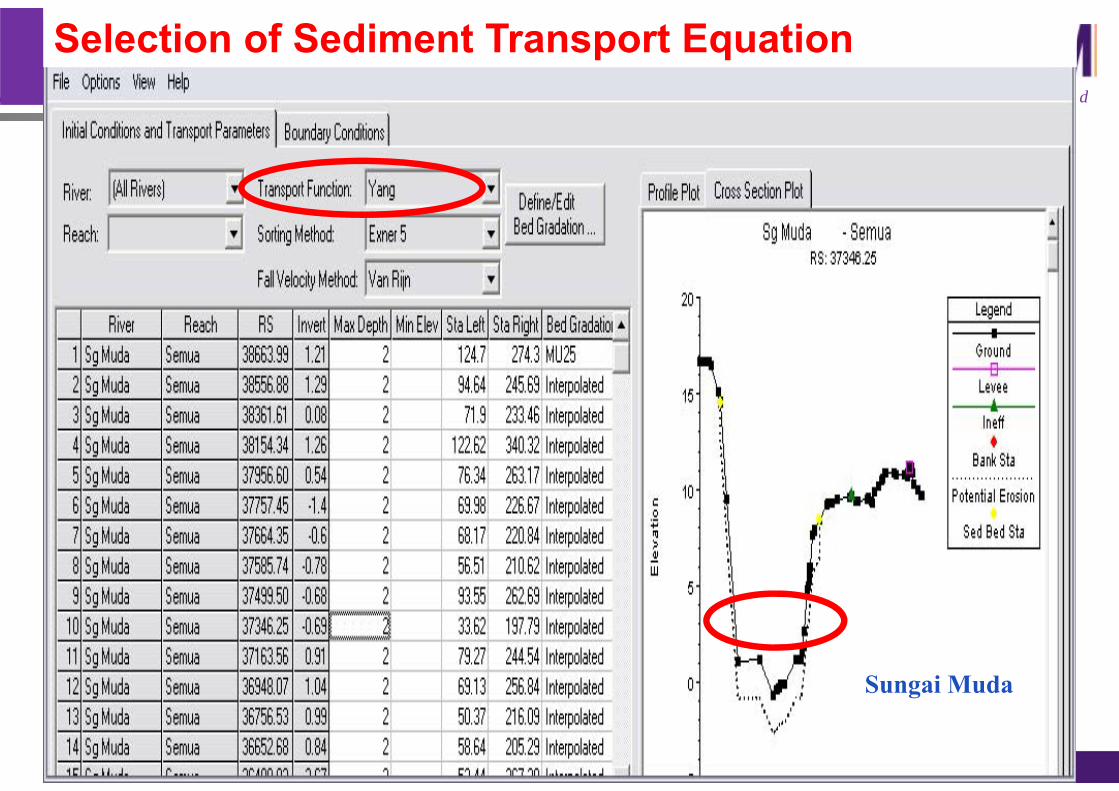
Selection of Sediment Transport Equation
Sungai Muda

W e l e a dSediment Deposition after October 2013 Flood (50-yr ARI)
Sungai Muda 2003 Hydrograph
Deposition
Original Bed Level
W e l e a d
FLUVIAL-12 Modeling

Sediment Delivery
• Sediment delivery is defined as the accumulated amount ofsediment that has been delivered passing a certain channelsection for a specified period of time.• The spatial variation of sediment delivery depicts the erosionand deposition along a stream reach.• A decreasing delivery in the downstream direction, i.e. negativegradient for the delivery-distance curve, signifies that sedimentload is partially stored in the channel to result in a netdeposition.• On the other hand, an increasing delivery in the downstreamdirection indicates sediment removal from the channel boundaryor net scour.• A uniform-sediment delivery along the channel indicatessediment balance.

Sediment Delivery

-2
0
2
4
6
8
10
0 25 50 75 100 125 150 175 200 225 250 275 300 325 350 375Distance (m)
Lev
el (m
)
Initial Bed Level Predicted Bed Level (Dec 2003) Water Level (Dec 2003)
CH 25.40
-2
02
46
810
12
0 25 50 75 100 125 150 175 200 225 250 275 300 325 350 375 400Distance (m)
Lev
el (m
)
Initial Bed Level Predicted Bed Level (Dec 2003) Water Level (Dec 2003)
CH 33.60
Cross Sections with Sediment Deposition
Sungai Muda (FRCP)

Reach Volume of Deposition (tons) Volume of Deposition (m3)
1. CH 33.40 – CH 31.60 76,400 49,506
2. CH 30.00 – CH 23.00 97,900 63,438
** Assume sand density = 1400 kg/m3
1 tons = 907.18474 kg
Sediment Delivery
0
20000
40000
60000
80000
100000
120000
140000
0 2 4 6 8 10 12 14 16 18 20 22 24 26 28 30 32 34 36 38 40 42
Sedi
men
t Del
iver
y (to
ns)
Chainage no.
Peak (6th October 2003)End of Simulation (25th December 2003)
Reach 1
Reach 2
ErosionDeposition
Sungai Muda

-6
-4
-2
0
2
4
6
8
10
12
-200 -150 -100 -50 0 50Distance (m)
Ele
vatio
n (m
)
Predicted Bed Level (Design: ARI-50) Predicted Water Level (Design: ARI-50)Predicted Bed Level (Design: ARI-100) Predicted Water Level (Design: ARI-100)Predicted Bed Level (JPZ: ARI-50) Predicted Water Level (JPZ: ARI-50)Predicted Bed Level (JPZ: ARI-100) Predicted Water Level (JPZ: ARI-100)Existing Bed Level
Cross Section Changes (n=0.025)
(a) Ch. 39.50 (M8‐Ladang Victoria Bridge)
(b) Ch 31.60 (Kuari Kg Pantai Perai )

-8
-6
-4
-2
0
2
4
6
8
10
-200 -150 -100 -50 0 50Distance (m)
Ele
vatio
n (m
)
Predicted Bed Level (Design: ARI-50) Predicted Water Level (Design: ARI-50)Predicted Bed Level (Design: ARI-100) Predicted Water Level (Design: ARI-100)Predicted Bed Level (JPZ: ARI-50) Predicted Water Level (JPZ: ARI-50)Predicted Bed Level (JPZ: ARI-100) Predicted Water Level (JPZ: ARI-100)Existing Bed Level
Cross Section Changes (n=0.025)
(c) Ch. 25.20 (M7-Pinang Tunggal Bridge )
-6
-4
-2
0
2
4
6
8
10
-400 -350 -300 -250 -200 -150 -100 -50 0 50 100Distance (m)
Ele
vatio
n (m
)
Predicted Bed Level (Design: ARI-50) Predicted Water Level (Design: ARI-50)Predicted Bed Level (Design: ARI-100) Predicted Water Level (Design: ARI-100)Predicted Bed Level (JPZ: ARI-50) Predicted Water Level (JPZ: ARI-50)Predicted Bed Level (JPZ: ARI-100) Predicted Water Level (JPZ: ARI-100)Existing Bed Level
(d) Ch. 23.00 (Kg Lahar Tiang)

W e l e a d
SWAT ModelingThe predictions of suspended load fromthe catchment and in-stream were madeusing SWAT (Soil and Water AssessmentTool) model.

Subbasin for Upper Sungai Langat Basin

0
20
40
60
80
100
06/14/97 06/19/97 06/24/97 06/29/97 07/04/97 07/09/97 07/14/97
Date (day)
Flow
rate
, Q (m
3 /s)
Q observed
Q Predicted
0
2000
4000
6000
8000
10000
12000
14000
06/14/97 06/19/97 06/24/97 06/29/97 07/04/97 07/09/97 07/14/97
Date (day)
Susp
ende
d Se
dim
ent (
ton/
day) SS Observed
SS PredictedPredicted and Observed Suspended Sediment
Predicted and Observed Flow
Sungai Langat
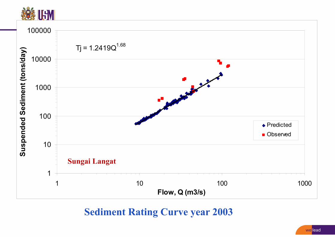
Tj = 1.2419Q1.68
1
10
100
1000
10000
100000
1 10 100 1000Flow, Q (m3/s)
Susp
ende
d Se
dim
ent (
tons
/day
)
PredictedObserved
Sediment Rating Curve year 2003
Sungai Langat

W e l e a d
RIVER SEDIMENT MANAGEMENT AND CONTROL PLAN

W e l e a d
-Universal Soil Loss Equation (USLE) or-Revised Universal Soil Loss Equation (RUSLE)
A = R. K. L. S. C. P
A – Annual soil loss in tonnes/ha/yearR – Rainfall/Runoff Erosivity Index in MJmmha‐1h‐1K – Soil Erodibility Factor in tones/ha/(MJmmha‐1h‐1) L – Slope length FactorS – Slope steepness FactorC – Ground Cover‐management FactorP – Supporting practices Factor/erosion control practice factor
Annual Soil Loss Estimation

W e l e a dESC Manual

W e l e a d
Peninsular Map is for display of Erosivity spatial distribution only.
R Factor should be extracted from blown‐up maps

W e l e a d
Table 6.15: Support Practice, P factor for BMPs at construction/ developing sites1 (Adapted from Layfield, 2009; Troehet al., 1998; Mitchell and Bubenzer, 1980; ECTC, 2003; Israelsen et al. 1980; HDI, 1987; SCS, 1978; Weischmeier andSmith, 1978; Kuenstler, 2009)
Erosion control treatment PFactor Figure
Bare soil 1.00
Disked bare soil (rough or irregularsurface)
0.90
Bertam, Cameron Highland
Support Practice Factor, P

W e l e a dWired log / Sand bag barriers 0.85
Check Dam 0.80
Grass buffer strips (to filter sedimentladen sheet flow)
Basin slope (%)0 to 10
11 to 24
0.600.80
Bertam, Cameron Highland
Kolej Universiti Islam Malaysia,Nilai
Sime Darby,Sepang Sarawak
Support Practice Factor, P

W e l e a dErosion control treatment P
Factor Figure
Contour furrowed surfaceSlope (%) Max. length
1 to 2 1203 to 5 906 to 8 609 to 12 40
13 to 16 2517 to 20 20> 20 15
0.600.500.500.600.700.800.80
Silt fence 0.55
Sediment containment systems(Sediment basin/Trap)
0.50
Bertam, Cameron Highland
Bertam, Cameron Highland
KUIM, Nilai
Support Practice Factor, P

W e l e a d
Berm drain and Cascade 0.50
TerracingSlope (%)1 to 23 to 89 to 12
13 to 1617 to 20> 20
0.120.100.120.140.160.18
Taiping, PerakBertam, Cameron Highland
Tawau,SabahGua Musang, Kelantan
Support Practice Factor, P

W e l e a d
Evaluation of Water Resources with SWAT
SPECIAL ISSUE 2015

W e l e a d
Detailed spatial analysis of SWAT-simulated surface runoff andsediment yield in a mountainous watershed in China (Bieger et al. 2015)
Xiangxi catchment (Yangtze Basin)

W e l e a d

W e l e a d

W e l e a d
Changjiang River basin. Water issues are droughts and floods in the upper reach; floods in the middle reach due to its low elevation and the sudden change from mountain areas to flood plains; and floods and navigation issues in the lower reach.
Integrated water resources management using engineering measures

W e l e a d
Integrated water resources management using engineering measures

W e l e a d
Combination of engineering measures for flood management of Changjiang River
The water level for gauge stations (which are also very important cities/towns) of Shashi, Chenglingji, Hankou and Hukou will not exceed 45.0 m, 34.4 m, 29.73 m and 22.5 m, respectively, corresponding to the 50~100 year return period safety level

W e l e a d

W e l e a d
Major hydraulic works and reservoirs in the case study regions

W e l e a d
Comparison of sediment yields and trends in sediment discharge

W e l e a d
Modelling Techniques Used

Dam construction

W e l e a d
Priority Sediment‐related Issues in each River Basin.

W e l e a dPolicy Recommendations

W e l e a dPolicy Recommendations

W e l e a dPolicy Recommendations

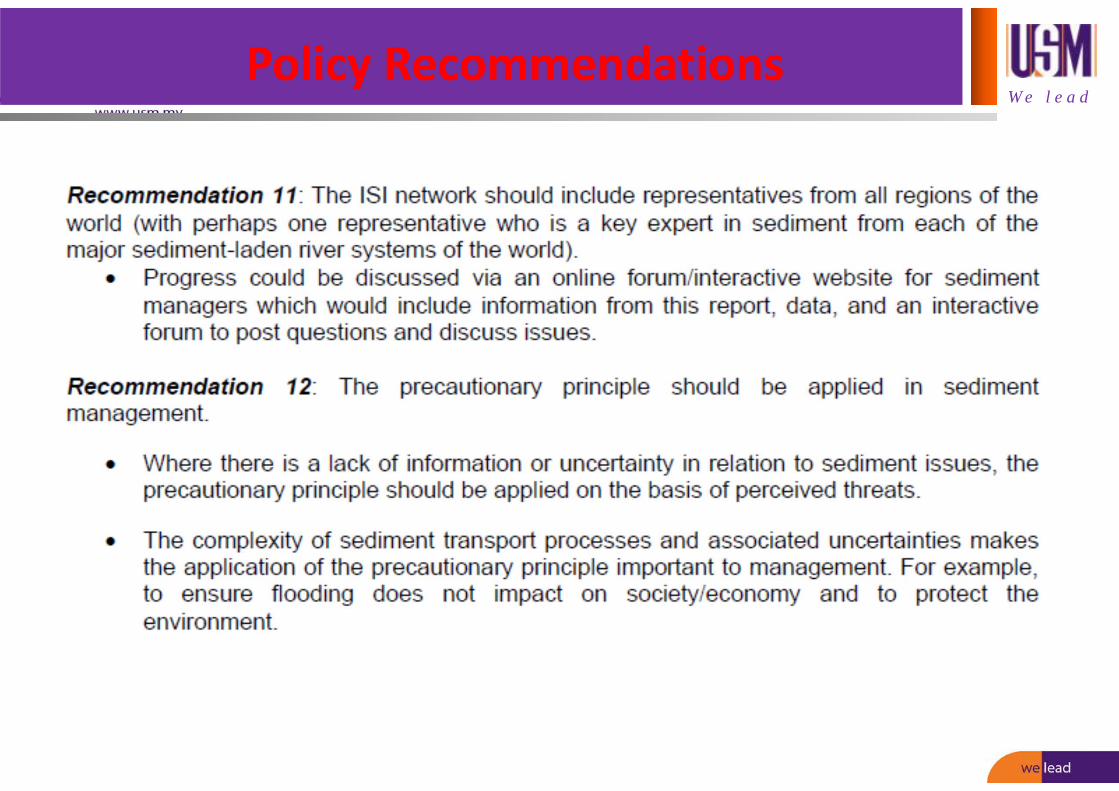
W e l e a dPolicy Recommendations

W e l e a dPolicy Recommendations
W e l e a dPolicy Recommendations
Related Documents