Sediment budget of the Rhône delta shoreface since the middle of the 19th century François Sabatier a,b, ⁎ , Grégoire Maillet a,c , Mireille Provansal a , Thomas-Jules Fleury a , Serge Suanez d , Claude Vella a a Centre Européen de Recherche et d'Enseignement des Géosciences et de l'Environnement, UMR CNRS 6635, Europôle de l'Arbois, B.P.80, 13545 Aix-en-Provence Cedex 04, France b Delft University of Technology, Faculty of Civil Engineering, Hydraulic Engineering Section, Stevinweg 1, 2628 CN Delft, The Netherlands c Laboratoire “Paysages & Biodiversité” (PPF DS10), Université d'Angers, UFR Sciences, 2 Bd Lavoisier, 49045 Angers cedex 1, France d Géomer, UMR 6554 CNRS, IUEM, Technopôle Brest Iroise Place Nicolas Copernic, 29280 Plouzané, France Accepted 5 September 2006 Abstract This study analyses long-term (1841–1872–1895–1974) changes in the Grand Rhône prodeltaic lobe to (1) quantify the accumulation, (2) determine the evolution of relict prodeltaic lobes and (3) establish long-term relationships between river sediment discharge, the shoreface and the continental shelf. Our results show a reduction of the sedimentation of the prodeltaic lobe at the main river mouth, since 150 yr by a factor of 3.7 (12.63 to 3.41 × 10 6 m 3 yr - 1 ). At the minor mouth of the river, erosion dominates and speeds up during the same period (- 0.53 to - 1.34 × 10 6 m 3 yr - 1 ). These changes are found to directly result from the river sediment input decrease related to the natural decreasing of the frequency of major floods (end of the Little Ice Age), the reforestation in the catchment area, the dam construction and the dredging activities (since the 1950s). Our results indicate that while there is large sediment accumulation in the area around a growing prodeltaic lobe, there is also a reduced contribution of the river sediments to the non-adjacent beaches of the mouth. Following a shift in the river channel and mouth, the relict prodeltaic lobes (Petit Rhône–St Férreol, Bras de Fer and Pégoulier) are reworked by waves and their sediments contribute partially to the growth of the spits (Espiguette, Beauduc and Gracieuse). This suggests that there is a “time-shift” between the input of river sediment to the sea and the build up of a beach. The chronic erosion of the coastline is likely to continue in the future since (1) a river shift is not possible, because the river channels are controlled by dykes and human intervention, (2) the decrease of river sediment input and (3) the relict prodeltaic lobes constitute sedimentary reservoirs that are gradually being used up. © 2006 Published by Elsevier B.V. Keywords: bathymetry; river sediments input; prodeltaic lobe; large scale coastal behaviour 1. Introduction When a river discharges into the sea, delta building will occur if the input of sediment exceeds the marine erosion able to remove the deposited material. Under- standing and assessing the input of river sediment to the sea, as well as its littoral distribution, represent Marine Geology 234 (2006) 143 – 157 www.elsevier.com/locate/margeo ⁎ Corresponding author. Centre Européen de Recherche et d'En- seignement des Géosciences et de l'Environnement, UMR CNRS 6635, Europôle de l'Arbois, B.P.80, 13545 Aix-en-Provence Cedex 04, France. Tel.: +33 0 442 971 576; fax: +33 0 442 971 595. E-mail addresses: [email protected] (F. Sabatier), [email protected] (G. Maillet), [email protected] (M. Provansal), [email protected] (T.-J. Fleury), [email protected] (S. Suanez), [email protected] (C. Vella). 0025-3227/$ - see front matter © 2006 Published by Elsevier B.V. doi:10.1016/j.margeo.2006.09.022

Welcome message from author
This document is posted to help you gain knowledge. Please leave a comment to let me know what you think about it! Share it to your friends and learn new things together.
Transcript
(2006) 143–157www.elsevier.com/locate/margeo
Marine Geology 234
Sediment budget of the Rhône delta shorefacesince the middle of the 19th century
François Sabatier a,b,⁎, Grégoire Maillet a,c, Mireille Provansal a,Thomas-Jules Fleury a, Serge Suanez d, Claude Vella a
a Centre Européen de Recherche et d'Enseignement des Géosciences et de l'Environnement, UMR CNRS 6635, Europôle de l'Arbois,B.P.80, 13545 Aix-en-Provence Cedex 04, France
b Delft University of Technology, Faculty of Civil Engineering, Hydraulic Engineering Section, Stevinweg 1, 2628 CN Delft, The Netherlandsc Laboratoire “Paysages & Biodiversité” (PPF DS10), Université d'Angers, UFR Sciences, 2 Bd Lavoisier, 49045 Angers cedex 1, France
d Géomer, UMR 6554 CNRS, IUEM, Technopôle Brest Iroise Place Nicolas Copernic, 29280 Plouzané, France
Accepted 5 September 2006
Abstract
This study analyses long-term (1841–1872–1895–1974) changes in the Grand Rhône prodeltaic lobe to (1) quantify theaccumulation, (2) determine the evolution of relict prodeltaic lobes and (3) establish long-term relationships between river sedimentdischarge, the shoreface and the continental shelf. Our results show a reduction of the sedimentation of the prodeltaic lobe at themain river mouth, since 150 yr by a factor of 3.7 (12.63 to 3.41×10⁶ m3 yr−1). At the minor mouth of the river, erosion dominatesand speeds up during the same period (−0.53 to −1.34×10⁶ m3 yr−1). These changes are found to directly result from the riversediment input decrease related to the natural decreasing of the frequency of major floods (end of the Little Ice Age), thereforestation in the catchment area, the dam construction and the dredging activities (since the 1950s). Our results indicate thatwhile there is large sediment accumulation in the area around a growing prodeltaic lobe, there is also a reduced contribution of theriver sediments to the non-adjacent beaches of the mouth. Following a shift in the river channel and mouth, the relict prodeltaiclobes (Petit Rhône–St Férreol, Bras de Fer and Pégoulier) are reworked by waves and their sediments contribute partially to thegrowth of the spits (Espiguette, Beauduc and Gracieuse). This suggests that there is a “time-shift” between the input of riversediment to the sea and the build up of a beach. The chronic erosion of the coastline is likely to continue in the future since (1) ariver shift is not possible, because the river channels are controlled by dykes and human intervention, (2) the decrease of riversediment input and (3) the relict prodeltaic lobes constitute sedimentary reservoirs that are gradually being used up.© 2006 Published by Elsevier B.V.
Keywords: bathymetry; river sediments input; prodeltaic lobe; large scale coastal behaviour
⁎ Corresponding author. Centre Européen de Recherche et d'En-seignement des Géosciences et de l'Environnement, UMR CNRS6635, Europôle de l'Arbois, B.P.80, 13545 Aix-en-Provence Cedex04, France. Tel.: +33 0 442 971 576; fax: +33 0 442 971 595.
E-mail addresses: [email protected] (F. Sabatier),[email protected] (G. Maillet), [email protected](M. Provansal), [email protected] (T.-J. Fleury),[email protected] (S. Suanez), [email protected] (C. Vella).
0025-3227/$ - see front matter © 2006 Published by Elsevier B.V.doi:10.1016/j.margeo.2006.09.022
1. Introduction
When a river discharges into the sea, delta buildingwill occur if the input of sediment exceeds the marineerosion able to remove the deposited material. Under-standing and assessing the input of river sediment to thesea, as well as its littoral distribution, represent

144 F. Sabatier et al. / Marine Geology 234 (2006) 143–157
important challenges since major deltas all around theworld are undergoing an erosional regime (Stone andDonley, 1998). In microtidal Mediterranean environ-ments, previous studies have already tried to establish arelationship between fluvial input and sediment redis-tribution in the littoral zone, e.g. the deltas of theDanube (Giosan et al., 1999), Ebro (Jiménez andSánchez-Arcilla, 1993; Guillen and Palanques, 1997),Nile (Stanley and Warne, 1998), Pô (Cencini, 1998) andRhône (Blanc, 1977; Suanez and Provansal, 1998, 1999;Sabatier and Suanez, 2003). By using old maps,bathymetric profiles, aerial photographs, longshoresediment transport equations and box models, thesestudies have led towards establishing shoreline changesand the quantification of littoral cells. If river sedimentinput decreases or if the river mouth changes itslocation, the prodeltaic lobe starts to be destroyed bywave action and the shoreline migrates landwards (Kolband Van Lopik, 1966; Wells and Coleman, 1987; Liet al., 2000; Pranzini, 2001). The reworked materialfrom the pre-existing prodeltaic lobe is re-distributedover the shoreface according to wave action andsediment grain size (Stive and de Vriend, 1995).However, studies have seldom addressed the relation-ships and interactions between fluvial sediment inputand the building of associated prodeltaic lobes. In anycase, even though the decreasing river sedimentdischarge to the sea in relation to climatic change, re-forestation and dams are often described as responsiblefor coastal erosion (Guillen and Palanques, 1993;Milliman, 1997; Pont et al., 2002). The connectionbetween the fluvial sediment inputs, the deltaic lobesand the shoreface is not well established.
At the present, the Rhône delta is a “wave-dominateddelta” according to Galloway's (1975) terminology.Nevertheless, the river sediment load may play animportant role in controlling shoreline location andcoastal sediment budget (Suanez and Simon, 1997;Suanez and Provansal, 1998; Sabatier and Suanez,2003). Since the middle of the 19th century, in relationwith climatic changes (end of the Little Ice Age), thefrequency of major floods has been consistentlydecreasing on the Rhône, as on the other main Europeanrivers (Probst, 1989; Pichard, 1995; Arnaud-Fassettaand Provansal, 1999). At the same time, land-usechanges and reforestation in the catchment are reducingthe solid discharge, notably the bedload (Bravard, 1989;Miramont and Guilbert, 1997; Warner, 2000). This trendhas been reinforced since the 1950s by dam constructionand dredging activities (Poinsard, 1992; Klingemanet al., 1994; Gautier, 1994; IRS, 2000). Previous works(Arnaud-Fassetta, 1997; Antonelli et al., 2004) have
shown that the deltaic response of the river channel is ageneral incision of the bed between the end of the 19thcentury and the end of 20th century. However, theeffects of decreasing fluvial sediment discharge on theevolution of the prodeltaic lobes and the shoreface arepoorly understood on this time scale. In this study, weanalyse long-term (150 yr) shoreline and bathymetricchanges to (1) quantify the accumulation of the Rhôneprodeltaic lobe, (2) determine the evolution of relictprodeltaic lobes and (3) establish long-term relation-ships between river sediment discharge, the shorefaceand the continental shelf.
2. Environmental settings
2.1. The Rhône river
The present Rhône river is divided in two main arms:the eastern branch (Grand Rhône, 50 km in length) andthe western branch (Petit Rhône, 70 km in length), bothdischarging into the Mediterranean Sea by the Roustanand the Orgon mouths, respectively (Fig. 1). Thebreakdown of the river discharge is 10–15% for thePetit Rhône and 85–90% for the Grand Rhône (Surell,1847). The mean annual water discharge (measurementsfrom 1960 to 1996) is 1710 m3 s−1 without any generaltrend during the 20th century (Antonelli et al., 2004),but the frequency of major floods has been decreasingsince the beginning of the 19th century (Pichard, 1995)(Fig. 2). Return period discharges for 2, 10 and 100 yr are6000, 8300 and 11,200 m3 s−1, respectively (Pont et al.,2002). 80% of the solid discharge is related to liquiddischarge when the flood is higher than 3000 m3 s−1
(Pont and Bardin, 1996).Several authors have estimated the Bedload Sedi-
ment Transport (BST) and/or the Suspended SedimentTransport (SST) of the Rhône river (Surell, 1847; Pardé,1925; Van Straaten, 1959; Savey and Deleglise, 1967;Pauc, 1976; Aloisi et al., 1977; Blanc, 1977; Millimanand Meade, 1983; El Habr and Golterman, 1987; Dugas,1989; Roditis and Pont, 1993; Pont and Blombed, 1995;Antonelli and Provansal, 2002a,b; Pont et al., 2002).Studies carried out since the end of the 19th centuryhave used different methodologies and especially focuson the SST, but they all indicate a general decreasingtrend (Pichard, 1995) in good correlation with thetributaries (Fig. 2). From the beginning of the 19thcentury to the first part of the 20th century, before theconstruction of dams, the mean SST is estimated torange between 27.2 to 31.0×10⁶ t yr−1. Sogreah (1999)re-evaluated previous measurements between 1956 to1958 and argued for a mean SST value of about
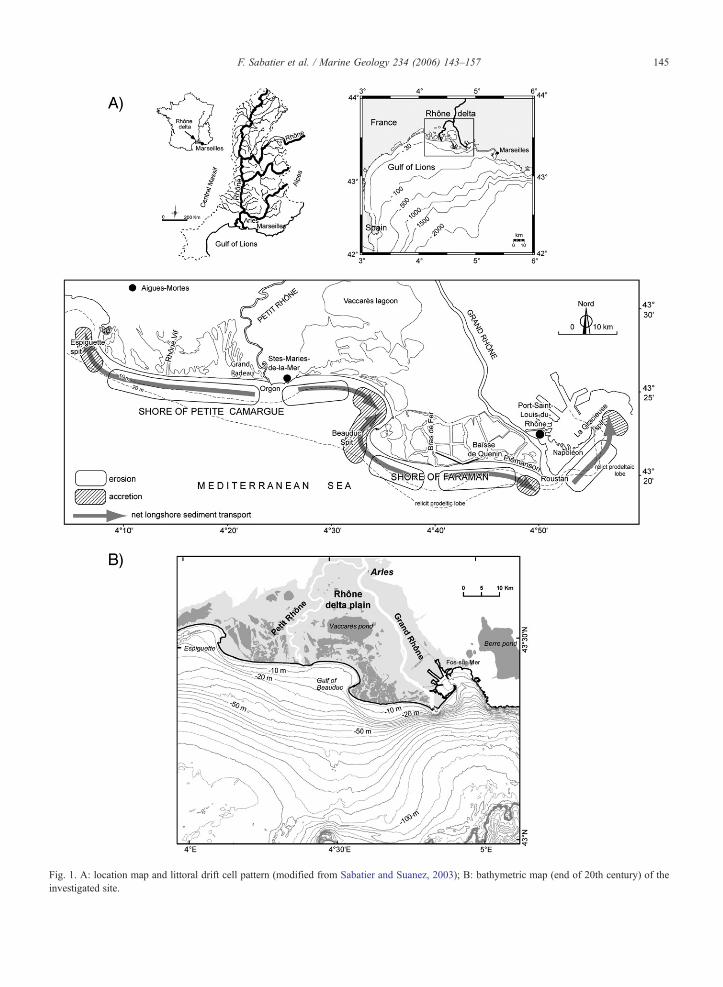
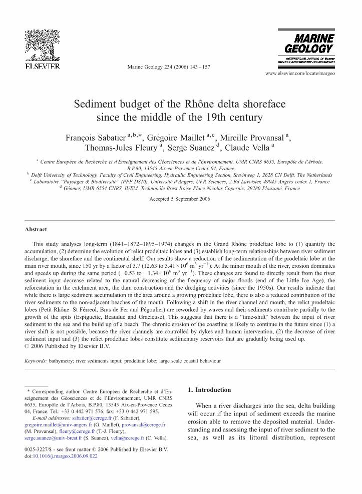
Fig. 1. A: location map and littoral drift cell pattern (modified from Sabatier and Suanez, 2003); B: bathymetric map (end of 20th century) of theinvestigated site.
145F. Sabatier et al. / Marine Geology 234 (2006) 143–157
Fig. 2. Decrease in river floods and suspended sediment input to the sea. A: mean SST from different authors.; B: frequency of floods at Arles(modified from Pichard, 1995).
146 F. Sabatier et al. / Marine Geology 234 (2006) 143–157
13.0×10⁶ t yr−1 for the middle part of the 20th century.While Pont et al. (2002) proposed a mean SST value ofabout 7.4×10⁶ t yr−1 for the period 1962–1996,Antonelli and Provansal (2002a) demonstrated that thefield measurements of Pont et al. (2002) underestimatedsediment transport and the authors proposed a meanvalue of 9.6×10⁶ t yr−1 between 1980 to 2000.
2.2. Successive river mouths and construction of Rhôneprodeltaic lobes
Although the present Rhône is divided into two mainarms, the river and mouths had different locationsduring the construction of the Holocene Rhône delta(Russell, 1942; Kruit, 1955; Oomkens, 1970; L'Homeret al., 1981; Arnaud-Fassetta, 1998; Vella and Provan-sal, 2000; Vella et al., 2005). At this time scale, all theseauthors provide evidence that the shoreline advance isconnected to the river mouth position and river sedimentinput. Since 4000 yr BP, the Rhône river has developedseveral successive arms and mouths, and the presentdeltaic plain displays remnants of these relict structuresthat have been re-examined by Vella et al. (2005), whogive a new chronology for the sub-surface sedimentaryridge of the Rhône deltaic plain. Successive displace-ments of the river mouths have thus given rise to theoffshore abandonment of relict prodeltaic lobes: StFerreol (Cal. 2845–2420 BC to 1st Century AD.),Grand Passon-Bras de Fer (12th century to 1711) andPégoulier (1711 to 1892). These latter can be identifiedat the present day through the lobe-type pattern of theirbathymetry, such as exhibited by the prodeltaic lobes atthe Roustan and Orgon mouths (Fig. 1). However, thereremain some uncertainties on the existence of the relictprodeltaic lobe of the Rhône Vif (1532 to 1552),identified according to L'Homer (1993) from the
sedimentology and morphology. This artificial mouthwith low discharge remained open for only 20 yr, whichseems very short to build up a prodeltaic lobe. Since1552, the location of the Petit Rhône mouth (Orgon) hasbeen fixed on the west side of Saintes-Maries-de-la-Mer(L'Homer et al., 1981). The current shoreline began totake its present shape from the beginning of the 18thcentury. Following an important flood in 1711, theRhône of the Bras de Fer channel changed coursetowards the east and assumed its present-day configu-ration as the Grand Rhône (Fig. 3). Since 1711, althoughthe location of the Grand Rhône channel has remainedthe same, the number and location of the local mainmouths has changed (Fig. 4). Between 1711 and 1852,the Grand Rhône had three separate and concomitantmouths: Piémanson, Roustan and Pégoulier. In 1855,the Piémanson and Roustan mouths were closed bydykes in order to concentrate water and sedimentdischarge into the Pégoulier. In 1892, engineeringworks re-opened the Roustan mouth for navigation.The re-opening of the Roustan mouth and thesubsequent shifting of the sediment discharge throughit led to the start of the filling in of the Pégoulierchannel. Meanwhile, the Pégoulier mouth was closedoff by longshore sediment transport deposits. However,since 1892, the Grand Rhône has continued to dischargeat the same mouth (Roustan).
2.3. The nearshore and shelf domain
The wave regime is divided into three dominantdirections: SW (30% calm waves generated by offshorewinds), SSE (16%) and SE (11% storm waves generatedby onshore winds). The modal, annual and decennialrecurrence significant wave heights (Hsig) are 0.6 m,3.3 m and 4.6 m, with a significant period (Tsig) of 4 s,
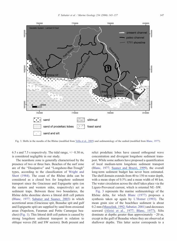
Fig. 3. Shifts in the mouths of the Rhône (modified from Vella et al., 2005) and sedimentology of the seabed (modified from Blanc, 1977).
147F. Sabatier et al. / Marine Geology 234 (2006) 143–157
6.5 s and 7.5 s respectively. The tidal range, +/−0.30 m,is considered negligible in our study.
The nearshore zone is generally characterised by thepresence of two or three bars. Beaches of the surf zoneare of the “Dissipative” and “Longshore-Bar-Trough”types, according to the classification of Wright andShort (1984). The coast of the Rhône delta can beconsidered as a closed box for longshore sedimenttransport since the Gracieuse and Espiguette spits (onthe eastern and western sides, respectively) act assediment traps. Between these two boundaries, theRhône delta shoreline shows a littoral drift cell pattern(Blanc, 1977; Sabatier and Suanez, 2003) in whichaccretional areas (Gracieuse spit, Beauduc spit and gulfand Espiguette spit) are supplied by sand from erosionalareas (Napoleon, Faraman and Petite Camargue bea-ches) (Fig. 1). This littoral drift cell pattern is caused bystrong longshore sediment transport in relation tooblique waves (SE and SW sectors). Both present and
relict prodeltaic lobes have caused orthogonal waveconcentration and divergent longshore sediment trans-port. While some authors have proposed a quantificationof local medium-term longshore sediment transport(Blanc, 1977; Suanez and Bruzzi, 1999), the overalllong-term sediment budget has never been estimated.The shelf domain extends from 40 to 150 m water depth,with a mean slope of 0.5% and a mean width of 40 km.The water circulation across the shelf takes place via theLiguro-Provencal current, which is oriented NE–SW.
Fig. 3 represents the marine sedimentology of theRhône delta, for which Blanc (1977) proposes asynthesis taken up again by L'Homer (1993). Themean grain size of the beachface sediment is about0.2 mm (Masselink, 1992; Sabatier, 2001) and decreasesseaward (Aloisi et al., 1977; Blanc, 1977). Siltsdominate at depths greater than approximately −20 m,except in the gulf of Beauduc where they are observed atshallower depths. This latter sector corresponds to a
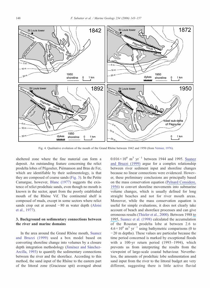
Fig. 4. Qualitative evolution of the mouth of the Grand Rhône between 1842 and 1950 (from Vernier, 1976).
148 F. Sabatier et al. / Marine Geology 234 (2006) 143–157
sheltered zone where the fine material can form adeposit. An outstanding feature concerning the relictprodelta lobes of Pégoulier, Piémanson and Bras de Fer,which are identifiable by their sedimentology, is thatthey are composed of coarse sands (Fig. 3). In the PetiteCamargue, however, Blanc (1977) suggests the exis-tence of relict prodeltaic sands, even though no mouth isknown in the sector, apart from the poorly establishedmouth of the Rhône Vif. The continental shelf iscomposed of muds, except in some sectors where relictsands crop out at around −80 m water depth (Aloisiet al., 1977).
3. Background on sedimentary connections betweenthe river and marine domains
In the area around the Grand Rhône mouth, Suanezand Bruzzi (1999) used a box model based onconverting shoreline change into volumes by a closuredepth integration methodology (Jiménez and Sánchez-Arcilla, 1993) to quantify the sedimentary connectionsbetween the river and the shoreface. According to thismethod, the sand input of the Rhône to the eastern partof the littoral zone (Gracieuse spit) averaged about
0.016×10⁶ m3 yr−1 between 1944 and 1995. Suanezand Bruzzi (1999) argue for a complex relationshipbetween river sediment input and shoreline changesbecause no linear connections were evidenced. Howev-er, these preliminary conclusions are principally basedon the mass conservation equation (Pelnard Considere,1956) to convert shoreline movements into submarinevolume changes, which is usually defined for longstraight beaches and not for river mouth areas.Moreover, while the mass conservation equation isuseful for simple evaluations, it does not clearly takeaccount of beach and shoreface processes and can giveerroneous results (Thieler et al., 2000). Between 1988 to1995, Suanez et al. (1998) calculated the accumulationof the Roustan prodelta lobe at between 2.6 to4.6×106 m3 yr−1 using bathymetric comparisons (0 to−20 m depths). These values are particular because thetime period concerned is marked by exceptional floodswith a 100-yr return period (1993–1994), whichprevents us from interpreting the results from theviewpoint of large-scale coastal behaviour. Neverthe-less, the amounts of prodeltaic lobe sedimentation andsand input from the river to the littoral budget are verydifferent, suggesting there is little active fluvial
Table 1Data used for the shoreline and bathymetric changes analysis
Date Type of data Source Area
1841 Bathymetricmap
Etat Major Grand Radeau toGrand Rhône mouth
1872 Bathymetricsounding
EPSHOM (Brest) Espiguette to la Gracieuse
1895 Bathymetricsounding
EPSHOM (Brest) Espiguette to la Gracieuse
1974 Bathymetricsounding
EPSHOM (Brest) Rhône Vif to Piémanson
1982 Bathymetricsounding
EPSHOM (Brest) Espiguette to Rhône Vif
1988 Bathymetricsounding
EPSHOM (Brest) Piémanson to la Gracieuse
149F. Sabatier et al. / Marine Geology 234 (2006) 143–157
sediment contribution to the beach system. In contrast,Blanc (1977), Masselink (1992) and Suanez and Bruzzi(1999) suggested that relict prodeltaic lobes are crucialin coastal sediment transport processes because they canfeed the surf zone and contribute to the littoral sedimentbudget, at least for the coarse-grained fraction. Conse-quently, the Rhône river sand contribution to the beachis not yet clearly evaluated.
On the shelf, offshore deposition of fluvial sedimentis demonstrated by Zuo et al. (1997), Radakovitch et al.(1998), Durrieu de Madron et al. (2000) and Touzaniand Giresse (2002), who used 210Pb and 137Cs datingmethods on cores between −20 to −100 m water depth.The analysis of cores indicates rapid sedimentation inthe proximal part of the prodelta (average rate of 40 gcm−2 y−1), with values between 0.2 and 0.6 g cm−2 y−1
at depths ranging between −20 to −50 m in the moredistal parts. Sedimentation rates fall to 0.1–0.25 gcm−2 y−1 in the deeper areas (Radakovitch et al., 1998;Durrieu de Madron et al., 2000). Authors studying theshelf argue for three different sediment sources, i.e.:Rhône sediment input, biogenic productivity and atmos-pheric input. Previous studies have linked particulatematter and organic carbon budget between the shelf andthe slope (Durrieu de Madron et al., 2000), but norelationship has been investigated between the shorefaceand the shelf.
In summary, previous studies evaluating the contri-bution of the Rhône in the sediment supply to the littoralzone are based on a rather imprecise methodology (massconservation equation) and concern only the middle ofthe 20th century. On the other hand, studies quantifyingsedimentation around the mouth (prodeltaic lobe) of theGrand Rhône are based on the comparison of bathymet-ric surveys relating to only one limited period of 8 yr.Moreover, the sedimentation rates measured by geo-chemistry only relate to the continental shelf. Lastly,none of these previous studies allows us to appreciateand to quantify the long-term impact of the Rhônesedimentary input reduction to the sea. In order toimplement these spatial, temporal and methodologicalshortcomings, the present study analyses the variationsrecorded in bathymetric surveys between 1841 and 1974.The objective is to characterise the long-term prodeltaiclobe behaviour as well as the sediment budget of theshoreface and the river–shoreface–shelf system of theRhône delta.
4. Methodology
In order to determine and quantify the long-termbathymetric changes of the Rhône delta, we analysed
bathymetric data from four time intervals. All data werecollected by the Etablissement Principal du ServiceHydrographique et Océanographique de la Marine(EP SHOM), except for the data from near the Roustanmouth collected in 1988 by the Port Autonome deMarseille (PAM). The data sets span from the middle ofthe 19th century to the end of the 20th century (1841–1872–1895 and 1974–1982–1988 (Table 1). The setfrom 1841 covers the littoral zone between the GrandRhône and the Petit Rhône, so it cannot be used inevaluating the littoral budget for the whole Rhône delta.The other data sets cover the whole Rhône deltanearshore zone. The last bathymetric survey is acompilation of several dates to obtain a more completebathymetric morphology of the Rhône delta shoreface in1974–1982 and 1988. For simplification, we refer to allthe 20th century data as “1974” in the text. Allsoundings are digitized and corrected to the commonFrench horizontal and vertical reference system (Lam-bert III Sud and 0 National Elevation Level) using GISand image processing software. The secular verticalevolution of the sea level, +2.01 mm/yr during the 20thcentury (Suanez et al., 1997) is corrected on all data sets.The X and Y coordinates errors are estimated at ±10 m.The vertical errors integrating error measurements, tidesand waves are estimated at +0.76 and −0.56 m for the19th century data set and +/−0.20 for the 20th centurydata set (Sabatier, 2001). For each period, we computeda Digital Terrain Modelling (DTM). A commonbathymetric contour of 20 m is taken as a deeperboundary because this contour is common to the sets ofbathymetric data. This depth is also consistent with thetheoretical significant wave base estimated at −21.9 mdepth by the common rule Lo/4 of Komar (1998) using adecennial storm return period (where Lo is the deepwave length). Moreover, this depth is close to the sand/
150 F. Sabatier et al. / Marine Geology 234 (2006) 143–157
mud limit observed between −20 and −30 m depth (Fig.3). Thus, we can assume that we include the major partof the shoreface influenced by waves. The amount oferosion or sedimentation between two periods isdetermined by DTM comparison. The sediment budgetis obtained by the difference between the accretional anderosional volumes: net positive and negative valuessuggest sediment input and output, respectively. Over-wash and aeolian sediment transport were not taken intoaccount into the sediment budget because previousstudies have shown that these processes are negligible incomparison to submarine processes in a long-termsediment budget (Sabatier, 2001). We calculated abreakdown by depth of the budget at around −10 m inorder to investigate the behaviour of the shorefacebetween the upper part, where longshore drift in the surfzone is prevalent, and the lower part, where longshoreprocesses decrease and cross-shore processes increase(Wright et al., 1991; Stive and de Vriend, 1995; Zeiler etal., 2000; Hequette et al., 2002). Thus, we can comparethe behaviours of the upper shoreface (0 to −10 mdepth) and the lower shoreface (−10 to −20 m depth).
5. Results
5.1. Global sediment budget
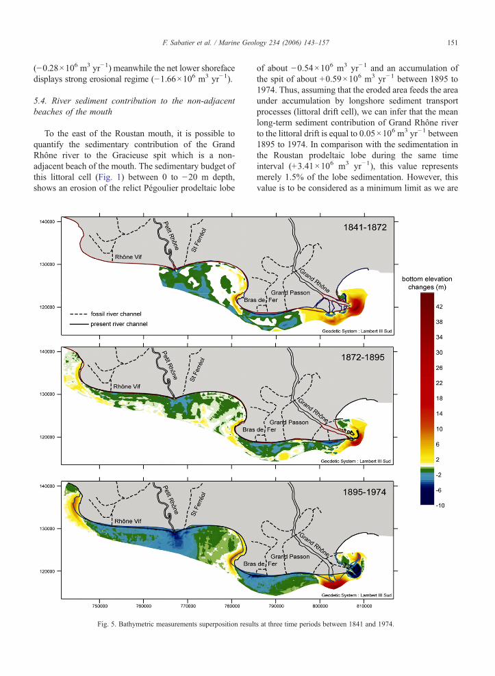
Our bathymetric data display areas which are under-going depositional and erosional processes (Fig. 5). Aftera mouth location change, the remainder river mouths andprodeltaic lobes are systematically undergoing erosion.Atthe contrary, the Petit Rhône prodeltaic lobe is eroding allover the investigated period while the presence of theriver. Since 1841, areas undergoing sediment accumula-tion are the Beauduc Gulf and the littoral spits ofEspiguette and of Beauduc. The Gracieuse spit appearedin 1895. The Grand Rhône mouths spatial distributiondisplay a sedimentary accumulation belt of 1.5 km.
Since bathymetric data for the whole littoral zone arejust available for the periods 1872–1895 and 1895–1974,we can only estimate two overall sedimentary budgets.For both the time intervals 1872–1895 and 1895–1974,the overall sediment budget is positive, but it decreasesby a factor of 7.4 when the two periods are compared(from +11.10 to +1.47×10⁶ m3 yr−1, respectively).
5.2. Quantification of changes in prodeltaic lobes
The long-term bathymetric changes (Fig. 5) showthat the net accumulation at the Grand Rhône prodeltaiclobes decreases consistently with time, yielding valuesof 12.63; 8.37 and 3.40×10⁶ m3 yr−1 for the periods
1841–1872, 1872–1895 and 1895–1974, respectively.In contrast to the Grand Rhône, the offshore areas of thePetit Rhône mouth and prodeltaic lobe are beingincreasingly eroded, with values of −0.53; −1.07 and−1.34×10⁶ m3 yr−1 for the same respective periods.This erosion combines the Petit Rhône and St Férréolrelict prodeltaic lobe, without any eventual distinctionbetween them.
All relict prodeltaic lobes show the same trend: whenthe river is no longer discharging at their mouth, after anatural or anthropic river shift, they all become subjectto erosion (Fig. 5). The erosion of the Bras de Fer relictprodeltaic lobe is slowly decreasing with time (e.g.:−1.30; −1.14 and −1.02×10⁶ m3 yr−1 for 1841–1872,1872–1895 and 1895–1974 respectively). Between1841 and 1895, the erosion of the prodeltaic lobes ofPiémanson and Roustan started after the artificialclosure of their mouth, and only ceased after the re-opening of the Roustan mouth in 1892. Since then, themouth location changed towards the west induceserosion of the Pégoulier relict prodeltaic lobe.
5.3. Quantification of changes in the shoreface
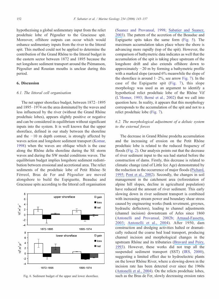
In order to evaluate sediment budgets for areasdominated by waves and less influenced by the river, wecalculated sediment volumes located at the western partof the Grand Rhône accumulation zone (around thesector Baïsse de Quenin). This area is called “shoreface”in this study. The eastern part sediment processes aredominated by the Rhône inputs (Fig. 5 and Sabatier andSuanez, 2003) and then not integrated in the analysis ofthe shoreface because we try to focus on the wavedominated part of the delta. The Petit Rhône prodeltaiclobe remains in the shoreface budget quantification as itis under an erosional regime and as it is not possible toestablish the sediment input to the sea by the Orgonmouth. The sediment budget of the shoreface zoneremains positive (+2.73×10⁶ m3 yr−1) during the firsttime interval but become negative (−1.94×10⁶ m3 yr−1)for the second time interval in relation to an increase oferosion (−3.04 to −4.21×10⁶ m3 yr−1) and a decrease inaccumulation (+5.77 to +2.27×10⁶ m3 yr−1). In detail,the upper shoreface (0–10 m), between 1872 and 1895,shows fairly similar values between accumulative anderosional regimes, yielding a slightly net positive budget(+0.34×10⁶ m3 yr−1) (Fig. 6). In contrast, the lowershoreface gained more sediment during the same periodand the net sedimentary budget is significantly positive(+2.39×10⁶ m3 yr−1). Between 1895 and 1974, theopposite trend is observed (Fig. 6). The net sedimentarybudget of the upper shoreface is slightly in erosion
151F. Sabatier et al. / Marine Geology 234 (2006) 143–157
(−0.28×10⁶ m3 yr−1) meanwhile the net lower shorefacedisplays strong erosional regime (−1.66×10⁶ m3 yr−1).
5.4. River sediment contribution to the non-adjacentbeaches of the mouth
To the east of the Roustan mouth, it is possible toquantify the sedimentary contribution of the GrandRhône river to the Gracieuse spit which is a non-adjacent beach of the mouth. The sedimentary budget ofthis littoral cell (Fig. 1) between 0 to −20 m depth,shows an erosion of the relict Pégoulier prodeltaic lobe
Fig. 5. Bathymetric measurements superposition result
of about −0.54×10⁶ m3 yr−1 and an accumulation ofthe spit of about +0.59×10⁶ m3 yr−1 between 1895 to1974. Thus, assuming that the eroded area feeds the areaunder accumulation by longshore sediment transportprocesses (littoral drift cell), we can infer that the meanlong-term sediment contribution of Grand Rhône riverto the littoral drift is equal to 0.05×10⁶ m3 yr−1 between1895 to 1974. In comparison with the sedimentation inthe Roustan prodeltaic lobe during the same timeinterval (+3.41×10⁶ m3 yr−1), this value representsmerely 1.5% of the lobe sedimentation. However, thisvalue is to be considered as a minimum limit as we are
s at three time periods between 1841 and 1974.
152 F. Sabatier et al. / Marine Geology 234 (2006) 143–157
hypothezising a global sedimentary input from the relictprodeltaic lobe of Pégoulier to the Gracieuse spit.Moreover, offshore outputs can occur which wouldenhance sedimentary inputs from the river to the littoralspit. This method could not be applied to determine thecontribution of the Grand Rhône to the littoral budget inthe eastern sector between 1872 and 1895 because thenet longshore sediment transport around the Piémanson,Pégoulier and Roustan mouths is unclear during thisperiod.
6. Discussion
6.1. The littoral cell organisation
The net upper shoreface budget, between 1872–1895and 1895–1974 on the area dominated by the waves andless influenced by the river (without the Grand Rhôneprodeltaic lobes), appears slightly positive or negativeand can be considered in equilibrium without significantinputs into the system. It is well known that the uppershoreface, defined in our study between the shorelineand the −10 m depth contour, is strongly affected bywaves action and longshore sediment transport (Komar,1998) when the waves are oblique which is the casealong the Rhône delta shoreline during the SE stormwaves and during the SW modal conditions waves. Theequilibrium budget implies longshore sediment redistri-bution between erosional and accretional area. The relictsediments of the prodeltaic lobe of Petit Rhône–StFérreol, Bras de Fer and Pégoulier are movedalongshore to build the Espiguette, Beauduc andGracieuse spits according to the littoral cell organisation
Fig. 6. Sediment budget of the upper and lower shoreface.
(Suanez and Provansal, 1998; Sabatier and Suanez,2003). The pattern of the accretion of the Beauduc andEspiguette spits takes the same form (Fig. 5). Themaximum accumulation takes place where the shore isadvancing more rapidly (top of the spit). However, thecomparison of bathymetric data indicates as well that theaccumulation of the spit is taking place upstream of thelongshore drift and also extends offshore down toapproximately −20 m by forming a bathymetric profilewith a marked slope (around 6% meanwhile the slope ofthe shoreface is around 1–2%, see arrow Fig. 7). In thecase of the Espiguette spit (Fig. 7), this slopemorphology was used as an argument to identify ahypothetical relict prodeltaic lobe of the Rhône Vif(L'Homer, 1993; Berné et al., 2002) that we call intoquestion here. In reality, it appears that this morphologycorresponds to the accumulation of the spit and not to arelict prodeltaic lobe (Fig. 7).
6.2. The morphological adjustment of a deltaic systemto the external forces
The decrease in Grand Rhône prodelta accumulationand the increasing of erosion on the Petit Rhôneprodeltaic lobe is related to the reduced frequency offloods (Fig. 2). Our analysis points out that the decreaseof river sediment input to the sea had started before theconstruction of dams. Firstly, this decrease is related toclimatic change (end of Little Ice Age) demonstrated bythe reduction in the occurrence of major floods (Pichard,1995; Pont et al., 2002). Secondly, the changes in soilmanagement in the catchment area (reforestation ofalpine hill slopes, decline in agricultural population)have reduced the amount of river sediment. This earlyslowing down in river sediment transport is combinedwith increasing stream power and boundary shear stresscaused by engineering works (bank revetment, groynes,hydraulic deflectors), leading to channel adjustments(channel incision) downstream of Arles since 1860(Antonelli and Provansal, 2002b; Arnaud-Fassetta,2003; Antonelli et al., 2004). After 1950, damconstruction and dredging activities halted or dramati-cally reduced the coarse bed load transport, producingchannel incision and morphological changes in theupstream Rhône and its tributaries (Bravard and Peiry,1993). However, these works did not trap all thesuspended sediment transport (SST) (IRS, 2000),suggesting a limited effect due to hydroelectric plantson the lower Rhône River, where a slowing-down in theincision rate has been detected ever since the 1960s(Antonelli et al., 2004). On the relicts prodeltaic lobes,such as the Bras de Fer, slowly decreasing erosion rates
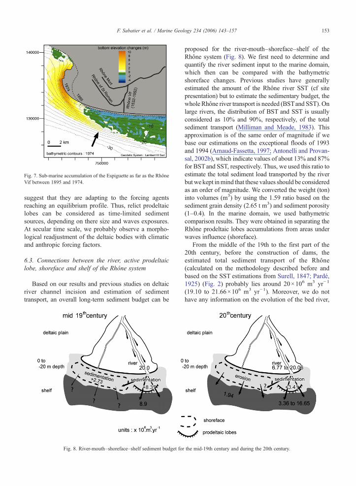
Fig. 7. Sub-marine accumulation of the Espiguette as far as the RhôneVif between 1895 and 1974.
153F. Sabatier et al. / Marine Geology 234 (2006) 143–157
suggest that they are adapting to the forcing agentsreaching an equilibrium profile. Thus, relict prodeltaiclobes can be considered as time-limited sedimentsources, depending on there size and waves exposures.At secular time scale, we probably observe a morpho-logical readjustment of the deltaic bodies with climaticand anthropic forcing factors.
6.3. Connections between the river, active prodeltaiclobe, shoreface and shelf of the Rhône system
Based on our results and previous studies on deltaicriver channel incision and estimation of sedimenttransport, an overall long-term sediment budget can be
Fig. 8. River-mouth–shoreface–shelf sediment budget for
proposed for the river-mouth–shoreface–shelf of theRhône system (Fig. 8). We first need to determine andquantify the river sediment input to the marine domain,which then can be compared with the bathymetricshoreface changes. Previous studies have generallyestimated the amount of the Rhône river SST (cf sitepresentation) but to estimate the sedimentary budget, thewhole Rhône river transport is needed (BSTand SST). Onlarge rivers, the distribution of BST and SST is usuallyconsidered as 10% and 90%, respectively, of the totalsediment transport (Milliman and Meade, 1983). Thisapproximation is of the same order of magnitude if webase our estimations on the exceptional floods of 1993and 1994 (Arnaud-Fassetta, 1997; Antonelli and Provan-sal, 2002b), which indicate values of about 13% and 87%for BSTand SST, respectively. Thus, we used this ratio toestimate the total sediment load transported by the riverbutwe kept inmind that these values should be consideredas an order of magnitude. We converted the weight (ton)into volumes (m3) by using the 1.59 ratio based on thesediment grain density (2.65 t m3) and sediment porosity(1–0.4). In the marine domain, we used bathymetriccomparison results. They were obtained in separating theRhône prodeltaic lobes accumulations from areas underwaves influence (shoreface).
From the middle of the 19th to the first part of the20th century, before the construction of dams, theestimated total sediment transport of the Rhône(calculated on the methodology described before andbased on the SST estimations from Surell, 1847; Pardé,1925) (Fig. 2) probably lies around 20×106 m3 yr−1
(19.10 to 21.66×10⁶ m3 yr−1). Moreover, we do nothave any information on the evolution of the bed river,
the mid-19th century and during the 20th century.
154 F. Sabatier et al. / Marine Geology 234 (2006) 143–157
which can either traps sediments in transit (by accretion)or, on the contrary, supplies sediments (by incision)which then move towards the sea. Thus, as the netsedimentation of the Grand Rhône prodeltaic lobe isabout 8.37×10⁶ m3 yr−1 during the period 1872–1895,we estimate the river sediment by-pass via the prodeltaiclobe at around 11.63×10⁶ m3 yr−1. In the lowershoreface area (−10 to −20 m), the sediment budget ispositive for the period 1872–1895. Since the net uppershoreface budget is in equilibrium, the sediments in thelower shoreface cannot come from the upper zone.Onshore sediment transport from zones deeper than−20 m can hardly be expected, so we consider that thenet accumulation of the lower shoreface is derived fromthe Rhône river sediment input. The lower shoreface ofthe Rhône delta can receive river sediment discharge(Zuo et al., 1997; Radakovitch et al., 1998; Durrieu deMadron et al., 2000; Touzani and Giresse, 2002)extending out to sea via plumes as observed in othercomparable deltaic environments (Jiménez et al., 1999).By deducing the Rhône inputs from the prodeltaic lobeand from the shoreface, the supplies of the Rhône riverto the shelf (deeper than −20 m depth) is thus estimatedto be around 8.90 M m3 yr−1 (Fig. 8).
It is difficult to propose a mean value of the riversediment input for the 20th century because ofdecreasing river floods during this period and the lackof reliable data. In consequence, based on maximum(Surell, 1847; Pardé, 1925) and minimum (Antonelliand Provansal, 2002a) SST evaluation during the 20thcentury, we calculated the total river sediment transportranging between 6.71 and 20×106 m3 yr−1. Based onbathymetric profile line comparisons (1907 and 1991),Arnaud-Fassetta (1998) estimated a negative sedimentbudget for the Grand Rhône of about 0.06×10⁶ m3
yr−1. Since the Grand Rhône channel is under anerosional regime, we may assume that it can supplysediment to the coastal zone. Arnaud-Fassetta (2003)suggested that sediment transport was facilitated bychannelization of the Rhône during the 20th century.While we do not take into account bank morphology andnarrowing, field measurements indicate that thesefeatures are partially artificial and that their influenceis negligible at the considered time scale (Arnaud-Fassetta, 2003). Moreover, civil engineering workssince 1867 along the two arms have limited the extentof flooding, and sedimentation on the deltaic plain hasbeen significantly reduced. It therefore appears reason-able to consider that the incised bed-material istransported downstream and acts as source of sedimentsupply to the sea. Because there are no long-term riverbathymetric profile lines available for the Petit Rhône,
the sediment budget of this arm is not evaluated.Nevertheless, it should not have any strong influence onthe overall sediment budget at this time scale becausethe Petit Rhône is a minor arm and its sinuousmorphology probably favours accumulation in thechannel (Arnaud-Fassetta, 1998; Antonelli et al.,2004). By subtracting the river sediment input to thesea (total sediment transport added to the channel ero-sion) from the prodeltaic lobe accumulation (+3.41×10⁶ m3 yr−1), we can estimate a maximum prodeltaiclobe by-pass between 3.36 and 16.65×10⁶ m3 yr−1.Between 1895 and 1974, the shoreface sediment budgetsuggests net equilibrium of the upper part and netoffshore loss on the lower part (1.66×10⁶ m3 yr−1)(Fig. 7), probably caused by undertow and downwellingas observed on other sites (Hequette and Hill, 1993;Jiménez et al., 1999; Hequette et al., 2002). During the20th century, with decreasing river sediment discharge,the sediment input to the sea was insufficient tocompensate for the loss of sediment farther offshore.We cannot infer that, while offshore sediment transportoccurred during 1895–1974, no such transport wouldhave occurred during 1872–1895. Indeed, our results arebased on bathymetric comparisons, which indicate thenet evolution. We thus consider that offshore sedimenttransport would have occurred during both periods, butduring the 19th century this movement was counter-balanced by considerable river discharge of suspendedsediment during plumes. River sediments are also beingdeposited offshore, on the shelf, where a positivesedimentation rate has been demonstrated (Zuo et al.,1997; Radakovitch et al., 1998; Durrieu deMadron et al.,2000; Touzani and Giresse, 2002). These authors arguefor an important contribution of the Rhône River to shelfsedimentation. However, the offshore loss of sedimentfrom the shoreface, estimated in this study frombathymetric comparisons, will also contribute to theshelf sedimentation (Fig. 8).
To conclude, we point out that our analysis andinterpretations are based on a comparison of bathymet-ric sounding over the long term and only yield orders ofmagnitude. Field measurements during storms andfloods most probably reflect sedimentary exchangesbetween the mouth zone and the shoreface, as well asbetween the upper and lower shoreface, as alreadyobserved in the Ebro delta (Jiménez et al., 1999) in acomparable environment with the delta of the Rhône. Itis also well known that coarse sediments move onshoreand fine sediments off-shore during storms (Stive and deVriend, 1995). While this segregation probably occurson the shoreface of the Rhône delta, such processes havenever yet been measured on this site.
155F. Sabatier et al. / Marine Geology 234 (2006) 143–157
7. Conclusion
The present analysis is based on the evolution of thelong-term bathymetry (150 yr), leading to some novelinsights into the relations between the river, active andrelict prodeltaic lobes, shoreface and continental shelf.First of all, we show that the reduction in thesedimentary inputs of the Rhône to the sea over thelast 150 yr has resulted in a reduction in sedimentationat the mouth. We also clearly show that this reductionbegan before the construction of dams. Our resultsindicate that there is a large accumulation of sediment inthe area around a growing prodeltaic lobe, associatedwith a reduced contribution to longshore sedimenttransport. Following a shift in the river channel andmouth, the prodeltaic lobe is reworked by waves and itssediment contributes partially to the growth of spits.This suggests that there is a “time-shift” between theinput of river sediment to the sea and the build up of abeach. In an initial stage, the sediments are trapped inthe prodeltaic lobe, and later, when the mouth locationhas shifted, they are reworked to build spits. During theHolocene and up to the modern period, the river channelhas shifted many times through natural and anthropicprocesses to build up the present deltaic plain andshoreface morphology. Nowadays, as the river channelsare controlled by dykes and human intervention, a rivershift is not possible (assuming that the dykes can resistthe strongest flood events). Under these conditions, andwith the decreased input of fluvial load into the sea, itthus appears unlikely that river sediments can signifi-cantly contribute to the beaches of the Rhône deltacoast. Moreover, the relict prodeltaic lobes constitutesedimentary reservoirs that are gradually being used up.The chronic erosion of the coastline, which is caused bya deficit in sediment, a very weak supply and theredistribution of the river sediments, is thus likely tocontinue in the future.
Acknowledgements
This work is a contribution to EuroStrataformEuropean Program (number EVK3-CT2002-20079) andFrench CNRS-RESYSTand CNRS-ORME programmes.The first author is supported by a Marie CurieIndividual Fellowship from the E.U. (EVK3-CT-2002-50015). The authors thank the Etablissement Principaldu Service Hydrographique et Océanographique de laMarine (EPSHOM) and the Port Autonome deMarseille (PAM) for providing the bathymetrics data.Lucie Raivard (Géomer) is acknowledge for her help indigitalizing the bathymetric maps. Marcel Stive is
acknowledged for his scientific help and profitablediscussions. We would like to acknowledge thereviewers and particularly José Jiménez (UPC Barce-lona) whom remarks enabled to significantly improvethe scientific interests of this paper.
References
Aloisi, J.C., Auffret, G.A., Auffret, J.P., Barusseau, J.P., Hommeril, P.,Larsonneur, C., Monaco, A., 1977. Essai de modélisation de lasédimentation actuelle sur les plateaux continentaux français. Bull.Soc. Géol. Fr. XIX, 2 (7), 183–195.
Antonelli, C., Provansal, M., 2002a. Vers une ré-évaluation desmatières en suspension de Rhône aval par acquisition de mesuressur toute la colonne d'eau. Geomorphology: From Expert Opinionto Modelling.
Antonelli, C., Provansal, M., 2002b. Characterisation and Assesse-ment of sand fluxes in the lower Rhône River, France. River Flow2002, Proceedings of the International Conference on FluvialHydraulics, Louvain, Belgium, vol. 2, pp. 587–593.
Antonelli, C., Provansal, M., Vella, C., 2004. Recent morphologicalchannel changes in a deltaïc environment. The case of the RhôneRiver, France. Geomorphology 57, 385–402.
Arnaud-Fassetta, G., 1997. Evolution du plancher alluvial du PetitRhône à l'échelle pluriannuelle (delta du Rhône, France du sud).Geomorphol. Relief Process. Environ. 3, 237–256.
Arnaud-Fassetta, G., 1998. Dynamiques fluviales holocènes dans ledelta du Rhône. Thèse de Doctorat en Géographie Physique,Université de Provence, Aix-en-Provence, 329 pp.
Arnaud-Fassetta, G., 2003. River channel changes in the Rhône Delta(France) since the end of the Little Ice Âge: geomorphologicaladjustment to hydroclimatic change and natural resource manage-ment. Catena 51 (2), 141–172.
Arnaud-Fassetta, G., Provansal, M., 1999. High frequency variationsof water flux and sediment discharge during the Little Ice Age(1586–1725 AD) in the Rhône Delta (Mediterranean France).Relationship to the catchment basin. Hydrobiologia 410,241–250.
Berné, S., Carré, D., Loubrieu, B., Mazé, J.P., Normand, A., 2002.Carte morpho-bathymétrique du Golfe du Lion. IFREMER, Brest(4 bathymetric maps at the 1/100000 scale). Vol.1, 48p.
Blanc, J., 1977. Recherche en sédimentologie appliquée au littoral dudelta du Rhône, de Fos au Grau du Roi. Publ. Cent. National pourl'EXploitation des Océans, 75 (1193). 69 pp.
Bravard, J.P., 1989. La métamorphose des rivières des Alpes françaisesà la fin du Moyen-Age et à l'époque moderne. Rev. Géogr. Liège25, 145–157.
Bravard, J.-P., Peiry, J.-L., 1993. La disparition du tressage dans lesAlpes françaises sous l'effet de l'aménagement des cours d'eau(19ème–20ème siècles). Z. Geomorphol. (Suppl. Bd 88), 67–79.
Cencini, C., 1998. Physical processes and human activities in theevolution of the Po Delta, Italy. J. Coast. Res. 14 (3), 774–793.
Dugas, S.F., 1989. Etude du transit sédimentaire par charriage dans leRhône entre Beaucaire et Arles. 1ère partie. Rapp. Instit. Franç. DeRech. Scient. Pour le Dev. En Coop. and Comp. Natio. Rhône.département DEC, Montpellier. 65 pp.
Durrieu de Madron, X., Abassi, A., Heussner, S., Monaco, A., Aloisi,J.C., Radakovitch, O., Giresse, P., Buscail, R., Kerhervé, P., 2000.Particulate matter and organic carbon budgets for the Gulf of Lions(NW Mediterranean). Oceanol. Acta 23 (6), 717–730.
156 F. Sabatier et al. / Marine Geology 234 (2006) 143–157
El Habr, H., Golterman, H.L., 1987. Input of nutrient and suspendedmatter into the Golfe du Lion and the Camargue by river Rhône.Rev. Sci. Eau 6, 395–422.
Galloway, W.E., 1975. Process framework for describing themorphologic and stratigraphic evolution of deltaïc depositionalsystems. In: Ed, B. (Ed.), Deltas. Geol. Soc., Houston, pp. 87–98.
Gautier, E., 1994. Interférence des facteurs anthropiques et naturelsdans le processus d'incision sur une rivière alpine— l'exemple duBuëch (Alpes du Sud). Rev. Géogr. Lyon 69 (1/94), 57–62.
Giosan, L., Bokuniewicz, H., Panin, N., Postolache, I., 1999.Longshore sediment transport pattern along the Romanian Danubedelta coast. J. Coast. Res. 15 (4), 859–871.
Guillen, J., Palanques, A., 1993. Longshore bar and trought systems ina microtidal, strom wave dominated coast: the Ebro delta (NWMediterranean). Mar. Geol. 115, 239–252.
Guillen, J., Palanques, A., 1997. A shoreface zonation in the Ebro detabased on grain size distribution. J. Coast. Res. 13 (3), 867–878.
Hequette, A., Hill, P.R., 1993. Storm-generated currents and offshoresediment transport on a sandy shoreface, Tibjak beach, CanadianBeaufort Sea. Mar. Geol. 111, 283–304.
Hequette, A., Desrosiers, M., Hill, P.R., Forbes, L., 2002. Tueinfluence of coastal morphology on shoreface sediment transportunder storm-combined flows, Canadian Beaufort Sea. J. Coast.Res. 17 (3), 507–516.
IRS, 2000. Etude globale pour une stratégie de réduction des risquesdus aux crues du Rhône. volet 1: Etude du transport solide, vol. 3.300 pp.
Jiménez, J.A., Sánchez-Arcilla, A., 1993. Medium-term coastalresponse at the Ebro delta, Spain. Mar. Geol. 114, 105–118.
Jiménez, J.A., Guillén, V., Gracia, A., Palanques, M., García, A.,Sánchez-Arcilla, A., Puig, P., Puigdefábregas, J., Rodríguez, G.,1999. Water and sediment fluxes on the Ebro Delta shoreface: onthe role of low frequency currents. Mar. Geol. 157, 219–239.
Klingeman, P.C., Bravard, J.-P., Giuliani, Y., 1994. Les impactsmorphodynamiques sur un cours d'eau soumis à un aménagementhydroélectrique a dérivation: le Rhône en Chautagne (France).Rev. Géogr. Lyon 69 (1/94), 73–87.
Kolb, C.R., Van Lopik, J.R., 1966. Depositional environment ofMississippi River Delta plain — Southeastern Louisiana. In:Shirley, M.L. (Ed.), Deltas in their Geologic Framework. HoustonGeological Society, Houston, TX, pp. 17–61.
Komar, P.D., 1998. Beach Processes and Sedimentation, 2nd ed.Prentice Hall. 544 pp.
Kruit, C., 1955. Sediments of the Rhône Delta Grain Size andMicrofauna. Verhand Konink.
L'Homer, A., 1993. Notice de la Carte Géologique au 1/50000, Feuilledu Grau du Roi. BRGM. 93 pp.
L'Homer, A., Bazile, F., Thommeret, J., Thommeret, Y., 1981.Principales étapes de l'édification du delta du Rhône de 7000 BP ànos jours; variations du niveau marin. Océanis 7 (4), 389–408.
Li, G., Zhuang, K., Wei, H., 2000. Sedimentation in the Yellow Riverdelta. Part III. Seabed erosion and diaprirism in the abandonedsubaqueous delta lobe. Mar. Geol. 168, 129–144.
Masselink, G., 1992. Longshore variation of grain size distributionalong the coast of the Rhône delta, Southern France: a test of the“Mc Laren model”. J. Coast. Res. 8 (2), 286–291.
Milliman, J.D., 1997. Blessed dams or damned dams? Nature 386,325–327.
Milliman, J.D., Meade, R.H., 1983. World-wide delivery of riversediment to the oceans. J. Geol. 91, 1–21.
Miramont, C., Guilbert, X., 1997. Variations historiques de lafréquence des crues et évolution de la morphogenèse fluviale en
Moyenne Durance (France du sud-est). Géomorphol. ReliefProcess. Environ. 4, 235–338.
Oomkens, E., 1970. Depositional sequences and sand distribution inthe postglacial Rhône delta complex. In: Ed, J.P.M. (Ed.), DeltaïcSedimentation Modern and Ancient, pp. 198–211.
Pardé, M., 1925. Le régime du Rhône, étude hydrologique, Etude ettravaux de l'Institut de Géographie Alpine de l'Université deGrenoble, Phd thesis, Université de Grenoble, 2 vol., 1323 p.
Pauc, H.E., 1976. Comportement dynamique des matériaux ensuspension. Etude de divers secteurs du Golfe du Lion. Bulletinde la Societe Naturelle d'Afrique du Nord, Alger, 67, pp. 151–169.
Pelnard Considere, R., 1956. Essai de théorie de l'Evolution des Formesde Rivage en Plages de Sable et de Galets. 4th Journées del'Hydraulique, Les Energies de la Mer, Question III, Rapport. No. 1,pp. 289–298.
Pichard, G., 1995. Les crues sur le bas-Rhône de 1500 à nos jours.Pour une histoire hydroclimatique. Méditerranée 3–4, 105–116.
Poinsard D., 1992. Effets des aménagements fluviaux sur les débitsliquides et solides. L'exemple du Rhône dans les plaines deMiribel-Jonage et de Donzère-Mondragon. Ph. D. Thesis, Lyon IIIUniversity, 501 p.
Pont, D., Bardin, O., 1996. Liquid and solid inputs from the Rhône intothe Ile de Camargue and its hydrological functioning. FinalWorkshop MEDDELT, Venezia (Italy), Oct. 2–6, 1996. The Pastand the Present, vol. I, pp. 4.29–4.46.
Pont, D., Blombed, B., 1995. Les débits solides du Rhône à proximitéde son embouchure durant l'année hydrologique 1994 – 1995.7èmes rencontres de l'Agence Régionale Pour l'Environnement,PACA, 24–27 Octobre 1995, Digne les bains, 283–292.
Pont, D., Simonnet, J.P., Walter, A.V., 2002. Medium-term changes insuspended sediment delivery to the ocean: consequences ofcatchment heterogeneity and river management (Rhône river,France). Estuar. Coast. Shelf Sci. 54, 1–18.
Pranzini, E., 2001. Updrift river mouth migration on cuspate deltas:two examples from the coast of Tuscany (Italy). Geomorphology38 (1–2), 125–132.
Probst, J.L., 1989. Hydroclimatic fluctuations of some European riverssince 1800. In: Petts, G.E. (Ed.), Historical Change of LargeAlluvial Rivers: Western Europe. Chicheser, Wiley, pp. 41–55.
Radakovitch, O., Charmasson, S., Arnaud, M., Bouisset, P., 1998. 210Pb and caesium accumulation in the Rhône delta sediment. Estuar.Coast. Shelf Sci. 48, 77–92.
Roditis, J.C., Pont, D., 1993. Dynamiques fluviales et milieux desédimentation du Rhône à l'amont immédiat de son delta.Méditerranée 3.4, 5–18.
Russell, J.R., 1942. Geomorphology of the Rhône delta. Ann. Assoc.Am. Geogr. XXXII (2), 149–254.
Sabatier F. 2001. Fonctionnement et dynamiques morphosédimen-taires du littoral du delta du Rhône. Ph. D. thesis, Université d'Aix-Marseille III, 272 p.
Sabatier, F., Suanez, S., 2003. Evolution of the Rhône delta coast sincethe end of the 19th century. Géomorphol. Relief Process. Environ.4, 283–300.
Savey, P., Deleglise, R., 1967. Les incidences de l'aménagement dutiers central du Bas-Rhône sur les transports solides par charriageet par suspension. Int. Assoc. Hydrol. Sci. Publ. (IAHS) 75,462–476.
Sogreah, 1999. Aqueduc du Rhône à Barcelone, investigationsupplémentaires. RMC8, Impacts sur les sédiments du Rhône.Rapport 55 0470/JLR/R3 VA, 82p.
Stanley, D.J., Warne, A.G., 1998. Nile Delta in its destruction phase.J. Coast. Res. 14 (3), 794–825.
157F. Sabatier et al. / Marine Geology 234 (2006) 143–157
Stive, M.J.F., de Vriend, H.J., 1995. Modelling shoreface profileevolution. Mar. Geol. 126, 235–248.
Stone, G.W., Donley, J., 1998. The World Deltas Conference: a tributeto the Late Professor James Plummer Morgan: 1919–1995.J. Coast. Res. 13 (3), 695–697.
Suanez, S., Bruzzi, C., 1999. Shoreline management and itsimplications for coastal processes in the eastern part of theRhône delta. J. Coast. Conserv. 5 (1), 1–12.
Suanez, S., Provansal, M., 1998. Large scale shoreline change, Rhônedelta. J. Coast. Res. 14, 493–503.
Suanez, S., Simon, B., 1997. Utilisation de l'analyse diachroniquedans l'étude de l'évolution du littoral oriental du delta du Rhône(France, Sud-Est). Photo-Interprétation 3–4, 147–176.
Suanez, S., Prosper-Laget, V., Provansal, M., 1997. Variationsrelatives du niveau marin dans le delta du Rhône et à Marseille.Implications climatiques et/ou tectoniques. C R. Acad. Sci. IIa 324,639–646.
Suanez, S., Bruzzi, C., Arnoux-Chiavassa, S., 1998. Données récentessur l'évolution des fonds marins dans le secteur oriental du delta duRhône (plage napoléon et flèche de la Gracieuse). Géomorphol.Relief Process. Environ. 4, 291–312.
Surell, M., 1847. Mémoire sur l'Amélioration des Bouches du Rhône,Imprimerie Cévenole, Nîmes, pp. 1–8.
Thieler, E.R., Pilkey, O.H., Young, R.S., Bush, D.M., Chai, F., 2000.The use of mathematical models to predict beach behavior fo U.S.coastal engineering: a critical review. J. Coast. Res. 16 (1), 48–70.
Touzani, A., Giresse, P., 2002. The Rhône River Prodelta: short-term(100–103 Year) sedimentation patterns and human impact.J. Coast. Res. 18 (1), 102–117.
Van Straaten, L.M.J.U., 1959. Littoral and submarine morphology ofthe Rhône delta. Proc. Coastal Geog. Conf. Louisiana StateUniversity, Baton Rouge, pp. 233–264.
Vella, C., Provansal, M., 2000. Relative sea-level rise and neotectonicevents during the last 6500 yr on the Southern eastern Rhône delta,France. Mar. Geol. 170, 27.
Vella, C., Fleury, T.-J., Raccasi, G., Provansal, M., Sabatier, F.,Bourcier, M., 2005. Evolution of the Rhône delta plain in theHolocene. Mar. Geol. 222–223, 235–265.
Vernier, E., 1976. Edification et évolution de la flèche de la Gracieuse,Ouest du Golfe de Fos. Bull. B.R.G.M. (2ème série) 4, 103–115.
Warner, R.F., 2000. Gross channel change along the Durance river,southern France, over the last 100 years using cartographic data.Regul. River Res. Manag. 16, 141–157.
Wells, J.T., Coleman, M., 1987. Wetland loss and the subdelta lifecycle. Estuar. Coast. Shelf Sci. 25, 111–125.
Wright, L.D., Short, A.D., 1984. Morphodynamic variability of surfzones and beaches: a synthesis. Mar. Geol. 56, 93–118.
Wright, L.D., Boon, J.D., Kim, S.C., List, J.H., 1991. Modes of cross-shore sediment transport on the shoreface of the Middle AtlanticBight. Mar. Geol. 96, 19–51.
Zeiler, M., Schulz-ohlberg, J., Figge, K., 2000. Mobile sand depositsand shoreface sediment dynamics in the inner German Bight(North Sea). Mar. Geol. 170, 363–380.
Zuo, Z., Eisma, D., Gieles, R., Beks, J., 1997. Accumulation rates andsediment deposition in the northwestern Mediterannean Sea. Deep-Sea Res. 44 (3–4), 597–609.
Related Documents