Doc.No: IT-26322 1 9 December 2005 SECTION 1.0 SIGNIFICANT RESOURCE MANAGEMENT ISSUES S1.1 SIGNIFICANT RESOURCE MANAGEMENT ISSUES The Lakes A Zone comprises a discrete planning unit within the Rotorua District. Part 20 of the District Plan contains specific provisions to manage the unique and sensitive attributes of the lakes’ environment. The high degree of intactness of the lakes’ environment contributes to the national significance of their catchments. The Significant Resource Management Issues for the Lakes A Zone are: S1.1.1 Reasonable Use Achieving the maintenance and enhancement of the natural character of the Lakes A Zone as a goal of the District Plan has been a matter of great debate within the community, particularly outside existing settlements. The maintenance and enhancement of natural character is very difficult if Council is to simultaneously enable the reasonable use of land by land owners. Council is not in a financial position to purchase tracts of land to ensure the maintenance and enhancement of the natural character. Links to Objectives OB 1, OB 2, OB 3, OB 5(b), OB 6, OB 7, OB 9, OB 10, OB 11, OB 12, OB 13, OB 14 S1.1.2 Indigenous vegetation The substantial land areas of indigenous vegetation and volcanic landforms provide a unique visual setting to the lakes. The values ascribed to indigenous vegetation include biodiversity and habitats, landscapes, natural character, ecology and water and soil conservation. These values are threatened by ongoing changes in land use, particularly: • Changes in land use, including clearance and increases in built developments; • Presence of pest animal and pest plants; • Poor land management including grazing and neglect; • Drainage and reclamation of wetlands. S1.1.3 Okareka and Tarawera The Lakes A Zone landscape contains two small settlements confined to the lake shore of Okareka and Tarawera in a setting where there are backdrops of indigenous vegetation, pastoral farming and afforestation. However, to sustain the settlement communities, there needs to be the opportunity for additions and alterations to existing structures, development or redevelopmentof new structures in the settlements without compromising the settlements’ existing landscape qualities or the natural character and landscape quality of their setting Links to Objectives OB 1, OB 2, OB 4, OB 5, OB 6, OB 7, OB 9, OB 12, OB 13 OB 1, OB 3, OB 7, OB 9, OB 11, OB 12, OB 13, OB 14, OB 16, OB 17, OB18

Welcome message from author
This document is posted to help you gain knowledge. Please leave a comment to let me know what you think about it! Share it to your friends and learn new things together.
Transcript
Doc.No: IT-26322 1 9 December 2005
SECTION 1.0 SIGNIFICANT RESOURCE MANAGEMENT ISSUES
S1.1 SIGNIFICANT RESOURCE
MANAGEMENT ISSUES The Lakes A Zone comprises a discrete planning unit within the Rotorua District. Part 20 of the District Plan contains specific provisions to manage the unique and sensitive attributes of the lakes’ environment. The high degree of intactness of the lakes’ environment contributes to the national significance of their catchments. The Significant Resource Management Issues for the Lakes A Zone are:
S1.1.1 Reasonable Use
Achieving the maintenance and enhancement of the natural character of the Lakes A Zone as a goal of the District Plan has been a matter of great debate within the community, particularly outside existing settlements. The maintenance and enhancement of natural character is very difficult if Council is to simultaneously enable the reasonable use of land by land owners. Council is not in a financial position to purchase tracts of land to ensure the maintenance and enhancement of the natural character.
Links to Objectives OB 1, OB 2, OB 3, OB 5(b), OB 6, OB 7, OB 9, OB 10, OB 11, OB 12, OB 13, OB 14
S1.1.2 Indigenous vegetation The substantial land areas of indigenous vegetation and volcanic landforms provide a unique visual setting to the lakes. The values ascribed to indigenous vegetation include biodiversity and habitats, landscapes, natural character, ecology and water and soil conservation. These values are threatened by ongoing changes in land use, particularly: • Changes in land use, including clearance and
increases in built developments; • Presence of pest animal and pest plants; • Poor land management including grazing and
neglect; • Drainage and reclamation of wetlands.
S1.1.3 Okareka and Tarawera
The Lakes A Zone landscape contains two small settlements confined to the lake shore of Okareka and Tarawera in a setting where there are backdrops of indigenous vegetation, pastoral farming and afforestation. However, to sustain the settlement communities, there needs to be the opportunity for additions and alterations to existing structures, development or redevelopmentof new structures in the settlements without compromising the settlements’ existing landscape qualities or the natural character and landscape quality of their setting
Links to Objectives OB 1, OB 2, OB 4, OB 5, OB 6, OB 7, OB 9, OB 12, OB 13 OB 1, OB 3, OB 7, OB 9, OB 11, OB 12, OB 13, OB 14, OB 16, OB 17, OB18
Doc.No: IT-26322 2 9 December 2005
SECTION 1.0 SIGNIFICANT RESOURCE MANAGEMENT ISSUES
S1.1.4 Landscape Qualities The landscape of the Lakes A Zone contains volcanic crests and landforms, skylines, ridgelines, steeper and shore slopes and indigenous vegetation. The spaciousness, openness/enclosure, wilderness and ruralness is vulnerable to adverse effects from fragmentation and domestication through more intensified built development and land use patterns including changes in vegetation and earthworks.
S1.1.5 Riparian Margins
Indiscriminate development tincluding land drainage, vegetation clearance, stock grazing, and buildings or development within the riparian margins lessens their effectiveness as a filter of discharges (including septic tank effluent) to the lakes and rivers and may reduce their natural character values and functioning/inter-relationships of the lakes and rivers environments.
S1.1.6 Indigenous Terrestrial Ecosystems
Many indigenous terrestrial ecosystems are degraded by grazing, the presence of pests and weeds, and development including structures or buildings. Degradation and neglectful management practices are particularly significant in the small localised wetlands.
Links to Objectives OB 1, OB 7, OB 9, OB 10, OB 11, OB 12, OB 13, OB 14, OB15
OB 1, OB 2, OB 3, OB 4, OB 5, OB 6, OB 7, OB 9, OB 10, OB 12
OB 1, OB 2, OB 5, OB 6, OB 7, OB 9, OB 10
S1.1.7 Cultural and Historic Heritage
The use and development of land can destroy elements of the landscape and particular sites of cultural and historical importance. Greater value is now being placed by society on preserving the cultural and historic heritage of the nation. The eruption of Mt Tarawera has created a unique situation in the District. There is a lack of certainty and information about much of the pre-eruption settlement patterns and cultural sites. The historical interest is high as illustrated by the Buried Village at Te Wairoa. The consequence is that it is extremely difficult for the public to be aware of and protect appropriately pre-eruption cultural sites.
S1.1.8 Relationship of Maori with the Area
Following the eruption of Mount Tarawera on 10 June 1886 Maori left the area after several centuries of occupation. Hapu information and some early survey records refer to pre-eruption occupation around the shores of the lakes, including areas that are today covered in indigenous vegetation. Significant areas of this vegetation are protected in the Department of Conservation estate. For some hapu who retain land, there is a desire to enable opportunities to provide for social and economic well being of iwi and hapu members returning to their ancestral lands. In this respect there needs to be the opportunity for development in appropriate locations without compromising existing landscape qualities or natural character.
Links toObjectives
OB 11, OB 14, OB 15 OB 1, OB 5, OB 7, OB 11, OB 12, OB 14, OB 15
Doc.No: IT-26322 3 9 December 2005
SECTION 1.0 SIGNIFICANT RESOURCE MANAGEMENT ISSUES
S1.1.9 Effects on the Tangata Whenua
Use, development and protection of land, water and other taonga under the RMA can have effects on the relationship of the Tangata Whenua and their culture and traditions with their ancestral lands, water, sites, waahi tapu and other taonga. Matters of significance to the Tangata Whenua relating to the sustainable management of land and associated resources are likely to be compromised without consultation with the Tangata Whenua.
S1.1.10 Recreation
The ongoing popularity of the Rotorua District to national and international tourists is increasing conflicts on the lakes, congestion at lake shore localities, increased noise levels from some activities and development pressure on the Lakes A Zone.
S1.1.11 Habitats for Trout and Indigenous Aquatic
Fauna There are significant habitats for trout and indigenous aquatic fauna within the Lakes A Zone, and use and development of land can produce adverse effects including: • Low dissolved oxygen and high nutrient
levels in water (e.g. through some farming practices);
• High water temperatures (e.g. through removal of riparian shade vegetation);
Links to Objectives OB 1, OB 2, OB 3, OB 4, OB 5, OB 6, OB 7, OB 9, OB 10, OB 11, OB 12, OB 14, OB 15 OB 1, OB 3, OB 5, OB 11, OB 12, OB 13, OB 14, OB 16, OB 17 OB 3, OB 4, OB 6, OB 9, OB 10, OB 16, OB 17
• Sedimentation (e.g. through earthworks); • Stormwater discharges.
In addition trout fishing is an important recreational activity and attracts many tourists to the Lakes A Zone.
S1.1.12 Habitat for Aquatic Birds
There are significant habitats for the breeding, roosting, feeding and moulting of aquatic birds located in the Lakes A Zone. All species are threatened by: • Whole lake effects (e.g. through introduced
macrophytes, algae, fish, birds, pollution and contamination);
• Site effects (e.g. through disturbance and destruction to particular breeding, roosting, feeding and moulting sites).
S1.1.13 Natural Hazards
The lakes environment will continue to be at risk from volcanic and seismic activity and in some local areas stormwater overland flow paths.
S1.1.14 Noise
One of the components of the unique natural character of the lakes environments is the quiet ambient noise levels and this is threatened by recreational activities within the Lakes A Zone on land, water and in the air.
Links to Objectives OB 3, OB 4, OB 6, OB 7, OB 9, OB 10, OB 17 OB 18 OB 14, OB 16

Doc.No: IT-26322 4 9 December 2005
SECTION 1.0 SIGNIFICANT RESOURCE MANAGEMENT ISSUES
S1.1.15 Natural Character
Part of the natural character of the Lakes A Zone is the dominance of the natural elements in the landscape and the visual subservience of housing and roading. The narrow winding roads are part of the character of the area. The natural character is threatened by road widening to achieve safer traffic environments. At the same time there is a community desire to improve traffic safety.
Links to Objectives
OB 11, OB 12, OB 17
Doc.No: IT-26322 5 9 December 2005
SECTION 2.0 KEY MATTERS OF NATIONAL IMPORTANCE IN THE LAKES A ZONE
S2.1 Vision Statement
The Significant Resource Management Issues described in Section 1.0, along with the matters of national importance in the Lakes A Zone set out below, followed by all the objectives and policies in Section 4.0 and anticipated environmental results and monitoring detailed in Section 7.0 form part of Council’s vision for the sustainable management of the natural and physical resources of the Lakes A Zone.
S2.2 Matters of National Importance
The matters of National Importance in relation to the use, development and protection of land within the Lakes A Zone are considered to be:
• The preservation of natural character and protection from inappropriate subdivision, use and development [RMA s6(a)];
• The protection of outstanding natural features and landscapes from inappropriate subdivision, use and development [RMA s6(b)];
• The protection of areas of significant indigenous vegetation and significant habitats of indigenous fauna [RMA s6(c)];
• The maintenance and enhancement of public access to and along lakes and rivers [RMA s6(d)];
• The relationship of Maori and their culture and traditions with their ancestral lands, water, sites, waahi tapu and other taonga [RMA s6(e)];
• The protection of historic heritage from inappropriate subdivision, use and development [RMA s6(f)].
Where matters of national importance compete among themselves the Council will make a judgement as to the respective weighting to be applied taking into account the following matters.
S2A NATURAL CHARACTER DESCRIPTION
S2A.1 The maintenance and enhancement of Natural Character of the
Lakes A Zone is a key consideration in all provisions of this Plan. As such, understanding the elements that make up the natural character is quite crucial to the administration of the District Plan. Consideration of whether natural character is maintained or enhanced will also be a paramount consideration in all Resource Consent applications. The individual and unique character of the Tarawera Lakes within the Lakes A Zone is in essence derived from: • Recent dramatic volcanic changes to the land and waterbodies; • Highly variable topography; • Significant land area in indigenous vegetation with
consequential flora and fauna values contributing to NZ’s biodiversity and the high water quality values of the catchment lakes;
• Two small lakeside settlements discretely located on the shores of Lake Tarawera and Lake Okareka;
• Unspoilt lakes; • Geothermal features; • The upper slopes and skylines of the lakes being largely intact
and highly natural; and • People’s awareness, perception and appreciation of the
landscape, including the relationship Tangata Whenua have with their ancestral lands, water, sites, waahi tapu and other taonga.
Section 6(a) of the RMA seeks to preserve the natural character of the coastal environment, wetlands and lakes and rivers and their margins.

Doc.No: IT-26322 6 9 December 2005
SECTION 2.0 KEY MATTERS OF NATIONAL IMPORTANCE IN THE LAKES A ZONE
For the purposes of defining natural character the lake margins have been interpreted to include the land-water interface and the containing landforms that provide the context and character for that lake. The margin includes at least to the first main ridge back from the shore.
S2A.2 DEFINING NATURAL CHARACTER
The following statement shall be read together with the Objectives and Policies and Explanations of the Lakes A Zone as they relate to natural character and landscape values.
S2A.2.1 Defining 'Natural' in terms of the Lakes Landscape
The term ‘natural’ is often equated with ‘indigenous’. However the presence of areas in New Zealand which are now purely indigenous, and thus completely pristine, is exceptionally rare because there is usually a presence of humans, introduced plants or animals and an absence of certain indigenous species. Although it is possible to identify areas which are dominated by indigenous values and tending towards the pristine, it is not possible to isolate them completely from exotic elements in the landscape.
S2A.2.2 Natural Character Assessed in Terms of a Spectrum
In defining degrees to which natural character is present within an area, it is useful to assess natural character in terms of a spectrum. At one end of the spectrum is the largely modified built environment and, at the other, the predominantly natural environment. Natural character is present to some degree in every lake margin environment. Natural character of the lake margin is to be treated as
a matter of national importance in every development situation in the Lakes A Zone, in order to preserve and protect their relatively unmodified character from inappropriate subdivision use and development. However, where an environment is heavily modified by development, providing for development may not significantly compromise natural character.
S2A.2.3 Built components in terms of defining natural character
Natural character is restricted to natural components, that is, unbuilt or non-structural elements, but it is not necessarily restricted to indigenous components. Where the landscape is part of a working and living environment, it is the natural elements in that landscape that contribute to the natural character. Thus it does not include built elements, although it does include exotic vegetation, as it contributes to naturalness. The value of the exotic vegetation depends on its ecological and aesthetic compatibility with the surrounding landscape. Exotic trees will contribute more naturalness in a more modified catchment than in a more natural one.
S2A.2.4 Components of Natural Character
Defining naturalness in terms of section 6(a) encompasses both indigenous and introduced species. The primary components, which underpin natural character, are natural processes, natural elements and natural patterns. These interrelate with one another to produce 'natural character' to varying degrees. The three components are briefly described below:
Doc.No: IT-26322 7 9 December 2005
SECTION 2.0 KEY MATTERS OF NATIONAL IMPORTANCE IN THE LAKES A ZONE
i) Natural Processes
The preservation of natural character must first be concerned with sustaining ecological and other natural processes (both biotic and abiotic) which underlie the visual expression of the naturalness of an environment.
ii) Natural Elements
Natural elements are the product of ecological and geological processes. They may or may not be expressed visually. In terms of the lake and stream margins (including riparian areas), natural elements may include geology, landforms, vegetation cover, lake and river bed, foreshore wetlands and water features.
iii) Natural Patterns
Natural patterns are the basis for the natural expression or distribution of unmanufactured or unbuilt elements in an environment.
Natural character reflects the disposition of natural elements in dominantly natural patterns. It is natural processes that have contributed to those patterns and elements, and it is the restoration and continuation of the integrity of natural processes that will secure natural character in the future. Natural character, in the context of sustainability, is dependent on the presence of natural elements, arranged in natural patterns and underpinned by natural processes.
S2A.3 ASSESSING NATURAL CHARACTER
In addition to the presence of natural processes, elements and patterns, two important considerations in assessing the degree to
which natural character is present are context and potential naturalness. These are outlined below:
S2A.3.1 Context
The consideration of context in assessing natural character is paramount. A location does not exist in isolation and therefore consideration of the context is relevant. A minor modification from the near pristine environment may markedly lessen the comparative degree of natural character, whereas a small amount of indigenous vegetation in a highly modified area may exhibit a relatively high degree of natural character. The contrast between the pocket of nature in a built up area, compared with a built element in a pristine or minimally modified area, heightens the awareness of the more natural. The contrast emphasises the character of the more natural. Natural character is considered to be present for both.
S2A.3.2 Potential Naturalness
The significance of potential naturalness and appropriateness of change is also to be considered in assessing natural character. The ability of any environment to return to its 'natural' state can be judged in terms of a place’s ecological resilience and natural restoration potential. Whilst a return to a totally natural state may not be feasible, restoration, repair or re-instatement of natural elements, natural patterns and natural processes may be undertaken.
S2A.4 PRESERVING NATURAL CHARACTER
Preserving the natural character including terrestrial and aquatic habitats and water quality of the Lakes A Zone, creates tensions that have been identified in Section 1.0 of this Plan as a Significant Resource Management Issue. Retaining indigenous vegetation, the
Doc.No: IT-26322 8 9 December 2005
SECTION 2.0 KEY MATTERS OF NATIONAL IMPORTANCE IN THE LAKES A ZONE
naturalness of the lake and river margins and retaining the landform, lies at the heart of protecting the natural character of the Lakes A Zone while providing for reasonable use and development of land in a working and living landscape in a sustainable manner. Preservation of natural character is most likely to be achieved in predominantly 'natural' environments, which are largely free of built structures and modifications. However, it can not be assumed that development will always be 'appropriate' in modified environments. In some situations, development may be 'inappropriate' if it will further degrade or lessen the naturalness of a lake or lake margin environment from its current modified state. Even in highly modified environments, it is still necessary to take into account the effects of such use or development on the lake and the values of what is left of the natural character of the lake margin, both within the immediate area affected by the application and outside of it.
S2B OUTSTANDING LANDSCAPES
The protection of outstanding natural features and landscapes from inappropriate subdivision, use and development is a key consideration in all the provisions of this Plan. ‘Landscape’ is not defined in the RMA. In this Plan it is interpreted to include both the physical and the perceptual. The physical resource in any area is expressed in landscape. In addition, each area is perceived and experienced. The values people place on these areas are subjective, although many are widely shared. Landscape as a human experience combines both aesthetic values and other values which humans attribute to landscape. Used in this sense
landscape is not only the physical appearance of land, but also a person’s awareness, perception and appreciation of the landscape. Attributes used for assessing whether the landscapes within the Lakes A Zone are ‘outstanding’, and therefore of national significance, included: A. Natural Science
Natural features and landscapes of at least district importance for reasons of the rarity or representativeness of their particular landform and landcover. A natural feature may be a landscape feature or an element/component of the landscape. Under section 6(b), geology and soils are elements of particular focus.
B. Aesthetic
Landscapes (and natural features where applicable) that are of high aesthetic value are determined on how memorable they are, on their naturalness, on their composition (coherence) and on other important aesthetic factors. ‘Aesthetic’ is not defined in the RMA. A professional working definition interprets aesthetic as “pertaining to the quality of human perceptual experience (including sight, sound, smell, touch, taste and movement) evoked by phenomena or elements or configurations of elements in the environment.” (Boffa Miskell & Lucas Associates. 1993. Canterbury Regional Landscape Study).

Doc.No: IT-26322 9 9 December 2005
SECTION 2.0 KEY MATTERS OF NATIONAL IMPORTANCE IN THE LAKES A ZONE
C. Legibility
The landscape (or natural feature) of district significance should clearly express past natural and/or cultural processes. Some may have strong historical connotations and evoke a distinctive sense of place.
D. Transience
The natural feature or landscape has significance by providing predictable or regular experience of dimensions of nature other than (or in addition to) landform or landcover such as the occasional presence of wildlife or (other) values.
E. Shared & Recognised
There should be a substantial measure of agreement between professional and public opinion as to the value of natural features and landscapes, for example as reflected through writings and paintings or through favourite locations to sight or visit. The presence of existing protected sites is also likely to reflect shared and recognised values.
F. Tangata Whenua
The natural feature or landscape identified as having particular district importance to the Tangata Whenua.
G. History
The landform, indigenous land cover, the particular farming and forestry pattern and the scale and bushed character of the settlements of Tarawera and Okareka since the eruption of Mount Tarawera in 1886, provide historical associations and a particular context and meaning to human presence and occupation within the landscape. The historical associations also evoke strong memories of a tragic loss of human life
particularly in settlements around Lake Tarawera including the Buried Village, and a lost landscape, that contained natural wonders such as the pink and white terraces. In addition, the area (land and lakes) has historical associations with recreational and/or tourism activities.
S2C SENSITIVE/LESS SENSITIVE LANDSCAPES
The Lakes A Zone includes seven lake catchments that are known or assumed to drain into the Tarawera River. These catchments have been identified as an outstanding natural landscape. There is a very important series of outstanding natural volcanic features that form the basis to this outstanding landscape of the Lakes A Zone. Within the Lakes A Zone, the seven lakes catchments, landscape values, landscape quality and landscape sensitivity vary. Two levels of landscape management have been mapped and described as the: • Sensitive Landscape; and • Less Sensitive Landscape. The ‘sensitive landscape’ defines the outstanding landscape as delineated within the Lakes A Zone. The ‘less sensitive landscape’ includes the Lake Okaro catchment a small area on Ash Pit Road and a western portion of the Lake Tarawera catchment. Overall, the Sensitive Landscape Policy Areas were assessed as outstanding on all above Attributes A - G. The attributes that contribute to an overall outstanding natural feature and landscape must therefore be protected from inappropriate subdivision, use and
Doc.No: IT-26322 10 9 December 2005
SECTION 2.0 KEY MATTERS OF NATIONAL IMPORTANCE IN THE LAKES A ZONE
development. At different scales of interest, the attributes may be applied to a greater or lesser degree or in different combinations in assessing an outstanding natural feature or landscape.
S2D DETERMINING ‘APPROPRIATENESS’
Appropriate subdivision, use and development within the Lakes A Zone must be considered within the context of the requirements of section 6 of the RMA. Section 6 requires Council to recognise and provide for as matters of national importance: i) The preservation of the natural character of the lakes and lake
margins; ii) Protection of outstanding natural features and landscape; iii) The protection of areas of significant indigenous vegetation
and habitats of indigenous fauna; iv) The maintenance and enhancement of public access to and
along lakes and rivers; v) The relationship of Maori and their culture and traditions with
their ancestral lands, water, sites, waahi tapu, and other taonga; and
vi) The protection of historic heritage from inappropriate subdivision, use and development.
The appropriateness or inappropriateness of subdivision, use and development within the context of the section 6 requirements is therefore different from need or market driven demand. Subdivision, use and development must be considered in the context of the above values to determine appropriateness.
In the Lakes A Zone appropriateness of subdivision, use and development is also determined by having regard to the following considerations: • Continued functioning and repair of ecosystems; • Maintenance and enhancement of natural patterns, processes
and elements; • Intactness of natural character; • Sensitivity and vulnerability of the landscape and natural
features; • Protection of areas of significant indigenous vegetation and
significant habitats of indigenous fauna; • The ‘fit’ between the existing environment and the
characteristics of a proposal, including: context, existing character, scale of proposal, and the capacity of the environment to absorb change;
• The relationship of the Tangata Whenua including their culture and traditions with their ancestral lands, water, sites, waahi tapu and other taonga (refer S2E below);
• Protection of historic heritage. S2E TANGATA WHENUA
Recognising and providing for the relationship of the Tangata Whenua and their culture and traditions with their ancestral lands, water, sites, waahi tapu and other taonga is a key consideration in all provisions of this Plan.
S2E.1 Part Five of District Plan
By virtue of Rule 1.1, Part Five of the District Plan (as at 13 May 2000) will continue to apply within the Lakes A Zone.

Doc.No: IT-26322 11 9 December 2005
SECTION 2.0 KEY MATTERS OF NATIONAL IMPORTANCE IN THE LAKES A ZONE
S2E.2 The Tangata Whenua
The Tangata Whenua of the Lakes A Zone are descendants of Te Arawa Waka. Their tribal affiliation is to the Te Arawa confederation of Tribes. Most hapu who identify with the area have whakapapa (genealogy) with the Tuhourangi and Rangitihi Iwi. The Tangata Whenua have historically occupied the Tarawera Area and maintain a sense of identity and association with the area especially through tribal representation, and land trusts. The history is primarily an oral history recorded in patere (chants) and waiata (songs), but is also recorded in mahi whakairo (carving) and raranga (weaving). Some hapu can affiliate with specific areas such as the lakes, mountains, settlements, places of historical value, and significant land features. These specific areas are regarded as taonga and all hapu respect their spiritual and traditional importance.
S2E.3 Tarawera Eruption
Prior to 1886 the area was occupied and the resources used to sustain the Iwi and their hapu. In 1886 with the Tarawera and Rotomahana eruptions, most of the area was devastated with significant loss of life and property. Mud and volcanic debris covered and changed all the natural features in the area and notably the form of Lake Rotomahana. The shore lines of Lake Tarawera also changed significantly over a period of time. The area affected by the eruption was declared tapu. The descendants of those who perished or survived the eruption, continue to have a strong relationship with the area and may wish to relocate back to ancestral lands.
S2E.4 Section 6(e): Maori Cultural and Traditional Relationships
In this Plan considerable emphasis is placed on the matters of national importance set out in section 6. Almost every element is present in the Lakes A Zone. Council is required to recognise and provide for matters of national importance in managing the use, development and protection of natural resources. Under section 6(e) Council has to consider ‘the relationship of Maori and their culture and traditions with their ancestral lands, water, sites, waahi tapu and other taonga’. Council recognises that the Tangata Whenua of the Rotorua District are Te Arawa Confederation of Tribes and in the Lakes A Zone those who hold Mana Whenua are the hapu and whanau of the area.
S2E.5 The Relationship
The ancestral lands and the lakes (water) are the natural and physical resources that form the landforms, encompass the vegetation, natural features and landscapes analysed in the preceding sections. The relationship of the Mana Whenua with their ancestral lands, water, sites, waahi tapu, and other taonga is understood in a number of ways.
• A spiritual relationship and identity through past generations
and whakapapa (genealogy), both before and after the eruption;
• A relationship of dependency on the natural resources of the area including the cultivation of land;
• Continuance of cultural traditions including toi (art), raranga (weaving), mahi whakairo (carving), and rongoa (medicine);
• A relationship based on Rangatiratanga through whakapapa (genealogy) and patere (chants);
Doc.No: IT-26322 12 9 December 2005
SECTION 2.0 KEY MATTERS OF NATIONAL IMPORTANCE IN THE LAKES A ZONE
• A relationship based on Kaitiakitanga; • A relationship of ownership in the customary sense is Mana
Whenua. S2E.6 Plan Implications
Descendants of families displaced by the eruption are now looking to return to the area with a view to future use or occupation of their ancestral land. In this respect, it is considered important to enable Tangata Whenua to provide for the social and economic well being of Iwi and hapu members returning to their ancestral lands. To this end, the Plan enables opportunity for development in appropriate locations without compromising existing landscape qualities or natural character.
S2E.6.1 Heritage
Ancestral sites, waahi tapu and other taonga are, in many parts of the area, no longer visible, having being buried under the layers of Rotomahana mud. Hapu records and old survey maps provide some information of such heritage features. Council recognises the desire of the Tangata Whenua and Mana Whenua to have an active role in looking after their valued heritage and taonga in the area. Management of such matters is best achieved through an on-going relationship between the Council and the relevant Iwi/hapu.
S2E.6.2 Land and Resources
All the matters of national importance are equally relevant to the lakes and Maori land within the Lakes A Zone. Given the different land tenures under Te Ture Whenua Maori (Maori Land Act) 1993
applicable to multiply owned Maori land, there will be different ways of achieving the Objectives and Policies of the Lakes A Zone. In addition the exercise by the Iwi/hapu of their Kaitiaki role could serve to ensure that section 6(e) matters are appropriately addressed. Providing for the relationship of Iwi/hapu to the lakes and ancestral lands therefore requires careful management in such a sensitive natural environment. Appropriate objectives, policies and rules enabling the relationship of Iwi/hapu with the lakes and ancestral lands to be strengthened and, in some cases, rekindled.
The historical significance of the area to the Tangata Whenua requires that the natural and indigenous characteristics of the area be retained. The Council shares the vision that in Sensitive Policy Areas the outstanding natural features and landscapes be protected. The future management of the area recognises the need to preserve the quality of the environment for future generations and to facilitate appropriate use and development of the land. Recognition has been given to the desire of those who seek to return and live on their ancestral lands and provide for social and economic opportunities for Tangata Whenua. The approach has not been to deny reasonable use of land held by Maori Owners as evidenced by the approach taken to such activities as buildings and forestry. To enable appropriate development in certain locations, Sections 8.0 and 9.0 of this Plan provide for the development of Structure Plans for a specified number of sites which have been identified. These provisions provide the opportunity for Tangata Whenua to develop and sustainably manage areas of ancestral land in selected locations without compromising other matters of national importance relevant to the Lakes A Zone. In addition, there are exemptions from some

Doc.No: IT-26322 13 9 December 2005
SECTION 2.0 KEY MATTERS OF NATIONAL IMPORTANCE IN THE LAKES A ZONE
rules to facilitate the establishment of Marae. The site definition makes clear the status of land for the purpose of houses or papakainga that could be built within the site coverage and building design rules. For some of the land the presence of indigenous vegetation and limitations on earthworks will constrain the siting of buildings. The individual characteristics of each site will influence the form of development permitted in the Lakes A Zone.
S2E.7 Weighing up of Council Responsibilities
The presence of attributes that account for all of the section 6 matters of national importance means that Council has weighed up all of its environmental responsibilities under the RMA. Council has determined that the matters of national importance must be viewed holistically to achieve sustainable management. A shared vision is to see natural character, outstanding natural features and landscapes, and significant areas of indigenous vegetation preserved and enhanced while enabling the relationship of Iwi/hapu with the lakes and ancestral lands to be strengthened and, in some cases, rekindled in selected locations. Council has formed the view that the future use, development or protection of land must now be viewed in its contemporary context. Recognition is given to the unique history and provision is made to preserve features of traditional and historic heritage for future generations. Such recognition is applicable to both general and Maori land.
The provisions of this Plan will recognise and provide for the relationship through active protection and through development rights within the limits set by the rules.
S2E.8 Consultation with Applicants
The effect of the development on the relationship of Iwi/hapu with the land and resources of the area will require proper consultation before proposals are undertaken especially activities involving earthworks. Following the eruption the location of many who perished is not known. Therefore the sacred nature of the whole area must be observed when carrying out earthworks. It is important that when human remains are found that the Iwi/hapu are contacted immediately.
Doc.No: IT-26322 14 9 December 2005
SECTION 3.0 INTRODUCTION TO OBJECTIVES, POLICY AREAS AND RULE MANAGEMENT AREAS
S3.1 OBJECTIVES
There are eighteen objectives for the Lakes A Zone. The objectives are not arranged in any hierarchy or ranking. The following section explains how the various policy areas within the Lakes A Zone relate to each other.
S3.2 POLICY AREAS
Within the Lakes A Zone two primary policy levels have been identified. These have been termed the Sensitive and Less Sensitive Policy Areas. All land within the Lakes A Zone has been assessed in terms of whether it is sensitive or less sensitive. The Lakes A Zone has further been divided into eight secondary policy areas, seven of which have been defined on a catchment basis. Policies at this level focus on the specific landscape character within each of these policy areas. These Policy Areas are shown on the Planning Maps for the Lakes A Zone. Within the Tarawera and Okareka Policy Areas, additional landscape policies have been developed for the Tarawera and Okareka Settlements and the Tarawera Bush Settlement Policy Area.
S3.3 RULES AND MANAGEMENT AREAS The Rules for the Lakes A Zone uses five ‘management’ areas for each of the identified policy areas within the Zone as follows: • Protection;
• Settlements; • Bush Settlement; • Sensitive Rural; and • Less Sensitive Rural. The Rule Management Areas are shown on the Planning Maps for the Lakes A Zone. The following table shows Rules Management Areas that apply within each of the eight secondary Policy Areas.

Doc.No: IT-26322 15 9 December 2005
SECTION 3.0 INTRODUCTION TO OBJECTIVES, POLICY AREAS AND RULE MANAGEMENT AREAS
POLICY AREA RULE MANAGEMENT AREAS Okataina Protection
Sensitive Rural
Tarawera Settlement Bush Settlement
Sensitive Rural Settlements Bush Settlements Less Sensitive Rural Protection
Okaro Less Sensitive Rural
Okareka Settlement
Sensitive Rural Settlement
Rotomahana Sensitive Rural Less Sensitive Rural
Tikitapu Protection
Rotokakahi Protection
Western Corridor Less Sensitive Rural Sensitive Rural
Explanation: The Policy Areas listed above include land as well as the lakes and are identified on the Planning Maps for the Lakes A Zone.
S3.4 OBJECTIVES, POLICIES AND RULES LINKS The policy tables of Section 4.0 of this Plan contain the links of policies to objectives and rules. It should be noted that it is only the key links and relationships that have been identified in Section 4.0.
Doc.No: IT-26322 16 9 December 2005
SECTION 4.0 OBJECTIVES AND POLICIES
The objectives and policies that follow are not limited to the current planning period and provide a framework for sustainable management over the ensuing planning periods to ensure that the attributes of the Zone will not become eroded, either in character or degree.
OBJECTIVES OB 1 Maintained or enhanced indigenous biodiversity and natural character of the Lakes Catchments.
OB 2 Maintained integrity of eco-units which characterise the Rotorua Lakes Ecological District.
OB 3 Maintained water quality standards (as set by Environment BOP) of lakes and rivers, through the management of subdivision, use and development.
OB 4 Healthy functioning aquatic ecosystems with a high degree of ecological integrity.
OB 5 a) Recognised, protected and enhanced significant natural resources within the Lakes A Zone that are valued for their intrinsic, scientific, educational and recreational value.
b) Protected geothermal surface features.
OB 6 Healthy functioning wetlands with a high degree of ecological integrity.
OB 7 A network of healthy functioning areas of indigenous vegetation with a high degree of ecological integrity.
OB 8 Maintained air quality (as set by Environment BOP objectives), through the management of subdivision, use and development.
OB 9 Protected and enhanced riparian areas.
OB 10 Land management that: a) Avoids adverse effects on water quality, aquatic ecosystems, and wetlands; b) Remediates currently polluted soils; c) Avoids polluting soils; and d) Retains healthy and intact soils.
OB 11 Land management that retains existing landforms as described for each Policy Area.
OB 12 Maintained or enhanced naturalness of the landscapes as it contributes to the natural character of the lakes catchments.
OB 13 Protected viewpoints and scenic corridors of roads.
Doc.No: IT-26322 17 9 December 2005
SECTION 4.0 OBJECTIVES AND POLICIES
OB 14 Land management practices that: a) Protect known historic places and historic heritage; b) Recognises the relationships of the Tangata Whenua, their culture and traditions with their ancestral lands, water, sites, waahi tapu, and other
taonga; c) Protect known features of scientific importance; d) Reaffirm Tarawera and Okareka as the only settlement areas; e) Recognise existing amenity values (including ambient noise levels which are consistent with amenity values); f) Recognise and protect a unique or representative range of heritage items of value to the community and to the nation.
OB 15 Acknowledgement of the Tangata Whenua through: a) Recognition that land and associated resources have characteristics of special spiritual, historical, and cultural significance to the Tangata Whenua; b) Direct and effective involvement of the Tangata Whenua in sustaining the mauri of natural and physical resources; c) Provision of appropriate development opportunities in selected locations to enable the relationship of the Tangata Whenua and their culture and
traditions with their ancestral lands, water, sites, waahi tapu and other taonga.
OB 16 Recreational opportunities on land and water that: a) Do not detract from the natural character of the landscapes; b) Maintain and enhance existing amenity values including ambient noise levels which are consistent with amenity values; c) Are serviced by appropriate access and facilities to meet the needs of residents and visitors.
OB 17 Infrastructure and Utility Services Management of roading, stormwater, sewage disposal, provision of potable water supplies and provision of energy and communication in ways that: a) promote the health and safety, social, economic, and cultural wellbeing of people; b) Avoid, remedy or mitigate adverse effects on the environment, whilst ensuring that the effect from activities on infrastructure and utilities are
avoided, remedied or mitigated.
OB 18 Limited risks to human occupation and activity caused by the risks posed by natural hazards including: a) Flooding (river and lake level fluctuations); b) Okataina volcanic centre and localised volcanism; c) Geothermal activity; d) Seismic activity in active fault lines; e) Fires.
Doc.No: IT-26322 18 9 December 2005
SECTION 4.0 OBJECTIVES AND POLICIES
OB 19 Integrated Management Integrated and co-ordinated management of the lakes’ catchments through statutory and non-statutory processes (such as the Lakes Management Strategy) that establishes and promotes: a) partnerships and working relationships with Iwi; b) partnerships and working relationships with statutory authorities; c) partnerships and working relationships with community groups.

Doc.No: IT-26322 19 9 December 2005
SECTION 4.0 OBJECTIVES AND POLICIES
P1.0 LANDSCAPE POLICIES FOR THE LAKES A ZONE
Links to Objectives Links to Methods Links to Rules
OB 1.0, OB 2.0, OB 3.0, OB 5.0, OB 6.0, OB 7.0, OB 9.0, OB 10.0, OB 11.0, OB 12.0, OB 13.0, OB 14.0, OB 16.0, OB17.0
P1.0 LANDSCAPE: P1.1 To maintain and enhance the lake catchments as outstanding natural features
and landscapes, each with its unique character. P1.2 To recognise the heritage and Tangata Whenua values associated with the
landscape. P1.3 To maintain and enhance the landscape qualities, including the vegetated
character of scenic roads. P1.4 To retain natural character of landscapes by:
a) Confining close built development to the settlements of Okareka and Tarawera.
b) Managing built development outside the identified settlements according to landscape sensitivity to absorb change.
c) Encouraging clustered rather than dispersed built development outside identified settlements.
d) Managing traffic in relation to built development. e) Limiting signage where it can be viewed from a lake, public reserve or
public road and where it causes distraction from official signs or reduction of traffic safety.
f) To require a sign to directly relate to the site of the activity. P1.5 To avoid, remedy or mitigate adverse effects on the post-eruption cultural
landscapes and settlement patterns, and known pre-eruption heritage including archaeological evidence and waahi tapu.
P1.6 To ensure scales of building and built elements, and vegetation that contribute to the naturalness, visual consistency and coherence of the landscape.
M1.0, M2.0, M3.0, M4.0, M5.0, M6.0, M7.0, M9.0, M10.0
2.0, 3.0, 4.0, 5.0, 6.0, 7.0, 8.0, 9.0, 10.0, 11.0, 14.0, 17.0, 19.0, 20.0, 21.0, 22.0, 23.0, 24.0, 25.0, 32.0, 33.0, 37.0, 38.0, 39.0, 40.0, 41.0, 42.0

Doc.No: IT-26322 20 9 December 2005
SECTION 4.0 OBJECTIVES AND POLICIES
P1.0 LANDSCAPE POLICIES FOR THE LAKES A ZONE
Links to Objectives Links to Methods Links to Rules
P1.7 To protect identified viewshafts.

Doc.No: IT-26322 21 9 December 2005
SECTION 4.0 OBJECTIVES AND POLICIES
P2.0 LANDSCAPE POLICY
P2.1 OKATAINA POLICY AREA P2.2 TIKITAPU POLICY AREA P2.3 ROTOKAKAHI POLICY AREA
P2.1.1 To ensure that the Okataina Policy Area remains the least modified by human activity.
P2.1.2 To protect the natural character of the policy area based on indigenous vegetation.
P2.2.1 To protect the natural character based on indigenous and exotic forest.
P2.3.1 To protect the natural character based on indigenous and exotic forest.
P2.1.3 To protect and enhance the indigenous vegetation cover within the policy area to reflect its near-pristine character.
P2.2.2 To protect and enhance the indigenous vegetation cover within the policy area.
P2.3.2 To protect and enhance the indigenous vegetation cover within the policy area.
P2.1.4 To recognise and provide for the Tangata Whenua heritage associations.
P2.2.3 To recognise and provide for the Tangata Whenua heritage associations.
P2.3.3 To recognise and provide for the Tangata Whenua heritage associations.
P2.1.5 To avoid built development including lake structures and vessels.
P2.2.4 To avoid built development including lake structures (other than those associated with reserves for public recreation), and vessels.
P2.3.4 To avoid built development including lake structures and vessels.
P2.1.6 To ensure activities and recreational opportunities: a) do not compromise the policy area’s
unpopulated attributes; b) protect and enhance the existing
natural character of the policy area.
P2.2.5 To ensure activities and recreational opportunities: a) retain the policy area’s uninhabited
attributes; b) protect and enhance the existing
natural character of the policy area.
P2.3.5 To ensure activities and recreational opportunities: a) do not compromise the policy area’s
uninhabited attributes; b) protect and enhance the existing natural
character of the policy area and the tapu nature of the islands in the lake.
P2.1.7 To promote re-vegetation of pasture with locally sourced indigenous shrub and tree species.
P2.2.6 To retain a forested environment. P2.3.6 To retain a forested environment.
P2.2.7 To ensure that plantation forest harvesting operations do not adversely affect the forested character of the policy area.
P2.3.7 To ensure that plantation forest harvesting operations do not adversely affect the forested character of the policy area.
Doc.No: IT-26322 22 9 December 2005
SECTION 4.0 OBJECTIVES AND POLICIES
P2.0 LANDSCAPE POLICY
P2.1 OKATAINA POLICY AREA P2.2 TIKITAPU POLICY AREA P2.3 ROTOKAKAHI POLICY AREA
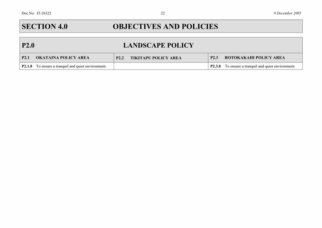
P2.1.8 To ensure a tranquil and quiet environment. P2.3.8 To ensure a tranquil and quiet environment.

Doc.No: IT-26322 23 9 December 2005
SECTION 4.0 OBJECTIVES AND POLICIES
P2.0 LANDSCAPE POLICY P2.4 ROTOMAHANA POLICY AREA P2.5 TARAWERA POLICY AREA P2.6 OKAREKA POLICY AREA
P2.4.1 To protect and enhance the natural character of the policy area based on: (a) indigenous and exotic forests and
geothermal features; (b) protection of the outstanding natural
feature of Mount Tarawera.
P2.5.1 To protect and enhance the natural character of the policy area based on: a) protection of existing indigenous
vegetation; b) afforestation and/or re-vegetation of
steep land; c) retirement and restoration of the
shoreline; d) protection of the outstanding natural
feature of Mount Tarawera.
P2.6.1 To protect and enhance the natural character of the policy area based on: a) protection of existing indigenous
vegetation; b) afforestation and/or re-vegetation of
steep land; c) retirement and restoration of the
shoreline.
P2.4.2 To ensure that activities and recreational opportunities maintain and enhance the existing natural character of the lake and geothermal features.
P2.5.2 To ensure that activities and recreational opportunities: a) retain a character that has an
appearance of being uninhabited away from the settlement;
b) protect and enhance the existing natural character of the policy area.
P2.6.2 To ensure that activities and recreational opportunities: a) retain a character that has an
appearance of being uninhabited away from the settlement;
b) protect and enhance the existing natural character of the policy area.
P2.4.3 To ensure a quiet environment.
P2.4.4 To avoid the presence of buildings and structures which: a) are obtrusive when viewed from Lake
Rotomahana; b) detract from the naturalness of the
views of Lake Rotomahana and Mount Tarawera from identified viewpoints.
P2.5.3 To avoid the presence of buildings and structures which: a) detract from the naturalness of the
views of Lake Tarawera and Mount Tarawera from identified viewpoints;
b) are obtrusive when viewed from Lake Tarawera;
c) reduce the natural landscape context of the settlement;
P2.6.3 To avoid the presence of buildings and structures which: a) detract from the naturalness of the
views of Lake Okareka and Mount Tarawera from identified viewpoints;
b) are obtrusive when viewed from Lake Okareka;
c) reduce the rural and natural landscape context of the settlement;
Doc.No: IT-26322 24 9 December 2005
SECTION 4.0 OBJECTIVES AND POLICIES
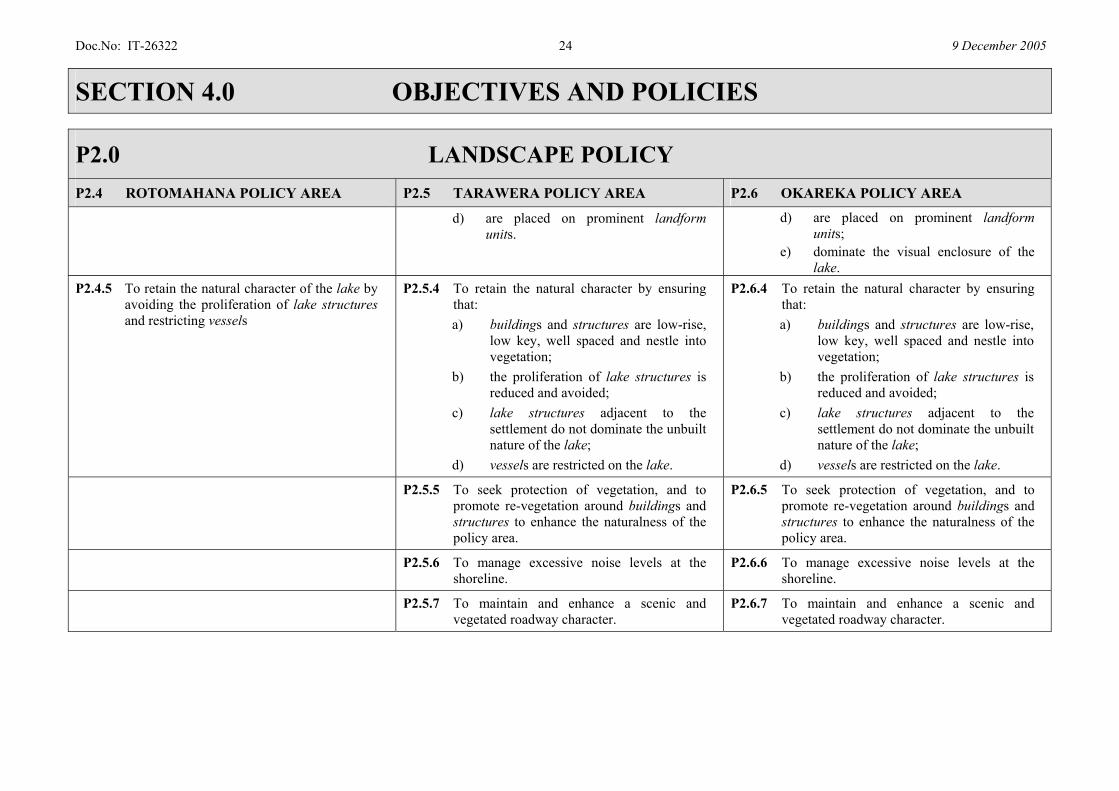
P2.0 LANDSCAPE POLICY P2.4 ROTOMAHANA POLICY AREA P2.5 TARAWERA POLICY AREA P2.6 OKAREKA POLICY AREA
d) are placed on prominent landform units.
d) are placed on prominent landform units;
e) dominate the visual enclosure of the lake.
P2.4.5 To retain the natural character of the lake by avoiding the proliferation of lake structures and restricting vessels
P2.5.4 To retain the natural character by ensuring that: a) buildings and structures are low-rise,
low key, well spaced and nestle into vegetation;
b) the proliferation of lake structures is reduced and avoided;
c) lake structures adjacent to the settlement do not dominate the unbuilt nature of the lake;
d) vessels are restricted on the lake.
P2.6.4 To retain the natural character by ensuring that: a) buildings and structures are low-rise,
low key, well spaced and nestle into vegetation;
b) the proliferation of lake structures is reduced and avoided;
c) lake structures adjacent to the settlement do not dominate the unbuilt nature of the lake;
d) vessels are restricted on the lake.
P2.5.5 To seek protection of vegetation, and to promote re-vegetation around buildings and structures to enhance the naturalness of the policy area.
P2.6.5 To seek protection of vegetation, and to promote re-vegetation around buildings and structures to enhance the naturalness of the policy area.
P2.5.6 To manage excessive noise levels at the shoreline.
P2.6.6 To manage excessive noise levels at the shoreline.
P2.5.7 To maintain and enhance a scenic and vegetated roadway character.
P2.6.7 To maintain and enhance a scenic and vegetated roadway character.
Doc.No: IT-26322 25 9 December 2005
SECTION 4.0 OBJECTIVES AND POLICIES
P2.0 LANDSCAPE POLICY P2.4 ROTOMAHANA POLICY AREA P2.5 TARAWERA POLICY AREA P2.6 OKAREKA POLICY AREA
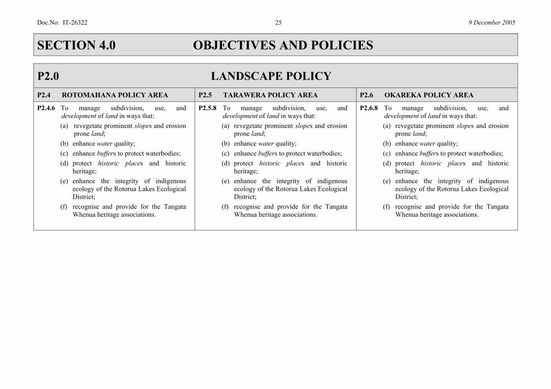
P2.4.6 To manage subdivision, use, and development of land in ways that: (a) revegetate prominent slopes and erosion
prone land; (b) enhance water quality; (c) enhance buffers to protect waterbodies; (d) protect historic places and historic
heritage; (e) enhance the integrity of indigenous
ecology of the Rotorua Lakes Ecological District;
(f) recognise and provide for the Tangata Whenua heritage associations.
P2.5.8 To manage subdivision, use, and development of land in ways that: (a) revegetate prominent slopes and erosion
prone land; (b) enhance water quality; (c) enhance buffers to protect waterbodies; (d) protect historic places and historic
heritage; (e) enhance the integrity of indigenous
ecology of the Rotorua Lakes Ecological District;
(f) recognise and provide for the Tangata Whenua heritage associations.
P2.6.8 To manage subdivision, use, and development of land in ways that: (a) revegetate prominent slopes and erosion
prone land; (b) enhance water quality; (c) enhance buffers to protect waterbodies; (d) protect historic places and historic
heritage; (e) enhance the integrity of indigenous
ecology of the Rotorua Lakes Ecological District;
(f) recognise and provide for the Tangata Whenua heritage associations.
Doc.No: IT-26322 26 9 December 2005
SECTION 4.0 OBJECTIVES AND POLICIES
P2.0 LANDSCAPE POLICY P2.4 ROTOMAHANA POLICY AREA P2.5 TARAWERA POLICY AREA P2.6 OKAREKA POLICY AREA
P2.4.7 In less sensitive areas to maintain and enhance rural amenity values by: a) maintaining a low density of buildings
and structures; b) maintaining a large separation between
individual buildings or clusters of buildings;
c) maintaining expansive areas of vegetation, particularly indigenous vegetation;
d) managing building bulk and height to a rural scale;
e) screening or landscaping of buildings, structures, or hard surfaces to integrate them into the rural landscape and to avoid adverse visual effects when viewed from roads, reserves and adjacent sites;
f) To promote grazing retirement and revegetation of pasture with locally sourced indigenous plants.
P2.5.9 In less sensitive areas to maintain and enhance rural amenity values by: a) maintaining a low density of buildings
and structures; b) maintaining a large separation between
individual buildings or clusters of buildings;
c) maintaining expansive areas of vegetation, particularly indigenous vegetation;
d) managing building bulk and height to a rural scale;
e) screening or landscaping of buildings, structures, or hard surfaces to integrate them into the rural landscape and to avoid adverse visual effects when viewed from roads, reserves and adjacent sites.
Doc.No: IT-26322 27 9 December 2005
SECTION 4.0 OBJECTIVES AND POLICIES
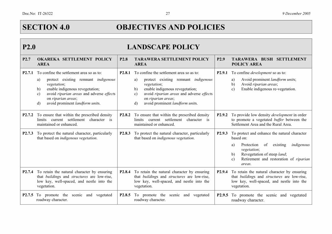
P2.0 LANDSCAPE POLICY P2.7 OKAREKA SETTLEMENT POLICY
AREA P2.8 TARAWERA SETTLEMENT POLICY
AREA P2.9 TARAWERA BUSH SETTLEMENT
POLICY AREA
P2.7.1 To confine the settlement area so as to: a) protect existing remnant indigenous
vegetation; b) enable indigenous revegetation; c) avoid riparian areas and adverse effects
on riparian areas; d) avoid prominent landform units.
P2.8.1 To confine the settlement area so as to: a) protect existing remnant indigenous
vegetation; b) enable indigenous revegetation; c) avoid riparian areas and adverse effects
on riparian areas; d) avoid prominent landform units.
P2.9.1 To confine development so as to: a) Avoid prominent landform units; b) Avoid riparian areas; c) Enable indigenous re-vegetation.
P2.7.2 To ensure that within the prescribed density limits current settlement character is maintained or enhanced.
P2.8.2 To ensure that within the prescribed density limits current settlement character is maintained or enhanced.
P2.9.2 To provide low density development in order to promote a vegetated buffer between the Settlement Area and the Rural Area.
P2.7.3 To protect the natural character, particularly that based on indigenous vegetation.
P2.8.3 To protect the natural character, particularly that based on indigenous vegetation.
P2.9.3 To protect and enhance the natural character based on: a) Protection of existing indigenous
vegetation; b) Revegetation of steep land; c) Retirement and restoration of riparian
areas.
P2.7.4 To retain the natural character by ensuring that buildings and structures are low-rise, low key, well-spaced, and nestle into the vegetation.
P2.8.4 To retain the natural character by ensuring that buildings and structures are low-rise, low key, well-spaced, and nestle into the vegetation.
P2.9.4 To retain the natural character by ensuring that buildings and structures are low-rise, low key, well-spaced, and nestle into the vegetation.
P2.7.5 To promote the scenic and vegetated roadway character.
P2.8.5 To promote the scenic and vegetated roadway character.
P2.9.5 To promote the scenic and vegetated roadway character.
Doc.No: IT-26322 28 9 December 2005
SECTION 4.0 OBJECTIVES AND POLICIES
P2.0 LANDSCAPE POLICY P2.7 OKAREKA SETTLEMENT POLICY
AREA P2.8 TARAWERA SETTLEMENT POLICY
AREA P2.9 TARAWERA BUSH SETTLEMENT
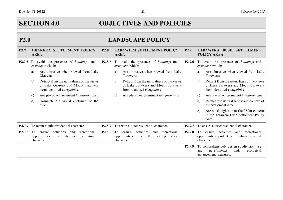
POLICY AREA
P2.7.6 To avoid the presence of buildings and structures which: a) Are obtrusive when viewed from Lake
Okareka; b) Detract from the naturalness of the views
of Lake Okareka and Mount Tarawera from identified viewpoints;
c) Are placed on prominent landform units; d) Dominate the visual enclosure of the
lake.
P2.8.6 To avoid the presence of buildings and structures which: a) Are obtrusive when viewed from Lake
Tarawera; b) Detract from the naturalness of the views
of Lake Tarawera and Mount Tarawera from identified viewpoints;
c) Are placed on prominent landform units.
P2.9.6 To avoid the presence of buildings and structures which: a) Are obtrusive when viewed from Lake
Tarawera; b) Detract from the naturalness of the views
of Lake Tarawera and Mount Tarawera from identified viewpoints;
c) Are placed on prominent landform units; d) Reduce the natural landscape context of
the Settlement Area; e) Are sited higher than the 380m contour
in the Tarawera Bush Settlement Policy Area.
P2.7.7 To retain a quiet residential character. P2.8.7 To retain a quiet residential character. P2.9.7 To ensure a quiet residential character.
P2.7.8 To ensure activities and recreational opportunities protect the existing natural character.
P2.8.8 To ensure activities and recreational opportunities protect the existing natural character.
P2.9.8 To ensure activities and recreational opportunities protect and enhance natural character.
P2.9.9 To comprehensively design subdivision, use and development with ecological enhancement measures.

Doc.No: IT-26322 29 9 December 2005
SECTION 4.0 OBJECTIVES AND POLICIES
P2.0 LANDSCAPE POLICY
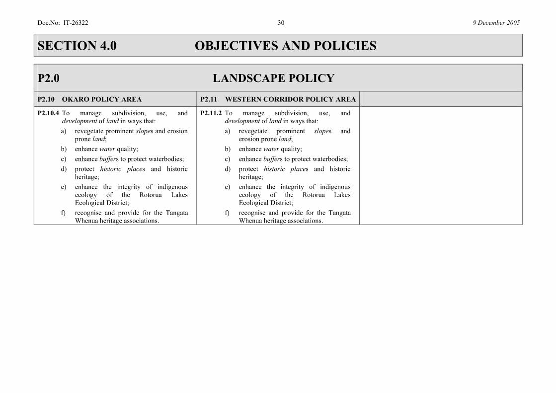
P2.10 OKARO POLICY AREA P2.11 WESTERN CORRIDOR POLICY AREA
P2.10.1 To allow recreational opportunities on and around Lake Okaro.
P2.10.2 a) To allow afforestation which increases the area of trees and indigenous vegetation within the catchment;
b) To enhance riparian vegetation around Lake Okaro.
P2.10.3 To maintain and enhance rural amenity values by: a) maintaining a low density of buildings
and structures; b) maintaining a large separation between
buildings; c) maintaining expansive areas of
vegetation including indigenous vegetation;
d) managing building bulk and height to a rural scale;
e) screening or landscaping of buildings, structures, or hard surfaces to integrate them into the rural landscape and to avoid adverse visual effects when viewed from roads, reserves and adjacent sites.
P2.11.1 To maintain and enhance rural amenity values by: a) maintaining a low density of buildings
and structures; b) maintaining a large separation between
buildings; c) maintaining expansive areas of
vegetation including indigenous vegetation;
d) managing building bulk and height to a rural scale;
e) screening or landscaping of buildings, structures, or hard surfaces to integrate them into the rural landscape and to avoid adverse visual effects when viewed from roads, reserves and adjacent sites.
Doc.No: IT-26322 30 9 December 2005
SECTION 4.0 OBJECTIVES AND POLICIES
P2.0 LANDSCAPE POLICY
P2.10 OKARO POLICY AREA P2.11 WESTERN CORRIDOR POLICY AREA
P2.10.4 To manage subdivision, use, and development of land in ways that: a) revegetate prominent slopes and erosion
prone land; b) enhance water quality; c) enhance buffers to protect waterbodies; d) protect historic places and historic
heritage; e) enhance the integrity of indigenous
ecology of the Rotorua Lakes Ecological District;
f) recognise and provide for the Tangata Whenua heritage associations.
P2.11.2 To manage subdivision, use, and development of land in ways that: a) revegetate prominent slopes and
erosion prone land; b) enhance water quality; c) enhance buffers to protect waterbodies; d) protect historic places and historic
heritage; e) enhance the integrity of indigenous
ecology of the Rotorua Lakes Ecological District;
f) recognise and provide for the Tangata Whenua heritage associations.
Doc.No: IT-26322 31 9 December 2005
SECTION 4.0 OBJECTIVES AND POLICIES
P2.0 LANDSCAPE POLICY
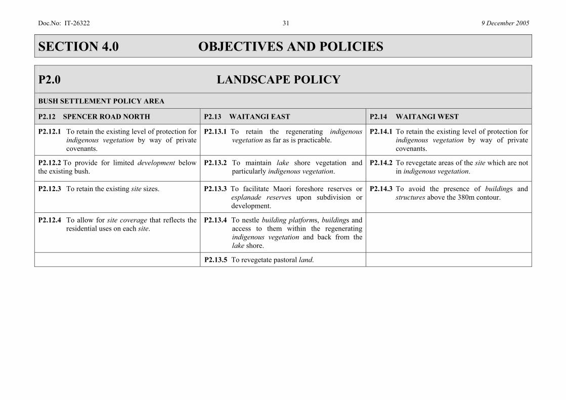
BUSH SETTLEMENT POLICY AREA
P2.12 SPENCER ROAD NORTH P2.13 WAITANGI EAST P2.14 WAITANGI WEST
P2.12.1 To retain the existing level of protection for indigenous vegetation by way of private covenants.
P2.13.1 To retain the regenerating indigenous vegetation as far as is practicable.
P2.14.1 To retain the existing level of protection for indigenous vegetation by way of private covenants.
P2.12.2 To provide for limited development below the existing bush.
P2.13.2 To maintain lake shore vegetation and particularly indigenous vegetation.
P2.14.2 To revegetate areas of the site which are not in indigenous vegetation.
P2.12.3 To retain the existing site sizes. P2.13.3 To facilitate Maori foreshore reserves or esplanade reserves upon subdivision or development.
P2.14.3 To avoid the presence of buildings and structures above the 380m contour.
P2.12.4 To allow for site coverage that reflects the residential uses on each site.
P2.13.4 To nestle building platforms, buildings and access to them within the regenerating indigenous vegetation and back from the lake shore.
P2.13.5 To revegetate pastoral land.
Doc.No: IT-26322 32 9 December 2005
SECTION 4.0 OBJECTIVES AND POLICIES
P2.0 LANDSCAPE POLICY
BUSH SETTLEMENT POLICY AREA
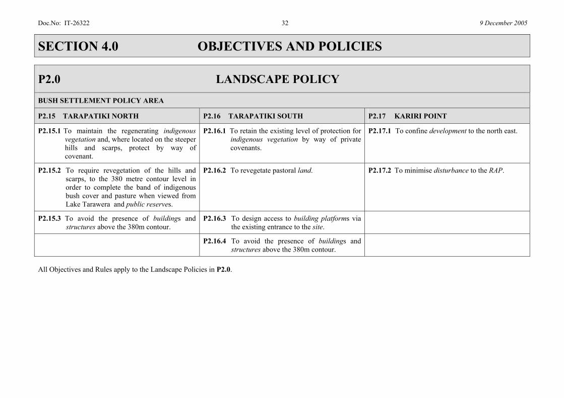
P2.15 TARAPATIKI NORTH P2.16 TARAPATIKI SOUTH P2.17 KARIRI POINT
P2.15.1 To maintain the regenerating indigenous vegetation and, where located on the steeper hills and scarps, protect by way of covenant.
P2.16.1 To retain the existing level of protection for indigenous vegetation by way of private covenants.
P2.17.1 To confine development to the north east.
P2.15.2 To require revegetation of the hills and scarps, to the 380 metre contour level in order to complete the band of indigenous bush cover and pasture when viewed from Lake Tarawera and public reserves.
P2.16.2 To revegetate pastoral land. P2.17.2 To minimise disturbance to the RAP.
P2.15.3 To avoid the presence of buildings and structures above the 380m contour.
P2.16.3 To design access to building platforms via the existing entrance to the site.
P2.16.4 To avoid the presence of buildings and structures above the 380m contour.
All Objectives and Rules apply to the Landscape Policies in P2.0.
Doc.No: IT-26322 33 9 December 2005
SECTION 4.0 OBJECTIVES AND POLICIES
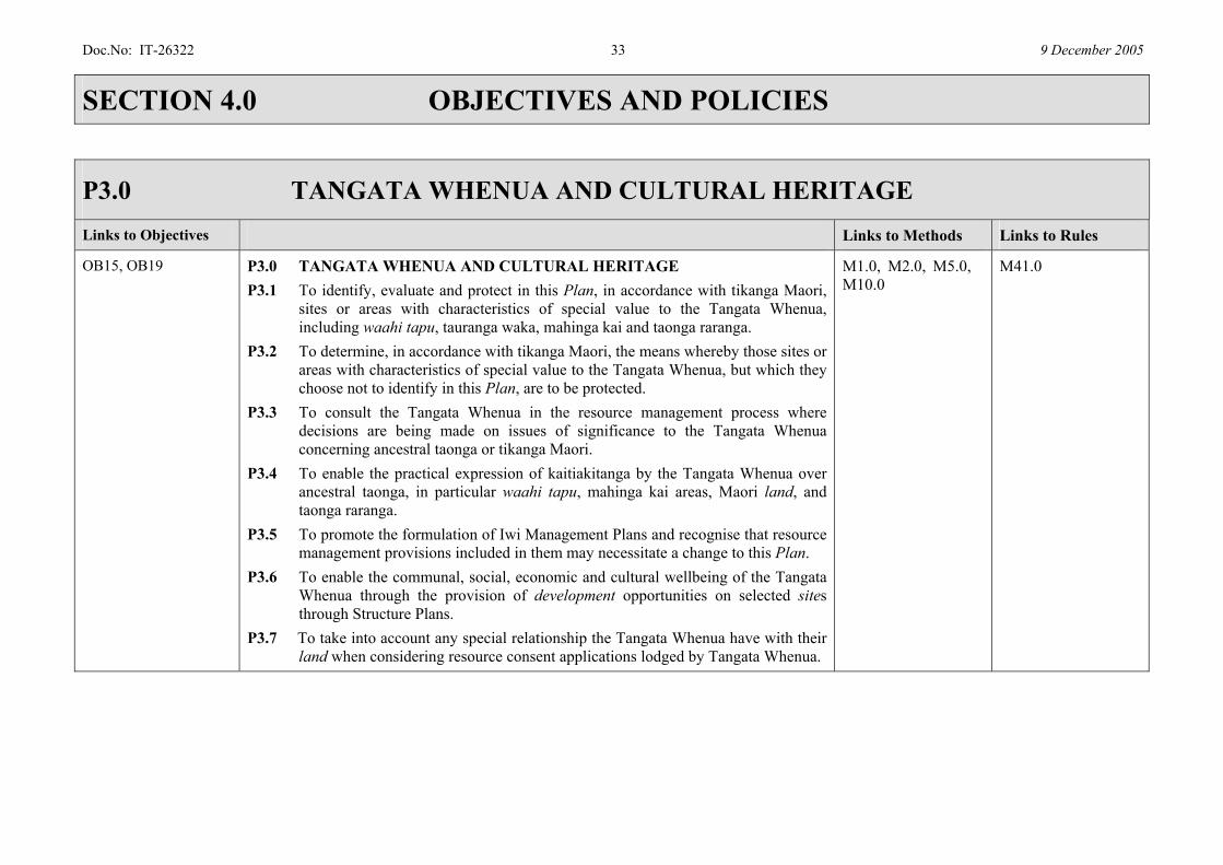
P3.0 TANGATA WHENUA AND CULTURAL HERITAGE Links to Objectives Links to Methods Links to Rules
OB15, OB19 P3.0 TANGATA WHENUA AND CULTURAL HERITAGE P3.1 To identify, evaluate and protect in this Plan, in accordance with tikanga Maori,
sites or areas with characteristics of special value to the Tangata Whenua, including waahi tapu, tauranga waka, mahinga kai and taonga raranga.
P3.2 To determine, in accordance with tikanga Maori, the means whereby those sites or areas with characteristics of special value to the Tangata Whenua, but which they choose not to identify in this Plan, are to be protected.
P3.3 To consult the Tangata Whenua in the resource management process where decisions are being made on issues of significance to the Tangata Whenua concerning ancestral taonga or tikanga Maori.
P3.4 To enable the practical expression of kaitiakitanga by the Tangata Whenua over ancestral taonga, in particular waahi tapu, mahinga kai areas, Maori land, and taonga raranga.
P3.5 To promote the formulation of Iwi Management Plans and recognise that resource management provisions included in them may necessitate a change to this Plan.
P3.6 To enable the communal, social, economic and cultural wellbeing of the Tangata Whenua through the provision of development opportunities on selected sites through Structure Plans.
P3.7 To take into account any special relationship the Tangata Whenua have with their land when considering resource consent applications lodged by Tangata Whenua.
M1.0, M2.0, M5.0, M10.0
M41.0

Doc.No: IT-26322 34 9 December 2005
SECTION 4.0 OBJECTIVES AND POLICIES
Links to Objectives POLICIES Links to Methods Links to Rules
OB 14 P4.0 HISTORIC HERITAGE: P4.1 To avoid, remedy or mitigate the adverse effects of activities on the identified
heritage items bearing in mind that public access to heritage sites should not jeopardise the integrity of the item or the reasonable operation of activities on the site.
M1.0 13.0, 41.0
OB 3, OB 6, OB 9, OB 10
P5.0 WATER QUALITY: P5.1 To manage subdivision, use and development to protect the high water quality
in Lakes Tikitapu, Rotokakahi, Okataina, and Tarawera. P5.2 To manage subdivision, use and development to enhance the water quality in
Lakes Okaro, Rotomahana and Okareka. P5.3 To control small scale earthworks where there is a risk of resulting
sedimentation in wetlands, lakes and rivers. P5.4 To require stormwater management within new subdivisions or developments
that: a) improves water quality before diffuse discharge to lakes, rivers, streams,
or wetlands, by the use of on-site treatment and disposal of stormwater, artificial wetlands, or grassed swales, and by the retention of vegetation on-site;
b) minimises increases in peak flows; c) minimise increases in impermeable areas.
P5.5 To promote retrofitting of stormwater remediation methods in existing situations where practicable.
P5.6 To restrict vessels on the lakes to protect the natural character of the lakes and the high water quality in Tikitapu, Rotokakahi, Okataina, and Tarawera, and to assist in the improvement of water quality in Okareka and Okaro.
P5.7 To avoid, mitigate or remedy adverse effects on aquatic ecosystems.
M2.0, M3.0, M4.0, M6.0, M9.0, M16.0
2.0, 3.0, 5.0, 6.0, 11.0, 12.0, 15.0, 35.0, 36.0, 38.0, 39.0, 40.0
Doc.No: IT-26322 35 9 December 2005
SECTION 4.0 OBJECTIVES AND POLICIES
Links to Objectives POLICIES Links to Methods Links to Rules
OB 1, OB 2, OB 6, OB 9
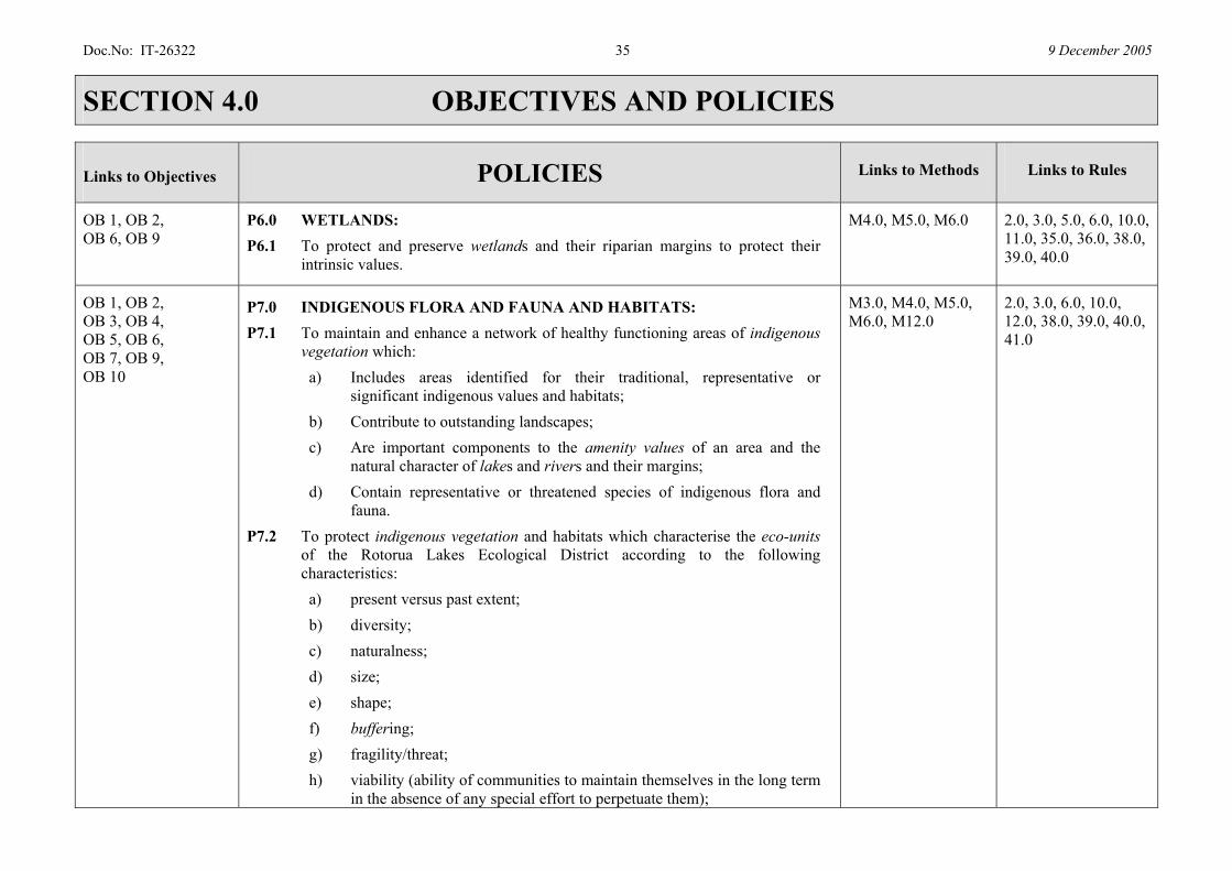
P6.0 WETLANDS: P6.1 To protect and preserve wetlands and their riparian margins to protect their
intrinsic values.
M4.0, M5.0, M6.0 2.0, 3.0, 5.0, 6.0, 10.0, 11.0, 35.0, 36.0, 38.0, 39.0, 40.0
OB 1, OB 2, OB 3, OB 4, OB 5, OB 6, OB 7, OB 9, OB 10
P7.0 INDIGENOUS FLORA AND FAUNA AND HABITATS: P7.1 To maintain and enhance a network of healthy functioning areas of indigenous
vegetation which: a) Includes areas identified for their traditional, representative or
significant indigenous values and habitats; b) Contribute to outstanding landscapes; c) Are important components to the amenity values of an area and the
natural character of lakes and rivers and their margins; d) Contain representative or threatened species of indigenous flora and
fauna. P7.2 To protect indigenous vegetation and habitats which characterise the eco-units
of the Rotorua Lakes Ecological District according to the following characteristics: a) present versus past extent; b) diversity; c) naturalness; d) size; e) shape; f) buffering; g) fragility/threat; h) viability (ability of communities to maintain themselves in the long term
in the absence of any special effort to perpetuate them);
M3.0, M4.0, M5.0, M6.0, M12.0
2.0, 3.0, 6.0, 10.0, 12.0, 38.0, 39.0, 40.0, 41.0
Doc.No: IT-26322 36 9 December 2005
SECTION 4.0 OBJECTIVES AND POLICIES
Links to Objectives POLICIES Links to Methods Links to Rules
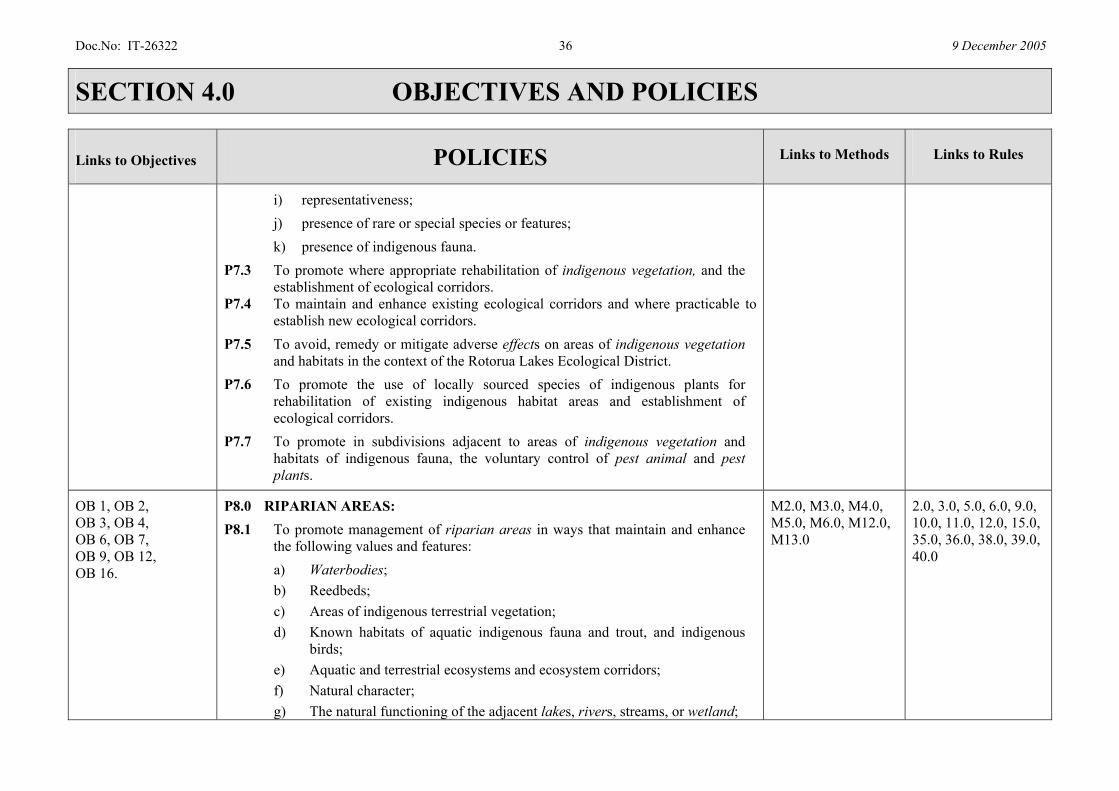
i) representativeness; j) presence of rare or special species or features; k) presence of indigenous fauna.
P7.3 To promote where appropriate rehabilitation of indigenous vegetation, and the establishment of ecological corridors.
P7.4 To maintain and enhance existing ecological corridors and where practicable to establish new ecological corridors.
P7.5 To avoid, remedy or mitigate adverse effects on areas of indigenous vegetation and habitats in the context of the Rotorua Lakes Ecological District.
P7.6 To promote the use of locally sourced species of indigenous plants for rehabilitation of existing indigenous habitat areas and establishment of ecological corridors.
P7.7 To promote in subdivisions adjacent to areas of indigenous vegetation and habitats of indigenous fauna, the voluntary control of pest animal and pest plants.
OB 1, OB 2, OB 3, OB 4, OB 6, OB 7, OB 9, OB 12, OB 16.
P8.0 RIPARIAN AREAS: P8.1 To promote management of riparian areas in ways that maintain and enhance
the following values and features: a) Waterbodies; b) Reedbeds; c) Areas of indigenous terrestrial vegetation; d) Known habitats of aquatic indigenous fauna and trout, and indigenous
birds; e) Aquatic and terrestrial ecosystems and ecosystem corridors; f) Natural character; g) The natural functioning of the adjacent lakes, rivers, streams, or wetland;
M2.0, M3.0, M4.0, M5.0, M6.0, M12.0, M13.0
2.0, 3.0, 5.0, 6.0, 9.0, 10.0, 11.0, 12.0, 15.0, 35.0, 36.0, 38.0, 39.0, 40.0
Doc.No: IT-26322 37 9 December 2005
SECTION 4.0 OBJECTIVES AND POLICIES
Links to Objectives POLICIES Links to Methods Links to Rules
h) Water quality. P8.2 To establish riparian areas as buffers that avoid or mitigate the adverse effects
from land use and development on waterways. P8.3 To avoid clearance and ensure revegetation of terrestrial and aquatic vegetation
and shorelines. P8.4 To acknowledge the presence of the existing boatsheds. P8.5 To not support further boatsheds or extensions to existing ones. P8.6 To achieve fenced and vegetated riparian buffers where farmland adjoins lakes
and waterways.
OB 2, OB 5, OB 9
P9.0 GEOTHERMAL FEATURES: P9.1 To protect geothermal eco-units (including surface features and associated
indigenous vegetation). P9.2 To require buffers around geothermal features to avoid or mitigate the adverse
effects of land use and development.
M5.0, M7.0, M14.0
2.0, 3.0, 5.0, 6.0, 11.0, 38.0, 39.0, 40.0
OB 11, OB 12, OB 14
P10.0 LANDFORMS: P10.1 To ensure that all earthworks are carried out and stabilised in a manner that
avoids, remedies or mitigates adverse effects on the environment, and in particular, on the natural character, as described in P2.0 for the Landscape Policy Areas.
M9.0 5.0
OB 1, OB 3, OB 4, OB 5, OB 6, OB 9, OB 16
P11.0 RECREATIONAL OPPORTUNITIES: P11.1 To manage facilities, lake structures and access to waterbodies, to avoid
adverse effects on the functioning of: a) riparian areas; b) habitats of aquatic indigenous fauna and trout; c) Maori heritage sites;
M2.0, M3.0, M4.0, M5.0, M6.0, M12.0, M13.0
2.0, 3.0, 10.0, 12.0, 39.0, 40.0, 41.0
Doc.No: IT-26322 38 9 December 2005
SECTION 4.0 OBJECTIVES AND POLICIES
Links to Objectives POLICIES Links to Methods Links to Rules
d) spread of aquatic pests; e) the natural character of the margins.
P11.2 To manage activities on the surface of the water to avoid adverse effects: a) on natural character; b) from noise on residents and other lake and catchment users; c) from nuisance to other people; d) from interference to trout spawning and feeding; e) from interference to the habitats of indigenous flora and fauna and in
particular on indigenous aquatic vegetation in Lake Rotomahana; f) from interference to the nesting, roosting, feeding and moulting sites of
indigenous aquatic birds; g) on water quality.
P11.3 To manage the audible characteristics of motorised watercraft according to the ambient noise environment as described in P2.0 for the Landscape Policy Areas.
P11.4 To support appropriate recreational activities and to ensure that these are enhanced through the protection of natural character and aesthetic values.
OB 3, OB 4, OB 13, OB 14, OB 17, OB 18
P12.0 INFRASTRUCTURE AND UTILITY SERVICES: Water P12.1 To ensure safe potable water supplies for consumption that provide for the
health and hygiene of people and which optimises water conservation and continuity of supply.
P12.2 To ensure water supplies with sufficient capacity for fire fighting within Gazetted Fire Districts.
Stormwater P12.3 To ensure collection and disposal of stormwater where adverse effects on the
M11.0 30.0, 31.0, 32.0, 33.0, 34.0, 35.0, 36.0, 37.0, 39.0
Doc.No: IT-26322 39 9 December 2005
SECTION 4.0 OBJECTIVES AND POLICIES
Links to Objectives POLICIES Links to Methods Links to Rules
environment and in particular: a) water quality; b) land stability; c) the safety and health of people; d) the safety of property; e) the functioning of roads intended for public use; f) indigenous flora and fauna; are avoided, remedied or mitigated.
P12.4 To ensure that where the collection and disposal of stormwater creates inundation or ponding, the adverse effects can be remedied or mitigated.
Sewage P12.5 To ensure treatment and disposal of sewage in ways that avoid, remedy or
mitigate adverse effects on human health and water quality of streams, lakes and ground water and the amenity values of the settlements and natural character of the lakes.
P12.6 To ensure sewerage systems avoid ingress of stormwater.

Doc.No: IT-26322 40 9 December 2005
SECTION 4.0 OBJECTIVES AND POLICIES
Links to Objectives POLICIES Links to Methods Links to Rules
Transport and Roading P12.7 To ensure a roading network, with practicable access to sites, that enables safe
and efficient traffic movement, including separate pedestrian and cycle traffic where appropriate, whilst avoiding, remedying or mitigating adverse effects on the natural character of the environment as described in P2.0 for the Landscape Policy Areas.
P12.8 To ensure public roading is established and maintained in ways that avoid, remedy or mitigate adverse effects on the environment’s natural character.
P12.9 To have a public roading network access based on a hierarchy ranging from State Highways to cul-de-sacs, where traffic movement and ease of access is related to the function of the road within the hierarchy.
P12.10 To avoid, remedy or mitigate adverse effects of Traffic Generation on amenity values. Energy and Communications
P12.11 To recognise a communications and energy supply network that enables continuity of connection and supply and avoids adverse effects on the environment and in particular on landscapes and significant indigenous vegetation and habitats of indigenous fauna.
P12.12 To protect the natural character by placing new overhead lines away from State Highways 5 and 33 and Tarawera and Okareka Loop Roads outside the settlement areas, ridgelines, prominent topographical features and identified viewpoints.
OB 18 P13.0 NATURAL HAZARDS: P13.1 To recognise that hazards arise from volcanic activity, seismic activity,
geothermal activity, flooding, fire, erosion and sedimentation and apply measures that reduce risk to people and property.
P13.2 To avoid use and development over and by geothermal hazards.
M14.0 6.0, 24.0, 35.0, 40.0

Doc.No: IT-26322 41 9 December 2005
SECTION 4.0 OBJECTIVES AND POLICIES
Links to Objectives POLICIES Links to Methods Links to Rules
P13.3 To avoid remedy or mitigate the effects of 2% AEP flood events arising from streams, ephemeral watercourses, and high lake levels.
P13.4 To not restrict re-vegetation and afforestation to avoid fire risk, but to rely on firefighting, fire prevention and evacuation.
OB 11, OB 12, OB 13, OB 14, OB 17
P14.0 SUBDIVISION & DEVELOPMENT: Subdivision P14.1 To promote the design of sites so as to facilitate development in a manner that is
consistent with the objectives, and the policies as described in P2.0 for the Landscape Policy Areas.
P14.2 To ensure that each site created is capable of supporting its intended future use and that building platforms are designed and located so as to avoid, remedy or mitigate adverse effects on natural character.
Solar Access P14.3 To minimise the shading effects of buildings on the solar access received by
neighbouring habitable buildings between 9am and 3pm in the Tarawera and Okareka Settlements and the Tarawera Bush Settlement Area. (For the purposes of determining shading effects of buildings, an assessment will be made using the angle of the sun between the hours of 9am and 3pm on May 6.)
2.0, 3.0, 5.0, 6.0, 17.0, 19.0, 20.0, 22.0, 23.0, 24.0, 25.0, 31.0, 32.0, 34.0, 35.0, 36.0, 38.0, 39.0, 40.0, 41.0
OB 1, OB 2, OB 3, OB 4, OB 5, OB 6, OB 7, OB 9, OB 14, OB 16, OB 18
P15.0 ESPLANADE RESERVES AND STRIPS: P15.1 To require Esplanade Reserves and Strips for the range of purposes specified in
section 229 of the RMA and in particular to: a) achieve riparian management; b) access to the lakes and rivers to meet the needs of residents and visitors.
P15.2 To consider esplanade instruments wider than 20 metres, either as esplanade reserves alone or in conjunction with other reserves or easements, in the
M6.0, M13.0 40.0
Doc.No: IT-26322 42 9 December 2005
SECTION 4.0 OBJECTIVES AND POLICIES
Links to Objectives POLICIES Links to Methods Links to Rules
following circumstances: a) Where an existing retired area (for example, an LIA – Land Improvement
Agreement) is being converted to a reserve; b) Where topography, cultural values or ecological values makes access
impracticable or undesirable within 20 metres of the waterbody; c) Where facilities will be required in conjunction with the esplanade reserve,
for example, parking or picnic areas; d) Where an area is required for avoidance, remediation or mitigation of
adverse effects arising from the expected or likely use of the new sites where those adverse effects cannot be avoided, remediated or mitigated on-site;
e) Other situations where the subdividing owner offers a wider reserve and particular features of the site make this desirable;
f) Where a particular feature or area contributes to natural values or the natural character of a lake and its margin.
P15.3 To allow esplanade instruments less than 20 metres wide where: a) The protection of values expressed in section 229 of the RMA are
achievable through other methods and there is no practical opportunity for access;
b) Existing permanent buildings such as houses are sited within 25 metres of the waterbody;
c) Existing access to service all or part of a site is sited within 20 metres of the waterbody and cannot be readily resited;
d) Topography adjacent to or within the proposed reserve requires that services such as a road or access servicing a site must be placed within 20 metres of the waterbody;
e) Identified Maori heritage sites are within 20 metres of the waterbody.
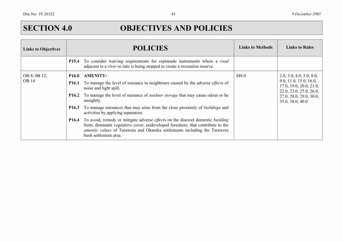
Doc.No: IT-26322 43 9 December 2005
SECTION 4.0 OBJECTIVES AND POLICIES
Links to Objectives POLICIES Links to Methods Links to Rules
P15.4 To consider waiving requirements for esplanade instruments where a road adjacent to a river or lake is being stopped to create a recreation reserve.
OB 8, 0B 12, OB 14
P16.0 AMENITY: P16.1 To manage the level of nuisance to neighbours caused by the adverse effects of
noise and light spill. P16.2 To manage the level of nuisance of outdoor storage that may cause odour or be
unsightly. P16.3 To manage nuisances that may arise from the close proximity of buildings and
activities by applying separation. P16.4 To avoid, remedy or mitigate adverse effects on the discreet domestic building
form, dominant vegetative cover, undeveloped foreshore, that contribute to the amenity values of Tarawera and Okareka settlements including the Tarawera bush settlement area.
M8.0 2.0, 3.0, 4.0, 5.0, 8.0, 9.0, 11.0, 15.0, 16.0, 17.0, 19.0, 20.0, 21.0, 22.0, 23.0, 25.0, 26.0, 27.0, 28.0, 29.0, 30.0, 35.0, 38.0, 40.0
Doc.No: IT-26322 44 9 December 2005
SECTION 5.0 EXPLANATION AND PRINCIPAL REASONS
S5.1 OBJECTIVES AND POLICIES S5.1.1 Introduction
The following section provides the explanations and principal reasons for the objectives and policies for the Lakes A Zone.
S5.1.2 Outstanding Natural Features and Landscapes
The Lakes A Zone is an area of outstanding natural features and landscapes, and as such Council’s management (considering section 6 (b) RMA) with protective and enhancing techniques is to ensure that the area retains the identified values for future generations, whilst providing opportunities for the current community. The Sensitive Policy Area has been derived from the identification of outstanding features and landscapes. An assessment of the outstanding landscape was made by identifying and evaluating the following: • Natural Science; • Legibility; • Aesthetic; • Transient; • Shared and Recognised; • Tangata Whenua; and • Historic Values.
The Less Sensitive Policy Area does not constitute an outstanding natural feature or landscape and includes the Lake Okaro catchment, a small area on Ash Pit Road and the western portion of the Lake Tarawera catchment.
S5.1.3 Attributes that apply to the Sensitive Policy Area within the
Lakes A Zone The attributes that apply to the Sensitive Policy Area as a whole are described below: Natural Science • Geological formations - recent and current volcanic landscape
of mountains, domes, scarps, lakes, geothermal features, etc. • Natural colonisation of new post-eruption surfaces. • Intactness of indigenous ecological sequences, spatially and
temporally. • The complex of the total Upper Tarawera Lakes Catchment as
a whole, with the complex biotic and abiotic inter-relationships between each lake catchment.
• The generally exceptionally high natural quality of lake waters.
• A highly significant trout fishery. Legibility • Dramatic expression of recent volcanic activity as an
outstandingly legible landscape. • Evident natural colonisation of fresh land surfaces, meaning
there is naturally very little old vegetation. • Evident water quality expressing the natural quality and
intactness of catchments. • Natural patterns, processes and elements of a predominantly
indigenous natural landscape are clearly and dramatically displayed.
Doc.No: IT-26322 45 9 December 2005
SECTION 5.0 EXPLANATION AND PRINCIPAL REASONS
Aesthetic • Classic picturesque landscape values of distinctive craggy
mountains and cliffs above natural lakes surrounded by groves of indigenous bush and gentle pastoral lands.
• Settlements tucked into discrete enclaves and niches, as refuges for people, looking out on lake and mountain views, with the Arcadian mid-ground of farmland.
• Memorable landform features, such as the Tarawera skyline, its rift and other craters, the dome, the escarpments and plateaux, and the lake shore outlines of headlands and embayments.
• The overwhelming naturalness of the landscape character, with little and very localised built development.
• High aesthetic coherence, high scenic value and beauty. • Tranquillity, an atmosphere of peaceful remoteness and high
naturalness. Transient • The important wildlife of the area, such as the brown teal and the
rare New Zealand dabchick on Lakes Okareka, Tarawera, Rotomahana, Okataina, Tikitapu, Rotokakahi and Okaro.
Shared and Recognised • Community recognition through the planning process of the
significance of the whole lakes complex. • Known nationally and wider afield as an important, natural,
beautiful and historic landscape. • Recognition through the visitor industry, with scenic flights,
mountain visits, boat trips, tramping tracks, etc., and through recreation.
• Recognition in the arts, in poetry, paintings, print making, photography, etc.
• Shared enjoyment through high recreational use, particularly sightseeing, via land-based driving, walking, picnicking, etc; water-based boating, fishing, swimming, hot pools, etc, and air-borne flights, etc.
• Valued indigenous ecosystems, much recognised in reserve lands, and in the waters.
• Intermittent calls for recognition of the area as a national park.
• Recognition as an integral component of an internationally renown trout fishery. Shared enjoyment through angling use.
Tangata Whenua • The Mauri of natural resources. • The ‘tapu’ or sacred nature of Mt Tarawera. • Long recognition by the Tangata Whenua of the very special
significance of the lakes. • The landscapes of the past, a known, loved and peopled place,
and the events that changed the area from their lived in place to a desolate one.
• Traditions passed down through waiata and customs that speak about the landscape.
Historic Values • Iwi and hapu left the area and resettled in other parts of the
Rotorua District and as far away as the Coromandel. • Retained memories of the landscape as it was prior to the
eruption. • Strong memories of the lost landscape, of the tragic events of
the past, the Buried Village, the Pink and White Terraces, etc. • The tradition of guides and tourism. The Sensitive Policy Area in total thus ranks as outstanding in terms of the above attributes.
Doc.No: IT-26322 46 9 December 2005
SECTION 5.0 EXPLANATION AND PRINCIPAL REASONS
The additional attributes that apply to each particular Policy Area within the Sensitive Policy Area are explained below. In addition where applicable there is a description of those parts of the Lakes A Zone that are within the Less Sensitive Policy Area.
S5.2 LANDSCAPE POLICY AREAS
All of the policy areas in the Lakes A Zone are known or assumed to be linked through hydrological and ecological systems. The descriptions include landform units, which were also used for ecological descriptions1 and the landscape assessment2. These units are underlined and are described in the definitions under ‘landform unit’. The landform units are shown on the Landforms Maps and illustrated for each Lake Catchment in Appendix 13.0. The distinctive character for the policy areas is described below.
S5.2.1 Okataina
The Okataina Policy Area covers an area of 7012 hectares. The lake has a surface area of 1104 hectares. The Okataina Policy Area comprises steep slopes, undulating to hilly land, low terraces, scarps and gullies. Most of the Okataina Policy Area remains covered in indigenous vegetation, ranging from primary revegetation to tertiary vegetation, including large podocarps and hardwoods which have been largely untouched by human influence. Small areas of exotic forestry and pastoral land use are present in the policy area, although they are not evident from the road.
1 Beadel SM, Shaw WB, Nicholls JL (1998): Rotorua Lakes Ecological District Natural Area Survey.
Wildland Consultants Ltd Report 175 for Rotorua District Council and Environment BOP. 2 Wallace Ian (1998): Rotorua Lakes Landscape Assessment. Report for Rotorua District Council.
The indigenous vegetation coupled with the lack of development in this policy area makes it closest to pristine of all the policy areas within the Lakes A Zone. The difficulty of access via a single access road assists in retaining the unpeopled nature of this policy area. Any development which has taken place in the policy area has been done so sensitively and is so limited that very few structures are evident. Thick vegetation is dominant to the edges of Lake Okataina Road and the road is a significant scenic corridor. The protection of the vegetation to the road edge and the maintenance of the road as a scenic corridor is a priority. Lake Okataina is popular for fishing, boating and walking. There is also a low key accommodation lodge located on the shores of the lake at the northern end. In addition to the attributes that apply to the Sensitive Policy Area within the Lakes A Zone (Refer to S5.1.3), important landscape character values or attributes identified specifically for the Okataina Policy Area include: Natural Science • Lava from the Mamaku eruptive episode dammed the valley
to form Lake Okataina. • Lake Okataina lies in the western margin of the Haroharo
Caldera. • No obvious tributaries or outlet from the lake. • Very high level of natural vegetation, supporting natural
patterns and processes. • The presence of the indigenous fish koaro. • Quality of the water has low levels of nutrients. • A highly significant trout fishery.
Doc.No: IT-26322 47 9 December 2005
SECTION 5.0 EXPLANATION AND PRINCIPAL REASONS
Legibility • Very high water quality indicating intactness of the catchment. • Dominant indigenous vegetation supports natural elements,
patterns and processes. • Very small level of modification. Aesthetic • Overwhelming naturalness throughout the catchment. • Small amount of pasture and exotic forestry is insignificant. • Predominance of indigenous vegetation provides strong
coherence. • Lack of interference provides natural skyline. Shared and Recognised • Restricted access and lack of development provides remoteness. • Low impact recreational use provides a quiet environment. • Tracks and fishing promote quiet recreational opportunities. • Recognition as destination for people seeking undisturbed
indigenous vegetation. • Recognition as an integral component of an internationally
renown trout fishery. Shared enjoyment through angling use. Tangata Whenua • Sacred sites. • Historical occupation. • Cultural traditions. Historic Values • Once a valley linking to Lake Tarawera.
• Lack of disturbance sets apart from other catchments. • Least modified and strongest protection of environment.
S5.2.2 Tikitapu (Blue Lake)
The Tikitapu Policy Area covers an area of 567 hectares. Lake Tikitapu has a surface area of 146 hectares. The Tikitapu Policy Area rises steeply from the lake on all sides, except for two flats at the northern end of the lake. The eastern, western and southern sides of this policy area rise steeply from the lake to hill and undulating to hilly country. A small, shallow saddle connects Lake Tikitapu with Lake Rotokakahi at the southern end. While most of the policy area is densely vegetated with secondary indigenous vegetation, exotic forestry dominates the western slopes, especially close to the lake. The lake is connected to several tracts of indigenous and exotic forest via the Whakarewarewa Forest. Indigenous vegetation dominates the character of the policy area providing landscape coherence and naturalness. The section of Tarawera Road along the eastern shores Lake Tikitapu is a valuable scenic corridor. Development in this policy area has been kept to a minimum. A camping ground is the only non-public development in the area. The camping ground has been nestled into the landscape and is relatively low key. Lake Tikitapu is a very busy recreational area with high numbers in the summer enjoying swimming, boating, cycling, and walking in the Tikitapu Policy Area. The continued recreational demand is generally accommodated in the large areas of recreation reserves adjacent to the lake and in particular, on the northern shores of the lake.
Doc.No: IT-26322 48 9 December 2005
SECTION 5.0 EXPLANATION AND PRINCIPAL REASONS
The high level of recreational use and the small and inward looking catchment have led to a noisy environment in times of heavy usage. While the heavy usage can be noisy, the lack of permanent development ensures that the policy area retains a quiet character outside of the key recreational times. In addition to the attributes that apply to the Sensitive Policy Area within the Lakes A Zone (Refer to S5.1.3), important landscape character values or attributes identified specifically for the Tikitapu Policy Area include: Natural Science • Quality of the water has low levels of nutrients. • A highly significant trout fishery. Legibility • The lake resulting from an explosion crater, with water dammed
by lava barriers. • The forest cover over almost all the catchment (and the lack of
pastoral activity) is perceived as contributing landscape value in sustaining the water quality and clarity.
Aesthetic Value • A small, compact catchment to which people closely relate. • A picturesque character with forest clad hills surrounding the
lake. • Predominantly a forested lake catchment, including indigenous
and well-integrated exotic forest, with the forests valued as the landscape context for the lake.
• The recreational focus contributes to enjoyment of the setting.
• Lack of development contributes to the remote and wild character.
• Intimate landscape scale and low-key, natural character. Shared and Recognised • Public ownership and management contributes to the use and
popularity of this shared landscape. • The encouragement for public recreation and lack of built and
private development. • Widely valued as the Tikitapu or the Blue Lake, and a focus
for water-based recreation, including motorised activities. • Circular track provides for land-based enjoyment. • Recognition as an integral component of an internationally
renown trout fishery. Shared enjoyment through angling use. Tangata Whenua • Cultural traditions.
S5.2.3 Rotokakahi (Green Lake)
The Rotokakahi Policy Area covers an area of 1872 hectares. Lake Rotokakahi has a surface area of 452 hectares. The south-western side comprises steep scarps whilst the remainder of the policy area rises from the lake into hill and undulating to hilly country. A shallow saddle at the north-eastern end of the Lake Rotokakahi connects this policy area with the Tikitapu Policy Area. Most of the policy area is covered in exotic forestry. The balance of the policy area, particularly the northern end, is covered in indigenous forest and the southern end features areas of pastoral land use. The exotic forest is superficially similar in character to the indigenous forest, lending some consistency to the character of
Doc.No: IT-26322 49 9 December 2005
SECTION 5.0 EXPLANATION AND PRINCIPAL REASONS
the forested areas. The pastoral land use is not obvious from the main access points to the area and does not detract from the forested character of the policy area. Much of the character of the Rotokakahi Policy Area derives from the lake being privately owned and not generally available for public use. Access to the lake is at the discretion of the Rotokakahi Board of Control. An Urupa on the Island adds mystique to the lake. This limited access and tapu or sacred nature and spiritual significance of the ‘urupa’ gives the policy area a very quiet and serene character. Limited access to the water means that the recreational opportunities on the lake are almost non-existent. Tracks around the lake are popular for walking, mountain biking and other non-intrusive recreational activities. In addition to the attributes that apply to the Sensitive Policy Area within the Lakes A Zone (Refer to S5.1.3), important landscape character values or attributes identified specifically for the Rotokakahi Policy Area include: Natural Science • Lake backed up behind a lava barrier. • Flows via Te Wairoa stream into Lake Tarawera. • Quality of the water has moderate levels of nutrients. • Indigenous Waterbird habitat. Legibility • The extensive forest cover (and small amount of pastoral activity)
in the lake catchment is perceived as contributing landscape value in sustaining water quality.
Aesthetic Value • Predominantly a forested lake catchment, including both
indigenous and exotic, is valued as the landscape context for the lake.
• Islands add to very high aesthetic value. • Peaceful - in contrast to Tikitapu. Shared and Recognised • Privately owned and with limited water access available,
recreational access to the lands is important. • Commonly known as the Green Lake, and linked with nearby
Tikitapu, the Blue Lake. • The lake is valued for its mystique through having a different
management regime. • Strong association with Te Arawa, and in particular
Tuhourangi and Ngati Tumatawera. Tangata Whenua • Motutawa and Punaruku, waahi tapu islands, contribute
landscape value. S5.2.4 Rotomahana
The Rotomahana Policy Area covers an area of 5277 hectares. Lake Rotomahana has a surface area of 897 hectares. Lake Rotomahana is the south-western crater located at the base of Mount Tarawera. The north-eastern end of the lake rises steeply to base of Mount Tarawera. The volcanic rift continues at the south-western end of the lake as the Waimangu Thermal Valley.

Doc.No: IT-26322 50 9 December 2005
SECTION 5.0 EXPLANATION AND PRINCIPAL REASONS
A shallow saddle at the north-western end of the lake separates Lake Rotomahana from Lake Tarawera. Lake Rotomahana water level is 38 metres above the Lake Tarawera water level. The rising lake level adds to the dynamism of this policy area. The eastern, western and southern sections of this policy area contain many landform components, including, volcanic flats, hills, flat to undulating, undulating to hilly, volcanic rifts, flats, gullies and wetlands. Given the diverse range of landform types, the character across this policy area is variable. The south-eastern end of the catchment is dominated by pastoral land use. The Waimangu Valley and the north-western end of the catchment are covered in predominately indigenous vegetation. Areas of exotic vegetation are dispersed within the indigenous cover. The Waimangu Valley contains specialised geothermal vegetation, which contributes much to the character of the valley. The tourist oriented development at Waimangu Valley is contained within a predominantly geothermal landform and vegetation association. Much of the sides and crater of Mount Tarawera are not vegetated or are covered by sub montane vegetation. The small amount of rural development in this policy area adds to the rural character at the south-eastern end of the lake. The dominant landscape features of this policy area are parts of Mount Tarawera and the Waimangu Geothermal Valley, however the character of the area is dominated by indigenous and exotic forest cover and pastoral land use. The Rotomahana Policy Area is popular for its tourist activities, fishing, boat tours and walking tracks. Difficult road access makes Lake Rotomahana less visited than other lakes in the area.
In addition to the attributes that apply to the Sensitive Policy Area (Refer to S5.1.3) within the Lakes A Zone (where relevant in the Rotomahana Policy Area), important landscape character values or attributes identified specifically for the Rotomahana Policy Area include: Natural Science • Volcanic rift and geothermal features - Waimangu Valley. • Geothermal vegetation. • Quality of the water has moderate levels of nutrients. • Indigenous Waterbird habitat. • A highly significant trout fishery. Legibility • Geothermal expression, particularly at Waimangu Thermal
Valley. Historic • The loss of the Pink and White Terraces.
Shared and Recognised • Recognition as an integral component of an internationally
renown trout fishery. Shared enjoyment through angling use.
S5.2.5 Tarawera This description includes the Tarawera Settlement and the Tarawera Bush Settlement areas. The Tarawera Policy Area covers an area of 14,494 hectares. Lake Tarawera has a surface area of 4165 hectares. The Tarawera
Doc.No: IT-26322 51 9 December 2005
SECTION 5.0 EXPLANATION AND PRINCIPAL REASONS
Policy Area rises from the lake into hills, undulating to hilly, undulating with knolls, flats, low terraces and gullies. The most dominant landform in the area is Mount Tarawera. The mountain rises from the south-eastern shores of the lake and it has a very strong physical and cultural presence. The three flat topped domes of the mountain are very specific to landforms in this volcanic region. The Makatiti dome at the northern end of the lake has been formed by similar processes, however has much less visual prominence. Road access is only available to the western side of the lake at the settlement, and at the north-eastern end at the outlet to the Tarawera River. Shallow saddles join the lake with the neighbouring policy areas of Rotomahana, Okataina and Okareka. The lake is heavily vegetated around its margins. The main forest cover is indigenous vegetation, with areas of exotic forestry and pasture away from the lake margins. Indigenous vegetation contributes strongly to the character of the policy area, especially adjacent to the lake. Secondary indigenous species are dominant and a strong association with coastal indigenous vegetation, including Pohutukawa, is evident around the shores of much of the lake. Exotic weeds and invasive plants, including acacias, have found their way into the indigenous vegetation at various points around Lake Tarawera. The areas of vegetation between the settlement and the lake, and also behind the settlement, provide valuable visual and ecological buffers. Lake Tarawera and its catchment are heavily utilised for recreation activities including fishing, boating, swimming, tourist tours, walking, mountain activities and camping. Lake Tarawera is the most pressured of all the lakes in the Lakes A Zone for its recreational resources. In addition to the attributes that apply to the Sensitive Policy Area (Refer to S5.1.3) within the Lakes A Zone (where relevant in the
Tarawera Policy Area), important landscape character values or attributes identified specifically for the Tarawera Policy Area including the Tarawera Settlement and Bush Settlement Areas, include: Natural Science • Tarawera Volcano with rift crater. • Large deep lake. • Large areas of post-eruption regeneration forest. • Pohutukawa down to lake shore. • Hot water beach. • Quality of the water has relatively low levels of nutrients. • Indigenous waterbird habitat for many species including New
Zealand dabchick. • Nationally threatened indigenous mistletoe species Tupeia
antarctica. Legibility • Crater and lagoon. • Mountain. • Boundaries built-unbuilt landscape. • Steep volcanic crater sloping straight into the lake. Aesthetic Value • Memorable mountain form. • Very open view of Mt Tarawera from most areas of
settlement. • Deep, clear, clean lake waters. • Sacred. • An unbuilt, highly natural character, with the lands beyond
the settlements uncluttered by structures, and skylines, faces and shorelines appear natural.

Doc.No: IT-26322 52 9 December 2005
SECTION 5.0 EXPLANATION AND PRINCIPAL REASONS
• Tranquil and remote character, low key, with people and built
elements seeming to be subordinate to nature. • Beyond the settlement, is predominately indigenous. Shared and Recognised • Sacredness and mystique of Tarawera, the mountain. • Recognised high recreational value, mainly for water based
activity. • High level of indigenous bush recognised as contributing
significantly to the character of the settlement area. • Recognised destinations include hot water beach and the outlet. • Recognition as an integral component of an internationally
renown trout fishery. Shared enjoyment through angling use. Transient • The important wildlife of the area. • The trout fishing culture and associated events. Tangata Whenua • The significance of Mt Tarawera and its sacred nature. • Pa and garden sites form pre-eruption settlement. • Early settlement travelling routes and tourism corridors e.g.
Tarawera/Rotomahana Saddle. • Cultural traditions. Historic Value • Memories of the devastation of Mt Tarawera for Tuhourangi. • Pre-eruption villages and features, e.g. Te Wairoa (the Buried
Village). • Missions at Kariri and Te Mu.
S5.2.5.1 Tarawera Settlement
The Tarawera Settlement Policy Area is located on low terraces and undulating to hilly country. The ribbon configuration of the settlement is a strong feature of its character. Much of the housing in the Tarawera Settlement Policy Area is nestled into the indigenous vegetation and is relatively small in scale. Vegetation within the settlement along Spencer Road is predominantly indigenous and is largely intact, given the levels of development within the settlement. The narrow road corridor and small scale development in the ribbon settlement have enabled the settlement to retain a high level of natural character. The Tarawera Settlement Policy Area is very popular for recreation and it has a number of access points to Lake Tarawera. Access to the settlement and the main recreational areas is very pressured at certain times of the year and is further compounded by narrow road access.
S5.2.6 Okareka This description includes the Okareka Settlement. The Okareka Policy Area is a small inward looking catchment covering 1865 hectares. The lake surface covers 334 hectares. A series of small flats can be found at the northern and western ends of the lake. At the north-eastern end of the lake there are steep scarps, rising some 150 metres above the lake. A series of small valleys open out into the lake at the western and northern ends. The eastern, southern and north-western ends of the policy area contain flat to hilly country. A shallow saddle is obvious at the eastern end of the lake, which opens out to the Tarawera Policy Area.

Doc.No: IT-26322 53 9 December 2005
SECTION 5.0 EXPLANATION AND PRINCIPAL REASONS
The north-eastern faces of the policy area are heavily vegetated with secondary stage indigenous vegetation. The forest is revegetating following the 1886 Tarawera eruption. The eastern, southern and north-western ends of the policy area are characterised by pastoral land use. The western end of the policy area contains a variety of exotic species, mainly in wood lot plantings. A large quarry in this area also marks a strong human influence in the south-western part of the policy area. In addition to the attributes that apply to the Sensitive Policy Area within the Lakes A Zone (Refer to S5.1.3), important landscape character values or attributes identified specifically for the Okareka Policy Area including the Okareka Settlement Area, include: Natural Science • Volcanic landforms. • Presence of indigenous wildlife, including the rare dabchick and
the indigenous fish koaro. • Quality of the water has moderate levels of nutrients. • Nationally threatened indigenous mistletoe species Tupeia
antarctica and Ileostylus micranthus. • A highly significant trout fishery. Legibility • Volcanic landscape clearly legible. • Important volcanic features including scarps, lake and the
mountain beyond.
Aesthetic • The complex mosaic of mountains, lake, indigenous bush and
farmland following natural patterns. • Classic picturesque views and scenic landscape compositions. • The framed view to the mountain, Tarawera. An iconic vista,
highly memorable. • The context for the lake being indigenous bush-clad around
the north-eastern slopes, elsewhere a predominantly pastoral landscape.
• An unbuilt, highly natural character, with the lands beyond the settlement uncluttered by structures. Skylines, faces and shorelines appear natural.
• The settlement unobtrusive and clearly confined on the well-vegetated and indented lake shore, to peek out at the views around.
• Tranquil and remote character. Low key, with people and the built seeming subordinate to nature.
• Beyond the settlement, it is predominantly nature, plus a picturesque, unbuilt, pastoral character, that dominate the Okareka lake catchment landscape.
Transient • The important wildlife of the area, such as the teal and the rare
dabchick on the lake. Shared and Recognised • A recognised destination and special place. • Recreational attraction. • Recognition as an integral component of an internationally
renown trout fishery. Shared enjoyment through angling use.
Doc.No: IT-26322 54 9 December 2005
SECTION 5.0 EXPLANATION AND PRINCIPAL REASONS
S5.2.6.1 Okareka Settlement The Okareka Settlement Policy Area is located at the western end of Lake Okareka. The settlement contributes much to the character of the policy area. It is nestled into hills, undulating to hilly country and low terraces, which come down to the lake edge. Many of the sites are elevated and some are located up toward the crest of surrounding landforms. The small scale, well contained, inward looking settlement has a character which specifically relates to the catchment itself. The internal nature and containment is a valuable feature of the settlement. The settlement contains a high proportion of woody vegetation, with a strong mix of both exotic and indigenous vegetation. The only prominent view from the settlement out of the policy area is that through to Mount Tarawera. This view is highly valued by the residents and visitors.
S5.2.7 Okaro
The Okaro Policy Area covers an area of 407 hectares. Lake Okaro has a surface area of 31 hectares. The Okaro Policy Area comprises hill and undulating to hilly country. The Okaro Policy Area is dominated by pastoral land use. Pasture is dispersed with exotic plantings within the policy area adding to its rural character. The lack of buffer planting and the presence of pastoral land use down to the lake edge contribute to the degradation of the water quality in this lake.
Lake Okaro is popular for water skiing as the lake water clarity does not allow prolific weed growth in the lake. Important landscape character values or attributes identified specifically for the Okaro Policy Area include: Natural Science • Quality of the water has high levels of nutrients. Legible • A crater lake within the Waiotapu thermal area. • A pastoral catchment, displaying the underlying landform
patterns. Aesthetic • Associated with Rainbow Mountain. • Distant views of Tarawera Mountain. • The least natural, picturesque or memorable of the Tarawera
lakes catchments. Shared and Recognised • Valued for water-skiing activity as low water quality inhibits
weed growth.
S5.2.8 Western Corridor
The Western Corridor Policy Area covers an area of 762 hectares on the western edge of the lakes area. The Western Corridor Policy Area comprises undulating to hilly country.
Doc.No: IT-26322 55 9 December 2005
SECTION 5.0 EXPLANATION AND PRINCIPAL REASONS
The Western Corridor Policy Area is dominated by pastoral land use. The attributes that apply to the Sensitive Policy Area (Refer to S5.1.3) within the Lakes A Zone also apply where relevant in the Western Corridor Policy Area.
S5.3 BUSH SETTLEMENT S5.3.1 Principles of Bush Settlement
The intention of Bush Settlement is to enhance the natural character of the area by linking revegetation to limited development rights in carefully selected locations. The following principles apply to Bush Settlement Areas:
1. Revegetation
The concept of Bush Settlement is to maintain and enhance the landscape through revegetation and protection of existing vegetation. In some areas identified for Bush Settlement, there is already bush on the site, but in other areas the land is pastoral. Measures to both protect existing indigenous vegetation and to encourage revegetation of land with indigenous plants are required. It is considered that enhancement vegetation planting or formal protection of indigenous bush is unlikely to occur without an incentive to undertake this work. Revegetation has therefore been linked with the allowance of a limited degree of built development. This has the added benefit of allowing landowners to access and maintain planted indigenous bush. The preferable revegetation is with indigenous species as set out in S5.17. Weed control is also encouraged.
2. Low Density Development
In order that the adverse effects of additional development are minimised, and so that development takes place which is not seen to be an extension of the settlement area, the density of development permitted in Bush Settlement areas has been set at a significantly lower level than that identified in the Settlement Area. This results in a buffering effect between the settlement and pastoral rural land with a band of bush in between these areas which may include some low density built development in places.
3. Landforms
Development is to be kept off prominent landforms, ridgelines and steep slopes and in so doing, reduces the probability of earthworks in the siting of building platforms and access. The intent of Bush Settlement is that carefully-sited buildings nestle into vegetation and landforms, be lower on the slopes and unobtrusive from the lakes and public places.
4. Design of Buildings
Appropriate building design requirements relate to aspects such as reflectivity, height and hard surface coverage.
5. Waterbodies
Development is generally to be kept away from lake shores and the valley sides of rivers, with specific controls through the rules, in particular the building platform rules.
Doc.No: IT-26322 56 9 December 2005
SECTION 5.0 EXPLANATION AND PRINCIPAL REASONS
S5.3.2 Tarawera Bush Settlement Areas - Criteria
Identifying land suitable for Bush Settlement Areas was done by using aerial photography, field visits, topographical information and a computer generated model. In Tarawera, the following criteria were used to identify possible areas:
Contour To keep development off prominent landforms and ridgelines. To keep developments to mid and lower elevations in order to allow building development to nestle. Vegetation
To encourage bush settlement in areas which will contribute to the landscape layers in the backdrop to the settlement as viewed from the lake, where indigenous vegetation forms a buffer between the settlement area and the pastoral slopes. To generally keep development away from RAPs (Recommended Areas for Protection). Association
To confine development to areas that show a relationship with the Settlement Areas and therefore the lake, by being directly adjacent to the Tarawera settlement, accessible from Spencer Road and at the backdrop to the settlement.
Sites Identified These principles and criteria have resulted in the identification of 14 sites on the west of Spencer Road, generally behind the Tarawera settlement area, nine sites on the flatter land to the east of Spencer Road in the Waitangi Bay area and part of the land adjacent to Kariri Point as suitable for Bush Settlement. Although the Bush Settlement Management Area generally includes whole sites, analysis was undertaken to identify which parts of the sites may be able to accommodate development and on which parts development is likely to detract from the natural character and landscape values of the area. A contour line of 380 metres above sea level has been identified as the upper limit for development as a Discretionary Activity in the Bush Settlement Management Area. It is likely that the landforms will not allow building envelopes to the 380 metre level on all sites, however the design of each individual site and the placement of building platforms can be dealt with at resource consent stage. In addition, some areas of indigenous vegetation on slopes have been excluded as well as areas that are already in Bush Covenants or which are in RAPs. The 380 metre level contour was selected for two reasons. Firstly, this is generally the maximum level for development that has occurred along the beginning of Spencer Road. There are only two houses within the Tarawera Settlement area above this contour level and approximately twenty-five sites in the settlement area where development is just below this contour. Allowing housing development to this level would not be inconsistent with the elevations of housing in the Settlement area. Secondly, the existing bush generally comes up to this contour line on all sites which form the backdrop to the Tarawera settlement. There are a number of ‘gaps’ in this layer of vegetation,
Doc.No: IT-26322 57 9 December 2005
SECTION 5.0 EXPLANATION AND PRINCIPAL REASONS
particularly on Lots 1 DPS 19175, Lot 2 DPS 67566 and Lot 2 DPS 28635. These gaps in vegetation reduce the landscape coherence and hence encouraging the owners to plant indigenous vegetation would contribute to a significant improvement in the landscape amenity of the area. This enhancement planting would contribute to the completion of the band of indigenous vegetation and thus the natural lake margin, albeit with some limited development.
A description of the character of each area that was identified for Bush Settlement is provided below:
1. Spencer Road North
This area includes seven sites which were subdivided in 1994. An area behind the sites has been preserved as a Scenic Reserve, while four of the sites include areas of bush that have been protected by conservation covenants. The bushed areas are on the steeper portions of the slope, with the existing housing developments on the less steep areas. Current site sizes are 2478 m2 to 2.4220 ha.
2. Waitangi East
This is an area of flat to undulating land with some low terraces. It is situated between Spencer Road to the west, the lake to the east, and the two settlement areas. The northern portion of the site consists of a large bushed site with a stream flowing through it. The southern portion consists of a low flat based valley, which is in pastoral land with some indigenous and exotic planting and existing development.
3. Waitangi West
This is defined as the area of Bush Settlement west of Spencer Road in the Waitangi Bay area. It includes a narrow area between Spencer Road and Miller’s Bush Reserve and the
Waitangi Forest Block. The land to the north of Waitangi Stream is undulating to hilly and steep in places. There is partial clearance and the land is regenerating with young indigenous species present. Waitangi Forestry Block has recently been cleared of pine forest and contains young regenerating indigenous vegetation, exotic species and weeds.
4. Tarapatiki North
This area consists of an undulating to hilly basin to the south and a hilled area to the north. The upper slopes of the basin are in pasture except for the north-eastern corner of the site which is in young indigenous regeneration.
5. Tarapatiki South
This area consists of a terrace of flat land behind the existing settlement area and is backed by rising hills behind, covered by indigenous vegetation. The bush is protected by a Conservation Covenant and the site is dissected by a gully.
6. Kariri Point
The area of Bush Settlement identified at Kariri Point is a low terrace that forms the neck between Kariri Point itself and the western side of Lake Tarawera. This area contains regenerating vegetation including mahoe forest on Rotomahana muds. It sits between Rangiuru Bay and Boatshed Bay, and is backed by rising slopes that contain the Tarawera Settlement Area.

Doc.No: IT-26322 58 9 December 2005
SECTION 5.0 EXPLANATION AND PRINCIPAL REASONS
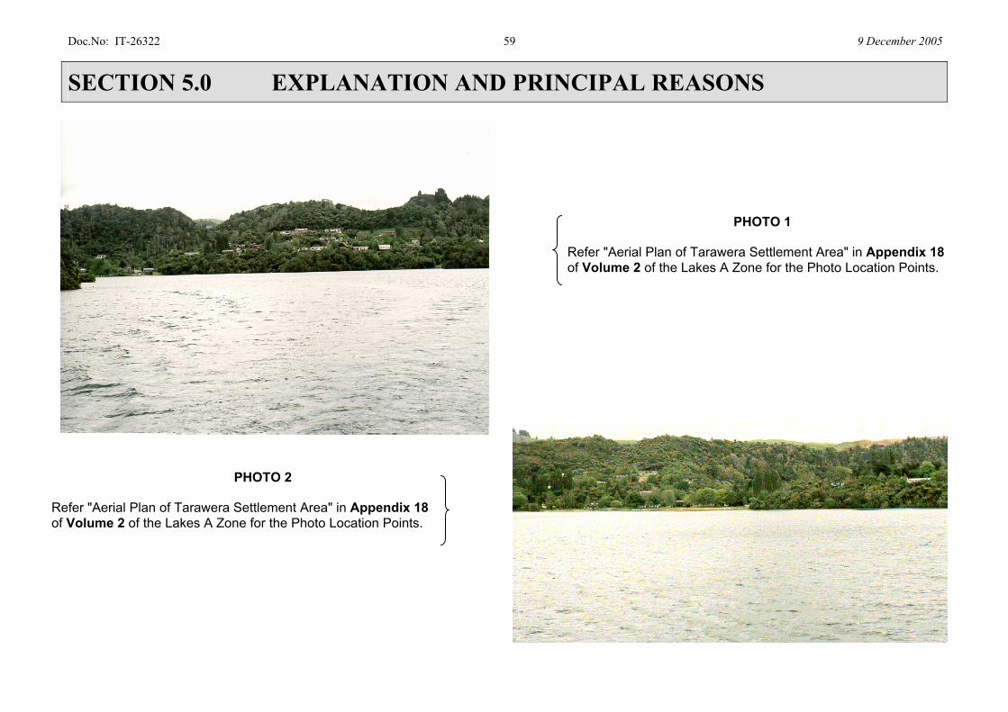
Doc.No: IT-26322 59 9 December 2005
SECTION 5.0 EXPLANATION AND PRINCIPAL REASONS
PHOTO 1 Refer "Aerial Plan of Tarawera Settlement Area" in Appendix 18 of Volume 2 of the Lakes A Zone for the Photo Location Points.
PHOTO 2 Refer "Aerial Plan of Tarawera Settlement Area" in Appendix 18 of Volume 2 of the Lakes A Zone for the Photo Location Points.
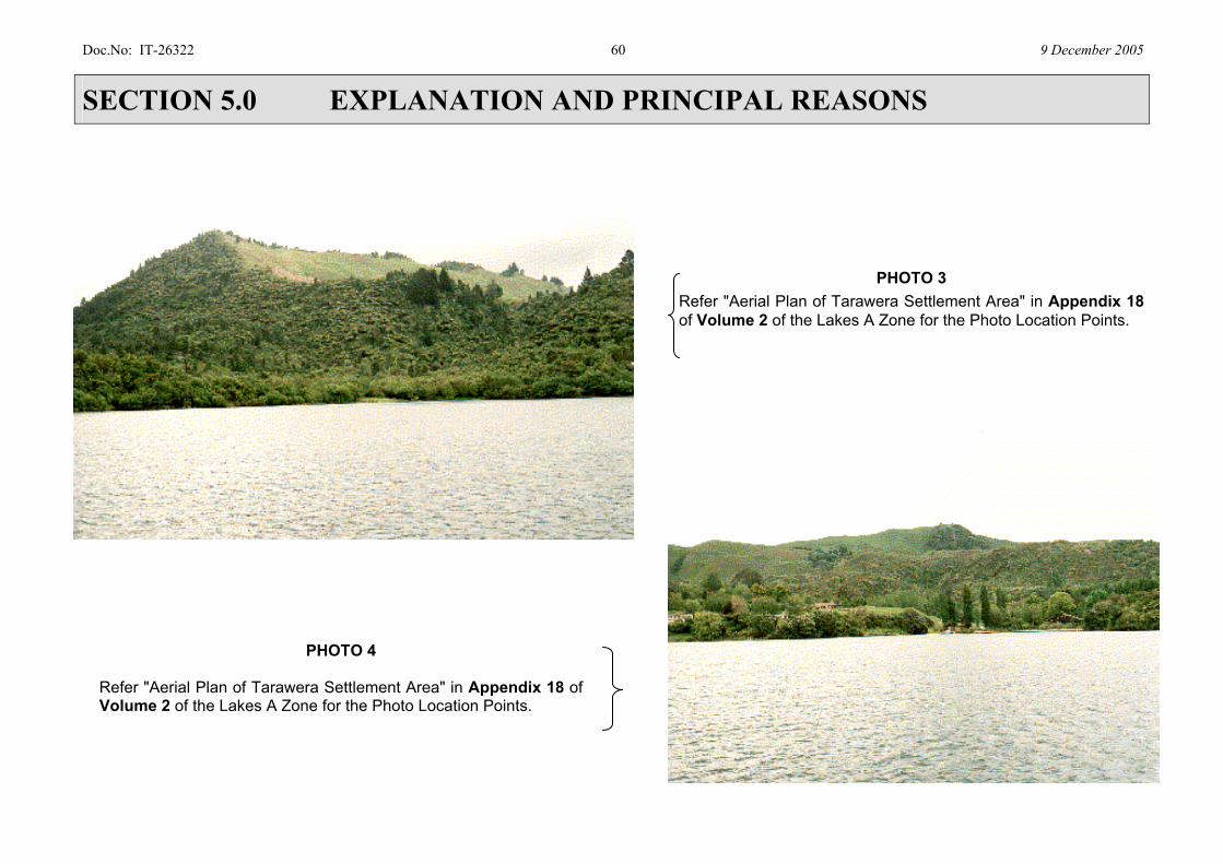
Doc.No: IT-26322 60 9 December 2005
SECTION 5.0 EXPLANATION AND PRINCIPAL REASONS
PHOTO 4 Refer "Aerial Plan of Tarawera Settlement Area" in Appendix 18 of Volume 2 of the Lakes A Zone for the Photo Location Points.
PHOTO 3
Refer "Aerial Plan of Tarawera Settlement Area" in Appendix 18 of Volume 2 of the Lakes A Zone for the Photo Location Points.
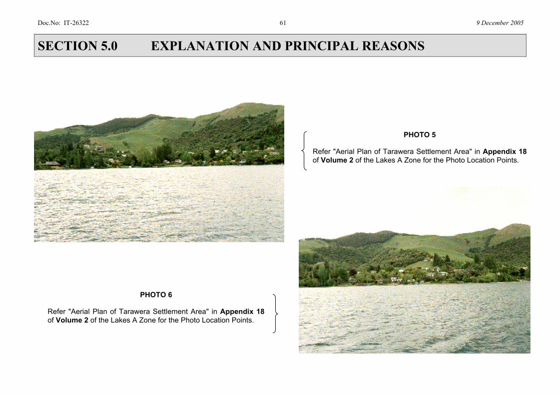
Doc.No: IT-26322 61 9 December 2005
SECTION 5.0 EXPLANATION AND PRINCIPAL REASONS
PHOTO 5 Refer "Aerial Plan of Tarawera Settlement Area" in Appendix 18 of Volume 2 of the Lakes A Zone for the Photo Location Points.
PHOTO 6 Refer "Aerial Plan of Tarawera Settlement Area" in Appendix 18 of Volume 2 of the Lakes A Zone for the Photo Location Points.
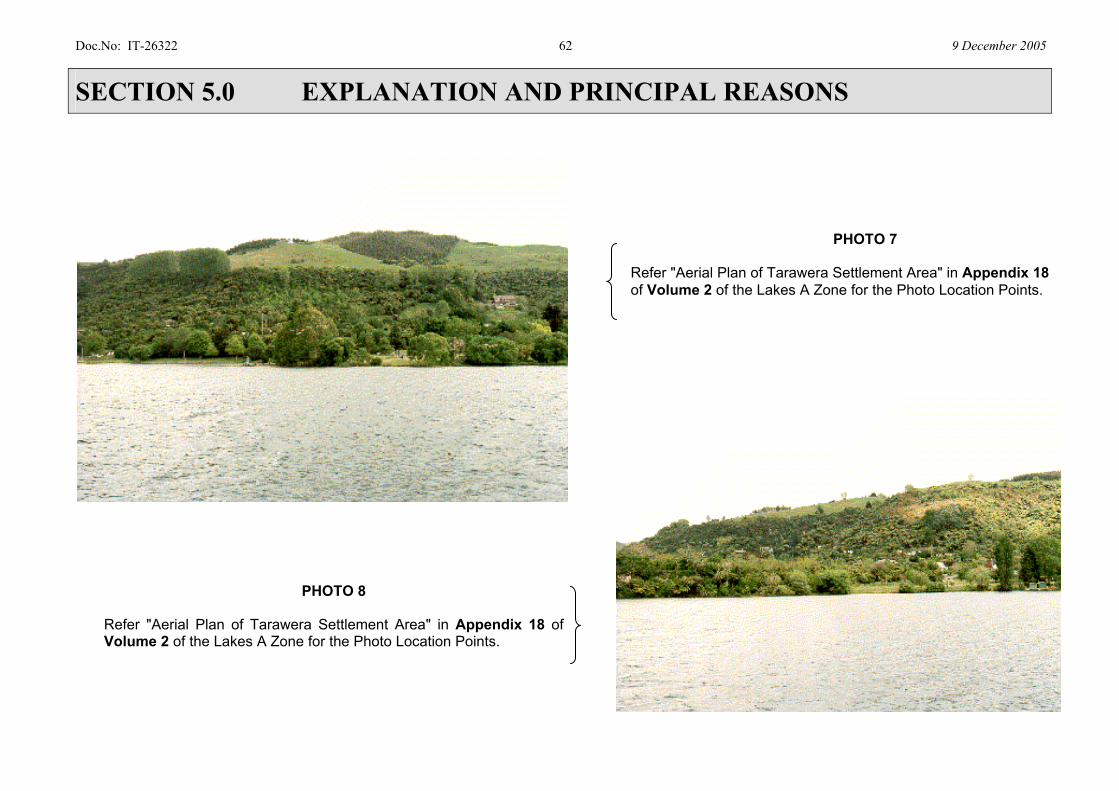
Doc.No: IT-26322 62 9 December 2005
SECTION 5.0 EXPLANATION AND PRINCIPAL REASONS
PHOTO 8 Refer "Aerial Plan of Tarawera Settlement Area" in Appendix 18 of Volume 2 of the Lakes A Zone for the Photo Location Points.
PHOTO 7 Refer "Aerial Plan of Tarawera Settlement Area" in Appendix 18 of Volume 2 of the Lakes A Zone for the Photo Location Points.

Doc.No: IT-26322 63 9 December 2005
SECTION 5.0 EXPLANATION AND PRINCIPAL REASONS
PHOTO 9 Refer "Aerial Plan of Tarawera Settlement Area" in Appendix 18 of Volume 2 of the Lakes A Zone for the Photo Location Points.
PHOTO 10 Refer "Aerial Plan of Tarawera Settlement Area" in Appendix 18 of Volume 2 of the Lakes A Zone for the Photo Location Points.

Doc.No: IT-26322 64 9 December 2005
SECTION 5.0 EXPLANATION AND PRINCIPAL REASONS
S5.3. 3 Bush Settlement Provisions
Policies
Policies apply to the Bush Settlement Management Area as a whole and there are also specific policies relating to locations within the Bush Settlement Management Area.
Structure Plans A structure plan approach is used, which identifies which parts of the land are suitable for development. All building development above 400 m2 site coverage is considered to be a discretionary or non-complying activity. This is because each site will require particular and unique enhancement measures by way of mitigation and in order to ensure that development, including planting on the site, contributes to the overall landscape rather than detracting from it. The structure plan identifies the site coverage and subdivision potential for each Bush Settlement site. Rules The rules in relation to outdoor storage, helicopter landing pads, solar access, Traffic Generation are the same as within the Settlement area, while the rules in relation to indigenous vegetation disturbance, earthworks, building platforms, viewpoints and buffers are the same as the Sensitive Rural area. This reflects the location of Bush Settlement which acts as a buffer between the Settlement and Sensitive Rural areas. There is a need to consider both amenity values on neighbouring properties as well as the wider effects of the Bush Settlement area on the landscape as a whole.
S5.4 TANGATA WHENUA
The policies are to address relevant matters of resource management significance to Tangata Whenua, to give effect to the requirements of Part II of the RMA, and to ensure that this Plan is not inconsistent with the provisions of regional policy statements and plans. In achieving the purposes of the RMA, section 6(e) requires that the relationship of Maori and their culture and traditions with their ancestral lands, water, sites, waahi tapu, and other taonga be recognised and provided for as a matter of national importance. It is recognised in the RMA that it may not always be appropriate to identify sites of significance in a public document. It may be necessary to determine whether sites will be adversely affected by proposals through consultation with the Tangata Whenua. In the preparation of the District Plan or any change to it Council can consider the findings of relevant Treaty claims and any resolutions reached by direct negotiation with the Crown. Relevant Treaty claims are those relating to the management of natural and physical resources under the RMA. Policies providing for the involvement of the Tangata Whenua give effect to case law and will help avoid, remedy or mitigate adverse effects on relationships of the Tangata Whenua with their ancestral taonga, and has particular regard to kaitiakitanga under section 7(a) of the RMA.
S5.4A TANGATA WHENUA STRUCTURE PLAN SITES The intention of the Tangata Whenua Structure Plan Sites is to implement Objective 15(c), through the provision of appropriate development opportunities on identified sites to rekindle and
Doc.No: IT-26322 65 9 December 2005
SECTION 5.0 EXPLANATION AND PRINCIPAL REASONS
foster the relationship of Tangata Whenua and their culture and traditions with their ancestral lands, water, sites, waahi tapu and other taonga while avoiding compromising existing landscape qualities and natural character. This is achieved through a two stage structure plan process being:
1. A Tangata Whenua Master Structure Plan showing the location
of specific Tangata Whenua Structure Plan Sites and connections between sites (where relevant). The Master Structure Plan is for guidance and information purposes only and is not linked to rules or assessment criteria.
2. Site specific Tangata Whenua Structure Plans outlining (where
applicable) suitable building areas, building coverage, vegetation removal, access and earthwork requirements.
Building platforms on the Structure Plan sites are to be selected in consultation with the Tangata Whenua to nestle into existing vegetation and landforms and to ensure that the proportion of indigenous vegetation removal on any one site is minimised. It is anticipated that there will be only one Structure Plan developed for each of the sites identified on the Tangata Whenua Master Structure Plan. Structure Plans on these sites will be limited to marae, papakainga houses, kaumatua houses, tourist accommodation as defined in Section 10.0 of this Volume (Volume 1) and tourist activities. Four of the seven Tangata Whenua Structure Plan sites have areas of indigenous vegetation on them that are Recommended Areas for Protection (RAPs). The Recommended Areas for Protection are identified in ‘Beadel, SM, Shaw WB, Nicholls JL (March 1998): Rotorua Lakes Ecological District Natural Area Survey’.
A description of each Tangata Whenua Structure Plan site is outlined below. Site 8 3 This site is legally described as Rotomahana Parekarangi 6B Block and has an area of 130.42 hectares inclusive of the island Otumutu.
A significant portion of the site’s Lake Tarawera shorelines contains wetland vegetation backed by indigenous forest. The centre of this site is covered with scrub vegetation. Much of the shoreline vegetation including that on Otumutu is included in RAP 66 and is shown on Planning Maps Constraints 208 and 268. Details of RAP 66 are included in Appendix 12.0, Volume 2 of the Lakes A Zone which includes the relevant extract from ‘Beadel, SM, Shaw WB, Nicholls JL (March 1998): Rotorua Lakes Ecological District Natural Area Survey’. The areas of RAP within this site cover 26.68 hectares.
Access may be negotiated over the adjoining reserve to the end of Spencer Road. The site is shown on Planning Maps Policy 208 and 268 as being located within the Tarawera Policy Area and the Sensitive Rural Management Area.
3 The reader is advised that the sites identified for Tangata Whenua Structure Plans are not numbered
sequentially. The numbers for the sites replicate numbers from an original source document. There is difficulty in renumbering the Structure Plan sites and maintaining the integrity of the source documents concerned.
Doc.No: IT-26322 66 9 December 2005
SECTION 5.0 EXPLANATION AND PRINCIPAL REASONS
Site 13 This site is legally described as Lot 3 DPS 19146 (previously part of Rotomahana Parekarangi 6G3B Block) and has an area of 5.82 hectares. The site is predominantly covered with scrub and areas of regenerating indigenous forest, with the latter particularly on the lake shore escarpment. The site has frontage to and legal access from Spencer Road. It would be relatively easy to develop an access into the site.
The site is shown on Planning Map Policy 271 as being located within the Tarawera Policy Area and is located in the Sensitive Rural Management Area. The site is relatively steep from the shoreline of Lake Tarawera. The steep area affects approximately half the total area of the site. There is land with slightly easier contours adjacent to Spencer Road. In recognition of the rich cultural history of Tarawera, the Tangata Whenua Structure Plan for Site 13 provides for the establishment of a wharenui (meeting house) in a prominent position overlooking the lake and other sites of cultural importance. This location will allow for traditional ceremonies and reference to important taonga during whaikorero (ceremonial speeches). Other activities included within the definition of marae and buildings to provide for kaumatua houses, have been provided for in less prominent locations in this Structure Plan. Site 20 This site is legally described as Rotomahana Parekarangi 6J2B4 and has an area of 9.29 hectares. This site has access to Tarawera Road.
Topographically the site is predominantly a flat low terrace. This site is predominantly covered in pasture and has access to Tarawera Road. A small stand of poplars on the road frontage is located in the centre of the site. There are no RAPs on this site. The Wairua Stream forms the southern boundary of the site. The site is shown on Planning Map Policy 272 as being located within the Tarawera Policy Area and is located in the Sensitive Rural Management Area. The original Hinemihi wharenui was located on this site. It was this meeting house that provided shelter for a number of people who survived the eruption of Mt Tarawera on June 10 1886. Site 29 This site is legally described as Rotomahana Parekarangi 6O2B Block and has an area of 254 hectares. The western portion of the site is covered in production forestry while the eastern portion, including the Lake Tarawera shoreline, is in indigenous forest. Much of the site is included in RAP 69 and is shown on Planning Maps Constraints 208 and 211. Details of RAP 69 are included in Appendix 12.0, Volume 2 of the Lakes A Zone which includes the relevant extract from ‘Beadel, SM, Shaw WB, Nicholls JL (March 1998): Rotorua Lakes Ecological District Natural Area Survey’. The area of RAP within this site covers 202.24 hectares. A significant part of the western portion of the RAP has been compromised by the use of the land for production forestry. There is currently no legal access to the site although it is possible for there to be physical access from the adjoining forestry or farming properties.
Doc.No: IT-26322 67 9 December 2005
SECTION 5.0 EXPLANATION AND PRINCIPAL REASONS
The site is shown on Planning Map Policy 208 and 211 as being located within the Tarawera Policy Area and is located in the Sensitive Rural Management Area. The production forestry part of the site could accommodate buildings as a permitted activity where this is clear of indigenous vegetation. There may be areas of remnant vegetation in gully floors or along side ephemeral streams which would more than likely be unsuitable for a building platform in any event. There is a relatively small area of flat land in an embayment known as Shag Rock Bay. Some exotic vegetation is present adjacent to the shoreline while the steeper scarps are primarily in indigenous vegetation. The lake shore landforms are prominent from close to the shoreline and further distant views. Site 30 This site is legally described as Rotomahana Parekarangi 3A5A Block and has an area of 77.92 hectares. It is located on a peninsula and has frontage to Lake Tarawera on the northern and southern shorelines of the block. There is no legal access or physical access other than from Lake Tarawera.
This site is predominantly covered in indigenous forest but there is a small area of bare ground in the centre of the block. Much of the site is included in RAP 70 and is shown on Planning Map Constraints 209. Details of RAP 70 are included in Appendix 12.0, Volume 2 of the Lakes A Zone which includes the relevant extract from ‘Beadel, SM, Shaw WB, Nicholls JL (March 1998): Rotorua Lakes Ecological District Natural Area Survey’. The area of RAP encompasses the entire site.
The site is shown on Planning Map Policy 209 as being located within the Tarawera Policy Area and is located in the Sensitive Rural Management Area. There is a recorded archaeological site V16/17 shown on the Planning Map Constraints 209 and located on the southern shoreline of the site. Archaeological site V16/17 is a pa site and is listed as item 242 in section a1.6 of Appendix A that is part of Rule 1.1 of the Lakes A Zone (full text version).
The site is undeveloped. The presence of indigenous vegetation over much of the site means that Rule 2.0 Indigenous Vegetation Disturbance is relevant to this site. There are aspects of the indigenous vegetation disturbance, earthworks and building rules relating to riparian areas that would also be relevant. The site contains hilly landforms as shown on Map Landforms 209 in Appendix 13.0, Volume 2 of the Lakes A Zone. The topographic map shows that the site contains a ridge which is most evident from views of the northern shoreline. The area is popular for recreational boating and is designated as an access lane for water skiing as shown on Planning Map Constraints 209. The contour for the southern portion of the site is more gentle and there is a relatively flat area in the vicinity of the bare ground. The land rises to a hill on the south-western boundary known as Pukehou. Site 31 This site is legally described as Rotomahana Parekarangi 6Q2B Block and has an area of 77.92 hectares. The northern shoreline bounds Lake Tarawera and the southern shoreline bounds Lake Rotomahana. There is no legal access or physical access other than from each of the lakes.

Doc.No: IT-26322 68 9 December 2005
SECTION 5.0 EXPLANATION AND PRINCIPAL REASONS
The site is predominantly covered in indigenous forest but includes sizeable areas of scrub. Wetland vegetation occupies some of the shoreline. There are a number of Wattles growing within the vegetation. The entire site is included in RAP 71 and is shown on Planning Maps Constraints 212. Details of RAP 71 are included in Appendix 12.0, Volume 2 of the Lakes A Zone which includes the relevant extract from ‘Beadel, SM, Shaw WB, Nicholls JL (March 1998): Rotorua Lakes Ecological District Natural Area Survey’. The site is shown on Planning Map Policy 212 as being located within the Tarawera and Rotomahana Policy Areas and is located in the Sensitive Rural Management Area.
There are two recorded archaeological pa sites numbered V16/70 and V16/73 shown on the Planning Map Constraints 212 and located close to the north eastern and north western boundary of the site respectively. These are listed as items 237 and 228 in section a.1.6 of Appendix A that is part of Rule 1.1 of the Lakes A Zone (full text version).
This site is undeveloped. The presence of indigenous vegetation over much of the site means that Rule 2.0 Indigenous Vegetation Disturbance is relevant to this site. Site 45 Site 45 is legally described as Section 5 Block XII Tarawera Survey District which is shown on SO 20794. Site 45 has an area of 17.69 hectares. The site is covered with indigenous vegetation. The indigenous vegetation has not been identified as a RAP in 'Beadel SM, Shaw
WB, Nicholls JL (March 1998): Rotorua Lakes Ecological District Natural Area Survey'. The land is shown on Planning Policy Map 209 as being located within the Tarawera Policy Area and is within the Sensitive Rural Management Area. The land is hilly and steep. The village of Moura was located on this site prior to the eruption of Mount Tarawera. The north-western part of this site is listed as item 243 (V16/18) in section a1.6 of Appendix A that is part of Rule 1.1 of the Lakes A Zone (full text version). Item 243 (V16/18) is an archaeological site (pa site). This is shown on the Planning Map Constraints 209. The site also contains a burial ground. Planning Map Constraints 209 shows that the site is a Maori Reserve. The 1974 Gazette Reference (page 169) specifies that the purpose of the reserve is for a Maori burial ground. The site contains a memorial to the eruption of Mt Tarawera.
This site does not have road access. Access is from Lake Tarawera.
S5.4B STRUCTURE PLANS BY WAY OF A LAND USE CONSENT
For sites identified on the Tangata Whenua Master Structure Plan that have not had Structure Plans developed for them (Sites 8, 29, 30, 31 and 45), Structure Plans for marae, papakainga houses, kaumatua houses, tourist accommodation as defined in Section 10.0 of this Volume (Volume 1) and tourist activities, can be applied for by way of a Discretionary Activity Land Use Consent. The following factors shall be taken into account when selecting development areas on the identified sites and when considering an application:
Doc.No: IT-26322 69 9 December 2005
SECTION 5.0 EXPLANATION AND PRINCIPAL REASONS
1 The provision of appropriate development opportunities to
enable the relationship of Tangata Whenua and their culture and traditions with their ancestral lands, water, sites, waahi tapu and other taonga.
2 Avoiding as far as is practicable development in riparian areas
and enhancing the restoration of indigenous vegetation in riparian areas.
3 The level of vegetation disturbance necessary to construct
building platforms and access to the site. In this respect, the disturbance of exotic vegetation is preferred but where there is no alternative indigenous vegetation may be disturbed. The disturbance of indigenous vegetation is to take into account the quality of the indigenous vegetation on site. Vegetation of a lesser age, structure, density and rarity is preferred.

Doc.No: IT-26322 70 9 December 2005
SECTION 5.0 EXPLANATION AND PRINCIPAL REASONS
4
4 The reader is advised that the sites identified for Tangata Whenua Structure Plans are not numbered sequentially. The numbers shown on the diagram replicate numbers from an original source document. There is difficulty in
renumbering the Structure Plan sites and maintaining the integrity of the source document concerned.
Doc.No: IT-26322 71 9 December 2005
SECTION 5.0 EXPLANATION AND PRINCIPAL REASONS
4 The extent of earthworks required to provide building
platforms and access to the site. In this respect, earthworks should also avoid slopes that exceed 24° and prominent and upper slopes and ridges.
5 The protection of historic heritage sites. 6 The siting of buildings in discrete areas, with low visibility
from any lake, viewpoint or public reserve. 7 The scale and intensity of the activity.
S5.5 WATER QUALITY The existing water quality in Lakes Tikitapu, Rotokakahi, Okataina and Tarawera is high, being a product of generally large tracts of bush and forest cover with minimal earthworks, sedimentation episodes and urbanised areas. The maintenance of such good water quality standards will only be possible by careful management of land use practises and therefore Council will be monitoring development – particularly earthworks (not covered by Regional Council rules) and stormwater discharges. The water quality in Lake Okareka is still of a relatively high standard while Lake Rotomahana has geothermal activity that influences water quality. Water quality in Lake Okaro is poor. The water quality of the Rotorua Lakes, including those within the Lakes A Zone, is monitored by Environment BOP. The results of this monitoring for the period 1992-1994 provides a base level for the water quality of the lakes contained in Environment BOP’s Operative Regional Plan for the Tarawera River Catchment. It is from this base level that trends relating to water quality improvement or degradation are able to be determined. Statements concerning the ‘nutrient status’
of each lake within the Lakes A Zone as contained in section 5.2 above under the heading ‘Natural Science’ reflect the respective base level water quality position.
S5.6 WETLANDS Wetlands are important for habitat values, maintenance of water quality in the lakes, contributing to the natural character of the margins of the lakes, and as landscape features in their own right. For these reasons this Plan has strong objectives and policies and rules relating to their protection. This Plan relies on the Regional Council’s rules for wetland modification. Wetlands are included in the criteria for taking Esplanade Reserves or Strips, and where wetlands are present on its own reserves Council will manage them to retain their values.
S5.7 INDIGENOUS VEGETATION, INDIGENOUS FAUNA AND
HABITATS The values ascribed to the vegetation (biodiversity including habitats, landscapes, natural character, water and soil conservation) are very important in the Lakes A Zone, and so the circumstances where disturbance can be carried out as Permitted Activities are closely detailed. This Plan identifies ‘Recommended Areas for Protection’ (RAPs) which are to be protected through Plan rules to assist in the retention of the District’s indigenous biodiversity. Council has considered alternative approaches including public purchase and assistance with management of the areas.
Vegetation provides habitat for birdlife and in particular indigenous species. The Lakes are an internationally significant habitat for trout. There are also important habitats for aquatic
Doc.No: IT-26322 72 9 December 2005
SECTION 5.0 EXPLANATION AND PRINCIPAL REASONS
birds including the endangered New Zealand dabchick.
S5.8 RIPARIAN AREAS AND PUBLIC ACCESS The definition of riparian areas uses three sets of criteria: presence of waterbodies and geothermal areas, the sensitive landscape area and the less sensitive landscape area, and slope of land. Each criterion will need to be determined on a site-by-site basis. This Plan does not identify the riparian areas as ‘no go’ areas but states where land management needs to be subject to more stringent controls because of the environmental risks. The management of riparian areas will seek to protect the intrinsic values, manage the effects of land use on waterways and maintain public access where it retains the natural character values. All the lakes except for Rotokakahi are used for public recreation. Access around sections of lake edges is possible because of the extensive network of existing reserves managed by both the Department of Conservation and Rotorua District Council. However, practical access is hindered by lack of formed tracks and by intervening blocks of private land.
S5.9 GEOTHERMAL FEATURES Geothermal features and the volcanic landforms are part of the natural character of the Lakes A Zone and as such are an integral part of the assessment criteria for resource consents. The maintenance and enhancement of such features through the District Plan is a key factor particularly in the consideration of earthworks and disturbance of vegetation.
S5.10 SOILS The soils that covers nearly all of the Lakes A Zone are very recent, resulting from Rotomahana muds produced by the 1886 Tarawera Eruption. They are relatively fertile, but being fine-grained and unstructured, are particularly susceptible to instability and erosion. These soils make up one of the 8 at-risk land classes in the Bay of Plenty identified by Environment BOP. Depending on their location, they are between a few centimetres to several metres thick. Underlying them are several paleosols (old soils developed from previous volcanic ash layers). The issue of avoiding pollution of soils is dealt with through Part Fourteen that forms part of Rule 1.1 of the Lakes A Zone (full text version).
S5.11 RECREATIONAL OPPORTUNITIES Policies specifically target the attributes of each lake environment that provides recreational opportunities. Such values are reflected in the character statements. Recreational pressures and conflicts have been identified. For example those seeking solitude or an undisturbed fishing spot find motorised water sports intrusive and disruptive. Access via boat launching ramps is regulated under the Regional Plan for the Tarawera River Catchment along with jetties. Access Lanes (i.e. ski and jetski lanes) on the lakes are presently established under bylaws under the Harbours Act 1950, and the main criteria for establishing them are navigation and safety. Environment BOP has transferred its administration of jetties under the Operative Regional Plan for the Tarawera River Catchment to the Rotorua District Council, as well as

Doc.No: IT-26322 73 9 December 2005
SECTION 5.0 EXPLANATION AND PRINCIPAL REASONS
administration of its bylaws relating to navigation and safety in the lakes. The Lakes A Zone contains provisions where necessary as a refinement of regional provisions controlling lake structures to recognise their cumulative effects on natural character. Lake surface activities, particularly motorised craft, are controlled to reflect the natural character attributes of each lake, especially noise. Large craft (vessels) are also controlled to reflect the natural attributes of the lakes. Large craft are particularly visible in small enclosed lakes, and houseboats can become a de facto residential development with the attendant visual, effluent and access problems.
S5.12 INFRASTRUCTURE AND UTILITY SERVICES This Plan enables the continuance of on-site provision of water supply, sewage disposal and stormwater management as well as community water supply and reticulated sewerage systems subject to the management of adverse effects. All works and network utilities provide services for the ongoing functioning of the community. Given the significant natural character values in the lakes area, new services will be required to minimise adverse effects on the environment. However, the rules acknowledge the present alignment and characteristics of above ground electric and telecommunication lines and structures that support them. Construction of new roads or widening of existing roads requires careful design to maintain or improve the scenic and vegetated character of roads to ensure the naturalness of the outstanding landscapes of the Lakes A Zone are maintained and enhanced.
S5.13 NATURAL HAZARDS There is a wide range of possible natural hazards and some created hazards that constrain development. The lakes area has a significantly large number of faultlines, the avoidance of which by development,
would be impossible. As such, Council’s approach is to keep development at a relatively low density, to apply the provisions of the Building Act 1991 and implement evacuation procedures rather than prohibit further development in the area. It is not considered practical to avoid the effects of earthquake and volcanic eruptions other than timely evacuation. Council is managing stormwater effects and mitigating flood hazards. The risk of fire hazard from allowing built development in bush environments is acknowledged. However, those choosing to live in such vegetated environments must live with this risk in the context of a largely undeveloped landform covered in indigenous vegetation.
S5.14 SUBDIVISION AND DEVELOPMENT The creation of land titles, building platforms and the scale of buildings and structures are all to be managed to retain the natural character of the Lakes A Zone. As such, subdivision is relatively limited to opportunities in the settlement and bush settlement areas. Larger scale rural lot subdivision is provided for in the remainder of the zone. Appropriate and Inappropriate Activities The Lakes A Zone has taken an ‘activity neutral’ approach by not listing what sorts of development can or cannot be undertaken in the Lakes A Zone. Instead, performance standards are defined, such as those limiting the size of buildings and their minimal distances from boundaries or streams, and the minimum size of a property. Not only residential but many types of development may be able to comply with these performance standards, but to provide clear direction that it is not an invitation to commercial use, such as for retailing or entertainment, there are also strict standards limiting traffic and noise generation based on individual
Doc.No: IT-26322 74 9 December 2005
SECTION 5.0 EXPLANATION AND PRINCIPAL REASONS
household levels. The rural land use activities of farming, forestry and conservation are however also recognised as having an important place in the Lakes A Zone, and their traffic and noise anticipated. Thus while there is no prescription for the Lakes A Zone as to what is or is not allowed, it is implicit that the intent is for residential, farming, forestry and conservation, as well as day visitors and some small scale visitor accommodation activities.
S5.15 ESPLANADE RESERVES AND STRIPS Much of the Lakes A Zone is already held in public reserve which affords associated recreational and access opportunities. Council will continue to acquire (through the provisions of the RMA) esplanade reserves and strips to: • Assist in the management of riparian margins from an ecological
perspective; • Improve public access along the lake margins and to/from the
lakes; and • Assist in the retention of indigenous vegetation clad character of
lake margins. S5.16 AMENITY
The natural character of the Lakes A Zone generates amenity values associated with undeveloped, peaceful, vegetated wilderness with minor intrusions of buildings. There is potential for conflict to occur among residents and/or visitors, who have different amenity value sets. This is particularly evident in relation to motorised craft on lakes, including jet skis and water skiers and the intrusion that this causes to fishermen (anglers) and residents on shore.
The Council has acknowledged the unique natural character of the area, its value as a nationally significant geographical area for its natural features of indigenous flora and fauna and lake recreational environment where public access is significant, and significant cultural heritage. The acknowledgement is reflected in this Plan’s rules which seek containment of built development and the emphasis on retention of the natural character. The management of effects that cause nuisance or annoyance to other people is achieved through defining the amenity values enjoyed by residents and visitors. In the Lakes A Zone, amenity relates to noise, spill light or stray light emissions and electromagnetic radiation. Other aspects of amenity are dealt with under other headings such as natural character and landscapes.
S5.17 ENHANCEMENT Enhancement of natural landscape attributes is promoted and allowed for throughout the Policies (Section 4). The enhancement measures are intended to restore attributes of natural character of the lands and waters of the Lakes A Zone. These attributes include the ecology of the lands and waters as well as addressing people’s experience of these places, in particular how things look in terms of their naturalness. The types of enhancement envisaged include: • Enhancement of the indigenous ecology, through supporting
or establishing ecological corridors, and, in providing a buffering habitat for indigenous fauna;
• Protection of waterbodies and enhancement of water quality
through the establishment and enlargement of vegetated
Doc.No: IT-26322 75 9 December 2005
SECTION 5.0 EXPLANATION AND PRINCIPAL REASONS
buffers, through increased vegetative cover, and, also through wetland restoration or establishment;
• Revegetation of erosion prone land and of prominent landforms;
and • The nestling of development into an ecological framework.
S5.18 REVEGETATION
The enhancement measures provided for in the Lakes A Zone anticipate considerable revegetation. Revegetation is intended to involve the re-establishment of the local, indigenous plant communities that belong on each type of landform. To assist in the establishment of such indigenous vegetation, nurse plantings of non-invasive exotic species may be utilised, providing their removal would not adversely affect visual amenity, ecological, or soil and water values. A commercial plantation is not intended.

Doc.No: IT-26322 76 9 December 2005
SECTION 6.0 METHODS OTHER THAN RULES
Methods
Methods other than rules are actions Rotorua District Council will or may take outside the District Plan to help achieve the objectives of the Lakes A Zone.
M1.0 TANGATA WHENUA M1.1 To consider transferring, where appropriate, functions, powers and duties to iwi authorities in terms of s.33 of the RMA. M1.2 To consider delegating, where appropriate, functions, powers and duties to a Committee of Council comprising the relevant Tangata Whenua
representatives in terms of s.34 of the RMA. M1.3 To encourage applicants to consult the affected Tangata Whenua prior to submitting any request for a Plan Change. M1.4 To consult the affected Tangata Whenua on any proposal for a Plan Change or Variation. M1.5 To provide for tikanga Maori and Marae hearings where appropriate, and for the use of Maori language in statutory procedures, where the Tangata Whenua
are an affected party. M1.6 To provide, where appropriate, for tikanga Maori and Marae hearings on the request of an applicant where the Tangata Whenua are the applicant. M1.7 To provide for the appointment of a person with recognised expertise in tikanga Maori to any hearing committee where ancestral taonga or tikanga Maori is
a significant issue to the Tangata Whenua. M1.8 To recognise the importance of Maori customary, cultural and traditional knowledge. M1.9 To enable the Tangata Whenua to participate in the assessment of the effects of any activity on relationships with ancestral taonga, including public access
to, or use of, ancestral taonga. M1.10 To consider altering this Plan where a finding on a Treaty claim by the Waitangi Tribunal, or a resolution by direct negotiation with the Crown, includes
matters affecting the management of natural and physical resources.
Doc.No: IT-26322 77 9 December 2005
SECTION 6.0 METHODS OTHER THAN RULES
Methods
M2.0 WATER QUALITY: M2.1 To work with Environment BOP and landowners to promote land management in the lake catchments (including human effluent disposal) that enables
the standards set by Environment BOP for water quality and discharge and water permits to be met. M2.2 To work with Environment BOP to manage activities on the surface of water that enable the water quality standards set by Environment BOP to be met. M2.3 To work with Environment BOP and landowners to establish adequate riparian buffers and wetlands, and to minimise nutrients entering the lake. M2.4 To promote the upgrading of existing stormwater systems as practicable, having regard to:
a) upgrade opportunities; b) cost effectiveness c) availability of land; d) potential damage to utilities; e) effects on the environment; f) protection of water quality.
Doc.No: IT-26322 78 9 December 2005
SECTION 6.0 METHODS OTHER THAN RULES
Methods
M3.0 AQUATIC ECOSYSTEMS:
M3.1 To promote the protection of known habitats of indigenous birds and aquatic fauna and trout in lakes and streams. M3.2 To work with Environment BOP, the Department of Conservation and to identify the distribution of indigenous aquatic habitats and vegetation in the
lakes. M3.3 To protect Rotomahana from further invasion by aquatic weeds by controlling boat access using Council’s powers under the Reserves Act 1977 and
Lakes’ Bylaw delegated by Environment BOP under the Harbours Act 1950. M3.4 To assist funding to provide informative signs at boat ramps concerning the spread of aquatic pest plants and pest animals, and to provide boat wash-
down facilities at boat ramps where practicable. M3.5 To work with neighbouring Councils and the Department of Conservation (DOC) on co-ordinated approaches for managing the risks of spread of aquatic
weeds and pest fish. M3.6 To rely on the Regional Council to regulate discharges to water and water takes. M3.7 To work with landowners, Environment BOP and other organisations to rehabilitate streams and wetlands.
M4.0 WETLANDS:
M4.1 To fund assistance for wetland protection in Financial Strategies and Annual Plans. M4.2 To manage wetlands in Council reserves in ways that retain or enhance their viability and habitats by:
a) retaining watertables; b) rehabilitation planting; c) pest plant and pest animal control; d) removal of exotic plant species; e) prevention of grazing.
M4.3 To promote the importance and protection of wetlands. M4.4 To rely on Regional rules to regulate modification of wetlands.
M5.0 INDIGENOUS VEGETATION AND HABITATS:
M5.1 To require and facilitate the ongoing management of protected areas of indigenous vegetation and habitats.
Doc.No: IT-26322 79 9 December 2005
SECTION 6.0 METHODS OTHER THAN RULES
Methods
M5.2 To co-operate with other agencies which have responsibilities relating to indigenous vegetation and promote the control of pest animal and pest plants within protected areas.
M5.3 To work with landowners who own indigenous vegetation on ways of protecting and enhancing indigenous biodiversity including, where relevant, the use of exotic vegetation.
M5.4 To fund assistance for protection and rehabilitation in Financial Strategies and Annual Plans. M5.5 To use the presence of indigenous vegetation and habitats as criteria for reserves acquisition as a financial contribution. M5.6 To manage Council reserves with an objective to retain or enhance the viability of existing areas of indigenous vegetation by:
a) planting with locally-sourced indigenous species; b) controlling pest plant and pest animals; c) preventing grazing; d) where appropriate, removal of exotic species.
M5.7 To work with the Ministry of Agriculture and Forestry on the production of sustainable forest management plans and permits that promote the protection of indigenous ecosystems and habitats.
M5.8 To support the QEII National Trust. M5.9 To invite support for this Plan’s objectives from Nga Whenua and New Zealand Nature Heritage Fund and similar bodies. M5.10 To consider rate rebates for indigenous vegetation and habitat areas that are protected.
M6.0 RIPARIAN AREAS: M6.1 To manage Council reserves, including esplanade reserves, in ways that protect or enhance riparian values, including:
a) wetlands; b) reedbeds; c) areas of indigenous terrestrial vegetation; d) known habitats of aquatic indigenous fauna and trout, and indigenous birds; e) aquatic ecosystems; f) mitigation of adverse effects of the use and development of land on lakes and streams;

Doc.No: IT-26322 80 9 December 2005
SECTION 6.0 METHODS OTHER THAN RULES
Methods
g) threatened indigenous species. M6.2 To allow Council reserves, including esplanade reserves to be privately occupied only by way of a lease or licence and only where it can be shown that:
a) The values in M6.1 are maintained and, where consistent with an operative reserve management plan, enhanced; and b) Practicable public access is not restricted; and c) Such occupation is provided for in the Operative Reserve Management Plan, and can be lawfully established under the Reserves Act 1977. Council may place conditions on the lease to protect these matters, and to control appearance and maintenance.
M6.3 To prefer good land management practises in the catchment through techniques such as Environmental Property Plans over reliance on riparian areas as the sole buffer to the lake’s receiving environment.
M6.4 Except in situations where a particular rule applies, to negotiate with developers or subdividing owners with an aim to achieving riparian management of lakes, rivers and wetlands which maintains or enhances the above values. Council will consider esplanade strips or some other suitable covenant or easement.
M6.5 To recommend to the Regional Council the discharge of any LIA (Land Improvement Agreement) as appropriate where it has been replaced by an esplanade instrument of at least the same terms and area.
M6.6 To promote the values of riparian areas and the value of their good management
M7.0 GEOTHERMAL FEATURES: M7.1 To rely on Regional Rules to control the taking and discharge of geothermal fluids.
M8.0 AIR: M8.1 To rely on Regional Rules to regulate air quality.
M9.0 SOILS: M9.1 To encourage, with Environment BOP, the use and management of land in a manner which recognises the erodability of the soils, including:
a) minimising cultivation on slopes over 15o; b) encouraging alternatives to pastoral grazing on slopes over 15o; c) retention of intact vegetation in dry valleys (ephemeral watercourses).
Doc.No: IT-26322 81 9 December 2005
SECTION 6.0 METHODS OTHER THAN RULES
Methods
M9.2 To promote in conjunction with Environment BOP, and be involved with, Environmental Property Plans which meet the objectives of the Lakes A Zone. M9.3 To support Environment BOP’s promotion of sustainable management of land and soil conservation.
M10.0 HISTORIC AND CULTURAL HERITAGE M10.1 To work with the Tangata Whenua and agencies with responsibilities for historic and cultural heritage management to:
a) obtain up-to-date information on the location and nature of historic and cultural places including sites or areas with characteristics of special value to the Tangata Whenua;
b) seek protection of these places including where appropriate, progressively updating this Plan. M10.2 To consider rates rebates for historic or cultural heritage sites that are protected.
M11.0 INFRASTRUCTURE AND UTILITY SERVICES: M11.1 To promote and encourage where practical the establishment of pedestrian and cycle networks separate from the vehicular traffic network. M11.2 To promote undergrounding or discreet overhead cabling of existing lines for conveying electricity and telecommunications. M11.3 To fund assistance to off-road walkways and cycleways in the Tarawera settlement that do not mimic footpaths. M11.4 To work with roading providers and Environment BOP in developing Regional Land Transport Strategies, which may include new roads and widening of
existing roads. M11.5 To prepare annual road and traffic management work programmes as part of the Annual Plan process. M11.6 To use provisions in other legislation such as the creation of Bylaws under the Local Government Act 1974, to control activities, such as hawking in or
adjacent to roads.
M12.0 PESTS: M12.1 To provide, in conjunction with the SPCA, an euthanasing service for unwanted cats and dogs. M12.2 To promote, in conjunction with Environment BOP and the Department of Conservation as appropriate, the control of pest plants and pest animals in
protected natural areas (PNAs) by: a) considering funding assistance in Financial Strategies and Annual Plans for community and landowner initiatives; b) undertaking regular education and advertising programmes;

Doc.No: IT-26322 82 9 December 2005
SECTION 6.0 METHODS OTHER THAN RULES
Methods
c) producing and distributing information. M12.3 To facilitate, in conjunction with other interested parties, a public debate about the threats of cats and dogs to indigenous fauna, and the best way to
address those threats.
M13.0 RECREATIONAL OPPORTUNITIES: M13.1 To provide access to all lakes, except Rotokakahi and Rotomahana, in accordance with landscape policy. M13.2 To encourage and support community stream and lake care groups to manage access and amenity along streams and lake edges where these initiatives do
not compromise existing indigenous vegetation and wildlife habitats. M13.3 To establish access suitable for public enjoyment along Council reserves, including esplanade reserves but which avoid excessive access to wetlands, to
sensitive habitats especially of indigenous birds, and to identified waahi tapu. M13.4 To establish and maintain public walkways along Council reserves, including esplanade reserves in accordance with Reserves Management Plans. M13.5 To provide signs that inform the public of restrictions on the use of lakes. M13.6 To administer those functions of Environment BOP relating to lake structures in accordance with the terms of transfer of powers under s.33 of the RMA. M13.7 To work with the Department of Conservation on rationalisation of recreational management and facilities on Council and Departmental Reserves. M13.8 To work with the Department of Conservation on the co-operative provision of toilet facilities on reserves, particularly where access lanes are located. M13.9 To investigate the feasibility of providing holding tank pump-out facilities at boat launching ramps.
M14.0 NATURAL HAZARDS: M14.1 To maintain a register of known hazards on property files or on Council GIS. M14.2 To develop evacuation procedures and lifeline routes sufficient to deal with existing and future levels of population, including visitors. M14.3 To raise public awareness of natural hazards within the Lakes A Zone, particularly the fact that the entire Lakes A Zone is at risk from volcanic activity,
including thick ashfall from the Okataina Volcanic Centre. M14.4 To manage development over active fault lines through the provisions of the Building Act 1991.
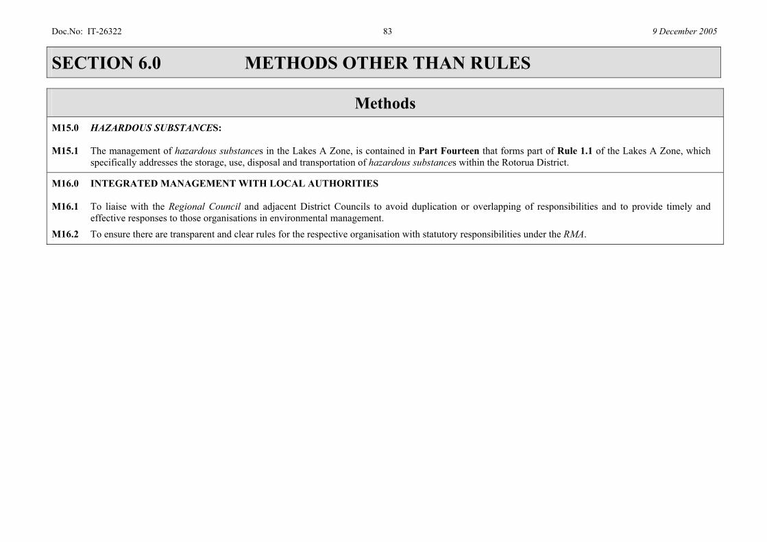
Doc.No: IT-26322 83 9 December 2005
SECTION 6.0 METHODS OTHER THAN RULES
Methods
M15.0 HAZARDOUS SUBSTANCES: M15.1 The management of hazardous substances in the Lakes A Zone, is contained in Part Fourteen that forms part of Rule 1.1 of the Lakes A Zone, which
specifically addresses the storage, use, disposal and transportation of hazardous substances within the Rotorua District.
M16.0 INTEGRATED MANAGEMENT WITH LOCAL AUTHORITIES M16.1 To liaise with the Regional Council and adjacent District Councils to avoid duplication or overlapping of responsibilities and to provide timely and
effective responses to those organisations in environmental management. M16.2 To ensure there are transparent and clear rules for the respective organisation with statutory responsibilities under the RMA.
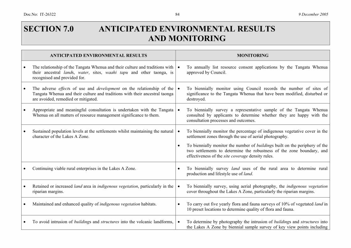
Doc.No: IT-26322 84 9 December 2005
SECTION 7.0 ANTICIPATED ENVIRONMENTAL RESULTS AND MONITORING
ANTICIPATED ENVIRONMENTAL RESULTS MONITORING
• The relationship of the Tangata Whenua and their culture and traditions with their ancestral lands, water, sites, waahi tapu and other taonga, is recognised and provided for.
• To annually list resource consent applications by the Tangata Whenua approved by Council.
• The adverse effects of use and development on the relationship of the Tangata Whenua and their culture and traditions with their ancestral taonga are avoided, remedied or mitigated.
• To biennially monitor using Council records the number of sites of significance to the Tangata Whenua that have been modified, disturbed or destroyed.
• Appropriate and meaningful consultation is undertaken with the Tangata Whenua on all matters of resource management significance to them.
• To biennially survey a representative sample of the Tangata Whenua consulted by applicants to determine whether they are happy with the consultation processes and outcomes.
• Sustained population levels at the settlements whilst maintaining the natural character of the Lakes A Zone.
• To biennially monitor the percentage of indigenous vegetative cover in the settlement zones through the use of aerial photography.
• To biennially monitor the number of buildings built on the periphery of the two settlements to determine the robustness of the zone boundary, and effectiveness of the site coverage density rules.
• Continuing viable rural enterprises in the Lakes A Zone. • To biennially survey land uses of the rural area to determine rural production and lifestyle use of land.
• Retained or increased land area in indigenous vegetation, particularly in the riparian margins.
• To biennially survey, using aerial photography, the indigenous vegetation cover throughout the Lakes A Zone, particularly the riparian margins.
• Maintained and enhanced quality of indigenous vegetation habitats. • To carry out five yearly flora and fauna surveys of 10% of vegetated land in 10 preset locations to determine quality of flora and fauna.
• To avoid intrusion of buildings and structures into the volcanic landforms, • To determine by photography the intrusion of buildings and structures into the Lakes A Zone by biennial sample survey of key view points including
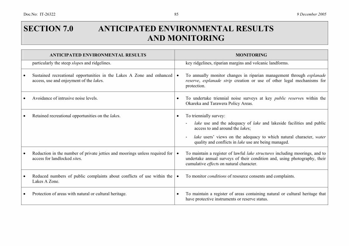
Doc.No: IT-26322 85 9 December 2005
SECTION 7.0 ANTICIPATED ENVIRONMENTAL RESULTS AND MONITORING
ANTICIPATED ENVIRONMENTAL RESULTS MONITORING
particularly the steep slopes and ridgelines. key ridgelines, riparian margins and volcanic landforms.
• Sustained recreational opportunities in the Lakes A Zone and enhanced access, use and enjoyment of the lakes.
• To annually monitor changes in riparian management through esplanade reserve, esplanade strip creation or use of other legal mechanisms for protection.
• Avoidance of intrusive noise levels. • To undertake triennial noise surveys at key public reserves within the Okareka and Tarawera Policy Areas.
• Retained recreational opportunities on the lakes. • To triennially survey: - lake use and the adequacy of lake and lakeside facilities and public
access to and around the lakes;
- lake users’ views on the adequacy to which natural character, water quality and conflicts in lake use are being managed.
• Reduction in the number of private jetties and moorings unless required for access for landlocked sites.
• To maintain a register of lawful lake structures including moorings, and to undertake annual surveys of their condition and, using photography, their cumulative effects on natural character.
• Reduced numbers of public complaints about conflicts of use within the Lakes A Zone.
• To monitor conditions of resource consents and complaints.
• Protection of areas with natural or cultural heritage. • To maintain a register of areas containing natural or cultural heritage that have protective instruments or reserve status.
Related Documents


