Victorian Environmental Water Holder Seasonal Watering Plan 2014-15

Welcome message from author
This document is posted to help you gain knowledge. Please leave a comment to let me know what you think about it! Share it to your friends and learn new things together.
Transcript
Victorian Environmental Water Holder
Seasonal Watering Plan
2014-15

© Victorian Environmental Water Holder 2014
This work is licensed under a Creative Commons Attribution 3.0 Australia licence. You are free to re-use the work under that licence, on the condition that you credit the Victorian Environmental Water Holder as author. The licence does not apply to any images, photographs or branding, including the Victorian Government logo and the Victorian Environmental Water Holder logo. To view a copy of this licence, visit http://creativecommons.org/licenses/by/3.0/au/deed.en
Printed by Impact Digital, Brunswick (June 2014)
ISSN: 2203-6539 (Print) ISSN: 2203-6520 (Online)
Disclaimer
This publication may be of assistance to you but the Victorian Environmental Water Holder and its employees do not guarantee that the publication is without flaw of any kind or is wholly appropriate for your particular purposes and therefore disclaims all liability for any error, loss or other consequence which may arise from you relying on any information in this publication.
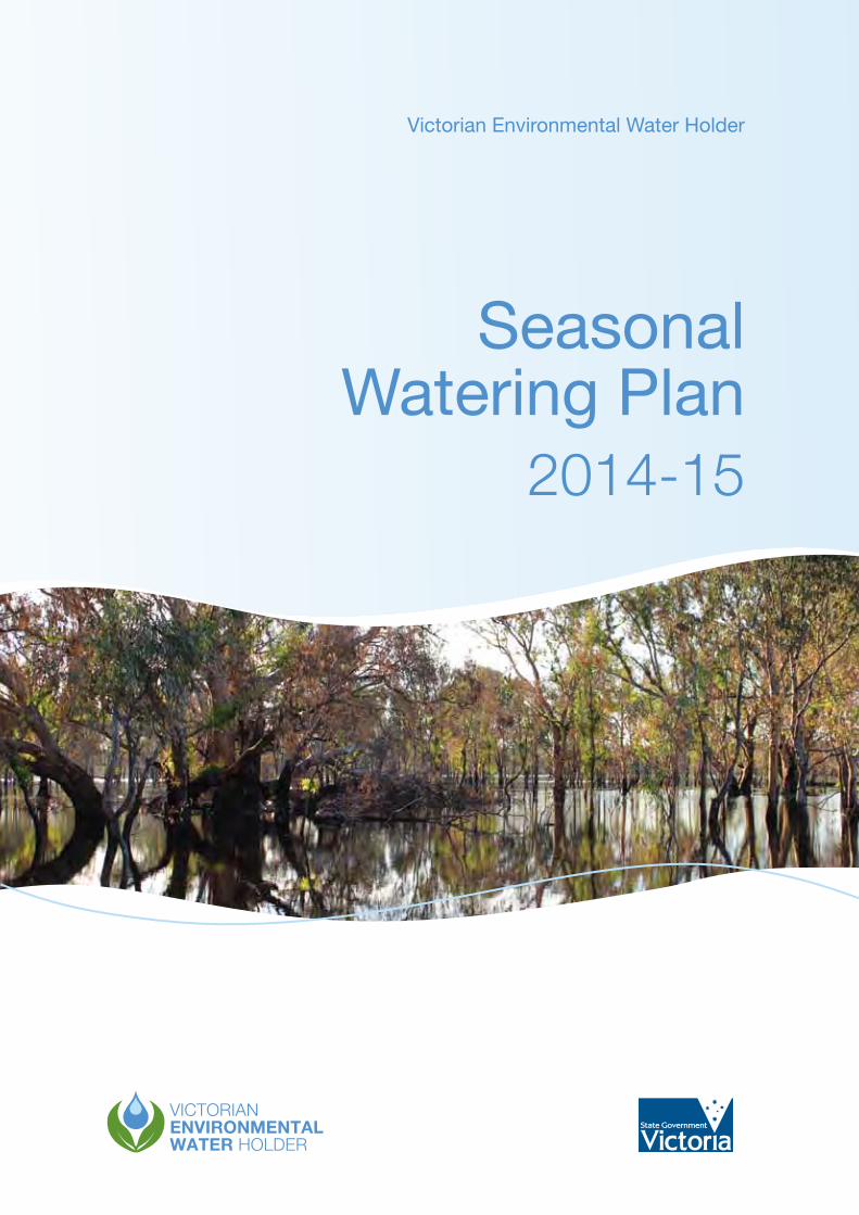
Front cover image: Kinnairds Wetland, by Jo Wood, Goulburn Broken CMA Pictured above: Tarago River, by Sarah Gaskill, Melbourne Water
collaborationintegrity commitmentinitiative
Accessibility
If you would like to receive this publication in an alternative format, please contact the Victorian Environmental Water Holder on (03) 9637 8951 or email [email protected]. This document is also available on the internet at www.vewh.vic.gov.au
Acknowledgment of Country
The Victorian Environmental Water Holder acknowledges Aboriginal Traditional Owners within Victoria, their rich culture and their spiritual connection to Country. The contribution and interests of Aboriginal People and organisations in the management of land and natural resources is also recognised and acknowledged.

Seasonal Watering Plan 2014–15 1
Section 1 – Background 31.1. Introduction 41.2. Planning 91.3. Managing 161.4. Reporting 201.5. Governance 221.6. Relationships 231.7. Learning 27
Section 2 – Gippsland Region 282.1 Snowy system 312.2 Latrobe system 34 2.2.1 Latrobe River 36 2.2.2 Latrobe wetlands 392.3 Thomson system 432.4 Macalister system 49
Section 3 – Central Region 553.1 Yarra system 583.2 Tarago system 653.3 Werribee system 713.4 Moorabool system 783.5 Lower Barwon wetlands 84
Section 4 – Western Region 904.1 Glenelg system 934.2 Wimmera system 1004.3 Wimmera-Mallee wetlands 112
Section 5 – Northern Region 1205.1 Victorian Murray system 124 5.1.1 Barmah Forest 126 5.1.2 Gunbower Creek and Forest 130 5.1.3 Central Murray wetlands 136 5.1.4 Hattah Lakes 140 5.1.5 Lower Murray wetlands 143 5.1.6 Lindsay, Wallpolla and Mulcra Islands 1495.2 Ovens system 1535.3 Goulburn system 158 5.3.1 Goulburn River 161 5.3.2 Goulburn wetlands 1665.4 Broken system 168 5.4.1 Broken River and upper Broken Creek 171 5.4.2 Lower Broken Creek 174 5.4.3 Broken wetlands 1775.5 Campaspe system 179 5.5.1 Campaspe River 182 5.5.2 Coliban River 1865.6 Loddon system 189 5.6.1 Loddon River, Tullaroop Creek and Pyramid Creek 192 5.6.2 Boort wetlands 197 5.6.3 Birchs Creek 200
Section 6 – Further information 2026.1 Contact details 2036.2 Glossary 2046.3 List of acronyms 208
Contents
Victorian Environmental Water Holder2
I am pleased to present the 2014-15 Seasonal Watering Plan for Victoria’s environmental watering program. This is the fourth seasonal watering plan prepared by the Victorian Environmental Water Holder (VEWH) since its establishment in 2011.
The seasonal watering plan is the operational document that guides most of the VEWH’s work within Victoria’s environmental watering program. The plan is critical in guiding watering decisions and in providing our program partners, stakeholders and the community with a sense of what to expect during the water year. The scenarios presented in this plan, which range from drought to wet, help the VEWH and waterway managers prioritise environmental watering decisions in line with unfolding seasonal conditions.
In 2013-14, many systems across Victoria experienced average to wet conditions early in the water year followed by drier conditions towards the end of the year. Priority watering actions were managed to meet these changing conditions and some significant environmental outcomes were achieved. The outcomes included spawning of the Australian grayling in the Macalister River and Macquarie perch in the Yarra River, widespread flowering of the endangered Wimmera bottlebrush on the Glenelg River, and the growth and flowering of moira grass as well as a significant ibis breeding event in Barmah Forest. The drier conditions also enabled many wetlands and floodplains to undergo a drying phase, which is a critical component of environmental water management in ephemeral systems.
While water availability is a critical factor determining opportunities for environmental watering in any given year, carryover and trade are important tools that can be planned for, and used by the VEWH to maximise environmental outcomes. This plan, importantly, identifies scenarios under which these tools can be used. For instance, to secure water for priority watering actions in the following water year, or to transfer water between systems for use at sites which have been prioritised for watering from a State-wide perspective to achieve the greatest environmental benefit.
Over the last three years, the VEWH has worked to help build strong relationships between the partners of the Victorian environmental watering program and with local communities. A new partnership agreement between the VEWH and the Commonwealth Environmental Water Holder recognises the collaborative, complementary, objective and integrated effort needed between partners to deliver optimal environmental outcomes and aims to further improve program performance.
It will be an exciting year for environmental watering in Victoria in 2014-15, with the opportunity to deliver environmental water to some new sites and to continue to support environmental values across the State. In addition, new infrastructure on the Victorian Murray system will enable large volumes of environmental water to be delivered to floodplains and wetlands to achieve widespread environmental outcomes.
The VEWH and its program partners are well placed to achieve most of the priority watering actions identified in this plan, no matter what seasonal conditions occur during 2014-15.
I look forward to the coming water year and the opportunity to demonstrate best-practice environmental water management to achieve the most effective and efficient use of Victoria’s Water Holdings.
Denis Flett
Chairperson, Victorian Environmental Water Holder
Foreword

Seasonal Watering Plan 2014–15 3
Section 1- BackgroundThis section of the plan provides some general information about the VEWH. It provides a brief outline of the VEWH’s strategic programs, including the three core programs (planning, managing and reporting) and the three enabling programs (governance, relationships and learning). Further information about these programs, including priority outputs and key performance indicators can be found in the VEWH’s Corporate Plan 2014-15 to 2017-18.
Sections 2 to 5 provide specific information about the priority watering actions for 2014-15 for each system in Victoria for which water from the Water Holdings may be available.
Seasonal Watering Plan 2014–15 3
Pictured: Black Swamp, by Jo Wood, Goulburn Broken CMA

Victorian Environmental Water Holder4
IntroductionEnvironmental water management is a complex and evolving field. This section explains the importance of environmental watering and the VEWH’s role in the broader context of environmental water management.
The VEWH holds the environmental water entitlements that make up the Victorian environmental Water Holdings and are the basis for Victoria’s environmental watering program. The Water Holdings are held in 15 source systems for delivery to 18 receiving systems (see Figure 1.1 and Table 1.1). Some river systems connect naturally, some are connected by man-made structures, and others do not connect at all. Environmental entitlements are sourced from reservoirs in one river system but may be able to be delivered and used in a number of river reaches and wetlands, depending on the specific rules of the entitlement and the physical connectivity between systems. For example, an entitlement held in the Goulburn River may be available for use in River Murray wetlands.
Figure 1.1 Systems which can receive water from the Water Holdings
1.1
Snowysystem
Taragosystem
Yarrasystem
Goulburnsystem
Ovenssystem
Brokensystem
Campaspesystem
Loddonsystem
Barwonsystem
Mooraboolsystem
Werribeesystem
Glenelgsystem
Wimmera-Malleesystem
Wimmerasystem
Victorian Murray system
Thomson,Macalisterand Latrobesystems
Gippsland Region
Central Region
Western Region
Northern Region
The Living Murray icon sites

Seasonal Watering Plan 2014–15 5
Table 1.1 Systems from which the Water Holdings are sourced and systems which can receive water from the Water Holdings
Region Source systems Receiving systems
Gippsland Latrobe Latrobe
Thomson Thomson
Macalister Macalister
Snowy#
Central Yarra Yarra
Tarago Tarago
Werribee Werribee
Moorabool Moorabool
Lower Barwon Lower Barwon
Western Wimmera and Glenelg Glenelg
Wimmera
Wimmera-Mallee
Northern* Ovens* Ovens*
Goulburn Goulburn
Broken* Broken*
Campaspe Campaspe
Loddon Loddon
Victorian Murray Victorian Murray
* While the VEWH does not have Water Holdings in these systems, the Commonwealth Environmental Water Holder does.
# The VEWH holds water entitlements in trust for the Snowy program, a joint initiative with the New South Wales and Commonwealth governments. Decisions about the preferred environmental water releases for the Snowy are made by the New South Wales Ministerial Corporation, on recommendation of the Snowy Scientific Committee. The VEWH does not have a direct role in planning for or delivering this water.
The volume of water available from the Water Holdings varies in any given year due to seasonal conditions, including rainfall and runoff in the catchments. At 30 June 2014, the VEWH’s Water Holdings equated to an expected long-term average of 658 GL.
Victorian river systems may also be allocated environmental water from other water holders, including partners in the Living Murray program and the Commonwealth Environmental Water Holder. It is the role of the VEWH to coordinate with other holders of environmental water entitlements to maximise benefits for Victorian waterways to ensure the delivery of this water is targeted and will not have any adverse impacts in Victoria (see sections 2 to 5 for more information). In most cases, other water holders will transfer the agreed amount of water to the VEWH, which then becomes part of the Victorian Water Holdings.
Introduction 1.1
Victorian Environmental Water Holder6
The Water Holdings held by the VEWH represent a small proportion of the water available for the environment in Victoria. This is the component that can be actively managed, with discretion as to when, where and in what volumes water is delivered. The non-discretionary components of environmental water include:
• watersetasidefortheenvironmentasobligationsonconsumptivewaterentitlementsheldbyurbanand rural water corporations – these are usually called ‘passing flows’ that must be released from storages or provided at a particular point of a river
• ‘abovecap’waterprovidedoncelimitsonconsumptivewaterusehavebeenreachedorduetounregulated flows and spills from storages, usually created by heavy rainfall.
It is not only water from the Water Holdings that is beneficial to the health of waterways. Other types of water can also provide environmental benefits, for example:
• consumptivewaterenroute(wateronitswaytobeingdeliveredtourban,ruralandirrigationwaterusers)
• systemoperatingwater(waterrequiredtobereleaseddownregulatedriversandthroughchannelsto enable water to be delivered to consumptive users)
• unregulatedflows(wateroccurringnaturallyinriversthatcannotbecapturedinstorages).
These other types of water are also considered in the development and implementation of the seasonal watering plan to ensure effective system operations, efficient use of water from the Water Holdings and to maximise environmental benefits. In many cases, timing of environmental releases can be combined with these other types of water to achieve greater environmental benefits than an environmental release alone could produce. For example, the timing and route for delivery of consumptive water can sometimes be altered to provide environmental benefit without impacting on other water users. This can reduce the amount of environmental water that needs to be recovered to meet specific objectives.
Why is environmental water important?
River systems across Victoria provide water that is important to our consumptive water supply and modern agriculture. As a result, many of Victoria’s river systems have become highly regulated and now operate in a way that is significantly modified from natural conditions. For example, instead of water flowing uninterrupted from the top of a catchment to the sea, water is stored in dams and weir pools, diverted via pipelines and man-made channels, and used for towns, cities and irrigation. This regulation of water has effects on the health of Victoria’s waterways.
Many plants and animals depend on water, just as humans do. For example, rivers, wetlands and floodplains support various plant communities, from in-stream reeds through to Australia’s iconic river red gum forests and black box communities. These systems and their plant communities in turn support a range of animals such as waterbirds, fish, turtles and frogs.
These environmental values are what make Victoria’s waterways so important to their local communities. It is a big part of why people enjoy camping, picnicking, walking or running beside them, boating, fishing or yabbying on them, or taking part in any other countless recreational activities associated with them.
With significant amounts of water allocated for consumptive use, water also needs to be set aside for the environment. After determining the environmental values of most importance to the community, scientific studies are undertaken to identify the environmental flows required to protect these values. Water from the Water Holdings is then released to create the recommended flow patterns. Often these releases help mimic what would have happened in a river, wetland or floodplain under natural conditions. However, it is recognised that as most river systems are highly modified, they will not be returned to a pristine condition; and the focus is on protecting the important values that still remain.
1.1 Introduction

Seasonal Watering Plan 2014–15 7
Why is environmental water important? (continued)
Introduction 1.1

Victorian Environmental Water Holder8
Integrated waterway managementIt is not only environmental flows that are important for healthy waterways. Equally important are complementary works and measures. Waterway managers are responsible for planning the integration of flows with works and measures. In part, this is done through regional waterway strategies (see section 1.2.1).
Complementary works and measures
1.1 Introduction

Seasonal Watering Plan 2014–15 9
1.2
PlanningA robust planning framework ensures the Water Holdings can be managed to maximise environmental benefits. This section outlines Victoria’s environmental water planning framework and the other factors considered when planning the effective management of the Water Holdings.
1.2.1 Victoria’s environmental water planning frameworkSeasonal watering proposals produced by waterway managers identify the regional priorities for environmental water use in each system under a range of planning scenarios. The proposals provide a clear rationale to directly inform the Statewide priorities in the seasonal watering plan. The VEWH produces a set of guidelines on which the waterway managers base their proposals, encouraging a rigorous and consistent approach to environmental water planning across Victoria.
The seasonal watering proposals are informed by relevant regional waterway strategies, developed in consultation with the community and other partners. In addition, scientific studies into the magnitude, timing, duration and frequency of environmental flows required for each system (known as environmental flow studies), provide the scientific basis for seasonal watering proposals. These studies will also inform environmental water management plans, which outline long-term environmental objectives, desired flow regimes and management arrangements for each system, river reach and site identified for environmental watering. Regional waterway strategies and environmental water management plans will be developed or refined over the next few years.
Seasonal watering proposals submitted by waterway managers have been considered by the VEWH and incorporated into this plan.
The planning process for Victoria’s environmental watering program is summarised in Figure 1.2.
Pictured: Tarago River at Drouin West, by Sarah Gaskill, Melbourne Water

Victorian Environmental Water Holder10
Environmental water management plan
•Outlines long term environmental objectives, desired flow regimes and management arrangements
•Will be developed progressively for each system/site identified as a long-term priority for environmental watering
•Updated as required with new information
•Assumes current water recovery commitments/targets
•Previously part of ‘environmental operating strategies’
Waterway managers
Required for approval of
Decisions communicated through
Actions and outcomes reported through
Scientific experts
VEWH
Environmental flow study
•Scientific analysis of flow components required to support key environmental values and objectives
•Updated as required with new information
Seasonal watering plan
•Describes Statewide priorities for environmental water use in the coming year under a range of climatic scenarios
•Developed annually
•Consolidates the seasonal watering proposals accepted by the VEWH
•Can be varied at any time (with same consultative requirements as initial development)
Seasonal watering statement
•Communicates decisions on watering activities to be undertaken as water becomes available during season
•Authorises waterway managers to undertake watering
•Statements can be released at any time during the season
•May be one or multiple statements for a system
Reporting
•Website updates
•Bi-monthly watering updates
•Annual watering booklet
•Annual report
Regional waterway strategy
• Identifies priority river reaches/wetlands and values in each region
•Developed every eight years
•Previously known as ‘regional river health strategies’
Seasonal watering proposal
•Describes regional priorities for environmental water use in the coming year under a range of climatic scenarios
•Developed annually
•Previously ‘environmental watering proposal’ or part of ‘annual watering plans’
Delivery arrangement
•Clarifies operational requirements for, and responsibilities in, implementation of the seasonal watering statement
•This arrangement may be described in the seasonal watering proposals or plan, in operating arrangements required under entitlements, or in a separate delivery plan
Key - who is responsible for what
Guides priorities for
Forms basis of
Informs
Informs
Figure 1.2 Planning for use of the Water Holdings
1.2 Planning

Seasonal Watering Plan 2014–15 11
1.2.2 The Water HoldingsThe Water Holdings are the environmental water entitlements held by the VEWH. Table 1.2 details the entitlements held by the VEWH, as at 30 June 2014, including those held in trust for the Living Murray program.
Table 1.2 The Water Holdings (as at 30 June 2014)
System Entitlement Volume (ML) Reliability
Latrobe Latrobe River Environmental Entitlement 2011 n/a1 n/a
Blue Rock Environmental Entitlement 2013 18,7372 n/a
Thomson Bulk Entitlement (Thomson River – Environment) Order 2005 10,000n/a
HighPassing flows
Macalister Macalister River Environmental Entitlement 2010 12,4616,230
HighLow
Yarra Yarra Environmental Entitlement 2006 17,00055n/a
HighUnregulatedPassing flows
Tarago Tarago and Bunyip Rivers Environmental Entitlement 20092 3,0002 n/a
Werribee Werribee River Environmental Entitlement 2011 n/a2 n/a
Moorabool Moorabool River Environmental Entitlement 20102 2,5002
n/an/aPassing flows
Barwon Barwon River Environmental Entitlement 2011 n/a1 n/a
Wimmera and Glenelg
Wimmera and Glenelg Rivers Environmental Entitlement 20103 40,5601000n/a
Highn/aPassing flows
Goulburn Goulburn River Environmental Entitlement 2010 1,4347,4193,140
HighHighLow
Environmental Entitlement (Goulburn System – Living Murray) 2007
39,625156,980
HighLow
Environmental Entitlement (Goulburn System - NVIRP Stage 1) 2012
n/a4 n/a
Bulk Entitlement (Goulburn System – Snowy Environmental Reserve) Order 2004
30,2528,156
High Low
Water shares – Snowy River Environmental Reserve 8,32117,852
HighLow
Silver and Wallaby Creeks Environmental Entitlement 2006 n/a Passing flows
Campaspe Environmental Entitlement (Campaspe River – Living Murray Initiative) 2007
126 5,048
HighLow
Campaspe River Environmental Entitlement 2013 20,6522,966
High Low
Loddon Bulk Entitlement (Loddon River – Environmental Reserve) Order 2005
3,4807,4902,024
Highn/aLow
Environmental Entitlement (Birch Creek – Bullarook System) 2009 100n/a
n/aPassing flows
Water shares – Snowy River Environmental Reserve 470 High
Planning 1.2

Victorian Environmental Water Holder12
System Entitlement Volume (ML) Reliability
Murray Bulk Entitlement (River Murray – Flora and Fauna) Conversion Order 1999
29,7833,99340,000
HighLowUnregulated
Bulk Entitlement (River Murray – Flora and Fauna) Conversion Order 1999 – Barmah-Millewa Forest Environmental Water Allocation
50,00025,000
HighLow
Bulk Entitlement (River Murray – Flora and Fauna) Conversion Order 1999 – Living Murray
9,589101,85034,300
HighLowUnregulated
River Murray Increased Flows 70,0005 n/a
Environmental Entitlement (River Murray – NVIRP Stage 1) 2012 n/a6 n/a
Bulk Entitlement (River Murray – Snowy Environmental Reserve) Conversion Order 2004
29,794 High
Water shares – Snowy Environmental Reserve 14,6716,423
HighLow
Notes1 Use of these entitlements is dependent upon suitable river heights, as specified in both the Latrobe and Barwon
environmental entitlements.2 This volume represents the average annual entitlement volume. The entitlements consist of passing flows and a
percentage share of inflows into storage (9 percent – Blue Rock; 10.3 percent – Tarago; 10 percent – Werribee; 11.9 percent – Moorabool), with the actual volume available in any year varying depending upon inflow conditions.
3 In addition to volumetric entitlement, the entitlement also consists of above cap water.4 The entitlement volume is equal to one-third of the total phase 4 water savings from GMW Connections Project Stage 1
achieved in the Goulburn component of the Goulburn Murray Irrigation District, as verified in the latest audit; and any mitigation water available in the Goulburn System in that year.
5 Long-term average volume.6 The entitlement volume is equal to one-third of the total phase 4 water savings from GMW Connections Project Stage 1
achieved in the Murray component of the Goulburn Murray Irrigation District, as verified in the latest audit; and any mitigation water available in the River Murray System in that year.
Further details about the Water Holdings can be viewed online at the Victorian Water Register (www.waterregister.vic.gov.au), which is a public register of all water entitlements in Victoria, or at the VEWH website (www.vewh.vic.gov.au).
1.2.3 Prioritising watering actionsIt is necessary to prioritise watering actions for many reasons including:
• toaddressthevariabilityinenvironmentalwaterdemandandsupplyfromyeartoyear
• becausesomeprioritywateringactionsmaybemetnaturally
• becausethereisnotalwaysenoughwateravailabletomeetallwateringdemands.
To address uncertainty, a flexible framework called the seasonally adaptive approach is used to plan for short-term climate variability and guide decision making. This robust planning framework involves developing scenarios that help identify and scope potential watering actions and determine the priority environmental objectives for all likely conditions. In dry conditions, priority watering actions are focused on protecting drought refuges and preventing critical or irreversible loss. In wetter conditions, the aim is to improve resilience and restore floodplain linkages.
As a result of natural connectivity and man-made channels, it is often possible to deliver water from a particular reservoir to a range of river or wetland systems. Northern Victoria is an example of a largely connected group of systems. This interconnectivity provides the opportunity to prioritise environmental water use across systems and waterway management regions. Determining priorities is most important when resources are constrained; for example, during drought periods or when there are limited funds for delivery charges.
1.2 Planning Table 1.2 The Water Holdings (as at 30 June 2014) (continued)

Seasonal Watering Plan 2014–15 13
Through the prioritisation process the VEWH seeks to maximise environmental outcomes across the State. The VEWH identifies critical watering actions, in consultation with waterway managers and other key stakeholders, and makes decisions with this Statewide perspective. A range of criteria are considered in prioritising watering actions within and between systems.
Criteria for prioritising watering actions
In considering seasonal watering proposals, developing the seasonal watering plan and prioritising the use of the Water Holdings, the criteria used include the:
• extentandsignificanceoftheenvironmentalbenefitexpectedfromthewateringaction - for example, the area watered, the size of the breeding event to be triggered, the
conservation status of the species that will benefit
• levelofcertaintyofachievingtheenvironmentalbenefitfromthewateringactionandabilitytomanage other threats
- for example, a flow has been provided in the past with demonstrated benefits and relevant complementary measures are being undertaken at the site
• theabilitytoprovideongoingbenefitsatthesiteatwhichthewateringactionistotakeplace - for example, where the management arrangements provide for watering in the long term
• thewaterrequirementsofthesiteatwhichthewateringistotakeplace,takingintoaccountwatering history at that site and the implications of not undertaking the proposed watering action at the site
- for example, the potential for critical or irreversible loss of important environmental values
• feasibilityofthewateringaction - for example, flexibility of timing of delivery, operational requirements and constraints, and
infrastructure capacity
• overallcosteffectivenessofthewateringaction - for example, considering the likely benefit to be achieved against the costs of the watering
action (including the volume of water to be used and any costs associated with delivery and risk management).
It is recognised that environmental watering can provide a range of environmental, social and economic benefits. In the interests of providing multiple outcomes wherever possible, opportunities to provide social and economic benefits will also be considered when prioritising watering actions, where there is no detriment to the potential environmental benefits.
Planning 1.2
1.2.4 Triggers for action A range of factors are considered in deciding to deliver a watering action during the year. It is important that there is flexibility to respond to these different factors which include:
• wateravailability,seasonalconditionsandweatherforecasts
• riverandsystemoperations,includingunregulatedflows,catchmentinflows,storagelevels,andanyrelevant capacity constraints
• ecologicalfactorsandtriggers,suchasplantandanimalresponsestonaturalflowsortemperature
• risksassociatedwithanaction,suchasdeterioratingwaterquality.

Victorian Environmental Water Holder14
1.2.5 Planning for the unknownThere are many unknown factors that can influence the planning and implementation of environmental water delivery. A number of these factors are outlined below.
Other water holder entitlements: Given Victoria’s position within the Murray-Darling Basin, the VEWH plays a key role in planning for the delivery of Commonwealth environmental water and water from the Living Murray program. The seasonal watering plan specifically outlines the priority watering actions for the use of all water holders’ water for environmental outcomes in Victorian river systems. However, the VEWH also acts as the intermediary for the delivery of other water holder’s environmental water held in Victoria for downstream demands; for example, for the Lower Lakes in South Australia. As it is not currently possible to anticipate the specifics of these demands, it is not possible to include this detail in this plan. However, the VEWH will seek to facilitate and authorise the use of other water holder’s water for environmental outcomes elsewhere, provided there are no adverse impacts on Victoria’s waterways and any other risks are appropriately managed.
Donations/contributions: The VEWH may also receive water donations from individuals, community groups and other organisations, which can contribute to the priority watering actions identified in this plan. This may include: using the allocation in the system to which it is donated; selling the allocation to buy at a later time or in a different system; or carrying it over for a priority watering action in a future year. Some donors may wish their water to be used for a specific purpose not listed in this plan, such as a local priority watering action of importance to the donor. The benefits and cost of this would need to be considered by the VEWH. These types of actions may be authorised if considered beneficial.
Research proposals: Research proposals requiring a small volume of environmental water may be received by the VEWH throughout the year. Water may be allocated from the Water Holdings for research and development purposes where it is likely to enhance knowledge and ultimately lead to better management of the Water Holdings. Research proposals will be considered on a case-by-case basis, and water use authorised where it is considered they maximise environmental outcomes in the long term. The primary focus of the research proposal must be for environmental benefit, consistent with the VEWH’s statutory objectives.
Emergency circumstances: In some cases, environmental water may be needed for an emergency management situation or to mitigate the impacts of a natural event, including reducing the impact of natural blackwater events, preventing fish deaths or mitigating the effects of blue-green algae. It could also include smoothing the transition to or from a high natural flow event; for example, supplementing natural flows to provide a more gradual rate of ‘rise and fall’ to minimise the threat of river bank slumping. It is not possible to specifically plan for these events at the start of the year, and swift action is often necessary when they occur. The VEWH will liaise closely with waterway managers and storage managers who share responsibility in such situations, and may decide, while considering current water availability and priority watering actions, to use a portion of the Water Holdings to mitigate adverse environmental impacts during these emergency situations.
Changing operational conditions and risk management: Due to the changing nature of each system, including evolving demands on systems and new water saving projects coming online, delivery constraints in a particular system may change during the water year. Likewise, it may be necessary for waterway managers or storage managers to undertake construction, scoping, maintenance or other works during the year. Changing conditions may also result in emerging or evolving risks which need to be managed. These will be taken into account as the season unfolds and delivery of environmental water adjusted as appropriate. This could include adjustment to the identified magnitude, timing or duration of watering actions.
Priority watering actions listed in sections 2 to 5 detail the targeted flow rates, timing and durations which environmental water releases aim to achieve. However, actual releases may be slightly amended if required, in response to system conditions or emerging risks, but will still aim to maximise the environmental outcomes achieved.
1.2 Planning
Seasonal Watering Plan 2014–15 15
1.2.6 Variations to the seasonal watering planIn line with the Water Act 1989, the VEWH can only authorise a priority watering action where it is consistent with a seasonal watering plan. The VEWH is able to vary any section of the seasonal watering plan at any point during the water year. Variations may be required throughout the year to include new or amended entitlements, or to address any circumstances not identified at the start of the water year. Section 1.2.5 highlights some of the circumstances where it will not be necessary to vary the plan in order to authorise a priority watering action. Section 1.3.2 also highlights where a variation is not required if the delivery of priority watering actions needs to be adjusted in order to manage associated risks.
All variations will be made publicly available as separate attachments to the original plan. These will be available on the VEWH website and printed copies will be available on request from the VEWH office.
While this plan outlines the priority watering actions for 2014-15, environmental water planning is carried out over a rolling 18-24 month period. As a result, a number of priority watering actions in this plan begin before, or continue beyond 2014-15. This plan, and any variations, will remain valid for the 2014-15 water year, and until the subsequent seasonal watering plan is released. This ensures priority watering actions that continue beyond the 2014-15 water year can continue if there are any unforeseen delays in the release of the 2015-16 plan.
Planning 1.2
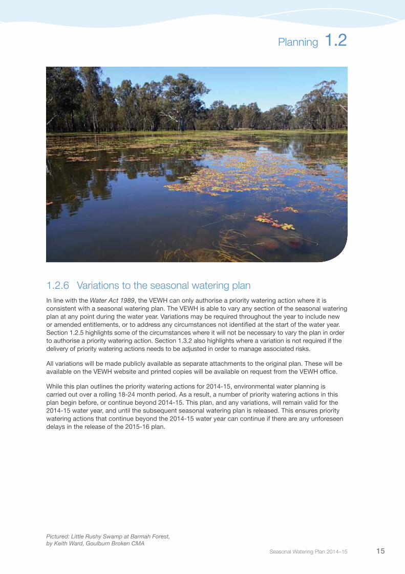
Pictured: Little Rushy Swamp at Barmah Forest, by Keith Ward, Goulburn Broken CMA
Victorian Environmental Water Holder16
ManagingThe effective and efficient management of the Water Holdings involves a number of processes and management tools. This section discusses the arrangements that must be in place before a priority watering action can be implemented, and how carryover and trade can be used to make the most effective use of the Water Holdings.
1.3.1 Delivering priority watering actionsThe physical storage and delivery of environmental water to sites in Victoria is guided by, and subject to, a number of conditions, rules, and where applicable fees and charges. The VEWH releases seasonal watering statements to communicate decisions and authorise the relevant waterway manager to order and deliver water on behalf of the VEWH. The statements can be made at any time throughout the year and depending on the nature of the system and the entitlement being used, there may be one or multiple statements made for a particular system.
Before issuing a seasonal watering statement the VEWH must be sure that delivery arrangements are in place and that any costs to be met by the VEWH are acceptable. In some instances, particularly for wetland watering, a delivery plan is prepared to outline the water source, delivery route, strategies to overcome delivery constraints, local site governance, mechanism, timing and triggers for watering, water ordering process, costs and funding sources, and reporting and monitoring requirements.
Priority watering actions will be undertaken by waterway managers in accordance with the seasonal watering plan, seasonal watering statements, and in consultation with the appropriate storage manager and, where relevant, land manager.
Operating arrangements between the VEWH, storage manager, waterway manager and land manager (and other entitlement holders where appropriate) are in the process of being agreed for all entitlements held by the VEWH. These operating arrangements describe the collaborative approach between key delivery partners for the effective management and delivery of the Water Holdings. This includes roles and responsibilities, procedures for planning, ordering and delivery of environmental water, monitoring, accounting, reporting, communications, risk management and adaptive management.
Once delivery arrangements have been confirmed, environmental watering can commence. This may be via a release from an upstream storage or by diverting directly from a river or channel.
A seasonal watering statement issued in a watering year may have commenced in the previous watering year or extend to water delivery in the future. Multiple-year statements and the watering actions they authorise must align with priorities in all the watering years that they span.
1.3

Seasonal Watering Plan 2014–15 17
1.3.2 Risk managementEnvironmental watering requires coordination and collaboration between multiple entities and agencies. It is not conducted within the boundaries of any single organisation, necessitating a shared approach for effective management of risks.
The VEWH is working to formalise a partnership with all delivery partners, to be known as the Victorian Environmental Watering Partnership (‘the Partnership’). As part of the Partnership, a risk management framework is being developed to provide a robust mechanism to manage inter-organisational risk. The framework will outline the governance, roles and responsibilities and a standard risk assessment approach for environmental watering throughout Victoria. It is intended that the framework will be agreed to in 2014-15, including identification and development of a range of tools for risk management.
Standardised principles and processes have been applied to the risk identification and categorisation process of each seasonal watering proposal, and then incorporated into the seasonal watering plan. This process assesses and rates risks relating to the implementation of priority watering actions. These risks include impacts of watering actions on third parties, unintended adverse environmental impacts of watering, and non-achievement of the environmental objectives associated with watering actions. Sections 2 to 5 outline the risks identified by waterway managers, and list the intended mitigating strategies for each. Watering actions will not be implemented where there are unacceptable associated risks.
The risks of personal injury and flooding of private land and/or public infrastructure are of particular note and have been assessed, with associated mitigating strategies identified. The VEWH and waterway managers will not flood private land without prior consent from affected land owners. Risk management strategies will be implemented as necessary to address the risk of accidental or exacerbated flooding. If rainfall events are significant enough to create a flood threat (for example, a flood watch or flood warning being issued by the Bureau of Meteorology), environmental flows will be reduced or ceased, resuming again, if required, once the flood risk has passed.
Watering actions will not proceed if the risks cannot be adequately controlled. In some cases, the priority watering actions detailed in this plan may need to be delivered in a slightly different way; the target flow magnitude, duration, frequency, timing or even location will be adjusted as necessary in order to achieve planned environmental outcomes with minimal risk.
1.3.3 Carryover and tradeIn certain circumstances, the VEWH can carry over allocation into the following water year or trade its water entitlements or allocations, consistent with the VEWH objectives – that is, the carryover or trade must benefit the environment. The mix of management tools including water use, carryover and trade will be used to optimise environmental benefits.
Carryover provides opportunities for more flexibility and efficiency in environmental water planning and delivery by allowing water holders to use environmental water when it is of greatest value to the environment. Water allocation left over at the end of the water year can be carried over and kept in storage for use in the following water year, subject to certain conditions.
Water trading also provides some opportunities to maximise environmental outcomes. For example, revenue raised through allocation trade may be used to purchase allocation at a different time or in a different system, to invest in technical work to address key knowledge gaps or even to fund small priority structural works to improve water use efficiency. While the VEWH also has the power to trade its water entitlements (that is, permanent trade), subject to approval by the Minister for Environment and Climate Change, it is not anticipated that this function would be used very often.
The VEWH has developed a decision tree (outlined in Figure 1.3) to outline some of the key considerations to guide carryover and allocation trading decisions. This involves assessing the amount of water available to meet environmental demand and then considering factors such as environmental risk, storage levels and allocation price.
Managing 1.3

Victorian Environmental Water Holder18
Fig
ure
1.3
Key
co
nsid
erat
ions
in a
lloca
tion
trad
e an
d c
arry
ove
r d
ecis
ions
Suf
ficie
nt w
ater
and
fund
ing
to m
eet e
nviro
nmen
tal d
eman
d?
Yes
No
No,
but
pot
entia
l for
op
timis
ed o
utco
mes
Eg1
Low
leve
ls
Eg.
2 M
ed-h
igh
leve
ls b
ut h
ave
abilit
y to
acc
ess
carry
over
w
ater
ear
ly
Eg3
Med
-hig
h le
vels
but
al
loca
tion
pric
e no
t pro
fitab
le
Eg1
Cur
rent
ly n
ot p
rofit
able
Eg2
Lik
ely
to b
e un
affo
rdab
le
in fu
ture
yea
rs w
hen
wat
er w
ill be
nee
ded
Eg1
Hig
h ris
k in
ear
ly p
art o
f the
fo
llow
ing
year
Eg2
Hig
h ris
k as
soci
ated
with
a
larg
er fl
ow c
ompo
nent
likel
y to
be
requ
ired
in a
dry
yea
r
•M
eet c
ritic
al o
r ear
ly s
easo
n ne
eds
in fo
llow
ing
wat
er y
ear
•A
ccum
ulat
e w
ater
for l
arge
r w
ater
ing
actio
ns in
futu
re y
ears
•M
ay in
clud
e pu
rcha
sing
ad
ditio
nal a
lloca
tion
for
carry
over
Car
ryo
ver
Eg1
Low
risk
in s
ellin
g sy
stem
Eg2
Hig
h ris
k in
buy
ing
syst
em o
r in
futu
re y
ears
Eg1
Hig
h le
vels
Eg1
Cur
rent
ly p
rofit
able
Eg2
Lik
ely
to b
e af
ford
able
in
futu
re y
ears
(whe
n w
ater
will
be re
quire
d)
•W
here
car
ryov
er c
harg
e ex
ceed
s bu
dget
•W
here
car
ryov
er n
ot re
quire
d fo
r cr
itical
or e
arly
seas
on n
eeds
or
larg
er w
ater
ing
actio
ns in
futu
re
dry
year
s
•To
use
reve
nue
to b
uy
wat
er a
lloca
tion
else
whe
re
or in
a fu
ture
yea
r, or
inve
st
in c
ompl
emen
tary
wor
ks/
mea
sure
s
Trad
e (s
ell)
Eg1
Ris
k el
sew
here
is g
reat
er th
an e
nviro
nmen
tal
risk
in s
ellin
g sy
stem
; sys
tem
s ar
e un
conn
ecte
d hy
drol
ogic
ally
E
g2 R
isk
in fu
ture
is g
reat
er th
an ri
sk in
cur
rent
ye
ar; f
utur
e ris
k no
t bes
t met
by
carry
over
Eg3
Ben
efit o
f wor
ks is
gre
ater
than
risk
of n
ot
wat
erin
g
N/A
Eg1
Cur
rent
ly p
rofit
able
Eg2
Lik
ely
to b
e af
ford
able
in fu
ture
yea
rs (w
hen
wat
er w
ill be
requ
ired)
•To
use
reve
nue
to b
uy w
ater
allo
catio
n el
sew
here
or
in a
futu
re y
ear,
or in
vest
in
com
plem
enta
ry w
orks
/mea
sure
s
Trad
e (s
ell)
Eg1
Hig
h ris
k
N/A
Eg1
Affo
rdab
le
•If
envi
ronm
enta
l dem
and
is d
eem
ed a
hig
h ris
k an
d su
ffici
ent f
unds
ava
ilabl
e
Trad
e (b
uy)
N/A
Eg1
Una
fford
able
Eg1
Low
risk
•If
envi
ronm
enta
l dem
and
is
low
ris
k or
insu
ffici
ent f
unds
av
aila
ble
Fore
go d
eman
d
Considerations and examples
Rationale Environmental risk
Storage levels
Allocation price
1.3 Managing
Seasonal Watering Plan 2014–15 19
All carryover and trade must be:
• inlinewiththegeneralrulessetbytheMinisterforWater(thatapplytoallentitlementholders)
• inlinewithanyspecificconditionsintheentitlements,andanyrulessetbytheMinisterforEnvironment and Climate Change
• undertakenonlytomaximiseenvironmentaloutcomes.
The VEWH has also developed a business rule to guide the internal decision-making processes for allocation trading. This includes assessing potential third party impacts and mitigating these where possible.
In some instances, it may be appropriate for the VEWH to carry over allocation into 2015-16 or to sell some water allocation, rather than using it in the current water year. Likewise, it may be necessary to buy additional water allocation in order to complete a priority watering action in a particular system. This could include water purchases in systems where no Water Holdings are currently held. Carryover and trade opportunities will be assessed throughout the season and undertaken only where they maximise environmental outcomes. If purchases occur in systems where no Water Holdings are currently held, this water will be released in line with best available scientific flow recommendations.
The VEWH must report annually on the management and use of the Water Holdings, including carryover and trade, to ensure transparency and accountability.
Managing 1.3
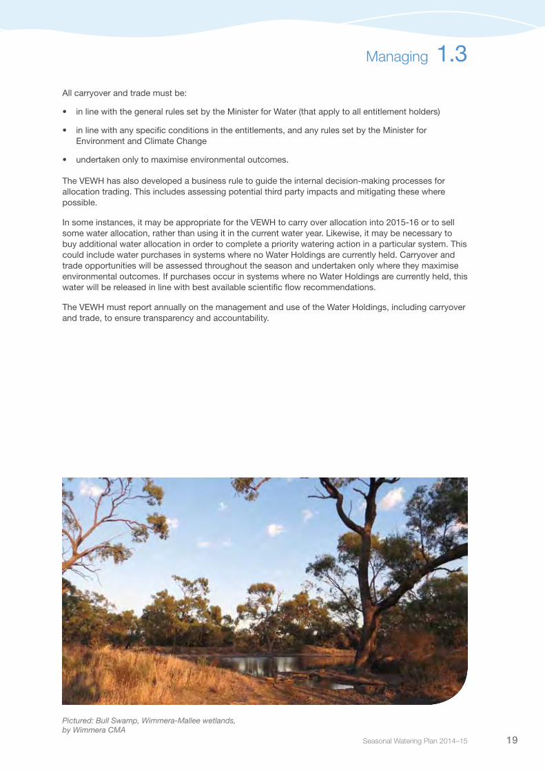
Pictured: Bull Swamp, Wimmera-Mallee wetlands, by Wimmera CMA

Victorian Environmental Water Holder20
ReportingIt is important to demonstrate that environmental water has been delivered, and that this water is resulting in environmental outcomes. This section outlines the water accounting, ecological monitoring and reporting undertaken by the VEWH.
The VEWH is required to report on when, where, how and why environmental water is used. The environmental objectives of environmental watering are summarised in sections 2 to 5.
1.4.1 Water accountingEnvironmental water accounting provides information on the volume of water allocated, and then released for and used at each of the environmental watering sites. This is in addition to any water carried over or traded throughout the water year.
As priority watering actions are implemented, the VEWH maintains internal water accounting records to track water use and the volumes remaining in the Water Holdings.
Allocation bank accounts are held for most of the entitlements held by the VEWH. As water is allocated to or delivered from each entitlement, these amounts are recorded in the Victorian Water Register (www.waterregister.vic.gov.au). All carryover and trading activity conducted by the VEWH will also be recorded on the Victorian Water Register and published in the VEWH annual report.
1.4.2 Metering The VEWH is in the process of documenting its metering programs to outline the sites at which information such as volume or depth is collected. The information in the metering programs demonstrates compliance with the requirements of the environmental entitlements and identifies areas for improvement. This information will be used to improve the long-term management of environmental water.
1.4.3 Ecological monitoringScientific environmental flow studies demonstrate the links between particular watering actions (such as freshes or overbank flows) and specific environmental outcomes (such as triggering breeding of a priority fish species).
In addition to these flow studies, the Victorian Government has developed and is undertaking the Victorian Environmental Flow Monitoring and Assessment Program (VEFMAP). This program will provide additional certainty and an even more robust scientific basis for the link between particular watering actions and ecological responses.
In addition to VEFMAP, the VEWH and waterway managers may also conduct targeted ecological monitoring to improve future management decisions. Key results from this monitoring are reported in the VEWH’s bi-monthly watering update and annual watering booklet “Reflections” (available at www.vewh.vic.gov.au). They are also used to improve future management of the Water Holdings.
1.4

Seasonal Watering Plan 2014–15 21
1.4.4 ReportingThe VEWH will report on the management of the Water Holdings at the end of each water year in its annual report. The VEWH also contributes environmental water information to the Victorian Water Register.
In reporting on the priority watering actions that are implemented, the VEWH largely relies on information provided by waterway managers. Throughout the season, waterway managers will communicate watering actions to stakeholders through media releases and stakeholder updates. Stakeholders include storage managers, river and wetland users, local landholders and the broader community.
This information is collated and made available on the VEWH website and in the bi-monthly watering update which reports on all use of the Water Holdings across Victoria. The environmental outcomes observed from priority watering actions are summarised in an annual watering booklet ‘Reflections – environmental watering in Victoria’. The VEWH will also report on environmental watering outcomes through its website, media releases and other publications as required.
The VEWH’s reporting framework is outlined in Figure 1.4.
Figure 1.4 Reporting on the use of Water Holdings
Information about broader environmental water management (that is, beyond the Water Holdings) can also be obtained through the Monthly Water Report (produced by the Department of Environment and Primary Industries). The Monthly Water Report provides a summary of the status of Victoria’s water resources and water supplies at the end of the reporting month (http://www.depi.vic.gov.au/water/water-resource-reporting/monthly-water-report).
This information is also collated in the Department of Environment and Primary Industries’ annual Victorian Water Accounts.
Bi-monthly update
Annual report Annual watering booklet
Weekly report
•Outlines watering actions currently occurring across Victoria
• Intended to be available on the VEWH website from 1 July 2014
Media releases and public notices
•Often issued by waterway managers to notify the community prior to watering actions commencing
•Available on waterway manager websites
•Summarises the environmental watering objectives and actions undertaken over the previous two months
•Emailed to key stakeholders and interested parties, and available on the VEWH website
•Outlines the governance and financial statements for the previous year
•Tabled in Parliament and available on the VEWH website
•Summarises the environmental outcomes and watering actions undertaken in the previous year
•Emailed to key stakeholders and interested parties, and available on the VEWH website
Reporting 1.4
Victorian Environmental Water Holder22
Governance Good governance arrangements and practices ensure that the VEWH is independent, transparent and accountable. This section describes the roles and responsibilities of the VEWH in relation to its mission and the Water Act 1989.
1.5.1 The role of the Victorian Environmental Water Holder
The VEWH’s vision provides insight and guidance to drive the VEWH’s operations in the long term. The vision is:
Environmental watering for healthy waterways: Healthy and resilient waterways with restored watering patterns that sustain a more natural level of biodiversity. Collaborative partnerships that build widespread support for environmental watering and the multiple values and services provided by waterways. Best-practice environmental water management to achieve the most effective and efficient use of Victoria’s Water Holdings.
The achievement of the VEWH vision is supported by a mission statement to:
Improve the environmental health of rivers, wetlands and floodplains by managing Victoria’s environmental Water Holdings and cooperating with partners.
In undertaking its mission, the VEWH:
• makesdecisionsonthemosteffectiveuseoftheWaterHoldings,includinguse,carryoverandtrade
• liaiseswithotherwaterholderstoensurecoordinateduseofallsourcesofenvironmentalwater
• authoriseswaterwaymanagerstoimplementwateringdecisions
• workswithstoragemanagerstocoordinateandmaximiseenvironmentaloutcomesfromthedeliveryof all water
• commissionstargetedprojectstodemonstrateecologicaloutcomesofenvironmentalwateringatkey sites or to improve environmental water management
• publiclycommunicatesenvironmentalwateringdecisionsandoutcomes.
The VEWH consists of three part-time Commissioners, supported by a small operations team. Denis Flett (Chairperson), Geoff Hocking (Deputy Chairperson), and Chris Chesterfield (Commissioner) act as a board of governance and were appointed by the Governor in Council on the recommendation of the Minister for Environment and Climate Change.
The objectives and functions of the VEWH are set out in sections 33DA-33DZA of the Water Act 1989. The VEWH also acts in accordance with Victorian Government policy including:
• anyrulesissuedbytheMinisterforEnvironmentandClimateChangeundersection33DZAoftheWater Act
• regionalsustainablewaterstrategies
• theVictorian Waterway Management Strategy.
The VEWH reports to the Minister for Environment and Climate Change. The Department of Environment and Primary Industries has a role in advising the Minister of the VEWH’s performance.
1.5

Seasonal Watering Plan 2014–15 23
RelationshipsEnvironmental watering occurs through the collaboration of a range of agencies and individuals, ensuring it is coordinated and effective, with optimal outcomes for Victoria’s waterways. This section outlines how the VEWH engages its key environmental watering program partners (those with a role in planning and implementing watering actions) and key stakeholders (those with an interest in contributing to environmental watering outcomes).
1.6.1 Environmental watering program partnersCollaboration with the VEWH’s key delivery partners is critical for effective delivery of environmental water to achieve desired outcomes. Environmental watering program partners, including waterway managers, storage managers and land managers, work with the VEWH to implement priority watering actions.
Figure 1.5 outlines the VEWH’s key environmental watering partners.
Figure 1.5 Key environmental watering partners in Victoria
1.6
Commonwealth Environmental Water
Office (CEWO)
Victorian Environmental Water
Holder (VEWH)
Waterway managers Storage managersLand managers
Murray-Darling Basin Authority
(MDBA)
•Holds and manages Victoria’s Water Holdings
•Coordinates with other States, CEWO and partners in the Living Murray program
•Engage communities to identify regional priorities and develops watering proposals for VEWH consideration
•Order and manage the delivery of environmental water in line with VEWH decisions
• Integrate watering with structural works and complementary measures
• Facilitates the Living Murray Environmental Watering Group (EWG)
•Coordinates with CEWO and States
•Endorse watering proposals prepared by waterway managers (if required for delivery)
•Provide the environmental water delivery service including from storages
•Holds and manages CEW Holdings in line with the Basin Plan
•Coordinates with partners in the Living Murray program and States
•Endorse watering proposals prepared by waterway managers where they propose to inundate public or private land
Victorian Environmental Water Holder24
The VEWH engages directly with waterway managers through the development and implementation of the seasonal watering plan. Waterway managers are the key partners of the VEWH, undertaking the local planning for and implementation of watering actions. In developing their seasonal watering proposals, waterway managers seek the endorsement of land managers and storage managers to ensure that the proposed watering actions align with land management objectives and that it is feasible to deliver them within planned system operations. Waterway managers also consult with local communities on their proposed watering actions.
Water corporations are appointed by the Minister for Water to act as storage managers for the publicly-owned water storages across Victoria. Storage managers operate and manage the reservoirs and associated infrastructure to meet set objectives, including reliable supply to entitlement holders.
A resource manager may be appointed by the Minister for Water under section 43A of the Water Act to prepare water accounts, monitor compliance with entitlements, investigate and mediate disputes between entitlement holders, investigate and deal with significant authorised users of water, and supervise the qualification of any rights to water made by the Minister during periods of declared water shortage.
The other key parties involved in environmental watering actions are the land managers responsible for managing the land which may be the target of some watering actions. This includes organisations such as Parks Victoria and the Department of Environment and Primary Industries. Land managers must be consulted and agree to the inundation of relevant land, and may also have a role in relation to the operation of regulating structures.
The seasonal watering proposals and seasonal watering plan are also provided to other water holders to ensure planning is aligned and coordinated. The VEWH works closely with other water holders, such as the Commonwealth Environmental Water Holder (through the Commonwealth Environmental Water Office), the Murray-Darling Basin Authority and other partners in the Living Murray program, to negotiate use of their water in Victorian rivers, wetlands and floodplains.
VEWH consultation and engagement activities include:
• Planning sessions: Held with waterway managers to modify the seasonal watering proposal guidelines to
facilitate improved and more consistent planning across Victoria.
• Seasonal watering proposal conference: Held with waterway managers, the Commonwealth Environmental Water Office, the
Murray-Darling Basin Authority and some storage managers to share knowledge, developments and annual planning for systems across Victoria. This includes ongoing liaison with waterway managers during the development of seasonal watering proposals.
• Attendance at key waterway manager group meetings: Regular attendance at specific meetings of the Environmental Water Reserve Officer Working
Group; Victorian Waterway Manager Forum meetings; and local community advisory groups.
• Ongoing involvement in the Murray-Darling Basin Authority’s Environmental Watering Group:
This group is responsible for planning the delivery of water from the Living Murray program.
• Other water holders: Fortnightly teleconferences and regular meetings with both the Commonwealth Environmental
Water Office and the Murray-Darling Basin Authority.
• Seasonal watering statements: Ongoing communication with waterway managers on the implementation and outcomes of
seasonal watering statements.
1.6 Relationships

Seasonal Watering Plan 2014–15 25
Relationships 1.6
• Commission site visits: Commission meetings are held in regional locations once a year, combined with
environmental watering site visits, to provide an opportunity to discuss existing or emerging issues and opportunities.
• Other government bodies/organisations: Engagement as appropriate with other environment and water organisations, including: New
South Wales Office of Water; Victorian Catchment Management Council; land managers such as Parks Victoria; storage managers such as Goulburn-Murray Water; and research agencies such as the Arthur Rylah Institute.
• Minister for Environment and Climate Change and Minister for Water: Meetings as required with both Ministers and their advisers to discuss significant matters
relating to Statewide environmental watering.
• Department of Environment and Primary Industries (Victoria): Meetings (as appropriate) with Deputy Secretary and Executive Directors in the Water and
Catchments Group to provide input to relevant policy development and implementation.
• Stakeholder events: Coordinated as required to publicise environmental watering outcomes (for example, the
launch of the annual watering booklet and Stakeholder Forum) and bring together key groups to enable discussion and build knowledge about environmental watering.
1.6.2 Stakeholder consultation in environmental wateringThere are a number of stakeholders with an interest in environmental watering including:
• landholdersandlocalcommunities
• localgovernment
• otherwaterentitlementholders
• environmentalgroups
Waterway managers are the key link between water holders and these important stakeholders. They undertake a range of consultation activities to ensure the views of stakeholders and potential issues are captured in identifying high-value waterways, setting priority environmental objectives and understanding the associated priority watering actions.
Community consultation in each system varies according to the level of involvement desired and availability of particular interest groups and individuals. In some systems, formal community advisory groups are established to contribute to the consultation process. This provides community members with the opportunity to liaise directly with waterway managers on key matters concerning environmental watering.
The specific consultation and engagement activities undertaken by waterway managers during the development of the seasonal watering proposals and implementation of priority watering actions are detailed in sections 2 to 5 of this plan.
Consultation with stakeholders is a key component in the development of regional waterway strategies, which identify priority sites and values; and environmental water management plans, which identify long-term objectives and environmental flow requirements.
VEWH consultation and engagement activities include: (continued)

Victorian Environmental Water Holder26
In addition, the VEWH seeks to engage Statewide and national stakeholders to encourage education about awareness of environmental watering. A key mechanism for this is the Stakeholder Forum. It is intended the Forum will be held at least once a year to review past watering actions, inform stakeholders about planned watering actions, and discuss new knowledge in environmental water management. It also provides an opportunity for these stakeholders to inform the VEWH and others of work they are undertaking which is relevant to environmental water management.
It is important to note that the VEWH’s consultation with key stakeholders does not replace the important consultation undertaken by waterway managers on local environmental watering issues or opportunities.
Any community members interested in sharing their views on local environmental watering actions are encouraged to contact their local waterway managers (see section 6.1 for contact details). The VEWH’s consultation with its stakeholders is intended to complement the waterway manager’s existing consultation, with a focus on Statewide issues and opportunities. Any Statewide or national stakeholder groups interested in being involved in the VEWH’s Stakeholder Forum are encouraged to email [email protected].
A partnership approach – working collaboratively for maximum benefit
To get the best results for Victorian rivers, the VEWH works collaboratively to develop its priorities and to promote communication and coordination between environmental water holders. The Murray-Darling Basin Authority, through the Living Murray, and the Commonwealth Environmental Water Holder both hold considerable environmental water entitlements for use within Victoria. The VEWH works closely with these bodies to plan for the delivery of environmental water in Victoria.
The Basin Plan sets sustainable diversion limits (SDLs) for groundwater and surface water catchments across the Murray-Darling Basin. These SDLs have been developed to reflect an environmentally sustainable level of water use. In some areas the SDLs mean that more water will be available for the environment. The Basin Plan also provides for the adjustment of the SDLs via supply and efficiency measures and improved constraints management, including the construction of environmental regulators, levees and channels to achieve important environmental outcomes with less water.
An environmental watering plan has been prepared to guide how the water recovered under the Basin Plan will be managed. It provides a framework for planning and coordinating environmental water, but does not stipulate when and where specific sites should be watered – this is left to the local environmental water managers. Each year the Murray-Darling Basin Authority must identify important environmental watering activities that will influence Basin-scale outcomes. These priorities complement and exist in parallel with other watering activities happening at local and regional levels.
The VEWH will continue to work closely with the Commonwealth Environmental Water Holder and the Murray-Darling Basin Authority to optimise environmental watering outcomes. This will involve continuing the current collaborative arrangement of managing risks and ensuring a flexible approach to deal with uncertainty over future conditions and changing circumstances.
1.6 Relationships

Seasonal Watering Plan 2014–15 27
LearningA major focus of the VEWH is to take a leading role in improving the field of environmental water management. This section describes what the VEWH and its partners are doing to learn more about environmental water management to achieve greater environmental outcomes for Victoria’s rivers, wetlands and floodplains.
1.7.1 Addressing knowledge gaps and constraintsEnvironmental water management is an evolving practice. There are many areas where additional knowledge and research is required to enable better decision making and ultimately, better environmental outcomes. The VEWH supports a range of monitoring and technical work where it:
• advancesknowledgeofecologicalorotherbenefitsorrisksrelatingtowateringevents(and/oraparticular targeted water regime) as identified in the seasonal watering plan
• addresseskeygapsinknowledge
• demonstratesoutcomesfromwateringactions
• improvesdecisionmakingandefficientuseoftheWaterHoldings,includingitsdelivery.
The VEWH works with waterway managers and other partners to identify and address these priority knowledge gaps. The VEWH has developed a business rule to guide investment in technical work and will continue to seek new opportunities to improve the transfer of knowledge to practice. In addition, collaborative work with research organisations in the area of environmental flows monitoring and evaluation, helps to make research more useful to environmental water management decisions and facilitate the adoption of new knowledge and tools.
1.7.2 Adaptive managementAdaptive management allows environmental water managers to reduce uncertainty in decision making. With better data and evaluation to inform decisions, we are more likely to achieve the targeted environmental outcomes. This is particularly important for recurrent decisions with high-value outcomes. New learnings obtained from research and experience of environmental water management are then used to inform future practice.
The VEWH is in a unique position, as a Statewide body, to facilitate shared learning between all delivery partners and stakeholders. In this way, environmental water management will continue to improve, ultimately leading to healthier waterways in Victoria.
1.7

Victorian Environmental Water Holder28
Section 2Gippsland Region
1
2
1 Snowy system2 Thomson, Macalister and Latrobe systems
Victorian Environmental Water Holder28
Seasonal Watering Plan 2014–15 29
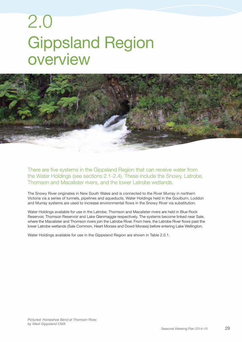
2.0 Gippsland Region overview
There are five systems in the Gippsland Region that can receive water from the Water Holdings (see sections 2.1-2.4). These include the Snowy, Latrobe, Thomson and Macalister rivers, and the lower Latrobe wetlands.
The Snowy River originates in New South Wales and is connected to the River Murray in northern Victoria via a series of tunnels, pipelines and aqueducts. Water Holdings held in the Goulburn, Loddon and Murray systems are used to increase environmental flows in the Snowy River via substitution.
Water Holdings available for use in the Latrobe, Thomson and Macalister rivers are held in Blue Rock Reservoir, Thomson Reservoir and Lake Glenmaggie respectively. The systems become linked near Sale, where the Macalister and Thomson rivers join the Latrobe River. From here, the Latrobe River flows past the lower Latrobe wetlands (Sale Common, Heart Morass and Dowd Morass) before entering Lake Wellington.
Water Holdings available for use in the Gippsland Region are shown in Table 2.0.1.
Pictured: Horseshoe Bend at Thomson River, by West Gippsland CMA
Seasonal Watering Plan 2014–15 29

Victorian Environmental Water Holder30
Water Holdings in the Gippsland Region
Table 2.0.1 Water Holdings available for use in the Gippsland Region
Entitlement Description
Snowy system
Bulk Entitlement (Goulburn System – Snowy Environmental Reserve) Order 2004
30,252 ML high-reliability entitlement8,156 ML low-reliability entitlement
Bulk Entitlement (River Murray – Snowy Environmental Reserve) Order 2004
29,794 ML high-reliability entitlement
Water shares 8,036 ML Goulburn high-reliability water share17,852 ML Goulburn low-reliability water share14,671 ML Murray high-reliability water share6,423 ML Murray low-reliability water share470 ML Loddon high-reliability water share
Latrobe system
Latrobe River Environmental Entitlement 2010 Access to water from the Latrobe River to inundate the lower Latrobe wetlands when river height is above -0.7m AHD at Swing Bridge gauging station
Blue Rock Environmental Entitlement 2013 9% share of storage inflows and reservoir storage
Thomson system
Bulk Entitlement (Thomson River – Environment) Order 20051
10,000 ML per year and reservoir storage spaceMinimum passing flows at various weirs and gauges throughout the Thomson system
Macalister system
Macalister River Environmental Entitlement 2010 12,461 ML high-reliability entitlement 6,320 ML low-reliability entitlement
Other entitlements
New South Wales entitlements (available for use in the Snowy system)
278,237 ML (at 1 March 2013)
1 Entitlement amendment expected to provide an additional 8,000 ML allocated throughout the year based on percentage of inflows. Currently awaiting funding to implement.
2.0 Gippsland Region Overview

Seasonal Watering Plan 2014–15 31
Waterway manager – New South Wales Office of Water and East Gippsland Catchment Management Authority
Storage manager – Snowy Hydro Limited
The heritage-listed Snowy River originates on the slopes of Mount Kosciuszko, draining the eastern slopes of the Snowy Mountains in New South Wales, before flowing through the Snowy River National Park in Victoria and emptying into Bass Strait. Much of the Snowy valley contains intact, remnant vegetation. The lower reaches of the Snowy River in Victoria, including floodplain wetlands and the river estuary, provide a diverse range of habitats for endangered flora and fauna as well as feeding and breeding areas for migratory birds. The highly modified flow regime of the Snowy River is the biggest threat to the substantial values it supports.
System overviewThe Snowy Mountains Hydro-electric Scheme (the Scheme) was constructed in the Snowy Mountains in New South Wales between 1949 and 1974. The Scheme resulted in the construction of four major dams (Guthega, Island Bend, Eucumbene and Jindabyne) and multiple diversion weirs in the Snowy River catchment. The Scheme diverts water to the Murrumbidgee and River Murray valleys and resulted in the diversion of 99 percent of the Snowy River’s mean annual natural flow at Jindabyne Dam until 2002. The Scheme can store up to 5,300,000 ML, which is primarily released to generate hydro-electricity.
While playing a critical role in electricity generation and irrigation supply, flow diversion and other activities have impacted on all aspects of the river’s hydrology and resulted in a significant deterioration in the health of the river.
Snowy system
2.1
Pictured: Snowy River at Tulloch Ard Gorge, by East Gippsland CMA
Victorian Environmental Water Holder32
In 2002, the New South Wales, Victorian and Commonwealth governments committed $425 million to recover water for three environmental water release programs:
• SnowyRiverIncreasedFlows–upto212,000MLperyear
• SnowyMontaneRiverIncreasedFlows–150gigawatthoursofforegoneelectricitygenerationwhichis equivalent of up to 117,800 ML per year
• RiverMurrayIncreasedFlows–70,000MLperyear.
In 2003, the joint government enterprise ‘Water for Rivers’ was established to undertake water recovery in the Murray and Murrumbidgee systems through irrigation modernisation and a small volume of purchased entitlement. Additionally, Snowy Hydro committed over $125 million to undertake infrastructure upgrades at Jindabyne Dam to allow annual flushing flows and a highly variable flow regime to be released to the Snowy River.
The Water for Rivers water recovery program is now complete and the subsequent environmental water entitlements created. The Victorian entitlements are held by the VEWH in trust for the Snowy River Increased Flows program.
A substitution arrangement is in place for VEWH Water Holdings in the Murray, Loddon and Goulburn systems to increase environmental flows in the Snowy system. Water savings in the Murray, Loddon and Goulburn systems provide additional water that can be supplied for consumptive use in northern Victoria. Similar arrangements apply on the New South Wales Murray and Murrumbidgee systems. This reduces the volume of water that must be supplied from the Snowy system to the Murray and Murrumbidgee rivers, thereby freeing up water for environmental flows in the Snowy.
Daily flow targets are set on an annual basis for the period from May to April each water year. These daily flow targets are designed to maximise the environmental outcomes to the Snowy River using the available water for the year. Currently, the New South Wales Office of Water develops these daily flow targets and consults with the Victorian and Australian governments and stakeholder groups regarding environmental water released to the Snowy River.
The Snowy River system is shown in Figure 2.1.1.
Current situationDuring 2013-14, the New South Wales, Victorian and Commonwealth governments committed 190,600 ML to be released to the Snowy River below Jindabyne Dam.
Priority watering actions and environmental objectivesEnvironmental flow releases aim to facilitate the rehabilitation of the Snowy River, below Jindabyne Dam, into a smaller but healthy river, recognising that it is not possible to restore or maintain the Snowy River to its former size with one fifth of its former flow volume.
Environmental water releases during May 2014 to April 2015 aim to mimic the typical flow pattern of a mixed snowmelt/rainfall river system, characteristic of the Snowy Mountains. A major component is a large flushing flow in spring that is timed to mimic natural snow melt. Other flows planned for the Snowy River primarily aim to improve the physical attributes of the river through scouring sediment and limiting the growth of riparian plants, which can block the river channel.
Over time, this will improve habitat for fish such as river blackfish and support stable and diverse ecological communities in the long term. Variable flows will also flush leaf litter and other material into the river to increase productivity and stimulate the food chain.
The 2014-15 flow regime will also consist of a sustained period of high flows from September to December. This will assist with maintenance of the Snowy River mouth to the sea and provide continuous freshwater mixing in the estuary for the benefit of fish, such as Australian bass.
2.1 Snowy system
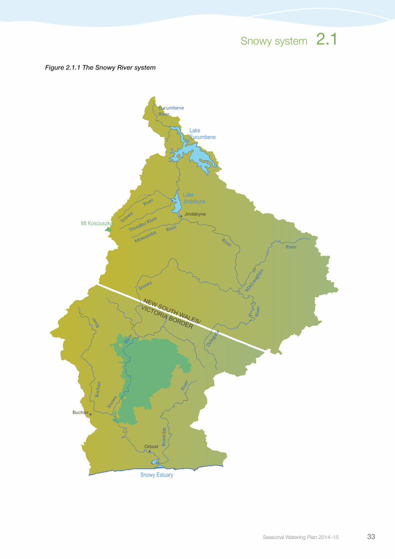
Seasonal Watering Plan 2014–15 33
Snowy system 2.1
Figure 2.1.1 The Snowy River system
Jindabyne
Orbost
Mac
Laug
hlin
Delega
te
Mt Kosciuszko
LakeEucumbene
Thredbo RiverSnowy
Mowamba River
Snowy
Brod
ribb
Snow
y Buch
an
EucumbeneRiver
Rive
r
Rive
r
Rive
r
River
River
River
Rive
r
NEW SOUTH WALES/
VICTORIA BORDER
LakeJindabyne
Snowy Estuary
Buchan

Victorian Environmental Water Holder34
Latrobe system
2.2
Waterway manager – West Gippsland Catchment Management AuthorityStorage manager – Southern Rural Water
Considered one of the most significantly modified rivers in Victoria, the Latrobe River system, which includes the Latrobe River and Latrobe wetlands, supports a range of plant and animal species of high conservation significance, including a number of threatened vegetation types, waterbirds and fish and frog species. The Latrobe River also provides an essential source of fresh water to the Ramsar-listed Gippsland Lakes system, of which the lower Latrobe wetlands are an important component.
System overviewThe Latrobe River rises near Powell Town in West Gippsland and eventually flows into Lake Wellington, the western-most point of the Gippsland Lakes. The upper Latrobe River is ecologically healthy with endangered and vulnerable riparian vegetation communities present in all but the most modified river reach that flows through the Latrobe Valley. The tributaries along the length of the Latrobe River include the Tanjil River, Narracan Creek, Morwell River, Tyers River, Traralgon Creek and Thomson River. Environmental Water Holdings are stored in Blue Rock Reservoir.
Due to its good stands of endangered riparian vegetation, the Latrobe River from Rosedale to the Thomson River confluence (reach 5) is the priority reach for active environmental watering (see Figure 2.2.1). This reach has the highest potential to improve its environmental condition through the use of managed environmental water. The measurement point for environmental flows delivered to reach 5 is the Latrobe River at Kilmany South streamflow gauge.
The Latrobe wetlands are situated along the Latrobe River between its confluence with the Thomson River and Lake Wellington. River regulation and water extraction from the Latrobe, Thomson and Macalister rivers has reduced the frequency of small to medium sized floods that would naturally inundate the Latrobe wetlands. Construction of levees, drains and filling in of natural depressions has also substantially altered wetland water movement.
Pictured: Eastern Heart Morass, Lower Latrobe wetlands, by Eleisha Keogh, West Gippsland CMA

Seasonal Watering Plan 2014–15 35
The Latrobe wetlands that can be actively managed with environmental water are Sale Common and Heart Morass on the northern floodplain and Dowd Morass on the southern floodplain.
Figure 2.2.1 The Latrobe River and lower wetlands system
Latrobe system 2.2
•Maffra
Thomson Dam
•
Avon
Perr
y
Barkly
Valencia
Freestone Creek
Toms
Rive
r
Creek
River
Creek
River
Macalister
River
Macalister
Thomson
Thomson
Aberfeldy
Glenmaggie
Blac
kall
Ben
Rainbow
Fiddlers Boggy
River
River
RiverCreek
Creek
Creek
Creek
River
Cree
k
Cruachan
Creek
••
•• •
•
•
•Neerim
Moe
Erica
Noojee
Rosedale
Sale
Warragul
Traralgon
Tyers
Mor
wel
l
Flyn
ns
Latrobe
Trar
algo
n
Shady
Moe
Middle
Tanjil
Eaglehawk Creek
Cree
k
Creek
Cree
k
Rive
r
River
River
River
Latrobe
River
River
Creek
River
Narrac
an
Loch
Waterhole
Latrobe
Creek
Creek
River
Lake Glenmaggie
Lake Wellington
Blue RockReservoir
LakeNarracan
1
2
3
4 56 78
Yallourn Weir
MorwellDowd Morass
Heart Morass
Sale Common
River
River
Latrobe
Thomson
MoondarraReservoir
•
Thomson Rainbow Creek
•
•Rosedale
Sale
Traralgon
Flyn
ns
Trar
algo
n
Eaglehawk
Creek
Cree
k
Cree
k
Waterhole
Latrobe
Creek
Lake Wellington
4
11 Dowd Morass
Heart Morass
Sale Common
Wetlands
•
1
2
3
4
5
6
7
8
Reach Upstream of Willow GroveReach Willow Grove to Lake NarracanReach Lake Narracan to Scarnes Bridge Reach Scarnes Bridge to RosedaleReach Rosedale to Thomson River confluenceReach Downstream of Thomson confluenceReach Lake WellingtonReach Tanjil River Water infrastructure Measurement point Town
Jordan River
RiverThomson

Victorian Environmental Water Holder36
2.2.1 Latrobe RiverCurrent situationDuring the last two to three years, there has been increased rainfall throughout the Latrobe River catchment compared to the preceding decade of mostly below average rainfall and drought. Rainfall in winter 2013 was above average and this was followed by an average to dry spring and summer. Flows in the Latrobe River through 2013-14 were responsive to rainfall patterns, with high flows in winter/spring and low flows in summer/autumn.
Riparian and aquatic vegetation such as swamp paperbark, common reed and silver wattle began to establish on the lower river bank and the river bed during the drought. Recent high flows have encouraged growth of these plants, which in many places now trap sediment to provide more opportunity for vegetation to establish. In the long term, this will improve the stability of the river by preventing bank erosion and will help to protect downstream assets, such as the Gippsland Lakes, by reducing sediment and nutrient loads.
Despite a relatively dry summer, the predicted outlook for the availability of the environmental Water Holdings held in Blue Rock Reservoir in 2014-15 is positive. However, adequate rainfall and natural flows throughout the year will also be required.
Priority watering actions and environmental objectivesPriority watering actions along with their associated environmental objectives are provided in Table 2.2.1 and illustrated in Figure 2.2.2.
The Latrobe River from Rosedale to the Thomson River confluence (reach 5) is the priority reach for active environmental watering in 2014-15. Rehabilitation of in-stream habitat by encouraging vegetation growth low in the river channel is the crucial first step to stabilise the river and improve habitat.
Table 2.2.1. Priority watering actions and environmental objectives for the Latrobe River
Priority watering action Environmental objectives
Spring/summer freshes (up to eight events of up to 1,300 ML per day for at least two to four days during September to February)
Encourage vegetation diversity along lower banks and recruitment/maintenance of in-stream vegetation
Flush pools to improve water quality and introduce carbon and nutrients (re-oxygenation of water is especially important in summer and autumn)
Disturb river bed to flush accumulated fine sediment and organic matter to maintain channel form
Redistribute organic matter for incorporation into aquatic food webs
Allow for fish movement between habitats
Prevent excessive in-channel encroachment by terrestrial vegetation
Autumn/winter freshes (up to eight events of up to 1,300 ML per day for at least two to four days during March to August)
Winter/spring baseflows (690-1,500 ML per day during June to November)
Facilitate the formation of in-stream bars (elevated deposits of sediment and gravel in the river channel)
Allow for fish movement between reaches
Prevent excessive in-channel encroachment by terrestrial vegetation
Summer/autumn baseflows (up to 690 ML per day for up to six months during December to May)
Provide in-stream habitat, especially for macroinvertebrates, fish and vegetation
Allow for local fish movement between habitats
Inundate coarse woody debris to encourage colonisation by microorganisms
2.2 Latrobe system
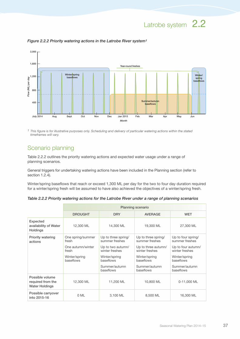
Seasonal Watering Plan 2014–15 37
Latrobe system 2.2
Figure 2.2.2 Priority watering actions in the Latrobe River system1
1 This figure is for illustrative purposes only. Scheduling and delivery of particular watering actions within the stated timeframes will vary.
Scenario planningTable 2.2.2 outlines the priority watering actions and expected water usage under a range of planning scenarios.
General triggers for undertaking watering actions have been included in the Planning section (refer to section 1.2.4).
Winter/spring baseflows that reach or exceed 1,300 ML per day for the two to four day duration required for a winter/spring fresh will be assumed to have also achieved the objectives of a winter/spring fresh.
Table 2.2.2 Priority watering actions for the Latrobe River under a range of planning scenarios
Planning scenario
DROUGHT DRY AVERAGE WET
Expected availability of Water Holdings
12,300 ML 14,300 ML 19,300 ML 27,300 ML
Priority watering actions
One spring/summer fresh
One autumn/winter fresh
Winter/spring baseflows
Up to three spring/summer freshes
Up to two autumn/winter freshes
Winter/spring baseflows
Summer/autumn baseflows
Up to three spring/summer freshes
Up to three autumn/winter freshes
Winter/spring baseflows
Summer/autumn baseflows
Up to four spring/summer freshes
Up to four autumn/winter freshes
Winter/spring baseflows
Summer/autumn baseflows
Possible volume required from the Water Holdings
12,300 ML 11,200 ML 10,800 ML 0-11,000 ML
Possible carryover into 2015-16
0 ML 3,100 ML 8,500 ML 16,300 ML
Dec Jan 2015 Feb Mar AprNovOctSeptAug
400
800
1,200
1,600
2,000
May JunJuly 2014
Summer/autumn baseflows
Month
Flo
w (M
L) p
er d
ay
Year-round freshes
Winter/spring baseflows
Winter/spring
baseflows
Victorian Environmental Water Holder38
Risk management In preparation of its seasonal watering proposal, the West Gippsland Catchment Management Authority considered and assessed risks, and identified mitigating strategies, relating to the implementation of priority watering actions (refer to Table 2.2.3). Risks and mitigating actions are continually reassessed by environmental watering program partners throughout the water year.
Table 2.2.3 Risk management in the Latrobe River
Risk type Mitigating strategies
Current recommendations on environmental flow inaccurate
Continue to apply best available scientific knowledge to environmental water management
Improved conditions for non-native species (eg. carp) No practical controls currently available for carp
Environmental benefit exceeds risk posed by European carp
Environmental water release causes personal injury to river user
Early notifications sent to all registered persons/organisations and installation of public signage
An alarm sounds at the dam when releases are underway to warn people
Unable to provide evidence in meeting ecological objective
Some basic monitoring will be undertaken
Document basis of decisions made throughout the year
Key stakeholders not supportive of environmental water release
Engage community stakeholders
Inform key stakeholders about the seasonal watering plan
Notify relevant stakeholders and explain purpose prior to undertaking environmental watering using appropriate mechanisms
Engage key stakeholders in the development of seasonal watering proposals
ConsultationWest Gippsland Catchment Management Authority has engaged key stakeholders and relevant individuals in preparation of the seasonal watering proposal for the Latrobe River. These stakeholders are shown in Table 2.2.4.
Table 2.2.4 Key stakeholders involved in the preparation of the seasonal watering proposal for the Latrobe River
Stakeholder Consultation
Southern Rural WaterWest Gippsland Catchment Management Authority Board, management and staffVictorian Environmental Water Holder
2.2 Latrobe system

Seasonal Watering Plan 2014–15 39
Latrobe system 2.2
2.2.2 Lower Latrobe wetlandsCurrent situationSome partial wetting flows were actively delivered to Dowd Morass in March 2013 and Sale Common in May and June 2013, prior to moderate flooding in the lower Latrobe and Thomson rivers, which filled all wetlands in the system in June. Additional water continued to be contributed to the wetlands through winter and spring 2013 due to sustained high baseflows and flooding in the Latrobe, Thomson and Macalister rivers.
The summer of 2013-14 was hot and dry and led to substantial, but not complete, drawdown of all of the Latrobe wetlands. The drawdown has provided opportunities for wetland plants to germinate and grow, and has opened up new shallow feeding habitat for a wide variety of waterbirds including great egrets, royal spoonbills, swamp hens, Eurasian coots, numerous duck species, and migratory waders.
Overall the lower Latrobe wetlands are showing signs indicative of the mostly continuous inundation they have experienced over the last few years. While long periods of inundation have provided excellent opportunity for colonial waterbirds, there has also been a decline in the diversity of aquatic plants and an increase in the number and size of European carp. A wetland drawdown of similar extent to that which occurred in summer 2013-14 is now preferred to increase the habitat values of the site provided by a diverse array of vegetation types.
Priority watering actions and environmental objectivesPriority watering actions along with their associated environmental objectives are provided in Table 2.2.5.
The aim in 2014-15 will be to consolidate, and if possible build on the benefits arising from the good inflow conditions experienced in recent years, and the partial drawdowns in summer/autumn 2013-14. Drawdown of the wetlands are a priority to increase overall habitat diversity which, in turn, will improve conditions for waterbirds that return to the wetlands during wet periods. This management approach will also increase aesthetic appeal and recreation opportunities for the community.
Table 2.2.5 Priority watering actions and environmental objectives for the lower Latrobe wetlands
Priority watering action Environmental objectives
Sale Common
Complete drawdown (primarily August to March) Promote oxygenation of surface soils, breakdown of accumulated organic matter and nutrient recyclingEncourage the growth and reproduction of wetland plants across the wetland bedReduce the number and size of European carp
Wetting flow (February to May) Provide feeding and sheltering habitat for wetland fauna, particularly waterbirds and frogsDiscourage the spread of giant rush
Partial wetting flow (August to November) Encourage the growth and reproduction of wetland plants, particularly tall marsh, aquatic herbland and aquatic sedgelandProvide feeding and breeding habitat for wetland fauna, particularly waterbirds and frogs
Wetting flow (anytime) Mimic the natural inundation regime

Victorian Environmental Water Holder40
Priority watering action Environmental objectives
Dowd Morass
Substantial drawdown (primarily August to March) Promote oxygenation of surface soils, breakdown of accumulated organic matter and nutrient recyclingEncourage the growth and reproduction of wetland plants, particularly swamp shrub, tall marsh, aquatic herbland and brackish herblandReduce the number and size of European carp
Wetting flow (February to May) Provide feeding habitat for wetland fauna, particularly waterbirds
Wetting flow (anytime) Avoid/mitigate risks to wetland plants and waterbird habitat from adverse salinity and exposure of acid sulphate sedimentMimic the natural inundation regime
Partial wetting flow (August to November) Encourage colonial waterbird breedingReduce salinityEncourage the growth and reproduction of wetland plants, particularly swamp scrub, tall marsh, aquatic herbland and brackish herblandProvide feeding and breeding habitat for wetland fauna, particularly waterbirds and frogs
Heart Morass
Substantial drawdown (primarily August to March) Promote oxygenation of surface soils, breakdown of accumulated organic matter and nutrient recyclingEncourage the growth and reproduction of wetland plants, particularly swamp scrub, tall marsh, aquatic herbland and brackish herblandReduce the number and size of European carp
Wetting flow (February to May) Provide feeding habitat for wetland fauna, particularly waterbirds
Wetting flow (anytime) Avoid/mitigate risks to wetland plants and waterbird habitat from adverse salinity and exposure of acid sulphate sedimentMimic the natural inundation regime
Partial wetting flow (August to November) Avoid/mitigate risks to wetland plants and waterbird habitat from adverse salinity and exposure of acid sulphate sedimentEncourage the growth and reproduction of wetland plants, particularly swamp scrub, tall marsh, aquatic herbland, and brackish herblandProvide feeding and breeding habitat for wetland fauna, particularly waterbirds and frogs
Scenario planningTable 2.2.6 outlines the priority watering actions and expected water usage under a range of planning scenarios.
General triggers for undertaking watering actions have been included in the Planning section (refer to section 1.2.4).
Complete drawdown is a high priority in 2014-15 for Sale Common, and substantial drawdown is a high priority for Heart Morass and Dowd Morass. Several years have passed since an extensive drawdown has occurred across the wetlands. Drawdown is required to promote diversity of wetland plants and reduce the abundance of carp. Wetting flows in all wetlands are also important to provide sheltering, feeding and breeding habitat for waterbirds and frogs, and to reduce the risk from acid-sulphate soils. Complete and sustained inundation is not preferred due to the extent of flooding in recent years, however uncontrolled river flows may inundate some or all of the wetlands anytime.
Table 2.2.5 Priority watering actions and environmental objectives for the lower Latrobe wetlands (continued)
2.2 Latrobe system

Seasonal Watering Plan 2014–15 41
Latrobe system 2.2
The overall approach to achieve these objectives will be to allow water levels to fluctuate in accordance with seasonal conditions, and selectively undertake active watering and drawdown to augment this if required and when feasible.
Table 2.2.6 Priority watering actions for the Latrobe wetland system under a range of planning scenarios
Planning scenario
DROUGHT DRY AVERAGE WET
Expected availability of Water Holdings
No volumetric limitation, dependent on river levels
No volumetric limitation, dependent on river levels
No volumetric limitation, dependent on river levels
No volumetric limitation, dependent on river levels
Sale Common
Priority watering actions
Complete drawdown (July-June)
Wetting flow (anytime)
Complete drawdown (August-April)
Wetting flow (February-May)
Wetting flow (anytime)
Complete drawdown (August-March)
Wetting flow (February-May)
Wetting flow (August-November)
Wetting flow (anytime)
Flushing/wetting flow (August-November)
Partial drawdown (December-March)
Wetting flow (February-May)
Wetting flow (anytime)
Possible volume required from the Water Holdings
0-1,300 ML 0-1,300 ML 1,300 ML 0 ML
Dowd Morass
Priority watering actions
Complete drawdown (July-June)
Wetting flow (anytime)
Substantial drawdown (August-April)
Wetting flow Feb-May)
Wetting flow (anytime)
Substantial drawdown (August-March)
Wetting flow (February-May)
Wetting flow (August-November)
Wetting flow (anytime)
Flushing/wetting flow (August-November)
Partial drawdown (December-March)
Wetting flow (February-May)
Wetting flow (anytime)
Possible volume required from the Water Holdings
0-5,800 ML 0-5,800 ML 5,800 ML 0 ML
Heart Morass
Priority watering actions
Complete drawdown (July-June)
Wetting flow (anytime)
Substantial drawdown (August-April)
Wetting flow (February-May)
Wetting flow (anytime)
Substantial drawdown (August-March)
Wetting flow (February-May)
Wetting flow (August-November)
Wetting flow (anytime)
Flushing/wetting flow (August-November)
Partial drawdown (December-March)
Wetting flow (February-May)
Wetting flow (anytime)
Possible volume required from the Water Holdings
0-7,100 ML 0-7,100 ML 7,100 ML 0 ML

Victorian Environmental Water Holder42
Risk managementIn preparation of its seasonal watering proposal, the West Gippsland Catchment Management Authority considered and assessed risks, and identified mitigating strategies relating to the implementation of priority watering actions (refer to Table 2.2.7). Risks and mitigating actions are continually reassessed by environmental watering program partners throughout the water year.
Table 2.2.7 Risk management in the lower Latrobe wetlands
Risk type Mitigating strategies
Unable to undertake environmental watering efficiently and effectively
Develop and implement operational monitoring program
Design and upgrade/construct water control regulators and complementary earthworks at Dowd Morass and Heart Morass
Improved conditions for non-native species (eg. carp) Proposed drying should significantly reduce carp numbers
Carp screens have been installed in Sale Common and Dowd Morass
Environmental watering causes unplanned flooding of private land
At Heart Morass (the only wetland in which private land is within the boundary of targeted watering), establish formal landholder agreements prior to undertaking watering
Unable to provide evidence in meeting ecological objective
Undertake environmental monitoring/research to assist in reporting on the effects of environmental water management and in refining understanding and management over time
Document basis of decisions made throughout the year
Key stakeholders not supportive of environmental watering action
Inform key stakeholders about the seasonal watering plan
Notify relevant stakeholders and explain purpose prior to undertaking environmental watering using appropriate mechanisms
Engage key stakeholders in the development of seasonal watering proposals
Ensure landholder support for environmental watering prior to proceeding with active inundation of private land
ConsultationWest Gippsland Catchment Management Authority has engaged key stakeholders and relevant individuals in preparation of the seasonal watering proposal for the Lower Latrobe wetlands. These stakeholders are shown in Table 2.2.8.
Table 2.2.8 Key stakeholders involved in the preparation of the seasonal watering proposal for the Latrobe wetlands
Stakeholder consultation
Parks VictoriaWetlands Environmental TaskforceField and Game AustraliaWest Gippsland Catchment Management Authority Board, management and staffVictorian Environmental Water Holder
2.2 Latrobe system
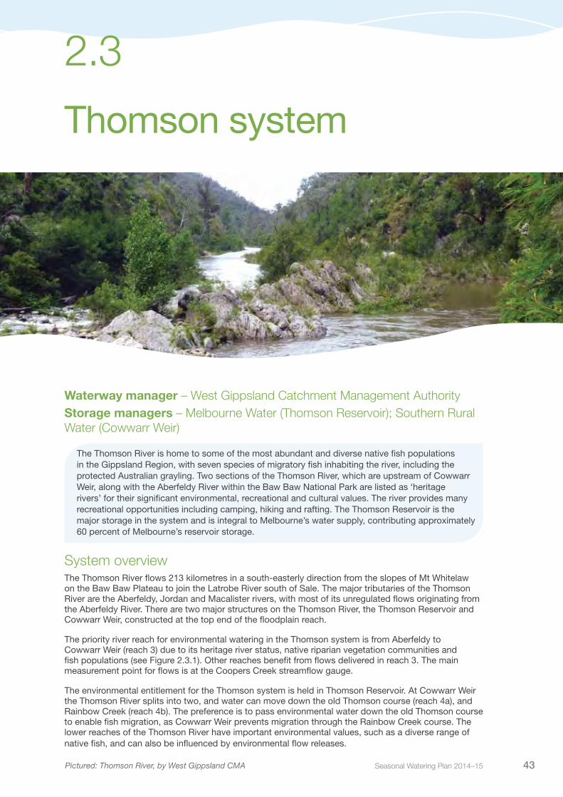
Seasonal Watering Plan 2014–15 43
Thomson system
2.3
Waterway manager – West Gippsland Catchment Management AuthorityStorage managers – Melbourne Water (Thomson Reservoir); Southern Rural Water (Cowwarr Weir)
The Thomson River is home to some of the most abundant and diverse native fish populations in the Gippsland Region, with seven species of migratory fish inhabiting the river, including the protected Australian grayling. Two sections of the Thomson River, which are upstream of Cowwarr Weir, along with the Aberfeldy River within the Baw Baw National Park are listed as ‘heritage rivers’ for their significant environmental, recreational and cultural values. The river provides many recreational opportunities including camping, hiking and rafting. The Thomson Reservoir is the major storage in the system and is integral to Melbourne’s water supply, contributing approximately 60 percent of Melbourne’s reservoir storage.
System overviewThe Thomson River flows 213 kilometres in a south-easterly direction from the slopes of Mt Whitelaw on the Baw Baw Plateau to join the Latrobe River south of Sale. The major tributaries of the Thomson River are the Aberfeldy, Jordan and Macalister rivers, with most of its unregulated flows originating from the Aberfeldy River. There are two major structures on the Thomson River, the Thomson Reservoir and Cowwarr Weir, constructed at the top end of the floodplain reach.
The priority river reach for environmental watering in the Thomson system is from Aberfeldy to Cowwarr Weir (reach 3) due to its heritage river status, native riparian vegetation communities and fish populations (see Figure 2.3.1). Other reaches benefit from flows delivered in reach 3. The main measurement point for flows is at the Coopers Creek streamflow gauge.
The environmental entitlement for the Thomson system is held in Thomson Reservoir. At Cowwarr Weir the Thomson River splits into two, and water can move down the old Thomson course (reach 4a), and Rainbow Creek (reach 4b). The preference is to pass environmental water down the old Thomson course to enable fish migration, as Cowwarr Weir prevents migration through the Rainbow Creek course. The lower reaches of the Thomson River have important environmental values, such as a diverse range of native fish, and can also be influenced by environmental flow releases.
Pictured: Thomson River, by West Gippsland CMA

Victorian Environmental Water Holder44
Figure 2.3.1 The Thomson system
2.3 Thomson system
•Maffra
Thomson Dam
Cowwarr Weir
•
Avon
Perr
y
Barkly
Valencia
Freestone Creek
Toms
Rive
r
Creek
River
Creek
River
Macalister
River
Macalister
Thomson
Aberfeldy
Jordan
Glenmaggie
Blac
kall
Ben
Rainbow
Fiddlers Boggy
River
River
River
River
RiverCreek
Creek
Creek
Creek
River
Cree
k
Cruachan
Creek
••
•• •
•
•
•Neerim
Moe
Erica
Noojee
Rosedale
Sale
Warragul
Traralgon
Tyers
Mor
wel
l
Flyn
ns
Trar
algo
n
Shady
Moe
Middle
Tanjil
Eaglehawk Creek
Cree
k
Creek
Cree
k
Rive
r
River
River
River
Latrobe
Latrobe
RiverRiver
Creek
River
Narrac
an
Loch
Waterhole
Latrobe
Creek
Creek
River
LakeGlenmaggie
Lake Wellington
Blue RockReservoir
LakeNarracan
MoondarraReservoir
Morwell
Dowd Morass
Heart Morass
Sale Common
Thomson
•
2
3
4a
4b
5
6
2
4a
4b
5
6
Reach Thomson River: Thomson Dam to Aberfeldy RiverReach Thomson River: Aberfeldy River to Cowwarr WeirReach Old Thomson River: Cowwarr Weir to Rainbow CreekReach Rainbow Creek: Cowwarr Weir to Thomson RiverReach Thomson River: Rainbow Creek/Old Thomson Confluence to Macalister RiverReach Thomson River: Macalister River to Latrobe River Water infrastructure Measurement point Town
3
Mount Whitelaw
Seasonal Watering Plan 2014–15 45
Thomson system 2.3
Current situationWinter/spring 2013 delivered above average rainfall to the Thomson catchment and there was good flow variability with a number of freshes and a bankfull flow occurring naturally. Conditions turned dry in summer, which resulted in higher than preferred flows during the summer/autumn irrigation season and low flow variability through most Thomson River reaches. Good storage levels in the Thomson Reservoir were maintained overall through 2013-14, thereby reasonable availability of the Thomson environmental Water Holdings is expected at the commencement of 2014-15.
Environmental watering activities for 2013-14 included spring and autumn baseflows and an autumn fresh which was delivered in May 2014 to promote the migration and spawning of Australian grayling. Monitoring of Australian grayling has identified Australian grayling eggs and larvae present during autumn freshes in previous years, which demonstrates the success of flows targeted to improve conditions for grayling. A summer fresh was provided in March 2014 to allow for movement of fish between habitats.
Priority watering actions and environmental objectivesPriority watering actions along with their associated environmental objectives are provided in Table 2.3.1 and illustrated in Figure 2.3.2.
Priority watering actions focus on the ecological condition and the presence of the vulnerable Australian grayling.
In addition to the environmental objectives, these watering actions will also provide improved recreational conditions for activities including rafting and fishing.
Table 2.3.1 Priority watering actions and environmental objectives for the Thomson system
Priority watering action Environmental objectives
Autumn freshes (one to two events of 800 ML per day for four days each during April to May)
Maintain/enhance native fish community structure by providing a migration and spawning cue for Australia grayling and other aquatic species
Regeneration and inundation of riparian vegetation
Sediment scour exposing fresh habitat areas
Spring baseflows (230 ML per day from October to November)
Maintain/enhance native fish community structure by providing habitat availability, large woody debris inundation, and fish migration cues for Australian grayling
Provide opportunities for exotic fish management (particularly carp egg drying) by exposing bed and banks
Autumn/winter baseflows (230 ML per day from May to June)
Maintain/enhance native fish community structure by providing a migration trigger for Australia grayling and other aquatic species
Spring freshes (one to two events of 800 ML per day for four days each during September to October)
Maintain/enhance native fish community structure by providing habitat availability and large woody debris inundation
Provide opportunities for exotic fish management (carp egg drying) by exposing bed and banks
Regenerate and inundate riparian vegetation
Sediment scour exposing fresh habitat areas
Summer/autumn freshes (seven events of 230 ML per day for four days during December to April)
Autumn/winter/spring freshes (four events of 800 ML per day for four days during May to November)
Maintain/enhance native fish community structure by providing opportunities for localised fish movement between habitats

Victorian Environmental Water Holder46
Figure 2.3.2 Priority watering actions in the Thomson system1
1 This figure is for illustrative purposes only. Scheduling and delivery of particular watering actions within the stated timeframes will vary.
Bankfull flows maintain and enhance native fish communities by enabling movement between habitats. This also creates disturbance and scour within the river channel, which maintains habitat conditions for aquatic life. Bankfull flows may occur naturally during 2014-15 and will not be actively managed due to the volume of water required and potential flooding risk involved.
Scenario planningTable 2.3.2 outlines the priority watering actions and expected water usage under a range of planning scenarios.
Research on Australian grayling indicates the optimal spawning period is between April and May. Due to the species’ short lifespan (two to three years), regular spawning and survival of offspring is critical to ensure a viable population. The flows needed for spawning and recruitment success have been achieved regularly in the last five years. This means, under a drought scenario, there is less urgency to provide a spawning flow release for Australian grayling.
Delivery of spring and summer freshes is important for providing variable feeding habitat for a range of fish species. If water availability permits the delivery of these flows in 2014-15, the West Gippsland Catchment Management Authority will work closely with the storage manager on the timing of releases to maximise the effectiveness of concurrent irrigation releases.
Dec Jan 2015 Feb Mar AprNovOctSeptAug
200
400
600
800
1,000
May JunJuly 2014
Spring baseflows
Month
Flo
w (M
L) p
er d
ay
Summer/autumn freshes
Autumn/winter
baseflows
Autumn/winter/spring freshesAutumn/winter/spring freshes
2.3 Thomson system
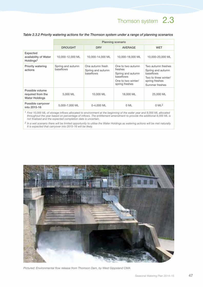
Seasonal Watering Plan 2014–15 47
Thomson system 2.3
Table 2.3.2 Priority watering actions for the Thomson system under a range of planning scenarios
Planning scenario
DROUGHT DRY AVERAGE WET
Expected availability of Water Holdings1
10,000-12,000 ML 10,000-14,000 ML 10,000-18,000 ML 10,000-20,000 ML
Priority watering actions
Spring and autumn baseflows
One autumn freshSpring and autumn baseflows
One to two autumn freshesSpring and autumn baseflowsOne to two winter/spring freshes
Two autumn freshesSpring and autumn baseflowsTwo to three winter/spring freshesSummer freshes
Possible volume required from the Water Holdings
5,000 ML 10,000 ML 18,000 ML 25,000 ML
Possible carryover into 2015-16
5,000-7,000 ML 0-4,000 ML 0 ML 0 ML2
1 First 10,000 ML of storage inflows allocated to environment at the beginning of the water year and 8,000 ML allocated throughout the year based on percentage of inflows. The entitlement amendment to provide the additional 8,000 ML is not finalised and the expected completion date is uncertain.
2 In a wet scenario there will be limited opportunity to utilise the Water Holdings as watering actions will be met naturally. It is expected that carryover into 2015-16 will be likely.
Pictured: Environmental flow release from Thomson Dam, by West Gippsland CMA

Victorian Environmental Water Holder48
Risk managementIn preparation of its seasonal watering proposal, the West Gippsland Catchment Management Authority has considered and assessed risks, and identified mitigating strategies, relating to the implementation of priority watering actions (refer to Table 2.3.3). Risks and mitigating actions are continually reassessed by environmental watering program partners throughout the water year.
Table 2.3.3 Risk management in the Thomson system
Risk type Mitigating strategies
Environmental release causes personal injury to river user Adequate communication of planned flow releases
Environmental water account is overdrawn Storage manager to maintain daily accounts and provide provisional weekly accounts during releases
Due to the potential for reduced passing flows to impact on other users downstream harvest rights, any water accumulated will be held in storage and not used as part of discretionary releases as it may be required to compensate for any impact on this harvest right
West Gippsland Catchment Management Authority to work with storage manager on spill and pre-release rules
Release volume is insufficient or exceeds flow at target point
Storage manager aims to meet required flow at target point as a minimum
Flows are typically slightly higher than required
Delivery constraints due to storage management/maintenance and/or irrigation releases
Ongoing dialogue with storage manager to schedule maintenance works
Unable to provide evidence in meeting ecological objective
Continue with Victorian Environmental Flows Monitoring and Assessment Program reporting
Environmental water release causes flooding of private land
Adequate planning, including rainfall outlooks
Adequate communication of, and during planned flow releases
ConsultationWest Gippsland Catchment Management Authority has engaged key stakeholders and relevant individuals in preparation of the seasonal watering proposal for the Thomson system. These stakeholders are shown in Table 2.3.4.
Table 2.3.4 Key stakeholders involved in the preparation of the seasonal watering proposal for the Thomson system
Stakeholder consultation
Melbourne WaterSouthern Rural WaterWest Gippsland Catchment Management Authority Board, management and staffVictorian Environmental Water Holder
2.3 Thomson system
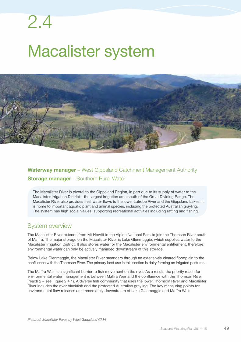
Seasonal Watering Plan 2014–15 49
Macalister system
2.4
Waterway manager – West Gippsland Catchment Management Authority
Storage manager – Southern Rural Water
The Macalister River is pivotal to the Gippsland Region, in part due to its supply of water to the Macalister Irrigation District – the largest irrigation area south of the Great Dividing Range. The Macalister River also provides freshwater flows to the lower Latrobe River and the Gippsland Lakes. It is home to important aquatic plant and animal species, including the protected Australian grayling. The system has high social values, supporting recreational activities including rafting and fishing.
System overviewThe Macalister River extends from Mt Howitt in the Alpine National Park to join the Thomson River south of Maffra. The major storage on the Macalister River is Lake Glenmaggie, which supplies water to the Macalister Irrigation District. It also stores water for the Macalister environmental entitlement, therefore, environmental water can only be actively managed downstream of this storage.
Below Lake Glenmaggie, the Macalister River meanders through an extensively cleared floodplain to the confluence with the Thomson River. The primary land use in this section is dairy farming on irrigated pastures.
The Maffra Weir is a significant barrier to fish movement on the river. As a result, the priority reach for environmental water management is between Maffra Weir and the confluence with the Thomson River (reach 2 – see Figure 2.4.1). A diverse fish community that uses the lower Thomson River and Macalister River includes the river blackfish and the protected Australian grayling. The key measuring points for environmental flow releases are immediately downstream of Lake Glenmaggie and Maffra Weir.
Pictured: Macalister River, by West Gippsland CMA
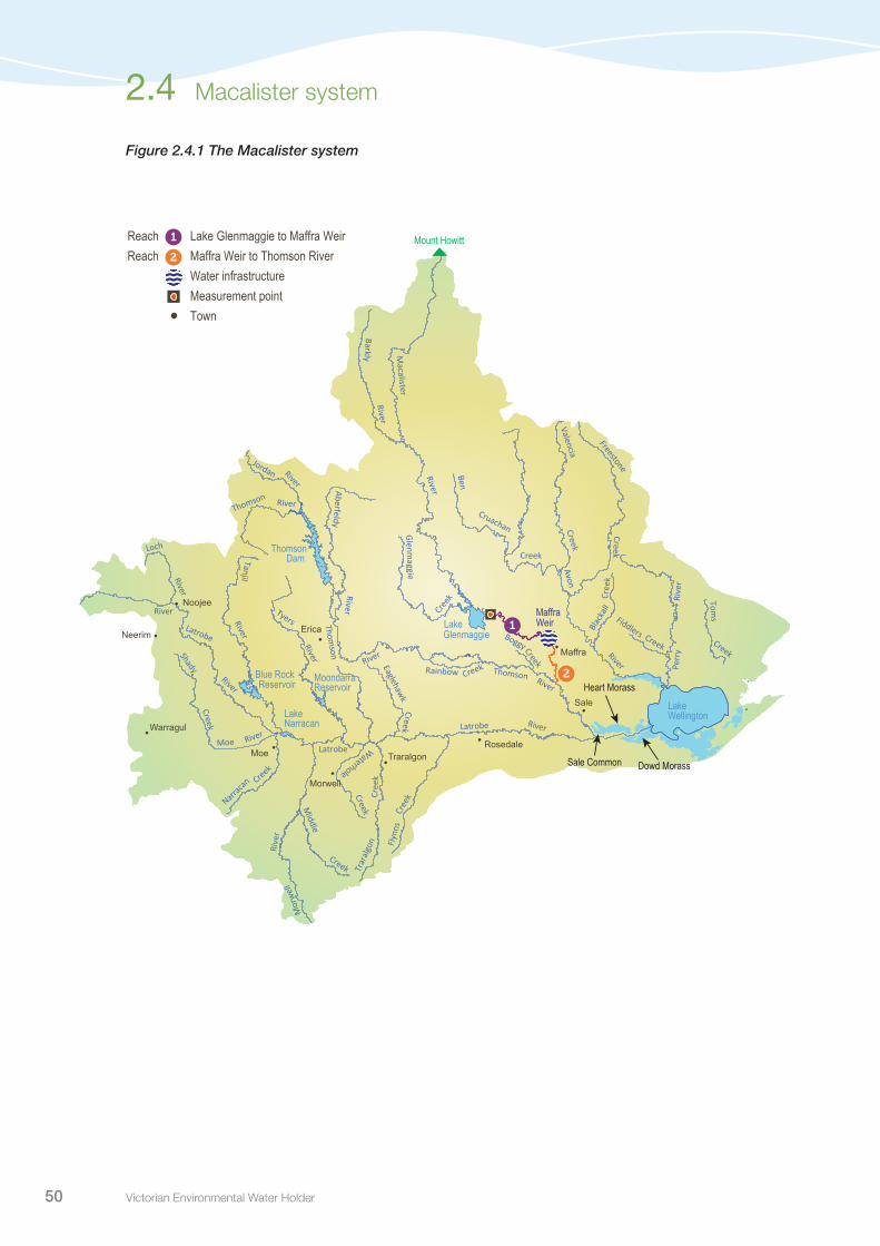
Victorian Environmental Water Holder50
•Maffra
ThomsonDam
•
Avon
Perr
y
Barkly
Valencia
Freestone Creek
Toms
Rive
r
Creek
River
Creek
River
Macalister
River
Thomson
Thomson
Aberfeldy
Glenmaggie
Blac
kall
Ben
Rainbow
Fiddlers Boggy
River
River
RiverCreek
Creek
Creek
Creek
Cree
k
Cruachan
Creek
••
•• •
•
•
•Neerim
Moe
Erica
Noojee
Rosedale
Sale
Warragul
Traralgon
Tyers
Mor
wel
l
Flyn
ns
Trar
algo
n
Shady
Moe
Middle
Tanjil
Eaglehawk Creek
Cree
k
Creek
Cree
k
Rive
r
River
River
River
Latrobe
Latrobe
River
River
Creek
River
Narracan
Loch
Waterhole
Latrobe
Creek
Creek
River
Lake Glenmaggie
Lake Wellington
Blue RockReservoir
LakeNarracan
MoondarraReservoir
Morwell
Maffra Weir
Dowd Morass
Heart Morass
Sale Common
Mount Howitt
Reach Lake Glenmaggie to Maffra WeirReach Maffra Weir to Thomson River Water infrastructure Measurement point Town•
1
1
2
2
Jordan River
RiverThomson
Figure 2.4.1 The Macalister system
2.4 Macalister system
•Maffra
ThomsonDam
•
Avon
Perr
y
Barkly
Valencia
Freestone Creek
Toms
Rive
r
Creek
River
Creek
River
Macalister
River
Thomson
Thomson
Aberfeldy
Glenmaggie
Blac
kall
Ben
Rainbow
Fiddlers Boggy
River
River
RiverCreek
Creek
Creek
Creek
Cree
k
Cruachan
Creek
••
•• •
•
•
•Neerim
Moe
Erica
Noojee
Rosedale
Sale
Warragul
Traralgon
Tyers
Mor
wel
l
Flyn
ns
Trar
algo
n
Shady
Moe
Middle
Tanjil
Eaglehawk Creek
Cree
k
Creek
Cree
k
Rive
r
River
River
River
Latrobe
Latrobe
River
River
Creek
River
Narracan
Loch
Waterhole
Latrobe
Creek
Creek
River
Lake Glenmaggie
Lake Wellington
Blue RockReservoir
LakeNarracan
MoondarraReservoir
Morwell
Maffra Weir
Dowd Morass
Heart Morass
Sale Common
Mount Howitt
Reach Lake Glenmaggie to Maffra WeirReach Maffra Weir to Thomson River Water infrastructure Measurement point Town•
1
1
2
2
Jordan River
RiverThomson

Seasonal Watering Plan 2014–15 51
Macalister system 2.4
Current situationIn 2013-14, wetter conditions prevailed during winter, however, spring and summer saw a return to average and dry conditions respectively. Prior to the onset of dry conditions, Lake Glenmaggie was quite full, necessitating some releases of water, which provided good winter and spring flows with some natural variability. Flows in summer and autumn were mostly provided by irrigation releases.
Environmental watering in 2013-14 provided autumn freshes to enhance Australian grayling populations. Environmental flow releases combined with the wetter conditions in recent years have seen a return in Australian grayling numbers, which were declining during the extended drought. In 2013-14 all priority watering actions identified for the year were fully or partially provided, with the exception of bankfull flows. Lake Glenmaggie is a small storage and water allocations are currently high. Good availability of environmental Water Holdings is expected in 2014-15, and possibly spills and releases that will provide flow variability.
Priority watering actions and environmental objectivesPriority watering actions along with their associated environmental objectives are provided in Table 2.4.1 and illustrated in Figure 2.4.2.
The primary environmental objective is to improve spawning and migration opportunities for the vulnerable Australian grayling. The flows will also help to sustain communities of other native fish, such as southern pygmy perch, tupong, smelt and short-finned eels.
In addition to the environmental objectives, these watering actions will also provide improved recreational conditions for activities including rafting and angling.
Table 2.4.1 Priority watering actions and environmental objectives for the Macalister system
Priority watering action Environmental objectives
Autumn freshes (one to three events of 350 ML per day for seven days each during April to May)
Maintain self-sustaining populations of flathead gudgeon, southern pygmy perch, Australian smelt, short-finned eel, and tupong by providing flows that target recruitment and allow fish to move between different habitatsRestore self-sustaining populations of long-finned eel, Australian grayling and river blackfish by providing flows that target recruitment and allow fish to move between different habitats
Autumn/winter baseflows (140 ML per day during May to July)
Maintain self-sustaining populations of flathead gudgeon, southern pygmy perch, Australian smelt, short-finned eel, and tupong by providing flows to maintain habitat availabilityRestore self-sustaining populations of long-finned eel, Australian grayling and river blackfish by providing flows to maintain habitat availability
Spring baseflows (140 ML per day during October to November)
Summer/autumn freshes (three events of 350 ML per day for seven days each during December to April)
Maintain self-sustaining populations of flathead gudgeon, southern pygmy perch, Australian smelt, short-finned eel, and tupong by providing flows that target recruitment and allow fish to move between different habitatsRestore self-sustaining populations of long-finned eel, Australian grayling and river blackfish by providing flows that target recruitment and allow fish to move between different habitats
Autumn/winter/spring freshes (two events of 1,477 ML per day for nine days each during May to November)
Maintain self-sustaining populations of flathead gudgeon, southern pygmy perch, Australian smelt, short-finned eel, and tupong by providing flows that target recruitmentRestore self-sustaining populations of long-finned eel, Australian grayling and river blackfish by providing flows that target recruitment
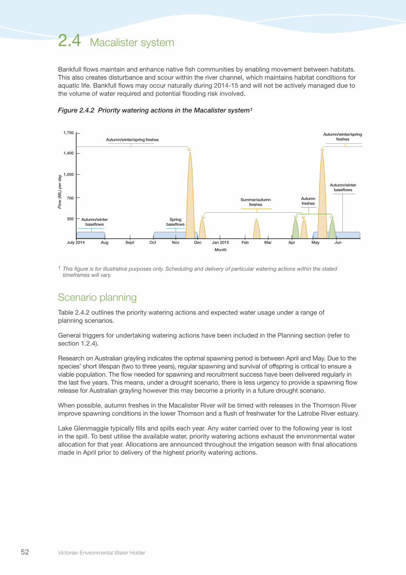
Victorian Environmental Water Holder52
Bankfull flows maintain and enhance native fish communities by enabling movement between habitats. This also creates disturbance and scour within the river channel, which maintains habitat conditions for aquatic life. Bankfull flows may occur naturally during 2014-15 and will not be actively managed due to the volume of water required and potential flooding risk involved.
Figure 2.4.2 Priority watering actions in the Macalister system1
1 This figure is for illustrative purposes only. Scheduling and delivery of particular watering actions within the stated timeframes will vary.
Scenario planningTable 2.4.2 outlines the priority watering actions and expected water usage under a range of planning scenarios.
General triggers for undertaking watering actions have been included in the Planning section (refer to section 1.2.4).
Research on Australian grayling indicates the optimal spawning period is between April and May. Due to the species’ short lifespan (two to three years), regular spawning and survival of offspring is critical to ensure a viable population. The flow needed for spawning and recruitment success have been delivered regularly in the last five years. This means, under a drought scenario, there is less urgency to provide a spawning flow release for Australian grayling however this may become a priority in a future drought scenario.
When possible, autumn freshes in the Macalister River will be timed with releases in the Thomson River improve spawning conditions in the lower Thomson and a flush of freshwater for the Latrobe River estuary.
Lake Glenmaggie typically fills and spills each year. Any water carried over to the following year is lost in the spill. To best utilise the available water, priority watering actions exhaust the environmental water allocation for that year. Allocations are announced throughout the irrigation season with final allocations made in April prior to delivery of the highest priority watering actions.
350
700
1,050
1,400
1,750
Autumn freshes
Summer/autumn freshes
Autumn/winter baseflows
Spring baseflows
Autumn/winter baseflows
Dec Jan 2015 Feb Mar AprNovOctSeptAug May JunJuly 2014
Month
Flo
w (M
L) p
er d
ay
Autumn/winter/spring freshesAutumn/winter/spring freshes
2.4 Macalister system

Seasonal Watering Plan 2014–15 53
Macalister system 2.4
Table 2.4.2 Priority watering actions for the Macalister system under a range of planning scenarios
Planning scenario
DROUGHT DRY AVERAGE WET
Expected availability of Water Holdings
8,000 ML 12,000 ML 14,000 ML 18,500 ML
Priority watering actions
Autumn baseflows Two autumn freshesAutumn/winter baseflows
Two autumn freshesAutumn/winter baseflows
Three autumn freshesAutumn/winter baseflows
Possible volume required from the Water Holdings
8,000 ML 12,000 ML 14,000 ML 18,500 ML
Possible carryover into 2015-16
0 ML 0 ML 0 ML 0 ML
Risk managementIn preparation of its seasonal watering proposal, the West Gippsland Catchment Management Authority considered and assessed risks, and identified mitigating strategies, relating to the implementation of priority watering actions (refer to Table 2.4.3). Risks and mitigating actions are continually reassessed by environmental watering program partners throughout the water year.
Table 2.4.3 Risk management in the Macalister system
Risk type Mitigating strategies
Environmental release causes personal injury to river user Adequate communication of planned flow releases
Environmental water account is overdrawn Storage manager to maintain daily accounts and provide provisional weekly accounts during releasesWest Gippsland Catchment Management Authority to work with storage manager on spill and pre-release rules
Release volume is insufficient or exceeds flow at target point
Storage manager aims to meet required flow at target point as a minimumFlows are typically slightly higher than required
Delivery constraints due to storage management/maintenance and/or irrigation releases
Ongoing dialogue with storage managers to schedule maintenance works
Unable to provide evidence in meeting ecological objective
Basic ecological monitoring will be undertaken
Environmental water release causes flooding of private land
Adequate communication of planned flow releases.
Unable to provide environmental flows due to loss of carryover and passing flow savings to spills
Ongoing dialogue with storage managers to understand storage conditions and establish sophisticated release rules and planningA review of environmental flow recommendations and an environmental water management plan will be initiated in 2014-15 to develop a prioritised release schedule based on water availability and objectives
Current recommendations on environmental flow requirements inaccurate
A review of environmental flow recommendations and an environmental water management plan will be initiated in 2014-15 to develop a prioritised release schedule based on water availability and objectives
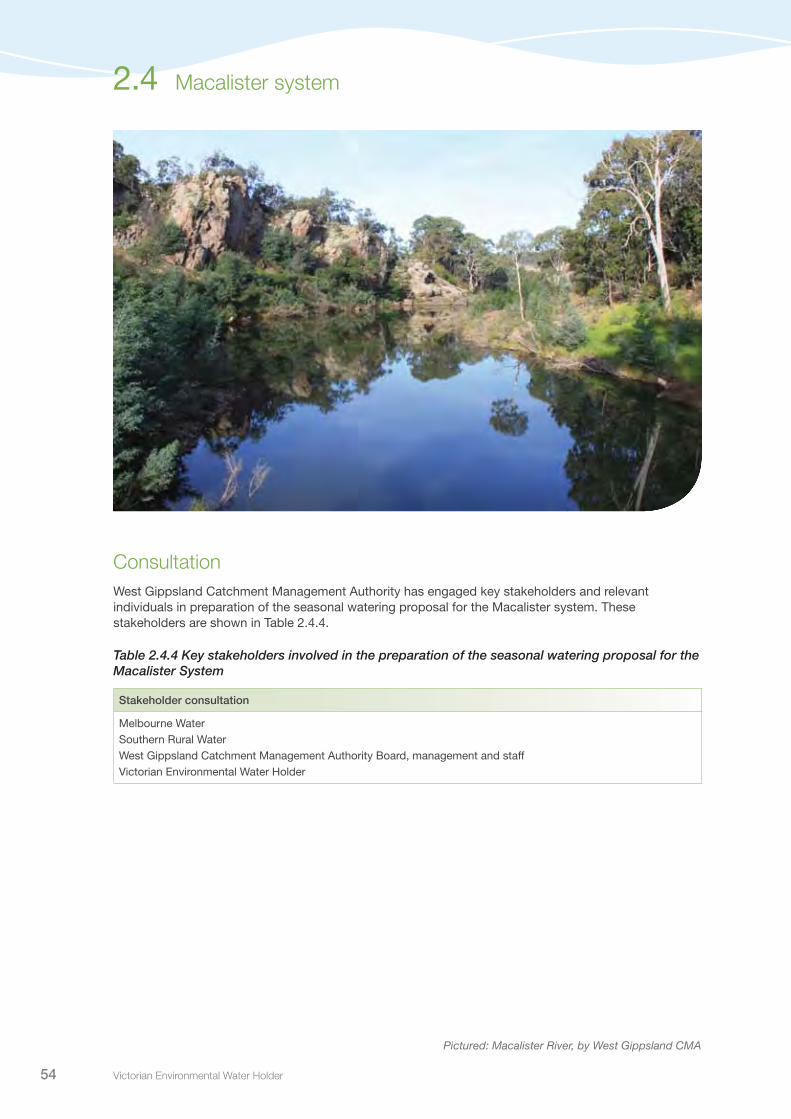
Victorian Environmental Water Holder54
ConsultationWest Gippsland Catchment Management Authority has engaged key stakeholders and relevant individuals in preparation of the seasonal watering proposal for the Macalister system. These stakeholders are shown in Table 2.4.4.
Table 2.4.4 Key stakeholders involved in the preparation of the seasonal watering proposal for the Macalister System
Stakeholder consultation
Melbourne WaterSouthern Rural WaterWest Gippsland Catchment Management Authority Board, management and staffVictorian Environmental Water Holder
Pictured: Macalister River, by West Gippsland CMA
2.4 Macalister system
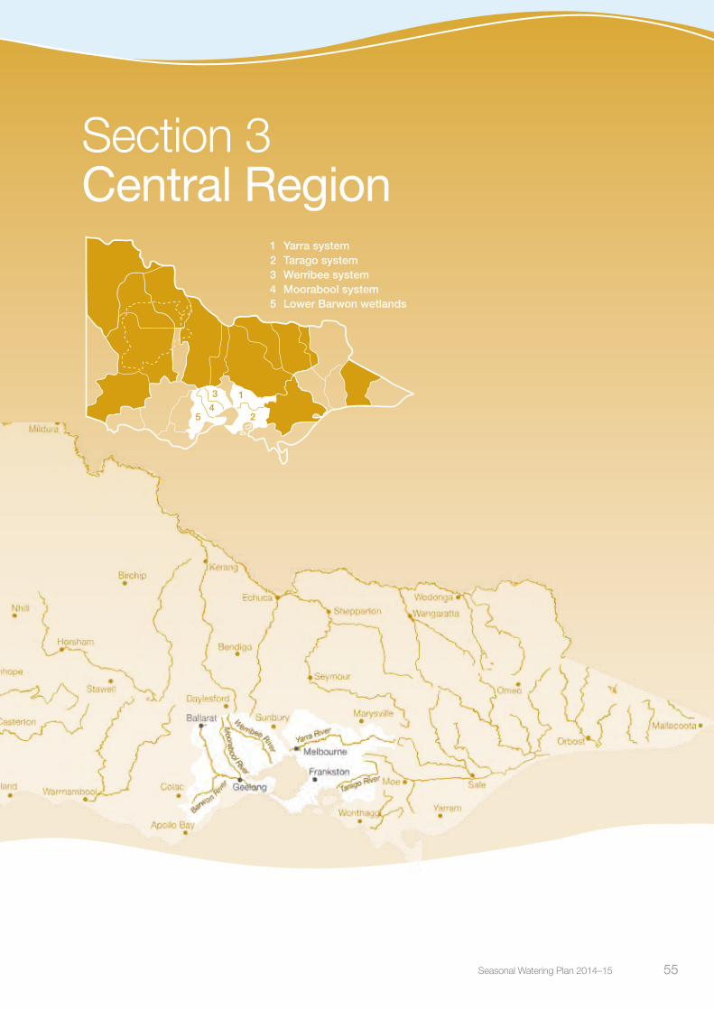
Seasonal Watering Plan 2014–15 55 Seasonal Watering Plan 2014–15 55
Section 3Central Region
2
1
543
1 Yarra system2 Tarago system3 Werribee system4 Moorabool system5 Lower Barwon wetlands

Victorian Environmental Water Holder56
Central Region overview
3.0
Victorian Environmental Water Holder56
There are five systems that can receive water from the Water Holdings in the Central Region of Victoria – the Yarra and Tarago systems in the east; and the Werribee, Moorabool and Barwon (lower Barwon wetlands) systems in the west.
The upper reaches of the Yarra and Tarago system are important water supply catchments for Greater Melbourne with the Yarra alone providing up to 70 percent of Melbourne’s drinking water. Drinking water for Greater Geelong is predominantly sourced from the upper reaches of the Barwon River and also the Moorabool. The river systems also contribute to rural urban water supplies to towns and support agriculture in important irrigation districts, such as Bacchus Marsh and Werribee in the west and Neerim in the east.
Pictured: Upper Coimadai Creek, by Bill Moulden, Melbourne Water
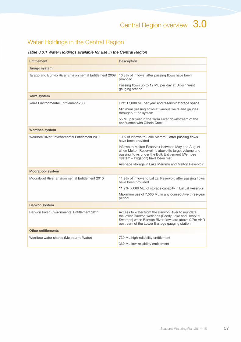
Seasonal Watering Plan 2014–15 57
Central Region overview 3.0
Water Holdings in the Central Region
Table 3.0.1 Water Holdings available for use in the Central Region
Entitlement Description
Tarago system
Tarago and Bunyip River Environmental Entitlement 2009 10.3% of inflows, after passing flows have been provided
Passing flows up to 12 ML per day at Drouin West gauging station
Yarra system
Yarra Environmental Entitlement 2006 First 17,000 ML per year and reservoir storage space
Minimum passing flows at various weirs and gauges throughout the system
55 ML per year in the Yarra River downstream of the confluence with Olinda Creek
Werribee system
Werribee River Environmental Entitlement 2011 10% of inflows to Lake Merrimu, after passing flows have been provided
Inflows to Melton Reservoir between May and August when Melton Reservoir is above its target volume and passing flows under the Bulk Entitlement (Werribee System – Irrigation) have been met
Airspace storage in Lake Merrimu and Melton Reservoir
Moorabool system
Moorabool River Environmental Entitlement 2010 11.9% of inflows to Lal Lal Reservoir, after passing flows have been provided
11.9% (7,086 ML) of storage capacity in Lal Lal Reservoir
Maximum use of 7,500 ML in any consecutive three-year period
Barwon system
Barwon River Environmental Entitlement 2011 Access to water from the Barwon River to inundate the lower Barwon wetlands (Reedy Lake and Hospital Swamps) when Barwon River flows are above 0.7m AHD upstream of the Lower Barrage gauging station
Other entitlements
Werribee water shares (Melbourne Water) 730 ML high-reliability entitlement
360 ML low-reliability entitlement

Victorian Environmental Water Holder58
Yarra system
3.1
Waterway manager – Melbourne WaterStorage manager – Melbourne Water
The upper reaches of the Yarra River are important water supply catchments, supplying up to 70 percent of Melbourne’s drinking water. The lower reaches provide social and recreational opportunities for more than four million people who live in and travel to Greater Melbourne. The Yarra River supports many important environmental values, including platypus and nationally significant fish species, such as the Australian grayling and the Macquarie perch.
System overviewThe Yarra River catchment is the largest within the Port Phillip and Westernport region, being home to over two million people (one third of Victoria’s population). It is one of Victoria’s most iconic waterways, covering over 4,000 square kilometres, flowing from the Yarra Valley to the heart of Melbourne’s central business district at Southbank.
Environmental water can be released from the Upper Yarra, Maroondah and O’Shannassy reservoirs. In the lower reaches, urbanised tributaries such as Diamond Creek, Plenty River and Merri Creek provide additional water to the Yarra River. In the upper reaches the system is influenced by tributaries such as the Woori Yallock Creek, Watts River and Little Yarra River.
The upper system (reaches 1-3) provides habitat for a range of fish species, including river blackfish, spotted galaxias and common galaxias and contains good quality riparian and aquatic vegetation. The lower system (reaches 4-6) contains Australian grayling, Macquarie perch, and tupong. Priority river reaches for environmental watering are reach 2 (immediately downstream of Armstrong Creek through to a measurement point at Millgrove) and reach 5 (immediately downstream of Yering Gorge with flow measured at Warrandyte). Delivery of water to reaches 2 and 5 will achieve flow requirements in neighbouring reaches, both upstream and downstream. The environmental flow reaches for the Yarra system are shown in Figure 3.1.1.
Pictured: Yarra River at Warburton, by John Winther, Melbourne Water

Seasonal Watering Plan 2014–15 59
Yarra system 3.1
Reach 1 and the upper part of reach 2 can only receive environmental water from the Upper Yarra Reservoir. The lower part of reach 2 and reach 3 can also be supplied from O’Shannassy Reservoir, while water from Maroondah Reservoir flows into the Yarra River via Watts River at reach 4.
As well as the river itself, there are several billabongs in the Yarra system. These are an important feature of the Yarra River floodplain downstream of Millgrove and support a variety of distinct vegetation communities, providing foraging and breeding habitat for waterbirds and frogs. Except in very high flows, the billabongs are disconnected from the Yarra River.
Passing flows are provided at many locations in the Yarra system. Managed environmental water releases seek to build on the benefits of passing flows and other natural flows in the system.
Current situationIn 2013-14, conditions ranged from average to wet, resulting in good streamflows. In spring and summer, flows remained within the average range, with an extended dry period in February 2014 causing streamflows to drop quite low.
During 2013-14, Melbourne Water managed a ‘cease to harvest’ request to protect unregulated flows to help achieve a winter fresh event, and delivered two summer fresh events, and an autumn high flow.
Ecological monitoring throughout the year identified a strong spawning response by Macquarie perch. Water quality monitoring in the lower Yarra indicated an improvement in water quality resulting from the release of a summer fresh event. Monitoring at Dights Falls fishway also showed good migration of juvenile Australian grayling into the Yarra River in late spring 2013 and early summer 2014.
Priority watering actions and environmental objectivesPriority watering actions along with their associated environmental objectives, are provided in Table 3.1.1 and illustrated in Figure 3.1.2.
The environmental objectives focus on: fish spawning and migration, particularly Macquarie perch and Australian grayling; scouring sediment from the riverbed to provide optimal habitat for fish and macroinvertebrates; and maintaining water quality. In addition, improved vegetation composition through the Yarra system will be sought by providing water to inundate the low banks of the river, increasing the zone of flood-tolerant vegetation.
These watering actions will also provide recreational opportunities such as canoeing, kayaking and birdwatching, and will increase aesthetic appeal of the river for walkers and cyclists.
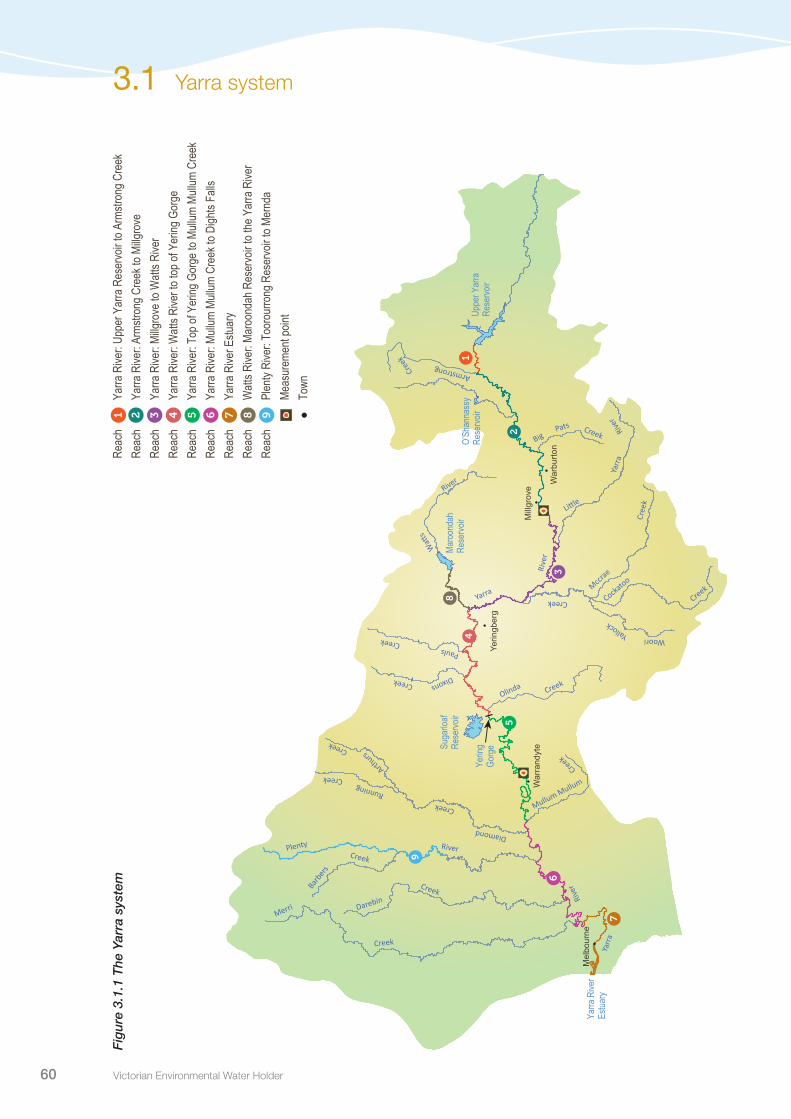
Victorian Environmental Water Holder60
3.1 Yarra system F
igur
e 3.
1.1
The
Yar
ra s
yste
mRe
ach
Yarra
Rive
r: Up
per Y
arra
Res
ervo
ir to A
rmstr
ong C
reek
Reac
h Ya
rra R
iver:
Arms
trong
Cre
ek to
Millg
rove
Re
ach
Yarra
Rive
r: Mi
llgro
ve to
Watt
s Rive
r Re
ach
Yarra
Rive
r: W
atts R
iver t
o top
of Y
ering
Gor
ge
Reac
h Ya
rra R
iver:
Top o
f Yer
ing G
orge
to M
ullum
Mull
um C
reek
Re
ach
Yarra
Rive
r: Mu
llum
Mullu
m Cr
eek t
o Digh
ts Fa
lls
Reac
h Ya
rra R
iver E
stuar
y Re
ach
Watt
s Rive
r: Ma
roon
dah R
eser
voir t
o the
Yar
ra R
iver
Reac
h Pl
enty
Rive
r: To
orou
rrong
Res
ervo
ir to M
ernd
a
Meas
urem
ent p
oint
To
wn
1 2 3 4 5 6 7 8 9
River
Creek
Rive
r
Rive
r
Yarra
Yallock
Creek
Pats Creek
••
•
•
•
Mill
grov
e
War
burto
n
Yerin
gber
g
War
rand
yte
Maro
onda
hRe
servo
ir
Yarra
Rive
rEs
tuary
O’Sh
anna
ssy
Rese
rvoir
Yerin
gGo
rgeSu
garlo
af Re
servo
ir
Uppe
r Yar
ra
Rese
rvoir
Yarr
a
Merri
Plenty
Creek
Mccrae
Pauls
Dixons
Arthurs
Running
Cockatoo
Creek
Cree
k
Creek
Creek
Watts
Little
Creek
River
Darebin
Creek
Creek
Olinda
Armstrong
Mullum Mullum
Creek
Cree
k
Diamond
Barbe
rs
Big
Woori
Yarr
a
River
Creek
Creek
•M
elbo
urne
1
2
3
4
5
7
8
9
6

Seasonal Watering Plan 2014–15 61
Table 3.1.1 Priority watering actions and associated environmental objectives for the Yarra system
Priority watering action1 Environmental objective
Year-round low flows2 (varying rates between 80 and 350 ML per day, all year)
Provide fish and macroinvertebrate habitatPrevent water quality decline
Summer/autumn freshes (three to four freshes of varying rates between 300 ML and 750 ML per day for two to four days each during December to May)
Improve connectivity and access to habitat for fish and macroinvertebratesImprove water quality in the lower river
Autumn high flows (one high flow of varying rates between 560 ML and 1,300 ML per day for seven to 14 days during April to May)
Assist Australian grayling spawning
Spring freshes (one fresh of varying rates between 700 ML and 2,500 ML per day for more than seven days each during September to October)
Assist Macquarie perch spawning and support native fish migration
Winter/spring high flows in reach 1 (one high flow of between 300 ML and 600 ML per day for three days during July to September)
Scour sediment to provide additional fish and macroinvertebrate habitat
Winter/spring fresh (one to two freshes of 700 ML to 2,500 ML per day for seven days during June to September)
Support native fish migration
Winter/spring high flow (one high flow of 700 ML to 2500 ML per day for 14 days during September to November)3
Vegetation wetting on banks
Targeted billabong watering Support native vegetation and improve habitat availability
1 The magnitude and duration of priority watering actions depends upon the target reach, with the lower range generally occurring in reach 2, and higher range in reach 5.
2 These flows are generally provided by passing flows under the environmental entitlement, however, during dry conditions, it may be necessary to supplement low flows using water from the Water Holdings.
3 Water will not be specifically released to achieve a winter/spring high flow, however Melbourne Water may manage for this outcome by ceasing harvesting from the system during the high flow to let this priority watering action occur.
Bankfull and overbank flows are important to the health of the Yarra River, helping to maintain channel form, entrain organic matter and engage high flow channels and the floodplain. These flows will not be met through managed flows due to the volume of water required and the potential for flooding risk, with achievement relying solely on natural events.
Figure 3.1.2 Priority watering actions in the Yarra system1
Yarra system 3.1
1 This figure is for illustrative purposes only. Scheduling and delivery of particular watering actions within the stated timeframes will vary.
Winter/spring freshes
Winter/spring freshes
Year-round low flows
Summer/autumn freshes
600
1,200
1,800
2,400
3,000
Jan 2015 Feb Mar AprNovOctSeptAug May JunJuly 2014
Month
Flo
w (M
L) p
er d
ay
Autumn high flow
Winter high flow, Reach 1
Spring high flow
Dec

Victorian Environmental Water Holder62
Scenario planningTable 3.1.2 outlines the priority watering actions and expected water usage under a range of planning scenarios.
General triggers for undertaking watering actions have been included in the Planning section (refer to section 1.2.4).
Environmental water delivery to priority billabongs on the Yarra River floodplain may be considered during 2014-15. The 55 ML unregulated product available under the Yarra environmental entitlement may be accessed to undertake these actions, alternatively the water may be provided from the regulated source of environmental water available in reservoirs of the upper Yarra catchment.
Reach 1 receives relatively low regulated flows due to its position close to upper Yarra Reservoir. Releases specifically for reach 1 may be required if downstream reaches are receiving adequate water through rainfall to meet downstream objectives.
Table 3.1.2 Priority watering actions for the Yarra system under a range of planning scenarios
Planning scenario
DROUGHT DRY AVERAGE WET
Expected availability of Water Holdings
30,000 ML carryover17,000 ML allocation47,000 ML total
30,000 ML carryover17,000 ML allocation47,000 ML total
30,000 ML carryover17,000 ML allocation47,000 ML total
30,000 ML carryover17,000 ML allocation47,000 ML total
Priority watering actions
Year-round low flows
Summer/autumn freshes when required
Autumn high flows
Winter/spring freshes
Year-round low flows
Summer/autumn freshes when required
Autumn high flows
Winter/spring freshes
Winter high flow (Reach 1)
Targeted billabong watering
Year-round low flows
Summer/autumn freshes when required
Autumn high flows
Winter/spring freshes
Winter high flow (Reach 1)
Targeted billabong watering
Winter/spring high flows may occur naturally but will not be actively delivered.
Year-round low flows
Summer/autumn freshes when required
Autumn high flows
Winter/spring freshes
Winter high flow (Reach 1)
Targeted billabong watering
Winter/spring high flows and bankfull and overbank flows may occur naturally but will not be actively delivered.
Possible volume required from the Water Holdings
31,000 ML 23,000 ML 22,000 ML 12,000 ML
Possible carryover into 2015-16
16,000 ML 24,000 ML 25,000 ML 35,000 ML
Risk managementIn preparing its seasonal watering proposal, Melbourne Water considered and assessed risks, and identified mitigating strategies, relating to the implementation of priority watering actions (refer to Table 3.1.3). Risks and mitigating actions are continually reassessed by environmental watering program partners throughout the water year.
3.1 Yarra system
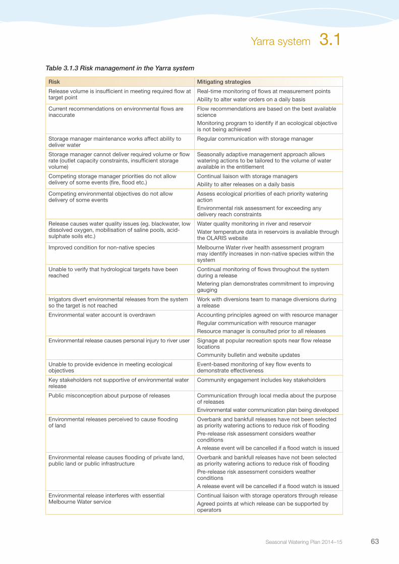
Seasonal Watering Plan 2014–15 63
Table 3.1.3 Risk management in the Yarra system
Risk Mitigating strategies
Release volume is insufficient in meeting required flow at target point
Real-time monitoring of flows at measurement pointsAbility to alter water orders on a daily basis
Current recommendations on environmental flows are inaccurate
Flow recommendations are based on the best available scienceMonitoring program to identify if an ecological objective is not being achieved
Storage manager maintenance works affect ability to deliver water
Regular communication with storage manager
Storage manager cannot deliver required volume or flow rate (outlet capacity constraints, insufficient storage volume)
Seasonally adaptive management approach allows watering actions to be tailored to the volume of water available in the entitlement
Competing storage manager priorities do not allow delivery of some events (fire, flood etc.)
Continual liaison with storage managersAbility to alter releases on a daily basis
Competing environmental objectives do not allow delivery of some events
Assess ecological priorities of each priority watering actionEnvironmental risk assessment for exceeding any delivery reach constraints
Release causes water quality issues (eg. blackwater, low dissolved oxygen, mobilisation of saline pools, acid-sulphate soils etc.)
Water quality monitoring in river and reservoirWater temperature data in reservoirs is available through the OLARIS website
Improved condition for non-native species Melbourne Water river health assessment program may identify increases in non-native species within the system
Unable to verify that hydrological targets have been reached
Continual monitoring of flows throughout the system during a releaseMetering plan demonstrates commitment to improving gauging
Irrigators divert environmental releases from the system so the target is not reached
Work with diversions team to manage diversions during a release
Environmental water account is overdrawn Accounting principles agreed on with resource managerRegular communication with resource managerResource manager is consulted prior to all releases
Environmental release causes personal injury to river user Signage at popular recreation spots near flow release locationsCommunity bulletin and website updates
Unable to provide evidence in meeting ecological objectives
Event-based monitoring of key flow events to demonstrate effectiveness
Key stakeholders not supportive of environmental water release
Community engagement includes key stakeholders
Public misconception about purpose of releases Communication through local media about the purpose of releasesEnvironmental water communication plan being developed
Environmental releases perceived to cause flooding of land
Overbank and bankfull releases have not been selected as priority watering actions to reduce risk of floodingPre-release risk assessment considers weather conditionsA release event will be cancelled if a flood watch is issued
Environmental release causes flooding of private land, public land or public infrastructure
Overbank and bankfull releases have not been selected as priority watering actions to reduce risk of floodingPre-release risk assessment considers weather conditionsA release event will be cancelled if a flood watch is issued
Environmental release interferes with essential Melbourne Water service
Continual liaison with storage operators through releaseAgreed points at which release can be supported by operators
Yarra system 3.1

Victorian Environmental Water Holder64
ConsultationMelbourne Water has engaged with key stakeholders and other relevant individuals in the preparation of the seasonal watering proposal for the Yarra system. These stakeholders are included in Table 3.1.4.
Table 3.1.4 Key stakeholders engaged in the development of the seasonal watering proposal for the Yarra system
Stakeholder consultation
Yarra River Environmental Flows Advisory Group including representatives from local councils, irrigators and landholders, Yarra Valley Water, Environment Protection Authority (Victoria), Yarra River Keepers, Native Fish Australia, VR Fish, Kew Golf Club and Environment Victoria Melbourne Water (Water Supply Operations and Integrated Planning)Melbourne Water BoardVictorian Environmental Water Holder
3.1 Yarra system

Seasonal Watering Plan 2014–15 65
Tarago system
3.2
Waterway manager – Melbourne WaterStorage manager – Melbourne Water
The Tarago system contains significant native plant and animal species, including populations of the protected Australian grayling. Threatened vegetation species such as long pink-bells, tree geebung, and swamp bush-pea can be found along some river reaches. The upper catchment contains healthy riparian vegetation and in-stream habitat diversity, supporting native fish including river blackfish and mountain galaxias. While the lower catchment has been highly modified, it contains good patches of remnant vegetation, and healthy populations of Australian grayling and platypus.
System overviewThe Tarago River is a major tributary of the Bunyip River, which rises in the Bunyip State Forest. The Tarago River headwaters are within the Tarago State Forest and flow into the Tarago Reservoir at Neerim. Downstream of the reservoir, the Tarago flows through the town of Rokeby before meeting the Bunyip River at Longwarry North. The downstream reach towards Western Port Bay supplies many irrigators in the catchment. Water available under the Tarago environmental entitlement is stored in and released from Tarago Reservoir.
The priority reach for environmental watering is reach 2, the Tarago River from Tarago Reservoir to the Bunyip River confluence. This reach contains important environmental values, including Australian grayling, and is the reach most influenced by water released from Tarago Reservoir. Releases provided for reach 2 of the Tarago River will also provide benefit by assisting Australian grayling migration to the lower Bunyip River and the Bunyip River estuary. The measurement point for flows is at Drouin West. The environmental flow reaches are shown in Figure 3.2.1.
Efficient use of the Tarago environmental entitlement is achieved by working with Southern Rural Water, who make irrigation releases from Tarago Reservoir during the summer period. These releases will partially meet the environmental flow objectives of reach 2, and provide an opportunity to efficiently achieve objectives by supplementing the irrigation releases.
Pictured: Tarago River, by Sarah Gaskill, Melbourne Water

Victorian Environmental Water Holder66
The Tarago and Bunyip River Environmental Entitlement includes access to 3,000 ML of storage space in Tarago Reservoir. The VEWH has reached an agreement with other entitlement holders in the system to allow access to any available ‘airspace’ (temporarily unused storage) in Tarago Reservoir to store additional water, subject to conditions. There are two main benefits from accumulating inflows in excess of 3,000 ML. Firstly, the accumulated inflows can be used if dry years eventuate in the future. Secondly, the extra water increases capacity for delivering the highest priority flows in the current year, such as high flows for Australian grayling.
Current situationGood inflows to the Tarago system since 2011 have resulted in high achievement of flow recommendations in recent years. A recent return to dry conditions in 2013 has led to more reliance on regulated water from the environmental entitlement, especially to achieve summer and autumn flow components that are important for Australian grayling.
Environmental water releases have been delivered to provide a range of benefits to the system, including discouraging the growth of unwanted vegetation in the river channel, and restoring important habitat for aquatic species. Releases have also helped provide suitable conditions for the migration of juvenile native fish from the estuary into the upper reaches of the system.
At the commencement of the 2014-15 water year, Tarago Reservoir is nearly at capacity. Should the reservoir spill in winter/spring 2014 this will provide good flow variability and natural cues for fish movement. The environmental entitlement will augment natural conditions to provide opportunities for dispersal and recruitment.
Priority watering actions and environmental objectivesPriority watering actions along with their associated environmental objectives are provided in Table 3.2.1 and illustrated in Figure 3.2.2.
The environmental objectives focus on: maintaining and improving aquatic species’ habitat; assisting native fish spawning and migration; maintaining habitat connectivity; and discouraging terrestrial vegetation encroachment into the channel.
In addition to the environmental objectives, these watering actions will also provide improved visual amenity at various picnic areas and nature reserves along the Tarago system.
Table 3.2.1 Priority watering actions and associated environmental objectives for the Tarago system
Priority watering action Environmental objective
Summer/autumn freshes (five events of 100 ML per day for four days each during December to May)
Prevent vegetation growing on sand bars, encourage scour hole creation, and improve habitat availability for aquatic species
Autumn high flow (one event of 100 ML per day for two days during April to May)
Spawning of Australian grayling
Spring high flow (one event of 280 ML per day for four days during late October to December)
Migration of Australian grayling, and inundation of barriers, providing for fish passage
Winter/spring freshes (up to four events of 280 ML per day for three days during June to November)
Generate habitat variability, prevent sedimentation, and provide sufficient depth for fish passage
Summer/autumn low flows (12 ML per day during December to May)*
Maintenance of water quality and provision of habitat for river blackfish, Australian grayling, platypus, and macroinvertebrates
* Summer-autumn low flows are generally provided by passing flows under the environmental entitlement, however during dry conditions it may be necessary to supplement these flows using water from the Water Holdings.
3.2 Tarago system

Seasonal Watering Plan 2014–15 67
Tarago system 3.2F
igur
e 3.
2.1
The
Tar
ago
sys
tem
Pede
rson W
eir
Creek
Cree
k
Cree
k
Drain
Creek
Creek
Creek
Tara
goRe
servo
ir
Adam
s Cree
k
Cardinia
Toomuc
Ararat
Buny
ip Ki
ng
Main Creek
Buny
ipBa
ckCr
eek
RiverDi
amon
d
Lang
Pheasant
Baxter
Stony Creek
Wylies
Tara
go
River
Parro
t
Creek
Creek
Lang River
Main
Drain
Cannibal
Yallock
Balcombe
Laberto
uche
Manton Creek
O'Mah
oney
's
Dunn
s Warr
ingine
Lang
Cree
k
Creek
Cree
k
Lang
Lit
tleLa
ng
River
Cree
kLa
ng
Rive
r
Creek
Cree
k
•
••
•
•
Dro
uin
Ros
ebud
Dan
deno
ng
Fran
ksto
nIo
na
•
•• •
Rok
eby
Nee
rim
Pak
enha
m
Koo
-wee
-rup
1
23
4
5
6
7
Reac
h Up
per T
arag
o Rive
r: Pe
derso
n Weir
to T
arag
o Res
ervo
irRe
ach
Lowe
r Tar
ago R
iver:
Tara
go R
eser
voir t
o Bun
yip R
iver
Reac
h La
berto
uche
Cre
ekRe
ach
Uppe
r Bun
yip R
iver:
Buny
ip St
ate F
ores
t to T
arag
o Rive
rRe
ach
Cann
ibal C
reek
Reac
h Bu
nyip
Main
Drain
Reac
h Bu
nyip
estua
ry
Wate
r infra
struc
ture
Me
asur
emen
t poin
t
Town
1 2 3 4 5 6 7 •
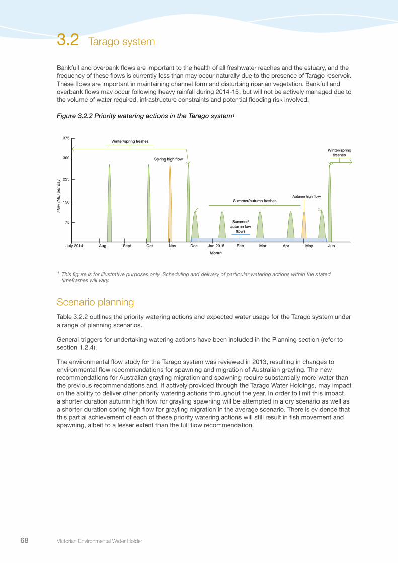
Victorian Environmental Water Holder68
Bankfull and overbank flows are important to the health of all freshwater reaches and the estuary, and the frequency of these flows is currently less than may occur naturally due to the presence of Tarago reservoir. These flows are important in maintaining channel form and disturbing riparian vegetation. Bankfull and overbank flows may occur following heavy rainfall during 2014-15, but will not be actively managed due to the volume of water required, infrastructure constraints and potential flooding risk involved.
Figure 3.2.2 Priority watering actions in the Tarago system1
Winter/spring freshes
Winter/spring freshes
Summer/autumn freshes
Summer/autumn low
flows
Autumn high flow
Spring high flow
75
150
225
300
375
Dec Jan 2015 Feb Mar AprNovOctSeptAug May JunJuly 2014
Month
Flo
w (M
L) p
er d
ay
3.2 Tarago system
1 This figure is for illustrative purposes only. Scheduling and delivery of particular watering actions within the stated timeframes will vary.
Scenario planningTable 3.2.2 outlines the priority watering actions and expected water usage for the Tarago system under a range of planning scenarios.
General triggers for undertaking watering actions have been included in the Planning section (refer to section 1.2.4).
The environmental flow study for the Tarago system was reviewed in 2013, resulting in changes to environmental flow recommendations for spawning and migration of Australian grayling. The new recommendations for Australian grayling migration and spawning require substantially more water than the previous recommendations and, if actively provided through the Tarago Water Holdings, may impact on the ability to deliver other priority watering actions throughout the year. In order to limit this impact, a shorter duration autumn high flow for grayling spawning will be attempted in a dry scenario as well as a shorter duration spring high flow for grayling migration in the average scenario. There is evidence that this partial achievement of each of these priority watering actions will still result in fish movement and spawning, albeit to a lesser extent than the full flow recommendation.

Seasonal Watering Plan 2014–15 69
Table 3.2.2 Priority watering actions for the Tarago system under a range of planning scenarios
Planning scenario
DROUGHT DRY AVERAGE WET
Expected availability of Water Holdings
1,000-1700 ML carryover200 ML allocation1,200-1,900 ML total
1,000-1700 ML carryover500-1,000 ML allocation1,500-2,000 ML total
1,000-1700 ML carryover1,000-2,200 ML allocation2,500-3,700 ML total
1,000-1700 ML carryover2,200-3,500 ML allocation3,900-5,200 ML total
Priority watering actions
Summer/autumn low flows Summer/autumn freshes
Summer/autumn freshesAutumn high flow (partial achievement)*
Summer/autumn freshesAutumn high flowSpring high flow (partial achievement)*
Summer/autumn freshesAutumn high flowSpring high flowWinter/spring freshes
Possible volume required from the Water Holdings
1,000 ML 1,000-1,500 ML 1,500-2,700 ML 0-3,500 ML
Possible carryover into 2015-16
200-900 ML 500-1,200 ML 1,000-1,200 ML 1,000-1,700 ML
* Refer above for information of partial achievement of spring high flows in the Tarago system.
Risk managementIn preparing its seasonal watering proposal, Melbourne Water considered and assessed risks, and identified mitigating strategies, relating to the implementation of priority watering actions (refer to Table 3.2.3). Risks and mitigating actions are continually reassessed by environmental watering program partners throughout the water year.
Table 3.2.3 Risk management in the Tarago system
Risk Mitigating strategies
Release volume is insufficient in meeting required flow at target point
Tarago rainfall/runoff model assists in predicting the release required to meet flow targetsReal-time monitoring of flows at compliance pointsAbility to alter water orders on a daily basis
Current recommendations on environmental flow inaccurate
Flow recommendations are based on the best available scienceMonitoring program to identify if an ecological objective is not being achieved
Storage manager maintenance works affect ability to deliver water
Regular communication with storage manager
Storage manager cannot deliver required volume or flow rate (outlet/capacity constraints, insufficient storage volume)
Seasonally adaptive management approach allows watering actions to be tailored to the volume of water available in the entitlement
Competing environmental objectives do not allow delivery of some events (delivery reach capacity constraints)
Releases will be based on the priority watering actions
Competing storage manager priorities do not allow delivery of some events (fire, flood etc.)
Detailed risk assessment undertaken prior to each release event, to will consider catchment conditions, the seven day weather forecast and the level of communication requiredRelease can be postponed or stopped part way through if a flood warning or watch is issued by the Bureau of MeteorologyFire risk actively monitored and Melbourne Water fire risk guidelines followed
Tarago system 3.2

Victorian Environmental Water Holder70
Risk Mitigating strategies
Releases cause water quality issues (eg. blackwater, low dissolved oxygen, mobilisation of saline pools, acid-sulphate soils etc.)
Continual water quality monitoring to be installed at Drouin West measurement pointWater temperature data in Tarago Reservoir is available through the OLARIS website
Unable to verify that hydrological targets have been reached
Actively monitor gauge performance and report potential errorsCollate reports to feed into capital works project to upgrade the weirs if required
Irrigators divert environmental releases from the system so the target is not reached
Liaise with Southern Rural Water when releases are being made
Environmental water account is overdrawn Accounting principles agreed on with resource managerRegular communication with resource managerResource manager is consulted prior to all releases
Environmental release causes personal injury to river user Detailed risk assessment undertaken prior to each release event to consider catchment conditions, the seven day weather forecast and the level of communication requiredRelease can ben postponed or stopped part way through if a flood warning or watch is issued by the Bureau of Meteorology
Unable to provide evidence in meeting ecological objective
Monitoring program to identify if an ecological objective is not being achieved
Key stakeholders not supportive of environmental water release
Consultation process used to consult key stakeholders during development of seasonal watering proposal
Public misconception about purpose of releases Consultation process used to consult key stakeholders during development of seasonal watering proposalCommunity bulletin issued for releasesMelbourne Water/VEWH webpages updated and signage installed on site
Environmental releases perceived to cause flooding of private land
Overbank and bankfull releases have not been selected as priority watering actions to reduce the risk of floodingA detailed risk assessment will be undertaken prior to each release event to consider catchment conditions, the seven-day weather forecast and the level of communication requiredThe release can be postponed or stopped part way through if a flood warning or watch is issued by the Bureau of Meteorology
Environmental releases cause flooding of public infrastructure, private or public land
ConsultationMelbourne Water has engaged with key stakeholders and other relevant individuals in preparing the seasonal watering proposal for the Tarago system. These stakeholders are included in Table 3.2.4.
Table 3.2.4 Key stakeholders engaged in the development of the seasonal watering proposal for the Tarago system
Stakeholder consultation
Tarago and Bunyip Rivers Environmental Flow Advisory Group including representatives from local councils, irrigators, landholders and Landcare groupsMelbourne Water (Water Supply Operations and Integrated Planning)Southern Rural WaterMelbourne Water BoardVictorian Environmental Water Holder
Table 3.2.3 Risk management in the Tarago system (continued)
3.2 Tarago system
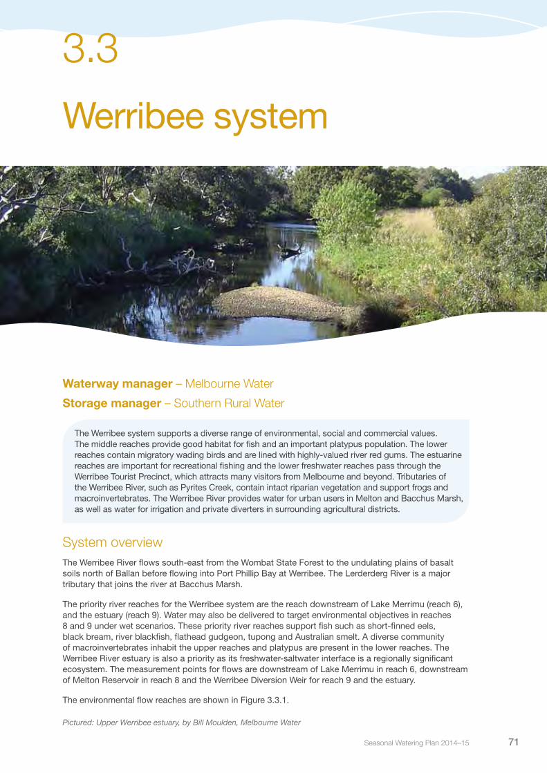
Seasonal Watering Plan 2014–15 71
Werribee system
3.3
Waterway manager – Melbourne Water
Storage manager – Southern Rural Water
The Werribee system supports a diverse range of environmental, social and commercial values. The middle reaches provide good habitat for fish and an important platypus population. The lower reaches contain migratory wading birds and are lined with highly-valued river red gums. The estuarine reaches are important for recreational fishing and the lower freshwater reaches pass through the Werribee Tourist Precinct, which attracts many visitors from Melbourne and beyond. Tributaries of the Werribee River, such as Pyrites Creek, contain intact riparian vegetation and support frogs and macroinvertebrates. The Werribee River provides water for urban users in Melton and Bacchus Marsh, as well as water for irrigation and private diverters in surrounding agricultural districts.
System overviewThe Werribee River flows south-east from the Wombat State Forest to the undulating plains of basalt soils north of Ballan before flowing into Port Phillip Bay at Werribee. The Lerderderg River is a major tributary that joins the river at Bacchus Marsh.
The priority river reaches for the Werribee system are the reach downstream of Lake Merrimu (reach 6), and the estuary (reach 9). Water may also be delivered to target environmental objectives in reaches 8 and 9 under wet scenarios. These priority river reaches support fish such as short-finned eels, black bream, river blackfish, flathead gudgeon, tupong and Australian smelt. A diverse community of macroinvertebrates inhabit the upper reaches and platypus are present in the lower reaches. The Werribee River estuary is also a priority as its freshwater-saltwater interface is a regionally significant ecosystem. The measurement points for flows are downstream of Lake Merrimu in reach 6, downstream of Melton Reservoir in reach 8 and the Werribee Diversion Weir for reach 9 and the estuary.
The environmental flow reaches are shown in Figure 3.3.1.
Pictured: Upper Werribee estuary, by Bill Moulden, Melbourne Water

Victorian Environmental Water Holder72
The Werribee River Environmental Entitlement provides for 10 percent of flows into Lake Merrimu which can be released to the Werribee system from Lake Merrimu and Melton Reservoir. There is no secure access to storage capacity, only opportunistic access to airspace (temporarily unused storage). Lake Merrimu receives a significant amount of inflow from the Lerderderg River via a tunnel system, and operation of this tunnel influences the amount of water available under the environmental entitlement.
In 2014-15, the environment will also have access to 730 ML of high-reliability and 360 ML of low-reliability water shares purchased in the Werribee system by Melbourne Water. Water allocated to the water shares will most likely be released from Melton Reservoir to benefit the lower reaches and estuary.
Figure 3.3.1 The Werribee system
3.3 Werribee system
River
Creek
Cree
k
Creek
River
keer
C
Creek
Creek
•
•
• •
•Ballan
DjerriwarrhWeir
WerribeeLower Werribee
Bacchus Marsh
Werribee South
Cre
ek
Parwan
Skeleton
Pykes
Good
man
s
Pyrit
es
Spring
Tool
ern
CreekMelton Reservoir
Pykes CreekReservoir
Lerderderg
Kororoit
Werribee
Werribee
Werribee
Djer
riwar
rh
Dale
Kororoit
Kororoit River
River
Creek
Creek West Branch Branch
CreekEast
Cree
k
LakeMerrimu
Diversion Weir
Upper WerribeeDiversionWeir
Bacchus Marsh Weir
Melton
1
23
4
5
6
7
8
9
Reach Werribee River: Upstream of Upper Werribee Diversion WeirReach Pykes Creek: Pykes Creek Reservoir to Werribee RiverReach Werribee River: Upper Werribee Diversion Weir to Pykes CreekReach Werribee River: Pykes Creek to Bacchus Marsh WeirReach Werribee River: Bacchus Marsh Weir to Lerderderg RiverReach Pyrites Creek: below Lake Merrimu to Melton ReservoirReach Djerriwarrh Creek: below Djerriwarrh Weir to Melton ReservoirReach Werribee River: Melton Reservoir to Lower Werribee Diversion WeirReach Werribee River: Lower Werribee Diversion Weir to estuary Measurement point Water infrastructure Town
1
2
3
4
5
6
7
8
9
•
Goodmans Creek to Pyrites Creek Tunnel
Lerderberg River to Goodmans Creek Tunnel

Seasonal Watering Plan 2014–15 73
Current situationRainfall and streamflow in the Werribee system was above average from 2010 to 2012, which led to consecutive spills of Melton Reservoir, and Lake Merrimu reaching full supply level for the first time in 15 years. This period of good flows followed a long period of extreme drought, and subsequently environmental flow recommendations in 2010 to 2012 were almost completely achieved.
In 2013, for the first time in three years, there was below average streamflow to the Werribee River and neither reservoir spilled or reached full supply level. Most priority watering actions for reach 6 were partially achieved and provided benefit to fringing vegetation and frogs in pools. In the lower Werribee River and the estuary, the full suite of environmental flow recommendations were not met due to the lack of natural flows and spills. Nonetheless, there were regulated releases in March, April and October 2013 that were delivered to partially meet watering objectives in the lower Werribee reaches and for the benefit of black bream recruitment in the estuary.
Priority watering actions and environmental objectivesPriority watering actions, along with their associated environmental objectives, are provided in Table 3.3.1 and illustrated in Figure 3.3.2 and 3.3.3.
The environmental objectives for 2014-15 focus on enhancing fish populations in the lower reaches and estuary and improving macroinvertebrate populations and vegetation downstream of Lake Merrimu in reach 6. Secondary objectives are to improve vegetation and platypus populations in the lower Werribee reaches and frog populations in Pyrites Creek.
In addition to the environmental objectives, these watering actions will also provide benefits for anglers and other recreational users of the lower reaches.
Table 3.3.1 Priority watering actions and associated environmental objectives for the Werribee system
Priority watering action Environmental objective
Winter/spring/summer freshes in reach 6 (five events [or natural]1 of 40 ML per day for two days each during July to December)
Scour silt and sand from rifflesPromote vegetation growthProvide habitat for pygmy perch and macroinvertebrates
Summer/autumn/winter freshes in reach 6 (four events of 5 ML per day for three days each during December to June)
Maintain pool habitat for pygmy perch and macroinvertebrates
Baseflow of 2 ML per day in reach 6 between May to January (duration to be determined by scientific evidence and community consultation)
Provide frog habitat
Spring/summer freshes in the estuary (two events of 80 ML per day for two days, twice per season during November to February)
Promote juvenile black bream recruitment
Winter/spring baseflows in the estuary (15 ML per day during June to November)
Provide black bream habitat
Autumn freshes in the estuary (three events of 90 ML per day for two days each during March to May)
Provide fish passage between estuary and freshwater reaches
Autumn/winter/spring freshes in the estuary (one event of 140 ML per day for one day during May to November)
Inundate salt marsh with brackish water
Summer/autumn freshes in reach 9 (three events of 137 ML per day [or natural]1 for one day during January to April)
Maintain pool water quality for fish and platypusAllow for fry dispersal and mobilise silt from riffles
Winter/spring/summer flows in reaches 8 and 9, in addition to natural baseflows (targeting 81 ML per day) and freshes (targeting 350 ML per day for five days) during June to December2
Scour silt from rifflesPromote vegetation growth
1 The specification of ‘or natural’ means that in the absence of any upstream extraction or diversion the priority watering action may still be deemed to be met when the inflows are ‘naturally’ providing less than the recommended magnitude, duration or frequency of streamflow.
2 There is not sufficient water available in the Werribee Environmental Entitlement to achieve baseflows and freshes in reaches 8 and 9, however opportunistic watering may occur to supplement flows in the river to achieve these priority watering actions.
Werribee system 3.3

Victorian Environmental Water Holder74
Bankfull and overbank flows are important in maintaining channel form and disturbing riparian vegetation for the overall the health of the system. This may occur naturally in a wet year, but will not be actively managed due to the volume of water required, infrastructure constraints and potential flooding risk involved.
Figure 3.3.2 Priority watering actions in the Werribee River1
Figure 3.3.3 Priority watering actions in Pyrites Creek (Reach 6)1
1 This figure is for illustrative purposes only. Scheduling and delivery of particular watering actions within the stated timeframes will vary.
Month
30
60
90
120
150
Dec Jan 2015 Feb Mar AprNovOctSeptAug May JunJuly 2014
Flo
w (M
L) p
er d
ay
Spring/summer
freshes in the estuary
Winter/spring
baseflows in the
estuary
Autumn freshes in the
estuary
Summer/autumn freshes in reach 9
Winter/spring
baseflows in the
estuary
Autumn/winter/spring fresh in
the estuary
Autumn/winter/spring fresh in
the estuary
10
20
30
40
50
Dec Jan 2015 Feb Mar AprNovOctSeptAug May JunJuly 2014
Month
Flo
w (M
L) p
er d
ay
Summer/autumn/winter freshes
Year-round baseflows
Winter/spring/summer freshes
Year-round baseflows
3.3 Werribee system

Seasonal Watering Plan 2014–15 75
Scenario planningTable 3.3.2 outlines the priority watering actions and expected water usage under a range of planning scenarios.
General triggers for undertaking watering actions have been included in the Planning section (refer to section 1.2.4).
The environmental entitlement in the Werribee system does not include secure storage space in any reservoir and only allows storage in airspace not being used by other entitlements. This means there is some risk in storing and carrying over a large volume of environmental water because if tunnel diversions or inflows are high the water is lost if the reservoir spills. For this reason, large volumes of environmental water will generally not be carried over from one season to the next.
Melbourne Water is currently reviewing the flow recommendations for reach 6. The new environmental flow study is reviewing the environmental objectives for Pyrites Creek and the flow recommendations required to support these objectives. Management approaches may be adapted throughout the year depending upon the outcomes of the study.
Table 3.3.2 Priority watering actions for the Werribee system under a range of planning scenarios
Planning scenario
DROUGHT DRY AVERAGE WET
Expected availability of Water Holdings
800 ML carryover750 ML allocation
1,550 ML total
800 ML carryover950-1,150 ML allocation1,750-1,950 ML total
800 ML carryover1,200-1,700 ML allocation2,000-2,500 ML total
800 ML carryover>1,700 ML allocation
>2,500 ML total
Priority watering actions
Reach 6:Winter/spring/summer fresh
Summer/autumn/winter fresh
Estuary:Spring/summer fresh
Winter/spring baseflow
Reach 6:Year-round low flows
Winter/spring/summer fresh
Summer/autumn/ winter fresh
Estuary:Spring/summer fresh
Autumn fresh
Winter/spring baseflow
Reach 8 and 9:Summer/autumn fresh
Reach 6:Year-round low flows
Winter/spring/summer fresh
Summer/autumn/ winter fresh
Estuary:Spring/summer fresh
Autumn fresh
Winter/spring baseflow
Autumn/winter/ spring fresh
Reach 8 and 9:Summer/autumn fresh
Winter/spring/summer baseflows and freshes
Reach 6:Year-round low flows
Winter/spring/summer fresh
Summer/autumn/ winter fresh
Estuary:Spring/summer fresh
Autumn fresh
Winter/spring baseflow
Autumn/winter/ spring fresh
Reach 8 and 9:Summer/autumn fresh
Winter/spring/summer baseflows and freshes
Possible volume required from the Water Holdings
900 ML 1,500 ML 1,500 ML 2,000 ML
Possible carryover into 2015-16
650 ML 250-450 ML 500-1,000 ML > 500 ML
Werribee system 3.3

Victorian Environmental Water Holder76
Risk managementIn preparing its seasonal watering proposal, Melbourne Water considered and assessed risks, and identified mitigating strategies, relating to the implementation of priority watering actions (refer to Table 3.3.3). Risks and mitigating actions are continually reassessed by environmental watering program partners throughout the water year.
Table 3.3.3 Risk management in the Werribee system
Risk Mitigating strategies
Release volume is insufficient in meeting required flow at target point
To date, orders have generally been slightly higher than required to ensure compliance
Close communication with storage managers and monitoring of losses is increasing the required body of knowledge
Current recommendations on environmental flow are inaccurate
Flow recommendations are based on the best possible science
Monitoring program to identify if an ecological objective is not being achieved
Systematic review of recommendations in 2014
Storage manager maintenance works affect ability to deliver water
There are no major maintenance works planned in 2014
There is sufficient institutional experience in delivering passing flows when maintenance does occur
Storage manager cannot deliver required volume of flow rate (outlet/capacity constraints, insufficient storage volume)
Seasonally adaptive management approach allows watering actions to be tailored to the volume of water available in the entitlement
Competing storage manager priorities do not allow delivery of some events (fire, flood etc.)
Summer freshes can compete with irrigation deliveries for a share of valve capacity under certain circumstances, and coordination with the storage manager has avoided this in the past by changing the scheduling of delivery
Upgrade of valve at Melton has increased capacity
Releases cause water quality issues (eg. blackwater, low dissolved oxygen, mobilisation of saline pools, acid-sulphate soils etc.)
Water quality monitoring is in place to measure effects of releases and preliminary results suggest that water quality impacts are generally beneficial and that blackwater effects are transient and localised to small sections of the estuary that are frequently flushed by tidal action
Unable to provide evidence that hydrological target has been met
Stream flow gauging is adequate
Access to Southern Rural Water’s flow gauging has been negotiated
Irrigators divert environmental releases from the system so the target is not reached
Irrigators must order water releases before they can extract
Storage manager and field staff routinely check compliance
Environmental water account is overdrawn Accounting principles agreed on with resource manager
Regular communication with resource manager
Resource manager is consulted prior to all releases
Environmental release causes personal injury to river user A detailed risk assessment will be undertaken prior to each release event to consider catchment conditions, the seven-day weather forecast and the level of communication required
Delivered flows are low volume and velocity
Unable to provide evidence in meeting ecological objectives
Comprehensive ecological monitoring program is in place
3.3 Werribee system

Seasonal Watering Plan 2014–15 77
Risk Mitigating strategies
Key stakeholders not supportive of environmental water release; public misconception about the purpose of releases; environmental releases perceived to cause flooding
An email list of interested parties has been created and updates on planned watering occur regularly
Interest from Wyndham Council and public enquiries indicates a reasonably widespread level of community interest and support
Environmental releases cause flooding of public infrastructure, private or Crown land
Overbank and bankfull releases have not been selected as priority watering actions to reduce the risk of flooding
Environmental release interferes with essential Melbourne Water service
Regular communication has been established with Melbourne Water river health and maintenance teams and potential risk to delivery of works has been rated as low at a general level
Teams are notified prior to all releases
ConsultationMelbourne Water has engaged with key stakeholders and other relevant individuals in preparing the seasonal watering proposal for the Werribee system. These stakeholders are included in Table 3.3.4.
Table 3.3.4 Key stakeholders engaged in the development of the seasonal watering proposal for the Werribee system
Stakeholder consultation
Werribee River Community Advisory Group including representatives from Western Wyndham, Melton and Moorabool Councils, ‘Friends of’ groups, Landcare groups and fishing clubsSouthern Rural Water and licensed divertersMelbourne Water BoardVictorian Environmental Water Holder
Table 3.3.3 Risk management in the Werribee system (continued)
Werribee system 3.3

Victorian Environmental Water Holder78
Moorabool system
3.4
Waterway manager – Corangamite Catchment Management Authority
Storage manager – Central Highlands Water
The Moorabool system sustains native fish of high conservation significance, platypus populations and stands of significant remnant vegetation, including river red gums, silver wattle and woolly tea tree. The Moorabool is an important catchment for the major urban centres of Geelong and Ballarat, and sustains economic values by contributing to extensive agricultural practices. Local communities have a strong historical connection to the river, which provides many social and recreational opportunities through its spectacular scenery, parks, picnic sites, lookouts, swimming holes, fishing spots and historic bridges.
System overviewThe Moorabool River flows southward from the Central Highlands between Ballarat and Ballan, passing through State Forest near Meredith and flowing south to join the Barwon River at Fyansford. The Moorabool River’s catchment is heavily farmed with about three-quarters of its catchment area used for agriculture. It is a highly regulated waterway with several large water storages in the upper reaches including Lal Lal Reservoir. In the lower reach, between She Oaks and Batesford, there are nine private diversion weirs that are a significant barrier to fish. These barriers have increased the extent of slow-flowing habitat and reduced habitat diversity in the lower reach of the Moorabool. Despite this development, years of drought, and large volumes of water extraction, the river still retains significant environmental values.
Pictured: Moorabool River, by Corangamite CMA
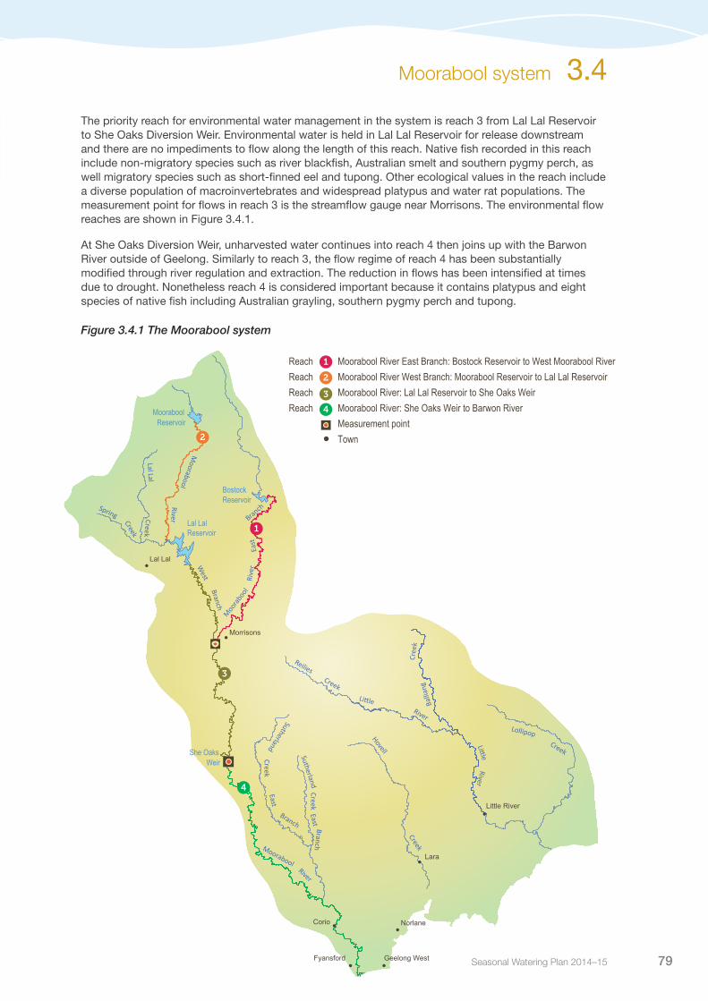
Seasonal Watering Plan 2014–15 79
The priority reach for environmental water management in the system is reach 3 from Lal Lal Reservoir to She Oaks Diversion Weir. Environmental water is held in Lal Lal Reservoir for release downstream and there are no impediments to flow along the length of this reach. Native fish recorded in this reach include non-migratory species such as river blackfish, Australian smelt and southern pygmy perch, as well migratory species such as short-finned eel and tupong. Other ecological values in the reach include a diverse population of macroinvertebrates and widespread platypus and water rat populations. The measurement point for flows in reach 3 is the streamflow gauge near Morrisons. The environmental flow reaches are shown in Figure 3.4.1.
At She Oaks Diversion Weir, unharvested water continues into reach 4 then joins up with the Barwon River outside of Geelong. Similarly to reach 3, the flow regime of reach 4 has been substantially modified through river regulation and extraction. The reduction in flows has been intensified at times due to drought. Nonetheless reach 4 is considered important because it contains platypus and eight species of native fish including Australian grayling, southern pygmy perch and tupong.
Figure 3.4.1 The Moorabool system
Moorabool system 3.4
Lal LalReservoir
Hovell
Lollipop
Reilies Creek
Cree
k
River
River
Spring
Moorabool
Lal Lal
Moorabool
Sutherland
Balli
ang
She Oaks
Morrisons
Lal Lal
River
River
West
Branch
Moo
raboo
l Ri
ver
East
Branch
Creek
Creek
Creek
Creek
Weir
East k
eerC
Branch
Sutherland East
kee
rC
Branch
Moorabool Reservoir
BostockReservoir
1
2
3
4
Reach Moorabool River East Branch: Bostock Reservoir to West Moorabool RiverReach Moorabool River West Branch: Moorabool Reservoir to Lal Lal ReservoirReach Moorabool River: Lal Lal Reservoir to She Oaks WeirReach Moorabool River: She Oaks Weir to Barwon River Measurement point Town•
1
2
3
4
Lara
Corio Norlane
Fyansford
Little River
Geelong West•
•
•
•
•
•
•
•
Victorian Environmental Water Holder80
Current situationFrom 2010 to 2012, following an extended period of drought, virtually all the environmental flow requirements of the Moorabool River were provided. In the winter of 2010, there were large flows into water storages and right down the length of the Moorabool River. Rainfall in 2011 and 2012 resulted in Lal Lal Reservoir spilling in spring 2012 and passing flows from Lal Lal Reservoir to the Moorabool River continuing into summer.
Dry conditions returned in 2013 and the full suite of flow requirements have not been achieved since. Nonetheless, there has been sufficient allocation in the environmental entitlement to deliver priority summer flows as planned in 2013-14. Allocations to water corporations, and subsequent usage, has also contributed to environmental flows to support fish and other aquatic fauna.
The volume of regulated water available to the Moorabool Environmental Entitlement is 2,500 ML per year on average. At the commencement of the water year, the entitlement has more than 2,000 ML of water available for use. Inflows during winter and spring are expected to increase the volume available, which can be stored for future years and will also contribute to passing flows from Lal Lal reservoir of up to 5 ML per day during 2014-15.
Priority watering actions and environmental objectivesPriority watering actions for reach 3 along with their associated environmental objectives, are provided in Table 3.4.1 and illustrated in Figure 3.4.2.
The environmental objectives focus on supporting fish, macroinvertebrates, vegetation, habitat, and physical processes, as well as meeting water quality targets.
In addition to the environmental objectives, these watering actions will also provide improved conditions at the many parks, picnic spots, swimming holes, camping sites and fishing sites located along the length of the Moorabool River.
Table 3.4.1 Priority watering actions and environmental objectives for the Moorabool system
Priority watering action Environmental objective
Summer/autumn freshes (three events of greater than 31 ML per day for 10 days each during December to May)
Allow upstream movement of Australian smeltReshape the channel form to maintain physical processes and habitat diversity and complexity
Summer/autumn low flows (average of 20 ML per day during December to May)
Provide habitat for short-finned eel, southern pygmy perch and Australian smeltMaintain in-stream macrophyte species diversity and woody debris habitat within the riverMaintain water quality
Winter fresh (greater than 146 ML per day for five days during June)1
Maintain macroinvertebrate communityLimit encroachment of in-stream vegetation and species common to non-flowing water-bodiesReinstate appropriate water quality
Winter low flows (86 ML per day during June)1 Assist with providing adequate habitat for short-finned eel, southern pygmy perch and Australian smeltMaintain in-steam macrophyte species diversity and woody debris/snag habitat
1 A winter fresh and winter low flows will only be delivered in June providing there is sufficient water available in the environmental entitlement at this time.
3.4 Moorabool system

Seasonal Watering Plan 2014–15 81
1 This figure is for illustrative purposes only. Scheduling and delivery of particular watering actions within the stated timeframes will vary.
While reach 4 is not listed as a priority, with the water available under the Moorabool Environment Entitlement, monitoring has shown that environmental water releases are regularly recorded through to the end of reach 4. Water quality monitoring has also shown improved water quality in reach 4 since the establishment of the environmental entitlement. Where possible, environmental releases will be managed to ensure as much water as possible is able to pass into reach 4 to maintain such improvements in condition.
Winter and spring high flows are important to the Moorabool system, particularly to limit encroachment of vegetation in the channel and also to flush organic matter and sediment that has accumulated in pools. However, these flows cannot be actively delivered due to water availability and outlet capacity limitations.
Scenario planningTable 3.4.2 outlines the priority watering actions and expected water use under a range of planning scenarios.
General triggers for undertaking watering actions have been included in the Planning section (refer to section 1.2.4).
Use of the water from the environmental entitlement is restricted to a maximum of 7,500 ML in any consecutive three years. The entitlement is managed by curbing use to a maximum of 2,500 ML in any given year, thereby ensuring 7,500 ML is not exceeded in a rolling three-year period. With a maximum of 2,500 ML available per year, there is insufficient water to meet all flow recommendations. Summer flows, which are achievable through use of the expected 2,500 ML of water available, have been prioritised over winter flows. This strategy minimises ecological risk to the Moorabool River in the longer term by ensuring that the volume of water held in the entitlement is available for use to protect water quality and fish in summer if dry conditions eventuate and persist. Over summer, water quality will be monitored at six sites between Lal Lal Reservoir and She Oaks Diversion Weir. If water quality declines below a set of trigger levels for dissolved oxygen, electrical conductivity and water temperature, environmental water may be released to assist in improving water quality.
Figure 3.4.2 Priority watering actions in the Moorabool system1
50
100
150Winter fresh
Summer/autumn freshes
Summer/autumn low flows
Winter low flows
Dec Jan 2015 Feb Mar AprNovOctSeptAug May JunJuly 2014
Month
Flo
w (M
L) p
er d
ayMoorabool system 3.4

Victorian Environmental Water Holder82
Table 3.4.2 Priority watering actions for the Moorabool system under a range of planning scenarios
Planning scenario
DROUGHT DRY AVERAGE WET
Expected availability of Water Holdings
2,000-7,000 ML 4,000-7,000 ML 7,000 ML 7,000 ML
Priority watering actions
Summer/autumn freshesSummer/autumn low flows
Summer/autumn freshesSummer/autumn low flowsWinter/spring fresh
Summer/autumn freshes1
Summer/autumn low flowsWinter/spring fresh1
Winter low flow
Summer/autumn freshes1
Summer/autumn low flowsWinter/spring fresh1
Winter low flow
Possible volume required from the Water Holdings
500-2,500 ML 1,500-2,500 ML 2,500 ML 2,500 ML
Possible carryover into 2015-162 1,500-4,500 ML 2,500-4,500 ML 4,500 ML > 4,500 ML
1 Target flow rates may be increased to ensure flows are sustained below the She Oaks Diversion Weir (into reach 4). 2 Use of water from the Moorabool environmental entitlement is restricted to an average of 2,500 ML use over a rolling
three-year period.
Risk managementIn preparing its seasonal watering proposal, the Corangamite Catchment Management Authority considered and assessed risks, and identified mitigating strategies, relating to the implementation of priority watering actions (refer to Table 3.4.3). Risks and mitigating actions are continually reassessed by environmental watering program partners throughout the water year.
Table 3.4.3 Risk management in the Moorabool system
Risk type Mitigating strategies
Release volume is insufficient in meeting required flow at target point
Monitor flow at measurement point and readjust release volumes if necessaryRelease environmental flows in conjunction with releases for consumptive use or when passing flows increase due to rainfall
Current recommendations on environmental flow inaccurate
Monitor water quality, and where possible, ecology
Storage manager maintenance works affect ability to deliver water
Ongoing dialogue with Central Highlands Water to determine best timing for proposed works
Storage manager cannot deliver required volume or flow rate (insufficient storage volume)
Time freshes to coincide with natural rainfall events and/or Barwon Water releases so less water from the entitlement is used leaving more to be used for winter low flow requirements
Limited catchment management authority resource to deliver environmental release
Resource capacity assessed before environmental release
Cost of delivery exceeds available funding Cost of delivery and funding monitored
Environmental release causes personal injury to river user Media release prepared to inform community of summer fresh and winter fresh flows
Blue-green algae bloom in reservoir resulting in cessation of environmental flows
Environmental water delivery will be discontinued if it is considered that it will cause a blue-green algae event in the river
3.4 Moorabool system

Seasonal Watering Plan 2014–15 83
Risk type Mitigating strategies
Releases cause blackwater events Monitor water quality before, during and after releases, and if water quality issues occur, discuss options with Barwon Water and Central Highlands Water and develop an action plan
Improved conditions for non-native species including redfin and carp
Monitor where possible
Environmental water account is overdrawn Environmental release volumes are tracked on a regular basis when a release is in progressCorangamite Catchment Management Authority release requests are cross checked against Central Highlands Water figures
Environmental releases cause flooding to public infrastructure, private or Crown land
Media release before winter fresh flowMonitor water releasesIf a flood watch is issued by the Bureau of Meteorology, environmental water releases will be stopped
Unable to provide evidence in meeting ecological objective
Ongoing evaluation of monitoring results and implementation of recommendations
Key stakeholders unsupportive of environmental water releases
Community meeting prior to seasonal watering proposalCommunication with stakeholders through media prior to environmental water release
ConsultationCorangamite Catchment Management Authority has engaged with key stakeholders and other relevant individuals in preparing the seasonal watering proposal for the Moorabool system. These stakeholders are included in Table 3.4.4.
Table 3.4.4 Key stakeholders engaged in the development of the seasonal watering proposal for the Moorabool system
Stakeholder consultation
People for a Living Moorabool (made up of community members)Waterwatch volunteers Department of Environment and Primary IndustriesSouthern Rural WaterCentral Highlands WaterBarwon WaterVictorian Environmental Water Holder
Table 3.4.3 Risk management in the Moorabool system (continued)
Moorabool system 3.4
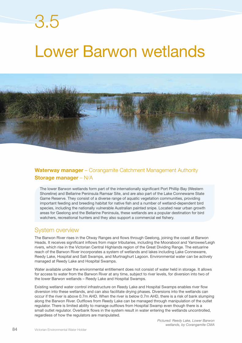
Victorian Environmental Water Holder84
Lower Barwon wetlands
3.5
Waterway manager – Corangamite Catchment Management AuthorityStorage manager – N/A
The lower Barwon wetlands form part of the internationally significant Port Phillip Bay (Western Shoreline) and Bellarine Peninsula Ramsar Site, and are also part of the Lake Connewarre State Game Reserve. They consist of a diverse range of aquatic vegetation communities, providing important feeding and breeding habitat for native fish and a number of wetland-dependent bird species, including the nationally vulnerable Australian painted snipe. Located near urban growth areas for Geelong and the Bellarine Peninsula, these wetlands are a popular destination for bird watchers, recreational hunters and they also support a commercial eel fishery.
System overviewThe Barwon River rises in the Otway Ranges and flows through Geelong, joining the coast at Barwon Heads. It receives significant inflows from major tributaries, including the Moorabool and Yarrowee/Leigh rivers, which rise in the Victorian Central Highlands region of the Great Dividing Range. The estuarine reach of the Barwon River incorporates a system of wetlands and lakes including Lake Connewarre, Reedy Lake, Hospital and Salt Swamps, and Murtnaghurt Lagoon. Environmental water can be actively managed at Reedy Lake and Hospital Swamps.
Water available under the environmental entitlement does not consist of water held in storage. It allows for access to water from the Barwon River at any time, subject to river levels, for diversion into two of the lower Barwon wetlands – Reedy Lake and Hospital Swamps.
Existing wetland water control infrastructure on Reedy Lake and Hospital Swamps enables river flow diversion into these wetlands, and can also facilitate drying phases. Diversions into the wetlands can occur if the river is above 0.7m AHD. When the river is below 0.7m AHD, there is a risk of bank slumping along the Barwon River. Outflows from Reedy Lake can be managed through manipulation of the outlet regulator. There is limited ability to manage outflows from Hospital Swamp even though there is a small outlet regulator. Overbank flows in the system result in water entering the wetlands uncontrolled, regardless of how the regulators are manipulated.
Pictured: Reedy Lake, Lower Barwon wetlands, by Corangamite CMA

Seasonal Watering Plan 2014–15 85
Rive
r
Creek
Retreat Creek
•
•
•
Ballarat
Barwon
Boundary Creek
Yarrowee
River
Dewing CreekRiver
East Branch
Barwon River W
est
Branch
Birregurra
Deans Marsh
Creek
Yarrowee
Leigh
River
Warram
bine
Creek
Native Hut
Creek
Barwon River
Barwon
Waurn Ponds Creek
Pennyroyal Creek
Creek
Williamson
Lal LalReservoir
Hovell
Lollipop
Reilies Creek
Cree
k
RiverLittle
Little
River
SpringM
oorabool
Lal Lal
Moorabool
Balli
ang
Morrisons
Lal Lal
River
RiverW
est Branch
Moo
rabo
ol
Rive
r East
BranchCreek
Creek
Creek
Creek
East
Sutherland Creek
Branch
MooraboolReservoir
BostockReservoir
Lara
Corio
Fyansford
Norlane
Little River
Geelong West•
•
•
•
•
•
•
•
Geelong
Barwon Heads
• Measurement point Town
•
•
Geelong
Barwon Heads
Salt Swamp
Hospital Swamp
Lake Connewarre
Murtnagurt Swamp
Barwon
River
Wetlands
Reedy Lake
Rive
r
Creek
Retreat Creek
•
•
•
Ballarat
Barwon
Boundary Creek
Yarrowee
River
Dewing CreekRiver
East Branch
Barwon River W
est
Branch
Birregurra
Deans Marsh
Creek
Yarrowee
Leigh
River
Warram
bine
Creek
Native Hut
Creek
Barwon River
Barwon
Waurn Ponds Creek
Pennyroyal CreekCreek
Williamson
Lal LalReservoir
Hovell
Lollipop
Reilies Creek
Cree
k
RiverLittle
Little
River
Spring
Moorabool
Lal Lal
Moorabool
Balli
ang
Morrisons
Lal Lal
River
RiverW
est Branch
Moo
rabo
ol
Rive
r East
BranchCreek
Creek
Creek
Creek
East
Sutherland Creek
Branch
MooraboolReservoir
BostockReservoir
Lara
Corio
Fyansford
Norlane
Little River
Geelong West•
•
•
•
•
•
•
•
Geelong
Barwon Heads
• Measurement point Town
•
•
Geelong
Barwon Heads
Salt Swamp
Hospital Swamp
Lake Connewarre
Murtnagurt Swamp
Barwon
River
Wetlands
Reedy Lake
Reedy Lake and Hospital Swamps support aquatic vegetation communities that provide important feeding and breeding habitat for native fish, including Australian grayling, dwarf galaxias, and Yarra pygmy perch. They also support wetland-dependent bird species, including the threatened Australian painted snipe, Latham’s snipe, Caspian tern and whiskered tern.
Figure 3.5.1 The Barwon River and lower Barwon wetland system
Lower Barwon wetlands 3.5

Victorian Environmental Water Holder86
Current situationBetween 1997 and 2010, the lower Barwon River experienced low river flows and therefore irregular inundation of the lower Barwon wetland system. Post-2010, the conditions have improved which has resulted in regular inundation of Reedy Lake and Hospital Swamps, increasing the potential for fish breeding and migration. January and February 2014 were dry in comparison, causing a drop in water levels across most wetlands. The recent short-term drying phase in Hospital Swamps has been beneficial for vegetation establishment, which in turn supports a diverse array of birds.
The establishment of channel works, culvert installation, and levee banks in the wetlands has resulted in Reedy Lake remaining full most years in the recent past. This has changed the natural wetting and drying cycle of the wetland, reduced the overall habitat diversity of the wetland, and increased the abundance of tall reeds.
Corangamite Catchment Management Authority has facilitated substantial consultation with stakeholders and undertaken a number of investigations to determine the best way to manage the water regime at Reedy Lake. A scientific study has recommended an intermittent drying regime for Reedy Lake as the best approach to protect the ecological character of the wetland. However, concerns have been expressed that an intermittent drying regime may impact commercial interests at Reedy Lake. Until the environmental, social, cultural and economic aspects relevant to water management are clearer, a drying regime at Reedy Lake will not be implemented.
3.5 Lower Barwon wetlands
Pictured: Hospital Swamps, Lower Barwon wetlands, by Corangamite CMA
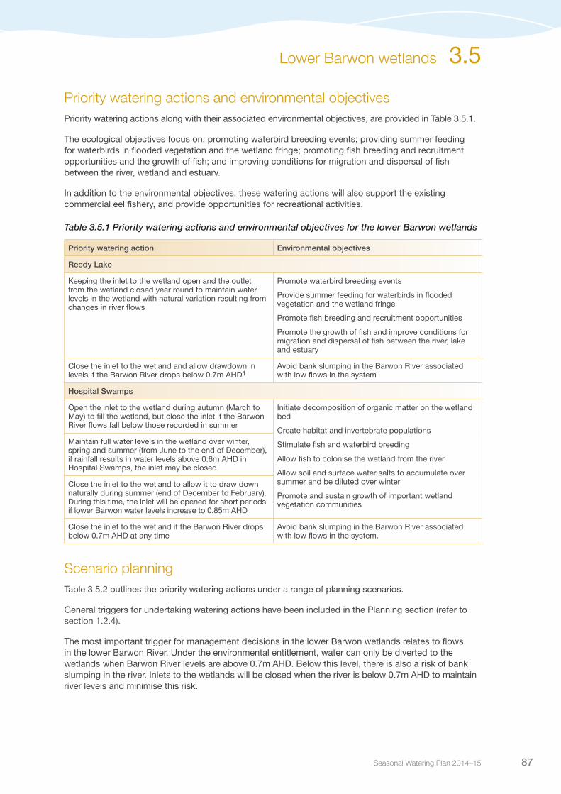
Seasonal Watering Plan 2014–15 87
Priority watering actions and environmental objectivesPriority watering actions along with their associated environmental objectives, are provided in Table 3.5.1.
The ecological objectives focus on: promoting waterbird breeding events; providing summer feeding for waterbirds in flooded vegetation and the wetland fringe; promoting fish breeding and recruitment opportunities and the growth of fish; and improving conditions for migration and dispersal of fish between the river, wetland and estuary.
In addition to the environmental objectives, these watering actions will also support the existing commercial eel fishery, and provide opportunities for recreational activities.
Table 3.5.1 Priority watering actions and environmental objectives for the lower Barwon wetlands
Priority watering action Environmental objectives
Reedy Lake
Keeping the inlet to the wetland open and the outlet from the wetland closed year round to maintain water levels in the wetland with natural variation resulting from changes in river flows
Promote waterbird breeding events
Provide summer feeding for waterbirds in flooded vegetation and the wetland fringe
Promote fish breeding and recruitment opportunities
Promote the growth of fish and improve conditions for migration and dispersal of fish between the river, lake and estuary
Close the inlet to the wetland and allow drawdown in levels if the Barwon River drops below 0.7m AHD1
Avoid bank slumping in the Barwon River associated with low flows in the system
Hospital Swamps
Open the inlet to the wetland during autumn (March to May) to fill the wetland, but close the inlet if the Barwon River flows fall below those recorded in summer
Initiate decomposition of organic matter on the wetland bed
Create habitat and invertebrate populations
Stimulate fish and waterbird breeding
Allow fish to colonise the wetland from the river
Allow soil and surface water salts to accumulate over summer and be diluted over winter
Promote and sustain growth of important wetland vegetation communities
Maintain full water levels in the wetland over winter, spring and summer (from June to the end of December), if rainfall results in water levels above 0.6m AHD in Hospital Swamps, the inlet may be closed
Close the inlet to the wetland to allow it to draw down naturally during summer (end of December to February). During this time, the inlet will be opened for short periods if lower Barwon water levels increase to 0.85m AHD
Close the inlet to the wetland if the Barwon River drops below 0.7m AHD at any time
Avoid bank slumping in the Barwon River associated with low flows in the system.
Scenario planningTable 3.5.2 outlines the priority watering actions under a range of planning scenarios.
General triggers for undertaking watering actions have been included in the Planning section (refer to section 1.2.4).
The most important trigger for management decisions in the lower Barwon wetlands relates to flows in the lower Barwon River. Under the environmental entitlement, water can only be diverted to the wetlands when Barwon River levels are above 0.7m AHD. Below this level, there is also a risk of bank slumping in the river. Inlets to the wetlands will be closed when the river is below 0.7m AHD to maintain river levels and minimise this risk.
Lower Barwon wetlands 3.5

Victorian Environmental Water Holder88
Table 3.5.2 Priority watering actions for the lower Barwon wetlands under a range of planning scenarios
Planning scenario
DRY AVERAGE WET
Expected availability of Water Holdings
N/A – use of water based on river levels
N/A – use of water based on river levels
N/A – use of water based on river levels
Reedy Lake
Priority watering actions Open inlet and maintain water in wetland over winterClose inlet to wetland if water levels in Barwon River fall below 0.7m AHD
Open inlet and maintain water in wetland throughout seasonClose inlet to wetland if water levels in Barwon River fall below 0.7m AHD
Open inlet and maintain water in wetland throughout season (overbank flows likely to inundate the wetland during winter as a result of higher river flows, stormwater inflows and local rain/runoff)
Hospital Swamps
Priority watering actions Open inlet to wetland when flows in Barwon River increase in autumn Allow wetland water level to draw down over summerClose inlet to wetland if water levels in Barwon River fall below 0.7m AHD
Open inlet to wetland when flows in Barwon River increase in autumnAllow wetland water level to draw down over summerClose inlet to wetland if water levels in Barwon River fall below 0.7m AHD
Open inlet to wetland when flows in Barwon River increase in autumn (overbank flows likely to inundate the wetland during winter as a result of higher river flows, stormwater inflows and local rain/runoff)
Risk managementIn preparing its seasonal watering proposal, the Corangamite Catchment Management Authority considered and assessed risks, and identified mitigating strategies, relating to the implementation of priority watering actions (refer to Table 3.5.3). Risks and mitigating actions are continually reassessed by environmental watering program partners throughout the water year.
Table 3.5.3 Risk management in the lower Barwon wetlands
Risk type Mitigating strategies
Inability to achieve management recommendations Monitor Barwon River flow and water levels in the wetlands; results will be used to inform future seasonal watering proposalThe watering regime identified for 2014-15 is favourable to tall reeds in Reedy Lake, but it is unlikely that it will cause irreversible harm to the wetland if implemented for this year
Current recommendations on environmental flow inaccurate
Undertake ongoing evaluation of monitoring results and implementation of flow recommendations; results will be used to inform future seasonal watering proposalsFurther investigations are also underway to inform future management
Maintenance works affect ability to deliver water Schedule structure upgrades to coincide with wetland drying where possible
Reeds growing in channels limit the ability to deliver environmental water
Annual use of an amphibious weed cutter to keep channels clear, or when deemed necessary
Limited catchment management authority resource to deliver environmental release
Allocate time for monitoring and gate operation
Environmental releases cause personal injury to river user High flow rates are not expected as a result of infrastructure operation
3.5 Lower Barwon wetlands

Seasonal Watering Plan 2014–15 89
Risk type Mitigating strategies
Releases cause water quality issues Monitor water quality and take action if necessary/possible based on best available information
Improved conditions for non-native species Carp screens have been installed on the inlet to Reedy Lake
Blue-green algae If the growth conditions in Reedy Lake or Hospital Swamps are conducive to blue-green algae, independent expert advice indicates it will bloom irrespective of connectivity to the Barwon River, therefore there is no plan to disconnect the wetlands from the Barwon River in the event of an algal bloom
Environmental releases cause flooding of public infrastructure, private or Crown land
Ongoing consultation and agreements put in place with impacted landholders where possibleRules are in place to minimise this riskAny flooding of public infrastructure will be the result of natural flood eventsWork closely with and seek endorsement from the public land manager, Parks Victoria
Unable to provide evidence in meeting ecological objective
Ongoing evaluation of monitoring results and implementation of recommendations Tall reed monitoring currently underway
Key stakeholders unsupportive of environmental water release
Community Advisory Committee establishedStakeholder involvement in monitoring activitiesOngoing stakeholder engagement
Environmental water management impacts on other users Continue to work with, and assess impact to commercial users of the lower Barwon WetlandsAs there is no proposal to dry Reedy Lake in 2013-14, the risk of impacting other users is low
Unable to provide evidence in meeting ecological objective
Ongoing evaluation of monitoring results and implementation of recommendationsTall reed monitoring currently underway
Key stakeholders not supportive of environmental water release
Community Advisory Committee establishedStakeholder involvement in monitoring activitiesOngoing stakeholder engagement
ConsultationCorangamite Catchment Management Authority has engaged with key stakeholders and other relevant individuals in the preparation of the seasonal watering proposal for the lower Barwon wetlands. These stakeholders are included in Table 3.5.4.
Table 3.5.4 Key stakeholders engaged in the development of the seasonal watering proposal for the lower Barwon Wetlands
Stakeholder consultation
Lower Barwon Wetlands Advisory Group including representatives from Field and Game Geelong Branch, Geelong Environment Council, Geelong Field Naturalists, Geelong Gun and Rod Association, Federation University, RMIT University, local landowners, community members and local commercial eel fishing licence holdersScientific consultantsLocal Member of ParliamentDepartment of Environment and Primary Industries (Fisheries)Department of Environment and Primary Industries (Water Group)Parks VictoriaCorangamite Catchment Management Authority Board, management and staffVictorian Environmental Water Holder
Table 3.5.3 Risk management in the lower Barwon wetlands (continued)
Lower Barwon wetlands 3.5
Related Documents