11/14/2016 Seaglider File Formats Manual https://sahale.apl.washington.edu/svn/Archive/software/releases/main66.12/docs/File_Formats_Man.html 1/18 Seaglider File Formats Manual SCHOOL OF OCEANOGRAPHY and APPLIED PHYSICS LABORATORY UNIVERSITY OF WASHINGTON Version 66.12 April 2012 Chapter 1 Conventions and Introduction 1.1 Conventions Example files are given in bold Courier font. Direct annotations of files are given in smaller font. Parameters are in UPPER CASE BOLD font, and have a preceding $. File names that are used in Seaglider command, control, or operations are given in lowercase bold font. Documents and sections of documents are italicized. 123 is used throughout this document as a placeholder for Seaglider serial number, and 55 is used as a placeholder for dive number. Many file names include a three digit Seaglider serial number, followed by a four digit dive number, both with preceding zeros (e.g. p1230055.log). Numerals after the dot in a file name are represented by 0's and, when additional numerals are needed, 9's. Because they represent various meanings, numerals after the dot are always annotated the first time the file name appears, and in the file description heading. 1.2 Introduction This manual is designed to help the Seaglider user identify and interpret files he or she will encounter on the basestation. It is to be used in conjunction with the Seaglider Pilot's Guide, Parameter Reference Manual, and Extended PicoDOS Reference Manual. 1.2.1 List of Files Found on the Basestation (using SG132, dive 55, for example file names) These files are described in the document below. processed_files.cache baselog_080221110101 baselog.log sg_calib_constants.m cmdfile comm.log p1230055.asc p1230055.cap p1230055.dat p1230055.eng p1230055.log p1230055.pro p1230055.bpo p1230055.pvt p indicates that these files have been processed by the basestation. They are the files that contain information from the glider, for use by the pilot, operator, and scientist. p1230000.prm This file is sent at the end of a self test. Contains a list of the parameters and their settings at the time of the self test, and some information about the transmission of files during the self test. cmdedit.log targedit.log sciedit.log These files are made by the basestation, and document each change made to the command file, targets file, and science file using cmdedit, targedit, and sciedit. comm_merged.log Merged comm log and history history.log Record of shell commands cmdfile.0 targets.0 science.0 p1230055.000.pdos Every time a cmdfile, targets file, or science file is taken up by the glider, it is saved on the basestation and renamed to include the dive number. PDOS command files are also saved, but already include the dive number, so they are saved with a serial number. If there are multiple calls on one surfacing, a cmdfile is sent each time, and a serial number is added after the dive number. These files are intermediates found on the basestation. They are used to create the processed files documented in this manual. Characters in the file names indicate the following: st0055du.1a.x00 st0055du.r st0055du.x00 d indicates that these intermediate files will be used to create a data file. st0055lu.1a.x00 st0055lu.x00 l indicates that these intermediate files will be used to create a log file.

Welcome message from author
This document is posted to help you gain knowledge. Please leave a comment to let me know what you think about it! Share it to your friends and learn new things together.
Transcript

11/14/2016 Seaglider File Formats Manual
https://sahale.apl.washington.edu/svn/Archive/software/releases/main66.12/docs/File_Formats_Man.html 1/18
Seaglider File Formats ManualSCHOOL OF OCEANOGRAPHY
andAPPLIED PHYSICS LABORATORY
UNIVERSITY OF WASHINGTONVersion 66.12 April 2012
Chapter 1Conventions and Introduction
1.1 Conventions
Example files are given in bold Courier font. Direct annotations of files are given in smaller font. Parameters are in UPPER CASE BOLD font, and have apreceding $. File names that are used in Seaglider command, control, or operations are given in lowercase bold font. Documents and sections of documents areitalicized.
123 is used throughout this document as a placeholder for Seaglider serial number, and 55 is used as a placeholder for dive number. Many file names include a threedigit Seaglider serial number, followed by a four digit dive number, both with preceding zeros (e.g. p1230055.log). Numerals after the dot in a file name arerepresented by 0's and, when additional numerals are needed, 9's. Because they represent various meanings, numerals after the dot are always annotated the firsttime the file name appears, and in the file description heading.
1.2 Introduction
This manual is designed to help the Seaglider user identify and interpret files he or she will encounter on the basestation. It is to be used in conjunction with theSeaglider Pilot's Guide, Parameter Reference Manual, and Extended PicoDOS Reference Manual.
1.2.1 List of Files Found on the Basestation(using SG132, dive 55, for example file names)
These files are described in the documentbelow.
processed_files.cachebaselog_080221110101baselog.logsg_calib_constants.mcmdfilecomm.logp1230055.ascp1230055.capp1230055.datp1230055.engp1230055.logp1230055.prop1230055.bpop1230055.pvt
p indicates that these files have been processed by the basestation. They arethe files that contain information from the glider, for use by the pilot, operator,and scientist.
p1230000.prm This file is sent at the end of a self test. Contains a list of the parameters andtheir settings at the time of the self test, and some information about thetransmission of files during the self test.
cmdedit.logtargedit.logsciedit.log
These files are made by the basestation, and document each change madeto the command file, targets file, and science file using cmdedit, targedit, andsciedit.
comm_merged.log Merged comm log and history
history.log Record of shell commands
cmdfile.0targets.0science.0p1230055.000.pdos
Every time a cmdfile, targets file, or science file is taken up by the glider, itis saved on the basestation and renamed to include the dive number. PDOScommand files are also saved, but already include the dive number, so theyare saved with a serial number. If there are multiple calls on one surfacing, acmdfile is sent each time, and a serial number is added after the divenumber.
These files are intermediates found on thebasestation. They are used to create theprocessed files documented in this manual.Characters in the file names indicate thefollowing:
st0055du.1a.x00st0055du.rst0055du.x00
d indicates that these intermediate files will be used to create a data file.
st0055lu.1a.x00st0055lu.x00 l indicates that these intermediate files will be used to create a log file.
11/14/2016 Seaglider File Formats Manual
https://sahale.apl.washington.edu/svn/Archive/software/releases/main66.12/docs/File_Formats_Man.html 2/18
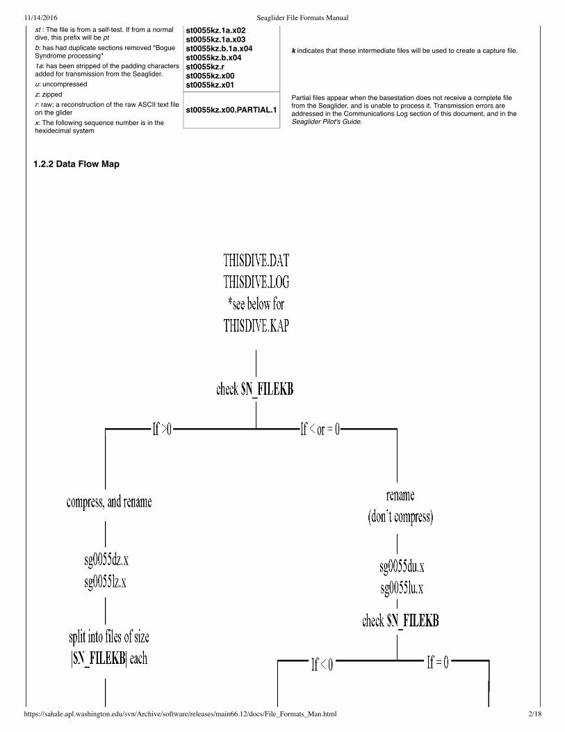
st : The file is from a self-test. If from a normaldive, this prefix will be ptb: has had duplicate sections removed "BogueSyndrome processing"1a: has been stripped of the padding charactersadded for transmission from the Seaglider.u: uncompressedz: zippedr: raw; a reconstruction of the raw ASCII text fileon the gliderx: The following sequence number is in thehexidecimal system
st0055kz.1a.x02st0055kz.1a.x03st0055kz.b.1a.x04st0055kz.b.x04st0055kz.rst0055kz.x00st0055kz.x01
k indicates that these intermediate files will be used to create a capture file.
st0055kz.x00.PARTIAL.1Partial files appear when the basestation does not receive a complete filefrom the Seaglider, and is unable to process it. Transmission errors areaddressed in the Communications Log section of this document, and in theSeaglider Pilot's Guide.
1.2.2 Data Flow Map

11/14/2016 Seaglider File Formats Manual
https://sahale.apl.washington.edu/svn/Archive/software/releases/main66.12/docs/File_Formats_Man.html 3/18

11/14/2016 Seaglider File Formats Manual
https://sahale.apl.washington.edu/svn/Archive/software/releases/main66.12/docs/File_Formats_Man.html 4/18
start: 7 17 106 19 24 20, day and time (UTC) of start of dive
second (UTC, starting with 0)
minute (UTC, starting with 0)
hour (UTC, starting with 0)
year after 1900
day of month
month
Chapter 2File Descriptions
This section describes the files relevant to the Seaglider user. Where appropriate, excerpts from real files, with explanatory annotation, are shown.
2.1 Processed Files
2.1.1 Log File(p1230055.log)
One log file is made for each dive. The first portion of the data is a list of the Seaglider's parameters and their values for that dive. See the Parameter ReferenceManual for more information. The second section, beginning with the entry $GPS1, contains information concerning the pre-dive period at the surface. The $GC-labeled lines describe motor actions (pitch, roll, or VBD), one line per motor move. The information listed after the $GC lines are data collected at the end of thedive (surface maneuver data, final temperature reading, etc). Some of this data is from the previous surfacing (before the start of the current dive). Not allSeagliders will report all of the lines that appear in the example given here, because the devices installed vary among Seagliders.
Example Log File
version: 66.06Seaglider operating codeglider: 123 Seaglider serial numbermission: 1 counter settable by pilot or launch operatordive: 055 dive number
data:$ID,123$MISSION,1$DIVE,55$D_SURF,2$D_FLARE,3$D_TGT,990$D_ABORT,1090$D_NO_BLEED,500$D_FINISH,0$T_DIVE,220$T_MISSION,275$T_ABORT,1440$T_TURN,225$T_TURN_SAMPINT,5$T_NO_W,120$USE_BATHY,0$USE_ICE,1$D_OFFGRID,1001$T_WATCHDOG,10$RELAUNCH,1$APOGEE_PITCH,5$MAX_BUOY,225$COURSE_BIAS,0$GLIDE_SLOPE,30$SPEED_FACTOR,1$RHO,1.0275$MASS,52202$NAV_MODE,0$FERRY_MAX,60$KALMAN_USE,1$HD_A,0.003

11/14/2016 Seaglider File Formats Manual
https://sahale.apl.washington.edu/svn/Archive/software/releases/main66.12/docs/File_Formats_Man.html 5/18
$HD_B,0.0099999998$HD_C,9.9999997e06$HEADING,1$ESCAPE_HEADING,0$ESCAPE_HEADING_DELTA,10$TGT_DEFAULT_LAT,21$TGT_DEFAULT_LON,158.3$TGT_AUTO_DEFAULT,0$SM_CC,400$N_FILEKB,4$FILEMGR,0$CALL_NDIVES,1$COMM_SEQ,0$N_NOCOMM,1$N_NOSURFACE,0$PITCH_MIN,331$PITCH_MAX,3664$C_PITCH,2720$PITCH_DBAND,0.1$PITCH_ADJ_DBAND,0.5$PITCH_ADJ_GAIN,0.03$PITCH_MAXERRORS,1$ROLL_DEG,45$ROLL_MAX,4000$ROLL_MIN,120$PITCH_CNV,0.0046000001$P_OVSHOOT,0.039999999$PITCH_GAIN,16$PITCH_TIMEOUT,20$PITCH_AD_RATE,150$UPLOAD_DIVES_MAX,1$CALL_TRIES,5$CALL_WAIT,60$CAPUPLOAD,0$CAPMAXSIZE,100000$T_GPS,15$N_GPS,20$T_GPS_ALMANAC,0$T_GPS_CHARGE,47579.566$T_RSLEEP,3$C_ROLL_DIVE,2150$C_ROLL_CLIMB,2225$HEAD_ERRBAND,10$ROLL_CNV,0.028270001$ROLL_TIMEOUT,15$R_PORT_OVSHOOT,62$R_STBD_OVSHOOT,42$ROLL_AD_RATE,500$ROLL_MAXERRORS,0$ROLL_ADJ_GAIN,0$ROLL_ADJ_DBAND,0$VBD_MIN,704$VBD_MAX,3940$C_VBD,2956$VBD_DBAND,2$VBD_CNV,0.24529999$VBD_TIMEOUT,720$PITCH_VBD_SHIFT,0.0020000001$VBD_PUMP_AD_RATE_SURFACE,5$VBD_PUMP_AD_RATE_APOGEE,4$VBD_BLEED_AD_RATE,8$UNCOM_BLEED,20$VBD_MAXERRORS,1$CF8_MAXERRORS,0$AH0_24V,91.800003$AH0_10V,61.200001$MINV_24V,19$MINV_10V,8$FG_AHR_10V,6.94801 $FG_AHR_24V,6.73398 $PHONE_SUPPLY,2 $PRESSURE_YINT,9.1756201$PRESSURE_SLOPE,9.1530041e05$AD7714Ch0Gain,64$TCM_PITCH_OFFSET,0$TCM_ROLL_OFFSET,0$ALTIM_BOTTOM_PING_RANGE,0$ALTIM_TOP_PING_RANGE,0
See Parameter ReferenceManual for information onparameters reported in the logfile.

11/14/2016 Seaglider File Formats Manual
https://sahale.apl.washington.edu/svn/Archive/software/releases/main66.12/docs/File_Formats_Man.html 6/18
$GPS1, 191808,1910.592, 15645.222,55, 1.0, 59,
Total time to acquire fix. See$N_GPS in the ParameterReference Manual for details
HDOP (Horizontal Dilution OfPrecision) - a measure of the strengthof the figure used to compute the GPSfix.
Time to first fix, in seconds
Longitude, as +/- dddmm.mmm; sign (only minusesare shown; positive East) degrees, minutes, anddecimal minutes
Latitude, as +/- ddmm.mmm (only minuses are shown; positive North)
Time, in hhmmss UTC
$KALMAN_CONTROL,0.082,0.346
The glider's desired speed to the north, in m/s.
The glider's desired speed to the east, in m/s.
Desired heading is derived from these speeds.
$KALMAN_X,194116.0,264.0,95.2,71195.6,1396.7
$ALTIM_TOP_PING_RANGE,0$ALTIM_BOTTOM_TURN_MARGIN,0$ALTIM_TOP_TURN_MARGIN,0$ALTIM_TOP_MIN_OBSTACLE,1$ALTIM_PING_DEPTH,0$ALTIM_PING_DELTA,0$ALTIM_FREQUENCY,13$ALTIM_PULSE,2$ALTIM_SENSITIVITY,4$XPDR_VALID,0$XPDR_INHIBIT,90$INT_PRESSURE_SLOPE,0.0097660003$INT_PRESSURE_YINT,0$MOTHERBOARD,4$DEVICE1,2$DEVICE2,20$DEVICE3,37$DEVICE4,1$DEVICE5,1$DEVICE6,1$COMPASS_DEVICE,33$PHONE_DEVICE,48$GPS_DEVICE,32$RAFOS_DEVICE,1$XPDR_DEVICE,24$SIM_W,0$SIM_PITCH,0$SEABIRD_T_G,0.004327164$SEABIRD_T_H,0.00064159534$SEABIRD_T_I,2.4326842e05$SEABIRD_T_J,2.4823044e06$SEABIRD_C_G,10.256908$SEABIRD_C_H,1.181479$SEABIRD_C_I,0.0036624616$SEABIRD_C_J,0.00030102869
These values are from the first of two GPS fixesprior to the start of the current dive.
$_CALLS,1 Total number of calls that were made in an attempt to connect on the previous surfacing.
_XMS_NAKs,0 Total number of transfers that ended with a NAK (No Acknowledgements) on the previous surfacing.
$_XMS_TOUTs,0 Total number of transfers that ended without a timeout on the previous surfacing.
$_SM_DEPTHo,2.36 Glider-measured depth, in meters, while the glider is at the surface at the end of the previous dive.
$_SM_ANGLEo,58.8 Glider-measured angle at the surface, at the end of the previous dive, in degrees
$GPS2,192327,1910.511,15645.083,18,1.5,19,9.6
These values are from the second GPS fix prior to the start of the current dive. See the "Canonical DiveProfile" in the Seaglider Pilot's Guide for further details on where the GPS fix is taken.
$SPEED_LIMITS,0.260,0.356 The minimum and maximum horizontal speed attainable by the Seaglider on this dive, in meters per second.These values are based on the minimum and maximum dive angles and the allowable buoyancy force. Theminimum speed corresponds to the maximum dive angle; the maximum speed is obtained as the minimumvalue of the horizontal speed.
$TGT_NAME,WPT5 The name of the active target of this dive. See the Targets File section for details.
$TGT_LATLONG,2000.000,15640.000The latitude and longitude, in +/- ddmm.mmm and +/- dddmm.mmm format, for the target of this dive.
$TGT_RADIUS,1852.000 The radius for the active target for this dive, in meters.
11/14/2016 Seaglider File Formats Manual
https://sahale.apl.washington.edu/svn/Archive/software/releases/main66.12/docs/File_Formats_Man.html 7/18
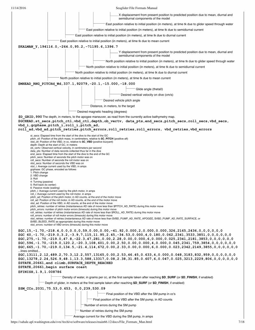
$KALMAN_X,
X displacement from present position to predicted position due to mean, diurnal andsemidiurnal components of the model
East position relative to initial position (in meters), at time tk due to glider speed through water
East position relative to initial position (in meters), at time tk due to semidiurnal current
East position relative to initial position (in meters), at time tk due to diurnal current
East position relative to initial position (in meters), at time tk due to mean current
$KALMAN_Y,194116.0,264.0,95.2,71195.6,1396.7
Y displacement from present position to predicted position due to mean, diurnal andsemidiurnal components of the model
North position relative to initial position (in meters), at time tk due to glider speed through water
North position relative to initial position (in meters), at time tk due to semidiurnal current
North position relative to initial position (in meters), at time tk due to diurnal current
North position relative to initial position (in meters), at time tk due to mean current
$MHEAD_RNG_PITCHd_Wd,337.1,92079,20.1,15.000,18.000
Glide angle (theta0)
Desired vertical velocity on dive (cm/s)
Desired vehicle pitch angle
Distance, in meters, to the target
Desired magnetic heading (degrees)
$FINISH,1.9,1.008786
Density of water, in grams per cc, at the first sample taken after reaching $D_SURF (or $D_FINISH, if enabled)
Depth of glider, in meters at the first sample taken after reaching $D_SURF (or $D_FINISH, if enabled)
$SM_CCo,2031,75.53,0.653, 0,0,239,530.09
Final position of the VBD after the SM pump in cc's
Final position of the VBD after the SM pump, in AD counts
Number of errors during the SM pump
Number of retries during the SM pump
Average current for the VBD during the SM pump, in amps
$D_GRID,990 The depth, in meters, to the apogee maneuver, as read from the currently active bathymetry map.$GCHEAD,st_secs,pitch_ctl,vbd_ctl,depth,ob_vertv, data_pts,end_secs,pitch_secs,roll_secs,vbd_secs,vbd_i,gcphase,pitch_i,roll_i,pitch_ad,roll_ad,vbd_ad,pitch_retries,pitch_errors,roll_retries,roll_errors, vbd_retries,vbd_errors
st_secs: Elapsed time from the start of the dive to the start of the GCpitch_ctl: Position of the pitch mass, in centimeters, relative to $C_PITCH (positive aft)vbd_ctl: Position of the VBD, in cc, relative to $C_VBD (positive buoyant)depth: Depth at the start of GC, in metersob_vertv: Observed vertical velocity, in centimeters per seconddata_pts: Number of data records collected thus far in the diveend_secs: Elapsed time from the start of the dive to the end of the GCpitch_secs: Number of seconds the pitch motor was onroll_secs: Number of seconds the roll motor was onvbd_secs: Number of seconds the VBD was onvbd_i: Average current used by the VBD, in ampsgcphase: GC phase, encoded as follows1: Pitch change2: VBD change3: Roll4: Turning (passive)5: Roll back (to center)6: Passive mode (waiting)pitch_i: Average current used by the pitch motor, in ampsroll_i: Average current used by the roll motor, in ampspitch_ad: Position of the pitch motor, in AD counts, at the end of the motor moveroll_ad: Position of the roll motor, in AD counts, at the end of the motor movevbd_ad: Position of the VBD, in AD counts, at the end of the motor movepitch_retries: number of retries (instantaneous AD rate of move less than $PITCH_AD_RATE) during this motor movepitch_errors: number of pitch motor errors (timeouts) during this motor moveroll_retries: number of retries (instantaneous AD rate of move less than $ROLL_AD_RATE) during this motor moveroll_errors: number of roll motor errors (timeouts) during this motor movevbd_retries: number of retries (instantaneous AD rate of move less than $VBD_PUMP_AD_RATE_APOGEE, $VBD_PUMP_AD_RATE_SURFACE, or$VBD_BLEED_RATE as appropriate) during this motor movevbd_errors: number of VBD errors (timeouts) during this motor move
$GC,15,1.70,218.4,0.0,0.0,0,59,0.00,0.00,41.92,0.000,2,0.000,0.000,326,2165,2436,0,0,0,0,0,0$GC 60,1.70,219.0,3.2,3.9,7,115,11.95,2.45,34.53,0.000,4,0.180,0.062,2341,3533,3851,0,0,0,0,0,0$GC,275,1.70,219.0,47.8,22.3,47,281,0.00,2.28,0.00,0.000,6,0.000,0.025,2341,2181,3853,0,0,0,0,0,0$GC,596,1.70,219.0,120.2,20.3,108,601,0.00,2.50,0.00,0.000,4,0.000,0.045,2341,759,3854,0,0,0,0,0,0$GC,665,1.70,219.0,134.5,21.4,114,672,0.00,2.33,0.00,0.000,6,0.000,0.023,2342,2149,3855,0,0,0,0,0,0...lines omitted...$GC,13111,2.12,489.2,70.3,12.2,557,13165,0.00,2.53,46.45,0.633,4,0.000,0.048,3183,832,959,0,0,0,0,0,0$GC,13278,2.24,526.9,48.1,13.3,588,13317,0.08,2.38,31.85,0.607,6,0.047,0.025,3213,2229,806,0,0,0,0,0,0$STATE,20661,end climb,SURFACE_DEPTH_REACHED$STATE,20661,begin surface coast

11/14/2016 Seaglider File Formats Manual
https://sahale.apl.washington.edu/svn/Archive/software/releases/main66.12/docs/File_Formats_Man.html 8/18
Time in seconds for the SM pump
Time in seconds from the start of the dive to when the Surface Maneuver (SM) pump was started
$24V_AH,23.3,21.710
Total amp-hours consumed on the 24V battery since the last reset of the battery meters (usually when new batteries are installed).
The minimum measured battery voltage (measured during active phase) on the 24V battery pack, in volts.
$FG_AHR_24Vo,6.819
Cumulative A-hr consumed from the 24V battery pack as tracked by the supervisor fuel gauge and recorded at the end of the dive.Only meaningful for RevC and later motherboards
$DATA_FILE_SIZE,36111,664
The number of data samples taken during the dive
The total size of the data file in bytes
$CFSIZE,260165632,248328192
The available free space on the compact flash cardThe total capacity of the compact flash card
$SM_GC 1.25,11.30,0.00,0.00,0.038,0.000,0.000,424,2272,1263,10.22,0.34,438.35$IRIDIUM_FIX,1904.66,12231.77,091207,191902$TT8_MAMPS,0.02301 Power draw on the 10 V power pack, in amps, measured at the end of the dive. This measurement can be used
to determine if devices are being left on.$HUMID,40.11 Relative humidity inside the pressure hull, in percent.$INTERNAL_PRESSURE,7.15848 Pressure inside the pressure hull, in PSIA.$TCM_TEMP,23.60 Last temperature reading taken from the compass, in degrees C.$XPDR_PINGS,8 Number of times the transponder commanded a ping on the dive. This could be altimeter pings, or pings in
response to something that sounded like an interrogation.$ALTIM_BOTTOM_PING, 875.1,26.8 Depth of the glider, and altimeteter-detected distance to bottom.
$10V_AH,10.0,17.969 Same as $24V_AH, but for 10V battery pack.
$FG_AHR_10Vo,6.967 Same as $FG_AHR_24Vo, but for 10V battery pack. Only meaningful for RevC and later motherboards$DEVICES,Pitch_motor,Roll_motor,VBD_pump_during_apogee,VBD_pump_during_surface,VBD_valve,Iridium_during_init,Iridium_during_connect,Iridium_during_xfer, Transponder_ping,Mmodem_TX,Mmodem_RX,GPS,TT8,LPSleep,TT8_Active,TT8_Sampling,TT8_CF8,TT8_Kalman,Analog_circuits,GPS_charging,Compass,RAFOS,Transponder.
Provides the titles of the numbers in the next twolines ($DEVICE_SECS and $DEVICE_MAMPS). Themeaning of each title is listed below.
Pitch_motor: All use of the pitch motor, in the units given in the next two linesRoll_motor: All use of the roll motor, in the units given in the next two linesVBD_pump_during_apogee: Use of the VBD pump during active modeVBD_pump_during_surface: Use of the VBD pump outside of the diveVBD_valve: Any use of the VBD valveIridium_during_init: Use of the phone related to turning the phone onIridium_during _connect: Use of the phone while connecting to the basestationIridium_during_xfer: Use of phone during a file transferTransponder_ping: Use of the transponder during an active pingMmodem_TX:Mmodem_RX:GPS: All use of the GPS for fix acquisitionTT8: Use of the TT8 at 2 MHzLPSleep: Use of the TT8 under low power sleepTT8_Active: Use of the TT8 in active modeTT8_Sampling: Use of the TT8 while sampling sensorsTT8_CF8: Use of the TT8 while accessing the flashTT8_Kalman: Use of the TT8 while running the Kalman filter codeAnalog_circuits: Use of the analog circuitry, including the pressure sensorGPS_charging: Use of the auxiliary GPS charging circuitCompass: Use of the compassRAFOS: Use of the RAFOS receiverTransponder: Total use of the transponder (including ping time)
$DEVICE_SECS,28.900,130.775,625.775,0.000,0.000,32.521,48.298,129.845,2.000,81.068,563.712,9134.856,711.991,3431.997,344.516,33.374,1911.731,0.000,3107.613,0.000,0.186
Reports the number of seconds each devicewas powered on during the dive.
$DEVICE_MAMPS,180.245,87.438,1307.735,0.000,0.000,103.000,160.000,223.000,420.000,50.000,19.800,2.190,19.800,39.800,45.800,81.800,12.000,0.000,8.000,0.000,30.000
Reports the maximum current (in mA) drawnby each device listed in $DEVICES.
$SENSORS,SBE_CT,SBE_O2,WL_BB2F,nil,nil,nil
SBE_CT: Seabird CT sensor. By convention, this is configured as the first device.SBE_O2: Seabird O2 sensor.WL_BB2F: Wetlabs BB2F combination backscatter sensor and fluorometer.Optode: Optode oxygen sensor.nil: indicates that no sensor is installed in this position.
Similar to $DEVICES, in simply providingtitles for the numbers listed in the followingtwo columns ($SENSOR_SECS and$SENSOR_MAMPS). Each title representsone of the sensors installed on theSeaglider, as described here.
$SENSOR_SECS,2182.877,1551.421,748.579,0.000,0.000,0.000 Reports the number of seconds each sensorwas powered on during the dive.
$SENSOR_MAMPS,24.000,19.000,105.000,0.000,0.000,0.000 Reports the maximum current drawn byeach sensor during the dive.

11/14/2016 Seaglider File Formats Manual
https://sahale.apl.washington.edu/svn/Archive/software/releases/main66.12/docs/File_Formats_Man.html 9/18
$GPS,170706,231510,1911.874,15644.574,40,1.4,40,9.6
Magnetic variation(degrees, positive E)
UTC
$ERRORS,0,0,0,0,0,0,0,0,0,0,0,0,0,0,0,0
Number of sensor timeouts
Number of times the GPS did not provide data from $GPRMC (Position and time)or $GPGGA (Fix Data) records within the 2 second timeout.
Number of VBD retries
Number of roll retries
Number of pitch retries
Number of VBD errors
Number of roll errors
Number of pitch errors
Number of CF8 retries while closing files
Number of CF8 retries while writing files
Number of CF8 retries while opening files
Number of CF8 errors while closing files
Number of CF8 errors while writing files
Number of CF8 errors while opening files
The number of spurious interrupts. Spurious interrupts may result from divide by zeroor memory dereference problems. They may also arise from interrupt contention.Occasional isolated spurious interrupts are normal.
Buffer Overruns-The number of times the log file output is longer than the internal buffer length.For each of the buffer overruns, the output is truncated to fit in the buffer, resulting in lost logfile output.
These values are from the most recent GPS fix,which corresponds to the end of the current dive.
2.1.2 Data File(p1230055.dat)
The .dat file is an ASCII text file that is generated by the Seaglider and transmitted to the basestation for further processing. The first line is the only actual value;all following lines are differences. It serves as the primary conduit for the science data collected by the Seaglider. Each data file covers one dive of information.The format is designed to minimize transmission size and, while clear text, is not intended for direct use by users.
The numbers in the data file can be interpreted by the column titles listed in the "columns" line. The meaning of each column title is summarized below. The first10 columns ("rec" through "GC_phase") are always present. The remaining columns depend on the sensors installed on the individual glider.
rec: the record number of the individual sampleelaps_t: time since the start of the divedepth: depth, in centimeters, at the start of the sampleheading: vehicle heading at the start of the sample, in degrees (magnetic) times 10pitch: vehicle pitch angle at the start of the sample, in degrees times 10, positive uproll: vehicle roll at the start of the sample, in degrees times 10, positive starboard wing downAD_pitch: Pitch mass position, in A/D countsAD_roll: roll mass position, in A/D countsAD_vbd: VBD position, in A/D countsGC_phase: GC phase, encoded as follows
1: Pitch change2: VBD change3: Roll4: Turning5: Roll back (to center)6: Passive mode
TempFreq: Temperature, in cycle counts of 4 MHz, in 255 cycles of signal frequencyCondFreq: Conductivity, in cycle counts of 4 MHz, in 255 cycles of signal frequencyredRef: red reference, in A/D countsredCount: red backscatter, in A/D countsblueRef: blue reference, in A/D countsblueCount: blue backscatter, in A/D countsFluorCount: Fluorometer, A/D countsVFtemp: BB2F temperatureO2: optional Aanderaa optode oxygen concentrationTemp: optional Aanderaa optode temperatureDphase: optional Aanderaa optode dphase
2.1.3 ASC File(p1230055.asc)
11/14/2016 Seaglider File Formats Manual
https://sahale.apl.washington.edu/svn/Archive/software/releases/main66.12/docs/File_Formats_Man.html 10/18
2966.752,N,Capture file opened
Descriptive text; often what action was taken, and sometimes the reason for the action.
Output level. There are three letters that can appear in this position: N, C, or D. N indicates normal output level. C stands for critical, andmeans that only output considered critical to glider function will be printed. For the most part, this consists of dire problems with hardware orsoftware, like motor errors or buffer overruns. D stands for Debug, and is used for extended diagnostics. This output can be quite voluminousand it is recommended that this only be set on specific services when it is known that some needed output will be captured. Most services donot have output in this level currently, but work is ongoing to add extended diagnostics under this output level.Time, in seconds, since the start of the dive
The .asc, or ASCII, files are created on the basestation. They are essentially the reconstituted (uncompressed, reassembled, and differentially summed) versionsof the data (DAT) files created on the Seaglider. See the Data File section for descriptions of the column names. The entry NaN indicates that there was nosample returned for that sensor. Either the sensor was not installed, or the sensor was not enabled for that sample/deployment, as controlled by the Science File.
2.1.4 Eng File(p1230055.eng)
The .eng, or engineering, files are created on the basestation. They restate data contained in the .asc and .log files, but with the Seaglider control state andattitude observations converted into engineering units. The column titles are described below. The first 10 columns are always present, while the remaining 10columns vary, depending on the installed sensors.
elaps_t_0000: Time, in seconds, since 0000UTC of the current dayelaps_t: Time, in seconds, since the start of the divecondFreq: Conductivity frequency, in Hertz.tempFreq: Temperature frequency, in Hertz. depth: Depth, in centimeters, at the start of the samplehead: Vehicle heading, in degrees magneticpitchAng: Vehicle pitch at the start of the sample, in degrees; positive nose-uprollAng: Vehicle roll at the start of the sample, in degrees; positive starboard wing down (rolled to starboard)pitchCtl: Pitch mass position relative to $C_PITCH, in centimeters; positive nose uprollCtl: Roll mass position, in degrees relative to $C_ROLL_DIVE or $C_ROLL_CLIMB; positive starboard wing downvbdCC: VBD value relative to $C_VBD, in cc's; positive buoyantO2Freq: Oxygen concentration (in Hertz)redRef: Red reference, in A/D countsredCount: Red backscatter, in A/D countsblueRef: Blue reference, in A/D countsblueCount: Blue backscatter, in A/D countsFluorCount: Fluorometer, in A/D countsVFtemp: BB2F temperature, in degrees CO2: Aanderaa optode oxygen concentrationtemp: Aanderaa optode temperaturedphase: Aanderaa optode dphase
2.1.5 Profiles File(p1230055.pro)
The .pro files contain the scientific data that was acquired during the dive, such as temperature and salinity. The column names are as follows:
elapse_time_s_v: time, in seconds, since the beginning of the dive (before the first sample is taken)Pressure_v: pressure, in decibarsdepth_m_v: depth, in metersTempC_Cor_v: temperature, in degrees C, corrected for 1st order time lag (response time of sensor)Cond_Cor_v: conductivity, corrected as aboveSalinity_v: salinity, calculated SigmaT_v: density at the current temperaturedive_pos_lat_dd_v: estimated latitude, in decimal degrees. It should be noted that this position is a rough estimate based on the position at thesurface, and the depth-averaged current, not an actual GPS or other reading. dive_pos_lon_dd_v: estimated longitude (see above).
2.1.6 Binned Profiles File(p1230055.bpo)
This is the same data as in the .pro files, but here it is "binned", or averaged, into depth intervals specified by the user.
2.1.7 Capture File(p1230055.cap)
The capture file contains information about all of the actions the Seaglider took during the dive. It captures the output written to the console while the Seaglider isoperating. Capture files are a great source of information on the glider's performance, especially in error analysis and debugging. For more information on the useof capture files, please see the Capture File section in the Seaglider Pilot's Guide. The format of the capture file is not as hard and fast as other file formats, but it usually conforms to that shown below:
time, service, output level, textExample Capture File

11/14/2016 Seaglider File Formats Manual
https://sahale.apl.washington.edu/svn/Archive/software/releases/main66.12/docs/File_Formats_Man.html 11/18
839.570,SDIVE,N,Reached SD,Wo = 0.064493,6 more points
Seaglider calculated that it should take this many more samples beforebeginning surface maneuver
Vertical velocity when surface depth reached
Surface depth
0055:0:0:1:0:0:0:0:0:0:0:0:0:0:0:0: GPS,031207,031455,1855.179,12237.359,41,1.3,41,2.1
Magnetic variation
Total time to acquire fix. See$N_GPS in the ParameterReference Manual for details.
HDOP (Horizontal Dilution OfPrecision) - a measure of thestrength of the figure used tocompute the fix.
Time to first fix, in seconds
Longitude, as +/- dddmm.mmm; sign (onlyminuses are shown; positive East), degrees,minutes, and decimal minutes.
Latitude, as +/- ddmm.mmm (only minuses are shown;positive North).
Time, as hhmmss in UTC
2967.080,HTT8,N,Writing NVRAM...done.2995.325,HGPS,N,Acquiring GPS fix ...2998.197,HGPS,N,VVVVA270407, 140904, 4806.097168, 12222.047852 1.500000 13/13 seconds3009.584,HTT8,N,Updating parameter $T_GPS_CHARGE to 13320.147
The capture file gives the following information regarding every pitch, roll and VBD maneuver:876.356,HROLL,N,Roll commanded from 39.80 deg (3384) to 0.00 deg (1976)...877.415,HROLL,N,34.5 deg (ad: 3195) Updating parameter $R_PORT_OVSHOOT to 18880.082,SMOTOR,N,MOTOR_DONE: ticks: 1 max 24v: 0.006A avg 24v: 0.006A880.215,SMOTOR,N,GC TICKS/TIME: 117/119500880.304,HROLL,N,done.
If problems occur, they are reported here.132.434,HPITCH,N,Pitch completed from 8.87 cm (1472) to 1.24 cm (3130) took 17.0 sec 0.292A (0.377Apeak) 97 AD/sec 681 ticks; 10 retries
The capture file also describes changes between dive phases:839.259,SDIVE,N,Leaving climb state due to SURFACE_DEPTH_REACHED839.402,SDIVE,N,Entering surface coast state
2.1.8 NetCDF File(p1230055.nc)
The netCDF file captures all processed files, and is self-documenting. Read-write access to netCDF files is provided by the software libraries supplied by UCAR(University Corporation for Atmospheric Research). The netCDF file is meant primarily for sharing data between scientific users.
2.1.9 Private File(p1230055.pvt)
PVT, or private, files are created on the basestation. They contain data that was originally in the logfile that could pose a security problem if propagated off thebasestation (as the logfile may well be). Thus, the data is stripped from the log file and placed in the matched pvt file. The lines in the pvt file correspond withparameters that are listed in the Parameter Reference Manual.
2.2 Processing Control Files
This section includes files that are used by the pilot to monitor and, when necessary, modify, how the basestation processes Seaglider data.
2.2.1 Communications Log(comm.log)
The "comm log" file is appended during each communication session, and so is a complete record of the Seaglider's communications over an entire deployment.It is a plain-text file that resides in the Seaglider's home directory. Running tail -f comm.log in the Seaglider's home directory during (or while waiting for)communication sessions is a useful monitor.
Example comm.log
Connected at Sun Dec 2 19:17:03 PST 2007 Date and time of communications session

11/14/2016 Seaglider File Formats Manual
https://sahale.apl.washington.edu/svn/Archive/software/releases/main66.12/docs/File_Formats_Man.html 12/18
Date, as ddmmyy(after 2000)
Current internal relative humidity (measured right before the call session)
Current internal pressure (measured right before the call session)
Current 24V battery voltage (measured right before the call session)
Current 10V battery voltage (measured right before the call session)
Observed depth (measured right before the call session)
Observed pitch (measured right before the call session)
AD position of the vbd
AD position of the roll motor
AD position of the pitch motor
Error code from the last call session (0 no error - non-zero error)
Reboot count (increments each time the glider code is started)
Mission number (increments each time glider is launched)
No-comm count: number of calls since last complete data transfer
Calls made
Call cycle
Dive number
Sun Dec 2 19:18:07 2007 [sg123] received EOT and read timed out
End of transmission
Sun Dec 2 19:18:07 2007 [sg123] sector number = 10,block length = 1024
Indicates end of file
Sun Dec 2 19:18:07 2007 [sg123] done sending ACK
Acknowledgement that file was sent
Sun Dec 2 19:18:07 2007 [sg123] sg0055lz.x00/XMODEM: 4096 Bytes, 178 BPS
The name of the file is printed after the glider has finished sending it.
ver=66.04l,rev=1243M,frag=4,launch=110908,151311Iridium bars: 5 geolocation: 1846.424805,12238.228516,031207,020210 Location obtained by the iridium phone's
geolocation property. This may be accurate to+/- 20km or more
Sun Dec 2 19:17:20 2007 [sg123] cmdfile/XMODEM: 128 Bytes, 17 BPSReceived cmdfile 17 bytes
Describes the transmission of the commandfile from the basestation to the Seaglider
Sun Dec 2 19:17:49 2007 [sg123] sector number = 1, block length = 1024Sun Dec 2 19:17:54 2007 [sg123] sector number = 2, block length = 1024Sun Dec 2 19:18:00 2007 [sg123] sector number = 3, block length = 1024Sun Dec 2 19:18:05 2007 [sg123] sector number = 4, block length = 1024
These lines describe the glider sending a fileto the basestation.
Sun Dec 2 19:18:07 2007 [sg123] Exiting (0)Sun Dec 2 19:18:14 2007 [sg123] sector number = 1, block length = 1024Sun Dec 2 19:18:19 2007 [sg123] sector number = 2, block length = 1024Sun Dec 2 19:18:23 2007 [sg123] sector number = 3, block length = 1024Sun Dec 2 19:18:28 2007 [sg123] sector number = 4, block length = 1024Sun Dec 2 19:18:31 2007 [sg123] received EOT and read timed outSun Dec 2 19:18:31 2007 [sg123] sector number = 10, block length = 1024Sun Dec 2 19:18:31 2007 [sg123] done sending ACKSun Dec 2 19:18:31 2007 [sg123] sg0055dz.x00/XMODEM: 4096 Bytes, 189 BPSSun Dec 2 19:18:31 2007 [sg123] Exiting (0)Sun Dec 2 19:18:38 2007 [sg123] sector number = 1, block length = 1024Sun Dec 2 19:18:43 2007 [sg123] sector number = 2, block length = 1024Sun Dec 2 19:18:49 2007 [sg123] timeout trying to read next sectorSun Dec 2 19:18:50 2007 [sg123] finished waiting for next line cnt = 999Sun Dec 2 19:18:50 2007 [sg123] got 0x2d sector headerSun Dec 2 19:18:53 2007 [sg123] finished waiting for next line cnt = 746
Errors in transmission are reported. If theIridium connection drops, thecommunications session times out.
Sun Dec 2 19:18:54 2007 [sg123] got 0x40 sector headerSun Dec 2 19:18:57 2007 [sg123] finished waiting for next line cnt = 787Sun Dec 2 19:18:59 2007 [sg123] sector number = 3, block length = 128Sun Dec 2 19:19:02 2007 [sg123] timeout trying to read next sectorSun Dec 2 19:19:03 2007 [sg123] finished waiting for next line cnt = 999Sun Dec 2 19:19:04 2007 [sg123] got 0xe6 sector headerSun Dec 2 19:19:06 2007 [sg123] finished waiting for next line cnt = 1Sun Dec 2 19:19:06 2007 [sg123] got 0xb7 sector headerSun Dec 2 19:19:07 2007 [sg123] finished waiting for next line cnt = 875Sun Dec 2 19:19:08 2007 [sg123] sector number = 4, block length = 128Sun Dec 2 19:19:10 2007 [sg123] sector number = 4, block length = 128Sun Dec 2 19:19:10 2007 [sg123] received dup sector = 4
Duplicate and/or missing sector numbersindicate loss of synchronization betweenthe Seaglider and the basestation.
Sun Dec 2 19:19:12 2007 [sg123] timeout trying to read next sectorSun Dec 2 19:19:13 2007 [sg123] finished waiting for next line cnt = 999
Errors can also be caused by droppedIridium connections. The Seaglider willautomatically call back and try sending

11/14/2016 Seaglider File Formats Manual
https://sahale.apl.washington.edu/svn/Archive/software/releases/main66.12/docs/File_Formats_Man.html 13/18
calibcomm = 'SBEs/n0041, calibration 25 April 2006';
Sensor serial number (found in SG notebook)
Sea-Bird Electronics
Sun Dec 2 19:19:13 2007 [sg123] got 0xaf sector headerSun Dec 2 19:19:15 2007 [sg123] finished waiting for next line cnt = 1Sun Dec 2 19:19:15 2007 [sg123] got 0x59 sector headerSun Dec 2 19:19:17 2007 [sg123] finished waiting for next line cnt = 543Sun Dec 2 19:19:17 2007 [sg123] got 0x59 sector headerSun Dec 2 19:19:21 2007 [sg123] finished waiting for next line cnt = 130Sun Dec 2 19:19:23 2007 [sg123] sector number = 6, block length = 128Sun Dec 2 19:19:23 2007 [sg123] sync error in protocol
data again until it succeeds or reachesthe maximum number of calls (set by theparameter $CALL_TRIES).
Sun Dec 2 19:19:23 2007 [sg123] sg0055dz.x01/XMODEM: got errorRenamed partial file sg0055dz.x01 to sg0055dz.x01.PARTIAL.1Sun Dec 2 19:19:23 2007 [sg123] processed partial file sg0055dz.x01 (0x0)Sun Dec 2 19:19:23 2007 [sg123] Exiting (128)Disconnected at Sun Dec 2 19:19:39 PST 2007
In this case, the glider "realizes" that thebasestation did not receive a completefile. The glider will automatically resendthe file on the next call.
Connected at Sun Dec 2 19:21:39 PST 2007159:0:2:0 GPS,031207,031455,1855.179,12237.359,41,1.3,41,2.1ver=66.03,rev=1243M,frag=4Iridium bars: 5 geolocation: 1846.424805,12241.375977,031207,070746Sun Dec 2 19:21:58 2007 [sg123] cmdfile/XMODEM: 128 Bytes, 14 BPSReceived cmdfile 17 bytesSun Dec 2 19:22:28 2007 [sg123] sector number = 1, block length = 1024Sun Dec 2 19:22:33 2007 [sg123] sector number = 2, block length = 1024Sun Dec 2 19:22:37 2007 [sg123] sector number = 3, block length = 1024Sun Dec 2 19:22:42 2007 [sg123] sector number = 4, block length = 1024Sun Dec 2 19:22:45 2007 [sg123] received EOT and read timed outSun Dec 2 19:22:45 2007 [sg123] sector number = 10, block length = 1024Sun Dec 2 19:22:45 2007 [sg123] done sending ACK
If no error is reported, but the basestationdoes not receive a complete file, the pilotcan command the glider to resend thedive by using a Pdos command (seeresend_dive in the Extended PicoDosReference Manual).
Sun Dec 2 19:22:45 2007 [sg123] sg0055dz.x01/XMODEM: 4096 Bytes, 186 BPS The file was successfully resent.Sun Dec 2 19:22:45 2007 [sg123] Exiting (0)Sun Dec 2 19:22:53 2007 [sg123] sector number = 1, block length = 1024Sun Dec 2 19:22:58 2007 [sg123] sector number = 2, block length = 1024Sun Dec 2 19:23:03 2007 [sg123] sector number = 3, block length = 1024Sun Dec 2 19:23:07 2007 [sg123] sector number = 4, block length = 1024Sun Dec 2 19:23:10 2007 [sg123] received EOT and read timed outSun Dec 2 19:23:10 2007 [sg123] sector number = 10, block length = 1024Sun Dec 2 19:23:10 2007 [sg123] done sending ACKSun Dec 2 19:23:10 2007 [sg123] sg0055dz.x02/XMODEM: 4096 Bytes, 186 BPS
2.2.2 SG Calib Constants(sg_calib_constants.m)
The "calib constants" file contains calibration information about each of the sensors on the Seaglider. This file is created by the pilot or operator, and exists onlyon the basestation. It does not have a counterpart on the Seaglider. Except for the compass, all of the Seaglider's sensors come calibrated to the SeagliderFabrication Center. Their calibration numbers can be found in the notebook delivered with the glider, and should be entered in this file. The compass values arerecorded when the Seaglider is fully assembled, and the compass is calibrated in the presence of the batteries and other hardware. The values in this file shouldbe checked, and changed if necessary, whenever new sensors are installed, batteries are changed, or other hardware alterations are made.
The calib_constants file is also used by various visualization tools (Matlab, GLMPC, etc.) to plot Seaglider data. Incorrect values in this file will result in incorrectscientific data in the plots.
Example Calibration Constants File
% sg_calib_constants.m% establishes glider calibration constants
id_str = '128'; Seaglider serial number
mission_title =' Port Susan Aug 15 2007'; pilot or operator specified
t_g = 4.37369092e03 ;t_h = 6.48722213e04 ;t_i = 2.63414771e05 ;t_j = 2.83524759e06 ;
SBE temperature sensor calibration coefficients
% Minimum and maximum frequencies (kHz) for reasonable% oceanographic values of temperature from SBE calibration% for C/T s/n 041

11/14/2016 Seaglider File Formats Manual
https://sahale.apl.washington.edu/svn/Archive/software/releases/main66.12/docs/File_Formats_Man.html 14/18
[email protected],gps,alerts,recov
If the glider goes into recovery, send the most recent GPS position and the recov code.
Send an alert when the basestation has a problem converting a file or files.
After every dive, send the most recent GPS position and, if the glider is in recovery, the recov code.
sbe_temp_freq_min = 3.214274; % kHzsbe_temp_freq_max = 6.081845; % kHz
From SBE sensor calibration. Basestation processing will reject observed temperature frequenciesoutside of this range.
c_g = 9.97922732e+00 ;c_h = 1.12270684e+00 ;c_i = 2.35632554e03 ;c_j = 2.37469252e04 ;
SBE conductivity sensor calibration coefficients
% Minimum and maximum frequencies (kHz) for reasonable% oceanographic values of conductivity SBE calibration% for C/T s/n 041
sbe_cond_freq_min = 2.98792; % kHzsbe_cond_freq_max = 7.95840; % kHz
From SBE sensor calibration. Basestation processing will reject observed temperature frequenciesoutside of this range.
cpcor = 9.57e08 ;ctcor = 3.25e06 ;
calibcomm_oxygen = '0106';
Soc = 2.1921e04;Boc = 0.0;Foffset = 825.6362;TCor = 0.0017;PCor = 1.350e04;
mass = 52.173; measured mass of glider
hd_a = 0.003836; lift hd_b = 0.010078; drag Seaglider hydrodynamic parametershd_c = 9.8541e6; induced drag (by lift)
rho0 = 1027.5; Greatest expected water density in area of operationpitch_min_cnts = 426;pitch_max_cnts = 3705;roll_min_cnts = 157;roll_max_cnts = 3897;vbd_min_cnts = 550;vbd_max_cnts = 3875;vbd_cnts_per_cc = 4.0767;
Software limits
volmax = 51344; Volume, in cc, the glider displaces when fully pumped; see the Seaglider Pilot's Guide for tank and ballastinginformation.
2.2.3 Pagers File(.pagers)
The "dot pagers" file controls the automatic notification system. It allows any of three types of messages to be sent to any valid email address: gps, alerts, andrecov (see below). This service is run by the data conversion script, which is invoked by a glider logout or disconnection. Lines begininning with a # are commentlines, and are ignored in processing.
# Joe Smith#[email protected],gps,alerts,[email protected],[email protected],recov
Joe Smith will receive emails to his APL account, and text messages to his Sprint phone,but will not receive messages to his gmail account.
# Jane Jones
#[email protected],gps,alerts,recov#[email protected],gps,alerts#Iridium Phone#[email protected],gps
11/14/2016 Seaglider File Formats Manual
https://sahale.apl.washington.edu/svn/Archive/software/releases/main66.12/docs/File_Formats_Man.html 15/18
baselog_000000999999,baselog.log)
Time; hhmmss (time zone as kept on basestation)
Date; ddmmyy
117 225 123.00000 36.00000 500 0.0 0.0
Optional entry: end date, in decimal yeardays, for period of map use. When blank or 0.0, nodate checking is performed.
Optional entry: start date, in decimal yeardays, for period of map use. When blank or 0.0, no date
2.2.4 .URLS(.urls)
The "Dot URLs" file is read by the basestation, following processing of dive data (triggered by a Seaglider logout. It specifies URLs on which to run GET for eachprocessed dive. This can be used for any supported httpd function, and is mainly used to poll for data transfers to support visualization servers. The first entry onthe line is the timeout (in seconds) to wait for a response to the GET. It is separated from the URL by a tab. convert.pl adds arguments"instrument_name=sg&dive=" with the proper separator. Comments in the file are indicated by a #
Example .urls file
1 http://iop.apl.washington.edu/~glider/cgibin/update.cgi
2.2.5 Basestation Log
The baselog_ file is produced by the basestation, and logs the output from the scripts that perform the data conversion and notification functions of thebasestation. It is written during each invocation. This file is the first place to look when debugging problems with the data conversion. If the basestation cannotprocess a file, it sends an alert to any contact listed in the .pagers file.
The baselog.log is an accumulation of all of the basestation conversions reported in the baselog_ files, without the timestamps.
2.3 On-board Glider Information
This section includes files that are stored on the Seaglider. Most of the information in these files is used by the glider in calculations regarding navigation andenergy usage.
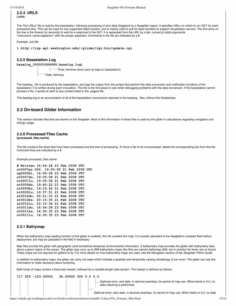
2.2.6 Processed Files Cache(processed_files.cache)
This file contains the dives that have been processed and the time of processing. To force a file to be re-processed, delete the corresponding line from this file.Comment lines are indicated by a #.
Example processed_files.cache
# Written 14:54:28 23 Feb 2008 UTCst0007pz.000, 19:05:58 21 Feb 2008 UTCsg0000kl, 14:54:28 23 Feb 2008 UTCst0007du, 19:05:58 21 Feb 2008 UTCst0007lu, 19:05:58 21 Feb 2008 UTCst0009du, 19:40:22 21 Feb 2008 UTCst0009kz, 19:16:44 21 Feb 2008 UTCst0009lu, 19:37:51 21 Feb 2008 UTCst0010du, 20:21:33 21 Feb 2008 UTCst0010kz, 20:15:35 21 Feb 2008 UTCst0010lu, 20:15:34 21 Feb 2008 UTCst0011du, 14:54:28 23 Feb 2008 UTCst0011kz, 14:30:35 23 Feb 2008 UTCst0011lu, 14:30:35 23 Feb 2008 UTC
2.3.1 Bathymap
When the bathymetry map-reading function of the glider is enabled, this file contains the map. It is usually uploaded to the Seaglider's compact flash beforedeployment, but may be uploaded in the field if necessary.
Map files provide the glider with geographic (and sometimes temporal) environmental information. A bathymetry map provides the glider with bathymetry dataabout a given region of the ocean. The glider may carry up to 999 bathymetry maps (the files are named bathymap.000), but in practice far fewer are on board.These maps are not required for gliders to fly. For more details on how bathymetry maps are used, see the Navigation section of the Seaglider Pilot's Guide.
In addition to bathymetry maps, the glider can carry ice maps which indicate a spatially and temporally varying climatology of ice cover. The glider can use thisinformation to make decisions about surfacing.
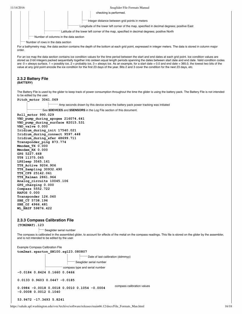
Both kinds of maps contain a fixed-size header, followed by a variable-length data section. The header is defined as follows:
11/14/2016 Seaglider File Formats Manual
https://sahale.apl.washington.edu/svn/Archive/software/releases/main66.12/docs/File_Formats_Man.html 16/18
checking is performed.
Integer distance between grid points in meters
Longitude of the lower left corner of the map, specified in decimal degrees; positive East
Latitude of the lower left corner of the map, specified in decimal degrees; positive North
Number of columns in the data section
Number of rows in the data section
Pitch_motor 3041.069
Amp seconds drawn by this device since the battery pack power tracking was initiated
See $DEVICES and $SENSORS in the Log File section of this document.
(TCM2MAT).123
Seaglider serial number
tcm2mat.sparton_SN100.sg123.080807
Date of last calibration (ddmmyy)
Seaglider serial number
compass type and serial number
For a bathymetry map, the data section contains the depth of the bottom at each grid point, expressed in integer meters. The data is stored in column majororder.
For an ice map the data section contains ice condition values for the time period between the start and end dates at each grid point. Ice condition values arestored as 2-bit integers packed sequentially together into sixteen equal length periods spanning the dates between start date and end date. Valid condition codesare: 0 = always surface, 1 = possibly ice, 2 = probably ice, 3 = always ice. As an example, for a start date = 0.0 and end date = 365.0, the lowest two bits of thevalue at any grid point encode the ice condition for the first 23 days of the year. Bits 2 and 3 cover the condition for the next 23 days, etc.
2.3.2 Battery File(BATTERY)
The Battery File is used by the glider to keep track of power consumption throughout the time the glider is using the battery pack. The Battery File is not intendedto be edited by the user.
Roll_motor 990.029VBD_pump_during_apogee 216074.641VBD_pump_during_surface 82015.531VBD_valve 0.000Iridium_during_init 17540.021Iridium_during_connect 9597.448Iridium_during_xfer 48699.711Transponder_ping 873.774Mmodem_TX 0.000Mmodem_RX 0.000GPS 5227.668TT8 11375.065LPSleep 3565.161TT8_Active 9204.906TT8_Sampling 30932.490TT8_CF8 25142.061TT8_Kalman 2861.964Analog_circuits 10045.106GPS_charging 0.000Compass 5552.722RAFOS 0.000Transponder 126.060SBE_CT 5738.196SBE_O2 4966.481WL_BB2F 59876.422
2.3.3 Compass Calibration File
The compass is calibrated in the assembled glider, to account for effects of the metal on the compass readings. This file is stored on the glider by the assembler,and is not intended to be edited by the user.
Example Compass Calibration File
0.0184 0.8424 0.1660 0.0466
0.0133 0.9603 0.0447 0.0185
0.0984 0.0018 0.0018 0.0010 0.1054 0.00040.0008 0.0012 0.1040
53.9472 17.3493 5.8241
compass calibration values

11/14/2016 Seaglider File Formats Manual
https://sahale.apl.washington.edu/svn/Archive/software/releases/main66.12/docs/File_Formats_Man.html 17/18
The bottom limit of each depth bin
The most frequent sample interval in this depth bin
Each digit in this column corresponds to one sensor. Sensors and sensor order vary bySeaglider. Consult $SENSORS in the Log File. Multiply this digit by the number in thetime column to calculate how often this sensor should sample in this depth bin.
The time interval on which the sensors should sample during the GC phase.
2.3.4 Capvec File
The Capvec File is parsed by the glider and updates one or more elements of the Capture Vector. Normally, this file is not used except for glider provisioning. Seethe capvec and parse_capvecfile commands in Extended PicoDOS Reference Manual for details on updating the Capture Vector, and the section Capture Filesin the Seaglider Pilot's Guide for details how and when to use capture files.
The Capvec File is a line oriented format. Lines may be comment lines, in which case the first character must be a /. All other lines are updates to the CaptureVector and are documented under the capvec command in the Extended PicoDOS Reference Manual.
2.4 Command and Control Files
These files are created by the pilot to control the Seaglider mission characteristics. Formats are given here, but usage of these files is discussed in the SeagliderPilot's Guide.
2.4.1 Targets File(targets)
The Pilot creates the targets file. One target is listed per line, and the target name must be listed first. The order of the other fields does not matter. Commentscan be included, preceded by a /.
SEVEN lat=4807.0 lon=12223.0 radius=200 goto=SIXSIX lat=4806.0 lon=12222.0 radius=200 goto=FIVEFIVE lat=4805.0 lon=12221.0 radius=200 goto=EIGHTFOUR lat=4804.0 lon=12220.0 radius=200 goto=EIGHTKAYAKPT lat=4808.0 lon=12223.0 radius=100 goto=KAYAKPT
Target name this can be anystring of numbers and/or letters,without whitespace.
Latitude, in +/ddmm.m;positive North
Longitude, in +/dddmm.m; positiveEast
Radius, in meters, within whichthe Seaglider determines it hasreached the target.
Next target this targetname must be specified inthe Target column.
Above is a typical version 66 targets file. It has all the fields necessary to direct the Seaglider to targets. There are also four optional fields, which can be addedas columns in the targets file:
escape=KAYAKPT depth=100 finish=90 timeout=3.0
The escape_target specifies whattarget to move to if the glider hasbeen unable to navigate for aspecified length of time (e.g. if it isstuck under the ice). Theescape_target must be a validnamed target in the file and can varyfor each named target. One possiblefuture use is to have the standardtargets along a cyclical survey routeall point to a single escape targetthat then points (throughnext_target) to a series of targetsthat define an entire route to aconvenient recovery location.
Specifying a value for depth ona target means that target canbe achieved by crossing abathymetric contour. If the valueis positive the target is achievedwhen crossing that contour fromdeep to shallow. When negative,target achievement is defined bymoving across that contour fromshallow to deep. The glidermeasures its depth forcomparison against the targetdepth either by altimetry or via a$T_NO_W timeout during thedive phase.
Finish specifies a direction (degrees), andestablishes a finish line through the target,perpendicular to the direction specified. Thetarget is considered achieved when thedifference between the bearing to the target andthe finish direction is greater than 90 (or lessthan 90) degrees. Example 1: finish direction of90 specifies a northsouth finish line drawnthrough the target; the target is achieved whenthe glider is east of the line. Example 2: finishdirection of 180 specifies an eastwest finishline; target is achieved when glider is south ofthe line. A value of 1 or no specification of finishmeans that no finish line will be tested.
Timeout specifiesa length of time(in days) that theglider should tryto achieve thistarget. If thetimeout isexceeded theglider will proceedto the targetnamed by goto. Iftimeout is notspecified or isgiven as zerothen the glider willtry to achieve thetarget with notime limit.
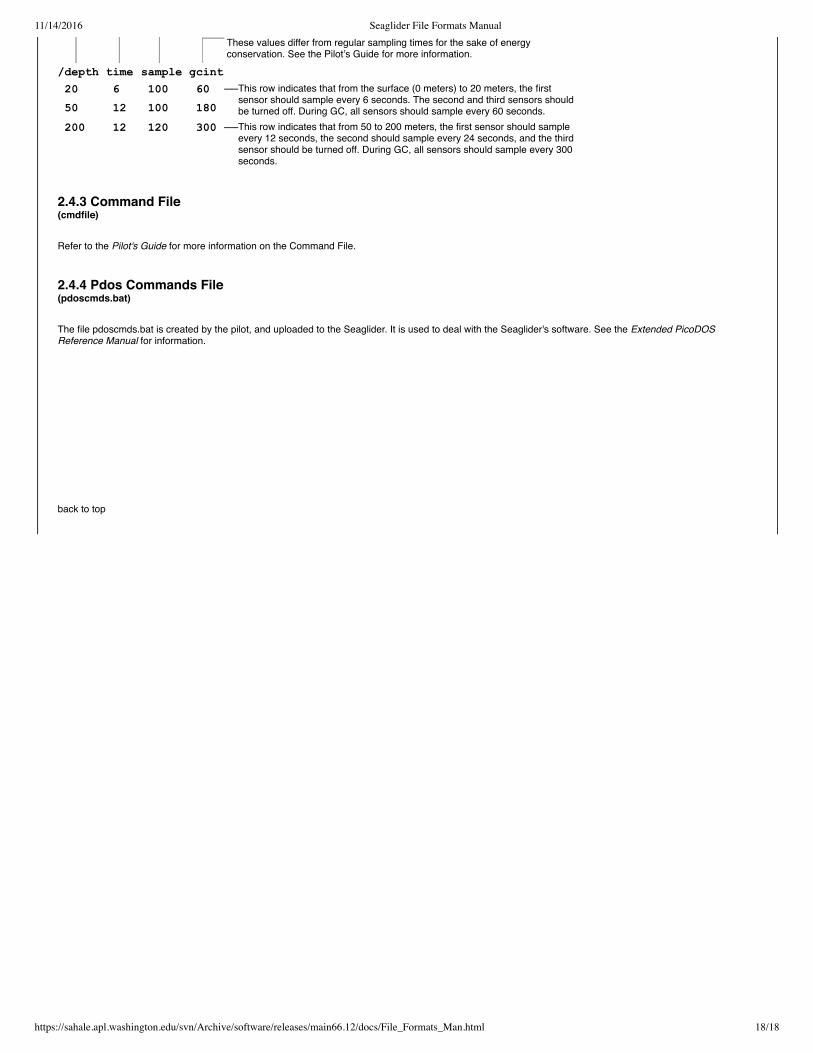
2.4.2 Science File(science)
This file, created by the pilot, contains instructions for the Seaglider about when to sample with the scientific instruments. Comment lines are indicated by a/, andcolumns are separated by tabs.
Example Science File
// Science for Port Susan
11/14/2016 Seaglider File Formats Manual
https://sahale.apl.washington.edu/svn/Archive/software/releases/main66.12/docs/File_Formats_Man.html 18/18
These values differ from regular sampling times for the sake of energyconservation. See the Pilot’s Guide for more information.
/depth time sample gcint
20 6 100 60 ——This row indicates that from the surface (0 meters) to 20 meters, the firstsensor should sample every 6 seconds. The second and third sensors shouldbe turned off. During GC, all sensors should sample every 60 seconds. 50 12 100 180
200 12 120 300 ——This row indicates that from 50 to 200 meters, the first sensor should sampleevery 12 seconds, the second should sample every 24 seconds, and the thirdsensor should be turned off. During GC, all sensors should sample every 300seconds.
2.4.3 Command File(cmdfile)
Refer to the Pilot's Guide for more information on the Command File.
2.4.4 Pdos Commands File(pdoscmds.bat)
The file pdoscmds.bat is created by the pilot, and uploaded to the Seaglider. It is used to deal with the Seaglider's software. See the Extended PicoDOSReference Manual for information.
back to top
Related Documents