Sea Level Rise for the Southern California Region Patrick Barnard USGS Coastal and Marine Geology Program, Santa Cruz, CA

Welcome message from author
This document is posted to help you gain knowledge. Please leave a comment to let me know what you think about it! Share it to your friends and learn new things together.
Transcript
Sea Level Rise for theSouthern California Region
Patrick BarnardUSGS Coastal and Marine Geology Program, Santa Cruz, CA

Sea Level Rise 101
•Other factors•Ocean basin configuration (geologic time scales)•Wind patterns (hourly to decadal)•Tidal (hourly to decadal)•Storms (hours to days)

Hallam et al. (1983), Ross & Ross (1988)
(Geologic) History of Sea Level Rise
Fleming et al. (1998), Fleming (2000), Milne et al. (2005)
http://www.azimuthproject.org/

NASA Goddard Institute for Space Studieshttp://www.nasa.gov/multimedia/videogallery/index.html?media_id=129395671
Temperature Change

Recent Sea Level Rise
Regional factors: •Ocean circulation patterns•Wind patterns•Glacial fingerprinting
NOAA, 2011
Global SLR is accelerating: •20th century = 2 mm/yr (e.g., Church et al., 2004)•1993-present = 3 mm/yr (e.g., Merrifield and Merrifield, 2009)

West Coast SLRWest Coast sea level rise has been suppressed for the last thirty years! BUT wind pattern changes may signal return to global or higher rates of SLR.
Bromirski et al. (2011)

Recent Findings- Storms
Graham and Diaz (2001)
•Storms and average winter and extreme waves are getting larger and more frequent for much of U.S. West Coast
Allan and Komar (2006)
• No evidence for changes in the strength or frequency of El Niños over last ~150 years (Ray and Giese, 2012) but perhaps a shift in styles
Lee and McPhaden (2010)
McPhaden et al. (2006)

0 0.5 1 1.5 2 2.5 3
Bahr et al.
IPCC AR4
IPCC AR 4
Hunter
UKCP09 (Lowe et al.)
Horton et al.
Kopp et al.
Detal Commissiee (Vellinga et al.)
Rahmstorf et al.
Jevrejeva et al.
Grinsted et al.
Rahmstorf
USACE Policy
Vermeer and Rhamstorf
Grinsted et al.
Nicholls et al.
Pfeffer et al.
Rohing et al.
Sea Level Rise by 2100 (meters)
Sea
Level
Rise
Study
Sea Level Rise Projections (based on various climate scenarios)
Average High (1.25m)
Average Low (0.6m)
National Climate Assessment SLR Subgroup

Global Sea Level Projections (by 2100)
Vermeer and Rahmstorf (2009)
• 0.18 to 0.59 m Intergovernmental Panel on Climate Change (IPCC, 2007)
– does not include ice sheet contributions from Greenland (7 m stored) and Antarctica (60 m + stored)
• 0.5 to 1.9 m Rahmstorf (Science, 2007)/ Vermeer and Rahmstorf (PNAS, 2009)
– relates sea level rise to mean surface temperature
• 0.8 to 2 m Pfeffer et al. (Science, 2008)– constrained by observations of ice sheet dynamics
• 5 m Hansen (Environ. Res. Lett., 2007)– non-linearity, amplifying polar feedbacks- ‘albedo flip’– sea level was 75 m higher at ~50 Ma– at 5 Ma, sea level was ~25 m higher , but only 2-3oC
warmer (A2 emissions scenario is 4.5 oC warmer)

The Copenhagen Diagnosis, 2009
Sea Level Rise Beyond 2100
•1.8 to 5.5 m of SLR by 2500 using latest IPCC Models (2013)
• Sea level will rise for several centuries after stabilization (Jevrejeva et al., 2011)

Coastal Vulnerability Considerations•Global factors:
• Eustatic sea level
•Regional factors: • Ocean circulation patterns• Storminess • Tectonics (large-scale)
•Local factors: • Subsidence • Local tectonic deformation • Fluvial discharge AND sediment
supply changes • Development and restoration
•Seasonal and storm impacts: • Steric effects• Waves and storm surge • River discharge
Shore and Beach (1989)
Bowden et al. (2001)

Projections for Southern CaliforniaSLR for Los Angeles (NRC, 2012)
-28 cm of sea level rise by 2050 (range 13-61 cm)-93 cm of sea level rise by 2100 (range 44-167 cm)-includes global and regional effects (e.g., wind and
circulation patterns, sea level fingerprint, glacial isostatic adjustment, tectonics)
Storms for Southern California (Bromirski et al., 2012; USGS)
-No significant changes in wave climate-Extreme events approach from ~5-10 degrees
further south
http://www.nap.edu/catalog.php?record_id=13389

• Accelerated beach erosion rates
• Greater incidence of cliff failures
• Landward translation of coastal flooding and inundation
• More dangerous navigation conditions
• Beach/shore safety more often compromised
Coastal Impact of Projected Climate Trends
L.A. City Lifeguards
L.A. City Lifeguards

What is the problem?• 480,000 people and $100 billion in
property are at risk of flooding along the California coast over the next century (Pacific Institute Report)
• California beaches support 883,000 jobs and contribute $73 billion to the national economy (King, 1999)
• 1982-83 El Niño storms caused more than $200 million in damage to California

Southern California Vulnerability
www.californiacoastline.org/

Critical Infrastructure
www.californiacoastline.org/

Coastal Vulnerability Efforts•NOAA SLR Viewer (static)
–Passive model, hydrological connectivity–Tides only (MHHW)–Excellent elevation data, datum control–Wetland migration model, socioeconomic impacts–‘1st order screening tool’
•CoSMoS (dynamic)–GCM ensemble forcing–Includes wind, waves, sediment transport, fluvial discharge, and vertical land movement rates–Range of SLR and storm scenarios–Flooding extent explicitly modeled, hydrological connectivity
http://www.csc.noaa.gov/digitalcoast/tools/slrviewer

Components of Total Water Level Predictions
MSL (datum)hslr
Hbr
dbr
waves increase in height towards breaking zone (shoaling)
breaker zoneH decreases rapidly due to
breaking swash zone
hR
hwv
hwn
hp
htide
sea level rise
tide difference
barometric set-up
wind set-up
wave set-up
wave run-up
(adapted from Frisby and Goldberg, 1981)
Bolinas Lagoon
Bathtub model (SLR + MHHW) Physics included (SLR + Extreme Event)
2 m2 m0.2 m0.8 m1.7 m

CoSMoS: A Tool for Coastal Resilience • Physics-based numerical modeling system
for assessing coastal hazards on West Coast
• Predicts coastal hazards for the full range of sea level rise and storm possibilities using the most sophisticated global climate and ocean modeling tools
• Developing coastal vulnerability tools with guidance from federal (e.g., NOAA, NPS), state (e.g., California State Parks), and city governments (City of San Diego, L.A., and San Francisco) to meet their planning and adaptation needs
G. Griggs, UCSC

CoSMoS Version 1.0- SoCal• Limited set of scenarios
– January 2010 hindcast– January 2010 hindcast + 50 and 100 yr SLR per Rahmstorf
(2007)

Dynamic Model GridsNWW III
ENP
SoCal
Santa Barbara Channel Los Angeles San Diego
GFS
NAM TPXO 6.2
meteo models
tide model
xb xb xb xb xb xb xb xb xb

Marina Del Rey/Venice
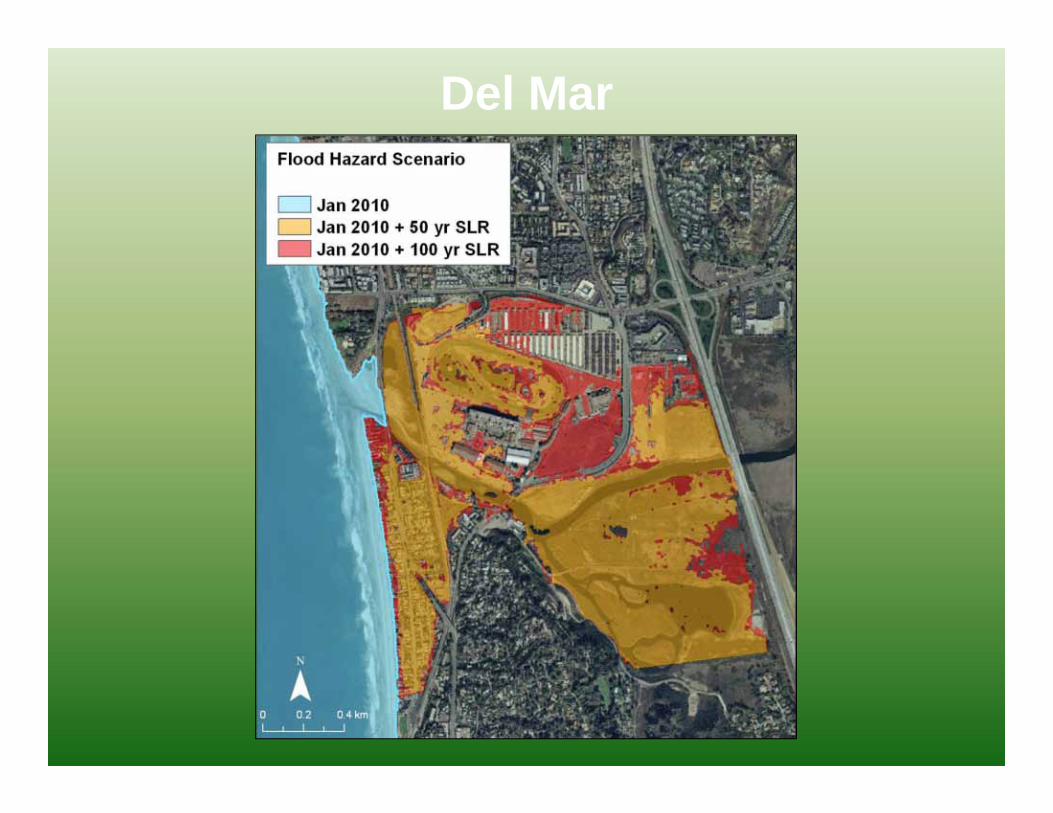
Del Mar

Imperial Beach

Identifying Future Risk with CoSMoS 2.0
1. Global forcing using the latest climate models
3. Scaled down to local hazards
projections
2. Drives global and regional wave models

Online Tool

Future Vulnerability

CoSMoS - The Path Forward• Pilot project for Southern California (Pt. Conception to Mexico)
completed- kmz files are available showing flooding extent• Supporting the AdaptLA climate change assessment• North-central coast will be completed and tool available this
year• New Southern California project proposed for 2013-2015• Available as a real-time warning system for emergency
managers, lifeline operators, and resource managers• Internal project at USGS drives ongoing research and
development of this modeling system
For more information, contact Patrick Barnard: [email protected]://walrus.wr.usgs.gov/coastal_processes/socalhazardshttp://cosmos.deltares.nl/SoCalCoastalHazards/index.html
Related Documents