coastal adaptation sea level rise Building capacity in two vulnerable points of the Colombian coastal area Martha. P. Vides Ed.

Welcome message from author
This document is posted to help you gain knowledge. Please leave a comment to let me know what you think about it! Share it to your friends and learn new things together.
Transcript
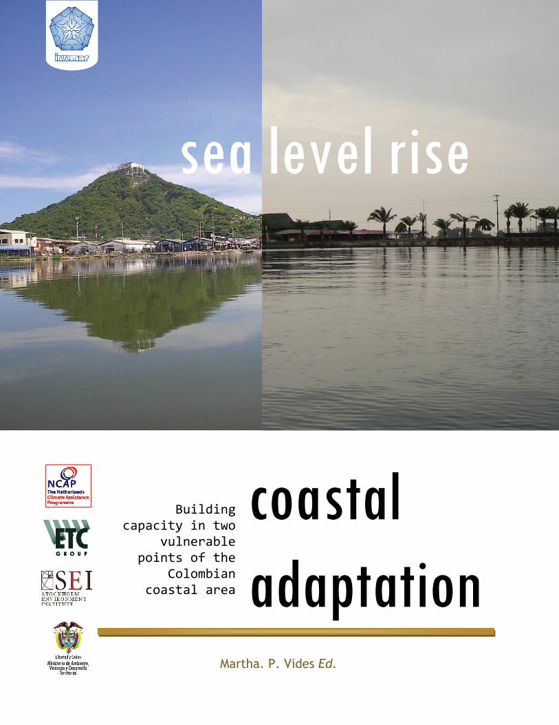
coastal adaptation
sea level rise
Building capacity in two
vulnerable points of the
Colombian coastal area
Martha. P. Vides Ed.


Published July 2008 by the Marine and Coastal Research Institute José Benito Vives de Andreis – Invemar, Santa Marta, Colombia. Any reproduction in full or in part of this publication must mention the title and credit the above‐mentioned publisher as the copyright owner.
© text 2008 Invemar. All rights reserved.
The material and the geographical designations in this report do not imply the expression of any opinion whatsoever on the part of Invemar concerning the legal status of any country, territory, or area, or concerning the delimitation of its frontiers or boundaries.
Cite as: Vides M.P.Ed.2008. Sea‐level rise coastal adaptation. Technical Report NCAP Colombia Project. ETC Project Number 032135. Marine and Coastal Research Institute. INVEMAR. Santa Marta, Colombia.290 p.
coastal adaptation
sea level rise Building
capacity in two vulnerable
points of the Colombian
coastal area
Martha Vides C. Ed.
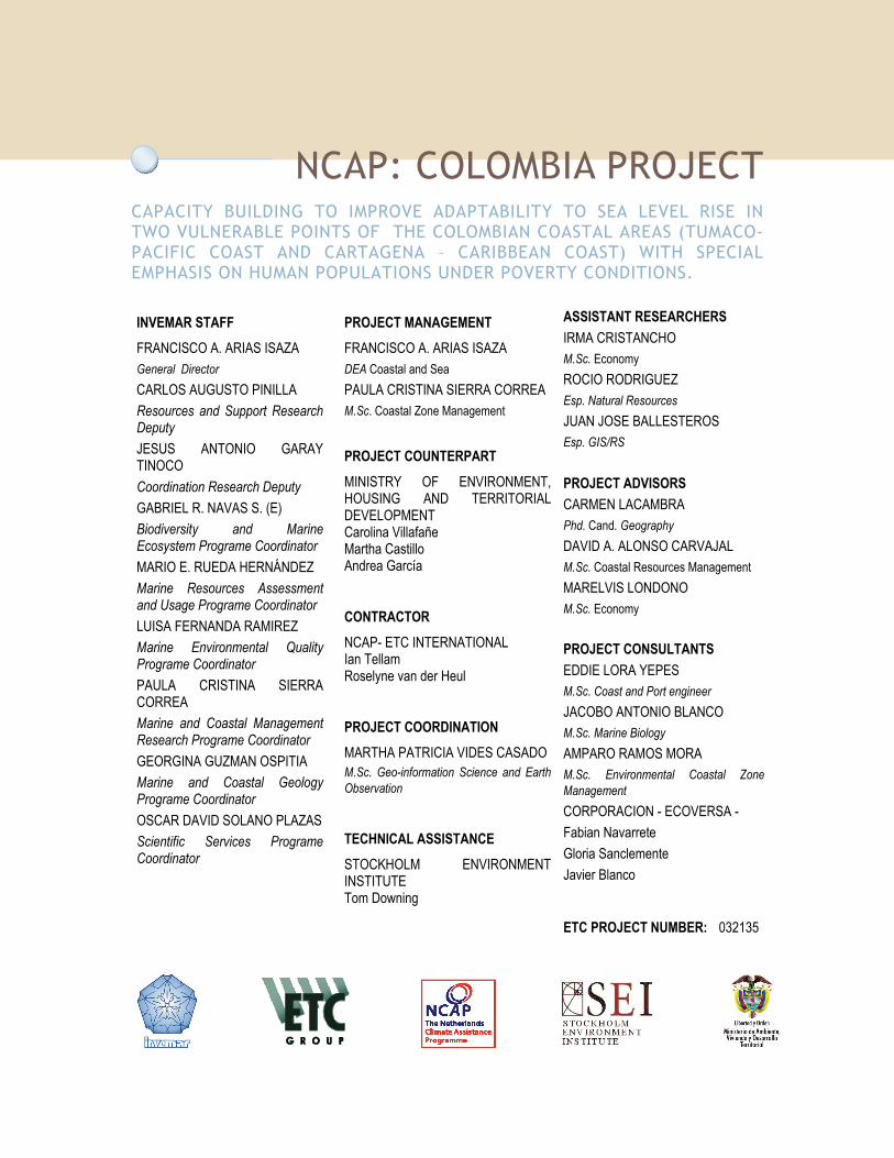
NCAP: COLOMBIA PROJECT CAPACITY BUILDING TO IMPROVE ADAPTABILITY TO SEA LEVEL RISE IN TWO VULNERABLE POINTS OF THE COLOMBIAN COASTAL AREAS (TUMACO-PACIFIC COAST AND CARTAGENA – CARIBBEAN COAST) WITH SPECIAL EMPHASIS ON HUMAN POPULATIONS UNDER POVERTY CONDITIONS.
INVEMAR STAFF FRANCISCO A. ARIAS ISAZA General Director CARLOS AUGUSTO PINILLA Resources and Support Research Deputy JESUS ANTONIO GARAY TINOCO Coordination Research Deputy GABRIEL R. NAVAS S. (E) Biodiversity and Marine Ecosystem Programe Coordinator MARIO E. RUEDA HERNÁNDEZ Marine Resources Assessment and Usage Programe Coordinator LUISA FERNANDA RAMIREZ Marine Environmental Quality Programe Coordinator PAULA CRISTINA SIERRA CORREA Marine and Coastal Management Research Programe Coordinator GEORGINA GUZMAN OSPITIA Marine and Coastal Geology Programe Coordinator OSCAR DAVID SOLANO PLAZAS Scientific Services Programe Coordinator
PROJECT MANAGEMENT FRANCISCO A. ARIAS ISAZA DEA Coastal and Sea PAULA CRISTINA SIERRA CORREA M.Sc. Coastal Zone Management
PROJECT COUNTERPART MINISTRY OF ENVIRONMENT, HOUSING AND TERRITORIAL DEVELOPMENT Carolina Villafañe Martha Castillo Andrea García
CONTRACTOR NCAP- ETC INTERNATIONAL Ian Tellam Roselyne van der Heul
PROJECT COORDINATION MARTHA PATRICIA VIDES CASADO M.Sc. Geo-information Science and Earth Observation
TECHNICAL ASSISTANCE STOCKHOLM ENVIRONMENT INSTITUTE Tom Downing
ASSISTANT RESEARCHERS IRMA CRISTANCHO M.Sc. Economy ROCIO RODRIGUEZ Esp. Natural Resources JUAN JOSE BALLESTEROS Esp. GIS/RS PROJECT ADVISORS CARMEN LACAMBRA Phd. Cand. Geography DAVID A. ALONSO CARVAJAL M.Sc. Coastal Resources Management MARELVIS LONDONO M.Sc. Economy PROJECT CONSULTANTS EDDIE LORA YEPES M.Sc. Coast and Port engineer JACOBO ANTONIO BLANCO M.Sc. Marine Biology AMPARO RAMOS MORA M.Sc. Environmental Coastal Zone Management CORPORACION - ECOVERSA - Fabian Navarrete Gloria Sanclemente Javier Blanco
ETC PROJECT NUMBER: 032135

THE NETHERLANDS CLIMATE ASSISTANCE PROGRAMME II
COLOMBIA CAPACITY BUILDING TO IMPROVE ADAPTABILITY TO SEA LEVEL RISE IN TWO VULNERABLE POINTS OF THE COLOMBIAN COASTAL AREAS (TUMACO-PACIFIC COAST AND CARTAGENA DE INDIAS - CARIBBEAN COAST) WITH SPECIAL EMPHASIS ON HUMAN POPULATIONS UNDER POVERTY CONDITIONS.
ESSENTIAL DATA
Responsible: Ministry of Environment, Housing and Territorial Development Contact Name: Andrea García Position: Coordinator, Colombian Climate Change Mitigation Group, Office of
Vice – Ministry of Environment Address: Calle 37 No. 8-40 E-mail: [email protected] Telephone: (+57) 1 2886877 or 3323400 Fax: (+57) 1 2889816 or 2889892 City/Country: Bogotá / COLOMBIA Executor: Marine and Coastal Research Institute –INVEMAR- Contact Name: Francisco A. Arias-Isaza Position: General Director Address: A.A. 1016 E-mail: [email protected] (copy to: [email protected]) Telefax: +57 +5 4312975 City/Country: Santa Marta / COLOMBIA Contractor: NCAP- ETC International Contact Name: Ian Tellam Address: P.O. Box 64, 3830 AB, Leusden Phone: +31 (0) 33 432 6000 Fax: +31 (0) 33 494 0791 E-mail: [email protected] City/Country: Leusden/ The Netherlands Technical Assistance: Stockholm Environment Institute Contact Name: Tom Downing Address: S-103 14 Stockholm, E-mail: [email protected] Country: Sweden

TABLE OF CONTENTS NCAP: COLOMBIA PROJECT................................................................................. 5
THE NETHERLANDS CLIMATE ASSISTANCE PROGRAMME II COLOMBIA.............................. 6
TABLE OF CONTENTS ........................................................................................ 7
TABLE OF FIGURES ..........................................................................................13
LIST OF TABLES ..............................................................................................17
ABBREVIATIONS ..............................................................................................19
INTRODUCTION...............................................................................................21
BACKGROUND ................................................................................................25
NCCSAP COLOMBIA PROJECT ................................................................................. 25 Study area ............................................................................................... 25 Scenarios ................................................................................................. 28
Sea-level rise scenarios..........................................................................................28 Socioeconomic scenarios ........................................................................................28
IMPACTS OF A 1 M SEA LEVEL RISE ON THE COLOMBIAN COASTS ................................................. 29 Estimation of land loss on due to inundation and erosion....................................... 29 Natural system response to sea level rise.......................................................... 30
Flood and increase in ground water levels. ..................................................................31 Estimates of value and population at risk ....................................................................31
Response strategies and adaptation Options ...................................................... 32 Evaluation of the vulnerability profile ............................................................. 34
Natural system susceptibility assessment ....................................................................35 Socio-economic assessment.....................................................................................35 Constrains related to the response strategies implementation feasibility ..............................37
COLOMBIA NATIONAL ACTION PLAN............................................................................ 38 Priority Actions ......................................................................................... 38
NCAP II: COLOMBIA PROJECT................................................................................. 39
APPROACH/METHODOLOGIES/TOOLS ....................................................................41
SYSTEM DESCRIPTION .......................................................................................... 42 VULNERABILITY ASSESSMENT ................................................................................... 43
Sea level rise scenarios ................................................................................ 45 ADAPTATION DECISION MATRIX (ADM) ........................................................................ 45 POLICY EXERCISE APPROACH................................................................................... 47
SYSTEM DESCRIPTION.......................................................................................49
CARTAGENA DE INDIAS ......................................................................................... 49 Meteorological aspects ................................................................................ 51 Ocean dynamics ......................................................................................... 53
Wave in deepwater...............................................................................................53 Wave in shallow water...........................................................................................55 Tides................................................................................................................56

Currents............................................................................................................56 Sediment transport...............................................................................................56 Sea-level ...........................................................................................................58
Geology and geomorphologic aspects ............................................................... 59 Sedimentary facies ...............................................................................................60 Coastal variations ................................................................................................61
Vegetation coverage ................................................................................... 64 Marine and coastal ecosystems....................................................................... 64
Sandy beaches ....................................................................................................65 Sea grasses ........................................................................................................65 Estuaries, deltas and coastal lagoons .........................................................................67 Mangroves..........................................................................................................68
Socioeconomic characteristics........................................................................ 69 Demography .......................................................................................................70 Poverty and welfare..............................................................................................72 Education ..........................................................................................................73 Health ..............................................................................................................74 Displacement......................................................................................................75
Economic aspects ....................................................................................... 75 International trade and tonnage handled by the Port of Cartagena .....................................75 Industry ............................................................................................................76 Employment .......................................................................................................76 Public investment ................................................................................................77 Land use and productive systems ..............................................................................78
SAN ANDRES DE TUMACO ...................................................................................... 80 Climate................................................................................................... 80 Ocean Dynamics......................................................................................... 81
Currents............................................................................................................81 Tides................................................................................................................81 Surface Water Temperature ....................................................................................81 Superficial Salinity ...............................................................................................81
Geology................................................................................................... 81 Coast Line Morphodinamics .....................................................................................82
Water Resources ........................................................................................ 83 Ecosystems............................................................................................... 84
Tropical rainforest ...............................................................................................84 Very Humid Tropical Rainforest ................................................................................85 Marine and coastal ecosystems.................................................................................85 Mangroves..........................................................................................................86
Socioeconomic characterization...................................................................... 86 Demography .......................................................................................................86 Economic aspects.................................................................................................90 Productive Systems use..........................................................................................91
VA- VULNERABILITY ASSESSMENT ........................................................................93
SUSCEPTIBILITY OF THE NATURAL SYSTEM ...................................................................... 96 Selection of indicators to assess natural susceptibility .......................................... 97
Ecosystem coverage..............................................................................................97 Water Quality and Hydrographic processes integrity .......................................................98 Ecosystem quality ................................................................................................99 Recovery areas.................................................................................................. 100 Land- Use: habitat conversion................................................................................ 100 Hazards........................................................................................................... 100
Natural susceptibility .................................................................................100 Cartagena de Indias: Cienaga de La Virgen and Cartagena Bay ......................................... 101 San Andres de Tumaco......................................................................................... 108

Environmental susceptibility Index.................................................................113 Cartagena de Indias: Cienaga de La Virgen and Cartagena Bay ......................................... 113 San Andres de Tumaco......................................................................................... 114
SOCIOECONOMIC VULNERABILITY ..............................................................................115 Selection of indicators to assess the impacts of the socioeconomic system.................116 Cartagena de Indias ...................................................................................119
Life Quality ...................................................................................................... 119 Services .......................................................................................................... 120 Housing........................................................................................................... 121 Human Capital Factor.......................................................................................... 121 Natural disaster INDEX......................................................................................... 121 Public Investment Indicator................................................................................... 122 Population Indicator ........................................................................................... 123 Overall socioeconomic vulnerability index ................................................................. 124
San Andres de Tumaco................................................................................125 Life Quality Indicator .......................................................................................... 125 Services Factor.................................................................................................. 126 Housing Factor .................................................................................................. 126 Human Capital Factor.......................................................................................... 127 Natural Disaster Indicator ..................................................................................... 127 Public Investment Indicator................................................................................... 128 Population Indicator ........................................................................................... 129
Overall socioeconomic vulnerability index ........................................................129
SCENARIO DEVELOPMENT................................................................................ 131
DESIRED SCENARIO – 2019 ...................................................................................133 Cartagena de Indias ...................................................................................133
Environmental dimension ..................................................................................... 133 Socioeconomic Dimension..................................................................................... 139
San Andres de Tumaco................................................................................143 Environmental Dimension ..................................................................................... 143 Socioeconomic Dimension..................................................................................... 147 Socioeconomic Vulnerability Index Interpretation ........................................................ 147
NATURAL AWARENESS SCENARIO – 2019......................................................................150 Cartagena de Indias ...................................................................................150
Environmental dimension ..................................................................................... 150 Tumaco ..................................................................................................155
Environmental dimension ..................................................................................... 155 Socioeconomic Dimension..................................................................................... 158 Socioeconomic Vulnerability Index .......................................................................... 159
ADAPTATION MEASURES.................................................................................. 161
PROTECTION MEASURES .......................................................................................164 Hard engineering response...........................................................................165
Levees – Armoring structures ................................................................................. 165 Beach stabilization structures ................................................................................ 168 Flood barriers ................................................................................................... 170
Soft engineering response............................................................................170 Beach nourishment & Mangrove barriers ................................................................... 170
Engineering protection for Cartagena .............................................................172 Leeve flood longitudinal protections ........................................................................ 174 Filled beaches................................................................................................... 176 Coastal Lagoons................................................................................................. 178 Port areas........................................................................................................ 178 Protection barrier in the Channel of the Dike ............................................................. 178

Relocation of settlements in the Tierra Bomba Island ................................................... 179 Engineering protection for Tumaco ................................................................179
Flood Longitudinal Leeve...................................................................................... 181 IDENTIFICATION OF LOCAL ADAPTATION MEASURES.............................................................181
Research and Information Collection ..............................................................183 Mainstreaming adaptation and risk management into local planning ........................184 Allow natural ecosystems to evolve in response to SLR.........................................184 Other types of responses .............................................................................185
SLR Adaptation measures for Cartagena de Indias ........................................................ 186 SLR Adaptation measures for San Andres de Tumaco..................................................... 187
IMPLEMENTATION CONSTRAINS ................................................................................187
POLICIES, LEGISLATION AND REGULATIONS.......................................................... 189
NATIONAL SYSTEM FOR THE DISASTERS PREVENTION AND ATTENTION...........................................189 TERRITORIAL DEVELOPMENT ..................................................................................193
Review of the application procedures in the regional and local territorial development instruments.............................................................................................198
NATIONAL ENVIRONMENTAL SYSTEM ...........................................................................206 Normative aspects of general character of the national order related to the environment and risk management: ................................................................................206 Environmental, Planning And Regulatory National Policy Instruments Applicable To The Integrated Handling Of Coastal Areas..............................................................208 Regional environmental planning instruments and regulators.................................211
EXISTING POLICIES AND REGULATIONS REGARDING CLIMATE CHANGE IN COLOMBIA..............................221 Law 164 of 1994. Framework convention on climate change..................................221 First national communication to the united nations framework convention on climate change - 2001...........................................................................................222 Climate change policy lineaments. Ministry of environment – 2002. ........................223
LEGAL CRITERIA FOR THE DESCRIBED REGULATIONS ANALYSIS ..................................................227
POLICY OPTIONS ........................................................................................... 233
PROACTIVE MANAGEMENT AND COMPREHENSIVE RISK MANAGEMENT CAUSED BY SEA LEVEL RISE. .............236 Justification ............................................................................................236 Actions...................................................................................................240 Option analysis.........................................................................................242
Effectiveness .................................................................................................... 242 Efficiency ........................................................................................................ 245 Equity............................................................................................................. 245 Political feasibility ............................................................................................. 246 Management capacity.......................................................................................... 247
COASTAL AREA TOURIST DEVELOPMENT........................................................................250 Justification ............................................................................................250 Actions...................................................................................................251 Option analysis.........................................................................................253
Effectiveness .................................................................................................... 253 Efficiency ........................................................................................................ 256 Equity............................................................................................................. 257 Political feasibility ............................................................................................. 257 Management capacity.......................................................................................... 258
RESEARCH INITIATIVES AND SCIENTIFIC DEVELOPMENT PROGRAMS. .............................................263 Justification ............................................................................................263 Actions...................................................................................................267 Option analysis.........................................................................................268
Effectiveness .................................................................................................... 268

Efficiency ........................................................................................................ 270 Equity............................................................................................................. 270 Political feasibility ............................................................................................. 271 Management capacity.......................................................................................... 272
RECOMMENDATIONS....................................................................................... 277
LESSONS LEARNED ............................................................................................278
REFERENCES ................................................................................................ 281


TABLE OF FIGURES FIGURE 1. REPRESENTATION OF THE POTENTIAL FLOODING DUE TO SLR IN THE COLOMBIAN CARIBBEAN COAST. ... 25 FIGURE 3. MOST EXPOSED MUNICIPALITIES TO SLR. CARTAGENA; BARRANQUILLA; SANTA MARTA;
TURBO; CIÉNAGA; TUMACO; BUENAVENTURA; GUAPI; NUQUI; MOSQUERA. .............. 34 FIGURE 5. METHODOLOGICAL SCHEME NCAP-COLOMBIA ......................................................... 41 FIGURE 6. SCHEMATIC COMPONENTS OF THE SD PHASE. .......................................................... 42 FIGURE 7. GENERAL SCHEME OF THE VULNERABILITY ASSESSMENT. ................................................ 44 FIGURE 8. FORMAT USED IN THE WORKSHOPS TO COLLECT THE ADAPTATION MEASURES DESCRIPTIONS. ............ 45 FIGURE 9. SCHEMATIC PROCESS OF THE ADAPTATION MEASURES IDENTIFICATION, PREFACTIBILITY ASSESSMENT AND
PRIORIZATION............................................................................................... 46 FIGURE 10. GENERAL SCHEME FOR THE POLICY OPTION ANALYSIS. ............................................... 47 FIGURE 11. GENERAL LIMITS OF DISTRITO TURISTICO Y CULTURAL DE CARTAGENA. ............................... 50 FIGURE 12. VALUES FOR TEMPERATURE, RELATIVE HUMIDITY, SUN SHINE AND EVAPORATION. SOURCE: IDEAM
2006....................................................................................................... 52 FIGURE 13. YEAR MONTHLY AVERAGE PRECIPITATION. 1961-1990. SOURCE: IDEAM, 2006..................... 52 FIGURE 14. WINDS ROSE. SOURCE: IDEAM, 2006............................................................... 52 FIGURE 15. STATE OF SEA AND WAVE DIRECTION AND PRESENTATION FREQUENCY. DEEPWATER. SOURCE: OLAS –
TEJADA 2002B ............................................................................................. 53 FIGURE 16. CARTAGENA DE INDIAS STUDY AREA, INCLUDING CIENAGA DE LA VIRGEN AND BAHIA DE CARTAGENA... 54 FIGURE 17. WAVE IN SHALLOW WATER. SOURCE: MODEL SMC-COL ............................................. 55 FIGURE 18. TIDE VARIATIONS IN CARTAGENA .................................................................... 56 FIGURE 19. CURRENT REGIME ON THE CARTAGENA BAY. WET SEASON. A)5 H B) 7 H C)14 H D)18 H E) 24 H.... 57 FIGURE 20. SEDIMENT TRANSPORT IN THE YEAR. SOURCE: OLAS.................................................. 57 FIGURE 21. A) CARTAGENA STEADY INCREASE OF SEA LEVEL (LINEAL-BLUE AND POLYNOMIAL-RED TENDENCY) MULTI-
ANNUAL MONTHLY MEAN (1951-2000). B) STATIONED CHANGES 6.5 PERIOD DURING THE LAST TWO DECADES (FILTERED FROM PREVIOUS) C) 80´S REGISTER AMPLIFICATION, D) 90´S REGISTER AMPLIFICATION. EVIDENT VARIABILITY DURING ENOS YEARS (1982-83 Y 1996-97). DECEMBER 99 RECORD THE HIGHEST LEVEL DURING THE PERIOD. ................................................................................................ 59
FIGURE 22. TERRACES, BEACHES AND MANGROVES ARE COMMON FEATURES OF THE CARTAGENA COASTS........... 60 FIGURE 23. SEDIMENTARY FASCIES OF THE BAHIA DE CARTAGENA. SOURCE DIMAR 1993......................... 61 FIGURE 24. EROSIVE SITES ALONG THE COAST OF CARTAGENA ON COASTAL GEOMORPHOLOGIC UNITS.............. 62 FIGURE 25. CATASTROPHIC CONSEQUENCES OF THE RAINY SEASON DURING 2006. ................................ 62 FIGURE 26. ATLANTIC SEA TROPICAL STORMS BETWEEN 1886-1995 (956 STORMS ). NOAA, 2005. ............ 64 FIGURE 27. OVERVIEW OF THE HARD STRUCTURES CONSTRUCTED ALONG THE BOCAGRANDE SECTOR BETWEEN 1999
AND 2004. ................................................................................................. 65 FIGURE 28. GENERAL DISTRIBUTION OF THE MAIN MARINE AND COASTAL ECOSYSTEMS FOUND IN THE STUDY AREA;
MANGROVES, BEACHES AND SEA GRASSES. .................................................................. 66 FIGURE 29. VISUAL COMPARISON OF THE EXPANSION OF THE INVASIVE ILLEGAL SETTLEMENT INTO THE CIENAGA DE LA
VIRGEN OCCURRING IN THE LAST 40 YEARS. ................................................................. 67 FIGURE 30. HIGHLY INTERVENED MANGROVE AREAS IN THE CITY. ................................................. 68 FIGURE 31. DISTRIBUTION OF THE ADMINISTRATIVE AND POLITICAL DIVISION OF CARTAGENA: LOCALITIES AND UCG69 FIGURE 32. POPULATION RANGE DISTRIBUTION AND POPULATION DENSITY RANGE DISTRIBUTION IN THE STUDY AREA.
............................................................................................................ 70 FIGURE 33. UCG HOUSING CHARACTERISTIC...................................................................... 71 FIGURE 34. URBAN UCG HOUSEHOLD OCCUPANCY, GENDER DISTRIBUTION AND MARITAL STATUS DISTRIBUTION.... 72 FIGURE 35. UCG SCHOOLING AND EDUCATION DISTRIBUTION. .................................................... 72 FIGURE 36. ECONOMIC ACTIVITY DISTRIBUTION OF THE UCG. .................................................... 72 FIGURE 37. DIFFERENT LEVELS OF SISBEN POPULATION IN CARTAGENA 1995-2003. LOWEST TO HIGHEST. ...... 73 FIGURE 38. DISPLACED REFUGEES OF THE RAINY SEASON MAINLY DUE TO LOW LAND ILLEGAL SETTLEMENTS. ....... 75

FIGURE 39. TUMACO CITY, MAINLY LOCATED ON TUMACO ISLAND (UPPER RIGHT), LA VICIOSA (CENTER DOWN) AND EL MORRO ISLAND (TOP LEFT), VIEW TO THE EAST. ......................................................... 80
FIGURE 40. UNCOVERED LOW TIDE MUDFLAT SOUTHERN TUMACO................................................. 82 FIGURE 41. VARIATIONS SHORE BEACH IN TUMACO. (CCCP 2003) ............................................... 83 FIGURE 42. BANANA PLANTATION AMONG NATURAL FOREST....................................................... 84 FIGURE 43. MANGROVE ACOMPAINING FOREST.................................................................... 85 FIGURE 44. POTENTIAL SLR EFFECTS BASED ON THE KEY STAKEHOLDERS PERCEPTION ON THE EQUIVALENT OF A
FLOODING CAUSED BY AN EXTREME CLIMATIC EVENT.......................................................... 95 FIGURE 45. ECOSYSTEM COVERAGE SUSCEPTIBILITY FOR CARTAGENA’S STUDY AREA. .............................101 FIGURE 46. ZONATION PROPOSED BY CARDIQUE (1998) FOR MANGROVE AREAS A). CARTAGENA’S BAY AND B).
CIENAGA DE LA VIRGEN. ...................................................................................105 FIGURE 47. LAND USE IN THE STUDY AREA. .....................................................................107 FIGURE 48. STUDY AREA DIVISION. ..............................................................................108 FIGURE 49. ECOSYSTEM COVERAGE. ............................................................................109 FIGURE 50. MANGROVE AREAS WITH THE DIFFERENT LEVELS OF INTERVENTION IN WHICH THEY OCCUR ............111 FIGURE 51. LAND USE IN THE STUDY AREA. .....................................................................112 FIGURE 52. ENVIRONMENTAL SUSCEPTIBILITY FOR TUMACO BEACHES AND MANGROVES. ..........................115 FIGURE 53. LIFE QUALITY INDICATOR............................................................................120 FIGURE 54. NATURAL DISASTER INDEX ..........................................................................122 FIGURE 55. PUBLIC INVESTMENT INDICATOR. ....................................................................123 FIGURE 56. OVERALL SOCIOECONOMIC VULNERABILITY INDEX ....................................................124 FIGURE 57. URBAN AND RURAL DISTRIBUTION OF THE LIFE QUALITY INDICATOR ..................................126 FIGURE 58. NATURAL DISASTER INDICATOR ON THE URBAN AND THE RURAL AREA. ...............................128 FIGURE 59. PUBLIC INVESTMENT INDICATOR ON THE URBAN AND RURAL AREAS. ..................................128 FIGURE 60. POPULATION INDICATOR ON THE URBAN AND RURAL AREAS. .........................................129 FIGURE 61. URBAN OVERALL SOCIOECONOMIC VULNERABILITY INDEX. RURAL SOCIOECONOMIC VULNERABILITY INDEX
...........................................................................................................129 FIGURE 62. BEACHES AND MANGROVES SUSCEPTIBILITY FOR 2019 VISION COMBINED WITH THE LOWEST RISE IN SEA
LEVEL CHOSEN FOR THIS STUDY.............................................................................136 FIGURE 63. BEACHES AND MANGROVES SUSCEPTIBILITY FOR 2019 VISION COMBINED WITH THE HIGHEST RISE IN SEA
LEVEL CHOSEN FOR THIS STUDY.............................................................................137 FIGURE 64. OVERALL SOCIOECONOMIC VULNERABILITY UNDER THE DESIRED SCENARIO -2019 ....................140 FIGURE 65. OVERALL NATURAL SUSCEPTIBILITY UNDER A LOW AND HIGH FLOODING DUE TO SLR..................146 FIGURE 66. SAN ANDRES DE TUMACO. IVS 2019FOR THE URBAN AND RURAL AREAS..............................148 FIGURE 67. TUMACO IVS 2019 UNDER A LOW FLOOD............................................................149 FIGURE 68. BEACHES AND MANGROVES SUSCEPTIBILITY FOR NATURAL AWARENESS SCENARIO COMBINED WITH THE
LOWEST AND HIGHEST RISE IN SEA LEVEL....................................................................153 FIGURE 69. SAN ANDRES DE TUMACO. IVS 2019................................................................159 FIGURE 70. SAN ANDRES DE TUMACO. IVS 2019................................................................159 FIGURE 71. MEASURES TO PROTECT AGAINST THE DAMAGE OF THE COAST. SOURCE: SHORE PROTECTION MANUAL
(2001)....................................................................................................164 FIGURE 72. AN EXAMPLE OF LEEVE ALONG A CENTRAL CHANNEL IN CARTAGENA. .................................166 FIGURE 73. PORT, FORTRESSES, AND GROUP OF MONUMENTS OF CARTAGENA....................................167 FIGURE 74. EXAMPLES OF BULKHEADS AND REVETMENTS USED IN THE CIENAGA DE LA VIRGEN TO FORCE THE
CIRCULATION OF THE WATER AND IMPROVE ITS QUALITY.....................................................168 FIGURE 75. BREAKWATERS FOUND ALONG THE BEACHES OF CARTAGENA. ........................................168 FIGURE 76. GROINS CONSTRUCTED ALONG THE SHORE OF CARTAGENA IN THE LAST 10 YEARS. ...................169 FIGURE 77. VEGETATED COAST ALONG IN THE TUMACO AREA. ...................................................169 FIGURE 78 SAN ANTONIO INLET, BUENAVENTURA COLOMBIA.....................................................170 FIGURE 79. COASTAL NATURAL PROTECTION AFTER A TSUNAMI ..................................................171 FIGURE 80.PRELIMINARY ENGINEERING PROPOSAL FOCUS TO PROTECT CARTAGENA AGAINST THE EFFECTS OF SLR.
...........................................................................................................174 FIGURE 81. PROTECTIONS ENGINEERING IN CARTAGENA. LEEVE CONCRETE, GEOTEXTILE AND ROCK .............175 FIGURE 82. PROTECTIONS ENGINEERING IN CARTAGENA. CROOS SECTION. LEEVE IN ROCK. TOURIST WALK......175 FIGURE 83. PROTECTIONS ENGINEERING IN CARTAGENA. LEEVE IN ROCK. TOURIST WALK .......................176

FIGURE 84. COMBINATION PROTECTIONS ENGINEERING IN CARTAGENA. CROOS SECTION. LEEVE IN ROCK. TOURIST WALK, BEACH NOURISHMENT ..............................................................................177
FIGURE 85. COMBINATION PROTECTIONS ENGINEERING IN CARTAGENA. PLAN VIEW. LEEVE IN ROCK. TOURIST WALK, BEACH NOURISHMENT......................................................................................178
FIGURE 86. SUBMERGED BARRIER PROTECTION...................................................................179 FIGURE 87. DETERIORATION ADVANCE OF THE MANGROVES SWAMPS ECOSYSTEMS IN CIÉNAGA DE LA VIRGEN –
DISTRICT OF CARTAGENA (COURTESY OF RAFAEL VERGARA – 2004)........................................231 FIGURE 88. PANORAMIC VIEW OF THE TUMACO ISLAND WHERE THE TOTAL LOSS OF THE MANGROVES SWAMPS
ECOSYSTEM COVERAGE AND THEIR PROTECTION ENVIRONMENTAL SERVICE AGAINST SUCH PHENOMENA AS THE TSUNAMIS. IN THE SECOND PHOTO THE 1979’S TSUNAMI EFFECTS IN THE SAME ISLAND ARE SHOWN AND THE RESULTS OF NOT COUNTING WITH “REAL” RISK PREVENTION STRATEGIES (PHOTOS TAKEN FROM THE VULNERABILITY OF THE TUMACO ISLAND REPORT – OSSO, 2003)..........................................231


LIST OF TABLES TABLE 1. VULNERABILITY CLASSES USED TO CLASSIFY THE NATURAL SYSTEM ....................................... 35 TABLE 2. LEGISLATIVE, ECONOMIC, TECHNICAL AND CULTURAL FEASIBILITY CONSTRAINS........................... 37 TABLE 3. FIELDS INCLUDED IN ADM. ............................................................................. 46 TABLE 4. DISTRITO DE CARTAGENA DE INDIAS EXTENTION (SOURCE: ALCALDÍA DE CARTAGENA) ................... 49 TABLE 5. WAVE HEIGHT DIRECTIONAL WAVE HEIGHT .............................................................. 55 TABLE 6. EXISTING PROTECTION STRUCTURES OF THE CARTAGENA COAST. ........................................ 58 TABLE 7. COASTAL GEOMORPHOLOGIC CLASSIFICATION. .......................................................... 60 TABLE 8. MAJOR DISASTERS IN CARTAGENA DE INDIAS SOURCE: DESINVENTAR (2005) ......................... 63 TABLE 9. TYPE AND COVERAGE AREAS IN SQUARE KILOMETERS WITH THE DTHC DE CARTAGENA ................... 64 TABLE 10. DISTRITO DE CARTAGENA SEA GRASSES COVERAGE (MODIFIED FROM DÍAZ, BARRIOS ET AL. 2003). .... 65 TABLE 11. MANGROVE AREAS FOR BOLIVAR’S DEPARTMENT (SOURCE:CIOH- CARDIQUE, 1998).................. 68 TABLE 12. ADMINISTRATIVE AND POLITICAL DIVISION OF CARTAGENA. SOURCE:
WWW.ALCALDIADECARTAGENA.GOV.CO ..................................................................... 70 TABLE 13. UNEVEN AGE CARTAGENA MORBIDITY 2003. SOURCE: DADIS - OFICINA DE PLANEACIÓN. ............. 74 TABLE 14. ANNUAL PER MONTH PERCENTAGE INDUSTRY VARIATION IN CARTAGENA- 2003. SOURCE: ENCUESTA DE
OPINI6N INDUSTRIAL CONJUNTA ANDI...................................................................... 76 TABLE 15. ACTIVITY SECTORS OCCUPIED AND VACANT PEOPLE IN CARTAGENA. 2001-2003. SOURCE: DANE 2004
............................................................................................................ 77 TABLE 16. AGE LABOR INDEXES IN CARTAGENA 2003. SOURCE: DANE 2004..................................... 77 TABLE 17. PUBLIC INVESTMENT BY SECTOR WITHIN COMUNAS 2003............................................... 78 TABLE 18. SIZE OF THE LAND USE UNITS. ESTUDIO PLAN DE ORDENAMIENTO TERRITORIAL. PLANIMETRÍA MAPA DE
USOS DEL SUELO ............................................................................................ 78 TABLE 19. OVERVIEW OF THE CARTAGENA BAY................................................................... 79 TABLE 20. SOME SPECIES RELATED TO HYDRIC SYSTEMS IN TUMACO (SOURCE: ALCALDÍA DE TUMACO 2000) ...... 84 TABLE 21. FORESTAL SPECIES AVAILABLE IN TUMACO AND CURRENT STATE (SOURCE: ALCALDÍA DE TUMACO, 2000)
............................................................................................................ 85 TABLE 22. TUMACO, POPULATION ACCORDING TO AREA AND SEX 2000-2005. SOURCE: PLAN OF DEVELOPMENT
2004 - 2007............................................................................................... 87 TABLE 23. SALAHONDA, NARIÑO. ................................................................................ 87 TABLE 24. TUMACO, COMPOSITION OF INCOME 1996-2000 CONSTANT PESOS OF 1996 .......................... 90 TABLE 25. DPSIR ASSOCIATED IMPACTS MATRIX TO NON EXTERNAL CLIMATIC SITUATIONS.......................... 94 TABLE 26. ECOSYSTEM COVERAGE FOR CIENAGA DE LA VIRGEN AND CARTAGENA’S BAY..........................102 TABLE 27. WATER QUALITY AND HYDROGRAPHIC PROCESSES INTEGRITY FOR CIENAGA DE LA VIRGEN AND
CARTAGENA’S BAY.........................................................................................103 TABLE 28. ECOSYSTEM QUALITY OF MANGROVES AND SEA GRASSES IN THE STUDY AREA (SOURCE: CIOH, 1998) 104 TABLE 29. RECOVERY AREAS WITHIN THE STUDY AREA ..........................................................104 TABLE 30. HABITAT CONVERSION FOR BEACHES AND MANGROVES WITHIN CARTAGENA’S STUDY AREA ............106 TABLE 31. RISK QUALIFICATION FOR CARTAGENA’S NATURAL SYSTEMS ...........................................107 TABLE 32. ECOSYSTEM COVERAGE FOR TUMACO’S MANGROVES..................................................108 TABLE 33. WATER QUALITY AND HYDROGRAPHIC PROCESSES INTEGRITY FOR TUMACO ...........................110 TABLE 34. ECOSYSTEM QUALITY FOR TUMACO’S MANGROVES ....................................................110 TABLE 35. AREAS WHERE NATURAL RECOVERY PROCESSES ARE TAKING PLACE IN MANGROVE SYSTEMS .............111 TABLE 36. HABITAT CONVERSION FOR TUMACO’S MANGROVES...................................................112 TABLE 37. RISK QUALIFICATION FOR TUMACO’S STUDIED NATURAL SYSTEMS......................................113 TABLE 38. SUSCEPTIBILITY CATEGORIES FOR NATURAL SYSTEM’S FOUND IN THE STUDY AREA .....................114 TABLE 39. SUSCEPTIBILITY CATEGORIES FOR NATURAL SYSTEM’S STUDIED IN TUMACO ...........................115 TABLE 40. INDICATORS SELECTION TO COMPOSE THE SOCIOECONOMIC VULNERABILITY INDEX......................117 TABLE 41. SVI CLASSIFICATION .................................................................................119 TABLE 42. CARTAGENA LIFE QUALITY INDICATOR ................................................................119

TABLE 43. CARTAGENA. SERVICE................................................................................120 TABLE 44. CARTAGENA. HOUSING ..............................................................................121 TABLE 45. CARTAGENA. HUMAN CAPITAL FACTOR ..............................................................121 TABLE 46. CARTAGENA NATURAL DISASTER INDEX...............................................................122 TABLE 47. CARTAGENA PUBLIC INVESTMENT INDICATOR .........................................................123 TABLE 48. CARTAGENA. PI .....................................................................................124 TABLE 49.CARTAGENA .SVI.....................................................................................125 TABLE 50. TUMACO. LQI URBAN AREA ..........................................................................125 TABLE 51. TUMACO LIFE QUALITY INDICATOR RURAL AREA ......................................................126 TABLE 52. TUMACO. SERVICES FACTOR URBAN AREA ............................................................126 TABLE 53. TUMACO. SERVICES FACTOR RURAL AREA.............................................................126 TABLE 54. TUMACO. HOUSING FACTOR URBAN AREA ............................................................127 TABLE 55. TUMACO. HOUSING FACTOR RURAL AREA ............................................................127 TABLE 56. TUMACO. HUMAN CAPITAL FACTOR URBAN AREA .....................................................127 TABLE 57. TUMACO. NDI URBAN AREA ..........................................................................127 TABLE 58. TUMACO NDI RURAL AREA ...........................................................................128 TABLE 59. TUMACO. IVS RURAL AREA...........................................................................130 TABLE 60. NATURAL SUSCEPTIBILITY FOR CARTAGENA 2019 VISION .............................................134 TABLE 61.OVERALL SUSCEPTIBILITY FOR CARTAGENA 2019 VISION ..............................................135 TABLE 62. AFFECTED AREAS AND POSSIBLE OUTCOMES FOR TWO DIFFERENT LEVELS OF SEA LEVEL RISE IN 2019’S
VISION .....................................................................................................138 TABLE 63. CARTAGENA. SVI 2019..............................................................................140 TABLE 64. AFFECTED POPULATION AND AREAS AT RISK FOR TWO DIFFERENT LEVELS OF SEA LEVEL RISE. ..........142 TABLE 65. NATURAL SUSCEPTIBILITY FOR TUMACO’S 2019 VISION...............................................145 TABLE 66. TUMACO. HOUSING INDICATOR.......................................................................149 TABLE 67. SAN ANDRÉS DE TUMACO. POPULATION AT RISK BY LEVEL OF FLOODING. .............................150 TABLE 68. NATURAL SUSCEPTIBILITY FOR CARTAGENA AWARENESS 2019 VISION .................................151 TABLE 69.OVERALL SUSCEPTIBILITY FOR CARTAGENA AWARENESS 2019 VISION..................................152 TABLE 70. AFFECTED AREAS AND POSSIBLE OUTCOMES FOR TWO DIFFERENT LEVELS OF SEA LEVEL RISE IN NATURAL
AWARENESS VISION .........................................................................................154 TABLE 71. NATURAL SUSCEPTIBILITY FOR TUMACO’S DESIRED SCENARIO 2019 VISION ...........................156 TABLE 72. BEACHES AND MANGROVES SUSCEPTIBILITY FOR NATURAL AWARENESS SCENARIO COMBINED WITH THE
LOWEST (UP) AND HIGHEST (DOWN) RISE IN SEA LEVEL CHOSEN FOR THIS STUDY.............................157 TABLE 73. TUMACO. HOUSING ..................................................................................160 TABLE 74. TYPES OF HARD ENGINEERING RESPONSES.............................................................165 TABLE 75. TYPES OF SOFT WORKS...............................................................................170 TABLE 76. COST IN COLOMBIAN PESOS PER EACH LEEVE TYPE ....................................................176 TABLE 77. ESTIMATED COSTS OF THE BEACH FILLING PROTECTION MEASURE ......................................177 TABLE 78 POPULATIONS TO RETREAT............................................................................180 TABLE 79. PRESUMED PROTECTION STRATEGY FOR TUMACO .....................................................181 TABLE 80. CHECKLIST FOR EVALUATING ADAPTATION MEASURES AND STRATEGIES IN CARTAGENA. ................181 TABLE 81. IDENTIFIED ADAPTATION MEASURES FOR SLR FOR CARTAGENA AND TUMACO ..........................182 TABLE 82. QUALIFICATION OF CARTAGENA MAIN RISKS...........................................................203 TABLE 83. SUMMARY OF THREATS IN THE TUMACO ISLANDS ......................................................205

ABBREVIATIONS ADM Adaptation Decision Matrix AEROCIVIL Civil Aeronautics of Colombia ANDI National association of Industrialists of Colombia CAR Regional Independent Corporation CARDIQUE Regional Independent Corporation of the Dike Channel CCCP Contamination Control Center of the Pacific CCE Equatorial Contra Current CCO Colombian Ocean Commission CIOH Oceanographic and Hydrographic Research Center CLOPAD Local committee for the Prevention and Attention of Disasters COLCIENCIAS Colombian Institute for the Development of Science and Technology -
Francisco Jose de Caldas CONPES National Economic and Social Policy Council CORPONARIÑO Regional Independent Corporation of Nariño DANE National Administrative Department of Statistic DGAPD General Direction for Disasters Prevention and Attention DIMAR Maritime General Direction DNP National Planning Department DTHC Tourist Historical and Cultural District ENOS El Niño/ South Oscillation EPA Public Environmental Establishment FONADE Development Projects Financial Fund GDP Gross Domestic Product GIP Gross Internal Product ICZM Integrated Coastal Zone Management IDEAM Institute of Hydrology, Meteorology and Environmental Studies of
Colombia INCODER Colombian Institute of Rural Development INDERENA Institute of Development of Renewable the Natural Resources INVEMAR Marine and Coastal Research Institute – Jose Benito Vives de Andreis INVIAS National Road Institute IPCC Intergovernmental Panel on Climate Change ITCZ Intertropical Convergence Zone LPNOEC Ocean and Coastal Spaces National Policy Lineaments MAVDT Ministry of Environment, Housing and Territorial Planning Minhacienda Ministry of Treasury and Public Credit Minjusticia Ministry of Interior and Justice MIZC Integrated Management of Coastal Areas NBI Unsatisfied basic needs NBP National Biodiversity Policy NCAP Netherlands Climate Assistance Programme NCCSAP Netherlands Climate Change Studies Assistance Programme NEC National Environmental Council OCMCC Colombian Office for Climate Change Mitigation ONG Non Governmental Organization OSSO South West Seismologic Observatory PAT Triennial Action Plan PGAT Territorial Environmental Management Plan PGLR Local Management Risk Plan

PNAOCI Environmental National Policy for the Sustainable Development of Oceanic Spaces and Coastal and Insular Areas of Colombia
PNAPD National Disasters Prevention and Attention Plan PND National Plan of Development PNICM Terrestrial and Marine Polluting Plan Reduction and Control POT Territorial Arrangement Plan SIMAC National Coral Reefs Monitoring System in Colombia SINA Environmental National System SINA National Environmental System, SINAM National Marine Environmental Information System SINANP National System of Protected Natural Areas SISBEN System for the Selection of Beneficiaries of Social Programs SLR Sea-level rise SNAPD Disasters Prevention and Attention System SNCyT National Science and Technology System SVI Socioeconomic vulnerability index UAC Coastal Environmental Unit UAESPNN Special Administrative Unit of the Natural National Parks System UCG Unidad Comunera de Gobierno UMI Integrated Management Unit

INTRODUCTION ONE CANNOT STUDY THE IMPACTS OF CLIMATE CHANGE WITHOUT ALSO STUDYING, OR AT LEAST MAKING ASSUMPTIONS ABOUT ADAPTATION (TOL 2003).
Adaptation was defined in 1992 by the United Nations Framework Convention on Climate Change (UNFCCC) as “all adjustments in socio-economic systems designed to reduce vulnerability to climate change”. Since then this concept has changed and given the necessary relevance in comparison to mitigation actions (Burton 1997); adaptation has been considered as an urgent and even imperative issue.
Whereas mitigation refers to limiting global climate change through reducing the emissions of greenhouse gases (GHGs) and enhancing their sinks, adaptation aims at moderating its adverse effects through a wide range of system–specific actions on the local or regional scales (Fussel and Klein 2002).
This very broad process is limited by the understanding of the mechanisms along which adaptation to climate change occurs. The identification and implementation of appropriate adaptation options, that is, options that are economically efficient, technically feasible, environmentally sound, culturally compatible and socially equitable, is therefore filled with uncertainties. Moreover, the costs and benefits of adaptation options, especially non-technical, are more difficult to measure and express in a common unit (Klein 2000).
In developing countries, especially the poorer, least developed, and most vulnerable to the effects of varying climate, the capacity to adapt is generally much lower that in developed countries. This is due to a relative lack of financial resources; less access to technology; weaker scientific research and development capacity; fewer effective institutions, social and governmental organization; and less development of skilled human resources. In addition, not only is the actual amount of national wealth a factor, but its distribution is also important. Countries with larger proportions of the population living in poverty have less adaptive capacity.
The uncertainty about the response of natural ecosystems and potential loss of biodiversity is another impediment to the development of sound adaptation policies, especially in tropical countries (Burton 1997).
Box 1. Definitions IPCC TAR 2001
Vulnerability is the degree to which a system is susceptible to, or unable to cope with, adverse effects of climate change, including climate variability and extremes. Vulnerability is a function of the character, magnitude and rate of climate variation to which a system is exposed, and its sensitivity and adaptive capacity. Adaptation to climate change refers to adjustment in natural or human systems in response to actual and expected stimuli or their effects, which moderates harm or exploits beneficial opportunities. Various types of adaptation can be distinguished, including anticipatory and reactive adaptation, private and public adaptation, and autonomous and planned adaptation

In general terms, the IPCC has distinguished between three categories of adaptation in coastal zones: protect, (managed) retreat, and accommodate. Each of these categories helps to reduce vulnerability to climate change. A protection strategy reduce the risk of the event by decreasing its probability of occurrence; a retreat option reduce the risk of the event by limiting its potential effects; and the accommodate strategy increase society’s ability to cope with the effects of the event. These strategies used in the first phase NCCSAP Colombia (INVEMAR-Instituto de Investigaciones Marinas y Costeras "José Benito Vives De Andreis" 2003) are good guidelines but too general be applied to case studies such as the localities of Cartagena de Indias and San Andres de Tumaco.
This first assessment also concluded that the legislative/institutional/organizational issues presented serious constrains to implement the response strategies towards adaptation. The economical implementation feasibility is critically low, since the country is not prepared to assume the financial costs of SLR consequences; Technical feasibility was also considered low due to the lack of technical capacity among the institutions and high scientific uncertainties and short knowledge on the subject. Cultural and social vulnerability are considered high, because of the low quality life conditions in terms of healthcare and public services at the Colombian Coastal zones, even far below the national mean. What is more important, the violence conflict affecting a great portion of the national territory influences negatively most of the economical activities (INVEMAR-Instituto de Investigaciones Marinas y Costeras "José Benito Vives De Andreis" 2003).
Having this in mind, adapting to SLR can be seen as a primarily matter of local managers, individual households and companies, in the context of a regional economy and society (Tol 2005). Domestic policy makers in climate-sensitive sectors have more limited needs for global information than for national information Planners in climate-sensitive sectors are interested in the local benefits and costs of adaptation related to specific options and projects.
However, slow changes in the natural environment are not generally seen as a problem neither the risk associated to it. It is given for granted that societies are constantly adapting to slow change, and communities are always making decisions in the face their own known risks. There is a generalized unawareness among local managers on the risks of climate change and the impact of SLR. This situation could be understood based on the fact of high uncertainty caused by unpredictable changes in specific projections of extreme events such as Tsunami as in the case of the Pacific coast.
Uncertainty could be used as a tool in the search for “no regrets” actions taken by individuals and governments. In the context of adaptation, a no regrets action is one that is taken for reasons other than avoiding climate change damages, but which nevertheless “softens” the impacts of climate change as they occur (Callaway 2003). Many actions can be taken today for reasons that are more directly related to a broad variety of other developmental goals (including reduced vulnerability to existing climate variability) that also are potentially effective in reducing the vulnerability of the regions to SLR.
This approach is the basis for the “facilitative” adaptation intended to be explored by the project. In the literature many forms of adaptation can be distinguished including anticipatory and reactive adaptation and planned and autonomous adaptation, where planning is carried out to happen at the level of analysis, normally at government and multilateral organizations (Adger 2005; Burton 1997; Fussel and Klein 2002; Klein 2000). Facilitative adaptation is perhaps a form of planned, anticipatory adaptation but, instead of telling local and regional managers which areas are under direct impact or where to invest in hard structures protection or how many people does it have to be relocated, facilitative adaptation are those actions that allow households, companies, lower authorities, local and regional planners adapt better (Tol 2003). This implies lightning out the benefits of adaptation or relating these benefits, consistently, to the damages caused by SLR, with and without adaptation.
Colombia could be considered fortunate to be right on time to take action towards the sustainable coastal management of its coasts. However, the cultural diversity in the Caribbean and Pacific Region embraces different indigenous groups and Afro Colombian groups to whom different resources exploitation methods are attributed. It is also a fact, that there is not similitude between the productive systems of the two coasts; there is a greater development in cattle rising, mining and industry in the Caribbean compared with the Pacific region. Because of the above, adaptive capacity must be particularly explored for each representative area an issue that helps to illustrate that it is difficult to find the differences in investing in adaptation measures and the investment that strengthens adaptation capacity.
As such, facilitative adaptation and adaptive capacity are not concepts that can be measured neither implemented in a straightforward way. The literature on adaptive capacity is rather scarce. There is no concrete guidance as to how adaptive capacity can be assessed, although a range of indicators have been identified that is assumed to be useful predictors of adaptive capacity. Some of these such as GDP/capita, literacy, incidence of poverty, life expectancy among others relate to the determinants of adaptive capacity, listed in the definition above.
Beside these the existence of planning regulations at national and local levels as well as existing warning and protection regulations from natural hazards can provide a first glimpse on the priority actions needed to reduce vulnerability on the selected case study areas. The methodological framework intended to asses this vulnerability is now introduced with an initial understanding of the general systems involved in the case study areas.

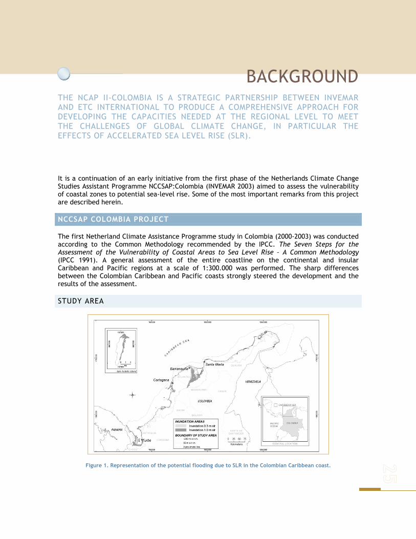
BACKGROUND THE NCAP II-COLOMBIA IS A STRATEGIC PARTNERSHIP BETWEEN INVEMAR AND ETC INTERNATIONAL TO PRODUCE A COMPREHENSIVE APPROACH FOR DEVELOPING THE CAPACITIES NEEDED AT THE REGIONAL LEVEL TO MEET THE CHALLENGES OF GLOBAL CLIMATE CHANGE, IN PARTICULAR THE EFFECTS OF ACCELERATED SEA LEVEL RISE (SLR).
It is a continuation of an early initiative from the first phase of the Netherlands Climate Change Studies Assistant Programme NCCSAP:Colombia (INVEMAR 2003) aimed to assess the vulnerability of coastal zones to potential sea-level rise. Some of the most important remarks from this project are described herein.
NCCSAP COLOMBIA PROJECT
The first Netherland Climate Assistance Programme study in Colombia (2000-2003) was conducted according to the Common Methodology recommended by the IPCC. The Seven Steps for the Assessment of the Vulnerability of Coastal Areas to Sea Level Rise – A Common Methodology (IPCC 1991). A general assessment of the entire coastline on the continental and insular Caribbean and Pacific regions at a scale of 1:300.000 was performed. The sharp differences between the Colombian Caribbean and Pacific coasts strongly steered the development and the results of the assessment.
STUDY AREA
Figure 1. Representation of the potential flooding due to SLR in the Colombian Caribbean coast.
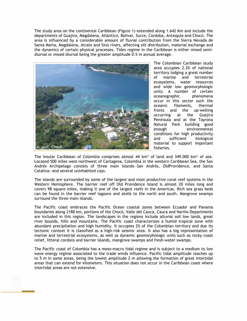
The study area on the continental Caribbean (Figure 1) extended along 1.642 Km and include the departments of Guajira, Magdalena, Atlántico, Bolivar, Sucre, Cordoba, Antioquia and Chocó. The area is influenced by a considerable amount of fluvial contribution from the Sierra Nevada de Santa Marta, Magdalena, Atrato and Sinú rivers, affecting silt distribution, material exchange and the dynamics of certain physical processes. Tides regime in the Caribbean is either mixed semi-diurnal or mixed diurnal being the greater amplitude 0.5 m annual average.
The Colombian Caribbean study area occupies 2.3% of national territory lodging a great number of marine and terrestrial ecosystems, water resources and wide low geomorphologic units. A number of certain oceanographic phenomena occur in this sector such the oceanic filaments, thermal fronts and the up-welling occurring at the Guajira Peninsula and at the Tayrona Natural Park building good enough environmental conditions for high productivity and sufficient biological material to support important fisheries.
The Insular Caribbean of Colombia comprises almost 44 km² of land and 349.000 km² of sea. Located 500 miles west-northwest of Cartagena, Colombia in the western Caribbean Sea, the San Andrés Archipelago consists of three main islands—San Andrés, OldProvidence, and Santa Catalina—and several uninhabited cays.
The islands are surrounded by some of the largest and most productive coral reef systems in the Western Hemisphere. The barrier reef off Old Providence Island is almost 20 miles long and covers 98 square miles, making it one of the largest reefs in the Americas. Rich sea grass beds can be found in the barrier reef lagoons and atolls to the north and south. Mangrove swamps surround the three main islands.
The Pacific coast embraces the Pacific Ocean coastal zones between Ecuador and Panama boundaries along 2188 km, portions of the Chocó, Valle del Cauca, Cauca and Nariño Departments are included in this region. The landscapes in the regions include alluvial soil low lands, great river bounds, hills and mountains. The Pacific coast characterizes a humid tropical zone with abundant precipitation and high humidity. It occupies 2% of the Colombian territory and due its tectonic context it is classified as a high-risk seismic area. It also has a big representation of marine and terrestrial ecosystems, as well as dynamic geomorphologic units such as rocky coast relief, littoral cordons and barrier islands, mangrove swamps and fresh-water swamps.
The Pacific coast of Colombia has a meso-macro tidal regime and is subject to a medium to low wave energy regime associated to the trade winds influence. Pacific tidal amplitude reaches up to 5 m in some areas, being the lowest amplitude 2 m allowing the formation of great intertidal areas that can extend for kilometers. This situation does not occur in the Caribbean coast where intertidal areas are not extensive.
Acandí, Chocó. C.G
arcia
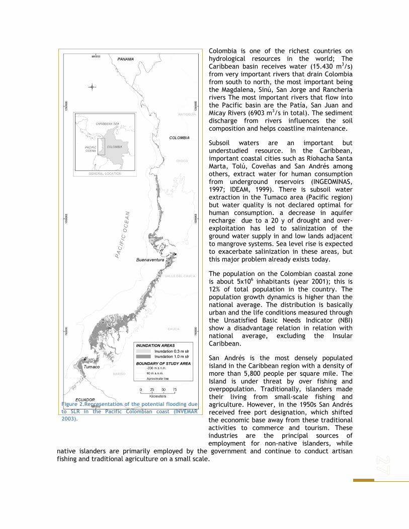
Colombia is one of the richest countries on hydrological resources in the world; The Caribbean basin receives water (15.430 m3/s) from very important rivers that drain Colombia from south to north, the most important being the Magdalena, Sinú, San Jorge and Rancheria rivers The most important rivers that flow into the Pacific basin are the Patía, San Juan and Micay Rivers (6903 m3/s in total). The sediment discharge from rivers influences the soil composition and helps coastline maintenance.
Subsoil waters are an important but understudied resource. In the Caribbean, important coastal cities such as Riohacha Santa Marta, Tolú, Coveñas and San Andrés among others, extract water for human consumption from underground reservoirs (INGEOMINAS, 1997; IDEAM, 1999). There is subsoil water extraction in the Tumaco area (Pacific region) but water quality is not declared optimal for human consumption. a decrease in aquifer recharge due to a 20 y of drought and over-exploitation has led to salinization of the ground water supply in and low lands adjacent to mangrove systems. Sea level rise is expected to exacerbate salinization in these areas, but this major problem already exists today.
The population on the Colombian coastal zone is about 5x10⁶ inhabitants (year 2001); this is 12% of total population in the country. The population growth dynamics is higher than the national average. The distribution is basically urban and the life conditions measured through the Unsatisfied Basic Needs Indicator (NBI) show a disadvantage relation in relation with national average, excluding the Insular Caribbean.
San Andrés is the most densely populated island in the Caribbean region with a density of more than 5,800 people per square mile. The Island is under threat by over fishing and overpopulation. Traditionally, islanders made their living from small-scale fishing and agriculture. However, in the 1950s San Andrés received free port designation, which shifted the economic base away from these traditional activities to commerce and tourism. These industries are the principal sources of employment for non-native islanders, while
native islanders are primarily employed by the government and continue to conduct artisan fishing and traditional agriculture on a small scale.
Figure 2.Representation of the potential flooding due to SLR in the Pacific Colombian coast (INVEMAR 2003).

Land use is very different for the three coastal areas: Cattle and crop rising are first on the continental Caribbean; in the insular Caribbean the use is for tourism, and in the Pacific coast, the areas are occupied for wild life and forest exploitation. Contribution of the coastal zone to the national economy is mainly centered on commercial trade, agriculture and cattle activities on the Caribbean and lumber industry on the Pacific coast. Anthropogenic uses of intertidal areas comprehend residence, ports development and recreation among others. In some cases even, mostly in the South Pacific, intertidal areas hold complete towns living on palafitte constructions.
Barranquilla is the main industrial (petrochemical and alimentary) city of the Caribbean region, followed by Cartagena and Santa Marta; trade and tourism activities are concentrated in those cities as well. The main cites of the Pacific coast are Buenaventura and Tumaco bearing a growing industrial and port activities. Those criteria indicate life quality conditions and social and cultural benefits that should promote social progress. However, despite these beneficiary circumstances, development and normal social progress dynamics can be strongly interfered by violence conditions. The actual crisis especially affects rich areas. In the Caribbean region, the higher violence indexes are especially found in banana plantation territories. Conflict intensity, kidnapping, murders and other ways that somehow influence administrative, industrial and agrarian centers express violence indexes.
Floods from rivers and estuaries have been the most common events reported in the Colombian coastal zones for the past 70 years. Followed by tropical storms, sudden and temporary sea level rise, rainy season, hurricanes, seismic, volcanic eruptions, habitat destruction and tsunamis.
There has occurred only one tsunami in the past 70 years (1979) that affected Tumaco, in the Pacific region. Main capital cities seem to be the most affected by coastal hazards; it is possible that even though coastal hazards occur along the entire coastal zones, cities are under greater pressure as population concentration centers and with more infrastructures that can be damaged in a coastal hazard event.
SCENARIOS
SEA-LEVEL RISE SCENARIOS
Two eustatic sea level rise scenarios were considered: 0.30 m for the year 2030 and 1.0 m for the year 2100. Although records of tide-gauge stations from Cartagena, Buenaventura and Tumaco were available, they didn’t cover a period long enough to allow analysis of sea level trends. Tide gauge records available cover only a short period of time with some missing data.
The accelerated sea-level rise inundation areas were generated on geomorphologic criteria due to the lack of detailed contour lines on Colombian cartography of coastal zones
SOCIOECONOMIC SCENARIOS
There are many aspects of sea level rise and its consequences that we are not able to predict. Thus two extreme scenarios for the Colombian coasts were analyzed, which involved socio-economic variables representing development factors as those key elements in the current and future outgrowth of the municipalities and coastal regions.
Rio Magdalena-Puerto Niño. Nov, 2007
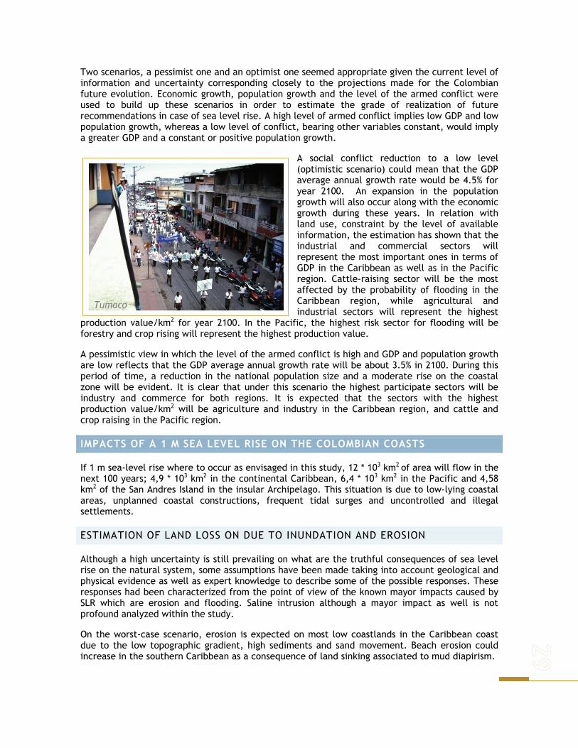
Two scenarios, a pessimist one and an optimist one seemed appropriate given the current level of information and uncertainty corresponding closely to the projections made for the Colombian future evolution. Economic growth, population growth and the level of the armed conflict were used to build up these scenarios in order to estimate the grade of realization of future recommendations in case of sea level rise. A high level of armed conflict implies low GDP and low population growth, whereas a low level of conflict, bearing other variables constant, would imply a greater GDP and a constant or positive population growth.
A social conflict reduction to a low level (optimistic scenario) could mean that the GDP average annual growth rate would be 4.5% for year 2100. An expansion in the population growth will also occur along with the economic growth during these years. In relation with land use, constraint by the level of available information, the estimation has shown that the industrial and commercial sectors will represent the most important ones in terms of GDP in the Caribbean as well as in the Pacific region. Cattle-raising sector will be the most affected by the probability of flooding in the Caribbean region, while agricultural and industrial sectors will represent the highest
production value/km2 for year 2100. In the Pacific, the highest risk sector for flooding will be forestry and crop rising will represent the highest production value.
A pessimistic view in which the level of the armed conflict is high and GDP and population growth are low reflects that the GDP average annual growth rate will be about 3.5% in 2100. During this period of time, a reduction in the national population size and a moderate rise on the coastal zone will be evident. It is clear that under this scenario the highest participate sectors will be industry and commerce for both regions. It is expected that the sectors with the highest production value/km2 will be agriculture and industry in the Caribbean region, and cattle and crop raising in the Pacific region.
IMPACTS OF A 1 M SEA LEVEL RISE ON THE COLOMBIAN COASTS
If 1 m sea-level rise where to occur as envisaged in this study, 12 * 103 km2 of area will flow in the next 100 years; 4,9 * 103 km2 in the continental Caribbean, 6,4 * 103 km2 in the Pacific and 4,58 km2 of the San Andres Island in the insular Archipelago. This situation is due to low-lying coastal areas, unplanned coastal constructions, frequent tidal surges and uncontrolled and illegal settlements.
ESTIMATION OF LAND LOSS ON DUE TO INUNDATION AND EROSION
Although a high uncertainty is still prevailing on what are the truthful consequences of sea level rise on the natural system, some assumptions have been made taking into account geological and physical evidence as well as expert knowledge to describe some of the possible responses. These responses had been characterized from the point of view of the known mayor impacts caused by SLR which are erosion and flooding. Saline intrusion although a mayor impact as well is not profound analyzed within the study.
On the worst-case scenario, erosion is expected on most low coastlands in the Caribbean coast due to the low topographic gradient, high sediments and sand movement. Beach erosion could increase in the southern Caribbean as a consequence of land sinking associated to mud diapirism.
Tumaco

Erosion on Pacific low coastland areas is also expected; high precipitation and rivers input have lead to the conformation of extend submarine sand barriers; deltas and sand barriers are expected to be the most affected systems on this coast. On the other hand, the sustainable management of the major deltas of the Pacific could reversed the erosion effects under a carefully controlled environment, allowing the natural functioning of deltas by utilizing, rather than diminishing, beneficial natural pulsing energies.
High coastal land erosion is expected to be a function of the resistance of cliffs materials. In this sense the southern Caribbean would be more affected whereas towards the northern cliffs, like Sierra Nevada de Santa Marta, significant effects are not expected. The same principle has been applied to the north Pacific high coastlands where erosion is expected towards the southern area and in some small local spots towards the north.
More so ever, despite the high rates of natural SLR over the past several thousand years, Pacific deltas have greatly increased in area because of riverine sediment delivery. Sediment deposition leads directly to accretion. Dissolved and particulate nutrients stimulate vegetation growth that increases organic soil formation, thus further increasing the rate of accretion. Deltas have grown through over bank flooding and also by changing channels every several hundred years.
The input of river water not only adds sediments, but also brings fresh water that lowers salinity stress and provides nutrients which increases the productivity of deltas. In this sense, it is also expected in some degree the self-response of this system to SLR impacts.
Again assuming the worst-case scenario, flooding processes in Colombia will parallel occur to the erosion process due to the characteristics of the coast morphology. Sea level rise would occur over all beaches along the Caribbean coastline and lead to the conformation of new sand deposits; flooding would affect the most the southern Pacific coast because of low coastlands extension, the presence of several rivers mouths and numerous internal drainage connections. Flooding will affect coastal lagoons and estuaries also by saline intrusion and the spread of their inundation area, fresh water input is expected to increase as well.
NATURAL SYSTEM RESPONSE TO SEA LEVEL RISE
In addition to the potential effects that inundation, erosion and saline intrusion have on natural systems, current pressures on the environment are also high. Habitat fragmentation, climate change (temperature and precipitation) and resources over exploitation could have equal or even higher effects than sea level rise as such. This is the case of the Colombian coastal ecosystems as well.
Salahonda
C. Ro
jas
Los Córdobas
B.Pos
ada

The effect of sea-level rise on ecosystems such as mangroves depends on the extent to which they continue to receive sediment. Where there is little o no sediment supply, submergence is likely to cause dieback and erosion of their seaward margin. But mangroves can still spread landward, displacing the low-lying hinterland in a natural environment.
The mangrove systems bordering the Cartagena and Morrosquillo Gulf areas of the Caribbean have all their hinterland reclaimed for settlements, and thus the mangrove fringe and the adjacent agricultural lands have become narrower and could eventually disappear as sea
level rises. This will lead to a loss of a large area of wetlands and fish spawning grounds.
The extent of sea level change effects over desert zonobiomes and dry tropical forest is expected to be primary as a consequence of saline intrusion and inundation, but tourism, industry and cities expansion have leaded to a considerable reduction of these systems n the last 20 years further than what could probably be caused by sea-level rise n the future.
Humid tropical forest will be affected by inundation and saline intrusion processes, it is expected a backwards migration, when possible, to more solid land and where the conditions allow colonization. Due to the large extension of the ecosystems, it is expected not to occur a definitive lost of the system; neither on uses or environmental services, as a general rule, once more the anthropogenic pressure over the system plays an important role in the near future.
Coral reefs responses to sea level rise will depend upon their distribution as well as the hydrographic, geomorphologic and biologic aspects occurring at short, middle and long term, also their inherent adaptation capabilities. Sea grasses remain sub-researched in Colombia; the effects of sea level change may be related to sediments and turbidity increment.
FLOOD AND INCREASE IN GROUND WATER LEVELS.
During the passages of extreme events the accompanying heavy downpour causes flooding in the mentioned mayor Caribbean cites, settlements established on reclaimed land in dried-up valleys and in settlements that have been developed very close to mangrove swamps and wetlands. Theses are also the areas where ground water is high and salinity is already a problem. The strengthen and frequency of tropical storms may increase due to climate change (IPCC 2000) This will lead to more flooding, and the problem may be exacerbated with sea level rise. Damage to structures such as buildings and roads will be the mayor effect of fresh water flooding.
ESTIMATES OF VALUE AND POPULATION AT RISK
For the social economic analysis only an approach for the impacts estimation in relation to the flooding effect was made. It is outlined that the natural system responses determine in a bigger
Cartagena de Indias M. Vi
des
Bahía Portete
D. Alo
nso
or minor grade the resources usage and its inherent costs and represent a social welfare lost. In order to solve methodological difficulties incapability between study area boundaries, potential flooding areas and the administrative boundaries as this is the reference for population and productive sector value information. In the specific case of the study area population, the base of information is represented by the municipalities’ projections corresponding to each scenario.
Not always, the coastal zone municipalities’ extension is included in the study area, moreover in a specific view; frequently a portion of the rural area of the municipality is contained in it. Taking into account these aspects, the population was consider for urban areas as the precise value of inhabitants and estimation was calculated for the rural areas based on the assumption of uniform distribution. According to this assumption, the estimation of population affected by inundation due to sea level rise and the population in risk was obtained
Based on an optimistic scenario by the year 2100 from the 12.7 million people that could inhabit the coastal areas, SLR could displace approximately 1.7 million. That is 2% of the national population for that year, being 77% correspondent to the Caribbean and 23% to the Pacific. In this scenario, it is also observed a mayor participation of the urban population corresponding to the 85% in comparison to the rural population. By the year, 2100 the mayor number of inhabitants would be located on the municipalities of Cartagena and Barranquilla as well as in the Tumaco, Turbo and Buenaventura areas.
On general terms and considering within the analysis the agricultural, catcalling, industrial, forestall and mining sectors, the result shows that 0.4% of the total departments GDP would be affected. Agriculture (81%), followed by catcalling (18%) and industry (1%) would be the most affected sectors. The affected participation of the Caribbean GDP would be 53% and for the Pacific would be 47%. The most affected departments under this scenario would be Chocó and Cauca with a 29% and 19% of their total affected GDP.
Under a pessimistic scenario, the total displaced population by 1.0 m SLR would be closer to 1.4 million people. That is 3% of the total national population of Colombia on that same year. An 86% of this population would inhabit the urban areas. By the year 2100, 0.4% of the total departmental GDP would be affected. The most affected economical sector would by agriculture (74%) followed by cattle (24%) and forestry (1%).
Preliminary analysis of the data suggest that XX US$ billion of property will be lost. It is not possible to attached monetary value to the loss of public places, ethnical territories, national parks, Biosphere Reserves, Ramsar sites and other similar places.
RESPONSE STRATEGIES AND ADAPTATION OPTIONS
A comprehensive evaluation of the economic consequences of 1.0 m sea-level rise of the entire Colombian coasts was not attempted. Due to limited information resources and time and because the vast scale of work, this evaluation was carried out only for critical areas identified by a matrix of importance done at the municipality level. The results of the matrix shows as risk critical areas due to SLR the municipalities of Cartagena, Santa Marta, Barranquilla and Turbo on the Caribbean, while Tumaco and Buenaventura were exposed on the Pacific. Case study areas where also included within this analysis to support the analysis due to their ecological importance as well as their great background knowledge: the north section of the Morrosquillo Gulf on the
Cartagena El
Unive
rsal

Caribbean and the Integrated Management Unit of Guapi-Iscuandé on the Pacific. Two response options to sea level were evaluated:
No protection: in this case, any coastal protection measures would be adopted. Therefore, land and capital loss would be the highest, but protection costs would be null. In this case, all the land in the study areas (12 * 103 km2) as well as the wetlands will be lost
Total protection: This option applied only on the critical and chosen areas, addresses two main strategies: the implementation of current Municipality Development Plans1 as well as current land planning strategies and the implementation of additional measures or actions to approach sea level rise and its effects. Additional measures include coastal defenses such as the protection of industrial, residential and tourist areas, including the maintenance of tourist beaches, raising coastal infrastructure and road protection. This response option also includes population relocation, construction of artificial reefs and islands, reinforcement of existing coastal defenses, promotion of accretion and other adaptation techniques.
If sea level rise where to occur as envisaged in this study, and considering the present economic situation of Colombia, the most appropriate response would be to protect the critical areas. These ones represent the greatest loss of the country in economic terms and have a higher population density. It is also important to consider the areas today being affected by severe erosion such as the beaches located of the Southern Colombian Caribbean on the Sucre, Córdoba and Antioquia departments. Coastal defenses would be feasible in Cartagena and Santa Marta, whereas in Barranquilla the main strategies focuses on the delta management and avoiding the location of population in the southern bound of the river. Population relocation will be a possible tool, mostly in the Pacific coast where thousands of people inhabit in the intertidal areas at present time. Buenaventura and Tumaco plans are already in process of implementing the allocation of the people, the main task for local governments will be then, to avoid new colonization of those areas.
1 Law 152, 1994) a Municipality Development Plan aims to enable a sustainable economic development that considers programs and projects in which environmental goods and values are estimated, in order to guarantee the environmental surplus for present and future generations

Figure 3. Most exposed municipalities to SLR. Cartagena; Barranquilla; Santa Marta; Turbo; Ciénaga; Tumaco; Buenaventura; Guapi; Nuqui; Mosquera.
While important autonomous adaptations will occur in coastal zones, the possible responses to climate change will require planned adaptation. This planned adaptation may include policies to allow autonomous adaptations to occur to the maximum possible extent. Evaluating adaptation requires a full understanding of the impact potential and the adaptation potential. The latter factor embraces autonomous adaptation, and (anticipatory and reactive) planned adaptations. This allows a realistic assessment of the likely initial and residual impacts, and hence the real vulnerability. Hence, this analysis should be considered as an academic and first impression exercise of the IPCC methodology, to identify the strengths and weakness of the present and future of Colombian Coastal Zones Management. The necessary measures to undertake the impacts of the future climate change should be taken under conscious and specific studies, based on former experiences and previous socialization measures.
The total protection strategy, adding management plans and additional measures to address a 1.0 m sea level rise, would require an initial cost of US$ mill 2.268 an equivalent of 3% of the national GDP for year 2001. The annual costs of the total protection strategies for the selected areas would be 62.2 US$ mill.
EVALUATION OF THE VULNERABILITY PROFILE

Even though, there is uncertainty regarding the impact of sea level change in Colombia, it is for sure that there will be a significant and possible severe change on the natural and socio-economic systems. The analysis established inhere has utilized the concept of vulnerability provided by the IPCC in 1997 in which a vulnerable system will be a system very sensible to moderate climate changes; such sensibility involves the potential detrimental effects and a low adaptation capacity. Hence, the analysis was divided in two phases: the first one measures natural systems susceptibility to sea level change and specific impacts in the socio-economic and natural systems; the second phase, involves the respond options implementation feasibility.
NATURAL SYSTEM SUSCEPTIBILITY ASSESSMENT
Natural system susceptibility assessment could be analyzed in terms of affected percentage area in relation of the total national cover and the autonomous adaptation of the system throughout the following expression:
Affected area Natural system susceptibility = ---------------------------------- Autonomous adaptation
Where the affected area is expressed as low (<3%), medium (3-30%) or high (>30%), with the correspond values 1, 2 or 3. The autonomous adaptation (Aa) is measured as 1= low aA or 2= high aA. The vulnerability classes used to classify the natural systems elements were 0.5-1, Low; 1.5 Medium; 2 High; 3 Critical.
Table 1. Vulnerability classes used to classify the natural system
Natural system components Values Low Medium High Critical
Tropical desert 2/1 Dry tropical forest 1/1 Humid tropical forest 1/2 Mangroves 3/1 Beaches 3/1 Coral reefs 3/1 Sea grasses 3/2 Sedimentary bottoms 2/2 Rocky shores 3/2
In general terms and based on the results of Table 1, the marine and coastal ecosystems of the Colombian coasts are highly susceptible to sea-level rise.
SOCIO-ECONOMIC ASSESSMENT
Values at loss, values at risk and response strategies are the three elements that have been included in this study to establish a quantitative vulnerability assessment analysis of the Colombian coastal zones. Values correspondent to such elements are the result of estimations under an optimistic and pessimistic development scenarios.
The capital value was calculated from the national GDP, which included agriculture, cattle, mining, forestry, industry and tourism sectors as well as the additional value of the affected accommodation. Vulnerability analysis comprehends the identification of two special scenarios (sea level rise and no sea level rise), on temporal scenarios (2001 and 2100) and two possible response strategies (no protection and total protection).

As a first insight from the analysis the differences between scenarios could be noticed and it is given by the cost of the strategy measured under the GDP participation, under this fact it would increase under a low economic grow. In terms of temporal scales, it is also possible to identify different results due to the participation of the capital value at lost and the population to translate within the national totals would be incremented assuming a 1 m SLR. The analysis for 2001 and 2100 let us evaluate the autonomous development changes of the study area under the

formulated scenarios. This result shows a tendency of growth of the capital value and population at risk in a more accelerated rate in the optimistic scenario compared with the pessimistic one.
Under an optimistic scenario, the capital value at lost would be 2.4% of the GDP in 2100; On the pessimistic scenario, this value is 1.9%. The vulnerability class according to the vulnerability classes’ category given by the IPCC methodology is medium. Taking into consideration the population needed to be relocated the percentage vary from 2% to 3.1% under an optimistic and a pessimistic scenario respectively in the year 2100. If a full strategy option shall be included within the former analysis, on the optimistic scenario the capital value would be reduced to 0.5% in 2100. The population to be relocated would also be reduced (0.7% in year 2100 projections). On a pessimistic scenario, a similar result can be observed with the difference of an increment strategy costs passing from 10% to 23% projection.
These results show that under intensification of the armed conflict and as a result of a diminishing on the economic growth of the country, it could be harder for Colombia to implement the necessary actions to reduce the risk of an SLR.
The table represents a summary of the detailed analysis. It can be observed that as a general tool, with the exception of the economic and financial aspects category, all of the vulnerability categories are ranked as high. Hence, it can be concluded that the vulnerability of Colombian coasts in economical terms to sea-level rise is high.
CONSTRAINS RELATED TO THE RESPONSE STRATEGIES IMPLEMENTATION FEASIBILITY
As it has been appointed by the IPCC methodology, the second part of the vulnerability assessment includes the identification of constrains to the implementation of response strategies. Constrains identified comprehend vulnerability assessment of legislation and regulations, economy and financial aspects, technical staff vulnerability and social and cultural aspects. Among those categories, three different levels have been determined: level A, basic institutions and requirements existence; level B, implementation and operation aspects; and level C, effectiveness and function constrains.
The results of the vulnerability assessment in reference of the feasibility of the selected scenario for Colombia are resumed on Table 2.
Table 2. Legislative, economic, technical and cultural feasibility constrains
FEASIBILITY CATEGORIES LOW MEDIUM HIGH CRITICAL Legislation, institution and organizations vulnerability assessment (VA-LIO)
Economic and financial aspects vulnerability assessment (VA-ECF)
Technical aspects vulnerability assessment (VA-TEC)
Cultural and social aspects vulnerability assessment (VA-CSO)
These results show that the legislative/institutional/organizational issues present a high vulnerability due to the lack of a national legal frame that involves Coastal Zone Management. The economical feasibility to implement the strategies is critical, since the country is not prepared to assume the financial coasts of the consequences of SLR. Technical feasibility is considered high due to the lack of technical capacity among the institutions to assume the subject; a formal institution willing to develop. Cultural and social vulnerability assessment is high, because life quality conditions at the Colombian Coastal zones is low in terms of healthcare and public services, which are bellow the national mean. What is more important, the violence

conflict affects a great area of the national territory and influences most of the economical activities.
It can be observed that as a general means, with the exception of the economic and financial aspects category, all of the vulnerability categories are ranked as high. However if the cost of implementing the proposed response options are considered, it is presumed that the country would not be able to afford the cost of implementing any of them. Hence, it can be conclude that the vulnerability of Colombian coasts to sea level rise is high.
COLOMBIA NATIONAL ACTION PLAN
The action plan includes priorities and measures of vulnerable geographic areas and economic sectors, management tools required to regulate the sustainable use of coastal zones and information required for present and future situations. It is targeted to the country's decision makers and aims to hand conclusions, recommendations and proposals that outline short, medium and long-term actions to address SLR as a consequence of climate change.
The ICZM process in Colombia has developed quite different from other countries in the world. It was one of the first countries in Latin America to approach the subject during the 1980s, enabling to accumulate experience that finally evolved into the PNAOCI presented by the Ministry of environment in December 2000. This apparent advantage should optimize the process of adaptation and response to SLR; however none of the plans presented, contemplate the vulnerability of coastal zones to SLR. None of them proposed specific measures for the prevention of the effects of SLR. The study results are to be inserted in the national coastal zone national plans where instruments already exist, but where there is a deficit of information and analysis on possible impacts of vulnerability and adaptation to SLR.
Another difference with other countries is that Colombia's coastal zone is not overpopulated; most of the development and population centers are located inland of Colombia. The country has an extent and complex coastal zone and oceanic space, for which the country has not yet developed management capacity. However, present tendencies show that growth is greater than the national average in these regions of the country and there are developments plans that point a change in population distribution and development. This urges the establishment of ICZM.
PRIORITY ACTIONS
The action plan outlines relevant short-term actions (30 years) directly related to actual problems encountered. For long-term actions, required responses should be evaluated in more detail under future circumstances. The following proposed actions will allow Colombia to start with the corrective measures needed to overcome the uncertainties and information lack, to improve governance capacity, to implement response strategies, to incorporate SLR in planning instruments and to create conscience and educate public in the topic:
Actions related to knowledge and information: Colombia revealed a deficiency of information to establish a proper integrated coastal management process. Even though there is technical capacity, the current lack of information only allows modeling the potential impact of SLR due to climate change in a coarse way. Apart from the lack of required information, there is disarticulation between researchers and information sources. Actions in this line are strongly related to other instruments such as the PNOACI and their developing programs based on research, monitoring and the implementation of an information system
Actions related to planning: SLR and climate change risks have not been included in any planning instrument or policy adopted by the governmental entities locally, regionally or at national level. The insertion of this topic into the actual framework is a way to start decreasing risks of climate change. Solutions must be participative and many levels of coastal management should be
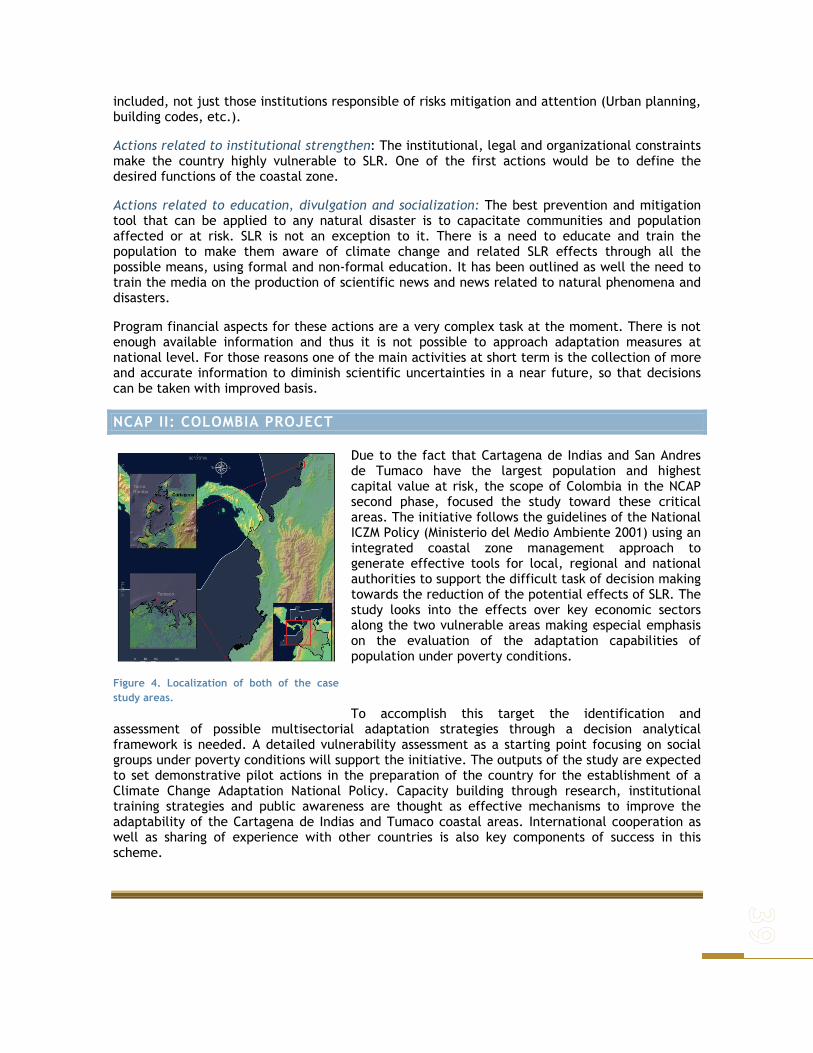
included, not just those institutions responsible of risks mitigation and attention (Urban planning, building codes, etc.).
Actions related to institutional strengthen: The institutional, legal and organizational constraints make the country highly vulnerable to SLR. One of the first actions would be to define the desired functions of the coastal zone.
Actions related to education, divulgation and socialization: The best prevention and mitigation tool that can be applied to any natural disaster is to capacitate communities and population affected or at risk. SLR is not an exception to it. There is a need to educate and train the population to make them aware of climate change and related SLR effects through all the possible means, using formal and non-formal education. It has been outlined as well the need to train the media on the production of scientific news and news related to natural phenomena and disasters.
Program financial aspects for these actions are a very complex task at the moment. There is not enough available information and thus it is not possible to approach adaptation measures at national level. For those reasons one of the main activities at short term is the collection of more and accurate information to diminish scientific uncertainties in a near future, so that decisions can be taken with improved basis.
NCAP II: COLOMBIA PROJECT
Due to the fact that Cartagena de Indias and San Andres de Tumaco have the largest population and highest capital value at risk, the scope of Colombia in the NCAP second phase, focused the study toward these critical areas. The initiative follows the guidelines of the National ICZM Policy (Ministerio del Medio Ambiente 2001) using an integrated coastal zone management approach to generate effective tools for local, regional and national authorities to support the difficult task of decision making towards the reduction of the potential effects of SLR. The study looks into the effects over key economic sectors along the two vulnerable areas making especial emphasis on the evaluation of the adaptation capabilities of population under poverty conditions.
To accomplish this target the identification and assessment of possible multisectorial adaptation strategies through a decision analytical framework is needed. A detailed vulnerability assessment as a starting point focusing on social groups under poverty conditions will support the initiative. The outputs of the study are expected to set demonstrative pilot actions in the preparation of the country for the establishment of a Climate Change Adaptation National Policy. Capacity building through research, institutional training strategies and public awareness are thought as effective mechanisms to improve the adaptability of the Cartagena de Indias and Tumaco coastal areas. International cooperation as well as sharing of experience with other countries is also key components of success in this scheme.
Figure 4. Localization of both of the casestudy areas.


APPROACH/METHODOLOGIES/TOOLS THE CAPACITY BUILDING STRATEGY AIMED ON THE PROJECT IS SUPPORTED ON THE GENERATION OF DECISION ANALYTICAL TOOLS SUITABLE FOR LOCAL POLICY AND DECISION MAKERS RESPONSIBLE FOR DEVISING AND IMPLEMENTING ADAPTIVE POLICIES TO THE IMPACTS OF SEA LEVEL RISE.
According with the line of action established for the ICZM approach followed by Colombia (Alonso-Carvajal et al. 2003), an integrated view of the systems of Cartagena de Indias and San Andres de Tumaco is intended. The physical, economic and social impacts of sea-level rise due to climate change will be examined. Fisheries and tourism have been identified as the most directly affected economic sectors by SLR, and thus a more rigorous evaluation is needed as a basis for discussion with key stakeholders such as population under poverty conditions.
For this purpose, the term ‘key stakeholders’ is used to mean individuals, groups, or institutions that have an interest or stake, or could be potentially affected by the outcome of the project. The primary stakeholders are the most affected and vulnerable populations to climate risks for a specified human system. They are the direct beneficiaries of the project. The secondary stakeholders are those who are able to influence the success, or failure, of the project. Serving both to meet the capacity building and adaptation goals of the project, stakeholders will be engaged in the project through information dissemination,
consultations, surveys, workshops to exchange and validate information, and cooperative actions.
The methodological scheme intended in the project (Figure 5) combines the adaptation frameworks proposed by Klein and Nicholls (1999), UNDP - GEF Adaptation Policy Framework (2003), DINAS-COAST Project methodology and the one proposed by Sharifi et al. (2004), Framework for Planning and Decision-making Process. The framework recognizes that local scale interventions should be consistent with and inform national-scale policies. The framework also assumes that systems change over time, and that vulnerabilities and adaptation to current experiences will not necessarily be the same in the future.
Figure 5. Methodological scheme NCAP-Colombia
Cartagena Workshop

Within this scheme, an initial state of the art of the system definition is used as the starting point. Then a vulnerability assessment is made to include into the analysis the assessment of both anticipated impacts and available adaptation options. A scenario development process is included in the Adaptation Decision Matrix approach (IPCC 2001) to synthesize and assess alternative policy options that respond to different adaptation measures. A spatial decision support system approach would help to assess the implications of local adaptation alternatives. Finally, a Policy Exercise Approach will follow to downscale known national policy options to reduce climate vulnerability in the local level. During the first eighteen months of execution of the project, the first three steps were completed, setting the basis for the last one.
SYSTEM DESCRIPTION
This phase examines the environment to identify problem or opportunity situations. Includes defining and describing the system; embrace perceived problems or opportunities in terms of boundaries, natural environment, social and economic sectors, stakeholders, space and time. It is based mainly on existing assessments and published and available studies, expert judgment and stakeholder’s verification. A specific examination of current development activities, especially those activities that increase vulnerability to climate variability and change, are also included.
Figure 6. Schematic components of the SD phase.
As explained before the information required for this study was taken from secondary sources. In the process a profound search of information concerning natural systems found in the area, was carried out. After gathering such information, both for Tumaco and Cartagena, the information was filtered, using only the one produced after 1999, and considering always the latest reports and data found. Despite this, some information was limited and it was complemented with expert knowledge that helped to understand current dynamics of the systems found in Tumaco and Cartagena.
In both areas important research institutes exist, which have carried out several investigations and are currently advancing in the research of the zone and the systems involved; however one of the main difficulties found in the process of establishing the basis for this study, was gathering the information as it is not clear how it can be found, who actually has the final versions and under what conditions can it be used.
Using secondary sources of information to describe the areas and natural systems involved returned a further complication, as the information wasn’t always done with the same level of detail for the entire area and all the systems involved; furthermore, information was produced at different moments, which means that data for each system was from different moments in time. Despite this, expert knowledge and area recognition helped in a great deal to create the most accurate picture of the areas that available information made possible.
For the biophysical component the main sources of information were previous studies carried out in the area that gave enough information to obtain a general idea of the current state of the natural systems involved. Stakeholders acted as a filter for such information and helped in a great deal to adapt such sources of information to actual state with old and new pressures that

were identified. In this point a Local Workshop showed the need to reduce study area for Cartagena de Indias case, given the wide array of difficulties and pressures imposed for the initial chosen area.
In this phase two crucial steps were carried out, as a problem analysis was done to identify specific problems that natural systems face in each study area. This problem analysis was done using information previously produced in the area, as well as stakeholder’s opinions. These turned out with a complete natural’s system description and a scenario that guided directly to the next stage in which a susceptibility assessment of the systems implied was done.
Socioeconomic system’s description for Cartagena is based on online available secondary information, as well as from statistical series and analytical documents. Given that in this phase a current situation description is intended, only recently produced information was used.
For San Andres de Tumaco, given institutional problems typical for the area, no diverse studies that analyze its socioeconomic situation were found. Neither detailed information of the rural area. For these reasons, this first phase of the analysis is complemented with primary information collected in the rural area throughout a fieldwork campaign.
Study area delimitation as a result of stakeholder’s participation, both in Cartagena de Indias and in San Andres de Tumaco, allowed selecting the most affected sectors by SLR: Fisheries and tourism. Impact analysis is presented as an additional chapter to the current report. In this phase other sectors are briefly described, which may have incidence in study areas and that contribute to a general vision of both municipalities.
VULNERABILITY ASSESSMENT
In natural systems the term susceptibility was preferred as it refers to the degree to which a system is open, liable, or sensitive to climate changes. This susceptibility depends not only on the systems characteristics, but on other pressures imposed upon them as well. Socioeconomic vulnerability refers to society’s economic, institutional, technical and cultural ability to prevent or face changes in the socioeconomic system.
Vulnerability and susceptibility for Cartagena and Tumaco were analyzed under the following concepts:
1) the susceptibility and vulnerability of the coastal area given current circumstances, without the effects of sea-level rise;
2) the susceptibility of the coastal area to the physical and ecological changes imposed by sea-level rise, under different scenarios and vulnerability regarding socioeconomic changes;
3) the capacity to cope with the impacts, including the possibilities to prevent or reduce impacts via adaptation measures (‘adaptive capacity’).
All three concepts were analyzed under the spatial representation of impacts in order to contribute to a more realistic problem analysis following the lessons learned from the DINAS-COAST projects methodology.
Following, a selection of impact indicators suitable for each particular area was done, the First generation of base- line environmental indicators of the Colombian Environmental Information System (SIAC in Spanish) was used (IDEAM et al. 2002). Indicators were accompanied by a definition, a method of calculation, interpretation, means of verification and associated assumptions. The sum of these indicators indicated overall susceptibility for the natural systems found in the area.

As a result, a set of susceptibility maps were generated for each area. The ESRI Geodatabase structure in Arc GIS9.0 seemed as an appropriated tool for modeling these dynamical systems concepts, for expressing the static information about the system data model as well as other concepts for representing the system’s dynamics.
Figure 7. General scheme of the vulnerability assessment.
For establishing natural system’s susceptibility, information obtained from the previous phase, as well as expert knowledge and local stakeholder perceptions were used to calculate the overall index composed of six indicators:
Ecosystem coverage Water Quality and Hydrographic processes integrity Ecosystem quality Recovery areas Land- Use: habitat conversion Hazards
Causality analysis of socioeconomic problems in both study areas, and its validation for Cartagena de Indias case, allowed the recognition of relevant variables to evaluate socioeconomic system’s vulnerability.
In such a way, socioeconomic vulnerability index (SVI) is composed by the following indicators:
Demographics Economics Natural resources usage Political and institutional Cultural
Although the same set of indicators was chosen for Tumaco and Cartagena, it is very important to keep in mind that they were calculated accordingly in each area, as it depended upon available information and their common and particular characteristics. A detailed description of such processes can be found in the chapter concerning natural system’s susceptibility and socioeconomic vulnerability. It is important to remember that this susceptibility and vulnerability reflected only the current state of natural and socioeconomic systems. Further pressure imposed by sea level rise is found afterwards, were scenarios were developed, using different socioeconomic and environmental characteristics and different levels of sea level rise.
Scenarios were located in the year 2019. The reason for choosing this particular year lays in the document Colombia’s national government Visión Colombia II Centenario: 2019. This document is an ambitious proposal from which it pretends to foster a long term vision of the country for the next 14 years, when it will commemorate its second century of political independence. This discussion document, prepared by Colombia’s Department of National Planning in concurrence with Ministries and other government agencies, proposes 19 different strategies; a vision of how

the country is supposed to be. It focus mainly on the socioeconomic aspect, however is important to understand that many of the improved aspects concerning this kind of development, affect indirectly or directly environmental aspects.
SEA LEVEL RISE SCENARIOS
Combined with different perspectives regarding the environment, scenarios were crossed with different inundation levels depend on the severity of sea level rise. It is important to note that although scenarios are located in the year 2019, sea level rises levels are not projections done for that year, but are based considering hazard maps found in the development plans for each area (Cartagena and Tumaco) and satellite image analysis.
Although the flooded areas remained constant for the different scenarios (depending on flood level, low or high) what was interesting to observe from a biophysical perspective is that given the system’s susceptibility, their ability to respond and readapt to sea level rise, changes not only with flooded area (depending inundation level) but it depends directly on system’s susceptibility (other pressures imposed upon them, migration possibilities, etc.) and on the topographic characteristics of a given area. The only thing that wasn’t modified within the scenarios was this last characteristic, but the other two were modified to reflect possible outcomes of different perspectives given different amounts in sea level rise.
ADAPTATION DECISION MATRIX (ADM)
This phase takes into consideration the understanding of the system’s behavior by establishing the functional and structural relationships among major elements. It is a tool used to determine given local circumstances which adaptation measures are likely to be implemented on a shorter time frame, given the measures characteristics, local needs and local capacity in different levels.
Figure 8. Format used in the workshops to collect the adaptation measures descriptions.
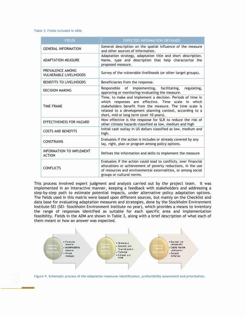
Table 3. Fields included in ADM.
FIELDS EXPECTED INFORMATION OBTAINED
GENERAL INFORMATION General description on the spatial influence of the measure and other sources of information.
ADAPTATION MEASURE Adaptation strategy, adaptation title and short description. Name, type and description that help characterize the proposed measure.
PREVALENCE AMONG VULNERABLE LIVELIHOODS
Survey of the vulnerable livelihoods (or other target groups).
BENEFITS TO LIVELIHOODS Beneficiaries from the response.
DECISION MAKING Responsible of implementing, facilitating, regulating, approving or monitoring/evaluating the measure.
TIME FRAME
Time, to make and implement a decision. Periods of time in which responses are effective. Time scale in which stakeholders benefit from the measure. The time scale is related to a development planning context, according to a short, mid or long term (over 10 years).
EFFECTIVENESS FOR HAZARD How effective is the response for SLR to reduce the risk of other climate hazards classified as low, medium and high
COSTS AND BENEFITS Initial cash outlay in US dollars classified as low, medium and high.
CONSTRAINS Evaluates if the action is includes or already covered by any lay, right, plan or program among policy options.
INFORMATION TO IMPLEMENT ACTION
Defines the information and skills to implement the measure
CONFLICTS
Evaluates if the action could lead to conflicts, over financial allocations or achievement of poverty reductions, in the use of resources and environmental externalities, or among social groups or cultural norms.
This process involved expert judgment and analysis carried out by the project team. It was implemented in an interactive manner, keeping a feedback with stakeholders and addressing a step-by-step path to estimate potential impacts, under alternative policy adaptation options. The fields used in this matrix were based upon different sources, but mainly on the Checklist and data base for evaluating adaptation measures and strategies, done by the Stockholm Environment Institute-SEI (SEI- Stockholm Environment Institute no year), which provides a means to inventory the range of responses identified as suitable for each specific area and implementation feasibility. Fields in the ADM are shown in Table 3, along with a brief description of what each of them meant or how an answer was expected.
Figure 9. Schematic process of the adaptation measures identification, prefactibility assessment and priorization.
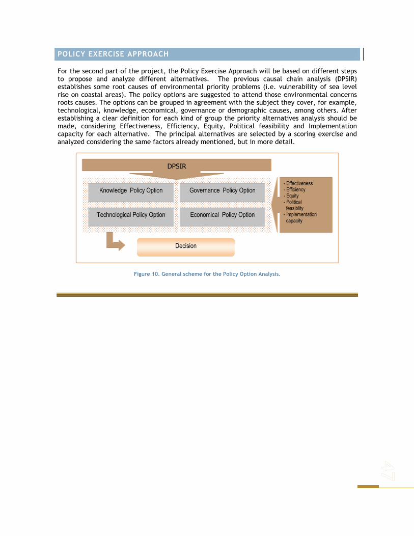
POLICY EXERCISE APPROACH
For the second part of the project, the Policy Exercise Approach will be based on different steps to propose and analyze different alternatives. The previous causal chain analysis (DPSIR) establishes some root causes of environmental priority problems (i.e. vulnerability of sea level rise on coastal areas). The policy options are suggested to attend those environmental concerns roots causes. The options can be grouped in agreement with the subject they cover, for example, technological, knowledge, economical, governance or demographic causes, among others. After establishing a clear definition for each kind of group the priority alternatives analysis should be made, considering Effectiveness, Efficiency, Equity, Political feasibility and Implementation capacity for each alternative. The principal alternatives are selected by a scoring exercise and analyzed considering the same factors already mentioned, but in more detail.
Figure 10. General scheme for the Policy Option Analysis.
Technological Policy Option
Knowledge Policy Option
Economical Policy Option
Governance Policy Option
DPSIR
- Effectiveness - Efficiency - Equity - Political feasiblity - Implementation capacity
Decision

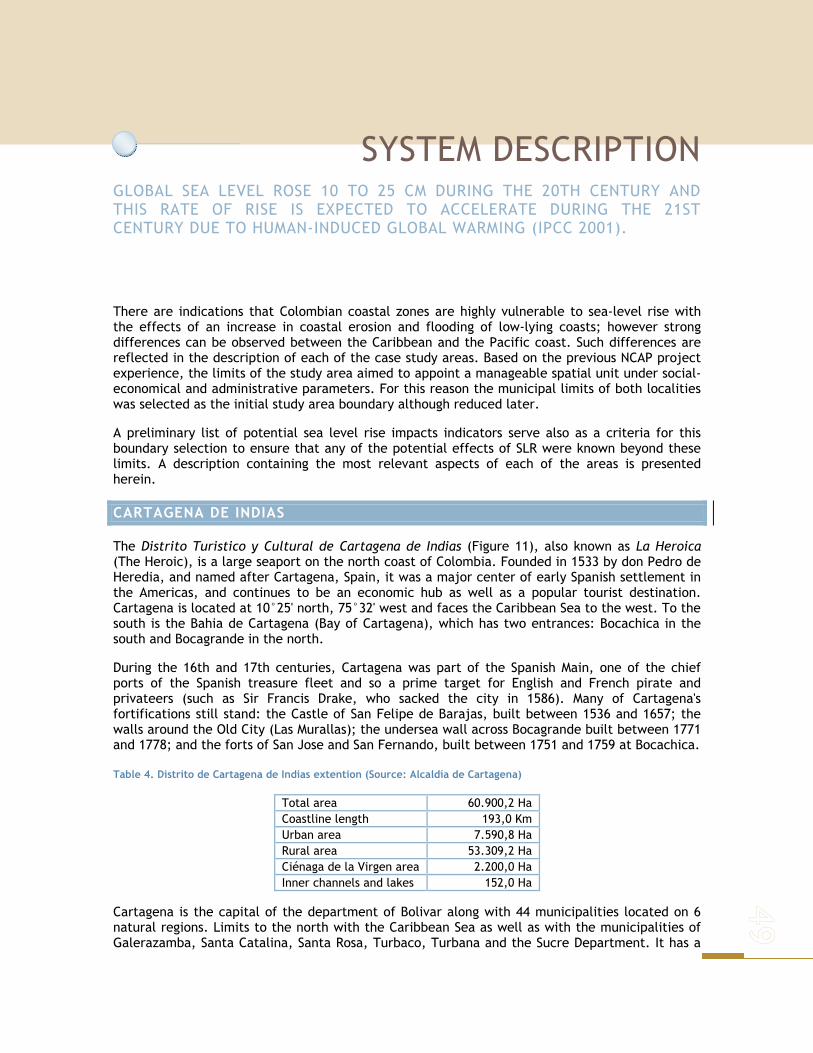
SYSTEM DESCRIPTION GLOBAL SEA LEVEL ROSE 10 TO 25 CM DURING THE 20TH CENTURY AND THIS RATE OF RISE IS EXPECTED TO ACCELERATE DURING THE 21ST CENTURY DUE TO HUMAN-INDUCED GLOBAL WARMING (IPCC 2001).
There are indications that Colombian coastal zones are highly vulnerable to sea-level rise with the effects of an increase in coastal erosion and flooding of low-lying coasts; however strong differences can be observed between the Caribbean and the Pacific coast. Such differences are reflected in the description of each of the case study areas. Based on the previous NCAP project experience, the limits of the study area aimed to appoint a manageable spatial unit under social-economical and administrative parameters. For this reason the municipal limits of both localities was selected as the initial study area boundary although reduced later.
A preliminary list of potential sea level rise impacts indicators serve also as a criteria for this boundary selection to ensure that any of the potential effects of SLR were known beyond these limits. A description containing the most relevant aspects of each of the areas is presented herein.
CARTAGENA DE INDIAS
The Distrito Turistico y Cultural de Cartagena de Indias (Figure 11), also known as La Heroica (The Heroic), is a large seaport on the north coast of Colombia. Founded in 1533 by don Pedro de Heredia, and named after Cartagena, Spain, it was a major center of early Spanish settlement in the Americas, and continues to be an economic hub as well as a popular tourist destination. Cartagena is located at 10°25' north, 75°32' west and faces the Caribbean Sea to the west. To the south is the Bahia de Cartagena (Bay of Cartagena), which has two entrances: Bocachica in the south and Bocagrande in the north.
During the 16th and 17th centuries, Cartagena was part of the Spanish Main, one of the chief ports of the Spanish treasure fleet and so a prime target for English and French pirate and privateers (such as Sir Francis Drake, who sacked the city in 1586). Many of Cartagena's fortifications still stand: the Castle of San Felipe de Barajas, built between 1536 and 1657; the walls around the Old City (Las Murallas); the undersea wall across Bocagrande built between 1771 and 1778; and the forts of San Jose and San Fernando, built between 1751 and 1759 at Bocachica.
Table 4. Distrito de Cartagena de Indias extention (Source: Alcaldía de Cartagena)
Total area 60.900,2 Ha Coastline length 193,0 Km Urban area 7.590,8 Ha Rural area 53.309,2 Ha Ciénaga de la Virgen area 2.200,0 Ha Inner channels and lakes 152,0 Ha
Cartagena is the capital of the department of Bolivar along with 44 municipalities located on 6 natural regions. Limits to the north with the Caribbean Sea as well as with the municipalities of Galerazamba, Santa Catalina, Santa Rosa, Turbaco, Turbana and the Sucre Department. It has a

territorial extension of 609 km2, with an 8.86% belonging to the urban area and the rest 551.1 km2 (91.14%) to the suburban and urban area (Alcaldia de Cartagena, 2000).
In 1984, the Committee of the World-wide Patrimony of UNESCO included in the list of the world-wide patrimony the "Port, Strength and Monumental Set of Cartagena de Indias".
Figure 11. General limits of Distrito Turistico y Cultural de Cartagena.
The bay of Cartagena de Indias is located geographically among the coordinates 10º 16', 10º 26' N and 75º 30', 75º 35' W. The area of the mirror of water is of 82.6 Km, depth average is 16 m and the maximum is around 30 m. It’s connected with the Caribbean Sea through several channels. In the north, the openning between Tierrabomba Island and Lake Bocagrande has a Jetty found
between 0.6 and 2.1 m deep and 2 km width. In the south there are three channels: Bocachica, the current sailing channel, with 30 m deep and 500 m wide; the Shipyard channel, 2 m deep and 500 m wide; and a last one is the one conformed between the islands Draga and Abanico, with 2 m of depth and 300 m wide.
In the south of the bay the Channel of the Dike an arm of the river Magdalena is located. The channel of the Dike has an approximate width of 100 m, a variable depth between 2 and 3 m and a flow between 100 and 1100 m3/s being the average of the order of 5000 m3/s. The bay of Cartagena is classified as an estuary, due to the presence of the channel of the Dike. The superficial salinity is variable, between 0 and 30, in short distances (some kilometers), between the outlet of the channel and the mouths of the bay. The saline stratification is the main factor that influences in general in the dynamics of the bay, formed, for the flow of sweet waters of the channel, the winds and the tide (Lonin et al. 2004) (Figure 11).
Due to Cartagena's tropical location, the climate changes very little, with an average high of 31°C (88°F) and an average low of 24°C (75.4°F) throughout the year. Cartagena also averages around 90% humidity, with a rainy season typically in October. Cartagena receives about 100 cm (40 inches) of rain a year (CIOH and CARDIQUE 1998).
About 30 km southeast of Cartagena there is a complex of islands, peninsulas and inner water bodies, that conform the insular and the continental area (Figure 11). Within the insular area the nationally protected park Corales del Rosario y San Bernardo embrace the biggest marine protected area of Colombia. The principal water bodies within the urban area are the Bahía de Cartagena, Ciénaga de la Virgen and Ciénaga de Juan Polo that are connected by a complex system of lakes and channels (Alcaldía de Cartagena 2000). All natural ecosystems had been seriously threaten by local mismanagement making them vulnerable to future disturbances such as the ones caused by SLR.
METEOROLOGICAL ASPECTS
To define the weather characteristics of the study area, were used the data of IDEAM for the Station in Cartagena. As typical in the Colombian Caribbean this zone has a tropical weather, hot and dry.
Cartagena´s average Temperature is 27.5 ºC, with 37 ºC maximum absolute and the 19 ºC minimum absolute. During the wet season temperatures superiors or equals to 31ºC, been June and July the month with the higher temperature values with 32ºC. Among January and March, dry season, the temperature is higher with values less than 31ºC. Cartagena´s monthly average sun shines total values 250 hours.
During the wet season sun shine is superiors or equals to 240 hour. The highest sun shine is presented in the month of January with 280 hour. The humidity varies in the range of 78% to 82% during the year. The values varies among January and May, humidity varies among 79% and 81%. Between July to December varies among 81% to 82%. The average evaporation varies among 140 and 200 mm per month. Graphics of temperature, sun shine, relative humidity and evaporation from the station IDEAM Cartagena are shown on Figure 12.

Figure 12. Values for Temperature, Relative humidity, Sun Shine and Evaporation. Source: IDEAM 2006.
The weather characteristics in the research area have a few rains, with high sun shine. In this zone the rainfall is 90mm average per month. The higher values is presented in October (during 17 days of month), with 260 mm average per month. Also from May to September (during 13 days of month), the rainfall is 41 mm average per month, and the lowest values of rainfall in January to April (during 2 days of month), with values of 10mm average per month, see Figure 13.
Figure 13. Year monthly average precipitation. 1961-1990. Source: IDEAM, 2006
Winds affecting the research area have its origins in the north (Alisios Winds), and its annual regimen it’s related with the winter in the north hemisphere. Its dominating direction is north and has the most intensity in February and March, which sometimes generates electrical storms. See figure 4.Given the different and severity of the threats the area faces, after the first workshop carried out in the area, the study area was reduced for Cartagena de Indias (Figure 14) to make a deeper analysis of the most threatened and vulnerable area according to local stake holders (Cienaga de la Virgen and Bahia de Cartagena).
Figure 14. Winds Rose. Source: IDEAM, 2006

OCEAN DYNAMICS
Circulation in the southwestern Caribbean is highly variable. It is driven in large part by seasonal changes in the trade winds and the Intertropical Convergence Zone, or "ITCZ", and possibly also by interactions with the offshore Caribbean Current. In winter, the ITCZ shifts slightly south and the weather over the Caribbean region is often dry, but very windy. These winds cause strong upwelling of nutrient-rich water and productive fisheries. In summer, the ITCZ moves north and the winds die away; however, ITCZ clouds produce intense rainfall up to two meters during the rainy season. Heavy rainfall in the region can modify the salinity and density of the nearby bay and affect current flow (CIOH and CARDIQUE 1998).
Additional to these general currents a local one is generated by the Canal del Dique (Dike Channel) that can reach the Islas del Rosario according to the season (June - July). Between December and April (dry season) the strong winds can cause high waves flooding inshore areas. (CIOH, 1998).
The Canal del Dique is an artificial structure also influencing greatly the dynamic of the area. It is an artificial channel constructed in 1650 than communicated the Magdalena river with the Cartagena and Barbacoas Bays thru the Lerica, Matunilla and Pasacaballos sewers. This channel has a low topography with north south direction (Lemaitre, 1982 en Alcaldía de Cartagena, 2000). The low Magdalena region hidro-climatic regimes make a distinction of its behavior averaging 1000 and 1500 mm annual precipitation (Niño 2001).
WAVE IN DEEPWATER
From the state of sea, calculated for the researched area, using the software “OLAS” (Tejada 2002b, developed by the CCCP with support from GIOC from Spain), it was observed that the representative waves correspond to the first, second and third quadrant, predominating the direction of the waves originated of the second quadrant (North -East), with a presentation frequency of the 75,9% of the time (274 days of the year), for the first quadrant (North – West) the presentation frequency is 4% (15days of the year), for the third quadrant (South – West) the presentation frequency is 6% (22 days of the year), for the fourth quadrant, which doesn’t have any incidence on the waves that arrive to the coast, the presentation frequency is 10,2% (37 days of the year). Finally, the non-wave existence in the sector is 3,9% (14 days of the year) (Figure 15.).
QUADRANT DIRECTION
Presentation frequency in deepwater
(%)
Quadrants presentation frequency
(%) N (N) 5.2 N – NE (N23E) 12.5 NE (N 45 E) 34.6 II
NE – E (N 68 E) 23.6
75.9
W (W) 1.3 W – NW (N68 – W) 0.9 NW (N 45 W) 0.7 I
NW – N (N 23 W) 1.1
4
S (S) 1.8 S – SW (S 23 W) 1.6 SW (S 45 W) 1.4 III
SW – W (S 68 W) 1.2
6
E (E) 8.3 E – SE (S 68 E) 0.8 SE (S 45 E) 0.5 IV
SE – S (S 23 E) 0.6
10.2
Calms outside range 3.9
Figure 15. State of sea and Wave direction and presentation frequency. Deepwater. Source: Olas – Tejada 2002b

Figure 16. Cartagena de Indias study area, including Cienaga de la Virgen and Bahia de Cartagena
The Scalar Wave Height shows the height of the waves coming from all directions in the Cartagena area. The Significant Wave Height of the deepwater in Cartagena (Hs50%) is 1.5 meters, (Average Height Hs50%), with peak period of 7.0 seconds. For probabilities superiors to 99%, wave heights are up to 3.5 meters, with peak periods of 15 seconds..
Directional Wave height presents the wave characteristics, according with the analyzed direction, Cartagena area are representative the first, second and third quadrant. For each representative direction, the average wave height (Hs50) was determined with presentation probability of 50%of the time, and the wave height for presentation probability over 95% of the time (See Table 5.)

Table 5. Wave height directional wave height
Direction Hs Tp Prof. N23E 1.5 7 1000 N23E 2.5 9 1000 N23E 3.5 15 1000 N 1.5 7 1000 N 2.5 9 1000 N 3.5 15 1000 N23W 1.5 7 1000 N23W 2.5 9 1000 N23W 3.5 15 1000 W 1.5 7 1000 W 2.5 13 1000 S67W 1.5 7 1000 S67W 2.5 13 1000
For all the evaluated directions, the average wave height (Hs50) is 1.5 meters, with a peak period (Tp) of 7.0 seconds, as well as presented before in the Scalar Wave.
The Colombian Caribbean Sea, there are not measurement of Extremal Wave that allows to do survey of the extremal wave analysis. To be able to identify the extremal wave, were used the equations deducted by Zuboy N.N. from the oceanographic tables Leningrado, Gdrometroizda, 1975, to calculate the Extremal Wave in average waves.
WAVES PERIOD π h F(h) = exp -
4 h
π t F(t) = exp -
4.8 t
where: h : extremal wave height h : medium height of wave t :extremal wave period t : wave médium period
2 4
The wave extreme analysis was done, based on average waves presented on the study zone for returns periods (Tr) from 5 to 100 years.
WAVE IN SHALLOW WATER
In shallow water, the height of wave that gets by the coast produced by directions North – East (the most frequent), is the average 0.25 meters. The directions West (less frequent), the height of wave that gets by the line coast is average 0.5 meters (Figure 17.).
Figure 17. Wave in shallow water. Source: Model SMC-COL
425000 430000 435000 440000 445000
1140000
1145000
1150000
1155000
0.00
0.50
1.00
1.50
2.00
2.50
3.00
3.50
4.00
4.50
5.00
5.50
6.00
6.50
7.00
7.50
8.00
8.50
9.00
9.50
10.00

The characteristics of the wave in different points located in the coast of Cartagena show that the height of the waves is between 0.2 and 0.6 meters, (for wave in depth water 1.5 to 3.5 meters). See Figure 17. and Table 5.
TIDES
The tides in the Colombian Caribbean Sea are irregular; they are semidiurnal with two high tides and two low tides are not presented exactly in a period of 24 hours, but rather it is presented a high tide, a low tide followed by an ascent and light descent of the level of the waters. The width (oscillation of the level starting from the half level) half multianual doesn't overcome the 30 cm. The characteristics of the tides during the period of measurement are presented in the Figure 18.
Figure 18. Tide variations in Cartagena
CURRENTS
In the sector of Cartagena, the currents are of the order of 0.05 m/s, which traffic parallel to the coast until the sector of Bocagrande. For the sector of Bocagrande the biggest currents were presented with intensities of up to 0.10 m/s, reflecting a high erosion process (Figure 19).
SEDIMENT TRANSPORT
The potential transport of sediments for an average year, it is calculated starting from the average régimen of the characteristic surf for the study area. The calculus can be obtained applying the formulations of Cerc and Kamphuis, using adjustment parameters proposed by Shoones and Theron (1994, 1996). The gross potential transport corresponds to the total transport regardless of clockwise along the coast line and the net is the one obtained carrying out the balance of the transport for clockwise. The net transport at the end of December gives an idea of the coast transport of silt in an average year.
For the study area, the transport of sediments monthly brute obtained through the formulation of Kamphuis is of the order of 50.000 m3/m, among the months of January to April, diminishing up to 20.000 m3/m, in June and increasing up to 60.000 m3/m, in July, and of 30.000 m3/m among August to December. The annual net transport is of 398.966,16 m3/year (Figure 20).
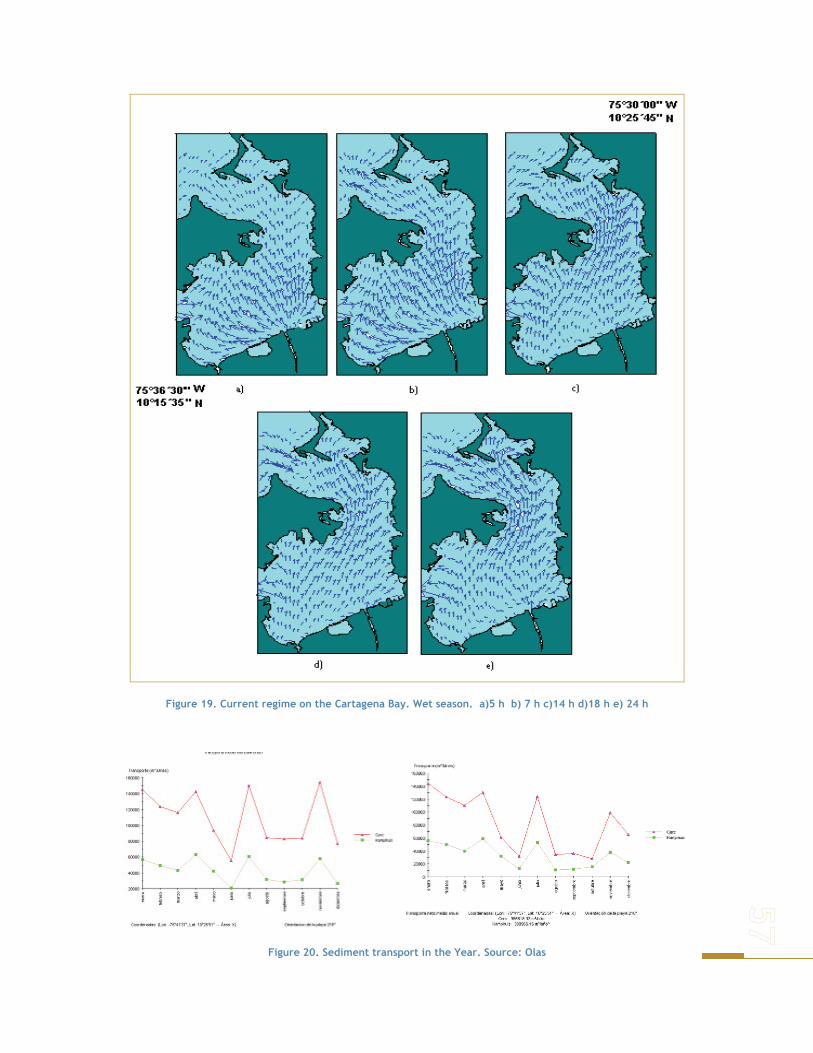
Figure 19. Current regime on the Cartagena Bay. Wet season. a)5 h b) 7 h c)14 h d)18 h e) 24 h
Figure 20. Sediment transport in the Year. Source: Olas
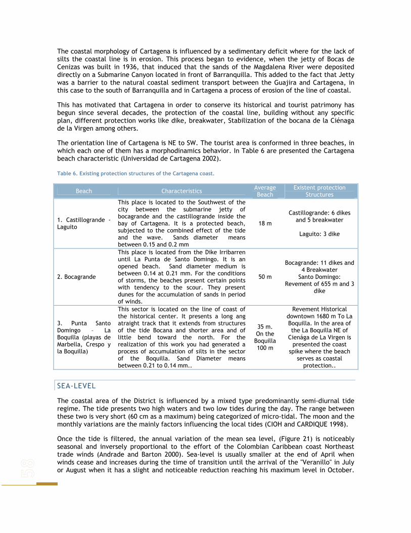
The coastal morphology of Cartagena is influenced by a sedimentary deficit where for the lack of silts the coastal line is in erosion. This process began to evidence, when the jetty of Bocas de Cenizas was built in 1936, that induced that the sands of the Magdalena River were deposited directly on a Submarine Canyon located in front of Barranquilla. This added to the fact that Jetty was a barrier to the natural coastal sediment transport between the Guajira and Cartagena, in this case to the south of Barranquilla and in Cartagena a process of erosion of the line of coastal.
This has motivated that Cartagena in order to conserve its historical and tourist patrimony has begun since several decades, the protection of the coastal line, building without any specific plan, different protection works like dike, breakwater, Stabilization of the bocana de la Ciénaga de la Virgen among others.
The orientation line of Cartagena is NE to SW. The tourist area is conformed in three beaches, in which each one of them has a morphodinamics behavior. In Table 6 are presented the Cartagena beach characteristic (Universidad de Cartagena 2002).
Table 6. Existing protection structures of the Cartagena coast.
Beach Characteristics Average Beach
Existent protection Structures
1. Castillogrande - Laguito
This place is located to the Southwest of the city between the submarine jetty of bocagrande and the castillogrande inside the bay of Cartagena. It is a protected beach, subjected to the combined effect of the tide and the wave. Sands diameter means between 0.15 and 0.2 mm
18 m
Castillogrande: 6 dikes and 5 breakwater
Laguito: 3 dike
2. Bocagrande
This place is located from the Dike Irribarren until La Punta de Santo Domingo. It is an opened beach. Sand diameter medium is between 0.14 at 0.21 mm. For the conditions of storms, the beaches present certain points with tendency to the scour. They present dunes for the accumulation of sands in period of winds.
50 m
Bocagrande: 11 dikes and 4 Breakwater
Santo Domingo: Revement of 655 m and 3
dike
3. Punta Santo Domingo – La Boquilla (playas de Marbella, Crespo y la Boquilla)
This sector is located on the line of coast of the historical center. It presents a long ang atraight track that it extends from structures of the tide Bocana and shorter area and of little bend toward the north. For the realization of this work you had generated a process of accumulation of silts in the sector of the Boquilla. Sand Diameter means between 0.21 to 0.14 mm..
35 m. On the Boquilla 100 m
Revement Historical downtown 1680 m To La Boquilla. In the area of the La Boquilla NE of
Cienága de La Virgen is presented the coast
spike where the beach serves as coastal
protection..
SEA-LEVEL
The coastal area of the District is influenced by a mixed type predominantly semi-diurnal tide regime. The tide presents two high waters and two low tides during the day. The range between these two is very short (60 cm as a maximum) being categorized of micro-tidal. The moon and the monthly variations are the mainly factors influencing the local tides (CIOH and CARDIQUE 1998).
Once the tide is filtered, the annual variation of the mean sea level, (Figure 21) is noticeably seasonal and inversely proportional to the effort of the Colombian Caribbean coast Northeast trade winds (Andrade and Barton 2000). Sea-level is usually smaller at the end of April when winds cease and increases during the time of transition until the arrival of the "Veranillo" in July or August when it has a slight and noticeable reduction reaching his maximum level in October.

At the end of the boreal summer, due to the seasonal thermal expansion, there is a shift of wind direction and intensity of the Crosscurrent of Panama-Colombia (Andrade 2000).
The lower sea-level returns at the end of November with the arrival of the “wind time”. This annual variation reaches around 40cm. Added to the 40cm of amplitude in a high tide in October, produces during day hours an increase of almost a meter at the Bay mean sea-level. The phenomena traduces in to the well-known yearly floods of the low zones of the coast in Cartagena, the overflowing of pipes, the opening of the bar of the Cienaga de la Virgen (from the sea towards inside) among other aspects that have been observed and little studied. When considering the associated problems of sea level rise it is generally spoken about the possible interannual increase greater to ten years. These are the most important variations to be considered at the present study.
a)b)
-400
-200
0
200
400
años1950 19801970 19901960 2000
-400
-200
0
200
400
años1950 19801970 19901960 2000
-100
0
100
200
300
ENOS
MUY ALTOS NIVELES DIC 99
-100
0
100
200
1980 1982 1984 1986 1988 1990
ENOS
Niv
el d
el m
ar C
arta
gena
(mm
)
c) d)
años años
1990 1992 1994 1996 1990 2000-100
0
100
200
300
ENOS
MUY ALTOS NIVELES DIC 99
-100
0
100
200
1980 1982 1984 1986 1988 1990
ENOS
Niv
el d
el m
ar C
arta
gena
(mm
)
c) d)
años años
1990 1992 1994 1996 1990 2000
-200
-100
0
100
200
1950 1960 1970 1980 1990 2000
-200
-100
0
100
200
1950 1960 1970 1980 1990 2000
Niv
el d
el m
ar C
arta
gena
(mm
)
años
Figure 21. a) Cartagena steady increase of sea level (lineal-blue and polynomial-red tendency) multi-annual monthly mean (1951-2000). b) Stationed changes 6.5 period during the last two decades (filtered from previous) c) 80´s register amplification, d) 90´s register amplification. Evident variability during ENOS years (1982-83 y 1996-97). December 99 record the highest level during the period.
GEOLOGY AND GEOMORPHOLOGIC ASPECTS
The morphological and sediment characteristics of the area are generated from the interaction of the three converging faults: Caribbean, Nazca and South American (Vernette 1985). The Andean sediments discharged from the Magdalena River and Canal del Dique are responsible for the terrestrial origin coastal continental margin of Cartagena; arcillious diapirism is also responsible for the formation of the base of the coral reefs areas from Islas del Rosario and San Bernardo archipelago (Vernette et al. 1992).
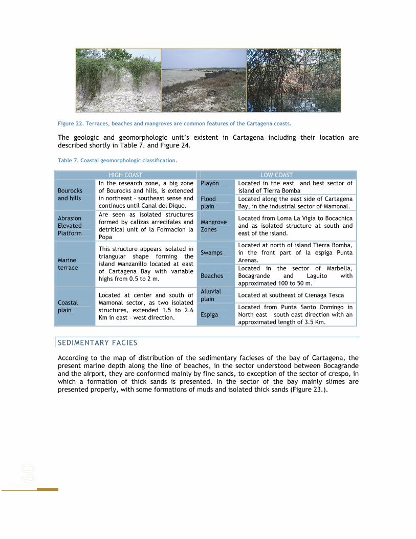
Figure 22. Terraces, beaches and mangroves are common features of the Cartagena coasts.
The geologic and geomorphologic unit’s existent in Cartagena including their location are described shortly in Table 7. and Figure 24.
Table 7. Coastal geomorphologic classification.
HIGH COAST LOW COAST Playón
Located in the east and best sector of island of Tierra Bomba Bourocks
and hills
In the research zone, a big zone of Bourocks and hills, is extended in northeast – southeast sense and continues until Canal del Dique.
Flood plain
Located along the east side of Cartagena Bay, in the industrial sector of Mamonal.
Abrasion Elevated Platform
Are seen as isolated structures formed by calizas arrecifales and detritical unit of la Formacion la Popa
Mangrove Zones
Located from Loma La Vigía to Bocachica and as isolated structure at south and east of the island.
Swamps Located at north of island Tierra Bomba, in the front part of la espiga Punta Arenas. Marine
terrace
This structure appears isolated in triangular shape forming the island Manzanillo located at east of Cartagena Bay with variable highs from 0.5 to 2 m. Beaches
Located in the sector of Marbella, Bocagrande and Laguito with approximated 100 to 50 m.
Alluvial plain
Located at southeast of Cienaga Tesca Coastal plain
Located at center and south of Mamonal sector, as two isolated structures, extended 1.5 to 2.6 Km in east – west direction. Espiga
Located from Punta Santo Domingo in North east – south east direction with an approximated length of 3.5 Km.
SEDIMENTARY FACIES
According to the map of distribution of the sedimentary facieses of the bay of Cartagena, the present marine depth along the line of beaches, in the sector understood between Bocagrande and the airport, they are conformed mainly by fine sands, to exception of the sector of crespo, in which a formation of thick sands is presented. In the sector of the bay mainly slimes are presented properly, with some formations of muds and isolated thick sands (Figure 23.).

Figure 23. Sedimentary fascies of the Bahia de Cartagena. Source DIMAR 1993
COASTAL VARIATIONS
During the last 12 years the coastal line between Galerazamba and Bahia de Barbacoas evidence important changes associated to coastal processes. These modifications are the result of short (winds, tides, waves, litological process) and long (tectonic) geological and geomorphologic agents. Seasonal climatic changes and their associated oceanographic phenomena act as modifiers on those areas susceptible to the sediment accumulation and lost. The regional accumulation and erosion processes can be associated to the Galerazamba arcillious diapirism (CIOH and CARDIQUE 1998).
Erosion and sedimentation rates of 10 m/year are considered extremely high in comparison to the global standard (Bird 1985); nevertheless in some sectors of Bocacanoas and Flecha de Galerazamba this rate can be as high as 18 and 53 m/year. This variability on the beaches nursing and misplacing during very long periods of time can also be understood on local seasonal changes. Significant changes on the position and conformation of the coast line of the area can be registered during the last 12 years of observation.
The coast is dominated by unconsolidated sediments and low topography. These changes can be reflected on huge extension of sediment deposition mainly in the Flecha de Glareazamba, Tombolo, Isla Cascajo, Punta Piedra and Punta Canoas. In some areas such as Galerazamba, Bocacanoa, Punta Canoas and Boquilla the coastal withdraw have been less important.

Figure 24. Erosive sites along the coast of Cartagena on coastal geomorphologic units.
The growing of old beaches in Flecha de Galerazamba sector has formed a sandy bar interrupting the Amangaguapo channel water mixed between the Cienaga de Totumo and the sea. Sea water enters the Cienaga La Redonda thru an artificial channel allowing sea water irrigation into the shrimp factories. High sedimentation into the channel forces continues dredging (CIOH and CARDIQUE 1998). Continuous backward movements, mainly in its distal part of the Flecha, have forced the relocation of Pueblo Nuevo causing illegal settlements and associated social problems Several meters of variation in the bathymetry of the area has been caused by the subsidence and uplifting of the shallow platform due to the arcillious diapirism (Correa 1990).
Figure 25. Catastrophic consequences of the rainy season during 2006.
Table 8., lists the major disasters experienced in the Cartagena region during the 1990s. The listing of events and their consequences is incomplete, but it does provide insight into the types

of events, and their significance. All the events listed have atmospheric origins, and 17 where caused by high tides.
Table 8. Major disasters in Cartagena de Indias Source: DESINVENTAR (2005)
Year Event type Casualties Population affected
Houses affected
Other losses
1932 Hurricane 1 100 Crops 1938 Landslide Roads 1938 Flooding NA Roads, crops (1) bridge 1939 Flooding- High tides NA Crops, cattle roads 1940 Flooding NA 3 Crops 1948 Flooding -Storm surge 2 5 Energy 1955 Flooding NA Roads 1957 Hurricane 100 10 1966 High tides NA Roads 1971 Storm surge Flooding 50 Energy, crops 1974 Flooding 15.000 1975 Storm surge 30 1978 High tides Roads 1980 Storm surge 4 Roads 1982 Storm surge 30 30 Industry
1984 High tides Dry wave Flooding
NA Roads, beaches, cattle, crops, Industry
1985 Flooding - Rain 2 NA NA Industry, roads, airport
1986 High tides –Flooding - Rain NA Roads, beaches, tourism airport
1987 High tides Flooding 1 40.000 520 Roads, communications
1987 High tides - Rain Roads, beaches, airport
1988 Flooding Dry wave Landslide
10 223.000 710 Roads, airport, energy
1989 Heat wave High tides Flooding
NA Communications, roads beaches
1990 Flooding - High tides 1.620 300 Roads, energy 1991 Heat wave - Storm surge Energy
1992 Dry wave - Storm surge - Flooding
Energy Communications
1993 High tides Flooding Tourism ,beaches, roads
1993 High tides 52 7 1995 Flooding - Landslide 7.320 26
1996 High tides -Storm surge Rain Flooding
3 53 110 Beaches, gas, roads Communications, energy
1999 Landslide - Flooding 9.505 36
2000 High tides - Landslide 20 8 Communications, energy
2002 High tides - Rain - Flooding 2.550 Beaches, Commerce Energy
The origin of the hurricanes is generally to the East of the Colombian coast, all years its occurrence is presented from July to November. Usually the area more affected it is the Guajira. The Sierra Nevada of Santa Marta is a very important natural protection; but the people coast has
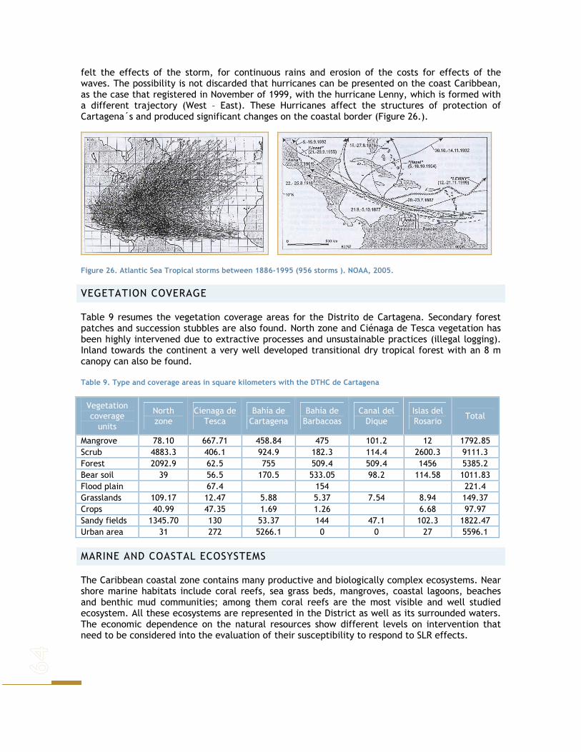
felt the effects of the storm, for continuous rains and erosion of the costs for effects of the waves. The possibility is not discarded that hurricanes can be presented on the coast Caribbean, as the case that registered in November of 1999, with the hurricane Lenny, which is formed with a different trajectory (West – East). These Hurricanes affect the structures of protection of Cartagena´s and produced significant changes on the coastal border (Figure 26.).
Figure 26. Atlantic Sea Tropical storms between 1886-1995 (956 storms ). NOAA, 2005.
VEGETATION COVERAGE
Table 9 resumes the vegetation coverage areas for the Distrito de Cartagena. Secondary forest patches and succession stubbles are also found. North zone and Ciénaga de Tesca vegetation has been highly intervened due to extractive processes and unsustainable practices (illegal logging). Inland towards the continent a very well developed transitional dry tropical forest with an 8 m canopy can also be found.
Table 9. Type and coverage areas in square kilometers with the DTHC de Cartagena
Vegetation coverage
units
North zone
Cienaga de Tesca
Bahía de Cartagena
Bahía de Barbacoas
Canal del Dique
Islas del Rosario
Total
Mangrove 78.10 667.71 458.84 475 101.2 12 1792.85 Scrub 4883.3 406.1 924.9 182.3 114.4 2600.3 9111.3 Forest 2092.9 62.5 755 509.4 509.4 1456 5385.2 Bear soil 39 56.5 170.5 533.05 98.2 114.58 1011.83 Flood plain 67.4 154 221.4 Grasslands 109.17 12.47 5.88 5.37 7.54 8.94 149.37 Crops 40.99 47.35 1.69 1.26 6.68 97.97 Sandy fields 1345.70 130 53.37 144 47.1 102.3 1822.47 Urban area 31 272 5266.1 0 0 27 5596.1
MARINE AND COASTAL ECOSYSTEMS
The Caribbean coastal zone contains many productive and biologically complex ecosystems. Near shore marine habitats include coral reefs, sea grass beds, mangroves, coastal lagoons, beaches and benthic mud communities; among them coral reefs are the most visible and well studied ecosystem. All these ecosystems are represented in the District as well as its surrounded waters. The economic dependence on the natural resources show different levels on intervention that need to be considered into the evaluation of their susceptibility to respond to SLR effects.
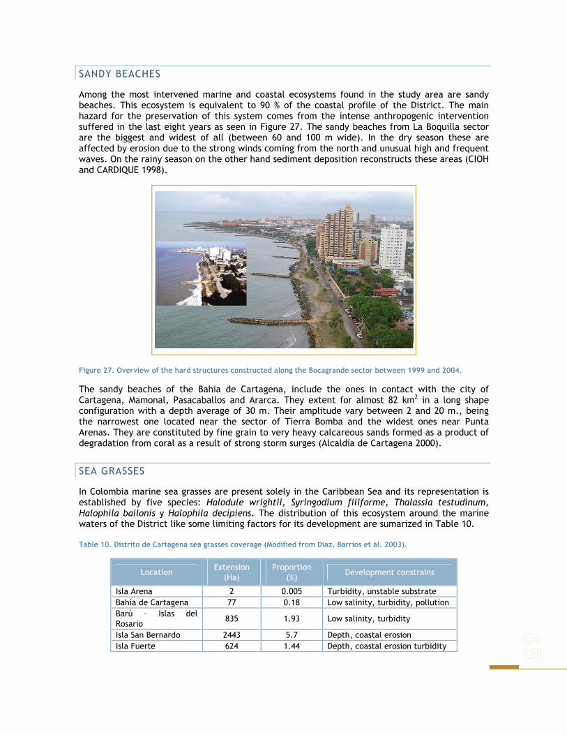
SANDY BEACHES
Among the most intervened marine and coastal ecosystems found in the study area are sandy beaches. This ecosystem is equivalent to 90 % of the coastal profile of the District. The main hazard for the preservation of this system comes from the intense anthropogenic intervention suffered in the last eight years as seen in Figure 27. The sandy beaches from La Boquilla sector are the biggest and widest of all (between 60 and 100 m wide). In the dry season these are affected by erosion due to the strong winds coming from the north and unusual high and frequent waves. On the rainy season on the other hand sediment deposition reconstructs these areas (CIOH and CARDIQUE 1998).
Figure 27. Overview of the hard structures constructed along the Bocagrande sector between 1999 and 2004.
The sandy beaches of the Bahia de Cartagena, include the ones in contact with the city of Cartagena, Mamonal, Pasacaballos and Ararca. They extent for almost 82 km2 in a long shape configuration with a depth average of 30 m. Their amplitude vary between 2 and 20 m., being the narrowest one located near the sector of Tierra Bomba and the widest ones near Punta Arenas. They are constituted by fine grain to very heavy calcareous sands formed as a product of degradation from coral as a result of strong storm surges (Alcaldía de Cartagena 2000).
SEA GRASSES
In Colombia marine sea grasses are present solely in the Caribbean Sea and its representation is established by five species: Halodule wrightii, Syringodium filiforme, Thalassia testudinum, Halophila bailonis y Halophila decipiens. The distribution of this ecosystem around the marine waters of the District like some limiting factors for its development are sumarized in Table 10.
Table 10. Distrito de Cartagena sea grasses coverage (Modified from Díaz, Barrios et al. 2003).
Location Extension
(Ha) Proportion
(%) Development constrains
Isla Arena 2 0.005 Turbidity, unstable substrate Bahía de Cartagena 77 0.18 Low salinity, turbidity, pollution Barú – Islas del Rosario
835 1.93 Low salinity, turbidity
Isla San Bernardo 2443 5.7 Depth, coastal erosion Isla Fuerte 624 1.44 Depth, coastal erosion turbidity

This is one of the most threatened ecosystems, and for the study area only an approximate of 76 ha of sea grasses are left in open beach and 58 Ha inside the bay. The predominant species is Thalassia and sometimes is combined with Syringodium, Halophila and Halodule. They can be found between 1 and 25 meters depth. They can be associated to seaweed, mollusks, crabs, sponges and sea urchins. They are threatened mainly by the untreated sewage disposal and the continental water unloading (Díaz et al. 2003).
Figure 28. General distribution of the main marine and coastal ecosystems found in the study area; Mangroves, Beaches and Sea grasses.

ESTUARIES, DELTAS AND COASTAL LAGOONS
The biggest coastal lagoon in the area is the Cienaga de la Virgen, which has a length of 22.5 km and a mean depth of about 1.5m. It is separated from the sea by La Boquilla’s bar and is surrounded by mangrove areas and anthropogenic intervened areas (Alcaldía de Cartagena 2000; Niño 2001). Additionally it is constantly loosing area given the constant inflow of sediments that result from continental erosion. On the eastern flank it receives streams that carry waters coming from nearby human settlements (Santa Catalina, Santa Rosa and Turbaco) and that wash out farming and cattle areas (Niño 2001).
South and west flanks are intervened by human expansion and the construction of a new road along its border. This area is home of several of the city’s periphery districts. In this zone also occurs the inflow of waste water systems and city drains from some of the most densely populated areas. Sedimentation processes observed have favored urban expansion towards the inner part of the lagoon. The western flank receives La Boquilla’s population constant pressure, were strong settlements that are constantly growing along with erosion, can be observed (Niño 2001).
Juan Polo’s marsh is the northern part of the Cienaga de la Virgen and the one that receives greater marine influence. It is as well the best environmentally preserved area. The central part of La Virgen’s complex, shows an island- like formation, resulting in sediment deposition, where a mangrove area has established. The inner side towards La Boquilla, a delta resulting from sea sedimentation is formed. In this area mangroves that diminish wave action have also settled down (Niño 2001).
In Cartagena’s bay low floodable areas restricted to the northeastern part of Tierra Bomba island, are found. These are usually surrounded by mangrove areas. The largest is going through accretion processes and shows high intervention levels as it is being filled with trash to adequate areas for building infrastructure (Alcaldía de Cartagena 2000).
Figure 29. Visual comparison of the expansion of the invasive illegal settlement into the Cienaga de la Virgen occurring in the last 40 years.
1954 2003

In this area other marshes located at the eastern flank of the bay can be found, in the industrial sector known as Mamonal. They have maximum amplitude of 12 m to the south of the bay. At present they have been modified by fillings done for port and industrial installation.
In Cartagena’s bay is possible to find low zones, susceptible to floods. They appear in the middle and south of Mamonal as two isolated bodies that reach between 1.5 and 2.6 km in eastern- western direction.
MANGROVES
In all the borders towards the sea in Cartagena there are mangroves, except in the frame between Mamonal and the inner bay (Figure 30).
Despite this it is possible to observe a small relict surrounding the islands facing Industrial zone, borders of inner streams connected to Cienaga de la Virgen and borders of Tierra Bomba and Baru Islands.
Figure 30. Highly intervened mangrove areas in the city.
In sea related areas in Canal del Dique’s sector, also mangroves are the main land cover, finding the five reported species for the Caribbean (mainly Rhizophora mangle, Avicennia nítida y Laguncularia racenosa) surrounded by verdolaga (Portulaca sp) (Sánchez- Páez et. al. 2004). In areas with low sea influence Avicennia nítida prevails (CIOH and CARDIQUE 1998).
Table 11. Mangrove areas for Bolivar’s Department (Source:CIOH- Cardique, 1998)
Mangrove Areas Units Extension
(Ha) Zonation
Delta and Canal del Dique Sectors Sustainable use Barbacoas Bay and Matunilla and Lequerica streams sectors
Recuperation Canal del Dique’s Delta and Barbacoa’s Bay
Cacique Dulio (Santa Ana- Baru Island)
4547
Preservation Baru Island Recuperation
Insular Rosario, San Bernardo, Punta de Baru, Palma Island and Fuerte Island
614 Preservation
Tierra Bomba Island Recuperation Cienaga del Coquito towards la Carbonera Sectors
Recuperation
Mamonal’s and Manzanillo’s Sectors Recuperation Varadero Sector Preservation
Cartagena’s Bay
Cartagena´s Bay Islands
556
Preservation Streams and Lagoons in Cartagena
Streams and inner lagoons 94 Preservation
Cienagas de la Virgen and Juan Polo’s complexes
Cienagas de la Virgen and Juan Polo 824 Recuperation
North Zone Manzanillo del mar- Galerazamba Sectors
366 Recuperation
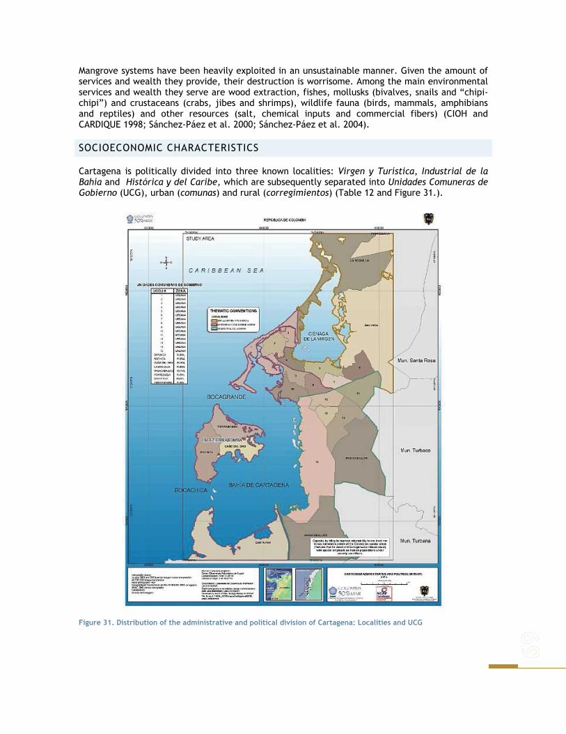
Mangrove systems have been heavily exploited in an unsustainable manner. Given the amount of services and wealth they provide, their destruction is worrisome. Among the main environmental services and wealth they serve are wood extraction, fishes, mollusks (bivalves, snails and “chipi-chipi”) and crustaceans (crabs, jibes and shrimps), wildlife fauna (birds, mammals, amphibians and reptiles) and other resources (salt, chemical inputs and commercial fibers) (CIOH and CARDIQUE 1998; Sánchez-Páez et al. 2000; Sánchez-Páez et al. 2004).
SOCIOECONOMIC CHARACTERISTICS
Cartagena is politically divided into three known localities: Virgen y Turística, Industrial de la Bahía and Histórica y del Caribe, which are subsequently separated into Unidades Comuneras de Gobierno (UCG), urban (comunas) and rural (corregimientos) (Table 12 and Figure 31.).
Figure 31. Distribution of the administrative and political division of Cartagena: Localities and UCG

DEMOGRAPHY
According to the projections of the National Statistical Administrative Department (DANE) in 2005 Cartagena counts with 1´030.149 inhabitants, from which 952.855 live in the urban area and 77.294 live in rural area.
Table 12. Administrative and political division of Cartagena. Source: www.alcaldiadecartagena.gov.co
Locality Unidades Comuneras de Gobierno -UCG
Rural Unidades Comuneras de Gobierno
Histórica y del Caribe Norte
1-2-3-8-9-10 Tierra bomba – Caño del oro – Bocachica – Santa
Ana- Barú – Isla Fuerte – Archipiélago de San Bernardo, Islas del Rosario.
De la Virgen y Turística
4-5-6-7 Boquilla - Punta Canoa – Pontezuela – Bayunca –
Arroyo de Piedra –Arroyo Grande. Industrial de la
Bahía 11-12-13-14-15
Pasacaballos – sector Membrillal – Sector variante Cartagena y Cordialidad
A detailed analysis using 2005 Census information was made using the urban and rural UCG classification. In general terms a notorious differentiation between the Urban UCG in terms of population, education level, public services, economic services and housing type is well notice.
Figure 32. Population range distribution and population density range distribution in the study area.
Nearly 60% of households in the urban areas are houses while this percentage grows up to 89% in the rural areas. The exception occurs in the UCG 1, where there are high percentage of apartments (70%). In rural areas, 95.4% of households have a connection to electricity, but only 4.6% is connected to sewerage. A similar proportion occurs in the urban area (Figure 33).

Figure 33.
Figure 33. UCG housing characteristic.
The number of people per household in rural areas is 4.3 while in the urban areas ranges from four in the UCG 6 up to six to in the UCG 3. Approximately 57.5% of households in rural areas have 4 or fewer people.

Figure 34. Urban UCG household occupancy, gender distribution and marital status distribution.
Of the total population of rural areas 50.4% are men and 49.6% women. The only notorious difference among the Urban UCG is seen in the UCG 1 where 44.1 % of the population is women and the 55.1% men. The 36.2% of the people in the rural area 10 years and over are living in free union. The 9.0% of the rural area population was born in another municipality.
Figure 35. UCG schooling and education distribution.
The 56.5% of the 3 to 5 years rural population attend a formal education establishment; 95.1% of the people from 6 to 10 years and 93.4% of the people from 11 to 17 years. The highest 3 to 17 age range attendace can be seen in the UCG 11 and the lowest one in the UCG 12. The 41.5% of the population living in rural areas, has reached the basic primary level and 33.8% secondary has reached the 1.1% level professional and 0.2% has studied specialization, masters or doctorate. The resident population without any educational level is 13.6%.
Figure 36. Economic activity distribution of the UCG.
The 6.0% of the establishments in the rural area are engaged in Industry; 46.7% to trade; 44.1% Services and 3.1% for other activities. The 3.2% of households in rural areas have economic activity in their homes.
POVERTY AND WELFARE
Poverty conditions are analyzed under SISBEN index. SISBEN (System for the Selection of Beneficiaries of Social Programs) is a proxy means test index widely used as a targeting system for social programs in Colombia. The SISBEN index is a function of a set of household variables related to the consumption of durable goods, human capital endowment and current income.

SISBEN was created by the Colombian government with the purpose of simplifying, expediting and reducing the cost of targeting individual beneficiaries of social programs at the various government levels (Vélez et al. 1999).
In the Cartagena case this index is applied to the people belonging to the 1 and 2 social strata (lowest out of 6) and served as a source of data for the social characterization of population and identification of household welfare.
By 2003, 54% of inhabitants of Cartagena were included under the SISBEN scheme; that is proportion of population with greater poverty and inequity. In this same year 33% of the new beneficiaries were mother’s head of house and most of new beneficiaries corresponded to under 24-year-old population. (Alcaldía Distrital de Cartagena and Cámara de Comercio de Cartagena 2004).
Figure 37. Different levels of SISBEN population in Cartagena 1995-2003. Lowest to highest.
Since 2001, the number of people under the SISBEN system shows a growing trend as illustrated on Grafica 1. However, that trend doesn’t necessarily reflect a growing population under poverty but a more accurate measurement. Districts with greater number of population “sisbenizada” in levels 1 and 2 are: Olaya Herrera with 52.259 inhabitans; followed by El Pozón with 39.363; Nelson Mandela with 25.262 and finally San Francisco and La Esperanza with 16.781 and 12.555 inhabitants respectively (Alcaldía Distrital de Cartagena and Cámara de Comercio de Cartagena 2004).
EDUCATION
The education system in the District of Cartagena is divided into five zones (Historical and Tourist, North, South-Eastern, South-western and Center), and 16 nuclei or communes. In the purpose of displaying the distribution of matriculation by degree, zone and sector, in 2001 the Secretariat of Education, zoned the district in 4 gerencias comuneras: North, South-Eastern, South-western and rural (Viloria 2002).
According to the results of the SISBEN survey, the maximum education level recorded the people under poverty conditions is high school. However only 37% does have it, 39% finish the first scholar years and 22% doesn’t have any educative level.
Since 2000 gross and net educative coverage rates have been growing; the net education rate moved from 78.4% in 2000 to 84.1% in 2003. By 2003 the District reached a gross coverage rate of 94% in basic education, equivalent to 253.339 registered students and net coverage of 84%. According to DANE (2005) in terms of education levels, variation from 2002 to 2003 in gross coverage is greater in primary than secondary education. In the case of the primary basic education, the gross cover is greater than 100%, this fact due to those students whose age are outside the established ranks, in this case 7-11 years. The low vocational education records can be explained by the high desertion phenomena before the end of the educative cycle.
SISBEN Level in Cartagena1995-2003
0
50.000
100.000
150.000
200.000
1995 1996 1997 1998 1999 2000 2001 2002 2003
Level 1 Level 2 Level 3 Other Total
Cienaga de la Virgen.

HEALTH
During the last decade, Cartagena’s public network of hospitals has remained into a financial crisis that leaded to closing of the University of Cartagena Hospital and the Clinic of Lions Club. That crisis considerably reduced the supply of health services of second and third level hospitals. In 2003, the District counted on 1.360 beds available in all the city (public as much as private), to support health care demand from 978.000 inhabitants. That points out a rate of one bed per 720 inhabitants (Alcaldía Distrital de Cartagena and Cámara de Comercio de Cartagena 2004).
The main morbidity causes are common cold, lung acute infections and urinary infections. From 10 year old onwards, the respiratory system disease are recurrent as well as parasites and pyrexia symptoms (Table 13).
Table 13. Uneven age Cartagena morbidity 2003. Source: DADIS - Oficina de Planeación.
Age range in years Disease
Sex 0 to 10 10 to
29 30 to
45 45 up
Total per sex
Total Part.
F 6.232 3.584 1.680 820 12.316 Common flu
M 7.048 1.916 596 360 9.920 22.236 18,8%
F 5.120 1.784 804 328 8.036 Lung acute infections
M 5.840 868 328 140 7.176 15.212 12,9%
F 804 3.404 2.416 1.048 7.672 Urinary infection without indication of the site M 704 1.184 656 260 2.804
10.476 8,9%
F 964 3.424 1.792 660 6.840 Other symptoms related to the abdomen and pelvis M 740 1.668 792 352 3.552
10.392 8,8%
F 2.684 1.904 788 276 5.652 Intestinal parasitism without another specification M 2.544 1.256 360 184 4.344
9.996 8,5%
F 2.016 1.516 1.084 596 5.212 Asthma no specified
M 2.884 828 468 440 4.620 9.832 8,3%
F 2.184 1.216 424 148 3.972 General symptoms: pyrexia of unknown origin M 2.404 1.104 236 112 3.856
7.828 6,6%
F 1.892 960 436 172 3.460 Other local infections of the skin and the cellular weave M 1.864 524 152 116 2.656
6.116 5,2%
F 1.572 700 348 160 2.780 Intestinal infection badly defined: diarrhea of presumed origin
M 1.920 308 180 60 2.468 5.248 4,4%
F 740 1.692 696 296 3.424 Anemia by iron deficiency
M 712 548 116 88 1.464 4.888 4,1%
F 768 684 332 160 1.944 Acute tonsillitis
M 980 500 148 72 1.700 3.644 3,1%
F 776 752 412 260 2.200 Escabiosis
M 792 344 172 96 1.404 3.604 3,1%
F 720 628 280 112 1.740 Viral infections without specification: infection M 876 496 124 72 1.568
3.308 2,8%
F 668 544 276 192 1.680 Acute laryngitis
M 660 336 100 64 1.160 2.840 2,4%
F 648 356 236 136 1.376 Intestinal infection badly defined: colitis enteritis. M 772 192 64 60 1.088
2.464 2,1%
Total 58.528 35.22
0 16.49
6 7.840 118.084
118.084
100,0%

DISPLACEMENT
According to the Network of Social Solidarity, in 2003 Cartagena received 7.138 displaced families by armed conflict, equivalent to 31.136 people and 2% of the total displaced in Colombia. Most of displaced families come from municipalities of Montes de Maria and South of Bolivar (Alcaldía Distrital de Cartagena and Cámara de Comercio de Cartagena 2004). The effect of this phenomenon on human settlements in Cartagena, is characterized by population concentration in peripheral and urban edges, affecting water bodies as much as protected zones, rural zones or municipality borders. Districts receiving displaced families are mainly Nelson Mandela (12% of displaced), el Pozón (9.8%) and Olaya Herrera (6.8%).
Figure 38. Displaced refugees of the rainy season mainly due to low land illegal settlements.
The type of land possession indicates that 60 % settlers are involved in illegal land possession and the rest in friends or relatives’ houses. Most of displaced families would prefer to be relocated in the place where they were at the moment of the survey (Alcaldía de Cartagena 2000).
The Nelson Mandela district, which concentrates the bulk displaced families, is characterized by vulnerability and poverty issues, due to the lack of social and public services as well as urban planning. This situation generates environmental problems and is a source of risks for inhabitants. In agreement with the information of Red de Solidaridad Social, Bolivar sectional, other districts receiving displaced families are: San José de los Campanos (2.7%), Boston (1.5%), El Líbano (1.0%), La Boquilla (0.9%), San Francisco (0.3%) and other districts o unknown (65%) (Instituto Nacional de Salud 2006).
ECONOMIC ASPECTS
INTERNATIONAL TRADE AND TONNAGE HANDLED BY THE PORT OF CARTAGENA
Activities and levels of development of Colombian Public Ports show a trend towards specialization; Cartagena’s port has developed a vocation to the movement of containers with great expectations of success in the business but with the implicit risk of the high competition with other Caribbean ports (Central America and Antilles), (DNP 2004).
Since 1997 the trade balances of Sociedad Portuaria of Cartagena, although displays a deficit, has an increasing tendency in tonnage handled thanks to the growth of exports and the stable behavior of imports. In 2003 the balance registered a surplus of 35,811 tons. In 2004, although the exports and
imports increased a 36% and 31% respectively, the trade balance was positive.
According to information provided by Superintendencia de Puertos y Transportes in 2003 exports thought the Port of Cartagena represented 14% of the total tons exported by the four main ports of Colombia, and 10% of the total tons entered the country. In spite of the recent recovery of
Cartagena Port overview
tonnage handled in the city, in the last decade the Port had a slight reduction in the share of national tonnage. I In 1994 exports through Cartagena represented 15.5% and imports 14.8% of the total of tonnage handled by the Colombian ports (Alcaldía Distrital de Cartagena and Cámara de Comercio de Cartagena 2004).
INDUSTRY
Industries located in Cartagena are characterized by a high capital/labor ratio, which restricts employment opportunities in the sector. However, some sub sectors, even with a small share in the total industry production, are a good source of employment generation. That is the case of food industry.
Table 14. Annual per month percentage industry variation in Cartagena- 2003. Source: Encuesta de Opini6n Industrial Conjunta ANDI.
Production Sales Installed capacity Month
Cartagena National Cartagena National Cartagena January -4,80% 5% 24% 2% 70% February 9,90% 2,50% 13% 2,50% 75% March 10% 5,50% 12% 5,10% 60% April 9,90% 4,00% 9,50% 5,20% 80% May 16,00% 4,50% 11,50% 5,10% 77% June 6,00% 4% 2% 2,20% 78% July 5,00% 3,50% 5% 2,50% 77% August 6,50% 3% 8,50% 3,10% 81% September 6,00% 3% 8% 3,50% 85% October 5,90% 3% 7,50% 4,20% 87% November 5,00% 5% 5% 4,70% 90% December 9,50% 4% 8% 5,30% 85%
The sub sector of Industrial Chemical Substances, contributes nearly 55% of the total production. According to numbers of the Manufacturing Annual Survey of DANE in 2001, the industrial production of Cartagena represented 6,38% of the industrial GDP and a 98% of the department of Bolivar (the rest take place out of the coastal zone).
Additionally 11,165 people in the local industry were employed, equivalent to 2,11% of industrial employment, and approximately 4% of the total employment in the city. General sales represented a growth tendency in Cartagena as well as in the Nation; however the percentage variations in Cartagena showed a lower variation by the end of the third semester (2%) in 2003.
EMPLOYMENT
According to DANE, since 2000 the quarterly unemployment rate in Cartagena has registered a decreasing path, much lower than the thirteen main cities and metropolitan areas of the country. That behavior is an indicator of a better economic performance of the city after a previous period of crisis. Also The “mototaxismo” (motorcycle taxi rides) has been a contributing factor employment generation (DC & CCC 2004).
In 2003, the last quarterly unemployment rate was 14.22%, which indicated a reduction of 0,8 points percentage with respect to the same period in 2002 (ADC & CCC 2004). Nevertheless, during the first three trimesters the rate of unemployment was greater than the registered in October - December period by 2003. The rate of sub-employment diminished during the course of 2003, this ratifies the reduction of the inadequate use by competitions and the inadequate use by income.

Accordingly to Table 15 in 2003, 34% of the occupied people were linked to the commerce sector, coincidently; this is the sector with higher rates of unemployment2. In 2003, 34 % of the employed people were from the commerce sector. Nevertheless from 2001 this participation has diminished, as well as in the communal, social and personal services where the proportion of vacated people has increased.
Table 15. Activity sectors occupied and vacant people in Cartagena. 2001-2003. Source: DANE 2004
Occupied Vacant Sector
2001 2002 2003 2001 2002 2003 Commerce 95.549 99.923 110.730 15.015 14.018 13.338
Communal, social and personal services 81.465 86.867 86.158 10.917 12.076 12.827
Industry 31.459 38.707 38.833 2.955 3.831 3.569
Transport 30.265 29.234 31.047 3.265 3.521 3.768
Construction 24.033 19.844 29.577 3.986 2.525 1.211
Real state activities 17.180 12.178 15.372 2.498 1.274 1.982 Other 10.125 9.772 7.037 627 689 509 Financial services 3.140 4.832 5.607 495 299 1.191
Total 293.216 301.357 324.361 39.758 38.233 38.395
In 2003, the people between 25 and 55 years of age constituted the main population group in being occupied (77%), followed by young people 18 and 24 years (15%); 70% of the people older than 56 are inactive. The working age population however is not looking for a job, which indicates that a great part of population over 56 years rely on a pension, with some additional income source or another means (Table 16).
Table 16. Age labor indexes in Cartagena 2003. Source: DANE 2004
Age in years Description
12 to 17 18 to 24 25 to 55 56 and more Total
Occupied 4.692 47.984 248.761 22.925 324.362
Sub-employed 940 11.718 39.091 2.723 54.472
Unemployed 97 11.998 25.634 664 38.393
Inactive 94.928 61.438 81.837 63.695 301.898
Total 100.657 133.138 395.323 90.007 719.125
PUBLIC INVESTMENT
The District public investment of 2003 focused on the comunas No. 8 (17%), No. 13 (15%) and the corregimientos (14%). Each of the urban and rural units received less than 10% of the total zonal investment. The most populated comunas received the highest investment. (ADC & CCC 2004).
The comunas invested mainly in education (23%), infrastructure (46%) and sports and recreation (22%). There are few communes who destine resources to the prevention of disasters; only Comuna 2 and 9 destine 3% of the total investment to this direction. The total investment of the
2 The unemployed are classified accordingly to the last known activity

Secretarias de Despacho in 2003 was $231,323, reserved in education (48%), health (25%), basic cleaning (12%) and others (4%).
Table 17. Public investment by sector within comunas 2003.
Sectors
Comuna To
tal
inve
stm
ent
Part
icip
atio
n
Hea
lth
Educ
atio
n
Infr
aest
ruc
.
Spor
ts a
nd
recr
eati
on
Basi
c eq
uipm
ent
Soci
al
deve
lopm
ent
Hou
sing
Secu
rity
Dis
aste
r pr
even
tion
Capa
city
bu
ildin
g
Oth
er
Comuna 1 3.726 7,70% - 179 1.650 773 44 15 - 17 1 100 948 Comuna 2 3.708 7,60% - 1.724 1.790 79 - - - - 115 - - Comuna 3 2.529 5,20% 65 2.027 304 94 12 28 - - - - - Comuna 4 1.819 3,80% - 629 1.128 55 8 - - - - - - Comuna 5 1.232 2,50% - 504 540 177 - - - - - 10 - Comuna 6 895 1,80% - 442 247 190 - 16 - - 0 - - Comuna 7 1.523 3,10% - 723 433 362 5 - - - - - - Comuna 8 7.900 16,30% - 545 1.376 5.955 24 - - - - - - Comuna 9 2.046 4,20% - 692 828 66 18 - 381 - 61 - - Comuna 10 1.892 3,90% - 447 269 89 997 - - 89 - - - Comuna 11 425 0,90% - 60 217 73 74 - - - - - - Comuna 12 3.785 7,80% 30 311 984 2.441 18 - - - - - - Comuna 13 7.269 15,00% - 1.633 5.521 70 36 - - 8 - - - Comuna 14 1.352 2,80% - 340 855 71 86 - - - - - - Comuna 15 1.733 3,60% - 68 874 39 741 10 - - - - - Corregimientos 6.661 13,70% 23 921 2.695 201 2.645 119 23 20 13 - 2 Total 48.495 100% 118 11.246 19.712 10.735 4.707 187 404 135 190 110 949 Sectored 100% 0,20% 23,20% 40,60% 22,10% 9,70% 0,40% 0,80% 0,30% 0,40% 0,20% 2,00%
LAND USE AND PRODUCTIVE SYSTEMS
In general terms 42% of the ground of the study area has no apparent use and is covered with open vegetation, followed by the urban zone mixed use (14,3%), agriculture (14%) and commerce (12,3%) (Alcaldía de Cartagena 2000).
CIÉNAGA DE LA VIRGEN
The urban area of Cartagena is enclosed in this sector. The main use is residential, where different types of houses located in the low part of the Cerro de la Popa, the Boquillita sector and the Suroriental zone of the Cienaga.
Table 18. Size of the land use units. Estudio Plan de Ordenamiento Territorial. Planimetría mapa de usos del suelo
Land use Cienaga de la
Virgen Bahía de
Cartagena Total
Agriculture 301,08 309,30 5.652,01 Shrimp cultivation 0,00 65,47 65,47 Cattle 63,39 125,73 2.268,33 Shrimp industry 0,00 0,00 806,11 Artisan fisheries 0,00 8,36 97,11 No use 24,02 398,66 3.613,20 Tourism 4.950,88 0,00 4.950,88 Open vegetation 749,88 1.784,22 17.064,51 Urban, mixed use 272,00 5.266,10 5.758,10 Total 6.361,26 7.957,84 40.275,71

Medium to high residential areas strata are located at Marbella and Crespo while marginal districts locate at the sandy cord separating the Cienaga from the sea. The base of the suroriental zone of the Cerro has been urbanized beyond of the natural and safe limits of firm land, which has implied reduction of the mangrove area and the development of houses without provision of public services.
Commercial use is developed throughout the main roads where the formal commerce is mixed as much as informal. The institutional use is represented by the organizations of educative and governmental character. There are also some no-built areas locate around the Cienaga (sector the northwest) and in limits with rural area. Those different uses categories appear simultaneously in the districts of the city as a result of spontaneous processes without control, which have generated deterioration of urban zone.
The deterioration of the Cienaga has harmed all the productive activities, specially agriculture, fisheries, and aquaculture. The Cerro de La Popa is located towards the central part of this zone and it is affected by subnormal urbanization in the low part, which has speeded without planning, as result of pressures from low income population.
BAHÍA DE CARTAGENA
Here, 90% of the population of the District is located. The condition of natural harbor and its strategic location, define the harbor use like the most relevant. The bay surrounds are completely urbanized, excepting small areas located to the south of Pasacaballos and Membrillal populated center. The harbor and industrial activities have been located throughout the east margin of the Bay, the industrial activities are located east of the Bay. Additionally, since the 50´s the Bay has been used for the pouring of residual waters of the harbor and industrial activity; as well as 40% of served waters of the city, without any treatment.
Table 19. Overview of the Cartagena Bay.
In the Bay activities such as commercial, artisan fishing and subsistence, recreation and tourism are marked. In the non-urbanized spaces near the municipal limits, farming activities like small subsistence agriculture occur.
Cerro de la Popa
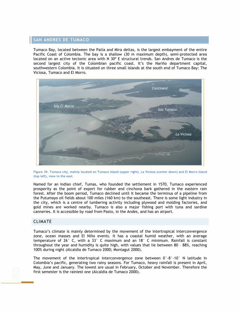
SAN ANDRES DE TUMACO
Tumaco Bay, located between the Patía and Mira deltas, is the largest embayment of the entire Pacific Coast of Colombia. The bay is a shallow (30 m maximum depth), semi-protected area located on an active tectonic area with N 30º E structural trends. San Andres de Tumaco is the second largest city of the Colombian pacific coast. It’s the Nariño department capital, southwestern Colombia. It is situated on three small islands at the south end of Tumaco Bay: The Viciosa, Tumaco and El Morro.
Figure 39. Tumaco city, mainly located on Tumaco Island (upper right), La Viciosa (center down) and El Morro Island (top left), view to the east.
Named for an Indian chief, Tumas, who founded the settlement in 1570, Tumaco experienced prosperity as the point of export for rubber and cinchona bark gathered in the eastern rain forest. After the boom period, Tumaco declined until it became the terminus of a pipeline from the Putumayo oil fields about 100 miles (160 km) to the southeast. There is some light industry in the city, which is a centre of lumbering activity including plywood and molding factories, and gold mines are worked nearby. Tumaco is also a major fishing port with tuna and sardine canneries. It is accessible by road from Pasto, in the Andes, and has an airport.
CLIMATE
Tumaco’s climate is mainly determined by the movement of the intertropical interconvergence zone, ocean masses and El Niño events. It has a coastal humid weather, with an average temperature of 26° C, with a 33° C maximum and an 18° C minimum. Rainfall is constant throughout the year and humidity is quite high, with values that lie between 80 – 88%, reaching 100% during night (Alcaldia de Tumaco 2000; Montagut 2000).
The movement of the intertropical interconvergence zone between 0°-8°-10° N latitude in Colombia’s pacific, generating two rainy seasons. For Tumaco, heavy rainfall is present in April, May, June and January. The lowest are usual in February, October and November. Therefore the first semester is the rainiest one (Alcaldia de Tumaco 2000).
Isla Tumaco
La Viciosa
Isla El Morro
Continent

The rise of air masses charged with humidity from the pacific, regulates weather as they lower temperature, resulting in humidity condensation and therefore rainfall. In Tumaco there’s a mean of 2500 mm of annual rainfall (Alcaldia de Tumaco, 2000).
El Niño phenomena is heavily felt in Tumaco, which influences marine conditions and appears every 2 to 7 years. Currents change, resulting in coastal water warmth, which in turn reduces nutrients concentration and therefore fishing. This also generates sea level rise, heavy rainfall and droughts (CCCP 1998).
OCEAN DYNAMICS
CURRENTS
Tumaco is influenced by ocean currents that come from the Southwest- West, belonging to the Northern arm of the Ecuatorial Contra current (CCE), which becomes Colombia’s current and runs North superficial water masses are displaced towards NE, being later deviated towards NW as a result of tide currents (CCCP 1998).
Wave direction may generate littoral transport of suspended solids and therefore result in erosion – accretion processes. This is common in Tumaco’s coast line, but as erosion processes occur in some areas, accretion processes take place in others and this is changing constantly the way the landscape is.
TIDES
Tide regime in Tumaco is semidiurnal with two high tides and two low tides every 24 hours. The multi annual average of high tides is of 2.807 meters and of 0.294 m for low tides. mid range is of 2.513 m and sea level average was of 1.530 meters (IDEAM, 1997 in Tejada, 2003). The highest value for a tide was of 3.68 m (Tejada 2003).
SURFACE WATER TEMPERATURE
Pacific Colombian waters are usually low tempered, rich in nutrient concentration and therefore very productive in fishing resources (CCCP 1998). Throughout the year two maximum and minimal take place. The highest temperatures are between June and July and between December and January. Minimum values take place between February and March and between September and October (Guayana 2001; INVEMAR 2003).
SUPERFICIAL SALINITY
Water salinity changes are due mainly to evaporation and precipitation processes. The lowest values are related to rainiest areas and near coasts where rivers converge (Tejada, 2003).
For the entire pacific region, salinity usually rises in January, reaching values ranging 30 to 32. river inflow begins in May – June, reaching its highest in November, when salinity decreases up to 25 - 28 (Guayana, 2001; INVEMAR, 2003; Tejada, 2003).
GEOLOGY
Colombian south pacific is part of the Atrato - San Juan – Tumaco system as defined by Etayo et al (1986) (CCCP, 1998). Tumaco is on the west flank of the western cordillera which is surrounded by important faults, towards the east the rio Cauca fault is found and towards the west Choco’s big crack, or rio Atrato fault system (Alcaldía de Tumaco 2000).

The costal zone has a low belt, 3 to 5 km wide that is affected by tides. This belt is followd by a region that has a width that varies from 35 to 45 km. Finally the higher areas that rise over 500 m above sea level (CCCP, 1998). The Tumaco Bay northern and east coasts are dominated by intertidal flats and by 10 to 40-m-high, vertical to sub-vertical cliffs cut into horizontal to sub-horizontal mudstones.
Figure 40. Uncovered low tide mudflat southern Tumaco.
Cliff retreat is slow in most sectors, but rockfalls and slumping are caused by seismic events and occasionally strong rain. Minor pocket beaches and wave-cut platforms can be found along the eastern cliffs of Tumaco Bay. Tidally influenced estuaries with lobe-shaped bars and tidal flats backed by extensive mangrove swamps characterize the southeastern shores of Tumaco Bay.
For the present study, intertidal zone is highly important as it supports the natural systems in which emphasis was made. It is divided in different kinds:
i. Not Vegetation Covered Inter tidal Platforms: Areas where sediments are clustered, located on Tumaco’s inlet, around Tumaco’s island, el Morro and between Tumaco and Bocagrande. These areas are completely covered with water during high tides.
Toward the ocean, these areas are shallow bottoms for the inlet and towards land they form beaches or suitable areas for mangrove establishment.
ii. Vegetation covered floodable platforms: Matter accumulation with high vegetative development that are periodically flooded by tidal action and water accumulation during high tides. They receive sediments from fluvial systems. On the southeast area they come from the river Mira; on the other areas they receive sediments from rivers Rosario, Mejicano, Tablones, Colorado and Patia.
These are areas covered mainly with mangroves and ferns, and other vegetation kinds that can stand halophytic conditions.
COAST LINE MORPHODINAMICS
The bay of Tumaco presents tourist places in the Beaches of Bocagrande, the Muzzle and the river Looks. Most of the beaches is natural since a minimum intervention antropica exists. In the sector of Tumaco there are beaches with superior wide of 20 m, moderate beaches with width between 5 and 20 m and narrow beaches with inferior widths to 5 m. The beaches wider than 20 m, are located in the north part of the island the Muzzle and the sector of Salahonda. The beaches with widths between 5 and 20 m, are presented in the sector of the Island Bocagrande, La Viciosa and Vaqueria. The beaches with inferior widths to 5.0 m, are present to the south of Bocagrande, Trujillo and the sector up north of the beach El Morro.
The costal line of Tumaco has varied considerably in the last 26 years, according to the surveys being held by the CCCP of Tumaco in the year 2002. This is mainly due to the erosion and sedimentary processes induced by marine dynamics presented in the area. High tides area additionally presented and tidal wave that have changed remarkably the morphology of the coast. As an example of this, it is observed the tsunami occurred in 1979 in which the island Guano disappeared located in front Tumaco. Another aspect is that the coastal line of Tumaco have varied due to effects caused by antropical and natural intervention as the artificial refill of

the island Tumaco in the sixties. The joint of La Visiosa Island with Tumaco one in the seventies and effects of El Niño Phenomenon in 1982 to 1983 and 1995 to 1996. See Figure 41..
Líneas de costa entre 1969 y 1995. Líneas de costa entre 1992 y 1995.
Figure 41. Variations shore beach in Tumaco. (CCCP 2003)
WATER RESOURCES
This is a very rich area in water resources that come from rain, rivers and marine waters (INVEMAR, 2003). There are 5 important basins in Tumaco’s inlet (Tejada, 2003):
- Rio Mira
- Esteros Natal, Aguaclara, Resurrección and Trapiche.
- Basin formed by rivers Rosario, Mejicano, Caunapi, Gualajo and Imbilpi.
- Basin formed by rivers Changui, Tablones, Colorado and Curay.
- Rio Patía.
Patia and Mira rivers are the most important deltas for Tumaco. They carry high matter concentration that results from erosive processes throughout their margins (CCCP 1998). Rio Rosario has an influence of over 60% of Tumaco’s inlet and is formed of four sub basins: Caunapi, Alto Rosario, Bajo Rosario and Mejicano. Rio Rosario and Mejicano drain directly to the sea and run through 25.2% of total Tumaco’s territory (Alcaldia de Tumaco 2000).
Given the highly richness in water resources, it is usual that local populations use related resources constantly. In Tumaco’s POT a list of species present in the area is available (Table 20). Some of this species are recognized as highly threatened as a result of over exploitation, habitat destruction and contamination amongst other reasons.
The most threatened groups in this area include: Agolti paca, Mazama americana, Tajassu sp., Tajassu tojaci, Dasyproctotus prectata, Felis concolor, Bradypus variegattus, Dosypus sp, Nasua nasua, Cíclopes didactitus, Felis tigrina and Potos flovus (Alcaldía de Tumaco, 2000).

Table 20. Some species related to hydric systems in Tumaco (Source: Alcaldía de Tumaco 2000)
Species Habitat Species Habitat
Xphopenaus rineti Marine Cynoponeticus conicep Marine Trachipenocus byerdi Marine Arius, Galeichtis Marine Penacaus occidentals Marine Anisotremus Marine Callirectes toxotes Marine Haemulon sp Marine Uca sp Marine Larimus sp Marine Anadora tuberculosa; A. similis
Marine Mentielrrus sp Marine
Dono panamentis Marine Centropomus sp Marine Surrogota sp Marine Cintropomus pectinotus Marine Litorino cebra Marine Bothides Marine Ostrea columbiasis Marine Caranx sp Marine Lepidochelys olivacea Marine Coryphaena hippurus Marine Eretmochely imbricato Marine* Scamberomuros sierra Marine Lutra longicaudis Marine* Hemibrycom tolimae Fluvial Caiman cocodrilus chiapasius
Marine* Hemiolotropis lotifasciotus
Fluvial
Centengraulis mystiecfus Marine Pimelodella sp Fluvial Opisthonema sp Marine Trychomycterus sp Fluvial Caranx caballus Marine Symbronchidel Fluvial Sphyraena ensis Marine Macrobaquium sp Fluvial Lutjanus, Hoplopargus Marine Macrobaquium tonelum Fluvial Cynoscion sp Marine Brycon sp Fluvial *Highly threatened
ECOSYSTEMS
Tumaco has an overall forest cover of 201.340 ha, that represent 60% of its total territory. In every area forestall exploitation for commercialization, use and recollection of other associated products, take place (Alcaldia de Tumaco, 2000). Tumaco makes part of bio-geographic Choco and has strong rainfall throughout the year. According to Holdridge classification it has 3 main life zones, two of which are relevant for the present study:
TROPICAL RAINFOREST
Characterized by low temperature variations, and high precipitation and humidity, these are the most complex ecosystems given their structural, stratification and species diversity (IAvH, 1997 en INVEMAR, 2003). Its temperature limits are close to 26° C and rainfall varies from 2500 to 3500 mm yearly. This zone covers a total area of 140900 ha, representing 42% of Tumaco’s territory (Alcaldía de Tumaco, 2000).
Figure 42. Banana plantation among natural forest.
In Tumaco, this life zone is found close to the coast line, being wider in the south than in the north. In littoral areas predominant vegetation are mangroves. Towards continent guandalls, agricultural systems and cattle areas can be found (Alcaldia de Tumaco, 2000).

VERY HUMID TROPICAL RAINFOREST
Mangroves can be found in these areas as well, where temperature is over 24° C, and rainfall varies from 3500 to 4500 mm/year.
Located below 200 m. over sea level, in these areas forests can be found, along with agriculture and cattle. It covers a total area of 168000 ha (50.1% of the total area) (Alcaldia de Tumaco, 2000).
Figure 43. Mangrove acompaining forest.
Table 21. Forestal species available in Tumaco and current state (Source: Alcaldía de Tumaco, 2000)
Species Conservation Situation Species Conservation Situation
Rhizophora brevistyla Abundant Psychotria santaritensis Scarce R. mangle Abundant Cespedesia macrophyla Laguncularia rocemota Abundant Colophyllum longifolium Highly threatened Conocarpus erecta Abundant Symphonia globulifero Scarce Avicenio sp. Abundant Virola reidii Scarce Pellieiera rhizophorae Abundant Virola dixoni Scarce Mora megiosperma Scarce Euterpe precatoria Scarce Pachira aquatico Scarce Terminalia amazonica Abundant Eutorpe sp Scarce Coropa guianensis Scarce Camnosperma panamensis Scarce Cederla odorata Scarce Alchaoncopsis floribunda Scarce Cordia olliodora Scarce Maurifiella pacifica Scarce Apeiba aspera Scarce Otoba gracilipe Scarce Sacoglotis sp Abundant Socretea exorrihiza Scarce Genipa americana Scarce Ocotea oblongifolia Highly threatened Achroma sp Scarce Aniba puchury Scarce Jessenia policarpa Abundant Guadua angustifolia Abundant Paraschcelea anchistropetole Scarce Crecentia cujeta Scarce
MARINE AND COASTAL ECOSYSTEMS
Tumaco’s coast line has important ocean – continent interactions. It has strong natural processes dynamics and it’s littoral width varies depending on mangrove coverage and marine influence (Montagut 2000).In this area the main marine ecosystems found are mangroves, beaches, estuaries and deltas.
BEACHES
Areas with no vegetation coverage. They can be seen in the islands of El Morro, Tumaco, Vaqueria and Bocagrande. They have semipermeable substrate with very low inclinations (below 5°).
Beaches in these areas haven’t faced major human intervention processes, being moderately well preserved. They can be divided in ample beaches (over 20 m wide, with some vegetation; may exhibit dunes and littoral cords, less than 70 cm height) seen in El Morro island.

Moderate beaches (amplitude between 5 and 20 meters) seen in Bocagrande, La Viciosa and Vaqueria islands and narrow beaches, with an amplitude below 5 meters, which can be seen in Bocagrande, Trujillo and el Morro (north) (Tejada 2003).
MANGROVES
Nariño has the biggest mangrove coverage of the country with a total of 149735 ha. Most mangrove species can be found in this area (Rhizophora mangle, Rhizophora harrisonii, Laguncularia racemosa, Conocarpus erecta, Avicennia germinans, Pelliciera rhizophorae, Mora oleifera) (Ulloa- Delgado & Gil Torres, 2002 in Sánchez- Páez et. al. 2004).
Specifically, for Tumaco, this system governs from estero Guandarajo up to Colorado River and in some areas between cliffs and recent littoral cords on the southern part of Tumaco Island. (Tejada 2003). Twenty nine percent of its total area (97400 ha) is covered with this ecosystem and includes the beaches: Bocagrande, Cabo Manglares, Mira river estuary and Ancon’s bay amongst others (Alcaldia de Tumaco, 2000).
Six main associations can be seen in the area, depending upon species composition (Hoyos & Rozo, 1973 in Sánchez et. al, 1997):
RHIZOPHORA ASSOCIATION: Distinguished by red mangrove (Rhizophora spp.) dominance associated with other species.
NATAL ASSOCIATION; Pure natal rodals (Mora oleifera) with short extensions.
AVICENNIA ASSOCIATION: Small sector colonized by Avicennia germinans
PELLICERA ASSOCIATION: Transition areas with Pelliciera rhizophorae.
LAGUNCULARIA ASSOCIATION: White mangroves are the main species found in these areas Laguncularia racemosa.
BEACH VEGETATION: formed by grasses and bushes in areas close to the sea.
In general, mangroves have been used by productive businesses of tannins, for extraction, aquaculture (mainly shrimp pools) and have been highly modified and affected by population growth (Sánchez et. al, 1997).
SOCIOECONOMIC CHARACTERIZATION
It is complemented with information collected in field, during the visit to the study area on September 2005. Twenty paths of the coastal zone of the municipality were visited; in each one of them a survey of socioeconomic characterization of 10% of the houses was applied.
DEMOGRAPHY
According to the 2005 Census the municipality of San Andrés de Tumaco has 161.490 inhabitants distributed 56% in the urban zone, 36% in the populated centers and 10% in the rural areas.
Although the distribution of the population by zone is almost equitable, is observed an urbanization of the municipality, in 2005, 51% of the inhabitants are in the urban zone, which means a variation of 6% in comparison to 1993.
The projections of the total population and its location in the urban or rural area, have a high degree of uncertainty because the rates of migration, obeying to economic or social factors of

nature as they are the drug trafficking, groups rebel, supply of services public and other factors (Plan of Municipal Development 2002 - 2004 of Tumaco).
Table 22. Tumaco, population according to area and sex 2000-2005. Source: Plan of Development 2004 - 2007.
TOTAL COUNTRYSIDE URBAN ZONE YEAR TOTAL
MEN WOMEN MEN WOMEN MEN WOMEN
2000 152.359 77.701 74.648 37.509 36.033 40.192 38.615
2001 155.764 79.440 76.324 38.392 36.886 41.047 39.438
2002 159.182 81.183 77.999 39.130 37.598 42.051 40.401
2003 162.604 82.928 79.676 39.971 38.404 42.957 41.272
2004 166.030 84.675 81.355 40.813 39.213 43.862 42.142
2005 169.454 85.912 83.542 41.410 40.785 44.502 42.757
In agreement with the projections by etareos groups, the representative groups are those of 1 to 14 years that include the children and young people in basic scholastic age and those of 25-54 years that includes the economically active population. The projections maintain a constant participation of the age groups. The little population of 15 to 24 years can obey to a migratory process of the young people to complete its studies.
The population is composed by different ethnic groups from the following form: 92% are of black, racially mixed ethnic group 6%, and native 2%. Displaying a population density of 38,3 hab/km2 (Muñoz 2002). Most of the population of the countryside is black entitled to the collective degree of its territory with base in the division of river basins and microriver basins, through the consejos comunitarios (Tejada 2003).
POVERTY AND QUALITY OF LIFE
According to Census DANE/2005, in Tumaco the 48.78% of the people and the 50,3% of the homes present some unsatisfied basic need (NBI). The 24,1% of people and 17,6% of the homes are in conditions of misery (Muñoz 2002). According to the projections, the population with NBI this in continuous ascent, in the period 2000-2004 appeared an increase of 8%.
Table 23. Salahonda, Nariño.
In agreement with it numbers presented in the development plan of Municipality 2004-2007, to September of 2004 almost 64% of the total population were “sisbenizada”. In agreement with the SISBEN classification, 82% of the population of the municipality of Tumaco belongs at level I and 15% at level II. This indicates that in 2004, 62% of the total population of Tumaco is in conditions of extreme poverty.
In the urban area 76% of the population is registered under the SISBEN; in the rural area the cover to September of 2004 was of 50%. In agreement with collected information in the field trip, this difference in the cover of application of the survey is demonstrated. Almost 54% of the resident people in the visited groups lack access to the health service, understood this like having the membership card of the Sisben that accredits them like beneficiaries of the subsidized regime.

EDUCATION
In agreement with the results of the characterization survey, 77% of men and 73% of women older than 15 years than live in the coastal countryside knows how to read and write. This indicates that the rate of illiteracy of the survey is 24,6%. These numbers show the little access that the population has to educative centers. Additionally if we consider that the smaller population of 15 years does not finish the primary education and that at the present time in several of the visited groups lacks on educative centers, not it would hope that in the short term this rate diminishes.
The training educative level reached by the population greater than 23 years in the coastal countryside is very low, only 2% of the surveyed population completed the educative cycle (primary and secondary). This samples one of the lowest human accumulations of capital which repels as it’s a better quality of life, since the educative level is closely related to the health and the level of income.
In spite of what it was perceived during the visit, according to official numbers, the Total population in scholastic age is 93%, indicating that this sector is the main offered, whereas the 0,05% is in the private one. In agreement with the information of the ministry of
Education, the rate of gross cover in 2003 was of 97,3%, indicating that almost the total of the population in scholastic age attends an educative center. Although this number means an increase of 4 % with respect to the previous year, is inferior to the one in 2001 (98%).
In general terms it is possible to affirm that the education in the municipality of Tumaco is catalogued like very deficient. The low educative quality is reflected in the tests of the ICFES, which results are very below the national averages (Muñoz 2002). Between the main problems of the educative sector is low planning and the deficient quality and cover, that can be blamed on administrative deficiencies mainly (POT of Tumaco, 2000).
HEALTH
The first causes of mortality are: respiratory insufficiency, low weight when being born, septicemia, bronchopneumonia, paludismo, neonative sepsis, perinatal infection, premature undernourishment , meningitis, acute diarrhea, pneumonia, tetanus, prenatal anoxia, among others, and are related mainly to an inadequate handling of the prenatal program as well as control programs of promotion and prevention (Muñoz 2002).
In the rural sector 17 health centers exist, that work with limitations of diverse types (Alcaldia de Tumaco 2000).The main problems that the system of health of the municipality confronts are the administrative weaknesses, the low cover of the service, the deficient levels of attention, quality and opportunity to the access to the service. The previous, brings like consequence a low level of answer as opposed to situations of emergency, diminution in the levels of labor
Hojas Blancas

productivity, delays in the costs and benefit of the services and low life expectancy of the population (Alcaldia de Tumaco 2000).
In accordance with the settled down by Law 100, the people classified in levels I and II of the Sisben, are beneficiaries of the Regime Subsidized in Health. The municipality of Tumaco in 2001 had 51,472 people classified in these levels and 37,395 were affiliated people to the subsidized regime, which indicates a cover of 73% in health of the SISBEN people. Nevertheless 54% of the total of the population are not covered by any regime.
PUBLIC DOMICILIARY SERVICES
AQUEDUCT
The distribution network is obsolete; Over thirty years old, the service is deficient and of bad quality. More than 35% of the urban population and over the 90% of the countryside lacks the service. In some important strategic centers aqueducts exist but due to its conditions it becomes necessary to rehabilitate, improve and/or extend as it is the case of Llorente, Guayacana, Cajapí, Palambí, the Carmen K 63, Espriella, Santa Rosa, Candelillas and Tangareal. The city of Tumaco is served by Acuamira EICE - ESP, which is a municipal dependency that administers the service of potable water and additionally collects the service of cleanliness. Pirate domiciliary attacks exist or illegal seizures of the main pipe reduce the pressure and the volume by the waste they cause (Muñoz 2002). The border populations mainly take the water from the rivers of their surroundings in direct form without treatment (Alcaldia de Tumaco 2000).
SEWAGE SYSTEM
The cover in the city only reaches 5% of the houses that corresponds to the Pradomar districts, Florida and the Nose. Some is characterized not to have treatment and to have pumping towards the Sea. Another population group spills its residual waters to the Septic Wells and more of 90% it spills them directly to the sea without no type of treatment, causing problems of contamination to the water body (Muñoz 2002).
Of the 570 estates of the commercial and industrial, single sector 5% have integral residual water treatment, the rest lacks some treatment. The countryside lacks totally of any type of sanitary sewage system, in some cases has latrines.
ELECTRICAL ENERGY
The municipality has been arranging for seven years electrical energy of the system from national interconnection in charge of ISA. The countryside of the municipality, to the highway area, has two substations that belong to the municipality. The countryside that counts on around 400 paths, only 60 is count on the service (Muñoz 2004).
In the zone of the Rivers in the rural area 30% of the populations do not count on any type of electrical equipment. In the Border zone 60% of the population have electrical plants in operation (Alcaldia de Tumaco 2000).
Los Puentes
ECONOMIC ASPECTS
FOREIGN TRADE AND HARBOR MOVEMENT
The Portuary Society of Tumaco, is a port for oil cabotage with increasing exports of bulk liquid palm oil mainly, in agreement with the physical characteristics and geographic location (DNP, 2005). The information of the harbor societies, estimates Tumaco port 2004 single foreign trade consistent with 39336840 tons. Despite not registering imports, the commerce display a growth of the 14% compared to 2003. Export of oil rises 62,134 Tons corresponding to the SRP Tumaco surplus.
MUNICIPAL FINANCES
During the period 1996-2000 the total income in constant prices of 1996 presented a growth of 29%. The tributary entrance although displays a descendent tendency, during the period register an increase of 21% due to the rise in this heading in the 2000. The nontributary income mainly come from them rate by the sale of services and the sale of goods and services, that have their origin in the services that lend the Secretaries of Planning and Municipal health (Alcaldia de Tumaco 2000).The transferences constitute the main source of current entrance of the Municipality, which highly makes State employee. Although they grow constantly, central government does not send them in a continuous way what causes that all the jobs cannot be executed, given the dependency of these resources.
Table 24. Tumaco, Composition of Income 1996-2000 constant pesos of 1996
CONCEPTS 1996 1997 1998 1999 2000 CURRENT INCOME 9.463.572 8.807.317 7.497.879 11.200.539 13.918.682 Tributary 3.404.838 2.307.730 1.689.968 1.448.790 4.105.724 Nontributary 466.454 451.463 170.856 1.157.708 984.702 Transferences 5.592.280 6.048.124 5.637.055 8.594.041 8.828.256
The generation of own resources is low and insufficient to provide the goods and services in an efficient form, and is necessary therefore to resort to the transferred income of the central level and exemptions. The capital income conform the resources of co financing, the oil exemptions and the credits. The co financing resources are few, which indicates a low capacity of management and dependency of the resources of the State. The oil exemptions constitute the main source of capital income, which has turned them source to finance expenses of operation and social investment.
The debits of the Municipality constitute expenses of operation, service of the debt, social investment and the payment of deficit of previous uses. In terms of constant prices of 1996, the expenses of financing are in reduction, nevertheless appears a continuous deficit in this heading, which forces the future administrations to diminish these expenses of operation and/or to generate increases is the income public. The social investment corresponds to the stipulated in
Law 60 of 1993, although it represents 75% of the expenses of the municipality, has not been executed of the appropriate form which has prevented to eradicate the true causes of the sectorial problems, mainly in which it talks about education, potable water and basic cleaning.
EMPLOYMENT
The greater percentage of the population in age to work is between the 10 and 24 years, indicating that is a young population, which has very surely not finished its scholastic

formation. The main activities are agriculture and the fishing for men older that 10 years. For 41% of the women their main activity is the offices of the home, activity that in most of the cases they complement with the fishing of piangua, a mollusk found on the mangrove roots and mayor fishing income of the community.
PRODUCTIVE SYSTEMS USE
The urban settlement is divided in sectors each one of which it displays diverse land uses of
SECTOR ISLAND EL MORRO: The land use of the public beach, institutional, mixed use (residential, industrialist deals and), residential, industrial, green and ecological zones of recreational use, zones (mangláricas zones) and invasion zones.
SECTOR ISLAND OF TUMACO: Differences public zones of mixed, institutional, recreational, residential, industrial use and beaches.
CONTINENTAL SECTOR: Zones are different from residential use, mixed, institutional, recreational and industrial use.
PRODUCTIVE SYSTEMS
The economic basic activities are related directly to agro-industries, the fishing and the shrimp cultivation, whose production is oriented to supply the internal and external demand of the municipality, and therefore constitutes the main source of income and accumulation of capital.
AGRICULTURE
Main generator of labor, the culture of African palm generates 4000 employments, constituting themselves in the main product, additionally counts on own industry in the crude oil extraction, whose production supplies national and international market. The palms are located in the zone of Espriella - Candelilla, Tangareal and Imbilí.
The cacao production comes in reduction; nevertheless its culture constitutes an activity that displays good possibilities the international conditions of its production and prices. The Coco culture constitutes an opportunity for the small producer and presents the possibility of developing agro industrial production. Alternative crops with potential in the industry are: fruit rubber, palm of chontaduro , species. Another option of operation is the native species, given to the possibilities of export and the climatic conditions of the municipality.
FISHING
Traditional activity of the region, whose generation of use is significant. It is classified in agreement with the techniques used in artisan and industrial. The artisan fishing does not count on a development due to the lack of resources (a line of specific credit does not exist), the production to a great extent depends on the time and the climate, the one that causes a great variability of the income. Additionally the producers do not count on a storing center that allows them to offer its products to a better price.
The industrial fishing is characterized so that the destiny of the production is the external market, for the national consumption destines products of white fishing (fished). The main failures that present are the inadequate arts of fishing, the deficiency of policies and planning, deficiency of appropriate technologies, little institutional support, deficient systems of commercialization.


VA- VULNERABILITY ASSESSMENT INCLUDES THE IDENTIFICATION OF THE BIOPHYSICAL SYSTEMS SUSCEPTIBILITY AND THE QUANTIFICATION OF IMPACTS OVER THE SOCIOECONOMIC SYSTEM.
The possibility to determine and reduce vulnerability is emerging as a critical part of any sustainable development strategy, as it considers present situations and possible future conditions. If taken into account for local planning strategies (towards reducing SRL as an example), it becomes an important tool to reduce the associated risks for a given area (Pratt et. al. 2004).
In order to reduce the vulnerability of a region to SLR, one must first try to identify priority sectors to focus on; because it is currently not possible to accurately predict the adverse effects of SLR, particularly at the local and regional levels, the IPCC maintains very strongly that learning to deal with climate variability and extremes is an excellent way of building adaptive capacity in the long run (IPCC 2001).
There are many different definitions of vulnerability nonetheless, in this study we use the term applied to the vulnerability of a specified system to a specified hazard or range of hazards. The term hazard is used to refer to physical manifestations of climatic variability or change, such as droughts, floods, storms, heavy rainfall or potential future shifts in climatic regimes. Climate hazards are referred to as climate events.
A disaster as measured in human terms (lives lost, people affected, economic losses) is therefore the outcome of a hazard, mediated by the properties of the human system that is exposed to and affected by the hazard. A flood associated with a heavy rainfall is viewed as a primary impact or outcome of the rainfall event; coastal floods are often the outcome of storm surges. In these cases it is the rainfall event or storm surge that constitute the principal hazard.
Strategies to cope with current climate variability and extremes exist at the community level. Hence the starting point could be to identify urgent action needed to expand the current coping range and enhance resilience in a way that would promote the capacity to adapt to current climate variability and extremes, and consequently to future climate change (UNFCCC 2002). Prioritizing targets towards reducing the vulnerability of the system (bio-geophysical, economic, institutional and socio-cultural factors) can be analyzed under three situations: those that occur independently of any external climatic situation; those that are triggered when extreme climatic events occur (hurricanes, strong storms, surges or flooding) and those conditions that could be worsen under SLR effects.
A preliminary evaluation on these three situations served as a discussion focus for the First Regional Workshop “Como nos afecta el acelerado ascenso del nivel del mar” carried out in Cartagena with key stakeholders on July 1st, 2005. The Driving Force, Pressure, State and Impact - DPSIR methodology was applied for two purposes: first, to prioritize based on the stakeholders perception, those social, economic and ecological sectors that are currently under risk of extreme climatic events that could worsen in a “business as usual” scenario; and second, to establish a set priority impacts that could be handled by the project and thus guide the selection of indicators on which the capacity building facility can be established. These results are resumed in the matrix shown in Table 25.

Table 25. DPSIR associated impacts matrix to non external climatic situations.
Driving Force Pressure State Impact Indicators Mangrove lodging – coal and handcraft (for housing and as an alternative sources of energy)
Degraded mangrove areas Mangrove coverage reduction Mangrove hectares
Pollution Physical and chemical water properties
Illegal settlements Cienaga de la Virgen –CDV -
Inadequate public service coverage and solid sewage disposal..
High organic matter and heavy metal water contents
Low oxygen levels and pollution causing diminish artisan fisheries
Fish capture rate
High turbidity levels in water Loss of depth (colmatación) of estuaries
CDV depth
Blocked canals entering the CDV Bogs salinization Water and soil salinity Sea grasses coverage reduction (light penetration reduction)
Sea grass hectares
Loss of vegetal cover in rivers and bogs
Erosion processes --> Soil instability
Higher water polluted discharges into the Bay
Coral reefs coverage reduction (bleaching)
Coral reef coverage
Artisan lodging for lumber and energy production Habitat destruction by opening of artificial channels
Land use changes in CDV and other estuaries
Served water poured directly to estuaries
Mangrove degraded zones and diminished resilience
Mangrove coverage reduction Mangrove hectares
Dependence of communities on unsustainable related forest resources
illegal lodging and burning to create spaces for agriculture and transitional crops
Tropical dry forest highly intervened
Tropical dry forest coverage reduction TDF hectares
Natural habitat fragmentation Unsustainable exploitation and extraction of natural resources
National and international demand of wild fauna commerce
Local biodiversity reduction Disappearance of important faunistic species by its commercial and ecological value
Number of species reported in the Colombian red books
High levels of anoxia in superficial water due to waist water contamination
Mobility index Heavy metals and industrial discharges from Mamonal Industrial sector and El Bosque Commercial Zone
High levels of soil contamination by hydrocarbons; mercury accumulations in sediment
Species density
Marine contamination in coastal water bodies and Cartagena Bay
Lixiviation material from waist accumulation
Contamination values causing detrimental human health
Species impoverishment below the 10 m depth. Morbidity increase
Water quality parameters
Untreated water sewage discharge system. Water bodies used as emergency sanitary emissaries.; direct unloading without any treatment.
Marine and coastal water bodies with microbiological contamination
Non-permissible coliform values in water
Coliform levels Marine contamination in coastal water bodies: Castillo Grande, Laguito and Isla de Manzanillo
Degraded natural barriers against marine water efects: coastal erosion
Coastal erosion Beach extension lost Beach area
ilegal settlement on Islas del Rosario- San Bernardo. Illegal settlements
Inadequate life conditions Greater number of settlers at risk Number of illegal houses in the CDV
Forced displacement
Lack of opportunity activities that generate a reasonable income among the native population
Foreign population settled in new spontaneous districts
Growth of informal economic activities in the city
Under employment rate
Migrations from the rural areas towards the city
Low income; impossibility to access houses in urbanized ground
Population economic stratification imbalance
Stratified population
Search of incorporation to the labor force
High risk urbanization zones Salubrity problems due to the presence of sewers and l very contaminated lagoons
Morbidity causes and rates
habitat deterioration caused by the population that lives in the marginality
Social problems such as alcoholism, promiscuity, crowding and health deterioration
Social unbalance
Excessive poverty levels among the population located in marginal sectors of the District
A young population structure due mainly to the recent establishments of immigrants
restricted access to secondary and higher education
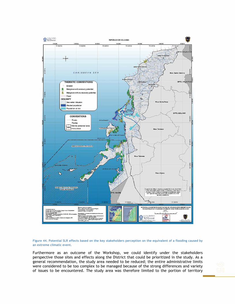
Figure 44. Potential SLR effects based on the key stakeholders perception on the equivalent of a flooding caused by an extreme climatic event.
Furthermore as an outcome of the Workshop, we could identify under the stakeholders perspective those sites and effects along the District that could be prioritized in the study. As a general recommendation, the study area needed to be reduced; the entire administrative limits were considered to be too complex to be managed because of the strong differences and variety of issues to be encountered. The study area was therefore limited to the portion of territory

between La Boquilla (the northern limit of Cienaga de la Virgen), all the urban area of Cartagena and the Cartagena Bay system as shown in Figure 44.
The mapping of the perception of the stakeholders towards the areas at risk and the associated effects of SLR was also achieved during the workshop. The participants were asked to use as flood scenario an extreme situation caused by the sum of high tide and heavy rain that took place Cartagena on November 2003, when almost 60 % of the city was flooded. The perception to the questions on “which would be the most affected areas?” and “what would be the more severe effects caused by this SLR scenario?” where used to construct the map shown in Figure 44.
Using these results and following the methodological framework proposed on the study, the susceptibility of the natural system and the impacts on the economical sectors were used to construct the vulnerability assessment of the selected study area within the Cartagena District and Tumaco Area as explained as follows.
In the sea level rise context, vulnerability of the natural system can be referred as the effects of such phenomena on a given ecosystem and it’s capacity to survive within time. This survival capacity is given by the ecosystems ability to quickly recover from shock, injury or depression (resilience). It is important to note that resilience can either be natural (intrinsic to a given system) or acquired (if it is gained from previous damage). Therefore a system’s susceptibility is decreased as it’s resilience increases (Nicholls and Leatherman 1999).
SUSCEPTIBILITY OF THE NATURAL SYSTEM
Susceptibility/resilience for a single issue can be examined; as well it can be studied in an overall sense for a collection of issues. Therefore overall susceptibility would be the result of many factors working together. It can be considered as suggested by Pratt et. al. (2004) in the following way:
This approach considers the system’s natural resilience and resistance to damage, the risk of hazards and the acquired resilience / susceptibility to damage which is increased risk to future damage because of some past events. Given the characteristics of natural systems and of the present study, developing an index to determine their susceptibility must be done considering the information available and their units of measurement, which implies the need to convert them into a common scale to be able to carry out comparisons. Such information is given by indicators which are components that can estimate the condition of a given resource.
Environmental susceptibility for a system is given in terms of it’s integrity and its exposure to natural and anthropogenic hazards. For a better understanding of this, one must consider risks (natural and anthropogenic), systems resistance (characteristics of the system which would reduce its susceptibility) and damage (acquired susceptibility) (Pratt et al. 2004).
Indicators chosen for a given system depend on it’s characteristic and current situation. Nevertheless it’s important to mention that in natural systems is necessary to evaluate susceptibility through different means, taking different aspects into consideration. Such indicators are also taken in different spatial and temporal scales to be able to obtain the information needed. Ecosystem integrity depends on biodiversity, ecosystem functioning and resilience. The risks to the environment are any events or processes that can cause damage to ecosystem integrity. These include natural and human events and processes (Pratt et al. 2004).
It is important to understand that the present study did not generate any information to establish natural susceptibility, but rather used other sources of information to generate such indicators and the final index. For this reason, although indicators used are the same for Cartagena and Tumaco, the information used to compute them, and the periods of time in which it was produced, change for each study area and even for the different indicators.

Values for indicators are given accordingly to what they imply for the system, and how the system is acting in terms of sustainability. It is different if a system is able to sustain, than if it faces no impact at all. This in turn is also defined by the characteristics not only of the system itself and of the pressures it must face, but it depends also on associated policies or other protective measures (such as protected areas) that regulate and control the use and exploitation of such system. The environmental susceptibility index model assumes that resilience is greater for a system the less damaged it is. Also these systems serve better for human necessities that degraded ones and the way humans use or interact with a given system is crucial and define part of the systems susceptibility (Pratt et al. 2004).
The susceptibility index results of computing the values from six indicators that reflect the current state of the system within the study area of Cartagena and Tumaco, separately. Such value is obtained by computing each indicator to a general constant according to the perceived importance each of them should have. In general the most important indicator was considered to be ecosystem quality, followed by ecosystem coverage. The other four indicators (water quality and hydrographic processes integrity, recovery areas, land use and hazards) receive the same constant values as are considered equally important in defining systems susceptibility.
Finally, indicators are summarized and a total value is obtained for each area, which defines it’s susceptibility. Despite this, it is very important to understand the process as the total value wont give as much information as each indicator by itself, which in turn defines what measures should be taken to be able to relief the main problems for a given area. With the index the idea is to reflect the extent to which the natural environment is prone to damage and degradation.
SELECTION OF INDICATORS TO ASSESS NATURAL SUSCEPTIBILITY
The purpose of this study was to use available information for each area, to be able to determine susceptibility of the systems involved and later suggest possible adaptation measures. With this in mind is important to understand then that information used for calculating the indexes is taken from different sources, done by different entities in different moments; nevertheless is important to understand that it is recent information and that it reflects accurately the actual sate of the systems, as it has been crossed over with local expert knowledge.
CIOH and CARDIQUE (1998) carried out a study to characterize and diagnose the general state of Cartagena. Information comes mainly from this study, but information gathered by Cartagena’s POT (2002) and sources like INVEMAR’s environmental quality network were also used.
Something similar occurs in Tumaco, were the main sources are the actualization of the diagnose study of physical – biotic components of mangroves in Tumaco’s bay (1997), Tumaco’s POT (2000), local environmental plans of community councils (2003) and INVEMAR’s environmental quality network as well. However is important to point that information was available only for Tumaco’s inlet mangroves, for the southern part no information was available on the quantitative level, so qualitative information based on local documents was used to build most indicators (except for Water Quality and Hydrographic processes integrity). Each of the indicators used to calculate the average susceptibility index for each system is presented as follows.
ECOSYSTEM COVERAGE
Coverage is an important measure to estimate the total extent of an ecosystem in a given area. This indicator focuses on changes of natural vegetation cover which generates impacts on biodiversity and ecosystem integrity. The loss of natural vegetation may result in biodiversity loss and may be also reflected on perceivable impacts on ecosystem structure and function through complex ecological interactions (Pratt et. al. 2004).

The total area occupied by mangroves and sea grasses (this last one just for Cartagena) for the given study areas, were measured in hectares or meters. At different points in recent history, cover changes allows to measure land-cover changes throughout the years. These changes may help to define the way these systems will behave under different situations, such as if protective measures are taken to preserve them. This indicator can give an idea on diversity changes and may evaluate the incidence of protective measures and policies taken over a certain area (IDEAM 2002).To be able to determine how these areas have been changing, may not only help to clarify how vulnerable they are (as the consequence of their reduction in total area and fragmentation), but may as well provide instruments to generate policies concerning risk areas with recovery potential.
For Cartagena’s beaches it is important to be able to determine what is left, to understand the consequences of what will be lost as result of erosion processes and general degradation. Specially since they are already seen as vulnerable areas. For Tumaco, the lack of studies resulted in a lack of information that made that for these areas the final index did not include this indicator. An area’s resilience to future hazards is related to the rate and total loss of naturally vegetated areas, specially if these are highly vulnerable to anthropogenic distress, as is the case with Cartagena and Tumaco. It will also be a measure of pressure on these ecosystems, relating to habitat disturbance and degradation (Pratt et. al. 2004).
WATER QUALITY AND HYDROGRAPHIC PROCESSES INTEGRITY
Water Quality and Hydrographic processes integrity is used for areas where water supports natural life and their associated terrestrial environments. It reflects the ability to allow reproduction, survival, growth, extraction and use of hydro-biological species, in any form (CIOH, 1998).
Water quality is the set of organoleptic, physicochemical and microbiological characteristics of water. These values must lie between accepted parameters which provide a base to estimate quality. These parameters are given either by local legislation or by international standards adopted for this purpose. Degraded water quality is the result of inadequate waste water disposal resulting from home use, industrial use and farming. It has sanitary, economic and ecological effects, resulting in a potential danger for the species that inhabit or use such areas (Marín et al. 2003)
Water contaminants can be of a diverse kind: solid, liquid and gas wastes, suspended solids, toxic substances, infectious microorganisms, radioactive sewage, among others. These substances give water undesirable characteristics as are toxicity, bad taste, bad smell and bad appearance (Marín et al. 2003). Water quality evaluation is based on data obtained from measures that record physical, chemical and microbiological agents concentrations. Such evaluation depends on the kind of water to be studied, given that the mentioned parameters behave accordingly to the kind of water (eg. Marine v.s. estuarine waters) (CIOH, 1998). The indicator is constituted by five sets of variables (physicochemical, fuels, metals, microbiological and pesticides), that describe environmental quality from natural and anthropogenic activities. The indicator itself is comprised by the following variables:
- Total Suspended Matter - Fecal Coliform Bacteria - Salinity - pH - Dissolved Oxygen
Physicochemical
- Nitrates
Microbiological - Total Coliform Bacteria
Hydrocarbons - Hydrocarbons Pesticides - Total organ chlorides Trace elements - Lead

Information used came from data taken by INVEMAR’s environmental quality network from 2001 up to 2004 in 20 different points for each study area. Extreme values were taken for this periods and such ranges were used to calculate the value of the indicator for each of the stations the network has in each study area. It is important to note that the indicator does not represent presence or absence of flora or fauna, it just gives a value that reflects water conditions and its sate (CIOH, 1998).
ECOSYSTEM QUALITY
Actual condition of the main ecosystems found in the area. Its an important measure that complement the total area index, as it provides an idea of the actual state of the ecosystems and the different hazards affecting them, reflecting an idea of their resilience capacity. It provides an important tool to determine conservation priorities and regulations to be taken regarding the use and other effects caused by human action upon them. Different approaches to measure such quality exist and have been used in this study, depending on available information done previously for these two areas.
For Cartagena the indicator is composed of several aspects, depending on the system evaluated. It includes fragmentation, associated fauna, forestry development and conservation levels. Fragmentation is an important indicator of ecosystem quality as it interrupts natural gene flow of the populations the ecosystems support.
For sea grasses it is measured in number of species of associated epibenthonic fauna. This particular system is found in Cartagena’s Bay, and it’s cover has diminished significantly in the last years, and so have the different groups associated (Díaz et al. 2003). Cartagena’s mangroves are evaluated in terms of forest development and conservation levels. It turns out as a map that shows the different areas with mangroves covers and the different degrees of intervention within them. This allows a comparison of the actual state of the resource and permits the identification of conservation priorities according to the necessities in each area. Information available did not make it possible to include this indicator for Cartagena’s beaches.
Tumaco’s ecosystem quality was measured through different strategies. For instance previous studies on mangroves have established areas where these systems existed, but that at the moment are completely degraded. This is one of the parameters used, mangrove area lost. The indicator also had associated a qualification given to the presence of certain desirable associated parameters for each area, as a signal of ecosystem quality. Such associated parameters included associated species of fauna and flora.
Finally, the other ingredient used for this indicator is the comparison between expected Holdridge Index and obtained. Holdridge Complexity Index is used to establish the complexity of mature forestall units. It considers height, basal area per unit area, number of species present and density. Tumaco’s mangroves can be thought of as complex forests. Differences between the expected and the obtained indexes can reflect intrinsic environmental characteristics, which allow stability and ecosystem development, given the availability of nutrients.
Information described above is available for the mangroves located in Tumaco’s inlet (A1, A2, B1, B2 & C), for the southern part of the study area, almost no information exists for this systems, as these areas don’t have much coverage of mangroves, but rather of other different vegetation types. Something similar occurs with the other system studied for Tumaco: beaches. The lack of studies resulted in a lack of information that made that for these areas the final index did not include this indicator.

RECOVERY AREAS
Areas in which measures and policies have been adopted to improve ecosystems quality and diminish pressures on them, specially in the anthropogenic level. It also includes areas where natural recovery processes are taking place. This indicator can give an idea of general resilience building. It can reflect new necessities for the ecosystems to be preserved.
For Cartagena’s mangroves, it is seen in figures that show the different areas that according to the zonation done in 1998, are being used with certain restrictions or are being completely preserved to be recuperated. For sea grasses no measures or direct policies have been taken. Something similar occurs with beaches, for no direct measures have been taken to alleviate their degradation.
In Tumaco no policies or mangrove areas have been institutionally protected, however some of them are naturally recovering, and this were the areas used for the present study for this indicator, compared with total mangrove area. This information is available only for Tumaco’s inlet, therefore the southern part of the study area and beaches resulted in the final index not including this indicator.
LAND- USE: HABITAT CONVERSION
Land use reflects transformation processes and pressures imposed over certain ecosystems, seen through maps and available information for these study areas. However, in Cartagena, sea grasses face a constant area loss as a result of habitat quality degradation, but there’s no direct transformation that has been measured to be able to build this indicator for this particular system. In Tumaco, this information doesn’t exist for beaches, so this indicator wasn’t included in the final index, for this particular system.
HAZARDS
Environmental susceptibility for a system depends of its integrity and its exposure to natural and anthropogenic hazards. Because of this it results critical to identify these hazards in each system, to be able to understand what is making a system more or less vulnerable, and foresee possible responses it could present for long term situations as sea level rise.
The main hazards Cartagena’s natural systems face, other that anthropogenic caused degradation, are liquation, soil remotion and flooding risks. These were evaluated with maps produced by the city, which showed the different areas of the cities with the different identified hazards for them. Something similar was done for Tumaco, but the hazards identified for this area included: tsunami exposure, erosive processes, floods, hydrocarbon spills, biodiversity loss and agro industrial activities.
NATURAL SUSCEPTIBILITY
Natural Susceptibility index values range from 0 to 100 as it value increases it indicates that the susceptibility of the system increases. The following division is used:
Range Susceptibility Over 81 High 61 – 80 Mid-High 41 – 60 Medium 21 – 40 Mid-Low 0 – 20 Low

This classification is also used in the qualification of each one of the indicators that compose the general index.
CARTAGENA DE INDIAS: CIENAGA DE LA VIRGEN AND CARTAGENA BAY
Given the information available, and to present results in an orderly manner, Cartagena’s study area was divided depending on the system evaluated. The Cienaga de la Virgen was divided in North and South, being “La Bocana” the boundary.
Figure 45. Ecosystem coverage susceptibility for Cartagena’s study area.
ECOSYSTEM COVERAGE
Information used to calculate this indicator for Cartagena for mangroves is from 1998, for seagrasses from 2001 and beaches were plotted with data from Ingeominas (2001).
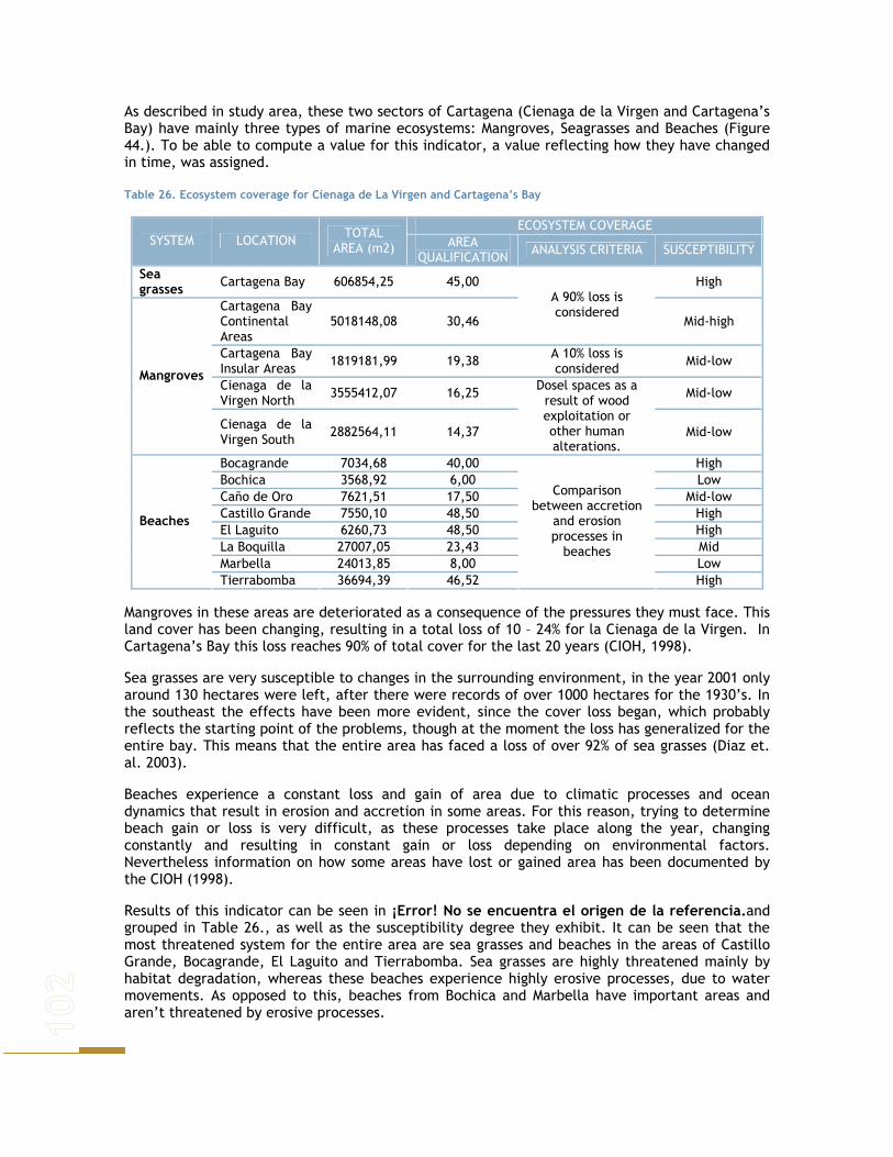
As described in study area, these two sectors of Cartagena (Cienaga de la Virgen and Cartagena’s Bay) have mainly three types of marine ecosystems: Mangroves, Seagrasses and Beaches (Figure 44.). To be able to compute a value for this indicator, a value reflecting how they have changed in time, was assigned.
Table 26. Ecosystem coverage for Cienaga de La Virgen and Cartagena’s Bay
ECOSYSTEM COVERAGE SYSTEM LOCATION TOTAL
AREA (m2) AREA QUALIFICATION ANALYSIS CRITERIA SUSCEPTIBILITY
Sea grasses Cartagena Bay 606854,25 45,00 High
Cartagena Bay Continental Areas
5018148,08 30,46
A 90% loss is considered
Mid-high
Cartagena Bay Insular Areas 1819181,99 19,38 A 10% loss is
considered Mid-low
Cienaga de la Virgen North 3555412,07 16,25 Mid-low
Mangroves
Cienaga de la Virgen South 2882564,11 14,37
Dosel spaces as a result of wood exploitation or other human alterations.
Mid-low
Bocagrande 7034,68 40,00 High Bochica 3568,92 6,00 Low Caño de Oro 7621,51 17,50 Mid-low Castillo Grande 7550,10 48,50 High El Laguito 6260,73 48,50 High La Boquilla 27007,05 23,43 Mid Marbella 24013,85 8,00 Low
Beaches
Tierrabomba 36694,39 46,52
Comparison between accretion
and erosion processes in
beaches
High
Mangroves in these areas are deteriorated as a consequence of the pressures they must face. This land cover has been changing, resulting in a total loss of 10 – 24% for la Cienaga de la Virgen. In Cartagena’s Bay this loss reaches 90% of total cover for the last 20 years (CIOH, 1998).
Sea grasses are very susceptible to changes in the surrounding environment, in the year 2001 only around 130 hectares were left, after there were records of over 1000 hectares for the 1930’s. In the southeast the effects have been more evident, since the cover loss began, which probably reflects the starting point of the problems, though at the moment the loss has generalized for the entire bay. This means that the entire area has faced a loss of over 92% of sea grasses (Diaz et. al. 2003).
Beaches experience a constant loss and gain of area due to climatic processes and ocean dynamics that result in erosion and accretion in some areas. For this reason, trying to determine beach gain or loss is very difficult, as these processes take place along the year, changing constantly and resulting in constant gain or loss depending on environmental factors. Nevertheless information on how some areas have lost or gained area has been documented by the CIOH (1998).
Results of this indicator can be seen in ¡Error! No se encuentra el origen de la referencia.and grouped in Table 26., as well as the susceptibility degree they exhibit. It can be seen that the most threatened system for the entire area are sea grasses and beaches in the areas of Castillo Grande, Bocagrande, El Laguito and Tierrabomba. Sea grasses are highly threatened mainly by habitat degradation, whereas these beaches experience highly erosive processes, due to water movements. As opposed to this, beaches from Bochica and Marbella have important areas and aren’t threatened by erosive processes.

WATER QUALITY AND HYDROGRAPHIC PROCESSES INTEGRITY
For the Cienaga de la Virgen and Cartagena’s Bay, environmental quality obtained from values gathered by INVEMAR’s marine quality network for these areas, during 2001 – 2004, don’t result as threatening as expected given the uses they’ve been subject to as receptors of untreated waste (Table 27).
The values obtained therefore reflect that water quality is not a definite hazard for associated flora and fauna.
Table 27. Water Quality and Hydrographic processes integrity for Cienaga de La Virgen and Cartagena’s Bay
WATER QUALITY AND HYDROGRAPHIC PROCESSES INTEGRITY SYSTEM LOCATION AREA
QUALIFICATION ANALYSIS CRITERIA SUSCEPTIBILITY
Sea grasses Cartagena Bay 2,14 Mid-low
Cartagena Bay Continental Areas
2,58 Mid-low
Cartagena Bay Insular Areas
2,04 Mid-low
Cienaga de la Virgen North
2,61 Mid-low Mangroves
Cienaga de la Virgen South
2,68 Mid-low
Bocagrande 2,62 Mid-low Bochica 1,89 Low Caño de Oro 2,56 Mid-low Castillo Grande 2,41 Mid-low El Laguito 2,39 Mid-low La Boquilla 1,40 Low Marbella 2,41 Mid-low
Beaches
Tierrabomba 1,99
Ponderate value for variables considered as physicochemical and microbiological indicators for marine and estuarine waters that support flora and fauna
Low
ECOSYSTEM QUALITY
Unplanned urban and industrial development in Cienaga de la Virgen and Cartagena´s Bay, has resulted in a lack of sewage treatment that has deteriorated the environment in these areas. Additionally, garbage accumulation an infrastructure have interrupted water exchange between the Cienaga de la Virgen and the sea, resulting in further damage.
Cartagena’s Bay is also subject to contamination from other sources, such as the second sea national port receiving fuel, oil and ballast waters among other contaminants. These activities result in habitat degradation, evident through the loss of associated macrofauna and poor forest development with high contamination levels.
For the 1970’s over 30 species of epibenthonic fauna were found in seagrasses of Cartagena’s Bay, being specially important sponges, gastheropods, epibenthonic bivalves, sea cucumbers, sea urchins and sea stars. In a study carried in May 2001, none of this groups were observed with the same frequency, and some of them weren’t observed at all (Diaz et. al., 2003) (Table 28). Additionally, fragmentation is evident in mangroves and sea grasses in the study area, resulting in an additional threat for the biological communities they sustain.
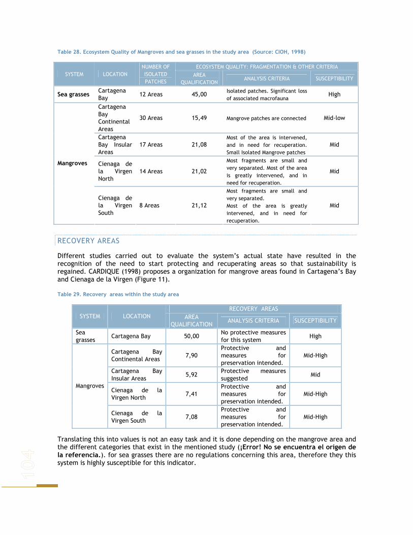
Table 28. Ecosystem Quality of Mangroves and sea grasses in the study area (Source: CIOH, 1998)
ECOSYSTEM QUALITY: FRAGMENTATION & OTHER CRITERIA SYSTEM LOCATION
NUMBER OF ISOLATED PATCHES
AREA QUALIFICATION
ANALYSIS CRITERIA SUSCEPTIBILITY
Sea grasses Cartagena Bay
12 Areas 45,00 Isolated patches. Significant loss of associated macrofauna
High
Cartagena Bay Continental Areas
30 Areas 15,49 Mangrove patches are connected Mid-low
Cartagena Bay Insular Areas
17 Areas 21,08 Most of the area is intervened, and in need for recuperation. Small Isolated Mangrove patches
Mid
Cienaga de la Virgen North
14 Areas 21,02
Most fragments are small and very separated. Most of the area is greatly intervened, and in need for recuperation.
Mid Mangroves
Cienaga de la Virgen South
8 Areas 21,12
Most fragments are small and very separated. Most of the area is greatly intervened, and in need for recuperation.
Mid
RECOVERY AREAS
Different studies carried out to evaluate the system’s actual state have resulted in the recognition of the need to start protecting and recuperating areas so that sustainability is regained. CARDIQUE (1998) proposes a organization for mangrove areas found in Cartagena’s Bay and Cienaga de la Virgen (Figure 11).
Table 29. Recovery areas within the study area
RECOVERY AREAS SYSTEM LOCATION AREA
QUALIFICATION ANALYSIS CRITERIA SUSCEPTIBILITY
Sea grasses
Cartagena Bay 50,00 No protective measures for this system
High
Cartagena Bay Continental Areas
7,90 Protective and measures for preservation intended.
Mid-High
Cartagena Bay Insular Areas
5,92 Protective measures suggested
Mid
Cienaga de la Virgen North
7,41 Protective and measures for preservation intended.
Mid-High Mangroves
Cienaga de la Virgen South
7,08 Protective and measures for preservation intended.
Mid-High
Translating this into values is not an easy task and it is done depending on the mangrove area and the different categories that exist in the mentioned study (¡Error! No se encuentra el origen de la referencia.). for sea grasses there are no regulations concerning this area, therefore they this system is highly susceptible for this indicator.

Figure 46. Zonation proposed by CARDIQUE (1998) for mangrove areas a). Cartagena’s Bay and b). Cienaga de la Virgen.
LAND USE: HABITAT CONVERSION
The connective system between the Cienaga de La Virgen and Cartagena’s Bay is currently interrupted as a result of unplanned urban invasion and garbage accumulation. In Cartagena’s Bay urban and industrial areas can be found. In this area fishing activities and wood exploitation were mangrove areas are still available, are common. Besides this, given its natural characteristics it is considered a natural port, being this the most important activity for this area, supporting industries as tourism, fishing and trade. Industry also takes place in the area and has a significant impact upon the ecosystem, given the constant inflows of wastes and fuels that go into the bay (CIOH, 1998).
Deeper into the continent in this area also residential use is found. This also occurs in Tierra Bomba, where some human settlements are found. The overall calculations were taken from comparing land use map with aptitude map and they can be seen in Table 30. For sea grasses habitat conversion is not studied, as this index refers to processes that change the landscape by human action as a result of direct intervention, which is not the case for sea grasses.

For beaches, habitat transformation results from invasion of these areas by buildings and other constructions established for different purposes.
Table 30. Habitat Conversion for Beaches and Mangroves within Cartagena’s study area
LAND USE: HABITAT CONVERSION SYSTEM LOCATION AREA
QUALIFICATION ANALYSIS CRITERIA SUSCEPTIBILITY
Cartagena Bay Continental Areas
7,08 Destruction for building associated residences.
Mid-high
Cartagena Bay Insular Areas
6,72
Exploitation for agricultural expansion and area preparation for building houses.
Mid-high
Cienaga de la Virgen North
6,20 Mid-high
Mangroves
Cienaga de la Virgen South
6,27
Habitat annual proportion converted from intact to altered Mid-high
Bocagrande 8,50 High Bochica 1,50 Low Caño de Oro 2,50 Mid-low Castillo Grande 9,00 High El Laguito 9,00 High La Boquilla 4,10 Mid Marbella 7,00 Mid-high
Beaches
Tierrabomba 7,86
Closeness of buildings to the sea, invasion of beach area
Mid-high
Figure 47 shows the different ways in which land is used in the study area. In the Cienaga de la Virgen a social problem can be seen in the way the area is being used. At present, poor people live in this area under subnormal conditions, generating not only severe conditions for the inhabitants, but also for the ecosystem, as it must face greater pressures than the one that it can handle. In this area agriculture, fishing, aquaculture and human settlements are the main uses found, being urbanization the principal.
This process has overcome dry areas, which means that flooded areas were mangroves are supposed to establish have been colonized by deforestation and filling flooded areas with different materials, to make the area available for building new structures. This has been done with no planning at all, which results in a complete lack of basic infrastructure for public services and waste disposal, which makes the impact even worse on the natural system (CIOH, 1998).
Other than this problems, in this area also inflow untreated wastes from other areas of the city, resulting in an incoming daily volume of 15 tons of organic matter. Additionally urbanization and agroindustrial activities affect the natural water exchange with the sea and produce agrochemicals inflows that enter the system (CIOH, 1998).
HAZARDS
Contrary to what is expected for Cartagena, the hazards that these areas face (liquation, soil remotion and inundation risks) are not as severe for the natural system. It is very important to understand that this evaluation was done using a map that shows the different risks for the different areas, along with expert knowledge that determined how negative, or positive such hazards could result for the natural systems (Table 31).

Figure 47. Land Use in the study area.
Table 31. Risk qualification for Cartagena’s natural systems
HAZARDS SYSTEM LOCATION
AREA QUALIFICATION ANALYSIS CRITERIA SUSCEPTIBILITY Sea grasses
Cartagena Bay 1,68 Low
Cartagena Bay Continental Areas
1,00 Low
Cartagena Bay Insular Areas
2,60 Mid-low
Cienaga de la Virgen North
2,97 Mid-low Mangroves
Cienaga de la Virgen South
2,72 Mid-low
Bocagrande 0,00 Low Bochica 6,00 Mid Caño de Oro 5,00 Mid Castillo Grande 5,00 Mid El Laguito 5,00 Mid La Boquilla 0,00 Low Marbella 0,00 Low
Beaches
Tierrabomba 5,87
Sum of the different hazards (natural and anthropogenic) a given area faces
Mid

SAN ANDRES DE TUMACO
Given the natural characteristics of the area, the differences seen and to present results in an orderly manner, Tumaco’s study area was divided (Figure 48) according to information available. Indicators differed depending on the area, as zones A1, A2, B1, B2 and C, quantitative information was available, which as mentioned above, was not the case for zone CCBM.
Figure 48. Study area division.
ECOSYSTEM COVERAGE: TOTAL HABITAT LOSS
Information used to calculate this indicator for Tumaco for mangroves is from the actualization of the diagnose study of physic – biotic components of mangroves in Tumaco’s bay (1997) and from local environmental plans of community councils (2003).
Table 32. Ecosystem coverage for Tumaco’s Mangroves
ECOSYSTEM COVERAGE SYSTEM ZONE
QUALIFICATION ANALYSIS CRITERIA SUSCEPTIBILITY A1 15,72 Mid-low
A2 43,44 High
B1 26,96 Mid
B2 43,63 High
C 31,98
Intervened and degraded areas over total mangrove area
Mid-high Mangroves
CCB.M
35,00
Qualitative description of intervened and degraded areas over total mangrove area
Mid-high
Data from total mangrove area and the state in which it is found, was used to calculate total habitat loss by comparing it with the given values for intervened and degraded areas. No comparable historical records were found, so this indicator was done for just one moment in time
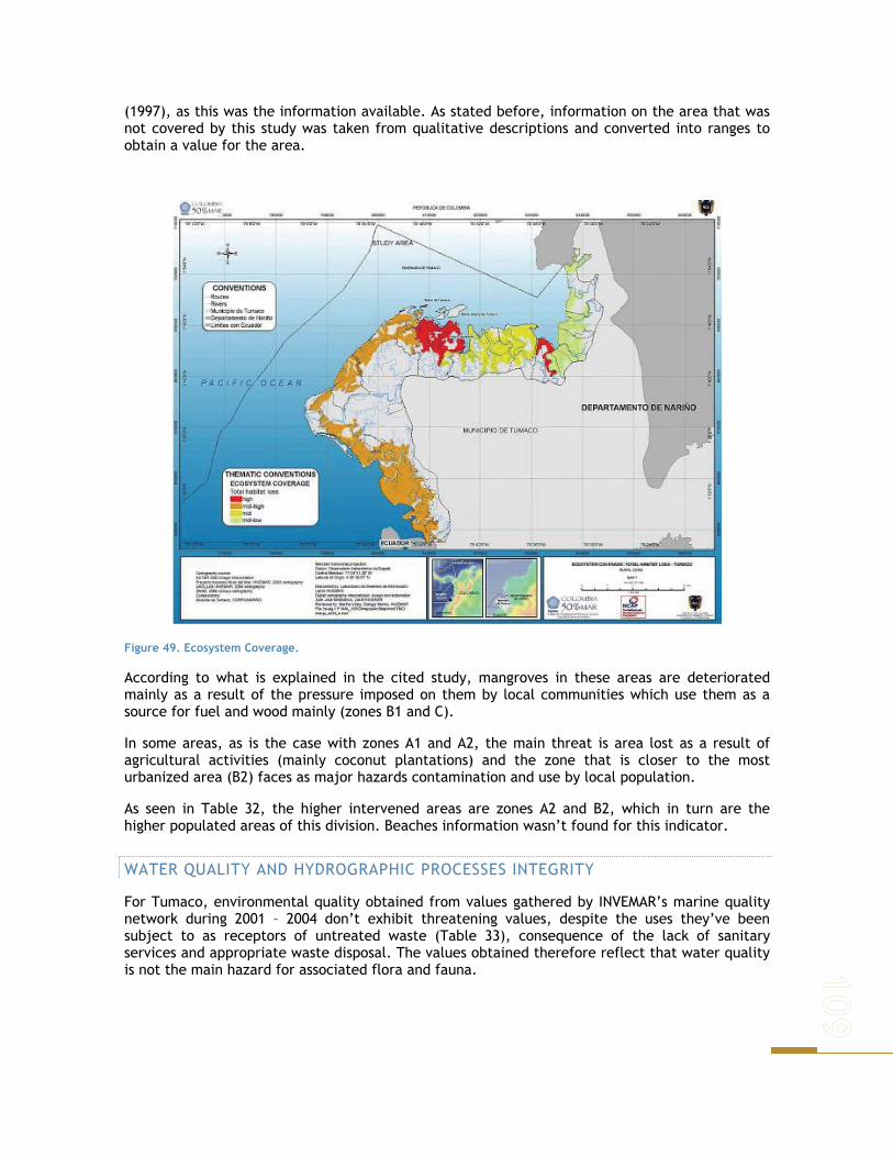
(1997), as this was the information available. As stated before, information on the area that was not covered by this study was taken from qualitative descriptions and converted into ranges to obtain a value for the area.
Figure 49. Ecosystem Coverage.
According to what is explained in the cited study, mangroves in these areas are deteriorated mainly as a result of the pressure imposed on them by local communities which use them as a source for fuel and wood mainly (zones B1 and C).
In some areas, as is the case with zones A1 and A2, the main threat is area lost as a result of agricultural activities (mainly coconut plantations) and the zone that is closer to the most urbanized area (B2) faces as major hazards contamination and use by local population.
As seen in Table 32, the higher intervened areas are zones A2 and B2, which in turn are the higher populated areas of this division. Beaches information wasn’t found for this indicator.
WATER QUALITY AND HYDROGRAPHIC PROCESSES INTEGRITY
For Tumaco, environmental quality obtained from values gathered by INVEMAR’s marine quality network during 2001 – 2004 don’t exhibit threatening values, despite the uses they’ve been subject to as receptors of untreated waste (Table 33), consequence of the lack of sanitary services and appropriate waste disposal. The values obtained therefore reflect that water quality is not the main hazard for associated flora and fauna.

Table 33. Water Quality and Hydrographic processes integrity for Tumaco
WATER QUALITY AND HYDROGRAPHIC PROCESSES INTEGRITY SYSTEM ZONE
QUALIFICATION ANALYSIS CRITERIA SUSCEPTIBILITY A1 2,58 Mid-low
A2 3,47 Mid-low
B1 2,55 Mid-low
B2 3,12 Mid-low
C 3,19 Mid-low
Mangroves
CCB.M 3,65 Mid-low
C 3,08 Mid-low
CCA.M 2,32 Mid-low Beaches
CCB.M 3,24
Ponderate value for variables considered as physicochemical and microbiological indicators for marine and estuarine waters that support flora and fauna
Mid-low
ECOSYSTEM QUALITY
Ecosystem quality seen as lost mangrove area, associated representative parameters and Holdridge’s complexity index, did not show the state of Tumaco’s mangroves as critical, but is important to mention how the highest qualification for this indicator (being the mostly threatened area) is zone B2. This is the highest populated area, where major impacts are expected, as extraction processes are the strongest of all (Table 34).
Unplanned urban development is evident through a lack of sewage treatment that has deteriorated the environment in these areas, and although not evident at the moment, these processes tend to worsen with time and measures to prevent this are to be taken immediately.
Other major stress source for these systems are occasional hydrocarbon spills that occur in the area and have a profound impact on mangroves and associated fauna. No information exists to be able to use this indicator for overall beaches susceptibility.
Table 34. Ecosystem quality for Tumaco’s Mangroves
ECOSYSTEM QUALITY SYSTEM ZONE
QUALIFICATION ANALYSIS CRITERIA SUSCEPTIBILITY A1 34 Mid-low
A2 35 Mid-low
B1 29 Mid-low
B2 48 Mid
C 25
Area where recovery processes are very unlikely to occur, leading to permanent mangrove area loss Absent parameters out of 14 that indicate environmental quality. Complexity index obtained compared with the expected to get an idea of forest behavior
Mid-low Mangroves
CCB.M 35
Qualitative description of areas where recovery processes are very unlikely to occur, leading to permanent mangrove area loss Qualitative description of absent parameters out of 14 that indicate environmental quality.
Mid-low
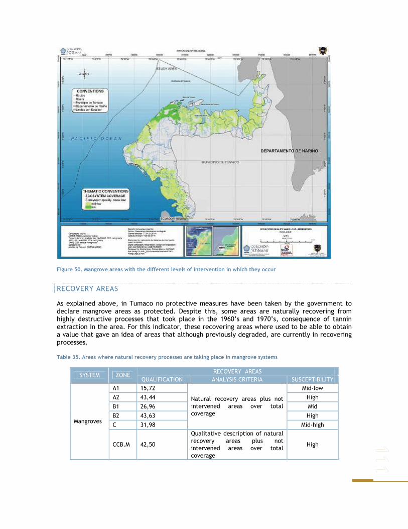
Figure 50. Mangrove areas with the different levels of intervention in which they occur
RECOVERY AREAS
As explained above, in Tumaco no protective measures have been taken by the government to declare mangrove areas as protected. Despite this, some areas are naturally recovering from highly destructive processes that took place in the 1960’s and 1970’s, consequence of tannin extraction in the area. For this indicator, these recovering areas where used to be able to obtain a value that gave an idea of areas that although previously degraded, are currently in recovering processes.
Table 35. Areas where natural recovery processes are taking place in mangrove systems
RECOVERY AREAS SYSTEM ZONE
QUALIFICATION ANALYSIS CRITERIA SUSCEPTIBILITY A1 15,72 Mid-low
A2 43,44 High
B1 26,96 Mid
B2 43,63 High
C 31,98
Natural recovery areas plus not intervened areas over total coverage
Mid-high Mangroves
CCB.M 42,50
Qualitative description of natural recovery areas plus not intervened areas over total coverage
High
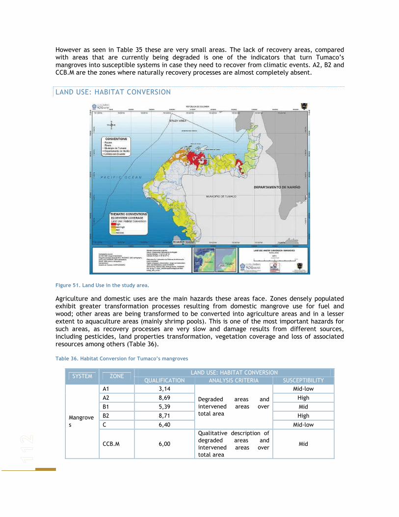
However as seen in Table 35 these are very small areas. The lack of recovery areas, compared with areas that are currently being degraded is one of the indicators that turn Tumaco’s mangroves into susceptible systems in case they need to recover from climatic events. A2, B2 and CCB.M are the zones where naturally recovery processes are almost completely absent.
LAND USE: HABITAT CONVERSION
Figure 51. Land Use in the study area.
Agriculture and domestic uses are the main hazards these areas face. Zones densely populated exhibit greater transformation processes resulting from domestic mangrove use for fuel and wood; other areas are being transformed to be converted into agriculture areas and in a lesser extent to aquaculture areas (mainly shrimp pools). This is one of the most important hazards for such areas, as recovery processes are very slow and damage results from different sources, including pesticides, land properties transformation, vegetation coverage and loss of associated resources among others (Table 36).
Table 36. Habitat Conversion for Tumaco’s mangroves
LAND USE: HABITAT CONVERSION SYSTEM ZONE
QUALIFICATION ANALYSIS CRITERIA SUSCEPTIBILITY A1 3,14 Mid-low
A2 8,69 High
B1 5,39 Mid
B2 8,71 High
C 6,40
Degraded areas and intervened areas over total area
Mid-low Mangroves
CCB.M 6,00
Qualitative description of degraded areas and intervened areas over total area
Mid

Regulations don’t exist and people use the resources with no major restrictions or directions so that impact is not as high as it actually is. There is no available information for beaches, and given the very ample tide variations and how erosion and accretion processes change constantly the area’s topography, the indicator could not be built from available maps for the zone.
HAZARDS
Tumaco beaches and mangrove areas face important hazards (tsunami, erosion, inundation, hydrocarbon spills, biodiversity loss) that increase their susceptibility. This evaluation was done using a map that shows the different risks for the different areas (Table 37).
Table 37. Risk qualification for Tumaco’s studied natural systems
HAZARDS SYSTEM ZONE
QUALIFICATION ANALYSIS CRITERIA SUSCEPTIBILITY A1 4,26 Mid
A2 5,88 Mid
B1 4,85 Mid
B2 3,53 Mid-low
C 5,59 Mid
Mangroves
CCB.M 3,92 Mid-low
C 5,29 Mid
CCA.M 2,94 Mid-low Beaches
CCB.M 5,29
Sum of the different hazards (natural and anthropogenic) a given area faces
Mid
ENVIRONMENTAL SUSCEPTIBILITY INDEX
To be able to obtain a unique index value, the results of each independent indicator were computed, resulting in a numerical value. The largest the value obtained, the more vulnerable from a natural system’s perspective the areas were regarded.
CARTAGENA DE INDIAS: CIENAGA DE LA VIRGEN AND CARTAGENA BAY
Table 38 shows how susceptibility values are distributed along the study area. As seen in the figure, ecosystems in the area face important pressures that make them highly vulnerable, diminishing in that way their resilience capacity to be able to face in an adaptive way problems that may arise as a result of climatic events, either extreme situational events or aspects resulting from long term processes as sea level rise.
The most vulnerable system at present are sea grasses, which face constant hazards that have resulted in an almost total loss of this cover in the area, and which has little recovering capabilities as it’s sustaining environment is highly degraded and no measures to reduce such hazards have been taken or proposed (Table 38). As far as mangroves, the most threatened are the ones located in Tierra Bomba’s urban area, which is expected given the pressures faced as a result of urbanization and direct exploitation, and general environmental quality found in the area.
The loss in ecosystem land cover, as a result of direct degradation and water quality and hydrographic processes integrity is reflected in these most vulnerable areas. This is also evident regarding fragmentation, as these areas are formed by isolated small patches. Given the degradation and unsustainable use to which these systems have been exposed, it is not strange that ecosystem quality is highly degraded. Nevertheless is important to note that for mangroves,

efforts to recuperate and regulate the use of these areas have been done, the problem is the real effects they have performed.
Table 38. Susceptibility categories for natural system’s found in the study area
SYSTEM LOCATION TOTAL
QUALIFICATION OVERALL
SUSCEPTIBILITY Sea grasses Cartagena Bay 188,81 High
Cartagena Bay Continental Areas 79,99 Mid Cartagena Bay Insular Areas 78,83 Mid Cienaga de la Virgen North 77,48 Mid
Mangroves
Cienaga de la Virgen South 75,36 Mid Bocagrande 11,12 Low
Bochica 15,39 Low
Caño de Oro 27,56 Mid-low
Castillo Grande 64,91 High El Laguito 64,89 High La Boquilla 28,94 Mid-low Marbella 9,41 Low
Beaches
Tierrabomba 62,24 Mid-high
For beaches erosive processes and habitat transformation hazards are the main responsible for some of them exhibiting a high susceptibility. Changes in landscape are evident and highly threatening were human settlements are found.
Sea level rise implies changes in local conditions that may impose greater pressures or may be good in environmental terms. This is the case of sea level rise, as it may turn areas into suitable for maintaining mangroves. Despite this, it is important to understand that suitability is not enough, as environmental quality is what at the end defines how capable is a system of prevailing in time.
In Cartagena environmental susceptibility is directly related with human presence in the different areas, and is mainly the result of the activities that these populations generate and the impacts that result from them. These conditions summed to the loss in area due to land use conversion processes make some of the mangrove areas highly susceptible. Beaches on the other hand are affected as well by such processes and considerable areas are being lost.
SAN ANDRES DE TUMACO
Table 39 shows how susceptibility values are distributed along the study area. As seen in Figure 52, ecosystems in the area face important pressures that make them vulnerable, diminishing in that way their resilience capacity to be able to face in an adaptive way problems that may arise as a result of climatic events, either extreme situational events or aspects resulting from long term processes as sea level rise
Mangroves and beaches face constant hazards mainly resulting from anthropogenic activities that deteriorate their general state. The lack of local policies and of territory arrangement make degrading processes harder to control and is highly complicated the fact that the resources are being constantly used and no areas have been declared to be able to preserve the systems (Table 39).

Table 39. Susceptibility categories for natural system’s studied in Tumaco
SYSTEM ZONE Total
Qualification Overall Susceptibility
A1 75,16 Mid-low
A2 139,98 Mid
B1 95,89 Mid-low
B2 151,01 Mid-high
C 104,35 Mid
Mangroves
CCB.M 126,07 Mid
C 8,38 Mid
CCA.M 5,26 Mid-low Beaches
CCB.M 8,53 Mid
Figure 52. Environmental susceptibility for Tumaco beaches and mangroves.
Respecting mangroves, the most threatened of these are the ones located in B2, the area closer to Tumaco’s urban area, which is expected given the pressures faced as a result of urbanization, direct exploitation and general environmental quality found in the zone.
SOCIOECONOMIC VULNERABILITY
Socioeconomic impacts refer to potential loss, measured by the natural exposition degree susceptibility to hazards and recuperation capacity. It is created as a result of localization and societal differences, in such a way that the lack of empowerment diminishes access to resources and the range of viable options in tense moments (Barnett, 2001). The socioeconomic vulnerability is given by the system’s potential impact or susceptibility and technical, institutional, economical and cultural ability of society to face or prevent such impacts. As in

resilience and resistance of natural systems, potential for a planed autonomous adaptation determines the ability to prevent or face potential impacts (Klein & Nicholls, 1999).
In a local level, vulnerability and adaptation capacity are influenced by processes that operate on a national scale as is the case of economical policies that influence economical well being of vulnerable groups. Because of this inversion in critical areas (education, health, physical infrastructure) influence vulnerability as they determine opportunities to diminish vulnerability and improve adaptation. At a national scale, economical vulnerability assumes a country is economically vulnerable despite its development.
SELECTION OF INDICATORS TO ASSESS THE IMPACTS OF THE SOCIOECONOMIC SYSTEM
A social economic vulnerability index involves three aspects: exposition to conditions of foreign trade, isolation and propensity to natural disasters (Briguglio,1995). The first of these three aspects relates to economical vulnerability in the sense that the greater the exposure, the more the country’s development depends upon foreign economical conditions. The second relates with economical vulnerability as it introduces uncertainty, delays and indivisible costs in international trade, and the third as it creates additional costs and resource deviation from productive activities.
For the indicators selection to be included in the Socioeconomic vulnerability index, theoretical concepts previously mentioned are considered, information availability to the required level of disaggregation for the analysis and the results of the DPSIR analysis. Table 40 shows the indicators description, justification and measurement methodology.
Basic data used to calculate socioeconomic vulnerability index (SVI), belongs mainly to SISBEN’s questionnaire results for each of the urban and rural areas of Cartagena and Tumaco. SISBEN is a proxy means test index widely used as a targeting system for social programs in Colombia. This index is a function of a set of household variables related to the consumption of durable goods, human capital endowment and current income.
SISBEN was created by the Colombian government with the purpose of simplifying, expediting and reducing the cost of targeting individual beneficiaries of social programs at the various government levels. The overall objective is to obtain reliable socio-economic information on poor and vulnerable groups of the Colombian population to be used in the targeting of social programs, particularly in the subsidized program of the newly reformed public health system (Vélez et al. 1999).
For Tumaco the results of the questionnaire for socioeconomic characterization will be used, which will allow the inclusion in the SVI morbility and analphabetism variables.
The proposed index has four components
SVI = LQI + NCRI + PII + P
where,
LQI = Life Quality Indicator NCRI = Natural Catastrophe Risk Indicator PII = Public Investment Indicator PI = Population Indicator

Table 40. Indicators selection to compose the socioeconomic vulnerability index
INDICATOR DEFINITION / JUSTIFICATION MEASUREMENT
Population
All the inhabitants of a given sex and/or age group that live effectively within a country’s, territory or geographical area’s boundaries at a given moment in time.
Number inhabitants
Children under 7 years of age
Total population percentage of a given country, territory or geographical area, under seven years of age, for a certain sex and at a particular moment in time.
Percentage of children under 7 years of age
Public investment Expenses destined for health, education, infrastructure, basic sanitation, household and disaster prevention.
Amount of money (thousands of pesos) destined to each item
Tendency to natural disasters
Knowledge of potential destruction risk, partial or total, of the house in case of natural vents, given that it’s localization is not appropriate. It is a key indicator as in case an event takes place, adaptation measures must be adopted.
Number of houses at risk of: flooding, sliding, avalanche, sinking, geological faults, others.
Sewage disposal Number of houses per options
Water Suply Number of houses according to water supply sources for human intake
Waste recollection Number of houses that receive waste recollection services
Cooking Fuel Number of houses per kind of fuel used to cook
House walls Materials Number of houses per main material of exterior walls
House floor material Number of houses per floor material
Scholarship (children from 6 to 11 years of age)
Number of children assisting to school from ages 6 to 11
Scholarship (children from 12 to 18 years of age)
This set of variables is part of the Life Conditions Index (LCI), it makes possible to identify poor sectors of the population. Additionally those related with households characteristics show interactions with the environment.
Number of children assisting to school from ages 12 to 18
Iliteracity
Population over 15 years of age that can’t read and write a text that comprises no difficulty. It is considered a standard indicator of vulnerability since apart from reflecting quality of the system, it also is associated to access to other services.
People over 15 years of age that can not read and write
Morbility
People proportion that get sick at a given place and time. It considers illnesses associated to the place of residence, life conditions and those with greater incidence in case of floods.
Number of cases per main diseases reported
Calculating Life Quality Index is based on the methodology3 proposed for calculating Colombia’s Life Quality Index, which doesn’t imply that a new Index is being calculated for Cartagena and Tumaco.
3 For greater detail on this methodology check Gamboa, González, Cortes, 2000

ifjfj
C
jf
F
fi VWWICV
f
∑∑==
=11
where,
fW is factor associated weight, factors are sets of variables incorporated to the
indicator.
fjW is variable j weight, belonging to factor f
ifjV is the valuation received by i commune in the response category that belongs
to j variable of f Factor
F is the number of factors
fC Variable number in each factor
i is the commune
Natural Catastrophe Risk Indicator is the potential risk of partial or total household destruction as a result of natural events, given an inadequate household location. Nearness to a river, sea or to geologic faults must be known, or if the area is suitable for building.
∑= ijji ZYIRCN
Where,
jY is variable j weight, belonging to the factor
ijZ commune i value in j variable
Public Investment Indicator are the expenses destined to health, education, infrastructure, aqueduct and sewer, household and disaster prevention. Additional to actual vulnerability, this indicator allows us to evaluate adaptive capacity in case of natural disasters, among them flooding as a result of rapid sea level rise.
∑= jij KXIIP
Where,
jX is variable j weight, belonging to the factor
jiK commune i weight in j variable
Finally, Population Indicator is population participation in a given geographic area (Government Commune Unit for Cartagena) over municipality’s total population.
∑= jijRJIP

Where,
jJ is variable j weight, belonging to the factor
jiR is the value received by i commune in j variable
Socioeconomic Vulnerability index values are located in the range [0,100], as it increases their value it indicates that the vulnerability diminishes. To simplify the analysis of the SVI, the following division is used:
Table 41. SVI Classification
Value Vulnerability
Under 15 Very High 15 to 28,9 High 29 to 42,9 Mid High 43 to 56,9 Mid 57 to 69,9 Mid Low
70 and above Low
This classification is also used in the qualification of each one of the indicators that compose the SVI.
CARTAGENA DE INDIAS
LIFE QUALITY
The indicator is composed by the variables that evaluate water supply, sewage disposal, garbage disposal and cooking fuel. In concordance to the results of the First Workshop of Cartagena, the sewage system and the lack of maintenance from sedimentation caused by erosion of the system of sewers become insufficient to overcome the city annual flood (Table 42).
Table 42. Cartagena life quality indicator
LIFE QUALITY INDICATOR
High Low Mid Mid High
Mid High*
Mid Low
Mid Low*
Mid* Very High
Corregimientos 3 0 11 15 0 0 0 0 1 Rural
Area % 10,0% 0,0% 36,7% 50,0% 0,0% 0,0% 0,0% 0,0% 3,3%
Districts 1 28 36 5 3 73 3 6 0 Area
Urban Area % 0,6% 18,1% 23,2% 3,2% 1,9% 47,1% 1,9% 3,9% 0,0%
Total 4 28 47 20 3 73 3 6 1 % 2,2% 15,1% 25,4% 10,8% 1,6% 39,5% 1,6% 3,2% 0,5%
This situation is reflected in the low values of the Services. Factor 39.5% of the City has mid low vulnerability. In the urban area, 23% of the districts have mid vulnerability. In the rural area 50% of the corregimientos have mid vulnerability.

Figure 53. Life quality indicator.
SERVICES
This factor groups together cooking fuel, water supply source and sanitary service kind. For each of the answer alternatives, an upward qualification was assigned, as they represent a better life quality condition (Table 43). In the urban area the neighborhood with the lowest classification was Henequen (12.63), in the UCG 15 Almirante Colon 87.5 UCG 12.
Table 43. Cartagena. Service
SERVICES CARTAGENA
High Low Mid Mid High
Mid Low
Very High
Corregimientos 15 0 0 3 0 12 Rural
% de área 50,0% 0,0% 0,0% 10,0% 0,0% 40,0%
Neighborhood 1 103 24 7 19 1 Area
Urban % de area 0,6% 66,5% 15,5% 4,5% 12,3% 0,6%
Total 16 103 24 10 19 13
% 8,6% 55,7% 13,0% 5,4% 10,3% 7,0%

HOUSING
This factor includes external walls materials and type of floor in which the house is built.
Table 44. Cartagena. Housing
HOUSING FACTOR CARTAGENA
High Low Mid Mid High
Mid Low
Corregimientos 0 8 3 7 12 Rural
% de área 0,0% 26,7% 10,0% 23,3% 40,0%
Neighborhood 1 111 6 3 34 Area
Urban % de área 0,6% 71,6% 3,9% 1,9% 21,9%
Total 1 119 9 10 46
% 0,5% 64,3% 4,9% 5,4% 24,9%
64% of the study area has low vulnerability in the housing factor. However a difference is appreciated among the rural and urban areas. While 40% of the rural area has mid low vulnerability 72% of the neighborhoods have Low vulnerability.
HUMAN CAPITAL FACTOR
This factor refers to population’s preparation. It is composed by population’s proportion that assists to an education institution by age ranges. In Cartagena it also includes children under 7 years of age.
Table 45. Cartagena. Human Capital Factor
HUMAN CAPITAL FACTOR CARTAGENA
S.I High Mid Mid High
Mid Low
Very High
Corregimientos 0 4 12 13 0 1 Rural
% de área 0,0% 13,3% 40,0% 43,3% 0,0% 3,3%
Neighborhood 13 23 56 56 1 6 Area
Urban % de área 8,4% 14,8% 36,1% 36,1% 0,6% 3,9%
Total 13 27 68 69 1 7
% 7,0% 14,6% 36,8% 37,3% 0,5% 3,8%
Most of the neighborhoods and corregimientos have mid high vulnerability, this shows the low coverage of basic education that Cartagena presents. Access to education in rural areas is more difficult, where 43% of the corregimientos have mid high vulnerability.
NATURAL DISASTER INDEX
Given that information comes from questionnaires done to each house, it measures inhabitants perception of house location. Natural disasters include flood, avalanche, sidings and others.
Both urban and rural area exhibit low vulnerability, which reflects that most of Cartagena’s inhabitants feel safe in the place where their houses are located.

Table 46. Cartagena Natural Disaster Index
NATURAL DISASTER INDICATOR Cartagena
High Low Mid Mid High
Mid Low
Very High
Corregimientos 1 22 2 1 1 3 Rural
% de área 3,3% 73,3% 6,7% 3,3% 3,3% 10,0%
Neighborhood 0 130 7 3 10 5 Area
Urban % de área 0,0% 83,9% 4,5% 1,9% 6,5% 3,2%
Total 1 152 9 4 11 8
% 0,5% 82,2% 4,9% 2,2% 5,9% 4,3%
Figure 54. Natural Disaster Index
PUBLIC INVESTMENT INDICATOR
Investment sectors included are health, education, basic reparation, infrastructure, housing and disaster prevention. Disaster prevention received the highest ponderador, to evaluate vulnerability of the municipalities regarding RSLR.

Table 47. Cartagena Public Investment Indicator
PUBLIC INVESTMENT INDICATOR Cartagena
High Low Mid Mid High
Mid Low
Very High
S.D S.I
Corregimiento 1 7 2 0 4 1 1 14 Rural
% de Área 3,3 23,3 6,7 0,0 13,3 3,3 3,3 46,7
Neighborhood 0 56 7 4 23 1 6 58 Area
Urban % de Área 0,0 36,1 4,5 2,6 14,8 0,6 3,9 37,4
Total 1 63 9 4 27 2 7 72
0,5 34,1 4,9 2,2 14,6 1,1 3,8 38,9
Generally, Cartagena has Low vulnerability regarding public investment.
Figure 55. Public Investment Indicator.
POPULATION INDICATOR
Composed of the number of inhabitants and the number of houses inside all the Government Commune Units. The total study area exhibits very high vulnerability.

Table 48. Cartagena. PI
Population Indicator Cartagena
Very High S.I
Corregimiento 29 1 Rural
% de área 96,7% 3,3%
Neighborhood 148 7 Area
Urban % de área 95,5% 4,5%
Total 177 7
% 95,7% 3,8%
OVERALL SOCIOECONOMIC VULNERABILITY INDEX
A High socioeconomic vulnerability reflects in general low life quality, which is seen through public service coverage, use of firewood as cooking fuel, houses built of materials different from cement, such as wood. All this characteristics have direct impacts over the ecosystems (mangroves and sea grasses in cases where habitat degradation is involved), degrading its general quality and diminishing its area.
Figure 56. Overall socioeconomic vulnerability index
Neighborhoods located in the southern border of the Cienaga de la Virgen (UCG 5 and 6), exhibit high socioeconomic and biophysical vulnerability. North western urban area, and neighborhoods along Santander avenue, exhibit high and very high vulnerability levels; those close to Chambacu and San Lorenzo lagoons exhibit high and mid high vulnerability, which can be correlated with mangroves susceptibility in areas nearby. The same occurs with the Tierra Bomba, which exhibits mid high and mid vulnerability (southern area).
Populations located in the rural area of the Cienaga de la Virgen present mid socioeconomic vulnerability, as they have some of the indicators to a certain degree of fulfillment. The same happens with populations close to la Boquilla. These areas cook mainly with firewood, and sanitary conditions are not optimum as some don’t have sanitary services connected to sewage systems. No adequate means for water supply and no investment in basic sanitation is present in the area. these facts can explain part of the reason for the degradation of some of the mangroves in these areas.
Table 49.Cartagena .SVI
SOCIOECONOMIC VULNERABILITY INDEX
High High* Low Mid Mid High
Mid High*
Mid Low
Mid* Very High*
Corregimiento 3 2 0 9 4 10 1 0 1 Rural
Area % 10,0 6,7 0,0 30,0 13,3 33,3 3,3 0,0 3,3 District 1 6 1 36 9 37 51 12 2
Area Urban
% de Área 0,6 3,9 0,6 23,2 5,8 23,9 32,9 7,7 1,3 Total 4 8 1 45 13 47 52 12 3
% 2,2 4,3 0,5 24,3 7,0 25,4 28,1 6,5 1,6
* Some corregimientos and districts don’t have Population or Public Investment information
SAN ANDRES DE TUMACO
As for Cartagena, the SVI is calculated based on the SISBEN 2005.survey data. For the analysis of the urban area of Tumaco, secure area division was taken from OSSO report. In the rural area, the corregimientos that besides having SISBEN information, are located in the coastal area of Tumaco, were taken. Annex 1 and 2 present SVI results for the corregimientos and neighborhoods that compose the study area, in a detailed manner.
LIFE QUALITY INDICATOR
LQI in the three secure areas of Tumaco’s urban area, present mid high vulnerability.
Table 50. Tumaco. LQI urban area
SECURE AREA LIFE QUALITY INDICATOR ISLA TUMACO Y LA VICIOSA Mid High ISLA EL MORRO Mid High
ZONA CONTINENTAL Mid High
On the other hand the LQI in the rural coastal area, shows that 80.6% of the corregimientos have High vulnerability and 19,4 Very High vulnerability. These results evidence the great difference on Life conditions among the urban and rural area and how this affects the vulnerability regarding SLR.
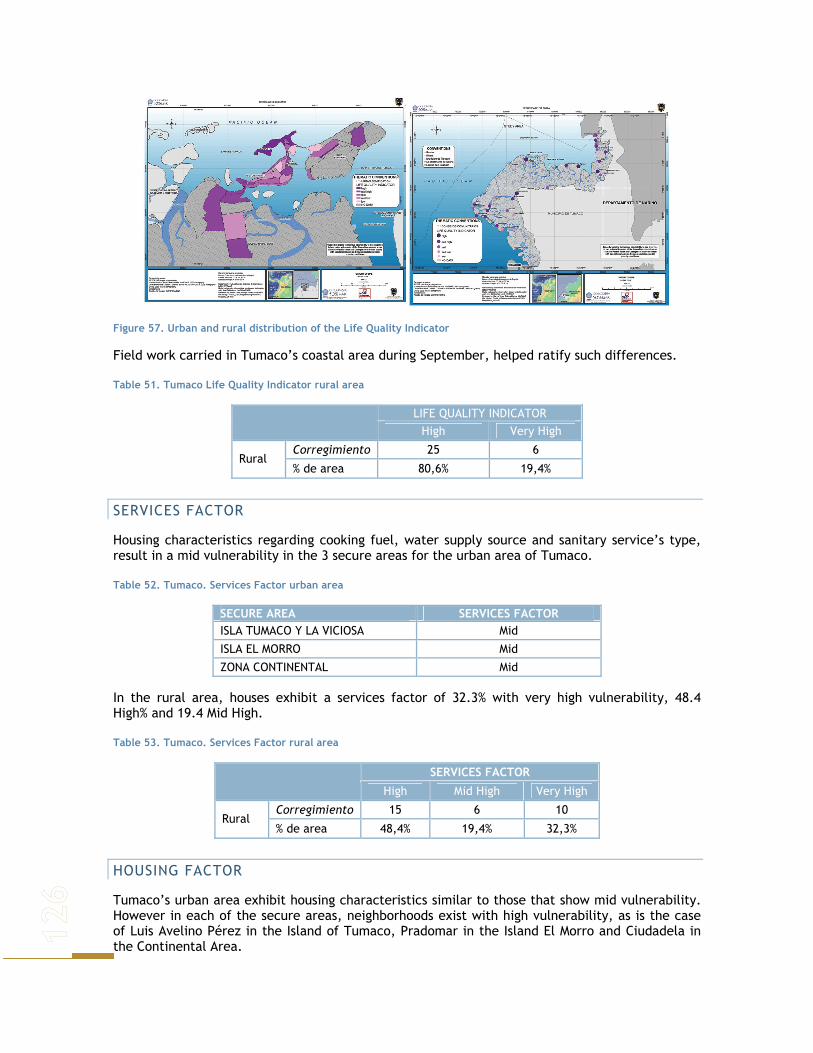
Figure 57. Urban and rural distribution of the Life Quality Indicator
Field work carried in Tumaco’s coastal area during September, helped ratify such differences.
Table 51. Tumaco Life Quality Indicator rural area
LIFE QUALITY INDICATOR
High Very High
Corregimiento 25 6 Rural
% de area 80,6% 19,4%
SERVICES FACTOR
Housing characteristics regarding cooking fuel, water supply source and sanitary service’s type, result in a mid vulnerability in the 3 secure areas for the urban area of Tumaco.
Table 52. Tumaco. Services Factor urban area
SECURE AREA SERVICES FACTOR ISLA TUMACO Y LA VICIOSA Mid
ISLA EL MORRO Mid
ZONA CONTINENTAL Mid
In the rural area, houses exhibit a services factor of 32.3% with very high vulnerability, 48.4 High% and 19.4 Mid High.
Table 53. Tumaco. Services Factor rural area
SERVICES FACTOR
High Mid High Very High
Corregimiento 15 6 10 Rural
% de area 48,4% 19,4% 32,3%
HOUSING FACTOR
Tumaco’s urban area exhibit housing characteristics similar to those that show mid vulnerability. However in each of the secure areas, neighborhoods exist with high vulnerability, as is the case of Luis Avelino Pérez in the Island of Tumaco, Pradomar in the Island El Morro and Ciudadela in the Continental Area.

Table 54. Tumaco. Housing Factor urban area
SECURE AREA HOUSING FACTOR ISLA TUMACO Y LA VICIOSA Mid
ISLA EL MORRO Mid
ZONA CONTINENTAL Mid
93% of the coastal rural area presents mid high vulnerability in the housing factor, showing the differences among both areas of the municipality.
Table 55. Tumaco. Housing Factor rural area
HOUSING FACTOR
High Mid High
Corregimiento 2 29 Rural
% de area 6,5% 93,5%
HUMAN CAPITAL FACTOR
Proxy variable used to analyze human capital factor is population on the SISBEN that is studying, this variable allows us to have an idea on how much invest the inhabitants of Tumaco in their preparation, and with this on their expectancies regarding improving their life style, as better education levels allow access to better employments and this insides on income level for its inhabitants.
Table 56. Tumaco. Human Capital Factor urban area
SECURE AREA HUMAN CAPITAL FACTOR ISLA TUMACO Y LA VICIOSA Low ISLA EL MORRO Low ZONA CONTINENTAL Low
Tumaco’s urban area exhibit a low vulnerability regarding human capital factor, except for el Pindo and Ciudadela which have mid low vulnerability. In contrast, the entire rural area of the corregimientos present a Very High vulnerability.
NATURAL DISASTER INDICATOR
Although the classification of the urban area corresponds to the secure areas, the inhabitants perception of their houses location in risk areas exhibits mid high vulnerability for Tumaco’s island and La Viciosa. Perception of vulnerability is mid for continental areas and mid low for el Morro island.
Table 57. Tumaco. NDI urban area
SECURE AREA NATURAL DISASTER INDICATOR ISLA TUMACO Y LA VICIOSA Mid High ISLA EL MORRO Mid Low ZONA CONTINENTAL Mid
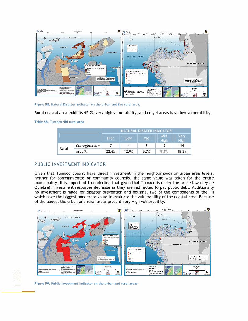
Figure 58. Natural Disaster Indicator on the urban and the rural area.
Rural coastal area exhibits 45.2% very high vulnerability, and only 4 areas have low vulnerability.
Table 58. Tumaco NDI rural area
NATURAL DISATER INDICATOR
High Low Mid Mid High
Very High
Corregimiento 7 4 3 3 14 Rural
Area % 22,6% 12,9% 9,7% 9,7% 45,2%
PUBLIC INVESTMENT INDICATOR
Given that Tumaco doesn't have direct investment in the neighborhoods or urban area levels, neither for corregimientos or community councils, the same value was taken for the entire municipality. It is important to underline that given that Tumaco is under the broke law (Ley de Quiebra), investment resources decrease as they are redirected to pay public debt. Additionally no investment is made for disaster prevention and housing, two of the components of the PII which have the biggest ponderate value to evaluate the vulnerability of the coastal area. Because of the above, the urban and rural areas present very High vulnerability.
Figure 59. Public Investment Indicator on the urban and rural areas.

POPULATION INDICATOR
All the corregimientos and neighborhoods exhibit very high vulnerability, except for Chajal which shows high vulnerability.
Figure 60. Population Indicator on the urban and rural areas.
OVERALL SOCIOECONOMIC VULNERABILITY INDEX
In general terms the urban area of Tumaco presents High vulnerability. In The Island of Tumaco and Visiosa over half of the secure areas present High vulnerability. Additionally Miramar urbanization presents Very high vulnerability regarding RSLR.
In the Island of El Morro, most of the secure areas that have information, present mid high vulnerability. The secure areas of the Continental area of Tumaco, have high vulnerability regarding SLR.
Figure 61. Urban Overall Socioeconomic Vulnerability Index. Rural Socioeconomic Vulnerability Index
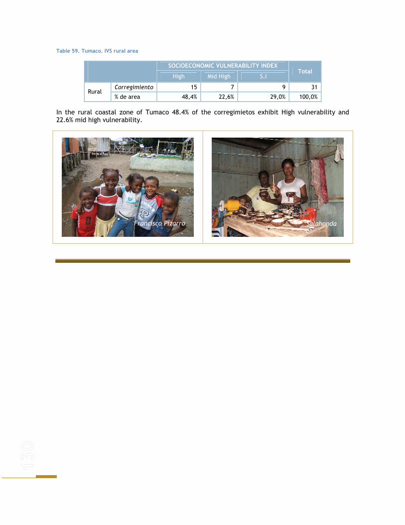
Table 59. Tumaco. IVS rural area
SOCIOECONOMIC VULNERABILITY INDEX
High Mid High S.I Total
Corregimiento 15 7 9 31 Rural
% de area 48,4% 22,6% 29,0% 100,0%
In the rural coastal zone of Tumaco 48.4% of the corregimietos exhibit High vulnerability and 22.6% mid high vulnerability.
Salahonda Francisco Pizarro
SCENARIO DEVELOPMENT TO DEVELOP ADAPTATION MEASURES NEEDED TO COPE WITH SLR, DIFFERENT SCENARIOS WERE DESIGNED TO CHARACTERIZE FUTURE STATES OF CARTAGENA AND TUMACO.
Such scenarios do not pretend to predict what will happen, but are merely descriptions of different possibilities these cities may face according to present situations and the way local governments are planning their future.
Scenarios are placed in the year 2019. This year was chosen for the National vision to be fulfilled by the present administration, which describe how the country is seen as it should be in that year. The country has produced different documents describing the dispositions for this year, as this is the time when Colombia celebrates two centuries as a political independent country (DNP, 2005).
Local government plans are also considered, to foresee the real possibilities each city has on a regional level to fulfill Colombia’s general vision for this year. Such plans are not thought up to this year, but they are done for a shorter term, usually periods established depending on actual governments and national planning laws.
Colombia in the year 2019 involves many aspects that are not going to be mentioned and only those considered relevant for the creation of scenarios are listed below.
In the socioeconomic aspect economy is expected to be growing at a rate of 6% yearly. Urban coverage of water supply and sewage coverage must reach 100% (at the moment they are of 97.4% and 90.2% respectively) and rural coverage must be of 82.2% for water supply (against a 68.6%) and of 75.2% for sewage coverage (against actual 57.9%).
Basic education coverage must be universal, with 100% of bachelors of capital cities bilingual. Education must reach an average of 11.3 years for people between 15 and 24 years of age (against an actual of 8.7 years), with a gross coverage of 40% in higher education (currently it is of 25.7%).
To avoid the establishment of new unsafe settlements, 3.9 millions of new houses are to be build, and 804000 houses must be improved, reducing total household deficit to a 12% (against an actual 30%).
In the year 2019, Colombia must have reconsidered it’s vision of the oceans, involving the 928.660 km2 of marine area (44.8% of total territory extension) in the development of the country, seizing sea potentialities and continental zones as well, through tourism (increasing foreign tourism eight times it’s actual number) and bio - commerce.
● Important velocity corridors must be established on the roads: a) North – South direction: The new Western highway, Magdalena’s highway, Central- Northern highway and Marginal Forest highway. b) East- West direction: Tumaco – Rio Putumayo corridor, Buenaventura-Puerto Carreño corridor, Media Luna de los Valles Fértiles highway and Caribbean Marginal highway.

● For port development Colombia must seize it’s strategic location on the main marine commerce corridor of the world, to increase to 285 millions of tons per year port’s capacity of public use (currently it is 150 million ton/year).
● Colombia must also increase to 99.4% energy service in interconnected areas (against an actual 90%). The state must be working completely by results and the decentralization process must result in a complete competence definition among the nation and territorial entities. All territorial entities must be financially viable.
Environmentally, Colombia’s vision for 2019 implies a constant development, based on the sustainable use of natural resources, involving society in the different decisions to be taken on environmental matters and on the costs and benefits such development implies (DNP, 2005). To be able to get to this point, national development must be based upon the sustainable development principles that seek to respect the interests of all and protect the integrity of the global environmental and developmental system, recognizing the integral and interdependent nature of the Earth (United Nations, 1972).
Colombia’s vision for 2019 involves environmental issues as well. The need for the country to involve environment in every planning aspect is highly recognized. It must also rely on a regulatory background that guarantees the solution of different priorities, equity and security. Institutional capacity must also be strengthened so that laws and regulations are seeing into order.
As a direct result, biodiversity loss and degradation processes should be diminished given that contamination problems that are found in the different urban centers of the country are to be corrected. As a result the goods and services that natural systems may offer, should be enhanced and result in bigger benefits for the population.
Environmental tasks must be based upon the principles of efficiency (objectives fulfilled in a rapid manner with few resources), efficacy (objectives fulfilled as planned), equity (costs and benefits for the entire population), transparency (policies, strategies, standards and regulations are to be public), participation (environmental planning must involve the public in general), recognition (of social, economical, environmental, territorial, cultural and ethnic diversity), complementary (policies, regulations, projects and activities that involve environmental aspects must be inter - institutionally coordinated and be complimentary so that they reinforce each other and are more effective and efficient).
For 2019 the country also seeks some specific objectives that are to be fulfilled all over the country. These include:
− Ecosystems and soils: adopt strategies, mechanisms and actions that prevent, recover and stop degradation processes.
− Maintain the country’s forestall coverage − Guarantee biodiversity and ecosystem’s conservation through the strengthening of
the National system of Protected Areas. − Promote sustainable use of biodiversity, defining clearly conditions of use and access
of biological resources. − Reduce hydrographic vulnerability and guarantee water offer for all the country. − Promote rational and efficient water use in the different productive sectors. − Reaching a 50% of water disposals that fulfill regulations and standards − Reaching particle concentrations that fulfill standards. − Contributing to global reduction of climatic problems. − Reduction of contamination problems and environmental and health hazards related
to waste disposal. − Improve information and early alert systems to prevent disasters. − Improve risk preparation through economic planning instruments that guarantee and
enhanced well being.

− Reduce state’s physical vulnerability in case a disaster takes place. − Guarantee the inclusion of environmental aspects in policies, plans and programs, and
in planning processes an problem solving as well. − Strengthen National Environmental System (SINA, for it’s name in Spanish) entities, so
that they help enhance development’s environmental benefits, assure fair distribution and internalize their environmental costs.
− SINA’s research tasks are to be optimized and efficient. Information should be systemized.
− Guarantee international country’s rights and capitalize the opportunities that result from instruments and international environmental agreements.
− Strengthen citizen participation mechanisms in environmental decision making and in the fight for environmental rights.
SLR is a phenomenon that is taking place gradually and people have to deal with it. By the year 2019, this phenomenon will be even more accentuated than today, but still not as bad as it will be in one hundred years. It is important therefore to start generating coping strategies that will help population at risk and will diminish the loss of biodiversity as a consequence of this process.
Adaptability may be enhanced therefore, by reducing the susceptibility of natural systems to SLR, it is important to note that in such a context, natural systems not only provide a source of resources for human populations for the goods and services they provide, but also act as natural barriers that help mitigate negative effects of SLR and other climatic phenomena.
With this in mind, is important to face the development of scenarios as a process in which the idea is to foresee what might happen with natural systems, depending on some different courses of action considered for a city. According to what is expected for Colombia in 2019 documents, and what local plans state, a very important aspect that will be strengthened in this year is local institutional capacity.
This will result in the focusing of plans, programs and actions agreed with local communities, which implies entities that have the capacity to design and generate policies that arrange territory and that are connected with regional and national policies and regulations.
In this vision is important to note that the solution to social problems is not exclusively technical or resource dependent, it is mainly political and institutional, being critical the adjustment of laws and regulations, institutional arrangements and consensus to implement policies effectively. The success of public policies is related to permanent existence of expenditure evaluation programs that assure efficiency, efficacy and a major impact of public investment.
DESIRED SCENARIO – 2019
CARTAGENA DE INDIAS
Cartagena has positioned as a major tourism destiny in Colombia’s Caribbean coast. It is recognized for its historic value and natural systems beauty. Cartagena’s vision for the future is of a city developed, exploiting its potential in a sustainable manner, highly positioned in the tourism sector, both nationally and internationally.
ENVIRONMENTAL DIMENSION
Cartagena’s vision as stated in city documents as Territorial Arrangement Plan (POT for its name in spanish), Territorial Environmental Management Plan (PGAT for its name in spanish) and Colombia 2019, involves incorporating the environmental dimension to territorial policies. This means restoring and protecting natural systems to assure conservation, and sustainable use,
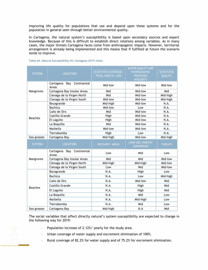
improving life quality for populations that use and depend upon these systems and for the population in general seen through better environmental quality.
In Cartagena, the natural system’s susceptibility is based upon secondary sources and expert knowledge. Because of this is difficult to establish direct relations among variables. As in many cases, the major threats Cartagena faces come from anthropogenic impacts. However, territorial arrangement is already being implemented and this means that if fulfilled at future the scenario tends to improve.
Table 60. Natural Susceptibility for Cartagena 2019 vision
SYSTEM LOCATION ECOSYSTEM COVERAGE: TOTAL HABITAT LOSS
WATER QUALITY AND HYDROGRAPHIC
PROCESSES INTEGRITY
ECOSYSTEM QUALITY
Cartagena Bay Continental Areas
Mid-low Mid-low Mid-low
Cartagena Bay Insular Areas Mid Mid-low Mid Cienaga de la Virgen North Mid Mid-low Mid-high
Mangroves
Cienaga de la Virgen South Mid-low Mid-low Mid-high Bocagrande Mid-high Mid-low N.A. Bochica Mid-low Low N.A. Caño de Oro Mid Mid-low N.A. Castillo Grande High Mid-low N.A. El Laguito High Mid-low N.A. La Boquilla Mid Mid-low N.A. Marbella Mid-low Mid-low N.A.
Beaches
Tierrabomba High Low N.A. Sea grasses Cartagena Bay Mid-high Mid-low Mid-high
SYSTEM LOCATION RECOVERY AREAS LAND USE: HABITAT
CONVERSION THREATS
Cartagena Bay Continental Areas
Low Mid Low
Cartagena Bay Insular Areas Mid Mid Mid-low Cienaga de la Virgen North Mid-high Mid-high Mid-low
Mangroves
Cienaga de la Virgen South Low Mid Mid-low Bocagrande N.A. High Low
Bochica N.A. Low Mid-high
Caño de Oro N.A. Mid-low Mid
Castillo Grande N.A. High Mid
El Laguito N.A. High Mid La Boquilla N.A. Mid Low Marbella N.A. Mid-high Low
Beaches
Tierrabomba N.A. Mid Low Sea grasses Cartagena Bay Mid-high N.A Mid
The social variables that affect directly natural’s system susceptibility are expected to change in the following way for 2019:
− Population increase of 2.12%/ yearly for the study area.
− Urban coverage of water supply and excrement elimination of 100%.
− Rural coverage of 82.2% for water supply and of 75.2% for excrement elimination.

− 99.4% energy service in interconnected areas.
The idea is to improve environmental offer for the territory and diminish negative impacts, seeking major equity in population’s access to the goods and services they provide. In this context, the recuperation of the Cienaga de la Virgen and Cartagena bay is explicit in such vision, being highlighted the importance of the restoration of the connections that la Cienaga has with the sea.
Waste treatment is also expected to improve, and the idea is that no more untreated sewage will be disposed in the Cienaga. This is expected to improve water and ecosystem quality in general, not only for this area, but for Cartagena Bay as well, for better disposal systems will have an impact over the entire area. Arrangement plans for La Cienaga de la Virgen are already at hand, and territory in this area has been divided according to the uses suitable and necessary considering vegetation condition.
All natural systems are intended to be recovered, including mangroves and sea grasses. Territory management is supposed to be paired with appropriate land and water resources use.
Water Quality and Hydrographic processes integrity is supposed to improve as water disposal treatments are to be implemented, as well as an increase in the service of excrement elimination. Although water quality wasn’t significantly threatening flora and fauna preservation. However, population increase and industry exacerbation will result in no change for the system’s susceptibility due to this indicator.
The northern area of the Cienaga de la Virgen is to be drained and turned suitable for urban expansion, which means that the mangroves in that area are destined to disappear. Because of this ecosystem quality for the mangroves located in such area is expected to decrease significantly, as the environment will be highly modified and intervened. However the susceptibility for mangroves in Cartagena Bay seems to diminish as a result of regulations.
Table 61.Overall susceptibility for Cartagena 2019 vision
SYSTEM LOCATION SUSCEPTIBILITY Cartagena Bay Continental Areas
Mid-low
Cartagena Bay Insular Areas Mid
Cienaga de la Virgen North Mid-high Mangroves
Cienaga de la Virgen South Mid Bocagrande Mid-high
Bochica Mid-low
Caño de Oro Mid
Castillo Grande High
El Laguito High La Boquilla Mid Marbella Mid-low
Beaches
Tierrabomba Mid-high Sea grasses Cartagena Bay High
Given territorial management processes and regulations, recovery areas are expected to be maintained or even grow in most cases, which in turn reduce general susceptibility for such index. However, habitat conversion is expected to increase as a major demand for land and expansion areas will be reflected in natural system’s coverage changes. The threats these systems’s face won’t change much, although they are expected to increase, especially because weather change and sea level rise will result in harsher environmental conditions.

Overall susceptibility is seen to increase (Figure 63), compared with the present state, which only confirms that natural systems are directly affected by human populations and they take long time to recover.
Figure 62. Beaches and mangroves susceptibility for 2019 vision combined with the lowest rise in sea level chosen for this study.
Given these characteristics for natural systems in this year, the effects of sea level rise can be observed in figures 60 and 61, given the different levels chosen for this study. In general, areas with higher susceptibility indexes are to be the greatest affected and their possibility to survive, adapt and recuperate depends directly on the BSI, inundation level and topographic characteristics for each area which not only define natural’s system actual state, but that reflect as well it’s migration possibilities for mangroves, and area loss for beaches. Sea grasses are not affected as by sea level rise as they are by other circumstances.

Figure 63. Beaches and mangroves susceptibility for 2019 vision combined with the highest rise in sea level chosen for this study.
As mentioned before, what changes between these two scenarios is flooded area affected by sea level rise. In table 50 a comparison between the two levels is done, listing some of the possible outcomes that could result with the different areas flooded.

Table 62. Affected areas and possible outcomes for two different levels of sea level rise in 2019’s vision
Vision 2019 – Low sea level rise Vision 2019 – High sea level rise
System Affected
Area Possible
consequences Affected
Area Possible
consequences
Bocagrande 1.41 Km. 1.41 Km. Castillo Grande 1.51 Km. 1.51 Km. El Laguito 0.21 Km. 1.11 Km. la Boquilla 4.42 Km. 5.08 Km. Marbella 4.61 Km. 4.61 Km.
Beaches
Tierrabomba 5.40 Km.
Erosive processes exacerbated, impacts on natural communities and on goods and services provided by these systems 4.87 Km.
Erosive processes exacerbated, impacts on natural communities and on goods and services provided by these systems
Cartagena Bay - continental areas
- - 2,80 Km2
Affected mangroves tend to disappear in general, given the existence of physical barriers that impede migration.
Cartagena Bay- Insular areas
0,03 Km2
Affected mangroves tend to disappear in general, given the absence of available areas for migration.
1,67 Km2
Affected mangroves tend to disappear in general, given the absence of available areas for migration.
Cienaga de la Virgen - North
1,52 Km2 7,00 Km2
Mangroves
Cienaga de la Virgen - South
0,68 Km2
Affected mangroves tend to disappear in general, given the existence of physical barriers that impede migration.
1,81 Km2
Affected mangroves tend to disappear in general, given the existence of physical barriers that impede migration.
Mangroves 2.23 Km2 13.3 Km2 Total Flooded Area Beaches 17.5 Km. 18.6 Km.
For Cartagena, the most critical areas of mangroves are seen to be those closer to human settlements and that have no space to migrate; however, these areas are also the ones that could act as buffers for climatic events and give protection to human populations located near by, besides these systems are crucial for stopping erosive processes and maintaining the coastline. Therefore it is critical to preserve them and aid in their process of adapting to SLR, for they will act as barriers to protect human population settled nearby.
Almost all the beaches found in Cartagena bay and in Tierra Bomba, seem to disappear, which imposes several problems, one of which comes from tourism and the protection they bring to infrastructure located nearby. The need to protect them is evident and must consider ocean dynamics.
Regarding natural systems, measures adopted to protect them and help them cope with climate change, are usually enhanced if access to technology at various levels and in all sectors is ample, with openness to development and utilization of new technologies for sustainable extraction, use, and development of natural resources (Goklany, 1995 in Smit et. Al.2001). Roles and
responsibilities for implementation of adaptation strategies must be clearly understood and systems must be placed for the dissemination of climate change and adaptation information, nationally and regionally (Gupta and Hisschemöller, 1997 in Smit et al.2001).
The best strategies to protect ecosystems from climatic changes may be those that reduce other stresses, thus increasing resilience to a variety of stresses. Societal priorities for ecosystem protection need to be articulated, and research is needed into the values of ecosystems, ecosystem functioning, human impacts, long-term ecological monitoring, and management options to provide a basis for selecting effective measures.
SOCIOECONOMIC DIMENSION
This scenario is characterized by the fulfillment of National Government goals for 2019. Equally, the goals of Cartagena’s POT have been fulfilled, as they include the improvement of housing in the urban zone, development of social interest housing in the designed areas of the city and the corregimientos, and legalization of subnormal settlements and relocation of houses in high natural or technological risk areas.
Given the above, Cartagena in the 2019 exhibits:
● Constant population growth to the same rate calculated by DANE in its quinquennial projections. For Cartagena, the rate of the department of Bolivar (2.12) was used.
● 90% of the urban area houses cook with Gas connected by tubes, 6% with electricity and the remaining 4% with Gas cylinder or pipette.
● 70% of the rural area houses cook with Gas connected by tubes, 20% with electricity and 10% with Gas cylinder or pipette.
● Water supply coverage of 100% in urban areas and of 82.2% in rural areas. In the rest of the rural area, water source is inside the property, but outside the housing.
● Rural and urban areas have 100% coverage in the trash harvesting service. ● Excrement elimination coverage in urban areas is of 100% and of 75.2% in rural areas. The
rest of the houses in rural areas use toilets with connection to septic well. ● Housing’s floors is no longer soil, arena, rough wood or boards. ● Exterior walls material of the houses in the rural and urban areas are Blocks, bricks,
stones, prefabricated material or treated wood. ● Basic and high school education coverage of 100% in rural and urban areas. ● Risk perception given housing location is diminished by 80%. ● The gap of existing conditions between the rural and urban zone has been reduced
notably, therefore participation of sectorial investment (90% of the total investment) is the same for all the territory of Cartagena. In this manner, 25% is destined to education, 25% to Health, Infrastructure 10%, basic sanitation 5%, housing 10% and disaster prevention 15%.
● House number increases by 10%
The execution of the previously mentioned goals makes the vulnerability of the study area Mid- Low. With the prospected scenario, district Las Gaviotas would present the largest reduction in the vulnerability index, which would be 33.3 contrasting a 52.4 in 2005, which implies vulnerability reduction of about 40%. On the other hand, Ciudadela obtains a 55.2 in the prospected scenario; contrasting a 61.8 in 2005, which implies vulnerability reduction of about 17%, this would be the lowest value for 2019.
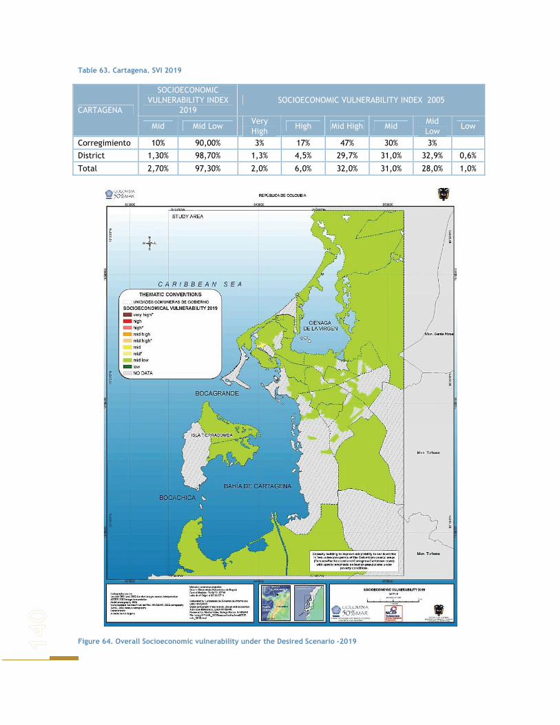
Table 63. Cartagena. SVI 2019
SOCIOECONOMIC VULNERABILITY INDEX
2019 SOCIOECONOMIC VULNERABILITY INDEX 2005
CARTAGENA
Mid Mid Low Very High
High Mid High Mid Mid Low
Low
Corregimiento 10% 90,00% 3% 17% 47% 30% 3%
District 1,30% 98,70% 1,3% 4,5% 29,7% 31,0% 32,9% 0,6%
Total 2,70% 97,30% 2,0% 6,0% 32,0% 31,0% 28,0% 1,0%
Figure 64. Overall Socioeconomic vulnerability under the Desired Scenario -2019

The district Las Gaviotas received the highest qualification, with a 66.7 contrasting a 47,6 in 2005, which implies an increase of 40%. On the other hand Ciudadela obtains a 44.8, being the lowest value for 2019.
LIFE QUALITY INDICATOR
This indicator points out a low vulnerability for the study area. Recalling that this indicator involves three factors namely services, house building materials and human capital, the 2019 scenario would be explained in terms of these factors. First of all, a full coverage of basic services in urban area and over 80% in rural areas would reduce the quality of life gap between both urban and rural population. That means a low score for services factor when estimating the quality of life indicator. Urban area will have a total score of 11.6 and 13.4 for rural area.
Secondarily, changes in the materials used for house building would reduce vulnerability to low in all of Cartagena’s corregimientos and districts. Those changes would be a result of improvement in housing development policies.
In 2019, the factor regarding house building materials has scores menor que 30, which means that rural and urban areas would have low vulnerability. The highest score (25) was shown by the Matuna district, located in the UCG 1 and the lowest (8) the Almirante Colon district in the UCG 12.
Human Capital factor indicates a mid low score for rural areas and mid low vulnerability for urban areas, except for Almirante Colon district which has low vulnerability.
SERVICES
A universal coverage of basic services in urban area and over 80% in rural area, reduces the gap between the two areas. In 2019, services factor will have a Low qualification. The urban area will have a total qualification of 88.4 and the rural area of 86.6.
HOUSING
Change in the materials used for building the houses, as a result of housing improvement policies, reduces vulnerability to low in all of Cartagena’s corregimientos and districts.
The housing factor for all the neighborhoods of the urban area and corregimientos of the rural area, obtained scores over 70 which means they have low vulnerability. The lowest score (75) was shown by the Matuna district, located in the UCG 1 and the highest (92) the Almirante Colon in the UCG 12.
HUMAN CAPITAL
Cartagena presents mid low vulnerability. Although a cover of 100% in basic education is achieved, the maximum score is not obtained as the proportion of children under 7 years remains constant.
The human Capital factor in the rural area obtained a mid low qualification, in the urban area all the districts obtained mid low vulnerability, except for Almirante Colon which has low vulnerability.

NATURAL DISASTER
In 2019 this indicator is expected to be low as a result of the relocation of the houses that were in risk areas, both in the urban and rural areas. 21 neighborhoods and 4 corregimientos would obtain the maximum score. Nevertheless the socioeconomic vulnerability of Cartagena will be reduced under this scenario; this doesn’t mean that it won’t be affected by SLR food. Affected population and value at lost are analyzed in order to the impact of flooding under a socioeconomic perspective.
The estimated value of land represented on the zonas geoeconómicas was used to estimate the value at loss. As result of the fulfillment of the goals in social and economic terms, presents an increase in the values of the zones that previously were presenting a major vulnerability since they are the located in the south zone of the Cienaga de la Virgen. The affected population was estimated bearing in mind the rate of growth supposed in this scenario. Additionaly two levels of flood (low and high) appeared for the estimation of the impacts. The estimations of the value at loss and affected population results from the analysis of crossing three maps: levels of flood, population and geo-economics zones.
According to Table 64, under a low flood scenario, it would be expected that population from the UCG 4 and 5 were the most affected. These units are located in the south zone of Cienaga de la Virgen. In the same way in the event of a strong flood in this zone would hold the major quantity of affected population.
Table 64. Affected population and areas at risk for two different levels of sea level rise.
High flood Low flood Localidad
UCG Rural-Urban Values at lost
(Millions COP) People at risk
Values at lost (Millions COP)
People at risk
4 85.637 45.274 27.041 21.885 5 77.766 53.093 6.433 26.086 6 37.450 40.669 No flooding
DE LA VIRGEN Y TURISTICA
7 51.576 12.232 No flooding 1 182.053 11.500 614.243 10.935 10 87.323 11.877 805 51 2 35.116 8.786 No flooding 3 8.989 11.520 5.605 S.I 8 37.016 7.490 No flooding
HISTORICA Y DEL CARIBE NORTE
9 25.095 9.569 No flooding 11 122.731 20.492 No flooding 12 57.201 27.471 No flooding 13 28.740 9.551 No flooding 14 25.622 23.988 No flooding
INDUSTRIAL DE LA BAHIA
15 9.913 10.378 No flooding TOTAL URBAN AREA 872.226 303.891 654.127 58.956
Pasacaballos S.I S.I S.I S.I Bayunca S.I 1.805 S.I 4 La Boquilla S.I 2.339 S.I 1.457
RURAL AREA
Tierra Bomba S.I 523 S.I 288 TOTAL RURAL AREA S.I 4.667 S.I 1.749 TOTAL 873.048 308.558 654.127 60.705
PUBLIC INVESTMENT
In 2019 the financial situation of Cartagena allows it to increase social investment to 90%, and specifically the item of Disaster Prevention to 15%. This, together with the decision that all the

neighborhoods and corregimientos should manage the same distribution of the budget, results in a low qualification for the PII for 2019.
POPULATION
A presumed constant growth rate, makes that this indicator doesn't present modifications.
SAN ANDRES DE TUMACO
Given the environmental qualities and development potential of Tumaco, it can become a well positioned area according to the expectancies found in various documents as the Territorial Arrangement Plan (POT for its name in spanish), The Regional Environmental Management Plan 2002- 2012 (PGAR for its name in spanish) and the Development Plan 2004 – 2007.
ENVIRONMENTAL DIMENSION
Tumaco is one of the poorest areas of the country, and it has adopted the law of broken entities, which means that no public investment will be made in this area for the next years. Nevertheless on the environmental level, Tumaco has been depending on some scarce public resources and projects carried out with external aid that allow some processes to continue, as is the case of the present study. With this in mind is important to understand that investment on the environmental level will be restricted and scarce and probably highly focalized.
Tumaco makes emphasis on environmental education through strategies that allow community’s commitment and understanding of their responsibility with sustainable development. Having in mind the possibility of generating an environmental conscience in the population, the idea is that many of the threats that Tumaco faces will be reduced, not only as a result of more efficient and effective institutional action, but also as a result of population conviction as well. Another

strategy to be considered involves the promotion, establishment, recuperation and implementation of protected areas, either by the nation or by civil society (Corponariño, 2002).
The main objective is to guarantee it’s inhabitants alimentary security, without threatening the natural systems, resulting in sustainable development. This in turn strengthens the green market programs resulting in new sources of income and in the possibility of promoting practices as ecotourism, and organic agriculture, which is in turn less harmful for the environment. This will create a greater environmental awareness and will promote the need to regenerate degraded areas (Corponariño, 2002).
To be able to obtain such results, traditional productive systems are to be promoted with certain improvements that don’t cause negative impacts on the natural systems. Research in science and technology must be enhanced as well, as should business promotion. Management of water sources should also be regarded as a key point in the environmental processes (Corponariño, 2002).
Given that the natural system’s susceptibility is based upon secondary sources and that information available varies, it results very difficult to be able to establish direct relations among variables. However as the major threats Tumaco faces come from anthropogenic impacts, the way natural systems will change and behave throughout time is directly related with population changes and the conditions under which they are at a given time. This in turn results as well in the fact that territorial arrangement becomes the main tool to be able to plan the area in a sustainable manner.
As social variables affect directly natural’s system susceptibility, the following are changes that were assumed to modify individual indices and to finally generate de index:
− Population increase of 1.59%/ yearly for the study area
− Urban coverage of water supply and excrement elimination of 100%
− Rural coverage of 82.2% for water supply and of 75.2% for excrement elimination
− 99.4% energy service in interconnected areas
If governmental projections fulfill and Colombia 2019 fits the different parameters mentioned, the impact generated by a growing population will be mitigated. Ecosystem coverage can be enhanced, as total habitat loss can be reduced as a result of the recognition of the need to protect and preserve the ecosystem, and of using it in a sustainable manner. Therefore although total coverage might not be increased, the fact that the use given to this area will be more “environmentally friendly”, might result in a system that although exhibits more intervened areas, degraded area will be probably reduced.
Water Quality and Hydrographic processes integrity is one of the most affected indicators by population growth, as this is the main source of contamination water faces. However, the fact that with population growth, there is a projected increase in sanitary services (excrement elimination) and an improvement in waste disposal and in agricultural practices, reducing agrochemical use, a general diminish in these contaminants can be expected. Despite this, as was seen in the system’s susceptibility chapter, water quality wasn’t significantly threatening flora and fauna preservation. With a scenario in which sanitary coverage improves as well as other practices, regarding the fact that population grows, the difference in system susceptibility due to this indicator is not going to be significant.
Ecosystem Quality is directly related with what was described for Ecosystem coverage, as although some areas that weren’t intervened may become intervened, through education and change in practices, through an increase in sustainable alternatives for the population that reduce impact on the natural system and through an improvement in environmental conditions (resulting from better systems coverage), the quality of ecosystems will improve with time. This

will be reflected in lost areas, recovering from degradation, representative parameters as diversity and abundance of related species might be improved and general complexity indexes will be increased as a result of natural dynamics in recovery areas.
In this order of ideas, recovery areas will also increase, resulting in the recuperation of degraded areas and probably the establishment of areas that are to be merely preserved and not used at all.
Table 65. Natural Susceptibility for Tumaco’s 2019 vision
Ecosystem coverage
System ZONE Susceptibility A1 Mid-low A2 High B1 Mid-low B2 Mid-high C Mid-high
Mangroves
CCB.M Mid
Water Quality and Hydrographic processes integrity
System ZONE Susceptibility A1 Mid-low A2 Mid-low B1 Mid-low B2 Mid-low C Mid-low
Mangroves
CCB.M Mid-low C Mid-low CCA.M Low Beaches CCB.M Mid-low
Ecosystem Quality
System ZONE Susceptibility A1 Low A2 Mid-low B1 Mid-low B2 Low C Mid-low
Mangroves
CCB.M Low
Recovery areas
System ZONE Susceptibility A1 Mid-low A2 High B1 Mid-low B2 Mid-high C Mid-high
Mangroves
CCB.M Mid
Habitat Conversion
System ZONE Susceptibility A1 Mid-low A2 High B1 Mid-low B2 Mid-high C Mid-high
Mangroves
CCB.M Mid-high
Environmental Susceptibility Index
System ZONE Natural
Susceptibility A1 Mid-low A2 Mid B1 Mid B2 Mid C Mid
Mangroves
CCB.M Mid C Mid
CCA.M Mid-low Beaches CCB.M Mid
Threats
System ZONE Susceptibility A1 Mid-high A2 Mid B1 Mid-high B2 Mid C High
Mangroves
CCB.M Mid C High CCA.M Mid Beaches CCB.M High
Habitat conversion is one of the most affected indicators by population growth, as it is the result of agricultural processes and of the establishment of human settlements in a given area. Both of these factors increase, in case population grows, and no matter how sustainable and educated the population becomes, transformation processes still take place and generate important impacts upon the physical system.
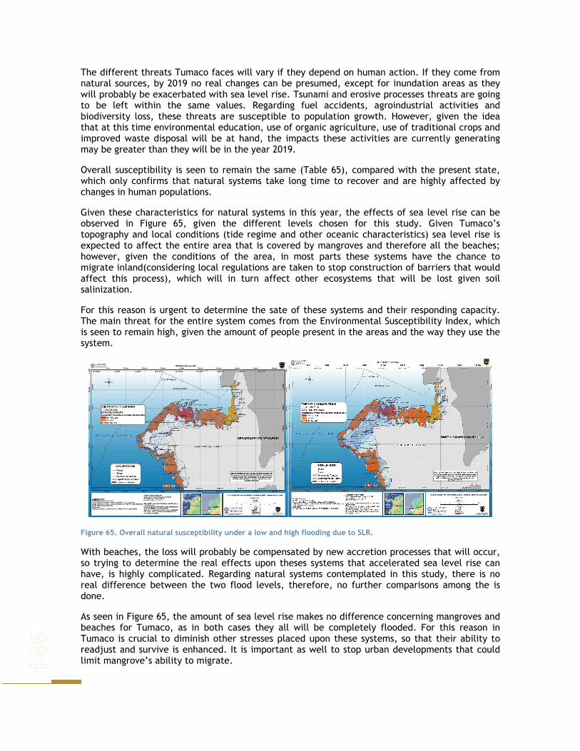
The different threats Tumaco faces will vary if they depend on human action. If they come from natural sources, by 2019 no real changes can be presumed, except for inundation areas as they will probably be exacerbated with sea level rise. Tsunami and erosive processes threats are going to be left within the same values. Regarding fuel accidents, agroindustrial activities and biodiversity loss, these threats are susceptible to population growth. However, given the idea that at this time environmental education, use of organic agriculture, use of traditional crops and improved waste disposal will be at hand, the impacts these activities are currently generating may be greater than they will be in the year 2019.
Overall susceptibility is seen to remain the same (Table 65), compared with the present state, which only confirms that natural systems take long time to recover and are highly affected by changes in human populations.
Given these characteristics for natural systems in this year, the effects of sea level rise can be observed in Figure 65, given the different levels chosen for this study. Given Tumaco’s topography and local conditions (tide regime and other oceanic characteristics) sea level rise is expected to affect the entire area that is covered by mangroves and therefore all the beaches; however, given the conditions of the area, in most parts these systems have the chance to migrate inland(considering local regulations are taken to stop construction of barriers that would affect this process), which will in turn affect other ecosystems that will be lost given soil salinization.
For this reason is urgent to determine the sate of these systems and their responding capacity. The main threat for the entire system comes from the Environmental Susceptibility Index, which is seen to remain high, given the amount of people present in the areas and the way they use the system.
Figure 65. Overall natural susceptibility under a low and high flooding due to SLR.
With beaches, the loss will probably be compensated by new accretion processes that will occur, so trying to determine the real effects upon theses systems that accelerated sea level rise can have, is highly complicated. Regarding natural systems contemplated in this study, there is no real difference between the two flood levels, therefore, no further comparisons among the is done.
As seen in Figure 65, the amount of sea level rise makes no difference concerning mangroves and beaches for Tumaco, as in both cases they all will be completely flooded. For this reason in Tumaco is crucial to diminish other stresses placed upon these systems, so that their ability to readjust and survive is enhanced. It is important as well to stop urban developments that could limit mangrove’s ability to migrate.
SOCIOECONOMIC DIMENSION
As in Cartagena, population growth is assumed constant, in the same rate calculated by DANE in its five-year projections. For Tumaco the rate of Narino is taken (1.59).
Given that no information on education coverage is available per levels, the proxy used is the population’s proportion that assists to an education institution. In such a way 100 coverage in basic education and 40% in high school education, represents a 70% of the population assisting to an educational center.
National policy of reducing housing deficit by 40%, together with a relocation of houses located in risk areas, turns people perception regarding house location to improve. In such a way, 80% of the households are to be located in areas with no associated risks, 3% are in sliding risk, 1.5% in flooding risk, 0.5% in avalanche risk and the remaining 15% are located in areas where inhabitants perceive different risks.
Following such line of ideas, housing policies make suburban settlements to be reduced, and as such housing conditions are improved. Firewood, mineral coal and kerosene are not used as cooking fuels any more. Cooking is done mainly with electricity (70%) and gas. Moreover, external wall materials are made from wood and bricks exclusively and floors aren’t dirt, soil or arena any more.
This scenario for 2019, with a universal coverage of basic services, with housing conditions improved and where fiscal sustainability exists, implies that before 2019 a great investment in health, education, basic sanitation, infrastructure, housing and disaster prevention is made. From 2019, investment is destined to maintaining the levels reach, rather than increasing coverage. Because of this the same investment percentage is destined to each of the sectors (14%), given the awareness that they are highly related.
In rural areas water supply reaches 82.2% and excrement elimination is of 75.2%. Following local plans, rural houses have basic services and improve the materials in which they are built, using only bricks and wood in external walls and not using soil, dirt or arena for the floor.
Electric interconnection in the rural areas exists, for firewood, mineral coal and kerosene aren’t used as cooking fuels any longer. Nevertheless as opposed to the urban area, gas (80%) is the main source of fuel followed by electricity.
Considering that national government lines of action, and local plans seek equity and equality in the access of services for the entire population, as in urban area a coverage in basic education of 100% is attained and 40% for high school. As such, population proportion assisting to an education institution is of 70%.
According to the plan of government in the rural areas, houses located in high risk zones are to be moved to low risk areas, so that the risk of being in an area with flood, avalanche or sliding risk is reduced by 80%.
SOCIOECONOMIC VULNERABILITY INDEX INTERPRETATION
Given the socioeconomic characteristics of Tumaco in 2019, the SVI was calculated. In attachments 5 and 6 the detailed variation of the SVI and each corrregimiento and neighborhood can be seen.
In the rural area, except for Piñal Salado and Chajal whose vulnerability would be mid low, the other corregimientos exhibit mid vulnerability. This represents an increase in this index. An increase in the population's well-being is reflected, as in 2005 most of the corregimientos showed high vulnerability.

In the urban area, all the secure areas are qualified as mid low vulnerable, with the exception of the neighborhoods Carbonera and el Bajito, which have mid vulnerability.
LIFE QUALITY INDICATOR
In the rural area, except for Piñal Salado and Chajal whose vulnerability would be mid low, the other corregimientos exhibit mid vulnerability. This represents an increase in this index. An increase in the population's well-being is reflected, as in 2005 most of the corregimientos showed high vulnerability.
In the urban area, all the secure areas are qualified as mid low vulnerable, with the exception of the neighborhoods Carbonera and el Bajito, which have mid vulnerability.
Opon the fulfillment of goals in enhancing basic services coverage, Tumaco will reach a low vulnerability, meaning a remarkable improvement in life quality for inhabitants in rural areas were classified with High and Very High vulnerability in 2005 in near 70% of the corregimientos.
Compared with 2005 when the minimum qualification was of 75 and 70.4 in the urban and rural areas respectively, in 2019 the minimum qualification is close to 30. This means that the vulnerability of this factor for the urban and rural areas is low.
Figure 66. San Andres de Tumaco. IVS 2019for the urban and rural areas.
SERVICES
Given the fulfillment of goals in enhancing basic services coverage, Tumaco will reach a low vulnerability, meaning a remarkable improvement in life quality for inhabitants in rural areas were classified with High and Very High vulnerability in 2005 in near 70% of the corregimientos.
HOUSING
Compared with 2005 when the minimum qualification was of 25 and 29.6 in the urban and rural areas respectively, in 2019 the minimum qualification is close to 70. This means that the vulnerability of this factor for the urban and rural areas is low.

Table 66. Tumaco. Housing indicator.
Area Housing 2005 Housing 2019 Min 25,00 75,00
Urban Max 90,00 92,00
Min 29,64 76,47 Rural
Max 78,49 85,29
HUMAN CAPITAL
Given that the population proportion assisting to education institutions increased to 70%, vulnerability for this factor changes to mid high in urban and rural areas in both areas
NATURAL DISASTER
In 2019 as a result of housing policies, and of moving houses to low risk areas, the total of the urban area obtains a qualification of 93.6 and the rural area 96.7. In such a way Tumaco changes from having almost all it’s neighborhoods and corregimientos with high vulnerability, to have the total of the municipality with Low vulnerability.
Figure 67. Tumaco IVS 2019 under a low flood.
Under a low flood the zones of the urban area that are flooded correspond to those marked with red and orange color, the first ones correspond to the secure zones that average vulnerability and the oranges present, to the secure zones classified with average to low vulnerability. This shows that the islands present a minor risk of flood that the continental zone. In the rural area the corregimientos that are flooded give average vulnerability.
PUBLIC INVESTMENT INDICATOR
Although the percentage of social investment remains constant, including investment in the housing and disaster prevention, makes this indicator obtain a qualification of 63, with a mid low vulnerability in both rural and urban areas.
POPULATION INDICATOR
The same as Cartagena, this indicator presents no variations. This means that the coastal zone is more vulnerable accordingly to the indicator and strongly depends on the participation of the

coastal population to the total population of the units of analysis and in the littoral corregimientos where most of the population is located.
To evaluate the socioeconomic impact in case of Tumaco the estimation of the value of loss was not calculatet due to the lack of the necessary information. The Table 67 present the population affected according to the rate of population growth assumed in the development of this scenario under both levels of flood. Though the highest flooded area correspondsto the rural zone, is in urban area where there would be the majorquantity of population affected by both levels of flood, which is consistent with the fact that the population of Tumaco prefers to locate in the urban area.
Table 67. San Andrés de Tumaco. Population at risk by level of flooding.
Population at risk Zona Low flood High flood
Isla El Morro 430 1.587 Isla Tumaco y La Viciosa 9.973 12.743 Urban area Continent 22.869 22.842
Total Urban area 33.271 37.172 C.C Bajo Mira y Frontera 2.499 4.084 C.C Río Chagui 2.005 2.005 C.C Tablon Salado 46 993 C.C Rescate Las Varas No flood 847
Rural area
Junta Prodefensa 2.583 3.729 Sin Titular 1.329 1.329 Total Rural area 8.463 12.988 TOTAL 41.734 50.159
NATURAL AWARENESS SCENARIO – 2019
Natural disasters are more frequent and harsh on human populations by the day, floods and droughts are common and severe all around the world. Human populations have learned that an important way to mitigate some of their effects is by means of the natural systems by restoring natural equilibriums (where possible), and preventing further damage to them. Human populations have understood their dependence upon natural systems, and although for some areas this was not recognized soon enough, for others results are starting to be visible.
Considering this, the current situation of the country and institutional background, on the socioeconomic level the tendency is expected to continue, with a few improvements in some of the aspects. On the environmental level, some areas have improved, however the damage done in the past is still visible and felt in all the ecosystems.
Population growth is expected to remain, although at a slower rate, waste treatment is expected to improve as well as alternative sources of energy, not negative for the environment.
CARTAGENA DE INDIAS
Cartagena has several areas that given city’s development and resource management, have deteriorated in such an advanced degree that is not likely that they’ll be recovered. Poverty has been reduced and territorial planning is better, as well as household conditions.
ENVIRONMENTAL DIMENSION
As mentioned above, Cartagena has changed its original landscape dramatically, and the lack of planning and a non sustainable use of the resources has resulted in a progressive loss of many of

its natural systems. However, given the severity of the late climatic events, and the awareness of the public sectors of the importance of conserving and preserving natural systems, as they are source for many goods and provide various services, for the last years a strategy to protect and restore natural systems, has taken place in the city.
However, given the fact that the sea level has changed in the last years, some areas previously covered by mangroves have been lost, but to compensate for them, the city has rearranged it’s development plans and at the moment urban expansion areas are no longer allowed in mangrove areas.
Table 68. Natural Susceptibility for Cartagena awareness 2019 vision
SYSTEM LOCATION ECOSYSTEM COVERAGE: TOTAL HABITAT LOSS
WATER QUALITY AND HYDROGRAPHIC
PROCESSES INTEGRITY
ECOSYSTEM QUALITY
Cartagena Bay Continental Areas Mid Low Mid Cartagena Bay Insular Areas Mid Low Mid Cienaga de la Virgen North Mid-low Low Mid-low
Mangroves
Cienaga de la Virgen South Mid Low Mid Bocagrande Mid-high Low N.A. Bochica Mid-low Low N.A. Caño de Oro Mid Low N.A. Castillo Grande High Low N.A. El Laguito High Low N.A. La Boquilla Mid Low N.A. Marbella Mid-low Low N.A.
Beaches
Tierrabomba High Low N.A. Sea grasses Cartagena Bay Mid-high Low Mid-high
SYSTEM LOCATION RECOVERY AREAS LAND USE: HABITAT
CONVERSION THREATS
Cartagena Bay Continental Areas Mid-low Mid Mid Cartagena Bay Insular Areas Mid-low Mid Mid-high Cienaga de la Virgen North Mid Mid-low Mid-low
Mangroves
Cienaga de la Virgen South Mid Mid Mid Bocagrande N.A. High Mid-high Bochica N.A. Low Mid-high Caño de Oro N.A. Mid-low Mid Castillo Grande N.A. High High El Laguito N.A. High High La Boquilla N.A. Mid-low Mid Marbella N.A. Mid-high Mid
Beaches
Tierrabomba N.A. Mid-high High Sea grasses Cartagena Bay Mid-high N.A Low
Given the pressures faced for years and the way in which the systems have been exploited, mangrove areas have reduced; however sea intrusion has also made some areas ready, where mangrove expansion is occurring, though change in species dominance has also occurred. Islands found in Cartagena Bay with mangrove coverage, and those areas in the Cienaga de la Virgen and Cartagena Bay continental sections, where given the presence of infrastructure mangroves can’t migrate, are the most affected areas. Some of these have already disappeared completely. But in these areas as well, mangroves have been protected and no more buildings have been made so the northern area of the Cienaga, the southern part of the bay and some areas of Tierra Bomba are showing mangrove expansion (at a very slow rate).
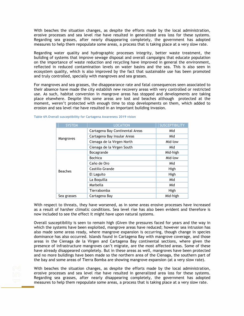
With beaches the situation changes, as despite the efforts made by the local administration, erosive processes and sea level rise have resulted in generalized area loss for these systems. Regarding sea grasses, after nearly disappearing completely, the government has adopted measures to help them repopulate some areas, a process that is taking place at a very slow rate.
Regarding water quality and hydrographic processes integrity, better waste treatment, the building of systems that improve sewage disposal and overall campaigns that educate population on the importance of waste reduction and recycling have improved in general the environment, reflected in reduced contamination levels on water basins and the sea. This is also seen in ecosystem quality, which is also improved by the fact that sustainable use has been promoted and truly controlled, specially with mangroves and sea grasses.
For mangroves and sea grasses, the disappearance rate and fatal consequences seen associated to their absence have made the city establish new recovery areas with very controlled or restricted use. As such, habitat conversion in mangrove areas has stopped and developments are taking place elsewhere. Despite this some areas are lost and beaches although protected at the moment, weren’t protected with enough time to stop developments on them, which added to erosion and sea level rise have resulted in an important building invasion.
Table 69.Overall susceptibility for Cartagena Awareness 2019 vision
SYSTEM LOCATION SUSCEPTIBILITY
Cartagena Bay Continental Areas Mid
Cartagena Bay Insular Areas Mid
Cienaga de la Virgen North Mid-low Mangroves
Cienaga de la Virgen South Mid Bocagrande Mid-high
Bochica Mid-low
Caño de Oro Mid
Castillo Grande High
El Laguito High La Boquilla Mid Marbella Mid
Beaches
Tierrabomba High Sea grasses Cartagena Bay Mid-high
With respect to threats, they have worsened, as in some areas erosive processes have increased as a result of harsher climatic conditions. Sea level rise has also been evident and therefore is now included to see the effect it might have upon natural systems.
Overall susceptibility is seen to remain high (Given the pressures faced for years and the way in which the systems have been exploited, mangrove areas have reduced; however sea intrusion has also made some areas ready, where mangrove expansion is occurring, though change in species dominance has also occurred. Islands found in Cartagena Bay with mangrove coverage, and those areas in the Cienaga de la Virgen and Cartagena Bay continental sections, where given the presence of infrastructure mangroves can’t migrate, are the most affected areas. Some of these have already disappeared completely. But in these areas as well, mangroves have been protected and no more buildings have been made so the northern area of the Cienaga, the southern part of the bay and some areas of Tierra Bomba are showing mangrove expansion (at a very slow rate).
With beaches the situation changes, as despite the efforts made by the local administration, erosive processes and sea level rise have resulted in generalized area loss for these systems. Regarding sea grasses, after nearly disappearing completely, the government has adopted measures to help them repopulate some areas, a process that is taking place at a very slow rate.

Regarding water quality and hydrographic processes integrity, better waste treatment, the building of systems that improve sewage disposal and overall campaigns that educate population on the importance of waste reduction and recycling have improved in general the environment, reflected in reduced contamination levels on water basins and the sea. This is also seen in ecosystem quality, which is also improved by the fact that sustainable use has been promoted and truly controlled, specially with mangroves and sea grasses.
For mangroves and sea grasses, the disappearance rate and fatal consequences seen associated to their absence have made the city establish new recovery areas with very controlled or restricted use. As such, habitat conversion in mangrove areas has stopped and developments are taking place elsewhere. Despite this some areas are lost and beaches although protected at the moment, weren’t protected with enough time to stop developments on them, which added to erosion and sea level rise have resulted in an important building invasion.
Table 69), despite the efforts made to protect natural systems. This is a result of a longtime story of unsustainable use, no protective measures applied and natural conditions. However, given the new vision and measures adopted, natural susceptibility is expected to be reduced in time.
Although general susceptibility for mangroves has diminished, inundation level and topographic characteristics for each area determine their local possibility to adapt and survive sea level rise. Some areas can be diminished, while others can increase depending the factors mentioned before. The different affected areas, together with the expected system’s susceptibility under this scenario, can be seen in Figure 68.
Figure 68. Beaches and mangroves susceptibility for Natural awareness scenario combined with the lowest and highest rise in sea level.
As before, what changes between these two scenarios is flooded area affected by sea level rise. And this in turn is what changes the outcomes between both possibilities.

Table 70. Affected areas and possible outcomes for two different levels of sea level rise in Natural awareness vision
Vision 2019 – Low sea level rise Vision 2019 – High sea level rise
System Affected
Area Possible
consequences Affected
Area Possible consequences
Bocagrande 1.41 Km. 1.41 Km. Castillo Grande
1.51 Km. 1.51 Km.
El Laguito 0.21 Km. 1.11 Km. la Boquilla 4.42 Km. 5.08 Km. Marbella 4.61 Km. 4.61 Km.
Beaches
Tierrabomba 5.40 Km.
Erosive processes exacerbated, impacts on natural communities and on goods and services provided by these systems 4.87 Km.
Erosive processes exacerbated, impacts on natural communities and on goods and services provided by these systems
Cartagena Bay - continental areas
- - 2,80 Km2
Affected mangroves tend to disappear in general, however protective measures adopted in some areas protect the remnants.
Cartagena Bay- Insular areas
0,03 Km2
Affected mangroves tend to disappear in general, given the absence of available areas for migration. Mangroves that remain improve gradually their ecosystem’s quality.
1,67 Km2
Affected mangroves tend to disappear in general, given the absence of available areas for migration. Mangroves that remain improve gradually their ecosystem’s quality.
Cienaga de la Virgen - North
1,52 Km2
Mangroves can start to move inland and the system can maintain and even regain in some areas the coverage.
7,00 Km2
Mangroves can start to move inland and the system can maintain and even regain in some areas the coverage.
Mangroves
Cienaga de la Virgen - South
0,68 Km2
Affected mangroves tend to disappear in general, given the existence of physical barriers that impede migration.
1,81 Km2
Affected mangroves tend to disappear in general, given the existence of physical barriers that impede migration.
Mangroves 2.23 Km2 13.3 Km2 Total Flooded Area Beaches 17.5 Km. 18.6 Km.

TUMACO
The “Desired Scenario” is characterized by the fulfillment of National Government goals for 2019 as well as local goals projected in the Tumaco’s POT and the Development Plan 2004 – 2007.
ENVIRONMENTAL DIMENSION
As mentioned above, urban expansion and unsustainable use have diminished overall mangrove coverage seen through an important increase in habitat conversion. This has had an effect on many aspects, as resource scarcity became evident, as well as the need to protect some of these areas. However some mangrove inland expansion is taking place, although change in species dominance has also occurred.
Health problems and public opinion have resulted in efforts for improving waste disposal during the last ten years continuous and with visible results. These efforts have been made with infrastructure and public education, trying to change traditional waste disposal and educating people on the finite of natural systems and their ability to recover and handle only limited amounts of organic and non organic wastes. As a result water quality and hydrographic processes integrity have improved and are not seen as a threat for natural systems; this is also related with a recovery in ecosystems quality, which is also result of the implementation of alternative energy sources and improvement in resource use.
These facts have made local administrations realize the need to establish protected areas (recovery areas), which didn’t exist until the year 2015, and they are barely starting to show some recovering; besides the process of educating people and making these areas real, with laws regarding them and the infrastructure needed to make them work was not enough until recently, when new strategies and programs have made this possible.
Regarding threats, the last years have made obvious Tumaco’s vulnerability. As a result erosive processes have increased as a result of harsher climatic conditions. Sea level rise has also been evident and therefore is now included to see the effect it might have upon natural systems. Tsunami menace (one of the strongest fears) is constant and given the different events seen in other parts of the world, preparation for such an event has continued. However natural system’s susceptibility to such an event is now greater as resilience capacity has been diminished as a consequence of other processes that have affected the environment.
Overall susceptibility is high (Table 71), as the efforts made to protect natural systems are very recent and they haven’t got time to recover. This longtime story of unsustainable use, no protective measures applied and natural conditions, have made Tumaco’s mangroves and beaches highly susceptible, with very limited response capacity in case a dramatic event occurs. Given the new vision and measures adopted, and with a hope of new measures that continue protecting the environment, natural susceptibility is expected to be reduced in time.
As before, given Tumaco’s topography and local conditions (tide regime and other oceanic characteristics) sea level rise is expected to affect the entire area that is covered by mangroves and therefore all the beaches; however, given the topographic conditions of the area, in most parts these systems have the chance to migrate inland (considering local regulations are taken to stop construction of barriers that would affect this process), which will in turn affect other ecosystems that will be lost given soil salinization. However, as opposed to what occurs in Cartagena, the main threat for the entire system comes from ESI, which is seen to remain high, given the amount of people present in the areas and the way they use the system.

Table 71. Natural Susceptibility for Tumaco’s Desired scenario 2019 vision
Ecosystem coverage
System ZONE Susceptibility A1 Mid A2 High B1 Mid-high B2 High C Mid-high
Mangroves
CCB.M Mid-high
Water Quality and Hydrographic processes integrity
System ZONE Susceptibility A1 Low A2 Low B1 Low B2 Mid-low C Mid-low
Mangroves
CCB.M Mid-low C Mid-low CCA.M Low Beaches CCB.M Mid-low
Ecosystem Quality
System ZONE Susceptibility A1 Mid-low A2 Mid-low B1 Mid-low B2 Mid C Mid-low
Mangroves
CCB.M Mid-low
Recovery areas
System ZONE Susceptibility A1 Mid A2 High B1 Mid-high B2 High C Mid-high
Mangroves
CCB.M High
Habitat Conversion
System ZONE Susceptibility A1 Mid A2 High B1 Mid-high B2 High C Mid-high
Mangroves
CCB.M Mid
Environmental Susceptibility Index
System ZONE Natural
Susceptibility A1 Mid-low A2 Mid B1 Mid B2 Mid-high C Mid
Mangroves
CCB.M Mid C Mid
CCA.M Mid-low Beaches CCB.M Mid Threats
System ZONE Susceptibility
A1 Mid A2 Mid-low B1 Mid B2 Mid C Mid-high
Mangroves
CCB.M Mid C Mid CCA.M Mid-low Beaches CCB.M Mid

Table 72. Beaches and mangroves susceptibility for Natural awareness scenario combined with the lowest (up) and highest (down) rise in sea level chosen for this study.

SOCIOECONOMIC DIMENSION
As one of the poorest areas at the beginning of the century, Tumaco’s development has been very slow. Besides, Tumaco has faced several climatic threats that have impoverished the municipality, but that have also made the population aware and urban expansion has started inland and not towards the islands.
Despite this, unsustainable use and urban expansion has reduced mangrove areas in general, and only recently have measures been adopted and regulations implemented to stop further damage and plan development towards different sectors that will not only stop the threat on these ecosystems, but that will reduce the threats that human populations face regarding household location.
In Tumaco tourism is gaining importance, but with it the need to preserve natural systems and to do it in a sustainable manner so that it remains as an attractive destiny.
Such as in the case of Cartagena, the rate of population growth is assumed to remain constant in the same rate calculated by DANE. For Tumaco the rate of Nariño taken is 1.59.
Regarding the lack of information on share of population by education levels, a used proxy variable is the share of population enrolled in education institutions. In such a way 100% of population enrolled in basic education and 40% in high school and assumes a 70% of the IVS calculus of the population assisting to an educational center.
A national policy to reduce housing deficit by 40%, together with relocation of houses located in risk areas, turns people’s perception to a better outlook. 80% of households are to be located in areas with no associated risks, 3% are in sliding risk areas, 1.5% in flooding risk, 0.5% in avalanche risk and the remaining 15% are located in areas where inhabitants perceive other risks.
Consequently, housing policies reduce inadequate settlements, and houses’ building material are improved. Timber is not longer used and electricity is main source for coking energy. Moreover external housing walls are not Langer wood but some cement constructions are made. Flors have some revetments and not only sand.
For the 2019 scenario an increase in social investment is expected; specifically in health, education, basic sanitation, infrastructure, housing and disaster prevention. That would be possible due to a universal coverage of basic services, improvements in house’s building materials and fiscal sustainability. In 2019, investment is destined to maintaining the levels reach, rather than increasing coverage. Because of this the same investment percentage is destined to each of the sectors (14%), given the awareness that they are highly related.
In rural areas water supply reaches 82.2% and excrement elimination is of 75.2%. Following local plans, rural houses have basic services and improve the materials in which they are built, using only bricks and wood in external walls and not using soil, dirt or arena for the floor.
Electric interconnection in the rural areas exists, for firewood, mineral coal and kerosene aren’t used as cooking fuels any longer. Nevertheless as opposed to the urban area, gas (80%) is the main source of fuel followed by electricity.
Considering that national government lines of action, and local plans seek equity and equality in the access of services for the entire population, as in urban area a coverage in basic education of 100% is attained and 40% for high school. As such, population proportion assisting to an education institution is of 70%.
According to the plan of government in the rural areas, houses located in high risk zones are to be moved to low risk areas, so that the risk of being in an area with flood, avalanche or sliding risk is reduced by 80%.

SOCIOECONOMIC VULNERABILITY INDEX
Given the socioeconomic characteristics of Tumaco in 2019, the SVI was calculated. In the rural area, except for Piñal Salado and Chajal whose vulnerability would be mid low, the other corregimientos exhibit mid vulnerability. This represents an increase in this index. An increase in the population's well-being is reflected, as in 2005 most of the corregimientos showed high vulnerability.
Figure 69. San Andres de Tumaco. IVS 2019
In the urban area, all the secure areas are qualified as mid low vulnerable, with the exception of the neighborhoods Carbonera and el Bajito, which have mid vulnerability.
Figure 70. San Andres de Tumaco. IVS 2019

LIFE QUALITY INDICATOR
Upon the fulfillment of goals in enhancing basic services coverage, Tumaco will reach a low vulnerability, meaning a remarkable improvement in life quality for inhabitants in rural areas were classified with High and Very High vulnerability in 2005 in near 70% of the corregimientos.
Compared with 2005 when the minimum qualification was of 75 and 70.4 in the urban and rural areas respectively, in 2019 the minimum qualification is close to 30. This means that the vulnerability of this factor for the urban and rural areas is low (Table 73).
Table 73. Tumaco. Housing
Area Housing 2005 Housing 2019 Max 75,00 25,00
Urban Min 10,00 8,00
Max 70.36 23.53 Rural
Min 21.51 14.719
Given that the population proportion assisting to education institutions increased to 70%, vulnerability for this factor changes to mid high in urban and rural areas.
NATURAL DISASTER
In 2019 as a result of housing policies, and of moving houses to low risk areas, the total of the urban area obtains a qualification of 6.4 and the rural area 3.3. In such a way Tumaco changes from having almost all its neighborhoods and corregimientos with high vulnerability, to have the total of the municipality with Low vulnerability.
PUBLIC INVESTMENT INDICATOR
Although the percentage of social investment remains constant, including investment in the housing and disaster prevention makes this indicator obtain a qualification of 37, with a mid low vulnerability in both rural and urban areas. This classification rsesult of investment in different sectors, but principally in disaster preparedness and housing translates in the capacity of response of the municipality.
The same as Cartagena, the population indicator presents no variations.

ADAPTATION MEASURES AT THE MOST BASIC LEVEL, THE COASTAL AREAS OF CARTAGENA DE INDIAS AND SAN ANDRES DE TUMACO ARE LIKELY TO BE IMPACTED BY CLIMATE CHANGE BY A NUMBER OF FACTORS INCLUDING DROUGHTS, FLOODS, CYCLONES AND LONG-TERM SEA LEVEL RISE.
In the short term this means that people are likely to be hit by more and more natural disasters in the coming years. The first and most effective measure would be to improve disaster preparedness. Dealing with or adapting to climate change in the long term can bring immediate benefits in the short term to protect people and property from adverse natural calamities.
Human and natural ecosystems have sought to adapt both to climate averages (through diversity in clothing and lifestyles), as well as significant departures from these averages, such as those experienced every few years in the Pacific region as a result of the El Niño Southern Oscillation (ENSO) (Agrawala and Berg 2002).
The importance for human beings on the ability of natural systems to adjust and adapt to sea level rise, lies in the interdependence between human systems and natural systems, which is even more evident in developing countries (McLean et al. 2001). The adaptive capacity of coastal systems to perturbations is related to coastal resilience, which has morphological, ecological, and socioeconomic components. Enhancing resilience is a particularly appropriate adaptive strategy given future uncertainties and the desire to maintain development opportunities. Among the measures considered for enhancing the
adaptability of vulnerable natural systems are reducing other stresses and removing barriers to migration, reversing trends that increase vulnerability and improving societal awareness and preparedness (Smit B. et al. 2001).
Adaptation can yield benefits regardless of the uncertainty and nature of climate change (Ali 1999; Smit B. et al. 2001). Planned anticipatory adaptation, as recognized in the UNFCCC, seeks to reduce a system’s vulnerability by diminishing risk or improving adaptive capacity. Building adaptive capacity requires a strong, unifying vision; scientific understanding of the problems; an openness to face challenges; pragmatism in developing solutions; community involvement; and commitment at the highest political level. Adaptation is also adjustment in ecologic systems in response to actual or expected climatic stimuli and their effects or impacts. It involves adjustments to reduce the vulnerability of communities, regions, or activities to climatic change and variability (Smit B. et al. 2001).
Box 2. Adaptation definitions
Susceptibility Degree to which a system is open, liable, or sensitive to climate stimuli (similar to sensitivity, with some connotations toward damage) Resilience Degree to which a system rebounds, recoups, or recovers from a stimulus Resistance Degree to which a system opposes or prevents an effect of a stimulus Coping Ability Degree to which a system can successfully grapple with a stimulus (similar to adaptability, but includes more than adaptive means of “grappling”) Adaptive Capacity The potential or capability of a system to adapt to (to alter to better suit) climatic stimuli or their effects or impacts Adaptability The ability, competency, or capacity of a system to adapt to (to alter to better suit) climatic stimuli (essentially synonymous with adaptive capacity) Source: Smit et al., 2001

______________________________________________________________________
Generally, adaptive measures will fall into one of three categories: retreat, accommodate or protect. Usually retreat focus on planning for relocation and emergency management. It usually involves preventing development in vulnerable areas or allowing development on condition that the area will be abandoned if necessary.
Accommodation must also be planned with enough time, and accepting the fact that some values are to be lost. The strategy is based on the principle that the land-ward shifting ecosystem due to SLR will not be counteracted but that functional uses should be adapted, meaning that they are to be allowed to migrate.
Among planned strategies, protection implies using defensive measures that protect systems from the effects associated with rapid sea level rise.
According to Burton (1997), adaptation measures to climate change could be classified in 8 different types: share the loss, bear the loss, modify events, prevent effects, change use, change location, research and education- behavioral (Burton 1997). However, some of these measures are taken as a response to climate change; nevertheless is important to note that this study intends to propose adaptation measures to be taken before the effects of sea level rise make it necessary to consider that losses are already present. As sea level rise is a process that occurs in a rapid manner from a natural systems perspective, but it occurs gradually in human terms, populations have the opportunity to foresee and prevent some of it’s negative effects, while the ones that can’t be prevented are managed, and some of the ones that are identified as positive are exploited.
It is generally recognized that anticipatory and precautionary adaptation is more effective and less costly than forced, last-minute, emergency adaptation or retrofitting. This is why it is fundamental to start preparing and adjusting as soon as possible. Adaptation options are more acceptable and effective when they are incorporated into coastal zone management, disaster mitigation programs, land-use planning, and sustainable development strategies. These are conditioned by existing policies and development objectives, which requires researchers and policymakers to work toward a commonly acceptable framework for adaptation (Smit and Pilifosova 2002).
The nonstructural measures are any procedure that alters to the exhibition of individuals and properties before the flood. They look for to reduce the vulnerability of the system exposed through legislative or organization measures that on their own or in combination with the structural measures allow to mitigate the risk of an effective and integral way.
The legislative measures are related to the legislation and planning and affect the dynamic causes of bottom, pressures and the conditions of security of the exposed elements. As an example, the elaboration and implementation of policies, the Plans or Schemes of Territorial Ordering, Development Plans, Fiscal and Financial codes of construction, Stimuli or promotion of insurances, etc. These are incumbent on to the planners and they require of political will.
On the other hand the organizative measures are those that promote the direct interaction with the community. The reduction of the risk and the attention of emergencies, the institutional fortification, the education, the public information and the participation talk about to the organization. They are incumbent to the environmental authorities and the community in general and require of its active participation (Millan, 2005).
Box. 3. Types of Measures
• Protect, protect the land from the sea so that existing land uses can continue, by constructing hard structures (e.g., seawalls) as well as using soft measures (e.g., beach nourishment)
• Accommodate, which implies that people continue to occupy the land but make some adjustments (e.g., elevating buildings on piles, growing flood- or salt tolerant crops)
• Retreat, which involves no attempt to protect the land from the sea; in an extreme case, the coastal area is abandoned. Source: Biljsma et al. (1996) in McLean, et. al. 2001

Natural systems take longer to adapt and adjust to changes than human systems. Their ability to respond is determined by how fast these changes occur and the effects of other pressures placed upon them. Therefore adaptation is a natural process that can be affected and sometimes even determined by human activities. As a result, other pressures placed upon natural systems must be relieved so that the probability for them to be able to recover is enhanced. Potential impacts of
rapid sea level rise on coastal systems can include increased coastal erosion, extensive coastal inundation, higher storm-surge flooding and landward intrusion of seawater (McLean et al. 2001).
In unmanaged natural systems, adaptation is autonomous and reactive; it is the process by which species and ecosystems respond to changed conditions. Enhancement of adaptive capacity represents a practical means of coping with changes and uncertainties in climate, including variability and extremes. In this way, enhancement of adaptive capacity reduces susceptibilities and promotes sustainable development. Planned anticipatory adaptation has the potential to reduce vulnerability and realize opportunities associated with climate change, regardless of autonomous adaptation (Ali 1999; Smit B. et al. 2001). These are gain –gain measures as no matter if the estimates are correct, the natural systems are more likely to adapt and help protect human communities if they are taken. Even if climate conditions don’t change, current conditions will be improved and current natural disasters can be mitigated.
Implementation of adaptation policies, programs, and measures usually will have immediate benefits, as well as future
benefits. Adaptation measures are likely to be implemented only if they are consistent with or integrated with decisions or programs that address non climatic stresses. Many of these adaptations essentially represent improved resource management, and many would have benefits in dealing with current climatic hazards as well as with future climatic risks (Smit B. et al. 2001).
The extent to which ecosystems are susceptible depends on exposure to sea level rise and on their ability to adapt. Thus, to assess the dangerousness of climate change, impact and susceptibility assessments must address the likelihood of autonomous adaptations. In these cases adaptation assessment is essentially equivalent to natural system impact assessment.
Some occasions single the implementation of structural measures is viable, is the case of areas that are vulnerable to the flood and they are characterized by a high production, count on a tourist development and in them they inhabit great amount of people. Then to think about relocating the properties and people is inconceivable in costs as well as unmanageable physical and social disorder.
Box. 4. LESSONS TO LEARN FROM:
Canada: New Brunswick completed remapping of the entire coast of the province to delineate the landward limit of coastal features. Setback for new development is defined from this limit. Some other provinces have adopted a variety of setback policies, based on estimates of future coastal retreat. Barbados: A national statute establishes a minimum building setback along sandy coasts of 30 m from mean high-water mark; along coastal cliffs the setback is 10 m from the undercut portion of the cliff. Aruba and Antigua: Setback established at 50 m inland from high-water mark. Sri Lanka: Setback areas and no-build zones identified in Coastal Zone Management Plan. Minimum setbacks of 60 m from line of mean sea level are regarded as good planning practice. United Kingdom: House of Commons in 1998 endorsed the concept of managed realignment as the preferred long-term strategy for coastal defense in some areas. United States: The states of Maine, Massachusetts, Rhode Island, and South Carolina have implemented various forms of rolling easement policies to ensure that wetlands and beaches can migrate inland as sea level rises. Australia: Several states have coastal setback and minimum elevation policies, including those to accommodate potential sea-level rise and storm surge. In South Australia, setbacks take into account the100-year erosional trend plus the effect of a 0.3-m sea-level rise to 2050. Building sites should be above storm-surge flood level for the 100-year return interval. Examples of managed retreat and related measures as adaptation to sea-level rise (source: McLean, et. al. 2001)

______________________________________________________________________
It is necessary to clarify that a series of projects that aim to transform deficient structural conditions, frequently, contributes greatly to the management of the risk; this it is the case of actions like the reforestation and/or conservation of microriver basins, modernization of the communication networks or the investments in health or education, that in conjuction diminish the vulnerability of the social groups of the infrastructure and the economic activities forehead to different types of threats (DNP-DDUPA, 2005). Thus fulfilling the goals of reducing social inequality and promoting inequitable development, the municipalities can follow indirect measures to adapt opposed or forward sea level rise.
PROTECTION MEASURES
By man and nature’s action the coast zones are submitted to impacts that alter it’s natural condition, in such a way that is necessary to find measures to protect them. The common processes found in the coast areas could be produced by erosion of the line from coast and the flooding which can be produced by storms, tidal wave and the sea level rise.
Figure 71. Measures to protect against the damage of the coast. Source: Shore Protection Manual (2001)
In this chapter is summarizing alternatives and their functional design for shore protection. Coastal defense and stabilization works are used to retain or rebuild natural systems cliffs, dunes, wetlands,

and beaches) or to protect man’s artifacts (buildings, infrastructure, etc.) landward of the shoreline.
The Shore Protection Manual – SPM (U. S. Army Corps of Engineers – USACE 2001) schematically displays five alternative ways to mitigate the damage of coastal, namely, accommodation, protection, beach nourishment, retreat and of course, the do-nothing alternative .
The protections from de edge of coast, which are used as engineering Works world Wide, are defined as hard and soft Works. In the solution of issues is usual to use combination of works as well.
HARD ENGINEERING RESPONSE
The hard works are composed by a series of structures made in order to protect the coast line from erosive processes, hard waving and flooding. The following are the engineering hard works for protection of the line of coast, according to Shore protection Manual – SPM 2001.
Table 74. Types of hard engineering responses
Leeves (Armoring Structures) Beach Stabilization Structures Type
Seawall Bulkhead Dike/ revetment
Breakwaters Groins Sills
Geometry
Vertical Curved Gravity
Crib Stepped/ Terraced Cantilevered Tie-backed
Sloped
Headland Detached Single System Submerged
Normal Angled Single System (field) Notched Permeable Adjustable . Shaped (t or l)
Shoreline Submerged Perched Beach Intertidal Submerged
Materials of Construction
.concrete
. Rock
. Sheet-pile - steel - timber -concrete - aluminum
. Earth
. Rock revetment . Geotextiles (bags) . Gabions
. Rock
. Precast concrete units
. Sheet-pile types - steel - concrete - timber . Geotextiles bags
LEVEES – ARMORING STRUCTURES
Levees are earthen embankments whose primary purpose is to furnish flood protection from seasonal high water for a few days or weeks a year or level sea rise. Levees are broadly classified as either urban or agricultural because of the different requirements for each. Urban levees provide protection from flooding in communities; including their industrial, commercial, and residential facilities. Agricultural levees provide protection from flooding in lands used for agricultural purposes. There are five know main types of levees used in the areas of interest.
Mainline and tributary levees: generally parallel the main channel and/or its tributaries.

______________________________________________________________________
Figure 72. An example of leeve along a central channel in Cartagena.
Ring levees: completely encircle or "ring" an area from all directions.
Setback levees: generally built as a backup to an existing levee that has become endangered due to such actions as river migration.
Sublevees: constructed for the purpose of underseepage control. Sublevees encircle areas landward of the main levee that are flooded, generally by capturing seepage water, during high-water stages thus counterbalancing the hydrostatic pressures beneath the top stratum.
Spur levees: project from the main levee and provide protection to the main levee by directing erosive river currents riverward.
The following are the types of leeves existing based on their geometry and construction material.
SEAWALLS: A seawall is typically a massive, concrete structure with its weight providing stability against sliding forces and overturning moments. Dikes are typically earth structures (dams) that keep elevated water levels from flooding interior lowlands. The primary purpose of a seawall (and dike) is to prevent inland flooding from major storm events accompanied by large, powerful waves. The key functional element in design is the crest elevation to minimize the overtopping from storm surge and wave runup.
Although constructed for different reason the center of Cartagena is dominated by massive seawalls. About 50 years after its foundation (1533 A.D.), following pirate attacks and repeated assaults, the military engineer Antonelli was asked by the king to build a fortification wall for the site. The initial construction was made up of an urban enclosure, the San Felipe tower and the Bastion gate of San Matias. In the 18th century, numerous forts were added to control all access points to the port; the fortification wall system has thus been conserved (Figure 73.).
DIKES: The primary purpose of a seawall (and dike) is to prevent inland flooding from major storm events accompanied by large, powerful waves. The key functional element in design is the crest elevation to minimize the overtopping from storm surge and wave runup. A seawall is typically a massive, concrete structure with its weight providing stability against sliding forces and overturning moments. Dikes are typically earth structures (dams) that keep elevated water levels from flooding interior lowlands.
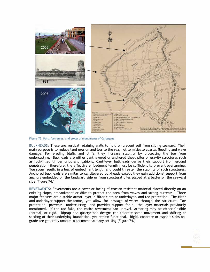
Figure 73. Port, fortresses, and group of monuments of Cartagena
BULKHEADS: These are vertical retaining walls to hold or prevent soil from sliding seaward. Their main purpose is to reduce land erosion and loss to the sea, not to mitigate coastal flooding and wave damage. For eroding bluffs and cliffs, they increase stability by protecting the toe from undercutting. Bulkheads are either cantilevered or anchored sheet piles or gravity structures such as rock-filled timber cribs and gabions. Cantilever bulkheads derive their support from ground penetration; therefore, the effective embedment length must be sufficient to prevent overturning. Toe scour results in a loss of embedment length and could threaten the stability of such structures. Anchored bulkheads are similar to cantilevered bulkheads except they gain additional support from anchors embedded on the landward side or from structural piles placed at a batter on the seaward side (Figure 74.).
REVETMENTS: Revetments are a cover or facing of erosion resistant material placed directly on an existing slope, embankment or dike to protect the area from waves and strong currents. Three major features are a stable armor layer, a filter cloth or underlayer, and toe protection. The filter and underlayer support the armor, yet allow for passage of water through the structure. Toe protection prevents undercutting and provides support for all the layer materials previously mentioned. If the toe fails, the entire revetment can unravel. Armoring may be either flexible (normal) or rigid. Riprap and quarrystone designs can tolerate some movement and shifting or settling of their underlying foundation, yet remain functional. Rigid, concrete or asphalt slabs-on- grade are generally unable to accommodate any settling (Figure 74.).
1981
2005
2003

______________________________________________________________________
Figure 74. Examples of Bulkheads and Revetments used in the Cienaga de la Virgen to force the circulation of the water and improve its quality.
BEACH STABILIZATION STRUCTURES
BREAKWATER: Near shore breakwaters are detached, generally shore-parallel structures that reduce the amount of wave energy reaching a protected area. They are similar to natural bars, reefs or near shore islands that dissipate wave energy. The reduction in wave energy slows the littoral drift, produces sediment deposition and a shoreline bulge or salient feature in the sheltered area behind the breakwater. Some long shore sediment transport may continue along the coast behind the near shore breakwater.
GROINS: Are the oldest and most common shore-connected, beach stabilization structure. They are probably the most misused and improperly designed of all coastal structures. They are usually perpendicular or nearly at right angles to the shoreline and relatively short when compared to navigation jetties at tidal inlets. Over the course of some time interval, accretion causes a positive increase in beach width updrift of the groin. Conservation of sand mass therefore produces erosion and a decrease in beach width on the downdrift side of the groin. The planform pattern of shoreline adjustment over 1 year is a good indicator of the direction of the annual net longshore transport of sediment at that location.
Figure 75. Breakwaters found along the beaches of Cartagena.
Groins are constructed to maintain a minimum, dry beach width for storm damage reduction to control the amount of sand moving alongshore. Previously stated purposes such as trapping littoral drift are discouraged for this implies removal of sand from the system. Modern coastal engineering practice is to combine beach nourishment with groin construction to permit sand to immediately begin to bypass the groin field. At the end of the sediment cell, terminal groins may be used to anchor the beach and limit the movement of sand into a navigational channel or onto an ebb-tidal shoal at tidal inlets.

Figure 76. Groins constructed along the shore of Cartagena in the last 10 years.
REEFS, SILLS AND WETLANDS (SUBMERGED DIKE): Additional types of shore protection alternatives for both high and low wave energy coasts function by reducing the wave energy striking the shoreline. Reefs are platforms of biotic organisms built up to a strict elevation in relation to low tide. Natural reefs require high wave energy to survive. Wetlands are coastal salt or freshwater marshes that are low-lying meadows of herbaceous plants subject to periodic, water level inundations.
Figure 77. Vegetated coast along in the Tumaco area.
Wetlands are fragile and only survive in low wave energy environments. The word .sill. has evolved to take on two separate identities in coastal engineering. Both meanings imply wave attenuation in the lee of the structure. A submerged, continuous, near shore dike to hold sand moving offshore from a nourished beach is one definition and also labeled a perched beach. Free-standing, low- profile, continuous shoreline structures to permit establishment of a marsh fringe in the lee of the structure are also called sills.

______________________________________________________________________
FLOOD BARRIERS
Another type of structure used to control flooding produced by the rise level sea and waves generated by storms are the barrier flooding. Those that are typically placed on the entrance of the bays, river and other. An example of this type of structure used in Colombia are the Geotubse. This structures were used for construction of confined disposal area islands used for containment and dewatering of fine-grained maintenance dredged materials.
The project is located on the San Antonio Inlet, Buenaventura Colombia. This dredged material containment area was the first of two circular shaped islands planned in this riverine and tidal environment. This new and innovative construction methodology involved hydraulically filling geotubes with a sandy fill material. Geotubes are simply an assemblage of geotextile fabric panels sewn to form long tubes for containment of dredged material. The geotubes were positioned end to end to provide a perimeter dike for dredged material containment in tidal variations of 4 m twice a day.
Figure 78 San Antonio Inlet, Buenaventura Colombia
After the first island was completed, it served as a dredged material containment facility until it was filled. After it has stabilized, it will be planted in Mangrove trees and other native vegetation and will be used exclusively for environmental purposes.
SOFT ENGINEERING RESPONSE
Another type of structures for the protection of the coastal border composes it the engineering works, which are carried out by natural elements characteristic of the same coastal border in its majority. Next the types of existent soft works are described in Table 75
Table 75. Types of soft works
Beach Restoration Type
Beach Nourishments Sand Passing Vegetation
Geometry (configurations) Or location
. Subaerial
. Dune
. Feeder
. Profile
. Underwater berms
. Bypassing
. Bankpassing
Materials of Construction
. Borrow sites - offshore - land . Dredged material . Artificially made (crushed rock)
Littoral traps . Smooth out hot-spots . Downdrift material returned updrift
. Wetland
. Submerged aquatic vegetation . Mangrove
BEACH NOURISHMENT & MANGROVE BARRIERS
Some natural systems found on shores provide coastal protection. These include coral reefs, beaches and mangroves. Beaches usually function as wave energy sinks and breakwaters. Vegetation on coastal slopes stops surface erosion and may prevent shallow slides. Rising water levels and storm

waves strip vegetation from shoreline beaches, beach ridges and eroding dunes. The natural establishment and growth of new vegetation is a key step in the rebuilding process of beach ridges and dunes. Approaches to restoration can be either hydrological or biological. Hydrological remediation includes restoring hydrologic connections between lakes and wetland water bodies and restoring wetland water tables. Biological methods include control of nonindigenous plants and animals, increasing populations of native wetland plants and animals, and enhancing habitat through management of plant species that provide habitat or introduce constructed habitats (Keillor and White 2003:; McLean et al. 2001).
Figure 79. Coastal natural protection after a Tsunami
Beach Nourishment is a technique used to restore an eroding or lost beach or to create a new sandy shoreline. It involves the placement of sand fill with or without supporting structures along the shoreline to widen the beach. It is a management tool which serves the dual purpose of protecting coastal lands and preserving beach resources. The initial nourishment project typically requires thousands of cubic meters of sand per kilometer of shoreline, and most beaches need periodic re-nourishment (National Oceanic and Atmospheric Administration (NOAA) 2000; National Research Council (NRC) 1995). There are two main types of nourishment methods. One involves placement of “new” material trucked in from inland sources; the other involves reintroducing material that has been removed from the littoral transport system.
A beach nourishment program requires effective planning, coordination, and implementation by decision-makers. Nourishment programs involve complex issues and must comply with applicable federal, state, and local laws, policies, and regulations. The first step in the planning process is to identify applicable requirements, programs, and stakeholders. Factors such as property ownership, beach access, location of project (state and local jurisdiction), purpose of project, environmental resources present, and beach erosion causes are primary considerations that are affected by applicable programs, resources, and requirements (such as permitting) for a beach nourishment project (National Oceanic and Atmospheric Administration (NOAA) 2000).
In general, the goal of regulations regarding beach nourishment projects is to consider and mitigate negative impacts to the environment. A variety of types and degrees of impacts can result from implementing this type of measure. Impact may result from placing the sand on the beach as well as from removing the sand from a source area. These projects may generate ecological and biological impacts on protected species, hard bottom areas, fish and wildlife resources, vegetation, and water quality, local economies, and cultural resources (National Oceanic and Atmospheric Administration (NOAA) 2000).

______________________________________________________________________
Found in the inter-tidal region between sea and land, mangrove forests help stabilize shorelines and provide protection against tsunamis, cyclones and other extreme weather events. Examples of this have been documented in several occasions, among them are the cyclone in 1999 which hit the Indian coastal state of Orissa and washed away several villages along the coast claiming over 10,000 lives, it spared many of the villages in and around the Bhitarkanika Wildlife Sanctuary – the second largest mangrove formation in the country. Likewise, there is evidence from Bangladesh where large-scale mangrove restoration made a substantial difference in mitigating the impact of severe cyclonic events (IUCN, 2005).
Many mangrove stands and coastal tree plantations contributed to saving human lives by bearing the initial brunt of storms, tsunamis, and other harsh climatic events as stated from the experience of the IUNC after the 2005 Tsunami in Indonesia. It is possible that these were then destroyed or severely damaged. In places where vast tracts of pristine mangroves and other coastal forest ecosystems have been destroyed, it is anticipated that this will pose a severe long-term threat for the region not only in terms of forest and biodiversity conservation, but also in terms of the ability of the ecosystem to support local economies and livelihoods.
Regarding sea level rise, mangroves are expected to mitigate sea water intrusion, and related problems as erosive processes. They don’t only protect the coastline, but also benefit nearby populations. This situation can be exploited in Tumaco, where large mangrove areas still exist. For Cartagena, a study to determine areas where this could work should be done. Probably resulting in the necessity of establishing new mangrove areas and protecting existing ones. Restoration is done using different tools, which include the entire population, both at a local, a regional and a national level. All stakeholders are to be included in such processes.
ENGINEERING PROTECTION FOR CARTAGENA
The line coastal of Cartagena, can be gravely affected by the rise of water level, added to this the erosive processes the coast line presents today. For this reason the engineering solutions that are studied, should be integral in such a way that it reduces or mitigate the flood and controls the erosive processes of the coast line.
It has been identified that for the ascent of the level of the sea in Cartagena the following affectations may take place:
1. LOST OF BEACHES: The beaches of Cartagena, they are exploded every year by tourists and residents, their loss would cause a important impact in the local economy of the city. Another aspect is that the beaches are the natural defense of the coastal border. The rise level sea can cause that the beach area is flooded, in such a way that the beach dried reduces in the most minimum thing until disappearing, phenomenon that he/she can accelerates keeping at the moment in mind the existing erosive processes. With the lost the beach the sea will be more defenses to the coastal border, this is why city will be more exposed to the storms and hurricanes and the local marine dynamics.
2. DAMAGES “VIA AL MAR” (CARTAGENA - BARRANQUILLA): The rise sea level, floods can be presented in the road that communicates Cartagena with Barranquilla and the interior of the country. Economically, this will affect notably the city when being isolated from great part of the country, reason why the affluence of tourists would diminish considerably. The road today presents some design conditions that he/she doesn't keep in mind the vicinity of the sea, due to this aspect not having an appropriate protection, it could fail.
Likewise, toward the future it will be impossible to enlarge the vehicular capacity of the road, limiting it to the current traffic and not the prospective growths of the city.
The affectation of the road can give begiven erosion of the banking that supports the structure of the pavements that composes the highway, for this phenomenon a flipping over of the berms can take place as well as the floods of the sea for effect of the RunUp of the wave.
The flood of the road, would unstable the structure of the pavement, since the asphaltic materials are, in contact with the saline water, they lose its link capacity which will produce the detachment of the materials.
3. HISTORICAL DOWNTOWN FLOODING: The biggest asset that has the city of Cartagena is its historical wealth, with its monuments and its walled city that have converted it famous worldwide and of great interest for the tourists. For this reason, the city should preserve these old structures, which can be affected and destroyed by the ascent of the level of the sea and the approach of the coastal border.
The floods with marine waters or the strong surf caused by storms can affect the foundations of the walls and/or monuments, that which influences in a possible collapse of these structures. Therefore, the conservation of the historical center becomes a priority for the city.
4. CHANGE IN THE DYNAMICS OF THE EXISTING LAGOONS COASTAL SYSTEM: Coastal lagoons system can be ichanged by the rise level sea. The increment of the level of the sea, can introduce an increase of the currents of flow that govern the system lagoons in such a way that flooding and erosions take place.
The erosive processes of the afferent area to the lagoons, affect so much to the biotical communities as the urban area. It is frequent to find in these areas, legal seated urban areas and illegally, which were constituted by the desiccation of the lagoons and their later refill. For the specific case of the Cienaga de la Virgen, from the point of view of quality of the water, an increase in the pattern of flow would be advantageous for the increase of the depurative capacity of the lagoons. In this moment there is built the road perimetral around the Cienaga de la Virgen. This structure can be affected by flooding and therefore to generate great impact for its future use. For this reason, it is a must to evaluate that the work of the Cienaga de la Virgen, is able to control the patterns of flow and increase of the level of the sea to diminish the floods.
5. LAND LOSS IN THE PORT AREA: For the rise of sea level, the port areas located in the Cartagena bay, can be affected by flooding of their facilities being stopped the operation of ports. For the city the port area produces important in amount of resources that influences its economy.
6. INCREASE THE SALINE WEDGE IN THE CANAL DEL DIQUE: The Canal del Dique, arm of the River Magdalena, connects Calmar (Bolívar) with Cartagena in a longitude of 115 km. For the Canal del Dique, a fluvial port movement is developed that comes from the interior of the country to Cartagena. Likewise, it has associated an ecosystem very important biologically, when reflecting through a system composed by lagoons for 10 marshes. In one of these marshes (Juan Gómez), the city of Cartagena takes the water for its drinkable supply.
In an estuary like the Channel of the Dike in the Bay of Cartagena, the fresh water for difference of density with the salted water, reflects above this. This causes that the salted water is introduced into the Channel, in opposite track to the flow in this phenomenon known as saline wedge.
According to studies carried out by the Universidad del Norte in 2001, it has been found that the saline wedge has penetrated until 20 Km of the outlet of the channel.
The increment of the level of the sea can cause that the penetration of the salt wedge is bigger, even arriving up to where the Marsh Juan Gómez is located. The consequence of this is the salinization of the soils and the waters of the marshes, with which the system of drinkable water of the city of Cartagena can be affected.

______________________________________________________________________
Sumerged Barrier
Hard Protections (Leeve – Tourist Walk)
Soft Protections (Beach Nourishment)
Via al Mar
Port Area
Vegetations Mangrove
Cienaga de la Virgen
Isla TierraBomba
CARTAGENA
Groins
Leeve flood
Canal del Dique
Sumerged Barrier
Protection Barrier
Cartagena Bay
Port area
Vía al Mar
Figure 80.Preliminary engineering proposal focus to protect Cartagena against the effects of SLR.
7. FLOODING IN THE ISLAND TIERRA BOMBA: The Island Tierra Bomba, located in the bay of Cartagena in front of the city, can be affected by flooding and erosive processes caused by the increase in the level of the sea. At the moment, the island has a low population density that can be affected for this phenomenon. The affectations would be mainly on the biotical communities.
Base in the presented affectations a proposal is described to mitigate the effects on the coastal border for the ascent of the level of the sea Figure 80.
LEEVE FLOOD LONGITUDINAL PROTECTIONS
With the objective of protecting the coastal border of the city that would be mostly exposed for the rise sea level, between the sector of Castillogrande and El Laguito, it is proposed a construction of a longitudinal leeve the construction of levee flood and erosions longitudinal protection. This

structure it can guarantee himself the preservation of the historical Center, the Urban Area and the Hotel area and the road to the Sea.
Figure 81. Protections Engineering in Cartagena. Leeve Concrete, Geotextile and Rock
The proposed structure is composed by a leeve of gravity, which can be carried out with materials as concrete, rock and Geotextil among other, depending on the economic resources that are pursued and the iteration of the structure with the environment. According to the marine climate of the area, added to the increase of the level of the sea, the height of the structure will be between the 2.0 and 2.5 m, to avoid the floods caused by the RunUp of the wave in winter time (Figure 81.). The estimated cost of the measure are presented in Table 76.
Colonial City Via al Mar
Tourist Walk
Leeve
Sea
Figure 82. Protections Engineering in Cartagena. Croos section. Leeve in Rock. Tourist Walk
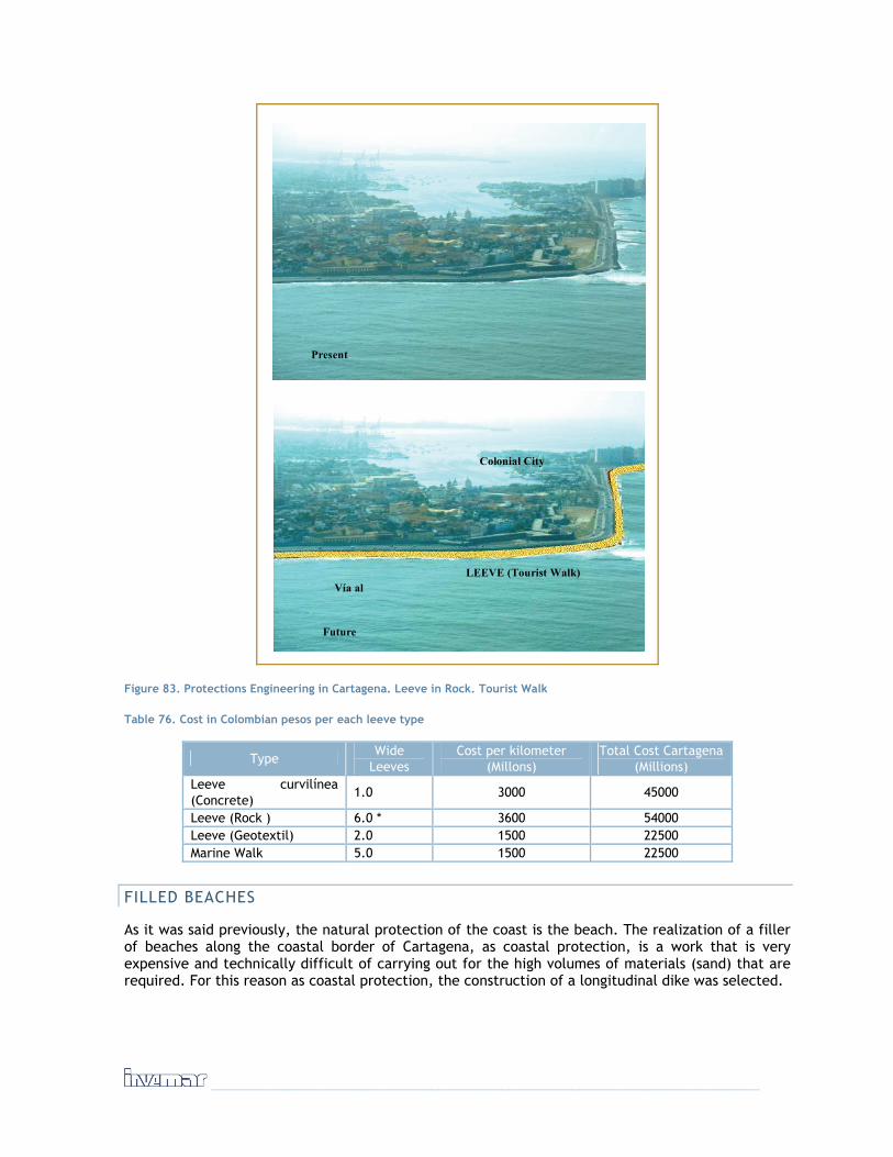
______________________________________________________________________
Present
Future
Colonial City
LEEVE (Tourist Walk)Vía al M
Figure 83. Protections Engineering in Cartagena. Leeve in Rock. Tourist Walk
Table 76. Cost in Colombian pesos per each leeve type
Type Wide
Leeves Cost per kilometer
(Millons) Total Cost Cartagena
(Millions) Leeve curvilínea (Concrete)
1.0 3000 45000
Leeve (Rock ) 6.0 * 3600 54000 Leeve (Geotextil) 2.0 1500 22500 Marine Walk 5.0 1500 22500
FILLED BEACHES
As it was said previously, the natural protection of the coast is the beach. The realization of a filler of beaches along the coastal border of Cartagena, as coastal protection, is a work that is very expensive and technically difficult of carrying out for the high volumes of materials (sand) that are required. For this reason as coastal protection, the construction of a longitudinal dike was selected.

In this case the recovery of the beaches is focused from the touristic point of view, in such a way that the city is not affected. In this case it is proposed to do refiil of beaches in the three (3) tourist sectors as Castillogrande, Bocagrande and the La Boquilla (beaches of Marbella and Crespo).
Refiil of beaches were carried out with material of dredged extracted near the areas, (in front of Cartagena as it is shown by the survey of the sedimentary facieses). For this activity a dredged of suction and cut can be used carries out the refill through a pipe. During this activity you previously carry out studies of grains to determine the best materials that allow to carry out the refiil.
The proposed fillers are the following ones:
Sector Filling longitude (km) Width (m) Castillo Grande 1.0 100 Bocagrande 3.0 150 Marbella y crespo 3.0 150
To guarantee the stability of the fillers, the placed material was confined with two curved lateral groins, placed until the depth where the longitudinal transport doesn't exist. See Figures 18 and 19.
Figure 84. Combination Protections Engineering in Cartagena. Croos section. Leeve in Rock. Tourist Walk, Beach Nourishment
Table 77. Estimated costs of the beach filling protection measure
Sector Filling longitude (km) Width (m) Costs (Millions) Castillo Grande 1.0 100 2500 Bocagrande 3.0 150 4500 Marbella y crespo 3.0 150 4500 Number Longitude (m) Confinement groins 6.0 200 4300

______________________________________________________________________
Beach Nourishment
Leeve (Tourist Walk)
Vía al Mar
Groin Groin
Figure 85. Combination Protections Engineering in Cartagena. Plan View. Leeve in Rock. Tourist Walk, Beach Nourishment
COASTAL LAGOONS
Afferent to the existent marshes in the coastal border of Cartagena, are neighborhoods having displaced people of high extract that have gained land to the marsh cutting the vegetable covering, displacing the communities biotical drying up the bodies of water. Due to the rise of sea these areas will be affected, since for the coastal dynamics the marshes again try to gain their spaces.
For this reason inside the classification of the city a plan of relocation of these urban areas will be settled down. This place will be replaced with vegetable covering, using the Mangrove to reestablish the natural atmosphere that had gotten lost.
PORT AREAS
The ports to work with capital deprived through use makings with the state, must settle down in the long term the contingent measures that it allows it to elevate it is lands, in such a way that is not interrupted the port activities. For this a refill must be done, through Bulkhead that allows the contention of the same ones. The costs associated to these activities can be through considerations with the state or for investments of their own.
PROTECTION BARRIER IN THE CHANNEL OF THE DIKE
To mitigate the effects of the saline wedge in the Channel of the Dike you can build a submerged barrier or a sluice in such a way that it doesn't interfere with the sailing in the channel. The
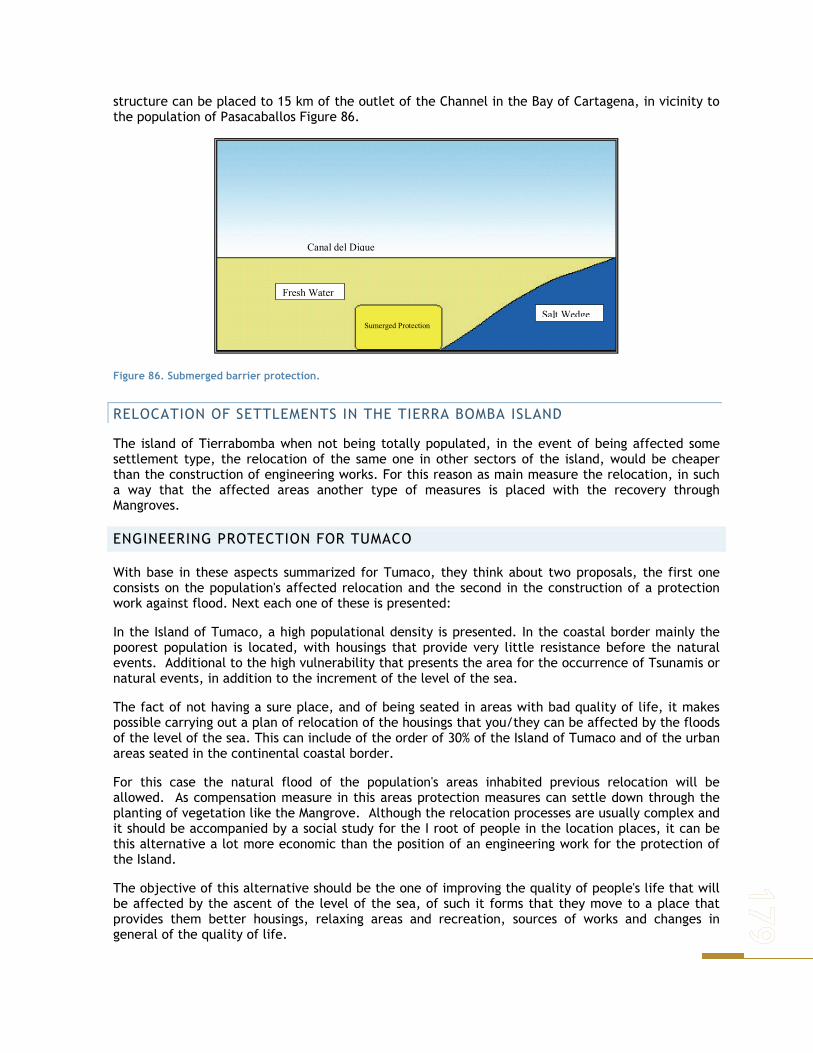
structure can be placed to 15 km of the outlet of the Channel in the Bay of Cartagena, in vicinity to the population of Pasacaballos Figure 86.
Fresh Water
Sumerged Protection Salt Wedge
Canal del Dique
Figure 86. Submerged barrier protection.
RELOCATION OF SETTLEMENTS IN THE TIERRA BOMBA ISLAND
The island of Tierrabomba when not being totally populated, in the event of being affected some settlement type, the relocation of the same one in other sectors of the island, would be cheaper than the construction of engineering works. For this reason as main measure the relocation, in such a way that the affected areas another type of measures is placed with the recovery through Mangroves.
ENGINEERING PROTECTION FOR TUMACO
With base in these aspects summarized for Tumaco, they think about two proposals, the first one consists on the population's affected relocation and the second in the construction of a protection work against flood. Next each one of these is presented:
In the Island of Tumaco, a high populational density is presented. In the coastal border mainly the poorest population is located, with housings that provide very little resistance before the natural events. Additional to the high vulnerability that presents the area for the occurrence of Tsunamis or natural events, in addition to the increment of the level of the sea.
The fact of not having a sure place, and of being seated in areas with bad quality of life, it makes possible carrying out a plan of relocation of the housings that you/they can be affected by the floods of the level of the sea. This can include of the order of 30% of the Island of Tumaco and of the urban areas seated in the continental coastal border.
For this case the natural flood of the population's areas inhabited previous relocation will be allowed. As compensation measure in this areas protection measures can settle down through the planting of vegetation like the Mangrove. Although the relocation processes are usually complex and it should be accompanied by a social study for the I root of people in the location places, it can be this alternative a lot more economic than the position of an engineering work for the protection of the Island.
The objective of this alternative should be the one of improving the quality of people's life that will be affected by the ascent of the level of the sea, of such it forms that they move to a place that provides them better housings, relaxing areas and recreation, sources of works and changes in general of the quality of life.

______________________________________________________________________
For being the increment of the level of the sea a long term effect, just as much it is able to execute a relocation process, in such a way that politicies are defined to allow to execute it in the time.
It is observed that in the coastal border of the department of Nariño one can study areas that in the proximity more possible of the Island, the relocated population can settle. These areas will be those but stable possible and to present a low vulnerability before the affectation of the events natural existent today in the area like the tsunamis and earthquakes.
For selection of the relocation places will be carried out a study that allows to define them, from the physical component (geology, geomorphology, vulnerability of the areas enters other), biotical and social. With this information one will be able to elaborate a relocation plan where the state will enter legally to relocate the families affected by this phenomenon.
For the case of the families you don't relocate, the port area and the tourist development of the Island the Muzzle will be carried out a process of improvement of the existent infrastructure, which will include the improvement and relief of communication roads between the island and the continental area, to evaluate if the existent bridges were not affected by the ascent of the level sea that otherwise will rise, the relief of the port areas in what has to do with jetties and operation areas, and the the realization of refills of beaches in the area tourist of the Island the Muzzle.
For the high vulnerability of the Island before the tsunamis, it is important to emphasize the use of measures as vegetation with Mangrove, in the flooded areas, in such a way that is to carry out a barrier of longitudinal protection in the coastal border of the islands, which will be able to vanish in great measure the strong energy taken place by the surf that produces an event like east in some moment.
The relocation plan should have the necessary studies that allow to define the places inundables and affected of the island, in such a way that is allowed to quantify the housings that will be relocated and to define which can stay in the area.
ZONE FOR REUBICATION
ZONE FOR REUBICATION
PORT AREA
Bridge
Table 78 Populations to retreat

FLOOD LONGITUDINAL LEEVE
In the event of being impossible to carry out a process of relocation of the families affected by the ascent of the level of the Sea, the construction of an engineering work is evaluated against floods.
This alternative consists on the possibility of Building a longitudinal dike against flood that skirts perimetralmente the Island of Tumaco, which will be bigger affected by the high populational density that presents, the elevation of roads, relief of bridges, relief of the port area and the construction of refiller of the beach in the Island The Muzzle.
This alternative, will be supplemented by a relocation Plan to smaller scale of the housings located in the areas where they think about the realization of the protection works.
The design of the dike will be to mitigate the effects of the floods and the surf taken place by storms that are presented in the area. The consideration in the design of an effect taken place as a Tsunami, will bring about the necessity to build too big works that would not be viable technically for the conditions of the project.
Construction of the dike will be, from the point of view against flood and it won't keep in mind the effect of a Tsunami of great magnitude, since this would require of a work with high cost that would be outside of the reach of the study.
The proposed longitudinal dike, it skirted the Island of Tumaco, it can be built in different materials as concrete, rock and geotextil, selected the one that is technically and economically better for the study area.
For the case of the Island the Vicious one and The Muzzle that present low low populational density, don't think about the construction of protection works against flood in which case the natural flood of the Islands will be allowed. In these islands the places will be protected that are important for the economic development of the region, like they are the port area and the tourist area. For he/she intends to enhance it the lands of the port area and the execution of beach fillers in the area of tip Island the Muzzle.
It is important for the economic development, maintaining the communication roads between the Island and the continental area, for this reason will be carried out a process of maintenance of the existent infrastructure through the relief of roads and bridges.
Table 79. Presumed protection strategy for Tumaco
Type Wide Leeves Cost per kilometer
(Millions) Total Cost (Millions)
Curved Leeve (Concrete) 1.0 7000 56000 Leeve (Rock ) 2.0 5000 40000 Leeve (Geotextil) 2.0 4000 36000
Table 80. Checklist for evaluating adaptation measures and strategies in Cartagena.
IDENTIFICATION OF LOCAL ADAPTATION MEASURES
In this last stage of this phase of the project, a list of adaptation measures was generated using a modified Checklist and data base for evaluating adaptation measures and strategies, produced by the Stockholm Environment Institute (Downing no year). A decision matrix was then completed with local stakeholders in workshops that took place in each area. These results served as the basis for the following phase in which a policy option exercise approach is made for each of the selected adaptation measures.
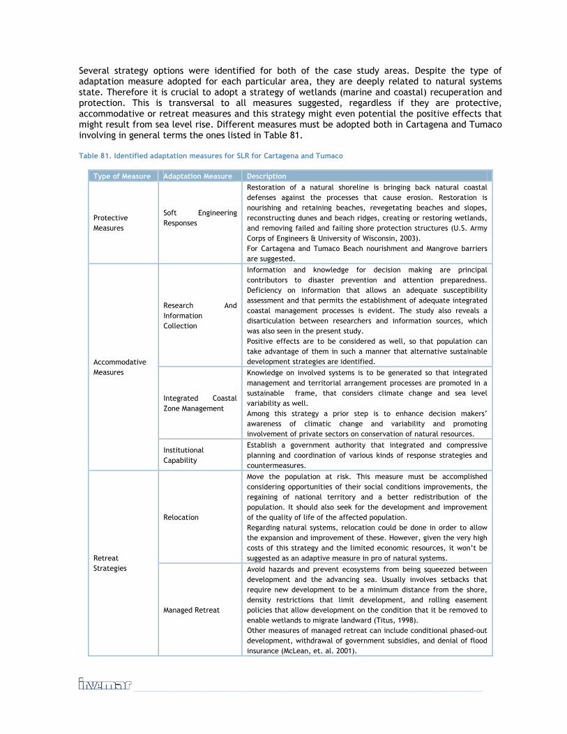
______________________________________________________________________
Several strategy options were identified for both of the case study areas. Despite the type of adaptation measure adopted for each particular area, they are deeply related to natural systems state. Therefore it is crucial to adopt a strategy of wetlands (marine and coastal) recuperation and protection. This is transversal to all measures suggested, regardless if they are protective, accommodative or retreat measures and this strategy might even potential the positive effects that might result from sea level rise. Different measures must be adopted both in Cartagena and Tumaco involving in general terms the ones listed in Table 81.
Table 81. Identified adaptation measures for SLR for Cartagena and Tumaco
Type of Measure Adaptation Measure Description
Protective Measures
Soft Engineering Responses
Restoration of a natural shoreline is bringing back natural coastal defenses against the processes that cause erosion. Restoration is nourishing and retaining beaches, revegetating beaches and slopes, reconstructing dunes and beach ridges, creating or restoring wetlands, and removing failed and failing shore protection structures (U.S. Army Corps of Engineers & University of Wisconsin, 2003). For Cartagena and Tumaco Beach nourishment and Mangrove barriers are suggested.
Research And Information Collection
Information and knowledge for decision making are principal contributors to disaster prevention and attention preparedness. Deficiency on information that allows an adequate susceptibility assessment and that permits the establishment of adequate integrated coastal management processes is evident. The study also reveals a disarticulation between researchers and information sources, which was also seen in the present study. Positive effects are to be considered as well, so that population can take advantage of them in such a manner that alternative sustainable development strategies are identified.
Integrated Coastal Zone Management
Knowledge on involved systems is to be generated so that integrated management and territorial arrangement processes are promoted in a sustainable frame, that considers climate change and sea level variability as well. Among this strategy a prior step is to enhance decision makers’ awareness of climatic change and variability and promoting involvement of private sectors on conservation of natural resources.
Accommodative Measures
Institutional Capability
Establish a government authority that integrated and compressive planning and coordination of various kinds of response strategies and countermeasures.
Relocation
Move the population at risk. This measure must be accomplished considering opportunities of their social conditions improvements, the regaining of national territory and a better redistribution of the population. It should also seek for the development and improvement of the quality of life of the affected population. Regarding natural systems, relocation could be done in order to allow the expansion and improvement of these. However, given the very high costs of this strategy and the limited economic resources, it won’t be suggested as an adaptive measure in pro of natural systems. Retreat
Strategies
Managed Retreat
Avoid hazards and prevent ecosystems from being squeezed between development and the advancing sea. Usually involves setbacks that require new development to be a minimum distance from the shore, density restrictions that limit development, and rolling easement policies that allow development on the condition that it be removed to enable wetlands to migrate landward (Titus, 1998). Other measures of managed retreat can include conditional phased-out development, withdrawal of government subsidies, and denial of flood insurance (McLean, et. al. 2001).

It is necessary that before suggesting any measure in a given area, research and studies on local conditions are made and used to plan such process. In Tumaco erosive – accretion processes are constant and beaches appear and disappear constantly. Besides, given the amplitude on sea tides, and other conditions, beaches are usually very wide, so unless further research recommends it, this measure is not suggested for Tumaco. For Cartagena different situations have resulted in constant erosion of beaches and almost no accretion, which at present is seen through the loss of beach areas in many places. This measure could be used to improve such situation, given that it not only protects, but also act as an attractive feature for tourism, which is one of Cartagena’s main industries.
RESEARCH AND INFORMATION COLLECTION
In order to guarantee that adopted measures to sea level rise are only the no regrets kind, every single action must be done with prior research and information collection so that the consequences are foreseen. Plenty of information is available; the problem lies in its quality. To perform any further analysis a deep understanding of coastal processes that prevail in the areas has to exist.
The limited information currently available and the uncertainty associated with it means that the agency charged with managing climate change preparedness activity will have to expend energy to constantly update its knowledge and potentially change its direction and advice. Thus the agency could benefit from operating as a ‘learning system’ , i.e. by recognizing in advance that it will make ‘mistakes’, the agency needs to be willing to learn from these mistakes and update its procedures and response capacity iteratively.
There is little existing connection between the scientific community and the result of its studies with the policies formulation process in the disasters subject and prevention related to SLR. That is why it is so important the need to develop scientific, technical and institutional capacities and the quality to achieve a basic understanding that allows the planning and application of adequate measures. Work with national agencies in charge of coastal management and planning, to exploit the bathymetric and terrestrial datasets for the development of targeted maps and services, including flooding maps, determination of set back lines, coastal ecosystem mapping, and zonation for coastal users.
An environmental scan can be conducted to determine if there are networks or organizational structures that can expand the capacity of community-based organizations. Determining the presence, scope, capacity, and quality of such groups can be helpful in targeting and leveraging resources. Mapping nonprofit organizations to determine both their prevalence and geographic distribution within a community could also provide a framework for identifying potential gaps in service or a spatial mismatch between needs and resources in local areas.
Climate change and it’s potential effects (i.e. sea level rise among others) must be included in research programs, and real of all the systems involved must be examined. Positive effects are to be considered as well, so that population can take advantage of them in such a manner that alternative sustainable development strategies are identified. Also the effect that these changes will bring on different species related to the natural systems affected, must be understood, and especially if they are commercially relevant for associated human populations as is the case of many fishes for Tumaco and Cartagena.
To understand and predict system susceptibilities, we need appropriate data and information on:
● The climatic influencing factors (temperature, rain, wind, etc.);
● The non-climatic influences (population, prices, pests, policies, etc.);
● The internal functions of the system, and their climatic and other sensitivities;
______________________________________________________________________
● The interactions (physical, biological and social) with other systems and resultant integrated behaviours.
Adaptation research includes such things as trend studies, sensitivity studies, model building, scenario development, case studies, and adaptation developments. Is a critical need for plausible scenarios of the future, scenarios that incorporate the characteristics of historical data, the trends evident in today’s world, and the projected changes in a future world of enhanced greenhouse gases and other rapid environmental and social changes. Although climate models are not very reliable for predicting future conditions at the local scale, it is relatively easy to use past data to generate future scenarios of climate statistics.
MAINSTREAMING ADAPTATION AND RISK MANAGEMENT INTO LOCAL PLANNING
Consideration of climate change impacts needs to be integrated into the normal interaction between stakeholders and decision-makers, rather than added as a separate consideration. Key documents such as Vision 2019, Land Use Zoning and Planing documents, enhance coordination, competence, tasks and responsibilities among different agencies and departments by acting across administrative boundaries, and assuring participation of stakeholders (Integrated coastal zone management).
Within the frame of the Program for the Reduction of the Fiscal Vulnerability of the State before Natural Disasters Guidance was elaborated To orient the Actions and Investments In Local Management Of the Risk At Municipal Level, in this guide the different measures consider orients the actions and investments that must make the municipalities Colombian in order reduce or avoid the level of losses associated to the occurrence of adverse natural and socio natural phenomena, contributing this way to the obtaining of better and more sustainable levels of social, environmental and economic development. This guide affirms that to make management of the risk she consists basically of executing of correct form the investments in any sector of the development. This way, the investments in reduction and prevention of risks are in fact necessary and cross-sectional elements in all the public investments.
Following the guide in mention, in addition to necessary a normative development, the governance of the country must also advance in the consolidation of a culture of the management of the risk that assumes the incorporation of the subject in the different instruments of diagnosis and regulation of the use of the territory and of its resources. It is necessary to count on the communitarian support in all the phases of the management of the risk, since these actors take part actively as much in the origin as in the possible solutions to risk situations. Of equal way the inclusion of the private sector is indispensable, since often the ones in charge of projects of development with a great impact of risk are these actors. The incorporation of the community and the private sector is requisite for the success in this type of actions. In addition to general topics, the communities must be enabled in particular subjects, (for example climatic change and its effects) that turn them actors of the management of the risk.
Finally, the CLOPAD must be positioned politically, which means coordination with the cabinet of the mayor and to guarantee the participation of the different instances in the same one.
ALLOW NATURAL ECOSYSTEMS TO EVOLVE IN RESPONSE TO SLR
For some regions, even though there will be massive changes in landscape and environment, it is considered unlikely that human actions and resources could be effective in managing these even in developed countries, especially for large systems facing rapid rates of change. Hence living with inevitable change could be more efficient than resisting it.
Sand and silt deposits stabilized by mangroves and other plant will form a natural dyke, which can serve as safety zone. If some infrastructure is develop close to this line additional small scale measures must be implemented too, like small dikes or elevated grounds especially when it is concerning industrial activities.
Activities that conserve biological diversity, reduce fragmentation and degradation of habitat, and increase functional connectivity among habitat fragments will increase the ability of ecosystems to resist anthropogenic environmental stresses, including climate change. Actions should focus on actively manage changes so as to preserve existing natural ecosystems in their location, species composition and their ecosystem services as far as possible.
Identify natural barriers to tsunami, cyclones, storm surges, flooding and coastal erosion (specifically coral reefs, mangroves, near-shore rock outcrops, sand bars, and sand dunes) and protect them from degradation due to construction activity. Ecosystems will be better suited to deal with climate variability and change if other stresses are significantly reduced.
OTHER TYPES OF RESPONSES
General adaptation measures to be adopted for both Cartagena and Tumaco were identified and they involve the following considerations:
THERE NEEDS TO BE A MOVE AWAY FROM TOP-DOWN IMPLEMENTATION. There needs to be more work on resilience at ground level. Local capacity is critical to successful environmental adaptation. Adaptation has to be consistent and equitable with economic development, environmentally sustainable and socially equitable over time. Both city planning measures should anticipate floods using hard and soft responses, and ensure that land safe sites are available to low-income households to build their own homes. All of this depends on better local governance.
We cannot operate in isolation as the decisions we make nearly always impact beyond the immediate site. Tackling the problems facing our sites also requires action by others, especially neighboring coastal owners and managers. Finding mutually beneficial solutions like large-scale realignment projects requires a strong partnership approach.
THINK AND ACT IN A WIDER CONTEXT: Boundaries of the territorial planning scheme take no account of the real boundaries of the environmental coastal units4 in which coastal processes operate. In order to take a flexible and responsive approach to dealing with coastal change, we need to think and act in a much wider spatial context, managing our sites within freshwater catchments and coastal units.
LONG-TERM STRATEGY: Sea level rise adaptation in both coastal areas needs long term strategy rather than a reactive short-term approach. To adapt effectively planning needs to be done at least 30 to 40 years ahead. In many cases it will be necessary to relocate people, habitats and buildings and to do so cost-effectively require early action. The future is inherently unpredictable, even more so with climate change and a dynamic coastal environment, so flexibility in management and planning needs to be allowed. The study areas need the long-term view for meeting the impacts of climate change for the greater interest of the country’s sustainable development.
TAKE “NO REGRETS” ACTIONS: Many organizations working in coastal zones have adopted participatory approaches, but often in the limited sense of consultation procedures within an outcome-oriented, expert-driven approach. This consultation occurs at stages in the management process when experts have already designed the project alternatives or management interventions. Meaningful and early participation in coastal management, however, is likely to play a significant if not dominant role in both prevention and risk management. This will have to include early
4 An Environmental Coastal Unit is a section of coastline which reflects the natural physical processes acting along it – where the social, economic and governance structure is largely self-contained.

______________________________________________________________________
contributions from all stake holders in the design of project or program objectives as well as in the design of project alternatives or management interventions and their implementation.
RAISING AWARENESS: Awareness is an important factor for public movement and community participation. There is a need to increase awareness of the emerging problems of climate change and sea level rise, consequently how this sea level could be mitigated or adapted with more resource utilization. Before this process can begin there has to be an acceptance that sea level is an issue that requires the investment of thought and resources. We must listen to stakeholders before providing climate change information, to understand their local knowledge, and to understand the information most needed by them. This includes the need to understand the choices that are actually open to stakeholders in adapting to sea level impacts.
Raising awareness of the impacts on our coastal areas is vital to winning public confidence. Any form of realignment of the coast can create uncertainty and even hostility. Building consensus and providing information takes time and effort, but is crucial to finding sustainable solutions. All the key stakeholders, such as policy makers, academics, technocrats, and the general public must be involved in this awareness program. More importantly, such public awareness campaigns should focus on taking advantage of the country’s indigenous knowledge and experience in coping with such extreme events that have occurred in the past, and using that to prepare for the future eventualities.
CAPACITY BUILDING. The local governmental capacity to deal with climate-related issues is not at a phase that will ensure timely implementation of adaptation measures. The business community has also not shown any apprehension even though some components of business such as tourism are cognizant of the problem. One of the main organizations concerning Climate Change in Colombia is IDEAM. It’s technical expertise level especially at the professional level and its capital and recurrent funds are lacking to address training, purchase of equipment to monitor climate, recruitment of field technicians and maintenance of reliable continuous records of climate of the coastal areas. To remedy this situation, the Institute requires human, financial, technical and technological resource building if it is to play the crucial role of alerting the nation to changes (or variability) of climate and issuing warnings to the sectors, which will be affected.
WORK IN FAVOR OF NATURE NOT AGAINST IT: Experience has demonstrated that working with natural processes is the most sustainable approach. In some cases this will mean undoing past mistakes, taking out hard defenses and letting the coast realign naturally. In others we will need to phase our approach, buying time with temporary solutions while finding space to allow natural defenses to form.
SLR ADAPTATION MEASURES FOR CARTAGENA DE INDIAS
For Cartagena different situations have resulted in constant erosion of beaches and almost no accretion, which at present is seen through the loss of beach areas in many places. The city was identified as the most critical area in the Caribbean coastal zone, due to its low altitude. The main identified measures were:
1. Establish a new regulatory measure for the design and construction of infrastructure.
All new developments will be expected to use water retention areas or similar sustainable urban drainage systems to dispose surface run-off waters without enhancing the flood risk. Although there is information available on the sewerage network, there is no comprehensive information currently available on the problems caused due to failures in the whole drainage system and on the extent to which these could be
Cartagena, 1987

mitigated by better co-ordination between responsible institutions.
Make it a statutory requirement that individual planning proposals include flood risk assessments. This would also require primary legislation and would impose extra costs on developers and local authorities. The benefits would be in ensuring that flood risk will always be taken into account, and provide adequate information to the environment agencies (Corponariño and EPA).
2. Designate ‘no build’ areas
Define shoreline setbacks or buffer zones around vulnerable coastlines to avoid loss of human life as well as damage of infrastructure in case of natural hazards; A construction setback line should be defined on the basis of the mean high water mark, available scientific information regarding the effect of historical trends in erosion and accretion, the inland extent of flooding in past storms and anticipated sea level rise. Local government should also consider constructing and maintaining appropriate infrastructure for storm impacts and safe refuges for dealing with possible rising sea level and increased storminess.
SLR ADAPTATION MEASURES FOR SAN ANDRES DE TUMACO
The strategies identified for Tumaco are the following:
1. Do not develop anything below the 3.40 meter altitude line.
This measure refers to the establishment of a new regulatory and mandatory measure for the design and construction of infrastructure (houses, buildings, roads, etc). The area below the 3.40 meter line has to serve as an area where natural processes have the space to develop themselves without interference.
2. Develop a regulatory system for land planning, including risk zoning
In order to anticipate the disasters and reduce its negative impacts, a more comprehensive approach that includes the risk reduction before the disasters as well as the subsequent recovery is needed. It should be framed in new institutional policies and mechanisms that favor an efficient action. Careful periodic revision of safe areas is needed as sea level rises.
IMPLEMENTATION CONSTRAINS
During the workshops some important problems that may slow processes were identified. One of the most important is the fact that these processes involve deep cultural and educational practices which often are very slow. Another important difficulty that stakeholders identified is the fact that these measures or strategies, and the subject of climate change and sea level rise, have not been included in the city’s development plans and therefore are not considered at all in the city’s arrangement and budget. This added to the fact that actual policies and lack of regulations are destroying the natural systems left (for Cartagena) implies greater investments when it comes to realizing the importance of this measure and the need to redo what is already lost.
This in turn generates another complication given that mangrove forests take ten years or longer to recuperate, which results in a long time for this to be acting as an adaptation measure, for it implies changing people’s mentality, changing development programs and laws and then trying to recuperate what has been lost before and during this time.
Regarding this measure, stakeholders mentioned other initiatives and documents that could interfere or support these measures, although not planned in such a way from the beginning. Actors present in the workshop mentioned a project of urban development done by EDURBE, which affects mangrove remnants found in the city of Cartagena. This has been evident through different processes that have occurred in the city and that have awakened public awareness on the subject.

______________________________________________________________________
These conflicts have been documented and reflect illegal mangrove deforestation with urban purposes in several areas of the city (For further information visit: http://www.invemar.org.co/portal/noticias.jsp?id=2228&idcat=121).
Concerning beach nourishment, and mangrove protection, there are no documents that treat them as adaptive measures for sea level rise; however there are some regulations (Decreto 2324/84, Decreto 721, Wetlands and coastal zones policy, mangrove project, forestall statute 1791) that mention them and may serve as the basis for future policy projects that might regard them as adaptive measures for climate change.
During the workshop for Cartagena, stakeholders pointed out several problems that the area faces concerning research and information collection. According to their statements, at present no batimetric or coast line monitoring occurs in Cartagena. This makes it very hard for estimates to be done and for processes to be followed over. Added to the lack of continuous processes that can give a baseline for studies in the field of climate change, what stakeholders regard as the major problem is the lack of socialization and publication of studies done in the area. because of this decisions concerning natural systems, and infrastructure among others, are done blindly and the results are continuous losses that could have been prevented.
Stakeholders also identified a lack of preparation and technical knowledge in the city, and therefore in the people that assess different processes. There is an urgent need of rearranging the city, and that this process involves social conflicts that are currently affecting natural systems and the city’s situation in general. Academy recognizes that in their mission research plays a crucial role, however none of the institutions present at the workshop includes the subject of climate change or sea level rise in their statutes. These joined with the lack of information divulgation results in a lack of clarity of the roles the institutions play among these processes.
As with other subjects, in the city is not very clear which institutions are responsible for this subject, however stakeholders identified CARDIQUE (Autonomous Corporation of the Dique Channel) as one of the institution whose main mission involves a strong component of research. The special unit administration of the national natural parks system (UAESPNN) doesn’t have research included in its mission.
Among documents mentioned that may involve the subject, stakeholders identified the law 768 of 2002. This law makes no direct reference to research; however it does involve the subject of management and conservation of water sheds and inner lagoons, and specifies that the agents responsible for doing so are the city’s major and an environmental public entity that will act as environmental authority for the urban area. beaches are to be regulated by the DIMAR. As stated before, even though regulation responsibilities are stated, no mention on the subject of research is done in this law (for more information visit: Diario Oficial No. 44.893, de 07 de agosto de 2002 -
http://www.aciem.org/bancoconocimiento/L/LEYambien7682002/LEYambien%207682002.doc).
A law that states research responsibilities is the law 99 which created the national environmental system (SINA). Among other statements it makes responsible for scientific research (besides other functions) the following entities: IDEAM, IAvH, INVEAMR, SINCHI and IIAP, which are the research institutes on environmental matters for the country. However this law does not specify such responsibility at the local level (Further information: http://www.minambiente.gov.co/plantilla1.asp?pag_id=1576&pub_id=269&cat_id=220).
Finally the last mentioned law was the decreto 2324/84 which created the Center of Oceanographic and Hydrographic research responsible for the application, coordination, and supervision of national and international regulations concerning marine preservation and protection.

POLICIES, LEGISLATION AND REGULATIONS
REVIEW AND ANALYSIS OF THE EXISTING POLICIES, LEGISLATION AND REGULATIONS IN COLOMBIA RELATED TO THE CLIMATE CHANGE IN COASTAL AREAS OR RELATED ENVIRONMENTAL SUBJECT MATTERS, REQUIRED TO MAKE VIABLE THE PRIORITY ACTIVITIES IDENTIFYING THE GAPS AND / OR POSSIBLE (IF NECESSARY) REGULATORY ACTIONS.
Climate change is one of the most serious threats against human welfare and health, the economy and many of the natural ecosystems and against the sustainable human development. Likewise, it is expected that as one of the global climate change consequences the appearance of a sea level rise as a result of the global warming.
Taking into consideration the previous definitions we can establish that the global climate change and the sea level rise that will arise from it are natural phenomena and induced by the human activities that represent a risk for society and, in this sense, and taking into account the normative framework existing in Colombia, its prevention and attention must be considered from three fronts: the one strictly related to the National System for the Disasters Prevention and Attention; the one associated to the Territorial Development matters of the country and the territorial bodies and the environmental aspects for their prevention and mitigation as a responsibility of the SINA.
Following we will present, in a summarized way, which is the normative framework associated to each one of these areas and subsequently the analysis of how these regulations facilitate or not the implementation of the adaptation measures proposed by INVEMAR will be made.
NATIONAL SYSTEM FOR THE DISASTERS PREVENTION AND ATTENTION
Colombia counts with the National System for the Disasters Prevention and Attention (SNPAD), established by Law 46 of 1988 and organized by the Decree – Law 46 of 919 of 1989. The System, at its turn, counts on the National Disasters Prevention and Attention Plan (PNPAD), adopted by means of Decree 93 of 1998, and with an inter – institutional strategy for its execution at the short and medium term, adopted by means of the CONPES document 3146 of 2001.
Law 46 of 1988 establishes that the National System for the Disasters Prevention and Attention that is being created and organized has the following objectives:
● Define the responsibilities and duties of all the organisms and public entities, private and communal, in the prevention, handling, rehabilitation, reconstruction and development phases arising from the disaster situations.
● Integrate the public and private efforts for the adequate prevention and attention of the disaster situation.
● Assure a timely and efficient handling of all the human, technical, administrative, economic resources indispensable for the prevention and attention of the disaster situations.

______________________________________________________________________
Likewise, the same law defines that the National Office for Disasters Attention (currently the National Direction), will prepare a National Disasters Prevention and Attention Plan which, once approved by the National Committee for the Disasters Prevention and Attention, will be adopted by means of a Decree of the National Government. The Plan will include and state all the orientations, actions, programs and projects of the sectorial character as well as of the national, regional and local order referring, among others, to the following aspects:
● Prevention, immediate attention, reconstruction and development phases regarding the different types of disasters;
● The technical, scientific, economic, financing, communal, legal and institutional subject matters;
● The communal education, training and participation; ● The integrated information and communication systems at a national, regional and local
level; ● The function that corresponds to the mass media; ● The human and physical resources of technical and operative order; ● The inter- institutional and inter – sectorial coordination; ● The necessary scientific investigation and technical studies; ● The control and evaluation systems and procedures for the prevention and attention
processes.
Subsequently, and in development of the Law 46 mandates, the National System for the Disasters Prevention and Attention is organized, as established by Decree 919 of 1989. Of its contents, the following aspects are outlined:
● Define the responsibilities and duties of all the organisms and public, private and community entities, in the prevention, handling, rehabilitation, reconstruction and development phases provoked by the disaster or calamity situations;
● Integrate the public and private efforts for the adequate prevention and attention of the disaster or calamity situations;
● Insure a timely and efficient handling of all the human, technical, administrative and economic resources indispensable for the prevention and attention of the disaster or calamity situations.
The same regulation defines that the following are part of the National System for the Disasters Prevention and Attention:
● The National Committee for the Disasters Prevention and Attention. ● The National (Direction) Office for the Disasters Attention ● The National Technical Committee for the Disasters Prevention and Attention ● The National Operative Committee for Disasters Attention. ● The Ministries and Administrative Departments, as far as their competences and duties have
relation to the disasters prevention and attention activities and, particularly, the Ministry of Government (today of Interior and Justice), the Ministry of National Defense, the Ministry of Health (Social Protection), the Ministry of Transportation, the Ministry of National Education, the Ministry of Agriculture, the Ministry of Communications and the National Planning Department.
● The national order de-centralized entities, as far as their competences and duties have relation to the disasters prevention and attention activities and, particularly, the National Geological and Mining Institute, Ingeominas; the Colombian Civil Defense; the INCODER, the National Learning Service, Sena; the Geographic Institute Agustín Codazzi, INGAC; the National Renewable Natural Resources and Environment Protection Institute (MAVDT), the Autonomous Regional Corporations; and the Sociedad Fiduciaria La Previsora, (Fiduciary Society La Previsora), as administrator of the National Calamities Fund.
● The territorial bodies and their decentralized entities as far as their competences and duties have relation to the disasters prevention and attention and calamities activities.

● The National Society of the Colombian Red Cross. ● The entities and private persons that because of their object and duties have relation to
the Disasters Prevention and Attention and Calamities activities.
Finally, this Decree repeats the mandate of formulating the National Plan for the Disasters Prevention and Attention, which is formally adopted by means of Decree 93 of 1998. Among its main characteristics, regarding this work, it is worthy to outline some fundamental aspects.
The Plan’s main objective is to guide the Government and the civil society’s actions for the prevention and mitigation of risks, the preparations for the attention and recovery in case of a disaster, contributing to the risk reduction and the sustainable development of the vulnerable communities in view of the natural and anthropic events.
The general principles that guide the national and territorial entities regarding the preparation, execution and tracking of the National Disasters Prevention and Attention Plan are:
DECENTRALIZATION: The Nation and the territorial entities will, freely and autonomously, exercise their functions in the disasters prevention and attention subject matter, with a strict subjection to the powers assigned to each one of them by the Constitution and the Law, as well as by the provisions included in Decree – Law 919 of 1989. The application of the National Disasters Prevention and Attention Plan must contribute to the strengthening of the decentralization process by means of which the municipalities and regions may autonomously assume their responsibilities, reserving at a national level the task of the policy frameworks definition and the coordination of the actions.
THE COMPETENCES SCOPE: In the activities for the disasters prevention and attention for the effects of the corresponding competence exercise, the observance of concurrence, complementarity and subsidiary criteria will be taken into account.
THE COORDINATION: The national, regional and local order entities must internally guarantee the existence of the due harmony, consistency, coherence and continuity of actions regarding all other sectorial and territorial instances for the disasters prevention and attention effects.
THE PARTICIPATION: During the disasters prevention and attention activities, the competent entities will see to it that the people participation procedures provided by Law be enforced.
The general strategies of the National Disasters Prevention and Attention Plan are:
THE AWARENESS OF NATURAL AND ANTHROPIC ORIGIN RISKS. The investigation and awareness of natural and anthropic origin risks constitute the basis for the decision – making as well as for the prevention and mitigation criteria incorporation in the planning processes. Its development must be one of the National System Disasters Prevention priorities at all its levels.
THE INCORPORATION OF THE RISKS PREVENTION AND REDUCTION IN THE PLANNING. The risks prevention and reduction as a planning criterion must be present in the decision – making on the economic and social future of the municipalities, the departments and the nation. The existing planning instruments, regional, urban or sectorial are fundamental to guarantee more secure and benefic investments, from the social and economic point of view.
STRENGTHENING OF THE INSTITUTIONAL DEVELOPMENT. The strengthening actions for the institutional level development of the national entities or those constituting the regional and local committees must be promoted by means of coordination processes at a national level and of decentralized and participative processes with territorial entities. These actions must be addressed to impulse and coordinate the elaboration and application of organizative, institutional management and work instruments that insure the functioning and compliance with the National System for the Disasters Prevention and Attention’s objectives.

______________________________________________________________________
THE SOCIALIZATION OF THE DISASTERS PREVENTION AND MITIGATION. For the effects of incorporating a preventive attitude in the culture and an acceptance of the government prevention actions by the community, a socialization process for the disasters prevention and mitigation must be developed by the national order competent entities in coordination with the territorial entities.
The National Plan proposal is developed through different programs orienting the projects, works and activities implementation.
Due to their relation with the objective of this document, the following is highlighted:
PROGRAMS FOR THE AWARENESS ON NATURAL AND ANTHROPIC ORIGIN RISKS:
a- Risks Evaluation. Methodological instruments for threats, vulnerabilities and risks evaluation at a departmental and municipal level, the evaluation of natural and anthropic threats with zoning purposes, regulation and planning and vulnerability analysis and urban centers, indispensable buildings and vital lines infrastructures must be developed
PROGRAM FOR THE INCORPORATION OF THE RISKS PREVENTION AND REDUCTION IN PLANNING:
a- Incorporation of preventing and safety criteria in the development plans, instruments, methodologies and regulations must be devised for the risk consideration as the determinant factor in the decision – making and the formulation by the sectorial entities of programs and projects in order that the risks estimate and mitigation be considered in the investment and management plans. The territorial entities must draw up plans, programs and projects for the risks reduction and allocate resources for the disasters prevention and attention.
b- Handling and treatment of human settlements and infrastructures located in risk areas. Inventories of houses in risk must be devised at a municipal level; promote housing and the risk influence areas relocation, improvement and protection; promote the soil use regulation and the territorial organization with preventive purposes and risks mitigation. Prepare security regulations and building and vital lines infrastructure design and construction, intervene and reduce the vulnerability of urban centers, indispensable buildings and existing vital lines infrastructures and study and promote the application of safety mechanisms for the assets and individual and collective services protection.
c- Coordination of the environmental and disasters prevention policy. Activities must be coordinated for the organization of the National Environmental System and the National System for the Disasters Prevention and Attention. The incorporation of information on threats, vulnerabilities and risks in diagnosis and environmental profiles at a national, regional and local level, consider the risks mitigation and disasters prevention in the impact studies and the environmental handling plans of infrastructure plans, and promote the environmental aptitude studies at a municipal level, considering the risk as a restriction or determining factor for the habitat planning and urban development.
STRENGTHENING PROGRAMS OF THE INSTITUTIONAL DEVELOPMENT:
a- Regional and local committees’ strengthening for disasters attention and prevention. The management instruments and evaluation of inter – institutional activities evaluation must be developed for the regional and local level draw up and set in motion regional plans for the disasters attention and prevention.
b- Protection and contingency measures in infrastructure works. The contingency plans must be promoted and developed for the public utilities and vital lines for the reply and rehabilitation of utilities in case of disasters; promote and draw up contingency plans of high industrial and technological level civil projects for the reply and attention of external or internal origin disasters.
c- Integrated information system. An Integrated Information System must be drawn up and kept. Systematize the inventory and existing information on threats and risks for the
planning and for the historic information on disasters and losses in the national territory. Systematize the information related to vigilance, alert, early diagnosis and inventory systems of resources for the effective institutional reaction and, systematize the information on the handling and transportation of dangerous substances.
PROGRAMS FOR THE SOCIALIZATION OF THE DISASTERS PREVENTION AND MITIGATION:
a- Public information for the prevention and fast reaction of the community in case of a disaster. Periodic information must be supplied to the municipal and departmental authorities on the legal, technical and motivation aspects. Technical assistance and support must be provided to the Regional and Local Committees in the preparation of public information campaigns. And public information campaigns must be drawn up at a national and regional level for the awareness of threats and the preventive measures, both individual and communal. Spreading campaigns must be developed with the private sector entities, expansion of the school program coverage in the education establishments and boost prevention programs in sports, theaters, public buildings scenarios.
Finally, and as a mechanism to develop the National Plan, in 2001 the CONPES Document No. 3146 was approved, in which the strategy to consolidate its execution (PNPAD) in the short and medium term was defined as well as the priority actions for its development in a 3 years horizon relating to the four PNPAD problematic lines, as far as: 1) the knowledge; 2) the incorporation of the subject matter in the planning; 3) the SNPAD institutional strengthening; and 4) the improvement of education and spreading programs. Likewise, it included financial and tracking order aspects, necessary to consolidate the National Plan.
Of the actions proposed, the following where directed to guarantee the inclusion of risks handling in the territorial and sectorial planning processes so that the subject matter be adequately included in the Organization and Territorial development Plans and in the Sectorial Development ones.
For these reasons, the actions set out are addressed to strengthen the support and orientation that the national and regional entities must offer to territorial entities for the formulation or development of the POTs, the PDTs and their Contingency Plans, and the following tasks were recommended:
● The DGPAD and the SNPAD technical entities, will produce or update the thematic threat maps in Colombia as of the information available and will promote the development or updating of detailed risk studies in the critical areas.
● The MDE (today MAVDT), the MMA (today MAVDT) and the MADR will support the territorial bodies in the definition of strategies for the handling of areas with flooding, landslides and avalanches.
● The MDE (today MAVDT), will support the territorial bodies for the development of studies of seismic micro zoning in urban centers.
● The MDE (today MAVDT) and the DNP will design a strategy to support the territorial bodies in the elaboration of the functional vulnerability of the cities.
● The MMA (today MAVDT), will guide the CAR (Autonomous Regional Corporations) on their environmental authority functions and technical support to territorial bodies in the risks handling in the territorial environmental organization. In addition, it will promote the adequate inclusion of the subject matter during the current PGARs formulation and updating process.
TERRITORIAL DEVELOPMENT
In the territorial development field, we must take into account two fundamental aspects: i) the Development plans in their different scales (national, departmental and local); and ii) the territorial organization and soil uses.
______________________________________________________________________
Regarding the development planning and its instruments, national as well as regional and local, the applicable legislative framework is Law 152 of 1994, in which it is established that:
● The National Development Plan will be constituted by a general part and an investment plan of the national order public entities.
● The plan’s general part will include the following:
a- The national and sectorial objectives of the medium to long term State action according to that resulting from the general economy diagnosis and of its main sectors and social groups;
b- The national and sectorial objectives of the medium to long term state action and the general procedures and mechanisms to obtain them;
c- The strategies and policies in economic, social and environmental subject matter that will guide the Government’s action to reach the objectives and goals that had been defined;
d- The designation of the entailment and harmonization ways, means and instruments of the national planning with the sectorial, regional, departmental, municipal, district and indigenous territorial entities’ planning; and of those other territorial entities that be constituted in application of the current constitutional regulations.
● The national order public entities investments plan will mainly include:
a- The projection of available financial resources for its execution and harmonization with the public expenditure plans;
b- The description of the main programs and sub – programs, with an indication of their objectives and national, regional and sectorial goals and the priority investment projects;
c- The multi – annual budgets by means of which the most important public investment program expenditures contemplated in the general part will be projected; and
d- The specification of the ideal mechanisms for its execution.
Likewise, it has been established that the development plans of the territorial entities will be conformed by a strategic part and a medium and short - term investments plan, in the terms and conditions that in a general manner the Departmental Assemblies and the District and Municipal Councils regulate. In a similar manner, the territorial entities have autonomy on the subject of economic, social and environmental handling development planning in the framework of competences, resources and responsibilities attributed to them by Constitution and Law; and it is mentioned that for the elaboration of their development plans, without prejudice of their autonomy, the policies and strategies of the National Development Plan must taken into account to guarantee coherence.
Taking into account the preceding and the regulations framework established for the territorial development, it is required that the territorial bodies (departments, metropolitan areas, districts and municipalities) from the different territorial spheres of its management, incorporate the strategic ecosystems, environmental services, as well as the risks and threats associated to the conditions of their territorial reality as a mechanism to improve its environmental, social and economic performance that will allow them to insure the development of their communities.
A special mention must be made regarding the black communities that have been occupying vacant lots in riverside rural areas of the Pacific Basin rivers, to whom, among other aspects, and according to that established by Law 70 of 1993, the right to collective property is recognized to them and, likewise, the mechanisms for the encouragement of their economic and social development, with the purpose of insuring that these communities obtain real conditions of equal opportunities facing the rest of the Colombian society.
In this sense, and taking into account the location of the San Andrés de Tumaco municipality and the characteristics of the town located there, we must remember that the collective property on the titled areas must be exercised according to the social and ecological purposes inherent to them. Consequently, the owners must comply with the obligations of the environmental and renewable natural resources protection and contribute with the authorities in defense of that patrimony. This implies that the members of the black communities, owners of the collective property rights, will continue to preserve, keep or bring about the regeneration of the waters’ protection vegetation and insuring, by means of an adequate use the persistence of specially fragile ecosystems such as the mangroves swamps and water loggings, and protecting and conserving the wild fauna and flora species threatened or in danger of extinction. For those purposes the Law establishes that the National Government will allocate the necessary entries so that the community may comply with its environmental obligations.
Law 1151 of 2007, by means of which in Chapter 5 the National Development Plan establishes:
RELATED WITH AN ENVIRONMENTAL AND RISK MANAGEMENT, that the sustainable development must be be forged in function of guaranteeing adequate and secure life conditions quality for the inhabitants and the favorable conditions for the economic growth, which implies integrating the environmental and risk considerations in the planning processes so that strategies for the risk reduction and the environmental degradation prevention be promoted.
The increase of the vulnerability conditions in the presence of certain threats, in some cases intensified by the environmental degradation and which manifest in disasters scenarios, necessarily imply the environmental and risk management.
The rational use of resources additionally requires the evaluation of risks existing on the territory, that is, be aware of the threats and vulnerabilities and incorporate them as fundamental determinants in the development and territory occupation processes. With this purpose, the PND 2007-1010, sets out the strategies that allow the government to harmonize, in its different levels, the actions and resources to reduce the risk and guarantee the sustainable development. These strategies are:
ENVIRONMENTAL MANAGEMENT PROMOTING THE SUSTAINABLE DEVELOPMENT, with the following components and strategies applicable to the study subject matter:
Environmental Planning of Territorial Management
− Incorporation of the environmental and cultural determinants on the territory use and occupation, for which purpose, the MAVDT will support the authorities in the adoption and formulation of the coastal environmental units’ organization management.
− Natural and Anthropic Risk Origin incorporation in the territorial organization processes.
● Coasts and Seas Integral Management, outlining the importance of implementing the Environmental National Policy for the Colombian 0ceanic spaces and coastal and insular areas sustainable development, giving continuity to the MIZC lineaments incorporation in the POTs of the coastal municipalities, with a direct entailment of the territorial entities, environmental authorities, investigation institutes of each one of the coastal environmental units (CEU) established in the policy.
RISK MANAGEMENT FOR THE DISASTERS PREVENTION AND ATTENTION, in this sense, the PND states that the country faces geographic, climate and territory occupation conditions that added to the population vulnerability increase the fragility and the risk. That it is why it is necessary to strengthen the actions common to the prevention under the following objectives:
● Increasing the threats awareness, analysis and evaluation, the vulnerability and the risk ● Improving the information and its spreading

______________________________________________________________________
● Strengthening the measures for the risk prevention and mitigation ● Increasing the financial capacity for the prevention and not only for the disasters’ attention
The PND suggests actions more of prevention than of the immediate attention of disasters, taking in to account the planning instruments and especially those of the territorial organization.
The components and strategies defined by the PND are:
● Risk identification and monitoring, information and spreading − Extension and updating of monitoring and early alert networks (seismic, volcanic and
hydrometereological) and the awareness generation. − SNPAD’s integrated information system − Culture, education and investigation for the integral risk management.
● Risk reduction (prevention and mitigation) − Incorporation of the risk reduction in the development planning. − Tracking the public investment and exchange of experience in the risk management
● Policies development and institutional strengthening ● Fiscal vulnerability and risk transfer
All of the above should be taken into account by the Bolívar and Nariño provincial governments, the District of Cartagena de Indias and the San Andrés de Tumaco municipality, in the preparation of the development plans and the review of the Territorial organization plans, especially at this moment, in which the elected Majors and Governors will initiate their corresponding term on January 1st, 2008.
On the other side, the Territorial Organization is basically ruled in Law 388 of 1997, known as the Territorial Development Law, which establishes guidelines, regulations and guidance so that the territorial entities, in exercise of their autonomy, establish the use of their jurisdiction’s soil. Among others, the law has the following objectives:
● The establishment of mechanisms which will allow the municipality, in exercise of its autonomy, to provide the organization of its territory, the equitable and rational soil use, the preservation and defense of the ecological and cultural patrimony located in its territorial scope and the prevention of disasters in high risk settlements, as well as the execution of efficient urban developments.
● Look after the environmental protection and the disasters prevention. ● Promote the harmonious concurrence of the nation, the territorial entities, the
environmental authorities and the administrative and planning instances and authorities in the compliance of the constitutional and legal obligations that prescribe the government the territory organization in order to obtain the improvement of its inhabitants’ quality of life.
● Facilitate the execution of the integral urban acting, in which the municipal organization and management converge with the national urban policy, as well as with the efforts and resources of the entities in charge of the development of said policy.
The territory organization constitutes, in its overall, a public function that has as purposes, among others, to help in the soil use processes and adequate it, in the name of common interest, procuring its rational use in harmony with the social function of the property to which an ecological function is inherent and improving the safety of the human settlements in the presence natural risks.
Likewise, the territorial organization has as an objective to complement the economic and social planning with the territorial dimension, rationalize the participations on the territory and guide its development by means of:

● The definition of the soil use, occupation and handling territorial strategies in development of the economic, social, urban development and environmental objectives.
● The design and adoption of management and acting instruments and procedures that allow the performance of integral urban acting and articulate the sectorial acting which affect the municipal or district territory structure.
● The definition of programs and projects that define these purposes.
For the compliance of this objectives, law establishes the Nation, the department, the metropolitan areas and the municipalities and districts’ competences, who are directly responsible for the formulation and adoption of the territorial plans included in the Organic Law of the Development Plan, specifically regulate the soil uses of its jurisdiction and coordinate the sectorial plans in harmony with the national policies and the departmental and metropolitan plans. All these entities must exercise their functions under the coordination, concurrence and subsidiary principles.
It is important to take into consideration that it corresponds to the municipalities and districts, in development of the urban development action:
● Classify the territory in the urban, rural, and urban expansion territory ● Establish the zoning and location of the production centers, tertiary and residential
activities, define the specific uses and usage intensities as well as the occupation percentages.
● Determine the non – development land which presents risks for the location of human settlements, due to natural or other type of threats present unhealthy housing conditions.
● Locate the critical recovery and control areas for the disasters prevention as well as areas with landscape conservation and recovery.
In addition, in the preparation of the POTs, the environmental determinants must be taken into account, among which those related to the environmental protection, the natural resources and the threats and risks prevention are found, such as:
● The regulations on environmental and renewable natural resources conservation, preservation, use and handling in the marine and coastal areas, and those issued by the environmental authorities as far as the special handling hydrographic basins and conservation of areas of special ecological importance is concerned.
● The policies, guidelines and regulations on natural threats and risks, the designation and location of risk areas for human settlements as well as the handling strategies for areas exposed to threats and natural risks.
GENERAL MARITIME DIRECTION – DIMAR - COMPETENCE
Within the national context of this review on the normative framework applicable to the risks associated to the SLR management, it is very important to take into consideration that a great
Box 6. Definitions
NATIONAL COAST: An area of two kilometers wide parallel to the line of the highest tide.
MARITIME BEACH: An area of non – consolidated material that extends toward the land from the lowest tide line to the place where there is present a marked change in the material, physiographic form or where the permanent vegetation line starts, usually the effective limit of the stormy waters.
LOW TIDE: The maximum waters depression or minimum height
LOW TIDE LAND: The one covered by the maximum mark and left uncover when this descends.

______________________________________________________________________
percentage of the territories with an affectation potential due to the phenomenon and where the proposed adaptation measures will be carried out, are legally under a particular juridical regime.
According to Decree Law 2324 of 1984, the DIMAR is the national maritime authority executing the government’s policy in maritime subject matter and has as an objective the direction, coordination and control of maritime activities.
In development of this object,it corresponds to it, among others, the duty to authorize and control the concessions and permits in the waters, low tide land beaches and other public use assets of its jurisdiction.
By public use assets, Decree Law defines the beaches, the low tide land and maritime waters. And as such, they are non – transferable at any title to individuals, who could only obtain the use and possession concessions, permits and licenses according to that defined in the same Decree.
Likewise, the same Decree Law has some definitions that are fundamental for the identification of competence conflicts between institutions and the responsibilities of each one of them in the execution of the proposed measures:
The DIMAR’s jurisdiction goes until the exterior limit of the exclusive economic area, among others, in the following areas: littorals, including the beaches and the low tide lands; islands, islets and keys, as well as the Nation’s coasts and the river banks under its jurisdiction in an extension of 50 mts. measured from the highest mark and the highest tide inwards.
REVIEW OF THE APPLICATION PROCEDURES IN THE REGIONAL AND LOCAL TERRITORIAL DEVELOPMENT INSTRUMENTS.
In this item, a synthesis of the Departmental Development Plans of the Bolívar and Nariño departments, as well as the Cartagena de Indias Territorial Organization Plan is presented, with the purpose of determining the way in which the disasters prevention and attention aspects have been included and if there are programs or projects specifically related to the SLR effects. It is important to also mention, that no review of San Andrés de Tumaco’s POT is made, since up to date the same has not been formulated by the municipality.
DEPARTMENT OF BOLÍVAR’S DEVELOPMENT PLAN, 2004-2007
In the investment programs, the eighth, makes reference to the disasters prevention and attention, in which a project directed to the application of the National Disasters Prevention and Attention Plan in the Department is presented: this program includes a set of priority actions to improve the development of the four National Disasters Prevention and Attention Plan and the National Development Plan programmatic lines “Toward a Community Government”, in the department as far as:
Awareness on the natural and anthropic origin risks: The main consumables for an adequate prevention and attention of disasters are the information and the knowledge for the correct decision – making, by the Departments and Municipalities. In this sense, the following actions will be carried out: a) Strengthening of twenty five (25) Local Committees in Risk Handling; b) Achieve one (1) University degree in Risk Management for Local Disasters Prevention and Attention Risk Management’s Coordinators; and c) Preparation and implementation of a Schooling Plan for the Disasters Prevention and Attention 2004 – 2007.
Risks Prevention and Reduction in Planning: This line of action includes the preparation of training events for municipal officials addressed to guarantee the inclusion of risk management in the territorial planning processes so that the subject matter be adequately included in the territorial organization plans (POT) and in the Municipal Development Plans. The POTs and the development plans, as instruments directed for the long term sustainable development and for the short and

medium term of the territorial management, have an strategic role in the current risks reduction and in the non – generation of new risks. Likewise, as far as the awaited disasters prevention and attention, it is essential the formulation of the Local Emergencies and Contingencies Plans and the preparation of the Natural Threats Map at a Departmental level. Consequently, the departmental government shall provide technical support to the twenty (20) department’s municipalities with the higher vulnerability index, for the preparation of the Local Emergencies and Contingencies Plan. In addition, it will prepare the Department of Bolivar Threats and Risks Map.
Institutional Strengthening of the Disasters Prevention and Attention System: The management is directed on one side, to guarantee the inter – institutional organization and coordination, and on the other, the institutional strengthening of the systems authorities and entities for the disasters prevention and attention at a departmental and municipal level. In order to achieve an adequate organization and coordination of the regional committee for the disasters prevention and attention and the local committees, the following actions will be carried out: a) Four (4) annual meetings will be held with local coordinators for the prevention of disasters with the purpose of strengthening the ties and expand their knowledge. b) The coordination of the education commission and the inter – institutional committee for the environmental education will be promoted. c) Promote the creation of municipal volunteer fire fighters bodies.
Spreading and socialization of the risk management: The spreading and socialization of the subject matter in order to elevate the conscience level and the political action of the public, private and the community in general actors around the risk handling. In this sense, the most important actions will be developed around: a) the execution of training and formation events for officials and communities, and b) spreading and socialization campaigns on risk for the citizens’ awareness.
DEVELOPMENT PLAN FOR THE TOURIST AND CULTURAL DISTRICT OF CARTAGENA DE INDIAS – 2006.
In the strategic objective 1: Cartagena a government with authority, and the strategy 1: safety and coexistence, the Emergencies and Disasters’ Attention and Prevention program is mentioned. This program pretends to offer the guarantees so that the Cartagena’s population receives the timely prevention and attention in case emergencies and disasters are present in its jurisdiction. The prevention work and the safety and prevention culture will be an important work object in this program. Among the goals proposed, the following are highlighted:
● Implement, as minimum, 50 Schooling Emergency Plans ● Training on Emergency and Evacuation Plans to be given to teachers and students of the 9th
and 10th grades in 100 district education centers ● Formulate the Strategic Emergency Plan of Cartagena ● Creation and training in disasters prevention and attention to 50 quarters of the city
(priority given to the risk areas). ● CLOPAD logistic strengthening. ● Try to obtain the quantification of the number of houses located in high risk areas ● Try to obtain the assurance of the public utilities networks and public infrastructure, in
the presence of eventual disasters, especially where the displaced inhabitants are located ● A logistically strengthened and trained Fire fighters Command
In the Strategic Objective 5: Cartagena a place for the people, strategy 3 is developed: infrastructure for the people and in it, the Coastal Line Protection and Defense Program is mentioned with the purpose of defining and protecting the district’s coastal line with maritime hydraulic structures in the Tierra Bomba island and the areas currently affected.
In this same strategic objective, the strategy 6 is defined: recovering the environment with 6 programs among which 2 are highlighted:

______________________________________________________________________
Recovery and conservation of Urban Ecosystems: Negotiate with the environmental regional authority, the financial resources demanded in an attempt to recover and preserve the Urban Ecosystems; continuously pointing through proactive policies over the Bocana, channels and lakes, beaches, coast line, the Bazurto sanitary filling and the impoverished urban ecosystems existing in the district.
Environmental Monitoring of the Rainfall Drainages and Water Systems Quality: Exercise the environmental monitoring and keep the quality of the district’s water and rainfall systems. Includes the maintenance and cleaning of the drainage and rainfall channels network of Cartagena de Indias.
In the component support and management to the public agenda projects, among others, the Crespo coastal protection and recovery is mentioned.
TERRITORIAL ORGANIZATION PLAN OF THE TOURIST AND CULTURAL DISTRICT OF CARTAGENA DE INDIAS, DECREE 0977 OF 2001.
In the organization plan objectives, the third one makes reference to the integration of the environmental dimension to the system constructed in the District, making emphasis in the restoration and protection of ecosystems to insure the conservation, the lasting exploitation and the sustainability of the territory formed by the Caribbean Sea scopes, the Cartagena and Barbacoas Bays, Ciénaga (Swamp) de la Virgen, Canal del Dique, coral reefs and other District’s ecosystems, by means of their linkage to the design of the city and the activities which are carried out there. Among others, the following policies and strategies are mentioned there:
Policies.
a- Value the District’s water system constituted by the Caribbean Sea, the Bays, Ciénaga de la Virgen, Internal Channels and Lakes, the Canal del Dique with its swamps and lagoons and all other water elements and bodies, as a strategic environmental axis.
b- Conserve the fresh water sources, as well as the receiving basins and water recharge places.
Strategies.
a- Recovery of the Cartagena Bay, the Ciénaga de la Vírgen, the Barbacoas Bay, the Canal del Dique influence area and other city’s water bodies.
b- Prioritization of projects that renew the facades of the city on the littoral and its interior water bodies.
c- Restoration of the swamps, lagoons and internal water bodies’ connections with the sea, the protection of the mangrove areas, eliminating its use mainly as a served water and solid residues outlet.
d- Decrease of the sediments reaching the bay and the Islas del Rosario by the Canal del Dique and the hydro biological restoration of the water loggings associated to the system.
e- Recovery and conservation of the mangrove, marine grass and coral banks in the sea of the littoral.
f- Criteria definition for the awarding of the territory use and organization, establishing water, air, soil and biodiversity management programs and projects.
In the District’s natural resources and landscape protection and conservation and the handling measures of the protection areas, the following are identified:
− Natural National Park –Rosario and San Bernardo reefs: the park includes the submarine area where the reefs that circle the Islas del Rosario and the Islas de San Bernardo are found.
− Cartagena Bay: includes all its area as well as the Las Ánimas Bay, the internal, the external, the Honda, Coquitos swamps in the Tierra Bomba littoral. The area suitable for its environmental recovery and destined for the multiple uses sustainable exploitation and as a

landscape component granting a privilege to the water body, the beaches, the mangroves and the surrounding visual basin.
− Mangrove areas: corresponds to the areas occupied by the existing mangroves swamps along the District littoral, referenced in the zoning study made by CARDIQUE in 1998, and approved by the Environmental Ministry.
− Maritime Beach Stripe: the stripe of beaches along the District littoral, adjacent to the sea, constituted by non - consolidated material, of variable width and which dividing line with the consolidated land must be determined.
In Chapter IV, determination and location of risk areas for local human settlements, the areas with susceptibilities to different characteristics are established and which we will be briefly describing below related to the SLR and its effects.
Soils sensitive of flooding:
Related to low areas skirting the sea and the bodies of water. Specifically those related to water bodies are identified surrounding the Cartagena Bay, generalizing the land adjacent to the sea; the flooding levels depend on the tide altitudes, which could present variations of 0,6mm. with a 20 years recurrence and of the volume of the flow toward the Bay. High tide levels coincident with groundswells and/or torrential rains generating flooding along the coast, including the developed area, such as the tourist area, the Plaza de la Aduana, Parque de la Marina, the walled area (Santo Domingo, San Pedro) and la Boquilla (Marlinda and Villa Gloria). The land surrounding the Ciénaga de la Virgen, the internal channels and lagoons and the Cartagena Bay, with heights below 0,98 meters. Around the Ciénaga de la Virgen the land with heights of up to 1, 1 mts. are subject to flooding with strong rains and high tide.
The measures to be taken in the areas sensitive of flooding are the following:
− No new constructions will be allowed in the flooding areas. − The works and channels will be reviewed in order to determine obstructions of the water
courses and perform the corresponding clearance. − Maintenance programs of the sewage networks and channels will be implemented. − Campaigns to raise the awareness and preparation to face a possible emergency will be
carried out. − Shelters with medical attention will be adapted in high susceptibility areas.
Sensitivity to coastal erosion:
The main cause of the coastal erosion in Cartagena de Indias is the sea and the action of the winds. A lesser contribution is constituted by the global sea level irse and, at a local level, the exploitation of the beach material. The exploitation of the beach material is well known in Manzanillo del Mar and La Boquilla. The sea level rise could be considered a direct factor in the dynamic processes of the coast. The increase of 0,2 centimeters per year, could cause effects in the coast depending on the local topography. This sensitivity is divided in sectors according to the impact level as follows:
High sensitivity to coastal erosion: is present in the littoral areas exposed to the direct action of the sea swell. It is evidenced in all its magnitude during the groundswells. The coastal area between La Boquilla and the Crespo and Marbella neighborhoods, at the Romero Aguirre bridge are in those conditions.
Moderate sensitivity to coastal erosion: present in the littoral sectors exposed to the direct action of the sea swell but locally protected by engineering works (cutwaters, seafronts and breakwaters). Notwithstanding such protection, during the groundswells there are coast line retreats. The beaches between the COMFENALCO Recreation Center and El Laguito and Castillogrande are included in these conditions, which constitute 60% of the city’s beaches. In Marbella, Bocagrande and part of

______________________________________________________________________
Castillogrande, the existing cutwaters and breakwaters trap sediments and form wide beaches. However, during the groundswell the damages and flooding are generated between Santo Domingo and the entrance to Bocagrande.
Low sensitivity to the coastal erosion: is presented in the littoral areas naturally protected by the direct sea swell action. The presence of low coral reefs and mangrove swamp type vegetation prevents that the swell, when eventually gets near the coast in a tangential manner, directly have an effect on the same. The internal part of the Cartagena Bay is currently in these conditions, south of the Manzanillo island and at the Mamonal sector.
Coastal erosion between La Boquilla and the District’s North Limit: the erosion phenomenon of the beaches between La Boquilla and Palmarito is present in the La Boquilla and Cascajo Island areas. At the southeast of Punta Canoas and Arroyo de Piedras, in longitudes of 1,000 and 700 mts., respectively, an accelerated retreat of beaches has been present. In both cases the coast line is low where the swell has a bearing in all its intensity in front of the beach, the back of the beach and the dunes located parallel to the coast border. North of Arroyo de Piedra toward Palmarito is defined as a non – consolidated coast. The Cascajo Island is among the few areas currently suffering the erosive action of the coast line. Presenting as a projecting or cape, such place all the time suffers the arrival of considerable height waves coming from the open sea. These waves cause a continuous erosion on the low coral reef forming the island.
Coastal erosion in the Barú Island: the stability of the coastal areas of the Barú Island is medium since, though there is no beach migration opponent, the waves’ action has affected the lowest terraces that frequently suffer collapses.
As far as the measures to be taken in the coastal erosion sensitivity areas, it is mentioned that while the detail studies are being made, an entailment with INVEMAR, or else, and other national order entities will be established, to produce a two – way flow and devise studies on the vulnerability of the biophysics and socio – economic systems due to the sea level change.
A link with international authorities performing the coastal areas monitoring regarding the changes due to the sea level rise will be simultaneously established and kept with the purpose of keeping updated the information on the sea level rise process and prepare in time the pertinent measures.
The compliance of the beaches material exploitation prohibition will be observed (sands and gravel).
As it can be seen, the Cartagena de Indias’ Departmental Development Plan and the District’s POT include actions related to the Disasters Prevention and Attention, of which we outline the program for the coast line defense and not allowing new buildings in the flooding areas. The actions that could be qualified as preventive, but no program or project was identified, tending to solve the actual problems and risk vulnerability of the towns actually located in the most sensitive areas of having the SLR impacts.
DISTRICT OF CARTAGENA DE INDIAS LOCAL EMERGENCY AND CONTINGENCY PLAN. CARTAGENA DE INDIAS MAYORALTY, DISASTERS PREVENTION AND ATTENTION UNIT. 2005
The emergency plans directly related to the District’s marine and coastal areas are included. In that related to the natural threats, this document reports the same information as the territorial organization plan of the Cartagena de Indias’ tourist and cultural district, where the District’s sensitivities in the different aspects (flooding, mass removal, coastal erosion, etc) are identified Table 82).
In the emergencies plan, the document mentions, in the threats matrix, the natural geological risks such as: earthquakes, soil liquation and tsunamis. This last one reports as the main consequences
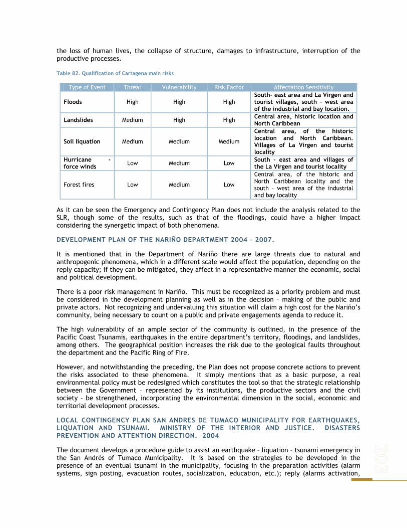
the loss of human lives, the collapse of structure, damages to infrastructure, interruption of the productive processes.
Table 82. Qualification of Cartagena main risks
Type of Event Threat Vulnerability Risk Factor Affectation Sensitivity
Floods High High High South- east area and La Virgen and tourist villages, south – west area of the industrial and bay location.
Landslides Medium High High Central area, historic location and North Caribbean
Soil liquation Medium Medium Medium
Central area, of the historic location and North Caribbean. Villages of La Virgen and tourist locality
Hurricane - force winds Low Medium Low South – east area and villages of
the La Virgen and tourist locality
Forest fires Low Medium Low
Central area, of the historic and North Caribbean locality and the south – west area of the industrial and bay locality
As it can be seen the Emergency and Contingency Plan does not include the analysis related to the SLR, though some of the results, such as that of the floodings, could have a higher impact considering the synergetic impact of both phenomena.
DEVELOPMENT PLAN OF THE NARIÑO DEPARTMENT 2004 – 2007.
It is mentioned that in the Department of Nariño there are large threats due to natural and anthropogenic phenomena, which in a different scale would affect the population, depending on the reply capacity; if they can be mitigated, they affect in a representative manner the economic, social and political development.
There is a poor risk management in Nariño. This must be recognized as a priority problem and must be considered in the development planning as well as in the decision – making of the public and private actors. Not recognizing and undervaluing this situation will claim a high cost for the Nariño’s community, being necessary to count on a public and private engagements agenda to reduce it.
The high vulnerability of an ample sector of the community is outlined, in the presence of the Pacific Coast Tsunamis, earthquakes in the entire department’s territory, floodings, and landslides, among others. The geographical position increases the risk due to the geological faults throughout the department and the Pacific Ring of Fire.
However, and notwithstanding the preceding, the Plan does not propose concrete actions to prevent the risks associated to these phenomena. It simply mentions that as a basic purpose, a real environmental policy must be redesigned which constitutes the tool so that the strategic relationship between the Government – represented by its institutions, the productive sectors and the civil society – be strengthened, incorporating the environmental dimension in the social, economic and territorial development processes.
LOCAL CONTINGENCY PLAN SAN ANDRES DE TUMACO MUNICIPALITY FOR EARTHQUAKES, LIQUATION AND TSUNAMI. MINISTRY OF THE INTERIOR AND JUSTICE. DISASTERS PREVENTION AND ATTENTION DIRECTION. 2004
The document develops a procedure guide to assist an earthquake – liquation – tsunami emergency in the San Andrés of Tumaco Municipality. It is based on the strategies to be developed in the presence of an eventual tsunami in the municipality, focusing in the preparation activities (alarm systems, sign posting, evacuation routes, socialization, education, etc.); reply (alarms activation,

______________________________________________________________________
replies coordination, evacuation, damages evaluation, search and rescue, debris removal, etc.); recovery; revision and updating and relocation and adaptation activities.
SAN ANDRES DE TUMACO LOCAL EMERGENCY PLAN. MINISTRY OF THE INTERIOR AND JUSTICE. DISASTERS PREVENTION AND ATTENTION DIRECTION. 2004.
The general outlook of the risk situation of the San Andrés de Tumaco municipality is presented as far as threats and vulnerability is concerned and definition of the institutional organization to respond in the presence of emergency or disaster situations in the coastal areas of the municipality.
It is mentioned that ar a municipal level, the guiding regulation in matter of Disasters Prevention and Attention in Tumaco, is Resolution 005 of January 2002, by means of which the CLOPAD is restructured and its duties are established regarding the integrated information system of the DPADs, with the disasters situation and with the specific action plans; it is also established the creation of a municipal budget item, exclusively for the Disasters Prevention and Attention.
The threats have been classified according to their origin in natural phenomena and those caused by men. The DGPAD 1998 classification was used.
As far as the vulnerability increment factors, the following environmental aspects are mentioned:
Mangroves’ cutting and fishery resource decrease: the disappearance of mangroves swamps facilitates the floodings and decreases fishing that is why it is necessary to recover the mangroves areas, which act as natural swell cushioning barriers.
Solid and liquid residues contamination: caused by the deficiency in the sewage service and collection of solid residues; the decay on the open air of these last ones contribute to the proliferation of diseases vectors.
As far as the instructions related to the Disasters Prevention and Attention, the Pacific Contamination Control Center, the first – aid organisms and the San Andrés Hospital are mentioned, as well as the institutions performing training activities.
The national order investigation entities participation (INGEOMINAS and DIMAR) and of regional order (OSSO), has been given through the carrying out of the evaluation and characterization studies of the natural threats in Tumaco, specially in the urban area. Other institutions such as the National Planning and the INURBE, participated in the “ALA” project formulation and execution (an Agreement between Colombia and the European Union) with which the re – location of the housing located in high risk areas could be obtained.
SOCIAL VULNERABILITY DUE TO TSUNAMI, FLOODING AND LIQUATION IN THE TUMACO’S INSULAR AREA. DISASTERS PREVENTION AND ATTENTION DIRECTION – CAUCA UNIVERSITY. NO DATE.
The document is developed around the vulnerability of communities living in the Tumaco’s islands, in the presence of tsunamis, floodings and liquates.
Box7. Threaths
Natural origin threats
● Geological a- Earthquake b- Tsunami c- Liquation d- Erosion
● Hydrometeorologic a- Swell b- Flooding
Anthropic origin threats
● Technologic a- Vehicle or air accident b- Structural collapse c- Fire d- Hydrocarbons spill
● Contamination presence of a- Contamination b- Epidemic
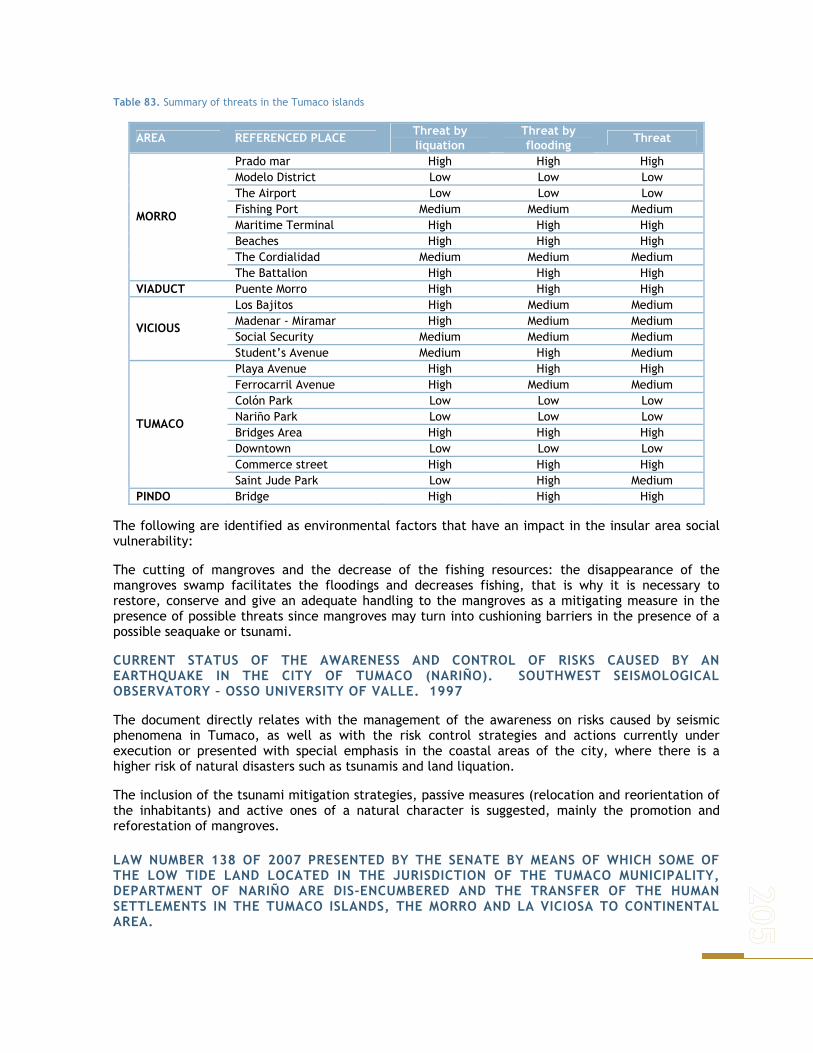
Table 83. Summary of threats in the Tumaco islands
AREA REFERENCED PLACE Threat by liquation
Threat by flooding Threat
Prado mar High High High Modelo District Low Low Low The Airport Low Low Low Fishing Port Medium Medium Medium Maritime Terminal High High High Beaches High High High The Cordialidad Medium Medium Medium
MORRO
The Battalion High High High VIADUCT Puente Morro High High High
Los Bajitos High Medium Medium Madenar - Miramar High Medium Medium Social Security Medium Medium Medium
VICIOUS
Student’s Avenue Medium High Medium Playa Avenue High High High Ferrocarril Avenue High Medium Medium Colón Park Low Low Low Nariño Park Low Low Low Bridges Area High High High Downtown Low Low Low Commerce street High High High
TUMACO
Saint Jude Park Low High Medium PINDO Bridge High High High
The following are identified as environmental factors that have an impact in the insular area social vulnerability:
The cutting of mangroves and the decrease of the fishing resources: the disappearance of the mangroves swamp facilitates the floodings and decreases fishing, that is why it is necessary to restore, conserve and give an adequate handling to the mangroves as a mitigating measure in the presence of possible threats since mangroves may turn into cushioning barriers in the presence of a possible seaquake or tsunami.
CURRENT STATUS OF THE AWARENESS AND CONTROL OF RISKS CAUSED BY AN EARTHQUAKE IN THE CITY OF TUMACO (NARIÑO). SOUTHWEST SEISMOLOGICAL OBSERVATORY – OSSO UNIVERSITY OF VALLE. 1997
The document directly relates with the management of the awareness on risks caused by seismic phenomena in Tumaco, as well as with the risk control strategies and actions currently under execution or presented with special emphasis in the coastal areas of the city, where there is a higher risk of natural disasters such as tsunamis and land liquation.
The inclusion of the tsunami mitigation strategies, passive measures (relocation and reorientation of the inhabitants) and active ones of a natural character is suggested, mainly the promotion and reforestation of mangroves.
LAW NUMBER 138 OF 2007 PRESENTED BY THE SENATE BY MEANS OF WHICH SOME OF THE LOW TIDE LAND LOCATED IN THE JURISDICTION OF THE TUMACO MUNICIPALITY, DEPARTMENT OF NARIÑO ARE DIS-ENCUMBERED AND THE TRANSFER OF THE HUMAN SETTLEMENTS IN THE TUMACO ISLANDS, THE MORRO AND LA VICIOSA TO CONTINENTAL AREA.

______________________________________________________________________
Currently in the Congress of the Republic, this Law project looks to:
● Dis-encumber the use of public space, 5 properties with a total area of 429 hectares located in the continental low tide areas of the Municipality of Tumaco.
● These areas could be sensitive of the private property for which the Law project will proceed to reserve and issue the property titles to whom exercises possession, ownership or holders of a concession of portions of these areas or are persons who exercise possession or ownership in low tide lands located in the Tumaco islands, El Morro and La Viciosa.
● The affected areas where no constructions or possessions exist will be incorporated to the POT as areas for immediate developments, specially for social interest housing.
● The National Government, previous concept of the National System’s Committee for the Disasters Prevention and Attention, will declare the Colombian Pacific littoral coast area corresponding to the Department of Nariño, as a high risk area due to natural type threats such as seismic movements, the tsunami, erosion and the El Niño phenomenon, and for such purpose, will prepare an emergency plan for the massive evacuation of human settlements located in the low tide area of this region.
● The National Government will carry out a special plan for the total relocation of the population actually settled in the Tumaco, el Morro and la Viciosa islands toward the continental area land dis-encumbered by this Law.
It is very important to analyze this Law project and that the responsible entities already mentioned, take into consideration the effects that the same could have in case it becomes a Law of the Republic. Though the project may have a good purpose, that is, grant adequate location conditions and options to the most vulnerable populated areas by the SLR in the San Andrés de Tumaco municipality, the lands being dis-encumbered to be destined for housing, are the ones that by definition of Decree Law 2324 of 1984, could not be destined for housing since they are those which are covered by the high tide and uncovered by the low tide. That is, they will always be flooded. Therefore, they could not be object of housing programs even with characteristics adequate for stilt houses, because they continue to be vulnerable to the SLR’s effects and the tsunamis.
NATIONAL ENVIRONMENTAL SYSTEM
NORMATIVE ASPECTS OF GENERAL CHARACTER OF THE NATIONAL ORDER RELATED TO THE ENVIRONMENT AND RISK MANAGEMENT:
THE RENEWABLE NATURAL RESOURCES CODE AND LAW 99 OF 1993.
The Decree Law 2811 of 1974, by means of which the Natural Renewable and Environmental Resources Code is adopted, does not have express provisions related to the natural threats and risks prevention. Its main objectives are:
a- Attain the environmental preservation and restoration, and the conservation, improvement and rational use of renewable natural resources, according to the equity criteria insuring the harmonious development of man and of such resources, their permanent availability and the maximum social participation for the health benefit and that of the future inhabitants of the national territory.
b- Avoid and control the harmful effects of the natural non – renewable resources exploitation on the other resources.
c- Regulate the human, individual and collective conduct and the public administration activity regarding the environment and the renewable natural resources as well as the relations arising from the exploitation and conservation of such resources and the environment.
These objectives are developed by means of three regulations that seek:

● The protection, conservation or restoration of the natural resources such as water, soil, wild flora and fauna, the air, the sea and the fishing resources, among others.
● The organization of the environment built by men, such as the human settlements and the internal activities carried out, through the means to acquire the right to use the natural resources and of the evaluation technical systems that make the users participants of the restoration or conservation duties.
● The protection of the human health from the environmental effects, establishing permissible contamination limits or of natural resources exploitation.
As mentioned, the CNRNR does not have express provisions with the Disasters Prevention and Attention. However, it defines in a general way the objectives to which the environmental regulations and objectives must point out and which must be additionally taken into consideration by the entities in charge of their implementation.
Law 99 of 1993, by means of which the Ministry of Environment is created and the National Environmental System, SINA, is reorganized, on its side, establishes the following:
● The disasters prevention will be a subject matter of collective interest and the measures taken to avoid or mitigate the effects of their occurrence will be of mandatory compliance.
● It corresponds to the MAVDT, to promote, in coordination with the Ministry of the Interior, the execution of environmental management programs and projects for the prevention of disasters, so that the activities of the National Environment System and the National System for Disasters Prevention and Attention, created by Law 46 of 1988 and regulated by means of Decree 919 of 1989, be coordinately carried out.
It corresponds to the Regional Autonomous Corporations:
a- Coordinate the environmental development plans, programs and projects preparation process that the different organisms and entities integrating the SINA must formulate, in the area of their jurisdiction and specially, counseling the departments, districts and municipalities in the definition of their environmental development plans and in their programs and projects regarding the environment and renewable natural resources protection, in order to insure the harmony and coherence of the policies and actions adopted by the different territorial entities.
b- Together with all other organisms and competent bodies participate in the field of their jurisdiction in the planning and territorial organization planning processes in order that the environmental factor be taken into account in the decisions adopted.
c- Carry out the disasters analysis, tracking, and prevention and control activities, in coordination with all other competent authorities and assist them in the environmental aspects in the prevention and attention of emergencies and disasters; with the municipal or district administrations, carry out the adaptation of the high risk urban areas, such as erosion control, control of the water beds and reforestation.
In environmental subject, it corresponds to the departments, the following tasks:
a- Promote and carry out national, regional and sectorial programs and policies related to the environment.
b- Promote, co-finance or perform, in coordination with the bodies’ directors and the executing organisms of the National Lands Adaptation System and with the CARs, the irrigation, drainage, land recovery, defense against flooding and regulation of the streams or water currents works and projects for the adequate handling and exploitation of the hydrographic basins.
In environmental subject, it corresponds to the districts and municipalities, the following tasks:
a- Promote and carry out national, regional and sectorial programs and policies related to the environment.

______________________________________________________________________
b- Design the municipal environmental plans, programs and projects jointed to the regional, departmental and national plans, programs and projects.
c- Adopt the plans and programs. d- Promote, co-finance or execute, in coordination with the bodies’ directors and the executing
organisms of the National Lands Adaptation System and with the CARs, the irrigation, drainage, land recovery and defense against flooding, and the regulation of the streams or water currents works and projects for the adequate handling and exploitation of the hydrographic basins.
LAW 768 OF 2002
BY MEANS OF WHICH THE POLITICAL, ADMINISTRATIVE AND FISCAL REGIME OF THE PORT AND INDUSTRIAL DISTRICTS OF BARRANQUILLA, THE TOURIST AND CULTURAL ONES OF CARTAGENA DE INDIAS, AND THE TOURIST, CULTURAL AND HISTORIC DISTRICTS OF SANTA MARTA,
We find out that:
− Given the special characteristics of the territory under the jurisdiction of the cities of Barranquilla, Cartagena de Indias and Santa Marta, resulting from the geographic and landscape configuration, the environmental, development, historic – cultural conditions, this Law confers SPECIAL FACULTIES in that related to the handling, use, preservation, recovery, control and exploitation of such resources and of the public use assets or those that are part of the public space or are allocated to public use in the territory of their corresponding jurisdictions—which will be subject to the provisions and regulations issued by the district agencies and authorities in charge of such affairs—without prejudice of DIMAR’s functions.
− It corresponds to the district order authorities, the management and administration of public
use assets existing in the jurisdiction of the Special Districts, sensitive of tourist, recreational, cultural, industrial, and port exploitation. Exception made of the low tide and maritime and fluvial waters areas under the DIMAR’s jurisdiction, as well as the Natural National Parks System areas.
− Regarding the handling and exploitation of natural resources and the environment, this Law
establishes that the Barranquilla, Cartagena and Santa Marta Districts will exercise within the urban perimeter of the district administrative center, the same duties attributed to the Regional Autonomous Corporations in that applicable to the environment, in the same terms of Article 66 of Law 99 of 1993, that is, it corresponds to them exercise in the subject matter of Disasters Prevention and Attention the same duties already mentioned for the CARs and which are define in Law 99 of 1993.
According to the preceding, we must take into consideration that for the Tourist and Cultural District of Cartagena de Indias, there are two environmental authorities: the Canal del Dique Regional Autonomous Corporation – CARDIQUE and the Environmental Public Establishment of Cartagena – EPA- both with environmental authority duties, one in the rural area and the other one in the District’s urban perimeter.
ENVIRONMENTAL, PLANNING AND REGULATORY NATIONAL POLICY INSTRUMENTS APPLICABLE TO THE INTEGRATED HANDLING OF COASTAL AREAS
In the national range, with regards to the Environmental Policy, since 2000 the Environmental National Policy exists, for the sustainable development of the oceanic spaces and the coastal and insular areas of Colombia PNAOCI (MMA, 2000). In connection with the adaptability measures to the sea level rise. Of this instrument it is important to emphasize its reasoning as far as territorial organization of the coastal areas, the rehabilitation and/or restoration of the impoverished coastal and marine ecosystems and the risk management in the country’s littorals.

As regards to the first subject, the Policy establishes that the coastal areas have not been identified in the territorial organization plans as part of the national territory that require a special handling, due to its interaction area characteristics among two completely different environments: the marine and the adjacent continental. It is indicated that the land use planning determines the development type, intensity, size and rate, and the protection or conservation of a fixed area of the territory, and that the weak incorporation of the coastal maritime territory in this processes is evident at a local, regional or national scale.
This circumstance causes, for example, that not enough attention be given to the coast line dynamic and to the natural risks impacts such as hurricanes in the Caribbean Region or Tsunamis in the Colombian Pacific, or as it has been subsequently identified by INVEMAR, by the effects of the sea level rise in critical areas on both littorals.
In order to rectify or improve this situation the demarcation and establishment of Coastal Environmental Units was proposed, as referent to their planning and territorial organization, which corresponds to ecosystem with a functional relation, with their own and distinctive characteristics, with environmental homogeneity as far as its structural and functional physiognomy is concerned, therefore, they could be delimited for a determined geographical area.
These units must be the benchmarks to include in the economic and social development planning processes and of those of territorial organization (environmental determiners), the aspects related to the proposed adaptability measures for the Cartagena (Environmental Coastal Unit of the Magdalena River – Canal del Dique Complex – Lagoon System of the Ciénaga Grande de Santa Marta. It includes the Islas del Rosario Archipelago) and Tumaco (Coastal Environmental Unit of the South Alluvial Plain).
With regards to the coastal mangroves swamps ecosystems conservation, rehabilitation and/or restoration and given the specific associated problems (likewise identified in INVEMAR’s studies), the MAVDT, since 1995 established a regulatory framework for those ecosystems and subsequently, as development of the PNAOCI and using the results of the regional implementation of the mentioned regional regulatory framework, in 2002 formulated and coordinated the initiation of the National Program Implementation for the conservation and sustainable use of those natural systems in Colombia.
Taking into account the previous and the need of having the fundamentals to attain its adequate conservation and sustainable use and by means of that stated by Resolutions 1602 of 1995 and 20 of 1996, issued by the Ministry of Environment, the Regional Autonomous Corporations and Sustainable Development Corporations, with jurisdiction in the mangroves areas in their territories, should prepare studies on the mangroves in their territories, preparing zoning proposals and carrying out of activities, that submitted to the consideration of the Ministry would be the base for it to approve the corresponding handling lineaments and guidelines. By means of Resolution 924 dated October 16 of 1997, the Ministry of Environment establishes the reference terms for the execution of the mentioned studies and proposals, granting a deadline for its presentation by the Corporations until April 1999.
Considering, among other aspects, that the Pacific Coast Corporations decided to initially receive the Preliminary Zoning and the guidelines prepared by the Colombia’s Mangroves Project for the handling of that region’s mangroves, and that several Corporations, including those of the Caribbean, had not even started the studies required for those purposes, by means of Resolution 233 dated March 29, 1999, the Ministry of Environment, extended until April 2000 the term for the Corporations to prepare the mentioned studies and present them to the Ministry, complementing, adjusting and detailing the zoning information and the proposals prepared by the Colombia’s Mangrove Project. Subsequently, by means of Resolution 0694 of 2000, the term was extended until July 2001, with the purpose of socializing and setting up the different proposals with the local communities.

______________________________________________________________________
Based on the previous, up to date, all the environmental authorities with mangrove swamps ecosystems in their jurisdiction, must have the corresponding zoning and handling plans and, in use of those results, the environmental authorities of Cartagena and Tumaco should incorporate in the studies and analysis carried out the forecasts to implement the proposed adaptation measures related to the mangroves handling.
Regarding the water loggings ecosystems (specially important in connection with the adaptability measures of Cartagena), by means of Law 357 of 1997, Colombia adopts the Convention related to the water loggings of International Importance Specially as a Habitat for Aquatic Birds, approved in Ramsar on February 1971, in which the Governments agreed to take all the necessary procedures for the water loggings protection. In compliance with the preceding, in 2001 the NATIONAL POLICY FOR INTERNAL WATER LOGGINGS OF COLOMBIA was issued, the objective of which is to bring about the conservation and rational use of these ecosystems with the purpose of keeping and obtaining ecological, economic and socio – cultural benefits, as an integral part of the country’s development. As specific objectives of this policy and for the purposes of this report, it is established that the SINA must advance in:
a- Integrating the country’s water loggings in the planning processes of the physical space use, the land, the natural resources and the territory organization, recognizing them as an integral and strategic part of the territory, in attention to their own characteristics, and promote the assigning of a real value to these ecosystems and their associated resources, in the economic development planning processes.
b- Promote the conservation, rational use and rehabilitation of the country’s water loggings in accordance to their ecological and socio economic characteristics.
The policy document sets up some legal and institutional instruments, that look to, on one side, harmonize the rules with the development of the different actions tending to the protection and sustainable use of those ecosystems and, on the other side, strengthen the management capacity of the environmental authorities for the achievement of those objectives.
In development of the policy, the Ministry of Environment, Housing and Territorial Development, issued Resolution 157 of 2004, by means of which the sustainable use, conservation and handling of the water loggings is established and the aspects referring to the Ramsar Convention application in our country is developed. This regulatory provision invests the Environmental Authorities with the obligation of designing Management Plans for the priority water loggings of their jurisdiction, as of a delimitation, characterization and zoning which includes the definitions of handling uses and measures, so that the sustainable use and the maintenance of its biodiversity and biological productivity is guaranteed. Subsequently, by means of Resolution 196 of 2006, the Ministry adopts a technical guide for the water loggings environmental handling plans’ formulation, as a guidance so that the Environmental Authorities comply with this obligation.
Consequently, the adequate implementation of this specific regulator framework for water loggings allows the environmental authorities in the regions to give priority to their environmental intervention regarding the conservation, restoration and/or rehabilitation of those natural systems, establishing, based on the diagnosis, the investment needs associated to the activities to be developed.
Finally, all the above characterization, diagnosis and zoning existing activities of the ecosystems in question, lead toward the establishment of the environmental determining factors for the organization of the soil uses in the municipal and district scope as established by Law 388 of 1997 and its later regulations and in this way, the necessary activities for the conservation and restoration of the main ecological structure of the municipalities must be reflected in the territory organization instruments corresponding to the territorial body.
The third aspect considered from the MAVDT (2000) Coastal Areas Policy, is that the natural disasters in the coastal area affect all the social and economic areas. The damaged done by the
winds and rain, hurricanes or tropical storms, common to the Caribbean, or the coastal floodings produced by the Tsunamis or fluvial contributions, effects of the El Niño Phenomenon, coastal erosion produced by the swell, dunes and beaches migration; have, in general, a special significance for the human settlements in those areas, due to its negative impacts on the infrastructure and the public and private assets, civil works, industrial installations and the same coastal marine ecosystems.
Likewise, it is mentioned that the climate change effect at a global scale may be translated into low lands flooding, increase of erosion and changes in the fishing and abundance areas, producing considerable economic losses. They could displace entire towns, putting under risk the urban low cultivating areas and change the coasts forms. Though the mentioned risks are phenomena that happen naturally, the coastal erosion, the fluvial flooding and the dunes and beaches migration could, in some situations, be caused only by use activities. Generally, the inadequate uses of the coastal areas increment the destructive effects of the natural phenomena.
With the purpose of facing with a preventive character this climate phenomenon, the policy proposed that the Ministry of Environment, the INVEMAR, the DIMAR and the National Direction for the Disasters Prevention and Attention, design and formulate the Regional Coastal Risk Prevention and Attention Plans and that they will take into consideration the technical characterization and handling of each Coastal Environmental Unit, in order to identify the most vulnerable areas and the risk magnitude and will define the prevention and attention mechanisms and instruments required.
Likewise, it was indicated that the CAR’s and the DIMAR, through their Port Captaincies will advise the territorial bodies to limit the construction in high risk coastal locations due to natural disasters and that will strengthen the application of the safe construction regulations application avoiding non – controlled settlements in these areas, incorporating them in the territorial organization plans or schemes according to that established by Law 388 of 1997 and its subsequent modifications.
Finally, there must be noted that there is no specific legal framework related to the Integrated Handling of Coastal Areas, although there are regulations and institutions that have to do with its handling. Actually, the handling is determined by specific sectorial regulations in fishing and aquiculture, mining, tourism, ports, maritime transportation, forests subject matters that though they offer a legal framework do not have an integrating vision for the solution to conflicts, therefore, loosing its efficiency.
In summary, one of the main problems of the coastal area handling is the lack of coordination between the institutions involved and of an integrated approximation to the search of environmental problems and, why not, to the risk management. According to the analysis carried out, more than one entity performs similar activities within the same coverage scope, creating a duplications and inadequate assignment of duties, which hinder an efficient management. Coordination efforts have been made, but these mechanisms have not been the most efficient ones.
REGIONAL ENVIRONMENTAL PLANNING INSTRUMENTS AND REGULATORS
Initially we have to mention that in the current regulations for the environmental aspects planning there are two different types of instruments, some that refer to the environmental management aspects of the environmental authorities, such as the Environmental Management Plans – PGAR and the Triennial Action Plans – PAT; and others, which in the development of the Environmental Policies and Regulations, are considered as the technical instruments of environmental planning, such as the Environmental Organization and Management of Ecosystems Plans (General Forest Organization Plan, Water loggings and Mangroves Environmental Plan, Organization and Management of Hydrographic Basins Plan) and the Protected Areas Management Plans (if any).
Below we will present a description of the PGARs and PAT of CARDIQUE and CORPONARIÑO and the Environmental Management Plan for the District of Cartagena, and other relevant documents, emphasizing those programs and projects that have an evident relation with the adaptability

______________________________________________________________________
measures set up for both cities and that, therefore, offer an adequate planning framework to include budget items to assist and develop activities in this sense.
REGIONAL ENVIRONMENTAL MANAGEMENT PLAN - PGAR – 2002 -2012. CARDIQUE.
Within the strategic action lines, the plan defines the following:
− Forests and Mangroves as Habitat of the Biodiversity Program: we pretend to highlight the forests and specially the mangroves’ importance as generators of the Flora and Fauna Biodiversity, prioritizing the execution of inventories and strengthening the conservation of public as well as private, protected areas, and the collective territories of the black communities. Within this Program, those projects aimed at the conservation and recovery of Forests, Mangroves and Biodiversity are framed. The coordinating projects of this program are the following:
● Conservation, recovery, organization and handling of forest areas ● Generation and recovery of public space ● Use, conservation and handling of wild fauna ● Conservation and recovery of mangroves
− Environmental Citizen’s Education, Communication and Participation Program: The environmental education role is to place emphasis on the citizens – communities’ relationships axis, to share with the institutions a common responsibility in the administration of natural resources and the environment in general. The Citizens Environmental Education seeks to encourage the community participation processes and create citizens’ meeting spaces to develop the collective increase of awareness and sensitiveness on the environment, its management, conservation, reorganization and control processes. The preceding, understanding that it is not feasible to stop the environment deterioration only through advertising campaigns of constraining measures without previous reasoning or the indiscriminate use of technologies without an analysis mediation that allows its appropriation and the empowerment by the communities. Following are the projects included in the program:
● Institutional Strengthening ● Environmental Education for the integral management of solid residues ● School environmental projects strengthening ● Disasters Prevention and Attention ● Environmental education for the mitigation of atmospheric emissions by sources ● Motives ● Communication, mass media diffusion
• Reference with threats and assignment of state responsibilities: the “Disasters Prevention and Attention Project (Decree 919 of May 1st of 1989, CONPES 3146 of 2001)”, has as an objective the carrying out of an environmental training process in the education communities and civil society which makes possible the incorporation of the prevention culture as well as improve the quality of life by means of the harmonization with the environment from the environmental point of view.
TRIENNIAL ACTION PLAN 2007 – 2009 “ENVIRONMENTAL CONSERVATION: AN ENGAGEMENT THAT CANNOT BE POSTPONED.” CARDIQUE.
In the zoning framework of the Corporation’s jurisdiction, the Coastal Area Ecoregion – Ciénaga de la Vírgen is found.
It is mentioned that the Cartagena area mangroves, (Ciénaga de la Virgen, Cartagena Bay, Barbacoas Bay, Barú and Tierra Bomba Islands,) boost the exploitation activities such as fishing production, associated fauna and flora concentrations; besides they work as a sediment trap, organic material natural filter, beaches stabilizer and natural barrier against natural and anthropic disasters.

In relation to the priority environmental problems, potentials and actions analysis, the following are reported:
● forest degradation and loss of the biodiversity ● deforestation ● inadequate agricultural and livestock practices ● extension of the agricultural frontier ● illegal fauna trafficking ● erosion ● conflict on the soil use ● habitat reduction and destruction
Also, and in relation to this work, the preparation of the mangroves zoning in the Cartagena Bay is identified as an initiative to be taken into consideration, which includes the planning activities of the management of the two preservation areas, three recovery areas and one special area. Among others, the following priority actions are defined:
● Environmental organization and handling of the main jurisdiction’s forests areas. ● Preparation of the jurisdiction’s mangroves handling plan ● Hydrodynamic restoration. ● Reforestation in impoverished areas.
In the operative plan 2007 – 2009, 7 programs are defined, together with their corresponding projects established according to the Regional Environmental Management Plan 2002 – 2012. In this context, a program and two projects pertinent to the subject matter are identified:
PAT 03 PROGRAM FORESTS AND MANGROVES AS BIODIVERSITY HABITAT: these projects are addressed to the flora and fauna resources conservation and restoration as are the Forest, the Mangrove swamps and the Wild Fauna, as well as the green areas recovery.
PROJECT 03-01 FOREST MANAGEMENT: It’s main purpose is to perform integral actions in the forest resource by means of the zoning and organization with the purpose of adopting its use, handling and sustainable exploitation, according to the functions established by the National Government in the Forest Organization Plan.
Likewise, the recovery actions in the impoverished areas of the hydrographic basins that supply human consumption water. In the same way, soil recovery works will be carried out in areas with erosive processes, for their conservation and stabilization.
PROJECT 03-03 Mangrove Implementation and Zoning: It has as a purpose the performance of mangroves areas recovery and restoration projects and carry out the studies ordered by the Ministry of Environment, Housing and Territorial Development, according to Resolution 0721 of 2002, as is the “Environmental Handling Plan of the Mangrove Zoning Sustainable Use Area.”
ENVIRONMENTAL HANDLING AND CONTROL PLAN FOR THE CARDIQUE JURISDICTION PORT AND COASTAL AREA. 1998
The entire plan is focused on the “CARDIQUE” jurisdiction Port and Coastal Areas with the purpose of having a tool to face the environmental problems of the area between Galerazamba and the Barbacoas Bay.
Among the document’s objectives the “Formulation of an integrated plan for the handling of coastal areas, formulating strategies and activities, defining handling units, their recommendations and suggesting special actions to attain the citizens participation on its execution” are highlighted.
Regarding the threats, the documents mentions the main impacts generated by the activities developed in the area:

______________________________________________________________________
Mangroves destruction: the main threats to this ecosystem are reported by the tourist activity, since it involves the infrastructure construction. These modifications culminate in moderate alterations on the ecosystems stability, as a product of the sum of the resources involved in the construction process.
The natural marine hydrodynamics is affected by the construction of the beach protection structures, the natural sedimentation processes; and the hydrodynamics was altered by the deviation of its course, which is defined as a severe impact on the ecosystem.
The aquatic activity is represented by the marine shrimp farming in the Galerazamba area. There, the effects of this activity have lead to the mangrove community alterations and the ecosystem in general, with moderate changes due to its medium magnitude.
In the risks, identification and evaluation chapter, in the subject matter of coastal risks, the following are defined:
− In the extreme south of Punta Canoas and Arroyo de Piedra in a longitude of 1,00 and 700 mts., respectively, an accelerated backward movement of the beaches is present. In both cases, the coast line is low, with the swell incidence in all its magnitude on the front of the beach, the back beach and over the dunes located parallel to the coastal border. In this area, the recent sediments are constituted by an alluvial filling formed by silt sands and gravel, easily subject to erosion. Due to the backward movement present in these areas, trees falling and the incorporation of the green areas to the sea action is produced.
− In the area adjacent to the Guayepo Stream an accelerated backward movement under the hydraulic and mechanic action of the waves is present.
− The northern part of the Guayacán hills is catalogued as one of the most unstable areas of the entire coast. Due to the infiltration of rain water through the deep cracks affecting the area, overloading on the impermeable levels are produced, facilitating the collapse of wide areas of these hills. The talus stability is affected by the mechanical action of the waves, which in the maximum tide arrive to sweep with severity its base, contributing, in this way, to the cliff degree of instability.
− The coast line between Arroyo de Piedra and Palmarito shows forms of a rectilinear tendency, except in the precise sector of the Cascajo Island, which due to the aggression suffered across time has substantially modified its form. The location of the Cascajo Island, and other non – identified shallow waters constitute refraction waves centers, facilitating the accumulation of sediments around and on the back of them. It is deduced that due to the plain configuration and low elevation of the area, the areas adjacent to the coast line must end up flooded after a swell event. As a reasonable measure, it is recommended that the areas near the beach, in the Arroyo de Piedra – Palmarito area be free of any eventual tourist, industrial or of other nature development.
In the management plan the problematic nucleus are identified, with their causes and strategies and activities. Below the most relevant ones are listed in each one of the zoning scopes stated (area).
1. NORTH AREA:
Problematic nucleus – Alteration of the coast line
Causes:
a- Infrastructure construction. b- Material extraction from bottoms and dunes.
Strategies:

1. Implement the Environmental Vigilance and Control Programs. Entities involved: CARDIQUE, DIMAR, DAMARENA, Environmental and Agricultural Attorney’s Office, Urban Control Secretary, Secretary of Government, Base Organizations.
Problem Nucleus – Alteration of hydrodynamic conditions, terrestrial and marine waters
Causes:
a- Infrastructure construction and inadequate soil use.
Strategies
1. Implement the Vigilance and Environmental control. Entities Involved: CARDIQUE, DIMAR, Secretary of Urban Control, Environmental and Agricultural General Office , DAMARENA
2. Implement the Control Programs for the Use, Exploitation or Mobilization of Natural Resources. Entities Involved: CARDIQUE, DAMARENA, DIMAR, Secretary of Government
3. Implement the Environmental Evaluation, Control and Tracking Programs. Entities Involved: CARDIQUE, MINENVIRONMENT, DAMARENA
4. Order and establish the Regulations for the Management of the Area Basins. Entities Involved: CARDIQUE, MINENVIRONMENT, DAMARENA, UMATA, Environmental and Agricultural General Office, Lots owners, Communities, Base Organizations, Productive Trade Unions.
2. CIÉNAGA DE TESCA OR DE LA VIRGEN
Problem Nucleus - Alteration of the Coast Line and the Limits of the Ciénaga de Tesca.
Causes
a- Infrastructure construction. b- Bottom material extraction. c- Cutting and filling of the mangrove. d- Filling of the La Ciénaga limits.
Strategies
1. Develop the Recovery Programs of the Coast Line. Entities involved: MINTRANSPORTATION, District of Cartagena.
2. Implement the Vigilance and Environmental Control Programs. Entities involved: CARDIQUE, DIMAR, DAMARENA, Secretary of Urban Control, Secretary of Government, Environmental and Agricultural General Office.
3. Control on Collection, Handling and Disposal of Solid and Liquids. Entities involved - CARDIQUE, DIMAR, DAMARENA, LIME, Ciudad Limpia, ACUACAR, Base Organizations.
4. Implement the Reforestation Programs. Entities involved: CARDIQUE, DAMARENA, MINENVIRONMENT, La Boquilla Natives, Base Groups, Environmental NGO´s.
5. Implement the Environmental Organization Programs. Entities Involved: CARDIQUE, MINENVIRONMENT, DAMARENA
Nucleus Problem - Alteration of Aquatic Communities.
Causes
a- Cutting and filling of the mangrove areas. b- Urban solid and liquids dumping. c- Agricultural activity residues dragging.

______________________________________________________________________
Strategies
1. Implement the Vigilance and Environmental Control Programs. Entities involved: CARDIQUE, CIOH, ACUACAR, University of Cartagena, INPA.
2. Implement Reforestation Programs. Entities Involved: CARDIQUE, DAMARENA, MINENVIRONMENT, environmental NGO’s, Base Groups, Secretary of Social and Human Development.
3. Control on the Collection, Handling and Disposition of Solid and Liquid Residues. CARDIQUE, DIMAR, DAMARENA, LIME, Ciudad Limpia, ACUACAR, Base Groups.
4. Implement the Environmental Evaluation, Control and Tracking Programs. Entities involved: CARDIQUE, University of Cartagena, CIOH, ACUACAR.
3. CARTAGENA BAY
Problem Nucleus - Alteration of the Coast Line
Causes
a- Tourist, industrial, port, development infrastructure construction. b- Cutting and filling of the mangroves areas. c- Continuous vessels traffic. d- Canal del Dique and littoral’s drift sediments contribution. e- Disposal of sediments product of the dredgings.
Strategies
1. Implement Environmental Evaluation, Control and Tracking Programs. Entities involved: CARDIQUE, DAMARENA, SUPERPUERTOS, MINENVIRONMENT and DIMAR.
4. BARBACOAS BAY
Problem Nucleus - Alteration of the Coast Line.
Causes
a- Tourist and wharfs construction infrastructure. b- Extraction of bottom material c- Mangrove areas cutting and filling d- Beach and vessels traffic area fillings.
Strategies
1. Implement Environmental Evaluation, Control and Tracking programs. Entities Involved: CARDIQUE, DAMARENA, SUPERPUERTOS, MINENVIRONMENT and DIMAR.
2. Implement Environmental Control and Vigilance Programs. Entities Involved: CARDIQUE, DAMARENA, SUPERPUERTOS, MINENVIRONMENT and DIMAR
3. Implement Reforestation Programs. Entities Involved: CARDIQUE, DAMARENA, MINENVIRONMENT, Base Groups, AGRODIQUE
5. ISLAS DEL ROSARIO
Problem Nucleus - Alteration of the Coast Line.
Causes
a- Tourist and wharfs construction infrastructure. b- Sand and gravel extraction. c- Mangrove areas cutting and filling.
d- Fillings to create and expand the beaches. e- Vessels traffic.
Strategies
1. Implement the Environmental Evaluation, Control and Tracking programs. 2. Implement the Environmental Control and Vigilance.
CARTAGENA DE INDIAS ACTION PLAN 2006 – 2007.
PUBLIC ENVIRONMENTAL ESTABLISHMENT - EPA.
In the Action Plan’s General Objective it is pretended to administer and guide the Urban Environment Management of the District of Cartagena to guarantee its conservation, restoration and sustainable development, aiming a better quality of life framed in the citizens’ equity and participation criteria.
Of its 7 specific objectives, the EPA defines three related to the marine and coastal areas:
− Recover the urban mangroves swamps and water loggings located in the EPA’s influence area.
− Implement an environmental organization program of the District of Cartagena, emphasizing on the integrated management of the coastal areas and of urban protected areas.
− Perform a constant monitoring and control of the environmental quality of the district by means of the institutionalization of an environmental monitoring system.
Regarding the risk management, in the natural threats reported by EPA, were:
● Hurricanes and strong winds: Sporadic phenomena present with regards to the climate behavior.
● Sea Level Rise: The sea level rise is another element that could be considered a direct factor in the erosion acceleration present in the coastal District’s area.
● Floodings: The floodings in low Districts such as La Boquilla and Policarpa with levels up to 2.5 meters
● Hydrometereologic phenomena: in the Cartagena de Indias' urban area the floodings are related with the low areas skirting the Ciénaga de la Vírgen, the internal channels and lagoons and the Cartagena Bay. These low areas constitute the receiving basins of drainages (sub – basins) that bathe the hills and hillocks. Likewise, during the presence of rainy seasons local floodings are generated as a consequence of the channels and fluvial valleys obstruction.
● Coastal Dynamic: Sensitivity to the coastal erosion. The recovery capacity of beaches in Cartagena has been estimated as low, in the order of 4 – 5 meters per month. That is why it is so sensitive to the groundswell. This phenomenon is particularly intense in La Boquilla, Crespo, Bocagrande and Castillogrande.
● Soil liquation: the ground of the large beaches, intertidals and mangroves swamps substratum are particularly sensitive to this phenomenon. In Cartagena the favorable conditions for this phenomenon are met in el Laguito, Pie de la Popa and Manga, as well as in Cabrero, Bocagrande, Marbella, and la Boquilla.
● Coastal erosion in the urban area: The intense coastal erosion is a threat whose incidence in Cartagena de Indias is evident given the city’s location in low areas associated to large beaches, bars – spikes and inter - tidal plains.
In the problems analysis matrix the following information relating to the subject matter is reported:

______________________________________________________________________
Development Objectives
Problem Describer
Problem Causes
Priority Action Area
Institutional factors and SINA actors
Problem tendency
or criticality
Factors affecting the governability
Consolidate the actions oriented toward the natural patrimony conservation
Mangroves deterioration
Cutting for developments, coal production, inappropriate cultural guidelines, water flow interruptions, eutrophyzation, water dumping
Ciénaga de Tesca Cartagena Bay, Internal Water Bodies
CARDIQUE ONG District EPA, MAVDT Edurbe Community Universities Investigation Centers DIMAR IavH
INCREASE
Conflict of Competences Institutional Weakness Inter – Institutional Coordination Forced Displacement
Decrease population in risks associated to natural phenomena
Environ-mental deterioration due to erosion and accretion in the coast line
Action of the Sea
Crespo, Bocagrande and Castillogrande
MAVDT INVEMAR DIMAR CARDIQUE EPA Universities, Investigation Centers, Ministry of Works, Min Transportation District
INCREASE
Institutional Weakness
REGIONAL ENVIRONMENTAL MANAGEMENT PLAN FOR NARIÑO (PGAR) 2002 – 2012.
CORPONARIÑO.
The highlighted objectives of this Regional Environmental Management Plan regarding this work are the following:
1. Identify the critical and / or strategic intervention areas, the determined problems and potentials at a regional level with the purpose of directing the regional priorities and the focused actions around which the actions coordination processes of preventive character and strategies to insert the environmental dimension in a timely manner in these development processes, seeking to decrease its impact on the natural resources and on the regional environmental conditions are considered.
2. Adjust the environmental regionalization and zoning processes, for the environmental action.
3. Carry out a strategic, participative and prospective planning process aimed to harmonize the regional development dynamics and the environment.
4. Identify the programmatic areas and financial requirements and determine the management levels of the different actors.
With regards to the collection of the information on threats present in the Nariño Department, that produced the territorial organization plans for the municipalities which are approved or are in the approval process, indicates that the Department of Nariño is involved in a series of natural and anthropic phenomena representing the potential threats and place the existing towns in a high vulnerability of different phenomena occurrence that at any moment would represent risk problems.
− For the Nariño’s Pacific Coast, the situation is especially complex mainly in the Tumaco, Mosquera and Satinga case, due mainly to the high littoral erosion and the vulnerability in

the presence of Tsunamis, earthquakes, liquefaction and floodings, which is generalized for the entire coastal area. This merits inter – institutional coordination processes and communal management oriented toward the devising of the region’s threats maps, identification of strategic and supra – municipal prevention and mitigation projects, the execution of buildings and vital lines mitigation measures,
In the financial strategy framework, the Management Plan programs and sub-programs are identified, as well as the possible financing sources:
FINANCIAL STRATEGY
PROGRAM SUB - PROGRAM POSSIBLE FINANCING SOURCE
Forest organization and zoning implementation program.
Environmental Investment Fund, National Royalties Fund
Implement the prevention program of Forest fires CORPONARIÑO
Implementation of the productive forests chains program, forest wood exploitation
Environmental Action Fund, Environmental Investment Fund
Deforestation Control CORPONARIÑO
CONSERVATION AND SUSTAINABLE USE OF THE FOREST RESOURCE
Promote the forest sustainable protection and use and the ecological restoration through plans and economic incentives
National Royalties Fund
Formulate and implement programs for the prevention, reduction and control of terrestrial and marine pollution in coastal areas
National Royalties Fund, Technical Cooperation of the Netherlands’ Government
Environmental and territorial organization of coastal areas, adopting and characterizing environmental units in each one of them
Pacific Coast Environmental Investigation Institutes of the Pacific Coast, CORPONARIÑO
Rehabilitation and restoration of degraded marine and coastal ecosystems
Colombia Europe Plan, Ministry of Environment
INTEGRAL MANAGEMENT OF COASTAL AREAS
Define action criteria and priorities for the management and sustainable use of marine and coastal resources
ACCI, Ministry of Environment, OIMT
the establishment of monitoring and alert systems, communications systems, contingency plans, etc.
The following aspects for the Pacific are set out exactly and in more detail:
− Guide the urban and rural soil use and apply the territorial organization plans so that the productive activity and the human settlements do not produce any deterioration nor accelerate the physical and chemical processes degrading the vegetal resource and cover on which the biodiversity is nourished or held.
− Together with the competent entities, promote the compliance of the regulations, directing the development processes so that the expansion toward the fragile natural ecosystems, productive inserts in natural threats areas in the entire Department.

______________________________________________________________________
− Management, formulation and execution of projects with emphasis on the recovering of impoverished areas and those affected by natural disasters by means of the technical advise during the construction and / or the direct execution of civil works of erosion control and high inclination talus, waters and soils regulation and handling, and the torrential control in urban and rural river beds for their rehabilitation.
− Prepare the inventories of the potential threats or risk areas structuring and updating the existing information, deepening in the natural threats awareness, their vulnerability degree, determining the risk areas and formulate the effects prevention and mitigation measures.
− Determine the risk areas to support the execution of the relocation programs, and parallel to it the diagnosis, design and quantification of effects will be performed with the purpose of recovering the impoverished areas.
Support to local and regional disasters prevention committees to reach a better operative and action capacity in the technical aspects of the disasters attention and emergencies produced by natural and anthropic disasters, together with regional, departmental, and municipal character institutions and obtain the coordination to the common benefit.
TRIENNIAL ACTION PLAN 2007 – 2009. CORPONARIÑO.
The Corporation’s PAT sets forth the following strategies where the SLR subject matter would be inserted, since no specific mention of the phenomenon is made:
− Carry out coordination processes with Specialized Institutions to develop the environmental investigation that facilitates the application of results that contribute to solve intense environmental problems and the sustainable exploitation of environmental assets and services.
− Promote the environmental planning and organization plans and the participation of ethnic groups in the handling of the natural resources and the environment with emphasis placed on the Life Plans and the Management Plans.
− Carry out the planning, organization and handling of the basins and micro basins, uniting efforts at a local, regional and national level.
− Support the insertion of the risk management in the territorial organization plans, impulse inter – institutional actions and managements for the prevention and mitigation due to Andean hydrometereological area, and other threats of priority character in the Pacific Coast.
In the operative actions, the PAT expresses that according to the national and regional character guidelines, as well as with the Entity organizational situation analysis, the following programs are proposed:
Conservation and sustainable use of the environmental natural patrimony.
Concordantly with the National Development Plan guidelines, the program structures the maintenance of the environmental offer of assets and services of the threatened ecosystems by the different processes, specially those associated to the human intervention, with the purpose of boosting the maintenance of the natural base as a factor for development.
In the Coast, it is important to collaborate with the ecosystems fragmentation mitigation processes at different scales and promote the existing biodiversity conservation in the coastal areas (mangrove, “guandal” and “naidí”). In them, we seek to preserve their attributes, insure and improve the offer of environmental assets and services supplied by the natural forests and other associated ecosystems, minimize the impact of the degradation processes and support the technical exploitation processes associated to green markets, in the regional environmental plans and agendas and with the support of ethnic groups of the region.

Environment efficient planning and administration.
With the leadership of CORPONARIÑO, the development and strengthening planning and environmental processes is seeked, by means of the coordination of territorial planning processes at their different levels and consolidate the environmental as a development factor; for this it is required the Management Capacity and coordination strengthening of the different actors in the territorial organization.
Regarding the soil resource, the Corporation will enter into a strategic alliance with the MAVDT and the Government of Nariño, to consolidate the missing POTs, advising the territorial bodies in the adequate inclusion of the environmental dimension, complying with the Law 99 of 1993 and Law 388 of 1997’s lineaments.
The territorial municipal environmental organization and planning processes will continue to be oriented and evaluated by the entity according to Law, as of the accompaniment and training of municipal administration for a due insertion in their planning processes of the environmental dimension.
Based on the environmental determinants, CORPONARIÑO will consider the subject matters of evaluation in the territorial organization plans, guaranteeing the transparency and agility in the process, in an accompanying framework and permanent counseling to the territorial bodies, in the assurance that they see their municipal management capacity strengthened. To this purpose, the territorial zoning proposals design and the use and handling of sustainable urban and rural soil will be supported; emphasizing in regualtions the different categories, according to their capacities and environmental aptitude.
The integral vision of the territory and the evaluation from an ecosystemic option will allow the identification of strategies for the soil improvement. The work in the pilot municipalities with natural threats and risks planning will be emphasized. Likewise, the urban municipal planning processes pointing toward the green space public consolidation will be supported.
Improvement of the main environmental populated centers quality in urban and rural areas.
The territorial planning processes accompaniment will be strengthened in that referring to the insertion of natural threats and risks. The Contingency Plans will be accompanied, with emphasis in the hydrocarbon pollution subject, the management for the Canal Naranjo mitigation and the prevention of the tsunami’s impacts on the coast. The SLR is not mentioned as a relevant risk for the Nariño coast.
EXISTING POLICIES AND REGULATIONS REGARDING CLIMATE CHANGE IN COLOMBIA.
LAW 164 OF 1994. FRAMEWORK CONVENTION ON CLIMATE CHANGE.
The Law 164 of 1994 of the Congress of the Republic, adopts in Colombia the “United Nations Framework Convention on Climate Change”, held in New York on May 9, 1992, and consequently the country agrees, among other aspects, to:
a- Prepare, periodically update, publish and facilitate the Parties Conference, according to Article 12, the national inventories of the anthropogenic emissions by the sources and of the absorption by the carbon sinks of all the greenhouse effect gases not controlled by the Montreal Protocol, using the comparable methodologies that must be agreed by the Conference of the Parties.
b- Formulate, apply, publish and regularly update the national programs and, as it proceeds, regional ones that contain measures oriented toward the mitigation of the climate change, taking into account the anthropogenic emissions by the sources and the absorption by all the

______________________________________________________________________
carbon sinks the greenhouse effect gases not controlled by the Montreal Protocol and measures to facilitate the adequate adaptation to the climate change;
c- With its cooperation, promote and support the development, the application and the diffusion, including the transference of technologies, practices and processes that control, reduce or avoid the anthropogenic gases of the greenhouse effect not controlled by the Montreal Protocol in all the pertinent sectors, among those the energy, the transportation, the industry, the agriculture, the silviculture and the waste management;
d- Promote the sustainable management and with its cooperation, promote and support the conservation and the reinforcement, as pertinent, of the carbon sinks and deposits of all the greenhouse effect gases not controlled by the Montreal Protocol, including the biomass, forests and oceans, as well as other terrestrial, coastal and marine ecosystems;
e- Cooperate in the preparations for the adaptation to the climate change impacts; develop and prepare appropriate and integrated plans for the organization of the coastal areas, the water resources and the agriculture, and for the protection and rehabilitation of the areas, particularly of Africa, affected by the drought and desertification, as well as by floodings;
f- Take into account, as far as possible, the considerations related to the climate change in its policies and the pertinent social, economic and environmental measures and use appropriate methods, for example, impact evaluations, formulated and determined at a national level with the purpose of reducing to the minimum the adverse effects in the economy, public health and the environment quality, of projects or measures undertaken by the Parties to mitigate the climate change or adapt to it;
g- With its cooperation, promote and support the scientific, technological, technical, socioeconomic and other nature, the systematic observation and the establishment of data files related to the climate system with the purpose of facilitating the understanding of the causes, effects, magnitude and chronological distribution of the climate change and of the economic and social consequences of the different reply strategies and reducing or eliminating the uncertainty elements that still continue to be on this regard;
h- With its cooperation, promote and support the full exchange, open and timely of the pertinent scientific, technological, technical, socioeconomic and legal order information on the climate system and the climate change, and on the economic and social consequences of the different reply strategies;
i- With its cooperation, promote and support the public education, training and increase of awareness regarding the climate change and stimulate the most ample participation possible in that process, including that of the non – governmental organizations;
j- Communicate to the Conference of the Parties the information relating to the application, as per Article 12.
FIRST NATIONAL COMMUNICATION TO THE UNITED NATIONS FRAMEWORK CONVENTION ON CLIMATE CHANGE - 2001.
In compliance of the preceding, the MAVDT under the IDEAM’s technical coordination, prepared in 2001 the First National Communication in the presence of the United Nations Framework Convention on Climate Change, and regarding the vulnerability and adaptation of the coastal and insular areas, mentions that the effects of the potential sea level rise were evaluated by means of geomorphologic and morphodynamic indicators, as of a physical characterization of the littoral, the evaluation of its sensitivity and the projection of the possible biophysical changes it will cause.
According to this evaluation, an increment of the medium sea level in one meter in the Colombian coasts would cause the permanent flooding of 4,900 square meters of coast shallow waters, the strong swamping to total drowning of 5,100 square meters of coastal areas moderately sensitive, as well as the swamping of the nearby areas and the deepening of the water bodies located in the littoral area and the continental platform. Likewise, this flooding would cause the erosion increment in especially sensitive areas, where the anthropic activity has reduced the muffling capacity of the littoral systems. Natural systems such as beaches and salt marshes would be the most affected ones by the littoral erosion and flooding.

It was established that the potential biophysical changes that would affect the Colombian littoral due to the change of the sea level by 1 meter would make that an important part of the population, the economic activities and the vital infrastructure of the country be threatened by the flooding. The population located in the areas exposed to flooding is of approximately 1.4 million inhabitants, population settled, in its majority in the urban area (85%). For the Caribbean littoral, only 9% of the urban housing presents a high vulnerability to flooding, percentage that reaches 46% in the rural area. In the Pacific littoral, 48% of the urban area housing and 87% of the rural area are highly vulnerable, 11% are moderately vulnerable, and 61% little vulnerable.
As far as the social homes vulnerability in the Caribbean littoral, urban area, 1% are highly vulnerable, 16% moderately vulnerable, and 83% are little vulnerable. In the rural area of this littoral, 28% of the homes are highly vulnerable, 11% are moderately vulnerable, and 61% are little vulnerable.
In the Pacific littoral the homes with high social vulnerability reach 13%, 62% are moderately vulnerable and the remainder 25% have low vulnerability.
In the Caribbean littoral, the analysis concluded that in the farming and animal husbandry, of the 7,208,299 ha. of reported cultivations and grass reported, 4.9% are exposed to different threats degrees by flooding. Of these, 49.5% present a high vulnerability, represented mainly in banana and African palm crops. In the industrial sector, it was found that 75.3% (475 has.) of the area occupied by the manufacturing establishments in Barranquilla and 99.7% (877 has) in Cartagena are of high vulnerability. It is considered that 44.8% of the roads network has a high vulnerability; 5.2% moderate vulnerability, and 22.7% is little vulnerable.
The proposed adaptation measures are oriented to recover and strengthen the littoral resiliency mechanisms to facilitate the natural adaptation of the coastal areas to the sea level rise. Other adaptation measures that have as framework the integrated management of coastal areas that the country has established for its littorals, are the coastal water loggings preservation, the regulation of uses and activities in the threatened areas due to flooding and the protection of vital socioeconomic interest areas.
CLIMATE CHANGE POLICY LINEAMENTS. MINISTRY OF ENVIRONMENT – 2002.
In connection to the SLR and according to the studies made by the IDEAM and INVEMAR5, this document expresses that the vulnerability of the Colombian coastal areas is between HIGH and CRITICAL, in the presence of a possible sea level rise of one meter due to the climate change in a horizon of 30 to 100 years.
In the Caribbean littoral, approximately 2,121,887 persons (excluding the indigenous population) are located in the affectation area, of which around 58.5% are located in the threat flooding area. The population located in the threat area represents a 3% of the national population and the 17% of the Caribbean population. For the Pacific littoral, it is calculated that the population on the affectation area adds to 498,970 persons, of which 48% are exposed to some type of threat by flooding. An important proportion of the urban centers population of Tolú, San Juan de Urabá, Turbo, San Bernardo del Viento, Ponedera, Puerto Colombia, Cartagena, Buenaventura, Tumaco, Timbiquí,
5 IDEAM. Colombia 2001, First National Communication in the presence of the CMNUCC United Nations Framework on Climate Change. NCCSAP – Colombia / MMA - INVEMAR “Vulnerabiity definition of the biogeophysical and socioeconomic systems due to a change in the sea level in the Colombian coast area (Insular Caribbean and Pacific) and adaptation measures.” Invemar, 2002

______________________________________________________________________
Nuquí, Charco and Guapi will be affected by flooding since they are on a high and medium threat area.
The Sea Level Rise will have a direct impact on the population due to the effects of the saline intrusion in the aquiferous and an indirect impact due to the increments in the water treatment costs by the aqueducts.
The Caribbean farming and animal husbandry area exposed to different threat types is equivalent to 351,971 has. (4.9% of the total area considered). The exposed area, 49.5% of the crops and grasses area presents a high vulnerability, in which case the bananas would be affected in 39.2% of its area, the African palm in 9.7%, the temporary crops in 6.8% and the permanent crops in 1.2%.
The 75.3% (475 has.) of the area occupied by the manufacturing establishments in Barranquilla and 99.7% (877 has.) in Cartagena are of a high vulnerability. The 44.8% of the Caribbean roads infrastructure presents a high vulnerability, 5.2% medium vulnerability and 22.7% low vulnerability.
An unexpected sea level rise would generate an affectation in the capital value equivalent to 1.5% of the GIP (Gross Internal Product) for 2001. The participation in the value of the Continental Caribbean and the Pacific coast capital affected in total for both coasts corresponds to 69% and 31% respectively, in 2001.
In general terms, an element to be highlighted has to do with the fact that approximately a 10% of the farming GIP of the Pacific coast departments and a 4.3% of the Caribbean GIP would be affected by an unexpected medium sea level rise of one meter. Being precisely this sector the main job generator in the Pacific coast and the second in the continental Caribbean.
The mangroves, the coral reefs and the beaches and large beaches have a critical vulnerability. The tropical desert zonobiome has been qualified as of high vulnerability; the sea grasses and rocky littorals with a medium vulnerability and the tropical dry forests, tropical humid forests, continental platform bottoms with a low vulnerability.
In the Caribbean littoral urban area, the housing distribution according to the vulnerability levels indicates that the 15% is in the medium – low vulnerability, 83% in low and the remainder percentage in the high and medium categories. Regarding the rural area, it is recorded that 28% of the homes presents a high vulnerability, 29% presents a low vulnerability, 59% medium and 12% high. In the urban area, 88% of the homes present a low vulnerability, 6% medium and 6% high vulnerability.
An analysis of the vulnerability critical areas determined that of the 56 Caribbean municipalities analyzed, 3 municipalities where catalogued as of high importance: Cartagena, Barranquilla and Santa Marta. The Colombian Pacific area shows in its order, Tumaco and Buenaventura as high importance critical areas.
The objective of these lineaments set up by the MMA is to identify the strategies required to consolidate the necessary national capacity, which allows responding to possible climate change threats; answer to the Kyoto Convention and Protocol provisions, in terms of boosting the opportunities derived from the financial mechanisms and comply with the established engagements.
The following were proposed as strategies and action lines:
DEFINE AND SET IN MOTION THE INSTITUTIONAL FRAME WORK FOR THE CLIMATE CHANGE NATIONAL REGIME
• The creation by the National Environmental Council of the Inter – Sectorial National Climate Change Technical Committee is recommended, as a consulting agency and supervisor of the National Climate Change Regime, as well as the creation of sub - committees, as executing bodies of the different lines of actions established by the climate change policy.

• The creation of sub – committees for the following work areas is recommended:
• Adaptation to the negative impacts of the climate change
• Emissions reduction options by source and trapping by greenhouse effect carbon sinks
• Public spreading and raise the awareness on the different aspects related to the climate change
• Preparation and publication of the National Communication before the CMCC
• International negotiation of the CMCC implementation and the Kyoto Protocol
• Investigation on subjects associated to the climate change
• Options to reduce the implementation impacts of the Kyoto Protocol at an international level, on fossil fuels Colombian exports
IMPROVE THE ADAPTATION CAPACITY TO CLIMATE CHANGE IMPACTS
• Improve the adaptation capacity of the coastal and insular areas to a possible sea level rise
• Improve the adaptation capacity of the agricultural ecosystems to the possible climate change impacts
• Improve the adaptation capacity of the water resources to the possible climate change impacts
• Improve the adaptation capacity of the soils to the possible climate change impacts
• Improve the adaptation capacity of the possible climate change impacts on human health, specially on the occurrence of malaria and dengue fever
• Formulate and present to international funds projects such as the Global Environment Facility (GEF), on the vulnerability and adaptation measures of the country’s different areas and sectors.
• It is recommended to the General Direction for Disasters Prevention and Attention to promote in the National System for the Disasters Prevention and Attention, the possible negative impacts on the national territory of the climate changes.
PROMOTE THE EMISSIONS REDUCTION BY SOURCES AND GEI CARBON SINKS ABSORPTION.
• Improve the awareness on the emissions reduction options by sources and carbon sinks absorption in the different areas of the country. Taking into account the principle of common but differentiated responsibilities, as well as the fact that Colombia does not significantly contributes to the global emissions of GEI, these options should be in agreement with the development and growing priorities and goals for the country.
• Develop the base scenario of the country of GEI emissions by source for the energetic and transportation sector.
• Develop the base scenario of the country of emissions by sources and GEI carbon sinks absorption for the agricultural – forest sector
• Evaluate the economic implications of the climate change effects in the presence of the measures implementation to reduce the GEG concentration in the atmosphere.

______________________________________________________________________
• Develop the emissions reduction and GEG absorption
• Evaluate the necessary regulatory requirements to incentive and promote the reduction projects of the greenhouse effect gases. For the non – conventional energy options, it is essential the participation of bodies regulating these activities in the definition of these priorities.
• Promote the technology transference
• Develop and consolidate the national capacity for the MDL development according to the strategies and activities determined in the National Strategy Study for the MDL Implementation in Colombia:
• Promote and support the development of measures and projects not framed in the MDL
DECREASE THE IMPACTS OF THE KYOTO PROTOCOL MEASURES ON THE EXPORT OF FOSSIL FUELS
• Improve the knowledge on possible negative effects of the implementation of the Kyoto Protocol measures on the export of fossil fuels
• Promote the creation of the “green fossils fuels” market”
PROMOTE THE INVESTIGATION AND STRENGTHEN THE INFORMATION SYSTEM ON CLIMATE CHANGE
• Assign the institutional competence and responsibility for the elaboration of the National Communication
• Develop, systemize and update the information on the investigation government on subjects related to the climate change (investigators, groups, knowledge generator centers and institutes, investigation projects in development and finalized)
• Include the climate change subject in the development of the action lines of the National Environmental Investigation Policy strategies
• Promote the creation in the Environmental Formation Colombian Network, of a thematic network for the climate change
• Promote the reactivation of the investigation line on climate change in the National Environmental and Habitat Sciences Program of COLCIENCIAS
STRENGTHENING OF THE INTERNATIONAL NEGOTIATION IN THE DIFFERENT INTERNATIONAL CLIMATE CHANGE REGIME FORUMS
• Tend to expand the negotiators’ team
• Invite other public as well as private institutions, besides the Ministry of Environment and Foreign Affairs, to conform the negotiating team to offer technical support
• Create a negotiation team for the climate change with a continuity vocation
• Training of the negotiating team
• Guarantee the knowledge of the United Nations rules and procedures
• Guarantee the knowledge of the technical bases that facilitate the decision – making during the negotiations
• Guarantee the institutional memory of the negotiation process and Colombia’s role and position in each meeting and the results of the same
PROMOTE THE PUBLIC AWARENESS AND SPREADING
• Develop a national and regional communication program on the different subjects and concepts associated to the climate change, on the interior as well as outside the SINA. This strategy must guarantee the improvement of the public knowledge on essential subjects.
PROMOTE THE FINANCIAL MECHANISMS FOR THE DEVELOPMENT OF STRATEGIES AND LINES OF ACTION OF THIS POLICY
• Prepare a Financing Sources Manual for the climate changes development of investigation and management activities in Colombia
• Promote an inter – institutional agreement to guarantee the resources allotment for climate changes investigation and management, in the allotment of the Nation’s General Budget resources and of those administered by the public environmental entities
• Design and execute an international cooperation strategy with the purpose of incrementing and improving the technology transfer processes and the acquisition of financial and technical resources for the investigation and management of the activities in climate change in Colombia
• Design and implement a fiscal incentives program for the promotion of the private sector investment in climate change investigation and management
• Include in the foreign credit operations contracted for the public environmental management financing in Colombia, the climate change investigation and management activities
• Develop the Procedures Manual for the environmental investigation projects formulation and evaluation to be financed with the National Royalties Fund’s resources
• Generate a mechanism to promote the climate change investigation and management projects by the NGOs and Base Groups to be financed with the Environmental Action Fund’s resources.
• Promote the summoning to finance projects though COLCIENCIAS and the balancing entries of other institutions
• Promote parafiscal funds which allow the execution formulation of projects
LEGAL CRITERIA FOR THE DESCRIBED REGULATIONS ANALYSIS
There is a generalized perception, not only in Colombia but at the level of Latin America, that the environmental legislation has had a low level of application, which in many cases has political type explanations, represented in the lack of will by the environmental and administrative authorities called to put them in practice or demand their compliance.
In order to analyze these aspects, it is necessary to precise the efficiency and effectiveness concepts. By EFFICIENCY we can understand the suitability degree of a legal regulation to reach its objectives and by EFFECTIVENESS, the compliance degree of the legal regulation by its addressees.

______________________________________________________________________
According to the Mexican Environmental Law Doctrine6, “There can be found among the factors that make inefficient the environmental legislation there are the lack of development as well as the wrong focus that assumes for the treatment of the environmental matters when all or some of the following elements occur: 1) the absence of the sustainable development idea in the juridical system in general and specially in the economic legislation. 2) the lack of appropriate instruments for its application, particularly of those of preventive and planning. 3) the lack of consideration of social and natural matters involved in the environmental subjects, and 4) its heterogeneity not only material but structural.
And among the factors that make inefficient the environmental legislation the following could be found: 1) the insufficient social valuation of the environmental legislation by its addressees and even its total ignorance and 2) the deficiencies that the institutions in charge of applying them administrative and judicially”.
Applying these concepts to our environmental regulations, we have that:
The Efficiency: in many cases the environmental regulations do not have the adequate focus nor take into consideration the regional features, to solve the environmental problems expected to correct or order, which leads to the regional non – application of the regulation and therefore, to the increase of the deterioration or exhaustion of natural resources.
On the other side, many times the environmental regulations does not take into consideration the sustainable development concept but tends to legitimate the predominant economic development but tends to legitimate the predominant economic development without taking into consideration the environmental variable.
The partial application of the regional level regulations, turns, as well, the problem into Efficiency, since despite having availability of the formulated normative instruments, they have not been integrated to the sectorial policies of the economic development of the country and in some cases, the environmental subject is more an inconvenience than a development fundamental determinant, due to the inexhaustible conception that still is being held of some renewable natural resources.
Additionally, at the moment of formulating the environmental regulations, little or nothing are the scientific data being taken into account, which contribute to the scientific investigation institutes on the seriousness and tendencies of the environmental problems nor establish mechanisms to measure or evaluate the impact that the application of the regulations has in the improvement of environmental problems.
As far as Effectiveness is concerned, as expressed before, in this concept it must be taken into account, the institutional capacity and the appropriation and knowledge level of the regulations by its addressees.
There are many criticisms on the response capacity of the SINA entities in the presence of the increasing environmental deterioration fact of our natural resources, notwithstanding the attainment in some concrete regions. At its moment, the INDERENA was not provided with enough
6 Mexican Environmental Law Doctrine, April of 1987.

financial instruments to conscientiously fulfill its functions in the entire national territory and the Regional Development Corporations of the time (1974 – 1991) obtained accomplishments as far as the regional development was concerned but which made incompatible with the fulfilling of the function as the administrators of the renewable natural resources.
Afterwards, with the creation of SINA in 1993, and which is based in the decentralization, autonomy and financial sufficiency principles, many difficulties are present to face in a harmonious and integrated way the regional environmental problems with the environmental regulations in force. We could mention some of the problems, which have been identified:
● Weak institutional capacity represented in: i) administrative structures that do not respond to the regional needs and in which the support dependencies are strongly reinforced and not the mission ones; ii) officers poorly qualified or specialized in the handling of the regional environmental problems, due to the low salary levels offered and which makes that the officers linked to these entities, in many cases, are not the most qualified and also no performance training and improvement programs are defined.
● Jurisdictional complexity of the environmental problems which is represented in: i) the ignorance of the ecosystems nature which they have to administer, that not always coincide with the scope or their jurisdiction nor limited to the renewable natural resources individually considered; ii) little political will to solve the problems manifesting in the directive’s inaction before the pressures of the pollutant sectors or users of the renewable natural resources and in the presence of the null or weak inter – institutional coordination that would allow them to join efforts and resources to coordinately solve the regional environmental problems.
● Insufficiency of knowledge and information to perform an adequate planning of the solutions, as well as the lack of public consciousness and its scarce participation in the development of environmental improvement actions also has an influence.
● Lack of updated and compatible among themselves geographic information systems, including the cadastral information, as an instrument for decision – making.
Regarding the community participation and their level of appropriation of the environmental regulations, it is important to outline that the country has had significant advances and that in this aspect, the Political Constitution gave a great impulse.
It was required to adopt efficient mechanisms that allow the appropriation of the subject matter by the regulations addressees, objective of environmental education and increase of awareness outlined by the Constitutional Court on the occasion of the review of the Biological Diversity Agreement signed in Rio de Janeiro on June 5, 1992 and of its Approval Law (Law 165 of 1994).
On its side, the Law 115 of 1994, General Education Law, following this line, in Article 5, Item 10, establishes as one of the education purposes “the acquisition of an environment conservation, protection and improvement consciousness, of the quality of life, the rational use of natural resources, of the prevention of disasters, within an ecological culture and the risk and defense of the nation’s cultural patrimony.”
As far as the appropriation of the environmental regulations by the productive sectors in the quality of users of the renewable natural resources, significant advances have been made, since they have the obligation of legalizing their use as well as implement prevention and control measures. The constitutional principle of the sustainable development is reflected in the economic sector as follows: 1) the limitations to the property right to look for the protection of the ecosystems located in the private properties or make possible the ecological function of the property and which concentrates on the duty to use and usufruct it, within this ecological limit. Also, based on the same reasons, that is, because of the duty of private individuals to protect the environment or at least not cause it any damage with the development of their activities, the consecution of environmental licenses is demanded for the development and execution of works, establishment of industries, etc. that could cause a serious deterioration to the environment. ii) the restrictions to

______________________________________________________________________
the economic freedom, that according to article 334, limit the exercise of economic rights in general, and specially as far as the exploitation of natural resources and soil uses have to do, allowing the state intervention in the economy in order to reach the development and submitting individuals to the regulations and restrictions that with this objective the Government establishes. The same article indicates as motives justifying this intervention, the preservation of the environment, the improvement of the quality of life, the equitable distribution of the development opportunities and benefits.
In this aspect it is very important to outline that stated by the Constitutional Court7
“The environmental regulations included in the different ordinances, respect the liberty of the economic activity freedom developed by private individuals but impose a series of limitations and conditionings to their exercise that tend to be compatible with the sustained economic development with the need to preserve and maintain a healthy environment. Such ordinances subordinated the private interests representing the economic activity, the public or social interest that demands the environment preservation, so that the individual must perform its corresponding economic activity within the precise frameworks indicated by the environmental Law, the regulations and authorizations that the entity responsible of the handling of the resource or its conservation must have.
Performing the economic activity, the individual has to adjust his conduct to the normative framework that directs, controls and verifies it, with the purpose of not causing deterioration to the environment or reduce it to the most minimum consequences and within the levels allowed by the environmental authority.
(…)
The environmental authority must admit the exercise of a legitimate economic activity when its performance does not compromise the pollution tolerable limits, because if they are exceed, the common good shall demand the restriction or prohibits the individual the exercise of his activity.”
As first conclusions, we could affirm that of a simple theorical analysis, the existing regulations in Risk Prevention and Attention, analyzed from the three described fronts, is EFFICIENT since it has clear principles and objectives tending to avoid the disasters and have been included in a general or specific way in the planning and regional and local territorial development, even from the environmental, which allows to have an adequate scenario for the performance of the proposed adaptation measures.
In relation to the EFFICIENCY of the analyzed regulations, we find that in the regions object of study there still persist competence conflicts or jurisdiction problems that hinder the application of the regulations, such as the CARDIQUE and EPA Cartagena cases, and that the regulations, though they have been enacted, they are not adequate for the communities nor the sectors, as the most
7 Tutelage Sentence of Tutela 254 of 1993 – Constitutional Court

vulnerable areas are being object of human settlements or productive activities development, as is the case of the city of Tumaco and the Port in San Andrés de Tumaco, for example.
Other examples on the lack of Efficiency have to do with the “theory of the regulations” implementation, where, for example, the regulations associated to the mangroves in Cartagena as well as in Tumaco, has not advance from being a simply technical exercise that has not given the expected results for the conservation, sustainable use and handling of these ecosystems and their resources. In few words, the preservation areas and eve the restoration ones identified in the Diagnosis and Zoning processes developed by the CAR’s in compliance of the normative framework issued by the MAVDT, have not had a real effect on the conservation management of these ecosystem. In fact, the intervention and deterioration processes still continue (Figure 87).
Figure 87. Deterioration advance of the mangroves swamps ecosystems in Ciénaga de La Virgen – District of Cartagena (Courtesy of Rafael Vergara – 2004).
However, having detected the lack of efficiency of the regulation, it is necessary to go into greater detail on the causes of this situation, and as a result of this analysis other factors are found that have an impact in the happening of these situations.
Figure 88. Panoramic view of the Tumaco Island where the total loss of the mangroves swamps ecosystem coverage and their protection environmental service against such phenomena as the tsunamis. In the second photo the 1979’s tsunami effects in the same island are shown and the results of not counting with “real” risk prevention strategies (Photos taken from the Vulnerability of the Tumaco Island Report – OSSO, 2003).
In first place, for example, in both cities there are situations related with extreme poverty in the areas where these environmental deterioration are reported and, in this sense, while the attention of these towns do not facilitate the improvement of their quality of life or relocation to other

______________________________________________________________________
places, it will practically be impossible to revert the environmental associated to their presence and intervention and the deterioration of the ecosystems and their resources and the risk associated by the natural phenomena, being the NAM obviously included.
On the other side, the environmental authority exercise is not exactly the strong point of the environmental authorities, and in the absence of the necessary control and vigilance to handle these situations, the environmental deterioration will continue at the current rhythm, loosing the opportunity to act in a preventive way in the presence of the SLR, through the execution of the set up adapting measures regarding the conservation and / or restoration of the mangroves in both cities.
Being so, it has little value to diagnose, to zone and to plan the use of the renewable natural resources, if in the practice these measures are not carried out nor affect other regulations associated to the territorial development (the mechanism to establish environmental restrictions is stated in Law 388, however, and though the environmental determinants established by the CAR’s in the POT’s exist for those use limitations, in the practice they do not have any real effect) and even that of some of the productive sectors.
Finally, it could be argued that, in some cases, the risk prevention measures (clearly identified in the plans, national as well as regional and local; of development as well as environmental, previously described and analyzed), they have not been carried out due to lack of economic resources. However, it could be asked why so much planning if the needs of the population and economic sectors potentially affected by the SLR and other natural phenomena such as flooding and tsunamis, do not count on the required budget allowance and, therefore, it is not feasible an adequate execution of actions that allows to preventatively assist their social, economic and environmental effects.
It could be concluded, in this wise, that there is a generalized inefficiency of the normative framework in the three fronts associated to the execution of the adaptability measures proposed for the SLR effects, taking into account that currently, though there are regulations to preventatively act in the presence of impacts that could cause the phenomenon, the lack of the necessary political will and institutional coordination for an “efficient intervention” generate an uncertainty situation that must be solved in the short term if what it is expected is to act in attention to the concurrence, complementarily and subsidiary principles, in search of the best results and with a cost wise vision – effectiveness of activities to be developed.
Finally, though concrete programs and projects have been defined related to the spreading of the associated risks to the community associated to their locations and of the instruments of inter – institutional coordination such as local emergency committees, this instances are more corrective than preventive, and therefore, the new Departmental and Local Development Plans should incorporate the PREVENTION principle included in the PND and not that of disasters’ attention, which has traditionally been done.
POLICY OPTIONS AIMED TOWARD AN INTEGRATED RISK MANAGEMENT; A SCENARIO HAS BEEN UNDER CONSTRUCTION IN COLOMBIA, ALLOWING TO START FROM A RELATIVE THOUGH COMPLEX POSITION.
The frequent occurrence of catastrophic events in the country has made evident that the adequate attention to the disasters situations demands the coordinated participation in different fields or territorial levels of national entities.
During the last decade, the most significant steps have been undertaken, with the adoption in 1998 of the National Disasters Prevention and Attention Plan1 – PNAD, designed to prevent and minimize the negative effects of natural and induced disasters risks. In 1999, with the Contingency National Plan against Hydrocarbons, By-products and Harmful Substances in Marine, Fluvial and Marshy Waters (PNC). In 2001, the strategy to consolidate the execution of the National Disasters Prevention and Attention Plan –PNPAD- in the short and medium term3, approved by the National Economic and Social Policy Council – CONPES. The Prevention and Contingency National Plan for the Pacific Event Effects Handling that obeyed the National Government policy expressed in the CONPES Document 2948 of 1997.
Likewise, in coastal regions’ subject, there is Law 164 of 1994, by means of which the United Nations Framework Convention on Climate Changes has been approved, and in its article 4, items d), e) and f), respectively, and which establishes as the parties’ commitments: To promote the sustainable management and, as appropriate, to promote and bring about, with its cooperation, the conservation and reinforcement of the carbon sinks and deposits of all the greenhouse effect gases not controlled by the Montreal Protocol, including the biomass, forests and oceans, as well as other terrestrial, coastal and maritime ecosystems. To cooperate in the preparation to the adaptation to the climate changes impacts. To develop and design the appropriate and integrated plans for the coastal areas, water resources and agriculture. And, for the protection and rehabilitation of areas, especially of Africa —affected by the drought and desertification, as well as by the flooding— taking into account in its policies and pertinent social, economic and environmental measures, as far as possible, the considerations relating to the climate changes and employing the appropriate methods (for example, the impact evaluations, formulated and determined at a national level), with the purpose of reducing to the minimum the unfavorable effects of projects or measures undertaken by the Parties to mitigate the climate changes or adapting to them in the economy, public health and environment quality.
Law 165 of 1994, with which the Agreement on Biological Diversity is approved, in its Article 8 establishes that each contracting party, as far as possible and as appropriate: a) It will establish a system of protected areas, or areas where special measures must be taken in order to conserve the biological diversity; b) Whenever it is necessary, it will prepare the guidelines for the selection, establishment and organization of protected areas, or areas where special measures must be taken in order to keep the biological diversity; c) It will regulate or administer the important biological resources for the biological diversity conservation, either inside or outside the protected areas, to guarantee their conservation and sustainable usage; d) It will promote the ecosystems and natural habitats protection and the maintenance of viable species population in natural environments; f) It will rehabilitate and restore the degraded ecosystems and will promote the recovery of threatened species, among other things, by means of the preparation

______________________________________________________________________
and application of plans or other organization strategies; i) It will try to establish the necessary conditions to harmonize the current sustainable use with the conservation of the biological diversity and the sustainable use of its components; j) In accordance with its national legislation, will respect, preserve, and keep the knowledge, innovations and practices of the indigenous and local communities that involve traditional lifestyles pertinent to the sustainable conservation and utilization of the biological diversity, and will promote the most ample application, with the approval and participation of those who have these knowledge, innovations and practices, and will promote that the benefits derived from the use of these knowledge, innovations and practices be equitable shared; k) It will establish or keep the necessary legislation and/or other regulation dispositions for the species and endangered populations’ protection.
Likewise, as significant contributions and determinant advance for the sea and coastal pollution prevention and control as well as the rehabilitation measures of the most affected ecosystems seeking to improve the standard of living of the coastal population as well as the environmental richness that the seas and coasts have, there are, the Environmental National Policy for the Sustainable Development of Oceanic Spaces and the Coastal and Insular Areas of Colombia; the National Policy for the Internal Wetlands of Colombia, approved by the National Environmental Council (NEC) in December 2000 and 2001, respectively. The Ocean and Coastal Spaces National Policy Lineaments (LPNOEC), the 2002 – 2004 Action Plan for the consolidation and launching of the Environmental National Policy for the Sustainable Development of Oceanic Spaces and the Coastal and Insular Areas of Colombia; the National Plan for the Research, Evaluation, Prevention, Reduction and Control of Terrestrial and Marine Polluting the Ocean (PNICM), adopted in 2004. The National Biodiversity Policy indicates that some of the causes of the biodiversity loss are the climate changes and the global change that could alter the physical environmental conditions beyond the ecosystems and their components’ response capacity, or alter the evolution processes.
The study developed here, besides being framed within the boundaries of the sustainability lines of the natural base and the environmental quality of the marine resources of the Environmental National Policy for the Sustainable Development of Oceanic Spaces and the Coastal and Insular Areas of Colombia, whose strategies, among others, are the prevention of coastal disasters, adoption and implementation of the National Disasters Prevention and Attention Plan in that related to the risks management in the oceanic spaces and coastal areas, coordinated with the attention and disasters prevention plans, as well as with the territory distribution plans, and with engagements acquired by the country at the Climate Changes Convention that in its Article 4.1 establishes: The formulation, application, publication and regular updating of national and regional programs with measures oriented toward the mitigation of the climate change, and for the adequate adjustment to the climate change.
The cooperation in the climate change adjustment preparations. Develop and devise appropriate and integrated plans for the coastal areas, water resources and agricultural management, and for the protection and rehabilitation of the areas affected by the drought and desertification, as well as flooding. Promote and support with its cooperation the scientific, technological, technical and socio-economical research related to the climate system with the purpose of facilitating the understanding of the causes, the effects, the magnitude and the chronological distribution of the climate change, of the economic and social consequences of the different response strategies and of the reduction or elimination of the uncertainties still subsisting in this regard.
Promote and support the scientific, technological, technical, socio-economic and legal information on the climate system and the climate change, and on the economic and social consequences of the different response strategies. Promote and support the public education, training and awareness regarding the climate changes and stimulate the most ample possible participation in this process, including that of the non-governmental organizations.
This is how for the organization and execution of the above policies and related to the risk management subject form the national scale some coordination levels have been reached

between the responsible national authorities, in particular the Disasters Prevention and Attention Direction – PAD, attached to the Ministry of Interior and Justice, the Ministry of Treasury and Public Credit, the Ministry of Environment, Housing and Territorial Development and the National Planning Department – DNP, who are part of the Disasters Prevention and Attention System5 – SNPAD – (established by the public and private entities responsible for the prevention and mitigation of the areas affected by natural or anthropic non-intentional origin), the National Environmental System – SINA and the National Planning System – SNP, though there is no specific institutional framework concentrating and organizing these subjects. Additionally, in the particular case of the country’s coastal areas and their vulnerability to the climate change effects, there are some systems through which a better knowledge of those coastal and marine ecosystems, vulnerable to the effects of the climate changes, is allowed. These are, the National Marine Environmental Information System – SINAM and the National Coral Reefs Monitoring System in Colombia (SIMAC), consolidated by INVEMAR.
Since some time ago, the National Planning Department has been working in the risk handling and management incorporation in the sectorial, territorial and national planning and in the politics’ lineaments that will allow the coordination of the SNP – SINA – SNPAD. This in order to develop the government’s policy included in the National Development Plan (PND) 2002-2006 “Toward a Community State”, in its Chapter III, “Construct Social Equity”, “Natural Disasters Prevention and Mitigation Program”, the strategy to consolidate the execution of the National Disasters Prevention and Attention Plan (PNPAD) in the short and medium –term). This last one, adopted by means of Decree 93 of 1998, and which seeks to incorporate the comprehensive risk management as the essential transverse axis of development, and with an investment character and not an expenses one7.
On the climate changes subject there are the Climate Change8 Policy Lineaments. They identify the required strategies to consolidate the national capacity necessary, which allow responding to the possible climate change threats; responding to the Kyoto Convention and Protocol provisions, in terms of boosting the opportunities derived from the financial mechanisms and complying with the engagements established. In this way it identifies six strategies, among which the following stand out: improve the adaptation capacity to the climate changes impacts, promote the research and strengthen the climate changes information; promote the publication and public awareness and stimulate the financial mechanisms for the development of strategies and action lines of this policy. In this way, the advance Colombia has achieved in this subject has made it to stand out at Latin American level.
As an example, the National Disasters Prevention and Attention System is used as a reference in the natural and anthropic origin risks management in Latin America. Principles such as the regional decentralization and autonomy are the success factors of the Colombian system. However, a general balance of its institutional development allows pointing out some aspects that need to be strengthened9.
In development of the objectives foreseeable in the political scene described, particularly that related with the deepening in the natural threats knowledge, the risks reduction and disasters prevention, the vulnerability degree and the measures to avoid or mitigate its effects included in the PNPAD, and in development of the Risk Management Program for the Disasters Attention in the Oceanic Spaces and Coastal Areas included in the coastal areas policy and its action plan. This study has deepened in the vulnerability, threat and risk definition in the sea level rise in the Colombian coastal area, and in the measures for its adaptation. Taking into consideration that in risks subject, two types are faced which require different approaches to the gradual risk, the existing risk and the risk to be created.
As a result of the study made, three political options are proposed that will help to face the specific risks caused by the sea level rise, the fulfillment of the objectives and the development of the foreseeable strategies in the National Disasters Prevention and Attention Plan, the

______________________________________________________________________
Environmental National Policy for the Sustainable Development of Oceanic Spaces and the Coastal and Insular Areas of Colombia (PNAOCI), and the Action Plan.
These political options constitute the courses to be continuously developed in a continuous way and with a long-term vision by the national sectorial entities as well as by the departmental and municipal administrations acting in each territory, in order to obtain the exploitation of human, technical and financial resources available. Also, try to find the risk conditions to which their population, goods, economy and environment are subject or, at least, avoid and reduce the negative impacts.
Regarding the regulations framework, as regards to disasters and risks, there are rules concerning to the responsibilities at a local level as far as risk management is concerned. Decree - Law 919 of 1989, which organizes the Disasters Prevention and Attention System, Decree 93 of 1998 which adopted the National Disasters Prevention and Attention Plan (PNPAD) and defines the three basic objectives of the policy: an effective reply in case of disasters and fast recovery of the affected areas. Law 09 of 1989 which defined the responsibility of urban reform municipal authorities as far as security of the urban areas’ inhabitants facing the natural dangers; Law 388 of 1997 of Territorial Organization defining the objectives as far as risk is concerned such as the establishment of mechanisms allowing the municipality, in exercise of its autonomy, among others, the prevention of human settlement in high risk areas, localize the critical recovery and control areas for disasters prevention as well as areas with landscape conservation and recovery purposes. Improve the safety of human settlements before the natural risks; reconcile the territorial organization that defines a long and medium - term occupation model of the municipal territory with the municipality’s development plan. Decree 4002 of 2004, by means of which it is established that taking into account the public interest, the acts of God, or force majeure exception reasons, the municipality or district mayor may initiate the process of reviewing the territorial organization plan.
However, in all these advances, a list of events generated by natural phenomena has been pre-defined, among which there are: erosion, tsunami, volcanism (including the mud volcanoes activity, present in some Caribbean regions), hydrometereological or climate origin flooding (understood as the fast or slow overflowing or water rise) occupying areas that due to their use must normally be dry. They are originated by strong precipitations, increase of the rivers level, change of the course of the rivers, absence of sewage or drainage systems for rainwater control. On the other side, the Vision Colombia II Centennial: 2019 document, indicates that on the Disasters’ Prevention subject, the phenomena that may significantly affect the human settlements and the ecosystems associated to seas and coasts in Colombia are the El Niño (Pacific), the tsunamis or seaquakes and the coastal erosion, without contemplating, among others, flooding caused by the sea level rise.
PROACTIVE MANAGEMENT AND COMPREHENSIVE RISK MANAGEMENT CAUSED BY SEA LEVEL RISE.
JUSTIFICATION
The absence of an adequate coordination among sectors, the incipient or weak institutional capacity to reduce the impacts of activities that entail the loss of resources and, the lack of development control of the different coastal activities has, in a certain measure, contributed to
Include the adaptation measures for the sea level rise and the actions for the risk management in the territorial organization plans and schemes of the departmental and municipality´s entities.

the natural resources reduction, to the degradation of the coastal environment, to the loss of the biodiversity, to conflicts in the use of resources, to the onslaught of natural resources and, therefore, to higher risks.
In many cases, it can be demanded that the coastal development be executed within the general framework of the National Environmental Policy for the Sustainable Development of Oceanic Spaces and the Coastal included in the action plan for the policy implementation, the physical port organization of the coast lines, the harbor area expansion plans, the sectorial tourist plans, among others, suggesting in this way mechanisms that could result useful so that those planning the territory development and activities in the coastal area, using the already existing tools, harmonize the policy with territorial planning processes as recommended by the action plan; promoting, therefore, the coordinated management with the coastal municipalities to get on with the territorial organization and planning contributing to mitigate negative environmental effects and risks on the ecosystems and coastal resources and economic systems change.
It is important to attract the attention to the fact that once the disasters have materialized, enormous costs associated with the attention to the affected population, rehabilitation, restoration and reconstruction are generated. A great part of these costs is directly undertaken by the Government. Consequently it must re-orientate the resources and restrain the scope of its performances in other regions and sectors. Other difficult to valuate expenses, are related with the productive apparatus and the loss of commercial opportunities10. The natural disasters, including the sea level rise generate risks for the local, regional and national development. It is commonly considered that the disasters subject matter is the exclusive responsibility of the government entities in charge of the emergencies attention, setting aside the management and the proactive handling as well as the risks prevention and mitigation as a comprehensive concept of development. This happens in spite of the PNPAD’s existence and other regulations developments promoting the incorporation of the subject in the territorial development and organization plans. On the other side, the contingency plans development is limited in its organization with the latter ones11.
Though the incorporation of this subject started with the territorial organization plans and schemes (POT) according to the preliminary analysis of the Disasters Attention and Prevention General Direction (2001), the majority of municipalities incorporate it; but a high percentage incorporate it deficiently. Being the institutional weakness and the lack of experience at territorial level the most important reasons.
The relation between vulnerability and governability is important, because until now attention has been given to the physical, social, economic and environmental aspects of vulnerability and the political-institutional vulnerability has been left unattended, except when the organisms specifically in charge of the disasters managements are examined. The political-institutional vulnerability is defined as the institutional weakness as a whole and, more concretely, the system weakness with its negative consequences in the efficiency, implementation and empowerment of policies, the legitimacy of the governmental action, the limited participation of citizens and companies in the national efforts, the organization with local governments and civil society organizations in the management and handling of risks. This characteristic has been revealed in many occasions as one of the most important causes of vulnerability facing the natural phenomena and, at its turn, even as the cause of other vulnerabilities. As of the recognition of the government’s fiscal vulnerability condition against costs generated by great magnitude disastrous events or by the sum of several medium intensity ones, the government has decided to undertake steps, such as these, directed to the strengthening of the national and local capacity to reduce their vulnerability to confront natural unfavorable phenomena.
In dealing with this risk subject, the government, in first place, seeks to advance in the awareness of the different natural threats since not all have the same awareness degree as it happens with the sea level rise. Having the knowledge on the vulnerability and risk of the sea level rise provides the elements for decision – making as to how to organize and manage the

______________________________________________________________________
coastal territory, and specifies the necessary prevention, mitigation and adaptation measures and actions that must be incorporated in the development planning processes, the territorial organization and the sectorial development.
Secondly, the government seeks to advance in the definition of instruments that promote the risk prevention and mitigation and in the incorporation of the risk reduction as planning criteria, so it is present in the decision – making processes on the economical and social future of the nation as well as of the territorial bodies.
The municipality is the first governmental authority responsible for orienting, coordinating and implementing actions tending to guarantee the integrity of the development from the short, medium and long - term perspectives, and it is in these actions on which the risk management strategic elements must be12.
It is essential to get out of the vicious destruction – construction circle and the fundamental vulnerability causes be deal with instead of limiting to treat the symptoms and wait until a disasters happens13.
A detailed analysis of the factors transforming a natural phenomena such as the sea level rise, in human and economic disasters, reveals that the fundamental development problems in the areas studied are the same that contribute to its vulnerability to catastrophic effects of other natural threats as are a fast and non-regulated development in flooding risk areas due to erosion, among others, the generalized poverty persistence, the environment degradation caused by the mishandling of natural resources, the inefficient public policy, and the infrastructure investment mistakes. In the study areas, for example, very little is invested in the natural threats mitigation, due to the fact that the policy, in disasters matters, has mainly centered in the reply to emergency situations.
The effects of the potential sea level rise were evaluated by means of geomorphologic and morphodynamic indicators, as of a physical characterization of the coast line region, the evaluation of its sensitivity and the projection of the possible biophysics’ changes it will cause. According to this evaluation, an increment of one meter of the medium sea level in the Colombian coasts would cause the permanent flooding of 4,900 km2 of low coasts, the strong waterlogging to total flooding of 5,100 km2 of moderately susceptible coastal areas, as well as the waterlogging of the neighboring areas and the deepening of the bodies of water located in the coast line area and the continental platform. Likewise, this flooding would cause the increase of the erosion in particularly sensible areas, where the anthropic activity has reduced the cushioning capacity of the coast line region systems. The natural systems such as beaches and marshlands would be the most affected by the coast line region erosion and flooding. By being able to establish that the potential biophysical changes that would affect the Colombian coast line region caused by the sea level change in 1 meter caused by the flooding would threaten an important part of the population, the economic activities and the country’s vital infrastructure.
In order to anticipate the disasters and reduce its negative impacts, a more comprehensive approach that includes the risk reduction before the disasters as well as the subsequent recovery is needed. It should be framed in new institutional policies and mechanisms that favor an efficient action14. For example, each municipality must define a comprehensive risk management plan based on some basic elements such as:
● resources valuation and disposition for preventive investment with special emphasis in territorial organization principles, strategies and processes to reduce the vulnerability;
● incorporation of the vulnerability and risk factors in the preparation cycle and projects evaluation and development programs;

● avoid that rehabilitation and reconstruction programs be only be a vulnerability reconstruction;
● establishment and strengthening of information, observation, forecast, research, vigilance and early alert systems; development of an institutionalization with appropriate resources funding for the management of emergencies and disasters;
● Together with the private sector, civil society organizations, especially those of the affected communities and the specialized international community agencies, design permanent organization and cooperation mechanisms; execution of permanent population education programs.
It is important to integrate the risk management concept, risk reduction and adaptation in the medium and long – term, in the local planning processes aimed at territorial organization8 and the investments in the local development area and create a permanent technical and operational capacity in order to manage it more efficiently.
It is important to remember that the territorial organization is a territory planning and management tool that seeks to guide the use and transformation of their spaces to harmonize and optimize their better use and capacities, according to the potentials and restrictions that, in different dimensions, may determine the governability and the development16. It is through the territorial organization where the actual conditions of the territory are recognized and the stages in the temporary transformation processes are focused in the provision of actions that are intended to obtain the desired future. In this manner the territory organization constitutes a key tool to undertake as a whole the threats expansion, the vulnerabilities and risks in their different types.
Being the territorial organization plan a basic planning instrument to get on and develop the organization process in the municipalities, it must formulate dynamize and diversify the Development Plan and the different Sectorial Plans.
It is necessary to attract the attention to the fact that the sea level rise is a specific phenomenon not too much known by communities in general, therefore they ignore the risks they must confront although the climate changes are already visible and are recognized. For example, throughout last century and in what has elapsed of this one, it has been confirmed that the global temperature has increased. Likewise, an increase in the frequency of certain extreme climate phenomena has been verified and, among others, the sea level rise, confirming in this manner that the risks due to the changes in the global climate require, since now, adjusting measures.
The climate changes Policy Lineaments establish that the sea level rise will have a direct impact on the population due to the effects of the saline intrusion in the aquiferous and an indirect impact due to the increments in the water treatment costs by the aqueducts. That an analysis of the critical vulnerability areas determined that of the 56 Caribbean municipalities analyzed, 3 of them where listed as of high importance: Cartagena, Barranquilla and Santa Marta. The Colombian Pacific area shows in its order: Tumaco and Buenaventura as high importance critical areas. The mangrove swamps, the coral reefs, beaches and large beaches have a critical vulnerability.
28
Environmental National Policy for the Sustainable Development of Oceanic Spaces and the Coastal and Insular Areas of Colombia of 2000
______________________________________________________________________
According to recent information, in the Colombian shores there are about 33,000 pieces of land located on the beach areas17, which could be vulnerable to a sea level rise. Several occupants have already stated that their properties are now on the beach areas because of the sea: “since with the passing of the years, the sea, little by little, has entered in the continent”. The problem is that the figure is small considering there is no occupation inventory in the low areas exposed to the sea level rise. In Cartagena, for example, there are approximately 528 pieces of land located on beach areas, which are public use estates, property of the Nation. In Tumaco there are approximately 87,48118, where the situation aggravates since they are poor families settlements that require special programs for their relocation.
Among other prioritization criteria, it is important to keep in mind that in front of each type of risk it is necessary to establish intervention priorities and set them in specific plans taking into account the probable affectation of the population, infrastructure, environment, restrictions imposed by the non-mitigation to the future development.
ACTIONS
At a national scale, the management should focus on:
● Define in which way it will be regulated, will allow, authorize and grant the use of the shores.
● Implement the objectives and decisions coordination mechanisms of all those involved in the coastal risk management.
● Adopt the recommended adaptation measures for the sea level rise in the action plans for the implementation of the Environmental National Policy for the Sustainable Development of Oceanic Spaces and the Coastal and Insular Areas of Colombia and in the National Disasters Prevention and Attention Plan.
● Define coast line criteria and conservation measures.
● Establish and adopt the new recovery areas and the protected areas.
● Establish coast line control and monitoring schemes.
● Work out normative criteria for developments in the coast line.
● Implementation of measures for the adaptation and mitigation of the climate change effects, particularly the sea level rise.
● Improve the experiences exchange and the intra and extra-regional cooperation to minimize the accidental as well as induced natural phenomenon and environmental effects.
● Integrated recovery and management of the coastal waterloggings.
● Regulation and effective control in the use of mangrove swamps and their associated resources.
At a local scale, the management should focus on:
● In the territorial organization plans and schemes adopt the risk areas indicated as of flooding caused by the sea level rise, as exclusion areas or with use limitation.

● Adopt the adaptation measures identified and suggested by the sea level rise for Cartagena and Tumaco in the territorial organization plans, and in the municipal plans for the investments and, in the sectorial development plans.
● Implement the protection measures suggested including the execution of flexible engineering works such as beaches filling, banks stabilization, dunes reconstruction, creation or restoration of waterloggings, beaches and banks re-vegetation and removal of coastal protection works.
● Avoid the erosion, the flora and fauna or the biological cycles essential for the coast line and littoral protection.
● Design and implement actions to discourage the occupation of areas susceptible of flooding caused by the sea level rise.
● Establish measures for the coastal vegetation conservation.
● Contribute to the devising of the regulation criteria for coast line developments.
● Make an inventory of the flooding risk houses caused by the sea level rise.
● Respect the new recovery areas and the proposed protected areas.
● Design and implement actions to increase awareness and improve the action capacity facing the sea level rise subject matter, by means of activities in the formal education at every level, officials and communities training, and propagation of the information to the society in general.
● Develop and implement more deep cultural and educative processes directed to the risk management caused by the sea level rise.
● Strengthen the technical, administrative and financial capacity necessary to facilitate the fast recovery processes of the affected areas.
● Incorporation of the risk due to the sea level rise, specifically in the emergencies and contingencies local plan as well as in the Local Management Risk Plan and adopt the adaptation measures identified in the study.
● Promotion of soil usage regulations and territorial organization with preventive purposes.
● Identify where could be obtained the resources without causing coastal environmental degradation.
● Public information for the risk prevention and reduction. The local risk management success depends, in great measure, in the social groups’ engagement degree and it depends directly of the public information level offered.
● Incorporation of the risk management caused by the sea level rise as a coordinator element in comprehensive coastal development programs and projects.
● Socialize with the decision – making individuals the knowledge relating to the risk management caused by sea level rise.
● Build the risk management caused by sea level rise follow – up and control instruments, therefore the opportunity for an adequate indicators implementation is presented. The follow – up and control include formal and non-formal, institutional and communal mechanisms.
______________________________________________________________________
● Promote the assurance culture in the private sector.
● Assure the participation of the different players of the public sector as well as the private sector interested in the risk management caused by sea level rise.
● Develop and implement local guides and manuals for the management of risks caused by the sea level rise, considering its specifics.
Negotiate resources with different sources and incorporate a budget for the execution of the risk studies in the Organization, Development, Action Plans, and Sectorial Plans. Taking into consideration that it is always more expensive to assume the consequences of a disaster than to anticipate it by means of the corrective, adaptative or prospective (preventive) management.
The technical capacity at a local level must be strengthened in the identification and formulation of projects that take into consideration the social and cultural characteristics of the affected population and through the training of local officials in the formulation and preparation of projects with the support of the national order entities in charge of rendering technical assistance in the different aspects involved in the reconstruction of the affected human settlements.
Prepare and develop guides and methodological instruments for the coastal threats, vulnerabilities and risks with prevention and mitigation purposes.
OPTION ANALYSIS
EFFECTIVENESS
Option impact. The survey implies the anticipated visualization of the risk that could be generated toward others in the interior as well as in the exterior. The management in this case implies the fitting of adaptation measures and own actions, so that the risk acquires an acceptable level. In this order, the proactive management transforming actions must find an expression in the organization plans as well as in the local risk development and management ones.
In the Local Management Risk Plan (PGLR), for example, it is set forth as a necessary instrument to order the reflection and the municipality interventions in the subject with short, medium and long – term perspectives, incorporating the different management options, particularly those pointing toward the intervention of risks attacking its causes, controlling or avoiding them.
The proactive management establishes a direct relation with the development planning processes. Let us see, the Local Management Risk Plan constitutes a component of the Local Development Plan that, at its turn, includes the preparation component for emergencies attention, which is: the Emergency and Contingencies Plan. At its turn, the Local Management Risk Plan projects the actions and investments defined in the Territorial Organization Plan to avoid disasters, reduce existing risks and avoid the generation of new risks. Therefore, the POT and the Territorial Development Plans (PDT), as guiding instruments of the long - term sustainable development and the territorial management in the short and medium term, have a strategic role in the current risks reduction and in the non - generation of new risks. At the same time, the Development and/or Sectorial Expansion Plans (PDS), as guiding instruments of the sectorial management in the short and medium term have a strategic role in the reduction of current risks and in the prevention of others.
It is necessary to bear in mind that the vulnerability reduction is a key investment, not only to reduce the human and material costs of natural disasters, but also to reach a sustainable development. In other words, in social, economic and political terms, it is a high profitability

investment. Therefore, the vulnerability reduction must be incorporated in an organic way in a systematic and comprehensive vision of the national, regional and local development.
On the other hand, the Risk Management Local Plan is coherent and is in agreement in a great measure with that required for the risk management herein studied, since it includes components such as: the risk knowledge and monitoring; risk corrective management and prospective (prevention) management; strengthening of organizations for the risk management; follow – up and control of the risk management, among others.
In order for the risk comprehensive management and handling caused by the sea level rise be proactive and effective, it must, in first term, be framed in the Territorial Organization Plan objectives and in the Development Plan policies and strategies, shaping as a program or sub-program of the same and incorporating in its components a series of projects and goals with their indicators since the risk is considered as a variable for the promotion and location of new projects; that is, a “determining factor” in the zoning and regulation of the soil use19.
It is important to indicate that the territory organization and adaptation and the regulation on the use, transformation and occupation of the space are tasks that must be executed by the municipalities and districts in performance of the general economic, social, cultural and environmental objectives, in such way that the municipality physical-spatial organization (territorial organization) contributes to direct the investment programs and the achievement of the Development Plan results.
The Development Plan is an instrument that directs the municipality public and private entities through the development of promotion actions in its different dimensions: economic, social, environmental, institutional and political.
The risk management caused by the sea level must be treated together with the Development Plan or even before, to give reflections to emerge and have the opportunity to enrich the Development Plan.
The municipal development plans are framed within some purposes, among which the following stand out, due to their interest: 1) Promote the permanent development of the municipality in its different dimensions, adequately using its potentialities and observing the restriction imposed by the territory (existing and potential threats and risks). 2) Improve the quality of life and the access to equal conditions opportunities to all municipality inhabitants, overcoming the existing social unbalances. 3) Order the use of resources available, seeking its optimum use and guaranteeing the environment sustainability. 4) Ensure the efficiency, transparency and equity in the resources allowance, by means of investment projects. Orientate the head and its government team, as well as that of the private sector.
In this way, it is clear that the local risk management has a direct relation with the first three general purposes of the development plans and the knowiledge of the specific risks of an area, allows a better utilization of potentials and resources, and suggests the most secure way to do so. On the other side, the risk, in general, is higher for marginalized social groups, turning into one factor more of social unbalance20.
The sea level rise is a threat that must be dealt with in the territorial organization plan formulation of San Andres de Tumaco, considering that it has not been approved yet and there still is time to include the adaptation actions and measures herein proposed to manage the risk, considering also that the plan has a nine-year validity.
For the Cartagena case, that already has a Territorial Organization Plan21, that that established in Decree 4002 of 2004 must be applied, making an extraordinary review of the POT of the municipality, regulatory of Law 388 of 1997 and which establishes in the paragraph of Article 5 and in Article 7th:

______________________________________________________________________
Art. 5. “Review of the territorial organization plans. … Paragraph. Due to exceptional public interest reasons, or Acts of God or force majeure, the municipal or district mayor, at any moment, may initiate the Plan or any of its contents revision process. The following will be the exceptional public interest reasons, or Acts of God or force majeure:
a) The disasters or public calamity declaration stated by Articles 18 and 48 of Decree - Law 919 of 1989, due to the sudden happening of natural or anthropic origin disasters;
b) The detailed technical studies on threats, risks and vulnerability justifying the re-qualification of non-mitigable risk areas and other restriction conditions different from the ones originally adopted in the valid Territorial Organization Plan”.
“Article 7. Procedure to approve and adopt revisions. Every revision project and modification of the Territorial Organization Plan or of some of its contents will be subject to the same agreement, consultation and approval procedures established in Articles 24 and 25 of Law 388 of 1997”.
On the other hand, the Cartagena de Indias Emergencies Local Plan establishes among its risks areas the ones susceptible of flooding, especially the areas related to lower areas skirting the sea border and the water bodies and those susceptible of coastal erosion mainly caused by the action of the sea and the winds and with a lesser contribution, the global phenomenon of the sea level rise and, at a local level, the beach materials exploitation.
The Tumaco contingency plan, for example, was made based on a particular earthquake and tsunami risk setting, that notwithstanding being specific, contains a high uncertainty level and where the applicable coordination mechanisms in case of an emergency caused by an earthquake, liquation and tsunami are defined, and the safe areas and evacuation routes to be used in case of a tsunami are identified.
With the adoption of the adaptation measures identified for the sea level rise in the different planning instruments, a more integrated focus will be gradually incorporated to decisions relating to risks, investments in coastal areas highlighting the quality of investments in the sectors depending on the coast, such as the tourist, fishery, port facilities and sanitation ones. The adaptation measures proposed in the climate change policy lineaments are oriented, for example, to recover and strengthen the coast resiliency mechanisms and facilitate the natural adaptation of the coastal areas to the sea level rise. Other adaptation options that the country has established for its littorals and that have as a frame the integrated management of the coast areas, are the coastal waterloggings, the regulation of uses and activities in flood threatened areas and the protection of vital socio-economic interest areas.
Obstacles and risks. The main obstacles and risks to achieve the expected product are: 1) restrictions in financing and investment matters, ii) deficient institutional and legal plans that obstruct the delegation of responsibilities at lower administrative levels including communities and non - governmental organizations; iii) lack of consciousness and political will; iv) lack of information, v) the sector needs; vi) lack of knowledge and practical experience in the management of the risk caused by the sea level rise; vii) drastic changes in the soil use models and use of coast resources; viii) extended time for the implementation and adoption of identified adaptation measures; ix) lack of continuity in the development plans measures; x) absence of a prevention culture; xi) low capacity of municipalities to plan, contract, and execute prevention actions; xii) the information and knowledge socialization processes are insufficient; xiii) the risk management financing assigned by the municipalities is scarce or non-existing; xiv) the climatic change and sea level rise subjects have not been included in the development plan, therefore, are not considered in the agreements nor in the budget; xv) the weak relation between the POT execution programs and the development plans; xvi) low investment in prevention and risks attention; xvii) delay in the identified processes since they imply deep cultural and education processes that frequently are very slow; xviii) urban development projects contrary to the
adaptation measures proposed; xix) lack of an integrated information system on the subject; xx) it is not clear for investors and the community in general which are the responsible institutions in this subject, although they identify some; xx) the incipient or weak institutional capacity to reduce the impact of activities that entail the loss of natural resources and the services they render.
Results levels in favorable, normal and unfavorable conditions: i) evaluating the achievements of the efforts undertaken until today it shows that for the organization and execution of politics related with the risk management previously indicated, from the national scale, some coordination levels among the national entities responsible have been reached; however, it is unknown if the local scale has been the same. ii) the most important scientific uncertainty and data gaps which impede the decision – making in this subject; iii) in favorable conditions, a POT with proactive management and comprehensive risk management will be obtained; iv) the success of the risk management will, in great measure, depend on the compromise degree of social groups in front of the different intervention types; v) the expenses are considered very high to prevent and mitigate risks; vi) the conceptual gaps reflected in the lack of precision and confusions by those who design the plans and interpret them; vii) the risk management in Tumaco depends on the POT approval; viii) the long – term for some adaptation measures to act.
Success probabilities of each result level. The success probability is moderate, that is, less than 75% due to the obstacles, risks and difficulties.
EFFICIENCY
Benefits list: In general terms, the following benefits are outlined: i) relevant information availability; ii) improvement of the investors efforts to handle the risks in their projects caused by the sea level rise; iii) important scientific uncertainty and information gaps reduction which impede the adequate decision – making related to coastal matters that deserve a greater research support; iv) strengthening of the proactive management for coastal areas; v) knowledge of the critical points that could generate risks; vi) updated census of population in the risk areas; vii) inventory of high risk areas; viii) information about the threats and risks types, their handling and management; ix) identification of the types of risks that could generate the sector activation as the population attraction toward areas with threats; x) higher capacity to obtain financial resources at the departmental and national levels that could be re-oriented toward the risk management; xi) higher communities sensitiveness for the maintenance of soft engineering works; xii) zoning of coastal risks for planning purposes; xiii) detailed plans development for the mitigation of specific risks; xiv) soil usage regulations and territorial organization with preventive purposes; xv) improvement of the planning capacity and coordination in the risk management.
Expenses list: i) investigations to improve the methodologies that will allow to design scenarios; ii) generate databases, with indicators and methodologies design; iii) networks establishment to facilitate an efficient access to information; iv) communities and investors training in particular subjects that will turn them into risk management players; v) environmental protection works to avoid new occupations in the risk areas caused by the sea level rise; vi) execution of works for the mitigable risk reduction; vii) increment in the national and regional research on local threats and vulnerabilities facing the natural and anthropic origin risks; viii) monitoring of the coast line.
Benefits and costs quantitative estimates. There are no known references that allow the costs and benefits estimates.
EQUITY
List of net winners and losers and their losses and profits. Winners: The National Government improving the planning process, the decision – making and the quality of the information regarding the sea level rise and the measures for its adaptation; the territorial bodies and their environmental

______________________________________________________________________
authorities and the government, respectively, who will count on a higher capacity to take viable and correct decisions, with the capacity to avoid risks in coastal areas and the community in general that improves its life quality.
Who assumes the chosen option costs: i) the national and local government in their different management and execution levels; ii) the international community that supports the risk management initiatives pro sea level rise and the integrated management of the coastal areas; iii) the private companies who are performing researches for the development of their productive projects and receive fiscal benefits and deductions for scientific research investments; iv) the free investment resources coming from the nation’s transfers, the National Royalties Fund and the National Calamities Fund); v) the international technical cooperation, animus lucrandi foundations; vi) the special climate change fund, under the Climate Change Convention will finance projects related to the institutional capacity strengthening, adaptation to the climate change impacts; technology transference; climate change mitigation; and economic diversification alternatives for countries whose income depends greatly on the fossils fuel production and exportation and the fund for less developed countries who will support the development of a special work program for underdeveloped countries.
How losses and profits are justified from the chosen option. This assessments must be taken into consideration when the municipality decides if it is convenient to assume the administration and the risk management, that is, do not intervene to reduce, avoid and/or transfer it and expect the natural phenomena associated do not appear (at least during a determined period of time), which means the less efficient decision (and not a very good one).
List the compensation instrument. Does not apply.
POLITICAL FEASIBILITY
Allied and net opponents. i) Potential allies: The Interamerican Development Bank who will help countries to integrate the risk reduction in the planning and the investments in the development field and create a permanent and technical operational capacity to more efficiently manage the risk reduction; United Nations Development Program, the Ministry of Environment, Housing and Territorial Development, National Planning Department, the Canal del Dique Regional Autonomous Corporation, Nariño Regional Autonomous Corporation, the Cartagena Environmental Public Establishment - EPA, groups of farmers, fishermen, communities, investors, research institutes; ii) potential opponents: economic, industrial, armed sectors; iii) the pressure groups who do not have a direct relation but do affect generating changes in the decision – making regarding the risk areas caused by the sea level rise.
Affected interests. Large landowners who see their right to exchange the soil usage models and practices affected without taking into account the climate changes and the sea level rise that finally affect the coastal area; the industry that sees its right limited to indiscriminately use the littorals, the natural resources and do not accept any limitations for the use of the same; the developers and illegal occupants of the maritime beaches and coast line who do not respect the soil usage regulations nor the sea level rise risks.
Feasibility and effectiveness of the actions against the implementation. The political power that seeks to favor the interests of the large economic groups that could see their interests affected. The investors who seek to obtain higher economic yields not taking into consideration the coastal environmental risks.
Possibility to implement the instrument. There is already a political framework in risk prevention and attention matters, as well as coastal and waterloggings areas that would facilitate the implementation of the instrument. In addition, there is a normative framework regarding the disasters attention, the territorial organization and the planning.

Management of the opposition. Some of the actions that could be considered are: i) Insure the participation of the different players in the public sector as well as in the private sector in the different planning processes to assure the defense of their interests and the awareness and risk management; ii) Sensitize the investors, the society in general, and the communities settled in the coast line areas regarding the local risk management subject and introduce them in the basic concepts and in the normative, administrative and institutional framework in which the risk management caused by the sea level rise must be developed assuring in this way a higher knowledge and their participation in the prevention, mitigation, adaptation and management measures implementation, insuring as well the support to the risk and decision – making risk management. iii) development of an integrated information system; and iv) consolidation of the follow – up and monitoring networks; v) Set out alternatives and instruments that allow the municipal administration, in coordination with other social players, to surpass limitations, especially of financial order and assume concrete risk management actions.
Results levels according to conditions: facts to determine the result levels are missing.
MANAGEMENT CAPACITY
Abilities and resources to execute the recommendation.
i) in a policies’ framework, Colombia has been constructing a scenario, on one side, toward an integrated management of the coastal areas (MIZC), allowing to start from a relatively advanced, though complex, position. Currently, we have the Environmental National Policy for the Sustainable Development of Oceanic Spaces and the Coastal and Insular Areas of Colombia (2000), Oceanic Spaces and the Coastal and Insular Areas of Colombia; the National Policy for the Internal Wetlands of Colombia, approved by the National Environmental Council (2001). The approval by the CONPES of the Action Plan for the implementation of the National Policy (CONPES doc. 3164/02) and the Ocean and Coastal Spaces National Policy Lineaments (LPNOEC) of 2002, The National Program for Research, Evaluation, Prevention, Reduction and Control of the Terrestrial and Marine Sea Contamination Sources (PNICM) of 2004.
ii) Additionally, in the risks subject, there is the National Disasters Prevention and Attention Plan – PNAD (Decree 093 of 1998) that has as an objective to direct the Government and the civil society actions for the risk prevention and mitigation, the preparations for the attention and recovery in case of a disasters, contributing in the reduction of risk and sustainable development of the vulnerable communities in from of natural and anthropic events22; the strategy to consolidate the execution of the National Disasters Prevention and Attention Plan in the Short and Medium Term included in the CONPES 3146 Document. The National Contingency Plan against Hydrocarbon, Derivates and Harmful Substances spills in Marine, Fluvial and Marshy Waters (PNC) and the National Plan for the Prevention and Contingency for the Handling of the Pacific Event Effects that complied with the National Government policy expressed in the CONPES 2948 Document of 1997.
In the environmental subject matter, the following stand out: the Biodiversity National Policy, that in its conservation strategy establishes the reduction in the processes and activities causing the biodiversity deterioration by means of the identification of the main deterioration processes of the national ecosystems, and direct and indirect agents causing them; the restoration of the degraded ecosystems and threatened species. It also specifies that the National Direction for Disasters Attention and Prevention, the IDEAM and the Geographic Institute Agustín Codazzi (IGAC) will determine the areas prone to landslides, forest fires, and serious soil erosion processes, for the adoption of prevention and mitigation measures and that the research institutes attached and linked to the Ministry of Environment, particularly the IDEAM and the universities will develop restoration and recovery of degraded ecosystems methodologies, including the biodiversity as a fundamental factor.
______________________________________________________________________
The Climate Change Policy Lineaments specify that there are response measures in policies, programs, plans terms, that although they do not specifically originate in the problems associated to the climate change, they do have a relation to it. The most convincing reply that the country has had until now to improve the knowledge of threats that the climate change represents for the territory, as well as the adjustment capacity to this phenomenon of different is the First National Communication of Colombia before the United Nations Framework Convention on climate changes. Also, the recent analysis made by INVEMAR on the Vulnerability Definition of Biogeophysical and Socioeconomic Systems due to a change in the sea level in the Colombian Coastal Area (Caribbean, Insular and Pacific) and adjustment measures. Within the proposed action lines the adjustment capacity improvement of coastal and insular areas to a possible sea level riseare emphasized; promote in the National Disasters Prevention and Attention System, the possible negative impacts of the climate changes on the national territory, and promote the research and strengthen the climate change information system.
iii) In a normative framework, we count with Law 46 of 1988, by means of which the National Disasters Prevention and Attention System is created and organized, Decree – Law 919 of 1989 that organizes the Disasters Attention and Prevention System; Decree 93 of 1998, by means of which the National Prevention and Attention Plan (PNPAD) is adopted; Decree 321 of 1999 by means of which the Contingency National Plan against Hydrocarbons, By-products and Harmful Substances in Marine, Fluvial and Marshy Waters. Law 09 of 1989 which defines the urban reform municipal authorities responsibility as far as the security of urban areas inhabitants in front of natural dangers; Law 388 of 1997 of Territorial Organization which defines objectives as far as risk such as the establishment of mechanisms allowing the municipality, in exercise of its autonomy, among others: the prevention of human settlement in high risk areas, locate the critical recovery areas and control for the disasters prevention, as well as areas with preservation purposes and landscape recovery. Improve the human settlements security in front of natural risks; harmonize the territorial organization that defines at long and medium terms a municipal territory occupation model with the municipal Development Plan; Law 99 of 1993 (December 22) by means of which the Ministry of Environment is established, the public sector in charge of the environment and natural resources management and conservation is realigned, the National Environmental System, SINA, is organized. Law 152 of 1994 by means of which the Organic Law of the Development Plan is established. Law 768 of 2002 by means of which the political administrative and fiscal regime of the ports and industrial districts of Barranquilla, tourist and cultural of Cartagena de Indias, and tourist, cultural and historic of Santa Marta which includes the rules on public use assets, natural resources and environment rules is adopted. Law 164 of 1994, by means of which the United Nations Framework Convention on Climate Changes is approved; Law 165 of 1994 by means of which, among others, the Agreement on Biological Diversity is approved.
iv) In the institutional framework, there is the National Environmental System (Decree 632 of 1994), the System for the Comprehensive Management of Oceanic and Coastal Spaces23 not yet organized but which will include inter-institutional coordination and concertation mechanisms, as well as regional and local jurisdiction delimitation and institutional competence, the National Science and Technology System, the National Planning System, the National Disasters Prevention and Attention System; the National Natural Parks System. Most of these systems must be made operational for the purposes of the instruments.
On the other side, there is the National Economic and Social Policy Council (CONPES) in charge of the decision – making on economic and social policy aspects of the government, presided over by President of the Republic, and it includes the economic area Ministers. The CONPES in some degree is useful to guarantee the coordination between the Ministries. It also serves as a forum to discuss the differences between the public entities, and grants the President the possibility to act as an arbitrator in conflicts and decision - making. The Colombian Ocean Commission (CCO), a permanent intersectorial organ of advice, consultation, planning and coordination of the National Government in the Ocean National Policy and the Coastal Spaces and subject matters

related to science, technology, economy and environment for the sustainable development of the Colombian seas and their resources.
Additionally, we count with institutions such as the Ministry of Environment, Housing and Territorial Development that draws together the functions related to the coastal marine environment, water resources and territorial organization; the Regional Autonomous Corporations as the highest environmental authority in the scene of their geographical jurisdiction, their roles are especially centered at the executive level of the environmental management and renewable natural resources. They are the link between the policies, plans and projects of the Ministry of Environment and the Government with the territorial bodies of which they are constituted. The Maritime (DIMAR), highest national maritime authority who enforces the government policy in maritime subject, and has as an objective the direction, coordination and control of maritime activities24.
The National Planning Department has as a fundamental objective the preparation, monitoring of the execution and evaluation of results, policies, general plans, programs and projects of the public sector. Permanently carries out the monitoring of the national economy and suggests the plans and programs for the economic and environmental development of the country of which he is responsible. The Ministry of Interior – General Direction for the disasters prevention and attention in charge of managing and coordinating the National System for the Disasters Prevention and Attention, allowing the risks prevention and mitigation and the organization of preparations for the attention of emergencies, the rehabilitation and reconstruction in case of disasters; including the prevention concept in the planning, education and culture of the country, leading to the vulnerability and catastrophic effects of natural and anthropic disasters. The Colombian Office for the Climate Changes Mitigation (OCMCC) created in development of the national strategy, operates in the Ministry of Environment, Housing and Territorial Development (MAVDT) and its duties are related to the structuring and marketing of the Colombian portfolio of the emissions reduction projects. Finally, there are the municipal city halls and government authorities in the municipality area.
Changes required in capacities. Regarding the institutions there is no adequate coordination level between the entities and the territorial bodies involved, although there has been an advance; therefore, it is necessary to reinforce even more the inter-institutional coordination mechanisms for the monitoring and evaluations of policies related to risks.
It is recommended that the National Planning Department establishes a system insuring that the decisions taken by the National Economic and Social Policy Council through the CONPES documents are being observed and are evaluated. Additionally, it is necessary to make operational the existing systems, which would result in an alternative for the achievement of objectives and goals proposed for the instruments implementation.
The application and compliance of the regulation must be accompanied by an adequate institutional management capacity. The institutional and local structure is normally rigid and any transformation implies the adoption of political decisions, political will, budget allowances and modifications that in the structure usually is slow and difficult.
Other government matters that could affect: the main factor that the instruments implementation could affect is the lack of political will and lack of economic resources.
______________________________________________________________________
COASTAL AREA TOURIST DEVELOPMENT
JUSTIFICATION
Currently, the tourism industry is the activity that presents the highest growing indexes in the global economic context. At its turn, the ecotourism in the tourist and travel industry is the segment presenting the highest growth, as a result of the continuous increase in offers and demands to those destinations.
The tourism as an economic activity also suffers constant innovations facing the markets competitiveness and the requirements of the demand. In view of this, the tourist companies are on their way to specialization, leaving aside the generalities and offering segmented products, destined to specific customers. In this segmentation several options are placed at the disposal of tourists, such as the cultural tourism, old age tourism, sports tourism, nautical tourism and ecotourism, among others.
That is how the tourist destination offer today depends essentially of: the existence of areas with a high landscape and cultural value, in the way these areas are generated, the adequate infrastructure existence, and the availability of trained human resources.
In fact, there is a strong global perception about the urgent need to protect and recover the natural resources, in principle originated by conservation movements, political forces and the media, that influence the tourist preferences and the tourist routes destinations.
The Climate Changes Policy lineaments, in its diagnosis stipulate that the protection measures involve the reply as well as the prevention measures to try to maintain the coast line in its current place, which could include the defense of economic and tourist importance areas potentially affected by flooding and erosion. Due to the economic importance, the Mamonal industrial area and the Cartagena and Barranquilla ports protection is considered necessary. The option of protecting tourist importance areas by means of feeding the beaches, would allow to maintain the recreation function of the beaches and the tourist use of the land in the places developing this type of activity. Likewise, the port areas of Buenaventura and Tumaco would also require a similar treatment.
The tourism industry environment is a very significant part of the product being offered. But unfortunately, the uncontrolled growth of this activity together with a lack of an adequate handling is generating the degradation of the resources themselves, raw material for the tourist attraction, as are the beaches, the coral reefs, the waterloggings, the beauty of the landscape and in many cases, the culture of the inhabitants, generating not only an economic loss but a great ecological and cultural loss25. It must be added to it the fact that the tourist sector is one that could be affected by the sea level rise due to the fact that their infrastructures could be affected, which are generally located very near the beach. In addition, the beach resource, which is of great interest in the sector development, would be affected. Likewise, the erosion and ground loss as a consequence of the sea level rise would affect in great proportions their infrastructures and their raw material, risking the public and private capital and investments.
Consolidate a tourist development model designed to insure the environmental sustainability of coastal assets and services essential for the development of the sector, which will be integrated to the regional economic, social and environmental dynamics.

In summary, there are three features that would characterize the coastal tourism: its vulnerability to risk situations, the environment affectation, the violence and insecurity and, on the other side, the climate changes and the sea level rise (flooding, erosion and soil loss).
In the tourist activity there are several fields that interact, such as the environment, legislation, town planning, infrastructures, health, etc., that together to those own of the tourism (hotels, leisure activities, cultural activities, agencies and operators, etc.) make up a comprehensive whole that must be correctly interpreted and evaluated at the moment the tourist development model that is determined to be followed, be defined. The adequate optimization of the available resources in the destination in question, the definition of a work plan that gathers and coordinates the different elements taking part in the tourist development and, above all, the adequate planning of the marketing destiny strategy, could suppose the difference between obtaining a competitive tourist product or a deficient tourist product, with a tendency to disappear in the short term (OMT, 1998).
In this sense, the tourist planning has as an objective the integrated development of all the tourism system parts; outlining, as Inskepp (1994) indicated, that the tourism planning has to be focus as a continuous and flexible process and, therefore, in the policies and plans recommendations framework, there must be certain flexibility that allows the adjustment to changing circumstances.
There is a great uncertainty for investors on how the climate changes and the sea level rise affect the tourism industry and the frequency with which it happens. However, if the beaches, water quality and coastal landscape are recognized to be essential resources for tourism and if they are affected, the activity and its investments would have enormous losses.
The actions herein proposed do not exhaust the discussion on the subject, because they hardly constitute the initiation of the activity consolidation process as a coastal and economic environmental conservation alternative for several regions.
ACTIONS
At a national scale:
● Strengthen the inter-institutional technical cooperation.
● Strengthen and promote the international cooperation.
● Promote and facilitate the international investment.
● Propose the municipalities to consider the ecotourist activity in the designing of studies on the soil use and occupation; government plans and development plans.
● Establish fiscal incentives for tourism investments.
At a local scale:
● Strengthen the national, regional and local inter-institutional cooperation;
● Make possible the effective participation of all those acting in the sector;
● Design strategies to attract national and international investors (public and private) to finance the Tourism Sectorial Plan execution;
● Diversify the tourism activities;
● Establish the use of soft materials for coastal constructions;

______________________________________________________________________
● Reconcile the ecotourism activities with the natural areas conservation;
● Promote and stimulate the human resource training to develop and assist the ecotourism;
● Promote, encourage and stimulate the infrastructure creation and improvement for the ecotourism activity;
● Promote the ecotourism exploitation as an environmental coastal education vehicle;
● Quality control of the ecoturist product. Keep updated and exchange information on the natural resources and cultural attributes related to ecotourism;
● Develop campaigns to raise the awareness in governmental and municipal sectors on the ecotourism advantages as an alternative of sustainable development;
● Encourage the respect attitude toward coastal resources, such as diversification of tourism activities;
● Formulate the Tourism Master Plan, make a reality the Tourist Regional Agenda, and develop concrete tasks referring to the Colombian Caribbean Coast tourism;
The private sector, through the action of investors and businessmen, a predominant part in the ecotourism consolidation as an economic growth instrument, promotes the measures essential to improve the quality of services to be rendered and contribute to the improvement of the infrastructure and in the human resources training.
● Identify the impacts related to climate changes and sea level rise on the tourism sector in its different forms and evaluate the specific adjustment measures.
In the municipalities, identify the preferably tourist areas, due to the tourism attractions and resources, also, make an inventory of the existing resources, their potential given by the availability and peculiarity of the features for tourism, their evaluation considering the sea level rise risks to prepare the specific design of actions aimed to their adaptation, restoration, rehabilitation and conservation.
Starting from the tourist users identify the areas having a tourist interest, but that due to their conditions imply risks for individuals and the tourist development due to flooding, erosion and soil loss as a consequence of the sea level rise and compels to take special and specific mitigation, adaptation and prevention measures for existing and potential risks.
● Identify the types of beaches, the characteristics for their use, potentiality and exploitation for the tourist and ecotourist sector as well as the establishment of highest permissible usage limits.
The territorial bodies (departments and municipalities), with the expert advise of the Regional Autonomous Corporations and those of the Sustainable Development, will establish in the Territory Organization Plans or Outlines, the areas within their corresponding jurisdictions, where the tourist sector expansion will be allowed, in order to avoid, in the future, the competence for the use and access to the Nation’s marine and coastal resources, according to the terms established by Law 388/97 and the subsequent amendments.
● Promote among the sector’s users, the development of comprehensive tourist projects, which in their design must incorporate the environmental variable during their construction and operation.
● With interested non-governmental, national and international organizations, formulate the possibility to cooperate technically and financially in ecotourism projects;

● Identify the most vulnerable areas for the tourist development and propose adaptation actions and measures for their development.
● Provide the ecotourism segment with its own legal structure.
● Promote the organization, and information and experiences exchange among the governmental organisms and private sector entities.
● Human resource formation and training for the performance of different roles pertaining to tourism and ecotourism activities.
● Stimulate, encourage and promote ecological architecture criteria, according to customs, traditional uses and harmonious with the coastal natural landscape and feasible for the sea level rise.
● Stimulate and encourage the private sector initiatives, which imply the sustainable exploitation of coastal resources, the use of ecological technologies and the incorporation of the local society.
● Promote and stimulate the creation and adjustment of incentives for the improvement technologies and services, the enlargement of the existing infrastructure and the implementation of ecoturist projects.
● Search and promote the interest of potential and existing communities located in ecotourism destinations, encouraging them to identify and develop the ecotourism as an alternative economically feasible.
● Establish a monitoring system that allows the establishment of positive and negative impacts as well as the implementation of management alternatives.
● Sign agreements with academic institutions and non-governmental organizations for the execution of pilot projects for tourist.
OPTION ANALYSIS
EFFECTIVENESS
Impact of the option: According to the CONPES 3110 of 2001, Colombia has advantages for the coastal tourist activity exploitation since it is accessible for all types of tourism all year round. Its geographical location gives access to an important stripe of the Caribbean and Pacific seas and to strategic insular possessions such as San Andrés and Providencia. In addition, it is a country that has the largest natural beaches extension in the Caribbean circuit. It has special attractive places in the Caribbean and in the Pacific.
Among them, Cartagena de Indias, historic and cultural patrimony of humanity; the Rosario Islands and Saint Bernard; the Tayrona National Park; the Santa Marta Bay, the Morrosquillo Gulf, Isla Fuerte, Acandí, Zapsurro and Capurganá, Punta Tiburón and the San Andrés and Providencia Archipielago. On the Pacific: Solano Bay, Nuquí, Cupica Bay, Utría Inlet, Málaga Bay, Tumaco, Malpelo and Gorgona Islands. Destinations all that offer interesting alternatives to diversify the tourist activities in its different modes such as the nautical, ecotourist, rest, sun and beach, among others.
However, these magnificent natural scenarios and diverse cultural resources for the tourist development do not represent great advantages at the moment of conforming the touristy products that combined to the deficiencies that show up such as infrastructure and transportation insufficiency, especially in the Pacific areas, degradation of the beach resource,

______________________________________________________________________
landscape degradation, makes that the comparative advantages are no longer enough to successfully compete in international markets, because in order to do so the exploitation of comparative advantages and the consolidation of competitive advantages is required28.
The coastal tourism, in its different specialties, at this moment is configured as an important alternative of the economic development for the Colombian coastal municipalities if done in a sustainable way, rationally using the natural resources without compromising their renovation capacity and their conservation. In this segment, several market niches have been identified, being the ecotourism one of them. As already mentioned, we count with natural attractions of great interest and singularity, constituted by the fauna and flora, beach extensions, islands, waterloggings, among others. However, the lack of conditioning and adaptation of a great part of these natural resources for tourist use, turn them into a just potential state.
In fact, Cartagena, for example, is the most sold tourist destination in Colombia, it is the third national destination that has the greatest tourist receptive movement9, that is: foreign tourists (after Cundinamarca and Valle del Cauca). The most frequent trip motive of tourists traveling to Cartagena consists of developing “leisure, recreation and vacation” (36%), followed by “trips and business” (34%), “congresses and conventions” (25%), and other motives (2%), so the services offered by the city is much varied31. Among its potentials, for example in the Barú Island, there are the excellent beaches to be developed, that besides generating important employment and development sources for the island and for Cartagena have a high potential for the development of any tourist or ecotourist project in the area.
Knowing that the beaches are first order assets for tourism and that they constitute an important asset and attraction of our country, these must be offered with quality. Therefore, a work plan must be established so that the conservation of this vulnerable natural patrimony from phenomena such as the sea level rise and the tourism development is complementary. In order for the tourist get to know and enjoy them and their associated resources in each place, it is important that this work plan be focused on the revitalization, restoration, accommodation, protection and improvement of beaches as well as water loggings and their related resources that result of interest for the tourism and ecotourism.
For Tumaco, the industry of tourism as such is very weak though the area has a high potential in its attractions, it lacks the adequate infrastructure for its development, mainly for the ecotourism and for it the increase of the society’s awareness is required in that related to environmental matters for the growth of the ecotourist activities demand33. The ecotourism destinations offer depends essentially on the existence of high ecological and cultural value areas, of the way in which these areas are generated, the existence of adequate infrastructure and the availability of trained human resources.
For Latin America, where the ecotourism starts to stand out, the activity has an extreme importance for the national promotion of the economic and social development. The adequate exploitation of the varied existing ecosystems, yet little explored, will favor the opening of new economic alternatives and the resulting improvement of the population’s directly involved life conditions, as well as reducing some of the negative impacts caused by the traditional tourisms due to the profile and expectations of the visitors who normally travel in small groups compared to the mass tourism.
9 Mainly tourists coming from Spain, United States, Chile, Italy and Germany and other less proportionate countries, visit it.

In this context, Tumaco extends through a diversified mosaic of forest ecosystems with enough differentiated flora structures and compositions, with a great quantity of floodable grounds due to the tide changes accompanying ecosystems characterized by a great biological diversity. The negative and positive impacts that could come from the ecotourism activity, in principle, could be related to potential damages to the environment and to the community and, on the other side, to socioeconomic and environmental benefits expected at local, regional and national levels. In compensation to the environmental and communal risks, the ecotourism would represent significant economic, social and environmental benefits for Tumaco, such as: diversification of the local economy, through the induction of the micro-enterprises establishment, generation of local employments, improvement of the transportation, communications and reorganization infrastructures, decrease of the impact on the natural and cultural patrimony, decrease of the impact on the aesthetic – landscape level, protected areas equipping improvement.
The ecotourism activity must reach, in its conceptualization, the knowledge of nature, the interpretative educational experience, the appreciation of traditional local cultures and the promotion of the sustainable development. For the National Government, the ecotourism has a high significance. It understands it as a protection and care instrument of areas with that potential and as the great opportunity for the growth of the country’s consciousness toward the sustainability in the use of natural resources, as well as the opening of new economic possibilities that contribute to the improvement of the life quality. From it, the establishment of the Ecotourism Development Policy.
It is necessary to direct the tourist activities toward the sustainable development objectives, assuring that in this context the tourism, inside as well as outside of the marine and coastal protected areas, be the object of an adequate and respectful organization of the natural, social and cultural values, at the same time generating alternatives worthy of income for the local communities35. In addition, it is necessary to have clear the information needs, the existing information in order to design and establish the adaptation measures required by the tourism sector regarding climate changes and sea level rise. It is necessary to provide information to the tourism industry on how the climate change, the sea level rise and the tourism interact. How their vulnerability can be reduced, what are the adaptation measures for different types of tourism, which are the available adaptation and mitigation technologies and what the costs could be; which sector’s human resource needs to be trained, what governmental incentives are offered to the tourism sector to avoid risks; what technologies are appropriate for tourism operators, how to involve tourists in the risk management. An example of the measures to be applied would be the mangrove swamps reforestation, the water loggings conservation, the use of renewable energies, makes an inventory of the entire tourist infrastructure vulnerable to sea level, consciousness increase, establishment and respect for the new recovery areas and protected areas.
The establishment of marine parks to protect the coastal areas ecologies could support the ecotourism and the protection of marine resources such as reefs, marine grass, mangroves, and their associated species. Besides, they offer unique facilities for the investigation and studies of effects and impacts of the sea level rise on these ecosystems.
As the Vice President Santos recently said36: “At present, the entire Colombian coast tourist potential is under utilized. More than money, what is required is institutional political will. This must be a real and persistent work between the national government, the local government and the guilds, in general. Only so, the present situation will improve”.
Obstacles and risks. i) Financial access difficulties; ii) Budget restrictions; iii) the lack or discontinuity of Regional Tourist Development Plans. In general, the territorial bodies present difficulties in tourist planning matters. This is evidenced in the majority of regions in the lack of a Tourist Development Plan; iv) The deficiencies in the formulation and execution of tourism policies: there is an absence of public policies, especially in those of territorial order, or an
______________________________________________________________________
ignorance of those already existing; v) Absence of tourist awareness. There is no awareness work among the population in subjects such as the tourism and the cultural characteristics. The regions do not assume yet a protagonist role in the sector’s development, since it is not the nation that attracts tourists, it is the regions and, therefore, an effort by the authorities and the regional private sector is required; vii) There is no development plan for the tourism sector that integrates with the development plans and to the Territorial Organization Plans; viii) The insecurity and public order situation, as one of the factors that concerns the transversal way, not only difficult the sector’s development but affects the perception abroad37; xi) The lack of durability of tourist policies, since in general terms, policies depend excessively on the elections ups and downs; x) Weakness in the institutions that regulate the tourist activity, generating an evident growth of informality and disorder in the tourism sector development; xi) There are no instruments articulating the competences, strategies, programs and projects of the different territorial levels that coordinate the competences, strategies, programs and projects of the different territorial levels around the development organization and planning; xii) The absence of the Tourism Master Plan that seeks to obtain the maximum benefit of the historic cities and national parks suitable for the ecological tourism development, among many other attractions;38 xiii) Drastic changes in the soil usage models and the use of coastal resources; xiv) Prolonged time for the implementation of the instrument.
Favorable, normal and unfavorable conditions results levels: In favorable conditions: i) Tourist sector development plan integrated to Regional Development Plans, to the Territorial Organization Plans and the Disasters Prevention and Attention Plans; ii) Human Educated, specialized and competitive human resource; iii) Establishment of strategies to be developed according with the related involved entities; iv) Coordination units to promote the cooperation at a national, regional and local scale. In unfavorable conditions: i) minimum institutional levels; ii) minimum quality levels in the tourist offer; coastal resources degradation; iii) under utilization in the coasts of the tourist potential.
Success probability of each result level: The success probability is moderate, that is, less or equal to 75% due to obstacles, risks and difficulties.
EFFICIENCY
List of benefits: i) a comprehensive long – term policy, sectorial plans; ii) natural and cultural attractions conservation and promotion, essential for the Cartagena and Tumaco’s maintenance and productive quality as tourist destinations; iii) diversification of the regional economy by means of the induction of the establishment of micro and small business; iv) local employment generation; v) decrease of the impact on the natural and cultural patrimony; vi) educational experience, interpretative, assessment of cultural traditions and the sustainable development promotion; vii) regulations and incentives that guide the businessmen, investors and the government itself, in the stimulation, exploration of the natural beauties and the available cultural values, at the same time promoting their conservation; viii) orientation to the tourism development in the coastal areas and to the decision – making with regard to this subject; ix) a more equitable, efficient and sustainable handling of coastal areas in the planning, policies formulation and the conservation and development practices; x) higher awareness and capacity to identify and apply environmental technical and economic instruments for the sectorial handling; xi) improvement of the coastal goods and services demand management; xii) better awareness in the institutionalization regarding cases or situations that could affect the coastal area and economic sectors sustainable development; xiii) access to the IDB’s credits and financing, who takes care of loan requests and the technical cooperation to finance investment studies and projects which contribute to the tourism development in the member countries.
List of costs: i) design and establish a monitoring system that allows to establish the coastal areas positive and negative tourism and ecotourism impacts; ii) investigation projects; iii) networks establishment to facilitate an efficient access to sectorial information; iv) execution of works for

the mitigable risk reduction; v) coastal line monitoring; vi) spreading of pilot studies; vii) basic and applied investigation; viii) development capacity awareness in environmental economic aspects of the coastal areas management.
Quantitative estimates of benefits and costs. There are no known references that allows to estimate the costs and benefits.
EQUITY
Net winners and losers list and their losses and profits. Winners: i) the community that assures the best life conditions and real benefits; ii) the nation, departments and municipalities that assure a richness source, foreign currency and employment generation; iii) the international community that has the opportunity to know and value the natural and cultural patrimony where the economy and the ecology concur and the ecology for the knowledge and use of future generation; iv) the tourism sector which obtains a powerful tool to value and to record in books the resources as a tourism asset that requires investment and capital to maintain it; the national government by improving the planning process, decision – making, investments and the quality of information regarding the coastal tourism, its vulnerabilities, risks and adapting measures to be implemented; vi) the territorial entities and their environmental and governmental authorities respectively, who will count with a higher viable and relevant decision – making capacity; vii) the nation in general by increasing the healthy and sustainable coastal environmental goods and services production and offer; viii) the national government by developing the coastal areas policies, and the sectorial policies and by strengthening its oceanic and coastal environmental management; ix) the coastal municipalities due to the benefits already mentioned, and x) the resources users who guarantee their sustainability.
Who assumes the chosen option costs. i) the National Government; ii) the Ministry of Commerce, Industry and Tourism; iii) the Development Projects Financial Fund – FONADE – an industrial and commercial enterprise of the Government of financial character, subject to the Financial System Organic Statute regulations, who in its Article 48, authorizes the National Government to authorize the operations that could be performed by this type of entities in development of their corporate purposes; iv) the National and Local Government in their different management and execution levels; v) the international community who supports the ecotourism development initiatives and projects; vi) the private companies who are performing investigations for the development of the productive projects and receive fiscal benefits and deduction for investments and investigation; v) International technical cooperation, non – profit foundations.
How are the profits and losses of the chosen option justified. This assessment must be taken into account at the moment of putting into practice the recommended option.
List the compensation instruments. Does not apply.
POLITICAL FEASIBILITY
Net allies and opponents. 1) Potential allies: i) the Inter – American Development Bank who receives loan and technical cooperation requests to finance studies and investment projects that contribute to the tourism development in the member countries and who respond to one or more of the following objectives: Attract the international tourism and promote the national tourism, therefore, improving the payment balance situation of the countries and raising the local income; to be developed mainly in areas who have tourist attractions and who are economically less developed; open new employment opportunities, mainly in tourist attraction areas; and create new employment opportunities especially in tourist attraction areas; and contribute to the Latin America regional integration; ii) the United Nations Development Program; iii) the Ministry of Environment, Housing and Territorial Development; iii) The National Planning Department, iv) The Canal del Dique Autonomous Regional Corporation, Nariño Autonomous Regional Corporation
______________________________________________________________________
and the Cartagena Environmental Public Establishment - EPA, iv) communities, investors, research institutes. 2) Potential opponents: i) the industry, ii) armed groups; iii) pressure groups who do not have a direct relation but do affect generating changes in the decision – making regarding the reserve, restoration or protection of degraded ecosystems areas.
Affected interests. Great landlords who see their right to change the soil usage models and practices without taking into consideration the climate changes and the sea level rise that at the end affect the coastal area; the industry that sees its right to indiscriminately use the littorals, the national resources and who do not accept limits for the use of the same; the developers and illegal occupants of the maritime beaches and littorals who do not respect the soil use organization, nor the risks due to sea level rise.
Feasibility and effectiveness of actions against the implementation. The political power who looks to favor the interests of big economic groups that could see their interests affected. The investors who look to obtain the highest economic profits without taking into consideration the tourist sector, the ecotourism, the nautical tourism development, the management of resources, the environment and the environmental coastal risks.
Possibility to implement the instrument. There already is a political framework in tourism and ecotourism matter, as well as a policy in coastal areas and waterloggins that would facilitate the implementation of the instrument. Likewise, there is a set of rules regarding tourism, the territorial organization and planning and there are policies and plans related to the risk.
Management of the opposition. Some of the actions that could be considered are: i) guarantee the participation of different players from the public sector as well as from the private sector in the different planning processes to insure the defense of their interests, the knowledge and the integrated management; ii) sensitize the investors, the society in general, and the communities to diversify the tourist activities and direct conservation actions and management of the resources necessary for the tourism and ecotourism development; iii) the design and implementation of an information system for the Colombian Caribbean and Pacific Littoral; iv) the consolidation of the tracking and monitoring networks; v) set out alternatives and instruments that allow the municipal administration, in coordination with other social players, to overcome the limitations, especially those of the financial order and assume the concrete actions in the tourist development model; vi) knowledge of the quality improvement of the Colombian littoral tourist offer and other investment possibilities in the sector; vii) Establish communication lines between the experts, players and users to facilitate the access to the information, to the decision – making in the investment and development projects formulation matters.
Levels of results according to conditions: there are judgment elements missing to determine the levels of results.
MANAGEMENT CAPACITY
Capacities and resources to execute the recommendation. The tourist policy in Colombia.
Capacities and resources to execute the recommendation. The tourism policy in Colombia that has been directed mainly toward the strengthening of the diverse national tourist products and destinations and the development the development of promotion and marketing policies at a national level39.
A scenario has been constructed within a policies’ framework, with the aim of an integrated management of the coastal areas (MIZC). Currently counting with: i) the Environmental National Policy for the Sustainable Development of Oceanic Spaces and the Coastal and Insular Areas of Colombia (2000) with the recreation and tourism sub-program and the rehabilitation and restoration programs of degraded marine and coastal ecosystems; and the National Policy for Interior Water loggings of Colombia (2001); ii) the approval by the CONPES of the Action Plan for

the Implementation of the National Policy (CONPES 3164/02), iii) the National Ocean and Coastal Spaces Policy (LPNOEC) of 2002; iv) the strategy for a National System of protected natural areas, whose purpose is assuring the conservation of the biological and cultural diversity and the sustainable production of environmental goods and services indispensable for the Economic, Social and Environmental Development of the country by means of the design and set up of a National System of Protected Natural Areas (SINANP) which will be integrated to the economic, social and environmental dynamics of the regions; iv) The climate change policy lineaments, the objective of which is the identification of required strategies to consolidate the necessary national capacity that allows to respond to possible climate change threats; respond to the Kyoto Convention and Protocol, in terms of boosting the opportunities derived from financial mechanisms and fulfill the established engagements.
Within the specific tourism subject matter there is: i) the Policy for the Nautical Tourism Development (2001)40 through which the strategies for the developing of the nautical tourism are design41 in the Colombian coasts42; ii) the Tourism Sectorial Policy43, that establishes the lineaments for the development of a comprehensive policy for the sector development and the strategies necessary to be implemented to obtain such purpose. Also, it can be relied on: iii) the Social Participation Policy in Conservation of 2001; iv) the Sectorial Tourism Plan 2003 – 2006 called: “Tourism for a new country”, which is part of the National Development Plan, and which recognizes tourism as a powerful social transformation too, since this sector of the economy is undoubtedly an important factor of the construction of a new society. The policy in current tourist subject is guided toward the strengthening of competitiveness of different Colombian tourist products and destinations, aspects on which the sector’s efforts have concentrated during the last years.
On the other side, there is the “Vision Colombia Centennial II: 2019”, that was constructed taking into account some policy criteria that must guide the actions for the achievement of the goals expressed, especially in the social sectors. It is a useful instrument to express the actions, construct proposals and express solutions for the country we want between 2010 and 2019, through eight strategies: a) consolidate a growth strategy; b) reinforce the macroeconomic consistency; c) develop a competitive business strategy; d) take advantage of the countryside’s potentials; e) take advantage of the maritime resources; f) generate an adequate infrastructure for the development; g) guarantee a sustainable development strategy; and h) back up the scientific and technological development growth.
In the risk subject, it establishes as a goal the strengthening of the study and investigation on risks and disasters, as a development transversal subject. Incorporate the risk prevention in the sectorial investment plans and in territorial planning instruments and implement the municipal risk management plans and the indispensable infrastructure contingency plans. Finally, implement intersectorial and inter - institutional mechanisms to solve sectorial or territorial environmental problems. Guarantee the participation in the environmental decision – making and in the defense of environmental rights. Regarding the Oceans and the Coastal Areas it is established that the maritime culture must be promoted from the education institutions and generate scientific and technological knowledge on the oceanic spaces, the costal and insular areas. In order for all these to be possible, it would be required a new institutionality for the handling of these matters that eventually could be an administrative department of a new ministry. As of 2006, the development plan must include a chapter on oceans and toward 2019 there must be an Ocean Law as a specific and integrator legal framework of this subject matter.
As far as the regional and local policies for Cartagena: i) the Colombian Caribbean Littoral Master Plan, which identified for Cartagena the tourist products considered as current or potential business, showing the joint results with regard to other cities of the Caribbean Littoral of the Colombian Caribbean, identifying sun and beach, cultural tourism, events tourism, cruises’ tourism; the nature tourism, health, nautical, yachting, touring, among others. Identifying as well geographical areas for products such as sun and beach (Boquilla and North Area, the Tierra Bomba Island, the Barú Island, the Rosary Islands). Ecotourism (Boquilla and North Area, Barú

______________________________________________________________________
Island, Rosary Islands), Nautical (Boquilla and North Area, the Tierra Bomba Island, the Barú Island, the Rosary Islands); ii) The Cartagena de Indias Sectorial Tourism Plan (2004 – 07), in compliance with that established in Law 768 and incorporated to the General District Development Plan. In it, it was detected as the main problems of the city’s tourist activity, the poor condition of the tourist area.
● Insufficient organization capacity to regulate the tourist activities.
● Lack of permanent control policies on the use of public space.
● Lack of a comprehensive linking public policy of the sector.
● Lack of long – term policies to improve the citizen’s culture in tourist attention.
● Deficient innovation in the tourist services.
● Insufficient organization capacity to regulate the tourist activities.
● Rescue and maintenance of the cultural and historic patrimony.
● Lack of international air, maritime and nautical tourist access.
● Lack of planning, organization and urban, sub-urban and rural regulations for the tourism, among others;
iii) the Tourist Policy lineaments subject – Playa Blanca Barú Project44, establishes the Lineaments in Tourist Policy Subject – Tourist and Cultural District Project of Cartagena de Indias, the POT, for example, in that related with the Barú Island and admitting the criteria included on Agreement 14 of 1994, where it is envisaged that the Barú Island ground will be incorporated as sub urban for tourist and recreational developments of ecologic type, dominating the natural, environmental and landscape characteristics conservation, recoursing to that pertinent to Law 99 of 1993 and its regulatory decrees.
For Tumaco there are: i) the strategies to support the Comprehensive Development of the Nariño Department, included in the CONPES 3303 document of 2004 and directed to support the Nariño Department comprehensive development, given the economic and social deterioration. However, in the tourist development matter, it foresees the enormous potential for the agro-ecotourism, a great natural, cultural and theological attraction.
It also identifies some bio-regions due to their natural potential and their geostrategic position as scenarios for the tourist offer and green markets, among them Mira – Mataje, Medium and Low Patía, where protection, preservation and management of natural resources at a local and regional level are being carried out; ii) in the Tourism Sectorial Plan 2003 – 2006 framework “Tourism for a new country”, it was identified as a cluster with tourist potential the Nariño Department, with the purpose of promoting the region as a tourist destination.
In favor of improving the competitiveness of the destination which defined its product as Ethno tourism, the tourist competitiveness agreement was structured, which is a coordination mechanism between the public and private sector, as a tool to draw together the efforts of the different agents around an specific product. In addition, the National Planning Department will accompany the Department in the management of international cooperation resources for the drawing up of the Tourism Sector Master Plan for Nariño, which will complement the sector’s competitiveness agreement.
On the other side, through INCODER and the Ministries of Agriculture and Rural Development and the Interior and Justice, the constitution of a Business Development Zone will be stimulated in the Tumaco Municipality, in the framework of Law 160 of 1994, with the purpose of promoting

productive employment and agro industrial development for the Pacific Nariño region. In the Government Fiscal Vulnerability Reduction before Natural Disasters, the Risk Reduction is anticipated with the strengthening of the risk subject incorporation in the Territorial Organization Plans, the execution of mitigation works and the relocation of settlements in non - mitigable risk areas as those located in the Pacific Coast due to the effects of the floodings and the Development of Institutional Strengthening Policies.
The National Government, on the POT subject matter will promote the execution of an inter-institutional agreement between the Nariño provincial government, Corponariño, the International Organization for Migration and the Ministry of Environment, Housing and Territorial Development, with the purpose of contributing economic and technical resources for the POT’s formulation in municipalities that have not started their formulation process and the Tumaco POT revision.
In the support framework of the long – term strategic planning processes offered by the National Government through the DNP, the Department of Nariño is supported in the execution phase of its Prospective Strategic Plan “Nariño 2030”, by means of the technical support around the process management to execute the present Development Plan, according to the guidelines set out in the prospective exercise. This support is framed in actions tending to guarantee the financial and technical feasibility of the Plan, as well as in institutional capacity terms for the implementation of policies and the identified strategic projects.
In a normative framework, it relies on: i) The General Tourism Law (Law 300 of 1996)45; ii) Law 790 of 2002 that merged the Economic Development and the Foreign Commerce Ministries, granting a special treatment to the tourism development; iii) Decree 210 of February 3, 2003, by means of which the objectives and the organic structure of the Commerce, Industry and Tourism Ministry; iv) Law 768 of 2002 by means of which the administrative and fiscal political regime of the Port and Industrial Districts of Barranquilla is adopted, the tourist and cultural of Cartagena de Indias and the tourist, cultural and historic of Santa Marta which contains regulations on public use assets, the management and exploitation of natural resources and the environment.
Besides, they are awarded with faculties, instruments and resources that allows them to perform the duties and render the services to their care; promote the comprehensive development of their territory to contribute to the improvement of the quality of live of their inhabitants, as of the exploitation of their resources and the advantage derived from the characteristics, conditions and special circumstances on the, considered in particular; v) Law 356 of 1997, which approves the Protocol related to the wild flora and fauna, especially protected by the Agreement for the Protection and Development of the Marine Means of the Great Caribbean Region46 and the Attachments to the Protocol, and that in its Article 4 establishes that the Environment protection is one of the basic principles that our Political Constitution, in such way, joining to the increasing worldwide concern for the conservation of this Planet.
The control to the environmental deterioration, the repair of damages caused to the environment, the safeguard of the environment diversity and integrity, the sustainable development of natural resources, the conservation of special ecologic importance and the impetus to education programs in order to achieve these purposes, are the duties of a Government that, as ours, has full awareness of the value of its natural richness.
In its item establishes that each Party must, whenever necessary, establish protected areas where it exercises sovereignty, or sovereign rights or jurisdiction, with the aim of conserving the natural resources of the Great Caribbean Region and promote the rational and appropriate ecological use of these areas, as well as the awareness and leisure activities, according to the objectives and characteristics of each one of them. Such areas will be established to preserve, keep and restore, particularly the productivity of ecosystems and natural resources supplying economic or social benefits and from which the local population welfare depends and special biological, ecological educative, scientific, historic, cultural, recreative, archeological, aesthetic
______________________________________________________________________
or economic value, including, particularly, those whose ecological and biological processes are essential for the functioning of the Great Caribbean. vi) the Decree 2062 of 2004 by means of which the tourist free zone47 quality is granted to cruise docks and terminals< vii) the Law 263 of 2006 project approved in a plenary session of the Congress on October 3, 2006 and which modifies the General Tourism Law (Law 300) in some of its points related to tourism tax incentives and that are actually in presidential sanction.
In the institutional framework, there is the National Environmental System (Decree 632 of 1994), the system for the Comprehensive Management of Oceanic and Coastal Spaces48, not yet organized but which will include inter-institutional coordination and agreement mechanisms, as well as regional and local jurisdiction delimitation frameworks. The National Natural Parks System. On the other side, there is the National Economic and Social Policy Council (CONPES) in charge of the decision – making on the government economic and social policy’s aspects, the Colombian Ocean Commission (CCO) a permanent advisor, consulting, planning and coordination intersectorial organ of the National Government in National Ocean Policy, the Coastal Spaces and subjects related to science, technology, economy and environment for the sustainable development of the Colombian seas and their resources.
The Ministry of Commerce, Industry and Tourism, with the role of formulating the tourism policy, technical assistance to territorial bodies, promotion of quality processes for the sector, among others, and that together with the Ministry of Environment, Housing and Territorial Development coordinate with other national, regional and local authorities – public and private - the start up and the application of the National Policy for the Ecotourism Development and afford technical assistance to touristy destinations who require the improvement of processes linked to the environmental organization of areas destined to the ecotourism practices, the planning of the same, the product design and the structuring of marketing and promotion plans.
Tourism is an activity that involves the participation of different entities of national and territorial order such as the Ministry of Transportation (Invías, the National Institute of Concessions and the Aerocivil), the Ministry of National Defense, the Ministry of Environment, Housing and Territorial Development, the Ministry of Culture, the National Police, the Sena, the Dane, the Superintendence of Industry and Commerce, PROEXPORT, who designs and develops promotion campaigns at an international level based on the production of high potential tourist destinations, and other national order entities in charge of directing the economic resources available for investment by the National Government in the different plans, programs and projects to be developed within the strategic lines frames of the National Policy.
In the scale there are the local Development and Tourism Secretaries of the Bolivar and Nariño Departments; the Development and Tourism Secretary of the Historic and Cultural District of Cartagena; the Tumaco Municipality’s Development and Tourism Secretary; and the Cartagena de Indias Tourism Corporation, a mixed entity that gathers together and defends the public and private interests of the city tourist sector.
Additionally, there are institutions such as the Ministry of Environment, Housing and Territorial Development which draws together the functions related to the coastal marine environment, water resource and territorial organization; the Regional Autonomous Corporations, as the highest territorial organization authority in its geographical jurisdiction sphere whose duties are mainly centered at the executive level of the environmental management and renewable natural resources. They are the link between the policies, plans and projects of the Ministry of Environment and the Government with territorial bodies of which they are formed. The Special Administrative Unit of the Natural National Parks System – UAESPNN, of the National Parks System administration and management areas and the coordination of the National System of Natural Protected Areas – SINAP, through the counseling to entities and social organizations conforming it.

The Maritime General Direction (DIMAR) the highest national maritime authority executing the government’s policy in maritime matters, and has as an object the direction, coordination and control of maritime activities. The National Planning Department, has as a fundamental objective the preparation, the monitoring execution and the evaluation of resources, of policies, general plans, programs and projects of the public sector. It permanently performs the follow up of the national economy and proposes plans and programs for the social and environmental economic programs of the country of which it is in charge.
Required changes in capacities. Regarding the institutions, there is no adequate coordination level between the entities and the territorial bodies involved, though an advance has been made. Therefore, it is necessary to reinforce even more the inter- institutional coordination mechanisms in the local and national levels, strengthen the decision capacity in institutions, favor mechanisms to obtain financial resources and train the human resource, implement follow-up mechanisms and evaluation of policies related to tourism and ecotourism.
It is advisable that the National Planning Department establishes systems that assure that the decisions taken by the National Economic and social Policy Council be complied with and be evaluated. Additionally, it is necessary to operate the existing systems, which will result in an alternative for the attaining of the instrument implementation proposed objectives and goals.
The regulations application and compliance must be accompanied by an adequate institutional management capacity. The national and local institutional structure is generally rigid and any transformation implies the adoption of political decisions, political will, budget allocations and modifications in the structure that is usually slow and difficult. Besides, change the weak structure on which the Caribbean and Pacific tourism areas is based.
Other government matters that could be affected: The main factor that could affect the implementation of the instruments is the lack of political will and of budget, the investment in the development of the sector and the instruments required.
RESEARCH INITIATIVES AND SCIENTIFIC DEVELOPMENT PROGRAMS.
JUSTIFICATION
It is necessary to remember that Colombia, as many other countries, faces the environmental deterioration problems in its renewable natural resources (soil, water, vegetal and animal biodiversity, air, ecosystems and man), as well as in the constructed habitat of the Colombian population. The scientific investigation in the environment and habitat fulfills a paramount function, since it looks to solve the problems, warranting: a) the knowledge of the natural and habitat patrimony; b) its conservation; c) its recovery and appropriate management; and d) its efficient and sustainable use by men and other living beings, with a beneficial environmental impact at a biophysical, social and economic level, always looking to improve the life quality49.
For the country, the environment protection is one of the fundamental principles included in the National Constitution, uniting in this way to the growing worldwide concern for the Planet conservation. The Government’s obligations are: the control of the environmental deterioration, repair of damages caused to the environment, the defense of the diversity and its integrity, the sustainable development of natural resources, the conservation of special ecosystemic
Create an inter-institutional and interdisciplinary investigation cooperation group of the highest level in the Colombian coastal areas to facilitate and generate an excellence investigation in the subject of climate change and associated events.
______________________________________________________________________
importance areas, the boost to scientific investigation and education programs for the attainment of these purposes.
In accordance with the international comparisons, Colombia has been defined as a “scientifically under development” country, with an adequate advance in competences and capacities in some areas or sectors, but in a generalized shortage context50.
The Vision Colombia II Centennial 2019 confirms it, concluding that in Colombia, the technological investigation and development activities have entered into an ascending process, due mainly to the government’s continuous effort to strengthen the institutionalism. Although this has signified a growth in the knowledge generation, adaptation and usage capacity, there still are obstacles that prevent that the required dynamism for its contribution in the economic activity and the country’s development be more robust51. These obstacles have mainly to do with the lack of a permanent and stable financing source from the public sector, the insufficient impulse given to scientific activities by the public sector, the lack of effective operational capacity of the current system and the absence of a scientific and technological culture in the population in general and in the private sector in particular. Not less important is to mention the preoccupation that has existed on the separation enterprise – university and it is noticed from both contexts.
In general terms, the scientific investigation faces other problems related to the information obtaining, especially with the deficient inter - institutional coordination for its raising, causing methodological difficulties of scale and data interpretation. On the other side, there are deficiencies and information gaps, due to the fact that the studies are not periodically performed, so it is not possible to make evaluations and historic analysis of the ecosystems, periodic events in the majority of the cases due to the lack of available economic resources for such purpose.
Regarding the climate change subject, in the country there is a general lack of knowledge and information on its consequences. Besides the little existing connection between the scientific community and the result of its studies with the policies formulation process in the disasters subject and prevention related to this phenomenon52. That is why it is so important the need to develop scientific, technical and institutional capacities and the quality to achieve a basic understanding that allows the planning and application of adequate measures. Although there are scientific investigation advances that have allowed having a better understanding on the GEI emissions in the country, some reduction options and consequently a contribution to the country’s climate change. The most conclusive answer that has been obtained up to this moment to achieve a better knowledge on the threat that the climate changes represents for the territory, as well as the adaptation capacity to this phenomenon of the different elements, is the First National Communication of Colombia before the United Nations Convention Framework on Climate Changes coordinated in 2001 by the IDEAM53. In addition, the recent analysis carried out by INVEMAR on the Biogeophysic and Socio-economic Systems Vulnerability Definition due to the Sea Level Change in the Colombian Coastal Area (Caribbean, Insular and Pacific) and Adaptation Measures54.
The Climate Change Policy Lineaments55, whose objective is the identification of strategies required to consolidate the necessary national capacity that allows to respond to the possible climate change threats; reply to the Kyoto Convention and Protocol’s regulations states, for example, that regarding the coastal and insular areas, according to studies made by the IDEAM and INVEMAR, the vulnerability of the Colombian coastal areas is high and critical, facing a possible sea level rise of one meter due to climate changes in a horizon of 30 to 100 years.
Despite the country already counts with some information of investigative type on the subject, this mainly corresponds to individual and punctual institutional efforts with disperse objectives, without a planning horizon oriented to the long - term that allows the establishment of criteria and policy and investigation lineaments really relevant and coherent. That is why, for a better

approach to the climate changes vulnerability problem, it is necessary to join efforts considering the complexity of the studies required and work inter-institutionally and coordinated joining capacities, experiences and resources and therefore develop investigation programs for phenomena so complex as the climate changes and the associated events. So, on one side a better financing could be obtained and on the other, a better knowledge of the causes, less uncertainty and more relevant evaluations that would finally lead to a policy with clearer objectives, goals and strategies regarding the risks mitigation.
It is necessary to keep in mind that the Colombian government has given a high priority to the climate change problem, and therefore ratified the Climate Changes Convention Framework by means of Law 164 of 1994 being part of the Agreement since June 20, 1995. Also, by means of Law 629 of December, 2000, approved the Kyoto Protocol and accepted as a ratification instrument in November, 2001.
For the Agreement Framework on Climate Changes, UNFCCC, the main objective of the scientific and technical cooperation is to join efforts to facilitate the knowledge and understanding of the causes, the effects, the magnitude and the chronological distribution of the climate changes and the economic and social consequences of the different reply strategies and reduce or eliminate the uncertainty elements that still persist regarding this matter56; for the UNFCCC, it is very important that the investigations be made based on the most accurate scientific knowledge available57. The Agreement also establishes that in development of the engagements acquired, the parties must support and develop the programs and networks or international and intergovernmental organizations who have as an objective define, execute, evaluate or finance investigation activities, data compilation and systematic observation activities, taking into consideration the need to reduce efforts duplicity; and support the international and intergovernmental efforts to reinforce the systematic observation and the national capacity and scientific and technical means, particularly in countries under development58.
The Kyoto Protocol59, at its turn, establishes among other aspects60, that the parties, taking into account their responsibilities, must: i) cooperate in the promotion of efficient ways for the development, the application and diffusion of technologies, specialized knowledge, practices and processes ecologically rational related to the climate change. ii) cooperate and promote at international level, and when appropriate, and using the existing organisms, the development and implementation of education and training programs. This includes the reinforcement of the capacity, particularly the human and institutional capacities and the personnel exchange for the training of experts in this field, mainly for developed countries and public awareness facilities at national level and public access to information on climate change.
On the other side, the Colombian Science and Technology Law61 establishes that it corresponds to the Government to promote and direct the scientific and technological advance incorporating the science and technology to economic and social development plans of the country and formulate science and technology plans for the medium as well as long – term, besides establishing the relation mechanisms among their scientific and technological development activities and those that, in the same fields, will be carried out by the Colombian universities, the scientific community and the private sector. For such purpose, favorable conditions for the Colombian scientific and technology knowledge must be created; organize a national scientific and technological information system and consolidate the institutional system, among others62.
It would be very useful and supporting for the climate change phenomena investigations and their associated events that will promote the creation of inter - institutional and inter - disciplines investigation and high quality studies on climatic phenomena technical groups at a country level, starting from the universities’ senates. These groups would produce the results of the existing problematical results and could formulate solution proposals, based on the scientific and technological knowledge obtained throughout their studies and experiences. In this way, not only the public participation in the decision – making is encouraged but the scientific study of climaxing phenomena in a much more permanent and generalized way is established and could

______________________________________________________________________
reply in a more scientific and relevant way to engagements acquired in the Climate Changes Convention and the Kyoto Protocol.
In the national communications to be presented to the UNFCCC Secretary, in compliance with the engagement the importance that each Part of Attachment I and II of the Agreement includes the measures taken regarding the implementation of technologies in their national policies to combat the climate change is emphasized. Likewise, it indicates that countries under development or those not included in the Attachment I of the Convention, in their national communications must present the needs that arise in the science and technology to fulfill their Convention engagements63.
All the above means that in order to creatively face the already mentioned large needs, a new organization and relation between the diverse types of institutions that conform and develop the marine and coastal marine scientific investigation in Colombia is required.
Among the main advances in the Colombian scientific community construction processes that have recently obtain an international recognition, the “Group of Investigation”64 notion has been developed as the main scientific activity and the scientific knowledge generation and technological development.
The investigation groups and centers expresses in the most modern and active way the investigative and scientific activity organization. However, at present these entities are going through serious difficulties to finance their functioning as well as new projects, being this one of the main reasons why the investigation under development in the country is insufficient to satisfactorily meet the solution of the national environmental problems.
The policy option hereby proposed, oriented toward the improvement and strengthening of the investigation, expresses the need of the conceptualization of a new marine and coastal sciences investigation and the institutions engaged with such knowledge. A new denomination and role is offered for the diverse institution whose mission is the investigation in diverse areas of knowledge. Also, it is proposed a set of lineaments guided to the establishment of a scientific investigation opportunities’ system and also promote the cooperation for the interdisciplinary investigation on those global climate changes aspects related with the coastal areas of the country, with special emphasis on their effects on the marine – coastal ecosystems, in their socio – economic impacts and in the technology that tries to mitigate the global changes and adapt to them.
This political option is presented to the community as a contribution to the reflection and discussion in subjects of such importance for the future scientific marine development, as well as the new law framework of science and technology, close to be presented to the Congress of the Republic, the Science and Technology Plan 2020, the science and technology component of Vision 2019 and the Investigation Agenda facing the Free Trade Treaty.
The new policies package implies the construction of internationally competitive scientific investigation capacities, the sustainable financing of complex investigation programs and projects, the construction of a national culture centered in the science and technology, the engagement of the business sector with regional science and development. In essence, with the option a new approach is proposed capable of boosting the strategic knowledge and the coastal area environment subjects. This approach requires the construction of a long - term vision of the marine scientific investigation (basic, applied and of technological development) so that it is on a par to the challenges that the global transformations create.
The proposed option finds backing in several documents such as the National Pact for the Technological Innovation, where the Academy, the investigation, and technological development players' engagements are guided toward the strengthening of the national work in chain and their association with international investigation networks and the creation of Excellence Investigation Centers65. The strengthening of the investigation and innovation, through national programs that

have consolidated the Colciencias acting strategy, by applying new ways of organization ways that impulse initiatives to coordinate less developed groups with those more prominent; butalso with the increment of new projects and the increasing allotment of financial resources, particularly, the promotion of the investigation quality.
The CONPES document 3080, that regarding the consolidation of the scientific community states that the financing by the National Science and Technology System (SNCyT), besides giving priority to strategic character programs and projects for the development and promotion of the national competitiveness, should also privilege the activities performed under the context of new organizational forms necessary for the scientific community consolidation such as: investigation and innovation networks; strategic alliances between the investigation centers, universities and business; and investigation programs and projects in which different groups and centers participate in an associative way. In addition, it states that it is necessary to promote the institutional strengthening in the National Science and Technology System, so that it allows the adequate Science and Technology strategies and policies formulation, implementation, evaluation and management but also implies that its members develop the operation and coordination capacity among themselves.
Law 99 of 1993, that entrusts the Ministry of Environment66 to promote and create a marine investigation centers network, in which all the entities develop investigations in the Colombian littorals, tending to the rational exploitation of all the scientific capacity that the country already has in this field.
The first national communication to the United Nations Framework Convention on the climate change, for example, indicated that for such an extensive and highly dynamic coastal area as the Colombian, the precision of the socio – economic impacts on the ecosystems and the costs evaluation of the adapting measures require the analysis with a new approximation, where higher details, precision, time and economic resources recommending, in addition, that for future investigation alliances be established with national and international institutes and universities’ investigators that allow to share experiences and information on coastal areas, so that the information quality and homogeneity as well as its treatment be of the best possible quality allowing to obtain efficient results.
Finally, the Vision Colombia II Centennial 2019, in the science, technology and innovation67 promotion policy indicates the importance that the knowledge and efficient communication channels’ generators, mediators and users participate active and coordinately, but the will of the players involved in the generation, comprehension, validation and use of the scientific and technological knowledge would be definite to obtain the due social appropriation of such knowledge. It also establishes that the promotion of the scientific and technological activities by the Government must be oriented to the comprehension and solution of the national and regional problems and that given the economic, social, political and cultural challenges, the scientific and technological knowledge generation must take care of the needs and solve problems based on the potentials (natural and cultural resources) and all the national territory inhabitants problems.
ACTIONS
At a national scale:
● Include in the new Science and Technology Law project this new mode to execute the high level investigation to generate the investigation of the excellence required in the planning and decision – making processes so complex as those related to the climate changes and the associated events.
● Actively participate in the legislative updating process of Law 29 of 1990 (the Science and Technology Law) and other legal regulations, so that in a concerted way with the Ministries, centers and investigation groups, universities, the private sector and investigators the necessary reforms be defined, which allow a greater high level

______________________________________________________________________
investigations, incentives, budget, financing, incorporation to the global contexts, spreading, technology transference, institutional adaptation, hiring, investigators regime, human capability formation and financing.
● Identify the strategic areas and the complexity that required high quality investigation such as the climate changes and associated events for the national marine and coastal development;
● Promote the institutional strengthening of the National Science and Technology System, that allows the adequate coordination, formulation, management, implementation, follow-up and evaluation of the scientific marine investigation policies and strategies;
● Promote the cooperation among the investigation institutions and jointly develop investigation in strategic subjects at a national or regional level in order to generate in this way, quality results, backing for the decision – making and with a higher impact than the one performed isolated by groups or institutions individually;
● Determine and obtain an economic investment to execute the strategic investigation for the country, as is the climate changes and their associated events, and identify their possible sources, addressees, the same as the different institutional responsibilities in their execution;
● Optimize the international resources management and consolidate new spaces of international cooperation toward the high quality investigation.
● Improve the scientific, technical capacity and the investigation infrastructure of institutions dedicated to the marine and coastal scientific investigation and strengthen in this way their specialties.
● Develop, consolidate and strengthen the Colombian human capital required to perform the excellence investigation, identifying the required formation levels, formation areas, master and PhD levels required, to be included in the policy and the action plans with the economic resources allocation.
● Improve the information, follow – up and evaluation mechanisms of the activities in Science and Technology.
● Promote the definition of concerted and self - managed agendas in science and technology that coordinate with the national and local development priorities as well as with the national, sectorial, environmental and social policies related to the management of the risk due to complex events such as the global warming and associated events.
● Generate and apply the scientific and technological knowledge oriented to insure the sustainable development of coastal areas, based on the knowledge, in the preservation and rational use of the biodiversity and the natural resources, as well as the design of sustainable human settlement patterns.
● Promote the methodologies normalization, recompilation, analysis and data and scientific information exchange on global climate changes;
● Improve the public knowledge and supply relevant scientific information in order not to generate uncertainties, expectations or distortions.
OPTION ANALYSIS
EFFECTIVENESS
Option Impact. Its impact would be positive in several aspects: i) It constitutes a contribution to reflection and discussion about such important subjects for the marine scientific development, as the new law framework of science and technology, the Science and Technology Plan 2020, the science and technology component of the Vision 2019 and the Investigation Agenda facing the Free Trade Treaty; ii) In essence, it proposes a new focus capable of boosting strategic sectors in the so called economy of knowledge.
This focus requires the construction of a long – term vision and the transition toward a knowledge economy, the new coordination focuses of institutions dedicated to scientific investigation, the environmental policies, the design of prospective criteria of plans, programs and project, and in

general the development of the capacity to manage the science and technology in such a way that they are at the height of the challenges that express the global transformation; iii) With this option the expansion of the country’s investigation capacity is promoted, the interaction with other groups and centers is promoted, new inter - institutional or intergroup investigation focuses toward a higher level are promoted; iv) it would be of great use and support that the creation of technical investigation and study inter - institutional groups on complex climatic phenomena at a country level be promoted, starting from the universities’ senates. These groups would produce results of the existing problems and could formulate solution proposals, based on the scientific and technical knowledge that could be obtained through their study. In this way, not only the scientific participation in the decision – making is promoted, but it is established in a much permanent and generalized way in the planning processes of risks associated to climate phenomena; v) the scientific excellence, national and international cooperation and a full and open exchange of high quality scientific information in marine sciences subject and the extent of the global climate changes subject in coastal strategic areas for the country would be reached; vi) It would be the way to execute and develop investigations that could not be individually executed by any group or institution, and the efforts of scientific subjects of national importance would be concentrated and combined; vii) The cooperation and support among the country’s ocean science investigation institutions would be promoted at the same time that support would be given to other countries who would like to perform the high level investigation.
Obstacles and risks. The main obstacles and risks to obtain the expected product are: i) the disorganization among the different systems around the science and technology, in such way that the coordinated action must be materialized through groups of institutions, in the subject matters as well as territorial plans. Such is the case of the national environmental system, the National Science and Technology System, the National Culture System, among others; ii) the limited resources and budget allocations; iii) the low investment level in science and technology; vi) the insufficient number of professionals dedicated to the investigation in marine and coastal sciences; v) the slowness in the processing and approval of the investigation projects; vi) the serious difficulties that the investigation centers and groups go through to finance their functioning as well as the new projects, reasons by which the ongoing investigation in the country is insufficient to satisfactorily solve the national problems; vii) The National Science and Technology System that in its moment obeyed to an adequate and well conceived but presents serious deficiencies in its operation which reflect in the disorganization of the different sectors and entities of the System68.
Results levels in favorable, normal and adverse conditions: In favorable conditions: i) Constitution of groups or Superior Study Centers that promote the inter – institutional, inter – disciplinary investigation cooperation on those global climate changes aspects related to the coastal areas of the country, with special emphasis on their effects on the marine – coastal ecosystems, the socioeconomic impacts, and in the technology in an attempt to mitigate the effects, the impacts and the measures to adapt to the same; ii) The scientific excellence, national cooperation and the exact and open exchange of scientific information on marine sciences subjects and the extension of the global climate changes subject matter in the strategic coastal areas for the country; iii) Colombia could in the medium – term obtain an economy based on the production, diffusion and use of knowledge, which could be a fundamental element in the national, regional and local planning processes, in the decision – making, the international productivity and competitivity.
In adverse conditions, the gaps, lack of information and deep knowledge will continue on how the climate change is happening in the country, the isolated efforts will continue, the little scientific, technical and institutional capacity to support the decision – making as far as the risks associated to the climate change will continue; the management, isolated and little coherent interpretation of the information and data will continue.
The success probability of each level of result. The success probability is high, that is, higher than 80% considering the low difficult level in its implementation, the benefits to be reached, the
______________________________________________________________________
allies and success probability, though a high management capacity and inter – institutional coordination is required to achieve the implementation of actions.
EFFICIENCY
Benefits list: In general terms the following are outlined: i) Improvement of the scientific and technical capacity, and the investigation infrastructure of the participating institutions; ii) Improvement of the public knowledge and the scientific information for the devising of policies and the decision – making in the global climate changes adapting subject; iii) Scientific and technological knowledge on the oceanic spaces, coastal and insular areas, as an instrument to establish new richness sources, increase productivity, decision – making and direct the use and rational exploration of the coastal and marine resources; iv) The permanent and generalized scientific study of the climatic phenomena and their associate, answering in a more scientific and relevant way to engagements acquired in the Climate Changes Convention and Kyoto Protocol framework and supporting the decision – making at a national level and of the government institution in all its levels; v) Strengthening of the institutions dedicated to the scientific research capacity; vi) Generation and application of the scientific and technological knowledge assuring and backing the development, the preservation and rational use of the marine and coastal biodiversity as well as the development of coastal areas settlements development; vii) Consolidation of a new scientific investigation model for the seas and coastal areas; viii) Institutional operational capacity and strengthening of the National Science and Technology System; ix) Expansion of the investigation capacity in the country, promoting the interaction with other promissory Groups and Centers and the inter – institutional and inter – disciplinary investigation.
Costs List. i) Design the methodological and unified data standards that allow their incorporation to the different scientific processes; ii) High complexity database design and implementation, design of indicators and methodologies; iii) Improvement of the scientific and technical capacity, the institutions’ investigation infrastructure, and human resources; iv) High level training of the human resources dedicated to the climate change and associated events investigation; v) A unique climate change information integrated system.
Quantitative estimates of benefits and costs. There is not enough information that allows to estimate the costs and benefits.
EQUITY
List of net winners and losers and their losses and profits. Winners: i) The National Government improving the planning process, the decision – making and the quality of the information regarding the sea level rise and the measures for its adaptation; the territorial bodies and its environmental authorities and the government, respectively, who will count on a higher capacity to take viable and correct decisions, with the capacity to avoid risks in coastal areas and the community in general that improves the life quality of its inhabitants. ii) The institutionalism in investigation which is consolidated, strengthened and joins the planning processes, the decision – making, the comprehensive management and the sustainable exploitation of the oceanic spaces, coastal and insular areas of Colombia. iii) The academic, public and private sectors by participating in the investigation of strategic investigation subjects such as the climate change. iv) The National Science and Technology System that is made operative and strengthened.
Who assumes the costs of the chosen option. i) The Interamerican Development Bank (IDB) which supports the excellence investigation; ii) the World Bank; iii) some of the organizations or countries with which Colombia has scientific investigation cooperation relationships; vi) the National Government through COLCIENCIAS, the Ministry of Environment, Housing and Territorial Development and the National Royalties Fund; v) Under the Climate Changes Convention, the Special Fund for Climate Changes that finances the projects related to the strengthening of the

institutional capacity, adaptation to climate changes impacts; technology transference; climate change mitigation; among others.
How does the profits and losses of the chosen option are justified. The losses with the absence and lack of interest of the institutions dedicated to the scientific investigation in order to be strengthened and specialized. The winnings with the management capacity of institutions dedicated to the investigation.
List the compensation instruments. Does not apply.
POLITICAL FEASIBILITY
Net allies and opponents. Potential allies: i) the Interamerican Development Bank that helps countries to integrate the risk reduction in the planning, investments in the development sphere and create a permanent technical and operational capacity to more efficiently manage the risk reduction; ii) The United Nations Program for the Development; iii) the proposer of the Science and Technology Law Project before the Congress of the Republic; iv) The Ministry of Environment, Housing and Territorial Development; v) The National Climate Change Office; v) COLCIENCIAS, vi) the National Planning Department; vii) The Investigation Institutes attached or connected to the Ministry of Environment and Universities; viii) The Maritime General Direction; ix) The Colombian Ocean Commission; x) The National Ocean Council.
Net Opponents: At this moment are not identified.
Interests Affected: no interests are affected, they benefit.
Feasibility and effectiveness of the actions against the implementation. Demonstration of the feasibility with the application of this mode in some project requiring high - level investigation due to its complexity and that could be taken as a pilot.
Possibility to implement the instrument.
1) There is a normative framework through which the scientific and technological development is promoted, established by the National Constitution, Law 29 of 1990 and Decrees 393, 585 and 591 of 1991, through which the SNCyT is established, which allows in one or other way to coordinate the scientific and technological activities with the requirements and the questions of different sectors of the national life. Besides, there is a politic framework on this matter, which will facilitate the instrument implementation;
2) There is a structure that seeks to optimize the integration and coordination between the government entities in external and internal policy’s matter, such as: i) The National Science and Technology System (SNCyT), which at its turn has as a directive authority a National Council attached to the Presidency of the Republic, and an organism to make the system’s Technical Secretary, as is the Colombian Institute for the Science and Technology Institute – Colciencias. The SNCyT is organized in eleven national programs, each one of them coordinated by a Council that reflects in its structure the presence of government, businessmen and academic’s organisms; ii) The National Environmental System (SINA) conformed by the Ministry of Environment, the country’s five governmental Environmental Investigation Institutes (IDEAM, SINCHI, Alexander Von Humboldt, INVEMAR and the Pacific Environmental Investigation Institute), the Regional Autonomous Corporations (CAR´s), the Urban Environmental Authorities, other Ministries, control organisms and the other government entities whose acts could have direct or indirect effects on the conservation of the country’s environmental conditions, the non – governmental organizations – ONGs – the communal organizations, the representatives of indigenous villages, afro – Colombians and/or peasants, the universities, the private sector, the production associations, and practically all Colombians organized around environmental actions; iii) the System for the Comprehensive Management of Oceanic and Coastal Spaces; iv) The National Cultural System; v)
______________________________________________________________________
The National Disasters Prevention and Attention System; vi) The Coastal Areas Integrated Management National Committee; vii) The Oceanic and Coastal Information National System.
3) In the National Economic and Social Policy Council (CONPES) they count on the permanent presence of COLCIENCIAS since 2004, which has been an important step to obtain a scientific subject dialogue with the national leaders.
4) Besides, it is expected that as of the next science and technology law, COLCIENCIAS, in association with the National Planning Department, may exercise the national investment in science and technology coordination and supervision.
Management of the opposition. Some of the actions that could be considered are: i) Assure the participation of the different public sector as well as private sector players in the climate change thematic and the need to perform the high level investigation; ii) Sensitize investors, the society in general, and the scientific communities about the need to act coordinately in the scientific investigation subject matter; iii) Development of an integrated climate change information system; iv) Consolidation of a follow – up and monitoring network regarding the implementation of the option; v) Propose alternatives and instruments that allow to overcome limitations, especially, of financial order and be able to assume concrete actions.
Level of results according to conditions: Lack of judgment elements to determine the results levels.
MANAGEMENT CAPACITY
Capacities and resources to perform the recommendation. 1) In a policies and programs framework, Colombia has been constructing a scenario; i) The new internationalization policy of science and technology that has as an objective favor the Colombian CTyl positioning in the international contexts and facilitate the access the Colombian investigation and development groups and centers to strategic knowledge. Besides, it seeks to develop the negotiation capacity and uphold Colombia’s participation in the CTyl subject matters, strengthen and expand the international cooperation management and the resources direction in the CTyl area. And strengthen the Colombian investigation and innovation promoting the exchange and cooperation in projects, networks, programs and activities with international investigators and innovators and with those Colombians living abroad69; ii) The basic science and technology policy lineaments that in a general way direct Colciencias’ management during the 2002 – 2006 period. Basically, the policy lineaments are seven: Generate new institutional agreements; promote the sustainable investment; increment the human talent trained for investigation and innovation; make science, technology and innovation part of the national culture; compel the business sector with the innovation and technological development for competitiveness; strengthen the investigation and make it internationally competitive and re-position the science, technology and innovation as key activities for the regional development; iii) The national science and technology policy included in the CONPES document 3080 of 2000; iv) The Environmental Investigation National Policy70, whose objective is the national and regional capacity strengthening that impels the timely generation and use of relevant knowledge for the sustainable development, to obtain the improvement of the environmental qualities and the life conditions of the Colombian inhabitants, according to the natural and cultural diversity of the country and in harmony with the National Environmental Policy, which revolve around strategies such as the promotion of investigation programs, training and management and the development and organization of the investigative community. V) The Excellence Investigation Centers Program, to perform an advance in the consolidation of the CTyl and understood as a national network of the highest investigation level groups, articulated around a common work program in a scientific and technological area considered as strategic for the country71; vi) The Connectivity Agenda, lead by the Communications Ministry, is a set of strategies articulated among themselves for the better use of the information technologies in the economic, social and political development of the country.

Additionally, we rely on: vi) The Vision Colombia II Centennial: 2019, where the action principles sustaining the vision for the exploitation of the marine and coastal resources are: 1) The generation of the scientific and technological knowledge on oceanic spaces, coastal and insular areas, as an instrument to establish new wealth sources, increase productivity, make decisions and direct the rational use and exploitation of coastal and marine resources, with the participation of the private companies and the universities. 2) The creation and strengthening of a new Science, Technology and Innovation National System by means of the issuance of regulations for the scientific, technological and innovation that, together with the generation of effective and efficient public expenses coordination mechanisms, will allow to fill the present vacuums. This includes a reform to Law 29 of 1990 and Decree 585 of 1991 after which there must be a solid administrative, legal and logistic mechanism to facilitate the planning and supervision coordination of the CyT programs execution in public entities, keeping, of course, their corresponding missions and autonomies. 3) The design of mechanisms that ensure the CyT financing sustainability with public resources, stimulate the private investment and facilitate the coordination between both sectors, including the direct support of the Government to private individuals who contribute to these purposes. 4) The thrust of new ways to organize the knowledge generation, such as Excellence Investigation Centers and the investigation management organization in universities to spread the knowledge and optimize the resources. Finally, the central elements of Vision 2019 are the basis for the drawing up of the CTyl 2020 Strategic Plan that Colciencias is developing.
On the other side, we count with: i) the Environmental National Policy for the Sustainable Development of Oceanic Spaces and the Coastal and Insular Areas of Colombia (2000) that regarding the scientific basis instruments (4): knowledge and information oriented to the integrated management of the oceanic spaces and coastal and insular areas. (4.1) Contribute to the generate and stimulate the national scientific capacity, in natural sciences as well as socioeconomic sciences, to carry out the suitable investigation that would produce the necessary knowledge to generate the information to be the basis for the Integrated Management of the Oceanic Spaces and Coastal Areas in Colombia and the understanding of specific matters on its management. (Development 2: Provide the scientific basis to generate the knowledge on the structure and function of the Nation’s marine and coastal ecosystems and their environmental quality changes as a support for their integrated management); ii) the Action Plan for the implementation of the National Policy (Doc CONPES 3164/02) that includes the set of actions and instruments to strengthen the national scientific capacity in the integrated management of the oceanic spaces and coastal areas in Colombia such as the promotion to investigations, where COLCIENCIAS, through the National Science and Technology System, must promote the national institutions or groups for the investigation of the strategic knowledge areas investigation for the national coastal development, considering that established by the National Program of the Sea Science and Technologies Strategic Plan and the policy lineaments. Also, it must be promoted with the Coastal Environmental Units (UACO), the development of projects framed in the National Basic and Applied Investigations Program and applied to their 2001 – 2010 Action Plan on Marine Biodiversity; iii) the National Policy for Interior Waterloggings of Colombia (2001); iv) the 2002 Ocean and Coastal Spaces National Policy lineaments (LPNOEC), v) the National Biodiversity Policy72, among others.
2) Within a normative framework: i) the National Political Constitution that defined the nation’s obligation of supporting the science and technology, which was a topmost point in the construction of the long – term policy; ii) the issuance of Law 29 of 1990 and Decrees 393, 585 and 591 of 1991, by means of which the SNCyT is established, constitute an important advance in the scientific and technology matter in the country in the last decades, allowing in one way or the other the coordination in the most efficient way of the scientific and technological activities with the requirements and the problematic of the different sectors of the national life; iii) Law 29 of 1990 that established the guidelines for the coordination of all the national investment in science and technology and laid the foundations for the National Science and Technology System, created by Decree – Law 585 of 1991, defined as an “open, non – excluding system, of which all the science and technology programs, strategies and activities or the person that develop them;

______________________________________________________________________
iv) Decree 591 of 1991 which establishes that in order to perform scientific or technological activities, the Nation and its decentralized entities may sign with private and other public entities of any order, special cooperation agreements and by virtue of these agreements, the persons who sign them contribute with resources in cash, kind or industry, to facilitate, promote or develop some of the scientific or technological activities such as the creation and support to scientific and technological centers and the establishment of investigation and information networks. The scientific services such as the scientific and technological plans, studies, statistics and census execution; the resources prospecting, terrestrial resources inventory and territorial organization, and the scientific promotion, among others; v) Decree 585 of 1991 by means of which the National Science and Technology Council is created, as a direction and coordination organization of the National Science and Technology System and as main consultant of the National Government in these subjects; vi) Law 99 of 1993 established five investigation institutes as a scientific and technical support of the Ministry of Environment and laid the foundation for the construction of a National Information System and Environmental Investigation that must generate and supply to the different public entities and the citizens the information required for the decision – making; vii) Law 164 of 1994 by means of which the Climate Changes Convention Framework is approved being of special interest for the option in item g) of Article 4.5 and Article 5; viii) Law 356 of 1997 which approves the protocol related to the wild flora and fauna areas especially protected in the Protection and Development of the Marine Means of the Great Caribbean Region73, being of special interest Articles 4, 5 and 17; ix) Law 165 of 1994 by means of which the “Agreement of Biological Diversity” is approved, being of special interest Articles 6, 7 and 8; x) Law 388 of 1997 of the Territorial Organization that defines the objectives as far as risk is concerned.
3) In the institutional framework; i) The Ministry of Environment, Housing and Territorial Development, in charge of promoting and creating a network of marine investigation centers, in which all the entities developing investigation activities in the Colombian littorals participate, tending to the rational exploitation of all the scientific capacity that the country already has in this field; ii) the National Planning Department, as an organizator and coordinator, keeps a higher participation in its different units in the design and coordination of Science and Technology policies through the internal analysis, evaluation and coordination committee of science and technology matters74 composed by the DNP representatives in the different SNCyT Program Councils; iii) The Colombian Ocean Commission (CCO) a permanent advising, consulting, planning and coordination intersectorial body of the National Government in the Ocean and Coastal Spaces National Policy and subjects related with the science, technology, economy and environment for the sustainable development of the Colombian seas and their resources; iv) COLCIENCIAS that seeks to dynamize, through its actions the Science, Technology and Innovation positioning in the international contexts and facilitate the access of the Colombian investigation and development investigation groups and centers to strategic knowledge. Besides, it has turned into an interlocutor of Science and Technology in the National Economic and Social Policy Council (CONPES) since 2004; iv) The Colombian Office for the Climate Changes Mitigation develops action lines that promote the execution of mitigation activities by means of reduction and capture of the high quality greenhouse effect gases that consolidates the country in the carbon world market; v) The Maritime General Direction, that since 1975 with the creation of the CIOH and the CCCP in 1984, has carried out programs and projects directed to the marine scientific investigation; v) the investigation institutes attached to the Ministry of Environment, to the public and private universities, to the Maritime General Direction (CIOH, CCCP), among others; vi) The SINA, constituted by the country’s Ministry of Environment, the five Environmental Investigation governmental institutes (IDEAM, SINCHI, Alexander Von Humboldt, INVEMAR and the Pacific Environmental Investigations Institute, IIAP), the 34 Regional Autonomous Corporations (CAR), the Urban Environmental Authorities. Also part of the SINA are other entities such as other Ministries, the control organizations and other state bodies whose performance could have direct or indirect effects in the conservation of the country’s environmental conditions, the non – governmental organizations – ONGs – the communal organizations, the representatives of the indigenous towns, afro Colombians and/or peasants, the universities, the private sector, the production industries and practically all the Colombians organized around environmental actions;

vii) The SNCyT constituted by the Ministries of Education, Foreign Commerce, Economic Development, Agriculture, Health, Mines and Energy, Communications and Environment, among others.
4) On the other side, Colombia keeps official scientific cooperation relationships with countries such as the United States, France, Spain, Germany, the United Kingdom, the European Union, G24, Japan, Brazil, Mexico, the Andean Community, the Andean Development Corporation, Central America and Caribbean Countries, China, India, NAM – Science and Technology Centre, CIAM (Materials Interamerican Collaboration), G-77 (the 77 Group of the United Nations’ Pérez Guerrero Fund), OAS (Organization of American States), TWAS (Third World Academy of Science), CYTED (Ibero – American CyT Program for the Development), IFS (International Foundation for Science).
Changes required in capacities. Regarding the SNCyT there is no coordination adequate level between the entities involved, though an advance has been made. Therefore it is necessary to reinforce even more the interinstitutional coordination mechanisms at all levels, strengthen the decision capacity in institutions, favor mechanisms for the securing of financial resources to develop the investigation in strategic subjects for the country as is the climate changes and events associated, and train the human resource.
Other government matters that could affect: the main factor that cold affect the implementation of instruments is the lack of political will, the lack of interest of institutions dedicated to the marine and coastal scientific investigation and the lack of economic resources.


RECOMMENDATIONS NEXT PHASE AND FUTURE SIMILAR STUDIES
Climate change is a present reality not contemplated in local developmental plans, which results in a visible lack of preparation to face the changes that it implies. Sea level rise, accelerated by this phenomenon is one of the various effects to consider that has not been deeply and thoroughly studied to prepare coastal cities to face the effects it is expected to bring.
Effects will be seen mainly in a negative manner, for the sea will occupy dry areas and generate problems on many levels as sea intrusion, erosion and inundation have each by itself several consequences. The study of these consequences turns out to be crucial, as it determines how these impacts can be diminished and therefore reduce the losses and problems that will arise.
However is important to note that accelerated sea level rise can also result in some positive effects. If enough research is carried out to identify them, another adaptation measure that the cities, and the country can have, is to prepare for these changes so that the negative ones are diminished, but the positive ones are seized to generate new opportunities.
This implies that the country must start to be prepared as soon as possible, for the changes are taking place and the need to adapt is immediate. In this context planning processes should be permanent and dynamic and start functioning at this moment, so that adaptation measures act as preventive measures (planned adaptation) and not as reactive measures, which is expensier and harder for the system and for local populations
For this to work the purpose of this study results critical, as capacity building must be created so that the ability to start doing research and generating policies to be prepared for climate change can be fulfilled. Indicators are to be designed at the local level, to define how effective adopted measures result, institutional capacity, willingness and functions are to be considered so that local approach is consistent with local possibilities.
Concerning this study’s methodology, using information from secondary sources imposes advantages and disadvantages. The main difficulties found concerned information gathering and unification. The problem arose as information was produced by different agents, at different moments, at different scales and with different qualities. This made it very hard to establish relations and comparisons.
Among local difficulties found throughout the workshops several problems concerning political conflicts were found given local traditions. These areas are supposed to belong to the nation, but throughout history this law has not been respected an political interests are at stake. This is a key point as it defines how laws are projected and how possible it is to create regulations that may prepare the city for subjects like climate change.
For the pacific (Tumaco), an interesting observation was done, as they are prepared and constantly considering the tsunami menace. Given this and the fact that their daily inter - tidal change is so ample, they are pre -adjusted in the sense that they have a very high response capacity to sea level changes and climatic phenomena. However given the fact that natural systems are expected to be affected greatly, they are to be the focus of further studies and how their changes will affect local populations that depend upon them.
______________________________________________________________________
As general recommendations done by local stakeholders during the last workshop that took place in Cartagena, they suggest that the study area should be expanded to the south, as this area, which had the better preserved mangrove coverage, is currently facing direct threats due to industrial and urban expansion. This area also involves another natural system, which might serve as well as a natural barrier to mitigate wave impact: coral reefs.
Regarding integrated coastal zone management, actors recognize that efforts have been made and that capacitating attempts have taken place, but that at the moment this is not really occurring in Cartagena. There is still an important lack of integration among involved institutions and there is nothing concerning these subject on legislative terms. As a result only certain isolated efforts done by some institutions have taken place.
Other conflicts that may arise during these processes and are very important to understand and be considered for both Cartagena and Tumaco, are of a cultural nature. Other processes involving the subject of risk prevention have failed as a consequence of the lack of understanding and consideration for this aspect. Financing is also an important conflict as it is not clear for the actors involved who should be the responsible entity for covering the expenses these measures would arise.
LESSONS LEARNED
LONG-TERM PLANNING IS ESSENTIAL
To adapt effectively to sea-level rise and climate change planning needs to be done at least 30 to 50 years ahead. In many cases it will be necessary to relocate people, habitats and buildings and to do so cost-effectively require early action. The future is inherently unpredictable, even more so with climate change and a dynamic coastal environment, so flexibility in management and planning needs to be allowed.
THINK AND ACT IN A WIDER CONTEXT
Boundaries of the territorial planning scheme take no account of the real boundaries of the environmental coastal units*10 in which coastal processes operate. In order to take a flexible and responsive approach to dealing with coastal change, we need to think and act in a much wider spatial context, managing our sites within freshwater catchments and coastal units.
WORK IN FAVOR OF NATURE NOT AGAINST IT
Experience has demonstrated that working with natural processes is the most sustainable approach. In some cases this will mean undoing past mistakes, taking out hard defenses and letting the coast realign naturally. In others we will need to phase our approach, buying time with temporary solutions while finding space to allow natural defenses to form.
SOLUTIONS NEED ALLIANCES
We cannot operate in isolation as the decisions we make nearly always impact beyond the immediate site. Tackling the problems facing our sites also requires action by others, especially neighboring coastal owners and managers. Finding mutually beneficial solutions like large-scale realignment projects requires a strong partnership approach.
10 * An Environmental Coastal Unit is a section of coastline which reflects the natural physical processes acting along it – where the social, economic and governance structure is largely self-contained.

INVOLVEMENT IS CRITICAL
Raising awareness of the impacts on our coastal areas is vital to winning public confidence. Any form of realignment of the coast can create uncertainty and even hostility. Building consensus and providing information takes time and effort, but is crucial to finding sustainable solutions.
INVEMAR is not alone in facing these risks. All coastal institutions in the face of climate change and sea-level rise need a common approach to plan for a future coast and to manage the risks the changes will bring.


REFERENCES Adger, W.N., 2005. Approaches to Vulnerability to Climate Change, In Centre for Social and Economic Research on the Global Environment- CSERGE. London.
Agrawala, S., Berg, M., 2002. Development and climate change project: Concept paper on scope and criteria for case study selection, In Organisation for Economic Co-operation and Development -OECD. p. 17, Paris, France.
Alcaldía de Cartagena, 2000. Plan de Ordenamiento Territorial - Distrito de Cartagena de Indias. Componente General. Despacho del Alcalde Municipal de Cartagena. Cartagena de Indias. Diagnóstico General Vol. 1: 403 p.
Alcaldía de Tumaco, 2000. Plan de Ordenamiento Territorial municipio de Tumaco. Documento diagnóstico y Conceptualización Preliminar. Despacho del Alcalde Municipal de Tumaco. San Andrés de Tumaco. 177 p.
Alcaldía Distrital de Cartagena, Cámara de Comercio de Cartagena ADC-CCC, 2004. Compendio Estadísco Cartagena en Síntesis 2004. Cámara de Comercio de Cartagena, Cartagena de Indias.
Alcaldía Mayor de Cartagena de Indias, Corporación Turismo Cartagena de Indias, Instituto de Patrimonio y Cultura, Corporación Cartagena 2011, Programa De Las Naciones Unidas Para El Desarrollo. 2004, Plan Sectorial de Turismo de Cartagena de Indias.
Alcaldía Municipal de San Andrés de Tumaco. 2000. Plan de Ordenamiento Territorial del Municipio de Tumaco– Documento Resumen Año 2000. Ed. Rueda E. y Paz- Mosquera D. Tumaco.
Alcaldía Municipal. 2001. Plan de Desarrollo del Municipio de Tumaco 2002-2004. San Andrés de Tumaco.
Ali, A., 1999. Climate change impacts and adaptation assessment in Bangladesh, In National Assessment Results of Climate Change: Impacts and Responses:. ed. N. Mimura, pp. 109–116. Inter-research, Oldendorf, Germany.
Alonso-Carvajal, D.A., Sierra-Correa, P.C., Arias-Isaza, F.A., Fontalvo Herazo, M.L., 2003. Conceptos y Guía Metodológica para el Manejo Integrado de Zonas Costeras en Colombia. Servigráficas S.A., Santa Marta, Colombia.
Andrade, C., 2000. Circulation and variability of the Colombian Basin in the Caribbean Sea,, p. 223. University of Wales, Menai Bridge, U.K.
Andrade, C., Barton, E.D., 2000. Eddy development and motion in the Caribbean Sea. Journal of Geophysical Research C: Oceans 105, 26,191-126,201.
Bird, E., 1985. Coastline Changes, A Global Review. John Wiley & Sons, London,.
Burke, L., K. Yumiko, K. Kassem, C. Revenga, M. Spalding, D. Mcallister. 2001. Pilot Analysis of Global Ecosystems: Coastal Ecosystems. World Resources Institute. Estados Unidos de América. 93 p.
Burton, I., 1997. Vulnerability and Adaptive Response in the Context of Climate and Climate Change. Climate Change 36, 185-196.
______________________________________________________________________
Callaway, J.M., 2003. Improving Information for Policy Makers Adaptation benefits and costs – measurement and policy issues, In Workshop on the Benefits of Climate Policy. ed. O.f.E.C.-o.a.D.-. OECD, p. 44. WORKING PARTY ON GLOBAL AND STRUCTURAL POLICIES.
Centro Control Contaminación del Pacífico (CCCP). 1996. Diagnóstico de la Contaminación Marina en la ensenada de Tumaco. San Andrés de Tumaco, 93 p.
Centro Control Contaminación del Pacífico (CCCP). 1998. Informe final del proyecto de caracterización de zona costera. Tumaco.
Centro de Investigaciones Oceanográficas e Hidrográficas (CIOH). 1998. Caracterización y diagnostico integral de la zona costera comprendida entre Galerazamba y Bahía Barbacoas. III Tomos. Colombia.
CIOH, CARDIQUE, 1998. Caracterización y diagnostico integral de la zona costera comprendida entre Galerazamba y Bahía Barbacoas, p. 412. CIOH - CARDIQUE, Cartagena.
COLCIENCIAS, 2000, Resolución interna No. 0084, por la cual se regula lo relativo al reconocimiento de los Centros de Investigación, Centros de Desarrollo Tecnológico y Centros y Grupos de Investigación de Instituciones de Educación Superior para los efectos previstos en los artículos 12 y 30 de la Ley 633 del 29 de diciembre de 2000.
Comisión Colombiana del Océano, (CCO) 2002, Lineamientos de la Política Nacional del Océano y de los Espacios Costeros (LPNOEC).
Congreso de la República de Colombia, 1988, Ley 46 por medio de la cual se crea Sistema Nacional para la Prevención y Atención de Desastres (SNPAD).
Congreso de la Republica de Colombia, 1989, Ley 9 por la cual se dictan normas sobre planes de desarrollo municipal, compraventa y expropiación de bienes y se dictan otras disposiciones”.
Congreso de la República de Colombia, 1993, Ley 99 sobre medio ambiente. Diario oficial. Año cxxix. N. 41146. 22, diciembre,
Congreso de la República de Colombia, 1994, Ley 165 de 1994 por medio de la cual se aprueba el Convenio sobre la Diversidad Biológica, diario oficial. Año cxxx. N. 41589. 9, noviembre.
Congreso de la Republica de Colombia, 1994. Ley 164 de 1994, por medio de la cual se aprobó el Convenio Marco sobre Cambio Climático, diario oficial. Año cxxx. N. 41575. 28, octubre.
Congreso de la República de Colombia, 1997, Ley 388 de Ordenamiento Territorial, Diario oficial. Año cxxxiii .no. 43091. 24, julio, 1997. Pag. 4
Congreso de la República de Colombia, 2002, Ley 768 Régimen Político Administrativo y Fiscal de los Distritos Portuario e Industrial de Barranquilla. Turístico y Cultural de Cartagena y Turístico Cultural e Histórico de Santa Marta. Diario oficial. Año cxxxviii. N. 44893. 7, agosto, 2002.
Consejo Nacional Ambiental, 1995, Política Nacional de Biodiversidad.
Consejo Nacional Ambiental, 2000, Política Nacional Ambiental para el Desarrollo Sostenible de los Espacios Oceánicos y las Zonas Costeras e Insulares de Colombia
Consejo Nacional Ambiental, 2001, Política Nacional para Humedales Interiores de Colombia.
Consejo Nacional de Política Económica y Social, 2000, Documento Conpes 3080, Política Nacional de ciencia y Tecnología.
Consejo Nacional de Política Económica y Social, 2002. Documento Conpes 3164, Política Nacional Ambiental Para El Desarrollo Sostenible De Los Espacios Oceánicos Y Las Zonas Costeras E Insulares De Colombia Plan De Acción 2002 – 2004
Consejo Nacional de Política Económica y Social, 1997, Documento CONPES2948 de 1997, Plan Nacional para la Prevención y Contingencia para el Manejo de los Efectos del Evento del Pacífico que obedeció a la política del Gobierno Nacional.
Consejo Nacional de Política Económica y Social, 1997, Plan Nacional Para La Prevención y Contingencia para el Manejo de los Efectos del Eventos del Pacífico
Consejo Nacional de Política Económica y Social, 2001, Documento CONPES 3146 del 2001, Estrategia Para Consolidar la Ejecución del Plan Nacional para la Prevención y Atención de Desastres –PNPAD- En el Corto y Mediano Plazo.
Consejo Nacional de Política Económica y Social, 2001, Documento Conpes 3110, Políticas para el Desarrollo del Turismo Náutico.
Consejo Nacional de Política Económica y Social, 2003, Documento Conpes 3242, Estrategia institucional para la venta de servicios ambientales de mitigación del cambio climático
Consejo Nacional de Política Económica y Social. 2004, Doc CONPES 3303.Estrategias para apoyar el desarrollo integral de departamento de Nariño.
Consejo Nacional de Política Económica y Social. 2004, Documento Conpes 3296, Lineamientos para promover la participación privada en la prestación de servicios ecoturísticos en el sistema de parques nacionales naturales – SPNN
Consejo Nacional de Política Económica y Social. 2005, Doc CONPES 3333. Lineamientos De Política En Materia Turística – Proyecto Playa Blanca Barú
Consejo Nacional de Política Económica y Social. 2005, Doc CONPES 3397 Plan Sectorial de Turismo
Corporación Autónoma Regional del Canal del Dique CARDIQUE. 1998. Diagnostico, zonificación y planificación estratégica de las áreas de manglar de Bolívar. VII Tomos. Cartagena de Indias, D. T y C.
Corporación Autónoma Regional del Canal del Dique, CARDIQUE. 1997. Algunos aspectos cualitativos del ecosistema manglar y su función como hábitat de fauna silvestre (Franja costera del Departamento de Bolívar). Cartagena de Indias D.T.C. 29 p.
Correa, I.D., 1990. Inventario de Erosión y Acreción litoral (1793 - 1999) entre Los Morros y Galerazamba, Departamento de Bolívar, Colombia., In AGID Report No. 13: Environmental Geology and Natural Hazards of The Andean Region. ed. M. Hermelín, pp. 129 - 142. Universidad EAFIT, Medellín.
DANE 2003. Proyección de Población Nacional 2005.Bogotá.
DANE 2005. Censo Nacional Ampliado 2005. Sistema de Consulta de Informacion Censal. http://www.dane.gov.co/censo/
Departamento Nacional de Planeación (DNP), 1991, Decreto 393 Por el cual se dictan normas sobre asociación para actividades científicas y tecnológicas, proyectos de investigación y creación de tecnologías.
Departamento Nacional de Planeación (DNP), 2002, Lineamientos de Política de Cambio Climático

______________________________________________________________________
Departamento Nacional de Planeación (DNP), Visión Colombia II Centenario: 2019
DesInventar.2005. Sistema de Inventario de Desastres. Colombia - Inventario histórico de desastres. Corporación OSSO / LA RED, Universidad EAFIT. http://online.desinventar.org/
Diario El Tiempo, 22 de septiembre del 2006
Díaz, J. M., L. M. Barrios y D. I. Gómez-López (Eds). 2003. Las Praderas de Pastos Marinos en Colombia: Estructura y Distribución de un Ecosistema Estratégico. INVEMAR, Serie Publicaciones Especiales No. 10, Santa Marta, 160 p.
Díaz, J. M., L. M. Barrios, M. H. Cendales, J. Garzón- Ferreira, J. Geister, M. López- Victoria, G. H. Ospina, E. Parra- Velandia, J. Pinzón, B. Vargas- Angel, F. A. Zapata y S. Zea. 2000. Áreas coralinas de Colombia. INVEMAR, Serie Publicaciones Especiales No. 5, Santa Marta, 176 p.
Díaz, J.M., Barrios, L.M., Gomez, D.I. eds., 2003. Las praderas de pastos marinos en Colombia: Estructura y distribución de un ecosistema estratégico, Santa Marta, Colombia.
Downing, T., no year. Checklist and data base for evaluating adaptation measures and strategies, In Risk, Livelihoods & Vulnerability Programme. ed. S.-S.E. Institute.
Dubinsky, Z. (Ed) 1990. Coral Reefs. Elsevier Science Publishers B.V. Amsterdam. 550 pp.
Fussel, H.M., Klein, R.J.T., 2002. Assessing Vulnerability and Adaptation to Climate Change: An Evolution of Conceptual Thinking, In “Integrating Disaster Reduction and Adaptation to Climate Change”. ed. UNDP. UNDP Expert Group, Havana - Cuba.
Garay, J., M. T. Vélez, J. Becerra, L. Mendoza, R. Pedraza, F. Cabanzo. 2000. Diagnóstico Ambiental del Archipiélago Islas del Rosario, como fundamento para su ordenamiento territorial. En: Anuario Científico Centro de Investigaciones Oceanográficas e Hidrográficas 1975- 2000. Cartagena de Indias, p. 17 – 36.
Glick, K.L., Hatcher, R., Ashton, A., 2002. Stakeholder Analysis, In International Research on Permanent Authentic Records in Electronic Systems.
Guayana, T. 2001. Descripción oceanográfica y meteorológica del Pacífico Colombiano: Caso específico de estudio área de San Andrés de Tumaco. Centro Control Contaminación del Pacífico, San Andrés de Tumaco. 35 p.
IDEAM (Ed.) 2002. Primera Generación de Indicadores de la Línea Base de la Información Ambiental de Colombia. Tomo 2. Sistema de Información Ambiental de Colombia –SIAC-, Colombia, 941 p.
IDEAM ed., 2002. Primera Generación de Indicadores de la Línea Base de la Información Ambiental de Colombia., Bogota.
IDEAM, SINCHI, HUMBOLDT, V., IIAP, INVEMAR, 2002. Primera generación de Indicadores de la línea base de la informacion ambiental de Colombia. Trade Link Ltda., Bogota.
Instituto Nacional de Salud, 2006. Estudio de Perfil Epidemiológico de población desplazada y población estrato uno no desplazada en cuatro ciudades de Colombia. , ed. Organización Panamericana de la Salud.
INVEMAR, 2003. Programa Holandés de asistencia para estudios de cambio climático, Colombia: Definición de la vulnerabilidad de los sistemas bio-geofísicos y socioeconómicos debido a un cambio en el nivel del mar en la zona costera colombiana (Caribe Continental, Caribe Insular y

Pacífico) y medidas para su adaptación. VII Tomos, Resumen ejecutivo y CD- Atlas digital. Programa de Investigación para la Gestión Marina y Costera – GEZ. Santa Marta, Colombia.
INVEMAR, 2006 Información Base para la Conformación de una Agenda de Investigaciones en Ciencias del Mar
INVEMAR-Instituto de Investigaciones Marinas y Costeras "José Benito Vives De Andreis", 2003. Programa holandés de asistencia para estudios en cambio climático: Colombia.Definición de la vulnerabilidad de los sistemas bio-geofísicos y socioeconómicos debido a un cambio en el nivel del mar en la zona costera colombiana (Caribe continental, Caribe insular y Pacífico) y medidas para su adaptación., In Programa para Investigacion Marina y Costera - GEZ. ed. M.P. Vides, pp. VII Tomos, Resumen Ejecutivo y CD Atlas digital. INVEMAR, Santa Marta, Colombia.
IPCC, 1991. The Seven Steps to the Assesssment of the Vulnerability of Coastal Areas to Sea Level Rise. A Common methodology. Advisory Group on Assesing Vulnerability to Sea Level Rise and Coastal Zone Management.
IPCC ed., 2001. Climate Change 2001: Impacts, Adaptation, and Vulnerability. Cambridge University Press, Cambridge UK.
IUCN Forest Conservation Programme. Statement Early Observations of Tsunami Effects On Mangroves And Coastal Forests. 2005. Gland, Switzerland.
Keillor, P., White, E., 2003:. Living on the Coast, eds U.S. Army Corps of Engineers, University of Wisconsin, p. 54, Wisconsin.
Klein, R.J.T. and R.J. Nicholls, 1999: Assessment of coastal vulnerability to climate change.Ambio, 28(2), 182-187.
Klein, R.J.T., 2000. An IPCC Perspective on Climate Adaptation, with special reference to coastal zones, In SURVAS Expert Workshop on European Vulnerability and Adaptation to impacts of Accelerated Sea-Level Rise (ASLR). ed. SURVAS, Hamburg - Germany.
Lemmen, D. & F. J. Warren. ed. Climate Change Impacts and Adaptation: A Canadian Perspective. 2004. Canada.
Lim, B., Spanger-Siegfried, E. eds., 2004. Adaptation Policy Frameworks for Climate Change: Developing Strategies, Policies and Measures. Cambridge University Press, Cambridge. 244 pag.
Lonin, S., Parra, C., Andrade, C., Thomas, Y.-F., 2004. Patrones de la pluma turbia del canal del Dique en la bahía de Cartagena. Bol Cient. CIOH 22, 77-89.
Marín, B., L. Martín, J. Garay, W. Troncoso, J. Betancourt, M. L. Gómez, J. Acosta, A. M. Vélez, G. Ramírez y J. Vivas, 2003. Sistema de Indicadores de la Calidad de las Aguas Marinas y Costeras de Colombia Programa Calidad Ambiental Marina –CAM-. INVEMAR. Santa Marta, 183 p.
Maui County Beach Management Plan for Maui: http://www.soest.hawaii.edu/SEAGRANT/bmpm/table_of_contents.html
McLean, R., A.Tsyban, Burkett, V., Codignotto, J.O., Forbes, D.L., Mimura, N., Beamish, R.J., Ittekkot, V., 2001. Coastal Zone and Marine Ecosystems, In Climate Change 2001: Impacts, Adaptation and Vulnerability. eds J.J. McCarthy, O.F. Canziani, N.A. Leary, D.J. Dokken, K.S. White, p. 380. Cambridge University Press, Cambridge.

______________________________________________________________________
Mclean, R.F., A. Tsyban, V. Burket, J.O. Codignotto, D.L. Forbes, N. Mimura, R.J. Beamish, V. Ittekkot, Coastal Zones and Marine Ecosystems. Chapter 6, in: CLIMATE CHANGE 2001: IMPACTS, ADAPTATION, AND VULNERABILITY. 2001. Cambridge University Press: Cambridge UK.
Ministerio de Gobierno, 1991, Decreto 585 Por el cual se regulan las modalidades especificas de Contratos de fomento de actividades científicas y Tecnológicas.
Ministerio del Interior. 1998 Decreto 93 de 1998, Plan Nacional para la Prevención y Atención de Desastres. Diario Oficial Año Cxxxiii. N. 43217. 19, Enero, 1998.
Ministerio del Interior. 1999. Decreto 321 de 1999, Plan Nacional De Contingencia Contra Derrames De Hidrocarburos Derivados Y Sustancias Nocivas. Diario Oficial. Año Cxxxiv. N. 43507. 22, Febrero.
Ministerio del Medio Ambiente, 2001. Política nacional ambiental para el desarrollo sostenible de los espacios oceánicos y las zonas costeras e insulares de Colombia. Panamericana Formas e Impresos S.A., Bogota.
Ministerio del Medio Ambiente, Vivienda y Desarrollo Territorial, Consejo Nacional Ambiental, Conciencias, Departamento Nacional de Planeación, 2001, Política Nacional de Investigación Ambiental.
Ministerio del Medio Ambiente, Vivienda y Desarrollo Territorial. 2004, Decreto 4002 por medio del cual se reglamenta la Ley 388. Diario oficial. Año cxl. N. 45749. 1º, diciembre, 2004.
Montagut, E. 2000. Manejo integral de zona costera aplicado al ordenamiento territorial del municipio de Tumaco. En: Anuario Científico Centro Control Contaminación del Pacífico (CCCP), 1984 – 2000. San Andrés de Tumaco, Nariño, Colombia. p. 3 – 11.
Muñoz, E. Perfil poblacional e histórico, factores de riesgo, expectativas y actuales condiciones de vida de un estudio de caso: Tumaco. Universidad nacional de Colombia. Santafé de Bogotá. 191 p.
National Oceanic and Atmospheric Administration (NOAA), 2000. State, Territory, and Common wealth Beach Nourishment Programs, A National Overview., In OCRM Program Policy Series. eds Department of Commerce, National Oceanic and Atmospheric Administration, National Ocean Service, Office of Ocean and Coastal Resource Management.
National Research Council (NRC), 1995. Beach Nourishment and Protection. Committee on Beach Nourishment and Protection. National Academy Press, Washington, D.C.
Nicholls, R.J., Leatherman, S.P. eds., 1999. The Potential Impacts of Accelerated Sea-Level Rise on Developing Countries. Journal of Coastal Research.
Niño, L., 2001. Caracterización biofísica, In Cartagena de Indias. ed. IDEADE, pp. 103-137, Bogotá, Colombia.
NOAA Coastal Services Center. Compliance and Integration of Legal and Regulatory Requirements for Beach Nourishment Programs: http://www3.csc.noaa.gov/beachnourishment/html/human/law/require.htm
Núñez, S., N. López, C. García, G. Navas. 1999. Caracterización y comportamiento bimensual de la comunidad sésil asociada con el litoral rocoso de Bocachica, isla de Tierra Bomba, Caribe Colombiano. Ciencias marinas, 25 (4): 629- 646.

Pew Center on Global Climate Change, Sea - level rise & Global climate change: A Review of Impacts to U.S. Coasts. 2000. USA.
Pratt, C.R., Kaly, U.L., and Mitchell, J. 2004. Manual: How to Use the Environmental Vulnerability Index (EVI). SOPAC Technical Report 383, 60 pp; 1 appendix, 2 figures. United Nations Environment Programme (UNEP). South Pacific Applied Geoscience Commission (SOPAC).
Presidencia de La Republica de Colombia – Departamento Nacional de Planeación. 2005. Documento 'Visión Colombia, II Centenario: 2019 - Resumen Ejecutivo. Editorial Planeta. 60 p. www.presidencia.gov.co/sne/2005/agosto/10/vision2019.pdf
Programa Nacional para la Investigación, Evaluación, Prevención, Reducción y Control de las Fuentes Terrestres y Marinas de Contaminación al Mar (PNICM), Plan de Acción 2004-2014, Comité Nacional de Contaminación Marina, 2004
República del Ecuador. 1994. Plan Integral de Desarrollo de los Recursos Hídricos de la Provincia de Loja. Washington D.C. http://www.oas.org/usde/publications/Unit/oea02s/begin.htm#Contents
Sánchez – Páez, H., Ulloa-Delgado, G. A., Tavera- Escobar, H. A. 2004. Manejo Integral de Manglares por Comunidades Locales Caribe de Colombia. CONIF. Bogota, Colombia.
Sánchez Páez,H., R. Alvarez León, O. Guevara Mancera, A. Zamora Guzmán, H. Rodríguez Cruz, H. E. Bravo Pazmiño. 1997. Diagnostico y zonificación preliminar de los manglares del pacifico de Colombia.. Ministerio del Medio Ambiente. Bogota, Colombia, 340 p.
Sánchez-Páez, H., Ulloa-Delgado, G.A., Alvaréz-León, R. eds., 2000. Hacia la recuperación de los manglares del Caribe de Colombia. Impresos Panamericana, Bogotá, Colombia.
Sánchez-Páez, H., Ulloa-Delgado, G.A., Tavera-Escobar, H.A., 2004. Manejo Integral de los Manglares por Comunidades Locales, Caribe Colombia. Ministerio de Ambiente, Vivienda y Desarrollo Territorial, Corporación Nacional de Investigación y Fomento Forestal-CONIF y Organización Internacional de Maderas Tropicales-OIMT, Bogotá.
Schoonees, J.S. and A.K., Theron. 1996. Improvement of the most accurate longshore transport formula. 25 Intern. Conf. on Coastal Eng., ASCE, Orlando, Florida. ASCE, vol. 3, pp. 3652–3665.
SEI- Stockholm Environment Institute, no year. Checklist and data base for evaluating adaptation measures and strategies, In Risk, Livelihoods & Vulnerability Programme. ed. S.-S.E. Institute.
Shorta, F & H. A. Necklesb. 1999. The effects of global climate change on seagrasses. Aquatic Botany, 63: 169-196.
Smit B. et al., 2001. Adaptation to climate change in the context of sustainable development and equity, In Climate Change 2001: Impacts, Adaptation and Vulnerability. Contribution of Working Group II. eds J.J. McCarthy, O.F. Canziani, N.A. Leary, D.J. Dokken, K.S. White. Intergovernmental Panel on Climate Change -IPCC, Cambridge.
Smit, B., O. Pilifosova, I. Burton, B. Challenger, S. Huq, R.J.T. Klein, G. Yohe. Adaptation to Climate Change in the Context of Sustainable Development and Equity. Chapter 18, in: CLIMATE CHANGE 2001: IMPACTS, ADAPTATION, AND VULNERABILITY. 2001. Cambridge University Press: Cambridge UK.
Smit, B., Pilifosova, O., 2002. From Adaptation to Adaptive Capacity and Vulnerability Reduction, In Climate Change, Adaptive Capacity and Development. eds J.B. Smith, R.J.T. Klein, S. Huq, p. 356. Imperial College Press, London.

______________________________________________________________________
Sociedad de Profesionales Ambientales (SOPRAM LTDA.). 1997. Actualización del estudio diagnóstico de los componentes físico- bióticos del manglar y pautas metodológicas para la formulación del plan de ordenamiento y manejo de los manglares de la bahía de Tumaco. II Tomos, Corponariño, San Andrés de Tumaco.
Steer, R., F. Arias- Isaza, A. Ramos, P. Sierra- Correa, D. Alonso, P. Ocampo. 1997. Documento base para la elaboración de la “Política Nacional de Ordenamiento Integrado de las Zonas Costeras Colombianas”. Documento de consultoría para el Ministerio del Medio Ambiente. Serie publicaciones especiales No. 6, 390 p.
Tejada Velez, C. E. 2002. OLAS. Régimen de oleaje para las aguas jurisdiccionales colombianas [CD-ROM] 4files 2files.doc. + 12,9 MB
Tejada, C., J. Otero. L. Castro. F. Afanador. A. Devis. J. Solano. A. Fonseca. 2003. Aportes al Entendimiento de la Bahía de Tumaco: Entorno Oceanográfico, Costero y de Riesgos. Centro Control Contaminación del Pacífico Colombiano. Ed. DIMAR. Serie Publicaciones Especiales Vol. 2, San Andrés de Tumaco, 120 pp.
Tol, R.S.J., 2003. Adaptation and Mitigation: Trade-Offs in Substance and Methods, In Working Paper FNU-33.
Tol, R.S.J., 2005. Adaptation and mitigation: trade-offs in substance and methods. Environmental Science & Policy 8, 572–578.
U.S. Army Corps of Engineers and University of Wisconsin. Living on the Coast. Editors: Philip Keillor & Elizabeth White, 2003: http://demos.sseinc.com/coastalprocesses/Publications/Living_on_the_Coast.pdf
UNFCCC, 2002. Annotated guidelines for the preparation of national adaptation programmes of action, In Least Developed Countries Expert Group. p. 45.
Unidad Administrativa de Parques Naturales, 2005 resumen de los lineamientos generales de la “Política Nacional para el Desarrollo del Ecoturismo”
Universidad de Cartagena, CARDIQUE. (1998). Plan de manejo y control ambiental de las zonas portuarias y costeras en el área de jurisdicción de CARDIQUE. Cartagena de Indias, VIII Capítulos.
Vélez, C.E., Castaño, E., Deutsch, R., 1999. An Economic Interpretation of Targeting Systems for Social Programs: The Case of Colombia’s SISBEN, ed. World_Bank.
Vernette, G., 1985. La plate-forme continentale Caräibe de Colombie (du débouché du Magdalena au golfe de Morrosquillo). Importance du diapirisme argileux sur la morphologie et la sédimentation., p. 387. Université Bordeaux, Bordeaux, France.
Vernette, G., Mauffret, A., Bobier, C., Briceno, L., Gayet, J., 1992. Mud diapirism, fan sedimentation and strike-slip faulting, Caribbean Colombian margin. Tectonophysics 202, 335-349.
Vides, M. P. y P. C. Sierra (Eds.) 2003. Atlas de paisajes costeros de Colombia. Instituto de Investigaciones Marinas y Costeras – INVEMAR- y Corporación Autónoma Regional y de Desarrollo Sostenible del Archipiélago de San Andrés, Providencia y Santa Catalina – CORALINA- . Santa Marta, Colombia. 132 p. (Serie Documentos generales de INVEMAR No. 16).
Viloria, J., 2002. Educación Primaria en Cartagena: Análisis de cobertura, costos y eficiencia, In Economía Regional. Banco de la República, Cartagena.
Wood, R. 1999. Reef evolution. Oxford University Press, Oxford. 414 p.

Adger, W.N., 2005. Approaches to Vulnerability to Climate Change, In Centre for Social and Economic Research on the Global Environment- CSERGE. London.
Agrawala, S., Berg, M., 2002. Development and climate change project: Concept paper on scope and criteria for case study selection, In Organisation for Economic Co-operation and Development -OECD. p. 17, Paris, France.
Alcaldía de Cartagena, 2000. Plan de Ordenamiento Territorial - Componente General. Diagnóstico General, In Despacho del Alcalde Municipal de Cartagena., p. 403, Distrito de Cartagena de Indias.
Alcaldía Distrital de Cartagena, Cámara de Comercio de Cartagena, 2004. Compendio Estadísco Cartagena en Síntesis 2004. Cámara de Comercio de Cartagena, Cartagena de Indias.
Ali, A., 1999. Climate change impacts and adaptation assessment in Bangladesh, In National Assessment Results of Climate Change: Impacts and Responses:. ed. N. Mimura, pp. 109–116. Inter-research, Oldendorf, Germany.
Alonso-Carvajal, D.A., Sierra-Correa, P.C., Arias-Isaza, F.A., Fontalvo Herazo, M.L., 2003. Conceptos y Guía Metodológica para el Manejo Integrado de Zonas Costeras en Colombia. Servigráficas S.A., Santa Marta, Colombia.
Andrade, C., 2000. Circulation and variability of the Colombian Basin in the Caribbean Sea,, p. 223. University of Wales, Menai Bridge, U.K.
Andrade, C., Barton, E.D., 2000. Eddy development and motion in the Caribbean Sea. Journal of Geophysical Research C: Oceans 105, 26,191-126,201.
Bird, E., 1985. Coastline Changes, A Global Review. John Wiley & Sons, London,.
Burton, I., 1997. Vulnerability and Adaptive Response in the Context of Climate and Climate Change. Climate Change 36, 185-196.
Callaway, J.M., 2003. Improving Information for Policy Makers Adaptation benefits and costs – measurement and policy issues, In Workshop on the Benefits of Climate Policy. ed. O.f.E.C.-o.a.D.-. OECD, p. 44. WORKING PARTY ON GLOBAL AND STRUCTURAL POLICIES.
CIOH, CARDIQUE, 1998. Caracterización y diagnostico integral de la zona costera comprendida entre Galerazamba y Bahía Barbacoas, p. 412. CIOH - CARDIQUE, Cartagena.
Correa, I.D., 1990. Inventario de Erosión y Acreción litoral (1793 - 1999) entre Los Morros y Galerazamba, Departamento de Bolívar, Colombia., In AGID Report No. 13: Environmental Geology and Natural Hazards of The Andean Region. ed. M. Hermelín, pp. 129 - 142. Universidad EAFIT, Medellín.
This publication is a joint contribution from several governmental institutions, local stakeholders, Non‐governmental organizations and private companies, within the cooperation agreement between the Ministry of Environment, Housing and Territorial Planning‐ MAVDT and the Netherlands Climate Assistance Programme NCAP under execution of INVEMAR.
Santa Marta, Colombia April 2008.
About the NCAP
The raison d'etre of the NCAP is the shortfall in many developing countries to reach external technical and/or financial assistance to obtain a qualitatively good preparation, formulation, implementation, and self‐supporting evaluation in formulating national climate policy.
About INVEMAR
INVEMAR is the marine and coastal research institute entitled to the MAVDT addressing climate change research to support policy issues for integrated sustainable development of the coastal areas of Colombia.
For information and other resources and links on coastal climate change and sea‐level rise visit:
http://www.invemar.org.co/cambioclimatico

Díaz, J.M., Barrios, L.M., Gomez, D.I. eds., 2003. Las praderas de pastos marinos en Colombia: Estructura y distribución de un ecosistema estratégico, Santa Marta, Colombia.
Downing, T., no year. Checklist and data base for evaluating adaptation measures and strategies, In Risk, Livelihoods & Vulnerability Programme. ed. S.-S.E. Institute.
Fussel, H.M., Klein, R.J.T., 2002. Assessing Vulnerability and Adaptation to Climate Change: An Evolution of Conceptual Thinking, In “Integrating Disaster Reduction and Adaptation to Climate Change”. ed. UNDP. UNDP Expert Group, Havana - Cuba.
IDEAM ed., 2002. Primera Generación de Indicadores de la Línea Base de la Información Ambiental de Colombia., Bogota.
IDEAM, SINCHI, HUMBOLDT, V., IIAP, INVEMAR, 2002. Primera generación de Indicadores de la línea base de la informacion ambiental de Colombia. Trade Link Ltda., Bogota.
Instituto Nacional de Salud, 2006. Estudio de Perfil Epidemiológico de población desplazada y población estrato uno no desplazada en cuatro ciudades de Colombia. , ed. Organización Panamericana de la Salud.
INVEMAR-Instituto de Investigaciones Marinas y Costeras "José Benito Vives De Andreis", 2003. Programa holandés de asistencia para estudios en cambio climático: Colombia.Definición de la vulnerabilidad de los sistemas bio-geofísicos y socioeconómicos debido a un cambio en el nivel del mar en la zona costera colombiana (Caribe continental, Caribe insular y Pacífico) y medidas para su adaptación., In Programa para Investigacion Marina y Costera - GEZ. ed. M.P. Vides, pp. VII Tomos, Resumen Ejecutivo y CD Atlas digital. INVEMAR, Santa Marta, Colombia.
INVEMAR, 2003. Programa holandés de asistencia para estudios en cambio climático: Colombia.Definición de la vulnerabilidad de los sistemas bio-geofísicos y socioeconómicos debido a un cambio en el nivel del mar en la zona costera colombiana (Caribe continental, Caribe insular y Pacífico) y medidas para su adaptación., In Programa para Investigacion Marina y Costera - GEZ. ed. M.P. Vides, pp. VII Tomos, Resumen Ejecutivo y CD Atlas digital. INVEMAR, Santa Marta, Colombia.
IPCC, 1991. The Seven Steps to the Assesssment of the Vulnerability of Coastal Areas to Sea Level Rise. A Common methodology. Advisory Group on Assesing Vulnerability to Sea Level Rise and Coastal Zone Management.
IPCC ed., 2001. Climate Change 2001: Impacts, Adaptation, and Vulnerability. Cambridge University Press, Cambridge UK.
Keillor, P., White, E., 2003:. Living on the Coast, eds U.S. Army Corps of Engineers, University of Wisconsin, p. 54, Wisconsin.
Klein, R.J.T., 2000. An IPCC Perspective on Climate Adaptation, with special reference to coastal zones, In SURVAS Expert Workshop on European Vulnerability and Adaptation to impacts of Accelerated Sea-Level Rise (ASLR). ed. SURVAS, Hamburg - Germany.
Lonin, S., Parra, C., Andrade, C., Thomas, Y.-F., 2004. Patrones de la pluma turbia del canal del Dique en la bahía de Cartagena. Bol Cient. CIOH 22, 77-89.

Marín, B., Martín, L., Garay, J., Troncoso, W., Betancourt, J., Gómez, M.L., Acosta, J., Vélez, A.M., Ramírez, G., Vivas, J., 2003. Sistema de Indicadores de la Calidad de las Aguas Marinas y Costeras de Colombia, Santa Marta.
McLean, R., A.Tsyban, Burkett, V., Codignotto, J.O., Forbes, D.L., Mimura, N., Beamish, R.J., Ittekkot, V., 2001. Coastal Zone and Marine Ecosystems, In Climate Change 2001: Impacts, Adaptation and Vulnerability. eds J.J. McCarthy, O.F. Canziani, N.A. Leary, D.J. Dokken, K.S. White, p. 380. Cambridge University Press, Cambridge.
Ministerio del Medio Ambiente, 2001. Política nacional ambiental para el desarrollo sostenible de los espacios oceánicos y las zonas costeras e insulares de Colombia. Panamericana Formas e Impresos S.A., Bogota.
National Oceanic and Atmospheric Administration (NOAA), 2000. State, Territory, and Common wealth Beach Nourishment Programs, A National Overview., In OCRM Program Policy Series. eds Department of Commerce, National Oceanic and Atmospheric Administration, National Ocean Service, Office of Ocean and Coastal Resource Management.
National Research Council (NRC), 1995. Beach Nourishment and Protection. Committee on Beach Nourishment and Protection. National Academy Press, Washington, D.C.
Nicholls, R.J., Leatherman, S.P. eds., 1999. The Potential Impacts of Accelerated Sea-Level Rise on Developing Countries. Journal of Coastal Research.
Niño, L., 2001. Caracterización biofísica, In Cartagena de Indias. ed. IDEADE, pp. 103-137, Bogotá, Colombia.
Pratt, C.R., Kaly, U.L., Mitchell, J., 2004. Manual: How to Use the Environmental Vulnerability Index (EVI), ed. U.N.E.P. (UNEP). p. 60. South Pacific Applied Geoscience Commission (SOPAC).
Sánchez-Páez, H., Ulloa-Delgado, G.A., Alvaréz-León, R. eds., 2000. Hacia la recuperación de los manglares del Caribe de Colombia. Impresos Panamericana, Bogotá, Colombia.
Sánchez-Páez, H., Ulloa-Delgado, G.A., Tavera-Escobar, H.A., 2004. Manejo Integral de los Manglares por Comunidades Locales, Caribe Colombia. Ministerio de Ambiente, Vivienda y Desarrollo Territorial, Corporación Nacional de Investigación y Fomento Forestal-CONIF y Organización Internacional de Maderas Tropicales-OIMT, Bogotá.
SEI- Stockholm Environment Institute, no year. Checklist and data base for evaluating adaptation measures and strategies, In Risk, Livelihoods & Vulnerability Programme. ed. S.-S.E. Institute.
Smit, B., Pilifosova, O., 2002. From Adaptation to Adaptive Capacity and Vulnerability Reduction, In Climate Change, Adaptive Capacity and Development. eds J.B. Smith, R.J.T. Klein, S. Huq, p. 356. Imperial College Press, London.
Smit B. et al., 2001. Adaptation to climate change in the context of sustainable development and equity, In Climate Change 2001: Impacts, Adaptation and Vulnerability. Contribution of Working Group II. eds J.J. McCarthy, O.F. Canziani, N.A.

Leary, D.J. Dokken, K.S. White. Intergovernmental Panel on Climate Change -IPCC, Cambridge.
Tol, R.S.J., 2003. Adaptation and Mitigation: Trade-Offs in Substance and Methods, In Working Paper FNU-33.
Tol, R.S.J., 2005. Adaptation and mitigation: trade-offs in substance and methods. Environmental Science & Policy 8, 572–578.
UNFCCC, 2002. Annotated guidelines for the preparation of national adaptation programmes of action, In Least Developed Countries Expert Group. p. 45.
Vélez, C.E., Castaño, E., Deutsch, R., 1999. An Economic Interpretation of Targeting Systems for Social Programs: The Case of Colombia’s SISBEN, ed. World_Bank.
Vernette, G., 1985. La plate-forme continentale Caräibe de Colombie (du débouché du Magdalena au golfe de Morrosquillo). Importance du diapirisme argileux sur la morphologie et la sédimentation., p. 387. Université Bordeaux, Bordeaux, France.
Vernette, G., Mauffret, A., Bobier, C., Briceno, L., Gayet, J., 1992. Mud diapirism, fan sedimentation and strike-slip faulting, Caribbean Colombian margin. Tectonophysics 202, 335-349.
Viloria, J., 2002. Educación Primaria en Cartagena: Análisis de cobertura, costos y eficiencia, In Economía Regional. Banco de la República, Cartagena.
Related Documents