Sea cliffs resulting from late Miocene extensional tectonics: the Serra Gelada case study (Betic Cordillera, Spain) Alfonso Ye ´benes * , Pedro Alfaro, Jose ´ Delgado, Antonio Este ´vez, Jesu ´s M. Soria Dpto. Ciencias de la Tierra, Universidad de Alicante. Ap. Correos 99, 03080 Alicante, Spain Received 27 September 2000; received in revised form 17 March 2001; accepted 20 March 2001 Abstract The Serra Gelada sea cliffs are carved in Mesozoic carbonate rocks belonging to the External Zones of the eastern Betic Cordillera (Alicante, SE Spain). Several normal faults with vertical slips of more than a hundred metres have played an important role in the origin of this coastline. Some previous studies propose that the present cliff morphology was mainly originated by Quaternary fault activity. However, the integration of geomorphological features, stratigraphical and sedimentological data, together with the results of the tectonic analysis of fractures occurring in Serra Gelada, and a detailed study of seismic reflection profiles carried out in the adjacent continental shelf, indicate that these normal faults were active mainly during the late Miocene. Therefore, the Serra Gelada sea cliffs represent a tectonically controlled long-term landscape. Thus, normal faults have not significantly modified the Serra Gelada relief since then. Furthermore, the northern part of the Serra Gelada cliff may be considered as an inherited pre-Quaternary relict palaeocliff since it has only undergone very little erosive recession. D 2002 Elsevier Science B.V. All rights reserved. Keywords: Palaeocliff; Extension; Tectonic geomorphology; Betic Cordillera; Spain; Mediterranean Sea 1. Introduction In spite of the significant extent of sea cliffs along the Mediterranean coastline in southeast Spain, very few geomorphological studies have addressed the origin of these coastal cliffs. The northern part of the coast of the province of Alicante is characterized by a predominance of these stretches of cliff, includ- ing the Serra Gelada, the object of the present study. The Serra Gelada is a small mountain chain, aligned in a NE–SW orientation, composed of calcareous and marly Lower Cretaceous materials. It gives rise to cliffs more than 400-m high that extend along 6 km of coast between the bays of Benidorm and Altea (Fig. 1). Previous authors (Navarro et al., 1959; Gaibar- Puertas, 1974; Dumas, 1977; Sanjaume, 1985) pro- pose a tectonic origin for this cliff-dominated coast- line. However, both the timing of its formation as well as its more recent development have been sub- jects of controversy. Thus, some authors attribute the formation of these cliffs to recent tectonic activity that was responsible for the elevation of the Serra Gelada during the Quaternary. Dı ´az del Rı ´o et al. (1986) related the geomorphology of this area with the neotectonic activity of normal faults, which af- fected Mesozoic and Neogene materials. Rey et al. (1993), Rey and Fumanal (1996) and Rosello ´ and Fumanal (1999) also highlighted the importance of 0169-555X/02/$ - see front matter D 2002 Elsevier Science B.V. All rights reserved. PII:S0169-555X(01)00086-1 * Corresponding author. Fax: +34-965-903-552. E-mail address: [email protected] (A. Ye ´benes). www.elsevier.com/locate/geomorph Geomorphology 42 (2002) 197 – 211

Welcome message from author
This document is posted to help you gain knowledge. Please leave a comment to let me know what you think about it! Share it to your friends and learn new things together.
Transcript
Sea cliffs resulting from late Miocene extensional tectonics: the
Serra Gelada case study (Betic Cordillera, Spain)
Alfonso Yebenes *, Pedro Alfaro, Jose Delgado, Antonio Estevez, Jesus M. Soria
Dpto. Ciencias de la Tierra, Universidad de Alicante. Ap. Correos 99, 03080 Alicante, Spain
Received 27 September 2000; received in revised form 17 March 2001; accepted 20 March 2001
Abstract
The Serra Gelada sea cliffs are carved in Mesozoic carbonate rocks belonging to the External Zones of the eastern Betic
Cordillera (Alicante, SE Spain). Several normal faults with vertical slips of more than a hundred metres have played an
important role in the origin of this coastline. Some previous studies propose that the present cliff morphology was mainly
originated by Quaternary fault activity. However, the integration of geomorphological features, stratigraphical and
sedimentological data, together with the results of the tectonic analysis of fractures occurring in Serra Gelada, and a detailed
study of seismic reflection profiles carried out in the adjacent continental shelf, indicate that these normal faults were active
mainly during the late Miocene. Therefore, the Serra Gelada sea cliffs represent a tectonically controlled long-term landscape.
Thus, normal faults have not significantly modified the Serra Gelada relief since then. Furthermore, the northern part of the
Serra Gelada cliff may be considered as an inherited pre-Quaternary relict palaeocliff since it has only undergone very little
erosive recession. D 2002 Elsevier Science B.V. All rights reserved.
Keywords: Palaeocliff; Extension; Tectonic geomorphology; Betic Cordillera; Spain; Mediterranean Sea
1. Introduction
In spite of the significant extent of sea cliffs along
the Mediterranean coastline in southeast Spain, very
few geomorphological studies have addressed the
origin of these coastal cliffs. The northern part of
the coast of the province of Alicante is characterized
by a predominance of these stretches of cliff, includ-
ing the Serra Gelada, the object of the present study.
The Serra Gelada is a small mountain chain, aligned
in a NE–SW orientation, composed of calcareous and
marly Lower Cretaceous materials. It gives rise to
cliffs more than 400-m high that extend along 6 km
of coast between the bays of Benidorm and Altea
(Fig. 1).
Previous authors (Navarro et al., 1959; Gaibar-
Puertas, 1974; Dumas, 1977; Sanjaume, 1985) pro-
pose a tectonic origin for this cliff-dominated coast-
line. However, both the timing of its formation as
well as its more recent development have been sub-
jects of controversy. Thus, some authors attribute the
formation of these cliffs to recent tectonic activity
that was responsible for the elevation of the Serra
Gelada during the Quaternary. Dıaz del Rıo et al.
(1986) related the geomorphology of this area with
the neotectonic activity of normal faults, which af-
fected Mesozoic and Neogene materials. Rey et al.
(1993), Rey and Fumanal (1996) and Rosello and
Fumanal (1999) also highlighted the importance of
0169-555X/02/$ - see front matter D 2002 Elsevier Science B.V. All rights reserved.
PII: S0169-555X(01 )00086 -1
* Corresponding author. Fax: +34-965-903-552.
E-mail address: [email protected] (A. Yebenes).
www.elsevier.com/locate/geomorph
Geomorphology 42 (2002) 197–211
neotectonic processes on the geomorphology and
sedimentology of the continental and marine areas
of the Serra Gelada, pointing out that the activity of
the normal faults affected very recent Quaternary ma-
rine materials, significantly altering this sector of the
coast during the Pleistocene and Holocene. On the
other hand, Yebenes (1996), although also defending
a tectonic origin, suggested a pre-Quaternary origin
for the principal cliff of the Serra Gelada and linked it
to a process of extension, which would have taken
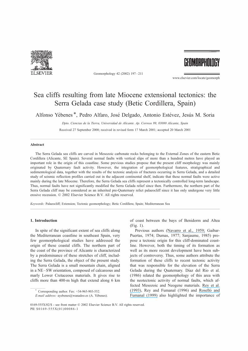
Fig. 1. Geological map of Serra Gelada. Location of geological cross-section and seismic profiles, respectively shown in Figs. 3 and 6, is
also drawn.
A. Yebenes et al. / Geomorphology 42 (2002) 197–211198
place close to the Miocene–Pliocene transition. This
extension would be, in his opinion, responsible for
the subsidence of a block situated to the SE of the
present-day relief of the Serra Gelada giving rise to
the main cliff running NE–SW.
This paper is a multidisciplinary study, which aims
to establish a long-term landscape development of a
coastal area. We define the type and timing of the
events responsible for the genesis of the Serra Gelada
sea cliffs. The geomorphological analysis of the study
area and its integration with tectonic, stratigraphic
and sedimentological data obtained both from the
emergent parts of the mountain range as well as from
the adjacent marine continental shelf (by means of
seismic reflection profiles, deeper than those used by
previous authors), have enabled us to set out a pro-
posal concerning the timing of the formation of this
cliff. In addition, its recent development has been
examined, the relevance of tectonic activity during
the Quaternary is discussed and its possible repercus-
sion on the present-day morphology of the Serra
Gelada is assessed.
2. Geological and geomorphological setting
The Alicante region is located in the eastern part of
the Betic Cordillera, which constitutes the western-
most part of the Alpine Mediterranean chain (Fig. 1).
The Betic Cordillera is subdivided into an Internal
Zone in the south, and an External Zone in the north,
corresponding to the foreland fold-and-thrust belts of
the orogeny and composed of Mesozoic and Tertiary
sedimentary rocks. These rocks represent the former
continental margin of southern Iberia (Garcıa Hernan-
dez et al., 1980). The External Zone is subdivided into
the Subbetic Zone in the south, characterized by
pelagic facies, and a Prebetic Zone in the north, where
shallow marine facies prevail. The Serra Gelada is
located in the northeastern part of the Prebetic Zone,
also called the Alicante Prebetic.
According to De Ruig (1992), the Alicante Pre-
betic presents a large-scale structure characterized by
a deformed sedimentary cover overlying a thinned
continental crust. Its basal detachment corresponds to
Upper Triassic, lutitic and evaporitic materials. This
unit plays an important structural role as the level of
detachment, as well as being the material responsible
for the halokinetic activity, as illustrated by the Altea
diapir (Moseley, 1973). The post-Triassic cover is
composed mainly of Jurassic, Cretaceous and Ceno-
zoic limestones and marls. Folds and thrusts with
NNW trend, along with normal and strike-slip faults,
dominate the structure of this cover.
Present-day climate in this region is semi-arid and
characterized by geomorphological processes con-
trolled by the occasional, but very strong, storm
events. These cause widespread erosion and supply
large sediment loads to mainly ephemeral stream
channels.
The coast is characterized by a succession of sea
cliffs (Toix, Serra Gelada, Torre Vigıa, etc.) and
beaches (Altea, Benidorm, etc.) whose distribution is
mainly controlled by tectonic and lithological factors.
The inland region shows a mountainous relief (Serra
Cortina, Serra de Bernia, etc.) resulting from a com-
plex geological structure (Moseley, 1990) concerning
rocks of different competence (predominantly lime-
stone and marl). Lowland areas and valleys are do-
minated by Pleistocene alluvial fans and valley fills.
The evolution of the Pleistocene alluvial fans, issuing
from the surrounding mountains, show complex his-
tories with early phases, predominantly of alluvial
accumulation and formation of calcrete crusts, and
later phases of dissection of the fans (Harvey, 1978).
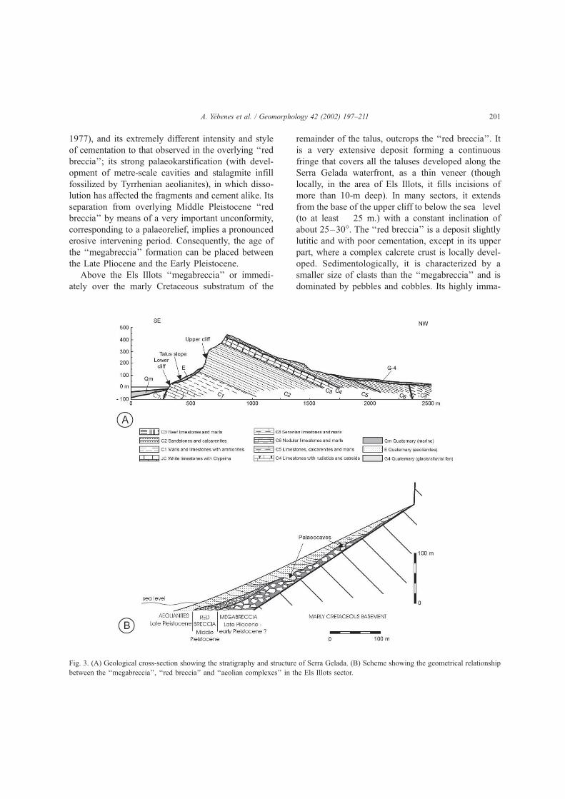
3. Stratigraphy of Serra Gelada
The Mesozoic frame of the Serra Gelada comprises
a succession more than 800-m thick of predominantly
calcareous materials, whose age extends from the Late
Jurassic to the Late Albian (Granier, 1987; Castro,
1998). Within this succession, it is possible to differ-
entiate a series made up of seven lithological units
(Yebenes, 1996), as illustrated in Fig. 3A.
Overlying this Mesozoic substratum, and specifi-
cally on the taluses of the Serra Gelada waterfront,
three successive units were defined by Fumanal and
Yebenes (1996): ‘‘megabreccia’’, ‘‘red breccia’’ and
‘‘aeolian complexes’’ (Fig. 3B).
The oldest unit corresponds to the ‘‘megabreccia’’,
a deposit 2–6-m thick consisting of large ( > 4-m F),
derived basically from the Cretaceous ‘‘sandstones
and calcarenites’’ unit. The unit is totally cemented
(but without any signal of calcrete development) and
A. Yebenes et al. / Geomorphology 42 (2002) 197–211 199
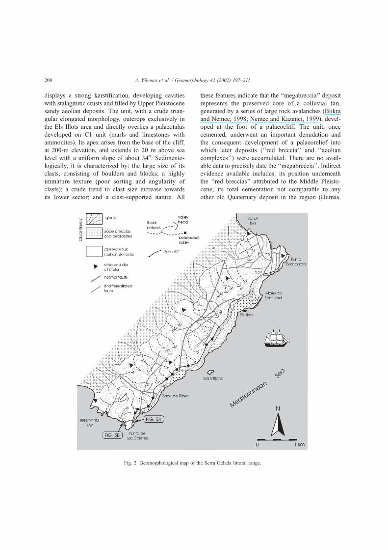
displays a strong karstification, developing cavities
with stalagmitic crusts and filled by Upper Pleistocene
sandy aeolian deposits. The unit, with a crude trian-
gular elongated morphology, outcrops exclusively in
the Els Illots area and directly overlies a palaeotalus
developed on C1 unit (marls and limestones with
ammonites). Its apex arises from the base of the cliff,
at 200-m elevation, and extends to 20 m above sea
level with a uniform slope of about 34�. Sedimento-
logically, it is characterized by: the large size of its
clasts, consisting of boulders and blocks; a highly
immature texture (poor sorting and angularity of
clasts); a crude trend to clast size increase towards
its lower sector; and a clast-supported nature. All
these features indicate that the ‘‘megabreccia’’ deposit
represents the preserved core of a colluvial fan,
generated by a series of large rock avalanches (Blikra
and Nemec, 1998; Nemec and Kazanci, 1999), devel-
oped at the foot of a palaeocliff. The unit, once
cemented, underwent an important denudation and
the consequent development of a palaeorelief into
which later deposits (‘‘red breccia’’ and ‘‘aeolian
complexes’’) were accumulated. There are no avail-
able data to precisely date the ‘‘megabreccia’’. Indirect
evidence available includes: its position underneath
the ‘‘red breccias’’ attributed to the Middle Pleisto-
cene; its total cementation not comparable to any
other old Quaternary deposit in the region (Dumas,
Fig. 2. Geomorphological map of the Serra Gelada littoral range.
A. Yebenes et al. / Geomorphology 42 (2002) 197–211200
1977), and its extremely different intensity and style
of cementation to that observed in the overlying ‘‘red
breccia’’; its strong palaeokarstification (with devel-
opment of metre-scale cavities and stalagmite infill
fossilized by Tyrrhenian aeolianites), in which disso-
lution has affected the fragments and cement alike. Its
separation from overlying Middle Pleistocene ‘‘red
breccia’’ by means of a very important unconformity,
corresponding to a palaeorelief, implies a pronounced
erosive intervening period. Consequently, the age of
the ‘‘megabreccia’’ formation can be placed between
the Late Pliocene and the Early Pleistocene.
Above the Els Illots ‘‘megabreccia’’ or immedi-
ately over the marly Cretaceous substratum of the
remainder of the talus, outcrops the ‘‘red breccia’’. It
is a very extensive deposit forming a continuous
fringe that covers all the taluses developed along the
Serra Gelada waterfront, as a thin veneer (though
locally, in the area of Els Illots, it fills incisions of
more than 10-m deep). In many sectors, it extends
from the base of the upper cliff to below the sea level
(to at least � 25 m.) with a constant inclination of
about 25–30�. The ‘‘red breccia’’ is a deposit slightly
lutitic and with poor cementation, except in its upper
part, where a complex calcrete crust is locally devel-
oped. Sedimentologically, it is characterized by a
smaller size of clasts than the ‘‘megabreccia’’ and is
dominated by pebbles and cobbles. Its highly imma-
Fig. 3. (A) Geological cross-section showing the stratigraphy and structure of Serra Gelada. (B) Scheme showing the geometrical relationship
between the ‘‘megabreccia’’, ‘‘red breccia’’ and ‘‘aeolian complexes’’ in the Els Illots sector.
A. Yebenes et al. / Geomorphology 42 (2002) 197–211 201
ture texture (very poor sorting, angularity of the clasts
and reddish lutitic matrix), the irregular alternation of
both clast-supported and matrix-supported fabric, and
the presence of inverse grading and outsized cobbles
in the matrix-rich levels, suggest a deposit of a
colluvial apron resulting from the coalescence of
colluvial fans, where processes of rock fall avalanch-
ing and high viscosity debris flow alternated irregu-
larly (Morris and Hebertson, 1996; Blikra and Nemec,
1998). There are no direct data on the age of the ‘‘red
breccia’’, but it can be correlated with alluvial fan
deposits outcropping in the northwestern sector of
Serra Gelada, with a similar topmost calcrete dated as
late Middle Pleistocene.
Over the ‘‘red breccia’’, sets of large ‘‘aeolian
complexes’’ are developed, along almost all of the
talus. Aeolian deposits are dominated by climbing
dunes that ascended over the palaeotalus reaching the
base of the cliff. Fumanal and Yebenes (1996) iden-
tified four dune-building periods developed during the
Upper Pleistocene, with TL ages ranging between 100
and 38 ka (isotopic stages 5c to 3). Still active dunes
are present in the upper part of the Pleistocene aeolian
complexes in front of Els Illots.
It may be emphasized that Holocene and currently
active gravitational and run-off processes are respon-
sible for the development of erosional gullies and the
accumulation of very thin deposits (small colluvial
fans and slope-foot aprons).
In some sectors, such as the northwestern face of
the Serra Gelada and its NE and SW margins, various
alluvial fan deposits occur, which are made up of
debris-flow deposits (Fig. 2A). In this sector, Rey et
al. (1993) established four alluvial deposits whose
surfaces defined four glacis surface. The oldest one
(G-4) is characterized by the presence of a topmost
well developed calcrete, with a complex composite
profile and several morphological horizons, dated by
Bruckner and Radtke (1985, 1986) as Middle Pleis-
tocene (Th/U, age of 205F 30 ka).
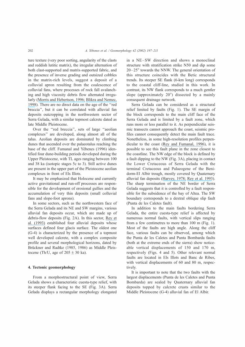
4. Tectonic geomorphology
From a morphostructural point of view, Serra
Gelada shows a characteristic cuesta-type relief, with
its steeper flank facing to the SE (Fig. 3A). Serra
Gelada displays a rectangular morphology elongated
in a NE–SW direction and shows a monoclinal
structure with stratification strike N50 and dip some
20–25� towards the NNW. The general orientation of
this structure coincides with the Betic structural
trends. Its steeper SE flank (6-km long) corresponds
to the coastal cliff-line, studied in this work. In
contrast, its NW flank corresponds to a much gentler
slope (approximately 20�) dissected by a mainly
consequent drainage network.
Serra Gelada can be considered as a structural
relief limited by faults (Fig. 1). The SE margin of
the block corresponds to the main cliff face of the
Serra Gelada and is limited by a fault zone, which
runs more or less parallel to it. As perpendicular seis-
mic transects cannot approach the coast, seismic pro-
files cannot consequently detect the main fault trace.
Nonetheless, in some high-resolution profiles perpen-
dicular to the coast (Rey and Fumanal, 1996), it is
possible to see this fault plane in the zone closest to
the coastline. The NW edge of the block is defined by
a fault dipping to the NW (Fig. 3A), placing in contact
the Lower Cretaceous of Serra Gelada with the
terminal Cretaceous and Palaeogene of the Beni-
dorm-El Albir trough, mostly covered by Quaternary
alluvial fan deposits (Harvey, 1978; Rey et al. 1993).
The sharp termination of the NE border of Serra
Gelada suggests that it is controlled by a fault respon-
sible for the subsidence of the bay of Altea. The SW
boundary corresponds to a dextral oblique slip fault
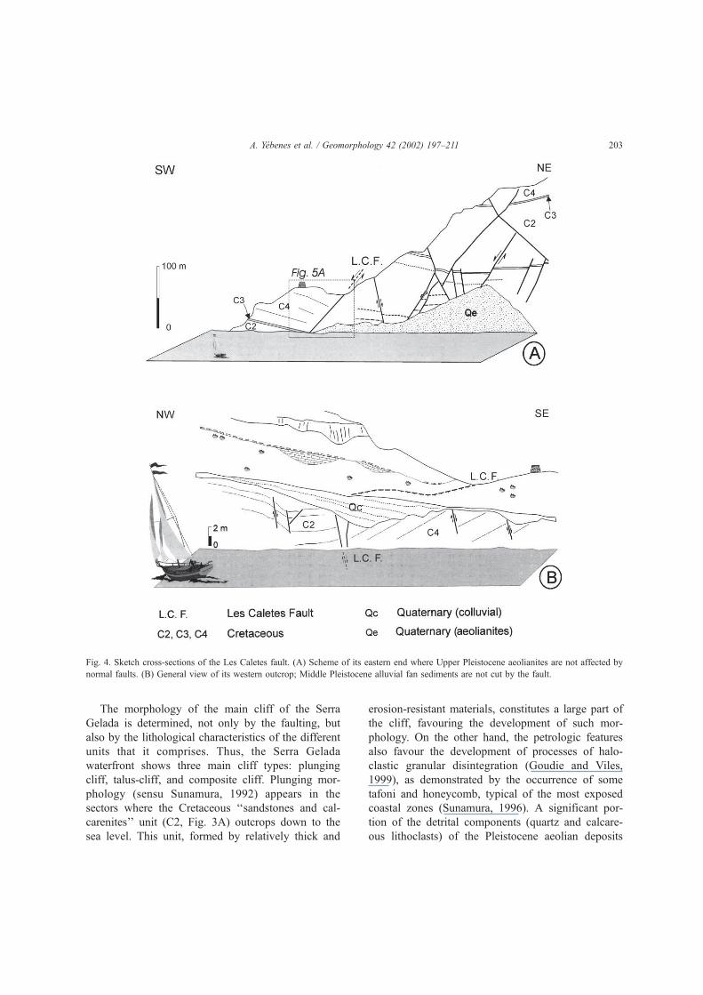
(Punta de les Caletes fault).
In addition to the main faults bordering Serra
Gelada, the entire cuesta-type relief is affected by
numerous normal faults, with vertical slips ranging
from a few centimetres to more than 100 m (Fig. 1).
Most of the faults are high angle. Along the cliff
face, various faults can be observed, among which
the Punta de les Caletes and Punta Bombarda faults
(both at the extreme ends of the sierra) show notice-
able vertical displacements of 150 and 170 m,
respectively (Figs. 4 and 5). Other relevant normal
faults are located in Els Illots and Banc de Ribes,
with vertical displacements of 60 and 80 m, respec-
tively.
It is important to note that the two faults with the
largest displacements (Punta de les Caletes and Punta
Bombarda) are sealed by Quaternary alluvial fan
deposits topped by calcrete crusts similar to the
Middle Pleistocene (G-4) alluvial fan of El Albir.
A. Yebenes et al. / Geomorphology 42 (2002) 197–211202
The morphology of the main cliff of the Serra
Gelada is determined, not only by the faulting, but
also by the lithological characteristics of the different
units that it comprises. Thus, the Serra Gelada
waterfront shows three main cliff types: plunging
cliff, talus-cliff, and composite cliff. Plunging mor-
phology (sensu Sunamura, 1992) appears in the
sectors where the Cretaceous ‘‘sandstones and cal-
carenites’’ unit (C2, Fig. 3A) outcrops down to the
sea level. This unit, formed by relatively thick and
erosion-resistant materials, constitutes a large part of
the cliff, favouring the development of such mor-
phology. On the other hand, the petrologic features
also favour the development of processes of halo-
clastic granular disintegration (Goudie and Viles,
1999), as demonstrated by the occurrence of some
tafoni and honeycomb, typical of the most exposed
coastal zones (Sunamura, 1996). A significant por-
tion of the detrital components (quartz and calcare-
ous lithoclasts) of the Pleistocene aeolian deposits
Fig. 4. Sketch cross-sections of the Les Caletes fault. (A) Scheme of its eastern end where Upper Pleistocene aeolianites are not affected by
normal faults. (B) General view of its western outcrop; Middle Pleistocene alluvial fan sediments are not cut by the fault.
A. Yebenes et al. / Geomorphology 42 (2002) 197–211 203
might originate through this kind of mechanical
disaggregation process.
On the other hand, where that unit does not outcrop
down to the sea level, talus-cliff morphology appears
with the talus developed on the easily erodible Creta-
ceous underlying unit (marls and limestones with
ammonites) (C1, Fig. 3A). The Plio-Pleistocene col-
luvial and aeolian deposits cover those taluses.
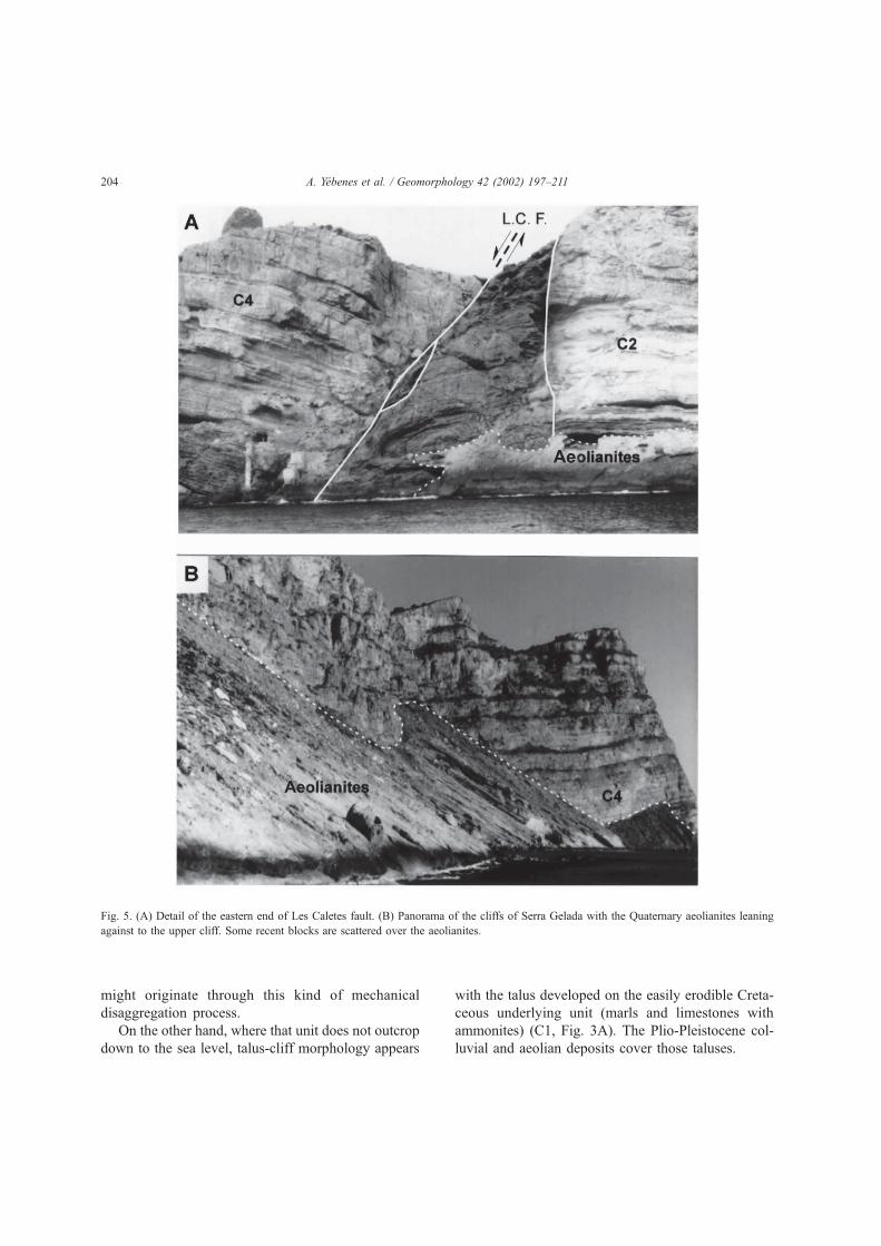
Fig. 5. (A) Detail of the eastern end of Les Caletes fault. (B) Panorama of the cliffs of Serra Gelada with the Quaternary aeolianites leaning
against to the upper cliff. Some recent blocks are scattered over the aeolianites.
A. Yebenes et al. / Geomorphology 42 (2002) 197–211204
In the sector of Morro de Sant Jordi (Fig. 2), the
presence of very erosion-resistant outcrops of the
Jurassic ‘‘white limestones with clypeina’’ (JC, Fig.
3A) at sea level, control the development of a lower
plunging cliff, in some places up to 50-m high. At
these points, the Serra Gelada waterfront displays a
composite configuration as illustrated in Fig. 3A:
lower plunging cliff, talus and upper cliff.
At the plunging cliff toes, a very marked notch is
developed coinciding with the present sea level.
However, on these rocky shores, we have not found
bioconstructive or erosive evidence that would in-
dicate recent tectonic uplift along this part of the
coast.
The inland continental face of the Serra Gelada
shows a gentle slope, but highly dissected by a
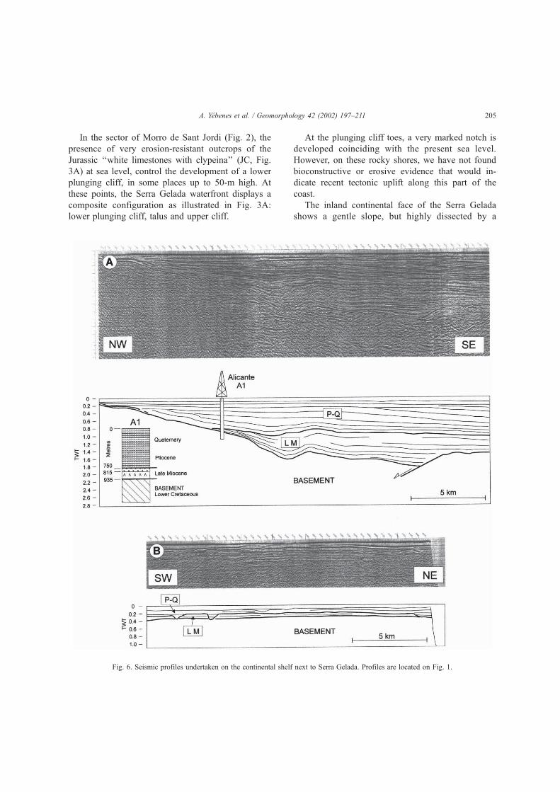
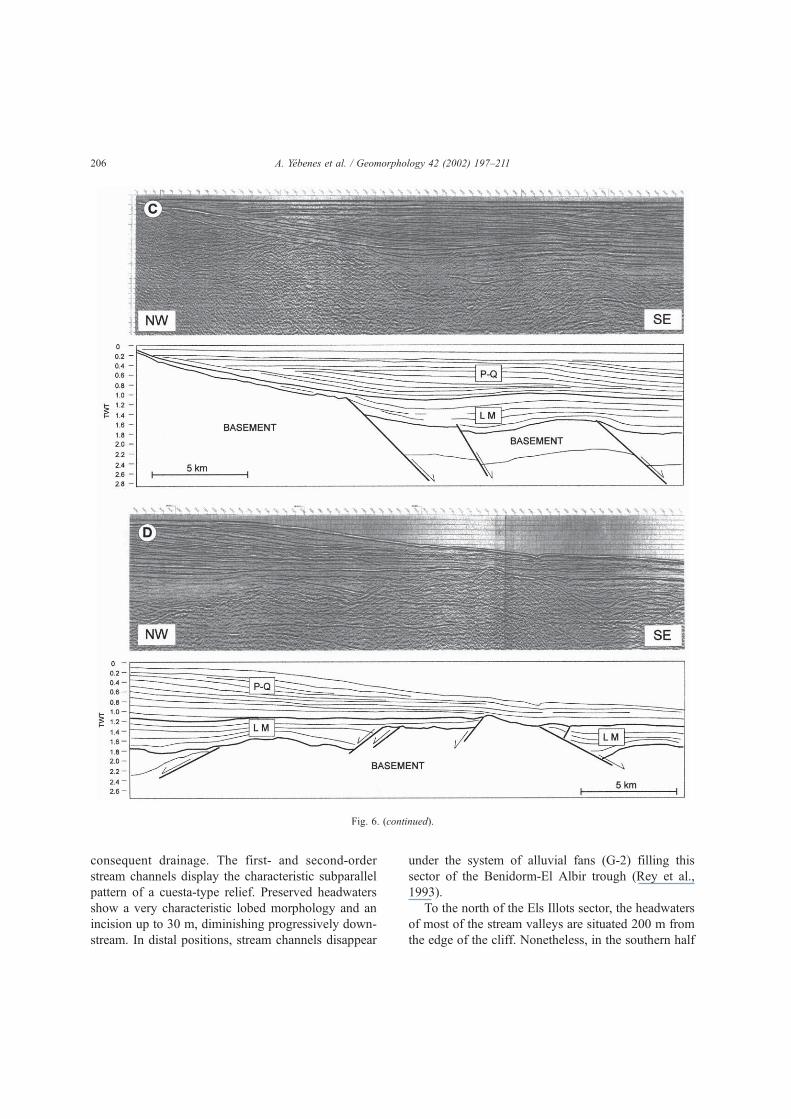
Fig. 6. Seismic profiles undertaken on the continental shelf next to Serra Gelada. Profiles are located on Fig. 1.
A. Yebenes et al. / Geomorphology 42 (2002) 197–211 205
consequent drainage. The first- and second-order
stream channels display the characteristic subparallel
pattern of a cuesta-type relief. Preserved headwaters
show a very characteristic lobed morphology and an
incision up to 30 m, diminishing progressively down-
stream. In distal positions, stream channels disappear
under the system of alluvial fans (G-2) filling this
sector of the Benidorm-El Albir trough (Rey et al.,
1993).
To the north of the Els Illots sector, the headwaters
of most of the stream valleys are situated 200 m from
the edge of the cliff. Nonetheless, in the southern half
Fig. 6. (continued).
A. Yebenes et al. / Geomorphology 42 (2002) 197–211206
of the sea cliff, the old headwaters have been clearly
beheaded by the marine cliff (Fig. 2). This evidences a
greater recession of the SW sector of the cliff in
comparison to its NE sector.
5. Stratigraphy and tectonic features of the
adjacent continental shelf
From the stratigraphic and palaeontological data
obtained from the offshore exploration well ‘‘Alicante
1’’, situated about 8 km to the SE of the Serra Gelada,
and the offshore seismic reflection profiles (Figs. 1
and 6), Catafau et al. (1994) established several
Triassic to Quaternary seismic units. In this paper,
we have grouped them in three main seismic units.
(1) Basement seismic unit, comprising Triassic to
Middle Miocene sedimentary rocks.
(2) Late Miocene seismic unit, with relatively
shallow-water marine clays, anhydrite, argillaceous
dolomite and limestone, which is supported at a
discordant angle over the underlying unit. Its distri-
bution is irregular and it shows significant variations
in thickness, since it appears as a fill within exten-
sional half-grabens. In the Alicante 1 well, this unit
was attributed to the Tortonian, based in micropaleon-
tological data (presence of Heterostegina complanata
and other benthic foraminifera.
(3) Plio-Holocene seismic unit, consisting of deep-
water marine clays with occasional, thin interbeds of
sandstone. Its base clearly erodes the underlying
‘‘Late Miocene’’ or ‘‘basement’’ seismic units. In
the Alicante 1 well, the lower part of the unit con-
tains frequent and diverse planktonic foraminifera
dated as Early–Middle Pliocene. The thickness of
the ‘‘Plio-Holocene’’ unit tends to diminish towards
the coast.
The analysis of the seismic profiles reveals the
existence of faults, related to the ‘‘basement’’, parallel
to the coastline. The ‘‘Late Miocene’’ seismic unit
generally fills troughs. Seismic profiles (Fig. 6) show
clearly that most of them exhibit a half-graben struc-
ture with throws that can exceed 1000 m.
The ‘‘Plio-Holocene’’ seismic unit seals normal
faults affecting ‘‘basement’’ and ‘‘Late Miocene’’
seismic units, and shows no evidence of extension.
Based on the fact that the Upper Miocene top reflec-
tor is, in general, undeformed, a pre-Pliocene age may
be inferred for the main vertical displacements asso-
ciated with the movement of the fault zone in this
sector.
Although the main fault zone is situated some 13
km from the coast, normal faults belonging to the
same system, though less numerous and less impor-
tant in displacement, also occur very close to the
coast.
6. Discussion
Analysis of the seismic profiles obtained from the
continental shelf adjacent to Serra Gelada reveals the
occurrence of important sets of normal faults, approx-
imately parallel to the coast. These faults fundamen-
tally affect the materials of the ‘‘basement’’ and ‘‘Late
Miocene’’ seismic units. The latter unit displays a
characteristic half-graben structure in which the
geometry of the reflectors indicates that the graben-
fill is contemporaneous with the extension process.
The sediments that constitute the ‘‘Plio-Holocene’’
seismic unit lie unconformably over the underlying
units sealing the extensional structures. Thus, in this
sector, a significant extension took place between the
Tortonian and the Early Pliocene.
These results agree with studies undertaken in the
inland sector. As De Ruig (1992) pointed out, there
was a generalized uplift of the eastern Prebetic from
the Early–Late Tortonian, with a simultaneous devel-
opment of transtensional faults.
The normal faults crosscutting Mesozoic materials
of Serra Gelada, including the one bordering its SE
margin, were formed mainly during the Tortonian–
Early Pliocene interval. As a consequence of the
extension, the present Serra Gelada block was uplifted
while the SE sector subsided. Thus, the Serra Gelada
relief may be considered as a faulted block, similar to
those observed in the seismic lines on the continental
shelf (Fig. 6).
By the reasons mentioned previously, most of the
seismic profiles cannot detect the main fault trace.
Nonetheless, it has been located very near of the
Morro de Sant Jordi and near the seawards face of
the Mitjana Island (Fig. 1). The resulting pre-Pliocene
original palaeocliff would be much more extensive
than the preserved one, probably extending as far as
the Benidorm Island.
A. Yebenes et al. / Geomorphology 42 (2002) 197–211 207
Therefore, the present lower sea cliff of the Morro
de Sant Jordi sector and the seawards face of the
Mitjana Island (both formed by the very erosion-
resistant Jurassic limestones) represent the relicts of
the original palaeocliff resulting from the Upper
Miocene faulting.
Later evolution of the original palaeocliff was not
significantly affected by tectonics, but was mainly
controlled by lithology and, to a lesser grade, by
eustatic and climatic factors. Thus, the early develop-
ment of a palaeotalus on ‘‘marls and limestones with
ammonites’’ unit was clearly related to its easily
erodible lithology. Similarly, the development of the
upper main cliff also was controlled by the erosion-
resistant nature of the ‘‘sandstones and calcarenites’’
unit.
The presence of the ‘‘megabreccia’’, a colluvial fan
deposit developed on the palaeotalus and joined to the
main sea-cliff face, is fundamental to understand the
Plio-Pleistocene evolution of the original palaeocliff.
In fact, the occurrence of these materials indicates
that: (a) the upper cliff was already perfectly devel-
oped when the ‘‘megabreccia’’ was deposited (Late
Pliocene–Early Pleistocene); (b) the ‘‘megabreccia’’
overlies an equilibrium slope of a well developed
cliff – talus palaeomorphology, and therefore, an
appreciable time lag between the formation of the
original palaeocliff and the deposition of the ‘‘mega-
breccia’’ could be considered; and (c) the slope of the
‘‘megabreccia’’ deposit indicates that, since its depo-
sition, the sierra has undergone no tilting around a
NE–SW axis.
The intense denudation undergone by the ‘‘mega-
breccia’’ makes it impossible to evaluate the original
distribution of these old colluvial fans. However, it is
clear that, at least in the sector of the cliff situated to
the north of Els Illots, recession of the upper cliff
face has been imperceptible. Therefore, the upper
cliff can be also considered as a pre-Quaternary
palaeocliff.
Since their deposition and complete cementation,
the colluvial sediments of the ‘‘megabreccia’’ under-
went intense karstification and significant denudation
that eventually led to their almost total disappearance,
with the exception of the outcrop preserved in the Els
Illots sector. After a noticeable sedimentary gap, with
respect to the deposition of the ‘‘megabreccia’’, a
Middle Pleistocene colluvial apron, the ‘‘red breccia’’,
developed all along the palaeotaluses of the main
Serra Gelada cliff-face. This deposit extends from
the upper cliff-toe, implying that, after its deposition
and up to present day, the cliff has not receded.
An analysis of the Plio-Pleistocene deposits and
the geomorphology of the mountain range highlight
the fact that the cliff has evolved differently in the NW
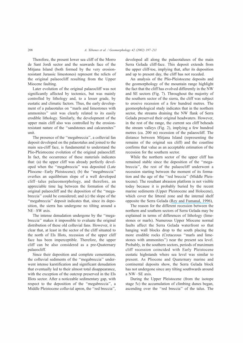
and SE sectors (Fig. 7). Throughout the majority of
the southern sector of the sierra, the cliff was subject
to erosive recession of a few hundred metres. The
geomorphological study indicates that in the northern
sector, the streams draining the NW flank of Serra
Gelada preserved their original headwaters. However,
in the rest of the range, the current sea cliff beheads
the stream valleys (Fig. 2), implying a few hundred
metres (ca. 200 m) recession of the palaeocliff. The
distance between Mitjana Island (representing the
remains of the original sea cliff) and the coastline
confirms that value as an acceptable estimation of the
recession for the southern sector.
While the northern sector of the upper cliff has
remained stable since the deposition of the ‘‘mega-
breccia’’, the rest of the palaeocliff underwent a
recession starting between the moment of its forma-
tion and the age of the ‘‘red breccia’’ (Middle Pleis-
tocene). The resultant abrasion platform is not visible
today because it is probably buried by the recent
marine sediments (Upper Pleistocene and Holocene),
which cover the littoral zone and the internal shelf
opposite the Serra Gelada (Rey and Fumanal, 1996),
The reason for the different recession between the
northern and southern sectors of Serra Gelada may be
explained in terms of differences of lithology (lime-
stones or marls). Numerous Upper Miocene normal
faults affect the Serra Gelada waterfront so that
hanging wall blocks drop to the south placing the
more erodible rocks (Cretaceous ‘‘marls and lime-
stones with ammonites’’) near the present sea level.
Probably, in the southern sectors, periods of maximum
cliff recession coincided with Early Pleistocene
eustatic highstands where sea level was similar to
present. As Pliocene and Quaternary marine and
continental deposits show, the Serra Gelada block
has not undergone since any tilting southwards around
a NW–SE axis.
During the Upper Pleistocene (from the isotope
stage 5c) the accumulation of climbing dunes began,
ascending over the ‘‘red breccia’’ of the talus. The
A. Yebenes et al. / Geomorphology 42 (2002) 197–211208
more voluminous aeolian complex (‘‘white eolianite’’)
formed during the first regressive phases, as shown by
its richness in bioclasts (mainly warm-water benthic
foraminifera, some of relatively deep-water, remobi-
lised by the wind when the continental shelf was
being exposed).
Finally, during the Holocene, the aeolian deposits
located at the lowest parts of the taluses of the Serra
Gelada cliff were subject to significant marine ero-
sion that culminated during the last transgressive
episode, with the removal of large volumes of Pleis-
tocene aeolianites.
Fig. 7. Interpretative scheme of cliff retreat in SE Serra Gelada. (A) Plan view. (B) Three-dimensional sketches showing lateral variation of cliff
recession.
A. Yebenes et al. / Geomorphology 42 (2002) 197–211 209
None of the Quaternary deposits of Serra Gelada
seem to have been affected by appreciable tectonic
deformation. In fact, the two large faults that occur in
the extremes of the Serra Gelada (the Punta Bombarda
and Les Caletes faults) are fossilized by Middle
Pleistocene alluvial fan deposits (Fig. 4B).
As mentioned in Introduction, most of previous
authors attribute the formation of the cliff to the recent
tectonic activity responsible for the uplift of the block
of the sierra. Although the weak seismicity in the zone
suggests the occurrence of certain recent activity
(Yebenes, 1996), no evidence has been found that
demonstrates the role of this activity in the morpho-
logical configuration of the Serra Gelada cliff. Rey
and Fumanal (1996) report normal faults affecting
Upper Pleistocene and Holocene on the inner con-
tinental shelf in front of Serra Gelada. We think,
though (as it may be inferred in the figures of that
paper), that these faults do not propagate downwards
and not affect deeper deposits. So, they are likely
synsedimentary faults caused by gravitational pro-
cesses.
The fact that we have not found any evidence of
Quaternary compression in the Serra Gelada block is
consistent with the possibility that elsewhere, such
structures could exist due to active compressional
regional tectonics.
7. Conclusions
Through a multidisciplinary approach, we have
developed a model for the long-term landscape evo-
lution of Serra Gelada sea cliffs.
Data obtained from the seismic profiling of the
continental shelf leads us to consider that during the
late Miocene, important normal faults developed in
this sector, which were related to tensional processes.
The original cliff of the Serra Gelada formed as a
consequence of the activity of these faults. The main
alignments that define the morphology of the moun-
tain range and determined the Pleistocene sedimenta-
tion are, therefore, clearly pre-Quaternary.
In the sector to the north of Els Illots, the original
palaeocliff is preserved, having been subject to nei-
ther tectonics nor erosive recession since the Late
Pliocene. However, in the southern sector, the palae-
ocliff has recessed several hundred metres, though
this recession was not a consequence of tectonic
activity but of erosional processes, which occurred
between its formation and the Middle Pleistocene.
From that time, there has been no appreciable reces-
sion of the cliff.
The Quaternary deposits outcroping in Serra
Gelada are not influenced by tectonic deformation.
This fact rules out any significant geomorphological
consequence of tectonic activity during the Quater-
nary.
Acknowledgements
The authors wish to warmly thank the reviewers,
P. Silva and M. Stokes, for their careful and con-
structive comments and suggestions on the original
manuscript. We are also grateful to the Direccion
General de Hidrocarburos del Ministerio de Econo-
mıa of Spain for providing the offshore seismic lines
and Alicante-1 well data. This investigation was
financed by the research projects of the Spanish
Direccion General de Ensenanza Superior e Inves-
tigacion Cientıfica (DGESIC) Project PB96-0327 and
Direccion General Investigacion (DGI) Project
BTE2000-0339.
References
Blikra, L.H., Nemec, W., 1998. Postglacial colluvium in western
Norway: depositional processes, facies and palaeoclimatic re-
cord. Sedimentology 45, 909–959.
Bruckner, H., Radtke, H., 1985. Neue Erkenntnisse zum marinen
Quartar an Spaniens Mittelmeerkuste. Kiel. Geogr. Schr. 62,
49–71.
Bruckner, H., Radtke, H., 1986. Paleoclimatic implications de-
rived from profiles along the Spanish Mediterranean coast.
In: Lopez-Vera, F. (Ed.), Quaternary Climate in Western Med-
iterranean. Universidad Autonoma de Madrid, Madrid, pp.
467–486.
Castro, J.M., 1998. Las plataformas del Valanginiense superior–
Albiense superior en el Prebetico de Alicante. Tesis Doctoral.
Universidad de Jaen, 464 pp.
Catafau, E., Gaytan, M., Pereda, I., Vazquez, J.T., Wandossell, J.,
1994. Mapa Geologico de la Plataforma Continental Espanola y
Zonas Adyacentes, Escala 1:200.000, Elche-Alicante. Instituto
Tecnologico Geominero de Espana, Madrid, 73 pp.
De Ruig, M., 1992. Tectono–Sedimentary Evolution of the Prebetic
Fold Belt of Alicante (SE Spain). Doctoral Thesis. Vrije Uni-
versiteit, Amsterdam, 207 pp.
A. Yebenes et al. / Geomorphology 42 (2002) 197–211210
Dıaz del Rıo, V., Rey, J., Vegas, R., 1986. The Gulf of Valencia
continental shelf: extensional tectonics in Neogene and Quater-
nary sediments. Mar. Geol. 73, 169–179.
Dumas, B., 1977. Le Levant Espagnol: La Genese du Relief. These
Doctorat, Universite Paris-Sorbonne, 520 pp.
Fumanal, M.P., Yebenes, A., 1996. Los depositos cuaternarios de les
Penyes de l’Albir en el contexto sedimentario litoral valenciano.
Cuad. Geogr. Univ. Valencia 60, 259–294.
Gaibar-Puertas, C., 1974. Los movimientos recientes del litoral
alicantino: II. El segmento extendido entre la Punta de Ifach
y el Cabo de las Huertas. Rev. Inst. Estud. Alicantinos 11,
43–106.
Garcıa-Hernandez, M., Lopez-Garrido, A.C., Rivas, P., Sanz de
Galdeano, C.y, Vera, J.A., 1980. Mesozoic paleogeographic
evolution of the External Zones of the Betic Cordillera. Geol.
Mijinbow 59, 155–168.
Granier, B. 1987. Le Cretace inferieur de la Costa Blanca entre
Busot et Altea (Alicante, Espagne): Biostratigraphie, Sedimen-
tologie, Evolution Tectono-Sedimentaire. These Doctorat d’Etat,
Univ. Paris VI, 281 pp.
Goudie, A.S., Viles, H.A., 1999. The frequency and magnitude
concept in relation to rock weathering. Z. Geomorphol. N.F.
Suppl. Bd. 115, 175–189.
Harvey, A.M., 1978. Dissected alluvial fans in southeast Spain.
Catena 5, 177–211.
Morris, T.H., Hebertson, G.F., 1996. Large-rock avalanche deposits,
eastern Basin and Range: emplacement, diagenesis, and eco-
nomic potential. Am. Assoc. Pet. Geol. Bull. 80, 1135–1149.
Moseley, F., 1973. Diapiric and gravity tectonics in the pre-Betic
(Sierra Bernia) of south-east Spain. Bol. Geol. Min. Esp. 84,
114–126.
Moseley, F., 1990. A Geological Field Guide to the Costa Blanca,
Spain. The Geologists’ Association, London, 79 pp.
Navarro, A., Villalon, C., Trigueros, E., 1959. El Cuaternario mar-
ino de la Serra Gelada (Alicante) y la tectonica reciente. Notas
Comun. I.G.M.E. 56, 25–32.
Nemec, W., Kazanci, N., 1999. Quaternary colluvium in west-cen-
tral Anatolia: sedimentary facies and palaeoclimatic signifi-
cance. Sedimentology 46, 139–170.
Rey, J., Fumanal, M.P., 1996. Cuaternario submarino frente a la
Serra Gelada (Alicante) y sus implicaciones eustatico-paleo-
geograficas. Cuad. Geogr. Univ. Valencia 60, 243–258.
Rey, J., Fumanal, M.P., Ferrer, C., Vinals, M.J., Yebenes, A., 1993.
Correlacion de las unidades morfologicas cuaternarias (domi-
nio continental y plataforma submarina) del sector Altea-Villa
Joiosa, Paıs Valenciano, (Espana). Cuad. Geogr. Univ. Valencia
54, 249–267.
Rosello, VM., Fumanal, M.P., 1999. Climbing dunes and interbed-
ded rubble fans. Quaaternary patterns of Serra Gelada (Spanish
Mediterranean littoral). Z. Geomorphol. N.F. 43, 235–254.
Sanjaume, E., 1985. Las Costas Valencianas. Sedimentologıa y
Morfologıa. Tesis Doctoral, Universidad de Valencia, 505 pp.
Sunamura, T., 1992. Geomorphology of Rocky Coasts. Wiley, New
York, 302 pp.
Sunamura, T., 1996. A physical model for the rate of coastal tafoni
development. J. Geol. 104, 741–748.
Yebenes, A., 1996. Estratigrafıa y estructura de la Serra Gelada.
Cuad. Geogr. Univ. Valencia 60, 201–222.
A. Yebenes et al. / Geomorphology 42 (2002) 197–211 211
Related Documents